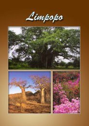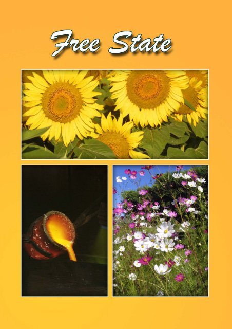
Free State provincial article - South African Vacations
Free State provincial article - South African Vacations
Free State provincial article - South African Vacations

Create successful ePaper yourself
Turn your PDF publications into a flip-book with our unique Google optimized e-Paper software.
Index<br />
OVERVIEW...........................................................................................................................3<br />
CLIMATE ..............................................................................................................................6<br />
ROUTES ...............................................................................................................................6<br />
BBT HERITAGE ROUTE....................................................................................................6<br />
DIAMOND AND WINE ROUTE ..........................................................................................6<br />
GOLDFIELDS ROUTE .......................................................................................................7<br />
MALUTI ROUTE.................................................................................................................7<br />
N6 ROUTE .........................................................................................................................7<br />
REGIONS..............................................................................................................................8<br />
LEJWELEPUTSWA..............................................................................................................8<br />
ALLANRIDGE.....................................................................................................................9<br />
BOSHOF ..........................................................................................................................10<br />
BOTHAVILLE ...................................................................................................................11<br />
BRANDFORT ...................................................................................................................14<br />
BULTFONTEIN.................................................................................................................15<br />
DEALESVILLE..................................................................................................................16<br />
HENNENMAN ..................................................................................................................17<br />
HERTZOGVILLE ..............................................................................................................17<br />
HOOPSTAD .....................................................................................................................18<br />
ODENDAALSRUS............................................................................................................19<br />
THEUNISSEN ..................................................................................................................20<br />
VENTERSBURG ..............................................................................................................22<br />
VIRGINIA..........................................................................................................................23<br />
WELKOM..........................................................................................................................25<br />
WESSELSBRON..............................................................................................................27<br />
WINBURG ........................................................................................................................28<br />
MOTHEO REGION .............................................................................................................29<br />
BLOEMFONTEIN .............................................................................................................30<br />
BOTSHABELO .................................................................................................................41<br />
DEWETSDORP................................................................................................................41<br />
EXCELSIOR .....................................................................................................................42<br />
HOBHOUSE .....................................................................................................................43<br />
LADYBRAND....................................................................................................................44<br />
THABA ‘NCHU .................................................................................................................47<br />
TWEESPRUIT ..................................................................................................................48<br />
VAN STADENSRUS.........................................................................................................49<br />
WEPENER .......................................................................................................................49<br />
NORTHERN FREE STATE.................................................................................................51<br />
DENEYSVILLE .................................................................................................................52<br />
EDENVILLE......................................................................................................................53<br />
FRANKFORT....................................................................................................................54<br />
HEILBRON .......................................................................................................................56<br />
KOPPIES (including Kwakwatsi) ......................................................................................58<br />
KROONSTAD...................................................................................................................61<br />
ORANJEVILLE .................................................................................................................64<br />
PARYS .............................................................................................................................65<br />
1
SASOLBURG ...................................................................................................................69<br />
TWEELING.......................................................................................................................72<br />
VILJOENSKROON ...........................................................................................................72<br />
VILLIERS..........................................................................................................................73<br />
VREDEFORT ...................................................................................................................73<br />
THABO MOFUTSANYANA (EASTERN FREE STATE).....................................................76<br />
ARLINGTON.....................................................................................................................77<br />
BETHLEHEM....................................................................................................................77<br />
CLARENS.........................................................................................................................79<br />
CLOCOLAN......................................................................................................................83<br />
CORNELIA .......................................................................................................................85<br />
FICKSBURG.....................................................................................................................85<br />
FOURIESBURG ...............................................................................................................91<br />
HARRISMITH (Including Swinburn and Van Reenen)......................................................94<br />
KESTELL..........................................................................................................................98<br />
LINDLEY...........................................................................................................................99<br />
MARQUARD...................................................................................................................101<br />
MEMEL...........................................................................................................................103<br />
PAUL ROUX...................................................................................................................104<br />
PETRUS STEYN ............................................................................................................106<br />
PHUTHADITJHABA/QWA-QWA ....................................................................................107<br />
REITZ-PETSANA ...........................................................................................................109<br />
SENEKAL.......................................................................................................................111<br />
STEYNSRUS..................................................................................................................113<br />
VREDE ...........................................................................................................................113<br />
WARDEN........................................................................................................................115<br />
XHARIEP REGION ...........................................................................................................116<br />
BETHULIE......................................................................................................................117<br />
EDENBURG ...................................................................................................................118<br />
FAURESMITH ................................................................................................................119<br />
XHARIEP DAM...............................................................................................................121<br />
JACOBSDAL ..................................................................................................................122<br />
JAGERSFONTEIN .........................................................................................................124<br />
KOFFIEFONTEIN...........................................................................................................126<br />
LUCKHOFF ....................................................................................................................128<br />
PETRUSBURG...............................................................................................................128<br />
PHILIPPOLIS..................................................................................................................130<br />
REDDERSBURG............................................................................................................131<br />
ROUXVILLE ...................................................................................................................133<br />
SMITHFIELD ..................................................................................................................134<br />
SPRINGFONTEIN ..........................................................................................................135<br />
TROMPSBURG..............................................................................................................136<br />
ZASTRON ......................................................................................................................137<br />
SOURCES ........................................................................................................................139<br />
2
OVERVIEW<br />
<strong>Free</strong> <strong>State</strong> Department of Tourism, Environmental and Economic Affairs<br />
Physical address: Bojanala Building, 34 Markgraaf Street, Bloemfontein, 9301<br />
Postal address: Private Bag X20801, Bloemfontein, <strong>Free</strong> <strong>State</strong>, <strong>South</strong> Africa, 9300<br />
Tel: +27 (0) 51 403 3719<br />
Fax: +27 (0) 51 403 3718<br />
Website: http://www.freestateprovince.co.za<br />
A golden thread runs through the <strong>Free</strong> <strong>State</strong>, the kidney-shaped province that lies deep in<br />
the heart of <strong>South</strong> Africa. The rich seams of gold ore that run for many kilometres<br />
underground are echoed in the golden fields of wheat, maize and sunflowers that stretch<br />
above ground as far as the eye can see. The skies of the <strong>Free</strong> <strong>State</strong> are also edged with<br />
gold as the rays of the afternoon sun bathe the sandstone rock formations of the Golden<br />
Gate National Park in the Eastern <strong>Free</strong> <strong>State</strong> in coppery gold.<br />
Some 2000 million years ago, a meteorite crashed into the<br />
earth near the present-day town of Vredefort. This<br />
phenomenon not only created the Vredefort Dome, a fertile<br />
basin with beautiful natural vegetation, but also changed<br />
the composition of the earth’s crust and determined the<br />
position of the gold-bearing reefs of <strong>South</strong> Africa.<br />
3<br />
The impact caused the gold-bearing reefs to<br />
circle out into a much larger “dome”<br />
underground and pushed the reefs as far as<br />
the Witwatersrand. But it did not leave the <strong>Free</strong><br />
<strong>State</strong> wanting. The <strong>Free</strong> <strong>State</strong> produces nearly<br />
21 per cent of the world’s gold and accounts<br />
for half of <strong>South</strong> Africa’s total gold output.
Just as the province nestles safe in the heart of the country, the people of the province are<br />
willing to take visitors to their hearts, to welcome them into their homes and show them<br />
their way of life. Most of the visitors to the province comment on the genuine warmth and<br />
hospitality with which <strong>Free</strong> <strong>State</strong> people treat visitors and state this as one of the reasons<br />
why they often return. Tired city dwellers often come here to show their children how their<br />
grandparents once made a living on farms or to relax in one of the many game reserves.<br />
Whether they are English-, Afrikaans- or Sotho-speaking, visitors to the <strong>Free</strong> <strong>State</strong> can all<br />
find a spiritual home in the province with the heart of gold.<br />
4<br />
The <strong>Free</strong> <strong>State</strong> is completely<br />
landlocked, bordered by six of the<br />
nine provinces of <strong>South</strong> Africa<br />
and folded protectively around<br />
the Kingdom of Lesotho. The rich<br />
soils and strong rivers of the<br />
province create rich and glorious<br />
life and the <strong>Free</strong> <strong>State</strong> is not<br />
called the “food basket” of the<br />
country without reason. Fields of<br />
maize, wheat and sunflowers<br />
cover vast acres of farmland, and<br />
dairy, sheep and cattle farming<br />
also contribute strongly to the<br />
economy of the province.<br />
Many holidaymakers drive through the <strong>Free</strong> <strong>State</strong> annually on their way to and from the<br />
Western Cape. Over the last few years in particular, many people have realised that the<br />
<strong>Free</strong> <strong>State</strong> is not just a throughway, but has unique features of its own to recommend it to<br />
the discerning traveller. Like the discoverers of old, people need to explore the <strong>Free</strong> <strong>State</strong><br />
to truly appreciate its attraction as a place where people can escape the hustle and bustle<br />
of city life, take leisurely walks amid historical or natural surroundings and reconnect with<br />
nature and other people.<br />
Although the <strong>Free</strong> <strong>State</strong> does not have many cities and is not densely populated, it has an<br />
extremely well-developed infrastructure. All its destinations are thus eminently accessible,<br />
while still giving visitors the feeling of being in another world, well removed from city life.<br />
Ride the main routes lined with the pink, purple and white cosmos wild flowers and gaze<br />
beyond them at the fields of sunflowers facing the sun, the maize fields with their cobs<br />
hanging heavy and the waving corn stalks and simply drink in the goodness of Mother<br />
Nature.<br />
The Lejweleputswa Region owes its main claim to fame to the mine surveyor who, in 1948,<br />
sunk a borehole on the farm St Helena in search of water, but instead found a deep source<br />
of gold-bearing ore linked to the gold reefs of the Witwatersrand. This discovery marked the<br />
beginning of the <strong>Free</strong> <strong>State</strong> gold rush. “Lejweleputswa” means “grey stone” and refers to<br />
the unprocessed gold-bearing rock that is found here. Lejweleputswa lies at the heart of the<br />
“Maize Triangle”, where golden maize fields stretch from horizon to horizon and is also the<br />
fourth most important manufacturing district in the country.<br />
The Motheo Region is the home of Bloemfontein, the <strong>provincial</strong> capital and the business<br />
and cultural hub of the <strong>Free</strong> <strong>State</strong>. This is the place of golden opportunities, where several
political parties saw the light of day and where the population of the province comes<br />
together to merge into a cosmopolitan community. At night, the city lights form a golden<br />
glow on the horizon, as locals and visitors revel in the cultural and entertainment<br />
opportunities associated with city life. But Motheo is also a region of golden fields of wheat<br />
and maize, where sheep and cattle graze. Game reserves and private farms, where gamewatching<br />
and hunting are allowed, make up the rest of the region.<br />
Kilometres and kilometres of maize fields, the yellowed cobs winking from afar,<br />
interspersed with fields of sunflowers - this is the gold grown on the land in the Northern<br />
<strong>Free</strong> <strong>State</strong>. This region produces the major portion of the country’s maize crop. With an<br />
abundance of water and the presence of such diverse features as hilly grasslands, rugged<br />
mountains, fertile highveld plains, the region can truly be said to have it all. In the extreme<br />
north lies the mighty Vaal River, a prime holiday destination that is ideal for adventure<br />
activities such as white-water rafting, canoeing, boating and angling. The presence of the<br />
Vredefort Dome is another bonus for adventurers and anyone who enjoys a taste of the<br />
unique and unusual. Inside the Dome area there are several adventure opportunities and<br />
several species of plants and insects can be seen that are found nowhere else on earth.<br />
The golden sandstone hills and<br />
mountains of the Thabo<br />
Mofutsanyana Region in the Eastern<br />
<strong>Free</strong> <strong>State</strong> dominate the fields of<br />
sunflowers, wheat and maize and<br />
the orchards of peach trees and<br />
cherries that stretch across its plains.<br />
The hills and mountains, magical,<br />
mystical places, were home to early<br />
San and Sotho tribes and prehistoric<br />
creatures and are rich in San rock art<br />
and fossils. The skies of the Eastern<br />
<strong>Free</strong> <strong>State</strong> are imbued with coppery<br />
golden hues as the late afternoon<br />
rays of the sun reflect off the fabulous sandstone highlands of the Golden Gate National<br />
Park and its twin, Qwa-Qwa National Park.<br />
5
The Xhariep region encompasses the tranquil, semi-arid hills, valleys and open grassland<br />
planes and prairies of the <strong>South</strong>ern <strong>Free</strong> <strong>State</strong>. The mighty Orange River forms the region’s<br />
southern border and feeds much of thefarmlands in the <strong>Free</strong> <strong>State</strong> and Northern Cape and<br />
most of the industrial developments in the province. The golden theme is repeated in the<br />
wheat and maize fields and vineyards of the region and in the warm, yellow hues of the<br />
white wines produced at the Wilreza and Landzicht Wine Cellars.<br />
The province has its own distinctive vegetation, which consists of almost 3 000 different<br />
species of plants. There are six basic veld types and the vegetation can be divided into<br />
three biomes, namely Grassland, Nama Karoo and Savannah. Savannah-type vegetation<br />
has developed in the extreme western and north-western parts of the province. Acacia,<br />
camel thorn and sweet thorn all thrive in this grassy area. The southern part of the province<br />
consists of veld that has been invaded by Karoo vegetation (scrub). The south-western part<br />
of the province is dry with Karoo vegetation. Dwarf trees, shrubs and succulents dot the<br />
landscape. Since there is more moisture on the hills, grasses and trees are more common<br />
here than on the dry plains.<br />
CLIMATE<br />
The weather conditions that characterise the <strong>Free</strong> <strong>State</strong> are typical of those of an interior<br />
plateau: summer rains, cold winters and plenty of sunshine – between 60 and 85 per cent<br />
of the days of the year are without significant cloud cover. Other factors that determine the<br />
climate are altitude above sea level and distance from the ocean, which result in semiarid<br />
to warm conditions in the west, semi-arid and cool conditions in the central parts and<br />
moist and cool conditions in the eastern parts of the province, where the mountains are<br />
often covered in snow. The southern part of the province is dry and hot in summer and cold<br />
in winter. Frost occurs throughout the region usually from May to early September in the<br />
west and up to early October in the east.<br />
ROUTES<br />
The <strong>Free</strong> <strong>State</strong> Tourism Authority has developed various self-packaged/self-drive tourist<br />
routes to assist visitors to explore the many tourist attractions on offer in the various<br />
regions. Choose any one of the following routes and, as the <strong>Free</strong> <strong>State</strong> people say, “Tloho<br />
bone” – come and see!<br />
BBT HERITAGE ROUTE<br />
This route takes one to all the diverse attractions and activities of the Bloemfontein,<br />
Botshabelo and Thaba ’Nchu Region, which all resort under the Mangaung Metropolitan<br />
Municipality. Within this relatively small geographical area, one finds such a variety of<br />
communities, landscapes and activities, that one will find it difficult to choose. But choose<br />
one must and the route will help travellers to get to the most well-known attractions. From<br />
the city lights of Bloemfontein to the traditions of rural Basotho villagers – this is the extent<br />
of the diverse cultural and political heritage the region and its people offer you.<br />
DIAMOND AND WINE ROUTE<br />
This route follows in the footsteps of the diamond prospectors of yesteryear. Their efforts<br />
resulted in a man-made hole (diamond mine) at Jagersfontein, which at 760 m is claimed to<br />
be bigger than the better-known “Big Hole” at Kimberley. The wine cellars of Landzicht and<br />
Wilreza in the semi-desert Jacobsdal area are a novelty not to be missed out on. The route<br />
runs from Bloemfontein to Jacobsdal, Jagersfontein and Koffiefontein in the Xhariep<br />
Region, to Kimberley in the Northern Cape and back to Bloemfontein.<br />
6
GOLDFIELDS ROUTE<br />
This route passes through the Lejweleputswa Region of the <strong>Free</strong> <strong>State</strong>. Stop over and<br />
explore historic towns and the mines around which they were established. Watch as they<br />
cast an ingot of gold. Welkom lies at the centre of this tourist region that spans an area of<br />
some 9 000 square metres. Some of the well-known gold mining towns on this route are<br />
Virginia, Allanridge and Odendaalsrus.<br />
MALUTI ROUTE<br />
This route forms the gateway to the mountain Kingdom of Lesotho and the Eastern Cape. It<br />
starts at Ladybrand (to travel to Ladybrand from Bloemfontein take National Road N8). The<br />
route passes Hobhouse (named after Emily Hobhouse, the famous British Human Rights<br />
fighter at the time of the Anglo-Boer War), Jammersdrif, Wepener on the Lesotho border,<br />
Van Stadensrus, Zastron at the foot of the Aasvoëlberg Mountain Range and further<br />
east into the Maluti Mountains in Lesotho. Alternatively, the route passes south-east (on the<br />
R726) to Sterkspruit (in the Eastern Cape) or south-west into Rouxville and the Eastern<br />
Cape town of Aliwal North and its famous hot springs. One of the most important features<br />
of the route is the RAMSAR accredited wetlands of the Seekoeivlei Nature Reserve at<br />
Memel.<br />
N6 ROUTE<br />
Follow the N6 motorway to enter or exit the <strong>Free</strong> <strong>State</strong> from the south and take the<br />
opportunity to see some of the Xhariep Region. The route links Bloemfontein, capital of the<br />
<strong>Free</strong> <strong>State</strong>, with East London in the Eastern Cape and includes towns such as<br />
Reddersburg and Smithfield. It passes through open countryside where sheep, cattle and<br />
goats graze, past Anglo-Boer War battlefields and off-the-beaten track villages and towns<br />
in both provinces. Motorists have dubbed this motorway “the friendly way” because of the<br />
hospitality and sunny disposition of the people of these small, mostly farming, communities.<br />
7
REGIONS<br />
The <strong>Free</strong> <strong>State</strong> Province is divided into five regions: Lejweleputswa; Motheo; Northern <strong>Free</strong><br />
<strong>State</strong>; Thabo Mofutsanyana; and Xhariep.<br />
LEJWELEPUTSWA<br />
Lejweleputswa Tourism Authority<br />
Street address: Tempest Road, Jim Fouche Park, Welkom, 9459.<br />
Postal address: P O Box 2163, Welkom, <strong>Free</strong> <strong>State</strong>, <strong>South</strong> Africa, 9460.<br />
Tel: +27 (0) 57 353 3094<br />
Fax: +27 (0) 57 353 3382<br />
E-mail: ainah@lejwe.co.za<br />
In April 1948, a mine surveyor, Oscar Weiss, sunk a borehole on the farm St Helena. He<br />
was in search of water, but instead found lava, and beneath it a thick seam of gold-bearing<br />
ore linked to the gold reefs of the Witwatersrand. This discovery marked the beginning of<br />
the <strong>Free</strong> <strong>State</strong> gold rush and also gave the area its name. “Lejweleputswa” means “grey<br />
stone” and refers to the unprocessed gold-bearing rock that is found here.<br />
Although gold is still mined in the region, it is expected that the ore will be depleted in<br />
approximately 20 to 30 years from now. Alternatives are already being put into place to<br />
ensure that economic survival will remain possible after the gold mines have been worked<br />
out.<br />
Fortunately, the region is blessed with adequate summer rainfall and fertile soil that make it<br />
ideal for most types of farming. Lejweleputswa lies at the heart of the Maize Triangle,<br />
where golden yellow maize fields stretch from horizon to horizon.<br />
8
The Lejweleputswa Region is the fourth most important manufacturing district in the country<br />
– six mines are in operation here and industries are expanding rapidly. The city of Welkom<br />
is the industrial capital of the region.<br />
ALLANRIDGE<br />
In 1896, long before this mining town was named Allanridge, two British prospectors dug a<br />
shaft on the farm Aandenk, removed some promising-looking ore and set off for London to<br />
have it analysed. Unfortunately the two prospectors and their ore ended up at the bottom of<br />
the sea when their liner sank. Several years later, in 1930, another prospector, Archibald<br />
Megson, and his friend, Allan Roberts, a geologist and prospector, deepened the shaft but<br />
had to stop drilling when their money ran out. It was only after the Second World War that<br />
the hole was once again deepened and the gold-bearing Basal Reef was reached – a mere<br />
120 m deeper than Megson and Roberts’ hole! Today, a small monument marks the site of<br />
the original hole and the town proudly bears the name of Allan Roberts. One of the town’s<br />
landmarks is the tall headgear and reduction works of the Lorraine Gold Mine and the<br />
extensive lake formed and filled with water pumped from the underground workings.<br />
ADVENTURE AND SPORT<br />
Club sport: The town has a 9-hole golf club, bowling green, swimming pool and squash<br />
courts.<br />
ART AND CRAFTS<br />
Candles: Hand-made candles are on sale from a private crafter in town.<br />
Wood carved items: The town has its own local woodcarver and her beautiful<br />
woodcarvings can be viewed on request.<br />
FAUNA AND FLORA<br />
Birdwatching: Allanridge Lake is a vision in pink, since it is the playground of thousands of<br />
flamingos. Several other species of less flamboyantly coloured water birds also frequent<br />
the lake.<br />
HISTORY AND ARCHITECTURE<br />
Allan Roberts’ Memorial: The Allan Roberts’ Prospectors' Borehole Memorial is shaped in<br />
the form of a key and symbolises the unlocking of the <strong>Free</strong> <strong>State</strong> goldfields.<br />
Mine locomotive: An old mine locomotive named “Paulina” can be seen at the entrance to<br />
the mine.<br />
Museum: The Mynsinkgat (“Big Hole”) Museum on the farm Aandenk chronicles the history<br />
of gold mining in and around the town.<br />
OTHER ATTRACTIONS<br />
Edel Olie/Eden Health: This family-run factory is one of the few in <strong>South</strong> Africa that<br />
produces virgin sunflower oil using a technique that prevents the oil from warming up and<br />
losing its potency. This technique also prohibits the use of additives. The oil thus produced<br />
is rich in antioxidants and vitamin E. The factory also produces an Eden Health Oil<br />
Cosmetic Collection of creams and treatment oils.<br />
Target Gold Mine: This modern mine uses the deep-mining process to extract gold and is<br />
situated in what is known as the “Bothaville Gap”; between two of the world’s biggest gold<br />
9
fields namely those of Welkom and Klerksdorp. Underground tours and visits to the mine’s<br />
foundry/smelting house can be organised on request.<br />
BOSHOF<br />
This typical <strong>Free</strong> <strong>State</strong> rural town was established in 1859 on the lovely Vanwyksvlei Farm<br />
in an area characterised by saltpans. The town was named after Jacobus Boshof, the then<br />
president of the Orange <strong>Free</strong> <strong>State</strong> and was the western administrative capital of the old<br />
Orange <strong>Free</strong> <strong>State</strong>. Today, Boshof acts as the administrative centre of the Lejweleputswa<br />
Region and is a peaceful rural town with friendly, hospitable people.<br />
ADVENTURE AND SPORT<br />
Hiking: Contact the Municipality for more information about the Spitskop and Vrede Hiking<br />
Trails.<br />
ARCHAEOLOGY AND PALAEONTOLOGY<br />
Rock Art: Several examples of San rock art can be seen on the farms Rondefontein and<br />
Merriesfontein.<br />
FAUNA AND FLORA<br />
Boshof Nature Reserve: The small municipal nature reserve is home to a variety of<br />
antelope, such as springbok and blesbok.<br />
HISTORY AND ARCHITECTURE<br />
Battlefield site: The Poplar Grove Battlefield site is located close to town. This is the site<br />
where, on 7 March 1900, the Boer General, Christiaan de Wet, ambushed the British forces<br />
advancing on Bloemfontein. The ambush was not a success and the British nearly<br />
succeeded in surrounding the Boers, who were forced to leave their defences and fall back.<br />
Chris Van Niekerk Museum: The Chris Van Niekerk Museum focuses on the history of<br />
Afrikaner folk dancing or “volkspele” as it is called in Afrikaans. This type of dancing<br />
originated in Boshof.<br />
Folk Dancing Monument: The Folk Dancing Monument honours Dr SH Pellissier, who<br />
introduced “volkspele” to the town.<br />
Gunpowder House: Boshof also has an old Gunpowder House dating from the Anglo-Boer<br />
War.<br />
Historic Buildings: Boshof has a collection of old historical buildings, including an old jail,<br />
the Town Hall (built in 1905), the Dutch Reformed Church and lovely old Niemeyer House,<br />
to name but a few.<br />
Historic Tablet and Grave: A memorial tablet in honour of General De Villebois, the brave<br />
French aristocrat and leader of the Foreign Legion of men who fought on the Boers’ side<br />
during the Anglo-Boer War, is situated on Middendeel Farm close to the spot where he<br />
died. He was first buried in the town’s cemetery but his remains were later removed to the<br />
cemetery at the Magersfontein Battle site. His grave and headstone remain in the town’s<br />
cemetery where they can still be seen.<br />
Rooidak School: This historic little school, which is still in use, was the town’s first school.<br />
A section of the Chris van Niekerk Museum has been set aside to preserve and exhibit<br />
memorabilia relating to the school. The history of the school and of some of its famous expupils<br />
such as late <strong>State</strong> Presidents Nico Diederichs and Dr Dönges, and the author, Mrs<br />
10
SJA De Villiers, who taught a whole generation of young <strong>South</strong> <strong>African</strong> women how to cook<br />
and whose cook book is still in print, is recorded and exhibited here.<br />
Voortrekker Monument: The Voortrekker Monument was inaugurated in 1938 during the<br />
centenary celebrations of the Great Trek of 1838.<br />
BOTHAVILLE<br />
The town of Bothaville, established in 1891 as a church parish called Botharnia is situated<br />
at the confluence of the Vals and Vaal Rivers. In 1893 the town received municipal status<br />
and was renamed Bothaville. Bothaville is located in one of the corners of the so-called<br />
“Maize Triangle” and was officially recognised as the “Maize Capital of <strong>South</strong> Africa” in<br />
February 1995. The region’s total annual maize crop is between 4 and 10 million tons,<br />
depending on the rainfall and the production per hectare varies from under a ton per<br />
hectare on subsistence farms to 10 tons on commercial farms. Bothaville is well known for<br />
the annual NAMPO (National Maize Production Organisation) Harvest Day Show, the<br />
largest privately owned agricultural show in the world, which is hosted here each May, and<br />
the NAMPO Outdoor Living Expedition held in September each year. Many local and<br />
international visitors regularly attend the agricultural show. The town also has a factory that<br />
manufactures agricultural machinery and tractors and is the headquarters of Grain <strong>South</strong><br />
Africa (GSA).<br />
ADVENTURE AND SPORT<br />
Hiking, birdwatching and angling: There are several hiking trails in the vicinity, including<br />
the Visarend and Mealie Trails. Wag-‘n-Bietjie Eco Farm offers visitors a fantastic hiking<br />
trail, as well as superb birdwatching opportunities and fly-fishing from the banks of the<br />
Vaal River.<br />
Sport: The town has facilities for basketball, bowls, cricket, golf, horse riding (gymkhana),<br />
karate, rugby, squash and jukskei. There is also a parachuting club and a marathon<br />
running club.<br />
11
Water sport: The nearby Vals and Vaal Rivers offer wonderful opportunities for boating,<br />
angling and other water sports.<br />
ART AND CRAFTS<br />
Art and Craft Shops: Several shops in town sell <strong>article</strong>s, such as concrete ornaments at De<br />
Meyer Betonwerke, decorative furniture and paintings at Metal Magic, beautifully crafted<br />
gold and silver jewellery at Cas Cordier Jewellers and Goldsmith, leather watches from<br />
Anker Leather Works, and wooden puzzles and décor for children’s rooms from Deja Zoo.<br />
Miniature Wire Cars: The business with the innovative name of Africars produces typical<br />
<strong>South</strong> <strong>African</strong> wire cars and other toys that will appeal to the young and young at heart.<br />
Model cars: Handmade model cars are manufactured to scale and sold on the farm<br />
Vienna.<br />
Pottery: Argilla Pottery designs and sells handmade pottery <strong>article</strong>s.<br />
Tarentaalbosch Art Market: A big art and craft market is held at this venue, on the farm<br />
Tarentaalbosch, at designated times during the year.<br />
Thusanang: Lovely handmade <strong>article</strong>s produced by local residents are on sale at this<br />
venue.<br />
CULTURE/COMMUNITY TOURISM<br />
Maize-Witblits-Culture Route: The Bothaville/Maize Capital Tourism Forum has compiled<br />
and developed 18 routes that traverse the town and surroundings and that take in most - if<br />
not all - the tourist attractions of the town and district. The attractions and leisure activities<br />
that are included vary from hiking, river rafting and fly-fishing on the Vaal River, to visiting<br />
museums, goldsmiths and art and craft markets. Visitors may also opt to pay a visit to one<br />
of the farms in the district; there are a lion farm, pig farm and maize and cattle farm to<br />
choose from. Most tours include a champagne breakfast and/or a chance to sample the<br />
“witblits” for which the town is famous. Contact the Maize Capital Tourism Forum to find out<br />
more or to book a tour (Tel: (056) 515 3042, Fax: (056) 515 3619).<br />
12
ENTERTAINMENT AND SHOPPING<br />
Agricultural Show: The annual NAMPO (National Maize Production Organisation) Harvest<br />
Day Show takes place in May each year on the NAMPO Farm where mostly summer grain<br />
farmers and their providers exhibit their products and expertise and also organise and run<br />
the show. More than 35 000 visitors, mainly other farmers, extension officers and<br />
government officials, as well as the general public attend the show each year. There is a<br />
landing strip and heliport on the farm and a commuter service connects the showground<br />
with the airport and the town.<br />
Outdoor Living Expo: NAMPO Outdoor Living Expo is hosted at the NAMPO farm in<br />
September each year where outdoor, eco tourism and nature enthusiasts can attend live<br />
demonstrations and find out what is on offer in the world of outdoor living.<br />
Pioneer Maize Capital Food and Witblits Festival: This festival, held annually in October,<br />
offers visitors a taste of the town’s locally produced liqueur and potent “witblits”, an<br />
alcoholic drink said to “kick” like a mule! Other interesting drinks, dishes and foodstuffs<br />
featuring the honoured mealie are on sale, as well as fresh vegetables and flowers and an<br />
array of handmade arts and crafts. Come and enjoy true <strong>Free</strong> <strong>State</strong> hospitality.<br />
FAUNA AND FLORA<br />
Arabian horses: Middelbult Farm and Sadat Horse Farm are successful breeders of<br />
Arabian horses. Visits to these farms are by appointment only.<br />
Roses: Hundreds of different rose hybrids can be seen at Slots Roses and on Middelbult<br />
Farm.<br />
HISTORY AND ARCHITECTURE<br />
Distilling Vat: The word “witblits” means “white lightning” and is the name of a very potent<br />
alcoholic drink, traditionally brewed by Afrikaners. Bothaville still preserves a copper vat<br />
used in the distilling of “witblits”.<br />
13
Doornkraal Battlefield and Monument: The Doornkraal Battlefield near Bothaville was the<br />
site of a surprise attack on General Christiaan de Wet and his men on 6 November 1900.<br />
Although De Wet escaped, the other members of his commando made a brave stand and<br />
fought to the bitter end. De Wet’s escape led to a determined effort by the British to capture<br />
him and became known as the second drive on de Wet. The Monument erected at the<br />
battlefield site honours the 131 Boers who died in the attack.<br />
Dutch Reformed Church and Vicarage: The imposing sandstone Dutch Reformed Church,<br />
erected in 1918, was designed by Gerhard Moerdyk, the architect who designed the<br />
Voortrekker Monument in Pretoria . The beautiful sandstone vicarage was built in 1898.<br />
Historic Police Station: The oldest building in town, a three-room sandstone building in<br />
President Street, was erected in 1894 to serve as a police station and prison. It now serves<br />
as the town’s museum.<br />
Rider Memorial: A marble Anglo-Boer War memorial, the Rider Memorial, is situated in<br />
front of the Dutch Reformed Church.<br />
Town Hall: This lovely old building is a structure well worth preserving.<br />
BRANDFORT<br />
Established in 1866 and named after the president of the <strong>Free</strong> <strong>State</strong>, President Brand,<br />
Brandfort is today a mixed-farming centre and is also known as the place to which Winnie<br />
Mandela was banished during the Apartheid era. The government at the time thought that<br />
this move would minimise her influence on the disgruntled <strong>African</strong>s in the townships on the<br />
Rand. Her home subsequently became a tourist attraction.<br />
ADVENTURE TOURISM<br />
Angling: Palmietfontein Dam, in the Brandfort area, is open to anglers.<br />
Bird-hunting: Grassland and Stone Safaris offer bird-hunting trips to interested parties.<br />
Hunting: Several farms in the area offer hunting and game-watching safaris.<br />
Quad biking: The Grasslands Quad biking trails are guided eco-trails through typical <strong>Free</strong><br />
<strong>State</strong> landscape. Clay pigeon shooting is also offered and accommodation is available in<br />
an upmarket lodge.<br />
Sport: The town has bowling, badminton, rugby, soccer, squash and tennis clubs, as well<br />
as an 18-hole golf course.<br />
FAUNA AND FLORA<br />
Cyferfontein Flower Farm: Plants and cut flowers including Inca lilies and Michaelmas<br />
daisies are cultivated on the farm Cyferfontein in the Brandfort district. Viewing is by<br />
appointment only.<br />
Prickly Pears: Prickly Pears are ripe and ready to be eaten from early January to the end of<br />
March. Visit the Waterkloof Prickly Pear Farm in the Middekaalspruit area, where you will<br />
not only be able to eat the fresh fruit but will also be able to find out about the 24 other uses<br />
of this humble fruit.<br />
14
HISTORY AND ARCHITECTURE<br />
De Aap Farm: The farm De Aap, one-time home of the first president of the Republic of<br />
<strong>South</strong> Africa, CR Swart, is situated in the district and has been proclaimed a National<br />
monument.<br />
Dwyersdorp Concentration Camp: Dwyersdorp Concentration Camp, outside the town, was<br />
named after Captain Dwyer, a humane man, who showed mercy towards the Boer women<br />
and children incarcerated there and helped them wherever he could. A beautiful statue of<br />
an angel, all in white, resting against an upright cross, in front of the Dutch Reformed<br />
Church, honours the many women and children who died here. The Monument erected at<br />
the Concentration Camp cemetery, on the farm Lovain, lists all the names of the dead.<br />
Vice-Admiral Weston Home: The first aeroplane ever built in Africa saw the light of day on<br />
the property of Vice-Admiral Weston, who lived in Brandfort. His home is now a popular<br />
tourist attraction.<br />
Voortrekker Memorial Wall: The memorial wall located in front of the Dutch Reformed<br />
Church, honours the early Voortrekker settlers.<br />
Winnie Madikizela Mandela’s House: The house in Majwemasweu to which Winnie<br />
Madikizela Mandela, former wife of Nelson Mandela and chairlady of the ANC Woman’s<br />
League was banished during the Apartheid era, is now a popular tourist attraction.<br />
BULTFONTEIN<br />
Bultfontein was established in 1874 on one side of the farm, Kameeldoorns. Bultfontein is<br />
in a mainly farming district that gets its water from the Sand-Vet irrigation system. Several<br />
farmers in the district breed pedigree cattle; Herefords, Limousins and Fries/Holsteins.<br />
Other interesting farming activities include the cultivation of cut flowers on the farm<br />
Rondepan, 10 km east of the town on the Theunissen Road.<br />
ADVENTURE AND SPORT<br />
Hunting: There are several private farms, such as Driehoek, Excelsior, Hanover, Hartenbos<br />
and Holfontein, in the area that allow hunting during the season.<br />
Sport: The town has a bowling green and golf course, as well as netball, rugby and tennis<br />
facilities.<br />
Water sport: Balanseer Dam, on the Wesselsbron Road, offers water sport opportunities to<br />
locals and visitors alike.<br />
FAUNA AND FLORA<br />
Birdwatching: The many water features of Fontein Park entice a variety of aquatic birds to<br />
the park and the large Protea Salt Pan, 13 km from the town, is inhabited by a colony of<br />
flamingos.<br />
Game viewing: The AC van Wyk Game Park, near town, is home to several different<br />
species of game.<br />
HISTORY AND ARCHITECTURE<br />
Grain Elevator: The largest grain elevator in the country is in the town.<br />
Magistrate’s Court: The Magistrate’s Court, in Mark Street, survived many Anglo-Boer War<br />
attacks.<br />
15
Police Station Cell: The old police cell in van der Poel Street is worth a visit just for the fun<br />
of it; it was erected more than 100 years ago!<br />
DEALESVILLE<br />
Dealesville is located in typical prairie country characterised by saltpans and thermal<br />
springs. The world-renowned archaeological site at Florisbad lies approximately 40 km out<br />
of town. Established in 1914, Dealesville supports mainly mixed-farming activities and the<br />
harvesting of salt.<br />
ADVENTURE AND SPORT<br />
Hunting: The farm, Mooihoek, in the Dealesville district offers hunting facilities. Contact the<br />
Municipality for more details.<br />
ARCHAEOLOGY AND PALAEONTOLOGY<br />
Florisbad Archaeological Site: Florisbad is the site of the<br />
famous Florisbad skull discovery; a skull fragment widely<br />
accepted as an archaic Homo sapiens (people who were<br />
almost, but not entirely modern humans), dating back<br />
approximately 260 000 years. A replica of the skull can be<br />
seen in the Bloemfontein National Museum.<br />
FAUNA AND FLORA<br />
Soetdoring Nature Reserve: The Soetdoring Nature<br />
Reserve, on the banks of Krugersdrift Dam, is the closest<br />
nature reserve to the town.<br />
HISTORY AND ARCHITECTURE<br />
Jan Wessels Museum: Learn more about the history of the <strong>Free</strong> <strong>State</strong> at the Jan Wessels<br />
Museum.<br />
Voortrekker Monument: A Voortrekker Monument was erected in honour of the pioneer<br />
Voortrekkers who left the Cape Colony in 1838 in search of a better life, free of threats to<br />
their culture, language and property.<br />
NATURAL WONDERS<br />
Mineral Springs: The Florisbad/Baden Baden Mineral Springs are a popular holiday venue<br />
with both geologists and tourists.<br />
16
Saltpans: There are several natural saltpans in this area.<br />
HENNENMAN<br />
A railway “whistle-stop” station called Ventersburg Road, established in 1892, marked the<br />
spot where the town of Hennenman would later be developed. The discovery of lime<br />
deposits near the station saw two cement factories erected. However, what really<br />
accelerated the development of the town was the discovery of gold on the farm Geduld<br />
between Hennenman and Odendaalsrus. In 1927 the station was renamed Hennenman<br />
and the settlement that had sprung up in the vicinity of the station eventually became a<br />
town in its own right rather than just a halt on the road and railway line to somewhere else.<br />
The private self-sustaining town of Whites, established to house workers of the two cement<br />
factories, was later incorporated in the town.<br />
HERTZOGVILLE<br />
This town was named for one of <strong>South</strong> Africa’s former Prime Ministers, JBM Hertzog. There<br />
are several cattle stud farms in the district.<br />
ADVENTURE TOURISM<br />
Hunting: Some of the farms in the area arrange hunting expeditions. Contact the<br />
Municipality for more information.<br />
ADVENTURE AND SPORT<br />
Sport: The town has facilities for bowling, netball, tennis and “jukskei”, a traditional<br />
Afrikaans sport.<br />
FAUNA AND FLORA<br />
Palmietpan Game Reserve: Palmietpan Game Reserve is home to many different species<br />
of game and birds. There are trails, campsites and picnic spots in the reserve.<br />
17
HISTORY AND ARCHITECTURE<br />
Sandstone Church: The Dutch Reformed Church is a typical example of a <strong>Free</strong> <strong>State</strong><br />
sandstone church.<br />
HOOPSTAD<br />
Hoopstad was established on the farm Kameeldoorns in 1875. The town lies on the<br />
northern bank of the Vet River and borders the Sandveld Nature Reserve. It is situated in<br />
the rich maize-producing area of the <strong>Free</strong> <strong>State</strong> and is renowned for its many Afrikaner<br />
cattle studs and game farms. However, there are also several Brahman, Hereford,<br />
Bonsmara and Simmentaler stud farms in the vicinity and the country’s biggest game and<br />
bull auction is held annually in the town. The town also has a factory where farming<br />
implements and the well-known ACO tractor are manufactured and exported all over the<br />
continent. Hoopstad is the home of the international tennis star, Amanda Coetzer.<br />
ADVENTURE AND SPORT<br />
Air ventures: Hoopstad has its own airfield with four<br />
hangars. Flying lessons are offered and there is also<br />
a micro-light club.<br />
Country Club: The Hoopstad Country Club offers<br />
several sporting facilities – tennis and squash<br />
courts, a bowling green and golf course.<br />
Hunting: Bird- and game-hunting opportunities are<br />
available on several private farms in the district.<br />
Water sport: Bloemhof Dam, on the Vaal River,<br />
about 40 kms north-west of Hoopstad offers<br />
excellent angling and water sport opportunities.<br />
ART AND CRAFTS<br />
Art and crafts: Some of the art and crafts on sale in<br />
the town and surroundings include paintings in<br />
different media, creative needlework, quilting,<br />
appliqué and leaded glass artwork.<br />
FAUNA AND FLORA<br />
Bird-watching: Contact the Municipality for more information about bird-watching<br />
opportunities on Corista Farm and visits the various private bird breeders in the district.<br />
Groenvlei Farm Game Breeding: Various types of game, especially lions, are bred on the<br />
farm Groenvlei, 5 km from the town on the Hoopstad-Bloemhof Road.<br />
Municipal Game Reserve: The reserve is situated next to the town and stocks a wide<br />
variety of game. The reserve also has conference facilities, the Amanda Coetzer Lapa and<br />
a braai area.<br />
Reptiles: Mr Kobus Buys breeds snakes, crocodiles and other rare species of reptiles.<br />
Contact him for an appointment.<br />
Sandveld Nature Reserve: The 37 700 ha Sandveld Nature Reserve is next to the<br />
Bloemhof Road, about 30 km from Hoopstad. It is home to animals such as giraffe,<br />
18
wildebeest, tsessebe, white rhino, kudu and buffalo. The trees on the banks of the<br />
Bloemhof Dam provide the ideal breeding place for birds such as egrets, cormorants and<br />
ibises. Ducks, geese and flamingos are also frequent guests during certain times of the<br />
year. The reserve provides accommodation in the form of camping sites, some with power<br />
points, and holiday chalets with all the most modern conveniences.<br />
HISTORY AND ARCHITECTURE<br />
Historic buildings: The historic sandstone Dutch Reformed Church, in the centre of town,<br />
was inaugurated in 1892 and is well worth a visit. The church was used as a hospital during<br />
the Anglo-Boer War and shots were fired from its bell tower. British soldiers carved their<br />
names on the walls of the tower. The old Post Office Building, built in 1904, still stands and<br />
today is used as a shop.<br />
Japie Greyling Memorial: Japie Greyling was a young Boer boy born on a farm in the<br />
district, who, during the Anglo-Boer War, staunchly refused to betray the whereabouts of<br />
his father and elder brothers’ commando even when facing a British firing squad. He<br />
became a hero and household name after General Sealy, the British officer in charge, was<br />
so touched by his bravery that he spared his life. The story of Japie’s bravery was recorded<br />
in the officer’s book “Fear and be slain”, written and published in Britain after the war. Sealy<br />
was so impressed with Japie’s bravery that he wrote to him in 1932; 31 years after the<br />
incident, saying that he would not rest before returning to <strong>South</strong> Africa to shake the hand of<br />
the man who had been so brave as a boy. A bust of the boy is surrounded by a memorial<br />
honouring all the residents of the town who died during the Anglo-Boer War.<br />
ODENDAALSRUS<br />
Odendaalsrus was established in 1899 by the Dutch Reformed Church on the farm Kalkkuil<br />
and for many years, was one of the most isolated towns in the <strong>Free</strong> <strong>State</strong>. An almost<br />
impassable track through the flat, sandy terrain caused more than one vehicle, even ox<br />
wagons, to become bogged down in the soft sand. However, these conditions changed<br />
dramatically with the discovery of a rich gold-bearing core and the subsequent flood of<br />
fortune hunters that descended on the town. Today, Odendaalsrus is a pleasant, wellplanned<br />
and modern gold-mining town.<br />
ADVENTURE AND SPORT<br />
Gliding: The town and surroundings offer excellent gliding conditions.<br />
Motor racing: The Goldfields motor racing circuit, situated 2 km out of town on the road to<br />
Hennenman, is regarded as one of the top five motor racing circuits in the world. Grand<br />
Prix as well as local motorcar and motorcycle races, are regularly held at the circuit.<br />
Sport: Angling, canoeing and motor boating facilities are available at Freddie’s Mine. The<br />
mine also has horse riding, rugby and squash facilities. The town has its own tennis courts<br />
and active marathon, netball, gymnastics, karate and wrestling clubs, as well as a carrierpigeon<br />
club.<br />
Canoeing: Canoeing is allowed on the Mimosa Dam.<br />
ART AND CRAFTS<br />
Art Gallery: Art and crafts enthusiasts enjoy a visit to Ernie’s Art Centre in Josia Street.<br />
FAUNA AND FLORA<br />
De Rust Private Nature Reserve: The reserve is situated 25 km from town on the road to<br />
Kroonstad. Accommodation is offered in a tent and caravan park with ablution blocks and<br />
19
a swimming pool, as well as chalets and a guest house. Enjoy viewing game species, such<br />
as gemsbok, eland, impala, lechwe, zebra and ostrich, as well as many other smaller<br />
species of antelope.<br />
Mimosa Dam Recreation Resort: The Mimosa Dam Recreation Resort is the perfect place<br />
to take a weekend break.<br />
Mini zoo: The “mini” zoo on Thelma Farm will appeal to children and grown-ups alike. Do<br />
pay it a visit.<br />
Municipal Gardens: The Municipal Gardens, in Church Street, offer a tranquil setting in<br />
which to relax or take a leisurely stroll.<br />
Quiver Trees: Although these trees are endemic to Namibia, a resident of the town<br />
managed to establish a small “forest” of quiver trees (Aloe dichotoma) in his garden at 84<br />
Erleigh Boulevard. The quiver tree gets its name from the early San warriors who used the<br />
branches of the tree as quivers for their poisoned arrows. The tree is a slow-growing<br />
member of the Aloe family and can grow to a height of up to seven metres. The trees<br />
can be seen by appointment only.<br />
HISTORY AND ARCHITECTURE<br />
Musical Recordings Collection: Mr Jimmy Marais and his wife are the owners of a unique<br />
collection of historic music recordings and paraphernalia ranging from old tape recorders,<br />
old turntables, LP records, the oldest dating back to 1892, needles, etc. and can be viewed<br />
by appointment.<br />
Sinkhuisie: View the first corrugated iron house erected in the town, on the corner of Kerk<br />
and Oranje Streets.<br />
THEUNISSEN<br />
This town, founded in 1906, bears the<br />
name of Colonel Helgaard Theunissen,<br />
commandant of the Winburg Commando<br />
during the Anglo-Boer War. Theunissen lies<br />
in the centre of the Province and is<br />
surrounded by rich agricultural land. It is<br />
only 15 km from the Vet River and the<br />
Erfenis Dam from which it receives its<br />
water. Apart from the big maize crop<br />
harvests raised in the area, this area is also<br />
one of the few in the <strong>Free</strong> <strong>State</strong> to boast of<br />
an estate vineyard. Mushrooms are also<br />
cultivated in the area and the town also has<br />
a cheese factory. There are several<br />
goldmines and two diamond mines in the<br />
area.<br />
ADVENTURE AND SPORT<br />
Golf: The town has its own golf course.<br />
Water sports: Angling, canoeing, power boating and skiing opportunities abound at the<br />
nearby Erfenis Dam. Abseiling facilities are also available.<br />
20
ART AND CRAFTS<br />
Art and Crafts Route: The town is one of the stops on the Goldfields Art Route. Weaving is<br />
one of the crafts practised in this area.<br />
CUISINE<br />
Cheese factory: Five different kinds of cheese are made on the farm Welgeluk, namely<br />
Gouda, Pepper Gouda, Garlic Gouda, Feta and low-fat cheese. Visit, taste and buy by<br />
appointment.<br />
Goldfields Wine Cellar: Wine can be sampled at the Goldfields Wine Cellar; the only<br />
privately owned country estate wine cellar in the Northern <strong>Free</strong> <strong>State</strong>. Ask to see its<br />
interesting cycad collection before you leave. This collection contains 29 of the 31 <strong>South</strong><br />
<strong>African</strong> varieties of cycad found in the country.<br />
Mushrooms: Mushrooms are cultivated on Geluksfontein, a farm in the district. Make an<br />
appointment to see the farm and sample their lovely delicacies.<br />
FAUNA AND FLORA<br />
Erfenis Dam Nature Reserve: The Erfenis Dam Nature Reserve lies in the grassveld and<br />
vlei (marsh) region of the <strong>Free</strong> <strong>State</strong> about 18 km east of Theunissen. Beautiful karee and<br />
wild olive trees grow along the ridges of the reserve. The turn-off to the reserve lies just off<br />
the Theunissen-Winburg Road. Animals such as mountain reedbuck, red hartebeest and<br />
zebra can be easily spotted in the open grass savannah. The reserve also has many<br />
different species of terrestrial and aquatic birds and waterfowl, such as <strong>South</strong> <strong>African</strong><br />
shellduck and Egyptian geese. Accommodation consists of a caravan park with power<br />
points for some of the sites, as well as a bush camp with five tents (2 beds per tent). All the<br />
tents have power points and lights. Both the caravan park and the bush camp have<br />
adequate ablution facilities. The dam in the reserve is home to several species of fish, such<br />
as yellowfish, carp, barbel and Orange River mudfish. Angling is one of the most popular<br />
activities in the reserve but visitors can also participate in other water sports, such as<br />
skiing, canoeing, paragliding and windsurfing.<br />
Tweefontein Nature Reserve and Game Farm: The farm is situated approximately 7 km<br />
from the town. Game viewing and hunting, as well as birdwatching are offered. Game<br />
species include the usual antelope and buck, as well as zebra, lion and giraffe.<br />
Accommodation ranges from luxury log cabins, a bush camp for those who want to “rough”<br />
it and a 100 year-old house that has been lovingly restored to its former glory. Wild dogs<br />
are successfully being bred at the reserve.<br />
HISTORY AND ARCHITECTURE<br />
Great Trek Monument: The Great Trek Monument is in the centre of town.<br />
Paardenvallei Farm Museum: The Paardenvallei Farm Museum has a unique private<br />
collection of antique furniture, books, Anglo-Boer War memorabilia and many other items of<br />
antique and historic value. The owner of the farm has dedicated her life to recording the<br />
history of her family and of other Afrikaans families in the district and of the farm on which<br />
she lives. The farm is situated near the site of the Battle of Vet River and is one of only a<br />
few farms and homesteads that were not burnt down by the British. Instead, the house was<br />
used as a supply depot and hospital during the war. The graves of several British soldiers,<br />
some trenches and the foundations of blockhouses erected by the British can still be seen<br />
on the farm.<br />
OTHER ATTRACTIONS<br />
Mine Tours: Several of the old gold mines in the area offer underground tours.<br />
21
VENTERSBURG<br />
After the death of his father, the owner of the farm Kromfontein, PA Venter, allowed the<br />
farmhouse to be used for church services. In 1864 a town began to develop and the first<br />
plots were sold to prospective residents in 1871. However, Ventersburg only received<br />
official town status in 1873.<br />
ADVENTURE AND SPORT<br />
Allemanskraal Dam: The beautiful Allemanskraal Dam, in the Willem Pretorius Game<br />
Reserve, is the ideal venue for birdwatching, angling and water sports.<br />
Hiking: There are hiking trails available in the nearby Bosrand Nature Reserve as well as in<br />
the vicinity of the town. The three easy routes on the farm Koolspruit will appeal to novice<br />
hikers. Contact the Municipality for more information.<br />
Sport: The town has a bowling green and squash and tennis courts.<br />
ARCHAEOLOGY AND PALAEONTOLOGY<br />
Leghoya Ruins: The well-preserved ruins of a prehistoric settlement of the long-vanished<br />
Leghoya people can be seen on Doornberg, in the nearby Willem Pretorius Game Reserve.<br />
ART AND CRAFTS<br />
Pottery, paintings, candles and woodwork: Several resident artists in the town produce<br />
lovely candles, woodwork <strong>article</strong>s, pottery and paintings in various media.<br />
Find the latter at the corner of Eeufees and Van Andel Streets and view andmade candles<br />
at 10 Springbok Avenue. Hip Hop in Pienaar Street sells art and various types of craftwork<br />
and handmade <strong>article</strong>s.<br />
ENTERTAINMENT AND SHOPPING<br />
Aventura Aldam resort: Visit the resort<br />
with its lovely chalets situated along the<br />
waterfront for a relaxing holiday or<br />
weekend breakaway.<br />
Farm Holidays: Visit farms such as<br />
Strydfontein or Bundu Camp for a taste<br />
of farm life and the added attraction of<br />
4x4 and hiking trails, swimming, birdwatching<br />
and angling opportunities.<br />
FAUNA AND FLORA<br />
Birds: Bird lovers will enjoy an outing to<br />
the “bird man” of Ventersburg, Mr Jan<br />
van Wyk. Visits are by appointment<br />
only. Bosrand Nature Reserve: This<br />
reserve is a paradise for bird and<br />
nature lovers and also offers hiking<br />
routes and game drives.<br />
Accommodation is provided in a chalet<br />
with a “lapa” (an open, thatch-roofed<br />
enclosure) and “braai” (barbecue)<br />
facilities.<br />
22
Inca Lilies: Make an appointment to visit this Inca Lily Farm in the vicinity of the town.<br />
Rondebossie Farm: Visit the farm Rondebossie where you can view the lion, king of the<br />
beasts, and his pride, as well as many other animals. Day visitors are welcome.<br />
Tara Game Reserve: The reserve has several eco-tourism opportunities, such as game<br />
drives and hunting facilities. Accommodation is available in a modern lodge, chalets, tents<br />
and log cabins.<br />
Willem Pretorius Game Reserve: The 12 000 ha Willem Pretorius Game Reserve is<br />
situated on the Ventersburg Road 150 km north of Bloemfontein. The reserve is divided in<br />
two by the Allemanskraal Dam and the Sand River. It houses two of the “Big Five” and the<br />
hilly, densely vegetated northern part of the reserve is ideally suited for baboon and certain<br />
species of antelope such as mountain reedbuck, kudu and duiker. Karee and white<br />
stinkwood trees dot the shady ravines of the Doornberg and Bekkersberg mountains. The<br />
southern part of the reserve features open grassy plains inhabited by antelope such as<br />
eland, blesbuck, springbuck, wildebeest, hartebeest, as well as by zebra. The reserve has<br />
excellent accommodation facilities, which include chalets and a bush camp that sleeps 16.<br />
The reserve also allows for sport and water sports, such as angling, water-skiing,<br />
windsurfing and paragliding. A particularly popular attraction is the “sundowner” cruise on<br />
the dam.<br />
HISTORY AND ARCHITECTURE<br />
Anglo-Boer War Battlefields: There are a number of Anglo-Boer War battlefields in the<br />
vicinity.<br />
Basotho War Rampart: The Basotho War Rampart, built by Moshweshwe in 1856 as a<br />
defence against other raiders has been recreated next to the original wall, of which little<br />
remains, and is preserved as a monument to the great leader.<br />
Dutch Reformed Church: Every small town in the <strong>Free</strong> <strong>State</strong> has a Dutch Reformed Church<br />
Building and Ventersburg is no exception. The original church, erected in 1890, was burned<br />
down by the British during the Anglo-Boer War and the present church came into use in<br />
1913.<br />
Sand River Memorial: The Sand River Memorial, 15 km from town on road N1 to Winburg,<br />
was built to commemorate the signing of the Sand River Convention in 1852, by which the<br />
British recognised the independence of the Transvaal Boers.<br />
Ventersburg Police Station Museum: The tiny corrugated-iron, two-man police station<br />
served as the town's police station and jail from 1902 to 1954. Several exhibits and<br />
dioramas are on view inside the building. The Ventersburg Police Station Museum is one of<br />
five Police Museums in the country and the only original police station in <strong>South</strong> Africa that<br />
has been fully restored.<br />
VIRGINIA<br />
The town of Virginia was laid out in 1954 and is situated between the gold and uranium<br />
mines of Beatrix, Harmony, <strong>Free</strong> <strong>State</strong> Saaiplaas, Joel and Oryx. The town owes its name<br />
to two American surveyors who were worki ng on the railway project in 1890 and who<br />
carved the name of their home state, Virginia in the United <strong>State</strong>s, on a boulder. This name<br />
became the name of the local station and, in time, was extended to the new town. Virginia<br />
is one of the most beautiful towns in the <strong>Free</strong> <strong>State</strong> and with the Sand River flowing through<br />
the town, is also a popular holiday destination. An annual Sand River Festival celebrates<br />
23
the town’s many attributes. To add to the attraction, hectare upon hectare of golden wheat<br />
fields surrounds the town, lending it a distinct rural atmosphere.<br />
ADVENTURE AND SPORT<br />
Angling and water sport: The Sand River is ideal for angling, canoeing, boating and<br />
water-skiing activities and has been the venue for various <strong>South</strong> <strong>African</strong> water sport<br />
championships.<br />
Golf: The 18-hole Sand River Golf Course possesses a central lake.<br />
Hiking: Trails such as the Hammerkop and Paradise Flycatcher Trails will allow you to<br />
experience the wonderful bird life of the area.<br />
Horse riding: There are several horse riding schools in the town that are ready to<br />
accommodate riders both young and old.<br />
Sport: The town abounds with gyms and sporting facilities for judo, karate, boxing,<br />
wrestling, rugby, soccer, cricket, tennis and many other popular sports.<br />
Swimming: Harmonie Recreation Club sports a lovely swimming pool and Tikwe Lodge has<br />
an Olympic-size pool.<br />
ART AND CRAFTS<br />
Art and Crafts Centres: There are several art and crafts centres in the town such as at<br />
Tikwe Lodge that hosts a monthly art and crafts market, as well as the Kontrei Winkel,<br />
Anne’s Potteries and Onner-innie-straat art and crafts. The town is on the Goldfields Art<br />
Route.<br />
24
CUISINE<br />
Biltong Factory: The Biltong Factory shows visitors how this well-known <strong>South</strong> <strong>African</strong> treat<br />
is made. Meat, spices and dry air are all that is needed to make this protein-rich snack.<br />
FAUNA AND FLORA<br />
Birdwatching: Virginia is situated on the migratory route and many rare varieties of birds fly<br />
into and flourish in the town and its surroundings.<br />
Guest Houses and Holiday Farms: Lekker Rus is situated just outside the town and has a<br />
caravan park, restaurant and boating trips. Elizamor, “Die Ou Huis” and “Boer en Brit” also<br />
offer accommodation and true <strong>Free</strong> <strong>State</strong> hospitality.<br />
Harmonie Farmhouse and Riverside Resort: The resort has a caravan park and angling<br />
facilities. The original farmhouse was burnt down during the Anglo-Boer War and later<br />
rebuilt.<br />
Sand River Resort: This resort has bungalows and a caravan park along a 10 km long<br />
stretch of the Sand River and is popular among stressed-out visitors. The area is also a<br />
nature sanctuary.<br />
Tourism Raft: The tourism raft on the Sand River seats about 50 people and is available for<br />
cruises and a variety of other activities.<br />
Virginia Game Reserve and Park: The Virginia Game Reserve houses a large number of<br />
small species of antelope. It is also a birdwatcher’s paradise, with many water birds and<br />
guinea fowl.<br />
HISTORY AND ARCHITECTURE<br />
Sand River Bridge: The old railway bridge spanning the Sand River was the place where<br />
the British signed the Sandrivier Convention on 17 January 1852, thereby legally<br />
acknowledging the “Voortrekkers’” right to an independent republic north of the Vaal River.<br />
War Cemetery: The graves of more than 20 British soldiers who died during the Anglo-Boer<br />
War are in the cemetery. A monument erected in honour of a Major Louis Irving who died<br />
here on 14 June 1900, can also be seen in the cemetery.<br />
OTHER ATTRACTIONS<br />
Mine Tours: Some of the deepest and richest mines in the world are found in this area. A<br />
mine tour will enable you to understand all the hard work that is involved in the mining of<br />
gold. Regular exhibitions of tribal dancing form part of some of the tours.<br />
WELKOM<br />
The city of Welkom (“Welcome”) is the second largest city in the <strong>Free</strong> <strong>State</strong>. After the<br />
discovery of extremely rich goldfields in the area, in 1947, Sir Ernest Oppenheimer,<br />
Director of the Anglo-American Corporation, which had gained a controlling interest in the<br />
new goldfields, announced that a garden, not a mining, city would be established close to<br />
the most important shafts. To this day, Welkom is known as “the city within a garden” on<br />
account of its many parks and recreational areas. The large volumes of saline water<br />
pumped from the mines collect in hollows (“pans”) on the sandy plains to form the dams<br />
and lakes that attract the many aquatic birds, especially flamingos, for which this city is<br />
famous. These pans and lakes also offer superb water sport spossibilities for residents and<br />
visitors alike. Today, gold and uranium are mined in Welkom in great quantities and at<br />
considerable depths.<br />
25
ADVENTURE AND SPORT<br />
Golf: The Ernest Oppenheimer Golf Course is a tricky course but is a great challenge. Two<br />
other golf courses, the Western at Western Holdings and Flamingo at Flamingo Park, also<br />
offer good rounds of golf.<br />
Phakisa Racing Circuit: The Phakisa Racing Circuit is considered to be the third best<br />
racetrack in the world.<br />
Paragliding and skydiving: Welkom caters for paragliding and skydiving enthusiasts as well<br />
as for most of the other types of water sport activities.<br />
Sport: The town has facilities for tennis, cricket, rugby, hockey, squash, bowls, archery and<br />
swimming.<br />
ART AND CRAFTS<br />
Ernest Oppenheimer Theatre: The Ernest Oppenheimer Theatre was named after Sir<br />
Ernest Oppenheimer, Director of the Anglo-American Corporation that gained a controlling<br />
interest in the new goldfields - the man who founded and developed Welkom.<br />
Golden Art and Crafts Tourism Route: Contact the Municipality for more details about the<br />
Golden Art and Crafts Tourism Route through Welkom, Virginia and other towns in the<br />
vicinity.<br />
ENTERTAINMENT AND SHOPPING<br />
Flea Market: Browse and bargain at the North Park Flea Market on the second Saturday of<br />
every month.<br />
FAUNA AND FLORA<br />
Flamingo Pan: Enjoy a picnic at scenic Flamingo Pan while watching the, graceful, longlegged,<br />
pink and white flamingos going about their business.<br />
Klippan Farm Park: This park, with its live farm animals, is a firm favourite with children.<br />
Parks: Sir Ernest Oppenheimer intended that Welkom should be a “city within a garden”.<br />
The numerous parks with their rolling, green, lawns, picnic spots and barbecue facilities,<br />
made this possible. Most of the city’s monuments can be found in Van Riebeeck Park, and<br />
Peter Pan Park, with its roller-skating arena, is ideal for the younger generation. Other<br />
parks in the city include Central Park and West Park.<br />
Theronia Pan Bird Sanctuary: Theronia Pan Bird Sanctuary is yet another safe haven for<br />
the many birds in the area, especially waterfowl, greater and lesser flamingo and, strangely<br />
enough, the occasional seagull.<br />
Toronto Recreation Centre: This child-friendly recreation centre offers regular educational<br />
and recreational programmes and demonstrations.<br />
HISTORY AND ARCHITECTURE<br />
Gold Mine Museum: The museum is located in the local library and provides an overview of<br />
the history of gold mining in <strong>South</strong> Africa. Welkom Museum, at the same venue, details the<br />
discovery of gold in the area, the town's history and the bird and animal life of the area.<br />
Monuments: The monuments in town that warrant a visit are the Afrikaans Language<br />
Monument, World War Two Monument, Voortrekker Memorial, Aandenk Monument,<br />
26
Joanne Pimm Monument in Central Park, Dog Monument, Old Indaba Bluegum Tree and<br />
the MOTH Memorial.<br />
Vintage cars: Make an appointment to view the vintage cars owned by members of the<br />
Vintage Car Collectors Club.<br />
Welkom Publicity Clock Tower: Climb the 196 steps to reach the top of the tower and be<br />
rewarded with spectacular views of the town and its surroundings.<br />
OTHER ATTRACTIONS<br />
Mine tours: Some of the deepest and richest mines in the world are found in this area.<br />
Alternatively, visit the mock-up training centre (a simulation of underground working<br />
conditions) where all miners are trained before going underground.<br />
WESSELSBRON<br />
Wesselsbron lies 75 km south of Bothaville, 35 km from Odendaalsrus and 50 km from<br />
Welkom in the so-called “panneveld” (marshland) area of the <strong>Free</strong> <strong>State</strong>. The small town<br />
was established on the farm Zoetvlei that belonged to one Dawid de Villiers, and was<br />
named after Commandant Cornelis Wessels, the man who commanded the Boer forces<br />
that besieged Kimberley in 1899. The farm was known for its strong underground water<br />
resources and, since the main source of the water was situated far out of town the water<br />
had to be transported by donkey cart to the town and its forty inhabitants. Today this source<br />
is situated in one of the upmarket areas of the town. The Wesselsbron area supports<br />
several cattle, sheep and horse stud farms. Maize, corn, potatoes, sunflower and peanuts<br />
are also cultivated in the area.<br />
ADVENTURE AND SPORT<br />
Hunting: Hunting and gaming activities and hunting packages are available, in season, on<br />
several private farms.<br />
Sport: The town has facilities for bowling, tennis, golf and squash.<br />
ARCHAEOLOGY AND PALAEONTOLOGY<br />
San Rock Art: Some good examples of San rock art can be seen near the farm Boskop.<br />
ART AND CRAFTS<br />
Art Gallery: The art gallery is situated at 59 Bredenkamp Street.<br />
CUISINE<br />
Cheese factory: The Clover Cheese Factory produces 18 tons of Gouda cheese per day<br />
and has won numerous prizes for its Zoetvlei Gouda. Visit the factory by appointment and<br />
see if you agree with the judges.<br />
Peanut Factory: The Zesto Peanut Factory processes 32 tons of peanuts a day. Visits by<br />
appointment only.<br />
FAUNA AND FLORA<br />
Brakfontein Horse Breeding Station: Visitors are welcome at this well-organised horse<br />
breeding station. Apart from appreciating the beautiful horses, visitors will also enjoy the<br />
farm atmosphere.<br />
Farm Holidays: For a holiday with a difference, a true farm holiday, visit Gelukspan Holiday<br />
Farm.<br />
27
Goose Farm: This goose farm, close to the Vet River, uses goose feathers and down to<br />
make duvets, cushions, sleeping bags and other items. The geese are only plucked<br />
periodically from May to October and are allowed to rest during the cold winter months.<br />
Visits are by appointment only.<br />
Waterbirds: There are several water pans (shallow, water-filled depressions) in the<br />
immediate vicinity of the town, which attract a myriad of birds and other types of wildlife.<br />
The pans are aptly named and the names are descriptive of either the animals found there<br />
or of the local conditions, for example, Besempan (“Broom Pan”), Graspan (“Grass Pan”),<br />
Volstruispan (“Ostrich Pan”), and Ganspan “(Goose Pan”), to name but a few.<br />
HISTORY AND ARCHITECTURE<br />
Cemetery: Dawid de Villiers, the owner of the farm on which the town was established, is<br />
buried here as is Jan Viljoen, Minister of Education, Art, Science and Mining in 1951 and<br />
James Stewart, an unknown Irishman who was born in 1859 and died in 1937.<br />
Church: The oldest church in the town is situated opposite the Town Museum in<br />
Bredenkamp Street. The renowned architect, Gerhard Moerdyk, designed the church.<br />
Farm Museum: The Farm Museum has a display of farming implements and explains what<br />
life and work on a farm entails.<br />
Town Museum: The museum depicts the history of the town and its early inhabitants,<br />
recorded and illustrated with the help of approximately 400 photographs and other items of<br />
historical value. The museum is housed in an old gabled house in Bredenkamp Street, the<br />
former home of Wessel Wessels, son of Commandant Cornelis Wessels.<br />
OTHER ATTRACTIONS<br />
Grain Silo Visits: Conducted tours can be arranged to visit the huge Senwes Grain Silo<br />
complex and the large mill next to the complex. This complex can handle a massive<br />
275 000 tons of grain.<br />
WINBURG<br />
The Winburg area was where the five main Voortrekker parties united under the leadership<br />
of the Voortrekker leader Piet Retief. The town was founded a few years later (1842) – the<br />
first Voortrekker town to be established in the <strong>Free</strong> <strong>State</strong>. Since then the town has acted as<br />
an outpost and a religious centre for the Voortrekker pioneers. The town, with its large,<br />
central square dominated by a typical Dutch Reformed Church, is a classic example of a<br />
<strong>South</strong> <strong>African</strong> town of that period.<br />
FAUNA AND FLORA<br />
Nature Reserves: The two nature reserves that are closest to Winburg are the Willem<br />
Pretorius Nature Reserve near Ventersburg and the Erfenis Dam Nature Reserve on the<br />
road between Winburg and Theunissen.<br />
HISTORY AND ARCHITECTURE<br />
Dutch Reformed Churches: There are two sandstone Dutch Reformed Churches in town. A<br />
new church was built in 1917 after a dispute split the original congregation in two.<br />
Ford’s Hotel: Ford’s Hotel is a historic old hotel whose dining hall was used by many a<br />
Voortrekker in days gone by.<br />
28
Post Office: The Post Office building is yet another example of the architecture of the<br />
Voortrekker era.<br />
Town Hall: The plan of the massive stone Town Hall was based on the outline of an old ox<br />
wagon. However, the shape is not easily discernible unless seen from an aeroplane.<br />
Voortrekker Cemetery: A Voortrekker cemetery and an Anglo-Boer War concentration<br />
camp cemetery lie close to the impressive Voortrekker Monument.<br />
Voortrekker Garden of Remembrance: This garden commemorates the Great Trek and<br />
those who participated in it.<br />
Winburg Museum Complex: The Winburg Museum Complex outside the town consists of a<br />
towering five-tiered monument honouring the five original Voortrekker groups who<br />
undertook the Great Trek. It also includes the modest dwelling of Marthinus Steyn, the last<br />
president of the Orange <strong>Free</strong> <strong>State</strong> Republic. His homestead, on the farm Rietfontein, is<br />
now a museum.<br />
MOTHEO REGION<br />
Motheo Tourism Information Centre<br />
Physical Address: Motheo District Municipality Tourist Office,<br />
Bloemfontein Tourist Centre, 60 Park Road,<br />
Willows, Bloemfontein, 9320.<br />
Postal Address: PO Box 3667, Bloemfontein, <strong>Free</strong> <strong>State</strong>, <strong>South</strong> Africa, 9300<br />
Tel: +27 (0) 51 447 1362<br />
Fax: +27 (0) 51 447 1363<br />
E-mail: tourism@motheo.co.za<br />
29
“Motheo” is the Sotho word for “foundation” or “strong base of a building”, a reference to the<br />
fact that this region lies at the centre of the province. Right in the middle of the region lies<br />
Bloemfontein, the <strong>provincial</strong> capital and the judicial capital of <strong>South</strong> Africa, as well as the<br />
business and cultural hub of the <strong>Free</strong> <strong>State</strong>. This is the place of golden opportunities,<br />
where several political parties saw the light of day and where the population of the province<br />
come together to merge into a cosmopolitan community. At night, the city lights form a<br />
golden glow on the horizon as locals and visitors revel in the cultural and entertainment<br />
opportunities associated with city life.<br />
But Motheo is not only the region where the <strong>provincial</strong> capital is located, it is also a region<br />
of golden fields of wheat and maize, where sheep and catlle graze. Game reserves and<br />
private farms where game watching and hunting is allowed, make up the rest of the region.<br />
Imagine an area with a city, several small towns and farms where farmers welcome you<br />
into their homes and make you feel like one of the family and you will know what Motheo is<br />
like.<br />
BLOEMFONTEIN<br />
The name Bloemfontein means<br />
“Fountain of flowers”. The flowery<br />
splendour of the 4 000 rose bushes<br />
planted at King’s Park earned the<br />
city the nickname “City of Roses”.<br />
The annual Rose Festival, held in<br />
October each year celebrates this<br />
unique feature of the city. The<br />
spring referred to in the city’s name<br />
still surfaces in downtown<br />
Bloemfontein. The Tswana name<br />
for the city, “Mangaung”, means<br />
“Place of the Cheetahs”, a<br />
reminder that this area teemed with<br />
wildlife long before man arrived<br />
here.<br />
30
Bloemfontein is the sixth largest city in <strong>South</strong> Africa. When one drives through this<br />
cosmopolitan modern city, it is nearly impossible to believe that it started out as a humble<br />
little frontier town. Today the city offers the tourist excellent accommodation facilities,<br />
entertainment opportunities ranging from restaurants, art galleries, theatres and nightclubs<br />
to movie theatres and pubs and as an added bonus, a game reserve in the centre of the<br />
town. Bloemfontein is also renowned for its beautiful residential suburbs, stately old<br />
buildings and pleasant parks. The city boasts two excellent universities, a Technikon,<br />
several colleges, more than 50 secondary and over 100 primary schools and the renowned<br />
Glen Agricultural College.<br />
ADVENTURE AND SPORT<br />
Air ventures: Bloemfontein has active flying and gliding clubs stationed at Tempe Airport.<br />
Angling and water sport: Anglers have no less than four dams to choose from when<br />
planning an angling trip. These include Tierpoort Dam, south of the city on National Road<br />
N1, Rustfontein Dam, east of the city on the Thaba ‘Nchu Road, Krugersdrift and Mockes<br />
Dams at the Philip Saunders Resort. Krugersdrift Dam is situated in the Soetdoring Nature<br />
Reserve where fish such as yellowfish, Orange River mudfish, barbel and carp can be<br />
caught. Rustfontein Dam, in the Rustfontein Nature Reserve is an angler’s paradise where<br />
carp, barbel, mudfish and yellowfish can be caught. Visitors also enjoy water sport such as<br />
skiing, windsurfing and paragliding.<br />
Bungee jumping: Adrenaline junkies can engage in some “high falling” antics at Loch Logan<br />
Waterfront.<br />
Canoeing and windsurfing: Contact the Loch Logan Canoe Club at the popular Loch Logan<br />
Waterfront for “paddle” information. A two-day canoe route can be followed in the<br />
Soetdoring Nature Reserve. Krugersdrift Dam, in the reserve, is ideal for windsurfing and<br />
canoeing, as is Rustfontein Dam in the Rustfontein Nature Reserve.<br />
4x4 routes: The Soetdoring Nature Reserve has several 4x4 routes and a Continental<br />
Academy for 4x4 enthusiasts.<br />
Golf: The city has several excellent golf courses.<br />
Hiking: Among the hiking trails and<br />
walks in the area are those at<br />
Tempe (Vallei van Sewe Damme<br />
Trail); Langenhoven Park (Koppie<br />
Walking Route); Happy Valley<br />
(Happy Valley Walking Route);<br />
Pellissier (Olien Walking Route)<br />
and Deale Road (Ekopark Walking<br />
Route).<br />
Horse riding/racing: The<br />
Bloemfontein Turf Club and<br />
Equestrian Centre are situated on<br />
the Mazelspoort Road.<br />
Maselspoort Resort: Maselspoort resort lies on the banks of the Modder River, about 23 km<br />
north of the city. It offers ample opportunities for canoeing, swimming, rowing, angling and<br />
tennis or just relaxing amid the lovely natural surroundings. Comfortable accommodation is<br />
available.<br />
31
Parachuting: Parachute jumps at Bainsvlei can be organised on request.<br />
32<br />
Skydiving: Skydiving<br />
is done from Tempe<br />
Airport. Contact the<br />
Bloemfontein<br />
Skydiving Club for<br />
more information.<br />
Sport: The city’s<br />
rugby, cricket,<br />
hockey, gymnastics,<br />
swimming and<br />
athletics facilities are<br />
of world standard.<br />
ARCHAEOLOGY AND PALAEONTOLOGY<br />
Florisbad Site: The National Museum in Bloemfontein has a large variety of archaeological<br />
exhibits but is renowned, both locally and internationally, for its most important exhibit -<br />
the Florisbad skull. This skull fragment was discovered in 1932, at Florisbad, a natural<br />
mineral spring, just north of the city of Bloemfontein. Today, the Florisbad skull is accepted<br />
as that of an archaic Homo sapiens (people who were almost, but not entirely modern<br />
humans) and it is dated at approximately 260 000 years old. Fully modern humans - such<br />
as the San hunters living at Florisbad at the time - were believed to have appeared in<br />
<strong>South</strong>ern Africa about 120 000 years ago.
Fossil Finds: During the 1920s and 1930s excavations at the Florisbad site also yielded<br />
other interesting finds, such as rare and distinct fossil animals. The research laboratory at<br />
Florisbad now houses several fossil mammal collections from the central interior and an<br />
osteological collection of modern mammals - one of only three such facilities in <strong>South</strong><br />
Africa.<br />
San Rock Art: The Rock Art Department of the National Museum is one of only two full-time<br />
rock art research entities in southern Africa. The Department has a collection of some<br />
engravings and paintings on show. These exquisitely engraved and painted images inform<br />
the onlooker of the complex religious and social lives of the San communities that lived in<br />
this area. The <strong>Free</strong> <strong>State</strong> has some of the finest San rock art sites in <strong>South</strong> Africa —<br />
Tandjesberg is one such site and is located 14 km north-east of Ladybrand. Modderpoort in<br />
the Eastern <strong>Free</strong> <strong>State</strong> is another.<br />
ART AND CRAFTS<br />
Art and crafts market: The “Volksblad” Art and Crafts Market is held at King’s Park on the<br />
first Saturday of each month.<br />
Art Route: Follow the Bloemfontein Art Route for an interesting overview of the city’s art<br />
treasures. On the way pay a visit to the Johannes Stegmann Art Gallery.<br />
Oliewenhuis Art Gallery and Museum: The Oliewenhuis Art Museum, in Harry Smith Street,<br />
is housed in a Neo-Cape Dutch Manor house. The former residence of previous<br />
Governors-General and <strong>State</strong> Presidents of <strong>South</strong> Africa, it became an art museum in 1985<br />
and houses superior local and foreign works of art. The Museum's permanent collection of<br />
historical and contemporary <strong>South</strong> <strong>African</strong> art boasts works by renowned <strong>South</strong> <strong>African</strong><br />
artists such as JH Pierneef, Gregoire Boonzaier and Walter Battiss. One of the highlights of<br />
a visit to the Museum is the Blind Alphabet A, by Willem Boshoff. This work consists of 94<br />
sculptures, each sculpture representing a particular form or shape that can be linked to a<br />
particular word or term describing the shape. Carved in various kinds of wood, each<br />
sculpture is placed inside a small closed black box. Braille plaques are glued onto each lid,<br />
explaining the origin of the sculpture and the word that was used. In this way blind people<br />
are able to appreciate the sculptures and the sighted are left in the dark! Blind guides are<br />
on hand on occasional Sundays to lead sighted visitors through the exhibition.<br />
Sand du Plessis Theatre: The Sand du Plessis Theatre is considered by many to be one of<br />
the most modern theatres in the country. The clever use of glass and light, combined with<br />
the beautiful and very valuable paintings that form part of the interior décor, has earned it<br />
national acclaim. It is a popular venue for national and international productions.<br />
Sculptures and statues: There are many individual statues at various venues throughout<br />
the city. For example, opposite the City Hall, surrounded by 33 fountains, stands an<br />
imposing statue of the late <strong>South</strong> <strong>African</strong> statesman, JBM Hertzog - the work of <strong>South</strong><br />
<strong>African</strong> sculptor Danie de Jager. The statue of the <strong>Free</strong> <strong>State</strong> Boer hero, General<br />
Christiaan de Wet, on his favourite horse, stands guard in front of the Fourth Raadsaal in<br />
President Brand Street. The busts of some of <strong>South</strong> Africa's most renowned Afrikaans<br />
writers, poets and musicians stand in the garden of the Old Government Building.<br />
CULTURE/COMMUNITY TOURISM<br />
Macufe Festival: This festival, the event of the year, is a cultural eisteddfod of storytelling,<br />
poetry, art music and dance. Macufe is growing by the year and is an ideal opportunity for<br />
local artists to gain national and international exposure.<br />
33
Mangaung Cultural Township Tour: Mangaung Township is situated approximately five km<br />
from Bloemfontein and is renowned for its friendly people. Popular tourist attractions<br />
include the St Johannes Lutheran Church (scene of the first forced removals of coloured<br />
people), Coostah House (the only sandstone building in the township), the Victorian-style<br />
Jack Parr House and Maphikela House, which has been declared a National monument.<br />
Get to know the local people and spend an evening of entertainment in the township.<br />
Township tours are conducted strictly by appointment only. Contact the Mangaung<br />
Municipality for more information on professional tour guides.<br />
Onze Rust Estate Tour: Onze Rust farm is situated south of Bloemfontein and belongs to<br />
the fifth generation of Steyns descended from the original owner, MT Steyn, one-time<br />
President of the Orange <strong>Free</strong> <strong>State</strong>. The President purchased the farm in 1897 and lived<br />
there until his death in 1916. Many historical events took place at the homestead and on<br />
the farm before, during and after the Anglo-Boer War. Today the farm has its own postage<br />
stamp and exports a unique KWV sherry. Visit the farm and homestead and stay overnight<br />
or join an organised tour that includes activities such as a visit to the homestead filled with<br />
personal memorabilia, art and the collections of President Steyn, hiking to an old<br />
blockhouse on the farm, attending an informative slide show and the chance to shoot with<br />
an array of old (1886) guns, such as an old Martini Henry, Mauser or British Lee Enfield<br />
rifles.<br />
ENTERTAINMENT AND<br />
SHOPPING<br />
Loch Logan: Enjoy a<br />
meal at Loch Logan,<br />
Bloemfontein’s own<br />
Waterfront. In addition to<br />
the many restaurants<br />
and entertainment<br />
centres, visitors can also<br />
browse through the flea<br />
market stalls during the<br />
day.<br />
Revolving Restaurant:<br />
The revolving restaurant<br />
on the 26th floor of the<br />
CR Swart Building<br />
provides diners with<br />
excellent views of the city.<br />
Shopping Centres and Flea Markets: The city has several modern shopping centres.<br />
Street, farm and flea markets are held throughout the month at different venues.<br />
<strong>State</strong> President Swart Park: Spend a relaxing afternoon at <strong>State</strong> President Swart Park,<br />
renowned for its sporting facilities, and enjoy the spectacular array of 4 000 rose bushes in<br />
adjoining Kings Park or while away a few hours at the nearby zoo.<br />
FAUNA AND FLORA<br />
Bloemfontein Agricultural and Industrial Show: This show is usually presented in July, each<br />
year.<br />
Boyden Observatory: The Boyden Observatory, at Maselspoort, on the outskirts of<br />
Bloemfontein, was built in 1927 by Harvard University, America, and equipped with a<br />
152,40-cm telescope.<br />
34
Bloemfontein Orchid House: The Orchid House, situated in Hamilton Park on the western<br />
slope of Naval Hill, is home to a wondrous array of over 3 000 beautiful and delicate orchid<br />
plants. A specially designed section - the Fragrance Garden - has been set aside for<br />
visitors who are visually impaired.<br />
Bloemfontein Zoological Garden: The Bloemfontein Zoological Garden in President Swart<br />
Park is home to many different species of animals and birds, as well as to the biggest<br />
collection of primates in <strong>South</strong> Africa. The zoo, however, gained international fame with the<br />
birth of "Tokkelos", the product of cross breeding a lion and tiger.<br />
Botanical Garden:<br />
The 70 ha <strong>Free</strong> <strong>State</strong><br />
Botanical Garden is<br />
criss-crossed by trails<br />
that offer visitors,<br />
including the elderly<br />
and disabled, a<br />
chance to enjoy its<br />
beautiful indigenous<br />
plants and numerous<br />
species of birds.<br />
Some 6 ha of the<br />
garden have been set<br />
aside to grow as<br />
much of the <strong>Free</strong><br />
<strong>State</strong> flora as<br />
possible.<br />
Beyond the cultivated garden lie some naturally wooded dolomite koppies (hillocks)<br />
covered in cabbage (Cussonia paniculata), white stinkwood (Celtis africana), false olive<br />
(Buddleja salinga) and wild olive (Olea europaea subsp. africana) trees. Climb these<br />
koppies and be rewarded by a view of the garden. Some 110 species of grasses from the<br />
<strong>Free</strong> <strong>State</strong> are grouped in different grass gardens and are scientifically labelled. The<br />
Botanical Garden is at its best during Spring, when most of the flowers are in bloom, but<br />
even mid-Winter offers something special - splashes of red and yellow when the Aloe<br />
grandidentata and the wild pomegranate (Rhigozum obovatum) burst forth in colour. A wellstocked<br />
nursery (with surplus plants for sale), a herbarium (much appreciated and used by<br />
students) and a tea garden conclude the attractions.<br />
Crocodile Farm: Bloemfontein Crocodile Farm, situated on National Road N1, north<br />
of the city, allows one insightful glimpses into the fascinating lives of these ancient reptiles.<br />
Franklin Game Reserve: The Franklin Game Reserve on Naval Hill is the only city-centre<br />
game reserve in the world. Here you will find giraffe, ostrich several species of antelope,<br />
many birds, the ruins of the houses of a pre-historic people who lived here many years ago,<br />
as well as the renowned “white horse” of Naval Hill. A naval brigade was quartered on top<br />
of the “koppie” (hillock) known as Naval Hill, during the Anglo-Boer War. After the departure<br />
of the Naval Brigade, the Wiltshire Regiment was quartered on the hill. The soldiers of this<br />
regiment fashioned a white horse out of whitewashed stones on the slope of the “koppie”,<br />
inspired by a similar pre-historic white horse cut into a hillside in their home county of<br />
Wiltshire in England.<br />
35
Herbal Garden for the Blind: The herbal garden for the visually impaired is situated in Union<br />
Avenue.<br />
King's Park: The park, with its more than 4 000 rose bushes, is one of Bloemfontein's<br />
prettiest landmarks. The city's small zoo is situated in this park.<br />
Rustfontein Dam Nature Reserve: This reserve lies just off the Thaba ‘Nchu Road, 50 km<br />
east of Bloemfontein. The tree-covered hillocks and ridges and grassy plains are home to<br />
animals such as wildebeest, blesbuck, springbuck and zebra. The dam inside the reserve is<br />
home to several species of waterfowl and Egyptian geese are usually present in large<br />
numbers. The natural vegetation is savannah veld dotted with hardy camel-thorn trees. The<br />
tops of the camel-thorn trees make ideal nesting places for white-backed vultures. Camping<br />
sites are available.<br />
Soetdoring Nature Reserve: The 7 500 ha Soetdoring Nature Reserve lies 45 km from<br />
Bloemfontein. The name “Soetdoring” means “sweet thorn” - an indigenous thorn tree.<br />
Animals such as white rhino, eland and springbuck roam the plains of the reserve and<br />
kudu, waterbuck, reedbuck and impala find sanctuary in the bushes along the banks of the<br />
Modder River. Reptiles and smaller mammals, in the reserve, include the leguaan, the<br />
Cape clawless otter, the <strong>African</strong> wild cat and the water mongoose. The reserve also has a<br />
special predator park that contains lions and Cape wild dogs. The Modder River enters the<br />
reserve on its eastern border, snakes through the reserve and then exits into the<br />
Krugersdrift Dam in the west where a large variety of aquatic birds have made their home.<br />
The reserve offers a camp with accommodation of a somewhat interesting type: modified<br />
old railway coaches situated under shady sweet thorn trees.<br />
Swallow migration: Every year, during spring, thousands of migrating European swallows<br />
descend on a specific garden in the Bloemfontein suburb of Universitas. This garden has<br />
become their annual spring habitat and they return here every year without fail. For more<br />
information, visit the website www.nasmus.co.za/ornithol/swallow<br />
HISTORY AND ARCHITECTURE<br />
Anglican Cathedral: For an exquisite example<br />
of Victorian architecture, especially Victorian<br />
windows, visit the Anglican Cathedral in St.<br />
George Street. Major Henry Warden laid the<br />
foundation stone of the building, the third<br />
oldest Anglican Church in <strong>South</strong> Africa, in<br />
1850. The famous author, JRR Tolkien and<br />
his brother were baptised in the font of the<br />
Cathedral and their father lies buried nearby.<br />
Rudyard Kipling also worshipped in the<br />
Cathedral.<br />
Battlefields: Several famous battles took place in the vicinity of the city. The Driefontein and<br />
Poplar Grove Battlefields are situated between Dealesville and De Brug, northwest of the<br />
city and the Sannaspos Battlefield is on the Thaba ‘Nchu Road, east of the city.<br />
Bloemfontein Car Club: Are you a classic car lover and owner and enjoy organised<br />
activities with people who share your interests? If so, join the Bloemfontein Car Club. If you<br />
are in the city. Visit its website at http://www.houtspeek for more information.<br />
Bram Fischer House: The Bram Fischer House at 72 Reitz Avenue, Westdene, was the<br />
home of the Fischer family from 1910 to 1946. Bram Fischer, born in 1908, was a member<br />
36
of the Communist party and the lawyer who represented the <strong>African</strong> National Congress<br />
(ANC) members accused in both the Treason and Rivonia Trials in the 1960s. He was<br />
arrested in 1965 and sentenced to life imprisonment on Robben Island, the prison where<br />
Nelson Mandela was also incarcerated. Fischer was later transferred to a hospital after<br />
being diagnosed with cancer and died in 1976.<br />
City Hall: The old City Hall, designed by Sir Gordon Leith in 1935 and built of sandstone, is<br />
located in President Brand Street, a declared National Conservation area. The beautiful<br />
Burmese wood panelling inside the building and the Italian tiles are particularly interesting.<br />
Civic Centre: In contrast to the historic sandstone buildings lining President Brand Street,<br />
the Civic Centre is a modern-day “glass palace”. It serves as the headquarters of the<br />
Mangaung Municipality. A bust of Bram Fisher is located in the entrance hall of the building.<br />
Fichardt Library: The GA Fichardt Library in West Burger Street has a sizeable collection of<br />
“<strong>African</strong>a” as well as a unique drama library.<br />
First “Raadsaal” Museum: The first “Raadsaal” (Council Chamber), in St. George Street,<br />
was built in 1848/9 in the building style of the time — white-washed walls, a dung floor and<br />
a thatched roof. The Raadsaal is the oldest building in Bloemfontein that still survives in its<br />
original state and is indeed unique because it housed nearly every civilian institution of the<br />
time – from the local town school to the chamber of the <strong>Free</strong> <strong>State</strong> Volksraad (Parliament)<br />
in 1854. In 1936 the building was proclaimed a National monument.<br />
Fountain: The site of the fountain which gave the city its name also features a column and<br />
a mosaic with the town’s coat of arms.<br />
Fourth “Raadsaal” (Council Chamber): The fourth “Raadsaal” building, the last home of the<br />
"model" <strong>Free</strong> <strong>State</strong> Republican Parliament, was completed in 1893. Its architect, Lennox<br />
Canning, designed this impressive edifice in classical style with Doric columns and a<br />
37
domed tower. The original benches used by the members of the <strong>Free</strong> <strong>State</strong> Republican<br />
Parliament are still intact, as is the original, beautifully carved wooden Coat of Arms of the<br />
<strong>Free</strong> <strong>State</strong>. The building is situated on the corner of President Brand and Charles Streets.<br />
<strong>Free</strong> <strong>State</strong> Agricultural Museum: The <strong>Free</strong> <strong>State</strong> Agricultural Museum at Glen Agricultural<br />
College houses fascinating displays of antique farming implements, depicting the history of<br />
farming in the <strong>Free</strong> <strong>State</strong>.<br />
Freshford House Museum: The Freshford House Museum, in Kellner Street, gives the<br />
visitor an intimate glimpse into the old-world charm of the 1890s, an era of gracious living,<br />
romance and elegance. Built in 1897, by the British architect, John Edwin Harrison, for his<br />
new bride, the house was restored and refurbished to mint condition by the National<br />
Museum. A typical Edwardian garden was also recreated and planted with old English<br />
roses.<br />
Hertzog House Museum: The Hertzog House Museum is situated in Goddard Street, in the<br />
homestead of former Boer General and later Prime Minister of the Union of <strong>South</strong> Africa,<br />
JBM Hertzog. He lived in the house from 1895 to 1924. His Monument towers over Hertzog<br />
Square.<br />
Institute for Contemporary History: The Institute, on the campus the University of the <strong>Free</strong><br />
<strong>State</strong>, exhibits important paintings, busts and objects relating to political leaders and state<br />
presidents.<br />
Jubileum Building: The Jubileum Building was constructed in the 1920s and is a popular<br />
venue for concerts, political meetings and exhibitions.<br />
Jukskei Museum: The privately owned Jukskei Museum, the only one of its kind in the<br />
world, presents the visitor with an overview of the origin and development of this truly <strong>South</strong><br />
<strong>African</strong> sport. Visits to the museum can only be arranged by prior appointment with the<br />
owner.<br />
38
Maphikela House: Maphikela was one of the founder members of the Executive Committee<br />
of the ANC in Bloemfontein in 1935. Many important ANC meetings were held in Maphikela<br />
House, which is now a National monument.<br />
Museums: Bloemfontein has various other interesting museums such as the Educational<br />
Museum, the Music and Drama Museum , as well as numerous private museums.<br />
National Museum: The National Museum in Bloemfontein is a natural history, cultural<br />
history and art museum. It houses a large variety of archaeological and palaeontological<br />
exhibits, of which the Florisbad skull is the most famous and known all over the world.<br />
Another interesting exhibit at the museum is the reconstructed street scene that takes the<br />
visitor back to the turn of the 19th/20th centuries.<br />
The 50 horsepower, seven cylinder, air-cooled rotary engine of the Gnome type that was<br />
donated to the museum by one of <strong>South</strong> Africa’s early aviators, the engineer John Weston,<br />
in 1929, is the oldest aero-engine of its kind in the country. The museum also includes a<br />
large number of artefacts that depict the culture and lifestyle of the Sotho people. The Rock<br />
Art Department is another very important feature of the museum.<br />
National Afrikaans Literary Museum and Research Centre: This museum is housed in the<br />
Cape Dutch style Old Government Building, designed by Sir Herbert Baker, the architect<br />
who also designed the Union Buildings in Pretoria. The museum focuses on the birth and<br />
development of Afrikaans. It houses more than a million items connected with the Afrikaans<br />
literary heritage.<br />
National Women’s Memorial: The National Women’s Memorial, sculpted by Anton Van<br />
Wouw in the form of a 36,5 m high sandstone obelisk, honours the nearly 27 000 women<br />
and children who lost their lives in concentration camps during the Anglo-Boer War. The<br />
statue of two sombre women holding a dying child adorns the base of the obelisk that also<br />
holds the ashes of Emily Hobhouse, the renowned Englishwoman, who did much to ease<br />
the suffering of the Boer women and children in the concentration camps. Beloved Boer<br />
39
leader, General CR de Wet, President and Mrs MT Steyn and the Reverend JD Kestell are<br />
buried at the foot of the monument.<br />
Presidency: The presidents of the former Republic of the <strong>Free</strong> <strong>State</strong> used the stately old<br />
Presidency, built in 1885, by Lennox Canning, as their official residence. The building has<br />
since been restored and is now a museum. It is situated in President Brand Street.<br />
President Brand Cemetery: Many of the men, women and children who lost their lives<br />
during the Anglo-Boer War lie buried, with former <strong>State</strong> Presidents, in the President Brand<br />
Cemetery on the corner of Church Street and President Avenue. The row upon row of<br />
metal crosses are a stark reminder of the tragedy of war.<br />
President Brand Street: A trip down President Brand Street will take you past stately<br />
sandstone buildings such as the Old Presidency, Supreme Court, Appeal Court, Fourth<br />
Raadsaal, City Hall, Literature Museum, Hertzog Square and the statue of the Anglo-Boer<br />
War hero, General Christiaan de Wet. This charming tree-lined street, with its many<br />
historical buildings, has been declared a National monument.<br />
Rugby Museum: The Rugby Museum houses one of the largest private collections of rugby<br />
memorabilia in the world and may be visited by prior appointment with the owner.<br />
Queen’s Fort Military Museum: The Queen’s Fort Military Museum, in Church Street,<br />
depicts all the military conflicts that raged in the <strong>Free</strong> <strong>State</strong> and features exhibits dating<br />
from 1820 to the present. The fort was originally erected in 1848 by Boer forces to help<br />
withstand attacks by local Basotho tribes.<br />
School of Armour: The school has a fine display of weapons and tanks and an early military<br />
hospital.<br />
Supreme Court Building: The Supreme Court Building in President Brand Street was built in<br />
1909 in the Ionic style. Its fluted columns are typical of this classical "temple" style<br />
architecture.<br />
Twin-spired Church: The twin-spired church, in Charles Street, is the only twin-spired Dutch<br />
Reformed Church in <strong>South</strong>ern Africa. The building was completed in 1880 on the site of a<br />
smaller church where the famous Scottish-born evangelist and writer Andrew Murray<br />
ministered. The last three presidents of the old <strong>Free</strong> <strong>State</strong> Republic took their oath of office<br />
in this church.<br />
Unit Museum: The Unit Museum, at the Tempe Military Base, commemorates the efforts of<br />
the “One Special Service Battalion”. This special battalion was created to encourage and<br />
employ the many despondent young men who were unemployed as a result of the raging<br />
Depression of the 1930s.<br />
40<br />
University of the <strong>Free</strong> <strong>State</strong>: The campus of the<br />
University of the <strong>Free</strong> <strong>State</strong> has an interesting<br />
mixture of old and new buildings.<br />
Vintage Vehicle Collection: The Vintage<br />
Vehicle Collection consists of a collection of<br />
vintage and classical cars, motorcycles and<br />
other motor memorabilia of the past 100 years.<br />
Visits can only be arranged by prior<br />
appointment with the owner.
Wagon Museum: The Wagon Museum in St George Street is a tribute to the various<br />
modest means of transport used during bygone days. It houses a collection of historical<br />
wagons and carriages, such as stage coaches and Cape carts.<br />
War Museum: The War Museum is dedicated to the <strong>South</strong> <strong>African</strong> men who fought against<br />
the British in the Anglo-Boer War and other struggles in <strong>South</strong> Africa. This Museum is a<br />
standard source of reference and material for students of the Anglo-Boer War. Its exhibits<br />
include photographs, paintings, documents, books, uniforms, weapons and sculptures from<br />
that time.<br />
Warden Square: Warden Square with its many monuments and statues is situated close to<br />
the National Museum. The Square is named after Major HD Warden, the first official British<br />
Resident of the <strong>Free</strong> <strong>State</strong>.<br />
BOTSHABELO<br />
Botshabelo – “a place of refuge” is located some 45 km east of Bloemfontein on Road N8<br />
to Lesotho. The town was established in 1978 and is believed to be the largest township<br />
settlement in the <strong>Free</strong> <strong>State</strong> and the second largest in the country, after Soweto in<br />
Gauteng. Botshabelo became notorious during the Apartheid years for its struggle for<br />
liberation and steadfast refusal to be incorporated into the national homeland of Qwa-Qwa.<br />
ART AND CRAFTS<br />
Botshabelo Creation Co-op: Botshabelo Creation Co-op manufactures lovely materials and<br />
<strong>article</strong>s such as traditional <strong>African</strong> dresses, weaving, silk paintings and beadwork.<br />
HISTORY AND ARCHITECTURE<br />
Onverwacht Farm House: The farmhouse was the first settlement in Botshabelo.<br />
DEWETSDORP<br />
Dewetsdorp lies 75 km south-east of Bloemfontein and was named after the father of the<br />
Boer General, Christiaan de Wet. De Wet’s senior was also the founder of the town, which<br />
became a municipality in 1890. When a British garrison occupied the town during the<br />
Anglo-Boer War, General Christiaan de Wet’s men rallied to its defence and within four<br />
days the British surrendered. The town lies in a prime sheep and cattle area where wheat<br />
and maize are also cultivated. The town is part of the Battlefields Route.<br />
ADVENTURE AND SPORT<br />
Golf: Enjoy a relaxing game at the beautiful 9-hole golf course.<br />
HISTORY AND ARCHITECTURE<br />
British War Graves and Monument: The British Monument and War Graves lie on a hill<br />
outside the town. The memorial was erected in honour of the British soldiers who lost their<br />
lives during the Anglo-Boer War.<br />
Centenary Festival Monument: The Centenary Festival Monument in front of the Town Hall<br />
was erected in 1938 to commemorate the centenary of the Great Trek.<br />
Historic grave: The site of General Christiaan De Wet’s wife grave is marked by a small<br />
monument.<br />
41
Twins Memorial: The Twins Memorial was erected in the grounds of the Dutch Reformed<br />
Church in honour of a set of twins who both lost their lives during the Anglo-Boer War.<br />
EXCELSIOR<br />
This small town, about 110 km north-east of Bloemfontein, owes its existence to a few<br />
farmers who became tired of travelling the long distance between Ladybrand and Winburg<br />
and subsequently decided in 1910 to erect their own "Half Way House " stop.<br />
ADVENTURE AND SPORT<br />
Bird-hunting: Pointers Hunting Lodge has accommodation in a beautifully restored old<br />
farmhouse and offers bird-hunting opportunities accompanied by trained dogs. Patrysvlug<br />
Hunting alo offers bird-hunting packages, especially partridge shooting, with the necessary<br />
accommodation options included.<br />
4x4 routes: There are 4x4 routes laid out on the farm Vrugbaar and a 4x4, two-hour<br />
endurance race is hosted here every year, during June or July.<br />
Hiking: Several hiking trails have been laid out in the district. These include the Merrimetsi<br />
and Korannaberg Trails.<br />
Horse riding: Horse riding can be done on several private farms in the district.<br />
Sport: Excelsior has facilities for badminton, bowls, squash and tennis and golfers are<br />
welcome to a round of golf at the Excelsior Golf Club.<br />
ARCHAEOLOGY AND PALAEONTOLOGY<br />
San Rock Art: Good examples of San rock art can be seen at Korannaberg. Contact the<br />
Municipality for more details.<br />
42
ART AND CRAFTS<br />
Hunters Taxidermy: The taxidermy business is located in an old renovated sandstone<br />
building. Visitors are welcome to visit and view the many mounted animal heads (trophies)<br />
and to learn more about the art of taxidermy.<br />
Pottery: Visit Ria’s Pottery Studio on a nearby farm for local, hand crafted pottery <strong>article</strong>s.<br />
Contact the Information Centre for more information.<br />
HISTORY AND ARCHITECTURE<br />
Anglo-Boer War Monument: The Anglo-Boer War Monument was erected in honour of<br />
those who lost their lives during the Anglo-Boer War.<br />
Sandstone buildings: The town has two sandstone churches and a historic old sandstone<br />
reservoir. The striking Dutch Reformed Church was designed by architects Moerdyk and<br />
Louw and built out of local sandstone. The unique church organ is one of only six of its kind<br />
in the country.<br />
HOBHOUSE<br />
Hobhouse, founded in 1912, was named after the Welsh heroine Emily Hobhouse who,<br />
despite heavy criticism from her own people, worked tirelessly to improve conditions in the<br />
concentration camps during the Anglo-Boer War. She was so dedicated to her cause that<br />
she cancelled her engagement and wedding to help Boer women establish a livelihood<br />
after the Anglo-Boer War. To this day her wedding veil hangs in the head office of the<br />
“Oranje Vroue Vereniging” (Women’s Association), the first women’s welfare organisation in<br />
the <strong>Free</strong> <strong>State</strong>. After her death her ashes were brought to <strong>South</strong> Africa and interred at the<br />
foot of the “Vrouemonument” (National Women’s Monument) in Bloemfontein, a token of<br />
honour from a whole generation of grateful Boer women, men and children. Today, the<br />
town that has not changed much since the “old” days, lies close to the Caledon River, the<br />
border with Lesotho, amid prosperous maize, dairy and sheep farms.<br />
43
ADVENTURE AND SPORT<br />
Angling: The Arminia Dam and Game Reserve and the Leeu River Dam offer angling<br />
opportunities to both locals and visitors.<br />
Hunting: Venues, such<br />
as Alzoo Farm offer<br />
hunting packages in<br />
season.<br />
Polo: Polo is a popular<br />
sport in the Hobhouse<br />
district. The town hosts<br />
a local gymkhana<br />
every September.<br />
ARCHAEOLOGY AND<br />
PALAEONTOLOGY<br />
San Rock Art: Many<br />
San rock paintings<br />
adorn the walls of the<br />
numerous caves in the<br />
mountains above the Caledon River.<br />
HISTORY AND ARCHITECTURE<br />
Miniature church: A miniature church was built in the grounds of the local school in 1938 to<br />
commemorate the centenary celebrations of the Great Trek.<br />
LADYBRAND<br />
Ladybrand is situated near Lesotho’s north-western border and is one of the towns that has<br />
the Basotho War to thank for its existence. It was established in 1867 on land conquered<br />
from the Basotho and was named after the mother of President Brand of the <strong>Free</strong> <strong>State</strong>.<br />
The Ladybrand area is renowned for its many San rock art sites and fossils and the town is<br />
well-known for its many well-preserved sandstone buildings, many of which now do duty as<br />
guest houses. The town’s lovely surroundings of mountains, ravines and rivers also make it<br />
an ideal eco-tourism destination.<br />
ADVENTURE AND SPORT<br />
Angling and canoeing: The Cathcart Drift Dam, in the vicinity of the Melrose Holiday Farm,<br />
offers opportunities for angling and canoeing.<br />
Golf: There is an 18-hole golf course in town.<br />
Hiking: There are three major hiking trails in the area, namely the Fanie Terreblanche hike,<br />
the 8-km Melrose Holiday Farm hike and the Steve Visser hike. The latter starts at<br />
Leliehoek Holiday Resort and takes you through areas grown with indigenous vegetation<br />
and past several historical sites.<br />
Horse riding: The area is ideal for horse riding and there are many “bridle” trails to choose<br />
from.<br />
Mountain-biking: The Ladybrand area is a well-known mountain -iking venue with many<br />
well marked routes and trails. Endurance races are staged in the area at regular intervals.<br />
44
Two Nations Marathon: The Two Nations Marathon, between Ladybrand and Maseru, is<br />
staged here annually.<br />
ARCHAEOLOGY AND PALAEONTOLOGY<br />
Fossilised remains: The fossilised remains of Diathrognatus, a prehistoric animal believed<br />
to be the link between reptiles and mammals, were found near the Leliehoek Holiday<br />
Resort.<br />
San Rock Art: Several caves in the vicinity of the town house San rock paintings. This<br />
district probably has the largest concentration of San rock art in the world. The site at<br />
Tripolitana, also known as Tandjesberg, is situated on a farm, 10 km from town. The<br />
images cover a 10-m section of wall and have been copied onto seven lecterns at the site<br />
so that the images can be explained to visitors. Tripolitana/Tandjesberg became famous<br />
when the celebrated French historian Abbé Henri Breuil visited the site during the 1940s.<br />
This is one of the few sites where visitors can see how researchers decipher highly<br />
complex panels. A boardwalk has been constructed to protect the excavations that are still<br />
going on beneath the floor of the cave.<br />
The Modderpoort Mission Station site also has San rock art and Iron Age remains and has<br />
been of significance to a succession of <strong>South</strong> <strong>African</strong> people. There are a number of<br />
images of eland antelope, as well as one depicting two eland butting heads. There is also a<br />
depiction of a cattle raid and images of birds with zigzag legs. Zigzag images almost<br />
always refer to Shaman trance dancers in altered states of consciousness.<br />
ENTERTAINMENT AND SHOPPING<br />
Leliehoek Holiday Resort: Leliehoek Holiday Resort is just the place to laze away a day,<br />
weekend or even longer. The accommodation is rated top class. Many nature walks and<br />
rambles start here.<br />
45
HISTORY AND ARCHITECTURE<br />
Catharina Brand Museum: The Catharina Brand Museum houses records depicting the<br />
province's newspaper and publishing history as well as other items related to the history of<br />
the Boer, British and Basotho inhabitants of the area.<br />
Heritage Museum: The Heritage Museum in Kerk Street concentrates on local history and<br />
also has exhibits of vintage farming implements. Bread is baked the "old fashioned" way in<br />
an outside oven that stands on the premises of the museum.<br />
Modderpoort Mission Station: The gravestones of some of the brothers of the Society of St<br />
Augustine, who lived and worked at the station from 1869, can be seen at Modderpoort<br />
Mission Station. Another grave of particular and historical interest is that of a Basotho<br />
prophetess, Mantsopa Makheta, who was exiled to the mission because the then ruler,<br />
Moshweshwe, feared her influence on his people. She predicted the victory of the Basotho<br />
over the British and the rich harvest that would then follow. When it happened exactly as<br />
she said, her fame and reputation were established. Her grave continues to be revered and<br />
people often leave offerings at the graveside and at the spring where she bathed. Her<br />
gravestone is covered with clay pots, small heaps of maize and strings of beads from the<br />
pilgrims who come from all over the country to pay homage to her. Another interesting<br />
feature at Modderpoort Mission is the small rock shelter known as Cave Church or Rose<br />
Chapel. This cave shelter, probably first occupied and painted by the San, was used as a<br />
place of worship by the Anglican Brothers of St. Augustine before their church and priory<br />
were built. From the 1970s onwards members of the Zionist Christian Church used the<br />
shelter.<br />
Railway Station Buildings: The original ticket office and waiting rooms of the old Railway<br />
Station can be viewed at 37 Beaton Street.<br />
46
NATURAL WONDERS<br />
Stables Rock Crevice: The rock crevice in the mountainside near Leliehoek, called the<br />
Stables, is well worth a visit. According to local folklore, the Boers used this deep rock<br />
fissure as a stable for their horses during the Basotho War of 1858.<br />
THABA ‘NCHU<br />
Thaba ‘Nchu is only some 10 km from Botshabelo on the N8 Road to Lesotho. The name<br />
means was once the traditional stronghold of the Barolong people (a Tswana tribe). Led by<br />
their chief Moroka, the Barolong settled in this area in the 1830s. The Voortrekkers and the<br />
Barolong became allies united against their common enemy, Mzilikazi and his Matabele<br />
tribe. Several Voortrekker parties, such as those of Hendrik Potgieter, Gerrit Maritz, Piet<br />
Uys and Carl Landman, enjoyed the chief’s hospitality and camped in the area at one time<br />
or another. During the Apartheid years, the town became part of the homeland of<br />
Bophuthatswana but has since been re-incorporated into <strong>South</strong> Africa. Today, the town<br />
sports two luxury hotels with casino facilities and many other tourism attractions.<br />
ADVENTURE AND SPORT<br />
Angling: Anglers often flock to the popular Montloatsi Setlogelo Dam for a peaceful day of<br />
undisturbed angling.<br />
Hiking and mountain biking: The Maria Moroka National Park has several hiking and<br />
mountain-bike trails. The Eland Hiking Trail takes approximately four to five hours to<br />
complete and the less strenuous Ostrich Trail is a two-hour ramble.<br />
Hunting: The Thaba Lodge and Hunting Camp in the Maria Moroka National Park offers<br />
hunting opportunities to visitors<br />
CULTURAL/COMMUNITY TOURISM<br />
Mmabana Cultural Centre: The Mmabana Cultural Centre, a community project, was<br />
established to improve the cultural awareness of the local residents. The Centre offers<br />
music, drama, dance, art and sporting activities. The curio shop on the premises sells<br />
beadwork, pottery and art.<br />
Villages and Kraals: The surrounding area is a wonderful place to soak up and learn more<br />
about the Basotho culture of yesteryear and today.<br />
ENTERTAINMENT AND SHOPPING<br />
Casinos: There are two casinos in town, popular venues frequented by those who enjoy<br />
gambling or dining and dancing.<br />
FAUNA AND FLORA<br />
Maria Moroka Nature Reserve: The Maria Moroka Nature Reserve lies 70 km east of<br />
Bloemfontein on the Thaba ‘Nchu road. The reserve is situated a few km south of Thaba<br />
‘Nchu and next to the Thaba ‘Nchu Sun Hotel and Casino. The reserve encompasses the<br />
Montloatse Setlogelo Dam with the impressive Thaba ‘Nchu Mountain in the background.<br />
The Maria Moroka Nature Reserve is home to several species of game, such as black<br />
wildebeest, zebra, white rhino, springbuck and blesbuck, as well as to more than a hundred<br />
species of birds, including several aquatic species. Thaba Lodge can accommodate 10<br />
people and has a central kitchen and living area. The dam is ideal for angling and hikers<br />
can walk up to the top of Thaba ‘Nchu Mountain.<br />
47
Rustfontein Nature Reserve: The Rustfontein Dam in the Rustfontein Nature Reserve is a<br />
popular playground for anglers and water sport enthusiasts. The reserve attracts a wide<br />
variety of birds and also contains several species of wildlife.<br />
HISTORY AND ARCHITECTURE<br />
Sannaspos Battlefield: The Anglo-Boer War Sannaspos Battlefield site is situated a short<br />
distance west of the town on the road to Bloemfontein.<br />
Chief Moroka’s grave: The grave of Chief Moroka at the Wesleyan Mission Station has<br />
been declared a National monument but can only be viewed with special permission. The<br />
Chief’s Kgotla (Kraal) is also situated in the area.<br />
Great Trek Plaques: Bronze Voortrekker plaques mark the trails made by the Voortrekkers'<br />
ox wagons during the Great Trek of 1838.<br />
Historic Buildings: The Dutch Reformed Church and St Paul’s Methodist Church warrant a<br />
visit, as does the church designed by renowned priest-cum-artist, Father Claerhout.<br />
Moroka House: Moroka House in Ratlou Village was once the home of Doctor James Sebe<br />
Moroka, President-General of the <strong>African</strong> National Congress (ANC) between 1949 and<br />
1952.<br />
TWEESPRUIT<br />
This town lies in a primarily dairy-farming district and boasts an excellent agricultural<br />
school. Tweespruit is also the “home” of renowned, Father Claerhout, one of <strong>South</strong> Africa’s<br />
most prolific and respected artists.<br />
ADVENTURE AND SPORT<br />
Hiking: There are several well-marked hiking trails in the area.<br />
Sport: The town has its own bowling green and golf course and polo is a popular pastime.<br />
ART AND CRAFTS<br />
Art Gallery: The art gallery in town is full of surprises and is a must for art lovers.<br />
Father Claerhout’s Gallery: Visits to Father Claerhout’s Gallery and studio located at the<br />
nearby Mission Station, may be undertaken by appointment. Father Claerhout, a Belgian<br />
priest, came to <strong>South</strong> Africa in 1946 and started painting the simple rural scenes that<br />
surrounded him. Today, he is a world-renowned artist and his paintings are much in<br />
demand.<br />
ENTERTAINMENT AND SHOPPING<br />
Amimaweh Holiday Resort: Awimaweh Holiday Resort offers visitors luxury accommodation<br />
as well as a golf course, three swimming pools, a restaurant and angling and water sport<br />
facilities.<br />
HISTORY AND ARCHITECTURE<br />
Agricultural School: Sir Herbert Baker, architect of the Union Building in Pretoria, designed<br />
the Agricultural School buildings.<br />
Dairy Museum: This informative museum depicts the history and the workings of the dairy<br />
industry.<br />
48
Historic Church: The town’s sandstone church is typical of early Orange <strong>Free</strong> <strong>State</strong> church<br />
architecture.<br />
VAN STADENSRUS<br />
Situated between the <strong>Free</strong> <strong>State</strong> towns of Wepener and Zastron, this relatively young town<br />
was proclaimed in 1925 and named after the owner of the farm on which the town was laid<br />
out.<br />
WEPENER<br />
ADVENTURE AND SPORT<br />
Water sport: Egmont Dam, on<br />
the Wepener Road, is the ideal<br />
venue for those interested in<br />
water sport.<br />
HISTORY AND<br />
ARCHITECTURE<br />
Anglo-Boer War Grave: The<br />
grave of CWA Durand, a Boer<br />
commander during the Anglo-<br />
Boer War, is located in this<br />
area.<br />
This town, on the banks of the Caledon River at Jammerbergspruit, was named after the<br />
Boer leader Louw Wepener, who was killed in 1865 while attacking the Basotho stronghold<br />
of Thaba Bosiu during the Second Basotho War. The town and surroundings were also the<br />
scene of many battles fought during the early nineteenth century and the many unidentified<br />
graves in the valley of the Jammerbergspruit bear witness to this sad fact. Van Rooyen’s<br />
Gate Border Post, the gateway to Lesotho, lies 7 km from the town. The Wepener of today<br />
is a centre for a large wool, grain, maize and livestock farming area, as well as building<br />
sand manufacturing centre.<br />
ADVENTURE AND SPORT<br />
Angling and water sport: The Wepener district, with its many dams (Knelpoort, Welbedacht,<br />
Caledonia) and the nearby Caledon River, is a prime angling and water sport area.<br />
4x4 routes: 4x4 Enthusiasts are regular visitors to the region. The 4x4 trail in the Caledon<br />
Nature Reserve is one of several trails in the area. An off-road race is held here every<br />
September.<br />
Hiking: There are several hiking trails in town, such as those in the Caledon Nature<br />
Reserve.<br />
Mountain-biking: Mountain-hikers are welcome to try out Wepener's mountain bike trail.<br />
ARCHAEOLOGY AND PALAEONTOLOGY<br />
San Rock Art: Some intricate San rock art can be viewed on Ventershoek Farm.<br />
49
FAUNA AND FLORA<br />
Caledon Nature Reserve: The 3 700 ha Caledon Nature Reserve is located just off the<br />
Wepener-Smithfield Road, approximately 120 km from Bloemfontein. Game species include<br />
black wildebeest, grey rhebuck and zebra. Nearly 200 species of birds, including the<br />
majestic fish eagle, have also been recorded. The reserve has two floating bush camps,<br />
each of which can accommodate 16 people. Each of the bush camps has its own barbecue<br />
and ablution facilities. The reserve is ideal for angling and some record size carp and<br />
barbel have been caught here. Other species of fish include the yellow fish and the Orange<br />
River mudfish. Visitors can leave their bush camps to indulge in some canoeing, gliding<br />
over the waters of the Caledon River, or can try out the 4x4 trail. A visit to the Snake Park<br />
is yet another option to consider. The rolling hills of this reserve are clothed in various hues<br />
of green during summer and winter brings with it a golden glow. The Caledon River, with its<br />
thick reed beds, from which the reserve gets its name, slowly winds through the reserve.<br />
HISTORY AND ARCHITECTURE<br />
Jammerbergdrif Battlefield: The Jammerbergdrif Battlefield site near the Caledon River in<br />
the Wepener area witnessed many battles between the Boers and the British. One such<br />
battle saw General Christian de Wet and his soldiers attack a British garrison of 2 000 men,<br />
in a siege that lasted 17 days. However, when British reinforcements arrived, Boer forces<br />
had to retreat. The library in town houses a permanent exhibit of this battle site.<br />
Dutch Reformed Church: The sandstone Dutch Reformed Church, in Kerk Street, was<br />
erected in 1882 and has been declared a National monument.<br />
Lord Fraser’s House: The house of Lord Ian Fraser, an early local inhabitant, has been<br />
lovingly restored to its original Victorian glory and now serves as a guest house.<br />
Sandstone Bridge: The sandstone street bridge over the Caledon River has been declared<br />
a National monument.<br />
Town Hall: The sandstone Town Hall was built in 1927. Note the memorial gates and statue<br />
of Commandant Louw Wepener in front of the Hall. The renowned <strong>South</strong> <strong>African</strong> sculptor,<br />
Coert Steynberg, sculpted the bronze bust.<br />
50
NORTHERN FREE STATE<br />
Northern <strong>Free</strong> <strong>State</strong> Tourism Information Centre<br />
Street address: John Vorster Road, Sasolburg, 1947<br />
Postal address: PO Box 10, Sasolburg, <strong>Free</strong> <strong>State</strong>, <strong>South</strong> Africa, 1947<br />
Tel: +27 (0)16 976 0765<br />
Fax: +27 (0)16 973 3903<br />
E-mail: tourism@nfsdc.co.za<br />
Website: http//www.nfsdc.co.za<br />
Kilometres and kilometres of maize fields, their yellowed cobs winking at us from afar and<br />
interspersed with fields of sunflowers: this is the gold grown on the land of the Northern<br />
<strong>Free</strong> <strong>State</strong>. This region produces the major portion of the country’s maize crop and a<br />
section of it is also referred to as the Maize Triangle, to indicate where most of the maize is<br />
grown. With an abundance of water and the presence of such diverse features as hilly<br />
grasslands, rugged mountains, fertile highveld plains, the region can truly be said to have it<br />
all. In addition to the maize and sunflowers, wheat, sorghum, cattle, sheep and dairy<br />
farming is also practised here.<br />
In the extreme north, in a valley lined with willow trees, lie the mighty Vaal River, supplier of<br />
"liquid life" to the area, the 300 square km Vaal Dam and the Vaal Dam Nature Reserve.<br />
Both are prime holiday destinations ideal for adventure activities such as white-water<br />
rafting, canoeing, boating and angling. In fact, the Vaal Dam is regarded as one of the ten<br />
best flat-water canoeing, water skiing and boardsailing venues in <strong>South</strong> Africa.<br />
51
The presence of the Vredefort Dome, a unique geological formation resulting from a<br />
meteorite crashing into Earth some 2 000 million years ago, is another bonus for<br />
adventurers and anyone who enjoys a taste of the unique and unusual. Inside the Dome<br />
area, some 200 km wide, several adventure opportunities exist and there are plant and<br />
insect species that are found nowhere else on earth.<br />
Also found in the Northern <strong>Free</strong> <strong>State</strong> is Sasolburg, the home of SASOL, a world player in<br />
the petro-chemical industry.<br />
DENEYSVILLE<br />
Deneysville, on the southern banks of the Vaal Dam, was established in 1939 and was<br />
named after Deneys Reitz, son of a former President of the <strong>Free</strong> <strong>State</strong>. The hunting lodge<br />
originally used by Deneys Reitz is on the banks of Vaal Dam and now serves as a church.<br />
Deneysville boasts numerous yacht clubs, marinas, boat chandlers and builders and repair<br />
yards – it is an authentic water-sport playfield. The town and surroundings are a registered<br />
urban conservancy and it is therefore not strange to spot the odd hare, porcupine,<br />
hedgehog or other small animal right in the middle of town.<br />
ADVENTURE AND SPORT<br />
Air ventures: The town has an airfield that can be used by light aircraft and micro-light<br />
planes.<br />
Anchor Creek Marina: The Marina has accommodation in caravans or on a houseboat. It<br />
also offers yacht and boat charters and sunset cruises. There are picnic and braai<br />
(barbecue) areas, as well as a swimming pool on the premises.<br />
52
Hiking: The Klipkraal Hiking Trail is a clearly marked route through a tranquil environment<br />
with game and many birds. Over-night accommodation on the trail consists of a base camp<br />
that can sleep up to 30 people, and Kiepersol Cottage which is self-catering and sleeps<br />
four.<br />
Regatta: The biggest inland yacht race in the world, the Round-the-Island Race, is held on<br />
Vaal Dam, near Deneysville each year. Lake Deneys Yacht Club hosts the race and<br />
approximately 500 to 700 watercraft usually enter; ranging from dinghies to catamarans<br />
and keelboats.<br />
Water sports: Angling (carp, yellow fish and barbel) swimming, sailing and boating<br />
opportunities abound, as do water skiing and boardsailing opportunities.<br />
Yacht cruises: Vicita’s Executive Charters offer luxury yacht cruises on the Vaal Dam.<br />
Choose between day, sundown or overnight cruises.<br />
ART AND CRAFTS<br />
Art gallery: Gallery Girard and Tiley, on the banks of the Vaal Dam, sells a wide variety of<br />
paintings, sculptures, pottery and antique furniture. It also promotes the local art and crafts<br />
of the Vaal triangle.<br />
Ceramics: Visit Trucraft Studio at 12 van der Merwe Street for exclusive handmade and<br />
hand-painted ceramics or join one of the educational tours through the studio.<br />
FAUNA AND FLORA<br />
Bird- and game-watching: Many aquatic and other species of birds have made this area<br />
their home. As the entire area is an urban conservancy, many animals can be spotted and<br />
their whereabouts are generally a surprise since one would expect many of them to be<br />
living only in the wild.<br />
OTHER ATTRACTIONS<br />
Vaal Dam Wall Tours: An inspection of the dam wall will allow visitors to appreciate the<br />
vastness of the dam, its wall and the work that went into its construction.<br />
EDENVILLE<br />
This small town, which supports a predominantly farming community, was proclaimed in<br />
1912, and epitomises rural <strong>Free</strong> <strong>State</strong> living. For many people a huge poplar grove near the<br />
town was so beautiful that it reminded them of the Garden of Eden; hence the name of the<br />
town. Edenville is well placed in the fertile prairies of the Northern <strong>Free</strong> <strong>State</strong> Region and is<br />
about two and a half hours’ drive from both Bloemfontein and Johannesburg.<br />
ADVENTURE AND SPORT<br />
Horse riding: The farm Tweespruit, about seven km from town, is a popular farm holiday<br />
destination and is also home to Roemryk Horse Trails and Safaris. Groups of up to 15<br />
people, including children, can travel the lovely Riemland area on horseback.<br />
Sport: There are several sports facilities in the town, such as the Rudi Jacobs Bowling<br />
Green, Edenville’s golf course and Edenville Dam.<br />
Water sports: Edenville Dam is a perfect venue for angling and canoeing.<br />
53
ART AND CRAFTS<br />
Art and Crafts Market: Edenville's Arts and Craft Market has many hand crafted items for<br />
sale.<br />
FAUNA AND FLORA<br />
Paardekraal Lion Farm: Visits to this private lion-breeding farm to see the lions can be<br />
arranged.<br />
Pudumo Nature Reserve and Lion Farm: The reserve is home to some 13 different species<br />
of game and 30 lions, including the rare white lion. Lions are fed on Wednesdays and<br />
Sundays and visitors are welcome. For those who wish to stay longer there is a lovely<br />
wooden cabin available. One can also view game, do some angling or follow the cycling<br />
and horse trails on the farm.<br />
Stud farms: Make an appointment to visit the several stud farms in the district, and see the<br />
horses at Roemryk Stud and the cattle at Sernick Bonsmara Stud, where a bull-testing<br />
station has also been established.<br />
HISTORY AND ARCHITECTURE<br />
Centenary Monument: The 1938 monument commemorating the Voortrekkers and their<br />
Great Trek (migration/journey) from the Cape Colony into the interior of the country, is<br />
situated near the Dirkie Uys Sport Fields in the grounds of the secondary school.<br />
Classic cars: Edenville Motors has a fine collection of classic cars.<br />
Dirkie Uys Monument: The Dirkie Uys Monument was erected in honour of the Voortrekker<br />
boy who so courageously defended his father and subsequently died with him during an<br />
attack by the Zulus in 1838. Townsfolk individually inscribed and placed the rocks on this<br />
monument.<br />
Historic buildings: Historic buildings in town include the lovely old sandstone Dutch<br />
Reformed Church, and the Standard Bank Building with its interesting entrance. The<br />
historic Gunpowder House, in the centre of town, dates from the Anglo-Boer War.<br />
FRANKFORT<br />
The small town of Frankfort was established in 1873, on the banks of the Wilge River.<br />
Today, the town boasts a modern holiday resort, campsites and caravan parks. There are<br />
also several guest houses and a game farm in the immediate vicinity. The town is<br />
renowned for its annual Wilge Marathon in February and the Raft Race held every<br />
September. Frankfort is positioned in the heart of the Maize Triangle, the principal maizeproducing<br />
area in <strong>South</strong> Africa. During the late summer and early autumn (February to<br />
May) the area is transformed into a wonderland of white, pink and purple, as the cosmos<br />
flowers start blooming.<br />
ADVENTURE AND SPORT<br />
4x4 Routes: Two five-hour 4x4 routes have been established on the Aanleg Guest Farm,<br />
situated near the Wilge River, seven km from Frankfort.<br />
Hunting: Riemland Game offers hunting packages on a farm in the district.<br />
Water sports: The nearby Wilge River is ideal for swimming, angling, water skiing, boating<br />
and sailing, and the more adventurous can take part in either one or five-day dinghy trips.<br />
54
Wilge Marathon and Raft Race: These two events are well known and well supported both<br />
locally and nationally. The Raft Race is more for fun and entertainment, and the Marathon<br />
is a qualifying race for the international Comrades Marathon Race, the 90 km Ultra-<br />
Marathon run in KwaZulu-Natal in June every year.<br />
ARCHAEOLOGY AND PALAEONTOLOGY<br />
Stone dwellings: Some prehistoric stone dwellings can be seen close to the town. The long<br />
vanished Leghoya people are believed to have inhabited the Frankfort/Heilbron area and<br />
left behind the remains of some corbelled house.<br />
ART AND CRAFTS<br />
Namahadi Art and Crafts Centre: If<br />
you are after authentic cultural<br />
crafts and beadwork visit the<br />
Namahadi Art and Crafts Centre in<br />
Namahadi Township. Ask at the<br />
Municipality for a list of tourist<br />
guides.<br />
Taxidermy: Impala Taxidermy, the<br />
2002 winner of the “People’s<br />
Choice Trophy” offers guided tours<br />
through its taxidermy concern. See<br />
how the craft of taxidermy is plied<br />
and take home some lovely leather<br />
<strong>article</strong>s.<br />
ENTERTAINMENT AND<br />
SHOPPING<br />
Frankfort River Resort: The resort<br />
is situated on the banks of the<br />
Wilge River where visitors can<br />
angle and relax while listening to<br />
the calls of the numerous birds in<br />
the area.<br />
Guest Houses and lodges: For<br />
overnight accommodation try the<br />
Lodge in Brand Street or Alrines<br />
Cottage in Beckwith Street. The<br />
Siesta Guest House on the farm<br />
Merrydale is located 10 km out of<br />
town on road R26 to<br />
Tweeling/Bethlehem.<br />
Water Park Caravan Park: The caravan park is situated next to the Wilge River. A picnic<br />
site is laid out on the banks of the river.<br />
HISTORY AND ARCHITECTURE<br />
Historic buildings: The town has some interesting old buildings, ranging in architectural<br />
style from typical <strong>Free</strong> <strong>State</strong> sandstone buildings to buildings with fine Victorian fretwork<br />
and quaint thatched roofs. The Magistrate’s Office in Edwardian style, the sandstone Police<br />
Station and the Post Office (1904) with its Cape Dutch gable have all been declared<br />
National monuments and stand side by side in Van Reenen Street.<br />
55
Dutch Reformed Church: The old bell of the Dutch Reformed Church survived a fire in<br />
1901, as well as being thrown away on a rubbish dump, before it was found and restored to<br />
its rightful place in the church’s bell tower. The church was inaugurated in 1883.<br />
Anglo-Boer War Blockhouse: Relics from the Anglo-Boer War, such as the old blockhouse<br />
in the vicinity of the town, and a 15-pound British cannon, located on the farm<br />
Kalwerfontein, managed to survive. General Manie Botha who commanded the Harrismith<br />
Boers during the war and at the Battle of Paardeberg, is buried on Kalwerfontein, which<br />
now belongs to his son.<br />
HEILBRON<br />
Heilbron lies in the district known the Riemland – “place of thongs”. The thongs are<br />
made from the hides of the animals of the vast herds of game that used to roam the open<br />
savannah. The long vanished Leghoya people inhabited the area until they were driven<br />
away by Zulu and Matabele tribes. The European Trekkers followed next and clashed<br />
regularly with the Zulus and Matabele. A town was established here in 1890 and called<br />
Heilbron ("Fountain of blessing or well-being") because it was situated near a strong<br />
fountain that provided sufficient water for both man and beast. Heilbron is a typical,<br />
peaceful <strong>Free</strong> <strong>State</strong> town surrounded by stock, dairy, maize, sorghum, wheat and<br />
sunflower farms and also boasts two huge conservancies, Ghoya Africa and Francolin<br />
Creek.<br />
ADVENTURE AND SPORT<br />
Angling: Sweethome Fishing Paradise is situated on the banks of the Vaal Dam<br />
approximately 30 km from Heilbron and has a guest house, as well as camping and<br />
caravanning facilities.<br />
Golf: The town has its own 18-hole golf course. Visitors are welcome.<br />
Hiking: For a hike of a more historical nature try the hiking trail at the Vegkop Battlefield<br />
site, 20 km out of town. There are several superb hiking trails in the Ghoya Africa and<br />
Francolin Creek Conservancies.<br />
Holiday Farms: Mooifontein Holiday Farm offers guests accommodation in a beautiful 1922<br />
sandstone farmhouse dating from 1922, and Lekkerlag Farm, a fully operational dairy farm,<br />
offers accommodation in a garden chalet. Mooidraai Holiday Farm offers all the usual<br />
holiday farm amenities.<br />
Hunting: Leeupoort Safaris have several hiking and game viewing trails and<br />
accommodation is provided in a bush camp on the banks of the Renoster River. Hunting is<br />
allowed during the hunting season.<br />
Tierbank Safari Tented Camp: The camp is well suited to those who like to “rough” it.<br />
Angling, swimming and non-motorised water sport opportunities exist.<br />
Water Sport: Eeufees Dam on the Renoster River is the ideal venue for most kinds of water<br />
sports and angling.<br />
ARCHAEOLOGY AND PALAEONTOLOGY<br />
Ruins: The long vanished Leghoya people who lived in this area left behind the ruins of<br />
several corbelled houses. The ridge overlooking the site where the Battle of Vegkop took<br />
56
place was formerly the stronghold of a Sotho tribe. The ruins of their abandoned huts,<br />
kraals and walls give an indication of how they used to live.<br />
CUISINE<br />
Riemland Wine Route: The Heilbron area leg of this route includes visits to three Western<br />
Cape retail wine cellars such as the Boland Cellar, trading as Francolin Creek Wine Cellar,<br />
on the farm Dipkraal; the Van Loveren Cellar, trading as the Goedehoop Cellar, on the farm<br />
Goedehoop and the Swartland Cellar, trading as Stadlerheim Cellar, on the farm<br />
Schuttersrus. A fourth cellar that will stock Simonsig Wines will be opened on this route<br />
shortly. Spend the day tasting wine and have lunch at one of the picnic spots in the new<br />
Ghoya Africa or Francolin Creek Conservancies.<br />
CULTURE/COMMUNITY TOURISM<br />
Traditional Healers: The <strong>African</strong> National Healers Association, a group of traditional<br />
healers, who use methods rooted in ancestral medicine to diagnose and prescribe cures,<br />
can be contacted through the Municipality.<br />
FAUNA AND FLORA<br />
Francolin Creek Conservancy: The conservancy is situated on the farm Diepkraal where<br />
the Francolin Creek Wine Cellar is also located and has beautiful scenery, game and birdviewing,<br />
hiking and horse-riding. The Francolin Creek Guest Lodge serves home-cooked<br />
farm food and as a special treat, one of its famous “bush braais”.<br />
Ghoya Africa Conservancy: This relatively new conservancy was founded in 2001 on the<br />
farm Goedehoop and, in collaboration with other local farmers and landowners stretches<br />
over 6 000 ha of savannah grassland and hills criss-crossed by rivers, dams and big open<br />
skies. The conservancy includes the Moratiwa and Oppie Plaas Nature Reserves and the<br />
farm Schuttersrus where the Stadlerheim Wine Cellar is located. The Goedehoop Wine<br />
Cellar and Guest House that offers accommodation in a restored 1892 farmhouse, is also<br />
57
part of the conservancy. Herds of game have been reintroduced and established in this<br />
area and visitors can expect to encounter zebra and many different species of buck and<br />
antelope, as well as smaller mammals and many species of birds. The ”Fishing Spot”, set<br />
along a perennial stream surrounded by huge trees is the ideal place for a picnic and to<br />
swim and angle to your heart’s content. River rafting on the Renoster River is great fun.<br />
Game and bird hunting is allowed during the hunting season and horse riding and hiking<br />
opportunities abound. Four eco-friendly hiking trails, the Ghoya, Springbok, Blesbok and<br />
Johnny Walker Trails have been established in the conservancy. Accommodation is<br />
available in Buys Huis, a two-roomed, mud and stone hut that sleeps 11, is solar powered<br />
and offers ultimate isolation and silence.<br />
Riemland Game Bird Project: Birdlovers may want to visit the Windheuwel Lodge<br />
Research Centre where scientists from the University of Cape Town and Pretoria<br />
Technikon research the life cycles and mating habits of guinea fowl. Game bird hunting is<br />
allowed in season.<br />
Tau Thaba: For a close encounter with lions visit this farm situated about 16 km from<br />
Heilbron. Facilities include accommodation for ten people, a “boma” and entertainment<br />
area.<br />
HISTORY AND ARCHITECTURE<br />
Mother and Child Monument: The Mother and Child Monument was erected in honour of<br />
the 787 Boer women and children who died in the Heilbron Concentration Camp during the<br />
Anglo-Boer War.<br />
Riemland Museum: The Riemland Museum is housed in the old Jewish Synagogue in<br />
Langmark Street and depicts the chronological and cultural history of the district, as well as<br />
the facts behind the Battle of Vegkop.<br />
Vegkop Battlefield Monument and museum: The Vegkop Battlefield Monument and Vegkop<br />
Museum were erected as a reminder of the battle between the Matabele and the<br />
Voortrekkers at Vegkop in 1836. Although the Voortrekkers gained the victory at Vegkop,<br />
they still suffered severe losses and had to repulse many subsequent attacks. There are<br />
culptures by renowned <strong>South</strong> <strong>African</strong> sculptor, Coert Steynberg, at the site.<br />
Voortrekker Centenary Memorial: The Voortrekker Centenary Memorial is situated in town.<br />
KOPPIES (including Kwakwatsi)<br />
The renowned Boer General CR de Wet established this small town on the banks of the<br />
Renoster River in 1904 to aid underprivileged Boers who had lost their properties and<br />
livelihood as a result of the Anglo-Boer War. Emily Hobhouse, the famous Welsh<br />
humanitarian who worked hard to help the Boer women and children in the concentration<br />
camps, also played a major role in the settlement of the town. She promoted the idea of<br />
home industries to allow Boer women to earn a living. Koppies is located in the so-called<br />
“Maize Belt” a primarily agricultural area where maize, sunflower and grain crops flourish.<br />
The township of Kwakwatsi lies close to town and boasts no less than15 fully functional<br />
churches of different denominations in one street – appropriately called Church Street.<br />
ADVENTURE AND SPORT<br />
Farm holiday: The Sonneblom Guest House is on a working ostrich farm, next to the N1 Toll<br />
Road at the Rooiwal/Vredefort turn-off.<br />
58
Horse riding: Contact Erasmus Stables on the farm Arbeid, 10 km from Koppies on the<br />
Edenville Road, for horse riding lessons and other equestrian pursuits.<br />
Hunting: Hunting packages can be negotiated on the farms Verdeel and Prospect.<br />
Koppies Dam: The dam and nature reserve is a popular recreational, water sports and<br />
angling venue.<br />
Motorbike and quad bike trails: Well-indicated trails have been established on the farm<br />
Buffeldoorn, located along the gravel road to Waaihoek, between Koppies and Edenville.<br />
Paradys Holiday Resort: This resort is situated eight km north-west of Koppies on the<br />
Vredefort Road and offers game and birdviewing, water sports and angling on the nearby<br />
Rooipoort Dam. Accommodation consists of chalets and a guest house, on a hill<br />
overlooking the Rooipoort Dam. Paradys Hotel is situated in Koppies.<br />
Water sports: Water sports such as skiing, paragliding, sailing and angling can be enjoyed<br />
at Koppies Dam.<br />
ART AND CRAFTS<br />
Koppies Crafts: This business specialises in making the type of toys that children used to<br />
play with before the advent of video games and television. Do not be surprised to see doll’s<br />
rocker cots, rocking horses, miniature houses and a variety of pull-and-push toys for<br />
smaller children.<br />
Kwakwatsi Market: An informal market is held in front of the Community Hall every pension<br />
day. Contact the Municipality for more information.<br />
Lace: Handmade lace is made and sold at the Old Age Home in town.<br />
Taxidermy and Curio Shop: The De Moed Taxidermy and Curio Shop prepares hunting<br />
trophies, tan skins and offers an interesting array of leather <strong>article</strong>s and other curios.<br />
CUISINE<br />
Dairy with a difference: This unique goats’ milk dairy is located on a farm situated four km out<br />
of town on the Vredefort Road. The Van Schalkwyk Dairy produces goat milk cheese,<br />
yoghurt, ice cream and condensed milk. Goats’ milk is easier to digest and has lower levels<br />
of lactose than cows’ milk, making it very effective for use in diabetic diets and for people<br />
with peptic ulcers and other gastric complaints.<br />
ENTERTAINMENT AND SHOPPING<br />
Shopping: Koppies has several shopping facilities, such as the Carousel Gift Shop and<br />
Marthie’s Home Industry and Health Shop. The ladies of the <strong>Free</strong> <strong>State</strong> are renowned for<br />
their baking and sewing skills.<br />
FAUNA AND FLORA<br />
Koppies Dam Nature Reserve: Koppies Dam Nature Reserve covers an area of 4 300 ha.<br />
The reserve is 16 km east of Koppies and is home to several species of birds, some of<br />
which are aquatic. Game viewers may also spot white rhino, buffalo and small mammals,<br />
such as cane rats. This reserve consists mainly of grassveld and dense thickets of sweet<br />
thorn trees, an ideal nesting place for secretary birds. The weeping willows along the banks<br />
of the Renoster River lend colour to the surroundings. The reserve provides camping sites<br />
without electricity and there is also a self-catering bush camp with tents that sleep 12<br />
59
people. The huge Koppies Dam is a haven for anglers who hope to catch various species<br />
of fish, such as Orange River mudfish, yellowfish, barbel and carp.<br />
Plant Nursery: Keen gardeners will enjoy an outing to Serfontein Saailinge (seedling)<br />
situated on the old Kroonstad Road about 25 km from Koppies. Visit, view and buy<br />
ageratum, petunia, poppy, impatiens, begonia and many other seedlings.<br />
HISTORY AND ARCHITECTUE<br />
Roodewal Battlefield: The Battle of Roodewal took place on 7 June 1900 near Rooiwal<br />
Station, approximately 10 km from Koppies. On this day General Christiaan de Wet<br />
decided to attack the garrison of 150 British soldiers guarding the war supplies that had<br />
piled up at Rooiwal Station after the Boers had damaged the bridge over the Renoster<br />
River. He succeeded in overpowering the garrison with only 80 men and made off with<br />
supplies worth 100 000 pounds.<br />
Centenary Memorial: This memorial, erected in 1938 to commemorate the centenary of the<br />
Great Trek of 1838, was erected in the grounds of the Dutch Reformed Church in Kerk<br />
Street.<br />
Concentration Camp Cemetery: The Concentration Camp Cemetery lies near Dreamland<br />
Station on the Sasolburg/Koppies Road and contains the graves of the Boer women and<br />
children who died in the British concentration camps in the area.<br />
General de Wet’s House: General Christiaan de Wet, the well known Boer general, lived in<br />
this area for a few years during the 1900s. The British burnt down the original house during<br />
the Anglo-Boer War but General de Wet had it rebuilt after the war. The farm is situated in<br />
the vicinity of Rooipoort Dam on the Vredefort Road.<br />
German Church: Mr Fredrich Krause, a German resident of the town, donated the parcel of<br />
land on the farm Groenvlei on which a small German church was erected in 1918. This<br />
quaint little church is situated approximately 25 km outside the town and is still in use. It<br />
seats 60 people and is a popular venue for small, intimate weddings and christenings.<br />
Historic remains: The farm Poortjie on the Heilbron Road, approximately 15 km out of town<br />
belonged to a Mr Erasmus who, in 1917 built a big sandstone storehouse, stone pens and<br />
water canals on the farm. The storeroom is still relatively intact, as are the water canal and<br />
walls of the sheep pen. According to legend this was the site where General de Wet and<br />
his followers had their first meeting to discuss the Rebellion against the British and <strong>South</strong><br />
<strong>African</strong> Government.<br />
House Emily Hobhouse: Emily Hobhouse established a Lace School in Koppies in 1909.<br />
She introduced the idea of home industry crafts to help underprivileged Boer women to<br />
earn a living, to many of the small towns in the district. She was so highly revered by the<br />
Boer nation that her ashes were buried with those of the beloved Boer leader, General<br />
Christiaan de Wet, President and Mrs MT Steyn and the Reverend JD Kestell at the foot of<br />
the National Women’s Museum in Bloemfontein. Koppies Library and Emily Hobhouse<br />
House exhibit lace <strong>article</strong>s produced at the school.<br />
Kopjes Irrigation Nederzetting School Building: The Kopjes Irrigation Nederzetting School<br />
was established in 1914 to house and educate the children of the (mainly white) workforce<br />
that built the Koppies Dam. The dam was built after the war on the recommendation of<br />
General Christiaan de Wet to help impoverished Boers who had lost their farms and had no<br />
other work to do. Part of the old school building has been preserved and can be seen at the<br />
Sarel Cilliers High School. The old principal’s house is still standing. Both buildings were<br />
60
uilt with great expertise, some say by Italian artisans, with dressed ironstone/granite<br />
blocks and sandstone.<br />
Memorial Pillar: A memorial pillar erected in the grounds of the Dutch Reformed Church in<br />
Kerk Street commemorates the Emily Hobhouse Lace School, a godsend for impoverished<br />
Boer women who lost everything they owned during the Anglo-Boer War.<br />
Open-air Farm Museum: The farm Humphries has become the home of various old<br />
tractors, horse-drawn carriages and hooded carriages. This is a private collection that can<br />
only be viewed by prior appointment. The farm also boasts Red Afrikaner cattle, sheep and<br />
a Frisian horse stud. The homestead is filled with exquisite woodcarvings.<br />
KROONSTAD<br />
Kroonstad is the third largest town in the <strong>Free</strong> <strong>State</strong> and an important railway junction on<br />
the main line from Cape Town to Johannesburg. According to local folklore the town,<br />
established in 1855, was named after “Kroon”, the horse of Voortrekker leader Sarel<br />
Cilliers. The horse apparently drowned in a pothole in a nearby stream, henceforth called<br />
Kroonspruit (Kroon’s Stream). The Vals River runs through the town and draws angling and<br />
water sport enthusiasts to the town where an annual Kroon River Carnival offers all and<br />
sundry the opportunity to design and hopefully keep their own rafts afloat, for the duration<br />
of several fun races.<br />
ADVENTURE AND SPORT<br />
Angling: Bring your rod and tackle and enjoy the abundance of the Vals River.<br />
Golf: Kroonstad has two lovely 18-hole golf courses.<br />
61
Hiking: The Theronsdrift and Renosterkop Wildlife Hiking Trails will take you through a<br />
terrain dotted with indigenous trees, at least 150 different species of birds, and some fine<br />
San rock art sites.<br />
Hunting: Hunting is allowed in the Boskoppie Game Reserve.<br />
Jukskei: The indigenous <strong>South</strong> <strong>African</strong> sport, "jukskei", has its headquarters in Kroonstad.<br />
Road running: The town annually hosts the Kroon Marathon and half-marathon races. The<br />
marathon race is accepted as qualifier for the Comrades and Two Oceans races, held later<br />
in the year in KwaZulu Natal and the Western Cape respectively.<br />
Water sport: The Vals River and the neighbouring Serfontein and Bloemhoek Dams offer<br />
opportunities for nearly every form of water sport imaginable.<br />
ARCHAEOLOGY AND PALAEONTOLOGY<br />
San Rock Art: San rock art can be viewed on Boschpoort, a farm in the vicinity of the town.<br />
ART AND CRAFTS<br />
Antiques, arts and crafts: Spend an interesting hour or two at the Snuffelgat Antique Shop<br />
or browse through the handmade needlework items and other gifts at the Kroonstad Tuis<br />
Co-op. There is also a curio shop at the Kroonpark Complex, pottery and art for sale at 12<br />
Barnard Street, works of art produced on leather by Mr Chris Gerber and woodcarvings that<br />
can be viewed by appointment only on the farm Steildrif. Kosike Staal produces beautiful<br />
wrought iron steel furniture and other items. At Klee die Nasie some local women are<br />
generating an income for themselves with their needlework.<br />
Modern art: St Patrick’s Cathedral is a renowned repository of <strong>South</strong> <strong>African</strong> modern art.<br />
Performing arts: Renowned performing artists often take to the stage of the Civic Theatre.<br />
CULTURE/COMMUNITY TOURISM<br />
Cultural Historical Route: The Cultural Historical Route, designed by pupils of the local De<br />
Wet Nel High School, won an award from the Simon van der Stel Foundation and will take<br />
you to 20 cultural/historical places of interest in and around Kroonstad.<br />
ENTERTAINMENT AND SHOPPING<br />
Festival of Lights: The town is renowned for its Festival of Lights, held in the last three<br />
weeks of December, during which every building, tree and lamppost in the town is<br />
transformed into a wonderland of lights.<br />
Flea Markets and Festivals: The monthly Kroon Flea Market is conducted on premises next<br />
to the Pick and Pay Shopping Complex. A street festival is held in Cross Street in mid-<br />
September of each year.<br />
Kroonpark Recreational Complex: The modern Kroonpark Complex has an indoor, heated<br />
swimming pool as well as an outdoor pool, water slides and other water-related activities.<br />
Fully furnished chalets and a caravan park offer accommodation surrounded by green<br />
lawns and shady trees. The complex also has an 18-hole Putt-Putt (mini-golf) course and<br />
an 18-hole golf course.<br />
Tourism Routes: Contact the Municipality for more information about its specially designed<br />
Cultural Historical and Mieliekontrei (Maize Region) Tourism Routes.<br />
62
FAUNA AND FLORA<br />
Nature and Game Reserves: There are two private game reserves, Nooitgedacht and<br />
Boskoppie, in the vicinity. The Boskoppie Reserve has a pride of lions that are kept in<br />
captivity for a scientific lion-breeding programme as well as cheetah, leopard and 13 other<br />
species of game. Horse riding, hiking and 4x4 routes can be followed throughout the<br />
reserve. Nooitgedacht Reserve is home to several different species of game and has fully<br />
equipped chalets with magnificent views and braai (barbecue) facilities.<br />
HISTORY AND ARCHITECTURE<br />
Alexandra Bridge: This bridge, built in 1905 and named after the British royal, Princess<br />
Alexandra, was the only crossing over the Vals River before the Sarel Cilliers Bridge was<br />
built.<br />
Historic Cemeteries: Some of the<br />
over 2 000 Boer women and children<br />
who died in the nearby<br />
Concentration Camp during the<br />
Anglo-Boer War are buried in the<br />
town cemetery. Their names are<br />
recorded for posterity on a marble<br />
slab in the cemetery. The town also<br />
has a British and a Scottish<br />
Cemetery where the remains of the<br />
British and Commonwealth soldiers<br />
and soldiers of the First Scottish<br />
Brigade who lost their lives during<br />
the Anglo-Boer war, lie buried. An<br />
obelisk guards the entrance to the<br />
British cemetery and the Bloemspruit<br />
Monument mark the Concentration<br />
Camp cemetery.<br />
Historic buildings: A number of<br />
stately and historical old buildings<br />
adorn the streets of Kroonstad.<br />
These include the two Dutch<br />
Reformed Churches, the Methodist<br />
and Presbyterian Churches (1897),<br />
the City Hall (1903), the old Market<br />
Square Post Office (1883) and the<br />
old prison cells behind the Post<br />
Office building, which were built<br />
before 1861 and housed in what is<br />
believed to be the oldest building in<br />
town.<br />
Other fine old buildings that can be seen are the Standard Bank Building, designed by Sir<br />
Herbert Baker in 1906, the Old Magistrate’s Building (1905) on the corner of Mark and<br />
Murray Streets and the old Market Building where one of the most important councils of war<br />
was conducted on 17 April 1900 by President Paul Kruger, President MT Steyn and Boer<br />
Generals Louis Botha, Christiaan de Wet and Koos de la Rey.<br />
63
“Jukskei” Museum: This museum is dedicated to the game of “jukskei” a historic Afrikaans<br />
game played in earlier times with the yoke pins used to harness oxen in front of an ox<br />
wagon.<br />
Monuments: The town has several other monuments such as the Burger Monument<br />
dedicated to local men who died during the Anglo-Boer War (1899-1902), the Afrikaans<br />
Language Monument and the Bloemspruit Monument that commemorates the Great Trek<br />
of 1838.<br />
Sarel Cilliers Museum: The museum depicts the colourful history of Kroonstad and its<br />
inhabitants. It is a fully-fledged theme exhibition and one of only five of its kind in the <strong>Free</strong><br />
<strong>State</strong>.<br />
Sarel Cilliers Statue: The solemn statue of Voortrekker and religious leader, Sarel Cilliers,<br />
stands in front of the Dutch Reformed Church. Arrangements can be made to visit the farm<br />
Doornkloof, where Sarel Cilliers lived, to see his homestead and grave.<br />
Steam Train Cemetery: Steam train enthusiasts often make the trip to this, the last resting<br />
place of many worthy old steam locomotives.<br />
War Memorial and Gun Carriage: The memorial is situated in front of the Municipal Offices<br />
and commemorates the men of Kroonstad who died during the First and Second World<br />
Wars and during active service since then.<br />
ORANJEVILLE<br />
Oranjeville used to be a halfway stop for wagons travelling between Heilbron, Frankfort and<br />
Vereeniging. The town was established on the banks of the Wilge River in 1919 and named<br />
after the Netherlands Prince of Orange who was very involved in the upliftment of the<br />
people of <strong>South</strong> Africa at the time. Today, the town is surrounded by vast areas of water<br />
and commonly dubbed the “Peninsula” of the Northern <strong>Free</strong> <strong>State</strong>.<br />
ADVENTURE AND SPORT<br />
Angling and water sport: Angling is a popular local activity and there are many water sport<br />
opportunities to choose from in the vicinity of the town.<br />
Jim Fouché Holiday Resort: The 142 ha Jim Fouché Resort was named after a former<br />
<strong>South</strong> <strong>African</strong> President. It is located on the southern banks of the Vaal Dam, which makes<br />
it an ideal holiday and water sport paradise with ample opportunities for angling, boating<br />
and swimming. The resort has 46 chalets, two apartments, five wooden houses and<br />
several caravan sites, as well as a landing strip for micro-light aeroplanes.<br />
Municipal Dam Front Camping Site: This well-maintained camping site is a popular holiday<br />
and recreational venue used by both local and out-of-town visitors.<br />
Oranjeville Holiday Resort: This family holiday resort has safe, clean camping sites and<br />
ablution facilities and is situated on the Vaal Dam waterfront.<br />
Wilgedraai Holiday Resort: This resort has all the usual amenities and facilities under shady<br />
trees and has 10 km of water-frontage for angling and water sports.<br />
64
PARYS<br />
According to legend a German land surveyor who had participated in the Siege of Paris<br />
during the Franco-Prussian War named the town on the banks of the Vaal River Paris,<br />
since it reminded him of Paris on the River Seine. The Vaal River is more than one km wide<br />
near the town and is studded with islands, such as Gold Island, Woody Island, Steyn's<br />
Island and Groot Island. The many camping sites, caravan parks, and pleasure resorts on<br />
the banks of the river make the town a popular holiday destination. Parys is small and<br />
peaceful and many people have chosen to retire here. The river is part of the town and<br />
strolls and picnics on its banks are a regular local pastime.<br />
ADVENTURE AND SPORT<br />
Abseiling: Abseiling is yet another<br />
adventure sporting activity that<br />
visitors to Parys may indulge in.<br />
Angling: Many anglers and<br />
adventurers flock to Parys over<br />
weekends and holidays. Angling<br />
and fly-fishing venues include<br />
Fish Eagle Caravan Park, Hanzet<br />
Distillers, Hakuna Matata<br />
Adventures, Rocky Ridge, The<br />
Dell and Thabela Thabeng.<br />
Dimalachite Holiday Resort:<br />
Adventurers flock to this resort on<br />
the Vredefort Road, which is<br />
ideally suited for white-water<br />
rafting, hiking, mountain-biking,<br />
abseiling, horse-riding, fly-fishing,<br />
deep-water angling and game<br />
drives.<br />
Gliding and micro-light flying:<br />
Parys has facilities available for<br />
gliding and micro-light<br />
enthusiasts.<br />
Golf: Golf Island can lay claim to<br />
a 9-hole golf course. The Island is<br />
connected to the riverbank by a<br />
suspension bridge that was built<br />
high enough to allow access to<br />
the island, even when the river is<br />
in flood. The bridge was built in<br />
1919.<br />
Hadeda Creek River Tours and Safaris: Enjoy staying in a safari-style tented camp, do<br />
some river rafting, quad biking, fly-fishing, abseiling or simply enjoy being out of doors.<br />
65
Hiking: The 20 km Likkewaan Hiking Trail, with its abundance of animal and bird life,<br />
passes several historical battle sites and disused diamond diggings. Other trails include the<br />
Buffelskloof, Kruin, Rooihaas (“Red Rabbit”), Boat and Paddle and the Stap en Delf (“Walk<br />
and Dig”) Hiking Trails. There are also several shorter trails.<br />
Khaya Ibhubesi (Home of the Lion): This resort offers you a unique “<strong>African</strong>” experience<br />
with its rustic log cabins, chalets, traditional Zulu huts and beautiful riverside lodges.<br />
Excellent European and <strong>African</strong> cuisine is served in the different restaurants on the<br />
premises.<br />
Klein Paradys Christian Camp Resort: This adventure farm borders the Vaal River and has<br />
chalets, caravan and tent stands and facilities for water sports, hiking, abseiling, rock<br />
climbing, as well as a 4x4 route and quad biking facilities.<br />
Mimosa Garden Holiday Resort: The resort has several chalets, a restaurant and all the<br />
usual amenities and sporting facilities.<br />
Mountain-biking: Try the popular Likkewaan Mountain Biking Trail with or without a guide.<br />
Guided tours are available on request. Offtrax, on the Savannah Game Farm, also offers<br />
guided mountain biking tours.<br />
66<br />
River-rafting: Parys is one of the most<br />
popular river-rafting venues in the country.<br />
Several companies offer rafting<br />
opportunities for private as well as<br />
corporate groups. Book at Hadeda Creek<br />
(River Tour Safaris), Dimalachite and<br />
Sunwa Ventures, in town. As the river is so<br />
wide at Parys, the rapids increase as the<br />
water rises, causing a 900-m long<br />
continuous rapid dubbed the “Theatre”.
ART AND CRAFTS<br />
Antique shops: Driving down the main street, Bree Street, of Parys is like being<br />
transplanted to an earlier era. Antique shops line the street and many display their wares<br />
on the street corners and pavements, compelling most tourists to stop and take a better<br />
look at the treasures they have inside their shops.<br />
Art Gallery: The Art Lovers Coffee Shop and Art Gallery in Bree Street was once a church<br />
building. Today, it houses a selection of exquisite handmade merchandise, individually<br />
styled silverware, unique ceramics and works of art. Other art galleries in Bree Street<br />
include The White House and Plum Tree Coffee and Art Gallery. Enjoy a scrumptious meal<br />
that is an artwork in itself and tastes every bit as good as it looks.<br />
Art Route: Parys has its own Art Route, which is open to the public on the first weekend of<br />
every month. Many artists find inspiration in the town’s tranquil setting on the river bank and<br />
surrounded by the hills. They use media such as paint, clay, iron, wood and sand to<br />
express their creativity.<br />
Metal Art: Die Blakermakers, also situated in Bree Street, make and sell functional metal art<br />
items and Big Five lamps.<br />
Wenman-Smith Studios: The studios in Bree Street sell exclusive <strong>African</strong> artefacts and<br />
functional but exclusive pottery items.<br />
CUISINE<br />
Mampoer tasting: Visit Hanzet Distillers in Skandinawie Drift Road to taste some of their<br />
brews that include ”witblits”, liqueurs and apple sours.<br />
67
FAUNA AND FLORA<br />
Game-watching: Several private game farms and ranches, such as Buffelskloof Nature<br />
Reserve, Chazen Game Farm and Savannah Game Ranch, cater for visitors who would<br />
like to do some game watching.<br />
Savannah Game Lodge and River Retreat: This 1 000-ha private nature reserve<br />
comfortably nestles in a bend in the river. Cheetahs are bred on the reserve and a variety<br />
of game can be viewed.<br />
Smilin’ Thru Game Farm and Resort: The resort is situated 10 km outside Parys on Road<br />
R500 to Fochville. Smilin’ Thru is on the banks of the Vaal River and allows for game<br />
viewing, water sports, white-water rafting and much more.<br />
HISTORY AND ARCHITECTURE<br />
Anglican Church: The relatively “new” Anglican Church in Dolf Street was built from blocks<br />
of blue granite (ironstone) in 1915. The blocks came from the Relief Camp held by the<br />
British during the Anglo-Boer War, which is today the site of the festival grounds.<br />
Dutch Reformed Church: The beautiful old Dutch Reformed Church was built in 1899 and<br />
played an interesting role during the Anglo-Boer War. The British troops parked two cannon<br />
beside the church, believing that the Boer troops would not shoot at their church. During<br />
the fighting, the church building was damaged considerably. The original pulpit was also<br />
removed and sold to a congregation in KwaZulu-Natal in the 1960s. The streets around the<br />
church were named after the first four ministers who served in the church.<br />
Liebenberg Koppies: Liebenberg Koppies, the historic site where a party of Voortrekkers,<br />
under the leadership of Barend Liebenberg, were killed in 1836, lies just across the river on<br />
the Fochville Road. The site has been declared a National monument and a bronze plaque<br />
commemorates the sad event. A small number of Voortrekkers escaped to a nearby island,<br />
“Vlugeiland” (Flight Island).<br />
Ox wagon “Trek” Monument: This monument, commemorating the Great Trek of 1838, is<br />
located between Heap and Loop Streets next to the Sasolburg Road exit from the town. The<br />
memorial was built from rocks carried by hundreds of local inhabitants from the veld. The<br />
perimeter was constructed from rocks taken from Liebenberg Koppie and grinding stones<br />
from the ruins of Matabele “kraals” in the district. An authentic drag-shoe used by the<br />
Voortrekkers when they crossed the Drakensberg Mountains with their ox wagons was<br />
placed on top of the monument.<br />
Ox wagon “Trek” Monument at the High School: This monument, situated in the grounds of<br />
the High School in Schilbach Street, was erected in 1938 to commemorate the<br />
Voortrekkers’ Great Trek of 1838. The tracks of one of the wagons that took part in the trek<br />
were imprinted in a slab of concrete in front of the monument, which contains a message<br />
and vow made by all the pupils of the school. The sealed envelope may only be opened on<br />
5 November 2038.<br />
68
Palm Court Hotel: The current Parys Palm<br />
Court Hotel is one of the few turn-of- thecentury<br />
buildings to have survived the<br />
ravages of time.<br />
Parys Museum: The Museum is housed in<br />
the town’s old Magistrate’s Office, a<br />
building erected in 1904 and built in the<br />
architectural style of the short-lived “Orange<br />
River Colony” period. The building was<br />
proclaimed a National monument in 1986.<br />
The museum offers visitors a detailed<br />
overview of the local cultural, political and<br />
geological history of the town. Definitely<br />
worth a visit!<br />
Reformed Church: The design of the Reformed Church building on the corner of Loop and<br />
Van Coller Streets by the architect, Johan de Ridder, started a new trend in church design.<br />
The church was opened in 1955. The church is built in the shape of a tent – symbolising<br />
the Biblical reference that man’s life on earth is but a temporary life in a “tent dwelling”.<br />
Town Hall: The current town hall dates from the 1930s and was designed in the Art Deco<br />
style.<br />
War Memorial: The War Memorial in front of the Town Hall is believed to have been<br />
erected by ex-servicemen after the First World War. It is constructed out of pink granite<br />
blocks obtained locally and contains the names of the local men who died in these wars. A<br />
second block was later added containing the names of people who had fought and died<br />
during the Second World War.<br />
SASOLBURG<br />
The town, established in the early 1950s to provide housing and facilities for SASOL<br />
employees, owes its existence to the petro-chemical industry. SASOL’s three plants, (the<br />
other two are at Secunda in Mpumalanga) are still the only viable coal-derived oil refineries<br />
in the world. Sasolburg is known as the "Garden Town" of the Northern <strong>Free</strong> <strong>State</strong> and for<br />
several consecutive years has won the prize for the town with the most attractive entrance.<br />
It is a regional planning success story and people often jokingly remark that there are more<br />
trees and shrubs (over 70 000 planted originally) in Sasolburg than people. The many oak<br />
trees (a total of 11 849 on municipal ground) lining the streets and planted in other areas in<br />
and around the town are one of the town’s most distinguishing characteristics.<br />
ADVENTURE AND SPORT<br />
Hiking: The Leeuwspruit Hiking Trail takes you through the lovely Highveld Botanical<br />
Garden and Bird Sanctuary where more than 70 species of birds have been recorded. The<br />
Riemland Ecopark hike passes through a 370 ha game camp where you can see many<br />
buck, antelope and birds.<br />
Sport: This town has facilities for just about every sporting activity, including ladies soccer,<br />
jukskei, shooting, darts and deck tennis. The town also has several golf courses. The<br />
Penny Heyns Olympic Swimming Pool is a regular venue for water polo, diving and rescue<br />
69
competitions and for the national SASOL Winter Swimming Championships and the DP de<br />
Villiers Stadium, with its excellent facilities, hosts the annual SASOL Athletics Series finals.<br />
This is also the home ground of the Vaal Triangle Rugby Union.<br />
Vaal Racecourse: The Vaal Racecourse offers exciting horse races and the opportunity to<br />
make (or lose!) a buck or two.<br />
Walking: There are two easier routes to choose from on the Northern <strong>Free</strong> <strong>State</strong> Eco-Route<br />
Day Walk. Both routes go down to the Vaal drainage basin.<br />
Water sport: With the Vaal River so close, water sport activities in and around the town,<br />
abound.<br />
ART AND CRAFTS<br />
Art and craft shops: There are several shops in town, such as Hearts and Flowers Country<br />
Crafts in Hersov Street where hand-made gifts and artwork are on sale, Purr-fect Friends<br />
where you will find rag dolls, American crafts, woodwork and many other handmade<br />
<strong>article</strong>s for sale. A local artist makes porcelain dolls on request.<br />
Art Gallery: Gallery 88 is an upmarket gallery featuring the works of contemporary <strong>South</strong><br />
<strong>African</strong> artists. Paintings, graphic art, ceramics, sculptures, drawings and other durable art<br />
and crafts can be purchased at the gallery.<br />
Etienne Rossouw Theatre: The ultra-modern Etienne Rossouw Theatre often stages plays,<br />
shows and art exhibitions. It seats 480 people and its orchestra pit is large enough to<br />
accommodate a full symphony orchestra.<br />
70
Vaal Meander: The new Vaal Meander Art and Crafts Route is considered one of the ten<br />
best in <strong>South</strong> Africa and is open to the public on the first weekend of every month.<br />
Vaal Park Market: The Vaal Park Art and Handwork Market is a big, biannual event<br />
featuring art and crafts produced by local as well as other artists and crafters.<br />
ENTERTAINMENT AND SHOPPING<br />
Abrahamsrust Holiday Resort: Abrahamsrust Resort on the Vaal River offers swimming<br />
pools, water slides, a Putt-Putt course, a model steam train, game camp and play area for<br />
children. The river makes all forms of water sport possible. Caravan and camping sites, as<br />
well as chalets, are available for longer stays.<br />
Art festival: The WAM – Wax, Art and Music Festival - is held annually in the last week of<br />
August in the sports grounds of Sasolburg College. A wax exhibition, drama, music, dance,<br />
art and children’s theatre are on the programme.<br />
Emerald Safari Resort and Casino: A unique <strong>African</strong> adventure complex consisting of a<br />
Kenyan-style Hotel, Zanzibar Dome, Moroccan-style Souk and cultural village, an Aqua<br />
dome for children, Safari Lodges and animal world and a river resort.<br />
FAUNA AND FLORA<br />
Birdwatching: Bird lovers will enjoy an outing to either the Leeuwspruit Bird Park, in<br />
Colenso Street or to the Grootfontein Bird Park.<br />
Botanical Garden; The 8 ha Highveld Botanical Garden, in President Brand Street, protects<br />
the indigenous plant life of the highveld along meandering paths and rockeries set among<br />
small ponds. This area is also a bird sanctuary.<br />
Riemland Ecopark: A visit to the Riemland Ecopark in Paardeberg Drive is sure to be a hit<br />
with both adults and children. A variety of game such as springbok, impala, waterbuck,<br />
zebra and eland, to name a few, can be viewed.<br />
SASOL/NATREF Game Camps: Unused pockets of land belonging to these organisations<br />
have been turned into game camps housing ostrich, zebra and many species of antelope.<br />
Game camps have also been established next to Road R59 and against the Leeuspruit.<br />
Established waterholes make game- and bird-viewing a very relaxing and enjoyable<br />
outing.<br />
HISTORY AND ARCHITECTURE<br />
Contemporary architecture: The Etienne Rousseau Theatre and the Public Library are both<br />
excellent examples of contemporary architecture. The latter won the Fulton Award for the<br />
best use of concrete and its auditorium is often used for art and craft exhibitions and music<br />
recitals.<br />
OTHER ATTRACTIONS<br />
Lethaba Power Station: This power giant holds the distinction of being the only power<br />
station in the world capable of burning coal with an average calorific value of only 16 MJ/kg.<br />
Plant tours can be arranged with the plant’s visitor centre.<br />
SASOL Techno X: This exhibition for pupils and students showpieces the latest<br />
technologies and inventions and is aimed at helping children and young people to choose<br />
the right career.<br />
71
TWEELING<br />
Tweeling, situated 22 km south of the town of Frankfort, was established in 1920. The<br />
name of the town means “twins” and it refers to two similar looking hillocks that can be<br />
seen from town. The town is renowned for its goose farming, mostly to support the<br />
eiderdown (feather duvet) industry.<br />
ADVENTURE AND SPORT<br />
Hunting: Hunting expeditions can be undertaken on private farms in the district.<br />
Polo cross: The polo cross club allows for active relaxation in the countryside.<br />
ARCHAEOLOGY AND PALAEONTOLOGY<br />
San Rock Art: The area has several fine examples of San rock art.<br />
ART AND CRAFTS<br />
Welgemoed Farm: Eiderdowns/duvets: The town is well known for its goose farming.<br />
Welgemoed Farm makes and sells lightweight goose-feather eiderdowns/duvets.<br />
HISTORY AND ARCHITECTURE<br />
Geloftefees Area: The Geloftefees (“Vow Festival”) Area was laid out by an Afrikaans<br />
cultural organisation, the Rapportryers, in 1938 at the time of the inauguration of the<br />
Voortrekker Monument in Pretoria. In that year the area served as the official Great Trek<br />
Festival Site.<br />
VILJOENSKROON<br />
This town in the heart of the Maize Triangle was established in 1921 and named after the<br />
owner of the farm, JJ Viljoen and his horse, Kroon. The town is renowned for its many stud<br />
farms and for its massive grain silos. It is one of the largest grain storage centres in <strong>South</strong><br />
Africa.<br />
ADVENTURE AND SPORT<br />
Golf: Viljoenskroon has an 18-hole golf course.<br />
Vaal River Resorts: The Vaal River, with its many holiday resorts, lies approximately 40 km<br />
from Viljoenskroon.<br />
Wawiel (wagon wheel) Park Holiday Resort: The Resort, located on Road 76 to Klerksdorp,<br />
offers camping and caravan sites and has a pleasant hiking trail.<br />
Water sports: The Vaal River, with its many holiday resorts and water sport facilities, lies<br />
approximately 40 km from Viljoenskroon.<br />
ART AND CRAFTS<br />
Marne Farm: The farm offers several products, such as porcelain and wooden benches, for<br />
sale.<br />
Orange Potteries: Orange Potteries, in Rendezvous Street, sell pottery made by local<br />
artists.<br />
72
FAUNA AND FLORA<br />
Benwell Herb Garden and Nursery: The Benwell Herb Garden and Nursery has a fine<br />
collection of plants and herbs.<br />
HISTORY AND ARCHITECTURE<br />
Evans Tractor Museum: The Evans Tractor Museum on the farm Sandfontein has a<br />
comprehensive selection of early and late model tractors and other historical agricultural<br />
implements.<br />
Great “Trek” Monument: A monument commemorating the Great Trek of the Voortrekkers<br />
in 1838 into the hinterland can be seen in the Faan Rörich Sport Grounds.<br />
World War Two Memorial: The World War Two Memorial is built of metal, stone and<br />
concrete.<br />
VILLIERS<br />
The town of Villiers, on the Vaal River, is generally considered to be one of the prettiest<br />
towns in the Northern <strong>Free</strong> <strong>State</strong>. It was founded in 1882 on two farms owned by Lourens<br />
de Villiers. The sedate Victorian houses that still grace the town add to its old-world charm.<br />
ADVENTURE AND SPORT<br />
Angling and water sports: The nearby Vaal River has many designated angling spots and<br />
offers many water sport opportunities.<br />
Vaal Holiday Resort: This modern holiday resort on the banks of the Vaal River and close<br />
to the town, offers fun and relaxation as well as entertainment for both locals and visitors.<br />
ENTERTAINMENT AND SHOPPING<br />
Sandstone Guest House: This beautiful old sandstone house, on the corner of Main and<br />
Frankfort Streets, is now a guest house of distinction.<br />
Niki’s Road Stall: Visit Niki’s Road Stall if you feel peckish and choose between biltong,<br />
scones, freshly baked bread or ginger beer. The stall also sells local craftwork.<br />
HISTORY AND ARCHITECTURE<br />
Historic Buildings: There are various old historic buildings in town, such as the Post Office<br />
and the First National Bank Building, as well as two interesting old bridges: the Wagon<br />
Bridge and the old Train Bridge.<br />
VREDEFORT<br />
Vredefort (“Fort of Peace”) was<br />
founded in 1876. It owes its name to<br />
the peaceful conclusion of a<br />
threatened war between the<br />
Transvaal and the Orange <strong>Free</strong><br />
<strong>State</strong> Republics. The town is<br />
located near the impact site of a<br />
giant meteorite (approximately 10<br />
km in diameter, weighing about 750<br />
000 million tons) that hit the earth at<br />
a speed of 20 000 km per second,<br />
73
some 2 000 million years ago. Scientists worldwide recognise the Vredefort Dome site as<br />
the third largest and oldest meteorite impact site on earth. The Dome area now enclosed<br />
within the Dome Conservancy offers panoramic views over the Vaal River Valley and has<br />
become a popular tourist attraction. Following the Dome Bergland Meander with its 18<br />
stopovers is a good way to explore the surrounding Dome area.<br />
74<br />
ADVENTURE AND SPORT<br />
Adventure sport: The Dome area<br />
offers a large variety of adventure<br />
activities, such as hiking, horseriding,<br />
abseiling, rock climbing,<br />
canoeing, white river rafting, angling<br />
and birdwatching.<br />
Fly-fishing: The Vaal Hackle Flyfishing<br />
Resort, an exclusive, selfcatering,<br />
fly-fishing resort, is situated<br />
in the Vredefort Dome Highlands<br />
Yellow Fish Conservancy.<br />
Accommodation consists of four<br />
chalets on the riverbank in<br />
magnificent surroundings.<br />
Hiking, biking, paddling and<br />
canoeing: Popular Dome trails<br />
include the Rooihaas Hiking Trail, the<br />
Dome Mountain Biking Trail, the Driftto-Drift<br />
Canoe Trail and the Boot and<br />
Paddle Hiking and Canoe Trail. The<br />
five mountain bike trails that traverse<br />
the Dome are considered be among<br />
the ten best mountain bike trails in<br />
the country.<br />
Hunting: Hunting opportunities exist<br />
at Chazen Game Lodge.<br />
ARCHAEOLOGY AND PALAEONTOLOGY<br />
New archaeological find: An exciting new archaeological find at Askoppies in the Dome<br />
area, the remains of a young woman and the remains of an Iron Age settlement, have<br />
stirred much interest. Excavations are continuing here and in the many Iron Age caves in<br />
the area.<br />
San Rock Shelters and Caves: The rock shelters along the banks of the Vaal River bear<br />
witness to the earlier presence of the San.
FAUNA AND FLORA<br />
Birds and Butterflies: The Dome is recognised as having a unique eco-system and some<br />
species found here are found nowhere else in the world. Scientific research into the birds,<br />
butterflies and moths of the Dome area has so far revealed 450 species of birds, 99<br />
species of butterflies (as many as are found in the whole of Great Britain) and 15 species of<br />
big moths. Research into the fauna and flora of the area is ongoing.<br />
Chazen Game Lodge: Chazen Game Lodge, in the Dome area, boasts a large camp with a<br />
well-cared for pride of lions, as well as a herd of buffalo and various species of buck and<br />
smaller animals species.<br />
Fauna: Baboons abound in the rocky, mountainous Dome area and leopard, rooikat,<br />
aardwolf, many small species of buck and the endangered rock dassie also live here.<br />
Flora: Approximately 99 species of plants have been identified in the Dome area, including<br />
the world’s largest olivewood tree forest.<br />
Thwane Bush Camp: This exclusive, tented bush camp is situated on a private game farm<br />
and offers game viewing in beautiful surroundings and a relaxed atmosphere. There are<br />
several other private game camps and reserves in the area in which game may be viewed.<br />
HISTORY AND ARCHITECTURE<br />
Historic Buildings: An original Voortrekker hartbeeshuisie, a house constructed of<br />
intertwined, hard reeds and dating back to 1881, can be seen in the grounds of the<br />
sandstone Dutch Reformed Church. The latter was consecrated in 1923. The rectory of the<br />
church and the old Post Office Building are fine examples of Cape Dutch architecture. The<br />
two oldest houses in town are situated in Water Street (built in 1884) and Sarel Cilliers<br />
Street (built in 1885).<br />
Symbolic Ox wagon Trek Monument: A monument commemorating the symbolic ox wagon<br />
trek of 1938 stands in the grounds of the Dutch Reformed Church.<br />
NATURAL WONDERS<br />
Vredefort Dome: The Dome is the<br />
site where a meteorite, measuring<br />
approximately 10 km in diameter,<br />
crashed into the earth, approximately<br />
2 000 million years ago, forming a<br />
crater with a circumference of<br />
200 km. According to experts the<br />
impact caused an explosion of<br />
such magnitude that the<br />
meteor itself all but disintegrated.<br />
The resulting shock waves<br />
cause basement rocks deep in<br />
the bowels of the earth to rise up,<br />
pushing sedimentary and volcanic<br />
layers of rocks upwards into a huge<br />
tube-like structure.<br />
The impact of the meteorite, released an amount of energy equivalent to the simultaneous<br />
detonation of more than 780 000 000 hydrogen bombs and may have led to the formation<br />
of the diamond and gold-bearing reefs in the <strong>Free</strong> <strong>State</strong>. This status of the Dome site is<br />
75
currently under review at UNESCO and will, it is hoped, result in its being given full status<br />
as a World Heritage Site.<br />
THABO MOFUTSANYANA (EASTERN FREE STATE)<br />
Thabo Mofutsanyana Tourist Information Centre<br />
Street address: Cnr Mampoi and Mota Road, Phuthaditjhaba, 9866.<br />
Postal address: Private Bag X810, Witsieshoek, <strong>Free</strong> <strong>State</strong>, <strong>South</strong> Africa, 9870.<br />
Tel: +27 (0) 58 713 0012<br />
Fax: +27 (0) 58 7130015<br />
The Eastern <strong>Free</strong> <strong>State</strong> is a beautiful region where golden sandstone hills and mountains<br />
dominate the fields of sunflowers, wheat and maize and the orchards of peach trees and<br />
cherries that stretch across its plains. The north-eastern areas, surrounded by the<br />
Drakensberg Mountain Range and nestling in the foothills of the mighty Maluti Mountains<br />
are by far the most mountainous and most scenic. These hills and mountains, magical,<br />
mystical places, were home to early San and Sotho tribes and prehistoric creatures and are<br />
rich in San rock art and fossils.<br />
The skies of the Eastern <strong>Free</strong> <strong>State</strong> are imbued with coppery golden hues as the late<br />
afternoon rays of the sun reflect off the fabulous sandstone highlands of the Golden Gate<br />
National Park and its twin, Qwa-Qwa National Park.<br />
In the commercial centre of the region, Bethlehem, several sandstone buildings, a building<br />
style inherent to the <strong>Free</strong> <strong>State</strong>, bring the warm hues closer to the earth. Other well-known<br />
towns are Clarens, where trout fishermen often congregate, and Memel, home of an<br />
internationally recognised wetlands site.<br />
76
ARLINGTON<br />
Arlington started off as an important rail link between the towns of Lindley and Senekal, but<br />
it soon became an independent town serving a self-sufficient farming community.<br />
ADVENTURE AND SPORT<br />
Angling and water sport: The Piekniekdraai Resort Dam is a popular water sport and<br />
angling venue.<br />
Horse-riding: Horse-riding is a popular pastime and on 16 December each year, a 30-km<br />
horse trip is organised, in which all are welcome to participate.<br />
Hunting: Hunting trips may be undertaken on private farms in the area during the hunting<br />
season.<br />
Rafting: The town holds a day of raft racing on Spoorweg Dam in March every year.<br />
OTHER ATTRACTIONS<br />
Agricultural tours: If you are interested in life on the farm, take one of the two agricultural<br />
tours on offer in the area. One of these will introduce you to Simmentaler Stud farming and<br />
the other will take you to the Wilton Plough factory in town.<br />
BETHLEHEM<br />
77<br />
This town, set among waving fields of<br />
grain, is the commercial centre of the<br />
Eastern <strong>Free</strong> <strong>State</strong> and dates from<br />
1864. The Bethlehem region produces<br />
some 65 per cent of <strong>South</strong> Africa's<br />
wheat crop. The name, Bethlehem, is<br />
derived from the Hebrew word "Beit<br />
Lechem", which means "House of<br />
Bread". The Jordaan (Jordan) River<br />
flows through the town, and its banks<br />
form part of the Pretoriuskloof Nature<br />
Reserve, a lovely bird sanctuary and<br />
recreational area.<br />
ADVENTURE AND SPORT<br />
Air ventures: The National Hot Air<br />
Balloon Championships and air shows<br />
are held here annually. Contact the<br />
Tourism Bureau for information about air<br />
flips and hot air balloon trips.<br />
Angling, boating and swimming: Anglers<br />
frequent the three dams in the vicinity:<br />
Gerrand, Saulspoort and Athlone Dams,<br />
as well as the Jordaan River and Loch<br />
Athlone. These are ideal venues for<br />
angling, boating and swimming and the<br />
town also boasts an Olympic size<br />
swimming pool.
Christian festival: The town hosts an annual Christian festival attended by believers from all<br />
over the country.<br />
Cycling: Cycling is a popular pastime in this area and many cyclists participate in the<br />
annual Hoogland Classic Auto Cycle Race that is held here every October.<br />
Golf: The town boasts an immaculate 18-hole golf course.<br />
Hiking: There are several hiking trails in the Bethlehem area such as the Camorhi, Blesbok<br />
and Waterbok Trails and the 2-day, 19-km Wolhuter’s Hiking Trail that traverses the<br />
Wolhuterskop Nature Reserve.<br />
Pony and horse-riding: Wolhuterskop Nature Reserve lies on the road to Fouriesburg and<br />
offers pony and horse-riding trips. A 10-km long horse-riding trail starts at the entrance to<br />
the reserve.<br />
ART AND CRAFTS<br />
Art Galleries: There are two art galleries in town. One, the Weathervane Art Gallery, is<br />
situated at 18 Broster Street and the other, Strachan's Art Gallery, is located in the<br />
Metropolitan Centre.<br />
ENTERTAINMENT AND SHOPPING<br />
Floating restaurant: The mail ship, Athlone Castle, lies moored along the banks of Loch<br />
Athlone. It is a popular tourist attraction and floating restaurant.<br />
FAUNA AND FLORA<br />
Camorhi Game Ranch: Camorhi Game Ranch, situated about 16 km north of the town,<br />
offers hunting and game watching opportunities. It is renowned for its lions, especially the<br />
scarce white lion, and also offers sightings of the “Big Five” (buffalo, elephant, leopard, lion<br />
and rhino).<br />
78
Pretoriuskloof Bird Sanctuary: Enjoy the songs of several different species of birds as you<br />
walk through the Pretoriuskloof Bird Sanctuary on the banks of the Jordaan River. The river<br />
meanders through the town.<br />
Wolhuterskop Nature Reserve: The wide-open spaces of Wolhuterskop Nature Reserve<br />
are ideal for game watching. A popular hiking and horse-riding trail, approximately 10 km in<br />
length, starts at the entrance to this reserve. The reserve boasts large numbers of different<br />
species of antelope, as well as zebra and black wildebeest.<br />
HISTORY AND ARCHITECTURE<br />
Baartman Wagon House Museum: The Baartman Wagon House Museum displays an<br />
impressive collection of old farming equipment, kitchen utensils and woodcarvings.<br />
Basotho Stone Mound: During the gold rush, it was the custom of the Basotho labourers to<br />
place a stone at a specific spot before going to work. This act, together with a prayer to the<br />
ancestors, was supposed to prevent any ill from befalling them during the day. At night,<br />
they returned with another stone - this time to thank their ancestors for allowing them to<br />
return safely. Eventually, this became quite a sizeable mound of stones.<br />
Battle of Bethlehem Monument: A monument commemorating the Battle of Bethlehem,<br />
which took place between the Boers and the Basotho in 1866 during the Basotho War, can<br />
be seen at the Dutch Reformed "Mother" Church.<br />
Bethlehem Museum: The history of the town is documented with the help of exhibits such<br />
as wagons, furniture, horse carriages, farming implements and an old steam locomotive,<br />
among others. The museum is located in Muller Street.<br />
Nazareth Mission Church: The Church houses a cultural history museum that displays<br />
<strong>article</strong>s such as local costumes, needlework, furniture, porcelain and antiques.<br />
Ox wagon Monument: Hospital Hill is the site of yet another unique monument, the ox<br />
wagon built out of stone.<br />
Sandstone Hiking Trail: The town is well known for its legacy of fine old sandstone<br />
buildings. Follow the Sandstone Trail to view these lovely old buildings many of which are<br />
now proclaimed National monuments. Look out for the Meisies Seminar, the Wooden<br />
Spoon Restaurant, the Mother Church in Church Street, the Wagon House in Landdros<br />
Street, the Strapp Building, Town Hall and St Augustine’s Anglican Church. An interesting<br />
sandstone gate can be seen at Goble Park.<br />
OTHER ATTRACTIONS<br />
Agricultural Tours: There are several agricultural tours in the district that open up the world<br />
and the science of agriculture to visitors.<br />
CLARENS<br />
This picturesque little town, “The Jewel of the <strong>Free</strong> <strong>State</strong>”, nestles snugly against the<br />
foothills of the sandstone Rooiberge (“Red Mountains”) and is protectively surrounded by<br />
the mighty Maluti Mountains. It was established in 1912 and named after the Swiss town<br />
where President Paul Kruger spent his last days in voluntary exile after the Anglo-Boer<br />
War. Apart from the town’s spectacular location among the mountains, the scenery is<br />
further enhanced by the many trees planted in and around the town. During autumn the<br />
79
sight of the poplar trees in their different shades of red, orange and brown awaits visitors, to<br />
be replaced during spring with shades of white, pink and lime-green, as the many fruit trees<br />
start blossoming and the weeping willows push forth their first tender leaves.<br />
Fly-fishermen, artists and photographers all stream to Clarens for its beauty and<br />
tranquillity. Clarens has recently been acclaimed as having the best maintained fly-fishing<br />
waters for yellow fish, wild rainbow and brown trout in the country. Clarens is also<br />
spectacular horse-riding country and white-water rafters are guaranteed full water<br />
throughout the year. It is also conveniently close to the entrance of the renowned Golden<br />
Gate Highland National Park.<br />
ADVENTURE AND SPORT<br />
Abseiling: The mountainous areas surrounding the town present many opportunities for<br />
abseiling.<br />
Angling: No angler should leave his rod and tackle at home, with bass angling on offer at<br />
the Kloof Dam and trout and fly-fishing at venues such as the Townlands Dam,<br />
Bergwoning, Craigrossie, De Molen, Groenhoek, Zaaihoek and St Fort.<br />
Hiking: There are many hiking trails that will allow you to enjoy the natural beauty of the<br />
area and its mountains. Several hiking trails traverse the Golden Gate Nature Reserve.<br />
Holiday Farms: There are several holiday farms in the area. Bokpoort Adventure and<br />
Holiday Farm, with its interesting San rock art and nearby battlefield site, is deemed by<br />
many people to be one of the ten best holiday farms in the country.<br />
Horse-riding: Horse-riding trips are offered at Schaapplaats and Bokpoort Adventure and<br />
Holiday Farm where there are three different routes to follow. Horse-riding is also offered<br />
on other privately owned farms in the district and in the Golden Gate Nature Reserve.<br />
Hunting: Hunting trips can be undertaken on Rebellie Game Farm and Bokpoort Game<br />
Ranch.<br />
80
Mountain-biking and 4x4 Routes: Traverse the areas of the Rebellie Nature Reserve,<br />
Bergwoning and Bokpoort Adventure and Holiday Farm where you can choose between<br />
three different trails varying in length from five to 56 km.<br />
River Rafting: Water from the Khatse Dam in Lesotho is pumped through the Trans-<br />
Caledon tunnel into the Asrivier (“Ash River”) at a speed of 54 cubic metres per second.<br />
This causes spectacular rapids, ideal for rafting, to form on the river.<br />
Sport: The town offers bowls, tennis and squash facilities to locals and visitors alike and<br />
also has a neat golf course.<br />
Quad biking: Sethuthuthu Quad Bike Safaris offer bikers numerous biking trails laid out on<br />
several different farms with spectacular vegetation and views.<br />
ARCHAEOLOGY AND PALAEONTOLOGY<br />
Fossil and dinosaur tours: Early species of dinosaurs roamed these plains and hills until<br />
volcanic activity threatened their existence. The information office in Clarens will supply you<br />
with details regarding guided fossil and dinosaur tours.<br />
San Rock Art: An important San rock art site is located at the foot of massive sandstone<br />
outcrops on the farm Schaapplaats, in the Clarens district. This site is famous because it<br />
was once thought that the images depicted Phoenicians, making the art European in origin.<br />
This notion has long been abandoned as researchers pointed out the very obvious<br />
resemblance to San beliefs and other examples of San rock art. The paintings are in a very<br />
good state of preservation, most probably on account of the fact that the shelter is several<br />
metres deep and out of the direct sun. Other San rock art sites can be seen in the<br />
Golden Gate National Park.<br />
81
ART AND CRAFTS<br />
Arts Amble: Join the Arts Amble and meet some of the local artists in their own studios and<br />
galleries.<br />
Art Galleries and Craft Shops: Clarens is famous for its craft shops and for the<br />
approximately 18 art galleries in which the works of renowned <strong>South</strong> <strong>African</strong> artists, as well<br />
as those of several lesser known local artists, are exhibited.<br />
Clarens Art Festival: The Clarens Art Festival is held annually in May and many local and<br />
national artists exhibit their work.<br />
FAUNA AND FLORA<br />
Flower farm: Hypericum flowers are cultivated on a farm in the district and exported locally<br />
and to Europe. Guided tours can be undertaken to view the plants, hot houses, cold<br />
storage and sorting areas.<br />
Golden Gate Highlands National Park: This 11 500 ha nature reserve, proclaimed in 1963,<br />
is situated in the foothills of the Maluti Mountain Range. The park’s name is derived from<br />
the dying rays of the setting sun bathing the imposing sandstone formations and the grassy<br />
plains in a golden glow. The park is home to the rare bearded vulture, which has an<br />
impressive wingspan of about 3 m. As far as game is concerned, the visitor will be able to<br />
see relatively large herds of black wildebeest, eland, oribi, mountain reedbuck, rhebuck,<br />
zebra and buffalo. In summer the area is awash with colourful watsonias, fire lilies, red-hot<br />
pokers, arum lilies and many other wild flowers. During autumn the indigenous trees are<br />
clad in shades of red, green and yellow. The reserve offers excellent accommodation in the<br />
form of bungalows, cottages and camping areas. Horse-riding is a popular activity and<br />
there are many different walking and hiking trails in the reserve.<br />
Scenic view point: Ash River Outfall is one of the Highlands Water Scheme’s view points on<br />
the Bethlehem Road, approximately eight km from Clarens. Take time to stop off here for<br />
spectacular views of the surrounding area!<br />
HISTORY AND ARCHITECTURE<br />
Basotho War: Five men belonging to Paul Kruger's Transvaal Commando were killed near<br />
the town during the Basotho War of 1866. A monument in their memory stands in the<br />
central square of the town.<br />
Surrender Hill Battlefield: Historic Surrender Hill, an Anglo-Boer War site, is situated 10 km<br />
from Clarens on the Fouriesburg Road. This is the spot where 4 000 Boers surrendered to<br />
the British. Local folklore has it that the grass at the site where the Boers were disarmed<br />
and their weapons burnt, still refuses to grow to this day.<br />
Clarens Museum: The museum documents the history of the area and is housed in the<br />
Information Centre.<br />
Historic Buildings: There are many historic corrugated iron and sandstone buildings in the<br />
town. The Dutch Reformed Churches, the Rectory in Hoof Street and Lake Clarens Guest<br />
House are fine examples of typical sandstone buildings.<br />
Kruger Memorial Hall: The Kruger Memorial Hall honours Paul Kruger, the much admired<br />
President of the small Boer Transvaal Republic that took on the mighty British Empire<br />
during the Anglo-Boer War.<br />
82
NATURAL WONDERS<br />
Mushroom Rock: This interesting rock formation can be seen 3 km from the town on the<br />
Fouriesburg Road.<br />
Titanic Rock: The rock overlooking the entrance to Clarens resembles the hull of a ship and<br />
was dubbed the “Titanic” because Clarens and the Titanic were both in the news in 1912!<br />
CLOCOLAN<br />
This area, overshadowed by the 1 820 m high Hlohlowane Mountain, was first named<br />
Hlohlowane – “Ridge of the Battle” – by its Basotho inhabitants but, when they were driven<br />
out of the area in the early 1800s, the new inhabitants mispronounced the name, and it<br />
became Clocolan. The town is located in an area renowned for its fields of sunflowers, their<br />
huge heads diligently following the path of the sun during early autumn when they are in<br />
bloom. During spring the area is transformed into a sea of pink as the cherry trees start<br />
blossoming.<br />
ADVENTURE AND SPORT<br />
Angling and canoeing: Angling and canoeing opportunities abound in the many dams in the<br />
vicinity, such as Stasie, Moperi, Lucretia and Steunmekaar Dams.<br />
4x4 routes: The area around town has several 4x4 vehicle trails.<br />
Hiking: Many of the hiking trails start at the Evening Star, an old restored mission building.<br />
Holiday farms: There are various holiday farms in the district such as Breëkopskloof<br />
Holiday Farm.<br />
83
Sport: The town has facilities for rugby, cricket, squash, tennis and bowls. It also boasts its<br />
own golf course and an oval athletics track.<br />
ARCHAEOLOGY AND PALAEONTOLOGY<br />
San Rock Art: San rock art can be seen on De Hoek farm in the district.<br />
ART AND CRAFTS<br />
Lethotheng Weavers: Visitors may buy <strong>article</strong>s from local weavers at Lethotheng Weavers<br />
and also observe them at their weaving activities.<br />
Makoadi Rabbit Farm: Weavers using angora rabbit fur display their handiwork at Makoadi<br />
Rabbit Farm.<br />
Pottery: Buy locally made pottery on the farm Evening Star.<br />
CUISINE<br />
Cherry Wine: If you are in town during spring, be sure to visit a cherry wine cellar. An<br />
opportunity to buy cherry wine and liqueur does not present itself every day.<br />
Asparagus factory: Learn more about the history of this important local crop at Deemster’s<br />
Asparagus Factory.<br />
FAUNA AND FLORA<br />
Arum Lily Farm: Visit Umpukane Flora where the lovely white, pink-throated and evergreen<br />
group of arum lilies, as well as the beautiful Lisianthus, are cultivated and exported.<br />
HISTORY AND ARCHITECTURE<br />
Old Mission Building: The old monastery and chapel built at the turn of the century on the<br />
farm Evening Star has been fully restored. The farm also offers Bed and Breakfast<br />
accommodation.<br />
Stone Fort: The stone fort, 25 km from the town, was used by the British during the Anglo-<br />
Boer War.<br />
OTHER<br />
ATTRACTIONS<br />
Agricultural tours:<br />
Agricultural tours of<br />
the farms in the<br />
district are available<br />
on request. The<br />
town also holds an<br />
veteran tractor<br />
show every March.<br />
84
CORNELIA<br />
This small rural town was founded in 1875 and named after Cornelia, the wife of a former<br />
president of the <strong>Free</strong> <strong>State</strong>, Francis Reitz. The town is renowned throughout the <strong>Free</strong> <strong>State</strong><br />
Province for its archaeological significance and its rich fossil sites.<br />
ARCHAEOLOGY AND PALAEONTOLOGY<br />
Fossil Site: One of the most significant fossil sites in the <strong>Free</strong> <strong>State</strong> lies on the farm Uitzoek<br />
about 10 km out of town on the banks of the Schoonspruit. The owner of the farm had been<br />
aware of the fossils since boyhood but only realised their significance when Dr ECN van<br />
Hoepen of the National Museum in Bloemfontein inspected the site. The Museum then<br />
undertook large-scale excavations and many valuable fossils of extinct species of antelope,<br />
a giant buffalo, an extinct sub-species of hippo, four new species of horses and of a<br />
donkey-sized pig, as well as many stone-age tools, were discovered. Contact the<br />
Municipality if you wish to visit the site.<br />
FICKSBURG<br />
Ficksburg is a beautiful town situated on the west bank of the Caledon River at the foot of<br />
Imperani Mountain. The earliest inhabitants of the Ficksburg area were San huntergatherers,<br />
followed by the Tlokwa people. The Reverend James Allison, a Methodist<br />
Missionary, was the first European to settle in the area in 1834, closely followed by a Mr<br />
Moolman, one of the first Voortrekkers to start farming in the area. However, when the town<br />
was established in 1867 it was named after General Johan Fick who had led the Boers in a<br />
skirmish against the Basotho during one of the Basotho Wars. It is the only town in <strong>South</strong><br />
Africa in which a border post (with neighbouring Lesotho) is part of the town. Ficksburg is<br />
situated in a model stock, dairy and crop farming area where maize, wheat, deciduous fruit<br />
and asparagus are cultivated. In <strong>South</strong> Africa, the words Ficksburg and cherries have<br />
85
ecome synonymous - it is the largest cherry producing area in the country. Spectacular<br />
cherry orchards surround the town and the annual Cherry Festival is an experience not to<br />
be missed. The Ficksburg area is also renowned for its sandstone formations: stone<br />
quarried here was used to build the Union Building in Pretoria.<br />
ADVENTURE AND SPORT<br />
Adventure sport: Abseiling and rock climbing, mountain-biking and even ox wagon rides are<br />
available in the town and surrounding district. Adventure youth camps are offered to<br />
school-going children on the farm Moolmanshoek and in Hoekfontein Nature Reserve.<br />
Air ventures: Aerial flips over the Maluti Mountains and Khatse Dam can be arranged.<br />
However advance booking is essential.<br />
4x4 trails: Try the four 4x4 trails at Visierskloof, a private game reserve in the Ficksburg<br />
area. Accommodation for 24 people is available at the Langesnek Camp for those who<br />
wish to extend their stay. Also try out the off-road route at Imperani Nature Reserve, 5 km<br />
from Ficksburg.<br />
Golf: The town has an excellent 18-hole golf course.<br />
Hiking: The ideal way to explore Ficksburg and its surroundings is via the several hiking<br />
trails in the area. The Porcupine Nature Trail stretches over 26 km and includes an<br />
overnight stay on one of the farms in the area. The 23 km Imperani Trail takes<br />
approximately 7 hours to complete, but may be lingered over for longer. This trail takes the<br />
hiker past the impressive Imperani Mountain and takes in some San rock art sites on the<br />
way.<br />
Horse trails: Many of the privately owned farms have horse trails, such as the 29 km<br />
Franshoek Mountain trail, where riders can overnight in a cave. Franshoek is situated<br />
approximately 25 km north of Ficksburg on the Fouriesburg Road. Contact <strong>African</strong><br />
Hoofbeats for horse-riding excursions in and around Ficksburg.<br />
Meulspruit Dam Resort: The resort is situated some 5 km from Ficksburg and has camping<br />
and caravan facilities.<br />
Polo: The local club has two <strong>provincial</strong> polo fields and Franshoek Mountain Lodge boasts a<br />
polo school.<br />
Sport: The town’s sports complex has several tennis courts, two floodlit rugby fields, a<br />
hockey field, an athletic track, two cricket pitches, netball, badminton and squash courts, a<br />
swimming pool and a shooting range. There are two bowling greens on the slopes of<br />
Imperani Mountain.<br />
Water sport: Meulspruit Dam is an ideal spot for angling, power-boating and water sports,<br />
such as skiing and windsurfing.<br />
ARCHAEOLOGY AND PALAEONTOLOGY<br />
Late Iron Age Sites: The farm Hoekfontein in the vicinity has some Late Iron Age sites.<br />
These stone-walled settlements of early Sotho-Tswana speaking farmers are well<br />
preserved and date back to the time of the Difiqane or “Crushing” when most of the tribes in<br />
the interior were shattered or dispersed by Shaka and his Zulu armies.<br />
San Rock Art: San rock art can be found at different sites in the vicinity of Ficksburg, for<br />
example on the farms Moolmanshoek, Hoekfontein and Boschfontein.<br />
86
ART AND CRAFTS<br />
Art galleries and Art Collections: Visit the Eikelaan Gallery in Eike Avenue and Highlands<br />
Arts and Crafts in Voortrekker Street. The SH Pellissier Art Gallery at the local Primary<br />
School houses a large collection of paintings by renowned <strong>South</strong> <strong>African</strong> artists and is<br />
noted for its Pierneef frieze. Visits to the Gallery are by appointment only.<br />
Mohair Weavers: The Wormwood and Honey Mohair Weavers invite visitors to visit and<br />
observe the process of sorting, combing, spinning and dying raw mohair before weaving it<br />
into wall hangings or mats. Orders can be placed and buyers can choose their own designs<br />
and colours.<br />
Proudly Ficksburg Curios and Tourist Centre: Buy unique hand-made products from the<br />
Ficksburg area such as sandstone sculptures, mohair rugs and tasty cherry and asparagus<br />
eats.<br />
CUISINE<br />
Cherry Festival: The annual Cherry Festival, the longest-running agricultural festival in<br />
<strong>South</strong> Africa, has been held in Ficksburg for some 60 years. The cherry season runs from<br />
about the last half of October to the end of November and the festival is normally held in<br />
the third week of November. The festivities include various Cherry and Asparagus Tours,<br />
cruises on Meulspruit Dam, a golf classic, a half marathon road race, equestrian events<br />
and many other interesting events, such as live demonstrations of cherry “mampoer”<br />
(moonshine) distilling and baking competitions. The food and wine festival introduces<br />
visitors to locally made cherry wine and liqueurs and other wonderful dishes using local<br />
produce such as cherries, asparagus, deciduous fruit and goats’ milk cheese, to name but<br />
a few. Whiskey-tasting, a beer festival and a cooking workshop will keep the gastric juices<br />
flowing.<br />
87
Cherry and Asparagus Tours: “Taste and See” tours can be undertaken to Deemster, the<br />
oldest asparagus farm in <strong>South</strong> Africa, from September to December, and to Paspalm<br />
Farm, where demonstrations on the cultivation and production of asparagus are given.<br />
Taste and see how cherries are cultivated and jams, liqueurs and cherry wines are<br />
produced at Iona, the largest cherry farm in Africa, from October to November. Other cherry<br />
farms that may be visited include Ben Nevis and Loskop Cherry farms. Advance booking<br />
for these tours is essential. You can also visit the Glacè Cherry factory and GP Asparagus<br />
Factory in Ficksburg.<br />
ENTERTAINMENT AND SHOPPING<br />
Dam Leisure Tours: Spoil yourself with a leisurely cruise around Meulspruit Dam on the<br />
“White Mischief”, Africa’s only floating cigar bar! View the game in Thaba Imperani Game<br />
Reserve from the deck.<br />
Khatse Dam Wall Tour: Guided tours can be undertaken to the Khatse Dam Wall in<br />
Lesotho, with its breathtaking views of Lesotho and the surrounding area. The Khatse Dam<br />
wall is considered to be one of the highest in Africa.<br />
FAUNA AND FLORA<br />
Cherry Trees: Visit Braamhoek, 15 km south of the town on the Clocolan Road to see how<br />
cherry trees and other fruit trees are grown. An added bonus is the magnificent gardens on<br />
the estate.<br />
Game-viewing: There are several private game and holiday farms in the vicinity, where<br />
white rhino, hippo and other large animals may be viewed either from comfortable hides or<br />
during game drives. These include Thaba Imperani Game Reserve with its unique location<br />
– bordering Meulspruit Dam; Thaba Thabo, a local hunting lodge, renowned for its scenic<br />
setting, 22 km from Ficksburg, offering rustic accommodation and bird- and game-watching<br />
opportunities, and Tempelhof, a privately owned game farm 15 km from Ficksburg on the<br />
Rosendal Road.<br />
Hoekfontein Nature Reserve: This private nature reserve not only offers game- and birdwatching<br />
opportunities but also boasts a unique ox wagon camping site that allows visitors<br />
to experience life in the times of the “Voortrekkers by sleeping in an ox wagon, eating<br />
traditional “Boerekos” (food prepared in Boer fashion), going on an ox wagon game-viewing<br />
excursion in an area where San rock art and a Late Iron Age archaeological site can be<br />
viewed and learning to play traditional games and “boeresport” such as “jukskei”.<br />
Kenyana Game farm: The farm is only 3 km from the town and has the only pair of<br />
breeding rhino in the area. Visits are by appointment only.<br />
Mpharane Nature Reserve: The reserve was named after the nearby Mpharane Mountain<br />
and was formerly a mission station. Missionaries planted willow cuttings taken from<br />
Napoleon Bonaparte’s grave on the island of St. Helena on this property. The cuttings grew<br />
into a profusion of willow trees and the reserve doubles as a forestry station. Mpharane is<br />
ideal for game-viewing and visitors are sure to spot many different species of antelope,<br />
such as eland, hartebeest, kudu and springbuck, as well as zebra.<br />
88
HISTORY AND ARCHITECTURE<br />
All Saints Anglican Church: This church, dating back to 1891, is noteworthy for its beautiful<br />
stained glass windows, which were created by Helen Tennent, a talented local artist. The<br />
windows depict the natural fauna and flora of the <strong>Free</strong> <strong>State</strong> in blazing colours.<br />
Fick Memorial: General Fick and his wife lie buried at the foot of the Fick Memorial.<br />
Ficksburg’s Old Cemetery: The cemetery holds the graves of several British and Boer<br />
soldiers who died during the Anglo-Boer War as well as the graves of three Frenchmen<br />
who fought on the Boer side. However, the two most notorious graves belong to two men<br />
who were convicted of spying during the war and who both died maintaining their<br />
innocence. One of the men, Arthur Pond, was buried with his tombstone facing the wrong<br />
way and, even though his innocence was proved 15 years later, the alignment of his<br />
tombstone remains unchanged.<br />
Ficksburg Jail: The first president of the Republic of <strong>South</strong> Africa, President CR Swart, was<br />
once incarcerated in Ficksburg Jail. He was imprisoned in 1914 on suspicion of having<br />
aided and abetted the Boer republican rebels of General Christiaan de Wet and released<br />
the day before he was to have been executed. The jail is in Brand Street.<br />
Ficksburg Museum: The museum depicts the history of the town and gives an overview of<br />
the town’s cherry industry.<br />
89
Firearm Museum: The Pinedene Small Arms Museum is located on the farm Kromdraai, 22<br />
km north of Ficksburg on the Fouriesburg Road. A collection of antique military weapons,<br />
such as matchlock, flintlock and bolt action rifles, are some of the weapons on display.<br />
Sandstone Buildings: The town has its share of historical old sandstone buildings, such as<br />
the Reformed Church, Methodist Church (1896), Old Magistrate’s Court, Old Post Office<br />
and Town Hall (1897). Of special interest is the impressive old sandstone Dutch Reformed<br />
Church that was built to the design of Dr JD Kestell, who served as minister of the church<br />
from 1903 to 1912. The tallest sandstone building in the area, an old mill, can be seen at<br />
Gumtree between Ficksburg and Clocolan. The Sandstone Way Tour takes visitors to all<br />
these and other sandstone buildings in the town.<br />
Steam Train Collection: A large collection of privately owned steam locomotives and rolling<br />
stock is kept at Sandstone Estates, north-east of the town. The farm also boasts a large<br />
collection of vintage tractors and other farming equipment.<br />
Tunnon Museum: This museum, on the farm Tunnon, displays a collection of carriages and<br />
wagons.<br />
NATURAL WONDERS<br />
Mount Mautse: Since the early 1970s the caves at Mount Mautse have been a place where<br />
fervent prayers are offered to both God and the ancestors. Many <strong>African</strong> people come here<br />
to pray and partake in a combination of Christian and traditional <strong>African</strong> religious practices.<br />
The site is very important to the Basotho people who believe that the ancestral spirits find<br />
their final resting place here in the mountains.<br />
90
Some of the caves contain statues of Mary and Jesus and others are used by traditional<br />
healers. Visitors are welcome, but are requested to show the necessary reverence.<br />
FOURIESBURG<br />
Fouriesburg was established in 1892 on land donated to the Orange <strong>Free</strong> <strong>State</strong><br />
Government by one “Rooi” Stoffel Fourie. During the Anglo-Boer War the town was the<br />
seat of the Orange <strong>Free</strong> <strong>State</strong> Government for a few months. The modest house in which<br />
President Steyn lived during this period can still be seen. The town’s inhabitants have<br />
spectacular views of the often snow-clad Maluti Mountains and the surrounding sandstone<br />
hills. In October each year Fouriesburg hosts an Asparagus Festival and Agricultural Show,<br />
followed in November by a Rose Show.<br />
ADVENTURE AND SPORT<br />
Angling: There are several trout and bass angling dams in the area.<br />
Camelroc Guest Farm: Wild flowers and birds abound on this holiday farm with its selfcontained<br />
chalets and entertainment area. There are also hiking and 4x4x trails to explore.<br />
4x4 routes: 4x4 Safaris are the ideal way to explore the countryside. There are several<br />
routes to choose from.<br />
Hiking and biking: The Fouriesburg area is ideal for hiking and biking and there are many<br />
trails in and around the town. The five-day, 65-km Brandwater Hiking Trail passes through<br />
magnificent sandstone formations and offers overnight shelter in caves. One of these<br />
91
caves, Salpeterkrans, is reputed to be the biggest sandstone cave in the southern<br />
hemisphere.<br />
Horse-riding: Horse-riding is a popular pastime and there are many opportunities for this in<br />
the area.<br />
Hunting: Hunting trips can be organised on some of the private game farms in the area.<br />
Pumula Guest Farm: Two luxury self-catering chalets with lovely views and a clubhouse<br />
with swimming pool, steam bath and jacuzzi are available on this “working” farm. Horseriding<br />
options exist. Aromatherapy sessions are available but must be booked in advance.<br />
Road running: The Surrender Hill Marathon, a qualifying race for the Comrades Marathon,<br />
is held here every year.<br />
Wyndford Holiday farm: This farm, on the banks of the Little Caledon River, is regarded as<br />
one of the ten best holiday farms in the country. Although the farm exudes a sense of<br />
tranquillity, there are many adventure sport activities, such as horse-riding and hiking<br />
through the scenic Eastern Highlands of the <strong>Free</strong> <strong>State</strong> for the more adventurous.<br />
ART AND CRAFTS<br />
Art and Crafts: Gallery Cafè in Steyn Street sells original artwork and <strong>South</strong> <strong>African</strong> crafts in<br />
a gallery-cum-coffee shop/restaurant. New works by local artists, such as John Crowley<br />
and Denise Hill, are regularly exhibited here.<br />
Pottery Studio and Gallery: Visit the Linda Wilson Pottery Studio and Gallery in Noorder<br />
Street for terracotta and stoneware items, tiles and wall plaques<br />
92
FAUNA AND FLORA<br />
Bergdeel Private Nature Reserve: Bergdeel Private Nature Reserve lies midway between<br />
Bethlehem and Fouriesburg. The Witteberg, Rooiberg and Maluti Mountain Ranges form<br />
the backdrop to this small reserve. Several walking trails lead to the higher-lying areas and<br />
indigenous forests. Game that may be spotted in the reserve include several species of<br />
indigenous antelope as well as several species of exotic antelope. Accommodation is<br />
available in the form of two-bedroomed, self-catering lodges.<br />
Meiringskloof Nature Reserve: Meiringskloof Nature Reserve is particularly popular among<br />
birdwatchers but mammals such as blesbok and other smaller antelope can also be seen.<br />
The reserve has various hiking trails mapped out, such as the Brandwater Trail (five days)<br />
and the Ventersberg Trail (two days). The Rooiberg Mountains with their many caves and<br />
the gently meandering Meiringspoort stream dominate the surrounding landscape and add<br />
to the natural scenic beauty of the reserve. Overnight accommodation is available in the<br />
reserve.<br />
HISTORY AND ARCHITECTURE<br />
Dutch Reformed Church: The stately old Dutch Reformed Church, erected in 1894, marks<br />
the spot where Paul Kruger and his men camped during one of the Basotho Wars.<br />
President Steyn House: Visit the modest home of a former president of the Orange <strong>Free</strong><br />
<strong>State</strong>, President Marthinus Steyn.<br />
Sandstone Museum: The historic exhibits at the Sandstone Museum, in Robertson Street,<br />
depict the origins and past of the town.<br />
Surrender Hill Battlefield: The site of The Battle of Surrender Hill, where more than 4 000<br />
Boers were forced to surrender to the British during the Anglo-Boer War, is in the vicinity of<br />
the town.<br />
93
NATURAL WONDERS<br />
Holkrans Cave: The uninhabited Holkrans Cave in the Meiringskloof Nature Reserve<br />
offered shelter to the entire population of women and children of Fouriesburg during the<br />
Anglo-Boer War. They hid in the cave until the war was over. The cave has an enormous<br />
overhang and the entrance is not easily detected. Legend has it that the British soldiers<br />
often heard the women and children's voices in the hills but that they could not detect<br />
where the sound came from.<br />
Salpeterkrans: Salpeterkrans is the largest sandstone overhang in the southern<br />
hemisphere. Wind erosion carved out this magnificent formation, called the Fertility Cave.<br />
The cave has been in use since the earliest times, first by the San, then by the local<br />
Basotho and other <strong>African</strong> people. Traditional healers used the cave as a place to conduct<br />
their ancient spiritual rites. The mouth of the overhang is protected by a pile of fallen rocks<br />
and can easily be missed. Upon entering the cave, it is the accepted custom to light a<br />
candle to the ancestors. Next follows a walk in a clockwise direction while you leave all bad<br />
thoughts behind. To this day, many healers in training come to the cave to undergo their<br />
training. Visitors are welcome.<br />
Sandstone formation: A unique sandstone formation in the Rooiberge resembles the<br />
silhouette of Queen Victoria.<br />
HARRISMITH (Including Swinburn and Van Reenen)<br />
Harrismith lies on the banks of the Wilge River at the foot of the nine-km long, 2 394-m high<br />
Platberg Mountain. The town is strategically situated on National Road N3, midway<br />
between Johannesburg in Gauteng and Durban in KwaZulu-Natal. Established in 1849 and<br />
named after Sir Harry Smith, the then Governor of the Cape Colony, the town was used as<br />
a major base by the British during the Anglo-Boer War. The town also has strong historical<br />
ties with the early Voortrekkers, for it was in this area that Piet Retief, a Voortrekker leader,<br />
negotiated with the Zulu King Dingane for land. Retief and his men were led into ambush<br />
94
and killed. Today, Harrismith forms the gateway to the Drakensberg Mountain Range and<br />
the nearby Sterkfontein Dam with its extended nature conservation area. In addition, stock<br />
and crop farming flourishes on the grassy, rolling plains with their plentiful rivers and<br />
streams. Recent additions to the many crops produced in the area include apples, berries<br />
and flowers.<br />
ADVENTURE AND SPORT<br />
Angling: The many streams and rivers in the area and Sterkfontein Dam offer superb<br />
angling and fly-fishing opportunities. The Maluti Fly-fishing Club holds trout and yellowfish<br />
angling competitions every June.<br />
Golf: Harrismith's magnificent 18-hole golf course is the third oldest in <strong>South</strong> Africa. The<br />
Platberg Golf Classic is played here every March.<br />
Hiking and biking: There are several hiking and biking trails in and around town and on<br />
private land, guest farms and game reserves in the area. Several of the hiking trails pass<br />
through the Drakensberg Botanical Gardens.<br />
Hunting: Platkop Game Reserve and several private concerns offer extensive hunting<br />
packages.<br />
Polo and horse-riding: Harrismith is "horse country" and, apart from the polo played by<br />
locals, visitors can enquire about horse-riding opportunities at Kliphuis Guest Farm. The<br />
town hosts a gymkhana, coupled with horse-rides and “boeresport”, every April and polo<br />
tournaments in May and September.<br />
Road running: The Platberg Mountain Marathon is run annually in October and has an<br />
interesting story attached to it. After a British schoolteacher angered townsfolk during the<br />
Anglo-Boer War by referring to the mountain (Platberg) as “that small hill of yours”, he was<br />
challenged to see whether he could run up and down the mountain in less than an hour. He<br />
managed it - but only just - and that was the start of a tradition that has continued to this<br />
day. The race has recently been expanded to include the Berg Bohaai, Harrismith’s own<br />
festival of sport, music, art and crafts. The 25-km Sterkfontein Dam Race takes place in<br />
May.<br />
Sport: The town has facilities for bowls, squash, soccer, badminton, rugby and tennis. The<br />
Prince Arthur Men’s Fours tennis tournament is held in October.<br />
Water sport: Sterkfontein Dam is an ideal venue for water sport enthusiasts. Every<br />
February a 1 500-m swimming and catamaran race is held at the dam. The surrounding<br />
nature reserve offers accommodation to those who would like to extend their pleasurable<br />
visit.<br />
ART AND CRAFTS<br />
Art and Crafts: Art and crafts may be bought at Marqwa House in McKechnie Street where<br />
distinctive <strong>South</strong>ern <strong>African</strong> curios are for sale; at Thelmi's Studio in Warden Street and at<br />
Qwa-Qwa Weavers.<br />
Art gallery: The Le Art Gallery is situated next to Marqwa House.<br />
De Oude Huize: Visit this lovely renovated old house to purchase beautiful handcrafted<br />
journals adorned with beadwork, ostrich egg buttons, feathers and porcupine quills, as well<br />
as Lisianthus flowers and lavender. Visits are by appointment only!<br />
95
CULTURAL/COMMUNITY TOURISM<br />
Township Tours: Guided day-tours and overnight stays in the Intabazwe Township are<br />
popular among those who would like to experience life in an <strong>African</strong> township. Obtain the<br />
services of experienced guides first, since they best know the places that are worth<br />
visiting.<br />
ENTERTAINMENT AND SHOPPING<br />
Clifford Estates Health and Wellness Manor: The manor is situated just outside town and<br />
offers weary city dwellers tranquil surroundings, beautiful gardens and all manner of beauty<br />
and health therapies in the confines of lovely old sandstone buildings.<br />
FAUNA AND FLORA<br />
Bird-watching: Bird-watchers can make use of the facilities at Plover's Burrow.<br />
Drakensberg Botanical Gardens: The Drakensberg Botanical Gardens, on the lower slopes<br />
of Platberg Mountain is noted for its wide variety of indigenous flora. The wild flowers in the<br />
Gardens represent about 20 per cent of the Drakensberg flora. The Gardens are very<br />
attractive during the flowering season, which stretches from September to April. They also<br />
boast a historical attraction – an old blockhouse built during the Anglo-Boer War to protect<br />
the town’s water supply. Two dams within the boundaries of the Gardens supply the town<br />
with water.<br />
Platberg Nature Reserve: This reserve is privately managed and includes game-watching,<br />
hiking, biking, climbing and abseiling opportunities. Most of the game originally found in this<br />
area has been reintroduced to the reserve.<br />
President Brand Park: This lovely park, on the banks of the Wilge River, is an ideal spot for<br />
picnics and also has a bird sanctuary and caravan park.<br />
96
Sterkfontein Dam Nature Reserve: The 18 000-ha Sterkfontein Dam Nature Reserve lies<br />
approximately 23 km from Harrismith on the Harrismith-Bergville Road. The Drakensberg<br />
Mountains, with their intricate rock formations and bushy slopes, form a spectacular<br />
backdrop to the blue waters of Sterkfontein Dam, renowned for its water sport and angling<br />
opportunities, especially yellowfish angling. The reserve that surrounds the dam is famous<br />
for its vulture restaurant, a successful Mazda Wildlife project to save the Cape Griffon.<br />
Since the reserve has started “serving” carcasses at the restaurant, in other words, by<br />
leaving them outside for the vultures to feed on, the numbers of Griffon have grown from a<br />
mere three or four to a record 340 at one sighting. Other birds found in the reserve include<br />
ibis, korhaan, ground woodpecker and sentinel. Eleven species of game, such as<br />
wildebeest, reedbuck and oribi, also inhabit the reserve. At dusk, bats fly around the rocky<br />
slopes and marshes. Accommodation consists of chalets, camping sites and a caravan<br />
park. The northern part of the reserve consists of grassy slopes, but tree fern, yellow wood,<br />
silky bark, wild peach, cocoa tree, bush guarri and protea abound in the gorges of the<br />
southern regions. The wild grape twines into treetops to form a dense leafy canopy that<br />
protects the mosses and ferns on the forest floor, as well as the fungi and lichen that grow<br />
on the tree trunks. Other adventure tourism possibilities include paragliding and mountainbiking.<br />
HISTORY AND ARCHITECTURE<br />
Community Museum: The community museum is housed in the Market Hall at the rear of<br />
the Town Hall.<br />
Deborah Retief Memorial Garden: The Deborah Retief Memorial Garden, in the centre of<br />
town, honours those who fought and died during the Anglo-Boer War and the First World<br />
War and contains several war memorials. A 27-m, 250 million-year-old fossilised tree trunk<br />
is close by and a hitching post, water pump, a red Orange River Colony post box and naval<br />
guns dating back to the Basotho Wars can also be seen in the Gardens.<br />
Historic buildings: The oldest home in Harrismith is in 78 Warden Street. British<br />
architectural influence is still discernible in the many old churches and other old buildings in<br />
the town.<br />
Llandaff Oratory: The Llandaff Oratory, at Van Reenen, was built to honour Llandaff<br />
Matthew, a man who laid down his own life to help save others during a coalmine disaster.<br />
The petite little oratory can only seat eight people. It has been declared a National<br />
monument and is well worth a stopover and a cup of tea — there is a charming gift<br />
shop/cum tea garden close by.<br />
Retief’s Stone: Kerkenberg marks the spot where the Voortrekkers camped and waited<br />
while their leader, Piet Retief, conducted negotiations with the Zulu king, Dingane. On Piet<br />
Retief’s birthday his daughter Deborah painted his name and date of birth on a stone,<br />
which is now known as Retief’s Stone, and can still be seen. She was still under the<br />
impression that the negotiations were going well. Tragically, Retief and his men had walked<br />
into an ambush and were slaughtered by the Zulus. An authentic replica of the words that<br />
Deborah painted on the rock can be seen at the Voortrekker Monument in Pretoria where it<br />
has been immortalised in a frieze that depicts this incident.<br />
Swinburne Bridge, the second oldest bridge in the <strong>Free</strong> <strong>State</strong>, was officially opened to<br />
traffic in 1884. It has since been declared a National monument<br />
Town Hall: The graceful sandstone and brick Town Hall, built in 1907, has been declared a<br />
National monument.<br />
97
KESTELL<br />
The Reverend JD Kestell, a well-known churchman of the time, founded this small town in<br />
1905. Although Kestell was the son of an 1820 British settler he identified himself<br />
completely with the faith and the people of his Afrikaans mother. He became a prominent<br />
figure in Afrikaans-speaking church, educational and cultural circles and one of only three<br />
people afforded the honour of being buried at the foot of the National Women's Monument<br />
at Bloemfontein. Both Boers and British admired him for his bravery during the Battle of<br />
Wagon Hill, when he ministered to both his own and British soldiers while under heavy fire.<br />
The town is situated in the foothills of the Rooiberge, a very scenic part of the <strong>Free</strong> <strong>State</strong><br />
that offers spectacular views of the Drakensberg and Maluti Mountains.<br />
ADVENTURE AND SPORT<br />
Hunting: Hunting is allowed on private farms in the district.<br />
ARCHAEOLOGY AND PALAEONTOLOGY<br />
Insect and fossil collection: This interesting privately owned collection of fossils and insects<br />
belonged to Dr Astrid Jenkielson, an entomologist and resident of the town. The collection<br />
can only be viewed by prior appointment.<br />
San Rock Art and Archaeological Sites: There are several noteworthy archaeological sites<br />
at Lemoenhoek, as well as several San rock art sites at Rooikrans.<br />
98
HISTORY AND ARCHITECTURE<br />
Groenkop Battlefield: The Groenkop Battlefield Site, several km north of the town, was the<br />
site of a Christmas Day surprise attack on the British by General Christiaan de Wet. Boer<br />
and British Monuments have been erected at the battle site.<br />
Dutch Reformed Church: The Dutch Reformed Church is a lovely sandstone building,<br />
complete with spire and pillared portico. It is the second largest sandstone church in the<br />
<strong>Free</strong> <strong>State</strong> and can seat 1 000 people. Gerhard Moerdyk, the architect of the Voortrekker<br />
Monument in Pretoria, designed this church.<br />
Historic Oak Tree: An oak tree planted in 1837 by the Voortrekker leader, Piet Retief, when<br />
he passed this way, later became known as the tree of “samekoms” (gathering) because<br />
people from the district gathered here for church services before the establishment of the<br />
town and the building of the church. The huge old oak tree still stands and can be found at<br />
the foot of a hill, near an impressive sandstone mansion.<br />
Retief Museum: The Retief Museum, located in the Retief Book Shop, houses Retief and<br />
Voortrekker memorabilia, an interesting collection of German medicine bottles and<br />
medicines often found in Boer women’s medicine chests.<br />
Sandstone Route: Follow the Sandstone Route to view the town’s 30 sandstone buildings.<br />
Voortrekker Grave: The grave of the Voortrekker leader, Paul Maré, lies east of the town,<br />
just off the Bethlehem Road.<br />
LINDLEY<br />
This small town on the banks of the Vals River, named after the missionary David Lindley,<br />
was founded in 1875. A weir built across the river has created a five-km stretch of fairly<br />
99
deep water that is ideal for angling, boating and swimming and the lovely camping and<br />
picnic spots set out on the willow-lined banks of the river add to the charm of the town.<br />
Dairy farms abound in this area and the town has a powdered milk factory. Lindley also lies<br />
in both the Maize Triangle and the Sunflower Belt.<br />
ADVENTURE AND SPORT<br />
4x4 routes: Come and test your vehicle’s manoeuvrability at the renowned Lindley Wildekat<br />
Slote.<br />
Rugby: The Danie Craven Rugby Day is hosted in town annually by the Lindley Rugby Club<br />
to commemorate the doyen of <strong>South</strong> <strong>African</strong> rugby, Danie Craven. Craven was born and<br />
bred in the Lindley district where he first started playing rugby. He left town to study at<br />
Stellenbosch University and later became a Springbok rugby player and subsequently<br />
Chairman of the World Rugby Association.<br />
Sport: The town offers facilities for netball, rugby, swimming and horse-riding. There is also<br />
a pistol, pigeon and birdwatching club.<br />
ARCHAEOLOGY AND PALAEONTOLOGY<br />
Fossils and San Rock Art: Grootkrans Game Farm not only has fossilised tree trunks, but<br />
also some San rock paintings.<br />
Prehistoric ruins: The remains of prehistoric stone huts can be found at several locations in<br />
the district. Those who are interested in anthropology will find a visit to the Le Ghoya ruins,<br />
which date back to the fourteenth century, of special interest.<br />
ENTERTAINMENT AND SHOPPING<br />
Curios, Arts and Crafts: Visit Minnie Marais at 13 Cilliers Street for beadwork items,<br />
jewellery and ostrich egg art and the Ladies Home Industry shop in Jooste Street for handmade<br />
knitting, needlework and pottery items and delicious eats.<br />
October festival: A typical country fair is held in the town in October and the exciting 4x4<br />
race held on the same day is one of the major events and draw-cards of the day’s festivities<br />
Recreational Resorts: The Vals River and Piekniekdraai Dam Resorts are ideal for angling<br />
and water sports. The Lindley Caravan Park has camping and caravan stands, as well as<br />
the necessary ablution blocks.<br />
FAUNA AND FLORA<br />
Game-viewing, hunting and birdwatching: Magdalena, Vaalhoek and Grootkrans farms<br />
offer both game viewing and hunting. Birdlife is prolific in this area and more than 252<br />
different types of birds have been identified.<br />
HISTORY AND ARCHITECTURE<br />
Battlefield site and cemetery memorial: The British Memorial in the town cemetery was<br />
erected to commemorate the 443 members of the Yeomanry Regiment who were killed<br />
here in May 1900. At Lindley/Yeomanry Hill Battlefield the Boer forces, despite being<br />
inferior in number, managed to overpower a much larger British regiment, which<br />
surrendered without the consent of its commanding officer.<br />
Historic buildings: The Town Hall, Post Office, stately Dutch Reformed church and<br />
Methodist Church are all examples of typical sandstone buildings of the previous era.<br />
100
Miniature church: The miniature sandstone church was built as a replica of the Dutch<br />
Reformed Church that was burnt down during the Anglo-Boer War of 1899-1902. It was<br />
erected in 1928 to honour the Boers of the area who died during that war.<br />
MARQUARD<br />
Farmers living east of Winburg tried unsuccessfully to establish a town in the prosperous<br />
Marquard area and only succeeded in their efforts with the help of the Minister of the Dutch<br />
Reformed Church, the Reverend JJ Marquard. The town was eventually established<br />
in 1905 and named after the Reverend. Marquard is situated on Road R708<br />
between Winburg and Senekal and is regarded as the gateway to the Eastern <strong>Free</strong> <strong>State</strong>.<br />
The town and surrounding district is an eco-tourism, hiking and mountain biking Mecca.<br />
ADVENTURE AND SPORT<br />
Abseiling and rock climbing: Korannaberg Mountain offers many opportunities for abseiling<br />
and rock climbing. Experienced instructors are at hand to take you through the moves.<br />
Angling: There are many opportunities to fish in this area with its many natural and manmade<br />
dams.<br />
4x4 routes: The Korannaberg/Merrimetsi 4x4 Trail in the Korannaberg Conservancy is<br />
approximately 20 km long and can take up to seven hours to complete. It offers<br />
breathtaking views of the mountain scenery and has various obstacles.<br />
Hiking: The Koranna/Merrimetsi Hiking Trails in the 7-000 ha Korannaberg Conservancy<br />
vary in difficulty and length. The Koranna is a two-day backpacking trail with an overnight<br />
stay in either a magnificent cave or a thatch-roofed hut. You can also visit Magul se Gat<br />
(“Magul’s Hole”), high up in the Korannaberg Mountain. Magul, a local bandit, and his gang<br />
used to hide out in this cave after attacking the farmers in the low-lying areas. Finally, in<br />
desperation, the farmers drilled holes into the top of the cave to blast the gang out with<br />
dynamite. However, when the smoke cleared, there was no sign of the bandits. They had<br />
escaped through another entrance! The Merrimetsi Trail consists of three, colour-coded,<br />
day hikes: the 10-km (blue) route that passes more than 40 different types of trees,<br />
approximately 100 of which are tagged; the six-km (yellow) “pincushion/crow’s foot” route,<br />
101
enowned for the presence of these plants, that are only found in three places on this vast<br />
mountain, and the 10-km (green) route. There is also ample opportunity to view San rock<br />
art along these routes. There are various other hiking trails in this area such as the one-day<br />
Christmaskrans Trail on the Holland farm, the Banke Conservancy Trail, the Belvedere<br />
Nature Reserve Trail and the 23-km Kameelkop Trail.<br />
Mountain Biking: The area has a number of mountain biking trails with excellent signage,<br />
such as the Koranna/Merrimetsi Biking Trails and the Flora MTB Trail. The Koranna Two<br />
Mountains Mountain Biking Classic, through the Belvedere Game Resort and up and down<br />
the mountainous terrain in the area, is a well-known annual event on mountain bikers’<br />
calendars. The Flora Trail is used during this event as the Fun Riders and Challenging<br />
Riders’ trail. The Korannaberg Concervancy area is regarded as one of the ten best<br />
mountain biking areas in the country.<br />
Polo: The Sparta Polo Club is well known throughout the <strong>South</strong> <strong>African</strong> Polo fraternity for its<br />
excellent fields and facilities.<br />
Sport: The town has facilities for soccer, rugby, squash, badminton, bowls, tennis, darts<br />
and “jukskei” (a traditional Afrikaans sport).<br />
ARCHAEOLOGY AND PALAEONTOLOGY<br />
San Rock Art: There are many fine examples of San rock art in the caves and mountains in<br />
this area.<br />
FAUNA AND FLORA<br />
Belvedere Nature Reserve: The reserve is situated in hilly terrain near the Korannaberg<br />
Mountain Range. It houses some 16 species of game and many birds. Accommodation in<br />
the reserve consists of two sandstone huts and a unique, thatch-roofed hut built<br />
on stilts, almost in the middle of a large dam. Angling, canoeing and boating (inflatable<br />
boats) are allowed on the dam.<br />
Korannaberg Conservancy: This conservancy of some 16 000-ha is situated between the<br />
towns of Marquard, Clocolan and Excelsior and includes the majestic Korannaberg<br />
Mountain Range. Apart from the peace and quiet and spectacular mountain scenery, many<br />
species of game and birds can be observed. Several walking, hiking, mountain biking and<br />
4x4 routes have been established in the conservancy. Merrimetsi Lodge, a lovely, restored<br />
1886 sandstone dwelling, offers superb accommodation for up to ten people.<br />
HISTORY AND ARCHITECTURE<br />
Dutch Reformed Church: The Dutch Reformed Church, designed by the famous <strong>South</strong><br />
<strong>African</strong> architects Louw and Moerdyk in 1929, is a good example of a typical <strong>Free</strong> <strong>State</strong><br />
sandstone church.<br />
Voortrekker Memorial: In 1938, during the Ox Wagon Trek Centennial, every resident of the<br />
town carried a rock to the Dutch Reformed Church to create the memorial that stands there<br />
to this day. A message buried in the memorial will be excavated in the year 2038.<br />
NATURAL WONDERS<br />
Christmaskrans Caves: There is a particularly poignant story attached to these caves,<br />
which are situated on a farm in the area. According to legend three Boer women and their<br />
eleven children hid from the British in these caves during the Anglo-Boer War. On<br />
Christmas Day the women brewed some coffee and an English regiment encamped below<br />
the cave saw the smoke from their fire and promptly transported them to the nearest<br />
concentration camp.<br />
102
OTHER ATTRACTIONS<br />
Sparta Beef: The Sparta Beef feedlot operation is the largest of its kind in the <strong>Free</strong> <strong>State</strong><br />
and has between 38 000 and 42 000 head of cattle in its feedlot and several thousand<br />
calves on the Sparta farm. Visitors are welcome, but only by prior appointment.<br />
Azar Estates Farm Tours: The farm tours, which can be arranged by appointment only, are<br />
customised according to the season and activities currently taking place on the farm. True<br />
“Boere” refreshments and lunch are included in the tour.<br />
MEMEL<br />
This pristine little town lies close to the edge of the Central Plains in a basin that is so well<br />
watered that the grass sometimes grows as tall as a man’s head. The name of the town<br />
means “surrounded by waters” in the now extinct Prussian language and refers to the<br />
spectacular, internationally recognised RAMSAR wetlands area along the Klip River that is<br />
also a prime birdwatching area. Memel is also known for its lovely, natural scenery,<br />
consisting of undulating grasslands to the north and the Drakensberg escarpment and<br />
mountains to the east and south. The Boer General, Christiaan de Wet, once owned a farm<br />
in the district.<br />
ADVENTURE AND SPORT<br />
Adventure sport and angling: Mountain biking, canoeing and angling, particularly fly-fishing<br />
opportunities, are offered in and around the town.<br />
Caravan Park: The Dumela Private Caravan Park offers caravan sites with clean ablution<br />
blocks and undercover “braai” (barbecue) areas at reasonable tariffs.<br />
4x4 Routes: Botha’s Pass and the surrounding escarpment are ideal for 4x4 enthusiasts.<br />
However, some of the roads might pose a problem during the rainy season (in the summer<br />
months).<br />
Guest Farms: Ronderus Guest Farm offers rest and tranquillity; a good way to spend a<br />
weekend or short holiday. For thrill-seekers there are many hiking, mountain-biking, hanggliding<br />
and rock-climbing opportunities.<br />
Horse-riding: Umvubu Horse Trails offer you the chance to explore the Zeekoeivlei Nature<br />
Reserve on horseback by day or night! Umvubu Bush Camp, situated close to road R34<br />
next to the Reserve, offers easy access to the Reserve and makes a good base from which<br />
to explore the area.<br />
Hiking: Memel and its surrounds have a number of wonderful hiking trails, such as the<br />
Sediba (“Fountain water”) Trail, that traverse and explore the mountains, waterfalls, forests<br />
and caves in the area. Do not be surprised if you come across buck, baboons or monkeys.<br />
Hunting: Hunting packages are offered in season on some of the game farms in the area.<br />
FAUNA AND FLORA<br />
Birdwatching and game-viewing: A number of game farms in the district provide<br />
opportunities for birdwatching and game-viewing.<br />
Seekoeivlei Nature Reserve: The entrance to the 4 400 ha Seekoeivlei (“Hippopotamus<br />
marsh”) Nature Reserve lies just north of Memel. The Klip River, which meanders through<br />
the Seekoeivlei wetland, is characterised by many oxbow lakes. Since the reserve forms<br />
103
part of the larger wetland area, visitors will be able to spot several of the over 350 species<br />
of birds that have been identified here. Of the 350 species identified, some 21 are Red<br />
Data listed species, such as the three species of cranes, <strong>African</strong> marsh harrier, whitebellied<br />
korhaan, grass owl and the elusive white-winged flufftale. Grassland birds that have<br />
made the reserve their home include the southern bald ibis, blue korhaan and Rudd’s and<br />
Botha’s larks. Six bird hides interlinked with walkways will increase the possibility of<br />
observing the birds. At night, small carnivores, such as the white-tailed mongoose and the<br />
<strong>African</strong> wild cat, come out to play and during the day visitors can view some ten different<br />
species of game, such as roan antelope, zebra, buffalo, red hartebeest and black<br />
wildebeest. Hippopotami have recently been reintroduced to the reserve, 100 years after<br />
the last one was shot in this area. Visitors are welcome to fish, to go canoeing or to take<br />
short walks and hikes through the reserve.<br />
HISTORICAL AND ARCHITECTURE<br />
British Forts: The British erected forts along the escarpment for defence purposes during<br />
the Anglo-Boer War, which still stand.<br />
Rebellion Memorial: The Rebellion Memorial, to commemorate the 1914 Rebellion of the<br />
Boers against the British, was erected in front of the Dutch Reformed Church. The rebellion<br />
was planned on the farm Allenvale and executed from there. It was the result of many<br />
Afrikaners disagreeing with the <strong>South</strong> <strong>African</strong> government about whether or not <strong>South</strong><br />
Africa should invade the German Colony of <strong>South</strong> West Africa on behalf of Britain. Many<br />
Afrikaners were still bitter about the Anglo-Boer War and did not want to fight on the side of<br />
the British. Furthermore, many regarded and were in fact related to the people of the then<br />
<strong>South</strong> West Africa (now Namibia). The memorial also marks the spot where General<br />
Christiaan de Wet’s son, who died during the uprising, is buried. General de Wet was one<br />
of the Boer leaders who instigated the rebellion.<br />
NATURAL WONDERS<br />
Wetlands: The Memel wetland area incorporated into the Seekoeivlei Nature Reserve,<br />
two km north of Memel, is one of the largest remaining wetland areas of its kind in <strong>South</strong><br />
Africa. Some 220 oxbow lakes (small curved lakes in the floodplains of rivers, the<br />
remnants of former meanders) have formed over many centuries and now form one of the<br />
few remaining sponge areas in the Vaal River catchment area. The area supports a prolific<br />
community of birds, especially water birds, and has been declared a Wetland of<br />
International Importance (RAMSAR).<br />
PAUL ROUX<br />
In 1909, the Reverend Paul Roux, a firebrand minister of the Dutch Reformed Church, who<br />
had been a general during the Anglo-Boer War, founded the town. The town, in the Sand<br />
River Valley, is surrounded by typical Eastern <strong>Free</strong> <strong>State</strong> sandstone cliffs, the source of the<br />
sandstone used in many of the buildings in the town. The town also produces poplar wood<br />
for the safety match industry. Paul Roux is the birthplace of one of <strong>South</strong> Africa's Prime<br />
Ministers, Mr PW Botha.<br />
ADVENTURE AND SPORT<br />
Hiking: Hiking trails have been marked out on the farms Vingerpol and Holhoek, where<br />
hikers can view old Sotho dwellings dating back to 1815, as well as the hollow cliff where<br />
President PW Botha’s mother and other Boer women sought refuge from the British during<br />
the Anglo-Boer War. The only hiking trail for disabled persons in the <strong>Free</strong> <strong>State</strong> has been<br />
established on Holhoek farm. The 5-km trail is accessible to wheelchairs.<br />
104
105<br />
ARCHAEOLOGY AND<br />
PALAEONTOLOGY<br />
Dinosaur footprints:<br />
Dinosaur footprints were<br />
discovered on a farm in<br />
the area, proving that<br />
these extinct giants once<br />
roamed the area.<br />
ENTERTAINMENT AND<br />
SHOPPING<br />
<strong>African</strong> textiles: The<br />
Africa textile and<br />
material factory between<br />
Paul Roux and Senekal<br />
sells materials with<br />
exquisite <strong>African</strong> motives<br />
and designs.<br />
HISTORY AND ARCHITECTURE<br />
Open-Air Museum: The Open-Air Museum has a large collection of yesteryear’s farming<br />
implements.<br />
Semi-precious stones: An extensive collection of semi-precious stones can be seen at the<br />
Dutch Reformed Church. Members of the congregation collected stones from all over the<br />
world and used them to establish a rock garden on the church property.
PETRUS STEYN<br />
This small town between Tweeling and Kroonstad was proclaimed in 1912 and named after<br />
the owner of the farm Sterkfontein on which it was established. The highest railway siding<br />
in the <strong>Free</strong> <strong>State</strong>, (1 712 m above sea level) aptly named Hoogte (“Height”), is situated<br />
here. Petrus Steyn also boasts one of the largest grain silos in the province. Elandskop, a<br />
rocky outcrop west of the town, saw many historical meetings and engagements take place<br />
during the Anglo-Boer War and afterwards. The town is located in an area that is renowned<br />
for its potato, sunflower, maize, corn and soya bean crops.<br />
ADVENTURE AND SPORT<br />
Water sport and angling: Middelpunt Dam, 10 km west of the town, is a popular water sport<br />
and angling venue for both local inhabitants and visitors.<br />
ART AND CRAFTS<br />
Curio shops: Reitz Street is the place to find <strong>African</strong> and other curios.<br />
Painters and potters: Two local artists live on farms in the district. Some of their work can<br />
be viewed in the Concordia Hotel in Church Street. They also exhibit their work in the art<br />
gallery at Clarens.<br />
CUISINE<br />
Potato tasting: Potatoes can be bought and potato dishes tasted on Grap Potato Farm<br />
during the season (March to August).<br />
HISTORY AND ARCHITECTURE<br />
Historic Church Building: The Crossroads Church building was a private home before the<br />
Anglo-Boer War. In time, it became the mission church of the Dutch Reformed Church. The<br />
christening font in the church was fashioned from a petrified tree trunk and the exterior was<br />
painted in different colours to represent different facets associated with the Christian faith<br />
(e.g. the blood of Christ, sin and spiritual growth). Also take a look at the interesting Dutch<br />
Reformed Church building in Reitz Street.<br />
Monuments: The Afrikaans Language Monument was erected to commemorate the<br />
establishment of the Afrikaans language and the Wagon Wheel Monument was erected to<br />
commemorate the Great Trek of 1838. Both are situated on Dirkie Uys Square. The square<br />
was named after a Voortrekker boy, Dirkie Uys, the son of Piet Uys who led a punitive<br />
expedition against the Zulus after they had killed Piet Retief and his 70 men at Dingane’s<br />
kraal (settlement). During the expedition Piet Uys rode into a Zulu trap where he was<br />
surrounded by Zulus and it was clear that he would be killed. His young son, Dirkie, rode<br />
back into the same trap in an attempt to rescue his father, knowing that he might have to<br />
pay with his life for this heroic deed, which he did.<br />
Ox Wagon tracks: Ox Wagon tracks, dating back to the Centenary Celebration of the Great<br />
Trek of 1838, have been preserved in a concrete slab in Dirkie Uys Square.<br />
NATURAL WONDERS<br />
Geological formations: Interesting rock formations can be found on the farms<br />
Benadiesbank, Bloukrans and Rockview.<br />
106
PHUTHADITJHABA/QWA-QWA<br />
This town lies in a glen where the Elands River forces its way through the sandstone<br />
foothills of the Maluti Mountains after flowing from the summit of Mont-aux-Sources in the<br />
Drakensberg Mountain Range. The name Qwa-Qwa was bestowed on this area by the<br />
ancient San because in their language it meant “whiter than white”, referring to the<br />
surrounding snow-capped mountains that lend a special charm to the area during the cold<br />
winter months. The Afrikaans-speaking community renamed the town Witsieshoek, after<br />
Wetse, chief of the BaTlokwa section of the Basotho people, who settled here after the Zulu<br />
raids on smaller tribes had ended. In 1969 the area was granted self-government as Qwa-<br />
Qwa, the homeland of the baSotho ba Borwa (“Sotho people of the south”).<br />
ADVENTURE AND SPORT<br />
4x4 routes: Exhilarating off-road tracks in the area cater for 4x4 enthusiasts.<br />
Golf: Golfers are welcome to try out the ‘high altitude” Qwa-Qwa Golf Club.<br />
Hiking and rock climbing: There are several hiking trails in the area; amongst others the<br />
Herbal Trail, the renowned Sentinel Trail and a series of trails to the back of the<br />
Drakensberg Amphitheatre from which rock formations, such as the Devil’s Tooth, the<br />
Eastern Buttress and Tugela Falls can be seen. The Sentinel Trail to the top of the most<br />
northerly point in the Drakensberg Mountain Range gives hikers and rock climbers an<br />
opportunity to take in the stunningly beautiful scenery of the area and also that of the<br />
magnificent Drakensberg Mountain Range. Hikers and climbers can reach Sentinel Peak<br />
and Mont-aux-Sources via different climbing routes and with the help of a series of chainaided<br />
ascents.<br />
107
Hunting: Bird- and trophy-hunting facilities are available in the area.<br />
Trout-fishing: Two dams in the vicinity, Fika Patso and Metsi Matso Dams are open for<br />
trout-fishing throughout the year.<br />
ARCHAEOLOGY AND PALAEONTOLOGY<br />
San Rock Art: Make a point of visiting the many San rock art sites in the area. Visitors can<br />
admire the rock art in true, traditional Basotho style, from the back of a pony.<br />
ART AND CRAFTS<br />
Art and crafts: Typical Basotho art and crafts can be bought at all the various curio shops in<br />
and around the town. Items on sale include mohair wall hangings, karakul carpets, handpainted<br />
porcelain, copper and brass work, cane furniture, baskets and glassware.<br />
CULTURE/COMMUNITY TOURISM<br />
Basotho Cultural Village: To learn more about the lifestyle of the Basotho (the <strong>South</strong><br />
Sotho), you should pay a visit to the Basotho Cultural Village just off Road R712 (the Qwa-<br />
Qwa/Golden Gate road). The village is situated within the borders of the Qwa-Qwa National<br />
Park. On your arrival, a friendly receptionist will show you an introductory video followed by<br />
demonstrations of hut decoration, crushing of maize, traditional dancing and basketry. The<br />
tour will then officially commence with a visit to the chief of the village; you have to have his<br />
permission before proceeding with the tour. He will offer you Sotho beer as a token of<br />
hospitality, after which you will be allowed to partake in a traditional game called “marabaraba”.<br />
Visitors may visit the dwellings of the first and second wives of the chief and may<br />
enjoy some traditional food including “motoho” (porridge made of sorghum) and “dipadi”<br />
(toasted ground maize with a bit of salt and sugar). During the meal, the guide will explain<br />
some of the interesting utensils used by the Sotho people. <strong>African</strong> curios are sold at the<br />
108
village. Visitors may also follow the Herb Route, during which the guide will explain more<br />
about traditional medicinal plants that grow in the area. The village often produces song,<br />
dance and music festivals. Tourists who prefer to stay longer can overnight in one of the<br />
self-catering chalets.<br />
ENTERTAINMENT AND SHOPPING<br />
Fika Patso Mountain Resort: Fika Patso Mountain Resort is situated against the backdrop<br />
of the Devil’s Tooth and Sentinel peaks of the rugged Drakensberg Mountains. The resort<br />
offers comfortable accommodation and its location makes it an ideal base for all forms of<br />
adventure sport and angling.<br />
Maluti Picnic Resort: The Maluti Picnic Resort is a lovely scenic spot for a picnic.<br />
Witsieshoek Mountain Resort: Visit this lovely resort situated at an altitude of 2 680 m<br />
above sea level in an area where you can view some of the most spectacular scenery in<br />
<strong>South</strong> Africa.<br />
FAUNA AND FLORA<br />
Qwa-Qwa National Park: The 22 000-ha Qwa-Qwa National Park is located on the<br />
Harrismith - Golden Gate Road. It offers the discerning birdwatcher a rich variety of birds,<br />
including aquatic birds in the marshy areas, and game-watchers will be able to see a<br />
variety of antelope, such as eland, red hartebeest and springbuck, as well as zebra. The<br />
grassy slopes of the park are an ideal habitat for the marsh rat, an important prey for small<br />
carnivores and raptors. Guided horse trails can be undertaken, as well as the two-day<br />
Avondrus/Spelonken Hiking Trail. Those who want to do the complete trail can overnight in<br />
a hut at Spelonken. The reserve also has three 4x4 routes that will take from three to eight<br />
hours to complete, depending on the trail chosen. The trails are closed in summer to<br />
minimise damage to the environment. The gorges within the reserve are densely vegetated<br />
and trees such as ouhout, white stinkwood, kiepersol, karee, yellowwood and wild olive<br />
form part of the abundance of species of plants in the region. Colourful displays of white or<br />
different shades of pink and purple cosmos flowers welcome the visitor in autumn. Cosmos<br />
is actually an exotic weed but it is particularly attractive when in bloom. Indigenous flowers<br />
in the reserve include watsonia, arum, gladioli and scilla.<br />
HISTORY AND ARCHITECTURE<br />
Batlokwa Monument/Museum: The monument was erected in honour of the Tlokwa chief,<br />
Wetse, and the museum exhibits interesting exhibits from that time.<br />
Paulos Mopedi Statue: A statue of Paulos Mopedi, the founder of the town, stands in<br />
Namahadi Village.<br />
REITZ-PETSANA<br />
Reitz, founded in 1889, was named after a former president of the Orange <strong>Free</strong> <strong>State</strong>,<br />
Frederik Reitz, and is situated in the heart of the <strong>Free</strong> <strong>State</strong> wheat and maize area, an area<br />
known as Riemland. Fittingly, the largest agricultural cooperative in the <strong>Free</strong> <strong>State</strong> is<br />
located in the town. On several occasions Reitz has been voted the most attractive<br />
medium-sized town in the <strong>Free</strong> <strong>State</strong> and is renowned for its annual Bielie Mielie Festival.<br />
ADVENTURE AND SPORT<br />
Hiking and mountain-biking: Hiking trails have been established next to the rivers in the<br />
area and in the Bewaria (Conservation) area. Several mountain biking routes also traverse<br />
the area.<br />
109
Horse-riding: A number of private farms offer horse-riding opportunities and farm holidays.<br />
Sport: The town has its own golf course, bowling green and swimming pool, as well as<br />
facilities for cricket, tennis, soccer, netball, squash and “jukskei”, a traditional Afrikaans<br />
sport.<br />
Water sports: Water sports, such as canoeing and windsurfing, as well as angling<br />
opportunities, abound close to the town, owing to the many dams, pans of water and rivers,<br />
such as the Liebenbergsvlei and Wilge Rivers. Bietjie Water Resort offers angling and<br />
water sport facilities and a chance to relax and enjoy the outdoors.<br />
ARCHAEOLOGY AND PALAEONTOLOGY<br />
San Rock Art: The large cave on the farm Cavern that was used by General De Wet as an<br />
ammunition dump during the Anglo-Boer War boasts exquisite examples of San rock art.<br />
Other San rock art sites can be viewed on the farms Kuilenberg and Semper Fidelis.<br />
ART AND CRAFTS<br />
Art gallery: Reitz has its fair share of local artists whose work is exhibited in the Merwede<br />
Art Gallery in town.<br />
Flea market: The town holds a flea market on the last Saturday of each month.<br />
CUISINE<br />
Bielie Mielie Festival: This festival coincides with the time (February) when the maize on<br />
the land is still green but ready for human consumption. During the festival more than<br />
15 000 cobs of corn (mealies) are handed out free of charge by the Municipality. The<br />
rest of the festivities include sports events, cultural events, exhibitions of farming<br />
implements, decorative floats and much more.<br />
HISTORY AND<br />
ARCHITECTURE<br />
Bezuidenhoutsdrif<br />
Hospital: This building,<br />
used as a field hospital<br />
by the Boers during the<br />
Anglo-Boer War is one of<br />
a very few that is still<br />
standing. It is situated on<br />
the farm Smithsrus.<br />
Graspan Battlefield: The<br />
Graspan Battlefield lies<br />
12 km east of Reitz and<br />
is the site where a battle<br />
ensued between British<br />
soldiers and Boer troops<br />
who came to the rescue of the Reverend Kestell and a convoy of Boer women fleeing from<br />
the British in more than 100 wagons.<br />
Town Monument: A single monument has been erected in the grounds of the Dutch<br />
Reformed Church, in town, to honour the Boers who died during the Anglo-Boer War and<br />
the Rebellion of 1914 and also to commemorate the establishment of the Republic of <strong>South</strong><br />
Africa in 1961 and the Afrikaans language. The church itself has been declared a National<br />
monument.<br />
110
President Steyn and Mounted Attendant Monument: This monument is dedicated to the old<br />
President’s mounted attendant, a man of Griqua descent, who saved him from being<br />
captured by the British.<br />
War Graves: There are several historic Anglo-Boer War graves and monuments of both<br />
Boer and British soldiers in the town’s cemetery and in the area surrounding the town.<br />
OTHER ATTRACTIONS<br />
Agricultural Tours: The various agricultural tours on offer will teach you more about apple<br />
and potato farming, rose farming, exotic bird farming, vegetable and tulip bulb farming,<br />
cattle farming, dairy farming and lion breeding. You can also visit a dried flower factory.<br />
Star gazing: The Private Observatory Astronomer will share his knowledge of the stars with<br />
you.<br />
SENEKAL<br />
Senekal was named after a fallen Boer Commander, Commandant-General Frederik<br />
Senekal, who was killed in the Basotho War in 1865. Although established earlier, the town<br />
was only acknowledged by the then Orange <strong>Free</strong> <strong>State</strong> House of Assembly in 1877. The<br />
town is laid out on the banks of the Sand River, a tributary of the Vaal River.<br />
ADVENTURE AND SPORT<br />
Arcadia Vacation Farm: Tennis, swimming and horse-riding are some of the activities<br />
offered on this farm. Accommodation is supplied in a beautiful Cape Dutch farmhouse and<br />
guests are treated to traditional <strong>Free</strong> <strong>State</strong> cuisine.<br />
Biddulphsberg Resort: The resort has a Caravan Park with ablution facilities, two selfcatering<br />
units, a thatch roofed “lapa” and a dam suitable for swimming. Game drives can be<br />
arranged and walking and hiking trails are laid out on the farm.<br />
Biking: This is a popular biking area and there are numerous biking routes in the<br />
surrounding area and on Biddulphsberg, a farm that belonged to Voortrekker leader, Sarel<br />
Cilliers.<br />
Golf: The town has an 18-hole golf course and annually stages several tournaments and<br />
golf-days.<br />
Hiking: The Fern Route Hiking Trail is established on a game farm in the vicinity. The trail is<br />
suitable for young and old. Many species of game, birds and trees can be viewed. The<br />
routes followed by the hiking trails on the farm Biddulphsberg are very scenic.<br />
Hunting: There are a number of game ranches and game lodges located on private farms,<br />
such as Arizona and Biddulphsbergoord Hunting Safaris, that provide hunting facilities and<br />
hunting packages.<br />
Sport: The Senekal Country Club has squash, badminton, tennis, netball, rugby and bowls<br />
facilities. The town also has a Motorbike Club.<br />
ENTERTAINMENT AND SHOPPING<br />
Antiques: The local antique shop is a collector’s paradise.<br />
111
FAUNA AND FLORA<br />
Bible Garden: A visit to the Bible Garden is well worth while. It is a collection of several<br />
smaller gardens containing plants mentioned in the Bible. There are palm, herb, olive, aloe<br />
and pomegranate gardens. Several other types of plants also grow here.<br />
HISTORY AND ARCHITECTURE<br />
Battle of Biddulphsberg: The site of this battle between Boer and British forces in 1900 is<br />
situated on the farm Biddulphsberg. Two monuments now mark the place where 400 Boers<br />
overcame a superior force of 4 000 British soldiers. This location is also famous for its<br />
historical ties with the renowned anti-British Ossewabrandwag organisation that was<br />
founded in 1938 to further Afrikaner Nationalism.<br />
Church Square Monuments: Monuments located in the square include the Burger<br />
Monument, which was erected in memory of the Boers who lost their lives during the Anglo-<br />
Boer War, the Angel Statue, a bust of Commandant-General Frederik Senekal and two<br />
monuments commemorating the Great Trek of 1838.<br />
Dutch Reformed Church: The present mother church was erected in 1896 on the site of the<br />
original church, which was built in 1875. Although the church itself is an impressive<br />
sandstone structure, the sandstone wall surrounding the church usually gets most of the<br />
attention. This wall is topped with fossilised tree trunks dating back to between 250 and 350<br />
million years ago.<br />
Keet House: Visit the house of the late Dr AD Keet, renowned Afrikaans poet.<br />
Memorial Needle: A marble memorial needle situated within the Municipal premises on the<br />
corner of Voortrekker and Van Riebeeck Streets commemorates Senekal’s centenary<br />
(1877-1977).<br />
112
Museum: The museum attached to the library has exhibits honouring local notables such<br />
as Commandant-General FP Senekal, after whom the town was named, and Dr AD Keet.<br />
Private Collections: A collection of more than 3 000 different teaspoons from all over the<br />
world and a large collection of antique and war weapons from different eras may be viewed<br />
on request. Contact the local information office for more information.<br />
STEYNSRUS<br />
Steynsrus was established in 1910 and named after the last president of the <strong>Free</strong> <strong>State</strong><br />
Republic, Marthinus Steyn. The town’s name means “Steyn’s rest (resting place)”.<br />
Steynsrus is well-known for its Salem ceramics.<br />
ADVENTURE AND SPORT<br />
Adventure sport: The Eselkop Game Farm offers swimming, angling, horse-riding and<br />
several hiking trails.<br />
ART AND CRAFTS<br />
Art Gallery: The Goedehoop Gallery is 13 km north-west of the town on the Ventersburg<br />
road.<br />
Salem Ceramics: Salem ceramics are designed and produced locally and distributed<br />
nationally.<br />
HISTORY AND ARCHITECTURE<br />
Historic Church: The sandstone church is typical of early Orange <strong>Free</strong> <strong>State</strong> church<br />
architecture.<br />
VREDE<br />
After the dispute among local residents about the location of the new town was settled, the<br />
town was established in 1863 and aptly named Vrede, which means “peace”, in Afrikaans.<br />
The Bothasberg, Langberg and Witkoppe Mountain Ranges are prominent landmarks in the<br />
area.<br />
ADVENTURE AND SPORT<br />
Emanzini Country Resort: The resort will provide you with an angling and boating holiday to<br />
remember. A swimming pool, restaurant and comfortable chalets complete the picture.<br />
4x4 routes: Several farms in the district have superb 4x4 routes, as well as hiking and birdwatching<br />
opportunities.<br />
Hiking: Hiking routes have been established on the many holiday farms in the vicinity of the<br />
town. Try out the Langberg hiking, biking, abseiling and caving combination trail.<br />
Holiday farms: Langberg Springs on the farm Skerpkloof has four trout dams as well as<br />
hiking, mountain biking and rock climbing opportunities. Fairview Holiday Farm offers game<br />
viewing and hunting opportunities coupled with hiking, angling and 4x4 routes.<br />
Horse-riding: The Aldo Riding School is located on the farm Eureka and offers lessons for<br />
children as young as five years of age. Holiday camps are conducted during April and<br />
December. Other horse-riding opportunities and trails exist on the many holiday and game<br />
farms in the area.<br />
113
Mountain biking: The Langberg Trail takes bikers up to the top of Langberg where overnight<br />
accommodation is available in an old horse stable.<br />
Sport: Vrede has its own 9-hole golf course set in scenic surroundings, as well as a tennis<br />
club.<br />
Trout-fishing: Trout-fishing opportunities abound on the many holiday farms in the vicinity of<br />
the town.<br />
Vrede Marina: Vrede Dam, also called the Vrede Marina, is ideal for angling, water-skiing<br />
and boating.<br />
ART AND CRAFTS<br />
Art Holiday Farm: The Glen Harry Guest Farm offers accommodation and the chance to<br />
learn to paint with the help of a well-known local artist.<br />
Bonhani Arts and Crafts: This shop and factory creates crafts and works of art out of<br />
natural materials.<br />
Pottery: Stonet Potteries sells pottery items made by local potters.<br />
Sycamore Semi-precious Stones: “Sycamore Semi-edelgesteentes” is based on a farm in<br />
the district and manufacture hand-made jewellery and other <strong>article</strong>s using <strong>South</strong> <strong>African</strong><br />
semi-precious stones.<br />
FAUNA AND FLORA<br />
Little Long Creek: Little Long Creek lies in the foothills of the Drakensberg Mountain Range<br />
and has superb scenery, wild flowers and birds. Fly-fishing and horse-riding can also be<br />
done.<br />
Moreson (“Morning Sun”) Ranch: This holiday and game farm is situated at the foot of<br />
Bothasberg Mountain and offers game viewing, hunting, angling, 4x4 and hiking routes and<br />
horse-riding. The farm is renowned for its blesbok herd, the largest herd of this type of<br />
antelope in the <strong>Free</strong> <strong>State</strong>.<br />
HISTORY AND ARCHITECTURE<br />
Great Trek Monument: A granite monument commemorating the Great Trek of 1838 stands<br />
in the town.<br />
Sheep House: The Sheep House was used as a storage place by the British during the<br />
Anglo-Boer War. They killed flocks of sheep and stored the carcasses of the animals in the<br />
house to deprive the Boers forces of food.<br />
Old Cannon: A cannon that was used in <strong>South</strong> West Africa (now Namibia) during the First<br />
World War can be seen in the town.<br />
War Memorial: The Burghers Memorial in the grounds of the Dutch Reformed Church was<br />
erected in honour of the Boers who lost their lives during the Anglo-Boer War. The town<br />
also has a Garden of Remembrance for British soldiers who fought in that war.<br />
114
WARDEN<br />
Warden was laid out on the banks of the Cornelis River in 1913. It is named after Major<br />
Henry Warden, a popular British Administration Official in the <strong>Free</strong> <strong>State</strong> from 1848 to<br />
1854, when it was known as the Orange River Sovereignty under British suzerainty. The<br />
many marshes in the vicinity of the town offer sanctuary to a variety of aquatic birds.<br />
ADVENTURE AND SPORT<br />
Water sport: The Warden Dam offers several angling and recreation opportunities.<br />
ARCHAEOLOGY AND PALAEONTOLOGY<br />
San Rock Paintings: San rock paintings can be seen on the farm Goedgegewend in the<br />
area.<br />
FAUNA AND FLORA<br />
Cosmos Wild Flowers: The beautiful cosmos wild flowers grace the countryside with their<br />
colourful presence during the autumn months when splashes of purple, pink and white<br />
cover the landscape in a tapestry of colour.<br />
Bird-watching: The many marshes in the area attract a rich variety of birds, especially water<br />
birds.<br />
HISTORY AND ARCHITECTURE<br />
Dutch Reformed Church: The massive Dutch Reformed Church towers over the<br />
surrounding countryside. It is the largest sandstone church in the southern hemisphere and<br />
can accommodate more than 1 000 people.<br />
115
XHARIEP REGION<br />
The Xhariep region encompasses the tranquil, semi arid hills, valleys and open grassland<br />
plains and prairies of the <strong>South</strong>ern <strong>Free</strong> <strong>State</strong>. The mighty Orange River was named by the<br />
first Cape Dutch settlers (“Voortrekkers”) and forms the region’s southern boundary.<br />
Early San inhabitants originally called the river, “!Garib” (Great River) – a name aptly<br />
chosen for this artery that covers a total distance of some 2 000 km. The Orange River<br />
feeds much of the <strong>Free</strong> <strong>State</strong> and Northern Cape’s farmlands and most of the industrial<br />
developments in the province.<br />
116
The great Xhariep Dam is one of the main features of the region, which also contains<br />
several nature reserves, San rock art sites and Anglo-Boer War battlefields.<br />
The golden theme is repeated in the farmlands and vineyards of the region and in the warm<br />
yellow hues of the white wines produced at the Wilreza and Landzicht Wine Cellars.<br />
BETHULIE<br />
Bethulie lies on the northern bank of the Xhariep (former Hendrik Verwoerd) Dam, on the<br />
Xhariep (Orange) River. Originally a mission station belonging to the London Missionary<br />
Society, the site later became the property of the French Missionary Society. The<br />
honourable Reverend Jean Pellissier set up his headquarters here and named the mission<br />
Bethulie, meaning "Chosen by God".<br />
ADVENTURE AND SPORT<br />
Club sport: Bethulie has several sport facilities, such as a golf course, a bowling green and<br />
tennis courts.<br />
4x4 routes: 4x4 enthusiasts can follow a route that will take them past unusual rock<br />
formations (the “klipstapels”) in the Tussen-die-Riviere Nature Reserve.<br />
Hiking: There are several hiking trails in the area. The first in the Tussen-die-Riviere Nature<br />
Reserve will take you to the confluence of the Caledon and Xhariep (Orange) Rivers and<br />
the second has overnight facilities at Spesbona, which can accommodate 25 people.<br />
Hunting: Hunting is allowed in the Tussen-die-Riviere Nature Reserve, during the hunting<br />
season.<br />
ARCHAEOLOGY AND PALAEONTOLOGY<br />
San Rock Art: The caves on the eastern side of the ridge that runs the length of the<br />
Tussen-die-Riviere Nature Reserve still bear evidence of their early San inhabitants. Their<br />
drawings adorn the walls of the cave.<br />
ART AND CRAFTS<br />
Bethulie Gallery: The art gallery sells the works of various painters, potters and a<br />
sculptress.<br />
FAUNA AND FLORA<br />
Mynhardt Game Reserve: The 160 ha Mynhardt Game Reserve lies next to Bethulie Dam<br />
and offers sanctuary to numerous antelope, black wildebeest and zebra. Signs at the<br />
entrance to the town direct visitors to the reserve — one of the oldest municipal reserves in<br />
the province. The reserve also has a small holiday resort with a caravan park, campsites<br />
and chalets.<br />
Tussen-die-Riviere Nature Reserve: Tussen-die-Riviere (“Between the Rivers”) Nature<br />
Reserve is the southernmost reserve in the province. It lies 15 km from Bethulie, between<br />
the Caledon and Xhariep (Orange) Rivers. The wide-open plains of this reserve are home<br />
to antelope such as eland, rhebuck, reedbuck, impala, kudu, hartebeest and zebra. You will<br />
also be able to spot buffalo along the bushy riverbanks. Small nocturnal animals such as<br />
porcupine, aardvark, aardwolf and the bat-eared fox make night drives particularly<br />
interesting. The feisty warthog has also recently been introduced to the reserve. Fish<br />
eagles and black eagles explore the skies and secretary birds scour the grasslands for a<br />
morsel to eat. The plant life in the reserve ranges from open grassland to bushy areas on<br />
117
the riverbanks. Many trees, such as willow, wild olive, white stinkwood and star apple,<br />
fringe the banks of both rivers. Accommodation includes chalets and a hunter’s camp.<br />
HISTORY AND ARCHITECTURE<br />
Concentration Camp: The Concentration Camp at Bethulie was the largest of the many<br />
concentration camps established by the British during the Anglo-Boer War. Many women<br />
and children died here.<br />
DH Steyn Railway Bridge: The 2 993 m (including approaches), concrete railway viaduct<br />
and bridge, over the Xhariep (Orange) River, a triumph of engineering, is the longest such<br />
construction of its kind in the country.<br />
Horse Memorial: The Horse Memorial pays homage to the courage that horses often<br />
displayed on the battlefield.<br />
Louw Wepener Monument: A memorial in honour of the Boer hero, Louw Wepener, a<br />
commando leader during the second Basotho War, stands 10 km out of town.<br />
Ox Wagon Monument: This monument honours the ox wagon, the Voortrekkers main mode<br />
of travel during their arduous journey into the interior of the country.<br />
Pellissier House Museum: The original mission buildings have survived the ravishes of time<br />
as did the house in which the Reverend Pellissier lived. This house is thought to be the<br />
oldest European dwelling north of the Xhariep (Orange) River. Today, the house, furnished<br />
in rural Republican-Victorian style, is used as a Museum – the Pellissier House Museum.<br />
Some of the Reverend's personal belongings are on display, as well as other exhibits that<br />
reflect the history of the area.<br />
EDENBURG<br />
Edenburg is situated 83 km south-west of Bloemfontein in the golden prairie country so<br />
typical of this area. Disagreement exists about the origin of the town’s name. Some believe<br />
that the small farming town was named after the Biblical paradise of “Eden” while others<br />
believe it is the Afrikaans translation of “Edinburgh” — the birthplace of the renowned <strong>South</strong><br />
<strong>African</strong> clergyman, Andrew Murray.<br />
ADVENTURE AND SPORT<br />
Hunting: Hunting facilities are available on several farms in the district, such as De Put and<br />
Cyferkuil.<br />
Sport: The town offers sport enthusiasts a choice of a round of golf, bowls, a set of tennis<br />
or a game of soccer.<br />
ENTERTAINMENT AND SHOPPING<br />
Mineral Water Plant: Visit the Fontyn Mineral Water Establishment (make an appointment<br />
first) on the farm Beeskraal where the owners bottle the natural spring water found on the<br />
farm. The Edenburg area is known for the high quality of its subterranean water. The latter<br />
is for the health-conscious consumer.<br />
Taxidermy: A local taxidermist, Mr Albie van Zyl, offers taxidermy services to hunters, as<br />
well as a host of interesting taxidermy <strong>article</strong>s for sale at his Pudumo taxidermy and tanning<br />
venue.<br />
118
HISTORY AND ARCHITECTURE<br />
Berlin Mission Station: The Berlin Mission Station, 16 km north of the town, is the oldest of<br />
its kind in the <strong>Free</strong> <strong>State</strong>.<br />
Postal Coach Tracks: The Postal Coach Tracks date back to February 1852.<br />
Town Hall: The beautiful old Town Hall in Church Street has been declared a national<br />
monument.<br />
Voortrekker Graves: Many of the Voortrekkers who died during the nineteenth century are<br />
buried near the Dutch Reformed Church in Voortrekker Street.<br />
FAURESMITH<br />
This little town, the second oldest in the <strong>Free</strong> <strong>State</strong>, lies some 130 km south-west of<br />
Bloemfontein. The town was named after the Reverend Phillip E Faure and Sir Harry<br />
Smith, one-time Governor of the Cape. Fauresmith and Bloemfontein were regarded as the<br />
two most important towns in the then republic of the Orange <strong>Free</strong> <strong>State</strong>. The town lost out<br />
to Bloemfontein as the capital city by two votes. One of the oddities of the town is the<br />
railway line that used to pass through the town – right down the centre of the main street. A<br />
disused steam locomotive stands on its tracks in the centre of the main street as a<br />
reminder of this phenomenon that occurs in only two other towns in the world - in Victoria<br />
(Australia) and Tennessee (USA). Today, Fauresmith is renowned for the International<br />
Horse Endurance Race hosted by the town every July.<br />
ADVENTURE AND SPORT<br />
Hiking: The Randjiesveld Hiking Trail allows you to explore the town and its surroundings.<br />
Horse riding: The town is renowned for its 205-km, three-day, International Horse<br />
Endurance Race hosted here annually. The race that ends on a Sunday conclude with a<br />
church service featuring beautiful choir music.<br />
Hunting: Hunting is allowed on several privately owned farms in the district.<br />
119
Water sport and angling: Angling and boating on the Kalkfontein Irrigation Dam are popular<br />
pastimes for both locals and visitors. The Kalkfontein Dam is one of the few angling areas<br />
where yellow fish are relatively abundant.<br />
ARCHAEOLOGY AND PALAEONTOLOGY<br />
Stone Age Implements: Many Stone Age implements and artefacts have been found in this<br />
area.<br />
ART AND CRAFTS<br />
Local Artist: Mr Jan (“Jantha”) Botha is a renowned local artist who has won many prizes<br />
for his paintings. He is currently busy with a painting of Joan of Arc commissioned by a<br />
museum in Orleans, France. His studio can be visited but only by prior appointment.<br />
Spinning and Weaving School: Visitors are welcome to visit the Spinwiel spinning and<br />
weaving school.<br />
Tiisetsa Sewing Project: This project supplies several local people with sewing and knitting<br />
work. Articles for sale include a variety of jerseys and other knitwear, as well as shirts,<br />
aprons, curtains and other items.<br />
Toys: Handmade steel and metal toys such as tractors, cars and carts that will delight any<br />
young (and not so young) boy’s heart is manufactured and sold in the town.<br />
HISTORY AND ARCHITECTURE<br />
Battle of Boomplaats: The Battle of Boomplaats between British and Boer troops took place<br />
at Jagersfontein, approximately 30 km from Fauresmith.<br />
Fauresmith Jail: The jail in Westend Street, a declared National monument, was erected in<br />
1881, and is constructed mostly of stone.<br />
Great Trek Monument: The Great Trek Monument is situated on the farm Samar, seven km<br />
out of town.<br />
Historic graves: Graves dating back to the 1800s can be viewed in the town’s cemetery<br />
where there is also a Burgher Monument commemorating the Boers who lost their lives<br />
during the Anglo-Boer War. The graves of approximately 25 British soldiers also lie here<br />
but in a different part of the cemetery. The graves of three murderers, executed in public,<br />
lie in the open veld about one km outside the town.<br />
Historic Buildings: The Town Hall is a beautiful old Victorian style building completed in<br />
1930. The Dr WH Boshoff Homestead in Oos Burger Street is a typical example of<br />
sandstone architecture. The lovely old Standard Bank Building, in Voortrekker Street, was<br />
in use right up to 1998 and was then donated to the Dutch Reformed Church. The part of<br />
the building known as Die Blou Gallery (“The Blue Gallery”) is presently used as a church<br />
hall. The Post Office building was opened in 1905 and the Police Station and Magistrate’s<br />
Offices date back to 1936.<br />
Historic Tree: The historic old karee tree (Rhus lancea) dubbed the “Church Tree”, provided<br />
the shade under which the town’s first communion service was held on 9 November 1848.<br />
Thirty-two members of the Dutch Reformed Congregation took part in this communion<br />
service. The tree is located in the centre of the town.<br />
120
Methodist Church: The pristine little Methodist Church was erected in1906 but is currently<br />
used by the ladies of the local Oranje Women’s Society.<br />
FAUNA AND FLORA<br />
Kalkfontein Dam Nature Reserve: The Kalkfontein Dam Nature Reserve is located 36 km<br />
north of Fauresmith on the Petrusburg-Fauresmith Road. The reserve boasts a good<br />
selection of waterbirds, such as the <strong>South</strong> <strong>African</strong> shellduck, flamingo and osprey.<br />
Kalkfontein is also home to Smith’s red rabbits. The best time to try and spot these elusive<br />
creatures is in the early morning or evening. The reserve has a caravan park with adequate<br />
ablution and barbecue facilities. The dam is often frequented by anglers in search of yellow<br />
fish, Orange River mudfish, barbel and carp. Kalkfontein has a typical Karoo landscape and<br />
the hillocks and plains take on brown, red and yellow hues during the winter months.<br />
XHARIEP DAM<br />
The town of Xhariep Dam, one of the youngest towns in the country is better known for the<br />
dam for which it is named. Xhariep Dam, formerly Hendrik Verwoerd Dam, is the largest<br />
dam in the country. At full capacity, the dam covers an area of 36 500 ha. The dam is ideal<br />
for water sport such as sailing, windsurfing, skiing and angling. The sun-downer cruises in<br />
the late afternoon are particularly popular. The village established here during the 1960s to<br />
house the labour force that built the dam has been converted into a lovely holiday resort.<br />
ADVENTURE AND SPORT<br />
Air ventures: Xhariep Air, situated in Tinktinkie Street, takes visitors on aeroplane flips over<br />
the dam and surrounding areas.<br />
Xhariep Dam: Xhariep Dam is the largest dam in the country and is an ideal venue for<br />
angling, boating and water sports.<br />
Gliding: Excellent opportunities and conditions for gliding exist here and the National<br />
Gliding Championships are hosted annually at Xhariep Dam Airfield.<br />
Hiking: Hikers can enjoy a day out in the sun by following the trails laid out in the Xhariep<br />
Dam Nature Reserve.<br />
121<br />
River rafting: River rafting<br />
opportunities exist on<br />
<strong>South</strong>ford Farm near<br />
Xhariep Dam.
ENTERTAINMENT AND SHOPPING<br />
Aventura Midwaters Holiday Resort: The Aventura Midwaters Resort lies close to Xhariep<br />
Dam and offers power boating and sailing as well as horse riding, cycling and hiking<br />
facilities. The resort also boasts a 9-hole golf course, as well as facilities for swimming,<br />
tennis, Putt-Putt and bowling.<br />
Dam Wall Tours: Tours of the Xhariep Dam wall are conducted by prior arrangement with<br />
the Department of Water Affairs. There are 13 km of passages and halls within the walls of<br />
the dam.<br />
Fish Hatchery: The Xhariep Dam <strong>State</strong> Fish Hatchery in the Xhariep Dam Nature Reserve<br />
guarantees you an informative few hours.<br />
Hydro-electric Power Station: Tours can be arranged to view the Xhariep Power Station,<br />
the first hydro-electric power station built by Escom.<br />
FAUNA AND FLORA<br />
Xhariep Dam Nature Reserve: The 13 500 ha Xhariep Nature Reserve encompasses<br />
Xhariep Dam, and is approximately 200 km south of Bloemfontein. It stretches from the<br />
Xhariep Dam Wall in the west to the town of Bethulie in the east. Although the banks of<br />
Xhariep Dam boast lush green trees and bushes, the rest of the reserve surrounding the<br />
dam is characterised by dramatically contrasting landscapes of hillocks, ridges and rocky<br />
outcrops and dry, open plains with very little vegetation. However, animals such as<br />
springbuck (whose population is larger than that of any reserve in the country), eland and<br />
zebra roam freely within the borders of the reserve and birds such as the fish eagle and the<br />
Goliath heron live here too. The reserve also houses the <strong>State</strong> Fish Hatchery.<br />
Accommodation facilities include fully equipped chalets and camping facilities or<br />
accommodation aboard a boat or yacht, on Xhariep Dam.<br />
HISTORY AND ARCHITECTURE<br />
Norvalspont Concentration Camp: The Norvalspont Concentration Camp was laid out in<br />
February 1901 and 366 people, mainly children, died here, mostly as the result of a<br />
measles epidemic.<br />
JACOBSDAL<br />
This town near the <strong>Free</strong> <strong>State</strong>’s western border with the Northern Cape, was established in<br />
1859 on the farm Kalkfontein belonging to a Mr CJ Jacobs. Although situated in a semidesert<br />
area, four major rivers converge in the vicinity of the town namely the Modder, Riet,<br />
Vaal and Orange (Xhariep) rivers. The water from these rivers was harnessed via the Riet<br />
River with the help of the Sarel Hayward Irrigation Scheme. The Scheme, referred to as the<br />
“Oranje Riet”, provided life-giving water to crops such as grapes, grain, potatoes and<br />
lucerne, fruit, nuts and olives. In the ensuing years the community became the first outside<br />
the then Cape Province, to have its own wine cellar. The more recent establishment of<br />
large diary farming concerns in the district has added to the town’s stability and prosperity.<br />
However, Jacobsdal also has a rich historical and cultural heritage. The town is situated in<br />
close proximity to the place where the Anglo-Boer war started and was the first town in the<br />
<strong>Free</strong> <strong>State</strong> to be occupied by the British. Many historic battles took place near the town.<br />
ADVENTURE AND SPORT<br />
Angling: Holpan, Balanseer and Springbokkamp Dams are popular local angling spots.<br />
122
Golf: The Magersfontein Memorial Golf Club and Estate next to the Modder River has a golf<br />
course built to international standards. It is also very near to the Magersfontein Anglo-Boer<br />
War Battlefield, just over the <strong>provincial</strong> boundary, in the Northern Cape.<br />
Hiking: Travel on the Paardeberg Road outside the town to reach the Van Zyl Boerdery<br />
Hiking Trail.<br />
Water sport: Contact the Jacobsdal Power Boat Club for more information about power<br />
boating and windsurfing activities on the Balanseer Dam and the Information Centre for<br />
“bareback” rides down one of the irrigation canals.<br />
CUISINE<br />
Diamond and Wine Route: Jacobsdal is one of the towns earmarked as stopovers on the<br />
Diamond and Wine Tourism Route that passes through Jacobsdal, Jagersfontein,<br />
Koffiefontein and Fauresmith. Wine tasting and many other interesting activities are offered<br />
along the route.<br />
Wine Cellars: Jacobsdal has two private wine cellars, the Wilreza Private Wine Cellar and<br />
Restaurant and the Landzicht Wine Cellar that offers wine tours that will allow you to taste<br />
and buy. Wilreza sells white wines such as Chardonnay, Sauvignon Blanc, Grand Cru and<br />
Late Harvest and red wines such as Pinotage and Wilrouge, as well as sweet wines and<br />
grape juice.<br />
FAUNA AND FLORA<br />
Birdwatching: The Springbokkamp Dam area is a birdwatcher’s paradise. Be on the look<br />
out for the elusive blue crane.<br />
Grootfontein Private Nature Reserve: The reserve provides opportunities for hiking,<br />
hunting, game-viewing and birdwatching in a semi-desert area classified as Savannah<br />
Karoo where sweet thorn and camel thorn trees abound. Comfortable accommodation is<br />
available in the reserve.<br />
ENTERTAINMENT AND SHOPPING<br />
<strong>African</strong> pots: A local pottery concern in the town produces pots with <strong>African</strong> designs.<br />
Phutamagae: Visit Phutamagae to buy handmade <strong>article</strong>s, such as dresses designed in<br />
unique <strong>African</strong> style.<br />
HISTORY AND ARCHITECTURE<br />
British Blockhouse: This 1900 British Blockhouse, situated on the road to Paardeberg, is<br />
yet another memento of the Anglo-Boer War that raged in the district. The rectangular<br />
blockhouse, a National monument, is one of only 12 built in this shape to have survived<br />
totally intact.<br />
Dutch Reformed Church: The Dutch Reformed Church, in Voortrekker Street, was built in<br />
1879 and has a bullet hole in one of its front doors dating from the Anglo-Boer War. The<br />
building was used as a hospital during the war. All those wounded at the Battles of<br />
Belmont, Graspan, Modderrivier/Tweerivieren, Magersfontein and Paardeberg were nursed<br />
here. The beautiful trellis fence around the church dates from 1883. The old Vicarage on<br />
the corner of Voortrekker and Sarel Cilliers Streets was built in1866, even before the<br />
church was erected.<br />
Historic buildings: The very first dwelling to be built in the town belonged to a local farmer who<br />
built his Tuishuisie (town house), a house for use during visits to the town, opposite the<br />
123
southern entrance of the Dutch Reformed Church. The well-preserved building, to<br />
which the town owes its name, is being restored for use as an Information Centre.<br />
Historic Market Square: The Old Market Square used to be the site of the Town Hall. In<br />
October 1900 a major battle between the Boers and the British took place here, the Boers<br />
firing at the British from behind a stone wall that still stands.<br />
Jacobsdal Cemetery: Casualties from the Anglo-Boer War were buried in the Jacobsdal<br />
Cemetery, in de Villiers Street. The oldest grave dates back to 1859. However, some of the<br />
Boer dead were later exhumed and re-interred at the Magersfontein Battle Site.<br />
Magersfontein Battlefield: The famous Magersfontein Battlefield, site of a conclusive Boer<br />
victory by the Boer General, Piet Cronje, and his men, over the British forces of Lord<br />
Methuen, lies approximately 20 km north-west of Jacobsdal. Lord Methuen was attempting<br />
to free Kimberley when the Boers engaged him in battle at Magersfontein. He made a<br />
dreadful mistake when he wrongly calculated that the Boers were entrenched in the hills.<br />
The Boers were, in fact, well camouflaged in trenches at the foot of the hills, from where<br />
they were able to inflict a great number of casualties on the British. The 482-ha battlefield<br />
has been marked with monuments, lookout points, trenches and a museum and is<br />
considered to be one of the ten best open-air museums/battle sites in the country.<br />
Paardeberg Battlefield site: The Paardeberg Battlefield, on the banks of the Modder River,<br />
was the scene of heavy fighting during the Anglo-Boer War when 40 000 British soldiers<br />
besieged a Boer force of 4 000. The Boers surrendered after ten days of bombardment<br />
causing a severe blow to Boer logistics and morale. A museum at the Paardeberg station<br />
commemorates this battle.<br />
Stone Cairn: Before local Boer men left to fight in the Battle of Roodelaagte on<br />
11 November 1899, they put together a cairn of stones, each stone carrying the name or<br />
initials of an individual Boer soldier. This stone monument is still standing and is accessible<br />
from the Agricultural School.<br />
JAGERSFONTEIN<br />
Jagersfontein, <strong>South</strong> Africa’s oldest mining town, was established in 1870 on the farm of<br />
that name. When a 50-carat diamond was found on the property the farm was declared<br />
public diggings. The Cape Government bought the original farmhouse for use as an office<br />
and established what must be one of the most unique gaols in the country, right in front of<br />
the house – a Eucalyptus tree trunk to which the prisoners were tied. In time the diggings<br />
yielded even bigger stones such as the 972,75 carat Excelsior Stone (1893), the largest in<br />
the world until the Cullinan Diamond was found in 1905, as well as the 637-carat Reitz<br />
diamond (1895). In fact, eight of the 24 biggest diamonds ever found in the world came<br />
from this mine, the first place in the world where a diamond was found enclosed in its<br />
mother stone (blue ground/Kimberlite). The so-called “jagger” diamonds became renowned<br />
throughout the world and legend has it that Al Capone, the famous organised crime boss<br />
from Chicago, also owned one. In more recent times Elizabeth Taylor, the well-known film<br />
actress, became the recipient of a 20-carat “jagger” diamond. Today, Jagersfontein’s "Big<br />
Hole", reputedly the largest, man-made, vertical-sided open diamond mine in Africa and<br />
even bigger than Kimberley's Big Hole, is a popular tourist attraction. The famous <strong>South</strong><br />
<strong>African</strong> golfer, Bobby Locke, lived in Jagersfontein as a boy.<br />
ADVENTURE AND SPORT<br />
Hiking: The three-day, approximately 55 km Diggers Big Hole Hiking Trail takes hikers<br />
through typical <strong>Free</strong> <strong>State</strong> vegetation, up a steep ravine, the Donkerkloof, and past a<br />
124
eautiful fountain where overnight facilities are available. Many species of birds and game<br />
can be seen on the trail. There are shorter hikes too, all of which start at the Diggers Big<br />
Hole.<br />
125<br />
Horse riding: Horse rides can be<br />
organised on a farm in the vicinity.<br />
Contact the Jagersfontein Horse<br />
Riding Club for more details. The<br />
International Horse Endurance Race<br />
is run here every year during July.<br />
Hunting, 4x4 routes, horse riding,<br />
bird watching and game viewing:<br />
Various private farms and guest<br />
houses in the vicinity of town offer a<br />
range of different adventure<br />
activities.<br />
Sport: The town boasts a<br />
gymnasium, golf course and bowling<br />
and tennis clubs.<br />
Steam Train Marathon: This annual<br />
event coincides with the International<br />
Horse Endurance Race during July<br />
and sees athletes “racing” the train<br />
from Jagersfontein to Fauresmith.<br />
Woolwash Dam: Camping, angling<br />
and boating opportunities are on<br />
offer at the dam, 10 km north of the<br />
town.<br />
ART AND CRAFTS<br />
Taxidermy: Visit the local taxidermist, much frequented by trophy hunters, and see some of<br />
the exhibits at the shop.<br />
Glaasstudio Trust: The crafters at Glaasstudio Trust make lovely works of glass and wire, a<br />
typical <strong>South</strong> <strong>African</strong> art and craft form. On sale are wire baskets, bowls and lamps, as well<br />
as animal, insect and bird figures. Hand-made glass and Ostrich Egg art are also available.<br />
Itumeleng Women’s Sewing Group: The group makes and sells traditional Xhosa, Venda<br />
and Sotho ethnic dresses, dolls’ dresses and several other garments and <strong>article</strong>s.<br />
HISTORY AND ARCHITECTURE<br />
Battlefield sites: The Battle of Boomplaats took place on 29 August 1848 in the vicinity of<br />
the town. This battle, fought to reassert British authority in the area known as the Orange<br />
River Sovereignty, cost the British dearly even though they did manage to achieve their<br />
goal. The British subsequently erected a monument commemorating and naming those<br />
who died here. Also visit the Swartkoppies Battlefield site, situated on the Farm<br />
Swartkoppies, in the district.
Historic Churches: The beautiful old Roman Catholic Church was built in 1881 and features<br />
exquisite original paintings depicting the stages of the cross as well as a beautiful baptismal<br />
font. Both the Dutch Reformed and Methodist Churches were built in 1881, the Anglican<br />
Church being erected ten years later, in 1891.<br />
Historic Buildings: The town boasts no less than five buildings that were designed by the<br />
renowned architect Sir Herbert Baker. These buildings are the Town Hall, the Standard<br />
Bank Building and the building next to it, the old Barclays Bank Building and the Dutch<br />
Reformed Church. Jagersfontein also has the second oldest Masonic lodge in <strong>South</strong> Africa.<br />
Old Mine and Mining Village: Although active mining has long since ceased in<br />
Jagersfontein the mine that originally heralded in the diamond rush still exists. The<br />
historical mining village in Meteor Street bears testimony to the town's mining history. An<br />
interesting recent development is the recovery of diamonds from old mine dumps<br />
undertaken by the De Beers Mining Company.<br />
Open Mine: The Open Mine (“Big Hole”) has a handy lookout post nearby, and the Open<br />
Mine Museum offers an overview of the town’s origin and mining history.<br />
MOTH Museum: This Museum, known as the “Monte Sole Shell Hole”, exhibits<br />
memorabilia and other old and precious items from the Boer Wars, the First and Second<br />
World Wars and the more recent war waged on the northern borders of the former <strong>South</strong><br />
West Africa (Namibia).<br />
Sun Street: Sun Street, in Itumeleng, is one of the town’s oldest streets.<br />
Water pumps: The quaint, original old water pumps, installed in 1913, yielded three gallons<br />
of water per penny and are still standing. Jagersfontein was the first town in the province to<br />
deliver fresh water to its community via a piped system.<br />
KOFFIEFONTEIN<br />
Koffiefontein is situated on the Riet River, 140 km south-west of Bloemfontein. The town<br />
owes its name to an incident that happened in 1870 when a transport rider dismounted at a<br />
spring in the area for a cup of coffee and picked up a diamond on the spot. His discovery<br />
led to a diamond rush to the town appropriately known as Koffiefontein (“Coffee Fountain”).<br />
After having being closed for more than 30 years the Koffiefontein Mine re-opened in 1970<br />
bringing new-found prosperity to this mainly sheep and mixed farming area. The irrigation<br />
dam at Kalkfontein, 22 km from the town, supplies the necessary water for the various<br />
farming activities. After having gone through tough times Koffiefontein is today a<br />
prosperous town with its own cheese factory and vineyards.<br />
ADVENTURE AND SPORT<br />
Angling: The Kalkfontein Dam is a popular angling spot where yellow fish and carp are<br />
regularly caught. The Mine Dam is stocked with black bass.<br />
Golf: The town has a 9-hole golf course.<br />
Sport: The town has several sporting facilities, such as a swimming pool, cricket pitch,<br />
athletics track, netball facilities, bowling green, soccer and rugby fields and tennis courts.<br />
Water sport: Both the Mine and Kalkfontein Dams have facilities for sailing and boating.<br />
ARCHAEOLOGY AND PALAEONTOLOGY<br />
126
San Rock Art: There are several impressive examples of San rock art in the area.<br />
ART AND CRAFTS<br />
Prisoner-of-war art works: During the Second World War, Italian prisoners of war were<br />
interned in prisoner-of-war camps at Koffiefontein. An Italian inmate painted the fascinating<br />
murals now displayed at the entrance to the town. The Municipal Caravan Park features<br />
other <strong>article</strong>s made by the Italian prisoners of war.<br />
FAUNA AND FLORA<br />
Birdwatching: The Bird Park, in Engelbrecht Street, is home to various species of exotic<br />
and indigenous birds. Approximately seven km out of town, a man-made bird park in the<br />
open countryside attracts many water birds.<br />
Diamond Mine Game Farm: Several species of wildlife can be seen in the tranquil<br />
surroundings of the Diamond Mine Game Farm.<br />
HISTORY AND ARCHITECTURE<br />
Anglo Boer War Forts: Several forts were erected by the British after Boer forces under the<br />
command of General Brand and Commandant Hertzog attacked the town and mine. The<br />
remains of the first fort built here lies on a hill behind the golf course. The 17 men who<br />
guarded this fort left their signatures on the rocks surrounding the fort.<br />
Blue Diamond Tavern: The Blue Diamond Tavern is a historic watering hole.<br />
Coffee Pot Fountain: The Coffee Pot Fountain, built in the shape of a coffee pot,<br />
symbolically welcomes visitors by “pouring them coffee”.<br />
Etienne le Roux homestead and grave: The homestead and grave of renowned <strong>South</strong><br />
<strong>African</strong> novelist, Etienne le Roux, is located in the district.<br />
Guard House: The guard house that was situated at the entrance to the internment camp<br />
has been meticulously restored.<br />
Historic Buildings: Like many other <strong>Free</strong> <strong>State</strong> towns, Koffiefontein also boasts a number of<br />
interesting old buildings such as the Town Hall, which was erected in 1896, St Mark’s<br />
Church, the old Presbyterian Church and the Dutch Reformed Church (all built in the early<br />
1900s), as well as the house in which Mr GSF Rörich, who established the town, lived.<br />
Rörich’s barn, erected in 1877, is the oldest building in town and served first as a barn, then<br />
as a shop, a church and as the town’s first school.<br />
Library: The library exhibits numerous historical items donated by local inhabitants.<br />
Mining traction engine: A mining traction engine used in 1907 during the early mining days<br />
of the town stands at the entrance to the town.<br />
Open-air Museum: The Open-air Museum is situated at the entrance to the town.<br />
Town Monument: A monument, situated on a small hillock behind the school was erected<br />
with funds from local inhabitants to honour local men and women who died during the First<br />
World War. The cannon next to the monument dates back to the same period.<br />
OTHER ATTRACTIONS<br />
Koffiefontein De Beers Mine: This mine, the pride and joy of the town, is considered to be<br />
one of the most technologically advanced low-grade underground diamond mines in the<br />
127
country. The Lookout Post at the mine affords an excellent view over the open mine and its<br />
“Big Hole”.<br />
LUCKHOFF<br />
This town was established on the farm Koffiekuil, in 1892, and named after the Dutch<br />
Reformed minister of Fauresmith, when the new congregation was later officially formed. It<br />
is situated on Road R48, 50 km south of Koffiefontein, in a primarily merino sheep farming<br />
district. Taubie Kushlick, the doyenne of <strong>South</strong> <strong>African</strong> theatre, was born here.<br />
ADVENTURE AND SPORT<br />
Hunting: There are numerous farms in the district that offer hunting opportunities. For more<br />
information contact the Municipality.<br />
HISTORY AND ARCHITECTURE<br />
Dutch Reformed Church: The Dutch Reformed Church was built in 1892 with stone from<br />
the area.<br />
Gunpowder House: The Gunpowder House dates back to the Anglo-Boer War.<br />
Historic Gas Lamp: The gas lamp in front of the City Hall was used as a streetlight during<br />
bygone times.<br />
Weather Rock: The funny inscriptions, describing the different weather conditions in<br />
Luckhoff, on the “Weather Rock” at the entrance to the town, will hopefully elicit a chuckle<br />
or two; so do pay it a visit.<br />
PETRUSBURG<br />
This little town is situated on the N8 National Road exactly halfway between Bloemfontein<br />
and Kimberley, 80 km from each. The town was named after the original owner of the land<br />
upon which the village was established in 1892. Petrusburg derives its principal income<br />
128
from farming and is one of the largest potato producing areas in the country. The town<br />
hosts a big Potato Festival every two years to commemorate this fact. Emmaus, 20 km<br />
from town, is the most central point in <strong>South</strong> Africa. Andre Huguenet, the “father” of<br />
Afrikaans theatre, was born and grew up in this town.<br />
ADVENTURE AND SPORT<br />
Golf: The 9-hole golf course is popular among golfing enthusiasts.<br />
Water sport and angling: Locals make use of the facilities at the Modder River and<br />
Tierpoort Dam, 23 km outside town, for angling, canoeing and power boating opportunities.<br />
ENTERTAINMENT AND SHOPPING<br />
Furniture: Several carpenters in this area create beautiful and unique pieces of furniture.<br />
Leather tannery: Shop for beautiful, locally made leather <strong>article</strong>s at Oom Daantjie Menz’s<br />
leather tannery.<br />
129<br />
HISTORY AND ARCHITECTURE<br />
Blockhouses: At the entrance to the<br />
town stand two British-built<br />
blockhouses dating from the Anglo-<br />
Boer War.<br />
Anglo-Boer War Battlefields: Many<br />
battles, such as the Battle of Poplar<br />
Grove, during which the Boer General,<br />
Christiaan De Wet, and his men<br />
concealed themselves in a poplar<br />
grove near town to try to stop the<br />
British from advancing on<br />
Bloemfontein, were fought in this area.<br />
The Paardeberg Anglo-Boer War<br />
Museum and Battlefield is situated 23<br />
km from the town.<br />
Mission Church: The historic little<br />
Mission Church erected on the farm<br />
Kalvedon in 1885 and now a National<br />
monument, was used as a stable by<br />
British troops during the Anglo-Boer<br />
War.<br />
Petrusburg Cemetery: A monument<br />
dedicated to British soldiers was<br />
erected in the cemetery.<br />
Petrusburg Monument: This monument, at the entrance to the town, honours all the citizens<br />
of Petrusburg, both past and present.<br />
NATURAL WONDERS<br />
Saltpans: The vast saltpans in the area produce large amounts of sodium chloride. The<br />
local library has more information on these features.
PHILIPPOLIS<br />
Philippolis was first established in 1823 as a mission station of the London Missionary<br />
Society for San/Khoi-Khoi (later to be known as Griquas) people. It is the oldest settlement<br />
in the <strong>Free</strong> <strong>State</strong>. Adam Kok, the famous Griqua leader, and his people settled in the area<br />
in 1826 and he was subsequently appointed protector of the mission. When the<br />
government of the Orange <strong>Free</strong> <strong>State</strong> bought the land, Adam Kok and his people left to<br />
start a new life in Griqualand East. Dr John Philip was the London Missionary Society’s<br />
representative, hence the name of the town that was later established here. The renowned<br />
author, Laurens van der Post, who grew up in this town, described the area with its vast<br />
open spaces as “puritanical hills guarding secret water, so that it appears totally unpeopled.”<br />
ADVENTURE AND SPORT<br />
Angling and water sport: The nearby Xhariep (Orange) River and the Xhariep and<br />
Vanderkloof Dams offer excellent, angling, boating and other water sport opportunities.<br />
Hiking: Hikers may enquire at the Municipality regarding the "On the trail of the past and the<br />
present" hike/walk through town and the surrounding area.<br />
Horse-drawn cart rides: Book a ride through town on Café Khooa’s horse-drawn cart.<br />
Hunting: There are several farms in the district that offer hunting and game-viewing<br />
facilities.<br />
ARCHAEOLOGY AND PALAEONTOLOGY<br />
Fossil Finds: The Phillippolis area is renowned for its rich fossil finds. The recent<br />
discoveries of a fossilised fish thought to have become extinct 240 million years ago, a<br />
fossilised fish bed, reptile fossils and various fossilised footprints again prove that,<br />
impossible as it may seem, this area was once located at the bottom of a large lake.<br />
Rock Art: There are various San rock paintings in the area.<br />
ART AND CRAFTS<br />
Art Studio: The town has its own resident artist and child book illustrator, Rina Coetzee.<br />
Visit her studio and gallery in Kok Street but remember to make an appointment first.<br />
ENTERTAINMENT AND SHOPPING<br />
Festivals: the town hosts an annual Witblits (Peach Brandy) Festival in April and a Saddle<br />
Horse Show in November.<br />
FAUNA AND FLORA<br />
Birdwatching: More than 200 species of birds, including the blue crane, have been<br />
identified in this area.<br />
Grootfontein Nature Reserve: The private 1 600 ha Grootfontein Nature Reserve caters for<br />
both local inhabitants and international visitors. The reserve is home to some 18 different<br />
species of antelopes, ostriches, warthogs and numerous smaller animals. Grootfontein,<br />
together with several other privately owned farms in the district, also offers hunting facilities<br />
during the hunting season.<br />
Tiger project: Endangered tigers from China are being provided with a home in a nearby<br />
wilderness and conservation area.<br />
130
HISTORY AND ARCHITECTURE<br />
Adam Kok House: Adam Kok House, sometimes referred to as Griqua House, was once<br />
the home of the famous Griqua leader, Adam Kok.<br />
Dutch Reformed Church: The Dutch Reformed Church, situated in Voortrekker Street, has<br />
been declared a national monument. The historic pulpit is carved out of wild olive wood.<br />
Emily Hobhouse Spinning and Weaving School: Emily Hobhouse, the famous British<br />
humanitarian, choose Phillippolis as the location of a spinning and weaving school to help<br />
impoverished Boer women after the Anglo-Boer War. Exhibits from the school are on view<br />
at the TransXhariep Museum.<br />
Phillippolis Jail: The old jail, built in 1872, has been lovingly restored and turned into a<br />
guest house. Enjoy a voluntary stay in one of the individual 2 x 3 m cells safely ensconced<br />
behind the jail’s 45 cm thick inner walls and 60 cm thick outer walls, secure in the<br />
knowledge that you may leave in the morning. Several married couples have started their<br />
marriage in an unconventional way by staying in the honeymoon suite at the jail. For those<br />
scared of small spaces, more conventional facilities are also available.<br />
Historic Buildings: There are several historic buildings in and around the town, such as the<br />
Van der Post and Van Rensburg houses, as well as some typical flat-roofed Karoo houses.<br />
TransXhariep Museum: The TransXhariep Museum in Voortrekker Street depicts the<br />
history of the town and its people. Two historic cannons used by the Griquas can be viewed<br />
on a hillock behind the museum.<br />
Van der Post House and Memorial Garden: The ashes of Sir Laurens Jan van der Post,<br />
world-renowned <strong>South</strong> <strong>African</strong> author, war hero and naturalist, are kept in the Van der Post<br />
Memorial Garden. The garden, created by design architect, Alida Stewart, has as its central<br />
theme “life as a journey”; the philosophy heralded by Van der Post all through his life. The<br />
Sir Laurens van der Post Artist Retreat Centre is also located here and is a retreat where<br />
artists, writers, photographers and other creative people can unwind and seek new<br />
inspiration. The small museum, also part of the complex, keeps copies of his 25 books and<br />
the desk at which he used to write.<br />
REDDERSBURG<br />
The name of the town means “Town of the Saviour” (the Saviour being Jesus Christ). The<br />
town was established by the Dutch Reformed Church in 1859 and since then its history has<br />
been closely linked to the Church. It was run along strict Christian principles. At one time<br />
even the use of profane language could lead to banishment from the town. Reddersburg<br />
became a municipality in 1894.<br />
ADVENTURE AND SPORT<br />
Hunting: Several hunting facilities are available in the Reddersburg district.<br />
Sport: The town has golf, squash and tennis facilities.<br />
Tierpoort Dam: The nearby Tierpoort Dam offers birdwatching, angling, boating and other<br />
water sport opportunities.<br />
131
FAUNA AND FLORA<br />
Crocodile Farm: Make an appointment first before visiting the Crocodile Farm in the<br />
Reddersburg area.<br />
Mooifontein Game Ranch: This 1 200 ha game reserve with its flat, grassy plains and hilly<br />
terrain offers game viewing and trophy hunting coupled with superb accommodation and<br />
hospitality.<br />
ENTERTAINMENT AND SHOPPING<br />
Home Industries: There are several enterprising farmers and farmers’ wives in this area,<br />
who bake and sell delicious eats, such as cookies and rusks. Do not leave town before<br />
sampling some.<br />
HISTORY AND ARCHITECTURE<br />
Mostertshoek Battlefield: Mostertshoek Battlefield where the Boers overwhelmed the British<br />
in the Battle of Mostertshoek in April 1900, lies near the town.<br />
Bethany Mission Station: The Bethany Mission Station about 20 km out of town on the<br />
Wurasoord Road has been given back to the Griqua people who lived there many years<br />
ago. The Mission Church has a beautiful pulpit. There are also two old mission houses and<br />
a mission school on the premises.<br />
Burger Monument: The Burger Monument in front of the Reformed Church is dedicated to<br />
fallen Boer soldiers from the Reddersburg area.<br />
Centenary Monument: The Centenary Monument was erected in 1938 to commemorate the<br />
Great Trek.<br />
De Wet Obelisk: An obelisk was erected in honour of General Christiaan De Wet, the Boer<br />
commander, who succeeded in capturing an entire British column at Reddersburg during<br />
the Anglo-Boer War. The Small Paardekraal Monument, erected in response to his last<br />
public address on the farm Wolwas in 1920, forms part of this monument .<br />
Historic Churches: The two sandstone churches, namely the Reformed and Dutch<br />
Reformed Churches, are prominent landmarks in the town. Both were built with stone from<br />
local quarries. The Reformed Church was designed by Gerhard Moerdyk and boasts a<br />
unique interior design.<br />
School Building: The little school built in the town in 1900 has been declared a National<br />
monument.<br />
Old Jail: The town’s original jail stands behind the present Police Station Building and is<br />
open for viewing.<br />
Postma Building: This beautifully preserved building belongs to the Reformed Church and<br />
was erected in 1863 as a church building. It subsequently did duty as a hospital during the<br />
Basotho War and as a place of safety for women, children and the aged during the Anglo-<br />
Boer War. Today, it harbours a museum depicting the history of the church and parish.<br />
Postma Grave: The grave of the Reverend W Postma, much loved cleric and founder of<br />
the church and also an enthusiastic proponent of the Afrikaans language, is in the<br />
town’s cemetery. Amonument commemorating his and others’ efforts to support the use<br />
and development of Afrikaans was erected next to the National Road in 1975.<br />
132
Republic Monument: This small monument commemorates the day (31 May 1961) that<br />
<strong>South</strong> Africa became a Republic.<br />
ROUXVILLE<br />
Rouxville, one of the smallest towns in the province is situated next to the N6 National<br />
Road between Johannesburg and East London. It was established on the farm Zuurbult in<br />
1863 and named after the Reverend Pieter Roux of Smithfield who, for ten years, visited<br />
towns in the Eastern <strong>Free</strong> <strong>State</strong> to conduct church services. The town was completely<br />
deserted for two years during the Anglo-Boer War because Lord Roberts sent all the town’s<br />
inhabitants to a concentration camp established near the Kraai River. Today, this small<br />
town has a hotel and guest house and is well known for its hospitality, wool production and<br />
the breeding of Afrikaner cattle and saddle horses.<br />
ADVENTURE AND SPORT<br />
Adventure and water sport: Horse riding, hiking and 4x4 routes have been laid out on<br />
private farms in the district and some of them also offer canoeing and angling. Contact the<br />
Municipality for more information.<br />
Angling: The well-stocked Kalkoenkrans Dam is a popular local angling venue.<br />
Jan Smuts Nature Trail: This trail offers hiking, canoeing and horse-riding routes through<br />
rough terrain, past aloe-covered cliffs, indigenous forests and the Xhariep (Orange) River.<br />
There are three circular routes to follow: a 6 km, 22 km and 31 km route. All start and end<br />
at a beautifully restored 1867 farmhouse, some 25 km south of Rouxville.<br />
ARCHAEOLOGY AND PALAEONTOLOGY<br />
San Rock Art: San etchings and paintings can be viewed on various farms (Koesberg,<br />
Houtberg, Elandsberg, Diepkloof and Sterkstroom) in the district.<br />
ENTERTAINMENT AND SHOPPING<br />
Guest Farms: Enjoy the generosity and hospitality of the people on the three guest farms<br />
(Zeekoeigat, Badplaas and Beestekraal), where visitors may enjoy a truly unique <strong>Free</strong><br />
<strong>State</strong> “farm” experience.<br />
HISTORY AND ARCHITECTURE<br />
Dutch Reformed Church: The historic Dutch Reformed Church has an impressive pulpit<br />
(designed by Anton Anreith) and organ – the latter is one of only three of its kind in the<br />
country and was shipped in from overseas and carted to the town by ox wagon. The church<br />
has been declared a National monument and is the oldest church north of the Xhariep<br />
(Orange River) that is still in use.<br />
133
Grave of Johanna Van der Merwe: Johanna van der Merwe was a Voortrekker heroine,<br />
who survived 22 assegai (light spear) wounds by climbing into a tree and feigning death,<br />
during an attack by Zulu warriors. One of the <strong>South</strong> <strong>African</strong> Navy’s submarines was named<br />
after her.<br />
Great Trek Burger Monument: Rouxville also has a monument dedicated to the<br />
"Voortrekkers”, men and women who risked their lives to try and find a new homeland in<br />
the inhospitable interior of the country.<br />
Historic Buildings: There are two very old sandstone buildings in the town that remind us of<br />
the architecture and building styles of the past. One was used by a farmer on an outlying<br />
farm as a “town” home (home away from home) and the other as a shop in bygone days.<br />
On the farm Klipplaatsdrift the ruins of the original hartbeeshuisie (wattle-and-daub<br />
homestead) of the first resident who settled in this area can be seen.<br />
Historic graves: The graves of 40 Voortrekker children who died of diphtheria during the<br />
Great Trek and had to be buried on the spot can be seen on the farm Ramases. The<br />
graves of two of the town’s earliest residents, a Mr and Mrs Fouché, who lived in the area<br />
even before the Great Trek took place, are located on a farm approximately 20 km from<br />
town.<br />
SMITHFIELD<br />
Smithfield, one of the oldest towns in the <strong>Free</strong> <strong>State</strong>, was established in 1848 on the farm<br />
Waterval. Two important tourist routes, one linking Bloemfontein with East London in the<br />
Eastern Cape Province (N6) and the other linking Cape Town with Durban, meet and cross<br />
near the town. The town was named after Sir Harry Smith - Governor of the Cape Colony at<br />
the time. The area was the scene of much fighting between the early <strong>Free</strong> <strong>State</strong> settlers<br />
and Basotho tribes.<br />
ADVENTURE AND SPORT<br />
Hiking: Several hiking trails can be followed in this area, for example, the two-day, 24-km<br />
Stokstert Trail in the Caledon Conservancy. Overnight accommodation is provided in<br />
bungalows along the trail. Other hikes include the Grootkloof and Hamolapo Trails.<br />
Water sport and angling: Angling, power boating and windsurfing are popular pastimes on<br />
Smithfield Dam.<br />
ARCHAEOLOGY AND PALAEONTOLOGY<br />
San Rock Art: Some caves near Smithfield bear proud witness to San occupation of the<br />
area some 1 000 years ago. The cave walls are adorned with paintings and etchings.<br />
ART AND CRAFTS<br />
Biba’s Art and Crafts: Visit Biba’s to browse and buy an interesting range of art and crafts.<br />
Little Gallery: Little Gallery has an interesting collection of local art and crafts for sale.<br />
FAUNA AND FLORA<br />
Letsatsi Game Lodge: The lodge offers opportunities, such as game drives, birdwatching<br />
and hiking excursions, as well as luxury overnight accommodation and a tented camp.<br />
Welgegund Nature Reserve Conservancy: Enjoy horse riding, walking/hiking or just a<br />
peaceful picnic at this reserve.<br />
134
HISTORY AND ARCHITECTURE<br />
Basotho War Memorial: This memorial in front of the Town Hall was erected in honour of<br />
those who lost their lives during the Basotho War.<br />
Caledon River Museum: The museum depicts the history of the <strong>Free</strong> <strong>State</strong>. Exhibits include<br />
an eighteenth century kitchen and a wool washery dating back to 1866. “Old Grietjie”, the<br />
ship’s cannon named after the wife of gunner Robert Finlay that was used during the<br />
Basotho Wars to bombard the fort of Thaba Bosiu, is also housed on the property. Two<br />
gunners who were involved in the inauguration ceremony were killed when they peered<br />
down the barrel after lighting the fuse.<br />
French Mission Station: Carmel, a former French Mission Station, situated 43 km southwest<br />
of the town, can be visited by appointment only.<br />
Karoo House: Karoo House, now a guest house, has been declared a National monument.<br />
Leeukop Farm: The Anglo-Boer War hero, General Christiaan De Wet, was born on the<br />
farm Leeukop, near Smithfield.<br />
Ox wagon: An old ox wagon stands among willow trees and flowers on Juanaplein (Juana<br />
was the Spanish-born wife of the then Governor of the Cape, Sir Henry Smith) at the<br />
intersection of Voortrekker and President Hoffman Streets.<br />
Police Station: The elegant old sandstone police station is well worth a visit, especially to<br />
view the arched portico.<br />
Roberts War Memorial: This memorial was erected in honour of Lord Roberts, who<br />
commanded the British forces in this area during the Anglo-Boer War.<br />
Traacha Wool Washing Works: Traacha was established in 1874 as a wool-washing<br />
works and wheat mill. In 1894 when the farm was sold, the works were vacated and the<br />
ensuing years brought about decay and disintegration. All that now remains is a crumbling<br />
brick tower.<br />
SPRINGFONTEIN<br />
This small, railway junction town owes its name to the strong artesian spring on the farm<br />
Springfontein. It is situated 150 km south-west of Bloemfontein on National Road N1. The<br />
railway lines from Port Elizabeth and East London (in the Eastern Cape) to Gauteng<br />
converge here. The town’s history is closely associated with the Anglo-Boer War and the<br />
concentration camp erected east of the town.<br />
ADVENTURE AND SPORT<br />
Hiking: Contact the Municipality for more information about the Sooifontein and<br />
Rondefontein hiking trails.<br />
Hunting: Hunting on private game farms in the district commences with the start of the<br />
hunting season.<br />
ARCHAEOLOGY AND PALAEONTOLOGY<br />
San Rock Art: The San petroglyphs (engravings) in the area date back approximately 1 000<br />
years.<br />
135
HISTORY AND ARCHITECTURE<br />
Anglo-Boer War Blockhouses: Little remains but the foundations of the British blockhouses<br />
built next to the railway line during the Anglo-Boer War.<br />
Anglo-Boer War Concentration Camp: The Anglo-Boer War concentration camp was<br />
established east of town. In 1901 it was hit by a heavy snowstorm that severely damaged<br />
the already flimsy tents that housed the women and children. The death rate in this camp<br />
was particularly high: a total of 704 people, mainly children, having died here.<br />
Concentration Camp Cemetery: More than 700 Boer and 300 British casualties of the<br />
Anglo-Boer War lie buried in the Concentration Camp Cemetery, together with the other<br />
casualties of war. Unbaptised child victims of the concentration camp lie buried in a<br />
separate cemetery.<br />
De Bome House: Emily Hobhouse stayed over in the De Bome house on her visits to<br />
Springfontein. Her humanitarian work in the concentration camps necessitated regular<br />
visits to the town.<br />
Great Trek Memorials: Memorials and Ox Wagon Tracks, commemorate the centenary<br />
celebrations of the Great Trek of 1838.<br />
Historic Washing Stone: The original washing stone used by inmates of the concentration<br />
camp, now a monument, serves as a reminder of the awful conditions that Boer women<br />
and children suffered in the camp.<br />
TROMPSBURG<br />
The small town of Trompsburg, 122 km south-west of Bloemfontein, was established in<br />
1892 on a farm belonging to two brothers, Jan and Bastiaan Tromp. Another famous<br />
resident of this small town was the Afrikaans author, Karel Schoeman. Today, the town is<br />
the hub of a busy merino sheep-farming area.<br />
ADVENTURE AND SPORT<br />
Hunting: Hunting is allowed on some farms in the district. Contact the Municipality for more<br />
information.<br />
ART AND CRAFTS<br />
Art and crafts: Art and crafts <strong>article</strong>s, such as woodwork, paper and soap sculptures as well<br />
as needlework are on sale in the town.<br />
HISTORY AND ARCHITECTURE<br />
Boomplaas Battlefield: The Boomplaas Battlefield site is situated some 24 km north-west of<br />
the town, along the Jagersfontein Road.<br />
Great Trek Centenary: An obelisk in the main street commemorates the centenary<br />
celebrations of the Voortrekker Great Trek that took place in 1838.<br />
Model Firearms: Meticulously made scale models of historic firearms can be viewed on the<br />
farm Boesmansfontein.<br />
Shearing Barn: The country’s second largest shearing barn is situated near town.<br />
Stone Wall: An 11-km stone wall built by hand, can be seen in the vicinity of town.<br />
136
ZASTRON<br />
Zastron was laid out on JH du Winnaar’s farm Verliesfontein in 1876 and was named after<br />
the wife of <strong>Free</strong> <strong>State</strong> President, Johannes Brand. Renier du Winnaar, brother of the owner<br />
and a superb storyteller, became a legend in the area – the Rip van Winkle of Zastron. His<br />
stories, mostly about his brushes with the supernatural, have become part of <strong>South</strong> Africa's<br />
myths and legends. One of his most outrageous stories concerns the famous "Eye of<br />
Zastron", a hole 9 m in diameter, in a cliff on the slopes of the Aasvoëlberg (Vulture<br />
Mountain) and how the mountain acquired its "big hole". His grave lies at the foot of<br />
Eeufeeskloof. This area was also a favourite haunt of the San. They lived here long before<br />
the Basotho and Voortrekkers arrived on the scene and left a treasured legacy of San rock<br />
paintings and engravings for us to enjoy.<br />
ADVENTURE AND SPORT<br />
Cycling: Contact the Information Centre in town for more information on cycling routes.<br />
Hiking: Hikers can test their endurance on the Aasvoëlberg Hiking Trail or one of the other<br />
trails such as Die Kloof and Quaggafontein trails on the farms of private landowners.<br />
Horse riding: Various opportunities for horse riding exist. The Quaggafontein Horse Trail is<br />
a popular choice and overnight options are available.<br />
Hunting: Farms in the vicinity of the town offer hunting in season.<br />
Montagu Dam: Montagu Dam is ideal for water sport, picnicking and camping. The dam is<br />
situated approximately 8 km from the town on the Sterkspruit Road.<br />
Trout-fishing: The Eeufeeskloof Dam Resort lies to the west of the town and is often<br />
frequented by trout fishermen.<br />
ARCHAEOLOGY AND PALAEONTOLOGY<br />
Rock Art: A cave on Glen Rosa Farm houses a 5m-high, perfectly preserved polychrome<br />
San rock art frieze considered to be one of the world’s most important pieces of historic<br />
artwork. The Hippopotamus Cave derived its name from the many drawings of hippo on its<br />
walls. The cave has also yielded the remains of San cooking utensils and many potsherds.<br />
ART AND CRAFTS<br />
Art Gallery: The art gallery in Main Street has several exquisite works of art for sale.<br />
Palaver Hut Museum: The Palaver Hut Museum has a collection of West <strong>African</strong> tribal art<br />
on display.<br />
ENTERTAINMENT AND SHOPPING<br />
Farm holidays: Some farmers in the district have opened up their homes for tourists. Farm<br />
holidays include activities typically associated with farming, as well as adventure activities,<br />
such as hiking and horse riding.<br />
FAUNA AND FLORA<br />
Cape Vultures: Aasvoëlberg, with its strange circular rock formations also referred to as the<br />
“Eye of Zastron”, is the only place in the <strong>South</strong>ern <strong>Free</strong> <strong>State</strong> where Cape Vultures are<br />
found.<br />
137
Eeufeeskloof: Eeufeeskloof to the west of the town, offers breathtaking views of the town<br />
and surroundings.<br />
HISTORY AND ARCHITECTURE<br />
Anglo-Boer War Monument: The Anglo-Boer War Monument is situated in front of the<br />
Dutch Reformed Church.<br />
Battlefield: The 2 072-m high Vechtkop Peak, site of the battlefield where Louw Wepener<br />
defeated the Basotho chief, Poshudi, in 1849, lies immediately east of the town.<br />
Cable Car: The cable car, built in 1957 by Charles Moss, was used to enter the mountain<br />
kingdom of Lesotho.<br />
Historical Grave: The grave of JH Du Winnaar, founder of the town, is located in Chase<br />
Street.<br />
NATURAL WONDERS<br />
Eye of Zastron: The Eye is a nine-metre hole in the rock beneath the summit of Aasvoëlberg<br />
(“Vulture Mountain”). This natural wonder was most probably caused by erosion.<br />
138
SOURCES<br />
Bulpin, TV. 1999. Majestic <strong>South</strong>ern A: land of beauty and splendour. Cape Town:<br />
Reader’s Digest.<br />
<strong>Free</strong> <strong>State</strong>: the winning province. 1997. Johannesburg: Chris van Rensburg Publishers.<br />
<strong>Free</strong> <strong>State</strong> Prov Government Website: http://www.freestateprovince.co.za<br />
Getaway’s Top Ten. 1998. Cape Town: Reader’s Digest.<br />
Off the beaten track: selected day drives in <strong>South</strong>ern Africa. 1987. Cape Town: AA The<br />
Motorist Publications.<br />
Reader’s Digest Illustrated Guide to <strong>South</strong>ern Africa. 1982. Cape Town: Reader’s Digest.<br />
<strong>South</strong>ern Africa from the highway. 1991. Cape Town: AA The Motorist Publications.<br />
Brochures and personal correspondence were received from:<br />
Bothaville: Maize Capital Tourism Forum<br />
Ficksburg Cherry Festival Committee and Ficksburg Tourism Association<br />
<strong>Free</strong> <strong>State</strong> Women’s Agricultural Union: Various tourism brochures and unpublished<br />
manuscripts were obtained from the <strong>Free</strong> <strong>State</strong> Women’s Agricultural Union.<br />
Hoopstad Sakekamer<br />
Jacobsdal Historical Society<br />
Koffiefontein Tourism and D C McGill<br />
Kroonstad Municipality and De Wet Nel High School<br />
Memel Getaways Information Centre<br />
Parys Info Centre: http:www.parysinfo.co.za<br />
Reitz-Petsana Information Office/Entrepreneurs Forum<br />
Rouxville Information Centre<br />
139