indian notices to mariners - Indian Naval Hydrographic Department
indian notices to mariners - Indian Naval Hydrographic Department
indian notices to mariners - Indian Naval Hydrographic Department
Create successful ePaper yourself
Turn your PDF publications into a flip-book with our unique Google optimized e-Paper software.
5. 4<br />
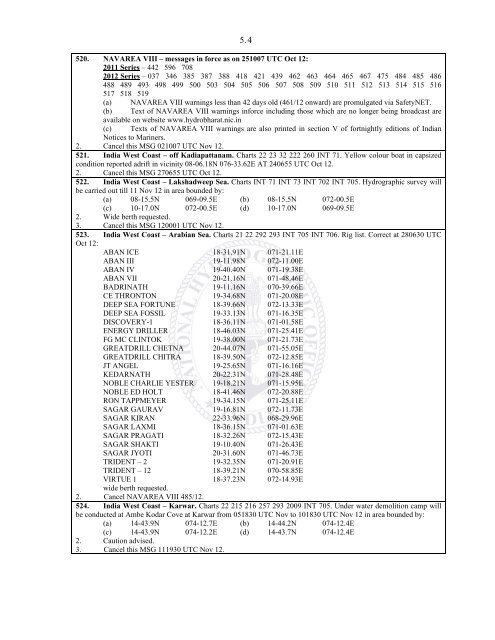
520. NAVAREA VIII – messages in force as on 251007 UTC Oct 12:<br />
2011 Series – 442 596 708<br />
2012 Series – 037 346 385 387 388 418 421 439 462 463 464 465 467 475 484 485 486<br />
488 489 493 498 499 500 503 504 505 506 507 508 509 510 511 512 513 514 515 516<br />
517 518 519<br />
(a) NAVAREA VIII warnings less than 42 days old (461/12 onward) are promulgated via SafetyNET.<br />
(b) Text of NAVAREA VIII warnings inforce including those which are no longer being broadcast are<br />
available on website www.hydrobharat.nic.in<br />
(c) Texts of NAVAREA VIII warnings are also printed in section V of fortnightly editions of <strong>Indian</strong><br />
Notices <strong>to</strong> Mariners.<br />
2. Cancel this MSG 021007 UTC Nov 12.<br />
521. India West Coast – off Kadiapattanam. Charts 22 23 32 222 260 INT 71. Yellow colour boat in capsized<br />
condition reported adrift in vicinity 08-06.18N 076-33.62E AT 240655 UTC Oct 12.<br />
2. Cancel this MSG 270655 UTC Oct 12.<br />
522. India West Coast – Lakshadweep Sea. Charts INT 71 INT 73 INT 702 INT 705. <strong>Hydrographic</strong> survey will<br />
be carried out till 11 Nov 12 in area bounded by:<br />
(a) 08-15.5N 069-09.5E (b) 08-15.5N 072-00.5E<br />
(c) 10-17.0N 072-00.5E (d) 10-17.0N 069-09.5E<br />
2. Wide berth requested.<br />
3. Cancel this MSG 120001 UTC Nov 12.<br />
523. India West Coast – Arabian Sea. Charts 21 22 292 293 INT 705 INT 706. Rig list. Correct at 280630 UTC<br />
Oct 12:<br />
ABAN ICE 18-31.91N 071-21.11E<br />
ABAN III 19-11.98N 072-11.00E<br />
ABAN IV 19-40.40N 071-19.38E<br />
ABAN VII 20-21.16N 071-48.46E<br />
BADRINATH 19-11.16N 070-39.66E<br />
CE THRONTON 19-34.68N 071-20.08E<br />
DEEP SEA FORTUNE 18-39.66N 072-13.33E<br />
DEEP SEA FOSSIL 19-33.13N 071-16.35E<br />
DISCOVERY-1 18-36.11N 071-01.58E<br />
ENERGY DRILLER 18-46.03N 071-25.41E<br />
FG MC CLINTOK 19-38.00N 071-21.73E<br />
GREATDRILL CHETNA 20-44.07N 071-55.05E<br />
GREATDRILL CHITRA 18-39.50N 072-12.85E<br />
JT ANGEL 19-25.65N 071-16.16E<br />
KEDARNATH 20-22.31N 071-28.48E<br />
NOBLE CHARLIE YESTER 19-18.21N 071-15.95E<br />
NOBLE ED HOLT 18-41.46N 072-20.88E<br />
RON TAPPMEYER 19-34.15N 071-25.11E<br />
SAGAR GAURAV 19-16.81N 072-11.73E<br />
SAGAR KIRAN 22-33.96N 068-29.96E<br />
SAGAR LAXMI 18-36.15N 071-01.63E<br />
SAGAR PRAGATI 18-32.26N 072-15.43E<br />
SAGAR SHAKTI 19-10.40N 071-26.43E<br />
SAGAR JYOTI 20-31.60N 071-46.73E<br />
TRIDENT – 2 19-32.35N 071-20.91E<br />
TRIDENT – 12 18-39.21N 070-58.85E<br />
VIRTUE 1 18-37.23N 072-14.93E<br />
wide berth requested.<br />
2. Cancel NAVAREA VIII 485/12.<br />
524. India West Coast – Karwar. Charts 22 215 216 257 293 2009 INT 705. Under water demolition camp will<br />
be conducted at Ambe Kodar Cove at Karwar from 051830 UTC Nov <strong>to</strong> 101830 UTC Nov 12 in area bounded by:<br />
(a) 14-43.9N 074-12.7E (b) 14-44.2N 074-12.4E<br />
(c) 14-43.9N 074-12.2E (d) 14-43.7N 074-12.4E<br />
2. Caution advised.<br />
3. Cancel this MSG 111930 UTC Nov 12.


