PDF version - the USGS
PDF version - the USGS
PDF version - the USGS
- No tags were found...

You also want an ePaper? Increase the reach of your titles
YUMPU automatically turns print PDFs into web optimized ePapers that Google loves.
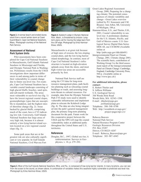
Figure 2. A narrow beach and eroded dunesresult from a recent winter storm at CoastGuard Beach, Cape Cod National Seashore,Mass. Photograph courtesy of <strong>the</strong> NationalPark Service.Assessment of NationalPark System UnitsPilot assessments have been completedfor Cape Cod National Seashorein Massachusetts, Gulf Islands NationalSeashore in Mississippi and Florida,and Olympic National Park in Washington.Preliminary results from <strong>the</strong> <strong>USGS</strong>investigations show important differencesin and among parks in terms of<strong>the</strong>ir vulnerability to coastal changedue to future sea-level rise. For example,Cape Cod National Seashore has avariable coastal landscape consisting ofhigh glacial bluffs, beaches, sand spits,and salt-marsh wetlands. The areasmost vulnerable to sea-level rise (fig. 1)have <strong>the</strong> lowest regional coastal slopes,geomorphologic types that are susceptibleto inundation, and <strong>the</strong> highest ratesof shoreline change (fig. 2). Areasbacked by glacial bluffs, comprisingmuch of <strong>the</strong> coast, have a CVI indicatinglow risk. Conversely, Gulf IslandsNational Seashore has large areas ofvery high risk, because it is almostentirely a low-lying barrier-island systemlocated on a low regional coastalslope (fig. 3).Some park areas that are at <strong>the</strong>greatest risk are also culturally significantor very popular. In Gulf IslandsNational Seashore, Civil War-era FortFigure 4. Kalaloch Lodge in Olympic NationalPark, Wash., is threatened by erosion. Longtermplans call for moving <strong>the</strong> lodge back from<strong>the</strong> cliff edge. Photograph by Erika Hammar-Klose, <strong>USGS</strong>.Massachusetts is at great risk becauseof high rates of erosion, <strong>the</strong> low-slopingcoastal plain, and <strong>the</strong> low-lying barrierisland morphology. In contrast, most ofCape Cod National Seashore’s infrastructureis located on high-elevationuplands away from <strong>the</strong> shore, and mosthigh-visitor-use areas are accessibleprimarily by foot.National Park Service staff areusing <strong>the</strong> CVI data for long-termresource management plans, park facilitiesplanning such as relocating coastalbuildings or roads, and assessing longtermthreats to cultural resources. Forexample, data from <strong>the</strong> Olympic NationalPark CVI study were used to identifyvulnerable infrastructure and implementplans to relocate <strong>the</strong> Kalaloch Lodge(fig. 4). The data are also being integratedinto <strong>the</strong> park’s general managementplan, <strong>the</strong> primary long-term planningdocument for <strong>the</strong> park. Future work forthis cooperative project between <strong>the</strong><strong>USGS</strong> and <strong>the</strong> NPS will map <strong>the</strong> coastalvulnerability index at additional parksthroughout <strong>the</strong> United States and U.S.territories.ReferencesDouglas, B.C., 1997, Global sea rise; Aredetermination: Surveys in Geophysics,v. 18, p. 279–292.Great Lakes Regional AssessmentGroup, 2000, Preparing for a changingclimate; The potential consequencesof climate variability andchange—Great Lakes overview(edited by P.J. Sousounis and J.M.Bisanz): Ann Arbor, MI, Universityof Michigan, 106 p.Hammar-Klose, E.S., and Thieler, E.R.,2001, Coastal vulnerability to sealevelrise: A preliminary databasefor <strong>the</strong> U.S. Atlantic, Pacific, andGulf of Mexico coasts: U.S. GeologicalSurvey Digital Data SeriesDDS–68, one CD-ROM (Availableonline athttp://pubs.usgs.gov/dds/dds68/)Intergovernmental Panel on ClimateChange, 2001, Climate change 2001;The scientific basis, contribution ofWorking Group I to <strong>the</strong> third assessmentreport of <strong>the</strong> IntergovernmentalPanel on Climate Change: Cambridge,England, Cambridge University Press,944 p. (Available online athttp://www.ipcc.ch/)For additional information, pleasecontact:E. Robert Thieler andS. Jeffress WilliamsU.S. Geological Survey384 Woods Hole RoadWoods Hole, MA 02543–1598E-mail: rthieler@usgs.govjwilliams@usgs.govTelephone: 508–548–8700Web: http://woodshole.er.usgs.gov/project-pages/nps-cvi/Rebecca BeaversNational Park ServiceNatural Resource Program CenterGeologic Resources DivisionP.O. Box 25287Denver, CO 80225–0287E-mail: Rebecca_Beavers@nps.govTelephone: 303–987–6945Figure 3. Most of <strong>the</strong> Gulf Islands National Seashore, Miss. and Fla., is composed of low-lying barrier islands. In many locations, you can seefrom <strong>the</strong> ocean to <strong>the</strong> sound, as shown above. A combination of variables makes this seashore highly vulnerable to predicted sea-level rise.Photograph by Erika Hammar-Klose, <strong>USGS</strong>.