

Humboldt Bay - U.S. Fish and Wildlife Service
Humboldt Bay - U.S. Fish and Wildlife Service
Humboldt Bay - U.S. Fish and Wildlife Service

Create successful ePaper yourself
Turn your PDF publications into a flip-book with our unique Google optimized e-Paper software.
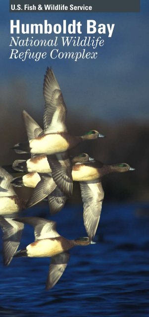
U.S. <strong>Fish</strong> & <strong>Wildlife</strong> <strong>Service</strong><br />
<strong>Humboldt</strong> <strong>Bay</strong><br />
National <strong>Wildlife</strong><br />
Refuge Complex
The north coast of<br />
California is one of<br />
the most beautiful<br />
<strong>and</strong> biologically rich<br />
places in the world.<br />
The coastal habitats<br />
conserved at <strong>Humboldt</strong><br />
<strong>Bay</strong> <strong>and</strong> Castle Rock<br />
National <strong>Wildlife</strong><br />
Refuges—from lush<br />
wetl<strong>and</strong>s to fragile<br />
dunes <strong>and</strong> jutting<br />
seastacks—support<br />
an incredible wealth<br />
of plants, fsh, <strong>and</strong><br />
wildlife. © Andrea Pickart
Welcome to <strong>Humboldt</strong> <strong>Bay</strong> NWR is located<br />
<strong>Humboldt</strong> <strong>Bay</strong> on an estuary, a place where fresh<br />
National <strong>Wildlife</strong> water from rivers <strong>and</strong> streams meets<br />
Refuge Complex ocean waters in a bay or slough. This<br />
dynamic situation creates some of the<br />
most productive ecosystems on earth.<br />
Castle Rock NWR is an amazing<br />
coastal isl<strong>and</strong> in Del Norte County<br />
that hosts over 100,000 nesting<br />
seabirds <strong>and</strong> hundreds of seals <strong>and</strong><br />
sea lions.<br />
These unique coastal refuges are<br />
two of over 540 sites in the National<br />
<strong>Wildlife</strong> Refuge System. This federal<br />
system, symbolized by the blue<br />
goose insignia, is the largest network<br />
of l<strong>and</strong>s in the world conserved<br />
specifcally for fsh <strong>and</strong> wildlife. As<br />
part of the Department of Interior,<br />
the U.S. <strong>Fish</strong> <strong>and</strong> <strong>Wildlife</strong> <strong>Service</strong><br />
manages the refuge system to<br />
sustain <strong>and</strong> preserve a dynamic<br />
living heritage, conserving wildlife<br />
<strong>and</strong> habitat for people today <strong>and</strong> for<br />
generations to come.<br />
“Whenever you meet this sign,<br />
respect it. It means that the<br />
l<strong>and</strong> behind the sign has been<br />
dedicated by the American<br />
people to preserving, for<br />
themselves <strong>and</strong> their children,<br />
as much of our native wildlife as can be<br />
retained along with modern civilization.”<br />
—Rachel Carson<br />
© Tupper Ansel Blake<br />
An International<br />
Flyway<br />
Yukon Delta NWR ✷<br />
✷ Izembek NWR<br />
Grays Harbor NWR<br />
✷<br />
Willapa NWR ✷<br />
<strong>Humboldt</strong><br />
<strong>Bay</strong> NWR ✷<br />
SF <strong>Bay</strong> NWR ✷<br />
San Diego NWR ✷<br />
Did You Know?<br />
More than 50%<br />
of all the brant<br />
in the Pacifc<br />
Flyway stop to<br />
refuel on eelgrass<br />
in <strong>Humboldt</strong><br />
<strong>Bay</strong> between<br />
November <strong>and</strong><br />
May!<br />
© Gary Kramer<br />
The Pacifc Flyway is an “aerial<br />
highway” used by birds that nest<br />
in the far north <strong>and</strong> migrate to<br />
wintering areas in North <strong>and</strong> South<br />
America. <strong>Humboldt</strong> <strong>Bay</strong> <strong>and</strong> many<br />
other refuges are some of the key<br />
“stepping stones” in the Pacifc<br />
Flyway.<br />
The majority of birds use this refuge<br />
as a stop-over where they rest <strong>and</strong><br />
replenish energy reserves. Others<br />
spend the winter here, <strong>and</strong> some use<br />
the refuge for nesting.<br />
The wetl<strong>and</strong>s around <strong>Humboldt</strong> <strong>Bay</strong><br />
are critical to tens of thous<strong>and</strong>s of<br />
shorebirds. This is the northernmost<br />
area on the Pacifc coast where<br />
species such as American avocets,<br />
long-billed curlews, marbled godwits,<br />
<strong>and</strong> willets spend the winter in large<br />
numbers. They can be seen feeding<br />
on the mudfats or acrobatically<br />
skimming over the bay from late July<br />
through April.<br />
<strong>Humboldt</strong> <strong>Bay</strong> is also a key area<br />
for Pacifc brant. These small geese<br />
require eelgrass-flled bays during<br />
their travels between Arctic wetl<strong>and</strong>s<br />
where they nest <strong>and</strong> coastal lagoons<br />
of Baja California <strong>and</strong> mainl<strong>and</strong><br />
Mexico where they overwinter. In<br />
November, most Pacifc brant fy nonstop<br />
from Izembek Lagoon in Alaska<br />
to Mexico in 48-60 hours! On their<br />
return trip from January through<br />
April, as many as 10,000-20,000 brant<br />
may be using <strong>Humboldt</strong> <strong>Bay</strong> at one<br />
time.
A Changing<br />
L<strong>and</strong>scape<br />
Did You Know?<br />
<strong>Humboldt</strong> <strong>Bay</strong><br />
historically<br />
sustained over<br />
9,000 acres of<br />
saltmarsh. Now<br />
only about 900<br />
acres remain.<br />
© Gary Todoroff<br />
European-American pioneers arrived<br />
in the late 1800s <strong>and</strong> rapidly began to<br />
alter the l<strong>and</strong>scape. Over the last 120<br />
years, the bay has been signifcantly<br />
changed by diking, flling, dredging,<br />
sedimentation from upstream logging,<br />
oyster culture, <strong>and</strong> development. Vast<br />
expanses of wetl<strong>and</strong>s were diked <strong>and</strong><br />
drained to create l<strong>and</strong>s for dairies,<br />
livestock, <strong>and</strong> farms.<br />
Once considered “useless swamps,”<br />
wetl<strong>and</strong>s are now recognized as<br />
extremely valuable <strong>and</strong> productive<br />
habitats. Wetl<strong>and</strong>s help control<br />
fooding <strong>and</strong> erosion, flter pollution,<br />
conserve biodiversity, <strong>and</strong> provide<br />
open space <strong>and</strong> resources for fsh,<br />
wildlife, <strong>and</strong> people.<br />
A Unique<br />
Diversity of<br />
Habitats<br />
Red-legged Frog<br />
© Jamie Bettaso<br />
<strong>Humboldt</strong> <strong>Bay</strong><br />
Owl’s Clover<br />
© Andrea Pickart<br />
<strong>Humboldt</strong> <strong>Bay</strong> NWR<br />
In 1971, the refuge was established<br />
to conserve precious habitat for the<br />
great diversity of birds, mammals,<br />
fsh, amphibians, invertebrates, <strong>and</strong><br />
plants that occur in the <strong>Humboldt</strong><br />
<strong>Bay</strong> area. The<br />
refuge has several<br />
different units<br />
totalling almost<br />
4,000 acres. These<br />
units consist<br />
of a mosaic<br />
of mudfats,<br />
estuarine eelgrass<br />
meadows,<br />
saltmarsh,<br />
brackish marsh,<br />
seasonally<br />
Great Blue Heron<br />
© Gary Kramer<br />
fooded freshwater wetl<strong>and</strong>s, riparian<br />
wetl<strong>and</strong>s, streams, coastal dunes, <strong>and</strong><br />
forest. These habitats support over<br />
316 species of birds <strong>and</strong> 40 species of<br />
mammals. The refuge also provides<br />
habitat for approximately 100 species<br />
of fsh <strong>and</strong> marine invertebrates,<br />
many of which contribute to sport<br />
or commercial fsheries, including<br />
steelhead, coho <strong>and</strong> chinook salmon,<br />
<strong>and</strong> Dungeness crab.
The Freshwater-<br />
Saltwater<br />
Continuum<br />
Riparian forest<br />
Freshwater<br />
marsh<br />
All photos on this page © Andrea Pickart<br />
When <strong>Humboldt</strong> <strong>Bay</strong> was diked in<br />
the early 20th century, the area of<br />
estuary was reduced by almost 40<br />
percent. Although there is no longer<br />
an uninterrupted gradient from<br />
rivers <strong>and</strong> creeks to the ocean water<br />
at the bay’s mouth, a complex mosaic<br />
of fresh, brackish, <strong>and</strong> saltwater<br />
wetl<strong>and</strong>s occurs in response to tidal<br />
infuence, freshwater inputs, <strong>and</strong> the<br />
residual salinity of old saltmarsh soils.<br />
As a result, there is a rich diversity of<br />
habitat types surrounding the bay.<br />
Riparian forest occurs along stream<br />
edges in freshwater areas. The canopy<br />
layer is dominated by red alder,<br />
willows, <strong>and</strong> Sitka spruce, with an<br />
understory of salmonberry, twinberry,<br />
California blackberry, <strong>and</strong> wax myrtle.<br />
Lady fern, wood fern, <strong>and</strong> sword<br />
fern create an attractive groundlayer<br />
in drier areas, with st<strong>and</strong>s of smallfruited<br />
bulrush joined by skunk<br />
cabbage in wetter areas. The rich<br />
structural diversity of these areas,<br />
combined with the many fruit-bearing<br />
shrubs, attract a rich bird fauna,<br />
especially migrating <strong>and</strong> nesting<br />
songbirds.<br />
Freshwater marsh was probably<br />
limited historically within the<br />
<strong>Humboldt</strong> <strong>Bay</strong> watershed. It<br />
has become quite abundant in<br />
areas, such as the refuge, that<br />
were converted in the past from<br />
saltmarsh to agricultural l<strong>and</strong> but<br />
are now managed as shallow seasonal<br />
wetl<strong>and</strong>s. Our present day freshwater<br />
wetl<strong>and</strong>s range from seasonally<br />
to permanently fooded marshes<br />
supporting a diversity of plants<br />
(cattails, rushes, <strong>and</strong> pondweeds)<br />
<strong>and</strong> invertebrates that sustain<br />
wildlife. Rails, otters, <strong>and</strong> frogs secret<br />
themselves among the dense marsh<br />
vegetation. Common waterfowl that<br />
use this seasonal habitat include<br />
green-winged teal, shoveler, wigeon,<br />
pintail, gadwall, <strong>and</strong> mallard.<br />
Agricultural<br />
wetl<strong>and</strong>s<br />
Brackish marsh<br />
Saltmarsh<br />
Mudfats<br />
Agricultural wetl<strong>and</strong>s are diked<br />
former saltmarshes that support<br />
pasture grasses such as ryegrass,<br />
velvet grass, <strong>and</strong> tall fescue, as well<br />
as the native wetl<strong>and</strong> species shortawned<br />
foxtail <strong>and</strong> Pacifc silverweed.<br />
These areas are hayed or grazed to<br />
maintain the shortgrass pastures<br />
attractive to Aleutian cackling geese.<br />
They are also used by shorebirds,<br />
herons, egrets, <strong>and</strong> black-tailed deer.<br />
Brackish marsh occurs where<br />
salt <strong>and</strong> fresh water mix or where<br />
salts in the soil remain high. These<br />
wetl<strong>and</strong>s support native saltgrass,<br />
tufted hairgrass, <strong>and</strong> two species of<br />
arrowgrass. The edges of former<br />
tidal channels, where water levels are<br />
more constant, are lined with seacoast<br />
bulrush. These sloughs are used by<br />
salmonids <strong>and</strong> tidewater gobies, all<br />
listed species.<br />
Saltmarsh was the most widespread<br />
wetl<strong>and</strong> type around <strong>Humboldt</strong><br />
<strong>Bay</strong>, but due to diking <strong>and</strong> draining<br />
in the early 1900s only 10 percent<br />
of our saltmarshes remain. Of the<br />
remaining 900 acres, most have been<br />
invaded by the aggressive densefowered<br />
cordgrass, introduced in the<br />
19th century in the ballast of ships.<br />
Cordgrass is currently being removed<br />
to restore a diverse community of<br />
plants including pickleweed, jaumea,<br />
saltgrass, <strong>and</strong> several rare species.<br />
Intertidal mudfat <strong>and</strong> eelgrass<br />
beds occupy vast areas of the bay.<br />
Seemingly barren mudfats teem with<br />
life just beneath the surface. Plankton<br />
<strong>and</strong> algae anchor food webs of<br />
invertebrates, mollusks, crustaceans,<br />
fsh, birds, <strong>and</strong> mammals, including<br />
humans. The intertidal fats of South<br />
<strong>Bay</strong> support approximately 2,000<br />
acres of eelgrass, which are critically<br />
important to Pacifc brant, other<br />
waterbirds, <strong>and</strong> the bay ecosystem.
<strong>Humboldt</strong> <strong>Bay</strong><br />
National <strong>Wildlife</strong> Refuge<br />
*<br />
To<br />
South<br />
Spit<br />
(ocean beach)<br />
HBNWR<br />
Table Bluff Unit<br />
PACIFIC<br />
OCEAN<br />
NWR L<strong>and</strong>s<br />
Designated Hunting Area<br />
Refuge Boundary<br />
Hiking Trail<br />
Non-motorized Boat Trail<br />
Non-motorized Boat Launch<br />
Visitor Center & Office<br />
Parking<br />
Hunt Check Station<br />
Interpretive Kiosk<br />
Hookton Rd.<br />
HBNWR<br />
Lanphere Dunes<br />
Unit<br />
Eel River<br />
101<br />
Teal<br />
Isl<strong>and</strong><br />
Hookton<br />
Slough Trail<br />
(3 miles roundtrip)<br />
255<br />
255<br />
ARCATA BAY<br />
EUREKA<br />
HBNWR<br />
FORTUNA<br />
Mad River<br />
101<br />
ARCATA<br />
SOUTH<br />
HUMBOLDT<br />
BAY<br />
Hookton<br />
Slough<br />
Long Pond<br />
Hookton<br />
Slough Unit<br />
Waterfowl<br />
Hunt Area<br />
Salmon Creek Unit<br />
N<br />
0 Miles 1<br />
0 Kilometers 1<br />
White<br />
Slough<br />
Unit<br />
Shorebird<br />
Loop Trail<br />
(1.75 mile loop)<br />
Hookton Rd.<br />
101<br />
Salmon Creek<br />
*<br />
Entry Gate<br />
Tompkins Hill Road<br />
Cattail<br />
Creek<br />
Refuge<br />
Entrance<br />
Road<br />
101<br />
College of<br />
the Redwoods<br />
Willow<br />
Brook<br />
Refuge<br />
Entrance<br />
Gate<br />
Exit 696
Traditional<br />
Wiyot basket<br />
©Wiyot Tribe<br />
© Andrea Pickart<br />
The Wiyot People<br />
The Wiyot Tribe has lived on the<br />
shores of <strong>Humboldt</strong> <strong>Bay</strong> (known<br />
to them as Wigi) <strong>and</strong> surrounding<br />
areas for thous<strong>and</strong>s of years. Their<br />
population is estimated to have been<br />
between 1,000 <strong>and</strong> 3,000 at the time<br />
of European-American settlement.<br />
The center of the Wiyot universe<br />
was Indian Isl<strong>and</strong>, the place of their<br />
creation, which continues to be<br />
the center of their culture. Wiyots<br />
subsisted on a variety of plant <strong>and</strong><br />
animal resources including mollusks,<br />
sea lions, str<strong>and</strong>ed whales, deer <strong>and</strong><br />
elk, <strong>and</strong> the rich berry harvest of the<br />
coastal forests. The anadromous<br />
fsh runs of the Mad <strong>and</strong> Eel<br />
Rivers were an important source<br />
of salmon that were smoked <strong>and</strong><br />
stored to last through winter.<br />
Village sites were primarily<br />
located on the bay, sloughs, <strong>and</strong><br />
rivers, but the tribe used the dunes<br />
extensively for implement-making<br />
sites, gathering, <strong>and</strong> surf-fshing.<br />
European-American contact at the<br />
time of the California Gold Rush<br />
changed the character of northwestern<br />
California forever, leading to the<br />
decimation <strong>and</strong> displacement of the<br />
Wiyot in only 15 years. From 1850<br />
to 1865, Wiyot territory became the<br />
center for the largest concentration<br />
of people in California north of San<br />
Francisco. Diseases <strong>and</strong> violence,<br />
culminating in the 1860 Indian Isl<strong>and</strong><br />
massacre, decimated the Wiyots, with<br />
the few survivors driven to distant<br />
reservations or marginal l<strong>and</strong>s in the<br />
<strong>Humboldt</strong> <strong>Bay</strong> region.<br />
Today, there are over 450 members<br />
of the Wiyot Tribe, approximately<br />
25 percent of whom live at the Table<br />
Bluff Reservation overlooking<br />
<strong>Humboldt</strong> <strong>Bay</strong>. They continue to work<br />
towards the perpetuation of their<br />
culture, <strong>and</strong> in 2004 had 40 acres of<br />
Indian Isl<strong>and</strong> restored to them by the<br />
City of Eureka.<br />
Because of the<br />
fragile nature<br />
of the dune<br />
habitats, the<br />
Lanphere Dunes<br />
Unit is only<br />
open by guided<br />
tour or special<br />
use permit. Call<br />
(707)444-1397 for<br />
information on<br />
programs <strong>and</strong><br />
tours.<br />
© Don Tuttle<br />
Dune Units<br />
of <strong>Humboldt</strong> <strong>Bay</strong> NWR<br />
<strong>Humboldt</strong> <strong>Bay</strong> NWR<br />
Ma-le’l Dunes<br />
Cooperative<br />
Management Area<br />
PACIFIC<br />
OCEAN<br />
BLM<br />
Manila<br />
Dunes<br />
Lanphere <strong>and</strong> Ma-le’l Dunes<br />
The Lanphere Dunes Unit is located<br />
at the upper end of the North Spit<br />
of <strong>Humboldt</strong> <strong>Bay</strong>, west of Mad River<br />
Slough. The most pristine remaining<br />
dune system in the Pacifc Northwest,<br />
the Lanphere Dunes were protected<br />
by two biology professors from<br />
<strong>Humboldt</strong> State University, William<br />
<strong>and</strong> Hortense Lanphere. They<br />
donated their l<strong>and</strong> to The Nature<br />
Conservancy, which added adjacent<br />
parcels <strong>and</strong>, in 1998, transferred 450<br />
acres to <strong>Humboldt</strong> <strong>Bay</strong> National<br />
<strong>Wildlife</strong> Refuge. In 2005, with funding<br />
from the State Coastal Conservancy<br />
<strong>and</strong> as the result of strong community<br />
support, 160 acres to the south were<br />
added to the refuge <strong>and</strong> the Ma-le’l<br />
Dunes Unit was<br />
created, using a<br />
place name of the<br />
ancestral Wiyot<br />
tribe. The Lanphere<br />
Dunes is the site<br />
of one of the most<br />
successful dune<br />
restoration projects<br />
on the west coast,<br />
accomplished<br />
through the ongoing<br />
removal of invasive, non-native<br />
vegetation. The new Ma-le’l Dunes is<br />
being similarly restored.<br />
Ma-le’l Access Road<br />
Lanphere<br />
Dunes<br />
Unit<br />
Access by<br />
permit or guided<br />
tours only<br />
Call 444-1397.<br />
Ma-le’l<br />
Dunes<br />
Unit<br />
<strong>Humboldt</strong> <strong>Bay</strong><br />
Entrance (Young Lane)<br />
Mad River Slough<br />
255<br />
The Ma-le’l Dunes<br />
Cooperative<br />
Management<br />
Area is open to<br />
the public 7 days a<br />
week during<br />
daylight hours.<br />
Use regulations<br />
differ by area; the<br />
Ma-le’l Dunes Unit<br />
of HBNWR is open<br />
to pedestrians<br />
only (no dogs or<br />
horses).<br />
(not to scale)<br />
ARCATA<br />
101
From Beach to<br />
Forest<br />
Native foredune<br />
grassl<strong>and</strong><br />
Dune mat<br />
Reindeer lichen<br />
<strong>and</strong> bearberry on<br />
the forest foor.<br />
All photos on this page<br />
© Andrea Pickart<br />
Native foredune grassl<strong>and</strong> is a<br />
community restricted to the foredune<br />
(the frst rise above the beach),<br />
<strong>and</strong> characterized by the native<br />
grass Leymus mollis, which is able<br />
to tolerate the intense salt spray<br />
<strong>and</strong> s<strong>and</strong> deposition that occurs in<br />
this habitat. The refuge supports<br />
one of the few remaining st<strong>and</strong>s of<br />
this community, which is globally<br />
endangered. It has been displaced<br />
by introduced European beachgrass,<br />
which outcompetes native plants,<br />
along the entire Pacifc Coast.<br />
Dune mat is a spectacular<br />
community of wildfowers that<br />
occurs on semi-stable dune ridges<br />
behind the foredune. Beginning<br />
in May with beach pea, successive<br />
waves of color paint the dunes as<br />
different wildfowers come into<br />
bloom, including beach buckwheat,<br />
seaside daisy, <strong>and</strong> dune goldenrod.<br />
This community is home to two<br />
endangered<br />
plants, <strong>Humboldt</strong><br />
<strong>Bay</strong> wallfower<br />
<strong>and</strong> beach layia.<br />
Native solitary bees<br />
create burrows in<br />
the s<strong>and</strong>, <strong>and</strong> are<br />
essential pollinators<br />
that maintain <strong>Humboldt</strong> <strong>Bay</strong><br />
this community. wallfower<br />
A variety<br />
of invertebrates, including<br />
many specially adapted for this<br />
environment,<br />
occur here.<br />
Mammals such as<br />
porcupines, gray<br />
fox, <strong>and</strong> striped<br />
skunk leave their<br />
calling cards<br />
in the form of<br />
footprints. Dune<br />
mat has become extremely rare in<br />
the Pacifc Northwest, <strong>and</strong> in many<br />
parts of California, due to the spread<br />
of European beachgrass, iceplant, <strong>and</strong><br />
other aggressive non-native species.<br />
Dune swales<br />
Moving dunes<br />
Coniferous dune<br />
forest<br />
Dune swales occur in the nearshore<br />
dunes in depressions between ridges.<br />
These seasonal freshwater wetl<strong>and</strong>s<br />
form in winter when loose s<strong>and</strong><br />
blows away <strong>and</strong> the water table rises,<br />
allowing plants to colonize. First<br />
algae, <strong>and</strong> then rushes <strong>and</strong> sedges<br />
occur with many associated herbs<br />
such as springbank clover, Pacifc<br />
silverweed, bird’s-foot trefoil, <strong>and</strong><br />
willow-herb. Soon, Hooker’s willow<br />
<strong>and</strong> beach pine follow, ultimately<br />
creating wooded swales that attract<br />
many birds <strong>and</strong> mammals. Swales<br />
provide the seasonal water needed for<br />
many amphibian species, including<br />
red-legged frogs <strong>and</strong> Pacifc tree<br />
frogs.<br />
Moving dunes are the most dramatic<br />
of the many l<strong>and</strong>forms found here.<br />
Large dunes migrate inl<strong>and</strong>, slowly<br />
covering the forest to the east. At the<br />
juncture of dune <strong>and</strong> forest, massive<br />
slipfaces slowly engulf trees that<br />
become bleached <strong>and</strong> skeletal as the<br />
dunes move forward. Few plants can<br />
gain a foothold here, but the constant<br />
traffc of mammals moving between<br />
forest <strong>and</strong> foraging areas on the<br />
dunes is recorded as an intricate maze<br />
of tracks.<br />
Coniferous dune forest occurs<br />
east of the moving dunes on older<br />
stabilized dunes. The dune forest is<br />
an incredibly lush <strong>and</strong> productive<br />
environment, with over 300 species<br />
of mushrooms, lichen, <strong>and</strong> mosses.<br />
The forest canopy is dominated by<br />
Sitka spruce <strong>and</strong> beach pine, with<br />
lesser gr<strong>and</strong> fr, Douglas-fr, <strong>and</strong><br />
madrone. The understory varies from<br />
dense st<strong>and</strong>s of huckleberry <strong>and</strong><br />
salal, to more open woodl<strong>and</strong>s with<br />
a groundcover of bearberry (ground<br />
manzanita), reindeer lichen, <strong>and</strong> the<br />
showy calypso orchid, rein orchid <strong>and</strong><br />
hooded ladies’ tresses. The largest<br />
mammals of the forest are gray fox,<br />
but there are many small mammals<br />
including the rare white-footed vole.
Visitor Center<br />
© HBNWR<br />
Hiking<br />
Restrooms are<br />
available at the<br />
Salmon Creek,<br />
Hookton Slough,<br />
<strong>and</strong> Ma-le’l<br />
Dunes Units.<br />
Hikes led by<br />
naturalists<br />
are offered<br />
throughout<br />
the year at the<br />
Salmon Creek<br />
<strong>and</strong> Lanphere<br />
Dunes Units. For<br />
information on<br />
these <strong>and</strong> other<br />
special events,<br />
please call<br />
(707) 733-5406.<br />
Emergencies—<br />
call 911.<br />
Please report<br />
any injuries<br />
or accidents<br />
to the refuge<br />
headquarters.<br />
Environmental<br />
Education<br />
Recreational Opportunities<br />
The Richard J. Guadagno<br />
Headquarters <strong>and</strong> Visitor Center<br />
is located at the Salmon Creek<br />
Unit <strong>and</strong> is open daily from 8 a.m.<br />
to 5 p.m. The Visitor Center has<br />
stunning dioramas <strong>and</strong> a beautiful<br />
observation room equipped with<br />
telescopes. There are exciting<br />
things to see <strong>and</strong> do all year<br />
with peak wildlife viewing from<br />
November through March.<br />
The Shorebird Loop Trail (1.7 miles<br />
roundtrip) is open during Visitor<br />
Center hours. This level gravel trail<br />
begins at the Visitor Center <strong>and</strong><br />
features an observation kiosk <strong>and</strong><br />
interpretive panels. The trail passes<br />
along seasonal freshwater wetl<strong>and</strong>s,<br />
eventually leading to a permanent<br />
brackish pond <strong>and</strong> the eastern edge<br />
of Hookton Slough. Look for swallows<br />
<strong>and</strong> sparrows, listen for the marsh<br />
wren or secretive sora rail, <strong>and</strong> keep<br />
an eye skyward for raptors like the<br />
peregrine falcon <strong>and</strong> bald eagle.<br />
To the southwest of the Visitor Center<br />
is the Hookton Slough Unit (see<br />
map). This unit is open daily from<br />
sunrise to sunset. The Hookton<br />
Slough Trail (1.5 miles one way)<br />
starts at the Hookton Slough Unit<br />
parking area <strong>and</strong> follows the west<br />
bank of Hookton Slough out <strong>and</strong> back.<br />
The trail is level, gravel-based, <strong>and</strong> has<br />
interpretive panels.<br />
For a completely different experience,<br />
there are several trails that explore<br />
the dune forest ecosystem <strong>and</strong> beach<br />
at the Ma-le’l Dunes Cooperative<br />
Management Area west of Arcata (see<br />
Dune Units map). This area also has a<br />
short, fully accessible trail that follows<br />
the edge of Mad River Slough. This<br />
area is open sunrise to sunset daily.<br />
The refuge offers opportunities <strong>and</strong><br />
guidance for outdoor class activities.<br />
Call (707) 733-5406 for information.<br />
<strong>Wildlife</strong><br />
Observation <strong>and</strong><br />
Photography<br />
Hunting<br />
<strong>Fish</strong>ing<br />
Boating<br />
For your<br />
personal safety,<br />
always wear<br />
proper fotation<br />
devices, carry<br />
required safety<br />
equipment, <strong>and</strong><br />
be aware of tides<br />
<strong>and</strong> weather<br />
conditions.<br />
© Shannon Smith<br />
The refuge is excellent for<br />
birdwatching, wildlife viewing, <strong>and</strong><br />
photography. The Salmon Creek Unit<br />
has an observation kiosk <strong>and</strong> a photo<br />
blind. The refuge offce has wildlife<br />
<strong>and</strong> plant lists <strong>and</strong> other information.<br />
Waterfowl hunting is permitted<br />
in designated areas of the refuge<br />
<strong>and</strong> governed by federal <strong>and</strong> state<br />
regulations. Waterfowl hunting on<br />
the Salmon Creek Unit takes place<br />
Tuesdays <strong>and</strong> Saturdays only, from<br />
mid-late October until late January.<br />
For current information, see the<br />
refuge hunting brochure or call<br />
(707) 733-5518. All frearms must be<br />
unloaded <strong>and</strong> cased.<br />
<strong>Fish</strong>ing is permitted in <strong>Humboldt</strong><br />
<strong>Bay</strong> <strong>and</strong> tidal sloughs year round. The<br />
Hookton Slough trail <strong>and</strong> boatdock<br />
are open to fshing; access to other<br />
areas is by boat.<br />
<strong>Humboldt</strong> <strong>Bay</strong> <strong>and</strong> tidal sloughs are<br />
open to boating. The refuge has two<br />
launch areas for non-motorized<br />
boats only. One is in South <strong>Bay</strong> at<br />
the Hookton Slough Unit, where a<br />
popular trip is to paddle around the<br />
remnant dikes of Teal Isl<strong>and</strong>. The<br />
other is in North <strong>Bay</strong> at the Ma-le’l<br />
Dunes Unit, adjacent to the Mad<br />
River Slough (see Dune Units map).<br />
Public boat launches for hunting,<br />
clamming, fshing, <strong>and</strong> exploring are<br />
available at Fields L<strong>and</strong>ing, Woodley<br />
Isl<strong>and</strong>, the Arcata Marsh, <strong>and</strong> Samoa<br />
County Park.
Who was<br />
Richard J.<br />
Guadagno?<br />
© USFWS<br />
Volunteers<br />
Welcome<br />
© Eric Nelson<br />
Friends of<br />
<strong>Humboldt</strong> <strong>Bay</strong><br />
NWR<br />
Partners<br />
Rich was a career employee of the<br />
<strong>Fish</strong> <strong>and</strong> <strong>Wildlife</strong> <strong>Service</strong> <strong>and</strong> had<br />
worked at several refuges across the<br />
nation before coming to <strong>Humboldt</strong><br />
<strong>Bay</strong> NWR. Rich was the Refuge<br />
Manager from March 2000 until<br />
September 11, 2001, when he was<br />
tragically killed on Flight 93 in<br />
Pennsylvania. The Visitor Center<br />
was named in his honor by Congress.<br />
There are three scholarships a year<br />
awarded in his name to local college<br />
students pursuing careers in the<br />
natural sciences.<br />
Volunteers are very important to the<br />
refuge’s success. Volunteers work<br />
alongside refuge staff <strong>and</strong> partners<br />
on virtually all refuge programs<br />
including<br />
interpretation<br />
<strong>and</strong><br />
environmental<br />
education,<br />
offce<br />
assistance,<br />
wildlife<br />
management<br />
activities <strong>and</strong><br />
a variety of<br />
maintenance<br />
duties. Please contact us in the offce<br />
or at (707) 733-5406 if you would like<br />
to volunteer or get more information.<br />
The Friends of <strong>Humboldt</strong> <strong>Bay</strong> NWR<br />
<strong>and</strong> Friends of the Dunes both assist<br />
the refuge in innumerable ways,<br />
from recruiting volunteers to leading<br />
walks <strong>and</strong> providing environmental<br />
education. Please call the refuge for<br />
further information.<br />
We also work with Audubon Society,<br />
<strong>Humboldt</strong> State University, The<br />
Nature Conservancy, CA Coastal<br />
Conservancy, CA Waterfowl<br />
Association, Ducks Unlimited,<br />
Pacifc Coast Joint Venture, Aleutian<br />
Goose Working Group, local schools,<br />
communities, ranchers, <strong>and</strong> others.<br />
When<br />
© Michael Peters<br />
Where<br />
How<br />
© Gary Kramer<br />
What to Bring<br />
<strong>Wildlife</strong> Viewing Tips<br />
Dawn <strong>and</strong> dusk are generally the best<br />
times to observe wildlife. However,<br />
tide levels also have great infuence<br />
on wildlife behavior <strong>and</strong> movements<br />
around estuaries. The best<br />
times around the South <strong>Bay</strong><br />
are generally within 1–2<br />
hours either side of high<br />
tide. Peak season for most species of<br />
waterbirds <strong>and</strong> raptors is November<br />
through April. Aleutian cackling<br />
geese, Pacifc brant <strong>and</strong> migratory<br />
shorebird populations peak from<br />
March to late April. Summer visitors<br />
can see many terns, cormorants, <strong>and</strong><br />
pelicans, as well as resident egrets,<br />
herons, <strong>and</strong> migratory songbirds such<br />
as warblers, sparrows, <strong>and</strong> swallows.<br />
Some mammals, like black-tailed<br />
deer, river otters, <strong>and</strong> gray fox, may<br />
be spotted all year.<br />
Most waterfowl, shorebirds, <strong>and</strong><br />
raptors can be found on the Hookton<br />
Slough <strong>and</strong> Salmon Creek Units.<br />
Each has a walking trail.<br />
Quick movements <strong>and</strong> noise scare<br />
away most wildlife. You will see more<br />
if you are quiet <strong>and</strong> listen. Look for<br />
tracks, nests, <strong>and</strong> other signs that<br />
can tell you interesting stories, then<br />
leave this evidence undisturbed for<br />
others. Please stay on trails to reduce<br />
disturbance to wildlife.<br />
Do not approach or disturb nesting<br />
birds, <strong>and</strong> leave all young animals<br />
alone. Even though you may think<br />
they are ab<strong>and</strong>oned, a parent is likely<br />
close by waiting for you to leave. Do<br />
NOT feed wildlife. It disrupts their<br />
digestive systems <strong>and</strong> compromises<br />
their natural instinct for survival.<br />
Binoculars <strong>and</strong> scopes, feld guides,<br />
insect repellent, water, <strong>and</strong> rain<br />
gear are recommended. Discovery<br />
Packs, containing feld guides <strong>and</strong><br />
binoculars, are available for loan at<br />
the Visitor Center.
Some Restrictions<br />
are Necessary<br />
Pets<br />
© Gary Kramer<br />
Help Protect the Refuge<br />
While you enjoy the refuge, please<br />
obey the following regulations which<br />
are designed to protect both wildlife<br />
<strong>and</strong> visitors.<br />
The following are prohibited:<br />
• dog walking<br />
• driving, biking, <strong>and</strong> jogging (except<br />
on paved entrance road)<br />
• fres <strong>and</strong> freworks<br />
• kite-fying (birds think they are<br />
aerial predators)<br />
• overnight parking<br />
• weapons (except frearms legal for<br />
refuge hunting)<br />
• horseback riding<br />
Please do not litter; carry out what<br />
you bring in!<br />
To ensure a quality experience for our<br />
visitors <strong>and</strong> to minimize disturbance<br />
to wildlife, collecting natural objects<br />
such as plants, animals, feathers,<br />
antlers, <strong>and</strong> objects of antiquity<br />
(including Native American artifacts)<br />
is strictly prohibited.<br />
To avoid conficts with wildlife <strong>and</strong><br />
visitors, pets are not permitted on<br />
the refuge.<br />
Why are hunting<br />
<strong>and</strong> fshing<br />
allowed on this<br />
National<br />
<strong>Wildlife</strong> Refuge,<br />
but not walking<br />
my dog, jogging,<br />
or biking?<br />
Why is there<br />
haying <strong>and</strong>/or<br />
grazing on the<br />
refuge?<br />
Aleutian<br />
cackling geese<br />
© Michael Peters<br />
Frequently Asked Questions<br />
The National <strong>Wildlife</strong> Refuge System<br />
was established in 1903 to “preserve<br />
a national network of l<strong>and</strong>s <strong>and</strong><br />
waters for the conservation <strong>and</strong><br />
management of fsh, wildlife, <strong>and</strong><br />
plant resources of the United States<br />
for the beneft of present <strong>and</strong> future<br />
generations.” This includes the<br />
following six priority public uses:<br />
wildlife observation, photography,<br />
interpretation, environmental<br />
education, hunting, <strong>and</strong> fshing. These<br />
pursuits are all wildlife dependent,<br />
while other activities such as jogging,<br />
biking <strong>and</strong> dog walking can be done at<br />
many other places.<br />
In the early 1900s most of the<br />
saltmarsh around the bay was diked<br />
off to create pasture. When kept short<br />
<strong>and</strong> nutritious, these grassl<strong>and</strong>s are<br />
used each winter <strong>and</strong> spring by many<br />
species of shorebirds, tundra swans,<br />
wigeon, <strong>and</strong> especially thous<strong>and</strong>s of<br />
Aleutian cackling geese. This once<br />
endangered population of geese has<br />
recovered from less than 800 in 1974<br />
to more than 100,000 in 2006. These<br />
geese are now having an increasing<br />
economic impact on local ranchers as<br />
signifcant numbers of geese graze<br />
on private l<strong>and</strong>s. To maintain optimal<br />
conditions for wildlife, management<br />
techniques include a combination of<br />
mowing, haying, <strong>and</strong> grazing.
© Stan Harris<br />
An Isl<strong>and</strong><br />
Paradise for<br />
<strong>Wildlife</strong><br />
From February<br />
to mid-April, the<br />
dawn fy-off of<br />
Aleutian cackling<br />
geese from Castle<br />
Rock is often<br />
spectacular. The<br />
geese roost on<br />
Castle Rock each<br />
night <strong>and</strong> feed<br />
on mainl<strong>and</strong><br />
pastures by day.<br />
Castle<br />
Rock<br />
NWR<br />
N<br />
Castle Rock NWR<br />
Eighty miles north of <strong>Humboldt</strong> <strong>Bay</strong>,<br />
Castle Rock National <strong>Wildlife</strong> Refuge<br />
lies about a half mile offshore from<br />
Crescent City, California. Castle<br />
Rock was purchased in 1979 from<br />
The Nature Conservancy to preserve<br />
habitat for magnifcent seabird<br />
colonies <strong>and</strong> marine mammals. Castle<br />
Rock NWR is only 14 acres in size,<br />
but is critical to the survival of several<br />
hundred thous<strong>and</strong> seabirds each year.<br />
It is also a key roost site for up to<br />
20,000 Aleutian cackling geese each<br />
winter <strong>and</strong> spring.<br />
Castle Rock rises 335 feet above sea<br />
level with a grassy slope, two large<br />
inlets, <strong>and</strong> cliffs that are important to<br />
nesting seabirds in the summer.<br />
Pt. St. George<br />
Pebble Beach Drive<br />
Washington Drive<br />
Interpretive<br />
Panels<br />
(best observation<br />
point)<br />
CRESCENT<br />
CITY<br />
The birds of<br />
Castle Rock<br />
NWR can best be<br />
seen in the early<br />
morning hours<br />
with a spotting<br />
scope. The refuge<br />
is closed to the<br />
public to prevent<br />
disturbance to<br />
the seabirds,<br />
their habitat,<br />
<strong>and</strong> marine<br />
mammals.<br />
Did You Know?<br />
Castle Rock<br />
NWR <strong>and</strong><br />
northcoast<br />
ranchers played<br />
a critical role in<br />
the recovery of<br />
Aleutian cackling<br />
geese, one of<br />
the signatory<br />
successes of the<br />
Endangered<br />
Species Act.<br />
Fully delisted<br />
in 2001, this<br />
population has<br />
grown from fewer<br />
than 800 birds<br />
in 1974 to more<br />
than 100,000 in<br />
2006.<br />
Harbor seals<br />
haul out on<br />
Castle Rock<br />
NWR.<br />
© Tupper Ansel Blake<br />
During April–<br />
May the clownlike<br />
tufted puffns<br />
may be seen.<br />
© Jesse Irwin<br />
The cliffs provide nesting habitat<br />
for one of the largest breeding<br />
populations (100,000) of common<br />
murres on the Pacifc coast. Ten other<br />
species of seabirds also nest here,<br />
including three species of cormorants,<br />
pigeon guillemots, Cassin’s <strong>and</strong><br />
rhinoceros auklets, Leach’s <strong>and</strong><br />
fork-tailed storm-petrels, <strong>and</strong> tufted<br />
puffns. Because many of these bird<br />
species nest in burrows <strong>and</strong> crevices<br />
<strong>and</strong> are primarily nocturnal, they<br />
avoid predation by western gulls that<br />
also nest on the isl<strong>and</strong>.<br />
Castle Rock NWR also serves as an<br />
important haul out (resting site) for<br />
marine mammals, including harbor<br />
seals, northern elephant seals (both<br />
bear pups there), <strong>and</strong> California <strong>and</strong><br />
Steller sea lions.
<strong>Humboldt</strong> <strong>Bay</strong><br />
National <strong>Wildlife</strong> Refuge Complex<br />
Refuge Manager<br />
<strong>Humboldt</strong> <strong>Bay</strong> NWR<br />
Castle Rock NWR<br />
P.O. Box 576, 1020 Ranch Road<br />
Loleta, CA 95551<br />
707/733-5406<br />
FAX 707/733-1946<br />
http://www.fws.gov/humboldtbay<br />
Visit the U.S. <strong>Fish</strong> & <strong>Wildlife</strong> <strong>Service</strong><br />
on the internet at<br />
http://www.fws.gov<br />
For Refuge information<br />
1 800/344 WILD<br />
July 2006<br />
© Gary Kramer


