


Create successful ePaper yourself
Turn your PDF publications into a flip-book with our unique Google optimized e-Paper software.
A model of Fernhurst Furnace<br />
©SDNPA/Bruce Middleton<br />
Belted-Galloway cattle<br />
©Mark Monk-Terry Sussex Wildlife Trust<br />
WINCHESTER<br />
<strong>HASLEMERE</strong><br />
PETERSFIELD<br />
GODALMING<br />
National Park Area<br />
Railway<br />
Station<br />
MIDHURST<br />
SOUTHAMPTON<br />
LEWES<br />
PORTSMOUTH<br />
BOGNOR<br />
REGIS<br />
BRIGHTON<br />
& HOVE<br />
FIND YOUR WAY<br />
Follow the arrows on waymarkers.<br />
Footpath<br />
Bridleway<br />
Restricted byway<br />
POINTS OF INTEREST<br />
Byway<br />
Open access land<br />
<br />
National Trail Acorn<br />
<strong>FERNHURST</strong><br />
FURNACE<br />
The remains of Fernhurst<br />
Furnace, also known as<br />
North Park Furnace, are<br />
some of the best preserved<br />
in the Sussex Weald. It is<br />
believed the site was in use<br />
between 1614 until 1777<br />
when the iron industry<br />
flourished here in the<br />
17th and 18th centuries<br />
using local ore, charcoal<br />
and water power.<br />
The untouched nature of<br />
the site and the rural<br />
surrounding make it hard<br />
to imagine the production<br />
of cast iron, tools and<br />
cannon once happened<br />
here. It was effectively the<br />
beginning of the Industrial<br />
Revolution and even<br />
though there are many<br />
‘hammer/furnace’ ponds<br />
throughout East and West<br />
Sussex, many people know<br />
little about the great<br />
historical and social<br />
importance of this<br />
bygone industry.<br />
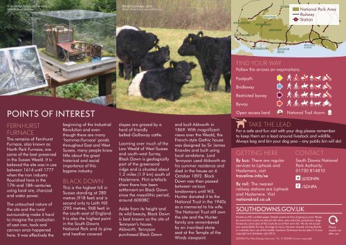
BLACK DOWN<br />
This is the highest hill in<br />
Sussex standing at 280<br />
metres (918 feet) and is<br />
second only to Leith Hill<br />
(295 metres, 968 feet) in<br />
the south-east of England.<br />
It is also the highest point<br />
in the South Downs<br />
National Park and its pine<br />
and heather covered<br />
slopes are grazed by a<br />
herd of friendly<br />
belted-Galloway cattle.<br />
Looming over much of the<br />
Low Weald of West Sussex<br />
and south-west Surrey,<br />
Black Down is geologically<br />
part of the greensand<br />
ridge and is situated about<br />
1.2 miles (1.9 km) south of<br />
Haslemere. Flint artefacts<br />
show there has been<br />
settlement on Black Down<br />
since the mesolithic period,<br />
around 6000BC<br />
Aside from its height and<br />
its wild beauty, Black Down<br />
is best known as the site of<br />
Tennyson’s house,<br />
Aldworth. Tennyson<br />
purchased Black Down<br />
and built Aldworth in<br />
1869. With magnificent<br />
views over the Weald, the<br />
French-style Gothic house<br />
was designed by Sir James<br />
Knowles and built using<br />
local sandstone. Lord<br />
Tennyson used Aldworth as<br />
his summer residence and<br />
died in the house on 6<br />
October 1892. Black<br />
Down was then passed<br />
between various<br />
landowners until W.E.<br />
Hunter donated it to the<br />
National Trust in the 1940s<br />
as a memorial to his wife.<br />
The National Trust still own<br />
the site and the Hunter<br />
family are remembered<br />
by an inscribed stone<br />
seat at the Temple of the<br />
Winds viewpoint.<br />
TAKE THE LEAD<br />
For a safe and fun visit with your dog please remember<br />
to keep them on a lead around livestock and wildlife.<br />
Always bag and bin your dog poo – any public bin will do!<br />
GETTING HERE<br />
By bus: There are regular<br />
services to Liphook and<br />
Haslemere, visit<br />
traveline.info/se<br />
By rail: The nearest<br />
railway stations are Liphook<br />
and Haslemere. Visit<br />
nationalrail.co.uk<br />
SOUTHDOWNS.GOV.UK<br />
CONTACT<br />
© SDNPA/Sam Moore<br />
South Downs National<br />
Park Authority:<br />
01730 814810<br />
@SDNPA<br />
/SDNPA<br />
Printed on FSC certified paper. Details correct at time of going to print. Please<br />
be aware that routes are shared with other users (vehicles, pedestrians, dogs,<br />
horses etc.) and users of this route do so at their own risk. We do not accept<br />
any responsibility for loss, damage or injury, however caused, arising directly<br />
or indirectly from use of this leaflet. Contains Ordnance Survey data © Crown<br />
copyright and database right 2013.<br />
SDNPA/The Way Design/January ‘16. © SDNPA Crown copyright<br />
Please<br />
recycle me<br />
after use