Challenges in using Remote Sensing Technology for Disaster Management

You also want an ePaper? Increase the reach of your titles
YUMPU automatically turns print PDFs into web optimized ePapers that Google loves.
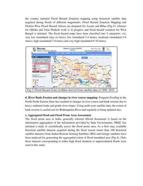
the country <strong>in</strong>itiated Flood Hazard Zonation mapp<strong>in</strong>g us<strong>in</strong>g historical satellite data<br />
acquired dur<strong>in</strong>g floods of different magnitudes. Flood Hazard Zonation Mapp<strong>in</strong>g and<br />
District-Wise Flood Hazard Atlases are prepared <strong>for</strong> Assam and Bihar (Fig-3); whereas<br />
<strong>for</strong> Odisha and Uttar Pradesh work is <strong>in</strong> progress and flood hazard zonation <strong>for</strong> West<br />
Bengal is <strong>in</strong>itiated. The flood hazard maps have been classified <strong>in</strong>to 5 categories, viz.<br />
very low (<strong>in</strong>undated once or twice), low (<strong>in</strong>undated 3-4 times), moderate (<strong>in</strong>undated 5-6<br />
times), high (<strong>in</strong>undated 7-8 times) and very high (<strong>in</strong>undated 9-10 times).<br />
Fig-3: Flood Hazard Zones <strong>in</strong> Bihar derived from satellite data of 1998- 2010<br />
d. River Bank Erosion and changes <strong>in</strong> river course mapp<strong>in</strong>g: Frequent flood<strong>in</strong>g <strong>in</strong> the<br />
North-North Eastern State has resulted <strong>in</strong> changes <strong>in</strong> river course and bank erosion due to<br />
heavy sediment loads and gentle river slopes. Us<strong>in</strong>g multi-year satellite data, the extent of<br />
bank erosion is carried out <strong>for</strong> Brahmaputra River and regularly is be<strong>in</strong>g updated also.<br />
e. Aggregated Flood and Flood Prone Area Assessment<br />
The flood prone area <strong>in</strong> India, generally referred official documents is based on the<br />
<strong>in</strong><strong>for</strong>mation aggregation of the <strong>in</strong><strong>for</strong>mation provided by State Governments. NRSC has<br />
<strong>in</strong>itiated a study to scientifically assess the flood prone area. As a first step, available<br />
historical satellite datasets acquired dur<strong>in</strong>g the flood season (more than 100 historical<br />
satellite datasets) from Indian <strong>Remote</strong> Sens<strong>in</strong>g Satellites (IRS) and <strong>for</strong>eign satellites have<br />
been analyzed <strong>for</strong> generat<strong>in</strong>g the aggregated extent of flood <strong>in</strong>undated area (Fig-4). Only<br />
those datasets correspond<strong>in</strong>g to either high flood situation or unprecedented floods were<br />
used <strong>in</strong> this study.