Plains Indian Studies - Smithsonian Institution Libraries
Plains Indian Studies - Smithsonian Institution Libraries
Plains Indian Studies - Smithsonian Institution Libraries

Create successful ePaper yourself
Turn your PDF publications into a flip-book with our unique Google optimized e-Paper software.
178 SMITHSONIAN CONTRIBUTIONS TO ANTHROPOLOGY<br />
ever, appears to be low in light of the extensive<br />
amateur and professional work conducted in<br />
western Iowa to date.<br />
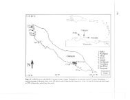
Currently, no earth lodge sites are known north<br />
of the Kullbom Village (13 MLIO) (Figure 29).<br />
In an intensive survey of the Waubonsie watershed,<br />
located approximately 9 miles (14.5 km)<br />
south of Glenwood and in a similar environmental<br />
setting, only one cluster of three earth lodges<br />
was found (Hotopp, Rhodes, and Semken, 1975).<br />
The failure to locate more lodges in an ecologically<br />
similar environment strongly supports Anderson's<br />
(1961) restricted spatial definition of the<br />
Glenwood locality.<br />
One explanation for the restricted distribution<br />
of lodges on the Iowa side of the Missouri River<br />
may lie in the limited timber resources available<br />
further upstream. Pierre Tabeau's narrative of<br />
Loisel's 1803-1805 expedition describes a change<br />
in the vegetation north of the Platte River (Abel,<br />
1939:66): "The two banks of the Missouri are<br />
well wooded as far as the approaches to the River<br />
Platte .... Then vast and high prairies, separated<br />
from the river by low and humid plains, present<br />
to the eye a monotonous expanse." In a later<br />
passage, Tabeau reiterates the point (Abel,<br />
1939:69) that "the Missouri, at least from the<br />
River Platte almost up to the Ricaras [probably<br />
near the Grand River in South Dakota], cannot<br />
be suitable for a large settlement and that the<br />
lack of wood alone would be more and more an<br />
insuperable obstacle." Tabeau's comments about<br />
the <strong>Indian</strong>'s dependence on wood is particularly<br />
applicable to sedentary and semi-sedentary societies.<br />
In a paper by Griffin (1976:35), timber was<br />
identified as the most critical resource and the<br />
one most exploited by a population:<br />
Timber was necessary for building and maintaining earthlodges,<br />
for other structures external to these dwellings, and<br />
was necessary for cooking, heating, and such manufacturing<br />
techniques as firing pottery.<br />
The large quantity of timber required in lodge<br />
construction was demonstrated by Scullin, who<br />
reconstructed a Hidatsa lodge as a bicentennial<br />
project following plans drawn by Wilson (1934).<br />
Scullin's project involved the construction of a<br />
full-scale replica of one lodge, the entryway of a<br />
second, and roughly 100 feet (30.5 m) of palisade.<br />
When completed, approximately 1000 logs were<br />
used, ranging from 8 to 14 feet (2.4 to 4.3 m) in<br />
length and 4 to 14 inches (10 to 36 cm) in<br />
diameter (Scullin, in litt., 1977).<br />
Timber availability and distribution should<br />
closely correlate with the observed settlement pattern<br />
in a locality. The majority of the lodges in<br />
the Glenwood area are located adjacent to Pony<br />
Creek. A second concentration of lodges is located<br />
in the vicinity of Horse Creek, a tributary to Keg<br />
Creek. Both the Pony and Horse Creek watersheds<br />
consist of small, highly dissected valleys.<br />
The locations of numerous lodges in these watersheds<br />
indicates that they were well timbered<br />
at the time of occupation. Orr's (1963, 10:4)<br />
comments are pertinent.<br />
According to the evidence of the oldest settlers now living,<br />
all the rough areas of the Missouri, with the exception of the<br />
sharp crests of the divides near, and steep bluff sides facing,<br />
the river, was well, sometimes heavily, timbered. East of the<br />
river the rough country merged rapidly into rolling upland,<br />
mostly prairie ....<br />
One WPA project in the 1930s was the compilation<br />
of the original land survey notes, dating<br />
from the establishment of township and section<br />
lines throughout the Iowa territory, and reconstruction<br />
of the forest cover in Iowa as described<br />
in these notes. The resulting forest cover map for<br />
Mills County (Figure 30) clearly illustrates a belt<br />
of timber transecting Pony and Keg Creek watersheds.<br />
This timbered area closely agrees with<br />
the known distribution of lodges (Figure 29). At<br />
the time of the Central <strong>Plains</strong> occupation, approximately<br />
A.D. 1050-1250, the forest cover probably<br />
was slightly denser, especially along the ridge<br />
tops on both sides of Pony Creek northward to<br />
the forks of the creek. This interpretation is based<br />
upon the number of lodges bordering the stream,<br />
both on the footslope-terrace contact and on the<br />
adjacent ridge spurs. The only lodge-remains<br />
north of the fork of Pony Creek are situated along<br />
the tributary nearest the Missouri River valley.<br />
The bluffline adjacent to the Missouri floodplain