Plains Indian Studies - Smithsonian Institution Libraries
Plains Indian Studies - Smithsonian Institution Libraries
Plains Indian Studies - Smithsonian Institution Libraries

Create successful ePaper yourself
Turn your PDF publications into a flip-book with our unique Google optimized e-Paper software.
NUMBER 30 179<br />
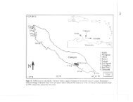
FIGURE 30.—Forest cover in the Glenwood locality (black<br />
areas represent forest identified during 1850s land surveys;<br />
dotted line represents the approximate bluff line; dashed<br />
line defines Mills County, Iowa; source: WPA, c. 1930).<br />
was probably largely prairie, as observed by Orr<br />
(1963) and Tabeau (Abel, 1939), with pockets of<br />
timber marking the hollows eastward into the<br />
bluffs. Based on the WPA forest cover map, the<br />
wide, gentle terraces of the Keg Creek watershed<br />
upstream from Glenwood were probably prairie<br />
covered. Because of the lack of timber and the<br />
open, unprotected character, the gentle slopes<br />
were apparently avoided as lodge sites.<br />
In his discussion of the Upper Republican villages,<br />
based on extensive excavations at Medicine<br />
Creek, Wedel (1959:558) notes a similar situation.<br />
There appears to be a marked preference for residence on<br />
small streams, perhaps because suitable building timber may<br />
have been more abundant here than on the main rivers, as<br />
seems to have been the case in the 19th century.<br />
Central <strong>Plains</strong> Settlement Patterns<br />
<strong>Studies</strong> of the Nebraska phase settlement patterns<br />
and lodge variability have been seriously<br />
compromised by two continuing problems: incomplete<br />
excavations of sites and a serious backlog<br />
of unreported fieldwork. In regard to the first<br />
problem, the majority of the published comparative<br />
studies primarily represent minimal excavations<br />
from widely scattered sites. Sampling of<br />
one or two lodges from a site is a common survey<br />
method and may not be representative of the<br />
range of variability that may be present in a<br />
particular locality. The necessarily incomplete<br />
nature of partial site excavations may result in<br />
distortions of the settlement pattern.<br />
For example, in a review of settlement patterns<br />
in the Central <strong>Plains</strong>, Gradwohl (1969:135) suggested<br />
that sampling localities has resulted in a<br />
built-in bias toward a dispersed community pattern.<br />
He argued that conceptualizing site units by<br />
individual house depressions, and excavating only<br />
these features without testing the areas lacking<br />
surface indications, has resulted in an apparent<br />
settlement pattern of either isolated lodges, linear<br />
strings, or small clusters of two to four lodges.<br />
Gradwohl stated that more nucleated villages are<br />
found in the Central <strong>Plains</strong> tradition, based upon<br />
excavations conducted at the Theodore Davis site<br />
in the Weeping Water locality of Nebraska. At<br />
this site, six lodge depressions were observed on<br />
the surface. Four were excavated, yielding typical<br />
square earth lodges. Rather than excavate the<br />
remaining two lodge depressions, a series of tests<br />
were conducted in the areas between the lodge<br />
depressions, resulting in the location of two additional<br />
lodges with no surface indication. Gradwohl<br />
assumed that these "buried" lodges were<br />
contemporaneous with the six lodges noted from<br />
the surface depressions and that the site actually<br />
was a small nucleated village. However, the floor<br />
area of the lodges found in the depressions (420<br />
to 1156 square feet or 39 to 107 m^) was two to<br />
five times the floor area of the buried lodges (196<br />
to 213 square feet or 18 to 20 m^). The six lodge<br />
depressions could alternately be interpreted as<br />
representing the terminal occupation of the site,<br />
and the buried lodges might date from an earlier<br />
occupation. Regardless of the correctness of either<br />
interpretation, the presence of additional lodges<br />
with no surface indication clearly illustrates the<br />
magnitude of the problem for settlement pattern<br />
studies.<br />
Closely related to this problem is the continued<br />
obliteration of surface indications of lodges. None<br />
of the lodges located by Brown (1967) in the Pony<br />
Creek watershed were visible on the surface.<br />
Many lodges located at the footslope bottomland<br />
contact were found only because erosion associ-