Plains Indian Studies - Smithsonian Institution Libraries
Plains Indian Studies - Smithsonian Institution Libraries
Plains Indian Studies - Smithsonian Institution Libraries

Create successful ePaper yourself
Turn your PDF publications into a flip-book with our unique Google optimized e-Paper software.
NUMBER 30 181<br />
a long line along the ridge. Even when they are located on<br />
the broad flat second bottom of the Missouri, the long line<br />
is retained.<br />
The theme of lodge placement and topography<br />
was reiterated by Cooper and Bell (1936:20-21)<br />
in their description of the Weisman site.<br />
Of the thirty-one house depressions located, all but two<br />
are scattered along a single ridge for a distance of approximately<br />
1,700 feet [518 m], in three fairly distinct groups ....<br />
While there seems to be some tendency toward a linear<br />
arrangment of the houses, this is probably largely dictated<br />
by the characteristics of the terrain upon which they are<br />
constructed.<br />
This brief summary of comments by archeologists<br />
investigating various localities of the Central<br />
<strong>Plains</strong> tradition suggests that the topography of<br />
the general area selected for settlement strongly<br />
influenced the placement of the lodges. With<br />
these observations from other localities of the<br />
Central <strong>Plains</strong> as a baseline for comparison, a<br />
brief review of the observations of the investigators<br />
in the Glenwood locality follows.<br />
Settlement Variations in Glenwood<br />
The surveys of both Proudfit (1881b) and Orr<br />
(1963) located the majority of the lodge depressions<br />
along the ridge tops overlooking the Pony<br />
Creek valley. Only two lodges were located north<br />
of Glenwood on Keg Creek by Proudfit (1881b)<br />
and Dean (1883), and the lodges located east of<br />
Keg Creek were confined mainly to the Horse<br />
Creek area. Based on his surveys and excavations,<br />
Proudfit (1881b:273) concluded: "A single lodge<br />
is the exception—a group the rule." Substantial<br />
development of the Mills County road system,<br />
residential and commercial construction, and<br />
continued farming had undoubtedly obliterated<br />
many of the house depressions in the 58-year<br />
interval between Proudfit's and Orr's surveys. As<br />
early as 1880, Dean (1883) noted that the depressions<br />
marking the Allis Village were becoming<br />
difficult to see because of filling associated with<br />
farming. To partially offset this problem, Orr<br />
searched out older residents of the area who<br />
provided locational information for a number of<br />
lodges that were no longer visible on the surface.<br />
After his 1938 field season, Orr (1963, 10:5) challenged<br />
the settlement pattern reported by Proudfit.<br />
Our survey finds the opposite of this is true. Forty-seven of<br />
the sixty-eight located by us, separated by distances of over<br />
half a mile, must certainly be considered singles.<br />
Doubtless a number of sites have quite certainly been<br />
obliterated by cultivation or have left no traces of their<br />
location, but just as certainly by no means enough to make<br />
every single location by us one of a group the others of which<br />
have disappeared.<br />
The pattern of lodge distribution was summarized<br />
by Orr (1963, 10:4).<br />
The earth lodge[s] . . . are found chiefly on the higher and<br />
wider parts of the crests of the divides, at the general upland<br />
level, and with two exceptions [probably the Allis village<br />
and house site 36], somewhat back—one-fourth mile—from<br />
the edge of the bluff line facing the river bottoms.<br />
Of the sixty-eight sites . . . fifty-five are so situated, seven<br />
are on small level benches or terraces on sloping points of<br />
spurs of the upland, and the remaining six at or about where<br />
the slope of the bluff and the bottom land meets.<br />
At no place are they in close enough proximity or in<br />
numbers sufficient, to be considered a village.<br />
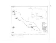
An opportunity to test for lodges and associated<br />
external features in a transect through both the<br />
Pony and Keg Creek watersheds was provided by<br />
the extensive right-of-way requirements for the<br />
Highway 34 relocation project. All 17 lodges<br />
excavated within the right-of-way were located<br />
with power equipment. Extensive testing between<br />
the lodges and monitoring during contruction<br />
failed to locate additional "buried" lodges, and<br />
only one external cache was found in association<br />
with a lodge (Hotopp, 1978a: 76-83). Based on<br />
the work conducted in the Glenwood locality by<br />
Anderson (1961), Brown (1967), and Hotopp<br />
(1978a), the settlement patterns identified by<br />
both Proudfit (1881b) (consisting of groups of<br />
lodges) and Orr (1963) (identified by isolated<br />
lodges) have been supported. By far, the most<br />
common settlement patterns is that of houses<br />
located in a linear arrangement along a ridge<br />
spur or at the footslope contact, a pattern indistinguishable<br />
from that reported by Cooper and<br />
Bell (1936), Sterns (1915), and Wedel (1961).