


Create successful ePaper yourself
Turn your PDF publications into a flip-book with our unique Google optimized e-Paper software.
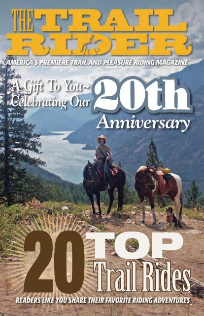
A Gift To You~<br />
Celebrating Our<br />
20th<br />
<strong>Anniversary</strong><br />
20TOP<br />
Trail Rides<br />
www.<strong>MyHorse</strong>.com/trailrider<br />
ReadeRs like you shaRe theiR favoRite Riding adventuRes
15<br />
Pacific Region<br />
19<br />
20 Top Trail Rides<br />
1 Grand Canyon National Park, Arizona .................................................................page 3<br />
2 Bar W Guest Ranch, Whitefish, Montana ............................................................page 4<br />
3 Salt Grass Trail Ride, Houston, Texas ..................................................................page 5<br />
4 Monongahela National Forest, West Virginia .......................................................page 6<br />
5 Merritt British Columbia, Canada .......................................................................page 7<br />
6 AHA Jack Monroe Horseback Beach Ride, Myrtle Beach, South Carolina ..............page 8<br />
7 Coldwater Recreation Area, Florida ....................................................................page 9<br />
8 Nebraska/South Dakota ..................................................................................page 10<br />
9 Cloud Peak Wilderness, Wyoming ....................................................................page 12<br />
10 Outlaw Trail Ride, Thermopolis, Wyoming .........................................................page 14<br />
11 Gunpowder Falls State Park, Maryland .............................................................page 15<br />
12 Canyon de Chelly National Monument, Arizona .................................................page 16<br />
13 Elk Country, Pennsylvania ................................................................................page 18<br />
14 Copper Canyon, Chihuahua, Mexico .................................................................page 20<br />
15 Ironwood Ranch, Hawaii ..................................................................................page 22<br />
16 Black Hills National Forest, South Dakota/Big Horn National Forest, Wyoming .....page 23<br />
17 Horse Heaven Ranch, Oklahoma ......................................................................page 24<br />
18 Shawnee National Forest, Illinois ......................................................................page 25<br />
19 V6 Ride, Parkfield, California ...........................................................................page 26<br />
20 Stehekin, Washington .....................................................................................page 28<br />
Resource Guide .................................................................................page 30<br />
5<br />
20<br />
1<br />
2<br />
Rocky Mountain<br />
Region<br />
12<br />
9 10<br />
Canada<br />
Southwest Region<br />
14<br />
Mexico<br />
16<br />
8<br />
Midwest Region<br />
17<br />
The Trail Rider Magazine 20 Top Trail Rides<br />
3<br />
18<br />
South/Southeast<br />
Region<br />
7<br />
Mid-Atlantic/<br />
Northeast<br />
Region<br />
13<br />
11<br />
On the cover: Michelle Schmidtke, DVM, on the Rainbow Loop Trail at the Lake Chelan Overlook in Washington’s Lake Chelan<br />
National Recreation Area. See “Stehekin, Washington,” on page 28. Cover photo by George Schoenfeld.<br />
4<br />
6
Grand Canyon National Park,<br />
Arizona<br />
For years, I wanted to<br />
take the overnight mule<br />
excursion into one of the<br />
world’s most awesome<br />
physical features, the Grand<br />
Canyon.<br />
The day before the ride,<br />
we reported to Bright Angel<br />
Lodge on the canyon’s<br />
South Rim to receive gear<br />
and be weighed. (People<br />
weighing more than 200<br />
pounds are prohibited to<br />
spare the mules from being<br />
overtaxed.) We were<br />
given small plastic bags for<br />
personal items, yellow rain<br />
slickers with the words<br />
“mule rider” emblazoned<br />
on the backs, and canteens. We were directed<br />
to report to the mule corral adjacent to the<br />
lodge no later than 6:30 the next morning.<br />
At the corral, a group of anxious people began<br />
congregating and offering moral support<br />
and suggestions about how to successfully<br />
complete the trip. The consensus was that it<br />
would be advisable not to look down.<br />
The livery manager soon delivered a serious<br />
talk about how strenuous the trip would<br />
be and how there would be seven hours of<br />
hard work ahead. “The mules need to be encouraged<br />
at every step, because they’re not<br />
overly eager to trek the 10 miles down,” he<br />
told us. “After all, they’d been there before.”<br />
The livery manager added that if folks wanted<br />
to change their minds about going down,<br />
their money would be refunded. There were no<br />
dropouts this morning, as all 16 people were<br />
eager to begin. The riders were divided into<br />
two groups of eight riders each, and a wrangler<br />
was assigned to lead each group. Both groups<br />
story and photo By ann nEVILLE<br />
www.<strong>MyHorse</strong>.com/trailrider<br />
consisted of six women and<br />
two men.<br />
As we began our descent<br />
of the Bright Angel Trail,<br />
we cast out our decision<br />
not to look down. We were<br />
enthralled with the magnificent<br />
views with color hues<br />
ranging from purple to pink.<br />
Some folks were clutching<br />
their saddle horns with<br />
white-knuckled grips. I casually<br />
remarked that if mules<br />
went over the side, it would<br />
be of no benefit to hang onto<br />
the horn. My remark wasn’t<br />
well-received!<br />
But, as our wrangler<br />
pointed out, “The mules<br />
don’t want to fall over the edge, either, and<br />
there has never been a fatality on the mule<br />
trips.” This is extraordinary since they’ve been<br />
in operation for more than 100 years.<br />
Near the canyon bottom, we entered a tunnel,<br />
then crossed a suspension bridge over the Colorado<br />
River. The temperature rose to 100 degrees.<br />
The trail followed the river’s sandy bank before<br />
turning up a side canyon to Phantom Ranch, a<br />
rustic oasis settled deep in the canyon.<br />
The next morning, the huge dining-hall<br />
bell was sounded at 6:30 to summon us to a<br />
hearty breakfast. By 7:30, we were at the corral<br />
to mount up. The trail that day was the South<br />
Kaibab; at seven miles long, it was shorter<br />
than the Bright Angel, but steeper. We completed<br />
the climb out by 12:30 p.m.<br />
In the winter, there’s a mule trip that includes<br />
a two-night stay at Phantom Ranch on<br />
the canyon floor. We echo the thousands who<br />
claim the Grand Canyon mule trip is “the experience<br />
of a lifetime.” TTR
At Bar W Guest Ranch, you can have a true<br />
Montana wilderness experience, yet be close<br />
enough to the resort town of Whitefish to take<br />
advantage of great shopping, fine dining, theater,<br />
and nightlife. Or, you can just sit back at<br />
the ranch and let the Montana experience surround<br />
you. As you explore the ranch, you may<br />
see deer, moose, geese, bears, eagles, coyotes,<br />
and other abundant wildlife.<br />
Located on Spencer Lake, the Bar W offers<br />
riding lessons for all levels of experience. Trail<br />
riders can enjoy the entire million or so acres<br />
where the Bar W holds permits.<br />
The ranch has a stable of trained horses.<br />
The full-week vacation on horseback begins<br />
with the proper matching of each guest to one<br />
of the Bar W’s well-trained ranch horses, followed<br />
by a morning horsemanship clinic.<br />
Riding in the mountains involves paying<br />
Bar W Guest Ranch,<br />
Whitefish, Montana<br />
By tImothy r. KEEfE<br />
The Trail Rider Magazine 20 Top Trail Rides<br />
attention to going up and down in elevation<br />
while keeping an eye open for wildlife and<br />
the next spectacular view of the Rockies just<br />
ahead. Riding the foothills is generally a more<br />
aggressive, faster ride, moving through more<br />
open country, with a trot or a lope thrown in.<br />
Even as winter approaches, riding activities<br />
continue, thanks to the Bar W’s state-of-theart,<br />
heated indoor arena. The ranch’s barn and<br />
arena can stall up to 30 horses.<br />
Bar W Ranch packages include accommodations,<br />
incredible meals, maid service, all<br />
ranch activities and facilities, horse and tack,<br />
guided trail riding, rodeo action, cookouts, use<br />
of boats, hiking in wilderness areas, fishing on<br />
the lake — essentially the run of the property.<br />
The ranch also offers overnight accommodations<br />
with a hearty breakfast for those just<br />
passing through. TTR<br />
Beautiful vistas with mountains and rolling ridges in all directions decorate the countryside of Bar W Guest Ranch,<br />
with 3,000 acres for riding and wilderness activities.
My friend and his wife, Doug and Lynn Calvin,<br />
hadn’t ridden horses since they were kids,<br />
so I told them that if they wanted<br />
to have some fun combined with<br />
a horse adventure, they should<br />
join me and my wife, Carol, for a<br />
week-long Salt Grass Trail Ride<br />
in Houston, Texas.<br />
The Salt Grass Trail Ride was<br />
initiated in 1951 by four individuals<br />
as a means to promote what<br />
was then called the Houston<br />
Fat Stock Show and Rodeo. The<br />
original ride was from Brenham,<br />
Texas, to Houston.<br />
Today, the Salt Grass begins<br />
in Cat Spring, Texas, and travels<br />
90-plus miles to Houston, culminating<br />
with the Houston Livestock<br />
Show and Rodeo Parade,<br />
which formally kicks off the<br />
show and rodeo.<br />
On any given day during the<br />
ride, 900 to 1,400 riders trek<br />
their way to Houston. A small<br />
city of horse rigs and other vehicles,<br />
cook shacks, and Porta-<br />
Potties must be moved each<br />
morning before the riders, their<br />
horses and wagons move out. It’s<br />
an amazing sight.<br />
To my surprise, the Calvins<br />
took us up on the offer and drove<br />
to our home outside Houston to<br />
begin the adventure. They first<br />
had to brush up on trail-riding<br />
basics, not the least of which was<br />
how to saddle and bridle a horse.<br />
At ride’s end, our friends were<br />
exhausted, but recovered rapidly.<br />
Funny, poignant memories still<br />
Salt Grass Trail Ride,<br />
Houston, Texas<br />
By JaCK hoLt<br />
www.<strong>MyHorse</strong>.com/trailrider<br />
resonate from their first taste of the Salt Grass<br />
Trail. TTR<br />
Cowboy Up<br />
By Lynn Calvin<br />
Houston, Texas, has an event of great tradition.<br />
Old West trail rides with some new additions.<br />
There are pickup trucks and huge motor homes,<br />
Cowboys and cowgirls, on horses, using cell phones.<br />
My hubby and I were invited to “get some kicks,”<br />
Riding the Salt Grass, along with Wagon Six.<br />
A privilege for us, the oldest ride we’d take.<br />
As we are out-of-towners, Wisconsin is our state.<br />
A thousand riders, for a week, a hundred miles they go.<br />
Skinners and their mules have covered wagons that they tow.<br />
The horses crow hop and have a hissy fit;<br />
A red ribbon in a tail means a horse will kick.<br />
Slickers, hat covers, stampede strings for wind and rain,<br />
A galley wagon for our meals, and Porta-Potties hitched like a train.<br />
Our trail boss and his crew were all the best.<br />
The cooks were the greatest, better than all the rest.<br />
The Houston Rodeo Parade awaited us at the end;<br />
We headed for tall buildings with horses and new friends.<br />
With jet planes flying overhead, the crowds would make us smile,<br />
The past and present converged that day, for those last few miles.<br />
And when it came time to part, I even saw some tears.<br />
I hope this tradition will continue through the years.<br />
Then the Old West will live in our hearts and minds,<br />
And we can return to “cowboy up” one more time.
Monongahela National Forest,<br />
West Virginia<br />
Just like the opening<br />
lyric from John Denver’s<br />
song, Country Roads, I<br />
honestly believe the<br />
mountains of the Virginias<br />
can truly be described<br />
as “almost heaven,” especially<br />
when highlighted in<br />
their peak fall splendor.<br />
This year, we decided<br />
to explore a portion of the<br />
nearly one-million-acre<br />
Monongahela National<br />
Forest of West Virginia. I<br />
located a rental cottage near the town of Glady,<br />
situated very close to several mapped trails<br />
within the national forest.<br />
Glady Fork Cabins provided us with an adjacent<br />
acre of fenced pasture for the horses.<br />
On a rainy October morning, we arrived at<br />
Glady Fork. I’d purchased a United States Forest<br />
Service map and contacted several ranger districts,<br />
but with the enormous amount of riding<br />
possibilities open to us, I took this brief opportunity<br />
to chat with cabin owner Gary Ransbottom<br />
about any recommended local trails.<br />
Gary offered to walk with us on the trail<br />
leading down to the river to show us the best<br />
place to make the crossing into the national<br />
forest. We happily accepted, and agreed to<br />
meet him after we unloaded the horses and<br />
settled into our cabin. After a quick lunch, my<br />
dad and I caught two “reluctant horses” enjoying<br />
themselves in the pasture, and rode down<br />
to meet Gary at the water crossing. Unfortunately,<br />
within minutes, the clap of thunder<br />
rolled across the mountaintop, and the rain<br />
returned with a serious intent on soaking us<br />
right down to our boots.<br />
The following morning, we saddled up the<br />
horses and hit the trail early. It was a blustery<br />
story and photo By daVE paup<br />
The Trail Rider Magazine 20 Top Trail Rides<br />
Wayne Paup crossing a creek<br />
on the scenic McCray Trail, off<br />
the Allegheny Trail.<br />
day, but thankfully, the<br />
rain had finally ended and<br />
a much more seasonable<br />
temperature graced the<br />
mountain air.<br />
We crossed the river<br />
and followed the Allegheny<br />
Trail north, paralleling<br />
the shoreline for<br />
several miles before the trail changed course<br />
up a steep grade along the hillside. After leveling<br />
off just long enough to give the horses a<br />
brief respite, the trail then headed back down<br />
toward the river to the turnoff for the eastern<br />
branch of the McCray Trail.<br />
This route then took us up a hollow along<br />
the creek bed, providing scenic views of the<br />
Frazier and McCray Ridge lines above us. The<br />
trail eventually joined a primitive forest road,<br />
allowing us to make another three-mile loop<br />
before returning to McCray Creek.<br />
On our return trip, we rode along the riverbank,<br />
making our crossing at the westward<br />
branch of the McCray Trail, continuing on<br />
until reaching Glady Road. This return route<br />
required us to ride several miles of hard road<br />
— my least favorite venue. But with little traffic<br />
and numerous meadows set beneath the<br />
colorful background of Shavers Mountain, it<br />
was still an enjoyable final leg of our ride.<br />
The entire family agreed this was a wonderful<br />
trip with “stellar accommodations.” One<br />
which we’ll certainly repeat in years to come,<br />
as there are many more miles of trails yet to<br />
explore in the beautiful Monongahela National<br />
Forest of West Virginia. TTR
Merritt, British Columbia,<br />
Canada<br />
Nestled in the heart<br />
of British Columbia’s<br />
Nicola Valley is a cow<br />
town called Merritt, a<br />
community of just under<br />
7,500 people. Merritt’s<br />
downtown is Westernstyle,<br />
reminiscent of the<br />
early 20th century. Visitors<br />
are often charmed<br />
by the down-home, generous<br />
hospitality of this community.<br />
Forestry campsites in the Merritt area accommodate<br />
the horsemen and their steeds. One<br />
of my favorite rides is at the Lundbom Lake<br />
Grasslands forestry site, located only minutes<br />
from downtown Merritt. It’s situated in rolling<br />
hills and is surrounded by small fishing lakes.<br />
The campsites are well set up for horsemen.<br />
The corrals were built by Back Country Horsemen<br />
of British Columbia. There are picnic<br />
tables and fire pits at every site, with beautiful<br />
lake views. There’s a camp host there from May<br />
though September. The cost is $10 per night;<br />
maximum stay is 14 days.<br />
The surrounding trails, built and maintained<br />
by local mountain-bike riders, range<br />
from easy to difficult. They’re well-marked, and<br />
it’s easy to find your way back to camp. (Note:<br />
Make sure your horse is used to cows, which<br />
run loose in the area.)<br />
One of my favorite trails is the Déjà Vu Trail.<br />
You ride past a lake, then you ride past another<br />
lake that looks just like the first one. It feels<br />
like déjà vu. Another good ride is the Cocobonk<br />
Trail; just off the trail is a viewpoint overlooking<br />
Nicola Valley and Nicola Lake.<br />
Minutes from Lundbom are the Kane Valley<br />
cross-country trails. This area offers many<br />
trails and loops. There are no corrals, but you<br />
can highline your horse or use a portable cor-<br />
story and photo By KELLy aLLEn<br />
www.<strong>MyHorse</strong>.com/trailrider<br />
Writer Kelly Allen on the Lundbom<br />
Lake Grasslands forestry site.<br />
ral. Like Lundbom, there’s a<br />
camp host who’ll collect $10<br />
per night.<br />
Every year, a group of<br />
horsemen from all over<br />
British Columbia gather<br />
together to celebrate Canadian<br />
Thanksgiving. Most are<br />
members of Back Country Horsemen of B.C.,<br />
but all are welcome. We have community potluck<br />
Thanksgiving Dinner that would make<br />
most five-star hotel buffets look wimpy.<br />
The menu includes a whole prime rib full<br />
rack, wild Pacific salmon, salads, and desserts.<br />
I make my famous double-creamed pumpkin<br />
cheesecake.<br />
We meet in a large meadow in an area<br />
called Rainbow Trails, just outside of Merritt,<br />
off the Coldwater Rd. turnoff. The trails are<br />
named after an endurance ride held there every<br />
July called “Over the Rainbow,” in which<br />
all the trails are marked with colored ribbon.<br />
The trails are very well-marked and can range<br />
from easy to difficult. They go as high as 5,000<br />
to 6,000 feet above sea level. Colored horseshoes<br />
or plastic ribbons indicate length of each trail.<br />
White and blue loops offer a few hours of riding.<br />
Orange loops offer all-day riding.<br />
You can ride to alpine meadows where<br />
cattle graze, to Lilly Lake, or through birch<br />
forests. Area wildlife includes deer, elk, black<br />
bear, and even herds of wild horses.<br />
No trip to Merritt is complete without a<br />
visit to Nicola Ranch, founded in 1919. It was<br />
once the center of the area’s ranching community;<br />
today it’s still a working ranch, and<br />
offers accommodations and ranch experiences<br />
to visitors. TTR
AHA Jack Monroe Horseback Beach<br />
Ride, Myrtle Beach, South Carolina<br />
The thrill of riding a<br />
horse through whitecaps<br />
and across hard-packed<br />
sandy ocean front was<br />
threatened to the brink<br />
of extinction. It was a<br />
full 25 years ago that<br />
horseback-riding enthusiasts<br />
took a stand in<br />
South Carolina.<br />
The first structured<br />
defenders of beach riding<br />
were members of various<br />
equine organizations<br />
and local riding clubs.<br />
Aware of the precious<br />
luxury of oceanfront<br />
land, they organized<br />
around a civic leader and<br />
fellow horse enthusiast,<br />
Jack Monroe, Senior.<br />
According to many accounts,<br />
it was his notion<br />
to begin a formal<br />
horseback ride along the<br />
beaches of South Carolina,<br />
to add a degree of<br />
credibility to the use of<br />
local beaches by riders.<br />
The equestrians<br />
gained a reputation for<br />
treating Myrtle Beach’s<br />
oceanfront respectfully, with genuine concern<br />
for the environment. In time, this event<br />
became a greatly-anticipated annual experience.<br />
Through the past 25 years, the affair has<br />
grown steadily and has distinguished itself as<br />
the largest organized ride in South Carolina.<br />
Not only has the annual AHA Jack Monroe<br />
Horseback Beach Ride encouraged thousands<br />
of people to enjoy the once-in-a-lifetime feeling<br />
story and photo By donna harrIson<br />
The Trail Rider Magazine 20 Top Trail Rides<br />
If you’ve ever dreamed of<br />
riding along a stretch of<br />
sandy beach, the annual Jack<br />
Monroe Horseback Beach<br />
Ride in Myrtle Beach, South<br />
Carolina, is a “must do” this<br />
October.<br />
of cantering through the<br />
surf with their horses, it<br />
has become a significant<br />
fundraiser for the American<br />
Heart Association.<br />
For many years, the<br />
Lakewood Camping Resort<br />
has accommodated<br />
ride participants. The<br />
oceanfront/lakefront<br />
campground provides<br />
complete services in<br />
a family-oriented atmosphere.<br />
Large, pullthrough<br />
campsites offer<br />
full hookups and tropical<br />
palm tree shade.<br />
A five-mile stretch<br />
of beach and surf riding<br />
is permitted as often as<br />
desired daily while the<br />
actual organized ride<br />
is held on the fourth<br />
scheduled day. This is a<br />
10-mile beach ride to the main pavilion area<br />
of the city.<br />
Ride organizers provide water, apples, and<br />
carrots for the horses, while riders and wagon<br />
drivers are provided with lunch. The 10-mile<br />
return trip makes for a memorable ride as you<br />
share the scenery with dolphins and sea birds.<br />
The 2009 ride will take place October 28-<br />
November 1. TTR
Coldwater Recreation Area,<br />
Florida<br />
story and photo By donna harrIson<br />
Coldwater Recreation Area<br />
is located north of Pensacola<br />
in the western part of the<br />
Florida Panhandle. While summer<br />
temperatures may push<br />
the mercury too high for truly<br />
comfortable riding, spring, fall,<br />
and winter riding seems ideal.<br />
We chose a mid-April visit<br />
and feel the timing couldn’t<br />
have been better. With daytime<br />
highs in the low 80s and evening<br />
temperatures around 65,<br />
we enjoyed balmy daylight skies<br />
and perfect fireside evenings.<br />
Managed by the Florida Division<br />
of Forestry and manned<br />
in large part by friendly, horse-loving volunteers,<br />
this camp is clean, orderly, safe, and attractively<br />
kept. It’s also well laid out. Equine<br />
accommodations include barn stalls; large,<br />
covered paneled stalls; and open paneled stalls.<br />
There are free shavings, plus wheelbarrows<br />
and forks. Water hoses are easily accessible.<br />
Another nice feature is the one-acre-plus paddock<br />
provided free for a 30-minute turnout<br />
per horse. After a long ride, what a treat for<br />
our mares to roll, graze, and just relax in the<br />
shade of trees before being confined. A 50-foot<br />
round pen and several concrete wash racks<br />
complete the horse facilities.<br />
The trailer sites are just as pleasant and<br />
easily accessible via a paved loop that runs<br />
through the camp. Coldwater is situated<br />
alongside a minor vein of the Blackwater River.<br />
Several campsites are located adjacent to this<br />
quiet, clear creek, and offer access to a small,<br />
sandy beach.<br />
Many sites are tree covered, providing<br />
cool shade. Water and electrical hookups are<br />
provided, although primitive camping is also<br />
www.<strong>MyHorse</strong>.com/trailrider<br />
The scenery is varied at Coldwater<br />
Recreation Area. Huge<br />
stands of long-needle pine are<br />
particularly stunning.<br />
available. A dump station is<br />
located at the exit drive, and<br />
day parking is available. Horses<br />
aren’t allowed in the trailer<br />
campsites, so the sites remain<br />
debris free.<br />
Coldwater Recreation Area<br />
advertises 69 miles of trails.<br />
These, coupled with USFS<br />
roads, provided more than<br />
enough riding to keep us and<br />
the horses busy.<br />
For the most part, these trails are flat and<br />
easily ridden. They’re well-marked, although efforts<br />
are underway to rework the guiding colors.<br />
While maps are provided at the USFS office, we<br />
found that after riding the perimeter trail, we<br />
could easily negotiate the interior trails.<br />
Several trails are crossed by clean, shallow,<br />
streams. Our horses had ample access to water<br />
during the rides. Some of the largest, oldest<br />
stands of long-needle pine around are found<br />
here. We crossed huge forested areas, riding<br />
on large, open tracts and weaving through<br />
thicker, shaded woodlands.<br />
Carnivorous pitcher plants were a uncommon<br />
sight, and we enjoyed trying to identify<br />
various wildlife. Spotting only a couple of<br />
black snakes, we kept our eyes open for other,<br />
more-threatening types, including rattlers and<br />
coral snakes, of which we were warned.<br />
Pleasant and affordable, Coldwater Recreation<br />
Area gets a “Happy Hoof” from us. Give this<br />
great place a call as you plan your next southern<br />
outing. You’ll be glad you did! TTR
Nebraska/<br />
South Dakota<br />
story By suzan fItzsImmons ~ photos By KatE LEhnEr<br />
Dedicated readers of The Trail Rider, our<br />
group of friends (the Steel Magnolias) never<br />
runs out of ideas on where to ride. Last year’s<br />
choice was Fort Robinson State Park in the<br />
northwestern corner of Nebraska. A closer<br />
study of the map revealed its close proximity<br />
to both Custer State Park and Mount Rushmore<br />
National Memorial in the southwestern<br />
corner of South Dakota. So the plan was made.<br />
June was chosen in hopes of avoiding<br />
the summer heat. Trails were measured and<br />
mapped, lists of equipment and supplies typed,<br />
printed, and distributed. Past issues of The<br />
Trail Rider provided good lists of daily supplies<br />
and emergency equipment to be packed. There<br />
was also a good article on trailer safety that I<br />
memorized before the trip.<br />
Riders and horses — including a Morgan,<br />
a mule, an Arabian, a Missouri Fox Trotter, a<br />
Paint Horse, and assorted Quarter Horses,<br />
ages 4 to 21 — began conditioning in Febru-<br />
0 The Trail Rider Magazine 20 Top Trail Rides<br />
ary. There was no way to duplicate the altitude<br />
we would experience, but our leisurely drive<br />
and two-day layover in Nebraska seemed to be<br />
enough time to acclimate before we reached<br />
the higher altitudes.<br />
While on the road, we used walkie-talkies to<br />
keep in touch with other vehicles in our caravan.<br />
This arrangement was practical and fun.<br />
We spent the first night of our 620-mile journey<br />
at the fairgrounds in Ogallala, Nebraska. Jeanie<br />
Borgraden met us and showed us the horse accommodations:<br />
small indoor stalls and rodeo<br />
pens, with plenty of room, plus water nearby.<br />
We were able to lock the area for the night.<br />
Ladies spent the night in the local hotel.<br />
By the next afternoon, we pulled into<br />
beautiful, historic Fort Robinson, Nebraska,<br />
elevation 3,380 feet. What a welcoming sight!<br />
Well-kept grounds and beautifully restored<br />
military buildings greeted us. There’s a museum<br />
at the fort well worth a visit. Nearby Craw-<br />
Mount Rushmore and the Steel Magnolias. “There are good-sized hitching posts across the road under the pines<br />
where the horses had a good rest before starting back to camp,” says writer Suzan Fitzsimmons.
ford is home to The Ranch House Restaurant<br />
that serves very good drinks and meals.<br />
The Fort Robinson stables were clean and<br />
beautiful. We had reserved stalls for our group<br />
and were asked to clean our own, just like<br />
home! The restored brick floors and interiors<br />
were quite comfortable, and water spigots<br />
were centrally located.<br />
Our first ride at Fort Robinson was made<br />
much more interesting by a group of riders familiar<br />
with the area who graciously invited us<br />
to ride with them. They shared local history and<br />
pointed out the “ladies club” the officers kept.<br />
The terrain was moderately steep, a little<br />
rocky, and very open with sensational vistas,<br />
due to past forest fires.<br />
The next morning, we again rode along the<br />
bluff overlooking the fort, then packed and<br />
drove on toward South Dakota. We felt honored<br />
to see Native American riders along the<br />
highway, an annual ride in memory of Chief<br />
Crazy Horse, who was killed at Fort Robinson.<br />
Heading to our next stop — Mount Rushmore<br />
KOA campground and the Palmer Gulch<br />
Lodge, we drove through Custer State Park,<br />
where buffalo grazed along the road’s edge.<br />
Palmer Gulch is nestled in the pines near the<br />
Peter Norbeck Wildlife Preserve on Highway<br />
244, between Hill City and Mount Rushmore.<br />
Our first ride started at a trailhead from the<br />
campground leading to Harney Peak, elevation<br />
7,242 feet, the highest point between the East<br />
Coast and the Rocky Mountains. This was a<br />
tough ride, steep and rocky. Horses would nor-<br />
www.<strong>MyHorse</strong>.com/trailrider<br />
The last ride at Deerfield<br />
Lake, South Dakota. “We<br />
circled the lake on trails<br />
leading through pine<br />
forests and were excited<br />
to see a cougar before<br />
she ambled over the hills,”<br />
says Fitzsimmons.<br />
mally be shod for this ride. My horse, Clue, wore<br />
Old Mac boots on his front feet, which worked<br />
out very well. The other horses slipped some on<br />
the rocks. The breathtaking views of the surrounding<br />
forests and hills were incredible.<br />
The second day, we rode from our campground<br />
to Mount Rushmore! I can’t begin to<br />
describe the thrill of rounding a mountain<br />
trail and having those magnificent sculptures<br />
pop into view. This ride was long, challenging,<br />
and absolutely worth all the hours spent conditioning<br />
my horses. We left our horses tied<br />
to sturdy hitching rails in the shade with our<br />
guides, while we took lots of photographs.<br />
The next day, we trailered to nearby Custer<br />
State Park to ride French Creek. What a<br />
beautiful spot — a valley with a crisp, rockybottomed<br />
creek running through it and an<br />
abundance of flora and fauna. We thoroughly<br />
enjoyed crossing French Creek 32 times.<br />
This was our third and last day with our<br />
guides, Dave and Harold, both retired local<br />
gentlemen who spend many of their days trail<br />
riding. They saved us valuable time by knowing<br />
the roads and trails. After three days of<br />
riding with our group, the Steel Magnolias,<br />
I think they were ready to retire again!<br />
Our last ride was at Deerfield Lake. We<br />
were threatened by stormy weather, but enjoyed<br />
the beautiful lake just the same. The<br />
trails were very well-marked and groomed.<br />
This was a fabulous, once-in-a-lifetime ride.<br />
I recommend it unconditionally. We were exhausted<br />
and happy all the way home. TTR
Cloud Peak Wilderness,<br />
Wyoming<br />
It was an intensely hot July afternoon, the<br />
temperature topping 105 degrees, when we<br />
arrived at the Aldinger homestead situated<br />
just outside the town of Worland, Wyoming.<br />
Our hosts, Bobby and Sue, had graciously welcomed<br />
their former Pennsylvania neighbors<br />
into their home.<br />
After a brief barnyard introduction following<br />
breakfast the next morning, we saddled<br />
up our chosen horses and took them out for a<br />
short ride in the surrounding high desert.<br />
We passed a herd of free-grazing sheep,<br />
careful to avoid provoking an attack by the<br />
large llama intent on guarding her flock.<br />
Climbing to the top of a bald, sandstone knoll,<br />
we stopped to view the surrounding countryside<br />
before turning back for the corral, anxious<br />
to make our final preparations for the<br />
high country.<br />
I packed my gear into my saddlebags, filled<br />
with anticipation for the<br />
long-awaited trip into<br />
the Cloud Peak Wilderness.<br />
I knew nothing of<br />
the grandeur awaiting<br />
us, only the area’s topography<br />
plainly displayed<br />
as black-and-white lines<br />
on my GPS’ tiny screen.<br />
At dawn, we loaded<br />
up two horses and two<br />
mules into the trailer<br />
and headed east out of<br />
Worland. Our destination<br />
within the Big Horn<br />
Writer Dave Paup was filled<br />
with anticipation before<br />
setting out on the first ride<br />
into Cloud Peak Wilderness.<br />
story and photos By daVE paup<br />
The Trail Rider Magazine 20 Top Trail Rides<br />
National Forest was about 50 miles away, close<br />
to the small town of Tensleep. We found this<br />
location convenient since the trailer had very<br />
small sleeping quarters.<br />
George Zeigler, Marvin Spahr, and I had<br />
reserved a room at a bunkhouse in town, and<br />
our host, Bobby, agreed to stay up on the<br />
mountain with the horses. I know it doesn’t<br />
sound much like “the cowboy way,” but on<br />
this occasion, we decided not to transport<br />
from home all the gear needed for a pack trip.<br />
Arriving at the trailhead, I completed the<br />
backcountry permit tag, a requirement for<br />
anyone entering the wilderness area, and we<br />
saddled up the horses and hit the trail.<br />
We chose a destination we believed was<br />
achievable for our first trek into the mountains,<br />
given the high elevation and conditioning<br />
level of our horses and ourselves. The Lost<br />
Twin Lakes are located just above 10,000 feet
in elevation; the trail<br />
up to them following<br />
Middle Creek is about<br />
six miles long.<br />
From the trailhead<br />
at West Tensleep Lake,<br />
we rode up through<br />
the pines and into the<br />
open grassland along<br />
the creek basin. We’d<br />
hoped to spot mule<br />
deer or moose grazing<br />
in these meadows,<br />
but the late-morning<br />
hour was obviously past<br />
prime viewing time for<br />
wildlife.<br />
As the trail cut back along the creek, we<br />
spotted a waterfall and stopped for some<br />
pictures. From here, the trail crossed into<br />
the wilderness area, and began to climb up<br />
through more pine forest toward Mirror Lake.<br />
Upon reaching this small lake, we tied our<br />
horses for a brief rest and scrambled down the<br />
rocks to the lakeshore to stretch our legs.<br />
As we continued up the mountain, the trail<br />
became very narrow, with a steep drop off to<br />
the creek bed below. We had to carefully cross<br />
over several areas of bare rock face, the horses<br />
treading attentively to keep their footing.<br />
As I checked the GPS coordinates, it appeared<br />
that we should be within a stone’s<br />
throw of the lakes, but the trail suddenly ended,<br />
and they were nowhere in sight. Securing<br />
our horses to shrubs, we scaled the rock pile<br />
before us hoping to see two pools of water hiding<br />
on the opposite side.<br />
Upon cresting this mound, our efforts were<br />
rewarded: The Lost Twin Lakes had once again<br />
been found. I took in the view, mindful that<br />
our horses might decide to head back on their<br />
own. We scurried down, grabbed the reins,<br />
www.<strong>MyHorse</strong>.com/trailrider<br />
Bobby, the trail host,<br />
and George Ziegler<br />
cross West Tensleep<br />
Creek. “From the trailhead<br />
at West Tensleep<br />
Lake, we rode up<br />
through the pines and<br />
into the open grassland<br />
along the creek basin,”<br />
writes Paup.<br />
and started home for<br />
base camp.<br />
On our second<br />
morning out, we set<br />
our goal a bit higher.<br />
Marvin and I would<br />
ride to the base of<br />
Bomber Mountain,<br />
resting site of a B-17<br />
bomber that crashed<br />
en route to England in June 1943.<br />
Heading up the trail, it was soon obvious<br />
that this route would be far less challenging<br />
than the previous day’s ride, and the scenery<br />
exceeded my wildest expectations. As we traveled<br />
up above the West Tensleep Creek basin,<br />
we enjoyed the spectacular views of the alpinelike<br />
mountains rising around us, and the scenic<br />
vistas of the valley below.<br />
As incredible as the surrounding landscape<br />
had appeared until now, when we arrived at<br />
Lake Helen we’d truly found nature’s masterpiece.<br />
The crystal-clear water was surrounded<br />
by green pines mixed with deadwood, all set<br />
beneath a backdrop of craggy mountain peaks.<br />
We passed Lake Marion, then Mistymoon,<br />
finally reaching the Fortress Lakes beneath<br />
Bomber Mountain by early afternoon. Achieving<br />
our objective at nearly 11,000 feet, we<br />
enjoyed the wildflowers scattered among the<br />
glacial boulders above the tree line, then began<br />
our return descent down the trail.<br />
This was one of most beautiful places<br />
we’ve ever ridden, and I’d recommend it to<br />
everyone. TTR
Outlaw Trail Ride, Thermopolis,<br />
Wyoming<br />
For some, the Outlaw Trail Ride is a weeklong<br />
vacation of a lifetime, riding the outlaw<br />
trails of Butch Cassidy, the Sundance Kid, and<br />
the Wild Bunch.<br />
The 100-mile trek crosses the southern<br />
slopes of the spectacular Big Horn Mountains.<br />
Riders experience the diversity of Wyoming’s<br />
backcountry — sagebrush-covered rolling<br />
hills, rocky canyons, elk trails, and wooded<br />
mountains. First-timers quickly learn that this<br />
isn’t a ride for the novice rider or unfit horse.<br />
The terrain can be rugged and challenging,<br />
with long hours in the saddle.<br />
Everyone is ready to kick back and relax<br />
when they get into camp each night. And<br />
relax they can, as they’re treated to delicious<br />
catered meals and campfire entertainment,<br />
including cowboy poetry, history, music, and<br />
historical-character impersonators.<br />
A live band provides dancing music during<br />
the Wednesday-night gala, held far from<br />
civilization, under the canopy of the moon<br />
and millions of stars in the Wyoming sky.<br />
First-timers<br />
quickly learn<br />
that this isn’t<br />
a ride for the<br />
novice rider<br />
or unfit horse.<br />
The terrain<br />
can be rugged<br />
and challenging,<br />
with long<br />
hours in the<br />
saddle.<br />
story and photo By sandy CLousE<br />
The Trail Rider Magazine 20 Top Trail Rides<br />
After four long days of riding and a night of<br />
dancing, both horses and riders welcome a day<br />
of relaxation. Last year, folks were occupied<br />
with horsemanship clinics, an equine massage<br />
demonstration, horseshoes, a poker run, visiting,<br />
resting, and swimming in the pond.<br />
Ride proceeds (more than $35,000 since<br />
the first ride) have been donated to select organizations<br />
and individuals. The money has<br />
been used to erect a historical monument at<br />
The Hole-in-the-Wall Hideout, for educational<br />
scholarships, and to support local youth programs,<br />
area museums, and more.<br />
The 2009 Outlaw Trail Ride will be<br />
held August 2 to 8. The ride fee is $1,550.<br />
The fee includes horse pens at the Hot<br />
Springs County Fairgrounds before and<br />
after the ride, an orientation dinner, Sunday<br />
breakfast in Thermopolis before leaving for<br />
the trailhead, ride organization, transportation<br />
from Thermopolis, on-trail meals, hay<br />
and grain for horses, campfire entertainment,<br />
and more. TTR
Gunpowder Falls State Park,<br />
Maryland<br />
Gunpowder Falls State<br />
Park in Hereford, Maryland,<br />
is within an hour’s drive<br />
of South Central Pennsylvania.<br />
This beautiful park<br />
contains about 20 miles of<br />
trails that traverse the area,<br />
and parallel both the north<br />
and south sides of the Gunpowder<br />
Falls River. The<br />
parking area is located off<br />
of Exit 27 on I-83. I would<br />
highly recommend parking<br />
at the pull off area, where<br />
you can easily access the<br />
trailheads for either the<br />
Mingo Forks or Bunker Hill trails.<br />
Before heading to Gunpowder, purchase a<br />
detailed trail guide from the Maryland Department<br />
of Natural Resources. The guide will<br />
help you to navigate the 3,620-acre park, and<br />
all trails are marked with a blaze that corresponds<br />
to the color code on the map.<br />
I’d rate many of the trails of the Hereford<br />
Area to be of moderate difficulty, and not wellsuited<br />
for beginners. There are numerous<br />
small stream crossings, and the water level<br />
can sometimes reach stirrup height.<br />
A ride on the Gunpowder North Trail that<br />
follows the river is one of my personal favorites.<br />
Even on a warm summer day, the cool<br />
water seems to chill the surrounding hillsides,<br />
filled with river birch, oaks, hemlocks, and<br />
mountain laurel.<br />
Rock outcroppings add to the backdrop,<br />
and give the area a feeling of seclusion. If<br />
you’re lucky, you may even spot a beaver. If<br />
you take the Gunpowder South Trail from the<br />
bridge at Masemore Road, you’ll encounter<br />
some tricky spots along the river where the<br />
trail narrows with a steep drop-off.<br />
story and photo By daVE paup<br />
www.<strong>MyHorse</strong>.com/trailrider<br />
Writer Dave Paup and his<br />
Paint Horse, Gracie, cool off<br />
while riding the trails of Sweet<br />
Air in Gunpowder State Park,<br />
Maryland. Paup reports that<br />
the park’s trails are “filled with<br />
river birch, oaks, hemlocks, and<br />
mountain laurel.”<br />
If you prefer a much less challenging trail<br />
ride, the Gunpowder Falls Sweet Air Area is<br />
also an excellent choice. This section of the<br />
park watershed system is a bit farther south,<br />
in Harford County.<br />
In late summer, my wife, Janell, and I<br />
rode out of the Sweet Air parking area on the<br />
Boundary Trail, which runs southwest for<br />
about a mile before reaching the river. This<br />
trail passed through some open cornfields bordering<br />
the north side of the park.<br />
Upon reaching Gunpowder Falls, we headed<br />
south following the Little Gunpowder Trail<br />
for about a mile and a half, before fording the<br />
river. About a mile after crossing the river, we<br />
picked up a connecting trail taking us in the<br />
direction of Green Glade Pond.<br />
We continued on the Boundary Trail taking<br />
us back toward the river, heading north<br />
along the opposite shore. Much to our disappointment,<br />
however, the trails at Sweet Air<br />
did not offer the dramatic aquatic backdrop<br />
you’ll find at Hereford. However, the trails<br />
are well-marked and maintained, and will<br />
provide you with many hours of scenic woodland<br />
travel. TTR
Canyon de Chelly National Monument,<br />
Arizona<br />
story and photos By ChrIstInE duVaL-sEnty<br />
Canyon de Chelly (pronounced<br />
d’SHAY) National<br />
Monument is located in<br />
the heart of the Navajo Indian<br />
reservation in Northeast<br />
Arizona, near Chinle.<br />
The monument is really<br />
made up of three canyons:<br />
Canyon de Chelly, Canyon<br />
del Muerto, and Monument<br />
Canyon.<br />
At the canyon mouth,<br />
the rock walls are only<br />
30 feet high. Deeper into<br />
the canyon, the walls rise<br />
dramatically, until they<br />
tower more than 1,000<br />
feet above the floor. Elevation<br />
ranges from 5,500<br />
feet at the visitor center to just over 7,000 feet<br />
at the last overlook. The best time of the year to<br />
ride is spring and late fall. In the summer, temperatures<br />
can climb to the triple digits; in the<br />
winter, the canyon does get snow.<br />
Canyon de Chelly’s physical nature has always<br />
had a profound effect on the people who<br />
lived there. The canyon has harbored some of<br />
the most fascinating and complex Indian cultures<br />
in America.<br />
In 1931, Canyon de Chelly National Monument<br />
was established to preserve archeological<br />
ruins within the canyon walls and their important<br />
record in human history. Embracing<br />
84,000 acres within the Navajo Indian Reservation<br />
and comprised entirely of Navajo Tribal<br />
Trust Land, the monument is administered by<br />
the National Park Service in partnership with<br />
the Navajo Nation.<br />
All except one in our party brought our<br />
own horses. (The monument rents horses to<br />
those who don’t have their own.) Canyon de<br />
The Trail Rider Magazine 20 Top Trail Rides<br />
“At the canyon mouth,<br />
the rock walls are<br />
only 30 feet high,”<br />
writes Christine Duval<br />
Sentry. “Deeper into the<br />
canyon, the walls rise<br />
dramatically.”<br />
Chelly has strict health<br />
requirements for horses<br />
and mules. All documents<br />
must be submitted to the<br />
National Park Service a<br />
minimum of two weeks<br />
prior to arrival.<br />
Some in our party<br />
camped in the Coolidge-<br />
Martin Campground,<br />
while others stayed in the Thunderbird Lodge<br />
close to the Visitor’s Center and across the<br />
street from the campground. I admit I stayed<br />
in the lodge, where I thoroughly enjoyed a hot<br />
shower every night and ate a hearty breakfast<br />
every morning.<br />
To enter the monument, you must be accompanied<br />
by an authorized Navajo guide. The<br />
park requires one guide per 10 riders. James Jr.<br />
and Perry Yazzie, who are brothers, were our<br />
official guides for several days of canyon exploration.<br />
Here’s my account of our journey.<br />
Day One: We rode out from camp into<br />
the canyon mouth. As we rode deeper into the<br />
canyon, the sheer cliffs got higher and higher.<br />
We rode primarily along a wash, sloshing<br />
through water.<br />
Along the way, we stopped at significant archeological<br />
sites, and gathered round to hear<br />
stories about Navajo culture and Anasazi history<br />
from our Navajo guides. We examined pictographs,<br />
petroglyphs, and ruins. Our final destina-
“Along the way, we stopped at significant archeological sites, and gathered round to hear stories about Navajo<br />
culture,” reports Duval-Sentry.<br />
tion was Standing Cow Ruins where the Navajo<br />
etched drawings into the canyon walls depicting<br />
the Spaniards’ arrival in the late 1700s.<br />
Day Two: We decided to take a shorter ride;<br />
as it turned out, it was shorter by just six miles.<br />
One visible, striking geologic phenomenon<br />
within Canyon de Chelly is the “desert varnish,”<br />
the long, uneven streamers that stain<br />
the vertical walls at almost every turn and<br />
view. These dark lines look like wet streaks left<br />
by a recent rainstorm, but are actually chemical<br />
deposits that have taken several thousand<br />
years to accumulate.<br />
Our destination this day was White House<br />
ruins, the second largest Anasazi ruins in the<br />
canyon. Occupied about 1,000 years ago, it’s<br />
the only place in the canyon that visitors can<br />
see without a guide — after hiking down from<br />
the rim about 500 feet.<br />
Day Three: We trailered to a spot on the<br />
canyon rim and snaked our way down Bat<br />
Canyon — a side canyon of Canyon de Chelly.<br />
What a ride! The canyon walls towered over<br />
1,000 feet, and we experienced very different<br />
vegetation and countryside. The washes and<br />
sand floor were replaced by Douglas firs and<br />
rocky, steep trails.<br />
www.<strong>MyHorse</strong>.com/trailrider<br />
The main attraction was Spider Rock, an<br />
800-foot spire that rises from the canyon floor<br />
at the junction of Canyon de Chelly and Monument<br />
Canyon.<br />
Day Four: We trailered to the opposite<br />
rim and slowly made our way down a side<br />
canyon. The trail was tremendously beautiful<br />
and definitely not for beginners. It consisted of<br />
narrow, steep switchbacks over slick rock with<br />
sheer drop-offs on one side.<br />
In fact, it was so steep that after traveling<br />
about 20 yards, the trail behind us seemed to<br />
disappear. We couldn’t see the switchbacks in<br />
front or behind us.<br />
Our final destination was Mummy Cave,<br />
the largest Anasazi ruins site. In the early<br />
1900s, archeologists discovered three mummies<br />
in this cave and confirmed the Anasazi<br />
people were only about three feet tall.<br />
In all, we rode nearly 65 miles in four days.<br />
The mysterious canyon was powerful and<br />
beautiful. The riding was varied and presented<br />
an interesting challenge at times for even our<br />
most experienced horse-and-rider teams. What<br />
began as a trail-riding adventure with friends<br />
and family became a spiritual journey through<br />
a mystical land. TTR
Each autumn, as shorter days and cooler<br />
temperatures approach, a familiar sound begins<br />
to echo across the fields and forests in Elk<br />
Country, Pennsylvania, near the small township<br />
of Benezette. It is, of course, the bugle of the<br />
bull elk. A call of the wild from Penn’s Woods<br />
that everyone should have the opportunity to<br />
experience, while seated around the fire ring at<br />
horse camp after a long day in the saddle.<br />
The herd today now numbers near 600,<br />
with their primary range comprising about<br />
225 square miles of Cameron and Elk Counties.<br />
The “elk ride” into Pennsylvania’s big<br />
north woods is enjoyed by both horse and<br />
rider.<br />
During my first few years of travel to Benezette,<br />
I was fortunate to be able to tag along<br />
with friends who knew the area well, and<br />
stayed at private camping sites owned by Elk<br />
Elk Country,<br />
Pennsylvania<br />
story and photos By daVE paup<br />
The Trail Rider Magazine 20 Top Trail Rides<br />
Foundation volunteer Don “Woody” Wood.<br />
Woody also has two organized trail rides each<br />
year (June and September). These three-day<br />
rides are great opportunities to experience and<br />
learn a portion of the trail system available in<br />
the Benezette area.<br />
Horses are also welcome at The Big Elk<br />
Lick, a private campground located just outside<br />
of town along PA Route 555. There’s also<br />
an outstanding horse trail located in the Elk<br />
State Forest, just north of Benezette. The<br />
Thunder Mountain Equestrian Trail is a 26mile<br />
double loop, with trailhead access along<br />
the East Branch of the Hicks Run Rd., approximately<br />
3.75 miles north of PA Route 555.<br />
The trailhead parking area is a day-use facility<br />
only, but you can obtain a free camping<br />
permit from the district office for two sites<br />
located along Bell Draft Rd. Both sites provide<br />
connecting trails to<br />
Thunder Mountain.<br />
Bring water for your<br />
horses, as these are<br />
primitive sites. I’d recommend<br />
staying at the<br />
north site (west of Bell<br />
Draft), which is far less<br />
exposed and provides<br />
much more shade for<br />
“Numerous food plots<br />
along Game Land trails<br />
increase the opportunity<br />
to view elk, as well<br />
as other wildlife, such<br />
as whitetail deer, wild<br />
turkey, and black bear,”<br />
writes Dave Paup.
your horses and rig<br />
than other areas.<br />
We made our elkcountry<br />
base camp<br />
in the quiet little<br />
town of Dent’s Run,<br />
just seven miles east<br />
of Benezette.<br />
With the designation<br />
of trails for<br />
horseback riding on<br />
State Game Lands<br />
in 2003, there are now approximately 20 miles<br />
of marked trails available on Game Land No.<br />
311, which adjoins the state forest just north<br />
of Benezette. You can access these trails from<br />
a parking area at the Winslow Hill viewing<br />
area, as well as a connecting trail from Thunder<br />
Mountain.<br />
These trails are closed from the last Saturday<br />
in September to the third Saturday in January,<br />
and from the second Saturday in April to<br />
the last Saturday in May (except on Sundays).<br />
All routes are clearly posted by green-triangle<br />
markers with illustrations of a mountain bike<br />
and horseback rider.<br />
The opening of the Game Land trails allows<br />
riders to access an additional portion of<br />
the elk’s primary range. These trails consist<br />
of dirt roads and narrow paths, through natural<br />
forest and reclaimed strip mine planted<br />
in evergreens. There are several challenging<br />
trails with steep drop-offs along the mine<br />
spoil banks, which offer great views of the surrounding<br />
landscape.<br />
Numerous food plots along these trails<br />
also increase the opportunity to view elk, as<br />
well as other wildlife, such as whitetail deer,<br />
wild turkey, and black bear. We’ve also had<br />
several close encounters with our state bird,<br />
the Ruffed Grouse, thundering out from the<br />
grassy trail.<br />
www.<strong>MyHorse</strong>.com/trailrider<br />
“Each autumn, as shorter<br />
days and cooler temperatures<br />
approach, a<br />
familiar sound begins<br />
to echo across the<br />
fields and forests in Elk<br />
Country, Pennsylvania,”<br />
writes Dave Paup. “It<br />
is, of course, the bugle<br />
from a bull elk.”<br />
To save valuable daylight hours, we made<br />
the drive to Dent’s Run, arriving at camp after<br />
dusk the evening before our scheduled ride, and<br />
headed straight for the parking area at Winslow<br />
Hill at daybreak the following morning.<br />
We unloaded the horses, grabbed the saddles<br />
and gear, and hit the trail. It was an unseasonably<br />
cold September morning, and my fingers<br />
tingled as I held the reins. This minor discomfort<br />
would soon be forgotten, as I noticed the<br />
perk in my horse’s ears as she listened to something<br />
in the distance. It was obvious that the<br />
ride on this day was about to get much more<br />
interesting.<br />
Directing our horses towards the sound of<br />
bugling elk, we located the first dominant bull,<br />
keeping a watchful eye on his group of cows.<br />
We spent the entire morning following area<br />
trails, careful not to spook the elk, a practice<br />
that everyone should follow while enjoying<br />
this incredible spectacle of nature. By day’s<br />
end, we’d spot nearly a dozen bulls, large and<br />
small, watching several as they sparred with<br />
one another over the cows.<br />
Pennsylvania’s magnificent elk country is<br />
a tremendous resource, providing those who<br />
live and ride in the eastern mountain region<br />
just a small taste of this annual display of<br />
nature that our Rocky Mountain friends find<br />
commonplace. TTR
Riding the Copper<br />
Canyon may not be<br />
for everyone, but for<br />
those who seek an ultimate<br />
adventure, the<br />
ride is well worth the<br />
risk. Terry and Randy<br />
Palmer, owners and<br />
operators of Over the<br />
Hill Outfitters of Durango,<br />
Colorado, offer<br />
a unique riding experience<br />
in November in<br />
conjunction with Doug<br />
“Diego” Rhodes, the<br />
caballero of the Copper<br />
Canyon out of<br />
Rancho del Oso, Chihuahua,<br />
Mexico.<br />
The Copper Canyon<br />
lies in northwest Mexico in the state of<br />
Chihuahua. We were to explore two of the six<br />
massive gorges: the Urique, 6,165 feet deep,<br />
and the Batopilas, 5,905 feet deep. By comparison,<br />
the Grand Canyon is approximately 5,000<br />
feet deep. The six gorges cover 25,000 square<br />
miles. Elevations range from 9,500 feet to<br />
1,300 feet above sea level.<br />
The group consisted of Randy Palmer, outfitter;<br />
Diego, our knowledgeable guide; his<br />
son, Hugo, who served as wrangler and packer;<br />
Ryan Hawkins, a seasonal employee and construction<br />
engineer; Dave Nelson, an electrical<br />
engineer employed at Los Alamos National<br />
Laboratory and a lifelong friend of Diego; Fred<br />
Whitehurst, an ophthalmologist, and myself, a<br />
retired attorney.<br />
Being a native of Southwest Colorado and<br />
having ridden since age 5, I thought that the<br />
rugged San Juan Mountains would have prepared<br />
me for any type of terrain an equine<br />
Copper Canyon,<br />
Chihuahua, Mexico<br />
story and photos By JIm anEsI<br />
0 The Trail Rider Magazine 20 Top Trail Rides<br />
Before embarking<br />
on his ride, writer<br />
Jim Anesi stayed at<br />
Hotel Paraiso del Oso,<br />
named for Yogi Bear<br />
Rock (shown).<br />
could handle. My<br />
opinion was about to<br />
change. While I have<br />
ridden on as steep<br />
trails and as rocky, I<br />
didn’t expect to remain<br />
vertical for hours on<br />
end going straight up<br />
and down. The Tarahumara<br />
Trail System follows<br />
ridges and has very few switchbacks. The<br />
natives prefer to walk or run rather than ride.<br />
The first day, our ride took us into the Sierra<br />
Madre Occidental following the famous<br />
Camino Real Trail System. We passed quaint<br />
Tarahumara ranchitos, climbed 1,500 feet to<br />
the pinnacle of The Arroyo Hondo, and began<br />
a 3,500-foot descent into the isolated village of<br />
Naranjo.<br />
A seven-hour ride that day brought us to<br />
the welcome sight of the ranchito where Diego<br />
had arranged for us to spend the night. Diego<br />
had purchased some rainbow trout and cooked<br />
it over open fire wrapped in tin foil with our<br />
hosts preparing a local rice and squash dish<br />
along with fresh grapefruit margaritas mixed<br />
with Fresca. We spread out bedrolls under the<br />
grapefruit trees to gaze up into the constellations.<br />
All in all, it was a great day.<br />
The next day, a five-hour descent brought<br />
us to the small pueblo of Urique where a mod
est hotel and a hot<br />
shower was a much-anticipated<br />
reward for a<br />
day’s travel.<br />
It was Thanksgiving<br />
Day, and I’d hoped<br />
our bill of fare would<br />
be enchiladas, but to<br />
our surprise, Diego and<br />
Ana had prepared for<br />
the first time a rolled<br />
turkey roast with potatoes<br />
and gravy, dressing,<br />
cranberries, and<br />
pumpkin pie.<br />
Diego had decided<br />
that because our group<br />
was small and he was comfortable with our<br />
riding skills, he would offer a more rugged<br />
and picturesque route than their normal one;<br />
he warned that he hadn’t been on the trail for<br />
more than four years. After some discussion<br />
we opted for the route.<br />
Diego has extensive knowledge of the numerous<br />
trail systems. One sees many trails<br />
traversing the mountainsides but appearing to<br />
lead nowhere. The terrain is steep and dense<br />
with pines and live oak, as well as numerous<br />
native plants. It’d be next to impossible to attempt<br />
the trip without a knowledgeable guide<br />
and surefooted animals.<br />
Days 3 and 4 of our ride consisted of five<br />
hours in the saddle each day over steep, narrow<br />
trails where vertical ascents and descents<br />
were the norm. Walking from time to time<br />
gave our legs a break and rested the animals.<br />
Nothing prepared us for the nine-hour marathon<br />
of the last day of our ride.<br />
The Fox Trotters and mules I use for my<br />
sojourns in the San Juan Mountains could’ve<br />
handled the terrain but would’ve surely<br />
starved. Grazing isn’t available in these steep<br />
www.<strong>MyHorse</strong>.com/trailrider<br />
“Riding the Copper Canyon<br />
may not be for everyone,<br />
but for those who seek an<br />
ultimate adventure, it was<br />
well worth the risk,” writes<br />
Jim Anesi.<br />
hills and what little<br />
does exist is consumed<br />
by the domesticated<br />
goats, isolated milk<br />
cow, and wandering<br />
burros. Diego had<br />
packed alfalfa pellets<br />
and local corn for feed.<br />
We had only two<br />
pack mules. One primarily<br />
carried our duffel<br />
and food, the other<br />
carried grain. The tough, sturdy Mexican<br />
mounts with very little provisions packed us<br />
five hours up the 4,000-foot ascent and then<br />
the 3,500-foot descent to the final destination<br />
of Batopilas.<br />
Riding on razor-thin ridges with a panoramic<br />
view of the magnificent canyon gorges<br />
was breathtaking. When we finally reached<br />
the summit on our last day, a sigh of relief was<br />
sounded by the group. But it was short-lived.<br />
Upon viewing the descent and being aware<br />
that there was little daylight left, we tried<br />
to pick up the pace. Because of the steep inclines<br />
and ledges, riding wasn’t practical, so<br />
we walked three of the four remaining hours.<br />
Again, as luck would have it, we arrived in Batopilas<br />
as the last ray of sunlight left the gorge.<br />
After unsaddling the horses and giving them<br />
well-deserved feed, we headed for the cantina<br />
for margaritas and exquisite Mexican cuisine.<br />
If you dream of a unique adventure riding<br />
in Mexico’s canyons, this trip should top your<br />
list. Go with a spirit of adventure, and be ready<br />
for great riding memories that will last a lifetime.<br />
TTR
Ironwood Ranch,<br />
Hawaii<br />
story and photo By KathErInE ChansKy<br />
Trail riding in Hawaii on the<br />
island of Maui is about getting<br />
off the beach and away from<br />
golf courses, crowds, and highways.<br />
It’s the sight of vast ocean<br />
views from high mountainside<br />
fields; it’s walking the horses<br />
on red clay roads through pineapple<br />
plantations; it’s the quiet<br />
and peace you look for in a getaway-from-it-all<br />
vacation.<br />
I spent the first days in Maui<br />
on the beach, but the horse<br />
lover in me wanted to ride. I called Ironwood<br />
Ranch, the closest stable to the resort area of<br />
Kaanapali, where I’d been staying. The brochure<br />
promised, “Maui’s best horseback riding.”<br />
Gina, the ranch manager, described the<br />
choice of rides: a sunset ride, a leisurely ride<br />
into Ironwood forests, or a faster, guided tour<br />
for the experienced rider. I chose the walk<br />
through the forest. I’m an experienced rider,<br />
but I wanted to enjoy the entire vacation without<br />
any risk of trouble on the trail.<br />
When the other guests and I arrived at the<br />
ranch, Gina called us over to the stable. She<br />
took a minute to size us up and began to assign<br />
horses to each rider.<br />
“At Ironwood Ranch, our guests are given<br />
the names of the horses,” she said. “It’s safer<br />
for us to direct you and the horse this way.”<br />
A retired schoolteacher and his wife were<br />
assigned Brad Pitt, a fit, bay Quarter Horse,<br />
and Queen Latifah. I was given a trim, gray<br />
Arabian Horse cross.<br />
Kate, our guide, rode a Paint Horse named<br />
Orlando Bloom. Kate and Orlando led us in<br />
single file past the shady paddocks into the<br />
bright sunlight of the pineapple fields.<br />
Pineapples and sugar cane are becoming a<br />
rare sight on Maui, as land is sold to developers<br />
The Trail Rider Magazine 20 Top Trail Rides<br />
Kate and Orlando Bloom take in<br />
the Maui scenery. “The view from<br />
the fields of the ocean below and<br />
the distant, hazy brown cliffs of<br />
Lana’i Island are panoramic and<br />
beautiful,” says writer Katherine<br />
Chansky.<br />
for resorts. The view from<br />
these fields of the ocean<br />
below and the distant, hazy<br />
brown cliffs of Lana’i Island<br />
are panoramic and beautiful.<br />
The surefooted horses carefully took us into<br />
the shady green of a tropical forest. We passed<br />
wild coffee plants, pepper trees with bright-red<br />
berries, oranges out of reach in the trees, and<br />
lilies that border the trail on the forest floor.<br />
At the lowest point on the trail, our horses<br />
splashed through a muddy stream — something<br />
my fine dressage horse at home would<br />
never cross without plenty of encouragement.<br />
At one point, Kate asked us to stop to look<br />
up the sides of the ravine at an ancient Hawaiian<br />
rock wall built to keep out wild pigs. Then<br />
we headed into a dense jungle and the famous<br />
Ironwood forests, where soft light filters<br />
through the trees.<br />
At the trail’s end, we left our horses and<br />
gathered on the screened porch for a cold<br />
drink and snacks. I left the group to ask Gina<br />
about her life on Maui. As ranch manager,<br />
she’s conducted 23,000 trail rides. Celebrity<br />
guests have included Britney Spears, Kelsey<br />
Grammer, Rachael Ray, Toby Maguire, Leonardo<br />
DiCaprio, and Natalie Portman.<br />
The horses come from Canada and Southern<br />
California. While many are warmblood/<br />
draft crosses, Gina also tends to prefer Paint<br />
and Quarter Horses. All the horses are fit, obedient,<br />
healthy, and a pleasure to ride. TTR
Black Hills National Forest, South Dakota/<br />
Big Horn National Forest, Wyoming<br />
Broken Arrow Campground<br />
is a new horse camp near<br />
Custer, South Dakota; it’s surrounded<br />
by the Black Hills National<br />
Forest. It offers covered<br />
pens, full hookups, trail access<br />
from camp, plus a rental trailer<br />
to get to other trailheads.<br />
The Black Hills area has<br />
miles of marked, fairly easy<br />
trails. We rode three hours<br />
from the campground to the<br />
Blue Bell Lodge in Custer<br />
State Park for lunch.<br />
Another day, we hauled<br />
24 miles to the Willow Creek<br />
Trailhead on Highway 244.<br />
From there, we rode Trail #9<br />
to Harney Peak (elevation,<br />
7,242 feet), which took 2½ hours. Harney Peak<br />
is a historic fire lookout that offers spectacular<br />
views.<br />
The final mile has numerous switchbacks<br />
and rocks, but isn’t dangerous. Near the top<br />
are rope tie rails to secure horses. We hiked<br />
the rest of the way on stone and then metal<br />
stairs. It was worth the ride!<br />
We took another day ride from the Iron<br />
Creek Trailhead on the north side of Custer<br />
State Park heading north on the Centennial<br />
Trail #89 and then to Blackberry Trail to<br />
Mount Rushmore, which took two hours. The<br />
last half-mile is steep and requires climbing<br />
over and around large rocks, but it’s doable!<br />
At Mount Rushmore (www.mtrushmore.<br />
net), there are pipe rails to tie horses located<br />
in a secluded area at the far edge of the gravel<br />
parking lot. I’d advise driving rather than riding<br />
to fully tour the monument and museum.<br />
We continued from Mount Rushmore north<br />
on the Centennial Trail to Big Pine Trailhead<br />
story and photo By suzIE smIth<br />
www.<strong>MyHorse</strong>.com/trailrider<br />
Writer Suzie Smith and her 3-yearold<br />
homebred Morgan, Higgins,<br />
at the Mount Rushmore Pipe<br />
Rails.<br />
on Highway 244, which took<br />
2½ hours.<br />
After a week in the Black<br />
Hills, we hauled to the Bighorn<br />
National Forest west of<br />
Buffalo, Wyoming. Our horses<br />
had no problem adjusting<br />
to the high altitude (7,000 to<br />
10,600 feet).<br />
Our day rides consisted of<br />
long loops through the mountains.<br />
We rode south about a<br />
half-mile on Forest Rd. #24<br />
from Battle Park Trailhead to<br />
the first all-terrain-vehicle trailhead going east<br />
toward Misty Moon Lake. Near Misty Moon Lake,<br />
we connected with the Solitude Lake Trail to<br />
loop back to Battle Park Trailhead (a nine-hour<br />
loop). We saw glacial lakes, stunning waterfalls,<br />
and patches of snow on the mountaintops. Wildlife<br />
included elk, deer, moose, and an owl.<br />
Our longest day started at 6:20 a.m. from<br />
Hunter Trailhead. We headed up the trail to Florence<br />
Pass at 11:00 a.m. Our easy trail became<br />
dangerous, with 10-inch talus (broken rock) and<br />
big boulders. Time constraints made us backtrack<br />
toward camp. We took an hour-long side<br />
trip up Trail #24 to view Seven Brothers (a chain<br />
of seven glacial lakes) and returned to camp at<br />
4:45 p.m., just ahead of the outfitter strings.<br />
This is magnificent country, but plan ahead.<br />
Call ranger districts and camps for more information.<br />
Know your and your horse’s abilities<br />
and needs. Carry emergency supplies, and get<br />
contact information in advance for area veterinarians<br />
and farriers. TTR
Horse Heaven Ranch,<br />
Oklahoma<br />
story and photo By shErrI BoatrIght<br />
Horse Heaven Ranch, a<br />
100-acre horse camp, offers<br />
direct access to endless<br />
miles of trails. It lies in the<br />
western portion of the Ouachita<br />
Mountains, off Highway<br />
63, about seven miles<br />
east of Talihina.<br />
The Ouachita National<br />
Forest, with more than 1.7<br />
million acres of pristine<br />
beauty, is the oldest and largest<br />
national forest in the southern United States.<br />
The Ouachita National Recreation Trail stretches<br />
192 miles from Talihina to Little Rock, Arkansas.<br />
You can’t miss the entrance to the horse<br />
camp: a grand circle-drive entry decorated with<br />
a well-manicured green lawn, white-wood fencing,<br />
and a magnificent stone wall built from<br />
natural rock and adorned with the camp logo.<br />
It’s about a one-mile drive to the actual<br />
camp, along a smooth, well-graded gravel road.<br />
Trees towered above us on both sides. As we<br />
entered the campground, we saw a very large<br />
arena with steel railing on our left.<br />
As though the “grand entrance” weren’t<br />
enough, the campground was a masterpiece.<br />
A well-lit, smooth gravel road runs through<br />
the middle. Several one-way roads branch off<br />
and loop through the campsites.<br />
At the end of the center road, at the northerly<br />
end of the camp, there are six cabins with<br />
horse facilities for rent. Trash cans are plentiful<br />
throughout the camp, and you can either<br />
bag your manure or scatter it. At the camp<br />
center is a large bath house built of stone.<br />
The restrooms are immaculate, and the showers<br />
offer plenty of hot water.<br />
Campsites vary in size and are comfortably<br />
spaced throughout the camp. Each of the 32<br />
recreational-vehicle sites has a level concrete<br />
The Trail Rider Magazine 20 Top Trail Rides<br />
Appaloosas Chase and Chester<br />
enjoy the sunset from their<br />
“room with a view.” Each of the<br />
32 campsites has two 10-by-10foot<br />
corrals.<br />
pad to park your rig, and offers<br />
shade trees, green grass,<br />
and a gravel picnic area. The<br />
picnic area has a table, barbeque<br />
grill, and campfire<br />
ring. For your horses, there<br />
are two white 10-by-10-foot corrals.<br />
Along with water and electric hookups,<br />
there’s a central dump station — and some sites<br />
even have a septic station right there at your<br />
pad! We’d never seen a horse camp like this one.<br />
The trails close to the horse camp are level<br />
and wide enough for two riders. Deeper into<br />
the mountains, the trails narrowed and became<br />
rockier. If you shoe your horses, make<br />
sure they’re freshly shod; if your horse is<br />
barefoot, take along hoof boots if his hooves<br />
haven’t yet toughened up.<br />
Along the trails are numerous ponds and<br />
water crossings, mostly large creeks lined with<br />
river rock. In spring, water is plentiful, but the<br />
creeks can disappear in the drier months.<br />
Another day, we went all the way up to the<br />
Talimena Scenic Drive and came back down<br />
the mountain on a different trail, making a<br />
great loop back to camp. Some trails have<br />
good, steady climbs and switchbacks, but not<br />
one trail has ledge; all the climbs are gradual.<br />
You can also find sections good enough to lope<br />
on, if you choose.<br />
We found the most scenic trails to be the<br />
Southface, Black Jack, Lords, Outrider, and<br />
the upper section of the “A” trail. They climb<br />
up the mountains through lush, green forest<br />
with views at the top. TTR
Shawnee National Forest,<br />
Illinois<br />
story and photos By Kathy a. WaLsh<br />
We’ve been horse owners for more than<br />
half our lives and used to live outside of Chicago.<br />
Everyone talked and dreamed abut riding<br />
in the Shawnee National Forest, or “the Shawnee”<br />
in southern Illinois. But without a trailer,<br />
it was a tough go.<br />
My husband suggested we find a rental stable<br />
in the Shawnee area to ride for a day. We<br />
did much better: We found Honey Bee Stables<br />
in Golcanda, Illinois, run by Wendy Daugherty.<br />
Wendy offers guided rides for a half-day, a full<br />
day, or several days.<br />
We chose to book two days. Wendy’s horses<br />
are calm and easy to<br />
ride. (Prior riding experience<br />
is preferred, but not<br />
required.) We opted for<br />
the all-day rides, which<br />
include a great packed-in<br />
lunch. As a bonus, Wendy<br />
spoiled us with handmade<br />
chocolates for dessert!<br />
The first day, we rode<br />
off from the stable into<br />
www.<strong>MyHorse</strong>.com/trailrider<br />
beautiful forest, crossing creeks and lunching<br />
at a waterfall in a small canyon. The colors<br />
were just changing, and it was fantastic.<br />
The second day, we trailered out to Lusk<br />
Creek and rode to an area called Indian Kitchen,<br />
which has unique rock formations. While<br />
we ran into several large groups, everyone was<br />
very nice and the horses were well-mannered.<br />
Some trails are narrow, but there are places to<br />
pass. The woods are deep and quiet, making<br />
this a must-ride area.<br />
This is a great way to see the Shawnee, and<br />
check out the trails and camps before taking<br />
your own horse. Although,<br />
with the high price of gas,<br />
we might just pay Wendy<br />
another visit. TTR<br />
“The colors were just changing,<br />
and it was fantastic,” writes Kathy<br />
Walsh of her ride. “The woods<br />
are deep and quiet.” Inset:<br />
Walsh’s husband aboard one of<br />
Honey Bee Stables’ mounts.
V6 Ride, Parkfield,<br />
California<br />
story and photos By LIsa thompson<br />
Conversation and chatter quieted and soon<br />
stopped. A few horses shifted their weight;<br />
you could hear their hooves on the soft earth<br />
below. The full moon above allowed only the<br />
brightest stars to shine in the clear night sky,<br />
but allowed us the view for miles across the<br />
rolling golden hills of central California.<br />
We were here in this place at the invitation<br />
of our host, Jack Varian. During dinner, he’d<br />
asked the group, “How about a moonlight ride?”<br />
I thought that was pretty sporty of him,<br />
seeing as how the 50 of us had just arrived<br />
at the V6 Ride in Parkfield, California. Most<br />
guests had trailered their own horses to<br />
camp. Jack’s wife, Zee, had brought 13 of<br />
their ranch horses for visitors who couldn’t<br />
bring their own.<br />
Gathering in the shadows of the oak trees<br />
at 9:00 p.m., we’d ridden down the dry creek<br />
bed, then up to the top of a hill, where Jack<br />
had suggested we stop — and listen — to the<br />
quiet. I tell you, it was almost religious.<br />
The ride was organized through the Arabian<br />
Horse Association. All sorts of horses and<br />
people had signed up. Show horses, endurance<br />
The Trail Rider Magazine 20 Top Trail Rides<br />
horses, and backyard horses — young and old,<br />
feisty and calm.<br />
Thursday morning, we climbed hills and<br />
crossed creeks, we got to know each other and<br />
enjoyed the warm day. Early in the ride, a few<br />
of the horses jumped around a bit, but soon<br />
settled in. I discovered that some of the horses<br />
— and riders, too — had never been up a hill<br />
or ridden out across country.<br />
Back at the barn, we enjoyed a delicious<br />
lunch. In the afternoon, participants could<br />
either rest, take a short ride with Zee, or rope<br />
a fake calf “running” behind an ATV, its back<br />
legs loping exactly like a calf’s would.<br />
Just prior to the afternoon activities, Jack’s<br />
cousin, Sheila Varian — the renowned Arabian<br />
Horse breeder, Cowgirl Museum and Hall<br />
of Fame inductee, and all-around great lady<br />
— presented the group with a clinic on opening<br />
a gate. This seemingly simple task, if done<br />
correctly, can teach you to master complete<br />
control and communication with your horse.<br />
Friday was our cattle drive. The morning<br />
was cool and the sky gray as we crossed the<br />
road and began our search. With coaching from<br />
All V6 participants line up for a photo. “All sorts of horses and people signed up,” notes writer Lisa Thompson.<br />
“Show horses, endurance horses, and backyard horses — young and old, feisty and calm.”
Jack and Zee, their son John, and his kids, we<br />
bunched the cattle together and marched them<br />
to the big arena below their house.<br />
While we ate our lunch, Sheila gave a<br />
talk about horsemanship, and the traditional<br />
methods and tack of the early California vaqueros.<br />
Her fine Arabian Horse, Jubilation,<br />
standing calmly behind her, she talked about<br />
spurs and bits, how to take a horse from a<br />
hackamore to a bosal to a bridle with two<br />
reins, and finally to a finished bridle horse.<br />
One person asked Sheila why a horseman<br />
would want his horse “finished” that way. “The<br />
difference is like driving an old Jeep around or<br />
driving a nice Mercedes; I prefer the Mercedes,”<br />
Sheila replied.<br />
Saturday was the long ride. A perfect day<br />
followed us as we climbed more than 2,000<br />
feet to the skyline. From our lunch spot on<br />
the ridge top, we looked out toward the east.<br />
We could just barely make out the tops of the<br />
Sierra Nevada Mountains.<br />
There’s no nose-to-tail riding at the V6<br />
Ranch; you can fan out and cover wide expanses<br />
of sloping hillsides. Trees, bushes, and rocks<br />
become your training aids, helping you learn<br />
to better maneuver your horse.<br />
Sheila and I split off from the group and<br />
took a steeper route. Knowing that there was<br />
one spot ahead that would be a challenge for<br />
some riders, we positioned ourselves at a good<br />
www.<strong>MyHorse</strong>.com/trailrider<br />
Participants in the Arabian<br />
Horse Association’s V6 Ride in<br />
Parkfield, California, gather cattle.<br />
“At the V6 ranch, you’re not<br />
hustled around by a bunch of<br />
employees; it’s all family fun,”<br />
notes writer Lisa Thompson.<br />
vantage spot. All came<br />
through safely, but we<br />
couldn’t help but notice<br />
the ones who raced up the<br />
hill on the other side of<br />
the crossing. The horses<br />
took their riders to a spot<br />
of their choosing, rather<br />
than the riders controlling the horses.<br />
Sheila began to turn sort of gray-green.<br />
She’s a teacher in her soul. There are times<br />
when a teacher needs to take control of the<br />
classroom and get everyone’s attention.<br />
She did a fine job of doing just that.<br />
Her lesson was on ranch etiquette. No<br />
matter what your discipline or sport is at<br />
home, there are rules of ranch riding that are<br />
as important as wearing a nice dress to high<br />
tea. The rules are simply mannerly conduct<br />
that focuses on not only controlling your own<br />
horse, but considering the minds of the horses<br />
near you, as well.<br />
The last few minutes of the ride, I spoke to<br />
riders about their experience on the V6. Jeff<br />
told me that he thought he’d learned more<br />
about riding in four days than he’d learned<br />
with 10 years of lessons. Anne told me that all<br />
the things she’d been learning at the trainers<br />
now made sense. Another man told me it was<br />
a life-changing experience.<br />
Dinner that night may’ve been the best<br />
steak dinner I’ve ever had. After dinner, we<br />
watched a slide show of our experiences. A<br />
cowboy from town came with his guitar and<br />
played around the campfire. He was still playing,<br />
with all singing along, while I took my<br />
hot shower. (Yes — a hot shower in a horse<br />
camp.) He kept playing till after my sleepy self<br />
snuggled into bed. TTR
Stehekin,<br />
Washington<br />
story and photos By mIChELLE sChmIdtKE, dVm<br />
The remote community<br />
of Stehekin lies at<br />
the north end of the 55mile<br />
long trench of Lake<br />
Chelan in north central<br />
Washington state. The<br />
easiest way to get there<br />
is by boat from the town<br />
of Chelan, 190 miles east<br />
of Seattle, at the lake’s<br />
south end.<br />
If you’re more adventurous,<br />
you can ride your<br />
horse to Stehekin along<br />
a wilderness trail. When<br />
you get there, treat yourself<br />
to the comforts and<br />
camaraderie of a stay<br />
at the Stehekin Valley<br />
Ranch.<br />
Last summer, I rode<br />
to the ranch with my husband. Before we left<br />
home, we called the National Park Service and<br />
the United States Forest Service for information<br />
about trail conditions.<br />
Our route passed through the North Cascades<br />
National Park and the Lake Chelan National<br />
Recreation Area, so we made sure we were in<br />
compliance with their respective regulations.<br />
You need a permit to camp in the national<br />
park. You can get a permit, free of charge, at a<br />
national park ranger station. Only 12 “heartbeats”<br />
— human, horse, or dog — are allowed<br />
in a designated wilderness area.<br />
Our point of departure was the Bridge<br />
Creek trailhead between Rainy and Washington<br />
Pass, elevation 4,500 feet, on State Route<br />
20, the North Cascades Scenic Hwy., 67 miles<br />
from Seattle. The Pacific Crest Trail crosses<br />
the highway here.<br />
The trailhead is right off the highway.<br />
The Trail Rider Magazine 20 Top Trail Rides<br />
Writer Michelle Schmidtke,<br />
DVM, on the trail at<br />
McAlester Pass, the long<br />
way back to Bridge Creek<br />
trailhead.<br />
You’ll find plenty of<br />
room for trucks and<br />
horse trailers.<br />
In the coolness of<br />
the early morning, we<br />
started south on the<br />
PCT. We rode down the<br />
heavily forested valley<br />
of Bridge Creek, occasionally<br />
catching sight<br />
of snow-covered peaks.<br />
Streams, tumbling<br />
down from the mountains<br />
around us, crossed<br />
the trail frequently and<br />
provided plenty of water for the horses.<br />
The PCT from State Route 20 to the Stehekin<br />
Valley was safe for horses and well-<br />
maintained. In the first nine miles, we crossed<br />
water, went over several bridges, and experienced<br />
minimal elevation changes.<br />
We stopped for lunch at the junction with<br />
the North Fork trail. This is a good place to tie<br />
horses, about nine miles from the trailhead.<br />
After lunch, we crossed to the other side of<br />
Bridge Creek and gently descended into the<br />
Stehekin River Valley at Mile 12.<br />
Shortly after entering the valley, we passed<br />
Bridge Creek Camp, a park service horse camp<br />
with corrals, hitch rails, and water. This is the<br />
only designated horse camp in the Stehekin<br />
Valley and a great place to stay if you don’t<br />
plan to continue on to the Stehekin Valley<br />
Ranch, seven miles farther. After 19 miles of<br />
trail riding, we reached our destination.<br />
GEORGE SCHOENFELD PHOTO
The Stehekin Valley Ranch is a wonderful<br />
place to stay. Meals, lodging, and transportation<br />
are included in the price. We stayed in a<br />
tent cabin, simple but very comfortable. Also<br />
available are cabins that sleep up to six people,<br />
with bathrooms and electricity. Rates vary,<br />
depending on the number of nights you stay,<br />
your age, and lodging choice.<br />
The food is plentiful and delicious. I’d<br />
characterize it as Western-style comfort food:<br />
plenty of meat and potatoes, but an ample<br />
spread of salads and fruit. Meals are served<br />
family-style in the main ranch house.<br />
On our second day, we explored the trails<br />
surrounding the ranch. In retrospect, we<br />
should’ve taken it easy and rested up for our<br />
ride out the next day.<br />
All too soon, we had to saddle up our horses<br />
and head back. The shorter way out was<br />
the way we came. A longer, more scenic loop<br />
goes over McAlester Pass and ties into the PCT<br />
about three miles from State Route 20.<br />
Gluttons for punishment, we opted for the<br />
scenic route. It was definitely not the easy way<br />
out; we recommend it only for experienced<br />
trail riders on very fit horses.<br />
After a four-mile ride down the Stehekin<br />
www.<strong>MyHorse</strong>.com/trailrider<br />
MICHELLE SCHMIDTKE, DVM, PHOTO<br />
George Schoenfeld,<br />
husband of<br />
writer Michelle<br />
Schmidtke, DVM,<br />
poses on the<br />
Rainbow Loop<br />
Trail at the Lake<br />
Chelan Overlook<br />
in the Lake<br />
Chelan National<br />
Recreation Area.<br />
River Road, the only road servicing the valley,<br />
we reached the Rainbow Loop trailhead. Forest<br />
fires were raging in the mountains above<br />
us. The scent of smoke filled the air. The trails<br />
accessing the Chelan Sawtooth Wilderness<br />
from here were closed due to fire hazard, but<br />
the trail to McAlester Pass was still open.<br />
The only way out of the valley was up. We<br />
reached a stunning overlook of Lake Chelan<br />
after about a 1,000-foot elevation gain in two<br />
miles.<br />
The trail continued to climb as it followed<br />
a stream for another two miles, then dropped<br />
as we approached the junction with the Rainbow<br />
Lake trail. Beside us, the rushing torrent<br />
of Rainbow Creek cascaded down from the<br />
mountains surrounding Lake Chelan.<br />
After we crossed Rainbow Creek, the<br />
trail climbed even higher. At 6,000 feet,<br />
we reached the lovely meadowlands of<br />
McAlester Pass and the junction with the<br />
South Pass and McAlester trails. We’d gained<br />
more than 5,000 feet since leaving the valley.<br />
We reined left on the McAlester trail. We<br />
rode past McAlester Lake, and the next four<br />
miles dropped gently to our loop’s completion<br />
at the PCT. TTR
AHA Jack Monroe Horseback Beach Ride<br />
For more information, call (843) 282-2930, or visit<br />
www.horsebackbeachride.kintera.org/myrtlebeachsc.<br />
For more on Lakewood Camping Resort, call<br />
(877) 525-3966, or visit www.lakewoodcampground.com.<br />
Bar W Guest Ranch<br />
For more information, call (866) 828-2900, or visit<br />
www.guestranches.com/barw.<br />
Black Hills National Forest/Bighorn National Forest<br />
For more information on Broken Arrow Campground, call<br />
(605) 673-4471, or visit www.brokenarrowcampground.<br />
com. For more on Black Hills National Forest, call<br />
(605) 673-9200, or visit www.fs.fed.us/r2/blackhills.<br />
For more on the Bighorn Mountains, call (307) 674-2600,<br />
or visit www.fs.fed.us/r2/bighorn.<br />
Canyon de Chelly<br />
National Monument<br />
For more information, call<br />
the National Park Service at<br />
(928) 674-5500, or visit<br />
www.nps.gov/cach.<br />
For more on Thunderbird<br />
Lodge, call (800) 679-2473,<br />
or visit www.tbirdlodge.com.<br />
For more on the Coolidge-<br />
Martin Campground, call<br />
(928) 550-1311.<br />
The best time of the<br />
year to ride in Canyon<br />
de Chelly National<br />
Monument in Arizona<br />
is spring and late fall. In<br />
the summer, temperatures<br />
can climb to the<br />
triple digits; in the winter<br />
the canyon can get<br />
snow. (See page 16.)<br />
Resource Guide<br />
0 The Trail Rider Magazine 20 Top Trail Rides<br />
Cloud Peak Wilderness<br />
For more information, visit www.fs.fed.us/r2/bighorn/<br />
recreation/wilderness.<br />
Coldwater Recreation Area<br />
For more information, contact the Florida Division of Forestry<br />
(850) 957-6161, or visit www.fl-dof.com.<br />
Copper Canyon<br />
For more information, visit www.mexicohorse.com and<br />
www.overthehilloutfitters.com.<br />
Elk Country<br />
For more information on the trail ride, call (570) 278-4747,<br />
or visit www.pennsylvaniarmef.org. For more on Big Elk Lick,<br />
call (814) 787-4656. For more on Thunder Mountain Equestrian<br />
Trail, visit www.dcnr.state.pa.us/forestry/equestrian/<br />
thunder_mountain.aspx.<br />
CHRISTINE DuVaL-SENTy PHOTO
Grand Canyon National Park<br />
For more information on the mule trip, visit www.grand<br />
canyon.com/gcnmule.html. For reservations, call Xanterra<br />
Parks & Resorts (888) 297-2757, or visit www.grand<br />
canyonlodges.com.<br />
Gunpowder Falls State Park<br />
For more information, call (888) 432-CAMP [2267], or visit<br />
www.dnr.state.md.us/publiclands/central/gunpowder.html.<br />
Horse Heaven Ranch<br />
For more information, call (254) 289-2242, or visit<br />
www.horseheavenranchresort.com.<br />
Ironwood Ranch<br />
For more information, call (808) 669-4991, or visit<br />
www.ironwoodranch.com.<br />
Merritt, British Columbia<br />
For more information, visit www.tourismmerritt.com.<br />
For more on riding in British Columbia, visit www.camping<br />
andhorses.com. For more on the Back Country Horsemen<br />
of British Columbia, visit www.bchorsemen.org. For more<br />
information on the Nicola Ranch, call (888) 708-7388,<br />
or visit www.nicolaranch.com.<br />
Monongahela National Forest<br />
For more information, call (304) 636-1800, or visit<br />
www.fs.fed.us/r9/mnf/rec/horse_backopportunities.html.<br />
For more on Glady Fork Cabins, call (877) 636-6574,<br />
or visit www.gladyforkcabins.com.<br />
Nebraska/South Dakota<br />
For more information on Fort Robinson State Park, call<br />
PHOTO COuRTESy OF baR W RaNCH<br />
www.<strong>MyHorse</strong>.com/trailrider<br />
(308) 665-2660, or visit www.stateparks.com/<br />
fortrobinson.html. For more on Custer State Park, visit<br />
www.sdgfp.info/parks. For more on Palmer Gulch Lodge,<br />
visit www.palmergulch.com. For more on Mount Rushmore<br />
National Memorial, call (605) 5740-2523, or visit<br />
www.nps.gov/moru.<br />
Outlaw Trail Ride<br />
For more information, call (307) 864-2287, visit<br />
www.rideoutlawtrail.com, or send an e-mail to<br />
outlaw@tribcsp.com.<br />
Salt Grass Trail Ride<br />
This ride is held annually in late February. For more<br />
information, visit www.saltgrasstrailride.org.<br />
Shawnee National Forest<br />
For more information on Honey Bee Stables, call<br />
(618) 949-3791, or visit www.honeybeestables.com.<br />
For more on the Shawnee National Forest, visit<br />
www.fs.fed.us/r9/forests/shawnee.<br />
Stehekin, Washington<br />
For more information on Stehekin Valley Ranch, call<br />
(800) 536-0745, or visit www.courtneycountry.com.<br />
For lodgings and attractions in the Stehekin Valley, visit<br />
www.stehekinvalley.com. For more on North Cascades<br />
National Park, visit www.north.cascades.national-park.com.<br />
V6 Ride<br />
For more information, call the Arabian Horse Association at<br />
(303) 696-4500, or visit www.arabianhorses.org/activities/<br />
trailride/V6ranch.asp. All breeds are welcome. TTR<br />
Beautiful vistas with<br />
mountains and<br />
rolling ridges in all<br />
directions decorate<br />
the countryside<br />
of Bar W Ranch in<br />
Whitefish, Montana,<br />
which offers 3,000<br />
acres for riding and<br />
wilderness activities.<br />
(See page 4.)
P.O. Box 420235<br />
Palm Coast, FL 32142<br />
TRD-PTTT9