COMAND - Mercedes Benz USA
COMAND - Mercedes Benz USA
COMAND - Mercedes Benz USA

You also want an ePaper? Increase the reach of your titles
YUMPU automatically turns print PDFs into web optimized ePapers that Google loves.
56 Introduction<br />
Navigation<br />
<strong>COMAND</strong> calculates a route by minimizing<br />
the driving time and takes into account<br />
traffic messages received along the route.<br />
The navigation system thus can avoid<br />
traffic jams by recalculating the route<br />
dynamically.<br />
RDynamic Route Only After Request<br />
Same as Dynamic Route with the<br />
exception that a message appears asking<br />
you whether you want to allow the<br />
rerouting or not.<br />
RFast Route<br />
<strong>COMAND</strong> calculates a route by minimizing<br />
the driving time without taking into acount<br />
traffic messages.<br />
RAvoid Highways<br />
RAvoid Toll Roads<br />
RAvoid Tunnels<br />
RAvoid Ferries<br />
RAvoid AutoTrains<br />
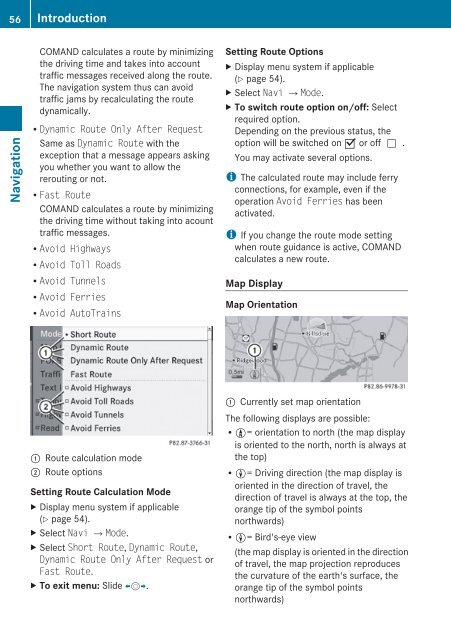
1 Route calculation mode<br />
; Route options<br />
Setting Route Calculation Mode<br />
X Display menu system if applicable<br />
(Y page 54).<br />
X Select Navi £Mode.<br />
X Select Short Route, Dynamic Route,<br />
Dynamic Route Only After Request or<br />
Fast Route.<br />
X To exit menu: Slide omp.<br />
Setting Route Options<br />
X Display menu system if applicable<br />
(Y page 54).<br />
X Select Navi £Mode.<br />
X To switch route option on/off: Select<br />
required option.<br />
Depending on the previous status, the<br />
option will be switched on Ç or offc.<br />
You may activate several options.<br />
i The calculated route may include ferry<br />
connections, for example, even if the<br />
operation Avoid Ferries has been<br />
activated.<br />
i If you change the route mode setting<br />
when route guidance is active, <strong>COMAND</strong><br />
calculates a new route.<br />
Map Display<br />
Map Orientation<br />
1 Currently set map orientation<br />
The following displays are possible:<br />
R9= orientation to north (the map display<br />
is oriented to the north, north is always at<br />
the top)<br />
R8= Driving direction (the map display is<br />
oriented in the direction of travel, the<br />
direction of travel is always at the top, the<br />
orange tip of the symbol points<br />
northwards)<br />
R8= Bird's-eye view<br />
(the map display is oriented in the direction<br />
of travel, the map projection reproduces<br />
the curvature of the earth's surface, the<br />
orange tip of the symbol points<br />
northwards)