Hiking the Entiat - Washington Trails Association
Hiking the Entiat - Washington Trails Association
Hiking the Entiat - Washington Trails Association

You also want an ePaper? Increase the reach of your titles
YUMPU automatically turns print PDFs into web optimized ePapers that Google loves.
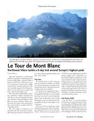
www.wta.org May+June 2009 » <strong>Washington</strong> <strong>Trails</strong> On Trail «<br />
<strong>Hiking</strong> <strong>the</strong> <strong>Entiat</strong><br />
WTA’s guide to a magnificent and threatened region<br />
By Craig Romano<br />
From glacial ice clinging to 9,000-foot giants,<br />
Mount Maude and Seven Fingered Jack, <strong>the</strong> <strong>Entiat</strong><br />
River begins its tumbling 50-mile journey eastward<br />
to <strong>the</strong> Columbia River. Taking its name from a Native<br />
American word meaning “rapid water,” <strong>the</strong> <strong>Entiat</strong><br />
flows freely and unharnessed, draining a sprawling,<br />
spectacular tract of <strong>the</strong> east slope of <strong>the</strong> Central<br />
Cascades. Within this expanse are countless cloudpiercing<br />
craggy summits, gentle rolling peaks and<br />
ridges, sprawling sun-kissed lawns bursting with<br />
wildflowers, cool subalpine forests offering respite<br />
from <strong>the</strong> sweltering sun, babbling creeks, sparkling<br />
icy alpine lakes and abundant wildlife.<br />
The <strong>Entiat</strong> and its prominent tributaries flow<br />
through deep, glacier-carved valleys shadowed by<br />
rows of prominent subranges. The Chelan Mountains<br />
form a 6,000- to 9,000-foot wall to <strong>the</strong> north. The <strong>Entiat</strong><br />
Mountains form a long lofty barrier to <strong>the</strong> south.<br />
An extensive trail system traverses <strong>the</strong> <strong>Entiat</strong><br />
country. The region’s relative remoteness from<br />
population centers usually assures lonesome wandering,<br />
yet a few of <strong>the</strong> area’s trails can still attract a<br />
good crowd on a sunny weekend. While <strong>the</strong> upper<br />
reaches of <strong>the</strong> <strong>Entiat</strong> are protected within <strong>the</strong> Glacier<br />
Peak Wilderness, <strong>the</strong> North Fork <strong>Entiat</strong> Basin<br />
and <strong>the</strong> upper Mad River Country, two significant<br />
and outstanding roadless areas, are not protected.<br />
Citizen protest spearheaded by pioneer guidebook<br />
authors Harvey Manning and Ira Spring led <strong>the</strong> Forest<br />
Service to reconsider its allowance of motorized<br />
recreation in <strong>the</strong> North Fork <strong>Entiat</strong> Basin.<br />
However, motorcycles still break <strong>the</strong> silence and<br />
trench <strong>the</strong> soft pumiceous soils of <strong>the</strong> upper Mad<br />
River country. But don’t let <strong>the</strong>m keep you away<br />
from this outstanding backcountry of rolling ridges<br />
and flowered lawns. The wheels are barred from<br />
mid-October to July 15 and use is light in <strong>the</strong> summer<br />
during <strong>the</strong> week. And perhaps someday with<br />
help from your activism, Congress will include this<br />
spectacular roadless area along with <strong>the</strong> North<br />
Fork <strong>Entiat</strong> within federally protected wilderness.<br />
In <strong>the</strong> meantime, here are a handful of outstanding<br />
hikes to help get you exploring <strong>the</strong> <strong>Entiat</strong> country<br />
this season.<br />
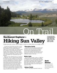
Left: Upper Mad River Trail. Right: Pyramid Mountain and wildflowers from Duncan<br />
Hill. The trails of <strong>the</strong> <strong>Entiat</strong> region offer spectacular hiking opportunities. But increasing<br />
motorized recreation in some areas threatens <strong>the</strong> area’s fragile beauty.
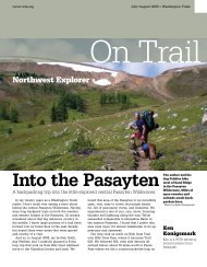
<strong>Entiat</strong> Region <strong>Trails</strong><br />
Garland Peak<br />
1<br />
Cougar Mountain<br />
3<br />
Mad River<br />
8
Carne Mountain<br />
2<br />
Silver Falls<br />
4<br />
Duncan Hill 5 Fern Lake 6<br />
Crow Hill<br />
7<br />
May 2009<br />
Data: Wenatchee<br />
National Forest,<br />
WSDOT, USGS, TNC<br />
Area of Interest in Red<br />
Cartography and Design by<br />
CORE GIS LLC<br />
www.coregis.net
» On Trail May+June 2009 » <strong>Washington</strong> <strong>Trails</strong> www.wta.org<br />
Lake Chelan from<br />
Crow Hill, a high<br />
alpine wonderland<br />
in <strong>the</strong> Chelan Mountains.<br />
Photo by Craig<br />
Romano.<br />
Silver Falls, a lovely<br />
1.8-mile round-trip<br />
hike that’s great for<br />
kids. Photo by Craig<br />
Romano.<br />
1 Garland Peak<br />
Round trip: 10.4 miles<br />
Elevation gain: 3,550 feet<br />
High point: 7,400 feet<br />
The first half of this hike is a brutally steep and<br />
brushy, curse-inducing slog. The second half is<br />
absolutely breathtaking! Follow <strong>the</strong> Basalt Pass<br />
Trail 1.7 miserable miles to Basalt Ridge. Turn<br />
right and ascend an open 6,763-foot knoll. The<br />
views are good here, but it gets better. Drop a little,<br />
<strong>the</strong>n continue climbing, traversing a huge field of<br />
pumice. At 5.2 miles, reach <strong>the</strong> Garland Peak Trail<br />
on a 7,400-foot knoll high in <strong>the</strong> <strong>Entiat</strong> Mountains.<br />
Feast on ridges and peaks for as far as <strong>the</strong> eye can<br />
see, from Glacier Peak to <strong>the</strong> craggy fortress of <strong>the</strong><br />
Chelan Mountains.<br />
2 Carne Mountain<br />
Round trip: 8.0 miles<br />
Elevation gain: 3,600 feet<br />
High point: 7,085 feet<br />
Carne is one of <strong>the</strong> finest viewing outposts in <strong>the</strong><br />
<strong>Entiat</strong> Mountains.<br />
The trail is wellbuilt,<br />
albeit steep.<br />
An excellent alpine<br />
choice in early<br />
summer, come for<br />
<strong>the</strong> wildflowers. Or<br />
forgo <strong>the</strong> floral show<br />
and arrive later for<br />
<strong>the</strong> larches. Starting<br />
from <strong>the</strong> Phelps<br />
Creek trailhead,<br />
don’t despair if<br />
<strong>the</strong> parking lot is<br />
overflowing. Ninety<br />
percent of those<br />
vehicles belong to<br />
hikers heading to<br />
Spider Meadow. The<br />
trail to Carne immediately<br />
commences<br />
to climb-switchbacking at times and shooting<br />
straight up at o<strong>the</strong>rs. After 3.0 miles of climbing<br />
enter a high hanging basin laced in larch and<br />
brushed with brilliant blossoms. Continue ano<strong>the</strong>r<br />
mile to Carne’s 7,085-foot summit enjoying a<br />
panorama of pointy peaks and deep valleys.<br />
3 Cougar Mountain<br />
Round trip: 10.0 miles<br />
Elevation gain: 2,350 feet<br />
High point: 6,701 feet<br />
Open to motorcycles July 15 to mid-October.<br />
Follow a babbling brook through pine forests<br />
and fields of dazzling wildflowers to a long gone<br />
lookout site. Gaze out at beautiful landscapes<br />
near and far—from verdant Cougar Meadows<br />
to <strong>the</strong> sun-baked wheat fields of <strong>the</strong> Waterville<br />
Plateau. Start by following <strong>the</strong> well-traveled Mad<br />
River Trail 1.3 miles to <strong>the</strong> easy-to-miss lightlyused<br />
Jimmy Creek Trail. Then travel upwards to<br />
<strong>the</strong> Cougar Ridge Trail. Head left through meadows<br />
and along <strong>the</strong> demarcation between burned<br />
and unburned forest reaching a junction with <strong>the</strong><br />
Cougar summit spur trail. Follow this made-forwheels<br />
path to <strong>the</strong> open summit.<br />
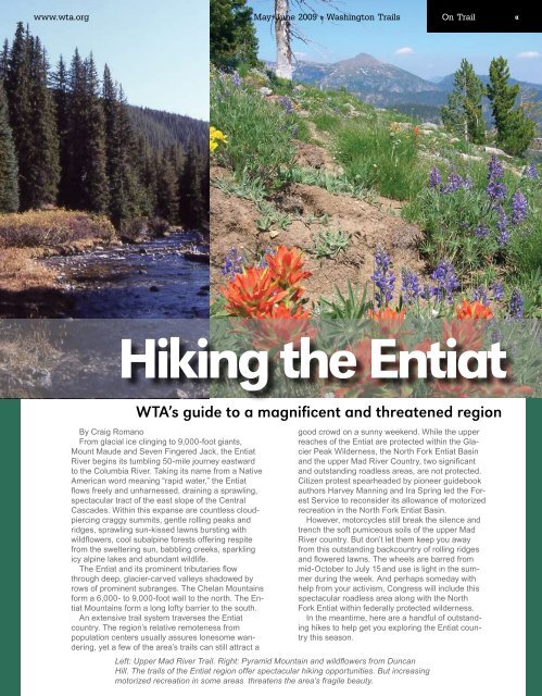
4 Silver Falls<br />
Roundtrip: 1.8 miles<br />
Elevation gain: 700 feet<br />
High point: 3,100 feet<br />
This is perhaps <strong>the</strong> most popular hike within<br />
<strong>the</strong> entire <strong>Entiat</strong> Valley, and Silver Falls is one of<br />
<strong>the</strong> prettiest cascades in all <strong>the</strong> Cascades. Silver<br />
Creek forms a silvery veil, dropping 140 feet over<br />
shiny granite slabs lined with stately pines. And<br />
while <strong>the</strong> falls <strong>the</strong>mselves are a real treat, <strong>the</strong><br />
loop trail leading to, below, and above <strong>the</strong>m is<br />
sure to delight even more—especially children.<br />
5 Duncan Hill<br />
Round trip: 13.6 miles<br />
Elevation gain: 3,000 feet<br />
High point: 7,819 feet<br />
Open to motorcycles (very light use).<br />
At 7,819 feet, Duncan is no hill. It’s a bona<br />
fide reach-for-<strong>the</strong>-clouds mountain, providing a<br />
panoramic perspective of peaks galore—from<br />
glistening Glacier Peak to Mount Rainier. It’s a<br />
long way to those views, however, but <strong>the</strong> first<br />
half of this hike is fairly easy walking. Start in a<br />
solid stand of subalpine fir and lodgepole pine<br />
before reaching a pretty little meadow about midway.<br />
The way <strong>the</strong>n turns steeper. Crest a ridge<br />
cradling a larch-lined basin; <strong>the</strong>n skirt beneath<br />
<strong>the</strong> summit block, traversing wide-open steep<br />
slopes. Stare 4,000 feet straight down into <strong>the</strong><br />
<strong>Entiat</strong> Valley!<br />
6 Fern Lake<br />
Round trip: 15.0 miles<br />
Elevation gain: 3,000 feet<br />
High point: 6,900 feet<br />
Here’s a trip to a high, lonely lake deep in a<br />
wilderness valley short on visitors and long on<br />
solitude. The hike is long, but most of it is easy<br />
along <strong>the</strong> North Fork of <strong>the</strong> <strong>Entiat</strong> River. The final<br />
stretch, however, is a real killer—a steep grunt up
www.wta.org May+June 2009 » <strong>Washington</strong> <strong>Trails</strong> On Trail «<br />
rock, ledge and eroded tread. Set in a high<br />
bowl beneath granite spires and flanked with<br />
ledges, talus and larch, Fern could be right out<br />
of <strong>the</strong> Enchantments, except <strong>the</strong>re’ll probably be<br />
nobody else up <strong>the</strong>re! Best to go late in <strong>the</strong> season<br />
for you’ll need to ford <strong>the</strong> North Fork before<br />
making <strong>the</strong> final climb.<br />
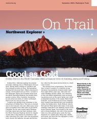
7 Crow Hill<br />
Round trip: 4.0 miles<br />
Elevation gain: 950 feet<br />
High point: 7,366 feet<br />
From one of <strong>the</strong> highest trailheads in <strong>the</strong> Central<br />
Cascades, set out on a delightful sky-walking,<br />
horizon-spanning, flower-lined frolic into <strong>the</strong><br />
cloud-piercing Chelan Mountains. Rove lonely<br />
meadows and ridges once roamed by lonely<br />
sheepherders and <strong>the</strong>ir flocks. And views! Gaze<br />
from colonnades of craggy peaks for as far as<br />
<strong>the</strong> eye can see to <strong>the</strong> sparkling waters of Lake<br />
Chelan over one mile straight below. Do this hike<br />
in July and be treated to a floral riot.<br />
8 Mad River Backpack<br />
By Joan Burton<br />
My friends Dave, Max, Gary and I took a<br />
backpack trip to <strong>the</strong> area before ORVs are<br />
allowed on <strong>the</strong> Fourth of July. On June 26th<br />
of a low-snow year we drove to Maverick<br />
Saddle, leaving <strong>the</strong> van before noon. We<br />
started along <strong>the</strong> small river on a partly<br />
sunny day, rejoicing because we had <strong>the</strong><br />
trail all to ourselves, as we did for <strong>the</strong> entire<br />
three days.<br />
We found excellent trail conditions with<br />
only one bridge out on <strong>the</strong> Upper Mad. At<br />
this season <strong>the</strong> stream was so low we had<br />
no problem fording it. We camped in Lower<br />
Whistling Pig Meadow and explored an old<br />
guard station in Upper Whistling Pig. Whistling<br />
Pig must, of course, have been named<br />
for its resident marmots.<br />
The meadow is filled with flowers and is<br />
surrounded by old growth firs and pines.<br />
We could see ruts in <strong>the</strong> trail where last<br />
season’s ORV use had dug deep grooves.<br />
The second day we left our flowery camp<br />
early for a 10-mile loop trip to Mad Lake. A<br />
large and lovely alpine lake set in a meadow<br />
basin, <strong>the</strong> lake was filled with jumping<br />
fish and seemed only recently melted out.<br />
Banks of snow surrounded its deep waters.<br />
Back at <strong>the</strong> meadow that night we heard<br />
marmots whistling and saw deer silently<br />
browsing <strong>the</strong> alpine grasses at twilight. We<br />
wondered whe<strong>the</strong>r <strong>the</strong> animals could enjoy<br />
<strong>the</strong> same evening peace and quiet once <strong>the</strong><br />
ORVs entered <strong>the</strong> area in a few days.<br />
The hike out was sunny and pleasant.<br />
Although hunters and bikers use this area<br />
in summer and into <strong>the</strong> fall, backpackers<br />
should claim <strong>the</strong>ir turn to enjoy its beauty<br />
as well.<br />
Joan Burton is author of Best Hikes with<br />
Kids: Western <strong>Washington</strong> and <strong>the</strong><br />
Cascades.<br />
You won’t find ferns at Fern Lake, but<br />
you will find larches, granite spires and<br />
solitude. Photo by Craig Romano.<br />
Craig Romano is <strong>the</strong><br />
author of five guidebooks<br />
with <strong>the</strong> Mountaineers<br />
Books, including his latest<br />
with photographer Alan<br />
Bauer, Day <strong>Hiking</strong> Central<br />
Cascades; which includes<br />
125 hikes in <strong>the</strong> Stevens<br />
Pass, Lake Wenatchee,<br />
and Alpine Lakes Regions,<br />
plus over a dozen <strong>Entiat</strong><br />
destinations. Visit Craig at<br />
www.craigromano.com.
» On Trail May+June 2009 » <strong>Washington</strong> <strong>Trails</strong> www.wta.org<br />
Saving <strong>the</strong> <strong>Entiat</strong><br />
WTA is working to protect a fragile landscape<br />
by Karl Forsgaard<br />
In March 2009, Okanogan-Wenatchee National Forest<br />
published maps of proposed changes in roads and trails<br />
open to motorized use. Reviewing <strong>the</strong> new maps inevitably<br />
brought reflection on how we got here, and where<br />
we’re headed.<br />
I began working on <strong>the</strong>se trails in 1991 with <strong>the</strong> WTA<br />
Issues Committee. Expertise on <strong>the</strong> committee included<br />
authors Ira Spring and Harvey Manning. Our advocacy<br />
work took some personal time, but it’s a worthy cause—I<br />
met new friends and learned about some great places to<br />
hike! That’s how I was introduced to <strong>the</strong> wonderful <strong>Entiat</strong><br />
and Mad River country.<br />
In early 1992, WTA intervened in litigation to support<br />
<strong>the</strong> Forest Service’s decision to close <strong>the</strong> North Fork<br />
<strong>Entiat</strong> River <strong>Trails</strong> to motorcycles. We wrote some powerful<br />
arguments that <strong>the</strong> federal courts adopted. The Ninth<br />
Circuit’s North <strong>Entiat</strong> decision is still <strong>the</strong> leading case in<br />
<strong>the</strong> U.S. on use conflict between motorized and nonmotorized<br />
users, and <strong>the</strong> North Fork <strong>Entiat</strong> Trail remains<br />
open to hikers, horses and mountain bikes.<br />
With my sons I celebrated <strong>the</strong> North <strong>Entiat</strong> victory by<br />
hiking at Big Hill on <strong>the</strong> Pyramid Mountain Trail. I carried<br />
Nick on my back, and Anders toddled on foot. On open<br />
meadow ridges high above Lake Chelan, this trail has<br />
spectacular flower displays in July. As <strong>the</strong> boys grew bigger,<br />
we kept going back, sometimes with <strong>the</strong>ir mom too.<br />
The Mad River country is between <strong>the</strong> <strong>Entiat</strong> River and<br />
<strong>the</strong> Chiwawa River. In 1993, WTA met with motorcyclists<br />
and <strong>Entiat</strong> District personnel about Three Creek and<br />
Shetipo, relatively parallel trails connecting <strong>the</strong> <strong>Entiat</strong><br />
Valley with <strong>the</strong> upper Mad River. It was proposed that<br />
one trail be motorized and <strong>the</strong> o<strong>the</strong>r not. We didn’t reach<br />
agreement <strong>the</strong>n, but maybe we will soon—<strong>the</strong> proposal<br />
reappeared on <strong>the</strong> Forest’s March 2009 maps.<br />
More trail explorations followed <strong>the</strong> 1996 Goose-<br />
Ponderosa pines on <strong>the</strong><br />
Lower Mad River Trail.<br />
Photo by Alan Bauer.<br />
Maverick motorcycle trail proposal. Above Maverick<br />
Saddle, <strong>the</strong> upper Mad River Trail follows <strong>the</strong> pristine<br />
river to its headwaters and beyond, through <strong>the</strong><br />
forested subalpine plateau and many large meadows—Blue<br />
Creek, Whistling Pig, Mad Lake, and<br />
more. In early summer, <strong>the</strong>re is a seasonal closure to<br />
motorcycles, to protect <strong>the</strong> wet soils immediately after<br />
snowmelt. So early-season hikers can experience<br />
natural quiet as flowers start to bloom before motorcycles<br />
arrive. As Dylan said, a highway of diamonds<br />
with nobody on it. <strong>Trails</strong> lead to <strong>the</strong> summits of Klone<br />
Peak and Cougar Mountain, and along Chikamin<br />
Ridge, with airy views down Three Creek valley. Bull<br />
trout, a threatened species, live in <strong>the</strong> Mad River.<br />
Over <strong>the</strong> years I’ve met a lot of motorcyclists on <strong>the</strong><br />
Mad River <strong>Trails</strong>. Although <strong>the</strong>ir machines are noisy,<br />
<strong>the</strong> local riding culture is polite. I’ve also worked<br />
alongside motorcycle advocates in meetings about<br />
projects, trail funding grant programs, and <strong>the</strong> biennial<br />
trail conferences hosted by <strong>the</strong> <strong>Washington</strong> State<br />
<strong>Trails</strong> Coalition.<br />
WTA’s successful advocacy also led to work<br />
outside <strong>Washington</strong>. Our informal national network<br />
became <strong>the</strong> Natural <strong>Trails</strong> and Waters Coalition, and<br />
we petitioned <strong>the</strong> Forest Service for <strong>the</strong> off-road<br />
vehicle (ORV) rule that is now being implemented as<br />
Travel Management.<br />
For <strong>the</strong> latest lawsuit, we hiked many times along<br />
<strong>the</strong> lower Mad River, a different ecosystem than <strong>the</strong><br />
upper Mad, but beautiful in its own way, with grassy<br />
slopes and scattered Ponderosa pines, some burned<br />
areas and more of those bull trout.<br />
In <strong>the</strong>se unprotected roadless areas, increased<br />
ORV use continues to displace hikers. Those who<br />
seek peace and quiet will be driven away by those<br />
who make noise, and it’s never <strong>the</strong> o<strong>the</strong>r way around.<br />
ORVs also have negative impacts on wildlife, vegetation,<br />
soil and water. The Forest Service has said that<br />
<strong>the</strong> <strong>Entiat</strong>-Mad River roadless area is highly suitable<br />
for addition to <strong>the</strong> adjacent Glacier Peak Wilderness.<br />
ORV interests will oppose such protection, while<br />
seeking to entrench ORV use in as many places as<br />
possible.<br />
The new proposed maps are on <strong>the</strong> Forest Service<br />
website, and you can submit comments until May 7.<br />
If you know any of <strong>the</strong>se places and want <strong>the</strong>m to<br />
stay wild, let <strong>the</strong> Forest Service hear about it. If you<br />
have not yet seen <strong>the</strong> <strong>Entiat</strong>, Chiwawa and Mad River<br />
country, make plans to visit!<br />
Karl Forsgaard is a WTA advisory board member.<br />
This full-color hiking guide<br />
and map was made possible<br />
by a grant from WTA’s<br />
Stusser Endowment for Hiker<br />
News and Reports. Mapping<br />
by CORE-GIS.