

Provisional Geologic Map of the Tintic Mountain - Utah Geological ...
Provisional Geologic Map of the Tintic Mountain - Utah Geological ...
Provisional Geologic Map of the Tintic Mountain - Utah Geological ...

Create successful ePaper yourself
Turn your PDF publications into a flip-book with our unique Google optimized e-Paper software.
UTAH GEOLOGICAL SURVEY<br />
a division <strong>of</strong><br />
<strong>Utah</strong> Department <strong>of</strong> Natural Resources<br />
This open-file release makes information available to <strong>the</strong> public<br />
that may not conform to UGS technical, editorial, or policy<br />
standards; this should be considered by an individual or group<br />
planning to take action based on <strong>the</strong> contents <strong>of</strong> this report.<br />
The <strong>Utah</strong> Department <strong>of</strong> Natural Resources, <strong>Utah</strong> <strong>Geologic</strong>al<br />
Survey, makes no warranty, expressed or implied, regarding its<br />
suitability for a particular use. The <strong>Utah</strong> Department <strong>of</strong> Natural<br />
Resources, <strong>Utah</strong> <strong>Geologic</strong>al Survey, shall not be liable under<br />
any circumstances for any direct, indirect, special, incidental, or<br />
consequential damages with respect to claims by users <strong>of</strong> this<br />
product.<br />
This geologic map was funded in part by <strong>the</strong> <strong>Utah</strong> <strong>Geologic</strong>al<br />
Survey and ancillary work was funded by <strong>the</strong> U.S. <strong>Geologic</strong>al<br />
Survey as part <strong>of</strong> <strong>the</strong> CUSMAP (Conterminous United States<br />
Mineral Assessment Program).<br />
The views and conclusions contained in this document are<br />
those <strong>of</strong> <strong>the</strong> authors and should not be interpreted as<br />
necessarily representing <strong>the</strong> <strong>of</strong>ficial policies, ei<strong>the</strong>r expressed<br />
or implied, <strong>of</strong> <strong>the</strong> U.S. Government.<br />
For use at 1:24,000 scale only. The UGS does not guarantee<br />
accuracy or completeness <strong>of</strong> <strong>the</strong> data.<br />
U T A H<br />
QUADRANGLE<br />
LOCATION<br />
SCALE 1:24,000<br />
1 0.5 0 1 MILE<br />
1000 0 1000 2000 3000 4000 5000 6000 7000 FEET<br />
1 0.5 0 1 KILOMETER<br />
CONTOUR INTERVAL 40 FEET<br />
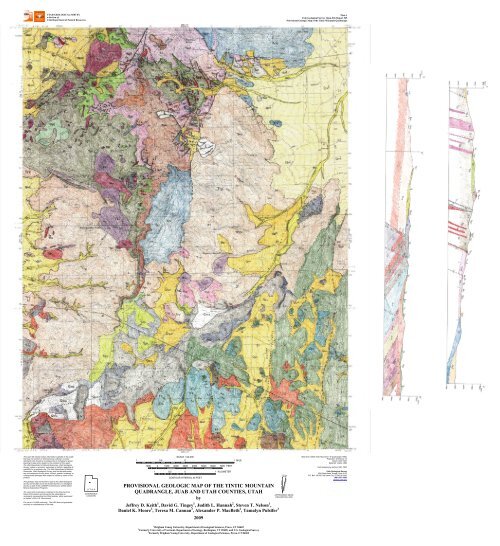
PROVISIONAL GEOLOGIC MAP OF THE TINTIC MOUNTAIN<br />
QUADRANGLE, JUAB AND UTAH COUNTIES, UTAH<br />
by<br />
Jeffrey D. Keith 1 , David G. Tingey 1 , Judith L. Hannah 2 , Steven T. Nelson 1 ,<br />
Daniel K. Moore 3 , Teresa M. Cannan 3 , Alexander P. MacBeth 2 , Tamalyn Pulsifer 3<br />
2009<br />
1 Brigham Young University, Department <strong>of</strong> <strong>Geologic</strong>al Sciences, Provo, UT 84602<br />
2 Formerly University <strong>of</strong> Vermont, Department <strong>of</strong> Geology, Burlington, VT 05405, and U.S. <strong>Geologic</strong>al Survey<br />
3 Formerly Brigham Young University, Department <strong>of</strong> <strong>Geologic</strong>al Sciences, Provo, UT 84602<br />
TRUE NORTH<br />
12°22'<br />
MAGNETIC NORTH<br />
APPROXIMATE MEAN<br />
DECLINATION, 2009<br />
Plate 1<br />
<strong>Utah</strong> <strong>Geologic</strong>al Survey Open-File Report 545<br />
<strong>Provisional</strong> <strong>Geologic</strong> <strong>Map</strong> <strong>of</strong> <strong>the</strong> <strong>Tintic</strong> <strong>Mountain</strong> Quadrangle<br />
Base from USGS <strong>Tintic</strong> <strong>Mountain</strong> 7.5’ Quadrangle (1992)<br />
Projection: UTM Zone 12<br />
Datum: NAD 1927<br />
Spheroid: Clarke 1886<br />
Field mapping by authors 1991-1993<br />
<strong>Utah</strong> <strong>Geologic</strong>al Survey<br />
1594 West North Temple, Suite 3110<br />
P.O. Box 146100, Salt Lake City, UT 84114-6100<br />
(801) 537-3300<br />
geology.utah.gov
PROVISIONAL GEOLOGIC MAP OF THE TINTIC MOUNTAIN<br />
QUADRANGLE, JUAB AND UTAH COUNTIES, UTAH<br />
by<br />
Jeffrey D. Keith 1 , David G. Tingey 1 , Judith L. Hannah 2 , Steven T. Nelson 1 ,<br />
Daniel K. Moore 3 , Teresa M. Cannan 3 , Alexander P. MacBeth 2 , Tamalyn Pulsifer 3<br />
1 Brigham Young University, Department <strong>of</strong> <strong>Geologic</strong>al Sciences, Provo, UT 84602<br />
2 Formerly University <strong>of</strong> Vermont, Department <strong>of</strong> Geology, Burlington VT 05405, and U.S. <strong>Geologic</strong>al Survey<br />
3 Formerly Brigham Young University, Department <strong>of</strong> <strong>Geologic</strong>al Sciences, Provo, UT 84602<br />
This open-file release makes information available to <strong>the</strong> public that may not conform to UGS technical, editorial,<br />
or policy standards; this should be considered by an individual or group planning to take action based on <strong>the</strong> contents <strong>of</strong><br />
this report. The <strong>Utah</strong> Department <strong>of</strong> Natural Resources, <strong>Utah</strong> <strong>Geologic</strong>al Survey, makes no warranty, expressed or implied,<br />
regarding its suitability for a particular use. The <strong>Utah</strong> Department <strong>of</strong> Natural Resources, <strong>Utah</strong> <strong>Geologic</strong>al Survey, shall not<br />
be liable under any circumstances for any direct, indirect, special, incidental, or consequential damages with respect to<br />
claims by users <strong>of</strong> this product.<br />
This geologic map was funded in part by <strong>the</strong> <strong>Utah</strong> <strong>Geologic</strong>al Survey, and ancillary work was funded by <strong>the</strong> U.S.<br />
<strong>Geologic</strong>al Survey as part <strong>of</strong> <strong>the</strong> CUSMAP (Conterminous United States Mineral Assessment Program).<br />
OPEN-FILE REPORT 545<br />
UTAH GEOLOGICAL SURVEY<br />
a division <strong>of</strong><br />
<strong>Utah</strong> Department <strong>of</strong> Natural Resources<br />
2009
INTRODUCTION<br />
Location, Methods, and Prior Work<br />
The <strong>Tintic</strong> <strong>Mountain</strong> quadrangle is located in central <strong>Utah</strong> about 6 miles (10 km) south <strong>of</strong><br />
Eureka near <strong>the</strong> central part <strong>of</strong> <strong>the</strong> East <strong>Tintic</strong> <strong>Mountain</strong>s. The quadrangle is on <strong>the</strong> east margin<br />
<strong>of</strong> <strong>the</strong> Basin and Range Physiographic Province.<br />
Because <strong>the</strong> quadrangle is partly within <strong>the</strong> East <strong>Tintic</strong> mining district, numerous<br />
geologic studies have been done on <strong>the</strong> area. Morris and Lovering (1979) prepared <strong>the</strong> most<br />
comprehensive report on <strong>the</strong> district; o<strong>the</strong>r examples are listed in <strong>the</strong> references in this open-file<br />
report. U.S. <strong>Geologic</strong>al Survey geologist H.T. Morris (1975) previously mapped <strong>the</strong> geology <strong>of</strong><br />
<strong>the</strong> <strong>Tintic</strong> <strong>Mountain</strong> quadrangle. Subsequent mapping occurred in <strong>the</strong> west (Hannah and<br />
MacBeth, 1990) and nor<strong>the</strong>ast (Keith and o<strong>the</strong>rs, 1989, 1991) parts <strong>of</strong> <strong>the</strong> quadrangle. This map<br />
focuses on <strong>the</strong> Tertiary volcanic rocks, and relies on geochemical, geochronologic, and<br />
stratigraphic data from Moore’s M.S. <strong>the</strong>sis (1993) supervised by J.D. Keith. The stratigraphy <strong>of</strong><br />
<strong>the</strong> <strong>Tintic</strong> <strong>Mountain</strong> Volcanic Group has been revised from that <strong>of</strong> Morris and Lovering (1979)<br />
with a mix <strong>of</strong> formal and informal rock unit names. The quadrangle was remapped in an effort<br />
to update and build upon <strong>the</strong> prior mapping and geologic studies <strong>of</strong> H.T. Morris.<br />
This open-file report is based primarily on mapping completed in 1991-1993; parts <strong>of</strong> <strong>the</strong><br />
quadrangle were mapped by coauthors Hannah, Cannan and MacBeth (1991-1992), Keith and<br />
Moore (1991-1992), Moore (1991-1992), and Tingey (1993), as depicted on <strong>the</strong> index to areas <strong>of</strong><br />
responsibility for geologic mapping (figure 1). Age determinations were conducted by S.T.<br />
Nelson. The map was compiled by T. Pulsifer under <strong>the</strong> direction <strong>of</strong> J.D. Keith and D.G.<br />
Tingey. Moore and o<strong>the</strong>rs (2007) subsequently discussed petrogenesis <strong>of</strong> <strong>the</strong> East <strong>Tintic</strong><br />
volcanic field based on Moore (1993).<br />
This geologic map focuses on <strong>the</strong> Tertiary igneous rocks in part <strong>of</strong> <strong>the</strong> East <strong>Tintic</strong><br />
<strong>Mountain</strong>s, and supercedes <strong>the</strong> reports <strong>of</strong> Morris (1975), and Hannah and MacBeth (1990). The<br />
revised stratigraphy <strong>of</strong> <strong>the</strong> <strong>Tintic</strong> <strong>Mountain</strong> Volcanic Group in this open-file report was partly<br />
shown in Keith and o<strong>the</strong>rs (1989, 1991) and Hintze (1988, chart 32, p. 149). The surface<br />
geology <strong>of</strong> <strong>the</strong> <strong>Tintic</strong> <strong>Mountain</strong> area is extremely complex and we recognize that some<br />
inconsistencies have not been resolved. Notably, <strong>the</strong> correlation chart is not fully compatible<br />
with <strong>the</strong> mapping and isotopic ages. Some isotopic age data do not match <strong>the</strong> physical<br />
stratigraphy and sample locations and units sampled are uncertain. Also, thicknesses shown on<br />
cross sections do not match those on nearby maps. A structural or stratigraphic explanation is<br />
needed to explain why map unit Trp is exposed on both sides <strong>of</strong> <strong>the</strong> range. Age ranges for Trp<br />
and some o<strong>the</strong>r map units may be longer than shown in <strong>the</strong> correlation chart. Not all units are<br />
named on <strong>the</strong> basis <strong>of</strong> <strong>the</strong>ir geochemistry. Geochemical and geochronologic research are<br />
ongoing.<br />
Inferred Calderas and <strong>Geologic</strong> History<br />
The <strong>Tintic</strong> <strong>Mountain</strong> quadrangle is characterized by exposures <strong>of</strong> Eocene and Oligocene volcanic,<br />
sedimentary, and intrusive rocks that lie unconformably upon faulted lower Paleozoic sedimentary rocks<br />
1
(Cambrian to Devonian?). Volcanic eruptions produced three nested calderas that are incompletely<br />
delimited, but likely extend into <strong>the</strong> adjacent Eureka, Furner Ridge, and McIntyre quadrangles. Eruption<br />
<strong>of</strong> <strong>the</strong> Fernow Quartz Latite (map symbol Tf) created <strong>the</strong> oldest <strong>of</strong> <strong>the</strong> three calderas (Fernow caldera),<br />
and severely altered <strong>the</strong> Herkimer Limestone (Ch) and Fish Haven Dolomite (Ofh) near <strong>the</strong> caldera wall in<br />
<strong>the</strong> southwest part <strong>of</strong> <strong>the</strong> map area. The caldera is dated at 34.71 ± 0.19 Ma or older, based on <strong>the</strong><br />
presumed correlation with <strong>the</strong> Packard Quartz Latite by Moore (1993).<br />
Subsequent eruption <strong>of</strong> <strong>the</strong> lava flows <strong>of</strong> Rattlesnake Peak (Trp) created a second caldera<br />
(Rattlesnake Peak caldera), destroying <strong>the</strong> nor<strong>the</strong>rn extent <strong>of</strong> <strong>the</strong> Fernow caldera. Collapse <strong>of</strong> <strong>the</strong> caldera<br />
walls following eruption resulted in <strong>the</strong> entrainment <strong>of</strong> large blocks <strong>of</strong> Paleozoic rocks, most notably <strong>the</strong><br />
<strong>Tintic</strong> Quartzite (Ct), within <strong>the</strong> lava flows. This caldera location is crudely comparable to <strong>the</strong> <strong>Tintic</strong><br />
caldera proposed by Morris (1975) and mostly encompasses unit Trp.<br />
Eruption <strong>of</strong> <strong>the</strong> tuff member <strong>of</strong> <strong>the</strong> Copperopolis Latite (Tct) created a third caldera<br />
(Copperopolis Latite caldera) approximately 7 miles (11 km) in diameter. Its location is based on: (1) <strong>the</strong><br />
sub-circular distribution <strong>of</strong> several intrusive units, including <strong>the</strong> Silver City stock (Tsc) and a breccia pipe<br />
(Tbp), present exclusively within <strong>the</strong> proposed caldera; (2) <strong>the</strong> arcuate contact <strong>of</strong> <strong>the</strong> tuff member <strong>of</strong> <strong>the</strong><br />
Copperopolis Latite (Tct) with <strong>the</strong> lava flows <strong>of</strong> Rattlesnake Peak (Trp); (3) <strong>the</strong> observation that tuff<br />
member thickness within <strong>the</strong> proposed caldera is ~425 feet (~130 m) thicker than <strong>the</strong> tuff outside <strong>the</strong><br />
caldera (Hannah and o<strong>the</strong>rs, 1991; Moore, 1993); (4) <strong>the</strong> presence <strong>of</strong> lacustrine strata (Tsu, Tsl) within <strong>the</strong><br />
caldera.<br />
The Copperopolis Latite caldera was later intruded by <strong>the</strong> Sunrise Peak Monzonite Porphyry<br />
(Tsp). Lacustrine shale clasts (Tsl) ripped up during <strong>the</strong> intrusion and related lava flows are visible in <strong>the</strong><br />
agglomerates <strong>of</strong> Sunrise Peak (Tspf) (Lindgren and Laughlin, 1919; Keith and o<strong>the</strong>rs, 1991). Overlying<br />
volcanoclastic sedimentary strata (Tse) record deposition in a terrain <strong>of</strong> high relief (Keith and o<strong>the</strong>rs,<br />
1991).<br />
Several volcanic units and intrusions postdate <strong>the</strong> lacustrine and sedimentary units. Lava flows<br />
<strong>of</strong> <strong>the</strong> shoshonite <strong>of</strong> Buckhorn <strong>Mountain</strong> (Tbm) filled and overflowed <strong>the</strong> Copperopolis Latite caldera.<br />
The latite <strong>of</strong> Dry Herd Canyon (Tdh), latite <strong>of</strong> Little Dog Canyon (Tld), and <strong>the</strong> Latite Ridge Latite (Tlr)<br />
overlie <strong>the</strong>se shoshonite lava flows in <strong>the</strong> center <strong>of</strong> <strong>the</strong> quadrangle. Volcaniclastic strata (Ts) are<br />
preserved only where overlain by <strong>the</strong> Latite Ridge Latite (Tlr) (Moore, 1993). Failure <strong>of</strong> <strong>the</strong><br />
volcaniclastic strata (Ts) led to Quaternary-age landslides involving <strong>the</strong> Latite Ridge Latite (Tlr) in <strong>the</strong><br />
southwest and south-central portions <strong>of</strong> <strong>the</strong> quadrangle. The latite <strong>of</strong> Rock Canyon (Trc) has 40 Ar/ 39 Ar ages<br />
<strong>of</strong> 33.72 + 0.08 and 33.87 + 0.13 Ma (Moore, 1993) and overlies <strong>the</strong> latite <strong>of</strong> Little Dog Canyon (Tld).<br />
Several intrusive rock units occur in <strong>the</strong> quadrangle. A dike swarm at Paul Bunyans Woodpile<br />
(Tli) is one <strong>of</strong> <strong>the</strong> outstanding geologic features within <strong>the</strong> <strong>Tintic</strong> <strong>Mountain</strong> quadrangle. These biotite<br />
latite intrusions (Tli), here correlated with <strong>the</strong> latite <strong>of</strong> Dry Herd Canyon (Tdh) lava flows, occur<br />
exclusively within <strong>the</strong> proposed Copperopolis Latite caldera, as does <strong>the</strong> Silver City stock (Tsc). The<br />
intrusions <strong>of</strong> Keystone Springs (Tks), which ended at 34.03 ± 0.1 Ma (Moore, 1993), are recognized<br />
within <strong>the</strong> sou<strong>the</strong>rn portion <strong>of</strong> <strong>the</strong> Copperopolis Latite caldera, as well as within <strong>the</strong> Rattlesnake Peak<br />
caldera. The monzonite porphyry <strong>of</strong> Silver City (Tsc), dated at 32.7 + 0.2 Ma, is <strong>the</strong> largest intrusive<br />
body in <strong>the</strong> East <strong>Tintic</strong> <strong>Mountain</strong>s and is associated with mineralization (Keith and o<strong>the</strong>rs, 1991; Moore,<br />
1993).<br />
Tertiary alluvium (Ta) shed from <strong>the</strong> East <strong>Tintic</strong> <strong>Mountain</strong>s contains Tertiary volcanic and<br />
Paleozoic sedimentary rock material and postdate volcanism. The Goshen fault (Jensen, 1984), which<br />
extends into <strong>the</strong> sou<strong>the</strong>astern part <strong>of</strong> <strong>the</strong> quadrangle, has displaced <strong>the</strong> Tertiary alluvium, as well as <strong>the</strong><br />
previously faulted Paleozoic units and Tertiary volcanic rocks.<br />
2
ACKNOWLEDGMENTS<br />
This geologic map was funded in part by <strong>the</strong> <strong>Utah</strong> <strong>Geologic</strong>al Survey, and ancillary work<br />
was funded by <strong>the</strong> U.S. <strong>Geologic</strong>al Survey as part <strong>of</strong> <strong>the</strong> CUSMAP (Conterminous United States<br />
Mineral Assessment Program). UGS staff Jon K. King, Donald Clark, and Grant Willis<br />
conducted preliminary reviews <strong>of</strong> this map.<br />
3
QUATERNARY SURFICIAL DEPOSITS<br />
MAP UNIT DESCRIPTIONS<br />
Qay Younger alluvium (Holocene) – Poorly consolidated deposits <strong>of</strong> stream alluvium incised<br />
into older alluvial deposits; mapped along most primary stream drainages, and also<br />
includes small areas <strong>of</strong> fan alluvium and colluvium; exposed thickness as much as 5 feet<br />
(2 m), total thickness unknown.<br />
Qao Older alluvium (Holocene to Pleistocene) – Poorly consolidated deposits <strong>of</strong> stream<br />
alluvium and fan alluvium typically present above younger stream deposits; includes<br />
small areas <strong>of</strong> older stream alluvium and colluvium; mapped in Furner Valley, Little Dog<br />
Valley, <strong>Map</strong>le and Jims Springs area, Government Canyon area, and <strong>Tintic</strong> Valley;<br />
exposed thickness as much as 10 feet (3 m), total thickness unknown.<br />
Qaf Alluvial-fan deposits, undivided (Holocene to Pleistocene) – Poorly consolidated<br />
deposits <strong>of</strong> coalescing fan alluvium in Goshen Valley; includes unmapped colluvium<br />
along valley margins; locally incised by younger alluvium <strong>of</strong> active streams; exposed<br />
thickness as much as 10 feet (3 m), total thickness unknown.<br />
Qms Landslide and slump deposits (Holocene to Pleistocene) – Landslides and slumps<br />
developed on “weak” volcanic rock units; mapped near Kessler Spring, Riley Springs,<br />
Little Valley, and Jump<strong>of</strong>f Spring areas; total thickness variable and unknown.<br />
Unconformity<br />
TERTIARY SEDIMENTARY AND VOLCANIC ROCKS<br />
Ta Tertiary alluvium (Oligocene?) – High-level alluvial fans that are dissected and eroded;<br />
contains clay to gravel from Eocene-Oligocene volcanic rocks and Paleozoic units; age(s)<br />
uncertain but postdates volcanism; thickness is 0 to 250 feet (0-80 m).<br />
Unconformity?<br />
Trc Latite <strong>of</strong> Rock Canyon (Oligocene) – Black, gray to reddish brown latitic lava flows and<br />
vitrophyres with conspicuous phenocrysts <strong>of</strong> biotite and plagioclase in hand sample;<br />
clinopyroxene, titanomagnetite, and apatite are always apparent in thin section;<br />
orthopyroxene, amphibole, sanidine, and magmatic sulfide blebs present in some<br />
samples; informally named for exposures in <strong>the</strong> Eureka quadrangle; thickness is 0 to<br />
1500 feet (0-460 m).<br />
Tlr Latite Ridge Latite (Eocene) – White to reddish brown, trachytic, ash-flow tuff; <strong>the</strong> tuff is<br />
densely welded, eutaxitic, locally perlitic, and crystal poor; contains phenocrysts <strong>of</strong> plagioclase,<br />
biotite, and clinopyroxene; aphanitic-porphyritic, lapilli-sized lithic fragments and vitrophyric<br />
clasts <strong>of</strong> andesitic lava are also present; named by Morris and Lovering (1979) for exposures in<br />
<strong>the</strong> Eureka quadrangle; thickness is 0 to 500 feet (0-150 m).<br />
4
Ts Volcaniclastic strata (Eocene) – Interbedded volcanic sandstone and conglomerate; strata are<br />
heterolithic, poorly sorted and stratified, and consist <strong>of</strong> angular, pebble- and cobble-size<br />
fragments <strong>of</strong> dark lava in a matrix <strong>of</strong> gray, biotite-bearing, volcanoclastic silt; clasts are much<br />
larger and more abundant in conglomerates; cross-stratification is common in <strong>the</strong> sandstones;<br />
thickness is 0 to 500 feet (0-150 m).<br />
Tld Latite <strong>of</strong> Little Dog Canyon (Eocene) – Black, blue-gray, and gr ay-green, f laggy,<br />
porphyritic-aphanitic, felty, latitic lava flows; wea<strong>the</strong>red surfaces are brown and subangular<br />
to smooth; forms a few poorly expo sed outcrops; informally name d for ex posures i n th e<br />
<strong>Tintic</strong> <strong>Mountain</strong> quadrangle; thickness is 0 to 250 feet (0-80 m).<br />
Tdh Latite <strong>of</strong> Dry Herd Canyon (Eocene) – Black, brown-black, and green vitrophyric and<br />
porphyritic-aphanitic lava flows; <strong>the</strong> flows are dense to scoriaceous, locally amygdaloidal, and<br />
contain phenocrysts <strong>of</strong> plagioclase, clinopyroxene, Fe-Ti oxides, and orthopyroxene; poorly<br />
exposed unit; commonly only cobble-size float is present; informally named for exposures in <strong>the</strong><br />
Eureka quadrangle; thickness is 0 to 350 feet (0-110 m).<br />
Tblu Upper biotite latite flows (Eocene) – Black to gray lava flows and vitrophyres with prominent<br />
biotite and plagioclase phenocrysts in hand sample; clinopyroxene, orthopyroxene,<br />
titanomagnetite, apatite, and magmatic sulfide blebs are also present, but are not obvious in hand<br />
sample; distinguished in <strong>the</strong> field from o<strong>the</strong>r biotite-latite flow units only on <strong>the</strong> basis <strong>of</strong><br />
stratigraphic position; stratigraphically above <strong>the</strong> mafic flow sequence (unit Tbm); thickness is 0 to<br />
350 feet (0-110 m).<br />
Tbm Shoshonite <strong>of</strong> Buckhorn <strong>Mountain</strong> (Eocene) – Dark to variably colored lava flows, breccias,<br />
and agglomerates with little or no biotite apparent in hand sample; <strong>the</strong>se flows and breccias are<br />
commonly vesicular and mildly altered; clinopyroxene, plagioclase, orthopyroxene,<br />
titanomagnetite, apatite, traces <strong>of</strong> magmatic sulfides, and a few strongly resorbed and oxidized<br />
relict biotite crystals can also be found in thin section; informally named for exposures in <strong>the</strong><br />
<strong>Tintic</strong> <strong>Mountain</strong> quadrangle; thickness is 0 to 500 feet (0-150 m).<br />
Tblf Lower biotite latite flows (Eocene) – Light gray to red brown lava flows with conspicuous<br />
biotite and plagioclase phenocrysts in hand sample; clinopyroxene, titanomagnetite, apatite, and<br />
traces <strong>of</strong> amphibole and magmatic sulfide blebs can also be found in thin section; separated from<br />
o<strong>the</strong>r biotite lava flow units during mapping based on stratigraphic position beneath <strong>the</strong><br />
shoshonite <strong>of</strong> Buckhorn <strong>Mountain</strong>; thickness is 0 to 200 feet (0-60 m).<br />
Tse Epiclastic strata (Eocene) – Poorly stratified volcaniclastic sedimentary rocks, including<br />
conglomerate, near Government Canyon; original composition <strong>of</strong>ten obscured by intense<br />
alteration; rarely, angular clasts <strong>of</strong> <strong>Tintic</strong> Quartzite or lower Paleozoic carbonate units are<br />
present; thickness is 0 to 150 feet (0-50 m).<br />
Tsu Upper lacustrine strata (Eocene) – Alternating beds <strong>of</strong> white limestone and dark-gray organicrich<br />
shale containing abundant plant remains; generally, very poorly exposed; small pebble- and<br />
cobble-size fragments in float are typically <strong>the</strong> only clue to its presence; this unit represents<br />
5
deposits in a lake that formed in <strong>the</strong> Copperopolis Latite caldera; thickness is about 50 feet (15<br />
m).<br />
Tspf Flows and agglomerates <strong>of</strong> Sunrise Peak (Eocene) – Light-green to light-brown, slabbywea<strong>the</strong>ring,<br />
latitic lava flows in which plagioclase phenocrysts are conspicuous in hand sample;<br />
o<strong>the</strong>r phenocrysts include biotite, clinopyroxene, titanomagnetite, and apatite; field relationships<br />
and composition suggest that <strong>the</strong> lava flows vented from <strong>the</strong> Sunrise Peak stock (and associated<br />
dikes); <strong>the</strong> agglomerate occupies <strong>the</strong> same stratigraphic position and contains <strong>the</strong> same<br />
phenocrysts except that biotite crystals are larger in size and more abundant in both fresh and<br />
altered outcrops; informally named for exposures in <strong>the</strong> <strong>Tintic</strong> <strong>Mountain</strong> quadrangle; thickness is 0<br />
to 600 feet (0-180 m).<br />
Tsl Lower lacustrine strata (Eocene) – Light-colored, fissile shale, with lesser amounts <strong>of</strong><br />
mudstone and volcaniclastic sandstone; strata include ovoidal structures replaced by pyrite that<br />
may represent gastropods; unit wea<strong>the</strong>rs easily and, <strong>the</strong>refore, is poorly exposed; thickness is 0 to<br />
350 feet (0-110 m).<br />
Tct Tuff member <strong>of</strong> Copperopolis Latite (Eocene) – Thin- to very thick-bedded, vitrophyric,<br />
lithic, phenocryst-poor, ash-flow tuff and minor autobrecciated tuff; rare, unaltered tuff is<br />
moderately welded and eutaxitic; brecciated tuff consists <strong>of</strong> angular tuff blocks in a matrix <strong>of</strong> <strong>the</strong><br />
same tuff; unit includes lapilli- and block-sized (up to 20 inches [50 cm] long) xenoliths that are<br />
commonly andesitic rocks (appear to be lava flows <strong>of</strong> Rattlesnake Peak); o<strong>the</strong>r included clasts are<br />
lower Paleozoic quartzite, limestone, and shale; named by Morris and Lovering (1979) for<br />
exposures near Copperopolis Canyon; thickness is 0 to 500 feet (0-150 m).<br />
Tpf Plagioclase-rich lava flows (Eocene) – Massive and locally autobrecciated gray-green flows and<br />
overlying heterolithic breccia; phenocrysts include plagioclase and pyroxene in a non-lustrous,<br />
and aphanitic to microcrystalline groundmass; heterolithic breccia contains volcanic clasts, many<br />
from underlying flows, supported by a granular matrix; thickness is 0 to 400 feet (0-120 m).<br />
Trp Lava flows <strong>of</strong> Rattlesnake Peak (Eocene) – Blue-gray and green, generally massive and<br />
glomerophyric, latitic and andesitic lava flows and minor flow breccia; rocks in unit are<br />
vitrophyric and contain phenocrysts <strong>of</strong> plagioclase, clinopyroxene, orthopyroxene, Fe-Ti oxides,<br />
and biotite; iron-staining <strong>of</strong> plagioclase phenocrysts and <strong>of</strong> matrix along fractures is ubiquitous;<br />
flow-breccia clasts are cobble- to boulder-size, and <strong>the</strong> matrix is heavily altered; informally<br />
named for exposures in <strong>the</strong> <strong>Tintic</strong> <strong>Mountain</strong> quadrangle; thickness is 0 to 1000 feet (0-300 m).<br />
Tf Fernow Quartz Latite (Eocene) – Blue-gray and white (when altered), very thick-bedded,<br />
rhyolitic, ash-flow tuff; unit is densely welded, eutaxitic, weakly spherulitic, and crystal rich;<br />
contains abundant (~ 48%), generally fragmented, phenocrysts <strong>of</strong> plagioclase, quartz, sanidine,<br />
biotite, and Fe-Ti oxides; locally, <strong>the</strong> tuff contains dark, glassy fiamme up to one foot (0.3 m)<br />
long and three inches (1 cm) thick; some fiamme are crystal rich while o<strong>the</strong>rs are nearly aphyric;<br />
lapilli- and block-size, lithic fragments are present and are commonly andesitic in composition,<br />
implying a still older andesitic volcanic unit is present in <strong>the</strong> East <strong>Tintic</strong> <strong>Mountain</strong>s; originally<br />
named <strong>the</strong> Fernow rhyolite by Tower and Smith (1899) and later <strong>the</strong> Fernow Quartz Latite by<br />
Morris (1957) for exposures near Furner Canyon (Fernow Canyon or Ferner Canyon on some<br />
maps) in <strong>the</strong> <strong>Tintic</strong> <strong>Mountain</strong> quadrangle; thickness is 0 to 1500 feet (0-460 m).<br />
6
Intrusive contacts<br />
TERTIARY INTRUSIVE ROCKS<br />
Tbp Breccia pipe (Oligocene to Eocene) – Roughly 1 mile (2 km)-long, northwesttrending<br />
intrusion near Copperopolis Canyon; contains large blocks <strong>of</strong> quartzite up to 300<br />
feet (100 m) long, and smaller blocks <strong>of</strong> carbonate and volcanic rocks; matrix is white,<br />
quartz-bearing, argillically altered igneous rock; cuts map units Tct and Trp, but youngest<br />
possible age uncertain; thickness is variable.<br />
Tsc Monzonite porphyry <strong>of</strong> Silver City (Oligocene to Eocene) – Phenocryst-rich, amphibolebearing<br />
monzonite porphyry with a seriate texture; some variations in size, abundance, and<br />
relative proportions <strong>of</strong> phenocrysts are typically present within <strong>the</strong> same dike or plug; quartz and<br />
amphibole are present in <strong>the</strong> more phenocryst-rich lithologies; clinopyroxene, biotite, plagioclase,<br />
and magnetite are early-formed crystal phases; orthoclase, apatite, sphene, and zircon are also<br />
present; hydro<strong>the</strong>rmal alteration expressed as epidote, chlorite, and minor clay, sericite, and<br />
pyrite is almost ubiquitous; referred to as Silver City stock by Morris and Lovering (1979),<br />
largely present in <strong>the</strong> southwestern quadrant <strong>of</strong> <strong>the</strong> Eureka quadrangle, and extending into <strong>the</strong><br />
adjacent <strong>Tintic</strong> Junction quadrangle; thickness is variable.<br />
Tks Intrusions <strong>of</strong> Keystone Springs (Eocene) – Near-surface domes or intrusive plugs <strong>of</strong> lightcolored,<br />
rhyolitic, feldspar porphyry; conspicuous large crystals <strong>of</strong> sanidine and plagioclase with<br />
much smaller, minor crystals <strong>of</strong> biotite, titanomagnetite, amphibole and traces <strong>of</strong> magmatic<br />
pyrrhotite; informally named for exposures in <strong>the</strong> <strong>Tintic</strong> <strong>Mountain</strong> quadrangle; thickness is variable.<br />
Tli Biotite latite intrusions (Eocene) – Dark-colored, vent-facies dikes and plugs,<br />
uncommonly exhibiting columnar jointing inward from <strong>the</strong> walls <strong>of</strong> <strong>the</strong> dike;<br />
compositionally identical to <strong>the</strong> biotite latite lava flows (Tblu, Tblf), but correlated with<br />
<strong>the</strong> latite <strong>of</strong> Dry Herd Canyon (Tdh); comprises spectacular, horizontally oriented,<br />
columnar-jointed dikes <strong>of</strong> Paul Bunyans Woodpile near Riley Canyon in southwest part<br />
<strong>of</strong> <strong>the</strong> map area; thickness is variable.<br />
Tsp Sunrise Peak Monzonite Porphyry (Eocene) – Distinctly porphyritic monzonite with a<br />
consistently fine-grained groundmass and fewer phenocrysts than <strong>the</strong> monzonite porphyry <strong>of</strong><br />
Silver City; conspicuous phenocrysts include plagioclase, clinopyroxene, biotite, and magnetite;<br />
forms stock and smaller intrusions in northwest part <strong>of</strong> quadrangle; named by Morris and Lovering<br />
(1979); thickness is variable.<br />
Unconformity<br />
Descriptions for Paleozoic rock units modified from Morris (1975). Unit thicknesses shown on<br />
cross section B-B” estimated from Hintze (1988) and sources cited <strong>the</strong>rein.<br />
DEVONIAN-SILURIAN-ORDOVICIAN SEDIMENTARY ROCKS<br />
7
DSOb Bluebell Dolomite (Devonian, Silurian, and Upper Ordovician) – Dusky-gray coarsegrained<br />
dolomite with some beds <strong>of</strong> sublithographic creamy-white dolomite; includes<br />
curly laminated marker beds near middle; Hintze (1988, figure 31, p. 27, and chart 32, p.<br />
149) puts Devonian strata (upper part <strong>of</strong> Bluebell <strong>of</strong> Morris and Lovering, 1961) in <strong>the</strong><br />
Guilmette Formation; thickness <strong>of</strong> 750 feet (230 m) shown on cross section.<br />
ORDOVICIAN SEDIMENTARY ROCKS<br />
Ofh Fish Haven Dolomite (Upper Ordovician) – Dusky-gray, coarse-grained dolomite;<br />
includes cherty, mottled beds near base and in upper part; thickness <strong>of</strong> 500 feet (150 m)<br />
shown on cross section.<br />
Unconformity<br />
Oo Opohonga Limestone (Lower Ordovician) – Light blue-gray, thin-bedded, argillaceous<br />
limestone with many beds <strong>of</strong> flat-pebble conglomerate, and chert lenses at base;<br />
thickness <strong>of</strong> 1100 feet (340 m) shown on cross section.<br />
CAMBRIAN SEDIMENTARY ROCKS<br />
Caj Ajax Dolomite (Upper Cambrian) – Inferred to be present at depth, and appears on cross<br />
section only; thickness <strong>of</strong> 800 feet (240 m) shown on cross section.<br />
Cop Opex Formation (Upper Cambrian) – Inferred to be present at depth, and appears on<br />
cross section only; thickness <strong>of</strong> 400 feet (120 m) shown on cross section.<br />
Ccc Cole Canyon Dolomite (Middle Cambrian) – Dark-gray dolomite with bedded limestone<br />
higher in <strong>the</strong> unit; includes abundant worm burrows; <strong>the</strong> most widely exposed lower<br />
Paleozoic unit in <strong>the</strong> quadrangle; thickness <strong>of</strong> 2000 feet (610 m) shown on cross section.<br />
Cb Bluebird Dolomite (Middle Cambrian) – Blue-gray, medium-grained limestone;<br />
thickness <strong>of</strong> 350 feet (110 m) shown on cross section.<br />
Ch Herkimer Limestone (Middle Cambrian) – Blue-gray, medium-grained, argillaceous<br />
limestone; thickness <strong>of</strong> 450 feet (140 m) shown on cross section.<br />
Cd Dagmar Dolomite (Middle Cambrian) – Creamy-white to gray, fine-grained, laminated,<br />
dolomitic limestone; thickness <strong>of</strong> 250 feet (80 m) shown on cross section.<br />
Cte Teutonic Limestone (Middle Cambrian) – Inferred to be present at depth, and appears on<br />
cross section only; thickness <strong>of</strong> 350 feet (110 m) shown on cross section.<br />
Co Ophir Formation (Middle Cambrian) – Inferred to be present at depth, and appears on<br />
cross section only; thickness <strong>of</strong> 400 feet (120 m) shown on cross section.<br />
8
Ct <strong>Tintic</strong> Quartzite (Lower Cambrian) – Mostly tan-colored, medium- to fine-grained,<br />
prominently bedded quartzite with gray-green phyllite beds in upper 500 feet (150 m) and<br />
conglomerate zones in lower 1000 feet (300 m); exposed in <strong>the</strong> quadrangle as large<br />
blocks within Tertiary lava flows; it is inferred that <strong>the</strong>se large blocks were included in<br />
volcanic units as landslides from caldera walls after voluminous pyroclastic eruption or<br />
as blocks rafted in <strong>the</strong> upper apophyses <strong>of</strong> intrusions; thickness <strong>of</strong> 2000+ feet (610+ m)<br />
shown on cross section.<br />
9
REFERENCES CITED<br />
Hannah, J.L., and MacBeth, A., 1990, Magmatic history <strong>of</strong> <strong>the</strong> East <strong>Tintic</strong> <strong>Mountain</strong>s, <strong>Utah</strong>: U.S.<br />
<strong>Geologic</strong>al Survey Open-File Report 90-0095, 24 p., 1 plate, scale 1:24,000.<br />
Hannah, J.L., MacBeth, A., and Stein, H.J., 1991, Field relations between magmatism and <strong>Tintic</strong>-type ore<br />
deposits, East <strong>Tintic</strong> <strong>Mountain</strong>s, <strong>Utah</strong>, in Raines, G.L., Lisle, R.E., Schafter, R.W., and<br />
Wilkinston, W.H., editors, Geology and ore deposits <strong>of</strong> <strong>the</strong> Great Basin: <strong>Geologic</strong>al Society <strong>of</strong><br />
Nevada Symposium Proceedings, v. 1., p. 485-489.<br />
Hintze, L.F., 1988, <strong>Geologic</strong> history <strong>of</strong> <strong>Utah</strong>: Brigham Young University Special Publication 7,<br />
202 p. (Reprinted with minor revisions July 1993) [in particular Chart 32 for <strong>the</strong> East<br />
<strong>Tintic</strong> mining district].<br />
Jensen, M.E., 1984, <strong>Geologic</strong> map and section <strong>of</strong> <strong>the</strong> Slate Jack Canyon quadrangle, Juab and <strong>Utah</strong><br />
Counties, <strong>Utah</strong>: Brigham Young University Geology Studies, v. 33, part 1, p. 1-19, scale 1:24,000.<br />
Keith, J.D., Dallmeyer, R.D., and Kim, C.S., 1989, A re-evaluation <strong>of</strong> <strong>the</strong> volcanic history and<br />
mineral potential <strong>of</strong> <strong>the</strong> central East <strong>Tintic</strong> <strong>Mountain</strong>s, <strong>Utah</strong>: <strong>Utah</strong> <strong>Geologic</strong>al and<br />
Mineral Survey Open-File Report 166, 90 p., 2 plates [Eureka and <strong>Tintic</strong> <strong>Mountain</strong><br />
quadrangles], scale 1:24,000.<br />
Keith, J.D., Dallmeyer, R.D., Kim, C.S., and Kowallis, B.J., 1991, The volcanic history and magmatic<br />
sulfide mineralogy <strong>of</strong> latites <strong>of</strong> <strong>the</strong> central East <strong>Tintic</strong> <strong>Mountain</strong>s, <strong>Utah</strong>, in Raines, G.L., Lisle,<br />
R.E., Schafter, R.W., and Wilkinston, W.H., editors, Geology and ore deposits <strong>of</strong> <strong>the</strong> Great Basin:<br />
<strong>Geologic</strong>al Society <strong>of</strong> Nevada Symposium Proceedings, v. 1., p. 461-483.<br />
Lindgren, W., and Loughlin, G.F., 1919, Geology and ore deposits <strong>of</strong> <strong>the</strong> <strong>Tintic</strong> mining district, <strong>Utah</strong>:<br />
U.S. <strong>Geologic</strong>al Survey Pr<strong>of</strong>essional Paper 107, 282 p.<br />
Moore, D.K., Keith, J.D., Christiansen, E.H., Kim, C.S., Tingey, D.G., Nelson, S.T., and Flamm,<br />
D.S., 2007, Petrogenesis <strong>of</strong> <strong>the</strong> Oligocene East <strong>Tintic</strong> volcanic field, <strong>Utah</strong> in Willis, G.C.,<br />
Hylland, M.D., Clark, D.L., and Chidsey, T.C., Jr., editors, Central <strong>Utah</strong>— diverse<br />
geology <strong>of</strong> a dynamic landscape: <strong>Utah</strong> <strong>Geologic</strong>al Association Publication 36, p. 163-<br />
180.<br />
Moore, D.K., 1993, Oligocene East <strong>Tintic</strong> volcanic field, <strong>Utah</strong> – geology and petrogenesis: Provo,<br />
Brigham Young University, M.S. <strong>the</strong>sis, 101 p.<br />
Morris, H.T., 1975, <strong>Geologic</strong> map and sections <strong>of</strong> <strong>the</strong> <strong>Tintic</strong> <strong>Mountain</strong> quadrangle and adjacent part <strong>of</strong><br />
<strong>the</strong> McIntyre quadrangle, Juab and <strong>Utah</strong> Counties, <strong>Utah</strong>: U.S. <strong>Geologic</strong>al Survey, Miscellaneous<br />
Investigations Series <strong>Map</strong> I-883, 1 plate, scale 1:24,000.<br />
Morris, H.T., 1957, General geology <strong>of</strong> <strong>the</strong> East <strong>Tintic</strong> <strong>Mountain</strong>s, <strong>Utah</strong>, in Cook, D.R., editor, Geology <strong>of</strong><br />
<strong>the</strong> East <strong>Tintic</strong> <strong>Mountain</strong>s and ore deposits <strong>of</strong> <strong>the</strong> <strong>Tintic</strong> mining districts: <strong>Utah</strong> <strong>Geologic</strong>al Society<br />
Guidebook to <strong>the</strong> Geology <strong>of</strong> <strong>Utah</strong>, no. 12, p. 1-56.<br />
10
Morris, H.T., and Lovering, T.S., 1961, Stratigraphy <strong>of</strong> <strong>the</strong> East <strong>Tintic</strong> <strong>Mountain</strong>s <strong>Utah</strong>: U.S.<br />
<strong>Geologic</strong>al Survey Pr<strong>of</strong>essional Paper 361, 145 p., 5 plates.<br />
Morris, H.T., and Lovering, T.S., 1979, General geology and mines <strong>of</strong> <strong>the</strong> East <strong>Tintic</strong> mining<br />
district, <strong>Utah</strong> and Juab Counties, <strong>Utah</strong>: U.S. <strong>Geologic</strong>al Survey Pr<strong>of</strong>essional Paper 1024,<br />
203 p.<br />
Tower, G.W., Jr., and Smith, G.O., 1899, Geology and mining industry <strong>of</strong> <strong>the</strong> <strong>Tintic</strong> district,<br />
<strong>Utah</strong>: U.S. <strong>Geologic</strong>al Survey Annual Report 19, part 3, p. 601-767.<br />
ADDITIONAL REFERENCES<br />
Delclos, L.A., III, 1993, Lithologic, petrologic and chemical characteristics as discriminators in<br />
<strong>the</strong> correlation <strong>of</strong> Oligocene tuffs in <strong>the</strong> East and West <strong>Tintic</strong> <strong>Mountain</strong>s, north-central<br />
<strong>Utah</strong>: Burlington, University <strong>of</strong> Vermont, M.S. <strong>the</strong>sis, 134 p.<br />
Disbrow, A.A., 1961, Geology <strong>of</strong> <strong>the</strong> Boulter Peak quadrangle, <strong>Utah</strong>: U.S. <strong>Geologic</strong>al Survey<br />
<strong>Map</strong> GQ 141, 1 plate, scale 1:24,000.<br />
Gutscher, M.A., 1989, Paleomagnetism <strong>of</strong> Oligocene volcanics in <strong>the</strong> East <strong>Tintic</strong> <strong>Mountain</strong>s,<br />
<strong>Utah</strong>: Burlington, University <strong>of</strong> Vermont, M.S. <strong>the</strong>sis, 240 p.<br />
Hannah, J.L., and Stein, H.J., 1995, Examining <strong>the</strong> caldera-ore deposit connection –<br />
hydro<strong>the</strong>rmal activity during resurgence <strong>of</strong> <strong>the</strong> <strong>Tintic</strong> caldera, <strong>Utah</strong>: <strong>Geologic</strong>al Society<br />
<strong>of</strong> America Abstracts with Programs, v. 27, no. 6, p. 327.<br />
Hildreth, S.C., and Hannah, J.L., 1996, Fluid inclusion and sulfur isotope studies <strong>of</strong> <strong>the</strong> <strong>Tintic</strong><br />
mining district, <strong>Utah</strong> – implications for targeting fluid sources: Economic Geology, v. 91,<br />
p. 1270-1281.<br />
Keith, J.D., and Kim, C.S., 1990, Tertiary geology <strong>of</strong> <strong>the</strong> sou<strong>the</strong>rn portion <strong>of</strong> <strong>the</strong> Eureka<br />
quadrangle, Juab and <strong>Utah</strong> Counties, <strong>Utah</strong>: <strong>Utah</strong> <strong>Geologic</strong>al and Mineral Survey Open-<br />
File Report 199, 22 p., 1 plate, scale 1:24,000.<br />
Keith, J.D., Whitney, J.A., Hattori, K., Ballantyne, G.H., Christiansen, E.H., Barr, D.L., Cannan,<br />
T.M., and Hook, C.J., 1997, The role <strong>of</strong> magnetic sulfides and mafic alkaline magmas in<br />
<strong>the</strong> Bingham and <strong>Tintic</strong> mining districts, <strong>Utah</strong>: Journal <strong>of</strong> Petrology, v. 38, no. 12, p.<br />
1679-1690.<br />
Kim, C.S., 1988, Geochemical aspects <strong>of</strong> Eocene-Oligocene volcanism and alteration in central<br />
<strong>Utah</strong>: A<strong>the</strong>ns, University <strong>of</strong> Georgia, M.S. <strong>the</strong>sis, 106 p.<br />
Krahulec, K.A., 1996, Geology and geochemistry <strong>of</strong> <strong>the</strong> SWT porphyry copper system, <strong>Tintic</strong><br />
mining district, Juab County, <strong>Utah</strong> in Green, S.M. and Struhsacker, E., editors, Geology<br />
and ore deposits <strong>of</strong> <strong>the</strong> American Cordillera, April 10-13, 1995, Reno/Sparks, Nevada,<br />
Field Trip Guidebook Compendium: <strong>Geologic</strong>al Society <strong>of</strong> Nevada, p. 62-78.<br />
11
Mabey, D.R., and Morris, H.T., 1967, <strong>Geologic</strong> interpretation <strong>of</strong> gravity and aeromagnetic maps<br />
<strong>of</strong> <strong>the</strong> <strong>Tintic</strong> Valley and adjacent areas, Tooele and Juab Counties, <strong>Utah</strong>: U.S. <strong>Geologic</strong>al<br />
Survey Pr<strong>of</strong>essional Paper 516-D, 10 p., 1 plate.<br />
MacBeth, A.P., 1990, Geology <strong>of</strong> <strong>the</strong> southwestern East <strong>Tintic</strong> <strong>Mountain</strong>s, central <strong>Utah</strong>:<br />
Burlington, University <strong>of</strong> Vermont, M.S. <strong>the</strong>sis, 164 p., 1 plate.<br />
Meibos, L.C., 1983, Structure and stratigraphy <strong>of</strong> <strong>the</strong> Nephi NW [Sugarloaf] 71/2-minute<br />
quadrangle, Juab County, <strong>Utah</strong>: Brigham Young University Geology Studies, v. 30, part<br />
1, p. 37-58, scale 1:24,000.<br />
Morris, H.T., 1964a, Geology <strong>of</strong> <strong>the</strong> Eureka quadrangle, <strong>Utah</strong> and Juab Counties, <strong>Utah</strong>: U.S.<br />
<strong>Geologic</strong>al Survey Bulletin 1142-K, 29 p., 1 plate, scale 1:24,000.<br />
Morris, H.T., 1964b, Geology <strong>of</strong> <strong>the</strong> <strong>Tintic</strong> Junction quadrangle, Tooele, Juab, and <strong>Utah</strong><br />
Counties, <strong>Utah</strong>: U.S. <strong>Geologic</strong>al Survey Bulletin 1142-L, 23 p., 1 plate, scale 1:24,000.<br />
Morris, H.T., 1977, <strong>Geologic</strong> map and sections <strong>of</strong> <strong>the</strong> Furner Ridge quadrangle, Juab County,<br />
<strong>Utah</strong>: U.S. <strong>Geologic</strong>al Survey Miscellaneous Investigations Series <strong>Map</strong> I-1045, scale<br />
1:24,000.<br />
Norman, D.K., 1983, Petrology and geochemistry <strong>of</strong> propylitic alteration at southwest <strong>Tintic</strong>,<br />
<strong>Utah</strong>: Salt Lake City, University <strong>of</strong> <strong>Utah</strong>, M.S. <strong>the</strong>sis, 82 p.<br />
Proctor, P.D., 1985, Preliminary geologic map <strong>of</strong> <strong>the</strong> Allens Ranch quadrangle, North <strong>Tintic</strong><br />
District, <strong>Utah</strong> County, <strong>Utah</strong>: <strong>Utah</strong> <strong>Geologic</strong>al Survey Open-File Report 69, 18 p., 2<br />
plates, scale 1:24,000.<br />
12
39°45'00"<br />
112°07'30"<br />
<strong>Map</strong>ped by Hannah,<br />
Cannan, and MacBeth<br />
1991–1992<br />
<strong>Map</strong>ped by Moore<br />
1991–1992<br />
Paul Bunyans<br />
Woodpile<br />
Sunrise<br />
Peak<br />
Bens Spring<br />
<strong>Tintic</strong> <strong>Mountain</strong><br />
<strong>Map</strong>ped by Keith and Moore<br />
1991–1992<br />
<strong>Map</strong>ped by Tingey<br />
1993<br />
Figure 1. Index to areas <strong>of</strong> responsibility for geologic mapping in <strong>the</strong> <strong>Tintic</strong> <strong>Mountain</strong> quadrangle.<br />
13<br />
Kimball Creek<br />
112°00'00"<br />
39°52'30"


