

Norfolk health, heritage and biodiversity walks - Enjoying the Norfolk ...
Norfolk health, heritage and biodiversity walks - Enjoying the Norfolk ...
Norfolk health, heritage and biodiversity walks - Enjoying the Norfolk ...

You also want an ePaper? Increase the reach of your titles
YUMPU automatically turns print PDFs into web optimized ePapers that Google loves.
Walk<br />
1<br />
Loch Neaton/<br />
Church Walk<br />
Start point War Memorial (Memorial Way, Watton)<br />
Grid reference TF917006 • Postcode IP25 6BS<br />
Parking Free parking on Thetford Road by <strong>the</strong> War Memorial/<br />
various town centre car parks<br />
Distance 1.8 miles<br />
Details Minor gradients, 10% soft<br />
Walk instructions<br />
Please note that walkers are asked to keep dogs on leads in <strong>the</strong><br />
grounds of Loch Neaton.<br />
1. Start at <strong>the</strong> war memorial <strong>and</strong> turn right on to Thetford Road towards<br />
<strong>the</strong> High Street. Turn left onto <strong>the</strong> High Street <strong>and</strong> after a short<br />
distance, cross at <strong>the</strong> zebra crossing, turning right into Middle Street.<br />
2. Follow <strong>the</strong> road round to <strong>the</strong> right in front of <strong>the</strong> town hall <strong>and</strong> <strong>the</strong>n<br />
turn left at <strong>the</strong> end. Almost immediately, turn right onto Dereham<br />
Road (one way street).<br />
3. Turn left at <strong>the</strong> T-junction on to <strong>the</strong> A1075 Dereham Road. Follow <strong>the</strong><br />
road for just under half a mile <strong>and</strong> <strong>the</strong>n turn left on to Loch Lane.<br />
Buggies, wheelchairs <strong>and</strong> mobility scooters: enter at <strong>the</strong> green gate<br />
near <strong>the</strong> Sports Centre on Dereham Road. Follow <strong>the</strong> path left <strong>and</strong> <strong>the</strong>n<br />
bear right around <strong>the</strong> loch on a wide gravel track to an open grassy area.<br />
Return to Dereham Road <strong>the</strong> way you came. Note that tracks around<br />
<strong>the</strong> loch can be uneven <strong>and</strong> narrow.<br />
4. Shortly after walking through <strong>the</strong> remains of <strong>the</strong> dismantled railway<br />
bridge climb <strong>the</strong> steps on <strong>the</strong> left <strong>and</strong> go through <strong>the</strong> green gate to <strong>the</strong><br />
picnic area.<br />
5. Follow <strong>the</strong> wide gravel track to <strong>the</strong> right of Loch Neaton, turning left in<br />
front of <strong>the</strong> gates of <strong>the</strong> sports centre to walk on <strong>the</strong> raised path around<br />
6<br />
(Easy access option<br />
avoids steps on<br />
Loch Lane)<br />
<strong>the</strong> end of <strong>the</strong> loch. Alternatively, you could follow <strong>the</strong> rough paths<br />
around <strong>the</strong> loch for a closer view; watch out for raised tree roots.<br />
6. Leave <strong>the</strong> nature reserve via <strong>the</strong> green gates <strong>and</strong> turn right on to<br />
Dereham Road again.<br />
7. Retrace your steps back along Dereham Road <strong>and</strong> <strong>the</strong>n turn left<br />
through <strong>the</strong> white gates on to Church Walk, a wide lime tree-lined<br />
pathway. At <strong>the</strong> end, turn right along Church Road past St Mary’s<br />
Church.<br />
8. Turn right at <strong>the</strong> T-junction <strong>and</strong> walk along Norwich Road to <strong>the</strong> traffic<br />
lights. Turn left on to Memorial Way to return to your start point beside<br />
<strong>the</strong> war memorial.<br />
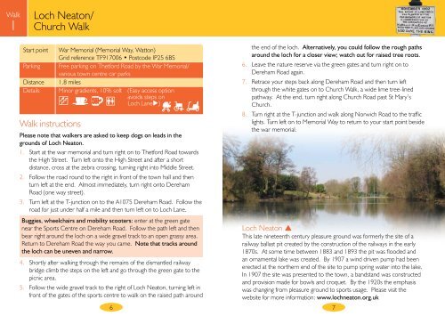
Loch Neaton <br />
This late nineteenth century pleasure ground was formerly <strong>the</strong> site of a<br />
railway ballast pit created by <strong>the</strong> construction of <strong>the</strong> railways in <strong>the</strong> early<br />
1870s. At some time between 1883 <strong>and</strong> 1893 <strong>the</strong> pit was flooded <strong>and</strong><br />
an ornamental lake was created. By 1907 a wind driven pump had been<br />
erected at <strong>the</strong> nor<strong>the</strong>rn end of <strong>the</strong> site to pump spring water into <strong>the</strong> lake.<br />
In 1907 <strong>the</strong> site was presented to <strong>the</strong> town, a b<strong>and</strong>st<strong>and</strong> was constructed<br />
<strong>and</strong> provision made for bowls <strong>and</strong> croquet. By <strong>the</strong> 1920s <strong>the</strong> emphasis<br />
was changing from pleasure ground to sports usage. Please visit <strong>the</strong><br />
website for more information: www.lochneaton.org.uk<br />
7