New Legaspi Airport Draft FS - PPP Center
New Legaspi Airport Draft FS - PPP Center
New Legaspi Airport Draft FS - PPP Center

Create successful ePaper yourself
Turn your PDF publications into a flip-book with our unique Google optimized e-Paper software.
Chapter 2 CONDITION OF THE EXISTING LEGASPI AIRPORT<br />
2.1 GENERAL<br />
<strong>Legaspi</strong> <strong>Airport</strong> is located in the city of <strong>Legaspi</strong>, Albay about 4.4 kilometers northwest of the<br />
city proper. Aerodrome reference point is at 13°09’43.1479”N, 123°44’04.4427”E having<br />
an ICAO reference code of 4C. Reference elevation is 20M and reference temperature is<br />
28°C. The area is relatively flat but slightly sloping to the south with longitudinal slope of<br />
the runway of 0.71% downhill to the southwest. This trunkline domestic airport is<br />
supervised and operated by the Air Transportation Office of the Department of<br />
Transportation and Communications.<br />
2.2 ENVIRONMENTAL CONDITIONS<br />
2.2.1 Natural Environment<br />
The existing airport is bounded by the Yawa River to the northeast and by the<br />
Bagtang River to the southwest. One of the major waterways draining the slopes<br />
of Mayon Volcano and passing through <strong>Legaspi</strong> City, Yawa River has become<br />
shallow along its lower reaches due to sedimentation caused by the recent<br />
activities of Mayon Volcano. Its quality has been deteriorating due to pollution<br />
from industrial activities, solid wastes and debris flow.<br />
Rice paddies are located east of the airport terminal building (outside airport<br />
property) and southwest of Rwy 06. Apart from the rice paddies, vegetation<br />
around the airport consists of coconut, grass, and fruit bearing trees such as<br />
mango, banana and chico.<br />
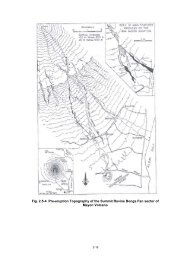
The Kemantong Range, a hilly terrain located southwest of the airport, protrudes<br />
about 40m above ground level and is considered a major hazard to airport<br />
operations. While Linion Hill, a smaller hill north of the airport and where a<br />
synoptic station of PAGASA is located, rises at least over 30m above ground level.<br />
2-1