Open-file Report 232 - New Mexico Bureau of Geology & Mineral ...
Open-file Report 232 - New Mexico Bureau of Geology & Mineral ...
Open-file Report 232 - New Mexico Bureau of Geology & Mineral ...

Create successful ePaper yourself
Turn your PDF publications into a flip-book with our unique Google optimized e-Paper software.
A Preliminary <strong>Mineral</strong>-Resource Potential<br />
<strong>of</strong><br />
€!an Juan County, Northwestern <strong>New</strong> <strong>Mexico</strong><br />
by<br />
Virginia T. McLemore,<br />
Ronald F. Broadhead,<br />
Kevin Cook,<br />
William L. Chenoweth,<br />
James M. Barker,<br />
Gretchen Roybal,<br />
Robert M. North,<br />
Peter Copeland,<br />
Mark R. Bowie,<br />
John S. Hingtgen,<br />
Kris Klein,<br />
and Karen B. Brown<br />
<strong>New</strong> <strong>Mexico</strong> <strong>Bureau</strong> <strong>of</strong> Mines and <strong>Mineral</strong> Resources<br />
<strong>Open</strong>-<strong>file</strong> <strong>Report</strong> <strong>232</strong><br />
November 1986<br />
United States Department <strong>of</strong> Interior<br />
Prepared in cooperation with<br />
<strong>Bureau</strong> <strong>of</strong> Land Management
Preface<br />
During the spring, 1985, the U.S. <strong>Bureau</strong> <strong>of</strong> Land Management<br />
(BLM) and the <strong>New</strong> <strong>Mexico</strong> <strong>Bureau</strong> <strong>of</strong> Mines and <strong>Mineral</strong> Resources<br />
(NMBMMR) entered a cooperative agreement to prepare a preliminary<br />
mineral-resource inventory and assessment <strong>of</strong> northwestern <strong>New</strong><br />
<strong>Mexico</strong>, including Valencia, Cibola, McKinley, San Juan, and<br />
western Rio Arriba Counties. This is the fifth <strong>of</strong> six reports<br />
describing the geology and mineral-resource potential <strong>of</strong> northern<br />
<strong>New</strong> <strong>Mexico</strong>. The first report describes the methodology and<br />
classification <strong>of</strong> mineral-resource potential used in this report<br />
and includes a summary <strong>of</strong> the mineral-resource potential San <strong>of</strong><br />
Juan County.<br />
These reports are based upon time consuming analyses <strong>of</strong> all<br />
available data, published and unpublished, by a group <strong>of</strong><br />
geologists and technical support staff. Without this team effort<br />
this project would be impossible. In addition to the co-authors<br />
<strong>of</strong> the final report, many other people NMBMMR at the and BLM<br />
provided assistance, especially in reviewing the rough drafts.<br />
This report is organized into a text, appendices (volume 2),<br />
and supporting figures, maps (scale 1:100,000), and tables.<br />
Known mineral occurrences, mines, and deposits, including<br />
material pits, are briefly described in Appendix 1 and plotted on<br />
1:100,000 scale maps. <strong>Mineral</strong>-resource potential <strong>of</strong> various<br />
commodities is discussed in the text and also shown 1:100,000 on<br />
scale maps.
ABSTFlACT<br />
A preliminary mineral-resource potential assessment San <strong>of</strong><br />
Juan County involves analyses <strong>of</strong> available published and<br />
unpublished geologic, geochemical, geophysical, and economic data<br />
and a brief field reconnaissance. <strong>Mineral</strong>-resource potential is<br />
an assessment <strong>of</strong> the favorability a that commodity will occur in<br />
substantial concentrations in a given area that can be exploited<br />
under current or future economic conditions. A classification <strong>of</strong><br />
high, moderate, low, very low, or unknown is assigned. A high<br />
mineral-resource potential exists in areas where geologic and<br />
economic data indicate an excellent probability that economic<br />
mineral deposits occur there. Moderate or low mineral-resource<br />
potential exists in areas where the data indicate a lesser<br />
probability that economic mineral deposits occur. A<br />
classification <strong>of</strong> very low potential is reserved for areas where<br />
sufficient information indicates that an area is unfavorable for<br />
economic deposits. A classification <strong>of</strong> unknown mineral-resource<br />
potential is assigned to areas where either necessary geologic,<br />
geochemical, geophysical, and economic data are inadequate to<br />
otherwise classify an area or where any other classification<br />
(high, moderate, low, or very low) would be misleading. Some<br />
areas have not been evaluated for specific commodities because o<br />
lack <strong>of</strong> usable data.<br />
Energy resources are the most important commodities in San<br />
Juan County, although other commodities have been produced.<br />
Coal, oil, and gas are currently being produced and have high<br />
potentials in various parts <strong>of</strong> San Juan County. A high resource
potential exists locally for carbon dioxide, clay, helium. sand<br />
and gravel, and limestone. Much <strong>of</strong> the county a high has<br />
resource potential for crushed and dimension stone.<br />
A moderate resource potential exists for uranium in the<br />
Shiprock district and at the Boyd prospect. A moderate potential<br />
exists locally for humate.<br />
Additional geologic mapping and geochemical studies are<br />
suggested in areas with active claims, at the Boyd prospect, in<br />
areas <strong>of</strong> aggregate resources, and in areas with potential for<br />
silica sand, clay, and zeolites. More drilling and quality<br />
analyses are needed to better evaluate the coal resource<br />
potential. The significance <strong>of</strong> barium anomalies along the<br />
Kirtland-Fruitland contact and in the Nacimiento Formation needs<br />
to be examined.
VOLUME I<br />
Abstract<br />
Introduction<br />
Purpose and scope<br />
Definitions<br />
TABLE OF CONTENTS<br />
Classification <strong>of</strong> mineral-resource potential<br />
Previous geologic investigations<br />
Acknowledgments<br />
Physiography and geology (by Virginia T. McLemore,<br />
Ronald F. Broadhead, and<br />
Gretchen Roybal)<br />
Mining history (by Karen B. Brown and Virginia T. McLemor?) 37<br />
Present mining claims, leases, and exploration activity 40<br />
Description <strong>of</strong> known deposits and mineral-resource potential 43<br />
Petroleum resources (by Ronald F. Broadhead) 43<br />
Coal resources (by Kevin Cook) 88<br />
Uranium resources (by Virginia T. McLemore<br />
and William L. Chenoweth) 12 0<br />
Geothermal resources (by Virginia T. McLemore<br />
and Kris Klein)<br />
Metals (by Virginia T. McLemore.and<br />
William L. Chenoweth)<br />
Deposit types<br />
Vanadium<br />
ii<br />
1<br />
3<br />
5<br />
8<br />
13<br />
14<br />
137<br />
139<br />
139<br />
139<br />
Miscellaneous 14 1<br />
Industrial materials 144<br />
Introduction (by M. Barker) James<br />
144<br />
Barite and fluorite (by Virginia T. McLemore) 151
Summary<br />
Recommendations<br />
References<br />
VOLW I1<br />
Carbon-dioxide resources (by Ronald F. BroadheaJ) 152<br />
Clays (by B. Brown) Karen 161<br />
Crushed stone (by Mark R. Bowie) 165<br />
Dimension stone (by R. Mark Bowie) 17 0<br />
Gemstones (by Robert M. North) 175<br />
Helium resources (by Ronald F. Broadhead) 17 6<br />
Humate (by Gretchen Roybal) 190<br />
Lightweight aggregate (by John S. Hingtgen) 192<br />
Limestone (by James M. Barker) 203<br />
Mica (by Mark R. Bowie) 207<br />
Saline minerals (by B. Karen Brown) 209<br />
Sand and gravel (by Peter Copeland)<br />
Silica sand (by Mark R. Bowie)<br />
Sulfur (by James M. Barker)<br />
Zeolites (by Mark M. Bowie)<br />
Appendix 1 - <strong>Mineral</strong> and other commodity occurrences,<br />
deposits, and mines<br />
in San Juan County<br />
Appendix 2 - Petroleum exploration wells drilled in<br />
San Juan County<br />
Appendix 3 - Summary sheets <strong>of</strong> oil and gas pools in<br />
San Juan County<br />
Appendix 4 - Cumulative production <strong>of</strong> oil and gas in<br />
San Juan County<br />
Appendix 5 - Coal quality data<br />
Appendix 6 - Coal resource data<br />
209<br />
215<br />
217<br />
220<br />
222<br />
224<br />
226
1.<br />
2.<br />
3.<br />
4.<br />
5.<br />
6.<br />
7.<br />
8.<br />
9.<br />
10.<br />
11.<br />
12.<br />
13.<br />
14.<br />
15.<br />
16.<br />
17.<br />
18.<br />
19.<br />
20.<br />
21.<br />
22.<br />
TABLES<br />
Stratigraphic units and associated economics<br />
commodities in San Juan County.<br />
Summary <strong>of</strong> production <strong>of</strong> various commodities in<br />
San Juan County.<br />
Petroleum production in <strong>New</strong> <strong>Mexico</strong> by county.<br />
Cumulative production <strong>of</strong> oil and gas in San Juan<br />
County by stratigraphic unit.<br />
Number <strong>of</strong> oil and gas wells producing from<br />
undesignated pools, San Juan County, <strong>New</strong> <strong>Mexico</strong>.<br />
Coal production in San Juan County.<br />
Mine production in San Juan County.<br />
Production <strong>of</strong> recent mines in San Juan County.<br />
Coal resources for San Juan County.<br />
Coal reserves for San Juan County.<br />
Quality analyses <strong>of</strong> coals in San Juan County.<br />
Comparison <strong>of</strong> quality <strong>of</strong> San Juan coals.<br />
Coal leases and PRLA's in San Juan County.<br />
Resources for deep coals in San Juan County.<br />
Uranium production by county from <strong>New</strong> <strong>Mexico</strong><br />
from 1948 to 1983.<br />
Uranium production by host formation in the San Juan<br />
Basin, <strong>New</strong> <strong>Mexico</strong> from 1948 through 1984.<br />
122<br />
Uranium production by district in San Juan County. 127<br />
Chemical analyses <strong>of</strong> uranium deposits in San Juan<br />
County, <strong>New</strong> <strong>Mexico</strong>.<br />
131<br />
Geothermal wells and springs in San Juan County.<br />
Vanadium production from uranium ores in <strong>New</strong> <strong>Mexico</strong>. 14 0<br />
Classification <strong>of</strong> industrial minerals.<br />
Some relationships between industrial materials<br />
based on conditions within <strong>New</strong> <strong>Mexico</strong>.<br />
15<br />
38<br />
44<br />
52<br />
56<br />
90<br />
91<br />
- 92<br />
93<br />
94<br />
95<br />
96<br />
97<br />
118<br />
121<br />
138<br />
145<br />
14 6
23a-c. Classification <strong>of</strong> industrial materials that occur<br />
in San Juan County by geology and industrial end 148-150 use.<br />
24. Carbon dioxide content <strong>of</strong> gases produced from oil<br />
and gas pools, San Juan County. 153-154<br />
25. Carbon dioxide content <strong>of</strong> gases recovered from<br />
Paleozoic and Triassic units in nonproductive<br />
wells in San Juan County.<br />
26. Currently exploited and potential crushed stone<br />
resources in San Juan County. 167<br />
27. Historical stone production in San Juan County. 168<br />
28. Current and potential sources <strong>of</strong> dimension stone<br />
in San Juan 172 County.<br />
29. Cumulative production <strong>of</strong> gas from oil and gas pools<br />
that contain helium-rich gas in San Juan County. 180<br />
30. Helium content <strong>of</strong> gases produced from Paleozoic oil<br />
and gas pools, San Juan County. 181<br />
31. Helium content <strong>of</strong> gases recovered from Triassic and<br />
Paleozoic reservoirs in wells drilled in San Juan<br />
county. 182-183<br />
32. Analysis <strong>of</strong> Todilto limestone channel samples from<br />
the Sanostee-Beautiful Mountain area <strong>of</strong> San Juan Couyty. 207<br />
33. Sand and gravel pits known to be operating in Jum San<br />
County 1985 or in 1986. 213<br />
34. Sand and gravel production in San Juan County. 213<br />
35. Potential sources <strong>of</strong> silica sand in San Juan County. 215<br />
36. Chemical analyses <strong>of</strong> raw sand from the Navajo Indian<br />
Reservation, San Juan County. 216<br />
37. Summary <strong>of</strong> the mineral-resource potential in<br />
San Juan County.<br />
FIQUREB<br />
1. Areas assessed by <strong>New</strong> <strong>Mexico</strong> <strong>Bureau</strong> <strong>of</strong> Mines and<br />
<strong>Mineral</strong> Resources.<br />
2. 1:100,000 scale topographic maps covering San Juan<br />
County.<br />
3. Classification <strong>of</strong> mineral-resource potential.<br />
156<br />
223<br />
2<br />
4<br />
6
4.<br />
5.<br />
6.<br />
7.<br />
8.<br />
9.<br />
10.<br />
11.<br />
12.<br />
13.<br />
14.<br />
15.<br />
16.<br />
17.<br />
18.<br />
19.<br />
20.<br />
Index <strong>of</strong> geologic mapping a at scale <strong>of</strong> 1:24,000<br />
or larger.<br />
Index <strong>of</strong> geologic mapping at scales greater than<br />
1:24,000 to 1:63,360.<br />
Index <strong>of</strong> geologic mapping at scales smaller than<br />
1:63,360.<br />
Basins and uplifts in San Juan County.<br />
Geologic map <strong>of</strong> San Juan County.<br />
Time-stratigraphic nomenclature chart for Paleozoic<br />
rocks <strong>of</strong> the San Juan Basin.<br />
Generalized stratigraphic section <strong>of</strong> Pennsylvanian<br />
sedimentary rocks in west-central <strong>New</strong> <strong>Mexico</strong>.<br />
Stratigraphic correlations <strong>of</strong> Jurassic rocks in<br />
San Juan County.<br />
Stratigraphy <strong>of</strong> Cretaceous rocks in San Juan County. 30<br />
Mining districts and areas in San Juan County.<br />
Sections with active mining claims in San Juan County. 41<br />
Active mines in San Juan County.<br />
42<br />
Designated oil and gas pools in San Juan County that<br />
produce from the Nacimiento Formation (Tertiary) and<br />
the Farmington Sandstone Member <strong>of</strong> the Kirtland Shale<br />
(Cretaceous) .<br />
45<br />
Designated oil and gas pools in San Juan County that<br />
produce from the Fruitland Formation.<br />
46<br />
Designated oil and gas pools in San Juan County that<br />
produce from the Pictured Cliffs Sandstone a or<br />
combination <strong>of</strong> the Pictured Cliffs Sandstone and the<br />
Fruitland Formation (Cretaceous).<br />
47<br />
Designated oil and gas pools in San Juan County that<br />
produce from the Chacra producing interval or the<br />
Mesaverde Group (Cretaceous).<br />
48<br />
Designated oil and gas pools in San Juan County that<br />
produce from the Gallup sandstone (actually basal<br />
Niobrara or Tocito sands) a or combination <strong>of</strong> the<br />
Gallup sandstone, lower part <strong>of</strong> the Mancos Shale,<br />
and the Dakota Sandstone (Cretaceous).<br />
49<br />
10<br />
11<br />
12<br />
16<br />
17<br />
18<br />
22<br />
27<br />
39
21.<br />
22.<br />
23.<br />
24.<br />
25.<br />
26.<br />
27.<br />
28.<br />
29.<br />
30.<br />
31.<br />
32.<br />
33.<br />
34.<br />
35.<br />
36.<br />
37.<br />
38.<br />
39.<br />
40.<br />
Designated oil and gas pools in San Juan County that<br />
produce from the Dakota Sandstone (Cretaceous) thz or<br />
Dakota and either the Lower Mancos Shale or the Gallup<br />
Sandstone.<br />
50<br />
Designated oil and gas pools in San Juan County that<br />
produce from the Entrada Sandstone (Jurassic)] and<br />
reservoirs <strong>of</strong> Pennsylvanian] Mississippian, and<br />
Devonian age.<br />
51<br />
Tectonic elements in San Juan County, <strong>New</strong> <strong>Mexico</strong>.<br />
Potential for petroleum occurrence in San Count:r. Juan<br />
Coal resources potential~in-San~~Juan County.<br />
Uranium subdistricts and areas in the Shiprock<br />
district.<br />
Uranium (vanadium) resource potential in San Juan<br />
County.<br />
Beach placer deposits in the San Juan Basin.<br />
Occurrences <strong>of</strong> natural gas that consist 10% <strong>of</strong> or<br />
more C02.<br />
Potential for C02 occurrence in San Juan County.<br />
Resource potential for crushed stone, mica, silica<br />
sand, and zeolite in San Juan County.<br />
Resource potential for dimension stone in San Juan<br />
County.<br />
Occurrences <strong>of</strong> helium-rich gas in Mississippian<br />
reservoirs, San Juan County.<br />
Occurrences <strong>of</strong> helium-rich gas in Pennsylvanian<br />
reservoirs] San Juan County.<br />
Occurrences <strong>of</strong> helium-rich gas in Triassic, Devonian.<br />
and Cambrian reservoirs.<br />
Potential for helium occurrence in San Juan County.<br />
Lightweight aggregate resources in San Juan County.<br />
Expansion Curves <strong>of</strong> Menefee and Mancos shales.<br />
Limestone resources in San Juan County.<br />
Resource potential for sand and gravel in<br />
San Juan County.<br />
67<br />
82<br />
89<br />
123<br />
128<br />
134<br />
155<br />
158<br />
166<br />
17 1<br />
177<br />
178<br />
179<br />
186<br />
200<br />
202<br />
208<br />
212
41. Comparison <strong>of</strong> average price <strong>of</strong> sand and gravel in<br />
San Juan and McKinley Counties, 1957-1975. 2 14<br />
Petroleum Maps<br />
63.<br />
64.<br />
65.<br />
66.<br />
67.<br />
68.<br />
69.<br />
70.<br />
71.<br />
MAPS (IN POCKET)<br />
Petroleum tests in the Toadlena 30- by 60-minute<br />
topographic quadrangle, San Juan County.<br />
Petroleum tests in the Farmington 30- by 60-minute<br />
topographic quadrangle, San Juan County.<br />
Petroleum tests in the Navajo Reservoir 30- by 60minute<br />
topographic quadrangle, San Juan and Rio<br />
Arriba Counties.<br />
Petroleum tests in the Chaco Canyon 30- by 60minute<br />
topographic quadrangle, San Juan and Rio<br />
Arriba Counties.<br />
Oil and gas fields in the Toadlena 30- by 60-minute<br />
topographic quadrangle, San Juan County.<br />
Oil and gas fields in the Farmington 30- by 60-minute<br />
topographic quadrangle, San Juan County.<br />
Oil and gas fields in the Navajo Reservoir 30- by<br />
60-minute topographic quadrangle, San Juan and Rio<br />
Arriba Counties.<br />
Oil and gas fields in the Chaco Canyon 30- by 60minute<br />
topographic quadrangle, San Juan and Rio<br />
Arriba Counties.<br />
Petroleum resource potential in the Toadlena 30- by<br />
60-minute topographic quadrangle, San Juan County.<br />
72. Petroleum resource potential in the Farmington 30by<br />
60-minute topographic quadrangle, San Juan County.<br />
COAL MAPS<br />
73. Coal occurrences, prospects, mines, and resource<br />
potential for Toadlena 30- by 60-minute topographic<br />
quadrangle, San Juan County.<br />
74. Coal occurrences, prospects, mines, and resource<br />
potential for Farmington 30- by 60-minute topographic<br />
quadrangle, San Juan County.<br />
75. Coal occurrences, prospects, mines, and resource<br />
potential for Navajo Reservoir 30- by 60-minute<br />
topographic quadrangle, San Juan and Rio Arriba Counties.
76 Coal occurrences, prospects, mines, and resource<br />
potential for Chaco Canyon 30- by 60-minute topographic<br />
quadrangle, San Juan and Rio Arriba Counties.<br />
URANIUM AND METALS<br />
77. <strong>Mineral</strong> occurrences, prospects, mines, and resource<br />
potential for Rock Point 30- by 60-minute topographic<br />
quadrangle, San Juan County.<br />
78. <strong>Mineral</strong> occurrences, prospects, mines, and resource<br />
potential for Canyon de Chelly 30- by 60-minute<br />
topographic quadrangle, San Juan County.<br />
79. <strong>Mineral</strong> occurrences, prospects, mines, and resource<br />
potential for Toadlena 30- by 60-minute topographic<br />
quadrangle, San Juan County.<br />
80. <strong>Mineral</strong> occurrences, prospects, mines, and resource<br />
potential for Farmington 30- by 60-minute topographic<br />
quadrangle, San Juan County.<br />
81. <strong>Mineral</strong> occurrences, prospects, mines, and resource<br />
potential for Chaco Canyon 30- by 60-minute topographic<br />
quadrangle, San Juan and Rio Arriba Counties.<br />
GEOTHERMAL MAPS<br />
82. Geothermal wells and resource potential in the Toadlena<br />
30- by 60-minute topographic quadrangle, San Juan<br />
county.<br />
83. Geothermal wells and resource potential in the<br />
Farmington 30- by 60-minute topographic quadrangle,<br />
San Juan County.<br />
84. Geothermal wells and resource potential in the<br />
Navajo Reservoir 30- by 60-minute topographic<br />
quadrangle, San Juan and Rio Arriba Counties.<br />
85. Geothermal wells and resource potential in the Chaco<br />
Canyon 30- by 60-minute topographic quadrangle, San<br />
Juan and Rio Arriba Counties.<br />
AGGREGATE (SAND AND GRAVEL)<br />
86. Aggregate pits and resource potential in the<br />
Toadlena 30- by 60-minute topographic quadrangle,<br />
San Juan County.<br />
87. Aggregate pits and resource potential in the<br />
Farmington 30- by 60-minute topographic quadrangle,<br />
San Juan County.
88.<br />
89.<br />
INDl JSTRIAL MATERIALS MAPS<br />
90<br />
91.<br />
92.<br />
93.<br />
94.<br />
95.<br />
96.<br />
97.<br />
Aggregate pits and resource potential in the<br />
Navajo Reservoir 30- by 60-minute topographic<br />
quadrangle, San Juan and Rio Arriba Counties.<br />
Aggregate pits and resource potential in the<br />
Chaco Canyon 30- by 60-minute topographic<br />
quadrangle, San Juan and Rio Arriba Counties.<br />
Resource potential for crushed and dimension stone,<br />
mica, and silica sand in the Toadlena 30- by 60minute<br />
topographic quadrangle, San Juan County.<br />
Resource potential for crushed and dimension stone,<br />
mica, and silica sand in the Farminqton 30- by 60minute<br />
topographic quadrangle, San Juan County.<br />
Resource potential for crushed and dimension stone,<br />
mica, and silica sand in the Navajo Reservoir 30by<br />
60-minute topographic quadrangle, San Juan and<br />
Rio Arriba Counties.<br />
Resource potential for crushed and dimension stone,<br />
mica, and silica sand in the Chaco 30- Canyon by<br />
60-minute topographic quadrangle, San Juan and Rio<br />
Arriba Counties.<br />
Resource potential for lightweight aggregate and<br />
limestone in the Toadlena 30- by 60-minute<br />
topographic quadrangle, San Juan County.<br />
Resource potential €or lightweight aggregate and<br />
limestone in the Farminqton 30- by 60-minute<br />
topographic quadrangle, San Juan County.<br />
Resource potential for lightweight aggregate and<br />
limestone in the Navajo Reservoir 30- by 60minute<br />
topographic quadrangle, San Juan and Rio<br />
Arriba Counties.<br />
Resource potential for lightweight aggregate and<br />
limestone in the Chaco Canyon 30- by 60-minute<br />
topographic quadrangle, San Juan and Rio Arriba<br />
Counties.
INTRODUCTION<br />
Purpose and Baope<br />
The Federal Land Policy and Management Act (FLPMA) <strong>of</strong> 1976<br />
charges the U.S. <strong>Bureau</strong> <strong>of</strong> Land Management (BLM) with<br />
responsibility for preparing a mineral-resource inventory and<br />
assessment <strong>of</strong> mineral-resource potential for all <strong>of</strong> the public<br />
lands they manage. These studies are essential to land-use<br />
planning and management and they are required to prior BLM<br />
actions such as disposal, withdrawal, exchange, or conveyance <strong>of</strong><br />
land and wilderness designations. In order to meet this<br />
statutory requirement, the BLM and the <strong>New</strong> <strong>Mexico</strong> <strong>Bureau</strong> <strong>of</strong> Min<br />
and <strong>Mineral</strong> Resources (NMBMMR) entered a cooperative agreement to<br />
prepare a preliminary mineral-resource inventory and assessment<br />
for northwestern <strong>New</strong> <strong>Mexico</strong>, including Valencia, Cibola,<br />
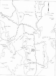
McKinley, San Juan, and western Rio Arriba Counties 1). (Fig.<br />
NMBMMR staff were already actively involved with compilations and<br />
geologic studies <strong>of</strong> various commodities on all lands within <strong>New</strong><br />
<strong>Mexico</strong>, so the requirements <strong>of</strong> both agencies were satisfied.<br />
McLemore (1984) and McLemore et al. (1984) previously evaluated<br />
the mineral-resource potential <strong>of</strong> Torrance County and Sandoval<br />
and Bernalillo Counties and adjacent parts <strong>of</strong> McKinley, Cibola,<br />
and Santa Fe Counties (Fig. 1).<br />
This preliminary mineral-resource inventory and assessment<br />
is based on analysis <strong>of</strong> available published and unpublished<br />
geologic, geochemical, geophysical, and economic data and brief<br />
field reconnaissance as described by McLemore (1985) and McLemore<br />
et al. (1986a). A more rigorous and complete analysis <strong>of</strong> all<br />
available information and additional field work could expand the<br />
1
.. . .<br />
.. . I. . .<br />
.. . . .<br />
-<br />
0 5 mi<br />
, . . .<br />
.L<br />
' Figure 1. Areas assessed by <strong>New</strong> <strong>Mexico</strong> <strong>Bureau</strong> <strong>of</strong> Mines<br />
, ... ..<br />
and <strong>Mineral</strong> Resources.<br />
. .. . . . .<br />
'. .:<br />
...<br />
..<br />
. . . ..<br />
.<br />
..<br />
.
preliminary conclusions <strong>of</strong> this report.<br />
This report is organized into a text, appendices, and<br />
supporting figures, maps, and tables. Known mineral occurrences,<br />
prospects, deposits, and mines, including material pits, are<br />
briefly described in Appendix 1 and generally described b:r<br />
deposit type in the text. Petroleum tests are tabulated in<br />
Appendices 2, 3, and 4. Coal reserves, resources, and coal<br />
quality data are tabulated in Appendices 5 and 6. Known mineral<br />
occurrences, prospects, deposits, mines, and oil and gas tests<br />
are plotted on 1:100,000-scale maps; Figure 2 is an index to<br />
1:100,000-scale topographic maps covering San Juan County.<br />
<strong>Mineral</strong>-resource potential <strong>of</strong> various commodities is discussed in<br />
the text and also shown on 1:100,000-scale maps.<br />
Definitions<br />
<strong>Mineral</strong> resources are the naturally occurring concentrations<br />
<strong>of</strong> materials (solid, gas, or liquid) in or on the earth's crust<br />
that can be extracted economically under current futum or<br />
economic conditions. <strong>Report</strong>s describing mineral resources vary<br />
from simple inventories known <strong>of</strong> mineral deposits to detailed,<br />
geologic investigations.<br />
A mineral occurrence is any locality where a useful mineral<br />
or material occurs. A mineral prospect is any occurrence that<br />
has been developed by underground or above ground techniques or<br />
by subsurface drilling. These two terms do not have any resource<br />
or economic implications. A mineral deposit is a sufficiently<br />
large concentration <strong>of</strong> a valuable or useful mineral or material<br />
that may be extracted under current or future economic<br />
3
I<br />
I<br />
,I ’<br />
Figure 2. 1:100,000 scale topographic maps covering San Juan County, <strong>New</strong> <strong>Mexico</strong>.<br />
4 -Na<br />
.I
conditions. A mine is any prospect which produced or is<br />
currently producing a useful mineral or material.<br />
The mineral-resource potential <strong>of</strong> an is area the likelihood<br />
or probability that a mineral will occur in sufficient quantities<br />
so that it can be extracted economically under current or future<br />
conditions (Taylor and Steven, 1983). <strong>Mineral</strong>-resource potential<br />
is preferred in describing an area whereas mineral-resource<br />
favorability is used in describing a specific rock type 07<br />
geologic environment (Goudarzi, 1984). The mineral-resource<br />
potential is not a measure <strong>of</strong> the quantities <strong>of</strong> the mineral<br />
resources, but is a measure <strong>of</strong> the potential <strong>of</strong> occurrence.<br />
Factors that could preclude development <strong>of</strong> the resources, such a<br />
the feasibility <strong>of</strong> extracting the minerals, land ownership,<br />
accessibility <strong>of</strong> the minerals, or cost <strong>of</strong> exploration,<br />
development, production, processing, or marketing, are no?<br />
considered in assessing the resource potential, although these<br />
factors certainly affect the economics <strong>of</strong> extraction. ToCal<br />
evaluation <strong>of</strong> mineral-resource potential involves a complete<br />
understanding <strong>of</strong> the known and undiscovered mineral resouxes in<br />
a given area.<br />
Classification <strong>of</strong> <strong>Mineral</strong>-Resourae Potential<br />
A simple subjective classification <strong>of</strong> mineral-resource<br />
potential is used for the purposes <strong>of</strong> this report. The potential<br />
is simply classified according to availability <strong>of</strong> geologic data<br />
and relative probability <strong>of</strong> occurrence as high, moderate, low,<br />
very low, or unknown (Fig. 3). More detailed descriptions <strong>of</strong><br />
this classification scheme and evaluation process are by McLemore<br />
5
. ..<br />
0<br />
-I<br />
0<br />
-I -I<br />
0<br />
3<br />
3 3<br />
a<br />
I
(1985) and McLemore et al. (1986a).<br />
A hish mineral-resource potential is assigned to areas where<br />
there are known mines or deposits or where the geologic,<br />
geochemical, or geophysical data indicate an excellent<br />
probability that mineral deposits occur. A moderate mineyal-<br />
resource potential exists in areas where data suggest a<br />
reasonable possibility that undiscovered deposits occur in<br />
formations or geologic settings known to contain economic<br />
deposits in similar geologic settings elsewhere. A moderate to<br />
low mineral-resource potential exists in areas where data suggest<br />
a reasonable possibility that undiscovered mineralization occurs<br />
in an area, but the potential is not as good as moderate.<br />
mineral-resource potential exists in areas where available data<br />
imply the occurrence <strong>of</strong> mineralization, but indicate a low<br />
possibility for the occurrence <strong>of</strong> a deposit. A classification <strong>of</strong><br />
verv low mineral-resource potential is reserved for areas where<br />
sufficient information indicates that an area is unfavorable for<br />
economic deposits. Use <strong>of</strong> the very low classification requires a<br />
high level <strong>of</strong> geologic assurance.<br />
A classification <strong>of</strong> unknown mineral-resource potential is<br />
reserved for areas where necessary geologic, geochemical, and<br />
geophysical data are inadequate to otherwise classify an area.<br />
This assessment is assigned to areas where the degree <strong>of</strong> geologic<br />
assurance is low and any other classification (high, moderate,<br />
low, or very low) would be misleading. These areas should<br />
receive high priority for additional study.<br />
The mineral-resource potential <strong>of</strong> some areas can not be<br />
assessed because <strong>of</strong> lack <strong>of</strong> useful data. Detailed geologic<br />
7
mapping at a scale <strong>of</strong> 1:24,000 may be required before the<br />
mineral-resource potential can be assessed. The lack <strong>of</strong> data<br />
does not imply a verv low mineral-resource votential. Th(l-<br />
difference between an unknown resource potential and unevaluated<br />
area is that some data exists in an unknown area <strong>of</strong> resouxe<br />
potential which implies the possibility <strong>of</strong> the occurrence <strong>of</strong><br />
resources.<br />
In addition to evaluation <strong>of</strong> the mineral-resource potential,<br />
the potential for development is assessed. The potential for<br />
development is classified simply as high, moderate, or low and<br />
takes into account such factors as grade, tonnage, current market<br />
conditions, and status, and similar economic factors.<br />
potential for develovment indicates that the is area currently<br />
producing a commodity or economic conditions suggest that<br />
production <strong>of</strong> the deposit is economically feasible currently or<br />
in the near future. Moderate votential for development exists in<br />
areas where production <strong>of</strong> the deposit would occur if certain<br />
geologic or economic conditions became favorable. Low votential<br />
for develovment indicates only a slight possibility, if any, for<br />
production <strong>of</strong> the deposit. The potential €or development<br />
classification is also a highly subjective judgment, but it does<br />
<strong>of</strong>fer an evaluation <strong>of</strong> the economic feasibility an area. <strong>of</strong><br />
Previous Geologic Investigations<br />
The geology <strong>of</strong> San Juan County is described <strong>of</strong> as part<br />
numerous regional geologic reports on the Colorado Plateau. Many<br />
<strong>of</strong> these reports are cited where appropriate. Much <strong>of</strong> the county<br />
is covered by geologic maps <strong>of</strong> various scales (Figs. 4, 5, 6).
Two state geologic maps and one regional map (Dane and Bachman,<br />
1957, 1965; <strong>New</strong> <strong>Mexico</strong> Geological Society and NMBMMR, 1983) also<br />
include San Juan County. Geologic mapping 1:250,000 at scale <strong>of</strong><br />
each 1- by 2-degree quadrangle (Shiprock and Aztec) are by<br />
O'Sullivan and Beckman (1963) and NURE (National Uranium Resource<br />
Evaluation) .<br />
Specific reports describing the mineral resources in San<br />
Juan County are numerous, especially concerning petroleum,.<br />
uranium, and coal resources. The best source describing all<br />
mineral resources in <strong>New</strong> <strong>Mexico</strong> a compilation is<br />
prepared by the<br />
U.S. Geological Survey (1965) in cooperation with various state<br />
and federal government agencies. Various reports on uranium<br />
resources include Anderson (1957), Siemers and Austin (1979a, b),<br />
U.S. Geological Survey and NMBMMR (1981), Anderson (1981), and<br />
McLemore (1983a). Schilling (1975) and McLemore (1983a) include<br />
bibliographies <strong>of</strong> additional citations concerning uranium<br />
resources. Various reports on coal resources include numerous<br />
geologic maps (Figs. 4, 5, 6), Shomaker et al. (1971), U.S.<br />
Geological Survey and NMBMMR (1981), and Nickelson (in press).<br />
Other mineral reports include Jones (1904), Talmage and Wootton<br />
(1937), Bieberman and Weber (1969), Foster and Grant (1974),<br />
Logsdon (1982), Austin (1982), Barker et al. (1984), and 1"orth<br />
and McLemore (1984, 1986). Additional commodity reports<br />
concerning this area are cited where appropriate. Production<br />
statistics are from various <strong>file</strong> U.S. data, Geological Survey<br />
(1903-1931), U.S. <strong>Bureau</strong> <strong>of</strong> Mines (1932-1984), and <strong>New</strong> <strong>Mexico</strong><br />
State Mine Inspector (1903-1983). A leasable mineral-lan$<br />
classification map has been prepared by DeCicco et al. (1?78a,<br />
9
e<br />
0
). As part <strong>of</strong> the U.S. Department <strong>of</strong> Energy's NURE, much <strong>of</strong> San<br />
Juan County was examined (Green et al., 1982a, b).<br />
ACKNOWLELWMENTS<br />
This project was completed under a cooperative agreement<br />
between the <strong>Bureau</strong> <strong>of</strong> Land Management (BLM) and the NMBMMX. The<br />
coordinators for the BLM include Henry Wilson, William Jo;las,<br />
Carl Yost, James Olsen, and Pat Hester who provided some <strong>of</strong> th<br />
data needed to evaluate the mineral-resource potential. Warren<br />
Bennett, <strong>New</strong> <strong>Mexico</strong> State Highway Department, provided on data<br />
aggregate resources. Many people on the NMBMMR staff in addition<br />
to the co-authors assisted greatly in preparing this repo-.<br />
Lynn Brandvold and associates provided chemical analyses. Robert<br />
North and James Barker assisted the senior author in the field.<br />
Cherie Pelletier, Cindie Salisbury, Kris Klein, and Lori Baker<br />
drafted most <strong>of</strong> the figures and Lynne McNeil typed the<br />
manuscript. This manuscript benefited from critical reviews by<br />
George Austin, Sam Thompson, Robert Bieberman, Pat Hester, Dennis<br />
Umpshler, Kay Hatton, and Shawn Leppert. Finally, Brian<br />
Christiansen, Kris Klein, Linda Frank, Karen Brown, Jose<br />
Manrique, Kent Anderson, Shawn Leppert, and Lori Baker assisted<br />
in copying, pro<strong>of</strong>reading, compiling the bibliography, compiling<br />
the mineral occurrences, compiling the geochemical anomaly maps,<br />
and compiling the index to geologic mapping.<br />
13
PHYSIOGRAPHY AND GEOMGY<br />
(by V. T. McLemore, R. F. Broadhead, and G. Roybal)<br />
San Juan County lies in the Colorado Plateau physiographic<br />
province and is dominated by the San Juan Basin, Defiance uplif<br />
and Four Corners platform (Fig. 7). '<br />
Two<br />
major rivers occ-ir in<br />
the northern portion <strong>of</strong> the county, the San Juan and La Plat<br />
Rivers.<br />
Lithologic units range from Paleozoic to Recent 8) (Fig. and<br />
many <strong>of</strong> the stratigraphic intervals contain mineral deposits<br />
(Table 1). A brief synopsis <strong>of</strong> the stratigraphy histxy and<br />
follows: for more detailed information the reader is refe-red to<br />
the references cited.<br />
Paleozoicr Stratigraphy<br />
(by R. F. Broadhead)<br />
The oldest rocks exposed in northwest <strong>New</strong> <strong>Mexico</strong> are<br />
Paleozoic and belong to the Ignacio Formation (Cambrian: Fig. 9).<br />
The Ignacio occurs in western San Juan County as erosional<br />
remnants in block-faulted grabens (Stevenson and Baars, 1977).<br />
It has a maximum thickness <strong>of</strong> 100 ft. The Ignacio consists <strong>of</strong><br />
friable to well-indurated, quartzose sandstones with local shale<br />
lenses. It is a transgressive marine deposit.<br />
The Aneth Formation (Devonian) unconformably overlies the<br />
Ignacio Formation (Fig. 9). Where the Ignacio has been rs.-moved<br />
by erosion, the Aneth Formation rests unconformably on<br />
Precambrian basement. The Aneth occurs in western Ju,m San<br />
County as erosional remnants in grabens (similar to the<br />
occurrence <strong>of</strong> the Ignacio Formation; Stevenson and 1977). Baars,<br />
14
Tnbls 1 - Stratlgraphlc units and oaaoclated economlc commoditlsa In san Juan County.<br />
U"lt or Porastlo" Ds.crlptlon<br />
aust.rnary alluvlun and eollan<br />
depomlts<br />
terrace and psdlment<br />
daposlt.<br />
Tartlary Intrualvs Igneous rook8<br />
Chuska Bsndstone<br />
Ban Joe0 Pormstlon<br />
Naclmlanto Pornatlon,<br />
Tartlary- Ojo Alamo Snndntmm, and<br />
Cret.%xOUI Anlmse Pormatlon<br />
Cretaceous Klrtland Shale and<br />
Fruitland formstlon<br />
Plctured Clttta Sandatnne<br />
Lewlm Shale<br />
Clitt nousa Bandstons<br />
uenete. Pornatlo"<br />
Point Lookout Sandstone<br />
Hanaos Ohale<br />
Dakota Bondstone<br />
Juraaalc tbrrison Pormatlon<br />
TrIas.Ic,<br />
Psnnaylvnnlan,<br />
Ulselmmlppian,<br />
and Mvonlan "-<br />
Suaaervllls Formation<br />
Todllto Llaamtons<br />
Entrada Sandstone<br />
unconaolldated send and eilt<br />
allrt'lclal vmeer <strong>of</strong> p r l y canaolldatad<br />
gravel and sand<br />
a serlna <strong>of</strong> dlkaa (northcant) nnd<br />
plug8 (west) <strong>of</strong> laapltolhyre and<br />
asseclntsd atkalic rocks.<br />
light hrown to white crosehsdded<br />
eollen sandetone.<br />
marslve aandatons and conglomeratic<br />
sandetwe Intarbedded wlth shale<br />
ahmle lnterbsdded with medltm to flna<br />
gralm?.l Randstone and conglomeratlc<br />
sandatone<br />
ahale, tlne grained sandstone, and<br />
coal.<br />
tan crosshedded to mnsslve flne- to<br />
medium-qrslned sandstone<br />
dark gray ahnle wlth concretionsry<br />
Ilmestone beds and anndetone (unlt<br />
le not alwsye prssant).<br />
tan to gr-y aroasbsdded smdetone<br />
wlth nlnor Intarbedded shale<br />
altsrnatlny bada <strong>of</strong> tan and brow"<br />
msndaLons nnd gray .hale.<br />
light to dnrk gray mrine shnle<br />
wlth subordlnsta tlns grslnnd<br />
sandatone, slltatona, and bedded<br />
or concretlonary limestone.<br />
tan snndstone and conglonsrstlc<br />
aanderons with lsnaaa <strong>of</strong> ahnle<br />
and cool.<br />
fluvlnl and floodploln depnslta<br />
with minor lacuatrlne and eollnn<br />
deposita conslatlng <strong>of</strong> alternatlng<br />
shale. aandqtone, conglomeratic<br />
sandstone, and slttstone.<br />
clayatone, alltetona, and snndstona.<br />
thin hcdded Ilaestons with nlnor<br />
eandy lntsrvals In lower pnrt.<br />
reddlnh-brown, flne- to medium-qralnad<br />
croesl,edded eolian sandetons<br />
Bandstonee, csrbonstea, and shales<br />
15<br />
crllaltn4 and dlmanslon<br />
stone<br />
sand<br />
petrol.)um<br />
conl, pstrolaum, uranlum<br />
petrolsum<br />
pstrohum<br />
"ranlum<br />
bulldlng stone<br />
petroleum<br />
pstrolaura. C02, H.
6<br />
v)<br />
C<br />
I
1<br />
I<br />
i<br />
- 52Qsa<br />
IO MILES<br />
10 20 KILOMETERS<br />
INTERVAL 500 FEET<br />
Figure 7. Basins and uplifts in San Juan County, <strong>New</strong> <strong>Mexico</strong>. Geologic features after Woodward and Callender (1977).
L JJ<br />
Figure 9. Time-stratigraphic nomenclature chart for Paleozoic rocks<br />
<strong>of</strong> the San Juan Basin (from Molenaar, 1977).
It has a maximum thickness <strong>of</strong> approximately 75 ft. The A?eth<br />
Formation consists <strong>of</strong> dark resinous limestones, argillacexs<br />
dolostones, black shales, and dark siltstones. It is a blsal<br />
euxinic facies <strong>of</strong> the Elbert Formation (Stevenson and Baars,<br />
1977).<br />
The Elbert Formation (Devonian) conformably overlies the<br />
Aneth Formation (Fig. 9; Stevenson and Baars, 1977). Where the<br />
Aneth is absent, the Elbert Formation rests unconformably on<br />
Precambrian basement. The Elbert is divided into a lower<br />
McCracken Sandstone Member and an unnamed upper member. The<br />
McCracken Member is present in western San Juan whmsre County it<br />
has a maximum thickness <strong>of</strong> 175 ft (Stevenson and Baars, 1977).<br />
It consists <strong>of</strong> poorly sorted, fine- to medium-grained, gray to<br />
red glauconitic sandstones. The upper member is present in San<br />
Juan, western Rio Arriba, northwest Sandoval and extreme<br />
northeast McKinley Counties (Stevenson and Baars, 1977). Maximum<br />
thickness is 200 ft in San Juan County and to thins the slxth and<br />
east. It consists <strong>of</strong> green shales, thin-bedded limestones and<br />
dolostones, and white glauconitic sandstones.<br />
The Ouray Formation (Devonian) conformably overlies the<br />
Elbert Formation (Fig. 9; Stevenson and Baars, 1977). The Ouray<br />
Formation is present in San Juan, western Rio Arriba, noeheast<br />
McKinley, and northwest Sandoval Counties. In northwest <strong>New</strong><br />
<strong>Mexico</strong>, it is 0-90 ft thick. The Ouray consists <strong>of</strong> dark-brown<br />
limestones and dolostones. It was deposited a in low-energy<br />
marine environment (Stevenson and Baars, 1977).<br />
Mississippian sedimentary rocks are 0-200 ft thick in<br />
northwest <strong>New</strong> <strong>Mexico</strong>. They are thickest in northwest San Juan<br />
19
County and thin to the east and south. They are absent from the<br />
Zuni and southern Defiance uplifts, and from Cibola sxthern and<br />
Bernalillo Counties.<br />
The Leadville Limestone (Mississippian, Fig. 9) is p.resent<br />
in northern San Juan and northern Rio Arriba Counties (Amstrong<br />
and Mamet, 1977). The Leadville rests unconformably Dwonian on<br />
sedimentary rocks. Where the Devonian is absent, the Leajville<br />
Limestone rests unconformably on Precambrian basement. Tlle<br />
Leadville consists <strong>of</strong> shallow-marine, crinoidal limestones and<br />
dolostones.<br />
The Arroyo Peiiasco Group (Mississippian, Fig. 9) is present<br />
in southern San Juan, southwestern Rio Arriba, northern M'zKinley,<br />
and Sandoval Counties (Armstrong and Mamet, 1977). The lower<br />
part <strong>of</strong> the Arroyo Peiiasco Group is equivalent to the Leal3ville<br />
Limestone <strong>of</strong> northwest <strong>New</strong> <strong>Mexico</strong> and the Kelly Limestone <strong>of</strong><br />
west-central <strong>New</strong> <strong>Mexico</strong>. The Arroyo Peiiasco Group comprised <strong>of</strong><br />
two formations (ascending): the Espiritu Santo Terrem and<br />
Formations. The Espiritu Santo consists <strong>of</strong> quartz conglomerates,<br />
sandstones, siltstones, and shales that grade upward into<br />
stromatolitic limestones, dolostones, and dedolomitic limestones.<br />
The Terrero Formation consists <strong>of</strong> brecciated' limestones, oolitic<br />
limestones, and pelletal limestones (Armstrong and Mamet, 1977).<br />
Pennsylvanian sedimentary rocks are present throughout most<br />
<strong>of</strong> northwest <strong>New</strong> <strong>Mexico</strong>. They attain a maximum thickness <strong>of</strong><br />
2,500 ft in north-central San Juan County (Jentgen, 1977). They<br />
thin to zero over the Zuni and southern Defiance uplifts. The<br />
Pennsylvanian section thins to less 500 than ft in central<br />
20
McKinley County and thickens to 2,250 ft in eastern Cibola and<br />
western Valencia Counties (Kottlowski, 1959).<br />
The Pennsylvanian section is comprised <strong>of</strong> two formations,<br />
the Sandia Formation and the Madera Formation, throughout <strong>of</strong> most<br />
northwest <strong>New</strong> <strong>Mexico</strong> (Fig. 10). The Sandia Formation rests<br />
unconformably on Mississippian sedimentary rocks. Where the<br />
Mississippian is absent, the Sandia rests unconformably 01 the<br />
Precambrian. The Sandia consists <strong>of</strong> marine shelf limesto?es,<br />
gray to green shales, and arkosic to quartzose shallow marine<br />
sandstones. The Madera consists <strong>of</strong> biostromal marine-shelf<br />
limestones, black, gray, and red shales, and arkosic to q-lartzose<br />
shallow-marine to deltaic sandstones (Kottlowski, 1959; Siemers,<br />
1983).<br />
In the northwest part <strong>of</strong> the San Juan Basin, the<br />
Pennsylvanian section is comprised <strong>of</strong> the Molas Formation and the<br />
Hermosa Group (Fig. 9; Wengerd and Matheny, 1959; Jentgen. 1977).<br />
The Molas Formation rests unconformably on the Mississippian and<br />
is equivalent to the lower part <strong>of</strong> the Sandia Formation. Maximum<br />
thickness is approximately 150 ft in northwest <strong>New</strong> <strong>Mexico</strong>. The<br />
Molas Formation is a clastic red-bed sequence that consists <strong>of</strong><br />
brown to variegated siltstone, red shale, calcareous sandistone,<br />
and minor limestone lenses; limestone conglomerates are p-resent<br />
in the lower part <strong>of</strong> the unit (Wengerd and Matheny,l959).<br />
According to Wengerd and Matheny (1959), the Molas was deposited<br />
as a terra rossa soil on top <strong>of</strong> the Mississippian carbonates.<br />
The Hermosa Group consists <strong>of</strong> the Pinkerton Trail, Paradox,<br />
Honaker Trail, and the Rico Formations (Fig. 9; Wengerd and<br />
Matheny, 1958). The Pinkerton Trail Formation rests conformably<br />
21
I<br />
. PENNSYLVANIAN 1 PERMIAN<br />
Magdalena Group.<br />
Figure lo. Generalized stratigraphic section <strong>of</strong> Pennsylvanian<br />
sedimentary rocks in west-central <strong>New</strong> <strong>Mexico</strong><br />
(from Siemers, 1983).
on the Molas Formation. It is equivalent to the upper part <strong>of</strong><br />
the Sandia Formation. Maximum thickness is approximately 200 ft.<br />
The Pinkerton Trail Formation consists <strong>of</strong> to fine- medium-<br />
crystalline fossiliferous limestones and light- to dark-gray<br />
silty shales.<br />
The Paradox Formation conformably overlies the Pinke3zon<br />
Trail Formation (Fig. 9; Wengerd and Matheny, 1958; Jentg3n,<br />
1977). It is equivalent to the uppermost part <strong>of</strong> the SanAia<br />
Formation and the lower part <strong>of</strong> Madera Formation. The Paradox<br />
Formation consists <strong>of</strong> conglomeratic and cherty limestones,<br />
siltstones, and arkosic sandstones; some <strong>of</strong> the limestones are<br />
biohermal. The Paradox Formation has been divided into five<br />
zones. In southeast Utah, the five zones are defined by black<br />
shale layers that occur between salt cycles. The cyclic<br />
stratigraphy is recognizable in the carbonates <strong>of</strong> the Paradox<br />
Formation in northwest <strong>New</strong> <strong>Mexico</strong>. The five zones are<br />
(ascending): Alkali Gulch, Barker Creek, Akah, Desert Creek, and<br />
Ismay.<br />
The Honaker Trail Formation rests conformably on the Parado<br />
Formation (Fig. 9; Wengerd and Matheny, 1958; Jentgen, 1977). It<br />
is equivalent to the upper part <strong>of</strong> the Madera Formation. The<br />
Honaker Trail Formation consists <strong>of</strong> massive cherty limestones and<br />
dolostones, calcareous gray shales, siltstones, and arkosic<br />
sandstones.<br />
The Rio Formation conformably overlies the Honaker Trail<br />
Formation (Wengerd and Matheny, 1958; Jentgen, 1977). It is a<br />
transitional unit between marine sedimentary rocks <strong>of</strong> the Hermosa<br />
Group and nonmarine sedimentary rocks <strong>of</strong> the Cutler Formation<br />
23
(Permian). The Rico Formation consists primarily <strong>of</strong> marine<br />
carbonates that grade upward into clastic nonmarine red bzds.<br />
In the San Juan Basin, Ab0 the Formation (Permian) overlies<br />
the Hermosa Group and Sandia Formation (Pennsylvanian; 9). Fig.<br />
The contact appears to be conformable in some places and<br />
disconformable in other places. The Ab0 is generally 1,290-1,600<br />
ft thick in the San Juan Basin; it 600 thins ft to on the<br />
Defiance uplift and 200 ft on the Zuni uplift (Baars and<br />
Stevenson, 1977; Baars, 1962). The Ab0 is a red bed sequznce; it<br />
consists <strong>of</strong> fluvial and lacustrine arkosic sandstones,<br />
conglomerates, and shales. The Ab0 grades northward into the<br />
arkosic Cutler red beds <strong>of</strong> Rio Arriba and northeast San Juan<br />
Counties.<br />
The Yeso Formation (Permian) overlies Ab0 the Formation with<br />
apparent conformity (Fig. 9). The lower part <strong>of</strong> the Yeso a is<br />
sand-rich unit that has variously been called the Meseta Blanca<br />
Sandstone Member and the De Chelly Sandstone (Baars, 1962; Baars<br />
and Stevenson, 1977). The Meseta Blanca is 200-800 ft thick in<br />
northwest <strong>New</strong> <strong>Mexico</strong>. It consists <strong>of</strong> a fine-grained, cross-<br />
stratified, orange sandstone. In the San Juan Basin, it is an<br />
aeolian deposit. The aeolian sandstones grade southward into<br />
shallow-marine sandstones in Valencia, Torrance, and Socorro<br />
Counties. The Meseta Blanca grades northward into the arkosic<br />
Cutler redbeds <strong>of</strong> Rio Arriba and northeast San Juan Count.ies.<br />
The upper part <strong>of</strong> the Yeso Formation conformably overlies<br />
the Meseta Blanca Member (Baars, 1962; Baars and Stevenson,<br />
1977). The upper part <strong>of</strong> the Yeso Formation is 1,000 ft thick in<br />
24
Valencia County. It thins northward and pinches out in southern<br />
San Juan and northern Sandoval Counties. The upper part <strong>of</strong> the<br />
Yeso consists <strong>of</strong> red to orange shales, fine-grained limesfones,<br />
dolostones, and anhydrite and halite beds.<br />
The Glorieta Sandstone (Permian) conformably overlies the<br />
Yeso Formation (Fig. 9; Baars, 1962). It is 200-300 ft thick in<br />
Valencia and Cibola Counties (Baars, 1962). It thins northward<br />
and pinches out in southern San Juan and southern Rio Arriba<br />
Counties (Baars, 1962; Baars and Stevenson, 1977). The Glorieta<br />
is a white, quartzose, well-sorted, fine- to medium-grained,<br />
shallow-marine sandstone.<br />
The San Andres Formation (Permian) conformably overlies and<br />
intertongues with the Glorieta Sandstone (Baars, 1962). The San<br />
Andres attains a maximum thickness <strong>of</strong> 400 ft in southern Valencia<br />
and Cibola Counties where it consists mostly <strong>of</strong> marine<br />
limestones, dolostones, and anhydrites. It thins northward to<br />
100 ft near the Zuni Mountains it where consists <strong>of</strong> limestones,<br />
dolostones, and Glorieta-like sandstones. Farther north, it<br />
pinches out in northern McKinley and central Sandoval Counties.<br />
North <strong>of</strong> the Zuni Mountains, the San Andres consists a thin <strong>of</strong><br />
sequence <strong>of</strong> clastic red beds.<br />
The Permian section is unconformably overlain by Triassic<br />
red beds in northwest <strong>New</strong> <strong>Mexico</strong>. Where the uppermost part <strong>of</strong><br />
the Permian is represented by carbonate <strong>of</strong> rocks the San Andres<br />
Formation, a karsted topography has generally been developed<br />
beneath the unconformity.<br />
25
Mesozoic Stratigraphy<br />
(by V. T. McLemore and G. Roybal)<br />
Triassic sedimentary rocks belonging to the Chinle Fsxmation<br />
unconformably overlie the Permian rocks and consists a thick <strong>of</strong><br />
section <strong>of</strong> maroon to red-brown shales with interbedded<br />
sandstones, conglomerate, and local thin limestone. The Chinle<br />
Formation is divided into five members (in ascending order by<br />
age): Shinarump, Monitor Butte, Petrified Forest, Owl Roc?<br />
Members, and an unnamed upper member (Repenning et 1969; al., <strong>New</strong><br />
<strong>Mexico</strong> Geological Society and NMBMMR, 1983). Correlations <strong>of</strong> the<br />
various members may be speculative unless a complete section <strong>of</strong><br />
the Chinle Formation is exposed. The Chinle Formation varies<br />
from 1,100 to 1,700 ft thick in the Colorado Plateau (Rep,?nning<br />
et al., 1969) and represents a continental sequence <strong>of</strong> floodplain<br />
and fluvial environments. Thin sandstone lenses <strong>of</strong> the Wingate<br />
Sandstone extend into western parts <strong>of</strong> San Juan County and<br />
overlie Chinle rocks. The precise age <strong>of</strong> the Wingate is<br />
uncertain, but presumed Triassic.<br />
Jurassic sedimentary rocks overlie Triassic rocks and<br />
consist <strong>of</strong> the Entrada Sandstone, Todilto Formation, Summerville<br />
Formation, Bluff Sandstone, and the Morrison Formation (F.'3. 11).<br />
The Entrada Sandstone consists <strong>of</strong> an eolian massive-bedded<br />
sandstone which is correlated with the Exeter Sandstone in<br />
eastern <strong>New</strong> <strong>Mexico</strong> and the Wingate Sandstone in western <strong>New</strong><br />
<strong>Mexico</strong> and Arizona. The Todilto Formation overlies the Entrada<br />
Sandstone and consists <strong>of</strong> two informal members: a basal limestone<br />
and an upper gypsum-anhydite. When just the limestone is<br />
present, this unit is referred to as the Todilto Limestone. The<br />
26
I J<br />
U<br />
R<br />
A<br />
S<br />
S<br />
I<br />
i<br />
WEST<br />
Carrlzo<br />
Mountains<br />
Church<br />
Rock<br />
MORRISON FORMATION<br />
Ambrosia<br />
Lake<br />
DAKOTA SANDSTONE (CRETACEOUS)<br />
WESTWATER CANYON MEMBER<br />
,.<br />
BLUFF SANDSTONE<br />
SUMMERVILLE FORMATION<br />
ENTRADA SANDSTONE<br />
CHINLE FORMATION (TRIASSIC)<br />
Laguna<br />
JACKPILE SANDSTONE<br />
BRUSHY BASIN MEMBER<br />
NORTHEAST<br />
Figure 11. Stratigraphic correlations <strong>of</strong> Jurassic rocks in the San Juan Basin.<br />
Charna<br />
Basin
actual depositional environment <strong>of</strong> the Todilto Formation is<br />
controversial. Recent isotopic evidence favors a marine origin<br />
(Ridgley and Goldhaber, 1983) rather than a lacustrine origin.<br />
The Summerville Formation and Bluff Sandstone overlie the<br />
Todilto Formation. These units consist <strong>of</strong> a sequence <strong>of</strong> thin-<br />
bedded to massive sandstone and gypsiferous shales.<br />
The youngest Jurassic unit is the Morrison Formation which<br />
consists <strong>of</strong> four members: Salt Wash, Recapture, Westwater Canyon,<br />
and Brushy Basin. The Salt Wash Member is exposed only in<br />
western San Juan County and consists <strong>of</strong> sandstone with<br />
interbedded shale and siltstone. The Recapture Member consists<br />
<strong>of</strong> alternating maroon and gray shales, siltstones, and fine-<br />
grained sandstones (Hilpert, 1969; Green, 1975). Near the top <strong>of</strong><br />
the Recapture, a disconformity separates the lower eolian-sabkha<br />
sequence from the overlying fluvial-lacustrine sequence (Green,<br />
1975). The overlying Westwater Canyon Member consists <strong>of</strong><br />
sandstones and shales deposited in fluvial and lacustrine<br />
environments. The Westwater Canyon Member is the major uranium<br />
bearing sequence, although orebodies occur throughout the<br />
Morrison. Shales <strong>of</strong> the Brushy Basin interfinger with the<br />
Westwater Canyon Member. Several sandstones occur in the Brushy<br />
Basin Member, including the Jackpile sandstone. The Poison<br />
Canyon sandstone, <strong>of</strong> economic usage, is defined as the lower<br />
Brushy Basin by industry, but is defined a tongue as <strong>of</strong> the<br />
Westwater Canyon Member by the U.S. Geological Survey. The<br />
Jackpile sandstone occurs at the top <strong>of</strong> the Morrison Formation<br />
eastern San Juan Basin is and not exposed in San Juan County.<br />
Cretaceous stratigraphy in San Juan County includes Early<br />
28
upper to Middle upper Cretaceous rocks. Figure 12 is a CYOSS<br />
section <strong>of</strong> these units in San Juan County, showing their gener<br />
stratigraphic relationships. Cretaceous rocks <strong>of</strong> the San Juan<br />
Basin represent five major transgressive-regressive cycles<br />
(Molenaar, 1983b). Deposition <strong>of</strong> most <strong>of</strong> these sediments<br />
occurred during major regressions. Regressive sequences consist<br />
principally <strong>of</strong> marine mudstones, deltaic, interdeltaic, coastal-<br />
plain, and alluvial-plain deposits, whereas the major<br />
transgressions are characterized by marine shales (Molenaar,<br />
1983b).<br />
The first major transgressive sequence is represented by the<br />
Dakota Sandstone and the lower part <strong>of</strong> the Mancos Shale. The<br />
Dakota Sandstone is the oldest Cretaceous unit cropping out in<br />
San Juan County. It is located in the extreme western portion <strong>of</strong><br />
the county, where it unconformably overlies the Jurassic Morriso<br />
Formation. The Dakota Sandstone consists mostly <strong>of</strong> tan, brown,<br />
and gray sandstone, with some brownish-gray shale and lenses <strong>of</strong><br />
coal (O'Sullivan and Beikman, 1963). This unit represents a<br />
nonmarine fluvial sandstone, with carbonaceous paludal shale<br />
(Molenaar, 1977a, b). Thicknesses <strong>of</strong> this unit range fron 140 ft<br />
near Toadlena to 205 ft in northwestern San Juan County<br />
(O'Sullivan et al., 1972).<br />
Complex intertonguing occurs between the Dakota Sandstone<br />
and Mancos Shale above the main body <strong>of</strong> the Dakota Sandstone.<br />
Recognized tongues include, in ascending order: Clay Mesa Shale<br />
Tongue(?) <strong>of</strong> the Mancos, Paguate Sandstone Tongue <strong>of</strong> the Dakota,<br />
Whitewater Arroyo Shale Tongue <strong>of</strong> the Mancos, and the TwoIrells<br />
29
sw Son &on Countv<br />
EXPLANATION FT<br />
Cliff House Ss cxporad ai Tsoya Canyon 000<br />
Barrepo Pass Sa Lentil oi Cmvosra Gmyon Fm<br />
Tonklo Member <strong>of</strong> Gollup Sondrlana<br />
fib Ronch S1 Mnbr <strong>of</strong> Trm Hermonos Fm<br />
500<br />
Corlhoqs Membar <strong>of</strong> Trsa Hsrmanoe Fm<br />
Atarqus Sa Member <strong>of</strong> Tfss Hermonos Fm<br />
Poquok Ss Mbr <strong>of</strong> Dohoto Sondrlone<br />
C<br />
M<br />
,300<br />
,2M)<br />
-100<br />
SAN BASN JUAN<br />
NE<br />
VcrL Exop.<br />
--“4m Mi<br />
30 K”<br />
Figure 12. Stratigraphy <strong>of</strong> Cretaceous Rocks in San Juan County<br />
(from Molenaar, 1983a, b).
Sandstone Tongue <strong>of</strong> the Dakota. All <strong>of</strong> these tongues repyesent<br />
open marine deposits, with the sandstones representing shfllow<br />
marine shelf deposits (Molenaar, 1977a).<br />
The lower part <strong>of</strong> the Mancos Shale is composed predominan<br />
<strong>of</strong> light to dark gray shale, with subordinate amounts <strong>of</strong> tan,<br />
fine-grained sandstone and siltstone (O’Sullivan and Beiknan,<br />
1963). This unit was deposited in open marine conditions. It<br />
ranges in thickness from 750 to 850 ft in San Juan County. In<br />
San Juan County the lower part <strong>of</strong> the Mancos Shale can be<br />
subdivided into three members: Graneros Shale(?), Greenho-n<br />
Limestone, and Juana Lopez Members (Molenaar, 1983a). Th2<br />
Graneros Shale Member is approximately 60 ft thick in the San<br />
Juan Basin. It is time-equivalent with the Hartland and the<br />
lower part <strong>of</strong> the Bridge Creek Members <strong>of</strong> the Greenhorn Limes<br />
(Formation?) on the east side <strong>of</strong> the San Juan Basin (Moleyaar,<br />
1977a). The Greenhorn Limestone Member 40 is to 70 ft thick in<br />
the San Juan Basin, and according to Molenaar (1977b) it<br />
represents the time <strong>of</strong> maximum transgression, with shxeline the<br />
located 280 miles to the west-northwest. The Juana Lopez Member<br />
<strong>of</strong> the Mancos Shale is composed <strong>of</strong> thinly interbedded calcareni<br />
with abundant fossil hash, sandstone, and shale (Molenaar,<br />
1977b). In San Juan County, the Juana Lopez Member is<br />
unconformably overlain by Gallup Sandstone.<br />
The first major regression and second major transgression<br />
are not well represented in San Juan County. However, th? second<br />
major regression <strong>of</strong> the Cretaceous seaway is characterize3 by t<br />
Gallup Sandstone. This unit is composed <strong>of</strong> tan, brown, ayd<br />
pinkish-gray, very fine to very coarse grained sandstone, with<br />
31
lesser amounts <strong>of</strong> brown carbonaceous shale, gray a?d shale, some<br />
thin coal seams (O'Sullivan and Beikman, 1963). Accordin3 to<br />
O'Sullivan et al. (1972), the Gallup Sandstone is 135 ft thick<br />
near Toadlena, and thins into 25 ft in northwestern San J.lan<br />
county.<br />
The Tocito Sandstone Lentil is a transgressive <strong>of</strong>fshxe bar<br />
located seaward (NE) <strong>of</strong> the Gallup Sandstone. This unit can be<br />
distinguished from the Gallup Sandstone in that it is coarser-<br />
grained than the Gallup (Molenaar, 1977a, b).<br />
The third major transgression-regression and fourth<br />
transgression are very poorly represented in San Juan CouTty b<br />
limited exposures <strong>of</strong> the Crevasse Canyon Formation in the extre<br />
southwestern portion <strong>of</strong> the county. During this transgressive-<br />
regressive-transgressive cycle the upper part <strong>of</strong> the marine<br />
Mancos Shale was being deposited in most <strong>of</strong> San Juan County.<br />
This unit is composed <strong>of</strong> gray and light-brownish gray shale, w<br />
several thin sandy zones and numerous limestone concretioys<br />
(O'Sullivan et al., 1972). The upper part <strong>of</strong> the Mancos is<br />
approximately 1,400 ft thick near Shiprock and thins southward t<br />
1,000 ft thick near Toadlena (O'Sullivan et al., 1972).<br />
The fourth major regressive sequence is defined by the Poi<br />
Lookout Sandstone and the lower part <strong>of</strong> the Menefee Formation<br />
(Molenaar, 1983a, b). The Point Lookout Sandstone is an<br />
extensive coastal-barrier sandstone (Molenaar, 1977a, b; 1983a,<br />
b). This unit consists <strong>of</strong> tan and brown, fine- to medium-grained<br />
quartzose sandstone with lesser amounts <strong>of</strong> gray sandy shale<br />
(O'Sullivan et al., 1972). It forms a gradational and<br />
32
conformable contact with the underlying Mancos Shale and<br />
overlying Menefee Formation. In San Juan County the Point.<br />
Lookout Sandstone ranges in thickness 150 from to over 207 ft.<br />
The Menefee Formation is a highly variable 400-ft-sewence<br />
<strong>of</strong> tan and brown sandstone, gray and brown claystone and shale<br />
and coal (OfSullivan and Beikman, 1963). This regressive<br />
sequence represents nonmarine-paludal to alluvial-plain<br />
environments (Molenaar, 1977a, b). The Menefee Formation can be<br />
divided into three members: Cleary Coal Member, Allison M?mber,<br />
and an unnamed upper coal-bearing member. Coals occur with<br />
proximity to shorelines (Molenaar, 1977a, b), and the thickest<br />
accumulation <strong>of</strong> coals occurred during stillstands. The Allison<br />
Member is not coal bearing and is composed <strong>of</strong> chamel stacked<br />
sands, with some fine-grained, overbank mudstones. The u?per<br />
coal-bearing unit represents a turn-around and final<br />
transgression <strong>of</strong> the Cretaceous seaway.<br />
The fifth major transgression is also characterized by the<br />
Cliff House Sandstone and Lewis Shale. The Cliff House Smdstone<br />
is a tan and gray, fine- to medium-grained, crossbedded<br />
sandstone, with varying amounts <strong>of</strong> interbedded gray shale<br />
(OfSullivan and Beikman, 1963). The Cliff House Sandston? 450 is<br />
to 800 ft thick in San Juan County. The thickness <strong>of</strong> this unit<br />
and complex intertonguing between the Cliff House Sandsto?e and<br />
Lewis Shale suggest that many stillstands and minor regressions<br />
occurred throughout this major transgressive cycle (Molenaar,<br />
1977a, b). The Cliff House Sandstone forms a gradational and<br />
conformable contact with the overlying Lewis Shale.<br />
The Lewis Shale is a light to dark gray marine shale, with
numerous beds <strong>of</strong> bentonite. The bentonitic beds serve as marker<br />
beds, and can be correlated using resistivity, conductivity, and<br />
transit-time logs (Molenaar, 1977a, b). In San Juan County the<br />
Lewis Shale is 500 ft thick near the San Juan River t’lins and to<br />
nonexistence near Hunter Wash (O‘Sullivan et al., 1972).<br />
The fifth and final regression <strong>of</strong> the Cretaceous seavay is<br />
represented by the Fruitland Formation and Kirtland Shale. The<br />
Fruitland Formation represents nonmarine, lower coastal-plain<br />
deposits, which were located behind the Pictured Cliffs c2astlin<br />
(Molenaar, 1977a, b). Lithologically, this unit consists <strong>of</strong> a<br />
highly variable sequence <strong>of</strong> intercalated gray, brown, and black<br />
shale, yellowish-brown and tan crossbedded sandstone, and<br />
economic quantities <strong>of</strong> coal (O’sullivan and Beikman, 1963). The<br />
upper part <strong>of</strong> the formation is much more shaly than the lower<br />
portion (O’Sullivan et al., 1972). The thickest coals ars<br />
located where stillstands and minor transgressions occurrsd. The<br />
thickness <strong>of</strong> the Fruitland Formation thins southward from 420 f<br />
near the San Juan River to 275 ft at Hunter Wash (OlSullivan<br />
al. , 1972).<br />
The Kirtland Shale conformably overlies the Fruit1an.l<br />
Formation and unconformably underlies the Tertiary Ojo Alamo<br />
Sandstone and younger rocks. This unit represents upper coastal-<br />
or alluvial-plain deposits on the landward side Fnitland <strong>of</strong> the<br />
Formation coal swamps (Molenaar, 1977a, b). The Kirtland Shale<br />
can be divided into three units: the lower shale member,<br />
Fruitland Sandstone Member, and the upper shale member. The<br />
lower shale member consists <strong>of</strong> greenish-gray shale a few with<br />
34
thin interbeds <strong>of</strong> sandstone and siltstone. The FarmingtoT<br />
Sandstone Member contains tan, fine- to medium-grained fluvial<br />
sandstones, interbedded with shale (OlSullivan and Beikma?,<br />
1963). The upper shale member is also composed <strong>of</strong> sandstones an<br />
greenish-gray shale. The Kirtland Shale thins from the n9rthwes.t<br />
to southeast, with a maximum thickness <strong>of</strong> 1,950 ft (Molensar,<br />
1977a, b).<br />
Cenozoic stratigraphy<br />
(by V. T. McLemore)<br />
Cretaceous rocks in San Juan county are overlain<br />
unconfonnably by Tertiary and Quaternary sediments and volcanics.<br />
The Paleocene Ojo Alamo Sandstone overlies Cretaceous units and<br />
consists <strong>of</strong> sandstone, locally conglomeratic with shale lenses<br />
(Fassett and Hinds, 1971; O'Sullivan et al., 1972). The<br />
Nacimiento Formation interfingers with Ojo the Alamo Sanditone<br />
and consists <strong>of</strong> shales with lenticular beds <strong>of</strong> sandstone. The<br />
San Jose Formation overlies the Nacimiento Formation and consi<br />
<strong>of</strong> four members: Cuba Mesa, Regina, Llaves, and Tapicitos<br />
Members. At the base, the Cuba Mesa Member consists <strong>of</strong><br />
conglomeratic sandstone with lenticular shale beds. The Regina<br />
Member overlies the Cuba Mesa and consists <strong>of</strong> variegated shales<br />
The Llaves Member consists <strong>of</strong> sandstone with some a?d the shale<br />
Tapicitos Member consists <strong>of</strong> maroon shale and some sandstone.<br />
In the Chuska Mountains <strong>of</strong> western San Juan County, the<br />
Chuska Sandstone crops out and is about 1,000 ft thick,<br />
consisting predominantly <strong>of</strong> eolian and fluvial sandstones<br />
(Blagbrough, 1968). The age is uncertain and may as be old as<br />
35
Eocene (Gregory, 1917, p. 15, 81) or as young as Pliocene<br />
(Repenning et al., 1958, p. 124).<br />
The end <strong>of</strong> Tertiary times was marked by volcanic eru?tions<br />
<strong>of</strong> predominantly basaltic, basaltic-andesite, and kimberlitic<br />
composition (Callaghan, 1951; Allen and Balk, 1954). The<br />
laccolith <strong>of</strong> Carrizo Mountain is a diorite porphyry. Most <strong>of</strong> the<br />
other igneous necks, plugs, dikes, and laccoliths between the<br />
Four Corners and Gallup are trachybasalt (flow rocks) or minettes<br />
(intrusive rocks). The volcanic necks are perhaps the moqt<br />
striking, with Shiprock as the most famous. These necks and<br />
plugs, called diatremes, are composed <strong>of</strong> tuff-breccia and<br />
numerous inclusions. Minette dikes transect the plugs<br />
(Callaghan, 1951; Shomaker, 1956). Over 300 diatremes oczur in<br />
the Hopi Buttes volcanic field <strong>of</strong> Arizona and <strong>New</strong> <strong>Mexico</strong>.<br />
Quaternary alluvial and colluvial deposits represent the<br />
youngest rocks in San Juan County. Landslide deposits oczur in<br />
the Chuska Mountains (Blagbrough, 1968). Typical sand an3 silt<br />
deposits occur along drainages.<br />
36
MINING HISTORY<br />
(by K. B. Brown and V. T. McLemore)<br />
Mining in San Juan County began in prehistoric A times,<br />
large number <strong>of</strong> minerals have been discovered a site at in Chaco<br />
Canyon, which was occupied from about 750 to 1150 A.D. Although<br />
many were obviously imported (notably copper and lead minorals),<br />
local stones include aragonite and calcite (as crystals, tufa,<br />
chalk, and limestone), gilsonite and jet (asphaltum and lignite),<br />
goethite and limonite (ochre), kaolinite, pyrite, sulfur, and<br />
quartz (chalcedony, flint, jasper, agate, petrified wood, and<br />
rock crystal). These were utilized for ornamental objects,<br />
jewelry, pigment, and tools (knives, scrapers, projectile points,<br />
etc.; Northrop, 1959).<br />
Records <strong>of</strong> more recent mining began 1912, in when th?-<br />
Kirtland limestone was used as lime for local consumption. Coal<br />
probably has been produced since the railroad begiming days, in<br />
the 1880's. The first oil and gas wells were completed 1921. in<br />
Other commodities have been produced since (Table 2).<br />
The area has never a been producer <strong>of</strong> precious or base<br />
metals; but vanadium, known in the Carrizo Mountains 13) (Fig.<br />
since-the early 1920's, was first mined during World 11. War It<br />
had been recovered a as byproduct <strong>of</strong> uranium production from<br />
1950 to the early 1980,s.<br />
Commercial uranium production began 1948; in however, a<br />
minor amount <strong>of</strong> uranium was produced from vanadium tailinys pr<br />
to 1948, as a source <strong>of</strong> uranium for the atomic weapons developed<br />
during World War I1 (Chenoweth, 1985).<br />
Sand and gravel, crushed stone, and pumice have been<br />
37
WLE 2 - Summary <strong>of</strong> production <strong>of</strong> various cummdities in San Juan "cy. Value is in dollars at time <strong>of</strong> prduction. N?+ - not available; Est. - estimate<br />
figures.<br />
Ccmcdity <strong>Report</strong>ed Value<br />
Years comments References<br />
prdwtion (aOll?rS) produced<br />
Oil 181,474,801 bbls<br />
GSS 9,307,867.53<br />
thousandft 3<br />
coal 129,000,000 tons<br />
(est. 1<br />
Uranium 492,045 lta<br />
Vanadium 2,239,242 Ibs<br />
Iron pi-t m<br />
crushad a d<br />
Dimmsicm Stone<br />
Helium -<br />
Hnmte m<br />
Sand and<br />
gravel 15,544, OOO ton6<br />
Sulfur NA<br />
$1,700,000,000<br />
(est.)<br />
NA<br />
NA<br />
-<br />
NR<br />
15,410,000<br />
NA<br />
1921-1984<br />
1922-19M<br />
3898-1984<br />
1948-1983<br />
1942-1969<br />
1930's<br />
-<br />
present<br />
1957-1975<br />
1953-1985<br />
- <strong>New</strong> Mexim Oil an5 Cas Engineering Conrm.<br />
(1985)<br />
- Nidcleson (in press)<br />
N.M. State Inspetor <strong>of</strong> Mines<br />
(1903-1983)<br />
plus 40,000 lbs recovered by<br />
mttan project in 1942-1945<br />
USAEC and COE rffords<br />
additional ore prduce3 1972-1983, USAEC remrds<br />
but not available<br />
- U.S. <strong>Bureau</strong> <strong>of</strong> Mines (1932-1984)<br />
available<br />
additional pralucticn was not <strong>New</strong> Wxim State Inspector <strong>of</strong> Mines<br />
(1903-1983)<br />
- -
produced as aggregate in San Juan County. The U.S. Burea-? <strong>of</strong><br />
Mines (1932-1984) reports a total <strong>of</strong> $15,878,165 worth <strong>of</strong><br />
aggregate from 1956 through 1983. Clay <strong>of</strong> unspecified type was<br />
produced in 1958; continuous production began 1971. in<br />
Sulfur, a byproduct <strong>of</strong> natural gas pumped from Barker field,<br />
was recovered in 1953 and 1954. Helium production from Beautiful<br />
Mountain district near Shiprock began 1954 in and has bee7<br />
continuous through 1983. Some gemstones were produced 1955, in<br />
1959, 1960, and 1961.<br />
Present mining claims, leases, and exploration activity<br />
Hundreds <strong>of</strong> mining claims cover portions <strong>of</strong> San Juan County<br />
(Fig. 14), although much <strong>of</strong> the western part <strong>of</strong> the county is on<br />
the Navajo Indian Reservation. Despite the large number <strong>of</strong><br />
mining claims and leases, only a few mines are currently<br />
producing (Fig. 15). Operating coal mines include San Jusn, La<br />
Plata, Black Diamond, Navajo, De-Na-Zin, and Gateway. Several<br />
sand and gravel quarries are still active. Oil and gas are<br />
currently being produced and most federal land to petroleum open<br />
leasing has been leased and exploration continues.<br />
40
DESCRIPTION OF KNOWN MINERAL DEPOSITS OR RESOURCE POTENTIAL<br />
PETROLEUM PRODUCTION HISTORY<br />
Petroleum Resources<br />
(by R. F. Broadhead)<br />
The Aztec Oil Syndicate No. 1 State, located in sec. 16, T.<br />
30 N., R. 11 W., was completed in 1921 and was the first<br />
commercial gas well in San Juan County (Matheny, 1978d). It<br />
produced from the Farmington Sandstone Member <strong>of</strong> the Kirtland<br />
Shale (Cretaceous). The Midwest No. 1 U.S.G., located in sec.<br />
36, T. 32 N., R. 14 W., was also completed in 1921 and wa? the<br />
first commercial oil well in San Juan County. Since 1921,<br />
approximately 180 million BO (Barrels <strong>of</strong> Oil) and 9 trillion<br />
cubic ft <strong>of</strong> natural gas have been produced from San Juan Co<br />
(Table 3). In 1984, San Juan County was the fourth largest<br />
producer <strong>of</strong> oil and the largest producer <strong>of</strong> natural <strong>of</strong> all gas<br />
counties in <strong>New</strong> <strong>Mexico</strong> (Table 3).<br />
KNOWN PETROLEUM OCCURRENCES<br />
Oil and gas have been produced 127 from designated oil and<br />
gas pools in San Juan County (Figs. 16-27; Appendices 2, 3). In<br />
addition, 161 wells have produced petroleum from accumulations<br />
that have not been formally designated as oil or gas pools by<br />
<strong>New</strong> <strong>Mexico</strong> Oil Conservation Division (Appendices 2, 4). Most oil<br />
and natural gas produced in San Juan County is recovered from<br />
Cretaceous reservoirs (Table 4). Oil and gas have also bzen<br />
produced from Tertiary, Jurassic, Pennsylvanian, Mississippian,<br />
and Devonian reservoirs.<br />
Geologic production information from each <strong>of</strong> 127 the<br />
43
Table 3 - Petroleum production in <strong>New</strong> <strong>Mexico</strong> by county.<br />
County Oil production, bbls Gas production, thousand ft 3<br />
McKinley<br />
Mora<br />
Rio Arriba<br />
sandoval<br />
san Juan<br />
Chaves<br />
Eddy<br />
Guadalupe<br />
Lea<br />
Roosevett<br />
"-~"-""""~-~""""""~ """"""""""-~""""""<br />
cumulative 1984 annual cumulative 1984 annual<br />
23,327,449<br />
0<br />
52,610,543<br />
5,200,229<br />
181,474,801<br />
109,351,819<br />
539,690,364<br />
362<br />
2,971,857,857<br />
65.362.760<br />
668.039<br />
0<br />
3,460,911<br />
477.128<br />
2,783,062<br />
2,013,897<br />
10,572,034<br />
259<br />
57,850,428<br />
1,401,465<br />
44<br />
1,586,070<br />
97,281<br />
4,229,607,919<br />
27,530,651<br />
9,307,067,537<br />
245,181,639<br />
3,223,020,344<br />
0<br />
4,695,427,623<br />
31,212,465<br />
119,064<br />
0<br />
144,990,376<br />
3,047,462<br />
289,662,842<br />
58,015,489<br />
104,469,542<br />
0<br />
262,066,612<br />
4,385,171
a<br />
P<br />
i<br />
:
a<br />
0<br />
0<br />
- m
N<br />
0
TABLE 4 - Cumulative production <strong>of</strong> oil and gas in San Juan by County stratigraphic unit, to 12/31/84. Gas tc<br />
does not include casinghead gas produced oil from wells. Data compiled from <strong>New</strong> <strong>Mexico</strong> Oil & Gas<br />
Engineering Committee (1985).<br />
Stratigraphic<br />
Oil,<br />
unit bbls<br />
Nacimiento (Tertiary)<br />
Ojo Alamo (Tertiary)<br />
Farmington (Cretaceous)<br />
Fruitland (Cretaceous)<br />
Pictured Cliffs (Cretaceous)<br />
Chacra (Cretaceous)<br />
Mesaverde (Cretaceous)<br />
Upper Mancos (Cretaceous)<br />
Gallup (Cretaceous)<br />
Gallup, lower Mancos, and<br />
Dakota (Cretaceous)<br />
Dakota (Cretaceous)<br />
Entrada (Jurassic)<br />
Pennsylvanian<br />
Mississippian<br />
Devonian<br />
reservoirs <strong>of</strong> undetermined<br />
stratigraphic position<br />
480<br />
4,264<br />
111,469<br />
36,002<br />
283,399<br />
8,448<br />
21,482,887<br />
17,496<br />
105,306,532<br />
581,615<br />
38,754,465<br />
450,885<br />
14,338,536<br />
105,338<br />
18,804<br />
8,633<br />
Percentage <strong>of</strong> Gas,<br />
oil produced in million ft3<br />
San Juan County<br />
0.0003<br />
0.002<br />
0.06<br />
0.02<br />
0.16<br />
0.01<br />
11.84<br />
0.01<br />
58.02<br />
0.32<br />
21.35<br />
0.25<br />
7.90<br />
0.06<br />
0.01<br />
0.01<br />
35<br />
0<br />
1,174<br />
62,158<br />
1,654,354<br />
32,754<br />
4,560,017<br />
0<br />
9,758<br />
83,905<br />
2,802,031<br />
0<br />
182,589<br />
5,479<br />
0<br />
0<br />
Percentage <strong>of</strong><br />
gas produced in<br />
San Juan County<br />
0.0004<br />
0<br />
0.01<br />
0.66<br />
17.61<br />
0.35<br />
48.54<br />
0<br />
0.10<br />
0.89<br />
29.83<br />
0<br />
1.94<br />
0.06<br />
0<br />
0
formally designated pools is summarized in Appendix 3. Pool<br />
locations are shown in Figs. 16-22 and in Appendix 2. <strong>Geology</strong><br />
and production information <strong>of</strong> wells that produce from<br />
undesignated pools is summarized in Appendix 4. Location? <strong>of</strong><br />
those wells are shown in Appendix 2.<br />
Nacimiento Pools--Two gas pools, the Arch and the Kiffen,<br />
produce from the Nacimiento Formation (Tertiary) in J'lan San<br />
County (Appendix 3; Fig. 16). Production from the Nacimiento is<br />
relatively minor and is confined to the northeast part <strong>of</strong> the<br />
county, where the Nacimiento has not been removed by erosion.<br />
Nacimiento reservoirs are fluvial channel sands. Nacimielto<br />
pools have produced 0.0003% <strong>of</strong> the oil and 0.0004% <strong>of</strong> the gas<br />
produced in San Juan County.<br />
Oio Alamo Pool--One well produces oil from an undesignated<br />
pool in the Ojo Alamo Formation (Tertiary). The Lee M. Crane No.<br />
1 N Martin, located in sec. 34, T. 30 N., R. 11 W., has p-oduced<br />
4,264 BO from the Ojo Alamo. Nacimiento gas is sweet and<br />
contains more than 90% hydrocarbons.<br />
Farminston Pools--Nine pools have produced oil and gss from<br />
the Farmington Sandstone Member <strong>of</strong> the Kirtland Shale<br />
(Cretaceous) in San Juan County (Appendix 3, Fig. 16). Five <strong>of</strong><br />
those pools are gas pools: Aztec, Bisti, Kutz, Manzanares, and<br />
South Gallegos. Four <strong>of</strong> those pools are oil pools: Alamo,<br />
Bloomfield, Oswell, and Wyper. In addition, five wells hwe<br />
produced from undesignated Farmington gas pools. Farmington<br />
reservoirs have produced 0.06% <strong>of</strong> the oil and 0.01% <strong>of</strong> th2 gas<br />
53
produced in San Juan County.<br />
Farmington pools are stratigraphic traps. Reservoirs are<br />
i<br />
lenticular channel sandstones. A typical Farmington sand?tone<br />
lense is 3 ft thick and 30 ft wide (Fassett et al., 1978). In<br />
pools with more than one well, production is from several sand<br />
lenses. Net pay is generally 10-20 ft. Porosity is variable and<br />
ranges from a low <strong>of</strong> 3% in some pools a to high <strong>of</strong> 30% in other<br />
pools. Farmington oil is light: oil gravity is 50' API or more.<br />
Farmington gas is more than 98% hydrocarbons.<br />
Farmington reservoirs generally contain small, unecoTomica1<br />
oil and gas reserves (Fassett and Hinds, 1971). Although<br />
pressures in some Farmington reservoirs are initially hig5, they<br />
decline rapidly when production starts. The rapid pressure<br />
declines are probably caused by the small size reservoirs. <strong>of</strong> the<br />
Generally, operators do not test gas shows in the Farmington.<br />
Fruitland Pools-Twenty pools produce gas from the Fruitland<br />
Formation (Cretaceous) in San Juan County (Appendix 3, Fig. 17).<br />
No Fruitland oil pools have been discovered in San Juan Clunty.<br />
Minor amounts <strong>of</strong> oil are produced from the gas pools. Friitland<br />
gas pools are: Aztec, North Aztec, Blanco, Conner, Crouch Mesa,<br />
Farmer, Flora Vista, Gallegos, South Gallegos, Glades, Jayis<br />
Canyon, Kutz, West Kutz, North Los Piiios, Mt. Nebo, Piiion. North<br />
Piiion, Pump Mesa, and Sedro Canyon. Fruitland gas pools are<br />
generally small. However, some Fruitland pools are large and<br />
produce substantial volumes <strong>of</strong> gas: the Aztec Fruitland p3ol has<br />
65 productive wells and has produced 33.6 BCF (billion ft3) gas.<br />
Fruitland reservoirs have produced 0.66% <strong>of</strong> the gas 0.02% and <strong>of</strong><br />
54
the oil produced from San Juan County 4). (Table<br />
Most Fruitland pools are stratigraphic traps. The<br />
reservoirs are lenticular channel sandstones. Both sandstones<br />
and coals are reservoirs in some pools. Generally, Fruitland<br />
pools have 10-20 ft <strong>of</strong> net pay. Reservoirs have 10-20% porosity.<br />
Permeability is generally less than one millidarcy; because <strong>of</strong><br />
the low permeability, the reservoirs must be artificially<br />
fractured before gas can be produced economically. Oil gravity<br />
is high, 56-59O API (Fassett and Hinds, 1971). The hydrocarbon<br />
content <strong>of</strong> Fruitland gas ranges from 92.58% to 98.97%. Fruitland<br />
gas is sweet.<br />
Pictured Cliffs and Fruitland-Pictured Cliffs Pools--Fifteen<br />
pools produce gas from the Pictured Cliffs Sandstone (Cretaceous)<br />
in San Juan County (Appendix 3; Fig. 18). No Pictured Cliffs oil<br />
pools have been discovered in San Juan County. Pictured Cliffs<br />
gas pools are: Albino, Aztec, Ballard, Blanco, South Blanzo,<br />
Fulcher-Kutz, South Gallegos, Harper Hill, Huerfano, West Kutz,<br />
South Los Piiios, Ojo, Potwin, Twin Mounds, and WAW. The South<br />
Gallegos, Harper Hill, South Los Piiios, Ojo and WAW pools produce<br />
from both the Pictured Cliffs Sandstone and the Fruitland<br />
Formation (Cretaceous). In addition, 12 wells have produ7ed from<br />
undesignated Pictured Cliffs gas pools (Table 5, Appendix 4).<br />
The Pictured Cliffs and Fruitland-Pictured Cliffs pools have<br />
produced 17.61% <strong>of</strong> the gas and 0.16% <strong>of</strong> the oil produced in San<br />
Juan County (Table 4).<br />
Pictured Cliffs gas pools are stratigraphic traps. Pictured<br />
Cliffs reservoirs are northwest-trending, lenticular, bar and<br />
55
TABLE 5 - Number <strong>of</strong> oil and gas wells roducing from undesignated pools, San Juan County, <strong>New</strong><br />
<strong>Mexico</strong>. Data compiled from Re! <strong>Mexico</strong> Oil 8 Gas Engineering Commission (1985) and<br />
unpublished records <strong>of</strong> <strong>New</strong> <strong>Mexico</strong> <strong>Bureau</strong> <strong>of</strong> Mines and <strong>Mineral</strong> Resources.<br />
Stratigraphic unit<br />
"_"_"________"_""""" Oil Uells Active Abandonedllnactive<br />
Gas Wells<br />
""""-~~-~"""""""<br />
Active Abandonedllnactive<br />
Ojo Alamo Ss (Tertiary) I 0 0 D<br />
Farmington Ss (Cretaceous) 2 3 5 2<br />
Farmington Ss 8 Fruitland Fm<br />
(Cretaceous)<br />
0 0 1 0<br />
Fruitland Fm (Cretaceous) 0 D 22 5<br />
Fruitland Fm 8 Pictured Cliffs Ss 0<br />
(Cretaceous) 8 Ojo ALamo Fm<br />
(Tertiary)<br />
0 1 0<br />
Pictured Ss (Cretaceous) Cliffs<br />
0 0 5 7<br />
Chacra producing interval<br />
(Cretaceous)<br />
0 0 8 1<br />
Hesaverde Gp (Cretaceous) 0 0 1 0<br />
Gallup (basal Niobrara) sandstone 29 28 1 0<br />
(Cretaceous)<br />
Gallup (basal Niobrara) sandstone 1<br />
& lower Msncos Sh (Cretaceous)<br />
Gallup (basal Niobrara) sandstone 4<br />
& Greenhorn Ls (Cretaceous)<br />
Gallup (basal Niobrara) sandstone 2<br />
& Dakota Ss (Cretaceous)<br />
Hospah (true Gallup) sandstone 0<br />
(Cretaceous)<br />
6 0 0<br />
0 0 0<br />
1 0 0<br />
2 0 0<br />
lower Mancos Sh (Cretaceous) 0 5 0 0<br />
Greenhorn Ls (Cretaceous) 2 2 1 0<br />
Graneros Sh (Cretaceous) 0 1 0 0<br />
Dakota Ss (Cretaceous) 0 1 0 0<br />
Pennsylvanian 0 3 0 2<br />
Mississippian 0 0 1 1<br />
Reservoirs <strong>of</strong> undetermined<br />
stratigraphic position<br />
0 4 0 0<br />
56
each sandstones that are sealed by shale. The stratigra7hic<br />
trapping may be modified by hydrodynamic mechanisms (Silvs,<br />
1968). Pictured Cliffs reservoirs are fine- to medium-grained,<br />
well-sorted sandstones. Reservoirs have an average porosity <strong>of</strong><br />
15-20% and permeabilities that range 0.5 from to 5 millidxcies.<br />
Average net pay for individual gas pools ranges 10 to from 40 ft.<br />
Because <strong>of</strong> low permeability, Pictured Cliffs reservoirs must be<br />
artificially fractured before gas can be produced economically.<br />
The hydrocarbon content <strong>of</strong> Pictured Cliffs gas ranges 95.92 fron<br />
to 99.35%. Pictured Cliffs gas is sweet.<br />
Mesaverde Pools--Seven pools produce oil and gas fron the<br />
Mesaverde Group (Cretaceous) in the San Juan Basin (Appen-lix 3;<br />
Fig. 19). There are four Mesaverde gas pools: Blanco, Crouch<br />
Mesa, Flora Vista, and Twin Mounds. There are three Mesaverde<br />
oil pools: Cuervo, Stony Butte, and Nenahnezad. The gas pools<br />
occur in the northeast part <strong>of</strong> San Juan County. The oil pools<br />
occur southwest <strong>of</strong> the gas pools. In addition, one well produces<br />
gas from an undesignated pool in the Mesaverde Group 5, (Table<br />
Appendix 4). Mesaverde reservoirs have produced 48.54% <strong>of</strong> the<br />
gas and 11.84% <strong>of</strong> the oil in San Juan County. The Blanco<br />
Mesaverde Pool has produced 48.27% <strong>of</strong> the gas produced in San<br />
Juan County.<br />
Most Mesaverde pools are combination stratigraphic and<br />
structural traps. Mesaverde pools are generally formed<br />
b r updip<br />
pinchouts <strong>of</strong> sandstones on a structural nose or monocline. The<br />
stratigraphic and structural trapping may be modified by<br />
hydrodynamic mechanisms (Silver, 1968). Mesaverde reservzdrs are<br />
57
sandstones in the Point Lookout and Cliff House Sandstones and<br />
the Menefee Formation (Pritchard, 1973). Mesaverde sandstones<br />
are fine to very fine grained, poorly to moderately sorte-l, and<br />
well cemented (Finley, 1984). Mesaverde pools have an av?-rage<br />
net pay <strong>of</strong> 15-200 ft. Porosity ranges from 4 to 14%. Av?-rage<br />
permeability <strong>of</strong> Cliff House sandstones 0.5 is millidarcy; average<br />
permeability <strong>of</strong> Point Lookout sandstones 2 millidarciea<br />
is<br />
(Pritchard, 1973). Because <strong>of</strong> low permeability, most Mes3verde<br />
reservoirs must be artificially fractured before oil and gas can<br />
be produced economically. Oil gravity varies from 30' API to 60°<br />
AFT. Mesaverde gas is sweet. Blanco Mesaverde gas contains<br />
98.88% hydrocarbons.<br />
Chacra Pools--Three pools produce gas from the Chacra<br />
producing interval (Cretaceous) in San Juan County (Appen3ix 3;<br />
Fig. 19). The Chacra producing interval has been defined by the<br />
<strong>New</strong> <strong>Mexico</strong> Oil Conservation Division as that part Lewis <strong>of</strong> the<br />
Shale that is 0-750 ft below the Huerfanito bentonite. The La<br />
Ventana Tongue <strong>of</strong> the Cliff House Sandstone is part <strong>of</strong> th? Cha<br />
producing level. The Chacra producing interval was deposited<br />
only in the northeast part <strong>of</strong> San Juan County. Chacra gas pools<br />
are: Animas, Navajo City, and Otero. No Chacra oil pools are<br />
known to exist in San Juan County, although a small amount <strong>of</strong> oil<br />
is produced from the Animas and Otero pools 4, (Table Appmdix<br />
3). In addition to the three designated gas pools, nine wells<br />
have produced gas from undesignated Chacra pools 5, (Table<br />
Appendix 4). Chacra reservoirs have produced 0.35% <strong>of</strong> th?- gas<br />
and 0.01% <strong>of</strong> the oil produced in San Juan County.<br />
58
Chacra pools have either stratigraphic or fracture trapping<br />
mechanisms. The Animas Chacra pool is a stratigraphic trap. It<br />
is formed by a lenticular, northwest-trending coastal sanlstone<br />
in the La Ventana Tongue. The sandstone reservoir is 86 ft thick<br />
and is sealed by shale. Net pay is 42 ft <strong>of</strong> sandstone with 4-6%<br />
porosity (Hoppe, 197813).<br />
The Otero Chacra pool is also a stratigraphic trap. It is<br />
formed by a northwest-trending coastal sandstone that is sealed<br />
by shale. The reservoir is a fine-grained shaly sandston?, 10-45<br />
ft thick. Net pay is 20-30 ft <strong>of</strong> sandstone with 6-12% poyosity<br />
(Hoppe, 1978~).<br />
The Navajo City Chacra pool a is fracture trap. The pool is<br />
located on the northwest limb a northeast-plunging <strong>of</strong><br />
anticlinal<br />
nose. The reservoir is a fractured shale (Meibos, 1983a).<br />
Fracturing may have been caused by flexure <strong>of</strong> the shale<br />
reservoir.<br />
Chacra reservoirs in San Juan County low have permea3ility.<br />
They must be artificially fractured before gas can be proluced<br />
economically.<br />
Gallup (basal Niobraral Pools--Thirty-six pools prodice oil<br />
and gas from the Gallup Sandstone in San Juan County 3; (App?-ndix<br />
Fig. 20). There are 28 Gallup oil pools in the county: Alamito,<br />
Amarillo, Ange1,s Peak, Armenta, Bisti, Cha Cha, Cuervo, Escrito,<br />
Gallegos, Horseshoe, Jewet Valley, Knickerbocker Buttes, Kutz, La<br />
Plata, Lybrook, Many Rocks, North Many Rocks, Meadows, Mesa,<br />
Nageezi, Piiion, Rattlesnake, Shiprock, Simpson, Totah, Ve-de, and<br />
South Waterflow. There are nine Gallup gas pools in San Juan<br />
59
County: Albino, Calloway, Dusenberry, Eagle, Flora Vista,<br />
McDermott, Ojo, North Shiprock, and Trail Canyon. In addition,<br />
58 wells have produced oil and gas from undesignated Gallup poo<br />
(Table 5, Appendix 4).<br />
The true Gallup Sandstone is not the reservoir for the<br />
Gallup pools. The reservoirs are transgressive, <strong>of</strong>fshore basal<br />
Niobrara (Tocito) sand bodies that are younger than the true<br />
Gallup Sandstone (Molenaar, 1973): they are separated fron the<br />
true Gallup by the basal Niobrara unconformity and generally<br />
occur basinward (northeast) <strong>of</strong> the true Gallup. The basal<br />
Niobrara sand bodies are generally referred to as vlGallupll<br />
because <strong>of</strong> early miscorrelations in the San Juan Basin. Gallup<br />
reservoirs have produced 58.02% <strong>of</strong> the oil and 0.10% <strong>of</strong> the gas<br />
produced in San Juan County (Table 4).<br />
Most Gallup oil pools are stratigraphic traps. The traps<br />
are formed by northwest-trending, linear, <strong>of</strong>fshore-marine sand<br />
bars that are sealed by Mancos Shale. Pool boundaries (Fig. 20)<br />
coincide with the areal extent <strong>of</strong> the northwest-trending,<br />
<strong>of</strong>fshore sand bars. At some pools, anticlinal flexure ha?<br />
modified the fundamental stratigraphic trapping mechanism. At<br />
other pools, the basal Gallup reservoirs are northwest-tr?nding,<br />
strike-valley marine sands (McCubbin, 1969). Productive Gallup<br />
is 10-500 ft thick: net pay 5-80 is ft <strong>of</strong> fine-grained sa’ldstone<br />
with 5-20% porosity. Permeability <strong>of</strong> Gallup reservoirs ranges<br />
from 0.5 to 200 millidarcies. Gallup reservoirs with hig’ler<br />
permeability produce economic quantities <strong>of</strong> oil and gas without<br />
artificial stimulation. Gallup reservoirs with low perme3bility<br />
must be artificially fractured before economic quantities <strong>of</strong> oil<br />
60
and gas can be produced. Reservoirs at the McDermott and Nageezi<br />
pools have had their matrix permeability enhanced by natural<br />
fractures.<br />
Four Gallup oil pools in San Juan County are fractur,? tra<br />
Albino, Armenta, La Plata, and Verde. Reservoirs are low-<br />
permeability fractured shales, siltstones, and sandstones. The<br />
reservoirs are tighter basinward equivalents <strong>of</strong> the more<br />
permeable Gallup sandstones that lie along the main Gallu?<br />
producing trend. Fractures coincide with structural flexlres.<br />
Gallup oil has a gravity <strong>of</strong> 38-42O API in most pools and is<br />
uniform along the main productive Gallup trend. Only sou*.hwest<br />
<strong>of</strong> the main trend is Gallup oil appreciably different; oil<br />
gravity is 65O API at the Ojo pool, 51° API at the Shipro'zk pool,<br />
and 59-67' API at the Rattlesnake pool. Gallup oil is paraffin<br />
based and has a low sulfur content. Gallup gas is sweet and<br />
contains approximately 98% hydrocarbons.<br />
Dakota and Lower Mancos Pools--Fourteen pools product2 oil<br />
and gas from the Dakota Sandstone (Cretaceous) in San Juax Count<br />
(Appendix 3; Fig. 21). There are five Dakota gas pools in San<br />
Juan County: Barker Creek, Basin, Snake Eyes, Straight Caxyon,<br />
and Ute Dome. There are nine Dakota oil pools in San Juax<br />
County: Hogback, Rattlesnake, Salt Creek, North Shiprock, Slick<br />
Rock, Stony Butte, Table Mesa, Dufers Point, and White Wash.<br />
Dakota production from the Dufers Point pool is commingled with<br />
production from the Gallup (basal Niobrara) sandstone and the<br />
Graneros Shale. Dakota production from the White pol31 Wash is<br />
commingled with production from the lower part <strong>of</strong> the Mancos<br />
61
Shale. The Basin Dakota pool produced from both the Dakota and<br />
the Graneros; most production probably comes from the Dakota. In<br />
addition to the designated pools, one well has produced fzom an<br />
undesignated Dakota oil pool (Table 5, Appendix 4). Three wells<br />
have commingled production from undesignated pools in the Gallup<br />
sandstone and the Dakota. Eleven wells have produced oil and gas<br />
from the lower Mancos Shale, the Greenhorn Limestone, or the<br />
Graneros Shale.<br />
Dakota reservoirs have produced 29.83% <strong>of</strong> the gas and 21.35%<br />
<strong>of</strong> the oil produced in San Juan County 4). (Table Lower Mancos<br />
reservoirs, some <strong>of</strong> which have production commingled with the<br />
Dakota and the Gallup, have produced 0.89% <strong>of</strong> the gas and 0.32%<br />
<strong>of</strong> the oil produced in San Juan County.<br />
Most Dakota pools in San Juan County are structural traps.<br />
Anticlines are the predominant trapping mechanism. Faults may<br />
modify trapping on the anticlines. The Basin Dakota gas pool<br />
appears to be a combination stratigraphic and hydrodynamic trap.<br />
Reservoirs are northwest-trending, lenticular beach sandstones<br />
(Hoppe, 1978d). Presumably, shale partially seals the Dakota<br />
sandstones. Hydrodynamic force exerted by water entering the<br />
Dakota on the basin margins is thought to help contain gas within<br />
the basin (Silver, 1968; Deischl, 1973). The internal<br />
stratigraphy <strong>of</strong> the Dakota will control the distribution <strong>of</strong> the<br />
best pay zones within the Basin Dakota pool.<br />
In the Basin Dakota pool, the Dakota Sandstone consists <strong>of</strong><br />
marine to non-marine shales and fine-grained sandstones and minor<br />
conglomerates and coals. The Graneros Shale consists <strong>of</strong> marine<br />
62
shale, siltstone, and fine-grained sandstone. Net pay in the<br />
Basin Dakota pool is 50-70 ft; pay sands have 5-15% porosity.<br />
Matrix permeability is low, 0.1-0.25 millidarcy, but is enhanced<br />
by natural fractures. The natural fractures must be present if<br />
economic quantities <strong>of</strong> gas to are be extracted (Hoppe, 1978d).<br />
Basin Dakota reservoirs must also be artificially fractured in<br />
order to produce economic quantities <strong>of</strong> gas.<br />
Other Dakota pools have as much 300 as ft <strong>of</strong> gross pay,<br />
which consists mostly <strong>of</strong> fine-grained sandstones, shales, and<br />
some coal. Net pay is generally 10-40 ft <strong>of</strong> lenticular marine to<br />
non-marine sandstones. Average porosity <strong>of</strong> pay sands varies from<br />
15 to 20% and permeability is highly variable, ranging from less<br />
than 1 millidarcy to as much as 1,500 millidarcies. The<br />
lenticularity <strong>of</strong> Dakota sandstones stratigraphically modifies the<br />
structural entrapment <strong>of</strong> oil and gas in the Dakota. Gravity <strong>of</strong><br />
Dakota oil varies from 40 to 76' API. Generally, Dakota oil is<br />
paraffin based and has a low sulfur content. Dakota gas is sweet<br />
and consists <strong>of</strong> more than 95% hydrocarbons.<br />
Entrada Pools--Two oil pools, Snake Eyes and Leggs, produce<br />
from the Entrada Sandstone in San Juan County (Appendix<br />
3; Fig.<br />
22). No Entrada gas pools are known to exist in San Juan County,<br />
and no gas is produced from the oil pools. The Entrada has<br />
produced 0.25% <strong>of</strong> the oil produced in San Juan County 4). (Table<br />
Known Entrada pools are confined to the southeasternmost part <strong>of</strong><br />
San Juan County. Most Entrada production in the San Juan Basin<br />
is from northwest Sandoval County and northeast McKinley County.<br />
Most Entrada pools are small and have only or two one producing<br />
63
wells.<br />
All Entrada pools in San Juan County and San in Juan the<br />
Basin are stratigraphic traps. The Entrada a is fine- to medium-<br />
grained, well-sorted, rounded to subrounded aeolian sandstone<br />
(Reese, 1978~). Oil is trapped by closure resulting from burial<br />
<strong>of</strong> aeolian sand dunes: impervious anhydrites and limestones <strong>of</strong><br />
the overlying Todilto Formation (Jurassic) seal the Entrada<br />
reservoirs (Vincelette and Chittum, 1981). Regionally, the<br />
Entrada is 100 ft thick. It is approximately 200 ft thick in<br />
Entrada oil pools where aeolian dunes are present. Average pay<br />
in the Entrada is 20-35 ft in San Juan County. Pay is confined<br />
to the uppermost part <strong>of</strong> the reservoir: that part <strong>of</strong> the Entra<br />
below the pay zone is saturated with water. Porosity is<br />
approximately 25%. Permeability is more than 600 millidarcies;<br />
both vertical and horizontal permeability are high. The high<br />
vertical permeability has resulted a in large volume <strong>of</strong> water<br />
being produced with the oil: after the initial few months <strong>of</strong><br />
production, water-to-oil volume ratios <strong>of</strong> produced fluids are<br />
100:1, or greater. At most pools, the produced water is<br />
reinjected into the Entrada; this helps maintain reservoir<br />
pressure. Natural reservoir pressures are low and Entrada oil<br />
must be pumped.<br />
Entrada oil is paraffin based and has a low sulfur content.<br />
Oil gravity is approximately 30' API and is uniform throughout<br />
the San Juan Basin.<br />
Pennsvlvanian Pools--Thirteen pools produce oil and gas from<br />
Pennsylvanian stratigraphic units in San Juan County (Appendix 3;<br />
64
Fig. 22). Nine Pennsylvanian oil pools are known to exis” in San<br />
Juan County: Big Gap, Buena Suerte, Cone, Four Corners, Hogback,<br />
Pajarito, Rattlesnake, Table Mesa, and Tocito Dome. Four<br />
Pennsylvanian gas pools are known to exist: Barker Creek, Blue<br />
Hill, North Tocito Dome, and Dome. Ute Five wells have produced<br />
oil and gas from undesignated Pennsylvanian pools 5, (Table<br />
Appendix 3). Most Pennsylvanian oil and gas is produced from the<br />
Barker Creek zone <strong>of</strong> the Paradox Formation. The Cone oil pool<br />
produces from the Desert Creek zone <strong>of</strong> the Paradox Formation.<br />
The Four Corners oil pool produces from the Ismay zone <strong>of</strong> the<br />
Honaker Trail Formation. Stratigraphic terminology <strong>of</strong><br />
Pennsylvanian units in the western San Juan Basin has been<br />
discussed by Baars et al. (1967). Pennsylvanian reservoirs have<br />
produced 7.90% <strong>of</strong> the oil and 1.94% <strong>of</strong> the gas produced in the<br />
San Juan Basin (Table 4).<br />
Most Pennsylvanian oil and gas pools in San Juan County ar<br />
combination structural-stratigraphic traps (Appendix 3). Most<br />
pools are partially or wholly formed by anticlines or structural<br />
noses; faults that occur in the folds form boundaries <strong>of</strong> some<br />
pools. Several Pennsylvanian pools in San Juan County also have<br />
a stratigraphic component <strong>of</strong> trapping. The reservoirs ar1s<br />
generally limestones: coral and algal bioherms are the PO-ous<br />
zones. Net pay ranges from 10 to 120 ft. Porosity generally<br />
varies from 8 to 15% and permeability varies from 2 millidarcies<br />
to more than 100 millidarcies. Most operators acidize tht%<br />
limestone reservoirs to increase permeability. Some operators<br />
artificially fracture the reservoirs to increase permeability.<br />
Gravity <strong>of</strong> Pennsylvanian oil varies 41 from to 63’ API.<br />
65
Composition <strong>of</strong> Pennsylvanian gases varies greatly among p3ols.<br />
Gas at the Hogback, North Tocito Dome, Table Mesa, and Ut? Dom<br />
pools contains substantial amounts <strong>of</strong> non-flammable components,<br />
chiefly nitrogen, carbon dioxide, and helium.<br />
MississiDDian Pools--Four gas pools produce from the<br />
Leadville Limestone (Mississippian) in San Juan County (A?pendix<br />
3; Fig. 21): Beautiful Mountain, Hogback, Table Mesa, and North<br />
Tocito Dome. All three pools are on the Four Corners platform<br />
(Fig. 23). Two wells have produced gas from undesignated gas<br />
pools in San Juan County (Table 5, Appendix 4). No Mississippian<br />
oil pools are known to exist in San Juan County, but small<br />
quantities <strong>of</strong> oil have been produced 0.06% <strong>of</strong> the gas and 0.06%<br />
<strong>of</strong> the oil produced in San Juan County 4). (Table<br />
Each Mississippian pool has a different trapping mechanism.<br />
The Beautiful Mountain pool a combination is<br />
fractured and<br />
structural trap. The reservoir is a dense, finely crystallized<br />
limestone. Porosity and permeability are provided by fractures<br />
(Brown, 1978~)~ which probably originated from flexure <strong>of</strong> the<br />
reservoir during formation a <strong>of</strong> structural nose.<br />
The Table Mesa pool a is structural trap (Hoppe, 1983). The<br />
reservoir is a fossiliferous limestone that has fracture and<br />
intercrystalline porosity. The trap is formed a by northeast-<br />
trending anticline.<br />
The North Tocito Dome pool is believed a structural to be<br />
trap (Riggs, 1978e), but not enough wells have been drilled to<br />
determine the exact nature <strong>of</strong> the trap.<br />
The Hogback pool a is structural trap, formed a by faulted<br />
66
~<br />
.<br />
.- .. ,<br />
Figure 23. Tectonic eiements in San Juan County, <strong>New</strong> Mexlco. Tectonic features from Woodward and Canender (1977).<br />
- _<br />
.. . -
dome (Maynard, 1978e).<br />
Gas produced from Mississippian reservoirs in Ju.m San<br />
County contains substantial amounts <strong>of</strong> non-flammable components<br />
(Appendix 3), chiefly nitrogen and helium. Gas in the Beautiful<br />
Mountain, Hogback, and Table Mesa pools is produced for its<br />
helium content.<br />
Devonian Pools--Two oil pools, the Akah Nez and Tom, have<br />
produced from Devonian reservoirs in San Juan County (Appl2ndix 3;<br />
Fig. 22). Both pools have been abandoned and no longer produce.<br />
Devonian reservoirs have produced 0.01% <strong>of</strong> the oil 0% <strong>of</strong> and the<br />
gas produced in San Juan County.<br />
Both Devonian pools are structural traps formed by narth-<br />
trending anticlines. Reservoirs are sandstones in the McCracken<br />
Sandstone Member <strong>of</strong> the Elbert Formation. Net pay is<br />
approximately 30 ft. Porosity ranges from 3 to 18%.<br />
Permeability at the Tom pool 1.1 is millidarcies.<br />
Oil produced from Devonian reservoirs a has gravity <strong>of</strong> 45-<br />
48O API. Associated gas is mostly nitrogen.<br />
Petroleum Resource Potential<br />
San Juan County is divided into two major tectonic elements<br />
(Fig. 23), the San Juan Basin and the Defiance uplift. The Four<br />
Corners platform is intermediate in structural position between<br />
the San Juan Basin and the Defiance uplift, but is generally<br />
considered part <strong>of</strong> the San Juan Basin. The Four Corners platform<br />
is separated from the central part <strong>of</strong> the San Juan Basin by th<br />
Hogback monocline (Woodward and Callender, 1977). The platform<br />
is separated from the Defiance uplift by the Red Rock and<br />
68
Defiance monoclines. Structural relief between the Four Corners<br />
platform and the central part <strong>of</strong> the San Juan 2,500- Basin is<br />
4,000 ft (Kelley, 1957). Structural relief between the San Juan<br />
Basin and the Defiance uplift along the Defiance monocline is<br />
approximately 8,000 ft. Most petroleum production in San Juan<br />
County is from the San Juan Basin and the Four Corners platfor<br />
The Defiance uplift produces only at the small Akah Nez Devoni<br />
pool <strong>of</strong> southwestern San Juan County (Fig. 22).<br />
Five key factors need to be analyzed in order to evaluate<br />
the petroleum potential <strong>of</strong> the San Juan and Basin the Defiance<br />
uplift: commercial accumulations <strong>of</strong> petroleum, source rocks,<br />
reservoirs, traps, and preservation <strong>of</strong> petroleum that has been<br />
generated and trapped. Based on geologic analyses <strong>of</strong> the five<br />
factors, the petroleum potential for each tectonic element is<br />
evaluated.<br />
The potential for petroleum occurrence in an area is<br />
classified as if geologic analyses indicate that reservoirs<br />
and traps are present in that area. Source rocks must be present<br />
unless analyses indicate that reservoirs in the area lie along<br />
migration paths that connect those reservoirs to source rocks<br />
that exist outside the area. Geologic analyses must also<br />
indicate that petroleum which has been generated has been<br />
preserved. Furthermore, a classification <strong>of</strong> high in a basin or<br />
on an uplift is only warranted if there is petroleum production<br />
elsewhere in that basin or on that uplift, or known if but<br />
undeveloped commercial petroleum accumulations have been proven<br />
to exist (usually by drilling) in that basin or on that uplift.<br />
69
The potential for petroleum occurrence in an area is<br />
classified as moderate if geologic analyses indicate that<br />
reservoirs and traps are present unless analyses indicate that<br />
reservoirs in the area lie along petroleum migration paths that<br />
connect those reservoirs to source rocks that exist outside the<br />
area. A moderate classification differs from a high<br />
classification because a basin or uplift may be assigned a<br />
moderate classification even'though there are not known any<br />
petroleum accumulations in that basin or on that uplift. Part <strong>of</strong><br />
a producing basin may be assigned a moderate potential fo-<br />
petroleum occurrence if reservoirs, traps, or source rocks are<br />
present to only a limited extent or if there is doubt that<br />
petroleum has been preserved.<br />
The potential for petroleum occurrence in an area is<br />
classified as low if geologic analyses indicate that source<br />
rocks, reservoirs, and traps are questionably present in that<br />
area, but the analyses also indicate stratigraphic units in that<br />
area are known to contain source rocks and reservoirs elsewhere.<br />
An area may also have a low classification if source rocks,<br />
reservoirs, and traps are probably present but if geologic<br />
analyses indicate that petroleum has almost certainly not been<br />
preserved.<br />
The potential for petroleum occurrence in an area is<br />
classified' as verv low if geologic analyses indicate that sour<br />
rocks, and more importantly, reservoirs are probably not present<br />
in that area. A classification <strong>of</strong> very low is almost always<br />
reserved for areas <strong>of</strong> outcropping Precambrian igneous or<br />
metamorphic rocks that have not been thrust a Phanerozoic<br />
over<br />
70
section that might have petroleum potential. A classification <strong>of</strong><br />
very low is also assigned for areas where extensive intrusive<br />
volcanism has occurred, such as a volcanic in caldera.<br />
San Juan Basin--Those parts <strong>of</strong> the San Juan Basin present<br />
San Juan County, the central part <strong>of</strong> the basin and the Four<br />
Corners platform, are assigned a high potential for petroleum<br />
occurrence. Major oil and gas pools are known to on exist the<br />
Four Corners platform and in the central part <strong>of</strong> the basin (Fi<br />
16-22; Maps 63-72). Source units <strong>of</strong> oil and gas also exist in<br />
the central basin and on the platform. Cretaceous reservoirs are<br />
definitely present throughout the San Juan Basin. Jurassic and<br />
upper Paleozoic reservoirs may be present throughout large parts<br />
<strong>of</strong> the basin. It is also known that structural, stratigraphic,<br />
and hydrodynamic traps exist. Oil and gas that have been<br />
generated and trapped within the San Juan Basin have also been<br />
preserved within the basin.<br />
Source rocks <strong>of</strong> oil and gas are to known exist in the San<br />
Juan Basin. Marine Mancos (Cretaceous) shales are considered the<br />
source <strong>of</strong> oil that is produced from several pools in the<br />
Farmington, Mesaverde, Gallup, lower Mancos, and Dakota (Ross,<br />
1980). Marine Mancos shales are present throughout most <strong>of</strong> the<br />
subsurface <strong>of</strong> the San Juan Basin in San Juan County, but their<br />
thermal maturity and kerogen content have not been analyzed.<br />
However, the presence <strong>of</strong> several oil pools in Cretaceous<br />
reservoirs indicates that Mancos source rocks exist in San Juan<br />
County. Those source rocks have probably been matured to the<br />
oil-generation stage in at least part <strong>of</strong> San Juan County. It is<br />
71
possible that Mancos source rocks have been matured past the<br />
stage <strong>of</strong> oil generation and preservation in northast extreme San<br />
Juan County where burial depths are greater and heat flow is<br />
higher (Reiter and Clarkson, 1983). Similar relationshipa may<br />
also apply to the Lewis Shale (Cretaceous).<br />
Shales in the nonmarine Mesaverde Group (Cretaceous) are<br />
sources <strong>of</strong> both oil and gas in the San Juan Basin. The Mlssaverde<br />
appears to be the source <strong>of</strong> the nonassociated gas that is<br />
produced from the Point Lookout, Hosta, and Cliff House<br />
Sandstones (Rice, 1983). The Mesaverde may also a be soume <strong>of</strong><br />
the oil produced from Dakota reservoirs in western San Juan<br />
County (Fig. 21; Ross, 1980), although it is possible that Dakota<br />
oil was generated in the nonmarine, lower part <strong>of</strong> the Dakota<br />
(Rice, 1983).<br />
The Fruitland Formation (Cretaceous) is another source rock<br />
in the San Juan Basin. Fruitland coals overlie the Pictured<br />
Cliffs Sandstone (Cretaceous) and appear to be the source <strong>of</strong><br />
nonassociated gas produced from the Pictured Cliffs 1983). (Rice,<br />
The Todilto Formation (Jurassic) is the source <strong>of</strong> oil<br />
produced from the Entrada Sandstone (Jurassic) in the San Juan<br />
Basin (Vincelette and Chittum, 1981; Ross, 1980). In eastern San<br />
Juan County, the Todilto consists a lower <strong>of</strong> unit <strong>of</strong> dark-brown,<br />
fetid limestone and an upper unit <strong>of</strong> anhydrite. The limestones<br />
are source rocks. Visual kerogen analysis indicates they have<br />
been matured to the stage <strong>of</strong> oil generation in southeast San Juan<br />
County (Vincelette and Chittum, 1981). In northeast San Juan<br />
County, the Todilto has been buried more deeply and also has<br />
72
subjected to high heat flows associated with the San Juan<br />
volcanic field. Visual kerogen analyses. indicate the Todilto has<br />
been matured past the stage <strong>of</strong> oil generation and may hav,?<br />
generated gas and condensate (Vincelette and Chittum, 1981). In<br />
western San Juan County, the Todilto limestone is light colored<br />
and apparently does not have enough organic matter a to be<br />
significant source rock.<br />
Limestones and gray to black shales <strong>of</strong> the Pennsylvanian<br />
section are possible source rocks in the San Juan Basin. The<br />
organic geochemistry <strong>of</strong> Pennsylvanian units in the San Juan Basi<br />
has not been documented. The presence <strong>of</strong> 13 oil and gas pools in<br />
Pennsylvanian reservoirs indicates that Pennsylvanian oil source<br />
rocks are present in the basin and have been matured to the s<br />
<strong>of</strong> oil generation. Reiter and Clarkson (1983) indicate that deep<br />
burial <strong>of</strong> the Pennsylvanian in northeast San Juan County,<br />
combined with high heat flows emitted from the San Juan volcan<br />
field, has been matured past the <strong>of</strong> stage oil generation and may<br />
have accumulations <strong>of</strong> only dry gas.<br />
Reservoir rocks <strong>of</strong> oil and gas are known to exist in the San<br />
Juan Basin. As previously discussed, Tertiary, Cretaceous,<br />
Jurassic, Pennsylvanian, Mississippian reservoirs produce oil and<br />
gas in the San Juan Basin (Table 4; Figs. 16-22; Maps 63-72).<br />
Possible reservoirs in the productive and nonproductive parts <strong>of</strong><br />
the basin are Upper Cretaceous sandstones, the Entrada Sandstone<br />
(Jurassic), Permian and Pennsylvanian sandstones and carbonates,<br />
Triassic sandstones, Mississippian carbonates, and Devonian<br />
sandstones and carbonates. Upper Cretaceous sandstones are<br />
primary reservoir targets for two reasons. First, Upper<br />
73
Cretaceous sandstones are prolific producers <strong>of</strong> oil g
pool (Fig. 19). The Point Lookout crops out along the Hogback<br />
monocline and dips eastward into the central part <strong>of</strong> the San J<br />
Basin. The Cliff House crops out along the Hogback monocline and<br />
also crops out in the southwest part <strong>of</strong> San Juan County; it di<br />
to the east and northeast into the central part <strong>of</strong> the San J<br />
Basin. Non-marine channel sandstones <strong>of</strong> the Menefee Formation <strong>of</strong><br />
the Mesaverde Group are important reservoirs that are present i<br />
all but the extreme northeast part <strong>of</strong> San Juan County.<br />
Molenaar (1983b) indicates that the true Gallup Sandstone is<br />
present only in southwestern San Juan County. The Gallup<br />
consists <strong>of</strong> fluvial-deltaic deposits which prograded northeast<br />
from a source area to the southwest. The Gallup strandline<br />
trends northwest. The true Gallup Sandstone does not produce in<br />
San Juan County and produces relatively minor amounts <strong>of</strong><br />
petroleum in McKinley County. Nevertheless, the true Gallup in<br />
San Juan County appears to consist <strong>of</strong> widespread, reservoir-<br />
quality sands.<br />
Basal Niobrara, or Tocito, sands are generally referred to<br />
as ttGalluptl sands in the San Juan Basin. They are major<br />
producers <strong>of</strong> oil and gas in the San Juan Basin 20; Table (Fig.<br />
4). The basal Niobrara sands are younger than the real Gallup<br />
Sandstone and are separated from the real Gallup by the<br />
unconformity at the base <strong>of</strong> the Niobrara Shale (Molenaar, 1983b).<br />
Furthermore, the basal Niobrara sands are present seaward<br />
(northeast) <strong>of</strong> the extent <strong>of</strong> the true Gallup. The best basal<br />
Niobrara reservoirs are northwest-trending shallow-marine sand<br />
bars that produce at the Bisti, Cha Cha, Gallegos, and other<br />
Gallup pools (Fig. 20). Although the best basal Niobrara<br />
75
eservoirs are developed along the trend <strong>of</strong> the Bisti and Cha<br />
pools, oil has also been produced to the northeast, where basal<br />
Niobrara sediments are finer grained and more basinal (Resse,<br />
1977). Therefore, it appears that Gallup and basal Niobrara<br />
reservoirs are present throughout the subsurface <strong>of</strong> San Juan<br />
County.<br />
Detailed stratigraphic and hydrologic studies (Owen, 1973;<br />
Stone et al., 1983) indicate that the Dakota Sandstone is well<br />
developed throughout the San Juan County part <strong>of</strong> the San Juan<br />
Basin. The Dakota <strong>of</strong> the San Juan Basin consists <strong>of</strong> fluvial,<br />
deltaic, and coastal sand deposits (Owen, 1973). Both marine and<br />
non-marine Dakota facies produce oil and gas in the San Juan<br />
Basin. Because those facies are present throughout the San Juan<br />
County part <strong>of</strong> the San Juan Basin, the Dakota a major is<br />
objective.<br />
Other Upper Cretaceous reservoirs in the San Juan County<br />
part <strong>of</strong> the San Juan Basin are the Farmington Sandstone Membe<br />
the Kirtland Shale, coals and channel sandstones Fnitland <strong>of</strong> the<br />
Formation, and marine sandstones and fractured shales <strong>of</strong> the<br />
Vhacra producing interval" <strong>of</strong> the Lewis Shale. Fractured upper<br />
Mancos shales are possible reservoirs but they produce only<br />
marginal amounts <strong>of</strong> oil in the San Juan Basin. Fractured<br />
reservoirs in the lower Mancos Shale produce significant amounts<br />
<strong>of</strong> oil in the San Juan Basin and are important reservoir targe<br />
the most significant reservoir units in the lower Mancos are th<br />
Greenhorn Limestone and the Graneros Shale.<br />
The Entrada Sandstone (Jurassic) a is primary reservoir<br />
76
target in the San Juan County part <strong>of</strong> the San Juan Basin. It<br />
present throughout the San Juan County part <strong>of</strong> the basin.<br />
Available data indicate it is a porous and permeable reseyoir<br />
everywhere except in northeast San Juan County (Vincelett,? and<br />
Chittum, 1981). In northeast San Juan County, the Entrada is<br />
t%ighttl because <strong>of</strong> silica cementation and burial compaction in<br />
the deeper, axial part <strong>of</strong> the San Juan Basin.<br />
Paleozoic reservoirs are important targets in the San Juan<br />
Basin. Few wells have drilled and tested the Paleozoic section<br />
outside <strong>of</strong> the known oil and gas pools (Fig. 22; Appendix 2).<br />
Therefore, the reservoir quality <strong>of</strong> Paleozoic units is no? well<br />
documented in the San Juan Basin. Permian units that may be good<br />
reservoirs are the Glorieta Sandstone, the Meseta Blanca Member<br />
<strong>of</strong> the Yeso Formation, and Ab0 the Formation. The Glorieta is a<br />
fine- to medium-grained sandstone that is generally and porous<br />
permeable. It is present in the southern third <strong>of</strong> San Juan<br />
County where it has a maximum thickness <strong>of</strong> 100 ft (Baars and<br />
Stevenson, 1977). The Glorieta pinches out to the north. The<br />
Meseta Blanca is a fine-grained, clean, aeolian sandstone. It is<br />
100-800 ft thick in the San Juan County part <strong>of</strong> San Juan Basi<br />
(Baars and Stevenson, 1977), and contains a maximum <strong>of</strong> 300 ft <strong>of</strong><br />
porous sandstone (Peterson et al., 1965). The Ab0 Formation is<br />
1,000-1,600 ft thick in the San Juan County part <strong>of</strong> the San J<br />
Basin (Baars and Stevenson, 1977). It consists <strong>of</strong> interbedded<br />
red arkosic sandstones, siltstones, and shales. The Ab0 contains<br />
more, and coarser, sands in the northeast part <strong>of</strong> San Juan Coun<br />
(Baars, 1962). The San Andres Formation (Permian) is probably<br />
not a significant reservoir in the San Juan Basin where it<br />
77
consists mostly <strong>of</strong> red beds. Permian reservoirs have a limited<br />
petroleum potential in the San Juan Basin because the Pernian is<br />
apparently devoid <strong>of</strong> petroleum source rocks.<br />
The Pennsylvanian section in the San Juan is Basin virtually<br />
untested outside <strong>of</strong> the known oil and gas pools. Therefore, the<br />
reservoir properties <strong>of</strong> Pennsylvanian units are kpoorly n t m n .<br />
The Pennsylvanian section is more 2,500 than ft thick in north-<br />
central San Juan County (Jentgen, 1977). Productive<br />
Pennsylvanian reservoirs in San Juan County are limestones;<br />
porous zones are coral and algal bioherms. Sandstones are other<br />
possible Pennsylvanian reservoirs.<br />
The Leadville Limestone (Mississippian) a is secondary<br />
reservoir target. Armstrong and Mamet (1977) indicate it is<br />
present throughout the San Juan County part <strong>of</strong> the San Juan<br />
Basin. The Leadville Limestone reaches a maximum thickness <strong>of</strong><br />
approximately 150 ft in San Juan County. Reservoir properties <strong>of</strong><br />
the Leadville are poorly known because few wells have penetrated<br />
and tested it. Generally, the Leadville appears to a be dense,<br />
finely crystalline limestone. Matrix porosity is poor and must<br />
be enhanced by natural fractures if economic levels <strong>of</strong> production<br />
are to be attained. Hydrocarbons in the Leadville Limestone<br />
presumably originated in either the Leadville or in overlying<br />
Pennsylvanian source rocks, but no data exist to substantiate<br />
this.<br />
Devonian reservoirs are secondary targets. The most<br />
favorable Devonian target is the McCracken Sandstone <strong>of</strong> Member<br />
the Elbert Formation. The McCracken produced at the now-<br />
78
abandoned Tom pool (Fig. 22). The McCracken consists <strong>of</strong> fine- to<br />
medium-grained, poorly sorted, glauconitic sandstone. St'wenson<br />
and Baars (1977) indicate it is present in the western half <strong>of</strong><br />
San Juan County where it a maximum has thickness <strong>of</strong> approximately<br />
175 ft. Other possible, but unlikely, Devonian reservoirs are<br />
limestones and dolostones <strong>of</strong> the Aneth and Formatiox. Ouray<br />
Possible traps in the San Juan Basin are stratigraphic,<br />
hydrodynamic, and structural. Most <strong>of</strong> the oil and gas produced<br />
from the basin is trapped stratigraphically and hydrodynamically<br />
in Upper Cretaceous sandstones. Cretaceous facies throughout the<br />
San Juan Basin consist <strong>of</strong> interbedded, generally lenticular,<br />
sandstones and shales, and may form stratigraphic traps. In<br />
widespread units (Point Lookout, Mesaverde, Gallup, Dakota) that<br />
crop out on the basin margins, oil and gas may be trapped by<br />
hydrodynamics acting in conjunction with facies variations.<br />
Structural traps also exist in the Cretaceous section. Most<br />
<strong>of</strong> the oil and gas produced from the Dakota on the Four Corner<br />
platform is trapped structural1.y. Most Dakota traps are<br />
anticlines, although faults have also acted to trap oil and gas<br />
in the Dakota. Structural warps on monoclines, combined with<br />
facies variations, may also form traps within the San Juan Basin<br />
Undiscovered stratigraphic traps may exist in the Entrada<br />
Sandstone (Jurassic). In the San Juan Basin, oil is trapped<br />
stratigraphically in the Entrada by closure formed on aeolian<br />
sand dunes (Vincelette and Chittum, 1981). The Entrada is sealed<br />
by overlying impermeable anhydrites <strong>of</strong> the Todilto Formation.<br />
Several undrilled Entrada dunes appear to be present in eastern<br />
San Juan County (Vincelette and Chittum, 1981). The proximity <strong>of</strong><br />
79
the Entrada reservoir to the overlying Todilto source rocks in<br />
eastern San Juan County increases the probability that<br />
undiscovered Entrada traps will be filled with oil. Entrada<br />
traps will probably be barren in western San Juan County wher<br />
the Todilto is not a source rock (Vincelette and Chittum, 1981).<br />
This is supported by the absence <strong>of</strong> oil shows in Entrada in tests<br />
western San Juan County (Appendix 2).<br />
Hydrodynamic trapping may occur in the Point Lookout,<br />
Mesaverde, Gallup, Dakota, and Entrada. Those units crop out<br />
along the margins <strong>of</strong> the San Juan Basin and dip into the<br />
subsurface, toward the basin center. Recharge occurs in<br />
topographically high areas (Stone et al., 1983) and exerts<br />
hydrodynamic force in a basinward direction. That hydrodynamic<br />
force, if sufficient, can prevent oil and gas from rising updip,<br />
through the porous reservoir, and to the outcrop.<br />
Undiscovered structural traps may exist in the Paleozoic<br />
section. Known Paleozoic oil and gas pools in San Juan County<br />
are structural traps. However, the association <strong>of</strong> porous zones<br />
with bioherms in the Pennsylvanian section indicates that<br />
undiscovered stratigraphic traps may exist. Facies variations<br />
associated with deltaic and shallow-marine Pennsylvanian sands<br />
may also form stratigraphic traps. The Paleozoic section has not<br />
been drilled~sufficiently to establish accurately depositionally<br />
dependent porosity zonations.<br />
Any petroleum that has been generated and trapped in the S<br />
Juan Basin has probably been preserved. Throughout the basin,<br />
geologic conditions are similar in both productive and<br />
80
nonproductive areas. Reservoirs may be flushed in areas close to<br />
where they crop out. Even in those areas, however, petroleum<br />
accumulations may be preserved by depositional or diagenetic<br />
permeability barriers. Intense volcanism and tectonism that<br />
could have destroyed petroleum accumulations are not apparent.<br />
The small Cenozoic intrusive centers at Beautiful Mountain and<br />
Washington Pass are poor reservoirs and may have thermally<br />
degraded previously trapped oil and gas; they a negative are<br />
factor when considering the preservation <strong>of</strong> petroleum.<br />
The San Juan Basin <strong>of</strong> San Juan County is assigned a high<br />
potential for petroleum occurrence (Fig. 24; Appendix 2).<br />
Petroleum potential is considered to be high for five reasons.<br />
First, the San Juan Basin a prolific is producer <strong>of</strong> oil and gas<br />
in San Juan County, having produced 127 from oil and gas pools.<br />
Those pools produce from 15 stratigraphic units (Table 4).<br />
Second, identified petroleum source rocks are present in the<br />
Fruitland Formation, Mesaverde Group, Lewis Shale, Mancos Shale,<br />
Dakota Sandstone, and Todilto Formation. Shaly source rocks may<br />
also be present in the Pennsylvanian section. Third, the entire<br />
basin is underlain by Cretaceous, Jurassic, and Pennsylvanian<br />
reservoirs. Fourth, favorable stratigraphic, hydrodynamic, and<br />
structural trapping mechanisms are present. Fifth, most<br />
petroleum that has been generated and trapped has probably been<br />
preserved. Cretaceous reservoirs may have been flushed by<br />
influent water near their outcrop areas in the western part <strong>of</strong><br />
the Basin. However, petroleum may be preserved in the subsurface<br />
by permeability barriers or it may occur in structural traps that<br />
are difficult to flush. The drilling density in areas between<br />
81
Figure 24. Potential for petroleum occurrence in San Juan County, <strong>New</strong> <strong>Mexico</strong>.<br />
-<br />
0 IO MILES<br />
0<br />
IO 20 KILOMETERS<br />
ywu-<br />
CONTOUR INTERVAL 500 FEET
productive petroleum pools is relatively high in the northern and<br />
eastern parts <strong>of</strong> San Juan County (Appendix 2): nevertheless,<br />
ample space is present that may contain prolific, undisco-rered,<br />
oil and gas accumulations. In addition, most wells stop in the<br />
prolific Cretaceous reservoirs: the Jurassic and Paleozoic<br />
sections have not been adequately tested. The San Juan B,%sin<br />
does not produce oil and gas in the southwest part <strong>of</strong> San Jua<br />
County. No shows have been reported from the few wells d-rilled<br />
in that area (Appendix 2). However, the area is sparsely drilled<br />
and remains virtually untested. The drilling density is less<br />
than one well per township.<br />
The Cenozoic intrusive centers at Beautiful Mountain and<br />
Washington Pass are assigned a moderate potential for petToleum<br />
occurrence for two reasons. First, heat emitted from those<br />
intrusions may have destroyed petroleum that had been trapped in<br />
adjacent reservoirs. Second, the intrusive igneous rocks are<br />
probably poor reservoirs. However, fractures and vesicles within<br />
the igneous body may have trapped petroleum that migrated into<br />
the intrusion after it cooled: this has occurred at the Dineh-bi-<br />
Keyah oil pool <strong>of</strong> northeast Arizona (Danie, 1978).<br />
Defiance UDlift--The Defiance uplift <strong>of</strong> San Juan County is<br />
bordered on the east by the Red Rock monocline. The Defiance<br />
uplift is capped by Tertiary, Jurassic, and Triassic sedimentary<br />
units in San Juan County. Cretaceous sedimentary units have been<br />
removed by erosion.<br />
Source rocks on the Defiance uplift are limited to shales<br />
and limestones in the relatively thin Pennsylvanian section.<br />
83
Wengerd and Matheny (1958) indicate the Pennsylvanian attains a<br />
maximum thickness <strong>of</strong> approximately 1,000 ft on the northe-nmost<br />
part <strong>of</strong> the uplift: from there, it thins to approximately 250 ft<br />
in southern San Juan County. Although the Todilto Formation<br />
(Jurassic) is present on parts <strong>of</strong> the Defiance uplift, it is not<br />
a petroleum source rock in the uplift part <strong>of</strong> Co-mty San Juan<br />
(Vincelette and Chittum, 1981).<br />
Reservoirs in the San Juan County part <strong>of</strong> the Defianoe<br />
uplift are Devonian, Mississippian, Pennsylvanian, Permia?,<br />
Triassic, and Jurassic. The Entrada Sandstone is the only<br />
potential Jurassic reservoir, but it has been eroded from all b<br />
small parts <strong>of</strong> the uplift. It has probably been flushed by fresh<br />
water where it is present. Triassic sandstones have a limited<br />
petroleum potential because the Triassic section is apparently<br />
devoid <strong>of</strong> source rocks. Permian reservoirs on the uplift are the<br />
San Andres Formation, Glorieta Sandstone, Yeso sandstones, and<br />
Ab0 sandstones. On the uplift, the San Andres consists <strong>of</strong><br />
sandstone and shale (Baars, 1962); the sands may be good<br />
reservoirs. Pennsylvanian marine limestones may be reservoirs on<br />
the uplift, particularly if they have Paradox Basin-type<br />
bioherms. Armstrong and Mamet (1977) indicate that carbonates <strong>of</strong><br />
the Leadville Limestone (Mississippian) attain a maximum<br />
thickness <strong>of</strong> approximately 150 ft on the Defiance uplift.<br />
Leadville carbonates produce oil and gas in the San Juan Basin.<br />
Possible Devonian reservoirs are limestones and dolostones <strong>of</strong> the<br />
Aneth and Ouray Formations and the McCracken Sandstone. The<br />
McCracken produced a small amount <strong>of</strong> oil from Akah the Nez<br />
Devonian pool (Table 4: Fig. 22).<br />
84
Possible traps on the Defiance uplift are structural and<br />
stratigraphic. The crest <strong>of</strong> the uplift is crossed by sev(.-ral<br />
northwest-trending anticlines (Woodward and Callender, 1977),<br />
which may form traps. Facies changes in Paleozoic units form may<br />
stratigraphic traps. Unconformities within the Paleozoic section<br />
on top <strong>of</strong> the uplift and on the flanks <strong>of</strong> the uplift may<br />
form traps.<br />
Data are not available to determine if petroleum<br />
accumulations in Paleozoic reservoirs were destroyed by tectonic<br />
movements that accompanied formation <strong>of</strong> the Defiance uplift.<br />
Petroleum accumulations in Jurassic and Triassic reservoirs may<br />
not be preserved because <strong>of</strong> flushing by influent surface water<br />
that may enter those units through outcrops on the uplift.<br />
The Defiance uplift San <strong>of</strong> Juan County is assigned a low to<br />
high potential for petroleum occurrence. The southwesternmost<br />
part <strong>of</strong> the uplift a has low potential for three reasons. First,<br />
the Devonian reservoirs that produce at the Akah Nez pool are<br />
absent. Second, the only apparent source rocks on the uplift are<br />
Pennsylvanian limestones and shales, and the source quality <strong>of</strong><br />
those units has not been documented by geochemical analyses.<br />
However, petroleum could migrate onto the uplift from surrsounding<br />
basins. Third, and positively, structures appropriate for<br />
trapping are present. The remainder <strong>of</strong> the uplift a high has<br />
potential for five reasons. First,,the Akah Nez pool produced<br />
marginally commercial quantities <strong>of</strong> oil from the McCracken<br />
Sandstone (Devonian) on the uplift. Second, present geologic<br />
knowledge indicates 'the McCracken is present throughout the<br />
a5
northern part <strong>of</strong> the uplift. Third, Pennsylvanian and Pe-rmian<br />
sandstones and carbonates are also present and to thicken the<br />
north. Fourth, structures appropriate for trapping are present<br />
on the uplift. Fifth, the monoclines on the east edge <strong>of</strong> the<br />
uplift could act in conjunction with permeability barriers in<br />
Paleozoic units to form combination structural-stratigraphic<br />
traps. The only apparent source rocks on the uplifts are<br />
Pennsylvanian limestones and shales, and the source quality <strong>of</strong><br />
those units has not been documented by geochemical analyses.<br />
However, petroleum could migrate onto the uplift souxe from<br />
rocks that generated the petroleum produced from Paleozoic<br />
reservoirs in the San Juan Basin.<br />
The Defiance uplift has been sparsely drilled. Apart form<br />
the two-well Akah Nez pool, only four wells have been drilled on<br />
the uplift in San Juan County. One <strong>of</strong> those wells, the Kerr<br />
McGee No. 1 Navajo MI located in sec. 9, T. 23 N., R. 20 W., had<br />
a reported gas show: the depth at which the gas show occurred h<br />
not been reported. The few wells drilled on the uplift do not<br />
condemn it: rather, they provide the only indication that<br />
favorable Paleozoic units are present on the uplift.<br />
Potential for Development<br />
Petroleum is a marketable commodity that will be in great<br />
demand well into the twenty-first century. The major uses <strong>of</strong><br />
petroleum are: (1) a major energy source, and (2) feedstock for<br />
the petrochemical industry. Because <strong>of</strong> the great long-term<br />
demand for petroleum.and the critical role that petroleum plays<br />
in the transportation and industrial sectors <strong>of</strong> the United
States, any accumulations <strong>of</strong> commercial size discovered in the<br />
future in San Juan county will almost certainly be develo3ed a<br />
produced. Oil pools are readily developed because oil cay be<br />
conveniently shipped by trucks from the well to site the<br />
refinery. The transportation <strong>of</strong> natural gas from the well site<br />
to the gas processing plant and the consumer is almost always<br />
through an underground pipeline. Therefore, gas pools ar13 not<br />
developed as quickly as oil pools unless there a pre-existing is<br />
pipeline close to the gas pool. The presence <strong>of</strong> several large<br />
gas pipelines in San Juan County (U.S. Geological Survey and <strong>New</strong><br />
<strong>Mexico</strong> <strong>Bureau</strong> <strong>of</strong> Mines and <strong>Mineral</strong> Resources, 1981) ensurw that<br />
any gas pools that will be discovered will also be developed<br />
produced.<br />
87
Introduction<br />
Coal Resouraes<br />
(by K. Cook)<br />
San Juan County contains several outcrops Cretacems <strong>of</strong><br />
coal-bearing sequences which have been designated recopized as<br />
fields. These fields are delineated by the outcrops <strong>of</strong> the coal-<br />
bearing Menefee and Fruitland Formations. The coal field; in San<br />
Juan County are the Fruitland, Navajo, Bisti, western Star Lake,<br />
Barker, Hogback, Toadlena, <strong>New</strong>comb, and western Chaco Canyon<br />
(Fig. 25).<br />
A general physiographic and geologic description and the<br />
known characteristics <strong>of</strong> the coals is given for each field. Coal<br />
mining and past production is discussed by individual field<br />
except where no recorded activity exists. Production fig-ires for<br />
San Juan County and for individual mines are given 6, in Tables<br />
7, and 8. Descriptions <strong>of</strong> individual mines and prospects are<br />
listed in Appendix 1.<br />
Resource (minimum 1.2 ft bed thickness) and reserve figures<br />
(minimum 2.5 ft) as defined by Wood et (1983) al. are givzn in<br />
the text and Tables 9 and 10 by field. The data are derived from<br />
point source data in the data base which is continually u?date<br />
as new data are acquired at the <strong>New</strong> <strong>Mexico</strong> <strong>Bureau</strong> <strong>of</strong> Mines<br />
<strong>Mineral</strong> Resources. Coal quality data are summarized in Tables 11<br />
and 12. Appendices 5 and 6 contain the raw data (except for<br />
confidential data) for both the coal quality and resource figure<br />
given in the text. Resource potential for each coal field is<br />
shown graphically on Figure 25 and the accompanying 1:100,000<br />
maps (Maps 73-76). The resource potential represented is that<br />
88
Table 6 - coal production In Sa" Juan County.<br />
1892<br />
1902<br />
1919<br />
1920<br />
1923<br />
1924<br />
1926<br />
1927<br />
1920<br />
1929<br />
1930<br />
1931<br />
1933<br />
1934<br />
1935<br />
1936<br />
1940<br />
1941<br />
1942<br />
1943<br />
1944<br />
1945<br />
1946<br />
1947<br />
1949<br />
1950<br />
1951<br />
1952<br />
1953<br />
1954<br />
1955<br />
1956<br />
1957<br />
1958<br />
1959<br />
1960<br />
1961<br />
1962<br />
1963<br />
1971<br />
1972<br />
1973<br />
1974<br />
1975<br />
1976<br />
1977<br />
1970<br />
1979<br />
1900<br />
1901<br />
1982<br />
1903<br />
1984<br />
<strong>New</strong> <strong>Mexico</strong> State<br />
u50m<br />
Mine inspector <strong>Mineral</strong> Yearbook<br />
I tone )<br />
"_ "_<br />
"_<br />
"_<br />
"_<br />
"-<br />
"_<br />
IO, 000<br />
8,000<br />
5.375<br />
2,003<br />
3,214<br />
1,615<br />
"_<br />
"_<br />
1,034<br />
1.437<br />
1,007<br />
1,182<br />
1,490<br />
2.174<br />
"_<br />
4.326<br />
4,057<br />
3,036<br />
3,049<br />
3,507<br />
2.980<br />
5; 334<br />
3,700<br />
420<br />
1,214<br />
1,393<br />
1,236<br />
2,208<br />
3.190<br />
"_<br />
"_<br />
"_<br />
"_<br />
"-<br />
"_ "_ "_<br />
"_<br />
200<br />
1,700<br />
3,949<br />
2,992<br />
4.060<br />
4;414<br />
5.054<br />
5, I01<br />
7.032<br />
6,009<br />
7.023 "_<br />
"_<br />
7,600<br />
7,343<br />
"_<br />
4,972<br />
6,301<br />
5,033<br />
13,041<br />
14,727<br />
19,052<br />
13,963<br />
"_ "_<br />
"_<br />
"_<br />
3,790<br />
3,943<br />
3,162<br />
16,032<br />
9,946<br />
6,820<br />
6,800<br />
4,209<br />
3,075<br />
3,650<br />
1.200.763<br />
6;665;000<br />
6,016,000<br />
7,678,000<br />
7,073,000<br />
7,301,000<br />
7.930.006<br />
9,265,447<br />
0.713.030<br />
9,203.534<br />
12,323,029<br />
11,223,145<br />
12,369,000<br />
14,518,550<br />
13,753,697
Bruce sec. 27, T. 31 N., R. 15 W.<br />
mms SeC. 22, T. 32 N., R. 13 W.<br />
Stevens sec. 3, T. 29 N., R. 15 W.<br />
Stephens sec. 3, T. 29N., R. 15W.<br />
Keener sec. 4, 1'. 29 N., R. 15 tl.<br />
Stevens-<br />
Young-<br />
Keener Sec. 3-4, T. 29 N., R. 15 W.<br />
EIorgan sec. 15, T. 32 N., R. 13 W.<br />
Klrtlarrl-<br />
llon~lrlckscn SeCr 4, 1'. 29 N., R. 15 W.<br />
ltwams sec. 22, T. 32 N., R. 13 W.<br />
Jmes sec. 21, T. 32N., R. 13W.<br />
Cnristensen SeC. 4, T. 29 N., R. 15 W.<br />
Black Dlamnd sec. 4, T. 29 N., R. 15 W.<br />
Smxlse sec. 3, T. 29 N., R. 15 W.<br />
Pruitt-<br />
Kemptm sec. 7. T. 32 N., R. 12 H.<br />
O'Brien-<br />
La Plata set. 22, T. 32 N., R. 1.3 W.<br />
mrce11uis-<br />
Caudell<br />
sec. 28, T. 30 N., R. 15 W.<br />
Fnterprise T. 29 N., R. I5 11.<br />
Flrehauyh-<br />
Greer-<br />
Morgan-<br />
moms SeC. 15, T. 32 N., R. 13 W.<br />
Stulling-<br />
Strang sec. 4, T. 29N.. R. 15W.<br />
san Juan T. 30 N., R. 15 W.<br />
Nave jo T. 25-29 N., R. 15-16 W.<br />
Wlrnham T. 23-25 N., R. 14-16 W.<br />
Gateway set. 32, T. 24 N., R. 13 W.<br />
Ma-Zin set. 9-11, T. 23 N., R. 13 W.<br />
Gw't.<br />
Shiprock-<br />
Hosback NO. 11 Set. 21, T. 30 N., R. 16 W.<br />
Wqbadt No. 13 a%?. 21, T. 30 N., R. 16 W.<br />
San Juan Ccunty<br />
(undifferentiated)<br />
Fruitlwd<br />
Frui t1arKl<br />
Fnlitland<br />
Frui tlalul<br />
Fruitla~lrl<br />
Frultland<br />
F N I tland<br />
Prill tlmd<br />
Fruitland<br />
Fruitland<br />
Fruitlanrl ,<br />
Fruitland<br />
Fruitland<br />
Frul eland<br />
Fruitlml<br />
Fruitland<br />
Fruitland<br />
Fruitland<br />
Navajo<br />
Navajo<br />
Blsri<br />
Bisti<br />
1.1001<br />
10.275'<br />
12,207l<br />
1,2001<br />
1,183'<br />
20.1m2<br />
5d: 2502<br />
7.945': 25,m2<br />
2, 2301<br />
3001<br />
3,670'<br />
3,2101<br />
1, 2401<br />
11, 3272<br />
IO, 31g2<br />
2,9801<br />
7,5212<br />
8, 2452<br />
30,746, 1613<br />
95,673,W13<br />
492,oOO3<br />
415,oOO3<br />
473,4273<br />
3, 5OO1:3, 1502<br />
70.oOO2<br />
1.348, 3611
Table 8 - Production (short tons) <strong>of</strong> recent mines in San Juan County (from Keystone<br />
Coal Industry Manual and EMD).<br />
...........................................<br />
Year Navajo San Juan De-Na-Zin Burnham Gateway<br />
...........................................<br />
1969 3.337.419<br />
1970 6,020,950<br />
1971 6.652.049<br />
1972 6.a9a.262<br />
1973 7,389,321 350,000<br />
1974 6,955,000 956,688<br />
1975 6,073,000 1,245,449<br />
1976 6,756,236 1,223,669<br />
1977 7,420.066 1,843,076<br />
1978 6,100,000 2.613.038<br />
1979 5,203,000 4,000,534<br />
1980 7,733,000 4,538,000<br />
13,177 39,652<br />
1981 6.845.000 4,119,000<br />
211,145 4a.ooo<br />
1982 7,144,802 4,906,034 229,585 89,459 202,229<br />
1983 a.958.056 4.975.770 19,165 363.338 213,846<br />
1984 a.4o3.000 5,151,579 9,697 31,221 213.846<br />
1985 6,978,000 5,110,790 34,077 No production 202,733<br />
1986 6.a41.000 5.215.966 31,379 No production 188.168 594,643<br />
............................................<br />
92
Table 9 - Coal resources for San Juan County. (1.2 ft minimum - reported in millions <strong>of</strong> tons.)<br />
De th<br />
De th<br />
0",'Ehft<br />
25O-gOO ft<br />
500-1bOO ft<br />
1. R. Ueas. lnd. Total Heas. Ind. Total Heas. Ind. Total<br />
Fruitland Field<br />
30N 15U 116.96 106.46<br />
32N 12U 25.35 26.18<br />
32N 13U<br />
223.42 93.67 ---<br />
51.53 37.49 73.18<br />
141.56 57.86 45.64 170.14 83.70<br />
93.67 54.37<br />
110.67 ---<br />
8.33 215.78<br />
"_ "_ 54.37<br />
"_<br />
8.33<br />
Navaio Field<br />
1.82<br />
85.10<br />
54.54<br />
3.21<br />
51.38<br />
15.95<br />
13.08<br />
9.60<br />
---<br />
143.11<br />
146.38<br />
18.41<br />
288.46<br />
112.61<br />
103.73<br />
15.06<br />
Bisti Field<br />
21N 9U 144.36 87.24 231.09 4.64 5.35<br />
22N 9U 5.37 9.23 14.60 8.26 65.79<br />
2211 1OU 66.71 429.50 496.21 20.57 124.60<br />
23N 11U 8.90 16.56 25.46 35.24 276.87<br />
23N 12U 116.88 299.75 416.63 19.38 117.00<br />
23N 13U 76.60 86.44 163.04 3.07 "_<br />
24N 13U 62.89 116.53 179.42 17.24 39.13<br />
9.99<br />
74.05<br />
145.17<br />
312.11<br />
136.38<br />
3.07<br />
56.37<br />
---<br />
---<br />
---<br />
---<br />
---<br />
---<br />
Star Lake Fjeld<br />
21N 8U 132.47 302.48<br />
22N 8U 1.18 9.41<br />
434.95<br />
10.59<br />
28.91<br />
"_<br />
81.07 "_ 109.98 "_<br />
"_<br />
5.66<br />
"_<br />
45.24<br />
"_<br />
50.90<br />
Barker Field<br />
3111 14U<br />
31N 15U<br />
31N 16U<br />
32N 14U<br />
0.45 ---<br />
4.59 ---<br />
2.04 16.29<br />
12.92 14.47<br />
0.45<br />
4.59<br />
18.33<br />
27.39<br />
8.91 12.67<br />
"_ "_<br />
1.36 10.86<br />
22.60 28.61<br />
21.58 "_<br />
12.22<br />
51.21<br />
1.49 "_<br />
Hogback Field<br />
27N 16U 47.88 243.18 291.06 "_ -__<br />
<strong>New</strong>comb Field<br />
23N 17U 8.15<br />
25N 17U 4.30<br />
65.14<br />
34.38<br />
73.29<br />
38.68<br />
"_<br />
1.36<br />
"_<br />
10.86<br />
"_<br />
12.22<br />
Chaco Canvon Field<br />
21N 9U 2.26<br />
21N 11U 1.55<br />
21N 12U<br />
18.10<br />
11.05<br />
2.53 0.32<br />
20.36<br />
12.60<br />
"_ __-<br />
2.85<br />
"- "_<br />
"_<br />
93<br />
"_
Table 10. Coal Reserves for San Juan Comty (2.5 ft rninimm--reported in millions <strong>of</strong> tons).<br />
Depth 0-250 ft Depth 250-500 ft Depth 500-1000 ft<br />
~"~~"""_~""""""~"-~<br />
_""""""""""""""- "~~~"~~"""~"""<br />
T. R. Mess. Ird. Total "S. Ird. Total Meas. Ird. Total<br />
Fruitland Field<br />
30N 15Y 112.40 106.46 218.86<br />
32N 12v 23.27 26.18 49.45 36.62<br />
w.77 "<br />
53.50 "<br />
90.77 53.50<br />
73.18 109.80<br />
32N 1% 54.24 70.68 124.92 43.29 159.43 202.72 8.33<br />
"""""""""""-~~"~""-~""""""-~-~""-~~"""""""""""""""~~"~~~~"~~"""""""""<br />
Navajo Field<br />
"<br />
__<br />
23N 1% 1.82 " 1.82 "<br />
24N 14U 75.98 128.64 204.62 1.12<br />
24N 15U 47.05 126.17 173.22<br />
__<br />
" 24N 16U 2.44 14.00 16.44<br />
25N 1% 15.95 112.61 128.56 "<br />
" 25N 16u 51.38 288.46 n9.84<br />
" 26N 16U 10.68 84.62 95.30<br />
"<br />
"<br />
"<br />
_-<br />
"<br />
"<br />
"<br />
__<br />
"<br />
1.12<br />
__<br />
__<br />
"<br />
_-<br />
"<br />
"<br />
"<br />
"<br />
__<br />
29N 15U 9.60 " 15.06 24.66<br />
"-~""""""""""-~~"~~"-~""""""""""~~-~""~""""""""""""""~~~""~~""""""""<br />
" " "<br />
_- 8.33<br />
" "<br />
" " "<br />
" " "<br />
Bisti Field<br />
21N 5U 124.94 80.63 205.57 4.64 5.35 9.99 "<br />
__ "<br />
"<br />
" "<br />
"<br />
__<br />
"<br />
"<br />
"<br />
__<br />
w5W 3.73 " 3.73 7.76 61.83 " 69.59 "<br />
"<br />
WI 1W 63.18<br />
23N 11U 8.10<br />
412.15<br />
13.84<br />
13.84 19.01<br />
273.71<br />
112.29<br />
34.74<br />
131.30 "<br />
272.91 _-<br />
"<br />
307.65 "<br />
"<br />
23N 124 107.88 273.71 381.59 18.93 114.68 " 133.61 " "<br />
23N 13U 65.01 78.76 143.77 3.07 " 3.07 "<br />
" "<br />
24N 1% 49.43 93.64 143.07 13.83 31.69 " 45.72 "<br />
"<br />
Star Lake Field<br />
21N Bu 114.84 276.50 391.34<br />
22N 8U 1.18 9.41<br />
"<br />
10.59 "<br />
""~"-~"""-_"""""~"-~""""~""""""""""""~~"-~"""""""~~""""""""""""~""~<br />
27.58 73.65 101.23<br />
"<br />
" "<br />
" 5.66 45.24 50.90<br />
Barker Field<br />
31N 14Y<br />
31N 1%<br />
3111<br />
"<br />
4.59<br />
16U<br />
"<br />
"<br />
2.04<br />
"<br />
4.59<br />
8.91<br />
"<br />
16.29<br />
12.67<br />
" "<br />
18.33 1.36<br />
21.58 "<br />
" "<br />
" " 10.86<br />
1.49 1.49<br />
__<br />
12.22 __<br />
32N 14Y 12.22 10.82 23.04 " 21.28 "<br />
" 28.61 49.8<br />
Chace Canyon Field<br />
31N 5W<br />
31N 11Y<br />
2.26<br />
1.29<br />
18.10<br />
9.33<br />
20.36<br />
10.62<br />
94<br />
"<br />
"<br />
"<br />
_-<br />
"<br />
"<br />
"<br />
"<br />
_-<br />
"<br />
__<br />
"<br />
"<br />
-_<br />
"
Table 11 - Quality analyses <strong>of</strong> coals in San Juan County (by field).<br />
No. . Avg S.O. Max. Min.<br />
Fruitland<br />
Prox. Moisture:<br />
Prox. Ash:<br />
Volatile Hatter:<br />
Fixed Carbon:<br />
Ult. Moisture:<br />
Carbon:<br />
H drogen:<br />
"Ytrogen:<br />
Sulfur:<br />
Org. s.:<br />
Pyr. s.:<br />
SUl. s.:<br />
Ult. Ash:<br />
Oxygen:<br />
'Btu:<br />
**mmmf Btu:<br />
ymJ&<br />
Prox. Moisture:<br />
Prox. Ash:<br />
Volatile Matter:<br />
Fixed Carbon:<br />
Ult. Moisture:<br />
Carbon:<br />
Hydrogen:<br />
Nitrogen:<br />
Sulfur:<br />
Org. s.:<br />
Pyr. s.:<br />
SUl. s.:<br />
Ult. Ash:<br />
Oxygen:<br />
*Btu:<br />
**mmf Btu:<br />
11<br />
14<br />
162<br />
162<br />
94<br />
94<br />
94<br />
94<br />
1<br />
1<br />
94<br />
1<br />
94<br />
94<br />
8.12<br />
23.1<br />
31.83<br />
37.26<br />
9.96<br />
56.87<br />
4.37<br />
1.18<br />
0.81<br />
0.57<br />
0.12<br />
0.02<br />
16.63<br />
10.41<br />
9651<br />
12865<br />
12.65<br />
21 .oo<br />
31.86<br />
34.35<br />
9.20<br />
55.60<br />
4.90<br />
1.20<br />
0.83<br />
0.37<br />
0.16<br />
0.02<br />
18.70<br />
19.00<br />
9082<br />
11773<br />
5.78<br />
10.7<br />
5.24<br />
7.37<br />
1.82<br />
2.77<br />
0.25<br />
0.11<br />
0.43<br />
0.17<br />
0.09<br />
0.00<br />
2.72<br />
1.46<br />
2018<br />
1670<br />
34.14<br />
66.80<br />
41.70<br />
48.34<br />
13.16<br />
60.70<br />
5 .OO<br />
I .30<br />
3.00<br />
0.69<br />
0.18<br />
0.02<br />
22.26<br />
15.10<br />
12650<br />
14964<br />
23.90<br />
43.80<br />
44.60<br />
46.90<br />
9.20<br />
55.60<br />
4.90<br />
1.20<br />
2.20<br />
0.37<br />
0.16<br />
0.02<br />
18.70<br />
19.00<br />
11320<br />
16446<br />
2.33<br />
6.70<br />
14.23<br />
11.99<br />
4.80<br />
50.71<br />
3.95<br />
0.87<br />
0.34<br />
0.45<br />
0.05<br />
0.02<br />
13.39<br />
9.09<br />
3012<br />
6969<br />
6.70<br />
8.10<br />
21.50<br />
12.20<br />
9.20<br />
55.60<br />
4.90<br />
1.20<br />
0.40<br />
0.37<br />
0.16<br />
0.02<br />
18.70<br />
19.00<br />
5814<br />
9025<br />
Prox. Moisture: 47 14.33 3.94 25.28 4.52<br />
Prox. Ash: 47 20.3 7.20 33.20 6.20<br />
Volatile Matter:<br />
43 28.67<br />
3.57<br />
34.50 20.70<br />
Fixed Carbon:<br />
43 35.70 5.62 47.80 25.60<br />
Ult. Moisture:<br />
40 15.39 2.53 25.28<br />
10.30<br />
Carbon:<br />
40 48.38<br />
6.06<br />
59.40<br />
37.50<br />
40<br />
4.60<br />
0.97<br />
6.80<br />
2.90<br />
x;:;<br />
40 0.84<br />
0.28<br />
1.20<br />
0.05<br />
Sulfur:<br />
47<br />
0.54<br />
0.12<br />
0.80 0.30<br />
Org. S.:<br />
24 0.39 0.09 0.55<br />
0.23<br />
Pyr. s.: 24 0.12 0.05 0.23<br />
0.04<br />
SUl. s.: 17<br />
0.02 0.01<br />
0.05 0.01<br />
Ult. Ash: 39 21.40 8.95 52.40 8.24<br />
Oxygen: 40 20.02 6.86 32.40<br />
8.27<br />
'Btu: 47 8739<br />
1127 11035 6630<br />
**mmmf Btu:<br />
47 11187 734 13090<br />
9375<br />
Star Lake<br />
Prox. Moisture: 3 12.73 0.66 13.60 12.00<br />
Prox. Ash:<br />
3 19.2 8.65 30.50 9.50<br />
Volatile Matter:<br />
3 31.9 2.26 33.60<br />
28.70<br />
Fixed Carbon: 3 36.17 6.84 44.90 28.20<br />
Ult. Moisture: 3 12.73 0.66 12.00 13.60<br />
Carbon: 3 52.50<br />
7.76 62.00 43.00<br />
Hydrogen:<br />
3<br />
5.33<br />
0.39 5.70 4.80<br />
Nitrogen:<br />
3<br />
1.03 0.21 1.30 0.80<br />
Sulfur:<br />
3 0.67 0.23<br />
1 .oo 0.49<br />
ora. . -. s.: . .<br />
0 "_ _" _" "_<br />
Pyr. s.:<br />
SUl. s.:<br />
Ult. Ash:<br />
3 19.2 8.65 30.50 9.50<br />
Oxygen:<br />
3 21.27 1.16<br />
22.90 20.40<br />
'Btu:<br />
3 9190 1406 10950<br />
7510<br />
**mmmf Btu:<br />
3 11561 467 12221 11207<br />
95
Table 11 (contfd)<br />
BarLer<br />
Prox. Moisture:<br />
Prox. Ash:<br />
Volatile Matter:<br />
Fixed Carbon:<br />
Ult. Moisture:<br />
Carbon:<br />
Hydrogen:<br />
Nltrogen:<br />
Sulfur:<br />
Org. s.:<br />
Pyr. s.:<br />
SUl. s.:<br />
Ult. Ash:<br />
Oxygen:<br />
*BtU:<br />
**mmmf Btu:<br />
Prox. Moisture:<br />
Prox. Ash:<br />
Volatile Matter:<br />
Fixad Carbon:<br />
Ult. Moisture:<br />
Carbon:<br />
H drogen:<br />
"Ytrogen:<br />
Sulfur:<br />
Org. s.:<br />
Pyr. s.:<br />
SUl. s.:<br />
Ult. Ash:<br />
Ox gen.<br />
d u : .<br />
**mmf Btu:<br />
Prox. Moisture:<br />
Prox. Ash:<br />
Voletile Matter:<br />
Fixed Carbon:<br />
Ult. Moisture:<br />
Carbon:<br />
H drogan:<br />
Nrtrogen:<br />
Sulfur:<br />
Org. S.:<br />
Pyr. s.:<br />
sui. s.:<br />
Ult. Ash:<br />
Oxygen:<br />
*Btu:<br />
**mmmf Btu:<br />
3<br />
3<br />
3<br />
3<br />
0<br />
0<br />
0<br />
0<br />
0<br />
3<br />
0<br />
3<br />
4<br />
4<br />
4<br />
4<br />
2<br />
2<br />
2<br />
4<br />
2<br />
0<br />
0<br />
0<br />
2<br />
4<br />
2<br />
4<br />
6<br />
6<br />
6<br />
6<br />
6<br />
6<br />
6<br />
6<br />
10.23<br />
7.00<br />
38.40<br />
44.33<br />
"_<br />
11497<br />
12434<br />
10.25<br />
3.90<br />
38.60<br />
47.28<br />
10.15<br />
67.25<br />
5.95<br />
1.40<br />
"_<br />
0.90<br />
"_<br />
4.10<br />
13.75<br />
11783<br />
12317<br />
17.25<br />
11.30<br />
32.27<br />
39.17<br />
17.25<br />
54.67<br />
5.83<br />
1.12<br />
0.93<br />
0.57<br />
0.11<br />
0.15<br />
11.78<br />
26.13<br />
9515<br />
10837<br />
0.93<br />
5.00<br />
1.08<br />
3.33<br />
__-<br />
844<br />
199<br />
0.37<br />
0.90<br />
1.36<br />
1.65<br />
0.49<br />
1.77<br />
0.07<br />
0.00<br />
0.29 "_<br />
"_<br />
1.27<br />
9.26<br />
537<br />
614<br />
1.48<br />
6.10<br />
2.69<br />
4.08<br />
1.48<br />
5.59<br />
0.29<br />
0.13<br />
0.34<br />
0.14<br />
0.08<br />
0.19<br />
6.35<br />
2.55<br />
I001<br />
592<br />
11.30<br />
12.70<br />
39.30<br />
46.50<br />
"_<br />
12090<br />
12551<br />
10.60<br />
5.00<br />
39.90<br />
49.60<br />
. 10.50<br />
68.50<br />
6.00<br />
1.40<br />
1.30<br />
* Btu - British thermal unit, a calorific value<br />
** mmmf Btu - moist mineral matter free Btu. determines rank <strong>of</strong> coal<br />
95 A<br />
"_<br />
__-<br />
5.00<br />
20.30<br />
12240<br />
12695<br />
19.10<br />
22.70<br />
35.50<br />
42.70<br />
19.10<br />
59.10<br />
6.30<br />
1.30<br />
1.40<br />
0.72<br />
0.20<br />
0.37<br />
22.70<br />
30.80<br />
10410<br />
11312<br />
9.60<br />
3.40<br />
37.20<br />
40.50<br />
"_<br />
10530<br />
12204<br />
9.80<br />
3.10<br />
36.70<br />
45.80<br />
9.80<br />
66.00<br />
5.90<br />
1.40<br />
0.60<br />
"_ "_<br />
3.20<br />
7.20<br />
11010<br />
11399<br />
15.30<br />
6.60<br />
27.70<br />
31.10<br />
15.30<br />
43.90<br />
5.50<br />
0.90<br />
0.50<br />
0.45<br />
0.04<br />
0.04<br />
6.60<br />
23.30<br />
7660<br />
10021
TABLE - 12<br />
Comparison <strong>of</strong> Quality <strong>of</strong> San<br />
Prox. Moisture: 377<br />
Fixed Carbon:<br />
Prox. Ash:<br />
366<br />
377<br />
Volatile Matter:<br />
Ult Ash:<br />
367<br />
124<br />
Ult Moisture: 125<br />
Carbon : 125<br />
Hydrogen: 125<br />
Nitrogen : 125<br />
Oxygen : 125<br />
Total Sulfur:<br />
Org S. :<br />
374<br />
29<br />
Pyr S. :<br />
SUl s. :<br />
Btu :<br />
mmmf Btu:<br />
29<br />
21<br />
376<br />
376<br />
No. Fruitland<br />
Avg. S.D.<br />
10.97<br />
35.55<br />
22.20<br />
31.25<br />
22.01<br />
13.46<br />
49.38<br />
4.20<br />
0.94<br />
13.58<br />
0.72<br />
0.41<br />
0.12<br />
0.02<br />
9185<br />
12094<br />
4.96<br />
6.79<br />
9.30<br />
4.62<br />
8.85<br />
2.67<br />
7.05<br />
0.76<br />
0.25<br />
6.33<br />
0.38<br />
0.10<br />
0.05<br />
0.01<br />
1641<br />
1435<br />
96<br />
Juan Coals<br />
Menef ee<br />
No. Avg. S.D.<br />
217<br />
195<br />
217<br />
195<br />
134<br />
122<br />
134<br />
13 3<br />
134<br />
134<br />
214<br />
71<br />
70<br />
40<br />
213<br />
213<br />
12.84<br />
41.28<br />
11.10<br />
35.59<br />
12.21<br />
14.94<br />
56.85<br />
4.68<br />
1.08<br />
13.95<br />
1.06<br />
0.58<br />
0.32<br />
0.05<br />
10595<br />
12062<br />
5.55<br />
6.74<br />
6.10<br />
4.10<br />
7.26<br />
4.21<br />
7.96<br />
0.88<br />
0.34<br />
6.74<br />
0.74<br />
0.22<br />
0.34<br />
0.10<br />
1412<br />
1340
HI5356 T. 311 NI, R. 15 H., BOC 2<br />
~14014<br />
MI5417<br />
MI9340<br />
E115354<br />
N19173<br />
MI9339<br />
T. 311 N., R. 15 H., BBC. 16<br />
T. 30 N.. R. 15 U., BCE. 16<br />
1'. 3U N., R. 15 H., B~C. 16. 36<br />
T. 30 N.. R. 15 PI.. .~ B~C. 32<br />
T. 2!1 N., R. 15 H., BBC. 2<br />
T. 311 N., R. 14 W., BPC. 30<br />
Federal I.eases/PRIA'e<br />
NM 0415196 T. 311 N., R. 15 W., suc. 2,3,9,l0,2I,7Il,JJ Utah Internetiorre1<br />
NtI 045217 TI 311 N.. R. 15 H.. oec. 3.4.9, IO Utah lnlernatlot~nl<br />
NII 045191 T. 311 N.. R. 15 U., sot. 15.22.27.34 Utah 11)IernatlorlaI<br />
Blstl Fleld<br />
state Lenses<br />
nloaiz<br />
Federal Leases<br />
NM 8129<br />
NII 3910<br />
NE1 3919<br />
NM 6804<br />
NU 8745<br />
NM 9764<br />
NE1 3755<br />
HI1 10931<br />
NM 3837<br />
NM 3836<br />
NM 6803<br />
NM 3835<br />
NE1 3838<br />
NII 3753<br />
NM 3752<br />
NII 3754<br />
NM 7235<br />
NE1 6802<br />
NEI 6001<br />
NH 11916<br />
NM 0!86612<br />
NW 0186615<br />
Star Lake Field<br />
state Lease8<br />
T. 22 N., R. 9 H.. B~C. 33,34,30,29,19<br />
T. 22 N., R. 10 H., BBC. 17,l9,22-25.Jll<br />
1. N. 8 R. 10 W., BBC. 14,15<br />
1. 22 N. I R. 10 w., Be=. 3,9,10<br />
T. 22 N. I R. la u.. aec. 21<br />
T. 22 N., R. 10 s., BBC. 21,20<br />
T. 22 N.. R. 11 H., BBC. 4.6.0.10.12<br />
1. 23 N. I R. 11 H., set. 29-31<br />
T. 23 N.. R. I1 H.< BLIC. 24-20, 33-35<br />
T. 23 N., R. 11 H., sac. 15.17-23<br />
T. 23 N. I R. In 11.. WC. 18,19.30,31<br />
T. 23 N., R. 23 11 H.. Bee. 10,11,13.14<br />
T. N., R. 12 11.. BBC. l-5,11,12,24<br />
T. 24 N. I R. 12 W.. BBC. 31<br />
Ip. 23 N. I R. 12 U.. SBC. 9.10.13-15<br />
T. 23 N., R. 12 W.. BBC. 17-23.36<br />
T. N., R. 12 H., BBC. 27-30<br />
T. 23 N.. R. I2 H.. BBF. 36<br />
T. 23 N. I R. 12 If., BBE. 6<br />
T. 24 N. I R. 13 W., BBC. 19-24<br />
T. 24 N. I R. 12 H., BBC. 19<br />
T. 24 N., R. 13 H., B~C. 25-20.35<br />
T. 24 N., R. 13 \I., BBC. 31<br />
T. 23 N., R. 13 H.# set. 5-9.17.18<br />
T. 23 N. I R. 13 H., BBC. 1,lO-12<br />
MI5261 1'. 21 N., R. 8 W., sac. 16<br />
MI9325 T. 21 N., R. 8 H., see. 2<br />
HI5266 T. 21 N.. R. 8 ti., B~C. 36<br />
MI5624 T. 21 N., R. 8 U.l BBC. 36<br />
MI5625 T. 21 N., R. 8 W., BBC. 16<br />
MI9328 T. 22 N.. R. 8 W., eec. 36<br />
Fedaral Lessee/PRLA's<br />
NE1 8128 TI 21 N., R. 8 W., sec. 8-10.15.17.22.<br />
NM 11670 T. 21 N.,<br />
25-27.34.35<br />
R. 0 H., set. 7,17,18<br />
Chaco Energy CO.<br />
Chnco Energy Co.<br />
Chaw Energy Co.<br />
Thermal Energy Co.<br />
Thermal Energy CO.<br />
CI~aco Energy Eo.<br />
Peabody and<br />
Thermal Energy Co.<br />
Peabody and<br />
Thermal Energy CO.
for the outcropping coal-bearing sequences.<br />
Fruitland Formation aoal fields<br />
The Fruitland Formation contains the largest coal resources<br />
<strong>of</strong> all the coal-bearing formations in <strong>New</strong> <strong>Mexico</strong> and a attains<br />
maximum thickness <strong>of</strong> 445 ft near the Colorado border. Th?<br />
Fruitland Formation consists <strong>of</strong> shales, sandstones, shaly<br />
sandstones, and sandy shales, and coals. Fields in San Jlan<br />
County that contain coals <strong>of</strong> the Fruitland Formation are the<br />
Fruitland, Navajo, Bisti, and Star Lake.<br />
FkitlanU FielU<br />
General DescriDtion--The Fruitland coal field is defined by<br />
the Colorado-<strong>New</strong> <strong>Mexico</strong> state line to the north, and the San Juan<br />
River to the south (Map 74). The field is bounded to the east by<br />
the contact between the Kirtland Shale and Fruitland Form3tion<br />
and on the west by the contact between the Pictured Cliffs<br />
Sandstone and the Fruitland Formation. The Fruitland field<br />
encompasses an area <strong>of</strong> approximately 206 sq mi.<br />
Strata in the Fruitland field are relatively flat-lying<br />
(less than 3 degrees), with an easterly dip. The dip<br />
progressively increases to 40 degrees in the northern portion <strong>of</strong><br />
the field as strata are influenced by the Hogback monocline.<br />
Faults associated with the Hogback monocline are present in the<br />
northern portion <strong>of</strong> the field. These faults have a definite<br />
impact on mining at the La Plata and Black Diamond mines.<br />
Faulting is not as prevalent in the southern end <strong>of</strong> the field.<br />
The northern part <strong>of</strong> the is field characterized by narrow ridges<br />
and valleys near the Hogback monocline and mesas tilted t-, the<br />
-9 8
east (Beaumont, 1971). The southern end <strong>of</strong> the field is marked<br />
by broad alluvial plains and sandstone-capped cuestas.<br />
Coal in the Fruitland field is located near the base <strong>of</strong><br />
Fruitland Formation. At least three zones <strong>of</strong> coal can be<br />
recognized in the,Fruitland field. The lower zone is the<br />
thickest and most.continuous <strong>of</strong> the three zones. The average<br />
thickness <strong>of</strong> coal in this 'is zone 11.3 ft, with a maximum<br />
thickness <strong>of</strong> 30 ft near the Colorado state line. The midlle zone<br />
contains between 1-3 beds <strong>of</strong> coal, each bed averaging 5 ft in<br />
thickness. This zone also contains the largest number <strong>of</strong><br />
partings <strong>of</strong> the three zones in the field. The upper zone<br />
contains 1-2 coal beds, with an average thickness 5 ft <strong>of</strong> per<br />
bed. In general, all three zones are thickest 'in the northern<br />
portion <strong>of</strong> the Fruitland field and to thin the south.<br />
Individual analyses for 163 coal samples €rom the Frlitland<br />
field are reported in Appendix 5, and a statistical breakiown <strong>of</strong><br />
these analyses is given in Table 11. The average ash content for<br />
Fruitland field coals 23.1%, is which is very close to th3<br />
average ash content for all Fruitland Formation coals 12). (Ta3le<br />
The average total sulfur content (0.81%) is slightly highsr than<br />
the average for all Fruitland Formation coals. An averagz mmmf<br />
Btu <strong>of</strong> 12,865 Btu/lb indicates that the coals in the Fruitland<br />
field are <strong>of</strong> a volatile C bituminous rank.<br />
Mininq and Past Productioq--Several small mines have<br />
operated in the Fruitland field in the past. These mines<br />
operated from the 189O1s-195O's, with most activity occurring in<br />
the early 1900rs. Most <strong>of</strong> these'mines are located T. in 32 N.,<br />
.9 9
R. 12-13 W., and in T. 29-30 N., R. 15 W. Most <strong>of</strong> the co?J mined<br />
was used for domestic purposes. Coal from one mine, the O'Brien-<br />
La Plata mine, was mined for the Phelps Dodge Mining and Smel<br />
Co. to determine if the coal was suitable to fuel their c2pper<br />
smelters in Arizona (Nickelson, in press).<br />
Currently three mines, the San Juan mine, Diammd Black<br />
mine, and La Plata mine are operating in the Fruitland field.<br />
The San Juan mine is the largest mine in the Fruitland field<br />
the second largest mine in <strong>New</strong> <strong>Mexico</strong> (Hatton and Stockto?,<br />
1984). It supplies coal to the San Juan generating station,<br />
which is located on the mine's property. The mine startel<br />
operating in 1973, producing 350,000 tons <strong>of</strong> coal in that year.<br />
In 1986 the San Juan mine produced 5 over million tons <strong>of</strong> coal<br />
(Table 8). Quality data from the San Juan mine indicate that<br />
coals contain 20% ash, 0.80% sulfur, and have a heating value <strong>of</strong><br />
9,400 Btu/lb (Nickelson, in press). The La Plata mine, nwth <strong>of</strong><br />
Farmington near the Colorado state line, was permitted in Januar<br />
1986 and began production in August 1986. It also supplies coal<br />
to the San Juan generating station, and 594,643 produced tons <strong>of</strong><br />
coal in 1986 (Table 8). The Black Diamond mine, a permitted<br />
mine, is mining humates under contract to NL Baroid.<br />
Resource and Develovment Potential--Resources and reserves<br />
were estimated using drill hole and outcrop data. The total<br />
resource estimate for Fruitland field coals from <strong>of</strong> depths 0 to<br />
250 ft is 416.2 million tons. Total reserve estimates fo- these<br />
coals is 393.2 million tons (Tables 9, 10). The coal resmrce<br />
potential in the Fruitland field is high because outcrop<br />
100
patterns, drill hole data, and mining activity indicate t\at coa<br />
beds are fairly continuous, relatively thick, and contain few<br />
partings.<br />
The development potential in the southern (low dip) portion<br />
<strong>of</strong> the field is high due to the thickness and continuity <strong>of</strong><br />
beds. Major county and state roads are numerous, and thr?e<br />
mining companies share an interest in the field. However, thick<br />
coal beds in the northern half <strong>of</strong> the field are not considere<br />
mineable because the steep dip (up 40°) to <strong>of</strong> these beds removes<br />
them from a 20:l stripping ratio in a relatively short distance.<br />
The Black Diamond mine is located in this area <strong>of</strong> steeply di<br />
beds and the La Plata mine is also located where a factor. dip is<br />
In these cases the thickness <strong>of</strong> the coals has outweighed the d<br />
factor.<br />
Navajo field<br />
General Description--The Navajo field is located on the<br />
Navajo Indian Reservation <strong>of</strong> San Juan County 73, (Map 74). The<br />
field extends from the San Juan River in the north to Hunter's<br />
Wash and Coal Creek in the south. The field is further<br />
delineated by the eastern boundary <strong>of</strong> the Navajo Reservation in<br />
the east and the contact between the Pictured Cliffs Sandztone<br />
and Fruitland Formation in the west. The field encompass?-s 406<br />
sq mi, making it the largest coal field in the San Juan B3sin.<br />
The field is structurally simple. Significant faults are<br />
not present, and beds dip less 5 than degrees to the east-<br />
northeast. Physiographically, the field is dissected by the<br />
Chaco River. The northern portion <strong>of</strong> the field is characterized<br />
101
y badlands topography, whereas the southern half consists <strong>of</strong><br />
mesas and undulating hills.<br />
Major coal beds are located near the base <strong>of</strong> the Fruitlan<br />
Formation. The number <strong>of</strong> mineable beds increases from to no-th<br />
south (Shomaker, 1971a). Individual coal beds are to up 26 ft<br />
thick, with an average thickness 7.5 <strong>of</strong> ft. In general, the<br />
thickness <strong>of</strong> these beds decreases from north to south.<br />
Ninety-four analyses are available for Navajo field coals<br />
(Appendix 5). Averages for these analyses is shown in Ta%le 11.<br />
Coals from the Navajo field are high volatile C bituminous, as<br />
indicated by an average mmmf Btu 11,773 <strong>of</strong> Btu/lb. This value<br />
and the average ash content (21.0%) are relatively close to the<br />
average mmmf Btu (12,094 Btu/lb) and ash content (22.2%)<br />
determined for all Fruitland Formation coals. The averag?- sulfur<br />
content (0.83%) is slightly higher than the average sulfur<br />
content (0.72%) for the entire Fruitland Formation (Table 12).<br />
Minins and Past Production--A few mines have operatel in the<br />
past, supplying coal to the Navajo Indians for domestic u?e.<br />
These mines were located T. in 29 N., R. 15 W., in the extreme<br />
north end <strong>of</strong> the Navajo field. Nickelson (in press) indicates<br />
that these mines were active in 1930,s the and 1950's. These<br />
mines became part <strong>of</strong> Utah Internationa1,s Navajo lease an3 have<br />
been mined out by Utah's strip mining operation. Production<br />
figures for these early mines are not available.<br />
The Navajo mine is presently operating in the Navajo coal<br />
field. The Navajo mine is the largest mine in <strong>New</strong> <strong>Mexico</strong> and<br />
ranks as one <strong>of</strong> the 20 largest mines in the nation. It bzgan<br />
102
operation in 1963, supplying coal to the Four Corners power plant<br />
for steam generation. Eight mineable beds are present in the<br />
mine, but due to the lenticularity and position <strong>of</strong> these beds<br />
only 4 beds can be mined in any given location (Nickelson, in<br />
press). In 1986 the Navajo mine produced approximately 6.8<br />
million tons <strong>of</strong> coal. A second mine, the Burnham (or Con Paso)<br />
mine, began operation in 1979. This mine was originally intended<br />
to supply coal to a coal gasification complex (Nickelson, in<br />
press), but due to legal complications coal has been sold to<br />
industrial and thermal electric interests in Arizona (Hatcon and<br />
Stockton, 1984). In 1984 the Burnham mine produced 31 thxsand<br />
tons <strong>of</strong> coal, but the mine has produced more coal on an ann<br />
basis in the past (Table 8). Burnham suspended mining in mid-<br />
1984.<br />
Resource and DeveloDment Potential--Estimates <strong>of</strong> coal<br />
resources in the Navajo field are based principally on drill h<br />
data and mining activity. Total resources a to depth <strong>of</strong> 250 ft<br />
were estimated at 1,062 million tons. total reserve estimates<br />
for these depths are 984 million tons (Tables 9, 10). Be'ls <strong>of</strong><br />
coal in the Fruitland Formation are relatively thick and<br />
continuous, with a slight thinning <strong>of</strong> beds to the south. From<br />
this information the resource potential <strong>of</strong> the Navajo field is<br />
high.<br />
The development potential for the Navajo is field also high.<br />
Most strippable tracts were leased from the Navajo Indian<br />
Reservation by Utah International and the Consolidation C>al<br />
Company-El Paso Natural Gas Company. Road access is good. with<br />
103<br />
,
Federal Route 666 running subparallel to the length <strong>of</strong> th3 field.<br />
Additional leases may be difficult to secure because the<br />
properties are on the Navajo Indian Reservation.<br />
Bisti Field<br />
General DescriDtion--The Bisti coal field is delineated by<br />
the western boundary T. <strong>of</strong> 23-24 N., R. 13 W., and the eaqtern<br />
boundary <strong>of</strong> the field is located at the contact between Ojo t4e<br />
Alamo Sandstone and Fruitland Formation, and the field extends<br />
southward to Chaco Wash (Maps 73, 76). The Bisti field c3vers an<br />
area <strong>of</strong> 270 sq mi.<br />
The Fruitland Formation has a regional dip <strong>of</strong> less t4an 1<br />
degree and a strike to the northwest in the Bisti field. Faults<br />
are not present in the field. The western portion <strong>of</strong> the field<br />
is characterized by badlands topography and the eastern hslf by<br />
gently rolling plains.<br />
There are at least three coal zones in the Bisti field. Th<br />
thickness and presence <strong>of</strong> these zones varies considerably<br />
throughout the field. All <strong>of</strong> these zones show a general thinning<br />
to the southeast. The lower zone is the most consistent in<br />
thickness <strong>of</strong> the three zones in the Bisti field. There 1-2 are<br />
coal beds, which average 7.8 ft, present in the lower zonz.<br />
These beds show the least variation in vertical position <strong>of</strong> an<br />
coal bed in the Bisti field. The middle zone is the most<br />
laterally continuous zone and contains the thickest coals in the<br />
field. An average thickness <strong>of</strong> coal in this zone 8.9 is ft. The<br />
upper zone contains the fewest number <strong>of</strong> partings <strong>of</strong> all the<br />
zones in the Bisti field. One to two coal beds, with an average<br />
104
thickness <strong>of</strong> 6 ft per bed, are present in the upper zone. In<br />
general the thickest coals in the entire Bisti field occur in<br />
middle <strong>of</strong> the field, where the upper and middle coal zones<br />
converge.<br />
Up to 47 samples (Appendix 5) <strong>of</strong> coal were analyzed from the<br />
Bisti coal field, and a statistical breakdown <strong>of</strong> these anllyses<br />
is shown in Table 11. The average ash content (20.3%) an3<br />
average mmmf Btu (11,187 Btu/lb) correlate relatively well with<br />
averages for all Fruitland Formation coals. However, the average<br />
total sulfur content (0.54%) for coals from the Bisti field is<br />
significantly lower than the average (0,.72%) for all coals in the<br />
Fruitland Formation (Table 12).<br />
Mininq and Past Production--Two mines, De-Na-Zin and<br />
Gateway, are currently operating in the extreme northwest2rn<br />
corner <strong>of</strong> the Bisti field. The De-Na-Zin mine has been aztive<br />
since 1980, supplying coal to the San Juan generating station.<br />
In 1985 the De-Na-Zin mine produced 34,077 tons <strong>of</strong> coal, but it<br />
had produced approximately 230 and 211 thousand tons in 1981 and<br />
1982 (Table 8). The Gateway mine produced over 202 thousmd tons<br />
<strong>of</strong> coal in 1985. The Gateway mine has been active since 1982<br />
providing steam coal to the San Juan generating a?d station<br />
Plains Electric. Production figures for 1986 for both mines are<br />
presently not available.<br />
Resource and DeveloRment Potential--According to Shonaker<br />
(1971b) the Bisti coal field represents the greatest unde-reloped<br />
reserves in the San Juan Basin. Fairly continuous coal b,?ds <strong>of</strong><br />
105
strippable thickness are located throughout most <strong>of</strong> this field.<br />
Based on drill hole data total resources at depths 0 betweeq and<br />
250 ft are estimated 1,526.5 at million tons, and total r?-serves<br />
at 1,375.0 million tons (Tables 9 and 10). These figures<br />
indicate that the resource potential for the Bisti field coals<br />
high.<br />
Development potential <strong>of</strong> the Bisti field is moderate.<br />
Access throughout the field is sparse. Most <strong>of</strong> the roads are<br />
dirt, with a few major paved county roads. Furthermore, most<br />
mineral ownership in the area is held by the federal gove-mment<br />
which at present (1986) continues its moratorium on the sale <strong>of</strong><br />
federal coal leases. Therefore, the present development<br />
potential for .the Bisti field does not look hopeful.<br />
Star Lake Field<br />
General Descriotion--The only portion <strong>of</strong> the Star Lake field<br />
in San Juan County T. is 21 N., R. 8 W. and the southwestzrn<br />
corner <strong>of</strong> T. 22 N., R. 8 W. (Map 76). The remainder <strong>of</strong> this<br />
field is located in Sandoval and McKinley Counties. This field<br />
is the smallest <strong>of</strong> the Fruitland Formation fields. nxthern The<br />
boundary <strong>of</strong> the field is defined by the contact between the Ojo<br />
Alamo Sandstone and Fruitland Formation, and the southern<br />
boundary by the Fruitland Formation and Pictured Cliffs Smdstone<br />
contact.<br />
Faults are not present in the western portion <strong>of</strong> the Sta<br />
Lake field, and the regional dip <strong>of</strong> the Fruitland Formation is<br />
less than 5 degrees' to the northeast. The topography <strong>of</strong> the area<br />
is characterized by -gentle relief, with low southward-facing<br />
106
cuestas dissected by sandy arroyos (Shomaker and Lease, 1971).<br />
Coals in the Star Lake field are irregular in thicknsss a<br />
contain many thin partings. The content <strong>of</strong> coal decrease3 from<br />
west to east. Coals in the west end <strong>of</strong> the Star Lake field are<br />
hard, bright, clean, and have good 'kleat. The field contains<br />
three coal zones. The thickest coals are located in the lower<br />
zone. An average <strong>of</strong> two beds are present in this zone, with an<br />
average thickness <strong>of</strong> 8.5 ft in each bed. The middle zone<br />
contains three beds. The average thickness <strong>of</strong> each <strong>of</strong> thsse beds<br />
is 4 ft and the thickest beds are 25 up ft. to The upper zone<br />
contains the thinnest coals. Two beds are present in the upper<br />
zone. The average thickness <strong>of</strong> the coal is less 2.5 than ft per<br />
bed, although coal beds 6-9 ft thick are present in the wsstern<br />
end <strong>of</strong> the field.<br />
Only three samples <strong>of</strong> coal were analyzed from the western<br />
portion <strong>of</strong> the Star Lake field (Appendix 5). Due to the limited<br />
number <strong>of</strong> analyses available, ash content, total cmtent, sulfur<br />
and mmmf Btu were not compared with other quality data fr2m<br />
Fruitland Formation coals. The average ash content, total sulfur<br />
content and mmmf Btu were 19.2%, 0.67%, 11,561 and Btu/lb,<br />
respectively. A subbituminous A or high-volatile C bituminous<br />
coal rank is indicated by the mmmf Btu value.<br />
Resource and Development Potential--Estimates <strong>of</strong> total<br />
resources for the western portion <strong>of</strong> the Star Lake field are<br />
445.5 million tons (Tables 9 and lo), and the total reser-re<br />
estimates are 401.9 million tons. Considering the small area <strong>of</strong><br />
this field in San Juan County the reserves are fairly high. Coa<br />
107
eds in the Star Lake field are very lenticular and accorling<br />
Shomaker and Lease (1971) few can be traced more than or one two<br />
miles without a significant change in thickness and lithologic<br />
makeup. However, considering the small area encompassed coupled<br />
with the high total resource estimates the resource potential<br />
the San Juan County portion <strong>of</strong> the Star Lake hig'l field to is<br />
moderate.<br />
The development potential for the Star Lake coals 21- in T.<br />
22 N., R. 8 W. is low. Peabody and Thermal Energy Compan:! have<br />
secured federal leases or PRLA's 'for most <strong>of</strong> T. 21 N., R. 8 W.<br />
(Table 13), but at the present time no federal lease sales have<br />
been activated to free up PRLA's for further coal leasing. Chaco<br />
Energy has some state leases but has not developed these a due<br />
lack <strong>of</strong> transportation. Most <strong>of</strong> the roads in the Star Lake field<br />
are dirt. State Route 56 is the nearest paved road. The<br />
building <strong>of</strong> the Star Lake railroad would greatly enhance the<br />
development potential <strong>of</strong> this area.<br />
Menefee Formation Coal Fields<br />
The Menefee Formation is divided into three members: the<br />
Cleary Coal Member, the Allison Member, and the upper coal zone.<br />
The Cleary Coal Member overlies the Point Lookout SandstoTe<br />
throughout most <strong>of</strong> the San Juan Basin. The Allison Membe?<br />
conformably overlies the Cleary Coal Member and contains<br />
yellowish-gray sandstones, sandy shales, mudstones, carbo?aceous<br />
shales and shaly coals. The upper coal zone is present<br />
throughout most <strong>of</strong> San Juan County, but thins to zero to the<br />
south (Campbell and Roybal, 1984). Menefee coal fields p-esent
in San Juan County are the Barker, Hogback, Toadlena, <strong>New</strong>comb,<br />
and Chaco Canyon (Fig. 25).<br />
Barker Coal Field<br />
General Description--The Barker coal field is locatel<br />
entirely in San Juan County, encompassing portions 31-32 <strong>of</strong> T.<br />
N., R. 13-17 W. (Map 74). The area is defined from the Cllorado-<br />
<strong>New</strong> <strong>Mexico</strong>'state line to the southern boundary T. 31 <strong>of</strong> N. The<br />
Pictured Cliffs Sandstone and Hogback monocline bound the area<br />
the east, and the contact between the Point Lookout Sandstone a<br />
Menefee Formation delineates the fields western boundary. The<br />
entire field covers approximately 150 sq mi.<br />
Due to the presence <strong>of</strong> the Hogback monocline, beds in t<br />
Barker field have steep dips '(20-30 degrees). Faulting is not<br />
apparent in the area. Topography is influenced to the east by<br />
the Hogback monocline, which exhibits as much 700 ft as <strong>of</strong> relief<br />
over the San Juan Basin (Fassett and Hinds, 197i). To th'? west<br />
the area is characterized by cuestas dissected by steep sided<br />
canyons.<br />
According to Shomaker (1971c), two coal zones are pr".-sent in<br />
the upper Menefee Formation. The upper zone coals obtain a<br />
maximum thickness <strong>of</strong> 19.2 ft, and multiple, thin beds <strong>of</strong> coal in<br />
the lower zone obtain a cumulative thickness up to 17.3 f:.<br />
Only a limited number <strong>of</strong> analyses (Appendix 5) are available<br />
for samples <strong>of</strong> coal collected in the Barker field. Three samples<br />
were analyzed for total sulfur content. Results <strong>of</strong> all <strong>of</strong> these<br />
analyses are insufficient to-compare with other Menefee coals.<br />
Resource and Development Potential--Total coal resou-ces and<br />
109
eserves were estimated from outcrop data a few and drill hole<br />
data in the Barker field. To*al resources a to depth <strong>of</strong> 250 ft<br />
for Barker coals are 50.8 million tons (Table 9). Total reserves<br />
for these coals are 46.0 million tons 10). (Table<br />
Due to the lack <strong>of</strong> available data the coal resources<br />
potential for the Barker field is low. Coals in the area are<br />
generally very thin and erratically distributed. More drilling<br />
and quality analyses are needed to better evaluate the c031<br />
resource potential for this part <strong>of</strong> the Barker field.<br />
The development potential for the Barker field veT low is<br />
because either coal beds dip too steeply to be strippable, or<br />
they are overlain a by significant thickness <strong>of</strong> Cliff Houqe<br />
Sandstone (Shomaker, 1971~). Access to the area is remote and<br />
restricted to a few county, mostly dirt, roads. The .Ute Indian<br />
Reservation is located in the Barker field which may make coal<br />
leases difficult to secure. Shomaker and Holt (1973) cits four<br />
areas which might be suitable for auger mining on the Ute Ind<br />
Reservation and Barker field. These areas are: near Salt Canyon,<br />
Middle Canyon, the south side <strong>of</strong> Purgatory Canyon, and fr?m Nort<br />
Salt Canyon south and eastward to Barker Creek.<br />
Hogbaak Coal Fiela<br />
General DescriDtion--The Hogback field is delineated by the<br />
northern boundary <strong>of</strong> T. 30 N., R. 15-16 W., and the south?-rn<br />
boundary <strong>of</strong> T. 26 N., R. 17-18 W. (Map 74). The contact between<br />
the Pictured Cliffs Sandstone and Menefee Formation is th's<br />
eastern boundary <strong>of</strong> the field, and the Point Lookout Sandstone-<br />
Menefee Formation contact is the western limit. The field covers<br />
110
an area <strong>of</strong> 140 sq mi.<br />
The Hogback monocline is the major structural feature in<br />
this field. Beds influenced by the monocline dip 40 degr?es to<br />
the east, but the dip <strong>of</strong> the beds gradually decreases 10 to<br />
degrees to the northeast in the southern end <strong>of</strong> the field. Majo<br />
faults are not present in the field. The topography in the<br />
Hogback field is also influenced by the Hogback monocline, and<br />
characterized by steep, sharp relief to the east, and gentler,<br />
westward-facing slopes in the west (Lease, 1971a).<br />
Individual coal beds in the Hogback field average 6.6 ft in<br />
thickness, with two coal zones present in the field. Coals in<br />
the lower zone range in thickness from several to inches 11 ft.<br />
The upper zone beds are very lenticular and contain many<br />
partings. Cumulative thickness <strong>of</strong> upper zone beds range from<br />
2.5-38 ft, with a maximum thickness <strong>of</strong> individual beds being 22<br />
ft.<br />
Four samples <strong>of</strong> coal from the Hogback field were analyzed<br />
determine ash content, total sulfur content, and mmmf Btu (Table<br />
11). Averages for these analyses are 3.9% for ash conten?, 0.90%<br />
for total sulfur contentland 12,317 Btu/lb for mmmf Btu. As with<br />
the Barker field these results are not sufficient to comp-ire with<br />
other Menefee coals.<br />
Minins and Past Production--Previous mining operatio?s for<br />
coal in the Hogback coal field were restricted to Coal Creek<br />
T. 30 N., R. 16 W. At least 17 small mines are.located in this<br />
area (Hayes and Zapp, ,1955) .. ... Most <strong>of</strong> these mines operate4 from<br />
the early 1900's through 1950, 'with the last mine ceasing<br />
111
operation in 1976 (Nickelson, in press). Coal from these mines<br />
was used for domestic purposes only. There is no mining activity<br />
at the present time in the Hogback field.<br />
Resource and DeVelODment Potential--Total coal resource and<br />
reserves in the Hogback field were estimated from drill h2le a<br />
outcrop data. Total coal resources are 291.1 million ton? for<br />
coals buried up to 250 ft beneath the surface (Table 9). Total<br />
reserves for these coals 235.3 are million tons (Table 10).<br />
The resource potential for the Hogback field is mode-ate.<br />
Resources indicate that the area contains an appreciable amount<br />
<strong>of</strong> coal. However, the coal beds are very lenticular and contain<br />
many thin partings. More data is needed to better evaluate the<br />
resource potential in this field.<br />
The development potential for this field is As low. with<br />
the Barker field, the dip <strong>of</strong> coal beds is too steep for stri<br />
mining. The area has good access, with two major highways, 666<br />
and 550, near the field. The Hogback field is on the Navajo<br />
Indian Reservation, therefore leases may be difficult to obtain.<br />
Toadlena Coal Field<br />
General Description--The Toadlena coal field is located in<br />
T. 23-24 N., R. 18-19 W. It is defined by the outcrop <strong>of</strong> the<br />
Menefee Formation east <strong>of</strong> the Defiance monocline and south <strong>of</strong><br />
Tocito dome. The western boundary <strong>of</strong> the field is the co?tact<br />
between the Point Lookout Sandstone and the Menefee Formation<br />
(Map 73).<br />
Strata in the Toadlena field 4 to dip 12 degrees to the<br />
11 2
southeast. Major faults are not apparent. Topographically, the<br />
area consists <strong>of</strong> mesas dissected by east-flowing streams (Lease,<br />
1971b).<br />
Coal beds in the Toadlena field are relatively thin. Most<br />
beds are 1.5-2.5 ft thick and commonly occur in pairs with shale<br />
partings. No quality analyses are available for this field.<br />
Resource and Develovment Potential--Due.to the lack <strong>of</strong> drill<br />
hole and outcrop data, estimates <strong>of</strong> total coal resources and<br />
reserves are not available. AS a result, the resource potential<br />
for this area must be classified as unknown. Lease (1971b)<br />
states that one exposure in the area indicates the-beds are very<br />
thin (less than 2.3 ft), contain a number <strong>of</strong> partings, ha-re steep<br />
dips, and a thick overburden. Lease (19.71b) also.indicatss that<br />
surface water is sparse and groundwater resources have no? been<br />
developed. Based on this work, resource and development<br />
potentials might be classified as very low.<br />
<strong>New</strong>comb Coal Field<br />
General Description--The <strong>New</strong>comb coal field is located from<br />
T. 25 N., R. 17 W. to the eastern boundary <strong>of</strong> the Navajo Indian<br />
Reservation (T. 21-23 N., R. 14 W.; Map 73). The field covers<br />
an area <strong>of</strong> approximately sq 140 mi.<br />
The <strong>New</strong>comb field is structurally simple. Beds are<br />
relatively flat-lying, with a dip <strong>of</strong> less than 5 degrees. The<br />
topography <strong>of</strong> the field is characterized by sandstone-sup?orted<br />
cuestas. In some areas, isolated hills and irregular ridges' are<br />
formed by the erosion <strong>of</strong> shales and sandstones, which wer? bake<br />
by burning coal beds (Shomaker, 1971d).<br />
113
Coal beds are located in the Upper Menefee Formation in t<br />
<strong>New</strong>comb field. These beds are irregularly distributed boCh<br />
geographically and stratigraphically. The average thicknzss <strong>of</strong><br />
individual beds is 5.5 ft, with approximately 21 ft <strong>of</strong><br />
interburden between beds.<br />
Six samples from the <strong>New</strong>comb field have been ana1ym.l for<br />
mmmf Btu, ash content, and total sulfur content (Table 11). A<br />
high volatile C bituminous rank is indicated by an averagz mmmf<br />
Btu <strong>of</strong> 10,387 Btu/lb. Average ash content in the <strong>New</strong>comb field<br />
coals is 11.3%, and the average total sulfur content 0.93%. is<br />
As with the other Menefee fields in the San Juan Basin, the<br />
quality data from the <strong>New</strong>comb field is too sparse to comp,nre<br />
total Menefee Formation coal analyses.<br />
Resource and DeveloDment Potential--Only a limited aaount <strong>of</strong><br />
drill hole and outcrop data are available for estimating the<br />
total coal resources and reserves for the <strong>New</strong>comb field.<br />
Estimates indicate total coal resources 112.0 <strong>of</strong> million tons for<br />
depths between 0 and 250 ft (Table 9). Total coal reserws are<br />
95.7 million tons for this depth category (Table 10).<br />
The resource potential <strong>of</strong> the <strong>New</strong>comb field is low, due to<br />
the lenticularity and distribution <strong>of</strong> the beds, and the s3arsity<br />
<strong>of</strong> available data. The northern portion <strong>of</strong> the field appszars to<br />
have the highest relative potential (moderate?) <strong>of</strong> the entire<br />
field, and the southern end <strong>of</strong> the field contains very little<br />
known resources (very low-unknown). More drill hole data is<br />
needed to adequately evaluate the resource potential <strong>of</strong> tSis<br />
field.<br />
114
The development potential for the <strong>New</strong>comb field is low. , .<br />
According to Shomaker (1971d), T. 24 N., R. 16-17 W. and T. 23.<br />
N., R. 17 W. show the greatest promise for development. The<br />
entire field is on the Navajo Indian Reservation, which msy mak<br />
it difficult to acquire coal leases in this field. 666 Route is<br />
to the west <strong>of</strong> the <strong>New</strong>comb field and is the only major rold<br />
the area. Additional access to the area may be obtained by dirt<br />
roads.<br />
Chaco Canyon Coal Field<br />
General Descriotion--The Chaco Canyon coal field is located<br />
from T. 23-24 N., R. 14 W. to T. 21-20 N., R. 8 W. (Maps 73, 76)<br />
The southeast portion <strong>of</strong> this field is located in McKinley<br />
County. The field is delineated to the northern edge <strong>of</strong> the<br />
Allison Member <strong>of</strong> the Menefee Formation.<br />
Structurally, the field is relatively simple. Beds dip less<br />
than 3 degrees to the northeast and major faults are not present<br />
in the area. Topographically, the field is characterized by<br />
northwest-trending mesas and valleys to the southeast and broad,<br />
grass-covered mesas, deeply cut by the Chaco River, to th?<br />
northwest.<br />
Coal beds are located in the Allison Member <strong>of</strong> the Msnefe<br />
Formation. The average thickness <strong>of</strong> coal beds in the Chalo<br />
Canyon field is 3.5 ft. Coals in the northern and wester3<br />
portions <strong>of</strong> the field are thin and discontinuous, but coals nea<br />
the San Juan-McKinley County line are more continuous and vary<br />
thickness from 1 inch to 2.5 ft (Lease, 1971~).<br />
Five samples <strong>of</strong> coal were analyzed on an as-received basis<br />
115
for this field (Table 11). A high volatile C bituminous coal is<br />
indicated by an average mmmf Btu <strong>of</strong> 11,326 Btu/lb. Avera-~e<br />
sulfur content for these samples is 1.36% and the average ash<br />
content is 18.6%. The number <strong>of</strong> analyses is too small to compare<br />
with analyses <strong>of</strong> all Menefee Formation coals.<br />
Resource and Development Potential--Only a limited anount <strong>of</strong><br />
drill hole and outcrop data is available for the Chaco Caxyon<br />
field. As a result, total coal resources and reserves for the<br />
San Juan portion <strong>of</strong> this field are sparse. 35.8 Only million<br />
tons <strong>of</strong> total coal resources are reported for Chaco Canyo? coa<br />
which are buried less than 250 ft beneath the surface (Ta5le 9).<br />
Of this amount 31.0 million tons are reported as total co,nl<br />
reserves (Table 10). Lease (1971~) indicates that the co'nls in<br />
the Chaco Canyon field are fairly continuous to broadly<br />
lenticular, and generally thin (less than 2.5 ft). As a result<br />
<strong>of</strong> these geologic characteristics and the lack <strong>of</strong> information<br />
coal resource potential for the San Juan County <strong>of</strong> portion the<br />
Chaco Canyon field is very low to low.<br />
The development potential is very low for the Chaco Canyon<br />
field due to the thinness <strong>of</strong> coal beds.and excessive thicyness<br />
<strong>of</strong><br />
overburden. Access to the field is restricted mainly to dirt<br />
roads. More drilling and quality analyses are needed to better<br />
evaluate the coal resource and development potential for this<br />
part <strong>of</strong> the field. Until this is done the outlook.for<br />
development in the Chaco Canyon field does not look hopefll.<br />
Deep Coals<br />
116
General DescriDtion--Several oil and gas wells in Sa? Juan<br />
County penetrate coal beds in the Fruitland and Menefee<br />
Formations at depths greater than 250 ft (Table 14). Infxmation<br />
from these holes is discussed below.<br />
The Fruitland Formation coals are overlain by as much as<br />
4,000 ft <strong>of</strong> strata in the San Juan Basin. The greatest<br />
accumulation <strong>of</strong> overburden in San Juan County (3,500 ft) occurs<br />
in the extreme northeastern corner <strong>of</strong> the county. Overburden<br />
thickness generally decreases to the west and southwest.<br />
Individual coal seams in the Fruitland Formation a gmeral show<br />
increase from west to east, with the thicker (20 coals ft) being<br />
located in the deeper parts <strong>of</strong> the basin. Shomaker and W:lyte<br />
(1977) show that the cumulative thickness <strong>of</strong> all Fruitlan'l coals<br />
show a similar trend to the overburden pattern. In general,<br />
coals with a cumulative coal thickness between 60 and 70 ft occur<br />
in the northeastern corner <strong>of</strong> San Juan County, and this thicknes<br />
decreases to the west and southwest.<br />
Deep coals in the Menefee Formation are difficult to<br />
correlate because <strong>of</strong> the lenticularity and thinness bells, <strong>of</strong> as<br />
well as the lack <strong>of</strong> closely spaced drill holes. Isopach contours<br />
by Shomaker and Whyte (1977) show'that, unlike the Fruitland<br />
Formation, the thinnest coals (5-10 ft) are located in th,?<br />
deepest (4,500 ft) part <strong>of</strong> the basin (east and noi-theast San Juan<br />
County). The thickest coals (20-30 ft) occur in the south-<br />
central portion <strong>of</strong> San Juan County T.. 25 in N., R. 11 W.<br />
Resource and DeveloDment Potential--Totai resources <strong>of</strong><br />
Fruitland and Menefee deep coals in San Juan County with minimu<br />
117
Table 14 - Resources for deep coals in San Juan County (reported<br />
in millions <strong>of</strong> tons).<br />
Depth<br />
Fruitland Field<br />
250- 500<br />
500-1000<br />
1000-2000<br />
2000-3000<br />
3000-4000<br />
Menefee Field<br />
250- 500<br />
500-1000<br />
1000-2000<br />
2000-3000<br />
3000-4000<br />
"_ "<br />
Coal Thickness<br />
2.5 ft 5 ft 10 ft<br />
1206.57 1016.95<br />
112.83 102.27<br />
333.36 152.75<br />
1306.24<br />
1137.47<br />
1038.89<br />
950.03<br />
91.84 100.21<br />
1.49<br />
16.29 "-<br />
0.83<br />
"-<br />
24.97<br />
118<br />
"_<br />
10.72<br />
786.76<br />
93.50<br />
"-<br />
557.30<br />
532.11<br />
-"<br />
"_<br />
"_<br />
38.14<br />
"-
thickness categories <strong>of</strong> 2.5, 5, and 10 ft are reported in Table<br />
14. The resource potential for deep coals located in the<br />
Fruitland Formation is moderate to high. Drill hole data<br />
indicate that a significant amount <strong>of</strong> coal is present. The<br />
resource potential for the Menefee coals is very to low, the due<br />
lenticularity and thinness <strong>of</strong> beds, and sparsity <strong>of</strong> data.<br />
The development potential <strong>of</strong> all deep coals is very low fo<br />
conventional uses. The depth <strong>of</strong> these coals would requirs new<br />
methods <strong>of</strong> extraction and production, which at present ars not<br />
economically feasible. Choate et al. (1982) show high cox1 bed<br />
methane contents (greater than 5 Bcf) in deep Fruitland Formation<br />
coals, which are correlative with deeper parts San <strong>of</strong> Juan the<br />
Basin (northeastern San Juan County). They state that th's deep<br />
coals in the basin exhibit all the necessary geologic criteria,<br />
suggesting a high coal bed methane production potential, but<br />
Choate et al. (1982) caution that additional studies should be<br />
conducted to determine the extent <strong>of</strong> gas production.
Introduction<br />
Uranium Resources<br />
(by V. T. McLemore and W. L. Chenoweth)<br />
Total uranium production from San Juan County throug'l 1983<br />
is 492,045 lbs <strong>of</strong> U308 (Table 15). Total uranium production from<br />
the San Juan Basin is 334 over million lbs <strong>of</strong> U308 (Table 16;<br />
McLemore, 1983a, b). The majority <strong>of</strong> production from San Juan<br />
County has been from the Morrison Formation in the Shiprozk<br />
district. <strong>Mineral</strong>ization also occurs in the Morrison Fornation<br />
at Tocito dome, in the Fruitland-Kirtland Formation at ths Boyd<br />
prospect, Cretaceous beach-placer sandstone deposits, and in the<br />
Ojo Alamo Sandstone.<br />
Shiprock District<br />
The Shiprock district is located on the Navajo Reserration<br />
in northwestern San Juan County and in <strong>New</strong> <strong>Mexico</strong> is subdivide<br />
into two subdistricts, the Chuska (or Sanostee) and Carrizo<br />
Mountains (Fig. 26; Maps 77-81). The majority <strong>of</strong> the ura?ium<br />
deposits occur in the Salt Wash and Recapture Members <strong>of</strong> the<br />
Morrison Formation, although some low-grade ore also was produced<br />
from the Todilto Limestone. Since 1948, over 495,000 lbs <strong>of</strong><br />
uranium have been produced from this district (Table 17). Only<br />
one mine, the Enos Johnson mine in the Chuska subdistrict, ' has<br />
been active during recent times. This mine closed 1982 in<br />
because <strong>of</strong> a lack <strong>of</strong> a market.<br />
The Salt Wash Member is the lowest member <strong>of</strong> the Moryison<br />
Formation in the area (Fig. 11) and consists <strong>of</strong> fine- to medium-<br />
grained sandstones and sandy and silty.shales. The Salt Wash is<br />
120
Table 15 - ursnlum production by county from <strong>New</strong> Nexico from 1948 io 1983 (in<br />
pounds U308).<br />
Y W I 6"" JUllll WcKlnluy cll,ola Othor Total<br />
1948 7.614 7.614<br />
1949 15.091 15,091<br />
1950 22.178 70 - 22,248<br />
1951 11,597 5,740 499 ~<br />
17.836<br />
1952 13.092 57,671 9,883 - 80,646<br />
1953 28,626 277.473 557,445 - 863.544<br />
1954 26,736 508,230 796,997 531 1,332.494<br />
1955 20,604 641,302 571,239 3,670 1,236,815<br />
1956 10,601 765,136 4,986,801 12.481 5,775,019<br />
1957 5,369 643,007 4,471,626 49.274 5,169,276<br />
1958 9.040 3,057,138 4,997,211 894 8,064,283<br />
1959 2,896 9,636,313 4,017,570 948 13,657,727<br />
1960 4,195 12,109,951 3,670,231 362 15,784,739<br />
1961 8,163 12,187.865 3,500,587 261 15,696.876<br />
1962 25.448 12,980,226 2.775.794 6,031 15,787,499<br />
1963 25,314 8,209,405 2,016,420 14,547 10,265,686<br />
1964 18,260 7,616,783 1,791,400 5.942 9,432,385<br />
1965 11.L82 7,566,313 1,841,465 - 9,418,960<br />
1966 15,422 7,929,956 1,837,821 1,106 9,784,305<br />
1967 8.353 9.539.740 2,084.671 - 11,632,764<br />
1968 5,406 9,347,432 3,533,898 - 12,886.816<br />
1969 974 8,984,386 3,434,711 - 12,420,071<br />
1970 2,856 8,120,453 3,889,697 - 12,113,006<br />
1971-1983 193,564 99,246,634 56,115,303 48,409 155,603.910<br />
TOTRL<br />
1948-1983 492.661 219,531,154 106,901,339 144,456 327,069,610
Table 16 - Uranium production by host formation in the San Juan Basin, Nev <strong>Mexico</strong> from<br />
1948 through 1984 (from U.S. Department <strong>of</strong> Energy records tabulated by U.<br />
Chenoueth and E. Lerned). 'member <strong>of</strong> the Horrison Formation; approximate<br />
figures (rounded to the nearest 1,000 pounds).<br />
..............................................<br />
PRODUCTION<br />
% <strong>of</strong><br />
TOTAL<br />
AREA HOST FORMATION (LBS U308) NEU MEXICO PERIOD<br />
"~ "_ "<br />
Nacimiento,<br />
Farmington<br />
OJo Alamo, Fruitland,<br />
Dakota, Morrison,<br />
Todilto, Chinle, and<br />
Cutler Formations<br />
Shiprock-<br />
Carrizo Mts.<br />
and Sanostee<br />
Salt Uash<br />
1<br />
Member<br />
Sanostee Recapture<br />
1<br />
Hember<br />
Todilto Limestone<br />
2,298 "_ 1954-1959<br />
161.708 0.05 1948-1967<br />
331,777<br />
14<br />
0.10 1952-1982<br />
"_ 1954<br />
Grants District Dakota 492,0002 Sandstone<br />
0.15 1951-1970<br />
Morrison Formation 321,790,0002 96134 1951-1984<br />
(Brushy Basin and<br />
Uestueter Canyon<br />
Members, Jackpile<br />
sandstone, Poison<br />
Canyon sandstone)<br />
breccia pipe 134,014 0.04 1953-1956<br />
Todilto Limestone 6,736,5202 2.02 1950-1981<br />
mine uater 4,330,0002 1.30 1963-1984<br />
TOTAL 333,980,0002 1948-1984<br />
.............................................<br />
122
figure^ 26.<br />
10 '0 10 20 30 40 ml<br />
b-" 1
220 ft thick at Oak Creek in the Carrizo Mountains subdistrict<br />
and thins to the north due a Bluff to high at the Four Comers.<br />
At Sanostee (Chuska subdistrict), the Salt Wash is 53 only ft<br />
thick. Farther southeast, in the Toadlena area and south?rn San<br />
Juan County, the Salt Wash is absent (Hilpert, 1969) due to non-<br />
deposition.<br />
The Recapture Member overlies the Salt Wash a?d Member<br />
consists <strong>of</strong> locally conglomeratic sandstones and minor interbeds<br />
<strong>of</strong> siltstone and shale. The Recapture Member is about 503 ft<br />
thick at Sanostee and thins northward, where it grades a in%o<br />
sandstone-shale sequence.<br />
The Westwater Canyon Member ranges from to 270 140 f'. thick<br />
and consists <strong>of</strong> arkosic to subarkosic sandstones and shales<br />
(Hilpert, 1969). The Brushy Basin Member ranges from 150 to 400<br />
ft in thickness and consists primarily <strong>of</strong> shale a fev with<br />
arkosic to subarkosic sandstones (Hilpert, 1969; Green et al.,<br />
1982a). The sandstones in these members are typical <strong>of</strong> the<br />
mineralized sandstones in the Grants uranium district; hovever,<br />
detrital organic material is absent in the outcrops (Gree? et<br />
al., 1982a). At least one subeconomic ore deposit is knovn to<br />
occur in the Westwater Canyon Member in this district, an,l the<br />
are a few occurrences and radioactive anomalies in Brushy Basin<br />
sandstones (Appendix 1; Green et al., 1982a). In additio?,<br />
similar lithologies, depositional environments, and alteration<br />
between the sandstones in the Shiprock district and the Grants<br />
district suggest that these sandstones could contain uranium<br />
orebodies (Green et al., 1982a; U.S. Department <strong>of</strong> Energy, 1980).<br />
Uranium mineralization occurs in the Todilto Limestoxe;<br />
124
however, only one property produced ore which was above 0.10%<br />
U308 (Appendix 1). Todilto mineralization is spotty and<br />
discontinuous, and does not constitute an economic resource in<br />
this area (Green et al., 1982a).<br />
Carrizo Mountains Subdistrict--The Carrizo Mountains<br />
subdistrict forms the northern portion <strong>of</strong> the Shiprock district<br />
in the eastern Carrizo Mountains along the <strong>New</strong> <strong>Mexico</strong> and Ariz<br />
border (Fig. 26). Much <strong>of</strong> the district lies in Arizona<br />
(Scarborough, 1981). Uranium and vanadium mineralization was<br />
discovered in the Salt Wash Member 1918 in by John Wade<br />
(Chenoweth and Learned, 1980). Radium ore was produced from one<br />
lease, owned by George 0. Williams and Nephi Johnson from 1923 to<br />
1927 (<strong>Bureau</strong> <strong>of</strong> Indian Affairs <strong>file</strong>s, 1927). The area renained<br />
inactive from 1927 until 1942, when Curran Brothers and Wlde, and<br />
the Vanadium Corporation <strong>of</strong> America (VCA) obtained mining leases<br />
for vanadium in Arizona and <strong>New</strong> <strong>Mexico</strong>. Subsequently 12 plots or<br />
claims were issued to VCA and the entire lease was commonly<br />
referred to as the East Reservation Lease (lease no. I-149-IND-<br />
57075). Early production from the East Reservation Lease from<br />
1942 to 1946 amounted to 10,216 tons <strong>of</strong> ore averaging 2.47% V205.<br />
Much <strong>of</strong> the uranium in the ore was recovered at Monticello, Ut<br />
for the Manhattan project. The total amount <strong>of</strong> recovered U308 is<br />
estimated to be 44,000 lbs (Chenoweth, 1985).<br />
The Atomic Energy Commission was created in 1947 a and. as<br />
result <strong>of</strong> an ore procurement program, VCA began prospecting and<br />
mining on their East Reservation Lease for uranium. The first<br />
uranium ore shipments were in April 1948. Mining in the Carrizo<br />
125
Mountains ceased in 1968. From 1948 to 1968, 160,772 lbs <strong>of</strong> U308<br />
were produced from the <strong>New</strong> <strong>Mexico</strong> portion <strong>of</strong> the Carrizo<br />
Mountains subdistrict (Table 17).<br />
Uranium and vanadium mineralization in the Carrizo Mnntains<br />
subdistrict is restricted to the Salt Wash Member. Oreboiies<br />
tend to form clusters that are elongated and blanket-like.<br />
Unlike uranium deposits in the Grants uranium district, t'le ore<br />
deposits in the Carrizo Mountains subdistrict are high in<br />
vanadium and are controlled by paleostream channels (Hilpzrt,<br />
1969; Chenoweth and Malan, 1973; Huffman et al., 1980). The U:V<br />
ratio averages about 1:lO and ranges from 1:6 to 1:19. Oyebodies<br />
tend to parallel paleostream channels and are associated with<br />
organic material derived from adjacent sandbar, swamp, an'l lake<br />
deposits. Most orebodies are small and irregular, and only a few<br />
deposits have yielded over 1,000 tons <strong>of</strong> ore (Appendix 1;<br />
Hilpert, 1969). It is likely that additional ore deposits may<br />
occur in the area (Hilpert, 1969; Scarborough, 1981; U.S.<br />
Department <strong>of</strong> Energy, 1980; Green et al., 1982a), especially<br />
downdip <strong>of</strong> King Tutt Mesa (Fig. 27; Map 77) in a projection <strong>of</strong> a<br />
mineralized paleochannel system (unpublished reconnaissan'ze by<br />
the authors). Additional orebodies may also occur on Horse Mesa<br />
(Fig. 27).<br />
The source <strong>of</strong> uranium and vanadium in the Salt Wash Membe<br />
is not known, but could have been derived from nearby volcanic<br />
terrains or volcanic detritus within the Morrison Formation<br />
(Thamm et al., 1981; Scarborough, 1981). The time <strong>of</strong> dep'xition<br />
is also not known, but is presumed to be pre-Laramide in age<br />
126
TABLE 17 - Uranium production by district in San Juan County, N ~ Hexico. Y 'Member <strong>of</strong> Morrison Formation.<br />
District Host Formation Production % <strong>of</strong> total Period<br />
or area (lbs U308) <strong>New</strong> <strong>Mexico</strong><br />
.........................................................<br />
Shiprock<br />
Carrizo Mountains Salt Wash Member 1<br />
Sanostee<br />
(Chuska) Salt<br />
Recapture Member<br />
1<br />
1<br />
Uash<br />
Todilto Limestone<br />
Member<br />
Farmington<br />
Hogback Point Lookout Sandstone<br />
(beach placer deposit)<br />
159,850 0.05 1948-1967<br />
331,777<br />
1,858<br />
14<br />
0.10 1952-1982<br />
" 1940-1967<br />
_ _ 1954<br />
3 " 1954<br />
Boyd prospect Fruitland-Kirtland 74 Formation " 1955<br />
Farmington-Aztec Ojo Alamo Formation<br />
(exact location<br />
unknown)<br />
48 " 1954<br />
TOTAL SAN JUAN COUNTY 493,624 0.15 1948-1982
C<br />
6<br />
E?
(Scarborough, 1981).<br />
Chuska Subdistrict--The Chuska or Sanostee subdistrict is in<br />
the southern portion <strong>of</strong> the Shiprock district in the Chuska<br />
Mountains (Fig. 26). Uranium and vanadium mineralization was<br />
discovered in the Salt Wash and Recapture Members and the Todil<br />
Limestone in the early 1950's and the first ore shipments were<br />
made in 1952. From 1952 to 1982, approximately 333,700 lbs <strong>of</strong><br />
U308 were produced from 16 properties. The only active mine in<br />
recent years in this subdistrict is the Enos Johnson mine, which<br />
is the largest producing mine outside the Grants uranium<br />
district.<br />
Uranium in the Salt Wash and Recapture Members occurs as<br />
grain coatings, cement, and tabular orebodies in sandston'l-s and<br />
is associated with organic material. <strong>Mineral</strong>ized carbonized logs<br />
are common. The upper Recapture sandstones contain the largest<br />
and richest deposits in the Chuska subdistrict. U:V The ratio in<br />
the Salt Wash ranges from 1:l to 1:5, and in the Recaptur's ranges<br />
from about 1:1.75 to 1:0.43, similar to U:V ratios found in the<br />
Grants district (Hilpert, 1969). Two types <strong>of</strong> ore are pr'ssent.<br />
A black ore is associated with organic material a red and ore is<br />
associated with hematite. The lack <strong>of</strong> vanadium and high<br />
quantities <strong>of</strong> clay have hindered the marketing or12 <strong>of</strong> at this<br />
mills in Durango and Shiprock. Orebodies may parallel<br />
paleostream channels as in the Carrizo Mountains subdistrict, but<br />
nonchannel-controlled peneconcordant orebodies are common (Green<br />
et al., 1982a; Blagbrough et al., 1959). The orebodies in the<br />
Salt Wash are small, ranging 25 from to 50 ft in diameter and up<br />
129
to 2 ft in thickness (Blagbrough et al., 1959). The oreb?dies in<br />
the upper Recapture are larger, ranging 500-600 up to ft in<br />
length, 150-200 ft in width and to up 20 ft in thickness. Ore<br />
grades in both units average about 0.20% U308. The sourcs and<br />
timing <strong>of</strong> these deposits are unknown, but probably relate1 to t<br />
deposits in the Carrizo Mountains subdistrict. is It likely that<br />
additional ore deposits may exist in the Salt Wash and Rezaptur<br />
Members in this area (Map 79; Blagbrough et al., 1959; Hilpert,<br />
1969; U.S. Department <strong>of</strong> Energy, 1980; Green et al., 1982a).<br />
Bopa Prospeat<br />
The Boyd prospect is located northwest <strong>of</strong> Farmington in San<br />
Juan County and is included on the San Juan Coal Companyrs mini<br />
lease. In 1955, 74 lbs <strong>of</strong> U308 at an average grade <strong>of</strong> 0.05% U308<br />
were produced from this mine (Appendix 1). One 10 ton shipment<br />
assayed 0.10% U308. The uranium mineralization is finely<br />
disseminated and occurs at the base a 2- <strong>of</strong> to 3-ft thick<br />
sandstone belonging to the lower Kirtland or upper Fruitland<br />
Formations. Hematitic alteration and finely disseminated organic<br />
material are associated with uranium mineralization. A ss..-lected<br />
sample assayed 0.182% U308 (Table 18), but assays up to 0.19%<br />
U308 are reported (Chenoweth, 1958).<br />
The stratigraphic position <strong>of</strong> this occurrence has be(..-n th<br />
subject <strong>of</strong> some controversy. The massive brown, uraniferixs<br />
sandstone has been correlated with the Pictured Cliffs Sandstone,<br />
the Kirtland Formation, and the Fruitland Formation (Chenoweth,<br />
1958). The mineralized sandstone rests a on fossiliferous<br />
bluish-gray lag conglomerate and gray to bluff shale.<br />
130
Table 18 - Chemical analyses <strong>of</strong> uranium deposits in San J~an<br />
County, <strong>New</strong> <strong>Mexico</strong>.<br />
Sample Location Name U308 V205 Other<br />
number % %<br />
7973 23N.19W.14 Toadlena .024 - No Au, Ag<br />
7974 23N.19W.31 Sanostee .032 - No Au,<br />
0.5 o?/ton Ag<br />
7983 29N.21W.24 Ring Tutt .235 3.4 -<br />
mine<br />
3164 30N.15W.3 Boyd .I82 - -<br />
13 1
Continental fluvial environments are indicated by vertebrate,<br />
mollusk, and plant fossils, thereby eliminating the Pictured<br />
Cliffs correlation. The absence <strong>of</strong> coal beds overlying the<br />
mineralized sandstone suggests correlation with lower Fruitland<br />
Formation; however, additional stratigraphic studies are<br />
required.<br />
The Boyd prospect is unique, as there are no other mljor<br />
uranium occurrences in middle Cretaceous rocks in the central San<br />
Juan Basin, excluding minor isolated occurrences in coal beds.<br />
The origin <strong>of</strong> mineralization is not known but may be related to<br />
faulting in the vicinity. The resource potential <strong>of</strong> the Boyd<br />
prospect is moderate (Fig. 27) but the potential for development<br />
is probably low judging from low-grade ore shipments and thin<br />
mineralized zones at the surface. Subsurface extent <strong>of</strong> this<br />
mineralized zone is unknown.<br />
Tocito ~ ome<br />
Uranium deposits are reported to occur in the Westwater<br />
Canyon Member on Tocito dome, northeast <strong>of</strong> Sanostee, by E:?xon<br />
<strong>Mineral</strong>s Co., USA (Nuclear Fuel, 3/1/81). Very little<br />
information, including the exact location, known is but drill<br />
hole records indicate drilling in sec. 3 and 4, T. 26 N., R. 18<br />
W. Depth to the Westwater averages about 1,560 ft. Pres-unably<br />
these deposits are similar to deposits in the Grants uranium<br />
district.<br />
Beach-placer sandstone deposits<br />
Beach-placer sandstone deposits are concentrations <strong>of</strong> heavy<br />
minerals that form on beaches or in long-shore bars a in<br />
132
marginal-marine environment (Mickle and Mathews, 1978; Mickle,<br />
1978; Mathews et al., 1979). Numerous beach-placer sandstone<br />
deposits are found in northern <strong>New</strong> <strong>Mexico</strong> (Appendix ar7d at l),<br />
least three wells have penetrated similar deposits in the<br />
subsurface (Chenoweth,l957). All <strong>of</strong> these deposits except the<br />
Cimarron deposit in Colfax County are in the San Juan Basin (Fi<br />
28). Although beach-placer sandstone deposits are found in<br />
strata <strong>of</strong> all ages, the deposits in <strong>New</strong> <strong>Mexico</strong> are restricted<br />
Upper Cretaceous rocks in the Gallup, Dalton, Point Looko-It,<br />
Pictured Cliffs, and Trinidad Sandstones (Chenoweth, 1957;<br />
Houston and Murphy, 1977).<br />
The beach-placer sandstones are radioactive due to<br />
radioactive zircon, monazite, and columbium-bearing minerals. In<br />
addition, minerals such as ilmenite, anatase, leucoxene,<br />
magnetite, hematite, zircon, garnet, and tourmaline cmmon are in<br />
these sandstones. Anomalously high concentrations <strong>of</strong> Ti, Fe, Sc,<br />
Zr, Ag, Nb, Th, U, and rare-earth elements are characteristic.<br />
Chemical analyses <strong>of</strong> two deposits in San Juan County are in Tabl<br />
18. These sandstones range from olive-gray, rust-brown,<br />
brownish-black to maroon, and are commonly called Ilblack<br />
sandstone deposits.11 Beach-placer sandstone deposits occx at<br />
the top <strong>of</strong> beach sandstones and at places in two or more<br />
intervals. They represent regressive sequences and typically<br />
occur near major coal beds.<br />
Only one locality in <strong>New</strong> <strong>Mexico</strong>, the Hogback #2 proptxty in<br />
San Juan County, has been mined; 8 where tons <strong>of</strong> llno-payll ore<br />
yielding 3 lbs <strong>of</strong> U308 (0.02%) were produced from the Point<br />
133
Figure 28. Beach placer deposits in the San Juan Basin, <strong>New</strong> <strong>Mexico</strong>.
Lookout Sandstone in 1954.<br />
Many <strong>of</strong> the beach-placer sandstone deposits in <strong>New</strong> Mzxico<br />
are low-tonnage and low-grade and remain undeveloped. Hosrever,<br />
it is estimated that a total <strong>of</strong> 4,751,200 tons <strong>of</strong> ore containing<br />
12.82% Ti02, 2.07% Zr02, 15.51% Fe, and less 0.10% than eTh02<br />
(radiometric equivalent Tho2) are present in the San Juan Basin<br />
in <strong>New</strong> <strong>Mexico</strong> (Dow and Batty, 1961). The reliability <strong>of</strong> this<br />
estimate is uncertain.<br />
Additional deposits probably remain undiscovered in the<br />
area. Drilling is required along strike and behind known<br />
deposits. The small size, low-grade, and difficulty rxovery in<br />
<strong>of</strong> individual deposits prevent large-scale mining <strong>of</strong> them despite<br />
their economic potential. In addition, Recent beach-placsr<br />
sandstone deposits in Florida and Georgia are mined for titanium,<br />
and thorium is recovered a as byproduct ' from monazite. M,mazite<br />
from these deposits.constitutes only 0.3' to 1.0% <strong>of</strong> the h'savy<br />
minerals recovered. Thorium may be as high as 5% in the<br />
monazite. Thus the amount <strong>of</strong> thorium produced in the will fut-Ire<br />
probably come from these Recent deposits or as by-product<br />
<strong>of</strong><br />
other mining ventures. The resource potential is moderat,? and<br />
the development potential is low.<br />
Ojo Alamo Sandstone<br />
In the spring <strong>of</strong> 1954, a 22-ton shipment assaying 0.11% U308<br />
and 0.06% V205 was received at the ore buying station at<br />
Shiprock. The shipper was the Meadows Mining Company and the<br />
property was identified Claim.14 as in San Juan County, <strong>New</strong><br />
<strong>Mexico</strong>. Notes in the AEC <strong>file</strong>s report that the shipment came<br />
135
from the Ojo Alamo Sandstone in the Farmington-Aztec area. No<br />
other information on the shipment is available. Efforts W. by L.<br />
Chenoweth to locate the source <strong>of</strong> the shipment in the 1950's late<br />
were in vain; however, the BLM <strong>file</strong>s a Meadows lists mine in sec.<br />
3, T. 30 N., R. 15 W. (Appendix 1). We are not sure if this is<br />
the same property.<br />
The Ojo Alamo is known to contain uranium minerals in the<br />
Cuba, <strong>New</strong> <strong>Mexico</strong> area, but there are no reported occurren?es in<br />
western part <strong>of</strong> the San Juan Basin, and the source <strong>of</strong> the Mea<br />
Mining Company shipment is still a mystery. The resource<br />
potential for uranium in Ojo the Alamo Sandstone is unkno-m.<br />
13 6
Geothermal Resources<br />
(by V. T. McLemore and K. Klein)<br />
Geothermal resources refer thematural to<br />
concentration <strong>of</strong><br />
heat, generated within the interior <strong>of</strong> the earth, that caq be<br />
extracted economically (Muffler, 1981). In <strong>New</strong> <strong>Mexico</strong>,<br />
geothermal energy is used for space heating (Hatton and Pzters,<br />
1982); several areas are being investigated for potential use in<br />
generating electricity.<br />
The Geothermal System Act 1970 <strong>of</strong> established criteria for<br />
the U.S. Geological Survey to utilize in designating areas that<br />
are prospectively valuable for geothermal energy; these areas are<br />
termed KGRA's (Known Geothermal Resource Areas; Godwin et al.,<br />
1971). The <strong>New</strong> <strong>Mexico</strong> State Land Office also designates<br />
favorable areas for potential geothermal resources; these areas<br />
are termed KGRF's (Known Geothermal Resource Fields; Hatt'm,<br />
1977, 1980, 1981a, b; Hatton and Peters, 1982).<br />
There are no KGRA's or KGRF's delineated by the U.S.G.S. or<br />
the <strong>New</strong> <strong>Mexico</strong> State Land Office in San Juan A County. fl2w wells<br />
in San Juan County suggest anomalously high heat flow in some<br />
areas, especially near volcanic and intrusive rocks in western<br />
San Juan County (Maps 82-85; Table 19). However, there is no<br />
indication <strong>of</strong> any potential for geothermal reservoirs in San Juan<br />
County and the resource potential is very low.<br />
137
m<br />
m<br />
IA<br />
>r,5<br />
142<br />
l%J<br />
93<br />
85<br />
106<br />
91<br />
68-122<br />
ho-122<br />
68-122<br />
s5<br />
En-122<br />
91<br />
151<br />
120<br />
lllR ,<br />
fn-122<br />
IIH<br />
li0<br />
€4-122<br />
116<br />
68-122<br />
611.122<br />
113<br />
641-122<br />
MI22<br />
113<br />
133<br />
"122<br />
"I22<br />
a-122<br />
1 -e<br />
60-122<br />
6R-122<br />
68-122<br />
93<br />
111<br />
91<br />
urn<br />
I'm<br />
n4<br />
1m<br />
I tm<br />
313<br />
925<br />
3%<br />
427<br />
635<br />
436<br />
31<br />
61<br />
34<br />
35<br />
41<br />
393<br />
17W<br />
412<br />
902<br />
64<br />
641<br />
312<br />
38<br />
81<br />
33<br />
67<br />
49<br />
42<br />
x)-m<br />
29<br />
48<br />
49<br />
x)-%<br />
49<br />
770<br />
nt<br />
88<br />
626<br />
523<br />
2RI.w.25<br />
2RI.LU.32<br />
2Fu.w.13<br />
747<br />
€61<br />
707<br />
56<br />
479<br />
397<br />
295<br />
302<br />
933<br />
951<br />
283<br />
31<br />
52<br />
2-3-9<br />
56<br />
51<br />
43<br />
2C-50<br />
2D.w<br />
2B.m<br />
XI-53<br />
-53<br />
mx)<br />
m-53<br />
53<br />
43<br />
20-53<br />
2D-M<br />
46<br />
273-53<br />
x-53<br />
1oso<br />
lo-53<br />
41<br />
42<br />
20-50<br />
20-50<br />
39<br />
,x)<br />
-50<br />
X)"<br />
*XI<br />
34<br />
20-x)<br />
2c-50<br />
32<br />
47<br />
il<br />
126<br />
68-122<br />
133<br />
124<br />
llr)<br />
68-122<br />
€5422<br />
60-122<br />
68-122<br />
En422<br />
60-122<br />
"122<br />
127<br />
68-1 22<br />
1 0<br />
60-122<br />
115<br />
G!R-lZ!<br />
M.122<br />
"I22<br />
60-122<br />
113<br />
llB<br />
68-122<br />
"I22<br />
,172<br />
1IR<br />
"122<br />
"122<br />
"122<br />
87<br />
688-122<br />
"122 10<br />
117<br />
-122<br />
IO3<br />
"122<br />
68-122<br />
115<br />
739<br />
658<br />
911<br />
403<br />
Ed6<br />
457<br />
394<br />
2 s<br />
368<br />
293<br />
753<br />
412<br />
38<br />
mw<br />
23%<br />
2u53<br />
46 546<br />
138
Deposit !rypes<br />
Metals<br />
(by V. T. McLemore and W. L. Chenoweth)<br />
Minor metallic mineralization occurs sporadically in San<br />
Juan County. Vanadium has been produced in the Shiprock<br />
district. Molybdenum and selenium also occur in these uranium-<br />
vanadium deposits but have not been recovered. Minor occlrrences<br />
<strong>of</strong> manganese are reported, but no economic deposits have been<br />
found. Unfortunately, production <strong>of</strong> metals in San Juan C3unty is<br />
not likely to occur in the near future.<br />
Vanadium<br />
Introduction--The principle use <strong>of</strong> vanadium is as an<br />
alloying agent in steel. Vanadium also is used as catalysts in<br />
producing sulfuric acid and organic compounds. A large pmx-tion<br />
<strong>of</strong> vanadium production and present reserves are bypmduct from<br />
production <strong>of</strong> uranium in the Colorado Plateau, including <strong>New</strong><br />
<strong>Mexico</strong>, Colorado, Utah, and Arizona (Fischer, 1965; Kuck, 1985).<br />
Over 2 million pounds <strong>of</strong> V205 were mined as vanadium prio: to<br />
1946 and as a byproduct <strong>of</strong> uranium mining in San Juan Couxty<br />
(Table 20).<br />
The majority <strong>of</strong> the uranium ore mined in San Juan County<br />
shipped to Durango, Colorado, where the vanadium was reco-rered by<br />
the Vanadium Corporation <strong>of</strong> America (VCA) which operated the mill<br />
there. The Shiprock mill <strong>of</strong> Kerr McGee Oil Industries Inc. only<br />
recovered about 58% <strong>of</strong> the vanadium in the ores processed at<br />
Shiprock because <strong>of</strong> milling problems (Albrethsen and McGinley,<br />
1982). The mill tailings at Shiprock have recently been<br />
139
stabilized under the Uranium Mill Tailings Radiation Control Act<br />
<strong>of</strong> 1978 and the contained vanadium no is longer available as a<br />
resource.<br />
Table 20 - Vanadium production from uranium ores in <strong>New</strong> Mzxico<br />
(in pounds VZO5). Not all <strong>of</strong> the vanadium fron 1950<br />
to 1970 was recovered by the mills. w = withhdd.<br />
Year San Juan McKinley Cibola Other Total<br />
1942 100 , 069<br />
1943 346,730<br />
1944 56,730<br />
1945<br />
1946<br />
582<br />
0<br />
1947 623<br />
1948 67,386<br />
1949<br />
1950<br />
1951<br />
174,222<br />
219,069<br />
121,514<br />
1952<br />
1953<br />
1954<br />
99,124<br />
195,755<br />
201,279<br />
1955 146,804<br />
1956<br />
1957 54<br />
73,267<br />
, 299<br />
1958 20,297<br />
1959 12,782<br />
1960 35,191<br />
1961 14 , 344<br />
1962 86,696<br />
1963 73 , 607<br />
1964<br />
1965<br />
32 , 820<br />
17 , 069<br />
1966<br />
1967<br />
58,740<br />
24 , 457<br />
1968 4,757<br />
1969 1,011<br />
1970 "<br />
197 1 "<br />
""<br />
1972 through<br />
1983 W<br />
TOTAL 2,239,224<br />
"<br />
"<br />
"<br />
"<br />
"<br />
"<br />
"<br />
"<br />
"<br />
2,394<br />
56,272<br />
99,464<br />
360,481<br />
147,882<br />
524,224<br />
155,765<br />
139,224<br />
33,262<br />
"<br />
"<br />
"<br />
"<br />
3 , 931<br />
3,415<br />
3 , 014<br />
640<br />
42<br />
42<br />
"<br />
"<br />
W<br />
1,529,922<br />
14 0<br />
"<br />
"<br />
"<br />
"<br />
"<br />
"<br />
"<br />
"<br />
38<br />
210<br />
8,630<br />
51,649<br />
391,822<br />
339,822<br />
2,606,636<br />
2,185,166<br />
"<br />
"<br />
"<br />
"<br />
"<br />
"<br />
"<br />
"<br />
"<br />
"<br />
"<br />
"<br />
"<br />
"<br />
" 100,069<br />
" 346,730<br />
" 56,730<br />
"<br />
582<br />
"<br />
0<br />
"<br />
623<br />
" 67,386<br />
" 174,222<br />
" 218,107<br />
"<br />
124 , 118<br />
" 164,026<br />
" 3,46,868<br />
404 953,986<br />
1,043 6,35,299<br />
5,244 3,279,371<br />
2,814 2,398,044<br />
" 159,521<br />
340 46,384<br />
" 35,191<br />
" 14 , 344<br />
" 86,696<br />
" 73,607<br />
" 36,751<br />
" 20,484<br />
" 61,754<br />
" 25,097<br />
" 4,799<br />
" 1,053<br />
"<br />
"<br />
0<br />
'0<br />
W " 94,452<br />
5,583,721 9 , 749 9,457 , 072
Geoloap-Vanadium occurs in most <strong>of</strong> the uranium depoqits in<br />
the Morrison and Todilto Formations in the Shiprock district<br />
(Fig. 27), however, production <strong>of</strong> vanadium is dependent u?on<br />
uranium production. Most <strong>of</strong> the uranium-vanadium deposits in San<br />
Juan County contain less than a few tens <strong>of</strong> percent V205. Most<br />
<strong>of</strong> the vanadium in primary uranium deposits occurs orgmic in<br />
compoundsr clay minerals, and chlorites. Additional infomation<br />
concerning the geology <strong>of</strong> uranium-vanadium deposits is pr,..-sented<br />
elsewhere in this report.<br />
Resource and develooment ootential--Reserves <strong>of</strong> 25,000 abou?<br />
tons <strong>of</strong> byproduct vanadium ore are in uraniferous sandstoles <strong>of</strong><br />
the Colorado Plateau (Kuck, 1985). However, most <strong>of</strong> thes(..-<br />
reserves and marginal reserves occur in Colorado and Utah.<br />
Specific estimates for <strong>New</strong> <strong>Mexico</strong> deposits are unknown. Mill<br />
tailings also contain large resources <strong>of</strong> vanadium, but estimates<br />
are unknown and the tailings are unavailable for reprocessing.<br />
The resource potential for vanadium a byproduct as <strong>of</strong><br />
uranium production is similar to the uranium-resource potential,<br />
as previously discussed (Fig. 27; Maps 77-81). Vanadium-yesource<br />
potential is high in the Morrison Formation in the Shiprock<br />
district and moderate surrounding these areas. The potential for<br />
development <strong>of</strong> vanadium is to low moderate and dependent upon the<br />
uranium market.<br />
Miscellaneous<br />
Minor occurrences <strong>of</strong> other metals occur in San Juan county,<br />
but not in economic quantities. Beach-placer sandstone deposits,<br />
discussed under uranium resources (Fig. 28), also contain minor<br />
14 1
quantities <strong>of</strong> titanium, iron, rare-earth elements, and zircon.<br />
These deposits are small and low grade. Molybdenum and s?-lenium<br />
occur in minor amounts in some uranium-vanadium deposits in the<br />
Shiprock district.<br />
Placer gold is reported from the San Juan River and at le<br />
one gravel operation uses a sluice (Carl Yost, personal<br />
communication, July, 1986). Extremely fine, flour gold W,’IS<br />
produced downstream along the San Juan River in Utah from Chinle<br />
Creek to Zahnls Camp, from 1892 to about 1915. Gold OCCU:~ in<br />
sand and gravel bars a few feet above the present river level and<br />
in ancient terrace remnants <strong>of</strong> coarse gravel and sand (Miser,<br />
1924). The Nephi claim, 4 miles below the Honaker Trail in Utah<br />
yielded $3,000 worth <strong>of</strong> gold in thirty days during 1890,s. the<br />
Other claims yielded significant quantities <strong>of</strong> gold. However,<br />
the resource potential for placer gold in <strong>New</strong> <strong>Mexico</strong> is unknown.<br />
An iron-pigment deposit occurs near Farmington’in the<br />
Farmington Sandstone Member <strong>of</strong> the Kirtland Shale. Iron oxides,<br />
once mined for local usage, occurs as streaks in clay and cement<br />
in the sandstone (Bieberman, 1951: Talmage and Wootton, 1937).<br />
The resource potential for iron as pigment a commercial on scale<br />
is probably low, although during 1930,s the total production<br />
averaged about $150 a year.<br />
Manganese occurrences are found in the Chuska Mountains near<br />
Crystal (sec. 11 T. 22 N., R. 21 W., sec. 4 T. 21 N., R. 20 W.:<br />
Appendix 1). Several shallow pits exposed zones <strong>of</strong> manganese<br />
oxides in s<strong>of</strong>t, friable white to buff sandstone, possibly <strong>of</strong> the<br />
Chuska sandstone. The zones were to up 15 ft thick and averaged<br />
21% manganese (Farnham, 1961). Other similar occurrences are<br />
142
found in the area (Allen, 1951). The resource potential is<br />
probably low.<br />
143
Introduation<br />
Industrial Materials<br />
(by J. M. Barker)<br />
Industrial materials are very difficult to classify. They<br />
have <strong>of</strong>ten been called lanon-metallicsla or faindustrial mineralsa8<br />
among many terms. Both terms are inadequate because industrial<br />
materials include solids, liquids (brine), and gases (carbon<br />
dioxide, nitrogen, etc.) along with minerals, rocks, manufactured<br />
products (lime), and some metals (boron, lithium, silicon) a in<br />
strict chemical sense. The end use <strong>of</strong> the material is typically<br />
the defining factor in classification so that coal, lignite,<br />
bitumen, asphalt, uranium/thorium and others are, in certain<br />
instances, considered llindustrial materialsa8, the term used in<br />
this report.<br />
Details <strong>of</strong> the classification problems <strong>of</strong> industrial<br />
materials are in Wright and Burnett (1962), Fisher (1969), Bates<br />
(1969), Kline (1970), Dunn (1973), and Blair (1981).<br />
Classification schemes span a broad spectrum from end-use<br />
through economic ones. In between are mixed parameter ones based<br />
on geologic end use or geologic economic schemes. For this<br />
study, Bates' (1960) classification (modified) is most<br />
illustrative (Table 21). A simple case differentiates chemical<br />
materials (used for what they contain) from physical materials<br />
(used for what they &) .<br />
Chemical materials are <strong>of</strong>ten used captively a fully by<br />
integrated producer/consumer and predominantly serve one end use<br />
in this context. Physical materials are rarely used by the<br />
producer and serve multiple end uses (Blair, 1981). Fuels and<br />
144
metallic materials have an inherent or intrinsic value.<br />
Industrial materials have an implied or inferred value (Blair,<br />
1981). Synthetic products form a third class in that the:r are<br />
manufactured from industrial material feed stock.<br />
Table 21 - Classification <strong>of</strong> Industrial <strong>Mineral</strong>s.<br />
Aspect<br />
Relative Production<br />
Unit Value<br />
Place Value<br />
Imports and Exports<br />
Occurrence<br />
<strong>Geology</strong><br />
Processing<br />
Typical End Use<br />
Specifications<br />
Mainly rocks Mainly minerals<br />
Large<br />
LOW<br />
High<br />
Few<br />
Widespread<br />
Simple<br />
Simple<br />
Physical<br />
Undifferentiated<br />
Small<br />
High<br />
LOW<br />
Many<br />
Restricted<br />
Complex<br />
Complex<br />
Chemical<br />
Differentiated<br />
The geography, industrial base, and demographics <strong>of</strong><br />
northwest <strong>New</strong> <strong>Mexico</strong> cause certain aspects to be preferentially<br />
emphasized. <strong>New</strong> <strong>Mexico</strong> has a small population but is areally<br />
large. Heavy industry is nearly absent and large chemical<br />
facilities are not abundant. This leads to restricted local<br />
commodity markets centered on the Rio Grande and Valley the<br />
interstate highway routes. Thus, place value, the location <strong>of</strong><br />
the deposit relative to consumption centers, is quite important<br />
in <strong>New</strong> <strong>Mexico</strong>. The relative remoteness <strong>of</strong> <strong>New</strong> <strong>Mexico</strong> compared to<br />
large industrial/chemical centers makes transport cost a key<br />
component for exporting industrial materials. These<br />
relationships are summarized in Table 22. San Juan County has a<br />
low population/industrial base even by <strong>New</strong> <strong>Mexico</strong> standards.<br />
Thus, many potential economic materials are uneconomic solely on<br />
145<br />
~~
Table 22 - Some relationships between industrial materials based on conditions within <strong>New</strong> <strong>Mexico</strong><br />
Sand & Gravel<br />
Large very high High<br />
Low<br />
Crushed Stone<br />
Large<br />
very high High Low<br />
potash -9e<br />
ucilerate Lcw High<br />
Perlite<br />
CemoJt<br />
Gypsum<br />
Salt<br />
P abundant in <strong>New</strong> <strong>Mexico</strong><br />
P abndant in <strong>New</strong> <strong>Mexico</strong><br />
C abundant in <strong>New</strong> <strong>Mexico</strong><br />
Medium derate Low Medium P abrtndant in <strong>New</strong> Meixco<br />
Medium 1 LYd Medium C small mrket <strong>New</strong> <strong>Mexico</strong> in<br />
mum ucilerate<br />
High lau c, p abundant in <strong>New</strong> <strong>Mexico</strong><br />
Medium derate High<br />
Low C abundant in <strong>New</strong> <strong>Mexico</strong><br />
Sulfur (H2S04) Small 1<br />
High Medium<br />
C expensive transprt, by prduct<br />
Clay small few Wderate Low<br />
C,P UnCormTDn in <strong>New</strong> <strong>Mexico</strong><br />
mte (5) small few<br />
Lcw Medium C abradant <strong>New</strong> <strong>Mexico</strong> in<br />
Dimmsion Stone small<br />
few High Lar P abundant in <strong>New</strong> <strong>Mexico</strong><br />
Mica small<br />
1 Low Medium P largest in prcducer West<br />
mrEs -<br />
(1) does not include c02, helium, or lime pr&d in <strong>New</strong> <strong>Mexico</strong>.<br />
(2) high place value usually inplies that mdty must be near c~~sume~s.<br />
(3) 1~4~ = $loO/ton.<br />
(4) P = physical material used for what it does; C = chemical material used for what it contains.<br />
(5) inclcdes '1-dite" and weathered coal.
a place-value basis. Of the materials produced, only humate has<br />
a possibility <strong>of</strong> rapid expansion in agriculture if its efficacy<br />
can be demonstrated (Gosz et al., 1977, 1978; McCaslin and Boyle,<br />
1980; Roybal and Barker, 1985, 1986).<br />
Twenty-two dozen major end uses for industrial materials<br />
have been identified (Lefond, 1983) along with about 100 major<br />
and several hundred minor industrial materials unevenly<br />
distributed throughout the major categories. A very simplified<br />
geologic versus end use matrix is presented in Table 23a-c to<br />
highlight this diversity. Resources and possible resources for<br />
San Juan County are also emphasized. This matrix by no means<br />
covers all the possible industrial material types. Building or<br />
dimension stone, for example, has at least 56 types <strong>of</strong> stone used<br />
in this capacity. Many <strong>of</strong> these types <strong>of</strong> stone occur within San<br />
Juan County but only those a with favorable combination <strong>of</strong><br />
quality, quantity, markets, and transportation can be distributed<br />
and sold.<br />
Industrial materials, which are for chemical end uses or ar<br />
minerals, tend to be highly differentiated products compared to<br />
undifferentiated ones such as copper, gold, and mercury, among<br />
many. Specifications for undifferentiated products, which are<br />
for physical end uses or are rock-based industrial materials, ar<br />
the same for each producer. They have ready-made, highly-visible<br />
markets with set prices and standard, generally simple<br />
specifications. In contrast, differentiated materials are highly<br />
diverse with no central market, no set price, and complex<br />
specifications. This relationship is <strong>of</strong>ten seen in the extreme<br />
where each customer for a differentiated industrial material sets<br />
147
2.21<br />
15,16,22<br />
2,3,15,19,22<br />
2,3,15,21,22<br />
2,3<br />
2,3,11,14,16,19<br />
?<br />
i4.21<br />
2,15,16,19,U,22<br />
3<br />
14<br />
ld _.<br />
2,3,17,19,21<br />
1,2,5,15,16,17,<br />
19,21,22 p3 x1<br />
2<br />
1<br />
14<br />
;;21<br />
15,21,22<br />
2.4.9.11.14.15.<br />
16.19.21.22<br />
2<br />
14<br />
~,~2,8,11,15,16,19<br />
2,3,16,19<br />
22<br />
X'<br />
X1<br />
X1<br />
XI
. .<br />
. . ... .<br />
I . .. ..<br />
. .<br />
. ,.<br />
.<br />
.
Table 23c - List <strong>of</strong> end use categories for industrial min?rals as<br />
numbered on Table 23a.<br />
End Use Number on Table 23a<br />
Abrasive<br />
Creamics/Art<br />
Chemical<br />
Crushed Stone<br />
Lightweight Aggregate<br />
Sand and Gravel<br />
Slag<br />
Cement<br />
Dimension and Cut Stone<br />
Gypsum and Anhydrite<br />
Insulation<br />
Ro<strong>of</strong>ing<br />
Electronics and Optical<br />
Fertilizer<br />
Filler, Filter, Absorbent<br />
Flux<br />
Foundry Sand<br />
Precious/Semi-Precious Gem<br />
Glass<br />
<strong>Mineral</strong> Pigment<br />
Refractory<br />
Well Drilling<br />
~ ~~~ ~<br />
Source: Lefond (1983)<br />
150<br />
1<br />
2<br />
3<br />
4<br />
5<br />
6<br />
7<br />
8<br />
9<br />
10<br />
11<br />
12<br />
13<br />
14<br />
15<br />
16<br />
17<br />
18<br />
19<br />
20<br />
21<br />
22
unique specifications that must be met, basically a custom on<br />
basis, over the long term by the producer. Frequently,<br />
continually varying specifications <strong>of</strong> delivered materials are<br />
contractual grounds for abrogation <strong>of</strong> formal sales agreements.<br />
Producers catering to different markets may have dozens <strong>of</strong><br />
glproductstg based on one material, each slightly different,<br />
because <strong>of</strong> each consumer's preference for slight differences in<br />
grain size, shape, purity, and other characteristics.<br />
The relationships described above lead to the dominance <strong>of</strong><br />
price, product specifications, customer location, transportation,<br />
and production costs over geology. Many industrial materials are<br />
potentially present in San Juan County (Table 23a-c). Only in<br />
the broadest sense are a they resource because no markets exist<br />
for them or end-user specifications cannot be met.<br />
Barite and Fluorite (by V. T. McLemore) '<br />
Although no barite or fluorite deposits are reported from<br />
San Juan County, a belt <strong>of</strong> anomalous barium values occur NmE in<br />
stream-sediment samples along the Kirtland-Fruitland contact and<br />
in the Nacimiento Formation in northern San Juan and southern<br />
Arriba Counties (McLemore et al., 1984). Strontium and sodium<br />
anomalies are also present. Barite concretions have been<br />
reported in the Kirtland and Nacimiento Formations (Talmage and<br />
Wootton, 1937; Donald Wolberg, NME%MMR, personal communication,<br />
June, 1984). These barium anomalies may be related to the<br />
concretions. The significance <strong>of</strong> these anomalies is unknown, but<br />
they may represent bedded barite and strontianite mineralization<br />
so additional work is suggested.<br />
151
Carbon Dioxide Resouraes (by R. F. Broadhead)<br />
Carbon Dioxide Occurrences--San Juan County has not yet<br />
produced commercial quantities <strong>of</strong> carbon dioxide (C02) gas.<br />
Natural gas produced in San Juan County consists <strong>of</strong> partly C02<br />
(Table 24; Fig. 29), but the C02 is not separated from the gas<br />
and subsequently sold. Most gases in Cretaceous and Tertiary<br />
reservoirs in San Juan County consist <strong>of</strong> less than 3% C02 (Tabl<br />
24). Gases produced from Pennsylvanian and Mississippian<br />
reservoirs have C02 contents ranging from to 0.1% 20% (Table 24).<br />
Nonproductive wells drilled in San Juan County have recovered g<br />
that is 90% C02 from Mississippian reservoirs (Table 25). Gas<br />
that is 10-20% C02 has been recovered from Pennsylvanian<br />
reservoirs by nonproductive wells in San Juan County 25). (Table<br />
No analyses <strong>of</strong> Paleozoic gases are available for the eastern par<br />
<strong>of</strong> San Juan County.<br />
C02 gas is produced commercially from McElmo dome in<br />
southwest Colorado. Reserves at McElmo dome are an estimated 17<br />
trillion ft3 <strong>of</strong> 98% pure C02 (Gerling, 1983). The reservoir is<br />
the Leadville Limestone (Mississippian). McElmo dome C02 is<br />
transported by pipeline to the Permian Basin, where it is used<br />
for enhanced oil recovery.<br />
C02 is found in porous rock reservoirs and is trapped<br />
similarly to natural hydrocarbon gases. In the reservoir, it is<br />
mixed with other gases, chiefly hydrocarbons. Helium and<br />
nitrogen may be present in substantial quantities. Generally,<br />
gas with less than 90% C02 is not produced for its C02 conten<br />
With future increased demand C02, for it is possible that gases<br />
152
TABLE 24. Carbon dioxide content <strong>of</strong> gases produced from oil and gas pools, SBn Juan County.<br />
Arch Nacimiento 'Gas Pool<br />
PO01 Location<br />
(tounship, range)<br />
Albino Pictured CLiffs Gas Pool<br />
Angel's Peak Gallup 011 Pool<br />
Arrnenta Gellup Oil Pool<br />
Barker Creek Dakota Gas Pool<br />
Basin Dakota Gas Pool<br />
Bisti Farmington Gas Pool<br />
Blanco Mesaverde Gas Pool<br />
Cuervo Gallup Oil Pool<br />
Escrito Gallup Oil Pool<br />
Flora Vista Gallup Gas Pool<br />
Flora Vista Mesaverde Gas Pool<br />
South Gallegos Farminston Gas Pool<br />
South Gallegos Fruitland Gas Pool<br />
Glades Fruitland Gas Pool<br />
Har er Hil Fruitland-Pictured<br />
cyiffs 68s pool<br />
Huerfano Pictured Cliffs Gas Pool<br />
Knickerbocker Buttes Gallup Gas Pool<br />
Kutz Gallup Oil Pool<br />
North Los Piiios Fruitland Gas Pool<br />
South Lo9 Piios Fruitland Gas Pool<br />
Lybrook Gallup Oil Pool<br />
Many Rocks Gallup Oil Pool<br />
North Many Rocks Gallup Oil Pool<br />
Mesa Gallup Oil Pool<br />
Ut. Nebo Fruitland Gas Pool<br />
Ojo-Fruitland-Pictured Cliffs Gas Pool<br />
010 Gallup Gas Pool<br />
Pi;lon Fruitland Ges pool<br />
Potuin Pictured Cliffs Gas Pool<br />
Sedro Canyon Fruitland Gas Pool<br />
Straight Canyon Dakota Gas Pool<br />
Barker Creek Paradox Gas Pool<br />
Big Gap Pennsylvanian Oil Pool<br />
Blue Hil Paradox Gas Pool<br />
Four Corners Paradox Oil Pool<br />
31N, 1OU<br />
21N. 8U<br />
26-2711. 9-IOU<br />
28-29N. 10-llU<br />
32N. 14'4<br />
25-32N, 8-14U<br />
25N, I2U<br />
27-32N. 6-13U<br />
24N. 8U<br />
24N, 8U<br />
30-31N. 12-13U<br />
30N. 12U<br />
26N, 12U<br />
26-27N, 12U<br />
32N. 12U<br />
29-30N, 14U<br />
26N. IOU<br />
30N, IOU<br />
27N, 10-llU<br />
32N, 7U<br />
31-3211- 6'4<br />
23-24N. 8U<br />
31-32N. 16-17U<br />
32N, 17U<br />
32N. 18U<br />
32N. 1OU<br />
28N, 15U<br />
28N, 14-15U<br />
28N, 12U<br />
24N. 8U<br />
31N. 9U<br />
31N, 16U<br />
32N, 14U<br />
27N. 19U<br />
31-32N. 18U<br />
32N. 20U<br />
Reservoir Pe<br />
carbon dioxide<br />
in gas<br />
Nacimiento (Tertiary)<br />
Pictured Cliffs (Cretaceous)<br />
Gallup (Cretaceous)<br />
Gallup (Cretaceous)<br />
Dakota (Cretaceous)<br />
Dakota (Cretaceous)<br />
Farminston (Cretaceous)<br />
Hesaverda (Cretaceous)<br />
Gallup (Cretaceous)<br />
Gallup (Cretaceous)<br />
Gallup (Cretaceous)<br />
Hesaverde (Cretaceous)<br />
Farmington (Cretaceous)<br />
Fruitland (Cretaceous)<br />
Fruitland (Cretaceous)<br />
Fruitland & Pictured<br />
Cliffs (Cretaceous)<br />
Pictured Cliffs (Cretaceous)<br />
Gallup (Cretaceous)<br />
Gallup (Cretaceous)<br />
Fruitland (Cretaceous)<br />
Fruitland (Cretaceous)<br />
Gallup (Cretaceous)<br />
Gallup (Cretaceous)<br />
Gallup (Cretaceous)<br />
Gallup (Cretaceous)<br />
Fruitland (Cretaceovs)<br />
Fruitland & Pictured<br />
Cliffs (Cretaceous)<br />
Gallup (Cretaceous)<br />
Fruitland (Cretaceocs)<br />
Pictured Cliffs (Cretaceous)<br />
Fruitland (Cretaceocs)<br />
Dakota (Cretaceous)<br />
louer zone <strong>of</strong> Barker Creek<br />
(Pennsylvanian)<br />
Barker Creek (Pennsylvanian)<br />
Barker Creek (Pennsylvanian)<br />
Ismay (Pennsylvanian)<br />
0.88<br />
1.51<br />
0.59<br />
0.46<br />
0.23<br />
3-5<br />
0.15<br />
0.85<br />
0.50<br />
0<br />
0.92<br />
0.60<br />
0.08<br />
0.03<br />
0.37<br />
0.47<br />
0.43<br />
0.96<br />
0.05<br />
2.08<br />
4.0<br />
0<br />
0.02<br />
0.02<br />
0.02<br />
1.6<br />
2.30<br />
2.38<br />
0.13<br />
0.08<br />
7.38 '<br />
0.13<br />
13.5<br />
0.18<br />
11.2<br />
7.60
TABLE 24 (cont’d)<br />
Pool Location<br />
(township, range)<br />
Hogback Pennsylvanian Oil Pool 29N, 16U<br />
Palarito Pennsylvanian Oil Pool 29N. 17-18U<br />
Rattlesnake Pennsylvanian BCD Oil Pool 29N. 19U<br />
Tabla Mesa Pennsylvanian Gas Pool 27-28N. 17U<br />
Tocito Dome Pennsylvanian D Oil Pool 26N, 18U<br />
North Tocito Dome Pennsylvanian Gas Pool 26N. 18U<br />
Ute Dome Paradox Gas Pool 31-32N, 14U<br />
Beautiful Mountain Mississippian Gas Pool 26N, 19U<br />
Hogback Mississippian Oil Pool 29N. 16U<br />
Table Mesa Hississippfan Gas Pool 27N, 17U<br />
North Tocito Dome Hfssissippian Gas Pool 26N, 18U<br />
Date from Fassett (19788, 1978b, 1983).<br />
E 4<br />
Reservoir Per<br />
carbqn dioxide<br />
in gas<br />
Paradox (Pennsylvanian)<br />
Barker Creek (Pennsylvanian)<br />
Hermosa (Pennsylvanian)<br />
Barker Creek (Pennsylvanian)<br />
Paradox (Pennsylvanian)<br />
Paradox (Pennsylvanian)<br />
Barker Creek (Pennsylvanian)<br />
Leadville (Mississfppien)<br />
Leadville (Mississlppian)<br />
Leadville (Mississippian)<br />
Leadville (Mississippfan)<br />
2<br />
12.9<br />
0.5<br />
0.60<br />
0.8<br />
2.1<br />
2.1<br />
1.62<br />
20<br />
1.4<br />
0.10
._<br />
6
TABLE 25. carbon dioxide content <strong>of</strong> gases recovered from Paleozoic and Triassic units in nonproductive<br />
wells in San Juan county. Deta from Moore (1976a. 1976b)<br />
0 erator,<br />
welr number,<br />
and lease<br />
Location<br />
(section-tounshiprange)<br />
Reservoir<br />
unit<br />
Percent C02<br />
in gas<br />
Kerr McGee Corp. 34-24N-2OU Cambrian 0.3<br />
No. 1 Navajo I<br />
Champlin Petroleum Co.<br />
No. 1 Navajo Humble<br />
Pure Oil Co.<br />
No. 1 Navajo<br />
16-25N-19U Aneth (Devonian) 0<br />
32-26N-15U Hississippien 95.3-96.2<br />
Sinclair Oil & Gas 23-26N-18U Co.<br />
Mississippian 0.1<br />
No. 49 Navajo<br />
Amerada Petroleum Corp.<br />
No. 1 Navajo Tract 381<br />
Gulf Oil Corp.<br />
No. 1 NavaJo BB<br />
Amerada Petroleum Corp. 20-27N-1N<br />
No. 1 Navajo Tract 4<br />
Sinclair 0Il & Gas co.<br />
NO. 1 NavaJo Trlbal 141<br />
Texaco Inc.<br />
No. 1 Navajo AU<br />
Pan American Petroleum Corp. 11-29N-17u<br />
No. 1 Navajo C<br />
0<br />
~-~""""_-_""_"""""""~~~<br />
5-25N-19U Hermosa (Pennsylvanian)<br />
McCracken (Devonian)<br />
0<br />
"""~-~"""-~"""""~~~~"~~""""""~<br />
Aneth (Devonian) trace<br />
25-26N-20U Mississippian 0.2<br />
Mississippian<br />
trace-0.5<br />
Devonian 0.1<br />
34-27N-18V 0.1<br />
""""________________________________""""<br />
7-27N-2OU Pennsylvanian 0.2<br />
Devonian 0.1<br />
-<br />
Paradox (Pennsylvanian) trace-4.3<br />
"__"_________________<br />
Mississippian 38.2<br />
San Juan Drilling Co. 11-29N-17U Paradox (Pennsylvanian) 0.1<br />
No. 1 Hamrah<br />
U.S. <strong>Bureau</strong> <strong>of</strong> Mines<br />
No. 1-G Rattlesnake<br />
Philli s Petroleum<br />
NO. I Ravajo<br />
13-29N-19U Ouray (Devonian) 1.9<br />
5-30N-17U Hermosa (Pennsylvanien) 17.3<br />
Continental oil co.<br />
No. 1 Biclabito<br />
13-30N-21U Chinle (Triassic) 0.2<br />
""___""____"_______________________"~~~~"<br />
Mississippiag and Ouray<br />
0.1<br />
(Devonian)<br />
Pan American Petroleum Corp. 10-31N-14U<br />
No. 1 Ute Mountain<br />
Pan American Petroleum Corp. 10-31N-14U<br />
NO. 1 Ute Mountain Tribal D<br />
Three States Natural Gas Co. 27-31N-17u<br />
No. 1 Navajo<br />
Texas Co.<br />
No. 1 Navajo<br />
Mississippian 88.0<br />
Mississippian 88.0<br />
Hermosa (Pennsylvanian) 3.0-10.8<br />
34-31N-17U Paradox (Pennsylvanian) I .35<br />
_~"""__""_"_______________________""""<br />
Humble Oil & Refinin Co. 15-31N-18U Desert Creek (Pennsylvanian) 0.3<br />
No. 1 Navajo Tract 21<br />
Barker Creek (Pennsylvanian) 0.1<br />
British American Oil Corp. 15-31N-20U Pennsylvanian 0.4<br />
NO. 1 Navajo E<br />
Mississippian 19.2<br />
-<br />
""___________________
with as little as 10-20% C02 could be produced for C02 their<br />
content. The C02 could be extracted from the gas; if the<br />
remainder <strong>of</strong> the gas a is valuable commodity (hydrocarbons or<br />
helium), it could also be sold.<br />
Carbon Dioxide Resource Potential--Four key factors were<br />
analyzed in order to evaluate C02 the potential <strong>of</strong> San Juan<br />
County: (1) known accumulations, (2) reservoirs, (3) traps, and<br />
(4) presence <strong>of</strong> hydrocarbon gases that could dilute C02 to<br />
insignificant concentrations in the reservoir. Those four key<br />
factors were analyzed for both <strong>of</strong> the tectonic subdivisions <strong>of</strong><br />
San Juan County (Fig. 30): San Juan Basin and Defiance uplift.<br />
Reservoirs and traps were discussed in detail in the section on<br />
petroleum resource potential and are only summarized here.<br />
Although sources <strong>of</strong> C02 are an important consideration when<br />
evaluating the potential for C02 occurrence in an area, C02<br />
sources are not evaluated in this report because little<br />
information is available. There are five theories <strong>of</strong> the origin<br />
<strong>of</strong> natural C02 gas (Picard, 1962; Foster and Jensen, 1972):<br />
volcanic emanations, breakdown <strong>of</strong> limestone adjacent to igneous<br />
intrusions, solution <strong>of</strong> limestones by ground water, bacterial or<br />
thermal decomposition <strong>of</strong> organic matter, and de-gassing <strong>of</strong><br />
Precambrian basement. Picard (1962) concluded that C02 in the<br />
Four Corners area originated by alteration <strong>of</strong> limestone; that<br />
idea is supported by the association <strong>of</strong> C02-rich gases with<br />
Mississippian limestone reservoirs.<br />
San Juan Basin--The potential C02 for occurrence in the San<br />
Juan Basin part <strong>of</strong> San Juan County is rated moderate to high<br />
157
Figure 30. Potential for carbon-dkxide occurrence h San Juan County. <strong>New</strong> <strong>Mexico</strong>.<br />
High<br />
Moderate la High<br />
Moderate<br />
I<br />
-i<br />
-<br />
0 IO MILES<br />
20 KILOMETERS<br />
CONTOUR INTERV4L M O FEET
(Fig. 30). The Four Corners platform and the northern and<br />
western parts <strong>of</strong> the central basin are assigned a high C02<br />
potential. Natural gas that consists <strong>of</strong> more than 10% CO, has<br />
been discovered in several wells and oil and gas (F.9. pools 24),<br />
but economic quantities C02 <strong>of</strong> gas have not yet been discovered<br />
on the Four Comers platform. C02 is produced commercially at<br />
McElmo dome, 20 miles north <strong>of</strong> the <strong>New</strong> <strong>Mexico</strong> part <strong>of</strong> the Four<br />
Corners platform. Reservoir quality Cretaceous sands are present<br />
throughout the Four Comers platform and central part <strong>of</strong> the<br />
basin. However, Cretaceous traps appear to be filled with<br />
petroleum; C02 in Cretaceous traps has probably been diluted to<br />
insignificant concentrations. Other reservoirs are the Entrada<br />
Sandstone (Jurassic), Triassic sandstones, Permian sandstones,<br />
Pennsylvanian carbonates, Mississippian sandstones, and<br />
carbonates, and Devonian sandstones and carbonates. Analyses <strong>of</strong><br />
gases in the Paleozoic reservoirs (Fig. 29; Tables 24, 25'<br />
indicates they are prone to C02 be rich. Gas in the Paleozoic<br />
section may be trapped stratigraphically and structurally. The<br />
Paleozoic section has been sparsely tested in San Juan County.<br />
Cenozoic intrusive bodies are assigned a moderate po5ential<br />
for C02 occurrence because the igneous rocks that form them are<br />
poor reservoirs. It is possible that fractures and vesicles<br />
within the intrusive rocks could serve as reservoirs for C02 tha<br />
migrated into the intrusives from adjacent sedimentary units.<br />
The southern and eastern parts <strong>of</strong> the San Juan Basin in Sa<br />
Juan County are assigned a moderate-to-high potential for C02<br />
occurrence (Fig. 30). Reservoirs and traps are probably similar<br />
to those in the northern part <strong>of</strong> the county, but no analyses a<br />
159
available to indicate that c02-rich is gas present in the<br />
southern part <strong>of</strong> the county. Also, Armstrong and Mamet (1977)<br />
indicate that the Mississippian (the primary C02 reservoir in the<br />
Four Corners area) is less 150 than ft thick in the southern part<br />
<strong>of</strong> the county. The boundary between the areas <strong>of</strong> high and<br />
moderate-to-high potential is transitional. Because so little<br />
data are available, that boundary can be placed only in an<br />
approximate and general position. Should gas analyses become<br />
available that indicate C02-rich gases are present in the area<br />
moderate to high potential, then the potential <strong>of</strong> that area<br />
should be changed to high.<br />
Defiance uolift--The Defiance uplift <strong>of</strong> San Juan County is<br />
assigned a moderate to high potential for C02 occurrence. The<br />
northern part <strong>of</strong> the uplift is assigned a high potential.<br />
Possible reservoirs on the northern part <strong>of</strong> the uplifts are<br />
Triassic sandstones, Permian sandstones, Pennsylvanian carbonates<br />
and sandstones, Mississippian carbonates, and Devonian sandstones<br />
and carbonates. The Pennsylvanian and Mississippian units<br />
contain C02-rich gas on the adjacent Four Corners platform.<br />
Structural and stratigraphic traps probably exist on the uplift.<br />
The southernmost part <strong>of</strong> the uplift is assigned a moderate<br />
potential because reservoirs are not as favorable as they are on<br />
the northern part <strong>of</strong> the uplift. Mississippian carbonates, the<br />
main C02 reservoirs in the Four Corners area, are absent.<br />
Pennsylvanian carbonates, which are also important C02 reservoirs<br />
in the Four Corners area, are thin. Also, Devonian reservoirs<br />
may not be present. Remaining reservoirs are sandstones in the<br />
160
Triassic, Permian, and Pennsylvanian.<br />
Cenozoic intrusive bodies on the northern part <strong>of</strong> the<br />
Defiance uplift are assigned a moderate potential for C02<br />
occurrence because the igneous rocks that form them are poor<br />
reservoirs. It is possible, but unlikely, that fractures and<br />
vesicles within the intrusive rock bodies could serve as<br />
reservoirs for C02.<br />
Potential for development--Carbon dioxide has many<br />
commercial uses. The main use C02 <strong>of</strong> is for enhanced recovery <strong>of</strong><br />
oil (Foster,l980; Broadhead, 1985). Other uses <strong>of</strong> C02 are in<br />
refrigeration (dry ice), beverages, cryogenics, and a as<br />
chemically inert shield (Foster and Jensen, 1972). Although<br />
current C02 supplies are adequate, demand will increase as more<br />
C02 is used for enhanced oil recovery. Demand will also increase<br />
as present C02 sources are depleted by production. Long-term<br />
demand will increase well into the twenty-first century.<br />
Therefore, natural gases rich C02 in will eventually be produced<br />
for their C02 content. The potential for development <strong>of</strong> (yet)<br />
undiscovered C02 accumulations in San Juan County is high because<br />
<strong>of</strong> proximity to three oil-productive basins: (1) Permian Basin <strong>of</strong><br />
southeast <strong>New</strong> <strong>Mexico</strong> and west Texas, (2) San Juan Basin <strong>of</strong><br />
northwest <strong>New</strong> <strong>Mexico</strong>, and (3) Paradox Basin <strong>of</strong> southeast Utah.<br />
Clay (by K. B. Brown)<br />
General description--Clays and shales have a variety <strong>of</strong><br />
ceramic, bulk filling, absorbent and fluid properties. They are<br />
commercially categorized as common clay, kaolin, ball clay, fire<br />
161
clay, fullers earth, bentonite, and common clay.<br />
Natural clay mixtures contain various proportions <strong>of</strong><br />
smectite, kaolinite, illite, and less common clay minerals: as<br />
well as impurities such as sand, iron, resistant minerals, and<br />
carbon. The percentage <strong>of</strong> each clay mineral, determined by x-ray<br />
diffraction methods, influences the strength, plasticity,<br />
thixotropy, swelling and shrinkage percent, fired color, and<br />
vitrification range <strong>of</strong> a given clay (Patterson and Murray, 1983).<br />
Common clay, a mixture <strong>of</strong> kaolinite, illite, and sme-tite,<br />
is used to make structural brick, tile, and pottery (Patterson<br />
and Murray, 1983). High percentages <strong>of</strong> smectite cause shrinkage<br />
and cracking upon drying and firing, making it unsuitable for<br />
bricks (with silt and sand), filling abandoned oil and gas wells,<br />
and tamping blast holes (Patterson and Murray, 1983). Illitic<br />
shale containing sulfur and carbon will bloat upon heatiny,<br />
making it useful as a lightweight aggregate (Patterson an3<br />
Murray, 1983).<br />
Fire clay, ball clay, and kaolin are high in kaolinite.<br />
Fire clay is used to make refractory brick. It must have a<br />
pyrometric cone equivalent (PCE) 20 <strong>of</strong> or more to be satisfactory<br />
for this purpose. Clays with higher PCE produce higher-dity<br />
refractory brick (Patterson and Murray, 1983). Ball clay (70% or<br />
more kaolinite) is very plastic and most widely used in c2rami<br />
Most kaolin is mined as an inexpensive white filler for plper<br />
(Severinghaus, 1983).<br />
Bentonite clays (smectite-rich) are valuable for their<br />
thixotropic, swelling, and cation exchange properties. S?dium<br />
bentonite has a high cation exchange capacity (CEC). It also<br />
162
forms a thixotropic gel in water. This gel has been used as<br />
drilling mud in the oil industry for decades. Palygorskite<br />
(attapulgite) is a magnesium bentonite that does not lose<br />
thixotropy in the presence <strong>of</strong> salty fluids (as sodium bentonite<br />
does). Calcium bentonites can absorb a great deal <strong>of</strong> water, and<br />
swell as a result. Shrinkage upon drying makes them unsuitable<br />
for structural uses, but quite valuable as desiccants,<br />
absorbents, and filters. Fullers earth, a commercial filter, is<br />
a bentonitic calcium smectite. Smectites are also valuable as<br />
fire retardants, fillers, carrying media for chemical products,<br />
and as sealants in lining waste pits and tailings ponds.<br />
Clays are alteration products <strong>of</strong> igneous and metamorphic<br />
minerals; alteration is caused by hydrothermal action or<br />
surficial weathering. Many important clays also are diagenetic<br />
alteration <strong>of</strong> less useful clay minerals. Most commercial<br />
deposits are residual pockets <strong>of</strong> concentration caught low- in<br />
energy environments after erosion from areas <strong>of</strong> alteration.<br />
Important accumulations <strong>of</strong> clay minerals are found in river<br />
floodplains, lakes, lagoons, and low-energy marine environments<br />
(Carroll, 1970).<br />
The clay mineral formed is dependent upon the parent rock<br />
type and conditions <strong>of</strong> alteration. Kaolinite is formed b:r<br />
tropical weathering <strong>of</strong> igneous rocks. If transported to the sea,<br />
it flocculates relatively near the shore, whereas co-transported<br />
smectites are deposited further into the basin. Smectites and<br />
bentonites are weathering products <strong>of</strong> volcanic ash and accumulat<br />
in alkaline environments where little leaching placl? takes<br />
163
(Carroll, 1970; Parham, 1964).<br />
Production--The U.S. <strong>Bureau</strong> <strong>of</strong> Mines (1932-1983) reports<br />
clay production in San Juan County 1958 in and from 1971 through<br />
1983 (the most recently available yearbook). No locations, clay<br />
types, or dollar and/or tonnage amounts were reported.<br />
Occurrence--The geology <strong>of</strong> San Juan County is dominated by<br />
the San Juan Basin, a structural depression active from<br />
Cretaceous time through mid Tertiary. It extends from San Juan<br />
County into adjacent counties in <strong>New</strong> <strong>Mexico</strong> and into the other<br />
"Four Corners" (Colorado, Utah, and Arizona) states. Cretaceous<br />
strata exposed in San Juan County include shales <strong>of</strong> the Mancos,<br />
Menefee, Fruitland, and Kirtland Formations (O'Sullivan and<br />
Beikman, 1963). The Mancos Shale is mostly smectite, with<br />
moderate potential <strong>of</strong> exploitation; it also may contain thin<br />
bentonite beds, though potential <strong>of</strong> occurrence is low (Molenaar,<br />
1977a, b). The Menefee Formation is high in smectite (Allen and<br />
Balk, 1954), though some high-kaolinite underclays occur locally<br />
below coals (Carmichael, 1982). There is moderate potential <strong>of</strong><br />
small, exploitable kaolinite clays occurring in this formation.<br />
Some shales <strong>of</strong> the Fruitland and Kirtland Formations may be<br />
bentonitic. Thin deposits within channels from alteration <strong>of</strong><br />
volcanic ash are small and local, however, potentially valuable<br />
specialty clay. Foster (1966) tested samples <strong>of</strong> the Fruitland<br />
Formation and determined many to be suitable as a lightweight<br />
aggregate in expanded form. Potential <strong>of</strong> occurrence <strong>of</strong><br />
lightweight-aggregate shale is high in the Fruitland and other<br />
Cretaceous shales. Further testing is needed to determine the<br />
164
quality <strong>of</strong> a particular shale. Potential for development is low<br />
due to competition from other lightweight aggregate resources.<br />
Little shale has been deposited in the Tertiary section <strong>of</strong><br />
strata in the county. Local Quaternary and Tertiary floodplains<br />
<strong>of</strong> rivers have high potential <strong>of</strong> occurrence <strong>of</strong> clay/sand mixtur<br />
suitable for adobe, and lesser potential for residual deposits <strong>of</strong><br />
pottery kaolin. Hydrothermal activity and alteration in the<br />
county is virtually unknown, therefore it a very has low<br />
potential for the occurrence <strong>of</strong> hydrothermally-formed clays.<br />
Crushed stone (by M. R. Bowie)<br />
Practically all <strong>of</strong> San Juan County contains surficial rocks<br />
potentially suitable for crushed stone applications. The rocks<br />
range from Paleozoic and Mesozoic sedimentary to rocks Cenozoic<br />
basaltic intrusives and flows, and eolian and alluvial deposits<br />
(Table 26). Crushed stone quarried in the county has been used<br />
primarily as construction aggregate, mostly for primary and<br />
secondary county roads. Historical production <strong>of</strong> stone in San<br />
Juan County is listed in Table 27.<br />
The resource potential for all areas <strong>of</strong> San Juan County i<br />
high (Fig. 31, Maps 90-93). However, although the whole county<br />
contains surficial deposits potentially suitable for crushed<br />
stone, only limited testing <strong>of</strong> the materials has been to done<br />
assess their commercial capabilities. Detailed mapping,<br />
sampling, and drilling is required to adequately separate good<br />
stone from less desirable material to and test the stone for<br />
specific industrial applications.<br />
Although the resource potential for crushed stone is high<br />
165
' Zeditc<br />
Figure 31. Resource potential for crushed stone.mica, silica sand. and zeolite in San Juan County, <strong>New</strong> <strong>Mexico</strong>.
TABLE 26 - Currently exploited and potential crushed stone resources in San Juan<br />
County.<br />
"_"_ "<br />
Age Rock Unit<br />
........................................<br />
Quaternary eolian, colluvial, and alluvial deposit<br />
Tertiary basaltic intrusive5 and flows, Chuska Sandstone, San Jose<br />
Formation, Nacimiento Formation, Ojo Alamo Sandstone<br />
Crataceous Kirtland SHale, Pictured Cliffs Sandstone, Lewis Shale,<br />
Hesaverde Group, Hancos Shale, Dakota Sandstone<br />
Jurassic Morrison Formation, Todilto Limestone, Summerville<br />
Formation, Entrada Sandstone<br />
Triassic Uinsate Sandstone, Chinle Formation<br />
........................................<br />
167
TABLE 27 - Historical stone production in San Juan County<br />
(source: U.S. <strong>Bureau</strong> <strong>of</strong> Mines Annual <strong>Report</strong>s). W =<br />
data withheld to avoid disclosing confidential company<br />
production.<br />
Year Production (in st) Value (in $)<br />
1958<br />
1,000 3,60<br />
1962<br />
125<br />
2.70<br />
1963<br />
200<br />
270<br />
1964<br />
1965<br />
1966<br />
847<br />
W<br />
472<br />
1,271<br />
708<br />
1967<br />
9,180<br />
13,830<br />
1968<br />
1969<br />
1970<br />
1971<br />
1972<br />
1974<br />
26,066<br />
33 , 000<br />
w<br />
32 , 000<br />
W<br />
640 1,230<br />
57 , 026<br />
65,070<br />
34,070<br />
1975<br />
1980<br />
W<br />
12,070<br />
168
throughout the county, the potential for development <strong>of</strong> the<br />
resources is variable. Generally, the development potential is<br />
influenced by the nature and quality <strong>of</strong> the stone, the distance<br />
from major transportation routes and potential markets, the<br />
expense <strong>of</strong> mining, and competition from other nearby stone<br />
resources. The development potential for crushed stone resources<br />
in San Juan County is high along primary county roads, railways,<br />
and near population centers. Stone resources in remote areas<br />
have only low to moderate development potentials.<br />
Several rock types merit top consideration as sources <strong>of</strong><br />
crushed stone in the county. These include Tertiary basaltic<br />
intrusives and flows on the Navajo Indian Reservation, notably<br />
those at Washington Pass, Beautiful Mountain, Bennett Peak, Ford<br />
Butte, Foster Peak, and those north <strong>of</strong> Shiprock (Allen, 1955).<br />
Basaltic gravel from the terrace north <strong>of</strong> Shiprock has been<br />
crushed for concrete aggregate in construction blocks. Allen<br />
(1955) notes that the igneous rock is weather resistant as it is<br />
hydrophobic and contains little clay or other material which upo<br />
wetting will swell and weaken the rock.<br />
Coal beds on the Navajo Reservation north and southeast <strong>of</strong><br />
Burnham have burned along their outcrop and underground,<br />
producing large amounts <strong>of</strong> coal ash, slag, clinker, and baked<br />
shale (Allen, 1955). This material is widespread at the surface<br />
and may provide a low-cost alternative to other,more resistant<br />
rock for road surfacing where it a transportation has<br />
cost<br />
advantage.<br />
The Todilto Limestone has been crushed for road surfacing<br />
and ground for use a as soil conditioner. It also has po%ential<br />
169
use as rip-rap and flagstone (Allen, 1955). On the reserration,<br />
the Todilto crops out along the Arizona line from Todilto Park<br />
Beautiful Mountain. The unit is only 7 to 14 ft thick, and<br />
consequently, will be economic to extract only where the dip <strong>of</strong><br />
the bed is low and the overburden minimal. A series <strong>of</strong> mesas<br />
west <strong>of</strong> Sanostee and south <strong>of</strong> Beautiful Mountain are capped by<br />
the Todilto (Allen, 1955). The limestone averages 7 ft in<br />
thickness over 2 sq mi without appreciable overburden. Allen<br />
(1955) estimates that there are to up 56 million tons <strong>of</strong><br />
reserves.<br />
Volcanic ash and pumicite exposed in several localities in<br />
the Chuska Mountains may be crushed for use as pozzolanic<br />
material in portland cement (Allen, 1955). The pozzolanic<br />
mixture would produce a more resistant and impervious concrete<br />
than one made without it.<br />
Dimension stone (by M. R. Bowie)<br />
San Juan County has an abundance <strong>of</strong> potential dimension<br />
stone resources (Fig. 32, Maps 90-93; Table 28). Historically,<br />
the demand for dimension stone in the county has been small a<br />
little published data is available regarding the commercial<br />
capabilities <strong>of</strong> stone resources.<br />
Several sandstones targeted as potentially marketable<br />
dimension stone in McKinley County (McLemore et 1986d), al., crop<br />
out in San Juan County. These include abundant tan, orange,<br />
brick-red, and darker colored sands exposed within Fo3 the<br />
Defiance and Tohatchi quadrangles (Allen and Balk, 1954) and the<br />
Navajo Indian Reservation (Allen, 1955). In the past, local<br />
170
0<br />
0
TABLE 28 - Current and potential sources <strong>of</strong> dimension sto?e in<br />
San Juan County.<br />
Rock Unit<br />
Tertiary Chuska Sandstone<br />
San Jose Formation<br />
Nacimiento Formation<br />
Ojo Alamo Sandstone<br />
Cretaceous Mesaverde Group<br />
Gallup Sandstone<br />
Mancos Shale<br />
Dakota Sandstone<br />
Jurassic Morrison Formation<br />
Zuni Sandstone<br />
Bluff Sandstone<br />
Todilto Limestone<br />
Summerville Formation<br />
Entrada Sandstone<br />
Triassic Wingate Formation<br />
Chinle Formation<br />
172<br />
Resource potential for<br />
dimension st'me<br />
moderate<br />
moderate<br />
moderate<br />
moderate<br />
moderate<br />
high<br />
moderate<br />
moderate<br />
moderate<br />
moderate<br />
moderate<br />
moderate<br />
moderate<br />
moderate to high<br />
high<br />
moderate
stones have been used in buildings at Tohatchi, Mexican Springs,<br />
and other communities. These stones may, in the future, provide<br />
flood protection along stream channels, in the form <strong>of</strong> chnnnel<br />
linings or rip-rap for abutments.<br />
The Chinle Formation, Entrada Sandstone, Summerville<br />
Formation, Todilto Limestone, Morrison Formation, and the Dakota<br />
Sandstone and other Cretaceous sandstones have been briefly<br />
examined for their commercial stone capability (Allen and Balk,<br />
1954). These units generally crop out in the extreme western<br />
part <strong>of</strong> the county, far from major population centers. The lower<br />
part <strong>of</strong> the Chinle Formation consists <strong>of</strong> several to brick- gray<br />
red, fine-grained sandstone lenses which break easily into large<br />
slabs 2 to 5 inches thick. The material is suitable for<br />
flagstone and decorative products, such as garden facing or<br />
sidewalk plates. A pale-green, very fine-grained, mildly<br />
silicified pellet-conglomerate, about 3 inches thick, occurs near<br />
the top <strong>of</strong> the formation. This well indurated rock may furnish<br />
durable construction material, possibly for use in heavy masonry,<br />
bridge abutments, and dams (Allen and Balk, 1954).<br />
The Entrada Sandstone has been suggested a possible as<br />
source <strong>of</strong> building material and may be targeted for large-scale<br />
commercial operations. The unit is a well-exposed, massive,<br />
fine-grained sandstone <strong>of</strong> uniform and pleasing color which crops<br />
out near several' fair-weather roads.<br />
The Summerville Formation consists'<strong>of</strong> a thick sequence <strong>of</strong><br />
gray and pink sandstones. Locally significant variations in<br />
color and physical properties may inhibit the stone from<br />
conforming to certain commercial specifications. Additionally,<br />
173
the sand layers generally break into slabs too thick for<br />
flagstone, yet too thin for building stone (Allen and Balk,<br />
1954). Detailed assessment work is needed to identify moye<br />
homogeneous zones which break into slabs suitable for commercial<br />
uses.<br />
Sandstones <strong>of</strong> the upper Morrison Formation may be locally<br />
suitable for dimension stone but are not as marketable as other<br />
nearby sandstones. Morrison sandstones are generally less<br />
indurated than the other sandstones and have an erratic<br />
distribution <strong>of</strong> coarse, gritty zones which detract from the<br />
appearance <strong>of</strong> large blocks. Furthermore, nearly all the larger<br />
exposures <strong>of</strong> these sandstones are too far from roads to encourag<br />
large-scale quarrying.<br />
A vlpink sandstone" at the top <strong>of</strong> the Cretaceous Gallup<br />
Sandstone has been quarried from several localities near Gallup<br />
in McKinley County for use in local buildings 1925). (Sears,<br />
Extensions <strong>of</strong> the Gallup Sandstone into San Juan County have hi<br />
resource potential for dimension stone. Other Cretaceous<br />
sandstones exposed in the Fort Defiance and Tohatchi quad-rangles<br />
locally are too erratic in composition, split irregularly, or are<br />
situated too far from transportation routes and potential markets<br />
to be <strong>of</strong> economic significance. Further work is needed to locate<br />
more homogeneous zones closer to markets.<br />
The potential for development <strong>of</strong> the possible dimension<br />
stone resources listed in Table 28 is dependent not only upon the<br />
quality and desirability <strong>of</strong> the stone, but also upon projected<br />
quarrying and transportation costs. In general, the development<br />
174
potential <strong>of</strong> stone near population centers is moderate to high,<br />
whereas it is low to moderate in more remote areas.<br />
Gemstones and <strong>Mineral</strong> specimens (by R. M. North)<br />
San Juan County has no recorded gemstone production and no<br />
well-known mineral specimen localities. <strong>Report</strong>ed collectible<br />
minerals in the county include petrified wood, agate, jas?er, the<br />
uranium minerals tyuyamunite, carnotite, and cuprosklodowakite,<br />
and possibly gem-quality olivine (peridot) and garnet.<br />
Petrified wood, agate, and jasper are widespread thrmghout<br />
the San Juan Basin. The San Juan River, Bisti area, and Blanco<br />
Trading Post area have been especially productive. No corrmercial<br />
operations are known.<br />
Uranium minerals also have been reported for the ares.<br />
Northrop (1959) reports museum specimens <strong>of</strong> carnotite and<br />
tyuyamunite from the Shiprock mining district on the east flank<br />
<strong>of</strong> the Carrizo Mountains. Kimbler and Narsavage (1981) r3port<br />
tyuyamunite and cuprosklodowskite from a locality in the S1/2,<br />
SW1/4 sec. 36, T. 25 N., R. 21 W., southwest <strong>of</strong> Sanostee.<br />
Northrop (1959) also reports two vague localities fo.:<br />
olivine and garnet (subspecies unspecified) from San Juan County.<br />
The olivine is said to occur as "large crystals near Washington<br />
Pass, Chuska Mountains, northeast <strong>of</strong> Crystalll (Northrop, 1959, p.<br />
383). No mention is made as to the quality <strong>of</strong> the crystals. The<br />
garnet locality is near Thumb Rock, 4 about miles west <strong>of</strong> Mitten<br />
Rock. Northrop quotes J. C. Carrera as having said "the most<br />
beautiful garnets and rubies occur in the San Juan Valley'#<br />
(Northrop, 1959, p. 256), suggesting the garnets are reddish<br />
175
pyrope, similar to those that occur at Buell Park in McKinley<br />
County. No production <strong>of</strong> gem-quality olivine or garnet is known.<br />
Helium Resources (by R. F. Broadhead)<br />
Helium Production Historv-Helium has been produced in San<br />
Juan County since 1943. First production was from the Ouray<br />
Formation (Devonian) and Leadville Limestone (Mississippian) in<br />
the Rattlesnake Mississippian gas pool (Fig. 33). The ga.3<br />
produced at the Rattlesnake pool contained 7-8% helium. The<br />
helium was extracted from the gas a U.S. at <strong>Bureau</strong> <strong>of</strong> Min'zs plant<br />
located near the town <strong>of</strong> Shiprock. In San Juan County, hszlium<br />
has been extracted from gas produced at the Rattlesnake, Hogback,<br />
Table Mesa, North Tocito Dome, and Beautiful Mountain pools<br />
(Casey, 1983). Presently, helium-rich gas produced in Sa? Juan<br />
County is processed at the Navajo Refined Helium plant, located<br />
approximately 5 miles south <strong>of</strong> the town <strong>of</strong> Shiprock. U.S. The<br />
<strong>Bureau</strong> <strong>of</strong> Mines plant has been abandoned.<br />
Statistics regarding the total amount <strong>of</strong> processed hl-.-lium<br />
produced in San Juan County are not available. However, the<br />
total amount <strong>of</strong> gas produced from pools with helium-rich gas is<br />
known (Table 29).<br />
Helium Occurrences--Natural gas from several wells a?d oil<br />
and gas pools in San Juan County is rich in helium 33-35; (Figs.<br />
Tables 31, 31). In this report, helium-rich gas is considered to<br />
be gas that contains more than 0.1% helium. Helium-rich gas<br />
occurs in Triassic, Permian, Pennsylvanian, Mississippian.<br />
Devonian, and Cambrian reservoirs. Commercial production has<br />
been obtained from Permian, Pennsylvanian, Mississippian, and<br />
176
P<br />
-N-
TABLE 29 - Cumulative production <strong>of</strong> gas from oil and gas pools that contain helium-rich 88s in San Juan<br />
County, <strong>New</strong> <strong>Mexico</strong> and aproximate percentage <strong>of</strong> helium in that gas.<br />
PO01<br />
Location Reservoir % heliurp Currylative as<br />
(township. range)<br />
in gas productlon to 1&$1,84<br />
(million ft )<br />
Beautiful Mountain 27N, 19U Dura & (Devonian) 7.14 3,048<br />
Leadvilre (Mississippian)<br />
""""""""-~-~"""""""""""""""""~""~"~"<br />
Organ Rock 5-5.5 275<br />
""_""""""_"""""""""~""-~"""""""""""<br />
Hogback 29N. 16U Mississippian 5.15<br />
Pennsylvanian 7.17 20,100<br />
North Tocito 27N, 18U Dome<br />
Mississippian 7.19 1,105<br />
""-~"~""""""""""""""""""~"~"~"""-~""~<br />
Pennsylvanian 3.26<br />
Table Mesa 27N. 17U Mississippian 5.7 1,193<br />
Rattlesnake 29N. 19U Ouray (Devonian) & 7-8 2<br />
Leadville (Mississippian)<br />
Data from woore (1976a 1976b1, Fassett (1978s 1978b) Casey (1983).<br />
Data from <strong>New</strong> <strong>Mexico</strong> Oil & Gas Engineering Conhittee (!985).<br />
180<br />
50
TABLE 30 - Helium content <strong>of</strong> gases produced from Paleozoic oil and gas pools, San Juar<br />
county.<br />
PO01<br />
Big Gap Pennsylvanian Oil Pool<br />
Hogback Pennsylvanian Oil Pool<br />
Pajarito Pennsylvanian Oil Pool<br />
Rattlesnake Pennsylvanian BCD Oil Pool<br />
Table Mesa Pennsylvanian Gas Pool<br />
Tocito Dome Pennsylvanian D Oil Pool<br />
North Tocito Dome Pennsylvanian Gas Pool<br />
Barker Creek Paradox Gas Pool<br />
Blue Hill Paradox Gas Pool<br />
Ute Dome Paradox Gas Pool<br />
Beautiful Mountain Mississippian Gas Pool<br />
Hogback Mississippian Oil Pool<br />
Rattlesnake Mississippian Gas Pool<br />
Table Mesa Mississippian Gas Pool<br />
North Tocito Dome Mississippian Gas Pool<br />
Location Percent hglium<br />
(tounship-range)<br />
in gas<br />
27N. 19U<br />
29N. 16U<br />
29N. 17-18U<br />
29N. 19U<br />
28N. 17h’<br />
26N, 18U<br />
26N, 18U<br />
32N. 14U<br />
31-32N, 18U<br />
31-32N, 14U<br />
26-27N, 19U<br />
29N. 16U<br />
29N. 19U<br />
27N. 17U<br />
27N. 18U<br />
Data from Fassett (1978a. 1978b). Moore (1976a, 1976b).<br />
181<br />
0.60<br />
7.17<br />
0.65<br />
0.18<br />
5.05<br />
0.51<br />
3.26<br />
0.23<br />
0.12<br />
0.34<br />
7.14<br />
5.15<br />
7-8<br />
5.7<br />
7.19
TABLE 31 - Helium content <strong>of</strong> gases recovered from Triassic and Paleozoic reservoirs in wells<br />
drilled in San Juan County. Data from Moore (1976a. 1978b).<br />
0 erator,<br />
we17 number,<br />
end lease<br />
Kerr McGee Corp.<br />
NO. 1 Navajo 1<br />
Location<br />
(section-townshiprange)<br />
Champlin Petroleum Co. 16-26N-19U<br />
No. 1 Navajo Humble<br />
Pure Oil Co.<br />
No. 1 Navajo<br />
Sinclair Oi! 8 Gas Co. 23-26N-18U<br />
No. 49 Naval0<br />
Amerada Petroleum Corp. 5-26N-19U<br />
No. 1 Naval0 Tract 381<br />
Gulf Oil Co.<br />
No. 1 Navajo E8<br />
Amerada Pefroleum Corp. 20-27N-17Y<br />
No. 1 Naval0 Tract 4<br />
sinclair Oil 8 Gas Co. 34-27N-18U<br />
No. I Navajo Tribal 141<br />
Texaco Inc.<br />
No. 1 Navajo AU<br />
Reservoir<br />
unit<br />
Precent helium<br />
in gas<br />
34-24N-2OU Cambrian 5.50<br />
Aneth (Devonian) 2.87<br />
32-26N-15U Mississippian 0.43-0.45<br />
Mississippian 2.54<br />
""""""""_""~"~~""""""""""""-<br />
Hermosa (Pennsylvanian)<br />
~~"""""""""""""""~~""~""-~"""<br />
5.42<br />
McCracken (Devonian)<br />
4.05<br />
Aneth (Devonian) 4.16<br />
25-26N-20U Wississippisn 2.55<br />
7-27N-20U<br />
Pan American Petroleum 1-29N-17U<br />
Corp. No. 1 Navajo C<br />
San Juan Drilling Co.<br />
No. 1 Hemrah<br />
Paradox (Pennsylvanian) 5.70<br />
-_"_"""""""_____________________"""""-<br />
""__"______"__""~-~""""""-~"~"""~"<br />
Mississippian<br />
4.96-6.14<br />
Devonian 4.40<br />
Pennsylvanian 7.07<br />
Paradox (Pennsylvanian)<br />
""_""""""""""~"""-~-~"~"~""-~" 2.40-6.90<br />
Mississippian 2.10<br />
ll-29N-17U Paradox (Pennsylvanian) 4.90<br />
U.S. <strong>Bureau</strong> <strong>of</strong> Mines 13-29N-19U Ouray (Devonian) 7.99<br />
No. 1-G Rattlesnake<br />
Philli s Petroleum Co. 5-30N-17U Hermosa (Pennsylvanian) 3.13<br />
No. 1 Ravajo<br />
Continental Oil Co. 13-3ON-21U Chinle (Triassic) 9.10<br />
No. 1 Biclabito<br />
Mississippian 8 Ouray 7.50<br />
(Devonian)<br />
Pan American Petroleum 10-31N-14U<br />
Coy .No. 1 Ute Mountain<br />
Trlgal D<br />
.........................<br />
Mississippian 0.50
TABLE 31 (cont'd)<br />
0 erator,<br />
Location Reservoir Precent helium<br />
welr number,<br />
(section-township-<br />
unit in gas<br />
and Lease range)<br />
Pan American Petroleum 10-31N-14U<br />
Cor . No. 1 Ute Mountain<br />
Trigat o<br />
Three States Natural 27-31N-17U<br />
Gas Co. No. 1 Navajo<br />
Texas co.<br />
No. 1 Navajo<br />
Mississippian 0.60<br />
Hermosa (Pennsylvanian) 0.52-0.66<br />
34-31N-17U Paradox (Pennsylvanian) 0.54<br />
Humble Oil and.Refining 15-31N-18U Desert Creek (Pennsylvanian) 0.10<br />
Co. No. 1 NavaJo Tract 24<br />
~~"""""""""____________________~""""~<br />
Barker Creek (Pennsylvanian) 0.10<br />
British American Oil 15-31N-20U<br />
corp. NO. 1 Navajo E<br />
Crevice near surface 16-32N-14U<br />
fault<br />
Southern Unjon Gas Co. 36-32N-18U<br />
No. 1A NavaJo<br />
"-~~"~"""-~~-~""""""""""-~~"~-~~"<br />
lower Pennsylvanian 6.60<br />
Pennsylvanian<br />
-_"""""""""""~~-~""""""""""~- 0.2<br />
Mississippian 6.60<br />
trace
Devonian reservoirs. Most occurrences are in Pennsylvanian and<br />
Mississippian reservoirs. The Cretaceous section contain3<br />
substantial reserves <strong>of</strong> hydrocarbon gas, but those gases contain<br />
insignificant amounts <strong>of</strong> helium.<br />
Helium-rich gas has been recovered from only the nor%hwest<br />
part <strong>of</strong> San Juan County. This may be explained by the palcity o<br />
wells that penetrate the Paleozoic section in the southern and<br />
eastern parts <strong>of</strong> the county (see Appendix 2). No gas analyses<br />
are available to indicate an absence <strong>of</strong> helium-rich gas in<br />
Paleozoic reservoirs in the southern and eastern parts <strong>of</strong> San<br />
Juan County.<br />
PrinciDles <strong>of</strong> Helium Occurrence--Helium is found in porous<br />
rock reservoirs and is trapped similarly to natural hydrocarbon<br />
gases. In the reservoir, it is mixed with other gases, chiefly<br />
nitrogen, carbon dioxide, and hydrocarbons. Helium is usually<br />
less than 10% <strong>of</strong> the total gas in the reservoir. Most natural<br />
gases contain less than 0.05% helium. Helium is extracted from<br />
the gas that is produced from the reservoir, and then it is<br />
marketed. Generally, gas with less than 0.3% helium is<br />
considered uneconomic (Hertweck and Miller, 1981; Casey, 1983;<br />
Spencer, 1983).<br />
Helium in reservoir rocks originated from the radioactive<br />
decay <strong>of</strong> uranium and thorium. There are three natural sources <strong>of</strong><br />
radioactive material that may generate significant amounts <strong>of</strong><br />
helium (Casey, 1983): (1) sediments containing uranium or<br />
thorium, (2) Precambrian basement rocks that contain uniform, low<br />
concentrations <strong>of</strong> radioactive materials, and (3) deep-seated<br />
184
igneous intrusives that de-gas as they rise and cool. Picard<br />
(1962) concluded that helium in the Four Corners area originated<br />
by de-gassing <strong>of</strong> the Precambrian core <strong>of</strong> the Defiance uplift.<br />
Casey (1983) listed two important factors that may ts2 lead the<br />
accumulation <strong>of</strong> helium: (1) presence <strong>of</strong> porous reservoir rock,<br />
and (2) deep fault systems that could serve as conduits f'x the<br />
helium to pass from the source to the reservoir rock. Hovever,<br />
deep fault systems are not required if sedimentary uraniua and<br />
thorium are the radioactive helium sources because the reservoir<br />
and the sources may occur in the same sedimentary units. The<br />
accumulation <strong>of</strong> significant amounts <strong>of</strong> helium is controlled by<br />
the presence or absence <strong>of</strong> large quantities <strong>of</strong> hydrocarbon gase<br />
in the reservoir; large quantities <strong>of</strong> hydrocarbon gases dilute<br />
the helium in the reservoir.<br />
Helium Resource Potential--Five key factors were analyzed in<br />
order to evaluate the helium potential <strong>of</strong> San Juan County (Fig.<br />
36): (1) known accumulations, (2) proximity to a possible source,<br />
(3) reservoirs, (4) traps, and (5) presence <strong>of</strong> other gases,<br />
especially hydrocarbons. Those five key factors were analyzed<br />
for the two tectonic subdivisions <strong>of</strong> San Juan County 7, (Figs.<br />
23), the San Juan Basin and the Defiance uplift. Reservoirs,<br />
traps, and the occurrence <strong>of</strong> hydrocarbons were discussed in<br />
detail in the section on petroleum resource potential and are<br />
only summarized here.<br />
San Juan Basin--The helium potential <strong>of</strong> the San Juan Basin<br />
is rated moderate to high. The Four Corners platform 7) (Fig.<br />
has a high potential and the central part <strong>of</strong> the basin a has<br />
185
c<br />
b
moderate potential.<br />
The Four Corners platform a has high potential for four<br />
reasons. First, Paleozoic reservoirs on the platform have<br />
produced commercial helium; reservoirs in several wells and oil<br />
and gas pools contain helium-rich gas (Figs. 33-35; Tables 29-<br />
31). Second, the Four Corners platform is adjacent to the<br />
Defiance uplift, whose Precambrian core may be the source <strong>of</strong><br />
helium produced in the Four Corners area (Picard, 1962). Third,<br />
reservoirs are present in several stratigraphic units on the Fou<br />
Corners platform. Possible helium reservoirs are Upper<br />
Cretaceous sandstones, Jurassic sandstones, Triassic sandstones,<br />
Permian sandstones, Pennsylvanian carbonates and sandstones,<br />
Mississippian carbonates, and Devonian sandstones and carhonates.<br />
Fourth, stratigraphic and structural traps are present in the<br />
Mesozoic and Paleozoic sections; those traps have resulted in the<br />
formation <strong>of</strong> oil and gas pools (see section on petroleum resource<br />
potential) .<br />
Known accumulations <strong>of</strong> helium on the Four Corners platform<br />
occur only in Paleozoic reservoirs. There may be two<br />
explanations for this. First, traps in the Mesozoic sect,ion<br />
(particularly in the Cretaceous) are filled with hydrocarhon gas,<br />
which probably dilutes helium to insignificant concentrations.<br />
Second, deep fault systems may not connect the Precambrian core<br />
<strong>of</strong> the Defiance uplift with Cretaceous reservoirs. Howevl?r,<br />
Jurassic and Cretaceous sandstones in the Juan San Basin host<br />
uranium deposits (see section on uranium potential); thost?<br />
uranium deposits could be helium sources. If that is trus, then<br />
deep fault systems that act as migration paths tht2 between<br />
187
Precambrian helium source and the Cretaceous reservoirs are not<br />
required. Cenozoic intrusive bodies on the Four Corners platform<br />
are assigned a moderate potential for helium occurrence because<br />
the igneous rocks which form them are poor reservoirs. It is<br />
possible, but unlikely, that fractures and vesicles within the<br />
intrusive rock bodies could serve as reservoirs for helium.<br />
The central part <strong>of</strong> the San Juan Basin is a assigned<br />
moderate, and not a high, helium potential for five reasons.<br />
First, Paleozoic and Mesozoic reservoirs in the central part <strong>of</strong><br />
the basin are similar to Paleozoic and Mesozoic reservoirs on the<br />
Four Corners platform. Second, stratigraphic traps are known to<br />
exist in the Cretaceous section. Structural and stratigraphic<br />
traps probably exist in the Paleozoic section. However, traps in<br />
the Cretaceous section are probably filled with hydrocarbons,<br />
which would dilute helium in the reservoir to insignificant<br />
levels. Another reason the central part <strong>of</strong> the basin is rated<br />
moderate, and not high, is because helium-rich gas has not been<br />
discovered in it; however, the apparent absence <strong>of</strong> helium-rich<br />
gas may be due to the paucity <strong>of</strong> wells that penetrate Paleozo<br />
reservoirs in the central part <strong>of</strong> the basin. A moderate<br />
potential is also warranted for the central part <strong>of</strong> the basin<br />
because it is separated by the Four Corners platform from the<br />
only apparent helium source, the Precambrian core <strong>of</strong> the Defianc<br />
uplift. It is unlikely that helium migrated from the Four<br />
Corners platform, down the Hogback monocline, and into the<br />
central basin. However, helium may have migrated into central<br />
and eastern San Juan County before the central basin was formed<br />
188
as a discrete tectonic element. Cenozoic intrusive bodies in the<br />
central basin are assigned a low potential for helium occurrence<br />
because the igneous rocks that form them are poor reservoirs. It<br />
is possible, but unlikely, that fractures and vesicles within the<br />
intrusive rock bodies could serve as reservoirs for heliwn.<br />
Defiance uplift--The helium potential <strong>of</strong> the Defiance uplift<br />
in San Juan County is rated moderate to high. Most <strong>of</strong> the<br />
northern part <strong>of</strong> the uplift is assigned a high potential for the<br />
same reasons the Four Corners platform is assigned a high<br />
potential. Cenozoic intrusive bodies on the uplift are assigned<br />
a moderate potential because the igneous rocks which form them<br />
are poor reservoirs. It is possible, but unlikely, that<br />
fractures and vesicles within the intrusive rock bodies could<br />
serve as reservoirs for helium.<br />
The southernmost part <strong>of</strong> the Defiance uplift in San Juan<br />
County is assigned a moderate potential for helium occurrtmce.<br />
Reservoirs are limited to sandstones in the Triassic, San Andres,<br />
Glorieta, Yeso, and Ab0 (Permian), and Pennsylvanian. Amording<br />
to Armstrong and Mamet (1977), Mississippian marine carbo2ates,<br />
which produce helium on the uplift in Arizona and on the Four<br />
Corners platform in San Juan County, are a only few feet thick.<br />
According to Stevenson and Baars (1977), Devonian units are<br />
present on the southernmost part <strong>of</strong> the uplift in San Juan<br />
County, where they have a maximum thickness <strong>of</strong> approximat'zly 140<br />
ft. Most helium-rich gas in San Juan County is found in<br />
Pennsylvanian carbonates, Mississippian carbonates, D'wonian and<br />
reservoirs. Therefore, a moderate potential is assigned for that<br />
189
part <strong>of</strong> the Defiance uplift where those units are thin or ab<br />
Potential for development--Helium has many commercial uses.<br />
The main uses <strong>of</strong> helium are (Spencer, 1983): cryogenics, welding,<br />
pressurizing and purging, synthetic breathing mixtures, leak<br />
detection, lifting gas (in balloons and blimps), tramfer, heat<br />
controlled atmospheres (needed to grow crystals used in<br />
transistors and semiconductors), and medical applications. Known<br />
helium reserves are adequate to meet demand well beyond the ye<br />
2000 (Hertweck and Hiller, 1981; Spencer, 1983). However, the<br />
long-term demand for helium is uncertain (Spencer, 1983; Casey,<br />
1983). Therefore, the potential for development <strong>of</strong> (yet)<br />
undiscovered helium accumulations in San Juan County is udcnown.<br />
Humate Resouraes (by G. Roybal)<br />
Geologically the term humate refers to mudrocks that are<br />
rich in humic acids (Siemers et al., 1975). Weathered coals are<br />
also rich in humic acid, which a product is <strong>of</strong> the weathe-ing<br />
process. The material mined, either humate or weathered coal, is<br />
determined by the end use. Humate is generally lower (17%) in<br />
humic acid than the weathered coal (66%) (Siemers and Wad,zll,<br />
1977). Weathered coal or material with a high humic acid content<br />
can be used a as dispersant to control drilling mud viscoisity.<br />
Humate which has a lower humic acid content is used a soil as<br />
additive.<br />
Humate is <strong>of</strong>ten associated with coal or coal-bearing<br />
sequences, both <strong>of</strong> which represent facies in poorly-drainlzd<br />
swamps in nearshore deltaic and fluvial sequences. These coal-<br />
bearing sequences have been designated as fields in the coal<br />
19 0
section <strong>of</strong> this report. The coal-bearing formations in San Juan<br />
County are the Menefee and Fruitland Formations. These coal-<br />
bearing sequences were deposited during regressive cycles <strong>of</strong> the<br />
Cretaceous seaway.<br />
Carbonaceous, humic-acid rich mudrocks a are common unit<br />
within both <strong>of</strong> the coal-bearing sequences mentioned, but no<br />
investigations <strong>of</strong> their potential have been completed. Siemers<br />
and Wadell (1977) estimate that humate deposits comprise 8 to 12%<br />
<strong>of</strong> the total thickness <strong>of</strong> the Menefee Formation compared to c<br />
which comprises 4%. Using these percentages and resource<br />
estimates for the Menefee (0-250 ft) in San Juan County (Barker,<br />
Hogback, Toadlena, <strong>New</strong>comb, Chaco Canyon fields) a humate<br />
resource <strong>of</strong> 1 to 1.5 billion st is indicated. The amount <strong>of</strong><br />
humate in the Fruitland Formation is much less than the Menef<br />
Formation due to its thin and limited extent in the sequence.<br />
Weathered coal occurs wherever there are coal outcrops and<br />
weathering may extend 30-50 ft back from the outcrop. In San<br />
Juan County the weathered coal resource is probably greater than<br />
in any other county with coal-bearing sequences to due the<br />
presence <strong>of</strong> the thicker and more extensive coals in the F:mitla<br />
Formation.<br />
Weathered coal is being mined in San Juan County at the<br />
Black Diamond mine (sec. 28, T. 32 N., R. 13 W.), a permitted<br />
inactive coal mine. Production <strong>of</strong> weathered coal at this mine<br />
began in 1980 under contract to NL Baroid. The outcrop m,ined<br />
here is the lowest coal bed in the Fruitland Formation with a<br />
average thickness <strong>of</strong> 40 ft and a 32' dip to the east-southeast.<br />
19 1
Production for the Black Diamond 1984 in was 12,632 st (M,mty<br />
Bayber, personal commun., 1985). The primary use <strong>of</strong> this<br />
material is as a drilling mud additive.<br />
The resource potential for humate in San Juan County can<br />
estimated to be low to moderate for the Menefee Formation a usin<br />
percentage <strong>of</strong> the overall coal-bearing sepence, but no dt-.-finite<br />
data is available. The resource potential for weathered coal can<br />
be estimated to be low to moderate, because is data there on the<br />
coal in the area and the Fruitland Formation somtz contains thick<br />
and somewhat continuous coal beds. The number <strong>of</strong> outcrop:; and<br />
the amount <strong>of</strong> weathering at the outcrop are factox unknown in<br />
determining the resource potential <strong>of</strong> weathered coal. The areas<br />
in which both <strong>of</strong> these commodities occur are the same as that<br />
shown on the maps for coal occurrences 73-76). (Maps The<br />
development potential for both humate and weathered is very coal<br />
low because the present market for such material is very small<br />
Lightweight Aggregate (by J. S. Hingtgen)<br />
Lightweight aggregates are, in general, construction<br />
materials <strong>of</strong> lower density than rock aggregates like sand and<br />
gravel. Because <strong>of</strong> this, they find greatest use in ro<strong>of</strong>ing and<br />
wall components and less use in foundation materials mad or<br />
bases. The normal complement <strong>of</strong> lightweight aggregates includes<br />
perlite, pumice, scoria and cinders, vermiculite and expaysible<br />
shale. Although perlite, expansible shale, and vermiculite are<br />
mined as dense rock, special processing allows them to be made<br />
lllightweight'l. Each <strong>of</strong> these three mineral products contains<br />
bound water. By firing the ground particles within a narrow<br />
192
temperature range the material expands. Pumice and scoria are<br />
already naturally expanded due to lava vesiculation; procnssing<br />
involves simply milling and sizing to specified grades.<br />
Specialty uses <strong>of</strong> the lightweight aggregates <strong>of</strong>ten grow olt <strong>of</strong><br />
their utility in building construction products. Perlite, for<br />
example, is used for cryogenic insulating in much the Sam,? way<br />
is used as a residential building insulator.<br />
Geologically, the lightweight aggregates are diverse, being<br />
derived from sedimentary, volcanic, and intrusive igneous rock<br />
types. Perlite, pumice, pumicite, scoria, and cinders a m found<br />
in both lava flows and pyroclastic deposits. Expansible shale<br />
occurs as special regions within shale strata. Vermiculite a is<br />
secondary mineral produced when deep-forming plutonic rock<br />
becomes exposed and altered. No indication <strong>of</strong> occurrence <strong>of</strong><br />
either vermiculite or perlite in San Juan County is found in<br />
literature.<br />
Specific descriptions <strong>of</strong> each lightweight aggregate follow<br />
with use, geology, and potential discussed under each mintzral.<br />
Generalizations about development potential can be made o-ler the<br />
whole county for all lightweight aggregates. These minerals are<br />
low unit-cost and for most applications have easily available<br />
substitutes. If development cost <strong>of</strong> one becomes much higher than<br />
the costs <strong>of</strong> the others, another will be used in place.<br />
Development potential is thus dependent on prices <strong>of</strong> the other<br />
aggregates. Transportation costs must be kept low, so<br />
development potential is highly dependent on nearness to end use<br />
centers. Prices in 1983 in <strong>New</strong> <strong>Mexico</strong> were as follows: p(zr1ite<br />
$34/short ton and scoria, $6/ton (NMEMD, 1984, p. 109, 111). The<br />
193
same year pumice was $lO/ton, and vermiculite sold for $9i/ton<br />
a national average (U.S. <strong>Bureau</strong> <strong>of</strong> Mines, 1985, p. 120, 172).<br />
The dearth <strong>of</strong> natural lightweight aggregate in San Juan<br />
County has long been recognized (Foster, 1966, p. 21). The<br />
older, easily extracted sources <strong>of</strong> pumice and cinders are<br />
virtually absent. Efforts to find raw materials for<br />
manufacturing aggregates or to find byproduct aggregates have<br />
occupied at least two research projects in the last few d(2cade<br />
(Allen, 1955; Foster, 1966). Alternate sources considered<br />
include bottom and fly ash from the coal-fired generating plant<br />
Fly ash "is reported to have good pozzolanic properties" and<br />
potentially can serve as a cement extender or in concrete block<br />
aggregate (Foster, 1966, p. 23). Another possible material is<br />
the burnt coal, also known as "baked shale", which occurs locally<br />
when coal beds exposed at the surface catch fire. Coal a ash is<br />
byproduct that may be usable a pozzolan. as<br />
A pozzolan is a siliceous or siliceous and aluminous mineral<br />
product Ilwhich in itself possesses little or no cementitious<br />
value but will, in finely divided form and in the presenctz <strong>of</strong><br />
moisture....form compounds possessing cementitious propeP-ies"<br />
(Ames and Cutcliffe, 1983, p. 143). It must chemically matt<br />
with the calcium hydroxide liberated as portland cement Wldrates<br />
(Ames and Cutcliffe, 1983, p. 143).<br />
Pumice and Pumicite--I1Pumice a is light-colored, cellular,<br />
almost frothy rock made up <strong>of</strong> glass-walled bubble casts. It may<br />
occur as coherent, massive blocks composed <strong>of</strong> highly vesicular<br />
glassy lava in either a flow or vent filling, or it may be more<br />
194
or less fragmented by violent eruption. Pumicite, the diminutive<br />
<strong>of</strong> pumice, has the same origin, chemical composition, and glassy<br />
structure, differing only in particle size. Particles lens than<br />
0.16-inch in diameter are designated pumicite" (Peterson and<br />
Mason, 1983, p. 1,079). An alternate definition <strong>of</strong> pumicite is<br />
that it consists "largely <strong>of</strong> angular and curved particles<br />
(shards) <strong>of</strong> the shattered vesicle walls <strong>of</strong> pumice81 1965, (Weber,<br />
p. 341). Uses <strong>of</strong> pumice and pumicite nationally 1985 in were 88%<br />
for concrete aggregate and for building blocks (U.S. <strong>Bureau</strong> <strong>of</strong><br />
Mines, 1986). The balance was for pozzuolanic additives, plaster<br />
aggregate, loose fill insulation, and as an abrasive, soil<br />
conditioner, and insecticide carrier (NMEMD, 1984, p. 109).<br />
Pumice and pumicite are types <strong>of</strong> volcanic ash product.-d in<br />
Ilexplosive volcanism when expansion <strong>of</strong> magmatic gases in hot,<br />
plastic, fragmental ejecta causes rapid vesiculation... D'zposits<br />
may be massive or stratified, depending upon the mechanics <strong>of</strong><br />
eruption, the influence <strong>of</strong> deposition in subaerial and su\aqueous<br />
environments, and modifications resulting from reworking by water<br />
and wind (Chesterman, 1956; Bates, 1960, pp. 39-50). The<br />
deposits include ash-fall and ash-flow tuff, tuff brecciarj, and<br />
reworked volcanic sediments. Because <strong>of</strong> its tendency to<br />
devitrify with time and the ease <strong>of</strong> alteration by several<br />
geologic processes, commercial-grade pumice is restricted to<br />
deposits <strong>of</strong> Tertiary and Quaternary age" (Weber, 1965, p. 342).<br />
As in McKinley County, the cream-colored so pumice c'3mmon in<br />
the Jemez is unlikely to be found in San Juan County. Allen<br />
(1955) reports pozzuolanic material at three places within the<br />
195
Chuska Mountains, which he describes as volcanic ash and<br />
pumicite. The first location is about a mile and a half north <strong>of</strong><br />
the town <strong>of</strong> Crystal on State Highway 134, NE corner <strong>of</strong> T. 21 N.,<br />
R. 20 W. The second is northwest <strong>of</strong> Toadlena is 10, sec. T. 24<br />
N., R. 20 W. about two miles west <strong>of</strong> Old Sawmill Spring. Allen<br />
(1955) suggests that these beds "may be thick to enough mine<br />
economically if a market should ever be developed (but)<br />
transportation difficulties and low prices will probably prevent<br />
such development." The third site is on the southwest <strong>of</strong> side a<br />
Pliocene igneous outcrop surrounding Washington (T. Pass 21 N.,<br />
R. 19 W.). OfSullivan and Beikman (1963) describe the unit on<br />
that side <strong>of</strong> the stock as "trachybasalt tuff and tuff-breacia,<br />
breccia, and subordinate trachybasalt agglomerate... Locally<br />
includes ... large blocks and small fragments <strong>of</strong> sedimentary<br />
rocks." The modifier "trachyll refers to a rough texture, and an<br />
increased proportion <strong>of</strong> alkali minerals in the basalt (Gary et<br />
al., 1972, p. 748). Although basalt is not normally used as<br />
pozzuolan, future testing might show that these bodies in San<br />
Juan County are suitable.<br />
Other features where the tuff breccia crops out in this<br />
vicinity include: a one-mile-long area capping the hill<br />
immediately north <strong>of</strong> the highway through Washington Pass and th<br />
entire east edge <strong>of</strong> the stock surrounding the pass: muth and the<br />
north edges <strong>of</strong> a stock on the state line straddling T. 23/24 the<br />
N. boundary: the entire outcrop at sec. 4 and 5, T. 23 N., R. 20<br />
W.: Ford Butte and Bennett Peak: Barker Peak: Shiprock, without<br />
its radial dikes; and the outcrops between Horse Mesa and Oak<br />
Spring Wash (O'Sullivan and Beikman, 1963).<br />
19 6
Some discrepancy regarding the outcrop <strong>of</strong> tuff-breccia on<br />
the north and west sides <strong>of</strong> the Washington Pass stock are<br />
reported by OfSullivan and Beikman (1963) and Zieglar (1955). To<br />
point out all possible resource sites, sum the <strong>of</strong> outcrop;s from<br />
both maps has been shown; although either source alone omits pa<br />
<strong>of</strong> this outer band bounding the stock.<br />
A few occurrences <strong>of</strong> the tuff breccia in Arizona lie roughl<br />
along the axis <strong>of</strong> the Chuska Mountains. Exploitation at any <strong>of</strong><br />
these sites depends on the need a local for source <strong>of</strong> agg-regate<br />
and on finding resources which meet particular specifications.<br />
Tuff and pozzuolan sources from outside the county are probably<br />
more economical for most users. <strong>Mineral</strong> resource potential is<br />
low for the sites noted and very low elsewhere 94-97). (Maps<br />
Development potential for the entire county is low.<br />
Scoria and Cinders--Although scoria and cinders are also<br />
derived from explosive volcanism, several differences fro3 pumice<br />
and pumicite result in somewhat different applications. Most<br />
important chemically is that the composition <strong>of</strong> scoria an11<br />
cinders is mafic, or iron and magnesium rich and silica p3or,<br />
rather than felsic, or alkali and silica rich. One result is<br />
that cinders and scoria tend to be or black red, whereas pumice<br />
and pumicite are typically white or <strong>of</strong>f-white. Pumice and<br />
pumicite are also generally lower in density than cinder and<br />
scoria. Cinders and scoria are deposited as coarser particles<br />
and are more coarsely cellular. They are used as aggregate for<br />
road construction, in concrete blocks (Peterson and Mason, 1983),<br />
in landscaping, ro<strong>of</strong>ing, and erosion control, and for railroad<br />
197
allast. In <strong>New</strong> <strong>Mexico</strong> during 1980, 28% <strong>of</strong> scoria produced went<br />
into landscaping, and, along with block production, these two<br />
uses accounted for 70% <strong>of</strong> sales (Osburn, 1982, p. 58).<br />
Scoria and cinders are <strong>of</strong>ten considered synonymous; the term<br />
%inderstl is more common in industrial usage. Technically,<br />
scoria is an in-place deposit, a "crust on the surface <strong>of</strong><br />
andesitic or basaltic lava", whereas cinder a mass is <strong>of</strong><br />
"pyroclastic fragment" (Gary et al., 1972, pp. 636, 126). In<br />
practice the physical properties <strong>of</strong> either rock are similar,<br />
so<br />
both cinder cones as well as basaltic flows have the potential<br />
for suitable deposits. In either case, formation occurs because<br />
<strong>of</strong> expanding gases during eruption. The surface a <strong>of</strong> lava flow<br />
vesiculates because atmospheric pressure is lower than the<br />
partial pressure <strong>of</strong> the dissolved gases. Cinders ejected a from<br />
volcanic neck vesiculate during their flight through the air.<br />
The "cinder conell is thus the typical form ejected material<br />
assumes and depending on wind strength, lava vent shape, and lava<br />
viscosity, may be elongated in the down wind direction (Osburn,<br />
1982, p. 57).<br />
Many <strong>of</strong> the basaltic features referred to under pumice and<br />
pumicite contain another lithology which <strong>of</strong>fers some scoria<br />
potential. Cinder cones, however, are not reported in San Juan<br />
County. O'Sullivan and Beikman (1963) report a trachybasalt, an<br />
...(<br />
"intrusive and extrusive basaltic rock with) locally some<br />
glass.I1 The extrusive phase <strong>of</strong> this unit <strong>of</strong>fers the potential<br />
for scoria resources. It crops out over most <strong>of</strong> Washington Pass<br />
and most <strong>of</strong> the state line T. 23/24 N. stock for a total area <strong>of</strong><br />
198
approximately eight square miles in <strong>New</strong> <strong>Mexico</strong>.<br />
Resource potential is again low here and very low everywhere<br />
else in San Juan County (Fig. 37; Maps 94-97). Deve1opme-k<br />
potential is low.<br />
Emanded Shale--Certain shales become usable as lightweight<br />
aggregate upon being expanded to reduce their density. The<br />
ability to expand depends not on the age or absence <strong>of</strong> silt in<br />
the rock, but rather on the presence and correct chemical bind<br />
<strong>of</strong> water in the clay minerals. The species <strong>of</strong> clay appears to be<br />
important, and smectite or mixed layer illite-smectite clays have<br />
been found "more favorable for expansion than kaolinite".<br />
Processing involves firing 1,800° at to 2,200°F to achiev?<br />
bloating. Although some slates have been expanded elsewh?re,<br />
none occur in San Juan County. <strong>of</strong> Use lightweight expand?d shale<br />
in cement block in former years is being surpassed a by use as<br />
high strength-to-weight ratio aggregate in construction m-iterials<br />
(Foster, 1966, p. 3).<br />
There is no simple way to predict whether a particular shaly<br />
formation will expand well, because test samples taken a few only<br />
miles apart have proved to vary greatly in expansibility. The<br />
NMBMMR has investigated the resource potential at four sites in<br />
San Juan County: at the Navajo coal mine and at three sit'zs<br />
around the town <strong>of</strong> Shiprock. After some preliminary testing<br />
Allen (1955) suggested that the Mancos Shale in the vicinity <strong>of</strong><br />
Shiprock would produce a good bloating shale). More thorsmgh<br />
testing revealed that the Mancos here is not expandable uiiing<br />
conventional methods (Foster, 1966, p. 37). At this site<br />
199
Ifabout 15 miles west <strong>of</strong> Shiprock on the south side <strong>of</strong> <strong>New</strong> Mexic<br />
50411, the shale was found unsuitable for expansion by rotary<br />
kiln, but "centering followed by crushing and sizing <strong>of</strong> the<br />
expanded shale may result a in usable aggregate <strong>of</strong> the haydite (a<br />
trade name) type" (Foster, 1966, p. 37). Figure 38 shows the<br />
expansion curve for this shale, labeled 1-3.<br />
The Menefee Formation, which was suitable McKin1e:l in County<br />
narrows northward until it becomes a neck one-mile wide n?-ar<br />
Stanolind. The northern limit <strong>of</strong> resource potential is drawn<br />
indefinitely near <strong>New</strong>comb in order not to include outcrop? far<br />
removed from the nearest sampled locality in McKinley (T. Coulty<br />
19 N., R. 10 W.). Positive test results in San Juan County were<br />
obtained <strong>of</strong> samples taken at the Navajo coal mine, 29 N., T. R.<br />
15 W. Sampled here was an interval <strong>of</strong> the Fruitland Formstion.<br />
Three groups <strong>of</strong> samples from this site, designated 2-2 on the<br />
graph in Figure 38, were gray, slightly silty, carbonaceo-1s<br />
shales, some calcareous and some not (Foster, 1966, p. 24).<br />
Although the section tested thins and thickens along strike,<br />
Foster (1966, p. 24) suggests that shale could easily be set<br />
aside, where found, in conjunction with the coal mining.<br />
Resource potential is unknown over the area <strong>of</strong> Fruitland<br />
outcrop, as transcribed from Reeside (1924) and O'Sulliva? and<br />
Beikman (1963), as well as over the majority <strong>of</strong> the Menefee<br />
Formation. Elsewhere it is low (Maps 94-97). As in McKinley<br />
County, development may be limited in southern San Cmnty Juan by<br />
the presence <strong>of</strong> archaeological sites around Chaco Canyon.<br />
Development potential is greater around Farmington and th'?-<br />
primary highways (U.S. 666, 550, 64) leading to it due to the<br />
201
I800 1900 2000 2100 2200<br />
Ternperoture (OF)<br />
Figure 38. Expansion curves <strong>of</strong> Fruitland (2-21,<br />
-<br />
Mancos (1-3), and commercial shales (Foster, 1966).<br />
I
construction aggregate market, but is moderate overall. Allen<br />
(1955) noted that cinder block is shipped to Farmington a?d<br />
Shiprock from Santa Fe and the development <strong>of</strong> local expanaied<br />
shale production might be able to replace this importatio?.<br />
Limestone (by J. M. Barker)<br />
General descriDtion--Limestone includes any rock com?osed <strong>of</strong><br />
more than 50% calcium carbonate (Gary et al., 1974). Limszstone<br />
is a term relatively free <strong>of</strong> genetic connotations so some<br />
classification problems occur. For example, travertine, which is<br />
typically a thermal spring deposit, a is limestone just a;$ a<br />
deposit composed <strong>of</strong> marine shells is also a limestone. The<br />
following discussion deals primarily with bedded limestonszs <strong>of</strong><br />
the Madera Group (Pennsylvanian), the Yeso and San Andres<br />
Formations (Permian), and the Todilto Formation (Jurassic), all<br />
called simply limestone hereafter.<br />
Few, if any, industrial minerals have as many US~~S end as<br />
limestone. Limestone comprises over 75% <strong>of</strong> all stone quarried<br />
domestically and makes up about 15% <strong>of</strong> the sedimentary crlst <strong>of</strong><br />
the earth. Locating a limestone deposit typically is not<br />
difficult (Scott and Dunham, 1984) compared to locating a market<br />
for it. The literature on limestone is voluminous. Carr and<br />
Rooney (1983) listed nearly 400 limestone references while noting<br />
that this was but a fraction <strong>of</strong> the total. Limestone has end-use<br />
in 30 main groups out <strong>of</strong> literally hundreds <strong>of</strong> specific e?d uses<br />
(Cam and Rooney, 1983, p. 846, table 7). The basic division is<br />
between end uses based on chemical properties and ones based on<br />
physical properties. Chemical uses are predominantly as raw<br />
203
material for lime (Boynton and Gutschick, 1983) and cement (Ames<br />
and Cutcliffe, 1983) manufacture, or stack-gas cleanup. Physical<br />
uses include building stone or aggregate.<br />
Limestone use is generally heavily to tied the relationship<br />
<strong>of</strong> the stone's specifications to the end use contemplated (Power,<br />
1983). The spectrum <strong>of</strong> limestone specifications is far t'3o<br />
detailed to discuss herein. A complex set <strong>of</strong> standards is in<br />
place exemplified by numerous American Society for Testing and<br />
Materials (ASTM) and American Association <strong>of</strong> State Highway and<br />
Transportation Officials (AASHTO) standards. The calcium<br />
carbonate (CaC03) content <strong>of</strong> limestone intended for chemical use<br />
typically exceeds 95%. Physical uses allow a wider range in<br />
limestone composition with the low end at 65-70% about CaC03.<br />
Chemical end uses are typically more pr<strong>of</strong>itable <strong>of</strong> and are<br />
greater importance in distant trade (Scott and Dunham 1984)<br />
because their value can support higher transportation cos%.<br />
Physical end uses have less stringent specifications, comnand a<br />
lower price, and hence are more important to regional use.<br />
Limestone is normally quarried but can support underlJround<br />
mining depending on complex interactions between competing<br />
economic factors. These factors have limited underground<br />
limestone mining primarily to the eastern United States. The<br />
current producers <strong>of</strong> limestone in <strong>New</strong> <strong>Mexico</strong> utilize open pit<br />
operations supplying cement, stack-gas cleanup, dimension stone,<br />
or crushed stone end uses.<br />
Geolosv and resource Dotential--Limestone resources are<br />
limited in San Juan County. They are primarily in Totfiilto the<br />
Formation (Jurassic) in the westernmost portion <strong>of</strong> comty the<br />
204
(Hackman and Olson, 1977; O'Sullivan and Beikman, 1963;<br />
O'Sullivan and Beaumont, 1957).<br />
Minor, thin limestone occurs in the Morrison Formation<br />
(Jurassic) and the Mancos and Lewis Shales (Cretaceous). These<br />
limestones are discontinuous, sporadically distributed, axd <strong>of</strong>ten<br />
concretionary. They are thus not a limestone resource, except<br />
perhaps on a limited, local basis. Some researchers do mt mention limestone in these units at all while others do which<br />
emphasizes the above characteristics (see, for example, Fasset<br />
and Hinds, 1971; O'sullivan, 1955; Beaumont and O'Sullivay, 1955;<br />
Beaumont, 1955, 1954; Reeside, 1924). Researchers who ha-re<br />
studied San Juan County do not place any limestone resour'ze<br />
outside the Todilto (Siemers, 1982; Kottlowski, 1962; Allen,<br />
1955). The Greenhorn limestone <strong>of</strong> northwest San Juan Couxty<br />
(Huffman, 1976) is too thin to be considered a resource. For<br />
these reasons, only the Todilto will be considered further.<br />
The limestone facies <strong>of</strong> the Todilto is limits.-d <strong>of</strong> very<br />
extent in San Juan County. It is present in outcrop only along<br />
the far western edge <strong>of</strong> San Juan County. The Todilto is on the<br />
northeast edge <strong>of</strong> the Defiance uplift and the southwest pxtion<br />
<strong>of</strong> the Red Rock bench (Kelley, 1957). It is present south <strong>of</strong> Oak<br />
Springs (about 36O45IN latitude) but is absent from north <strong>of</strong><br />
there to the Colorado border. is It replaced by about 4.5 ft <strong>of</strong><br />
grayish-red calcareous siltstone (Huffman and Lupe, 1977, p.<br />
277).<br />
The Todilto in San Juan County is from 7 (north) about to 14<br />
(south) feet thick. It is thick and thin bedded and a gray, is<br />
205
sandy, limestone with some sandy shale and siltstone inte?beds.<br />
The Todilto crops out west <strong>of</strong> Sanostee and south <strong>of</strong> Beautiful<br />
Mountain. Here it underlies about two square miles (Allel,<br />
1955). Three channel samples over the 7-fOOt thickness w{xe<br />
taken 1/2 to 1 mile apart (Allen, 1955) as shown in Table 32.<br />
The reserves are at last 36 million tons under little overburden<br />
with an additional 10-20 million tons under 10-30 ft <strong>of</strong> sandstone<br />
(Allen, 1955). The lower portion is the most siliceous (sandy),<br />
so selective mining <strong>of</strong> the upper part could yield a high-calcium<br />
limestone (Allen, 1955). The lower part could be used for road<br />
metal, aggregate, or cement.<br />
The presence <strong>of</strong> a high-calcium limestone is suggested by the<br />
operation <strong>of</strong> a lime kiln in San Juan County early in this<br />
century. It was located at Kirtland, west <strong>of</strong> Farmington<br />
(Burchard, 1913). The origin <strong>of</strong> the feedstock is not clear<br />
although it was most likely one <strong>of</strong> the Cretaceous unit<br />
(Kottlowski, 1965, p. 349). It was probably not the Todilto<br />
although this formation cannot be discounted.<br />
The resource potential <strong>of</strong> the Todilto is moderate from<br />
Sanostee-Beautiful Mountain southward (Fig. 39; Maps 94-97). If<br />
selective mining can be done, resource potential may be high. It<br />
is low at Oak Springs wash where the unit is pinching out.<br />
Potential for development is moderate, although high<br />
potential could exist. High potential for development would be<br />
appropriate based on a near lack <strong>of</strong> suitable limestone in other<br />
units and on the emerging economy <strong>of</strong> the local region.<br />
206
Table 32 - Analysis <strong>of</strong> Todilto limestone channel samples from the<br />
Sanostee-Beautiful Mountain area <strong>of</strong> San Juan Clmnty<br />
(from Allen, 1955).<br />
sio,<br />
=2'3<br />
CaO<br />
M90<br />
K20<br />
Na20<br />
C02 (calculated)<br />
Total<br />
CaC03 (calculated)<br />
CaC03 (silica free)<br />
Micra (by M. R. Bowie)<br />
13.04<br />
1.08<br />
45.84<br />
.72<br />
.58<br />
.12<br />
36.03<br />
""_<br />
97.41<br />
81.87<br />
97.03<br />
12.15<br />
.59<br />
47.06<br />
.68<br />
.56<br />
.14<br />
36.97<br />
""_<br />
98.15<br />
84.03<br />
97.71<br />
11.63<br />
.72<br />
47.00<br />
.83<br />
.32<br />
.15<br />
36.90<br />
-""<br />
97.35<br />
83.90<br />
97.87<br />
12.27<br />
.79<br />
46.63<br />
.74<br />
.48<br />
.14<br />
36.63<br />
""_<br />
83.60<br />
97.53<br />
Mica has not been mined in San Juan County, a but it is<br />
minor, disseminated constituent <strong>of</strong> many sedimentary units in the<br />
county. It has a very low mineral-resource potential thrlmghout<br />
the county, except for small, isolated areas in Ter".iary which<br />
basaltic intrusives and extrusives are exposed in the sou".hwest<br />
and west-central portions (Fig. 31, Maps 90-93). At Washington<br />
Pass, these rocks consist <strong>of</strong> trachybasalt tuff and tuff-b-eccia<br />
and subordinate trachybasalt agglomerate associated with minette.<br />
Trachybasalt composed <strong>of</strong> biotite-phlogopite, sanidine, diopside,<br />
and accessory minerals is also present (Northrop, 1959;<br />
O'Sullivan and Beikman, 1963). Minette <strong>of</strong> similar composition<br />
occurs at Beautiful Mountain. These mica occurrences ham low<br />
resource and low development potential.<br />
207
.<br />
Z
saline <strong>Mineral</strong>s (by K. B. Brown)<br />
Saline minerals (including borax, halite, soda-niter and<br />
trona) occur only rarely in San Juan County. No reported<br />
occurrences are associated with spring discharge. Bedded<br />
deposits are reported in outcrop and in the subsurface.<br />
Borax is reported in beds near Farmington (Otero, 1973, p.<br />
172; reported by Northrop, 1959), but Northrop (1959, p. 149)<br />
expresses doubt in the validity <strong>of</strong> this occurrence. The Paradox<br />
Member <strong>of</strong> the Pennsylvanian Hermosa Formation is present in the<br />
subsurface in extreme northwestern <strong>New</strong> <strong>Mexico</strong>. Bedded halite was<br />
reported in well data from a location in sec. 17, T. 32 N., R. 18<br />
W., at a depth <strong>of</strong> 6,777 ft (Alto et al., 1965). Depth <strong>of</strong> this<br />
occurrence probably precludes development. The resource<br />
potential for salines in San Juan County is probably low.<br />
Sand and Gravel (by P. Copeland)<br />
General Description--Sand and gravel is an inert fragmental<br />
material used extensively in the construction industry. Sand and<br />
gravel is used primarily in the manufacture <strong>of</strong> concrete and adobe<br />
and in highway and railroad construction. The use <strong>of</strong> sand and<br />
gravel is closely tied to the economic well an being area. <strong>of</strong><br />
This is so because these materials are needed in large quantities<br />
during periods <strong>of</strong> urban expansion and because sand and gravel i<br />
very rarely transported long distances to market.<br />
Various uses <strong>of</strong> sand and gravel may require specific<br />
engineering properties. These properties are measured a by<br />
series <strong>of</strong> geotechnical tests. Results <strong>of</strong> these tests are given<br />
for many <strong>of</strong> the materials pits listed in Appendix 1. These<br />
2 09
tests, which are performed following procedures listed in<br />
American Association <strong>of</strong> State Highway and Transportation<br />
Officials (AASHTO, 1982) include the following:<br />
1. Atterberg limits; in sediments is the water-cont'snt<br />
boundary between the semiliquid and plastic stata.-s (the<br />
liquid limit or L.L.), the water-content boundarr<br />
between the plastic and semisolid state (the plaistic<br />
limit or P.L.), and the water-content range at a which<br />
sediment behaves plastically (the plasticity ind(.-x or<br />
P.I.). Samples with little or no clay or silt will have<br />
plasticity indices <strong>of</strong> zero and are termed "not plasticIf.<br />
2. Los Angeles Wear; a measure <strong>of</strong> the resistance to<br />
abrasive action determined by tumbling measured portions<br />
in a steel cylinder with a number <strong>of</strong> steel balls. The<br />
result is given as the percent <strong>of</strong> material lost.<br />
3. The Magnesium Soundness Test (Soundness Loss); a measure<br />
<strong>of</strong> the resistance <strong>of</strong> coarse surfacing aggregate to<br />
freeze-thaw damage. This test is performed by soaking<br />
samples in a magnesium sulfate solution and drying them<br />
repeatedly. The result is given as the percent lost.<br />
Geolocn"Favorab1e sand and gravel deposits in San Juan<br />
County are found in alluvial, eolian, and landslide deposits <strong>of</strong><br />
Quaternary age. Most production in the county has f:om been the<br />
alluvium and older terrace deposits <strong>of</strong> the San Juan River from<br />
Blanco to Fruitland. The geographic distribution <strong>of</strong> the three<br />
types <strong>of</strong> deposits with high resource potential is shown in Figu<br />
40. Of the 184 known sand and gravel pits in San Juan County,<br />
210
71% produced from Quaternary units, 11% from Tertiary rocks, and<br />
18% from Cretaceous rocks. Over 50% <strong>of</strong> the pits are in<br />
Quaternary terrace and alluvial deposits. Individual pita are<br />
described in Appendix 1. Pits in San Juan County known to be<br />
active in 1985 or 1986 are listed in Table 33.<br />
Past Production--The amount <strong>of</strong> sand and gravel produced in<br />
San Juan County from 1957 to 1975 varied greatly with the lowest<br />
output in 1959 <strong>of</strong> 246,000 tons and the highest output 1961 in <strong>of</strong><br />
5,388,000 tons. Production data are listed in Table 34. The<br />
average price per ton for sand and gravel is also listed in T<br />
34. The high place value <strong>of</strong> sand and is gravel seen when<br />
comparing the average price per ton in San Juan and McKinley<br />
Counties (Fig. 41). While in some years the price <strong>of</strong> sand and<br />
gravel was roughly equal, in other years there were extreme<br />
differences in this price.<br />
Resource and DeveloDment Potential--Resource and development<br />
potential for San Juan County is high (Maps 86-89). The<br />
several known economically recoverable gravel deposits near<br />
Farmington, the population center <strong>of</strong> the county, can a provide<br />
substantial portion <strong>of</strong> the area’s need for aggregate in the near<br />
term. The rate at which these resources will be exploited will<br />
be determined by economic factors. Due to the abundance <strong>of</strong> high<br />
quality deposits <strong>of</strong> sand and gravel near the more populated are<br />
<strong>of</strong> the county, development potential for sand and gravel in<br />
southern San Juan County is only moderate. High quartz eolian<br />
sands may have development potential for industrial uses other<br />
than aggregate (see section on silica sand).<br />
211
0<br />
m<br />
x m<br />
a<br />
e<br />
m
Table 33 - Sand and gravel pits known to be operating Sari in Juan<br />
County in 1985 or 1986.<br />
Kirtland Sand & Gravel pit<br />
La Plata pit<br />
85-8-S<br />
85-6-S<br />
Loomis Const. pit (0865)<br />
Foutz Mine (5761)<br />
Name Location<br />
29N. 15W. 3<br />
32N.13W.28<br />
29N.14W.1.2283<br />
29N.llW.17.340<br />
29N.9W.9.400<br />
29N.13W.13.142<br />
Table 34 - Sand and gravel production in San Juan County.<br />
Year<br />
1957<br />
1958<br />
1959<br />
1960<br />
1961<br />
1962<br />
1963<br />
1964<br />
1965<br />
1966<br />
1967<br />
1968<br />
1969<br />
1970<br />
1971<br />
1972<br />
1973<br />
1974<br />
1975<br />
Amount produced<br />
(thousand <strong>of</strong> tons)<br />
694<br />
549<br />
246<br />
402<br />
5388<br />
499<br />
518<br />
352<br />
425<br />
1193<br />
757<br />
433<br />
564<br />
572<br />
433<br />
362<br />
596<br />
531<br />
1030<br />
2 13<br />
Value Average price<br />
(thousands <strong>of</strong> $) per ton ($1<br />
653<br />
807<br />
349<br />
420<br />
1452<br />
682<br />
887<br />
400<br />
465<br />
1069<br />
826<br />
511<br />
725<br />
734<br />
584<br />
473<br />
947<br />
966<br />
2460<br />
0.94<br />
1.47<br />
1.42<br />
1.04<br />
0.27<br />
1.37<br />
1.71<br />
1.14<br />
1. Or,<br />
0.90<br />
1.09<br />
1.18<br />
1.29<br />
1.28<br />
1.35<br />
0.75<br />
1.59<br />
1.82<br />
2.39
..<br />
3.5<br />
3 .O<br />
2.5<br />
2.0<br />
I .5<br />
I .o<br />
0 -5<br />
- Sari Juan<br />
. . . . . . . . .<br />
McKinley<br />
Figure 41. Comparison <strong>of</strong> average price <strong>of</strong> Sand and Gravel<br />
in San Juan and McKinley Counties, 1957-1975.<br />
I
Siliaa Sand (by M. R. Bowie)<br />
Several siliceous sedimentary units in San Juan County and<br />
adjacent areas <strong>of</strong> northwest <strong>New</strong> <strong>Mexico</strong> are potential sources <strong>of</strong><br />
silica sand (Table 35). The extent <strong>of</strong> potential highly siliceous<br />
material has not been sufficiently delineated and very little<br />
analytical work has been done to assess the commercial potential<br />
<strong>of</strong> these materials. .Only a few isolated reports contain data<br />
pertinent to commercial utilization <strong>of</strong> potential silica sand<br />
resources in San Juan County.<br />
Phelps Dodge Company analyzed selected areas <strong>of</strong> the Wingate,<br />
Summerville, Bluff, and Morrison units in northwest <strong>New</strong> <strong>Mexico</strong><br />
and found them to be unsuitable sources <strong>of</strong> high-grade silica flux<br />
(+go% SiO,) for their flash furnace, due primarily to<br />
inaccessibility and excessive natural contamination (Tipton,<br />
1979). The units contain variable amounts <strong>of</strong> calcareous and<br />
argillaceous cement, and are generally too arkosic and too low i<br />
quartz.<br />
Table 35 - Potential sources <strong>of</strong> silica sand in San Juan County.<br />
Age Lithologic Unit<br />
Quaternary eolian, colluvial, and alluvial deposits<br />
Tertiary Chuska Sandstone, San Jose Formation, Nacimiento<br />
Formation, Ojo Alamo Sandstone<br />
Cretaceous Farmington Sandstone, Pictured Cliffs Sandstone,<br />
Cliff House Sandstone, Menefee Formation,<br />
Point Lookout Sandstone, Gallup Sandstone,<br />
Dakota Sandstone<br />
Jurassic Morrison Formation, Zuni Sandstone, Bluff<br />
Sandstone, Smerville Formation, Entrada<br />
Sandstone<br />
Triassic Wingate Sandstone<br />
215
Table 36 - Chemical analyses <strong>of</strong> raw sand from the Navajo Indian<br />
Reservation, San Juan County (source: Allen, 1955).<br />
Sample 73-N-18 is from the Chuska Mountains ama,<br />
sample 7544-6 from the Chaco River drainage on the<br />
eastern edge <strong>of</strong> the Reservation, and sample 1-D-6 from<br />
the northeast side <strong>of</strong> the San Juan River drainage<br />
area, in the northwest corner <strong>of</strong> the Reservation.<br />
Percent<br />
Oxide<br />
Specified (AIME, 73-N-18 75-M-6 1-D-6<br />
1948, p. 973)<br />
sio,<br />
greater than 95<br />
A1203<br />
less than 4<br />
0.8<br />
Fe203<br />
less than 0.3 0.88<br />
FeZO<br />
no specification 0.355<br />
(afzer benef iciation)<br />
CaO and MgO less than 0.5<br />
0.709<br />
0.355<br />
0.709<br />
0.280<br />
Sandstones and unconsolidated sands are widespread on the<br />
Navajo Indian Reservation. Some have been leached <strong>of</strong> their<br />
impurities and may meet industrial specifications for silica<br />
sand. Blow sand is abundant along the lee (northeast) side <strong>of</strong><br />
the major drainages, such as the Chaco and San Juan Rivers, and<br />
on the lee side <strong>of</strong> major topographic highs. The Chuska<br />
Sandstone, a pale gray to pale yellow, crossbedded, massive<br />
sandstone about 1,000 ft thick, a very is attractive potential<br />
source <strong>of</strong> silica sand. Allen (1955) located two areas in this<br />
unit, one in the Chuska Mountains, the other in landslide blocks<br />
on the east side <strong>of</strong> the Chuskas near the San Juan-McKinley Cou<br />
line, which should be given top priority for further study.<br />
Allen and Balk (1954) and Allen (1955) presented analyses <strong>of</strong> sand<br />
from the Navajo Indian Reservation. These workers were<br />
investigating the possibility <strong>of</strong> using the sand in the productio<br />
<strong>of</strong> green glass. They hoped this material would support a small<br />
216
Indian glass industry which could compete with imported M(sxican<br />
glass products.<br />
Allen (1955) analyzed raw sand from the Chuska Mountain in<br />
the southwest corner <strong>of</strong> the Reservation, from the lee side <strong>of</strong><br />
Chaco River along the eastern edge <strong>of</strong> the Reservation, and from<br />
the lee side <strong>of</strong> the San Juan River in the northwest corne? o<br />
Reservation. He compared the analyses with specifications set<br />
forth by the AIME (1949, p. 973, table 6). The high iron content<br />
imparted a dark yellowish green cast to the raw material.<br />
Beneficiation using a small magnetic separator, however, reduced<br />
the iron content enough so that glass beads could be made which<br />
had a pleasant pale-green color, lighter than most <strong>of</strong> the<br />
imported Mexican glass.<br />
Since the extent and quality <strong>of</strong> the potential resources <strong>of</strong><br />
silica sand listed in Table 36 have not been adequately<br />
determined, the resource potential for silica sand is unknown in<br />
most areas <strong>of</strong> San Juan County (Fig. 31; Maps 90-93). The<br />
potential for development <strong>of</strong> these materials ranges low from to<br />
moderate, depending on the quality <strong>of</strong> the material, the cost <strong>of</strong><br />
mining it, and its proximity to major transportation routes and<br />
markets.<br />
Sulfur (by J. M. Barker)<br />
General Description--Sulfur has great physical, biological,<br />
and economic importance. It is widely but sparingly distributed<br />
throughout the hydrosphere, lithosphere, and biosphere (Barker,<br />
1983). The per capita consumption <strong>of</strong> sulfur <strong>of</strong>ten is a used as<br />
reliable index <strong>of</strong> the level <strong>of</strong> industrial development and<br />
2 17
economic activity (Field, 1972). Sulfur resources are abundant<br />
but the extent to which they can be utilized is greatly<br />
circumscribed by prices and technology. Resources <strong>of</strong> sulfur<br />
occur in evaporites (gypsum/anhydrite), volcanic rocks, metal<br />
sulfides (pyrite, etc.), coal, organic-rich shale, oil sands,<br />
oil, and natural gas. Of these, only natural gas yields sulfur<br />
in San Juan County.<br />
Sulfur is used very widely in industry and agriculture. It<br />
.has a very well integrated international market. About 85% <strong>of</strong><br />
sulfur is consumed in the form <strong>of</strong> sulfuric acid 2/3 <strong>of</strong> is which<br />
used by the fertilizer industry. The remainder <strong>of</strong> sulfur and<br />
acid is used in varied industries such as drugs, foods,<br />
detergents, plastics, paper, paint, explosives, metal mining and<br />
production, and petroleum refining (Morse, 1985, 1986; Barker,<br />
1983; Broderick, 1965).<br />
Sulfur can be classified as elemental or recovered.<br />
Elemental sulfur occurs naturally in the native form a as<br />
chemical element. Recovered sulfur is produced, in the elemental<br />
form, only after treatment a material <strong>of</strong> containing chemically<br />
bound sulfur. Sulfur produced in San Juan County is derived from<br />
H2S gas produced, with natural gas, primarily from Barker dome.<br />
Early production at Barker dome contained 1% H2S and 15% C02 from<br />
the Paradox Formation (Thompson, 1950). Barker dome is about 20<br />
miles northwest <strong>of</strong> Farmington 30 and miles southwest <strong>of</strong> Durango,<br />
Colorado (Fig. 16). The dome has a northeast trend and straddles<br />
the state line (Thompson, 1950).<br />
Past Production--El Paso Natural Gas operates the<br />
2 18
desulfurization facility near Farmington to remove sulfur<br />
from gas produced by other companies as well as own. their They<br />
have not released production data. Sulfur recovery began 1953 in<br />
(Broderick, 1965, p. 311) when sour gas from the Paradox<br />
Formation <strong>of</strong> Barker dome was processed. The plant, rated at one<br />
ton per hour, was subsequently closed owing to the low H2S<br />
content <strong>of</strong> the gas. A similar scale plant was reopened when<br />
environmental concerns dictated in 1970's the or late 1960,s.<br />
Typical annual production is between 5,000 and 10,000 tons.<br />
However, if blending and other factors permit, the<br />
desulfurization plant is periodically inactive. Such a situation<br />
has existed since January, 1986.<br />
Geolocry-The main sour gas producer in the San Juan Basin<br />
the Paradox Formation (Paradox Member <strong>of</strong> Rermosa). The Paradox<br />
is Pennsylvanian (Des Moines) in age and is restricted to the<br />
northwest part <strong>of</strong> the basin (Jentgen, 1977). The unit consists<br />
<strong>of</strong> thick evaporites (halite) interbedded with block shale in the<br />
area <strong>of</strong> Barker dome. It is more coarsely clastic and l*r to the<br />
southeast. Production is from carbonate buildups bordering the<br />
halite facies (Jentgen, 1977).<br />
Resource and DeVelODment Potential--The resource potential<br />
<strong>of</strong> recovered sulfur depends on the distribution <strong>of</strong> sour natural<br />
gas. Various concentrations occur depending on which pay zone is<br />
tapped. Because H2S content is heavily dependent on operator<br />
decisions on the levels <strong>of</strong> H2S desired and only the Barkey dom<br />
has sour gas, resource potential is low. Development potential<br />
is also low owing to the desire and <strong>of</strong> gas oil producers to avoid<br />
2 19
it as a generally unwanted byproduct.<br />
Zeolites (by M. R. Bowie)<br />
Zeolites have been reported from, but not mined from,<br />
igneous and sedimentary rocks in San Juan County. Analcime<br />
occurs at the Palisades, north <strong>of</strong> Crystal, in the southwest<br />
corner <strong>of</strong> the county (Northrop, 1959). Analcime is also present<br />
in a monchiquite intrusive southwest <strong>of</strong> Bennett Peak (O’Sullivan<br />
and Beilanan, 1963). The lligneousll occurrences a have verr low<br />
resource potential for zeolite (Fig. 31).<br />
The Brushy Basin Member <strong>of</strong> the Jurassic Morrison Formation<br />
has the greatest potential <strong>of</strong> any rock unit in the county for<br />
economic concentrations <strong>of</strong> zeolite. Turner-Peterson (1985, p.<br />
2004) delineates progressive facies transitions basinward from<br />
alluvial plain (sandstone) to mud flat (smectite) to playa margin<br />
(clinoptilolite) to central playa (analcime/potassium feldspar)<br />
in the Brushy Basin (Olson, 1983) generally from south to north<br />
in the San Juan Basin. The facies zonation is the result <strong>of</strong><br />
deposition and alteration <strong>of</strong> silicic, vitric ash,in saline, a<br />
alkaline-lake. Up to 30 individual air-fall tuff beds are<br />
present in the unit (Bell, 1981).<br />
Exposures <strong>of</strong> the mud flat, playa margin, and central playa<br />
facies occur in western San Juan County. However, these facies<br />
lie in the subsurface in the majority <strong>of</strong> the county. The playa<br />
margin clinoptilolite-rich facies is exposed T. in 25 and 26, R.<br />
20 and 21 W. The central playa analcime/potassium feldspar-rich<br />
facies crops out due north <strong>of</strong> this area. Analcime was found in<br />
tuffaceous mudstone near Red Wash (Olson, 1983). The facies<br />
220
oundaries are not exact and scattered occurrences a zsolite <strong>of</strong><br />
may be found in a facies area other than its own. In fact, ash<br />
beds in the mud flat (smectite) facies in the Chuska Mountains<br />
have been altered to clinoptilolite. No estimates are available<br />
on the quantity or quality <strong>of</strong> the zeolite resource in the Br<br />
Basin in the Chuskas or elsewhere in the county. Consequently,<br />
the resource potential for zeolites in the Brushy <strong>of</strong> San Basin<br />
Juan County is unknown (Fig. 31) and the potential for its<br />
development is low. Most <strong>of</strong> the other sedimentary units in the<br />
county have a very low resource potential for zeolites.<br />
The Chuska Sandstone, a pale gray to pale yellow,<br />
crossbedded, massive sandstone about 1,000 ft thick in tht3 Chuska<br />
Mountains is a potential source <strong>of</strong> zeolite. The base <strong>of</strong> the unit<br />
contains volcanic ash altered to clinoptilolite. Wright (1951)<br />
found microscopic laths <strong>of</strong> heulandite in opal and chalcedtmy<br />
cement in the sandstone. Little analytical or field work has<br />
been done to assess the commercial potential <strong>of</strong> the zeolite in<br />
the unit, and consequently, the Chuska Sandstone in San Juan<br />
County has an unknown potential for this commodity.<br />
221
SUMMARY<br />
As is true with all preliminary investigations, additional<br />
studies are necessary to assess adequately the mineral-re- *ource<br />
potential in San Juan County. These assessments must be re-<br />
evaluated as economic conditions, geologic interpretatiom, and<br />
models change.<br />
The mineral-resource potential for various commodities in<br />
San Juan County is summarized in Table 37 and Figures 24, 25, 27,<br />
30, 31, 32, 36, 37, 39, and 40. The most important commollities<br />
are petroleum and coal. Aggregate resources, COz, helium,<br />
limestone, clays, crushed and dimension stone resources also have<br />
a high potential and are needed to support production <strong>of</strong> the<br />
energy resources. Additional work is necessary to calcualate<br />
reserves and resources <strong>of</strong> these commodities in areas <strong>of</strong> high<br />
potential.<br />
222
commodity Gonlaglc<br />
Formation<br />
Petroleum Tertiary,<br />
CrBt.E.o"B,<br />
Jursssic.<br />
P."..yl"ania",<br />
Misaisaippian<br />
units<br />
cos1<br />
uranium<br />
(Vanadium)<br />
Oeothem.31<br />
Devonian.<br />
Mlssi~slppia".<br />
Penneylvanian.<br />
Permian,<br />
Triassic,<br />
and Juraeelc<br />
unita<br />
Fruitland Formation<br />
Menefee Fornation<br />
Jurassic mcke<br />
CTetaCeOUB rocks<br />
w*stwater canyon<br />
Member<br />
Upper Cretaceous<br />
rocks<br />
Natale "ari0"s<br />
(other than formatima<br />
vanadium)<br />
Barite and Cretaceoue rocks<br />
Fluorite<br />
co2 verioua ""ita<br />
various unite<br />
Clay various unite<br />
Crushed<br />
and<br />
dimenelon<br />
stone<br />
various ""ita<br />
Hall"" various unite<br />
varioua units<br />
Humate same ae coal<br />
P"dX Tertiary and<br />
maternary units<br />
Scoria and<br />
olnders<br />
expaneible<br />
shale<br />
Limestone Todilto limestone<br />
Mica<br />
Saline<br />
minerals<br />
Sand and<br />
gravs1<br />
slllca<br />
aand<br />
siu1tur<br />
Zeolite<br />
many sedimentary<br />
unite<br />
Pennsylvanlen<br />
mnternsry.<br />
Tertiary, and<br />
CretaCBOUB units<br />
var1oua ""its<br />
various unita<br />
Brushy Beeln<br />
Chuska Sandetme<br />
Goologic<br />
Aroa<br />
Defiance uplift<br />
Fruitland Field<br />
Navajo Field<br />
Bletl Field<br />
Star Lake Field<br />
Darker Field<br />
Ilogback Field<br />
Toadlena Field<br />
Neucomb Field<br />
Cham Canyon Field<br />
Shiprock Dietrict<br />
noyd Prospect<br />
Tocito Dome<br />
Beach-placer deposita<br />
(moat1y) westcen<br />
Sa" Juan County<br />
Entire County<br />
Northern Son Juan Basin<br />
Sa" Juan Basin<br />
Defiance uplift<br />
entire county<br />
entire COUnty<br />
SB"Ostee-<br />
Beautiful Ebountain<br />
southward<br />
entire COUnty<br />
Hermea Formation<br />
entire County<br />
entire county<br />
BBrker done<br />
Chuska Muntalne<br />
Chueke Mountains<br />
high<br />
high<br />
hloh<br />
hiGh<br />
high to mdsrete<br />
very low<br />
lOY<br />
unknown<br />
moderate to hlgh<br />
moderate to high<br />
low to hlgh<br />
high<br />
moderate to high<br />
moderate to high<br />
low to moderate<br />
Vary low to low
9)<br />
RECOMMENDATIONS<br />
Any areas with active claims should be examined 14). (Fig.<br />
Isopach facies and structure-contour maps <strong>of</strong> several<br />
formations in San Juan County should be completed to<br />
delineate favorable areas for oil, gas, COz, and helium<br />
accumulations.<br />
Aggregate resources should be mapped and sampled in greater<br />
detail prior to extraction <strong>of</strong> such materials.<br />
Chemical sampling <strong>of</strong> high-silica sandstones is required to<br />
determine the potential for high-silica sand resourc'ss.<br />
Detailed studies <strong>of</strong> the mineralogy and chemistry <strong>of</strong> clay<br />
deposits are required to assess their potential.<br />
More drilling and quality analyses are needed to better<br />
evaluate the coal resource potential for several fields,<br />
especially the Barker field.<br />
Gather drill hole and outcrop to data estimate total coal<br />
resources and reserves in various coal fields.<br />
Stratigraphic studies are needed at the Boyd prospect to<br />
determine correlation with lower Fruitland Formation to aid<br />
in uranium resource potential.<br />
More drill hole data is needed to better delineate t'le<br />
uranium deposits in the Westwater Canyon Member on Tmxito<br />
dome.<br />
Investigate the significance <strong>of</strong> barium anomalies along the<br />
Kirtland-Fruitland contact and in the Nacimiento Fornation<br />
in northern San Juan and southern Rio Arriba Counties.<br />
224
11) More testing <strong>of</strong> crushed stone resources is required to<br />
determine their commercial capabilities.<br />
12) More analytical and field work is needed to determine the<br />
resource potential for zeolites.<br />
225
REFERENCES<br />
Albrethsen, H., Jr., and McGimsey, F. E., 1982, Summary history<br />
<strong>of</strong> domestic uranium procurement under U.S. Atomic En?rgy<br />
Commission contracts--final report: U.S. Department <strong>of</strong><br />
Energy, <strong>Report</strong> GJBX-220(82), 161 pp.<br />
Allen, J. E., 1951, <strong>Mineral</strong> resources <strong>of</strong> the Navajo India?<br />
Reservation in <strong>New</strong> <strong>Mexico</strong>: <strong>New</strong> <strong>Mexico</strong> <strong>Bureau</strong> <strong>of</strong> Mines and<br />
<strong>Mineral</strong> Resources, Bulletin 44, 1:126,720, text.<br />
Allen, J. E., 1955, <strong>Mineral</strong> resources <strong>of</strong> the Navajo Reserration<br />
in <strong>New</strong> <strong>Mexico</strong> (exclusive <strong>of</strong> uranium, coal, oil, gas, and<br />
water): <strong>New</strong> <strong>Mexico</strong> <strong>Bureau</strong> <strong>of</strong> Mines and <strong>Mineral</strong> Resources,<br />
Bulletin 44, text, 1 sheet.<br />
Allen, J. E., and Balk, R., 1954, <strong>Mineral</strong> resources <strong>of</strong> Fo-t<br />
Defiance and Tohatchi quadrangles, Arizona and <strong>New</strong> M.-xico:<br />
<strong>New</strong> <strong>Mexico</strong> <strong>Bureau</strong> <strong>of</strong> Mines and <strong>Mineral</strong> Resources, Bulletin<br />
36, 192 pp., scale 1:48,000.<br />
Alto, B. R., Fulton, R. S., and Haigler, L. B., 1965, Min?ral and<br />
water resources <strong>of</strong> <strong>New</strong> <strong>Mexico</strong>: <strong>New</strong> <strong>Mexico</strong> <strong>Bureau</strong> <strong>of</strong> Mines<br />
and <strong>Mineral</strong> Resources, Bulletin 87, 299-306. pp.<br />
American Association <strong>of</strong> State Highway Transportation Officials,<br />
1982, Materials Handbook, 13th ed.: 'American Association <strong>of</strong><br />
State Highway Transportation Officials, 1,177 pp.<br />
. American Institute <strong>of</strong> Mining and Metallurgical Engineers (AIME),<br />
1949, Industrial minerals and rocks: American Institlte <strong>of</strong><br />
Mining and Metallurgical Engineers, 1,156 pp.<br />
Ames, J. S., and Cutcliffe, W. E., 1983, Construction mat.?rials:<br />
Cement and cement raw materials: Lefond, S. J. (efl.),<br />
Industrial minerals and rocks (5th ed.): Society <strong>of</strong> Mining<br />
Engineers <strong>of</strong> AIME, <strong>New</strong> York, pp. 133-159.<br />
Anderson, E. C., 1957, The metal resources <strong>of</strong> <strong>New</strong> <strong>Mexico</strong> and<br />
their economic features through 1954: <strong>New</strong> <strong>Mexico</strong> Bur?au <strong>of</strong><br />
Mines and <strong>Mineral</strong> Resources, Bulletin .39, 183 pp.<br />
Anderson, 0. J., 1981, Abandoned or inactive uranium mines in <strong>New</strong><br />
<strong>Mexico</strong>: <strong>New</strong> <strong>Mexico</strong> <strong>Bureau</strong> <strong>of</strong> Mines and <strong>Mineral</strong> Resources,<br />
<strong>Open</strong>-<strong>file</strong> <strong>Report</strong> OF-148, 778 pp.<br />
Appledorn, C. R., and Wright, H. E., Jr., 1957, Volcanic<br />
structures in the Chuska Mountains, Navajo Reservation,<br />
Arizona-<strong>New</strong> <strong>Mexico</strong>: Geological Society <strong>of</strong> America Bulletin,<br />
v. 68, n. 4, pp. 445-468, 8 fig., scale 1 = 22 miles.<br />
226
Armstrong, A. K., and Mamet, B. L.! 1977, Biostratigraphy and<br />
paleogeography <strong>of</strong> the Mississippian system in northern <strong>New</strong><br />
<strong>Mexico</strong> and adjacent San Juan mountains <strong>of</strong> southwestern<br />
Colorado: San Juan Basin 111: <strong>New</strong> <strong>Mexico</strong> Geologicsl<br />
Society, Guidebook to the 28th field conference, pp. 111-127.<br />
Austin, G. S., 1982, Industrial rocks and minerals <strong>of</strong> the<br />
Southwest: <strong>New</strong> <strong>Mexico</strong> <strong>Bureau</strong> <strong>of</strong> Mines and <strong>Mineral</strong> Resources,<br />
circular 182, 111 pp.<br />
Baars, D. L., 1962, Permian system <strong>of</strong> Colorado Plateau: A-aerican<br />
Association <strong>of</strong> Petroleum Geologists, Bulletin, 46, v. pp.<br />
149-218.<br />
Baars, D. L., 1983, Rattlesnake Dakota (oil): Fassett, J. E.<br />
(ea.), Oil and gas fields <strong>of</strong> the Comers Four area, v. 111:<br />
Four Corners Geological Society, pp. 998-1001.<br />
Baars, D. L., and Middleman, A. A., 1983, Rattlesnake<br />
Pennsylvanian BCD (oil); in Fassett, J. E. (ea.), Oil and<br />
gas fields <strong>of</strong> the Four Corners area, v. 111: Four Comers<br />
Geological Society, pp. 1008-1010.<br />
Baars, D. L., Parker, J. W., and Chronic, J., 1967, Reviszd<br />
stratigraphic nomenclature <strong>of</strong> Pennsylvanian System, Paradox<br />
Basin: American Association <strong>of</strong> Petroleum Geologists,<br />
Bulletin, v. 51, pp. 393-403.<br />
Baars, D. L., and Stevenson, G. M., 1977, Permian rocks <strong>of</strong> the<br />
San Juan Basin: <strong>New</strong> <strong>Mexico</strong> Geological Society, Guide3ook to<br />
the 28th field conference, pp. 133-138.<br />
Babcock, G., 1978, Pump Mesa Fruitland (gas): in Fassett, J. E.<br />
(ea.), Oil and gas fields <strong>of</strong> the Four Corners v. area, 11:<br />
Four Corners Geological Society, pp. 472-473.<br />
Baltz, E. H., Jr., 1955, A reconnaissance for uranium in<br />
carbonaceous rocks in southwestern Colorado and parts <strong>of</strong> <strong>New</strong><br />
<strong>Mexico</strong>: U.S. Geological Survey, Trace Elements Memo, TEM-<br />
915, 52 pp.<br />
Baltz, E. H., Jr., Ash, S. R., Anderson, R. Y.! 1966, History <strong>of</strong><br />
nomenclature and stratigraphy <strong>of</strong> rocks adlacent to the<br />
Cretaceous-Tertiary boundary, western San Juan Basin, <strong>New</strong><br />
<strong>Mexico</strong>: U.S. Geological Survey, Pr<strong>of</strong>essional Paper 524-D, 23<br />
pp., 5 figs., 1 pl., scale 1:250,000.<br />
Barker, J. M., 1983, Sulfur: in Lefond, S. J. (ea.), Induiztrial<br />
minerals and rocks, 5th ed.: Society <strong>of</strong> Mining Engin,.-ers <strong>of</strong><br />
AIME, <strong>New</strong> York, pp. 1235-1274.<br />
227
Barker, J. M., Campbell, F., Eveleth, R. W., McLemore, V. T., and<br />
Roybal, G. H. (compilers), 1984, Active mines and processing<br />
plants by county in <strong>New</strong> <strong>Mexico</strong>: <strong>New</strong> <strong>Mexico</strong> <strong>Bureau</strong> <strong>of</strong> Mines<br />
and <strong>Mineral</strong> Resources, Resource Map 14, 30 pp., 2 pls.,<br />
directory, continuing update.<br />
Bates, R. L., 1960, <strong>Geology</strong> <strong>of</strong> the industrial rocks and minerals:<br />
Harper and Brothers, <strong>New</strong> York, 441 pp.<br />
Bauer, C. M., 1916, Contributions to the geology and palemtology<br />
<strong>of</strong> San Juan County, <strong>New</strong> <strong>Mexico</strong>; 1, stratigraphy <strong>of</strong> a part <strong>of</strong><br />
the Chaco River valley: U.S. Geological Survey, Pr<strong>of</strong>essional<br />
Paper 98, pp. 271-278, maps 1" = 5 mi.<br />
Beaumont, E. C., 1954, <strong>Geology</strong> <strong>of</strong> the Beautiful Mountain<br />
anticline, San Juan County, <strong>New</strong> <strong>Mexico</strong>: U.S. Geological<br />
Survey, Oil and Gas Investigations, Map OM-147, 1:48,000<br />
(approx . ) .<br />
Beaumont, E. C., 1955, Preliminary geologic map <strong>of</strong> the Shiprock<br />
and Hogback quadrangles, San Juan County, <strong>New</strong> <strong>Mexico</strong>: U.S.<br />
Geological survey, Coal Investigations, Map C-29, 1:48,000<br />
(approx. ) .<br />
Beaumont, E. C., 1968, Coal bearing formations in the western<br />
part <strong>of</strong> the San Juan Basin <strong>of</strong> <strong>New</strong> <strong>Mexico</strong>: <strong>New</strong> <strong>Mexico</strong><br />
Geological Society, Guidebook to 19th field conferenze, pp.<br />
33-40, 2 figs.<br />
Beaumont, E. C., 1971, Fruitland field; Strippable low-sulfur<br />
coal resources <strong>of</strong> the San Juan Basin in <strong>New</strong> a?d <strong>Mexico</strong><br />
Colorado, J. W. Shomker, E. C. Beaumont, and F. E.<br />
Kottlowski, editors: <strong>New</strong> <strong>Mexico</strong> <strong>Bureau</strong> <strong>of</strong> Mines and <strong>Mineral</strong><br />
Resources, Memoir 25, pp. 104-108.<br />
Beaumont, E. C., and O'Sullivan, R. B., 1955, Preliminary<br />
geologic map <strong>of</strong> the Kirtland quadrangle, San Comty, Juan<br />
<strong>New</strong> <strong>Mexico</strong>: U.S. Geological Survey, Coal Investigations, Map<br />
C-32, 1:62,500.<br />
Bell, T. E., 1981, A Jurassic closed basin in the Morriso?<br />
Formation (abs.): Geological Society <strong>of</strong> America, Abstracts<br />
with Programs, v. 13, p. 406.<br />
Bieberman, R. A., 1951, <strong>Mineral</strong> resources <strong>of</strong> the San Juan Basin:<br />
<strong>New</strong> <strong>Mexico</strong> Geological Society, Guidebook to 2nd field<br />
conference, pp. 141-146.<br />
Bieberman, R. A., and Weber, R. H., 1969 (revised 1974), <strong>New</strong><br />
<strong>Mexico</strong> energy resources: <strong>New</strong> <strong>Mexico</strong> <strong>Bureau</strong> <strong>of</strong> Mines and<br />
<strong>Mineral</strong> Resources, Resource Map 2, scale 1:1,000,000.<br />
228
Bingler, E. C., 1963, Niobrium-bearing Sanostee heavy minxal<br />
deposits, San Juan Basin, northwestern <strong>New</strong> <strong>Mexico</strong>: N,-w<br />
<strong>Mexico</strong> <strong>Bureau</strong> <strong>of</strong> Mines and <strong>Mineral</strong> Resources, Circular 68,<br />
63 PP.<br />
Bircher, J. E., 1978a, Gallegos Fruitland, South (gas);<br />
Fassett, J. E. (ea.), Oil and gas fields <strong>of</strong> the Four Corners<br />
area, v. I: Four Corners Geological Society, pp. 314-316.<br />
Bircher, J. E., 1978b, Four Corners Paradox (oil); Fassett, J.<br />
E. (ea.), Oil and gas fields <strong>of</strong> the Four Corners arel, v. I:<br />
Four Corners Geological Society, pp. 300-303.<br />
Bircher, J. E., 1983, Glades Fruitland (gas); b Fassett, J. E.<br />
(ea.), Oil and gas fields <strong>of</strong> the Corners Four area, v. 111:<br />
Four Comers Geological Society, pp. 966-968.<br />
Blagbrough, J. W., 1968, Cenozoic geology <strong>of</strong> the Chuska<br />
Mountains: <strong>New</strong> <strong>Mexico</strong> Geological Society, Guidebook to 18th<br />
field conference, pp. 70-77, 7 figs., scale 1:88,700<br />
(approx . ) .<br />
Blagbrough, J. W., and Brown, J. F., 1955, Diamond and waJon<br />
drilling in the east Carrizo area, Apache County, Arizona,<br />
and San Juan County, <strong>New</strong> <strong>Mexico</strong>: U.S. Atomic Energy<br />
Commission, <strong>Report</strong> RME-83, pt. 1, 19 pp.<br />
Blagbrough, J. W., Thieme, D. A., Archer, B. I., Jr., and Lott,<br />
R. W., 1959, Uranium reconnaissance and drilling in the<br />
Sanostee area, San Juan County, <strong>New</strong> <strong>Mexico</strong> and Apacha<br />
County, Arizona: U.S. Atomic Energy Commission, RePo% RME-<br />
111, 27 pp.<br />
Blair, R. E., 1981, Extender/fillers: the economics <strong>of</strong> th,..producer-consumer<br />
interface: Society <strong>of</strong> Mining Engin2ers <strong>of</strong><br />
American Institute <strong>of</strong> Mining, Metallurgical Petnleum and<br />
Engineers, Inc., Preprint 81-339, Fall meeting, Denvar,<br />
Colorado, 3 pp.<br />
Bowman, K. C., 1978a, Los Piiios Fruitland, North (gas); in<br />
Fassett, J. E. (ea.), Oil and gas fields <strong>of</strong> the Four Corners<br />
area, v. 11: Four Corners Geological Society, pp. 393-394.<br />
Bowman, K. C., 1978b, Los Piiios Fruitland, South (gas);<br />
Fassett, J. E. (ea.), Oil and gas fields <strong>of</strong> the Comers Four<br />
area, v. 11: Four Comers Geological Society, pp. 393-394.<br />
Boynton, R. S., and Gutschick, K. A. [revised by R. C. Frs2as and<br />
J. L. Thompson], 1983, Lime; in Lefond, S. J. (ea.),<br />
Industrial rocks and minerals (5th ed.): Society <strong>of</strong> Mining<br />
Engineers <strong>of</strong> AIME, <strong>New</strong> York, pp. 809-831.<br />
Broadhead, R. F., 1985, Enhanced oil recovery with carbon dioxide<br />
flooding in <strong>New</strong> <strong>Mexico</strong>: <strong>New</strong> <strong>Mexico</strong> <strong>Geology</strong>, v. 7, no. 1, p.<br />
10.<br />
229
Broderick, G. N., 1965, Sulfur: <strong>New</strong> <strong>Mexico</strong> <strong>Bureau</strong> <strong>of</strong> Mines and<br />
<strong>Mineral</strong> Resources, Bulletin 87, pp. 309-312.<br />
Brookins, D. G., 1980, Geochronologic studies on the GranCs<br />
mineral belt: ir?. <strong>Geology</strong> and mineral technology <strong>of</strong> the<br />
Grants uranium region, 1979, C. A. Rautman, compiler: <strong>New</strong><br />
<strong>Mexico</strong> <strong>Bureau</strong> <strong>of</strong> Mines and <strong>Mineral</strong> Resources, Memoir 38, pp.<br />
52-58.<br />
Brown, C. F., 1978a, Kutz Pictured Cliffs, West (gas): h<br />
Fassett, J. E. (ea.), Oil and gas fields <strong>of</strong> the Four Corners<br />
area, v. I: Four Corners Geological Society, pp. 366-368.<br />
Brown, C. F., 1978b, Fulcher-Kutz Pictured Cliffs (gas): b<br />
Fassett, J. E. (ea.), Oil and gas fields <strong>of</strong> the Four Corners<br />
area, v. I: Four Corners Geological Society, pp. 307-309.<br />
Brown, C. F., 1978c, Aztec Pictured Cliffs (gas): b Fass?tt, J.<br />
E. (ea.), Oil and gas fields <strong>of</strong> the Four Corners arel, I: v.<br />
Four Corners Geological Society, pp. 192-194.<br />
Brown, C. F., 1978d, Ballard Pictured Cliffs (gas): b FaTsett,<br />
J. E. (ea.), Oil and gas fields <strong>of</strong> the Four Corners v. area,<br />
I: Four Corners Geological Society, pp. 195-197.<br />
Brown, C. F., 1978e, Blanco Pictured Cliffs (gas): ir?. Fassett, J.<br />
E. (ea.), Oil and gas fields <strong>of</strong> the Four Corners are.1, v. I:<br />
Four Corners Geological Society, pp. 225-227.<br />
Brown, C. F., 1978f, Blanco Pictured Cliffs, South (gas): h<br />
Fassett, J. E. (ea.), Oil and gas fields <strong>of</strong> the Four Corners<br />
area, v. I: Four corners Geological society, pp. 230-<strong>232</strong>.<br />
Brown, D. R., 1976, Hydrogeology and water resources <strong>of</strong> the Aztec<br />
quadrangle (San Juan County): M.S. thesis, <strong>New</strong> Mexic”,<br />
Institute <strong>of</strong> Mining and Technology, 175 pp., scale 1:62,500.<br />
Brown, H. H., 1978a, Nageezi Gallup (oil): Fassett, J. E.<br />
(ea.), Oil and gas fields <strong>of</strong> Four the Corners area, v. 11:<br />
Four Corners Geological Society, pp. 427-428.<br />
Brown, H. H., 197813, Buena Suerte Pennsylvanian (oil): b<br />
Fassett, J. E. (ea.), Oil and gas fields <strong>of</strong> the Four Corners<br />
area, v. I: Four Corners Geological Society, pp. 254-255.<br />
Brown, H. H., 1978c, Beautiful Mountain Mississippian (oil); b<br />
Fassett, J. E. (ea.), Oil and gas fields <strong>of</strong> the Four Corners<br />
area, v. I: Four corners Geological society, pp. 207-208.<br />
Brown, Janet L., 1983a, Geologic map <strong>of</strong> the Alamo Mesa East<br />
quadrangle, San Juan County, <strong>New</strong> <strong>Mexico</strong>: U.S. Geological<br />
Survey, Miscellaneous Field Studies Map, MF-1497, scale<br />
1:24,000.<br />
230
Brown, Janet L., 198213, Geologic map <strong>of</strong> the Huerfano Trading Post<br />
SW quadrangle, San Juan County, <strong>New</strong> <strong>Mexico</strong>: U.S. Geological<br />
Survey, Miscellaneous Field Studies Map, MF-1498, smle<br />
1:24,000.<br />
Bryant, A. C., 1978, Snake Eyes Entrada (oil), Snake Eyes Dakota<br />
(gas): Fassett, J. E. (ea.), Oil and gas fields <strong>of</strong> the<br />
Four Corners area, v. 11: Four Corners Geological Soziety,<br />
pp. 500-501.<br />
Burchard, E. F., 1913, <strong>New</strong> <strong>Mexico</strong> [Stone]: U.S. Geological<br />
Survey, <strong>Mineral</strong> Resources, pt. 2, pp. 914-915.<br />
Byers, V. P., 1979, Geologic map and sections <strong>of</strong> the Crystal<br />
quadrangle, San Juan and McKinley Counties, <strong>New</strong> <strong>Mexico</strong>: U.S.<br />
Geological Survey, <strong>Open</strong>-<strong>file</strong> <strong>Report</strong> 79-599, scale 1:24,000.<br />
Byers, V. P., 1980, Geologic map and sections <strong>of</strong> the Sons?la<br />
Butte 4 SE quadrangle, Apache County, Arizona, Sm and Juan<br />
and McKinley Counties, <strong>New</strong> <strong>Mexico</strong>: U.S. Geological Sn-vey,<br />
<strong>Open</strong>-<strong>file</strong> <strong>Report</strong> 80-788, scale 1:24,000.<br />
Byington, R. M., comp., 1962, Geologic map <strong>of</strong> the Four Comers;<br />
- in Bass, R. 0. and Sharps, S. L., eds.! Shelf carbon3tes <strong>of</strong><br />
the Paradox basin: Four Corners Geological Society, 4th<br />
field conference, scale 1:1,330,560.<br />
Callaghan, E.! 1951, Tertiary and later igneous rocks <strong>of</strong> the San<br />
Juan Basin: <strong>New</strong> <strong>Mexico</strong> Geological Society, Guidebook to 2nd<br />
field conference, pp. 119-123.<br />
Campbell, F., and Roybal, G., 1984, Coal fields <strong>of</strong> <strong>New</strong> Meuico:<br />
<strong>New</strong> <strong>Mexico</strong> <strong>Bureau</strong> <strong>of</strong> Mines and <strong>Mineral</strong> Resources,<br />
unpublished report, 59 pp.<br />
Carmichael, A. B., 1982, <strong>Mineral</strong>ogy and geochemistry <strong>of</strong> u,?per<br />
Cretaceous clay mineral assemblages from the Star Lake-<br />
Torreon coal fields, San Juan Basin, <strong>New</strong> <strong>Mexico</strong>: unplblished<br />
Ph.D. thesis, <strong>New</strong> <strong>Mexico</strong> Institute <strong>of</strong> Mining and Technology,<br />
87 PP.<br />
Carr, D. D., and Rooney, L. F., 1983, Limestone and dolomite:<br />
Lefond, S. J. (ea.), Industrial minerals and rocks (5th<br />
ed.): Society <strong>of</strong> Mining Engineers AIME, <strong>of</strong> <strong>New</strong> York, pp.<br />
883-868.<br />
Carroll, D., 1970, Clay minerals: A guide to their x-ray<br />
identification: Geological Society <strong>of</strong> America, Special Paper<br />
126, 80 pp.<br />
Casey, T. A. L., 1983, Helium potential <strong>of</strong> the Four Corners area:<br />
- in Fassett, J. E. (ea.), Oil and gas fields <strong>of</strong> the Four<br />
Corners area, v. 111: Four Corners Geological Societ-, pp.<br />
749-754.<br />
231
Chenoweth, W. L., 1957, Radioactive titaniferous heavy mineral<br />
deposits in the San Juan Basin, <strong>New</strong> <strong>Mexico</strong> and Colorado: N<br />
<strong>Mexico</strong> Geological Society, Guidebook 8th to field<br />
conference, pp. 212-217.<br />
Chenoweth, W. L., 1958, The Boyd uranium deposits in the<br />
Fruitland Formation, San Juan County, <strong>New</strong> <strong>Mexico</strong>: U.S.<br />
Atomic Energy Commission, <strong>Report</strong> RME-107, 13 pp.<br />
Chenoweth, W. L., 1980, Mine location map, Carrizo Mountains<br />
uranium area, Apache County, Arizona and San Co~nty, Juan<br />
<strong>New</strong> <strong>Mexico</strong>: U.S. Department <strong>of</strong> Energy, T"209, 1 she?-t.<br />
Chenoweth, W. L., 1985, Raw materials activities <strong>of</strong> the Msnhattan<br />
Project in <strong>New</strong> <strong>Mexico</strong>: <strong>New</strong> <strong>Mexico</strong> <strong>Bureau</strong> <strong>of</strong> Mines an3<br />
<strong>Mineral</strong> Resources, <strong>Open</strong>-<strong>file</strong> <strong>Report</strong> 241, 12 pp.<br />
Chenoweth, W. L., and Learned, E. A., 1980, Historical review <strong>of</strong><br />
uranium-vanadium production in the eastern Carrizo<br />
Mountains, San Juan County, <strong>New</strong> <strong>Mexico</strong> and Apache Comty,<br />
Arizona: U.S. Department <strong>of</strong> Energy, T"210, 19 pp.<br />
Chenoweth, W. L.! and Malan, R. C., 1973, The uranium depxits <strong>of</strong><br />
northern Arizona: <strong>New</strong> <strong>Mexico</strong> Geological Society, Guidebook<br />
to 24th field conference, pp. 139-149.<br />
Chenoweth, W. L., and Stehle, F. T., 1957, Reconnaissance for<br />
uranium in parts <strong>of</strong> San the Juan Basin, <strong>New</strong> <strong>Mexico</strong> a?d<br />
Colorado: U.S. Atomic Energy Commission, Technical T" M3mo<br />
114, 19 pp.<br />
Chesteman, C. W., 1956, Pumice, pumicite, and volcanic cinders in<br />
California: California Division <strong>of</strong> Mines, Bulletin 174, pp.<br />
3-97.<br />
Choate, R., Lent, J., and Rightmire, C., 1982, San Juan B-lsin<br />
<strong>Report</strong>: Upper Cretaceous geology, coal and the potential for<br />
methane recovery from coal beds in Colorado and <strong>New</strong> <strong>Mexico</strong>:<br />
TRW, Draft San Juan Basin <strong>Report</strong>l.<br />
Clinton, N. J., and Carithers, L. W.! 1956, Uranium deposits in<br />
sandstones <strong>of</strong> marginal origin; rn Contributions to t'le<br />
geology <strong>of</strong> uranium and thorium: U.S. Geological Surv?y,<br />
Pr<strong>of</strong>essional Paper 300, pp. 445-559.<br />
Coleman, A. H., 1944, A report on the geology and depsits ore <strong>of</strong><br />
the B'Cla B'Toh (Beclabito) district, Carrizo uplift area,<br />
<strong>New</strong> <strong>Mexico</strong> and Arizona: Union Mines Development Corp.,<br />
<strong>Report</strong> RMD-469, 23 pp.<br />
Collins, C. O., 1978, Bisti Carson Unit Gallup (oil); ~JJ Fassett,<br />
J. E. (ea.), Oil and gas fields <strong>of</strong> the Four Corners v. area,<br />
I: Four Corners Geological Society, pp. 209-212.<br />
<strong>232</strong>
Conlon, M. F., 1978a, Kutz Fruitland, West (gas): in Fassstt, J.<br />
E. (ea.), Oil and gas fields <strong>of</strong> the Four Corners are3, I: v.<br />
Four Corners Geological Society, pp. 361-362.<br />
Conlon, M. F. , 1978b, Piiion Fruitland, North (gas) : b Faxsett,<br />
J. E. (ea.), Oil and gas fields <strong>of</strong> the Four Corners v. area,<br />
11: Four Corners Geological Society, pp. 458-459.<br />
Corey, A. S., 1958, Petrography <strong>of</strong> the uranium-vanadium o-res <strong>of</strong><br />
the Nelson Point No. 1 mine, San Juan County, <strong>New</strong> <strong>Mexico</strong>:<br />
U.S. Atomic Energy Commission, <strong>Report</strong> RME-122, 30 pp.<br />
Dane, C. H., and Bachman, G. O., 1957, Preliminary geologic map<br />
<strong>of</strong> the northwestern part <strong>of</strong> <strong>New</strong> <strong>Mexico</strong>: U.S. Geological<br />
Survey, Miscellaneous Geological Inventory Map 1-224, scale<br />
1:380,160.<br />
Dane, C. H., and Bachman, G. O., 1965, Geologic map <strong>of</strong> Ne-#<br />
<strong>Mexico</strong>: U.S. Geological Survey, State Geologic Map, 2<br />
sheets, scale 1:500,000.<br />
Danie, T. C., 1978, Dineh-bi-Keyah (oil); b Fassett, J. E.<br />
(ea.), Oil and gas fields <strong>of</strong> the Comers Four area, v. I:<br />
Four Corners Geological Society, pp. 73-76.<br />
Dawson, M. K.! 1983, Akah Nez Devonian (oil): b Fassett, J. E.<br />
(ea.), 011 and gas fields <strong>of</strong> the Four Comers area, v. 111:<br />
Four Corners Geological Society, pp. 918-919.<br />
DeCicco, D. A., Patterson, E. D., and Lutz, A.! G. 1978b,<br />
Leasable mineral and waterpower land classiflcation map <strong>of</strong><br />
the Aztec quadrangle, <strong>New</strong> <strong>Mexico</strong>, Colorado: U.S. Geological<br />
Survey, <strong>Open</strong>-<strong>file</strong> <strong>Report</strong> 78-476, scale 1:250,000.<br />
Deischl, D. G., 1973, The characteristics, history and<br />
development <strong>of</strong> the Basin Dakota gas field, San Juan Basin,<br />
<strong>New</strong> <strong>Mexico</strong>: in Fassett, J. E. (ea.), Cretaceous and Tertiary<br />
rocks <strong>of</strong> the southern Colorado plateau: Comers Four<br />
Geological Society, Memoir, pp. 168-173.<br />
Dow, V. T., and Batty, J. V., 1961, Reconnaissance <strong>of</strong><br />
titaniferous sandstone deposits <strong>of</strong> Utah, Wyoming, Nev<br />
<strong>Mexico</strong>, and Colorado: U.S. <strong>Bureau</strong> <strong>of</strong> Mines, <strong>Report</strong> <strong>of</strong><br />
Investigations 5860, 52 pp.<br />
Drouilland, R. F., and Jones, E. E., 1951, Investigations <strong>of</strong><br />
uranium deposits near Sanostee, <strong>New</strong> <strong>Mexico</strong>: U.S. Atonic<br />
Energy Commission, <strong>Report</strong> RMD-861, 7 pp.<br />
Dugan, T., and Fagrelius, K., 1978a, Gallegos Farmington, South<br />
(gas): Fassett, J. E. (ea.), Oil and gas fields <strong>of</strong> the<br />
Four Comers area, v. I: Four Corners Geological Society,<br />
pp. 310-311.<br />
233
Dugan, T., and Fagrelius, K., 1978b, Harper Hill Fruitlanl and<br />
Pictured Cliffs (gas); b Fassett, J. E. (ea.), Oil and gas<br />
fields <strong>of</strong> the Four Corners area, v. I: Four Corners<br />
Geological Society, pp. 327-328.<br />
Dugan, T., and Fagrelius, K., 1978c, Cuervo Mesaverde (oil):<br />
Fassett, J. E. (ea.), Oil and gas fields <strong>of</strong> the Four Corners<br />
area, v. I: Four Comers Geological Society, pp. 274-275.<br />
Dugan, T., and Fagrelius, K., 1978d, Amarillo Gallup (oil); b<br />
Fassett, J. E. (ea.), Oil and gas fields <strong>of</strong> the Four Corners<br />
area, v. I: Four Corners Geological Society, pp. 179-180.<br />
Dugan, T. , and Fagrelius, K., 1978e, Ojo Gallup (gas); b<br />
Fassett, J. E. (ea.), Oil and gas fields <strong>of</strong> the Four Corners<br />
area, v. 11: Four Corners Geological Society, pp. 433-440.<br />
Dugan, T., and Fagrelius, K., 1978f, Shiprock Gallup, North<br />
(gas); Fassett, J. E. (ea.), Oil and gas fields <strong>of</strong> the<br />
Four Corners area, v. 11: Four Corners Geological Soziety,<br />
pp. 490-491.<br />
Dugan, T., and Fagrelius, K., 19789, Shiprock Dakota, North<br />
(oil): & Fassett, J. E. (ea.), Oil and gas fields <strong>of</strong> the<br />
Four Corners area, v. 11: Four Corners Geological Soziety,<br />
pp. 488-489.<br />
Duncan, D. C., and Stokes, W. L., 1942, Vanadium deposits in the<br />
Carrizo Mountains district, Navajo Indian Reservatio?<br />
northeastern Arizona and northwestern <strong>New</strong> <strong>Mexico</strong>: U.S.<br />
Geological Survey, <strong>Report</strong> RMD-28, 27 pp.<br />
Dunn, J. R., 1973, A matrix classification for industrial<br />
minerals and rocks; Proceedings <strong>of</strong> the 8th forum on<br />
geology <strong>of</strong> industrial minerals: Iowa Geological Surv?-y,<br />
Public Information Circular 5, pp. 185-189.<br />
Dunn, S. S., 1978a, Gallegos Gallup (oil); b Fassett, J. E.<br />
(ea.), Oil and gas fields <strong>of</strong> the Four Corners area, v. I:<br />
Four Corners Geological Society, pp. 317-319.<br />
Dunn, S. S., 1978b, Dufers Point Gallup-Dakota (oil):<br />
b Fassett,<br />
J. E. (ea.), Oil and gas fields <strong>of</strong> the Four Corners v. area,<br />
I: Four Corners Geological Society, pp. 282-284.<br />
Dunn, S. S., 1978c, Pajarito Pennsylvanian (oil): b Fass?-tt,J.<br />
E. (ea.), Oil and gas fields <strong>of</strong> the Four Corners v. arel,<br />
11: Four Corners Geological Society, pp. 449-450.<br />
Edmister, J. A., and Hornbeck, J. M., 1983, Shiprock Gallup<br />
(oil); Fassett, J. E. (ea.), Oil and gas fields <strong>of</strong> the<br />
Four Corners area, v. 111: Four Corners Geological Sxiety,<br />
pp. 1031-1034.<br />
234
Emmendorfer, A. P., 1983, Arch Navimiento (gas); in Fassett, J.<br />
E. (ea.), Oil and gas fields <strong>of</strong> the Four Corners are%, v.<br />
111: Four Corners Geological Society, pp. 931-933.<br />
Endsley, D., 1983, Waterflow Gallup, South (oil); Fassstt, J.<br />
E. (ea.), Oil and gas fields <strong>of</strong> the Four Corners are%, v.<br />
111: Four Corners Geological Society, pp. 1054-1056.<br />
Fagrelius, K., 1978a, WAW Fruitland-Pictured Cliffs (gas); b<br />
Fassett, J. E. (ea.), Oil and gas fields <strong>of</strong> the Four Corners<br />
area, v. 11: Four Corners Geological Society, pp. 555-560.<br />
Fagrelius, K., 1978b, Meadows Gallup (oil); in Fassett, J. E.<br />
(ea.), Oil and gas fields <strong>of</strong> the Four Corners area, I: v.<br />
Four Corners Geological Society, pp. 408-409.<br />
Fagrelius, K.! 1978c, Cone Paradox (oil): in Fassett, J. E.<br />
(ea.), Oil and gas fields <strong>of</strong> the Four Corners v. area, I:<br />
Four Corners Geological Society, pp. 268-269.<br />
Fagrelius, K. H., 1983, Cuervo Gallup (oil); b Fassett, J. E.<br />
(ea.), Oil and gas fields <strong>of</strong> the Four Corners area, v. 111:<br />
Four Corners Geological Society, pp. 954-956.<br />
Fagrelius, K., and Jacobs, J., 1978, Ojo Fruitland-Pictursd<br />
Cliffs (gas); b Fassett, J. E. (ea.), Oil and gas fields <strong>of</strong><br />
the Four Corners area, v. 11: Four Corners Geological<br />
Society, pp. 437-438.<br />
Farnham, L. L., 1961, Manganese deposits <strong>of</strong> <strong>New</strong> <strong>Mexico</strong>: U.S.<br />
<strong>Bureau</strong> <strong>of</strong> Mines, Information Circular 8030, 176 pp.<br />
Fassett, J. E., ed., 1978a. Oil and qas fields <strong>of</strong> the Four<br />
Coiners area, v. I: Four Corners Geological Society, pp. 1-<br />
368.<br />
Fassett, J. E., ed., 1978b, Oil and gas fields <strong>of</strong> the Four<br />
Corners area, v. 11: Four Corners Geological Society, pp.<br />
369-728.<br />
Fassett, J. E., ed., 1983c, Oil and gas fields~<strong>of</strong> the Four<br />
Corners area, v. 111: Four Corners Geological Societ-, pp.<br />
729-1142.<br />
Fassett, J. E., Arnold, E. C., Hill, J. M., Hatton, K. S.,<br />
Martinez, L. B., and Donaldson, D. A., 1978, Stratigraphy<br />
and oil and gas production <strong>of</strong> northwest <strong>New</strong> b <strong>Mexico</strong>;<br />
Fassett, J. E. (ea.), Oil and gas fields <strong>of</strong> the Four Corners<br />
area, v. I: Four Corners Geological Society, pp. 46-51.<br />
Fassett, J. E., and Hinds, J. S., 1971, <strong>Geology</strong> and fuel<br />
resources <strong>of</strong> the Fruitland Formation and Kirtland Shsle <strong>of</strong><br />
the San Juan Basin, <strong>New</strong> <strong>Mexico</strong> and Colorado: U.S. Ge3logical<br />
Survey, Pr<strong>of</strong>essional Paper 676, 76 pp.<br />
235
Field, C. W., 1972, Sulfur--element and geochemistry: b<br />
Fairbridge, R. W. (ea.), Encyclopedia <strong>of</strong> Geochemistry and<br />
Environmental Sciences, v. IVA: Van Nostrand Reinhold, <strong>New</strong><br />
York, p. 1142-1148.<br />
File, L. A., 1965, Directory <strong>of</strong> mines <strong>of</strong> <strong>New</strong> <strong>Mexico</strong>: <strong>New</strong> <strong>Mexico</strong><br />
<strong>Bureau</strong> <strong>of</strong> Mines and <strong>Mineral</strong> Resources, Circular 77, 188 pp.<br />
Finley, R. J., 1984, <strong>Geology</strong> and engineering characteristics <strong>of</strong><br />
selected low-permeability gas sandstones: a national survey:<br />
Texas <strong>Bureau</strong> <strong>of</strong> Economic <strong>Geology</strong>, <strong>Report</strong> <strong>of</strong> Investig3tions<br />
No. 138, 220 pp.<br />
Fischer, R. P., 1965, Vanadium: b <strong>Mineral</strong> and water reso-irces <strong>of</strong><br />
<strong>New</strong> <strong>Mexico</strong>: <strong>New</strong> <strong>Mexico</strong> <strong>Bureau</strong> <strong>of</strong> Mines and <strong>Mineral</strong><br />
Resources, Bulletin 87, pp. 226-230.<br />
Fisher, W. L., 1969, The non-metallic minerals: Examples <strong>of</strong><br />
diversity and quantity: Mining Congress Journal, v. 55, no.<br />
12, pp. 120-126.<br />
Fortner, D. B., Jentgen, R. W., and Middleman, A. A., 1983,<br />
Farmer Fruitland (gas): Fassett, J. E. (ea.), Oil and gas<br />
fields <strong>of</strong> the Four Corners area, v. 111: Four Corners<br />
Geological Society, pp. 957-958.<br />
Foster, R. W:, 1966, Sources <strong>of</strong> lightweight shale aggregate in<br />
<strong>New</strong> <strong>Mexico</strong>: <strong>New</strong> <strong>Mexico</strong> <strong>Bureau</strong> <strong>of</strong> Mines and <strong>Mineral</strong><br />
Resources, Bulletin 88, 86 pp.<br />
Foster, R. W., 1980, Carbon dioxide sources and use for e?hanced<br />
oil recovery: <strong>New</strong> <strong>Mexico</strong> Petroleum Recovery Research Center,<br />
<strong>Report</strong> 80-4, 73 pp.<br />
Foster, R. W., and Grant, P. R., Jr., 1974, The future <strong>of</strong> <strong>New</strong><br />
<strong>Mexico</strong>8s oil and gas resources: <strong>New</strong> <strong>Mexico</strong> <strong>Bureau</strong> <strong>of</strong> Mines<br />
and <strong>Mineral</strong> Resources, Resource 3, Map scale 1:1,287,000.<br />
Foster, R. W., and Jensen, J. G., 1972, Carbon dioxide in<br />
northeastern <strong>New</strong> <strong>Mexico</strong>: <strong>New</strong> <strong>Mexico</strong> Geological Society,<br />
Guidebook to 23rd field conference, pp. 192-200.<br />
Garvin, R. F., 1978, Slick Rock Dakota (oil): b Fassett, J. E.<br />
(ea.), Oil and gas fields <strong>of</strong> the Four Corners v. area, 11:<br />
Four Corners Geological Society, pp. 497-499.<br />
Gary, M., McAfee, R., Jr., and Wolf, C. L:, eds., 1972, Glossary<br />
<strong>of</strong> geology: American Geological Institute, Washingto?, D.C.,<br />
407 pp.<br />
Gary, M., McAfee, R., Jr., and Wolf, C. L., eds., 1974, Glossary<br />
<strong>of</strong> geology: American Geological Institute, Washingto?, D.C.,<br />
805 pp.<br />
236
Gerling, C. R., 1983, McElmo Dome Leadville carbon dioxid" field,<br />
Colorado: Fassett, J. E. (ea.), Oil and gas field; <strong>of</strong> the<br />
Four Corners area, v. 111: Four Corners Geological Sxiety,<br />
pp. 735-739.<br />
Godwin, L. H. , Haigler, L. B. , Rioux, P. L. , White, D. E.,<br />
Muffler, L. J. P., and Wayland, R. G., 1971, Classification<br />
<strong>of</strong> public lands valuable for geothrmal steam assxiated and<br />
resources: U.S. Geological Survey, Circular 647, 18 pp.<br />
Gosz, J. R., Barton, L., and Potter, L. D., 1977, An evaluation<br />
<strong>of</strong> <strong>New</strong> <strong>Mexico</strong> humate deposits for restoration <strong>of</strong> min?<br />
spoils, Final <strong>Report</strong>: <strong>New</strong> <strong>Mexico</strong> Energy Resources Bo3rd<br />
Grant 74-121, 15 pp.<br />
GOSZ, J. R., Barton, L., and Potter, L. D., 1978, An evaluation<br />
<strong>of</strong> <strong>New</strong> <strong>Mexico</strong> humate deposits for restoration <strong>of</strong> minz<br />
spoils; Wright, R. A., ed., The reclamation <strong>of</strong> disturbed<br />
arid lands: Univeristy <strong>of</strong> <strong>New</strong> <strong>Mexico</strong> Press, Albuquer-pe, pp.<br />
181-188.<br />
Goudarzi, G. H., 1984, Guide to preparation <strong>of</strong> mineral survey<br />
reports on public lands: U.S. Geological Survey, Opev<strong>file</strong><br />
<strong>Report</strong> 84-787, 50 pp.<br />
Green, M. W., 1975, Paleo-depositional units in upper Jurassic<br />
rocks in the Gallup-Laguna uranium area, <strong>New</strong> <strong>Mexico</strong>: U.S.<br />
Geological Survey, <strong>Open</strong>-<strong>file</strong> <strong>Report</strong> 75-610, 13 pp.<br />
Green, M. W., Byers, V. P., Condon, S. M., Huffman, A. C., Jr.,<br />
Kirk, A. R., Lupe, R. D., Ridgley, J. L., Robertson, J. F.,<br />
Sikkink, P. G. L., Theden, r. E., and Zech, R. S., 1982a,<br />
National Uranium Resource Evaluation, Shiprock quadrangle,<br />
Arizona, <strong>New</strong> <strong>Mexico</strong>, Colorado, and Utah: U.S. Depart-nent <strong>of</strong><br />
Energy, <strong>Report</strong> PGJ/F-24(82) , 70 pp.<br />
Green, M. W., Byers, V. P., Condon, S. M., Huffman, A. C., Jr.,<br />
Dubiel, R. F. , Kirk, A. R. , Lupe, R. D. , Pierson, C. T. ,<br />
Ridgley, J. L., Robertson, J. F., Robinson, K., Sikkiak, P.<br />
G. L., Stanton, M. G., Thaden, R. E., and Zech, S., R.<br />
1982b, National Uranium Resource Evaluation, Aztec<br />
quadrangle, <strong>New</strong> <strong>Mexico</strong> and Colorado: U.S. Department <strong>of</strong><br />
Energy, <strong>Report</strong> PGJ/F-12 (82), 79 pp.<br />
Greer, A., 1978, La Plata Gallup (oil): in Fassett, J. E. (ea.),<br />
Oil and gas fields <strong>of</strong> the Four Corners v. area, 11: Four<br />
Corners Geological Society, pp. 371-373.<br />
Gregory, H. E., 1917, The Navajo Country: A geographic an'l<br />
hydrographic reconnaissance <strong>of</strong> parts <strong>of</strong> Arizona, <strong>New</strong> <strong>Mexico</strong>,<br />
and Utah: U.S. Geological Survey, Water-Supply Paper 380,<br />
219 pp.<br />
237
Gruner, J. W., and Smith, D. K., Jr., 1955, A comparison for four<br />
important areas <strong>of</strong> black uranium ore mineralization in Utah<br />
<strong>New</strong> <strong>Mexico</strong>, and Wyoming, in the Chinle, including th,?<br />
Shinarump, Brushy Basin (Morrison), and Wind River<br />
Formations: U.S. Atomic Energy Commission <strong>Report</strong> RME-3020,<br />
pp. 1-15.<br />
Hackman, R. J., and Olson, A. B., 1977, <strong>Geology</strong>, structur~?, and<br />
uranium deposits <strong>of</strong> the Gallup lox2O quadrangle, <strong>New</strong> <strong>Mexico</strong>:<br />
U.S. Geological Survey, Miscellaneous Investigatons I- Map<br />
981, scale 1:250,000.<br />
Hamilton, D. P., 1978a, Jasis Canyon Fruitland (gas): b Fassett,<br />
J. E. (ea.), Oil and gas fields <strong>of</strong> the Four Corners area, v.<br />
I: Four Corners Geological Society, pp. 353-354.<br />
Hamilton, D. P., 1978b, Twin Mounds Pictured Cliffs (gas): b<br />
Fassett, J. E. (ea.), Oil and gas fields <strong>of</strong> the Four Corners<br />
area, v. 11: Four Corners Geological Society, pp. 540-542.<br />
Hamilton, D. P., 1978c, Twin Mounds Mesaverde (gas): b Fassett,<br />
J. E. (ea.), Oil and gas fields <strong>of</strong> the Four Corners area, v.<br />
11: Four Corners Geological Society, pp. 538-539.<br />
Hatton, K. S., 1977, Geothermal energy: in Arnold, E. C., and<br />
Hill, J. M. (compilers), <strong>New</strong> <strong>Mexico</strong>'s energy resourc~ss, '77:<br />
<strong>New</strong> <strong>Mexico</strong> <strong>Bureau</strong> <strong>of</strong> Mines and <strong>Mineral</strong> Resources, Circular<br />
167, pp. 42-46.<br />
Hatton, K. S., 1980, Geothermal energy: b Arnold, E. C., and<br />
Hill, J. M. (compilers), <strong>New</strong> <strong>Mexico</strong>'s energy resourc~?s, '79:<br />
<strong>New</strong> <strong>Mexico</strong> <strong>Bureau</strong> <strong>of</strong> Mines and <strong>Mineral</strong> Resources, Circular<br />
172, pp. 49-53.<br />
Hatton, K. S., 1981a, Geothermal energy: b Arnold, E. C., and<br />
Hill, J. M. (compilers), <strong>New</strong> <strong>Mexico</strong>'s energy resourcds, '80:<br />
<strong>New</strong> <strong>Mexico</strong> Energy and <strong>Mineral</strong>s Department, Annual <strong>Report</strong>,<br />
pp. 50-57.<br />
Hatton, K. S., 1981b, Geothermal energy: Arnold, E. C., and<br />
Hill, J. M. (compilers), <strong>New</strong> <strong>Mexico</strong>'s energy resourcIss, '81:<br />
<strong>New</strong> <strong>Mexico</strong> Energy and <strong>Mineral</strong>s Department, Annual <strong>Report</strong>,<br />
pp. 52-60.<br />
Hatton, K. S., and Peters, M., 1982, Geothermal: b Annual<br />
resources report: <strong>New</strong> <strong>Mexico</strong> Energy and <strong>Mineral</strong>s Department,<br />
Annual <strong>Report</strong>, pp. 79-87.<br />
Hatton, K. S., and Stockton, B., 1984: Coal; j&~ <strong>New</strong> <strong>Mexico</strong> Energy<br />
and <strong>Mineral</strong>s Department, Annual Resources <strong>Report</strong>, 26-38. pp.<br />
238
Hayes, P. T., and Zapp, A. D., 1955, <strong>Geology</strong> and fuel res?urces<br />
<strong>of</strong> the upper Cretaceous rocks <strong>of</strong> the Barker Dome-Fruitland<br />
area, San Juan County, <strong>New</strong> <strong>Mexico</strong>: U.S. Geological S'lrvey,<br />
Oil and Gas Inventory Map, OM-144, 2 sheets, scale =<br />
1:62,500.<br />
Hershey, R. E., 1958, <strong>Geology</strong> and uranium deposits <strong>of</strong> the Carrizo<br />
Mountains area, Apache County, Arizona, and San Juan County,<br />
<strong>New</strong> <strong>Mexico</strong>: U.S. Atomic Energy Commission, <strong>Report</strong> RM?-117,<br />
51 PP-<br />
Hertweck, F. R., Jr., and Miller, R. D., 1981, Helium res9urces<br />
<strong>of</strong> the United States, 1981: U.S. <strong>Bureau</strong> <strong>of</strong> Mines,<br />
Information Circular 8927, 17 pp.<br />
Hicks, R. T. Lowry, R. M., Della Valle, R. S., and Brookins, D.<br />
G., 1980, Petrology <strong>of</strong> Westwater Canyon Member,Morrison<br />
Formation, East Chaco Canyon drilling project, <strong>New</strong> M.-xico-comparison<br />
with Grants uranium region 1979, C. A. Raltman<br />
(compiler): <strong>New</strong> <strong>Mexico</strong> <strong>Bureau</strong> <strong>of</strong> Mines and <strong>Mineral</strong><br />
Resources, Memoir 38, pp. 208-214.<br />
Hilpert, L. S., 1969, Uranium resources <strong>of</strong> northwestern NZW<br />
<strong>Mexico</strong>: U.S. Geological Survey, Pr<strong>of</strong>essional Paper 693, 166<br />
PP -<br />
Hilpert, L. S., and Corey, A. F., 1955, Northwest <strong>New</strong> <strong>Mexico</strong>:<br />
U.S. Geological Survey, Trace Element Investigations TEI-<br />
590, pp. 104-118.<br />
Hoppe, W. F., 1978a, Alamo Farmington (oil); Fassett, J. E.<br />
(ea.), Oil and gas fields <strong>of</strong> the Four Corners v. area, I:<br />
Four Corners Geological Society, pp. 177-178.<br />
Hoppe, W. F., 1978b, Animas Chacra (gas): b Fassett, J. E.<br />
(ea.), Oil and gas fields <strong>of</strong> Four the Corners area, v. I:<br />
Four Corners Geological Society, pp. 184-185.<br />
Hoppe, W. F., 1978c, Otero Chacra (gas): b Fassett, J. E. (ea.),<br />
Oil and gas fields <strong>of</strong> the Four Corners area, v. 11: Four<br />
Corners Geological Society, pp. 442-443.<br />
Hoppe, W. F. 1978d, Basin Dakota (gas): Fassett, J. E. (ea.),<br />
Oil and gas fields <strong>of</strong> the Four Corners v. area, I: Fmr<br />
Corners Geological Society, pp. 204-206.<br />
Hoppe, W. F., 1983, Table Mesa Mississippian (gas), Table Mesa<br />
Pennsylvanian rrC1r (oil) : b Fassett, J. E. (ea. ) , Oil and<br />
gas fields <strong>of</strong> the Four Corners area, v. 111: Four Co-mers<br />
Geological Society, pp. 1046-1049.<br />
Hopson, P. S., 1978, Gallegos Fruitland (gas); Fassett, J. E.<br />
(ea.), Oil and gas fields <strong>of</strong> the Four Corners v. area, I:<br />
Four Corners Geological Society, pp. 312-313.<br />
239
Hornbeck, J. M., 1978, Flora Vista Gallup (gas): b Fassect, J.<br />
E. (ea.), Oil and gas fields <strong>of</strong> the Four Corners v. are?., I:<br />
Four Corners Geological Society, pp. 294-297.<br />
Houston, R. S., and Murphy, J. F., 1977, Depositional environment<br />
<strong>of</strong> Upper Cretaceous black sandstones <strong>of</strong> the western<br />
interior: U.S. Geological Survey, Pr<strong>of</strong>essional Paper 994-A,<br />
pp. Al-A29.<br />
Huffman, A. C., Jr., 1976, Preliminary geologic map <strong>of</strong> th? Sand<br />
Spring quadrangle, San Juan County, <strong>New</strong> <strong>Mexico</strong>: U.S.<br />
Geological Survey, <strong>Open</strong>-<strong>file</strong> <strong>Report</strong> 76-408, scale 1:24,000.<br />
Huffman, A. C., Jr. , 1979, Preliminary geologic map <strong>of</strong> th? Mitten<br />
Rock quadrangle, San Juan County, <strong>New</strong> <strong>Mexico</strong>: U.S.<br />
Geological Survey, <strong>Open</strong>-<strong>file</strong> <strong>Report</strong> 79-723, scale 1:24,000.<br />
Huffman, A. C., Jr., and Jones, T. W., 1978, Preliminary geologic<br />
map <strong>of</strong> the Redrock Valley SE quadrangle, Apache County,<br />
Arizona, and San Juan County, <strong>New</strong> <strong>Mexico</strong>: U.S. Geolo'jical<br />
Survey, <strong>Open</strong>-<strong>file</strong> <strong>Report</strong> 78-404, scale 1:24,000.<br />
Huffman, A. C., Jr., and Lupe, R. D., 1977, Influences <strong>of</strong><br />
structure on Jurassic depositional patterns and uranium<br />
occurrences, northwestern <strong>New</strong> <strong>Mexico</strong>: <strong>New</strong> <strong>Mexico</strong> Geological<br />
Society, Guidebook to 28th field conference, pp. 277-283.<br />
Hyndman, N., 1983a, Bisti Farmington (gas): Fassett, J. E.<br />
(ea.), Oil and gas fields <strong>of</strong> Four the Corners area, v. 111:<br />
Four Corners Geological Society, pp. 938-940.<br />
Hyndman, N., 1983b, Leggs Entrada (oil) i in Fassett, J. E. (ea.),<br />
Oil and gas fields <strong>of</strong> the Four Corners area, 111: v. Four<br />
Corners Geological Society, pp. 975-977.<br />
Jacobs, J. L., 1983, White Wash Mancos-Dakota (oil): b Fassett,<br />
J. E. (ea.), Oil and gas fields <strong>of</strong> the Four Corners v. area,<br />
111: Four Corners Geological Society, pp. 1057-1058.<br />
Jacobs, J. L., and Fagrelius, K., 1978a, Potwin Pictured Cliffs<br />
(gas): in Fassett, J. E. (ea.), Oil and gas fields <strong>of</strong> the<br />
Four Corners area, v. 11: Four Corners Geological So-iety,<br />
pp. 462-463.<br />
Jacobs, J., and Fagrelius, K., 1978b, Salt Creek Dakota (oil):<br />
Fassett, J. E. (ea.), Oil and gas fields <strong>of</strong> the Four Corners<br />
area, v. 11: Four Corners Geological Society, pp. 487-481.<br />
Jentgen, R. W., 1977, Pennsylvanian rocks in the San Juan Basin,<br />
<strong>New</strong> <strong>Mexico</strong> and Colorado: <strong>New</strong> <strong>Mexico</strong> Geological Society,<br />
Guidebook to 28th field conference, pp. 129-132.<br />
Jones, F. A., 1904, <strong>New</strong> <strong>Mexico</strong> mines and minerals (World's Fair<br />
edition): The <strong>New</strong> <strong>Mexico</strong> Printing Co., Santa Fe, 349 pp.<br />
240<br />
b
Kelley, V. C.! 1957, Tectonics <strong>of</strong> the San Juan Basin and<br />
surrounding areas; <strong>Geology</strong> <strong>of</strong> southwestern San Juan<br />
Basin, second field conference: Four Corners Geological<br />
Society, pp. 44-52.<br />
Kendrick, A., and Dugan, T. A., 1978, Aztec-Farmington (gss) : &<br />
Fassett, J. E. et al. (eds.), Oil and gas fields <strong>of</strong> the Four<br />
Corners area: Four Corners Geological Society, pp. 334-306.<br />
Kimbler, F. S., and Narsavage, R. J.! Jr., 1981, <strong>New</strong> <strong>Mexico</strong> rocks<br />
and minerals, the collecting guide: Santa Fe, SunstoTe<br />
Press, 70 pp.<br />
King, J. W., 1951, Geological reconnaissance <strong>of</strong> King Tutt Mesa,<br />
east Carrizo district, Arizona/<strong>New</strong> <strong>Mexico</strong>: U.S. Atomic<br />
Energy Commission, <strong>Report</strong> RMD-720, 11 pp.<br />
King, J. W., 1952, <strong>Geology</strong> <strong>of</strong> Horse Mesa, Arizona/<strong>New</strong> <strong>Mexico</strong>:<br />
U.S. Atomic Energy Commission, Technical Memo T"20, 5 pp.<br />
Kline, C. H., 1970, Industrial mineals are big business: Mining<br />
Engineering, v. 22, no. 12, pp. 46-48.<br />
Kottlowski, F. E., 1959, Pennsylvanian rocks on the north2ast<br />
edge <strong>of</strong> the Datil plateau: <strong>New</strong> <strong>Mexico</strong> Geological Society,<br />
Guidebook to 10th field conference, pp. 57-62.<br />
Kottlowski, F. E., 1962, Reconnaissance <strong>of</strong> commercial hig'lcalcium<br />
limestones in <strong>New</strong> <strong>Mexico</strong>: <strong>New</strong> <strong>Mexico</strong> <strong>Bureau</strong> <strong>of</strong> Mines<br />
and <strong>Mineral</strong> Resources, Circular 60, 77 pp.<br />
Kottlowski, F. E., 1965, Limestone: <strong>New</strong> <strong>Mexico</strong> <strong>Bureau</strong> <strong>of</strong> Mines<br />
and <strong>Mineral</strong> Resources, Bulletin 87, pp. 347-353.<br />
Kuck, P. H., 1985, Vanadium: U.S. <strong>Bureau</strong> <strong>of</strong> Mines, preprint to<br />
<strong>Mineral</strong> Facts and Problems, 21 pp.<br />
Lauth, R. E., 1978a, Stony Butte Mesaverde (oil); Fass?-tt, J.<br />
E. (ea.), Oil and gas fields <strong>of</strong> the Four Corners v. arep,<br />
11: Four Corners Geological Society, pp. 505-506.<br />
Lauth, R. E., 1978b, Stony Butte Dakota (oil); in Fassett, J. E.<br />
(ea.), Oil and gas fields <strong>of</strong> the Four Corners v. area, 11:<br />
Four Corners Geological Society, pp. 503-504.<br />
Lauth, R. E., 1978c, Table Mesa Dakota (oil): in Fassett, J. E.<br />
(ea.), Oil and gas fields <strong>of</strong> the Four Corners v. area, 11:<br />
Four Corners Geological Society, pp. 507-509.<br />
Lease, L. W., 1979, Geologic report on East Chaco Canyon drilling<br />
project, McKinley and San Juan Counties, <strong>New</strong> <strong>Mexico</strong>: U.S.<br />
Department <strong>of</strong> Energy, <strong>Report</strong> GJBX-98(80), 62 pp.<br />
241
Lease, R. C., 1971a, Hogback upper Menefee area: h Strip?able<br />
low-sulfur coal resources <strong>of</strong> the San Juan Basin Nzw in<br />
<strong>Mexico</strong> and Colorado: <strong>New</strong> <strong>Mexico</strong> <strong>Bureau</strong> <strong>of</strong> and Mines <strong>Mineral</strong><br />
Resources, Memoir 25, p. 47.<br />
Lease, R. C., 1971b, Toadlena upper Menefee area: Strippable<br />
low-sulfur coal resources <strong>of</strong> the San Juan Basin in N?w<br />
<strong>Mexico</strong> and Colorado: <strong>New</strong> <strong>Mexico</strong> <strong>Bureau</strong> <strong>of</strong> Mines and <strong>Mineral</strong><br />
Resources, Memoir 25, p. 47.<br />
Lease, R. C., 1971c, Chaco Canyon upper Menefee area: h<br />
Strippable low-sulfur coal resources <strong>of</strong> the San Juan Basin<br />
in <strong>New</strong> <strong>Mexico</strong> and Colorado: <strong>New</strong> <strong>Mexico</strong> <strong>Bureau</strong> <strong>of</strong> Minzs and<br />
<strong>Mineral</strong> Resources, Memoir 25, pp. 52-56.<br />
Lefond, S. J. (ea.), 1983, Industrial minerals and rocks (5th<br />
ed.): Society <strong>of</strong> Mining Engineers AIME, <strong>of</strong> <strong>New</strong> York, 2<br />
volumes, 1446 pp.<br />
Logsdon, M. J., 1982, Active mines and processing plants in <strong>New</strong><br />
<strong>Mexico</strong>: <strong>New</strong> <strong>Mexico</strong> <strong>Bureau</strong> <strong>of</strong> Mines and <strong>Mineral</strong> Resources,<br />
Resource Map 14, 2 pls., scales 1:3,500,00, 1:500,00.<br />
Malinowski, M. J. , 1983a, Straight Canyon Dakota (gas) : &<br />
Fassett, J. E. (ea.), Oil and gas fields <strong>of</strong> the Four Corners<br />
area, v. 111: Four Corners Geological Society, pp. 1043-<br />
1045.<br />
Malinowski, M. J., 1983b, Tom Devonian (oil): b Fassett, J. E.<br />
(ea.), Oil and gas fields <strong>of</strong> the Four Corners v. area, 111:<br />
Four Corners Geological Society, pp. 1050-1053.<br />
Malone, T. L., 1978a, Conner Fruitland (gas) : & Fassett, J. E.<br />
(ea.), Oil and gas fields <strong>of</strong> the Four Corners area, v. I:<br />
Four Corners Geological Society, pp. 270-271.<br />
Malone, T. L., 1978b, Flora Vista Fruitland (gas): b Fassett, J.<br />
E. (ea.), Oil and gas fields <strong>of</strong> the Four Corners v. are-i, I:<br />
Four Corners Geological Society, pp. 292-293.<br />
Malone, T. L., 1978c, Kutz Fruitland (gas): Fassett, J. E.<br />
(ea.), Oil and gas fields <strong>of</strong> the Four Corners area, v. I:<br />
Four Corners Geological Society, pp. 359-360.<br />
Malone, T. L., 1978d, Blanco Fruitland (gas): b Fassett, J. E.<br />
(ea.), Oil and gas fields <strong>of</strong> the Four Corners v. area, I:<br />
Four Corners Geological Society, pp. 220-221.<br />
Malone, T. L., 1978e, Aztec Fruitland (gas): h Fassett, J. E.<br />
(ea.), Oil and gas fields <strong>of</strong> the Four Corners v. area, I:<br />
Four Corners Geological Society, pp. 188-189.<br />
Malone, T. L., 1978f, Aztec Fruitland, North (gas): b Faosett,<br />
J. E. (ea.), Oil and gas fields <strong>of</strong> the Four Corners v. area,<br />
I: Four Corners Geological Society, pp. 190-191.<br />
242
Malone, T. L., 19789, Kutz Farmington (gas): in Fassett, J. E.<br />
(ea.), Oil and gas fields <strong>of</strong> the Four Corners v. area, I:<br />
Four Corners Geological Society, pp. 357-358.<br />
Matheny, J. P., 1983a, Alamito Gallup (oil): Fassett, J. E.<br />
(ea.), Oil and gas fields <strong>of</strong> the Four Corners v. area, 111:<br />
Four Corners Geological Society, pp. 920-923.<br />
Matheny, J. P., 1983b, Rattlesnake Gallup (oil): b Fassett, J.<br />
E. (ea.), Oil and gas fields <strong>of</strong> the Four Corners v. are%,<br />
111: Four Corners Geological Society, pp. 1002-1005.<br />
Matheny, M. L., 1978a, Huerfano Pictured Cliffs (gas):<br />
Fassett, J. E. (ed.), Oil and gas fields <strong>of</strong> the Four Corners<br />
area, v. I: Four Corners Geological Society, pp. 350-352.<br />
Matheny, M. L., 1978b, Barker Creek Dakota (gas): in Fass?tt, J.<br />
E. (ea.), Oil and gas fields <strong>of</strong> the Four Corners v. ares, I:<br />
Four Corners Geological Society, pp. 198-200.<br />
Matheny, M. L., 1978c, Barker Creek Paradox (gas): in Fasyett, J.<br />
E. (ea.), Oil and gas fields <strong>of</strong> the Four Corners v. ares, I:<br />
Four Corners Geological Society, pp. 201-203.<br />
Matheny, M. L., 1978d, A history <strong>of</strong> the petroleum industr-7 in the<br />
Four Corners area: Fassett, J. E. (ea.), Oil and gas<br />
fields <strong>of</strong> the Four Corners area, v. I: Four Corners<br />
Geological Society, pp. 17-36.<br />
Matheny, M. L., and Little, J. C., 1978a, Many Rocks Gallup<br />
(oil): in Fassett, J. E. (ea.), Oil and gas fields <strong>of</strong> the<br />
Four Corners area, v. 11: Four Corners Geological So-iety,<br />
pp. 398-402.<br />
Matheny, M. L., and Little, J. C., 1978b, Many Rocks Gallup<br />
(oil): b Fassett, J. E. (ea.), Oil and gas fields <strong>of</strong> the<br />
Four Corners area, v. 11: Four Corners Geological So-,iety,<br />
pp. 403-405.<br />
Matheny, M. L., and Little, J. C.,'1978c, Mesa Gallup (oil):<br />
Fassett, J. E. (ea.), Oil and gas fields <strong>of</strong> the Four Corners<br />
area, v. 11: Four Corners Geological Society, pp. 418-420.<br />
Matheny, M. L. , and Matheny, J. P., 1978a, Angells Peak G,.lllup<br />
(oil): Fassett, J. E. (ea.), Oil and gas fields <strong>of</strong> the<br />
Four Corners area, v. I: Four Corners Geological Society,<br />
pp. 181-183.<br />
Matheny, M. L., and Matheny, J. P., 1978b, Simpson Gallup (oil):<br />
- in Fassett, J. E. (ea.), Oil and gas fields <strong>of</strong> F'mr the<br />
Corners area, v. 11: Four Corners Geological Society, pp.<br />
492-494.<br />
243
Matheny, M. L., and Matheny, J. P., 1978c, Piiion Gallup (oil);<br />
Fassett, J. E. (ea.), Oil and gas fields <strong>of</strong> the Four Corners<br />
area, v. 11: Four Corners Geological Society, pp. 460-461.<br />
Matheny, M. L., and Matheny, J. P., 1978d, Cha Cha Gallup (oil);<br />
Fassett, J. E. (ea.), Oil and gas fields <strong>of</strong> the Four<br />
Corners area, v. I: Four Corners Geological Society, pp.<br />
256-259.<br />
Matheny, M. L., and Matheny, J. P., 1978e, Totah Gallup (oil):<br />
Fassett, J. E. (ea.), Oil and gas fields <strong>of</strong> the Four Corners<br />
area, v. 11: Four Corners Geological Society, pp. 535-537.<br />
Mathews, G. W., Jones, C. A., Pilcher, R. C., and D'Andrel, R.<br />
F., Jr., 1979, Preliminary recognition criteria for uranium<br />
occurrences--a field guide: U.S. Department <strong>of</strong> Energy,<br />
<strong>Report</strong> GJBX-32(79), 41 pp.<br />
Maynard, J., 1978a, Piiion Fruitland (gas); in Fassett, J. E.<br />
(ea.), Oil and gas fields <strong>of</strong> the Four Corners area, 11: v.<br />
Four Corners Geological Society, pp. 456-457.<br />
Maynard, J., 1978b, Mt. Neb0 Fruitland (gas); in Fassett, J. E.<br />
(ea)., Oil and gas fields <strong>of</strong> the Four Corners area, v. 11:<br />
Four Corners Geological Society, pp. 425-426.<br />
Maynard, J., 1978c, Hogback Dakota (oil): in Fassett, J. E.<br />
(ea.), Oil and gas fields <strong>of</strong> the Four Corners v. area, I:<br />
Four Corners Geological Society, pp. 331-332.<br />
Maynard, J., 1978d, Hogback Pennsylvanian (oil); Fassect, J.<br />
E. (ea.), Oil and gas fields <strong>of</strong> the Four Corners arel, I: v.<br />
Four Corners Geological Society, pp. 334.<br />
Maynard, J., 1978e, Hogback Mississippian (oil): in Fasse%t, J.<br />
E. (ed.), Oil and gas fields <strong>of</strong> the Four Corners v. aren, I:<br />
Four Corners Geological Society, pp. 333.<br />
McCaslin, B. D.! and Boyle, F. W.! 1980, <strong>Report</strong> on resear'lh on<br />
tlsoil conditioners": <strong>New</strong> <strong>Mexico</strong> State University,<br />
Agricultural Experiment Station Research <strong>Report</strong> 44 411, pp.<br />
McCubbin, D. G., 1969, Cretaceous strike valley sandstone<br />
reservoirs, northwestern <strong>New</strong> <strong>Mexico</strong>: American Association <strong>of</strong><br />
Petroleum Geologists, Bulletin, v. 53, pp. 2114-2140.<br />
McEachin, W. D., and Royce, R. M., 1978, Horseshoe Gallup (oil):<br />
- in Fassett, J. E. (ea.), Oil and gas fields <strong>of</strong> the F$>ur<br />
Corners area, v. I: Four Corners Geological Society, pp.<br />
335-357.<br />
McLemore, V. T., 1983a, Uranium and thorium occurrences in <strong>New</strong><br />
<strong>Mexico</strong>--distribution, geology, production, and resources,<br />
with selected bibliography: <strong>New</strong> <strong>Mexico</strong> <strong>Bureau</strong> Mims <strong>of</strong> and<br />
<strong>Mineral</strong> Resources, <strong>Open</strong>-<strong>file</strong> <strong>Report</strong> 183, 950 pp.<br />
244
McLemore, V. T., 1983b, Uranium industry in <strong>New</strong> <strong>Mexico</strong>--historv.<br />
production, and present status: <strong>New</strong> <strong>Mexico</strong> <strong>Geology</strong>, v. 5, ...<br />
pp. 45-51.<br />
McLemore, V. T., 1984, Preliminary report on the geology and<br />
mineral-resource potential <strong>of</strong> Torrance County, <strong>New</strong> <strong>Mexico</strong>:<br />
<strong>New</strong> <strong>Mexico</strong> <strong>Bureau</strong> <strong>of</strong> Mines and <strong>Mineral</strong> Resources, Op?n-<strong>file</strong><br />
<strong>Report</strong> 192, 102 pp.<br />
McLemore, V. T.! 1985, Evaluation <strong>of</strong> mineral-resource potential<br />
in <strong>New</strong> Mexlco: <strong>New</strong> <strong>Mexico</strong> <strong>Geology</strong>, v. 7, no. 3, pp. 30-35.<br />
McLemore, V. T. , Roybal, G. H. , Braodhead, R. F. , Chamberlin, R.<br />
M., North, R. M., Osburn, J. C., Arkell, B. W., Colpitts, R.<br />
M., Bowie, M. R.! Anderson, K., Barker, J. M., and Campbell,<br />
F., 1984, Prelimlnary report on the geology and mineral<br />
resource potential <strong>of</strong> the northern Rio Puerco Resource Area<br />
in Sandoval and Bernalillo Counties and adjacent parts <strong>of</strong><br />
McKinley, Cibola, and Santa Fe Counties, <strong>New</strong> <strong>Mexico</strong>: <strong>New</strong><br />
<strong>Mexico</strong> <strong>Bureau</strong> <strong>of</strong> Mines and <strong>Mineral</strong> Resources, <strong>Open</strong>-<strong>file</strong><br />
<strong>Report</strong> 211, 817 pp.<br />
McLemore, V. T., and Barker, J. M., 1985, Barite in north-central<br />
<strong>New</strong> <strong>Mexico</strong>: <strong>New</strong> <strong>Mexico</strong> <strong>Geology</strong>, 7, v. no. 2, pp. 21-25.<br />
McLemore, V. T., 1986a, A preliminary mineral-resource pokential<br />
<strong>of</strong> northwestern <strong>New</strong> <strong>Mexico</strong>, introduction: <strong>New</strong> <strong>Mexico</strong> <strong>Bureau</strong><br />
<strong>of</strong> Mines and <strong>Mineral</strong> Resources, <strong>Open</strong>-<strong>file</strong> <strong>Report</strong> 228.<br />
McLemore, V. T., Broadhead, R. F., Barker, J. M., Austin, G. S.,<br />
Klein, K. , Brown, K. B. , Murray, D. , Bowie, M. R. , a?d<br />
Hingtgen, J. S., 1986b, A preliminary mineral-resour-e<br />
potential <strong>of</strong> Valencia County, northwestern <strong>New</strong> Mexic3: <strong>New</strong><br />
<strong>Mexico</strong> <strong>Bureau</strong> <strong>of</strong> Mines and <strong>Mineral</strong> Resources, <strong>Open</strong>-<strong>file</strong><br />
<strong>Report</strong> 229, 164 pp.<br />
McLemore, V. T., Broadhead, R. F., Barker, J. M., Austin, G. S.,<br />
Klein, K., Brown,K. B., Murray, D. , Bowie, M. R. , an82<br />
Hingtgen, J. S., 1986c, A preliminary mineral-resour'ze<br />
potential <strong>of</strong> Cibola County, northwestern <strong>New</strong> <strong>Mexico</strong>: <strong>New</strong><br />
<strong>Mexico</strong> <strong>Bureau</strong> <strong>of</strong> Mines and <strong>Mineral</strong> Resources, <strong>Open</strong>-<strong>file</strong><br />
<strong>Report</strong> 230.<br />
McLemore, V. T., Roybal, G., Birdsall, K., Broadhead, R. F.,<br />
Chenoweth, W. L., North, R. M., Barker, J. M., Copeland, P.,<br />
Bowie, M. R., Hingtgen, J. S. , Brown, K. , and Klein, K.,<br />
1986d, A preliminary mineral-resource potential <strong>of</strong> MlzKinley<br />
County, northwestern <strong>New</strong> <strong>Mexico</strong>: <strong>New</strong> <strong>Mexico</strong> <strong>of</strong> <strong>Bureau</strong> Mines<br />
and <strong>Mineral</strong> Resources, <strong>Open</strong>-<strong>file</strong> <strong>Report</strong> 231.<br />
245
McLemore, V. T., Broadhead, R. F., Roybal, G., Chenoweth, W. L.,<br />
Barker, J. M., North, R. M., Copeland, P., Bowie, M. R.,<br />
Cook, K., Hingtgen, J. S., Klein, K., and Brown, K., 1986e,<br />
A preliminary mineral-resource potential <strong>of</strong> western Rio<br />
Arriba County, northwestern <strong>New</strong> <strong>Mexico</strong>: <strong>New</strong> <strong>Mexico</strong> <strong>Bureau</strong> <strong>of</strong><br />
Mines and <strong>Mineral</strong> Resources, <strong>Open</strong>-<strong>file</strong> <strong>Report</strong> 233.<br />
Meibos, L. C., 1983a, Navajo City Chacra (gas); in Fassett, J. E.<br />
(ea.), Oil and gas fields <strong>of</strong> the Four Corners v. area, 111:<br />
Four Corners Geological Society, pp. 989-991.<br />
Meibos, L. C., 1983b, Nenahnezad Mesaverde (oil); in Fassott, J.<br />
E. (ea.), Oil and gas fields <strong>of</strong> the Four Corners v. ares.,<br />
111: Four Corners Geological Society, pp. 992-994.<br />
Mickle, D. G., 1978, A preliminary classification <strong>of</strong> uranium<br />
deposits: U.S. Department <strong>of</strong> Energy, <strong>Report</strong> GJBX-63(78), 78<br />
PP .<br />
Mickle, D. G., and Mathews, G. W., 1978, Geologic characteristics<br />
<strong>of</strong> environments favorable for uranium deposits: U.S.<br />
Department <strong>of</strong> Energy, <strong>Report</strong> GJBX-67(78), 250 pp.<br />
Middleman, A. A., 1983a, Albino Pictured Cliffs (gas):<br />
Fassett, J. E. (ea.), Oil and gas fields <strong>of</strong> the Four Corners<br />
area, v. 111: Four Corners Geological Society, pp. 927-930.<br />
Middleman, A. A., 1983b, Jewet Valley Gallup (oil); in Fassett,<br />
J. E. (ea.), Oil and gas fields <strong>of</strong> the Four Corners area, v.<br />
111: Four Corners Geological Society, pp. 969-971.<br />
in Fassett, J. E.<br />
Middleman, A. A., 1983c, Albino Gallup (gas);<br />
(ea.), Oil and gas fields <strong>of</strong> the Four Corners v. area, 111:<br />
Four Corners Geological Society, pp. 924-926.<br />
Miser, , 1924,<br />
Molenaar, C. M., 1973, Sedimentary facies and correlation <strong>of</strong> the<br />
Gallup Sandstone and associated formations, northwestern <strong>New</strong><br />
<strong>Mexico</strong>: in Fassett, J. E. (ea.), Cretaceous and Tertiary<br />
rocks <strong>of</strong> the southern Colorado Plateau: Comers Four<br />
Geological Society, Memoir, pp. 85-110.<br />
Molenaar, C. M., 1977a, Stratigraphy and depositional history <strong>of</strong><br />
Upper Cretaceous rocks <strong>of</strong> the San Juan Basin N'?-w area,<br />
<strong>Mexico</strong> and Colorado, with a note on economic resourc'3s: <strong>New</strong><br />
<strong>Mexico</strong> Geological Society, Guidebook to 28th field<br />
conference, pp. 159-166.<br />
Molenaar, C. M., 1977b, San Juan time-stratigraphic nomen#-lature<br />
chart: <strong>New</strong> <strong>Mexico</strong> Geological Society, Guidebook 2,3th to<br />
field conference, p. xii.<br />
246
Molenaar, C. M., 1983a, Major depositional cycles and regional<br />
correlations <strong>of</strong> upper Cretaceous rocks, Southern Colorado<br />
Plateau and adjacent area: Reynolds, H. W., and Dolly, E.<br />
D. (eds.), Mesozoic paleography <strong>of</strong> west-central United<br />
States, Rocky Mountain Section: Society <strong>of</strong> Economic<br />
Paleontologists and <strong>Mineral</strong>ogists, pp. 201-205.<br />
Molenaar, C. M., 1983b, Principal reference section and<br />
correlation <strong>of</strong> Gallup Sandstone, northwestern <strong>New</strong> <strong>Mexico</strong>: &<br />
Contributions to mid-Cretaceous paleontology and<br />
stratigraphy <strong>of</strong> <strong>New</strong> <strong>Mexico</strong>--Part 11: <strong>New</strong> <strong>Mexico</strong> Buresu <strong>of</strong><br />
Mines and <strong>Mineral</strong> Resources, Circular 185, pp. 29-40.<br />
Moore, B. J., 1976a, Analyses <strong>of</strong> natural gases, 1917-74: U.S.<br />
<strong>Bureau</strong> <strong>of</strong> Mines, Computer Printout 1-76, 889 pp.<br />
Moore, €3. J., 1976b, Analyses <strong>of</strong> natural gases, 1975: U.S. <strong>Bureau</strong><br />
<strong>of</strong> Mines, Information Circular 8171, 82 pp.<br />
Morse, D. E., 1985, Sulfur: U.S. <strong>Bureau</strong> <strong>of</strong> Mines, Bulletin 675,<br />
pp. 783-797.<br />
Morse, D. E:, 1986, Sulfur: U.S. <strong>Bureau</strong> <strong>of</strong> Mines, <strong>Mineral</strong><br />
Commodity Summaries, pp. 154-155.<br />
Muffler, L. J. P., 1981, Geothermal resource assessment;<br />
Rybach, L., and Muffler, L. J. P. (eds.), Geothermal<br />
systems: principles and case histories: John Wiley a?d Sons,<br />
Ltd., <strong>New</strong> York, pp. 181-198.<br />
Myttonb J. W., 1979, Preliminary geologic map <strong>of</strong> Chaco Ca:ron<br />
1 xl/Zo quadrangle, showing coal zones <strong>of</strong> Fruitland<br />
Formation, San Juan, Rio Arriba, and Sandoval Counties, <strong>New</strong><br />
<strong>Mexico</strong>: U.S. Geological Survey, Miscellaneous Field Studies<br />
Map MF-1104, 1 sheet, scale 1:100,000.<br />
<strong>New</strong> <strong>Mexico</strong> Energy and <strong>Mineral</strong>s Department (NMEMD), 1984, Annual<br />
Resources <strong>Report</strong>: Santa Fe, 119 pp.<br />
<strong>New</strong> <strong>Mexico</strong> Geological Society and <strong>New</strong> <strong>Mexico</strong> <strong>Bureau</strong> <strong>of</strong> Mines and<br />
<strong>Mineral</strong> Resources, 1983, <strong>New</strong> <strong>Mexico</strong> highway geologic map:<br />
<strong>New</strong> <strong>Mexico</strong> Geological Society, map scale 1:1,000,000.<br />
<strong>New</strong> <strong>Mexico</strong> Oil & Gas Engineering Committee, 1985, Annual report<br />
<strong>of</strong> the <strong>New</strong> <strong>Mexico</strong> & Oil Gas Engineering Committee, v. 11:<br />
northwest <strong>New</strong> <strong>Mexico</strong>, 1984, 562 pp.<br />
<strong>New</strong> <strong>Mexico</strong> State Highway Department, 1974, <strong>Geology</strong> and aggregate<br />
resources study, District Number 3: <strong>New</strong> <strong>Mexico</strong> State Highway<br />
Department, 337 pp.<br />
<strong>New</strong> <strong>Mexico</strong> State Mines Inspector, 1903-1983, Annual reports: <strong>New</strong><br />
<strong>Mexico</strong> Energy and <strong>Mineral</strong>s Department, Albuquerque.<br />
247
Nickelson, H. B., 1988, One hundred years <strong>of</strong> coal mining in the<br />
San Juan Basin, <strong>New</strong> <strong>Mexico</strong>: <strong>New</strong> <strong>Mexico</strong> <strong>Bureau</strong> <strong>of</strong> Min?-s and<br />
<strong>Mineral</strong> Resources, Bulletin 111, 226 pp.<br />
North, R. M., and McLemore, V. T., 1984, Silver and gold<br />
occurrences in <strong>New</strong> <strong>Mexico</strong>: <strong>New</strong> <strong>Mexico</strong> <strong>Bureau</strong> <strong>of</strong> Mines and<br />
<strong>Mineral</strong> Resources, <strong>Open</strong>-<strong>file</strong> <strong>Report</strong> 191, 28 pp.<br />
North, R. M., and McLemore, V. T., 1986, Silver and gold<br />
occurrences in <strong>New</strong> <strong>Mexico</strong>: <strong>New</strong> <strong>Mexico</strong> <strong>Bureau</strong> <strong>of</strong> Mines and<br />
<strong>Mineral</strong> Resources, Resource Map 15, 32 pp., 1 map.<br />
Northrop, S. A., 1959, <strong>Mineral</strong>s <strong>of</strong> <strong>New</strong> <strong>Mexico</strong>, revised edition:<br />
University <strong>of</strong> <strong>New</strong> <strong>Mexico</strong> Press, Albuquerque, <strong>New</strong> <strong>Mexico</strong>, 665<br />
PP .<br />
O'Sullivan, R. H., 1983, Zeolites--introduction; Lefonl, S.<br />
J., ed., Industrial minerals and rocks: Society <strong>of</strong> Mining<br />
Engineers, <strong>New</strong> York, 5th edition, v. 2, pp. 1391-1393.<br />
O'Sullivan, R. E!., 1955, Preliminary geologic map <strong>of</strong> the<br />
Naschitti quadrangle, San Juan and McKinley Counties, <strong>New</strong><br />
<strong>Mexico</strong>: U.S. Geological Survey, Coal Investigations, Map C-<br />
3, scale 1:62,500.<br />
OfSullivan, R. B., and Beaumont, E. C., 1957, Preliminary<br />
geologic map <strong>of</strong> western San Juan Basin, San Juan and<br />
McKinley Counties, <strong>New</strong> <strong>Mexico</strong>: U.S. Geological Surve:r, Oil<br />
and Gas Investigations Map, OM-190, scale 1:125,000.<br />
O'sullivan, R. B., and Beikman, H. M., 1963 <strong>Geology</strong>, stricture<br />
and uranium deposits <strong>of</strong> the Shiprock 1 6 x2O quadrangle, <strong>New</strong><br />
<strong>Mexico</strong> and Arizona: U.S. Geological Survey, Miscella?eous<br />
Geological Investigations Map 1-345, 2 sheets, scale<br />
1:250,000.<br />
OfSullivan, R. B., Mytton, J. W., Strobell, Jr., J. D., Szott, G.<br />
R., and Erpenbeck, M. F., 1986, Preliminary geologic map <strong>of</strong><br />
the Tanner Lake Quadrangle, San Juan County, <strong>New</strong> <strong>Mexico</strong>:<br />
U.S. Geological Survey, Miscellaneous Field Studies Map, MF-<br />
1864, scale 1:24,000.<br />
O'Sullivan, R. B., Repenning, C. A., Beaumont, E. C., and Page,<br />
H. G., 1972, Stratigraphy <strong>of</strong> the Cretaceous rocks an3 the<br />
Tertiary Ojo Alamo Sandstone, Navajo and Hopi Indian<br />
reservations, Arizona, <strong>New</strong> <strong>Mexico</strong>, and Utah: U.S. Ge2logical<br />
Survey, Pr<strong>of</strong>essional Paper 521-E, 65 pp., 2 plates, scale<br />
1:500,000.<br />
O'Sullivan, R. B., Scott, G. R., and Heller, J. S., 1979a,<br />
Preliminary geologic map <strong>of</strong> the <strong>New</strong>comb SE quadrangle, San<br />
Juan County, <strong>New</strong> <strong>Mexico</strong>: U.S. Geological Survey,<br />
Miscellaneous Field Studies Map MF-1026, scale 1:24,000.<br />
248
O’Sullivan, R. B., Scott, G. R., and Heller, J. S., 1979b,<br />
Preliminary geologic map <strong>of</strong> the Bisti Trading Post<br />
quadrangle, San Juan County, <strong>New</strong> <strong>Mexico</strong>: U.S. Geological<br />
Survey, Miscellaneous Field Studies Map, MF-1075, scsle<br />
1:24,000.<br />
O’Sullivan, R. B., Scott, G. R., and Heller, J. S., 1979c,<br />
Preliminary geologic map <strong>of</strong> the Kirtland SW quadrangle,<br />
San Juan County, <strong>New</strong> <strong>Mexico</strong>: U.S. Geological Survey,<br />
Miscellaneous Field Studies Map, MF-1080, scale 1:24,000.<br />
O‘Sullivan, R. B., Scott, G. R., and Heller, J. S., 1979d.<br />
Preliminary geologic map <strong>of</strong> the Hogback South quadraygle,<br />
San Juan County, <strong>New</strong> <strong>Mexico</strong>: U.S. Geological Survey,<br />
Miscellaneous Field Studies Map, MF-1093, scale 1:24,000.<br />
O’Sullivan, R. B., Scott, G. R., Weide, D. L., 1979e, Preliminary<br />
geologic map <strong>of</strong> the Kin Klizhin Ruin quadrangle, San Juan<br />
and McKinley Counties, <strong>New</strong> <strong>Mexico</strong>: U.S. Geological S’lrvey,<br />
MF-1094, scale 1:24,000.<br />
Osburn, J. C., 1982, Scoria exploration and utilization in <strong>New</strong><br />
<strong>Mexico</strong>; & Austin, G. S. (compiler), Industrial rocks and<br />
minerals <strong>of</strong> the Southwest: <strong>New</strong> <strong>Mexico</strong> <strong>Bureau</strong> <strong>of</strong> Mines and<br />
<strong>Mineral</strong> Resources, Circular 182, pp. 57-59.<br />
Otero, M. A., 1903, <strong>Report</strong> <strong>of</strong> the Governor <strong>of</strong> <strong>New</strong> <strong>Mexico</strong> to the<br />
Secretary <strong>of</strong> the Interior, 1903: Washington, D.C., 651 p.<br />
Owen, D. E., 1973, Depositional history <strong>of</strong> the Dakota Sanlstone,<br />
San Juan Basin area, <strong>New</strong> <strong>Mexico</strong>: & Fassett, J. E., ed.,<br />
Cretaceous and Tertiary rocks <strong>of</strong> the southern Coloralo<br />
Plateau: Four corners Geological Society, Memoir, pp. 37-51.<br />
Parham, W. E., 1964, Lateral clay mineral variations in czrtain<br />
Pennsylvanian underclays: & Gradley, W. F. (ea.),<br />
Proceedings <strong>of</strong> the twelfth national conference on and clays<br />
clay minerals: International Series <strong>of</strong> monographs on Earth<br />
Sciences, v. 19, The MacMillan Co., <strong>New</strong> York, pp. 581-601.<br />
Patterson, S. H., and Murray, H. H., 1983, Clays: in Lefo?d, S.<br />
J. (ea)., Industrial minerals and rocks, 5th edition:<br />
American Institute <strong>of</strong> Mining Engineers, <strong>New</strong> York, pp. 1433<br />
Penttila, W. C., 1964, Evidence for the pre-Niobrara unco?formity<br />
in the northwestern part <strong>of</strong> the San Juan Basin: Mountain<br />
Geologist, v. 1, pp. 3-14.<br />
Perlman, S. H., 1985, Cedar Hills field, San Juan County, <strong>New</strong><br />
<strong>Mexico</strong>: a multi-well coal degasification project, Sa? Juan<br />
Basin, <strong>New</strong> <strong>Mexico</strong>--a case study (abstract): American<br />
Association <strong>of</strong> Petroleum Geologists, Bulletin, v. 69, p.<br />
858.<br />
249
Peterson, J. A., Loleit, A. J., Spencer, C. W., and Ullrich, R.<br />
A., 1965, Sedimentary history and economic geology <strong>of</strong> San<br />
Juan Basin: American Association <strong>of</strong> Petroleum Geologists,<br />
Bulletin, v. 49, pp. 2076-2119.<br />
Peterson, N. V.! and Mason, R. S., 1983, Pumice, pumicite, and<br />
volcanic clnders; b Lefond, S. J. (ea.), Industrial<br />
minerals and rocks (5th ed.): Society <strong>of</strong> Mining Engineers <strong>of</strong><br />
AIME, <strong>New</strong> York, pp. 1079-1084.<br />
Picard, M. D., 1962, Occurrence and origin <strong>of</strong> Mississippian gas<br />
in Four Corners region: American Association <strong>of</strong> Petroleum<br />
Geologists, Bulletin, v. 46, pp. 1681-1700.<br />
Power, W. R., 1983, Construction materials--dimension and cut<br />
stone; Lefond, S. J. (ea.), Industrial minerals aqd rocks<br />
(5th ed.): Society <strong>of</strong> Mining Engineers <strong>of</strong> AIME, <strong>New</strong> York,<br />
pp. 161-181.<br />
Pritchard, R. L., 1973, History <strong>of</strong> Mesaverde development in the<br />
San Juan Basin; in Fassett, J. E. (ea.), Cretaceous and<br />
Tertiary rocks <strong>of</strong> the southern Colorado Plateau: FOUK<br />
Corners Geological Society, Memoir, pp. 174-177.<br />
Pritchard, R. L., 1978a, Flora Vista Mesaverde (gas); Fassett,<br />
J. E. (ea.), Oil and gas fields <strong>of</strong> the Four Corners v. area,<br />
I: Four Corners Geological Society, pp. 298-299.<br />
Pritchard, R. L., 1978b, Crouch Mesa Mesaverde (gas); & Fassett,<br />
J. E. (ea.), Oil and gas fields <strong>of</strong> the Four Corners area, v.<br />
I: Four Corners Geological Society, pp. 272-273.<br />
Pritchard, R. L., 1978c, Blanco Mesaverde (gas); & Fassekt, J.<br />
E. (ea.), Oil and gas fields <strong>of</strong> the Four Corners are?,, v. I:<br />
Four Corners Geological Society, pp. 222-224.<br />
Pritchard, R. L., 1978d, Knickerbocker Buttes Gallup (gas); in<br />
Fassett, J. E. (ea.), Oil and gas fields <strong>of</strong> the Four Corners<br />
area, v. I: Four Corners Geological Society, pp. 355-356.<br />
Reese, V. R:, 1977, Oil and gas potential <strong>of</strong> the Gallup<br />
Formatlon--a fourth stratigraphic producing interval <strong>of</strong> the<br />
inner San Juan Basin: <strong>New</strong> <strong>Mexico</strong> Geological Society,<br />
Guidebook to 28th field conference, supplemental articles,<br />
pp. 23-30.<br />
Reese, V. R., 1978a, Lybrook Gallup (oil); Fassett, J. E.<br />
(ea.), Oil and gas fields <strong>of</strong> Four the Corners area, v. 11:<br />
Four Corners Geological Society, pp. 395-397.<br />
Reese, V. R., 1978b, Escrito Gallup (oil); b Fassett, J. E.<br />
(ea.), Oil and gas fields <strong>of</strong> Four the Corners area, v. I:<br />
Four Corners Geological Society, pp. 287-289.<br />
250
Reese, V. R., 1978c, Media Entrada (oil); Fassett, J. E.<br />
(ea.), Oil and gas fields <strong>of</strong> the Four Corners area, 11: v.<br />
Four Corners Geological Society, pp. 410-412.<br />
Reeside, J. B., Jr., 1924, Upper Cretaceous and Tertiary<br />
Formations <strong>of</strong> the western part <strong>of</strong> the San Juan Basin<br />
Colorado and <strong>New</strong> <strong>Mexico</strong>: U.S. Geological Survey,<br />
Pr<strong>of</strong>essional Paper 134, pp. 1-17.<br />
Reiter, M., and Clarkson, G., 1983, Relationships between heat<br />
flow, paleotemperatures, coalification and petroleum<br />
maturation in the San Juan Basin, northwest <strong>New</strong> <strong>Mexico</strong> and<br />
southwest Colorado: Geothermics, v. 12, no. 44, pp. 323-339.<br />
Repenning, C. A., Cooley, M. E., Akers, J. P., 1969, Stratigraphy<br />
<strong>of</strong> the Chinle and Moenkopi Formations, Navajo and Ho?i<br />
Indian Reservations, Arizona, <strong>New</strong> <strong>Mexico</strong>, and U.S. Utah:<br />
Geological Survey, Pr<strong>of</strong>essional Paper 521-B, 34 pp.<br />
Rice, D. D:, 1983, Relation <strong>of</strong> natural gas composition to thermal<br />
maturlty and source rock type in San Juan Basin,<br />
northwestern <strong>New</strong> <strong>Mexico</strong> and southwestern Colorado: Anerican<br />
Association <strong>of</strong> Petroleum Geologists, Bulletin, v. 67, pp.<br />
1199-1218.<br />
Ridgley, J. L., and Goldhaber, M. B., 1983,Isotopic evideyce for<br />
a marine origin <strong>of</strong> the Todilto Limestone, north-central <strong>New</strong><br />
<strong>Mexico</strong>. (abs.): Geological Society <strong>of</strong> America, Abstrazts with<br />
Programs, v. 15, no. 5, pp. 414.<br />
Riggs, E. A., 1978a, oswell Farmington (oil); Fassett, J. E.<br />
(ea.), Oil and gas fields <strong>of</strong> the Four Corners v. area, 11:<br />
Four Corners Geological Society, pp. 441.<br />
Riggs, E. A., 1978b, Bloomfield Farmington (oil); b Fassstt, J.<br />
E. (ea.), Oil and gas fields <strong>of</strong> the Four Corners v. ares, I:<br />
Four Corners Geological Society, pp. 243-244.<br />
Riggs, E. A., 1978c, Verde Gallup (oil); &I Fassett, J. E. (ea.),<br />
Oil and gas fields <strong>of</strong> the Four Corners v. area, 11: Four<br />
Corners Geological Society, pp. 550-552.<br />
Riggs, E. A., 1978d, Blue Hill Paradox (gas); Fassett, J. E.<br />
(ea.), Oil and gas fields <strong>of</strong> the Four Corners area, v. I:<br />
Four Corners Geological Society, pp. 245-247.<br />
Riggs, E. A., 1978e, Tocito Dome Mississippian, North (helium);<br />
- in Fassett, J. E. (ea.), Oil and gas fields <strong>of</strong> the Fmmr<br />
Corners area, v. 11: Four Corners Geological Society, pp.<br />
519-521.<br />
Riggs, E. A., 1983a, Kiffen Nacimiento (gas); b Fassett, J. E.<br />
(ea.), Oil and gas fields <strong>of</strong> Four the Corners area, v. 111:<br />
Four Corners Geological Society, pp. 972-974.<br />
251
Riggs, E. A., 1983b, Crouch Mesa Fruitland (gas); Fassstt, J.<br />
E. (ea.), Oil and gas fields <strong>of</strong> the Four Corners ares, v.<br />
111: Four Corners Geological Society, pp. 951-953.<br />
Riggs, E. A., 1983c, Wyper Farmington (oil); in Fassett, J. E.<br />
(ea.), Oil and gas fields <strong>of</strong> the Four Corners area, v. 111:<br />
Four Corners Geological Society, pp. 1059-1060.<br />
Ross, L. M., 1980, Geochemical correlation <strong>of</strong> San Juan Basin<br />
oils--a study: Oil and Gas Journal, v. 78, no. 44, p?. 102-<br />
104, 106, 109-110.<br />
Roybal, G. H., and Barker, J. M., 1985, <strong>Geology</strong> and produ-tion <strong>of</strong><br />
humate and weathered coal in <strong>New</strong> <strong>Mexico</strong>: Society <strong>of</strong> Mining<br />
Engineers <strong>of</strong> AIME, Fall Meeting Preprint 85-408, 11 pp.<br />
Roybal, G. H., and Barker, J. M., 1986, <strong>Geology</strong> and produztion <strong>of</strong><br />
humate and weathered coal in <strong>New</strong> <strong>Mexico</strong>: Transactions <strong>of</strong> the<br />
Society <strong>of</strong> Mining Engineers, in press.<br />
Sabins, F. F., Jr., 1963, Anatomy <strong>of</strong> stratigraphic trap, Bisti<br />
field, <strong>New</strong> <strong>Mexico</strong>: American Association <strong>of</strong> Petroleum<br />
Geologists, Bulletin, v. 47, pp. 193-228.<br />
in Fassett, J. E.<br />
sabins, F. F.! 1978, Bisti Lower Gallup (oil);<br />
(ea.), 011 and gas fields <strong>of</strong> Four the Corners area, v. I:<br />
Four Corners Geological Society, pp. 213-215.<br />
Scarborough, R. B., 1981, Radioactive occurrences and ura?ium<br />
production in Arizona--final report: U.S. Department <strong>of</strong><br />
Energy, Rep<strong>of</strong>t GJBX-143(81) , 311 pp.<br />
Schilling, F. A., Jr., 1975, Annotated bibliography <strong>of</strong> Grants<br />
uranium region, <strong>New</strong> <strong>Mexico</strong>, 1950-1972: <strong>New</strong> <strong>Mexico</strong> <strong>Bureau</strong> <strong>of</strong><br />
Mines and <strong>Mineral</strong> Resources, Bulletin 105, 69 pp.<br />
Schneider, G. B., 1978, Preliminary geologic map <strong>of</strong>the Kimbeto<br />
EMRIA study site area, Kimbeto, Sargent Ranch, Pueblo<br />
Bonito, and Pueblo Bonito NW quadrangles, San Juan Csmnty,<br />
<strong>New</strong> <strong>Mexico</strong>: U.S. Geological Survey, <strong>Open</strong>-<strong>file</strong> <strong>Report</strong> 78-90,<br />
scale 1:24,000.<br />
Schneider, G. B., Weide, D. L., Mytton, J. W., and Scott, G. R.,<br />
1979a, Geologic map <strong>of</strong> the Pueblo Bonito NW quadrangle, San<br />
Juan County, <strong>New</strong> <strong>Mexico</strong>: U.S. Geological Survey,<br />
Miscellaneous Field Studies Map, MF-1117, scale 1:24,000.<br />
Schneider, G. B. , Weide, D. L., and Scott, G. R., 1979b, Geologic<br />
map <strong>of</strong> the Kimbeto quadrangle, San Juan County, <strong>New</strong> <strong>Mexico</strong><br />
U.S. Geological Survey, Miscellaneous Field Studies Map, MF-<br />
1118, scale 1:24,000.<br />
252
Scott, G. R., O'Sullivan, R. B., and Heller, J. S., 1979a,<br />
Preliminary geologic map <strong>of</strong> the Burnham Trading Post<br />
quadrpngle, San Juan County, <strong>New</strong> <strong>Mexico</strong>: U.S. Geological<br />
Survey, Miscellaneous Field Studies Map, MF-1076, scale<br />
1:24,000.<br />
Scott, G. R:, OJSullivan, R. B., and Heller, J. S., 1979b,<br />
Preliminary geologic map <strong>of</strong> the Pillar NW quadrangle, San<br />
Juan County, <strong>New</strong> <strong>Mexico</strong>: U.S. Geological Survey,<br />
Miscellaneous Field Studies Map, MF-1077, scale 1:24,000.<br />
Scott, G. R:, O'sullivan, R. B., and Heller, J. S., 1979c,<br />
Preliminary geologic map <strong>of</strong> the <strong>New</strong>comb NE quadrangle, San<br />
Juan County, <strong>New</strong> <strong>Mexico</strong>: U.S. Geological Survey,<br />
Miscellaneous Field Studies Map, MF-1092, scale 1:24,000.<br />
Scott, G. R.! O'Sullivan, R. B., and Mytton, J. W., 1979d,<br />
Reconnalssance geologic map <strong>of</strong> the Alamo Mesa West<br />
quadrangle, San Juan County, <strong>New</strong> <strong>Mexico</strong>: U.S. Geological<br />
Survey, Miscellaneous Field Studies Map, MF-1074, scale<br />
1:24,000.<br />
Scott, P. W., and Dunham, A. C., 1984, Problems in the evaluation<br />
<strong>of</strong> limestone for diverse markets; Clarke, G. M. (ea.),<br />
Proceedings, Sixth Industrial <strong>Mineral</strong>s International<br />
Congerss: Metal Bulletin Group, <strong>New</strong> York, pp. PWS 1-.?WS 21.<br />
Sears, J. D., 1925, <strong>Geology</strong> and coal resources <strong>of</strong> the Gallup-Zuni<br />
Basin, <strong>New</strong> <strong>Mexico</strong>: U.S. Geological Survey, Bulletin 767,<br />
scale 1:125,000.<br />
Severinghaus, N., Jr., Fillers, filters and absorbents; h<br />
Lefond, S. J. (ea.), Industrial rocks and minerals, 5th<br />
edition: American Institute <strong>of</strong> Mining Engineers, <strong>New</strong> York,<br />
pp. 243-257.<br />
Shaler, M. K., 1907, A reconnaissance survey <strong>of</strong> the westem part<br />
<strong>of</strong> the Durango-Gallup coal field <strong>of</strong> Colorado and <strong>New</strong> <strong>Mexico</strong><br />
U.S. Geological Survey, Bulletin 316, pp. 375-426, scale<br />
approx. 1:823,680.<br />
Shoemaker, E. M., 1956, Occurrence <strong>of</strong> uranium in diatremes in the<br />
Navajo and Hopi Reservations, Arizona, <strong>New</strong> <strong>Mexico</strong>, and Utah;<br />
- in Contributions to the geology <strong>of</strong> uranium and thorium: U.S.<br />
Geological Survey, Pr<strong>of</strong>essional Paper 300, 179-185. pp.<br />
Shomaker, J. W., 1971a, Navajo Fruitland field; b Strippable<br />
low-sulfur coal resources <strong>of</strong> the San Juan Basin in <strong>New</strong><br />
<strong>Mexico</strong> and Colorado: <strong>New</strong> <strong>Mexico</strong> <strong>Bureau</strong> <strong>of</strong> Mines and <strong>Mineral</strong><br />
Resources, Memoir 25, pp. 108-110.<br />
Shomaker, J. W., 1971b, Bisti Fruitland area; b Strippable lowsulfur<br />
coal resources <strong>of</strong> the San Juan Basin in <strong>New</strong> <strong>Mexico</strong><br />
and Colorado: <strong>New</strong> <strong>Mexico</strong> <strong>Bureau</strong> <strong>of</strong> Mines and <strong>Mineral</strong><br />
Resources, Memoir 25, 110-117.<br />
253
Shomaker, J. W., 1971c, Mesa Verde, Durango, and Barker Creek<br />
Mesaverde areas; Strippable low-sulfur coal resources <strong>of</strong><br />
the San Juan Basin in <strong>New</strong> <strong>Mexico</strong> and Colorado: <strong>New</strong> Mexic<br />
<strong>Bureau</strong> <strong>of</strong> Mines and <strong>Mineral</strong> Resources, Memoir 25, pp. 45-47.<br />
h Strippable<br />
Shomaker, J. W., 1971d, <strong>New</strong>comb Upper Menefee area;<br />
low-sulfur coal resources <strong>of</strong> the San Juan Basin in <strong>New</strong><br />
<strong>Mexico</strong> and Colorado: <strong>New</strong> <strong>Mexico</strong> <strong>Bureau</strong> <strong>of</strong> Mines and <strong>Mineral</strong><br />
Resources, Memoir 25, pp. 47-52.<br />
Shomaker, J. W:, Beaumont, E. C., and Kottlowski, F. E. (ea).,<br />
1971, Strippable low-sulfur coal resources <strong>of</strong> the San Juan<br />
Basin in <strong>New</strong> <strong>Mexico</strong> and Colorado: <strong>New</strong> <strong>Mexico</strong> <strong>Bureau</strong> <strong>of</strong> Mine<br />
and <strong>Mineral</strong> Resources, Memoir 25, 189 pp.<br />
Shomaker, J. W., and Holt, R. D.! 1973, Coal resources <strong>of</strong><br />
Southern Ute and Ute Mountam, Ute Indian Reservatiox.,<br />
Colorado and <strong>New</strong> <strong>Mexico</strong>: <strong>New</strong> <strong>Mexico</strong> <strong>Bureau</strong> <strong>of</strong> Mines and<br />
<strong>Mineral</strong> Resources, Circular 134, 22 pp.<br />
Shomaker, J. W., and Lease, R. C., 1971, Star Lake Fruitland<br />
area; & Strippable low-sulfur coal resources <strong>of</strong> the San<br />
Juan Basin, <strong>New</strong> <strong>Mexico</strong> and Colorado: <strong>New</strong> <strong>Mexico</strong> Buresu <strong>of</strong><br />
Mines and <strong>Mineral</strong> Resources, Memoir 25, p. 117-123.<br />
Shomaker, J. W., and Whyte, M. R., 1977, Geologic apprais?l <strong>of</strong><br />
deep coals, San Juan Basin, <strong>New</strong> <strong>Mexico</strong>: <strong>New</strong> Bmeau <strong>Mexico</strong> <strong>of</strong><br />
Mines and <strong>Mineral</strong> Resources, Circular 155, 39 pp.<br />
Siemers, C. T., King, N. R., and Manhard, G. W., 1975, Huaate and<br />
associated deposits <strong>of</strong> the lower part <strong>of</strong> the Menefee<br />
Formation (stop 2): Field trip to central <strong>New</strong> <strong>Mexico</strong>, AAPG-<br />
SEPM Rocky Mountain Section Meeting, Albuquerque, Ju?e 1-4,<br />
1975, pp. 39-46.<br />
Siemers, C. T., and Wadell, J. S., 1977, Humate deposits <strong>of</strong> the<br />
Menefee Formation (Upper Cretaceous), northwestern Nsw<br />
<strong>Mexico</strong>: <strong>New</strong> <strong>Mexico</strong> Geological Society, Guidebook to the 28th<br />
field conference Supplemental Papers, pp. 1-21.<br />
Siemers, W. T., 1982, <strong>New</strong> <strong>Mexico</strong> limestones--geology, usese, and<br />
economic potential <strong>of</strong> high-calcium limestone: <strong>New</strong> Mevico<br />
<strong>Bureau</strong> <strong>of</strong> Mines and <strong>Mineral</strong> Resources, Circular 182, pp. 39-<br />
42.<br />
Siemers, W. T., 1983, The Pennsylvanian system, Socorro r'sgion,<br />
<strong>New</strong> <strong>Mexico</strong>: <strong>New</strong> <strong>Mexico</strong> Geological Society, Guidebook to 34th<br />
field conference, pp. 147-155.<br />
Siemers, W. T., and Austin, G. S., 1979a, Mines, processing<br />
plants, and power plants in <strong>New</strong> <strong>Mexico</strong>: <strong>New</strong> <strong>Mexico</strong> Blreau<br />
Mines and <strong>Mineral</strong> Resources, Resource 9, Map scale<br />
1:1,000,000.<br />
254
Siemers, W. T., and Austin, G. S., 1979b, Industrial rocks and<br />
minerals <strong>of</strong> <strong>New</strong> <strong>Mexico</strong>: Kottlowski, F. E., and staff,<br />
Annual <strong>Report</strong> 1977-78: <strong>New</strong> <strong>Mexico</strong> <strong>Bureau</strong> <strong>of</strong> Mines and<br />
<strong>Mineral</strong> Resources, pp. 43-60.<br />
Silver, C., 1968, Principles <strong>of</strong> gas occurrence, San Juan Basin:<br />
American Association <strong>of</strong> Petroleum Geologists, Memoir 9, pp.<br />
946-960.<br />
Spencer, C. W., 1978a, Tocito Dome Pennsylvanian 'IDt1 (oil):<br />
Fassett, J. E. (ea.), Oil and gas fields <strong>of</strong> the Four Corners<br />
area, v. 11: Four Corners Geological Society, pp. 522-527.<br />
Spencer, C. W., 1978b, Tocito Dome Pennsylvanian, North (gas);<br />
Fassett, J. E. (ea.), Oil and gas fields <strong>of</strong> the Four Corners<br />
area, v. 11: Four Corners Geological Society, pp. 523-531.<br />
Spencer, J. E., 1983, Helium: origin, use, supply, and demand:<br />
Field notes from the Arizona <strong>Bureau</strong> <strong>of</strong> <strong>Geology</strong> and <strong>Mineral</strong><br />
Technology, v. 13, no. 2, pp. 1-5.<br />
Sperandio, R. J., 1983a, Sedro Canyon Fruitland (gas); &<br />
Fassett, J. E. (ea.), Oil and gas fields <strong>of</strong> the Four Corners<br />
area, v. 111: Four Corners Geological Society, pp. 1029-<br />
1030.<br />
Sperandio, R. J., 1983b, Armenta Gallup (oil); & Fassett, J. E.<br />
(ea.), Oil and gas fields <strong>of</strong> the Four Corners v. area, 111:<br />
Four Corners Geological Society, pp. 934-935.<br />
Stevenson, G. M., and Baars, D. L., 1977, Pre-Carbonifero-1s<br />
paleotectonics <strong>of</strong> the San Juan Basin: <strong>New</strong> <strong>Mexico</strong> Geological<br />
Society, Guidebook to the 28th field conference, pp. 99-110.<br />
Stevenson, G. M., and Matheny, M. L., 1978, Kutz Gallup (oil) :<br />
Fassett, J. E. (ea.), Oil and gas fields <strong>of</strong> the Four Corners<br />
area, v. I: Four Corners Geological Society, pp. 363-365.<br />
Stokes, W. L., 1951, Carnotite deposits in the Carrizo Mo-mtains<br />
area, Navajo Indian Reservation, Apache County, Arizma, and<br />
San Juan County, <strong>New</strong> <strong>Mexico</strong>: U.S. Geological Survey,<br />
Circular 111, scale approx. 1:126,720.<br />
Stone, W. J., Lyford, F. P., Frenzel, P. F., Mizell, N. H., and<br />
Padgett, E. T., 1983, Hydrogeology and water resourc'ss <strong>of</strong><br />
San Juan Basin, <strong>New</strong> <strong>Mexico</strong>: <strong>New</strong> <strong>Mexico</strong> <strong>Bureau</strong> Mims and <strong>of</strong><br />
<strong>Mineral</strong> Resources, Hydrologic <strong>Report</strong> HR-6, 70 smzale pp.,<br />
1: 500,000.<br />
Strobell, J. D., Jr., 1956, <strong>Geology</strong> <strong>of</strong> the Carrizo Mountains area<br />
in the northeastern Arizona and northwest <strong>New</strong> U.S. <strong>Mexico</strong>:<br />
Geological Survey, Oil and Gas Investigations Map, ON-160,<br />
scale 1:48,000.<br />
255<br />
b
Strobell, J. D., Jr., O'Sullivan, R. B., Mytton, J. W., and<br />
Erpenbeck, M. F., 1985, Preliminary geologic map <strong>of</strong> the<br />
Pretty Rock quadrangle, San Juan County, <strong>New</strong> <strong>Mexico</strong>: U.S.<br />
Geological Survey, Miscellaneous Field Studies Map, MF-1788,<br />
scale 1:24,000.<br />
Strobell, J. D., Jr., Hayes, P. T., and O'Sullivan, R. B., 1980,<br />
Preliminary geologic map <strong>of</strong> the Waterflow quadrangle, San<br />
Juan County, <strong>New</strong> <strong>Mexico</strong>: U.S. Geological Survey,<br />
Miscellaneous Field Studies Map, MF-1253, 1:24,000.<br />
Swanson, M. A., and Hatfield, K. G., 1952, <strong>Geology</strong> and drilling<br />
recommendations, Oak Springs area, Apache County, Arizona,<br />
and San Juan County, <strong>New</strong> <strong>Mexico</strong>: U.S. Atomic Energy<br />
Commission, <strong>Report</strong> RMO-811, 17 pp.<br />
Talmage, S. B., and Wootton, T. P., 1937, The nonmetallic mineral<br />
resources <strong>of</strong> <strong>New</strong> <strong>Mexico</strong> and their economic features<br />
(exclusive <strong>of</strong> fuels): <strong>New</strong> <strong>Mexico</strong> <strong>Bureau</strong> <strong>of</strong> Mines and <strong>Mineral</strong><br />
Resources, Bulletin 12, 159 pp.<br />
Taylor, R. B., and Steven, T. A:, 1983, Definition <strong>of</strong> min?ralresource<br />
potential: Economlc <strong>Geology</strong>, v. 78, pp. 1269-1270.<br />
Taylor, R. B., Stoneman, R. J., Marsh, S. P., and Dersch, J. S.,<br />
1984, An assessment <strong>of</strong> mineral-resource potential <strong>of</strong> the San<br />
Isabel National Forest, south-central Colorado: U.S.<br />
Geological Survey, Bulletin 1638, 42 pp.<br />
Tezak, M. A., 1978a, Ute Dome Dakota (gas); Fassett, J. E.<br />
(ea.), oil and gas fields <strong>of</strong> the Four Corners v. area, 11:<br />
Four Corners Geological Society, pp. 543-545.<br />
Tezak,, M. A.! 1978b, Ute Dome Paradox (gas); Fassett, J. E.<br />
(ea.), 011 and gas fields <strong>of</strong> the Four Corners area, v. 11:<br />
Four Corners Geological Society, pp. 546-547.<br />
Thamm, J. K., Kouschak, A. A., Jr., and Adams, S. S., 1981,<br />
<strong>Geology</strong> and recongition criteria for sandstone uranium<br />
deposits <strong>of</strong> the Salt Wash type, Colorado Plateau pro-rince-final<br />
report: U.S. Department <strong>of</strong> Energy, <strong>Report</strong> GJBX-6(81),<br />
133 pp.<br />
Thompson, V., 1950, Marketing <strong>of</strong> oil and gas from the San Juan<br />
Basin: <strong>New</strong> <strong>Mexico</strong> Geological Society, Guidebook to 1st field<br />
conference, pp. 135-143.<br />
Tipton, W. D.! 1979, <strong>Mineral</strong> patent application by Phelps Dodge<br />
Corporatlon for Broclunan placer mining claims #5-#16:<br />
unpublished report, 30 pp.<br />
Tomkins, J. Q., 1957, Bisti oil field, San Juan County, <strong>New</strong><br />
<strong>Mexico</strong>: American Association <strong>of</strong> Petroleum Geologists,<br />
Bulletin, v. 41, pp. 906-922.<br />
256
Turner-Peterson, C. E.! 1985, Lacustrine-humate model for primary<br />
uranium ore deposlts, Grants uranium region, <strong>New</strong> <strong>Mexico</strong>:<br />
American Association <strong>of</strong> Petroleum Geologists, Bulletin, v.<br />
69, pp. 1999-2020.<br />
U.S. Atomic Energy Commission, 1959, Mine operation data report:<br />
U.S. Atomic Energy Commission, <strong>Report</strong> AEC-PED-1, 363 pp.<br />
U.S. Atomic Energy Commission, 1966, U.S. Atomic Energy<br />
Commission airbourne radiometric reconnaissance in Arizona,<br />
California, Nevada, and <strong>New</strong> <strong>Mexico</strong>, 1953-1956: U.S. Atomic<br />
Energy Commission, <strong>Report</strong> RME-147, 73 pp.<br />
U.S. <strong>Bureau</strong> <strong>of</strong> Mines, 1932-1984, <strong>Mineral</strong>s yearbooks, <strong>New</strong> <strong>Mexico</strong>:<br />
U.S. <strong>Bureau</strong> <strong>of</strong> Mines, Washington, D.C.<br />
U.S. <strong>Bureau</strong> <strong>of</strong> Mines, 1986, The mineral industry <strong>of</strong> <strong>New</strong> <strong>Mexico</strong> in<br />
1985: <strong>Mineral</strong> Industry Surveys, U.S. Department <strong>of</strong> the<br />
Interior, 2 pp.<br />
U.S. Department <strong>of</strong> Energy, 1980, An assessment report on uranium<br />
in the United States <strong>of</strong> America: U.S. Department <strong>of</strong> Energy,<br />
GJ0-111(80), 162 pp.<br />
U.S. Geological Survey, 1903-1931, <strong>Mineral</strong> resources <strong>of</strong> the<br />
United States, <strong>New</strong> <strong>Mexico</strong>: U.S. Geological Survey, annual<br />
reports.<br />
U.S. Geological Survey (compilers), 1965, <strong>Mineral</strong> and water<br />
resources <strong>of</strong> <strong>New</strong> <strong>Mexico</strong>: <strong>New</strong> <strong>Mexico</strong> <strong>Bureau</strong> <strong>of</strong> Mines and<br />
<strong>Mineral</strong> Resources, Bulletin 87, 437 pp.<br />
U.S. Geological Survey and <strong>New</strong> <strong>Mexico</strong> <strong>Bureau</strong> <strong>of</strong> Mines and Minera<br />
Resources, 1981, Enerw resource maw <strong>of</strong> <strong>New</strong> <strong>Mexico</strong>: U.S.<br />
Geological Survey, Miscellaneous Geologic Investigations Map<br />
1-1327, 1:500,000.<br />
Vincelette, R. R., and Chittum, W. E., 1981, Exploration for oil<br />
accumulations in Entrada Sandstone, San Juan Basin, <strong>New</strong><br />
<strong>Mexico</strong>: American Association <strong>of</strong> Petroleum Geologists,<br />
Bulletin, v. 65, pp. 2546-2570.<br />
Walker, R. N. , 1983, Big Gap Pennsylvanian (oil) ; b Fass'?-tt, J.<br />
E. (ed.), Oil and gas fields <strong>of</strong> the Four Corners are'l, v.<br />
111: Four Corners Geological Society, pp. 936-937.<br />
Weber, R. H., 1965, Lightweight aggregates; b <strong>Mineral</strong> an13 water<br />
resources <strong>of</strong> <strong>New</strong> <strong>Mexico</strong>: <strong>New</strong> <strong>Mexico</strong> <strong>Bureau</strong> <strong>of</strong> and Mines<br />
<strong>Mineral</strong> Resources, Bulletin 87, pp. 332-344.<br />
Weide, D. L:, OfSullivan, R. B., and Heller, J. S., 1979a,<br />
Prelimmary geologic map <strong>of</strong> the Fruitland quadrangle, San<br />
Juan County, <strong>New</strong> <strong>Mexico</strong>: U.S. Geological Survey,<br />
Miscellaneous Field Studies Map, MF-1089, scale 1:24,000.<br />
257
Weide, D. L., Schneider, G. B., Mytton, J. W., and Scott, G. R.,<br />
1979b, Geologic map <strong>of</strong> the Pueblo Bonito quadrangle, San<br />
Juan County, <strong>New</strong> <strong>Mexico</strong>: U.S. Geological Survey,<br />
Miscellaneous Field Studies Map MF-1119, scale 1:24,000.<br />
Weide, D. L., Schneider, G. B., Mytton, J. W., and Scott, G. R.,<br />
1979c, Geologic map <strong>of</strong> the Sargent Ranch quandrangle, San<br />
Juan County, <strong>New</strong> <strong>Mexico</strong>: U.S. Geological Survey,<br />
Miscellaneous Field Studies Map, MF-1120, scale 1:24,000.<br />
Weide, D. L., Mytton, J. W., and Scott, G. R., 1979d, Geologic<br />
map <strong>of</strong> the Fire Rock Well quadrangle, <strong>New</strong> <strong>Mexico</strong>: U.S.<br />
Geological Survey, Miscellaneous Field Studies Map, MF-1124,<br />
scale, 1:24,000.<br />
Wengerd, S . A., and Matheny, M. L., 1958, Pennsylvanian Sptem <strong>of</strong><br />
Four Corners region: American Association Petrolem <strong>of</strong><br />
Geologists, Bulletin, v. 42, pp. 2048-2106.<br />
Wood, G. H., Kehn, T. M., Carter, M. D., and Culbertson, W. C.,<br />
1983, Coal resource classification system <strong>of</strong> U.S. the<br />
Geological Survey: U.S. Geological Survey, Circular 891, 65<br />
PP .<br />
Woodward, L. A., and Callender, J. F., 1977, Tectonic franework<br />
<strong>of</strong> the San Juan Basin: <strong>New</strong> <strong>Mexico</strong> Geological Society,<br />
Guidebook to 28th field conference, pp. 209-212.<br />
Wright, H. E., Jr., 1951, Opal cement in thick Tertiary e3lian<br />
sandstone, Chuska Mountains, Arizona-<strong>New</strong> Mexicp (abst.):<br />
Geological Society <strong>of</strong> America Bulletin, v. 62, no. 12, part<br />
2, p. 1492.<br />
Wright, L. A., and Burnett, J. L.! 1962, The search for<br />
industrial mineals: Californla Division <strong>of</strong> Mines and<br />
<strong>Geology</strong>, <strong>Mineral</strong> Information Service, v. 15, no. 1, pp. 1-8.<br />
Zieglar, D. L., 1955, Preliminary geologic map <strong>of</strong> the Toadlena<br />
quadrangle, San Juan County, <strong>New</strong> <strong>Mexico</strong>: U.S. Geological<br />
Survey, Coal Investigations, Map C-30, scale not lisl-ed,<br />
approx. 1:62,500.<br />
258
APPENDIX 1<br />
MINERAL AND OTHER COMMODITY OCCURRENCESf DEPOSITSf AND MINES<br />
IN SAN JUAN COUNTY<br />
Introduction<br />
The following compilation <strong>of</strong> mineral and other commodity<br />
occurrences (excluding oil, gas, and C02 tests) is the most<br />
comprehensive tabulation <strong>of</strong> mineral occurrences in the area. It<br />
is probable that additional occurrences will be discovered in th<br />
future. For the purposes <strong>of</strong> this report, any locality where<br />
mineralization or materials prospects are found is considered an<br />
occurrence, including sand and gravel (materials) pits.<br />
Each description is a brief account <strong>of</strong> the location,<br />
commodities present, production, and geology <strong>of</strong> the occurTence<br />
that was compiled from the literature, unpublished sources, and<br />
field reconnaissance. Each occurrence is plotted on Maps 1-7,<br />
15-20, and 26-30. Metal occurrences are arranged by township and<br />
range.<br />
Explanation <strong>of</strong> descriptions<br />
The descriptions <strong>of</strong> mineral occurrences in this sect,ion are<br />
brief summaries <strong>of</strong> published and unpublished information.<br />
However, not all <strong>of</strong> the available information could be included;<br />
information for some occurrences is considered confidential a by<br />
company or the information is very extensive. Very little<br />
information could be obtained for some occurrences. Each<br />
description consists <strong>of</strong> 12 entries or less (depending on<br />
available information), and the entires are listed by num5er as<br />
described below.<br />
1
1: Occurrence number refers to the location or approximate<br />
location <strong>of</strong> each mineral occurrence, prospect, deposit, or<br />
mine. The numbering system used is based upon the township,<br />
range, and section land-grid system (Fig. 1-1) and is used by<br />
the <strong>New</strong> <strong>Mexico</strong> State Engineer for numbering water wells and<br />
springs. By this system, each occurrence has a unique<br />
location number consisting our <strong>of</strong> parts separated by periods<br />
(e.g., 3N.5E.15.441). The first part refers to the township,<br />
the second part to the range, and the third part to the<br />
section. The fourth part places the occurrence within the<br />
nearest quarter-quarter-quarter section block as indicated in<br />
Figure 1-1. An occurrence designated 3Ni5E.15.441 is located<br />
in the NW1/4 SE1/4 SEI/^ <strong>of</strong> sec. 15, T3N, R5E. some<br />
occurrences are located only to the nearest section, quarter-<br />
section, or quarter-quarter section because the occurrence<br />
can not be located more accurately or the occurrence extends<br />
over the entire given area. Some occurrences are listed by<br />
township and range and located in the center <strong>of</strong> the township.<br />
In unsurveyed areas, the locations are approximated ky<br />
projecting section lines.<br />
2. Name - <strong>of</strong> the occurrence, prospect, deposit, or mine a? found<br />
in the literature. Aliases are given in parentheses.<br />
3. Location <strong>of</strong> the occurrence by the section, township, and<br />
range and by latitude and longitude.<br />
4. Names <strong>of</strong> the 7 1/2-minute or 15-minute topographical<br />
-<br />
quadrangle maps; the 30-minute by 60-minute topograpkical<br />
quadrangle map is in parentheses.<br />
1-2
5.<br />
6.<br />
7.<br />
8.<br />
9.<br />
10.<br />
11.<br />
12.<br />
Mining district or - geographical - area.<br />
Commodities present at the locality.<br />
The extent <strong>of</strong> development or prospecting.<br />
Production statistics for various commodites.<br />
The formation name and geologic <strong>of</strong> the host age rock.<br />
”<br />
Brief description <strong>of</strong> the geology, host rock, and charecter <strong>of</strong><br />
the deposit; including chemical analyses and other pertinent<br />
information.<br />
Comments or additional information.<br />
References or sources <strong>of</strong> information are listed in an<br />
abbreviated form and arranged in chronological order.<br />
Published reports are listed with last name or author(s) and<br />
year <strong>of</strong> publication in parentheses; the complete citation may<br />
be found in the reference section. Unpublished sources are<br />
abbreviated as follows: FN (field notes); NMBMMR <strong>file</strong>s (<strong>New</strong><br />
<strong>Mexico</strong> <strong>Bureau</strong> <strong>of</strong> Mines and <strong>Mineral</strong> Resources unpublisked<br />
<strong>file</strong>s); USAEC <strong>file</strong>s (u.s. Atomic Energy Commission <strong>file</strong>s);<br />
PRR (Preliminary Reconnaissance <strong>Report</strong>s <strong>of</strong> the Atomic Energy<br />
Commission); USBM <strong>file</strong>s (U.S. <strong>Bureau</strong> <strong>of</strong> Mines <strong>file</strong>s); CRIB<br />
(Computerized Resource Information Bank, U.S. Geological<br />
Survey); MILS (<strong>Mineral</strong> Industry Location Survey, U.S. <strong>Bureau</strong><br />
<strong>of</strong> Mines); NMSHD (<strong>New</strong> <strong>Mexico</strong> State Highway Department <strong>file</strong>s);<br />
PC (personal communication); and WC (written communication).<br />
Copies <strong>of</strong> most <strong>of</strong> these reports are available for inspection<br />
at the <strong>New</strong> <strong>Mexico</strong> <strong>Bureau</strong> <strong>of</strong> Mines and <strong>Mineral</strong> Resources.<br />
1- 3
FIGURE i-1 - Numbering system used in.'this report.<br />
A- Subdivision <strong>of</strong> a township into sections.<br />
B-Subdivision <strong>of</strong> a section info quarter- quarter-quarter<br />
section blocks. Mine symbol indicates location<br />
<strong>of</strong> an occurrence numbered 3.N, 5E.24.441.<br />
RANGE 5 EAST SECTION 24<br />
t"------- 6 MILES- < I MI LE-<br />
A B<br />
-. .
1. NP<br />
2. Fisherdick Praspects<br />
3. SE 1/4 SEC.6 T.31N R.13W LAT. LONG.<br />
4. (SWi/4 sec.5) L ELEV.<br />
5. Barker Creek<br />
6. Coal<br />
7. 6 prospect entries<br />
8. 1905<br />
9. 3 upper beds <strong>of</strong> Mesaverde<br />
1O.dip 15-20 deg S70E<br />
il.See <strong>file</strong> for stratigraphy.<br />
12.Nickelson (p. 489)<br />
1. NP<br />
2. Eastern Aseociated Prop er ti es Corp.<br />
3. 114 SEC. T. R. LAT. LONG.<br />
4.<br />
ELEV .<br />
5. Bisti<br />
6. Coal<br />
7.<br />
8.<br />
9. Fruitland<br />
10.To deep to strip mine<br />
1l.One lease-10 permits<br />
i2.Nickelson (p. 414)<br />
1. NP<br />
2. La Rue Projects<br />
3. 1/4 SEC. T. R. LAT. LONG.<br />
4. Alamo Mesa W , H ELEV.<br />
5. Bisti<br />
6. Coal<br />
7.<br />
8.<br />
9. Southern edge <strong>of</strong> Fruitland Fm.<br />
10.<br />
and FE mnin Sm lare C orp.<br />
1l.E.B. and Bharon La Rue made coal permit applications in 1969<br />
Permittees only interested in strippable coal<br />
See <strong>file</strong> for list <strong>of</strong> permits and records <strong>of</strong> drilling<br />
12.Nickelson (p. '4191<br />
1- 5
1. NP<br />
2. HN Cunningham Permits<br />
3. 1/4 SEC. T.22N R.10W LAT. LONG.<br />
4. Pueblo Bonito & ELEV.<br />
5. Bisti<br />
6. Coal<br />
7. Drilled-proprietory information<br />
8.<br />
9. Fruitland<br />
10.<br />
11.NM 8592 (1/1/20) permit: NE1/4 sec.iO&ll, SW1/4 sec. 12&13<br />
NM1<strong>232</strong>4 (1/1/20) lots 3&4, E1/2, E1/2SW1/4 sec.18<br />
12.Nickel60n (p. 424)<br />
1.<br />
2. Thermal Energy Prospect<br />
3. 1/4 8EC.21,28 T.22N R.10W LAT. LONG.<br />
4. ELEV.<br />
5. Bisti<br />
6. coal<br />
7. 3 test holes<br />
8.<br />
9. Fruitland<br />
10.<br />
11.3 mi. N <strong>of</strong> Chaco Canyon National Monument<br />
12.Nickelson (p. 433)<br />
1. NP<br />
2. Thermal Energy Company Prospects<br />
3. 1/4 SEC. T.22N R.9W LOT. LONG.<br />
4. Sargent Ranch ELEV.<br />
5. Bisti<br />
6. Coal<br />
7. 32 holes drilled<br />
8.<br />
9. Fruitland<br />
10.Beds are thin and the coal is dirty<br />
11.Leland A Hodges obtained lease 1969,following 1 and6tlots 3,4,E1/26141/4<br />
sec. 19, W1/2SWl/4,SE1/4SWl/4 sec. 28, S1/2,Nh /4,Wl/Z,NE1/4<br />
Sec. 29 & 6ecs. 30-34 T22N R9Wg See.26, N1/2.h 1/4 Sed35 T22nRiOW:<br />
12. (4920.48 acres) Nickeleon (p. 431)<br />
1- 6
I. NP<br />
2. Ark Land Co Projects I&II<br />
3. 1/4 SEC. T.23N R.12W LAT. LONG.<br />
4. Tanner Lake,Pre ELEV.<br />
5. Bisti<br />
b. Coal<br />
7.<br />
8.<br />
9. Fruitland<br />
10.<br />
11.1 NM 3752(&/1/68) secs. 20-23 I1 NM 3755(6/1/68) secs.4,6,8,10,12<br />
NM 3753 secs. 9,10,13-15g NM 3918 secs. 5-9,14-15;<br />
NM3754 secs. 27-30,33,351NM 8745 secs. 20-22<br />
12.Nickelsun (p. 409) see <strong>file</strong> fur more information<br />
I. NP<br />
2. De-Na-Zin Mine<br />
3. N 1/4 SEC.lb T.23N R. 13W LAT. LONG.<br />
4. Tanner Lake ELEV.<br />
5. Bisti<br />
6. Coal<br />
7. dozer/scraper methud<br />
8. 1980- capacity <strong>of</strong> 250,000 tons/yr<br />
9. Fruitland<br />
l0.basal Fruitland seam and a second Beam 40' above! both are 5' thick<br />
11.6unbelt Mining Co. 1nc.g trucked tu San Juan Generating Station<br />
12.Nickelson (p. 408)<br />
1. NP<br />
2. Western Coal Cu.<br />
3. 114 SEC. T.23N R.13W LAT. LONG.<br />
4. Alamo Mesa W,Ta ELEV.<br />
5. Bisti<br />
6. Coal; and T24N<br />
7. 32 holes drilled<br />
8.<br />
9. Fruitland frm.<br />
10.<br />
11.1980-mine mouth generating plant planned<br />
Bee <strong>file</strong> fur lease lands<br />
1P.Nickelson (p. 405)<br />
1- 7
1. NP<br />
2. Kin-Ark Corporation Project<br />
3. 1/4 SEC. T.24N R.13W LAT. LONG.<br />
4. Alamo Mesa West ELEV.<br />
5. Bisti<br />
6. Coal<br />
7. Permit NM 11916(12/1/70) 4 hole5 drilled<br />
8.<br />
9. Fruitland<br />
10.<br />
1l.Secs. 25-27, 35 and E1/2 6ec. 28(2880 acres) Hoover Wright<br />
12.Nickelson (p. 407)<br />
1. NP<br />
2. Pueblo Bonita<br />
3. 1/4 SEC.14 T.20N R.11W LAT. LONG.<br />
4. Seven Lakes NW ELEV.<br />
5. Cham Canyon<br />
6. Coal<br />
7. 30' drift to rise <strong>of</strong> coal bed<br />
8. 1905-?; unknown<br />
9. coal bed below upper SS <strong>of</strong> Mesaverde Fm., good subbituminous coal<br />
10.<br />
1l.<strong>Open</strong>ed by the Welnerill 19051 coal used at Putnam Post Office.<br />
and an Indian Trading Post! located<br />
Chaco Canyon<br />
in the South Wall <strong>of</strong><br />
12.Nickeleon (p. 363)<br />
1. NP<br />
2. Blake Mine<br />
3. 1/4 SEC.13 T.22N R.13W LAT. LONG.<br />
4. Tanner Lake<br />
5. Cham Canyon<br />
6. Coal<br />
7.<br />
8.<br />
9. Fruitland<br />
ELEV.<br />
i0.SS rOOf, coal 1'7", shale I'l''$ coal 1'5", SS floorg moisture 19%,<br />
V.M.<br />
11.<br />
32.4%,Fxd.<br />
12.Nickelson (p. 362)<br />
1- 8
1. NP<br />
2. Peabody Coal Co., La Plate Project<br />
3. 114 SEC. T. R. LAT. LONG.<br />
4.<br />
ELEV.<br />
5. Fruitland<br />
6. Coal<br />
7. Peabody830 holes<br />
8.<br />
9. Fruitland frm.<br />
10.25-30’ bed dipping 5-8 deg. southerly<br />
il.5entry Royal Con got lease (exploration phase) on 7/1/63! part<br />
part already leased to Peabody Coal (Ute Reservation in Colo.);<br />
no more work done as <strong>of</strong> 7/78<br />
i2.Nickelson (p. 589)<br />
1. NP<br />
2. San Juan Mine<br />
3. 1/4 SEC. T. R. LAT. LONG.<br />
4. Waterf low ELEV,<br />
5. Fruitland<br />
6. Coal<br />
7. close spaced mine<br />
8. 1973 fueled mine-mouth powered generators<br />
9. Fruitland<br />
10.i6’ thick<br />
il.Present lessee: Western Coal Co.;Utah International Inc. chosen to<br />
mine coalli973 permit to open strip mineg coal was stockpiled! 3 units!<br />
No. 2 explosion destroyed boiler uniti3rd in construction at that time<br />
12.Nickelson (p. 558) (Permits(ii/i2/6i):NM 045196, 045197, 045217)<br />
1. NP<br />
2. Brimhall Mine<br />
3. 1/4 BEC,3 T.15N R.29W LAT. LONG.<br />
4. (or sec.4)Water ELEV.<br />
5. Fruitland<br />
6. Coal<br />
7. single entry 100’ deep<br />
8.<br />
9. Fruitland<br />
10.<br />
il.0wner Clayborne Brimhall; next to Stevens Mine<br />
12.Nickelson (p. 536)<br />
1- 9
I. 29N15W04441<br />
2. Christiansen-Black Diamond No.1 k 2,Rocks <strong>of</strong> Fire, Tree Doctors Mine<br />
3. NW 114 SEC.4 T.29N R.15W LFIT.364554 LONG.1082515<br />
4. Waterf low<br />
5. Fruitland<br />
ELEV.<br />
6. Coal for local domestic needs<br />
7. drift, slope 900';aircourse driven as 2nd drift<br />
8.<br />
9.<br />
1914-44,1969-72; 25 tons/yr<br />
10. 15'bed; only lower 6' mined<br />
11.Christiansen Mine 1914-171 JC McGee(l917) owner&cperator;I918 Christianeen<br />
leased to HJ Head & MH Hunt(gauged&abandoned)"Black Diamond";<br />
1939-44 owner WL Kennedy '69 H Lee%Hunt "Rocks <strong>of</strong> Fire";'70 H Lee<br />
12. ("Diamond No.2"~ '72) Nickelson (p. 539)<br />
1. 29N15W04432<br />
2. Kirtland-Hendrithsons' Mines<br />
3. NE 114 SEC.4 T.29N R.15W LFIT.364553 LONG.1082459<br />
4. Waterf low ELEV .<br />
5. Fruitland<br />
6. Coal<br />
7. drift entry 300';2nd NW; 2 adits & I shaft<br />
8. 1903-381 1910-300 days/2000 tonsgtota<br />
9. 1 25000 tons Carbonero bed<br />
10. 16' bed<br />
11.1903-5 owned by the Hendrichson family-1st entry abandoned; 2nd<br />
caught on firei1929 leased to SmousekCo. operated til '339'33<br />
leased to Hunt,37 caught on fire and sealedgnow owned by Western Coal Co.<br />
12.Nickelson (p. 537) Locationr 2400'NL/2000'EL<br />
1. 29N15W03231<br />
2. Smouse Mines<br />
3. NW 1/4 SEC.3 T.29N R.15W LFIT.364602 LONG.1082425<br />
4. Waterf low ELEV.<br />
5. Fruitland<br />
6. Coal<br />
7. 1931 new entry<br />
8. 192b-31,1931-47,1947-54 ceased operation, no production<br />
9. Fruitland<br />
10.<br />
Il.0wner Sam 8mouse;WB Keener 1926-31;Mrs. Smouse 1931-47fHarry Smouse<br />
1947-54; mine dumps near main rd. from Farmington to Shiprock;<br />
were on fire many years,Location: 2500'NL/4400'EL<br />
12.Nickelson (p. 533)
1. 29N15W04442<br />
2. Stevens(Stephens)-Young-Keener Nines<br />
3. NE 1/4 SEC. T.29N R.15W LAT.364553 LONG.1082438<br />
4. Waterflow ELEV.<br />
5. Fruitland<br />
6. Coal<br />
7. No.1-main entry 350'1 2 aditsiNo.2-2 closely spaced slopes<br />
8. 1898-192311898-99 310 tons! 20,000 tons total<br />
9. Fruitland<br />
10.drift driven on bed N30W; 100' 1906<br />
ll.No.l-opened by W Stevens(owner/operator) local use, 1901 ES Young owner,<br />
1904 Mrs. Young k leased by T Evans, 1910 mine flooded by irrigation ditch No.2:<br />
1917 w.b. Keener(1essee) opened;l918 bad condition;l921 No.3 opened! closed'23<br />
12*Nickelson(p. 554)<br />
1. 29N15W04311<br />
2. Stalling-Strang Et A1 Nine<br />
3. SW1/4 NW1/4 1/4 SEC.4 T.29N R.15W LAT.364541 LONG.1082549<br />
4. Waterf low ELEV.<br />
5. Fruitland<br />
6. Coal<br />
7. eingle slope,1939 new slope 12N165' vert. shaft provided ventilation<br />
8. $1936-498 1948-49 23 tons; total 8245 tons<br />
9. lower bed <strong>of</strong> Fruitland frm.<br />
10.18' thick! lower 6' mined- 4 partings(6")<br />
1l.Mr Stalling 1936-401LL Stalling 1940-41;1941 sold EA to Strang11946<br />
sold to Silva;1969 lease assigned Mrs. to Silva who sold it to<br />
Western coal who in the future plan to strip mine.<br />
12.Nickelson (p. 54l)(Permit SF 071448 (1/23/36)<br />
1. 30N15W15214<br />
2. Marcelius-Caudell Mine<br />
3. SE 1/4 SEC.15 T.30N R.15W LAT.364912 LONG.1082353<br />
4. Waterflow (NWl/ ELEV.<br />
5. Fruitland<br />
6. Coal<br />
7. started in old workings <strong>of</strong> Narcelius Nine<br />
8. 1916-45 10,319 tons; supplied domestic trade<br />
9. Fruitland Fm.<br />
10.14 112' coal with 8" <strong>of</strong> refuse at several partings<br />
ll.0wner Ben Caudell; used slope <strong>of</strong> Marceliuei Mine; 1935 son operated; conditions<br />
Mining Supervisor closed mine! dug up by Western Coal Co. San Juan strip<br />
mine! caught on fire(l943)~ lease cancelled 1945; USBM put out with soil (1951)~<br />
12. Nickelson (p. 548) Location! 2900'NL/1800'WL<br />
1- 11<br />
\
1. 30N15W16331<br />
2. Walker Mine<br />
3. NE 1/4 SEC.16 T.30N R.15W LAT.364853 LONG.1082543<br />
4. Waterf low ELEV.<br />
5. Fruitland<br />
6. Coal<br />
7. 100' adit 5S65E<br />
8. 1906-1; unknown<br />
9. Fruitland<br />
10.<br />
l1.On state land and leased by Western Coal Co, who wil strip mine<br />
Location:2300'NL/4700'EL<br />
12.Nickelson (p. 554)<br />
1. NP<br />
2. William 3 Spanzini Prospecting Permits<br />
3. 1/4 SEC. T.30N R.15W LAT. LONG.<br />
4. Waterflow ELEV.<br />
5. Fruitland<br />
6. Coal<br />
7. 8 holes on permit 045217<br />
8.<br />
9. Fruitland<br />
10.<br />
11.NM 045216 (8/20/59); NM 045217 (8/25/59); NM 045216 relinquished or 9/27/601<br />
WM. T. Spanzini, stockholder <strong>of</strong> NM Public Service Co., applied for<br />
coal prospecting permits that would be assigned to the company if commercial discove<br />
12.Nickelson (p. 555)<br />
i. np<br />
2. Blanchard Mine (Property)<br />
3. 1/4 6EC.28 T.30N R.15W.LAT. LONG.<br />
4. (secs.32,33,34, ELEV.<br />
5. Fruitland<br />
6. Coal<br />
7. 1906-7<br />
8.<br />
9. Fruitland , upper bed<br />
10.<br />
il.smal1 dumps in sec. 34 remain to mark development work <strong>of</strong><br />
Mr. Blanchard<br />
12.Nickelson (p. 546)<br />
1- 12
1.<br />
2.<br />
3.<br />
4.<br />
5.<br />
6.<br />
7.<br />
8.<br />
9.<br />
NP<br />
Public Service Co. <strong>of</strong> NM Praspecting Permits<br />
3 mi North <strong>of</strong> Fruitland 1/4 SEC. T.30N R.15W LAT. LONG.<br />
Waterf 1 ow ELEV.<br />
Fruitland<br />
Coal<br />
B holes(NM 045196),1(NM 045197),20(NM 074808) in 1959<br />
Fruitland frm.<br />
10.<br />
11.PSC <strong>file</strong>d for preference right leases(7/27/61)-NM 045196 and 045197<br />
NM 074808 combined w/ above permits g! eliminated)g19?? Western Coal<br />
made applicatian far competitive lease(1g. underground mine plan)<br />
12.Nickelson (p.566)<br />
1. NP<br />
2. Bruce Mine<br />
3. i/4 SEC.27 T.31N R.1SW LAT. LONG.<br />
4. Waterflaw or He ELEV.<br />
5. Fruitland<br />
6. Coal<br />
7. 1898-1902<br />
8. few 100 tons/yr far local domestic use<br />
9. Fruitland<br />
10.23’ coal bed<br />
i1.RE Bruce manager and aperator<br />
12.Nickelson (p. 547)<br />
1. NP<br />
2. Public Service Coal Ca., Ute Mountain Project<br />
3. 1/4 SEC. T.31N R.15W LAT. LONG.<br />
4. Young Lake and ELEV.<br />
5. Fruitland<br />
6. Coal<br />
7. core hales<br />
8. drilling permit 2/11/70<br />
9.<br />
10.<br />
1l.Drilling indicated that 10-14 million tons could be strip mined from<br />
the land PSCC,received permit from Ute Mtn. Ute Indians to drill care hales to<br />
to determine quantity, quality and gealogy <strong>of</strong> the coal beds in that area<br />
12.Nickelsan (p, 562) (Locatiun: secs. 25,26,34,35 and W1/2 36)<br />
1-13
1. 32NiZW18332<br />
2. Unknown Mine<br />
3. NE 1/4 SEC.18 T.32N R.12W LAT.365917 LONG.1081433<br />
4. La Plata ELEV.<br />
5. Fruitland<br />
6. Coal<br />
7. 1932-wagon mine<br />
8.<br />
9. Fruitland<br />
10.<br />
11. 9<br />
Location12200’NL/2100’EL<br />
12.Nickelson (p. 580)<br />
1. NP$<br />
2. <strong>New</strong> <strong>Mexico</strong> Mine<br />
3. NE1/4NEi/4 1/4 SEC.7 T.32N R.12W LAT. LONG.<br />
4. La Plata ELEV.<br />
5. Fruitland<br />
6. Coal<br />
7.<br />
8.<br />
9.<br />
10.24’ coal with 1’9” parting<br />
ii.Location# 1000’N <strong>of</strong> S1/2 corner(USGS 716); NE1/4NEi/4 sec.18 T32N R1ZW<br />
on La Plata 7112 min sudd<br />
12.Nickelson (p. 588)<br />
1. 32N12W07424<br />
2. Pruit-Kempton Nines<br />
3. RE 1/4 SEC.7 T.3ZN R.12W LAT.365950 LONG.1080744<br />
4. La Plata<br />
5. Fruitland<br />
6. Coal<br />
ELEV.<br />
7. 1929 chute&tipple constructed; h.orse and car<br />
8. 1929-44 during lease 11,327 tons84304<br />
9. Kempton lower bed in Fruitland frm.<br />
10.25-30’ bed with numerous rodk and carbonaceous shale partings dip 6-8 deg. SE;<br />
Pruit Mine (Kem<br />
11.Kempton and Neitzel awarded lease 1929; abandoned 1933-fa~tlt cut bed<br />
and they couldn’t find continuing bed water couldn’t be pumped<br />
out; Kempton then mined at Pruit Mine! lease cancelled 1450<br />
12.Nickelson (p. 581)<br />
1- 14
i. 32Ni3WZ22ii<br />
2. Thomas Mine<br />
3. 1/4 SEC.i2,22 T.32N R.13W LCIT. LONG.<br />
4. La Plata ELEV.<br />
5. Fruitland<br />
6. Coal and fire clay<br />
7. entry 275';extended to 330'<br />
8. 1895-1932; NO 5 400-700 tons/i25 days/yr<br />
9. Carbonera bed<br />
i0,NO 1 dips 205 53E;mined 4'10"coa1,6" fire clay and 4'6" <strong>of</strong> coal<br />
above 55 f lor (<br />
1i.Coal was for domestic fue1;NO 1 closed 1916;NO 2 1918 leased, caved 19195<br />
NO 3 leased to BF Steel(i908),GC Dawson(i919),Durango Cola. capitalists<br />
(1921) and Mr. Rasmusson (1930's)<br />
12.Nickelson LocationrNO 1 500'NL/3400'EL sec. 12 NP<br />
1. 32Ni3W21134<br />
2. Enterprise-Jone-Neff Mine .<br />
3. SE 1/4 SEC.21 T.32N R.13W LCIT.365803 LONG.1081222<br />
4. La Plata ELEV.<br />
5. Fruitland<br />
6. Coal<br />
7. slope 250';Znd opening inclined shaft,'09 main, slope reached 300'<br />
8. 1903-30;600 tons/60 days/yr sold in local area<br />
9. lower coal bed "Carbonero8'<br />
10.30'thick dips 29 BE<br />
1l.wet minegowned by G Jones;l913 leased to J 9chaaf;1916 leased to F. Parson<br />
1917 Schaaf resumed(owned by Jones Bros.);closed 1917 by State Mine<br />
Mine Inspector. 1918 A.J, Neff obtained and leased to CO Wa1ker;NOW Cimarron Mining<br />
12.Nickelson (Location:4300'NL/2000'EL)<br />
1. 32Ni3W13334<br />
2. Firebaugh-Grer-Morgan and Thomas Mine<br />
3. SE 1/4 SEC.15 T.32N R.13W LCIT.365851 LONG.1081119<br />
4. La Plata ELEV.<br />
5. Fruitland<br />
6. Coal<br />
7. main entry 175' N45W; 2nd entry 230'<br />
8. 7,521 tons sold<br />
9. lower portion <strong>of</strong> Fruitland Fm.<br />
10.28' coal bed dipping 128 30E<br />
11.1900-5 Grew Mine operated; 1928 lease granted to WH Thomas and GC<br />
Morgang mine sp1it:Thomas Nine and Morgan Mine; lease cancelled 7/25/49<br />
Location 4800'NL/2200'EL<br />
12.Nickelson (p. 569)<br />
1-15
1. 32N13W15443<br />
2. Morgan Mine<br />
3. SW 1/4 SEC.15 T.32N R.13W LAT.365850 LONG.1081127<br />
4. La Plata ELEV.<br />
5. Fruitland<br />
6. Coal<br />
7. shallow shaft<br />
8. 1898-99 250 tons<br />
9. Peacock bed (upper bed)<br />
10.3’10” bed<br />
Il.0perated by George Morgan; Locat’ion 5000’NL/2800’EL<br />
1Z.Nickelson (p. 577) see Morgan and Thomas Mine<br />
1. 32N13W22122<br />
2. O’Brien-La Plata Mine<br />
3. NE 1/4 SEC.22 T.32N R.13W LAT.365843 LONG.1081106<br />
4. La Plata ELEV.<br />
5. Fruitland<br />
6. Coal<br />
7. 2 slopes 300’ & 800’ dip 10 deg.<br />
8. from development work 2500 tons (1904-05)<br />
9.<br />
10.<br />
1l.Phelps Dodge Mining and Smelting Co. <strong>of</strong>ficials sent O’Brien to determine<br />
if the coal bed was suitable to fuel their copper smelters and<br />
mines in Arizona<br />
12.Nickelson (p. 578)<br />
1. 32N13W15144<br />
2. Phelps Dodge Prospect<br />
3. SE 1/4 BEC.15 T.32N R.13W LAT.365859 LONG.1081107<br />
4. La Plata ELEV.<br />
5. Fruitland<br />
6. Coal<br />
7, single opening; drift N70E<br />
8. 1904-5<br />
9. Fruitland<br />
10.<br />
11.Mined by Phelps Dodge Mining and Bmelting, Location: 430’NL/I20O1EL<br />
12.Nickelson (p. 579)<br />
1- 16
1.<br />
2. Charlie Begay Prospect<br />
3. 1/4 SEC. T. R. LAT. LONG.<br />
4. ELEV.<br />
5. Hogback<br />
6. coal<br />
7. single slope 26 deg. 70'9 two short rooms<br />
a. 1964-47<br />
9. Hogback Bed, Menefee<br />
io.<br />
11.Permit issued to Charlie Begay; not enough coal.between the water<br />
and the outcrop<br />
12.Nickelson (p. 515)<br />
I. NP<br />
2. Hogback No. I Mine<br />
3. 1/4 SEC. T. R. LAT. LONG.<br />
4. Fruitland & Pi1 ELEV.<br />
5. Hogback<br />
6. Coal<br />
7. single slope 130', rooms driven N hit fault<br />
a. 1940's<br />
9. Menefee<br />
1O.Coal dipped 21 deg. E<br />
ll.0pened by Tommy Lee<br />
12.Nickeleon (p. 497)<br />
1.<br />
2. Hogback No. 2 Mine<br />
3. 1/4 SEC. T. R. LAT. LONG.<br />
4. ELEV.<br />
5. Hogback<br />
6. coal<br />
7.<br />
a. 1967-1976<br />
9. Menefee<br />
1O.Coal dipping 22 deg.<br />
Il.0pened by Clifford George<br />
i2.Nickelson (p. 498)<br />
1- 17
1.<br />
2. Hagback Nos. 3 and 4 Mines<br />
3. 1/4 SEC. T. R. LAT. LONG.<br />
4. ELEV .<br />
5. Hagback<br />
6. coal<br />
7.<br />
8. 1951-1962<br />
9. Menefee<br />
io.<br />
ll.0pened by H. B. Lewis; water; closed due to'unsafe roaf canditians<br />
12.Nickelson (p. 503)<br />
1.<br />
2. Hagback No. 5 Mine<br />
3. 1/4 SEC. T. R. LAT. LONG.<br />
4. ELEV.<br />
5. Hogback<br />
6. coal<br />
7.<br />
8. Friar to 1951-1962<br />
9. Mene-fee<br />
10.<br />
1l.<strong>Open</strong>ed by Joe Betah; caving closed the mine<br />
12.Nickelsan (p. 505)<br />
1.<br />
2. Hagback No. 6 Mine<br />
3. 1/4 SEC. T. R. LAT. LONG.<br />
4. ELEV.<br />
5. Hagback<br />
6. coal<br />
7.<br />
8. 1951-1959(?)<br />
9. Menefee<br />
io.<br />
il.Permit issued to Shorty Duncan! in 1959 mining rusty caal near outcrop<br />
12,Nickelsan (pa 513)<br />
1- 18
1.<br />
2. Hogback No. 6 at- 14 Mine<br />
3. 1/4 SEC. T. R. LAT. LONG.<br />
4. ELEV.<br />
5. Hogback<br />
6. coal<br />
7. slope, chute<br />
8. 1951-1962<br />
9. Menefee<br />
10.<br />
11.0perated by Leroy Pettigrewi by 1962 lower levels caved<br />
12.Nickeleon (p. 506)<br />
1.<br />
2. Hogback No. 7 Mine<br />
3. 1/4 SEC. T. R. LAT. LONG.<br />
4.<br />
5. Hogback<br />
6. coal<br />
7.<br />
ELEV.<br />
8. 1951-1962<br />
9. Menefee<br />
10.<br />
11.0pened by Tom Foster<br />
12.Nickelson (p. 508)<br />
1.<br />
2. Hogback No. 8 Mine<br />
3. 1/4 SEC. T. R. LAT. LONG.<br />
4. ELEV.<br />
5. Hogback<br />
6. coal<br />
7.<br />
8. NO Records<br />
9. Menefee<br />
10.<br />
11.<br />
1Z.Nickelson (P. 509)<br />
1-19
I.<br />
2. Hogback No. 9 Mine<br />
3. 1/4 SEC. T. R. LAT. LONG.<br />
4. ELEV.<br />
5. Hogback<br />
6. coal<br />
I.<br />
8. 1936-1956<br />
9. Menefee<br />
10.<br />
1l.Permit issued to Mark Dan; ro<strong>of</strong> without adequate support<br />
12.Nickeleon (p. SIO)<br />
I.<br />
2. Hogback No. 10 Mine<br />
3. 1/4 SEC. T. R. LAT. LONG.<br />
4. ELEV.<br />
5. Hogback<br />
6. Coal<br />
7. slope 175'; rooms to left and right<br />
8. 1953-1962<br />
9. Menefee<br />
la.<br />
1l.Issued to Ben Begay<br />
12.Nickelson (p. 511)<br />
I.<br />
2. Hogback No. 11 Mine<br />
3. 1/4 SEC. T. R. LAT. LONG.<br />
4. ELEV.<br />
5. Hogback<br />
6. coal<br />
7. slope 420'<br />
8. 1951-1961<br />
9. Menefee<br />
la.<br />
1l.Permit issued to Frank Peshlakai; new entry hit water, lower workings<br />
caved! coal mined near outcrop was badly stained<br />
12.Nickelson (p. 512)<br />
1-20
1.<br />
2. Hogback NOS. 12 and 12A Mines<br />
3. 1/4 SEE. T. R. LAT. LONG.<br />
4. ELEV.<br />
5. Hogback<br />
6. coal<br />
7.<br />
8. 1951-1960<br />
9. Menefee<br />
10. i<br />
1l.Permit issued to George Simpsong coal chute and tipple<br />
burned in 1960<br />
12.Nickelson (p. 514)<br />
I.<br />
2. Hogback No. 15 Mine<br />
3. 1/4 SEC. T. R. LAT. LONG.<br />
4. ELEV.<br />
5. Hogback<br />
6. coal<br />
7.<br />
8. 1951-1960<br />
9. Menefee<br />
10.<br />
ll.0pened by Julius Begayg mined from water level up dip to rusty coal<br />
south into Tom Marshall's Mine<br />
1Z.Nickelson (p. 502)<br />
1. NP<br />
2. San Juan-Shiprock Agency-Government-Hogback No. 11 Nine<br />
3. 1/4 SEC.21 T.30N R.16W LAT. LONG.<br />
4. Chimney Rock 15 ELEV.<br />
5. Hogback<br />
6. Coal<br />
7. slope 200'<br />
8. 1907-611 350-800 tons/yr<br />
9. Menefee<br />
10.6'3" bed <strong>of</strong> clean coal! 18" left to support ro<strong>of</strong><br />
1l.Fueled Shiprock Indian Agency schools<br />
12.Nickelson (p. 493)<br />
1-2 1
1. NP<br />
2. Hogback No. 13 Mine<br />
3. NW 114 SEC.22 T.30N R.16W LAT. LONG.<br />
4. Chimney Rock 15 ELEV.<br />
5. Hogback<br />
6. Coal<br />
7. slope 20'<br />
8. est. 70,700 tons<br />
9. Menef ee<br />
10.6'2" at face; 1'10" coal above 1/4" shale parting! dipping<br />
SE strike N40E<br />
8-10 deg.<br />
ll.Warren~l944-4S~;Davidson~l945-57~~Warren~l958-59~~~lva<br />
M Tate(l958-72)g<br />
Warren(i973-75)gFloyd Ingraham(l977- )<br />
12.Nickelson (p. 523)<br />
1. NP<br />
2. David Cly Prospect<br />
3. 1/4 SEC. T. R. LAT. LONG.<br />
4. Fruitland(?)<br />
5. Navajo<br />
6. Coal<br />
7. one entry<br />
ELEV.<br />
8. Navajo Coal Permit No.20 5/17/51<br />
9. lower bed in Fruitland fun.<br />
10.11' bed<br />
1l.Provided local Navajos with winter fuel! destroyed by open pit<br />
operation at the Navajo Mine, Location: 1 1/2 mi. west <strong>of</strong><br />
Fruitland Irrigation Project Hdqtrs.<br />
12.Nickelson (p. 486)<br />
1. NP<br />
2. El Paso-Consol-Eurnham Projects.<br />
3. 1/4 SEC. T.23-25 R.14-ib W. LAT. LONG.<br />
4. The Pillar NW ELEV.<br />
5. Navajo<br />
6. Coal<br />
7.<br />
8.<br />
9. Fruitland<br />
10.<br />
11.El Paso Natural Gas Co. obtained Navajo prospecting permit 3/18/59#<br />
1000 sq.. land grid, drilled at corners-ended 1960(500,000,000<br />
tons <strong>of</strong> strippable coal Consolidation Coal Co.-project failed, leaw cancelled<br />
i2:Nickelson (p. 439) (1977 Nil Surface Mining Comm. granted El Paso ard Consul a permit<br />
1-22
1. NP<br />
2. Navajo Mine<br />
3. 1/4 SEC. T.25-29 R.15- LAT, LONG.<br />
4.<br />
5. Navajo<br />
6. Coal<br />
ELEV.<br />
7. see <strong>file</strong>-strip mine<br />
8. 1954-present<br />
9. Fruitland frm.<br />
10.<br />
1l.Utah Construction and Mining Co. (1954-71)s Utah Intermatianal Inc. (1971-)<br />
Location T. 25-29 N., R. 15-16 W. 31,000+ acres.<br />
Permit 1/25/54; Lease 10/30/57<br />
i2.Nickelson (p. 446)<br />
1. NP<br />
2. Ben Begay Mine<br />
3. 1/4 SEC.16 T.29N R.15W LAT. LONG.<br />
4. Fruitland ELEV.<br />
5. Navajo<br />
6. Coal (Navajo Coal Permit No.19 4/26/51)<br />
7. single entry 250’<br />
8. 1933-present! unknown<br />
9. lower bed in Fruitland frm.<br />
1O.li’ bed<br />
11.0pened by Navajos; local domestic market; 1955 Bekis Begay worked the mine<br />
and eventually it became part <strong>of</strong> Utah International Inc., Navajo lea5e<br />
and has now been stripped by Utah’s strip mining operation<br />
i2.Nickelson (p. 485) (Locationn 2 mi S <strong>of</strong> Fruitland on 6 side <strong>of</strong> the San Juan River(i0<br />
1-2 3
1:<br />
2:<br />
3:<br />
4:<br />
5:<br />
6:<br />
7:<br />
8:<br />
9:<br />
10:<br />
12:<br />
1:<br />
2:<br />
3:<br />
4:<br />
5:<br />
6:<br />
7:<br />
8:<br />
9:<br />
10:<br />
12:<br />
1:<br />
2:<br />
3:<br />
4:<br />
5:<br />
6:<br />
7:<br />
8:<br />
9:<br />
10 :<br />
11:<br />
12:<br />
SAN JUAN COUNTY<br />
21N.9W.31.412<br />
Chaco Canyon-Drill Hole CC-8<br />
NE1/4 NW1/4 SE1/4 31 T21N R9W 36000'30"N 107049'45"W<br />
Sargent Ranch 7-1/2 Elevation 6,265 ft (Chaco Canyon)<br />
Chaco Canyon area<br />
U<br />
drill hole - 4,707 ft<br />
no production<br />
Jurassic Morrison Formation-Westwater Canyon Member<br />
sandstone; 2 mineralized zones at 4,534-4,536 ft and<br />
4,586-4,587 ft: 564 ppm U at 4,527 ft depth<br />
McLemore (1983a) Hicks and others (1980): Lease (1979);<br />
Brookins (1980)<br />
21N.lOW.32.344<br />
Chaco Canyon-Drill Hole CC-12<br />
SE1/4 SE1/4 SW1/4 32 T21N RlOW 36°00'12"N 107°55'30"W<br />
Pueblo Bonito 7-1/2 Elevation 6,195 ft (Chaco Canyon)<br />
Chaco Canyon area<br />
U<br />
drill hole - 4,422 ft deep<br />
no production<br />
Jurassic Morrison Formation-Westwater Canyon Member<br />
mineralized siltstone at 4,151-4,153 ft<br />
McLemore (1983a): Hicks and others (1980); Lease (1979);<br />
Brookins (1980)<br />
23N.lOW.26.322<br />
Unknown prospect near Kimbeto T.P.<br />
C 26 T23N RlOW 36011'55"N 107051'45"W<br />
Kimbeto 7-1/2 Elevation 6,600 ft (Chaco Canyon)<br />
san Juan Basin<br />
U reported but not found<br />
no workings<br />
no production<br />
Tertiary Ojo Alamo Sandstone<br />
radioactive zone 1-3 ft thick reported at base <strong>of</strong> yellowgray<br />
conglomerate in gray to bluish-gray siltstone<br />
not found on 7/7/82; W.L. Chenoweth and Stehle (1957)<br />
believes this property was contaminated by foreign ore<br />
FN 7/7/82; McLemore (1983a); Green and others (1980a, 868);<br />
Chenoweth and Stehle (1957, p. 17); PRR ED-R-502 (1955);<br />
MILS (1981)<br />
1-24
1:<br />
2:<br />
3:<br />
4:<br />
5:<br />
6:<br />
7:<br />
8:<br />
9:<br />
10:<br />
12:<br />
1:<br />
2:<br />
3:<br />
4:<br />
5:<br />
6:<br />
7:<br />
8:<br />
9:<br />
10 :<br />
12:<br />
1:<br />
2:<br />
3:<br />
4:<br />
5:<br />
6:<br />
7:<br />
8:<br />
9:<br />
10:<br />
11:<br />
23N.19W.5.100<br />
Dodge Brothers (Airborne Anomaly #1)<br />
NE1/4 5 T23N R19W (unsurveyed) 36°15'28"N 108°53'27"W<br />
Old Pine Spring 7-1/2 (Toadlena)<br />
Shiprock district-Toadlena area<br />
ut v<br />
open cut<br />
no production<br />
Cretaceous Gallup Sandstone<br />
5-ft zone <strong>of</strong> siltstone<br />
McLemore (1983a); Green and others (1980d, #91); Hilpert<br />
(1969, p. 50); PRR ED-R-483 (1955); MILS (1981)<br />
23N.19W.8,17<br />
Dodge and Begay (A. Senutovitch, Adee Bitnay Dodge ard B.<br />
Tommy Toosee Begay)<br />
8, 17 T23N R19W (unsurveyed)<br />
Toadlena 7-1/2 (Toadlena)<br />
Shiprock district-Toadlena area<br />
ut v<br />
no workings<br />
no production<br />
Cretaceous Dakota Sandstone<br />
mineralized sandstone 1-2 ft thick bed; 2,500-ft long<br />
McLemore (1983a) Green and others (1980d, #333); Hilpert<br />
(1969, p. 50); PRR GJEB-R-185 (1952)<br />
23N.19W.14<br />
Toadlena<br />
14 T23N R19W (unsurveyed)<br />
Two Grey Hills 7-1/2 (Toadlena)<br />
Shiprock district-Toadlena area<br />
U, Th, REE, Ti<br />
no workings<br />
no production<br />
Cretaceous Gallup Sandstone<br />
olive-gray beach-placer "black-sandstone deposit" 1, 750-ft<br />
" - -<br />
long; 6-ft thick; 0.01% U308r 32% Ti02<br />
map bv Archer (1957)<br />
12: Mciemore (1983a) Chenoweth (1957a); Archer (1957); US3M <strong>file</strong>s<br />
(1958); CRIB (1972, 1983)<br />
1-25
1:<br />
2:<br />
3:<br />
4:<br />
5:<br />
6:<br />
7:<br />
8:<br />
9:<br />
10 :<br />
12:<br />
1:<br />
2:<br />
3:<br />
4:<br />
5:<br />
6:<br />
7:<br />
8:<br />
9:<br />
10:<br />
12:<br />
1:<br />
2:<br />
3:<br />
4:<br />
5:<br />
6:<br />
7:<br />
8:<br />
9:<br />
10 :<br />
12:<br />
23N.19W.16.300<br />
Dodge-Begay<br />
SW1/4 16 T23N R19W (unsurveyed) 36013'35"N 108052'1O"W<br />
Two Gray Hills 7-1/2 (Toadlena)<br />
Shiprock district-Toadlena area<br />
u, v<br />
no workings<br />
no production<br />
Cretaceous Dakota Sandstone<br />
mineralized sandstone 1-2 ft thick bed; 2,500-ft long<br />
McLemore (1983a) Green and others (1980d, 892): Hilpert (1969,<br />
p. 50); PRR GJEB-R-185 (1952); MILS (1981)<br />
23N. 20W. 1<br />
Dodge and Begay (Adee Bitnay Dodge B. and Tommy Toosee<br />
Beqav)<br />
- "<br />
1 T23N R20W (unsurveyed)<br />
Old Pine Spring 7-1/2 (Toadlena)<br />
Shiprock district-Toadlena area<br />
u, v<br />
no workings<br />
no production<br />
Jurassic Morrison Formation-Brushy Basin Member<br />
mineralized pocket in shale<br />
McLemore (1983a); PRr GJEB-R-185 (1952)<br />
24N.19W.7.110<br />
Dodge Brothers (Airborne Anomaly #2)<br />
NW1/4 7 T24N R19W (unsurveyed) 36020'10"N 108054'55"W<br />
Old Pine Spring 7-1/2<br />
Shiprock district-Toadlena area (Toadlena)<br />
u, v<br />
no production<br />
Cretaceous Gallup Sandstone<br />
mineralized zone along carbonaceous shale-sandstone contact<br />
McLemore (1983a) Green and others (1980d, #go); Hilpert<br />
(1969, P. 50); PRR ED-R-484 (1955)<br />
1: 25N.18W<br />
2: Unknown-Exxon<br />
3: T25, 26N R18W<br />
4: Sanostee 15 (Toadlena)<br />
5: Shiprock district-Tocito dome<br />
6: u, v<br />
7: no workings-drill holes<br />
8: no production<br />
9: Jurassic Morrison Formation-Westwater Canyon Member<br />
10: small- to medium-sized orebody in sandstone<br />
11 : 4 or 5 holes drilled (18.26N.18W) in. 1968 by International<br />
Geo-Marine Corp., Exxon Corp. drilled in late 1970's.<br />
12 : McLemore (1983a) Uranium <strong>New</strong>sletter (9/78)<br />
1-26
1:<br />
2:<br />
3:<br />
4:<br />
5:<br />
6:<br />
7:<br />
8:<br />
9:<br />
10:<br />
12:<br />
1:<br />
2:<br />
3:<br />
4:<br />
5:<br />
6:<br />
7:<br />
8:<br />
9:<br />
10 :<br />
11 :<br />
12:<br />
1:<br />
2:<br />
3:<br />
4:<br />
5:<br />
6:<br />
7:<br />
8:<br />
9:<br />
10 :<br />
12:<br />
25N.20W.4.331<br />
Unknown (Enos Johnson claim?)<br />
SW1/4 4 T25N R20W (unsurveyed) 36025'30"N 108059'15"W<br />
Sanostee West 7-1/2 Elevation 7,200 ft '(Toadlena)<br />
Shiprock district-Chuska Mountains-Sanostee<br />
u, v<br />
no workings<br />
no production<br />
Jurassic Morrison Formation-Recapture Member<br />
several small orebodies in sandstone<br />
McLemore (1983a) Green and others (1980d, #75); O'Sullivan<br />
and Beckman (1963): Blagbrough and others (1959)<br />
25N.20W.5.214<br />
Deneh Nez #1 and 2 (Dennett Nezz, Dennet Nez, Denez Nez)<br />
NE1/4 5 T25N R20W (unsurveyed) 36026'00"N 108059'25"W<br />
Sanostee West 7-1/2 Elevation 6,760 ft (Toadlena)<br />
Shiprock district-Chuska Mountains-Sanostee<br />
u, v<br />
25-ft adit, rim cuts<br />
312 tons ore yielding 1,036 lbs u o8 (0.17%); 2,299 lbs ~205<br />
Jurassic Morrison Formation-Recap ? ure Member<br />
sandstone<br />
mined 1952-1955 by Rogers and Lons<br />
McLemore (1983a); Anderson, O.J. (1980): Green and others<br />
(1980d, #170, 74): Hilpert (1969, p. 50, #24, 25); Blagbough<br />
and others (1959)PRR ED-R-365 (1954); ED-R-393 (1954); D-550<br />
(1953): MILS (1981); USAEC <strong>file</strong>s (1960)<br />
25N.20W.5.411<br />
Deneh Nez #3 (Dennet Nezz #3, Denez Nez)<br />
5 T25N R20W (unsurveyed) 36°25'50"N 108°59'50"W<br />
Sanostee West 7-1/2 Elevation 6,800 ft (Toadlena)<br />
Shiprock district-Chuska Mountains-Sanostee<br />
u, v<br />
no workings--possibly a rim cut now used as a road<br />
production reported with Deneh Nez #1 and 2<br />
Jurassic Morrison Formation-Recapture Member<br />
sandstone<br />
McLemore (1983a) Anderson, O.J. (1980): Green and oth%rs<br />
(1980d, #71); Hilpert (1969, p. 50, #26): PRR ED-R-365<br />
1-27
1:<br />
2:<br />
3:<br />
4:<br />
5:<br />
6:<br />
7:<br />
8:<br />
9:<br />
10:<br />
12:<br />
1:<br />
2:<br />
3:<br />
4:<br />
5:<br />
6:<br />
7:<br />
8:<br />
9:<br />
10:<br />
12:<br />
1:<br />
2:<br />
3:<br />
4:<br />
5:<br />
6:<br />
7:<br />
8:<br />
9:<br />
10:<br />
11 :<br />
12:<br />
25N.20W.5.420<br />
Unknown (Enos Johnson or Deneh Nez claim) '<br />
SE1/4 5 T25N R20W (unsurveyed) 36025'40"N 108059'25"W<br />
Sanostee West 7-1/2 Elevation 7,000 ft (Toadlena)<br />
Shiprock district-Chuska Mountains-Sanostee<br />
u, v<br />
no workings<br />
no production<br />
Jurassic Morrison Formation-Recapture Member<br />
large orebody in sandstone exposed at surface<br />
McLemore (1983a) Green and others (1980d, #72, 73); Hilpert<br />
(1969): Blagbrough and others (1959)<br />
25N.20W.6.113<br />
Alfred Talk<br />
NW1/4 6 T25N R20W (unsurveyed) 36026' 10"N 10901'16"W<br />
Sonsala Butte 1 NE 7-1/2, Lukachukai 15 Elevation 7,200 ft<br />
(Canyon de Chelly)<br />
Shiprock district-Chuska Mountains-Sanostee<br />
u, v<br />
pit(?)<br />
no production<br />
Jurassic Morrison Formation-Salt Wash Member<br />
sandstone; 1-ft channel sample 0.22% u308: Small deposit<br />
McLemore (1983a) Green and others (1980d, 888); Hilpert<br />
(1969, p. 50); Blagbrough and others (1959); Pw ED-R 405<br />
(1954); MILS (1981)<br />
25N.20W.6.131<br />
Tyler<br />
NW1/4 6 T25N R20W (unsurveyed) '<br />
Sonsala Butte 1 NE 7-1/2 Elevation 7,080 ft (Canyon de<br />
Chelly)<br />
Shiprock district-Chuska Mountains-Sanostee<br />
ut v<br />
no workings<br />
no production<br />
Jurassic Todilto Limestone<br />
tyuyamunite associated with intraformation folds in coarsely<br />
crystalline limestone<br />
probably on the Alfred Talk claim<br />
McLemore (1983a) Green and others (1980d, #66); Hilpert<br />
(1969, p. 50); Blagbrough and others (1959); PRR ED-R-39.5<br />
(1954)<br />
1-2.8
1:<br />
2:<br />
3:<br />
4:<br />
5:<br />
6:<br />
7:<br />
8:<br />
9:<br />
10:<br />
12 :<br />
1:<br />
2:<br />
3:<br />
4:<br />
5:<br />
6:<br />
7:<br />
8:<br />
9:<br />
10 :<br />
11:<br />
12 :<br />
1:<br />
2:<br />
3:<br />
4:<br />
5:<br />
6:<br />
7:<br />
8:<br />
9:<br />
10 :<br />
12:<br />
25N.20W.6.134<br />
Unknown<br />
NW1/4 6 T25N R20W (unsurveyed) 36026'00"N 10901'12"W<br />
Sonsala Butte 1 NE 7-1/2 Elevation 7,200 ft (Canyon de<br />
Chelly)<br />
Shiprock district-Chuska Mountains-Sanostee<br />
u, v<br />
no workings<br />
no production<br />
Jurassic Morrison Formation-Salt Wash Member<br />
sandstone<br />
McLemore (1983a); Green and others (1980d, #67); Blagbrough<br />
and others (1959)<br />
25N.20W.6.141<br />
Joe Ben #1<br />
NW1/4 6 T25N R20W (unsurveyed) 36025'30"~ 109000'50"W<br />
Sonsah Butte 1 NE 7-1/2 Elevation 7,400 ft (Canyon de<br />
Chelly)<br />
Shiprock district-Chuska Mountains-Sanostee<br />
U, V (U:V ratio 2:1)<br />
rim cuts, 3 short adits reported but not found by AnCerson,<br />
O.J. (1980)<br />
6 tons ore 'Yielding 41 1bs U308 (0.34%) ; 41 lbs V205<br />
Jurassic Morrison Formation-Salt Wash Member ,<br />
several small deposits in sandstone<br />
mined 1952<br />
McLemore (1983a); Anderson, O.J. (1980); Green and others<br />
(1980d, 868);Hilpert (1969, p. 50, 844): O'Sullivan and<br />
Beckman (1963) Blagbrough and others (1959); PRR ED-R-299<br />
(1954); MILS (1981); USAEC <strong>file</strong>s (1960)<br />
25N.20W.6.231<br />
Joe Ben #2 (Unknown)<br />
NE1/4 6 T25N R20W (unsurveyed) 36025'55"N 109000'25"W<br />
Sonsala Butte 1 NE 7-1/2 Elevation 7,000 ft (Canyon de<br />
Chelly)<br />
Shiprock district-Chuska Mountains-Sanostee<br />
ut v<br />
rim cuts<br />
no production<br />
Jurassic Morrison Formation-Salt Wash Member<br />
several small deposits in sandstone<br />
McLemore (1983a); Anderson, O.J. (1980); Green and others<br />
(1980d, 869); Hilpert (1969); Blagbrough and others (1959);<br />
MILS (1981); USAEC <strong>file</strong>s (1960)<br />
1-29
1:<br />
2:<br />
3:<br />
4:<br />
1:<br />
2:<br />
3:<br />
4:<br />
5:<br />
6:<br />
7:<br />
8:<br />
9:<br />
10 :<br />
11:<br />
12:<br />
25N.20W.7,8<br />
Enos Johnson (South Peak Mine, Sanostee Mine)<br />
7, 8 T25N R20W (unsurveyed) 36°24'45"N 109000'1"W<br />
SOnSala Butte 1 NE 7-1/2 Elevation 7,120 ft (Canyon de<br />
Chelly)<br />
5: Shiprock district-Chuska Mountains-Sanostee<br />
6: u, v<br />
7: 2,700-3,000-ft decline (8-man operation in 1982)<br />
8: 36,498 tons ore yielding 138,732 lbs ~308 (0.19%); 94,288<br />
lbs v205 until 1970<br />
9: Jurassic Morrison Formation-Salt Wash Member, Recapture<br />
Member<br />
10 : majority <strong>of</strong> orebodies in sandstone <strong>of</strong> Recapture Member; two<br />
types <strong>of</strong> ore present: a black c<strong>of</strong>finite ore and red<br />
hematitic ore, grades presently average 0.06 to 0.08% u308<br />
11: mined 1952-1956, 1958-1959, 1961-1972, 1976-1982<br />
12 : FN 8/17/83; McLemore (1983a); Green and others (1980d, #77-80);<br />
Hilpert (1969, p. 50, #30, 33); O'Sullivan and Beckman (1963);<br />
Blagbrough and others (1959); U.S. Atomic Energy Commission<br />
(1959, p. 26): Drouillard and Jones (1951); PRR ED-R-402 (1954);<br />
CEB-R-42 (1951); MILS (1978); USAEC <strong>file</strong>s (1970); <strong>New</strong> <strong>Mexico</strong><br />
State Inspector <strong>of</strong> Mines <strong>file</strong>s (1982); CRIB (1983)<br />
25N.20W.8.110<br />
John Joe 81<br />
NW1/4 8 T25N R20W (unsurveyed) 36025'15"N 109000'1O"W<br />
Sonsala Butte 1 NE 7-1/2 Elevation 6,880 ft (Canyon de<br />
Chelly)<br />
Shiprock district-Chuska Mountains-Sanostee<br />
U, V (U:V ratio 1:2)<br />
rim cuts<br />
94 tons ore yielding 243 lbs u308 (0.13%); 739 lbs ~205<br />
Jurassic Morrison Formation-Salt Wash Member<br />
sandstone<br />
mined 1955 by Rogers and Sons; USAEC <strong>file</strong>s indicate all or<br />
most <strong>of</strong> production is from John Joe #1 although some<br />
production may be from John Joe #2; Anderson, O.J. (1980)<br />
described some <strong>of</strong> the workings with Joe Ben #3<br />
McLemore (1983a); Anderson, O.J. (1980); Blagbrough a?d others<br />
(1959); MILS (1981); USAEC <strong>file</strong>s (1960)<br />
1-30
1: 25N.20W.8.131<br />
2: Joe Ben #3<br />
3: NW1/4 8 T25N R20W (unsurveyed) 36025'5"N 109000'15"W<br />
4: Sonsala Butte 1 NE 7-1/2 Elevation 6,960 ft (Canyon de<br />
Chelly)<br />
5: Shiprock district-Chuska Mountains-Sanostee<br />
6: U, v (U:V ratio 1:2.5)<br />
7: open cut, adits reported<br />
8: 225 tons ore Yielding 927 lbs u308 (0.21%); 3,264 lbs v205<br />
9: Jurassic Morrison Formation-Salt Wash Member<br />
10 : sandstone<br />
11: mined 1953, 1955 by Rogers and Sons; may be called Jce Ben<br />
83<br />
12: McLemore (1983a); Anderson, O.J. (1980); Green and others<br />
(1980dr #76); Hilpert (1969, p. 50, #45); PRR ED-R-364<br />
(1954): MILS (1981); USAEC <strong>file</strong>s (1960)<br />
1:<br />
2:<br />
3:<br />
4:<br />
5:<br />
6:<br />
7:<br />
8:<br />
9:<br />
10 :<br />
11 :<br />
12:<br />
1:<br />
2:<br />
3:<br />
4:<br />
5:<br />
6:<br />
7:<br />
8:<br />
9:<br />
10 :<br />
11:<br />
12:<br />
25N.20W.8.213<br />
Section 8 adit (Enos Johnson claim)<br />
8 T25N R20W (unsurveyed) 36025 ' 5"N 108059 ' 55"W<br />
SanOStee West 7-1/2 Elevation 7,100 ft (Toadlena)<br />
Shiprock district-Chuska Mountains-Sanostee<br />
ut v<br />
50-ft adit<br />
production, if any, included with Enos Johnson #1-4<br />
Jurassic Morrison Formation-Recapture Member<br />
Sandstone<br />
probably on the Enos Johnson claim<br />
McLemoGe (1983a); Anderson, O.J. (1980): Hilpert (1969, p.<br />
51); USAEC <strong>file</strong>s (1960)<br />
25N.20W.8.311<br />
Enos Johnson #3 (South Peak Mine)<br />
W1/2 8 T25N R20W (unsurveyed) 36024'45"N 10900'15"W<br />
Sonsala Butte 1 NE 7-1/2 Elevation 7,200 ft (Canyon de<br />
Chelly)<br />
Shiprock district-Chuska Mountains-Sanostee<br />
u, v<br />
adits<br />
production 'included with Enos Johnson #1-'4<br />
Jurassic Morrison Formation-Recapture Member<br />
sandstone; up to 60,000 ppm U<br />
examined by Green and others (1980d)<br />
McLemore (1983a) Green and others (1980d, #€IO): Hilpert<br />
(1969, p. 50, 833); Blagbrough and others (.1959); USAK!<br />
<strong>file</strong>s (1960)<br />
1-31<br />
.
1:<br />
2:<br />
3:<br />
4:<br />
5:<br />
6:<br />
7:<br />
8:<br />
9:<br />
10:<br />
12:<br />
25N.20W.8.331<br />
Unknown (Joe Ben 85 claim)<br />
NW1/4 6 T25N R20W (unsurveyed) 36°24'40"N 109000'15"W<br />
SOnSala Butte 1 NE 7-1/2 Elevation 7,200 ft (Canyon de<br />
Chelly)<br />
Shiprock district-Chuska Mountains-Sanostee<br />
u, v<br />
no workings<br />
no production<br />
Jurassic Morrison Formation-Salt Wash Member<br />
sandstone<br />
McLemore (1983a); Green and others (1980~3, 881); Hilpert<br />
(1969); Blagbrough and others (1959)<br />
1: 25N.20W.8.334<br />
2: Unknown<br />
3: 8, 17 T25N R20W (unsurveyed) 36024'30"N 109OOO'OO"W<br />
4: Sonsala Butte 1 NE 7-1/2, Sanostee west 7-1/2 Elevation<br />
7,000 ft (Canyon de Chelly)<br />
5: Shiprock district-Chuska Mountains-Sanostee<br />
6: U, V<br />
7: no workings<br />
8: no production<br />
9: Jurassic Morrison Formation-Recapture Member<br />
10: sandstone<br />
12: McLemore (1983a) Green and others'(l980d, #83): Hilpert<br />
(1969); O'Sullivan and Beckman (1963); Blagbrough and<br />
others (1959)<br />
1:<br />
2:<br />
3:<br />
4:<br />
5:<br />
6:<br />
7:<br />
8:<br />
9:<br />
10:<br />
11 :<br />
12:<br />
25N.20W.8.442<br />
Horace Ben #I<br />
SE1/2 8 T25N R20W (unsurveyed) 36024'35"N 108059'25"W<br />
Sanostee West 7-1/2 Elevaiton 7,200 ft (Toadlena)<br />
Shiprock district-Chuska Mountains-Sanostee<br />
u, v<br />
120-ft <strong>of</strong> adits, 300-ft rim stripping<br />
4 tons ore yielding 13 lbs u30& (0.17%): 18 lbs V205<br />
Jurassic Morrison Formation-Recapture Member<br />
sandstone<br />
mined 1952 by J.C. Cox and Grover Biggons<br />
McLemore (1983a); Green and others (1980d, #82): Hilpert<br />
(1969, p. 50, #41); O'Sullivan and Beckman (1963);<br />
Blaugbrough and.others (1955); PRR ED-R-367 (1953);<br />
MILS (1978); USAEC <strong>file</strong>s (1960)<br />
1- 3 2:
1:<br />
2:<br />
3:<br />
4:<br />
5:<br />
6:<br />
7:<br />
8:<br />
9:<br />
10:<br />
11:<br />
12:<br />
1:<br />
2:<br />
3:<br />
4:<br />
5:<br />
6:<br />
7:<br />
8:<br />
9:<br />
10:<br />
12:<br />
1:<br />
2:<br />
3:<br />
4:<br />
5:<br />
6:<br />
7:<br />
8:<br />
9:<br />
10 :<br />
11 :<br />
12:<br />
25N.20W.17.114<br />
Car41 Yazzie #1<br />
NW1/4 17 T25N R20W (unsurveyed) 36024'20"N 109000'5"W<br />
Sonsala Butte 1 NE 7-1/2, Lukachukai 15 Elevation 6,980 ft<br />
(Canyon de Chelly)<br />
Shiprock district-Chuska Mountains-Sanostee<br />
U, V (U:V ratio 1:3)<br />
20-ft adit, rim cut, 22-ft adit<br />
23 tons ore yielding 66 lbs U308 (0.15%), 347 lbs v2O5<br />
Jurassic Morrison Formation-Salt Wash Member<br />
sandstone; several small deposits<br />
mined 1954 by Bee Sho Shee Mining Co.<br />
McLemore (1983a); Anderson, O.J. (1980); Green and others<br />
(1980d, #84); Hilpert (1969, p. 50, 815): Blagbrough and others<br />
(1959); PRR ED-R-400 (1954); ED-R-401 (1954); USAEC f ileS (1960);<br />
MILS (1981)<br />
258.20W.17.231<br />
Unknown (Carl Yazzie claim)<br />
NE1/4 7 T25N R20W (unsurveyed) 36023'48"N 108059'36"W<br />
Sanostee West 7-1/2 Elevation 7,200 ft (Toadlena)<br />
Shiprock district-Chuska Mountains-Sanostee<br />
u, v<br />
no workings<br />
no production<br />
Jurassic Morrison Formation-Recapture Member<br />
sandstone<br />
McLemore (1983a); Green and others (1980d, 885); Hilpert<br />
(1969); Blagbrough and others (1959)<br />
25N.ZOW.18.441<br />
H.B. Roy (H.B. Roy #2)<br />
SE1/4 18 T25N R20W (unsurveyed) 36023'48"N 10900'40"W<br />
SOnSala Butte 1 NE 7-1/2 Elevation 7,120 ft (Canyon de<br />
Chelly)<br />
Shiprock district-Carrizo Mountains<br />
u, v<br />
open bench cuts<br />
6 tons ore yielding 11 lbs U308 (0.10%); 31 lbs V205<br />
Jurassic Morrison Formation-Recapture Member<br />
sandstone<br />
mined 1954 by Bigler Johnson<br />
McLemore (1983a) Anderson, O.J. (1980); Green and others<br />
(1980d, #89); Blagbrough and others (1959); PRR ED-R-366<br />
(1954): US-C <strong>file</strong>s (1960); MILS (1981)<br />
1-33
1:<br />
2:<br />
3:<br />
4:<br />
5:<br />
6:<br />
7:<br />
8:<br />
9:<br />
10:<br />
12 :<br />
1:<br />
2:<br />
3:<br />
4:<br />
5:<br />
6:<br />
7:<br />
8:<br />
9:<br />
10 :<br />
11 :<br />
12:<br />
1:<br />
2:<br />
3:<br />
4:<br />
5:<br />
6:<br />
7:<br />
8:<br />
9:<br />
10:<br />
25N.20W.18.444<br />
Unknown (H.B. Roy)<br />
SE1/4 18 T25N R20W (unsurveyed) 36023'48"N 109000'20"W<br />
Sonsala Butte 1 NE 7-1/2 Elevation 7,280 ft (Canyon de<br />
Chelly)<br />
Shiprock district-Chuska Mountains-Sanostee<br />
u, v<br />
no workings<br />
no production<br />
Jurassic Morrison Formation-Recapture Member<br />
sandstone<br />
McLemore (1983a) Green and others (1980d, #86); Blagbrough<br />
and others (1959)<br />
25N.20W.19.344<br />
Reed Henderson<br />
19 T25N R20W (unsurveyed) 36022'45"N 109000'58"W<br />
Sonsala Butte 1'NE 7-1/2 Elevation 8,000 ft (Canyon de<br />
Chelly)<br />
Shiprock district-Chuska Mountains-Sanostee<br />
u, v<br />
3 open pits reported by USAEC <strong>file</strong>s; no workings found by<br />
Anderson. O.J. (1980)<br />
tyuyamunite, metatyuyomunite, and cuprosklodowskite in<br />
limestone; associated with intraformational anticlinal folds<br />
mined 1954 by Hancock and Hutchison<br />
McLemore (1983a) Anderson, O.J. (1980); Green and others<br />
(1980d, #87); Hilpert (1969, p. 51); Blagbrough and others<br />
(1959): Hilpert and Corey (1955, #120): Gruner and Smith<br />
(1955); PRR ED-R-259 (1954): USAEC <strong>file</strong>s (1960)<br />
26N.19W.31<br />
Sanostee<br />
31 T26N R19W (unsurveyed) 36027'30"N 108054'30"W<br />
Sanostee West 7-1/2 Elevation 6,590 ft (Toadlena)<br />
Shiprock district-Chuska Mountains-Sanostee<br />
U, Th, Nb, REE, Ti, Fe, Zr<br />
minor bulldozer scrappings reported<br />
no production<br />
Cretaceous Gallup Sandstone<br />
brownish-gray beach-placer "black-sandstone deposit", 1-112-<br />
mi X 450-ft X 12-ft; 15.6% TiO2, 2.6% ZrO2, 0.12% Tho2 (USBM<br />
<strong>file</strong>s)<br />
12: McLemore (1983a) ; Bingler .( 1963) : Chenoweth (1957a) ; PRR ~ ~ ~ - 6 2<br />
(1956): USBM <strong>file</strong>s (1958); USAEC <strong>file</strong>s (1960); CRIB (1972; 1983)<br />
1- 34..
1:<br />
2:<br />
3:<br />
4:<br />
6:<br />
1:<br />
2:<br />
3:<br />
4:<br />
5:<br />
6:<br />
7:<br />
8:<br />
9:<br />
10:<br />
12 :<br />
1:<br />
2:<br />
3:<br />
4:<br />
5:<br />
6:<br />
7:<br />
8:<br />
9:<br />
10:<br />
11 :<br />
12:<br />
1:<br />
2:<br />
3:<br />
4:<br />
5:<br />
6:<br />
7:<br />
8:<br />
9:<br />
10 :<br />
11 :<br />
12:<br />
26N.20W.9.333<br />
Unknown<br />
SW1/4, SW1/4, SW1/4, Sec 9, T26N, R20W<br />
Samostee West 71/2 (Toadlena)<br />
U<br />
26N.20W.30.100<br />
H.B. Roy #1 (Bear Creek Canyon area)<br />
NW1/4 30 T26N R20W (unsurveyed) 36027'45"N 10902'30"W<br />
Sonsala Butte 1 NE 7-1/2 (Canyon de Chelly)<br />
Shiprock district-Chuska Mountains-Sanostee<br />
u, v<br />
open pit?<br />
no production<br />
Jurassic Morrison Formation-Recapture Member<br />
sandktone<br />
McLemore (1983a); Hilpert (1969, p. 51, %40); Blagbrough and<br />
others (1959)<br />
26N.20W.31.313<br />
Kee and Tohe (Kee and Tohne, Bee Sho Shee Mine)<br />
W1/2 31 T26N R20W (unsurveyed) 36°26'30"N 109°1'20"W<br />
SOnSala Butte 1 NE 7-1/2 Elevation 7,520 ft (Canyon de<br />
Chelly)<br />
Shiprock district-Chuska Mountains-Sanostee<br />
u, v<br />
300-ft rim stripping, 50 ft <strong>of</strong> adits<br />
47 tons ore yielding 90 lbs u308 (0.10%): 261 lbs v2O5<br />
Jurassic Morrison Formation-Recapture Member<br />
scattered small orebodies in sandstone<br />
mined 1954 by Bee Sho Shee Mining Co.<br />
McLemore (1983a) Anderson, O.J. (1980); Green and others<br />
(1980dn 861); Hilpert (1969, p. 50); PRR ED-R-397 (1954):<br />
ED-R-398 (1954); USAEC <strong>file</strong>s (1960): MILS (1981)<br />
26N.20W.31.334<br />
John Joe #2<br />
31 T26N R21W (unsurveyed) 36026' 15"N 10901' 12"W<br />
Sonsala Butte 1 NE 7-1/2 Elevation 7,200 ft (Canyon de<br />
Chelly)<br />
Shiprock district-Chuska Mountains-Sanostee<br />
U, v (U:V ratio 1:2)<br />
rim cuts<br />
production, if any, included with John Joe 81<br />
Jurassic Morrison Formation-Salt Wash Member<br />
sandstone<br />
USAEC <strong>file</strong>s indicate all or most <strong>of</strong> production from John Joe<br />
#1; Anderson, O.J. (1980) could not locate any workin~s; may<br />
be called John Joe #1<br />
McLemore (1983a); Anderson, O.J. (1980): Green and others<br />
(1980d, #62); Hilpert (1969, p. 50, #46); Blagbrough and others<br />
(1959 PRR ED-R-396 (1954) : MILS (1981) ; USAEC <strong>file</strong>s (1960)<br />
1-35
1:<br />
2:<br />
3:<br />
4:<br />
5:<br />
6:<br />
7:<br />
8:<br />
9:<br />
10:<br />
12 :<br />
1:<br />
2:<br />
-3 :<br />
4:<br />
5:<br />
6:<br />
7:<br />
8:<br />
9:<br />
10:<br />
12:<br />
1:<br />
2:<br />
3:<br />
4:<br />
5:<br />
6:<br />
7:<br />
8:<br />
9:<br />
10 :<br />
11:<br />
12:<br />
26N.21W.36.200<br />
Unknown<br />
NE1/4 36 T26N R21W 36025'48"N 10901'50"W<br />
Sonsala Butte 1 NE 7-1/2 (Canyon de Chelly)<br />
Shiprock district-Chuska Mountains-Sanostee<br />
u, v<br />
no production<br />
Jurassic Morrison Formation-Salt Wash Member<br />
sandstone<br />
McLemore (1983a); Green and others (1980d, 865); O'Sullivan<br />
and Beckman (1963)<br />
26N.21W.36.314<br />
David Kee<br />
SE1/4 36 T26N R21W (unsurveyed) 36026'30"N 10901'45"W<br />
Sonsala Butte 1 NE 7-1/2, Lukachukai 15 Elevation 7,400 ft<br />
(Canyon de Chelly)<br />
Shiprock district-Chuska Mountains-Sanostee<br />
ut v<br />
no workings<br />
no production<br />
Jurassic Morrison Formation-Recapture Member<br />
radioactive calcified fossil logs and adjacent sandstone<br />
McLemore (1983a); Green and others (1980d, #64); Hilpert<br />
(1969, p. 50); O'Sullivan and Beckman (1963): Blagbrcugh and<br />
others (1959) PRR ED-R-403 (1954): MILS (1981)<br />
26N.21W.36.444<br />
Castle Tsosie<br />
SE1/4 36 T26N R21W (unsurveyed) 36026'25"N 10901'40"W<br />
Sonsala Butte 1 NE 7-1/2, Lukachukai 15 Elevation 7,200 ft<br />
(Canyon de Chelly)<br />
Shiprock district-Chuska Mountains-Sanostee '<br />
U, V (U:V ratio 1:3)<br />
100-ft rim cut<br />
12 tons ore Yielding 60 lbs u308 (0.25%), 19 lbs V205<br />
Jurassic Morrison Formation-Recapture Member<br />
sandstone/shale; small deposit, 5-15 ft thick<br />
USAEC reports the orebody is mined out<br />
McLemore (1983a); Green and others (1980d, #63); Hilpert<br />
(1969, p. 50, #17); Blagbrough and others (1959); PRR ED-R-399<br />
(1954): USAEC <strong>file</strong>s (1960)<br />
1-36
1:<br />
2:<br />
3:<br />
4:<br />
5:<br />
6:<br />
7:<br />
9:<br />
10:<br />
12:<br />
1:<br />
2:<br />
3:<br />
4:<br />
5:<br />
6:<br />
7:<br />
8:<br />
9:<br />
10:<br />
12 :<br />
1:<br />
2:<br />
3:<br />
4:<br />
5:<br />
6:<br />
7:<br />
8:<br />
9:<br />
10:<br />
12 :<br />
1:<br />
2:<br />
3:<br />
4:<br />
5:<br />
6:<br />
7:<br />
8:<br />
9:<br />
10:<br />
12 :<br />
27N.21W.35<br />
Rocky Spring (J. Chee)<br />
35 T27N R21W (unsurveyed) 36040' 15"N 109000' 29"W<br />
Redrock Valley SE 7-1/2, Redrock Valley 15 (Rock Point)<br />
Shiprock district-Carrizo Mountains<br />
u, v<br />
prospect pit<br />
Jurassic Morrison Formation-Salt Wash Member<br />
two mineralized zones in sandstone less than one-foot thick<br />
extending for 1,500-ft along outcrop<br />
McLemore (1983a) Green and others (1980d, #335); Chenoweth<br />
and Learned (1980); Hilpert (1969, p. 51); PRR ED-R-229 (1953)<br />
28N.16W.21.114<br />
Airborne Anomaly #3<br />
NW1/4 21 T28N R16W (unsurveyed) 36043'1"N 10802'10"W<br />
The Hogback North 7-1/2 (Farmington)<br />
San Juan Basin<br />
U<br />
no workings<br />
no production<br />
Cretaceous Cliff House Sandstone<br />
associated with a red "clinker" coal bed<br />
McLemore (1983a); PRR ED-R-485 (1955)<br />
28N.17W.13<br />
Airborne Anomaly #46<br />
13 T28N R17W (unsurveyed)<br />
The Hogback North 7-1/2 (Farmington)<br />
San Juan Basin<br />
U<br />
no workings<br />
no production<br />
Cretaceous Point Lookout Sandstone<br />
beach-placer sandstone<br />
McLemore (1983a) PRR ED-R-491 (1955)<br />
29N.12W.17<br />
Weillack and Hamilton<br />
17 T29N R12W<br />
Horn Canyon 7-1/2 (Farmington)<br />
San Juan Basin<br />
U<br />
no workings<br />
no production<br />
Tertiary Ojo Alamo Sandstone<br />
Sandstone<br />
McLemore (1983a); PRR unnumbered (1954)<br />
1-37
1:<br />
2:<br />
3:<br />
4:<br />
5:<br />
6:<br />
7:<br />
8:<br />
9:<br />
10 :<br />
12 :<br />
1:<br />
2:<br />
3:<br />
4:<br />
5:<br />
6:<br />
7:<br />
8:<br />
9:<br />
10:<br />
11:<br />
12:<br />
1:<br />
2:<br />
3:<br />
4:<br />
5:<br />
6:<br />
7:<br />
8:<br />
9:<br />
10:<br />
12:<br />
29N.19W.34<br />
Shiprock diatreme<br />
34 T29N R19W (unsurveyed) 36041' 15"N 10805O'OO''W<br />
Shiprock 7-112, Shiprock 15 (Farmington)<br />
Shiprock district<br />
u, v<br />
no workings--state monument<br />
no production<br />
Tertiary diatreme<br />
minette agglomerate; 0.002% U<br />
McLemore (1983a); Shoemaker (1956a)<br />
29N.21W.2<br />
Lower Canyon (MP-56, Canyon #2, Cat0 Sells)<br />
2 T29N R21W 36045' 30"N 10902'30"W<br />
Pastora Peak SE 7-112, Pastora Peak 15 (Rock Point)<br />
Shiprock district-Carrizo Mountains<br />
u, v<br />
no workings on Lower Canyon permit, drill holes<br />
no production<br />
Jurassic Morrison Formation-Salt Wash Member<br />
sandstone<br />
Upper Canyon claim has produced U V and<br />
McLemore (1983a); Green and others (1980d, 823, 24);<br />
Chenoweth andd Learned (1980); Chenoweth and Malan (1973)<br />
Hilpert(1969, p. 51); PRR CEB-R-56 (1951); USAEC <strong>file</strong>s (1960)<br />
29N.21W. 3<br />
E. Leuppe, MP-430<br />
2, 3 T29N R21W (unsurveyed) 36045'30"N 10902'35"W<br />
Pastora Peak SE 7-112, Pastora Peak 15 (Rock Point)<br />
Shiprock district-Carrizo Mountains<br />
u, v<br />
no workings, drill holes<br />
no production<br />
Jurassic Morrison Formation-Salt Wash Member<br />
sandstone<br />
McLemore (1983a); Green and others (1980d, #25); Chen,3weth<br />
and Malan (1973); O'Sullivan and Beckman (1963)<br />
1-38
1: 29N.21W.11.124<br />
2: Unknown<br />
' 3: NW1/4 11 T29N R21W (unsurveyed) 36044'38"N 10901'58"W<br />
4: Redrock Valley NE 7-1/2, Redrock Valley 15 (Rock Point)<br />
5: Shiprock district-Carrizo Mountains<br />
6: U, V<br />
7: no workings<br />
8: no production<br />
9: Jurassic Morrison Formation-Salt Wash Member<br />
10: carnotite in sandstone<br />
12: McLemore (1983a); Green and others (1980d, #29); Hilpert<br />
(1969, p. 51); Coleman (1944); MILS (1981)<br />
1:<br />
2:<br />
3:<br />
4:<br />
5:<br />
6:<br />
7:<br />
8:<br />
9:<br />
10 :<br />
12 :<br />
29N.21W.11.333<br />
Franks Point (Plot 6, Unnamed)<br />
S1/2 11, N2 14 T29N R21W 36044'00"N 10902' 25"W<br />
Redrock Valley NE 1/2, Redrock Valley 15 Elevation 5,800 ft<br />
(Rock Point)<br />
Shiprock district-Carrizo Mountains<br />
u, v<br />
100-ft long trench<br />
produced in 1949 by VCA-part <strong>of</strong> East Reservation Lease<br />
Jurassic Morrison Formation-Salt Wash Member<br />
sandstone<br />
McLemore (1983a); Anderson, O.J. (1980); Green and others<br />
(1980d, #31); Chenoweth and Learned (1980); Chenoweth and<br />
Malan (1973); Hilpert (1969, p. 51); O'Sullivan and Beckman<br />
(1963); U.S. Atomic Energy Commission (1959a); USAEC<br />
<strong>file</strong>s (1960)<br />
1: 29N.21W.11.334<br />
2: Salt Rock (Upper and Lower Salt Rock, MP-69)<br />
3: 14 T29N R21W (unsurveyed) 36044'00"N 10902'15"W<br />
4: Redrock Valley NE 7-1/2, Redrock Valley 15 Elevation 5,600<br />
5:<br />
6:<br />
7:<br />
8:<br />
9:<br />
10 :<br />
11:<br />
12 :<br />
ft (Rock Point)<br />
Shiprock district-Carrizo Mountains<br />
u, v<br />
small open cuts, 25-ft adit, 20-ft shaft<br />
107 tons ore yielding 350 lbs u308 (0.17%); 4,122 lbs v205<br />
Jurassic Morrison Formation-Salt Wash Member<br />
sandstone<br />
mined 1950-1951, 1961-1962 from both upper and bower Salt<br />
Rock leases<br />
McLemore (1983a); Anderson, O.J. (1980); Green and others<br />
(1980d, #102); Chenoweth and Learned (1980); Chenoweth and<br />
Malan (1973); Chenoweth (1973)<br />
1-39
1:<br />
2:<br />
3:<br />
4:<br />
5:<br />
6:<br />
7:<br />
8:<br />
9:<br />
10:<br />
11:<br />
12:<br />
1:<br />
2:<br />
3:<br />
4:<br />
5:<br />
6:<br />
7:<br />
8:<br />
9:<br />
10:<br />
11 :<br />
12:<br />
1:<br />
2:<br />
3:<br />
4:<br />
5:<br />
6:<br />
7:<br />
8:<br />
9:<br />
10 :<br />
12:<br />
29N.21WS12,13<br />
King Tutt #2 (MP-6)<br />
12,13 T29N R21W 36O44' 18"N 109000' 30"W<br />
Redrock Valley NE 7-1/2, Redrock Valley 15 (Rock Point)<br />
Shiprock district-Carrizo Mountains<br />
ut v<br />
no workings, drill holes<br />
no production<br />
Jurassic Morrison Formation-Salt Wash Member<br />
sandstone<br />
leased to Sylvania Min. and Mill. Co.<br />
McLemore (1983a); Anderson, O.J. (1980); Chenoweth and Learned<br />
(1980); Green and others (1980d, 839): Chenoweth and Malan<br />
(1973); Chenoweth (1973); O'Sullivan and Beckman (1963)<br />
29N.21W.13,14<br />
Salt Canyon (George Tutt, MP-4, Unknown)<br />
13,14 T29N R21W (unsurveyed) 36043'30"N 10991'30"W<br />
Redrock Valley NE 7-1/2, Redrock Valley 15 Elevation 5,760<br />
ft (Rock Point)<br />
Shiprock district-Carrizo Mountains<br />
U, V (U:V ratio 1:9)<br />
numerous shallow adits and rim cuts<br />
93 tons ore yielding 331 lbs U308 (0.18%); 4,473 lbs v205<br />
Jurassic Morrison Formation-Salt Wash member<br />
sandstone<br />
mined 1950, 1953-1955<br />
McLemore (1983a); Anderson, O.J. (1980); Green and others<br />
(1980d, 830, 32); Chenoweth and Learned (1980); Chencweth<br />
and Malan (1973); Hilpert (1969, p. 51, #73); O'Sullivan~<br />
and Beckman (1963)<br />
29N.21W.14<br />
East Reservation Lease-Plot 3 (Sunnyside)<br />
14 T29N R21W 36043'10"N 10902'15'W<br />
Redrock Valley NE 7-1/2, Redrock Valley 15 (Rock Point)<br />
Shiprock district-Carrizo Mountains<br />
ut v<br />
numerous pits, adits<br />
6,578.tons ore yielding 29,786 lbs u308 (0.22%); 311,503 lbs<br />
from 1948-1950; 10,216 tons ore 2.43% <strong>of</strong> v205 from<br />
%?2-1944 (includrng additional properties)<br />
Jurassic Morrison Formation-Salt Wash Member<br />
Sandstone<br />
FN 8/16/83; McLemore (1983a) Anderson O.J. (1980);<br />
Chenoweth and Learned (1980); Chenoweth and Malan (1973<br />
USAEC <strong>file</strong>s (1960)<br />
1-40
1:<br />
2:<br />
29N.21W.14.122<br />
Lower Oak Creek (Oak Springs, Plot 7, Canyon View Mire,<br />
Lower Oak Springs, Unknown)<br />
3: 11,14 T29N R21W (unsurveyed) 36042' 58"N 10902 ' 00"W<br />
4: Redrock Valley NE 7-1/2, Redrock Valley 15 Elevatior 5,620<br />
ft (Rock Point)<br />
5: Shiprock district-Carrizo Mountains<br />
6: U, V (U:V ratio 1:5)<br />
7: 200-ft adit, open stopes, numerous adits and pits<br />
8: 3,870 tons ore yielding 21,014 lbs u308 (0.27%); 149,295 lbs<br />
'205<br />
9: Jurassic Morrison Formation-Salt Wash Member<br />
10: 1-2 ft thick sandstone ore zones in two stratigraphic levels<br />
11: mined 1943-1944, 1948-1961<br />
12: FN 8/16/83: McLemore (1983a); Green and others (1980d, 826<br />
27, 34, 36); Chenoweth and Learned (1980); Chenoweth and<br />
Malan (1973); Hilpert (1969, p. 52, #55): O'Sullivan and<br />
Beckman (1963); U.S..Atomic Energy Commission (1959, p. 153):<br />
PRR CEB-R54 (19**): USAEC <strong>file</strong>s (1964)<br />
1:<br />
2:<br />
3:<br />
4:<br />
5:<br />
6:<br />
7:<br />
8:<br />
9:<br />
10 :<br />
12 :<br />
1:<br />
2:<br />
3:<br />
4:<br />
5:<br />
6:<br />
7:<br />
8:<br />
9:<br />
10:<br />
11:<br />
12:<br />
29N.21W.14.122<br />
Lower Salt Rock (MP-69)<br />
14 T29N R21W (unsurveyed) 36°43'50"N 10902'5"W<br />
Redrock Valley NE 7-1/2, Redrock Valley 15 Elevation 5,600<br />
ft (Rock Point)<br />
Shiprock district-Carrizo Mountains<br />
u, v<br />
small open cuts<br />
see Salt Rock (29N.21W.14.121) for production<br />
Jurassic Morrison Formation-Salt Wash Member<br />
sandstone<br />
McLeroore (1983a): Anderson, O.J. (1980); Chenoweth and Learned<br />
(1980) Chenoweth and Malan (1973)<br />
29N.21W.14.320<br />
Williams Point (Plot 4)<br />
SW1/4 14 T29N R21W (unsurveyed) 36043'32"N 10901'50"W<br />
Redrock Valley NE 7-1/2, Redrock Valley 15 Elevation 5,800<br />
ft (Rock Point)<br />
Shiprock district-Carrizo Mountains<br />
u, v<br />
small open pits, short adits<br />
mined 1949 by VCA - production included with East<br />
Reservation Lease<br />
Jurassic Morrison Formation-Salt Wash Member<br />
sandstone<br />
examined by Green and others (1980d)<br />
McLemore (1983a); Anderson, O.J. (1980); Green and others<br />
(1980d); O'Sullivan and Beckman (1963)
1:<br />
2:<br />
3:<br />
4:<br />
5:<br />
6:<br />
7:<br />
8:<br />
9:<br />
10:<br />
12:<br />
1:<br />
2:<br />
3:<br />
4:<br />
5:<br />
6:<br />
7:<br />
8:<br />
9:<br />
10:<br />
11 :<br />
12:<br />
29N.21W.14.322<br />
Fissure-Plot 5<br />
14 T29N R21W<br />
Redrock Valley NE 7-1/2 (Rock Point)<br />
Shiprock district<br />
ut v<br />
no workings-outcrop<br />
no production<br />
Jurassic Morrison Formation-Salt Wash Member<br />
mineralized sandstone slump block <strong>of</strong> Salt Wash<br />
McLemore (1983a) USAEC <strong>file</strong>s (1960); Coleman (1944)<br />
29N.21W.14.342<br />
East Side diatreme (King Tutt diatreme)<br />
SW1/4 14 T29N R21W (unsurveyed) 36°43'20"N 10902'1"W<br />
Redrock Valley NE 7-1/2, Redrock Valley 15 (Rock Point)<br />
Carrizo Mountains-Shiprock district<br />
u, v<br />
no workings<br />
no production<br />
Tertiary diatreme<br />
uranium minerals impregnated sandstone dikes associated with<br />
diatreme<br />
near Lookout Point-Sunnyside mine<br />
McLemore (1983a) Blagbrough and Brown (1955); Shoemaker<br />
(1956a)<br />
1: 29N.21W.14.344<br />
2: Lookout Point-Sunnyside (Plot 3, Unknown)<br />
3: SW1/4 14. NW1/4 23 T29N R21W 36043'14"N 10902'11"W<br />
4: Redrock Valley NE 7-1/2, Redrock Valley 15 Elevation 5,640<br />
ft (Rock Point)<br />
5: Shiprock district-Carrizo Mountains<br />
6: u, v<br />
7: 100-ft adit<br />
8: 2,556 tons ore yielding 16,327 lbs u308 (0.32%); 144,377 lbs<br />
V205<br />
9: Jurassic Morrison Formation-Salt Wash Member<br />
10: sandstone<br />
11: mine plan by Duncan and Stokes (1942); mined 1942, 1928-<br />
1950, 1954, 1956, 1959<br />
12 : FN 8/16/83; McLemore (1983a): Anderson, O.J. (1980); Green and<br />
others (1980d, #37); Chenoweth and Learned (1980); Chenoweth<br />
and Malan (1973); Chenoweth (1973); Hilpert (1969, p. 51);<br />
O'Sullivan and Beckman (1963):: King (1951); Duncan and Stokes<br />
(1942)<br />
1-42
1:<br />
2:<br />
3:<br />
4:<br />
5:<br />
6:<br />
7:<br />
8:<br />
9:<br />
10 :<br />
11 :<br />
12:<br />
1:<br />
2:<br />
3:<br />
4:<br />
5:<br />
6:<br />
7:<br />
8:<br />
9:<br />
10:<br />
11 :<br />
12 :<br />
1:<br />
2:<br />
3:<br />
4:<br />
5:<br />
6:<br />
7:<br />
8:<br />
9:<br />
10:<br />
11:<br />
12:<br />
29N.21W.23<br />
Shadyside #1-Plot 3<br />
23 T29N R21W<br />
Redrock Valley NE 7-1/2, Redrock Valley 15 (Rock Point)<br />
Shiprock district-Carrizo Mountains<br />
u, v<br />
600-ft adit<br />
production included with Shadyside Incline<br />
Jurassic Morrison Formation-Salt Wash Member<br />
sandstone<br />
mined 1942, 1948-1953, 1956, 1964-1965<br />
McLemore (1983a); Anderson, O.J. (1980): Chenoweth and Learned<br />
(1980): Chenoweth and Malan (1973): Hilpert (1969, p. 51);<br />
King (1951); U S ~ C <strong>file</strong>s (1961)<br />
298.21W.23.122<br />
Lookout Point West Side (Plot 3-Corey Mine, Lookout Point<br />
Incline)<br />
NW1/4 23 T29N R21W (unsurveyed) 36043'5"N 10902'11"W<br />
Redrock Valley NE 7-1/2, Redrock Valley 15 Elevation 5,680<br />
ft (Rock Point)<br />
Shiprock district-Carrizo Mountains<br />
u, v<br />
100-ft decline, now caved<br />
506 tons ore yielding 2,713 lbs u308 (0.27%); 28,485 lbs<br />
v205<br />
Jurassic Morrison Formation-Salt Wash Member<br />
several small dep0sit.s in sandstone<br />
mined 1960-1961<br />
FN 8/16/83: McLemore (1983a); Anderson, O.J. (1980):<br />
Chenoweth and Learned (1980); Green'and others (1980d,<br />
844); Hilpert (1969, p. 51, #55)': O'Sullivan and Beckman<br />
(1963)<br />
29N. 21W. 23.124<br />
Shadyside Incline-Plot 3<br />
23 T29N R21W (unsurveyed) 36042'55"N 10902'00"W<br />
Redrock Valley NE 7-1/2, Redrock Valley 15 Elevatior 5,600<br />
ft (Rock Point)<br />
Shiprock district-Carrizo Mountains<br />
U, V (U:V ratio 1:8)<br />
2.80-ft decline, open pits<br />
1,728 tons ore yielding 8,841 lbs u308 (0.26%); 108583 Ibs<br />
V205<br />
Jurassic Morrison Formation-Salt Wash Member<br />
sandstone<br />
mined 1942, 1948-1953, 1956, 1964-1965<br />
McLemore (1983a); Anderson, O.J. (1980); Green and others<br />
(1980d, #42): Chenoweth and Learned (1980); Chenoweth and<br />
Malan (1973): Chenoweth (1973); Hilpert (1969, p. 51, #93):<br />
O'Sullivan and Beckman (1963): King (1951); MILS (1981);<br />
USAEC <strong>file</strong>s (1961)<br />
1-4 3
1:<br />
2:<br />
3:<br />
4:<br />
5:<br />
6:<br />
7:<br />
8:<br />
9:<br />
10:<br />
11 :<br />
12 :<br />
1:<br />
2:<br />
3:<br />
4:<br />
5:<br />
6:<br />
7:<br />
8:<br />
9:<br />
10:<br />
11 :<br />
12:<br />
1:<br />
2:<br />
3:<br />
4:<br />
5:<br />
6:<br />
7:<br />
8:<br />
9:<br />
10:<br />
11 :<br />
12:<br />
29N.21W.23.142<br />
Tent (MP-573)<br />
23 T29N R21W (unsurveyed) 36043' 17"N 10902'00"W<br />
Redrock Valley NE 7-1/2, Redrock Valley 15 Elevatior 5,680<br />
ft (Rock Point)<br />
Shiprock district-Carrizo Mountains<br />
U, V (U:V ratio 1:7)<br />
open cuts up to 120-ft long, 70-ft adit<br />
1,198 tons ore yielding 5,303 lbs U308 (0.22%): 54,156 lbs<br />
'205<br />
Jurassic Morrison Formation-Salt Wash Member<br />
several small deposits in sandstone<br />
mined 1955-1957, 1963<br />
McLemore (1983a): Anderson, O.J.. (1980); Green and others<br />
(1980d, #101); Chenoweth and Learned (1980): Chenoweth and<br />
Malan (1973); Chenoweth (1973);.Hilpert (1969, p. 51, #99):<br />
USAEC <strong>file</strong>s (1963); MILS (1981)<br />
29N.21W.23.212<br />
Shadyside #2-Plot 3<br />
23 T29N R21W (unsurveyed) 36O43'2"N 10901'45"W<br />
Redrock Valley NE 7-1/2, Redrock Valley 15 (Rock Point)<br />
Shiprock district-Carrizo Mountains<br />
U, V (U:V ratio 1:8)<br />
350-ft adit, open pits<br />
809 tons Ore yielding 6,183 1bS u308 (0.35%); 66,842 Ibs<br />
v205<br />
Jurassic Morrison Formation-Salt Wash Member<br />
sandstone<br />
mined 1942, 1948-1951, 1953-1955, 1966<br />
McLemore (1983a); Anderson, O.J. (1980); Green and others<br />
(1980d, 838); Chenoweth and Learned (1980); Chenoweth (1973);<br />
Hilpert (1969, p. 51, #94); O'Sullivan and Beckman (1963);<br />
King (1951); USAEC <strong>file</strong>s (1966)<br />
29N.21W.23.224<br />
Begay 82 (MP-24, Lookout Point, Upper Red Wash)<br />
NE1/4 23 T29N R21W (unsurveyed) 36043'10"N 109°1'30"W<br />
Redrock Valley NE 7-1/2, Redrock Valley 15 Elevation 5,670<br />
ft (Rock Point)<br />
Shiprock district-Carrizo Mountains<br />
U, V (U:v ratio 1:5)<br />
1 decline, pits<br />
4,515 tons ore yielding 18,450 lbs u308 (0.20%); 190,638 lbs<br />
v205<br />
Jurassic Morrison Formation-Salt Wash Member<br />
Sandstone<br />
mined 1962-1967<br />
FN 8/16/83: McLemore (1983a); Anderson, O.J. (1980): Green<br />
and others (1980d, #35); Chenoweth (1980: 1973): Chen2weth<br />
and Malan (1973) Hilpert (1969, p. 52)<br />
1-4 4
1:<br />
2:<br />
3:<br />
4:<br />
5:<br />
6:<br />
7:<br />
8:<br />
9:<br />
10:<br />
11:<br />
12:<br />
1:<br />
2:<br />
3:<br />
4:<br />
5:<br />
6:<br />
7:<br />
8:<br />
9:<br />
10 :<br />
11:<br />
12 :<br />
29N.21W.23.224<br />
Begay Incline (MP-24, Begay #1, Barton #l)<br />
E1/2 23 T29N R21W (unsurveyed) 36°43'00"N 109°1'27"W<br />
Redrock Valley NE 7-1/2, Redrock Valley 15 Elevatior 5,640<br />
ft (Rock Point)<br />
Shiprock district-Carrizo Mountains<br />
u, v<br />
1 decline<br />
655 tons ore yielding 3,475 lbs u308 (0.27%): 38,215 lbs<br />
v205<br />
Jurassic Morrison Formation-Salt Wash Member<br />
sandstone; mineralized log 2,140 ppm (Green and others, 1980d)<br />
mined 1955-1956; examined by Green and others (1980)<br />
FN 8/16/83; McLemore (1983); Anderson, O.J. (1980); Green<br />
and others (1980d, #46); Chenoweth (1980; 1973); Chen'3weth and<br />
Learned (1980); Chenoweth and Malan (1973); Hilpert (1969)<br />
29N.21W.23.410<br />
Nelson Point (Plot 3)<br />
23 T29N R21W (unsurveyed) 36042'50"N 10902'5"W<br />
Redrock Valley NE 7-1/2, Redrock Valley 15 Elevatior 5,700<br />
ft (Rock Point)<br />
Shiprock district-Carrizo Mountains<br />
U, V (U:V ratio 1:11)<br />
800-ft adit, open cuts<br />
2,684 tons ore yielding 13,364 lbs u308 (0.25%); 211,347 lbs<br />
v205<br />
Jurassic Morrison Formation-Salt Wash Member<br />
1-2 ft thick ore zone, several small and medium deposits;<br />
tyuyamunite; 6,750 ppm U (Green and others, 1980d)<br />
mined 1942-1943, 1948-1958, 1961, 1965-1967; mine map by<br />
Corey (1958) and Hershey (1958); examined by Green and<br />
others (1980d)<br />
FN 8/16/83; McLemore (1983a); Anderson, O.J. (1980); Chenoweth<br />
and Learned (1980); Green and others (1980d, #41); Chenoweth<br />
(1973); Chenoweth and Malan (1973); Hilpert (1969, p. 51,<br />
#62); O'Sullivan and Beckman (1963); U.S. Atomic Energy<br />
Commission (1959, p. 51); Hershey (1958); Corey (1958); MILS<br />
(1978)<br />
1-45
1:<br />
2:<br />
3:<br />
4:<br />
5:<br />
6:<br />
7:<br />
8:<br />
9:<br />
10:<br />
11 :<br />
12:<br />
1:<br />
2:<br />
3:<br />
4:<br />
5:<br />
6:<br />
7:<br />
8:<br />
9:<br />
10:<br />
12 :<br />
29N.21W.23.420<br />
King Tutt Point (Plot 2)<br />
24 T29N R21W (unsurveyed) 36042'30"N 10901'33"W<br />
Redrock Valley NE 7-1/2, Redrock Valley 15 Elevation 5,520<br />
ft<br />
Shiprock district-Carrizo Mountains<br />
U, V (U:V ratio 1:5)<br />
5 interconnecting adits (40-ft, 55-ft, 12-ft, 25-ft, 40-ft<br />
lonu)<br />
-<br />
~ -.<br />
Jurasslc Morrison Formation-Salt Wash Member<br />
ore related to an erosional surface in Salt Wash sandstone<br />
mined 1942, 1948-1956<br />
McLemore (1983a); Anderson, O.J. (1980); Chenoweth and Learned<br />
(1980); Green and others (1980d, #45); Chenoweth and Malan<br />
(1973); Hilpert (1969, p. 52, 853): Chenoweth (1963); O'Sullivan<br />
and Beckman (1963); King (1951); Coleman (1944)<br />
1: 29N.21W.23.424<br />
2: Carrizo 81 (MP-24)<br />
3: E1/2 23 T29N R21W 36042'40"N 10901'30"W<br />
4: Redrock Valley NE 7-1/2, Redrock Valley 15 Elevatior 5,550<br />
ft<br />
5: Shiprock district-Carrizo Mountains<br />
6: U, V (U:V ratio 1:4)<br />
7: 1, 120 decline which connects to Begay #1<br />
8: 828 tons ore yielding 3,426 lbs u308 (0.21%): 21,917 lbs<br />
'205<br />
9: Jurassic Morrison Formation-Salt Wash Member<br />
10: sandstone<br />
11: mined 1956-1958 by Spafford and Sones<br />
12: McLemore (1983a); Anderson, O.J. (1980): Green and others<br />
(1980d, #40); Chenoweth (1980; 1973); Chenoweth and Learned<br />
(1980); Chenoweth and Malan (1973); Hilpert (1969, p. 52,<br />
816): O'Sullivan and Beckman (1963): MILS (1981)<br />
29N.21W.24.220<br />
Benall and Shorty (Kunde-Yette, MP-362)<br />
24 T29N R21W (unsurveyed) 36O43' 20"N 10800'30"W<br />
Redrock Valley NE 7-1/2, Redrock Valley 15 (Rock point)<br />
Shiprock district-Carrizo Mountains<br />
u, v<br />
no workings, drill holes<br />
no production<br />
Jurassic Morrison Formation-Salt Wash Member<br />
sandstone<br />
McLemore (1983a); USAEC <strong>file</strong>s (1960)<br />
1-'4 6
1:<br />
2:<br />
3:<br />
4:<br />
5:<br />
6:<br />
7:<br />
8:<br />
9:<br />
10 :<br />
11:<br />
12:<br />
1:<br />
2:<br />
3:<br />
4:<br />
5:<br />
6:<br />
7:<br />
8:<br />
9:<br />
10:<br />
11:<br />
12 :<br />
1:<br />
2:<br />
3:<br />
4:<br />
5:<br />
6:<br />
7:<br />
8:<br />
9:<br />
10:<br />
11 :<br />
12:<br />
29N.21W.24.243<br />
Junction (MP-24)<br />
NE1/4 24 T29N R21W 36°42'58"N 109°00'30''W<br />
Redrock Valley NE 7-1/2, .~ Redrock Valley - 15 Elevatior 5,450<br />
ft (Rock Point)<br />
Shiprock district-Carrizo Mountains<br />
U, V (U:V ratio 1:3)<br />
bench cut, 25-ft adit<br />
18 tons ore yielding 38 lbs u308 (0.11%); 153 lbs V2c5<br />
Jurassic Morrison Formation-Salt Wash Member<br />
sandstone<br />
mined by Walter DUnCan in 1953<br />
McLemore (1983a); Anderson, O.J. (1980); Chenoweth and<br />
Learned (1980); Green and others (1980d, #47); Chenoweth<br />
and Malan (1973); Chenoweth (1973); Hilpert (1969, p.<br />
52, #47)<br />
29N.21W.24.323<br />
King Tutt #l (MP-6)<br />
W1/2 24 T29N R21W . 36°42'42"N 109°1'OO''w<br />
Redrock valley NE 7-1/2, Redrock Valley 15 Elevation 5,440<br />
ft (Rock Point)<br />
Shiprock district-Carrizo Mountains<br />
U, V (U:V ratio 1:5)<br />
75-ft adit, 150-ft decline, open cut<br />
290 tons ore yielding 1,060 6 s U308 (0.18%) : 8,257 lbs V205<br />
Jurassic Morrison Formation-Salt Wash Member<br />
radsoactive fossil logs in channel scour, elongated eastward<br />
mined 1951, 1953, 1956, 1958; mine map by Anderson, O.J.<br />
( 1980)<br />
McLemore (1983a); Anderson, O.J. (1980): Green and others<br />
(1980d, #43, 99); Chenoweth and Learned (1980); Chenoweth<br />
and Malan (1973): Chenoweth (1973); King (1951); USAEC <strong>file</strong>s<br />
(1960): MILS (1981)<br />
29N.21W.24.323<br />
Red Wash Point-Plot 1 (Sam Point)<br />
24 T29N R21W (unsurveyed) 36042'40"N 109°1'OO"W<br />
Redrock Valley NE 7-1/2, Redrock Valley 15 Elevation 5,440<br />
ft (Rock Point)<br />
Shiprock district-Carrizo Mountains<br />
U, v (U:V ratio 1:5)<br />
2 adits, open cuts<br />
305 tons ore yielding 2,244 lbs u308 (0.37%); 18,230 Ibs<br />
1-4 7
1:<br />
2:<br />
3:<br />
4:<br />
5:<br />
6:<br />
7:<br />
8:<br />
9:<br />
10:<br />
11 :<br />
12:<br />
29N.21W.24.333<br />
Begay #1 (MP-24, Unknown)<br />
SW1/4 24 T29N R21W (unsurveyed) 36042'31"N 10901'20"w<br />
Redrock Valley NE 7-1/2, Redrock Valley 15 Elevatior 5,550<br />
ft (Rock Point)<br />
Shiprock district-Carrizo Mountains<br />
ut v<br />
adit<br />
3,921 tons ore yielding 16,491 lbs u308 (0.21%); 127,499 lbs<br />
V205<br />
Jurassic Morrison Formation-Salt Wash Member<br />
sandstone<br />
mined 1953-1954, 1966-1967<br />
McLemore (1983a); Anderson, O.J. (1980); Green and others<br />
(1980d, #49, 100); Chenoweth (1980; 1973); Chenoweth and Learned<br />
(1980); Chenoweth and Malon (1973); Hilpert (1969, p. 52, #7)<br />
1: 29N.21W.24.440<br />
2: Unknown<br />
3: E1/2 SE1/4 24 T29N R21W (unsurveyed) 36042'25"N 10901'10"w<br />
4: Redrock Valley NE 7-1/2, Redrock Valley 15 (Rock point)<br />
5: Shiprock district-Carrizo Mountains<br />
6: U, V<br />
7: no workings<br />
8: no production<br />
9: Jurassic Morrison Formation-Salt Wash Member<br />
10: sandstone<br />
12: McLemore (1983a); Green and others (1980d, 848); Hilpert<br />
( 1969)<br />
1:<br />
2:<br />
3:<br />
4:<br />
5:<br />
6:<br />
7:<br />
8:<br />
9:<br />
10:<br />
11 :<br />
12:<br />
29N.21W.24.441<br />
Alongo (MP-336)<br />
SE1/4 24 T29N R21W (unsurveyed) 36042'25"N 10900'30"W<br />
Redrock Valley NE 7-1/2, Redrock Valley 15 Elevatior 5,580<br />
ft (Rock Point)<br />
Shiprock district-Carrizo Mountains<br />
U, v (U:V ratio 1:1)<br />
2 adits (220-ft apart), 110- and 72-ft long<br />
27 tons ore yielding lbs 76 U308 (0.14%), 76 lbs v205<br />
Jurassic Morrison Formation-Salt Wash Member<br />
sandstone<br />
mined 1956 by E.J. Alonzo<br />
McLemore (1983a) ; Anderson, O.J. (1980); Green and others<br />
(1980d, #51); Chenoweth (1980: 1973); Chenoweth and Learned<br />
(1980); Chenoweth and Malan (1973); Hilpert (1969, p. 52, #l);<br />
O'Sullivan and Beckman (1963); USAEC <strong>file</strong>s (1960); MILS (1981)<br />
1-4 8
1: 29N.21W.24.443<br />
2: Canyon.View (Red Wash)<br />
3: SE1/4 24 T29N R21W (unsurveyed) 36042'20"N 109000'33"W<br />
4: Redrock Valley NE 7-1/2, Redrock Valley 15 Elevatior 5,580<br />
(Rock Point)<br />
5: Shiprock district-Carrizo Mountains<br />
6: U, V (U:V ratio 1:6)<br />
7: 1 adit 2,220-ft south <strong>of</strong> Alongo (on-Along0 plot)<br />
8: 61 tons ore yielding 127 lbs U308 (0.37%); 636 lbs<br />
'205<br />
9: Jurassic Morrison Formation-Salt Wash Member<br />
10 : sandstone<br />
11: mined 1952 by H.S. Begay; mine plan by Anderson, O.J.<br />
(1980)<br />
12: McLemore (1983a); Anderson, O.J. (1980); Green and others<br />
. (1980d, #52); Chenoweth (1980; 1973); Chenoweth and Learned<br />
(1980): Chenoweth and MaIan (1973); Hilpert (1969, p. 53,<br />
814); O'Sullivan and Beckman (1963')<br />
1:<br />
2:<br />
3:<br />
4:<br />
5:<br />
6:<br />
7:<br />
8:<br />
9:<br />
10 :<br />
12:<br />
1:<br />
2:<br />
3:<br />
4:<br />
5:<br />
6:<br />
7:<br />
8:<br />
9:<br />
10:<br />
12 :<br />
29N.21W.25.332<br />
Unknown<br />
SW1/4 25 T29N R21W (unsurveyed) 30041'45"N 10901'OO"W<br />
Redrock Valley NE 7-1/2, Redrock Valley 15 (Rock Point)<br />
Shiprock district-Carrizo Mountains<br />
ut v<br />
no workings<br />
no production<br />
Jurassic Morrison Formation-Salt Wash Member<br />
sandstone<br />
McLemore (1983a); Green and others (1980d, #53); O'Sullivan<br />
and Beckman (1963); Coleman (1944)<br />
29N.21W.26.134<br />
Horse Mesa North (Red Rock)<br />
CW1/2 26 T29N R21W (unsurveyed) 36041'55"N 10902'2O"W<br />
Redrock Valley NE 7-1/2, Redrock Valley 15 (Rock Point)<br />
Shiprock district-Carrizo Mountains<br />
u, v<br />
pits, rim cuts<br />
King reports some production which is not verified by AEC<br />
production records<br />
Jurassic Morrison Formation-Salt Wash Member<br />
Several small deposits in sandstone along Horse Mesa, high<br />
V, 2-5 ft thick<br />
FN 8/17/83; McLemore (1983a): Green and others (1980d, #54);<br />
Hilpert (1969, p. 52); O'Sullivan and Beckman (1963); King<br />
(1952); MILS (1981)<br />
1-*9
1: 29N.21W.26.323<br />
2: Horse Mesa South (Red Rock)<br />
3: C W1/2 26 T29N R21W (unsurveyed) 36041'45"N 10902'16"W<br />
4: Redrock Valley NE 7-1/2, Redrock Valley 15 Elevatior: 5,640<br />
ft (Rock Point)<br />
5: Shiprock district-Carrizo Mountains<br />
6: U, V<br />
7: pit, 4 ft adit<br />
8: no production<br />
9: Jurassic Morrison Formation-Salt Wash Member<br />
10: 150 ft long ore zone, 1-2 ft thick; in sandstone<br />
12: FN 8/17/83; McLemore (1983a); Green and others (1980d, #56);<br />
Hilpert (1969, p. 52); King (1952); MILS (1981)<br />
1: 29N.21W.27.222<br />
2: Unknown (Horse Mesa)<br />
3: E1/2 27 T29N R21W 36041'50"N 10902'25'W<br />
4: Redrock Valley NE 7-1/2, Redrock Valley 15 (Rock Point)<br />
5: Shiprock district-Carrizo Mountains<br />
6: U, V<br />
7: no workings<br />
8: no production<br />
9: Jurassic Morrison Formation-Salt Wash Member<br />
10: sandstone<br />
12: McLemore (1983a); Green and others (1980d, #55); o'sullivan<br />
and Beckman (1963)<br />
1:<br />
2:<br />
3:<br />
4:<br />
5:<br />
6:<br />
7:<br />
8:<br />
9:<br />
10:<br />
12:<br />
29N.21W.35<br />
East Carrizo Area (AEC and Navajo Tribe)<br />
35 T29N R21W (unsurveyed) 36O41' 0O"N 10902'40"W<br />
Redrock Valley NE 7-1/2, Redrock Valley 15 (Rock Point)<br />
Shiprock district-Carrizo Mountains<br />
u, v<br />
no workings<br />
no production<br />
Jurassic Morrison Formation-Salt Wash Member<br />
sandstone<br />
McLemore (1983a); Green and others (1980d, 8340); Strobell<br />
(1952)
1:<br />
2:<br />
3:<br />
4:<br />
6:<br />
1:<br />
2:<br />
3:<br />
4:<br />
5:<br />
6:<br />
7:<br />
8:<br />
9:<br />
10:<br />
11:<br />
12:<br />
1:<br />
2:<br />
3:<br />
4:<br />
5:<br />
6:<br />
7:<br />
8:<br />
9:<br />
10:<br />
12:<br />
1:<br />
2:<br />
3:<br />
4:<br />
5:<br />
6:<br />
7:<br />
8:<br />
9:<br />
10:<br />
11:<br />
12:<br />
30N. 15W. 3<br />
Meadows Mine<br />
SW1/4, Sec 3, T30N, R15W<br />
Waterflow 91/2 (Farmington)<br />
u<br />
30N.15W.3.140<br />
Boyd (Jack Boyd, Claim #7)<br />
N1/2 3 T30N R15W 36050'45"N 108024'15"W<br />
Waterflow 7-1/2 Elevation 5,600. ft (Farmington)<br />
San Juan Basin<br />
U, V, coal<br />
rim cuts, pits<br />
74 tons ore Yielding 74 lbs u308 (0.05%), 74 lbs V205<br />
Cretaceous Fruitland Formation<br />
radioactive zone at base <strong>of</strong> medium-grained arkosic sandstone<br />
and up to 2-ft thick, hematitic alteration; 0.182% u308<br />
(NMBMMR chem lab, 3/3/83, #3164)<br />
mined 1954-1955 by Victory Exploration Mining Co., claims<br />
now owed by San Juan Coal Company; one 10 ton st ipment<br />
assayed 0.10% U308<br />
FN 7/8/82; McLemore (1983a); Green and others (1980d, #l);<br />
Fassett and Hinds (1971); Hilpert (1969, p. 52); Chenqweth<br />
(1958); PRR ED-R-274 (1954); ED-R-457 (1955); ED-R-246 (1954);<br />
USAEC <strong>file</strong>s (1960); CRIB (197'6, 1983)<br />
30N. 15W. 6<br />
Deposit X-Y '<br />
6 T30N R15W<br />
Waterflow 7-1/2 (Farmington)<br />
San Juan Basin<br />
U, Ti, Th<br />
no workings<br />
no production<br />
Cretaceous Point Lookout Sari' d st on e<br />
beach-placer sandstone<br />
McLemo;e (1983a) ; USBM <strong>file</strong>s (1958)<br />
30N.16W.10.340<br />
Airborne Anomaly #6<br />
SW1/4 10 T30N R16W<br />
Chimney Rock SE 7-1/2, Chimney Rock 15 (Farmington)<br />
San Juan Basin<br />
u<br />
no workings<br />
no production<br />
Cretaceous Point Lookout Sandstone<br />
beach-placer sandstone; 0.004-0.006% U308<br />
incorrect location given in PRR ED-R-450 (1955)<br />
McLemore (1983a); U.S. Atomic Energy Commission (1966,<br />
P. 63); Chenoweth (195713); PRR ED-R-445 (1955); ED-R-450<br />
(1955); USBM <strong>file</strong> (1958)<br />
1- 5.1
1:<br />
2:<br />
3:<br />
4:<br />
5:<br />
6:<br />
7:<br />
8:<br />
9:<br />
10 :<br />
11:<br />
12:<br />
1:<br />
2:<br />
3:<br />
4:<br />
5:<br />
6:<br />
7:<br />
8:<br />
9:<br />
10:<br />
11:<br />
12:<br />
1:<br />
2:<br />
3:<br />
4:<br />
5:<br />
6:<br />
7:<br />
8:<br />
9:<br />
11:<br />
12 :<br />
30N.16W.15.323<br />
Hogback Claim (Willie Davidson)<br />
SW1/4 15 T30N R16W 36048'35"N 108031'00"W<br />
Chimney Rock SE 7-1/2, Chimney Rock 15 Elevation 5,380 ft<br />
(Farmington)<br />
San Juan Basin<br />
U, Th, Ti<br />
small pits (5-ft x 5-ft x 3-ft)<br />
8 tons ore yielding 31 lbs u308 (0.02%), 23 lbs ~205<br />
Cretaceous Point Lookout Sandstone tongue in lower Menefee<br />
Formation<br />
Spotty radioactive zones in black beach-placer sandstone;<br />
0.01% u308 channel sample<br />
mine June, 1954, by Willie Davidson; examined by Green and<br />
others (1980d)<br />
McLemore (1983a): Anderson, O.J. (1980): Green and others<br />
(1980d, #3): Hilpert (1969, p. 52); Chenoweth (195713); PRR<br />
ED-R-456 (1955): ED-R-273 (1954): MILS (1981); USAEC <strong>file</strong>s<br />
(1960)<br />
30N.16W.32<br />
Airborne Anomaly #5<br />
32 T30N R16W (unsurveyed)<br />
Chimney Rock SE 7-1/2, Chimney Rock 15 (Farmington)<br />
San Juan Basin<br />
U, Ti<br />
no workings<br />
no production<br />
Cretaceous Point Lookout Sandstone<br />
resistive purple-brown beach-placer sandstone, 2-4 in thick<br />
bands, 50-ft diameter: 0.01% u308<br />
incorrect location given on PRR ED-R-449 (1955), Navajo<br />
Indian Reservation<br />
FN 8/17/83; McLemore (1983a); Chenoweth (1957b): PRR ED-R-449<br />
(1955); ED-R-432 (1955): USBM <strong>file</strong>s (1958)<br />
30N.18W.24.300<br />
A.L. Cook<br />
SE1/4 24 T3QN R18W<br />
Chimney Rock SW 7-1/2, Chimney Rock 15<br />
San Juan Basin<br />
U(?)<br />
no workings<br />
no production<br />
Recent Gravel Sands<br />
later determined that ore material spilled from an ore<br />
truck--no deposit occurrence (W.L. Chenoweth, PC, 11/1982)<br />
McLemore (1983a); PRR ED-R-482 (1955); MILS (1981)<br />
1-52
1:<br />
2:<br />
3:<br />
4:<br />
5:<br />
6:<br />
7:<br />
8:<br />
9:<br />
10:<br />
12 :<br />
1:<br />
2:<br />
3:<br />
4:<br />
5:<br />
6:<br />
7:<br />
8:<br />
9:<br />
10:<br />
12:<br />
1:<br />
2:<br />
3:<br />
4:<br />
5:<br />
6:<br />
7:<br />
8:<br />
9:<br />
10 :<br />
11:<br />
12:<br />
30N.21W.11.333<br />
Unknown-Troy Rose?<br />
SW1/4 11 T30N R21W 36049'10"N 10902'10"W<br />
Pastora Peak SE 7-1/2, Pastora Peak 15 (Rock point)<br />
Shiprock district-Carrizo Mountains<br />
ut v<br />
no workings<br />
no production<br />
Jurassic Morrison Formation-Salt Wash Member<br />
sandstone<br />
McLemore (1983a); Green and others (1980d, #4); Coleman<br />
(1944)<br />
30N.21W.14.300<br />
Unknown<br />
E1/2 SW1/4 14 T30N R21W 36049'5"N 10901'55"W<br />
Pastora Peak SE 7-1/2, Pastora Peak 15 (Rock Point)<br />
Shiprock district-Carrizo Mountains<br />
ut v<br />
no production<br />
Jurassic Morrison Formation-Salt Wash Member<br />
sandstone<br />
McLemore (1983a); Green and others (1980d, #5); Hilpert<br />
(1969): O'Sullivan and Beckman (1963)<br />
30N.21W.14.433<br />
King #6 (Jimmy King #6, Troy Rose, MP-292)<br />
14 T30N R21W (unsurveyed) 36O48'25"N 10901'58"W<br />
Pastora Peak SE 7-1/2, Pastora Peak 15 Elevation 5,920 ft<br />
(Rock Point)<br />
Shiprock district-Carrizo Mountains<br />
U, V (U:V ratio 1:5)<br />
12-ft adit, 30-ft adit<br />
54 tons Or Yielding 114 lbs u308 (0.11%); 773 lbs v205<br />
Jurassic Morrison Formation-Salt Wash Member<br />
sandstone<br />
mined 1955 and 1957 by Troy Rose Mining Co.<br />
McLemore (1983a); Anderson, O.J. (1980): Green and others<br />
(1980d, #6); Chenoweth and Learned (1980); Chenoweth and<br />
Malan (1973); Chenoweth (1973); Hilpert (1969, p. 52, #50);<br />
MILS (1978)<br />
1-5 3
1:<br />
2:<br />
3:<br />
4:<br />
5:<br />
6:<br />
7:<br />
8:<br />
9:<br />
10:<br />
12 :<br />
1:<br />
2:<br />
3:<br />
4:<br />
5:<br />
6:<br />
7:<br />
8:<br />
9:<br />
10:<br />
11 :<br />
12:<br />
1:<br />
2:<br />
3:<br />
4:<br />
5:<br />
6:<br />
7:<br />
8:<br />
9:<br />
10:<br />
11:<br />
12:<br />
30N.21W.22.420<br />
John John #l (MP-334)<br />
22 T30N R21W (unsurveyed) 36047'50"N 10902'40"W<br />
Pastora Peak SE 7-112, Pastora Peak 15 Elevation 6,200 ft<br />
(Rock Point)<br />
Shiprock district-Carrizo Mountains<br />
U, v (U:V ratio 1:12)<br />
21-ft adit, 60-ft adit, 6-ft adit, rim cut<br />
94 tons ore yielding 243 lbs 08 U (0.13%); 739 lbs v205 '<br />
Jurassic Morrison Formation-Sa?t Wash Member '<br />
sandstone<br />
McLemore (1983a); Anderson, O.J. (1980); Green and others<br />
(1980d, #16); Chenoweth and Learned (1980); Chenoweth. and<br />
Malan (1973); Chenoweth (1973); O'Sullivan and Beckman (1963);<br />
USAEC <strong>file</strong>s (1960)<br />
30N.21W.23.110<br />
Beclabito Lease (BB, BBB, Barton and Begay; Barton, Fegay,<br />
and Beyale; MP-35, Lewis Barton, B'Cla'B'to)<br />
23 T30N R21W (unsurveyed) 36048'15"N 10901'15"W<br />
Pastora Peak SE 7-112, Pastora Peak 15 (Rock Point)<br />
Shiprock district-Carrizo Mountains<br />
ut v<br />
50-ft rim cut, 12-ft adit, pits, rim cuts<br />
254 tons ore yielding 740 lbs U308 (0.15%): 11,311 lks V205<br />
Jurassic Morrlson Formation-Salt Wash Member<br />
sandstone<br />
mined 1950-1951, 1953<br />
McLemore (1983a); Anderson, O.J. (1980); Green and others<br />
(1980d, #7, 8, 9); Chenoweth and Learnefi (1980); Chen3weth and<br />
Malan (1973); Hilpert (1969, p. 52, #4, 5); U.S. Atomic Energy<br />
Commission (1951, p. 20); PRR ED-R-260 (1954); MILS (1981);<br />
USAEC <strong>file</strong> (1960)<br />
30N.21W.24.120<br />
Rocky Flats 81 (Barton and Lee, MP-30)<br />
24 T30N R21W (unsurveyed) 36O48' 5"N 10901 ' 5"W<br />
Pastora peak SE 7-112, Pastora Peak 15 Elevation 5,760 ft<br />
(Rock Point)<br />
Shiprock district-Carrizo Mountains<br />
u, v (u:v ratio 1:10)<br />
8-ft adit<br />
698 tons ore yielding 2,214 lbs u308 (0.16%); 34,154 lbs<br />
~205: includes ore from Rocky Flats #2<br />
Jurassic Morrison Formation-Salt Wash Member<br />
sandstone<br />
mined 1950-1953, 1955; majority <strong>of</strong> ore is from Rocky Flats<br />
#1<br />
McLemore (1983a); Anderson, O.J. (1980); Green and others<br />
(1980d, 810); Chenoweth and Learned (1980): Chenoweth and<br />
Malan (1973); Chenoweth (1973); Hilpert (1969, p. 52, #70);<br />
PRR unnumbered (1955); MILS (1981); USAEC <strong>file</strong>s (1960)<br />
1- 5.4
1:<br />
2:<br />
3:<br />
4:<br />
5:<br />
6:<br />
7:<br />
8:<br />
9:<br />
10:<br />
11:<br />
12:<br />
1:<br />
2:<br />
3:<br />
4:<br />
5:<br />
6:<br />
7:<br />
8:<br />
9:<br />
10:<br />
11 :<br />
12:<br />
1:<br />
2:<br />
3:<br />
4:<br />
5:<br />
6:<br />
7:<br />
8:<br />
9:<br />
10 :<br />
12 :<br />
30N.21W.24.420<br />
Canyon 81 (MP-44)<br />
24 T30N R21W (unsurveyed) 36°47'45"N 109°00'10"W<br />
Pastora Peak SE 7-1/2 Elevation 5,520 ft (Rock Point)<br />
Shiprock district-Carrizo Mountains<br />
ut v<br />
85-ft adit, 12-ft adit, open cut<br />
111 tons ore yielding 237 lbs U308 (0.11%); 4,039 lbs v205<br />
Jurassic Morrison Formation-Salt Wash Member<br />
sandstone<br />
mined 1950, 1951 and 1953 by Pete Atcitty<br />
FN 8/15/83; McLemore (1983a); Anderson, O.J. (1980); Chenoweth<br />
and Learned (1980); Green and others (1980d, #11, 12); Chenoweth<br />
and Malan (1978); Chenoweth (1973); O'Sullivan and Bezkman<br />
(1963); Clinton and Carithers (1956); USAEC <strong>file</strong>s (1960)<br />
(Rock Point)<br />
I .<br />
Shiprock district-Carrizo Mountains<br />
U, v (U:V ratio 1:12)<br />
150-ft open cut<br />
557 tons ore yielding 1,761 lbs U20R (0.16% ); 31,424 lbs "<br />
v205<br />
Jurassic Morrison Formation-Salt Wash Membe r<br />
sandstone<br />
mined 1950-1954 bv Jimmv Kina -<br />
McLemore (1983a) ;-Anderson, 0. J. (1980) ; Green and others<br />
(1980d, #IS); Chenoweth and Learned (1980); Hilpert (1969,<br />
P. 53, 847); MILS (1981); USAEC <strong>file</strong>s (1960)<br />
30N.21W.26.122<br />
Rocky Flats #2 (MP-30, Rocky Mine 82, Unknown)<br />
26 T30N R21W (unsurveyed) 36047'30"N 10902'3"W<br />
PaStOra Peak SE 7-112, Pastora Peak 15 Elevaiton 5,800 ft<br />
(Rock Point)<br />
Shiprock district-Carrizo Mountains<br />
U, V (U:V ratio 1:11)<br />
12-ft adit<br />
production included with Rocky Flats #1<br />
Jurassic Morrison Formation-Salt Wash Member<br />
sandstone<br />
McLemore (1983a); Anderson, O.J. (1980); Green and others<br />
(1980d, #13, 14); Chenoweth and Learned (1980); Chencweth<br />
and Malan (1973); Chenoweth (1973); Hilpert (1969, p. 52,<br />
#71); O'Sullivan and Beckman (1963)<br />
1-5.5
1:<br />
2:<br />
3:<br />
4:<br />
5:<br />
6:<br />
7:<br />
8:<br />
9:<br />
10:<br />
12 :<br />
1:<br />
2:<br />
3:<br />
4:<br />
5:<br />
6:<br />
7:<br />
8:<br />
9:<br />
10:<br />
12:<br />
1:<br />
2:<br />
3:<br />
4:<br />
5:<br />
6:<br />
7:<br />
8:<br />
9:<br />
10:<br />
11:<br />
12 :<br />
30N.21W.26.300<br />
Barton and Lee (MP-30)<br />
26 T30N R21W (unsurveyed) 36046'50"N 10902'10"W<br />
Pastora Peak SE 7-1/2, Pastora Peak 15 (Rock Point)<br />
Shiprock district-Carrizo Mountains<br />
ut v<br />
no workings<br />
no production<br />
Jurassic Morrison Formation-Salt Wash Member<br />
sandstone<br />
McLemore (1983a); USAEC <strong>file</strong>s (1960)<br />
30N.21W.27<br />
C. Bekis No. 1 (MP-41, Troy Rose)<br />
27 T30N R21W (unsurveyed) 36047'30"N 10902'40"W<br />
PaStOra Peak SE 7-1/2, Pastora Peak 15 (Rock point)<br />
Shiprock district-Carrizo Mountains<br />
ut v<br />
rim stripping<br />
no production<br />
Jurassic Morrison Formation-Salt Wash Member<br />
sandstone<br />
McLemore (1983a); Scarborough (1981); USAEC <strong>file</strong>s (1950)<br />
30N.21W.35.130<br />
Cottonwood Butte (Plot 8 - #5705)<br />
35 T30N R21W (unsurveyed) 36046' 16"N 10901' 20"W<br />
Pastora Peak SE 7-1/2, Pastora Peak 15 Elevation 5,800 ft<br />
(Rock Point)<br />
Shiprock district-Carrizo Mountains<br />
U, V (U:V ratio 1:8)<br />
open cuts, 40-ft adit<br />
250 tons ore yielding 1,245 lbs u308 (0.25%); 15,013 lbs<br />
V205<br />
Jurassic Morrison Formation-Salt Wash Member<br />
sandstone<br />
mined 1949-1950, 1954<br />
McLemore (1983a): Anderson, O.J. (1980): Green and others<br />
(1980d, #22); Chenoweth and Learned (1980): Chenoweth and<br />
Malm (1973); Hilpert (1969, p. 52, #23); MILS (1981);<br />
USAEC <strong>file</strong>s (1960)<br />
1-56
1: 30N.21W.35.310<br />
2: Lone Star (VCA Plot 9)<br />
3: SW1/4 35 T30N R21W (unsurveyed) 36046'8"N 10902'35"W<br />
4: Pastora Peak SE 7-1/2, Pastora Peak 15 Elevation 6,120 ft<br />
(Rock Point)<br />
5: Shiprock district-Carrizo Mountains<br />
6: U, V (U:V ratio 1:6)<br />
7: 20-ft adit<br />
" ~ _<br />
9: Jurassic Morrison Formation-Salt Wash Member<br />
10: one-ft thick sandstone ore zone<br />
11: mined 1950-1952, 1962; mine plan by Swanson and Hatfield<br />
(1952); production prior to 1948 included with East<br />
Reservation Lease: Anderson (1980) described Lonestar<br />
working which are actually in Arizona<br />
12: FN 8/16/83; McLemore (1983a); Anderson, O.J. (1980) ; Green<br />
and others (1980d, #17); Chenoweth and Learned (1980); Hilpert<br />
(1969, p. 53, #54): Swanson and Hatfield (1952): MILS (1981)<br />
1:<br />
2:<br />
3:<br />
4:<br />
5:<br />
6:<br />
7:<br />
8:<br />
9:<br />
10:<br />
12 :<br />
1:<br />
2:<br />
3:<br />
4:<br />
5:<br />
6:<br />
7:<br />
8:<br />
9:<br />
10:<br />
11:<br />
12:<br />
31N.14W.13<br />
Airborne Anomaly #4 (Barker Dome)<br />
13 T31N R14W (unsurveyed)<br />
Purgatory Canyon 7-1/2 (Farmington)<br />
San Juan Basin<br />
U<br />
no workings<br />
no production<br />
Cretaceous Pictured Cliffs Sandstone<br />
beach-placer sandstone<br />
McLemore (1983a): Chenoweth (195733): PRR ED-R-413 (1955)<br />
31N.15W.19.400<br />
Airborne Anomaly #13, 14, and 15<br />
SE1/4 19 T31N R15W (unsurveyed) 36053'19"N 108027'32"W<br />
Heifer Point 7-1/2 Elevation 5,580 ft<br />
San Juan Basin<br />
U, Th, Ti<br />
no workings<br />
no production<br />
Cretaceous Point Lookout Sandstone<br />
beach-placer sandstone<br />
Ute Mountain Indian Reservation: examined by Green and<br />
others (1980d)<br />
McLemore (1983a); Green and others (1980d, #2); Hilpert<br />
(1969, p. 53); Chenoweth (1955); PRR ED-R-451 (1955);<br />
ED-R-452 (1955); ED-R-453 (1955); USBM <strong>file</strong>s (1958)<br />
1-5 7
1:<br />
2:<br />
3:<br />
4:<br />
5:<br />
6:<br />
7:<br />
8:<br />
9:<br />
10:<br />
11 :<br />
12:<br />
31N.15W.30<br />
Airborne Anomalies #8 and 9<br />
30 T31N R15W<br />
Waterflow 7-1/2 (Farmington)<br />
San Juan Basin<br />
U, Ti<br />
no workings<br />
no production<br />
Cretaceous Point Lookout Sandstone<br />
beach-placer sandstone<br />
Ute Mountain Indian Reservation<br />
McLemore (1983a); Chenoweth (195713); PRR ED-R-433 (1355);<br />
USBM <strong>file</strong>s (1958)<br />
1: 31N.15W.30<br />
2:<br />
3:<br />
4:<br />
5:<br />
6:<br />
7:<br />
8:<br />
9:<br />
10:<br />
11:<br />
12 :<br />
1:<br />
2:<br />
3:<br />
4:<br />
5:<br />
6:<br />
7:<br />
8:<br />
9:<br />
10:<br />
11 :<br />
12:<br />
Airborne Anomalies 810 and 11<br />
30 T31N R15W<br />
Waterflow 7-1/2 (Farmington)<br />
San Juan Basin<br />
U, Ti<br />
no workings<br />
no production<br />
Cretaceous Point Lookout Sandstone<br />
beach-placer sandstone; 0.01% u308<br />
Ute Mountain Indian Reservation<br />
McLemore (1983a); Chenoweth (1957b); PRR ED-R-434 (1955);<br />
USBM <strong>file</strong>s (1958)<br />
31N. 15W. 30<br />
Airborne Anomaly #12<br />
S1/2 30 T31N R15W<br />
Waterflow 7-1/2 (Farmington)<br />
San Juan Basin<br />
u, Ti<br />
no workings<br />
no production<br />
Cretaceous Point Lookout Sandstone, Menefee Formation<br />
beach-placer sandstone<br />
Ute Mountain Indian Reservation<br />
McLemore (1983a); Chenoweth (1955); PRR ED-R-436 (1955);<br />
USBM <strong>file</strong>s (1958)<br />
1-58”
1:<br />
2:<br />
3:<br />
4:<br />
5:<br />
6:<br />
7:<br />
8:<br />
9:<br />
10:<br />
11:<br />
12:<br />
1:<br />
2:<br />
3:<br />
4:<br />
5:<br />
6:<br />
7:<br />
8:<br />
9:<br />
10:<br />
12 :<br />
1:<br />
2:<br />
3:<br />
4:<br />
5:<br />
6:<br />
7:<br />
8:<br />
9:<br />
10:<br />
12 :<br />
1:<br />
2:<br />
3:<br />
4:<br />
5:<br />
6:<br />
7:<br />
8:<br />
9:<br />
10 :<br />
11 :<br />
12:<br />
31N.16W.3.100<br />
Airborne Anomaly #21<br />
3 T31N R16W (unsurveyed)<br />
Chimney Rock NE 7-1/2, Chimney Rock 15<br />
San Juan Basin<br />
U, Ti<br />
no workings<br />
no production<br />
Cretaceous Point Lookout Sandstone<br />
beach-placer sandstone: 21.5% Ti02, 0.01% U308; 1.80% Zr02<br />
Ute Mountain Indian Reservation<br />
McLemore (1983a); Chenoweth (195713): PRR ED-R-439 (1955);<br />
USBM <strong>file</strong>s (1958)<br />
31N.16W.3.200<br />
Anomalous area near Airborne Anomaly #21<br />
NE1/4 3 T31N R16W (unsurveyed)<br />
Chimney Rock NE 7-1/2, Chimney Rock 15 (Farmington)<br />
San Juan Basin<br />
u, Ti, Zr<br />
no workings<br />
no production<br />
Cretaceous Point Lookout Sandstone<br />
beach-placer sandstone: uraniferous zircon<br />
McLemore (1983a): Chenoweth (195713): PRR ED-R-473 (1955),<br />
ED-R-437 (1955)<br />
31N.16W.10<br />
Airborne Anomaly #37<br />
10 T31N R16W<br />
Chimney Rock NE 7-1/2, Chimney Rock 15 (Farmington)<br />
San Juan Basin<br />
U<br />
no workings<br />
no production<br />
Cretaceous Point Lookout Sandstone<br />
beach-placer sandstone<br />
McLemore (1983a): Chenoweth (1957b); PRR ED-R-~M (1955)<br />
31N.16W.14<br />
Airborne Anomaly #16, 17 and 18<br />
S1/2 14 T31N R16W<br />
Heifer Point 7-1/2 (Farmington)<br />
San Juan Basin<br />
U, Ti, Zr<br />
no workings<br />
no production<br />
Cretaceous Point Lookout Sandstone<br />
beach-placer sandstone<br />
Ute Mountain Indian Reservation<br />
McLemore (1983a): PRR ED-R-437 (1955): USBM <strong>file</strong>s (1958)<br />
1'59
1:<br />
2:<br />
3:<br />
4:<br />
5:<br />
6:<br />
7:<br />
8:<br />
9:<br />
10:<br />
11 :<br />
12:<br />
1:<br />
2:<br />
3:<br />
4:<br />
5:<br />
6:<br />
7:<br />
8:<br />
9:<br />
10:<br />
12 :<br />
1:<br />
2:<br />
3:<br />
4:<br />
5:<br />
6:<br />
7:<br />
8:<br />
9:<br />
10:<br />
12 :<br />
31N.16W.15<br />
Airborne Anomaly #19 and 20<br />
15 T31N R16W (unsurveyed)<br />
Chimney Rock NE 7-1/2, Chimney Rock 15 (Farmington)<br />
San Juan Basin<br />
U<br />
no workings<br />
no production<br />
Cretaceous Point Lookout Sandstone<br />
beach-placer sandstone<br />
Ute Mountain Indian Reservation<br />
McLemore (183a); Chenoweth (1957b); PRR ED-R-438 (1955);<br />
USBM <strong>file</strong>s (1958)<br />
31N.16W.15,16<br />
Airborne Anomaly 836<br />
15, 16 T31N R16W<br />
Chimney Rock NE 7-1/2, Chimney Rock 15 (Farmington)<br />
San Juan Basin<br />
U<br />
no workings<br />
no production<br />
Cretaceous Point Lookout Sandstone<br />
beach-placer sandstone<br />
McLemore (1983a); PRR ED-R-440 (1955)<br />
31N.16W.24<br />
Airborne Anomaly 87<br />
24 T31N R16W (unsurveyed) (Farmington)<br />
Heifer Point 7-1/2<br />
san Juan Basin<br />
U<br />
no workings<br />
no production<br />
Cretaceous Point Lookout Sandstone<br />
beach-placer sandstone; 0.01% u308<br />
McLemore (1983a); Chenoweth (195713); PRR ED-R-~X (1955)<br />
1-60
1:<br />
2:<br />
3:<br />
4:<br />
5:<br />
6:<br />
7:<br />
8:<br />
9:<br />
10:<br />
11:<br />
12:<br />
32N.9W.32.300<br />
Lone Star<br />
SW1/4 32 T32N R9W 36°56'20"N 107048'5"W<br />
Aztec 15 (Navajo Reservoir)<br />
San Juan Basin-Aztec area<br />
U<br />
no workings<br />
no production<br />
Tertiary San Jose Formation<br />
mineralized channel sandstone; 0.01% u30 reported in PRR<br />
could not locate described prospect on 777/82<br />
FN 7/7/82: McLemore (1983a); Holen (1982); Green and others<br />
(1980a, #70); Chenoweth and Stehle (1957, p. 17); PRR ED-R-501<br />
(1955)<br />
1: 32N.9W.32.300<br />
2: Lone Star<br />
3:<br />
4:<br />
6: U<br />
1:<br />
2:<br />
3:<br />
4:<br />
5:<br />
6:<br />
7:<br />
8:<br />
9:<br />
10:<br />
11 :<br />
12:<br />
32N.lOW.29.100<br />
E.L. Chilton and Sons (Dalton prospect, Chilton prospect)<br />
NW1/4 29 T32N RlOW 36°57'40"N 107053'50"W<br />
Aztec 15 (Navajo Reservoir)<br />
San Juan Basin-Aztec area<br />
U<br />
pits reported<br />
no production<br />
Tertiary San Jose Formation(?)<br />
sandstone; 0.01-0.02% u308 reported in PRR<br />
could not locate any worklngs on 7/7/82<br />
FN 7/7/82; McLemore (1983a); Green and others (1980a, #69);<br />
Chenoweth and Stehle (1957, p. 17); PRR ED-R-271 (1954)<br />
1: 32N.lOW.29.100<br />
2: E.L. Chilton and Sons<br />
3:<br />
4:<br />
6: U<br />
1-6 1
1:<br />
2:<br />
3:<br />
4:<br />
5:<br />
6:<br />
7:<br />
8:<br />
9:<br />
10:<br />
12 :<br />
1:<br />
2:<br />
3:<br />
4:<br />
5:<br />
6:<br />
7:<br />
8<br />
9:<br />
10:<br />
11:<br />
12:<br />
1:<br />
2:<br />
3:<br />
4:<br />
5:<br />
6:<br />
7:<br />
8:<br />
9:<br />
10 :<br />
11:<br />
12:<br />
328.13W.15.444<br />
Coal Mine<br />
15, 22 T32N R13W (E corner) 36058'45"N 108011'3"W<br />
La Plata 7-1/2 Elevation 6,100 ft (Farmington)<br />
La Plats district-San Juan Basin<br />
coal, U<br />
rim cuts, 2 adits nearby<br />
no uranium production, coal produced<br />
Cretaceous Fruitland Formation<br />
coaly shale; 0.003% U reported<br />
FN 7/6/82; McLemore (1983a); Baltz (1955, p. 11)<br />
32N.16W.19<br />
Deposit #2<br />
19 T32N R16W (unsurveyed)<br />
Chimney Rock NE 7-1/2, Chimney Rock 15 (Farmington)<br />
San Juan Basin<br />
U, Ti, Th<br />
no workings<br />
no production<br />
Cretaceous Point Lookout Sandstone<br />
beach-placer sandstone<br />
Navajo Indian Reservation<br />
McLemore (1983a); USBM <strong>file</strong>s (1958)<br />
32N.16W.28<br />
Airborne Anomaly #22 and #23 (Salt Creek Wash)<br />
28 T32N R16W (unsurveyed) 36057'14"N 108031'49"W<br />
Chimney Rock NE 7-1/2, Chimney Rock 15 Elevation 5,600 ft<br />
(Farmington)<br />
San Juan Basin<br />
U, Th, Ti<br />
no workings<br />
no production<br />
Cretaceous Point Lookout Sandstone<br />
beach placer sandstone<br />
examined by Green and others (198013); Ute Mountain Indian<br />
Reservation<br />
McLemore (1983a); Green and others (1980d, #332); Houston<br />
and Murphy (1977); Dow and Batty (1961); Chenoweth (195733);<br />
PRR ED-R-454 (1955); ED-R-455 (1955); USBM <strong>file</strong>s (1958)<br />
1-6 2
1:<br />
2:<br />
3:<br />
4:<br />
5:<br />
6:<br />
7:<br />
8:<br />
9:<br />
10:<br />
12:<br />
1:<br />
2:<br />
3:<br />
4:<br />
5:<br />
6:<br />
7:<br />
8:<br />
9:<br />
10:<br />
11:<br />
12 :<br />
1:<br />
2:<br />
3:<br />
4:<br />
5:<br />
6:<br />
7:<br />
8:<br />
9:<br />
10:<br />
11:<br />
12 :<br />
32N.16W.28<br />
Outcrop SE <strong>of</strong> Airborne Anomaly NO. 23<br />
28 T32N R16W (unsurveyed)<br />
Chimney Rock NE 7-1/2, Chimney Rock 15 (Farmington)<br />
San Juan Basin<br />
U, Ti<br />
no workings<br />
no production<br />
Cretaceous Point Lookout Sandstone<br />
beach placer sandstone<br />
McLemore (1983a); PRR ED-R-472 (1955)<br />
32N.16W.29<br />
Airborne Anomaly 824<br />
29 T32N R16W (unsurveyed)<br />
Chimney Rock NE 7-1/2, Chimney Rock 15 (Farmington)<br />
San Juan Basin<br />
U, Th, Ti<br />
no workings<br />
no production<br />
Cretaceous Point Lookout Sandstone<br />
beach-placer sandstone<br />
Navajo Indian Reservation<br />
McLemore (1983a); Chenoweth (1957b); PRR ED-R-486 (1955);<br />
USBM <strong>file</strong>s (1958)<br />
32N.17W.15<br />
Airborne Anomaly #33<br />
15 T32N R17W (unsurveyed)<br />
Chimney Rock NE 7-1/2, Chimney Rock 15 (Farmington)<br />
San Juan Basin<br />
U, Ti<br />
no workings<br />
no production<br />
Cretaceous Point Lookout Sandstone<br />
beach-placer sandstone; 4.9% Tio2; 1.1% Zr02<br />
Navajo Indian Reservation<br />
McLemore (1983a) ; Chenoweth (1957b) ; PRR ED-R-488 (1955) ;<br />
USBM <strong>file</strong>s (1958)<br />
1-6 3
1:<br />
2:<br />
3:<br />
4:<br />
5:<br />
6:<br />
7:<br />
8:<br />
9:<br />
10:<br />
11:<br />
12 :<br />
1:<br />
2:<br />
3:<br />
4:<br />
5:<br />
6:<br />
7:<br />
8:<br />
9:<br />
10:<br />
11:<br />
12 :<br />
1:<br />
2:<br />
3:<br />
4:<br />
5:<br />
6:<br />
7:<br />
8:<br />
9:<br />
10 :<br />
11 :<br />
12 :<br />
32N.178.22,27<br />
Airborne Anomaly #35<br />
22, 27 T32N R17W<br />
Chimney Rock NE 7-1/2, Chimney Rock 15 (Farmington)<br />
San Juan Basin<br />
U, Ti<br />
no workings<br />
no production<br />
Cretaceous Point Lookout Sandstone<br />
beach-placer sandstone<br />
Navaio Indian Reservation<br />
Mcleiore (1983a) ; Chenoweth (195713) : PRR ED-R-490 (1955) :<br />
USBM <strong>file</strong>s (1958)<br />
32N.17W.27<br />
Airborne Anomaly #32<br />
27 T32N R17W (unsurveyed)<br />
Chimney Rock NE 7-1/2, Chimney Rock 15 (Farmington)<br />
San Juan Basin<br />
u, Ti<br />
no workings<br />
no production<br />
Cretaceous Point Lookout Sandstone<br />
beach-placer sandstone<br />
Navajo Indian Reservation<br />
McLemore (1983a): PRR ED-R-487 (1955); USBM <strong>file</strong>s (1958)<br />
32N.17W.27<br />
Airborne Anomaly #34<br />
27 T32N R17W (unsurveyed)<br />
Chimney Rock NE 7-1/2, Chimney Rock 15 (Farmington)<br />
San Juan Basin<br />
u, Ti<br />
no workings<br />
no production<br />
Cretaceous Point Lookout Sandstone<br />
beach-placer sandstone<br />
Navaio Indian Reservation<br />
~~ ~ ~~~<br />
McLemore (1983;) ; Chenoweth (1957b) : PRR ED-R-489 (1955) ;<br />
USBM <strong>file</strong>s (1958)<br />
1-6 4
1:<br />
2:<br />
3:<br />
4:<br />
5:<br />
6:<br />
7:<br />
8:<br />
9:<br />
10:<br />
11:<br />
12 :<br />
A<br />
Claim #14 (Meadows Mine #4?)<br />
location unknown-east <strong>of</strong> Farmington<br />
unknown<br />
San Juan Basin area<br />
U<br />
open cut?<br />
22 tons ore Yielding 48 lbs u308 (O.ll%), 25 lbs v205<br />
(0.06%)<br />
Tertiary Ojo Alamo Sandstone(?)<br />
sandstone<br />
mystery shipment from Farmington-Aztec area, mined Jcne,<br />
1954 by Meadow Mining Co.<br />
McLemore (1983a); USAEC <strong>file</strong>s (1954)<br />
1-65
SAN JUAN COUNTY<br />
INDUSTRIAL MINERALS<br />
1: 21N.13W.11.100<br />
3: NW1/4 11 T21N R13W 36°04f17"N 108°11f55"W<br />
4: La Vida Mission 7 1/2 (Toadlena)<br />
6: sand and gravel<br />
9: Cretaceous Menefee Formation<br />
12: MILS (1981) ; NMSHD <strong>file</strong>s<br />
1: 2lN.13W.11.100<br />
3: NW1/4, sec.11, T2lN, R3W, 36°04f17~1N,108011~55~fW<br />
4: La Vida Mission 7 1/2 (Toadlena)<br />
6: sand and gravel<br />
9: Cretaceous Menefee Formation<br />
12: MILS (1981), NMSHD <strong>file</strong>s<br />
1: 21N.13W.22.100<br />
2: Materials Pit<br />
3: NW1/4 22 T21N R13W 36°02'31"N 108°12f54"W<br />
4: La Vida Mission 7 1/2 (Toadlena)<br />
6: sand and gravel<br />
9: Cretaceous Menefee Formation<br />
12: MILS (1981); NMSHD <strong>file</strong>s<br />
1: 2lN.13W.27.300<br />
2: Materials Pit<br />
3: SW1/4 27 T21N R13W 35°07f0811N 108O 14'45"W<br />
4: La Vida Mission 7 1/2 (Toadlena)<br />
6: sand and gravel<br />
9: Cretaceous Menefee Formation<br />
12 : MILS (1981) ; NMSHD <strong>file</strong>s<br />
1:<br />
2:<br />
3:<br />
4:<br />
6:<br />
7:<br />
9:<br />
10 :<br />
12 :<br />
21N.15W.24<br />
Pit 0796<br />
Sec 24, T21N, R15W (projected)<br />
The Pillar 3 SW (Toadlena)<br />
limy sandstone<br />
prospect pit<br />
Cretaceous Menefee Formation<br />
very good quality, 1-3 ft thick, 75,000+ cu LA yds, wear<br />
28.2, soundness loss 21.6, P.I. S.N.P.<br />
NMSHD (1974)<br />
11-66
1:<br />
2:<br />
3:<br />
4:<br />
6:<br />
7:<br />
9:<br />
10:<br />
12 :<br />
1:<br />
2:<br />
3:<br />
4:<br />
6:<br />
7:<br />
9:<br />
10:<br />
12 :<br />
1:<br />
2:<br />
3:<br />
4:<br />
6:<br />
7:<br />
9:<br />
10 :<br />
12 :<br />
1:<br />
2:<br />
3:<br />
4:<br />
6:<br />
9:<br />
10:<br />
12 :<br />
21N.16W.22<br />
Pit 0840<br />
Sec 22, T21N, R16W (projected)<br />
Grey Hill Spring 7 1/2 (Toadlena)<br />
sand<br />
prospect pit<br />
Quaternary eolian deposits<br />
fair quality, 6+ ft thick, 100,000 cu yds, soundness loss<br />
9.0, P.I. not plastic<br />
NMSHD (1974)<br />
21N.17W.28<br />
Pit 6912<br />
Sec. 28, T21N, R17W (projected)<br />
Naschitti 7 1/2 (Toadlena)<br />
gravel<br />
developed pit<br />
Quaternary pediment deposits<br />
poor quality, 9 ft thick, 6,000 cu yds, LA wear 49.6,<br />
soundness loss 21.6 P.I. not plastic<br />
NMSHD (1974)<br />
21N. 19W.5<br />
Pit 0837<br />
Sec 5, T21N, R19W (projected)<br />
Washington Pass 7 1/2 (Toadlena)<br />
basalt<br />
prospect pit<br />
Tertiary basalt<br />
fair quality, 50+ ft thick, 500,000 cu yds, LA wear 48.3,<br />
soundness loss 53.1, P.I. not plastic<br />
NMSHD (1974)<br />
22N.lOW.20.121<br />
Pit #0816<br />
NE1/4 20 T22N RlOW<br />
Pueblo Bonito NW 7 1/2 (Chaco Canyon)<br />
baked shale<br />
Cretaceous Kirtland-Fruitland Formations<br />
red dog (baked shale), 10+ft thick, good quality, 103,000+<br />
cu yds, LA wear 47.9, soundness loss 9.2, P.I. S.N.P<br />
NMSHD (1974, P 15-1)<br />
1: 22N.llW.18.200<br />
2: Pit 79-05-5<br />
3: NE1/4 18 T22N RllW 36°08'43"N 108°02'37"W<br />
4: Pretty Rock 7 1/2 (Toadlena)<br />
6: sand and gravel<br />
9: Quaternary esliun sand<br />
12: MILS (1981); NMSHD <strong>file</strong>s
1: 22N.12W.6.340<br />
2: Materials Pit<br />
3:<br />
4:<br />
6:<br />
9:<br />
12:<br />
SW1/4 SE1/4 6 T22N R12W 36°10fO"N 108°9f14"W<br />
Tanner Lake 7 1/2 (Toadlena)<br />
sand and gravel<br />
Cretaceous Lewis Shale<br />
MILS (1981) ; NMSHD <strong>file</strong>s<br />
1:<br />
2:<br />
3:<br />
4:<br />
6:<br />
7:<br />
9:<br />
10 :<br />
12 :<br />
1:<br />
2:<br />
3:<br />
4:<br />
6:<br />
7:<br />
9:<br />
10 :<br />
12 :<br />
22N. 12W. 18.100<br />
Pit #0791<br />
NW1/4 18 T22N R12W<br />
Tanner Lake 7 1/2 (Toadlena)<br />
sandstone<br />
prospect pit<br />
Cretaceous Cliff House Sandstone<br />
fair quality, 25+ ft thick, unlimited volume<br />
NMSHD (1974 , P14-1)<br />
22N.12W.31.234<br />
Pit #0792<br />
E1/2 31 T22N R12W<br />
La Vida Mission 7 1/2 (Toadlena)<br />
baked shale<br />
prospect pit<br />
Cretaceous Menefee Formation<br />
good quality, 6+ ft thick, 25,000+ cu yds, LA wear 27.7,<br />
soundness loss 11.5<br />
NMSHD (1974, P14-1)<br />
1: 22N.13W.12.310<br />
3: NE1/4 SE1/4 12 T22N R13W 36°08'57"N 108°10'37"W<br />
4: Tanner Lake 7 1/2 (Toadlena)<br />
6: sand and gravel<br />
9: Cretaceous Lewis Shale<br />
12: MILS (1981) ; NMSHD <strong>file</strong>s<br />
1: 22N.13W.12.430<br />
2: Materials Pit<br />
3: SW1/4 SE1/4 12 T22N R13W 36°08f57"N 108°10f37"W<br />
4: Tanner Lake 7 1/2 (Toadlena)<br />
6: sand and gravel<br />
9: Cretaceous Cliff House Sandstone<br />
12 : MILS (1981) ; NMSHD <strong>file</strong>s
1: 22N.13W.24.323<br />
3: NW1/4 NW1/4 24 T22N R13W 36°07'5481N 108°11'191~W<br />
4: La Vida Mission 7 1/2 (Toadlena)<br />
6: sand and gravel<br />
9: Quaternary alluvium<br />
12: NMSHD (1974, P14-1)<br />
1:<br />
2:<br />
3:<br />
4:<br />
6:<br />
7:<br />
9:<br />
10 :<br />
12 :<br />
1:<br />
2:<br />
3:<br />
4:<br />
6:<br />
7:<br />
9:<br />
10 :<br />
12 :<br />
22N.13W.26.120<br />
Pit 6111 (Chaco Wash)<br />
NW1/4 26 T22N R13W 36°11'41"N<br />
Tanner Lake 7 1/2 (Toadlena)<br />
sand and gravel<br />
developed pit<br />
108' 11'51"W<br />
Quaternary terrace deposits<br />
good quality, 10+ ft thick, 60,000 cu yds, LA wear 34,<br />
soundness loss 10.9, P.I. not plastic<br />
MILS (1981); <strong>New</strong> Mine Registrations 1977; NMSHD<br />
(1974, P14-1)<br />
22N.13W.31<br />
Pit 6110<br />
Sec. 31, T22N, R13W (projected0<br />
The Pillar 3 SE 7 1/2 (Toadlena)<br />
baked sandstone and shale<br />
developed pit<br />
Cretaceous Menefee Formation<br />
fair quality, 8+ ft thick, 150,000 cu yds, LA war 40,<br />
soundness loss 6, P.I. not plastic<br />
NMSHD (1974)<br />
1: 22N.13W.35.200<br />
2: Materials Pit<br />
3: NE1/4 35 T22N R13W 36°06'04"N 108°11'55"W<br />
4: La Vida Mission 7 1/2 (Toadlena)<br />
6: sand and gravel<br />
9: Cretaceous Menefee Formation<br />
12: MILS (1981); NMSHD <strong>file</strong><br />
1: 22N.18W.13.444<br />
2: Sheep Springs Pit<br />
3: SE1/4,SE1/4,SE1/4, Sec.13 T22N R18W 36°08~011~N108042~16~1W<br />
4: sheep^ Springs 7- 1/2 (Toadlena)<br />
6: sand and gravel<br />
7: prospect pit<br />
9: Quaternary pediment deposits<br />
12: MILS (1981); <strong>New</strong> Mine Registrations 1977,<br />
3- 6 9
1:<br />
2:<br />
3:<br />
4:<br />
6:<br />
7:<br />
9:<br />
10:<br />
12 :<br />
1:<br />
2:<br />
3:<br />
4:<br />
6:<br />
7:<br />
9:<br />
10:<br />
12 :<br />
22N.19W.26<br />
Pit 0838<br />
Sec 26, T22N, R19W (projected)<br />
Washington Pass 7 1/2 (Toadlena)<br />
sandstone<br />
prospect pit<br />
Tertiary Chuska Sandstone (landslide)<br />
poor quality, 50+ ft thick, 500,000 cu yds, LA wear 93.1,<br />
P.1. not plastic<br />
NMSHD (1974)<br />
23N.8W.1.233<br />
Pit 0817<br />
E1/2 1 T23N R8W<br />
(Chaco Canyon)<br />
sand and gravel<br />
developed pit<br />
Quaternary alluvium<br />
2 - 5 ft thick, good quality 50,000 cu yds, LA wear 31 ..<br />
soundness loss 51.1<br />
NMSHD (1977, P15-1)<br />
1: 23N.8W.8.410<br />
3: N1/2 SE1/4 8 T23N R8W 36O 14'23"N 107°41'54"W<br />
4 : Lybrook NW 7 1/2 (Chaco Canyon)<br />
6: snd and gravel<br />
9: Tertiary Nacimiento Formation<br />
12: MILS (1981); NMSHD <strong>file</strong>s<br />
1:<br />
2:<br />
3:<br />
4:<br />
6:<br />
7:<br />
9:<br />
10:<br />
12 :<br />
1:<br />
2:<br />
3:<br />
4:<br />
6:<br />
7:<br />
9:<br />
10 :<br />
12 :<br />
23N.19W.7.200<br />
Pit 0832<br />
NE1/4, Sec.7, T23N, R19W (projected)<br />
Toadlena 7 1/2 (Toadlena)<br />
sandstone<br />
prospect pit<br />
Cretaceous Dakota Sandstone<br />
poor quality, 10 ft thick, 15,000 cu yds, LA wear 57.2,<br />
P.I. not plastic<br />
NMSHD (1974)<br />
23N.19W.7.300<br />
Pit 0834<br />
SW1/4, Sec 7, T23N, R19W (projected)<br />
Toadlena 7 1/2 (Toadlena)<br />
sandstone<br />
prospect pit<br />
Triassic Chinle Formation<br />
fair quality, 30+ ft thick, 35,000+ cu yds, LA wear 58.7,<br />
soundness loss 36.6, P.I. not plastic<br />
NMSHD (1974)<br />
A-70
1:<br />
2:<br />
3:<br />
4:<br />
6:<br />
7:<br />
9:<br />
10:<br />
12 :<br />
1:<br />
2:<br />
3:<br />
4:<br />
6:<br />
7:<br />
9:<br />
10 :<br />
23N.19W.13<br />
Pit 0835<br />
Sec 13, T23N, R19W (projected)<br />
Two Grey Hills 7 1/2 (Navajo Reservoir)<br />
sand and gravel<br />
prospect pit<br />
Quaternary alluvium<br />
poor quality, 8 ft thick, 100,000 cu yds LA wear 49.4,<br />
soundness loss 43.4, P.I. not plastic<br />
NMSHD (1974)<br />
24N.8W.21.222<br />
Pit 0815<br />
E 1/2 21 T24N R8W<br />
(Chaco Canyon)<br />
sand and gravel<br />
prospect pit<br />
Quaternary Terrace deposits<br />
15 ft thick, good quality 200,000+ cu yds<br />
1: 24N.8W.21.233<br />
3: C 21 T24N R8W 36O 17'53"N 107°42'02"W<br />
4 : (Chaco Canyon)<br />
6: sand and gravel<br />
9: Tertiary Nacimiento Formation<br />
12: MILS (1981); <strong>New</strong> mine registrations<br />
1: 24N.8W.36<br />
2: Blanco Wash Pit, Sundt Const.<br />
3: Sec. 36,T24NIR8W<br />
4: Crow Mesa West 7 1/2 (Chaco Canyon)<br />
6: sand<br />
9: Quaternary alluvium<br />
12: mine and mill registrations (1985)<br />
1:<br />
2:<br />
3:<br />
4:<br />
6:<br />
7:<br />
9:<br />
10 :<br />
12 :<br />
24N.9W.4.442<br />
Pit 0820<br />
SE 1/4 4 T24N R9W<br />
Blanco Trading Post 7 1/2 (Chaco Canyon)<br />
sand<br />
prospect pit<br />
Tertiary - Nacimiento Formation<br />
10+ ft thick, good quality, unlimited volume<br />
NMSHD (1977, P15-1)
1:<br />
2:<br />
3:<br />
4:<br />
6:<br />
7:<br />
9:<br />
10:<br />
12 :<br />
24N.9W.12.321<br />
Pit 0821<br />
SE 1/4 12 T24N R9W<br />
Blanco Trading Post 7 1/2 (Chaco Canyon)<br />
sand and gravel<br />
prospect pit<br />
Quaternary older pediment deposits<br />
15+ ft thick, fair quality, unlimited volume<br />
NMSHD (1974)<br />
1: 24N.9W.36.440<br />
3: SE 1/4 SE 1/4 36 T24N R9W 36O 15'34"N 107°44t17"W<br />
4 : (Chaco Canyon)<br />
6: sand and gravel<br />
9: Tertiary Nacimiento Formation<br />
12 : MILS (1981) ; NMSHD <strong>file</strong>s<br />
1:<br />
2:<br />
3:<br />
4:<br />
6:<br />
7:<br />
9:<br />
10 :<br />
12 :<br />
1:<br />
2:<br />
3:<br />
4:<br />
6:<br />
7:<br />
8:<br />
9:<br />
10 :<br />
12 :<br />
1:<br />
2:<br />
3:<br />
4:<br />
6:<br />
7:<br />
9:<br />
10 :<br />
12 :<br />
24N. 13W. 9.121<br />
Pit 0789<br />
NW1/4 T24N R13W<br />
Alamo Mesa West 7 1/2 (Toadlena)<br />
sand and gravel<br />
prospect pit<br />
Quaternary eoian sand<br />
good, 5+ ft thick, 50,000+ cu yds<br />
NMSHD (1974, P14-1)<br />
24N.13W.29.300<br />
Pit 0793<br />
SW1/4 29 T24N R13W<br />
Bisti Trading Post 7 1/2 (Toadlena)<br />
limy sandstone<br />
prospect pit<br />
production unknown<br />
Quaternary eolian sand<br />
very good quality, 6 ft thick, 1,000+ cu yds, LA wear 24.4,<br />
soundness loss 7.5<br />
NMSHD (1977, P14-2)<br />
24N.18W.12<br />
Pit 0830<br />
Sec. 12, T24N, R18W (projected)<br />
<strong>New</strong>comb 7 1/2 (Toadlena)<br />
sandstone<br />
developed pit<br />
Cretaceous Menefee Formation<br />
good quality, 3 ft thick, 25,000 cu yds, LA wear 26,<br />
soundness loss 27.6, P.I. not plastic<br />
NMSHD (1974)<br />
3- 7 2
1:<br />
2:<br />
3:<br />
4:<br />
6:<br />
7:<br />
9:<br />
10:<br />
12 :<br />
1:<br />
2:<br />
3:<br />
4:<br />
6:<br />
7:<br />
9:<br />
10:<br />
12 :<br />
1:<br />
2:<br />
3:<br />
4:<br />
7:<br />
9:<br />
10:<br />
12 :<br />
1:<br />
2:<br />
3:<br />
4:<br />
6:<br />
7:<br />
9:<br />
10 :<br />
12 :<br />
1:<br />
2:<br />
3:<br />
4:<br />
6:<br />
7:<br />
9:<br />
10 :<br />
12 :<br />
24N.18W.15<br />
Pit 5847<br />
Sec 15, T24,R18W (projected)<br />
<strong>New</strong>comb 7 1/2 (Toadlena)<br />
gravel<br />
developed pit<br />
Quaternary pediment deposits<br />
fair quality, 8 ft thick, 100,000 cu yds, LA wear 48.7,<br />
soundness loss 12.1 P.1. not plastic<br />
NMSHD (1974)<br />
24N.19W.32<br />
Pit 0833<br />
Sec. 32, T24N R19W (projected)<br />
Tsin-Nas-Kid 7 1/2 (Toadlena)<br />
sand and gravel<br />
prospect pit<br />
Quaternary pediment deposits<br />
Poor quality, 10 ft thick, 150,000 cu yds, LA wear 50.8,<br />
soundness loss 53.6, P.I. not plastic<br />
NMSHD (1974)<br />
25N.9W.32.212<br />
Pit 0814<br />
NE1/4 32 T25N R9W<br />
Blanco Trading Post 7 1/2 (Chaco Canyon)<br />
prospect pit<br />
Quaternary eolian sand<br />
sand and gravel, fair, quality, 20+ ft thick 100,000 cu yds<br />
NMSHD (1974, P15-1)<br />
25N.17W.34<br />
Pit 0831<br />
Sec 34, T25N, R17W (projected)<br />
<strong>New</strong>comb 7 1/2 (Toadlena)<br />
sandstone<br />
prospect pit<br />
Cretaceous pictured cliffs sandstone<br />
poor quality, 15 ft thick, 100,000 cu yds, LA wear 9,2.1,<br />
P.I. not plastic<br />
NMSHD (1974)<br />
25N.18W.27<br />
Pit 0829<br />
Sec 27, T25N, R18W (projected)<br />
<strong>New</strong>comb 7 1/2 (Toadlena)<br />
Minette and tuff breccia<br />
prospect pit<br />
Tertiary intrusive<br />
good quality, 200+ ft thick, 500,000+ cu yds, LA wear 39,<br />
soundness loss 14.8, P.I. not Plastic<br />
NMSHD (1974)<br />
1-73
1:<br />
2:<br />
3:<br />
4:<br />
6:<br />
7:<br />
9:<br />
10:<br />
12 :<br />
26N.lOW.7.432<br />
Pit 0818<br />
SE 1/4 7 T26N RlOW<br />
Huefano Trading Post NW 7 1/2 (Chaco Canyon)<br />
sand and gravel<br />
prospect pit<br />
Quaternary eolian sand<br />
10+ ft thick, fair quality, 200,000 cu yds.<br />
NMSHD (1974, P15-1)<br />
1: 26N.lOW.21.322<br />
2: Pit 0819<br />
3: S1/2 21 T26N RlOW<br />
4: Huefano Trading Post 7 1/2 (Chaco Canyon)<br />
6: sand and gravel<br />
7: prospect pit<br />
9: Quaternary eolian sand<br />
10: good quality, 15+ ft thick, 200,000+ cu yds<br />
12: NMSHD (1974, P15-1)<br />
1:<br />
2:<br />
3:<br />
4:<br />
6:<br />
7:<br />
9:<br />
10:<br />
12 :<br />
1:<br />
2:<br />
3:<br />
4:<br />
6:<br />
7:<br />
9:<br />
10 :<br />
12 :<br />
1:<br />
2:<br />
3:<br />
4:<br />
6:<br />
7:<br />
9:<br />
10 :<br />
12 :<br />
26N. 12W. 17.100<br />
Pit 0787<br />
NW1/4 17 T26N R12W<br />
Moncisco Wash 7 1/2 (Toadlena)<br />
sandstone<br />
prospect pit<br />
Tertiary Naciemiento Formation<br />
fair quality, 15+ ft thick, 50,000+ cu yds<br />
NMSHD (1977, P14-1)<br />
26N.12W.17.132<br />
Pit 0790<br />
NW1/4 17 T26N R12W<br />
Moncisco Wash 71/2 (Toadlena)<br />
sand and gravel<br />
prospect pit<br />
Quaternary alluvium<br />
Sand, 6+ ft thick, 100,000+ cu yds<br />
NMSHD (1974)<br />
26N.12W.32.411<br />
Pit 0788<br />
SE1/4 32 T26N R12W<br />
Moncisco Wash 7 1/2 (Toadlena)<br />
sand and gravel<br />
prospect pit<br />
Quaternary - alluvium<br />
good quality, 4+ ft thick, 25,000+ cu yds<br />
NMSHD (1974, P14-1)
1:<br />
2:<br />
3:<br />
4:<br />
6:<br />
7:<br />
9:<br />
10 :<br />
12 :<br />
1:<br />
2:<br />
3:<br />
4:<br />
6:<br />
7:<br />
9:<br />
10:<br />
12 :<br />
1:<br />
2:<br />
3:<br />
4:<br />
6:<br />
7:<br />
9:<br />
10:<br />
12 :<br />
1:<br />
2:<br />
3:<br />
4:<br />
6:<br />
7:<br />
9:<br />
10:<br />
12 :<br />
26N.17N.13<br />
Pit 0827<br />
Sec 13, T26N, R17W (projected)<br />
<strong>New</strong>comb NE 7 1/2 (Toadlena)<br />
baked shale<br />
prospect pit<br />
Cretaceous Fruitland Formation<br />
good quality, 12 ft thick, 150,000 cu LA yds, wear 24.8,<br />
soundness loss 1.8, P.I. not plastic<br />
NMSHD (1974)<br />
26N.17W.13<br />
Pit 0827<br />
Sec. 13, T26N, R17W (projected)<br />
<strong>New</strong>comb NE 7 1/2 (Toadlena)<br />
baked shale<br />
prospect pit<br />
Cretaceous Fruitland Formation<br />
good quality, 12 ft thick, 150,000 cu yds, LA wear 24.8,<br />
soundness loss 1.8, P.I. not plastic<br />
NMSHD (1974)<br />
26N. 17W. 19<br />
Pit 0826<br />
Sec 19, T26N, R17W (projected)<br />
Little water 7 1/2 (Toadlena)<br />
sandstone<br />
prospect pit<br />
Cretaceous Menefee Formation<br />
good quality, four 3 ft beds, 50,000+ cu yds, LA wear 15.8,<br />
soundness loss 1.0, P.I. not plastic<br />
NMSHD (1974)<br />
26N.17W.20<br />
Pit 0841<br />
sec 20, T26N, R17W (projected)<br />
Little water 7 1/2 (Toadlena)<br />
sandstone<br />
prospect pit<br />
Cretaceous Cliff House Sandstone<br />
poor quality, 50+ ft thick, 400,000+ cu LA yds wear 94 :.o,<br />
P.I., not plastic<br />
NMSHD (1974)<br />
It 75
1:<br />
2:<br />
3:<br />
4:<br />
6:<br />
7:<br />
9:<br />
10 :<br />
12 :<br />
1:<br />
2:<br />
3:<br />
4:<br />
6:<br />
7:<br />
9:<br />
10:<br />
12 :<br />
1:<br />
2:<br />
3:<br />
4:<br />
6:<br />
7:<br />
9:<br />
10:<br />
12 :<br />
1:<br />
2:<br />
3:<br />
4:<br />
6:<br />
7:<br />
9:<br />
10:<br />
12 :<br />
26N.17W.26<br />
Pit 0828<br />
Sec 26, T26N, R17W (projected)<br />
<strong>New</strong>comb NE 7 1/2 (Toadlena)<br />
sand and gravel<br />
prospect pit<br />
Quaternary terrace deposits (post-glacial)<br />
good quality, 5+ ft thick, 125,000+ cu yds, LA wear 39,<br />
soundness loss 14.8, P.I. not plastic<br />
NMSHD (1974)<br />
26N.18W.11<br />
Pit 0825<br />
Sec 11, T26N, R18W (projected)<br />
Little Water 7 1/2 (Toadlena)<br />
sandstone<br />
prospect pit<br />
Cretaceous Point Lookout Sandstone<br />
Poor quality, 8 ft thick, 10,000 cu yds, LA Wear 88.1, P.I.<br />
not plastic<br />
NMSHD (1972)<br />
26N.19W.21<br />
Pit 0823<br />
Sec 21, T26N, R19W (projected)<br />
Sanostee East 7 1/2 (Toadlena)<br />
sandstone<br />
prospect pit<br />
Cretaceous Gallup Sandstone<br />
Poor quality, 30 ft thick, 100,000+ cu yds, LA wear 99.6,<br />
P.I. not plastic<br />
NMSHD (1974)<br />
26N.19W.26<br />
Pit 0824<br />
Sec. 26, T26N, R19W (projected)<br />
Sanostee East 7 1/2 (Toadlena)<br />
sandstone<br />
prospect pit<br />
Cretaceous Gallup Sandstone<br />
poor quality, 30 ft thick, 100,000+ cu yds, LA wear 99.6,<br />
P.I. not plastic<br />
NMSHD (1974)<br />
1- 76
1:<br />
2:<br />
3:<br />
4:<br />
6:<br />
7:<br />
9:<br />
10:<br />
12 :<br />
1:<br />
2:<br />
3:<br />
4:<br />
6:<br />
7:<br />
9:<br />
10:<br />
12 :<br />
1:<br />
2:<br />
3:<br />
4:<br />
6:<br />
7:<br />
9:<br />
10 :<br />
12 :<br />
26N.20W.28<br />
Pit 0822<br />
Sec 28, T26N, 20W (projected)<br />
Sanostee West 7 1/2 (Toadlena)<br />
basalt<br />
prospect pit<br />
Quaternary landslide<br />
good quality, 4+ ft thick, unlimited volume, LA wear 15.8,<br />
soundness loss 1.7, P.I. not plastic<br />
NMSHD (1974)<br />
27N.9W.12.141<br />
Pit #0866<br />
NW 1/4 12 T27N R9W<br />
Huerfano Peak 71/2 (Navajo Resevoir)<br />
sand and gravel<br />
prospect pit<br />
Quaternary terrace deposits<br />
good quality, 10 ft thick, 100,000 cu yds, LA wear 35.3<br />
soundness loss 25.5, P.I. not plastic<br />
NMSHD (1974, P3-4)<br />
27N.llW.21.310<br />
Pit 0857<br />
SE 1/4 21 T27N RllW<br />
Gallegos Trading Post 71/2 (Farmington)<br />
sand and gravel<br />
prospect pit<br />
Quaternary pediment, older deposits<br />
good quality, 10+ ft thick, 100,000 cu yds., P.I. not<br />
plastic<br />
NMSHD (1974)<br />
1: 27N.llW.26.340<br />
3: NE 1/4 SE 1/4 26 T27N RllW 36O 32'42"N 107°58'17"W<br />
4: E Fork Huerfano Canyon 7 1/2 (Navajo Reservoir)<br />
6: sand and gravel<br />
9: Quaternary eolian sand<br />
12: MILS (1981)<br />
1:<br />
2:<br />
3:<br />
4:<br />
6:<br />
7:<br />
9:<br />
10:<br />
12 :<br />
27N.12W.29.200<br />
Pit 0856<br />
NE 1/4 29 T27N R12W<br />
Hugh Lake 7 1/2 (Farmington)<br />
Conglomerate<br />
prospect pit<br />
Cretaceous Ojo Alamo Sandstone<br />
good quality, 3 ft thick, 5,000 cu yds, LA wear 18.3,<br />
soundness loss 3.3, P.I. not plastic<br />
NMSHD (1974, P2-3)
1: 27N.13W.4.110<br />
3: NW1/4 4 T27N R13W 36°36104"N 108O 13'43"W<br />
4 : Hugh Lake 7 1/2 (Farmington)<br />
6: sand and gravel<br />
9: Quaternary pediment deposits<br />
12 : MILS (1981) ; NM State Hwy Dept Files<br />
1: 27N.13W.9.133<br />
3: NW1/4 9 T27N R13W 36O35'32" N 108°13'48"W<br />
4 : Hugh Lake 7 1/2 (Farmington)<br />
6: sand and gravel<br />
9: Tertiary Nacimiento Formation<br />
12: MILS (1981); NMSHD <strong>file</strong>s<br />
1: 27N.13W.32.400<br />
3: SE1/4 32 T27N R13W 36' 31'39"N 108O 14' 33"W<br />
4 : Hugh Lake 7 1/2 (Farmington)<br />
6: sand and gravel<br />
9: Tertiary Nacimiento Formation<br />
12: MILS (1981) ; NSHD <strong>file</strong>s<br />
1:<br />
2:<br />
3:<br />
4:<br />
6:<br />
7:<br />
9:<br />
10:<br />
12 :<br />
1:<br />
2:<br />
3:<br />
4:<br />
6:<br />
7:<br />
9:<br />
10:<br />
12 :<br />
27N.17W.3<br />
Pit 0804<br />
Sec. 3, T27N, R17W (projected)<br />
The Hogback South 7 1/2 (Farmington)<br />
sandstone<br />
prospect pit<br />
Cretaceous Menefee Formation<br />
good quality, 4 ft thick, 25,000+ cu yds, LA wear 27.8,<br />
soundness loss 7.3, P.I., not plastic<br />
NMSHD (1974)<br />
27N.20W.10<br />
Pit 0803<br />
Sec 10, 27N, 20W (projected)<br />
Mitten Rock 7 1/2 (Farmington)<br />
sand and gravel<br />
prospect pit<br />
quaternary alluvium<br />
good quality, 5 ft thick, 75,000 cu yds, LA wear 27,<br />
soundness loss 10.8 P.I. not plastic<br />
NMSHD (1974)
1:<br />
2:<br />
3:<br />
4:<br />
6:<br />
7:<br />
9:<br />
10:<br />
12 :<br />
1:<br />
2:<br />
3:<br />
4:<br />
6:<br />
7:<br />
9:<br />
10:<br />
12 :<br />
1:<br />
2:<br />
3:<br />
4:<br />
6:<br />
7:<br />
9:<br />
10 :<br />
12 :<br />
1:<br />
2:<br />
3:<br />
4:<br />
7:<br />
9:<br />
10:<br />
12 :<br />
28N.llW.35<br />
Pit 0865<br />
Sec. 35, T28N, RllW (projected)<br />
Bloom<strong>file</strong>d 7 1/2 (Navajo Reservoir)<br />
sand<br />
prospect pit<br />
Quaternary pediment deposits<br />
good quality, 6+ ft thick, 100,000 cu yds, P.I. not<br />
plastic<br />
NMSHD (1974)<br />
28N.13W.34.100<br />
Pit 0855<br />
NW1/4 34 T28N R13W<br />
Hugh Lake 7 1/2 (Farmington)<br />
Sand<br />
prospect pit<br />
Quaternary eolian sand<br />
Blow sand, fair quality, 4+ ft thick, 100,000 cu yds, P.I<br />
not plastic<br />
NMSHD (1974, P2-3)<br />
29N.9W.8.414<br />
Pit 0863<br />
SE1/4 8 T29N R4W<br />
Blanco 7 1/2 (Navajo Reservoir)<br />
sand<br />
prospect pit<br />
Quaternary alluvium<br />
good quality, 8 ft thick, 20,000 cu yds<br />
NMSHD (1974, P3-3)<br />
29N.9W.9.400<br />
Pit 0865<br />
SW1/4 9 T29N R9W<br />
Blanco 7 1/2 (Navajo Reservoir)<br />
prospect pit<br />
Quaternary pediment deposits<br />
good quality, 6+ ft thick, 100,000 ft thick, P.I. no?<br />
plastic<br />
NMSHD (1974, P3-4)
1:<br />
2:<br />
3:<br />
4:<br />
6:<br />
1:<br />
2:<br />
3:<br />
4:<br />
6:<br />
7:<br />
8:<br />
9:<br />
10:<br />
12 :<br />
1:<br />
2:<br />
3:<br />
4:<br />
6:<br />
1:<br />
2:<br />
3:<br />
4:<br />
6:<br />
1:<br />
2:<br />
3:<br />
4:<br />
6:<br />
1:<br />
3:<br />
4:<br />
6:<br />
9:<br />
12 :<br />
1:<br />
3:<br />
4:<br />
6:<br />
9:<br />
12 :<br />
29N.9W.17.111<br />
Gravel Pit<br />
NW1/4 NW1/4 NW1/4 17 T29N R9W<br />
Blanco 7 1/2 (Navajo Reservoir)<br />
sand and gravel<br />
29N.9W.17.130<br />
Materials Pit 57149<br />
S 1/2 NW 1/4 17 T29N R9W 36°43'43"N 107°48'26"W<br />
Huerfanto Peak 7 1/2 (Navajo Reservoir)<br />
snd and gravel<br />
developed pit<br />
production unknown<br />
Quaternary terrace deposits (Late Bull Lake)<br />
excellent quality, 10 ft thick, 35,000+ cu yds, LA wN3ar<br />
19.6, soundness loss 5.4, P.I. not plastic<br />
MILS (1981); NMBMMR <strong>file</strong>s: NMSHD (1974, P3-1)<br />
29N.9W.17.220<br />
Gravel Pit<br />
NE1/4 NE1/4 17 T29N R9W<br />
Blanco 7-1/2 (Navajo Reservoir)<br />
sand and gravel<br />
29N.9W.17.300<br />
Gravel Pit<br />
SW1/4 17 T29N R9W<br />
Blanco 7-1/2 (Navajo Reservoir)<br />
sand and gravel<br />
29N.9W.17.420<br />
Gravel Pit<br />
NE1/4 SE1/4 17 T29N R9W<br />
Blanco 7-1/2 (Navajo Reservoir)<br />
sand and gravel<br />
29N.9W.19.233<br />
C 19 T29N R9W 36O 42'39" N 107O 49'8"W<br />
Huerfanto Peak 7 1/2 (Navajo Reservoir)<br />
sand and gravel<br />
Quaternary alluvium<br />
MILS (1981), NMBMMR <strong>file</strong>s<br />
29N.lOW.19.400<br />
N 1/2 SE 1/4 19 T29N RlOW 36°42'31"N 107°55'2"W<br />
Bloomfield 7 1/2 (Navajo Reservoir)<br />
sand and gravel<br />
Quaternary alluvium<br />
MILS (1981) : NMBMMR <strong>file</strong>s<br />
1" 80
1:<br />
3:<br />
4:<br />
6:<br />
9:<br />
12 :<br />
1:<br />
2:<br />
3:<br />
4:<br />
6:<br />
7:<br />
9:<br />
10:<br />
12 :<br />
1:<br />
3:<br />
4:<br />
6:<br />
9:<br />
12 :<br />
1:<br />
3:<br />
4:<br />
6:<br />
9:<br />
12 :<br />
1:<br />
3:<br />
4:<br />
6:<br />
9:<br />
12 :<br />
1:<br />
3:<br />
4:<br />
6:<br />
9:<br />
12 :<br />
29N.lOW.20.310<br />
NW 1/4 SW 1/4 20 T29N RlOW 36' 42'21"N 107O 54'46"W<br />
Bloomfield 7 1/2 (Navajo Reservoir)<br />
sand and gravel<br />
Quaternary alluvium<br />
MILS (1981): N"MR <strong>file</strong>s<br />
29N.lOW.22.111<br />
Pit 0862<br />
NW 1/4 22 T29N RlOW<br />
Blanco 7 1/2 (Navajo Reservoir)<br />
sand and gravel<br />
prospect pit<br />
Quaternary terrace deposits (Pine dale)<br />
excellent quality, 10 ft thick, 300,000 cu yds, LA wear 22,<br />
soundness loss 7, P.I. not plastic<br />
NMSHD (1974, P3-3)<br />
29N.lOW.23.440<br />
SE 1/4 SE 1/4 23 T29N RlOW 36O 42'24"N 107' 50'48"W<br />
Blanco 7 1/2 (Navajo Reservoir)<br />
sand and gravel<br />
Quaternary alluvium<br />
MILS (1981) ; NMBMMR <strong>file</strong>s<br />
29N.lOW.24.144<br />
C24 T29N RlOW 36°42'44"N 107O 49'57"W<br />
Blanco 7 1/2 (Navajo Reservoir)<br />
sand and gravel<br />
Quaternary terrace deposits (post-glacial)<br />
MILS (1981); <strong>New</strong> Mine Registrations 1971<br />
29N.lOW.26.110<br />
NW 1/4 NW 1/4 26 T29N RlOW 36O 41'54"N 107' 51'<br />
Blanco 7 1/2 (Navajo Reservoir)<br />
sand and gravel<br />
Quaternary alluvium<br />
MILS (1981) ; NMBMMR <strong>file</strong>s<br />
15" W<br />
29N.lOW.27.200<br />
NE 1/4 27 T29N RlOW 36O 41' 46" N 107O 51' 55"<br />
Bloomfield 7 1/2 (Navajo Reservoir)<br />
sand and gravel<br />
Quaternary alluvium<br />
MILS (1981); NMBMMR <strong>file</strong>s
1: 29N.lOW.35.230<br />
3: W1/2 SW1/4 NE1/4 35 T29N RlOW 36O 41' 12" N 107O 50'58"W<br />
4 : Blanco 7 1/2 (Navajo Reservoir)<br />
6: sand and gravel<br />
9: Quaternary alluvium<br />
12: MILS (1981); NMBMMR <strong>file</strong>s<br />
1: 29N.llW.17.340<br />
2: Pit 85-6-S<br />
3: SE1/4, SW1/4, Sec. 17, T29N, RllW<br />
4: Horn Canyon 7 1/2 (Farmington)<br />
6: sand and gravel<br />
9: Quaternary alluvium<br />
12: NMSHD <strong>file</strong>s (1985)<br />
1: 29N.llW.23.420<br />
2: Sullivan Pit<br />
3: NE1/4 SE1/4 23 T29N RllW 36' 42'50"N 107°57'08"W<br />
4 : Bloomfield 7 1/2 (Navajo Reservoir)<br />
6: sand and gravel<br />
9: Quaternary alluvium<br />
12: MILS (1981); <strong>New</strong> Mine listings, 1961; NMBMMR <strong>file</strong>s<br />
1: 29N.llW.26.110<br />
3: NW1/4 NW1/4 26 T29N RllW 36°41144"N 107°57t58"W<br />
4: Bloomfield 7 1/2 (Navajo Reservoir)<br />
6: sand and gravel<br />
9: Quaternary alluvium<br />
12: MILS (1981) ; NMBMMR <strong>file</strong>s<br />
1: 29N.llW.26.324<br />
3: CS1/2 26 T29N RllW 36O 41'44"N, 107°57'44"W<br />
4: Bloomfield 7 1/2 (Navajo Reservoir)<br />
6: sand and gravel<br />
9: Quaternary alluvium<br />
12: MILS (1981)<br />
1: 29N.llW.26.330<br />
3: SW1/4 26 T29N RllW 36O 41'38"N 107O 57'30"W<br />
4: Bloomfield 7 1/2 (Navajo Reservoir)<br />
6: sand and gravel<br />
9: Tertiary Nacimiento Formation<br />
12: MILS (1981)<br />
1- 82
1: 29N.llW.27.310<br />
2: Pit 5970 (Magnum Pit)<br />
3: NW1/4 SW1/4 27 T29N RllW 36O 41'40"N 107O 58'46"W<br />
4: Bloomfield 7 1/2 (Navajo Reservoir)<br />
6: sand and gravel<br />
7: developed pit<br />
9: Quaternary terrace deposits (pinedale)<br />
10 : excellent quality, 12+ ft. thick, 20,000 cu yds.,LA wear<br />
18, soundness loss 0.6, P.1, not plastic<br />
12 : MILS (1981): <strong>New</strong> Mine Registrations 1973: NMSHD (1974)<br />
1: 29N.llW.28.430<br />
2: McCoy Pit<br />
3: SE1/4 28 T29N RllW 36°42'14"N 107°59f32"<br />
4 : Bloomf ield 7 1/2 (Navajo Reservoir)<br />
6: sand and gravel<br />
9: Quaternary terrace deposits<br />
12: MILS (1981); NMSHD <strong>file</strong>s; Mine and Mill Registrationis (1986)<br />
1: 29N.llW.30.144<br />
3: C30 T29N RllW 36O 42'00" N 108' 01'<br />
4 : Horn Canyon 7 1/2 (Farmington)<br />
6: sand and gravel<br />
9: Quaternary alluvium<br />
12: MILS (1981) : NMBMMR <strong>file</strong>s<br />
49"W<br />
1: 29N.llW.33.422<br />
2: Pit 77-15-S<br />
3: NW1/4 SW1/4 33 T29N RllW 36O 40'49"N 107' 59'57"W<br />
4 : Bloomfield (Navajo Reservoir)<br />
6: sand and gravel<br />
9: Tertiary Nacimiento Formation<br />
12: MILS (1981) : NMSHD <strong>file</strong>s<br />
1: 29N.12W.5.30<br />
3: SW1/4 SW1/4 5 T29N R12W 36O 45'01"N 108O 07'02"W<br />
4 : Farmington N 7 1/2 (Farmington)<br />
6: sand and gravel<br />
9: Quaternary terrace depostis (early Bull Lake)<br />
12: MILS (1981)<br />
1: 29N.12W.19.113<br />
2: Bolack No. 1<br />
3: W 1/2 NW 1/4 19 T29N R12W 36O 42'59"N 108O 08/46"<br />
4 : Farmington S 7 1/2 (Farmington)<br />
6: sand and gravel<br />
9: Quaternary terrace deposits (early Bull Lake)<br />
12: MILS (1981); <strong>New</strong> Mine Registrations 1976<br />
1-83
1:<br />
2:<br />
3:<br />
4:<br />
6:<br />
7:<br />
9:<br />
10 :<br />
12 :<br />
1:<br />
2:<br />
3:<br />
4:<br />
6:<br />
7:<br />
9:<br />
10 :<br />
12 :<br />
1:<br />
2:<br />
3:<br />
4:<br />
6:<br />
7:<br />
8:<br />
9:<br />
10:<br />
12 :<br />
29N.12W.19.41<br />
Pit 6145<br />
C, NW1/4 19 T29N R12W 36O 42'59"N 108O 08'50"W<br />
Farmington South 7 1/2 (Farmington)<br />
sand and gravel<br />
developed pit<br />
Quaternary terrace deposits<br />
excellent quality, 6+ ft thick, 100,000+ cu yds, LA wear<br />
26.8, soundness loss 5.0 P.I. not plastic<br />
MILS (1981); <strong>New</strong> Mine Registrations, 1976; NMSHD (1974, P2-1)<br />
29N.12W.20.400<br />
Pit 6146<br />
20 T29N R12W<br />
Farmington South 7 1/2 (Farmington)<br />
sand and gravel<br />
developed pit<br />
Quaternary terrace deposits (Late Bull Lake)<br />
good quality, 7 ft thick, 100,000 cu yds, LA wear 18.4,<br />
soundness loss 6.2, P.I. not plastic<br />
NMSHD (1974, P2-1)<br />
29N.12W.23.400<br />
Pit 6147<br />
SE1/4 23 T29N R12W<br />
Horn Canyon 7 1/2 (Farmington)<br />
sand and gravel<br />
developed pit<br />
production unknown<br />
Quaternary terrace deposits (PineDale)<br />
excellent quality, 11+ ft. thick, 175,000 cu yds, LA wear<br />
20.4, soundness loss 3.1, P.I. not plastic<br />
NMSHD (1974, P2-1)<br />
1: 29N.12W.29.420<br />
3: NE1/4 SE1/4 29 T29N R12W 36°41t20"N 108O 7'25" W<br />
4 : Horn Canyon 7 1/2 (Farmington)<br />
6: sand and gravel<br />
9: Quaternary alluvium<br />
12: MILS (1981); NMBMMR <strong>file</strong>s<br />
1:<br />
2:<br />
3:<br />
4:<br />
6:<br />
7:<br />
9:<br />
10 :<br />
12 :<br />
29N.13W.1.100<br />
Pit 5638<br />
NW 1/4 1 T29N R13W<br />
Farmington North 7 1/2 (Farmington)<br />
sand and gravel<br />
developed pit<br />
Quaternary terrace deposits (Early Bull Lake)<br />
good quality, 8+ ft thick, 200,000+ cu yds, LA wear 19.6,<br />
soundness loss 3.6, P.I. not plastic<br />
NMSHD (1974, P2-1)<br />
1-84
1: 29N.13W.3.100<br />
3: NW 1/4 3 T29N R13W 36O 45' 23" N 108O 11' 49" W<br />
4: Farmington North 7 1/2 (Farmington)<br />
9: Quaternary terrace deposits<br />
6: sand and gravel<br />
9: Quaternary terrace deposits (pre-Wisconsin)<br />
12: MILS (1981)<br />
1: 29N.13W.4.333<br />
3: SW1/4 SW1/4 SW1/4 4 T29N R13W 36' 44'56" W 108O 13'05"W<br />
4: Farmington South 7 1/2 (Farmington)<br />
6: sand and gravel<br />
9: Quaternary terrace deposits (post glacial)<br />
12: MILS (1981)<br />
1: 29N.13W.5.430<br />
3: SW1/4 SE1/4 5 T29N R13W 36O 45'5"N 108°13'3311W<br />
4: Farmington N 7 1/2 (Farmington)<br />
6: sand and gravel<br />
9: Quaternary terrace deposits<br />
12: MILS (1981)<br />
1: 29N.13W.7.212<br />
3: NE 1/4 7 T29N R13W 36O44' 44" N 108O 14' 35"W<br />
4 : Farmington South 7 1/2 (Farmington)<br />
6: sand and gravel<br />
9: Quaternary alluvium<br />
12: MILS (1981)<br />
1: 29N.13W.7.221<br />
3: NE1/4 7 T29N R13W 36°44'44"N 108' 14'25"W<br />
4: Farmington South 7 1/2 (Farmington)<br />
6: sand and gravel<br />
9: Quaternary alluvium<br />
12: MILS (1981)<br />
1:<br />
2:<br />
3:<br />
4:<br />
6:<br />
7:<br />
9:<br />
10 :<br />
12 :<br />
29N.13W.9.124<br />
Pit 0850<br />
NW 1/4 9 T29N R13W<br />
Farmington South 7 1/2 (Farmington)<br />
sand and gravel<br />
prospect pit<br />
Quaternary terrace deposits<br />
excellent quality, 6+ ft thick, 100,000 cu yds, LA wear<br />
17.6, soundness loss 5.3, P.I. not plastic<br />
NMSHD (1974 PZ-2)
1:<br />
2:<br />
3:<br />
4:<br />
6:<br />
7:<br />
9:<br />
10 :<br />
12 :<br />
1:<br />
2:<br />
3:<br />
4:<br />
6:<br />
7:<br />
9:<br />
10:<br />
12 :<br />
1:<br />
2:<br />
3:<br />
4:<br />
6:<br />
9:<br />
12 :<br />
1:<br />
2:<br />
3:<br />
4:<br />
6:<br />
9:<br />
12 :<br />
1:<br />
3:<br />
4:<br />
6:<br />
9:<br />
12 :<br />
29N. 13W. 9.132<br />
Pit 0851<br />
NW 1/4 9 T29N R13W<br />
Farmington South 7 1/2 (Farmington)<br />
gravel<br />
prospect pit<br />
Quaternary terrace deposits<br />
very good, 10 ft. thick, 100,000+ cu yds, LA wear 34.6,<br />
soundness loss 22.5, P.I. not plastic<br />
NMSHD (1974)<br />
29N.13W.13.142<br />
Pit 5761<br />
N 1/2 13 T29N R13W 36' 43'53"N 108' 09'30"W<br />
Farmington South 7 1/2 (Farmington)<br />
sand and gravel<br />
developed pit<br />
Quaternary terrace deposits<br />
good quality, 9+ ft thick, 50,000 cu yds, LA wear 26.0,<br />
soundness loss 12.2, P.I. not plastic<br />
MILS (1981); NMSHD (1974, P 2-1)<br />
29N.13W.16.330<br />
Allstate Pit<br />
16 T29N R13W 36O 49'23"N 108O 12'02"<br />
Farmington South 7 1/2 (Farmington)<br />
sand and gravel<br />
Quaternary alluvium<br />
MILS (1978)<br />
29N.13W.20<br />
Arc0 Pit<br />
C 20 T29N R13W 36O 42 '43"N 108O 13' 53"W<br />
Farmington South 7 1/2 (Farmington)<br />
sand and gravel<br />
Quaternary alluvium<br />
MILS (1981); <strong>New</strong> Mine Registrations 1978<br />
29N.13W.21.200<br />
NW1/4 21 T29N R13W 36O 39'09"N 108O 13 '41"W<br />
Farmington South 7 1/2 (Farmington)<br />
sand and gravel<br />
Quaternary terrace deposits (Pinedale)<br />
MILS (1981) : NMSHD <strong>file</strong>s
1: 29N.13W.21.322<br />
2: Acora Pit<br />
3: C 21 T29N R13W 36' 42'48"N 108' 12'44"W<br />
4: , Farmington South 7 1/2 (Farmington)<br />
6: sand and gravel<br />
9: Quaternary terrace deposits (Pinedale)<br />
12: MILS (1981); <strong>New</strong> Mines Registration 1976<br />
1: 29N.14W.1.220<br />
2: Pit 85-8-S<br />
3: NE 1/4, NE 1/4, Sec. 1, T29N, R14W<br />
4: Kirtland 7 1/2 (Farmington)<br />
6: sand and aravel<br />
9: Quaternary terrace deposits (Early Bull Lake)<br />
12: m H D <strong>file</strong>s (1985)<br />
1: 29N.14W.2<br />
2: Pit No 72-10-N<br />
3: C 2 T29N R14W 36O 45'20"N 108' 16'41"W<br />
4: Youngs Lake 7 1/2 (Farmington)<br />
6: sand and gravel<br />
9: Quaternary terrace deposits (early Bull Lake)<br />
12: MILS (1981); <strong>New</strong> Mines Registrations 1974<br />
1:<br />
2:<br />
3:<br />
4:<br />
6:<br />
7:<br />
9:<br />
10 :<br />
12 :<br />
29N.14W.14.300<br />
Pit 0849<br />
SW 1/4 14 T29N R14W<br />
Kirkland 7 1/2 (Farmington)<br />
sand and gravel<br />
prospect pit<br />
Quaternary alluvium<br />
good quality, 10 ft thick, 100,000+ cu yds, LA wear<br />
18.5, soundness loss 5.4, P.I. not plastic<br />
NMSHD (1974, P 2-2)<br />
1: 29N.14W.24<br />
2: Pit 77-11-5<br />
3: N 1/2 24 T29N R14W N 36O 42'04"N 108O 16'07"W<br />
4: Kirtland 7 1/2 (Farmington)<br />
6: sand and gravel<br />
9: Cretaceous Kirtland Formation<br />
12: MILS (1981) ; NMSHD <strong>file</strong>s
1:<br />
2:<br />
3:<br />
4:<br />
6:<br />
7:<br />
9:<br />
12 :<br />
29N. 15W. 3<br />
Kirtland sand and gravel Pit<br />
3, T29N, R15W<br />
Fruitland 7 1/2 (Farmington)<br />
sand and gravel<br />
developed pit<br />
Quaternary alluvium<br />
Mine and mill registrations (1986)<br />
1: 29N.15W.6.111<br />
2 : Waterflow Pit<br />
3: NW 1/4 NW 1/4 NW 1/4 6 T29N R15W 36O 45'45"N 108O 27'53"<br />
4 : Waterflow 7 1/2 (Farmington)<br />
6: sand and gravel<br />
9: Quaternary terrace deposit<br />
12: MILS (1981), <strong>New</strong> mine registration 1974<br />
1: 29N.15W.7<br />
2: Fruitland Pit<br />
3: 7 T29N R15W (projected)<br />
4: Fruitland 7 1/2 (Farmington)<br />
6: gravel<br />
12: Mine and mill registrations (1985)<br />
1: 29N.15W.12<br />
2: Harper Hill Pit<br />
3: C12 T29N R15W 36O 44'29"N 108' 22'05"W<br />
4: Kirkland 7 1/2 (Farmington)<br />
6: sand and gravel<br />
9: Quaternary terrace deposit<br />
12: MILS (1981), <strong>New</strong> mines registrations 1978<br />
1: 29N.15W.15.233<br />
2: Richey Pit<br />
3: C15 T29N R15W 36°43f43"N 108O 24'24"W<br />
4: Fruitland 7 1/2 (Farmington)<br />
6: sand and gravel<br />
9: Quaternary terrace deposits<br />
12: MILS (1981); <strong>New</strong> mine registrations 1978<br />
1: 29N.15W.15.322<br />
3: C15 T29N R15W 36<br />
4: Fruitland 7 1/2 (Farmington)<br />
6: sand and gravel<br />
9: Quaternary terrace deposits<br />
12: MILS (1981); <strong>New</strong> mine registration 1978<br />
i-88
1: 29N.15W.30<br />
~~~~ ~~~<br />
2: Lookout<br />
3: T29N R15W 36O 42'OO"N 108' 27'00"W<br />
4: Fruitland 7 1/2 (Farmington)<br />
6: stone-limestone<br />
9: Cretaceous Fruitland Formation<br />
12: MILS (1978); N M B <strong>file</strong>s ~ (1965)<br />
1: 29N.16W.4<br />
2: Pit 77-17-S<br />
3: N1/2 4 T29N R16W 36O 45'07"N 108O 32' O8ltW<br />
4 : (Farmington)<br />
6: sand and gravel<br />
9: Quaternary terrace deposit<br />
12: MILS (1981); NMSHD <strong>file</strong>s; <strong>New</strong> mine registrations, 1979<br />
1: 29N.16W.9.332<br />
2: Wheeler Pit<br />
3: NE 1/4 SW 1/4 SW 1/4 9 T29N R16W 36O 44'12"N 108O 32'06"W<br />
4: The Hogback North 7 1/2 (Farmington)<br />
6: sand and gravel<br />
9: Quaternary alluvium<br />
12: MILS (1981); USGS 7 1/2 Top0 1966; <strong>New</strong> mine registrations 1979<br />
1: 29N.16W.16.113<br />
3: SW 1/4 NW 1/4 NW 1/4 16 T29N R16W 36' 43'33"N 108O 31'31"W<br />
4 : The Hogback North 7 1/2 (Farmington)<br />
6: sand and gravel<br />
9: Quaternary terrace deposits<br />
12: MILS (1981)<br />
1: 29N.16W.16.133<br />
3: SW 1/4 NW 1/4 16 T29N R16W 36O 43'46"N 108' 32'08"W<br />
4: The Hogback North 7 1/2 (Farmington)<br />
6: sand and gravel<br />
9: Quaternary terrace deposits<br />
12: MILS (1981)<br />
1: 29N.16W.16.400<br />
2: materials pit<br />
3: SE 1/4 16 T29N R16W 36O 43'29" N 108' 31'31"W<br />
4: The Hogback North 7 1/2 (Farmington)<br />
6: sand and gravel<br />
9: Quaternary alluvium<br />
12: MILS (1981)<br />
-1-89
1: 29N.16W.27.300<br />
3: SW 1/4 27 T29N R16W 36O 41I3Zt1N 108O 301551tW<br />
4 : The Hogback North 7 1/2 (Farmington)<br />
6: Sand<br />
9: Cretaceous Lewis Shale<br />
12: MILS (1981)<br />
1: 29N.17W.25<br />
2: Pit 78-28-5<br />
3: C 25 T29N R17W 36O 45'7"N 108O 32'8"W<br />
4 : Chimney Rock 15 (Farmington)<br />
6: sand<br />
9: Cretaceous Mancos Shale<br />
12: MILS (1981); NM State Hwy Dept. Files<br />
1:<br />
2:<br />
3:<br />
4:<br />
6:<br />
7:<br />
9:<br />
10:<br />
12 :<br />
29N.19W.27<br />
Pit 0802<br />
Sec 27, T29N, R19W (projected)<br />
Shiprock 7 1/2 (Farmigton)<br />
monchiquite<br />
prospect pit<br />
Tertiary intrusive<br />
good quality, 150+ ft thick, 500,000 cu yds, LA wear 40.7,<br />
soundness loss 10.1 P.I. not plastic<br />
NMSHD (1974)<br />
1: 30N.7W.6.100<br />
2: Pit 6449<br />
3: NW 1/4 6 T30N R7W<br />
4: Pine River 7 1/2 (Navajo Reservoir)<br />
6: sand and gravel<br />
7: developed pit<br />
9: Tertiary San Jose Formation<br />
10: excellent quality, 16+ ft thick, 50,000 cu yds<br />
12: NMSHD <strong>file</strong>s<br />
1:<br />
2:<br />
3:<br />
4:<br />
6:<br />
7:<br />
9:<br />
10 :<br />
12 :<br />
30N.8W.5.112<br />
Pit 6453<br />
NE 1/4 15 T30N R8W<br />
Archeleta 7 1/2 (Navajo Reservoir)<br />
sand and gravel<br />
developed pit<br />
Quaternary terrace deposits (Bull Lake)<br />
excellent quality, 7+ ft thick, 80,000 cu LA yds, wear<br />
18.4, soundness loss 2.9, P.I. not plastic<br />
NMSHD (1974, P3-2)<br />
1-90
1:<br />
2:<br />
3:<br />
4:<br />
6:<br />
7:<br />
9:<br />
10 :<br />
12 :<br />
1:<br />
2:<br />
3:<br />
4:<br />
6:<br />
7:<br />
9:<br />
10:<br />
12 :<br />
' 1:<br />
2:<br />
3:<br />
4:<br />
6:<br />
7:<br />
9:<br />
10 :<br />
12 :<br />
1:<br />
2:<br />
3:<br />
4:<br />
7:<br />
9:<br />
10 :<br />
12 :<br />
30N.8W.15.134<br />
Pit 6453<br />
SE 1/4, SW 1/4, NW 1/4, Sec 15, T30N, R8W (projected)<br />
Archuleta 7 1/2 (Navajo Reservoir)<br />
sand and gravel<br />
developed pit<br />
Quaternary terrace deposits (pre-Wisconsin)<br />
excellent quality, 7+ ft thick, 80,000 cu yds, LA we,3r<br />
18.4, soundness loss 2.9, P.I. not plastic<br />
NMSHD (1974)<br />
30N.8W.15.420<br />
Pit 0861<br />
SE 1/4 15 T30N R8W<br />
Archeleta 7 1/2 (Navajo Reservoir)<br />
sand and gravel(?)<br />
prospect pit<br />
Quaternary terrace deposits (pre-Wisconsin)<br />
excellent quality, 8+ ft thick, 100,000 cu yds, LA wizar 20,<br />
soundness loss 3.6, P.I. not plastic<br />
NMSHD (1974, P 3-3)<br />
30W.8W.16.300<br />
Pit 6544<br />
SW 1/4 16 T30N R8W<br />
Archeleta 7 1/2 (Navajo Reservoir)<br />
sand and gravel<br />
developed pit<br />
Quaternary terrace deposits (Pinedale)<br />
good quality, 8 ft tick, 40,000 cu yds, LA we3r 22,<br />
soundness loss 1.6, P.I. not plastic<br />
NMSHD (1974 P 3-2)<br />
30N.8W.19.<strong>232</strong><br />
Pit 6410<br />
NE 1/4 19 T30N R8W<br />
Archeleta 7 1/2 (Naajo Reservoir)<br />
developed pit<br />
Quaternary alluvium<br />
excellent quality, 7 ft thick, 30,000 cu yds, LA wear 19<br />
soundness loss 2.7, P.I. not plastic<br />
NMSHD (1974)<br />
11-91
1:<br />
2:<br />
3:<br />
4:<br />
7:<br />
8:<br />
9:<br />
10 :<br />
12 :<br />
1:<br />
2:<br />
3:<br />
4:<br />
6:<br />
7:<br />
9:<br />
10 :<br />
12 :<br />
1:<br />
2:<br />
3:<br />
4:<br />
6:<br />
7:<br />
9:<br />
10:<br />
12 :<br />
1:<br />
2:<br />
3:<br />
4:<br />
6:<br />
7:<br />
9:<br />
10:<br />
12 :<br />
30N.8W.23.222<br />
Pit 5870<br />
NW 1/4 23 T30N R8W<br />
Archeleta 7 1/2 (Navajo Reservoir)<br />
developed pit<br />
production unknown<br />
Quaternary - terrace deposits (pre-Wisconsin)<br />
excellent quality, 9 ft thick, 90,000 cu yds, LA wear 19.8,<br />
soundness loss 6.9, P.I. not plastic<br />
NMSHD (1974, P 3-1)<br />
30N.9W.18.312<br />
Pit 0860<br />
S 1/2 18 T30N R9W<br />
Turley 7 1/2 (Navajo Reservoir)<br />
materials pit<br />
prospect pit<br />
Tertiary Naciemiento Formation<br />
fair quality, 3 x 10+ ft thick, 15,000 cu yds, LA wear<br />
14.8, soundness loss loss 14.1, P.I. not plastic<br />
NMSHD (1974, P 3-3)<br />
30N.9W.22.341<br />
Pit 6209<br />
NW 1/4, SE 1/4, SW 1/4, Sec 22, T30N, R9W<br />
Turley 7 1/2 (Navajo Reservoir)<br />
sand<br />
developed pit<br />
Ouaternarv alluvium<br />
good quality, 9+ ft thick, 75,000 cu yds, P.I. not plastic<br />
NMSHD (1974)<br />
30N.lOW.22.311<br />
Pit 6208<br />
SW 1/4 22 T30N RlOW<br />
Aztec 7 1/2 (Navajo Reservoir)<br />
sand<br />
developed pit<br />
Tertian Naciemiento Formation<br />
good quality, 9+ ft thick, 60,000 cu yds, P.I. not plastic<br />
NMSHD (1974, P 3-1)<br />
1: 30N.llW.1<br />
3: C 1 T30N RllW 36O 50'25"N 107O 56'49"W<br />
4: Aztec 7 1/2 15 (Navajo Reservoir)<br />
6: sand and gravel<br />
9: Tertiary Nacimiento Formation<br />
12: MILS (1981); NMBMMR <strong>file</strong>s
1:<br />
2:<br />
3:<br />
4:<br />
6:<br />
7:<br />
8:<br />
9:<br />
10 :<br />
12 :<br />
1:<br />
2:<br />
3:<br />
4:<br />
6:<br />
7:<br />
9:<br />
10 :<br />
12 :<br />
1:<br />
2:<br />
3:<br />
4:<br />
6:<br />
7:<br />
9:<br />
10 :<br />
12 :<br />
30N.llW.3.444<br />
Pit 5940<br />
SE 1/4 3 T30N RllW<br />
Aztec 7 1/2 (Navajo Reservoir)<br />
sand and gravel<br />
developed pit<br />
Production Unknown<br />
Quaternary terrace deposits (pre-Wisconsin)<br />
excellent quality, 10 ft thick, 40,000 cu yds, LA we,3r 19<br />
soundness loss 2.9, P.I. not plastic<br />
MNSHD (1974, P 3-1)<br />
30N.llW.10.422<br />
Pit 59109<br />
SE 1/4 T30N RllW<br />
Aztec 7 1/2 (Navajo Reservoir)<br />
sand<br />
developed pit<br />
Tertiary Naciemiento Formation<br />
excellent quality, 6+ ft thick, 45,000+ cu yds<br />
NMSHD (1975, P 3-1)<br />
30N.llW.11.310<br />
Pit #6207<br />
SW 1/4 11 T30N RlOW<br />
Aztec 7 1/2 (Navajo Reservoir)<br />
sand<br />
developed pit<br />
Tertiary Naciemiento Formation<br />
excellent quality, 9+ ft thick, 55,000 cu yds, P.I. not<br />
plastic<br />
NMSHD (1975, P 3-2)<br />
1: 30N.12W.11.420<br />
2: Spencerville Pit<br />
3: C NE 1/4 SE 1/4 11 T30N R12W 36' 49'39"N 108O 03' 42"W<br />
4: Flora Vista 7 1/2 (Farmington)<br />
6: sand and gravel<br />
9: Quaternary terrace deposits<br />
12: MILS (1981); <strong>New</strong> Mine Registrations<br />
3: NE 1/4 SW 1/4 NE 1/4 12 T30N R12W 36O 49' 48" N 108O 02' 56"<br />
1: 30N.12W.12.<strong>232</strong><br />
4: Flora Vista 7 1/2 (Farmington)<br />
6: sand and gravel<br />
9: Quaternary terrace deposits<br />
12: MILS (1981)
1: 30N.12W.16.221<br />
3: NW 1/4 NE 1/4 NE 1/4 16 T30N R12W 36O 49' loll N 108O 6'1"W<br />
4: Flora Vista 7 1/2 (Farmington)<br />
6: sand and gravel<br />
9: Quaternary alluvium<br />
12: MILS (1981)<br />
1: 30N.12W.24.420<br />
3: SW 1/4 SE 1/4 24 T30N R12W 36O 47'36"N 108O 02' 53"W<br />
4: Flora Vista 7 1/2 (Farmington)<br />
6: sand and gravel<br />
9: Quaternary alluvium<br />
12: MILS (1981) mMR <strong>file</strong>s<br />
1:<br />
2:<br />
3:<br />
4:<br />
6:<br />
7:<br />
9:<br />
10 :<br />
12 :<br />
1:<br />
2:<br />
3:<br />
4:<br />
6:<br />
7:<br />
9:<br />
10 :<br />
12 :<br />
30N.12W.29.224<br />
Pit 5615<br />
NE 1/4 29 T30N R12W<br />
Flora Vista 7 1/2 (Farmington)<br />
sand and gravel<br />
developed (?) Pit<br />
Quaternary terrace deposits (Late Bull Lake)<br />
good quality, 10+ ft thick, 200,000 cu yds, LA wear 22,<br />
soundness loss 5.5, P.I. not plastic<br />
NMSHD <strong>file</strong>s<br />
30N.13W.28.300<br />
Pit #0852<br />
SW 1/4 28 T30N R13W<br />
Farmington North 7 1/2 (Farmington)<br />
sand and gravel<br />
prospect pit<br />
Quaternary terrace deposits (Pre-Wisconsin)<br />
good quality, 4 ft. thick, 20,000 cu yds, LA wear 25.9,<br />
soundness loss 12.2, P.I. not plastic<br />
NMSHD (1975, P 2-3)<br />
1: 30N.15W.28.340<br />
2: Marcellius Mine (Delbert Caudell, Caudell Mine)<br />
3: SE 1/4 SW 1/4 28 T30N R15W 36O 46' 55" N 108O 25' 32"W<br />
4 : Farmington North 7 1/2 (Farmington)<br />
6: sand and gravel<br />
9: Quaternary alluvium<br />
12: MILS (1981), USBM Technical Paper 569P97, N"MR <strong>file</strong>s<br />
1: 3QN.15W.33.100<br />
3: C E 1/2 NW 1/4 33 T30N R15W 36O 46'28" 108O 25'24"W<br />
4: Waterflow 7 1/2 (Farmington)<br />
6: sand and gravel<br />
9: Quaternary alluvium<br />
12: MILS (1981)
1:<br />
2:<br />
3:<br />
4:<br />
6:<br />
7:<br />
9:<br />
10 :<br />
12 :<br />
30N. 17W.18<br />
Pit 6733<br />
Sec. 18, T30N, R17W (projected)<br />
Shiprock 7 1/2 (Farmington)<br />
sand and gravel<br />
developed pit<br />
Quaternary terrace deposits (pre-Wisconsin)<br />
excellent quality, 8 ft thick, 200,000 cu yds, LA wear 19.6,<br />
soundness loss 2.7, P.I. S.N.P.<br />
NMSHD (1974)<br />
1: 30N.17W.19<br />
2: Shiprock Gravel Pit<br />
3: C 19 T30N R17W 36O 47'30"N 108O 40'00"W<br />
4 : (Farmington)<br />
6: sand and gravel<br />
9: Quaternary terrace deposits<br />
12: MILS (1981); <strong>New</strong> mines registrations 1976<br />
1: 30N.17W.25<br />
2: Shiprock Pit<br />
3: 25 T30N R17W 36O 47' 05" N 108O 40t5711W<br />
4: Shiprock 7 1/2 (Farmington)<br />
6: sand and gravel<br />
9: Quaternary terrace deposits<br />
12: MILS (1978)<br />
1:<br />
2:<br />
3:<br />
4:<br />
6:<br />
7:<br />
9:<br />
10:<br />
12 :<br />
30N.17W.26.333<br />
Pit 7121<br />
SW 1/4, SW 1/4, SW 1/4, Sec. 26, T30N, R17W<br />
Chimney Rock 7 1/2 (Farmington)<br />
sand and gravel<br />
developed pit<br />
Quaternary terrace deposits<br />
excellent quality, 6+ ft thick, 75,000 cu yds, LA wear<br />
23.3, soundness loss 2.5, P.I. not plastic<br />
NMSHD (1974)<br />
1: 30N.18W.8<br />
2: Airport Pit<br />
3: 8 T30N, R18W 36O 49'39"N 108O 00'59"W<br />
4: Flora Vista 7 1/2 (Farmington)<br />
6: sand<br />
9: Cretaceous Mancos Shale<br />
12: MILS (1981); <strong>New</strong> mine registration 1977<br />
Il-95
1:<br />
2:<br />
3:<br />
4:<br />
6:<br />
7:<br />
9:<br />
10 :<br />
12 :<br />
1:<br />
2:<br />
3:<br />
4:<br />
6:<br />
7:<br />
9:<br />
10:<br />
12 :<br />
30N.18W.13.114<br />
Pit 5613<br />
C 13, T30N R18W 36O 48'30" N 108O 41'00"W<br />
(Farmington)<br />
sand and gravel<br />
developed pit<br />
Quaternary terrace deposits (Early Bull Lake)<br />
good quality, 9+ ft thick, 120,000 cu yds, LA wear 17.2,<br />
soundness loss 11.8, P.I. not plastic<br />
MILS (1981); <strong>New</strong> mines registrations 1974; NMSHD (1975,<br />
P 1-1)<br />
30N.18W.26.320<br />
Pit # 5684<br />
SW 1/4 26, T30N, R18W<br />
Shiprock 7 1/2 (Farmington)<br />
materials pit<br />
developed pit<br />
Quaternary Alluvial apron deposits<br />
quality, 10+ ft thick 100,000 cu yds, LA wear 23.6,<br />
soundness loss 3.4, P.I. not plastic<br />
NMSHD (1974)<br />
1: 30N.18W.30<br />
3:<br />
4:<br />
6:<br />
C 30, T30N, R18W 36O 48'O"N 108O 46'0"W<br />
Rattlesnake 15 (Farmington)<br />
sand and gravel<br />
9:<br />
12: MILS (1981); <strong>New</strong> mine registrations 1971<br />
1:<br />
2:<br />
3:<br />
4:<br />
6:<br />
7:<br />
9:<br />
10 :<br />
12 :<br />
1:<br />
2:<br />
3:<br />
4:<br />
6:<br />
7:<br />
9:<br />
10 :<br />
12 :<br />
30N.18W.36.144<br />
Pit 5846 (Neca)<br />
C 36, T30N, R18W 36O 46'00"N 108O 41' 0"W<br />
(Farmington)<br />
sand and gravel<br />
developed pit<br />
Quaternary terrace deposits (Late Bull Lake)<br />
excellent quality, 8 ft thick, 100,000 cu yds, LA wear 18,<br />
soundness loss 1.4, P.1. not plastic<br />
MILS (1981); <strong>New</strong> mine registrations 1979; NMSHD (1973, P 1-1)<br />
30N.20W.9<br />
Pit 5685<br />
sec. 9, T30N, R20W (projected)<br />
Rocky Point 7 1/2 (Farmington)<br />
gravel<br />
developed pit<br />
Quaternary pediment deposits<br />
fair quality, 150,000+ cu yds, LA wear 25.1, soundness loss<br />
7.8 P.I. not plastic<br />
NMSHD (1974)
1:<br />
2:<br />
3:<br />
4:<br />
6:<br />
7:<br />
9:<br />
10 :<br />
12 :<br />
1:<br />
2:<br />
3:<br />
4:<br />
6:<br />
7:<br />
9:<br />
10 :<br />
12 :<br />
1:<br />
2:<br />
3:<br />
4:<br />
6:<br />
7:<br />
8:<br />
9:<br />
10 :<br />
12 :<br />
1:<br />
2:<br />
3:<br />
4:<br />
6:<br />
7:<br />
9:<br />
10 :<br />
12 :<br />
31N.7W.32.110<br />
Pit 0867<br />
NE 1/4, NE 1/4, Sec 32, T31N, R7W (projected)<br />
Pine River 7 1/2 (Navajo Reservoir)<br />
gravel<br />
developed pit<br />
Quaternary terrace deposits (Late Bull Lake)<br />
good quality, 10 ft thick, 50,000 cu yds, LA wear 20,<br />
soundness loss 1.9, P.I. not plastic<br />
NMSHD (1974)<br />
31N.9W.30.210<br />
Pit 0867<br />
NE 1/4, 30, T31N, R7W<br />
Turley 7 1/2 (Navajo Reservoir)<br />
gravel<br />
prospect pit<br />
Quaternary terrace deposits<br />
good quality, 10 ft thick, 50,000+ cu yds, LA wear 20,<br />
soundness loss 1.9, P.I. not plastic<br />
NMHSD (1975, P 3-4)<br />
31N.lOW.4.300<br />
Pit 5943<br />
SE 1/4 5, T31N, RlOW<br />
Cedar Hill 7 1/2 (Navajo Reservoir)<br />
gravel<br />
developed pit<br />
production unknown<br />
Quaternary terrace deposits (Late Bull Lake)<br />
excellent quality, 10 ft thick, 300,000 cu yds, LA wizar<br />
20.0, soundness loss 3.3, P.I. not plastic<br />
NMSHD (1974)<br />
31N.lOW.5.320<br />
Pit 5942<br />
SW 1/4, 4, T31N, RlOW<br />
Cedar Hill 7 1/2 (Navajor Reservoir)<br />
sand and gravel<br />
developed pit<br />
Quaternary terrace deposits<br />
gravel, good quality, 8 ft thick, 80,000 cu yds, LA wear<br />
20.7, soundness loss 1.6, P.I. not plastic<br />
NMSHD (1974)
1: 31N.10@.29.100<br />
2: Gravel Pit<br />
3: NW1/4 29 T31N RlOW<br />
4: Aztec 7-1/2 (Navajo Reservoir)<br />
6: sand and gravel<br />
1: 31N.lOW.29.200<br />
2: Gravel Pit<br />
3: NE1/4 29 T31N R9W<br />
4: Aztec 7-1/2 (Navajo Reservoir)<br />
6: sand and gravel<br />
1: 31N.lOW.30<br />
2: San Juan Co. Crusher<br />
3: Sec. 30, T31N, RlOW<br />
4 : Aztec 7 1/2 (Navajo Reservoir)<br />
6: crushed stone<br />
12: Mine and mill registrations (1986)<br />
1: 31N.lOW.30.340<br />
2: Gravel Pit<br />
3: SE1/4 SW1/4 30 T31N RlOW<br />
4: Aztect 7-1/2 (Navajo Reservoir)<br />
6: sand and gravel<br />
1:<br />
2:<br />
3:<br />
4:<br />
6:<br />
7:<br />
9:<br />
10 :<br />
12 :<br />
1:<br />
2:<br />
3:<br />
4:<br />
6:<br />
7:<br />
9:<br />
10:<br />
12 :<br />
31N.llW.23.130<br />
Pit 0859<br />
SW1/4, NW1/4, Sec 23, T31N, RllW<br />
Cedar Hill 7 1/2 (Navajo Reservoir)<br />
gravel<br />
prospect pit<br />
Quaternary terrace deposits (Early Bull Lake)<br />
good quality, 10 ft thick, 75,000 cu yds, LA wear 23<br />
soundness loss 2.9, P.I. not plastic<br />
NMSHD (1974)<br />
31N.llW.30<br />
Pit 6732<br />
Sec 30, T31N, R18W (projected)<br />
Canal Creek 7 1/2 (Farmington)<br />
sand and gravel<br />
developed pit<br />
Quaternary terrace deposits (Late Bull Lake)<br />
excellent quality, 10+ ft thick, 250,000 cu yds, LA wear<br />
19.6, soundness loss 1.8, P.I., S.N.D.<br />
NMSHD (1974)
1: 31N.llW.30.420<br />
2:<br />
3:<br />
4:<br />
9:<br />
12:<br />
Aztec Gypsum Prospect<br />
E 1/2, NE 1/4, SE 1/4, 30, T31N, RllW 36O 52'03"N<br />
Flora Vista 7 1/2 (Farmington)<br />
Tertiary Nacimiento Formation<br />
MILS (1981) N"MR <strong>file</strong>s<br />
103O 01'26"W<br />
1:<br />
2:<br />
3:<br />
4:<br />
6:<br />
7:<br />
9:<br />
10 :<br />
12 :<br />
31N.llW.35.222<br />
Pit 59110<br />
NE 1/4, 35, T31N, RllW<br />
Aztec 7 1/2 (Navajo Reservoir)<br />
sand<br />
developed pit<br />
Quternary - terrace deposits<br />
good quality, 9+ ft thick, 60,000 cu yds<br />
NMSHD (1975, P 3-2)<br />
1: 31N.13W.4.414<br />
3: SE 1/4, NW 1/4, SE 1/4, 4, T31N, R13W 36O 55'31"N lO?O 12'25"W<br />
4: La Plata 7.5 (Farmington)<br />
9: Quaternary terrace deposits<br />
10: sand and gravel<br />
12: MILS (1981)<br />
1: 31N.13W.4.413<br />
3: SW 1/4, NW 1/4, SE 1/4, 4 T31N, R13W 36O 55'34"N 108O 12'31"W<br />
4: La Plata 7 1/2 (Farmington)<br />
9: Quaternary terrace deposits<br />
12: MILS (1981)<br />
1:<br />
2:<br />
3:<br />
4:<br />
6:<br />
7:<br />
9:<br />
10 :<br />
12 :<br />
1:<br />
2:<br />
3:<br />
4:<br />
6:<br />
9:<br />
10:<br />
11:<br />
12 :<br />
31N.13W.19.100<br />
Pit 0848<br />
NE 1/4, 9, T31N, R13W<br />
Farmington North 7 1/2 (Farmington)<br />
sand and gravel<br />
prospect pit<br />
Quaternary - pediment deposits<br />
good quality, 9+ ft thick, 50,000 cu yds<br />
NMSHD (1975, P 2-2)<br />
31N. 14W. 13<br />
Pit 0846<br />
Sec. 13, T31N, R14W<br />
Purgatory Canyon 7 1/2 (Farmington)<br />
sand and gravel<br />
Quaternary pediment deposits<br />
fair quality, 1-6 ft thick, 100,000 cu yds, LA wear 39<br />
soundness loss 10.8, P.I. not plastic<br />
not shown in NMSHD map<br />
NMSHD (1974)<br />
z -1- g g
1:<br />
2:<br />
3:<br />
4:<br />
6:<br />
9:<br />
10 :<br />
11:<br />
12 :<br />
1:<br />
2:<br />
3:<br />
4:<br />
6:<br />
9:<br />
10:<br />
11 :<br />
12 :<br />
1:<br />
2:<br />
3:<br />
4:<br />
6:<br />
9:<br />
10:<br />
11 :<br />
12 :<br />
31N.14W.24<br />
Pit 0854<br />
Sec. 24, T31N, R14W<br />
Furgatory Canyon 7 1/2 (Farmington)<br />
sand and gravel<br />
Quaternary pediment deposits<br />
good quality, 15,000 cu yds, LA wear 17.8,<br />
soundness loss 2.9, P.I. not plastic<br />
location not shown on NMSHD map<br />
NMSHD (1974)<br />
3lN.14W.25<br />
Pit 0853<br />
Sec. 25, T31N, R14W<br />
Purgatory Canyon 7 1/2 (Farmington)<br />
limy sandstone<br />
Cretaceous Kirtland-Fruitland Formations<br />
fair quality, 3 ft thick, 25,000 cu yds, LA wear 22.6,<br />
soundness loss 39.4, P.I. not plastic<br />
location not shown NMSHD on map<br />
NMSHD (1974)<br />
31N.14W.26<br />
Pit 0847<br />
Sec. 26, T31N, R14W<br />
Purgatory Canyon 7 1/2 (Farmington)<br />
sandstone<br />
Cretaceous Kirtland-Fruitland Formations<br />
excellent quality, 6 ft thick, 150,000 cu yds, LA wear<br />
16.4, P.I., not plastic<br />
location not shown WSHD on map<br />
NMSHD (1974)<br />
1: 31N.15W<br />
2: Pit 0842<br />
6: sandstone<br />
9: Cretaceous Menefee Formation<br />
10: fair quality, 4 ft thick, 100,000 cu yds, LA wear 22.0,<br />
soundness loss 8.8, P.I. not plastic<br />
11: location not shown on NMSHD map<br />
12: NMSHD (1974)<br />
- 1-100<br />
"
1:<br />
2:<br />
3:<br />
4:<br />
6:<br />
7:<br />
9:<br />
10:<br />
12 :<br />
1:<br />
2:<br />
3:<br />
4:<br />
6:<br />
7:<br />
9:<br />
10:<br />
12 :<br />
1:<br />
2:<br />
3:<br />
4:<br />
6:<br />
7:<br />
9:<br />
10:<br />
12 :<br />
1:<br />
2:<br />
3:<br />
4:<br />
6:<br />
7:<br />
9:<br />
10 :<br />
12 :<br />
31N.19W.17<br />
Pit 0800<br />
Sec. 32, T3lN, R19W (projected)<br />
Rattlesnake 7 1/2 (Farmington)<br />
sand and gravel<br />
prospect pit<br />
Quaternary alluvium<br />
excellent quality, 5 ft thick, 25,000 cu yds, LA wear 15.4,<br />
soundness loss 1.5, P.I. not plastic<br />
NMSHD (1974)<br />
31N.20W.5<br />
Pit 0797<br />
sec. 5, T13N, R20W (projected)<br />
Sallies Spring 7 1/2 (Farmington)<br />
gravel<br />
prospect pit<br />
Quaternary terrace deposits (Pinedale)<br />
good quality, 8,000 cu yds, LA wear 25.5 soundness loss 2.6<br />
P.I. not plastic<br />
NMSHD (1974)<br />
31N.20W.16<br />
Pit 0799<br />
Sec 16, T31N, R22W (projected)<br />
Sallies Spring 7 1/2 (Farmington)<br />
limestone<br />
prospect pit<br />
Cretaceous Mancos Shale<br />
good quality, 5,000+ cu yds, LA wear 26.3, soundness loss<br />
45.3, P.I. not plastic<br />
NMSHD (1974)<br />
31N.20W.33<br />
Pit 0801<br />
Sec 33, T31N, R20W (projected)<br />
Rocky Point 7 1/2 (Farmington)<br />
sand and gravel<br />
prospect pit<br />
Quaternary pediment deposits<br />
excellent quality, 50,000+ cu yds, LA wear 28.1, soundness<br />
loss 10.4, P.I. not plastic<br />
NMSHD (1974)<br />
l”10 1
1:<br />
2:<br />
3:<br />
4:<br />
6:<br />
7:<br />
9:<br />
10:<br />
12 :<br />
1:<br />
2:<br />
3:<br />
4:<br />
6:<br />
7:<br />
9:<br />
10:<br />
12 :<br />
1:<br />
2:<br />
3:<br />
4:<br />
6:<br />
7:<br />
9:<br />
10:<br />
12 :<br />
1:<br />
2:<br />
3:<br />
4:<br />
6:<br />
7:<br />
9:<br />
10 :<br />
12 :<br />
32N.8W.13.300<br />
Pit 0858<br />
SW1/4 13 T32N R8W<br />
Navajo Dam 15 (Navajo Reservoir)<br />
gravel<br />
prospect pit<br />
Quaternary - older pediment deposits<br />
good quality, 25+ ft thick, 200,000 cu yds, LA wear 29.0,<br />
soundness loss 6.1, P.I. 13.<br />
NHSHD (1975 P 3-3)<br />
32N.8W.13.300<br />
Pit 0858<br />
SW1/4, Sec 13, T32N, R8W (projected)<br />
Navajo Dam 15 (Navajo Reservoir)<br />
gravel<br />
prospect pit<br />
Quaternary pediment deposits<br />
Good quality, 25+ ft thick, 200,000 cu LA yds, wear 29.0,<br />
soundness loss 6.1, P.I. 13.<br />
NMSHD (1974)<br />
32N.9W.10<br />
Pit 0868<br />
NW1/4 10 T32N R7W<br />
Mount Lebo 7 1/2 (Navaj O R :eser voir)<br />
qravel<br />
prospect pit<br />
Quaternary - older pediment deposits<br />
excellent quality, 1-4 ft thick, 1,000 cu yds, LA wear 28.7,<br />
soundness loss 8.6, P.I. 10<br />
NMSHD (1975, P 3-4)<br />
32N.9W.10.300<br />
Pit 0868<br />
SW1/4, Sec 10, T32N, R9W<br />
Mount Neb0 7 1/2 (Navajo Reservoir)<br />
gravel<br />
prospect pit<br />
Quaternary pediment deposits<br />
excellent quality, 1-4 ft thick, 1,000+ cu yds, LA wear<br />
28.7, soundness loss 8.6, P.I. 10<br />
NMSHD (1974)<br />
1,-102<br />
> I
1:<br />
2:<br />
3:<br />
4:<br />
6:<br />
7:<br />
9:<br />
10:<br />
12 :<br />
1:<br />
2:<br />
3:<br />
4:<br />
6:<br />
7:<br />
9:<br />
10 :<br />
12 :<br />
1:<br />
2:<br />
3:<br />
4:<br />
6:<br />
7:<br />
9:<br />
10 :<br />
12 :<br />
1:<br />
2:<br />
3:<br />
4:<br />
6:<br />
7:<br />
9:<br />
10 :<br />
12 :<br />
32N.llW.21<br />
pit 0845<br />
Sec. 21, T32N, RllW (projected)<br />
Cedar Hill 7 1/2 (Navajo Reservoir)<br />
sand and gravel<br />
prospect pit<br />
Quaternary pediment deposits<br />
good quality, 1-4 ft thick: 2,000+ cu yds, LA wear 27.2,<br />
soundness loss 11.6, P.I. 9<br />
NMSHD (1974)<br />
32N.llW.21.100<br />
Pit 0845<br />
NW1/4 21 T32N RllW<br />
Cedar Hill 7 1/2 (Navajo Reservoir)<br />
sand and gravel<br />
prospect pit<br />
Quaternary - pediment deposits<br />
good quality, 1-4 ft thick, 2,000+ cu yds, LA wear 27.2,<br />
soundness loss 11.6, P.I. 9<br />
NMSHD (1975, P 2-2)<br />
32N.13W.15.200<br />
Pit 0843<br />
NE1/4 15 T32N R13W<br />
La Plata 7 1/2 (Farmington)<br />
materials pit<br />
prospect pit<br />
Quaternary - terrace deposits<br />
good quality, 6 ft thick, 55,000 cu yds, LA wear 18.6,<br />
soundness loss 3.8, P.I. 8<br />
NMSHD (1975, P 2-1)<br />
32N.13W.27.300<br />
Pit 0844<br />
SW1/4 27 T32N R13W<br />
La Plata 7 1/2 (Farmington)<br />
materials pit<br />
prospect pit<br />
Quaternary terrace deposits (Late Bull Lake)<br />
good quality, 5 ft thick, 100,000 cu yds, LA wear 16.4,<br />
soundness loss 1.8, P.I. not plastic<br />
NMSHD (1975, P 2-2)
1:<br />
2:<br />
3:<br />
4:<br />
6:<br />
7:<br />
9:<br />
12 :<br />
32N.13W.28<br />
La Plata Pit<br />
sec. 28, T32N, R13W<br />
La Plata 7 1/2 (Famington)<br />
sand and gravel<br />
developed pit<br />
Quaternary terrace deposits<br />
Mine and mill registrations (1986)
APPENDIX 2<br />
OIL AND GAS POOLS AND PETROLEUM EXPLORATION I3 WELLS<br />
SAN JUAN COUNTY AND 1:100,000 SCALE PETROLEUM<br />
POTENTIAL MAPS OF SAN JUAN COUNTY<br />
by Ronald F. Broadhead and Lorie A. Baker<br />
Appendix 2 contains a list <strong>of</strong> oil and gas exploratio? wells<br />
in San Juan County. Wells drilled within the boundaries <strong>of</strong> oil<br />
and gas pools are not listed unless those wells evaluated strat<br />
below or above the productive stratigraphic unit in ~201. the<br />
Wells that produce from undesignated oil and gas pools ar'?<br />
plotted on the accompanying maps and are listed in 5 <strong>of</strong> Table the<br />
main text in the section on petroleum resource potential. The<br />
geoloqy <strong>of</strong> individual oil and gas pools is discussed in the mai<br />
text in the section on petroleum resource potential. Well data<br />
are summarized from information archived at the Mexim <strong>New</strong><br />
Library <strong>of</strong> Subsurface Data, <strong>New</strong> <strong>Mexico</strong> <strong>Bureau</strong> <strong>of</strong> Mines and<br />
<strong>Mineral</strong> Resources. Several abbreviations are used in Table 1.<br />
They are explained below.<br />
The petroleum potential maps were prepared according to<br />
geologic criteria specified in the main text in the section on<br />
petroleum resource potential. Geologic data used in map<br />
preparation were obtained from geologic <strong>of</strong> maps the largest<br />
available scale in San Juan county: parts <strong>of</strong> San Juan Coulty are<br />
covered by geologic maps a at scale <strong>of</strong> 1:24,000 while cov'xage <strong>of</strong><br />
other parts <strong>of</strong> the county is a at scale <strong>of</strong> 1:500,000.<br />
Linda Frank and David Spradlin helped prepare the ma7s in<br />
this Appendix. Cherie Pelletier and Gustavo Porras Leiva drafted<br />
the maps.<br />
2-1
Abbreviations used in Table 1.<br />
D&A, dry and abandoned<br />
Oil, completed as oil well<br />
Gas, completed as gas well<br />
abd, abandoned<br />
BO, bbls oil<br />
MCFGD, thousand ft3 gas per day<br />
BW, bbls water<br />
BWPD, bbls water per day<br />
wtr, water<br />
DST, drill-stem test<br />
rec, recovered<br />
crd, cored<br />
sh, shale<br />
Is, limestone<br />
poro, porosity<br />
sd wtr frac, sand-water fractured<br />
swbd, swabbed<br />
prod , produced (from)<br />
F, flowed<br />
MCW, mud-cut water<br />
XW or SW, salt water<br />
SMCW, slight mud-cut water<br />
WCM, water-cut mud<br />
GCM, gas-cut mud<br />
SGCM, slight gas-cut mud<br />
SGCW, slight gas-cut water<br />
HGCW, heavy gas-cut water<br />
GCSW, gas-cut salt water<br />
HGCSW, heavy gas-cut salt water<br />
SGCXW, slight gas-cut salt water<br />
MCXW or MCSW, mud-cut salt water<br />
HGCMW, heavy gas-cut muddy water<br />
G&OCM, gas & oil-cut mud<br />
MCO, mud-cut oil<br />
FNL, feet from north boundary line <strong>of</strong> section<br />
FSL, feet from south boundary line <strong>of</strong> section<br />
FEL, feet from east boundary line <strong>of</strong> section<br />
FWL, feet from west boundary line <strong>of</strong> section<br />
GTS, gas to surface<br />
2-2
2-3
w e PR<br />
M. 3 M. Isaee<br />
SDlUlern mien<br />
M. 2 Navajo<br />
525 WL, 2240 E’& 11/36 n5A 395 CretnEUla<br />
1em-m<br />
san Juan<br />
2105 RU, 890 Em<br />
l-m-14w<br />
san Juan<br />
6/53 n5A 3,670 0%- mkota<br />
(Creta”<br />
Rawrva Oil /rJ DSA 780 metaceals Oil Band at 718 ft<br />
M. 1<br />
2-4
c. c. Bnmiy<br />
M. 1 Bears<br />
990 INL, 1650 PEL<br />
5-2m-W<br />
san Juan<br />
12/76 DhA 1,702<br />
Great !+astern 660 INL, 1980 IWL 11/56 DML 5,517<br />
Wl* 6"<br />
No. 1 S. Lham san Juan<br />
Hllmble MI 6 Hg. 1130 INL, 1130 FdL 6/57 DML 5,855<br />
M. 4 So. Cham Unit lo"<br />
Ben Juan<br />
Sari Juan Venture 717 ISL, 2214 EUL 3/78 DML 9x) cretam.<br />
2 Hi*<br />
22-zzN-Bil<br />
Sari Jvan Vemme<br />
M. 3 m&ay<br />
No. Z-YHir&Sy . 22-2m-m<br />
990 FSL, 1B50 m 12/81 DLA 1,453<br />
zz-27x-W<br />
sanJuan<br />
cretsrrous<br />
w h i- 417 FSL, 2214 m 4/70 DhA 1.1m Cretac€ma<br />
9an Juan<br />
ruSan Fro3xtim 1850 FSL, 790 PEL<br />
M. 1 Dillq<br />
34-2m-m<br />
san Jvan<br />
2/82 DhA 1,465 cretacg*uI amaa<br />
(CT&=l<br />
2-5
n. L. mu et al. 205 nu, 200 IWL 11/20 E a<br />
No. 1 Santa Fe RR 31-22N-141<br />
san Jusn<br />
430 FSL, 17W<br />
lO-2X-14H<br />
san Juan<br />
507<br />
11/69 1,lW<br />
Henefee<br />
(Cretacpus)
san Juan<br />
m e Oil 423 m, m2 m 9/56 DhA 3,645 Qetaceous mim<br />
M. 1 Navajo<br />
36-22"<br />
(Juraesia)<br />
san Juan<br />
&vie 011<br />
M. 6 Cham Unit<br />
1980 FSL, 6M) m<br />
l2-2.W.w<br />
san Juan<br />
3/58 , m 5,952<br />
2-7<br />
Oil h water aarrl775-91 ft~<br />
Oil abar -70 ft<br />
m-7- ft<br />
Oil shara 814-816 ft
shell Oil a.<br />
No. lHayer<br />
No. 2Hayeroah<br />
990 m, 990 IHL 7/56 DhR 5,220 a- mriedn Bar oil 3615-25 ft<br />
14-2a-llW<br />
(Jmaasic) ")<br />
san Juan<br />
9uv1 Oil 651 FNL, 2015 €'& 7/57 Dw 4,170 meta-<br />
Gauup<br />
26-ZW-lH (creta-)<br />
san Juan<br />
W l e O h R 660 R&, 660 FZL 9/57 Dw 4,942 aeh-<br />
~ ~ 1 W<br />
No. 3 Ruwr lblit<br />
san Juan<br />
No. 1 Hall<br />
Dw O il h nining @. 1650 ML, 1650 IHL 11/53 DhA 220 creta-<br />
e"1w<br />
Ean Juan
No. 1 mvajoa 12-2M-2M<br />
Ken- Oil Gorp. 2310 ENL, 330 FIZ 1/67<br />
san Juan<br />
DhA 2,920 CretaC-s CapbeiM<br />
2-9
No. 2 ckel<br />
Dqm pmil. 0. llM) FSL. 954 EEL 6/79 D6A 1,790 Pictured clif€€<br />
3-24L)-41<br />
san Juan<br />
2-10
2-11
ccd creek D3v. 1720 Et&, 1Mo F&<br />
No. 1<br />
22-24N-1%<br />
san Juan<br />
7/24 DML 504 Qatacgxla<br />
2-12
8-dMlhGas 990ML. 990m<br />
No. 1 Hairstm 31-2sanJuan<br />
8/55 DhA 6,650<br />
2-13
-<br />
S W l M Oil h Gas 1650 ESL, 990 pa 11/54 m 2,320 miary<br />
No. 31 IUer€am Unit 8-2m-f~<br />
san Juan<br />
Stamlln3 Oil L Gaa 165l FsL, 1650 11/51 m 2,121<br />
No. 8<br />
2E26N-5w<br />
sanJuan<br />
S" Oil L Qae 1980 m, 1980 m 9/50 m 2,425 miary<br />
M. 1-3 Slick 1-26N-lM<br />
8an Juan<br />
2-14
sulmllnd oil 6 Gaa 16% FsL, 16% E'E 11/51 m 2.295<br />
No. 7 mrf- 14-2WlM<br />
SWliEd Oil 6 Gaa 1980 FSL, 1980 PeL<br />
M. 1-2 Slid . 25-2WlM<br />
san Juan<br />
E. W. C5mny<br />
NO. 2 Hbad "8"<br />
wary<br />
lo/% m 2,105 Tertiary<br />
762 EWL, 889 YP. 11 159 m 775 -iary<br />
3-26N-lH<br />
?an Juan<br />
Qriffith t4nre 990 ML, 1050 na 9/52 m 2,030 Miary<br />
No. 1-A HBad<br />
12-26N-llW<br />
san Juan<br />
2-15
2-16
S-aU oil m. 560 F9, 4620 En 12/53 DhA 5,437 aeteceom hrri-<br />
No. 14-24 Ilurnham 24-2er-lRI<br />
(Juraaeic)<br />
an Juan<br />
2-17
m e Oil m.<br />
1980 RIL, 660 F& 9/61 DhA 10.4x) c r e w ETeaEbrian<br />
No. 1 Navajo ha& 27 32-26N-15w<br />
san Juan<br />
anthtal Oil 2678 PSL, 1325 i%%<br />
m. 1 l ~ t o 526N-lsx<br />
san Juan<br />
6/26 DhA 1.424 c r e w<br />
pan mican wc. 790 m, 790 F& 7/63 DhA 7,148 cretaceoue g.brlan<br />
No. 1 Navajo P<br />
526N-181<br />
san Juan<br />
2-18<br />
Bnr Oil at 877 ft
Kinswma oil 793 ML, 1850 FWL 7/59 9" 6,354 miary Geeanhorn pmd frcm Qkoca 61286270<br />
No. 1 U.S. ArF<br />
1e-2WlM<br />
(hetacgua) ft<br />
san Juan<br />
Big E(ac Oil 6 Oae 190 ESL, 960 EW 7/51 m 6,020 wary<br />
M. 1 mt<br />
%2WlM<br />
san Juan<br />
pan mi- oil 1070 ESL, 1650 F& 1/61 DLR 2,992 Tertiary Pictured cliff,,<br />
M. 8 Pi*in 1-27N-llw<br />
Laeta-)<br />
san Juan<br />
RM: orillhq 990 m, 990 Em 8/55 m 2,014 wary Pictured Cllffil<br />
M. 10 &" 3-27N-11w<br />
(creta-)<br />
san Juan<br />
mtier kfinitq 990 m, 14% EW 12/51 DhR 2,035 Tertiary<br />
No. 9 Palack<br />
4-2WllW<br />
€an Juan<br />
2-19
Mia J. Little 6 330 Ra, 2310 FA<br />
E. R Ndnrdem<br />
5-27N-144<br />
No. 1 Ltbby-(Btea san Juan<br />
12/67<br />
m 4.950 cretaceous Qllup<br />
(creta-'<br />
Stam%rd Oil <strong>of</strong> Texas 330 m, 33 na 2/61 m 4,720 creta- mtee<br />
M. 9-1 &va* 9-27N-lFd<br />
(creta-:<br />
san Juan<br />
shell Cor Oil 6~ m, 590 m 5/62<br />
DhA 5,020<br />
m. 44-u ~uit~and<br />
U-ZM-lm<br />
san Juan<br />
Davis Oil co. 6MPSL. 60% DMI 4.729 Qetaoeoue =w<br />
No. 1 Buia Navajo 17-27N-lYd<br />
(creLacexul!<br />
san Juan<br />
OnttwtAl M 1 co. 510 m, 6M) Fa<br />
No. 1 CottnacoS- 29-27N-1%<br />
&=* san JUM<br />
6/62 m 1,846 creta-<br />
2-20
anth?enGal oil m. 7% Em, 646 m<br />
M. 1-x cot- 24-2m141<br />
temp<br />
san Juan<br />
m1e oil h mflq 660 m, lea3 m<br />
No. 1 temp hate 16 9-2W16H<br />
san Juan<br />
6/62 Dw 4,693 cT&ns€ulE samstee<br />
(metaceam)<br />
12/61 Dw 4,737<br />
anti" Oil 15% Em, 330 Ek& 5/55 Dw 1,445 aeta- mta<br />
No. 22 Table &-a 2-zm-17w<br />
(cretac-4<br />
san Juan<br />
anthtal oil 2640 m, 2wo Fa. 3/55 DSA 1.562 creulceaul<br />
No. 20~ablem . 3-2m-1m<br />
san Juan<br />
cmtinsntal oil 330 Em, 1980 m 5/55 Dw 1,551<br />
No. Y Table Kea 3-2M-17w<br />
an Juan<br />
cmthntal oil 2200 E%, 1320 E-5. 3/55 DhR 1,511 aeta- Yomiern<br />
M. VA-322<br />
3-27?"<br />
~JUraeeiC)<br />
san Juan<br />
antinental MI 106 E, 2330 EQ 4/26 DL3 1,332 creta-<br />
shar oil 1322-32 ft<br />
M. 6 Table Msaa. 1+2m-17H<br />
san Jlnn<br />
entinental Oil 160 m. 1uo m 5 /26 DhR 1.364 asta-<br />
M. 7 Table mea lc+2W17w<br />
sanJuan<br />
eslaee ExTloreticm 1980 m, lW Ra<br />
No. 1-11 SE Table Msaa. ll-2xu-17w<br />
sanJllan<br />
12/63 DLA 1.W creta-<br />
2-21<br />
Eametea<br />
(creutoxue)
Alan J. Antmil 1650 FSL, 1650 €% 7/72 DML 1.650 Re" mota<br />
No.1" 10-2XI-1cH<br />
(crctaceals)<br />
san Juan<br />
mrtheat Pipelins 990 m, 2225 PEL<br />
No. 3 Barbara Kay 19-27N-141<br />
san Juan<br />
11/75 DML 6.299 cretaceaue<br />
NoRhwast Pipeline 990 m, 2710 PEL 4/75 DML 7,587 creta- EreAubrian<br />
No. 2 Barbara Kay 21-27N-141<br />
san Juan<br />
chi0 Oil<br />
No. 1 Gov+<br />
1650 FNL, 1500 PEL 7/57 DML 1,630<br />
22-28N-llH<br />
san Juan<br />
BelEUl6 Hmrin 169 R4L, 990 €'& 10/52 DML 1.8%<br />
NJ. 1 Rhcdaa<br />
31-28N-W<br />
san Juan<br />
E. J. Hiley<br />
NJ. 18. A. Miller<br />
3w FSL, 3w m<br />
25-m-1m<br />
Fan Juan<br />
Britishdlarican oil 660 m, 6% PEL<br />
No. 1-D Smt 2c-m-m<br />
san Juan<br />
3/26 DML 10 wiary<br />
8/57 DhR 6,426 -iary Lakota<br />
(creta-)<br />
2-22
2-23
smray HiB-CcntImnt 1980 rsL, 1980 Em 12/58 DML 1,657 cretaceous &rim<br />
No. 1 N.H. mwjo 27-Wl7H<br />
(Jurassic)<br />
san Juan<br />
2-24
2-25
ulicn Oil 6 HFning sE41<br />
No. 2 Pine<br />
8-2%-41 29% ft, 1Xk-25 ft,<br />
sanm<br />
1m2-85 ft, 21M21M ft,<br />
3156-75 ft<br />
BlMm (laa co.<br />
No. 1 Bradl6y<br />
1650 ML, 990 EL<br />
3 5 "<br />
san Juan<br />
RMciS L. 9W Ra, 990 EEl . 12/52<br />
No. 2 Pinkstaff Eatate 20-29N-lrM<br />
san Juan<br />
9/49 DhR 1,127 Tartiary<br />
George E. Hlllec 1983 m, 1911 m 1/62 DhA 1.240<br />
&. 4 sm w1ec 29-2m-lM<br />
san Juan<br />
Mer<br />
No. l raniar<br />
Aztec Oil<br />
No. 1 Vilae<br />
san Juan<br />
NEWS3<br />
9-zR)-llw<br />
san Juan<br />
u75 E%, u10 EL<br />
ll-2RI-llH<br />
8an Juan<br />
san Juan<br />
Daff 966 Tartialy<br />
927<br />
11/26 DhA 2,665 miary<br />
2-26
DoLores Oil 1520 FQI, 3670 FEL 9/25 DML 1,145 mian<br />
M. 1 Vila 11-mlw<br />
san Juan<br />
wapma MI<br />
M. 1 &kbel<br />
www<br />
l2"lw<br />
san Juan<br />
xarwy 8. Hid SESE 12/25 DML<br />
No. 1 niee1-8are 14-29cFllW<br />
sanJuan<br />
Otto "a 330 EL, 1629 2/61<br />
DML 840 -iarY<br />
M. 1 W W<br />
14-29N-llW<br />
sanm<br />
smith and Wfley 200 m, 6W EEL 7/27<br />
DML 785 Terri?.lY<br />
M I 1 Mlutz , 15-29cFllW<br />
san Juan<br />
Rank Valley et al. 475 FSL. 2475 EF3<br />
M. 1 Hatto 15-2%-1M<br />
san Juan<br />
91ar Of gM 815-75 ft<br />
Bar oil 1c90.ll10 ft<br />
M1 sad lU5-24 ft<br />
/u DhA 1,035 -iary 91a, <strong>of</strong> oil 6 159-168<br />
ft, ahw Of Oip;e34.5-%,<br />
634-48 ft, 743-47 ft<br />
6/33 DhA 105 -i=Y<br />
h J " 1 h<br />
1870 TSL, ll20 EE, 10/39 m 1,287<br />
Q8 co. M. 1<br />
1&2%-llH<br />
Henry san Juan<br />
wary<br />
26 Oil m. 300 m, 2w FEL 4/27 DML 740 Wiary<br />
m. 1<br />
21-2W-llw<br />
san Juan<br />
DML 821 Wiary bhpr gas 515, 572 ft<br />
91a, Oil 58&93 ft M1 smxl613-37 ft<br />
2-27<br />
9w ot Oil
Pictured oil<br />
No. 1 E M i n<br />
miam oil<br />
plo. 1 wlltbank<br />
san Juan<br />
SEW<br />
25-rn-llW<br />
san Juan<br />
10/27 DhA 740 miary<br />
Bhck 011 920 ENL, 1520 Tw. 3/31 DLA Boo<br />
No. 1 27-29N-lln<br />
san Juan<br />
Aztec 2310 ML, 9w FA 4/47 9” 1,645<br />
No. 1 Barrpan<br />
72-29N-llW<br />
san Juan<br />
wkry<br />
&yw h V. T. 390 ML, 1654 n& 9/53 DhA 1.52U miary Pictured ClitIa<br />
Drill*<br />
31-%llW (CTetacmJs)<br />
b. 1 HKtman san Juan<br />
rsoy plo. 1 s<br />
No. 1 sanmma<br />
147 EL, 200 FWL<br />
Z€-rn-l?H<br />
san Juan<br />
Mccay h Phillips 3Lo RL, 250 m<br />
27-29N-lzW<br />
san Juan<br />
4/33 Ba 40 miary<br />
5 133 USA 6M Tertiary<br />
2-28
TABLe 1 (mc'd)<br />
Grass, Gculd, Hatloch 3C4 m, 244 FWL 1/26 DhA<br />
No. 2 %tal 12-2Pi-lW<br />
% Juan<br />
512 ere-<br />
Fadqtcm Oil 6 Gaa SWSE 4/07<br />
DhA 2,730 c r e w<br />
No. 1 Blake<br />
16-2*1%<br />
san Juan<br />
Llwd 0. W e 1650 EL, 1650 IPL<br />
No. 1 &Sm Graham u-2RT-13H<br />
&led [hit sanJuan<br />
7/52 DhA 1,170 Wiary<br />
~ s mtTo1- y<br />
2110 m, 530 rn 4/55 DhA 1,529 Wiary<br />
M. 7 calla4 2Em-W<br />
san Juan<br />
No. 1 Fuuertm<br />
hw<br />
33-2Pi-13w<br />
% Juan<br />
bhcw oil 44042, 475-80 ft<br />
5h0, Oil 797 it, 2050-2x5<br />
ft, 9" w, 1185-1230<br />
ftt 9" 6 oil S94. 730,<br />
790 ft<br />
may Mid-Zmtinem 1850 m, 790 E!&<br />
M. 1 N.H. FBder&l 'I' 11-2%-1.m<br />
% Juan<br />
10157 ' gae 5,921 cr- Qkota<br />
(creta-)<br />
PccdlimlHPMverde<br />
3493-3505 ft<br />
2-29
No. 1 €tu- ' 12-m15w<br />
Great Heetem Ltlg 1670 PSL, 18% F&<br />
san Juan<br />
3/56 m 421<br />
BashM NENE5 1935 m 1.018 aetaoeare<br />
No. 2 2-zRF.164<br />
san Juan<br />
2-30
Lewis hDabts SESENE 7 139<br />
DhA 1,070 creta-<br />
No. 1 D. J. W m 2-2%"<br />
san Juan<br />
mllar 6 Bmekeq 1900 FSL, 660 En<br />
m. 1 psvaj~ 2025 10-ZIEl-lei<br />
6an Juan<br />
11/64 DhA 3.7%<br />
Rae Oil co. 530 RIL, 560 m 12/62 DhA 3,740 creta- Gallup<br />
No. 1-1M E Il-EU-lBx<br />
(me-]<br />
san Juan<br />
BqtncX-Nav.<br />
- M. 1 onpcca<br />
2560 ESL, 1389 TCL<br />
30-2%-161<br />
san Juan<br />
4 124 DhA 925 Retam<br />
2-31
Fan Alaei- Pet. 790 ML, 990 na.<br />
M. 1 Navajo c 1-2%-17w<br />
san Juan<br />
Texam Ilr. 2970 FSL, 5M) TWL 1/67 DhR 1.075<br />
M. 1 WMjo hits A2 2-ZIH-IM<br />
san Juan<br />
3/59 9as 7,026 Creta- Mirreiasippia,<br />
2-32<br />
~~
J. K. Wey<br />
M. 1 we CraMJo<br />
9W m, 330 Fa,<br />
?-2slrlni<br />
San Juan<br />
1/61 D6A Ll24 Q- Dakora<br />
IQetaCeola)<br />
saSuar.3 Oil<br />
M. 3 EumarAhvaJo<br />
16% FSL, 2310 €EL<br />
35-2Ct"<br />
San Juan<br />
5/77 DhA 1,410 Re- mota<br />
(Retaw)<br />
2-33
miweal Oil corp. e41 m, 764 m 3/59<br />
M. 3 Navnjo 17-2W-lW<br />
san Juan<br />
m.4 160 Crete- Kanx.3<br />
(Creta-)
-le Oil 6<br />
647 PjL, 1970 F& 12/61 Dw 510 Retaceols<br />
WMns<br />
4-2W-lffl<br />
m. 16 mee me san Juan<br />
Ontinmtal oil 660 Et&, 660 FEL<br />
1-2%-141<br />
san Juan<br />
alDst€a<br />
(Retecpus)<br />
12/58 Dw 7,165 mm<br />
m. 135 w ttwe (PaMSylVwiW)<br />
ootfnantal oil 333 m, 330 m 2/48 Dw 944 Re"<br />
No. 12l him<br />
13-1%-141<br />
san Juan<br />
2-35
W. R. Hebb EWMI<br />
No. 1 state<br />
6-3Ui-llW<br />
san Juan<br />
hGae<br />
M. 1 Gibscn<br />
Azts Oil<br />
No. 1<br />
WWW<br />
€-m-w<br />
san Juan<br />
1070 5%. 1570 EV&<br />
21-3oN-llW<br />
san Juan<br />
DhA 1,410<br />
2/25 . DbA 1,368 *iary<br />
2M FSL, 500 €Eb 4/35 DhR 1,576<br />
28-3CN-llW<br />
san Juan<br />
2-36<br />
-iary<br />
6h0, Oil 1010 ft, 1257 ft<br />
BM gaa at 1010 ft
J& H. Trigg 790 m, 1820 F& 5/60 DhA 2,lM<br />
No. 1-31 Federal 31-31KllW<br />
san Juan<br />
san SUM oil 1540 ML, 510 EFZ 8/= DLA 1,314<br />
No. 1 Lemlq,<br />
32-31KllW<br />
san Juan<br />
R. Hmlq<br />
No. 1 Federal<br />
6/44 DhA 2.440 Tertiary<br />
n*Rl Oil 2190 m, 2190 m 10/58 DhA 1,354 wary<br />
No. 3 min 34-XN-lIH<br />
san Juan<br />
LiorthVast prohlctim 990 EtU, 990 ETa 6/57 DL% 2,057<br />
No. 7-15 BLMm "12 l5-XN-1m<br />
san Juan<br />
tbklwest Prc&&im 1050 Zn, 1190 Ra 6/57 ma 1,930<br />
No. 14-15 Blanc0 32-12 15-31KlW<br />
€an Juan<br />
mea vera oil 460 EL, 600 E 7/20 DLA 2,025<br />
No. 1-A state 16-3a"<br />
sanJuan<br />
2-37
J.<br />
No. 1-A<br />
J. Zzmd3<br />
M. 3<br />
2310 FSL, 1650 F& 5/30 DhR 2,050<br />
25-KK12H<br />
san Juan<br />
1700 E5, 600 WL<br />
25-3Wla<br />
san Juan<br />
m. C. strath 2100 ESI., 200 EEL<br />
M. 1 GTavel 25-2UW.B<br />
san Juan<br />
10135 EA llM0<br />
6/35 m 1,680<br />
Elm Weat et a1. 2490 €NL, l220 EEL 4/49 OhA 1,590<br />
M. 1 Fatter- 5-3Ul-134<br />
san Juan<br />
No. 1 Ball<br />
QledeMlSGaa<br />
No. 1 -vis<br />
BBlscn, Hmtin. Gr- 990 FNt, 1570 FeL<br />
M. 1 HcBrd<br />
650 ESL, 650 F& DhR 5m 'Rlrriarl<br />
12-3W13w<br />
450 ENL. 2150 . 7/22 DhA 1,245 Tertiary<br />
24-y11-1W<br />
Ban Juan<br />
J4-xEI-l%<br />
san Juan<br />
7/26 DML 1,925<br />
lo/% m 1,771 Wiary<br />
5xn oil 870-871 f t<br />
5xn gas 685-88 h, 70<br />
MTOPD, 847-50 ft, 2M<br />
LnmpDt 1920-25 ft,<br />
5xn oil 1817-30 ft
mpll Frakctial 790 m, la50 no. 2 103 DhA 1,310 K1Nand Pictured Cliff8<br />
M. 2 Big Field 3-3W14W<br />
(metaceas)<br />
san Juan<br />
mpll PrOibMial 1450 Rn, 1833 FeL 12/01 DhA 1,320 creta- Picture3 Cliffa<br />
No. 3 Big Field<br />
3-3W14w<br />
(creta-)<br />
BanJuan<br />
w Bhwe 790 FSL, 910 Fa 2/59 DML 1,155 aetamm Pictured CUffE<br />
M. 25-1 Feseral 25-3W-149<br />
(creta-:<br />
Ban Juan<br />
No. 3 Reeae BL al. 24-3W14W<br />
san Juan<br />
H. Williams L. 506 F3L. 1050 ZWL 8/24<br />
DhA 1,735 QR+acaOua<br />
2-39
Ludlle Pipkin i€~24 E%l, 1699 FEL<br />
No. 1 COTe m1e 23-yK1%<br />
san Juan
StandKd Oil 1997 FSL, 1020 %% 2/60<br />
<strong>of</strong> T- 1-33"<br />
No. 1 Navajo 82-1 san Juan<br />
1,835 aeta- (Jallup<br />
(aetaoeaull<br />
Mitdlell h lhJ?&y 2010 E%, 1920 RIL 11/64 DhA 1,062 metam<br />
No. 1 Navajo 7-3CN-1811<br />
an*<br />
brusan<br />
No. 2 ng1e Naet<br />
l550 ENL, 1703 RIL<br />
17-3W-lW<br />
san Juan<br />
1o/a DhA 955 (58taecuB<br />
2-41<br />
mkxtee<br />
(aetae~orml
milling 6 CXiIq 700 m, 3M Em 3/61 DML 279 CT-<br />
No. 1 Navajo<br />
31-3Wl8ii<br />
san Juan<br />
mle Oil 6 1980 m, 660 El%<br />
Fafining 31-3W1W<br />
No. 1 Ne" san Juan<br />
6/60 Dw 1,073 Cretsceols<br />
2-42
R. 1. myless<br />
No. 1 (hurdl<br />
990 EL, 990 PEL<br />
€-3W17W<br />
san Juan<br />
’ 6/61 DML 508 QStaoeouB<br />
Kins Oil 16% m, 990 Fa 12/63 DML w CTBtWXOLS<br />
No. 1-x Joalla<br />
5-3QJ-1711<br />
ml Juan<br />
PNllips petrolarm 660 m, 660 Em<br />
No. 2-70 Navajo<br />
9-3WlW<br />
san JLYY)<br />
9/52<br />
DML 1,158 CretaceGla<br />
2-43
E. R mchardsol<br />
M. 2 Pearl<br />
660 FSL, 660 E&<br />
17-3R+l)w<br />
san Juan<br />
11/64 DhR 650 CTataarus<br />
2-44
Taam In.?.<br />
No. 1 Navajo<br />
660 €SL, 660 Fn 1/35 DhA 5,761<br />
8-3m-la4<br />
9an Juan<br />
-axJan 330 PSL, 2310 F& 2/68 DhR 924<br />
M. 1 I&I mlk l"1W<br />
san Juan<br />
E&. 1 thvajo 12<br />
2175 €SL, 465 FZ5<br />
12-3WlBil<br />
11/70 m 1,103 m<br />
2-45<br />
Perf 65766603 ft. ehtd 10<br />
m in 7 days
Wrrell h mxk3 2310 ESL, 2310 FE.<br />
No. 3 Navajo 27-ytl-1%<br />
san Juan<br />
u/m EXA 150 cretacslls<br />
2-46
Lblited<br />
No. mrp. Oil<br />
1 HcBrty Rsf. 3<br />
330 FSL, 660 FEZ<br />
lC-3N-134<br />
63n Juan<br />
3/48 m 1,502 -*<br />
D. H. Stiles<br />
No. 1 Gaberhart<br />
2310 ESL, 1650 W 10142 m 620<br />
15-3N-13W<br />
6an Juan<br />
wkry<br />
D. W. Stilee 1650 IWI, 1650 FiT. 9/41 ’ DhR 5w Wiary<br />
M. 1 Stiles<br />
15-3WlM<br />
san Juan<br />
8. L. willlama<br />
9x91 8/28 m 688 Misry<br />
No. 2 17-3W-139<br />
Ban Juan<br />
2-47
1<br />
BNDaAllaerspl<br />
m. 6<br />
mlta oil cv.<br />
mFSL,BBOE=& 11/81 IBR 1,730<br />
1984 Em, 768 F& 6/59 USA 3,485 miary<br />
OfUtah<br />
20-3lN-lW<br />
No. 1 Delta san Juan<br />
william<br />
No. 1<br />
%el&. oil cv. 790 m, law Fa<br />
No. 4 b A 5-3W14H<br />
san Juan<br />
-rugan 790 FSL. 790 E W 8/70<br />
No. 1 Fortail 35-3WlrRl<br />
san Juan<br />
No. 1 Nmjo<br />
Eat P Gray, Jr. 560 FSL, 930 FEZ<br />
5-3WlW<br />
san Juan<br />
(hiL3-S 6<br />
500 m, 150 LHL<br />
R. R Lkxke<br />
24-3lN-18x<br />
No. 1 we an Juan<br />
5/a DIA 3,248<br />
10161 EA 1,847 Q" SBm9tEm<br />
(Qeta-:<br />
12/25 DIA 2,053 Retaw<br />
30 GM: c6T 0395-0418 ft<br />
a), ret 25 KO, 627<br />
7/29 DhA 2.490 Re- shat oil & gm 2970-90 ft<br />
bhar <strong>of</strong> oil U13-18 ftt<br />
l9W ft1 2370-90 ft<br />
2-48
Hamld Bmm 1650 F9, 2310 IHL<br />
M. 3 NBMJO-21<br />
. 21-3lN-lW<br />
san Juan<br />
Eyrd Rat CSHSE<br />
22-3lWlM<br />
Fan Juan<br />
6/69 m 326 C r e w<br />
/a DML 1,365 CT-<br />
2-49
2-50
kbXble Oil 6 2131 PNL, 534 10161 DM 776 Q" salxetee<br />
15-3lN-lW<br />
Stm&rd <strong>of</strong> Texu 1980 m, 1980 IHL 12/63 DM 7,008 R e t a w<br />
No. 1-21 wmjo w. 35-31N-181<br />
sanJuan<br />
2-51
Em Amrim Pet. 1650 RIL, 1650 EWL 9/57 m 7,750 Crete- Hsrnosa<br />
M. 1 Navajo '3. 10-3lN-1%<br />
(PamSYldd<br />
san Juan<br />
British American 1980 m, 19ea TWL 8/61<br />
M. 1 Navajo 'E" 15-31N-2W<br />
Ban Juan<br />
strmk, F&qere.<br />
635 FEL 11/57 DbR 1,892<br />
WU#U mt. 14-3%-m<br />
M. 141 san Juan<br />
Gw. Rli11ip-Ute<br />
625 m,<br />
DhR 7.308 Cretae3.m AneUl<br />
(-an)<br />
2-52
mest Oil Cap. 1170 PSL, 1170 Ra 11/58 DhA 10,010 Cretanoue Mieaiseippian D6T 9214-305 ft (Mise) gaa<br />
Na 31-1 IJw 31-3X-15w<br />
flared after 10 mirmten @<br />
san Juan<br />
M &am, rec 270 au 6 1st<br />
frm Oil1 t6r 9Yx)-603 ft<br />
(Mias) gas €lM in 12 min<br />
@ e6 M3Rm. res 7700 salt<br />
katerr t6r 9875-10010 ft<br />
Wac) rec %-cut mlt<br />
kaw<br />
Aztec Oil 6 Gaa WFSL, 890m<br />
M. 1 Ute Hf 14-3aFlW<br />
Strat 'A' san Juan<br />
7/63 DQA 3.w<br />
2-53
British Aw3Iican 1980 Em, 1980 m 11/63 m 1,915 R"<br />
m. 1 Mmb Ute Tr. 32-3ZN-lCU<br />
I olrtis J. Little ,1970 Em, 690 WL<br />
! M. 2 Navajo 21-3m-m<br />
san Juan<br />
1/63 m 1,722 aetacecus<br />
Garptt tee<br />
(aetM.eous'<br />
-tee<br />
("SI<br />
supeeiar oil 1975 FEL, 2282 m 9/64 DhA 1,797 CTStsceous<br />
No. 32-26<br />
26-324-1M (Cnt-sl<br />
Navajc-xe Mr. san Juan<br />
QlW<br />
Mis J. Little 1360 Ra, 260 EWL 6/64 ' DM<br />
No. 11-27 Navajo 27-3ZN-lM<br />
san Juan<br />
2-54<br />
1,694 0%- mule<br />
IRetamSS)
atrtls J. Little 330 8% 330 El 12/59 n5A 1,255 am- Gallup<br />
M. 1 Bxseshoe A 32-3WliW<br />
(Reram:<br />
san Juan<br />
Huh. m. 660 Et&, 560 €EL 1/59 DLA 1,145 aeteCeQLs<br />
M. 1-32 Navajo h. 32-32"<br />
san Juan<br />
?.XKstea<br />
(creta-!<br />
Exploration Ihilllng 365 m, 760 F'& 1/62 n5A 1,462 QBtaCBOUQ -tee<br />
M. 6 Navajo<br />
13-3ZN-lW<br />
(me-'<br />
san Juan<br />
lhcoas A. l&m 2310 Rn, €60 FEL 12/62<br />
DLA 1.150<br />
No. 1 mtte 2d3X-lW<br />
San Juan<br />
C. n. sarrain 410 FNL, K)40 PIZ<br />
M. 1 artah 34-3zN-lffl<br />
san Juan<br />
1/66 n5A 1.190<br />
2-55
8. R mt. 330 m, 330 EFL 4/85 DLA 3,884<br />
M. 1 Miesicn Federal 15-24N-lM<br />
san Juan<br />
2-56
APPENDIX 3<br />
Summary sheets <strong>of</strong> oil and gas pools in San Juan County. IP,<br />
initial potential; IPP, initial potential pumping; IPF, iritial<br />
potential flowing; MCFGPD, thousand ft3 gas per day; BOPD, bbls<br />
oil per day; BWPD, bbls water per day: BO, bbls oil; BW, tbls<br />
water; MCFG, thousand ft3 gas.<br />
POOL NAME: Arch Nacimiento Gas Pool<br />
LOCATION: SeC. 14, T. 31 N., R. 10 W., San Juan County, N?w<br />
<strong>Mexico</strong>.<br />
PRODUCING UNIT(S): Nacimiento Formation (Tertiary)<br />
DISCOVERY WELL: El Paso Natural Co. Gas No. 84 San Juan 32-9,<br />
located in Sec. 14, T. 31 N., R. 10 W.,<br />
completed 6/5/75 through perforations from 978<br />
to 990 ft. Total depth 3,195 ft; artificially<br />
fractured. IP 1,338 MCFGPD.<br />
LITHOLOGY AND TBICKNESS OF RESERVOIR: Sandstone, approximately<br />
12 ft thick.<br />
TYPE OF TRAP: Stratigraphic, formed by channel-sandstone<br />
complex.<br />
PROPERTIES OF OIL AND GAS: Oil gravity is 470 API. Gas is<br />
98.94% hydrocarbons.<br />
ANNUAL PRODUCTION, 1984: 3,726 MCFG<br />
CUMULATIVE PRODUCTION TO 12/31/84: 23,037 MCFG i 480 BO<br />
NOMBER PRODUCING WELLS, 12/31/84: 1<br />
ESTIMATED ULTIMATE RECOVERY: 30,000 MCFG<br />
REPERENCES: Emmendorfer (1983); <strong>New</strong> <strong>Mexico</strong> Oil & Gas Engineering .<br />
Committee (1985)<br />
3- 1
POOL NAME: Kiffen Nacimiento Gas Pool<br />
LOCATION: Sec. 34, T. 32 N., R. 11 W., San Juan County, <strong>New</strong><br />
<strong>Mexico</strong><br />
PRODUCING UNIT(S): Nacimiento Formation (Tertiary)<br />
DISCOVERY WELL: Kimbark Operating Company NO. 3 Stoney, located<br />
in Sec. 34, T. 32 N., R. 11 W., completed<br />
2/19/76 through open-hole interval from 710 ft<br />
to total depth <strong>of</strong> 725 ft. IP 410 MCFGPD + 5<br />
BWPD.<br />
LITEIOLQGY AND TEIICKNESS OF RESERVOIR: Pay zone is 7 ft thick,<br />
lithology undetermined.<br />
TYPE OF TRAP: Stratigraphic<br />
PROPERTIES OF OIL AND GAS: Gas is sweet and has a high BTU<br />
heating value.<br />
ANNUAL PRODUCTION, 1984: 0, pool is currently shut in.<br />
CUMULATIVE PRODUCTION TO 12/31/84: 11,767 MCFG<br />
NUMBER PRODUCING WELLS, 12/31/84: 0<br />
ESTIMATED ULTIMATE RECOVERY: 12,000 MCFG<br />
REFERENCES: Riggs (1983a); <strong>New</strong> <strong>Mexico</strong> Oil & Gas Engineering<br />
Committee (1985)<br />
3 -2
POOL NAME: Alamo Farmington Oil Pool<br />
LOCATION: Sec. 4, T. 30 N., R. 9 W., San Juan County, <strong>New</strong> <strong>Mexico</strong><br />
PRODUCING UNIT(S): Farmington Sandstone Member <strong>of</strong> Kirtlard Shale<br />
(Cretaceous)<br />
DISCOWRY WEL: El Paso Natural Gas Co. No. 4 Riddle, located in<br />
Sec. 4, T. 30 N., R. 9 W., completed 11/9/67<br />
through perforations from 2,280 to 2,296 ft;<br />
artificially fractured. Total depth 3,116 ft.<br />
IP 50 BOPD.<br />
LITHOLOGY AND THICKNESS OF RESERVOIR: Interbedded very fine- to<br />
medium-grained sandstone,<br />
siltstone and shale. 10-<br />
20 ft net pay <strong>of</strong><br />
sandstone, 3-17% pcrosity.<br />
TYPE OF TRAP: Stratigraphic, channel sandstones.<br />
PROPERTIES OF OIL AND GAS:<br />
ANNUAL PRODUCTION, 1984: 369 BO<br />
CUMULATIVE PRODUCTION TO 12/31/84: 23,436 BO<br />
NUMBER PRODUCING WELLS, 12/31/84: 1<br />
ESTIMATED ULTIMATE RECOVERY: Not available<br />
REFERENCES: Hoppe (1978a); <strong>New</strong> <strong>Mexico</strong> Oil h Gas Engineering<br />
Committee (1985)<br />
3 -3
POOL NAME: Aztec Farmington Gas Pool<br />
IDCATION: T. 30 N., R. 11 W., San Juan County, <strong>New</strong> <strong>Mexico</strong><br />
PRODUCING UNIT(S): Farmington sandstone Member <strong>of</strong> Kirtlard Shale<br />
(Cretaceous)<br />
DISCOVERY WELL: Aztec Oil Syndicate No. 1 State, located in Sec.<br />
16, T. 30 N., R. 11 W., completed 10/21/21<br />
through an open-hole interval <strong>of</strong> unknown depth.<br />
Total depth 1,750 ft, plugged back to 1,040 ft.<br />
IP 4,000 MCFGPD. Gas flowed from 890 to 900 ft.<br />
LITEIOLOGY AND THICKNESS OF RESERVOIR: Fine-grained sandstone,<br />
approximately 10 ft thick.<br />
TYPE OF TRAP: Stratigraphic, sandstone lense.<br />
PROPERTIES OF OIL AND GAS: Gas is at least 84% hydrocarbons.<br />
ANNUAL PRODUCTION, 1984: 5,707 MCFG + 37 BO<br />
CUMULATIVE PRODUCTION TO 12/31/84: 94,567 MCFG + 416 BO<br />
NUMBER PRODUCING WELLS, 12/31/84: 1<br />
ESTIMATED ULTIMATE RECOVERY: Not available<br />
REFERENCES: Kendrick and Dugan (1978); <strong>New</strong> <strong>Mexico</strong> Oil & Gas<br />
Engineering Committee (1985)<br />
3-4
POOL NAME: Bisti Farmington Gas Pool<br />
LOCATION: T. 25-26N, R. 12 W., San Juan County, <strong>New</strong> <strong>Mexico</strong><br />
PRODUCING UNIT(S): Farmington Sandstone Member <strong>of</strong> Kirtlard Shale<br />
(Cretaceous)<br />
DISCOVERY WELL: Dome Petroleum Corp. No. 14 Frew Federal,<br />
located in Sec. 29, T. 26 N., R. 12 W.,<br />
completed 8/30/79 through perforations from 580<br />
to 590 ft; artificially fractured. Total depth<br />
1,230 ft. IP 387 MCFGPD.<br />
LITHOLOGY AND THICKNESS OF RESERVOIR: Sandstone, 15 ft trick,<br />
20-30% porosity.<br />
TYPE OF TRAP: Stratigraphic, fluvial sandstone lenses.<br />
PROPERTIES OF OIL AND GAS: Gas is sweet and contains 98.9%<br />
hydrocarbons.<br />
ANNUAL PRODUCTION, 1984: 35,180 MCFG + 6 BW<br />
CUMULATIVE PRODUCTION TO 12/31/84: 211,893 MCFG<br />
NUMBER PRODUCING WELLS, 12/31/84: 6<br />
ESTIMATED ULTIMATE RECOVERY: 250,000 MCFG<br />
REFERENCES: Hyndman (1983a): <strong>New</strong> <strong>Mexico</strong> Oil & Gas Engineering<br />
Committee (1985)<br />
3-5
POOL NAME: Bloomfield Farmington Oil Pool<br />
LOCATION: T. 29 N., R. 11 W., San Juan County, <strong>New</strong> <strong>Mexico</strong><br />
PRODUCING UNIT(S): Farmington Sandstone Member <strong>of</strong> KirtlaEd Shale<br />
(Cretaceous)<br />
DISCOVERY WELL: Bloomfield Oil Co. No. 1 Casimero Saiz, located<br />
in Sec. 14, T. 29 N., R. 11 W., completed<br />
7/1/24; producing interval unknown. Total depth<br />
787 ft. IPP 5 BOPD.<br />
LITEIOLOGY AND THICKNESS OF RESERVOIR: Argillaceous fine- to<br />
coarse-grained san?stones,<br />
3-5 ft thick.<br />
TYPE OF TRAP: Stratigraphic, lenticular sand bodies.<br />
PROPERTIES OF OIL AND GAS: Oil gravity is 57 API; high pour<br />
point. Gas is sweet and flammable.<br />
mAL PRODUCTION, 1984: 1,262 BO + 12,254 MCFG + 14 BW<br />
"ULATIVE PRODUCTION TO 12/31/84: 28,363 BO<br />
NUMBER PRODUCING WELLS, 12/31/84: 8<br />
ESTIMATED ULTIMATE RECOVERY: Not available<br />
REFERENCES: Riggs (197813); <strong>New</strong> <strong>Mexico</strong> Oil fi Gas Engineering<br />
Committee (1985)<br />
3-6
POOL NAME: South Gallegos Farmington Gas Pool<br />
LOCATION: T. 26 N., R. 12 W., San Juan County, <strong>New</strong> <strong>Mexico</strong><br />
PRODUCING UNIT(S): Farmington Sandstone Member <strong>of</strong> Kirtlard Shale<br />
(Cretaceous)<br />
DISCOVERY WELL: Dugan Production Corp. No. 1 Benjamin Frcnklin,<br />
located in Sec. 10, T. 26 N., R. 26 N., R. 12<br />
W., completed 8/21/76 through perforations from<br />
640 to 648 ft. Total depth 1,389 ft. IECAOF<br />
112 MCFGPD.<br />
LITHOLOGY AND THICKNESS OF RESERVOIR: Interbedded sandstone and<br />
shale, 30 ft thick: 10-15<br />
ft net pay, 18% porosity.<br />
TYPE OF TRAP: Stratigraphic, discontinuous sandstone lenses.<br />
PROPERTIES OF OIL AM) GAS: Gas is sweet and contians 98.25%<br />
hydrocarbons.<br />
ANNUAL PRODUCTION, 1984: 935 MCFG<br />
CUMULATIVE PRODUCTION TO 12/31/84: 9,090 MCFG<br />
NUMBER PRODUCING WELLS, 12/31/84: 1<br />
ESTIMATED ULTIMATE RECOVERY: Not available<br />
REFERENCES: Dugan and Fagrelius (1978a); <strong>New</strong> <strong>Mexico</strong> Oil & Gas<br />
Engineering Committee (1985)<br />
3-7
POOL NAME: Kutz Farmington Gas Pool<br />
LOCATION: T. 28 N., R. 11 W., San Juan County, <strong>New</strong> Mexicc<br />
PRODUCING UNIT(S): Farmington Sandstone Member Kirtlard <strong>of</strong> Shale<br />
(Cretaceous)<br />
DISCOVERY WEL: R&G Drilling No. 11 Krause, located in Sec. 28,<br />
T. 28 N., R. 11 w., completed 10/2/55 through<br />
perforations from 1,105 to 1,118 ft. Total<br />
depth 1,711 ft. IP 1,690 MCFGPD.<br />
LITBOLOGY AND THICKNESS OF RESERVOIR: Sandstone, 30-40. ft thick,<br />
20 ft average net pay, 15-<br />
20% porosity.<br />
TYPE OF TRAP: Stratigraphic, fluvial sandstone lenses.<br />
PROPERTIES OF OIL AND GAS: Gas is at least 97.82% hydrocarbons.<br />
ANNUAL PRODUCTION, 1984: 8,178 MCFG<br />
CUMULATIVE PRODUCTION TO 12/31/84: 460,789 MCFG<br />
NUMBER PRODUCING WELLS, 12/31/84: 2<br />
ESTIMATED ULTIMATE RECOVERY: 500,000 MCFG<br />
REFERENCES: Malone (1978g); <strong>New</strong> <strong>Mexico</strong> oil & Gas Engineering<br />
Committee (1985)<br />
3-8
POOL NAME: Manzanares Farmington Gas Pool<br />
LOCATION: SeC. 9, T. 29 N., R. 9 W., San Juan County, <strong>New</strong> <strong>Mexico</strong><br />
PRODUCING UbTIT(S): Kirtland Shale (Cretaceous)<br />
DISCOVERY WEL: Amoco Production Co. No. 14, WD Heath A, located<br />
in Sec. 9, T. 29 N., R. 9 w., completed 4/30/81<br />
thraough perforations from 1,116 to 1,154. ft;<br />
artificially fractured. Total depth 2,2*7 ft.<br />
IPF 2,349 MCFGPD.<br />
LITHOLOGY AND TBICKNESS OF RESERVOIR: Sandstone<br />
TYPE OF TRAP: Probably stratigraphic<br />
PROPERTIES OF OIL AND GAS:<br />
ANNUAL PRODUCTION, 1984: 3,603 MCFG + 2 BW<br />
CUMULATIVE PRODUCTION TO 12/31/84: 28,796 MCFG<br />
NUMBER PRODUCING WELLS, 12/31/84: 1<br />
ESTIMATED ULTIMATE RECOVERY: Not available<br />
REE'ERENCES: <strong>New</strong> <strong>Mexico</strong> Oil & Gas Engineering Committee (1985);<br />
unpublished data <strong>of</strong> <strong>New</strong> <strong>Mexico</strong> <strong>Bureau</strong> <strong>of</strong> Mines and<br />
<strong>Mineral</strong> Resources<br />
3- 9
POOL NAME: Oswell Farmington Oil Pool<br />
LOCATION: T. 29-30 N., R. 11 W., San Juan County, <strong>New</strong> <strong>Mexico</strong><br />
PRODUCING UNIT(S): Farmington Sandstone Member <strong>of</strong> Kirtlard Shale<br />
(Cretaceous)<br />
DISCOVERY WELL: Anna Oil Corp. No. 2, Oswell, located in Sec.<br />
34, T. 30 N., R. 11 W., completed 1/1/32;<br />
producing interval unknown. Total depth 1,455<br />
ft. IPP 25 BOPD + 5 BWPD.<br />
LITHOLOGY AND TBICKNESS OF RESERVOIR: Argillaceous sandstone,<br />
thickness unknown.<br />
TYPE OF TRAP: Assumed to be stratigraphic.<br />
PROPERTIES OF OIL AND GAS: Oil gravity is 54-570 API. Gas is<br />
sweet and flammable.<br />
ANNUAL PRODUCTION, 1984: 628 BO + 9,657 MCFG + 128 BW<br />
CUHULATIVE PRODUCTION TO 12/31/84: 15,845 BO (a minimum value<br />
because production records<br />
are not available for several<br />
abandoned, but previously<br />
productive wells).<br />
NUMBER PRODUCING WELLS, 12/31/84: 2<br />
ESTIMATED ULTIMATE RECOVERY: Not available<br />
REFERENCES: Riggs (1978a); <strong>New</strong> <strong>Mexico</strong> Oil & Gas Engineering<br />
Committee (1985)<br />
3 -10
POOL NAME: Wyper Farmington Oil Pool<br />
LOCATION: Sec. 29, T. 30 N., R. 12 W., San Juan County, NPW<br />
<strong>Mexico</strong><br />
PRODUCING UNIT(S): Farmington Sandstone Member <strong>of</strong> Kirtland Shale<br />
(Cretaceous)<br />
DISCOVERY WEL: B.M.N.S. No. 1 Wyper, located in Sec. 29, T. 30<br />
N., R. 12 w., completed 7/24/46 through an openhole<br />
interval from ft 542 to total depth <strong>of</strong> 580<br />
ft. IPF 12 BOPD i 750 MCFGPD.<br />
LITBOLUGY AND THICKNESS OF RESERVOIR: Sandstone, 12 ft thick.<br />
TYPE OF TRAP: Assumed to be stratigraphic.<br />
PROPERTIES OF OIL AND GAS: Oil gravity is 500 API.<br />
AbmTIJAL PRODUCTION, 1984: 0, pool inactive since 1950.<br />
CUMULATIVE PRODUCTION TO 12/31/84: 6,582 BO, estimated.<br />
NUMBER PRODUCING WELLS, 12/31/84: 0<br />
ESTIMATED ULTIMATE RECOVERY: Not available<br />
REPEFUZNCES: Riggs (1983~);<br />
3-11
POOL NAME: Aztec Fruitland (gas)<br />
LOCATION: T. 29-30 N., R. 10-11 W., San Juan County, <strong>New</strong> <strong>Mexico</strong><br />
PRODUCING UNIT(S): Fruitland Formation (Cretaceous)<br />
DISCOVERY WELL: Francis L. Harvey No. 1 Hare, located in Sec.<br />
14, T. 29 N., R. 11 W., completed 6/20/52<br />
through perforations from 1,563 to 1,605 ft.<br />
Total depth 1,880 ft. IP 500 MCFGPD.<br />
LITBOLOGY AND TEICKNESS OF RESERVOIR: Sandstone, 10-60 ft thick,<br />
10-18% porosity.<br />
TYPE OF TRAP: Stratigrpahic, discontinuous fluvial sandstones.<br />
PROPERTIES OF OIL AND GAS: Gas is at least 97.5% hydrocarbons.<br />
ANNUAL PRODUCTION, 1984: 811,291 MCFG + 303 BO + 481 BW<br />
CUMULATIVE PRODUCTION TO 12/31/84: 20,779,887 MCFG + 3,613 BO<br />
NUMBER PRODUCING WELLS. 12/31/84: 65<br />
ESTIMATED ULTIMATE RECOVERY: 33,600,000 MCFG<br />
REFERENCES: Malone (1978e); <strong>New</strong> <strong>Mexico</strong> oil & Gas Engineering<br />
Committee (1985);<br />
3-1 2
POOL NAME: North Aztec Fruitland Gas Pool<br />
LOCATION: Sec. 20, T. 30 N., R. 10 W., San Juan County, N"w<br />
<strong>Mexico</strong><br />
PRODUCING UNIT(S): Fruitland Formation (Cretaceous)<br />
DISCOVERY WELL: El Paso Natural Gas Co. No. 1 Gage, located in<br />
SeC. 20, T. 30 N., R. 10 W., completed 8/2/54<br />
through perforations from 2,486 to 2,500 ft:<br />
artificially fractured. Total depth 2,851 ft.<br />
IP 400 MCFGPD.<br />
LITHOLOGY AM) TEIICKNESS OF RESERVOIR: Sandstone, 10-35 ft thick,<br />
10-16% porosity.<br />
TYPE OF TRAP: Stratigraphic, discontinuous channel sand lenses.<br />
PROPERTIES OF OIL AND GAS: Gas is at least 96.77% hydrocarbons.<br />
ANNUAL PRODUCTION, 1984: 38,437 MCFG<br />
CUMULATIVE PRODUCTION TO 12/31/84: 259,549 MCFG<br />
NUMBER PRODUCING WELLS, 12/31/84: 2<br />
ESTIMATED ULTIMATE RECOVERY: 1,700,000 MCFG<br />
REFERENCES: Malone (1978f); <strong>New</strong> <strong>Mexico</strong> Oil & Gas Engineering<br />
Committee (1985)<br />
3-13
POOL m: Blanco Fruitland Gas Pool<br />
LOCATION: T. 29-30 N., R. 8-9 W., San Juan County, <strong>New</strong> <strong>Mexico</strong><br />
PRODUCING UNIT(S): Fruitland Formation (Cretaceous)<br />
DISCOVERY WELL: Tenneco Oil Co. No. 1 Florance, located in Sec.<br />
29, T. 30 N., R. 8 W., completed 3/1/68 through<br />
perforations from 2,580 to 2,607 ft;<br />
artificially fractured. Total depth 3,010 ft.<br />
IPF 2,077 MCFGPD.<br />
LITHOLOGY AND THICKNESS OF RESERVOIR: Sandstone, 15-35 ft thick,<br />
20 ft average net pay, 8-<br />
15% porosity.<br />
TYPE OF TRAP: Stratigraphic, northeast-trending channel<br />
sandstones.<br />
PROPERTIES OF OIL AND GAS: Gas is at least 98.19% hydrocarbons.<br />
ANNUAL PRODUCTION, 1984: 166,617 MCFG + 420 BO + 19 BW<br />
CUMULATIVE PRODUCTION TO 12/31/84: 2,778,811 MCFG + 23,334 BO<br />
NUMBER PRODUCING WELLS, 12/31/84: 13<br />
ESTIMATED ULTIMATE RECOVERY: Not available<br />
REFERENCES: Malone (1978d); <strong>New</strong> <strong>Mexico</strong> Oil & Gas Engineering<br />
Committee (1985)<br />
3-14
POOL NAME: Cedar Hill Fruitland-Basal Coal Gas Pool<br />
LOCATION: T. 31-32 N., R. 10 W., San Juan County, <strong>New</strong> <strong>Mexico</strong><br />
PRODUCING UNIT(S): Fruitland Formation (Cretaceous)<br />
DISCOVERY WELL: Amoco Production Co. No. 1 Homeberg Gas Com. A,<br />
located in Sec. 28, T. 32 N., R. 10 W.,<br />
completed 12/5/72 through perforations from<br />
2,504 to 2,522 ft; artificially fractured.<br />
Total depth 2,897 ft. IPF 1,164 MCFGPD.<br />
LITEIOMGY AND TEICKNESS OF RESERVOIR: Undetermined; most wells<br />
produce through an openhole<br />
interval 20-50 ft<br />
thick. Thickness <strong>of</strong> net<br />
TYPE OF TRAP: Probably stratigraphic.<br />
PROPERTIES OF OIL AND GAS:<br />
pay is not known. At<br />
least one well produces<br />
from a coal bed.<br />
ANNU?& PRODUCTION, 1984: 1,414,511 MCFG + 57,893 BW<br />
CUMULATIVE PRODUCTION TO 12/31/84: 3,902,856 MCFG<br />
NUMBER PRODUCING WELLS, 12/31/84: 7<br />
ESTIMATED ULTIMATE RECOVERY: Not available<br />
REPEREXCES: <strong>New</strong> <strong>Mexico</strong> Oil & Gas Engineering Committee (1985);<br />
unpublished data <strong>of</strong> <strong>New</strong> <strong>Mexico</strong> <strong>Bureau</strong> <strong>of</strong> Mines and<br />
<strong>Mineral</strong> Resources; Perlman (1985)<br />
3-1 5
POOL HAME: Conner Fruitland Gas Pool<br />
LOCATION: T. 30 N., R. 14 W., San Juan County, <strong>New</strong> <strong>Mexico</strong><br />
PRODUCING UNIT(S): Fruitland Formation (cretaceous)<br />
DISCOVERY WEL: Shar Allen Oil No. 3 Dick Hunt Federal, located<br />
in Sec. 1, T. 30 N., R. 14 W., completed<br />
12/28/76 through perforations from 1,171 to<br />
1,194 ft. Total depth 6,275 ft: artificially<br />
fractured. IP 297 MCFGPD.<br />
LITHOLOGY AND THICKNESS OF RESERVOIR: Fluvial sandstone, 20 ft<br />
thick: 12-16% porosity.<br />
TYPE OF TRAP: Stratigraphic, northeast-trending channel<br />
sandstone<br />
PROPERTIES OF OIL AND GAS: Gas is at least 98.97% hydrocarbons.<br />
ANNUAL PRODUCTION, 1984: 0, pool currently shut in.<br />
CUMULATIVE PRODUCTION TO 12/31/84: 26,279 MCFG<br />
NUMBER PRODUCING WELLS, 12/31/84: 0<br />
ESTIMATED ULTIMATE RECOVERY: 200,000 MCFG<br />
REFERENCES: Malone (1978a); <strong>New</strong> <strong>Mexico</strong> Oil & Gas Engineering<br />
Committee (1985)<br />
3-16
POOL NAME: Crouch Mesa Fruitland Gas Pool<br />
LOCATION: Sec. 4, T. 29 N., R. 12 W., San Juan County, Nev<br />
<strong>Mexico</strong><br />
PRODUCING UNIT(S): Fruitland Formation (Cretaceous)<br />
DISCOVERY WEL: Devonian Gas and Oil Co. No. 1 Federal, located<br />
in Sec. 4, T. 27 N., R. 12 W., completed 6/26/59<br />
throuah perforations from 1.566 to 1.576 ft:<br />
artificially fractured. Total depth. 1,856 ft.<br />
IP 1,500 MCFGPD.<br />
LITHOLOGY AND THICKNESS OF RESERVOIR: Sandstone, 10 ft tpick,<br />
13% porosity.<br />
TYPE OF TRAP: Stratigraphic, sandstone lenses.<br />
PROPERTIES OF OIL AND GAS: Gas has a heating value <strong>of</strong> 1,100-<br />
1,200 BTU/ft3.<br />
ANNUAL PRODUCTION, 1984: 1,016 MCFG<br />
CUMULATIVE PRODUCTION TO 12/31/84: 125,811 MCFG<br />
MJPlBER PRODUCING WELLS, 12/31/84: 1<br />
ESTIMATED ULTIMATE RECOVERY: 124,000 MCFG; pool has reached<br />
approximate maximum pay.<br />
REPERENCES: Riggs (198313): <strong>New</strong> <strong>Mexico</strong> oil & Gas Engineering<br />
Committee (1985)<br />
3- 17
POOL NAME: Farmer Fruitland Gas Pool<br />
LOCATION: T. 30 N., R. 11 W., San Juan County, <strong>New</strong> <strong>Mexico</strong><br />
PRODUCING UNIT(S): Fruitland Formation (Cretaceous)<br />
DISCOVERY WELL: Mafiana No. 1 Bobbie Herrera, located in Fec. 4,<br />
T. 30 N., R. 11 W., completed 2/14/79 through<br />
perforations from 1,950 to 2,055 ft:<br />
artificially fractured. Total dpeth 2,3EO ft.<br />
IP 830 MCFGPD.<br />
LITHOLOGY AND THICKNESS OF RESERVOIR: Sandstone, 0-18 ft thick,<br />
12% porosity.<br />
TYPE OF TRAP: Stratigraphic, deltaic distributary and overbank<br />
sandstones.<br />
PROPERTIES OF OIL AND GAS:<br />
ANNUAL PRODUCTION, 1984: 41,626 MCFG<br />
CDMULATIVE PRODUCTION TO 12/31/84: 45,617 MCFG<br />
NUMBER PRODUCING WELLS, 12/31/84: 2<br />
ESTIMATED ULTIMATE RECOVERY: Not available<br />
REFERENCES: Fortner et al. (1983); <strong>New</strong> <strong>Mexico</strong> Oil & Gas<br />
Engineering Committee (1985)<br />
3-18
POOL NAME: Flora Vista Fruitland Gas Pool<br />
LOCATION: T. 30 N., R. 12 W., San Juan County, <strong>New</strong> <strong>Mexico</strong><br />
PRODUCING UNIT(S): Fruitland Formation (Cretaceous)<br />
DISCOVERY WELL: Northwest Production Corp. NO. 3 Blanc0 30-12~,<br />
located in Sec. 10, T. 30 N., R. 12 W.:<br />
completed 12/29/56 through perforations from<br />
1,754 to 1,774 ft; artificially fractured.<br />
Total depth 4,568 ft. IP 4,528 MCFGPD.<br />
LITEOLOGY AND THICKNESS OF RESERVOIR: Sandstone, 10-50 ft thick,<br />
8-16% porosity.<br />
TYPE OF TRAP: Stratigraphic, northeast-trending channel<br />
sandstone.<br />
PROPERTIES OF OIL AND GAS: Gas is at least 96.77% hydrocarbons.<br />
AbmTuAL PRODUCTION, 1984: 40,473 MCFG i 25 BW<br />
CUMULATIVE PRODUCTION TO 12/31/84: 1,619,249 MCFG<br />
NUMBER PRODUCING WELLS, 12/31/84: 8<br />
ESTIMATED ULTIMATE RECOVERY: 1,700,000 MCFG<br />
REFERENCES: Malone (197833); <strong>New</strong> <strong>Mexico</strong> Oil & Gas Engineering<br />
Committee (1985)<br />
3-19
POOL NAME: Gallegos Fruitland Gas Pool<br />
LOCATION: SeC. 27, T. 27 N., R. 11 W., San Juan County, Nsw<br />
<strong>Mexico</strong><br />
PRODUCING UNIT(S): Fruitland Formation (Cretaceous)<br />
DISCOVERY WELL,: British-American Petroleum Corp. No. 2 Douthit,<br />
located in Sec. 27, T. 27 N., R. 11 W.;<br />
completed 3/16/52 through perforations from<br />
1,672 to 1,682 ft. Total depth 2,042 ft. IP<br />
1,300 MCFGPD.<br />
LITHOLOGY AND TEICKNESS OF RESERVOIR: Sandstone, 20 ft thick, 12<br />
ft average net pay.<br />
TYPE OF TRAP: Stratigraphic, isolated sandstone lenses.<br />
PROPERTIES OF OIL AND GAS:<br />
ANNUAL PRODUCTION, 1984: 13,303 MCFG<br />
CUMULATIVE PRODUCTION TO 12/31/84: 962,058 MCFG + 13 BO<br />
NUMBER PRODUCING WELLS, 12/31/84: 4<br />
ESTIHATED ULTIMATE RECOVERY: Not available<br />
REFERE~TCES: Hopson (1978); <strong>New</strong> <strong>Mexico</strong> Oil & Gas Engineering<br />
Committee (1985)<br />
3-20
POOL NAME: South Gallegos Fruitland Gas Pool<br />
LOCATION: T. 26-27 N., R. 11-12 W., San Juan County, <strong>New</strong> <strong>Mexico</strong><br />
PRODUCING UNIT(S): Fruitland Formation (Cretaceous)<br />
DISCOVERY WELL: Skelly Oil Co. No. 16 Navajo, located in Sec.<br />
12, T. 26 N., R. 12 W.; completed 5/27/68<br />
through perforations from 1,100 to 1,113 ft:<br />
acidized and artificially fractured. Total<br />
depth 5,115 ft. IP 1,767 MCFGPD.<br />
LITHOLOGY AND THICKNESS OF RESERVOIR: Interbedded sandstcnes,<br />
siltstones, and coals, 12<br />
ft average net pay.<br />
TYPE OF TRAP: Stratigraphic, lenticular channel sandstones.<br />
PROPERTIES OF OIL AND GAS: Gas is 98.93% hydrocarbons.<br />
ANNUAL PRODUCTION, 1984: 595,109 MCFG + 390 BW<br />
CUMULATIVE PRODUCTION TO 12/31/84: 8,388,012 MCFG<br />
NUMBER PRODUCING WELLS, 12/31/84: 23<br />
ESTIMATED ULTIMATE RECOVERY: 10,000,000 MCFG<br />
REFERENCES: Bircher (1978a); <strong>New</strong> <strong>Mexico</strong> Oil & Gas Engineering<br />
Committee (1985)<br />
3- 21
POOL NAME: Glades Fruitland Gas Pool<br />
LOC?iTION: T. 31-32 N., R. 11-12 W., San Juan County, <strong>New</strong> <strong>Mexico</strong><br />
PRODUCING UNIT(S): Fruitland Formation (Cretaceous)<br />
DISCOVERY WELL: Mesa Petroleum No. 15-A State Com. S., located<br />
in Sec. 36, T. 32 N., R. 12 W.: completed<br />
5/25/78 through perforations from 2,806 to 2,820<br />
ft: acidized and artificially fractured. Total<br />
depth 5,581 ft. IPF 1,002 MCFGPD.<br />
LITHOLOGY AND THICKNESS OF RESERVOIR: Approximately 40 ft <strong>of</strong><br />
sandstone: 20 ft net pay:<br />
8-15% porosity.<br />
TYPE OF TRAP: Stratigraphic, northeast-trending channel<br />
sandstones.<br />
PROPERTIES OF OIL AND GAS: Oil gravity is 46.30 API. Gac is<br />
97.57% hydrocarbons.<br />
?LNNUAL PRODUCTION, 1984: 114,830 MCFG + 68 BO + 518 BO<br />
CUMULATIVE PRODUCTION TO 12/31/84: 741,916 MCFG + 2,660 FO<br />
NUMBER PRODUCING WELLS, 12/31/84: 11<br />
ESTIMATED ULTIMATE RECOVERY: 1,710,000 MCFG<br />
REPEFUZNCES: Bircher (1983): <strong>New</strong> <strong>Mexico</strong> Oil & Gas Engineering<br />
Committee (1985)<br />
3-22
POOL NAME: Jasis Canyon Fruitland Gas Pool<br />
LOCATION: T. 28-29 N., R. 7-8 W., San Juan County, <strong>New</strong> <strong>Mexico</strong><br />
PRODUCING UNIT(S): Fruitland Formation (Cretaceous)<br />
DISCOVERY WELL: Mesa, Petroleum Co. No. 39 State Com., located in<br />
Sec. 36, T. 29 N., R. 8 W.; completed 6/6/76<br />
through perforations from 2,594 to 2,618 ft;<br />
acidized and artificially fractured. Total<br />
depth 2,980 ft. IP 965 MCFGPD.<br />
LITHOLOGY AND TFIICKNESS OF RESERVOIR: Fine-grained sandstone, 20<br />
ft average net pay, 13.5%<br />
porosity.<br />
TYPE OF TRAP: Stratigraphic, northwest-trending fluvial sand<br />
lens.<br />
PROPERTIES OF OIL AM) GAS: Gas is dry and sweet. Oil gravity is<br />
640 API .<br />
ANNUAL PRODUCTION, 1984: 8,721 MCFG<br />
CUMULATIVE PRODUCTION TO 12/31/84: 176,992 MCFG<br />
NUMBER PRODUCING WELLS, 12/31/84: 1<br />
ESTIMATED ULTIMATE RECOVERY: 400,000 MCFG<br />
REFERENCES: Hamilton (1978a); <strong>New</strong> <strong>Mexico</strong> Oil & Gas Engineering<br />
Committee (1985)<br />
3-23
POOL NAME: Kutz Fruitland Gas Pool<br />
LOCATION: T. 28 N., R. 10-11 W., San Juan County, <strong>New</strong> <strong>Mexico</strong><br />
PRODUCING UNIT(S): Fruitland Formation (Cretaceous)<br />
DISCOVERY WELL: R&G Drilling Co. No. 25 Schlosser, located in<br />
Sec. 27, T. 28 N., R. 11 W.; completed 10/30/56<br />
through perforations from 1,330 to 1,345 ft:<br />
artificially fractured. Total depth 1,610 ft.<br />
IP 5,000 MCFGPD.<br />
LITHOLOGY AND THICKNESS OF RESERVOIR: Sandstone, 10-35 ft thick,<br />
10-16% porosity.<br />
TYPE OF TRAP: Stratigraphic, lenticular channel sandstones.<br />
PROPERTIES OF OIL AND GAS: Gas is at least 97.9% hydrocarbons.<br />
ANNUAL PRODUCTION, 1984: 330,529 MCFG + 20 BW<br />
CUMULATIVE PRODUCTION TO 12/31/84: 9,361,446 MCFG + 912 BO<br />
NUMBER PRODUCING WELLS, 12/31/84: 21<br />
ESTIMATED ULTIMATE RECOVERY: 16,000,000 MCFG<br />
REFERENCES: Malone (1978~); <strong>New</strong> <strong>Mexico</strong> Oil & Gas Engineering<br />
Committee (1985)<br />
3-24
POOL NAME: West Kutz Fruitland Gas Pool<br />
IOCATION: T. 29 N., R. 12-13 W., San Juan County, <strong>New</strong> <strong>Mexico</strong><br />
PRODUCING UNIT(S): Fruitland Formation (Cretaceous)<br />
DISCOVERY WELL: Locke-Taylor Drilling Co. No. 1 Tycksen, located<br />
in Sec. 23, T. 29 N., R. 13 W.: complete?<br />
10/22/52 through an open-hole interval from 900<br />
to 975 ft: artificially fractured. Total depth<br />
1,230 ft. IP 370 MCFGPD.<br />
LITHOLOGY AND THICKNESS OF RESERVOIR: Sandstone, 20 ft tkick,<br />
16% porosity.<br />
TYPE OF TRAP: Stratigraphic, northwest-trending sandstone lense.<br />
PROPERTIES OF OIL AND GAS:<br />
ANNUAL PRODUCTION, 1984: 32,755 MCFG + 84 BW<br />
CUMULATIVE PRODUCTION TO 12/31/84: 1,010,020 MCFG<br />
NUMBER PRODUCING WELLS, 12/31/84: 4<br />
ESTIMATED ULTIMATE RECOVERY: 1,370,000 MCFG<br />
REFERENCES: Conlon (1978a); <strong>New</strong> <strong>Mexico</strong> Oil & Gas Engineering<br />
Committee (1985)<br />
3-25
POOL NAME: North Los PiEos Fruitland Gas Pool<br />
LOCATION: T. 32 N., R. 7-8 W., San Juan County, <strong>New</strong> <strong>Mexico</strong><br />
PRODUCING UNIT(S): Fruitland Formation (cretaceous)<br />
DISCOVERY WEL: Phillips Petroleum Co. No. 3-18 Mesa Unit 32-7,<br />
located in Sec. 18, T. 32 N., R. 7 W.; completed<br />
7/31/53 through perforations from 2,766 to 2,806<br />
ft. Total depth 5,002 ft. IP 1,310 MCFGFD.<br />
LITEOLOGY AND TEICKNESS OF RESERVOIR: Approximately 320 ft <strong>of</strong><br />
interbedded sandstone,<br />
siltstone, and shale; 50<br />
ft average net pay; 12-14%<br />
porosity.<br />
TYPE OF TRAP: Stratigraphic, but production is from an<br />
anticlinal nose.<br />
PROPERTIES OF OIL AND GAS: Gas is 96.94% hydrocarbons.<br />
ANNUAL PRODUCTION, 1984: 93,753 MCFG +'13 BW<br />
CUMULATIVE PRODUCTION TO 12/31/84: 1,626,207 MCFG<br />
NUMBER PRODUCING WELLS, 12/31/84: 4<br />
ESTIMATED ULTIMATE RECOVERY: 929,000 MCFG<br />
REFERENCES: Bowman (1978a); <strong>New</strong> <strong>Mexico</strong> Oil & Gas Engineering<br />
Committee (1985)<br />
3-26
POOL NAME: Mt. Neb0 Fruitland Gas Pool<br />
LOCATION: T. 32 N., R. 10 W., San Juan County, <strong>New</strong> <strong>Mexico</strong><br />
PRODUCING UNIT(S): Fruitland Formation (Cretaceous)<br />
DISCOVERY WEL.: Amoco Production Co. No. 1 Holmberg Com. A.,<br />
located in Sec. 28, T. 32 N., R. 10 W.;<br />
completed 12/5/72 through perforations from<br />
2,504 to 2,522 ft; artificially fractured.<br />
Total depth 2,679 ft. IP 1,164 MCFGPD.<br />
LITHOLOGY AND THICKNESS OF RESERVOIR: Sandstone, 26 ft average<br />
net pay, 10% porosity,<br />
0.21 millidarcy<br />
permeability<br />
TYPE OF TRAP: Stratigraphic, lenticular channel sandstone<br />
PROPERTIES OF OIL AND GAS: Gas is 98.25% hydrocarbons.<br />
ANNUAL PRODUCTION, 1984: 39,560 MCFG + 24 BO + 49 BW<br />
CUMULATIVE PRODUCTION TO 12/31/84: 296,333 MCFG + 462 BO<br />
NUMBER PRODUCING WELLS. 12/31/84: 4<br />
ESTIMATED ULTIMATE RECOVERY: 1,600,000 MCFG<br />
REFERENCES: Maynard (1978b): <strong>New</strong> <strong>Mexico</strong> Oil & Gas Engineering<br />
Committee (1985)<br />
3-2 7
POOL NAME: Pifion Fruitland Gas Pool<br />
LOCATION: T. 28 N., R. 11 W., San Juan County, <strong>New</strong> <strong>Mexico</strong><br />
PRODUCING UNIT(S): Fruitland Formation (Cretaceous)<br />
DISCOVERY WEL: Amoco Production Co. No. 220 Gallegos Canyon<br />
Unit, located in Sec. 13, T. 28 N., R. 11 W.;<br />
completed 6/14/66 through perforations from<br />
1,242 to 1,252 ft; acidized and artificia.lly<br />
fractured. Total depth 1,332 ft. IP 4,300<br />
MCFGPD.<br />
LITHOLOGY AND THICKNESS OF RESERVOIR: Argillaceous sandstone,<br />
117 ft thick, 26 ft<br />
average net pay, 14.6%<br />
porosity, oil millidarcy<br />
permeability.<br />
TYPE OF TRAP: Stratigraphic, lenticular channel sandstone.<br />
PROPERTIES OF OIL AND GAS: Gas is 99.51% hydrocarbons.<br />
ANNUAL PRODUCTION, 1984: 221,530 MCFG + 121 BW<br />
CUMULATIVE PRODUCTION TO 12/31/84: 7,229,759 MCFG<br />
NUMBER PRODUCING WELLS, 12/31/84: 14<br />
ESTIMATED ULTIMATE RECOVERY: 5,406,000 MCFG<br />
REPERENCES: Maynard (1978a); <strong>New</strong> <strong>Mexico</strong> Oil & Gas Engineering<br />
Committee (1985)<br />
3 -28
POOL NAME: North Pifion Fruitland Gas Pool<br />
LOCATION: Sec. 28, T. 29 N., R. 12 W., San Juan County, N ~ w<br />
<strong>Mexico</strong><br />
PRODUCING UNIT(S): Fruitland Formation (Cretaceous)<br />
DISCOVERY WELL: Pan American No. 82 Gallegos Canyon Unit,<br />
located in Sec. 28, T. 29 N., R. 12 W.;<br />
completed 9/1/66 through perforations from 950<br />
to 964 ft; artificially fractured. Total depth<br />
1,304 ft. IP 900 MCFGPD.<br />
LITHOLOGY AND THICKNESS OF RESERVOIR: Sandstone, 20 ft tkick,<br />
16% porosity.<br />
TYPE OF TRAP: Stratigraphic, northwest-trending sandstone lense.<br />
PROPERTIES OF OIL AND GAS:<br />
ANNUAL PRODUCTION, 1984: 207,504 MCFG + 630 BW<br />
CUMULATIVE PRODUCTION TO 12/31/84: 753,830 MCFG<br />
NUMBER PRODUCING WELLS, 12/31/84: 6<br />
ESTIMATED ULTIMATE RECOVERY: 180,000 MCFG<br />
REFERENCES: Conlon (1978b); <strong>New</strong> <strong>Mexico</strong> Oil & Gas Engineering<br />
Committee (1985)<br />
3-29
POOL NAME: Pump Mesa Fruitland Gas Pool<br />
LOCATION: Secs. 31 and 32, T. 32 N., R. 8 W., San Juan County,<br />
<strong>New</strong> <strong>Mexico</strong><br />
PRODUCING UNIT(S): Fruitland Formation (Cretaceous)<br />
DISCOVERY WELL: Aztec Oil and Gas No. 1 Rattlesnake Canyon,<br />
located in Sec. 32, T. 32 N., R. 8 W.; completed<br />
8/25/69 through perforations from 3,280 to 3,300<br />
ft; artificially fractured. Total depth 8,298<br />
ft. IPF 1,625 MCFGPD.<br />
LITHOLOGY AND THICKNESS OF RESERVOIR: Sandstone, 20 ft tkick,<br />
12% porosity.<br />
TYPE OF TRAP: Stratigraphic<br />
PROPERTIES OF OIL AND GAS:<br />
ANNUAL PRODUCTION, 1984: 11,053 MCFG + 15 BW<br />
CUMULATIVE PRODUCTION TO 12/31/84: 370,750 MCFG<br />
NUMBER PRODUCING WELLS, 12/31/84: 1<br />
ESTIMATED ULTIMATE RECOVERY: Not available<br />
REFERENCES: Babcock (1978); <strong>New</strong> <strong>Mexico</strong> oil & Gas Engineering<br />
Committee (1985)<br />
3-30
POOL NAME: Sedro Canyon Fruitland Gas Pool<br />
LOCATION: Sec. 23, T. 31 N., R. 9 W., San Juan County, Nev<br />
<strong>Mexico</strong><br />
PRODUCING UNIT(S): Fruitland Formation (Cretaceous)<br />
DISCOVERY WEL: Southern Union Production Co. No. 9 Seymour,<br />
located in Sec. 3, T. 31 N., R. 9 W.; completed<br />
7/26/73 through perforations from 2,640 to 2,962<br />
ft; acidized and artificially fractured. Total<br />
depth 3,086 ft. IP 685 MCFGPD.<br />
LITHOLOGY AND THICKNESS OF RESERVOIR: Interbedded sandstcne,<br />
siltstone, shale, and<br />
coal; fractured coal is<br />
primary reservoir; 80 ft<br />
average net pay.<br />
TYPE OF TRAP: Stratigraphic, fractured coals and sandstores on<br />
an anticlinal crest.<br />
PROPERTIES OF OIL AND GAS: Gas is 92.58% hydrocarbons.<br />
ANNUAL PRODUCTION, 1984: 28,102 MCFG<br />
CUMULATIVE PRODUCTION TO 12/31/84: 352,864 MCFG<br />
NUMBER PRODUCING WELLS, 12/31/84: 1<br />
ESTIMATED ULTIMATE RECOVERY: 1,000,000 MCFG<br />
REFERENCES: Sperandio (1983a); <strong>New</strong> <strong>Mexico</strong> Oil & Gas Engineering<br />
Committee (1985)<br />
3-31
POOL NAME: Albino Pictured Cliffs Gas. Pool<br />
LOCATION: T. 32 N., R. 8 W., San Juan County, <strong>New</strong> <strong>Mexico</strong><br />
PRODUCING UbTIT(S): Pictured Cliffs Sandstone (Cretaceous)<br />
DISCOVERY WELL: John E. Schalk No. 3 Lone Star Industries-schalk<br />
94, located in Sec. 26, T. 32 N., R. 8 W.;<br />
completed 6/1/74 through perforations frcm 2,815<br />
to 2,880 ft; artificially fractured. Total<br />
depth 4,007 ft. IP 556 MCFGPD.<br />
LITHOLOGY AND THICKNESS OF RESERVOIR: Interbedded, fine-grained,<br />
sandstones, shales, coals,<br />
and siltstones,<br />
approximately 200 ft<br />
thick, 40 ft net pay, 12%<br />
porosity.<br />
TYPE OF TRAP: Stratigraphic, northwest-trending lenticular<br />
sandstones.<br />
PROPERTIES OF OIL AND GAS: Gas is 98.23% hydrocarbons.<br />
ANNUAL PRODUCTION, 1984: 472,272 MCFG + 701 BO + 1,111 BW<br />
CUMULATIVE PRODUCTION TO 12/31/84: 2,141,643 MCFG + 2,411 BO<br />
NUMBER PRODUCING WELLS, 12/31/84: I<br />
ESTIMATED ULTIMATE RECOVERY: 4,520,000 MCFG<br />
REFERENCES: Middleman (1983a); <strong>New</strong> <strong>Mexico</strong> Oil & Gas Engineering<br />
Committee (1985)<br />
3- 32
POOL NAME: Aztec Pictured Cliffs Gas Pool<br />
LOCATION: T. 28-31 N., R. 9-12 W., San Juan County, <strong>New</strong> Vexico<br />
PRODUCING UNIT(S): Pictured cliffs Sandstone (Cretaceous)<br />
DISCOVERY WELL: George Greer No. 2 Thompson, located in Fec. 10,<br />
T. 30 N., R. 11 W.; completed 9/16/41 through an<br />
open-hole interval from 2,097 ft to total depth<br />
<strong>of</strong> 2,362 ft. IP 180 MCFGPD.<br />
LITHOLOGY AND THICKNESS OF RESERVOIR: Very fine- to medium-<br />
grained sandstone, 40 ft<br />
thick, 15% porosity.<br />
TYPE OF TRAP: Stratigraphic, northwest-trending lenticular beach<br />
and bar sandstones.<br />
PROPERTIES OF OIL AND GAS: Gas is at least 99.35% hydrocarbons.<br />
ANNUAL PRODUCTION, 1984: 6,437,123 MCFG + 609 BO + 2,622 BW<br />
CUMULATIVE PRODUCTION TO 12/31/84: 296,149,750 MCFG<br />
NUMBER PRODUCING WELLS, 12/31/84: 534<br />
ESTIMATED ULTIMATE RECOVERY: 432,992,540 MCFG<br />
REFERENCES: C. F. Brown ( 1978~); <strong>New</strong> <strong>Mexico</strong> Oil & Gas<br />
Engineering Committee (1985)<br />
3-33
POOL NAME: Ballard Pictured Cliffs Gas Pool<br />
LOCATION: T. 22-27 N., R. 2-9 W., Sandoval, San Juan, and Rio<br />
Arriba Counties, <strong>New</strong> <strong>Mexico</strong><br />
PRODUCING UNIT(S): Pictured Cliffs Sandstone (Cretaceous)<br />
DISCOVERY WELL: Jack Foster Trust No. 1-A Riddle, located in<br />
Sec. 4, T. 25 N., R. 7 W., Rio Arriba County,<br />
<strong>New</strong> <strong>Mexico</strong>; completed 4/8/53 through an cpenhole<br />
interval from 2,208 ft to total depth <strong>of</strong><br />
2,304 ft: artificially fractured. IP 396<br />
MCFGPD.<br />
LITHOLOGY AND THICKNESS OF RESERVOIR: Very fine- to mediumgrained<br />
sandstone, 30-80<br />
ft thick, 25 ft average<br />
net pay, 15% average<br />
porosity, 5.4 millidarcies<br />
average permeability.<br />
TYPE OF TRAP: Stratigraphic, northwest-trending lenticular bar<br />
and beach sandstone.<br />
PROPERTIES OF OIL AND GAS: Gas is at least 98.57% hydroca.rbons.<br />
ANNUAL PRODUCTION, 1984: 3,729,967 MCFG + 27 BO + 48 BW from San<br />
Juan County part pool. <strong>of</strong><br />
CUMULATIVE PRODUCTION TO 12/31/84: 178,913,667 MCFG + 25,156 BO<br />
from San Juan County Fat <strong>of</strong><br />
pool.<br />
NUMBER PRODUCING WELLS, 12/31/84: 231 in San Juan County part <strong>of</strong><br />
pool<br />
ESTIMATED ULTIMATE RECOVERY: 479,412,454 MCFG, from all 3<br />
counties.<br />
REFERENCES: C. F. Brown (1978d); <strong>New</strong> <strong>Mexico</strong> Oil & Gas<br />
Engineering Committee (1985)<br />
3-34
POOL NAME: Blanco Pictured Cliffs Gas Pool<br />
LOCATION: T. 28-32 N., R. 7-12 W., San Juan and Rio Arriba<br />
Counties, <strong>New</strong> <strong>Mexico</strong><br />
PRODUCING UNIT(S): Pictured Cliffs Sandstone (Cretaceous)<br />
DISCOVERY WELL: Huntington Park Oil Co. No. 1 Goede, located in<br />
Sec. 29, T. 30 N., R. 9 W., San Juan County;<br />
completed 12/27.through an undetermined cpen-<br />
hole interval; total depth 4,550 ft. IP is<br />
unknown.<br />
LITHOLOGY AND THICKNESS OF RESERVOIR: Very fine- to medium-<br />
grained sandstone, 60-150<br />
ft thick, 40 ft average<br />
net pay, 15% porosity.<br />
TYPE OF TRAP: Stratigraphic, northwest-trending 1enticula.r bar<br />
and beach sandstones.<br />
PROPERTIES OF OIL AND GAS: Gas is at least 98.75% hydrocarbons.<br />
ANNUAL PRODUCTION, 1984: 21,248,39 MCFG + 6,999 BO + 7,887 BW in<br />
San Juan County part<br />
<strong>of</strong> pool.<br />
CUMULATIVE PRODUCTION TO 12/31/84: 443,418,970 MCFG + 215,548 BO<br />
in San Juan County part <strong>of</strong><br />
pool.<br />
NUMBER PRODUCING WELLS, 12/31/84: 709 in San Juan County part <strong>of</strong><br />
pool.<br />
ESTIMATED ULTIMATE RECOVERY: 818,357,633 MCFG<br />
REFERENCES: C. F. Brown (1978e); <strong>New</strong> <strong>Mexico</strong> Oil & Gas<br />
Engineering Committee (1985)<br />
3-35
POOL NAME: South Blanc0 Pictured Cliffs Gas Pool<br />
LOCATION: T. 23-28 N., R. 1-9 W., Sandoval, San Juan, and Rio<br />
Arriba Counties, <strong>New</strong> <strong>Mexico</strong><br />
PRODUCING UNIT(S): Pictured Cliffs Sandstone (Cretaceous)<br />
DISCOVERY WELL: Doswell Federal No. 1-B, located in Sec. 15, T.<br />
26 N., R. 6 W., Rio Arriba County: completed<br />
6/19/51 through an open-hole interval frcm 2,861<br />
ft to total depth Of 2,929 ft. IP 1,900 MCFGPD.<br />
LITHOLOGY AND THICKNESS OF RESERVOIR: Fine- to medium-gra.ind<br />
sandstone, 60-100 ft<br />
thick, 30 ft average net<br />
pay, 15% porosity, 0-5.5<br />
millidarcies permeability.<br />
TYPE OF TRAP: Stratigraphic, northwest-trending 1enticula.r beach<br />
and bar sandstones.<br />
PROPERTIES OF OIL AND GAS: Gas is at least 99.14% hydrocarbons.<br />
ANNUAL PRODUCTION, 1984: 4,949,003 MCFG + 15 BO + 244 BW in San<br />
Juan County part pool. <strong>of</strong><br />
CUMULATIVE PRODUCTION TO 12/31/84: 244,819,546 MCFG + 5,641 BO<br />
in San Juan County part <strong>of</strong><br />
pool.<br />
NUMBER PRODUCING WELLS, 12/31/84: 321 in San Juan County part <strong>of</strong><br />
pool.<br />
ESTIMATED ULTIMATE RECOVERY: 1,377,618,000 MCFG<br />
REFERENCES: C. F. Brown (1978f): <strong>New</strong> <strong>Mexico</strong> Oil & Gas<br />
Engineering Committee (1985)<br />
3-36
POOL NAME: Fulcher-Kutz Pictured Cliffs Gas Pool<br />
LOCATION: T. 17-30 N., R. 9-13 W., San Juan County, <strong>New</strong> <strong>Mexico</strong><br />
PRODUCING UNIT(S): Pictured Cliffs Sandstone (Cretaceous)<br />
DISCOVERY WEL: Congress No. 1 Frank Garland, located in Sec.<br />
34, T. 29 N., R. 11 W.; completed 11/25/27<br />
through an open-hole interval from 1,626 ft to<br />
total depth <strong>of</strong> 1,910 ft. IPF 650 MCFGPD.<br />
LITHOLOGY AND THICKNESS OF RESERVOIR: Very fine- to mediumgrained<br />
sandstone, 20-75<br />
ft thick, 15% porosity.<br />
Most wells in Fulcher-<br />
Pictured Cliffs Gas Pool<br />
are artificially fractured<br />
to enhance reservoir<br />
permeability.<br />
TYPE OF TRAP: Stratigraphic, northwest-trending 1enticula.r bar<br />
and beach sandstones.<br />
PROPERTIES OF OIL AND GAS: Gas is at least 99.26% hydroca.rbons.<br />
ANNUAL PRODUCTION, 1984: 5,453,397 MCFG + 136 BO + 1,883 BW<br />
CUMULATIVE PRODUCTION TO 12/31/84: 287,147,059 MCFG + 5,765 BO<br />
bTDMBER PRODUCING WELLS, 12/31/84: 339<br />
ESTIMATED ULTIMATE RECOVERY: 326,375,500 MCFG<br />
REFERENCES: C. F. Brown (1978b); <strong>New</strong> <strong>Mexico</strong> Oil & Gas<br />
Engineering Committee (1985)<br />
3-37
POOL NAME: South Gallegos Fruitland-Pictured Cliffs Gas Fool<br />
LOCATION: T. 26-27 N., R. 11-12 W., San Juan County, <strong>New</strong> <strong>Mexico</strong><br />
PRODUCING UNIT(S): Fruitland Formation and Pictured Cliffs<br />
Sandstone (Cretaceous)<br />
DISCOVERY WELL: Skelly Oil Co. No. 16 Navajo, located in SeC.<br />
12, T. 26 N., R. 12 W.; completed 5/27/68<br />
through perforations from 1,100 to 1,113 ft;<br />
acidized and artificially fractured. Total<br />
depth 5,115 ft. IPF 1,767 MCFGPD.<br />
LITEOLOGY AND THICKNESS OF RESERVOIR: Interbedded sandstones,<br />
siltstones, and co?.ls,<br />
approximately 55 ft thick,<br />
12 ft average net Fay.<br />
TYPE OF TRAP: Stratigraphic, lenticular channel sandstones.<br />
PROPERTIES OF OIL AND GAS: Gas is 98.93% hydrocarbons.<br />
ANNUAL PRODUCTION, 1984: 595,109 MCFG + 390 BW<br />
CUMULATIVE PRODUCTION TO 12/31/84: 8,388,012 MCFG<br />
m'ER PRODUCING WELLS, 12/31/84: 23<br />
ESTIMATED ULTIMATE RECOVERY: 10,000,000 MCFG<br />
~ E ~ C E S Bircher : (1978b): <strong>New</strong> <strong>Mexico</strong> Oil & Gas Engineering<br />
Committee (1985)<br />
3-38
POOL N W: Harper Hill Fruitland-Pictured Cliffs Gas Pool<br />
LOCATION: Sec. 1, T. 29 N., R. 14 W., San Juan County, Nev<br />
<strong>Mexico</strong><br />
PRODUCING UNIT(S): Pictured Cliffs Sandstone and Fruitland<br />
Formation (Cretaceous)<br />
DISCOVERY WEL: Dugan Production Corp. No. 4 Federal I, located<br />
in Sec. 1, T. 29 N., R. 14 W.: completed 2/24/69<br />
through perforatios from 860 to 865 ft<br />
(Fruitland) and 1,203 to 1,208 ft (Pictured<br />
Cliffs); artificially fractured. Total depth<br />
1,274 ft. IPAOF 1,069 MCFGPD.<br />
LITHOLOGY AND TEIICKNESS OF RESERVOIR: Sandstone, 200 ft thick,<br />
10 ft net pay, 15%<br />
porosity, 5-25<br />
millidarcies permeebility.<br />
TYPE OF TRAP: Stratigraphic, combined with a homoclinal 2ip.<br />
PROPERTIES OF OIL AND GAS: Gas is 99.19% hydrocarbons.<br />
ANNUAL PRODUCTION, 1984: 67,708 MCFG i 1,190 BW<br />
CUMULATIVE PRODUCTION TO 12/31/84: 1,161,477 MCFG<br />
NUMBER PRODUCING WELLS, 12/31/84: 8<br />
ESTIMATED ULTIMATE RECOVERY: 3,900,000 MCFG<br />
REPERENCES: Dugan and Fagrelius (197813): <strong>New</strong> <strong>Mexico</strong> Oil & Gas<br />
Engineering Committee (1985)<br />
3-39
POOL NAME: Harper Hill Fruitland-Pictured Cliffs Gas Pool<br />
LOCATION: Sec. 1, T. 29 N., R. 14 W., San Juan County, <strong>New</strong><br />
<strong>Mexico</strong><br />
PRODUCING UNIT(S): Pictured Cliffs Sandstone and Fruitland<br />
Formation (Cretaceous)<br />
DISCOVERY WEL: Dugan Production Corp. No. 4 Federal I, located<br />
in Sec. 1, T. 29 N., R. 14 W.; completed 2/24/69<br />
through perforations from 860 to 865 ft<br />
(Fruitland) and 1,203 to 1,208 ft (Pictured<br />
Cliffs); artificially fractured. Total depth<br />
1,274 ft. IPAOF 1,069 MCFGPD.<br />
LITHOLOGY AND THICKNESS OF RESERVOIR: Sandstone, 200 ft thick,<br />
10 ft net pay, 15%<br />
porosity, 5-25<br />
millidarcies permea.bility.<br />
TYPE OF TRAP: Stratigraphic, combined with a homoclinal eip.<br />
PROPERTIES OF OIL AND GAS: Gas. is 99.19% hydrocarbons.<br />
ANNUAL PRODUCTION, 1984: 67,708 MCFG + 1,190 BW<br />
CUMULATIVE PRODUCTION TO 12/31/84: 1,161,477 MCFG<br />
NUMBER PRODUCING WELLS, 12/31/84: 8<br />
ESTIMATED ULTIMATE RECOVERY: 3,900,000 MCFG<br />
REFERENCES: Dugan and Fagrelius (1978b); <strong>New</strong> <strong>Mexico</strong> Oil & Gas<br />
Engineering Committee (1985)<br />
3-40
3<br />
POOL NAME: Huerfano Pictured Cliffs Gas Pool<br />
W)CATION: T. 25-26 N., R. 9-10 W., San Juan County, <strong>New</strong> Er’exico<br />
PRODUCING UNIT(S): Pictured Cliffs Sandstone (Cretaceous)<br />
DISCOVERY WEL: Stanolind No. 1 Earl Ader, Jr., located in Sec.<br />
25, T. 26 N., R. low.; completed 10/24/50<br />
through an open-hole interval from 2,033 ft to<br />
total depth <strong>of</strong> 2,105 ft; artificially fractured.<br />
IP 428 MCFGPD.<br />
LITHOLOGY AND THICKNESS OF RESERVOIR: Sandstone, 110 ft thick,<br />
50 ft net pay, 15%<br />
porosity.<br />
TYPE OP TRAP: Probably stratigraphic, formed by permeability<br />
barriers associated with lenticular sandstones;<br />
structural control by faults and homoclinal dips<br />
is possible.<br />
PROPERTIES OF OIL AND GAS: Gas contains 99.00% hydrocarbons.<br />
ANNUAL PRODUCTION, 1984: 12,018 MCFG<br />
CUMULATIVE PRODUCTION TO 12/31/84: 1,472,072 MCFG<br />
NUMBER PRODUCING WELLS, 12/31/84: 1<br />
ESTIMATED ULTIMATE RECOVERY: 1,600,000 MCFG<br />
REFERENCES: Matheny (1978a); <strong>New</strong> <strong>Mexico</strong> Oil & Gas Engineering<br />
Committee (1985)<br />
3-41
POOL NAME: West Kutz Pictured Cliffs Gas Pool<br />
LOCATION: T. 26-29 N., R. 10-13 W., San Juan County, <strong>New</strong> <strong>Mexico</strong><br />
PRODUCING UNIT(S): Pictured Cliffs Sandstone (Cretaceous)<br />
DISCOVERY W: J. D. Hancock No. 1 Edgar, located in Sec. 12,<br />
T. 27 N., R. 12 W.; completed 5/31/50 through an<br />
open-hole interval from 1,771 to 1,850 ft;<br />
artificially fractured. Total depth 1,900 ft,<br />
plugged back to 1,850 ft. IP 1,250 MCFGPD.<br />
LITHOLOGY AND THICKNESS OF RESERVOIR: Sandstone, 80 ft thick, 25<br />
ft net pay, 14% porosity,<br />
5.45 millidarcies average<br />
permeability.<br />
TYPE OF TRAP: Stratigraphic, lenticular beach and bar<br />
sandstones.<br />
PROPERTIES OF OIL .AND GAS: Gas contains at least 98.76%<br />
hydrocarbons.<br />
WALt PRODUCTION, 1984: 6,573,831 MCFG + 1 BO + 253,417 BW<br />
CUMULATIVE PRODUCTION TO 12/31/84: 158,151,160 MCFG + 242 BO<br />
NUMBER PRODUCING WELLS, 12/31/84: 255<br />
ESTIMATED ULTIMATE RECOVERY: 211,800,873<br />
REPERENCES: C. F. Brown (1978a); <strong>New</strong> <strong>Mexico</strong> Oil & Gas<br />
Engineering Committee (1985)<br />
3-42
POOL NAME: South Los Pifios Fruitland-Pictured Cliffs Gas Pool<br />
LOCATION: T. 31 N., R. 7 w., San Juan County, <strong>New</strong> <strong>Mexico</strong><br />
PRODUCING UNIT(S): Fruitland Formation and Pictured Cliffs<br />
Sandstone (Cretaceous)<br />
DISCOVERY WELL: Phillips Petroleum Co. No. 6-17 San Juan 32-7<br />
Unit, located in Sec. 17, T. 31 N., R. 7 W.;<br />
completed 8/24/53 through an open-hole interval<br />
from 3,054 to 3,240 ft. Total depth 3,240 ft.<br />
IP 1,790 MCFGPD.<br />
LITHOLOGY AND THICKNESS OF RESERVOIR: Interbedded sandstone,<br />
siltstone, shale, and<br />
coal, approximately 320 ft<br />
thick; reservoir ic<br />
naturally fractured.<br />
TYPE OF TRAP: Stratigraphic<br />
PROPERTIES OF OIL AND GAS: Gas contains 95.96% hydrocarbcns<br />
ANNUAL PRODUCTION, 1984: 1,070,471 MCFG + 1,638 BO + 744 BW<br />
CUMULATIVE PRODUCTION TO 12/31/84: 8,127,121 MCFG + 9,560 BO<br />
"BER PRODUCING WELLS, 12/31/84: 31<br />
ESTIMATED ULTIMATE RECOVERY: 2,500,000 MCFG<br />
REFERENCES: Bowman (197833); <strong>New</strong> <strong>Mexico</strong> Oil & Gas Engineering<br />
Committee (1985)<br />
3-43
POOL NAME: Ojo Fruitland-Pictured Cliffs Gas Pool<br />
LOCATION: T. 28 N., R. 15 W., San Juan County, <strong>New</strong> <strong>Mexico</strong><br />
PRODUCING UNIT(S): Pictured Cliffs Sandstone (Cretaceous)<br />
DISCOVERY WELL: Dugan Production Corp. No. 2 Pet Inc., located<br />
in Sec. 36, T. 28 N., R. 15 w.; completed<br />
2/13/71 through perforations from 767 to 772 ft;<br />
artificially fractured. Total depth 848 ft. IP<br />
130 MCFGPD.<br />
LITHOLOGY AND THICWSS OF RESERVOIR: Interbedded sandstcne and<br />
shale, 200 ft thick, 5-10<br />
ft net pay, 16% porosity,<br />
0.25 millidarcy<br />
permeability.<br />
TYPE OF TRAP: Stratigraphic, lenticular sand bodies.<br />
PROPERTIES OF OIL AND GAS: Gas is 97.45% hydrocarbons.<br />
ANNU= PRODUCTION, 1984: 42,251 MCFG + 1,239 BW<br />
("UMULATIVE PRODUCTION TO 12/31/84: 931,639 MCFG<br />
NUMBER PRODUCING WELLS, 12/31/84: 16<br />
ESTIMATED ULTIMATE RECOVERY: Not available<br />
REFERENCES: Fagrelius and Jacobs (1978); <strong>New</strong> <strong>Mexico</strong> Oil & Gas<br />
Engineering Committee (1985)<br />
3-44
POOL NAME: Potwin Pictured Cliffs Gas Pool<br />
LOCATION: T. 24 N., R. 8 W., San Juan County, <strong>New</strong> <strong>Mexico</strong><br />
PRODUCING UNIT(S): Pictured Cliffs Sandstone (Cretaceous)<br />
DISCOVERY WELL: Dugan Production Corp. No. 1 Mountain, located<br />
in Sec. 15, T. 24 N., R. 8 W.: completed 5/7/76<br />
through perforations from 2,030 to 2,039 ft;<br />
artificially fractured. Total depth 3,040 ft.<br />
IP 1,100 MCFGPD.<br />
LITHOLOGY AND THICKNESS OF RESERVOIR: Sandstone, With interbedded<br />
shale, 80 ft thick,<br />
10 ft net pay, 18%<br />
porosity, 0.5 millidarcy<br />
permeability<br />
TYPE OF TRAP: Stratigraphic, lenticular sandstone<br />
PROPERTIES OF OIL AND GAS: Gas is 95.92% hydrocarbons.<br />
ANNUAL PRODUCTION, 1984: 16,071 MCFG i 402 BW<br />
CUMULATIVE PRODUCTION TO 12/31/84: 46,905 MCFG<br />
NUMBER PRODUCING WELLS, 12/31/84: 3<br />
ESTIMATED ULTIMATE RECOVERY: Not available<br />
REPERENCES: Jacobs and Fagrelius ; <strong>New</strong> <strong>Mexico</strong> Oil & Gas<br />
Engineering Committee<br />
3-45
POOL NAME: Twin Mounds Pictured Cliffs Gas Pool<br />
LOCATION: Sec. 33, T. 30 N., R. 14 W., San Juan County, N?w<br />
<strong>Mexico</strong><br />
PRODUCING UNIT(S): Pictured Cliffs Sandstone (Cretaceous)<br />
DISCOVERY WELL: Pubco Development Co. No. 2 Russell Federal,<br />
located in Sec. 33, T. 30 N., R. 14 W.;<br />
completed 7/28/54 through perforations from 921<br />
to 939 ft. Total depth 3,512 ft. IP 1,875<br />
MCFGPD.<br />
LITEOLOGY AND TEtICKNESS OF RESERVOIR: Fine- to medium-grained,<br />
glauconitic, friable<br />
sandstone, 16-26 ft thick,<br />
24% porosity, 65<br />
millidarcies permeability.<br />
TYPE OF TRAP: Combined stratigraphic and structural, up-dip<br />
permeability barrier formed by sandstone-to-shale<br />
transition.<br />
PROPERTIES OF OIL AND GAS: Gas is sweet.<br />
ANNUAL, PRODUCTION, 1984: 60,569 MCFG + 1,769 BW<br />
CUMULATIVE PRODUCTION To 12/31/84: 1,891,098 MCFG<br />
NUMBER PRODUCING WELLS, 12/31/84: 6<br />
ESTIMATED ULTIMATE RECOVERY: 1,600,000 MCFG<br />
REFERENCES: Hamilton (1978b): <strong>New</strong> <strong>Mexico</strong> Oil & Gas Engineering<br />
Committee (1985)<br />
3 -46
POOL NAME: WAW Fruitland-Pictured Cliffs Gas Pool<br />
LOCATION: T. 26-27 N., R. 13 W., San Juan County, <strong>New</strong> <strong>Mexico</strong><br />
PRODUCING UNIT(S): Pictured Cliffs Sandstone and Fruitland<br />
Formation (Cretaceous)<br />
DISCOVERY WEL: Dugan Production Corp. NO. 1 WAW, located in<br />
SeC. 32, T. 27 N., R. 13 W.; completed 6/30/70<br />
through perforations from 1,325 to 1,329 ft<br />
(Pictured Cliffs); artificially fracture?.<br />
Total depth 1,411 ft.<br />
LITHOLOGY AND THICKNESS OF RESERVOIR: Sandstone, 15 ft tSick,<br />
18% porosity, 1-1OC<br />
millidarcies permeability.<br />
TYPE OF TRAP: Stratigraphic, lenticular sandstone bodies.<br />
PROPERTIES OF OIL AND GAS: Gas is 90% methane.<br />
ANNUAL PRODUCTION, 1984: 2,150,441 MCFG i 9,150 BW<br />
CUMULATIVE PRODUCTION TO 12/31/84: 21,039,644 MCFG + 5 BC<br />
NUMBER PRODUCING WkLS, 12/31/84: 155<br />
ESTIMATED ULTIMATE RECOVERY: 4,000,000 MCFG<br />
REFERENCES: Fagrelius (1978a); <strong>New</strong> <strong>Mexico</strong> Oil & Gas Engineering<br />
Committee (1985)<br />
3- 47
POOL NAME: Blanco Mesaverde Gas Pool<br />
LOCATION: T. 25-32 N., R. 2-13 W., San Juan and Rio Arriba<br />
Counties, <strong>New</strong> <strong>Mexico</strong><br />
PRODUCING UNIT(S): Mesaverde Group (Cretaceous), including Cliff<br />
House Sandstone, Menefee Formation, acd Point<br />
Lookout Sandstone.<br />
DISCOVERY WELL: Huntington Park No. 1 Goede, located in Sec. 29,<br />
T. 30 N., R. 9 W., San Juan County: completed<br />
12/27 through an open-hole interval from 4,130<br />
ft to total depth Of 4,550 ft. IP 600 MCFGPD.<br />
LITHOLOGY AND THICKNESS OF RESERVOIR: Interbedded sandstones,<br />
shales, and coals, 700-<br />
1,100 ft thick, 80-200 ft<br />
net pay, 10-16% porosity.<br />
Permeability is 0.5<br />
millidarcy in Cliff House<br />
Sandstone and 2.0<br />
millidarcies in Point<br />
Lookout Sandstone. Modern<br />
wells are generally<br />
completed to produce only<br />
through gas-bearing<br />
sandstone beds, which are<br />
artificially fractured.<br />
TYPE OF TRAP: 'Combination stratigraphic and hydrodynamic;<br />
hydrodynamics traps gas within northwest-trending,<br />
bench-shaped bodies <strong>of</strong> shoreline sandstone.<br />
PROPERTIES OF OIL AND GAS: Oil gravity is 33-600 API. Gas is<br />
98.88% hydrocarbons.<br />
ANNUAL PRODUCTION, 1984: 124,952,181 MCFG + 552,758 BO + 47,651<br />
BW from San Juan County part <strong>of</strong> pool.<br />
CUMULATIVE PRODUCTION TO 12/31/84: 4,534,392,036 MCFG +<br />
21,257,387 BO from San Juan<br />
County part <strong>of</strong> pool.<br />
NUMBER PRODUCING WELLS, 12/31/84: 2,202 wells in San Juar County<br />
part <strong>of</strong> pool.<br />
ESTIMATED ULTIMATE RECOVERY: 12,000,000,000 MCFG from both San<br />
Juan and Rio Arriba Counties.<br />
REFERENCES: Pritchard (1978~); <strong>New</strong> <strong>Mexico</strong> Oil E, Gas Engineering<br />
Committee (1985)<br />
3-48
POOL NAME: Crouch Mesa Mesaverde Gas Pool<br />
LOCATION: SeC. 6, T. 29 N., R. 11 W., San Juan County, <strong>New</strong><br />
<strong>Mexico</strong><br />
PRODUCING UNIT(S): Cliff House Sandstone (Cretaceous)<br />
DISCOVERY WEL: Pubco Petroleum Corp. No. 6 Pubco Federal B,<br />
located in Sec. 6, T. 29 N., R. 11 W.; conpleted<br />
5/7/61 through perforations from 3,695 to 3,710<br />
ft. Total depth 6,683 ft. IP 9,304 MCFGPD.<br />
LITHOLOGY AND THICKbTESS OF RESERVOIR: Sandstone, 60 ft thick, 22<br />
ft net pay, 14% porosity.<br />
TYPE OF TRAP: Combination stratigraphic and structural, formed<br />
by updip pinchout <strong>of</strong> a lenticular sandstone body.<br />
PROPERTIES OF OIL AND GAS:<br />
ANNUAL PRODUCTION, 1984: 360,335 MCFG + 1,341 BO + 2,568 BW<br />
CUMULATIVE PRODUCTION TO 12/31/84: 4,949,803 MCFG + 20,2C7 BO<br />
NUMBER PRODUCING WELLS, 12/31/84: 1<br />
ESTIMATED ULTIMATE RECOVERY: 4,000,000 MCFG<br />
REFERENCES: Pritchard (197813); <strong>New</strong> <strong>Mexico</strong> Oil & Gas Engineering<br />
Committee (1985)<br />
3-49
POOL NAME: Cuervo Mesaverde Oil Pool<br />
LOCATION: Sec. 28, T. 24 N., R. 8 W., San Juan County, Nev<br />
<strong>Mexico</strong><br />
PRODUCING UNIT(S): Point Lookout Sandstone (Cretaceous)<br />
DISCOVERY WELL: Haynes and V. T. No. 1 Sapp, located in Fec. 28,<br />
T. 24 N., R. 8 W.: completed 1/9/56 through<br />
perforations from 4,115 to 4,135 ft: acidized<br />
and artificially fractured. Total depth 5,480<br />
ft. IPP 96 BOPD + gas too small to measure.<br />
LITEIOLOGY AM) TBICRNESS OF RESERVOIR: Interbedded sandstone and<br />
shale, 200 ft thick: net<br />
pay is 15 ft <strong>of</strong> siliceous<br />
sandstone interbedded with<br />
shale, 14-19% poroFity,<br />
0.13-10.0 millidarcies<br />
permeability.<br />
TYPE OF TRAP: Combined stratigraphic and structural, forlred by<br />
updip pinchout <strong>of</strong> reservoir sandstone.<br />
PROPERTIES OF OIL AND GAS: Oil gravity is 380 API.<br />
ANNUAL PRODUCTION, 1984: 850 BO<br />
CUMULATIVE PRODUCTION TO 12/31/84: 49,723 BO<br />
NUMBER PRODUCING WELLS, 12/31/84: 1<br />
ESTIMATED ULTIMATE RECOVERY: 60,000 BO<br />
REFERENCES: Dugan and Fagrelius (1978~): <strong>New</strong> <strong>Mexico</strong> Oil & Gas<br />
Engineering Committee (1985)<br />
3-50
POOL NAME: Flora Vista Mesaverde Gas Pool<br />
IAXATION: T. 30 N., R. 12 W., San Juan County, <strong>New</strong> <strong>Mexico</strong><br />
PRODUCING UNIT(S): Cliff House Sandstone (Cretaceous)<br />
DISCOVERY WELL: J. Glenn Turner NO. 1-22 Osburn, located in Set.<br />
22, T. 30 N., R. 12 W.;<br />
LITKOLOGY AM) TEICKNISSS OF RESERVOIR: Sandstone, 80 ft tkick,<br />
18.5 ft net pay, 14-17%<br />
porosity, 2-3 millidarcies<br />
permeability.<br />
TYPE OF TRAP: Combination stratigraphic and structural, formed<br />
by updip pinchout <strong>of</strong> a lenticular sandstone body.<br />
PROPERTIES OF OIL AND GAS: Oil is described as distillate. Gas<br />
is sweet, contains 98.9% hydrocarbons.<br />
ANNWU PRODUCTION, 1984: 44,438 MCFG + 34 BO + 577 BW<br />
CUMULATIVE PRODUCTION TO 12/31/84: 19,880,376 MCFG + 95,569 BO<br />
NUMBER PRODUCING WELLS, 12/31/84: 7<br />
ESTIMATED ULTIMATE RECOVERY: 18,750,000 MCFG + 97,000 BO<br />
REFERENCES: Pritchard (1978a): <strong>New</strong> <strong>Mexico</strong> Oil & Gas Engiceering<br />
Committee (1985)<br />
3-51
POOL NAME: Nenahnezad Mesaverde Oil Pool<br />
LOCATION: Sec. 10, T. 29 N., R. 15 W., San Juan County, Now<br />
<strong>Mexico</strong><br />
PRODUCING LlNIT(S): Menefee Formation <strong>of</strong> Mesaverde Group<br />
DISCOVERY WELL: Atom Inc. NO. 1 Atom, located in Sec. 10, T. 29<br />
N., R. 15 W.: completed 6/17/70 through<br />
perforations from 2,551 to 2,556 ft; acidized,<br />
artificially fractured. Total depth 4,358 ft.<br />
IP 9 BOPD f 19 BWPD.<br />
LITHOLOGY AND THICKNESS OF RESERVOIR: Sandstone, 30 ft ttick,<br />
23% porosity.<br />
TYPE OF TRAP: Stratigraphic, formed by sandstone lense on a<br />
north-plunging anticlinal nose.<br />
PROPERTIES OF OIL AND GAS: Oil has a high pour point.<br />
ANNUAL PRODUCTION, 1984: 0, abandoned in 1974<br />
CUMULATIVE PRODUCTION TO 12/31/84: 1,025 BO<br />
NUMBER PRODUCING WELLS, 12/31/84: 0<br />
ESTIMATED ULTIMATE RECOVERY: 1,025 BO<br />
REFERENCES: Meibos (198313): <strong>New</strong> <strong>Mexico</strong> Oil & Gas Engineering<br />
Committee (1985)<br />
3-52
POOL NAME: Stoney Butte Mesaverde Oil Pool<br />
LOCATION: Sec. 36, T. 22 N., R. 14 W., San Juan County, N ~ w<br />
<strong>Mexico</strong><br />
PRODUCING UNIT(S): Allison Member <strong>of</strong> Menefee Formation<br />
DISCOVERY WELL: L. G. Stearns et al. No. 1 Navajo-149 Indian<br />
7178, located in Sec. 36, T. 22 N., R. 14. w.:<br />
completed 9/22/53 through an open-hole icterval<br />
from 857 ft to total depth <strong>of</strong> 889 ft. Ip 12<br />
BOPD.<br />
LITHOLOGY AND TEIICIWESS OF RESERVOIR: Sandstone, average<br />
thickness 5-1/2 ft, 18%<br />
porosity .<br />
TYPE OF TRAP: Combination stratigraphic and structural, formed<br />
by sandstone lense. Northwest boundary <strong>of</strong> pool<br />
may be fault controlled.<br />
PROPERTIES OF OIL AND GAS: Oil gravity is 330 API; pour point is<br />
300F. Oil has low sulfur content.<br />
ANNUAL PRODUCTION, 1984: 0, pool abandoned in 1960.<br />
CUMULATIVE PRODUCTION TO 12/31/84: 15,851 BO<br />
NUMBER PRODUCING WELLS, 12/31/84: 0<br />
ESTIMATED ULTIMATE RECOVERY: Not available<br />
REFERENCES: Lauth (1978a)<br />
35 3
POOL NAME: Twin Mounds Mesaverde Gas Pool<br />
LOCATION: Sec. 4, T. 29 N., R. 14 W., San Juan County, Nev<br />
<strong>Mexico</strong><br />
PRODUCING UNIT(S): Point Lookout Sandstone (Cretaceous)<br />
DISCOVERY WELL: Pubco Development, Inc. No. 1 Russell Federal,<br />
located in Sec. 4, T. 29 N., R. 14 W.: completed<br />
1/27/54 through perforations fro m3,348 to 3,358<br />
ft. Total depth 5,760 ft. IP 2,416 MCFGPD.<br />
LITHOLOGY AND THICKNESS OF RESERVOIR: Sandstone, 15 ft tkick,<br />
25% porosity, 6<br />
millidarcies permea.bility.<br />
TYPE OF TRAP: Combination structural and stratigraphic:<br />
permeability pinchout <strong>of</strong> northwest-trending<br />
coastal sandstone on a northeast-plunging<br />
structural nose.<br />
PROPERTIES OF OIL AND GAS: Gas is sweet and contains mostly<br />
hydrocarbons.<br />
ANNUAL PRODUCTION, 1984: 0, pool abandoned in 1955.<br />
CUMULATIVE PRODUCTION TO 12/31/84: 652,995 MCFG + 4,575 BO<br />
NUMBER PRODUCING WELLS, 12/31/84: 0<br />
ESTIMATED ULTIMATE RECOVERY: 654,884 MCFG<br />
REFERENCES: Hamilton (1978~); <strong>New</strong> <strong>Mexico</strong> Oil & Gas Engineering<br />
Committee (1985)<br />
3-54
POOL NAME: Animas Chacra Gas Pool<br />
LOCATION: Sec. 6, T. 31 N., R. 10 W., San Juan County, Nev<br />
<strong>Mexico</strong><br />
PRODUCING IJNIT(S): La Ventana Member <strong>of</strong> Cliff House Sandstone<br />
(Cretaceous)<br />
DISCOVERY WELL: Mesa Petroleum Co. No. 1A Prim0 Federal, located<br />
in Sec. 6, T. 31 N., R. 10 W.; completed<br />
12/16/75 through perforations from 3,444 to<br />
3,446 ft, 3,454 to 3,456 ft, 3,470 to 3,486 ft,<br />
3,737 to 3,739 ft, 3,929 to 3,935 ft, 3,942 to<br />
3,946 ft, 3,952 to 3,956 ft, and 3,980 to 3,990<br />
ft; artificially fractured. Total depth 5,082<br />
ft. IP 3,300 MCFGPD.<br />
LITHOLOGY AND THICKNESS OF RESERVOIR: Very fine-grained<br />
sandstone, 86 ft ttick, 42<br />
ft net pay, 4-6% pcrosity.<br />
TYPE OF TRAP: Stratigraphic, northwest-trending 1enticula.r<br />
coastal sandstone.<br />
PROPERTIES OF OIL AND GAS:<br />
ANNUAL PRODUCTION, 1984: 429,607 MCFG + 336 BO + 163 BW<br />
CUMULATIVE PRODUCTION TO 12/31/84: 5,685,379 MCFG + 1,813 BO<br />
NUMBER PRODUCING WELLS, 12/31/84: 1<br />
ESTIMATED ULTIMATE RECOVERY: 3,400,000 MCFG<br />
REFERENCES: Hoppe (197823); <strong>New</strong> <strong>Mexico</strong> Oil & Gas Engineering<br />
Committee (1985)<br />
3-55
POOL NAME: Navajo City Chacra Gas Pool<br />
LOCATION: Sec. 35, T. 30 N., R. 8 W., San Juan County, Ne-?<br />
<strong>Mexico</strong><br />
PRODUCING UNIT(S): Lewis Shale (Cretaceous)<br />
DISCOVERY WELL: Lively Exploration Co. No. 7Y, located ir SeC.<br />
35, T. 30 N., R. 8 W.; completed 4/30/74 through<br />
perforations from 3,685 to 3,700 ft;<br />
artificially fractured. Total depth 7,406 ft.<br />
LITHOLOGY AND THICKNESS OF RESERVOIR: Fractured shale, 5C ft<br />
thick; matrix porosity is<br />
3-4%.<br />
TYPE OF TRAP: Fracture trap, located on northwest limb <strong>of</strong><br />
northeast-plunging anticlinal nose.<br />
PROPERTIES OF .OIL AND GAS:<br />
ANNUAL PRODUCTION, 1984: 586,914 MCFG + 43 BW<br />
CUMULATIVE PRODUCTION TO 12/31/84: 5,983,121 MCFG<br />
NUMBER PRODUCING WELLS, 12/31/84: 1<br />
ESTIMATED ULTIMATE RECOVERY: 11,600,000 MCFG<br />
REFERENCES: Meibos (1983a); <strong>New</strong> <strong>Mexico</strong> Oil & Gas Engineering<br />
Committee (1985)<br />
3-56
POOL NAME: Otero Chacra Gas Pool<br />
LOCATION: T. 25-29 N., R. 5-11 W., San Juan and Rio Arriba<br />
Counties, <strong>New</strong> <strong>Mexico</strong><br />
PRODUCING UNIT(S): Chacra Sandstone (Cretaceous)<br />
DISCOVERY WELL: Amerada Petroleum Corp. No. 3 Jicarilla Ppache<br />
A, located in Sec. 23, T. 25 N., R. 5 w.;<br />
completed 12/5/55 through perforations from<br />
3,784 to 3,815 ft; artificially fractured.<br />
Total depth 7,505 ft. IP 600 MCFGPD.<br />
LITHOLOGY AND THICKNESS OF RESERVOIR: Fine-grained, silty shaly<br />
sandstone, 10-45 ft thick,<br />
20-30 ft net pay, 6-12%<br />
porosity, 0.15-0.3<br />
millidarcy permeability.<br />
TYPE OF TRAP: Stratigraphic, northwest-trending shoreline<br />
sandstone.<br />
PROPERTIES OF OIL AND GAS:<br />
ANNUAL PRODUCTION, 1984: 3,878,550 MCFG + 6 BO +- 2,480 BW from<br />
San Juan County part <strong>of</strong> pool.<br />
CUMULATIVE PRODUCTION TO 12/31/84: 25,780,763 MCFG + 6,635 BO<br />
from San Juan County part <strong>of</strong><br />
pool.<br />
NUMBER PRODUCING WELLS, 12/31/84: 173 in San Juan County part <strong>of</strong><br />
pool.<br />
ESTIMATED ULTIMATE RECOVERY: Not available<br />
REFERENCES: Hoppe (1978~); <strong>New</strong> <strong>Mexico</strong> Oil & Gas Engineering<br />
Committee (1985)<br />
3-57
POOL NAME: Alamito Gallup Oil Pool<br />
LOCATION: T. 22-23 N., R. 7-8 W., San Juan and Sandoval<br />
Counties, <strong>New</strong> <strong>Mexico</strong><br />
PRODUCING UNIT(S): Gallup Sandstone (Cretaceous)<br />
DISCOVERY WELL: BCO No. 1 Federal C, located in Sec. 31, T. 23<br />
N., R. 7 W., Sandoval County; completed 5/14/71<br />
through perforations from 4,706 to 4,958 ft;<br />
acidized and artificially fractured. Total<br />
depth 6,015 ft. IPF 50 BOPD + 200 MCFGPD + 2<br />
BWPD .<br />
LITHOLOGY AND THICKNESS OF RESERVOIR: Shaly sandstone,<br />
approximately 300 ft<br />
thick, 50 ft net pay, 10%<br />
average porosity, less<br />
than 0.5 millidarcy<br />
permeability.<br />
TYPE OF TRAP: Combination stratigraphic and structural, formed<br />
by a northwest-trending, linear, <strong>of</strong>fshore sand<br />
body folded by a northeast-plunging structural<br />
nose.<br />
PROPERTIES OF OIL AND GAS: Oil gravity is 38-420 API. Oil is<br />
sweet.<br />
ANNUAL PRODUCTION, 1984: 798 BO, 1 MCFG, and 218 BW in San Juan<br />
County part <strong>of</strong> pool.<br />
CUMULATIVE PRODUCTION TO 12/31/84: 18,874 BO in San Juan County<br />
part <strong>of</strong> pool.<br />
NUMBER PRODUCING WELLS, 12/31/84: 2 in San Juan County part <strong>of</strong><br />
pool.<br />
ESTIMATED ULTIMATE RECOVERY: Not available.<br />
REFERENCES: Matheny (1983a); <strong>New</strong> <strong>Mexico</strong> Oil & Gas Engineering<br />
Committee (1985)<br />
3-58
POOL NAME: Albino Gallup Gas Pool<br />
LOCATION: Sec. 26, T. 32 N., R. 8 W., San Juan County, Ney<br />
<strong>Mexico</strong><br />
PRODUCING UNIT(S): Gallup Sandstone (Cretaceous)<br />
DISCOVERY WEL: John L. Schalk No. 1 Lone Star, locted in Sec.<br />
26, T. 32 N., r. 8 W.; completed 1/24/74 through<br />
perforations from 7,545 to 7,560 ft; aci?.ized<br />
and artificially fractured. Total depth 8,446<br />
ft. Initial potential 2,900 MCFGPD (includes<br />
commingled gas produced from the Dakota<br />
Sandstone (Cretaceous)<br />
LITHOLOGY AND THICKNESS OF RESERVOIR: Interbedded marine shale,<br />
siltstone, and fine-<br />
grained sandstone,<br />
approximately 600 ft<br />
thick; produces from<br />
fractures, fracturcd zone<br />
is up to 400 ft thick.<br />
TYPEOF TRAP: F ra ctured trap; si lty, sandy, calcareous Ga.llup<br />
Zone is fractured on limb <strong>of</strong> north-trending<br />
anticline.<br />
PROPERTIES OF OIL AND GAS: Oil gravity is 38-420 API. Oil is<br />
sweet.<br />
ANNUAL PRODUCTION, 1984: 7,967 MCFG f 94 BW<br />
CUMULATIVE PRODUCTION TO 12/31/84: 165,484 MCFG<br />
NUMBER PRODUCING WELLS, 12/31/84: 1<br />
ESTIMATED ULTIMATE RECOVERY: Not available<br />
REFERENCES: Middleman (1983~); <strong>New</strong> <strong>Mexico</strong> Oil & Gas Engineering<br />
Committee (1985)<br />
359
POOL NAME: Amarillo Gallup Oil Pool<br />
LOCATION: T. 28 N., R. 13 W., San Juan County, <strong>New</strong> <strong>Mexico</strong><br />
PRODUCING UNIT(S): Gallup Sandstone (Cretaceous)<br />
DISCOVERY WELL: Royal Development No. 1 Douthit, located in Sec.<br />
33, T. 28 N., R. 13 W.; completed 3/1/58 through<br />
perforations from 5,388 to 5,548 ft;<br />
artificially fractured. Total depth 6,361 ft..<br />
IPF 106 BOPD.<br />
LITHOLOGY AND THICKNESS OF RESERVOIR: Shaly sandstone,<br />
approximately 500 ft<br />
thick; 25-30 ft average<br />
net pay; 8-10% porcsity;<br />
less than 1 millida.rcy<br />
permeability.<br />
TYPE OF TRAP: Stratigraphic<br />
PROPERTIES OF OIL AND GAS: Oil gravity is 400 API. Oil is<br />
sweet.<br />
ANNUAL PRODUCTION, 1984: 270 BO<br />
CUMULATIVE PRODUCTION TO 12/31/84: 51,200 BO<br />
NUMBER PRODUCING WELLS, 12/31/84: 1<br />
ESTIMATED ULTIMATE RECOVERY: 55,000 BO<br />
REFERENCES: Dugan and Fagrelius (1978d); <strong>New</strong> <strong>Mexico</strong> Oil & Gas<br />
Engineering Committee (1985)<br />
3-60
POOL NAME: Angel’s Peak Gallup Oil Pool<br />
LOCATION: T. 26-27 N., R. 9-10 W., San Juan County, <strong>New</strong> Yexico<br />
PRODUCING UNIT(S): Gallup Sandstone (Cretaceous)<br />
DISCOVERY WELL: Weaver and Brown No. 1 McAdams, located in Sec.<br />
34, T. 27 N., R. 10 W.; completed 3/3/58 through<br />
perforations from 6,106 to 6,140 ft;<br />
artificially fractured. Total depth 6,289 ft.<br />
IP 9,000 MCFGPD + 72 BOPD.<br />
LITHOLOGY AND THICKNESS OF RESERVOIR: Fine- to medium-grained<br />
sandstone, approximately<br />
20 ft thick, 15% average<br />
porosity, 75 milli5arcies<br />
average permeability.<br />
TYPE OF TRAP: Stratigraphic, formed by northwest-trending<br />
<strong>of</strong>fshore marine bars.<br />
PROPERTIES OF OIL AND GAS: Oil gravity is 410 API. Oil is sweet<br />
and paraffin based. Gas is sweet,<br />
contains 98.62% hydrocarbons.<br />
ANNUAL PRODUCTION, 1984: 12,798 BO + 1,050,672 MCFG<br />
CUMULATIVE PRODUCTION TO 12/31/84: 826,435 BO<br />
NUMBER PRODUCING WELLS, 12/31/84: 41<br />
ESTIMATED ULTIMATE RECOVERY: 854,000 BO, primary recovery<br />
REFERENCES: Matheny and Matheny (1978a); <strong>New</strong> <strong>Mexico</strong> Oil & Gas<br />
Engineering Committee (1985)<br />
3-61
POOL NAME: Armenta Gallup Oil Pool<br />
LOCATION: T. 28-29 N., R. 10-11 W., San Juan County, <strong>New</strong> <strong>Mexico</strong><br />
PRODUCING UNIT(S): Gallup Sandstone (Cretaceous)<br />
DISCOVERY WELL: Amoco Production Co. No. 1 Pollack Gas Ccm. B,<br />
located in Sec. 28, T. 29 N., R. 10 W.;<br />
completed 7/13/80 through an open-hole interval<br />
from 5,315 ft to a total depth <strong>of</strong> 5,749 ft;<br />
artificially fractured. IP 117 BOPD + 193<br />
MCFGPD.<br />
LITHOLOGY AND THICKNESS OF RESERVOIR: Thinly interbedded<br />
sandstone, siltstore, and<br />
shale, approximately 450<br />
ft thick. Effective<br />
porosity and permea.bility<br />
are provided by natural<br />
fractures.<br />
TYPE OF TRAP: Fr actured tr ap. Fractures are associated with<br />
north-northe ast trending, Laramide-age folds.<br />
PROPERTIES OF OIL AND GAS:<br />
Oil gravity is 400 MI. Oil is<br />
paraffin based. Gas is sweet,<br />
contains 97.58% hydrocarbons.<br />
ANNUAL PRODUCTION, 1984: 208,416 BO + 2,333,381 MCFG + 2,734 BW<br />
CUMULATIVE PRODUCTION TO 12/31/84: 530,829 BO<br />
NUMBER PRODUCING WELLS, 12/31/84: 81<br />
ESTIMATED ULTIMATE RECOVERY: Not available<br />
REFERENCES: Sperandio (198313): <strong>New</strong> <strong>Mexico</strong> Oil & Gas Engineering<br />
Committee (1985)<br />
3-62
POOL NAME: Bisti Gallup Oil Pool<br />
LOCATION: T. 25-27 N., R. 9-14 W., San Juan County, <strong>New</strong> Yexico<br />
PRODUCING UNIT(S): Gallup Sandstone (Cretaceous)<br />
DISCOVERY WELL: El Paso Natural Gas Co. No. 1 Kelly State,<br />
located in Sec. 16, T. 25 N., R 12 W.;<br />
completed 10/755 through perforations frcm 4,760<br />
to 4,842 ft: artificially fractured. Total<br />
depth 5,150 ft. IPF 180 BOPD + 100 MCFGFD.<br />
LITHOLOGY AND TEICKNESS OF RESERVOIR: Sandstone, 55 ft th.ick, 10<br />
ft average net pay, 15%<br />
average porosity, i5-35<br />
millidarcies average<br />
permeability.<br />
TYPE OF TRAP: Stratigraphic, formed by northwest-trending<br />
<strong>of</strong>fshore marine bars.<br />
PROPERTIES OF OIL AND GAS: Oil gravity is 390 API. Oil has low<br />
sulfur content.<br />
ANNUAL PRODUCTION, 1984: 341,736 BO + 448,729 MCFG + 1,352,247<br />
BW.<br />
CUMUL?LTIVE PRODUCTION TO 12/31/84: 35,150,252 BO<br />
NUMBER PRODUCING WELLS, 12/31/84: 155<br />
ESTIMATED ULTIMATE RECOVERY: 45,000,000 BO<br />
REFERENCES: Collins (1978); Sabins (1953); <strong>New</strong> <strong>Mexico</strong> Oil & Gas<br />
Engineering Committee (1985); Tomkins (1957)<br />
3-63
POOL NAME: Calloway Gallup Gas Pool<br />
LOCATION: T. 30 N., R. 10-11 W., San Juan County, <strong>New</strong> <strong>Mexico</strong><br />
PRODUCING UNIT(S): Gallup Sandstone (Cretaceous)<br />
DISCOVERY WELL: Southland Royalty NO. 17 Nye, located in Sec. I,<br />
T. 30 N., R. 11 W.; completed 8/27/81 through<br />
perforations from 6,154 to 6,288 ft;<br />
artificially fractured. Total depth 7,126 ft.<br />
IPF 503 MCFGPD.<br />
LITHOLOGY AND THICKNESS OF RESERVOIR: Sandstone<br />
TYPE OF TRAP: Probably stratigraphic<br />
PROPERTIES OF OIL AND GAS:<br />
ANNUAL PRODUCTION, 1984: 38,936 MCFG + 582 BC + 18 BW<br />
CUMULATIVE PRODUCTION TO 12/31/84: 56,445 MCFG + 1,417 BC<br />
NUMBER PRODUCING WELLS, 12/31/84: 2<br />
ESTIMATED ULTIMATE RECOVERY: Not available<br />
REFERENCES: <strong>New</strong> <strong>Mexico</strong> Oil & Gas Engineering Committee (1985):<br />
unpublished data <strong>of</strong> <strong>New</strong> <strong>Mexico</strong> <strong>Bureau</strong> <strong>of</strong> Mines and<br />
<strong>Mineral</strong> Resources<br />
3-64
POOL NAME: Cha Cha Gallup Oil Pool<br />
LOCATION: T. 28-29 N., R. 12-15 W., San Juan County, <strong>New</strong> <strong>Mexico</strong><br />
PRODUCING UNIT(S): Gallup Sandstone (Cretaceous)<br />
DISCOWRY WELL: Benson-Montin-Greer No. 2 Jones, located in Sec.<br />
17, T. 28 N., R. 13 W.; completed 10/21/59<br />
through perforations from 5,623 to 5,676 ft;<br />
artificially fractured. Total depth 5,772 ft.<br />
IPP 132 BOPD.<br />
LITHOLOGY AND THICKNESS OF RESERVOIR: Fine- to medium-grained<br />
sandstone; two pay zones,<br />
each 10 ft thick.<br />
TYPE OF TRAP: Stratigraphic, formed by northwest-trending<br />
<strong>of</strong>fshore marine bars.<br />
PROPERTIES OF OIL AND GAS: Oil gravity is 410 APi. Oil is sweet<br />
and paraffin based.<br />
ANNUAL PRODUCTION, 1984: 104,390 BO + 196,242 MCFG + 246,827 BW<br />
CUMULATIW,PRODUCTION TO 12/31/84: 9,546,151 BO<br />
NUMBER PRODUCING WELLS, 12/31/84: 48<br />
ESTIMATED ULTIMATE RECOVERY: 9,000,000+ BO<br />
REFERENCES: Matheny and Matheny (1978d); <strong>New</strong> <strong>Mexico</strong> Oil & Gas<br />
Engineering Committee (1985)<br />
3-65
POOL NAME: Cuervo Gallup Oil Pool<br />
LOCATION: T. 24 N., R. 8 W., San Juan County, <strong>New</strong> <strong>Mexico</strong><br />
PRODUCING UNIT(S): Gallup Sandstone (Cretaceous)<br />
DISCOVERY WELL: Dugan Production Corp. No. 1 Adobe A, located in<br />
Sec. 29, T. 24 N., R. 8 W.: completed 11/3/75<br />
through perforations from 5,093 to 5,336 ft;<br />
artificially fractured. Total depth 5,520 ft.<br />
IP 377 BOPD + 16 BWPD.<br />
LITHOLOGY AND THICKNESS OF RESERVOIR: Fine- to medium-greined,<br />
sandstone, 40 ft thick, 4-<br />
12% porosity, 0.05-1.0<br />
millidarcy permeability.<br />
TYPE OF TRAP: Stratigraphic, formed by northwest-trendinq<br />
<strong>of</strong>fshore marine bars.<br />
PROPERTIES OF OIL AND GAS: Oil gravity is 410 APi. Oil is<br />
sweet. Gas is 98.19% hydrocarbons.<br />
ANU= PRODUCTION, 1984: 2,804 BO + 14,353 MCFG<br />
CUMULATIVE PRODUCTION TO 12/31/84: 32,291 BO<br />
NUMBER PRODUCING WELLS, 12/31/84: 2<br />
ESTIMATED ULTIMATE RECOVERY: Not available<br />
REFERENCES: Fagrelius (1983); <strong>New</strong> <strong>Mexico</strong> Oil E, Gas Engineering<br />
Committee (1985)<br />
3-66
POOL NAME: Dusenberry Gallu Gas Pool<br />
LOCATION: Sec. 1, T. 31 N., R. 12 W., San Juan County, <strong>New</strong><br />
<strong>Mexico</strong><br />
PRODUCING UNIT(S): Gallup Sandstone (Cretaceous)<br />
DISCOVERY WELL: Southland Royalty No. 3-E Dusenberry, located in<br />
Sec. 1, T. 31 N., R. 12 W.; completed 11/6/79<br />
through perforations from 6,818 to 6,871 ft;<br />
artificially fractured. Total depth 7,704 ft.<br />
IPF 140 MCFGPD.<br />
LITEOLOGY AND THICKNESS OF RESERVOIR: Sandstone<br />
TYPE OF TRAP: Probably stratigraphic<br />
PROPERTIES OF OIL AND GAS:<br />
ANNUAL PRODUCTION, 1984: 1,069 MCFG<br />
CUMULATIVE PRODUCTION TO 12/31/84: 6,675 MCFG<br />
NUMBER PRODUCING WELLS, 12/31/84: 1<br />
ESTIMATED ULTIMATE RECOVERY: Not available<br />
REFERENCES: <strong>New</strong> <strong>Mexico</strong> Oil & Gas Engineering Committee (1985);<br />
unpublished data <strong>of</strong> <strong>New</strong> <strong>Mexico</strong> <strong>Bureau</strong> <strong>of</strong> Mines and<br />
<strong>Mineral</strong> Resources<br />
3-67
POOL NAME: Eagle Gallup Gas Pool<br />
LOCATION: SeC. 36, T. 30 N., R. 16 W., San Juan County, Nsw<br />
<strong>Mexico</strong><br />
PRODUCING UNIT(S): Gallup Sandstone (Cretaceous), Sanastee<br />
Member <strong>of</strong> lower Mancos Shale (Cretacecus)<br />
DISCOVERY WEL: Aztec Energy No. 1 Stock, located in Sec. 36, T.<br />
30 N., R. 16 W.: completed 11/4/81 throuch<br />
perforations from 3,701 to 3,778 ft (Gallup) and<br />
3,864 to 3,883 ft (Sanastee); artificially<br />
fractured. Total depth 4,050 ft. IPP 3 BOPD +<br />
20 MCFGPD + 1 BWPD.<br />
LITHOLOGY AND THICKNESS OF RESERVOIR: Sandstone, shale.<br />
TYPE OF TRAP: Probably stratigraphic, sandstone lense<br />
PROPERTIES OF OIL AND GAS:<br />
ANNUAL PRODUCTION, 1984:<br />
CUMULATIVE PRODUCTION TO 12/31/84: 0, pool is inactive<br />
NUMBER PRODUCING WELLS, 12/31/84: 0<br />
ESTIMATED ULTIMATE RECOVERY: Not available<br />
REFERENCES: <strong>New</strong> <strong>Mexico</strong> Oil & Gas Engineering Committee (1985):<br />
unpublished data <strong>of</strong> <strong>New</strong> <strong>Mexico</strong> <strong>Bureau</strong> <strong>of</strong> Mines and<br />
<strong>Mineral</strong> Resources<br />
3-68
I<br />
POOL NAME: Escrito Gallup oil pool<br />
LOCATION: T. 24 N., R. 6-8 W., San Juan and Rio Arriba Co-mties,<br />
<strong>New</strong> <strong>Mexico</strong><br />
PRODUCING UNIT(S): Gallup Sandstone (Cretaceous)<br />
DISCOVERY WEL: Standard <strong>of</strong> Texas No. 1 Federal 1-27, located in<br />
SeC. 27, T. 24 N., R. 7 W., Rio Arriba Co.;<br />
completed 6/10/57 through perforations from<br />
5,700 to 5,713 ft and 5,757 to 5,768 ft;<br />
artificially fractured. Total depth 6,956 ft.<br />
IP 70 BOPD.<br />
LITEOLOGY AM) THICKNESS OF RESERVOIR: Interbedded sandstones and<br />
shales, approximately 400<br />
ft thick; reservoirs are<br />
10-30 ft thick, sh?.ly,<br />
low-porosity sandstone<br />
beds; 80 ft average. net<br />
pay, 1.31 millidarcies<br />
average permeability.<br />
TYPE OF TRAP: Stratigraphic, formed by northwest-trending<br />
<strong>of</strong>fshore marine bars.<br />
PROPERTIES OF OIL AND GAS: Oil gravity is 400 API. Oil is<br />
paraffin based. Gas is sweet,<br />
contains more than 90% hydroca.rb0n.s.<br />
ANNUAL PRODUCTION, 1984: 16,150 BO + 61,601 MCFG + 272 BW for<br />
San Juan County part<br />
<strong>of</strong> pool.<br />
CUMULATIVE PRODUCTION TO 12/31/84: 396,896 BO for San Juan<br />
County part <strong>of</strong> pool.<br />
NUMBER PRODUCING WELLS, 12/31/84: 8 wells in San Juan County<br />
part <strong>of</strong> pool.<br />
ESTIMATED ULTIMATE RECOVERY: Not available for San Juan County<br />
part <strong>of</strong> pool.<br />
REFERENCES: Reese (1978b); <strong>New</strong> <strong>Mexico</strong> Oil & Gas Engineering<br />
Committee (1985)<br />
3-69
POOL NAME: Flora Vista Gallup Gas Pool<br />
LOCATION: T. 30 N., R. 12 W., San Juan County, <strong>New</strong> <strong>Mexico</strong><br />
PRODUCING UNIT(S): Gallup Sandstone (Cretaceous)<br />
DISCOVERY WEL: Consolidated Oil and Gas Co. No. 1-2 Clayton,<br />
located in Sec. 2, T. 30 N., R. 12 W.: completed<br />
10/24/61 through perforations from 5,954 to<br />
5,961 ft; artificially fractured. Total depth<br />
6,701 ft. IP 1,070 MCFGPD.<br />
LITHOLOGY AND THICKNESS OF RESERVOIR: Fine- to medium-grzined,<br />
sandstone, 16 ft tl-ick,<br />
10% porosity.<br />
TYPE OF TRAP: Stratigraphic, formed by north-trending, <strong>of</strong>fshore,<br />
marine sand bodies.<br />
PROPERTIES OF OIL AND GAS: Gas is sweet, contains 98.48%<br />
hydrocarbons.<br />
ANNUAL PRODUCTION, 1984: 357,126 MCFG + 5,388 BO 4- 115 BW<br />
CUMULATIVE PRODUCTION TO 12/31/84: 8,329,525 MCFG + 94,115 BO<br />
NUMBER PRODUCING WELLS, 12/31/84: 12<br />
ESTIMATED ULTIMATE RECOVERY: 8,600,000 MCFG + 64,000 BO<br />
REFERENCES: Hornbeck C1978); <strong>New</strong> <strong>Mexico</strong> Oil & Gas Engineering<br />
Committee (1985)<br />
3- 70
POOL NAME: Gallegos Gallup Oil Pool<br />
LOCATION: T. 26-27 N., R. 11-12 W., San Juan County, <strong>New</strong> <strong>Mexico</strong><br />
PRODUCING UNIT(S): Gallup Sandstone (Cretaceous)<br />
DISCOVERY WEL: Skelly Oil Co. No. 1 Navajo B, located ir Sec.<br />
14, T. 26 N., R. 12 W.; completed 9/54 through<br />
perforations from 5,010 to 5,050 ft. Total<br />
depth 7,134 ft. IP 3,500 MCFGPD.<br />
LITHOLOGY AND TEIICKNESS OF RESERVOIR: Fractured, calcarecus<br />
siltstones and silty<br />
sandstones, 20-100 ft<br />
thick, 19.ft average net<br />
pay, 8.6% average<br />
porosity, 0.50-0.65<br />
millidarcy permeability.<br />
TYPE OF TRAP: Stratigraphic, formed by northwest-trending<br />
<strong>of</strong>fshore marine bars.<br />
PROPERTIES OF OIL AM) GAS: Oil gravity is 400 API:<br />
ANNUAL PRODUCTION, 1984: 37,517 BO + 704,441 MCFG + 7,855 BW<br />
CUMULATIVE PRODUCTION TO 12/31/84: 1,978,541 BO<br />
NUMBER PRODUCING WELLS, 12/31/84: 36<br />
ESTIMATED ULTIMATE RECOVERY: 2,256,000 BO, primary recovery<br />
REFERENCES: Dunn (1978a): <strong>New</strong> <strong>Mexico</strong> Oil & Gas Engineering<br />
Committee (1985)<br />
3-71
POOL NAME: Horseshoe Gallup Oil Pool<br />
LOCATION: T. 30-32 N., r. 15-17 W., San Juan County, <strong>New</strong> <strong>Mexico</strong><br />
PRODUCING UNIT(S): Gallup Sandstone (Cretaceous)<br />
DISCOVERY WELL: Arizona Explorations, Inc. No. 1 Horseshoe<br />
Canyon, located in Sec. 4, T. 30 N., R. 16 W.;<br />
completed 9/21/56 upper sandstone bed through<br />
perforations from 1,300 to 1,324 ft;<br />
artificially fractured. Total depth 1,0€'5 ft.<br />
IPP 75 BOPD. Completed 4/20/60 in lower<br />
sandstone bed through perforations from 1,288 to<br />
1,300 ft. IPP 92 BOPD.<br />
LITHOLOGY AND THICKNESS OF RESERVOIR: Upper sandstone bed 10-40<br />
ft thick, 14-15% porosity,<br />
30 millidarcies<br />
permeability. Lower<br />
sandstone bed 0-40 ft<br />
thick, 17-18% porosity, 90<br />
millidarcies permeability.<br />
TYPE OF TRAP: Stratigraphic, formed by northwest-trendinq<br />
<strong>of</strong>fshore marine sand bodies. Sands were deposited<br />
in northwest-trending strike valleys erodeZ into<br />
the Gallup Sandstone and Carlisle Shale.<br />
PROPERTIES OF OIL AND GAS: Oil gravity is 430 MI.<br />
ANNUAL PRODUCTION, 1984: 300,988 BO + 9,203 MCFG + 6,040,936 BW<br />
CUMULATI?W. PRODUCTION TO 12/31/84: 37,593,810 BO<br />
NUMBER PRODUCING WELLS, 12/31/84: 194<br />
ESTIMATED ULTIMATE RECOVERY: Not available<br />
REFERENCES: McEachin and Royce (1978): <strong>New</strong> <strong>Mexico</strong> Oil E, Gas<br />
Engineering Committee (1985); McCubbin (1969):<br />
Penttila (1964)<br />
3-72
POOL NAMl3: Jewet Valley Gallup Oil Pool<br />
LOCATION: T. 29 N., R. 16 W., San Juan County, <strong>New</strong> <strong>Mexico</strong><br />
PRODUCING UNIT(S): Gallup Sandstone (Cretaceous)<br />
DISCOVERY WELL: Grossman Peters Associates No. 1 Don Stock,<br />
located in Sec. 3, T. 29 N., R. 16 W.; completed<br />
4/11/61 through perforations from 3,519 to 3,542<br />
ft; artificially fractured. Total depth 3,576<br />
ft. IP 3 BOPD + 5 BWPD.<br />
LITHOLOGY AND THICKNESS OF RESERVOIR: Interbedded shale and<br />
fine-grained sandstone,<br />
35-50 ft thick, 40 ft<br />
average net pay<br />
(sandstone), 6-10%<br />
porosity .<br />
TYPE OF TRAP: Stratigraphic, formed by northwest-trending<br />
strike-valley, marine sands.<br />
PROPERTIES OF OIL ?ND GAS:<br />
ANNUAL PRODUCTION, 1984: 0, abandoned in 1965.<br />
CUMULATIVE PRODUCTION TO 12/31/84: 21,486 BO<br />
NUMBER PRODUCING WELLS, 12/31/84: 0<br />
ESTIMATED ULTIMATE RECOVERY: 22,371 BO<br />
REFERENCES: Middleman (198313); <strong>New</strong> <strong>Mexico</strong> Oil & Gas Engineering<br />
Committee (1985); McCubbin (1969)<br />
3-13
POOL NAME: Knickerbocker Buttes Gallup O il Pool<br />
LOCATION: Sec. 17, T. 30 N., R. 10 W., San Juan County, <strong>New</strong><br />
<strong>Mexico</strong><br />
PRODUCING UNIT(S): Gallup Sandstone (Cretaceous)<br />
DISCOVERY WELL: El Paso Natural Gas Co. No. 13 Schumacher,<br />
located in Sec. 17, T. 30 N., R. 10 W.:<br />
completed 5/21/75 through perforations from<br />
6,440 to 6,779 ft: artificially fracture?.<br />
Total depth 6,816 ft.<br />
LITHOLOGY AND THICKNESS OF RESERVOIR: Interbedded sandstcne,<br />
shale, and siltstore,<br />
approximately 300 ft<br />
thick, 35 ft net pay<br />
(sandstone), 7% porosity.<br />
TYPE OF TRAP: Stratigraphic, formed by <strong>of</strong>fshore marine sand<br />
body, probably lenticular in shape.<br />
PROPERTIES OF OIL AND GAS: Gas contains 98.68% hydrocarbcns.<br />
ANNUAL PRODUCTION, 1984: 468 BO + 9,434 MCFG<br />
CUMULATIVE PRODUCTION TO 12/31/84: 10,006 BO<br />
NUMBER PRODUCING WELLS, 12/31/84: 1<br />
ESTIMATED ULTIMATE RECOVERY: Not available<br />
REFERENCES: Pritchard (19788): <strong>New</strong> <strong>Mexico</strong> Oil & Gas Engineering<br />
Committee (1985)<br />
3-74
POOL NAME: Kutz Gallup Oil Pool<br />
LOCATION: T. 27 N., R. 11 W., San Juan County, <strong>New</strong> <strong>Mexico</strong><br />
PRODUCING UNIT(S): Gallup Sandstone (Cretaceous)<br />
DISCOVERY WELL: El Paso Products Co. No. 1-B Frontier, located<br />
in Sec. 9, T. 27 N., R. 11 W.; completed 7/25/58<br />
through perforations from 5,818 to 5,868 ft and<br />
5,916 to 5,938 ft; artificially fractured.<br />
Total depth 6,770 ft. IPF 31 BOPD + 776 MCFGPD.<br />
LITHOLOGY AND THICKNESS OF RESERVOIR: Sandstone, 25 ft tkick,<br />
15% average porosity, 50<br />
millidarvies average<br />
permeability.<br />
TYPE OF TRAP: Stratigraphic, formed by northwest-trending<br />
<strong>of</strong>fshore marine bars.<br />
PROPERTIES OF OIL A~TD GAS: oil gravity is 410 API. oil is sweet<br />
and paraffin based. Gas is sweet,<br />
99.25% hydrocarbons.<br />
ANbTuAL PRODUCTION, 1984: 1,648 BO + 49,393 MCFG + 36 BW<br />
CUMULATIVE PRODUCTION TO 12/31/84: 551,613 BO<br />
NUMJ3ER PRODUCING WELLS, 12/31/84: 2<br />
ESTIMATED ULTIMTE RECOVERY: 542,000 BO, primary recovery<br />
REFERENCES: Stevenson and Matheny (1978); <strong>New</strong> <strong>Mexico</strong> Oil & Gas<br />
Engineering Committee (1985)<br />
3-75
POOL NAME: La Plata Gallup Oil Pool<br />
LOCATION: T. 31-32 N., R. 13-14 W., San Juan County, <strong>New</strong> <strong>Mexico</strong><br />
PRODUCING UNIT(S): Mancos Shale (Cretaceous)<br />
DISCOVERY WELL: Standard Oil Co. <strong>of</strong> Texas No. 1-5 Federal 12,<br />
located in Sec. 5, T. 31 N., R. 13 W.; completed<br />
5/5/59 through a liner slotted from 5,900 to<br />
6,200 ft: artificially fractured. Total depth<br />
6,200 ft. IPF 241 BOPD.<br />
LITHOLOGY AND THICKNESS OF RESERVOIR: Fractured shale, 60 ft<br />
thick.<br />
TYPE OF TRAP: Fractured trap.<br />
PROPERTIES OF OIL AND GAS: Oil gravity is 380 API. Oil and gas<br />
are sweet.<br />
ANNUAL PRODUCTION, 1984: 7,696 BO -k 24,116 MCFG<br />
CUMULATIVE PRODUCTION TO 12/31/84: 600,048 BO<br />
NUMBER PRODUCING WELLS, 12/31/84: 4<br />
ESTIMATED ULTIMATE RECOVERY: Not available<br />
REFERENCES: Greer (1978): <strong>New</strong> <strong>Mexico</strong> Oil & Gas Engineering<br />
Committee (1985)<br />
3-76
POOL NAME: Lybrook Gallup Oil Pool<br />
LOCATION: T. 23-24 N., R. 6-8 W., San Juan, Sandoval, and Rio<br />
Arriba Counties, <strong>New</strong> <strong>Mexico</strong><br />
PRODUCING UNIT(S): Gallup Sandstone (Cretaceous)<br />
DISCOVERY WEL: ' Harrell<br />
Budd No. 1 Dunn, located in Sec. 9, T.<br />
23 N., R. 7 W., Rio Arriba County: completed<br />
3/11/57 through perforations from 5,716 to 5,846<br />
ft: artificially fractured. IPF 47 BOPD.<br />
LITHOLOGY AND THICKNESS OF RESERVOIR: Interbedded sandstcnes and<br />
shales, approximately 400<br />
ft thick, 73 ft average<br />
porosity, 0.56 millidarcy<br />
average permeability.<br />
TYPE OF TRAP: Stratigraphic, formed by northwest-trending<br />
<strong>of</strong>fshore marine bars.<br />
PROPERTIES OF OIL AND GAS: Oil gravity is 400 API. Oil is<br />
paraffin based. Gas is sweet,<br />
contains more than 90% methane.<br />
ANNUAL PRODUCTION, 1984: 97,763 BO, 508,419 MCFG, and 92 BW from<br />
San Juan County part <strong>of</strong> pool.<br />
CUMULATIVE PRODUCTION TO 12/31/84: 494,271 BO from San Juan<br />
County part <strong>of</strong> pool.<br />
bTUMBER PRODUCING WELLS, 12/31/84: 39 in San Juan County<br />
ESTIMATED ULTIMATE RECOVERY: Not available for San Juan County<br />
part <strong>of</strong> pool.<br />
REFERENCES: Reese (1978a); <strong>New</strong> <strong>Mexico</strong> Oil & Gas Engineering<br />
Committee (1985)<br />
3-7 7
POOL NAME: Many Rocks Gallup Oil Pool<br />
LOCATION: T. 31-32 N., R. 16-17 W., San Juan County, <strong>New</strong> <strong>Mexico</strong><br />
PRODUCING UNIT(S): Gallup Sandstone (Cretaceous)<br />
DISCOVERY WELL: Curtis J. Little No. 2-27 Navajo, located in<br />
Sec. 27, T. 32 N., R. 17 W.; completed 11/27/62<br />
through perforations from 1,240 to 1,251 ft;<br />
artificially fractured. Total depth 1,2€'8 ft.<br />
IPP 40 BOPD.<br />
LITHOLOGY AND THICKNESS OF RESERVOIR: Fine- to medium-grained<br />
sandstone, 30 ft tkick,<br />
15% average porosity, 145<br />
millidarvies permeibility.<br />
TYPE OF TRAP: Stratigraphic, formed by northwest-trending<br />
<strong>of</strong>fshore marine bars.<br />
PROPERTIES OF OIL AND GAS: Oil gravity is 400 API. Oil is sweet<br />
and paraffin based. Gas contains<br />
97.34% hydrocarbons.<br />
ANNUAL PRODUCTION, 1984: 17,404 BO + 2,833 MCFG + 99,578 BW<br />
CUMULATIVE PRODUCTION TO 12/31/84: 2,955,808 BO<br />
NUMBER PRODUCING WELLS, 12/31/84: 34<br />
ESTIMATED ULTIMATE RECOVERY: 3,100,000 BO<br />
REFERENCES: Matheny and Little (1978a); <strong>New</strong> <strong>Mexico</strong> Oil & Gas<br />
Engineering Committee (1985)<br />
3-78
POOL lyAMpl: North Many Rocks Gallup Oil Pool<br />
LOCATION: T. 32 N., R. 17 W., San Juan County, <strong>New</strong> <strong>Mexico</strong><br />
PRODUCING UNIT(S): Gallup Sandstone (Cretaceous)<br />
DISCOVERY WELL: Murphy Corp. No. 3 Navajo AA, located in Sec.<br />
18, T. 32 N., R. 17 E.: completed 7/24/6?<br />
through perforations from 1,443 to 1,446 ft:<br />
artificially fractured. Total depth lr4F2 ft.<br />
IPP 65 BOPD.<br />
LITHOLOGY AND THICRbTESS OF RESERVOIR: Fine- to medium-grained<br />
sandstone, 13 ft tkick,<br />
15% porosity, 160<br />
millidarcies permeebility.<br />
TYPE OF TRAP: Combination stratigraphic and structural, formed<br />
by northwest-trending strike-valley sand.<br />
Northwest and southeast edge <strong>of</strong> field are fault<br />
controlled.<br />
PROPERTIES OF OIL AND GAS: Oil gravity is 410 API. Oil is sweet<br />
and paraffin based. Gas is sweet,<br />
contains 97.34% hydrocarbons.<br />
ANNUAL PRODUCTION, 1984: 4,056 BO + 5,480 MCFG + 812 BW<br />
CUMULATIVE PRODUCTION TO 12/31/84: 338,676 BO<br />
NUMBER PRODUCING WELLS, 12/31/84: 9<br />
ESTIMATED ULTIMATE RECOVERY: 560,000 BO<br />
REFERENCES: Matheny and Little (197833): <strong>New</strong> <strong>Mexico</strong> Oil & Gas<br />
Engineering Committee (1985)<br />
3-79
POOL NAME: McDermott Gallup Gas Pool<br />
LOCATION: T. 32 N., R. 12 W., San Juan County, <strong>New</strong> <strong>Mexico</strong><br />
PRODUCING UNIT(S): Gallup Sandstone and Greenhorn Limestcne<br />
(Cretaceous)<br />
DISCOVERY WELL: Amoco Production Co. No. 1 Stanolind Gas Con. B,<br />
located in Sec. 9, T. 32 N., R. 12 W.; completed<br />
1/15/81 through perforations from 5,968 to 6,058<br />
ft and 6,139 to 6,260 ft (Gallup), and<br />
perforations from 6,722 to 6,778 ft (Greenhorn);<br />
acidized and artificially fractured. Total<br />
depth 7,109 ft. IPF (Gallup) 2,523 MCFGFD. IPF<br />
(Greenhorn) 368 MCFGPD.<br />
LITHOLOGY AND THICKNESS OF RESERVOIR: Sandstone and shale.<br />
TYPE OF TRAP: Probably stratigraphic, possibly fracture<br />
enhanced.<br />
PROPERTIES OF OIL AND GAS:<br />
ANNU?& PRODUCTION, 1984: 33,956 MCFG + 9 BC + 13 BW<br />
CUMULATIVE PRODUCTION TO 12/31/84: 140,152 MCFG + 93 BC<br />
NUMBER PRODUCING WELLS, 12/31/84: 2<br />
ESTIMATED ULTIMATE RECOVERY: Not available<br />
REFERENCES: <strong>New</strong> <strong>Mexico</strong> Oil & Gas Engineering Committee (1985);<br />
unpublished data <strong>of</strong> <strong>New</strong> <strong>Mexico</strong> <strong>Bureau</strong> <strong>of</strong> Mines and<br />
<strong>Mineral</strong> Resources<br />
3-80
POOL NAME: Meadows Gallup Oil Pool<br />
LOCATION: T. 30 N., R. 15 W., San Juan County, <strong>New</strong> Mexicc<br />
PRODUCING UNIT(S): Gallup Sandstone (Cretaceous)<br />
DISCOVERY WEL: Sunray Mid-Continent Oil Co. No. 1 Harry<br />
Amargis, located in Sec. 33, T. 30 N., R. 15 W.:<br />
completed 9/11/61 through perforations from<br />
4,060 to 4,166 ft: artificially fractured.<br />
Total depth 4,330 ft.<br />
LITHOLOGY AND THICKNESS OF RESERVOIR: Sandy shale, 300 ft thick.<br />
TYPE OF TRAP: Stratigraphic<br />
PROPERTIES OF OIL AND GAS: Oil gravity is 410 API.<br />
?WNUAL PRODUCTION, 1984: 12,416 BO + 47,094 MCFG + 688 BW<br />
CUMULATIVE PRODUCTION TO 12/31/84: 156,234 BO<br />
NUMBER PRODUCING WELLS, 12/31/84: 13<br />
ESTIMATED ULTIMATE RECOVERY: 105,000 BO<br />
REFERENCES: Fagrelius (1978b); <strong>New</strong> <strong>Mexico</strong> Oil & Gas Engireering<br />
Committee (1985)<br />
3- 81
POOL NAME: Mesa Gallup Oil Pool<br />
LOCATION: T. 32 N., R. 17-18 W., San Juan County, <strong>New</strong> <strong>Mexico</strong><br />
PRODUCING UNIT(S): Gallup Sandstone (Cretaceous)<br />
DISCOVERY WEL: Amalgamated Petroleum No. 3 Navajo, located in<br />
Sec. 24, T. 32 N., R. 18 W.; completed 8/24/64<br />
through perforations from 1,110 to 1,126 ft;<br />
artificially fractured. Total depth 1,164 ft.<br />
IPP 49 BOPD.<br />
LITHOLCGY AND THICKNESS OF RESERVOIR: Fine-grained sandstone, 0-<br />
20 ft thick, 17% average<br />
porosity, 90 millidarcies<br />
permeability.<br />
TYPE OF TRAP: Stratigraphic, formed by northwest-trendinp,<br />
<strong>of</strong>fshore marine bar.<br />
PROPERTIES OF OIL AND GAS: Oil gravity is 410 API. Oil is sweet<br />
and paraffin based. Gas is sweet and<br />
wet, contains 97.34% hydrocarbons.<br />
ANNUAL PRODUCTION, 1984': 9,008 BO + 193 MCFG<br />
CUMULATIW PRODUCTION TO 12/31/84: 549,379 BO<br />
NUMBER PRODUCING WELLS, 12/31/84: 18<br />
ESTIMATED ULTIMATE RECOVERY: 545,000 BO, primary recovery<br />
REFERENCES: Matheny and Little (1978~); <strong>New</strong> <strong>Mexico</strong> Oil & Gas<br />
Engineering Committee (1985)<br />
3-82
POOL NAME: Nageezi Gallup Oil Pool<br />
LOCATION: T. 23 N., R. 8-9 W., San Juan County, <strong>New</strong> <strong>Mexico</strong><br />
PRODUCING UNIT(S): Gallup Sandstone (Cretaceous)<br />
DISCOVERY WELL: El Paso Natural Gas Co. No. 1 English, located<br />
in Sec. 1, T. 23 N., R. 9 W.; completed 5/17/71<br />
through perforations from 5,079 to 5,320 ft;<br />
artificially fractured. Total depth 6,378 ft.<br />
LITEOLOGY AND THICRbTESS OF RESERVOIR: Tight, very fine-grained,<br />
limy sandstone, siltstone,<br />
and shale, approximately<br />
130 ft thick, 38 ft net<br />
pay, 8% porosity, less<br />
than 1 millidarcy<br />
permeability.<br />
TYPE OF TRAP: Combination stratigraphic and fractured, fcrmed by<br />
fractured, low-permeabiality, lenticular<br />
sandstones.<br />
PROPERTIES OF OIL AND GAS:<br />
ANNUAL PRODUCTION, 1984: 14,188 BO + 144,825 MCFG + 894 EW<br />
CUMULATIVE PRODUCTION TO 12/31/84: 95,524 BO<br />
NUMJ3ER PRODUCING WELLS, 12/31/84: 12<br />
ESTIMATED ULTIMATE RECOVERY: 75,000 BO<br />
REFERENCES: H. H. Brown (1978a); <strong>New</strong> <strong>Mexico</strong> Oil & Gas<br />
Engineering Committee (1985)<br />
3-83
POOL NAME: Ojo Gallup Gas Pool<br />
LOCATION: T. 28 N., R. 15 W., San Juan County, <strong>New</strong> Mexicc<br />
PRODUCING UNIT(S): Gallup Sandstone (Cretaceous)<br />
DISCOVERY WEL: Exploration Drilling Co. NO. 1 Pet Inc., locted<br />
in Sec. 26, T. 28 N., R. 15 W.: completel<br />
11/9/61 through perforatios from 4,512 to 4,528<br />
ft: acidized. Total depth 4,600 ft. IPCAOF<br />
5,250 MCFGPD.<br />
LITHOLOGY AND THICRNESS OF RESERVOIR: Silty sandstone, 3CO ft<br />
thick, 15 ft net pzy, 14%<br />
porosity, 70 millid.arcies<br />
permeability.<br />
TYPE OF TRAP: Stratigraphic, formed by a lenticular sandstone<br />
bed.<br />
PROPERTIES OF OIL AND GAS: Condensate, gravity is 650 API. Gas<br />
contains 96.84% hydrocarbons.<br />
ANNUAL PRODUCTION, 1984: 15,470 MCFG + 202 BC<br />
CUMULATIVE PRODUCTION TO 12/31/84: 851,351 MCFG + 10,418 BC<br />
NUMBER PRODUCING WELLS, 12/31/84: 1<br />
ESTIMATED ULTIMATE RECOVERY: Not available<br />
REPERENCES: Dugan and Fagrelius (1978e): <strong>New</strong> <strong>Mexico</strong> Oil S Gas<br />
Engineering Committee (1985)<br />
3- 84
POOL NAME: Piiion Gallup Oil Pool<br />
LOCATION: T. 28 N., R. 11-12 W., San Juan County, <strong>New</strong> <strong>Mexico</strong><br />
PRODUCING UNIT(S): Gallup Sandstone (Cretaceous)<br />
DISCOVERY WEL: Pan American Petroleum Corp. No. 250 Gallegos<br />
Canyon Unit, located in Sec. 14, T. 28 N., R. 12<br />
W.; completed 5/14/66 through perforations from<br />
5,646 to 5,662 ft; artificially fractured.<br />
Total depth 5,715 ft. IPF 125 BOPD.<br />
LITHOLOGY AND THICKNESS OF RESERVOIR: Sandstone, 23 ft Wick, 18<br />
ft average net pay, 12%<br />
porosity, 6 millidercies<br />
average permeability.<br />
TYPE OF TRAP: Stratigraphic, formed by northwest-trendinq<br />
<strong>of</strong>fshore marine bars.<br />
PROPERTIES OF OIL AM) GAS: oil gravity is 410 API. oil is sweet<br />
and paraffin based.<br />
AhmTuAL PRODUCTION, 1984: 5,901 BO + 29,070 MCFG + 84 BW<br />
CUMULATIVE PRODUCTION M 12/31/84: 354,175 BO<br />
NUMBER PRODUCING WELLS, 12/31/84: 4<br />
ESTIMATED ULTIMATE RECOVERY: 350,000+ BO<br />
REFERENCES: Matheny and Matheny (1978~); <strong>New</strong> <strong>Mexico</strong> Oil& Gas<br />
Engineering Committee (1985)<br />
3-85
POOL NAME: Rattlesnake Gallup Oil Pool<br />
LOCATION: T. 29 N., R. 19 W., San Juan County, <strong>New</strong> Mexicc<br />
PRODUCING UNIT(S): Gallup Sandstone (Cretaceous)<br />
DISCOVERY WEL: Eastern Petroleum Co. No. 23 Navajo, located in<br />
Sec. 2, T. 29 N., R. 19 W.: completed 7/19/68<br />
through an open-hole interval from 195 ft to<br />
total depth <strong>of</strong> 420 ft. IPP 18 BOPD + 9 YCFGPD.<br />
LITHOLOGY AND THICKNESS OF RESERVOIR: Interbedded sandstone,<br />
siltstone, and shale, 225<br />
ft thick, 10 ft average<br />
net pay, 12% porosity.<br />
Reservoirs are thin,<br />
lenticular sandstore beds.<br />
TYPE OF TRAP: Combination structural and stratigraphic, formed<br />
by thin, lenticular sandstone reservoirs on the<br />
northwest-trending Rattlesnake anticline.<br />
PROPERTIES OF OIL AND GAS: Oil gravity is 58-670 API.<br />
ANNUAL PRODUCTION, 1984: 0, pool abandoned in 1970.<br />
CUMULATIVE PRODUCTION TO 12/31/84: 1,425 BO<br />
NUMBER PRODUCING WELLS, 12/31/84: 0<br />
ESTIMATED ULTIMATE RECOVERY: 6,000 BO<br />
REFERENCES: Matheny (198313); <strong>New</strong> <strong>Mexico</strong> Oil & Gas Engineering<br />
Committee (1985)<br />
3- 86
POOL NAME: Shiprock Gallup Oil Pool<br />
LOCATION: T. 29 N., R. 18 W., San Juan County, <strong>New</strong> Mexicc<br />
PRODUCING UNIT(S): Gallup Sandstone (Cretaceous)<br />
DISCOVERY WELL: Universal Oil Corp. No. 2 Navajo, located in<br />
Sec. 17, T. 29 N., R. 18 W.; completed 3/10/59<br />
through an open-hole interval from 00 ft to a<br />
total depth <strong>of</strong> 100 ft. IPP 8 BOPD.<br />
LITBOLOGY AND TBICKhTESS OF RESERVOIR: Sandstone, 5 ft ave.rage<br />
pay, 200 millidarcies<br />
permeability.<br />
TYPE OF TRAP: Combination stratigraphic and structural, formed<br />
by northwest-trending <strong>of</strong>fshore marine bar.<br />
PROPERTIES OF OIL AND GAS: Oil gravity is 510 API.<br />
ANNUAL PRODUCTION, 1984: 2,954 BO + 1,353 BW<br />
CUMULATIVE PRODUCTION TO 12/31/84: 251,820 BO<br />
NUMBER PRODUCING WELLS, 12/31/84: 17<br />
ESTIMATED ULTIMATE RECOVERY: 300,000 BO<br />
REPERENCES: Edmister and Hornbeck (1983): <strong>New</strong> <strong>Mexico</strong> Oil Fi Gas<br />
Engineering Committee (1985)<br />
.3-87
POOL NAME: North Shiprock Gallup Gas Pool<br />
LOCATION: T. 30 N., R. 18 W., San Juan County, <strong>New</strong> Mexicc<br />
PRODUCING UbTIT(S): Gallup Sandstone (Cretaceous)<br />
DISCOWRY WELL: Thomas A. Dugan No. 8 Shiprock, located in Sec.<br />
14, T. 30 N., R. 18 W.; completed 4/21/67<br />
through an undocumented open-hole interval.<br />
Total depth 395 ft. IP 2,600 MCFGPD.<br />
LITHOLOGY AND THICKNESS OF RESERVOIR: Interbedded sandstcne and<br />
shale, 150 ft thick, 6 ft<br />
net pay, 20% porosity, 100<br />
millidarcies permeebility.<br />
TYPE OF TRAP: Stratigraphic, formed by lenticular <strong>of</strong>fshore<br />
marine bar.<br />
PROPERTIES OF OIL AND GAS: Gas is sweet.<br />
ANbTuAL PRODUCTION, 1984: 0, pool has been inactive since 1973.<br />
CUMULATIVE PRODUCTION TO 12/31/84: 82,894 MCFG<br />
NUMBER PRODUCING WELLS, 12/31/84: 0<br />
ESTIMATED ULTIMATE RECOVERY: 82,894 MCFG<br />
REFERENCES: Dugan and Fagrelius (1978f): <strong>New</strong> <strong>Mexico</strong> Oil & Gas<br />
Engineering Committee (1985)<br />
3-88
POOL NAME: Simpson Gallup oil pool<br />
LOCATION: T. 28 N., R. 11-12 W., San Juan County, <strong>New</strong> <strong>Mexico</strong><br />
PRODUCING UNIT(S): Gallup Sandstone (Cretaceous)<br />
DISCOVERY WELL: Pan American Oil Corp. No. 83 Gallegos Canyon<br />
Unit, located in Sec. 26, T. 28 N., R. 12 W.;<br />
completed 2/25/59 through perforations from<br />
5,548 to 5,620 ft, 6,200 to 6,230 ft, and 6,280<br />
to 6,294 ft; artificially fractured. Total<br />
depth 6,343 ft.<br />
LITHOLOGY AND THICKNESS OF RESERVOIR: Sandstone, 60 ft thick, 8<br />
ft average net pay, 12.6%<br />
average porosity, 6.4<br />
millidarcies averace<br />
permeability.<br />
TYPE OF TRAP: Stratigraphic, formed by northwest-trendinc<br />
<strong>of</strong>fshore marine bars.<br />
PROPERTIES OF OIL AND GAS: oil gravity is 410 API. Oil is sweet<br />
and paraffin based.<br />
ANU= PRODUCTION, 1984: 4,213 BO + 45,221 MCFG + 40 BW<br />
CUMULATIV?3 PRODUCTION TO 12/31/84: 913,089 BO<br />
NUMBER PRODUCING WELLS, 12/31/84: 3<br />
ESTIMATED ULTIMATE RECOVERY: 900,000 BO, primary recovery<br />
REFERENCES: Matheny and Matheny (1978b); <strong>New</strong> <strong>Mexico</strong> Oil & Gas<br />
Engineering Committee (1985)<br />
3-89
POOL NAME: Totah Gallup Oil Pool<br />
LOCATION: T. 28-29 N., R. 12-14 W., San Juan County, <strong>New</strong> <strong>Mexico</strong><br />
PRODUCING UNIT(S): Gallup Sandstone (Cretaceous)<br />
DISCOVERY WEL: Tenneco Oil Co. No. 8 Callow, located in Sec.<br />
27, T. 29 N., R. 13 W.; completed 9/7/59 through<br />
perforations from 5,185 to 5,245 ft (Gallup).<br />
Total depth 6,030 ft. IPF 505 BOPD.<br />
LITHOLOGY AND THICIWESS OF RESERVOIR: Fine- to medium-gra.ined<br />
sandstone, 20 ft thick,<br />
12% porosity, 47<br />
millidarcies permez.bility.<br />
TYPE OF TRAP: Stratigraphic, formed by northwest-trending<br />
<strong>of</strong>ffshore marine bars.<br />
PROPERTIES OF OIL AND GAS: oil gravity is 410 API. oil is sweet<br />
and paraffin based.<br />
ANNUAL PRODUCTION, 1984: 119 BO + 761 MCFG<br />
CUMULATIVE PRODUCTION TO 12/31/84: 3,353,679 BO<br />
NUMBER PRODUCING WELLS, 12/31/84: .1<br />
ESTIMATED ULTIMATE RECOVERY: 3,394,000 BO<br />
REFERENCES: Matheny and Matheny (1978e): <strong>New</strong> <strong>Mexico</strong>Oil& Gas<br />
Engineering Committee (1985)<br />
3-90
POOL NAME: Trail Canyon Gallup Gas Pool<br />
LOCATION: T. 32 N., R. 8 W., San Juan County, <strong>New</strong> <strong>Mexico</strong><br />
PRODUCING UNIT(S): Gallup Sandstone (Cretaceous)<br />
DISCOVERY WELL: Bixco Inc. No. 2 Trail Canyon, located in Sec.<br />
18, T. 32 N., R. 8 W.: completed 5/7/01 through<br />
an open-hole interval from 7,559 ft to tctal<br />
depth <strong>of</strong> 7,597 ft. IPF 12,195 MCFGPD.<br />
LITHOLOGY AND THICKNESS OF RESERVOIR: Sandstone<br />
TYPE OF TRAP: Probably stratigraphic or fractured.<br />
PROPERTIES OF OIL AND GAS:<br />
ANNUAL PRODUCTION, 1984: 15,383 MCFG<br />
CUMULATIVE PRODUCTION To 12/31/84: 100,989 MCFG<br />
NUMBER PRODUCING WELLS, 12/31/84: 2<br />
ESTIMATED ULTIMATE RECOVERY: Not available<br />
REFERENCES: <strong>New</strong> <strong>Mexico</strong> Oil & Gas Engineering Committee (1985);<br />
unpublished data <strong>of</strong> <strong>New</strong> <strong>Mexico</strong> <strong>Bureau</strong> <strong>of</strong> Mines and<br />
<strong>Mineral</strong> Resources<br />
3- 91
POOL NAME: Verde Gallup Oil Pool<br />
LOCATION: T. 31 N., R. 14-15 W., San Juan County, <strong>New</strong> <strong>Mexico</strong><br />
PRODUCING UNIT(S): Gallup Sandstone (Cretaceous)<br />
DISCOVERY WEL: C. M. Carroll No. 1 Ute located in Sec. 14, T.<br />
31 N., R. 15 W.: completed 10/20/55 through an<br />
open-hole interval from 2,335 ft to total depth<br />
<strong>of</strong> 2,400 ft. IPP 180 BOPD.<br />
LITHOLOGY AND THICKNESS OF RESERVOIR: Fractured sandstones and<br />
siltstones.<br />
TYPE OF TRAP: Fractured trap, fractures formed on south-Sipping<br />
Hogback monocline.<br />
PROPERTIES OF OIL AND GAS: Oil gravity is 38-420 API. Gas is<br />
sweet and contains mostly<br />
hydrocarbons.<br />
ANNUAL PRODUCTION, 1984: 20,987 BO + 17,001 MCFG + 11,944 BW<br />
CUMULATIVE PRODUCTION TO 12/31/84: 7,834,154 BO<br />
NUMBER PRODUCING WELLS, 12/31/84: 28<br />
ESTIMATED ULTIMATE RECOVERY: Not available<br />
REFERENCES: Riggs (1978~): <strong>New</strong> <strong>Mexico</strong> Oil & Gas Engineering<br />
Committee (1985) i<br />
3-92
POOL NAME: South Waterflow Gallup Oil Pool<br />
LOCATION: T. 29 N., R. 15 W., San Juan County, <strong>New</strong> Mexicc<br />
PRODUCING UNIT(S): Gallup Sandstone (Cretaceous)<br />
DISCOVERY WELL: Humble Oil & Refining Co. No. 1 Navajo, Tract 2,<br />
located in Sec. 18, T. 29 N., R. 15 W.;<br />
completed 11/1/63 through perforations from<br />
4,109 to 4,114 ft: artificially fractured.<br />
Total depth 11,165 ft. IP 15 BOPD + 894 MCFGPD<br />
+ 5 BWF'D.<br />
LITBOLOGY AND THICKNESS OF RESERVOIR: Fine- to medium-grFined,<br />
vertically fractured<br />
sandstone, 0-40 ft thick,<br />
13-15% porosity, 60<br />
millidarcies permezbility.<br />
TYPE OF TRAP: Stratigraphic, formed by northwest-trendinc<br />
<strong>of</strong>fshore marine bar.<br />
PROPERTIES OF OIL AND GAS: Oil gravity is 410 API.<br />
ANNUAL PRODUCTION, 1984: 0, pool abandoned in 1982.<br />
CUMULATIVE PRODUCTION TO 12/31/84: 224,230 BO<br />
NUMBER PRODUCING WJXCJX, 12/31/84: 0<br />
ESTIMATED ULTIMATE RECOVERY: 224,000 BO<br />
REFERENCES: Endsley (1983): <strong>New</strong> <strong>Mexico</strong> Oil & Gas Engineering<br />
Committee (1985)<br />
3- 93
POOL NAME: Barker Creek Dakota Gas Pool<br />
LOCATION: T. 32 N., R. 14 W., San Juan County, <strong>New</strong> Mexicc<br />
PRODUCING UNIT(S): Dakota Sandstone (Cretaceous)<br />
DISCOVERY WELL: Gypsy Oil Co. No. 1 Ute, located in Sec. 16, T.<br />
32 N., R. 14 W.; completed 7/25 through an openhole<br />
interval from 3,128 ft to total depth <strong>of</strong><br />
3,325 ft. IP estimated at 10,000-30,000 MCFGPD.<br />
LITHOLOGY AND THICKNESS OF RESERVOIR: Lenticular, <strong>of</strong>fshore,<br />
marine, bar-shaped<br />
sandstone bodies; 75 ft,<br />
gross thickness, 40 ft net<br />
pay, 14% porosity, 0-1,500<br />
millidarcies permez.bility.<br />
TYPE OF TRAP: Structural, formed by northeast-trending<br />
anticline.<br />
PROPERTIES OF OIL AND GAS: Gas is sweet, contains 97.74%<br />
hydrocarbons.<br />
ANNUAL PRODUCTION, 1984: 0, pool inactive since 1983.<br />
CUMULATIVE PRODUCTION TO 12/31/84: 20,989,470 MCFG<br />
NUMBER PRODUCING WELLS, 12/31/84: 0<br />
ESTIMATED ULTIMATE RECOVERY: 18,100,000 MCFG<br />
REFERENCES: Matheny (197813); <strong>New</strong> <strong>Mexico</strong> Oil & Gas Engineering<br />
Committee (1985)<br />
3- 94
POOL NAME: Basin Dakota Gas Pool<br />
LOCATION: T. 23-32 N., R. 3-14 W., San Juan, Rio Arriba, and<br />
Sandoval Counties, <strong>New</strong> <strong>Mexico</strong><br />
PRODUCING UNIT(S): Dakota Sandstone and Graneros Shale<br />
(Cretaceous)<br />
DISCOVERY WELL: Byrd, Frost, Inc. No. 1 Hargrove, located in<br />
Sec. 4, T. 27 N., R. 10 W., San Juan County:<br />
completed 4/12/47 through an interval frcm 6,495<br />
to 6,730 ft; artificially fractured. Total<br />
depth 6,745 ft. IP 1,200 MCFGPD + 10 BOED.<br />
LITHOLOGY AND TEIICKNESS OF RESERVOIR: Dakota Sandstone ard<br />
Graneros Shale, 20C-350 ft<br />
thick. Dakota conrists<br />
mostly <strong>of</strong> fine-grained<br />
sandstones and shales and<br />
minor conglomerater and<br />
coals. Graneros consists<br />
<strong>of</strong> marine silt, shele, and<br />
fine-grained sandstones.<br />
50-70 ft net pay, E-15%<br />
porosity, 0.1-0.25<br />
millidarcy permeability<br />
enhanced by natural<br />
fractures.<br />
TYPE OF TRAP: Stratigraphic, formed by northwest-trendin? beach<br />
sandstones. Hydrodynamic mechanisms may be<br />
involved.<br />
PROPERTIES OF OIL AND GAS: Oil gravity is 500 API. Gas is<br />
sweet, contains at least 94%<br />
hydrocarbons.<br />
ANNUAL PRODUCTION, 1984: 87,776,497 MCFG + 679,186 BO + 165,<br />
BW in San Juan County part <strong>of</strong> pcol.<br />
CUMULATIVE PRODUCTION TO 12/31/84: 2,766,418,314 MCFG +<br />
25,933,990 BO in San Juan<br />
County part <strong>of</strong> pool.<br />
NUMBER PRODUCING WELLS, 12/31/84: 2,501 in San Juan County part<br />
<strong>of</strong> pool.<br />
ESTIMATED ULTIMATE RECOVERY: 5,000,000,000 MCFG for San Juan,<br />
Rio Arriba, and Sandoval County<br />
part <strong>of</strong> pool.<br />
REFERENCES: Hoppe (1978d); <strong>New</strong> <strong>Mexico</strong> Oil & Gas Engineering<br />
Committee (1985); Silver (1968): Deischl (1973)<br />
3-95<br />
686
POOL NAME: Dufers Point Gallup-Dakota Oil Pool<br />
LOCATION: T. 24-25 N., R. 8 W., San Juan County, <strong>New</strong> <strong>Mexico</strong><br />
PRODUCING UNIT(S): Gallup Sandstone, Graneros Shale, Dakota<br />
Sandstone (Cretaceous)<br />
DISCOVERY WEL: Merrion and Bayless No. 1 Stephenson, located in<br />
Sec. 17, T. 25 N., R. 8 W.; completed 9/27/59<br />
through perforations from 6,334 to 6,356 ft<br />
(Dakota); artificially fractured. Total depth<br />
6,705 ft. IPF 260 BOPD + 65 BWPD.<br />
LITHOLOGY AM) THICKNESS OF RESERVOIR: Graneros and Dakota.<br />
consist <strong>of</strong> fine-grz.ined<br />
sandstone, 300 ft thick,<br />
16 ft average net pay, 13%<br />
TYPE OF TRAP: <strong>Report</strong>ed to be stratigraphic.<br />
porosity. Gallup consists<br />
PROPERTIES OF OIL AND GAS: Oil gravity is 400 API.<br />
<strong>of</strong> fine-grained sandstone,<br />
275 ft thick, 18 ft<br />
average net pay, 1C%<br />
porosity.<br />
ANNUAL PRODUCTION, 1984: 63,205 BO + 581,092 MCFG + 1,632 BW<br />
CUMULATIVE PRODUCTION TO 12/31/84: 414,289 BO<br />
NUMBER PRODUCING WELLS, 12/31/84: 31<br />
ESTIMATED ULTIMATE RECOVERY: Not available<br />
REFERENCES: Dunn (197833); <strong>New</strong> <strong>Mexico</strong> Oil & Gas Engineerirg<br />
Committee (1985)<br />
3-96
POOL NAME: Hogback Dakota Oil Pool<br />
LOCATION: T. 29 N., R. 16 W., San Juan County, <strong>New</strong> Mexicc<br />
PRODUCING UNIT(S): Dakota Sandstone (Cretaceous)<br />
DISCOVERY WELL: Midwest Refining No. 1 Navajo, located in Sec.<br />
19, T. 29 N., R. 16 W.; completed 9/25/22<br />
through an open-hole interval from 776 ft to<br />
total depth <strong>of</strong> 796 ft. IPP 375 BOPD + 61. BWPD.<br />
LITHOLOGY AND THICKNESS OF RESERVOIR: Interbedded sandstcne and<br />
shale, 210 ft thick, 20 ft<br />
average net pay.<br />
TYPE OF TRAP: Structural, formed by a faulted anticline.<br />
PROPERTIES OF OIL AND GAS: Oil gravity is 60-630 API.<br />
ANNUAL PRODUCTION, 1984: 33,852 BO i 2,671,296 BW<br />
CUMULATIVE PRODUCTION To 12/31/84: 5,521,571 BO<br />
NUMBER PRODUCING WELLS, 12/31/84: 15<br />
ESTIMATED ULTIMATE RECOVERY: Not available<br />
REFERENCES: Maynard (1978~); <strong>New</strong> <strong>Mexico</strong> Oil h Gas Engineering<br />
Committee (1985)<br />
3-97
POOL NAME: Rattlesnake Dakota Oil Pool<br />
LOCATION: T. 29 N., R. 19 W., San Juan County, <strong>New</strong> Mexicc<br />
PRODUCING UNIT(S): Dakota Sandstone (Cretaceous)<br />
DISCOVERY WELL: Santa Fe Corp. No. 1 Rattlesnake, located in<br />
Sec. 1, T. 29 N., R. 19 W.; completed 2/27/24<br />
through open-hole interval from 826 ft to total<br />
depth <strong>of</strong> 835 ft. IP 10 BOPD.<br />
LITHOLOGY AND THICKNESS OF RESERVOIR: Interbedded sandstone,<br />
shale, and coal, 215 ft<br />
thick: net pay 14 ft <strong>of</strong><br />
lenticular sandstores.<br />
TYPE OF TRAP: Structural, formed by north-trending anticline.<br />
PROPERTIES OF OIL AND GAS: Oil gravity is 760 API. Gas is<br />
98.68% hydrocarbons, 61.27% propane<br />
and heavier hydrocarbons.<br />
ANNUAL PRODUCTION, 1984: 0, pool abandoned in 1978.<br />
CUMULATIVE PRODUCTION TO 12/31/84: 4,802,900 BO<br />
NUMBER PRODUCING WELLS, 12/31/84: 0<br />
ESTIMATED ULTIMATE RECOVERY: Not available<br />
REFERENCES: Baars (1983); <strong>New</strong> <strong>Mexico</strong> Oil & Gas Engineericg<br />
Committee (1985)<br />
3-98
POOL NAME: Salt Creek Dakota Oil Pool<br />
LOCATION: T. 30 N., R. 17 W., San Juan County, <strong>New</strong> Mexicc<br />
PRODUCING UNIT(S): Dakota Sandstone (Cretaceous)<br />
DISCOVERY WEL: King Oil Co. No. 1X Navajo C, located in Sec. 4,<br />
T. 30 N., R. 17 W.; completed 7/21/58 through an<br />
open-hole interval from 1,039 ft to total depth<br />
Of 1,043 ft. IPP 192 BOPD.<br />
LITHOLOGY AND THICKNESS OF RESERVOIR: Interbedded sandstone and<br />
shale, 100 ft thick, 30-40<br />
ft net pay.<br />
TYPE OF TRAP: Structural, formed by east-trending fault on the<br />
south end <strong>of</strong> a northeast-trending anticline..<br />
PROPERTIES OF OIL AND GAS: Oil gravity is 520 API.<br />
ANNUAL PRODUCTION, 1984: 5,331 BO + 2,600 BW<br />
CUMULATIVE PRODUCTION TO 12/31/84: 156,686 BO<br />
NUMBER PRODUCING WELS. 12/31/84: 9<br />
ESTIMATED ULTIMATE RECOVERY: 170,000 BO<br />
REFERENCES: Jacobs and Fagrelius (1978b); <strong>New</strong> <strong>Mexico</strong> Oil & Gas<br />
Engineering Committee (1985)<br />
3-99
POOL NAME: North Shiprock Dakota Oil Pool<br />
LOCATION: SeC. 14, T. 30 N., R. 18 W., San Juan County, N?w<br />
<strong>Mexico</strong><br />
PRODUCING UNIT(S): Dakota Sandstone (Cretaceous)<br />
DISCOVERY WEL: Dugan Production Corp. No. 1 Shiprock, located<br />
in Sec. 14, T. 30 N., R. 18 W.: completed<br />
6/20/66 through perforations from 1,006 to 1,400<br />
ft; acidized. IPP 1 BOPD i 98 BWPD.<br />
LITHOLOGY AND THICKNESS OF RESERVOIR: Interbedded sandstcne and<br />
shale, 500 ft thick 5-10<br />
ft net pay, 15-17%<br />
porosity.<br />
TYPE OF TRAP: <strong>Report</strong>ed to be stratigraphic.<br />
PROPERTIES OF OIL AND GAS: Oil gravity is 500 API. Gas is<br />
sweet.<br />
ANNUAL PRODUCTION, 1984: 0, pool abandoned in 1975.<br />
CUMULATIVE PRODUCTION TO 12/31/84: 1,069 BO<br />
NUMBER PRODUCING WELLS, 12/31/84: 0<br />
ESTIMATED ULTIMATE RECOVERY: 1,069 BO<br />
REFERENCES: Dugan and Fagrelius (1978g); <strong>New</strong> <strong>Mexico</strong> Oils Gas<br />
Engineering Committee (1985)<br />
3-100
?<br />
POOL NAME: Slick Rock Dakota Oil Pool<br />
LOCATION: T. 29 N., R. 16-17 W., San Juan County, <strong>New</strong> <strong>Mexico</strong><br />
PRODUCING UNIT(S): Dakota Sandstone (Cretaceous)<br />
DISCOVERY WELL: Walter Duncan No. 2 Hogback, located in Sec. 1,<br />
T. 29 N., R. 17 W.: completed 1/23/67 through an<br />
open-hole interval from 661 to total depth <strong>of</strong><br />
663 ft. IPF 72 BOPD.<br />
LITHOLOGY AND THICKNESS OF RESERVOIR: Sandstone, 20 ft ttick,<br />
15-22% porosity, 75-400<br />
millidarcies perme?.bility.<br />
TYPE OF TRAP: Structural, formed by northwest-trending<br />
anticline.<br />
PROPERTIES OF OIL AND GAS: Oil gravity is 580 API.<br />
ANNUAL PRODUCTION, 1984: 6,963 BO + 10,060 BW<br />
CUMULATIVE PRODUCTION TO 12/31/84: 782,186 BO<br />
NUMBER PRODUCING WELLS, 12/31/84: 26<br />
ESTIMATED ULTIMATE RECOVERY: Not available<br />
REFERENCES: Garvin (1978); <strong>New</strong> <strong>Mexico</strong> Oil & Gas Engineering<br />
Committee (1985)<br />
3-101
POOL NAME: Snake Eyes Dakota Gas Pool<br />
LOCATION: Sec. 20, T. 21 N., R. 8 W., San Juan County, <strong>New</strong><br />
<strong>Mexico</strong><br />
PRODUCING UNIT(S): D zone <strong>of</strong> Dakota Sandstone (Cretaceouc)<br />
DISCOVERY WELL: Davis Oil Co. No. 1 Snake Eyes, located in SeC.<br />
20, T. 21 N., R. 8 W.; completed 6/15/71 through<br />
perforations from 4,597 to 4,607 ft: acidized.<br />
Total depth 4,379 ft. IP 2,553 MCFGPD + 10 BCPD<br />
+ 85 BWPD.<br />
LITHOLOGY AND TBICWTESS OF RESERVOIR: Sandstone<br />
TYPE OF TRAP: Probably stratigraphic, formed by channel<br />
sandstone.<br />
PROPERTIES OF OIL AND GAS: Condensate gravity is 620 API.<br />
ANNUAL PRODUCTION, 1984: 0, pool abandoned in 1976 becaure <strong>of</strong><br />
water encroachment on the single<br />
productive well in the pool.<br />
CUMULATIVE PRODUCTION TO 12/31/84: 671,555 MCFG + 10,465 BO.<br />
NUMBER PRODUCING WELLS, 12/31/84: 0<br />
ESTIMATED ULTIMATE RECOVERY: Not available<br />
REFERENCES: Bryant (1978); <strong>New</strong> <strong>Mexico</strong> Oil & Gas Engineering<br />
Committee (1985)<br />
3-102
POOL NAME: Stoney Butte Dakota Oil Pool<br />
LOCATION: Sec. 1, T. 21 N., R. 14 W., San Juan County, <strong>New</strong><br />
<strong>Mexico</strong><br />
PRODUCING UNIT(S): Dakota Sandstone (Cretaceous)<br />
DISCOVERY WELL: Southern Union Gas Co. No. 1 Navajo, loc?.ted in<br />
Sec. 1, T. 21 N., R. 14 W.: completed 9/13/50<br />
through an open-hole interval from 3,645 ft to<br />
total depth <strong>of</strong> 3,650 ft. Well subsequently<br />
drilled to total depth <strong>of</strong> 9,346 ft. IPP 54 BOPD<br />
+ 26 BWPD.<br />
LITHOLOGY AND TBICRNESS OF RESERVOIR: Two sandstone units, 36 ft<br />
and 5 ft thick.<br />
TYPE OF TRAP: Combination structural and stratigraphic, formed<br />
by a lenticular marine sandstone on a nortytrendig<br />
anticline.<br />
PROPERTIES OF OIL AND GAS: Oil gravity is 480 API.<br />
ANNUAL PRODUCTION, 1984: 0, pool abandoned in 1952.<br />
CUMULATIVE PRODUCTION TO 12/31/84: 7,714 BO<br />
NUMBER PRODUCING WELLS, 12/31/84: 0<br />
ESTIMATED ULTIMATE RECOVERY: 7,714 BO<br />
REFERENCES: Lauth (1978b)<br />
34.03
POOL NAME: Straight Canyon Dakota Gas Pool<br />
LOCATION: Sec. 14, T. 31 N., R. 16 W., San Juan County, <strong>New</strong><br />
<strong>Mexico</strong><br />
PRODUCING UbSIT(S): Dakota Sandstone (Cretaceous)<br />
DISCOVERY WELL: Robert C. Anderson No. 1 Ute Mountain, located<br />
in Sec. 14, T. 31 N., R. 16 W.; completed<br />
10/3/75 through perforations from 2,262 to 2,279<br />
ft. Total depth 2,521 ft. IP 303 MCFGPD, no<br />
water, no condensate or oil.<br />
LITHOLOGY AND THICKNESS OF RESERVOIR: Interbedded fine-grained<br />
sandstone and shale, 150-<br />
200 ft thick, 12 ft<br />
average net pay, 15%<br />
porosity, 0.66-17<br />
millidarcies permec.bility.<br />
TYPE OF TRAP: Structural, formed by southeast-trending<br />
anticline.<br />
PROPERTIES OF OIL AM) GAS: Gas is 95.68% hydrocarbons.<br />
ANNUAL PRODUCTION, 1984: 0, pool abandoned in 1982.<br />
CUMULATIVE PRODUCTION TO 12/31/84: 144,155 MCFG<br />
NUMBER PRODUCING WELLS, 12/31/84: 0<br />
ESTIMATED ULTIMATE RECOVERY: 1,000,000 MCFG<br />
REFERENCES: Malinowski (1983a); <strong>New</strong> <strong>Mexico</strong> Oil & Gas Engineering<br />
Committee (1985)<br />
3-104
POOL NAME: Table Mesa Dakota Oil Pool<br />
LOCATION: T. 27 N., R. 17 W., San Juan County, <strong>New</strong> Mexicc<br />
PRODUCING UNIT(S): Dakota Sandstone (Cretaceous)<br />
DISCOVERY WELL: Continental Oil Co. No. 1 Table Mesa, located in<br />
sec. 3, T. 27 N., R. 17 w.: completed 9/25/25<br />
through an open-hole interval from 1,315 ft to<br />
plugged-back total depth <strong>of</strong> 1,320 ft. Total<br />
depth 1,333 ft. IPF 312 BOPD.<br />
LITHOLOGY AND THICRNESS OF RESERVOIR: Interbedded lenticclar<br />
sandstone and shale, 200<br />
ft thick, 12 ft average<br />
net pay, 20% average<br />
porosity, 200 millidarcies<br />
average permeability.<br />
TYPE OF TRAP: Structural, formed by northeast-trending<br />
anticline.<br />
PROPERTIES OF OIL AND GAS: Oil gravity is 560 API. Oil is<br />
paraffin based.<br />
ANbnrAL PRODUCTION, 1984: 3,436 BO + 372,134 BW<br />
CUMULATIVE PRODUCTION TO 12/31/84: 1,387,858 BO<br />
NUMBER PRODUCING WELLS, 12/31/84: 2<br />
ESTIMATED ULTIMATE RECOVERY: Not available<br />
REFERENCES: Lauth (1978~): <strong>New</strong> <strong>Mexico</strong> Oil & Gas Engineering<br />
Committee (1985)<br />
3- 105
POOL NAME: Ute Dome Dakota Gas Pool<br />
LOCATION: T. 31-32 N., R. 13-14 W., San Juan County, <strong>New</strong> <strong>Mexico</strong><br />
PRODUCING UNIT(S): Dakota Sandstone (Cretaceous)<br />
DISCOVERY WELL: Stanolind No. 1-30X, located in Sec. 35, T. 32<br />
N., R. 14 W.; completed in 1921 through an openhole<br />
interval from 1,971 ft to total depth <strong>of</strong><br />
2,325 ft. Estimated IP 12,000 MCFGPD.<br />
LITHOLOGY AND THICKNESS OF RESERVOIR: Interbedded very fine- to<br />
fine-grained sandstone and<br />
shale, 80-160 ft thick.<br />
Pay zones are sandstones,<br />
20-55 ft net pay, 15%<br />
porosity, 10 milliC'arcies<br />
permeability.<br />
TYPE OF TRAP: Structural, formed by northwest-trending, faulted<br />
anticline.<br />
PROPERTIES OF OIL AND GAS: Oil gravity is 450 API. Gas is<br />
sweet, contains mostly hydrocerbons.<br />
ANNUAL PRODUCTION, 1984: 941,225 MCFG + 5,083 BO + 12,80C BW<br />
CUMULATIVE PRODUCTION TO 12/31/84: 13,808,274 MCFG<br />
NUMBER PRODUCING WELLS, 12/31/84: 26<br />
ESTIMATED ULTIMATE RECOVERY: Not available<br />
REFERENCES: Tezak (1978a); <strong>New</strong> <strong>Mexico</strong> Oil & Gas Engineering<br />
Committee (1985)<br />
3-106
POOL NAME: White Wash Mancos-Dakota Oil Pool<br />
LOCATION: T. 24 N., R. 9 W., San Juan County, <strong>New</strong> <strong>Mexico</strong><br />
PRODUCING UblIT(S): lower Mancos Shale, Dakota Sandstone<br />
(Cretaceous)<br />
DISCOVERY WELL: Dugan Production Corp. No. 2 Blanc0 Wash,<br />
located in Sec. 2, T. 24 N., R. 9 W.; completed<br />
12/25/71 through perforations from 4,904 to<br />
4,920 ft, 5,122 to 5,168 ft, 5,230 to 5,319 ft,<br />
and 6,064 to 6,118 ft; artificially fractured.<br />
Total depth 6,350 ft. IP 34 BOPD from Mancos.<br />
LITEOLOGY AND THICKNESS OF RESERVOIR: Mancos consists <strong>of</strong> blanket<br />
shales and siltstones, 300<br />
ft thick, 40 ft net pay;<br />
Dakota consists <strong>of</strong> a<br />
blanket sandstone, 40 ft<br />
thick, 15 ft net pa.y.<br />
TYPE OF TRAP: <strong>Report</strong>ed to be stratigraphic, but not docurented<br />
by facies and isopach maps. Mancos be a may<br />
fracture trap.<br />
PROPERTIES OF OIL AND GAS: Oil gravity is 410 API. Oil is<br />
sweet. Gas is mostly hydrocarbons.<br />
ANNUAL PRODUCTION, 1984: 4,329 BO i 18,005 MCFG i 569 BW<br />
CUMULATIVE PRODUCTION TO 12/31/84: 59,963 BO<br />
NUMBER PRODUCING WELLS, 12/31/84: 8<br />
ESTIMATED ULTIMATE RECOVERY: 120,000 BO, primary recovery<br />
REFERENCES: Jacobs (1983); <strong>New</strong> <strong>Mexico</strong> Oil & Gas Engineering<br />
Committee (1985)<br />
37107
POOL NAME: Leggs Entrada Oil Pool<br />
LOCATION: Sec. 11, T. 21 N., R. 10 W., San Juan County, Nsw<br />
<strong>Mexico</strong><br />
PRODUCING UNIT(S): Entrada Sandstone (Jurassic)<br />
DISCOVERY WELL: Dome Petroleum Corp. No. 1 Santa Fe Legg.5,<br />
located in Sec. 11, T. 21 N., R. 10 w.;<br />
completed 8/14/77 through perforations from<br />
5,404 to 5,412 ft. Total depth 5,644 ft. IPP<br />
235 BOPD.<br />
LITHOLOGY AND THICKNESS OF RESERVOIR: Sandstone, 200 ft thick,<br />
20-24 ft net pay, 23%<br />
porosity.<br />
TYPE OF TRAP: Stratigraphic, formed by closure on a buried<br />
aeolian sand dune.<br />
PROPERTIES OF OIL AND GAS: Oil gravity is 320 API. Oil is<br />
paraffin based.<br />
ANNUAL PRODUCTION, 1984: 20,559 EO i 1,587,816 BW<br />
CUMULATIVE PRODUCTION TO 12/31/84: 209,501 BO<br />
NUMBER PRODUCING WELLS, 12/31/84: 1<br />
ESTIMATED ULTIMATE RECOVERY: 275,000 BO, primary recovery<br />
REFERENCES: Hyndman (1983b); <strong>New</strong> <strong>Mexico</strong> Oil E, Gas Engineering<br />
Committee (1985)<br />
3-108
POOL NAME: Snake Eyes Entrada Oil Pool<br />
LOCATION: Sec. 20, T. 21 N., R. 8 W., San Juan County, <strong>New</strong><br />
<strong>Mexico</strong><br />
PRODUCING UN%T(S): Entrada Sandstone (Jurassic)<br />
DISCOVERY WEL: Dome Petroleum corp. No. 20-1 Santa Fe, located<br />
in Sec. 20, T. 21 N., R. 8 W.: completed 2/10/77<br />
through perforations from 5,604 to 5,612 ft.<br />
Total depth 5,818 ft. IPP 231 BOPD.<br />
LITHOLOGY AND THICKNESS OF RESERVOIR: Sandstone, approxiaately<br />
200 ft thick, 35 ft<br />
average net pay, 25%<br />
porosity, 665 millidarcies<br />
permeability.<br />
TYPE OF TRAP: Stratigraphic, formed by closure on a buried<br />
aeolian sand dune.<br />
PROPERTIES OF OIL AND GAS: Oil gravity is 290 API. Oil is<br />
paraffin based.<br />
ANU& PRODUCTION, 1984: 17,667 BO + 2,381,737 BW<br />
CUMULATIVE PRODUCTION TO 12/31/84: 241,384 BO<br />
NUMBER PRODUCING WELLS, 12/31/84: 2<br />
ESTIMATED ULTIMATE RECOVERY: Not available<br />
REFERENCES: Bryant (1978): <strong>New</strong> <strong>Mexico</strong> Oil & Gas Engineering<br />
Committee (1985)<br />
3- 109
POOL NAME: Barker Creek Paradox Gas Pool<br />
LOCATION: T. 32 N., R. 14 W., San Juan County, <strong>New</strong> Mexicc and La<br />
Plata County, Colorado<br />
PRODUCING UNIT(S): Paradox Formation (Pennsylvanian)<br />
DISCOVERY WELL: Southern Union Gas Co. No. D-9 Barker, located<br />
in SeC. 21, T. 32 N., R. 14 W.: completed<br />
3/18/45 through perforations from 8,420 to 8,498<br />
ft and 8,630 to 8,650 ft: acidized. Total depth<br />
9,468 ft. IPAOF 42,000 MCFGPD.<br />
LITBOLOGY AND THICKNESS OF RESERVOIR: Vuggy, fractured dclostone<br />
and limestone, approximately<br />
200 ft thick, approximately<br />
100 ft net pay in 6<br />
zones, 2-10% porosity.<br />
TYPE OF TRAP: Structural, formed by northeast-trending<br />
anticline.<br />
PROPJCRTIES OF OIL AND GAS: Pay zones in upper part <strong>of</strong> Paradox<br />
produce sweet gas; pay zones in lower<br />
part <strong>of</strong> Paradox produce sour gas.<br />
Gas in upper pay zones 94% is<br />
methane: gas in lower pay zones is<br />
82% methane.<br />
ANNUAL PRODUCTION, 1984: 477,739 MCFG + 1,465 BC + 2,239 BW in<br />
<strong>New</strong> <strong>Mexico</strong> part<br />
<strong>of</strong> pool.<br />
CUMULATIVE PRODUCTION TO 12/31/84: 105,264,600 MCFG + 77,790 BC<br />
in <strong>New</strong> <strong>Mexico</strong> part <strong>of</strong> pool.<br />
NOMBER PRODUCING WELLS, 12/31/84: 2 in <strong>New</strong> <strong>Mexico</strong> part <strong>of</strong> pool.<br />
ESTIMATED ULTIMATE RECOVERY: 230,000,000 MCFG + 142,000 EC<br />
REPERENCES: Matheny (1978~); <strong>New</strong> <strong>Mexico</strong> Oil & Gas Engineering<br />
Committee (1985)<br />
3-110
POOL NAME: Big Gap Pennsylvanian Oil Pool<br />
LOCATION: T. 27 N., R. 19 W., San Juan County, <strong>New</strong> Mexicc<br />
PRODUCING UNIT(S): Barker Creek zone <strong>of</strong> Paradox Formatior<br />
(Pennsylvanian)<br />
DISCOVERY WELL: Bass Enterprises Production Co. No. 1-20 Navajo,<br />
located in Sec. 20, T. 27 N., R. 19 w.;<br />
completed 1/11/79 through perforations from<br />
5,589 to 5,594 ft: acidized. Total depth 5,670<br />
ft. IPP 22 BOPD + 60 MCFGPD + 46 BWPD.<br />
LITHOLOGY AND THICKNESS OF RESERVOIR: Dense to finely<br />
crystalline vuggy<br />
limestone, 70-80 ft thick,<br />
6 ft average net pz.y, 8-<br />
13.5% porosity, 6.5-113<br />
millidarcies permez.bility.<br />
TYPE OF TRAP: Combination str at ig raphic and structural, formed<br />
by algal mounds on a structural dome.<br />
PROPERTIES OF OIL AND GAS: Oil gravity is 480 API. Gas is 73%<br />
methane, 9% ethane, and 5% prcpane.<br />
ANNUAL PRODUCTION, 1984: Not available.<br />
CIJMULATIVE PRODUCTION TO 12/31/84: 299 BO<br />
NUMBER PRODUCING WELLS, 12/31/84: Not available<br />
ESTIMATED ULTIMATE RECOVERY: Not available<br />
REFERENCES: Walker (1983): <strong>New</strong> <strong>Mexico</strong> Oil & Gas Engineering<br />
Committee (1985)<br />
3-111
POOL NAME: Blue Hill Paradox Gas Pool<br />
LOCATION: Sec. 26, T. 32 N., R. 18 W., San Juan County, <strong>New</strong><br />
<strong>Mexico</strong><br />
PRODUCING IJNIT(S): Barker Creek zone <strong>of</strong> Paradox Formation<br />
(Pennsylvanian)<br />
DISCOVERY WELL: Southern Union Gas Co. No. 1A Navajo, located in<br />
Sec. 26, T. 32 N., R. 18 W.: completed 2/23/53<br />
through perforations from 7,604 to 7,628 ft and<br />
7,690 to 7,695 ft. Total depth 8,150 ft. IP<br />
13,900 MCFGPD.<br />
LITHOLOGY AND THICKNESS OF RESERVOIR: Porous limestone, 2 8 ft<br />
thick, 12 ft net pc.y.<br />
TYPE OF TRAP: Structural, formed by northeast-trending<br />
anticline. POsosible stratigraphic control caused<br />
by porosity variations within the Barker Creek.<br />
PROPERTIES OF OIL AND GAS: Gas is 11.2% c02, 0.3% H2S, 1.6% N<br />
83.7% methane, 1.6% ethane. and 1-24<br />
other constituents.<br />
ANNUAL PRODUCTION, 1984: 0, pool abandoned in 1964.<br />
CUMULATIVE PRODUCTION TO 12/31/84: 1,221,724 MCFG.<br />
NUMBER PRODUCING WELLS, 12/31/84: 0<br />
ESTIMATED ULTIMATE RECOVERY: Not available<br />
REFERENCES: Riggs (1978d): <strong>New</strong> <strong>Mexico</strong> Oil & Gas Engineering<br />
Committee (1985)<br />
3-112
POOL NAME: Buena Suerte Pennsylvanian Oil Pool<br />
LOCATION: SeC. 3, T. 24 N., R. 11 W., San Juan County, <strong>New</strong><br />
<strong>Mexico</strong><br />
PRODUCING UNIT(S): Paradox Formation (Pennsylvanian)<br />
DISCOVERY WELL: Tenneco Oil Co. No. 1 Pah, located in Sez. 3, T.<br />
25 N., R. 11 W.; completed 8/27/71 through<br />
perforations from 10,956 to 10,958 ft; acidized<br />
and artificially fractured. Total depth 11,490<br />
ft. IPF 192 BOPD + 116 MCFGPD.<br />
LITHOLOGY AND THICKNESS OF RESERVOIR: Medium- to coarse-grained<br />
sandstone, 6 ft thick, 2<br />
ft net pay, 12% porosity.<br />
TYPE OF TRAP: <strong>Report</strong>ed to be stratigraphic.<br />
PROPERTIES OF OIL AND GAS: Oil gravity is 530 API.<br />
ANbTuAL PRODUCTION, 1984: 0, pool abandoned in 1972.<br />
CUMULATIVE PRODUCTION To 12/31/84: 5,296 BO<br />
NUMBER PRODUCING WELLS, 12/31/84: 0<br />
ESTIMATED ULTIMATE RECOVERY: Not available<br />
REFERENCES: Brown (197823): <strong>New</strong> <strong>Mexico</strong> Oil & Gas Engineering<br />
Committee (1985)<br />
3-113
POOL NAME: Cone Paradox Oil Pool<br />
LOCATION: Sec. 22, T. 31 N., R. 18 W., San Juan County, N?w<br />
<strong>Mexico</strong><br />
PRODUCING UNIT(S): Desert Creek zone <strong>of</strong> Paradox Formation<br />
(Pennsylvanian)<br />
DISCOVERY WELL: Dugan Production Corp. No. 1 Ricky, located in<br />
Sec. 22, T. 31 N., R. 18 W.; completed 6/13/64<br />
through perforations from 6,734 to 6,859 ft:<br />
acidized. Total depth 7,194 ft. IPF 51 BOPD.<br />
LITE0M)GY AND THICIQG3SS OF RESERVOIR: Interbedded crystalline<br />
limestone and shale, 250<br />
ft thick, 40-50 ft net<br />
pay, 8-10% porosity, 2-3<br />
millidarcies permeability.<br />
TYPE OF TRAP: Stratigraphic, formed by a porous algal mocnd.<br />
PROPERTIES OF OIL AND GAS: Oil gravity is 500 APi. Gas is sour.<br />
ANNUAL PRODUCTION, 1984: 0, pool abandoned in 1981.<br />
CUMULATIVE PRODUCTION TO 12/31/84: 15,527 BO<br />
NUMBER PRODUCING WELS. 12/31/84: 0<br />
ESTIMATED ULTIMATE RECOVERY: 16,000 BO, primary recovery.<br />
REFERENCES: Fagrelius (1978~): <strong>New</strong> <strong>Mexico</strong> Oil & Gas Engireering<br />
Committee (1985)<br />
3-114
POOL NAME: Four Corners Paradox Oil Pool<br />
LOCATION: T. 32 N., R. 20 W., San Juan County, <strong>New</strong> Mexicc<br />
PRODUCING UNIT(S): Ismay zone <strong>of</strong> Honaker Trail Formation<br />
(Pennsylvanian)<br />
DISCOVERY WELL: Humble Oil & Refining Co. No. 1B Navajo, located<br />
in Sec. 29, T. 32 N., R. 20 W.; completed<br />
4/29/56 through perforations from 5,608 to 5,632<br />
ft; acidized. Total depth 6,850 ft. IP 369<br />
BOPD (13% water).<br />
LITHOLOGY AND THICKNESS OF RESERVOIR: Medium- to coarsely<br />
crystalline vuggy<br />
limestone, 40 ft tkick, 7%<br />
porosity, 34 millidarcies<br />
permeability.<br />
TYPE OF TRAP: Combination stratigraphic and structural, formed<br />
by a porous algal mound located on a structural<br />
nose.<br />
PROPERTIES OF OIL AND GAS: Oil gravity is 440 API. Oil bas a<br />
low sulfur content. Gas is 7.60%<br />
carbon dioxide, 1.33% nitroger,<br />
59.06% methane, 11.83% ethane, 10.86%<br />
propane, 5.91% butane, 2.12% pentane,<br />
and 1.29% hexane.<br />
ANNUAL PRODUCTION, 1984: 0, pool abandoned in 1968.<br />
CUMULATIVE PRODUCTION TO 12/31/84: 91,945 BO<br />
NUMBER PRODUCING WELLS, 12/31/84: 0<br />
ESTIMATED ULTIMATE RECOVERY: 92,000 BO<br />
RKFERENCES: Bircher (1978b); <strong>New</strong> <strong>Mexico</strong> Oil & Gas Engineering<br />
Committee (1985): unpublished data <strong>of</strong> <strong>New</strong>. <strong>Mexico</strong><br />
<strong>Bureau</strong> <strong>of</strong> Mines and <strong>Mineral</strong> Resources<br />
3-115
POOL NAME: Hogback Pennsylvanian Oil Pool<br />
LOCATION: Sec. 19, T. 29 N., R. 16 W., San Juan County, N?w<br />
<strong>Mexico</strong><br />
PRODUCING UNIT(S): Paradox Formation (Pennsylvanian)<br />
DISCOVERY WELL: Pan American Petroleum Corp. No. 13 U.S.G. 19,<br />
located in Sec. 19, T. 29 N., R. 16 W.;<br />
completed 3/18/54 through perforations from<br />
6,6166 to 6,214 ft, 6,330 to 6,400 ft, 6,514 to<br />
6,524 ft, and 6,620 to 6,632 ft; acidized and<br />
artificially fractured. Total depth 7,406 ft.<br />
IPF 145 BOPD + 6,650 MCFGPD + 5 BWPD.<br />
LITHOu)(;Y AND THICKNESS OF RESERVOIR: Carbonaceous limestone,<br />
900 ft thick, 16 ft<br />
average net pay, 8-20%<br />
porosity.<br />
TYPE OF TRAP: Structural, formed by a faulted dome.<br />
PROPERTIES OF OIL AND GAS: Oil gravity is 570 API. Gas is 29.1%<br />
methane, 6.3% ethane and heavier<br />
hydrocarbons, 54.6% nitrogen, 0.6%<br />
ar on, 7.17% helium, 2.0% C02r<br />
% Zydrogen.<br />
trace<br />
ANNUAL PRODUCTION, 1984: 2,538 BO<br />
CUMULATIVE PRODUCTION TO 12/31/84: 387,567 BO<br />
NUMBER PRODUCING WELLS, 12/31/84: 1<br />
ESTIMATED ULTIMATE RECOVERY: 230,000 BO<br />
REFERENCES: Maynard (1978d); <strong>New</strong> <strong>Mexico</strong> Oil & Gas Engineering<br />
Committee (1985)<br />
3-116
POOL NAME: North Tocito Dome Pennsylvanian Gas Pool<br />
LOCATION: T. 26 N., R. 18 W., San Juan County, <strong>New</strong> Mexicc<br />
PRODUCING UNIT(S): Paradox Formation (Pennsylvanian)<br />
DISCOVERY WELL: Campbell, Kiel, and Rothwell No. 1 Navajc<br />
Tocito, located in Sec. 9, T. 26 N., R. 18 W.;<br />
completed 12/2/67 through perforations from<br />
6,322 to 6,328 ft. Total depth 6,365 ft. IPF<br />
384 BOPD + 8,275 MCFGPD.<br />
LITHOLOGY AND THICKNESS OF RESERVOIR: Algal and corallie<br />
limestone bioherms and<br />
biostromes, 100 ft thick,<br />
10 ft average net Fay, 6-<br />
14% porosity.<br />
TYPE OF TRAP: Combination structural and stratigraphic trap.<br />
Pool located on northeast-plunging anticliral<br />
nose, bounded on southwest by a normal fault and<br />
bounded on west by a porosity pinchout.<br />
PROPERTIES OF OIL AbTD GAS: Oil gravity was initially 5742.9'<br />
?@I, decreased to 470 API in 1978.<br />
Gas is 49.6% methane, 5.7% ethane,<br />
4.7% propane and heavier<br />
hydrocarbons, 34.2% nitrogen, 0.1%<br />
oxygen, 0.3% argon, 2.1% carbcn<br />
dioxide, 3.26% helium, and trz.ce %<br />
hydrogen.<br />
ANNU?& PRODUCTION, 1984: 0, poo is currently shut in.<br />
CUMULATIVE PRODUCTION TO 12/31/84: 289,748 Bo<br />
NUMBER PRODUCING WELLS, 12/31/84: 0<br />
ESTIMATED ULTIMATE RECOVERY: Not available<br />
REFERENCES: Spencer (197813); <strong>New</strong> <strong>Mexico</strong> Oil & Gas Engineering<br />
Committee (1985)<br />
3-117
WOL NAME: Pajarito Pennsylvanian D Oil Pool<br />
LOCATION: T. 29 N., R. 17 W., San Juan County, <strong>New</strong> Mexicc<br />
PRODUCING mIT(S): Barker Creek zone <strong>of</strong> Paradox Formatior<br />
(Pennsylvanian)<br />
DISCOVERY WELL: Amerada Petroleum Corp. No. 20-1 Navajo Tract,<br />
located in Sec. 31, T. 29 N., R. 17 W.;<br />
completed 5/23/63 through perforations from<br />
7,198 to 7,222 ft; acidized. Total deptk 8,101<br />
ft. IPF 346 BOPD.<br />
LITHOLOGY AND THICKNESS OF RESERVOIR: Vuggy, fractured<br />
limestone, 16 ft ttick,<br />
14% porosity, 13<br />
millidarcies permeability.<br />
Most porosity is ir<br />
leached corals.<br />
TYPE OF TRAP: Structural, formed by faulted, northeast-trending<br />
anticline.<br />
PROPERTIES OF OIL AND GAS: Oil gravity is 430 API. Gas is 12.9%<br />
carbon dioxide.<br />
ANNUAL PRODUCTION, 1984: 0, pool abandoned in 1983.<br />
CUMULATIVE PRODUCTION TO 12/31/84: 166,549 BO<br />
NClMJ3ER PRODUCING WELLS, 12/31/84: 0<br />
ESTIMATED ULTIMATE RECOVERY: 177,000 BO<br />
REFERENCES: Dunn (1978~): <strong>New</strong> <strong>Mexico</strong> Oil & Gas Engineericg<br />
Committee (1985)<br />
3 -118
POOL NAME: Rattlesnake Pennsylvanian BCD Oil Pool<br />
LOCATION: T. 29 N., R. 19 W., San Juan County, <strong>New</strong> Mexicc<br />
PRODUCING UNITCS): Hermosa Group (Pennsylvanian)<br />
DISCOVERY WELL: Continental Oil Co. No. 17 Rattlesnake, located<br />
in SEc. 2, T. 29 N., R. 19 W.: completed 6/7/29<br />
through an open-hole interval from 6,769 to<br />
6,771 ft. Total depth 6,985 ft. IPF 650 BOPD +<br />
1,700 MCFGPD + 1,300 BWPD.<br />
LITEOMGY AND TfIICKNESS OF RESERVOIR: Limestone, 3-25 ft thick,<br />
12 ft average net pay.<br />
TYPE OF TRAP: Combination stratigraphic and structural trap,<br />
formed by lenticular reservoir limestones folded<br />
by north-trending anticline.<br />
PROPERTIES OF OIL AND GAS: Oil gravity is 410 API. Gas is 46.9%<br />
methane, 49.6% ethane and heavier<br />
hydrocarbons, 3.9% nitrogen, 0.5%<br />
carbon dioxide, and 0.1% oxygen.<br />
ANNUAL PRODUCTION, 1984: 0, pool abandoned in 1972.<br />
CUMULATIVE PRODUCTION TO 12/31/84: 405,270 BO<br />
NUMBER PRODUCING WELS. 12/31/84: 0<br />
ESTIMATED ULTIMATE RECOVERY: 951,000 BO<br />
REPERENCES: Baars and Middleman (1983); <strong>New</strong> <strong>Mexico</strong> Oil & Gas<br />
Engineering Committee (1985)<br />
3-119
POOL NAME: Table Mesa Pennsylvanian C Oil Pool<br />
LOCATION: T. 27-28N., R. 17 W., San Juan County, <strong>New</strong> <strong>Mexico</strong><br />
PRODUCING ULJIT(S): Barker Creek zone <strong>of</strong> Paradox Formatior<br />
(Pennsylvanian)<br />
DISCOVERY WEL: Continental Oil Co. No. 17 Table Mesa, located<br />
in Sec. 3, T. 27 N., R.17 W.; completed 1/15/51<br />
through perforations from 7,010 to 7,060 ft;<br />
acidized. Total depth 7,763 ft. IPF 2,COO<br />
MCFGPD.<br />
LITHOLOGY AND TEICKNESS OF RESERVOIR: Vuggy algal limestone, 110<br />
ft thick.<br />
TYPE OF TRAP: Combined structural and stratigraphic, forred<br />
mostly by northeast-trending anticline.<br />
PROPERTIES OF OIL AND GAS: Oil gravity is 410 API. Gas<br />
composition is 77.8% nitrogen, 10.0%<br />
methane, 5.4% helium, 0.2% carbon<br />
dioxide, 2.2% ethane, 1.8% propane,<br />
2.6% butanes and heavier<br />
hydrocarbons.<br />
ANNUAL PRODUCTION, 1984: 0, pool abandoned in 1979.<br />
CUMUL?iTIVE PRODUCTION TO 12/31/84: 174,220 BO<br />
NUMBER PRODUCING WELLS, 12/31/84: 0<br />
ESTIMATED ULTIMATE RECOVERY: Not available<br />
REFERENCES: Hoppe (1983): <strong>New</strong> <strong>Mexico</strong> Oil & Gas Engineericg<br />
Committee (1985)<br />
3-120
POOL NAME: Tocito Dome Pennsylvanian D Oil Pool<br />
LOCATION: T. 26 N., R. 18 W., San Juan County, <strong>New</strong> Mexicc<br />
PRODUCING UNIT(S): Paradox Formation (Pennsylvanian)<br />
DISCOVERY WELL: Pan American Oil Corp. No. 1 Tribal N, lccated<br />
in Sec. 17, T. 26 N., R. 18 W.; complete?.<br />
4/21/63 through perforations from 6,338 to 6,410<br />
ft; acidized. Total depth 6,694 ft. IP 5,077<br />
MCFGPD.<br />
LITHOLOGY AND THICRNESS OF RESERVOIR: Limestone bioherms interbedded<br />
with minor ?hale<br />
and siltstone, 100-120 ft<br />
thick, 17 ft net pay, 8.6%<br />
average porosity ir: pay<br />
zones.<br />
TYPE OF TRAP: Combined structural and stratigraphic, formed by<br />
discontinuous algal and coral bioherms locz.ted on<br />
a faulted anticline.<br />
PROPERTIES OF OIL AND GAS: Oil gravity is 44-470 API. Gs.s is<br />
79.9% methane, 10.6% ethane ard<br />
heavier hydrocarbons, 7.9% nitrogen,<br />
0.3% oxygen, 0.1% argon, 0.519<br />
helium, 0.8% carbon dioxide.<br />
ANNUAL PRODUCTION, 1984: 61,170 BO + 156,874 MCFG + 917,782 BW<br />
CUMULATIVE PRODUCTION TO 12/31/84: 12,571,836 BO<br />
NUMBER PRODUCING WELS. 12/31/84: 22<br />
ESTIMATED ULTIMATE RECOVERY: 15,000,000 BO, primary recovery<br />
REFERENCES: Spencer (1978a); <strong>New</strong> <strong>Mexico</strong> Oil & Gas Engineering<br />
Committee (1985)<br />
3-121
POOL NAME: Ute Dome Paradox Gas Pool<br />
LOCATION: T. 31-32 N., R. 13-14 W., San Juan County, <strong>New</strong> <strong>Mexico</strong><br />
PRODUCING WIT(S): Barker Creek zone <strong>of</strong> Paradox Formatior<br />
(Pennsylvanian)<br />
DISCOVERY WEL: Stanolind Oil Co. No. 4 Ute Indian, located in<br />
SeC. 35, T. 32 N., R. 14 W.: completed 9/8/48<br />
through perforations from 8,295 to 8,360 ft;<br />
acidized. Total depth 8,602 ft. IP 13,100<br />
MCFGPD.<br />
LITHOLOGY AND THICKNESS OF RESERVOIR: Medium-crystalline, algal,<br />
bioclastic limestone,<br />
approximately 700 ft<br />
thick, 116 ft averige net<br />
pay, 3.5% porosity.<br />
TYPE OF TRAP: Structural, formed by a northeast-trending faulted<br />
anticline.<br />
PROPERTIES OF OIL AND GAS: Gas is sour, contains 2% H2s, and 21%<br />
c02 *<br />
ANNUAL PRODUCTION, 1984: 4,772,310 MCFG 4- 10,138 BC + 15,368 BW<br />
CUMULATIVE PRODUCTION TO 12/31/84: 76,032,302 MCFG + 81,C03 BC<br />
NUMBER PRODUCING WELLS, 12/31/84: 14<br />
ESTIMATED ULTIMATE RECOVERY: Not available<br />
REFERENCES: Tezak (197813); <strong>New</strong> <strong>Mexico</strong> Oil & Gas Engineering<br />
Committee (1985)<br />
3-122
POOL NAME: Beautiful Mountain Mississippian Gas Pool<br />
LOCATION: T. 26-27 N., R. 19 W., San Juan County, <strong>New</strong> <strong>Mexico</strong><br />
PRODUCING IJNIT(S): Leadville Limestone (Mississippian)<br />
DISCOVERY WELL: Petroleum Energy Inc. No. 1-5 Navajo, located in<br />
Sec. 5, T. 26 N., R. 19 W.; completed 6/3/75<br />
. through perforations from 5,960 to 6,040 ft.<br />
Total depth 6,080 ft. IPF 110 BOPD + 38 MCFGPD<br />
+ 154 BWPD.<br />
LITHOLOGY AND THICKNESS OF RESERVOIR: Fractured, dense, finely<br />
crystalline limestone,<br />
locally oolitic, aFproxi-<br />
mately 150 ft thicl.: 8 ft<br />
average net pay.<br />
TYPE OF TRAP: Combination fractured and structural trap, formed<br />
by fractures originating from flexure <strong>of</strong> a<br />
structural nose.<br />
PROPERTIES OF OIL AND GAS: Gas is 88% nitrogen, 7% heliuu, 2%<br />
carbon dioxide, and 3% hydrocarbons.<br />
Gas is produced from helium, which is<br />
extracted and sold separately. Oil<br />
gravity is 410 API.<br />
ANNUAL, PRODUCTION, 1984: 842,612 MCFG + 1,931 BO + 4,801 BW<br />
CUMULATIVE PRODUCTION TO 12/31/84: 3,047,862 MCFG + 29,1C3 BO<br />
bTUMBER PRODUCING WELLS, 12/31/84: 6<br />
ESTIMATED ULTIMATE RECOVERY: Not available<br />
REFERENCES: H. H. Brown (1978~); <strong>New</strong> <strong>Mexico</strong> oil & Gas Encineering<br />
Committee (1985)<br />
3-123
POOL NAME: Hogback Mississippian Oil Pool<br />
LOCATION: Sec. 19, T. 19 N., R. 16 W., San Juan County, <strong>New</strong><br />
<strong>Mexico</strong><br />
PRODUCING UNIT(S): Leadville Limestone (Mississippian)<br />
DISCOVERY WELL: Stanolid NO. 13 U.S.G. Sec. 19, located in Sec.<br />
19, T. 19 N., R. 16 W.; completed 10/15/52<br />
through perforations from 6,930 to 7,030 ft;<br />
acidized. Total depth 7,406 ft. IPF 147 BOPD +<br />
14,900 MCFGPD + 6 BWPD. No record <strong>of</strong> commercial<br />
production is available. Leadville Limectone<br />
was abandoned as a producing zone and'the well<br />
was recompleted on 3/18/54 in a Pennsylva.nian<br />
reservoir.<br />
LITHOLUGY AND THICKNESS OF RESERVOIR: Limestone and fractured<br />
dolostone, 75 ft tk.ick, 48<br />
ft average net pay, 8-20%<br />
porosity.<br />
TYPE OF TRAP: Structural, formed by a faulted dome.<br />
PROPERTIES OF OIL AND GAS: Oil gravity is 490 API. Gas is 6.1%<br />
methane, 4.8% ethane and heavier<br />
hydrocarbons, 63.5% nitrogen, 0.5%<br />
argon, 20% carbon dioxide, and 5.15%<br />
helium.<br />
ANNUAL PRODUCTION, 1984: 0<br />
CUMULATIVE PRODUCTION TO 12/31/84: 0, no commercial<br />
NUMBER PRODUCING WELLS, 12/31/84: 0<br />
,<br />
ESTIMATED ULTIMATE RECOVERY: Not available<br />
REFERENCES: Maynard (1978e)<br />
3-124
POOL NAME: Table Mesa Mississippian Gas Pool<br />
LOCATION: T. 27-28 N., R. 17 W., San Juan County, <strong>New</strong> <strong>Mexico</strong><br />
PRODUCING UNIT(S): Leadville Limestone (Mississippian)<br />
DISCOVERY WELL: Continental Oil Co. No. 17 Table Mesa, lccated<br />
in Sec. 3, T. 27 N., R. 17 W.; completed 1/15/51<br />
through perforations from 7,450 to 7,533 ft;<br />
acidized. Total depth 7,763 ft.<br />
LITEIOLOGY AND TEIICKNESS OF RESERVOIR: Fossiliferous limertone,<br />
approximately 130 ft<br />
thick, 40 ft net pa.y,<br />
fracture and intercrystalline<br />
porosity.<br />
TYPE OF TRAP: Structural, formed by northeast-trending<br />
anticline.<br />
PROPERTIES OF OIL AND GAS: Oil gravity is 590 API. Gas is 1.4%<br />
carbon dioxide, 83.8% nitrogen, 5.7%<br />
helium, 0.1% oxygen, 0.7% argon, 6.1%<br />
hydrocarbons.<br />
ANNUAL PRODUCTION, 1984: 0, pool abandoned in 1975.<br />
CUMULATIVE PRODUCTION TO 12/31/84: 1,193,006 MCFG + 74,3S3 BO<br />
NUMBER PRODUCING WELLS, 12/31/84: 0<br />
ESTIMATED ULTIMATE RECOVERY: Not available<br />
REFERENCES: Hoppe (1983); <strong>New</strong> <strong>Mexico</strong> Oil & Gas Engineering<br />
Committee (1985)<br />
3- 125
POOL NAME: North Tocito Dome Mississippian Gas Pool<br />
MCATION: Sec. 34, T. 27 N., R. 18 W., San Juan County, <strong>New</strong><br />
<strong>Mexico</strong><br />
PRODUCING UNIT(S): Leaville Limestone (Mississippian)<br />
DISCOVERY WELL: Sinclair Oil and Gas Co. No. 1 Navajo Tribal<br />
141, located in Sec. 34, T. 27 N., R. 18 W.;<br />
completed 8/23/63 through perforations from<br />
6,812 to 6,828 ft; acidized. Total deptk 7,309<br />
ft. IP 1,006 MCFGPD.<br />
LITHOLOGY AM) THICKNESS OF RESERVOIR: Carbonate rocks, arproxi-<br />
mately 180 ft thick, 64 ft<br />
average net pay, 1C%<br />
porosity.<br />
TYPE OF TRAP: Structural; exact nature <strong>of</strong> trap is undetermined.<br />
PROPERTIES OF OIL AND GAS: Gas is 7.2% helium, 0.1% carbcn<br />
dioxide, 0.7% argon, 0.3% oxynen,<br />
89.6% nitrogen, and 2.1% hydrc-<br />
carbons. Gas was produced for<br />
helium, which was extracted ard sold<br />
separately.<br />
ANNU?& PRODUCTION, 1984: 0, pool is presently shut in.<br />
CUMULATIVE PRODUCTION TO 12/31/84: 1,104,668 MCFG + 828 EO<br />
NUMBER PRODUCING WELLS, 12/31/84: 0<br />
ESTIMATED ULTIMATE RECOVERY: Not available<br />
REFERENCES: Riggs (1978e); <strong>New</strong> <strong>Mexico</strong> Oil E, Gas Engineering<br />
Committee (1985)<br />
3- 126
POOL NAME: Akah Nez Devonian Oil Pool<br />
LOCATION: SeC. 23, T. 23 N., R. 20 W., San Juan County, N?w<br />
<strong>Mexico</strong><br />
PRODUCING UNIT(S): McCracken Sandstone Member <strong>of</strong> Elbert<br />
Formation (Devonian)<br />
DISCOVERY WEL: Kerr-McGee Corp. No. 1 Navajo J, located in Sec.<br />
23, T. 23 N., R. 20 W.: completed 11/19/67<br />
through perforations from 3,982 to 4,028 ft:<br />
acidized and artificially fractured. Total<br />
depth 4,300 ft.<br />
LITHOLOGY AND THICKNESS OF RESERVOIR: Sandstone, 46 ft thick; 31<br />
ft net pay, 9-18%<br />
porosity.<br />
TYPE OF TRAP: Structural, formed by north-trending anticline.<br />
PROPERTIES OF OIL AND GAS: Oil gravity is 480 API. Gas t.as a<br />
low heating value, indicating that it<br />
consists mostly <strong>of</strong> non-flammable<br />
components, such as nitrogen, carbon<br />
dioxide, and helium.<br />
ANNUAL PRODUCTION, 1984: 0, pool abandoned in 1973.<br />
CUMULATIVE PRODUCTION To 12/31/84: 17,199 BO<br />
NUMBER PRODUCING WELLS, 12/31/84: 0<br />
ESTIMATED ULTIMATE RECOVERY: Not available<br />
REFERENCES: Dawson (1983): <strong>New</strong> <strong>Mexico</strong> oil & Gas Engineering<br />
Committee (1985)<br />
3-127
POOL NAME: Tom Devonian Oil Pool<br />
LOCATION: Sec. 33, T. 26 N., R. 19 W., San Juan County, <strong>New</strong><br />
<strong>Mexico</strong><br />
PRODUCING UNIT(S): McCracken Sandstone Member <strong>of</strong> Elbert<br />
Formation (Devonian)<br />
DISCOVERY WEL: Brooks Hall Oil Corp. No. 1 Navajo Tribe AO,<br />
located in Sec. 33, T. 25 N., R. 19 W.;<br />
completed 9/12/76 through perforations from<br />
6,453 to 6,570 ft; acidized. Total deptf 6,613<br />
ft. IP 20 BOPD + 83 MCFGPD + 5 BWPD.<br />
LITEOLOGY AND TKICKbTESS OF RESERVOIR: Fine- to medium-grained,<br />
poorly sorted sandFtone,<br />
approximately 75 ft thick;<br />
28 ft net pay, 3-8%<br />
porosity, 1.1 millidarcies<br />
permeability.<br />
TYPE OF TRAP: Structural, formed by northeast-trending Beautiful<br />
Mountain anticline.<br />
PROPERTIES OF OIL AND GAS: Oil gravity is 450 API. Gas is 85%<br />
nitrogen.<br />
ANNUAL PRODUCTION, 1984: 0, pool abandoned in 1982.<br />
CUMULATIVE PRODUCTION TO 12/31/84: 1,605 BO<br />
NUMl3ER PRODUCING WELLS, 12/31/84: 0<br />
ESTIMATED ULTIMATE RECOVERY: 4,000 BO<br />
REFERENCES: Malinowski (1983b); <strong>New</strong> <strong>Mexico</strong> Oil & Gas Engineering<br />
Committee (1985)<br />
3-128
Lee M. 34-3CN-llW,<br />
No. 1 wtin san J m<br />
Bearrmul Oil and<br />
Gas Co.<br />
34-29N-llW,<br />
san Juan<br />
ojo Alm om+ 4.264 m<br />
(Tertiary) 5,505 WTG<br />
4/83 9% 735-755 111 m +<br />
IM m +<br />
24 W<br />
4/81 1,567 l.WC-l,WAr Mngron 4,347 MCPG 17,059 WF3 artifioially fractured<br />
1.517-1.525 (Cretaceous)<br />
El pago Natura Gas Co. 15-3QJ-IH, 9/68 3,250 2,146-2,W Famiwtm 0. ebd in 1.m m<br />
No. 7 Riddle A<br />
san Juan (cretarrrsls) 1972<br />
Ternvxo Oil Do. 26-28N-lUi. 6/82<br />
No. 15 War A<br />
artificially fractured<br />
1,700 1.624-1.630 mitland 16,315 &SF3 45,W Hm acidid, artificially<br />
san Juan (creca~) fractured<br />
4-1
Termem Oil m.<br />
6-3m. 5/81 2,903 2,696-2,704 Fluitland 15,404 BXG 43,416 ICPG artificially fractured<br />
No. 103 Fla- san JIsan<br />
(creta-)<br />
T m<br />
M. 9 Witchard<br />
011 co.<br />
Orvine s.<br />
Slaqhtar, Jr.<br />
M. 2<br />
1-3oc)",<br />
sen Juan<br />
)4-3Wl1WH.<br />
San Juan<br />
l<strong>of</strong>a 2,650 2,470-2,650 Fluitlad 20.928 UZG 20,928 UFO scidizad, artificially<br />
(creta-) fractured<br />
2/79 2.3M 1.950-2.055 Fluitland 17,706 UFO 127,193 bcG artifidally fractured,<br />
(rnetacgue) dual "ion with<br />
Pictured Cliffs<br />
Fluitlarrl 1.454 BXG 4,174 UFO<br />
(creta-)<br />
Norwt Prc&cticn 9-3Wlai, 3/51 2,115 1,806-1,942 Fluitland 0. atd in 27,202 MXO arcitidally fractured<br />
mrp.<br />
San Juan (Q6taceara) 1963<br />
M. 5-9 BLanm 30 12<br />
nisan Wdwtial Corp. 2-3W13H.<br />
M. 2 Seven <strong>of</strong> M W San Juan<br />
UJ83 2,lM 1,720-1,738 huitlanp 26,148 E(IG 26,198 MXG acidized<br />
(creta-) +28w<br />
axJan Fwdmtion Oorp. 10-3oN-1%, 9/79 1.840 1.315-1.329; Rvttlana 3,992 UFO 18,541 PCFo<br />
M. 2 FIva <strong>of</strong> Di- San Juan 1,697-1,707 (cretaceaw)<br />
won ~aae mtm1e.m 7 - 3 ~ .<br />
COTp. M. 11-Y<br />
SM Juan<br />
JohnsM Federal<br />
Fa paso Natural ma Co. 34-3rd-w,<br />
M. 3 pritchard san Juan<br />
SaJward WtY<br />
M. 2 ChFldere<br />
No. 2 Ql1-y<br />
12/77 3.655 3,334-3,412 huitlana<br />
(cretaceous)<br />
3,824 BXG 130,871 BXG acidized! dm1 -1tim<br />
vith Picture3<br />
Cliffe (Qeta~ms)<br />
3/82 7,497 2.486-2.648 FluitLand 3,216 BXG 227,942 BXG artifidally fractured<br />
(R8taceaw)<br />
1-3N-llW, 10 /78 3,052 2,535-2.749 FluitM 10.352 BXG 70,M)J En0 midi&, artificially<br />
sen Juan<br />
(CT-1 + 14 80 fractured, dual -1-<br />
tim with Pictured<br />
Uffe (me-)<br />
3 /82 7,497 2,486-2.648 Fluitlard<br />
(CretaceoUS)<br />
scu- malcy 22-3WllW, 5/79 2,627 2.216-2.318 Fluitlad<br />
sen Juan<br />
13,461 MXG 51,717 UFO artificiauy fractured<br />
6,476 ElcFG 73,924 BXG artificially frachlredt<br />
(cr*taceOue) +6BH dual -1etim with<br />
Pictured Cliffn
Consolidated Oil 6 Gas 35-3W13W.<br />
No. 4 Pap 6an Juan<br />
Rmm Prxbztian m. 27-32“.<br />
No.lKqsOae(ICm.P -Juan<br />
- 31-32+11!4,<br />
mo Natural m. 2&3a”.<br />
M. 4 €id& A<br />
san Juan<br />
10179<br />
M. 2 Vasaly PSBaral San Juan<br />
No. 2 (hanbuun<br />
12/82 2,260 1,192-2.076; Witlend 12,021 NIG + 35.152 W%G acidieed, artificially<br />
2,132-2.145; Pictured Cliffs 1,9w R4<br />
fractured<br />
(creta-)<br />
1.210-1.229 0% RLano<br />
11/13 2.9W 2.451-2.676 Fruitlend 0. am in 209 m artificially fractured<br />
(creta-) 1975<br />
5/78 5,615 2,488-2,663 Fruitland 10.524 MPG 123,562 m artificially fractured;<br />
(creta-) + 10 m mral -1eti.m with<br />
with Hasavsrde<br />
(me”)<br />
3,252 2,734-2,942 Ruitlend 8,868 NIG + 63,141 MXG + artificially fractured<br />
(creta-) 54mf6R4 448m<br />
mthlalk3 WtY 14-3aFlW.<br />
Juan<br />
l0/8l 2,950 2,465-2.596 Witland<br />
(creta-)<br />
3,376 EFU + 26,455 MXG +<br />
73 EO+ 6 BH 320 03<br />
artificially fractured;<br />
rsral ampletion with<br />
Pictured Cliffs<br />
(aetamxd<br />
muland raDye1ty 15-3m-lW, 9/61 2,685 2,W-2,363 Ruitlarrl 8,471 EFU + 29,271 Mcm + artificially fractured<br />
M. 6 Rlbbard San Jusn (met”) ex m + 17 BH 3,280 m -1eri.m with<br />
Pictured Cliffs<br />
(aeca-)<br />
Dqm prcrhseion mrp. 10-2-%-911,<br />
No. 1 E k d P. OMa san Juan<br />
4/03 2,814 1,740-1.144 Pictured Cliffs 1,846 MZG + 1,846 MXG ddizeil, artificially<br />
(creta-) 1,Ml E3l fracture3<br />
El paso Nahlral Gas 00. 1-25N-lM, 10/53 2,195 2,110-2,175 Pictured Cliffs 0, am 10.468 rrm artifidally fractured<br />
No. 1 Pipkin A Federal 9u, Juan (cretac€suB) in 1966<br />
El paso Natural Gas m. 25-2e”.<br />
No. 2 Wfam wt san Juan<br />
No. 4 Sullivan<br />
r*lgan pr0mcti.m mq. 25-2%-11!4,<br />
mrp. No. 124<br />
lo/% 2,105 2,M5-2,085 plctured Cliffll 0, am 149,376 M%G<br />
(uetac€.xe) in 1967<br />
6/58 1,840 1,5544,574 Pictured Cliffs 0 899 rrm artificially fracture<br />
san Juan (creta-) m aM<br />
” ETcduction 4-3Q?-lzw, 4/57<br />
Blanm 30 12 D<br />
6811 Juan<br />
2,133 2,076-2.084 Pictured Cliffs 0, am 812 MXG artificially fractured<br />
(creta-) in 1958<br />
Mrrmrast pmilurrim 9-3WlW,<br />
3/57 2,105 2,002-2.022 Pictured Cliffs 0, am 117.968 Mcm artificially fractured<br />
corp. M. 11-9<br />
sur Jmn (creta-) in 1971<br />
Blanm30UD<br />
Mrthvsat pipuns cow. 0-3lna4, 2/82 5,MO 3,2”3,309 Pictured Cliffs 0, &ut in 526 KICI acidizd, artificially<br />
No. 88 Rara Unit sen Juan (metactpus) a h 1983 fracturedr duail maole-<br />
4-3
mEL5 6 (mt'd)<br />
Wrator,<br />
m t i m mte TDtal PraducLxJ PrcdXing 1984 cumlarive -ta<br />
well w, (euctim-ccwEhip mmp1eted dspth interval unit pr0aUai.n prdua'm<br />
and 1- range, rmnty) (unth/yaar) (ft) (ft) to 12/3'./84<br />
Eahr Oil 6 Gaa<br />
No. 3 Federal<br />
B l a W h Nihle 27-3W7W.<br />
CO. Ltd. No. 217 san Juan<br />
Nom Blanc0 Wit<br />
supm -gY No. 9 IWM<br />
-4<br />
10-3Wm, 5/70 3,630 3,325-3,522 Piccured Cliffs 4,489 rn 4,469 EITO midized, artificially<br />
san Juan (creta-) + 428 BH fractured? dual mople-<br />
tim with mritlanl<br />
(creta-)<br />
9/= 3.W 3,364-3,442 pictured Cliffs 74,W rn 74.366 HI.c. acidid, artificially<br />
(creta-) fractured<br />
20-3lN-81, 1/01 3.6M 3.476-3.535 Pictured Cliffs 0, shut in 11,940 HI.c. addized, artificially<br />
san Juan (Retam) since 1982 fractured<br />
Standard <strong>of</strong><br />
No. 1 Ute EIxmtain<br />
14-3lN-14H.<br />
san Juan<br />
12/58 3,695 2.916-2.980 upper part<br />
n3nox Shale<br />
(cretecpue)<br />
Of 0. atd 2.363 m<br />
in<br />
artificially fractured:<br />
Oil gravity 1964 400 API<br />
Auon Praak2ti.n co. 11-27N-lM,<br />
No. 1 -in Gas Corn. C San Juan<br />
12/81 6,6w 3,01&3,031 &ma<br />
(creta-)<br />
0, W t in<br />
eim 1982<br />
4,235 Nm artificially fracture<br />
&Id Rnp1etim with<br />
Orruxvcs old m t a<br />
(creta-)<br />
Termeco 011 co. 35-2M, 2/69 6,635 3,036-3.072: Cham 63.W3 h m 205,lO: rn acidizeil, artifidally<br />
No. 117 PLOrance E san Juan<br />
3,172-3,x)l (creta-) fractured? -letim<br />
with DakMa<br />
4-4
5-b
usan prm~cric~ mrp. 27-2m-w.<br />
No. 1 aright rurgel san Juan<br />
U paeo LBrW GIB 30-2&Bil.<br />
No. 1 sapp san Juan<br />
0/01 6,470 5,1455,322 Gallup 3,380 m + 10,486 m acidizd, artificially<br />
(cretaceous) ll.598 b T G<br />
fractured: oil gravity<br />
+ 245 m 4@ API<br />
9/57 5,475 5,320.5,333 GellW<br />
(Q€3t=JW)<br />
0. am<br />
in 1960<br />
artificially fractured<br />
4/57 5,469 5,32&5,341: Gallup 0. am 4.410 m arcifidally fracture<br />
5,362-5.3761 (creta-) in 1963<br />
5.420.5.430<br />
txqm &C&ctian Cbm. 27-2&-l(kl, 9/84 4,952 4,5444,056 oellup 1.708 m + 1,7(38 m artificially fractured:<br />
No. 1 SilVRI Hedal san Jvan (cretaceous) 3.196 KFO<br />
Oil gravity 400 API<br />
+ 240 BH<br />
Jdvl H. Rigg<br />
No. 1 Federal Hu<br />
3-W1M,<br />
san Juan<br />
8/61 6,752 5,9894,038 -up 0, abil 1,292 m artifidally tracture<br />
lcremaous) in 1963<br />
4-6
ulion T- Permla lC-ZW81,<br />
Oorp. M. 16 Nnrscai A San Juan<br />
unim Tern petrol- 14-2m-m.<br />
Cop. M. 22 N ickm San Juan<br />
UI83 7,135 6.179-7.078 Gallup 753 m + 753 m acidiredl artificially<br />
(creta-) 51.182 HCm fractured<br />
+ 35 Ed<br />
11/83 6,520 5,6416,445 -up 2,375 m + 2.376 m<br />
(cretac-) 40,376 EIz%<br />
acidized, artiticiauy<br />
fracturedl oil gravity<br />
41° API<br />
Wal Oil m. Of 27-27X-141, 1/59 5,340 5,242-5,276 -up 0, atd 6 8 , m ~ artificially fractured1<br />
wfconia M. 1 San Juan<br />
(cretecgua) in 1971<br />
Oil gravity 420 API<br />
Nnman Federal<br />
Na8e.w 1°C. 27-25N4,<br />
No. 1 b%m Federal 6%" Juan<br />
EUintt A. Riggs<br />
M. 1 Damna<br />
3-2%-14.1.<br />
san Juan<br />
8/61 4,494 4,2024,314 -up 0. abd 19,074 Bo artificially fractured<br />
(creta-) in 1969<br />
4-7<br />
61 Ed
T m Oil 00. X-29N-RI.<br />
No. 1 Ramner ?an Juan<br />
smray nx Oil co.<br />
No. 2 Neu HBX1c.a<br />
K Federal<br />
34-3(KlW,<br />
san Juan<br />
12/62 4,525<br />
-Uup 4,557 Km + 19,862 tCE t<br />
(Cretaceous) 202 Bo + 950 m<br />
115 BH<br />
l&O PTcducfiM "144, 12/83 5.708 4.607-5.044 Qllup Z,W7 m + 2,745 83 addled, artificially<br />
N o . Z M n d n W m & &Juan (Cretacpue) 10.186 rn<br />
fractured; proauctim<br />
dngled with aakata<br />
(cretaceous) prcdmtim<br />
DX oil m. M-MN-l%, 10/60 4,115 3.960-4.115 Gallup or 0, am<br />
No. 1 Nerr HBxim san Juan<br />
1- Wnma in 1967<br />
P Federal (Cretacgxls)<br />
4-8<br />
6,767 83 artificially fractured
m. 17-2%-%.<br />
~l b Natural rtl~<br />
No. 199 rnerfam kit NP san Juan<br />
(-)<br />
9/83 6,620 5,7324,292: Gallup 4,095<br />
6,3854,559 O r a + 32.m KZG<br />
(Cretaceus) +M)w<br />
m 5,573 m acidid, artificially<br />
fractured: Oil gravity<br />
400 API<br />
12/74 6.684 6,3686,414 Greanharn 0. shut in 1,126 Bo artificially fractured<br />
(Cretacaous) eince 1976 Oil gra"ity 400 API<br />
4-9
Tenncm oil 00. 162&1ai,<br />
No. 2 bum?nt san Juan<br />
sun oil m. 27-m-lm, 11/65 8,rn 7,25-7,3m Table mea 0, ab3 47,533 m<br />
No. 2 Navajo Table kea San Jvan lpsnneylvanian) in 1972<br />
Navajo TIM 14-3W-lE4, 6/74 6,740 6.4896,92 1swy 0. otd 70,392 KSG addid<br />
Utility AuLhol-iry san Jvan<br />
(PeMeYlvanid + 374 m<br />
No. 1 Navajo B<br />
8/57 5,272<br />
4-10
Appendix 5 Coal Analyses Data<br />
The analyses data for determining coal quality for the<br />
fields discussed in the text are entered on the below. form shown<br />
The data in Appendix 3 is only the non-confidential data and may<br />
or may not reflect the entire data set used for the coal qual<br />
figures used in the text.<br />
MOISTURE: \\\\\\ . kH :\\\\ VOLATILE MATTER: \\\\\<br />
FIXED CARBON: \\\\\.<br />
ULTIMATE ANALYSIS(%)<br />
MOISTURE: \\\\\ CARBON: \\\\\ HYDROGEN: \\\\\ NITROGEN: \\\\\<br />
SULE'LJR: \\\\\ ASH: \\\\\ OXYGEN: \\\\\<br />
BTU: \\\\\\\\\\\\ FORMS OF SULFUR (%) ORG:\\\\ PYR: \\\\ SULFATE: \\\<br />
FUSION TEMPERATURE OF ASH (F) REDUCING OXIDIZING<br />
INITIAL DEFORMATION: \\\\\\\ \\\\\\\\<br />
SOFTENING<br />
\\\\\\\ \\\\\\\\<br />
HEMISPHERICAL VVVViVV VVVViVVV<br />
FLUID \\\\\\\ \\\\\\\\\ Conf \<br />
LAT-LONG : \\\\\\\\-\\\\\\\\ MEN: \\\\\\\\\\\\\\\ ZNE : \\\\\\\\\\\\\\\<br />
HGI:\\\\\ EQ MOIST:\\\\\ FSI:\\\ DATE REC:\mm\ COMPL:\mm\<br />
Explanation <strong>of</strong> form:<br />
SAMPLE NO. - Number assigned by the original source to the coal<br />
sample analyzed.<br />
DONE FOR - Source <strong>of</strong> sample or analyses.<br />
SAMPLE LOCATION - Location by quarters <strong>of</strong> a section, section,<br />
township and range.<br />
FIELD - Coal field the coal sample is from.<br />
5- 1
!'<br />
COUNTY and QUAD - County and quadrangle the coal sample is from.<br />
TYPE OF SAMPLE - The type <strong>of</strong> sample known, if such as core, cuttings,<br />
or tipple.<br />
DEPTH INTERVAL - Interval analyzed<br />
FORMATION - Geologic formation in which coal sample 0ccu:s.<br />
THICKNESS OF SEAM - Thickness <strong>of</strong> coal bed analyzed.<br />
PROXIMATE ANALYSES - Elements <strong>of</strong> the proximate analysis an as on<br />
received basis by percent.<br />
ULTIMATE ANALYSES - Elements <strong>of</strong> the ultimate analysis on an as<br />
received basis by percent.<br />
BTU - Heating value per ton<br />
FORMS OF SULFUR (by percent) - Organic Sulfur, Pyritic Sllfur, and<br />
Sulfate<br />
FUSION TEMPERATURE <strong>of</strong> ash in degrees Farenheit - Temperature at<br />
different stages under reducing and oxidizing conditions.<br />
LAT - LONG - Latitude and Longitude <strong>of</strong> sample point.<br />
MEM - Member <strong>of</strong> the geologic formation in which the sample occ<br />
ZNE - Zone <strong>of</strong> the geologic formation in which the sample occur<br />
HGI - Hardgrove Grindability Index<br />
EQ. MOISTURE - Equilibrium Moisture<br />
FSI - Free Swelling Index<br />
DATE RECEIVED - If known, the date (day/month/year) the sample was<br />
received by the lab.<br />
COWL - If known, the date (day/month/year) the analyses on the<br />
sample were completed by lab. the<br />
5."2
APPENDIX<br />
Coal Quality Data for Individual Samples from San Juan Cou;?ty<br />
SAMPLE NO. 29025(usbm 569) DONE FOR marcelius mine<br />
SAMPLE LOCATION: 1/4, sw1/4, SEC. 28, T.30nr R.15~<br />
FIELD: fruitland C0UNTY:san juan<br />
QUAD:waterflow<br />
TYPE OF SAMPLE: DEPTH INTERVAL<br />
FORMATION: fruitland THICKNESS OF SEAM:<br />
PROXIMATE ANALYSIS (%)<br />
MOISTURE:8.8 ASH:8.3 VOLATILE MATTER: 41.7 FIXED C,WON: 41.2<br />
ULTIMATE ANALYSIS( %)<br />
MOISTURE: CARBON : HYDROGEN :<br />
SULFUR: 0.6 ASK :<br />
OXYGEN :<br />
NITROGEN:<br />
BTU: 11660 FORMS OF SULFUR (%) ORG: PYR: SULFATE:<br />
SAMPLE NO. 29026(ueSm 569) DONE FOR prospect<br />
SAMPLE LOCATION: 1/4, nw1/4, SEC. 28, T.30n, R.15~<br />
FIELD: fruitland C0UNTY:san juan<br />
QUAD:waterflow<br />
TYPE OF SAMPLE: DEPTH INTERVAL<br />
FORMATION: fruitland THICKNESS OF SEAM:<br />
PROXIMATE ANALYSIS (%)<br />
MOISTURE:9.6 ASH:12.7 VOLATILE MATTER: 37.2 FIXED CARBON: 40.5<br />
ULTIMATE ANALYSIS(%)<br />
MOISTURE: CARBON : HYDROGEN : NITROGEN:<br />
SULFUR: 2.4 ASH : OXYGEN:<br />
BTU: 10530 FORMS OF SULFUR (%) ORG: PYR : SULFATE :<br />
SAMPLE NO. 17749(usbm 569) DONE FOR new mexico mine<br />
SAMPLE LOCATION: 1/4, 1/4, SEC. 22, T.32n, R.12~<br />
FIELD: fruitland C0UNTY:san juan<br />
QUAD:la plata<br />
TYPE SAMPLE: OF<br />
DEPTH INTERVAL<br />
FORMATION: fruitland THICKNESS OF SEAM:<br />
PROXIMATE ANALYSIS (%)<br />
MOISTURE:6.6 ASH:13.1 VOLATILE MATTER: 35.4 FIXED CARBON: 44.9<br />
ULTIMATE ANALYSIS (%)<br />
MOISTURE: CARBON : HYDROGEN :<br />
SULFUR: 0.7 ASH : OXYGEN:<br />
NITROGEN:<br />
BTU: 11490 FORMS OF SULFUR (%) ORG: PYR: SULFATE :<br />
5-3
SAMPLE NO. 2925O(usbm 569) DONE FOR jones mine<br />
SAMPLE LOCATION: 1/4 1/4, SEC. 21, T.32nf R.13~<br />
FIELD: fruitland C0UNTY:san juan<br />
QUAD:la plaka<br />
TYPE OF SAMPLE:<br />
DEPTH INTERVAL<br />
FORMATION: fruitland THICKNESS OF SEAM:<br />
PROXIMATE ANALYSIS (%)<br />
MOISTURE:6.9 ASH:11.9 VOLATILE MATTER: 38.1 FIXED CARBON: 43.1<br />
ULTIMATE ANALYSIS(%)<br />
MOISTURE: CARBON :<br />
SULFUR: 1.3 ASH:<br />
HYDROGEN:<br />
OXYGEN:<br />
NITROGEN:<br />
BTU: 11630 FORMS OF SULFUR (%) ORG: PYR: SULFATE :<br />
SAMPLE NO. 29249(usbm 569) DONE FOR bill thomas mine<br />
SAMPLE LOCATION: 1/4, nw1/4, SEC. 22, T.32n, R.13~<br />
FIELD: fruitland C0UNTY:san juan QUAD:la plata<br />
TYPE OF SAMPLE: DEPTH INTERVAL<br />
FORMATION: fruitland THICKNESS OF SEAM:<br />
PROXIMATE ANALYSIS (%)<br />
MOISTURE:5.9 ASH:ll.O VOLATILE MATTER: 39.1 FIXED CARBON: 44.0<br />
ULTIMATE ANALYSIS(%)<br />
MOISm: CARBON :<br />
SULFUR: 0.6 ASH :<br />
HYDROGEN: NITROGEN:<br />
OXYGEN:<br />
BTU: 12050 FORMS OF SULFUR (%) ORG: PYR : SULFATE :<br />
SAMPLE NO. 22807(usbm 569) DONE FOR prospect<br />
SAMPLE LOCATION: 1/4, 1/4, SEC. 31, T.24n, R.13~<br />
FIELD: bisti C0UNTY:san juan QUAD:alamo mesa west<br />
TYPE OF SAMPLE:<br />
DEPTH INTERVAL<br />
FORMATION: fruitland THICKNESS OF SEAM:<br />
PROXIMATE ANALYSIS (%)<br />
MOISTURE:19.1 ASH:6.2 VOLATILE MATTER: 33.0 FIXED CLARBON: 41.7<br />
ULTIMATE ANALYSIS ~~ % \ I<br />
MOISTURE: CARBON: HYDROGEN:<br />
SULFUR: 0.4 ASH : OXYGEN :<br />
NITROGEN:<br />
BTU: 10180 FORMS OF SULFWR (%) ORG: PYR: SULFATE :<br />
5-4
SAMPLE NO. 22685(usbm 569) DONE FOR local mine<br />
SAMPLE LOCATION: 1/4, 1/4, SEC. , T.22n, R.13~<br />
FIELD: san juan COUNTY: san juan QUAD :<br />
TYPE OF SAMPLE: DEPTH INTERVAL<br />
FORMATION: fruitland THICKNESS OF SEAM:<br />
PROXIMATE ANALYSIS (%)<br />
MOISTURE:16.1 ASH:7.0 VOLATILE MATTER: 36.2 FIXED CZRBON: 40.7<br />
ULTIMATE ANALYSIS(%)<br />
MOISTURE: CARBON :<br />
SULFUR: 0.7 ASH :<br />
HYDROGEN: N1,TROGEN:<br />
OXYGEN :<br />
BTU: 10540 FORMS OF SULFUR ( % ) ORG : PYR: SULFATE :<br />
SAMPLE NO. 22508(usbm 569) DONE FOR black diamond mi<br />
SAMPLE LOCATION: 1/4, 1/4, SEC. 3 , T.29nf R.15w<br />
FIELD: fruitland C0UNTY:san juan<br />
QUAD:waterflow<br />
TYPE OF SAMPLE: DEPTH INTERVAL<br />
FORMATION: fruitland THICKNESS OF SEAM:<br />
PROXlMATE ANALYSIS (%)<br />
MOISTURE:11.6 ASH:9.9 VOLATILE MATTER: 38.6 FIXED CZRBON: 39.9<br />
ULTIMATE ANALYSIS(%)<br />
MOISTURE: CARBON : HYDROGEN :<br />
SULFUR: 0.6 ASH : OXYGEN:<br />
NITROGEN:<br />
BTU: 10990 FORMS OF SULFUR (%) ORG: PYR: SULFATE :<br />
SAMPLE NO. 22509(usbm 569) DONE FOR hendrickson mine<br />
SAMPLE LOCATION: 1/4, 1/4, SEC. 4 , T.29n, R.15~<br />
FIELD: fruitland C0UNTY:san juan<br />
QUAD:waterflow<br />
TYPE OF SAMPLE:<br />
DEPTH INTERVAL<br />
FORMATION: fruitland THICKNESS OF SEAM:<br />
PROXIMATE ANALYSIS (%)<br />
MOISTUFU3:10.5 ASH:9.3 VOLATILE MATTER: 38.6 FIXED CARBON: 41.6<br />
ULTIMATE ANALYSIS(%)<br />
MOISTURE: CARBON : HYDROGEN :<br />
SULFUR: 0.6 ASH :<br />
OXYGEN:<br />
NITROGEN:<br />
BTU: 11210 FORMS OF SULFUR ( % ) ORG: PYR : SULFATE :<br />
5-5
SAMPLE NO. 2464(usbm 569) DONE FOR young or stevens<br />
SAMPLE LOCATION: nw1/4, sw1/4, SEC. 3 , T.29n, R.15~<br />
FIELD: fruitland C0UNTY:san juan<br />
QUAD:waterflow<br />
TYPE SAMPLE: OF<br />
DEPTH INTERVAL<br />
FORMATION: fxuitland THICKNESS OF SEAM:<br />
PROXIMATE ANALYSIS (%)<br />
MOISTURE:9.9 ASH:10.2 VOLATILE MATTER: 38.4 FIXED CARBON: 41.5<br />
ULTIMATE ANALYSIS(%)<br />
MOISTURE: CARBON :<br />
SULFUR: 0.6 ASH :<br />
HYDROGEN : NITROGEN:<br />
OXYGEN :<br />
BTU: 11300 FORMS OF SULFUR (%) ORG: PYR: SULFATE :<br />
SAMPLE NO. dl94012 DONE FOR emria<br />
SAMPLE LOCATION: se1/4, nw1/4, SEC. 18, T.22n, R.lOw<br />
FIELD: bisti COUNTY : san juan QUAD : kimbeto<br />
TYPE OF SAMPLE:<br />
DEPTH INTERVAL<br />
FORMATION: fruitland THICKNESS OF SEAM:<br />
PROXIMATE ANALYSIS (%)<br />
MOISTURE:15.0 ASH:15.9 VOLATILE MATTER: 31.7 FIXED CARBON: 37.4<br />
ULTIMATE ANALYSIS(%)<br />
MOISTURE: 15.0 CARBON: 52.4 HYDROGEN: 5.6 NITROGEN: 1.1<br />
SULFUR: 0.6 ASH: 15.9 OXYGEN: 24.4<br />
BTU: 9260 FORMS OF SULFUR (%) ORG:0.34 PYR: 0.21 SULFATE: 0.04<br />
SAMPLE NO. dl94015 DONE FOR usqs<br />
SAMPLE LOCATION: se1/4, nw1/4, SEC. 18, T.22n, R.lOw<br />
FIELD: bisti COUNTY: san juan QUAD:pueblo bonito nw<br />
TYPE OF SAMPLE:<br />
DEPTH INTERVAL 106.0<br />
FORMATION: fruitland THICKNESS OF SEAM: 2.6<br />
PROXIMATE ANALYSIS (%)<br />
MOISTURE:14.1 ASH:27.9 VOLATILE MATTER: 27.7 FIXED CARBON: 30.3<br />
ULTIMATE ANALYSIS(%)<br />
MOISTURE: 14.1 CARBON: 43.0 HYDROGEN: 5.4 NITROGEN: 0.9<br />
SULEVR: 0.6 ASH: 27.9 OXYGEN: 22.3<br />
BTU: 7570 FORMS OF SULFUR (%) ORG:0.46 PYR: 0.10 SULFATE: 0.01<br />
5-6
SAMPLE NO. dl94016 DONE FOR usgs<br />
SAMPLE LOCATION: se1/4, nw1/4, SEC. 18, T.22n1 R.lOw<br />
FIELD: bisti COUNTY: san juan QUAD:pueblo bonito nw<br />
TYPE OF SAMPLE: DEPTH INTERVAL 116.1<br />
FORMATION: fruitland THICKNESS OF SEAM: 9.4<br />
PROXIMATE ANALYSIS (%)<br />
MOISTURE:15.4 ASH:ll.O VOLATILE MATTER:' 32.4 FIXED CARBON: 41.2<br />
ULTIMATE ANALYSIS(%)<br />
MOISTURE: 15.4 CARBON: 57.2 HYDROGEN: 5.9 NITROGEN: 1.2<br />
SULFUR: 0.6 ASH: 11.0 OXYGEN: 24.1<br />
BTU: 9980 FORMS OF SULFUR (%) ORG:O.37 PYR: 0.23 SULFATE: 0.02<br />
SAMPLE NO. dl94017 DONE FOR usqs <strong>of</strong> 79<br />
SAMPLE LOCATION: se1/4, sw1/4, SEC. 7 , T.22n1 R.lOw<br />
FIELD: bisti C0UNTY:san juan QUAD:pueblo bonito nw<br />
TYPE OF SAMF'LE:<br />
DEPTH INTERVAL 78.6<br />
FORMATION: fruitland THICKNESS OF SEAM: 1.5<br />
PROXIMATE ANALYSIS (%)<br />
MOISTURE:14.9 ASH:9.3 VOLATILE MATTER: 34.5 FIXED CAREiON: 41.3<br />
ULTIMATE ANALYSIS(%)<br />
MOISTURE: 14.9 CARBON: 59.4 HYDROGEN: 6.2 NITROGEN: 1.2<br />
SULFUR: 0.6 ASH: 9.3 OXYGEN: 23.3<br />
BTU: 10415 FORMS OF SULFUR (%) ORG:O.55 PYR: 0.05 SULFATE: 0.04<br />
SAMPLE NO. dl94018 DONE FOR usgs <strong>of</strong> 79<br />
SAMPLE LOCATION: se1/4, sw1/4, SEC. 7 , T.22n, R.lOw<br />
FIELD: bisti COUNTY : san j uan QUAD:pueblo bonito nw<br />
TYPE OF SAMPLE: DEPTH INTERVAL 82.5<br />
FORMATION: fruitland THICKNESS OF SEAM:<br />
PROXIMATE ANALYSIS (%)<br />
MOISTURE:12.7 ASH:18.5 VOLATILE MATTER: 33.5 FIXED CAREION: 35.3<br />
ULTIMATE ANALYSIS(%)<br />
MOISTURE: 12.7 CARBON: 52.3 HYDROGEN: 5.4 NITROGEN: 1.0<br />
SULFUR: 0.6 ASH: 18.5 OXYGEN: 22.2<br />
BTU: 9210 FORMS OF SULFUR (%) ORG:0.53 PYR: 0.07 SULFATE: 0.03<br />
5-7
SAMPLE NO. dl94019 DONE FOR usqs <strong>of</strong> 79<br />
SAMPLE LOCATION: se1/4, sw1/4, SEC. 7 I T.22n, R.lOw<br />
FIELD: bisti COUNTY: san juan QUAD:pueblo bonito nw<br />
TYPE OF SAMPLE:<br />
DEPTH INTERVAL 134.0<br />
FORMATION: fruitland THICKNESS OF SEAM: 7.0<br />
PROXIMATE ANALYSIS (%)<br />
MOISTURE:13.6 ASH:29.3 VOLATILE MATTER: 28.3 FIXED CARBON: 28.8<br />
ULTIMATE ANALYSIS(%)<br />
MOISTURE: 13.6 CARBON: 42.5 HYDROGEN: 4.9 NITROGEN: 0.9<br />
SULFUR: 0.7 ASH: 29.3 OXYGEN: 21.9<br />
BTU: 7585 FORMS OF SULFUR (%) ORG:0.46 PYR: 0.16 SULFATE: 0.05<br />
SAMPLE NO. dl94020 DONE FOR usqs <strong>of</strong> 79<br />
SAMPLE LOCATION: se1/4, sw1/4, SEC. 7 , T.22n, R.lOw<br />
FIELD: bisti COUNTY:san juan QUAD:pueblo bonito nw<br />
TYPE OF SAMPLE: DEPTH INTERVAL 161.8<br />
FORMATION: fruitland THICKNESS OF SEAM: 8.0<br />
PROXIMATE ANALYSIS (%)<br />
MOISTURE:16.8 ASH:24.2 VOLATILE MATTER: 27.0 FIXED CARBON: 32.0<br />
ULTIMATE ANALYSIS(%)<br />
MOISTURE: 16.8 CARBON: 44.0 HYDROGEN: 5.1 NITROGEN: 0.9<br />
SULFUR: 0.4 ASH: 24.2 OXYGEN: 25.4<br />
BTU: 7820 FORMS OF SULFUR (%) ORG:0.33 PYR: 0.04 SULFATE: 0.02<br />
SAMPLE NO. dl94021 DONE FOR usqs <strong>of</strong> 79<br />
SAMPLE LOCATION: se1/4, sw1/4, SEC. 7 I T.22n, R.lOw<br />
FIELD: bisti COUNTY : san j uan QUAD:pueblo bonito nw<br />
TYPE OF SAMPLE:<br />
DEPTH INTERVAL 191.2-196.2<br />
FORMATION: fruitland THICKNESS OF SEAM: 5<br />
PROXIMATE ANALYSIS (%)<br />
MOISTURE:15.5 ASH:33.2 VOLATILE MATTER: 25.7 FIXED CARBON: 25.6<br />
ULTIMATE ANALYSIS(%)<br />
MOISTURE: 15.5 CARBON: 37.5 HYDROGEN: 4.8 NITROGEN: 0.8<br />
SULFUR: 0.5 ASK: 33.2 OXYGEN: 23.2<br />
BTU: 6630 FORMS OF SULFUR (%) ORG:0.32 PYR: 0.13 SULFATE: 0.02<br />
5-8
SAMPLE NO. d194022. DONE FOR usgs <strong>of</strong> 79<br />
SAMPLE LOCATION: se1/4, sw1/4, SEC. 7 , T.22nr R.lOw<br />
FIELD: bisti COUNTY : san j uan QUAD:pueblo bonito nw<br />
TYPE OF SAMPLE:<br />
DEPTH INTERVAL 206.3-218.4<br />
FORMATION: fruitland THICKNESS OF SEAM: 12.1<br />
PROXIMATE ANALYSIS (%)<br />
MOISTURE:15.4 ASH:25.2 VOLATILE MATTER: 26.3 FIXED CARBON: 33.1<br />
ULTIMATE ANALYSIS(%)<br />
MOISTURE: 15.4 CARBON: 45.0 HM)ROGEN: 5.1<br />
SULFUR: 0.4 ASH: 25.2 OXYGEN: 23.4<br />
NITROGEN: 1.0<br />
BTU: 7890 FORMS OF SULFUR (%) ORG:0.23 PYR: 0.10 SULFATE: 0.03<br />
SAMPLE NO. dl94023 DONE FOR USgS Of 79<br />
SAMPLE LOCATION: nw1/4, sw1/4, SEC. 4 , T.22n, R.lOw<br />
FIELD: bisti C0UNTY:san juan QUAD:pueblo bonito nw<br />
TYPE OF SAMPLE:<br />
DEPTH INTERVAL 214-<strong>232</strong>.9<br />
FORMATION: fruitland PHICKNESS OF SEAM: 18.9<br />
PROXIMATE ANALYSIS (%)<br />
MOISTURE:13.6 ASH:22.1 VOLATILE MATTER: 32.1 FIXED CARBON: 32.2<br />
ULTIMATE ANALYSIS(%)<br />
MOISTURE: 13.6 CARBON: 48.5 HYDROGEN: 5.3 NITROGEN: 0.9<br />
SULFUR: 0.5 ASH: 22.1 OXYGEN: 22.7<br />
BTU: 8580 FORMS OF SULFUR (%) ORG:0.34 PYR: 0.11 SULFATE: 0.03<br />
SAMPLE NO. dl94024 DONE FOR usga <strong>of</strong> 79<br />
SAMPLE LOCATION: nw1/4, sw1/4, SEC. 4 , T.22n, R.lOw<br />
FIELD: bisti COUNTY: san juan QUAD:pueblo bonito nw<br />
TYPE OF SAMPLE: DEPTH INTERVAL 245.6-246.2<br />
FORMATION: fruitland THICKNESS OF SEAM: 0.6<br />
PROXIMATE ANALYSIS (%)<br />
MOISTURE:14.3 ASH:28.5 VOLATILE MATTER: 27.6 FIXED CARBON: 29.6<br />
ULTIMATE ANALYSIS(%)<br />
MOISTURE: 14.3 CARBON: 42.6 HYDROGEN: 5.0<br />
SULFUR: 0.5 ASH : OXYGEN: 22.4<br />
NITROGEN: 0.9<br />
BTU: 7605 FORMS OF SULFUR (%) ORG:O.37 PYR: 0.11 SULFATE: 0.03<br />
5- 9
SAMPLE NO. dl94025 DONE FOR usqs <strong>of</strong> 79<br />
SAMPLE LOCATION: nw1/4, sw1/4, SEC. 4 , T.22n, R.lOw<br />
FIELD: bisti COUNTY: san juan QUAD:pueblo bonito nw<br />
TYPE OF SAMPLE:<br />
DEPTH INTERVAL 255.0-258.5<br />
FORMATION: fruitland THICKNESS OF SEAM: 3.5<br />
PROXIMATE ANALYSIS (%)<br />
MOISTuRE:14.1 ASH:32.7 VOLATILE MATTER: 27.4 FIXED CARBON: 25.8<br />
ULTIMATE ANALYSIS(%)<br />
MOISTURE: 14.1 CARBON: 39.6 HYDROGEN: 4.9 NITROGEN: 0.8<br />
SULFUR: 0.5 ASH: 32.7 OXYGEN: 21.4<br />
BTU: 6940 FORMS OF SULFUR (%) ORG:0.36 PYR: 0.11 SULFATE: 0.02<br />
SAMPLE NO. dl94026 WNE FOR usqs <strong>of</strong> 79<br />
SAMPLE LOCATION: nw1/4, sw1/4, SEC. 4 , T.22n, R.lOw<br />
FIELD: bisti COUNTY: san j uan QUAD:pueblo bonito nw<br />
TYPE OF SAMPLE: DEPTH INTERVAL 271.1-284<br />
FORMATION: fruitland THICKNESS OF SEAM: 12.9<br />
PROXIMATE ANALYSIS (%)<br />
MOISTURE:14.7 ASH:28.6 VOLATILE MATTER: 28.0 FIXED CARBON: 28.7<br />
ULTIMATE ANALYSIS(%)<br />
MOISTURE: 14.7 CARBON: 41.9 HYDROGEN: 5.2 NITROGEN: 0.9<br />
SULFUR: 0.4 ASH: 28.6 OXYGEN: 23.0<br />
BTU: 7420 FORMS OF SULF'UR (%) ORG:0.31 PYR: 0.11 SULFATE: 0.02<br />
SAMPLE NO. dl94028 DONE FOR usqs <strong>of</strong> 79<br />
SAMPLE LOCATION: se1/4, sw1/4, SEC. 10, T.22n, R.lOw<br />
FIELD: bisti COUNTY : san j uan QUAD:pueblo bonito nw<br />
TYPE OF SAMPLE:<br />
DEPTH INTERVAL 192.8-228.5<br />
FORMATION: fruitland THICKNESS OF SEAM: 35.7<br />
PROXIMATE ANALYSIS (%)<br />
MOISTURE:13.9 ASH:21.8 VOLATILE MATTER: 32.3 FIXED CARBON: 32.0<br />
ULTIMATE ~~~~~~~~~<br />
ANALYSIS I %<br />
MOISTURE: 13.9'~'CARBON: 48.8 HYDROGEN: 5.4 NITROGEN: 0.9<br />
SULFUR: 0.5 ASH: 21.8 OXYGEN: 22.5<br />
BTU: 8560 FORMS OF SULFUR (%) ORG:0.36 PYR: 0.12 SULFATE: 0.01<br />
5-10
SAMPLE NO. dl76206<br />
DONE FOR usgs<br />
SAMPLE LOCATION: 1/4, sw1/4, SEC. 36, T,28n, R.16~<br />
FIELD: hogback C0UNTY:san juan QUAD:the hogback north<br />
TYPE OF SAMPLE: face channel DEPTH INTERVAL<br />
FORMATION: fruitland THICKNESS OF SEAM:<br />
PROXIMATE ANALYSIS (%)<br />
MOISTURE:11.5 ASH:17.4 VOLATILE MATTER: 30.3 FIXED CARBON: 40.8<br />
ULTIMATE ANALYSIS(%)<br />
MOISTURE: 11.5 CARBON: 54.7 HYDROGEN: 5.1<br />
SULFUR: 0.5 ASH: 17.4 OXYGEN: 21.1<br />
NITROGEN: 1.2<br />
BTU: 9570 FORMS OF SULFUR (%) ORG:0.44 PYR: 0.08 SULFATE: 0.02<br />
SAMPLE NO. dl76207 DONE FOR usgs<br />
SAMPLE LOCATION: 1/4, nw1/4, SEC. 36, T.28n, R.16~<br />
FIELD: navajo COUNTY: san juan QUAD:kirtland sw<br />
TYPE OF SAMPLE: channel DEPTH INTERVAL<br />
FORMATION: fruitland THICKNESS OF SEAM:<br />
PROXIMATE ANALYSIS (%)<br />
MOISTURE:9.2 ASH:18.7 VOLATILE MATTER: 30.4 FIXED CARBON: 41 ..7<br />
ULTIMATE ANALYSIS(%)<br />
MOISTURE: 9.2 CARBON: 55.6<br />
SULFUR: 0.5 ASH: 18.7<br />
HYDROGEN: 4.9<br />
OXYGEN: 19.0<br />
NITROGEN: 1.2<br />
BTU: 9680 FORMS OF SULFUR (%) ORG:0.37 PYR: 0.16 SULFATE: 0.02<br />
SAMPLE NO. usgs(d)d190721,b DONE FOR (dt 420771-C)<br />
SAMPLE LOCATION: 1/4, 1/4, SEC. 33, T.30n, R.15w<br />
FIELD: fruitland C0UNTY:san juan<br />
QUAD:~aterf:.ow<br />
TYPE OF SAMPLE:<br />
DEPTH INTERVAL<br />
FORMATION: fruitland THICKNESS OF SEAM: 3.0,4.0ft<br />
PROXIMAm ANALYSIS (%)<br />
MOISTURE:5.0 ASH:13.3 VOLATILE MATTER: 39.4 FIXED CARBON: 42.3<br />
ULTIMATE ANALYSIS(%)<br />
MOISTURE: CARBON : HYDROGEN :<br />
SULFUR: 0.7 ASH :<br />
OXYGEN :<br />
NITROGEN:<br />
BTU: 11399 FORMS OF SULFUR (%) ORG: PYR: SULFATE :<br />
5-11
SAMPLE NO. ~~g~(d)d190720,b DONE FOR (dt 420771-b)<br />
SAMPLE LOCATION: 1/4, 1/4, SEC. 33, T.30n, R.15w<br />
FIELD: fruitland C0UNTY:san juan QUAD:waterflow<br />
TYPE SAMPLE: OF<br />
DEPTH INTERVAL<br />
FORMATION: fruitland THICKNESS OF SEAM: 3.0,4.0ft<br />
PROXIMATE ANALYSIS (%)<br />
MOISTURE:5.1 ASH:10.6 VOLATILE MATTER: 39.5 FIXED CARBON: 44.8<br />
ULTIMATE ANALYSIS(%)<br />
MOISTURE: CARBON : HYDROGEN:<br />
SULFUR: 0.6 ASH : OXYGEN:<br />
NITROGEN:<br />
BTU: 11401 FORMS OF SULFUR ( % ) ORG: PYR: SULFATE :<br />
SAMPLE NO. d176213,4,5 DONE FOR<br />
SAMPLE LOCATION: se1/4, sw1/4, SEC. 33, T.30n, R.15~<br />
FIELD: fruitland C0UNTY:san juan<br />
QUAD:waterf:.ow<br />
TYPE OF SAMPLE:<br />
DEPTH INTERVAL<br />
FORMATION: fruitland THICKNESS OF SEAM:<br />
PROXIMATE ANALYSIS (%)<br />
MOISTURE:4.8 ASH:17.0 VOLATILE MATTER: 37.3 FIXED CARBON: 40.9<br />
ULTIMATE ANALYSIS ( % )<br />
MOISTURE: 4.8 CARBON: 60.7 HYDROGEN: 5.0<br />
SULFUR: 0.9 ASH: 17.0 OXYGEN: 15.1<br />
NITROGEN: 1.3<br />
BTU: 10760 FORMS OF SULFUR (%) ORG:0.69 PYR: 0.18 SULFATE: 0.02<br />
SAMPLE NO. d176209,10,11,12 DONE FOR<br />
SAMPLE LOCATION: 1/4, sw1/4, SEC. 36, T.28n, R.16w<br />
FIELD: hogback COUNTY: san juan QUAD:the hcqback north<br />
TYPE OF SAMPLE:<br />
DEPTH INTERVAL<br />
FORMATION: fruitland THICKNESS OF SEAM:<br />
PROXIMATE ANALYSIS (%)<br />
MO1STURE:E.O ASH:25.8 VOLATILE MATTER: 33.1 FIXED CARBON: 33.1<br />
ULTIMATE ANALYSIS(%)<br />
MOISTURE: 8.0 CARBON: 50.8 HYDROGEN: 4.6 NITROGEN:<br />
SULFUR: 0.7 ASH: 25.8 OXYGEN: 16.7<br />
1.4<br />
BTU: 8820 FORMS OF SULFUR (%) ORG:0.50 PYR: 0.18 SULFATE: 0.02<br />
5-12
SAMPLE NO. usgs(d)d190718 DONE FOR (m-1-3-22)<br />
SAMPLE LOCATION: 1/4, 1/4, SEC. T. I R.<br />
FIELD: san juan COUNTY: san juan QUAD :<br />
TYPE OF SAMPLE:<br />
DEPTH INTERVAL<br />
FORMATION: fruitland THICKNESS OF SEAM:<br />
PROXIMATE ANALYSIS (%)<br />
MOISTURE:4.3 ASH:20.0 VOLATILE MATTER: 35.8 FIXED CARBON: 39.9<br />
ULTIMATE ANALYSIS(%)<br />
MOISTURE:<br />
SULFUR: 0.6 ASH :<br />
CARBON : HYDROGEN : NITROGEN:<br />
OXYGEN :<br />
BTU: 10456 FORMS OF SULFUR (%) ORG: PYR: SULFATE :<br />
SAMPLE NO. b-61218 DONE FOR usbm<br />
SAMPLE LOCATION: sw1/4, nw1/4, SEC. 4 , T.29nf R.15~<br />
FIELD: fruitland C0UNTY:san juan<br />
QUAD:waterflow<br />
TYPE OF SAMPLE: tipple DEPTH INTERVAL<br />
FORMATION: fruitland THICKNESS OF SEAM:<br />
PROXIMATE ANALYSIS (%)<br />
MO1STURE:lO.l ASH: 9.1 VOLATILE MATTER: 39.1 FIXED CARBON: 41.7<br />
ULTIMATE ANALYSIS(%)<br />
MOISTURE: CARBON :<br />
SULEWR: ASH : OXYGEN:<br />
HYDROGEN:<br />
NITROGEN:<br />
BTU: FORMS OF SULFUR ( % ) ORG: PYR: SULFATE:<br />
SAMPLE NO. b-61248 DONE FOR usbm<br />
SAMPLE LOCATION: se1/4, ne1/4, SEC. 21, T.32nf R.13~<br />
FIELD: fruitland C0UNTY:san juan<br />
QUAD:la plata<br />
TYPE OF SAMPLE: tipple DEPTH INTERVAL<br />
FORMATION: fruitland THICKNESS OF SEAM:<br />
PROXIMATE ANALYSIS (%)<br />
MOISTURE:5-4 ASH:8.4 VOLATILE MATTER: 40.0 FImD CAFBON: 46.2<br />
ULTIMATE ANALYSIS(%)<br />
MOISTURE:<br />
SULFUR:<br />
CARBON<br />
ASH :<br />
:<br />
OXYGEN :<br />
HYDROGEN:<br />
NITROGEN:<br />
BTU: 12650 FORMS OF SULFUR (%) ORG: PYR: SULFATE :<br />
5-13
SAMPLE NO. b-61247<br />
DONE FOR usbm<br />
SAMPLE LOCATION: se1/4, sw1/4, SEC. 15, T.32n, R.13w<br />
FIELD: fruitland C0UNTY:san juan<br />
QUAD:la plats<br />
TYPE OF SAMPLE: tipple DEPTH INTERVAL<br />
FORMATION: fruitland THICKNESS OF SEAM:<br />
PROXIMATE ANALYSIS (%)<br />
MOISTURE:5.4 ASH:lO.O VOLATILE MATTER: 38.6 FIXED CARBON: 46.0<br />
ULTIMATE ANALYSIS(%)<br />
MOISTURE: CARBON :<br />
SULFUR: ASH : OXYGEN :<br />
HYDROGEN :<br />
NITROGEN:<br />
BTU: 1<strong>232</strong>0 FORMS OF SULFUR ( % ) ORG: PYR : SULFATE :<br />
SAMPLE NO. p-78-18-c DONE FOR cimarron coal<br />
SAMPLE ~~ LOCATION: 1/4, -, -, 1/4. -r SEC. , IC. , R.<br />
-I , - -<br />
FIELD: fruitland COUNTY: san juan QuG: la plata<br />
TYPE OF SAMPLE: core DEPTH INTERVAL 200.9-228.3<br />
FORMATION: fruitland THICKNESS OF SEAM: 27.4<br />
PROXIMATE ANALYSIS (%)<br />
MOISTURE: 6.44 ASH:24.5 VOLATILE MATTER: 32.39 FIXED CARBON: 36<br />
ULTIMATE ANALYSIS(%)<br />
MOISTURE: CARBON : HYDROGEN : NITROGEN:<br />
SULFUR: -65 ASH: OXYGEN:<br />
BTU :<br />
10043 FORMS OF SULFUR (%) ORG: PYR: SULFATE :<br />
SAMPLE NO. #p-78-18-c DONE FOR dmarrnn cnal m<br />
SAMPLE LOCATION: 1/4 , 1/4 , SEC . I T- I R.<br />
FIELD: fruitla]<br />
~ ~~ ~~~ "~~nd COUNTY: san juan QUAD:<br />
TYPE OF SAMPLE: core DEPTH INTERVAL<br />
FORMATION: fruitland<br />
~ ~~~ THICKNESS -~ OF SEAM:<br />
PROXIMATE ANALYSIS ~(%,<br />
MOISTURE: 7.89 ASH:36.9 VOLATILE MATTER: 28.83 FIXED CARBON: 26<br />
ULTIMATE ANALYSIS(%)<br />
MOISTURE:<br />
SULFUR: 0.89 ASH: CARBON:<br />
HYDROGEN: NITROGEN:<br />
OXYGEN:<br />
la plata<br />
BTU: 7274 FORMS OF SULFUR (%) ORG: PYR: SULFATE :<br />
5-14
SAWLE NO. #p-78-18-c WNE FOR cimarron coal co<br />
SAMPLE LOCATION: 1/4, 1/4, SEC. r T- r R.<br />
FIELD: fruitland COUNTY: san juan QUAD: la plata<br />
TYPE OF SAMPLE: core DEPTH INTERVAL<br />
FORMATION: fruitland THICKNESS OF SEAM:<br />
PROXIMATE ANALYSIS (%)<br />
MOISTURE: 4.93 ASH:32.0 VOLATILE MATTER: 30.36 FIXED CARBON: 32<br />
ULTIMATE ANALYSIS(%)<br />
MOISTURE: CARBON :<br />
SULFUR: 0.57 ASH:<br />
HYDROGEN : NITROGEN:<br />
OXYGEN :<br />
* BTU: 8763 FORMS OF SULFUR (%) ORG: PYR: SULFATE :<br />
SAMPLE NO. #p-78-18-c DONE FOR cimarron coal co<br />
SAMPLE LOCATION: 1/4, 1/4, SEC. r T. I R.<br />
FIELD: fruitland COUNTY: ~~<br />
san iuan OUAD: -~ la data ,. ~~~~<br />
TYPE OF SAMPLE: core DEPTH INTE~V~L<br />
FORMATION: fruitland THICKNESS OF SEAM:<br />
PROXIMATE ANALYSIS (%)<br />
MOISTURE: 4.97 ASH:20.7 VOLATILE MATTER: 35.15 FIXED CARBON: 39<br />
ULTIMATE ANALYSIS ( % )<br />
MOISTURE: CARBON :<br />
SULFUR: 0.49 ASH:<br />
HYDROGEN : NITROGEN:<br />
OXYGEN :<br />
BTU: 10588 FORMS OF SULFUR (%) ORG: PYR: SULFATE :<br />
SAMPLE NO. #p-78-18-c DONE FOR cimarron coal co<br />
SAMPLE LOCATION: 1/4, 1/4, SEC. t T. , R.<br />
FIELD: fruitland COUNTY: san juan QUAD: la plata<br />
TYPE OF SAMPLE: core DEPTH INTERVAL<br />
FORMATION: fruitland THICKNESS OF SEAM:<br />
PROXIMATE ANALYSIS (%)<br />
MOISTURE: 4.72 ASH:22.6 VOLATILE MATTER: 34.63 FIXED CARBON: 38<br />
ULTIMATE ANALYSIS(%)<br />
MOISTURE: CARBON :<br />
SULFUR: 0.47 ASH:<br />
HYDROGEN : NITROGEN:<br />
OXYGEN:<br />
BTU: 10312 FORMS OF SULFUR (%) ORG: PYR: SULFATE :<br />
5-15
SAMPLE NO. #p-78-18-c DONE FOR cimarron coal co<br />
SAMPLE LOCATION: 1/4, 1/4, SEC.<br />
I T- I R-<br />
FIELD: fruitland COUNTY: san juan QUAD: la plata<br />
TYPE OF SAMPLE: core DEPTH INTERVAL<br />
FORMATION: fruitland THICKNESS OF SEAM:<br />
PROXIMATE ANALYSIS (%)<br />
MOISTURE: 6.06 ASH:19.4 VOLATILE MATTER: 33.64 FIXED CARBON: 40<br />
ULTIMATE ANALYSIS(%)<br />
MOISTURE: CARBON :<br />
SULFUR: 0.42 ASH:<br />
HYDROGEN: NITROGEN:<br />
OXYGEN:<br />
BTU: 10567 FORMS OF SULFUR (%) ORG: PYR: SULFATE:<br />
SAMPLE NO. #p-78-18-c WNE FOR cimarron coal co<br />
SAMPLE LOCATION: 1/4, 1/4, SEC.<br />
I T- I R.<br />
FIELD: fruitland COUNTY:<br />
san juan QUAL): la plata<br />
TYPE OF SAMPLE: core DEPTH ~~~ ~~~ INTERVAL<br />
~~<br />
FORMATION: fruitland THICKNESS OF SEAM:<br />
PROXIMATE ANALYSIS (%)<br />
MOISTURE: 7.20 ASH:13.0 VOLATILE MATTER: 34.47 FIXED CARBON: 45<br />
ULTIMATE ANALYSIS (% )<br />
MOISTURE: CARBON : HYDROGEN :<br />
SULFUR: 0.44 ASH:<br />
OXYGEN:<br />
NITROGEN:<br />
BTU: 11703 FORMS OF SULFUR (%) ORG: PYR: SULFATE :<br />
SAMPLE NO. #p-78-18-c DONE FOR cimarron coal co<br />
SAMPLE LOCATION: 1/4, 1/4, SEC.<br />
I T. I R-<br />
FIELD: fruitland COUNTY:<br />
san juan QUAD: la plata<br />
TYPE OF SAMPLE: core DEPTH INTERVAL<br />
FORMATION: fruitland THICKNESS OF SEAM:<br />
PROXIMATE ANALYSIS (%)<br />
MOISTURE: 6.44 ASH:24.5 VOLATILE MATTER: 32.39 FIXED CARBON: 36<br />
ULTIMATE ANALYSIS(%)<br />
MOISTURE: CARBON : HYDROGEN:<br />
SULFUR: .65 ASH:<br />
OXYGEN:<br />
NITROGEN:<br />
BTU: 10043 FORMS OF SULFUR (%) ORG: PYR: SULFATE :<br />
5-16
SAMPLE NO. #p-78-18-c DONE FOR cimarron coal co<br />
SAMPLE LOCATION: 1/4, 1/4, SEC. T* R.<br />
FIELD: fruitland COIJNTY: san iuan OIJAD:<br />
~ ". _I - ~ ~ ~ --- - -<br />
TYPE OF SAMPLE: core DEPTH INTERVAL<br />
FORMATION: fruitland THICKNESS OF SEAM:<br />
PROXIMATE ANALYSIS ~- (%\<br />
MOISTURE: 7.98 . ASH:36.9 VOLATILE MATTER: 28.83<br />
ULTIMATE ANALYSIS(%)<br />
MOISTURE:<br />
SULFUR: 0.96 ASH: CARBON:<br />
la plata<br />
FIXED CARBON: 26<br />
HYDROGEN: NITROGEN:<br />
OXYGEN :<br />
BTU: 7274 FORMS OF SULFUR (%) ORG: PYR: SULFATE :<br />
SAMPLE NO. #p-78-18-c DONE FOR cimarron coal co<br />
SAMPLE LOCATION: 1/4, 1/4, SEC.<br />
T. I R.<br />
FIELD: fruitland COUNTY: san juan QUAD: la plata<br />
TYPE OF SAMPLE: core DEPTH INTERVAL<br />
FORMATION: fruitland THICKNESS OF SEAM:<br />
PROXIMATE ANALYSIS (%)<br />
MOISTURE: 4.93 ASH:32.0 VOLATILE MATTER: 30.36 FIXED CARBON: 32<br />
ULTIMATE ANALYSIS(%)<br />
MOISTURE: CARBON : HYDROGEN : NITROGEN:<br />
SULFUR: 0.57 ASH: OXYGEN :<br />
BTU: 8763 FORMS SULFUR OF (%) ORG: PYR: SULFATE:<br />
SAMPLE NO. #p-78-18-c DONE FOR cimarron coal co<br />
SAMPLE LOCATION: ~ 1/4. .~, 1/4. SEC. , T. , R.<br />
~ , -~r - 9 , ~~<br />
FIELD: fruitland COUNTY: san juan Qui: la plata<br />
TYPE OF SAMPLE: core DEPTH INTERVAL<br />
FORMATION: fruitland THICKNESS OF SEAM:<br />
PROXIMATE ANALYSIS (%)<br />
MOISTURE: 4.97 ASH:20.7 VOLATILE MATTER: 35.15 FIXED CARBON: 39<br />
ULTlMATE ANALYSIS(%)<br />
MOISTURE: CARBON :<br />
SULFUR: 0.49 ASH:<br />
HYDROGEN:<br />
OXYGEN:<br />
NITROGEN:<br />
BTU: 10588 FORMS OF SULFUR (%) ORG: PYR: SULFATE :<br />
5-17
SmLE NO. #p-78-18-c DONE FOR cimarron coal co<br />
SAMPLE LOCATION: 1/4, 1/4, SEC.<br />
T- t R-<br />
FIELD: fruitland COUNTY:<br />
san juan QUAD: la plata<br />
TYPE OF SAMPLE: core DEPTH INTERVAL<br />
FORMATION: fruitland THICKNESS OF SEAM:<br />
PROXIMATE ANALYSIS (%)<br />
MOISTURE: 4.72 ASH:22.6 VOLATILE MATTER: 34.63 FIXED CARBON: 38<br />
ULTIMATE ANALYSIS(%)<br />
MOISTURE: CARBON :<br />
SULFUR: 0.47 ASH:<br />
HYDROGEN : NITROGEN:<br />
OXYGEN :<br />
BTU: 10312 FORMS OF SULFUR (%) ORG: PYR: SULFATE :<br />
SAMPLE NO. #p-78-18-c DONE FOR cimarron coal co<br />
SAMPLE LOCATION: 1/4, 1/4, SEC. I T- I R.<br />
FIELD: fruitland COUNTY:<br />
san juan QUAD: la plata<br />
TYPE "" OF - SAMPLE: core DEPTH INTERVAL<br />
FORMATION: fruitland THICKNESS OF SEAM:<br />
PROXIMATE ANAL!YSIS (%)<br />
MOISTURE: 6.06 ASH:19.3 VOLATILE MATTER: 33.64 FIXED CARBON: 40<br />
ULTIMATE ANALYSIS(%)<br />
MOISTURE: CARBON :<br />
SULFUR: 0.42 ASH:<br />
HYDROGEN : NITROGEN:<br />
OXYGEN :<br />
BTU: 10567 FORMS OF SULFUR (%) ORG: PYR: SULFATE :<br />
SAMPLE NO. #p-78-18-c DONE FOR cimarron coal co<br />
SAMPLE LOCATION: 1/4, 1/4, SEC. I T. I R-<br />
FIELD: fruitland COUNTY:<br />
san juan QUAD: la plata<br />
TYPE OF SAMPLE: core DEPTH INTERVAL<br />
FORMATION: fruitland THICKNESS OF SEAM:<br />
PROXIMATE ANALYSIS (%)<br />
MOISTURE: 7.20 ASH:13.0 VOLATILE MATTER: 34.47 FIXED CARBON: 45<br />
ULTIMATE ANALYSIS(%)<br />
MOISTURE: CARBON : HYDROGEN: NITROGEN:<br />
SULFUR: 0.44 ASH: OXYGEN :<br />
BTU: 11703 FORMS OF SULFUR (%) ORG: PYR: SULFATE :<br />
5-18
SAMPLE NO. dh #78-10-c DONE FOR charron coal co<br />
SAMPLE LOCATION: 1/4, 1/4, SEC. I T- I R.<br />
FIELD: fruitland COUNTY: san juan QUAD: la plata<br />
TYPE OF SAMPLE: core DEPTH INTERVAL<br />
FORMATION: fruitland THICKNESS OF SEAM:<br />
PROXIMATE ANALYSIS (%)<br />
MOLSTURE: 4.84 ASH:12.2 VOLATILE MATTER: 35.69 FIXED CARBON: 47<br />
ULTIMATE ANALYSIS(%)<br />
MOISTURE: CARBON : HYDROGEN : NITROGEN:<br />
SULFUR: 0.92 ASH: OXYGEN:<br />
BTU: 11950 FORMS OF SULFUR (%) ORG: PYR: SULFATE :<br />
SAMPLE NO. dh #78-10-c DONE FOR cimarron coal co<br />
SAMPLE LOCATION: 1/4, 1/4, SEC. r T. I R.<br />
FIELD: fruitland COI%TY:' san juan QUAD: la plata<br />
TYPE OF SAMPLE: core DEPTH INTERVAL<br />
FOFNATION: fruitland THICKNESS OF SEAM:<br />
PROXIMATE ANALYSIS (%)<br />
MOISTURE: 6.28 ASH:12.6 VOLATILE MATTER: 36.31 FIXED CARBON: 44<br />
ULTIMATE ANALYSIS(%)<br />
MOISTURE: CARBON :<br />
SULFUR: 0.91 ASH:<br />
HYDROGEN: NITROGEN:<br />
OXYGEN:<br />
BTU: 10767 FORMS OF SULFUR (%) ORG: PYR: SULFATE :<br />
SAMPLE NO. dh #78-19-c DONE FOR cimarron coal co<br />
SAMPLE LOCATION: 1/4, 1/4, SEC. I T- I R.<br />
FIELD: fruitland COUNTY: san juan QUAD: la plata<br />
TYPE OF SAMPLE: core DEPTH INTERVAL<br />
FORMATION: fruitland THICKNESS OF SEAM:<br />
PROXIMATE ANALYSIS (%)<br />
MOISTURE: 3.93 ASH:15.8 VOLATILE MATTER: 35.34 FIXED CARBON: 44<br />
ULTIMATE ANALYSIS(%)<br />
MOISTURE: CARBON :<br />
SULFUR: 1.00 ASH:<br />
HYDROGEN: NITROGEN:<br />
OXYGEN :<br />
BTU: 11420 FORMS OF SULFUR (%) ORG: PYR: SULFATE :<br />
5-19
SAMPLE NO. dh #78-19-c DONE FOR cimarron coal co<br />
SAMPLE LOCATION: 1/4, 1/4, SEC.<br />
I T* R-<br />
FIELD: fruitland COUNTY: san juan QUAD: la plata<br />
TYPE OF SAMPLE: core DEPTH INTERVAL<br />
FORMATION: fruitland THICKNESS OF SEAM:<br />
PROXIMATE ANALYSIS (%)<br />
MOISTURE: 4.25 ASH:16.3 VOLATILE MATTER: 35.52 FIXED CARBON: 43<br />
ULTIMATE ANALYSIS(%)<br />
MOISTURE: CARBON :<br />
SULFUR: 0.85 ASH:<br />
HYDROGEN: NITROGEN:<br />
OXYGEN:<br />
BTU: 11601 FORMS OF SULFUR (%) ORG: PYR: SULFATE:<br />
SAMPLE NO. dh #78-19-c DONE FOR cimarron coal co<br />
SAMPLE LOCATION: 1/4, 1/4, SEC.<br />
MOISTURE: 2.96 ' kH:13.5 VOLATILE MATTER: 38.12 FIXED CARBON: 45<br />
ULTIMATE ANALYSIS(%)<br />
MOISTURE: CARBON :<br />
SULE'UR: 0.57 ASH:<br />
HYDROGEN: NITROGEN:<br />
OXYGEN:<br />
BTU : 12292 FORMS OF SULFUR (%) ORG: PYR: SULFATE :<br />
SAMPLE NO. dh #78-10-c DONE FOR cimarron coal co<br />
SAMPLE LOCATION: 1/4, 1/4, SEC. I T. I R.<br />
FIELD: fruitland COUNTY: san juan QUAD: la plata<br />
TYPE OF SAMPLE: core DEPTH INTERVAL<br />
FORMATION: fruitland THICKNESS OF SEAM:<br />
PROXIMATE ANALYSIS (%)<br />
MOISTURE: 6.28 ASH:12.6 VOLATILE MATTER: 36.31 FIXED CARBON: 44<br />
ULTIMATE ANALYSIS(%)<br />
MOISTURE: CARBON :<br />
SULFUR: 0.91 ASH:<br />
HYDROGEN : NITROGEN:<br />
OXYGEN :<br />
BTU: 10767 FORMS OF SULFUR (%) ORG: PYR: SULFATE :<br />
5-20
SAMPLE NO. dh #78-10-c WNE FOR cimarron coal co<br />
SAMPLE LOCATION: 1/4, 1/4, SEC. t T- r R.<br />
FIELD: fruitland COUNTY: san juan QUAD: la plata<br />
TYPE OF SAMPLE: core DEPTH INTERVAI.<br />
FORMATION: fruitland THICKNESS OF SEAM:<br />
PROXIMATE ANAJLYSIS (%)<br />
MOISTURE: 3.48 ASH:20.0 VOLATILE MATTER: 33.75 FIXED CARBON: 42<br />
ULTIMATE ANALYSIS(%)<br />
MOISTURE: CARBON :<br />
SULFUR: 0.76 ASH:<br />
HYDROGEN: NITROGEN:<br />
OXYGEN :<br />
BTU: 11014 FORMS OF SULFUR ( % ) ORG: PYR: SULFATE :<br />
SAMPLE NO. dh #78-10-c DONE FOR cimarron coal co<br />
SAMPLE LWATION: 1/4, 1/4, SEC. I T. r R.<br />
FIELD: fruitland COUNTY: san juan QUAD: la plata<br />
TYPE OF SAMPLE: core DEPTH INTERVAL<br />
FORMATION: fruitland THICKNESS OF SEAM:<br />
PROXIMATE ~~~~ ANALYSIS f%\<br />
MOISTURE: 4.84 ’ kH:12.2 VOLATILE MATTER: 35.69 FIXED CARBON: 47<br />
ULTIMATE ANALYSIS(%)<br />
MOISTURE: CARBON :<br />
SULFUR: 0.92 ASH:<br />
HYDROGEN:<br />
OXYGEN:<br />
BTU: 11950 FORMS OF SULFUR (%) ORG: PYR: SULFATE:<br />
NITROGEN:<br />
SAMPLE NO. dh #78-19 DONE FOR cimarron coal co<br />
SAMPLE LOCATION: 1/4, 1/4, SEC. I T. I R*<br />
FIELD: fruitland COUNTY: san juan QUAD: la plata<br />
TYPE OF SAMPLE: core DEPTH INTERVATJ<br />
FORMATION: fruitland THICKNESS OF SEAM:<br />
PROXIMATE ANALYSIS (%)<br />
MOISTURE: 3.45 ASH:13.1 VOLATILE MATTER: 37.84 FIXED CARBON: 45<br />
ULTIMATE ANALYSIS(%)<br />
MOISTURE: CARBON : HYDROGEN : NITROGEN:<br />
SULm: 0.74 ASH: OXYGEN:<br />
BTU : 11982 FORMS OF SULFUR (%) ORG: PYR: SULFATE :<br />
5-21
SAMPLE NO. dh #78-22-c DONE FOR cimarron coal co<br />
SAMPLE LOCATION: 1/4, 1/4, SEC.<br />
I T. I R.<br />
FIELD: fruitland COUNTY: san juan QUAD: la plata<br />
TYPE OF SAMPLE: core DEPTH INTERVAL<br />
FORMATION: fruitland THICKNESS OF SEAM:<br />
PROXIMATE ANALYSIS (%)<br />
MOISTURE: 3.32 ASH:12.5 VOLATILE MATTER: 37.40 FIXED CARBON: 46<br />
ULTIMATE ANALYSIS(%)<br />
MOISTURE: CARBON :<br />
SULFUR: 0.51 ASH:<br />
HYDROGEN: NITROGEN:<br />
OXYGEN :<br />
BTU: 1<strong>232</strong>0 FORMS OF SULFUR (%) ORG: PYR: SULFATE:<br />
SAMPLE NO. dh #78-19-c DONE FOR cimarron coal co<br />
SAMPLE LOCATION: 1/4, 1/4, SEC. I T- I R.<br />
FIELD: fruitland COUNTY: san juan QUAD: la plata<br />
TYPE OF SAMPLE: core DEPTH INTERVAL<br />
FORMATION: fruitland THICKNESS OF SEAM:<br />
PROXIMATE ANALYSIS (%)<br />
MOISTURE: 3.93 ASH:15.8 VOLATILE MATTER: 35.34 FIXED CARBON: 44<br />
ULTIMATE ANALYSIS(%)<br />
MOISTURE: CARBON : HYDROGEN : NITROGEN:<br />
SULFUR: 1.00 ASH: OXYGEN:<br />
BTU: 11420 FORMS OF SULFUR (%) ORG: PYR: SULFATE :<br />
SAMPLE NO. dh 78-28 DONE FOR cimarron coal co<br />
SAMPLE LOCATION: 1/4, 1/4, SEC. I T. I R.<br />
FIELD: fruitland COUNTY: san juan QUAD: la plata<br />
TYPE OF SAMPLE: core DEPTH INTERVAL<br />
FORMATION: fruitland THICKNESS OF SEAM:<br />
PROXIMATE ANALYSIS (%)<br />
MOISTURE: 3.29 ASH:11.5 VOLATILE MATTER: 36.89 FIXED CARBON: 48<br />
ULTIMATE ANALYSIS(%)<br />
MOISTURE: CARBON :<br />
SULFUR: 0.50 ASH:<br />
HYDROGEN : NITROGEN:<br />
OXYGEN:<br />
BTU : 12545 FORMS OF SULFUR (%) ORG:0.45 PYR: 0.05 SULFATE:<br />
5-22
SAMPLE NO. dh #78-19-c DONE FOR charron coal co<br />
SAMPLE LOCATION: 1/4, 1/4, SEC. r ,T- I R.<br />
FIELD: fruitland COUNTY: san ]uan QUAD: la plata<br />
TYPE OF SAMPLE: core DEPTH INTERVAL<br />
FORMATION: fruitland THICKNESS OF SEAM:<br />
PROXIMATE ANALYSIS (%)<br />
MOISTURE: 3.68 ASH:32.5 VOLATILE MATTER: 30.76 FIXED CARBON: 33<br />
ULTIMATE ANALYSIS(%)<br />
MOISTURE: CARBON :<br />
SULFUR: 0.59 ASH:<br />
HYDROGEN: NITROGEN:<br />
OXYGEN:<br />
BTU: 9044 FORMS OF SULFUR (%) ORG: PYR: SULFATE :<br />
SAMPLE NO. #78-19-c DONE FOR cimarron coal co<br />
SAMPLE LOCATION: 1/4, 1/4, SEC. r T- I R.<br />
FIELD: fruitland COUNTY: san juan QUAD: la plata<br />
TYPE OF SAMPLE: core DEPTH INTERVAL<br />
FORMATION: fruitland THICKNESS OF SEAM:<br />
PROXIMATE ANALYSIS (%)<br />
MOISTURE: 3.18 ASH:23.7 VOLATILE MATTER: 34.16 FIXED CARBON: 38<br />
ULTIMATE ANALYSIS(%)<br />
MOISTURE: CARBON :<br />
SULFUR: 0.47 ASH:<br />
HYDROGEN: NITROGEN:<br />
OXYGEN:<br />
BTU: 10565 FORMS OF SULFUR (%) ORG: PYR: SULFATE :<br />
SAMPLE NO. #78-19-c DONE FOR cimarron coal co<br />
SAMPLE LOCATION: 1/4, 1/4, SEC. r T. I R.<br />
FIELD: fruitland COUNTY: san juan QUAD: la plata<br />
TYPE OF SAMPLE: core DEPTH INTERVAL<br />
FORMATION: fruitland THICKNESS OF SEAM:<br />
PROXIMATE ANALYSIS (%)<br />
MOISTURE: 3.14 ASH:15.9 VOLATILE MATTER: 34.66 FIXED CARBON: 46<br />
ULTIMATE ANALYSIS(%)<br />
MOISTURE: CARBON :<br />
SULFUR: 0.42 ASH:<br />
HYDROGEN: NITROGEN:<br />
OXYGEN:<br />
BTU: 11815 FORMS OF SULFUR (%) ORG: PYR: SULFATE :<br />
5-23
SAMPLE NO. #78-19-c DONE FOR cimarron coal co<br />
SAMPLE LOCATION: 1/4, 1/4, SEC.<br />
I T- r R.<br />
FIELD: fruitland COUNTY: san juan QUAD: la plata<br />
TYPE OF SAMPLE: core DEPTH INTERVAL<br />
FORMATION: fruitland THICKNESS OF SEAM:<br />
PROXIMATE ANALYSIS (%)<br />
MOISTURE: 3.39 ASH:19.6 VOLATILE MATTER: 36.31 FIXED CARBON: 40<br />
ULTIMATE ANALYSIS(%)<br />
MOISTURE: CARBON :<br />
SULFUR: 0.58 ASH:<br />
HYDROGEN: NITROGEN:<br />
OXYGEN :<br />
BTU: 11302 FORMS OF SULFUR (pi) ORG: PYR: SULFATE:<br />
SAMPLE NO. #78-22-c DONE FOR cimarron coal co<br />
SAMPLE LOCATION: 1/4, 1/4, SEC. T.<br />
I R.<br />
FIELD: ~ ~~~ fruitland ~~ ~~~ ~~ COUNTY: ~~~~ ~ san iuan OUAD:<br />
-<br />
TYPE OF SAMPLE: core DEPTH INTE~VAL<br />
PROXIMATE ANALYSIS (%)<br />
-<br />
FORMATION: fruitland THICKNESS OF SEAM:<br />
MOISTURE: 2.90 ASH:28.7 VOLATILE MATTER: 32.53 FIXED CARBON: 35<br />
ULTlMATE ANALYSIS(%)<br />
MOISTURE : CARBON : HYDROGEN :<br />
SULFUR: 0.67 ASH: OXYGEN:<br />
la data<br />
NITROGEN:<br />
BTU: 9808 FORMS OF SULFUR (%) ORG: PYR: SULFATE:<br />
SAMPLE NO. #78-22-c DONE FOR cimarron coal co<br />
SAMPLE LOCATION: 1/4, 1/4, SEC.<br />
I T. r R.<br />
FIELD: fruitland COUNTY: san juan QUAD:<br />
la plata<br />
TYPE OF SAMPLE: core DEPTH INTERVAL<br />
FORMATION: fruitland THICKNESS OF SEAM:<br />
PROXIMATE ANALYSIS (%)<br />
MOISTURE: 2.78 ASH:24.8 VOLATILE MATTER: 32.93 FIXED CARBON: 39<br />
ULTIMATE ANALYSIS(%)<br />
MOISTURE: CARBON :<br />
SULFUR: 0.60 ASH:<br />
HYDROGEN : NITROGEN:<br />
OXYGEN:<br />
BTU: 10465 FORMS OF SULFUR (%) ORG: PYR: SULFATE :<br />
5-24
SAMPLE NO. #78-22-c DONE FOR cimarron coal co<br />
SAMPLE LOCATION: 1/4, 1/4, SEC. T- I R.<br />
FIELD: fruitland COUNTY: san juan QUAD:<br />
TYPE OF SAMPLE: core DEPTH INTERVAL<br />
la plata<br />
MOISTURE: 3.03 ' ASH:16.0 VOLATILE MATTER: 35.94 FIXED CARBON: 45<br />
ULTIMATE ANALYSIS(%)<br />
MOISTURE: CARBON :<br />
SULFUR: 0.46 ASH:<br />
HYDROGEN : NITROGEN:<br />
OXYGEN:<br />
BTU: 11869 FORMS OF SULFUR (%) ORG: PYR: SULFATE :<br />
SAMPLE NO. #78-22-c DONE FOR cimarron coal co<br />
SAMPLE LOCATION: 1/4, 1/4, SEC. I T- r R.<br />
FIELD: fruitland COUNTY: san juan QUAD: la plata<br />
TYPE ~~~~ OF " SAMPLE: ~~ ~~~~~~ core ~ ~~ ~ DEPTH ~~ ~~~ INTERVAL<br />
~<br />
FORMATION: fruitland THICKNESS OF SEAM:<br />
PROXIMATE ANALYSIS (S)<br />
MOISTURE: 3.07 ASH:12.3 VOLATILE MATTER: 38.71 FIXED CARBON: 45<br />
ULTIMATE ANALYSIS(%)<br />
MOISTURE: CARBON : HYDROGEN:<br />
SULFUR: 0.55 ASH: OXYGEN:<br />
NITROGEN:<br />
BTU: 12376 FORMS OF SULFUR (%) ORG: PYR: SULFATE:<br />
SAMPLE NO.<br />
78-28 DONE FOR cimarron coal co<br />
SAMPLE LOCATION: 1/4, 1/4, SEC. r T* r R.<br />
FIELD: fruitland COUNTY:<br />
san juan QUAD: la plata<br />
TYPE OF SAMPLE: core DEPTH INTERVAL<br />
FORMATION: fruitland THICKNESS OF SEAM:<br />
PROXIMATE ANALYSIS (%)<br />
MOISTURE: 4.75 ASH:19.9 VOLATILE MATTER: 36.30 FIXED CARBON: 43<br />
ULTIMATE ANALYSIS(%)<br />
MOISTURE:<br />
SULFUR: .69 ASH:<br />
CARBON : HYDROGEN :<br />
OXYGEN :<br />
NITROGEN:<br />
BTU: 11725 FORMS OF SULFUR (%) ORG: PYR: , SULFATE:<br />
5-25
SAMPLE NO.<br />
78-28 DONE FOR cimarron coal co<br />
SAMPLE LOCATION: 1/4, 1/4, SEC. I T. r R.<br />
FIELD: fruitland COUNTY: san juan QUAD:<br />
la plata<br />
TYPE OF SAMPLE: core DEPTH INTERVAL<br />
FORMATION: fruitland THICKNESS OF SEAM:<br />
PROXIMATE ANALYSIS (%)<br />
MOISTURE: 5.54 ASH:27.7 VOLATILE MATTER: 32.94 FIXED CARBON: 39<br />
ULTIMATE ANALYSIS(%)<br />
MOISTURE: CARBON : HYDROGEN :<br />
SULFUR: .48 ASH: OXYGEN:<br />
NITROGEN:<br />
BTU: 10328 FORMS OF SULFUR (%) ORG: PYR: SULFATE :<br />
SAMPLE NO.<br />
78-28 DONE FOR<br />
SAMPLE LOCATION: 1/4, 1/4, SEC.<br />
FIELD: fruitland COUNTY:<br />
TYPE OF SAMPLE:<br />
core DEPTH INTERVAL<br />
FORMATION: fruitland THICKNESS OF SEAM:<br />
PROXIMATE ANALYSIS (%)<br />
MOISTURE: 4.66 ASH:19.9 VOLATILE MATTER: 36.71 FIXED CARBON: 43<br />
ULTIMATE ANALYSIS(%)<br />
MOISTURE: CARBON :<br />
SULFUR: .50 ASH:<br />
cimarron coal co<br />
I T. I R.<br />
san juan QUAD: la plata<br />
HYDROGEN: NITROGEN:<br />
OXYGEN :<br />
BTU: 11647 FORMS OF SULFUR (%) ORG: PYR: SULFATE :<br />
SAMPLE NO.<br />
78-28 DONE FOR cimarron coal co<br />
SAMPLE LOCATION: 1/4, 1/4, SEC. I T- I R.<br />
FIELD: fruitland COUNTY: san juan QUAD:<br />
la plata<br />
TYPE OF SAMPLE: core DEPTH INTERVAL<br />
FORMATION: fruitland ~ ~~~<br />
THICKNESS ~~ OF ~ SEAM:<br />
~~ ~~<br />
PROXIMATE ANALYSIS (%)<br />
MOISTURE: 4.45 ASH:17.9 VOLATILE MATTER: 36.66 FIXED CARBON: 45<br />
ULTIMATE ANALYSIS (%)<br />
MOISTURE: CARBON :<br />
SULFUR: .56 ASH:<br />
HYDROGEN: NITROGEN:<br />
OXYGEN :<br />
BTU: 11991 FORMS OF SULFUR (%) ORG: PYR: SULFATE :<br />
5-26
SAMPLE NO. 78-28 DONE FOR cimarron coal co<br />
SAMPLE LOCATION: 1/4, 1/4, SEC. I T- r R.<br />
FIELD: fruitland COUNTY:<br />
san juan QUAD: la plata<br />
TYPE OF SAMPLE: core DEPTH INTERVAL<br />
FORMATION: fruitland THICKNESS OF SEAM:<br />
PROXIMATE ANALYSIS (%)<br />
MOISTURE: 5.02 ASH:13.5 VOLATILE MATTER: 38.14 FIXED CARBON: 48<br />
ULTIMATE ANALYSIS(%)<br />
MOISTURE: CARBON : HYDROGEN :<br />
SULFUR: .60 ASH: OXYGEN:<br />
BTU: 12650 FORMS OF SULFUR (%) ORG: PYR: SULFATE:<br />
NITROGEN:<br />
SAMPLE NO. 78-28 DONE FOR cimarron coal co<br />
SAMPLE LOCATION: 1/4, -, -, 1/4, SEC. . T. . R~<br />
-I - I "" r -. , -..<br />
FIELD: fruitland COUNTY: san juan QUAD: la plata<br />
TYPE OF SAMPLE: core DEPTH INTERVAL<br />
FORMATION: fruitland THICKNESS OF SEAM:<br />
PROXIMATE ANALYSIS (%)<br />
MOISTURE: 5.00 ASH:14.6 VOLATILE MATTER: 37.88 FIXED CARBON: 47<br />
ULTIMATE ANALYSIS(%)<br />
MOISTURE: CARBON :<br />
SULFUR: .64 ASH:<br />
HYDROGEN : NITROGEN:<br />
OXYGEN :<br />
BTU: 12584 FORMS OF SULFUR (%) ORG: PYR: SULFATE :<br />
SAMPLE NO. #78-10-c DONE FOR cimarron co coal<br />
SAMPLE LOCATION: 1/4. -, -, 1/4. SRC. . T~ . R<br />
-I -I "" r -. , -..<br />
FIELD: fruitland COUNTY: san juan QUAD: la plata<br />
TYPE OF SAMPLE: core DEPTH INTERVAL<br />
FORMATION: fruitland THICKNESS OF SEAM:<br />
PROXIMATE ANALYSIS (%)<br />
MOISTURE: 3.48 ASH:20.O VOLATILE MATTER: 33<br />
.75 FIXED CARBON: 42<br />
ULTIMATE ANALYSIS (%)<br />
MOISTURE: CARBON :<br />
SULFUR: 0.76 ASH:<br />
HYDROGEN :<br />
OXYGEN :<br />
NITROGEN:<br />
BTU: 11014 FORMS OF SULFUR (%) ORG: PYR: SULFATE :<br />
5-27
SAMPLE NO. #78-19-c #53 DONE FOR cimarron coal co<br />
SAMPLE LOCATION: 1/4, 1/4, SEC.<br />
I T. r R.<br />
FIELD: fruitland COUNTY: san juan QUAD: la plata<br />
TYPE OF SAMPLE: core DEPTH 1NTF.RVAL<br />
FORMATION: fruitland THICKNESS OF SEAM:<br />
PROXIMATE ANALYSIS (%)<br />
MOISTWE: 4.25 ASH:16.3 VOLATILE MATTER: 35.52 FIXED CARBON: 43<br />
ULTIMATE ANALYSIS (%)<br />
MOISTURE: CARBON : HYDRWEN :<br />
SULFUR: .85 ASH:<br />
OXYGEN:<br />
BTU: 11601 FORMS OF SULFUR (%) ORG: PYR: SULFATE:<br />
NITROGEN:<br />
SAMPLE NO.<br />
#78-19 DONE FOR cimarron coal co<br />
SAMPLE LOCATION: 1/4, 1/4, SEC. I T. r R.<br />
FIELD: fruitland COUNTY: san juan QUAD:la plata<br />
TYPE OF SAMPLE:<br />
core DEPTH INTERVAL<br />
FORMATION: fruitland THICKNESS OF SEAM:<br />
PROXIMATE ANALYSIS (%)<br />
MOISTURE: 3.87 ASH:23.8 VOLATILE MATTER: 32.89 FIXED CARBON: 39<br />
ULTIMATE ANALYSIS(%)<br />
MOISTURE: CARBON:<br />
SULFUR: 1.01 ASH:<br />
HYDROGEN :<br />
OXYGEN :<br />
NITROGEN:<br />
BTU : 10260 FORMS OF SULFUR (%) ORG: PYR: SULFATE :<br />
SAMPLE NO.<br />
78-28 DONE FOR cimarron coal co<br />
SAMPLE LOCATION: 1/4, 1/4, SEC. , T. , R.<br />
FIELD: fruitland COUNTY: san juan QUAD: la plata<br />
TYPE OF SAMPLE: core DEPTH INTERVAL<br />
FORMATION: fruitland THICKNESS OF SEAM:<br />
PROXIMATE ANALYSIS (%)<br />
MOISTURE: 5.49 ASH:19.8 VOLATILE MATTER: 36.07 FIm CARBON: 44<br />
ULTIMATE ANALYSIS(%)<br />
MOISTURE: CARBON : HYDROGEN: NITROGEN:<br />
SULFUR: .56 ASH:<br />
OXYGEN:<br />
BTU: 11669 FORMS OF SULFUR (%) ORG: PYR: SULFATE:<br />
5-28
SAMPLE NO. b-7-80-201-1 DONE FOR western coal co.<br />
SAMPLE LOCATION: 1/4 1/4, SEC. I T- t R.<br />
FIELD: fruitland C0UNTY:san juan<br />
QUAD:la plata<br />
TYPE OF SAMPLE: core DEPTH INTERVAL<br />
FORMATION: fruitland THICKNESS OF SEAM:<br />
PROXIMATE ANALYSIS (%)<br />
MOISTURE:4.82 ASH:20.9 VOLATILE MATTER: 33.77 FIXED CARBON: 40.51<br />
ULTIMATE ANALYSIS(%)<br />
MOISTURE: CARBON : HYDROGEN: NITROGEN:<br />
SULJiUR: 0.60 ASH: OXYGEN :<br />
BTU: 10685 FORMS OF SULFUR (%) ORG: PYR: SULFATE:<br />
SAMPLE NO. b-7-80-201-2 DONE FOR western coal co.<br />
SAMPLE LOCATION: 1/4, 1/4, SEC. I T. t R-<br />
FIELD: fruitland COUNTY : san j uan<br />
TYPE OF SAMPLE: core DEPTH INTERVAL<br />
FORMATION: fruitland THICKNESS OF SEAM:<br />
QUAD:la plata<br />
PROXIMATE ANALYSIS (%)<br />
MOISTURE:7.67 ASH:61.4 VOLATILE MATTER: 17.52 FIXED CARBON: 13.42<br />
ULTIMATE ANALYSIS(%)<br />
MOISTURE: CARBON :<br />
SULFUR: 0.93 ASH:<br />
HYDROGEN: NITROGEN:<br />
OXYGEN:<br />
BTU: 3650 FORMS OF SULFUR (%) ORG: PYR: SULFATE :<br />
SAMPLE NO. b-7-80-201-3 DONE FOR western coal co.<br />
SAMPLE LOCATION: 1/4, 1/4, SEC. I T- I R-<br />
FIELD: fruitland C0UNTY:san juan<br />
QUAD: la plaka<br />
TYPE OF SAMPLE: core DEPTH INTERVAL<br />
FORMATION: fruitland THICKNESS OF SEAM:<br />
PROXIMATE ANALYSIS (%)<br />
MOISTm:4.12 ASH:13.4 VOLATILE MATTER: 37.86 FIXE3 CAREION: 44.61<br />
ULTIMATE ANALYSIS(%)<br />
MOISTURE:<br />
CARBON : HYDROGEN: NITROGEN:<br />
SULFUR: 0.66 ASH : OXYGEN :<br />
BTU: 12154 FORMS OF SULFUR ( % ) ORG: PYR: SULFATE :<br />
5-29
SAMPLE NO. b-7-80-205-1 WNE FOR western coal co.<br />
SAMPLE LOCATION: 1/4 I 1/4 I SEC. I T. I R.<br />
FIELD: ~ ~~ fruitland ~ ~ ~~~ COUNTY: ~ ~ san ~~ iuan 0UAD:la wlata<br />
~ ~<br />
2 ~~~~<br />
TYPE OF SAMPLE: core DEPTH INTERVAL<br />
FORMATION: fruitland THICRNESS OF SEAM:<br />
PROXIMATE ANALYSIS (%)<br />
MOISTURE:5.61 ASH:27.2 VOLATILE MATTER: 33.76 FIXED CARBON: 33.40<br />
ULTIMATE ANALYSIS(%)<br />
MOISTURE: CARBON :<br />
SULFUR: 0.80 ASH :<br />
HYDROGEN: NITROGEN:<br />
OXYGEN:<br />
BTU: 9357 FORMS OF SULFUR ( % ) ORG : PYR: SULFATE :<br />
SAMPLE NO. b-7-80-205-2 DONE FOR western coal co.<br />
SAMPLE LOCATION: 1/4, 1/4, SEC.<br />
r T. r R.<br />
FIELD: fruitland C0UNTY:san juan<br />
QUAD:la plata<br />
TYPE OF SAMPLE: core DEPTH INTERVAL<br />
FORMATION: fruitland THICKNESS OF SEAM:<br />
PROXIMATE ANALYSIS (%)<br />
MOISTURE:5.21 ASH:39.1 VOLATILE MATTER: 28.13 FIXED CARBON: 27.52<br />
ULTIMATE ANALYSIS(%)<br />
MOISTURE: CARBON :<br />
SULFUR: 0.61 ASH :<br />
BTU: 7728 FORMS OF S m<br />
HYDROGEN : NITROGEN:<br />
OXYGEN :<br />
(%) ORG: PYR: SULFATE :<br />
SAMPLE NO. b-7-80-205-3 DONE FOR western coal co.<br />
SAMPLE LOCATION: 1/4, 1/4, SEC. , T. I R.<br />
FIELD: fruitland C0UNTY:san juan<br />
QUAD:la plata<br />
TYPE OF SAMPLE: core DEPTH INTERVAL<br />
FORMATION: fruitland THICKNESS OF SEAM:<br />
PROXIMATE ANXYSIS (%)<br />
MOISTURE:5.27 ASH:18.6 VOLATILE MATTER: 35.01 FIXE3 CARBON: 41.10<br />
ULTIMATE ANALYSIS(%)<br />
MOISTURE: CARBON :<br />
SULFLTR: 0.51 ASH :<br />
HYDROGEN: NITROGEN :<br />
OXYGEN:<br />
BTU: 11030 FORMS OF SULFUR (%) ORG: PYR: SULFATE :<br />
5-30
SAMPLE NO. b-7-80-208-1 DONE FOR western coal co.<br />
SAMPLE LOCATION: 1/4, 1/4, SEC.<br />
I T- I R-<br />
FIELD: fruitland C0UNTY:san juan<br />
QUAD:la plata<br />
TYPE OF SAMPLE: core DEPTH INTERVAL<br />
FORMATION: fruitland THICKNESS OF SEAM:<br />
PROXIMATE ANALYSIS (%)<br />
MOISTURE:17.68 ASH:20.0 VOLATILE MATTER: 26.01 FIXED CARBON: 36<br />
ULTIMATE ANALYSIS(%)<br />
MOISTURE: CARBON :<br />
SULFUR: .44 ASH :<br />
HYDROGEN: NITROGEN:<br />
OXYGEN :<br />
BTU: 7070 FORMS OF SULFUR (%) ORG: PYR: SULFATE :<br />
SAMPLE NO. b-7-80-212-4 DONE FOR western coal co<br />
SAMPLE LOCATION: 1/4, 1/4, SEC. I T. I R-<br />
FIELD: fruitland C0UNTY:san juan ' QUAD:la plata<br />
TYPE OF SAMPLE: core DEPTH INTERVAL<br />
FORMATION: fruitland THICKNESS OF SEAM:<br />
PROXIMATE ANALYSIS (%)<br />
MOISTURE:6.78 ASH:27.6 VOLATILE MATTER: 31.87 FIXE3 CARBON: 33.67<br />
ULTIMATE ANALYSIS(%)<br />
MOISTURE: CARBON :<br />
SULFUR: 1.10 ASH :<br />
HYDROGEN: NITROGEN:<br />
OXYGEN:<br />
BTU: 9259 FORMS OF SULFUR ( % ) ORG: PYR: SULFATE:<br />
SAMPLE NO. b-7-80-212-2 DONE FOR western coal co<br />
SAMPLE LOCATION: 1/4, 1/4, SEC.<br />
I T. I R-<br />
FIELD: fruitland C0UNTY:san juan<br />
QUAD:la plata<br />
TYPE OF SAMPLE: core DEPTH INTERVAL<br />
FORMATION: fruitland THICKNESS OF SEAM:<br />
PROXIMATE ANALYSIS (%)<br />
MOISTURE:5.71 ASH:21.3 VOLATILE MATTER: 33.60 FIXE3 CARBON: 39.35<br />
ULTIMATE ANALYSIS(%)<br />
MOISTURE:<br />
SULFUR: 0.74 ASH :<br />
CARBON : HYDROGEN : N1,TROGEN:<br />
OXYGEN:<br />
BTU: 10388 FORMS OF SULFUR (%) ORG: PYR: SULFATE:<br />
5-31
SAMPLE NO. b-7-80-212-3 DONE FOR western coal co<br />
SAMPLE LOCATION: 1/4, 1/4, SEC. I T- I R.<br />
FIELD: fruitland C0UNTY:san juan<br />
QUAD:la plata<br />
TYPE OF SAMPLE: core DEPTH INTERVAL<br />
FORMATION: fruitland THICKNESS OF SEAM:<br />
PROXIMATE ANALYSIS (%)<br />
MOISTURE:6.51 ASH:39.8 VOLATILE MATTER: 27.78 FIXE3 CARBON: 25.93<br />
~. ,<br />
ULTIMATE ANALYSIS (% )<br />
MOISTURE: CARBON :<br />
SULFUR: 1.96 ASH :<br />
HYDROGEN: NITROGEN:<br />
OXYGEN:<br />
BTU: 7272 FORMS OF SULFUR (%) ORG: PYR: SULFATE :<br />
SAMPLE NO. b-7-80-213-4 DONE FOR western coal co<br />
SAMPLE LOCATION: 1/4, 1/4, SEC. r T. I R.<br />
FIELD: fruitland C0UNTY:san juan<br />
QUAD : la plata<br />
TYPE OF SAMPLE: core DEPTH INTERVAL<br />
FORMATION: fruitland THICKNESS OF SEAM:<br />
PROXIMATE ANALYSIS (%)<br />
MOISTURE:6.54 ASH:41.7 VOLATILE MATTER: 24.79 FIXE3 CARBON: 26.94<br />
..<br />
ULTIMATE ANALYSIS(%)<br />
MOISTURE: CARBON :<br />
SULFUR: 1.84 ASH :<br />
HYDROGEN: NITROGEN:<br />
OXYGEN:<br />
BTU: 7235 FORMS OF SULFUR ( % ) ORG: PYR: SULFATE :<br />
SAMPLE NO. b-7-80-213-1 DONE FOR western coal co<br />
SAMPLE LOCATION: 1/4 1/4, SEC. T. R.<br />
FIELD: fruitland C0UNTy:san juan<br />
QUAD : la plata<br />
TYPE OF SAMPLE: core DEPTH INTERVAL<br />
FORMATION: fruitland THICKNESS OF SEAM:<br />
PROXIMATE ANALYSIS (%)<br />
MOISTURE:5.59 ASH:31.7 VOLATILE MATTER: 29.81 FIXE3 CARBON: 32.93<br />
ULTIMATE ANALYSIS(%)<br />
MOISTURE: CARBON : HYDROGEN : NITROGEN:<br />
SULFUR: 1.39 ASH : OXYGEN:<br />
BTU: 8953 FORMS OF SULFUR (%) ORG: PYR: SULFATE :<br />
5-32
SAMPLE NO. b-7-80-213-2 DONE FOR western coal co<br />
SAMPLE LOCATION: 1/4, 1/4, SEC.<br />
T. I R.<br />
FIELD: fruitland C0uNTy:san juan<br />
QUAD : la plata<br />
TYPE OF SAMPLE: core DEPTH INTERVAL<br />
FORMATION: fruitland THICKNESS OF SEAM:<br />
PROXIMATE ANALYSIS (%)<br />
MOISTURE:7.00 ASH:66.8 VOLATILE MATTER: 14.23 FIXE3 CARBON: 11.99<br />
ULTIMATE ANALYSIS(%)<br />
MOISTURE: CARBON :<br />
SULFUR: 1.15 ASH :<br />
HYDROGEN : NITROGEN:<br />
OXYGEN:<br />
BTU: 3012 FORMS OF SULFUR ( % ) ORG: PYR : SULFATE :<br />
SAMPLE NO. b-7-80-213-3 DONE FOR western coal co.<br />
SAMPLE LOCATION: 1/4, 1/4, SEC. , T. R.<br />
FIELD: fruitland C0UNTY:san juan QUAD : la plata<br />
TYPE OF SAMPLE: core DEPTH INTERVAL<br />
FORMATION : fruitland THICKNESS OF SEAM:<br />
PROXIMATE ANALYSIS (%)<br />
MOISTURE:4.43 ASH:32.5 VOLATILE MATTER: 29.79 FIXE3 CARBON: 33.27<br />
ULTIMATE ANALYSIS(%)<br />
MOISTURE:<br />
SULFUR: 2.20 ASH :<br />
CARBON : HYDROGEN : NITROGEN:<br />
OXYGEN:<br />
BTU: 9094 FORMS OF SULFUR (%) ORG: PYR: SULFATE :<br />
SAMPLE NO. #30 78-14 DONE FOR cimarron coal co<br />
SAMPLE LOCATION: 1/4, 1/4, SEC. I T. I R.<br />
FIELD: fruitland C0UNTY:san juan<br />
QUAD : la plata<br />
TYPE OF SAMPLE: core DEPTH INTERVAL<br />
FORMATION: fruitland THICKNESS OF SEAM:<br />
PROXIMATE ANALYSIS (%)<br />
MOISTURE:21.30 ASH:35.6 VOLATILE MATTER: 29.54 FIXED CARBON: 34<br />
ULTIMATE ANALYSIS ( % )<br />
CARBON : HYDROGEN: NITROGEN:<br />
MOISTURE:<br />
SULFUR: .54 ASH : OXYGEN :<br />
BTU: 9131 FORMS OF SULFUR (%) ORG: PYR: SULFATE :<br />
5-33
SAMPLE NO. #38 78-28 DONE FOR cimarron co coal<br />
SAMPLE LOCATION: 1/4, 1/4, SEC. I T. t R.<br />
FIELD: fruitland C0UNTY:san juan<br />
QUAE :<br />
la plata<br />
TYPE OF SAMPLE: core DEPTH INTERVAL<br />
FORMATION: fruitland THICKNESS OF SEAM:<br />
PROXIMATE ANaYSIS (%)<br />
MOISTURE:5.54 ASH:26.1 VOLATILE MATTER: 31.11 FIXE3 CARBON: 37.22<br />
ULTIMATE ANALYSIS(%)<br />
MOISTURE: CARBON : HYDROGEN : NITROGEN:<br />
SULFUR: .45 ASH : OXYGEN :<br />
BTU: 9756 FORMS OF SULFUR ( % ) ORG: PYR: SULFATE:<br />
SAMPLE NO. #37 78-28 DONE FOR cimarron coal co<br />
SAMPLE LOCATION: 1/4, 1/4, SEC.<br />
FIELD: fruitland C0UNTY:san juan<br />
TYPE OF SAMPLE: core DEPTH INTERVAL<br />
FORMATION: fruitland THICKNESS OF SEAM:<br />
PROXIMATE ANALYSIS (%)<br />
MOISTURE:4.75 ASH:18.9 VOLATILE MATTER: 34.58 FIXE3 CARBON: 41.75<br />
I T. I R.<br />
QUAD : la plata<br />
ULTIMATE ANALYSIS(%)<br />
MOISTURE: CARBON : HYDROGEN: NITROGEN:<br />
SULFUR: .66 ASH : OXYGEN:<br />
BTU: 11168 FORMS OF SULFUR (%) ORG: PYR: SULFATE :<br />
SAMPLE NO. #12 78-24 DONE FOR cimarron coal co<br />
SAMPLE LOCATION: 1/4, 1/4, SEC.<br />
I T. I R.<br />
FIELD: fruitland C0UNTY:san juan<br />
QUAD:<br />
la plata<br />
TYPE OF SAMPLE: core DEPTH INTERVAL<br />
FORMATION: fruitland THICKNESS OF SEAM:<br />
PROXIMATE ANALYSIS (%)<br />
MOISTURE:4.05 ASH:25.1 VOLATILE MATTER: 33.82 FIXED CARBON: 37.07<br />
ULTIMATE ANALYSIS(%)<br />
MOISTURE: CARBON : HYDROGEN: NITROGEN:<br />
SKLFUR: .87 ASH : OXYGEN :<br />
BTU: 10000 FORMS OF SULFUR (%) ORG: PYR: SULFATE:<br />
5-34
SAMPLE NO. #15 78-22 DONE FOR cimarron caol co<br />
SAMPLE LOCATION: 1/4, 1/4, SEC. I T- I R-<br />
FIELD: fruitland C0UNTY:san juan<br />
QUAD: la plata<br />
TYPE OF SAMPLE: core DEPTH INTERVAL<br />
FORMATION: fruitland THICKNESS OF SEAM:<br />
PROXIMATE ANALYSIS (%)<br />
MOISTURE:9.56 ASH:21.4 VOLATILE MATTER: 31.14 FIXED CARBON: 37.93<br />
ULTIMATE ANALYSIS(%)<br />
MOISTURE: CARBON : HYDROGEN : NITROGEN:<br />
STJLEVR: .52 ASH : OXYGEN :<br />
BTU: 9910 FORMS OF SULmTR (%) ORG: PYR: SULFATE :<br />
SAMPLE NO. #36 78-15 DONE FOR cimarron coal co<br />
SAMPLE LOCATION: 1/4, 1/4, SEC. I T. r R.<br />
FIELD: fruitland C0UNTY:san juan<br />
QUAD : la plata<br />
TYPE OF SAMPLE: core DEPTH INTERVAL<br />
FORMATION: fruitland THICKNESS OF SEAM:<br />
PROXIMATE ANALYSIS (%)<br />
MOISTURE:21.92 ASH:26.9 VOLATILE MATTER: 24.31 FIXED CARBON: 26<br />
ULTIMATE ANALYSIS<br />
(%)<br />
MOISTURE: CARBON : HYDROGEN : NITROGEN:<br />
SULFUR: .38 ASH : OXYGEN :<br />
BTU: 7386 FORMS OF SULFUR ( % ) ORG: PYR: SULFATE:<br />
SAMPLE NO. #30 78-14 DONE FOR cimarron coal co<br />
SAMPLE LOCATION: 1/4, 1/4, SEC. I T- I R.<br />
FIELD: fruitland C0UNTY:san juan<br />
QUAD : la plata<br />
TYPE OF SAMPLE: core DEPTH INTERVAL<br />
FORMATION: fruitland THICKNESS OF SEAM:<br />
PROXIMATE ANALYSIS (%)<br />
MOISTURE:21.30 ASH:28.0 VOLATILE MATTER: 23.25 FIXED CARBON: 27<br />
ULTIMATE ANALYSIS(%)<br />
MOISTURE: CARBON : HYDROGEN : NITROGEN:<br />
SULFUR: .42 ASH: OXYGEN:<br />
BTU: 7186 FORMS OF SULFUR (%) ORG: PYR: SULFATE:<br />
5-35
SAMPLE NO. #23 78-13 WNE FOR cimarron coal co<br />
SAMPLE LOCATION: 1/4, 1/4, SEC. , T. I R.<br />
FIELD: fruitland C0UNTY:san juan<br />
QUAD : la plata<br />
TYPE OF SAMPLE: core DEPTH INTERVAL<br />
FORMATION: fruitland THICKNESS OF SEAM:<br />
PROXIMATE ANALYSIS (%)<br />
MOISTURE:15.26 ASH:36.4 VOLATILE MATTER: 24.31 FIXED CARBON: 27<br />
ULTIMATE ANALYSIS(%)<br />
MOISTURE: CARBON :<br />
SULFUR: 0.58 ASH :<br />
HYDROGEN : NITROGEN:<br />
OXYGEN :<br />
BTU: 7218 FORMS OF SULFUR (%) ORG: PYR: SULFATE:<br />
SAMPLE NO. #34 78-12 DONE FOR cimarron coal co<br />
SAMPLE LOCATION: 1/4, 1/4, SEC.<br />
FIELD: fruitland C0UNTY:san juan<br />
TYPE OF SAWLE: core DEPTH INTERVAL<br />
FORMATION: fruitland THICKNESS OF SEAM:<br />
PROXIMATE ANALYSIS (%)<br />
MOISTURE:5.13 ASH:30.1 VOLATILE MATTER: 30.24 FIXED CARBON: 34.27<br />
ULTIMATE ANALYSIS(%)<br />
I T. I R.<br />
QUAD : la plata<br />
MOISTURE: CARBON : HYDROGEN : NITROGEN:<br />
SULFUR: 0.53 ASH : OXYGEN:<br />
BTU: 9196 FORMS OF SULFUR (%) ORG: PYR: SULFATE:<br />
SAMPLE NO. #2 78-9<br />
DONE FOR cimarron coal co<br />
SAMPLE LOCATION: 1/4, 1/4, SEC. I T- I R-<br />
FIELD: fruitland C0UNTY:san juan<br />
QUAD :<br />
TYPE OF SAMPLE: core DEPTH INTERVAL<br />
FORMATION : fruitland THICKNESS OF SEAM:<br />
PROXIMATE ANALYSIS (%)<br />
MOISTURE:14.82 ASH:19.1 VOLATILE MATTER: 27. 68<br />
ULTIMATE ANALYSIS(%)<br />
MOISTURE: CARBON :<br />
SULFUR: 0.86 ASH :<br />
HYDROGEN : NITROGEN:<br />
OXYGEN:<br />
la plata<br />
FIXED CARBON: 38<br />
BTU: 8079 FORMS OF SULEVR (%) ORG: PYR: SULFATE :<br />
5-36
SAMPLE NO. #28 78-8 DONE FOR cimarron coal co<br />
SAMPLE LOCATION: 1/4, 1/4, SEC. I TO I R-<br />
FIELD: fruitland C0UNTY:san juan<br />
QUAD : la plata<br />
TYPE OF SAMPLE: core DEPTH INTERVAL<br />
FORMATION: fruitland THICKNESS OF SEAM:<br />
PROXIMATE ANALYSIS (%)<br />
MOISTURE:10.49 ASH:31.9 VOLATILE MATTER: 26.44 FIXED CARBON: 31<br />
ULTIMATE ANALYSIS(%)<br />
MOISTW: CARBON :<br />
SULFUR: 0.68 ASH :<br />
HYDROGEN : NITROGEN:<br />
OXYGEN :<br />
BTU: 5970 FORMS OF SULFUR ( % ) ORG: PYR: SULFATE :<br />
SAMPLE NO. #13 78-4 DONE FOR cimarron coal co<br />
SAMPLE LOCATION: 1/4, 1/4, SEC. I T- I R.<br />
FIELD: fruitland C0UNTY:san juan<br />
QUAD : la plata<br />
TYPE OF SAMPLE: core DEPTH INTERVAL<br />
FORMATION: fruitland THICKNESS OF SEAM:<br />
PROXIMATE ANALYSIS (%)<br />
MOISTUFU3:8.08 ASH:27.1 VOLATILE MATTER: 28.41 FIXD CARBON: 36.44<br />
ULTIMATE ANALYSIS(%)<br />
MOISTURE: CARBON : HYDROGEN : NITROGEN:<br />
SULFUR: 0.53 ASH : OXYGEN :<br />
BTU: 9236 FORMS OF SULFUR (%) ORG: PYR: SULFATE :<br />
SAMPLE NO. #3 78-5 DONE FOR cimarron coal<br />
SAMPLE LOCATION: 1/4, 1/4, SEC.<br />
FIELD: fruitland C0UNTY:san juan<br />
TYPE OF SAMPLE: core DEPTH INTERVAL<br />
FORMATION: fruitland THICKNESS OF SEAM:<br />
PROXIMATE ANALYSIS (%)<br />
MOISTURE:5.06 ASH:20.4 VOLATILE MATTER: 33.61<br />
I T. I R-<br />
QUAD :<br />
ULTIMATE ANALYSIS(%)<br />
MOISTW: CARBON : HYDROGEN:<br />
SULFUR: 0.49 : ASH OXYGEN:<br />
co<br />
la plata<br />
FIXED CARBON: 40. 93<br />
NITROGEN:<br />
BTU: 10716 FORMS OF SULFUR (%) ORG: PYR: SULFATE :<br />
5-37
SAMPLE NO. #8 78-3 DONE FOR cimarron coal co<br />
SAMPLE LOCATION: 1/4, 1/4, SEC. I T- I R.<br />
FIELD: fruitland C0UNTY:san juan<br />
QUAD : la plata<br />
TYPE OF SAMPLE: core DEPTH INTERVAL<br />
FORMATION: fruitland THICKNESS OF SEAM:<br />
PROXIMATE ANALYSIS (%)<br />
MOISTURE:4.19 ASH:26.1 VOLATILE MATTER: 32.78 FIXED CARBON: 36.97<br />
ULTIMATE ANALYSIS ( % )<br />
MOISTURE: CARBON: HYDROGEN: NITROGEN:<br />
SULFUR: 0.56 ASH : OXYGEN:<br />
BTIJ: 9856 FORMS OF SULFUR (%) ORG: PYR: SULFATE:<br />
SAMPLE NO. #4 78-6 DONE FOR cimarron coal co<br />
SAMPLE LOCATION: 1/4, 1/4, SEC. I T. I R.<br />
FIELD: fruitland C0UNTY:san juan QUAD : la plata<br />
TYPE OF SAMPLE: core DEPTH INTERVAL<br />
FORMATION: fruitland THICKNESS OF SEAM:<br />
PROXIMATE ANALYSIS (%)<br />
MOISTURE:6.01 ASH:20.9 VOLATILE MATTER: 32.41 FIXE3 CARBON: 40.61<br />
ULTIMATE ANALYSIS(%\<br />
~ ~~<br />
, I<br />
MOISTLTRE: CARBON : HYDROGEN:<br />
SULFUR: 0.54 ASH : OXYGEN:<br />
NITROGEN:<br />
BTU: 10422 FORMS OF SULFLTR ( % ) ORG: PYR: SULFATE :<br />
SAMPLE NO. #36 78-15 DONE FOR cimarron coal co<br />
SAMPLE LOCATION: 1/4, 1/4, SEC.<br />
I T. I R.<br />
FIELD: fruitland C0UNTY:san juan<br />
QUAD : la plata<br />
TYPE OF SAMPLE: core DEPTH INTERVAL<br />
FORMATION: fruitland THICKNESS OF SEAM:<br />
PROXIMATE ANALYSIS (%)<br />
MOISTURE:21.92 ASH:26.9 VOLATILE MATTER: 24.31 FIXED CARBON: 26<br />
ULTIMATE ANALYSIS(%\<br />
~~ ~<br />
I ,<br />
MOISTLTRE:<br />
SULFUR: 0.38 ASH :<br />
CARBON : HYDROGEN :<br />
OXYGEN:<br />
NITROGEN:<br />
BTU: 7386 FORMS OF SULFUR ( % ) ORG: PYR: SULFATE :<br />
5-38
SAMPLE NO. #21 78-19 DONE FOR cimarron coal co<br />
SAMPLE LOCATION: 1/4 1/4, SEC. I T. I R.<br />
FIELD: fruitland C0UNTY:san juan<br />
QUAD : la plata<br />
TYPE OF SAMPLE: core DEPTH INTERVAL<br />
FORMATION: fruitland THICKNESS OF SEAM:<br />
PROXIMATE ANALYSIS (%)<br />
MOISTURE:6.13 ASH:44.7 VOLATILE MATTER: 23.38 FIXED CARBON: 25-63<br />
ULTIMATE ANALYSIS(%)<br />
MOISTURE: CARBON : HYDROGEN : NITROGEN:<br />
SULFUR: 0.69 ASH : OXYGEN :<br />
BTU: 6491 FORMS OF SULFUR ( % ) ORG: PYR: SULFATE:<br />
SAMPLE NO. 7 78-23 DONE FOR cimarron coal co<br />
SAMPLE LOCATION: 1/4, 1/4, SEC.<br />
I T- I R.<br />
FIELD: fruitland C0UNTY:san juan QUAE : la plata<br />
TYPE OF SAMPLE: core DEPTH INTERVAL<br />
FORMATION: fruitland THICKNESS OF SEAM:<br />
PROXIMATE ANALYSIS (%)<br />
MOISTURE:5.70 ASH:22.9 VOLATILE MATTER: 30.89 FIXE3 CARBON: 40.50<br />
ULTIMATE ANALYSIS(%)<br />
MOISTURE: CARBON : HYDROGEN: NITROGEN:<br />
SULFUR: 0.49 ASH : OXYGEN :<br />
BTU: 10164 FORMS OF SULFUR ( % ) ORG: PYR: SULFATE :<br />
SAMPLE NO. 16-78-25 DONE FOR cimarron coal co<br />
SAMPLE LOCATION: 1/4, 1/4 SEC. I T. I R-<br />
FIELD: fruitland C0UNTY:san juan<br />
QUAD : la plata<br />
TYPE OF SAMPLE: core DEPTH INTERVAL<br />
FORMATION: fruitland THICKNESS OF SEAM:<br />
PROXIMATE ANALYSIS (%)<br />
MOISTURE:4.62 ASH:28.7 VOLATILE MATTER: 28.69 FIXF) CARBON: 37.98<br />
ULTIMATE ANALYSIS(%)<br />
~ ~~<br />
. I<br />
MOISTURE:<br />
SULFUR: 0.49 ASH :<br />
CARBON : HYDRdGEN :<br />
OXYGEN:<br />
BTU: 9273 FORMS OF SULFUR ( % ) ORG: PYR: SULFATE:<br />
5-39<br />
NITROGEN:
SAMPLE NO. 39-78-28 DONE FOR cimarron coal co<br />
SAMPLE LOCATION: 1/4, 1/4, SEC. I T- I R.<br />
FIELD: fruitland C0UNTY:san juan<br />
QUAD : la plata<br />
TYPE OF SAMPLE: core DEPTH INTERVAL<br />
FORMATION: fruitland THICKNESS OF SEAM:<br />
PROXIMATE ANALYSIS (%)<br />
MOISTURE:4.66 ASH:18.9 VOLATILE MATTER: 35.00 FIXE3 CARBON: 41 .. 38<br />
ULTIMATE ANALYSIS(%)<br />
MOISTURE: CARBON : HYDROGEN : NITROGEN:<br />
SULFUR: 0.48 ASH : OXYGEN:<br />
BTU: 11104 FORMS OF SULFUR (%) ORG: PYR: SULFATE :<br />
SAMPLE NO. 40-78-28 DONE FOR cimarron coal co<br />
SAMPLE LOCATION: 1/4, 1/4, SEC. I T- I R.<br />
FIELD: fruitland C0UNTY:san juan<br />
QUAD : la plata<br />
TYPE OF SAMPLE: core DEPTH INTERVAL<br />
FORMATION: fruitland THICKNESS OF SEAM:<br />
PROXIMATE ANALYSIS (%)<br />
MOISTURE:4.45 ASH:17.1 VOLATILE MATTER: 35.03 FIXTI CARBON: 43.43<br />
ULTIMATE ANALYSIS(%)<br />
MOISTURE: CARBON : HYDROGEN: NITROGEN:<br />
SULFUR: 0.54 ASH : OXYGEN:<br />
BTU: 11458 FORMS OF SULFUR ( % ) ORG: PYR: SULFATE :<br />
SAMPLE NO. 41 78-28 DONE FOR cimarron coal co<br />
SAMPLE LOCATION: 1/4, 1/4, SEC. r T. I R.<br />
FIELD: fruitland C0UNTY:san juan<br />
QUAD : la plata<br />
TYPE OF SAMPLE: core DEPTH INTERVAL<br />
FORMATION: fruitland THICKNESS OF SEAM:<br />
PROXIMATE ANALYSIS (%)<br />
MOISTURE:5.02 ASH:12.8 VOLATILE MATTER: 36.22 FIXED CARBON: 45.92<br />
ULTIMATE ANALYSIS(%)<br />
MOISTURE: CARBON : HYDROGEN: NITROGEN:<br />
SULFUR: 0.57 ASH : OXYGEN :<br />
BTU: 12015 FORMS OF SULFUR (%) ORG: PYR: SULFATE :<br />
5-40
SAMPLE NO. 43-78-28 DONE FOR cimarron coal co<br />
SAMPLE LOCATION: 1/4, 1/4, SEC.<br />
t T- I R-<br />
FIJCLD: fruitland C0UNTY:san juan<br />
QUAD : la plata<br />
TYPE OF SAMPLE: core DEPTH INTERVAL<br />
FORMATION: fruitland THICKNESS OF SEAM:<br />
PROXIMATE ANALYSIS (%)<br />
MOISTURE:5.00 ASH:13.9 VOLATILE MATTER: 35.99 FIXED CARBON: 45.14<br />
ULTIMATE ANALYSIS(%)<br />
MOISTURE: CARBON : HYDROGEN : NITROGEN:<br />
SULFUR: 0.61 ASH : OXYGEN :<br />
BTU: 11955 FORMS OF SULFUR (%) ORG: PYR: SULFATE :<br />
SAMPLE NO. 42a 42b 78-28 DONE FOR cimarron coal co<br />
SAMF'LE LOCATION: 1/4, 1/4, SEC. I T- I R-<br />
FIELD: fruitland C0UNTY:san juan<br />
QUAD : la plata<br />
TYPE OF SAMPLE: core DEPTH INTERVAL<br />
FORMATION: fruitland THICKNESS OF SEAM:<br />
PROXIMATE ANALYSIS (%)<br />
MOISTURE:5.49 ASH:18.8 VOLATILE MATTER: 34.09 FIXE3 CARBON: 41.65<br />
ULTIMATE ANALYSIS(%)<br />
MOISTURE: CARBON : HYDROGEN : NITROGEN:<br />
SULFUR: 0.53 ASH : OXYGEN :<br />
BTU: 11029 FORMS OF SULFUR (%) ORG: PYR: SULFATE:<br />
SAMPLE NO. 22<br />
DONE FOR cimarron coal co<br />
SAMF'LE LOCATION: 1/4, 1/4, SEC.<br />
t T- r R.<br />
FIELD: fruitland C0UNTY:san juan<br />
QUAD : la plata<br />
TYPE OF SAMPLE: core DEPTH INTERVAL<br />
FORMATION: fruitland THICKNESS OF SEAM:<br />
PROXIMATE ANALYSIS (%)<br />
MOISTURE:4.03 ASH:12.8 VOLATILE MATTER: 35.47 FIXD CARBON: 47.69<br />
ULTIMATE ANALYSIS(%)<br />
MOISTURE: CARBON : HYDROGEN : NITROGEN:<br />
SULFUR: 0.54 ASH : OXYGEN :<br />
BTU: 12223 FORMS OF SULFUR (%) ORG: PYR: SULFATE:<br />
5-41
SAMPLE NO. 8-78-3<br />
DONE FOR charron coal co<br />
SAMPLE LOCATION: 1/4, 1/4, SEC. I T- I R.<br />
FIELD: fruitland C0UNTY:san juan<br />
QUAD : la plata<br />
TYPE OF SAMPLE: core DEPTH INTERVAL<br />
FORMATION: fruitland THICKNESS OF SEAM:<br />
PROXIMATE ANALYSIS (%)<br />
MOISTURE:4.19 ASH:16.2 VOLATILE MATTER: 34.35 FIXE3 CARBON: 45.27<br />
ULTWATE ~ ~~ ANALYSIS(%)<br />
~~<br />
, I<br />
MOISTURE:<br />
CARBON : HYDROGEN: NITROGEN:<br />
SULFUR: 0.46 ASH : OXYGEN:<br />
BTU: 11437 FORMS OF SULFUR (%) ORG: PYR: SULFATE :<br />
SAMPLE NO. 9<br />
DONE FOR cimarron coal co<br />
SAMPLE LOCATION: 1/4, 1/4, SEC. r T. I R.<br />
FIELD: fruitland C0UNTY:san juan<br />
QUAE : la plata<br />
TYPE OF SAMPLE: core DEPTH INTERVAL<br />
FORMATION : fruitland THICKNESS OF SEAM:<br />
PROXIMATE ANALYSIS (%)<br />
MOISTURE:24.73 ASH:25.3 VOLATILE MATTER: 23.09 FIXED CARBON: 26<br />
ULTIMATE ANALYSIS(%)<br />
CARBON : HYDROGEN: NITROGEN:<br />
MOISTURE:<br />
SULFUR: 0.34 ASH : OXYGEN :<br />
BTU: 5218 FORMS OF SULFUR (%) ORG: PYR: SULFATE :<br />
SAMPLE NO. 11<br />
DONE FOR cimarron coal co<br />
SAMPLE LOCATION: 1/4, 1/4, SEC. I T- I R-<br />
FIELD: fruitland COUNTY: san juan<br />
QUAD :<br />
TYPE ~ ~ OF SAMPLE: ~~ ~~~~~~ core DEPTH ~~. ". INTERVAL<br />
FORMATION: fruitland THICKNESS OF SEAM:<br />
PROXIMATE ANALYSIS (%)<br />
MOISTURE:27.36 ASH:18.0 VOLATILE MATTER: 24.08<br />
ULTIMATE ANALYSIS(%)<br />
MOISTURE: CARBON :<br />
SULFUR: 0.39 ASH :<br />
la plata<br />
HYDROGEN : NITROGEN:<br />
OXYGEN:<br />
FIXED CARBON: 30<br />
BTU: 5619 FORMS OF SULFUR (%) ORG: PYR: SULFATE :<br />
5-42
SAMPLE NO. 14 DONE FOR cimarron coal co<br />
SAMPLE LOCATION: 1/4, 1/4, SEC. r T- t R.<br />
FIELD: fruitland C0UNTY:san juan<br />
QUAD : la plata<br />
TYPE OF SAMPLE: core DEPTH INTERVAL<br />
FORMATION: fruitland THICKNESS OF SEAM:<br />
PROXIMATE ANALYSIS (%)<br />
MOISTW:7.68 ASH:35.4 VOLATILE MATTER: 25.70 FIm CARBON: 31.21<br />
ULTIMATE ANALYSIS(%)<br />
MOISTLTRE: CARBON : HYDROGEN:<br />
SULFUR: 0.77 ASH : OXYGEN:<br />
NITROGEN:<br />
BTU: 7848 FORMS OF SULFLTR ( % ) ORG: PYR: SULFATE :<br />
SAMPLE NO. 27-78-8 DONE FOR cimarron coal co<br />
SAMPLE LOCATION: 1/4, 1/4, SEC. I T. r R-<br />
FIELD: fruitland COUNTY: san juan QUAD : la plata<br />
TYPE OF SAMPLE: core DEPTH INTERVAL<br />
FORMATION: fruitland THICKNESS OF SEAM:<br />
PROXIMATE ANALYSIS (%)<br />
MOISTLTRE:25.02 ASH:22.6 VOLATILE MATTER: 23.78 FIXED CARBON: 28<br />
ULTIMATE ANALYSISf%\<br />
~<br />
, I<br />
MOISTURE: CARBON : HYDROGEN:<br />
SULFUR: 0.45 ASH : OXYGEN :<br />
BTU: 7559 FORMS OF SULFUR ( % ) ORG: PYR: SULFATE:<br />
NITROGEN:<br />
SAMPLE NO. 5-78-10 DONE FOR cimarron coal co<br />
SAMPLE L02ATION: 1/4, 1/4 I SEC. I T- I R*<br />
FIELD: fruitland C0UNTY:san juan<br />
QUAD : la plata<br />
TYPE OF SAMPLE: core DEPTH INTERVAL<br />
FORMATION: fruitland THICKNESS OF SEAM:<br />
PROXIMATE ANALYSIS (%)<br />
MOISTURE:6.63 ASH:39.7 VOLATILE MATTER: 25.38 FIXE3 CARBON: 28.26<br />
ULTIMATE ANALYSIS(%)<br />
MOISTURE: CARBON : HYDROGEN: NITROGEN:<br />
SULFUR: 1.24 ASH : OXYGEN :<br />
BTU: 7458 FORMS OF SULFUR (%) ORG: PYR: SULFATE :<br />
5-43
SAMPLE NO. 33-78-12 DONE FOR cimarron coal co<br />
SAMPLE LOCATION: 1/4 1/4, SEC. T- R-<br />
FIELD: fruitland C0UNTY:san juan<br />
QUAD : la plata<br />
TYPE OF SAMPLE: core DEPTH INTERVAL<br />
FORPIATION: fruitland THICKNESS OF SEAM:<br />
PROXIMATE ANALYSIS (%)<br />
MOISTURE:6.69 ASH:39.2 VOLATILE MATTER: 25.26 FIXE3 CARBON: 28.85<br />
ULTIMATE AN&YSIS(%)<br />
MOISTURE: CARBON: HYDROGEN : NITROGEN :<br />
SULFUR: 0.63 ASH : OXYGEN:<br />
BTU: 7558 FORMS OF SULFUR ( % ) ORG: PYR: SULFATE :<br />
SAMPLE NO. 31-78-13 DONE FOR cimarron coal co<br />
SAMPLE LOCATION: 1/4, 1/4, SEC.<br />
FIELD: fruitland C0UNTY:san juan<br />
TYPE OF SAMPLE: core DEPTH INTERVAL<br />
FORMATION: fruitland THICKNESS OF SEAM:<br />
PROXIMATE ANALYSIS (%)<br />
MOISTURE:7.18 ASH:43.1 VOLATILE MATTER: 23.22 FIXED CARBON:<br />
I T. I R.<br />
QUAE : la plata<br />
ULTIMATE ANALYSIS(%)<br />
MOISTURE: CARBON : HYDROGEN : NITROGEN:<br />
SULFUR: 0.73 ASH : OXYGEN:<br />
BTU: 6915 FORMS OF SULFUR ( % ) ORG : PYR: SULFATE :<br />
SAMPLE NO. 35-2-78-15 DONE FOR cimarron<br />
SAMPLE LOCATION: 1/4 1/4 , SEC.. , T. r R.<br />
FIELD: fruitland C0UNTY:san juan<br />
QUAD : la plata<br />
TYPE OF SAMPLE: core DEPTH INTERVAL<br />
FORMATION: fruitland THICKNESS OF SEAM:<br />
PROXIMATE ANALYSIS (%)<br />
MOISTURE:7.10 ASH:36.9 VOLATILE MATTER: 26.39 FIXED CARBON: 29.52<br />
ULTIMATE ANALYSIS(%)<br />
MOISTURE: CARBON :<br />
SULFUR: 0.74 ASH :<br />
HYDROGEN : NITROGEN:<br />
OXYGEN:<br />
BTU: 7845 FORMS OF SULFUR (%) ORG: PYR: SULFATE :<br />
5-44
SAMPLE NO. 25-2-78-17 DONE FOR cimarron coal co<br />
SAMPI.E LOCATION: 1/4, 1/4, SEC. r T. I R.<br />
FIELD: fruitland C0UNTY:san juan<br />
QUAD : la plata<br />
TYPE OF SAMPLE: core DEPTH INTERVAL<br />
FORMATION: fruitland THICKNESS OF SEAM:<br />
PROXIMATE ANALYSIS (%)<br />
MOISTURE:20.19 ASH:33.1 VOLATILE MATTER: 23.23 FIXED CARBON: 23<br />
ULTIMATE ANALYSIS(%)<br />
MOISTURE:<br />
SULFUR: 1.08 ASH : OXYGEN :<br />
CARBON : HYDROGEN : NITROGEN:<br />
BTU: 6497 FORMS OF SULFUR ( % ) ORG: PYR: SULFATE:<br />
SAMPLE NO. 20-78-19 DONE FOR cimarron coal co<br />
SAMPLE LOCATION: 1/4, 1/4, SEC. , T. I R-<br />
FIELD: fruitland C0UNTY:san juan QUAD : la plata<br />
TYPE OF SAMPLE: core DEPTH INTERVAL<br />
FORMATION : fruitland THICKNESS OF SEAM:<br />
PROXIMATE ANALYSIS (%)<br />
MOISTURE:16.80 ASH:49.3 VOLATILE MATTER: 16.41 FIXED CARBON: 17<br />
ULTIMATE ANALYSIS(%\<br />
~<br />
I ,<br />
MOISTURE:<br />
SULFUR: 0.91 ASH :<br />
CARBON : HYDROGEN :<br />
OXYGEN:<br />
NITROGEN:<br />
BTU: 4276 FORMS OF SULFUR ( % ) ORG: PYR : SULFATE :<br />
SAMPLE NO. 26-78-27 DONE FOR cimarron coal co<br />
SAMPLE LOCATION: 1/4, 1/4, SEC. I T- I R.<br />
FIELD: fruitland C0UNTY:san juan<br />
QUAD : la plata<br />
TYPE OF SAMPLE: core DEPTH INTERVAL<br />
FORMATION: fruitland THICKNESS OF SEAM:<br />
PROXIMATE ANALYSIS (%)<br />
MOISTURE:20.87 ASH:25.4 VOLATILE MATTER: 23.29 FIXED CARBON: 30<br />
ULTIMATE ANALYSIS (%)<br />
MOISTURE: CARBON : HYDROGEN: NITROGEN:<br />
SULFUR: 0.86 ASH : OXYGEN :<br />
BTU: 7617 FORMS OF SULFUR ( % ) ORG: PYR: SULFATE :<br />
5-45
SAMPLE NO. 9-1 DONE FOR cimarron coal co<br />
SAMPLE LOCATION: 1/4, 1/4, SEC. / T- r R-<br />
FIELD: fruitland C0UNTY:san juan<br />
QUAD : la plata<br />
TYPE OF SAMPLE: core DEPTH INTERVAL<br />
FORMATION: fruitland THICKNESS OF SEAM:<br />
PROXIMATE ANALYSIS (%)<br />
MOISW:24.73 ASH:12.4 VOLATILE MATTER: 29.90 FIXED CARBON: 32<br />
ULTIMATE ANALYSIS(%)<br />
MOISTURE: CARBON : HYDROGEN:<br />
SULFUR: 0.40 ASH : OXYGEN:<br />
NITROGEN:<br />
BTU: 6642 FOW OF SULFUR (%) ORG: PYR: SULFATE :<br />
SAMPLE NO. 10 DONE FOR cimarron coal co<br />
SAMPLE ~ LOCATION: 1/4. ~, 1/4. SEC. , T. , R.<br />
~ ~, ~, . ~-<br />
FIELD: fruitland COUNTY : san j uan QUAD:<br />
TYPE OF SAMPLE: core DEPTH INTERVAL<br />
FORMATION: fruitland THICKNESS OF SEAM:<br />
PROXIMATE ANALYSIS (%)<br />
MOISTLTRE:19.35 ASH:18.7 VOLATILE MATTER: 28.78 FIXED CARBON: 33<br />
ULTIPlATE ANALYSIS(%)<br />
MOISTURE:<br />
SULFUR: 0.34 ASH : OXYGEN:<br />
CARBON : HYDROGEN : NITROGEN:<br />
BTU: 6723 FORMS OF SULFUR ( % ) ORG: PYR: SULFATE:<br />
la plata<br />
SAMPLE NO. 11 DONE FOR cimarron coal co<br />
SAMPLE LOCATION: 1/4, 1/4, SEC. I T. I R.<br />
FIELD: fruitland C0UNTY:san juan<br />
QUAD : la plata<br />
TYPE OF SAMPLE: core DEPTH INTERVAL<br />
FORMATION: fruitland THICKNESS OF SEAM:<br />
PROXIMATE ANALYSIS (%j<br />
MOISTURE:27.36 ASH:6.74 VOLATILE MATTER: 31.34 FIXED CARBON: 34<br />
ULTIMATE ANALYSIS(%)<br />
CARBON : HYDROGEN: NITROGEN:<br />
MOIS-:<br />
SULFUR: 0.43 ASH : OXYGEN :<br />
BTU: 7032 FORMS OF SULE'UR (%) ORG: PYR: SULFATE :<br />
5-46
SAMPLE NO. 17-78-20 DONE FOR cimarron coal co<br />
SAMPLE LOCATION: 1/4, 1/4, SEC. I T* I R.<br />
FIELD: fruitland C0UNTY:san juan<br />
QUAD : la plata<br />
TYPE OF SAMPLE: core DEPTH INTERVAL<br />
FORMATION: fruitland THICKNESS OF SEAM:<br />
PROXIMATE ANALYSIS (%)<br />
MOISTURE:6.88 ASH:14.0 VOLATILE MATTER: 33.23 FIXED CARBON: 45.89<br />
ULTIMATE ANALYSIS (4;)<br />
MOISTURE: CARBON :<br />
SULFUR: 0.97 ASH :<br />
HYDROGEN : NITROGEN:<br />
OXYGEN:<br />
BTU: 11233 FORMS OF SULFUR ( % ) ORG: PYR: SULFATE:<br />
SAMPLE NO. 3a seam DONE FOR cimarron coal co<br />
SAMPLE LOCATION: 1/4, 1/4, SEC. I T- I R.<br />
FIELD: fruitland COUNTY: san juan<br />
QUAD : la plata<br />
TYPE OF SAMPLE: core DEPTH INTERVAL<br />
FORMATION: fruitland THICKNESS OF SEAM:<br />
PROXIMATE ANALYSIS (%)<br />
MOISTURE:18.35 ASH:12.1 VOLATILE MATTER: 32.32 FIm CARBON: 37<br />
ULTIMATE ANALYSIS(%)<br />
MOISTURE: CARBON : HYDROGEN :<br />
SULFUR: 0.68 ASH : OXYGEN:<br />
NITROGEN:<br />
BTU: 7735 FORMS OF SULFUR (%) ORG: PYR: SULFATE:<br />
SAMPLE NO. 3b seam DONE FOR cimarron coal co<br />
SAMPLE LOCATION: 1/4, 1/4, SEC. I T. I R.<br />
FIELD: fruitland COUNTY: san juan QUAD : la plata<br />
TYPE OF SAMPLE: core DEPTH INTERVAL<br />
FORMATION: fruitland THICKNESS OF SEAM:<br />
PROXIMATE ANALYSIS (%)<br />
MOISm:18.69 ASH:12.2 VOLATILE MATTER: 31.66 FIXED CARBON: 37<br />
ULTIMATE ANALYSIS(%)<br />
MOISTURE: CARBON :<br />
SULFUR: 0.62 ASH :<br />
HYDROGEN:<br />
OXYGEN :<br />
BTU: 7978 FORMS OF SULFUR ( % ) ORG: PYR: SULFATE:<br />
5-47<br />
NITROGEN:
SAMPLE NO. 1-78-2 DONE FOR cimarron coal co<br />
SAMPLE LOCATION: 1/4, 1/4, SEC. I T. r R.<br />
FIELD: fruitland C0UNTY:san juan<br />
QUAD : la plata<br />
TYPE OF SAMPLE: core DEPTH INTERVAL<br />
FORMATION: fruitland THICKNESS OF SEAM:<br />
PROXIMATE ANALYSIS (%)<br />
MOISTURE:34.14 ’ ASH:18.2 VOLATILE MATTER: 21.91 FIXED CARBON: 25<br />
ULTIMATE ANALYSIS (pi)<br />
MOISTURE: CARBON : HYDROGEN: NITROGEN:<br />
SULFUR: 0.55 ASH : OXYGEN:<br />
BTU: 6767 FORMS OF SULFUR ( % ) ORG: PYR: SULFATE :<br />
SAMPLE NO. 24-78-18 DONE FOR cimarron coal co<br />
SAMPLE LOCATION: 1/4, 1/4, SEC.<br />
FIELD: fruitland C0UNTy:san juan<br />
TYPE OF SAMPLE: core DEPTH INTERVAL<br />
FORMATION: fruitland THICKNESS OF SEAM:<br />
PROXIMATE ANALYSIS (%)<br />
MOISTURE:20.22 ASH:46.8 VOLATILE MATTER: 18.22 FIXED CARBON: 14<br />
I T. r R.<br />
QUAD : la plata<br />
ULTIMATE ANALYSIS(%)<br />
MOISTURE: CARBON : HYDROGEN: NITROGEN:<br />
SULFUR: 0.60 ASH : OXYGEN:<br />
BTU: 3626 FORMS OF SWUR (%) ORG: PYR: SULFATE:<br />
SAMPLE NO. 19-78-19 DONE FOR cimarron coal co<br />
SAMPLE LOCATION: 1/4, 1/4, SEC.<br />
I T. I R.<br />
FIELD: fruitland C0UNTy:san juan<br />
QUAD : la plata<br />
TYPE OF SAMPLE: core DEPTH INTERVW<br />
FORMATION: fruitland THICKNESS OF SEAM:<br />
PROXIMATE ANALYSIS (%)<br />
MOISTURE:6.81 ASH:34.6 VOLATILE MATTER: 27.85 FIX33 CARBON: 30.74<br />
ULTIMATE ANALYSIS(%) , I<br />
MOISTURE: CARBON :<br />
SULFUR: 1.91 ASH :<br />
HYDROGEN: NITROGEN:<br />
OXYGEN:<br />
BTU: 7424 FORMS OF SULFUR (%) ORG: PYR: SULFATE :<br />
5-48
SAMPLE NO. j-62557 DONE FOR<br />
mem 25<br />
SAMPLE LOCATION: sw1/4, sw1/4, SEC. 26, T.21n, R.8w<br />
FIELD: star lake C0UNTY:san juan<br />
QUAD:fire rock well<br />
TYPE OF SAMPLE: core DEPTH INTERVAL<br />
35.5<br />
FORMATION: fruitland THICKNESS OF SEAM: 16.0<br />
PROXIMATE ANALYSIS (%)<br />
MOISTURE: 13.6 ASH:17.6 VOLATILE MATTER: 33.4 FIXED CARBON: 3<br />
ULTIMATE ANALYSIS( %)<br />
MOISTURE: 13.6 CARBON: 52.5 HYDROGEN: 5.5 NITROGEN: 1.0<br />
SULFUR: .53 ASH: 17.6 OXYGEN: 22.9<br />
BTU: 9110 FORMS OF SUZFUR (%) ORG: PYR: SULFATE :<br />
SAMPLE NO. j-61645 DONE FOR<br />
mem 25<br />
SAMPLE MXATION: se1/4, ne1/4, SEC. 29, T.23n, R.llw<br />
FIELD: bisti C0UNTY:san juan<br />
QUAD:pretty rock<br />
TYPE OF SAMPLE: core DEPTH INTERVAL 317<br />
FORMATION : fruitland THICKNESS OF SEAM: 13.0<br />
PROXIMATE ANALYSIS (%)<br />
MOISTURE: 14.6 ASH:16.0 VOLATILE MATTER: 30.8 FIXED CARBON: 3<br />
ULTIMATE ANALYSIS(%)<br />
MOISTURE: 14.6 CARBON: 54.4 HYDROGEN: 5.7 NITROGEN: 1.1<br />
SULFUR: .3 ASH: 16.0 OXYGEN: 22.5<br />
BTU: 9440 FORMS SULFUR OF (%) ORG: PYR: SULFATE:<br />
SAMPLE NO. 21-a DONE FOR<br />
mem 25<br />
SAMPLE LOCATION: ne1/4, sw1/4, SEC. 9, T.23nf R.12~<br />
FIELD: bisti COUN!tY:san juan QUAD:pretty rock<br />
TYPE OF SAMPLE: cuttings DEPTH INTERVAL<br />
FORMATION: fruitland THICKNESS OF SEAM:<br />
PROXIMATE ANALYSIS (%)<br />
MOISTURE: 5.28 ASH:18.0 VOLATILE MATTER: FITED CARBON:<br />
-. I<br />
ULTIMATE ANALYSIS(%)<br />
MOISTURE: CARBON : HYDROGEN :<br />
SULFUR: .6 ASH: OXYGEN:<br />
NITROGEN:<br />
BTU: 10206 FORMS OF SULFUR (%) ORG: PYR: SULFATE:<br />
5-49
SAMPLE NO. j-63220 DONE FOR<br />
mem 25<br />
SAMPLE LOCATION: se1/4, ne1/4, SEC. 29, T.23n, R.11~<br />
FIELD: bisti C0UNTY:san juan<br />
QUAD:pretty rock<br />
TYPE OF SAMPLE: core DEPTH INTERVAL 252.5<br />
FORMATION: fruitland THICKNESS OF SEAM: 29.5<br />
PROXIMATE ANALYSIS (%)<br />
MOISTURE: 12.7 ASH:21.2 VOLATILE MATTER: 31.9 FIXED CARBON: 3<br />
ULTIMATE ANALYSIS(%)<br />
MOISTURE: 12.7 CARBON: 49.5 HYDROGEN: 5.3 NITROGEN:<br />
SULFUR: .3 ASH: 21.2 OXYGEN: 22.9<br />
BTU: 8680 FORMS OF SULFUR (%) ORG: PYR: SULFATE :<br />
SAMPLE NO. j-63526 DONE FOR<br />
mem 25<br />
SAMPLE LOCATION: ne1/4, ne1/4, SEC. 15, T.22n, R.lOw<br />
FIELD: bisti C0UNTY:san juan<br />
QUAD:pueblo bonito nw<br />
TYPE OF .~ SAMPLE:<br />
~ ~~~~~<br />
core ~ ~~ ~ ~~~ ~~~ DEPTH " ~~ INTERVAL 261<br />
FORMATION: fruitland THICKNESS OF SEAM: 22.2<br />
PROXIMATE ~ ~~~~ ANALYSIS ~~~~~ ~ (%\<br />
MOISTURE: 12.4 ' kH:16.1 VOLATILE MATTER: 33.9 FIXED CARBON: 3<br />
ULTIMATE ANALYSIS(%)<br />
MOISTURE: 12.4 CARBON: 54.7 HYDROGEN: 5.6 NITROGEN: 1.0<br />
SULFUR: .49 ASH: 16.1 OXYGEN: 22.1<br />
BTU: 9630 FORMS OF SULFUR (%) ORG: PYR: SULFATE :<br />
SAMPLE NO. 7 WNE FOR<br />
mem 25<br />
SAMPLE LOCATION: ne1/4, se1/4, SEC. 25, T.23n, R.12~<br />
FIELD: bisti. C0UNTY:san juan QUAD:pretty rock<br />
TYPE OF SAMPLE: cuttings DEPTH INTERVAL<br />
FORMATION: fruitland THICKNESS OF SEAM:<br />
PROXIMATE ANALYSIS (%)<br />
MOISTURE: 4.98 ASH:20.2 VOLATILE MATTER: FI.X!D CARBON:<br />
ULTIMATE ANALYSIS(%)<br />
MOISTURE: CARBON : HYDROGEN:<br />
SULFUR: .57 ASH: OXYGEN :<br />
NITROGEN:<br />
BTU: 10222 FORMS OF SULFUR (%) ORG: PYR: SULFATE :<br />
5-50<br />
.9
SAMPLE NO.<br />
19 DONE FOR mem 25<br />
SAMPLE LOCATION: se1/4, sw1/4, SEC. 17, T.23n, R.lhu<br />
FIELD: bisti C0UNTY:san juan QUAD:pretty rock<br />
TYPE OF SAMPLE: cuttings DEPTH INTERVAL<br />
FORMATION: fruitland THICKNESS OF SEAM:<br />
PROXIMATE ANALYSIS (%)<br />
MOISTURE: 5.39 ASH:24.2 VOLATILE MATTER: FIXED CARBON:<br />
ULTIMATE ANALYSIS ( % )<br />
MOISTURE: CARBON : HYDROGEN: NITROGEN:<br />
SULFUR: .46 ASH: OXYGEN:<br />
BTU : 9497 FORMS OF SWUF'. (%) ORG: PYR: SULFATE:<br />
SAMPLE NO. 28 DONE FOR mem 25<br />
SAMPLE LOCATION: ne1/4, se1/4, SEC. 32, T.24n, R.13w<br />
FIELD: bisti ~ ~~ C0UNTY:san ~ ~ ~~~~~<br />
luan 0UAD:bisti tradina<br />
~~<br />
~ _ I ~ ~ - ~ ~<br />
2<br />
TYPE OF SAMPLE: core DEPTH INTERVAL<br />
17<br />
FORMATION: fruitland THICKNESS OF SEAM:<br />
PROXIMATE ANALYSIS (%)<br />
MOISTURE: 14.4 ASH:13.1 VOLATILE MATTER: 31.8 FIXED CARBON: 4<br />
ULTIMATE ANATJYSIS(%)<br />
MOISTURE: 14.4 CARBON: 48.1 HYDROGEN: 4.7 NITROGEN: 1.14<br />
SULFUR: .58 ASH: 13.1 OXYGEN: 32.4<br />
BTU: 9067 FORMS OF SULFUR (%) ORG: PYR: SULFATE :<br />
SAMPLE NO. 5 DONE FOR mem 25<br />
SAMPLE LOCATION: sw1/4, nw1/4, SEC. 11, T.23nf R.13~<br />
FIELD: bisti C0UNTY:san juan QUAD:tanner lake<br />
TYPE OF SAMPLE: core DEPTH INTERVAL 14 7<br />
FORMATION:<br />
fruitland THICKNESS OF SEAM:<br />
PROXIMATE ANALYSIS (%)<br />
MOISTURE: 14.9 ASH:16.1 VOLATILE MATTER: 24.4 FIXED CARBON:<br />
ULTIMATE ANALYSIS (%)<br />
MOISTURE: 14.9 CARBON: 54.4 HYDROGEN: 3.5 NITROGEN: 1.0<br />
SULFUR: .6 ASH: 16.1 OXYGEN: 24.4<br />
BTU: 9470 FORMS OF SULFUR (%) ORG: PYR: SULFATE:<br />
5-51<br />
4
SAMPLE NO. 5 DONE FOR ma25<br />
SAMPLE LOCATION: sw1/4, nw1/4, SEC. 11, T.23nr R.13~<br />
FIELD: bisti C0UNTY:san juan QUAD:tanner lake<br />
TYPE OF SAMPLE: core DEPTH INTERVAL 80<br />
FOFMATION: fruitland THICKNESS OF SEAM:<br />
PROXIMATE ANALYSIS (%)<br />
MOISTURE: 10.3 ASH:30.8 VOLATILE MATTER: 23.3 FIXED CARBON: 3<br />
ULTIMATE ANALYSIS(%)<br />
MOISTURE: 10.3 CARBON: 42.3 HYDROGEN: 4.4 NITROGEN:<br />
SULFUR: .7 ASH: 30.8 OXYGEN: 21.6<br />
BTU: 7436 FORMS OF SULFUR (%) ORG: PYR: SULFATE :<br />
SAMPLE NO. 63 DONE FOR<br />
mem 25<br />
SAMPLE LOCATION: ne1/4, sw1/4, SEC. 8, T.23n, R.13~<br />
FIELD: bisti C0UNTY:san juan QUAD:tanner lake<br />
TYPE OF SAMPLE: core DEPTH INTERVAL 72<br />
FORMATION: fruitland THICKNESS OF SEAM:<br />
PROXIMATE ANALYSIS (%)<br />
MOISTURE: 13.2 ASH:12.3 VOLATILE MATTER: 26.0 FIXED CARBON: 4<br />
ULTIMATE ANALYSIS(%)<br />
MOISTURE: 13.2 CARBON: 55.9 HYDROGEN: 6.8 NITROGEN:<br />
SULFUR: .63 ASH: 12.3 OXYGEN: 23.9<br />
BTU : 9851 FORMS OF SULFUR (%) ORG: PYR: SULFATE :<br />
SAMPLE NO. 54 DONE FOR mem 25<br />
SAMPLE LOCATION: sw1/4, sw1/4, SEC. 4, T.23n, R.13~<br />
FIELD: bisti C0UNTY:san juan QUAD:alamo mesa west<br />
TYPE OF SAMPLE: core DEPTH INTERVAL 132<br />
FORMATION: fruitland THICKNESS OF SEAM:<br />
PROXIMATE ANALYSIS (%)<br />
MOISTURE: 16.4 ASH:lO.l VOLATILE MATTER: 27.8 FIXED CARBON: 4<br />
ULTIMATE ANALYSIS ( % )<br />
MOISTURE: 16.4 CARBON: 58.6 HYDROGEN: 3.2 NITROGEN: .05<br />
SULFUR: .7 ASH: 10.1 OXYGEN: 27.3<br />
BTU: 10075 FORMS OF SULFUR (%) ORG: PYR: SULFATE :<br />
5-52<br />
.2<br />
.49
SAMPLE NO. 53 DONE FOR<br />
mem 25<br />
SAMPLE LOCATION: sw1/4, sw1/4, SEC. 4, T.23n, R.13n<br />
FIELD: bisti C0UNTY:san juan<br />
QUAD:alamo mesa west<br />
TYPE OF SAMPLE: core DEPTH INTERVAL<br />
33<br />
FORMATION: fruitland THICKNESS OF SEAM:<br />
PROXIMATE ANALYSIS (%)<br />
MOISTURE: 17.6 ASH:27.7 VOLATILE MATTER: 20.7 FIXED CARBON: 3<br />
ULTIMATE ANALYSIS f %)<br />
MOISTURE: 17.6’ ‘CARBON: 44.6 HYDROGEN: 4.1 NITROGEN: .12<br />
SULFUR: .71 ASH: 27.7 OXYGEN: 21.8<br />
BTU: 8098 FORMS OF SULFUR (%) ORG: PYR: SULFATE :<br />
SAMPLE NO. 1 DONE FOR<br />
mem 25<br />
SAMPLE LOCATION: nw1/4, se1/4, SEC. 1, T.23n, R.13~<br />
FIELD: bisti C0UNTY:san juan<br />
QUAD:alamo mesa west<br />
TYPE OF SAMPLE: core DEPTH INTERVAL 192<br />
FORMATION: fruitland THICKNESS OF SEAM:<br />
PROXIMATE ANALYSIS (%)<br />
MOISTURE: 13.0 ASH:27.1 VOLATILE MATTER: 23.5 FIXED CARBON: 3<br />
ULTIMATE ANALYSIS(%)<br />
MOISTURE: 13.0 CARBON: 43.5 HYDROGEN: 3.7 NITROGEN: .5<br />
SULFUR: .6 ASH: 27.1 OXYGEN: 22.8<br />
BTU: 7410 FORMS OF SULFCTR (%) ORG: PYR: SULFATE:<br />
SAMPLE NO. 15 DONE FOR<br />
mem 25<br />
SAMPLE LOCATION: nw1/4, se1/4, SEC. 1, T.23n, R.13~<br />
FIELD: bisti C0uNTY:san juan<br />
QUAD:alamo mesa west<br />
TYPE OF SAMPLE: core DEPTH INTERVAL<br />
97<br />
FORMATION: fruitland THICKNESS OF SEAM:<br />
PROXIMATE ANALYSIS (%)<br />
MOISTURE: 15.8 ASH:26.6 VOLATILE MATTER: 22.2 FIXED CARBON: 3<br />
ULTIMATE ANALYSISf%)<br />
MOISTURE: 15.8’ ‘CARBON: 42.3 HYDROGEN: 2.9 NITROGEN: .88<br />
SULFUR: .48 ASH: 26.6 OXYGEN: 26.8<br />
BTU: 7630 FORMS OF SULFUR (%) ORG: PYR : SULFATE:<br />
5-53
SAMPLE NO. 14 DONE FOR mem 25<br />
SAMPLE LOCATION: nw1/4, se1/4, SEC. 1, T.23n, R.13~<br />
FIELD: bisti C0UNTY:san juan QUAD:alamo mesa west<br />
TYPE OF SAMPLE: core DEPTH INTERVAL<br />
80<br />
FORMATION: fruitland THICKNESS OF SEAM:<br />
PROXIMATE ANALYSIS (%)<br />
MOISTURFI: 15.4 ASH:19.1 VOLATILE MATTER: 24.8 FIXED CARBON: 4<br />
ULTIMATE ANALYSIS (% )<br />
MOISTURE: 15.4 CARBON: 46.4 HYDROGEN: 4.4 NITROGEN: 1.07<br />
SULFUR: .64 ASH: 19.1 OXYGEN: 28.4<br />
BTU: 8652 FORMS OF SULFUR (%) ORG: PYR : SULFATE :<br />
SAMPLE NO.<br />
23 DONE FOR mem 25<br />
SAMPLE LOCATION: ne1/4, ne1/4, SEC. 10, T.23n, R.12w<br />
FIELD: bisti C0UNTY:san juan QUAD:pretty rock<br />
TYPE OF SAMPLE: core DEPTH INTERVAL<br />
FORMATION: fruitland THICKNESS OF SEAM:<br />
PROXIMATE ANALYSIS (%)<br />
MOISTURE: 9.39 ASH:17.4 VOLATILE MATTER: 30.11 FIXED CARBON: 4<br />
ULTIMATE ANALYSIS(%)<br />
MOISTURE: CARBON : HYDROGEN: NITROGEN:<br />
SULFUR: .72 ASH: OXYGEN:<br />
BTU: 9915 FORMS OF SULFUR (%) ORG: PYR: SULFATE :<br />
SAMPLE NO. 34 DONE FOR<br />
mem 25<br />
SAMPLE LOCATION: se1/4, se1/4, SEC. 9, T.22n, R.lOw<br />
FIELD: bisti C0UNTY:san juan QUAD:pueblo bonita nw<br />
TYPE OF SAMPLE: cuttings DEPTH INTERVAL<br />
FORMATION: fruitland THICKNESS OF SEAM:<br />
PROXIMATE ANALYSIS (%)<br />
MOISTURE: 9.28 ASH:23.0 VOLATILE MATTER: 29.26 FIXED CARBON: 38<br />
ULTIMATE ANALYSIS(%)<br />
MOISTURE: CARBON : HYDROGEN : NITROGEN:<br />
SULFUR: .54 ASH: OXYGEN :<br />
BTU: 9240 FORMS OF SULFUR (%) ORG: PYR: SULFATE :<br />
5-54
SAMPLE NO. 29 DONE FOR<br />
mem 25<br />
SAMPLE LOCATION: nw1/4, nw1/4, SEC. 5, T.22n, R.lOw<br />
FIELD: bisti C0UNTY:san juan QUAD:pueblo bonita nw<br />
TYPE OF SAMPLE: cuttings DEPTH INTERVX<br />
FORMATION: fruitland THICKNESS OF SEAM:<br />
PROXIMATE ANALYSIS (%)<br />
MOISTURE: 4.52 ASH:13.7 VOLATILE MATTER: FIXED CARBON:<br />
ULTIMATE ANALYSIS(%)<br />
MOISTURE:<br />
SULFUR:<br />
CARBON :<br />
.59 ASH:<br />
HYDROGEN:<br />
OXYGEN:<br />
NITROGEN:<br />
BTU: 11035 FORMS OF SULFUR (%) ORG: PYR: SULFATE :<br />
SAMPLE NO. 72-4334 DONE FOR c-134 ct&e<br />
SAMPLE LOCATION: ne1/4, nw1/4, SEC. 35, T.31n, R.15~<br />
FIELD: fruitland COUNTY: san juan QUAD: water flow<br />
TYPE OF SAMPLE: core DEPTH INTERVAL 96. -103.<br />
FORMATION: fruitland THICKNESS OF SEAM: 7.0<br />
PROXIMATE ANALYSIS (%)<br />
MOISTURE: 8.55 ASH:18.O VOLATILE MATTER: FI.TD CARBON:<br />
ULTIMATE ANALYSIS(%)<br />
MOISTURE: CARBON : HYDROGEN :<br />
SULFUR: 0.9 ASH: OXYGEN :<br />
NITROGEN:<br />
BTU: 10221 FORMS OF SULFUR (%) ORG: PYR: SULFATE :<br />
SAMPLE NO. 72-4336 DONE FOR c-734 ct&e<br />
SAMPLE LOCATION: ne1/4, nw1/4, SEC. 35, T.31n, R.15w<br />
FIELD: fruitland COUNTY: san juan QUAD: water flow<br />
TYPE OF SAMPLE: core DEPTH INTERVAL 73.431.2<br />
FORMATION: fruitland THICKNESS OF SEAM: 8.2<br />
PROXIMATE ANALYSIS (%)<br />
MOISTLTRE: 12.57 ASH:I~.~ VOLATILE MATTER: FITD CARBON:<br />
ULTIMATE ANALYSIS(%)<br />
MOISTURE:<br />
SULFUR: 1.09 ASH:<br />
CARBON : HYDROGEN :<br />
OXYGEN:<br />
NITROGEN:<br />
BTU: 10193 FORMS OF SULFUR (%) ORG: PYR: SULFATE :<br />
5-55
SAMPLE NO. 72-4260 DONE FOR c-134 ct&e<br />
SAMPLE LOCATION: ne1/4, sw1/4, SEC. 35, T.31n, R.15w<br />
FIELD: fruitland COUNTY: san juan QUAD: waterflow<br />
TYPE OF SAMPLE: core DEPTH INTERVAL 159.-164.9<br />
FORMATION: fruitland THICKNESS OF SFAM: 5.9<br />
PROXIMATE ANALYSIS (%)<br />
MOISTURE: 13.21 ASH:18.7 VOLATILE MATTER: FIXED CARBON:<br />
ULTIMATE ANALYSIS(%)<br />
MOISTURE : CARBON : HYDROGEN :<br />
SULFUR: 1.25 ASH: OXYGEN:<br />
NITROGEN:<br />
BTU: 9443 FORMS OF SULFUR (%) ORG: PYR: SULFATE :<br />
SAMPLE NO. 72-4337 DONE FOR c-134 ct&e<br />
SAMPLE LOCATION: se1/4, sw1/4, SEC. 25, T.31n, R.15~<br />
FIELD: fruitland COUNTY: san juan QUAD: youngs lake<br />
TYPE OF SAMPLE: core DEPTH INTERVAL 136.-147.8<br />
FORMATION : fruitland THICKNESS OF SEAM: 11.8<br />
PROXIMATE ANALYSIS (%)<br />
MOISTURE: 10.44 ASH:19.8 VOLATILE MATTER: FITD CARBON:<br />
ULTIMATE ANALYSIS (% )<br />
MOISTURE: CARBON : HYDROGEN:<br />
SULFUR: 0.99 ASH: OXYGEN:<br />
NITROGEN:<br />
BTU: 9669 FORMS OF SULFUR (%) ORG: PYR: SULFATE:<br />
SAMPLE NO. 72-4335 DONE FOR c-134 ct&e<br />
SAMPLE LOCATION: se1/4, sw1/4, SEC. 25, T.31n, R.15~<br />
FIELD: fruitland COUNTY: san juan QUAD: youngs lake<br />
TYPE OF SAMPLE: core DEPTH INTERVAL 198.-205.9<br />
FORMATION: fruitland THICKNESS OF SEAM: 7.9<br />
PROXIMATE ANALYSIS (%)<br />
MOISTURE: 11.02 ASH:11.8 VOLATILE MATTER: FIXD CARBON:<br />
ULTIMATE ANALYSIS(%)<br />
MOISTURE : CARBON : HYDROGEN:<br />
SULFUR: 0.81 ASH: OXYGEN:<br />
NITROGEN:<br />
BTU : 10871 FORMS OF SULFUR (%) ORG: PYR: SULFATE :<br />
5-56
SAMPLE NO. 72-4338 DONE FOR c-734 ct&e<br />
SAMPLE LOCATION: ne1/4, se1/4, SEC. 25, T.31n, R.15~<br />
FIFLD: fruitland COUNTY: san juan QUAD: youngs lake<br />
TYPE OF SAMPLE: core DEPTH INTERVAL<br />
FORMATION: fruitland THICKNESS OF SEAM:<br />
PROXIMATE ANALYSIS (%)<br />
MOISTURE: 12.47 ASH:17.6 VOLATILE MATTER: FI.TD CARBON:<br />
ULTIMATE ANALYSIS(%)<br />
MOISTURE: CARBON : HYDROGEN: NITROGEN:<br />
SULFUR: 0.88 ASH: OXYGEN :<br />
BTU: 9670 FORMS OF SULFUR (%) ORG: PYR: SULFATE:<br />
SAMPLE NO. dc-3 k 57025 DONE FOR n.m.b.m.m.r.<br />
SAMPLE LOCATION: sw1/4, ne1/4, SEC. 7 , T.21n, R.8w<br />
FIELD: star lake C0UNTY:san juan QUAD:fire rock well<br />
TYPE OF SAMPLE: core DEPTH INTERVAL 1275.a-1277.7<br />
FORMATION: fruitland THICKNESS OF SEAM: 1.9<br />
PROXIMATE ANALYSIS (%)<br />
MOISTURE:12.0 ASH:9.5 VOLATILE MATTER: 33.6 FIXED CIARBON: 44.9<br />
ULTIMATE ANALYSIS(%)<br />
MOISTURE: 12.0 CARBON: 62.0 HYDROGEN: 5.7<br />
SULFUR: 1.0 ASH: 9.5 OXYGEN: 20.5<br />
NITROGEN: 1.3<br />
BTU: 10950 FORMS OF SULFUR (%) ORG: PYR: SULFATE :<br />
SAMPLE NO. 50ff<br />
DONE FOR western coal<br />
SAMPLE LOCATION: 1/4, 1/4 , SEC. , T.30n, R.15w<br />
FIELD: fruitland C0UNTY:san juan<br />
QUAD:waterf:.ow<br />
TYPE OF SAMPLE: core DEPTH INTERVAL 52.55-67.75<br />
FORMATION: fruitland THICKNESS OF SEAM: 15.2<br />
PROXIMATE ANALYSIS (%)<br />
MOISTURE:10.41 ASH:13.9 VOLATILE MATTER: 35.33 FIXED CARBON: 40<br />
ULTIMATE ANALYSIS(%)<br />
MOISTURE: 10.41 CARBON: 58.76 HYDROGEN: 4.52<br />
SULFUR: 0.69 ASH: 13.96 OXYGEN: 10.44<br />
NITROGEN: 1.21<br />
BTU: 10357 FORMS OF SULFUR (%) ORG: PYR: SULFATE :<br />
5-57
SAMPLE NO. 50f<br />
DONE FOR western coal<br />
SAMPLE LOCATION: 1/4 1/4 SEC. , T.30n, R.15~<br />
FIELD: fruitland C0UNTY:san juan<br />
QUAD : waterf low<br />
TYPE OF SAMPLE: core DEPTH INTERVAL 164.0-179.3<br />
FORMATION: fruitland THICKNESS OF SEAM: 15.3<br />
PROXIMATE ANALYSIS (%)<br />
MOISTURE:10.12 ASH:18.2 VOLATILE MATTER: 35.49 FIXED CARBON: 36<br />
ULTIMATE ANALYSIS(%)<br />
MOISTURE: 10.12 CARBON: 55.3 HYDROGEN: 4.23 NITROGEN: 1.28<br />
SULFUR: 0.84 ASH: 18.24 OXYGEN: 9.99<br />
BTU: 9792 FORMS OF SULFUR (%) ORG: PYR: SULFATE :<br />
SAMPLE NO. 50b<br />
DONE FOR western coal<br />
SAMPLE LOCATION: 1/4, 1/4, SEC. , T.30n, R.15w<br />
FIELD: fruitland C0UNTY:san juan<br />
QUAD:waterflow<br />
TYPE OF SAMPLE: core DEPTH INTERVAL 73.5-89.65<br />
FORMATION: fruitland THICKNESS OF SEAM: 16.15<br />
PROXIMATE ANALYSIS (%)<br />
MOISTURE:10.28 ASH:18.8 VOLATILE MATTER: 34.69 FIXED CARBON: 36<br />
ULTIMATE ANALYSIS(%)<br />
MOISTURE: 10.28 CARBON: 54.89 HYDROGEN: 4.23 NITROGEN: 1.21<br />
SULFUR: 0.81 ASH: 18.79 OXYGEN: 9.79<br />
BTU: 9652 FORMS OF SULFUR (%) ORG: PYR: SULFATE :<br />
SAMPLE NO. 48dd<br />
DONE FOR western coal<br />
SAMPLE LOCATION: 1/4, 1/4 SEC. , T.30nf R.15w<br />
FIELD: fruitland C0UNTY:san juan<br />
QUAD:waterf?-ow<br />
TYPE OF SAMPLE: core DEPTH INTERVAL 34.0-49.0<br />
FORMATION: fruitland THICKNESS OF SEAM: 15.0<br />
PROXIMATE ANALYSIS (%)<br />
MOISTURE:13.16 ASH:13.7 VOLATILE MATTER: 34.71 FIXED CARBON: 38<br />
ULTIMATE ANALYSIS(%)<br />
MOISTURE: 13.16 CARBON: 55.44 HYDROGEN: 4.16<br />
SULFUR: 0.82 ASH: 13.77 OXYGEN: 11.42<br />
NITROGEN: 1.23<br />
BTU: 9842 FORMS OF SULFUR ( % ) ORG: PYR: SULFATE :<br />
5-58
~~~~ ~ ~~~~~~~<br />
FORMATION: fruitlaid THICKNESS OF SEAM: 3.7<br />
PROXIMATE ANALYSIS (%)<br />
MOISTURE:9.28 ASH:19.1 VOLATILE MATTER: 35.01 FIXE3 CARBON: 36.64<br />
ULTIMATE ANALYSIS(%)<br />
MOISTURE: 9.28 CARBON: 55.15 HYDROGEN: 4.27<br />
SULFUR: 0.82 ASH: 19.07 OXYGEN: 10.22<br />
NITROGEN: 1.09<br />
BTU: 9956 FORMS OF SULFUR (%) ORG: PYR: SULFATE :<br />
SAMPLE NO. S-17-h-0 DONE FOR Sari juan coal<br />
SAMPLE LOCATION: 1/4, 1/4, SEC. , T.30n, R.15~<br />
FIELD: fruitland C0UNTY:san juan<br />
QUAD:waterflow<br />
TYPE OF SAMPLE: core DEPTH INTERVAL 212.2-216.5<br />
FORMATION: fruitland THICKNESS OF SEAM: 4.3<br />
PROXIMATE ANALYSIS (%)<br />
MOISTURE:9.32 ASH:18.9 VOLATILE MATTER: 35.16 FIXE3 CARBON: 36.58<br />
ULTIMATE ANALYSIS(%)<br />
MOISTURE: 9.32 CARBON: 55.8 HYDROGEN: 4.46 NITROGEN: 1.21<br />
SULFUR: 1.15 ASH: 18.94 OXYGEN: 9.09<br />
BTU: 10185 FORMS OF SULFUR (%) ORG: PYR: SULFATE :<br />
SAMPLE NO. k-23-j DONE FOR san juan coal<br />
SAMPLE LOCATION: 1/4, 1/4, SEC. , T.30n, R.15w<br />
FIELD: fruitland COUNTY : san j uan QUAD:waterflow<br />
TYPE OF SAMPLE: core comp DEPTH INTERVAL 311.2,316.05<br />
FORMATION: fruitland THICKNESS OF SEAM: 9.85<br />
PROXIMATE ANALYSIS (%)<br />
MOISTURE:9.71 ASH:16.3 VOLATILE MATTER: 33.36 FIXED CARBON: 40.6<br />
ULTIMATE ANALYSIS(%)<br />
MOISTURE: 9.71 CARBON: 57.4 HYDROGEN: 4.22 NITROGEN: 1.15<br />
SULFUR: 1.43 ASH: 16.33 OXYGEN: 9.71<br />
BTU: 10254 FORMS OF SULFUR ( % ) ORG: PYR: SULFATE :<br />
5-59
SAMPLE NO. p-21-h<br />
DONE FOR san juan coal<br />
SAMPLE LOCATION: 1/4, 1/4, SEC. , T.30n, R.15~<br />
FIELD: fruitland C0UNTY:san jaun<br />
QUAD:waterflos<br />
TYPE OF SAMPLE: core DEPTH INTERVAL 202.3-215.4<br />
FORMATION: fruitland THICKNESS OF SEAM: 13.1<br />
PROXIMATE ANALYSIS (%)<br />
MOISTURE:10.7 ASH:14.4 VOLATILE MATTER: 36.58 FIXED CARBON: 38.36<br />
ULTIMATE ANALYSIS(%)<br />
MOISTURE: 10.7 CARBON: 58.28 HYDROGEN: 4.36 NITROGEN: 1.27<br />
SULFUR: 1.00 ASH: 14.36 OXYGEN: 10.00<br />
BTU: 10445 FORMS OF SULFUR (%) ORG: PYR: SULFATE :<br />
SAMPLE NO. 47-5-gg DONE FOR western coal<br />
SAMPLE LOCATION: 1/4 , 1/4, SEC. , T.30n, R.15~<br />
FIELD: fruitland C0UNTY:san juan<br />
QUAD:waterflow<br />
TYPE OF SAMPLE: core DEPTH INTERVAL 128.5-143.85<br />
FORMATION: fruitland THICKNESS OF SEAM: 15.35<br />
PROXIMATE ANALYSIS (%)<br />
MOISTLJRE:10.71 ASH:18.3 VOLATILE MATTER: 33.22 FIXED CARBON: 37<br />
ULTIMATE ANALYSIS(%)<br />
MOISTURE: 10.71 CARBON: 54.64 HYDROGEN: 4.29 NITROGEN: 1.23<br />
SULFUR: 0.82 ASH: 18.26 OXYGEN: 10.05<br />
BTU: 9633 FORMS OF SULFIJR ( % ) ORG: PYR: SULFATE :<br />
SAMPLE NO. k-23-j DONE FOR san juan coal<br />
SAMPLE LOCATION: 1/4, 1/4, SEC. , T.30n, R.15~<br />
FIELD: fruitland C0UNTY:san juan<br />
QUAD:waterflow<br />
TYPE OF SAMPLE: core DEPTH INTERVAL 311.2-313.8<br />
FORMATION: fruitland THICKNESS OF SEAM: 2.6<br />
PROXIMATE ANALYSIS (%)<br />
MOISTURE:9.77 ASH:13.6 VOLATILE MATTER: 34.29 FIXED CARBON: 42.33<br />
ULTIMATE ~~~~~~ ANALYSIS(%\<br />
~~<br />
, I<br />
MOISTURE: 9.77 CARBON: 60.03 HYDROGEN: 4.44<br />
SULFUR: 1.29 ASH: 13.61 OXYGEN: 9.93<br />
NITROGEN: 0.87<br />
BTU: 10658 FORMS OF SULFUR (%) ORG: PYR: SULFATE :<br />
5-60
SAMPLE NO. p-21-h DONE FOR san jam<br />
SAMPLE LOCATION: 1/4, 1/4, SEC. , T.30n, R.15~<br />
FIELD: fruitland C0UNTY:san juan QUAD:waterflow<br />
TYPE OF SAMPLE: core DEPTH INTERVAL 90.6-94.6<br />
FORMATION: fruitland THICKNESS OF SEAM: 4.0<br />
PROXIMATE ANALYSIS (%)<br />
MOISTUF3:11.87 ASH:22.3 VOLATILE MATTER: 32.28 FIXED CARBON: 33<br />
ULTIMATE ANALYSIS (%)<br />
MOISTURE: 11.87 CARBON: 50.71 HYDROGEN: 3.95<br />
SULFUR: 0.62 ASH: 22.26 OXYGEN: 9.45<br />
NITROGEN: 1.13<br />
BTU: 9105 FORMS OF SULE'UR ( % ) ORG : PYR: SULFATE :<br />
SAMPLE NO. p-17-h<br />
DONE FOR san juan coal<br />
SAMPLE LOCATION: 1/4, 1/4, SEC. , T.30n, R.15W<br />
FIELD: fruitland C0UNTY:san juan QUAD:waterflow<br />
TYPE OF SAMPLE: core DEPTH INTERVAL 193.9-208.7<br />
FORMATION: fruitland TkLCKNESS OF SEAM: 14.8<br />
PROXIMATE ANALYSIS (%)<br />
MOISTURE:9.58 ASH:14.9 VOLATILE MATTER: 36.44 FIXED CARBON: 39.13<br />
ULTIMATE ANALYSIS(%)<br />
MOISTLTRE: 9.58 CARBON: 59.49 HYDROGEN: 4.36 NITROGEN: 1.06<br />
SULFUR: 0.70 ASH: 14.85 OXYGEN: 9.95<br />
BTU: 10548 FORMS OF SULFLTR ( % ) ORG: PYR: SULFATE :<br />
SAMPLE NO. p-09-f DONE FOR san juan coal<br />
SAMPLE LOCATION: 1/4, 1/4, SEC. , T.30n, R.15W<br />
FIELD: fruitland C0UNTY:san juan QUAD:waterflow<br />
TYPE OF SAMPLE: core DEPTH INTERVAL 125.95-130-5<br />
FORMATION: fruitland THICKNESS OF SEAM: 4.6<br />
PROXIMATE ANALYSIS (%)<br />
MOISTURE:9.69 ASH:13.4 VOLATILE WiTTER: 38.79 FIXED CARBON: 39.03<br />
ULTIMATE ANALYSIS(%)<br />
MOISTURE: 9.69 CARBON: 59.54 HYDROGEN: 4.64<br />
SULFUR: 0.81 ASH: 13.39 OXYGEN: 10.65<br />
NITROGEN: 1.27<br />
BTU: 10806 FORMS OF SULFUR (%) ORG: PYR: SULFATE :<br />
5-61
SAMPLE NO. ui-10-142 DONE FOR<br />
Utah intl<br />
SAMPLE LOCATION: 1/4, 1/4, SEC. 22, T.27n, R.16w<br />
FIELD: nava j o COUNTY : san juan QUAD: f ruitland<br />
TYPE OF SAMPLE: core DEPTH INTERVAL<br />
FORMATION: fruitland THICKNESS OF SEAM:<br />
PROXIMATE ANALYSIS (%)<br />
MOISTURE: 11.9 ASH:21.4 VOLATILE MATTER: 31.0 FIXED CARBON: 3<br />
ULTIMATE ANALYSIS(%)<br />
MOISTURE: CARBON :<br />
SULFUR: 0.6 ASH:<br />
HYDROGEN: NITROGEN:<br />
OXYGEN:<br />
BTU : 9106 FORMS OF SULFUR (%) ORG: PYR: SULFATE :<br />
SAMPLE NO. ui-11-44 WNE FOR Utah intl<br />
SAMPLE LOCATION: 1/4, 1/4, SEC. 15, T.27n, R.16w<br />
FIELD: navajo COUNTY: san juan QUAD: fruitland<br />
TYPE OF SAMPLE: core DEPTH INTERVAL<br />
FORMATION : fruitland THICKNESS OF SEAM:<br />
PROXIMATE ANALYSIS (%)<br />
MOISTURE: 13.1 ASH:22.5 VOLATILE MATTER: 29.2 FIXED CARBON: 3<br />
ULTIMATE ANALYSIS(%)<br />
MOISTURE: CARBON :<br />
SULFUR: 0.9 ASH:<br />
HYDROGEN : NITROGEN:<br />
OXYGEN:<br />
BTIJ: 8701 FORMS OF SULFUR (%) ORG: PYR: SULFATE :<br />
SAMPLE NO. ui-1-103 DONE FOR Utah intl<br />
SAMPLE LOCATION: 1/4, 1/4, SEC. 15, T.27n, R.16~<br />
FIELD: nava j o COUNTY : san juan QUAD: fruitland<br />
TYPE OF SAMPLE: core DEPTH INTERVAL<br />
FORMATION: fruitland THICKNESS OF SEAM:<br />
PROXIMATE ANALYSIS (%)<br />
MOISTURE: 12.9 ASH:22.7 VOLATILE MATTER: 29.2 FIXED CARBON: 3<br />
ULTIMATE ANALYSIS(%)<br />
MOISTURE : CARBON :<br />
SULFUR: 1.2 ASH:<br />
HYDROGEN :<br />
OXYGEN:<br />
NITROGEN:<br />
BTU : 8777 FORMS OF SULFUR (%) ORG: PYR: SULFATE :<br />
5-62
SAMPLE NO. ui-11-107 DONE FOR Utah intl<br />
SAMPLE LOCATION: 1/4, 1/4, SEC. 15, T.27n, R.16~<br />
FIELD: nava j o COUNTY : san juan QUAD: fruitland<br />
TYPE OF SAMPLE: core DEPTH INTERVAL<br />
FORMATION: fruitland THICKNESS OF SFAM:<br />
PROXIMATE ANALYSIS (%)<br />
MOISTURE: 14.9 ASH:13.6 VOLATILE MATTER: 31.7 FIXED CARBON: 3<br />
ULTIMATE ANALYSIS(%)<br />
MOISTURE: CARBON : HYDROGEN: NITROGEN:<br />
SULFUR: 1.1 ASH: OXYGEN:<br />
BTU : 9835 FORMS OF SULFUR (%) ORG: PYR: SULFATE :<br />
SAMPLE NO. ui-11-150 DONE FOR Utah intl<br />
SAMPLE LOCATION: 1/4, 1/4, SEC. 15, T.27n, R.16~<br />
FIELD: nava j o COUNTY : san juan QUAD: fruitland<br />
TYPE OF SAMPLE: core DEPTH INTERVAL<br />
FORMATION: fruitland THICKNESS OF SEAM:<br />
PROXIMATE ANALYSIS (%)<br />
MOISTURE: 11.2 ASH:29.6 VOLATILE MATTER: 28.5 FIXED CARBON: 3<br />
ULTIMATE ANALYSIS (%)<br />
MOISTURE: CARBON :<br />
SULFUR: 0.9 ASH:<br />
HYDROGEN : NITROGEN:<br />
OXYGEN:<br />
BTU: 7956 FORMS OF SULFUR (%) ORG: PYR: SULFATE :<br />
SAMPLE NO. ui-12-52 DONE FOR Utah intl<br />
SAMPLE LOCATION: 1/4, 1/4, SEC. 15, T.27n, R.16~<br />
FIELD: nava j o COUNTY : san juan QUAD: fruitland<br />
TYPE OF SAMPLE: core DEPTH INTERVAL<br />
FORMATION: fruitland THICKNESS OF SEAM:<br />
PROXIMATE ANALYSIS (%)<br />
MOISTURE: 15.8 ASH:12.3 VOLATILE MATTER: 31.7 FIXED CARBON: 4<br />
ULTIMATE ANALYSIS(%)<br />
MOISTURE: CARBON :<br />
SULFUR: 0.6 ASH:<br />
HYDROGEN : NITROGEN:<br />
OXYGEN :<br />
BTU : 9895 FORMS OF SULFUR (%) ORG: PYR: SULFATE:<br />
5-63
SAMPLE NO. Ui-16-183 DONE FOR utah intl<br />
SAMPLE LOCATION: 1/4, 1/4, SEC. 27, T.221, R.16~<br />
FIELD: navajo COUNTY: san juan QUAD: fruitland<br />
TYPE OF SAMPLE: core DEPTH INTERVAL<br />
FORMATION: fruitland THICKNESS OF SEAM:<br />
PROXIMATE ANALYSIS (%)<br />
MOISTURE: 13.1 ASH:20.5 VOLATILE MATTER: 29.5 FIXED CARBON: 3<br />
ULTIMATE ANALYSIS( %)<br />
MOISTURE: CARBON :<br />
SULFUR: 0.6 ASH:<br />
HYDROGEN:<br />
OXYGEN:<br />
NITROGEN:<br />
BTU: 9350 FORMS OF SULFUR (%) ORG: PYR: SULFATE :<br />
SAMPLE NO. ui-17-56 DONE FOR<br />
utah intl<br />
SAMPLE LOCATION: 1/4, 1/4, SEC. 34, T.26n, R.16~<br />
FIELD: navajo COUNTY: san juan QUAD: fruitland<br />
TYPE OF SAMPLE: core DEPTH INTERVAL<br />
FORMATION: fruitland THICKNESS OF SEAM:<br />
PROXIMATE ANALYSIS (%)<br />
MOISTURE: 14.6 ASH:12.3 VOLATILE MATTER: 31.9 FIXED CARBON: 4<br />
ULTIMATE ANAJiYSIS ( . % . )<br />
MOISTURE: CARBON :<br />
SULFUR: 0.7 ASH:<br />
HYDROGEN : NITROGEN:<br />
OXYGEN :<br />
BTU: 10074 FORMS OF SULEVR (%) ORG: PYR: SULFATE :<br />
SAMPLE NO. ui-17-88 DONE FOR Utah intl<br />
SAMPLE MCATION: 1/4, 1/4, SEC. 34, T.26n, R.16~<br />
FIELD: nava jo COUNTY : san jum QUAD: fruitland<br />
TYPE OF SAMPLE: core DEPTH INTERVAL<br />
FORMATION: fruitland THICKNESS OF SEAM:<br />
PROXIMATE ANALYSIS (%)<br />
MOISTURE: 13.6 ASH:27.6 VOLATILE MATTER: 27.2 FIXED CARBON: 3<br />
~. ,<br />
ULTIMATE ANALYSIS(%><br />
MOISTURE: CARBON :<br />
SULFUR: 0.5 ASH:<br />
HYDROGEN: NITROGEN:<br />
OXYGEN:<br />
BTU: 7981 FORMS OF SULFUR (%) ORG: PYR: SULFATE :<br />
5-64
SAMPLE NO. ui-17-99 DONE FOR<br />
utah intl<br />
SAMPLE LOCATION: 1/4, 1/4, SEC. 34, T.26n, R.16~<br />
FIELD: nava j o COUNTY : san juan QUAD: fruitland<br />
TYPE OF SAMPLE: core DEPTH INTERVAL<br />
FORMATION: fruitland THICKNESS OF SEAM:<br />
PROXIMATE ANALYSIS (%)<br />
MOISTURE: 11.3 ASH:28.7 VOLATILE MATTER: 28.5 FIXED CARBON: 3<br />
ULTIMATE ANALYSIS(%)<br />
MOISTURE: CARBON : HYDROGEN: NITROGEN:<br />
SULE’UR: 0.5 ASH: OXYGEN:<br />
BTU: 8026 FORMS OF SULFUR (%) ORG: PYR: SULFATE :<br />
SAMPLE NO. ui-17-105 DONE FOR utah intl<br />
SAMPLE LOCATION: 1/4, 1/4, SEC. 34, T.26n, R.16~<br />
FIELD: navaio COUNTY: ~ ~ ~~ ., san ., iuan OUAD: fruitland<br />
~~~~ -<br />
TYPE OF SAMPLE: core DEPTH INTERVAL<br />
FORPIATION: fruitland THICKNESS OF SFAM:<br />
PROXIMATE ANALYSIS (%)<br />
MOISTURE: 13.7 ASH:12.6 VOLATILE MATTER: 32.0 FIXED CARBON: 4<br />
ULTIMATE ANALYSIS(%)<br />
MOISTURE: CARBON : HYDROGEN : NITROGEN:<br />
SULFUR: 0.5 ASH: OXYGEN :<br />
BTU: 10189 FORMS OF SULFUR (%) ORG: PYR: SULFATE :<br />
SAMPLE NO. ~i-17-128 DONE FOR utah intl<br />
SAMPLE LOCATION: 1/4, 1/4, SEC. 34, T.26n, R.16~<br />
FIELD: nava j o COUNTY: san juan QUAD: fruitland<br />
TYPE OF SAMPLE: core DEPTH INTERVAL<br />
FORMATION: fruitland THICKNESS OF SEAM:<br />
PROXIMATE ANALYSIS (%)<br />
MOISTURE: 14.6 ASH:19.7 VOLATILE MATTER: 27.7 FIXED CARBON: 3<br />
ULTIMATE ANALYSIS (%)<br />
MOISTURE: CARBON : HYDROGEN: NITROGEN:<br />
SULFUR: 0.7 ASH: OXYGEN :<br />
BTU : 9054 FORMS OF SULm (%) ORG: PYR: SULFATE :<br />
5-65
SAMPLE NO. ui-17-132 DONE FOR Utah intl<br />
SAMPLE LOCATION: 1/4, 1/4, SEC. 34, T.26n, R.16~<br />
FIELD: nava j o COUNTY : san juan QUAD: fruitland<br />
TYPE OF SAMPLE: core DEPTH INTERVAL<br />
FORMATION: fruitland THICKNESS OF SEAM:<br />
PROXIMATE ANALYSIS (%)<br />
MOISTURE: 13.5 ASH:17.4 VOLATILE MATTER: 30.0 FIm CARBON: 3<br />
ULTIMATE ANALYSIS (%)<br />
MOISTURE: CARBON: HYDROGEN: NITRO<br />
SULFUR: 0.7 ASH: OXYGEN:<br />
BTU : 9523 FORMS OF SULFUR (8) ORG: PYR: SULFATE :<br />
SAMPLE NO. Ui-18-43 DONE FOR<br />
Utah intl<br />
SAMPLE LOCATION: 1/4, 1/4, SEC. 33, T.26n, R.16w<br />
FIELD: nava j o COUNTY : San juan QUAD: fruitland<br />
TYPE OF SAMPLE: core DEPTH INTERVAL<br />
FORMATION: fruitland THICKNESS OF SEAM:<br />
PROXIMATE ANALYSIS (%)<br />
MOISTURE: 13.2 ASH:16.6 VOLATILE MATTER: 32.1 FIXED CARBON: 3<br />
ULTIMATE ANALYSIS(%)<br />
MOISTURE: CARBON :<br />
SULFUR: 0.5 ASH:<br />
HYDROGEN: NITROGEN:<br />
OXYGEN:<br />
BTU: 9563 FORMS OF SULFUR (%) ORG: PYR: SULFATE :<br />
SAMPLE NO. ui-18-57 DONE FOR<br />
Utah intl<br />
SAMPLE LOCATION: 1/4, 1/4, SEC. 33, T.26n, R.16w<br />
FIELD: nava j o COUNTY : san juan QUAD: fruitland<br />
TYPE OF SAMPLE: core DEPTH INTERVAL<br />
FORPIATION: fruitland THICKNESS OF SEAM:<br />
PROXIMATE ANALYSIS (%)<br />
MOISTURE: 14.5 ASH:27.4 VOLATILE MATTER: 28.5 FIXED CARBON: 2<br />
ULTIMATE ANALYSIS(%)<br />
MOISTURE: CARBON : HYDROGEN : NITROGEN:<br />
SULFUR: 0.6 ASH: OXYGEN :<br />
BTU : 7880 FORMS OF SULFUR (%) ORG: PYR: SULFATE :<br />
5-66
SAMPLE NO. ui-18-80 DONE FOR Utah intl<br />
SAMPLE LOCATION: 1/4f 1/4, SEC. 33, T.26n, R.16~<br />
FIELD: nava j o COUNTY: san juan QUAD: fruitland<br />
TYPE OF SAMPLE: core DEPTH INTERVAL<br />
FORMATION: fruitland THICKNESS OF SEAM:<br />
PROXIMATE ANALYSIS (%)<br />
MOISTURE: 13.8 ASH:34.3 VOLATILE MATTER: 24.6 FIXED CARBON: 2<br />
ULTIMATE ANALYSIS(%)<br />
MOISTURE: CARBON :<br />
SULFUR: 0.9 ASH:<br />
HYDROGEN: NITROGEN:<br />
OXYGEN:<br />
BTU: 7051 FORMS OF SULFUR (%) ORG: PYR: SULFATE :<br />
SAMPLE NO. ui-18-119 DONE FOR<br />
Utah intl<br />
SAMPLE LOCATION: 1/4, 1/4, SEC. 33, T.26nr R.16w<br />
FIELD: navajo , COUNTY: san juan QUAD: fruitland<br />
TYPE OF SAMPLE: core DEPTH INTERVAL<br />
FORMATION: fruitland THICKNESS OF SEAM:<br />
PROXIMATE ANALYSIS (%)<br />
MOISTURE: 14.9 ASH:13.0 VOLATILE MATTER: 32.5 FIXED CARBON: 3<br />
ULTIMATE ANALYSIS(%)<br />
MOISTUFU3: CARBON :<br />
SULFUR: 1.1 ASH:<br />
HYDROGEN: NITROGEN:<br />
OXYGEN:<br />
BTU: 10042 FORMS OF SULFUR (%) ORG: PYR: SULFATE :<br />
SAMPLE NO. ui-19-159 DONE FOR Utah intl<br />
SAMPLE LOCATION: 1/4, 1/4, SEC. 36, T.27nr R.16~<br />
FIELD: nava jo COUNTY : san juan QUAD: fruitland<br />
TYPE OF SAMPLE: core DEPTH INTERVAL<br />
FORMATION: fruitland THICKNESS OF SEAM:<br />
PROXIMATE ANALYSIS (%)<br />
MOISTURE: 11.5 ASH:23.2 VOLATILE MATTER: 30.8 FIXED CARBON: 3<br />
ULTIMATE ANALYSIS(%)<br />
MOISTLTRE: CARBON :<br />
SULFUR: 0.6 ASH:<br />
HYDROGEN: NITROGEN:<br />
OXYGEN :<br />
BTU: 9135 FORMS OF SULFUR (%) ORG: PYR: SULFATE :<br />
5-67
SAMPLE NO. ui-19-94 DONE FOR Utah intl<br />
SAMPLE LOCATION: 1/4, 1/4, SEC. 36, T.27n, R.16w<br />
FIELD: nava j o COUNTY : san juan QUAD: fruitland<br />
TYPE OF SAMPLE: core DEPTH INTERVAL<br />
FORMATION: fruitland THICKNESS OF SEAM:<br />
PROXIMATE ANALYSIS (%)<br />
MOISTURE: 13.1 ASH:18.4 VOLATILE MATTER: 31.4 FIXED CARBON: 3<br />
ULTIMATE ANALYSIS (%)<br />
MOISTURE : CARBON :<br />
SULFUR: 0.8 ASH:<br />
HYDROGEN : NITROGEN:<br />
OXYGEN :<br />
BTU: 9544 FORMS OF SULFUR (%) ORG: PYR : SULFATE :<br />
SAMPLE NO. ui-19-124 DONE FOR Utah intl<br />
SAMPLE LOCATION: 1/4, 1/4, SEC. 36, T.27n, R.16~<br />
FIELD: nava j o COUNTY : san juan QUAD: fruitland<br />
TYPE OF SAMPLE: core DEPTH INTERVAL<br />
FORMATION: fruitland 6HICKNESS OF -SFAM:<br />
PROXIMATE ANALYSIS (%)<br />
MOISTURE: 11.5 ASH:24.6 VOLATILE MATTER: 29.6 FIXED CARBON: 3<br />
ULTIMATE ANALYSIS(%)<br />
MOISTURE: CARBON :<br />
SULFUR: 0.8 ASH:<br />
BTU : 8856 FORMS OF S m<br />
HYDROGEN: NITROGEN:<br />
OXYGEN :<br />
(%) ORG: PYR: SULFATE :<br />
SAMPLE NO. ui-19-50 DONE FOR Utah intl<br />
SAMPLE LOCATION: 1/4, 1/4, SEC. 36, T.27n, R.16w<br />
FIELD : nava j o COUNTY : san juan QUAD: fruitland<br />
TYPE OF SAMPLE: core DEPTH INTERVAL<br />
FORMATION: fruitland THICKNESS OF SEAM:<br />
PROXIMATE ANALYSIS (%)<br />
MOISTURE: 23.9 ASH:17.2 VOLATILE MATTER: 21.5 FIXED CARBON: 3<br />
ULTIMATE ANALYSIS (%)<br />
MOISTURE: CARBON :<br />
SULFUR: 0.8 ASH:<br />
HYDROGEN: NITROGEN:<br />
OXYGEN :<br />
BTU: 9516 FORMS OF SULFUR (%) ORG: PYR: SULFATE :<br />
5-68
SAMPLE NO. ui-19-224 DONE FOR Utah intl<br />
SAMPLE LOCATION: 1/4, 1/4, SEC. 36, T.27n, R.16~<br />
FIELD: nava j o COUNTY : san juan QUAD: fruitland<br />
TYPE OF SAMPLE: core DEPTH INTERVAL<br />
FORMATION: fruitland THICKNESS OF SEAM:<br />
PROXIMATE ANALYSIS (%)<br />
MOISTURE: 10.9 ASH:22.7 VOLATILE MATTER: 32.1 FIXED CARBON: 3<br />
ULTIMATE ANALYSIS(%)<br />
MOISTURE: CARBON :<br />
SULFUR: 0.6 ASH:<br />
HYDROGEN: NITROGEN :<br />
OXYGEN:<br />
BTU : 9248 FORMS OF SULFUR (%) ORG: PYR: SULFATE :<br />
SAMPLE NO. ui-19-243 DONE FOR Utah intl<br />
SAMPLE LOCATION: 1/4, 1/4, SEC. 36, T.27n, R.16~<br />
FIELD: nava j o COUNTY : san juan QUAD: fruitland<br />
TYPE OF SAMPLE: core DEPTH INTERVAL<br />
FORMATION: fruitland THICKNESS OF SEAM:<br />
PROXIMATE ANALYSIS (%)<br />
MOISTURE: 13.6 ASH:12.4 VOLATILE MATTER: 31.7 FIXED CARBON: 4<br />
ULTIMATE ANALYSIS(%)<br />
MOISTURE:<br />
SULFUR: 0.6 ASH:<br />
CARBON:<br />
HYDROGEN : NITROGEN:<br />
OXYGEN :<br />
BTU : 10367 FORMS OF SULFUR (%) ORG: PYR: SULFATE:<br />
SAMPLE NO. ui-20-43 DONE FOR Utah intl<br />
SAMPLE LOCATION: 1/4, 1/4, SEC. 16, T.25n, R.16~<br />
FIELD: nava j o COUNTY : san juan QUAD: fruitland<br />
TYPE OF SAMPLE: core DEPTH INTERVAL<br />
FORMATION: fruitland THICKNESS OF SEAM:<br />
PROXIMATE ANALYSIS (%)<br />
MOISTURE: 12.9 ASH:25.1 VOLATILE MATTER: 29.7 FIXED CARBON: 3<br />
ULTIMATE ANALYSIS (% \<br />
~ ~, I<br />
MOISTURE: CARBON : HYDROGEN:<br />
SULFUR: 0.5 ASH: OXYGEN:<br />
NITROGEN:<br />
BTU: 8412 FORMS OF SULFUR (%) ORG: PYR: SULFATE:<br />
5-69
SAMPLE NO. ui-20-105 DONE FOR Utah intl<br />
SAMPLE LOCATION: 1/4, 1/4, SEC. 16, T.25n, R.16w<br />
FIELD: nava j o COUNTY : san juan QUAD: fruitland<br />
TYPE OF SAMPLE: core DEPTH INTERVAL<br />
FORMATION: fruitland THICKNESS OF SEAM:<br />
PROXIMATE ANALYSIS (%)<br />
MOISTURE: 7.7 ASH:38.4 VOLATILE MATTER: 26.8 FIXED CARBON: 2<br />
.,<br />
ULTIMATE ANALYSIS(%\<br />
MOISTURE: CARBON :<br />
SULFUR: 0.5 ASH:<br />
HYDROGEN: NITROGEN:<br />
OXYGEN :<br />
BTU: 9482 FORMS OF SULFUR ( % ) ORG: PYR: SULFATE :<br />
SAMPLE NO. ui-20-110 DONE FOR Utah intl<br />
SAMPLE LOCATION: 1/4, 1/4, SEC. 16, T.25nf R.16~<br />
FIELD: nava j o COUNTY : san juan QUAD: fruitland<br />
TYPE OF SAMPLE: core DEPTH INTERVAL<br />
FORMATION: fruitland THICKNESS OF SEAM:<br />
PROXIMATE ANALYSIS (%)<br />
MOISTURE: 13.3 ASH:16.0 VOLATILE MATTER: 33.7 FIXED CARBON: 3<br />
~. ,<br />
ULTIMATE ANALYSIS(%\<br />
MOISTURE: CARBON :<br />
SULFUR: 0.8 ASH:<br />
HYDROGEN : NITROGEN:<br />
OXYGEN:<br />
BTU: 9300 FORMS OF SULFUR (%) ORG: PYR: SULFATE:<br />
SAMPLE NO. ui-1-108 DONE FOR Utah intl<br />
SAMPLE LOCATION: 1/4, 1/4, SEC. 15, T.27nf R.16w<br />
FIELD: nava j o COUNTY : san juan QUAD: fruitland<br />
TYPE OF SAMPLE: core DEPTH INTERVAL<br />
FORMATION: fruitland THICKNESS OF SEAM:<br />
PROXIMATE ANALYSIS (%)<br />
MOISTURE: 11.6 ASH:21.1 VOLATILE MATTER: 33.1 FIXED CARBON: 3<br />
ULTIMATE ANALYSIS(%)<br />
MOISTURE: CARBON :<br />
SULFUR: 0.7 ASH:<br />
HYDROGEN : NITROGEN :<br />
OXYGEN :<br />
BTU: 9157 FORMS OF SULFUR (%) ORG: PYR: SULFATE:<br />
5-70
SAMPLE NO. ui-1-227 DONE FOR Utah intl<br />
SAMPLE LOCATION: 1/4, 1/4, SEC. 15, T.27n, R.16~<br />
FIELD: nava j o COUNTY : san juan QUAD: fruitland<br />
TYPE OF SAMPLE: core DEPTH INTERVAL<br />
FORMATION: fruitland THICKNESS OF SEAM:<br />
PROXIMATE ANALYSIS (%)<br />
MOISTURE: 10.9 ASH:^.^ VOLATILE MATTER: 30.4 FIXED CARBON: 3<br />
,<br />
ULTIMATE ANALYSIS(%\<br />
~ ~.<br />
MOISTURE: CARBON :<br />
SULFUR: 0.9 ASH:<br />
HYDROGEN : NITROGEN:<br />
OXYGEN :<br />
BTU: 8369 FORMS OF SULFUR (%) ORG: PYR: SULFATE :<br />
SAMPLE NO.<br />
ui-2-71 DONE FOR Utah int<br />
SAMPLE LOCATION: 1/4, 1/4, SEC. 24, T.28nf R.16w<br />
FIELD: nava j o COUNTY : san juan QUAD: fruitland<br />
TYPE OF SAMPLE: core DEPTH INTERVAL<br />
FORMATION: fruitland THICKNESS OF SEAM:<br />
PROXIMATE ANALYSIS (%)<br />
MOISTURE: 12.0 ASH:27.2 VOLATILE MATTER: 32.2 FIXED CARBON: 2<br />
ULTIMATE ANALYSIS(%)<br />
MOISTURE: CARBON : HYDROGEN: NITROGEN:<br />
SULFUR: .7 ASH: OXYGEN :<br />
BTU: 8273 FORMS OF SULFUR (%) ORG: PYR: SULFATE:<br />
SAMPLE NO. ui-2-102 DONE FOR Utah int<br />
SAMPLE LOCATION: 1/4, 1/4, SEC. 24, T.28n, R.16w<br />
FIELD: nava j o COUNTY : S a juan QUAD: fruitland<br />
TYPE OF SAMPLE: core DEPTH INTERVAL<br />
FORMATION: fruitland THICKNESS OF SEAM:<br />
PROXIMATE ANALYSIS (%)<br />
MOISTURE: 13.9 ASH: 8.1 VOLATILE MATTER: 33.2 FIXED CARBON: 4<br />
ULTIMATE ANALYSIS(%)<br />
MOISTURE: CARBON : HYDROGEN:<br />
SuLmTR: .9 ASH: OXYGEN :<br />
BTU : 10735 FORMS OF SULFUR (%) ORG: PYR: SULFATE:<br />
5-71<br />
NITROGEN:
SAMPLE NO. ui-2-133 WNE FOR utah int<br />
SAMPLE LOCATION: 1/4, 1/4, SEC. 24, T.28nI R.16~<br />
FIELD: nava j o COUNTY : san juan QUAD: fruitland<br />
TYPE OF SAMPLE: core DEPTH INTERVAL<br />
FORMATION: fruitland THICKNESS OF SEAM:<br />
PROXIMATE ANALYSIS (%)<br />
MOISTURE: 12.2 ASH:17.4 VOLATILE MATTER: 32.4 FIXED CARBON: 3<br />
ULTIMATE ANALYSIS(%)<br />
MOISTURE: CARBON : HYDROGEN: NITROGEN:<br />
SULFUR: .5 ASH: OXYGEN :<br />
BTU: 9669 FORMS OF SULFUR (%) ORG: PYR: SULFATE :<br />
SAMPLE NO. ui-3-88 DONE FOR utah int<br />
SAMPLE LOCATION: 1/4, 1/4, SEC. 34, T.28nI R.16~<br />
FIELD: nava j o COUNTY : san juan QUAD: fruitland<br />
TYPE OF SAMPLE: core DEPTH INTERVAL<br />
FORMATION: fruitland THICKNESS OF SEAM:<br />
PROXIMATE ANALYSIS (%)<br />
MOISTURE: 11.8 ASH:19.6 VOLATILE MATTER: 31.8 FIXED CARBON: 3<br />
~. ,<br />
ULTIMATE ANALYSIS( %)<br />
MOISTURE: CARBON :<br />
SULFUR: .7 ASH:<br />
HYDROGEN: NITROGEN:<br />
OXYGEN :<br />
BTU: 9219 FORMS OF SULFUR (%) ORG: PYR: SULFATE:<br />
SAMPLE NO. ui-4-195 DONE FOR Utah int<br />
SAMPLE LOCATION: 1/4, 1/4, SEC. 4, T.27nI R.16w<br />
FIELD: nava j o COUNTY : san juan QUAD: fruitland<br />
TYPE OF SAMPLE: core DEPTH INTERVAL<br />
FORMATION: fruitland THICKNESS OF SEAM:<br />
PROXIMATE ANALYSIS (%)<br />
MOISTURE: 12.5 ASH:26.5 VOLATILE MATTER: 28.3 FIXED CARBON: 3<br />
ULTIMATE ANALYSIS(%)<br />
MOISTURE:<br />
SULFUR: .5 ASH: OXYGEN:<br />
CARBON : KYDROGEN : NITROGEN:<br />
BTU: 8167 FORMS OF SULFUR (%) ORG: PYR: SULFATE :<br />
5-72
SAMPLE NO. ui-5-115 DONE FOR Utah int<br />
SAMPLE LOCATION: 1/4, 1/4, SEC. 25, T.28n, R.16w<br />
FIELD: nava j o COUNTY : san juan QUAD: fruitland<br />
TYPE OF SAMPLE: core DEPTH INTERVAL<br />
FORMATION: fruitland THICKNESS OF SEAM:<br />
PROXIMATE ANALYSIS (%)<br />
MOISTURE: 11.3 ASH:17.6 VOLATILE MATTER: 33.9 FIXED CARBON: 3<br />
ULTIMATE ANALYSIS (%)<br />
MOISTURE: CARBON :<br />
SULFUR: 1.9 ASH:<br />
HYDROGEN: NITROGEN:<br />
OXYGEN:<br />
BTU: 9661 FORMS OF SULE'UR (%) ORG: PYR: SULFATE:<br />
SAMPLE NO. ui-5-142 DONE FOR Utah int<br />
SAMPLE LOCATION: 1/4, 1/4, SEC. 25, T.28n, R.16~<br />
FIELD: nava j o COUNTY : san juan QUAD: fruitland<br />
TYPE OF SAMPLE: core DEPTH INTERVAL<br />
FORMATION: fruitland THICKNFSS OF SEAM:<br />
PROXIMATE ANALYSIS (%)<br />
MOISTURE: 12.2 ASH:10.4 VOLATILE MATTER: 36.5 FIXED CARBON: 4<br />
ULTIMATE ANALYSIS(%)<br />
MOISTURE: CARBON :<br />
SULFUR: 2.2 ASH:<br />
HYDROGEN: NITROGEN:<br />
OXYGEN :<br />
BTU: 10699 FORES OF SULFUR (%) ORG: PYR: SULFATE :<br />
SAMPLE NO. ui-5-175 DONE FOR Utah int<br />
SAMPLE LOCATION: 1/4, 1/4, SEC. 25, T.28n, R.16w<br />
FIELD: nava j o COUNTY : san juan QUAD: fruitland<br />
TYPE OF SAMPLE: core DEPTH INTERVAL<br />
FORMATION: fruitland THICKNESS OF SEAM:<br />
PROXIMATE ANALYSIS (%)<br />
MOISTURE: 13.1 ASH:16.4 VOLATILE MATTER: 33.1 FIXED CARBON: 3<br />
ULTIMATE ANALYSIS(%)<br />
MOISTURE: CARBON :<br />
SULFUR: 2.1 ASH:<br />
HYDROGEN : NITROGEN:<br />
OXYGEN:<br />
BTlJ: 9628 FORMS OF SULFUR (%) ORG: PYR: SULFATE :<br />
5-13
SAMPLE NO. ui-7-123 DONE FOR Utah int<br />
SAMPLE LOCATION: 1/4, 1/4, SEC. 32, T.29n, R.15~<br />
FIELD: nava j o COUNTY : san juan QUAD: fruitland<br />
TYPE OF SAMPLE: core DEPTH INTERVAL<br />
FORMATION: fruitland THICKNESS OF SEAM:<br />
PROXIMATE ANALYSIS (%)<br />
MOISTURE: 12.0 ASH:20.4 VOLATILE MATTER: 33.2 FIXED CARBON: 3<br />
ULTIMATE ANALYSIS(%)<br />
MOISTURE: CARBON : HYDROGEN :<br />
SULFUR: .9 ASH:<br />
OXYGEN :<br />
NITROGEN:<br />
BTU: 9315 FORMS OF SULFCTR (%) ORG: PYR : SULFATE :<br />
SAMPLE NO. ui-8-48 DONE FOR<br />
Utah int<br />
SAMPLE LOCATION: 1/4, 1/4, SEC. 24, T.28n, R.16w<br />
FIELD: nava j o COUNTY : san juan QUAD: fruitland<br />
TYPE OF SAMPLE: core DEPTH INTERVAL<br />
FORMATION: fruitland THICKNESS OF SEAM:<br />
PROXIMATE ANALYSIS (%)<br />
MOISTURE: 11.8 ASH:32.3 VOLATILE MATTER: 30.7 FIXED CARBON: 2<br />
ULTIMATE ANALYSIS(%)<br />
MOISTURE: CARBON :<br />
SULFUR: 0.9 ASH:<br />
HYDROGEN: NITROGEN :<br />
OXYGEN :<br />
BTU: 6906 FORMS OF SULFUR (%) ORG: PYR: SULFATE:<br />
SAMPLE NO. ui-8-48 DONE FOR<br />
Utah intl<br />
SAMPLE LOCATION: 1/4, 1/4, SEC. 24, T.28nr R.16w<br />
FIELD: nava j o COUNTY : san juan QUAD: fruitland<br />
TYPE OF SAMPLE: core DEPTH INTERVAL<br />
FORMATION: fruitland THICKNESS OF SEAM:<br />
PROXIMATE ANALYSIS (%)<br />
MOISTURE: 11.5 ASH:17.9 VOLATILE MATTER: 34.2 FIXED CARBON: 3<br />
ULTIMATE ANALYSIS(%)<br />
MOISTURE: CARBON :<br />
SULFUR: 0.8 ASH:<br />
HYDROGEN : NITROGEN:<br />
OXYGEN:<br />
BTU: 9670 FORMS OF SULFUR (%) ORG: PYR: SULFATE :<br />
5-74
SAMPLE NO. ui-8-109 DONE FOR Utah intl<br />
SAMPLE LOCATION: 1/4, 1/4, SEC. 24, T.28n, R.16~<br />
FIELD: nava j o COUNTY : san juan QUAD: fruitland<br />
TYPE OF SAMPLE: core DEPTH INTERVAL<br />
FORMATION: fruitland THICKNESS OF SEAM:<br />
PROXIMATE ANALYSIS (%)<br />
MOISTURE: 11.5 ASH:17.8 VOLATILE MATTER: 32.8 FIXED CARBON: 3<br />
.,<br />
ULTIMATE ANALYSIS(%\<br />
MOISTURE: CARBON :<br />
S m : 0.6 ASH:<br />
HYDROGEN : NITROGEN:<br />
OXYGEN:<br />
BTU: 9534 FORMS OF SULFUR (%) ORG: PYR: SULFATE :<br />
SAMPLE NO. Ui-9-59 DONE FOR Utah intl<br />
SAMPLE LOCATION: 1/4, 1/4, SEC. 2, T.26n, R.16~<br />
FIELD: nava j o COUNTY : san juan QUAD: fruitland<br />
TYPE OF SAMPLE: core DEPTH INTERVAL<br />
FORMATION: fruitland THICKNESS OF SEAM:<br />
PROXIMATE ANALYSIS (%)<br />
MOISTURE: 12.2 ASH:30.0 VOLATILE MATTER: 26.5 FIXED CARBON: 3<br />
ULTIMATE ANALYSIS(%)<br />
MOISTURE: CARBON :<br />
SULFUR: 1.5 ASH:<br />
HYDROGEN: NITROGEN:<br />
OXYGEN :<br />
BTU: 7739 FORMS OF SULFUR (%) ORG: PYR: SULFATE :<br />
SAMPLE NO. ui-9-69 DONE FOR Utah intl<br />
SAMPLE LOCATION: 1/4, 1/4, SEC. 2, T.26n, R.26~<br />
FIELD: nava j o COUNTY : S a jua QUAD: fruitland<br />
TYPE OF SAMPLE: core DEPTH INTERVAL<br />
FORMATION: fruitland THICKNESS OF SEAM:<br />
PROXIMATE ANALYSIS (%)<br />
MOISTURE: 14.1 ASH:28.1 VOLATILE MATTER: 25.1 FIXED CARBON: 3<br />
ULTIMATE ANALYSIS(%)<br />
MOISTURE: CARBON :<br />
SULFUR: 1.0 ASH:<br />
HYDROGEN: NITROGEN:<br />
OXYGEN :<br />
BTU: 7765 FORMS OF SULFUR (%) ORG: PYR: SULFATE :<br />
5-75
SAMPLE NO. ui-9-80 DONE FOR Utah intl<br />
SAMPLE LOCATION: 1/4, 1/4, SEC. 2, T.26n, R.16w<br />
FIELD: nava j o COUNTY : san juan QUAD: fruitland<br />
TYPE OF SAMPLE: core DEPTH INTERVAL<br />
FORMATION: fruitland THICKNESS OF SEAM:<br />
PROXIMATE ANALYSIS (%)<br />
MOISTURE: 13.6 ASH:12.8 VOLATILE MATTER: 31.3 FIXED CARBON: 4<br />
ULTIMATE ANALYSIS(%)<br />
MOISTURE: CARBON :<br />
SULFUR: 0.5 ASH:<br />
HYDROGEN: NITROGEN:<br />
OXYGEN:<br />
BTU: 10219 FORMS OF SULFUR (%) ORG: PYR: SULFATE :<br />
SAMPLE NO. ui-9-129 DONE FOR<br />
Utah intl<br />
SAMPLE LOCATION: 1/4, 1/4, SEC. 2, T.26n, R.16w<br />
FIELD: navaio ~~ ., COUNTY: san iuan OUAD: fruitland<br />
~ _ . ~ -<br />
TYPE OF SAMPLE: core DEPTH INTERVAL<br />
FORMATION: fruitland THICKNESS OF SEAM:<br />
PROXIXATE ANALYSIS (%)<br />
MOISTURE: 12.4 ASH:29.5 VOLATILE MATTER: 26.4 FIXED CARBON: 3<br />
ULTIMATE ANALYSIS(%)<br />
MOISTURE: CARBON : HYDROGEN: NITROGEN:<br />
SULFUR: 1.9 ASH: OXYGEN:<br />
BTU : 7759 FORMS OF SULFUR (%) ORG: PYR: SULFATE :<br />
SAMPLE NO. ui-9-145 DONE FOR<br />
Utah intl<br />
SAMPLE LOCATION: 1/4, 1/4, SEC. 2, T.26n, R.16~<br />
FIELD: nava j o COUNTY : san juan QUAD: fruitland<br />
TYPE OF SAMPLE: core DEPTH INTERVAL<br />
FORMATION: fruitland THICKNESS ~ ~~~ OF ~~ ~~ SEAM:<br />
PROXIMATE ANALYSIS (%)<br />
MOISTURE: 12.6 ASH:21.8 VOLATILE MATTER: 29.4 FIXED CARBON: 3<br />
ULTIMATE ANALYSIS(%)<br />
MOISTURE: CARBON : HYDROGEN : NITROGEN:<br />
SULFUR: 0.6 ASH: OXYGEN :<br />
BTU: 9079 FORMS OF SULFUR (%) ORG: PYR: SULFATE:<br />
5-76
SAMPLE NO. ui-9-153 DONE FOR<br />
utah intl<br />
SAMPLE MCATION: 1/4, 1/4, SEC. 2, T.26n, R.16w<br />
FIELD: nava j o COUNTY : san juan QUAD: fruitland<br />
TYPE OF SAMPLE: core DEPTH INTERVAL<br />
FORMATION: fruitland THICKNESS OF SEAM:<br />
PROXIMATE ANALYSIS (%)<br />
MOISTURE: 13.0 ASH:24.0 VOLATILE MATTER: 27.7 FIXED CARBON: 3<br />
ULTIMATE ANALYSIS(%\<br />
~ ~~<br />
I ,<br />
MOISTURE:<br />
SULFUR: 2.1 ASH:<br />
CARBON : HYDROGEN :<br />
OXYGEN:<br />
NITROGEN:<br />
BTU : 8596 FORMS OF SULFUR (%) ORG: PYR: SULFATE :<br />
SAMPLE NO. ui-10-64 DONE FOR<br />
Utah intl<br />
SAMPLE LOCATION: 1/4, 1/4, SEC. 22, T.27n, R.16w<br />
FIELD: nava j o COUNTY : san juan QUAD: fruitland<br />
TYPE OF SAMPLE: core DEPTH INTERVAL<br />
FORMATION: fruitland THICKNESS OF SEAM:<br />
PROXIMATE ANALYSIS (%)<br />
MOISTURE: 12.2 ASH:15.2 VOLATILE MATTER: 32.6 FIXED CARBON: 3<br />
ULTIMATE ANALYSIS(%)<br />
MOISTURE: CARBON :<br />
SULFUR: 1.4 ASH:<br />
HYDROGEN: NITROGEN:<br />
OXYGEN:<br />
BTU: 9841 FORMS OF SULF’UR (%) ORG: PYR: SULFATE :<br />
SAMPLE NO. ui-10-84 DONE FOR<br />
utah intl<br />
SAMPLE LOCATION: 1/4, 1/4, SEC. 22, T.27n, R.16w<br />
FIELD: nava j o COUNTY: san juan QUAD: fruitland<br />
TYPE OF SAMPLE: core DEPTH INTERVAL<br />
FORMATION: fruitland THICKNESS OF SEAM:<br />
PROXIMATE ANALYSIS (%)<br />
MOISTURE: 13.1 ASH:11.1 VOLATILE MATTER: 33.9 FIXED CARBON: 4<br />
ULTIMATE ANALYSIS(%)<br />
MOISTURE: CARBON :<br />
SULFUR: 0.6 ASH:<br />
HYDROGEN : NITROGEN:<br />
OXYGEN :<br />
BTU: 10581 FORMS OF SuLmm (%) ORG: PYR: SULFATE :<br />
5-77
SAMPLE NO. ui-12-75 DONE FOR Utah intl<br />
SAMPLE LOCATION: 1/4, 1/4, SEC. 15, T.27n, R.16~<br />
FIELD: nava j o COUNTY : san juan QUAD:<br />
TYPE OF SAMPLE: core DEPTH INTERVAL<br />
FORMATION: fruitland THICKNESS OF SEAM:<br />
PROXIMATE ANALYSIS (%)<br />
MOISTURE: 12.5 ASH:18.2 VOLATILE MATTER: 32.6<br />
ULTIMATE ANALYSIS(%)<br />
MOISTURE: CARBON :<br />
SULFLTR: 2.1 ASH:<br />
fruitland<br />
HYDROGEN : NITROGEN:<br />
OXYGEN:<br />
FIXED CARBON: 3<br />
BTU : 9539 FORMS OF SULFUR (%) ORG: PYR: SULFATE:<br />
SAMPLE NO. ui-12-86 DONE FOR Utah intl<br />
SAMPLE LOCATION: 1/4, 1/4, SEC. 15, T.27n, R.16~<br />
FIELD: nava j o COUNTY : san juan QUAD: fruitland<br />
TYPE OF SAMPLE: core DEPTH INTERVAL<br />
FORMATION: fruitland THICKNESS OF SEAM:<br />
PROXIMATE ANALYSIS (%)<br />
MOISTURE: 11.9 ASH:43.8 VOLATILE MATTER: 21.8 FIXED CARBON: 2<br />
ULTIMATE ANALYSIS(%)<br />
MOISTURE:<br />
CARBON :<br />
SULFUR: 0.7 ASH:<br />
HYDROGEN: NITROGEN:<br />
OXYGEN:<br />
BTU : 5814 FORMS OF SULFUR (%) ORG: PYR: SULFATE :<br />
SAMPLE NO. Ui-12-100 DONE FOR Utah intl<br />
SAMPLE LOCATION: 1/4, 1/4, SEC. 15, T.27n, R.16~<br />
FIELD: nava j o COUNTY : san juan QUAD: fruitland<br />
TYPE OF SAMPLE: core DEPTH INTERVAL<br />
FORMATION: fruitland THICKNESS OF SEAM:<br />
PROXIMATE ANALYSIS (%)<br />
MOISTURE: 14.0 ASH:20.3 VOLATILE MATTER: 29.8 FIXED CARBON: 3<br />
ULTIMATE ANALYSIS ( % )<br />
MOISTURE: CARBON :<br />
SULFUR: 0.9 ASH:<br />
HYDROGEN : NITROGEN:<br />
OXYGEN:<br />
BTU: 9079 FORMS OF SULFUR (%) ORG: PYR: SULFATE:<br />
5-78
SAMPLE NO. ui-12-123 DONE FOR Utah intl<br />
SAMPLE LOCATION: 1/4, 1/4, SEC. 15, T.27nf R.16~<br />
FIELD: nava j o COUNTY : san juan QUAD: fruitland<br />
TYPE OF SAMPLE: core DEPTH INTERVAL<br />
FORMATION: fruitland THICKNESS OF SEAM:<br />
PROXIMATE ~~ ANALYSIS I %I<br />
\ ~ I<br />
MOISTURE: 9.4 ASH:37.3 VOLATILE MATTER: 27.7 FIXED CARBON: 2<br />
ULTIMATE ANALYSIS (%)<br />
MOISTURE: CARBON :<br />
SULFUR: 1.1 ASH:<br />
HYDROGEN : NITROGEN:<br />
OXYGEN:<br />
BTU: 7082 FORMS OF SULFUR (%) ORG: PYR: SULFATE :<br />
SAMPLE NO. ui-12-153 DONE FOR Utah intl<br />
SAMPLE LOCATION: 1/4, 1/4, SEC. 15, T.27nf R.16~<br />
FIELD: nava j o COUNTY : san juan QUAD: fruitland<br />
TYPE OF SAMPLE: core DEPTH INTERVAL<br />
FORMATION: fruitland THICKNESS OF SEAM:<br />
PROXIMATE ANALYSIS (%)<br />
MOISTURE: 12.8 ASH:20.6 VOLATILE MATTER: 31.0 FIXED CARBON: 3<br />
ULTIMATE ANALYSIS(%)<br />
MOISTURE: CARBON :<br />
SULFUR: 0.6 ASH:<br />
HYDROGEN: NITROGEN:<br />
OXYGEN :<br />
BTU: 9255 FORMS OF SULFUR (%) ORG: PYR: SULFATE :<br />
SAMPLE NO. ui-13-75 DONE FOR Utah intl<br />
SAMPLE LOCATION: 1/4, 1/4, SEC. 26, T.27n, R.16~<br />
FIELD: nava j o COUNTY : san juan QUAD: fruitland<br />
TYPE OF SAMPLE: core DEPTH INTERVAL<br />
FORMATION: fruitland THICKNESS OF SEAM:<br />
PROXIMATE ANALYSIS (%)<br />
MOISTURE: 12.9 ASH:21.9 VOLATILE MATTER: 29.9 FIXED CARBON: 3<br />
ULTIMATE ANALYSIS(%)<br />
MOISTURE: CARBON :<br />
SULFUR: 1.1 ASH:<br />
HYDROGEN : NITROGEN:<br />
OXYGEN :<br />
BTU : 9027 FORMS OF SULFUR (%) ORG: PYR: SULFATE:<br />
5-79
SAMPLE NO. Ui-13-109 DONE FOR Utah intl<br />
SAMPLE LOCATION: 1/4, 1/4, SEC. 26, T.27n, R.16~<br />
FIELD: nava j o COUNTY : san juan QUAD: fruitland<br />
TYPE OF SAMPLE: core DEPTH INTERVAL<br />
FORMATION: fruitland THICKNESS OF SEAM:<br />
PROXIMATE ANALYSIS (%)<br />
MOISTURE: 11.3 ASH:17.6 VOLATILE MATTER: 33.2 FIXED CARBON: 3<br />
ULTIMATE ANALYSIS(%)<br />
MOISTURE: CARBON :<br />
SULFUR: 0.7 ASH:<br />
HYDROGEN : NITROGEN:<br />
OXYGEN :<br />
BTU: 10085 FORMS OF SULFUR (%) ORG: PYR: SULFATE:<br />
SAMPLE NO. ui-13-163 DONE FOR<br />
Utah intl<br />
SAMPLE LOCATION: 1/4, 1/4, SEC. 26, T.27n, R.16w<br />
FIELD: nava j o COUNTY : san juan QUAD: fruitland<br />
TYPE OF SAMPLE: core DEPTH INTERVAL<br />
FORMATION: fruitland THICKNESS OF SEAM:<br />
PROXIMATE ANALYSIS (%)<br />
MOISTURE: 12.3 ASH:17.3 VOLATILE MATTER: 32.1 FIXED CARBON: 3<br />
ULTIMATE ANALYSIS(%)<br />
MOISTURE: CARBON :<br />
SULFUR: 0.8 ASH:<br />
HYDROGEN : NITROGEN:<br />
OXYGEN:<br />
BTU: 9881 FORMS SULFUR OF (%) ORG: PYR: SULFATE:<br />
SAMPLE NO. ui-13-176 DONE FOR utah intl<br />
SAMPLE LOCATION: 1/4, 1/4, SEC. 26, T.27n, R.16w<br />
FIELD: nava jo COUNTY : san juan QUAD: fruitland<br />
TYPE OF SAMPLE: core DEPTH INTERVAL<br />
FORMATION: fruitland THICKNESS OF SEAM:<br />
PROXIMATE ANALYSIS (%)<br />
MOISTURE: 15.1 ASH:24.1 VOLATILE MATTER: 27.4 FIXED CARBON: 3<br />
ULTIMATE ANALYSIS(%)<br />
MOISTURE: CARBON :<br />
SULFUR: 0.8 ASH:<br />
HYDROGEN : NITROGEN:<br />
OXYGEN :<br />
BTU: 8107 FORMS OF SULFUR (%) ORG: PYR: SULFATE :<br />
5-80
SAMPLE NO. Ui-13-186 DONE FOR Utah intl<br />
SAMPLE LOCATION: 1/4, 1/4, SEC. 26, T.27n, R.16w<br />
FIELD: nava jo COUNTY : san juan QUAD: fruitland<br />
TYPE OF SAMPLE:<br />
core DEPTH INTERVAL<br />
FORMATION: fruitland THICKNESS OF SEAM:<br />
PROXIMATE ANALYSIS (%)<br />
MOISTURE: 10.7 ASH:18.5 VOLATILE MATTER: 32.9 FIXED CARBON: 3<br />
ULTIMATE ANALYSIS(%)<br />
MOISTURE: CARBON :<br />
SULFUR: 0.9 ASH:<br />
HYDROGEN : NITROGEN:<br />
OXYGEN :<br />
BTU: 9977 FORMS OF SULFUR (%) ORG: PYR: SULFATE :<br />
SAMPLE NO. ui-14-73 DONE FOR Utah intl<br />
SAMPLE LOCATION: 1/4, 1/4, SEC. 10, T.27n, R.16~<br />
FIELD: nava j o COUNTY : san juan QUAD: fruitland<br />
TYPE OF SAMPLE:<br />
core DEPTH INTERVAL<br />
FORMATION: fruitland THICKNESS OF Sm:<br />
PROXIMATE ANALYSIS (%)<br />
MOISTURE: 12.5 ASH:35.7 VOLATILE MATTER: 36.8 FIXED CARBON: 1<br />
ULTIMATE ANALYSIS(%)<br />
MOISTURE: CARBON :<br />
SULFUR: 1.0 ASH:<br />
HYDROGEN : NITROGEN:<br />
OXYGEN:<br />
BTU: 6653 FORMS OF SULFUR (%) ORG: PYR: SULFATE :<br />
SAMPLE NO. Ui-14-122 DONE FOR Utah intl<br />
SAMPLE LOCATION: 1/4, 1/4, SEC. 10, T.27n, R.16~<br />
FIELD: nava j o COUNTY : san juan QUAD: fruitland<br />
TYPE OF SAMPLE: core DEPTH INTERVAL<br />
FORMATION: fruitland THICKNESS OF SEAM:<br />
PROXNTE ANALYSIS (%) . .<br />
MOISTURE: 11.9 ASH:27.9 VOLATILE MATTER: 40.0 FIXED CARBON: 2<br />
ULTIMATE ANALYSIS(%)<br />
MOISTURE: CARBON : HYDROGEN:<br />
SULFUR: 0.7 ASH: OXYGEN :<br />
NITROGEN :<br />
BTU: 7917 FORMS OF SULFLTR (%) ORG: PYR: SULFATE:<br />
5-81
SAMPLE NO. ui-14-133 DONE FOR<br />
Utah intl<br />
SAMPLE LOCATION: 1/4, 1/4, SEC. 10, T.27n, R.16~<br />
FIELD: navajo COUNTY: san juan QUAD: f ruitland<br />
TYPE OF SAMPLE: core DEPTH INTERVAL<br />
FORMATION: fruitland THICKNESS OF SEAM:<br />
PROXIMATE ANALYSIS (%)<br />
MOISTURE: 13.1 ASH:20.9 VOLATILE MATTER: 44.0 FIXED CARBON: 2<br />
~. I<br />
ULTIMATE ANALYSIS( %<br />
MOISTURE:<br />
SULFUR: 0.7 ASH:<br />
CARBON : HYDROGEN :<br />
OXYGEN:<br />
NITROGEN:<br />
BTU: 8873 FORMS SULEWR OF (%) ORG: PYR: SULFATE:<br />
SAMPLE NO. ui-14-193 DONE FOR Utah intl<br />
SAMPLE LOCATION: 1/4, 1/4, SEC. 10, T.27n, R.16~<br />
FIELD: nava j o COUNTY : san juan QUAD: fruitland<br />
TYPE OF SAMPLE: core DEPTH INTERVAL<br />
FORMATION : fruitland THICKNESS OF SEAM:<br />
PROXIMATE ANALYSIS (%)<br />
MOISTURE: 12.3 ASH:16.2 VOLATILE MATTER: 44.6 FIXED CARBON: 2<br />
ULTIMATE ANALYSIS(%)<br />
MOISTURE: CARBON :<br />
SULFUR: 0.5 ASH:<br />
HYDROGEN : NITROGEN:<br />
OXYGEN:<br />
BTU: 9175 FORMS SULFLTR OF (%) ORG: PYR: SULFATE:<br />
SAMPLE NO. ui-14-228 DONE FOR Utah intl<br />
SAMPLE LOCATION: 1/4, 1/4, SEC. 10, T.27n, R.16w<br />
FIELD: nava j o COUNTY : san juan QUAD: fruitland<br />
TYPE OF SAMPLE: core DEPTH INTERVAL<br />
FORMATION: fruitland THICKNESS OF SEAM:<br />
PROXIMATE ANALYSIS (%)<br />
MOISTURE: 9.9 ASH:28.2 VOLATILE MATTER: 38.8 FIXED CARBON: 2<br />
ULTIMATE ANALYSIS(%)<br />
MOISTURE: CARBON :<br />
SULFUR: 0.5 ASH:<br />
HYDROGEN: NITROGEN:<br />
OXYGEN:<br />
BTU: 8389 FORMS OF SULEWR (%) ORG: PYR: SULFATE :<br />
5-82
SAMPLE NO. ui-15-78 DONE FOR<br />
Utah intl<br />
SAMPLE LOCATION: 1/4, 1/4, SEC. 34, T.27n, R.16w<br />
FIELD: nava j o COUNTY : san juan QUAD: fruitland<br />
TYPE OF SAMPLE: core DEPTH INTERVAL<br />
FORMATION: fruitland THICKNESS OF SFAM:<br />
PROXIMATE ANALYSIS (%)<br />
MOISTURE: 12.9 ASH:13.9 VOLATILE MATTER: 34.9 FIXED CARBON: 3<br />
ULTIMATE ANALYSIS(%)<br />
MOISTURE: CARBON :<br />
SULFUR: 0.6 ASH:<br />
HYDROGEN : NITROGEN:<br />
OXYGEN:<br />
BTU: 7729 FORMS OF SULFUR (%) ORG: PYR: SULFATE :<br />
SAMPm NO. ui-15-92 DONE! FOR Utah intl<br />
SAMPLE LOCATION: 1/4, 1/4, SEC. 34, T.27n, R.16~<br />
FIELD: nava j o COUNTY : san juan QUAD: fruitland<br />
TYPE OF SAMPLE: core DEPTH INTERVAL<br />
FORMATION: fruitland THICKNESS OF SEAM:<br />
PROXIMATE ANALYSIS (%)<br />
MOISTURE: 11.7 ASH:22.1 VOLATILE MATTER: 31.6 FIXED CARBON: 3<br />
ULTIMATE ANALYSIS(%)<br />
MOISTURE: CARBON :<br />
SULFUR: 0.9 ASH:<br />
HYDROGEN : NITROGEN:<br />
OXYGEN:<br />
BTU: 9083 FORMS OF SULFUR (%) ORG: PYR: SULFATE :<br />
SAMPLE NO. ui-15-110 DONE FOR Utah intl<br />
SAMPLE LOCATION: 1/4, 1/4, SEC. 34, T.27n, R.16w<br />
FIELD: nava j o COUNTY : san juan QUAD: fruitland<br />
TYPE OF SAMPLE: core DEPTH INTERVAL<br />
FORMATION: fruitland THICKNESS OF SEAM:<br />
PROXIMATE ANALYSIS (%)<br />
MOISTURE: 13.2 ASH:12.7 VOLATILE MATTER: 34.0 FIXD CARBON: 4<br />
ULTIMATE ANALYSIS(%)<br />
MOISTURE: CARBON :<br />
SULFUR: 0.5 ASH:<br />
HYDROGEN : NITROGEN:<br />
OXYGEN:<br />
BTU: 10256 FORMS OF SULFUR (%) ORG: PYR : SULFATE:<br />
5-83
SAMPLE NO. ui-14-193 DONE FOR<br />
Utah intl<br />
SAMPLE LOCATION: 1/4, 1/4, SEC. 10, T.27n, R.16w<br />
FIELD: nava j o COUNTY : san juan QUAD: fruitland<br />
TYPE OF SAMPLE: core DEPTH INTERVAL<br />
FORMATION: fruitland THICKNESS OF SEAM:<br />
PROXIMATE ANALYSIS (%)<br />
MOISTURE: 12.3 ASH:16.2 VOLATILE MATTER: 44.6 FIXED CARBON: 2<br />
ULTIMATE ANALYSIS (%)<br />
MOISTURE: CARBON :<br />
SULFUR: 0.5 ASH:<br />
HYDROGEN : NITROGEN:<br />
OXYGEN:<br />
BTU: 9758 FORMS OF SULFUR (%) ORG: PYR: SULFATE :<br />
SAMPLE NO. ui-14-228 DONE FOR Utah intl<br />
SAMPLE LOCATION: 1/4, 1/4, SEC. 10, T.27n, R.16~<br />
FIELD: nava j o COUNTY : san juan QUAD: fruitland<br />
TYPE OF SAMPLE: core DEPTH INTERVAL<br />
FORMATION: fruitland THICKNFSS OF SEAM:<br />
PROXIMATE ANALYSIS (%)<br />
MOISTURE: 9.9 ASH:28.2 VOLATILE M?iTTER: 38.8 FIXED CARBON: 2<br />
.,<br />
ULTIMATE ANALYSIS(%)<br />
~ ~~<br />
MOISTURE: CARBON : HYDROGEN :<br />
SULFUR: 0.5 ASH: OXYGEN:<br />
NITROGEN:<br />
BTU: 8389 FORMS OF SULFUR (%) ORG: PYR: SULFATE :<br />
SAMPLE NO. ui-15-78 DONE FOR Utah intl<br />
SAMPLE LOCATION: 1/4, 1/4, SEC. 34, T.27n, R.16w<br />
FIELD: nava j o COUNTY : san juan QUAD: fruitland<br />
TYPE OF SAMPLE: core DEPTH INTERVAL<br />
FORMATION: fruitland THICKNESS OF SEAM:<br />
PROXIMATE ANALYSIS (%)<br />
MOISTURE: 12.9 ASH:13.3 VOLATILE MATTER: 34.9 FIXED CARBON: 3<br />
ULTIMATE ANALYSIS(%)<br />
MOISTURE: CARBON :<br />
SULFUR: 0.6 ASH:<br />
HYDROGEN: NITROGEN:<br />
OXYGEN:<br />
BTU: 7729 FORMS OF SULFUR (%) ORG: PYR: SULFATE :<br />
5-84
SAMPLE NO. ui-15-92 DONE FOR<br />
Utah intl<br />
SAMPLE LOCATION: 1/4, 1/4, SEC. 34, T.27n, R.16w<br />
FIELD : nava j o COUNTY : san juan QUAD: fruitland<br />
TYPE OF SAMPLE: core DEPTH INTERVAL<br />
FORMATION: fruitland THICKNESS OF SEAM:<br />
PROXIMATE ANALYSIS (%)<br />
MOISTURE: 11.7 ASH:22.1 VOLATILE MATTER: 31.6 FIXED CARBON: 3<br />
ULTIMATE ANALYSIS ( % )<br />
MOISTURE: CARBON :<br />
SULFUR: 0.9 ASH:<br />
HYDROGEN : NITROGEN :<br />
OXYGEN:<br />
BTU : 9083 FORMS OF SULFUR (%) ORG: PYR: SULFATE:<br />
SAMPLE NO. ui-15-110 DONE FOR utah intl<br />
SAMPLE LOCATION: 1/4, 1/4, SEC. 34, T.27n, R.16~<br />
FIELD: nava j o COUNTY : san juan QUAD: fruitland<br />
TYPE OF SAMPLE: core DEPTH INTERVAL<br />
FORMATION: fruitland THICKNESS OF SEAM:<br />
PROXIMATE ANALYSIS (%)<br />
MOISTURE: 13.2 ASHz12.7 VOLATILE MATTER: 34.0 FIXED CARBON: 4<br />
ULTIMATE ANALYSIS(<br />
~~ ~- %) \ I<br />
MOISTURE:<br />
SULFUR: 0.5 ASH:<br />
CARBON : HYDROGEN :<br />
OXYGEN:<br />
NITROGEN:<br />
BTU: 10256 FORMS OF SULFUR (%) ORG: PYR: SULFATE :<br />
SAMPLE NO. ui-15-158 DONE FOR<br />
Utah intl<br />
SAMPLE LOCATION: 1/4, 1/4, SEC. 34, T.27n, R.16w<br />
FIELD: nava j o COUNTY : san juan QUAD: fruitland<br />
TYPE OF SAMPLE: core DEPTH INTERVAL<br />
FORMATION: fruitland THICKNESS OF SEAM:<br />
PROXIMATE ANALYSIS (%)<br />
MOISTURE: 13.9 ASH:26.2 VOLATILE MATTER: 28.4 FIXED CARBON: 3<br />
ULTIMATE ANALYSIS(%)<br />
MOISTURE: CARBON :<br />
SULFUR: 0.6 ASH:<br />
HYDROGEN: NITROGEN:<br />
OXYGEN:<br />
BTU: 8116 FORMS OF SULFUR (%) ORG: PYR: SULFATE :<br />
5-85
SAMPLE NO. ui-15-179 DONE FOR<br />
Utah intl<br />
SAMPLE LOCATION: 1/4, 1/4, SEC. 34, T.27nl R.16~<br />
FIELD: nava j o COUNTY: san juan QUAD: fruitland<br />
TYPE OF SAMPLE: core DEPTH INTERm<br />
FORMATION: fruitland THICKNESS OF SEAM:<br />
PROXIMATE ANALYSIS (%)<br />
MOISTURE: 11.7 ASH:29.0 VOLATILE MATTER: 29.0 FIXED CARBON: 3<br />
ULTIMATE ANALYSIS(%)<br />
MOISTURE: CARBON :<br />
SULFUR: 1.0 ASH:<br />
HYDROGEN: NITROGEN:<br />
OXYGEN:<br />
BTU: 7998 FORMS OF SULFUR (%) ORG: PYR: SULFATE :<br />
SAMPLE NO. ui-15-189 DONE FOR<br />
utah intl<br />
SAMPLE LOCATION: 1/4, 1/4, SEC. 34, T.27nf R.16~<br />
FIELD: navajo COUNTY: san juan QUAD: fruitland<br />
TYPE OF SAMPLE: core DEPTH INTERVAL<br />
FORMATION: fruitland THICKNESS OF SEAM:<br />
PROXIMATE ANALYSIS (%)<br />
MOISTURE: 13.5 ASH:15.9 VOLATILE MATTER: 33.2 FIXED CARBON: 3<br />
ULTIMATE ANALYSIS(%)<br />
MOISTURE:<br />
SULFUR: 1.0 ASH:<br />
CARBON:<br />
HYDROGEN : NITROGEN:<br />
OXYGEN :<br />
BTU: 9775 FORMS OF SULFUR (%) ORG: PYR: SULFATE :<br />
SAMPLE NO. ui-16-57 DONE FOR<br />
Utah intl<br />
SAMPLE LOCATION: 1/4, 1/4, SEC. 22, T.27nf R.16~<br />
FIELD: nava j o COUNTY : san juan QUAD: fruitland<br />
TYPE OF SAMPLE: core DEPTH INTERVAL<br />
FORMATION: fruitland THICKNESS OF SEAM:<br />
PROXIMATE! ANALYSIS (%)<br />
MOISTURE: 12.2 ASH:34.6 VOLATILE MATTER: 39.3 FIXED CARBON: 1<br />
ULTIMATE ANALYSIS(%)<br />
MOISTURE: CARBON :<br />
SULFUR: 0.6 ASH:<br />
HYDROGEN: NITROGEN:<br />
OXYGEN :<br />
BTU: 10276 FORMS OF SULFUR (%) ORG: PYR: SULFATE :<br />
5-86
SAMPLE NO. ui-16-100 DONE FOR Utah intl<br />
SAMPLE LOCATION: 1/4, 1/4, SEC. 22, T.27n, R.16~<br />
FIELD: ~ naval ~ ~~ o COUNTY : san iuan OUAD: fruitland<br />
~~2 -<br />
~ ~ ~ ~~~~~<br />
TYPE OF SAMPLE: core DEPTH INTE~~L<br />
FORMATION: fruitland THICKNESS OF SEAM:<br />
PROXIMATE ANALYSIS (%)<br />
MOISTURE: 15.9 ASH:l1.3 VOLATILE MATTER: 32.0 FIXED CARBON: 4<br />
ULTIMATE ANALYSIS(%)<br />
MOISTURE: CARBON : HYDROGEN: NITROGEN:<br />
SULFUR: 0.6 ASH: OXYGEN:<br />
BTU : 10153 FORMS OF SULFUR (%) ORG: PYR: SULFATE :<br />
SAMPLE NO. ui-16-165 DONE FOR Utah intl<br />
SAMPLE LOCATION: 1/4, 1/4, SEC. 22, T.27n, R.16w<br />
FIELD: nava j o COUNTY : san juan QUAD: fruitland<br />
TYPE OF SAMPLE: core DEPTH INTERVAL<br />
FORMATION : fruitland THICKNESS OF SEAM:<br />
PROXIMATE ANALYSIS (%)<br />
MOISTURE: 11.5 ASH:27.2 VOLATILE MATTER: 29.6 FIXED CARBON: 3<br />
ULTIMATE ANALYSIS(%)<br />
MOISTURE: CARBON :<br />
SULFUR: 1.2 ASH:<br />
HYDROGEN: NITROGEN:<br />
OXYGEN :<br />
BTU: 8334 FORMS SULFUR OF (%) ORG: PYR: SULFATE:<br />
SAMPLE NO. ui-21-35 DONE FOR Utah intl<br />
SAMPLE LOCATION: 1/4, 1/4, SEC. 11, T.25n, R.16~<br />
FIELD: nava j o COUNTY : san juan QUAD: fruitland<br />
TYPE OF SAMPLE: core DEPTH INTERVAL<br />
FORMATION: fruitland THICKNESS OF SEAM:<br />
PROXIMATE ANALYSIS (%)<br />
MOISTURE: 14.4 ASH:21.5 VOLATILE MATTER: 31.9 FIXED CARBON: 3<br />
ULTIMATE ANALYSIS(%)<br />
MOISTURE: CARBON :<br />
SULFUR: 1.0 ASH:<br />
HYDROGEN: NITROGEN:<br />
OXYGEN :<br />
BTU: 8479 FORMS OF SULFUR (%) ORG: PYR: SULFATE :<br />
5-87
SAMPLE NO. ui-21-75 DONE FOR<br />
Utah intl<br />
SAMPLE LOCATION: 1/4 , 1/4 , SEC. 11, T.25n, R.16~<br />
FIELD: nava j o COUNTY : san juan QUAD: f ruitland<br />
TYPE OF SAMPLE: core DEPTH INTERVAL<br />
FORMATION: fruitland THICKNESS OF SEAM:<br />
PROXIMATE ANALYSIS (%)<br />
MOISTW: 11.4 ASH:16.3 VOLATILE MATTER: 34.6 FIXED CARBON: 3<br />
ULTIMATE ANALYSIS(%)<br />
MOISTURE: CARBON :<br />
SULFUR: 0.9 ASH:<br />
HYDROGEN: NITROGEN:<br />
OXYGEN:<br />
BTU: 10412 FORMS OF SULFUR (%) ORG: PYR: SULFATE :<br />
SAMPLE NO. ui-21-130 DONE FOR utah intl<br />
SAMPLE LOCATION: 1/4, 1/4, SEC. 11, T.25n, R.16~<br />
FIELD: nava j o COUNTY : san juan QUAD: fruitland<br />
TYPE OF SAMPLE: core DEPTH INTERVAL<br />
FORMATION: fruitland THICKNESS OF SEAM:<br />
PROXIMATE ANALYSIS (%)<br />
MOISTURE: 13.6 ASH:18.7 VOLATILE MATTER: 33.1 FIXED CARBON: 3<br />
ULTIMATE ANALYSIS(%)<br />
MOISTURE: CARBON : HYDROGEN : NITROGEN:<br />
SULFUR: 0.8 ASH: OXYGEN:<br />
BTU: 9237 FORMS OF SULFUR (%) ORG: PYR: SULFATE :<br />
SAMPLE NO. ui-22-40 DONE FOR<br />
SAMPLE LOCATION: 1/4, 1/4, SEC. 2, T. 251-1, R. 16w<br />
FIELD: nava j o COUNTY : san juan QUAD:<br />
TYPE OF SAMPLE: core DEPTH INTERVAL<br />
FORMATION: fruitland THICKNESS OF SEAM:<br />
PROXIMATE ANALYSIS (%)<br />
MOISTURE: 12.9 ASH:24.1 VOLATILE MATTER: 29.6 FIXED CARBON: 3<br />
ULTIMATE ANALYSIS(%)<br />
MOISTURE: CARBON : HYDROGEN : NITROGEN:<br />
SULFUR: 0.9 ASH: OXYGEN:<br />
BTU: 8568 FORMS OF SULFUR (%) ORG: PYR: SULFATE :<br />
5-88
SAMPLE NO. ui-22-82 DONE FOR<br />
SAMPLE LOCATION: 1/4, 1/4, SEC. 2, T.25n, R.16~<br />
FIELD: nava j o COUNTY : san juan QUAD:<br />
TYPE OF SAMPLE:<br />
DEPTH INTERVAL<br />
FORMATION: fruitland THICKNESS OF SEAM:<br />
PROXIMATE ANALYSIS (%)<br />
MOISTURE: 13.8 ASH:14.5 VOLATILE MATTER: 31.7 FIXED CARBON: 4<br />
ULTIMATE ANALYSIS(%)<br />
MOISTURE: CARBON : HYDROGEN:<br />
SULFUR: 0.7 ASH: OXYGEN :<br />
NITROGEN:<br />
BTU: 9681 FORMS OF SULFUR (%) ORG: PYR: SULFATE :<br />
SAMPLE NO. ui-22-144 DONE FOR Utah intl<br />
SAMPLE LOCATION: 1/4, 1/4, SEC. 2, T.25n, R.16~<br />
FIELD: nava j o COUNTY : san juan QUAD:<br />
TYPE OF SAMPLE: DEPTH INTERm<br />
FORMATION: fruitland THICKNESS OF SEAM:<br />
PROXIMATE ANALYSIS (%)<br />
MOISTURE: 13.6 ASH:17.7 VOLATILE MATTER: 30.9 FIXED CARBON: 3<br />
ULTIMATE ANALYSIS(%)<br />
MOISTURE: CARBON :<br />
SULFUR: 0.7 ASH:<br />
HYDROGEN:<br />
OXYGEN:<br />
NITROGEN:<br />
BTU: 9487 FORMS OF SULFUR (%) ORG: PYR: SULFATE:<br />
SAMPLE NO. ui-23-62 DONE FOR<br />
SAMPLE LOCATION: 1/4, 1/4, SEC. 10, T.25n, R.16~<br />
FIELD: navaj o COUNTY : san juan QUAD:<br />
TYPE OF SAMPLE:<br />
DEPTH INTERVAL<br />
FORMATION: fruitland THICKNESS OF SEAM:<br />
PROXIMATE ANALYSIS (%)<br />
MOISTURE: 14.6 ASH:18.6 VOLATILE MATTER: 30.5 FIXED CARBON: 3<br />
ULTIMATE ANALYSIS (%)<br />
MOISTURE: CARBON :<br />
SULFUR: 1.0 ASH:<br />
HYDROGEN: NITROGEN:<br />
OXYGEN :<br />
BTU: 9127 FORMS OF SULE'UR (%) ORG: PYR: SULFATE :<br />
5-89
SAMPLE NO. ui-23-170 DONE FOR<br />
SAMPLE LOCATION: 1/4, 1/4, SEC. 10, T.25n, R.16~<br />
FIELD: nava j o COUNTY : san juan QUAD:<br />
TYPE OF SAMPLE:<br />
DEPTH INTERVAL<br />
FORMATION: fruitland THICKNESS OF SEAM:<br />
PROXIMATE ANALYSIS (%)<br />
MOISTURE: 14.1 ASH:15.4 VOLATILE MATTER: 31.9 FIXED CARBON: 3<br />
ULTIMATE ANALYSIS(%)<br />
MOISTURE: CARBON : HYDROGEN: NI'TROGEN:<br />
SULFUR: 1.3 ASH: OXYGEN:<br />
BTU : 9598 FORMS OF SULFUR (%) ORG: PYR: SULFATE :<br />
SAMPLE NO. ui-24-62 DONE FOR<br />
SAMPLE LOCATION: 1/4, 1/4, SEC. 10, T.25n, R.16w<br />
FIELD : nava j o COUNTY : san juan QUAD:<br />
TYPE OF SAMPLE:<br />
DEPTH INTERVAL<br />
FORMATION: fruitland THICKNESS OF SEAM:<br />
PROXIMATE ANALYSIS (%)<br />
MOISTURE: 11.4 ASH:18.0 VOLATILE MATTER: 27.2 FIXED CARBON: 3<br />
ULTIMATE ANALYSIS(%)<br />
MOISTURE: CARBON : HYDROGEN:<br />
SULFUR: 0.7 ASH: OXYGEN:<br />
NITROGEN:<br />
BTU: 8055 FORMS OF SULFUR (%) ORG: PYR: SULFATE :<br />
SAMPLE NO. ui-24-115 DONE FOR<br />
SAMPLE LOCATION: 1/4, 1/4, SEC. 10, T.25n, R.16~<br />
FIELD: nava j o COUNTY: s a juan QUAD:<br />
TYPE SAMPLE: OF<br />
DEPTH INTERVAL<br />
FORMATION: fruitland THICKNESS OF SEAM:<br />
PROXIMATE ANALYSIS (%)<br />
MOISTURE: 13.1 ASH:14.8 VOLATILE MATTER: 31.6 FIXED CARBON: 4<br />
ULTIMATE ANALYSIS(%)<br />
MOISTURE: CARBON : HYDROGEN :<br />
SULFUR: 0.4 ASH:<br />
OXYGEN:<br />
NITROGEN:<br />
BTU: 9767 FORMS OF SULFUR (%) ORG: PYR: SULFATE :<br />
5-90
SAMPLE NO. ui-24-170 DONE FOR<br />
SAMPLE LOCATION: 1/4, 1/4, SEC. 10, T.25n, R.16w<br />
FIELD: nava j o COUNTY : san juan QUAD:<br />
TYPE OF SAMPLE: DEPTH INTERVAL<br />
FORMATION: fruitland THICKNESS OF SEAM:<br />
PROXIMATE ANALYSIS (%)<br />
MOISTURE: 12.2 ASH:24.2 VOLATILE MATTER: 28.9 FIXED CARBON: 3<br />
.,<br />
ULTIMATE ANALYSIS ( %<br />
MOISTURE: CARBON :<br />
SULFUR: 0.7 ASH:<br />
HYDROGEN : NITROGEN:<br />
OXYGEN :<br />
BTU: 9064 FORMS OF SULFUR (%) ORG: PYR: SULFATE :<br />
SAMPLE NO. ui-14-228 DONE FOR<br />
SAMPLE LOCATION: 1/4, 1/4, SEC. 10, T.27n, R.16~<br />
FIELD: nava j o COUNTY : san juan QUAD:<br />
TYPE OF SAMPLE: DEPTH INTERVAL<br />
FORMATION : fruitland THICKNESS OF SEAM:<br />
PROXIMATE ANALYSIS (%)<br />
MOISTURE: 9.9 ASH:28.2 VOLATILE MATTER: 38.8 FIXED CARBON: 2<br />
ULTIMATE ANALYSIS(%)<br />
MOISTURE: CARBON : HYDROGEN :<br />
SULFUR: 0.5 ASH:<br />
OXYGEN:<br />
NITROGEN:<br />
BTU: 9758 FORMS OF SULFUR (%) ORG: PYR: SULFATE :<br />
SAMPLE NO. ui-14-193 DONE FOR<br />
Utah intl<br />
SAMPLE LOCATION: 1/4, 1/4, SEC. 10, T.27n, R.16~<br />
FIELD: nava j o COUNTY : san juan QUAD: fruitland<br />
TYPE OF SAMPLE:<br />
core DEPTH INTERVAL<br />
FORMATION: fruitland THICKNESS OF SEAM:<br />
PROXIMATE ANALYSIS (%)<br />
MOISTURE: 12.3 ASH:16.2 VOLATILE MATTER: 44.6 FIXED CARBON: 2<br />
.,<br />
ULTIMATE ANALYSIS ( %<br />
MOISTURE: CARBON :<br />
SULFUR: 0.5 ASH:<br />
HYDROGEN : NITROGEN:<br />
OXYGEN :<br />
BTU : 9758 FORMS OF SULEWR (%) ORG: PYR: SULFATE :<br />
5-91
SAMPLE NO.<br />
h-19885 DONE FOR<br />
SAMPLE LOCATION: 1/4, 1/4, SEC. 32, T.24n, R.13~<br />
FIELD: nava j o COUNTY : san juan QUAD: f ruitland<br />
TYPE OF SAMPLE: core DEPTH INTERVAL<br />
FORMATION: fruitland THICKNESS OF SEAM:<br />
PROXIMATE ANALYSIS (%)<br />
MOISTURE: 12.0 ’ kH:16.2 VOLATILE MATTER: 32.5 FIXED CARBON: 3<br />
ULTIMATE ANALYSIS(%)<br />
MOISm: CARBON : HYDROGEN:<br />
SULFUR: 0.5 ASH: OXYGEN:<br />
NITROGEN:<br />
BTU: 9670 FORMS OF SULFUR (%) ORG: PYR: SULFATE :<br />
SAMPLE NO. h-22722 DONE FOR<br />
SAMPLE LOCATION: 1/4, 1/4, SEC. 3, T.23n, R.13~<br />
FIELD: navajo COUNTY: san juan QUAD: fruitland<br />
TYPE OF SAMPLE: core DEPTH INTERVAL<br />
FORMATION : fruitland THICKNESS OF SEAM:<br />
PROXIMATE ANALYSIS (%)<br />
MOISTURE!: 6.7 ASH:10.5 VOLATILE MATTER: 35.9 FIXED CARBON: 4<br />
ULTIMATE ANALYSIS(%)<br />
MOISTURE: CARBON: HYDROGEN: NITRO<br />
SULFUR: 0.6 ASH: OXYGEN:<br />
BTU: 11320 FORMS OF SULFUR (%) ORG: PYR: SULFATE :<br />
SAMPLE NO. 1-3-3c3 DONE FOR morrison-knudsen<br />
SAMPLE LOCATION: 1/4, 1/4, SEC. I T. I R.<br />
FIELD: san juan COUNTY: san juan QUAD:<br />
blanco<br />
TYPE OF SAMPLE: core DEPTH INTERVAL 712.8<br />
FORMATION: fruitland THICKNESS OF SEAM: 4.9<br />
PROXIMATE ANALYSIS (%)<br />
MOISTURE!: 9.89 ASH:72.6 VOLATILE MATTER: 11.59 FIXED CARBON: 5<br />
ULTIMATE ANALYSIS(%)<br />
MOISTURE: 9.89 CARBON: 10.72 HYDROGEN: 1.42 NITROGEN: .33<br />
SULFUR: .43 ASH: 72.55 OXYGEN: 4.66<br />
BTU: 1382 FORMS OF SULFUR (%) ORG: PYR: SULFATE :<br />
5-92
SAMPLE NO. 1775O(usbm 569) DONE FOR government mine<br />
SAMPLE LOCATION: 1/4, 1/4, SEC. 21, T.30n, R.16~<br />
FIELD: hogback COUNTY: san juan QUAD : chimne:7 rock<br />
TYPE OF SAMPLE: DEPTH INTER-<br />
FORMATION: menefee THICKNESS OF SEAM:<br />
PROXIMATE ANALYSIS (%)<br />
MOISTLJR.E:10.6 ASH:3.1 VOLATILE MATTER: 36.7 FIXED C.ZRBON: 49.6<br />
ULTIMATE ANALYSIS(%)<br />
MOISTURE: CARBON :<br />
SULFUR: 0.6 ASH :<br />
HYDROGEN :<br />
OXYGEN :<br />
BTU: 11010 FORMS OF SULFLTR (%) ORG: PYR: SULFATE:<br />
NITROGEN:<br />
SAMPLE NO. 23003(usbm 569) DONE FOR blake mine<br />
SAMPLE LOCATION: 1/4, sw1/4, SEC. 13, T.22n, R.13~<br />
FIELD: chaco cnyn C0UNTY:san juan<br />
QUAD:la vid,i mission<br />
TYPE OF SAMPLE: DEPTH INTERVAL<br />
FORMATION: menefee THICKNESS OF SEAM:<br />
PROXIMATE ANALYSIS (%)<br />
MOISTURE:19.0 ASH:5.4 VOLATILE MATTER: 32.4 FIXED CZRBON: 43.2<br />
ULTIMATE ANALYSIS(%)<br />
MOISTURE: CARBON : HYDROGEN:<br />
SULFUR: 0.9 ASH : OXYGEN :<br />
NITROGEN:<br />
BTU: 10190 FORMS OF SULFUR (%) ORG: PYR: SULFATE:<br />
SAMPLE NO. 3823(usbm569) DONE FOR pueblo bonita mi<br />
SAMPLE LOCATION: 1/4, 1/4, SEC. 14, T.21n, R.1lw<br />
FIELD: chaco cnyn C0UNTY:san juan<br />
QUAD:pueblo bonita<br />
TYPE OF SAMPLE:<br />
DEPTH INTERVAL<br />
FORMATION: menefee THICKNESS OF SEAM:<br />
PROXIMATE ANALYSIS (%)<br />
MOISTURE:17.5 ASH:8.4 VOLATILE MATTER: 32.9 FIXED C,WON: 41.2<br />
ULTIMATE ANALYSIS(%)<br />
MOISTURE: CARBON :<br />
SULEUR: 2.2 ASH :<br />
HYDROGEN:<br />
OXYGEN:<br />
NITROGEN:<br />
BTU: FORMS OF SULFUR ( % ) ORG: PYR: SULFATE:<br />
5-93
SAMPLE NO. 23004(usbm 569) DONE FOR pueblo bonita<br />
SAMPLE LOCATION: 1/4, 1/4, SEC. 14, T.21n, R.1lw<br />
FIELD: chaco cnyn C0UNTy:san juan<br />
QUAD:pueblo bonita<br />
TYPE OF SAMPLE:<br />
DEPTH INTERVAL<br />
FORMATION: menefee THICKNESS OF SEAM:<br />
PROXIMATE ANALYSIS (%)<br />
MOISTURE:14.4 ASH:7.5 VOLATILE MATTER: 34.8 FIXED CARBON: 42.3<br />
ULTIMATE ANALYSIS(%)<br />
MOISTURE: CARBON : HYDROGEN: NITROGEN:<br />
SULFUR: 1.5 ASH : OXYGEN :<br />
BTU: 10220 FORMS OF SULFUR (%) ORG: PYR: SULFATE :<br />
SAMPLE NO. 29006 (usbm 569) DONE FOR shiprock indian<br />
SAMPLE LOCATION: 1/4, 1/4, SEC. 21, T.30n, R.16~<br />
FIELD: hogback COUNTY: san juan QUAD:chimne? rock<br />
TYPE OF SAMPLE: DEPTH INTERVAL<br />
FORMATION: menefee THICKNESS OF SEAM:<br />
PROXIMATE ANALYSIS (%)<br />
MO1STURE:lO.l ASH:4.2 VOLATILE MATTER: 39.9 FIXED CZRBON: 45.8<br />
ULTIMATE ANALYSIS(%)<br />
MOISTURE: CARBON :<br />
SULFUR: 0.9 ASH :<br />
HYDROGEN:<br />
OXYGEN:<br />
NITROGEN:<br />
BTU: 12010 FORMS OF SULFUR ( % ) ORG: PYR: SULFATE :<br />
SAMPLE NO. a46364(usbm 569) WNE FOR shiprock iridian<br />
SAMPLE LOCATION: 1/4, 1/4, SEC. 21, T.30n, R.16~<br />
FIELD: hogback COUNTY: san juan QUAD: chimne:r rock<br />
TYPE OF SAMPLE:<br />
DEPTH INTERVAL<br />
FORMATION: menefee THICKNESS OF SEAM:<br />
PROXIMATE ANALYSIS (%)<br />
MOISTURE:9.8 ASH:5.0 VOLATILE MATTER: 38.7 FIXED C.ZRBON: 46.5<br />
ULTIMATE ANALYSIS(%)<br />
MOISTURE: 9.8 CARBON: 66.0 HYDROGEN: 6.0 NITROGEN: 1.4<br />
SULFUR: 1.3 ASH: 5.0 OXYGEN: 20.3<br />
BTU: 11870 FORMS OF SULFUR (%) ORG: PYR: SULFATE :<br />
5-94
SAMPLE NO. a46365(usbm 569) DONE joe FOR duncan mine<br />
SAMPLE LOCATION: 1/4, ne1/4, SEC. 21, T.30n, R.16w<br />
FIELD: hogback C0UNTY:san juan QUAD : ckimne~7 rock<br />
TYPE OF SWLE:<br />
DEPTH INTERVAL<br />
FORMATION: menefee THICKNESS OF SEAM:<br />
PROXIMATE ANALYSIS (%)<br />
MOISTURE:10.5 ASH:3.2 VOLATILE MATTER: 39.1 FIXED C.ZRBON: 47.2<br />
ULTIMATE ANALYSIS(%)<br />
MOISTURE: 10.5 CARBON: 68.5 HYDROGEN: 5.9 NITROGEN: 1.4<br />
SULFUR: 0.8 ASH: 3.2 OXYGEN: 7.2<br />
BTU: 12240 FORMS OF SULFUR (%) ORG: PYR: SULFATE :<br />
SAMPLE NO. 142<br />
DONE FOR san juan<br />
SAMPLE LOCATION: 1/4, 1/4, SEC. 31, T.19n, R.lw<br />
FIELD: la ventana ~~ C0UNTY:sandoval ~~<br />
0UAD:la venlana<br />
TYPE OF SAMPLE:<br />
DEPTH INTERVAL<br />
FORMATION: menefee THICKNESS OF SEAM:<br />
PROXIMATE ANALYSIS (%)<br />
-~ ~ ~~ ~~~~~~<br />
M0ISTURE:ll.l ASH:8.3 VOLATILE MATTER: 40.0 FIXED C,WON: 51.7<br />
ULTIMATE ANALYSIS(%)<br />
MOISTURE: CARBON :<br />
SULFUR: 0.6 ASH :<br />
HYDROGEN:<br />
OXYGEN:<br />
NITROGEN:<br />
BTU: 11180 FORMS OF SULFUR (%) ORG: PYR: SULFATE :<br />
SAMPLE NO. 143<br />
DONE FOR san juan<br />
SAMPLE LOCATION: 1/4, 1/4, SEC. 31, T.19n, R.lw<br />
FIELD: la ventana C0UNTY:sandoval<br />
QUAD:la ventana<br />
TYPE OF SAMPLE:<br />
~ DEPTH ~ ~~~ ~~ INTERVAL<br />
FORMATION: menefee THICKNESS OF SEAM:<br />
PROXIMATE ANALYSIS (%)<br />
MOISTURE:10.6 ASH:8.5 VOLATILE MATTER: 40.0 FIXED CIWON: 51.5<br />
ULTIMATE ANALYSIS(%)<br />
MOISTURE: CARBON :<br />
SULFUR: 0.6 ASH :<br />
HYDROGEN: NITROGEN:<br />
OXYGEN:<br />
BTU: 11300 FORMS OF SULFUR (%) ORG: PYR: SULFATE:<br />
5-95
SAMPLE NO. 144<br />
DONE FOR san juan<br />
SAMPLE LOCATION: 1/4, 1/4, SEC. 31, T.19n, R.lw<br />
FIELD: la ventana C0UNTY:sandoval<br />
QUAD:la ventana<br />
TYPE OF SAMPLE:<br />
DEPTH INTERVAL<br />
FORMATION: menefee THICKNESS OF SEAM:<br />
PROXIMATE ANALYSIS (%)<br />
MOISTURE:16.5 ASH:11.9 VOLATILE MTTER: 39.6 FIXED CARBON: 48.5<br />
ULTIMATE ANALYSIS(%)<br />
MOISTURE: CARBON :<br />
SULFUR: 1.0 ASH :<br />
HYDROGEN:<br />
OXYGEN :<br />
NITROGEN:<br />
BTU: 10120 FORMS OF SULFUR ( % ) ORG: PYR: SULFATE :<br />
SAMPLE NO. 145 DONE FOR san juan<br />
SAMPLE LOCATION: 1/4, 1/4, SEC. 31, T.19nf R.lw<br />
FIELD: la ventana C0UNTY:sandoval QUAD:la venkana<br />
TYPE OF SAMPLE:<br />
DEPTH INTERVAL<br />
FORMATION : menefee THICKNESS OF SEAM:<br />
PROXIMATE ANALYSIS (%)<br />
MOISTURE:14.0 ASH:10.4 VOLATILE MATTER: 37.6 FIXED CARBON: 52.0<br />
ULTIMATE ANALYSIS(%)<br />
MOISTURE: CARBON :<br />
SULFUR: 0.7 ASH :<br />
HYDROGEN:<br />
OXYGEN:<br />
NITROGEN:<br />
BTU: 10660 FORMS OF SULFUR (%) ORG: PYR : SULFATE :<br />
SAMPLE NO. b-29026 DONE FOR usbm<br />
SAMPLE LOCATION: sw1/4, sw1/4, SEC. 21, T.30n, R.16w<br />
FIELD: barker COUNTY : san j uan QUAD : chimneTr rock<br />
TYPE OF SAMPLE: mine DEPTH INTERVAL<br />
FORMATION: menefee THICKNESS OF SEAM:<br />
PROXIMATE ANALYSIS (%)<br />
MOISTURE:9.6 ASH:12.7 VOLATILE MATTER: 37.2 FIXED CARBON: 40.5<br />
ULTIMATE ANALYSIS<br />
MOISTURE:<br />
SULFUR: ASH :<br />
(%)<br />
CARBON :<br />
OXYGEN:<br />
HYDROGEN : NITROGEN:<br />
BTU: 10530 FORMS OF SULFUR (%) ORG: PYR: SULFATE :<br />
5-96
SAMPLE NO. C-31312 DONE FOR circ-134 usbm<br />
SAMPLE LOCATION: nw1/4, nw1/4, SEC. 20, T.30n, R.16w<br />
FIELD: barker COUNTY: san juan QUAD: c'limney rock<br />
TYPE OF SAMPLE: tipple DEPTH INTERVAL<br />
FORMATION: menefee THICKNESS OF SEAM:<br />
PROXIMATE ANALYSIS (%)<br />
MOISTURE: 11.3 ASH: 3.4 VOLATILE MATTER: 39.3 FIXED CARBON: 4<br />
ULTIMATE ANALYSIS(%)<br />
MOISTURE:<br />
SULFUR: ASH:<br />
CARBON : HYDROGEN:<br />
OXYGEN :<br />
NITROGEN:<br />
BTU: 12090 FORMS OF SULFUR (%) ORG: PYR: SULFATE :<br />
SAMPLE NO. a-46364 DONE FOR circ-134 usbm<br />
SAMPLE LOCATION: nw1/4, se1/4, SEC. 19, T.30n, R.16w<br />
FIELD: barker COUNTY: san juan QUAD: chimney rock<br />
TYPE OF SAMPLE: mine DEPTH INTERVAL<br />
FORMATION: menefee THICKNESS OF SEAM:<br />
PROXIMATE ANALYSIS (%)<br />
MOISTURE: 9.8 ASH: 5.0 VOLATILE MATTER: 38.7 FIXED CARBON; 4<br />
ULTIMATE ANALYSIS(%)<br />
MOISTURE:<br />
SULFUR: ASH:<br />
CARBON : HYDROGEN:<br />
OXYGEN:<br />
NITROGEN:<br />
BTU: 11870 FORMS OF SULFUR (%) ORG: PYR: SULFATE :<br />
SAMPLE NO. 3811(usbm 569) DONE FOR local mine<br />
SAMPLE LOCATION: 1/4, 1/4, SEC. , T.23n, R.14w<br />
FIELD: newcomb COUNTY: san juan QUAD:the pillar<br />
TYPE OF SAMPLE: DEPTH INTERVAL<br />
FORMATION: menefee THICKNESS OF SEAM:<br />
PROXIMATE ANALYSIS (%)<br />
MOISTURE:15.8 ASH:9.4 VOLATILE MATTER: 35.0 FIXED CARBON: 39.8<br />
ULTIMATE ANALYSIS(%)<br />
~ ~~<br />
MOISTURE: 15.8' 'CARBON: 55.7 HYDROGEN: 5.9 NITROGEN: 1.4<br />
SULFUR: 1.8 ASH: 9.4 OXYGEN: 25.8<br />
BTU: 9970 FORMS OF SULFUR (%) ORG: PYR: SULFATE :<br />
5-97
I'<br />
i'<br />
..<br />
.(.<br />
I .:<br />
..<br />
Appendix 6 Coal Resource Data<br />
The data for calculating coal resources according Wood to<br />
and others (1983) has been entered on the form shown below. Data<br />
contained in this appendix is non-confidential data and may or<br />
may not reflect. the entire data set used to obtain the<br />
resource/reseme figures given in the text.<br />
NUMBER \\\\\\\\\\\\\\\\\\ COUNTY \\\\\\\\\\\\\\<br />
QUADRANGLE ........................................<br />
\\ 1/4 \\ 1/4 \\ 1/4 SEC \\ T \\\ R \\\ FIELD: \\\\\\\\\\\\\\\\\\\<br />
FORMATION: \\\\\\\\\\\\\\\ COAL THICKNESS: \\\\ DEPTH: \\\\\\<br />
ACRES: MEASURED \\\\\ INDICATED \\\\\\ INFERRED \\\\\\\<br />
SOURCE: ................................................... Conf \<br />
REC NuM: \\\\\ LJ+T-LONG \\\\\\\\-\\\\\\\\ MEMBER \\\\\\\\\\\\\<br />
ZONE \\\\\\\\\\\\\\\\\\<br />
Explanation <strong>of</strong> form:<br />
WELL NUMBER - Drill hole number or measured section number<br />
COUNTY, QUADRANGLE, 1/4's, SEC., T. R. - Location <strong>of</strong> drill<br />
hole/measured section by county, quadrangle, quarters <strong>of</strong> a<br />
section, section, township and range.<br />
FIELD - Coal field as defined by the text in which drill<br />
hole/measured section occurs.<br />
FORMATION - Geologic formation containing the coal bed<br />
encountered in the drill hole/measured section.<br />
COAL THICKNESS - Thickness <strong>of</strong> coal bed in feet.<br />
DEPTH - Depth to top <strong>of</strong> the coal bed.<br />
ACRES - The planimetered acres<br />
MEASURED - 1/4 mi. circle from the drill hole/rneasured<br />
section<br />
6-1
INDICATED - 3/4 mi. circle from the drill holeLneasured<br />
section<br />
INFERRED - 1 1/4 mi. circle from the drill hole,/measured<br />
section<br />
CONF. - Confidential or non-confidential status <strong>of</strong> the data<br />
REC NUM - The record number in NMBMMR the data <strong>file</strong>.<br />
LAT-LONG - Latitude and longitude <strong>of</strong> the drill hole/measured<br />
section<br />
MEMBER - Member <strong>of</strong> the geologic formation in which the coal<br />
bed occurs.<br />
ZONE - Zone <strong>of</strong> the geologic formation in which the coal bed<br />
occurs.<br />
6-2
APPENDIX<br />
Coal Resource Data for San Juan County<br />
WELLNI BER<br />
sj 399 COUNTY san juan<br />
QUADRANGLE<br />
burnham trading post<br />
1/4 1/4 1/4 SEC T 25n R 1 5 FIELD: ~ nava j o<br />
FORMATION: fruitland COAL THICKNESS: 14.7 DEPTH: 18.3<br />
ACRES: MEASURED 125.7 INDICATED 730.97 INFERRED<br />
SOURCE :<br />
conpaso-burnham mine plan Conf<br />
REC NUM: 1494 LAT-LONG 36<strong>232</strong>2 -1082917 MEMBER<br />
ZONE<br />
WELL NUMBER sj 399 COUNTY . san juan<br />
QUADRANGLE<br />
burnham trading post<br />
1 /4 1 /4 1/4 SEC T 25n R 1% FIELD:<br />
~ ~~~~~~ ~ navaio -~><br />
~<br />
FOF&TION: ' fruitland COAL THICKNESS: 2.9 DEPTH: 34.4-~<br />
ACRES: MEASURED 125.7 INDICATED 730.97 INFERRED<br />
SOURCE : conpaso-burnham mine plan<br />
REC NUM: 1496 LAT-LONG 36<strong>232</strong>2 -1082917 MEMBER<br />
ZONE<br />
WELL NUMBER<br />
QUADRANGLE<br />
sj 399 COUNTY san juan<br />
burnham trading post<br />
1/4 1/4 1/4 SEC T 25n R 15w FIELD: nava<br />
FORMATION: fruitland COAL THICKNESS: 4.0 DEPTH: 73.3<br />
ACRES: MEASURED 125.7 INDICATED 730.97 INFERRED<br />
SOURCE : conpaso-burnham mine<br />
REC NUM: 1497 LAT-LONG 36<strong>232</strong>2 -1082917 "BER<br />
ZONE<br />
j o<br />
plan<br />
WELL NUMBER<br />
QUADRANGLE<br />
sj 399 COUNTY san juan<br />
burnham trading post<br />
1/4 1/4 1/4 SEC T 25n R 15w FIELD: nava<br />
FORMATION: fruitland COAL THICKNESS: 4.2 DEPTH: 100.8<br />
ACRES: MEASURED 125.7 INDICATED 730.97 INFERRED<br />
SOURCE : conpaso-burnham mine<br />
REC NUM: 1498 LAT-LONG 36<strong>232</strong>2 -1082917 MEMBER<br />
ZONE<br />
j o<br />
plan<br />
6-3
WELL NUMBER<br />
sj 399 COUNTY san juan<br />
QUADRANGLE<br />
burnham trading post<br />
1/4 1/4 1/4 SEC T 25n R 15w FIELD: nava j o<br />
FORMATION: fruitland COAL THICKNESS: 4.5 DEPTH: 116.5<br />
ACRES: MEASURED 125.7 INDICATED 730.97 INFERRED<br />
SOURCE : conpaso-burnham mine Conf<br />
REC NUM: 1499 LAT-LONG 36<strong>232</strong>2 -1082917 MEMBER<br />
ZONE<br />
p<br />
WELL NUMBER<br />
sj 400 COUNTY san juan<br />
QUADRANGLE<br />
burnham trading post<br />
ne 1/4 ne 1/4 sw 1/4 SEC 29 T 25n R 15w FIELD:<br />
nava j o<br />
FORMATION: fruitland COAL THICKNESS: 17.0 DEPTH: 140.0<br />
ACRES: MEASURED 125.7 INDICATED 1005.3 INFERRED<br />
SOURCE : conpaso burnham mine plan Conf<br />
REC NUM: 1500 LAT-LONG 36<strong>232</strong>1 -1082712 MEMBER<br />
ZONE<br />
WELL NUPLBER sj 400 COUNTY san juan<br />
QUADRANGLE<br />
burnham trading post<br />
ne 1/4 ne 1/4 sw 1/4 SEC 29 T 25n R 15w FIELD:<br />
navajo<br />
FORMATION: fruitland COAL THICKNESS: 4.3 DEPTH: 166.5<br />
ACRES: MEASURED 125.7 INDICATED 1005.3 INFERRED<br />
SOURCE : conpaso burnham mine plan Conf<br />
REC NUM: 1501 LAT-LONG 36<strong>232</strong>1 -1082712 MEMBER<br />
ZONE<br />
WELL NUMBER sj 400 COUNTY san juan<br />
QUADRANGLE<br />
burnham trading post<br />
ne 1/4 ne 1/4 sw 1/4 SEC 29 T 25n R 15w FIELD:<br />
nava j o<br />
FORMATION: fruitland COAL THICKNESS: 15.0 DEPTH: 182 .o<br />
ACRES: MEASURED 125.7 INDICATED 1005.3 INFERRED<br />
SOURCE :<br />
conpaso burnham mine plan Conf<br />
REC NUM: 1502 LAT-LONG 36<strong>232</strong>1 -1082712 MEMBER<br />
ZONE<br />
WELL NUMBER<br />
sj 400 COUNTY san juan<br />
QUADRANGLE<br />
burnham trading post<br />
ne 1/4 ne 1/4 sw 1/4 SEC 29 T 25n R 15w FIELD:<br />
FORMATION:<br />
nava j o<br />
fruitland COAL THICKNESS: 3.9 DEPTH: 198.6<br />
ACRES: MEASURED 125.7 INDICATED 1005.3 INFERRED<br />
SOURCE: conpaso burnham mine plan Conf<br />
REC NUM: 1504 LAT-LONG 36<strong>232</strong>1 -1082712 MEMBER<br />
ZONE<br />
6-4
WELL NUMBER<br />
sj 401 COUNTY san juan<br />
QUADRANGLE<br />
burnham trading post<br />
se 1/4 sw 1/4 ne 1/4 SEC 36 T 24n R 15w FIELD:<br />
nava j o<br />
FORMATION: fruitland COAL THICKNESS: 3.0 DEPTH: 25.5<br />
ACRES: MEASURED 125.7 INDICATED 603.46 INFERRED<br />
SOURCE : conpaso burnham Conf mine<br />
REC NU": 1505 LAFLONG 362230 -1082901 MEMBER<br />
ZONE<br />
WELL NUMBER<br />
sj 401 COUNTY san juan<br />
QUADRANGLE<br />
burnham trading post<br />
se 1/4 sw 1/4 ne 1/4 SEC 36 T 24n R 15w FIELD:<br />
nava j o<br />
FORMATION: fruitland COAL THICKNESS: 7.1 DEPTH: 32.0<br />
ACRES: MEASURED 125.7 INDICATED 603.46 INFERRED<br />
SOURCE : conpaso burnham Conf mine<br />
REC NUM: 1506 LAT-LONG 362230 -1082901 MEMBER<br />
ZONE<br />
WELL NUMBER sj 401 COUNTY san juan<br />
QUADRANGLE<br />
burnham trading post<br />
se 1/4 sw 1/4 ne 1/4 SEC 36 T 24n R 15w FIELD:<br />
nava j o<br />
FORMATION: fruitland COAL THICKNESS: 9.6 DEPTH: 40.2<br />
ACRES: MEASURED 125.7 INDICATED 603.46 INFERRED<br />
SOURCE : conpaso burnham Conf mine<br />
REC NUM: 1507 LAT-LONG 362230 -1082901 MEMBER<br />
ZONE<br />
WELL NUMBER<br />
sj 401 COUNTY san juan<br />
QUADRANGLE<br />
burnham trading post<br />
se 1/4 sw 1/4 ne 1/4 SEC 36 T 24n R 15w FIELD:<br />
nava j o<br />
FORMATION: fruitland COAL THICKNESS: 2.5 DEPTH: 82.7<br />
ACRES: MEASURED 125.7 INDICATED 603.46 INFERRED<br />
SOURCE : conpaso burnham Conf mine<br />
REC NUM: 1508 LAT-LONG 362230 -1082901 MEMBER<br />
ZONE<br />
WELL NUMBER<br />
sj 401 COUNTY san juan<br />
QUADRANGLE<br />
burnham trading post<br />
se 1/4 sw 1/4 ne 1/4 SEC 36 T 24n R 15w FIELD:<br />
nava j o<br />
FORMATION: fruitland COAL THICKNESS: 2.5 DEPTH: 116.3<br />
ACRES: MEASURED 125.7 INDICATED 603.46 INFERRED<br />
SOURCE : conpaso burnham Conf mine<br />
REC NUM: 1509 LAT-LONG 362230 -1082901 MEMBER<br />
ZONE<br />
6-5
WELL NUMBER<br />
sj 401 COUNTY san juan<br />
QUADRANGLE<br />
burnham trading post<br />
se 1/4 SW 1/4 ne 1/4 SEC 36 T 24n R 15w FIELD:<br />
nava j o<br />
FORMATION: fruitland COAL THICKNESS: 2.2 DEPTH: 120.9<br />
ACRES: MEASURED 125.7 INDICATED 603.46 INFERRED<br />
SOURCE : conpaso burnham mine plan Conf<br />
REC NUM: 1510 LAT-LONG 362230 -1082901 MEMBER<br />
ZONE<br />
WELL NUMBER<br />
sj 401 COUNTY san juan<br />
QUADRANGLE<br />
burnham trading post<br />
se 1/4 sw 1/4 ne 1/4 SEC 36 T 24n R 15w FIELD:<br />
nava j o<br />
FORMATION: fruitland COAL THICKNESS: 3.5 DEPTH: 126.0<br />
ACRES: MEASURED 125.7 INDICATED 603.46 INFERRED<br />
SOURCE : conpaso burnham mine plan<br />
REC NUM: 1511 LAT-LONG 362230 -1082901 MEMBER<br />
ZONE<br />
WELL NUMBER<br />
sj 401 COUNTY san juan<br />
QUADRANGLE<br />
burnham trading post<br />
se 1/4 SW 1/4 ne 1/4 SEC 36 T 24n R 15w FIELD:<br />
FORMATION:<br />
nava j o<br />
fruitland COAL THICKNESS: 1.6 DEPTH: 131.6<br />
ACRES: MEASURED 125.7 INDICATED 603.46 INFERRED<br />
SOURCE : conpaso burnham mine pla<br />
REC NUM:' 1512 LAT-LONG 362230 -1082901 MEMBER<br />
ZONE<br />
WELL NUMBER<br />
sj 403 COUNTY san juan<br />
QUADRANGLE<br />
newcomb se<br />
ne 1/4 nw 1/4 sw 1/4 SEC 3 T 25n R 16w FIELD:<br />
nava j o<br />
FORMATION: fruitland COAL THICKNESS: 2.7 DEPTH: 45. .4<br />
ACRES: MCASURED 125.7 INDICATED 728.47 INFERRED<br />
SOURCE : compaso burnham plan Conf mine<br />
REC NUM: 1513 UT-LONG 362200 -1083046 MEMBER<br />
ZONE<br />
WELL NUMBER<br />
QUADRANGLE<br />
Sj 403 COUNTY san juan<br />
newcomb se<br />
ne 1/4 nw 1/4 sw 1/4 SEC 3 T 25n R 16w FIELD:<br />
FORMATION: fruitland COAL THICKNESS: 3.7 DEPTH: 51.1<br />
ACRES: MEASURED 125.7 INDICATED 728.47 INFERRED<br />
nava j o<br />
SOURCE: compaso burnham mine plan Conf<br />
REC NUM: 1514 UT-LONG 362200 -1083046 MEMBER<br />
ZONE<br />
6-6
WELL NUMBER<br />
sj 403 COUNTY san juan<br />
QUADRANGLE<br />
newcomb se<br />
ne 1/4 nw 1/4 SW 1/4 SEC 3 T 25n R 16w FIELD:<br />
FORMATION: fruitland COAL THICKNESS: 2.5 DEPTH: 67.5<br />
ACRES: MEASURED 125.7 INDICATED 728.47 INFERRED<br />
SOURCE : compaso burnham Conf mine pla<br />
RE!C NUM: 1515 LAT-LONG 362200 -1083046 MEMBER<br />
ZONE<br />
nava j o<br />
WELL NUMBER<br />
sj 404 COUNTY san juan<br />
QUADRANGLE<br />
burnham trading post<br />
1/4 1/4 1/4 SEC 26 T 24n R 15w FIELD:<br />
nava j o<br />
FORMATION: fruitland COAL THICKNESS: 6.9 DEPTH: 42. .2<br />
ACRES: MEASURED 125.7 INDICATED 574.3 INFERRED<br />
SOURCE :<br />
compaso burnham mine Plan Conf<br />
REC NUM: 1516 I AT-LONG 362151 -1082908 MEMBER<br />
ZONE<br />
WELL NUMBER<br />
QUADRANGLE<br />
sj 404 COUNTY san juan<br />
burnham trading post<br />
1/4 1/4 1/4 SEC 26 T 24n R 15w FIELD: nava<br />
FORMATION: fruitland COAL THICKNESS: 3.3 DEPTH: 66.2<br />
ACRES: MEASURED 125.7 INDICATED 574.3 INFERRED<br />
SOURCE : compaso burnham<br />
REC NUM: 1517 LAT-LONG 362151 -1082908 MEMBER<br />
ZONE<br />
j o<br />
Conf mine pla<br />
WELL NUMBER<br />
QUADRANGLE<br />
sj 404<br />
burnham<br />
COUNTY san<br />
trading<br />
juan<br />
post<br />
1/4 1/4 1/4 SEC 26 T 24n R 15w FIELD: nava j o<br />
FORMATION: fruitland COAL THICKNESS: 2.8 DEPTH: 132.0<br />
ACRES: MEASURED 125.7 INDICATED 574.3 INFERRED<br />
SOURCE : compaso burnham Conf mine<br />
REC NUM: 1518 LAT-LONG 362151 -1082908 MEMBER<br />
ZONE<br />
pla<br />
WELL NUMBER sj 404 COUNTY san juan<br />
QUADRANGLE<br />
burnham trading post<br />
1/4 1/4 1/4 SEC 26 T 24n R 15n r FIELD:<br />
FORMATION: fruitland COAL THICKNESS: 1.5 DEPTH: 143.8<br />
ACRES: MEASURED 125.7 INDICATED 574.3 INFERRED<br />
SOURCE : compaso burnham<br />
REC NUM: 1519 UT-LONG 362151 -1082908 MEMBER<br />
ZONE<br />
nava j o<br />
Conf mine pla<br />
6-7
WELL NUMBER sj 405 COUNTY san juan<br />
QUADRANGLE burnham trading post<br />
1/4 sw 1/4 sw 1/4 SEC 30 T 24n R 15w FIELD: nava j o<br />
FORMATION: fruitland COAL THICKNESS: 1.5 DEPTH: 104.8<br />
ACRES: MEASURED 125.7 INDICATED 682.6 INFERRED<br />
SOURCE : conpaso burnham Conf<br />
REC NUM: 1520 LAT-LONG 362140 -1082731 MEMBER<br />
ZONE<br />
WELL NUMBER<br />
sj 405 COUNTY san juan<br />
QUADRANGLE<br />
burnham trading post<br />
1/4 sw 1/4 sw 1/4 SEC 30 T 2411 R 15w FIELD: nava j o<br />
FORMATION: fruitland COAL THICKNESS: 2.5 DEPTH: 164.8<br />
ACRES: MEASURED 125.7 INDICATED 682.6 INFERRED<br />
SOURCE : conpaso burnham Conf<br />
REC NUM: 1521 LAT-LONG 362140 -1082731 MEMBER<br />
ZONE<br />
WELL NUMBER sj 405 COUNTY san juan<br />
QUADRANGLE burnham trading post<br />
1/4 sw 1/4 sw 1/4 SEC 30 T 24n R 15w FIELD: nava j o<br />
FORMATION: fruitland CO?& THICKNESS: 7.5 DEPTH: 167.6<br />
ACRES: MEASURED 125.7 INDICATED 682.6 INFERRED<br />
SOURCE: conpaso mine Conf burnham<br />
REC NUM: 1522 LAT-LONG 362140 -1082731 MEMBER<br />
ZONE<br />
QUADE<br />
F( 1/<br />
WELL NUMBER<br />
sj 405 COUNTY san juan<br />
ANGLE burnham trading post<br />
'4 sw 1/4 sw 1/4 SEC 30 T 24n R 15~ Y FIELD:<br />
nava j o<br />
IRMATION: fruitland COAL -."JKNESS: 1.4 DEP-~ TH : 184, .5<br />
ACRES: MEASURED 125.7 IND 682.6 INFERRED<br />
SOURCE : conpaso mine Conf burnham<br />
REC NUM: 1523 LAT-LONG 362140 -1082731 MEMBER<br />
ZONE<br />
WELL NUMBER sj 405 COUNTY san juan<br />
QUADRANGLE<br />
burnham trading post<br />
1/4 sw 1/4 sw 1/4 SEC 30 T 24n R 15w FIELD:<br />
nava j o<br />
FORMATION: fruitland COAL THICKNESS: 5.4 DEPTH: 194.3<br />
ACRES: MEASURED 125.7 INDICATED 682.6 INFERRED<br />
SOURCE : conpaso burnham Conf<br />
REC NUM: 1524 UT-LONG 362140 -1082731 MEMBER<br />
ZONE<br />
6-8
WELL NUMBER sj 405 COUNTY san juan<br />
QUADRANGLE<br />
burnham trading post<br />
1/4 sw 1/4 sw 1/4 SEC 30 T 24n R 5w FIELD:<br />
nava j o<br />
FORMATION: fruitland COAL THICKNESS: 1.3 DEPTH: 200.3<br />
ACRES: MEASURED 125.7 INDICATED 682.6 INFERRED<br />
SOURCE : conpaso burnham Conf<br />
REC NUM: 1525 UT-LONG 362140 -1082731 MEMBER<br />
ZONE<br />
WELL NUMBER sj 405 COUNTY san juan<br />
QUADRANGLE<br />
burnham trading post<br />
1/4 sw 1/4 sw 1/4 SEC 30 T 24n R 15w FIELD:<br />
nava j o<br />
FORMATION: fruitland COAL THICKNESS: 2.9 DEPTH: 216.2<br />
ACRES: MEASURED 125.7 INDICATED 682.6 INFERRED<br />
SOURCE : sconpaso burnham mine Conf<br />
REC NUM: 1526 LAT-LONG 362140 -1082731 "BER<br />
ZONE<br />
WELL NUMBER sj 405 COUNTY san juan<br />
QUADRANGLE burnham trading post<br />
1/4 sw 1/4 sw 1/4 SEC 30 T 24n R 15w FIELD: nava j o<br />
FORMATION: fruitland COAL THICKNESS: 1.1 DEPTH: 231.7<br />
ACRES: MEASURED 125.7 INDICATED 682.6 INFERRED<br />
SOURCE : conpaso burnham Conf mine<br />
MC NUM: 1527 LAT-LONG 362140 -1082731 MFNBER<br />
ZONE<br />
WELL NUMBER sj 405 COUNTY san juan<br />
QUADRANGLE burnham trading post<br />
1/4 sw 1/4 sw 1/4 SEC 30 T 24n R 15w FIELD: nava j o<br />
FORMATION: fruitland COAL THICKNESS: 1.8 DEPTH: 236.8<br />
ACRES: MEASURED 125.7 INDICATED 682.6 INFERRFD<br />
SOURCE : conpaso burnham Conf<br />
REC NUM: 1528 LAT-LONG 362140 -1082731 MEMBER<br />
ZONE<br />
WELL NUMBER sj 406 COUNTY san juan<br />
QUADRANGLE newcomb se<br />
ne 1/4 sw 1/4 ne 1/4 SEC 10 T 24n R 16w FIELD:<br />
nava j o<br />
FORMATION: fruitland COAL THICKNESS: 1.3 DEPTH: 14.2<br />
ACRES: MEASURED 125.7 INDICATED 720.1 INFERRED<br />
SOURCE : conpaso burnham mine Conf<br />
REC NUM: 1529 UT-LONG 362116 -1083031 MEMBER<br />
ZONE<br />
6-9
WELL NUMBER sj 406 COUNTY san juan<br />
QUADRANGLE<br />
newcomb se<br />
ne 1/4 SW 1/4 ne 1/4 SEC 10 T 24n R 1 6 FIELD: ~<br />
nava j o<br />
FORMATION: fruitland COAL THICKNESS: 7.8 DEPTH: 28.7<br />
ACRES: MEASURED 125.7 INDICATED 720.1 INFERRED<br />
SOURCE : conpaso mine<br />
REC NUM: 1530 LAT-LONG 362116 -1083031 MEMBER<br />
ZONE<br />
NUMBER<br />
sj 406 COUNTY san juan<br />
QUADRANGLE<br />
newcomb se<br />
ne 1/4 sw 1/4 ne 1/4 SEC 10 T 24n R 16w FIELD:<br />
FORMATION:<br />
fruitland COAL THICKNESS: 2.1 DEPTH: 42.2<br />
nava j o<br />
ACRES: MEASURED 125.7 INDICATED 720.1 INFERRED<br />
SOURCE : conpaso burnham mine Conf<br />
REC NUM: 1531 UT-LONG 362116 -1083031 MEMBER<br />
ZONE<br />
mLL NUMBER<br />
sj 406 COUNTY san juan<br />
QUADRANGLE<br />
newcomb se<br />
ne 1/4 sw 1/4 ne 1/4 SEC 10 T 24n R 16w FIELD:<br />
FORMATION:<br />
nava j o<br />
fruitland COAL THICKNESS: 3.0 DEPTH: 105.5<br />
ACRES: MEASURED 125.7 INDICATED 720.1 INFERRED<br />
SOURCE : conpaso burnham m<br />
REC NUM: 1532 LAT-LONG 362116 -1083031 MEMBER<br />
ZONE<br />
WELL NUMBER sj 407 COUNTY san juan<br />
QUADRANGLE<br />
burnham trading post<br />
nw 1/4 sW 1/4 se 1/4 SEC 35 T 24n R 15w FIELD:<br />
nava j o<br />
FORMATION: fruitland COAL THICKNESS: 1.7 DEPTH: 23.3<br />
ACRES: MEASURED 116.6 INDICATED INFERFED<br />
SOURCE : conpaso burnham mine Conf<br />
REC NUM: 1533 LAT-LONG 362055 -1082908 MEMBER<br />
ZONE<br />
WELL NUMBER sj 407 COUNTY san juan<br />
QUADRANGLE<br />
burnham trading post<br />
nw 1/4 sw 1/4 se 1/4 SEC 35 T 24n R 15w FIELD:<br />
nava j o<br />
FORMATION: fruitland COAL THICKNESS: 3.0 DEPTH:<br />
30.3<br />
ACRES: MEASURED 116.6 INDICATED INFERRED<br />
SOURCE: conpaso mine Conf bu<br />
REC NUM: 1534 LAT-LONG 362055 -1082908 MEMBER<br />
ZONE<br />
6-10
WELL NUMBER<br />
sj 407 COUNTY san juan<br />
QUADRANGLE<br />
burnham trading post<br />
nw 1/4 sw 1/4 se 1/4 SEC 35 T 24n R 15w FIELD:<br />
FORMATION:<br />
nava j o<br />
fruitland COAL THICKNESS: 6.0 DEPTH: 40.4<br />
ACRES: MEASURED 116.6 INDICATED INFERRED<br />
SOURCE :<br />
conpaso burnham mine Conf<br />
REC NUM: 1535 LAT-LONG 362055 -1082908 MEMBER<br />
ZONE<br />
WELL NUMBER sj 407 COUNTY san juan<br />
QUADRANGLE<br />
burnham trading post<br />
nw 1/4 sw 1/4 se 1/4 SEC 35 T 24n R 15w FIELD:<br />
nava j o<br />
FORMATION: fruitland COAL THICKNESS: 4.0 DEPTH: 60.1<br />
ACRES: MEASURED 116.6 INDICATED INFERRED<br />
SOURCE:<br />
conpaso burnham mine Conf<br />
REC NUM: 1536 LATLONG 362055 -1082908 MEMBER<br />
ZONE<br />
WELL NUMBER sj 407 COUNTY san juan<br />
QUADRANGLE<br />
burnham trading post<br />
nw 1/4 SW 1/4 se 1/4 SEC 35 T 24n R 15w FIELD:<br />
nava j o<br />
FORMATION: fruitland COAL THICKNESS: 1.8 DEPTH: 89.8<br />
ACRES: MEASURED 116.6 INDICATED INFERRED<br />
SOURCE :<br />
conpaso burnham mine Conf<br />
REC NUM: 1537 LAT-LONG 362055 -1082908 MEMBER<br />
ZONE<br />
WELL NUMBER sj 407 COUNTY san juan<br />
QUADFZANGLE<br />
burnham trading post<br />
nw 1/4 SW 1/4 se 1/4 SEC 35 T 2411 R 15w FIELD:<br />
nava j o<br />
FORMATION: fruitland COAL THICKNESS: 2.6 DEPTH: 133.0<br />
ACRES: MEASURED 116.6 INDICATED IWFERRED<br />
SOURCE :<br />
conpaso burnham mine Conf<br />
REC NUM: 1538 UT-LONG 362055 -1082908 MEMBER<br />
ZONE<br />
WELL NUMBER sj 407 COUNTY san juan<br />
QUADRANGLE<br />
burnham trading post<br />
nw 1/4 sw 1/4 se 1/4 SEC 35 T 24n R 15w FIELD:<br />
nava j o<br />
FORMATION: fruitland COAL THICKNESS: 13.0 DEPTH: 139.1<br />
ACRES: MEASURED 116.6 INDICATED INFERRED<br />
SOURCE :<br />
conpaso burnham mine Conf<br />
REC NUM: 1539 UT-LONG 362055 -1082908 MEMBER<br />
ZONE<br />
6-11
WELL NUMBER sj 408 COUNTY san juan<br />
QUADRANGLE<br />
burnham trading post<br />
nw 1/4 ne 1/4 ne 1/4 SEC 36 T 24n R 15w FIELD:<br />
nava j o<br />
FORMATION: fruitland COAL THICKNESS: 1.8 DEPTH: 99.2<br />
ACRES: MEASURED 125.7 INDICATED INFERRED<br />
SOURCE :<br />
conpaso burnham mine Conf<br />
REC NUM: 1540 LAT-LONG 362110 -1082736 MEMBER<br />
ZONE<br />
WELL NUMBER<br />
sj 408 COUNTY san juan<br />
QUADRANGLE<br />
burnham trading post<br />
nw 1/4 ne 1/4 ne 1/4 SEC 36 T 24n R 15w FIELD:<br />
nava j o<br />
FORMATION: fruitland COAL THICKNESS: 3.0 DEPTH: 156.4<br />
ACRES: MEASURED 125.7 INDICATED INFERRED<br />
SOURCE: conpaso Conf burnham<br />
REC NUM: 1541 LAT-LONG 362110 -1082736 MEMBER<br />
ZONE<br />
WELL NUMBER sj 408 COUNTY san juan<br />
QUADRANGLE<br />
burnham trading post<br />
nw 1/4 ne 1/4 ne 1/4 SEC 36 T 24n R 15w FIELD:<br />
nava j o<br />
FORMATION: fruitland COAL THICKNESS: 4.2 DEPTH: 183.2<br />
ACRES: MEASURED 125.7 INDICATED INFERRED<br />
SOURCE :<br />
conpaso burnham mine Conf<br />
REC NUM: 1542 LAT-LONG 362110 -1082736 MEMBER<br />
ZONE<br />
WELL NUMBER sj 408 COUNTY san juan<br />
QUADRANGLE<br />
burnham trading post<br />
nw 1/4 ne 1/4 ne 1/4 SEC 36 T 24n R 15w FIELD:<br />
nava j o<br />
FORMATION: fruitland COAL THICKNESS: 2.8 DEPTH: 228.4<br />
ACRES: MEASURED 125.7 INDICATED INFERRED<br />
SOURCE :<br />
conpaso burnham mine Conf<br />
REC NUM: 1543 LAT-LONG 362110 -1082736 MEMBER<br />
ZONE<br />
WELL NUMBER sj 408 COUNTY san juan<br />
QUADRANGLE<br />
burnham trading post<br />
nw 1/4 ne 1/4 ne 1/4 SEC 36 T 24n R 15w FIELD:<br />
nava j o<br />
FORMATION: fruitland COAL THICKNESS: 1.7 DEPTH: 236.2<br />
ACRES: MEASURED 125.7 INDICATED INFERRED<br />
SOURCE :<br />
conpaso burnham mine Conf<br />
REC NUM: 1544 LAT-LONG 362110 -1082736 MEMBER<br />
ZONE<br />
6-12
WELL NUMBER<br />
usgs-3 COUNTY san juan<br />
QUADRANGLE<br />
ojo encino mesa<br />
ne 1/4 ne 1/4 sw 1/4 SEC 23 T 20n R 6w FIELD:<br />
star lake<br />
FORMATION: fruitland COAL THICKNESS: 2.0 DEPTH: 222.0<br />
ACRES: MEASURED 125.7 INDICATED 1005.3 INFERRED<br />
SOURCE : mf 1<br />
REC NUM: 417 LATLONG - MEMBER<br />
ZONE<br />
WELL NUMBER<br />
hz 3 COUNTY san juan<br />
QUADRANGLE<br />
waterflow<br />
nw 1/4 nw 1/4 nw 1/4 SEC 1 T 29n R 16w FIELD:<br />
FORMATION: fruitland COAL THICKNESS: 16.0 DEPTH: 51.0<br />
ACRES: MEASURED 125.7 INDICATED 1005.3 INFERRED<br />
SOURCE : hayes<br />
REC NUM: LAT-LONG 3664608 -1082831 MEMBER<br />
ZONE<br />
fruitland<br />
and n z<br />
WELL NUMBER<br />
hz 1 COUNTY san juan<br />
QUADRANGLE<br />
fruitland<br />
se 1/4 sw 1/4 ne 1/4 SEC 3 T 29n R 15w FIELD:<br />
FORMATION: fruitland COAL THICKNESS: 2.9 DEPTH: 30.0<br />
SOURCE:<br />
REC NUM: LAT-LONG<br />
ZONE<br />
fruitland<br />
ACRES: MEASURED 120.0 INDICATED INFERRED<br />
hayes and zapp Conf n<br />
- MEMBER<br />
WELL NUMBER<br />
hz 1 COUNTY san juan<br />
QUADRANGLE<br />
fruitland<br />
se 1/4 sw 1/4 ne 1/4 SEC 3 T 29n R 15w FIELD: fruitland<br />
FORMATION: fruitland COAL THICKNESS: 3.6 DEPTH: 50.9<br />
ACRES: MEASURED 120.0 INDICATED INFERRED<br />
SOURCE :<br />
REC NUM: LAT-LONG<br />
ZONE<br />
hayes and zapp Conf n<br />
- MEMBER<br />
WELL NUMBER hz 2 COUNTY san juan<br />
QUADRANGLE<br />
f ruitland<br />
sw 1/4 sw 1/4 ne 1/4 SEC 10 T 29n R 15w FIELD: fruitland<br />
FORMATION: fruitland COAL THICKNESS: 9.4 DEPTH: 51.0<br />
ACRES: MEASURED 120.0 INDICATED 890.0 INFERRED<br />
SOURCE : hayes and n z<br />
REC NUM: UT-LONG - MEMBER<br />
ZONE<br />
6-13
WELL NUMBER<br />
hz 13 COUNTY san juan<br />
QUADRANGLE<br />
waterflow<br />
nw 1/4 nw 1/4 se 1/4 SEC 23 T 30n R 16w FIELD: fruitland<br />
FORMATION: fruitland COAL THICKNESS: 6.1 DEPTH: 52.0<br />
ACRES: MEASURED 125.7 INDICATED 1005.3 INFERRED<br />
SOURCE :<br />
hayes and zapp Conf<br />
REC NUM: LAT-LONG 364823 -1082903 MEMBER n<br />
ZONE<br />
WELL NUMBER<br />
hz 13 COUNTY san juan<br />
QUADRANGLE<br />
waterflow<br />
nw 1/4 nw 1/4 se 1/4 SEC 23 T 30n R 16w FIELD: fruitland<br />
FORMATION: fruitland COAL THICKNESS: 1.2 DEPTH: 70.9<br />
ACRES: MEASURED 125.7 INDICATED 1005.3 INFERRED<br />
SOURCE :<br />
hayes and zapp Conf n<br />
REC NUM: LAT-LONG 364823 -1082903 MEMBER<br />
ZONE<br />
WELL NUMBER<br />
hz 13 COUNTY san juan<br />
QUADRANGLE<br />
waterf low<br />
nw 1/4 nw 1/4 se 1/4 SEC 23 T 30n R 1 6 FIELD: ~<br />
fruitland<br />
FORMATION: fruitland COAL THICKNESS: 1.2 DEPTH: 103.0<br />
ACRES: MEASURED 125.7 INDICATED 1005.3 INFERRED<br />
SOURCE :<br />
hayes and zapp Conf n<br />
mc NUM: LAT-LONG 364823 -1082903 MEMBER<br />
ZONE<br />
WEU NUMBER<br />
hz 11 COUNTY san juan<br />
QUADRANGLE<br />
waterflow<br />
sw 1/4 sw 1/4 se 1/4 SEC 19 T 30n R 15w FIELD:<br />
FORMATION: fruitland CO- THICKNESS: 16.0 DEPTH:<br />
ACRES: MEPSUREZ 101.7 INDICATED 533.1 INFERRED<br />
SOURCE :<br />
REC NUM:<br />
ZONE<br />
LAT-LONG 364803 -1082654 MEMBER<br />
fruitland<br />
50.0<br />
Conf<br />
WELL NUMBER<br />
hz 10 COUNTY san juan<br />
QUADRANGLE<br />
waterflow<br />
ne 1/4 ne 1/4 e 1/4 SEC 30 T 30n R 15w FIELD:<br />
fruitland<br />
FORMATION: fruitland COAL THICKNESS: 3.7 DEPTH: 104.2<br />
ACRES: MEASURED 101.7 INDICATED 533.1 INFERRED<br />
SOURCE:<br />
Conf<br />
REC NUM: LAT-LONG 364759 -1082626 MEMBER<br />
ZONE<br />
6-14
WELL NUMBER hz 6 COUNTY san juan<br />
QUADRANGLE<br />
youngs lake<br />
nw 1/4 se 1/4 sw 1/4 SEC 34 T 30n R 14w FIELD:<br />
san juan<br />
FORMATION: fruitland COAL THICKNESS: 5.0 DEPTH: 2148.0<br />
ACRES: MEASURED 125.7 INDICATED 1005.3 INFERRED<br />
SOURCE :<br />
pp-676-62 Conf n<br />
REC NUM: LAT-LONG - MEMBER<br />
ZONE<br />
WELL NUMBER Ohio govt 1-20 COUNTY san juan<br />
QUADRANGLE<br />
adobe downs ranch<br />
1/4 1/4 1/4 SEC 20 T 31n R 12w FIELD: san juan<br />
FORMATION: fruitland COAL THICKNESS: 3.0 DEPTH: 2194.<br />
ACRES: MEASURED 125.7 INDICATED 1005.3 INFERRED<br />
SOURCE :<br />
pp 676-62 Conf n<br />
REC NUM: LAT-LONG - MEMBER<br />
ZONE<br />
WELL NUMBER OM0 govt 1-20 COUNTY san juan<br />
QUADRANGLE<br />
adobe downs ranch<br />
1/4 114 1/4 SEC 20 T 31n R 12w FIELD: san juan<br />
FORMATION: fruitland COAL THICKNESS: 6.0 DEPTH: 2309.<br />
ACRES: MEASURED 125.7 INDICATED 1005.3 INFERRED<br />
SOURCE : pp 676-62 Conf n<br />
REC NUM: LAT-LONG - MEMBER<br />
ZONE<br />
WELL NUMBER ohio govt 1-20 COUNTY san juan<br />
QUADRANGLE<br />
adobe downs ranch<br />
1/4 1/4 1/4 SEC 20 T 31n R 12w FIELD: san juan<br />
FORMATION: fruitland COAL THICKNESS: 4.0 DEPTH: 2348.0<br />
ACRES: bDlASURED 125.7 INDICATED 1005.3 INFEFXED<br />
SOURCE :<br />
pp 676-62 Conf n<br />
REC NUM: LAT-LONG - MEMBER<br />
ZONE<br />
WELL NUMBER ohio govt 1-20 COUNTY san juan<br />
QUADRANGLE<br />
adobe downs ranch<br />
1/4 114 1/4 SEC 20 T 31n R 12w FIELD: san juan<br />
FORMATION: fruitland COAL THICKNESS: 3.0 DEPTH: 2353.0<br />
ACRES: MEASURED 125.7 INDICATED 1005.3 INFERRED<br />
SOURCE:<br />
pp 676-62 Conf n<br />
REC NUM: LAT-LONG - MEMBER<br />
ZONE<br />
6-15
WELL NUMBER Ohio govt 1-20 COUNTY san juan<br />
QUADRANGLE<br />
adobe downs ranch<br />
1/4 1/4 1/4 SEC 20 T 31n R 12w FIELD: san juan<br />
FORMATION: fruitland COAL THICKNESS: 4.0 DEPTH: 2144.0<br />
ACRES: MEASURED 125.7 INDICATED 1005.3 INFEFXD<br />
SOURCE: pp 676-62 Conf n<br />
REC NUM: LAT-LONG - MEMBER<br />
ZONE<br />
Ohio govt 1-20 COUNTY san juan<br />
adobe downs ranch<br />
114 1/4 1/4 SEC 20 T 31n R 12w FIELD:<br />
san juan<br />
FORMATION: fruitland COAL THICKNESS: 3.0 DEPTH: 4450.0<br />
ACRES: MEASURED 125.7 INDICATED 1005.3 INFERRED<br />
SOURCE:<br />
KID 6 76-62 Conf n<br />
REC NUM: LAT-LONG - MEMBER<br />
ZONE<br />
WEm NUMBER 14581-111 COUNTY rio arriba<br />
QUADRANGLE gobernador<br />
sw 1/4 se 1/4 ne 1/4 SEC 30 T 29n R 5w FIELD: san juan<br />
FORMATION: fruitland COAL THICKNESS: 12.0 DEPTH: 3573.<br />
ACRES: MEASURED 125.7 INDICATED 994.3 INFERRD<br />
SOURCE: pacific nw ; san juan 29-5,#13-30<br />
Conf n<br />
REC NUM: LAT-LONG - MEMBER<br />
ZONE<br />
WLL NUMBER 14581-111 COUNTY rio arriba<br />
QUADRANGLE gobernador<br />
sw 1/4 se 1/4 ne 1/4 SEC 30 T 29n R 5w FIELD: san juan<br />
FORMATION: fruitland COAL THICKNESS: 8.0 DEPTH: 3537.0<br />
ACRES: MEASURED 125.7 INDICATED 994.3 INFERRED<br />
SOURCE: pacific nw; san juan 29-5,#13-30 Conf n<br />
REC NUM: LAT-LONG - MEMBER<br />
ZONE<br />
WELL NUMBER 8815-108 COUNTY san juan<br />
QUADRANGLE gould pass<br />
nw 1/4 se 1/4 nw 1/4 SEC 21 T 29n R 8w FIELD: san juan<br />
FORMATION: fruitland COAL THICKNESS: 9.0 DEPTH: 2970.0<br />
ACRES: MEASURED 125.7 INDICATED 994.3 INFERRED<br />
SOURCE: el paso nat'l gas; #3 mv strat test<br />
Conf n<br />
REC NUM: LAT-LONG - MEMBER<br />
ZONE<br />
6-16
WELL NUMBER 8815-108 COUNTY san juan<br />
QUADRANGLE gould pass<br />
nw 1/4 se 1/4 nw 1/4 SEC 21 T 29n R 8w FIELD: sari juan<br />
FORMATION: fruitland COAL THICKNESS: 6.0 DEPTH: 2386.0<br />
ACRES: MEASURED 125.7 INDICATED 994.3 INFERRED<br />
SOURCE: el paso nat'l gas; #3 mv strat test Conf n<br />
REC NUM: UT-LONG - MEMBER<br />
ZONE<br />
WELL NUMBER 8815-108 COUNTY san juan<br />
QUADRANGLE gould pass<br />
nw 1/4 se 1/4 nw i/4 SEC 21 T 29n R 8w FIELD: san juan<br />
FORMATION: fruitland COAL THICKNESS: 7.0 DEPTH: 3702<br />
ACRES: MEASURED 125.7 INDICATED 994.3 INFERRED<br />
SOURCE: el paso nat'l gas; #3 mv strat test<br />
REC NUM: LAT-LONG - MEMBER<br />
ZONE<br />
WELL NUMBER 8815-108 COUNTY san juan<br />
QUADRANGLE gould pass<br />
nw 1/4 se 1/4 nw 1/4 SEC 21 T 29n R 8w FIELD: san juan<br />
FORMATION: friutland COAL THICKNESS: 18.0 DEPTH: 3362.0<br />
ACRES: MEASURED 125.7 INDICATED 994.3 INFERRED<br />
SOURCE: el paso nat'l gas; #3 mv strat test<br />
REC NUM: LAT-LONG - MEMBER<br />
ZONE<br />
Conf n<br />
Conf n<br />
WELL NUMBER 8877-107 COUNTY san juan<br />
QUADRANGLE bloomfield<br />
nw 1/4 sw 1/4 sw 1/4 SEC 33 T 29n R 9w FIELD: san juan<br />
FORMATION: fruitland COAL THICKNESS: 3.0 DEPTH: 2317.<br />
ACRES: MEASURED 125.7 INDICATED 994.3 INFERRED<br />
SOURCE: hdh drilling, sj#2 Conf n<br />
REC NUM: LAT-LONG - MEMBER<br />
ZONE<br />
WELL NUMBER 8877-107 COUNTY san juan<br />
QUADRANGLE bloomfield<br />
nw 1/4 sw 1/4 sw 1/4 SEC 33 T 29n R 9w FIELD: san juan<br />
FORMATION: fruitland COAL THICKNESS: 6.0 DEPTH: 2303.<br />
ACRES: MEASURED 125.7 INDICATED 994.3 INFERRED<br />
SOURCE: hdh drilling, sj#2<br />
REC NUM: UT-LONG - MEMBER<br />
ZONE<br />
6-17<br />
Conf n
WELL NUMBER 8877-107 COUNTY san juan<br />
QUADRANGLE bloomfield<br />
nw 1/4 sw 1/4 sw 1/4 SEC 33 T 29n R 9w FIELD: san juan<br />
FORMATION: friutland COAL THICKNESS: 3.0 DEPTH: 2.1.12.<br />
ACRES: MEASURED 125.7 INDICATED 994.3 INFERRED<br />
SOURCE: hdh drilling,sj#2<br />
REC NUM: LAT-LONG - MEMBER<br />
ZONE<br />
WELT.. "BER 8877-107 COUNTY san juan<br />
QUADRANGLE bloomfield<br />
nw 1/4 sw 1/4 sw 1/4 SEC 33 T 29n R 9w FIELD: san juan<br />
FORMATION: fruitland COAL THICKNESS: 10.0 DEPTH: 2303.<br />
ACRES: MEASURED 125.7 INDICATED 994.3 INFEXRED<br />
SOURCE: hdh drilling, sj#2<br />
REC NUM: UT-LONG - MEMBER<br />
ZONE<br />
Conf n<br />
Conf n<br />
WELL NUMBER 8960-100 COUNTY san juan<br />
QUADRANGLE farmington south<br />
se 1/4 ne 1/4 ne 1/4 SEC 33 T 29n R 13w FIELD: san juan<br />
FORMATION: fruitland COAL THICKNESS: 4.0 DEPTH: 1096.<br />
ACRES: MEASURED 125.7 INDICATED 994.3 INFERRED<br />
SOURCE: tennessee & gas oil; callow #13 Conf n<br />
REC NUM: LAT-LONG - MEMBER<br />
ZONE<br />
WELZ, NUMBER 8960-100 COUNTY san juan<br />
QUADRANGLE farmington south<br />
se 1/4 ne 1/4 ne 1/4 SEC 33 T 29n R 13w FIELD: san juan<br />
FORMATION: fruitland COAL THICKNESS: 3.0 DEPTH: 1140.<br />
ACRES: MEASURED 125.7 INDICATED 994.3 INFERRED<br />
SOURCE: tennessee oil & gas; callow #13<br />
Conf n<br />
REC NUM: LAT-LONG - MEMBER<br />
ZONE<br />
WELL NUMBER 8960-100 COUNTY san juan<br />
QUADRANGLE farmington south<br />
se 1/4 ne 1/4 ne 1/4 SEC 33 T 29n R 13w FIELD: san juan<br />
FORMATION: fruitland COAL THICKNESS: 2.0 DEPTH: 1147.<br />
ACRES: MEASURED 125.7 INDICATED 994.3 INFERRED<br />
SOURCE: tennessee oil & gas; callow #13<br />
Conf n<br />
REC NUM: LAT-LONG - MEMBER<br />
ZONE<br />
6-18
WELL NUMBER 8960-100 COUNTY san juan<br />
QUADRANGLE farmington south<br />
se 1/4 ne 1/4 ne 1/4 SEC 33 T 29n R 13w FIELD: san juan<br />
FORMATION: fruitland COAL THICKNESS: 3.5 DEPTH: 1151.<br />
ACRES: MEASURED 125.7 INDICATED 994.3 INFERRED<br />
SOURCE: tennessee oil and gas; callow #13<br />
Conf n<br />
REC NUM: LAT-LONG - MEMBER<br />
ZONE<br />
WELL NUMBER 9020-90 COUNTY rio arriba<br />
QUADRANGLE gomez ranch<br />
se 1/4 nw 1/4 sw 1/4 SEC 20 T 30n R 6w FIELD: san juan<br />
FORMATION: fruitland COAL THICKNESS: 11.0 DEPTH: 3368.<br />
ACRES: MEASURED 125.7 INDICATED 994.3 INFERRED<br />
SOURCE: el paso nat'l gas; manning #1-a Conf n<br />
REC NUM: LAT-LONG - MEMBER<br />
ZONE<br />
WELL NUMBER 9020-90 COUNTY rio arriba<br />
QUADRANGLE gomez ranch<br />
se 1/4 nw 1/4 sw 1/4 SEC 20 T 30n R 6n FIELD: san juan<br />
FORMATION: fruitland COAL THICKNESS: 7. DEPTH: 3102,<br />
ACRES: MEASURED 125.7 INDICATED 994.3 INFERRED<br />
SOURCE: el paso nat'l gas; manning #1-a<br />
REC NUM: LAT-LONG - MEMBER<br />
ZONE<br />
Con .f n<br />
WELL NUMBER 13715-82 COUNTY san juan<br />
QUADRANGLE flora vista<br />
sw 1/4 ne 1/4 sw 1/4 SEC 36 T 30n R 12w FIELD: san juan<br />
FORMATION: fruitland COAL THICKNESS: 4. DEPTH: 1842.<br />
ACRES: MEASURED 125.7 INDICATED 994.3 INFERRED<br />
SOURCE: pubco petroleum; state #30<br />
Conf n<br />
REX NUM: LAT-LONG - MEMBER<br />
ZONE<br />
WELL NUMBER 13715-82 COUNTY san juan -<br />
QUADRANGLE flora vista<br />
sw 1/4 ne 1/4 sw 1/4 SEC 36 T 30n R 12w FIELD: san juan<br />
FORMATION: fruitland COAL THICKNESS: COAL THICKNESS: 2. DEPTH: 2. DEPTH: 1 -850<br />
ACRFS: MEASURED 125.7 INDICATED 994.3 INFERRED<br />
SOURCE: pubco pet.; state #30<br />
Conf n<br />
REC NUM: LAT-LONG - MEMBER<br />
ZONE ZONE<br />
6-19
WELL NUMBER 13715-82 COUNTY san juan<br />
QUADRANGLE flora vista<br />
sw 1/4 ne 1/4 sw 1/4 SEC 36 T 30n R 12w FIELD: san juan<br />
FORMATION: fruitland COAL THICKNESS: 5. DEPTH: 1913.<br />
ACRES: MEASURED 125.7 INDICATED 994.3 INFERRED<br />
SOURCE: pubco pet.; state #30<br />
Conf n<br />
REC NUM: LAT-LONG - MEMBER<br />
ZONE<br />
WELL NUMBER<br />
13715-82 COUNTY san juan<br />
QUADRANGLE<br />
flora vista<br />
sw 1/4 ne 1/4 sw 1/4 SEC 36 T 3011 R 12w FIELD: san juan<br />
FORMATION: fruitland COAL THICKNESS: 3. DEPTH: 1921.<br />
ACRES: MEASURED 125.7 INDICATED 994.3 INFERRED<br />
SOURCE: pubco pet.; state #30<br />
REC NUM: UT-LONG - MEMBER<br />
ZONE<br />
Conf n<br />
WELL NUMBER 12278-69 COUNTY rio arriba<br />
QUADRANGLE nava jo dam<br />
sw 1/4 ne 1/4 sw 1/4 SEC 31 T 31n R 6w FIELD: san juan<br />
FORMATION: fruitland COAL THICKNESS: 2.5 DEPTH: 2333.<br />
ACRES: MEASURED 125.7 INDICATED 994.3 INFERRED<br />
SOURCE: pacific nw pipeline; sj 31-6 mesa 5-31 Conf n<br />
REC NUM: LAT-LONG - MEMBER<br />
ZONE<br />
WELL NUMBER 12278-69 COUNTY rio arriba<br />
QUADRANGLE nava jo dam<br />
sw 1/4 ne 1/4 sw 1/4 SEC 31 T 31n R 6w FIELD: san juan<br />
FORMATION: fruitland COAL THICKNESS: 4. DEPTH: 2 358<br />
ACRES: MEASURED 125.7 INDICATED 994.3 INFERRED<br />
SOURCE: pacific nw pipe1ine;sj 31-6 mesa 5-31 Conf n<br />
REC NUM: LAT-LONG - MEMBER<br />
ZONE<br />
WELL NTJMBER 12278-69 COUNTY rio arriba<br />
QUADRANGLE nava jo dam<br />
sw 1/4 ne 1/4 sw 1/4 SEC 31 T 31n R 6w FIELD: san juan<br />
FORMATION: fruitland COAL THICKNESS: 4. DEPTH: 2396.<br />
ACRES: MEASURED 125.7 INDICATED 994.3 INFERRED<br />
SOURCE: pacific nw pipeline; sj 31-6, mesa 5-31 Conf n<br />
REC NUM: LAT-LONG - "BER<br />
ZONE<br />
6-20
WELL NUMBER 12278-69 COUNTY rio arriba<br />
QUADRANGLE nava jo dam<br />
sw 1/4 ne 1/4 sw 1/4 SEC 31 T 31n R 6w FIELD: san juan<br />
FORMATION: fruitland COAL THICKNESS: 4. DEPTH: 2354.<br />
ACRES: MEASURED 125.7 INDICATED 994.3 INFERRED<br />
SOURCE: pacific nw pipeline; sj 31-6 mesa 5-31<br />
Conf n<br />
REC NUM: LAT-LONG - MEMBER<br />
ZONE<br />
WELL NUMBER 12278-69 COUNTY rio arriba<br />
QUADRANGLE navajo dam<br />
sw 1/4 ne 1/4 sw 1/4 SEC 31 T 31n R 6w FIELD: san juan<br />
FORMATION: fruitland COAL THICKNESS: 6. DEPTH: 2364.<br />
ACRES: MEASURED 125.7 INDICATED 994.3 INFERRED<br />
SOURCE: pacific nw pipeline, sj 31-6, mesa 5-31<br />
Conf n<br />
mc NUM: UT-LONG - MEMBER<br />
ZONE<br />
WELL NUMBER 12278-69 COUNTY rio arriba<br />
QUADRANGLE nava jo dam<br />
sw 1/4 ne 1/4 sw 1/4 SEC 31 T 31n R 6w FIELD: san juan<br />
FORMATION: fruitland COAL THICKNESS: 5. DEPTH: 2382.<br />
ACRES: MEASURED 125.7 INDICATED 994.3 INFERRED<br />
SOURCE: pacific nw pipeline; sj 31-6, mesa 5-31<br />
Conf n<br />
REC NUM: LAT-LONG - MEMBER<br />
ZONE<br />
W NUMBER 9394-71 COUNTY rio arriba<br />
01 -JADRANGLE gomez ranch<br />
nw 1/4 se 1/4 ne 1/4 SEC 29 T 31n R 5w FIELD: san juan<br />
FORMATION: fruitland<br />
ACRES: PlEASURED 125.<br />
SOURCE: pacific nw pipeline; rosa unit 15-29<br />
REC NUM: UT-LONG - MEMBER<br />
ZONE<br />
WELL NUMBER 9394-71 COUNTY rio arriba<br />
QUADRANGLE yomez ranch<br />
nw 1/4 se 1/4 ne 1/4 SEC 29 T 31n R 5w FIELD: san juan<br />
FORMATION: fruitland COAL THICKNESS: 4. DEPTH: 3199.<br />
ACRES: MEASURED 125.7 INDICATED 994.3 INFERRED<br />
SOURCE: pacific nw pipeline; rosa unit 15-29<br />
REC NUM: LAT-LONG - MEMBER<br />
ZONE<br />
6-21<br />
Conf n<br />
Conf n
WELL NUMBER 9394-71<br />
COUNTY rio arriba<br />
QUADRANGLE qomez ranch<br />
nw 1/4 se 1/4 ne 1/4 SEC 29 T 31n R 5w FIELD: san juan<br />
FORMATION: fruitland COAL THICKNESS: 4. DEPTH: 3205.<br />
ACRES: MEASURED 125.7 INDICATED 994.3 INFERRED<br />
SOURCE: pacific nw pipeline; rosa unit15-29 Conf n<br />
REC NUM: LAT-LONG - MEMBER<br />
ZONE<br />
WELL NUMBER 9394-71 COUNTY rio arriba<br />
QUADRANGLE qomez ranch<br />
nw 1/4 se 1/4 ne 1/4 SEC 29 T 31n R 5w FIELD: san juan<br />
FORMATION: fruitland COAL THICKNESS: 3. DEPTH: 3238.<br />
ACRES: MEASURED 125.7 INDICATED 994.3 INFERRED<br />
SOURCE: pacific nw pipe.;rosa unit 15-29<br />
Conf n<br />
REC NUM: LAT-LONG - MEMBER<br />
ZONE<br />
WEZL NUMBER 9394-71<br />
COUNTY rio arriba<br />
QUADRANGLE qomez ranch<br />
nw 1/4 se 1/4 ne 1/4 SEC 29 T 31n R 5w FIELD: san juan<br />
FORMATION: fruitland COAL THICKNESS: 5. DEPTH: 3247.<br />
ACRES: MEASURED 125.7 INDICATED 994.3 INFERRED<br />
SOURCE: pacific nw pl; rosa unit 15-29<br />
Conf n<br />
REC NUM: LAT-LONG - MEMBER<br />
ZONE<br />
WELL NUMBER 9394-71 COUNTY rio arriba<br />
QUADRANGLE qomez ranch<br />
nw 1/4 se 1/4 ne 1/4 SEC 29 T 31n R 5w FIELD: san juan<br />
FORMATION: fruitland COAL THICKNESS: 3. DEPTH: 3256.<br />
ACRES: MEASURED 125.7 INDICATED 994.3 INFED<br />
SOURCE: pacific nw pl; rosa unit 15-29 Conf n<br />
REC NUM: LAT-LONG - MEMBER<br />
ZONE<br />
WEZL NUMBER 9394-71 COUNTY rio arriba<br />
QUADRANGLE qomez ranch<br />
nw 1/4 se 1/4 ne 1/4 SEC 29 T 31n R 5w FIELD: san juan<br />
FORMATION: fruitland COAL THICKNESS: 6. DEPTH: 3264.<br />
ACRES: MEASURED 125.7 INDICATED 994.3 INFERRED<br />
SOURCE: pacific nw pl; rosa unit 15-29 Conf n<br />
REC NUM: LATLONG - MEMBER<br />
ZONE<br />
6-22
WELL NUMBER p79 COUNTY san juan<br />
QUADRANGLE la plata<br />
nw 1/4 se 1/4 se 1/4 SEC 14 T 32n R 13w FIELD: fruitland<br />
FORMATION: fruitland COAL THICKNESS: 05.5 DEPTH: 0755.0<br />
ACRES: MEASURED 110.0 INDICATED 0610.6 INFERRED 0000000<br />
SOURCE : Conf<br />
REC NUM: 00000 LAT-LONG 370023 -1080939 MEMBER<br />
ZONE<br />
WELL NUMBER p79 COUNTY san juan .<br />
QUADRANGLE la plata<br />
nw 1/4 se 1/4 se 1/4 SEC 14 T 32n R 13w FIELD: fruitland<br />
FORMATION: fruitland COAL THICKNESS: 04.5 DEPTH: 0766.5<br />
ACRES: MEASURED 110.0 INDICATED 0610.6 INFERRED 0000000<br />
SOURCE : Conf<br />
REC NUM: 00000 LAT-LONG 360023 -1080939 &EMBER<br />
ZONE<br />
WELL NUMBER p79<br />
COUNTY san juan<br />
QUADRANGLE la plata<br />
nw 1/4 se 1/4 se 1/4 SEC 14 T 32n R 13w FIELD: fruitland<br />
FORMATION: fruitland COAI THICKNESS: 02.0 DEPTH: 0166.0<br />
ACRES: MEASURED 110.0 INDICATED 0610.6 INFERRED 0000000<br />
SOURCE :<br />
REC NUM: 00000 LAT-LONG 360023 -1080939 MEMBER<br />
ZONE<br />
Conf<br />
WELL NUMBER p79 COUNTY san juan<br />
QUADRANGLE la plata<br />
nw 1/4 se 1/4 se 1/4 SEC 14 T 32n R 13w FIELD: fruitland<br />
FORMATION: fruitland COAL THICKNESS: 07.5 DEPTH: 0169.5<br />
ACRES: MEASURED 110.0 INDICATED 610.0 INFERRED 0000000<br />
SOURCE : Conf<br />
REC NU": 00000 LAT-LONG 360023 -1080939 MEMBER<br />
ZONE<br />
WELL NUMBER p79 COUNTY san juan<br />
QUADRANGLE la plata<br />
nw 1/4 se 1/4 se 1/4 SEC 14 T 32n R 13w FIELD: fruitland<br />
FORMATION: fruitland COAL THICKNESS: 03.0 DEPTH: 0255.5<br />
ACRES: MEASURED 110.0 INDICATED 610.6 INFERRED 0000000<br />
SOURCE : Conf<br />
REC NUM: 00000 UT-LONG 360023 -1080939 MEMBER<br />
ZONE<br />
6-23
WELL NUMBER p79 COUNTY san juan<br />
QUADRANGLE la plata<br />
nw 1/4 se 1/4 se 1/4 SEC 14 T 32n R 13w FIELD: fruitland<br />
FORMATION: fruitland COAL THICKNESS: 03.0 DEPTH: 0260.0<br />
ACRES: MEASURED 110.0 INDICATED 610.6 INFERRED 0000000<br />
SOURCE :<br />
REC NUM: 00000 LAT-LONG 360023 -1080939 MEMBER<br />
ZONE<br />
WELL NUMBER p79 COUNTY san juan<br />
QUADRANGLE la plata<br />
nw 1/4 se 1/4 se 1/4 SEC 14 T 32n R 13w FIELD: fruitland<br />
FORMATION: fruitland COAL THICKNESS: 02.8 DEPTH: 0292.2<br />
ACRES: MEASURED 110.0 INDICATED 610.6 INFERRED 0000000<br />
SOURCE :<br />
REC NUM: 00000 LAT-LONG 360023 -1080939 MEMBER<br />
ZONE<br />
WELL NUMBER p79 COUNTY san juan<br />
QUADRANGLE la plata<br />
nw 1/4 se 1/4 se 1/4 SEC 14 T 32n R 13w FIELD: fruitland<br />
FORMATION: fruitland COAL THICKNESS: 02.5 DEPTH: 0295.5<br />
ACRES: MEASURED 110.0 INDICATED 610.6 INFERRED<br />
SOURCE :<br />
REC NUM: 00000 LAT-LONG 360023 -1080939 MEMBER<br />
ZONE<br />
0000000<br />
Conf<br />
Conf<br />
Conf<br />
WELL NUMBER 179 COUNTY san juan<br />
QUADRANGLE la plata<br />
nw 1/4 sw 1/4 se 1/4 SEC 15 T 3211 R 13w FIELD: fruitland<br />
FORMATION: fruitland COAL THICKNESS: 02.0 DEPTH: 0138.0<br />
~ ~~<br />
ACRES: MEASURED 110.0 INDICATED 584.2 INFER& 0000000<br />
SOURCE : Conf<br />
REC NUM: 00000 LAT-LONG 360025 -1081052 MEMBER<br />
ZONE<br />
WELL NUMBER 179 COUNTY san juan<br />
QUADRANGLE la plata<br />
nw 1/4 sw 1/4 se 1/4 SEC 15 T 3211 R 13w FIELD: fruitland<br />
FORMATION: fruitland COAL THICKNESS: 05.0 DEPTH: 0141.0<br />
ACRES: MEASURED 110.0 INDICATED 584.2 INFERRED 0000000<br />
SOURCE : Conf<br />
REC NUM: 00000 LAT-LONG 360025 -1081052 MEMBER<br />
ZONE<br />
6-24
WELL NUMBER 179<br />
COUNTY san juan<br />
QUADRANGLE la plata<br />
nw 1/4 sw 1/4 se 1/4 SEC 15 T 32n R 13w FIELD: fruitland<br />
FORMATION: fruitland COAL THICKNESS: 01.3 DEPTH: 0189.0<br />
ACRES: MEASURED 110.0 INDICATED 584.2 INFERRED 0000000<br />
SOURCE:<br />
REC NUM: 00000 LAT-LONG 360025 -1081052 MEMBER<br />
ZONE<br />
Conf<br />
WELL NUMBER 179 COUNTY san juan<br />
QUADRANGLE la plata<br />
nw 1/4 sw 1/4 se 1/4 SEC 15 T 32n R 13w FIELD: fruitland<br />
FORMATION: fruitland COAL THICKNESS: 02.0 DEPTH: 0191.0<br />
ACRES: MEASURED 110.0 INDICATED 584.2 INFERRED 0000000<br />
SOURCE:<br />
Conf<br />
REC NUM: 00000 LAT-LONG 360025 -1081052 MEMBER<br />
ZONE<br />
WEEL NUMBER 179 COUNTY san juan<br />
QUADRANGLE la plata<br />
nw 1/4 sw 1/4 se 1/4 SEC 15 T 32n R 13w FIELD: fruitland<br />
FORMATION: fruitland COAL THICKNESS: 06.0 DEPTH: 0196.0<br />
ACRES: MEASURED 110.0 INDICATED 584.2 INFERRED 0000000<br />
SOURCE : Conf<br />
REC NUM: 00000 UT-LONG 360025 -1081052 MEMBER<br />
ZONE<br />
WLL NUMBER 179 COUNTY san juan<br />
QUADRANGLE la plata<br />
nw 1/4 sw 1/4 se 1/4 SEC 15 T 32n R 13w FIELD: fruitland<br />
FORMATION: fruitland<br />
COAL THICKNESS: 03.0 DEPTH: 0351.0<br />
ACRES: MEASURED 110.0 INDICATED 584.2 INFERRED 0000000<br />
SOURCE :<br />
REC NUM: 00000 LAT-LONG 360025 -1081052 MEMBER<br />
ZONE<br />
WELL NUMBER 179 COUNTY san juan<br />
QUADRANGLE la plata<br />
nw 1/4 sw 1/4 se 1/4 SEC 15 T 32n R 13w FIELD: fruitland<br />
FORMATION: fruitland COAL THICKNESS: 30.0 DEPTH: 0355.0<br />
ACRES: MEASURED 110.0 INDICATED 584.2 INFERRED 0000000<br />
SOURCE :<br />
REC NUM: 00000 LAT-LONG 360025 -1081052 "BER<br />
ZONE<br />
6-25<br />
Conf<br />
Conf
WELL NUMBER 179 COUNTY san juan<br />
QUADRANGLE la plata<br />
nw 1/4 sw 1/4 se 1/4 SEC 15 T 3211 R 13w FIELD: fruitland<br />
FORMATION: fruitland COAL THICKNESS: 04.0 DEPTH: 0386.0<br />
ACRES: MEASURED 110.0 INDICATED 584.2 INFERRED 0000000<br />
SOURCE:<br />
Conf<br />
REC NUM: 00000 LAT-LONG 360025 -1081052 MEMBER<br />
ZONE<br />
WELL NUMBER 18-13-13 COUNTY san juan<br />
QUADRANGLE la plata<br />
nw 1/4 sw 1/4 c 1/4 SEC 13 T 32n R 13w FIELD: fruitland<br />
FORMATION: fruitland COAL THICKNESS: 05.5 DEPTH: 01 77. .o<br />
ACRES: MEASURED 122.0 INDICATED 668.8 INFERRE33 0000000<br />
SOURCE :<br />
-.<br />
REC NU": 00000 LAFLONG 370042 -1080851 MEMBER<br />
ZONE<br />
Conf<br />
WELL NUMBER 18-13-13 COUNTY san juan<br />
QUADRANGLE la plata<br />
nw 1/4 sw 1/4 c 1/4 SEC 13 T 32n R 13w FIELD: fruitland<br />
FORP?ATION: fruitland COAL THICKNESS: 05.0 DEPTH: 0193.0<br />
ACRES: MEASURED 122.0 INDICATED 668.8 INFERRED 0000000<br />
SOURCE : Conf<br />
REC NUM: 00000 LAT-LONG 370042 -1080851 MEMBER<br />
ZONE<br />
WELL NUMBER 18-13-13 COUNTY san juan<br />
QUADRANGLE la plata<br />
nw 1/4 sw 1/4 c 1/4 SEC 13 T 32n R 13w FIELD: fruitland<br />
FORMATION: fruitland COAL THICKNESS: 01.8 DEPTH: 0273.0<br />
ACRES: MEASURED 122.0 INDICATED 668.8 INFERRED 0000000<br />
SOURCE : Conf<br />
REC NUM: 00000 LAT-LONG 370042 -1080851 MEMBER<br />
ZONE<br />
WELL NUMBER 18-13-13 COUNTY san juan<br />
QUADRANGLE la plata<br />
nw 1/4 sw 1/4 c 1/4 SEC 13 T 32n R 13w FIELD: fruitland<br />
FORMATION: fruitland COAL THICKNESS: 01.8 DEPTH: 0276.0<br />
ACRES: MEASURED 122.0 INDICATED 668.2 INFERRED 0000000<br />
SOURCE: Conf<br />
REC NU": 00000 LAT-LONG 370042 -1080851 MEMBER<br />
ZONE<br />
6 -26
WELL NUMBER 18-13-13 COUNTY san juan<br />
QUADRANGLE la plata<br />
nw 1/4 sw 1/4 c 1/4 SEC 13 T 32n R 13w FIELD: fruitland<br />
FORMATION: fruitland COAL THICKNESS: 02.5 DEPTH: 0279.0<br />
ACRES: MEASURED 122.0 INDICATED 668.8 INFERRED 0000000<br />
SOURCE : Conf<br />
REC NUM: 00000 LAT-LONG 370042 -1080851 MEMBER<br />
ZONE<br />
WELL NUMBER 18-13-13 COUNTY san juan<br />
QUADRANGLE la plata<br />
nw 1/4 sw 1/4 c 1/4 SEC 13 T 32n R 13w FIELD: fruitland<br />
FORMATION: fruitland COAL THICKNESS: 04.5 DEPTH: 0283.0<br />
ACRES: MEASURED 122.0 INDICATED 668.8 INFERRED 0000000<br />
SOURCE :<br />
Conf<br />
REC NUM: 00000 LAT-LONG 370042 -1080851 MEMBER<br />
ZONE<br />
WELL NUMBER 18-13-13 COUNTY san juan<br />
QUADFGLE la plata<br />
nw 1/4 sw 1/4 c 1/4 SEC 13 T 32n R 13w FIELD: fruitland<br />
FORMATION: fruitland COAL THICKNESS: 02.0 DEPTH: 0291.0<br />
ACRES: MEASURED 122.0 INDICATED 668.8 INFERRED 0000000<br />
SOURCE :<br />
Conf<br />
REC NUM: 00000 LAT-LONG 370042 -1080851 MEMBER<br />
ZONE<br />
WELL NUMBER 18-13-13<br />
COUNTY san juan<br />
QUADRANGLE la plata<br />
nw 1/4 sw 1/4 c 1/4 SEC 13 T 32n R 13w FIELD: fruitland<br />
FORMATION: fruitland COAL THICKNESS: 26.0 DEPTH: 0376.0<br />
ACRES: MEASURED 122.0 INDICATED 668.8 INFERRED 0000000<br />
SOURCE : Conf<br />
REC NUM: 00000 LAT-LONG 370042 -1080851 MEMBER<br />
ZONE<br />
WELL NUMBER 18-13-13 COUNTY san juan<br />
QUADRANGLE la plata<br />
nw 1/4 sw 1/4 c 1/4 SEC 13 T 32n R 13w FIELD: fruitland<br />
FORMATION: fruitland COAL THICKNESS: 01.5 DEPTH: 0132.0<br />
ACRES: MEASURED 122.0 INDICATED 668.8 INFERRED 0000000<br />
SOURCE :<br />
Conf<br />
REC NUM: 00000 UT-LONG 370042 -1080851 MEMBER<br />
ZONE<br />
6-27
WELL NUMBER 18-13-13 COUNTY san juan<br />
QUADRANGLE la plata<br />
nw 1/4 sw 1/4 c 1/4 SEC 13 T 32n R 13w FIELD: fruitland<br />
FORMATION: fruitland COAL THICKNESS: 01.8 DEPTH: 0,134.0<br />
ACRES: MEASURED 122.0 INDICATED 668.8 INFERRED 0000000<br />
SOURCE :<br />
Conf<br />
REC NUM: 00000 LAT-LONG 370042 -1080851 MEMBER<br />
ZONE<br />
WELL NUMBER federal gas no. 1 COUNTY san juan<br />
QUADRANGLE<br />
adobe downs ranch<br />
114 114 1/4 SEC 20 T 32n R 12w FIELD: san juan<br />
FORMATION: fruitland COAL THICKNESS: 3.0 DEPTH: 1972.<br />
ACRES: MEASURED 125.7 INDICATED 971.3 INFERRED<br />
SOURCE:<br />
pp-676-40 Conf<br />
REC NUM: 3 LAT-LONG - MEMBER<br />
ZONE<br />
WELZ, NUMBER federal gas no. 1 COUNTY san juan<br />
QUADRANGLE<br />
adobe downs ranch<br />
114 1/4 1/4 SEC 20 T 32n R 12w FIELD: san juan<br />
FORMATION: fruitland COAL THICKNESS: 3.0 DEPTH: 1994.<br />
ACRES: MEASURED 125.7 INDICATED 971.3 INFERRED<br />
SOURCE : pp-676-40 Conf<br />
REC NUM: 4 LAT-LONG -<br />
MEMBER<br />
ZONE<br />
WELL NUMBER federal gas no. 1 COUNTY san juan<br />
QUADRANGLE<br />
1/4 1/4<br />
FORMATION:<br />
adobe downs ranch<br />
1/4 SEC 20 T 32n R 12w FIELD:<br />
fruitland COAL THICKNESS: 3.0 DEPTH:<br />
san juan<br />
2072.<br />
ACRES: MEASURED 125.7 INDICATED 971.3 INFERRED<br />
SOURCE:<br />
REC NUM: 5<br />
ZONE<br />
LAT-LONG<br />
- MEMBER<br />
pp-676-40 Conf<br />
WELL NUMBER federal gas no. 1 COUNTY san juan<br />
QUADRANGLE<br />
adobe downs ranch<br />
1/4 1/4 1/4 SEC 20 T 3211 R 12w FIELD: san juan<br />
FORMATION: fruitland COAL THICKNESS: 5.0 DEPTH: 2076.<br />
ACRES: MEASURED 125.7 INDICATED 971.3 INFERRED<br />
SOURCE :<br />
pp-676-40 Conf<br />
REC NUM: LAT-LONG - MEMBER<br />
ZONE<br />
6-28
WELL NUMBER federal gas no. 1 COUNTY san juan<br />
QUADRANGLE<br />
adobe downs ranch<br />
1/4 114 1/4 SEC 20 T 32n R 12w FIELD: san juan<br />
FORMATION: fruitland COAL THICKNESS: 19. DEPTH: 2173.<br />
ACRES: MEASURED 125.7 INDICATED 971.3 INFERRED<br />
SOURCE:<br />
pp-676-40 Conf<br />
REC NUM: LAT-LONG - MEMBER<br />
ZONE<br />
WELL NUMBER federal gas<br />
QUADRANGLE<br />
no. 1 COUNTY san juan<br />
adobe downs ranch<br />
1/4 114 1/4 SEC 20 T 32n R 12w FIELD: san juan<br />
FORMATION: fruitland COAL THICKNESS: 7.0 DEPTH: 2215.<br />
ACRES: MEASURED 125.7 INDICATED 971.3 INFERRED<br />
SOURCE: pp-676-40<br />
REC NTJM: LAT-LONG - MEMBER<br />
ZONE<br />
WELL NUMBER moore no.6 COUNTY san juan<br />
QUADRANGLE<br />
adobe downs ranch<br />
114 1/4 1/4 SEC 25 T 32n R 12w FIELD: san juan<br />
FORMATION: fruitland COAL THICKNESS: 25. DEPTH: 2605.<br />
ACRES: MEASURED 125.7 INDICATED 1005.3 INFERRED<br />
SOURCE :<br />
pp-676-41 Conf<br />
REC NUM: LAFLONG - MEMBER<br />
ZONE!<br />
WELL NUMBER sju 32-9-48 COUNTY san juan<br />
QUADRANGLE<br />
aztec<br />
1/4 1/4 1/4 SEC 14 T 32n R low FIELD:<br />
san juan<br />
FORMATION: fruitland COAL THICKNESS: 5. DEPTH: 3100.<br />
ACRES: MEASURED 125.7 INDICATED 1005.3 INFERRED<br />
SOURCE :<br />
PP-6 76-43 Con€<br />
REC NUM: LAT-LONG - "BE8<br />
ZONE<br />
WELL NUMBER SjU 32-9-48 COUNTY san juan<br />
QUADRANGLE<br />
aztec<br />
1/4 1/4 1/4 SEC 14 T 32n R 1OW FIELD:<br />
san juan<br />
FORMATION: fruitland COAL THICKNESS: 5. DEPTH: 3122.<br />
ACRES: MEASURED 125.7 INDICATED 1005.3 INFERRED<br />
SOURCE :<br />
pp-676-43 Conf<br />
REC NUM: LAT-LONG - PlEPlBER<br />
ZONE<br />
6-29
WELL NUMBER<br />
SjU 32-9-48 COUNTY san juan<br />
OUADRANGLE - a ""_ zt.ec<br />
1/4 1/4 1/4 SEC 14 T 32n R 1OW FIELD:<br />
FORMATION: fruitland COAL THICKNESS: 5. DEPTH:<br />
ACRES: MEASURED 125.7 INDICATED 1005.3 INFERRED<br />
san juan<br />
3200.<br />
SOURCE :<br />
REC NUM:<br />
ZONE<br />
LAT-LONG - "BER<br />
pp-676-43 Conf<br />
WELE NUMBER sju 32-9-48 COUNTY san juan<br />
QUADRANGLE<br />
aztec<br />
1/4 1/4 1/4 SEC 14 T 32n R 1Ow FIELD: san juan<br />
FORMATION: fruitland COAL THICKNESS: 8. DEPTH: 3264.<br />
ACRES: MEASURED 125.7 INDICATED 1005.3 INFERRED<br />
SOURCE :<br />
pp-676-43 Conf<br />
REC NUM: LAT-LONG - MEMBER<br />
ZONE<br />
WELL NUMBER sju 32-9-48 COUNTY san juan<br />
OUADRANGLE - a " z+ec "_<br />
1/4 114 1/4 SEC 14 T 32n R low FIELD: sari juan<br />
FORMATION: fruitland COAL THICKNESS: 26.0 DEPTH: 3277.<br />
ACRES: MEASURED 125.7 INDICATED 1005.3 INFERRED<br />
SOURCE:<br />
pp-676-43 Conf<br />
REC NUM: LAT-LONG -<br />
MEMBER<br />
ZONE<br />
WELL NUMBER sju 32-9-48 COUNTY san juan<br />
QUADRANGLE<br />
aztec<br />
1/4 1/4 1/4 SEC 14 T 32n R low FIELD:<br />
san juan<br />
FORMATION: fruitland COAL THICKNESS: 3. DEPTH: 3313.<br />
ACRES: MEASURED 125.7 INDICATED 1005.3 INFERRED<br />
SOURCE : pp-676-43 Conf<br />
REC NUM: LAT-LONG -<br />
MEMBER<br />
ZONE<br />
WEJL NUMBER sju 32-9-48 COUNTY san juan<br />
QUADRANGLE<br />
aztec<br />
114 1/4 1/4 SEC 14 T 32n R low FIELD:<br />
san juan<br />
FORMATION: fruitland COAL THICKNESS: 19.0 DEPTH: 3405.<br />
ACRES: MEASURED 125.7 INDICATED 1005.3 INFERRED<br />
SOURCE :<br />
PP-67 6-43 Conf<br />
REC NUM: LAT-LONG - MEMBER<br />
ZONE<br />
6-30
WELL NUMBER sju 32-9-63 COUNTY san juan<br />
QUADRANGLE<br />
aztec<br />
1/4 1/4 1/4 SEC 36 T 32n R 9w FIELD:<br />
san juan<br />
FORMATION: fruitland COAL THICKNESS: 5.0 DEPTH: 3108.<br />
ACRES: MEASURE?) 125.7 INDICATED 1005.3 INFERRED<br />
SOURCE :<br />
pp-676-45 Conf<br />
REC NUM: LAT-LONG - MEMBER<br />
ZONE<br />
WELL NUMBm sju 32-9-63 COUNTY san juan<br />
QUADRANGLE<br />
aztec<br />
1/4 1/4 1/4 SEC 36 T 3211 R 9w FIELD:<br />
san juan<br />
FORMATION: fruitland COAL THICKNESS: 6.0 DEPTH: 3210.<br />
ACRES: MEASURED 125.7 INDICATED 1005.3 INFERRED<br />
SOURCE : pp-676-45<br />
REC NUM: LAT-LONG - MEMBER<br />
ZONE<br />
WELL NUMBER sju 32-9-63 COUNTY san juan<br />
QUADRANGLE<br />
aztec<br />
1/4 1/4 1/4 SEC 36 T 32n R 9w FIELD:<br />
san juan<br />
FORMATION: fruitland COAL THICKNESS: 18.0 DEPTH: 3252.<br />
ACRES: MEASURED 125.7 INDICATED 1005.3 INFERRED<br />
SOURCE :<br />
pp-676-45 Conf<br />
REC NUM: LAT-LONG - MEMBER<br />
ZONE<br />
WELL NUMBER sju 32-9-63 COUNTY san juan<br />
QUADRANGLE<br />
aztec<br />
1/4 1/4 1/4 SEC 36 T 32n R 9w FIELD:<br />
san juan<br />
FORMATION: fruitland COAL THICKNESS: 16.0 DEPTH: 3295.<br />
ACRES: MEASURED 125.7 INDICATED 1005.3 INFERRED<br />
SOURCE :<br />
pp-676-45 Conf<br />
REC m: LAT-LONG - MEMBER<br />
ZONE<br />
WELL NUMBER sju 32-9-63 COUNTY san juan<br />
QUADRANGLE<br />
aztec<br />
1/4 1/4 1/4 SEC 36 T 32n R 9w FIELD: san juan<br />
FORMATION: fruitland COAL THICKNESS: 18.0 DEPTH: 3343.<br />
ACRES: MEASURED 125.7 INDICATED 1005.3 INFERRED<br />
SOURCE:<br />
pp-676-45 Conf<br />
REC NUM: LAT-LONG - MEMBER<br />
ZONE<br />
6-31
WELL NUMBER sju 32-9-63 COUNTY san juan<br />
QUADRANGLE<br />
aztec<br />
1/4 1/4 1/4 SEC 36 T 32n R 9w FIELD: san juan<br />
FORMATION: fruitland COAL THICKNESS: 6.0 DEPTH: 3415.<br />
ACRES: MEASURED 125.7 INDICATED 1005.3 INFERRED<br />
SOURCE: pp-676-45 Conf<br />
REC NUM: LAT-LONG - MEMBER<br />
ZONE<br />
WELL NUMBER<br />
QUADRANGLE<br />
sju 32-8 COUNTY san juan<br />
navajo dam<br />
1/4 1/4 1/4 SEC 20 T 32n R 8w FIELD: san juan<br />
FORMATION: fruitland COAL THICKNESS: 26.0 DEPTH: 3562.<br />
ACRES: MEASURED 125.7 INDICATED 1005.3 INFERRED<br />
SOURCE :<br />
pp-676-46 Conf<br />
REC NUM: LAT-LONG - MEMBER<br />
ZONE<br />
WELL NUMBER<br />
QUADRANGLE<br />
sju 32-8 COUNTY san juan<br />
navajo dam<br />
1/4 114 1/4 SEC 20 T 32n R 8w FIELD: san juan<br />
FORMATION: fruitland COAL THICKNESS: 10.0 DEPTH: 3623.<br />
ACRES: MEASURED 125.7 INDICATED 1005.3 INFERRED<br />
SOURCE :<br />
pp-676-46 Conf<br />
REC NUM: UT-LONG - MEMBER<br />
ZONE<br />
WELL NUMBER sju 32-8 COUNTY san juan<br />
QUADRANGLE<br />
navajo dam<br />
114 114 1/4 SEC 20 T 32n R 8w FIELD: san juan<br />
FORMATION: fruitland COAL THICKNESS: 5.0 DEPTH: 3640.<br />
ACRES: MEASURED 125.7 INDICATED 1005.3 INFERRED<br />
SOURCE :<br />
pp-676-46 Conf<br />
REC NUM: LAT-LONG - MEMBER<br />
ZONE<br />
WELL NUMBER<br />
QUADRANGLE<br />
sju 32-8 COUNTY san<br />
navajo dam<br />
juan<br />
1/4 1/4 1/4 SEC 20 T 32n R 8w FIELD: san juan<br />
FORMATION: fruitland COAL THICKNESS: 26.0 DEPTH: 3664.<br />
ACRES: MEASURED 125.7 INDICATED 1005.3 INFERRED<br />
SOURCE :<br />
pp-676-46 Conf<br />
REC NUM: LAT-LONG - MEMBER<br />
ZONE<br />
6-32
WELL NUMBER allison # 16 COUNTY rio arriba<br />
QUADRANGLE<br />
burnt mesa<br />
1/4 1/4 1/4 SEC 15 T 32n R 7w FIELD: san juan<br />
FORMATION: fruitland COAL THICKNESS: 4.0 DEPTH: 3430.<br />
ACRES: MEASURED 125.7 INDICATED 1005.3 INFERRED<br />
SOURCE :<br />
pp-676-47 Conf<br />
REC NUM: LAT-LONG - MEMBER<br />
ZONE<br />
WELL NUMBER allison<br />
QUADRANGLE<br />
# 16 COUNTY rio arriba<br />
burnt mesa<br />
1/4 1/4 1/4 SEC 15 T 32n R 7w FIELD: san juan<br />
FORMATION: fruitland COAL THICKNESS: 7.0 DEPTH: 3452.<br />
ACRES: MEASURED 125.7 INDICATED 1005.3 INFERRED<br />
SOURCE :<br />
pp-676-47 Conf<br />
REC m: LAT-LONG - MEMBER<br />
ZONE<br />
WELL NUMBER allison # 16 COUNTY rio arriba<br />
QUADRANGLE<br />
burnt mesa<br />
1/4 1/4 1/4 SEC 15 T 32n R 7w FIELD: san juan<br />
FORMATION: fruitland COAL THICKNESS: 8.0 DEPTH: 3473.<br />
ACRES: MEASURED 125.7 INDICATED 1005.3 INFERRED<br />
SOURCE :<br />
pp-676-47 Conf<br />
REC NUM: LAT-LONG - MEMBER<br />
ZONE<br />
WELL NUMBER allison<br />
QUADRANGLE<br />
# 16 COUNTY rio arriba<br />
burnt mesa<br />
1/4 1/4 1/4 SEC 15 T 32n R 7w FIELD: san juan<br />
FORMATION: fruitland COAL THICKNESS: 3.0 DEPTH: 3488.<br />
ACRES: MEASURED 125.7 INDICATED 1005.3 INFERRED<br />
SOURCE : pp-676-47<br />
REC NUM: LAT-LONG - MEMBER<br />
ZONE<br />
WELL NUMBER allison # 16 COUNTY rio arriba<br />
QUADRANGLE<br />
burnt mesa<br />
1/4 1/4 1/4 SEC 15 T 32n R 7w FIELD:<br />
san juan<br />
FORMATION: fruitland COAL THICKNESS: 23.0 DEPTH: 3496.<br />
ACRES: MEASURED 125.7 INDICATED 1005.3 INFERRED<br />
SOURCE:<br />
PP-6 76-47 Conf<br />
REC NUM: LAT-LONG - MEMBER<br />
ZONE<br />
6-33
WELL NUMBER allison # 16 COUNTY rio arriba<br />
QUADRANGLE<br />
burnt mesa<br />
1/4 1/4 1/4 SEC 15 T 32n R 7w FIELD: san juan<br />
FORMATION: fruitland COAL THICKNESS: 4.0 DEPTH: 3554.<br />
ACRES: MEASURED 125.7 INDICATED 1005.3 INFERRED<br />
SOURCE: pp-676-47<br />
REC NUM: LAT-LONG - MEMBER<br />
ZONE<br />
WELL NUMBER allison # 13 COUNTY rio arriba<br />
QUADRANGLE<br />
burnt mesa<br />
114 114 1/4 SEC 12 T 32n R 7w FIELD:<br />
san juan<br />
FORMATION: fruitland COAL THICKNESS: 16.0 DEPTH: 3104.<br />
ACRES: MEASURED 125.7 INDICATED 1005.3 INFERRED<br />
SOURCE: DB-676-48<br />
WELL NUMBER allison # 13 COUNTY rio arriba<br />
QUADRANGLE<br />
burnt mesa<br />
1/4 114 1/4 SEC 12 T 32n R 7w FIELD: san juan<br />
FORMATION: fruitland COAL THICKNESS: 3.0 DEPTH: 3125.<br />
ACRES: MEASURED 125.7 INDICATED 1005.3 INFERRED<br />
SOURCE :<br />
pp-676-48 Conf<br />
REC NUM: LAT-LONG - MEMBER<br />
ZONE<br />
WELL NUMBER allison # 13 COUNTY rio arriba<br />
QUADRANGLE<br />
burnt mesa<br />
1/4 1/4 1/4 SEC 12 T 32n R 7w FIELD: san juan<br />
FORMATION: fruitland COAL THICKNESS: 8.0 DEPTH: 3134.<br />
ACRES: " R E D 125.7 INDICATED 1005.3 INFERRED<br />
SOURCE :<br />
pp-676-48 Conf<br />
REC NUM: LAT-LONG - MEMBER<br />
ZONE<br />
NUMBER allison # 13 COUNTY<br />
UADRANGLE<br />
6-34<br />
rio arriba<br />
burnt mesa<br />
FIELD:<br />
san juan<br />
SS: 15.0 DEPTH: 3176.<br />
INFERRED<br />
pp-676-48 Conf<br />
MTWFW,R
WELL NUMBER<br />
QUADRANGLE<br />
allison # 17 COUNTY rio arriba<br />
burnt mesa<br />
1/4 1/4 1/4 SEC 24 T 32n R 7w FIELD: san juan<br />
FORMATION: fruitland COAL THICKNESS: 26.0 DEPTH: 3126.<br />
ACRES: MEASURED 125.7 INDICATED 1005.3 INFERRED<br />
SOURCE :<br />
pp-676-49 Conf<br />
REC NUM: LAT-LONG - MEMBER<br />
ZONE<br />
WELL NUMBER<br />
QUADRANGLE<br />
allison # 17 COUNTY rio arriba<br />
burnt mesa<br />
1/4 114 1/4 SEC 24 T 32n R 7w FIELD:<br />
san juan<br />
FORMATION: fruitland COAL THICKNESS: 14.0 DEPTH: 3178.<br />
ACRES: MEASURED 125.7 INDICATED 1005.3 INFERRED<br />
SOURCE :<br />
pp-676-49 Conf<br />
REC NUM: LAT-LONG - MEMBER<br />
ZONE<br />
WEIL NUMBER sju 32-2 no. 6-10 COUNTY rio arriba<br />
QUADRANGLE<br />
bancos mesa nw<br />
1/4 1/4 1/4 SEC 10 T 32n R 6w FIELD: san juan<br />
FORMATION: fruitland COAL THICKNESS: 24.0 DEPTH: 2716.<br />
ACRES: MEASURED 125.7 INDICATED 1005.3 INFERRED<br />
SOURCE :<br />
pp-676-50 Conf<br />
REC Nm: LAT-LONG - MEMBER<br />
ZONE<br />
WELZ, NUMBER sju 32-5 no. 6-10 COUNTY rio arriba<br />
QUADRANGLE bancos mesa nw<br />
1/4 1/4 1/4 SEC 10 T 32n R 6w FIELD: san juan<br />
FORMATION: fruitland COAL THICKNESS: 10.0 DEPTH: 2745.<br />
ACRES: MELASURED 125.7 INDICATED 1005.3 INFERRED<br />
SOURCE :<br />
pp-676-50 Conf<br />
REC NUM: LAT-LONG - MEI\IBER<br />
ZONE<br />
WELL NUMBER sju 32-5 nc no.14 COUNTY rio arriba<br />
QUADRANGLE bancos mesa nw<br />
1/4 SEC 26 T 32n R 6w FIELD: san juan<br />
FORMATION: fruitland COAL THICKNESS: 24. DEPTH: 3017.<br />
ACRES: MEASURED 125.7 INDICATED 1005.3 INFERRED<br />
SOURCE :<br />
pp-676-51 Conf<br />
REC NUM: LAT-LONG<br />
MEMBER<br />
ZONE<br />
6-35
WELL NUMBER sju 32-5 no. 14 COUNTY rio arriba<br />
QUADRANGLE<br />
bancos mesa nw<br />
1/4 1/4 1/4 SEC 26 T 32n R 6w FIELD: san juan<br />
FORMATION: fruitland COAL THICKNESS: 10.0 DEPTH: 3056.<br />
ACRES: MEASURED 125.7 INDICATED 1005.3 INFERRED<br />
SOURCE :<br />
pp-676-51 Conf<br />
REC NUM: LAT-LONG - MEMBER<br />
ZONE<br />
WELL NUMBER sju 32-5 no.1-31 COUNTY rio arriba<br />
QUADRANGLE<br />
bancos mesa nw<br />
114 1/4 1/4 SEC 31 T 3211 R 5w FIELD: san juan<br />
FORMATION: fruitland COAL THICKNESS: 24.0 DEPTH: 3344.<br />
ACRES: MEASURED 125.7 INDICATED 1005.3 INFERRED<br />
SOURCE :<br />
pp-676-52 Conf<br />
REC NUM: LAT-LONG - MEMBER<br />
ZONE<br />
WELL NUMBER sju 32-5 no.1-31 COUNTY rio arriba<br />
QUADRANGLE<br />
bancos mesa nw<br />
114 114 1/4 SEC 31 T 32n R 5w FIELD: san juan<br />
FORMATION: fruitland COAL THICKNESS: 12.0 DEPTH: 3425.<br />
ACRES: MEASURED 125.7 INDICATED 1005.3 INFERRED<br />
SOURCE:<br />
pp-676-52 Conf<br />
REC NUM: LAT-LONG - MEMBER<br />
ZONE<br />
WELL NUMBER carracas mesa#l-26 COUNTY rio arriba<br />
QUADRANGLE<br />
bancos mesa nw<br />
1/4 1/4 1/4 SEC 26 T 32n R 5w FIELD: san juan<br />
FORMATION : fruitland COAL THICKNESS: 22.0 DEPTH: 3765.<br />
ACRES: MEASURED 125.7 INDICATED 1005.3 INFERRED<br />
SOURCE :<br />
pp-676-53 Conf<br />
REC NUM: UT-LONG - MEMBER<br />
ZONE<br />
WEGL NUMBER carracas mesa#l-26 COUNTY rio arriba<br />
QUADRANGLE<br />
bancos mesa nw<br />
1/4 1/4 1/4 SEC 26 T 32n R 5w FIELD: san juan<br />
FORMATION: fruitland COAL THICKNESS: 8.0 DEPTH: 3799.<br />
ACRES: MEASURED 125.7 INDICATED 1005.3 INFERRFD<br />
SOURCE :<br />
pp-676-53 Conf<br />
REC m: LAT-LONG - MEMBER<br />
ZONE<br />
6-36
WELL NUMBER mesaunit#32-4#1-29 COUNTY rio arriba<br />
QUADRANGLE bancos mesa nw<br />
1/4 1/4 1/4 SEC 29 T 32n R 4w FIELD: san juan<br />
FORMATION: fruitland COAL THICKNESS: 23. DEPTH: 4020.<br />
ACRES: MEASURED 125.7 INDICATED 1005.3 INFERRED<br />
SOURCE :<br />
pp-676-54 Conf<br />
REC NUM: LAT-LONG - MEMBER<br />
ZONE<br />
WELL NUMBER mesaunit#32-4#1-29 COUNTY rio arriba<br />
QUADRANGLE<br />
bancos mesa nw<br />
1/4 1/4 1/4 SEC 29 T 32n R 4w FIELD: san juan<br />
FORMATION: fruitland COAL THICKNESS: 5.0 DEPTH: 4077.<br />
ACRES: MEASURED 125.7 INDICATED 1005.3 INFERRED<br />
SOURCE :<br />
pp-676-54 Conf<br />
REC NUM: LAT-LONG - MEMBER<br />
ZONE<br />
WELL NUMBER mesaunit#32-4#1-29 COUNTY rio arriba<br />
QUADRANGLE<br />
bancos mesa nw<br />
114 1/4 1/4 SEC 29 T 32n R 4w FIELD: san juan<br />
FORMATION: fruitland COAL THICKNESS: 3.0 DEPTH: 4087.<br />
ACRES: MEASURED 125.7 INDICATED 1005.3 INFERRED<br />
SOURCE:<br />
pp-676-54 Conf<br />
REC NUM: LAT-LONG - MEMBER<br />
ZONE<br />
WELL NUMBER mesaunit#32-4#2-16 COUNTY rio arriba<br />
QUADRANGLE<br />
bancos mesa nw<br />
114 1/4 1/4 SEC 16 T 32n R 4w FIELD: san juan<br />
FORMATION: fruitland COAL THICKNESS: 3.0 DEPTH: 3062.<br />
ACRES: MEASURED 125.7 INDICATED 1005.3 INFERRED<br />
SOURCE:<br />
pp-676-55 Conf<br />
REC NUM: LAT-LONG - MEMBER<br />
ZONE<br />
WELL NUMBER mesaunit#32-4#2-16 COUNTY rio arriba<br />
QUADRANGLE<br />
bancos mesa nw<br />
1/4 114 1/4 SEC 16 T 32n R 4w FIELD: san juan<br />
FORMATION: fruitland COAL THICKNESS: 4.0 DEPTH: 3618.<br />
ACRES: MEASURED 125.7 INDICATED 1005.3 INFERRED<br />
SOURCE :<br />
pp-676-55 Conf<br />
REC NUM: LAT-LONG - MEMBER<br />
ZONE<br />
6-37
WELL NUMBER mesaunit#32-4#2-16 COUNTY rio arriba<br />
QUADRANGLE bancos mesa nw<br />
1/4 1/4 1/4 SEC 16 T 32n R 4w FIELD: san juan<br />
FORMATION: fruitland COAL THICKNESS: 24.0 DEPTH: 3646.<br />
ACRES: MEASURED 125.7 INDICATED 1005.3 INFERRED<br />
SOURCE :<br />
pp-676-55 Conf<br />
REC NUM: LAT-LONG - MEMBER<br />
ZONE<br />
WELL NUMBER pagosa jicarilla COUNTY rio arriba<br />
QUADRANGLE<br />
carracas canyon<br />
1/4 1/4 1/4 SEC 23 T 32n R 3w FIELD:<br />
san juan<br />
FORMATION: fruitland COAL THICKNESS: 10.0 DEPTH: 1030.<br />
ACRES: MEASURED 125.7 INDICATED 1005.3 INFERRED<br />
SOURCE : pp-676-56 Conf<br />
mc NUM: LAT-LONG -<br />
MEMBER<br />
ZONE<br />
WELL NUMBER fed lease no. 1 COUNTY san juan<br />
OUADRANGLE ""<br />
la plata<br />
1/4 1/4 1/4 SEC 34 T 31n R 13w F 'TEIID:<br />
san juan<br />
FORMATION: fruitland COAL THICKNESS<br />
,: 7.0 DEPTH: 1706.<br />
ACRES: MEASURED 125.7 INDICATED 1005. 3 INFERRED<br />
SOURCE ~~~ ~ :<br />
pp-676-61 Conf<br />
REC NUM: LAT-LONG - "BER<br />
ZONE<br />
WELL NUMBER fed lease no. 1 COUNTY san juan<br />
QUADRANGLE<br />
la plata<br />
1/4 1/4 1/4 SEC 34 T 31n R 13w FIELD: san juan<br />
FORMATION: fruitland COAL THICKNESS: 4.0 DEPTH: 1733.<br />
ACRES: MEASURED 125.7 INDICATED 1005.3 INFERRED<br />
SOURCE : pp-676-61 Conf<br />
REC NUM: LAT-LONG - MEMBER<br />
ZONE<br />
WELL NUMBER fed lease no. 1 COUNTY san juan<br />
QUADRANGLE<br />
la - plata<br />
1/4 1/4 1/4 SEC 34 T 31 .n R 13w FIELD:<br />
FORMATION: fruitland COAL THICKNESS: 6.0 DEPTH:<br />
ACRES: MEASURED 125.7 INDICATED 1005.3 INFERRED<br />
SOURCE:<br />
REC NUM: LAT-LONG<br />
MEMBER<br />
2 ONE<br />
PP-6<br />
san juan<br />
1780.<br />
76-61 Conf<br />
6-38
WELL NUMBER fed lease no. 1 COUNTY san juan<br />
QUADRANGLE<br />
la plata<br />
1/4 1/4 1/4 SEC 34 T 31n R 13w FIELD:<br />
san juan<br />
FORMATION: fruitland COAL THICKNESS: 7.0 DEPTH: 1865.<br />
ACRES: MEASURED 125.7 INDICATED 1005.3 INFERRED<br />
SOURCE: pp-676-61 Conf<br />
REC NUM: LAT-LONG - MEMBER<br />
ZONE<br />
WELL NUMBER<br />
15a COUNTY san juan<br />
QUADRANGLE<br />
pueblo bonito nw<br />
1/4 ne 1/4 ne 1/4 SEC 15 T 22n R low FIELD: bisti<br />
FORMATION: fruitland COAL THICKNESS: 22.2 DEPTH: 267.<br />
ACRES: MEASURED 125.7 INDICATED 1005.3 INFERRED<br />
SOURCE :<br />
mem 25 Conf<br />
REC NUM: 2 LAT-LONG 361122 -1075220 MEMBER<br />
ZONE<br />
WEXL NUMBER<br />
tl-7-1 COUNTY san juan<br />
QUADRANGLE<br />
tanner lake<br />
se 1/4 nw 1/4 nw 1/4 SEC 7 T 23n R 12w FIELD:<br />
FORMATION:<br />
bisti<br />
fruitland COAL THICKNESS: 5.0 DEPTH: 33.0<br />
ACRES: MEASURED 119.4 INDICATED 703.4 INFERRED<br />
SOURCE: usgs <strong>of</strong> 77-369 Conf<br />
REC NUM: 551 LAT-LONG 361454 -1080954 MEMBER<br />
ZONE<br />
WELL NUMBER<br />
tl-7-1 COUNTY san juan<br />
QUADRANGLE<br />
tanner lake<br />
se 1/4 nw 1/4 nw 1/4 SEC 7 T 23n R 12w FIELD:<br />
bisti<br />
FORMATION: fruitland COAL THICKNESS: 6.8 DEPTH: 54 .o<br />
ACRES: MEASURED 119.4 INDICATED 703.4 INFERRED<br />
SOURCE : usgs <strong>of</strong> 7 7-369 Conf<br />
REC NUM: 552 LAT-LONG 361454 -1080954 MEMBER<br />
ZONE<br />
tl-7-1 COUNTY san juan<br />
tanner lake<br />
WELL NUMBER<br />
QUADRANGLE<br />
se 1/4 nw 1/4 nw 1/4 SEC 7 T 23n R 12w FIELD:<br />
bisti<br />
FORMATION: fruitland COAL THICKNESS: 4.0 DEPTH: 62.0<br />
ACRES: MEASURED 119.4 INDICATED 703.4 INFERRED<br />
SOURCE: usgs <strong>of</strong> 77-369 Conf<br />
REC NUM: 553 LAT-LONG 361454 -1070954 -ER<br />
ZONE<br />
6-39
WEIL NUMBER<br />
tl-7-1 COUNTY san juan<br />
QUADRANGLE<br />
tanner lake<br />
se 1/4 nw 1/4 nw 1/4 SEC 7 T 23n R 1% FIELD:<br />
bisti<br />
FORMATION: fruitland COAL THICKNESS: 4.1 DEPTH: 79.0<br />
ACRES: MEASURED 119.4 INDICATED 703.4 INFERRED<br />
SOURCE: usgs <strong>of</strong> 77-369<br />
REC NUM: 554 LAT-LONG 361454 -1080954 MEMBER<br />
ZONE<br />
WELL NUMBER<br />
tl-7-1 COUNTY san juan<br />
QUADRANGLE<br />
tanner lake<br />
se 1/4 nw 1/4 nw 1/4 SEC 7 T 23n R 12w FIELD:<br />
FORMATION: fruitland COAL THICKNESS: 5.0 DEPTH: 85.0<br />
ACRES: MEASURED 119.4 INDICATED 703.4 INFERRED<br />
SOURCE: usgs <strong>of</strong> Conf 77-369<br />
REC NUM: 555 LAT-LONG 361454 -1080954 MEMBER<br />
ZONE<br />
bisti<br />
WELL NUMBER tl-7-1 COUNTY san juan<br />
QUADRANGLE<br />
tanner lake<br />
se 1/4 nw 1/4 nw 1/4 SEC 7 T 23n R 12w FIELD:<br />
FORMATION : fruitland COAL THICKNESS: 7.8 DEPTH: 103 .o<br />
ACRES: MEASURED 119.4 INDICATED 703.4 INFERRED<br />
SOURCE : usgs <strong>of</strong><br />
REC NUM: 556 UT-LONG 361454 -1080954 MEMBER<br />
ZONE<br />
bisti<br />
Conf<br />
WELL NUMBER<br />
tl-7-1 COUNTY san juan<br />
QUADRANGLE<br />
tanner lake<br />
se 1/4 nw 1/4 nw 1/4 SEC 7 T 23n R 12w FIELD:<br />
FORMATION: fruitland COAL THICKNESS: 2.6 DEPTH: 114.0<br />
ACRES: MEASURED 119.4 INDICATED 703.4 INFERRED<br />
SOURCE :<br />
REC NUM: 557 LAT-LONG 361454 -1080954 MEMBER<br />
ZONE<br />
~ ~~~ ~<br />
bisti<br />
usgs 77-369 Conf<br />
WELL NUMBER<br />
tl-29-1 COUNTY san juan<br />
QUADRANGLE<br />
tanner lake<br />
se 1/4 nw 1/4 nw 1/4 SEC 29 T 23n R 13w FIELD:<br />
bisti<br />
FORMATION: fruitland COAL THICKNESS: 3.0 DEPTH: 52.0<br />
ACRES: MEASURED 125.7 INDICATED 1005.3 INFERRED<br />
SOURCE:<br />
usgs <strong>of</strong> 77-369 Conf n<br />
REC NUM: LAT-LONG 361214 -1081427 MEMBER<br />
ZONE<br />
6-40
WELL NUMBER<br />
tl-27-1 COUNTY san juan<br />
QUADRANGLE<br />
tanner lake<br />
1/4 nw 1/4 ne 1/4 SEC 27 T 23n R 13w FIELD: bisti<br />
FORMATION : fruitland COAL THICKNESS: 3.5 DEPTH: 75.0<br />
ACRES: " R E D 125.7 INDICATED 978.6 INFERRED<br />
SOURCE :<br />
usgs <strong>of</strong> 7-369 Conf n<br />
REC NUM: LAT-LONG 361210 -1081238 MEMBER<br />
ZONE<br />
WELL NUMBER<br />
tl-26-1 COUNTY san juan<br />
QUADRANGLE<br />
tanner lake<br />
se 1/4 se 1/4 nw 1/4 SEC 26 T 23n R 13w FIELD:<br />
FORMATION:<br />
bisti<br />
fruitland COAL THICKNESS: 4.0 DEPTH: 35.0<br />
ACRES: MEASURED 125.7 INDICATED 932.8 INFERRED<br />
SOURCE : usgs <strong>of</strong> 77-369 Conf<br />
REC NUM: 550 LAT-LONG 361203 -1081144 MEMBER<br />
ZONE<br />
WELL NUMBER<br />
tl-25-1 COUNTY san juan<br />
QUADRANGLE<br />
tanner lake<br />
SW 1/4 SW 1/4 SW 1/4 SEC 25 T 23n R 13w FIELD:<br />
bisti<br />
FORMATION: fruitland COAL THICKNESS: 4.8 DEPTH: 21.0<br />
ACRES: MEASURED 125.7 INDICATED 932.8 INFERRED<br />
SOURCE : usgs <strong>of</strong> 77-369 Conf n<br />
REC NUM: LAT-LONG 361143 -1081105 MEMBER<br />
ZONE<br />
tl-25-1 COUNTY san juan<br />
tanner lake<br />
WELZ, NUMBER<br />
QUADRANGLE<br />
nw 1/4 sw 1/4 SW 1/4 SEC 25 T 23n R 13w FIELD:<br />
FOMTION: fruitland COAL THICKNESS: 4.0 DEPTH: 61.0<br />
ACRES: MEASURED 125.7 INDICATED 932.8 INFERRED<br />
SOURCE: usgs <strong>of</strong> 77-369 Conf<br />
REC NUM: 549 LAT-LONG 361143 -1081105 MEMBER<br />
ZONE<br />
bisti<br />
WELL NUMBER<br />
Usgs-2 COUNTY san juan<br />
QUADRANGLE<br />
ojo encino mesa<br />
1/4 1/4 c 1/4 SEC 15 T 20n R 5w FIELD: star lake<br />
FORMATION: fruitland COAL THICKNESS: 2.0 DEPTH: 53.0<br />
ACRES: MEASURED 125.7 INDICATED 1005.3 INFERRED<br />
SOURCE :<br />
mr 1249 Conf<br />
REC NUM: 416 LAT-LONG 355914 -1072047 MEMBER<br />
ZONE<br />
6-41
WELL NUMBER<br />
dhoe 5 COUNTY san juan<br />
QUADRANGLE<br />
star lake<br />
se 1/4 nw 1/4 ne 1/4 SEC 5 T 19n R 5w FIELD: star lake<br />
FORMATION:<br />
fruitland COAL THICKNESS: 6.0 DEPTH: 27.5<br />
ACRES: MEASURED 125.7 INDICATED 732.6 INFERRED<br />
SOURCE:<br />
REC NUM: 418 LAT-LONG 355745 -1072226 MEMBER<br />
ZONE<br />
mf 1248 Conf<br />
WELL NUMBER<br />
dhoe 5 COUNTY san juan<br />
QUADRANGLE<br />
star lake<br />
se 1/4 nw 1/4 ne 1/4 SEC 5 T 19n R 5w FIELD: star lake<br />
FORMATION: fruitland COAL THICKNESS: 1.7 DEPTH: 59.4<br />
ACRES: MEASURED 125.7 INDICATED 732.6 INFERRED<br />
SOURCE :<br />
REC NUM: 419 LAT-LONG 3557456 -1072226 MEMBER<br />
ZONE<br />
WELL NUMBER<br />
dhoe 5 COUNTY san juan<br />
QUADRANGLE<br />
star lake<br />
se 1/4 nw 1/4 ne 1/4 SEC 5 T 19n R 5w FIELD:<br />
FORMATION:<br />
ACRES: MEASURED 125.7 INDICATED 732.6 INFERRED<br />
SOURCE :<br />
REC NUM: 420 LAT-LONG 355745 -1072226 MEMBER<br />
ZONE<br />
mf 1248 Conf<br />
star lake<br />
fruitland COAL THICKNESS: 21.7 DEPTH: 158.7<br />
mf 1248 Conf<br />
WEU NUMBER<br />
dhoe-2 COUNTY san juan<br />
QUADRANGLE<br />
star lake<br />
SW 1/4 SW 1/4 SW 1/4 SEC 4 T 19n R 5w FIELD:<br />
star lake<br />
FORMATION: fruitland COAL THICKNESS: 21.8 DEPTH: 16.5<br />
ACRES: MEASURED 125.7 INDICATED 732.6 INFERRED<br />
SOURCE : mf 1 .248 Conf<br />
REC MJM: 421 LAT-LONG 355706 -1072205 MEMBER<br />
ZONE<br />
WELL NUMBER<br />
dhoe-2 COUNTY san juan<br />
QUADRANGLE<br />
star lake<br />
sw ~~ 1/4 sw 1/4 sw 7~/4 SFC<br />
-I - -r - -, . _-_ 4 T 19n R 5w FIELD:<br />
FORMATION: fruitland COAL THICKNESS: 7.4 DEPTH:<br />
ACRES: ~ ~ MEASURED 125.7 INDICATED 732.6 TNFERRED<br />
SOURCE:<br />
~~~ ~<br />
REC NUM: 422 LAT-LONG 355706 -1072205 MEMBER<br />
ZONE<br />
6-42<br />
mf<br />
star lake<br />
58.6<br />
I -248 Conf
WELL NUMBER usgs 6 COUNTY san juan<br />
QUADRANGLE<br />
fire rock well<br />
ne 1/4 SW 1/4 ne 1/4 SEC 6 T 21n R 8w FIELD:<br />
star lake<br />
FORMATION: fruitland COAL THICKNESS: 2.0 DEPTH: 295.0<br />
ACRES: MEASURED 125.7 INDICATED 1005.3 INFERRED<br />
SOURCE :<br />
mf 1124 Conf<br />
REC NUM: 423 LAT-LONG 360543 -1074307 MEMBER<br />
ZONE<br />
WELL NUMBER usgs 6 COUNTY san juan<br />
QUADRANGLE<br />
fire rock well<br />
ne 1/4 sw 1/4 ne 1/4 SEC 6 T 21n R 8w FIELD:<br />
star lake<br />
FORMATION: fruitland COAL THICKNESS: 24.0 DEPTH: 312.0<br />
ACRES: MEASURED 125.7 INDICATED 1005.3 INFERRED<br />
SOURCE :<br />
mf 1124 Conf<br />
REC NUM: 424 LAT-LONG 360543 -1074307 MEMBER<br />
ZONE<br />
WELL NUMBER<br />
usgs 5 COUNTY san juan<br />
QUADRANGLE<br />
fire rock well<br />
se 1/4 se 1/4 nw 1/4 SEC 24 T 2111 R 8w FIELD:<br />
FORMATION:<br />
star lake<br />
fruitland COAL THICKNESS: 14.0 DEPTH: 380.5<br />
ACRES: MEASURED 125.7 INDICATED 1005.3 INFERRED<br />
SOURCE :<br />
REC NUM: 425 LAT-LONG 360230 -1073801 MEMBER<br />
ZONE<br />
mf 1124 Conf<br />
WELL NUMBER<br />
USgS 5 COUNTY san juan<br />
QUADRANGLE<br />
fire rock well<br />
se 1/4 se 1/4 nw 1/4 SEC 24 T 21n R 8w FIELD:<br />
star lake<br />
FORMATION: fruitland COAL THICKNESS: 2.1 DEPTH: 424.5<br />
ACRES: MEASURED 125.7 INDICATED 1005.3 INFERRED<br />
SOURCE :<br />
REC NUM: 426 LAT-LONG 360230 -1073801 MEMBER<br />
ZONE<br />
mf 1124 Conf<br />
WELL NUMBER<br />
usgs 5 COUNTY san juan<br />
QUADRANGLE<br />
fire rock well<br />
se 1/4 se 1/4 nw 1/4 SEC 24 T 21n R 8w FIELD:<br />
star lake<br />
FORMATION: fruitland COAL THICKNESS: 2.7 DEPTH: 430.7<br />
ACRES: MEASURED 125.7 INDICATED 1005.3 INFERRED<br />
SOURCE :<br />
REC NUM: 427 LAT-LONG 360230 -1073801 ME$BER<br />
ZONE<br />
6-43<br />
mf 1124 Conf
WELL NUMBER<br />
usgs 7 COUNTY san juan<br />
QUADRANGLE<br />
fire rock well<br />
1/4 1/4 c 1/4 SEC 27 T 22n R 8w FIELD: star lake<br />
FORMATION: fruitland COAL THICKNESS: 22.0 DEPTH: 662.0<br />
ACRES: MEASURED 125.7 INDICATED 1005.3 INFERRED<br />
SOURCE : mf 1<br />
REC NUM: 428 LAT-LONG 360817 -1072738 MEMBER<br />
ZONE<br />
WELL NUMBER<br />
usgs 7 COUNTY san juan<br />
QUADRANGLE<br />
fire rock well<br />
114 1/4 c 1/4 SEC 27 T 22n R 8w FIELD: star lake<br />
FORMATION: fruitland COAL THICKNESS: 3.0 DEPTH: 720.0<br />
ACRES: MEASURED 125.7 INDICATED 1005.3 INFERRED<br />
SOURCE:<br />
mf 1124 Conf<br />
REC NUM: 429 LAT-LONG 360817 -1074002 MEMBER<br />
ZONE<br />
WELL NUMBER<br />
dhoe-la COUNTY san juan<br />
OUADRANGLE<br />
star - - " lake - -. . -<br />
GW 1/4 nw 1/4 nw 1/4 SEC 7 T 19n R 5w FIELD: star lake<br />
FORMATION: fruitland COAL THICKNESS: 1.4 DEPTH: 42.6<br />
ACRES: MEASURED 125.7 INDICATED 1005.3 INFERRED<br />
SOURCE :<br />
usgs <strong>of</strong> 77-369 Conf<br />
REC NUM: 437 LAT-LONG 355653 -1072420 MEMBER<br />
ZONE<br />
WELL NUMBER<br />
dhce-la COUNTY san juan<br />
QUADRANGLE!<br />
star lake<br />
nw 1/4 nw 1/4 nw 1/4 SEC 7 T 19n R 5W FIELD: star lake<br />
FORMATION: fruitland COAL THICKNESS: 13.5 DEPTH: 48.1<br />
ACRES: MEASURED 125.7 INDICATED 1005.3 INFERRED<br />
SOURCE:<br />
mf 1248 Conf<br />
REC NUM: 438 LAT-LONG 355653 -1072420 MEMBER<br />
ZONE<br />
WELL NUMBER dhoe-la COUNTY san juan<br />
QUADRANGLE<br />
star lake<br />
nw 1/4 nw 1/4 nw 1/4 SEC 7 T 19n R 5w FIELD:<br />
FORMATION: fruitland COAL THICKNESS: 15.1 DEPTH:<br />
ACRES: MEASURED 125.7 INDICATED 1005.3 INFERRED<br />
SOURCE : mf<br />
REc NU": 439 LAT-LONG 355653 -1072420 MEMBER<br />
ZONE<br />
6-44<br />
1<br />
star lake<br />
101.2<br />
.248 Conf
WELL NUMBER<br />
dh-9k COUNTY san juan<br />
QUADRANGLE<br />
kimbeto<br />
se 1/4 se 1/4 sw 1/4 SEC 13 T 22n R low FIELD:<br />
bisti<br />
FORMATION: fruitland COAL THICKNESS: 7.3 DEPTH: 79.0<br />
ACRES: MEASURED 125.7 INDICATED 1005.3 INFERRD<br />
SOURCE :<br />
mf-1118 Conf<br />
REC NUM: 440 LAT-LONG 360827 -1075028 MEMBER<br />
ZONE<br />
san juan<br />
kimbeto<br />
,. FIELD:<br />
3SS: 7.0 DEPTH:<br />
TNFEF1RED<br />
REC NUM: 441 LAT-LONG 360827 -1075028 MEMBER<br />
ZONE<br />
bisti<br />
133 .o<br />
mf- -1118 Conf<br />
WELL NUMBER dh-9k COUNTY san juan<br />
QUADRANGLE<br />
kimbeto<br />
se 1/4 se 1/4 sw 1/4 SEC 13 T 22n R low FIELD:<br />
bisti<br />
FORMATION: fruitland COAL THICKNESS: 1.5 DEPTH: 173.0<br />
ACRES: MEASURED 125.7 INDICATED 1005.3 INFERRED<br />
SOURCE :<br />
mf-1118 Conf<br />
REC NUM: 442 LAT-LONG 360827 -1075028 MEMBER<br />
ZONE<br />
WELL NUMBER<br />
dh-9k COUNTY san juan<br />
QUADRANGLE<br />
kimbeto<br />
se 1/4 se 1/4 SW 1/4 SEC 13 T 22n R low FIELD:<br />
FORMATION: fruitland COAL THICKNESS: 2.2 DEPTH: 189 .4<br />
ACRES: MEASURED 125.7 INDICATED 1005.3 INFERRD<br />
SOURCE:<br />
mf - -1118<br />
REC NUM: 443 LAT-LONG 360827 -1075028 MEMBER<br />
ZONE<br />
bisti<br />
Conf<br />
WELL NUMBER<br />
dh-9k COUNTY san juan<br />
QUADRANGLE<br />
kimbeto<br />
se 1/4 se 1/4 sw 1/4 SEC 13 T 22n R low FIELD:<br />
bisti<br />
FORMATION: fruitland COAL THICKNESS: 4.2 DEPTH: 197.7<br />
ACRES: MEASURED 125.7 INDICATED 1005.3 INFERRED<br />
SOURCE :<br />
mf-1118 Conf<br />
REC NUM: 444 LAT-LONG 360827 -1075028 MEMBER<br />
ZONE<br />
6-45
WELL NUMBER dh-9k COUNTY san juan<br />
QUADRANGLE<br />
kimbeto<br />
se 1/4 se 1/4 sw 1/4 SEC 13 T 22n R 1Ow FIELD:<br />
bisti<br />
FORMATION: fruitland COAL THICKNESS: 4.8 DEPTH: 235.2<br />
ACRES: MEASURED 125.7 INDICATED 1005.3 INFERRED<br />
SOURCE :<br />
mf-1118 Conf<br />
REC NUM: 445 UT-LONG 360827 -1075028 MEMBER<br />
ZONE<br />
WELL NUMBER dh-1 COUNTY san juan<br />
QUADRANGLE<br />
alamo mesa west<br />
ne 1/4 se 1/4 nw 1/4 SEC 6 T 23n R 1% FIELD:<br />
bisti<br />
FORMATION: fruitland COAL THICKNESS: 2.9 DEPTH: 238. .8<br />
ACRES: MEASURED 125.7 INDICATED 644.3 INFERRED<br />
SOURCE : mf 1074 Conf<br />
REC NUM: 446 UT-LONG 361559 -1080855 MEMBER<br />
ZONE<br />
WELL NUMBER dh-1 COUNTY san juan<br />
QUADRANGLE<br />
alamo mesa west<br />
ne 1/4 se 1/4 nw 1/4 SEC 6 T 23n R 12w FIELD:<br />
bisti<br />
FORMATION: fruitland COAL THICKNESS: 20.0 DEPTH: 297.5<br />
ACRES: MEASURED 125.7 INDICATED 644.3 INFERRED<br />
SOURCE :<br />
mf 1074 Conf<br />
REC NUM: 447 UT-LONG 361559 -1080855 MEMBER<br />
ZONE<br />
WELL NUMBER dh-1 COUNTY san juan<br />
QUADRANGLE<br />
alamo mesa west<br />
ne 1/4 se 1/4 nw 1/4 SEC 6 T 23n R 1% FIELD:<br />
bisti<br />
FORMATION: fruitland COAL THICKNESS: 18.5 DEPTH: 320.0<br />
ACRES: MEASURED 125.7 INDICATED 644.3 INFERRED<br />
SOURCE :<br />
mf 1074 Conf<br />
REC NUM: 448 LAT-LONG 361559 -1080855 MEMBER<br />
ZONE<br />
WElL NUMBER dh-1 COUNTY san juan<br />
QUADRANGLE<br />
alamo mesa west<br />
ne 1/4 se 1/4 nw 1/4 SEC 6 T 23n R 12w FIELD:<br />
bisti<br />
FORMATION: fruitland COAL THICKNESS: 7.0 DEPTH: 346.2<br />
ACRES: MEASURED 125.7 INDICATED 644.3 INFERRED<br />
SOURCE :<br />
mf 1074 Conf<br />
REC NUM: 449 UT-LONG 361559 -1080855 MEMBER<br />
ZONE<br />
6-46
WELL NUMBER<br />
QUADRANGLE<br />
dh-1 COUNTY san juan<br />
alamo mesa west<br />
ne 1/4 se 1/4 nw 1/4 SEC 6 T 23n R 1% FIELD:<br />
FORMATION: fruitland COAL THICKNESS: 2.0 DEPTH: 357.5<br />
ACRES: MEASURED 125.7 INDICATED 644.3 INFERRED<br />
SOURCE :<br />
REC NUM: 450 LAT-LONG 361559 -1080855 MEMBER<br />
ZONE<br />
bisti<br />
mf 1074 Conf<br />
WELL NUMBER dhOe-3 COUNTY san juan<br />
QUADRANGLE<br />
ojo encino mesa<br />
sw 1/4 se 1/4 sw 1/4 SEC 34 T 20n R 5w FIELD: star lake<br />
FORMATION: fruitland COAL THICKNESS: 2.3 DEPTH: 19.7<br />
ACRES: MEASURED 125.7 INDICATED 699.3 INFERRED<br />
SOURCE :<br />
mf 1249 Conf<br />
REC NUM: 451 LAT-LONG 355510 -1072054 MEMBER<br />
ZONE<br />
WELL NUMBER<br />
dhOe-3 COUNTY san juan<br />
QUADRANGLE<br />
ojo encino mesa<br />
sw 1/4 se 1/4 sw 1/4 SEC 34 T 20n R 5w FIELD: star lake<br />
FORMATION:<br />
fruitland COAL THICKNESS: 18.0 DEPTH: 77.2<br />
ACRES: MEASURED 125.7 INDICATED 699.3 INFERRED<br />
SOURCE :<br />
REC NUM: 452 LAT-LONG 355510 -1072054 MEMBER<br />
ZONE<br />
mf 1249 Conf<br />
WELL NUMBER<br />
dhOe-3 COUNTY san juan<br />
QUADRANGLE<br />
ojo encino mesa<br />
sw 1/4 sw 1/4 sw 1/4 SEC 34 T 20n R 5w FIELD:<br />
star lake<br />
FORMATION: fruitland COAL THICKNESS: 1.4 DEPTH: 122.9<br />
ACRES: MEASURED 125.7 INDICATED 699.30 INFERRED<br />
SOURCE :<br />
mf 1249 Conf<br />
REC NUM: 453 LAT-LONG 355510 -1072054 MEMBER<br />
ZONE<br />
WELL NUMBER<br />
dhOe-3 COUNTY san juan<br />
QUADRANGLE<br />
ojo encino mesa<br />
sw 1/4 se 1/4 sw 1/4 SEC 34 T 20n R 5w FIELD:<br />
star lake<br />
FORMATION: fruitland COAL THICKNESS: 1.5 DEPTH: 130.0<br />
ACRES: MEASURED 125.7 INDICATED 699.3 INFERRED<br />
SOURCE :<br />
mf 1249 Conf<br />
REC NUM: 454 LAT-LONG 355510 -1072054 MEMBER<br />
ZONE<br />
6-47
WELL NUMBER dhOe-4 COUNTY san juan<br />
QUADRANGLE<br />
ojo encino mesa<br />
nw 1/4 ne 1/4 ne 1/4 SEC 3 T 19n R 5w FIELD: star lake<br />
FORMATION: fruitland COAL THICKNESS: 1.2 DEPTH: 32.5<br />
ACRES: MEASURED 125.7 INDICATED INFERRED<br />
SOURCE :<br />
mf 1249 Conf<br />
REC NUM: 455 UT-LONG 355507 -1072016 MEMBER<br />
ZONE<br />
WELL NUMBER dhOe-4 COUNTY san juan<br />
QUADRANGLE<br />
ojo encino mesa<br />
nw 1/4 ne 1/4 ne 1/4 SEC 3 T 19n R 5w FIELD:<br />
star lake<br />
FORMATION: fruitland COAL THICKNESS: 16.8 DEPTH: 46.6<br />
ACRES: MEASURED 125.7 INDICATED INFERREJJ<br />
SOURCE :<br />
mf1249 Conf<br />
REC NUM: 456 LAT-LONG 355507 -1072016 MEMBER<br />
ZONE<br />
WELL NUMBER<br />
dhOe-4 COUNTY san juan<br />
QUADRANGLE<br />
ojo encino mesa<br />
nw 1/4 ne 1/4 ne 1/4 SEC 3 T 19n R 5w FIELD: star lake<br />
FORMATION: fruitland COAL THICKNESS: 1.5 DEPTH: 113.2<br />
ACRES: MEASURED 125.7 INDICATED INFERRED<br />
SOURCE : mf 1249 Conf<br />
REC NUM: 457 LAT-LONG 355507 -1072016 MEMBER<br />
ZONE<br />
WELL NUMBER tl-7-2 COUNTY san juan<br />
QUADRANGLE<br />
tanner lake<br />
ne 1/4 sw 1/4 ne 1/4 SEC 7 T 23n R 12w FIELD:<br />
bisti<br />
FORMATION: fruitland COAL THICKNESS: 2.0 DEPTH: 8.0<br />
ACRES: MEaSuRFD 125.7 INDICATED 1005.3 INFERF3D<br />
SOURCE :<br />
usgs <strong>of</strong> 77-369 Conf<br />
REC NUM: 558 LAT-LONG 361451 -1080925 MEMBER<br />
ZONE<br />
WELL NUMBER tl-7-2 COUNTY san juan<br />
QUADMGLE<br />
tanner lake<br />
ne 1/4 sw 1/4 ne 1/4 SEC 7 T 23n R 12w FIELD:<br />
bisti<br />
FORMATION: fruitland COAL THICKNESS: 3.0 DEPTH: 18<br />
.o<br />
ACRES: MEASURED 125.7 INDICATED 1005.3 INFERRED<br />
SOURCE : US~S <strong>of</strong> Conf 77-369<br />
REC NUM: 559 LAT-LONG 361451 -1080925 MEMBER<br />
ZONE<br />
6-48
WELL NUMBER tl-7-2 COUNTY san juan<br />
QUADRANGLE<br />
tanner lake<br />
ne 1/4 sw 1/4 ne 1/4 SEC 7 T 23n R 12w FIELD:<br />
bisti<br />
FORMATION: fruitland COAL THICKNESS: 1.8 DEPTH: 35.0<br />
ACRES: MEASWEE 125.7 INDICATED 1005.3 INFERRED<br />
SOURCE : usgs <strong>of</strong><br />
REC NUM: 560 LAT-LONG 361551 -1080925 MEMBER<br />
ZONE<br />
WELL NUMBER tl-7-2 COUNTY san juan<br />
QUADRANGLE<br />
tanner lake<br />
ne 1/4 sw 1/4 ne 1/4 SEC 7 T 23n R 12w FIELD:<br />
bisti<br />
FORMATION: fruitland COAL THICKNESS: 10.5 DEPTH: 62.0<br />
ACRES: MEASURED 125.7 INDICATED 1005.3 INFERRED<br />
SOURCE :<br />
usgs <strong>of</strong> 77-369 Conf<br />
REC NUM: 561 LAT-LONG 361451 -1080925 MEMBER<br />
ZONE<br />
WELL NUMBER tl-7-2 COUNTY san juan<br />
QUADRANGLE tanner lake<br />
ne 1/4 sw 1/4 ne 1/4 SEC 7 T 23n R 1% FIELD:<br />
bisti<br />
FORMATION: fruitland COAL THICKNESS: 10.0 DEPTH: 75.0<br />
ACRES: MEASURED 125.7 INDICATED 1005.3 INFERRED<br />
SOURCE : usgs <strong>of</strong> 77-369 Con<br />
REC NUM: 562 LAT-LONG 361451 -1080925 MEMBER<br />
ZONE<br />
WELL NUMBER tl-7-2 COUNTY san juan<br />
QUADRANGLE<br />
tanner lake<br />
ne 1/4 sw 1/4 ne 1/4 SEC 7 T 23n R 12w FIELD:<br />
bisti<br />
FORMATION: fruitland COAL THICKNESS: 7.0 DEPTH: 100.0<br />
ACRES: WSURFD 125.7 INDICATED 1005.3 INFERRED<br />
SOURCE: usgs <strong>of</strong> Conf 77-369<br />
REC NUM: 563 LAT-LONG 361551 -1080925 MEMBER<br />
ZONE<br />
WELL NUMBER tl-7-2 COUNTY san juan<br />
QUADRANGLE<br />
tanner lake<br />
ne 1/4 sw 1/4 ne 1/4 SEC 7 T 23n R 12w FIELD:<br />
bisti<br />
FORMATION: fruitland COAL THICKNESS: 9.5 DEPTH: 118.0<br />
ACRES: MEASURED 125.7 INDICATED 1005.3 INFERRED<br />
SOURCE : usgs Conf <strong>of</strong><br />
REC NUM: 564 LAT-LONG 361451 -1080925 MEMBER<br />
ZONE<br />
6-49
WELL NUMBER tl-7-2 COUNTY san juan<br />
QUADRANGLE<br />
tanner lake<br />
ne 1/4 sw 1/4 ne 1/4 SEC 7 T 23n R 12w FIELD:<br />
bisti<br />
FORMATION: fruitland COAL THICKNESS: 7.0 DEPTH: 133.0<br />
ACRES: MEASURED 125.7 INDICATED 1005.3 INFERRED<br />
SOURCE : usgs <strong>of</strong> 77-369 Conf<br />
REC NUM: 565 LAT-LONG 361451 -1080925 MEMBER<br />
ZONE<br />
WELL NUMBER<br />
tl-7-2 COUNTY san juan<br />
QUADRANGLE<br />
tanner lake<br />
ne 1/4 sw 1/4 ne 1/4 SEC 7 T 23n R 12w FIELD:<br />
bisti<br />
FORMATION: fruitland COAL THICKNESS: 5.0 DEPTH: 143.0<br />
ACRES: MEASURED 125.7 INDICATED 1005.3 INFERRED<br />
SOURCE : usqs <strong>of</strong> 77-369 Conf<br />
REC NUM: 566 LAT-LONG 361451 -1080925 MEMBER<br />
ZONE<br />
WET& NUMBER<br />
tl-8-1 COUNTY san juan<br />
QUADRANGLE<br />
tanner lake<br />
se 1/4 nw 1/4 nw 1/4 SEC 8 T 23n R 12w FIELD:<br />
bisti<br />
FORMATION: fruitland COAL THICKNESS: 2.5 DEPTH: 77.0<br />
ACRES: MEASURED 110.7 INDICATED INFERRED<br />
SOURCE :<br />
usqs <strong>of</strong> 77-369 Conf<br />
REC NUM: 567 UT-LONG 361459 -1080845 MEMBER<br />
ZONE<br />
WELL NUMBER<br />
tl-8-1 COUNTY san juan<br />
QUADRANGLE<br />
tanner lake<br />
se 1/4 nw 1/4 nw 1/4 SEC 8 T 23n R 12w FIELD:<br />
bisti<br />
FORMATION: fruitland COAL THICKNESS: 6.0 DEPTH: 84.0<br />
ACRES: MEASUE?ED 110.7 INDICATED INFERRED<br />
SOURCE :<br />
usqs <strong>of</strong> 77-369 Conf<br />
REC NUM: 568 LAT-LONG 361459 -1080845 MEMBER<br />
ZONE<br />
WELL NUMBER tl-8-1 COUNTY san juan<br />
QUAD RANGLE<br />
tanner lake<br />
se 1, /4 nw 1/4 nw 1/4 SEC 8 T 23n R 1% FIELD:<br />
FORMATION: fruitland COAL THICKNE SS: 1.8 DEPTH: 102 .o<br />
ACRES: MEASURED 110.7 INDICATED INFERRED<br />
SOURCE : usas <strong>of</strong> 7 7-369<br />
bisti<br />
-. ~<br />
2- Conf "<br />
REC NUM: 569 LAT-LONG 361459 -1080845 "s&<br />
6-50
WELL NUMBER<br />
tl-8-1 COUNTY san juan<br />
QUADRANGLE<br />
tanner lake<br />
se 1/4 nw 1/4 nw 1/4 SEC 8 T 23n R 1% FIELD:<br />
FORMATION: fruitland COAL THICKNESS: 7.0 DEPTH: 134, .o<br />
ACRES: MEASURED 110.0 INDICATED INFERRED<br />
SOURCE : usgs <strong>of</strong> 77- -369<br />
REC..NupI:.. 570 LAT-LONG 361459 -1080845. -mER-.--<br />
ZONE. .................... ........................<br />
bisti<br />
Conf<br />
.......<br />
......... .. - .. - .......... - - -<br />
....... tl:8:1 COUNTY.. .............. san juan<br />
tanner lake<br />
se 1/4 nw 1/4 nw 1/4 SEC 8 T 2311 R 12w FIELD: bisti<br />
FORMATION: fruitland COAL THICKNESS: 8.4 DEPTH: 156.0<br />
ACRES: MEASURED 110.7 INDICATED INFERRED<br />
SOURCE:<br />
usgs <strong>of</strong> 77-369 Conf<br />
REC NUM: 571 LAT-LONG 361459 -1080845 PPJBER<br />
ZONE .. ... .." ............... ._ ... " ......... " "_<br />
.......... .....................................................<br />
WELL..NUMBER. . ....... t.l.787L CO LINW... - san..juan<br />
QUADRANGLE tanner lake<br />
se 1/4 nw 1/4 nw 1/4 SEC 8 T 23n R 12w FIELD: bisti<br />
FORMATION: fruitlarid COAL THICKNESS: 4.0 DElrTIi: 167.0<br />
ACRES: MEASURED 110.7 INDICATED INFERRED<br />
SOURCE.:.. ....... ........ usg.s<strong>of</strong> 77-369 Conf<br />
REC NUM: 572 UT-LONG 361459 -1080845 &ER<br />
ZONE<br />
........ - ........ . -...- .. "_ ... .". ....... - .............. .- ...<br />
............................................. ..............<br />
WELL NUMBER tl-8-2 COUNTY san juau<br />
QUADRANGLE tanner lake<br />
sw 1/4 ne 1/4 ne 1/4 SEC 8 T 23n R 1% FIELD:<br />
bisti<br />
FORMATION: fruitland COAL THICKNESS: 3.8 DEPTH: 19.0<br />
ACRES: MEASURED 117.4 INDICATED 747.9 INFEREED<br />
SOURCE: ......... ........... - ...... -usgs..<strong>of</strong> 77-369 Conf<br />
REC .................... NUN: 573 LAT-LONG 361458 -1080808 ............... MEMBER<br />
ZONE<br />
............................. ...................<br />
............ .......................<br />
WELL NUMBER tl-8-2 COUNTY san juan<br />
QUADRANGLE<br />
tanner lake<br />
sw 1/4 ne 1/4 ne 1/4 SEC 8 T 23n R 12w FIELD:<br />
bisti<br />
FORMATION: fruitland COAL THICKNESS: 3.3 DEPTH: 25.0<br />
ACRES: MEASURED 117.4 INDICATED 747.9 INFERRED<br />
SOURCE : usgs <strong>of</strong> 77-369 Conf<br />
REC-.NUM:.. 574 LAT-LONG 361458 -1080808. -hfEMBER<br />
z ONE . .................. ........................ .......<br />
............ .. - .. - - ......... . -<br />
............... ..................... .........................<br />
6-51
WELL NUMBER<br />
tl-8-2 COUNTY san juan<br />
QUADRANGLE<br />
tanner lake<br />
sw 1/4 ne 1/4 ne 1/4 SEC 8 T 23n R law FIELD:<br />
FORMATION: fruitland COAL THICKNESS: 5.0 DEPTH: 82 .o<br />
ACRES: FJ3ASURED 117.4 INDICATED 747.9 INFERRED<br />
SOURCE : usgs <strong>of</strong> 7 7-369<br />
REC..NW.:.. 575 LAT-LONG 361458 -1080808. .MliWBER<br />
bisti<br />
Conf<br />
ZQNE . .................. ........................<br />
EZrn!!ELZR .<br />
- .................. tl-8-2 COUNTY ........................ san juan<br />
tanner ~ ~~~~~~ ~ ~ ~~~~~ lake<br />
~<br />
SW 1/4 ne 1/4 ne 1/4 SEC 18 T 2311 R 12w FIELD:<br />
Lis ii<br />
FORMATION: fruitland COAL THICKNESS: 5.8 DEPTH: 89.0<br />
ACRES: MEASURED 117.4 INDICATED 747.9 INFERRED<br />
SOURCE : usgs <strong>of</strong> 77-369 Conf<br />
REC NUM: 576 LAT-LONG 361458 -1060808 iGTIBER<br />
mNE .......... - ................ ._ . .. - - ......... " -"<br />
.......... ..................................... .............<br />
WELL. WELL- .NUMBER. .NI ............ tl-8-2 COUNTY ........... san..juan an.. juan<br />
QLW-GLE<br />
tanner lake<br />
sw 1/4 ne 1/4 ne 1/4 SEC 8 T 23n R 12w FIELD:<br />
FORMATION:<br />
fruitlanit COAL THICLUESS: 7.0 DEPTH: 159, .o<br />
ACRES: MEASURD 117.4 INDICATED 747.9 INFERRED<br />
."I<br />
SOURCE.:..<br />
SOFP" ....... ........ usgs ...... <strong>of</strong> 77-369<br />
REC Et NUM: 577 LAT-LONG 361458 -1080808 MER"""'<br />
ZOhY ZONE<br />
bisti<br />
Conf<br />
... - ........ .-...- . . "_ ......................... ............... ,.<br />
...............................................................<br />
WELL NUMBER tl-8-2 COUNTY san juarl<br />
QUADRANGLE tanner lake<br />
sw 1/4 ne 1/4 ne 1/4 SEC 8 T 2311 R 12w FIELD:<br />
FORMATION: fruitland COAL THICKNESS: 6.7 DEPTH: 185.0<br />
ACRES: MEASURED 117.4 INDICATED 747.9 INFERRED<br />
SOURCE; ......... ..................<br />
REC,.G.:,.,5.78 LAT-LONG 361458 -1080808 mER.....<br />
ZONE<br />
bisti<br />
-usgs..<strong>of</strong> 77-369 Conf<br />
........<br />
............................ - ................... - ............ , ...... ,<br />
............ .......................<br />
WELZ, NUMBER tl-8-2 COUNTY san juan<br />
QUADRANGLE<br />
tanner lake<br />
sw 1/4 ne 1/4 ne 1/4 SEC 8 T 23n R 12w FIELD:<br />
bisti<br />
FORMATION: fruitland COAL THICKNESS: 2.0 DEPTH: 201.0<br />
ACRES: MEASURED 117.4 INDICATED 747.9 INFERRED<br />
SOURCE: usqs <strong>of</strong> 77-369 Conf<br />
REC..NupI.:.. 579 LAT-LONG 361458 -1080808. "EMBER<br />
ZONE. .................. ........................ .......<br />
............ .. - .. - - . ........ - - -<br />
............... ..................... .........................<br />
6-52
WELL NUMBER<br />
tl-8-2 COUNTY san juan<br />
QUADRANGLE<br />
tanner lake<br />
sw 1/4 ne 1/4 ne 1/4 SEC 8 T 23n R 12w FIELD:<br />
bisti<br />
FORMATION: fruitland COAL THICKNESS: 2.3 DEPTH: 208.0<br />
ACRES: MEASURED 117.4 INDICATED 747.9 INFERRED<br />
SOURCE : usgs <strong>of</strong> 77-369 Corlf<br />
REC..W.:.. 580 UT-LONG 361458 -1080808. "EMBER<br />
.... ZONE. ..................<br />
-<br />
........................ .......<br />
............<br />
.. .. - .......... - -<br />
............... 6-1 co UNTY...... ............ san juan<br />
alamo mesa west<br />
ne 1/4 sw 1/4 sw 1/4 SEC 6 T 23n R 12w FIELD:<br />
bisti<br />
FORMATION: fruitland COAL THICKNESS: 2.0 DEPTH: 30.0<br />
ACRES: MEASURED 119.5 INDICATED INFERRED<br />
SOURCE : usgs <strong>of</strong> 77-369 Conf<br />
REC NUM: 581 LAT-LONG 361533 -1080916 mBER<br />
ZONE .. __ ... __ .............. _ _ ... __ ......... " "_<br />
................ ................................................... ......<br />
WELI.-.NUMBER. . .. ._.. .amw. 6:L COIJN!lX.. .. san..juan<br />
QUADRANGLE<br />
alamo mesa west<br />
ne'.1/4 sw 1/4 sw 1/4 SEC 6 T 23n R 12w FIELD:<br />
bisti<br />
FORMATION: fruitland COAL THICKNESS: 2.0 DEPTE: 36.0<br />
ACRES: MEASURED 119.5 INDICATED INFERRED<br />
SOURCE.:.. ....... ........ usgs <strong>of</strong> 77-369<br />
RE!C NUM: 582 LATLONG"361533 -1080916 &ER".".'<br />
ZONE<br />
................. ..... - . . - - - ......................... ............... ._ ..<br />
Conf<br />
............................................ ...<br />
WELL NUMBER<br />
amw 6-1 COUNTY san juar~<br />
QUADRANGLE<br />
alamo mesa west<br />
ne 1/4 1/4 SW 1/4 SEC 6 T 2311 R 12w FIELD:<br />
bisti<br />
FORMATION: fruitland COAL THICKNESS: 2.5 DEPTH: 54.0<br />
ACRES: MEASURED 119.5 INDICATED INFERRED<br />
SOURCE.:.-. ...... - -. - - ............... -usgs..<strong>of</strong> 77-369 Conf<br />
REC .................... NUM: 583 LAT-LONG 361533 -1080916 .......... E E R , ,,,<br />
ZONE<br />
......... ............. " ........ .................<br />
~ ~~ .......................<br />
6-1 COUNTY san juan<br />
QUADRANGLE<br />
alamo mesa west<br />
ne 1/4 sw 1/4 sw 1/4 SEC 6 T 23n R 12w FIELD:<br />
bisti<br />
FORMATION: fruitland COAL THICKNESS: 8.0 DEPTH: 101.0<br />
ACRES: MEASURED 119.5 INDICATED INFERRED<br />
SOURCE : usgs <strong>of</strong> 77-369<br />
REC..NUM.:.. 584 LAT-LONG 361533 -1080916- MEMBER--.<br />
C<br />
ZONE. ............................................ .......<br />
............ .. - - - - . ........ - - -<br />
................ . - ................. .............. - .......<br />
6-53
WELL NUMBER 6-1 COUNTY san juan<br />
QUADRANGLE<br />
alamo mesa west<br />
ne 1/4 sw 1/4 sw 1/4 SEC 6 T 23n R 12w FIELD:<br />
bisti<br />
FORMATION: fruitland COAL THICKNESS: 7.0 DEPTH: 111.0<br />
ACRES: MEASURED 119.5 INDICATED INFERRED<br />
SOURCE :<br />
US~S <strong>of</strong> 77-369 Corlf<br />
REC..NUK:.. 585 LAT-LONG 361533 -1088916- MEMBER".<br />
ZONE ......................... ........................ .......<br />
............ ..........................................................<br />
....<br />
125. .o List;<br />
-369 Conf<br />
WELZ..NUMBER. . ...... .mw. 671 COUN!JX.. ....... san..juan<br />
QUADRANGLE alamo mesa<br />
ne"1/4 sw 1/4 sw 1/4 SEC 6 T 23n R 12w FIELD:<br />
FORMATION: fruitland COm THICKNESS: 5.0 DZPTi:<br />
ACRES: MEASURED 119.5 INDICATED INFERRED<br />
west<br />
bisti<br />
141.0<br />
SOURCE.:., ....... ........ usgs <strong>of</strong><br />
REC NUM: 587 LAT-LONG.'361533 -1080916 Mk? .......<br />
ZONE<br />
................. ... ......................... - ..............<br />
77-369<br />
.....<br />
Con<br />
............................................ ..............<br />
WELL NUMBER<br />
amw 6-1 COUNTY sal juan<br />
QUADRANGLE<br />
alamo mesa west<br />
ne 1/4 SW 1/4 SW 1/4 SEC 6 T 23n R 12w FIELD:<br />
bisti<br />
FORMATION: fruitland COAL THICKNESS: 2.5 DEPTH: 149.0<br />
ACRES: MEASURED 119.5 INDICATED IWERRED<br />
SOURCE: ......... . -. . - ............... -usgs..<strong>of</strong> 77-369 Conf<br />
REC .................... NUM: 588<br />
ZONE<br />
LAT-LONG 361533 -1080916,., MER. ...<br />
...... ............. " ........ .................<br />
............ .......................<br />
WELL NUMBER am^ 6-1 COUNTY san juan<br />
QUADRANGLE<br />
alamo 111esa west<br />
ne 1/4 sw 1/4 sw 1/4 SEC 6 T 23n R 12w FIELD:<br />
bisti<br />
FORMATION: fruitland COAL THICKNESS: 3.2 DEPTH: 155.0<br />
ACRES: MEASURED 119.5 INDICATED INFEm<br />
SOURCE :<br />
usgs <strong>of</strong> 77-369 Conf<br />
REC..NUM.:.. 589 LAT-LONG 361533 -1080916- MEMBER".<br />
ZONE ..................... ........................ .......<br />
............ .. - .. - .......... - - -<br />
................ . - ................. .......................<br />
6-54
WELL NUMBER<br />
amw 6-1 COUNTY san juan<br />
QUADRANGLE<br />
alamv mesa west<br />
ne 1/4 SW 1/4 SW 1/4 SEC 6 T 2311 R 12W FIELD:<br />
bisti<br />
FORMATION: fruitland COAL THICKNESS: 8.0 DEPTH: 169.0<br />
ACRES: MEASURED 119.5 INDICATED INFERRED<br />
SOURCE:<br />
usgs <strong>of</strong> 77-369 Cvnf<br />
REC..NUM:.. 590 LAT-LONG 361533 -1080916- MEMBER--.<br />
ZONE. .................... ........................ .......<br />
............ .. . . . .<br />
WELL Q U ~ NUMBER ~ G ... L E . - .......... amy. 671 COUNTY ....................... san juan<br />
alamo mesa west<br />
ne 1/4 SW 1/4 SW 1/4 SEC 6 T 23n R 12w FIELD:<br />
bisti<br />
FORMATION: fruitland COAL THICKNESS: 3.3 DEPTH: 179.0<br />
ACRES: MEASURED 119.5 INDICATED INFERRED<br />
SOURCE :<br />
usgs <strong>of</strong> 77 -369 Conf<br />
REC NUM: 591 LAT-LONG 361533 -1080916 KEXG3ER<br />
ZONE . - " ... " . . - ........... ... " ......... " "_<br />
................ ..................................... ............ ......<br />
WELL..NUMBER. ............ amw. 6-2 COUNTY ......... san..juan<br />
QU&!?RANGLE<br />
alarno mesa west<br />
nw 1/4 se 1/4 se 1/4 SEC 6 T 2311 R 12w FIELD:<br />
bisti<br />
A<br />
FORMATION: fruitland COAL THICiKXZSS: 1.7 DEPTd: 7.0<br />
ACRES: MEASURED 100.2 INDICATED INFERRED<br />
SOURCE:.. ....... ........<br />
usgs <strong>of</strong> 77-369 Conf<br />
REC NUM: 592 LATLONG'"361530 -1080834 MER.'"'.'<br />
ZONE<br />
. - ........ ..... - . . - - - ......................... .............. ....<br />
............................................... ...<br />
WELL NUMBER<br />
QUADRANGLE<br />
nw 1/4 se 1/4<br />
FORMATION:<br />
- - -<br />
amw 6-2 COUNTY sal juarl<br />
alamo mesa west<br />
se 1/4 SEC 6 T 23n R 12w FIELD: bisti<br />
fruitland COAL THICKNESS: 2.0 DEPTH: 49.0<br />
ACRES: MEASURED 100.2 INDICATED INFERRED<br />
SOURCE: ......... - " - ............... -usgs..<strong>of</strong> 77-369 Conf<br />
REC ..NUM:... 593 LAT-LONG 361530 -l08OSP.. E%. ...<br />
ZONE<br />
~. .......... ...................... ." ........ ._... ...........<br />
~ ~ E R ......................<br />
amw 6-2 COUNTY san juan<br />
QUADRANGLE<br />
alamv mesa west<br />
nw 1/4 se 1/4 se 1/4 SEC 6 T 23n R 12w FIELD:<br />
bisti<br />
FORMATION: fruitland COAL THICKNESS: 2.1 DEPTH: 53.0<br />
ACRES: MEASURED 100.2 INDICATED INFERRED<br />
SOURCE: usgs <strong>of</strong> 77-369 Cvnf<br />
REC..NUM.:.. 594 LAT-LONG 361530 -1080834- MEMBER".<br />
ZONE. .................. ........................ .......<br />
............ .. - - - - . ........ - - -<br />
............... . - .................. .......................<br />
6-55
WET& NUMBER<br />
~TIW 6-2 COUNTY san juan<br />
QUADRANGLE<br />
alamo mesa west<br />
nw 1/4 se 1/4 se 1/4 SEC 6 T 23n R 12w FIELD:<br />
bisti<br />
FORMATION: fruitland COAL THICKNESS: 3.6 DEPTH: 58.0<br />
ACRES: MEASURED 100.2 INDICATED INFERRED<br />
SOURCE:<br />
usqs <strong>of</strong> 77-369 Conf<br />
REC..NwpI.:.. 595 LAT-LONG 361530 -1088834- MEMBER".<br />
ZONE. .................. ........................ .......<br />
. I . ........... - -<br />
............... ~TIW 6-2 COUNTY ....................... san juan<br />
alamo mesa west<br />
nw 1/4 se 1/4 se 1/4 SEC 6 T 23n R 12w FIELD:<br />
bisti<br />
FORMATION: fruitland COAL THICKNESS: 2.0 DEPTH: 97.0<br />
ACRES: MEASURED 100.2 INDICATED INFERRED<br />
SOURCE : usqs <strong>of</strong> 77-369<br />
REC NUM: 596 LAT-LONG 361530 -1080834 P.eEEiBER<br />
ZONE .. - . ... - - .............. ._ ... " ......... " _"<br />
Con<br />
............. ...................................................<br />
WEILL .XUMBER. . . ......ami . 6-2 COUNTY.. ._ ..... san..juan<br />
QUADRANGLE alamo mesa<br />
nw 1/4 se 1/4 se 1/4 SEC 6 T 23n R 12w FIELD:<br />
FORMATION: fruitland COAL THICKNESS: 15.5 DZPTIi:<br />
ACRES: MEASURED 100.2 INDICATED INFERRED<br />
west<br />
bisti<br />
ii2.0<br />
SOURCE.:.. ....... ........ usqs<br />
REC NUM: 597 UT-LONG"361530 -1080834 ME$%ER""'.'<br />
ZONE<br />
................. ....... .... ". ................... .- - ............<br />
<strong>of</strong><br />
.....<br />
77-369<br />
............................................... ..............<br />
WELL NUMBER amw 6-2 COUNTY sa11 juan<br />
QUADRANGLE alamo mesa west<br />
nw 1/4 se 1/4 se 1/4 SEC 6 T 23n R 12w FIELD:<br />
bisti<br />
FORMATION: fruitland COAL THICKNESS: 3.0 DEPTH: 135.0<br />
ACRES: MEASURED 100.2 INDICATED IXFERRED<br />
SOURCE: ......... - " ................ -usgs..<strong>of</strong> 77-369 Conf<br />
MC.,w.:.,,598 LAT-LONG 361530 -1080834 ........................<br />
MEMBER<br />
ZONE<br />
- ..................................... " ........ ._ ..............<br />
............ .......................<br />
WELL NUMBER amw 6-2 COUNTY san juan<br />
QUADRANGLE alauo 111esa west<br />
nw 1/4 se 1/4 se 1/4 SEC 6 T 23n R 12w FIELD:<br />
bisti<br />
FORMATION: fruitland COAL THICKNESS: 9.0 DEPTH: 179.0<br />
ACRES: MEASURED 100.2 INDICATED INFERRED<br />
SOURCE : usgs <strong>of</strong><br />
REC..NupI.:.. 599 LAT-LONG 361530 -1088834- "BE!%-.<br />
ZONE. . ................. ........................ .......<br />
............ .. - .. - - . ........ - - -<br />
............... . I .................. .......................<br />
6-56
WELL NUMBER army 6-2 COUNTY san juan<br />
QUADRANGLE alaulo mesa west<br />
nw 1/4 se 1/4 se 1/4 SEC 6 T 23n R 1Zw FIELD:<br />
bisti<br />
FORMATION: fruitland COAL THICKNESS: 7.2 DEPTH: 195.0<br />
ACRES: MEASURED 100.2 INDICATED INFERRED<br />
SOURCE :<br />
Usgs <strong>of</strong> 77-369 Conf<br />
REC..m.:.. 600 LAT-LONG 361530 -1080834. FdRBER".<br />
ZQNE. . ................. ........................ .......<br />
............ .. - .. - - . ........ - - -<br />
WELL Q U NUMBER ~ ~ ... G .....................<br />
~ . am^ 6-2 ....................... COUNTY san juan<br />
alamo mesa west<br />
nw 1/4 se 1/4 se 1/4 SEC 6 T 23n R 12w FIELD:<br />
bisti<br />
FORMATION: fruitland COAL THICKNESS: 4.5 DEPTH: 207.0<br />
ACRES: MEASURED 100.2 INDICATED INFERRED<br />
SOURCE : usgs <strong>of</strong><br />
REC NUM: 601 LAT-LONG 361530 -1080834 BBBER<br />
ZONE . - - - .. - - - .. - ........... .- ... " ......... " "_<br />
... .................................... .............<br />
WELL..NUMBER. ............ .dh. Lk COUNTY.. .- ..... san..juan<br />
QY%RANGLE pueblo bonito nw<br />
ne 1/4 ne 1/4 sw 1/4 SEC 18 T 22n R low FIELD:<br />
FORMATION: fruitland COAL THICKNESS: 8.0 DZPTH: 26.0<br />
ACRES: MEASURED 125.7 INDICATED 892.9 INFERRED<br />
bisti<br />
SOURCE. ......... ........<br />
REC NU": 602 LAT-LONG 361052 -1075559 ME$6ER"""'<br />
mf 1117<br />
ZONE<br />
........ - ........ . - ... - . . - - - .... - .................... ...... , .. , ...... .....<br />
.................................................................<br />
WELL NUMBER dh lk COUNTY sal juau<br />
QUADRANGLE<br />
pueblo bonito nw<br />
ne 1/4 ne 1/4 sw 1/4 SEC 18 T 22n R low FIELD:<br />
bisti<br />
FORMATION: fruitland COAL THICKNESS: 3.5 DEPTH: 62.4<br />
ACRES: MEASURED 125.7 INDICATED 892.9 INFEhED<br />
SOURCE.: ......... ..... ._ ............. --- -..--mf 1117 Conf<br />
REC .................... NUM: 603 LAT-LONG 361052 -1075559 ........................<br />
MEMBER<br />
ZONE<br />
~.....<br />
... ..................... ." ............... ._.<br />
..............<br />
............ .............<br />
WELL NUMBER dh lk COUNTY san juan<br />
QUADRANGLE<br />
pueblo bonito IIW<br />
ne 1/4 ne 1/4 sw 1/4 SEC 18 T 22n R low FIELD:<br />
bisti<br />
FORMATION: fruitland COAL THICKNESS: 1.5 DEPTH: 82.10<br />
ACRES: MEASURED 125.7 INDICATED 892.9 INFERRED<br />
SOURCE :<br />
mf 1117 Conf<br />
REC!..NuM.:.. 604 LAT-LONG 361052 -1075559- -EX? .---<br />
ZONE .................................................. .......<br />
............ -. .......... -<br />
................. ................. ....................<br />
6-57
WEU NUMBER dh lk COUNTY<br />
san juan<br />
QUADRANGLE pueblo bonito IIW<br />
ne 1/4 ne 1/4 sw 1/4 SEC 18 T 22n R low FIELD:<br />
bisti<br />
FORMATION: fruitland COAL THICKNESS: 2.6 DEPTH: 106.2<br />
ACRES: MEASURED 125.7 INDICATED 892.9 INFERRED<br />
SOURCE : mf 1117<br />
REG.-NUM.:.. 605 LAT-LONG 361052 -1085559- MEUBEX .---<br />
ZONE. ... ............................................. .......<br />
............ -. . ......<br />
KEgm?ELgR . - ................... Ik COY!? ............... san juan<br />
pueblo bonito nw<br />
ne 1/4 ne 1/4 sw 1/4 SEC 18 T 2211 R low FIELD:<br />
bis Li<br />
FORMATION: fruitland COAL THICKNESS: 9.4 DEPTH: 116.3<br />
ACRES: MEASURED 125.7 INDICATED 892.9 INFERRED<br />
SOURCE :<br />
mf 1117 Conf<br />
REC NUM: 606 LAT-LONG 361052 -loa5559 "EIEZ<br />
ZONE . - .. - .. - " . . ~ ............. .- ... ." ......... " "_<br />
................ ..................................... ..................<br />
wELL..NuMBER. ............ .&..2k COUNTY.. - ....... san..juan<br />
Q!-?%RANGLE pueblo bonito nw<br />
nw 1/4 nw 1/4 ne 1/4 SEC 18 T 22n R low FIELD:<br />
bisti<br />
FORMATION: fruitland COAL THIC&WSS: 14.8 DZPTH: 90.0<br />
ACRES: MEASURED 125.7 INDICATED INFERRED<br />
SOURCE.:.. ....... ........<br />
mf 1117 Conf<br />
REC NUM: 607 LAT-LONG 361121 -1075559 MEk@lER"""'<br />
ZONE<br />
............ ....... ......................................... .....<br />
............................................. ...<br />
WELL NUMBER dh 2k COUNTY sa11 juan<br />
QUADRANGLE pueblo bonito nw<br />
nw 1/4 nw 1/4 ne 1/4 SEC 18 T 22n R low FIELD:<br />
FORMATION: fruitland COAL THICKNESS: 1.7 DEPTH: 107.1<br />
ACRES: MEASURED 125.7 INDICATED<br />
bisti<br />
INFERRED<br />
SOURCE.: ......... ..... ._ ............. ___ mf 1117 Conf<br />
REC .................... NUM: 608 LAT-LONG 361121 -1075559 ................. MEMBER ....<br />
ZONE<br />
........................................... .................<br />
............<br />
WELL NUMBER dh 2k COUNTY san juan<br />
QUADRANGLE pueblo bonito 11w<br />
nw 1/4 nw 1/4 ne 1/4 SEC 18 T 22n R low FIELD:<br />
FORMATION: fruitland COAL THICKNESS: 4.7 DEPTH: 133 .1<br />
ACRES: MEASURED 125.7 INDICATED INFERRED<br />
SOURCE ~~~ ~ : mf 1117<br />
REC..NUbl.. 609 LAT-LONG 361121 -1085559- MEMBER ---<br />
ZONE. .............................................<br />
bisti<br />
Conf<br />
..<br />
............ -. ....... - .. -<br />
................. .................... .....................<br />
6-58<br />
- ...
WELL NUMBER dh 2k COUNTY san juan<br />
QUADRANGLE<br />
pueblv bvuitv uw<br />
nw 1/4 nw 1/4 ne 1/4 SEC 18 T 22n R low FIELD:<br />
bisti<br />
FORMATION: fruitland COAL THICKNESS: 10.8 DEPTH: 153.3<br />
ACRES: MEASURED 125.7 INDICATED INFERRED<br />
SOURCE :<br />
mf 1117 Conf<br />
REC.-NUK:-. 610 LAT-LONG 361121 -1075559- MEMBER ---<br />
ZONE. ............................................. .......<br />
............ " . ...... - . -<br />
................. dh. Zk COrlFJTY san juan<br />
puebio bOiiXt0 nw<br />
nw 1/4 nw 1/4 ne 1/4 SEC 18 T 2211 R low FIELD:<br />
Lis ii<br />
FORMATION: fruitland COAL THICKNESS: 1.6 DEPTH: 174.2<br />
ACRES: MEASURED 125.7 INDICATED INFERRED<br />
SOURCE :<br />
mf 1117 Conf<br />
REC NUM: 611 LAT-LONG 361121 -1075559 MEMBER<br />
ZONE .. .." .. I .. - .. - ............. ._ .... __ ......... " "_<br />
.............. ..................................................<br />
WELL-.NUMBEB. . ....... .dh. 2k COUNTY,. . san..juan<br />
$?!-WRANGLE<br />
pueblo bonito nw<br />
nw 1/4 nw 1/4 ne 1/4 SEC 18 T 22n R low FIELD:<br />
bisti<br />
FORMATION: fruitland CO& THICkXESS: 2.3 DEPTH: 186.5<br />
ACRES: MEASURED 125.7 INDICATED INFERRED<br />
SPIURCE.:.. ....... ........<br />
mf 1117 Conf<br />
REC NUM: 612 UT-LONG 361121 -1075559 ME$"R'."'''<br />
ZONE<br />
............ . -...- .. " - ... .". ................... .............. ..... -<br />
............................................. ............<br />
WELL NUMBER dh 2k COUNTY sa11 juau<br />
QUADRANGLE<br />
pueblo bonito nw<br />
nw 1/4 nw 1/4 ne 1/4 SEC 18 T 22n R low FIELD:<br />
bisti<br />
FORMATION: fruitland COAL THICKNESS: 10.2 DEPTH: 196. .6<br />
ACRES: MEASURED 125.7 INDICATD INFERRED<br />
SOURCE.: . _. . ..... ._ ............. "_ mf 1117 Conf<br />
REC .................... NUM: 613 LAT-LONG 361121 ........................<br />
-1075559 MEMBER<br />
ZONE<br />
........................................ .................<br />
~ ~ E R ...........<br />
dh 3k COUNTY san juan<br />
QUADRANGLE pueblv bvuitv uw<br />
nw 1/4 nw 1/4 ne 1/4 SEC 7 T 22n R low FIELD:<br />
bisti<br />
FORMATION: fruitland COAL THICKNESS: 7.0 DEPTH: 120.5<br />
ACRES: MEASURED 125.7 INDICATED 1005.3 INFERRED<br />
SOURCE:<br />
mf 1117 Conf<br />
REC.-W.:.. 614 LAT-LONG 361213 -1OJ5601- MEMBEB .---<br />
ZONE. ................... ........................ .......<br />
........... ..................... ............. .......<br />
6-59<br />
............. -
WELL NUMBER dh 3k COUNTY san juan<br />
QUADRANGLE pueblo nw bvnitv<br />
nw 1/4 nw 1/4 ne 1/4 SEC 7 T 2211 R low FIELD:<br />
bisti<br />
FORMATION: fruitland COAL THICKNESS: 8.0 DEPTH: 148.3<br />
ACRES: MEASURED 125.7 INDICATED 1005.3 INFERRED<br />
SOURCE :<br />
mf 1117 Conf<br />
REC..W.:.. 615 LAT-LONG 361213 -1075601- MEXBEB ---<br />
ZONE. ................... ........................ .......<br />
............ .......... - .. -<br />
mFLky$E ............. .ah.?% c o w ................. san juan<br />
pueblo bonito nw<br />
nw 1/4 nw 1/4 ne 1/4 SEC 7 T 22n R 10w FIELD:<br />
bisti<br />
FORMATION: fruitland COAL THICKNESS: 8.0 DEPTH: 177.0<br />
ACRES: MEASURED 125.7 INDICATED 1005.3 INFERRED<br />
SOURCE : mf 1117 Conf<br />
REC NUM: 616 LAT-LONG 361213 -1075601 KENBEE<br />
ZONE . - .. - - .. - .. - .. - ........... .- .... " ......... " "_<br />
................ .........................................................<br />
WETJ-.NUMBER. . . .__._. .& .3k COUNTY. ... san..juan<br />
QUADRANGLE pueblo bonito nw<br />
nw 1/4 nw 1/4 ne 1/4 SEC 7 T 2211 R low FIELD:<br />
bisti<br />
FORMATION: fruitlard COAL THICKNESS: 5.0 DZPTH: 206.5<br />
ACRES: MEASURED 125.7 INDICATED 1005.3 INFERRED<br />
ZONE<br />
................. . ".. - . . - .... - .................... - .............. ..... -<br />
.............................................................<br />
WELL NUMBER dh 3k COUNW san juau<br />
QUADRANGLE<br />
pueblo bonito nw<br />
nw 1/4 nw 1/4 ne 1/4 SEC 7 T 22n R laW FIELD: bisti<br />
FORMATION: fruitland COAL THICKNESS: 12.1 DEPTH: 221.6<br />
ACRES: MEASURED 125.7 ImIcaTm 1005.3 I N F E ~<br />
SOURCE: ......... ..... - ............. --- -..--mf 1117 Conf<br />
REC .................... NUM: 618 UT-LONG 361213 -1075601 ........................ MEMBER<br />
ZONE<br />
......... ................................ ...,.- .................<br />
~ ~ E R ...........<br />
dh 4k COUNTY san juan<br />
QUADRANGLE<br />
pueblv bvnitv nw<br />
se 1/4 se 1/4 ne 1/4 SEC 17 T 22n R low FIELD:<br />
bisti<br />
FORMATION: fruitland COAL THICKNESS: 1.2 DEPTH: 112.0<br />
ACRES: MEASURED 125.7 INDICATED 834.3 INFERRED<br />
SOURCE: mf 1117 Conf<br />
REC..W.:.- 619 LAT-LONG 361100 -1075419- =EB ---<br />
ZONE. ... ........................................... .......<br />
............ "<br />
................ . - ................... ....................<br />
6-60<br />
. ......... -
WELL NUMBER<br />
dh 4k COUNTY san juan<br />
QUADRANGLE<br />
pueblo bonito 11w<br />
se 1/4 se 1/4 ne 1/4 SEC 17 T 22n R low FIELD:<br />
FORMATION: fruitland COAL THICKNESS: 30.5 DEPTH: 161, .3<br />
ACRES: MEASURED 125.7 INDICATED 1005.3 INFERRED<br />
SOURCE ~ ~ : mf 1117<br />
REC..NUK:.. 620 LAT-LONG 361100 -1075419- MEWBEB ---<br />
ZONE. ...........................................<br />
bisti<br />
Conf<br />
.....<br />
............ _. .<br />
...................... dh 4k COWTY. . san juan<br />
puebio ijijriito nw<br />
se 1/4 se 1/4 nw 1/4 SEC 17 T 2211 R low FIELD:<br />
bis ii<br />
FORMATION: fruitland COAL THICKNESS: 4.6 DEPTH: 198.7<br />
ACRES: MEASURED 125.7 INDICATED 1005.3 INFERRED<br />
SOURCE - :<br />
REC NUM: 621 LAT-LONG 361100 -1075419 LMEDBER<br />
ZONE .. -. ... .." ................ .- .... " .........<br />
mf 1 .117 Conf<br />
.......... .................................................<br />
-..NUMBER. ............ .dh.Bk COUNTY. ........ san..juan<br />
QYWRANGLE pueblo bonito nw<br />
se 1/4 se 1/4 ne 1/4 SEC 17 T 22n R low FIELD: bisti<br />
FORMATION: fruitland COAL THICKNESS: 1.4 DZFTii: 225.1<br />
ACRES: MEASURED 125.7 INDICATED 1005.3 INFERRED<br />
SOURCE.:.. ....... ........ mf 1117 Conf<br />
REC NUM: 622 LAT-LONG 361100 -1075419 W E R .......<br />
ZONE<br />
........ - ........ ..... - . . - . - .... - .................... . - ............ . ._ .<br />
..................................................................<br />
WELL NUMBER<br />
dh 5k COUNTY sa11 jum<br />
QUADRANGLE<br />
pueblo bonito nw<br />
se 1/4 se 1/4 nw 1/4 SEC 9 T 22n R low FIELD:<br />
bisti<br />
FORMATION: fruitland COAL THICKNESS: 37.5 DEPTH: 261.0<br />
ACRES: MEASURED 125.7 INDICATED 500.1 INFZRRED<br />
SOURCE.: ......... ..... ._ ............. --- -..--mf 1117 Conf<br />
REC .................... NUM: 623 LAT-LONG 361153 -1075353 ........................ MEMBER<br />
ZONE<br />
- ............................................. _..., . .. .......,.......<br />
............ ..............<br />
WELL NUMBER dh 5k COUNTY san juan<br />
QUADRANGLE pueblo uw bonito<br />
se 1/4 se 1/4 nw 1/4 SEC 9 T 22n R low FIELD:<br />
bisti<br />
FORMATION: fruitland COAL THICKNESS: 1.6 DEPTH: 310.9<br />
ACRES: MEASURED 125.7 INDICATED 500.1 INFERRED<br />
SOURCE: mf 1117 Conf<br />
REC..NUM.:.. 624 LAT-LONG 361153 -1075353- "BEB ---<br />
ZONE ... .................... ........................ .......<br />
............ .......... - .. -<br />
................. . - ................. ....................<br />
6-61
WELL NUMBER<br />
dh 5k COUNTY san juan<br />
QUADRANGLE<br />
pueblo bonito nw<br />
se 1/4 se 1/4 nw 1/4 SEC 9 T 22n R low FIELD:<br />
FORMATION: fruitland COAL THICKNESS: 5.0 DEPTH: 336.5<br />
ACRES: MEASURED 125.7 INDICATED 1005.3 INFERRED<br />
bisti<br />
SOURCE : mf Conf<br />
1<br />
REC...N6TM. :.. 625 LAT-MNG 361153 -1075353- "BEB ...<br />
ZPW .................... ........................ .......<br />
......... -. . ...... .. -<br />
.............. dh 5k COUNTY Du&jlo san bonito juan nw<br />
se 1/4 se 1/4 nw 1/4 SEC 9 T 22n R- low FIELD: bisti<br />
FORNATION:<br />
fruitland COAL THICKNESS: 1.8 DEPTH: 343.4<br />
ACRES: MEASURED 125.7 INDICATED 1005.3 INFERRED<br />
SOURCE:<br />
REC NUM: 626 LAT-LONG 361153 -1075353 " B E E<br />
ZONE .. - . ... .." ............... .- .... ." ......... "<br />
.......... ..........................................<br />
mf 1117 Conf<br />
"_<br />
WELL-.NUMBER. . ....... .&I. 5k COWNTY ......... san..juar<br />
WRANGLE pueblo bonito nw<br />
?IELD:<br />
;: 2.6 DEPTii: 348 - bisti<br />
.o<br />
1117 Conf<br />
.............. ....... ......................... .............. .......<br />
....... - ....................................................<br />
WELL NUMBER dh 6k COUNTY sau juar~<br />
QUADRANGLE<br />
pueblo bonito nw<br />
ne 1/4 ne 1/4 se 1/4 SEC 5 T 22n R low FIELD:<br />
bisti<br />
FORMATION: fruitland COAL THICKNESS: 18.9 DEPTH: 213.7<br />
ACRES: MEASURED 125.7 INDICATED 818.5 IWERRED<br />
SOURCE: ......... ..... ._ ............. --- -..--mf 1117 Conf<br />
REC .................... NUM: 628 LAT-LONG 361242 -1075427.. ER ,,__<br />
ZONE<br />
- ............ - ...................... - ............. - .................<br />
............<br />
WELL NUMBER dh 6k COUNTY san juan<br />
QUADRANGLE pueblo bonito uw<br />
ne 1/4 ne 1/4 se 1/4 SEC 5 T 22n R low FIELD:<br />
FORMATION: fruitland COAL THICKNESS: 2.1 DEPTH:<br />
ACRES: MEASURED 125.7 INDICATED 818.5 INFERRED<br />
SOURCE :<br />
REC..NUM:..629 LAT-LONG 361242 -10.75427- MEMBER --- mf<br />
....<br />
250 .2<br />
1117<br />
ZPW ................... ........................<br />
bisti<br />
Conf<br />
............ -. ....... - ..<br />
................. ...................... ............ - .......<br />
6-62
WELL NUMBER dh 6k COUNTY san juan<br />
QUADRANGLE pueblo hnito- 11w<br />
ne 1/4 ne 1/4 se 1/4 SEC 5 T 22n R 1Ow FIELD:<br />
FORMATION: fruitland COAL THICKNESS: 3.8 DEPTH:<br />
ACRES: MEASURED 125.7 INDICATED 818.5 INFERRED<br />
SOURCE :<br />
REC..N6TM.:.. 630 LAT-LONG 361242 -1075427- =EB<br />
mf<br />
_-_<br />
ZONE. .................. ........................<br />
bisti<br />
254. ,7<br />
1117<br />
Conf<br />
.......<br />
............ -. .......... -<br />
WELL Q U NUMBER ~ ... ~ . I ...................<br />
G ~ dh 6k COUNTY ....... - san ....... juan<br />
pueblo bonito nw<br />
ne 1/4 ne 1/4 se 1/4 SEC 5 T 22n R low FIELD:<br />
Listi<br />
FORMATION: fruitland COAL THICKNESS: 12.9 DEPTH: 270.8<br />
ACRES: MEASURED 125.7 INDICATED 818.5 INFERRED<br />
SOURCE :<br />
mf 1117 Conf<br />
REC NUM: 631 LAT-LONG 361242 -1075427 Y i E E<br />
ZONE . - ..... - - - .. - ........... ._ .... " ......... " _"<br />
................................................<br />
WELL..NUMBER. . ....... .dh .?k COUNTY- ....... san..juan<br />
QUADRANGLE<br />
pueblo bonito nw<br />
ne 1/4 ne 1/4 ne 1/4 SEC 22 T 22n R low FIELD:<br />
bisti<br />
FORMATION: fruitland COAL THICKiESS: 23.3 DEPTH: 142.0<br />
ACRES: MEASURED 125.7 INDICATED 985.3 INFERRED<br />
SOURCE.:.. ....... ........<br />
mf 1117 Conf<br />
REC NUM: 632 UT-LONG 361033 -1075213 MF$@k'"'"'<br />
ZONE<br />
................. ..... - . . - - - .... - ................................... ._ ...<br />
......................................................<br />
WELL NUMBER<br />
dh 7k COUNTY sa11 juau<br />
QUADRANGLE<br />
pueblo bonito nw<br />
ne 1/4 ne 1/4 ne 1/4 SEC 22 T 22n R low FIELD:<br />
FORMATION: fruitland COAT, THICKNESS: 5.1 DEPTH:<br />
bisti<br />
170.0<br />
ACRES: MEASURED 125.7 IWDICATTED 985.3 IIWEREEE<br />
SOURCE.: .__. ..... ..... - ............. --- mf 1117 Conf<br />
REC..W.:...633<br />
ZONE<br />
LAT-LONG 361033 -1075213.. ....<br />
....................................<br />
............ .............<br />
WELL NUMBER dh 7k COUNTY san juan<br />
QUADRANGLE<br />
pueblo bvnito 11w<br />
ne 1/4 ne 1/4 ne 1/4 SEC 22 T 22n R low FIELD:<br />
bisti<br />
FORMATION: fruitland COAL THICKNESS: 2.2 DEPTH: 243.1<br />
ACRES: MEASURED 125.7 INDICATED 985.3 INFERRED<br />
SOURCE : mf 1117 Conf<br />
REC..NUK:.. 634 LAT-LONG 361033 -1075213- MEMBER ---<br />
" ........ .................<br />
ZONE .............................................. .......<br />
............ -. ....... - .<br />
................ ..................... .....................<br />
6-63
WELL NUMBER<br />
dh 7k COUNTY san juan<br />
QUADRANGLE<br />
pueblo hnito nw<br />
ne 1/4 ne 1/4 ne 1/4 SEC 22 T 22n R low FIELD:<br />
bisti<br />
FORMATION: fruitland COAL THICKNESS: 7.6 DEPTH: 247.7<br />
ACRES: MEASURED 125.7 INDICATED 985.3 INFERRED<br />
SOURCE : mf 1117 Conf<br />
REC..NUK:.. 635 LAT-LONG 361033 -1075213- MENBEB ___<br />
ZONE. ... ............................................. .......<br />
............<br />
-. . ......... -<br />
WELL Q U NUMBER ~ . . ~ ................... G ~ 6% COFTY ... san juan<br />
puebio bonito nw<br />
ne 1/4 se 1/4 sw 1/4 SEC 10 T 2211 R low FIELD:<br />
Lis Li<br />
FORMATION: fruitland COAL THICKNESS: 36.6 DEPTH: 192.8<br />
ACRES: MEASURED INDICATED 922.5 INFERRED<br />
SOURCE ~ ~ ~ ~~~~ :<br />
mf "" 1117 Conf<br />
REC NUM: 636 LAT-LONG 361137 -1075249 MEMBER<br />
ZQNE .. -. ... __ ................ ._ .... __ ......... " "_<br />
................ .................................................... .......<br />
8k COUNTY san..juan<br />
QFWRANGLE pueblo nw bonito<br />
ne 1/4 se 1/4 sw 1/4 SEC 10 T 22n R low FIELD:<br />
bisti<br />
FORMATION: fruitland COAL THICEGUESS: 1.2 DEPTX: 268.3<br />
ACRES: MEASURED INDICATED 922.5 INFERRED<br />
SOURCE. ......... ........<br />
mf 1117 Conf<br />
REC NUM: 637 UT-LONG 361137 -1075249 WER" .....<br />
ZONE<br />
........ - ........ . - ...... - - - ......................... .............. .....<br />
.................... ...........................<br />
WELL. .NUMBER. . .. . .a.<br />
WELL NUMBER<br />
usys 8 COUNTY sal juar~<br />
QUADRANGLE<br />
sargent ranch<br />
sw 1/4 ne 1/4 sw 1/4 SEC 27 T 22n R 9w FIELD:<br />
bisti<br />
FORMATION: fruitland COAL THICKNESS: 6.0 DEPTH: 275.0<br />
ACRES: MEASURED 125.7 INDICATED 1G05.3 IN?ERRZG<br />
SOURCE: ......... .. - - - ............... --- -..--mf 1120 Conf<br />
gC,.q.:,..6.38 LAT-LONG 360818 -1074621 .................... "BER<br />
ZONE<br />
_ .................................................. - ..................<br />
~ ~ E R<br />
usgs 8 COUNTY san juan<br />
QUADRANGLE<br />
sargerlt rarlcll<br />
sw 1/4 ne 1/4 sw 1~/4 SFT 27<br />
~ .. -I - -- -I - _, . _-_ __ T 22n R low FTWtT): ""<br />
bisti<br />
FORMATION: fruitland COAL THICKNE SS: 1.4 DEPTH: 262 .7<br />
ACRES: MEASURED 125.7 INDICATED 1005.3 INF: ERRED<br />
rnf "" 1120 Conf<br />
REC..NLJM:.. 639 LAT-LONG 360818 -1074621-..-"BEB- --<br />
ZONE. .............................................<br />
.......<br />
............ -. ........... -<br />
................ . - .................... ......................<br />
6-64
WELL NUMBER<br />
USgS 8 COUNTY san juan<br />
QUADRANGLE<br />
saryent ranch<br />
sw 1/4 ne 1/4 sw 1/4 SEC 27 T 22n R 9w FIELD:<br />
FORMATION: fruitland COAL THICKNESS: 4.0 DEPTH:<br />
ACRES: MEASURED 125.7 INDICATED 1005.3 INFERRED<br />
bisti<br />
363.9<br />
SOURCE :<br />
RECXW".. 640 LAT-LONG 360818 -1074621 .... "EEB--mf<br />
1120 Conf<br />
ZGNIjr. ........................................... .....<br />
............ -. ........<br />
WELL Q U ~ NUMBER ~ G... L E . - ................... USYS 8 co WE..... ............ san juan<br />
sargent ranch<br />
sw 1/4 ne 1/4 sw 1/4 SEC 27 T 2211 R 9w FIELD:<br />
bisti<br />
FORMATION: fruitland COAL THICKNESS: 6.0 DEPTH: 435.9<br />
ACRES: MEASURED 125.7 INDICATED 1005.3 INFERRED<br />
SOURCE:<br />
REC NUM: 641 LAT-LONG 360818 -1074621 "BET(<br />
ZONE . - ...... " . . - ............ ._ . . . " .........<br />
mf 1120 Conf<br />
" "_<br />
.......... ......................................................<br />
WELL..NUMBER. ........... .bh=lOk COUNTY. ....... san.. juan<br />
QUrnRANGLE<br />
sargent ranch<br />
se 1/4 se 1/4 nw 1/4 SEC 19 T 22n R 9w FIELD:<br />
FORMATION: fruitlard COAL TH1CI;NESS: 1.2 DZFTii:<br />
ACRES: MEASURZD 125.7 INDICATED 1005.3 INFERRED<br />
bisti<br />
12.0<br />
SOURCE.:.. .......<br />
REC NUM: 642<br />
...................<br />
mf 1120 Conf<br />
LAT-LONG 360907 -1074936 MER.".'..<br />
ZONE<br />
................. . - ... - . . - - - .... - .................... .............. ....<br />
...................................................................<br />
WELL NUMBER<br />
bhrl0k COUNTY SL-LLI juarl<br />
QUADRANGLE<br />
sargent ranch<br />
se 1/4 se 1/4 nw 1/4 SEC 19 T 22n R 9w FIELD:<br />
FORMATION: fruitland COAL THICKNESS: 2.1 DEPTH:<br />
ACRES: MEASURED 125.7 INDICATED 1005.3 INFERRED<br />
SOURCE.: ......... ... - ... ._ ............. --- -..--mf<br />
bisti<br />
125.3<br />
1120 Conf<br />
gC,.XJ4,:,.,6.43<br />
ZONE<br />
LAT-LONG 360907 -1074936 .................... MEMBER<br />
..................................... I.. ..............................<br />
............ .............<br />
WELL NUMBER blm-l0k COUNTY san juan<br />
QUADRANGLE<br />
sargerlt ranch<br />
se 1/4 se 1/4 nw 1/4 SEC 19 T 22n R 9w FIELD:<br />
bisti<br />
FORMATION: fruitland COAL THICKNESS: 1.8 DEPTH: 168.1<br />
ACRES: MEASURED 125.7 INDICATED 1005.3 INFERRED<br />
SOURCE: mf 1120 Conf<br />
REC..NUPI.:.. 644 LAT-LONG 360907 -1074936-."EMElEB- --<br />
??NE. .......................................... .......<br />
............ I. ........ ..<br />
................ ...................... .....................<br />
6-65<br />
- .. -
WELL NUMBER<br />
5-1 COUNTY san juan<br />
QUADRANGLE<br />
alamo IIES~ west<br />
ne 1/4 SW 1/4 sw 1/4 SEC 5 T 23n R 12w FIELD:<br />
FORMATION:<br />
fruitland COAL THICKNESS: 2.1 DEPTH: 52.0<br />
bisti<br />
ACRES: MEASURED 110.7 INDICATED INFERRED<br />
SOURCE :<br />
usgs <strong>of</strong> 77-369 Conf<br />
REC..NuM:.- 645 LAT-LONG 361531 -1080808- "BEL-.<br />
ZONE. .................... ....................... .......<br />
............ .. - - - - . ........ -. -<br />
WELL Q U NUMBER ~ ~ . G ............ ~ . .a%. 5-1 COUNTY ......................... san juan<br />
alamo mesa west<br />
ne 1/4 sw 1/4 sw 1/4 SEC 5 T 2311 R 12w FIELD:<br />
bisti<br />
FORMATION: fruitland COAL THICKNESS: 2.8 DEPTH: 57.<br />
ACRES: MEASURED 110.7 INDICATED INFERRED<br />
SOURCE:<br />
usqs <strong>of</strong> 77-369 Conf<br />
REC NUM: 646 LAT-LONG 361531 -1080808 KEWBER<br />
ZQNE . - __ .. - __ .. - ........... ... __ .........<br />
................ ................................................... ...<br />
WELL.NuMBm. . . ......am? . 5-1 CO LJNW...... ..... san..juan<br />
QUADRANGLE<br />
alamo mesa west<br />
ne"1/4 sw 1/4 sw 1/4 SEC 5 T 23n R 1% FIELD:<br />
bisti<br />
FORMATION: fruitland COAL THICKNESS: 16.4 EEPTIi: iil.0<br />
ACRES: MEASURED 110.7 INDICATED INFERRED<br />
SOURCE.,. ....... ........<br />
REC NUM: 647 LAT-LONG'"361531 -1080808 -ER<br />
usgs <strong>of</strong><br />
.......<br />
77-369 Con<br />
ZONE<br />
........I ........ ..... - . . - - -. .... - ...................... - ............ .....<br />
....................................... ...........<br />
WEIL NUMBER amw 5-1 COUNTY san juan<br />
QUADRANGLE<br />
alamo mesa west<br />
ne 1/4 sw 1/4 sw 1/4 SEC 5 T 23n R 12w FIELD:<br />
bisti<br />
FORMATION : fruitland COAL THICKNESS: 4.0 DEPTH: 155.0<br />
ACRES: MEASURED 110.7 INDICATED INFERRED<br />
SOURCE: ......... . - .- - ............... - - - -. . - - Conf<br />
REC .................... NUM: 648 LAT-LONG 361531 -1080808 ........................<br />
MEMBER<br />
ZONE<br />
- .................................... - ........ .................<br />
~ ~ E R<br />
am^ 5-1 COUNTY san juan<br />
QUADRANGLE alamu 111esa west<br />
ne 1/4 sw 1/4 sw 1/4 SEC 5 T 23n R 12w FIELD:<br />
FORMATION: fruitland COAL THICKNESS: 2.0 DEPTH: 172.<br />
ACRES: MEASURED 110.7 INDICATED INFERRED<br />
SOURCE :<br />
REC..NWBI.:.. 649 LAT-LONG 361531 -1080808- MEMBER".<br />
...<br />
bisti<br />
Conf<br />
ZONE ..................... ....................... ..<br />
............ .. _.. .<br />
................ .................... .........................<br />
6-66<br />
" "_
WELL NUMBER p-22 COUNTY san juan<br />
QUADRANGLE<br />
fire rock well<br />
sw 1/4 nw 1/4 se 1/4 SEC 24 T 21n R 9w FIELD: bisti<br />
FORMATION: fruitland COAL THICKNESS: 2.5 DEPTH: 29.0<br />
ACRES: MEASURED 125.7 INDICATED INFERRED<br />
SOURCE :<br />
alamito coal-gallo wash Conf n<br />
REC NUM: LAT-LONG 360229 -1074438 MEMBER<br />
2 ONE<br />
WELL NUMBER p-22 COUNTY san juan<br />
QUADRANGLE fire rock well<br />
sw 1/4 nw 1/4 se 1/4 SEC 24 T 21n R 9w FIELD:<br />
FORMATION:<br />
bisti<br />
fruitland COAL THICKNESS: 2.0 DEPTH: 46.0<br />
ACRES: MEASURED 125.7 INDICATED INFERRED<br />
SOURCE :<br />
alamito coal-gallo w8ssh Conf n<br />
REC NUM: LAT-LONG 360229 -1074438 "BER<br />
ZONE<br />
WELL NUMBER<br />
p-24 COUNTY san juan<br />
QUADRANGLE<br />
fire rock well<br />
se 1/4 nw 1/4 se 1/4 SEC 24 T 21n R 9w FIELD:<br />
bisti<br />
FORMATION: fruitland COAT., THICKNESS: 11.0 DEPTH: 35.0<br />
ACRES: MEASURED 125.7 INDICATED INFERRED<br />
SOURCE :<br />
alamito coal-gall01 w,ssh Conf n<br />
REC NUM: LAT-LONG 360226 -1074406 MEMBER<br />
2 ONE<br />
WELL NUMBER<br />
p-24 COUNTY san juan<br />
QUADRANGLE<br />
fire rock well<br />
se 1/4 nw 1/4 se 1/4 SEC 24 T 2111 R 9w FIELD:<br />
FORMATION: fruitland COAL THICKNESS: 2.0 DEPTH: 50.0<br />
ACRES: MEASURED 125.7 INDICATED INFERRED<br />
bisti<br />
SOURCE :<br />
alamito coal-gallo msh Conf n<br />
REC NUM: LAT-LONG 360226 -1074406 MEMBER<br />
ZONE<br />
WELL NUMBER p-26d COUNTY san juan<br />
QUADRANGLE<br />
fire rock well<br />
sw 1/4 nw 1/4 se 1/4 SEC 19 T 21n R 8w FIELD: star lake<br />
FORMATION: fruitland COAL THICKNESS: 8.0 DEPTH: 60.0<br />
ACRES: MEASURED 105.2 INDICATED INFERRED<br />
SOURCE :<br />
alamito coal-gallo wash Conf n<br />
REC NUM: LAT-LONG 360341 -1074336 MEMBER<br />
ZONE<br />
6-67
WELL NUMBER p-26d COUNTY san juan<br />
QUADRANGLE<br />
fire rock well<br />
sw 1/4 nw 1/4 se 1/4 SEC 19 T 21n R 8w FIELD: star lake<br />
FORMATION : fruitland COAL THICKNESS: 2.0 DEPTH: 69.5<br />
ACRES: MEASURED 105.2 INDICATED INFERRED<br />
SOURCE :<br />
REC NUM: LAT-LONG 360341 -1074336 MEMBER<br />
ZONE<br />
alamito coal-gallo wash Conf n<br />
WELL NUMBER p-26d COUNTY san juan<br />
QUADRANGLE<br />
fire rock well<br />
sw 1/4 nw 1/4 se 1/4 SEC 19 T 21n R 8w FIELD:<br />
star lake<br />
FORMATION: fruitland COAL THICKNESS: 1.5 DEPTH: 80.5<br />
ACRES: MEASURED 105.2 INDICATED INFERRED<br />
SOURCE :<br />
alamito coal-gallo w,ssh n Conf<br />
REC NUM: LAT-LONG 360341 -1074336 MEMBER<br />
ZONE<br />
WELL NUMBER p-26d COUNTY san juan<br />
QUADRANGLE fire rock well<br />
se 1/4 nw 1/4 se 1/4 SEC 19 T 2111 R 8w FIELD:<br />
star lake<br />
FORMATION: fruitland COAL THICKNESS: 11.0 DEPTH: 95.0<br />
ACRES: MEASURED 105.2 INDICATED INFERRED<br />
SOURCE:<br />
alamito coal-gall01 wash Conf n<br />
REC NUM: LAT-LONG 360341 -1074336 MEMBER<br />
ZONE<br />
WELZ, NUMBER p-26d COUNTY san juan<br />
QUADRANGLE<br />
fire rock well<br />
sw 1/4 nw 1/4 se 1/4 SEC 19 T 2111 R 8w FIELD: star lake<br />
FORMATION: fruitland COAL THICKNESS: 2.0 DEPTH: 112.0<br />
ACRES: MEASURED 105.2 INDICATED INFERRED<br />
SOURCE :<br />
alamito coal-gallo wxh Conf n<br />
REC NUM: LAT-LONG 360341 -1074336 MEMBER<br />
ZONE<br />
WELL NUMBER p-28 COUNTY san juan<br />
QUADRANGLE fire rock well<br />
sw 1/4 nw 1/4 se 1/4 SEC 19 T 21n R 8w FIELD:<br />
star lake<br />
FORMATION: fruitland COAL THICKNESS: 8.5 DEPTH: 95.0<br />
ACRES: MEASURED 108.4 INDICATED INFERRD<br />
SOURCE :<br />
alamito coal-gallo wash Conf n<br />
REC NUM: LAT-LONG 360343 -1074305 MEMBER<br />
ZONE<br />
6-68
WELL NUMBER p-28 COUNTY san juan<br />
QUADRANGLE<br />
fire rock well<br />
se 1/4 nw 1/4 se 1/4 SEC 19 T 21n R 8w FIELD: star lake<br />
FORMATION: fruitland COAL THICKNESS: 12.0 DEPTH: 112.0<br />
ACRES: MEASURED 108.4 INDICATED INFERRED<br />
SOURCE :<br />
alamito coal-gallo wash Conf n<br />
REC NUM: LAT-LONG 360343 -1074305 MEMBER<br />
ZONE<br />
WELL NUMBER p-28 COUNTY san juan<br />
QUADRANGLE<br />
fire rock well<br />
se 1/4 nw 1/4 se 1/4 SEC 19 T 21n R 8w FIELD: star lake<br />
FORMATION: fruitland COAL THICKNESS: 2.5 DEPTH: 134.5<br />
ACRES: MEASURED 108.4 INDICATED INFERRED<br />
SOURCE :<br />
alamito coal-gallo wm3sh Conf n<br />
REC NUM: LAT-LONG 360343 -1074305 MEMBER<br />
ZONE<br />
WEZL NUMBER p-28 COUNTY san juan<br />
QUADRANGLE<br />
fire rock well<br />
se 1/4 nw 1/4 se 1/4 SEC 19 T 21n R 8w FIELD: star lake<br />
FORMATION: fruitland COAL THICKNESS: 6.0 DEPTH: 138.0<br />
ACRES: MEASURED 108.4 INDICATED INFERRED<br />
SOURCE:<br />
alamito coal-gallo wash Conf n<br />
REC NUM: LAT-LONG 360343 -1074305 MEMBER<br />
ZONE<br />
WELL NUMBER p-28 COUNTY san juan<br />
QUADRANGLE<br />
fire rock well<br />
se 1/4 nw 1/4 se 1/4 SEC 19 T 21n R 8w FIELD: star lake<br />
FORMATION: fruitland COAL THICKNESS: 3.5 DEPTH: 145.5<br />
ACRES: MEASURED 108.4 INDICATED INEERRED<br />
SOURCE :<br />
alamito coal-gallo wash Conf n<br />
REC NUM: LAT-LONG 360343 -1074305 MEMBER<br />
ZONE<br />
WELL NUMBER p-28 COUNTY san juan<br />
QUADRANGLE fire rock well<br />
se 1/4 nw 1/4 se 1/4 SEC 19 T 21n R 8w FIELD: star lake<br />
FORMATION: fruitland COAL THICKNESS: 2.0 DEPTH: 157.0<br />
ACRES: MEASURED 108.4 INDICATED INFERRED<br />
SOURCE :<br />
REC NUM:<br />
ZONE<br />
alarnito coal-gallo wash Conf n<br />
LAT-LONG 360343 -1074305 MEMBER<br />
6-69
WELL NUMBER p-30 COUNTY san juan<br />
QUADRANGLE<br />
fire rock well<br />
Sw 1/4 nw 1/4 ne 1/4 SEC 20 T 21n R 8w FIELD: star lake<br />
FORMATION: fruitland COAL THICKNESS: 1.5 DEPTH: 65.0<br />
ACRES: MEASURED 101.1 INDICATED INFERRED<br />
SOURCE :<br />
alamito coal-gallo wash Conf n<br />
REC NUM: LAT-LONG 360348 -1074233 MEMBER<br />
ZONE<br />
WELL NUMBER p-30 COUNTY san juan<br />
QUADRANGLE<br />
fire rock well<br />
sw 1/4 nw 1/4 ne 1/4 SEC 20 T 21n R 8w FIELD: star lake<br />
FORMATION: fruitland COAL THICKNESS: 2.0 DEPTH: 103.0<br />
ACRES: MEASURED 101.1 INDICATED INFERRED<br />
SOURCE :<br />
alamito coal-gallo wash Conf n<br />
REC NUM: LAT-LONG 360348 -1074233 MEMBER<br />
ZONE<br />
WELL NUMBER p-30 COUNTY san juan<br />
QUADRANGLE<br />
fire rock well<br />
sw 1/4 nw 1/4 ne 1/4 SEC 20 T 21n R 8w FIELD: star lake<br />
FORMATION: fruitland COAL THICKNESS: 1.5 DEPTH: 115.0<br />
ACRES: MEASURED 101.1 INDICATED INFERRED<br />
SOURCE :<br />
alamito coal-gallo wash Conf n<br />
REC NUM: UT-LONG 360348 -1074233 MEMBER<br />
ZONE<br />
WELL NUMBER p-30 COUNTY san juan<br />
QUADRANGLE<br />
fire rock well<br />
sw 1/4 nw 1/4 ne 1/4 SEC 20 T 21n R 8w FIELD: star lake<br />
FORMATION: fruitland COAL THICKNESS: 2.0 DEPTH: 128.0<br />
ACRES: MEASURED 101.1 INDICATED INFERRED<br />
SOURCE :<br />
alarnito coal-gallo wash Conf n<br />
REC NUM: LAT-LONG 360348 -1074233 MEMBER<br />
ZONE<br />
WELL NUMBER p-30 COUNTY san juan<br />
~<br />
QUADRANGLE fire rock well<br />
sw 1/4 nw 1/4 ne 1/4 SEC 20 T 21n R 8w FIELD: star lake<br />
FORMATION: fruitland COAL THICKNESS: 1.5 DEPTH: 135.5<br />
ACRES: MEASURED 101.1 INDICATED INFERRED<br />
SOURCE :<br />
alamito coal-gallo wash Conf n<br />
REC NUM: LAT-LONG 360348 -1074233 MEMBER<br />
ZONE<br />
6-70<br />
~
WELL NUMBER p-30 COUNTY san juan<br />
QUADRANGLE<br />
fire rock well<br />
sw 1/4 nw 1/4 ne 1/4 SEC 20 T 21n R 8w FIELD: star lake<br />
FORMATION: fruitland COAL THICKNESS: 9.0 DEPTH: 141.0<br />
ACRES: MEASURED 101.1 INDICATED INFEFXED<br />
SOURCE :<br />
alamito coal-qallo wash Conf n<br />
REC NUM: LAT-LONG 360348 -1074223 MEMBER<br />
ZONE<br />
WELL NUMBER p-30 COUNTY san juan<br />
QUADRANGLE<br />
fire rock well<br />
sw 1/4 nw 1/4 ne 1/4 SEC 20 T 21n R 8w FIELD:<br />
star lake<br />
FORMATION: fruitland COAL THICKNESS: 10.5 DEPTH: 174.0<br />
ACRES: MEASURED 101.1 INDICATED INFERRED<br />
SOURCE :<br />
alamito coal-gallo wash Conf n<br />
REC NUM: LAT-LONG 360348 -1074233 MEMBER<br />
ZONE<br />
WELL NUMBER p-30 COUNTY san juan<br />
QUADRANGLE<br />
fire rock well<br />
sw 1/4 nw 1/4 ne 1/4 SEC 20 T 21n R 8w FIELD: star lake<br />
FORMATION: fruitland COAL THICKNESS: 9.5 DEPTH: 187.0<br />
ACRES: MEASURED 101.1 INDICATED INFERRED<br />
SOURCE:<br />
alamito coal-qallo w,ssh Conf n<br />
REC NUM: LAT-LONG 360348 -1074233 MEMBER<br />
ZONE<br />
WELL NUMBER p-30 COUNTY san juan<br />
QUADRANGLE<br />
fire rock well<br />
sw 1/4 nw 1/4 ne 1/4 SEC 20 T 2111 R 8w FIELD: star lake<br />
FORMATION: fruitland COAL THICKNESS: 2.0 DEPTH: 204.0<br />
ACRES: MEASURFD 101.1 INDICATED INFERRED<br />
SOURCE :<br />
alamito coal-qallo wash Conf n<br />
REC NUM: LAT-LONG 360348 -1074233 MEMBER<br />
ZONE<br />
fire rock well<br />
. ." -, . _-_ 20 T 21n R 8w FTT7T.n:<br />
fruitland COAL THICKNES<br />
RED 101.1 1NFflnm- r<br />
6-71<br />
star lake<br />
223.0<br />
wssh Conf n
WELL NUMBER p-32 COUNTY san juan<br />
QUADRANGLE<br />
fire rock well<br />
se 1/4 nw 1/4 ne 1/4 SEC 20 T 21n R 8w FIELD:<br />
star lake<br />
FORMATION: fruitland COAL THICKNESS: 1.5 DEPTH: 174.0<br />
ACRES: MEASURED 94.5 INDICATED INFERRED<br />
SOURCE :<br />
alamito coal-gallo wt3sh Conf n<br />
REC NUM: LAT-LONG 360349 -1074204 MEMBER<br />
ZONE<br />
WELL NUMBER p-32 COUNTY san juan<br />
QUADRANGLE<br />
fire rock well<br />
se 1/4 nw 1/4 ne 1/4 SEC 20 T 21n R 8w FIELD: star lake<br />
FORMATION: fruitland COAL THICKNESS: 2.0 DEPTH: 180.0<br />
ACRES: MEASURED 94.5 INDICATED INFERRED<br />
SOURCE :<br />
alamito coal-gallo w,mh Conf n<br />
REC NUM: LAT-LONG 360349 -1074204 MEMBER<br />
ZONE<br />
WELL NUMBER p-32 COUNTY san juan<br />
QUADRANGLE<br />
fire rock well<br />
se 1/4 nw 1/4 ne 1/4 SEC 20 T 21n R 8w FIELD: star lake<br />
FORMATION: fruitland COAL THICKNESS: 2.0 DEPTH: 194.0<br />
ACRES: MEASURED 94.5 INDICATED INFERRED<br />
SOURCE :<br />
alamito coal-gallo wash Conf n<br />
REC NUM: LAT-LONG 360349 -1074204 MEMBER<br />
ZONE<br />
WELL NUMBER p-32 COUNTY san juan<br />
QUADRANGLE<br />
fire rock well<br />
se 1/4 nw 1/4 ne 1/4 SEC 20 T 2111 R 8w FIELD: star lake<br />
FORMATION: fruitland COAL THICKNESS: 2.0 DEPTH: 201.0<br />
ACRES: MEASURED 94.5 INDICATED INFERRED<br />
SOURCE :<br />
alamito coal-gallo wash Conf n<br />
REC NUM: LAT-LONG 360349 -1074204 MEMBER<br />
ZONE<br />
WELL NUMBER p-32. COUNTY san juan<br />
QUADRANGLE<br />
fire rock well<br />
se 1/4 nw 1/4 ne 1/4 SEC 20 T 21n R 8w FIELD: star lake<br />
FORMATION: fruitland COAL THICKNESS: 10.5 DEPTH: 233.0<br />
ACRES: MEASURED 94.5 INDICATED INFERRED<br />
SOURCE :<br />
alamito coal-gallo wash Conf n<br />
REC NUM: LAT-LONG 360349 -1074204 MEMBER<br />
ZONE<br />
6-72
WELL NUMBER p-32 COUNTY san juan<br />
QUADRANGLE<br />
fire rock well<br />
se 1/4 nw 1/4 ne 1/4 SEC 20 T 21n R 8w FIELD: star lake<br />
FORMATION: fruitland COAL THICKNESS: 5.0 DEPTH: 245.0<br />
ACRES: MEASURED 94.5 INDICATED INFERRED<br />
SOURCE:<br />
alamito coal-gallo w3sh Conf n<br />
REC NUM: LAT-LONG 360349 -1074204 MEMBER<br />
ZONE<br />
WELL NUMBER<br />
p-32 COUNTY san juan<br />
QUADRANGLE<br />
fire rock well<br />
se 1/4 nw 1/4 ne 1/4 SEC 20 T 21n R 8w FIELD: star lake<br />
FORMATION: fruitland COAL THICKNESS: 6.0 DEPTH: 254.0<br />
ACRES: MEASURED 94.5 INDICATED INFERRED<br />
SOURCE :<br />
alamito coal-gallo wash Conf n<br />
REC NUM: LAT-LONG 360349 -1074204 MEMBER<br />
ZONE<br />
WELL NUMBER p-32 COUNTY san juan<br />
QUADRANGLE<br />
fire rock well<br />
se 1/4 nw 1/4 ne 1/4 SEC 20 T 21n R 8w FIELD: star lake<br />
FORMATION: fruitland COAL THICKNESS: 2.5 DEPTH: 286.0<br />
ACRES: MEASURED 94.5 INDICATED INFERRED<br />
SOURCE:<br />
alamito coal-gallo w,ash Conf n<br />
REC NUM: UT-LONG 360349 -1074204 MEMBER<br />
ZONE<br />
WELL NUMBER p-34 COUNTY san juan<br />
QUADRANGLE<br />
fire rock well<br />
se 1/4 ne 1/4 nw 1/4 SEC 21 T 21n R 8w FIELD: star lake<br />
FORMATION: fruitland COAL THICKNESS: 2.5 DEPTH: ~~ ~~ ~ 86.0 ~<br />
ACReS: MEASURED 110.9 INDICATED INFERRED<br />
SOURCE :<br />
alamito coal-gallo wwh Conf n<br />
REC m: LAT-LONG 360220 -1074127 MEMBER<br />
ZONE<br />
. . ~<br />
WELL NUMBER p-34 COUNTY san juan<br />
QUADRANGLE<br />
fire rock well<br />
sw 1/4 ne 1/4 nw 1/4 SEC 21 T 21n R 8w FIELD: star lake<br />
FORMATION: fruitland COAL THICKNESS: 8.0 DEPTH: 90.5<br />
ACRES: MEASURED 110.9 INDICATED INFERRED<br />
SOURCE :<br />
alamito coal-gallo wash Conf n<br />
REC NUM: LAT-LONG 360220 -1074127 MEMBER<br />
ZONE<br />
6-73
WELL NUMBER p-34 COUNTY san juan<br />
QUADRANGLE<br />
fire rock well<br />
SW 1/4 ne 1/4 nw 1/4 SEC 21 T 21n R 8w FIELD: star lake<br />
FORMATION: fruitland COAL THICKNESS: 8.5 DEPTH: 99.0<br />
ACRES: MEASURED 110.9 INDICATED INFERRED<br />
SOURCE :<br />
REC NUM: LAT-LONG 360220 -1074127 MEMBER<br />
ZONE<br />
alamito coal-gallo wash Conf n<br />
WELL NUMBER p-34 COUNTY san juan<br />
QUADRANGLE<br />
fire rock well<br />
SW 1/4 ne 1/4 nw 1/4 SEC 21 T 21n R 8w FIELD: star lake<br />
FORMATION:<br />
fruitland COAL THICKNESS: 8.0 DEPTH: 108.5<br />
ACRES: MEASURED 110.9 INDICATED INFERRED<br />
SOURCE :<br />
alamito coal-gallo w,ash Conf n<br />
REC NUM: LAT-LONG 360220 -1074127 MEMBER<br />
ZONE<br />
WELL NUMBER p-34 COUNTY san juan<br />
QUADRANGLE<br />
fire rock well<br />
sw 1/4 ne 1/4 nw 1/4 SEC 21 T 21n R 8w FIELD: star lake<br />
FORMATION: fruitland COAL THICKNESS: 6.5 DEPTH: 132.0<br />
ACRES: MEASURED 110.9 INDICATED INFERRED<br />
SOURCE :<br />
REC NUM:<br />
ZONE<br />
alamito coal-gallo wash Conf n<br />
UT-LONG 360220 -1074127 "BER<br />
WELL NUMBER p-34 COUNTY san juan<br />
QUADRANGLE fire rock well<br />
sw 1/4 ne 1/4 nw 1/4 SEC 21 T 21n R 8w FIELD: star lake<br />
FORMATION: fruitland COAL THICKNESS: 3.0 DEPTH: 170.0<br />
ACRES: MEASURED 110.9 INDICATED INFERRED<br />
SOURCE :<br />
alamito coal-gallo wash Conf n<br />
REC NUM: LAT-LONG 360220 -1074127 MEMBER<br />
ZONE<br />
WELL NUMBER<br />
p-34 COUNTY san juan<br />
QUADRANGLE<br />
fire rock well<br />
sw 1/4 ne 1/4 nw 1/4 SEC 21 T 21n R 8w FIELD: star lake<br />
FORMATION: fruitland COAL THICKNESS: 2.0 DEPTH: 180.0<br />
ACRES: MEASURED 110.9 INDICATED INFERRED<br />
alamito coal-gallo wash Conf n<br />
LAT-LONG 360220 -1074127 MEMBER<br />
SOURCE :<br />
REC NUM:<br />
ZONE<br />
6-74
WELZ, NUMBER p-36 COUNTY san juan<br />
QUADRANGLE<br />
fire rock well<br />
se 1/4 ne 1/4 nw 1/4 SEC 21 T 21n R 8w FIELD: star lake<br />
FORMATION: fruitland COAL THICKNESS: 2.0 DEPTH: 121.0<br />
ACRES: MEASURED 112.6 INDICATED 519.5 INFERRED<br />
SOURCE : alamito coal-gallo wash Conf n<br />
REC NUM: LAT-LONG 360218 -1074053 MEMBER<br />
ZONE<br />
WELL NUMBER<br />
p-36 COUNTY san juan<br />
QUADRANGLE<br />
fire rock well<br />
se 1/4 ne 1/4 nw 1/4 SEC 21 T 2111 R 8w FIELD: star lake<br />
FORMATION: fruitland COAL THICKNESS: 29.0 DEPTH: 145.0<br />
ACRES: MEASURED 112.6 INDICATED 519.5 INFERRED<br />
SOURCE: alamito coal-gallo vash Conf n<br />
REC NUM: LAT-LONG 360218 -1074053 MEMBER<br />
ZONE<br />
WELL NUMBER<br />
p-36 COUNTY san juan<br />
QUADRANGLE<br />
fire rock well<br />
se 1/4 ne 1/4 nw 1/4 SEC 21 T 21n R 8w FIELD: star lake<br />
FORMATION: fruitland COAL THICKNESS: 1.5 DEPTH: <strong>232</strong>.0<br />
ACRES: MEASURED 112.6 INDICATED 519.5 INFERRED<br />
SOURCE :<br />
alamito coal-gallo vash Conf n<br />
REC NUM: UT-LONG 360218 -1074053 MEMBER<br />
ZONE<br />
WELL NUMBER p-36 COUNTY san juan<br />
QUADRANGLE<br />
fire rock well<br />
se 1/4 ne 1/4 nw 1/4 SEC 21 T 2111 R 8w FIELD: star lake<br />
FORMATION: fruitland COAL THICKNESS: 1.5 DEPTH: 245.0<br />
ACRES: MEASURED 112.6 INDICATED 519.5 INFERRED<br />
SOURCE :<br />
alamito coal-gallo wash Conf n<br />
REC NUM: LAT-LONG 360218 -1074053 MEMBER<br />
ZONE<br />
WELL NUMBER r-24.5 COUNTY san juan<br />
QUADRANGLE<br />
fire rock well<br />
ne 1/4 ne 1/4 sw 1/4 SEC 25 T 21n R 9w FIELD:<br />
bisti<br />
FORMATION: fruitland COAL THICKNESS: 9.0 DEPTH: 7.0<br />
ACRES: MEASURED 106.8 INDICATED INFERRED<br />
SOURCE : alamito coal-gallo vash Conf n<br />
REC NUM: LAT-LONG 360201 -1074357 MEMBER<br />
ZONE<br />
6-75
WELL NUMBER<br />
r24.5 COUNTY san juan<br />
QUADRANGLE<br />
fire rock well<br />
ne 1/4 ne 1/4 sw 1/4 SEC 25 T 21n R 9w FIELD:<br />
bisti<br />
FORMATION: fruitland COAL THICKNESS: 1.5 DEPTH: 20.0<br />
ACRES: MEASURED 106.8 INDICATED INFERRED<br />
SOURCE :<br />
REC NUM: LAT-LONG 360201 -1074357 MEMBER<br />
ZONE<br />
alamito coal-gallo wash Conf n<br />
WELL NUMBER r-26 COUNTY san juan<br />
QUADRANGLE<br />
fire rock well<br />
nw 1/4 ne 1/4 sw 1/4 SEC 30 T 21n R 8w FIELD:<br />
star lake<br />
FORMATION: fruitland COAL THICKNESS: 3.5 DEPTH: 15.5<br />
ACRES: MEASURED 105.8 INDICATED INFERRED<br />
SOURCE :<br />
alamito coal-gallo wash Conf n<br />
REC NUM: LAT-LONG 360146 -1074337 m E R<br />
ZONE<br />
WELL NUMBER r-26 COUNTY san juan<br />
QUADRANGLE<br />
fire rock well<br />
nw 1/4 ne 1/4 sw 1/4 SEC 30 T 21n R 8w FIELD:<br />
star lake<br />
FORMATION: fruitland COAT, THICKNESS: 12.0 DEPTH: 23.0<br />
ACRES: MEASURED 105.8 INDICATED INFERRED<br />
SOURCE :<br />
alamito coal-gallo wash Conf n<br />
REC m: LAT-LONG 360146 -1074337 MEMBER<br />
ZONE<br />
WELL NUMBER r-26 COUNTY san juan<br />
QUADRANGLE fire rock well<br />
nw 1/4 ne 1/4 sw 1/4 SEC 30 T 21n R 8w FIELD:<br />
star lake<br />
FORMATION: fruitland COAL THICKNESS: 2.0 DEPTH: 46.0<br />
ACRES: MEASURED 105.8 INDICATED INFERRED<br />
SOURCE : alami +o coil 1 -ua 1 1 o wash Conf n<br />
2 NUM: LAT-LONG 360146 -1074337<br />
WELL NlTMBER r-26 COUNTY san juan<br />
QUADRANGLE<br />
fire rock well<br />
nw 1/4 ne 1/4 sw 1/4 SEC 30 T 21n R 8w FIELD: star lake<br />
FORMATION: fruitland COAL THICKNESS: 9.0 DEPTH: 62.0<br />
ACRES: MEASURED 105.8 INDICATED INFERRED<br />
SOURCE:<br />
alamito coal-gallo wash Conf n<br />
REC NUM: LAT-LONG 360146 -1074337 MEMBER<br />
ZONE<br />
6-76
WELL NUMBER 1-26 COUNTY san juan<br />
QUADRANGLE<br />
fire rock well<br />
nw 1/4 ne 1/4 SW 1/4 SEC 30 T 21n R 8w FIELD:<br />
star lake<br />
FORMATION: fruitland COAL THICKNESS: 1.5 DEPTH: 73.0<br />
ACRES: MEASURED 105.8 INDICATED INFERRED<br />
SOURCE:<br />
alamito coal-gallo wash Conf n<br />
REC NUM: LAT-LONG 360146 -1074337 MEMBER<br />
ZONE<br />
WELL NUMBER r28d COUNTY san juan<br />
QUADRANGLE<br />
fire rock well<br />
ne 1/4 ne 1/4 sw 1/4 SEC 30 T 21n R 8w FIELD: star lake<br />
FORMATION: fruitland COAL THICKNESS: 2.0 DEPTH: 46.5<br />
ACRES: MEASURED 115.0 INDICATED 377.1 INFERRED<br />
SOURCE :<br />
alamito coal-gallo wash Conf n<br />
REC NUM: LAT-LONG 360318 -1074259 MEMBER<br />
ZONE<br />
WELL NUMBER r-28d COUNTY san juan<br />
QUADRANGLE<br />
fire rock well<br />
ne 1/4 ne 1/4 SW 1/4 SEC 30 T 21n R 8w FIELD:<br />
star lake<br />
FORMATION: fruitland COAL THICKNESS: 2.0 DEPTH: 56.0<br />
ACRES: MEASURED 115.0 INDICATED 377.1 INFERRED<br />
SOURCE: alamito coal-gallo wash Conf n<br />
REC NUM: LAT-LONG 360318 -1074259 MEMBER<br />
ZONE<br />
WELL NUMBER r-28d COUNTY san juan<br />
QUADRANGLE<br />
fire rock well<br />
ne 1/4 ne 1/4 sw 1/4 SEC 30 T 21n R 8w FIELD: star lake<br />
FORMATION: fruitland COAL THICKNESS: 2.0 DEPTH: 66.5<br />
ACRES: MEASURED 115.0 INDICATED 377.1 INFERRED<br />
SOURCE :<br />
alamito coal-gallo wash Conf n<br />
REC NUM: LATLONG 360318 -1074259 MEMBER<br />
ZONE<br />
WELL NUMBER r-28d COUNTY san juan<br />
QUADRANGLE<br />
fire rock well<br />
ne 1/4 ne 1/4 sw 1/4 SEC 30 T 21n R 8w FIELD: star lake<br />
FORMATION: fruitland COAL THICKNESS: 2.0 DEPTH: 78.0<br />
ACRES: MEASURED 115.0 INDICATED 377.1 INFERRED<br />
SOURCE :<br />
alamito coal-gallo wash Conf n<br />
REC NUM: UT-LONG 360318 -1074259 MEMBER<br />
ZONE<br />
6-77
WELL NUMBER r-28d COUNTY san juan<br />
QUADRANGLE fire fire rock well well<br />
ne 1/4 ne 1/4 sw 1/4 SEC 30 T 21n R 8w FIELD:<br />
star lake<br />
FORMATION: fruitland fruitland COAL THICKNESS: COAL THICKNESS: 2.0 DEPTH: 2.0 DEPTH: 81.5<br />
ACRES: MEASURED 115.0 INDICATED 377.1 INFERRED<br />
SOURCE :<br />
alarnito coal-gallo<br />
wash Conf n<br />
REC NUM: LAT-LONG 360318 -1074259 MEMBER<br />
ZONE<br />
WELL NUMBER r-28d COUNTY san juan<br />
QUADRANGLE<br />
fire rock well<br />
ne 1/4 ne 1/4 sw 1/4 SEC 30 T 21n R 8w FIELD:<br />
star lake<br />
FORMATION: fruitland COAL THICKNESS: 3.5 DEPTH: 84.5<br />
ACRES: MEASURED 115.0 INDICATED 377.1 INFERRED<br />
SOURCE :<br />
alamito coal-gallo wash Conf n<br />
REC NUM: UT-LONG 360318 -1074259 MEMBER<br />
ZONE<br />
WELL NUMBER r-28d COUNTY san juan<br />
QUADRANGLE<br />
fire rock well<br />
ne 1/4 ne 1/4 SW 1/4 SEC 30 T 21n R 8w FIELD:<br />
star lake<br />
FORMATION: fruitland COAL THICKNESS: 10.5 DEPTH: 126.0<br />
ACRES: MEASURED 115.0 INDICATED 377.1 INFERRED<br />
SOURCE :<br />
alarnito coal-gallo vash Conf n<br />
REC NUM: LAT-LONG 360318 -1074259 MEMBER<br />
ZONE<br />
WELL NUMBER r28d COUNTY san juan<br />
QUADRANGLE<br />
fire rock well<br />
ne 1/4 ne 1/4 sw 1/4 SEC 30 T 2111 R 8w FIELD:<br />
star lake<br />
FORMATION: fruitland COAL THICKNESS: 1.5 DEPTH: 142.0<br />
ACRES: MEASURED 115.0 INDICATED 377.1 INFERRED<br />
SOURCE : alamito coal-gallo n vash<br />
REC NUM: LAT-LONG 360318 -1074259 MEMBER<br />
ZONE<br />
WELL NUMBER r-28d COUNTY san juan<br />
QUADRANGLE<br />
fire rock well<br />
ne 1/4 ne 1/4 sw 1/4 SEC 30 T 21n R 8w FIELD:<br />
star lake<br />
FORMATION: fruitland COAL THICKNESS:' 11.0 DEPTH: 147.0<br />
ACRES: MEASURED 115.0 INDICATED 377.1 INFERRED<br />
SOURCE :<br />
alamito coal-gallo vash Conf n<br />
mc NUM: UT-LONG 360318 -1074259 MEMBER<br />
ZONE<br />
6-78
WELL NUMBER r-28d COUNTY san juan<br />
QUADRANGLE<br />
fire rock well<br />
ne 1/4 ne 1/4 sw 1/4 SEC 30 T 21n R 8w FIELD:<br />
star lake<br />
FORMATION: fruitland COAL THICKNESS: 3.5 DEPTH: 162.0<br />
ACRES: MEASURED 115.0 INDICATED 377.1 INFERRED<br />
SOURCE :<br />
alamito coal-qallo wash Conf n<br />
REC NUM: LAT-LONG 360318 -1074259 MEMBER<br />
ZONE<br />
WE&L NUMBER 30n15w3.1 COUNTY san juan<br />
QUADRANGLE waterflow<br />
sw 1/4 sw 1/4 sw 1/4 SEC 3 T 30n R 15w FIELD: fruitland<br />
FORMATION: fruitland COAL THICKNESS: 8.5 DEPTH: 148.0<br />
ACRES: MEASURED 125.7 INDICATED 943.3 INFERRED<br />
SOURCE: nmerdi coal quality study<br />
Conf<br />
REC NUM: LAT-LONG - MEMBER<br />
ZONE<br />
WELL NUMBER 30n15w3.1 COUNTY san juan<br />
QUADRANGLE waterflow<br />
SW 1/4 sw 1/4 sw 1/4 SEC 3 T 30n R 15w FIELD: fruitland<br />
FORMATION: fruitland COAL THICKNESS: 5.0 DEPTH: 158.55<br />
ACRES: MEASURED 125.7 INDICATED 943.3 INFERRED<br />
SOURCE: nmerdi coal quality study<br />
Conf<br />
REC NUM: LAT-LONG - PlEMBER<br />
ZONE<br />
WELL NUMBER 30n15w3.1 COUNTY san juan<br />
QUADRANGLE waterflow<br />
sw 1/4 sw 1/4 sw 1/4 SEC 3 T 30n R 15w FIELD: fruitland<br />
FORMATION: fruitland COAL THICKNESS: 4.5 DEPTH: 165.7<br />
ACRES: MEASURED 125.7 INDICATED 943.3 INFERRED<br />
SOURCE: nmerdi coal quality study<br />
Conf<br />
REC NUM: LAT-LONG - MEMBER<br />
ZONE<br />
WELL NUMBER 30n15w16.1 COUNTY san juan<br />
QUADRANGLE waterflow<br />
ne 1/4 se 1/4 ne 1/4 SEC 16 T 30n R 15w FIELD: fruitlanc'<br />
FORMATION: fruitland COAL THICKNESS: 3.45 DEPTH: 165.5<br />
ACRES: MEASURED 125.7 INDICATED 963.3 INFERRED<br />
SOURCE: nmerdi coal quality study<br />
REC NUM: LAT-LONG - PlEMBER<br />
ZONE<br />
6-79<br />
Conf
WELL NUMBER 3On15w16.1 COUNTY san juan<br />
QUADRANGLE waterflow<br />
ne 1/4 se 1/4 ne 1/4 SEC 16 T 30n R 15w FIELD: fruitland<br />
FORMATION: fruitland COAL THICKNESS: 8.85 DEPTH: 169.95<br />
ACRES: MEASURED 125.7 INDICATED 963.3 INFERRED<br />
SOURCE: nmerdi coal quality study<br />
REC NUM: LATLONG - MEMBER<br />
ZONE<br />
WELL NUMBER 30n15w27.1 COUNTY san juan<br />
QUADRANGLE waterflow<br />
nw 1/4 sw 1/4 nw 1/4 SEC 27 T 3011 R 15w FIELD: fruitlanc?<br />
FORMATION: fruitland COAL THICKNESS: 21.6 DEPTH: 156.0<br />
ACRES: MEASURED 125.7 INDICATED 917.3 INFERRED<br />
SOURCE: nmerdi coal quality study<br />
REC NUM: LAT-LONG - MEMBER<br />
ZONE<br />
WELL NUMBER 32n13w28.1 COUNTY san juan<br />
OUADRANGLE la olata<br />
iie 1/4 nw 1/4 'sw 1/4 SEC 28 T 32n R 13w FIELD: fruitland<br />
FORMATION: fruitland COAL THICKNESS: 10.3 DEPTH: 138.7<br />
ACRES: MEASURED 125.7 INDICATED 940.3 INFERRED<br />
SOURCE: nmerdi coal quality study<br />
REC NUM: LAT-LONG - MEMBER<br />
ZONE<br />
Conf<br />
Conf<br />
Conf<br />
WELL NUMBER 32n13w28.1 COUNTY san juan<br />
QUADRANGLE la plata<br />
se 1/4 nw 1/4 sw 1/4 SEC 28 T 32n R 13w FIELD: fruitland<br />
FORMATION: fruitland COAL THICKNESS: 3.25 DEPTH: 152 55<br />
ACRES: MEASURED 125.7 INDICATED 940.3 INFERRED<br />
SOURCE: nmerdi coal quality study<br />
Conf<br />
REC NUM: LAT-LONG - MEMBER<br />
ZONE<br />
WELL NUMBER 32n13w28.1 COUNTY san juan<br />
QUADRANGLE la plata<br />
se 1/4 nw 1/4 sw 1/4 SEC 28 T 32n R 13w FIELD: fruitlancl<br />
FORMATION: fruitland COAL THICKNESS: 2.55 DEPTH: 2.03.55<br />
ACRES: MEASURED 125.7 INDICATED 940.3 INFERRED<br />
SOURCE: nmerdi coal quality study<br />
Conf<br />
REC NUM: LAT-LONG - MEMBER<br />
ZONE<br />
6-80
WET& NUMBER 32n13w28.1 COUNTY san juan<br />
QUADRANGLE la plata<br />
se 1/4 nw 1/4 sw 1/4 SEC 28 T 32n R 13w FIELD: fruitland<br />
FORMATION: fruitland COAL THICKNESS: 32.0 DEPTH: 372.55<br />
ACRES: MEASURED 125.7 INDICATED 940.3 INFERRED<br />
SOURCE: nmerdi coal quality study<br />
Conf<br />
REC Nu": UT-LONG - MEMBER<br />
ZONE<br />
WELL NUMBER 32n13w28.1 COUNTY san juan<br />
QUADRANGLE la plata<br />
se 1/4 nw 1/4 sw 1/4 SEC 28 T 32n R 13w FIELD: fruitland<br />
FORMATION: fruitland COAL THICKNESS: 8.40 DEPTH: 407.15<br />
ACRES: MEASURED 125.7 INDICATED 940.3 INFERRED<br />
SOURCE: nmerdi coal quality study<br />
REC NUM: LAT-LONG - MEMBER<br />
ZONE<br />
WELL NUMBER 23nllw27.1 COUNTY san juan<br />
QUADRANGLE pueblo bonito nw<br />
ne 1/4 ne 1/4 se 1/4 SEC 27 T 23n R llw FIELD: bisti<br />
FORMATION: fruitland COAL THICKNESS: 34.6 DEPTH: 341.4<br />
ACRES: MEASURED 125.7 INDICATED 965.3 INFERRED<br />
SOURCE: nmerdi coal quality study<br />
REC NUM: UT-LONG - MEMBER<br />
ZONE<br />
WELL NUMEIER 23nllw27.1 COUNTY san juan<br />
QUADRANGLE pueblo bonito nw<br />
ne 1/4 ne 1/4 se 1/4 SEC 27 T 23n R llw FIELD: bisti<br />
FORMATION: fruitland COAL THICKNESS: 5.0 DEPTH: 415.4<br />
ACRFS: MEASURED 125.7 INDICATED 965.3 INFERRED<br />
SOURCE: nmerdi coal quality study<br />
RFC NUM: UT-LONG - MEMBER<br />
ZONE<br />
6-81<br />
305.9<br />
Conf<br />
Conf<br />
Conf<br />
Conf
WELL NUMBER 23nllw36.1 COUNTY san juan<br />
QUADRANGLE pueblo bonito nw<br />
sw 1/4 sw 1/4 ne 1/4 SEC 36 T 2311 R llw FIELD: bisti<br />
FORMATION: fruitland COAL THICKNESS: 2.7 DEPTH: 305.6<br />
ACRES: MEASURED 125.7 INDICATED 999.3 INFED<br />
SOURCE: nmerdi coal quality study<br />
REC NUM: LAT-LONG - MEMBER<br />
ZONE<br />
Conf<br />
WELL NUMBER 23nllw36.1 COUNTY san juan<br />
QUADRANGLE pueblo bonito nw<br />
sw 1/4 sw 1/4 ne 1/4 SEC 36 T 2311 R llw FIELD: bisti<br />
FORMATION: fruitland COAL THICKNESS: 2.2 DEPTH: 318.6<br />
ACRES: MEASURED 125.7 INDICATED 999.3 INFERRED<br />
SOURCE: nmerdi coal quality study<br />
Conf<br />
REC NUM: LAT-LONG - MEMBER<br />
ZONE<br />
WELL NUMBER 23nllw36.1 COUNTY san juan<br />
QUADRANGLE pueblo bonito nw<br />
sw 1/4 sw 1/4 ne 1/4 SEC 36 T 23n R llw FIELD: bisti<br />
FORMATION: fruitland COAL THICKNESS: 17.3 DEPTH: 385. 7<br />
ACRES: MEASURED 125.7 INDICATED 999.3 INFERRED<br />
SOURCE: nmerdi coal quality study<br />
Conf<br />
REC NUM: LAT-LONG - MEMBER<br />
ZONE<br />
WELL NUMBER 22n10w17.1 COUNTY san juan<br />
QUADRANGLE pueblo bonito nw<br />
nw 1/4 nw 1/4 se 1/4 SEC 17 T 22n R low FIELD: bisti<br />
FORMATION: fruitland COAL THICKNESS: 27.2 DEPTH: 125.6<br />
ACRES: MEASURED 125.0 INDICATED<br />
SOURCE: nmerdi coal quality study INFERRED<br />
REC NUM: LAT-LONG - MEMBER<br />
ZONE<br />
WELL NUMBER 22n10w17.1 COUNTY san juan<br />
QUADRANGLE pueblo bonito nw<br />
nw 1/4 nw 1/4 se 1/4 SEC 17 T 22n R low FIELD: bisti<br />
FORMATION: fruitland COAL THICKNESS: 4.2 DEPTH: 165.7<br />
ACRES: MEASURED 125.0 INDICATED INFERRED<br />
SOURCE: nmerdi coal quality study<br />
REC NUM: LAT-LONG - MEMBER<br />
ZONE<br />
6-82<br />
Conf<br />
Conf
WELL NUMBER 22nlOw17.1 COUNTY san juan<br />
QUADRANGLE pueblo bonito nw<br />
nw 1/4 nw 1/4 se 1/4 SEC 17 T 22n R low FIELD: bisti<br />
FORMATION: fruitland COAL THICKNESS: 5.25 DEPTH: 213.85<br />
ACRES: MEASURED 125.0 INDICATED<br />
SOURCE: nmerdi coal quality study INFERRED<br />
REC NUM: LAT-LONG - MEMBER<br />
ZONE<br />
Conf<br />
WELL NUMBER 21n8w7.1 COUNTY san juan<br />
QUADRANGLE fire rock well<br />
sw 1/4 nw 1/4 sw 1/4 SEC 7 T 21n R 8w FIELD: star lake<br />
FORMATION: fruitland COAL THICKNESS: 9.65 DEPTH: 259.3<br />
ACRES: MEASURED 119.3 INDICATED INFERRED<br />
SOURCE: nmerdi coal quality study<br />
Conf<br />
REC NUM: LAT-LONG - MEMBER<br />
ZONE<br />
WELL NUMBER 21n8w7.1 COUNTY san juan<br />
QUADRANGLE fire rock well<br />
sw 1/4 nw 1/4 sw 1/4 SEC 7 T 21n R 8w FIELD: star lake.<br />
FORMATION: fruitland COAL THICKNESS: 6.2 DEPTH: 277.35<br />
ACRES: MEASURED 119.3 INDICATED INFERRED<br />
SOURCE: nmerdi coal quality study<br />
Conf<br />
REC NUM: LAT-LONG - MEMBER<br />
ZONE<br />
WELL NUMBER 21n8w17.1 COUNTY san juan<br />
QUADRANGLE fire rock well<br />
nw 1/4 sw 1/4 se 1/4 SEC 17 T 21n R 8w FIELD: star lake<br />
FORMATION: fruitland COAL THICKNESS: 8.5 DEPTH: 147.3<br />
ACRES: MEASURED 118 INDICATED INFERRED<br />
SOURCE: nmerdi coal quality study<br />
REC NUM: LAT-LONG - MEMBER<br />
ZONE<br />
Conf<br />
WELL NUMBER 21n8w17.1 COUNTY san juan<br />
QUADRANGLE fire rock well<br />
nw 1/4 sw 1/4 se 1/4 SEC 17 T 21n R 8w FIELD: star lake<br />
FORMATION: fruitland COAL THICKNESS: 10.0 DEPTH: 163.0<br />
ACRES: MEASURED 118 INDICATED INFERRED<br />
SOURCE: nmerdi coal quality study<br />
Conf<br />
REC NUM: UT-LONG - MEMBER<br />
ZONE<br />
6-83
WELL NUMBER 21n8w17.1 COUNTY san juan<br />
QUADRANGLE fire rock well<br />
nw 1/4 sw 1/4 se 1/4 SEC 17 T 21n R 8w FIELD: star lake<br />
FORMATION: fruitland COAL THICKNESS: 9.35 DEPTH: 176.75<br />
ACRES: MEASURED 118 INDICATED<br />
INFERRED<br />
SOURCE: nmerdi coal quality study<br />
REC NUM: LAT-LONG - MEMBER<br />
ZONE<br />
Conf<br />
WELL NUMBER 21118~22.1 COUNTY san juan<br />
QUADRANGLE fire rock well<br />
se 1/4 sw 1/4 se 1/4 SEC 22 T 2111 R 8w FIELD: star lake<br />
FORMATION: fruitland COAL THICKNESS: 31.1 DEPTH: 345.6<br />
ACRES: MEASURED 116 INDICATED INFERRED<br />
SOURCE: nmerdi coal quality study<br />
Conf<br />
REC NUM: LAT-LONG - MEMBER<br />
ZONE<br />
WELL NUMBER 23n12w12.1 COUNTY san juan<br />
QUADRANGLE pretty rock<br />
se 1/4 se 1/4 sw 1/4 SEC 12 T 23n R 12w FIELD: bisti<br />
FORMATION: fruitland COAL THICKNESS: 4.65 DEPTH: 185.3<br />
ACRES: MEASURED 125.7 INDICATED 967.3 INFERRED<br />
SOURCE: merdi coal quality study<br />
Conf<br />
REC NUM: LAT-LONG - MEMBER<br />
ZONE<br />
WELL NUMBER 23nlhu12.1 COUNTY san juan<br />
QUADRANGLE pretty rock<br />
se 1/4 se 1/4 sw 1/4 SEC 12 T 23n R 12w FIELD: bisti<br />
FORMATION: fruitland COAL THICKNESS: 6.4 DEPTH: 285 .3<br />
ACRES: MEASURED 125.7 INDICATED 967.3 INFERRED<br />
SOURCE: nmerdi coal quality study<br />
Conf<br />
REC NUM: LAT-LONG - MEMBER<br />
ZONE<br />
WELL NUMBER 23nllw19.1 COUNTY san juan<br />
QUADRANGLE pretty rock<br />
ne 1/4 ne 1/4 ne 1/4 SEC 19 T 23n R llw FIELD: bisti<br />
FORMATION: fruitland COAL THICKNESS: 8.1 DEPTH: 214.75<br />
ACRES: MEASURED 125.7 INDICATED 949.3 INFERRED<br />
SOURCE: nmerdi coal quality study<br />
Conf<br />
REC m: UT-LONG - "BER<br />
ZONE<br />
6-84
WELL NUPlBER 23nllw19.1 COUNTY san juan<br />
QUADRANGLE pretty rock<br />
ne 1/4 ne 1/4 ne 1/4 SEC 19 T 23n R llw FIELD: bisti<br />
FORMATION: fruitland COAL THICKNESS: 8.2 DEPTH: 236.5<br />
ACRES: MEASURED 125.7 INDICATED 949.3 INFERRED<br />
SOURCE: nmerdi coal quality study Con<br />
REC NUM: LAT-LONG - MEMBER<br />
ZONE<br />
WELL NUMBER 23nllw19.1 COUNTY san juan<br />
QUADRANGLE pretty rock<br />
ne 1/4 ne 1/4 ne 1/4 SEC 19 T 23n R llw FIELD: bisti<br />
FORMATION: fruitland COAL THICKNESS: 5.75 DEPTH: 237.7<br />
ACRES: MEASURED 125.7 INDICATED 949.3 INFEFSED<br />
SOURCE: nmerdi coal quality study<br />
REC NUM: LAT-LONG - MEMBER<br />
ZONE<br />
WELL NUMBER 23nllw19.1 COUNTY san juan<br />
QUADRANGLE pretty rock<br />
ne 1/4 ne 1/4 ne 1/4 SEC 19 T 23n R llw FIELD: bisti<br />
FORMATION: fruitland COAL THICKNESS: 4.3 DEPTH:<br />
ACRES: MEASURED 125.7 INDICATED 949.3 INFERRED<br />
SOURCE: nmerdi coal quality study<br />
REC NUM: UT-LONG - MEMBER<br />
ZONE<br />
Conf<br />
379. ,55<br />
Conf<br />
WELL NUMBER 23nllw29.1 COUNTY san juan<br />
QUADRANGLE pretty rock<br />
sw 1/4 se 1/4 se 1/4 SEC 29 T 2311 R llw FIELD: bisti<br />
FORMATION: fruitland COAL THICKNESS: 17.2 DEPTH: 153.25<br />
ACRES: MEASURFD 125.7 INDICATED INFERRED<br />
SOURCE: nmerdi coal quality study<br />
Conf<br />
mc NUM: LAT-LONG - MEMBER<br />
ZONE<br />
WELL NUMBER 23nllw29.1 COUNTY san juan<br />
QUADRANGLE pretty rock<br />
sw 1/4 se 1/4 se 1/4 SEC 29 T 23n R llw FIELD: bisti<br />
FORMATION: fruitland COAL THICKNESS: 10.5 DEPTH: 173.7<br />
ACRES: MEASURED 125.7 INDICATED INFERRED<br />
SOURCE: nmerdi coal quality study<br />
Conf<br />
REC NUM: UT-LONG - MEMBER<br />
ZONE<br />
6-85
WELL NUMBER 23nllw29.1 COUNTY san juan<br />
QUADRANGLE pretty rock<br />
SW 1/4 se 1/4 se 1/4 SEC 29 T 23n R llw FIELD: bisti<br />
FORMATION: fruitland COAL THICKNESS: 2.05 DEPTH: 186.05<br />
ACRES: MEASURED 125.7 INDICATED INFERRED<br />
SOURCE: nmerdi coal quality study<br />
Conf<br />
REC NUM: LAT-LONG - MEMBER<br />
ZONE<br />
WELL NUMBER 221110~23.1 COUNTY san juan<br />
QUADRANGLE sargent ranch<br />
nw 1/4 ne 1/4 sw 1/4 SEC 23 T 2211 R low FIELD: bisti<br />
FORMATION: fruitland COAL THICKNESS: 13.7 DEPTH: 46.65<br />
ACRES: MEASURED 125.7 INDICATED 955.3 INFERRED<br />
SOURCE: nmerdi coal quality study<br />
Conf<br />
REC NUM: LAT-LONG - MEMBER<br />
ZONE<br />
WEXL NUMBER 221110~23.1 COUNTY san juan<br />
OUADRANGLE saruent ranch<br />
_I--nw<br />
1/4 ne 1/4 sw 1/4 SEC 23 T 22n R ~ O W FIELD: bisti<br />
FORMATION: fruitland COAL THICKNESS: 11.7 DEPTH: 123.55<br />
ACRES: MEASUFtED 125.7 INDICATED 955.3 INFERRED<br />
SOURCE: nmerdi coal quality study<br />
REC NUM: LAT-LONG - MEMBER<br />
ZONE<br />
Conf<br />
WELL NUMBER 22n9w29.1 COUNTY san juan<br />
QUADRANGLE sargent ranch<br />
se 1/4 nw 1/4 se 1/4 SEC 29 T 22n R 9w FIELD: bisti<br />
FORMATION: fruitland COAL THICKNESS: 4.75 DEPTH: 168.4<br />
ACRES: MEASURED 125.7 INDICATED INFERRED<br />
SOURCE: nmerdi coal quality study<br />
Conf<br />
REC NUM: LAT-LONG - MEMBER<br />
ZONE<br />
WELL NUMBER 22n9w29.1 COUNTY san juan<br />
QUADRANGLE sargent ranch<br />
se 1/4 nw 1/4 se 1/4 SEC 29 T 22n R 9w FIELD: bisti<br />
FORMATION: fruitland COAL THICKNESS: 3.4 DEPTH: 189.4<br />
ACRES: MEASURED 125.7 INDICATED INFERRED<br />
SOURCE: nmerdi coal quality study<br />
Conf<br />
REC NUM: LAT-LONG - PlEPlBER<br />
ZONE<br />
6-86
WELL NUMBER 22n9w29.1 COUNTY san juan<br />
QUADRANGLE sargent ranch<br />
se 1/4 nw 1/4 se 1/4 SEC 29 T 22n R 9w FIELD: bisti<br />
FORMATION: fruitland COAL THICKNESS: 4.35 DEPTH: 219.75<br />
ACRES: MEASURED 125.7 INDICATED INFERRED<br />
SOURCE: nmerdi coal quality study<br />
Conf<br />
REC m: LAT-LONG - MEMBER<br />
ZONE<br />
WEXL NUMBER 22n9w29.1 COUNTY san juan<br />
QUADRANGLE sargent ranch<br />
se 1/4 nw 1/4 se 1/4 SEC 29 T 22n R 9w FIELD: bisti<br />
FORMATION: fruitland COAL THICKNESS: 2.2 DEPTH: 225.7<br />
ACRES: MEASURED 125.7 INDICATED INFERRED<br />
SOURCE: nmerdi coal quality study<br />
Conf<br />
REC NUM: LAT-LONG - MEMBER<br />
ZONE<br />
WELL NUMBER 22n9w19<br />
COUNTY san juan<br />
QUADRANGLE kimbeto<br />
ne 1/4 SW 1/4 nw 1/4 SEC 19 T 22n R 9w FIELD: bisti<br />
FORMATION: fruitland COAL THICKNESS: 4.3 DEPTH: 123.7<br />
ACRES: MEASURED 116 INDICATED<br />
INFERRED<br />
SOURCE: nmerdi coal quality study<br />
REC NUM: LAT-LONG - MEMBER<br />
ZONE<br />
Conf<br />
WELL NUMBER 23n13w2 COUNTY san juan<br />
QUADRANGLE alarno mesa wast<br />
se 1/4 se 1/4 nw 1/4 SEC 2 T 23n R 13w FIELD: bisti<br />
FORMATION: fruitland COAL THICKNESS: 15.8 DEPTH: 225.8<br />
ACRES: MEASURED 125.7 INDICATED INFERRED<br />
SOURCE: nmerdi coal quality study<br />
Conf<br />
REC NUM: LAT-LONG - MEMBER<br />
ZONE<br />
WELT, NUMBER 23n12w6 COUNTY san juan<br />
QUADRANGLE alamo mesa west<br />
ne 1/4 ne 1/4 sw 1/4 SEC 6 T 23n R 12w FIELD: bisti<br />
FORMATION: fruitland COAL THICKNESS: 7.6 DEPTH: 114.4<br />
ACRES: MEASURED 90.0 INDICATED INFERRED<br />
SOURCE: nmerdi coal quality study<br />
REC m: LAT-LONG - MEMBER<br />
ZONE<br />
6-87<br />
Conf
WELL NUMBER 23n12w6 COUNTY san juan<br />
QUADRANGLE alamo mesa west<br />
ne 1/4 ne 1/4 sw 1/4 SEC 6 T 23n R 12w FIELD: bisti<br />
FORMATION: fruitland COAL THICKNESS: 7.35 DEPTH: 123.7<br />
ACRES: MEASURED 90.0 INDICATED INFERRED<br />
SOURCE: nmerdi coal quality study<br />
REC NUM: LAT-LONG - MEMBER<br />
ZONE<br />
WELL NUMBER 23n12w6 COUNTY san juan<br />
QUADRANGLE alamo mesa west<br />
ne 1/4 ne 1/4 sw 1/4 SEC 6 T 23n R 1% FIELD: bisti<br />
FORMATION: fruitland COAL THICKNESS: 3.9 DEPTH: 134.55<br />
ACRES: MEASURED 90.0 INDICATED INFERRED<br />
SOURCE: nmerdi coal quality study<br />
REC NUM: LAT-LONG - MEMBER<br />
ZONE<br />
WELL NUMBER 23n12w6 COUNTY san juan<br />
QUADRANGLE alamo mesa west<br />
ne 1/4 ne 1/4 sw 1/4 SEC 6 T 23n R 12w FIELD: bisti<br />
FORMATION: fruitland COAL THICKNESS: 2.65 DEPTH: 153.85<br />
ACRES: MEASURED 90.0 INDICATED INFERRED<br />
SOURCE: nmerdi coal quality study<br />
REC NUM: LAT-LONG - MEMBER<br />
ZONE<br />
WELL NUMBER 23n12w6 COUNTY san juan<br />
QUADRANGLE alamo mesa west<br />
ne 1/4 ne 1/4 sw 1/4 SEC 6 T 23n R 12w FIELD: bisti<br />
FORMATION: fruitland COAL THICKNESS: 3.95 DEPTH: 158.0<br />
ACRES: MEASURED 90.0 INDICATED INFERRED<br />
SOURCE: nmerdi coal quality study<br />
REC NUM: LAT-LONG - MEMBER<br />
ZONE<br />
WELL NUMBER 23n12w6 COUNTY san juan<br />
QUADRANGLE alamo mesa west<br />
ne 1/4 ne 1/4 sw 1/4 SEC 6 T 23n R 12w FIELD: bisti<br />
FORMATION: fruitland COAL THICKNESS: 5.2 DEPTH: 177.6<br />
ACRES: MEASURED 90.0 INDICATED INFERRED<br />
SOURCE: nmerdi coal quality study<br />
REC NUM: LAT-LONG - MEMBER<br />
ZONE<br />
6-88<br />
Conf<br />
Conf<br />
Conf<br />
Conf<br />
Conf
WELL NUMBER 23n12w6 COUNTY san juan<br />
QUADRANGLE alamo mesa west<br />
ne 1/4 ne 1/4 SW 1/4 SEC 6 T 23n R 12w FIELD: bisti<br />
FORMATION: fruitland COAL THICKNESS: 2.6 DEPTH: 190.0<br />
ACRES: MEASURED 90.0 INDICATED INFERRED<br />
SOURCE: nmerdi coal quality study<br />
REC NUM: LAT-LONG - MENBER<br />
ZONE<br />
Conf<br />
WELL NUMBER 23n12w4 COUNTY san juan<br />
QUADRANGLE alamo mesa west<br />
sw 1/4 ne 1/4 nw 1/4 SEC 4 T 23n R 12w FIELD: bisti<br />
FORMATION: fruitland COAL THICKNESS: 17.4 DEPTH: <strong>232</strong>.75<br />
ACRES: MEASURED 125.7 INDICATED 888.3 INFERRED<br />
SOURCE: nmerdi coal quality study<br />
Conf<br />
REC NUM: UT-LONG - MEMBER<br />
ZONE<br />
WELL NUMBER 23n12w4 COUNTY san juan<br />
QUADRANGLE alamo mesa west<br />
sw 1/4 ne 1/4 nw 1/4 SEC 4 T 23n R 12w FIELD: bisti<br />
FORMATION: fruitland COAL THICKNESS: 7.05 DEPTH: 356.75<br />
ACRES: MEASURED 125.7 INDICATED 888.3 INFERRED<br />
SOURCE: nmerdi coal quality study<br />
Conf<br />
REC NUM: LAT-LONG - MEMBER<br />
ZONE<br />
WELL NUMBER 23n12w4 COUNTY san juan<br />
QUADRANGLE alamo mesa west<br />
SW 1/4 ne 1/4 nw 1/4 SEC 4 T 23n R 12w FIELD: bisti<br />
FORMATION: fruitland COAL THICKNESS: 7.3 DEPTH: 366.2<br />
ACRES: MEASURED 125.7 INDICATED 888.3 INFERRED<br />
SOURCE: nmerdi coal quality study<br />
Conf<br />
REC NUM: LAT-LONG - MENBER<br />
ZONE<br />
WELL NUMBER 23n12w3.1 COUNTY san juan<br />
QUADRANGLE pretty rock<br />
se 1/4 se 1/4 se 1/4 SEC 3 T 23n R 12w FIELD: bisti<br />
FORMATION: fruitland COAL THICKNESS: 1.4 DEPTH: 201.0<br />
ACRES: MEASURED 125.7 INDICATED 998.3 INFERRED<br />
SOURCE: nmerdi coal quality study<br />
Conf<br />
REC NUM: LAT-LONG - MEMBER<br />
ZONE<br />
6-89
WELL NUMBER 23n12w3.1 COUNTY san juan<br />
QUADRANGLE pretty rock<br />
se 1/4 se 1/4 se 1/4 SEC 3 T 23n R 12w FIELD: bisti<br />
FORMATION: fruitland COAL THICKNESS: 13.0 DEPTH: 234.0<br />
ACRES: MEASURED 125.7 INDICATm 998.3 INFERRED<br />
SOURCE: nmerdi coal quality study<br />
Conf<br />
mc NUM: UT-LONG - MEMBER<br />
ZONE<br />
WELL NUMBER 23n12w3.1 COUNTY san juan<br />
QUADRANGLE pretty rock<br />
se 1/4 se 1/4 se 1/4 SEC 3 T 23n R 12w FIELD: bisti<br />
FORMATION: fruitland COAL THICKNESS: 5.85 DEPTH: 217.9<br />
ACRES: MEASURED 125.7 INDICATED 998.3 INFERRED<br />
SOURCE: nmerdi coal quality study<br />
Conf<br />
REC NUM: LAT-LONG - MEMBER<br />
ZONE<br />
WELL NUMBER 22n9w36.1 COUNTY san juan<br />
QUADRANGLE fire rock well ne<br />
ne 1/4 ne 1/4 SW 1/4 SEC 36 T 2211 R 9w FIELD: bisti<br />
FORMATION: fruitland COAL THICKNESS: 13.1 DEPTH: <strong>232</strong>.85<br />
ACRES: MEASURED 125.7 INDICATED 998.3 INFERRED<br />
SOURCE: nmerdi coal quality study<br />
REC NUM: LAT-LONG - MEMBER<br />
ZONE<br />
WELL NUMBER 22n9w36.1 COUNTY san juan<br />
QUADRANGLE fire rock well<br />
ne 1/4 ne 1/4 sw 1/4 SEC 36 T 22n R 9w FIELD: bisti<br />
FORMATION: fruitland COAL THICKNESS: 2.2 DEPTH: 237.2<br />
ACRES: MEASURED 125.7 INDICATED 998.3 INFERRED<br />
SOURCE: nmerdi coal quality study<br />
REC NUM: UT-LONG - MEMBER<br />
ZONE<br />
WELL NUMBER 22n9w36.1 COUNTY san juan<br />
QUADRANGLE fire rock well<br />
ne 1/4 ne 1/4 sw 1/4 SEC 39 T 22n R 9w FIELD: bisti<br />
FORMATION: fruitland COAL THICKNESS: 5.2 DEPTH: 326.6<br />
ACRES: MEASURED 125.7 INDICATED 998.3 INFERRED<br />
SOURCE: nmerdi coal quality study<br />
REC NUM: UT-LONG - MEMBER<br />
ZONE<br />
6-90<br />
Conf<br />
Conf<br />
Conf
WELL NUMBER b-1 COUNTY san juan<br />
QUADRANGLE bisti trading post<br />
ne 1/4 sw 1/4 nw 1/4 SEC 29 T 24n R 13w FIELD: bisti<br />
FORMATION: fruitland COAL THICKNESS: 3.0 DEPTH: 219<br />
ACRES: MEASURED 120 INDICATED INFERRED<br />
SOURCE: usgs <strong>of</strong> 1289<br />
REC NUM: UT-LONG 361615 -1081458 MEMBFR<br />
ZONE<br />
0<br />
Conf<br />
WELL NUMBER b-1 COUNTY san juan<br />
QUADRANGLE bisti trading post<br />
ne 1/4 sw 1/4 nw 1/4 SEC 29 T 24n R 13w FIELD: bisti<br />
FORMATION: fruitland COAL THICKNESS: 2.3 DEPTH: 2'23.0<br />
ACRES: MEASURFD 120 INDICATED INFERRED<br />
SOURCE: usgs <strong>of</strong> 1289<br />
Conf<br />
REC NUM: LAT-LONG 361615 -1081458 "BER<br />
ZONE<br />
WELL NUMBER b-1 COUNTY san juan<br />
QUADRANGLE bisti trading post<br />
ne 1/4 sw 1/4 nw 1/4 SEC 29 T 24n R 13w FIELD: bisti<br />
FORMATION: fruitland .COAL THICKNESS: 2.7 DEPTH: 226.0<br />
ACRES: MEASURED 120 INDICATED INFER3ED<br />
SOURCE: usgs <strong>of</strong> 1289 Conf<br />
REC NUM: LAT-LONG 361615 -1081458 MEMBER<br />
ZONE<br />
WELL NUMBER b-1 COUNTY san juan<br />
QUADRANGLE bisti trading post<br />
ne 1/4 sw 1/4 nw 1/4 SEC 29 T 2411 R 13w FIELD: bisti<br />
FORMATION: F -. - -. - - -. . . fruitland - - - COAL THICKNESS: XNESS: 1.6 DEPTH: 229.1<br />
ACRES: MEASURED MEASuREl 120 INDICATED INFERRED<br />
SOURCE: usgs usg- <strong>of</strong> _. 1289<br />
Conf<br />
mc NUM: LAT-LONG 361615 -1081458 MEMBER<br />
ZONE<br />
WELL NUMBER b-1 COUNTY san juan<br />
QUADRANGLE bisti trading post<br />
ne 1/4 sw 1/4 nw 1/4 SEC 29 T 24n R 13w FIELD: bisti<br />
FORMATION: fruitland COAL THICKNESS: 3.9 DEPTH: 259.1<br />
ACRES: MEASURED 120 INDICATED INFERRED<br />
SOURCE: usgs <strong>of</strong> 1289<br />
Conf<br />
mc NUM: LAT-LONG 361615 -1081458 MEMBER<br />
ZONE<br />
6-91
WELL NUMBER b-1 COUNTY san juan<br />
QUADRANGLE bisti trading post<br />
ne 1/4 sw 1/4 nw 1/4 SEC 29 T 24n R 13w FIELD: bisti<br />
FORMATION: fruitland COAL THICKNESS: 1.5 DEPTH: 265.6<br />
ACRES: MEASURED 120 INDICATED INFERRED<br />
SOURCE: usgs <strong>of</strong> 1289<br />
Conf<br />
REC NUM: LAT-LONG 361615 -1081458 MEMBER<br />
ZONE<br />
WELL NUMBER b-1 COUNTY san juan<br />
QUADRANGLE bisti tradinq post<br />
ne 1/4 m 1/4 nw 1/4 SEC 29 T 24n R 13w FIELD: bisti<br />
FORMATION: fruitland COAL THICKNESS: 2.0 DEPTH: 301.0<br />
ACRES: MEASURED 120 INDICATED INFERRED<br />
SOURCE: usys <strong>of</strong> 1289<br />
Conf<br />
REC NUM: LAT-LONG 361615 -1081458 ME&BER<br />
ZONE<br />
WELZ, NUMBER b-1 COUNTY san juan<br />
QUADRANGLE bisiti trading post<br />
ne 1/4 sw 1/4 nw 1/4 SEC 29 T 24n R 13w FIELD: bisti<br />
FORMATION: fruitland COAL THICKNESS: 1.7 DEPTH: 320.8<br />
ACRES: MEASURED 120 INDICATED INFERRFD<br />
SOURCE: USYS <strong>of</strong> 1289<br />
Conf<br />
REC NUM: LAT-LONG 361615 -1081458 MEMBER<br />
ZONE<br />
WELL NUMBER b-1 COUNTY san juan<br />
QUADRANGLE bisti trading post<br />
ne 1/4 sw 1/4 nw 1/4 SEC 29 T 24n R 13w FIELD: bisti<br />
FORMATION: fruitland COAL THICKNESS: 6.1 DEPTH: 350.8<br />
ACRES: MEASURED 120 INDICATED INFERRED<br />
SOURCE: usys <strong>of</strong> 1289<br />
REC NUM: LAT-LONG 361615 -1081458 MEMBER<br />
ZONE<br />
WELL NUMBER b-2 COUNTY san juan<br />
QUADRANGLE alamo mesa west<br />
ne 1/4 SW 1/4 ne 1/4 SEC 29 T 24n R 13w FIELD: bisti<br />
FORMATION: fruitland COAL THICKNESS: 3.4 DEPTH: 123.4<br />
ACRES: MEASURED 121 INDICATED 438 INFERRED<br />
SOURCE: usys <strong>of</strong> 1289<br />
REC NUM: LAT-LONG 361720 -1081440 MEMBER<br />
ZONE<br />
6-92<br />
Conf<br />
Conf
WELL NUMBER b-2 COUNTY san juan<br />
QUADRANGLE alamo mesa west<br />
ne 1/4 sw 1/4 ne 1/4 SEC 29 T 24n R 13w FIELD: bisti<br />
FORMATION: fruitland COAL THICKNESS: 2.4 DEPTH: 127.8<br />
ACRES: MEASURED 121 INDICATED 438 INFERRED<br />
SOURCE: usgs <strong>of</strong> 1289<br />
REC NUM: LAT-LONG 361720 -1081440 MEMBER<br />
ZONE<br />
Conf<br />
WELL NUMBER b-2<br />
COUNTY san juan<br />
QUADRANGLE alamo mesa west<br />
ne 1/4 sw 1/4 ne 1/4 SEC 29 T 2411 R 13w FIELD: bisti<br />
FORMATION: fruitland COAL THICKNESS: 3.7 DEPTH: 130.6<br />
ACRES: MEASURED 121 INDICATED 438 INFERRED<br />
SOURCE: usgs <strong>of</strong> 1289<br />
Conf<br />
REC NUM: LAT-LONG 361720 -1081440 MEMBER<br />
ZONE<br />
WFJL NUMBER b-2 COUNTY san juan<br />
QUADRANGLE alamo mesa west<br />
ne 1/4 sw 1/4 ne 1/4 SEC 29 T 24n R 13w FIELD: bisti<br />
FORMATION: fruitland COAL THICKNESS: 3.8 DEPTH: 176.1<br />
ACRES: MEASURED 121 INDICATED 438<br />
INFERRED<br />
SOURCE: usgs <strong>of</strong> 1289<br />
REC NUM: LAT-LONG 361720 -1081440 MEMBER<br />
ZONE<br />
WELL NUMBER b-2 COUNTY san juan<br />
QUADRANGLE alamo mesa west<br />
ne 1/4 sw 1/4 ne 1/4 SEC 29 T 24n R 13w FIELD: bisti<br />
FORMATION: fruitland COAL THICKNESS: 5.8 DEPTH: 2'54.1<br />
ACRES: MEASURED 121 INDICATED 438 INE'ERRED<br />
SOURCE: usgs <strong>of</strong> 1289<br />
REC NUM: LAT-LONG 361720 -1081440 MEMBER<br />
ZONE<br />
WEm NUMBER b-2 COUNTY san juan<br />
QUADRANGLE alamo mesa west<br />
ne 1/4 sw 1/4 ne 1/4 SEC 29 T 24n R 13w FIELD: bisti<br />
FORMATION: fruitland COAL THICKNESS: 2.7 DEPTH: 273.4<br />
ACRES: MEASURED 121 INDICATED 438 INFERRED<br />
SOURCE: usgs <strong>of</strong> 1289<br />
REC NUM: LAT-LONG 361720 -1081440 MEMBER<br />
ZONE<br />
6-93<br />
Conf<br />
Conf<br />
Conf
WELL NUMBER b-3 COUNTY san juan<br />
QUADRANGLE bisti trading post<br />
sw 1/4 ne 1/4 sw 1/4 SEC 29 T 24n R 13w FIELD: bisti<br />
FORMATION: fruitland COAL THICKNESS: 3.7 DEPTH: 66.2<br />
ACRES: MEASURED 112 INDICATED INFERRED<br />
SOURCE: <strong>of</strong> 1289 usgs Conf<br />
REC NUM: LAT-LONG 361651 -1081501 MEMBER<br />
ZONE<br />
WELL NUMBER b-3 COUNTY san juan<br />
QUADRANGLE bisti trading post<br />
sw 1/4 ne 1/4 sw 1/4 SEC 29 T 24n R 13w FIELD: bisti<br />
FORMATION: fruitland COAL THICKNESS: 2.2 DEPTH: 713.8<br />
ACRES: MEASURED 112 INDICATED INFERRED<br />
SOURCE: usgs <strong>of</strong> 1289<br />
REC NUM: LAT-LONG 361651 -1081501 MEMBER<br />
ZONE<br />
Conf<br />
WELL NUMBER b-3 COUNTY san juan<br />
QUADRANGLE bisti trading post<br />
sw 1/4 ne 1/4 sw 1/4 SEC 29 T 24n R 13w FIELD: bisti<br />
FORMATION: fruitland COAL THICKNESS: 3.8 DEPTH: 73.5<br />
ACRES: MEASURED 112 INDICATED INFERRED<br />
SOURCE: usgs <strong>of</strong> 1289<br />
Conf<br />
REC NUM: LAT-LONG 361651 -1081501 MEMBER<br />
ZONE<br />
WELL NUMBER b-3 COUNTY san juan<br />
QUADRANGLE bisti trading post<br />
sw 1/4 ne 1/4 sw 1/4 SEC 29 T 24n R 13w FIELD: bisti<br />
FORMATION: fruitland COAL THICKNESS: 3.0 DEPTH: 87.0<br />
ACRES: MEASURED 112 INDICATED INFERRED<br />
SOURCE: usgs <strong>of</strong> 1289<br />
Conf<br />
REC NUM: LAT-LONG 361651 -1081501 MEMBER<br />
ZONE<br />
WELL NUMBER b-3 COUNTY san juan<br />
QUADRANGLE bisti trading post<br />
sw 1/4 ne 1/4 sw 1/4 SEC 29 T 24n R 13w FIELD: bisti<br />
FORMATION: fruitland COAL THICKNESS: 1.7 DEPTH: 9Z.O<br />
ACRES: MEASURED 112 INDICATED INFERRED<br />
SOURCE: usgs <strong>of</strong> 1289<br />
Conf<br />
REC NUM: LAT-LONG 361651 -1081501 MEMBER<br />
ZONE<br />
6-94
WELL NUMBER b-3 COUNTY san juan<br />
QUADRANGLE bisti trading post<br />
sw 1/4 ne 1/4 sw 1/4 SEC 29 T 24n R 13w FIELD: bisti<br />
FORMATION: fruitland COAL THICKNESS: 1.7 DEPTH: 119.5<br />
ACRES: MEASURED 112 INDICATED INFERRED<br />
SOURCE: usgs <strong>of</strong> 1289<br />
Conf<br />
REC NUM: LAT-LONG 361651 -1085001 MEMBER<br />
ZONE<br />
WELL NUMBER b-3 COUNTY san juan<br />
QUADRANGLE bisti trading post<br />
sw 1/4 ne 1/4 sw 1/4 SEC 29 T 2411 R 13w FIELD: bisti<br />
FORMATION: fruitland COAL THICKNESS: 5.5 DEPTH: 199.3<br />
ACRES: MEASURED 112 INDICATED INFERRED<br />
SOURCE: usgs <strong>of</strong> 1289<br />
Conf<br />
REC NUM: LAT-LONG 361651 -1081501 MEMBER<br />
ZONE<br />
WELL NUMBER b-4 COUNTY san juan<br />
QUADRANGLE alamo mesa west<br />
ne 1/4 sw 1/4 se 1/4 SEC 29 T 24n R 13w FIELD: bisti<br />
FORMATION: fruitland COAL THICKNESS: 3.3 DEPTH: 40.5<br />
ACRES: MEASURED 116 INDICATED<br />
INFERRED<br />
SOURCE: usgs <strong>of</strong> 1289<br />
REC NUM: LAT-LONG 361655 -1081437 MEMBER<br />
ZONE<br />
WELL NUMBER b-4<br />
COUNTY san juan<br />
QUADRANGLE alamo mesa west<br />
ne 1/4 sw 1/4 se 1/4 SEC 29 T 24n R 13w FIELD: bisti<br />
FORMATION: fruitland COAL THICKNESS: 2.4 DEPTH: 44.5<br />
ACRES: MEASURED 116 INDICATED INFERRED<br />
SOURCE: usgs <strong>of</strong> 1289<br />
REC NUM: UT-LONG 361655 -1081437 "BER<br />
ZONE<br />
WELL NUMBER b-4 COUNTY san juan<br />
QUADRANGLE alamo mesa west<br />
ne 1/4 sw 1/4 se 1/4 SEC 29 T 24n R 13w FIELD: bisti<br />
FORMATION: fruitland COAL THICKNESS: 2.0 DEPTH: 53.5<br />
ACRES: MEASURED 116 INDICATED INFERRED<br />
SOURCE: usgs <strong>of</strong> 1289<br />
REC NUM: LAT-LONG 361655 -1081437 MEMBER<br />
ZONE<br />
6-95<br />
Conf<br />
Conf<br />
Conf
WELL NUMBER b-4 COUNTY san juan<br />
QUADRANGLE alamo mesa west<br />
ne 1/4 sw 1/4 se 1/4 SEC 29 T 24n R 13w FIELD: bisti<br />
FORMATION: fruitland COAL THICKNESS: 5.0 DEPTH: 95.0<br />
ACRES: MEASURED 116 INDICATED INFERRED<br />
SOURCE: usgs <strong>of</strong> 1289<br />
REC NUM: LAT-LONG 361655 -1081437 MEMBER<br />
ZONE<br />
WELL NUMBER b-4 COUNTY san juan<br />
QUADRANGLE alamo mesa west<br />
ne 1/4 sw 1/4 se 1/4 SEC 29 T 24n R 13w FIELD: bisti<br />
FORMATION: fruitland COAL THICKNESS: 1.5 DEPTH: 133.8<br />
ACRES: MEASURED 116 INDICATED INFERRED<br />
SOURCE: usgs <strong>of</strong> 1289<br />
REC NUM: LAT-LONG 361655 -1081437 MEMBER<br />
ZONE<br />
Conf<br />
Conf<br />
WELL NUMBER b-4 COUNTY san juan<br />
QUADRANGLE alamo mesa west<br />
ne 1/4 sw 1/4 se 1/4 SEC 29 T 24n R 13w FIELD: bisti<br />
FORMATION: fruitland COAL THICKNESS: 1.4 DEPTH: 136.0<br />
ACRES: MEASURED 116 INDICATED INFERRED<br />
SOURCE: usgs <strong>of</strong> 1289<br />
Conf<br />
REC NUM: LAT-LONG 361655 -1081437 MEWJER<br />
ZONE<br />
WELL NUMBER b-4 COUNTY san juan<br />
QUADRANGLE alamo mesa west<br />
ne 1/4 sw 1/4 se 1/4 SEC 29 T 24n R 13w FIELD: bisti<br />
FORMATION: fruitland COAL THICKNESS: 1.4 DEPTH: 138.0<br />
ACRES: MFASURED 116 INDICATED INFERRED<br />
SOURCE: usgs <strong>of</strong> 1289<br />
REC NUM: LAT-LONG 361655 -1081437 MEMBER<br />
ZONE<br />
WELL NUMBER b-4 b-4 COUNTY COUNTY san juan san juan<br />
OUADRANGLE QUADRANGLE alamo "" mesa mesa west west<br />
ne 1/4 sw 1/4 se 1/4 SEC 29 T 24n R 13w FIELD: bisti<br />
FORMATION: fruitland COAL THICKNESS: COAL THICKNESS: 2.4 DEPTH: 2.4 DEPTH: 141. 0<br />
ACRFS: MEASURED 116 INDICATED<br />
INFERRED<br />
SOURCE: usgs <strong>of</strong> 1289<br />
Conf<br />
RFC NUM: LAT-LONG 361655 -1081437 MEMBER<br />
ZONE<br />
6-96
WEZL NUMBER b-4<br />
COUNTY san juan<br />
QUADRANGLE alamo mesa west<br />
ne 1/4 sw 1/4 se 1/4 SEC 29 T 24n R 13w FIELD: bisti<br />
FORMATION: fruitland COAL THICKNESS: 2.0 DEPTH: 144.0<br />
ACRES: MEASURED 116 INDICATED<br />
INFERRED<br />
SOURCE: usgs <strong>of</strong> 1289<br />
REC NUM: LAT-LONG 361655 -1081437 MEMBER<br />
ZONE<br />
WELL NUMBER b-4 COUNTY san juan<br />
QUADRANGLE alamo mesa west<br />
ne 1/4 sw 1/4 se 1/4 SEC 29 T 24n R 13w FIELD: bisti<br />
FORMATION: fruitland COAL THICKNESS: 2.2 DEPTH: 154.0<br />
ACRES: MEASURED 116 INDICATED INFERRED<br />
SOURCE: usgs <strong>of</strong> 1289<br />
REC NUM: LAT-LONG 361655 -1081437 MEMBER<br />
ZONE<br />
WELL NUMBER b-4 COUNTY san juan<br />
QUADRANGLE alamo mesa west<br />
ne 1/4 sw 1/4 se 1/4 SEC 29 T 24n R 13w FIELD: bisti<br />
FORMATION: fruitland COAL THICKNESS: 5.5 DEPTH: 2'32.0<br />
ACRES: MEASURED 116 INDICATED INFERRED<br />
SOURCE: usgs <strong>of</strong> 1289<br />
REC NUM: LAT-LONG 361655 -1081437 MEMBER<br />
ZONE<br />
Conf<br />
Conf<br />
Conf<br />
NUMBER b-4 COUNTY san juan<br />
QUADRANGLE alamo mesa west<br />
ne 1/4 sw 1/4 se 1/4 SEC 29 T 24n R 13w FIELD: bisti<br />
FORMATION: fruitland COAL THICKNESS: 3.5 DEPTH: 239.8<br />
ACRES: MEASURED 116 INDICATED INFERFC3D<br />
SOURCE: usgs <strong>of</strong><br />
REC NUM: LAT-LONG 361655 -1081437 MEMBER<br />
ZONE<br />
1289<br />
WELL NUMBER b-5 COUNTY san juan<br />
QUADRANGLE alamo mesa west<br />
ne 1/4 sw 1/4 nw 1/4 SEC 28 T 24n R 13w FIELD: bisti<br />
FORMATION: fruitland COAL THICKNESS: 3.5 DEPTH: 142.4<br />
ACRES: MEASURED 126 INDICATED INFERRED<br />
SOURCE: usgs <strong>of</strong> 1289<br />
Conf<br />
REC NUM: LAT-LONG 361718 -1081403 "BER<br />
ZONE<br />
6-97
WELL NUMBER b-5 COUNTY san juan<br />
QUADRANGLE alamo mesa west<br />
ne 1/4 sw 1/4 nw 1/4 SEC 28 T 24n R 13w FIELD: bisti<br />
FORMATION: fruitland COAL THICKNESS: 3.4 DEPTH: 147.3<br />
ACRES: MEASURED 126 INDICATED<br />
INFERRED<br />
SOURCE: usgs <strong>of</strong> 1289<br />
REC NUM: LAT-LONG 361718 -1081403 PlEMBER<br />
ZONE<br />
WELL NUMBER b-5 COUNTY san juan<br />
QUADRANGLE alamo mesa west<br />
ne 1/4 sw 1/4 nw 1/4 SEC 28 T 24n R 13w FIELD: bisti<br />
FORMATION: fruitland COW THICKNESS: 3.6 DEPTH: 230.8<br />
ACRES: MEASURED 126 INDICATED INFERRED<br />
SOURCE: usgs <strong>of</strong> 1289<br />
REC NU": LAFLONG 36171 -1081403 MEMBER<br />
ZONE<br />
WELL NUMBER b-5 COUNTY san juan<br />
QUADRANGLE alamo mesa west<br />
ne 1/4 sw 1/4 nw 1/4 SEC 28 T 24n R 13w FIELD: bisti<br />
FORMATION: fruitland COAL THICKNESS: 2.7 DEPTH: 243.0<br />
ACRES: MEASURED 126 INDICATED INFERRED<br />
SOURCE: usgs <strong>of</strong> 1289<br />
REC NUM: LAT-LONG 361718 -1081403 MEMBER<br />
ZONE<br />
Conf<br />
Conf<br />
Conf<br />
WEIL NUMBER b-5 COUNTY san juan<br />
QUADRANGLE alamo mesa west<br />
ne 1/4 sw 1/4 nw 1/4 SEC 28 T 24n R 13w FIELD: bisti<br />
FORMATION: fruitland COAL THICKNESS: 3.0 DEPTH: 247.0<br />
ACRES: MEASURED 126 INDICATED INFERRED<br />
SOURCE: usgs <strong>of</strong> 1289<br />
REC NUM: LAT-LONG 361718 -1081403 MEMBER<br />
ZONE<br />
WELL NUMBER b-5 COUNTY san juan<br />
QUADRANGLE alamo mesa west<br />
ne 1/4 sw 1/4 nw 1/4 SEC 28 T 24n R 13w FIELD: bisti<br />
FORMATION: fruitland COAL THICKNESS: 2.0 DEPTH: 255.8<br />
ACRES: MEASURED 126 INDICATED INFERRED<br />
SOURCE: usgs <strong>of</strong> 1289<br />
Conf<br />
REC NUM: LAT-LONG 361718 -1081403 MEMBER<br />
ZONE<br />
6-98
WELL NUMBER b-5 COUNTY san juan<br />
QUADRANGLE alamo mesa west<br />
ne 1/4 SW 1/4 nw 1/4 SEC 28 T 24n R 13w FIELD: bisti<br />
FORMATION: fruitland COAL THICKNESS: 2.0 DEPTH: 270.0<br />
ACRES: MEASURED 126 INDICATED<br />
INFERRED<br />
SOURCE: usgs <strong>of</strong> 1289<br />
REC NUM: LAT-LONG 361718 -1081403 MEMBER<br />
ZONE<br />
Conf<br />
WELL NUMBER b-5 COUNTY san juan<br />
QUADRANGLE alamo mesa west<br />
ne 1/4 sw 1/4 nw 1/4 SEC 28 T 24n R 13w FIELD: bisti<br />
FORMATION: fruitland COAL THICKNESS: 9.2 DEPTH: 264.1<br />
ACRES: MEASURED 126 INDICATED INFERRED<br />
SOURCE: usgs <strong>of</strong> 1289<br />
Conf<br />
REC NUM: LAT-LONG 361718 -1081403 MEMBER<br />
ZONE<br />
WELL NUMBER b-5 COUNTY san juan<br />
QUADRANGLE alamo mesa west<br />
ne 1/4 sw 1/4 nw 1/4 SEC 28 T 24n R 13w FIELD: bisti<br />
FORMATION: fruitland COAL THICKNESS: 3.5 DEPTH: 275.5<br />
ACRES: MEASURED 126 INDICATED INFERRED<br />
SOURCE: usgs <strong>of</strong> 1289<br />
Conf<br />
REC NUM: LAT-LONG 361718 -1081403 MEMBER<br />
ZONE<br />
WELL NUMBER b-12 COUNTY san juan<br />
QUADRANGLE alamo mesa west<br />
se 1/4 nw 1/4 ne 1/4 SEC 34 T 24n R 13w FIELD: bisti<br />
FORMATION: fruitland COAL THICKNESS: 1.8 DEPTH: 76.5<br />
ACRES: MEASURED 126 INDICATED 1005 INFERRED<br />
SOURCE: usgs <strong>of</strong> 1289<br />
Conf<br />
REC NUM: LAT-LONG 361632 -1081226 MEMBER<br />
ZONE<br />
WELL NUMBER b-12 COUNTY san juan<br />
QUADRANGLE alamo mesa west<br />
se 1/4 nw 1/4 ne 1/4 SEC 34 T 24n R 13w FIELD: bisti<br />
FORMATION: fruitland COAL THICKNESS: 4.5 DEPTH: 85.0<br />
ACRES: MEASURED 126 INDICATED 1005 INFERRED<br />
SOURCE: usgs <strong>of</strong> 1289<br />
Conf<br />
REC NUM: LAT-LONG 361632 -1081226 MEMBER<br />
ZONE<br />
6-99
WELL NUMBER b-12 COUNTY san juan<br />
QUADRANGLE alamo mesa west<br />
se 1/4 nw 1/4 ne 1/4 SEC 34 T 24n R 13w FIELD: bisti<br />
FORMATION: fruitland COAL THICKNESS: 4.0 DEPTH: 125.0<br />
ACRES: MEASURED 126 INDICATED 1005 INFERRED<br />
SOURCE: usgs <strong>of</strong> Conf 1289<br />
REC NUM: LAT-LONG 361632 -1081226 MEMBER<br />
ZONE<br />
WELL NUMBER b-12 COUNTY san juan<br />
QUADRANGLE alamo mesa west<br />
se 1/4 nw 1/4 ne 1/4 SEC 34 T 24n R 13w FIELD: bisti<br />
FORMATION: fruitland COAL THICKNESS: 3.2 DEPTH: 235.5<br />
ACRES: MEASURED 126 INDICATED 1005 INFERRED<br />
SOURCE: usqs <strong>of</strong> 1289<br />
REC NUM: LAT-LONG 361632 -1081226 MEMBER<br />
ZONE<br />
Conf<br />
WELL NUMBER b-12 COUNTY san juan<br />
QUADRANGLE alamo mesa west<br />
se 1/4 nw 1/4 ne 1/4 SEC 34 T 24n R 13w FIELD: bisti<br />
FORMATION: fruitland COAL THICKNESS: 2.0 DEPTH: 236.0<br />
ACRES: MEASURED 126 INDICATED 1005 INFERRED<br />
SOURCE: usgs <strong>of</strong> 1289<br />
Conf<br />
REC NUM: LAT-LONG 361632 -1081226 MEMBER<br />
ZONE<br />
WELL NUMBER b-12 COUNTY san juan<br />
QUADRANGLE alamo mesa west<br />
se 1/4 nw 1/4 ne 1/4 SEC 34 T 24n R 13w FIELD: bisti<br />
FORMATION: fruitland COAL THICKNESS: 2.0 DEPTH: 238. 7<br />
ACRES: MEASURED 126 INDICATED 1005 INFERRED<br />
SOURCE: usgs <strong>of</strong> 1289<br />
Conf<br />
REC NUM: LAT-LONG 361632 -1081226 MEMBER<br />
ZONE<br />
WELL NUMBER b-12 COUNTY san juan<br />
QUADRANGLE alamo mesa west<br />
se 1/4 nw 1/4 ne 1/4 SEC 34 T 24n R 13w FIELD: bisti<br />
FORMATION: fruitand COAL THICKNESS: 3.8 DEPTH: 2$5. ,6<br />
ACRES: MEASURED 126 INDICATED 1005 INFERRED<br />
SOURCE: usqs <strong>of</strong> 1289<br />
Conf<br />
REC NUM: LAT-LONG 361632 -1081226 MEMBER<br />
ZONE<br />
6-100
WELTJ NUMBER b-18 COUNTY san juan<br />
QUADRANGLE alamo mesa west<br />
nw 1/4 se 1/4 ne 1/4 SEC 4 T 23n R 13w FIELD: bisti<br />
FORMATION: fruitland COAL THICKNESS: 2.0 DEPTH: 2,1..5<br />
ACRES: MEASURED 112 INDICATED INFERRED<br />
SOURCE :<br />
REC m: UT-LONG 361534 -1081328 MEMBER<br />
ZONE<br />
WELL NUMBER b-18 COUNTY san juan<br />
QUADRANGLE alamo mesa west<br />
nw 1/4 se 1/4 ne 1/4 SEC 4 T 23n R 13w FIELD: bisit<br />
FORMATION: fruitland COAL THICKNESS: 3.0 DEPTH: 32.8<br />
ACRES: MEASURED 112 INDICATED INFERRED<br />
SOURCE :<br />
REC NUM: LAT-LONG 361534 -1081328 MEMBER<br />
ZONE<br />
Conf<br />
Conf<br />
WELL NUMBER b-18 COUNTY san juan<br />
QUADRANGLE alamo mesa west<br />
nw 1/4 se 1/4 ne 1/4 SEC 4 T 23n R 13w FIELD: bisti<br />
FORMATION: fruitland CO& THICKNESS: 7.3 DEPTH: 127. 0<br />
ACRES: MEASURED 112 INDICATED INFERRED<br />
SOURCE :<br />
Conf<br />
REC NUM: LAT-LONG 361534 -1081328 MEMBER<br />
ZONE<br />
WELL NUMBER b-18 COUNTY san juan<br />
QUADRANGLE alamo mesa west<br />
nw 1/4 se 1/4 ne 1/4 SEC 4 T 23n R 1 3 FIELD: ~ bisti<br />
FORMATION: fruitland COAL THICKNESS: 2.6 DEPTH: 135.8<br />
ACRES: MEASURED 112 INDICATED INFERRED<br />
SOURCE :<br />
REC NUM: LAT-LONG 361534 -1081328 MEMBER<br />
ZONE<br />
Conf<br />
WELL NUMBER b-18<br />
COUNTY san juan<br />
QUADRANGLE alamo mesa west<br />
nw 1/4 se 1/4 ne 1/4 SEC 4 T 23n R 13w FIELD: bisti<br />
FORMATION: fruitland COAL THICKNESS: 1.5 DEPTH: 274.0<br />
ACRES: MEASURED 112 INDICATED<br />
INFERRED<br />
SOURCE :<br />
Conf<br />
REC NUM: LAT-LONG 361534 -1081328 MEMBER<br />
ZONE<br />
6-101
WELL NUMBER b-18<br />
COUNTY san juan<br />
QUADRANGLE alamo mesa west<br />
nw 1/4 se 1/4 ne 1/4 SEC 4 T 23n R 13w FIELD: bisti<br />
FORMATION: fruitland COAL THICKNESS: 2.3 DEPTH: 206.2<br />
ACRES: MEASURED 112 INDICATED<br />
INFERRED<br />
SOURCE :<br />
REC NUM: LATLONG 361534 -1081328 MEMBER<br />
ZONE<br />
WELL NUMBER b-18 COUNTY san juan<br />
QUADRANGLE alamo mesa west<br />
nw 1/4 se 1/4 ne 1/4 SEC 4 T 23n R 13w FIELD: bisti<br />
FORMATION: fruitland COAL THICKNESS: 3.2 DEPTH: 212.0<br />
ACRES: MEASURED INDICATED INFERRED<br />
SOURCE :<br />
REC NUM: LAT-LONG 361534 -1081328 MEMBER<br />
ZONE<br />
Conf<br />
Conf<br />
WELL NUMBER b-19 COUNTY san juan<br />
QUADRANGLE alamo mesa west<br />
se 1/4 nw 1/4 se 1/4 SEC 4 T 23n R 13w FIELD: bisti<br />
FORMATION: fruitland COAL THICKNESS: 1.8 DEPTH: 35.2<br />
ACRES: MEASURED 116 INDICATED<br />
INFERRED<br />
SOURCE :<br />
Conf<br />
REC NUM: LAT-LONG 361515 -1081334 MEMBER<br />
ZONE<br />
WEXL NUMBER b-19 COUNTY san juan<br />
QUADRANGLE alamo mesa west<br />
se 1/4 nw 1/4 se 1/4 SEC 4 T 23n R 13w FIELD: bisti<br />
FORMATION: fruitland COAL THICKNESS: 2.2 DEPTH: 93.8<br />
ACRES: MEASURED 116 INDICATED<br />
INFERRED<br />
SOURCE :<br />
Conf<br />
REC NUM: LAT-LONG 361515 -1081334 MEMBER<br />
ZONE<br />
WELL NUMBER b-19 COUNTY san juan<br />
QUADRANGLE alamo mesa west<br />
se 1/4 nw 1/4 se 1/4 SEC 4 T 23n R 13w FIELD: bisti<br />
FORMATION: fruitland COAL THICKNESS: 6.7 DEPTH: 125.2<br />
ACRES: MEASURED 116 INDICATED<br />
INFERRED<br />
SOURCE:<br />
Conf<br />
REC NUM: LAT-LONG 361515 -1081334 MEMBER<br />
ZONE<br />
6-102
WELL NUMBER b-19 COUNTY san juan<br />
QUADRANGLE alamo mesa west<br />
se 1/4 nw 1/4 se 1/4 SEC 4 T 23n R 13w FIELD: bisti<br />
FORMATION: fruitland COAL THICKNESS: 5.5 DEPTH: 133.0<br />
ACRES: MEASURED 116 INDICATED<br />
INFERRED<br />
SOURCE :<br />
Conf<br />
REC NUM: LAT-LONG 361515 -1081334 MEMBER<br />
ZONE<br />
WELL NUMBER b-19 COUNTY san juan<br />
QUADRANGLE alamo mesa west<br />
se 1/4 nw 1/4 se 1/4 SEC 4 T 23n R 13w FIELD: bisti<br />
FORMATION: fruitland COAL THICKNESS: 2.4 DEPTH: 144.0<br />
ACRES: MEASURED 116 INDICATED INFERRED<br />
SOURCE :<br />
REC NUM: LAT-LONG 361515 -1081334 MEMBER<br />
ZONE.<br />
Conf<br />
WELL NUMBER b-19 COUNTY san juan<br />
QUADRANGLE alamo mesa west<br />
se 1/4 nw 1/4 se 1/4 SEC 4 T 23n R 13w FIELD: bisti<br />
FORMATION: fruitland COAL THICKNESS: 5.5 DEPTH: 230.4<br />
ACRES: MEASURED 116 INDICATED<br />
INFERRED<br />
SOURCE :<br />
Conf<br />
REC NUM: LAT-LONG 361515 -1081334 MEMBER<br />
ZONE<br />
WELL NUMBER b-19 COUNTY san juan<br />
QUADRANGLE alamo mesa west<br />
se 1/4 nw 1/4 se 1/4 SEC 4 T 23n R 13w FIELD: bisti<br />
FORMATION: fruitland COAL THICKNESS: ~~ 3.7 DEPTH: 277.8<br />
ACRES: MEASURED 116 INDICATED<br />
INFERRED<br />
SOURCE :<br />
Con "" f<br />
REC NUM: LAT-LONG 361515 -1081334 MEMBER<br />
ZONE<br />
WELL NUMBER b-20 COUNTY san juan<br />
QUADRANGLE alamo mesa wesr<br />
ne 1/4 SW 1/4 nw 1/4 SEC 3 T 23n R 13w FIELD: bisti<br />
FORMATION: fruitland COAL THICKNESS: 2.3 DEPTH: 73.8<br />
ACRES: MEASURED 112 INDICATED INFERRED<br />
SOURCE :<br />
REC NUM: LAT-LONG 361535 -1081302 "BER<br />
ZONE.<br />
6-103<br />
Conf
WELL NUMBER b-20 COUNTY san juan<br />
QUADRANGLE alamo mesa west<br />
ne 1/4 sw 1/4 nw 1/4 SEC 3 T 23n R 13w FIELD: bisti<br />
FORMATION: fruitland COAL THICKNESS: 5.8 DEPTH: 174.5<br />
ACRES: MEASURED 112 INDICATED INFERRED<br />
SOURCE :<br />
REC NUM: LAT-LONG 351535 -1081302 MEMBER<br />
ZONE<br />
Conf<br />
WET.& NUMBER b-20<br />
COUNTY san juan<br />
QUADRANGLE alamo mesa west<br />
ne 1/4 sw 1/4 nw 1/4 SEC 3 T 23n R 13w FIELD: bisti<br />
FORMATION: fruitland COAL THICKNESS: 1.4 DEPTH: 182.3<br />
ACRES: MEASURED 112 INDICATED INFERRED<br />
SOURCE :<br />
Conf<br />
REC NUM: LAT-LONG 351535 -1081302 MEMBER<br />
ZONE<br />
WELL NUMBER b-20 COUNTY san juan<br />
QUADRANGLE alamo mesa west<br />
ne 1/4 sw 1/4 nw 1/4 SEC 3 T 23n R 13w FIELD: bisti<br />
FORMATION: fruitland COAL THICKNESS: 2.7 DEPTH: 199.5<br />
ACRES: MEASURED 112 INDICATED INFERRED<br />
SOURCE :<br />
Conf<br />
REC NUM: LAT-LONG 361535 -1081302 MEMBER<br />
ZONE<br />
WELL NUMBER b-20 COUNTY san juan<br />
QUADRANGLE alamo mesa west<br />
ne 1/4 SW 1/4 nw 1/4 SEC 3 T 23n R 13w FIELD: bisti<br />
FORMATION: fruitland COAL THICKNESS: 3.6 DEPTH: 28i3.0<br />
ACRES: MEASURED 112 INDICATED 1NE'ERRF;D<br />
SOURCE:<br />
REC NUM: LAT-LONG 361535 -1081302 MEMBER<br />
ZONE<br />
Conf<br />
WELL NUMBER b-21 COUNTY san juan<br />
QUADRANGLE alamo mesa west<br />
se 1/4 SW 1/4 ne 1/4 SEC 3 T 23n R 1 3 FIELD: ~ bisti<br />
FORMATION: fruitland COAL THICKNESS: 1.8 DEPTH: 114.1<br />
ACRES: MEASURED 115 INDICATED INFERRED<br />
SOURCE:<br />
Conf<br />
REC NUM: LAT-LONG 361527 -1081227 MEMBER<br />
ZONE<br />
6-104
WEU NUMBER b-21 COUNTY san juan<br />
QUADRANGLE alamo mesa west<br />
se 1/4 sw 1/4 ne 1/4 SEC 3 T 23n R 13w FIELD: bisti<br />
FORMATION: fruitland COAL THICKNESS: 2.0 DEPTH: 186.0<br />
ACRES: MEASURED 115 INDICATED INFERRED<br />
SOURCE :<br />
Conf<br />
REC NUM: LAT-LONG 361527 -1081227 MEMBER<br />
ZONE<br />
WELL NUMBER b-21 COUNTY san juan<br />
QUADRANGLE alamo mesa west<br />
se 1/4 sw 1/4 ne 1/4 SEC 3 T 23n R 13w FIELD: bisti<br />
FORMATION: fruitland COAL THICKNESS: 2.6 DEPTH: 195.8<br />
ACRES: MEASURED 115 INDICATED INFERREE<br />
SOURCE :<br />
Conf<br />
mc NUM: UT-LONG 361527 -1081227 MEMBER<br />
ZONE<br />
WELL NUMBER b-21 COUNTY san juan<br />
QUADRANGLE alamo mesa west<br />
se 1/4 sw 1/4 ne 1/4 SEC 3 T 23n R 13w FIELD: bisti<br />
FORMATION: fruitland COAL THICKNESS: 9.5 DEPTH: 199.3<br />
ACRES: PlEASURED 115 INDICATED INFERRED<br />
SOURCE :<br />
Conf<br />
REC NUM: LAT-LONG 361527 -1081227 MEMBER<br />
ZONE<br />
WELL NUMBER b-21 COUNTY san juan<br />
QUADRANGLE alamo mesa west<br />
se 1/4 sw 1/4 ne 1/4 SEC 3 T 23n R 13w FIELD: bisti<br />
FORMATION: fruitland COAL THICKNESS: 4.0 DEPTH: 210.0<br />
ACRES: YEASURED 115 INDICATED INFERRED<br />
SOURCE :<br />
Conf<br />
REC NUM: LAT-LONG 361527 -1081227 MEMBER<br />
ZONE<br />
WELL NUMBER b-21 COUNTY san juan<br />
QUADRANGLE alamo mesa west<br />
se 1/4 sw 1/4 ne 1/4 SEC 3 T 23n R 13w FIELD: bisti<br />
FORMATION: fruitland COAL THICKNESS: 2.5 DEPTH: 218.5<br />
ACRES: MEASURED 115 INDICATED INFERRED<br />
SOURCE :<br />
Conf<br />
REC NUM: UT-LONG 361527 -1081227 MEMBER<br />
ZONE<br />
6-105
WELL NUMBER b-21 COUNTY san juan<br />
QUADRANGLE alamo mesa west<br />
se 1/4 sw 1/4 ne 1/4 SEC 3 T 23n R 13w FIELD: bisti<br />
FORMATION: fruitland COAL THICKNESS: 1.5 DEPTH: 222<br />
ACRES: MEASURED 115 INDICATED INFERRED<br />
SOURCE :<br />
REC NUM: LAT-LONG 361527 -1081227 MEMBER<br />
ZONE<br />
6<br />
Conf<br />
WELL NUMBER b-21 COUNTY san juan<br />
QUADRANGLE alamo mesa west<br />
se 1/4 sw 1/4 ne 1/4 SEC 3 T 23n R 13w FIELD: bisti<br />
FORMATION: fruitland COAL THICKNESS: 2.7 DEPTH: 228.6<br />
ACRES: MEASURED 115 INDICATED INFERRED<br />
SOURCE :<br />
Conf<br />
REC NUM: UT-LONG 3615227 -1081227 MEMBER<br />
ZONE<br />
WELL NUMBER b-21 COUNTY san juan<br />
QUADRANGLE alamo mesa west<br />
se 1/4 sw 1/4 ne 1/4 SEC 3 T 23n R 13w FIELD: bisti<br />
FORMATION: fruitland COAL THICKNESS: 4.7 DEPTH: 278.0<br />
ACRES: MEASURED 115 INDICATED INFERRED<br />
SOURCE :<br />
Conf<br />
REC NUM: LATLONG 361527 -1081227 MEMBER<br />
ZONE<br />
WELL NUMBER b-21 COUNTY san juan<br />
QUADRANGLE alamo mesa west<br />
se 1/4 SW 1/4 ne 1/4 SEC 3 T 23n R 13w FIELD: bisti<br />
FORMATION: fruitland COAL THICKNESS: 3.0 DEPTH: 236.7<br />
ACRES: MEASURED 115 INDICATED INFERRED<br />
SOURCE :<br />
Conf<br />
REC NUM: LAT-LONG 361527 -1081227 MEMBER<br />
ZONE<br />
WELL NUMBER b-22 COUNTY san juan<br />
QUADRANGLE aalamo mesa west<br />
se 1/4 nw 1/4 m 1/4 SEC 3 T 23n R 13w FIELD: bisti<br />
FORMATION: fruitland COAL THICKNESS: 1.8 DEPTH: 45'.0<br />
ACRES: MEASURED 110 INDICATED 139 INFERRED<br />
SOURCE :<br />
REC NUM: UT-LONG 361514 -1081258 MEMBER<br />
ZONE<br />
6-106<br />
Conf
WELL NUMBER b-22 COUNTY san juan<br />
QUADRANGLE alamo mesa west<br />
se 1/4 nw 1/4 sw 1/4 SEC 3 T 23n R 13w FIELD: bisti<br />
FORMATION: fruitland COAL THICKNESS: 2.5 DEPTH: 93.5<br />
ACRES: MEASURED 110 INDICATED 139 INFERRED<br />
SOURCE: Conf<br />
REC NUM: LAT-LONG 361514 -1081258 MEMBER<br />
ZONE<br />
WELL NUMBER b-22 COUNTY san juan<br />
QUADRANGLE alamo mesa west<br />
se 1/4 nw 1/4 sw 1/4 SEC 3 T 23n R 13w FIELD: bisti<br />
FORMATION: fruitland COAL THICKNESS: 1.5 DEPTH: 100.0<br />
ACRES: MEASURED 110 INDICATED 139 INFERRED<br />
SOURCE :<br />
Conf<br />
REC NUM: LAT-LONG 361514 -1081258 MEMBER<br />
ZONE<br />
WFLL NUMBER b-22 COUNTY san juan<br />
QUADRANGLE alamo mesa west<br />
se 1/4 nw 1/4 sw 1/4 SEC 3 T 2311 R 13w FIELD: bisti<br />
FORMATION: fruitland COAL THICKNESS: 8.5 DEPTH: 130.8<br />
ACRES: MEASURED 110 INDICATED 139 INFERRED<br />
SOURCE :<br />
Conf<br />
REC NUM: LAT-LONG 361514 -1081258 MEMBER<br />
ZONE<br />
WELL NUMBER b-22 COUNTY san juan -<br />
QUADRANGLE alamo mesa west<br />
se 1/4 nw 1/4 sw 1/4 SEC 3 T 23n R 13w FIELD: bisti<br />
FORMATION: fruitland COAL THICKNESS: 3.3 DEPTH:<br />
ACRES: MEASURED 110 INDICATED 139 INFERRED<br />
SOURCE :<br />
REC NUM:<br />
ZONE<br />
LAT-LONG 361514 -1081258 MEMBER<br />
140.0<br />
Conf<br />
WELL NUMBER b-22 COUNTY san juan<br />
QUADRANGLE alamo mesa west<br />
se 1/4 nw 1/4 sw 1/4 SEC 3 T 23n R 13w FIELD: bisti<br />
FORMATION: fruitland COAL THICKNESS: 1.5 DEPTH: 149.0<br />
ACRES: MEASURED 110 INDICATED 139 INFERRED<br />
SOURCE:<br />
Conf<br />
REC NUM: LAT-LONG 361514 -1081258 MEMBER<br />
ZONE<br />
6-107
WELL NUMBER b-22 COUNTY san juan<br />
QUADRANGLE alamo mesa west<br />
se 1/4 nw 1/4 sw 1/4 SEC 3 T 23n R 13w FIELD: bisti<br />
FORMATION: fruitland COAL THICKNESS: 2.3 DEPTH: 209.0<br />
ACRES: MEASURED 110 INDICATED 139 INE'ERRED<br />
SOURCE:<br />
Conf<br />
REC NUM: LAT-LONG 361514 -1081258 MEMBER<br />
ZONE<br />
WELL NUMBER b-22 COUNTY san juan<br />
QUADRANGLE alamo mesa west<br />
se 1/4 nw 1/4 sw 1/4 SEC 3 T 23n R 13w FIELD: bisti<br />
FORMATION: fruitland COAL THICKNESS: 3.0 DEPTH: 212.1<br />
ACRES: MEASURED 110 INDICATED 139 INFERRED<br />
SOURCE:<br />
REC ": LAT-LONG 361514 -1081258 MEMBER<br />
ZONE<br />
Conf<br />
WEZL NUMBER b-22 COUNTY san juan -<br />
QUADRANGLE alamo mesa west<br />
se 1/4 nw 1/4 sw 1/4 SEC 3 T 23n R 3w FIELD: bisti<br />
FORMATION: fruitland<br />
COAL THICKNESS: 2.6 DEPTH: 217. 1<br />
ACRES: MEASURED 110 INDICATED 139 INFERRED<br />
SOURCE :<br />
Conf<br />
REC NUM: LAT-LONG 361514 - MEMBER<br />
ZONE<br />
WELL NUMBER b-23 COUNTY san juan<br />
QUADRANGLE alamo mesa west<br />
se 1/4 nw 1/4 se 1/4 SEC 3 T 23n R 13w FIELD: bist<br />
FORMATION: fruitland COAL THICKNESS: 1.7 DEPTH: 82.7<br />
ACRES: MEASURED 104 INDICATED INFERRED<br />
SOURCE :<br />
Conf<br />
REC NUM: LAT-LONG 361510 -1081233 MEbBER<br />
ZONE<br />
WELL NUMBER b-23 COUNTY san juan<br />
QUADRANGLE alamo mesa west<br />
se 1/4 nw 1/4 se 1/4 SEC 3 T 23n R 13w FIELD: bisti<br />
FORMATION: fruitland COAL THICKNESS: 2.2 DEPTH: 134.0<br />
ACRES: MEASURED 104 INDICATED INFERFS3D<br />
SOURCE :<br />
Conf<br />
REC NUM: LAT-LONG 361510 -1081233 MEMBER<br />
ZONE<br />
6-108
WELL NUMBER b-23 COUNTY san juan<br />
QUADRANGLE alamo mesa west<br />
se 1/4 nw 1/4 se 1/4 SEC 3 T 23n R 13w FIELD: bisti<br />
FORMATION: fruitland COAL THICKNESS: 13.2 DEPTH: 176.1<br />
ACRES: MEASURED 104 INDICATED INFERRED<br />
SOURCE :<br />
Conf<br />
REC NUM: UT-LONG 361510 -1081233 MEMBER<br />
ZONE<br />
WELL NUMBER b-23 COUNTY san juan<br />
QUADRANGLE alamo mesa west<br />
se 1/4 nw 1/4 se 1/4 SEC 3 T 23n R 13w FIELD: bisti<br />
FORMATION: fruitland COAL THICKNESS: 5.3 DEPTH: 2,$6.2<br />
ACRES: MEASURED 104 INDICATED INFERRED<br />
SOURCE :<br />
Conf<br />
REC NUM: LAT-LONG 361510 -1081233 MEMBER<br />
ZONE<br />
WELL NUMBER b-23 COUNTY san juan<br />
QUADRANGLE alamo mesa west<br />
se 1/4 nw 1/4 se 1/4 SEC 3 T 23n R 13w FIELD: bisti<br />
FORMATION: fruitland COAL THICKNESS: 4.0 DEPTH: 252.3<br />
ACRES: MEASURED 104 INDICATED INFERRED<br />
SOURCE :<br />
Conf<br />
REC NUM: LAT-LONG 361510 -1081233 MEMBER<br />
ZONE<br />
WELL NUMBER a-4 COUNTY san juan<br />
QUADRANGLE bisti trading post<br />
se 1/4 nw 1/4 se 1/4 SEC 30 T 24n R 13w FIELD: bisti<br />
FORMATION: fruitland COAL THICKNESS: 3.0 DEPTH: 128.7<br />
ACRES: MEASURED 116 INDICATED INFERRED<br />
SOURCE: usgs <strong>of</strong> 1289<br />
Conf<br />
REC NUM: LAT-LONG 361654 -1081600 MENBER<br />
ZONE<br />
WELL NUMBER a-4 COUNTY san juan<br />
QUADRANGLE bisti trading post<br />
se 1/4 nw 1/4 se 1/4 SEC 30 T 24n R 13w FIELD: bisti<br />
FORMATION: fruitland COAL THICKNESS: 2.5 DEPTH: 132.1<br />
ACRES: MEASURFD 116 INDICATED INFERRED<br />
SOURCE: usgs <strong>of</strong> 1289<br />
Conf<br />
REC NUM: LAT-LONG 361654 -1081600 MEMBER<br />
ZONE<br />
6-109
WELL NUMBER a-4 COUNTY san juan<br />
QUADRANGLE bisti trading post<br />
se 1/4 nw 1/4 se 1/4 SEC 30 T 24n R 13w FIELD: bisti<br />
FORMATION: fruitland COAL THICKNESS: 3.3 DEPTH: 135.0<br />
ACRES: MEASURED 116 INDICATED INFERRED<br />
SOURCE: usgs <strong>of</strong> 1289<br />
Conf<br />
REC NUM: UT-LONG 361654 -1081600 MEMBER<br />
ZONE<br />
WELL NUMBER a-4 COUNTY san juan<br />
QUADRANGLE bisti trading post<br />
se 1/4 nw 1/4 se 1/4 SEC 30 T 24n R 13w FIELD: bisti<br />
FORMATION: fruitland COAL THICKNESS: 1.5 DEPTH: 138.9<br />
ACRES: MEASURED 116 INDICATED INFERRED<br />
SOURCE: usgs <strong>of</strong> 1289<br />
Conf<br />
REC NUM: LAT-LONG 361654 -1081600 MEMBER<br />
ZONE<br />
WELL NUMBER a-4 COUNTY san juan<br />
QUADRANGLE bisti trading post<br />
se 1/4 nw 1/4 se 1/4 SEC 30 T 24n R 13w FIELD: bisti<br />
FORMATION: fruitland COAL THICKNFSS: 2.4 DEPTH: 173.2<br />
ACRES: MEASURED 116 INDICATED INFERRED<br />
SOURCE: usgs <strong>of</strong> 1289<br />
Conf<br />
REC NUM: UT-LONG 361654 -1081600 MEMBER<br />
ZONE<br />
WEXL NUMBER a-4 COUNTY san juan<br />
QUADRANGLE bisti trading post<br />
se 1/4 nw 1/4 se 1/4 SEC 30 T 2411 R 13w FIELD: bisti<br />
FORMATION: fruitland COAL THICKNESS: 1.4 DEPTH: 177.0<br />
ACRES: MEASURED 116 INDICATED INFERRED<br />
SOURCE: usgs <strong>of</strong> 1289<br />
Conf<br />
REC NUM: LAT-LONG 361654 -1081600 PlEMBER<br />
ZONE<br />
WELL NUMBER a-4 COUNW san juan<br />
QUADRANGLE bisti trading post<br />
se 1/4 nw 1/4 se 1/4 SEC 30 T 24n R 13w FIELD: bisti<br />
FORMATION: fruitland COAL THICKNESS: 2.0 DEPTH: 226.5<br />
ACRES: MEASURED 116 INDICATED INFERRED<br />
S 'OURCE: usgs <strong>of</strong> 1289<br />
Conf<br />
R .EC NUM: UT-LON 'G 361654 -1081600 MEMBER<br />
2 UNE<br />
6-110
WELL NUMBER a-4 COUNTY san juan<br />
QUADRANGLE bisti trading post<br />
se 1/4 nw 1/4 se 1/4 SEC 30 T 24n R 13w FIELD: bisti<br />
FORMATION: fruitland COAL THICKNESS: 2.0 DEPTH: 230.0<br />
ACRES: MEASURED 116 INDICATED INFERRED<br />
SOURCE: usgs <strong>of</strong> 1289<br />
Conf<br />
REC NUM: LAT-LONG 361654 -1081600 MEPlBER<br />
ZONE<br />
WELL NUMBER a-4 COUNTY san juan<br />
QUADRANGLE bisti trading post<br />
se 1/4 nw 1/4 se 1/4 SEC 30 T 24n R 13w FIELD: bisti<br />
FORMATION: fruitland COAL THICKNESS: 1.9 DEPTH: 2tO.O<br />
ACRES: MEASURED 116 INDICATED INFEm<br />
SOURCE: usgs <strong>of</strong> 1289<br />
Conf<br />
REC NUM: LATLONG 361654 -1081600 MEMBER<br />
ZONE<br />
WELL NUMBER a--4 COUNTY san juan<br />
QUADRANGLE bisti trading post<br />
se 1/4 nw 1/4 se 1/4 SEC 30 T 24n R 13w FIELD: bisti<br />
FORMATION: fruitland COAL THICKNESS: 6.6 DEPTH: 231.5<br />
ACRES: MEASURED 116 INDICATED INFERRED<br />
SOURCE: usgs <strong>of</strong> 1289<br />
Conf<br />
REC NUM: UT-LONG 361654 -1081600 MEMBER<br />
ZONE<br />
WELL NUMBER a-4 COUNTY san juan<br />
QUADRANGLE bisti trading post<br />
se 1/4 nw 1/4 se 1/4 SEC 30 T 24n R 13w FIELD: bisti<br />
FORMATION: fruitland COAL THICKNESS: 3.6 DEPTH: 219.1<br />
ACRES: MEASURED 116 INDICATED INFERRED<br />
SOURCE: usgs <strong>of</strong> 1289<br />
REC NUM: LAT-LONG 361654 -1081600 MEMBER<br />
ZONE<br />
WELL NUMBER a-8 COUNTY san juan<br />
QUADRANGLE tanner lake<br />
ne 1/4 ne 1/4 nw 1/4 SEC 8 T 23n R 13w FIELD: bisti<br />
FORMATION: fruitland COAL THICKNESS: 2.0 DEPTH: 82.0<br />
ACRES: MEASURED 117 INDICATED 519 INFERRED<br />
SOURCE :<br />
REC NUM: LAT-LONG 361454 -1081449 MEMBER<br />
ZONE<br />
6-111<br />
Conf<br />
Conf
WELL NUMBER a-9 COUNTY san juan<br />
QUADRANGLE tanner lake<br />
nw 1/4 se 1/4 ne 1/4 SEC 8 T 23n R 13w FIELD: bisti<br />
FORMATION: fruitland COAL THICKNESS: 2.5 DEPTH: 55.5<br />
ACRES: MEASURED 113 INDICATED INFERRED<br />
SOURCE: usgs <strong>of</strong> 1289<br />
mc NUM: LAT-LONG 361440 -1081425 MEMBER<br />
ZONE<br />
WELL NUMBER a-9 COUNTY san juan<br />
QUADRANGLE tanner lake<br />
nw 1/4 se 1/4 ne 1/4 SEC 8 T 23n R 13w FIELD: bisti<br />
FORMATION: fruitland COAL THICKNESS: 1.6 DEPTH: 73.8<br />
ACRES: MEASURED 113 INDICATED INFERRED<br />
SOURCE: usgs <strong>of</strong> 1289<br />
REC NUM: LAT-LONG 361440 -1081425 MEMBER<br />
ZONE<br />
WELL NUMBER a-9<br />
COUNTY san juan<br />
QUADMGLE tanner lake<br />
nw 1/4 se 1/4 ne 1/4 SEC 8 T 23n R 13w FIELD: bisti<br />
FORMATION: fruitland COAZ, THICKNESS: 3.7 DEPTH: 75.1<br />
ACRES: MEASURED 113 INDICATED INFERRED<br />
SOURCE: usgs <strong>of</strong> 1289<br />
REC NUM: LAT-LONG 361440 -1081425 MEMBER<br />
ZONE<br />
WELL NUMBER a-11 COUNTY san juan<br />
QUADRANGLE tanner lake<br />
sw 1/4 nw 1/4 nw 1/4 SEC 9 T 23n R 13w FIELD: bisti<br />
FORMATION: fruitland COAL THICKNESS: 6.3 DEPTH:<br />
ACRES: MEASURED 126 INDICATED INFERRED<br />
sc<br />
RE<br />
44.8<br />
Conf<br />
Conf<br />
Conf<br />
Conf<br />
WELL NUMBER a-11 COUNTY san juan<br />
QUADRANGLE tanner lake<br />
sw 1/4 nw 1/4 nw 1/4 SEC 9 T 23n R 13w FIELD: bisti<br />
FORMATION: fruitland COAL THICKNESS: 6.5 DEPTH: 136.5<br />
ACRES: MEASURED 126 INDICATED INFERRED<br />
SOURCE : Conf<br />
REC NUM: UT-LONG 361447 -1081323 MEMBER<br />
ZONE<br />
6-112
WELL NUMBER a-11 COUNTY san juan<br />
QUADRANGLE tanner lake<br />
sw 1/4 nw 1/4 nw 1/4 SEC 9 T 23n R 13w FIELD: bisti<br />
FORMATION: fruitland COAL THICKNESS: 5.0 DEPTH: 144.0<br />
ACRES: MEASURED 126 INDICATED INFERRED<br />
SOURCE : Conf<br />
REC NUM: LAT-LONG 361447 -1081323 MEMBER<br />
ZONE<br />
WELL NUMBER a-15 COUNTY san juan<br />
QUADRANGLE alamo mesa west<br />
nw 1/4 se 1/4 nw 1/4 SEC 1 T 24n R 13w FIELD: bisti<br />
FORMATION: fruitland COAL THICKNESS: 3.5 DEPTH: 194.0<br />
ACRES: MEASURED 126 INDICATED 660 INFERRED<br />
SOURCE:<br />
REC NUM: LAT-LONG 361534 -1081046 MEMBER<br />
ZONE<br />
WELL NUMBER a-15<br />
COUNTY san juan<br />
QUADRANGLE alamo mesa west<br />
nw 1/4 se 1/4 nw 1/4 SEC 1 T 24n R 13w FIELD: bisti<br />
FORMATION: fruitland COAL THICKNESS: 1.7 DEPTH: 251.7<br />
ACRES: MEASURED 126 INDICATED 660 INFERRED<br />
SOURCE:<br />
REC NUM: LAT-LONG 361534 -1081046 MEMBER<br />
ZONE<br />
WELL NUMBER a-15 COUNTY san juan<br />
QUADRANGLE alamo mesa west<br />
nw 1/4 se 1/4 nw 1/4 SEC 1 T 24n R 13w FIELD: bisti<br />
FORMATION: fruitland COAL THICKNESS: 2.2 DEPTH: 256.0<br />
ACRES: MEASURED 126 INDICATED 660 INFERRED<br />
SOURCE :<br />
REC NUM: LAT-LONG 361534 -1081046 MEMBER<br />
ZONE<br />
WELL NUMBER a-15 COUNTY san juan<br />
QUADRANGLE alamo mesa west<br />
nw 1/4 se 1/4 nw 1/4 SEC 1 T 24n R 13w FIELD: bisti<br />
FORMATION: fruitland COAL THICKNESS: 4.1 DEPTH: 255.6<br />
ACRES: MEASURED 126 INDICATED 660 INFERRED<br />
SOURCE :<br />
REC NUM: LAT-LONG 361534 -1081046 MEMBER<br />
ZONE<br />
6-113<br />
Conf<br />
Conf<br />
Conf<br />
Conf
WELL NUMBER a-15 .. " a-15 COUNTY san juan<br />
QUADRANGLE almo mesa west<br />
nw 1/4 se 1/4 nw 1/4 SEC 1 T 24n R 13w FIELD: bisti<br />
FORMATION: fruitland COAL THICKNESS: COAL THICKNESS: 3.3 DEPTH: 3.3 270 DEPTH: 270 .o<br />
ACRES: MEASURED 126 INDICATED 660 660 INFERRED INFERRED<br />
SOURCE :<br />
Conf<br />
REC NUM: LAT-LONG 361534 -1081046 MEMBER<br />
ZONE<br />
WELL NUMBER a-15 COUNTY san juan<br />
QUADRANGLE alamo mesa west<br />
nw 1/4 se 1/4 nw 1/4 SEC 1 T 24n R 13w FIELD: bisti<br />
FORMATION: fruitland COAL THICKNESS: 5.6 DEPTH: 277.8<br />
ACRES: MEASURED 126 INDICATED 660 INFERRED<br />
SOURCE :<br />
REC NUM: LAT-LONG 361534 -1081046 MEMBER<br />
ZONE<br />
Conf<br />
WELL NUMBER a-15<br />
COUNTY san juan<br />
QUADRANGLE alamo mesa west<br />
nw 1/4 se 1/4 nw 1/4 SEC 1 T 24n R 13w FIELD: bisti<br />
FORMATION: fruitland COAL THICKNESS: 2.2 DEPTH: 235.4<br />
ACRES: MEASURED 126 INDICATED 660 INFERRED<br />
SOURCE :<br />
Conf<br />
REC NUM: LAT-LONG 361534 -1081046 MEMBER<br />
ZONE<br />
WELL NUMBER a-15<br />
COUNTY san juan<br />
QUADRANGLE alamo mesa west<br />
nw 1/4 se 1/4 nw 1/4 SEC 1 T 24n R 1 3 FIELD: ~ bisti<br />
FORMATION: fruitland COAL THICKNESS: 4.2 DEPTH: 238.0<br />
ACRES: MEASURED 126 INDICATED 660 INFERRED<br />
SOURCE :<br />
REC NUM: LAT-LONG 361534 -1081046 MEMBER<br />
ZONE<br />
WELL NUMBER a-15 COUNTY san juan<br />
QUADRANGLE almo mesa west<br />
nw 1/4 se 1/4 nw 1/4 SEC 1 T 24n R 13w FIELD: bisti<br />
FORMATION: fruitland COAL THICKNESS: 4.0 DEPTH: 353.8<br />
ACRES: MEASURED 126 INDICATED 660 INFERRED<br />
SOURCE :<br />
REC NUM: LAT-LONG 361534 -1081046 MEMBER<br />
ZONE<br />
6-114<br />
Conf<br />
Conf
WELL NUMBER a-16 COUNTY san juan<br />
QUADRANGLE alamo mesa west<br />
sw 1/4 ne 1/4 ne 1/4 SEC 1 T 23n R 13w FIELD: bisti<br />
FORMATION: fruitland COAL THICKNESS: 2.0 DEPTH: 87.0<br />
ACRES: MEASURED 111 INDICATED INFERRED<br />
SOURCE : Conf<br />
REC NUM: LAT-LONG 361540 -1081011 MEMBER<br />
ZONE<br />
WELL NUMBER a-16 COUNTY san juan<br />
QUADRANGLE alamo mesa west<br />
sw 1/4 ne 1/4 ne 1/4 SEC 1 T 23n R 13w FIELD: bisti<br />
FORMATION: fruitland COAL THICKNESS: 7.7 DEPTH: 137.2<br />
ACRES: MEASURED 111 INDICATED INFERRED<br />
SOURCE : Conf<br />
REC NUM: LAT-LONG 361540 -1081011 MEMBER<br />
ZONE<br />
WELL NUMBER a-12 COUNTY san juan<br />
QUADRANGLE tanner lake<br />
se 1/4 ne 1/4 nw 1/4 SEC 10 T 23n R 13w FIELD: bisti<br />
FORMATION: fruitland COAL THICKNESS: 4.4 DEPTH: 101.0<br />
ACRES: MEASURED 115 INDICATED<br />
INFERRED<br />
SOURCE: -.<br />
Conf<br />
REC NUM: LAT-LONG 361454 -1081250 MEMBER<br />
ZONE<br />
WELL NUMBER a-12 COUNTY san juan<br />
QUADRANGLE tanner lake<br />
se 1/4 ne 1/4 nw 1/4 SEC 10 T 23n R 13w FIELD: bisti<br />
FORMATION: fruitland COAL THICKNESS: ~~ 2.2 DEPTH: 107.2<br />
ACRES: MEASURED 115 INDICATED<br />
INFERRED<br />
SOURCE :<br />
Conf<br />
REC NUM: LAT-LONG 361454 -1081250 MEMBER<br />
ZONE<br />
WELL NUMBER a-12 COUNTY san juan<br />
QUADRANGLE tanner lake<br />
se 1/4 ne 1/4 nw 1/4 SEC 10 T 23n R 13w FIELD: bisti<br />
FORMATION: fruitland COAL THICKNESS: 2.1 DEPTH: 110.3<br />
ACRES: MEASURED 115 INDICATED INFERRED<br />
SOURCE :<br />
Conf<br />
REC NUM: LAT-LONG 361454 -1081250 MEMBER<br />
ZONE<br />
6-115
WELL NUMBER a-12 COUNTY san juan<br />
QUADRANGLE tanner lake<br />
se 1/4 ne 1/4 nw 1/4 SEC 10 T 23n R 13w FIELD: bisti<br />
FORMATION: fruitland COAL THICKNESS: 1.5 DEPTH: 118.8<br />
ACRES: MEASURED 115 INDICATED INFERRED<br />
SOURCE :<br />
Conf<br />
REC NUM: LAT-LONG 361454 -1081250 MEMBER<br />
ZONE<br />
WELL NUMBER a-12 COUNTY san - juan<br />
QUADRANGLE tanner lake<br />
se 1/4 ne 1/4 nw 1/4 SEC 10 T 23n R 13w FIELD: bisti<br />
FORMATION: fruitland COAL THICKNESS: 7.2 DEPTH:<br />
ACRES: MEASURED 115 INDICATED INFERRED<br />
SOURCE :<br />
REC NUM: LAT-LONG 361454 -1081250 MEMBER<br />
ZONE<br />
182. 5<br />
Conf<br />
WELL NUMBER a-12 COUNTY san juan<br />
QUADRANGLE tanner lake<br />
se 1/4 ne 1/4 nw 1/4 SEC 10 T 23n R 13w FIELD: bisti<br />
FORMATION: fruitland COAL THICKNESS: 4.6 DEPTH: 192.0<br />
ACRES: MEASURED 115 INDICATED INFERRED<br />
SOURCE :<br />
Conf<br />
REC NUM: LAT-LONG 361454 -1081250 MENBER<br />
ZONE<br />
WELL NUMBER a-13 COUNTY san juan<br />
QUADRANGLE tanner lake<br />
sw 1/4 ne 1/4 ne 1/4 SEC 10 T 23n R 13w FIELD: bisti<br />
FORMATION: fruitland COAL THICKNESS: 8.0 DEPTH: 120.0<br />
ACRES: MEASURED 102 INDICATED INFERRED<br />
SOURCE :<br />
REC NUM: LAT-LONG 361451 -1081226 MEMBER<br />
ZONE<br />
Conf<br />
WELL NUMBER a-13 COUNTY san juan<br />
QUADRANGLE tanner lake<br />
sw 1/4 ne 1/4 ne 1/4 SEC 10 T 23n R 13w FIELD: bisti<br />
FORMATION: fruitland COAL THICKNESS: 7.6 DEPTH: 236. 1<br />
ACRES: MEASURED 102 INDICATED INFERRED<br />
SOURCE :<br />
Conf<br />
REC NUM: LAT-LONG 361451 - MEMBER<br />
ZONE<br />
6-116
WELL NUMBER a-13 COUNTY san juan<br />
QUADRANGLE tanner lake<br />
sw 1/4 ne 1/4 ne 1/4 SEC 10 T 23n R 13w FIELD: bisti<br />
FORMATION: fruitland COAL THICKNESS: 4.7 DEPTH: 215.8<br />
ACRES: MEASURED 102 INDICATED INFERRED<br />
SOURCE:<br />
Conf<br />
REC NUM: LAT-LONG 361451 -1081226 MEMBER<br />
ZONE<br />
WELL NUMBER a-14 COUNTY san juan<br />
QUADRANGLE tanner lake<br />
nw 1/4 nw 1/4 nw 1/4 SEC 11 T 23n R 13w FIELD: bisti<br />
FORMATION: fruitland COAL THICKNESS: 3.8 DEPTH: 57.1<br />
ACRES: MEASURED 122 INDICATED 560 INFERRED<br />
SOURCE:<br />
REC NUM: LAT-LONG 361639 -1081141 MEMBER<br />
ZONE<br />
WELL NUMBER a-14 COUNTY san juan<br />
QUADRANGLE tanner lake<br />
nw 1/4 nw 1/4 nw 1/4 SEC 11 T 23n R 13w FIELD: bisti<br />
FORMATION: fruitland COAL THICKNESS: 3.0 DEPTH:<br />
ACRES: MEASURED 122 INDICATED 560 INFERRED<br />
SOURCE :<br />
REC NUM: LAT-LONG 361639 -1081141 MEMBER<br />
ZONE<br />
9t.5<br />
WELL NUMBER a-14 COUNTY san juan<br />
QUADRANGLE tanner lake<br />
nw 1/4 nw 1/4 nw 1/4 SEC 11 T 23n R 13w FIELD: bisti<br />
FORMATION: fruitland COAL THICKNESS: 2.5 DEPTH: 93.5<br />
ACRES: MEASURED 122 INDICATED 560 INFERRED<br />
SOURCE :<br />
REC NUM: LAT-LONG 361639 -1081141 MEMBER<br />
ZONE<br />
WELL NUMBER a-14 COUNTY san juan<br />
QUADRANGLE tanner lake<br />
nw 1/4 nw 1/4 nw 1/4 SEC 11 T 23n R 13w FIELD: bisti<br />
FORMATION: fruitland COAL THICKNESS: 2.4 DEPTH:<br />
ACRES: MEASURED 122 INDICATED 560 INFERRED<br />
SOURCE:<br />
REC NUM:<br />
ZONE<br />
LAT-LONG 361639 -1081141 "BER<br />
6-117<br />
123.3<br />
Conf<br />
Conf<br />
Conf<br />
Conf
WELL NUMBER a--14 COUNTY san juan<br />
QUADRANGLE tanner lake<br />
nw 1/4 nw 1/4 nw 1/4 SEC 11 T 23n R 13w FIELD: bisti<br />
FORMATION: fruitland COAL THICKNESS: 5.7 DEPTH: 127.0<br />
ACRES: MEASURED 122 INDICATED 560 INFERRD<br />
SOURCE :<br />
Conf<br />
REC NUM: LAT-LONG 361639 -1081141 MEMBER<br />
ZONE<br />
WELL NUMBER a-14 COUNTY san juan<br />
QUADRANGLE tanner lake<br />
nw 1/4 nw 1/4 nw 1/4 SEC 11 T 23n R 13w FIELD: bisti<br />
FORMATION: fruitland COAL THICKNESS: 4.1 DEPTH: 134.0<br />
ACRES: MEASURED INDICATED<br />
INFERRED<br />
SOURCE : Conf<br />
REC NUM: LAT-LONG 361639 -1081141 MEMBER<br />
ZONE<br />
WELL NUMBER a-14<br />
COUNTY san juan<br />
QUADRANGLE tanner lake<br />
nw 1/4 nw 1/4 nw 1/4 SEC 11 T 23n R 13w FIELD: bisti<br />
FORMATION: fruitland COAL THICKNESS: 1.6 DEPTH: 139.0<br />
ACRES: MEASURED 122 INDICATEE 560 INFERRED<br />
SOURCE :<br />
REC NUM: LAT-LONG 361639 -1081141 MEMBER<br />
ZONE<br />
WELL NUMBER a-14 COUNTY san juan<br />
QUADRANGLE tanner lake<br />
nw 1/4 nw 1/4 nw 1/4 SEC 11 T 23n R 13w FIELD: bisti<br />
FORMATION: fruitland COAL THICKNESS: 3.3 DEPTH: 163.4<br />
ACRES: MEASURED 122 INDICATED 560 INFERRD<br />
SOURCE :<br />
REC NUM:<br />
ZONE<br />
LAT-LONG 361639 -1081141 MEMBER<br />
rui~tland COAL TH<br />
122 INDICATED 56<br />
-'OURCE :<br />
REC NUM: LAT-LONG 361639 -1081141 MEMBER<br />
ZONE<br />
6-118<br />
188.5<br />
Conf<br />
Conf<br />
Conf
WELL NUMBER a-14<br />
COUNTY san juan<br />
QUADRANGLE tanner lake<br />
nw 1/4 nw 1/4 nw 1/4 SEC 11 T 23n R 13w FIELD: bisti<br />
FORMATION: fruitland COAL THICKNESS: 3.4 DEPTH: 198.5<br />
ACRES: MEASURED 122 INDICATED 560 INFERRED<br />
SOURCE:<br />
REC NUM: LAT-LONG 361639 -1081141 MEMBER<br />
ZONE<br />
WELL NUMBER a-19 COUNTY san juan<br />
QUADMGLE tanner lake<br />
ne 1/4 sw 1/4 sw 1/4 SEC 7 T 23n R 13w FIELD: bisti<br />
FORMATION: fruitland COAL THICKNESS: 5.7 DEPTH: 49.5<br />
ACRES: MEASURED 110 INDICATED<br />
SOURCE :<br />
REC NUM:<br />
ZONE<br />
INFERRED<br />
LAT-LONG 361430 -1080942 MEMBER<br />
WELL NUMBER a-19 COUNTY san juan<br />
QUADRANGLE tanner lake<br />
ne 1/4 sw 1/4 sw 1/4 SEC 7 T 23n R 13w FIELD: bisti<br />
FORMATION: fruitland COAL THICKNESS: 2.5 DEPTH: 69.8<br />
ACRES: MEASURED 110 INDICATED INFERRED<br />
SOURCE:<br />
REC NUM: LAT-LONG 361430 -1080942 MEMBER<br />
ZONE<br />
WELL NUMBER a-20 COUNTY san juan<br />
QUADRANGLE tanner lake<br />
nw 1/4 SW 1/4 se 1/4 SEC 7 T 23n R 12W FIELD: bisti<br />
FORMATION: fruitland COAL THICKNESS: 5.5 DEPTH: 55. 0<br />
,CRES: MEASURED 119 INDICATED INFERRED<br />
_iOURCE:<br />
REC NUM: LAT-LONG 361428 -1080919 MEMBER<br />
ZONE<br />
WELL NUMBER a-20<br />
COUNTY san juan<br />
QUADRANGLE tanner lake<br />
nw 1/4 sw 1/4 se 1/4 SEC 7 T 23n R 12w FIELD: bisti<br />
FORMATION: fruitland COAL THICKNESS: 6.0 DEPTH: 75.1<br />
ACRES: MEASURED 119 INDICATED<br />
INFERRED<br />
SOURCE :<br />
REC NUM: LAT-LONG 361428 -1080919 MEMBER<br />
ZONE<br />
6-119<br />
Conf<br />
Conf<br />
Conf<br />
Conf<br />
Conf
WELL NUMBER a-20 COUNTY san juan<br />
QUADRANGLE tanner lake<br />
nw 1/4 sw 1/4 se 1/4 SEC 7 T 23n R 12w FIELD: bisti<br />
FORMATION: fruitland COAL THICKNESS: 2.0. DEPTH: 85.5<br />
ACRES: MEASURED 119 INDICATED INFERRED<br />
SOURCE :<br />
REC NUM: LAT-LONG 361428 -1080919 MEMBER<br />
ZONE<br />
WELL NUMBER a-21 COUNTY san juan<br />
QUADRANGLE tanner lake<br />
se 1/4 nw 1/4 sw 1/4 SEC 8 T 23n R 12w FIELD: bisti<br />
FORMATION: fruitland COAL THICKNESS: 3.4 DEPTH: 23.0<br />
ACRES: MEASURED 126 INDICATED<br />
INFERRED<br />
SOURCE :<br />
REC NUM: LAT-LONG 361434 -1080838 MEMBER<br />
ZONE<br />
WELL NUMBER a-21 COUNTY san juan<br />
QUADRANGLE tanner lake<br />
se 1/4 nw 1/4 sw 1/4 SEC 8 T 23n R 1% FIELD: bisti<br />
FORMATION: fruitland COAL THICKNESS: 3.7 DEPTH: 83.3<br />
ACRES: MEASURED 126 INDICATED INFERFXD<br />
SOURCE :<br />
REC ": LATLONG 361434 -1080838 MEMBER<br />
ZONE<br />
Conf<br />
Conf<br />
Conf<br />
WELL NUMBER a-21 COUNTY san juan<br />
QUADRANGLE tanner lake<br />
se 1/4 nw 1/4 sw 1/4 SEC 8 T 23n R 12w FIELD: bisti<br />
FORMATION: fruitland COAL THICKNESS: 6.0 DEPTH: 111.4<br />
ACWS: MEASURED 126 INDICATED INFERRED<br />
SOURCE :<br />
Conf<br />
REC NUM: LAT-LONG 361434 -1080838 MEMBER<br />
ZONE<br />
WELL NUMBER a-22 COUNTY san juan<br />
QUADRANGLE tanner lake<br />
nw 1/4 se 1/4 se 1/4 SEC 8 T 23n R 12w FIELD: bisti<br />
FORMATION: fruitland COAL THICKNESS: 7.0 DEPTH: 9i.8<br />
ACRES: MEASURED 114 INDICATED INFERRED<br />
SOURCE :<br />
REC NUM: LAT-LONG 361420 -1080800 MEMBER<br />
ZONE<br />
6-120<br />
Conf
WELL NUMBER a-22 COUNTY san juan<br />
QUADRANGLE tanner lake<br />
nw 1/4 se 1/4 se 1/4 SEC 8 T 23n R 12w FIELD: bisti<br />
FORMATION: fruitland COAL THICKNESS: 5.3 DEPTH: 110.0<br />
ACRES: MEASURED 114 INDICATED INFERRED<br />
SOURCE :<br />
Conf<br />
REC m: UT-LONG 361420 -1080800 MEMBER<br />
ZONE<br />
WELL NUMBER a-23 COUNTY san juan .<br />
QUADRANGLE tanner lake<br />
se 1/4 ne 1/4 ne 1/4 SEC 9 T 23n R 12w FIELD: bisti<br />
FORMATION: fruitland COAL THICKNESS: 3.5 DEPTH:<br />
ACRES: MEASURED 118 INDICATED<br />
INFERRD<br />
SOURCE :<br />
mc NUM: LAT-LONG 361454 -1080800 MEMBER<br />
ZONE<br />
33.6<br />
Conf<br />
WELZ, NUMBER a-23 COUNTY san juan<br />
QUADRANGLE tanner lake<br />
se 1/4 nw 1/4 nw 1/4 SEC 9 T 23n R 12w FIELD: bisti<br />
FORMATION: fruitland COAL THICKNESS: 2.2 DEPTH: 33.0<br />
ACRES: MEASURED 118 INDICATED INFERRED<br />
SOURCE :<br />
Conf<br />
REC NUM: UT-LONG 361454 -1080733 MEMBER<br />
ZONE<br />
WELL NUMBER a-23 COUNTY san juan<br />
QUADRANGLE tanner lake<br />
se 1/4 nw 1/4 nw 1/4 SEC 9 T 23n R 12w FIELD: bisti<br />
FORMATION: fruitland COAL THICKNESS: 6.0 DEPTH: 76.0<br />
ACRES: MEASURED 118 INDICATED INFERRED<br />
SOURCE :<br />
REC NUM: LAT-LONG 361454 -1080733 MEMBER<br />
ZONE<br />
Conf<br />
WELL NUMBER a-23 COUNTY san juan<br />
QUADRANGLE tanner lake<br />
se 1/4 nw 1/4 nw 1/4 SEC 9 T 23n R 12w FIELD: bisti<br />
FORMATION: fruitland COAL THICKNESS: 5.0 DEPTH: 87.0<br />
ACRES: MEASURED 118 INDICATED INFERRED<br />
SOURCE :<br />
Conf<br />
REC NUM: UT-LONG 361454 -1080733 MEMBER<br />
ZONE<br />
6-121
WELL NUMBER a-23 COUNTY san juan<br />
QUADRANGLE tanner lake<br />
se 1/4 nw 1/4 nw 1/4 SEC 9 T 23n R 12w FIELD: bisti<br />
FORMATION: fruitland COAL THICKNESS: 5.3 DEPTH: 161.5<br />
ACRES: MEASURED 118 INDICATED INFERRED<br />
SOURCE :<br />
Conf<br />
REC NUM: LAT-LONG 361454 -1080733 MEMBER<br />
ZONE<br />
WELL NUMBER a-23 COUNTY san juan<br />
QUADRANGLE tanner .anner lake<br />
se 1/4 nw 1/4 nw 1/4 SEC 9 T 23n R 12w FIELD: bisti<br />
FORMATION: fruitland COAL THICKNESS: 5.2 DEPTH: 108. 8<br />
ACRES: MEASURED 118 INDICATED INFERRED<br />
SOURCE SOURCE :<br />
Conf<br />
REC NUM: LAT-LONG 361454 -1080733 MEMBER<br />
ZONE<br />
WELL NUMBER a-24 COUNTY san juan<br />
QUADRANGLE tanner lake<br />
ne 1/4 sw 1/4 sw 1/4 SEC 9 T 23n R 12w FIELD: bisti<br />
FORMATION: fruitland COAL THICKNESS: 3.8 DEPTH: 33.5<br />
ACRES: MEASURED 114 INDICATED INFERRED<br />
SOURCE :<br />
REC NUM: LAT-LONG 361421 -1080733 MEMBER<br />
ZONE<br />
WELL NUMBER a-24 COUNTY san juan<br />
QUADRANGLE tanner lake<br />
ne 1/4 sw 1/4 sw 1/4 SEC 9 T 23n R 12w FIELD: bisti<br />
FORMATION: fruitland COAL THICKNESS: 2 .O DEPTH: 57.3<br />
ACRES: MEASURED 114 INDICATED INFERRED<br />
SOURCE :<br />
REC NUM: UT-LONG 361421 -1080733 MEMBER<br />
ZONE<br />
Conf<br />
Conf<br />
WELL NUMBER a-24 COUNW san juan<br />
QUADRANGLE tanner lake<br />
ne 1/4 sw 1/4 sw 1/4 SEC 9 T 23n R 12w FIELD: bisti<br />
FORMATION: fruitland COAL THICKNESS: 5.2 DEPTH: 109.3<br />
ACRES: MEASURE?) 114 INDICATED INFERRED<br />
SOURCE :<br />
Conf<br />
REC NUM: LAT-LONG 361421 -1080733 MEMBER<br />
ZONE<br />
6-122
WELL NUMBER a-24 COUNTY san juan<br />
QUADRANGLE tanner lake<br />
ne 1/4 sw 1/4 sw 1/4 SEC 9 T 23n R 12w FIELD: bisti<br />
FORMATION: fruitland COAL THICKNESS: 5.0 DEPTH: 120.1<br />
ACRES: MEASURED 114 INDICATED INFERRED<br />
SOURCE :<br />
Conf<br />
REC NUM: LAT-LONG 361421 -1080733 MEMBER<br />
ZONE<br />
WELL NUMBER a-26 COUNTY san juan<br />
QUADRANGLE tanner lake<br />
se 1/4 nw 1/4 nw 1/4 SEC 18 T 23n R 12w FIELD: bisti<br />
FORMATION: fruitland COAL THICKNESS: 6.4 DEPTH: 43.5<br />
ACRES: MEASURED 113 INDICATED INFERRED<br />
SOURCE : Conf<br />
REC NUM: LAT-LONG 361401 -1080910 MEMBER<br />
ZONE<br />
WELL NUMBER a-27 COUNTY san juan<br />
QUADRANGLE tanner lake<br />
sw 1/4 ne 1/4 nw 1/4 SEC 17 T 23n R 12w FIELD: bisti<br />
FORMATION: fruitland COAL THICKNESS: 3.2 DEPTH: 19.6<br />
ACRES: MEASURED 123 INDICATED INFERRED<br />
SOURCE :<br />
REC NUM: LAT-LONG 361356 -1080836 MEMBER<br />
ZONE<br />
WELL NUMBER a-27 COUNTY san juan<br />
QUADRANGLE tanner lake<br />
sw 1/4 ne 1/4 nw 1/4 SEC 17 T 23n R 12w FIELD: bisti<br />
FORMATION: fruitland COAL THICKNESS: 6.3 DEPTH: 42<br />
ACRES: MEASURED 123 INDICATED INFERRED<br />
SOURCE :<br />
REC NUM: LAT-LONG 361356 -1080836 MEMBER<br />
ZONE<br />
NUMBER a-28 COUNTY san juan<br />
QUADRANGLE tanner lake<br />
se 1/4 nw 1/4 ne 1/4 SEC 17 T 23n R 12w FIELD: bisti<br />
FORMATION: fruitland COAL THICKNESS: 5.8 DEPTH: 70.0<br />
ACRES: MEASURD 120 INDICATED INFERRED<br />
SOURCE :<br />
REC NUM: LAT-LONG 361356 -1080807 MEMBER<br />
ZONE<br />
6-123<br />
0<br />
Conf<br />
Conf<br />
Conf
WELL NUMBER a-28 COUNTY san juan<br />
QUADRANGLE tanner lake<br />
se 1/4 nw 1/4 ne 1/4 SEC 17 T 23n R 12w FIELD: bisti<br />
FORMATION: fruitland COAL THICKNESS: 6.0 DEPTH: 815.0<br />
ACRES: MEASURED 120 INDICATED INFERRED<br />
SOURCE :<br />
Conf<br />
REC NUM: UT-LONG 361356 -1080807 MEMBER<br />
ZONE<br />
WELL NUMBER a-30 COUNTY san juan<br />
QUADRANGLE tanner lake<br />
sw 1/4 ne 1/4 se 1/4 SEC 17 T 23n R 12w FIELD: bisti<br />
FORMATION: fruitland COAL THICKNESS: 5.3 DEPTH: 32.3<br />
ACRES: MEASURED 122 INDICATED INFERRED<br />
SOURCE :<br />
REC NUM: LAT-LONG 361332 -1080801 MEMBER<br />
ZONE<br />
WELL NUMBER a-33 COUNTY san juan<br />
QUADRANGLE tanner lake<br />
se 1/4 nw 1/4 nw 1/4 SEC 21 T 23n R 12w FIELD: bisti<br />
FORMATION: fruitland COAL THICKNESS: 3.2 DEPTH: 33.0<br />
ACRES: MEASURED 118 INDICATED INFERRED<br />
SOURCE :<br />
REC NUM: LAT-LONG 361305 -1080733 MEMBER<br />
ZONE<br />
Conf<br />
Conf<br />
WELL NLM3ER sj 41 COUNTY san juan<br />
QUADRANGU<br />
newcomb se<br />
1/4 sw 1/4 sw 1/4 SEC 36 T 25n R 17w FIELD:<br />
nava j o<br />
FORMATION: menefee COAL THICKNESS: 6.0 DEPTH: 31.0<br />
ACRES: MEASURED 125.7 INDICATED 1005.3 INFERRED<br />
SOURCE :<br />
mem 25 Conf<br />
REC NUM: 880 LAT-LONG 362100 -1083528 MEMBER<br />
ZONE<br />
WELL NUMBER sj 41 COUNTY san juan<br />
QUADRANGLE<br />
newcomb se<br />
1/4 sw 1/4 sw 1/4 SEC 36 T 25n R 17w FIELD:<br />
nava j o<br />
FOmTION: menefee COAL THICKNESS: 9.0 DEPTH: 56.0<br />
ACRES: MEASURED 125.7 INDICATED 1005.3 INFERRED<br />
SOURCE :<br />
m a 25 Conf<br />
REC NUM: 881 LAT-LONG 362100 -1083528 MEMBER<br />
ZONE<br />
6-124
WELL NUMBER sj 41 COUNTY san juan<br />
QUADRANGLE<br />
newcomb se<br />
1/4 sw 1/4 sw 1/4 SEC 36 T 2511 R 17w FIELD:<br />
nava j o<br />
FORMATION: menefee COAL THICKNESS: 4.0 DEPTH: 69.0<br />
ACRES: MEASURED 125.7 INDICATED 1005.3 INFERRED<br />
SOURCE :<br />
mem 25 Conf<br />
REC NUM: 882 LAFLONG 362100 -1083528 MEMBER<br />
ZONE<br />
WELL NUMBER sj 41 COUNTY san juan<br />
QUADRANGLE newcomb s<br />
1/4 sw 1/4 sw 1/4 SEC 36 T 25n R 17w FIELD: nava j o<br />
FORMATION: menefee COAL THICKNESS: 2.0 DEPTH: 256.0<br />
ACRES: MEASURED 125.7 INDICATED 1005.3 INFERRED<br />
SOURCE:<br />
mem 25 Conf<br />
REC NUM: 883 LAT-LONG 362100 -1083528 MEMBER<br />
ZONE<br />
WELL NUMBER sj 41 COUNTY san juan<br />
QUADRANGLE newcomb s<br />
1/4 sw 1/4 sw 1/4 SEC 36 T 2511 R 17w FIELD: nava j o<br />
FORMATION: menefee COAL THICKNESS: 4.0 DEPTH: 292.0<br />
ACRES: MEASURED 125.7 INDICATED 1005.3 INFERRED<br />
SOURCE :<br />
rnem 25 Conf<br />
REC NUM: 884 LAT-LONG 362100 -1083528 MEMBER<br />
ZONE<br />
sw 1/4 sw 1/4 sw 114 SEI<br />
FORMATION:<br />
WELL NUMBER<br />
sj-53 COUNTY san juan<br />
OUADRANGLE<br />
alamo ~~~~~ mesa ~~ ~ ~~~ east<br />
~<br />
sw 1/4 sw 1/4 sw 1/4 SEC 5 T 24n R llw FIELD:<br />
FORMATION: menefee COAL THICKNESS: 3.0 DEPTH: 3157 .o<br />
ACRES: MEASURED 125.7 INDICATED 1005.3 INFERRFD<br />
SOURCE : n.m.b.m.<br />
REC NUM: 790 LAT-LONG 362143 -1080138 MEMBER<br />
ZONE<br />
bisti<br />
Conf<br />
6-125
WELL NUMBER 3115-25-1 COUNTY san juan<br />
QUADRANGLE heifer point<br />
1/4 ne 1/4 se 1/4 SEC 25 T 3111 R 15w FIELD:<br />
FORMATION: menefee COAL THICKNESS: 12.4 DEPTH: 118. ,o<br />
ACRES: MEASURED 125.0 INDICATED INFERRED<br />
SOURCE: circ 134<br />
REC NUM: LAT-LONG - MEMBER<br />
ZONE<br />
barker<br />
Conf<br />
WELL NUMBER 3115-25-1 COUNTY san juan<br />
QUADRANGLE heifer point<br />
1/4 ne 1/4 se 1/4 SEC 25 T 31n R 15w FIELD: barker<br />
FORMATION: menefee COAL THICKNESS: 4.4 DEPTH: 185.0<br />
ACRES: MEASURED 125.0 INDICATED INFERRED<br />
circ 134 Conf<br />
- MEMBER<br />
SOURCE :<br />
REC ": LAT-LONG<br />
ZONE<br />
WELL NUMBER 3115-25-1 COUNTY san juan<br />
QUADRANGLE heifer point<br />
1/4 ne 1/4 se 1/4 SEC 25 T 3111 R 15w FIELD: barker<br />
FORMATION: menefee COAL THICKNESS: 3.6 DEPTH: 206.0<br />
ACRES: MEASURED 125.0 INDICATED INFERRED<br />
SOURCE :<br />
circ 134 Conf<br />
REC NUM: LAT-LONG - MEMBER<br />
ZONE<br />
WELL NUMBER<br />
3114-30-3 COUNTY san juan<br />
QUADRANGLE<br />
youngs lake<br />
1/4 ne 1/4 SW 1/4 SEC 30 T 31n R 14w FIELD: barker<br />
FORMATION: menefee COAL THICKNESS: 7.0 DEPTH: 294.0<br />
ACRES: MEASURED 116.7 INDICATED INFEm<br />
SOURCE :<br />
circ 134 Conf<br />
REC NUM: LAT-LONG 365143 -1082037 MEMBER<br />
ZONE<br />
WELL NUMBER<br />
3114-30-3 COUNTY san juan<br />
QUADRANGLE<br />
youngs lake<br />
1/4 ne 1/4 SW 1/4 SEC 30 T 31n R 1 4 FIELD: ~<br />
barker<br />
FORMATION: menefee COAL THICKNESS: 5.0 DEPTH: 364.0<br />
ACRES: MEASURED 116.7 INDICATED INFERRED<br />
SOURCE :<br />
circ 134 Conf<br />
mc NUM: LAT-LONG 365143 -1082037 MEMBER<br />
ZONE<br />
6-126
WELL NUMBER 3114-30-3 COUNTY san juan<br />
QUADRANGLE youngs lake<br />
1/4 ne 1/4 sw 1/4 SEC 30 T 31n R 14w FIELD: barker<br />
FORMATION: menefee COAL THICKNESS: 4.0 DEPTH: 390.0<br />
ACRES: MEASURED 116.7 INDICATED INFERRED<br />
SOURCE :<br />
circ 134 Conf<br />
REC NUM: LAT-LONG 365143 -1082037 MEMBER<br />
ZONE<br />
WELL NUMBER<br />
3114-31-1 COUNTY san juan<br />
QUADRANGLE<br />
youngs lake<br />
1/4 ne 1/4 nw 1/4 SEC 31 T 31n R 14w FIELD: barker<br />
FORMATION : menefee COAL THICKNESS: 5.0 DEPTH: 443.<br />
ACRES: MEASURED 91.8 INDICATED INFERRED<br />
SOURCE :<br />
Conf<br />
REC NUM: 160 LAT-LONG 365127 -1082127 MEMBER<br />
ZONE<br />
WELL NUMBER 3114-31-1 COUNTY<br />
san juan<br />
QUADRANGLE<br />
youngs lake<br />
1/4 ne 1/4 nw 1/4 SEC 31 T 31n R 14w FIELD:<br />
barker<br />
FORMATION: menefee COAL THICKNESS: 5.0 DEPTH: 534.0<br />
ACRES: MEASURED 91.8 INDICATED INFERRED<br />
SOURCE :<br />
Conf<br />
REC NUM: 161 LAT-LONG 365127 -1082127 MEMBER<br />
ZONE<br />
WElX NUMBER 3114-31-2 COUNTY san juan<br />
QUADRANGLE youngs lake<br />
1/4 nw 1/4 nw 1/4 SEC 31 T 31n R 14w FIELD:<br />
barker<br />
FORMATION: menefee COAL THICKNESS: 11.0 DEPTH: 413.0<br />
ACRES: MEASURED 91.8 INDICATED INFERRED<br />
SOURCE :<br />
circ 134 Conf<br />
REC NUM: 162 LAT-LONG 365129 -1082107 MEMBER<br />
ZONE<br />
WELL NUMBER<br />
3114-31-2 COUNTY san juan<br />
QUADRANGLE<br />
youngs lake<br />
1/4 nw 1/4 nw 1/4 SEC 31 T 31n R 14w FIELD: barker<br />
FORMATION: menefee COAL THICKNESS: 8.0 DEPTH: 492.0<br />
ACRES: MEASURED 91.8 INDICATED INFERRED<br />
SOURCE :<br />
circ 134 Conf<br />
REC NUM: LAT-LONG 365129 -1082107 MEMBER<br />
ZONE<br />
6-127
WELL NUMBER 3114-31-2 COUNTY san juan<br />
QUADRANGLE youngs lake<br />
1/4 nw 1/4 nw 1/4 SEC 31 T 31n R 14w FIELD: barker<br />
FORMATION: menefee COAL THICKNESS: 4.0 DEPTH: 511.0<br />
ACRES: MEASURED 91.8 INDICATED INFERRED<br />
SOURCE :<br />
circ 1134 Conf<br />
REC NUM: UT-LONG 365129 -1082107 MEMBER<br />
ZONE<br />
WELL NUMBER sj 40 COUNTY san juan<br />
SOURCE: ~~~ ~<br />
REC NUM:<br />
ZONE<br />
945 UT-LONG 361309 -1083734 MEMBER<br />
mem<br />
newcomb<br />
80.0<br />
25 Conf<br />
WELT, NUMBER sj 40 COUNTY san juan<br />
QUADRANGLE newcomb<br />
nw 1/4 sw 1/4 sw 1/4 SEC 2 T 23n R 17w FIELD:<br />
FORMATION: menefee COAL THICKNESS: 2.0 DEPTH:<br />
newcomb<br />
83.0<br />
ACRES: MEASURED 125.7 INDICATED 1005.3 INFERRED<br />
SOURCE :<br />
REC NUM: 946 UT-LONG 361309 -1083734 MEMBER<br />
ZONE<br />
mem 25 Conf<br />
WEXL NUMBER<br />
sj 40 COUNTY san juan<br />
QUADRANGE3<br />
newcomb<br />
nw 1/4 SW 1/4 SW 1/4 SEC 2 T 23n R 17w FIELD:<br />
newcomb<br />
FORMATION: menefee COAL THICKNESS: 4.0 DEPTH: 97.0<br />
ACRES: MEASURED 125.7 INDICATED 1005.3 INFERRED<br />
SOURCE :<br />
mem 25 Conf<br />
REC NUM:<br />
ZONE<br />
947 LAT-LONG 361309 -1083734 MEMBER<br />
WELL NUMBER<br />
sj 40 COUNTY san juan<br />
QUADRANGLE<br />
newcomb<br />
nw 1/4 sw 1/4 sw 1/4 SEC 2 T 23n R 17w FIELD:<br />
FORMATION:<br />
newcomb<br />
menefee COAL THICKNESS: 2.0 DEPTH: 102.0<br />
ACRES: MEASURED 125.7 INDICATED 1005.3 INFERRED<br />
SOURCE :<br />
REC NUM: 948 UT-LONG 361309 -1083734 MEMBER<br />
ZONE<br />
6-128<br />
mem 25 Conf
WELL NUMBER<br />
sj 40 COUNTY san juan<br />
QUADRANGLE<br />
newcomb<br />
nw 1/4 SW 1/4 Sw 1/4 SEC 2 T 23n R 17w FIELD:<br />
newcomb<br />
FORMATION: menefee COAL THICKNESS: 4.0 DEPTH: 1 -44.0<br />
ACRES: MEASURED 125.7 INDICATED 1005.3 INFERRED<br />
SOURCE : mem 25 Conf<br />
REC NUM: 949 UT-LONG 361309 -1083734 MEMBER<br />
ZONE<br />
WELL NUMBER<br />
sj 40 COUNTY san juan<br />
QUADRANGLE<br />
newcomb<br />
nw 1/4 SW 1/4 SW 1/4 SEC 2 T 23n R 17w FIELD:<br />
newcomb<br />
FORMATION: menefee COAL THICKNESS: 5.0 DEPTH: 152.0<br />
ACRES: MEASURED 125.7 INDICATED 1005.3 INFERRED<br />
SOURCE :<br />
mem 25 Conf<br />
REC NUM: 950 LAT-LONG 361309 -1083734 MEMBER<br />
ZONE<br />
WELL NUMBER sj 40 COUNTY san juan<br />
QUADRANGLE<br />
newcomb<br />
nw 1/4 sw 1/4 sw 1/4 SEC 2 T 23n R 17w FIELD:<br />
newcomb<br />
FORMATION: menefee COAL THICKNESS: 4.0 DEPTH: 168.0<br />
ACRES: MEASURED 125.7 INDICATED 1005.3 INFERRED<br />
SOURCE :<br />
mem 25 Conf<br />
REC NUM: 951 UT-LONG 361309 -1083734 MEMBER<br />
ZONE<br />
WELL NUMBER<br />
sj 40 COUNTY san juan<br />
QUADRANGLE<br />
newcomb<br />
nw 1/4 sw 1/4 sw 1/4 SEC 2 T 23n R 17w FIELD:<br />
newcomb<br />
FORMATION: menefee COAL THICKNESS: 2.0 DEPTH: 190.0<br />
ACRES: MEASURED 125.7 INDICATED 1005.3 INFERRED<br />
SOURCE :<br />
REC NUM: 952 LAT-LONG 361309 -1083734 MEMBER<br />
ZONE<br />
mem 25 Conf<br />
NUMBER sj 40 COUNTY san juan<br />
QUADRANGLE<br />
newcombn<br />
ws 1/4 ws 1/4 w 1/4 SEC 22 T 3nl R 7w FIELD:<br />
newcomb<br />
FORMATION: menefee COAL THICKNESS: 3.0 DEPTH: 233.01<br />
ACRES: MEASURED 25.71 INDICATED 005.3 INFERRED<br />
SOURCE :<br />
REC NUM:<br />
ZONE<br />
953 UT-LONG 361309 -1083734 MEMBER<br />
mem 25 Conf<br />
6-129
WELL NUMBER<br />
sj 40 COUNTY san juan<br />
QUADRANGLE<br />
newcomb<br />
nw 1/4 sw 1/4 sw 1/4 SEC 2 T 23n R 17w FIELD:<br />
newcomb<br />
FORMATION: menefee COAL THICKNESS: 5.0 DEPTH: 237.0<br />
ACRES: MEASURED 125.7 INDICATED 1005.3 INFERRED<br />
SOURCE :<br />
mem 25 Conf<br />
REC NUM: 954 LAT-LONG 361309 -1083734 MEMBER<br />
ZONE<br />
WELL NUMBER sj 40 COUNTY san juan<br />
QUADRANGLE newcomb<br />
nw 1/4 sw 1/4 sw 1/4 SEC 2 T 23n R 17w FIELD:<br />
newcomb<br />
FORMATION: menefee COAL THICKNESS: 6.0 DEPTH: 247.0<br />
ACRES: MEASURED 125.7 INDICATED 1005.3 INFERRED<br />
SOURCE:<br />
mem 25 Conf<br />
REC NUM: 955 LAT-LONG 361309 -1083734 MEMBER<br />
ZONE<br />
WELL NUMBER<br />
sj 367 COUNTY san juan<br />
QUADRANGLE<br />
tanner lake<br />
se 1/4 se 1/4 nw 1/4 SEC 34 T 2311 R 13w FIELD: chxo canyon<br />
FORMATION: menefee COAL THICKNESS: DEPTH :<br />
ACRES : MEASURED INDICATED INFERRED<br />
SOURCE :<br />
Conf<br />
REC NUM: 1167 LAT-LONG 361106 -1081222 MFNBER<br />
ZONE<br />
WELL NUMBER sj 181 COUNTY san juan<br />
QUADRANGG3<br />
kin Mizhin ruins<br />
nw 1/4 ne 1/4 sw 1/4 SEC 6 T 21n R llw FIELD: chxo canyon<br />
FORMATION: menefee COAL THICKNESS: 3.1 DEPTH: 233.6<br />
ACRES: MEASURED 125.7 INDICATED 1005.3 INFERRFD<br />
SOURCE : <strong>of</strong> 80-184 Conf<br />
REC NUM: 1168 LAT-LONG 360447 -1080314 MEMBER<br />
ZONE<br />
WELL NUMBER sj 182 COUNTY san juan<br />
QUADRANGLE<br />
kin klizhin ruins<br />
1/4 nw 1/4 sw 1/4 SEC 16 T 21n R llw FIELD: chaco canyon<br />
FORMATION: menefee COAL THICKNESS: 5.1 DEPTH: 52.8<br />
ACRES: MEASURED 64.0 INDICATED 405.0 INFERRED<br />
SOURCE : usgs <strong>of</strong> Conf 80-184<br />
REC NUM: 1169 LAT-LONG 360306 -1080119 MEMBER<br />
ZONE<br />
6-130
WELL NUMBER sj 184 COUNTY san juan<br />
QUADRANGLE kin klizhin ruins<br />
1/4 ne 1/4 se 1/4 SEC 21 T 21n R llw FIELD: ch,sco canyon<br />
FORMATION: menefee COAL THICKNESS: 1.6 DEPTH: 86.9<br />
ACRES: MEASURED 92.0 INDICATED 599.0 INFERRED<br />
SOURCE : usgs 80-184 Conf <strong>of</strong><br />
REC NUM: 1170 UT-LONG 360218 -1080026 "BER<br />
2 ONE<br />
WELL NUMBER<br />
sj 184 COUNTY san juan<br />
QUADRANGLE<br />
kin klizhin ruins<br />
1/4 ne 1/4 se 1/4 SEC 21 T 21n R llw FIELD: chsco canyon<br />
FORMATION: menefee COAL THICKNESS: 2.6 DEPTH: 294.8<br />
ACRES: MEASURED INDICATED INFERRED<br />
SOURCE : usgs 80-184 Conf <strong>of</strong><br />
REC NUM: 1171 LAT-LONG 360218 -1080026 MEMBER<br />
ZONE<br />
WELL NUMBER sj 187 COUNTY san juan<br />
QUADRANGLE<br />
kin klizhin ruins<br />
1/4 sw 1/4 sw 1/4 SEC 3 T 21n R 12w FIELD: chsco canyon<br />
FORMATION: menefee COAL THICKNESS: 1.4 DEPTH: 51.3<br />
ACRES: MEASURED 125.7 INDICATED 1005.3 INFERRED<br />
SOURCE : usgs 80-184 Conf <strong>of</strong><br />
REC NUM: 1172 LAT-MNG 360439 -1080650 MEMBER<br />
ZONE<br />
WELL NUMBER sj-50 COUNTY san juan<br />
QUADRANGLE sargent ranch<br />
1/4 nw 1/4 se 1/4 SEC 20 T 21n R 9w FIELD: chsco canyon<br />
FORMATION: menefee COAL THICKNESS: 3.0 DEPTH: 175.0<br />
ACRES: MEASUPSD 125.7 INDICATED 1005.3 INFERRED<br />
SOURCE ~~~~ ~ : Conf<br />
REC NUM: 1278 UT-LONG 360203 -1074847 MEMBER<br />
ZONE<br />
WELL NUMBER s j -50 COUNTY san juan<br />
QUADRANGLE<br />
sargent ranch<br />
1/4 nw 1/4 se 1/4 SEC 20 T 21n R 9w FIELD: chaco canyon<br />
FORMATION: menefee COAL THICKNESS: 3.0 DEPTH: 217.0<br />
ACRES: MEASURED 125.7 INDICATED 1005.3 INFERRED<br />
SOURCE :<br />
Conf<br />
REC NUM: 1279 UT-LONG 360203 -1074847 MEMBER<br />
ZONE<br />
6-131
WELL NUMBER sj-50 COUNTY san juan<br />
QUADRANGLE<br />
sargent ranch<br />
1/4 nw 1/4 se 1/4 SEC 20 T 21n R 9w FIELD: chaco canyon<br />
FORMATION: menefee COAL THICKNESS: 4.0 DEPTH: 236.0<br />
ACRES: MEASURED 125.7 INDICATED 1005.3 INFERRED<br />
SOURCE :<br />
Conf<br />
REC NUM: 1280 LAT-LONG 360203 -1074847 MEMBER<br />
ZONE<br />
WELL NUMBER navajo 17-5 COUNTY<br />
san juan<br />
QUADRANGLE chimney rock<br />
nw 1/4 se 1/4 se 1/4 SEC 17 T 31n R 16w FIELD:<br />
barker<br />
FORMATION: menefee COAL THICKNESS: 4.5 DEPTH: 352.0<br />
ACRES: MEASURED INDICATED INFERRED<br />
SOURCE : n.m.b.m. Conf lib<br />
REC NUM: 1434 LAT-LONG 365149 -1083038 MEMBER<br />
ZONE<br />
WEILL NUMBER navajo 17-5 COUNTY san juan<br />
QUADRANGLE<br />
chimney rock<br />
nw 1/4 se 1/4 se 1/4 11 SEC T 31n R 16w FIELD:<br />
barker<br />
FORMATION: menefee COAL THICKNESS: 2.0 DEPTH: 736.0<br />
ACRES: MEASURED INDICATED INFERRED<br />
SOURCE: n.m.b.m. lib 14326<br />
REC NUM: 1435 UT-LONG 365149 -1083038 MEMBER<br />
ZONE<br />
WELL NUMBER navajo 17-5 COUNTY san juan<br />
QUADRANGLE<br />
chimney rock<br />
nw 1/4 se 1/4 se 1/4 SEC T 31n 17 R 16w FIELD:<br />
FORMATION :<br />
barker<br />
menefee COAL THICKNESS: 5.0 DEPTH: 930.0<br />
ACRES: MEASURED INDICATED INFERRED<br />
SOURCE : n.m.b.m. lib 14326 Conf<br />
REC NUM: 1436 LAT-LONG 365149 -1083038 MEMBER<br />
ZONE<br />
WELL NUMBER navajo 17-5 COUNTY san juan<br />
QUADRANGLE<br />
chimney rock<br />
nw 1/4 se 1/4 se 1/4 SEC 17 T 31n R 16w FIELD:<br />
FORMATION:<br />
barker<br />
menefee COAL THICKNESS: 4.5 DEPTH: 1034.0<br />
ACRES : MEASURED INDICATED INFERRED<br />
SOURCE : n.m.b.m. lib 14326 Conf<br />
REC NUM: 1437 LAT-LONG 365149 -1083038 MEMBER<br />
ZONE<br />
6-132
WELL NUMBER navajo tribe 6213 COUNTY san juan<br />
QUADRANGLE chimney<br />
nw 1/4 SW 1/4 sw 1/4 SEC 1 T 31n R 17w FIELD:<br />
barker<br />
FORMATION: menefee COAL THICKNESS: 5.0 DEPTH: 440.0<br />
ACRES: MEASURED INDICATED INFERRED<br />
SOURCE:<br />
n.m.b.m. lib 14335 Conf<br />
REC NUM: 1438 LAT-LONG 365329 -1083332 MEMBER<br />
ZONE<br />
WELL NUMBER<br />
2-a Ute COUNTY san juan<br />
QUADRANGLE<br />
heifer point<br />
sw 1/4 nw 1/4 sw 1/4 SEC 21 T 31n R 18w FIELD:<br />
barker<br />
FORMATION: menefee COAL THICKNESS: 6.0 DEPTH: 279.0<br />
ACRES: MEASURED 125.7 INDICATED 1005.3 INFERRED<br />
SOURCE :<br />
REC NUM: 1439 LAT-LONG 365141 -1082551 MEMBER<br />
ZONE<br />
n.m.b.m. lib 98546 Conf<br />
WELL NUMBER<br />
2-a Ute COUNW san juan<br />
QUADRANGLE<br />
heifer point<br />
SW 1/4 nw 1/4 sw 1/4 SEC 21 T 31n R 18w FIELD:<br />
barker<br />
FORMATION: menefee COAL THICKNESS: 6.0 DEPTH: 310.0<br />
ACRES: MEASURED 125.7 INDICATED 1005.3 INFERRED<br />
SOURCE : n.m.b.m. lib 9546 Conf<br />
REC NUM: 1440 LAT-LONG 365141 -1082551 MEMBER<br />
ZONE<br />
WELL NUMBER 2-a Ute indians COUNTY san juan<br />
QUADRANGLE<br />
purgatory<br />
se 1/4 nw 1/4 se 1/4 SEC 2 T 31n R 14w FIELD:<br />
FORMATION:<br />
barker<br />
menefee COAL THICKNESS: 7.0 DEPTH: 371.0<br />
ACRES: MEASURED 125.7 INDICATED 1005.3 INFERRED<br />
SOURCE : n.m.b.m. lib <strong>232</strong>15 Conf<br />
REC NUM: 1441 LAT-LONG 365525 -1081633 MEMBER<br />
ZONE<br />
WELL NUMBER mountain tribe b-3 COUNTY san juan<br />
QUADRANGIX chimney rock<br />
SW 1/4 se 1/4 SW 1/4 SEC 21 T 31n R 1 6 FIELD: ~<br />
barker<br />
FORMATION: menefee COAL THICKNESS: 9.0 DEPTH: 42.0<br />
ACRES: MEASURED 125.7 INDICATED 1005.3 INFERRED<br />
SOURCE: n.m.b.m. lib 9700 Conf<br />
REC NUM: 1442 LAT-LONG 365054 -1083007 MEMBER<br />
ZONE<br />
6-133
WELL NUMBER navajo #1-f COUNTY san juan<br />
QUADRANGLE<br />
chimney rock<br />
se 1/4 nw 1/4 nw 1/4 SEC 74 T 31n R 17w FIELD:<br />
barker<br />
FORMATION: menefee COAL THICKNESS: 35.0 DEPTH: 15.0<br />
ACRES: MEASURED 125.7 INDICATED 1005.3 INFERRED<br />
SOURCE : n.m.b.m. lib 13439 Conf<br />
REC NUM: 1443 LAT-LONG 365406 -1083640 MEMBER<br />
ZONE<br />
WELL NUMBER navajo #1-f COUNTY san juan<br />
QUADRANGLE<br />
chimney rock<br />
se 1/4 nw 1/4 nw 1/4 SEC 4 T 31n R 17w FIELD: barker<br />
FORMATION:<br />
menefee COAL THICKNESS: 13.0 DEPTH: 237.0<br />
ACRES: MEASURED 125.7 INDICATED 1005.3 INFERRED<br />
SOURCE: n.m.b.m. lib 14349 Conf<br />
REC NUM: 1444 LAT-LONG 365406 -1083207 MEMBER<br />
ZONE<br />
WELL NUMBER chimney rock 23-7 COUNTY san juan<br />
QUADRANGLE<br />
chimney rock<br />
se 1/4 ne 1/4 sw 1/4 SEC 7 T 31n R 16w FIELD: barker<br />
FORMATION: menefee COAL THICKNESS: 6.0 DEPTH: 320.0<br />
ACRES: MEASURED 125.7 INDICATED 1005.3 INFERRED<br />
SOURCE : n.m.b.m. lib 14319 Conf<br />
REC NUM: 1446 LAT-LONG 365251 -1083207 MEMBER<br />
ZONE<br />
WELL NUMBER<br />
QUADRANGLE<br />
hz COUNTY 35 san<br />
purgatory<br />
juan<br />
canyon<br />
1/4 1/4 1/4 SEC T 32n R 14w FIELD:<br />
FORMATION: menefee COAL THICKNESS: 2.4 DEPTH:<br />
ACRES: MEASURED 125.7 INDICATED 846.2 INFERRED<br />
SOURCE : hayes and<br />
REC NUM: LAT-LONG 365911 -1082012 MEMBER<br />
ZONE<br />
barker<br />
90.0<br />
Conf n zapp<br />
WELL NUMBER<br />
hz 14 COUNTY san juan<br />
QUADRANGLE<br />
heifer point sw<br />
SW 1/4 SW 1/4 sw 1/4 SEC 13 T 31b R 16w FIELD:<br />
FORMATION: menefee COAL THICKNESS: 9.7 DEPTH:<br />
ACRES: MEASURED 125.7 INDICATED 1005.3 INFERRED<br />
SOURCE: hayes and<br />
REC NUM: LAFLONG 365214 -1082900 MEW3ER<br />
ZONE<br />
barker<br />
51.0<br />
Conf n zapp<br />
6-134
WELL NTJMBER hz 40 COUNTY san juan<br />
QUADRANGLE<br />
P~gatory<br />
nw 1/4 1/4 ne 1/4 SEC 16 T 32n R 14w FIELD:<br />
barker<br />
FORMATION: menefee COAL THICKNESS: 4.9 DEPTH: 225.0<br />
ACRES: MEASURED 93.1 INDICATED INFERRED<br />
SOURCE :<br />
hayes and zapp Conf n<br />
REC NUM: LAT-LONG 365914 -1081856 MEMBER<br />
ZONE<br />
WELL NUMBER<br />
hz 38 COUNTY san juan<br />
QUADRANGLE<br />
purgatory<br />
sw 1/4 nw 1/4 se 1/4 SEC 16 T 32n R 14w FIELD:<br />
FORMATION:<br />
menefee COAL THICKNESS: 3.3 DEPTH:<br />
ACRES: MEASURED 71.3 INDICATED<br />
SOURCE :<br />
REC NUM:<br />
ZONE<br />
INFERRED<br />
LAT-LONG 365857 -1081852 MEMBER<br />
WLL NUMBER<br />
hz 38 COUNTY san juan<br />
QUADRANGLE<br />
purgatory<br />
sw 1/4 nw 1/4 se 1/4 SEC 16 T 32n R 14w FIELD:<br />
FORMATION: menefee COAL THICKNESS: 1.2 DEPTH:<br />
ACRES: MEASURED 73.1 INDICATED<br />
INFERRED<br />
SOURCE :<br />
REC NUM:<br />
ZONE<br />
LAT-LONG 365857 -1081852 MEMBER<br />
WELZ, NUMBER<br />
hz 38 COUNTY san juan<br />
QUADRANGLE<br />
PU%PtOV<br />
SW 1/4 nw 1/4 se 1/4 SEC 16 T 32n R 14w FIELD:<br />
FORMATION: menefee COAL THICKNESS: 11.9 DEPTH:<br />
ACRES: MEASURED 73.1 INDICATED INFERRFD<br />
SOURCE ~ ~ :<br />
~<br />
mc NUM: LAT-LONG 365857 -1081852 MEMBER<br />
ZONE<br />
123.4<br />
barker<br />
Conf<br />
barker<br />
187.2<br />
Conf<br />
189.3<br />
barker<br />
Conf<br />
WELZ, NUMBER<br />
hz 38 COUNTY san juan<br />
QUADRANGLE<br />
purgatory<br />
sw 1/4 nw 1/4 se 1/4 SEC 16 T 32n R 14w FIELD:<br />
FORMATION: menefee COPL THICKNESS: 1.2 DEPTH:<br />
barker<br />
325.0<br />
ACRES: MEASURED 73.1 INDICATED INFERRED<br />
SOURCE:<br />
hayes and zapp Conf n<br />
REC NUM: LAT-LONG 365857 -1081852 MEMBER<br />
ZONE<br />
6-13
WELL NUMBER hz 37 COUNTY san juan<br />
QUADRANGLE<br />
purgatory canyon<br />
SW 1/4 se 1/4 sw 1/4 SEC 16 T R FIELD:<br />
barker<br />
FORMATION: menefee COAL THICKNESS: 5.8 DEPTH: 180.0<br />
ACRES: MEASURED 107.1 INDICATED INFERRED<br />
SOURCE : hayes and n z<br />
REC NUM: LAT-LONG 365842 -1081904 MEMBER<br />
ZONE<br />
WELL NUMBER<br />
hz 37 COUNTY san juan<br />
QUADRANGLE<br />
purgatory canyon<br />
sw 1/4 se 1/4 sw 1/4 SEC 16 T R FIELD:<br />
barker<br />
FORMATION: menefee COAL THICKNESS: 15.8 DEPTH: 240.0<br />
ACRES: MEASURED 107.1 INDICATED INFERRED<br />
SOURCE :<br />
hayes and zapp Conf n<br />
REC NUM: LAT-LONG 365842 -1081904 MEMBER<br />
ZONE<br />
WELL NUMBER hz 37 COUNTY san juan<br />
QUADRANGLE<br />
purgatory canyon<br />
SW 1/4 se 1/4 SW 1/4 SEC 16 T R FIELD:<br />
barker<br />
FORMATION: menefee COAL THICKNESS: 1.4 DEPTH: 309.2<br />
ACRES: MEASURED 107.1 INDICATED INFERRED<br />
SOURCE : hayes and n z<br />
REC NUM: LAT-LONG 365842 -1081904 MEMBER<br />
ZONE<br />
WJKL NUMBER<br />
hz 28 COUNTY san juan<br />
QUADRANGLE<br />
purgatory canyon<br />
sw 1/4 nw 1/4 nw 1/4 SEC 21 T 32n R 14w FIELD:<br />
barker<br />
FORMATION: menefee COAL THICKNESS: 6.3 DEPTH: 210.0<br />
ACRES: MEASURED 125.7 INDICATED 369.0 INE'ERREE<br />
SOURCE : hayes and zapp n Conf<br />
REC NUM: LAT-LONG 365826 -1081928 MEMBER<br />
ZONE<br />
WELL NUMBER<br />
hz 26 COUNTY san juan<br />
QUADRANGLE<br />
purgatory canyon<br />
se 1/4 se 1/4 se 1/4 SEC 16 T 32n R 14w FIELD:<br />
FOFWATION: menefee COAL THICKNESS: 10.1 DEPTH:<br />
ACRES: MEASURED 112.4 INDICATED INFERRED<br />
SOURCE :<br />
REC NUM: LAT-MNG 365819 -1081839 MEMBER<br />
ZONE<br />
6-136<br />
barker<br />
300 .o<br />
hayes and zapp Conf n
WELL NUMBER<br />
hz 43 COUNTY san juan<br />
QUADRANGLE<br />
purgatory canyon<br />
ne 1/4 ne 1/4 sw 1/4 SEC 15 T 32n R 14w FIELD:<br />
FORMATION:<br />
barker<br />
menefee COAL THICKNESS: 14.7 DEPTH: 280.0<br />
ACRES: MEASURED 115.4 INDICATED INFERRED<br />
SOURCE :<br />
hayes and zap Conf n<br />
REC NUM: UT-LONG 3658199 -1081839 MEMBER<br />
ZONE<br />
WELL NUMBER<br />
hz 45 COUNTY san juan<br />
QUADRANGLE<br />
purgatory canyon<br />
nw 1/4 se 1/4 nw 1/4 SEC 15 T 32n R 14w FIELD:<br />
barker<br />
FORMATION: menefee COAL THICKNESS: 23.3 DEPTH: 280.0<br />
ACRES: MEASURED 88.4 INDICATED 438.4 INFERRED<br />
SOURCE :<br />
hayes and zapp Conf n<br />
REC NUM: LAT-LONG 365919 -1081757 MEMBER<br />
ZONE<br />
WELL NUMBER<br />
hz 45 COUNTY san juan<br />
QUADRANGLE<br />
purgatory canyon<br />
nw 1/4 se 1/4 nw 1/4 SEC T 15 3211 R 14w FIELD:<br />
barker<br />
FORMATION: menefee COAL THICKNESS: 5.8 DEPTH: 305.6<br />
ACRES: MEASURED 88.4 INDICATED 438.9 INFERRED<br />
SOURCE :<br />
hayes and zapp Conf n<br />
REC NUM: UT-LONG 365919 -1081757 MEMBER<br />
ZONE<br />
WELZ, NUMBER<br />
hz 45 COUNTY san juan<br />
QUADRANGLE<br />
purgatory canyon<br />
nw 1/4 se 1/4 nw 1/4 SEC 15 T 32n R 14w FIELD:<br />
barker<br />
FORMATION: menefee COAL THICKNESS: 2.8 DEPTH: 312.0<br />
ACRES: MEASURED 88.4 INDICATED 438.9 INFERRED<br />
SOURCE :<br />
hayes and zapp Conf n<br />
REC NUM: LAT-LONG 365919 -1081757 MEMBER<br />
ZONE<br />
WELL NUMBER<br />
hz 44 COUNTY san juan<br />
QUADRANGLE<br />
purgatory canyon<br />
nw 1/4 ne 1/4 sw 1/4 SEC 15 T 32n R 14w FIELD:<br />
barker<br />
FORMATION: menefee COAL THICKNESS: 25.0 DEPTH: 282 .5<br />
ACRES: MEASURED 122.1 INDICATED INFERRED<br />
SOURCE : hayes zaPP Conf n<br />
REC NUM: LAT-LONG 365907 -1081732 MEMBER<br />
ZONE<br />
6-137
W<br />
WELL NUMBER<br />
hz 47 COUNTY san juan<br />
QUADRANGLE<br />
purgatory canyon<br />
nw 1/4 sw 1/4 se 1/4 SEC 10 T 32n R 14w FIELD:<br />
FORMATION:<br />
ACRES: MEASURED 125.7 INDICATED INFERRED<br />
SOURCE :<br />
REC NUM: LAT-LONG 365948 -1081749 MEMBER<br />
ZONE<br />
barker<br />
310.<br />
ZaPP<br />
.o<br />
Conf n<br />
barker<br />
menefee COAL THICKNESS: 20.5 DEPTH: 304.0<br />
hayes<br />
and zapp Conf n<br />
WELL NUMBER<br />
hz 47 COUNTY san juan<br />
QUADRANGLE<br />
purgatory canyon<br />
nw 1/4 sw 1/4 se 1/4 SEC 10 T 32n R 14w FIELD:<br />
barker<br />
FORMATION: menefee COAL THICKNESS: 1.2 DEPTH: 326.8<br />
ACRES: MEASURED 125.7 INDICATED INFERRED<br />
SOURCE :<br />
hayes and zapp Conf n<br />
REC NUM: LAT-LONG 365948 -1081749 MEMBER<br />
ZONE<br />
WELL NUMBER<br />
hz 47 COUNTY san juan<br />
QUADRANGLE<br />
purgatory canyon<br />
nw 1/4 SW 1/4 se 1/4 SEC 10 T 3211 R 14w FIELD:<br />
barker<br />
FORMATION: menefee COAL THICKNESS: 1.6 DEPTH: 328.8<br />
ACRES: MEASURED 125.7 INDICATED INFERRED<br />
SOURCE :<br />
REC NUM: LAT-LONG 365948 -1081749 MEMBER<br />
ZONE<br />
hayes and zapp Conf n<br />
WELL NUMBER<br />
hz 48 COUNTY san juan<br />
QUADRANGLE<br />
purgatory canyon<br />
ne 1/4 sw 1/4 sw 1/4 SEC 11 T 32n R 14w FIELD:<br />
barker<br />
FORMATION: menefee COAL THICKNESS: 4.3 DEPTH: 330.0<br />
ACRES: MEASURED 125.7 INDICATED 442.5 INFERRED<br />
SOURCE :<br />
hayes and zapp Conf n<br />
REC NUM: LAT-LONG 365948 -1081705 MEMBER<br />
ZONE<br />
6-138
WELL NUMBER<br />
hz 25 COUNTY san juan<br />
QUADRANGLE<br />
purgatory canyon<br />
sw 1/4 sw 1/4 ne 1/4 SEC 35 T 32n R 14w FIELD:<br />
FORMATION:<br />
barker<br />
menefee COAL THICKNESS: 6.5 DEPTH: 180.0<br />
ACRES: MEASURED 125.7 INDICATED INFERRED<br />
SOURCE :<br />
hayes and zapp Conf n<br />
REC NUM: LAT-LONG 365628 -1081646 MEMBER<br />
ZONE<br />
WELL NUMBER<br />
hz 24 COUNTY san juan<br />
QUADWGLE<br />
purgatory canyon<br />
nw 1/4 nw 1/4 nw 1/4 SEC 36 T 32n R 14w FIELD:<br />
FORMATION:<br />
barker<br />
menefee COAL THICKNESS: 4.0 DEPTH: 145.0<br />
ACRES: MEASURED 105.3 INDICATED INFERRED<br />
SOURCE :<br />
hayes and zapp Conf n<br />
REC NUM: LAT-LONG 365647 -1081611 MEMBER<br />
ZONE<br />
WELL NUMBER hz 24 COUNTY san juan<br />
QUADRANGLE purgatory canyon<br />
nw 1/4 nw 1/4 nw 1/4 SEC 36 T 32n R 14w FIELD:<br />
barker<br />
FORMATION: menefee COAL THICKNESS: 6.6 DEPTH: 169.0<br />
ACRES: MEASURED 105.3 INDICATED INFERRED<br />
SOURCE : hayes Conf and n z<br />
REC NUM: LAT-LONG 365647 -1081611 MEMBER<br />
ZONE<br />
WELL NUMBER<br />
hz 23 COUNTY san juan<br />
QUADRANGLE<br />
purgatory canyon<br />
sw 1/4 sw 1/4 nw 1/4 SEC 36 T 32n R 14w FIELD:<br />
barker<br />
FORMATION: menefee COAL THICKNESS: 6.3 DEPTH: 170.0<br />
ACRES: MEASURED 87.6 INDICATED 585.0 INFERRED<br />
SOURCE :<br />
hayes and zapp Conf n<br />
REC NUM: LAT-LONG 365632 -1081609 MEMBER<br />
ZONE<br />
WELL NUMBER<br />
hz 22 COUNTY san juan<br />
QUADRANGLE<br />
purgatory canyon<br />
ne 1/4 SW 1/4 SW 1/4 SEC 36 T 32n R 14w FIELD:<br />
FORMATION:<br />
barker<br />
menefee COAL THICKNESS: 6.1 DEPTH: 85.0<br />
ACRES: MEASURED 105.3 INDICATED INFERRED<br />
SOURCE :<br />
hayes and zapp Conf n<br />
REC NUM: LAT-LONG 365618 -1081559 MEMBER<br />
ZONE<br />
6-139
WELL NUMBER hz 22 COUNTY san juan<br />
QUADRANGLE<br />
purgatory<br />
nw 1/4 sw 1/4 sw 1/4 SEC 36 T 32n R 14w FIELD:<br />
barker<br />
FORMATION: menefee COAL THICKNESS: 6.5 DEPTH: 136.0<br />
ACRES: MEASURED 105.3 INDICATED INFERRED<br />
SOURCE :<br />
hayes and zapp Conf n<br />
REC NUM: LAT-LONG 365618 -1081559 MEMBER<br />
ZONE<br />
WELL NUMBER<br />
hz 22 COUNTY san juan<br />
QUADRANGLE<br />
purgatory canyon<br />
ne 1/4 sw 1/4 sw 1/4 SEC 36 T 32n R 14w FIELD:<br />
barker<br />
FORMATION: menefee COAL THICKNESS: 5.9 DEPTH: 172.6<br />
ACRES: MEASURED 105.3 INDICATED INFERRED<br />
SOURCE :<br />
hayes and zapp Conf n<br />
REC NUM: LAT-LONG 365618 - 1081559 MEMBER<br />
ZONE<br />
0<br />
WELL NUMBER hz 19 COUNTY san juan<br />
QUADRANGLE purgatory canyon<br />
nw 1/4 nw 1/4 nw 1/4 SEC 1 T 31n R 14w FIELD:<br />
FORMATION: menefee COAL THICKNESS: 2.0 DEPTH: 140, .o<br />
barker<br />
ACRES: MEASURED 125.7 INDICATED INFERRFD<br />
SOURCE :<br />
REC NUM: LAT-LONG 3655559 -1081614 MEMBER<br />
ZONE<br />
hayes and<br />
ZaPP<br />
Conf n<br />
WELL NUMBER<br />
cc-12 COUNTY san juan<br />
QUADRANGLE<br />
pueblo bonito<br />
ne 1/4 sw 1/4 sw 1/4 SEC 32 T 21n R low FIELD: chxo canyon<br />
FORMATION: menefee COAL THICKNESS: 2.0 DEPTH: 1536.0<br />
ACRES: MEASURED 125.7 INDICATED 1005.3 INFERRED<br />
SOURCE :<br />
benfiix Conf<br />
REC NUM: LAT-LONG 355922 -1075545 MEMBER<br />
ZONE<br />
WELL NUMBER<br />
CC-8 COUNTY san juan<br />
QUADRANGLE<br />
sargent ranch<br />
ne 1/4 ne 1/4 ne 1/4 SEC 09 T 20n R 9w FIELD: chxo canyon<br />
FORMATION: menefee COAL THICKNESS: 2.0 DEPTH: 1736.0<br />
ACRES: MEASURED 125.7 INDICATED 1005.3 INFERRED<br />
SOURCE : benlix Conf<br />
REC NUM: LAT-LONG 355914 -1074721 MEMBER<br />
ZONE<br />
6-140
WELL NUMBER 25430<br />
COUNTY san juan<br />
QUADRANGLE purgatory canyon<br />
nw 1/4 se 1/4 se 1/4 SEC 26 T 32n R 14w FIELD: barker<br />
FORMATION: menefee COAL THICKNESS: 3.5 DEPTH: 326.0<br />
ACRES : MEASURED INDICATED INFERRED<br />
SOURCE: amoco; Ute ind. a-19<br />
REC NUM: LAT-LONG<br />
ZONE<br />
- MEMBER<br />
Conf<br />
WELL NUMBER 25430 COUNTY san juan<br />
QUADRANGLE purgatory canyon<br />
nw 1/4 se 1/4 se 1/4 SEC 26 T 32n R 14w FIELD: barker<br />
FORMATION: menefee COAL THICKNESS: 2.5 DEPTH: 358.0<br />
ACRES: MEASURED INDICATED INFERRED<br />
SOURCE: amoco Ute ind. a-19<br />
Conf<br />
REC NUM: UT-LONG - MEMBER<br />
ZONE<br />
WELL NUMBER 25770-217 COUNTY san juan<br />
QUADRANGLE<br />
huerfano trading post<br />
se 1/4 nw 1/4 se 1/4 SEC 21 T 25n R 9w FIELD: san juan<br />
FORMATION: fruitland COAL THICKNESS: 3.0 DEPTH: 1674.0<br />
ACRES: MEASURED 125.7 INDICATED 1005.3 INFERRED<br />
SOURCE : petr. corp. texas; fed 21 no.1-r Conf n<br />
REC NUM: UT-LONG - MEMBER<br />
ZONE sf<br />
WELL NUMBER<br />
25770-217 COUNTY san juan<br />
QUADRANGLE<br />
huerfano trading post<br />
se 1/4 nw 1/4 se 1/4 SEC 21 T 25n R 9w FIELD:<br />
san juan<br />
FORMATION: fruitland COAL THICKNESS: 2.5 DEPTH: 1747.0<br />
ACRES: MEASURED 125.7 INDICATED 1005.3 INFERRED<br />
SOURCE :<br />
petr. corp. texas Conf n<br />
REC NUM: UT-LONG - MEMBER<br />
ZONE sf<br />
WELL NUMBER 25770-217 COUNTY san juan<br />
QUADRANGLE<br />
huerfano trading post<br />
se 1/4 nw 1/4 se 1/4 SEC 21 T 25n R 9w FIELD:<br />
san juan<br />
FORMATION: fruitland COAL THICKNESS: 3.0 DEPTH: 1820.0<br />
ACRES: MEASURED 125.7 INDICATED 1005.3 INFERRED<br />
SOURCE : petr. corp. texas; fed 21 no.1-r Conf n<br />
REC NUM: UT-LONG - MEMBER<br />
ZONE sf<br />
6-141
WELL NUMBER 25770-217 COUNTY san juan<br />
QUADRANGLE<br />
huerfano trading post<br />
se 1/4 nw 1/4 se 1/4 SEC 21 T 25n R 9w FIELD: san juan<br />
FORMATION: fruitland COAL THICKNESS: 2.0 DEPTH: 1834.0<br />
ACRES: MEASURED 125.7 INDICATED 1005.3 INFERRED<br />
SOURCE :<br />
petr. corp. texas; fed. 21 no. 1-r Conf n<br />
REC m: LAT-LONG - MEMBER<br />
ZONE sf<br />
WELL "BER 21342 COUNTY san juan<br />
QUADRANGLE farmington north<br />
nw 1/4 ne 1/4 se i/4 SEC 30 T 30n R 12w FIELD: san juan<br />
FORMATION: fruitland COAL THICKNESS: 3.0 DEPTH: 1622.0<br />
ACRES: MEASURED 125.7 INDICATED 1005.3 INFERRFD<br />
SOURCE: amoco: fed e-le Conf<br />
WELL NUMBER 21342 COUNTY san juan<br />
QUADRANGLE farmington north<br />
nw 1/4 ne 1/4 se 1/4 SEC 30 T 30n R 12w FIELD: san juan<br />
FORMATION: fruitland COAL THICKNESS: 6.0 DEPTH: 1629.0<br />
ACRES: MEASURED 125.7 INDICATED 1005.3 INFERRED<br />
SOURCE: amoco; fed e-le<br />
Conf<br />
mc NUM: LAT-LONG - MEMBER<br />
ZONE sf<br />
WELL NUMBER 25635 COUNTY san juan<br />
QUADRANGLE farminqton north<br />
se 1/4 nw 1/4 nw 1/4 SEC 35 T 30n R 13w FIELD: san juan<br />
FORMATION: fruitland COAL THICKNESS: 3.5 DEPTH: 1570.0<br />
ACRES: MEASURED 125.7 INDICATED 1005.3 INFERRED<br />
SOURCE: supron energy; cith farminqton 2-e<br />
Conf<br />
REC NUM: UT-LONG - MEMBER<br />
ZONE sf<br />
WELL NUMBER 25635 COUNTY san juan<br />
QUADRANGLE farminqton north<br />
se 1/4 nw 1/4 nw 1/4 SEC 35 T 30n R 13w FIELD: san juan<br />
FORMATION: fruitland COAL THICKNESS: 3.0 DEPTH: 1639.0<br />
ACRES: MEASURED 125.7 INDICATED 1005.3 INFERRED<br />
SOURCE: supron enerqy; city farmington 2-e<br />
Conf<br />
REC NUM: UT-LONG - MEMBER<br />
ZONE sf<br />
6-142
WELL NUMBER 25635 COUNTY san juan<br />
QUADRANGLE farmington north<br />
se 1/4 nw 1/4 nw 1/4 SEC 35 T 30n R 13w FIELD: san juan<br />
FORMATION: fruitland COAL THICKNESS: 2.5 DEPTH: 1645.0<br />
ACRES: MEASURD 125.7 INDICATED 1005.3 INFERRED<br />
SOURCE: supron energy; city farmington<br />
Conf<br />
REC NUM: LAT-LONG - MEMBER<br />
ZONE sf<br />
mLL NUMBER 25635 COUNTY san juan<br />
QUADRANGLE farmington north<br />
se 1/4 nw 1/4 nw 1/4 SEC 35 T 30n R 13w FIELD: san juan<br />
FORMATION: fruitland COAL THICKNESS: 4.0 DEPTH: 1650<br />
ACRES: MEASURED 125.7 INDICATED 1005.3 INFERRED<br />
SOURCE: supron energy; city farmington 2-e<br />
REC NUM: LAT-LONG - m E R<br />
ZONE sf<br />
WEZL NUMBER 14382 COUNTY san juan<br />
QUADRANGLE bancos mesa nw<br />
se 1/4 nw 1/4 ne 1/4 SEC 16 T 32n R 6w FIELD: san juan<br />
FORMATION: fruitland COAL THICKNESS: 15.0 DEPTH: 2529<br />
ACRES: MEASURED 125.7 INDICATED 1005.3 INFERRED<br />
SOURCE: pacific nw pipeline sj 32-5, #4-16<br />
REC NUM: LAT-LONG - MEMBER<br />
ZONE sf<br />
Conf<br />
Conf<br />
= NUMBER 14388 COUNTY san juan juan<br />
QUADRANGLE nava jo dam<br />
ne 1/4 sw 1/4 ne 1/4 SEC 13 T 3211 R 7w FIELD: san juan<br />
FORMATION: fruitland COAL THICKNESS: 12.5 12.5 DEPTH: <strong>232</strong>0<br />
ACRES: MEASURFD 125.7 INDICATED 1005.3 INE'ERRED<br />
SOURCE: epng u9 allison<br />
Conf<br />
REC NUM: LAT-LONG -<br />
MEMBER<br />
ZONE sf<br />
WELL NUMBER 14388 COUNTY san juan<br />
QUADRANGLE nava jo dam<br />
ne 1/4 sw 1/4 ne 1/4 SEC 13 T 32n R 7w FIELD: san juan<br />
FORMATION: fruitland COAL THICKNESS: 14.0 DEPTH: 2958. 0<br />
ACRES: MEASURED 125.7 INDICATED 1005.3 INFERRED<br />
SOURCE: epng, allison u9<br />
Conf<br />
REC NUM: LAT-LONG - MEMBER<br />
ZONE sf<br />
6-143
WELL NUMBER 14403 COUNTY san juan<br />
QUADRANGLE navajo dam<br />
sw 1/4 ne 1/4 ne 1/4 SEC 14 T 32n R 9w FIELD: san juan<br />
FORMATION: fruitland COAL THICKNESS: 7.5 DEPTH: 3502.0<br />
ACRES: MEASURED 125.7 INDICATED 1005.3 INFERRED<br />
SOURCE: epng sj 32-9 unit 11<br />
Conf<br />
REC NUM: LAT-LONG - MEMBER<br />
ZONE sf<br />
WELL NUMBER 14403 COUNTY san juan<br />
QUADRANGLE nava jo dam<br />
sw 1/4 ne 1/4 ne 1/4 SEC 14 T 32n R 9w FIELD: san juan<br />
FORMATION: fruitland COAL THICKNESS: 2.0 DEPTH: 3550.0<br />
ACRES: MEASURED 125.7 INDICATED 1005.3 INFERRED<br />
SOURCE: sj epng 32-9 11 unit<br />
Conf<br />
REC NUM: LAT-LONG - MEMBER<br />
ZONE sf<br />
WELL NUMBER 14445 COUNTY san juan<br />
QUADRANGLE aztec<br />
nw 1/4 se 1/4 sw 1/4 SEC 10 T 32n R llw FIELD: san juan<br />
FORMATION: fruitland COAT. THICKNESS: 12.0 DEPTH: 2370.0<br />
ACRES: MEASURED 125.7 INDICATED 1005.3 INFERRED<br />
SOURCE: white and mcmillan; wm# 1<br />
mc NUM: LAT-LONG - MEMBER<br />
ZONE sf<br />
Conf<br />
WELI, NUMBER 20385<br />
COUNTY san juan<br />
OIJADRANGLE - -. - . - - . - " aztec . - - - -<br />
nw 1/4 se 1/4 se 1/4 SEC 4 T 31n R llw FIELD: san juan<br />
FORMATION: fruitland COAL THICKNESS: 3.0 DEPTH: 2%97.0<br />
ACRES: MEASURED 125.7 INDICATED 971.4 INFERRED<br />
SOURCE: epng, neil no. 12<br />
Conf<br />
REC NUM: LAT-LONG - MEMBER<br />
ZONE sf<br />
WELL NUMBER 20385 COUNTY san juan<br />
QUADRANGLE aztec<br />
nw 1/4 se 1/4 se 1/4 SEC 4 T 31n R llw FIELD: san juan<br />
FORMATION: fruitland COAL THICKNESS: 4.0 DEPTH: 2502.0<br />
ACRES: MEASURED 125.7 INDICATED 971.4 INFERRED<br />
SOURCE: epng neil no. 12<br />
REC NUM: LAT-LONG - MEMBER<br />
ZONE sf<br />
6-144<br />
Conf
WELL NUMBER 20835 COUNTY san juan<br />
QUADRANGLE aztec<br />
nw 1/4 se 1/4 se 1/4 SEC 4 T 3111 R llw FIELD: san juan<br />
FORMATION: fruitland COAL THICKNESS: 4.0 DEPTH: 28564.0<br />
ACRES: MEASURED 125.7 INDICATED 971.4 INFERRED<br />
SOURCE: epng neil no. Conf 12<br />
REC NUM: LAT-LONG - MEMBER<br />
ZONE sf<br />
WELL NUMBER 20835<br />
COUNTY san juan<br />
QUADRANGLE aztec<br />
nw 1/4 se 1/4 se 1/4 SEC 4 T 31n R llw FIELD: san juan<br />
FORMATION: fruitland COAL THICKNESS: 14.0 DEPTH: 2721.0<br />
ACRES: MEASURED 125.7 INDICATED 971.4 INFERRED<br />
SOURCE: epng neil no. 12<br />
REC NUM: LAT-LONG - MEMBER<br />
ZONE sf<br />
WEZL NUMBER 20835 COUNTY san juan<br />
QUADRANGLE aztec<br />
nw 1/4 se 1/4 se 1/4 SEC 4 T 31n R llw FIELD: san juan<br />
FORMATION: fruitland COAL THICKNESS: 3.0 DEPTH: 2739.0<br />
ACRES: MEASURED 125.7 INDICATED 971.4 INFERRED<br />
SOURCE: epnq, neil no. 12<br />
REC m: LAT-LONG - MEMBER<br />
ZONE sf<br />
WELL NUMBER 14228 COUNTY san juan<br />
QUADRANGLE la plata<br />
se 1/4 nw 1/4 ne 1/4 SEC 15 T 31n R 13w FIELD: san juan<br />
FORMATION: menefee COAL THICKNESS: 2.0 DEPTH: 1704<br />
ACRES: MEASURED 125.7 INDICATED 1005.3 INFERRED<br />
SOURCE: consolidation oil and gas mccarty no. 1<br />
Conf<br />
REC NUM: LAT-LONG - MEMBER<br />
ZONE sm<br />
WELL NUMBER 14228 COUNTY san juan<br />
QUADRANGLE la plata<br />
se 1/4 nw 1/4 ne 1/4 SEC 15 T 31n R 13w FIELD: san juan<br />
FORMATION: menefee COAL THICKNESS: 2.5 DEPTH: 1880.0<br />
ACRES: MEASURED 125.7 INDICATED 1005.3 INFERRED<br />
SOURCE: consolidation oil and gas mccarty no. 1<br />
Conf<br />
REC NUM: LAT-LONG - MEMBER<br />
ZONE sm<br />
6-145
WELL NUMBER 14228 COUNTY san juan<br />
QUADRANGLE la plata<br />
se 1/4 nw 1/4 ne 1/4 SEC 15 T 31n R 13w FIELD: san juan<br />
FORMATION: menefee<br />
COAL THICKNESS: 3.0 DEPTH: 1887.0<br />
ACRES: MEASURED 125.7 INDICATED 1005.3 INFERRED<br />
SOURCE: consolidation oil and gas mccarty no. 1<br />
Conf<br />
REC NUM: LAT-LONG - MEMBER<br />
ZONE sm<br />
WELL NUMBER 21422 COUNTY san juan<br />
QUADRANGLE la plata<br />
se 1/4 nw 1/4 ne 1/4 SEC 27 T 31n R 13w FIELD: san juan<br />
FORMATION: menefee<br />
COAL THICKNESS: 2.0 DEPTH: 1625<br />
ACRES: MEASURED 125.7 INDICATED 1005.3 INFERRED<br />
SOURCE: consol. oil and gas templeton le<br />
Conf<br />
REC NUM: LAT-LONG - MEMBER<br />
ZONE sm<br />
WELL NUMBER 21422 COUNTY san juan<br />
QUADRANGLE la plata<br />
se 1/4 nw 1/4 ne 1/4 SEC 21 T 31n R 13w FIELD: san juan<br />
FORMATION: menefee<br />
COAL THICKNESS: 2.5 DEPTH: 1630.0<br />
ACRES: MEASURED 125.7 INDICATED 1005.3 INFERRED<br />
SOURCE: consol. oil and gas templeton le<br />
Conf<br />
REC NUM: LAT-LONG - MEMBER<br />
ZONE sm<br />
WELL NUMBER 20677 COUNTY san juan<br />
QUADRANGLE nava jo dam<br />
se 1/4 nw 1/4 nw 1/4 SEC 32 T 31n R 8w FIELD: san juan<br />
FORMATION: fruitland COAL THICKNESS: 2.5 DEPTH: 3166.0<br />
ACRES: MEASURED 125.7 INDICATED 1005.3 INFERRED<br />
SOURCE: epng corn. 9-8<br />
Conf<br />
REC NUM: LAT-LONG - MEMBER<br />
ZONE sf<br />
WELL NUMBER 20677 COUNTY san juan<br />
QUADRANGLE nava jo dam<br />
se 1/4 nw 1/4 nw 1/4 SEC 32 T 31n R 8w FIELD: san juan<br />
FORMATION: fruitland COAL THICKNESS: 10.0 DEPTH: 3172.0<br />
ACRES: MEASURED 125.7 INDICATED 1005.3 INFERRED<br />
SOURCE: epng com. 9-8<br />
Conf<br />
REC NUM: LAT-LONG - MEMBER<br />
ZONE sf<br />
6-146
WELL NUMBER 20677 COUNTY san juan<br />
QUADRANGLE nava jo dam<br />
se 1/4 nw 1/4 nw 1/4 SEC 32 T 31n R 8w FIELD: san juan<br />
FORMATION: fruitland COAL THICKNESS: 3.0 DEPTH: 3187.0<br />
ACRES: MEASURED 125.7 INDICATED 1005.3 INFERRE?)<br />
SOURCE: epng corn. 9-8<br />
Conf<br />
REC NUM: LAT-LONG - MEMBER<br />
ZONE sf<br />
WELL NUMBER 20677 COUNTY san juan<br />
QUADRANGLE nava jo dam<br />
se 1/4 nw 1/4 nw 1/4 SEC 32 T 31n R 8w FIELD: san juan<br />
FORMATION: fruitland COAL THICKNESS: 4.0 DEPTH: 3255.0<br />
ACRES: MEASURED 125.7 INDICATED 1005.3 INFERRED<br />
SOURCE: epng corn. 9-8<br />
Conf<br />
REC NUM: LAT-LONG - MENBER<br />
ZONE sf<br />
WELL NUMBER 20677 COUNTY san juan<br />
QUADRANGLE navajo dam<br />
se 1/4 nw 1/4 nw 1/4 SEC 32 T 31n R 8w FIELD: san juan<br />
FORMATION: fruitland COAL THICKNESS: 2.0 DEPTH: 3260. .o<br />
ACRES: MEASURED 125.7 INDICATED 1005.3 INFERRED<br />
SOURCE: enna corn. 9-8<br />
Conf<br />
LAT-LONG - MEMBER<br />
WELL NUMBER 20677 COUNTY san juan<br />
QUADRANGLE navajo dam<br />
se 1/4 nw 1/4 nw 1/4 SEC 32 T 31n R 8w FIELD: san juan<br />
FOFNATION: fruitland COAL THICKNESS: 6.0 DEPTH: 3308.0<br />
ACRES: MEASURED 125.7 INDICATED 1005.3 INFERRED<br />
SOURCE: epng corn. 9-8 Conf<br />
REC NUM: LAT-LONG - MEMBER<br />
ZONE sf<br />
WELL NUMBER 20677 COUNTY san juan<br />
QUADRANGLE nava jo dam<br />
se 1/4 nw 1/4 nw 1/4 SEC 32 T 31n R 8w FIELD: san juan<br />
FORMATION: fruitland COAL THICKNESS: 5.0 DEPTH: 3322.0<br />
ACRES: MEASURED 125.7 INDICATED 1005.3 INFERRED<br />
SOURCE: epng corn. 9-8<br />
Conf<br />
REC NUM: LAT-LONG - MEMBER<br />
ZONE sf<br />
6-147
WELL NUMBER 20677 COUNTY san juan<br />
QUADRANGLE nava jo dam<br />
se 1/4 nw 1/4 nw 1/4 SEC 32 T 31n R 8w FIELD: san juan<br />
FORMATION: fruitland COAL THICKNESS: 4.0 DEPTH: 3330.0<br />
ACRES: MEASURED 125.7 INDICATED 1005.3 INFERRED<br />
SOURCE: epng corn. 9-8<br />
Conf<br />
REC NUM: LAT-LONG - MEMBER<br />
ZONE sf<br />
WELL NUMBER 25752 COUNTY san juan<br />
QUADRANGLE navajo dam<br />
nw 1/4 se 1/4 sw 1/4 SEC 12 T 3111 R 7w FIELD: san juan<br />
FORMATION: fruitland COAL THICKNESS: 3.0 DEPTH: 3270.0<br />
ACRES: MEASURED 125.7 INDICATED 1005.3 INFERRED<br />
SOURCE :<br />
REC NUM: LAT-LONG<br />
ZONE sf<br />
blackwood and nichols, nebu 208 Conf<br />
- MEMBER<br />
WELL NUMBER<br />
25753 COUNTY san juan<br />
QUADRANGLE<br />
navajo dam<br />
nw 1/4 se 1/4 sw 1/4 SEC 12 T 31n R 7w FIELD:<br />
san juan<br />
FORMATION: fruitland COAL THICKNESS: 12.0 DEPTH: 3283.0<br />
ACRES: MEASURED 125.7 INDICATED 1005.3 INFERRED<br />
SOURCE :<br />
blackwood and nich(9s Conf<br />
REC NUM: LAT-LONG - MEMBER<br />
ZONE sf<br />
25753 COUNTY san juan<br />
navajo dam<br />
nw 1/4 se 1/4 SW 1/4 SEC 12 T 31n R 7W FIELD:<br />
san juan<br />
FORMATION: fruitland COAL THICKNESS: 2.0 DEPTH: 3236.0<br />
ACRES: MEASURED 125.7 INDICATED 1005.3 INFERRED<br />
WELL NUMBER<br />
QUADRANGLE<br />
SOURCE :<br />
REC NUM:<br />
ZONE sf<br />
LAT-LONG<br />
blackwood and nichols, nebu 208 Conf<br />
- MEMBER<br />
WELL NUMBER<br />
25753 COUNTY san juan<br />
QUADRANGLE<br />
navajo dam<br />
nw 1/4 se 1/4 sw 1/4 SEC 12 T 31n R 7w FIELD:<br />
san juan<br />
FORMATION: fruitland COAL THICKNESS: 2.5 DEPTH: 3240.0<br />
ACRES: MEASURED 125.7 INDICATED 1005.3 INFERRED<br />
SOURCE:<br />
blackwood and nichols, nebu 208 Conf<br />
REC NUM: LAT-LONG - MEMBER<br />
ZONE sf<br />
6-148
WELT, NUMBER<br />
25753 COUNTY san juan<br />
QUADRANGLE<br />
navajo dam<br />
nw 1/4 se 1/4 SW 1/4 SEC 12 T 31n R 7w FIELD: san juan<br />
FORMATION: fruitland COAL THICKNESS: 4.0 DEPTH: 3277.0<br />
ACRES: MEASURED 125.7 INDICATED 1005.3 INFERRED<br />
SOURCE : blackwood and nichols 208 Conf nebu<br />
REC NUM: LAT-LONG - MEMBER<br />
ZONE sf<br />
WELT, NUMBER 14489-40 COUNTY san juan<br />
QUADRANGLE aztec<br />
nw 1/4 se 1/4 ne 1/4 SEC 20 T 32n R 12w FIELD: san juan<br />
FORMATION: fruitland COAL THICKNESS: 4.0 DEPTH: 1983.0<br />
ACRES: MEASURED 125.7 INDICATED 935.3 INFERRED<br />
SOURCE: pan am. petroleum corp, fed gas unit #1<br />
Conf<br />
REC NUM: LAT-LONG - &EMBER<br />
ZONE sf<br />
WELLNUMB ,ER 14489-40<br />
COUNTY san juan<br />
-<br />
QUADRANGLE aztec<br />
-I ~ " -I - -- -, . _-_ _. 1 32n R 12w FIELD: san juan<br />
FORMATION: fruitland COAL THICKNESS: 9.0 DEPTH: 2371. .o<br />
ACRES: MEASURED 125.7 INDICATED 935.3 INFERRED<br />
m. petroleum corp, fed gas unit #1<br />
Conf<br />
LAT-LONG - MEMBER<br />
WELT, NUMBER 14489-40 COUNTY san juan<br />
QUADRANGLE aztec<br />
nw 1/4 se 1/4 ne 1/4 SEC 20 T 32n R 12w FIELD: san juan<br />
FORMATION: fruitland COAL THICKNESS: 4.0 DEPTH: 2178.0<br />
ACRES: MEASURED 125.7 INDICATED 935.3 INFERRD<br />
SOURCE: pan am. petroleum corp, fed gas unit #1<br />
Conf<br />
REC NUM: LAT-LONG - MEMBER<br />
ZONE sf<br />
WELT, NUMBER 14489-40<br />
COUNTY san juan<br />
OUADRANGLE aztec<br />
iw 1/4 se 1/4 ne 1/4 SEC 20 T 32n R 12w FIELD: san juan<br />
FORMATION: fruitland COAL THICKNESS: 4.0 DEPTH: 2188.0<br />
ACRES: MEASURED 125.7 INDICATED 935.3 INFERRED<br />
SOURCE: pan am. petroleum corp, fed gas unit #1<br />
Conf<br />
REC NUM: LAT-LONG - MEMBER<br />
ZONE sf<br />
6-149
WELL NUMBER 14489-40 COUNTY san juan<br />
QUADRANGLE aztec<br />
nw 1/4 se 1/4 ne 1/4 SEC 20 T 32n R 12w FIELD: san juan<br />
FORMATION: fruitland COAL THICKNESS: 2.0 DEPTH: 2217.0<br />
ACRES: MEASURED 125.7 INDICATED 935.3 INFERRED<br />
SOURCE: pan am. petroleum corp, fed gas unit #1<br />
REC NUM: LAT-LONG - MEMBER<br />
ZONE sf<br />
Conf<br />
WELL NUMBER 12285-53 COUNTY rio arriba<br />
QUADRANGLE bancos mesa<br />
nw 1/4 se 1/4 nw 1/4 SEC 26 T 3211 R 5w FIELD: san juan<br />
FORMATION: fruitland COAL THICKNESS: 5.0 DEPTH: 3764.0<br />
ACRES: MEASURED 125.7 INDICATED 994.3. INFERRED<br />
SOURCE: belco petrol. corp.; carracas mesa unit 1 Conf<br />
REC NUM: LAT-LONG - MEMBER<br />
ZONE<br />
WELL NUMBER 12285-53 COUNTY rio arriba<br />
QUADRANGLE bancos mesa<br />
nw 1/4 se 1/4 nw 1/4 SEC 26 T 32n R 5w FIELD: san juan<br />
FORMATION: fruitland COAL THICKNESS: 3.5 DEPTH: 3798.0<br />
ACRES: MEASURED 125.7 INDICATED 994.3 INFERRED<br />
SOURCE: belco petrol. corp.; carracas mesa 1 unit<br />
REC NUM: LAT-LONG - MEMBER<br />
ZONE<br />
Conf<br />
WELL NUMBER 9289-54 COUNTY rio arriba<br />
QUADRANGLE bancos mesa<br />
sw 1/4 ne 1/4 sw 1/4 SEC 29 T 32n R 4w FIELD: san juan<br />
FORMATION: fruitland COAL THICKNESS: 5.0 DEPTH: 4004.0<br />
ACRES: MEASURED 125.7 INDICATED 994.3 INFERRED<br />
SOURCE: Phillips petrol. mesa unit 32-4 well 1-29 Conf<br />
REC NUM: LAT-MNG - MEMBER<br />
ZONE<br />
WELL NUMBER 12281-56 COUNTY rio arriba<br />
QUADRANGLE wirt canyon<br />
se 1/4 nw 1/4 nw 1/4 SEC 23 T 32n R 3w FIELD: san juan<br />
FORMATION: fruitland COAL THICKNESS: 7.0 DEPTH: 1030.0<br />
ACRES: MEASURED 125.7 INDICATED 994.3 INFERRED<br />
SOURCE: pan am. pet. co.; pagosa-jicarilla #1<br />
Conf<br />
REC NUM: LAT-LONG - MEMBER<br />
ZONE<br />
6-150
WELL NUMBER 14238-61<br />
COUNTY san juan<br />
QUADRANGLE fadngton north<br />
nw 1/4 se 1/4 sw 1/4 SEC 34 T 31n R 13w FIELD: san juan<br />
FORMATION: fruitland COAL THICKNESS: 4.0 DEPTH: 1732.0<br />
ACRES: MEASURED 125.7 INDICATED. 994.3 INFERRED<br />
SOURCE: southern union prod. co. fed lea #1<br />
REC NUM: LAT-LONG - MEMBER<br />
ZONE sf<br />
Conf<br />
WELL NUMBER 14238-61 COUNTY san juan<br />
QUADRANGLE f-ngton north<br />
nw 1/4 se 1/4 sw 1/4 SEC 34 T 31n R 13w FIELD: san juan<br />
FORMATION: fruitland COAL THICKNESS: 2.5 DEPTH: 1867.0<br />
ACRES: MEASURED 125.7 INDICATED 994.3 INFERRED<br />
SOURCE: southern union prod. co. fed lea #1<br />
Conf<br />
REC NUM: UT-LONG - MEMBER<br />
ZONE sf<br />
WELL NUMBER 14238-61<br />
COUNTY san juan<br />
QUADRANGLE farmington north<br />
nw 1/4 se 1/4 sw 1/4 SEC 34 T 31n R 13w FIELD: san juan<br />
FORMATION: fruitland COAL THICKNESS: 3.0 DEPTH: 1872.0<br />
ACRES: MEASURED 125.7 INDICATED 994.3 INFERRED<br />
SOURCE: southern union prod. co. fed lea #1<br />
Conf<br />
REC NUM: UT-LONG - MEMBER<br />
ZONE sf<br />
WELL NUMBER 12278-69 COUNTY rio arriba<br />
QUADRANGLE navajo dam<br />
sw 1/4 ne 1/4 sw 1/4 SEC 31 T 31n R 6w FIELD: san juan<br />
FORMATION: fruitland COAL THICKNESS: 4.0 DEPTH: 2354.0<br />
ACRES: MEASURED 125.7 INDICATED 994.3 INFERRED<br />
SOURCE: pacific nw pipeling; sj 31-6, mesa 5-31<br />
Conf<br />
REC NUM: UT-LONG - MEMBER<br />
ZONE<br />
WELL NUMBER 12278-69 COUNTY rio arriba<br />
QUADRANGLE navajo dam<br />
sw 1/4 ne 1/4 sw 1/4 SEC 31 T 31n R 6w FIELD: san juan<br />
FORMATION: fruitland COAL THICKNESS: 6.0 DEPTH: 2364.0<br />
ACRES: MEASURED 125.7 INDICATED 994.3 INFERRED<br />
SOURCE: pacific nw pipeline; sj-31-6, mesa 5-31<br />
Conf<br />
REC NUM: LAT-LONG - MEMBER<br />
ZONE<br />
6-151
WELL NUMBER 12278-69 COUNTY rio arriba<br />
QUADRANGLE nava jo dam<br />
sw 1/4 ne 1/4 sw 1/4 SEC 31 T 31n R 6w FIELD: san juan<br />
FORMATION: fruitland COAL THICKNESS: 5.0 DEPTH: 2'382.0<br />
ACRES: MEASURED 125.7 INDICATED 994.3 INFERRED<br />
SOURCE: pacific nw pipeline; sj 31-6<br />
Conf<br />
REC NUM: LAT-LONG - MEMBER<br />
ZONE<br />
WELL NUMBER 9394-71 COUNTY rio arriba<br />
QUADRANGLE gemez ranch<br />
nw 1/4 se 1/4 ne 1/4 SEC 29 T 31n R 5w FIELD: san juan<br />
FORMATION: fruitland COAL THICKNESS: 4.0 DEPTH: 3157.0<br />
ACRES: MEASURED 125.7 INDICATED 994.3 INFERRED<br />
SOURCE: pacific nw pipeline, rosa unit 15-29 Conf<br />
REC NUM: LAT-LONG - MEMBER<br />
ZONE<br />
WELL NUMBER 9394-71 COUNTY rio arriba<br />
QUADRANGLE gemez ranch<br />
nw 1/4 se 1/4 ne 1/4 SEC 29 T 31n R 5w FIELD: san juan<br />
FORMATION: fruitland COAL THICKNESS: 3.0 DEPTH: 3200.0<br />
ACRES: MEASURED 125.7 INDICATED 994.3 INFERRED<br />
SOURCE: pacific nw pipeline, rosa unit 15-29<br />
REC NUM: LAT-LONG - MEMBER<br />
ZONE<br />
WELL NUMBER 9394-71 COUNTY rio arriba<br />
QUADRANGLE gemez ranch<br />
nw 1/4 se 1/4 ne 1/4 SEC 29 T 3111 R 5w FIELD: san juan<br />
FORMATION: fruitland COAL THICKNESS: 2.0 DEPTH: 3207,<br />
ACRES: MEASURED 125.7 INDICATED 994.3 INFERRED<br />
SOURCE: pacific nw pipeline, rosa unit 15-29<br />
REC NUM: LAT-LONG<br />
MEMBER<br />
ZONE<br />
WELT, NUMBER 9394-71 COUNTY rio arriba<br />
QUADRANGLE gemez ranch<br />
nw 1/4 se 1/4 ne 1/4 SEC 29 T 31n R 5w FIELD: san juan<br />
FORMATION: fruitland COAL THICKNESS: 3.0 DEPTH: 3238.0<br />
ACRES: MEASURED 125.7 INDICATED 994.3 INFERRED<br />
SOURCE: pacific nw pipeline, rosa unit 15-29<br />
REC NUM: LAT-LONG - MEMBER<br />
ZONE<br />
6-152<br />
Conf<br />
.o<br />
Conf<br />
Conf
WELL NUMBER 9394-71 COUNTY rio arriba<br />
QUADRANGLE gemez ranch<br />
nw 1/4 se 1/4 ne 1/4 SEC 29 T 31n R 5w FIELD: san juan<br />
FORMATION: fruitland COAL THICKNESS: 5.0 DEPTH: 3247.0<br />
ACRES: MEASURED 125.7 INDICATED 994.3 INFERRED<br />
SOURCE: pacific nw pipeline, rosa unit 15-29<br />
REC NUM: LAT-LONG - MEMBER<br />
ZONE<br />
WELL NUMBER 9394-71<br />
COUNTY rio arriba<br />
QUADRANGLE gemez ranch<br />
nw 1/4 se 1/4 ne 1/4 SEC 29 T 31n R 5w FIELD: san juan<br />
FORMATION: fruitland COAL THICKNESS: 6.0 DEPTH: 3264.0<br />
ACRES: MEASURED 125.7 INDICATED 994.3 INFERRED<br />
SOURCE: pacific nw pipeline, rosa unit 15-29<br />
REC NUM: LAT-LONG - MEMBER<br />
ZONE<br />
Conf<br />
Conf<br />
WELL NUMBER 9020-90 COUNTY rio arriba<br />
QUADRANGLE<br />
gomez ranch<br />
se 1/4 nw 1/4 sw 1/4 SEC 20 T 30n R 6w FIELD:<br />
san juan<br />
FORMATION: fruitland COAL THICKNESS: 11.0 DEPTH: 3368.0<br />
ACRES: MEASURED 125.7 INDICATEE 994.3 INFERRED<br />
SOURCE :<br />
el paso natl gas Conf<br />
REC NUM: LAT-LONG - MEMBER<br />
ZONE<br />
WELL NUMBER 9020-90 COUNTY rio arriba<br />
01 JADRANGLE<br />
gomez ranch<br />
.& 1/4 nw 1/4 sw 1/4 SEC 20 T 30n R 6w FIELD:<br />
san juan<br />
FORMATION: fruitland COAL THICKNESS: 7.0 DEPTH: 3112.0<br />
ACRES: MEASUFED 125.7 INDICATED 994.3 INFERRED<br />
SOURCE : el paso nat'l gas; #1-a manning Conf<br />
LAT-LONG - MEMBER<br />
WELL NUMBER<br />
13715-82 COUNTY san juan<br />
QUADRANGLE<br />
flora vista<br />
SW 1/4 ne 1/4 SW 1/4 SEC 36 T 30n R 12w FIELD:<br />
san juan<br />
FORMATION: fruitland COAL THICKNESS: 4.0 DEPTH: 1842.0<br />
ACRES: MEASURED 125.7 INDICATED 994.3 INFERRED<br />
SOURCE : pubco pet. state<br />
REC NUM: LAT-LONG - MEMBER<br />
ZONE sf<br />
6-153
WELL NUMBER<br />
13715-82 COUNTY san juan<br />
QUADRANGLE<br />
flora vista<br />
sw 1/4 ne 1/4 sw 1/4 SEC 36 T 30n R 12w FIELD:<br />
san juan<br />
FORMATION: fruitland COAL THICKNESS: 2.0 DEPTH: 1850.0<br />
ACRES: MEASURED 125.7 INDICATED 994.3 INFERRED<br />
SOURCE :<br />
pubco pet. state #30 Conf<br />
REC NUM: UT-LONG - MEMBER<br />
ZONE sf<br />
WELL NUMBER<br />
13715-82 COUNTY san juan<br />
QUADRANGLE<br />
flora vista<br />
sw 1/4 ne 1/4 sw 1/4 SEC 36 T 30n R 12w FIELD: san juan<br />
FORMATION: fruitland COAL THICKNESS: 5.0 DEPTH: 1913.0<br />
ACRES: MEASURED 125.7 INDICATED 994.3 INFERREE<br />
SOURCE: pubco pet. state #30 Conf<br />
REC NUM: LAT-LONG - MEMBER<br />
ZONE sf<br />
WELL NUMBER<br />
13715-82 COUNTY san juan<br />
QUADRANGLE<br />
flora vista<br />
sw 1/4 ne 1/4 sw 1/4 SEC 36 T 30n R 12w FIELD: san juan<br />
FORMATION: fruitland COAL THICKNESS: 3.0 DEPTH: 1921.0<br />
ACRES: MEASURED 125.7 INDICATED 994.3 INFEm<br />
SOURCE :<br />
pubco pet. state #30 Conf<br />
REC NUM: LAT-LONG - MEMBER<br />
ZONE sf<br />
WELL NUMBER 8877-107 COUNTY san juan<br />
QUADRANGLE bloomfield<br />
nw 1/4 sw 1/4 sw 1/4 SEC 33 T 29n R 9w FIELD: san juan<br />
FORMATION: fruitland COAL THICKNESS: 3.0 DEPTH: 2312.0<br />
ACRES: MEASURED 125.7 INDICATED 994.3 INFERRED<br />
SOURCE: hdh drilling, s.j. no. 2<br />
Conf<br />
REC NUM: LAT-LONG - MEMBER<br />
ZONE sf<br />
WELL NUMBER 8877-107<br />
COUNTY san juan<br />
QUADRANGLE bloomfield<br />
nw 1/4 sw 1/4 sw 1/4 SEC 33 T 29n R 9w FIELD: san juan<br />
FORMATION: fruitland COAL THICKNESS: 10.0 DEPTH: 2303.0<br />
ACRES: MEASURED 125.7 INDICATED 994.3 INFERRED<br />
SOURCE: hdh drilling, s.j. no. 2<br />
Conf<br />
REC NUM: LAT-LONG - MEMBER<br />
ZONE sf<br />
6-154
WELL NUMBER 8815-108 COUNTY san juan<br />
QUADRANGLE gould pass<br />
nw 1/4 se 1/4 nw 1/4 SEC 21 T 29n R 8w FIELD: san juan<br />
FORMATION: fruitland COAL THICKNESS: 6.0 DEPTH: 2386.0<br />
ACRES: MEASURED 125.7 INDICATED 994.3 INFERRED<br />
SOURCE: el paso nat'l #3m gas; strat test Conf<br />
REC NUM: LAT-LONG - MEMBER<br />
ZONE sf<br />
WELL NUMBER 8815-108 COUNTY san juan<br />
QUADRANGLE gould pass<br />
nw 1/4 se 1/4 nw 1/4 SEC 21 T 29n R 8w FIELD: san juan<br />
FORMATION: fruitland COAL THICKNESS: 18.0 DEPTH: 38762.0<br />
ACRES: MEASURED 125.7 INDICATED 994.3 INFERRED<br />
SOURCE: el paso nat'l gas! #3mv strat test Conf<br />
REC NUM: LAT-LONG - MEMBER<br />
ZONE sf<br />
WELL NUMBER 14581-111 COUNTY rio arriba<br />
QUADRANGLE gobernador<br />
sw 1/4 se 1/4 ne 1/4 SEC 30 T 29n R 5w FIELD: san juan<br />
FORMATION: fruitland COAL THICKNESS: 12.0 DEPTH: 3573.0<br />
ACRES: MEASURED 125.7 INDICATED 994.3 INFERRED<br />
SOURCE: pacific nw, san juan 29-5, 13-30<br />
Conf<br />
Fac NUM: LAT-LONG - MEMBER<br />
ZONE<br />
WELL NUMBER 14581-111 COUNTY rio arriba<br />
QUADRANGLE gobernador<br />
sw 1/4 se 1/4 ne 1/4 SEC 30 T 29n R 5w FIELD: san juan<br />
FORMATION: fruitland COAL THICKNESS: 8.0 DEPTH: 3537.0<br />
ACRES: MEASURED 125.7 INDICATED 994.3 INFERRED<br />
SOURCE: pacific nw, san juan 29-5, 13-30 Conf<br />
REC NUM: LAT-LONG - MEMBER<br />
ZONE<br />
WELL NUMBER 12120-116 COUNTY rio arriba<br />
QUADRANGLE leandro canyon<br />
sw 1/4 nw 1/4 se 1/4 SEC 30 T 2911 R 3w FIELD: san juan<br />
FORMATION: fruitland COAL THICKNESS: 6.0 DEPTH: 3533.0<br />
ACRES: MEASURED 125.7 INDICATED 1005.3 INFERRED<br />
SOURCE: pacific nw, jicarilla indian a-2<br />
Conf<br />
REC NUM: UT-LONG - MEMBER<br />
ZONE<br />
6-155
WELL NUMBER 12120-116 COUNTY rio arriba<br />
QUADRANGLE leandro canyon<br />
sw 1/4 nw 1/4 se 1/4 SEC 30 T 29n R 3w FIELD: san juan<br />
FORMATION: fruitland COAL THICKNESS: 4.0 DEPTH: 3591.0<br />
ACRES: MEASURED 125.7 INDICATED 1005.3 INFERRED<br />
SOURCE: pacific nw, jicarilla indian a-2 Conf<br />
REC NUM: LAT-LONG - MEMBER<br />
ZONE<br />
WELL NUMBER 12120-116 COUNTY rio arriba<br />
QUADRANGLE leandro canyon<br />
sw 1/4 nw 1/4 se 1/4 SEC 30 T 29n R 3w FIELD: san juan<br />
FORMATION: fruitland COAL THICKNESS: 3.5 DEPTH: 3,540.0<br />
ACRES: MEASURED 125.7 INDICATED 1005.3 INFERRED<br />
SOURCE: pacific nw, jicarilla indian a-2<br />
Conf<br />
REC NUM: LAT-LONG - MEMBER<br />
ZONE<br />
WELL NUMBER 8960-100 COUNTY san juan<br />
QUADRANGLE farmington south<br />
se 1/4 ne 1/4 ne 1/4 SEC 33 T 2911 R 13w FIELD: san juan<br />
FORMATION: fruitland COAL THICKNESS: 3.5 DEPTH: 1151.0<br />
ACRES: MEASURED 125.7 INDICATED 994.3 INFERRED<br />
SOURCE: tennessee gas and oil; callow #13<br />
Conf<br />
REC NUM: LAT-LONG - MEMBER<br />
ZONE sf<br />
WELL NUMBER 8960-100 COUNTY san juan<br />
QUADRANGLE farmington south<br />
se 1/4 ne 1/4 ne 1/4 SEC 33 T 29n R 13w FIELD: san juan<br />
FORMATION: fruitland COAL THICKNESS: 3.0 DEPTH: 1140.0<br />
ACRES: MEASURED 125.7 INDICATED 994.3 INFERRED<br />
SOURCE: tennesse gas and oil; callow #13<br />
Conf<br />
REC NUM: LAT-LONG - MEMBER<br />
ZONE sf<br />
WFJX NUMBER 8960-100 COUNTY san juan<br />
QUADRANGLE farmington south<br />
se 1/4 ne 1/4 ne 1/4 SEC 33 T 29n R 13w FIELD: san juan<br />
FORMATION: fruitland COAL THICKNESS: 2.0 DEPTH: 1147.0<br />
ACRES: MEASURED 125.7 INDICATED 994.3 INFERRED<br />
SOURCE: tennesse gas and oil; callow #13 Conf<br />
REC NUM: LATLONG - MEMBER<br />
ZONE sf<br />
6-156
WELL NUMBER 17877-194 COUNTY rio arriba<br />
QUADRANGLE gonzales mesa<br />
ne 1/4 sw 1/4 sw 1/4 SEC 7 T 26n R 5w FIELD: san juan<br />
FORMATION: fruitland COAL THICKNESS: 4.0 DEPTH: 2346.0<br />
ACRES: MEASURED 125.7 INDICATED 1005.3 INFERRED<br />
SOURCE: nw production; w#1-7<br />
Conf<br />
REC NUM: LAT-LONG - MEMBER<br />
ZONE<br />
WEJL NUMBER 17877-194 COUNTY rio arriba<br />
QUADRANGLE gonzales mesa<br />
ne 1/4 sw 1/4 sw 1/4 SEC 7 T 26n R 5w FIELD: san juan<br />
FORMATION: fruitland COAL THICKNESS: 5.0 DEPTH: 2360.0<br />
ACRES: MEASURED 125.7 INDICATED 1005.3 INFERRED<br />
SOURCE: nw production; w#1-7<br />
REC NUM: LAT-LONG - MEMBER<br />
ZONE<br />
WELL NUMBER 17877-194 COUNTY rio arriba<br />
QUADRANGLE gonzales mesa<br />
ne 1/4 sw 1/4 sw 1/4 SEC 7 T 26n R 5w FIELD: san juan<br />
FORMATION: fruitland COAL THICKNESS: 4.0 DEPTH: 3344.0<br />
ACRES: MEASURED 125.7 INDICATED 1005.3 INFERRED<br />
SOURCE: nw production; w#1-7<br />
REC NUM: LAT-LONG - MEMBER<br />
ZONE<br />
Conf<br />
Conf<br />
WELL NUMBER 11463-199 COUNTY rio arriba<br />
QUADRANGLE o j ito<br />
sw 1/4 ne 1/4 ne 1/4 SEC 14 T 26n R 3w FIELD: san juan<br />
FORMATION: fruitland COAL THICKNESS: 4.0 DEPTH: 3555.0<br />
ACRES: MEASURED 125.7 INDICATED 1005.3 INFERRED<br />
SOURCE: magnolia pet., jicarilla d#2<br />
Conf<br />
REC NUM: LAT-LONG - MEMBER<br />
ZONE<br />
WELL NUMBER 11463-199 COUNTY rio arriba<br />
QUADRANGLE o j ito<br />
sw 1/4 ne 1/4 ne 1/4 SEC 14 T 26n R 3w FIELD: san juan<br />
FORMATION: fruitland COAL THICKNESS: 7.0 DEPTH: 3595.0<br />
ACRES: MEASURED 125.7 INDICATED 1005.3 INFERRED<br />
SOURCE: magnolia pet., jicarilla d#2<br />
Conf<br />
REC NUM: LAT-LONG - MEMBER<br />
ZONE<br />
6-157
sw 1/4 ne 1/4 ne 1/4 SEC I4<br />
0<br />
Conf<br />
WELL NUMBER 22663-161 COUNTY san juan<br />
QUADRANGLE gould pass<br />
nw 1/4 se 1/4 ne 1/4 SEC 31 T 27n R 8w FIELD: san juan<br />
FORMATION: fruitland COAL THICKNESS: 2.0 DEPTH: 1920.0<br />
ACRES: MEASURED 125.7 INDICATED 1005.3 INFERRED<br />
SOURCE: epnq, bolack 9-c (pm) Conf<br />
REC NUM: LAT-LONG - . MEMBER<br />
ZONE sf<br />
WELL NUMBER 22663-161 COUNTY san juan -<br />
QUADRANGLE gould pass<br />
nw 1/4 se 1/4 ne 1/4 SEC 31 T 27n R 8w FIELD: san juan<br />
FORMATION: fruitland COAL THICKNESS: 6.0 DEPTH: 1 .990 .o<br />
ACRES: MEASURED 125.7 INDICATED 1005.3 INFERRED<br />
SOURCE: epng, bolack 9-c (pm)<br />
REC NUM: LAT-LONG -<br />
ZONE sf<br />
MEMBER<br />
Conf<br />
WELL NUMBER 22382-163 COUNTY rio arriba<br />
QUADRANGLE qould pass<br />
nw 1/4 se 1/4 sw 1/4 SEC 9 T 27n R 7w FIELD: san juan<br />
FORMATION: fruitland COAL THICKNESS: 4.0 DEPTH: 2356.0<br />
ACRES: PEASURED 125.7 INDICATED 1005.3 INFERRED<br />
SOURCE: epng, sj28-7 #93 (pm)<br />
Conf<br />
REC NUM: LAT-LONG - MEMBER<br />
ZONE<br />
WELL NUMBER 22382-163 COUNTY rio arriba<br />
QUADRANGLE gould pass<br />
nW 1/4 se 1/4 SW 1/4 SEC 9 T 27n R 7w FIELD: san juan<br />
FORMATION: fruitland COAL THICKNESS: 5.0 DEPTH: 2380.0<br />
ACRES: MEASURED 125.7 INDICATED 1005.3 INFERRED<br />
SOURCE: epnq, sj28-7 #93 (pm) .,<br />
Conf<br />
REC NUM: LAT-LONG - MEMBER<br />
ZONE<br />
6-158
WELL NUMBER 22382-163 COUNTY rio arriba<br />
QUADRANGLE gould pass<br />
nw 1/4 se 1/4 SW 1/4 SEC 9 T 27n R 7w FIELD: san juan<br />
FORMATION: fruitland COAL THICKNESS: 4.0 DEPTH: 3055.0<br />
ACRES: MEASURED 125.7 INDICATED 1005.3 INFERRED<br />
SOURCE: epnq, sj28-7 #93 (pm)<br />
Conf<br />
REC NUM: LAT-LONG - MEMBER<br />
ZONE<br />
WELL NUMBER 22480-165 COUNTY rio arriba<br />
QUADRANGLE qould pass<br />
se 1/4 nw 1/4 sw 1/4 SEC 18 T 27n R 6w FIELD: san juan<br />
FORMATION: fruitland COAL THICKNESS: 2.0 DEPTH: 3066.0<br />
ACRES: MEASURED 125.7 INDICATED 1005.3 INFERRED<br />
SOURCE: epnq, rincon #97 pm<br />
REC NUM: LAT-LONG<br />
ZONE<br />
- MEMBER<br />
Conf<br />
WELL NUMBER 22480-165 COUNTY rio arriba<br />
QUADRANGLE qould pass<br />
se 1/4 nw 1/4 sw 1/4 SEC 18 T 27n R 6w FIELD: san juan<br />
FORMATION: fruitland COAL THICKNESS: 6.0 DEPTH: 3137.0<br />
ACRES: MEASURED 125.7 INDICATED 1005.3 INFERRED<br />
SOURCE: epnq, rincon #97 pm<br />
Conf<br />
REC NUM: LAT-LONG - MEMBER<br />
ZONE<br />
WELL NUMBER 22480-165 COUNTY rio arriba<br />
QUADRANGLE qould pass<br />
Se 1/4 nw 1/4 sw 1/4 SEC 18 T 27n R 6w FIELD: san juan<br />
FORMATION: fruitland COAL THICKNESS: 6.0 DEPTH: 3158.0<br />
ACRES: MEASURED 125.7 INDICATED 1005.3 INFEFRED<br />
SOURCE: epnq, rincon #97 pm<br />
Conf<br />
REC NUM: LAT-LONG - MEMBER<br />
ZONE<br />
WELL NUMBER 8151-167 COUNTY rio arriba<br />
QUADRANGLE santos peak<br />
nw 1/4 se 1/4 sw 1/4 SEC 20 T 27n R 5w FIELD: san juan<br />
FORMATION: fruitland COAL THICKNESS: 1.5 DEPTH: 3273.0<br />
ACRES: MEASURED 125.7 INDICATED 1005.3 INFERRED<br />
SOURCE: epnq, sj 27-5 #19<br />
Conf<br />
REC NUM: LAT-LONG - MEMBER<br />
ZONE<br />
6-159
WELL NUMBER 8151-167 COUNTY rio arriba<br />
QUADRANGLE santos peak<br />
nw 1/4 se 1/4 sw 1/4 SEC 20 T 27n R 5w FIELD: san juan<br />
FORMATION: fruitland COAL THICKNESS: 4.0 DEPTH: 3278.0<br />
ACRES: MEASURED 125.7 INDICATED 1005.3 INFERRED<br />
SOURCE: epnq, sj 27-5 #19<br />
Conf<br />
REC m: LAT-LONG - MEMBER<br />
ZONE<br />
WELL NUMBER 8151-167 COUNTY rio arriba<br />
QUADRANGLE santos peak<br />
nw 1/4 se 1/4 sw 1/4 SEC 20 T 27n R 5w FIELD: san juan<br />
FORMATION: fruitland COAT. THICKNESS: 4.0 DEPTH: 3296.0<br />
ACRES: MEASURED 125.7 INDICATED 1005.3 INFERRED<br />
SOURCE: epnq, sj 27-5 #19 Conf<br />
REC NUM: LAT-LONG - MEMBER<br />
ZONE<br />
WELL NUMBER 8151-167 COUNTY rio arriba<br />
QUADRANGLE santos peak<br />
nw 1/4 se 1/4 sw 1/4 SEC 20 T 27n R 5w FIELD: san juan<br />
FORMATION: fruitland COAL THICKNESS: 5.0 DEPTH: 3346.0<br />
ACRES: MEASURED 125.7 INDICATED 1005.3 INFERRED<br />
SOURCE: epng, sj 27-5 #19<br />
REC m: LAT-LONG - MEMBER<br />
ZONE<br />
Conf<br />
WELL NUMBER 6490-282 COUNTY sandoval<br />
QUADRANGLE tancosa windmill<br />
sw 1/4 ne 1/4 sw 1/4 SEC 23 T 23n R 5w FIELJI: san juan<br />
FORMATION: fruitland COAL THICKNESS: 4.0 DEPTH: 2104.0<br />
ACRES: MEASuReD 125.7 INDICATED 1005.3 INE'EERED<br />
SOURCE: pubco petroleum, jicarilla 23-5, #23-11<br />
Conf<br />
REC NUM: LAT-LONG - MEMBER<br />
ZONE<br />
WELL NUMBER 20419 COUNTY san juan<br />
QUADRANGLE aztec<br />
sw 1/4 ne 1/4 se 1/4 SEC 25 T 31n R llw FIELD: san juan<br />
FORMATION: fruitland COAL THICKNESS: 4.5 DEPTH: 23<br />
ACRES: MEASURED 125.7 INDICATED 1005.3 INFERRED<br />
SOURCE: epng, heaton #26<br />
REC NUM: LATLONG - MEMBER<br />
ZONE sf<br />
6-160<br />
70 .o<br />
Conf
WELL NUMBER 20419 COUNTY san juan<br />
QUADRANGLE aztec<br />
sw 1/4 ne 1/4 se 1/4 SEC 25 T 31n R llw FIELD: san juan<br />
FORMATION: fruitland COAL THICKNESS: 4.0 DEPTH: 2,$15.0<br />
ACRES: MEASURED 125.7 INDICATED 1005.3 INFERRED<br />
SOURCE: epng; heaton #26<br />
Conf<br />
REC NUM: LAT-LONG - MEMBER<br />
ZONE sf<br />
WELL NUMBER 20419 COUNTY san juan<br />
QUADRANGLE aztec<br />
sw 1/4 ne 1/4 se 1/4 SEC 25 T 31n R llw FIELD: san juan<br />
FORMATION: fruitland COAL THICKNESS: 18.5 DEPTH: 2338.0<br />
ACRES: MEASURED 125.7 INDICATED 1005.3 INFERRED<br />
SOURCE: epng; heaton #26 Conf<br />
REC NUM: LAT-LONG - MEMBER<br />
ZONE sf<br />
WELL NUMBER 19300 COUNTY rio arriba<br />
QUADRANGLE navajo dam<br />
ne 1/4 sw 1/4 ne 1/4 SEC 36 T 31n R lw FIELD: san juan<br />
FORMATION: fruitland COAL THICKNESS: 2.0 DEPTH: 3780. .o<br />
ACRES: MEASURED 125.7 INDICATED INFERRED<br />
SOURCE: blackwood and nichols, nebu 22-a<br />
Conf<br />
REC NUM: LAT-LONG - MEMBER<br />
ZONE<br />
WELL NUMBER 19300 COUNTY rio arriba<br />
QUADRANGLE nava jo dam<br />
ne 1/4 sw 1/4 ne 1/4 SEC 36 T 31n R 7w FIELD: san juan<br />
FORMATION: fruitland COAL THICKNESS: 3.5 DEPTH: 3152.0<br />
ACRES: MEASURED 125.7 INDICATED INFERRED<br />
SOURCE: blackwood and nichols, nebu 22-a<br />
Conf<br />
REC NUM: LAT-LONG - MEMBER<br />
ZONE<br />
WELL NUMBER 19300 COUNTY rio arriba<br />
QUADRANGLE nava jo dam<br />
ne 1/4 sw 1/4 ne 1/4 SEC 36 T 31n R 7w FIELD: san juan<br />
FORMATION: fruitland COAL THICKNESS: 12.5 DEPTH: 3236.0<br />
ACRES: MEASURED 125.7 INDICATED INFERRED<br />
SOURCE: blackwood and nichols, nebu 22-a<br />
Conf<br />
REC NUM: LAT-LONG - MEMBER<br />
ZONE<br />
6-161
WELL NUMBER 19300 COUNTY rio arriba<br />
QUADRANGLE nava jo dam<br />
ne 1/4 sw 1/4 ne 1/4 SEC 36 T 3111 R 7w FIELD: san juan<br />
FORMATION: fruitland COAL THICKNESS: 3.0 DEPTH: 3254.0<br />
ACRES: MEASURED 125.7 INDICATED<br />
INFERRED<br />
SOURCE: blackwood and nichols, nebu 22-a<br />
Conf<br />
REC NU": LAT-LONG - MEMBER<br />
ZONE<br />
WELL NUMBER 19300 COUNTY rio arriba<br />
QUADRANGLE navajo dam<br />
ne 1/4 sw 1/4 ne 1/4 SEC 36 T 311-1 R 7w FIELD: san juan<br />
FORMATION: fruitland COAL THICKNESS: 2.0 DEPTH: 3271.0<br />
ACRES: MEASURED 125.7 INDICATED<br />
INFERRED<br />
SOURCE: blackwood and nichols, nebu 22-a<br />
Conf<br />
REC NUM: UT-LONG - MEMBER<br />
ZONE<br />
WELL NUMBER 19300<br />
COUNTY rio arriba<br />
QUADRANGLE nava jo dam<br />
ne 1/4 sw 1/4 ne 1/4 SEC 36 T 31n R 7w FIELD: san juan<br />
FORMATION: fruitland COAL THICKNESS: 5.0 DEPTH: 3289.0<br />
ACRES: MEASURED 125.7 INDICATED INFERRED<br />
SOURCE: blackwood and nichols, nebu 22-a<br />
Conf<br />
REC NUM: LAT-LONG - MEMBER<br />
ZONE<br />
WELL NUMBER 19300<br />
COUNTY rio arriba<br />
QUADRANGLE nava jo dam<br />
ne 1/4 sw 1/4 ne 1/4 SEC 36 T 31n R 7w FIELD: san juan<br />
FORMATION: fruitland COAL THICKNESS: 5.0 DEPTH: 3355.0<br />
ACRES: MEASURED 125.7 INDICATED INFERRED<br />
SOURCE: blackwood and nichols, nebu 22-a<br />
Conf<br />
REC NUM: UT-LONG - MEMBER<br />
ZONE<br />
WELL NUMBER 19300 COUNTY rio arriba<br />
QUADRANGLE nava jo dam<br />
ne 1/4 sw 1/4 ne 1/4 SEC 36 T 31n R 7w FIELD: san juan<br />
FORMATION: fruitland COAL THICKNESS: 12.0 DEPTH: 3373.0<br />
ACRES: MEASURED 125.7 INDICATED INFERRED<br />
SOURCE: blackwood and nichols, nebu 22-a<br />
Conf<br />
REC NUM: LAFLONG - MEMBER<br />
ZONE<br />
6-162
WELL NUMBER 11327 COUNTY san juan<br />
QUADRANGLE navajo dam<br />
ne 1/4 sw 1/4 sw 1/4 SEC 24 T 31n R 9w FIELD: san juan<br />
FORMATION: fruitland COAL THICKNESS: 4.0 DEPTH: 2716.0<br />
ACRES: MEASURED 125.7 INDICATED INFERRED<br />
SOURCE: souther union gas; Seymour #2<br />
REC NUM: LAT-LONG - MEMBER<br />
ZONE! sf<br />
Conf<br />
WELL NUMBER 11327 COUNTY san juan<br />
QUADRANGLE nava jo dam<br />
ne 1/4 sw 1/4 sw 1/4 SEC 24 T 31n R 9w FIELD: san juan<br />
FORMATION: fruitland COAL THICKNESS: 7.0 DEPTH: 2355.0<br />
ACRES: MEASURED 125.7 INDICATED INFERRED<br />
SOURCE: southern union gas; Seymour #2<br />
Conf<br />
REC NUM: LAT-LONG - MEMBER<br />
ZONE sf<br />
WELL NUMBER 14207 COUNTY san juan<br />
QUADRANGLE adobe downs<br />
ne 1/4 ne 1/4 ne 1/4 SEC 29 T 31n R 12w FIELD: san juan<br />
FORMATION: fruitland COAL THICKNESS: 5.0 DEPTH: 2238.0<br />
ACRES: MEASURED 125.7 INDICATED 1005.3 INFERRED<br />
SOURCE: pan american; stanolind a1<br />
Conf<br />
REC NUM: LAT-LONG - MEMBER<br />
ZONE sf<br />
WELL NUMBER 9469 COUNTY san juan<br />
QUADRANGLE aztec<br />
sw 1/4 ne 1/4 sw 1/4 SEC 6 T 3111 R low FIELD: san juan<br />
FORMATION: fruitland COAL THICKNESS: 3.0 DEPTH: 2538.0<br />
ACRES: MEASURED 125.7 INDICATED 1005.3 INFERRED<br />
SOURCE: pubco development; primo fed #1<br />
Conf<br />
REC NUM: LAT-LONG - MEMBER<br />
ZONE sf<br />
WELL NUMBER 9469 COUNTY san juan<br />
QUADRANGLE aztec<br />
sw 1/4 ne 1/4 sw 1/4 SEC 6 T 31n R low FIELD: san juan<br />
FORMATION: fruitland COAL THICKNESS: 5.0 DEPTH: 2553.0<br />
ACRES: MEASURED 125.7 INDICATED 1005.3 INFERRED<br />
SOURCE: pubco development; primo fed #1<br />
Conf<br />
REC NUM: UT-LONG - MEMBER<br />
ZONE sf<br />
6-163
WELL NUMBER 9469 COUNTY san juan<br />
QUADRANGLE aztec<br />
sw 1/4 ne 1/4 sw 1/4 SEC 6 T 31n R low FIELD: san juan<br />
FORMATION: fruitland COAL THICKNESS: 6.0 DEPTH: 2564.0<br />
ACRES: MEASURED 125.7 INDICATED 1005.3 INFERRED<br />
SOURCE: pubco deve1opment;primo fed #1 Conf<br />
REC NUM: LAT-LONG - MEMBER<br />
ZONE sf<br />
WELL NUMBER 19493 COUNTY san juan<br />
QUADRANGLE adobe downs<br />
ne 1/4 SW 1/4 sw 1/4 SEC 9 T 31n R llw FIELD: san juan<br />
FORMATION: fruitland COAL THICKNESS: 4.0 DEPTH: 2566.0<br />
ACRES: MEASURED 125.7 INDICATED 971.1 INFERRED<br />
SOURCE: delhi oil mudge no.3 Conf<br />
REC NUM:<br />
ZONE sf<br />
.<br />
LAT-LONG<br />
- MEMBER<br />
WELL NUMBER 19493 COUNTY san juan<br />
QUADRANGLE adobe downs<br />
ne 1/4 sw 1/4 sw 1/4 SEC 9 T 31n R llw FIELD: san juan<br />
FORMATION: fruitland COAL THICKNESS: 5.0 DEPTH: 2573.0<br />
ACRES: MEASURED 125.7 INDICATED 971.1 INFERRED<br />
SOURCE: delhi oil mudge n0.3<br />
Conf<br />
REC NUM: LAT-LONG - MEMBER<br />
ZONE sf<br />
WELL NUMBER 19493 COUNTY san juan<br />
QUADRANGLE adobe downs<br />
ne 1/4 sw 1/4 sw 1/4 SEC 9 T 3ln R llw FIELD: san juan<br />
FORMATION: fruitland COAL THICKNESS: 5.0 DEPTH: 2583.0<br />
ACRES: MEASURED 125.7 INDICATED 971.1 INFERRED<br />
SOURCE: delhi oil mudge n0.3<br />
Conf<br />
REC NUM: LAT-LONG - MEMBER<br />
ZONE sf<br />
WELL NUMBER 19493 COUNTY san juan<br />
QUADRANGLE adobe downs<br />
ne 1/4 sw 1/4 sw 1/4 SEC 9 T 31n R l lw FIELD: san juan<br />
FORMATION: fruitland COAL THICKNESS: 6.0 DEPTH: 2590.0<br />
ACRES: MEASURED 125.7 INDICATED 971.1 INFERRED<br />
SOURCE: delhi oil mudge n0.3<br />
REC NUM: LAT-LONG<br />
ZONE sf<br />
- MEMBER<br />
6-164<br />
Conf
WELL NUMBEX 15796 COUNTY san juan<br />
QUADRANGLE aztec<br />
nw 1/4 se 1/4 se 1/4 SEC 13 T 31n R llw FIELD: san juan<br />
FORMATION: fruitland COAL THICKNESS: 8.0 DEPTH: 2396.0<br />
ACRES: MEASURED 125.7 INDICATED 1005.3 INFERRED<br />
SOURCE: amoco caneple bl<br />
REC NUM: LAT-LONG<br />
ZONE sf<br />
- MEMBER<br />
Conf<br />
WELL NUMBER 15796 COUNTY san juan<br />
QUADRANGLE aztec<br />
nw 1/4 se 1/4 se 1/4 SEC 13 T 31n R llw FIELD: san juan<br />
FORMATION: fruitland COAL THICKNESS: 4.0 DEPTH: 21.09.0<br />
ACRES: MEASURED 125.7 INDICATED 1005.3 INFERRED<br />
SOURCE: ammo; caneple bl Conf<br />
REC NUM: LAT-LONG - MEMBER<br />
ZONE sf<br />
WELL NUMBER 13876 COUNTY san juan<br />
QUADRANGLE aztec<br />
nw 1/4 se 1/4 ne 1/4 SEC 27 T 31n R low FIELD: san juan<br />
FORMATION: fruitland COAL THICKNESS: 5.5 DEPTH: 2310.<br />
ACRES: MEASURED 125.7 INDICATED 1005.3 INFERRED<br />
SOURCE: delhi oil atlantic 1-7<br />
Conf<br />
REC NUM: LAT-LONG - MEMBER<br />
ZONE sf<br />
WEJX NUMBER 13876 COUNTY san juan<br />
QUADRANGLE aztec<br />
nw 1/4 se 1/4 ne 1/4 SEC 27 T 31n R low FIELD: san juan<br />
FORMATION: fruitland COAL THICKNESS: 5.0 DEPTH: 2'362.0<br />
ACRES: MEASURED 125.7 INDICATED 1005.3 INFERRED<br />
SOURCE: delhi oil atlantic 1-7 Conf<br />
REC NUM: LAT-LONG - MEMBER<br />
ZONE sf<br />
WELL NUMBER 13876 COUNTY san juan<br />
QUADRANGLE aztec<br />
nw 1/4 se 1/4 ne 1/4 SEC 27 T 31n R low FIELD: san juan<br />
FORMATION: fruitland COAL THICKNESS: 5.0 DEPTH: 2356.0<br />
ACRES: MEASURED 125.7 INDICATED 1005.3 INFERRED I<br />
SOURCE: delhi oil atlantic 1-7<br />
REC NUM: LAT-LONG<br />
ZONE sf<br />
- MEMBER<br />
6-165<br />
Conf
WEGL NUMBER 11564 COUNTY san juan<br />
QUADRANGLE navajo dam<br />
se 1/4 nw 1/4 sw 1/4 SEC 35 T 31n R 8w FIELD: san juan<br />
FORMATION: fruitland COAL THICKNESS: 7.0 DEPTH: 2395.0<br />
ACRES: MEASURED 125.7 INDICATED 1005.3 INFERRED<br />
SOURCE: pacific nw pipeline, blanco dv #1-35<br />
Conf<br />
REC NUM: LAT-LONG - MEMBER<br />
ZONE sf<br />
WELL NUMBER 11564 COUNTY san juan<br />
QUADRANGLE nava jo dam<br />
se 1/4 nw 1/4 sw 1/4 SEC 35 T 31n R 8w FIELD: san juan<br />
FORMATION: fruitland COAL THICKNESS: 4.0 DEPTH: 3753.0<br />
ACRES: MEASURED 125.7 INDICATED 1005.3 INFERRED<br />
SOURCE: pacific nw pipeline, blanco dv #1-35 Conf<br />
RE!c NUM: LAT-LONG - MEMBER<br />
ZONE sf<br />
WELL NUMBER 11564 COUNTY san juan<br />
QUADRANGLE navajo dam<br />
se 1/4 nw 1/4 sw 1/4 SEC 35 T 31n R 8w FIELD: san juan<br />
FORMATION: fruitland COAL THICKNESS: 12.0 DEPTH: 3768.0<br />
ACRES: MEASURED 125.7 INDICATED 1005.3 INFERRED<br />
SOURCE: pacific nw pipeline, blanco dv #1-35<br />
Conf<br />
REC NUM: LAT-LONG - MEMBER<br />
ZONE sf<br />
WELL NUMBER 9460 COUNTY san juan<br />
QUADRANGLE aztec<br />
ne 1/4 sw 1/4 ne 1/4 SEC 32 T 3111 R 9w FIELD: san juan<br />
FORMATION: fruitland COAL THICKNESS: 3.0 DEPTH: 2990.0<br />
ACRES: MEASURED 125.7 INDICATED 1005.3 INFERRED<br />
SOURCE: pubco; state #4<br />
Conf<br />
REC NUM: LAT-LONG - MEMBER<br />
ZONE sf<br />
WELL NUMBER 9460 COUNTY san juan<br />
QUADRANGLE aztec<br />
ne 1/4 sw 1/4 ne 1/4 SEC 32 T 31n R 9w FIELD: san juan<br />
FORMATION: fruitland COAL THICKNESS: 4.0 DEPTH: 3071.0<br />
ACRES: MEASURED 125.7 INDICATED 1005.3 INFERRED<br />
SOURCE: pubco; state #4 Conf<br />
REC m: LAT-LONG - MEMBER<br />
ZONE sf<br />
6-166
WEJX NUMBER 9460<br />
COUNTY san juan<br />
QUADRANGLE aztec<br />
ne 1/4 sw 1/4 ne 1/4 SEC 32 T 3111 R 9w FIELD: san juan<br />
FORMATION: fruitland COAL THICKNESS: 4.0 DEPTH: 3102, .o<br />
ACRES: MEASURED 125.7 INDICATED 1005.3 INFERRED<br />
sou<br />
Conf<br />
REC<br />
LONG - MEMBER<br />
ZONE sf<br />
WELL NUMBER 9460 COUNTY san juan<br />
QUADRANGLE aztec<br />
ne 1/4 sw 1/4 ne 1/4 SEC 32 T 31n R 9w FIELD: san juan<br />
FORMATION: fruitland COAL THICKNESS: 4.0 DEPTH: 3113.0<br />
ACRES: MEASURED 125.7 INDICATED 1005.3 INFERRD<br />
SOURCE: pubco; state #4<br />
Conf<br />
REC NUM: LAT-LONG - MEMBER<br />
ZONE sf<br />
WELL NUMBER 22397-168 COUNTY rio arriba<br />
QUADRANGLE vigas canyon<br />
se 1/4 nw 1/4 ne 1/4 SEC 3 T 27n R 5w FIELD: san juan<br />
FORMATION: fruitland COAL THICKNESS: 2.0 DEPTH: 3361.0<br />
ACRES: MEASURED 125.7 INDICATED 1005.3 INFERRED<br />
SOURCE: epng, sj 27-5 #21<br />
Conf<br />
REC NUM: LAT-LONG - MEMBER<br />
ZONE<br />
WELL NUMBER 22397-168 COUNTY rio arriba<br />
QUADRANGLE vigas canyon<br />
se 1/4 nw 1/4 ne 1/4 SEC 3 T 27n R 5w FIELD: san juan<br />
FORMATION: fruitland COAL THICKNESS: 3.0 DEPTH: 3368.0<br />
ACRES: MEASURED 125.7 INDICATED 1005.3 INFERRED<br />
SOURCE: epng, sj 27-5 #21<br />
Conf<br />
REC NUM: LAT-LONG - MEMBER<br />
ZONE<br />
WELL NUMBER 22397-168 COUNTY rio arriba<br />
QUADRANGLE vigas canyon<br />
se 1/4 nw 1/4 ne 1/4 SEC 3 T 27n R 5w FIELD: san juan<br />
FORMATION: fruitland COAL THICKNESS: 3.0 DEPTH: 3374.0<br />
ACRES: MEASURED 125.7 INDICATED 1005.3 INFERRED<br />
SOURCE: epng, sj 27-5 #21<br />
Conf<br />
REC NUM: LAT-LONG - MEMBER<br />
ZONE<br />
6-167
WELL NUMBER 22397-168 COUNTY rio arriba<br />
QUADRANGLE vigas canyon<br />
se 1/4 nw 1/4 ne 1/4 SEC 3 T 27n R 5w FIELD: san juan<br />
FORMATION: fruitland COAL THICKNESS: 2.0 DEPTH: 3383.0<br />
ACRES: MEASURED 125.7 INDICATED 1005.3 INFERRED<br />
SOURCE: epng, sj 27-5 #21<br />
Conf<br />
mc NUM: LAT-LONG - MEMBER<br />
ZONE<br />
WELL NUMBER 22397-168 COUNTY rio arriba<br />
QUADRANGLE vigas canyon<br />
se 1/4 nw 1/4 ne 1/4 SEC 3 T 27n R 5w FIELD: san juan<br />
FORMATION: fruitland COAL THICKNESS: 2.0 DEPTH: 3131.0<br />
ACRES: MEASURED 125.7 INDICATED 1005.3 INFERRED<br />
SOURCE: epng, sj 27-5 #21<br />
Conf<br />
REC NUM: LAT-LONG - MEMBER<br />
ZONE<br />
WELL NUMBER 8156-169 COUNTY rio arriba<br />
QUA DRANGLE vigas canyon<br />
nw 1/4 se 1/4 ne 1/4 SEC 26 T 2711 R 5w FIELD: san juan<br />
FORMATION: fruitland COAL THICKNESS: 4.0 DEPTH: 3236. 0<br />
ACRES: MEASURED 125.7 INDICATED 1005.3 INFERRED<br />
SOURCE: epng; sj 27-5 #33<br />
REC NUM: LAT-LONG<br />
ZONE<br />
- MEMBER<br />
Conf<br />
WELL NUMBER 11901-173 COUNTY rio arriba<br />
QUADRANGLE leavry canyon<br />
sw 1/4 ne 1/4 ne 1/4 SEC 25 T 27n R 3w FIELD: san juan<br />
FORMATION: fruitland COAL THICKNESS: 5.0 DEPTH: 3687.0<br />
ACRES: MEASURED 125.7 INDICATED 1005.3 INFERRED<br />
SOURCE: magnolia pet, jicarilla g 2 Conf<br />
REC NUM: LAT-LONG - "BER<br />
ZONE<br />
WELL NUMBER 11901-173 COUNTY rio arriba<br />
QUADRANGLE leavry canyon<br />
sw 1/4 ne 1/4 ne 1/4 SEC 25 T 27n R 3w FIELD: san juan<br />
FORMATION: fruitland COAL THICRNESS: 4.0 DEPTH: 3869.0<br />
ACRES: MEASURED 125.7 INDICATED 1005.3 INFERRED<br />
SOURCE: magnolia pet. jicarilla g 2<br />
Conf<br />
REC NUM: LAT-LONG - MEMBER<br />
ZONE<br />
6-168
WELL NUMBER 18775<br />
COUNTY san juan<br />
QUADRANGLE flora vista<br />
se 1/4 nw 1/4 nw 1/4 SEC 23 T 30n R 12w FIELD: san juan<br />
FORMATION: fruitland COAL THICKNESS: 2.5 DEPTH: 1723.0<br />
ACRES: MEASURED 125.7 INDICATED 1005.3 INFERRED<br />
SOURCE: manana gas mw 1<br />
Conf<br />
REC NUM: LAT-LONG - MEPlBER<br />
ZONE sf<br />
WELL NUMBER 18775 COUNTY san juan<br />
QUADRANGLE flora vista<br />
se 1/4 nw 1/4 nw 1/4 SEC 23 T 30n R 12w FIELD: san juan<br />
FORMATION: fruitland COAL THICKNESS: 2.5 DEPTH: 1728.0<br />
ACRES: MEASURED 125.7 INDICATED 1005.3 INFERRED<br />
SOURCE: manana gas mw 1 Conf<br />
REC NUM: LAT-LONG - MEMBER<br />
ZONE sf<br />
WELL NUMBER 18775 COUNTY san juan<br />
QUADRANGLE flora vista<br />
se 1/4 nw 1/4 nw 1/4 SEC 23 T 30n R 12w FIELD: san juan<br />
FORMATION: fruitland COAL THICKNESS: 5.0 DEPTH: 1732.0<br />
ACRES: MEASURED 125.7 INDICATED 1005.3 INFERRED<br />
SOURCE: manana gas mw 1<br />
Conf<br />
REC NUM: LAT-LONG - MEMBER<br />
ZONE sf<br />
WELL NUMBER 18775 COUNTY san juan<br />
QUADRANGLE flora vista<br />
se 1/4 nw 1/4 nw 1/4 SEC 23 T 30n R 12w FIELD: san juan<br />
FORMATION: fruitland COAL THICKNESS: 7.0 DEPTH: 1740.0<br />
ACRES: MEASURFD 125.7 INDICATED 1005.3 INFERRED<br />
SOURCE: manana gas mw 1 Conf<br />
REC NUM: LAT-LONG - MEMBER<br />
ZONE sf<br />
WELL NUMBER 20501 COUNTY san juan<br />
QUADRANGLE aztec<br />
m 1/4 ne 1/4 se 1/4 SEC 31 T 30n R low FIELD: san juan<br />
FORMATION: fruitland COAL THICKNESS: 5.0 DEPTH: 2152.0<br />
ACRES: MEASURED 125.7 INDICATED 2152.0 INFERRED<br />
SOURCE: epng; ludwick 26<br />
Conf<br />
REC NUM: LAT-LONG - MEMBER<br />
ZONE sf<br />
6-169
WELL NUMBER 20501 COUNTY san juan<br />
QUADRANGLE aztec<br />
sw 1/4 ne 1/4 se 1/4 SEC 31 T 30n R low FIELD: san juan<br />
FORMATION: fruitland COAL THICKNESS: 3.0 DEPTH: 2205.0<br />
ACRES: MEASURED 125.7 INDICATED 1005.3 INFERRED<br />
SOURCE: epnq; ludwick 26<br />
mc NUM: UT-LONG - MEMBER<br />
ZONE sf<br />
Conf<br />
WELL NUMBER 20501 COUNTY san juan<br />
QUADRANGLE aztec<br />
sw 1/4 ne 1/4 se 1/4 SEC 31 T 30n R 1Ow FIELD: san juan<br />
FORMATION: fruitland COAL THICKNESS: 3.0 DEPTH: 2387.0<br />
ACRES: MEASURED 125.7 INDICATED 1005.3 INFERRED<br />
SOURCE: epng; ludwick 26<br />
REC NUM: LAT-LONG<br />
ZONE sf<br />
- MEMBER<br />
Conf<br />
WELL NUMBER 20501 COUNTY san juan<br />
QUADRANGLE aztec<br />
sw 1/4 ne 1/4 se 1/4 SEC 31 T 30n R low FIELD: san juan<br />
FORMATION: fruitland COAL THICKNESS: 7.5 DEPTH: 2348.0<br />
ACRES: MEASURED 125.7 INDICATED 1005.3 INFERRED<br />
SOURCE: epng ludwick 26<br />
Conf<br />
REC NUM: UT-LONG - MEMBER<br />
ZONE sf<br />
WELL NUMBER 20504 COUNTY san juan<br />
QUADRANGLE aztec<br />
sw 1/4 ne 1/4 sw 1/4 SEC 25 T 30n R low FIELD: san juan<br />
FORMATION: fruitland COAL THICKNESS: 6.0 DEPTH: 2373.0<br />
ACRES: MEASURED 125.7 INDICATED 1005.3 INFERRFD<br />
SOURCE: epnq, florence f2 Conf<br />
REC NUM: LAT-LONG - MEMBER<br />
ZONE sf<br />
WELL NUMBER 20504<br />
COUNTY san juan<br />
OIJADRANGLE aztec<br />
~ -. - . - - . _" . - - - -<br />
sw 1/4 ne 1/4 sw 1/4 SEC 25 T 30n R 1Ow FIELD: san juan<br />
FORMATION: fruitland COAL THICKNESS: 3.0 DEPTH: 2383<br />
ACRES: MEASURED 125.7 INDICATED 1005.3 INFERRED<br />
SOURCE: epnq, florence f2<br />
REC NUM: LAT-LONG -<br />
ZONE sf<br />
6-170<br />
.o<br />
Conf
WELL NUMBER 20504 COUNTY san juan<br />
QUADRANGLE aztec<br />
sw 1/4 ne 1/4 sw 1/4 SEC 25 T 30n R low FIELD: san juan<br />
FORMATION: fruitland COAL THICKNESS: 5.0 DEPTH: 2463.0<br />
ACRES: MEASURED 125.7 INDICATED 1005.3 INFERRED<br />
SOURCE: epnq, florence f2<br />
Conf<br />
REC NUM: UT-LONG - MEMBER<br />
ZONE sf<br />
WELL NUMBER 20504 COUNTY san juan<br />
QUADRANGLE aztec<br />
sw 1/4 ne 1/4 sw 1/4 SEC 25 T 30n R low FIELD: san juan<br />
FORMATION: fruitland COAL THICKNESS: 2.5 DEPTH: 2,$71.0<br />
ACRES: MEASURED 125.7 INDICATED 1005.3 INFERRED<br />
SOURCE: epnq, florence f2<br />
Conf<br />
REC NUM: UT-LONG - MEMBER<br />
ZONE Sf<br />
WELL NUMBER 20504 COUNTY san juan<br />
QUADRANGLE aztec<br />
sw 1/4 ne 1/4 sw 1/4 SEC 25 T 30n R low FIELD: san juan<br />
FORMATION: fruitland COAL THICKNESS: 6.0 DEPTH: 2193.0<br />
ACRES: MEASURED 125.7 INDICATED 1005.3 INFERRED<br />
SOURCE: epng, florence f2<br />
Conf<br />
REC NUM:<br />
LAT-LONG - MEMBER<br />
ZONE sf<br />
WELL NUMBER 13494<br />
QUADRANGLE aztec<br />
sw 1/4 nw 1/4 sw 1/4 SEC 7 8<br />
COUNTY san juan<br />
FORMATION: fruitland<br />
ACRES: MEASURED 125.'<br />
SOURCE: delhi oil turner no. 1<br />
REC NUM: LAT-LONG -<br />
ZONE sf<br />
MEMBER<br />
WELL NUMBER 13494 COUNTY san juan<br />
QUADRANGLE aztec<br />
sw 1/4 nw 1/4 sw 1/4 SEC 18 T 30n R 9w FIELD: san juan<br />
FORMATION: fruitland COAL THICKNESS: 5.5 DEPTH: <strong>232</strong>7. .o<br />
ACRES: MEASURED 125.7 INDICATED 1005.3 INFERRED<br />
SOURCE: delhi oil turner no. 1<br />
Conf n<br />
LAT-LONG - MEMBER<br />
6-171<br />
.o<br />
Conf
WELL NUMBER 13494 COUNTY san juan<br />
QUADRANGLE aztec<br />
sw 1/4 ~, ~ nw 1/4 _, _. sw 1/4 SEC 18 T 30n R 9w FIELD: san juan<br />
FORMATION: fruitland COAL THICKNESS: 4.0 DEPTH: 2378. .o<br />
ACRES: MEASURED MEASURED 125.7 INDICATED 1005.3 INFERRED<br />
SOURCE: delhi . oil turner no. 1<br />
Conf<br />
REC m: LAT-LONG 3NG - MEMBER<br />
ZONE sf<br />
WELL NUMBER 13494 COUNTY san juan<br />
QUADRANGLE aztec<br />
sw 1/4 nw 1/4 sw 1/4 SEC 18 T 30n R 9w FIELD: san juan<br />
FORMATION: fruitland COAL THICKNESS: 5.0 DEPTH: 3720.0<br />
ACRES: MEASURED 125.7 INDICATED 1005.3 INFERRED<br />
SOURCE: delhi oil; turner no 1<br />
Conf<br />
REC NUM: LAT-LONG - MEMBER<br />
ZONE sf<br />
WELL NUMBER 11781-225 COUNTY rio arriba<br />
QUADRANGLE gonzales mesa<br />
nw 1/4 se 1/4 se 1/4 SEC 6 T 25n R 5w FIELD: san juan<br />
FORMATION: fruitland COAL THICKNESS: 3.0 DEPTH: 2719.0<br />
ACRES: MEASURED 125.7 INDICATED 1005.3 INFERRED<br />
SOURCE: humble oil jicarilla j4<br />
Conf<br />
REC NUM: LAT-LONG - MEMBER<br />
ZONE<br />
WELL NUMBER 11781-225 COUNTY rio arriba<br />
QUADRANGLE gonzales mesa<br />
llW 1/4 se 1/4 se 1/4 SEC 6 T 25n R 5w FIELD: san juan<br />
FORMATION: fruitland COAL THICKNESS: 3.5 DEPTH: 2767.0<br />
ACRES: MEASURED 125.7 INDICATED 1005.3 INFERRED<br />
SOURCE: humble oil jicarilla j4<br />
Conf<br />
REC NUM: LAT-LONG - MEMBER<br />
ZONE<br />
WELL NUMBER 11781-225 COUNTY rio arriba<br />
QUADRANGLE gonzales mesa<br />
nw 1/4 se 1/4 se 1/4 SEC 6 T 25n R 5w FIELD: san juan<br />
FORMATION: fruitland COAL THICKNESS: 2.5 DEPTH: 2788.0<br />
ACRES: MEASURED 125.7 INDICATED 1005.3 INFERRED<br />
SOURCE: humble oil jicarilla j4<br />
Conf<br />
REC NUM: LAT-LONG - MEMBER<br />
ZONE<br />
6-171
WELL NUMBER 11781-225 COUNTY rio arriba<br />
QUADRANGLE gonzales mesa<br />
nw 1/4 se 1/4 se 1/4 SEC 6 T 25n R 5w FIELD: san juan<br />
FORMATION: fruitland COAL THICKNESS: 4.0 DEPTH: 2314.0<br />
ACRES: MEASURED 125.7 INDICATED 1005.3 INFERRED<br />
SOURCE: humble oil jicarilla j4<br />
REC NUM: LAT-LONG<br />
ZONE<br />
- MEMBER<br />
Conf<br />
WELL NUMBER 19851-228 COUNTY rio arriba<br />
QUADRANGLE otero sttore<br />
nw 1/4 se 1/4 se 1/4 SEC 25 T 2511 R 5w FIELD: san juan<br />
FORMATION: fruitland COAL THICKNESS: 6.0 DEPTH: 3376.0<br />
ACRES: MEASURED 125.7 INDICATED 1005.3 INFERRED<br />
SOURCE: amerada pet, jicarilla apache a5<br />
Conf<br />
REC NUM: LAT-LONG - MEMBER<br />
ZONE<br />
WELL NUMBER 19851-228 COUNTY rio arriba<br />
QUADRANGLE otero store<br />
nw 1/4 se 1/4 se 1/4 SEC 25 T 25n R 5w FIELD: san juan<br />
FORMATION: fruitland COAL THICKNESS: 2.5 DEPTH: 3110.0<br />
ACRES: MEASURED 125.7 INDICATED 1005.3 INFERRED<br />
SOURCE: amerada pet. jicarilla apache<br />
Conf<br />
REC NUM: LAT-LONG - MEMBER<br />
ZONE<br />
WELL NUMBER 19851-228 COUNTY rio arriba<br />
QUADRANGLE otero store<br />
nw 1/4 se 1/4 se 1/4 SEC 25 T 251-1 R 5w FIELD: san juan<br />
FORMATION: fruitland COAL THICKNESS: 2.0 DEPTH: 3118.0<br />
ACRES: MEASURED 125.7 INDICATED 1005.3 INFERRED<br />
SOURCE: amerada pet. jicarilla apache a5 Conf<br />
REC NUM: LAT-LONG - MEMBER<br />
ZONE<br />
WELL NUMBER <strong>232</strong>54 COUNTY san juan<br />
QUADRANGLE la plata<br />
nw 1/4 se 1/4 se 1/4 SEC 24 T 32n R 13w FIELD: san juan<br />
FORMATION: fruitland COAL THICKNESS: 5.0 DEPTH: 1865.0<br />
ACRES: MEASURED 125.7 INDICATED 1005.3 INFERRED<br />
SOURCE: j. hill usa no. 1<br />
REC NUM: LAT-LONG<br />
ZONE sf<br />
- MEMBER<br />
6-172<br />
Conf
WELL NUMBER <strong>232</strong>54 COUNTY san juan<br />
QUADRANGLE la plata<br />
nw 1/4 se 1/4 se 1/4 SEC 24 T 32n R 13w FIELD: san juan<br />
FORMATION: fruitland COAL THICKNESS: 7.0 DEPTH: 1976.0<br />
ACRES: MEASURED 125.7 INDICATED 1005.3 INFERRED<br />
SOURCE: j. hill usa no. 1<br />
Conf<br />
REC NUM: LAT-LONG - MEMBER<br />
ZONE sf<br />
WEXL NUMBER <strong>232</strong>54 COUNTY san juan<br />
QUADRANGLE la plata<br />
nw 1/4 se 1/4 se 1/4 SEC 24 T 32n R 13w FIELD: san juan<br />
FORMATION: fruitland COAL THICKNESS: 31.0 DEPTH: 2782.0<br />
ACRES: MEASURED 125.7 INDICATED 1005.3 INFERRED<br />
SOURCE: j. hill; usa 1 no<br />
Conf<br />
REC NUM: UT-LONG - MEMBER<br />
ZONE sf<br />
WELI, NUMBER 24183 COUNTY san juan<br />
QUADRANGLE la plata<br />
nw 1/4 se 1/4 nw 1/4 SEC 31 T 32n R 1% FIm: san juan<br />
FORMATION: fruitland COAL THICKNESS: 3.0 DEPTH: 1905. 0<br />
ACRES: MEASURED 125.7 INDICATED 790.3 INFERRED<br />
SOURCE: union texas petroleum c-m 5-m<br />
Conf<br />
mc NUM: LAT-LONG - MEMBER<br />
ZONE sf<br />
WELL NUMBER 24183 COUNTY san juan<br />
QUADRANGLE la plata<br />
nw 1/4 se 1/4 sw 1/4 SEC 31 T 32n R 12w FIELD: san juan<br />
FORMATION: fruitland COAL THICKNESS: 7.0 DEPTH: 1993.0<br />
ACRES: MEASURED 125.7 INDICATED 790.3 INFERRED<br />
SOURCE: union texas petroleum c-m 5-m Conf<br />
REC NUM: LAT-LONG - MEMBER<br />
ZONE sf<br />
WELL NUMBER 24183 COUNTY san juan<br />
QUADRANGLE la plata<br />
nw 1/4 se 1/4 sw 1/4 SEC 31 T 32n R 12w FIELD: san juan<br />
FORMATION: fruitland COAL THICKNESS: 27.0 DEPTH: 2105.0<br />
ACRES: MEASURED 125.7 INDICATED 790.3 INFERRED<br />
SOURCE: union texas petroleum c-m 5-m Conf<br />
REC NUM: LAT-LONG - MEMBER<br />
ZONE sf<br />
6-173
WELL NUMBER 26014 COUNTY san juan<br />
QUADRANGLE aztec<br />
nw 1/4 se 1/4 ne 1/4 SEC 14 T 32n R llw FIELD: san juan<br />
FORMATION: fruitland COAL THICKNESS: 5.0 DEPTH: 2368.0<br />
ACRES: MEASURED 125.7 INDICATED 1005.3 INFERRED<br />
SOURCE: mesa petl, suter #8<br />
Conf<br />
REC NUM: LAT-LONG - MEMBER<br />
ZONE sf<br />
WELL NUMBER 26014<br />
COUNTY san juan<br />
QUADRANGLE aztec<br />
nw 1/4 se 1/4 ne 1/4 SEC 14 T 32n R llw FIELD: san juan<br />
FORMATION: fruitland COAL THICKNESS: 5.0 DEPTH: 2368.0<br />
ACRES: MEASURED 125.7 INDICATED 1005.3 INFERRED<br />
SOURCE: mesa petl, suter #E<br />
REC NUM: LAT-LONG<br />
ZONE sf<br />
- MEMBER<br />
WELL NUMBER 26014<br />
COUNTY san juan<br />
QUADRANGLE aztec<br />
nw 1/4 se 1/4 ne 1/4 SEC 14 T 32n R llw FIELD: san juan<br />
FORMATION: fruitland COAL THICKNESS: 11.0 DEPTH: 3374.0<br />
ACRES: MEASURED 125.7 INDICATED 1005.3 INFERRED<br />
SOURCE: mesa petl, suter #8<br />
REC NUM: LAT-LONG<br />
ZONE sf<br />
- MEMBER<br />
Conf<br />
Conf<br />
WELL NUMBER 26014<br />
COUNTY san juan<br />
QUADRANGLE aztec<br />
nw 1/4 se 1/4 ne 1/4 SEC 14 T 32n R llw FIELD: san juan<br />
FORMATION: fruitland COAL THICKNESS: 6.0 DEPTH: 3102.0<br />
ACRES: MEASURED 125.7 INDICATED 1005.3 INFERRED<br />
SOURCE: mesa petl, #8 suter<br />
Conf<br />
mc NUM: LAT-LONG - MEMBER<br />
ZONE sf<br />
WELL NUMBER 26014 COUNTY san juan<br />
QUADRANGLE aztec<br />
nw 1/4 se 1/4 ne 1/4 SEC 14 T 32n R llw FIELD: san juan<br />
FORMATION: fruitland COAL THICKNESS: 7.0 DEPTH: 3192.0<br />
ACRES: MEASURED 125.7 INDICATED 1005.3 INFERRED<br />
SOURCE: mesa petl, suter #8<br />
REC NUM: LAT-LONG<br />
ZONE sf<br />
- MEMBER<br />
6-174<br />
Conf
WELL NUMBER 26014 COUNTY san juan<br />
QUADRANGLE aztec<br />
nw 1/4 se 1/4 ne 1/4 SEC 14 T 32n R l lw FIELD: san juan<br />
FORMATION: fruitland COAL THICKNESS: 5.0 DEPTH: 3205.0<br />
ACRES: MEASURED 125.7 INDICATED 1005.3 INFERRED<br />
SOURCE: mesa petl, suter #8<br />
REC NUPI: LAT-LONG<br />
ZONE Sf<br />
- "BER<br />
Conf<br />
WELZ, NUMBER 25502 COUNTY san juan<br />
QUADRANGLE adobe downs ranch<br />
sw 1/4 ne 1/4 ne 1/4 SEC 18 T 32n R llw FIELD: san juan<br />
FORMATION: fruitland COAL THICKNESS: 6.5 DEPTH: 3718.0<br />
ACRES: MEASURED 125.7 INDICATED 1005.3 INFERRED<br />
SOURCE: mesa Detl. iohns fed 3 Conf<br />
mc NUM: UT-LONG - MEMBER<br />
ZONE sf<br />
WELL NUMEJER 25502 COUNTY san juan<br />
QUADRANGLE adobe downs ranch<br />
sw 1/4 ne 1/4 ne 1/4 SEC 18 T 32n R llw FIELD: san juan<br />
FORMATION: fruitland COAL THICKNESS: 4.0 DEPTH: 3735.0<br />
ACRES: MEASURED 125.7 INDICATED 1005.3 INFERRED<br />
SOURCE: mesa petl, johns fed 3<br />
Conf<br />
REC N": LAT-LONG - MEMBER<br />
ZONE sf<br />
WELL NUMBER 25502 COUNTY san juan<br />
QUADRANGLE adobe downs ranch<br />
sw 1/4 ne 1/4 ne 1/4 SEC 18 T 32n R llw FIELD: san juan<br />
FORMATION: fruitland COAT, THICKNESS: 6.0 DEPTH: 3353.0<br />
ACRES: MEASURED 125.7 INDICATED 1005.3 INE'ERRED<br />
SOURCE: mesa petl, johns 3 fed<br />
Conf<br />
REC NUM: LAT-LONG - MEMBER<br />
ZONE sf<br />
WELL NUMBER 25502 COUNTY san juan<br />
QUADRANGLE adobe downs ranch<br />
sw 1/4 ne 1/4 ne 1/4 SEC 18 T 32n R llw FIELD: san juan<br />
FORMATION: fruitland COAT, THICKNESS: 6.5 DEPTH: 3137.0<br />
ACRES: MEASURED 125.7 INDICATED 1005.3 INFERRED<br />
SOURCE: mesa petl, johns fed 3<br />
Conf<br />
REC NUM: LAT-LONG - MEMBER<br />
ZONE sf<br />
6-175
WELL NUMBER 25502 COUNTY san juan<br />
QUADRANGLE adobe downs ranch<br />
sw 1/4 ne 1/4 ne 1/4 SEC 18 T 32n R llw FIELD: san juan<br />
FORMATION: fruitland COAL THICKNESS: 6.0 DEPTH: 3180.0<br />
ACRES: MEASURED 125.7 INDICATED 1005.3 INFERRED<br />
SOURCE: mesa petl, johns fed 3 Conf<br />
REC NUM: LAT-LONG - MEMBER<br />
ZONE sf<br />
WELL NUMBER 25502 COUNTY san juan<br />
QUADRANGLE adobe downs ranch<br />
sw 1/4 ne 1/4 ne 1/4 SEC 18 T 32n R llw FIELD: san juan<br />
FORMATION: fruitland COAL THICKNESS: 7.5 DEPTH: 3243.0<br />
ACRES: MEASURED 125.7 INDICATED 1005.3 INFERREE<br />
SOURCE: mesa petl, johns fed 3<br />
Conf<br />
REC NUM: UT-LONG - MENBER<br />
ZONE sf<br />
WELL NUMBER 25478 COUNTY san juan<br />
QUADRANGLE aztec<br />
nw 1/4 se 1/4 nw 1/4 SEC 27 T 32n R low FIELD: san juan<br />
FORMATION: fruitland COAL THICKNESS: 5.0 DEPTH: 2734.0<br />
ACRES: MEASURED 125.7 INDICATED 1005.3 INFERRED<br />
SOURCE: amoco; keys gas corn a-2<br />
REC NUM: LAT-LONG<br />
ZONE sf<br />
- "BER<br />
Conf<br />
WELL NUMBER 25478 COUNTY san juan<br />
QUADRANGLE aztec<br />
nw 1/4 se 1/4 nw 1/4 SEC 27 T 32n R low FIELD: san juan<br />
FORMATION: fruitland COAL THICKNESS: 7.0 DEPTH: 2741.0<br />
ACRES: MEASURED 125.7 INDICATED 1005.3 INFERRED<br />
SOURCE: amoco; keys gas corn a-2<br />
Conf<br />
REC NUM: LAT-LONG - MEMBER<br />
ZONE sf<br />
WELI NUMBER 25478 COUNTY san juan<br />
QUADRANGLE aztec<br />
nw 1/4 se 1/4 nw 1/4 SEC 27 T 32n R low FIELD: san juan<br />
FORMATION: fruitland COAL THICKNESS: 5.0 DEPTH: 2750.0<br />
ACRES: MEASURED 125.7 INDICATED 1005.3 INFERRED<br />
SOURCE: amoco; keys gas corn a-2<br />
Conf<br />
REC NUM: LAT-LONG - "BER<br />
ZONE sf<br />
6-176
WELL NUMBER 25478<br />
COUNTY san juan<br />
QUADRANGLE aztec<br />
nw 1/4 se 1/4 nw 1/4 SEC 27 T 32n R low FIELD: san juan<br />
FORMATION: fruitland COAL THICKNESS: 3.0 DEPTH: 2757.0<br />
ACRES: MEASURED 125.7 INDICATED 1005.3 INFERRED<br />
SOURCE: amoco; keys gas com a-2<br />
Conf<br />
REC NUM: LAT-LONG - MEMBER<br />
ZONE sf<br />
WELL NUMBER 25875 COUNTY san juan<br />
QUADRANGLE la plata<br />
nw 1/4 se 1/4 ne 1/4 SEC 31 T 32n R 12w FIELD: san juan<br />
FORMATION: fruitland COAL THICKNESS: 5.0 DEPTH: 1945.0<br />
ACRES: MEASURED 125.7 INDICATED 656.3 INFERRED<br />
SOURCE: union texas petrol. c-m la<br />
Conf<br />
REC NUM: LAT-LONG - MEMBER<br />
ZONE sf<br />
WELL NUMBER 25875 COUNTY san juan<br />
QUADRANGLE la plata<br />
nw 1/4 se 1/4 ne 1/4 SEC 31 T 32n R 12w FIELD: san juan<br />
FORMATION: fruitland COAL THICKNESS: 4.5 DEPTH: 1955.0<br />
ACRES: MEASURED 125.7 INDICATED 656.3 INFERRED<br />
SOURCE: union texas petrol. c-m la<br />
REC NUM: LAT-LONG - MEMBER<br />
ZONE sf<br />
Conf<br />
WELL NUMBER 25875 COUNTY san juan<br />
QUADRANGLE la plata<br />
nw 1/4 se 1/4 ne 1/4 SEC 31 T 32n R 1% FIELD: san juan<br />
FORMATION: fruitland COAL THICKNESS: 8.5 DEPTH: 2027.0<br />
ACRES: MEASURED 125.7 INDICATED 656.3 INFERRED<br />
SOURCE: union texas petrol. c-m la Conf<br />
REC NUM: LAT-LONG - MEMBER<br />
ZONE sf<br />
WELL NUMBER 25875 COUNTY san juan<br />
QUADRANGLE la plata<br />
nw 1/4 se 1/4 ne 1/4 SEC 31 T 32n R 12w FIELD: san juan<br />
FORMATION: fruitland COAL THICKNESS: 30.0 DEPTH: 2137.0<br />
ACRES: MEASURED 125.7 INDICATED 656.3 INFERRED<br />
SOURCE: union texas petrol. c-m la<br />
REC NUM: LAT-LONG - MEMBER<br />
ZONE sf<br />
6-177<br />
Conf
WELL NUMBER 25875 COUNTY san juan<br />
QUADRANGLE la plata<br />
nw 1/4 se 1/4 ne 1/4 SEC 31 T 32n R 12w FIELD: san juan<br />
FORMATION: menefee COAL THICKNESS: 2.0 DEPTH: 4021.0<br />
ACRES: MEASURED 125.7 INDICATED 1005.3 INFERRED<br />
SOURCE: union tex petrol. c-m la<br />
REC NUM: LAT-LONG - MEMBER<br />
ZONE sm<br />
Conf<br />
WELL NUMBER 25875 COUNTY san juan<br />
QUADRANGLE la plata<br />
nw 1/4 se 1/4 ne 1/4 SEC 31 T 32n R 12w FIELD: san juan<br />
FORMATION: menefee COAL THICKNESS: 3.0 DEPTH: 4 :105, .o<br />
ACRES: MEASURED 125.7 INDICATED 1005.3 INFERRFD<br />
SOURCE: union tex petrol. c-mla<br />
Conf<br />
mc NUM: LAT-LONG - MEMBER<br />
ZONE sm<br />
WELZ, NUMBER 25435 COUNTY san juan<br />
QUADRANGLE adobe downs ranch<br />
sw 1/4 ne 1/4 ne 1/4 SEC 14 T 32n R 1% FIELD: san juan<br />
FORMATION: fruitland COAL THICKNESS: 3.0 DEPTH: 2598.0<br />
ACRES: MEASURED 125.7 INDICATED 1005.3 INFERRED<br />
SOURCE: southe1and;chamberlin no. 2<br />
Conf<br />
REC NUM: LAT-LONG - MEMBER<br />
ZONE sf<br />
WELL NUMBER 25435 COUNTY san juan<br />
QUADRANGLE adobe downs ranch<br />
sw 1/4 ne 1/4 ne 1/4 SEC 14 T 32n R 1% FIELD: san juan<br />
FORMATION: fruitland<br />
COAL THICKNESS: 2.0 DEPTH: 2 503 .o<br />
ACRES: MEASURED 125.7 INDICATED 1005.3 INFERRED<br />
SOURCE: southe1and;chamberlin no.<br />
2<br />
Conf<br />
REC NUM: LAT-LONG - PlEMBER<br />
ZONE sf<br />
WELL NUMBER 25435 COUNTY san juan<br />
QUADRANGLE adobe downs ranch<br />
sw 1/4 ne 1/4 ne 1/4 SEC 14 T 32n R 12w FIELD: san juan<br />
FORMATION: fruitland COAL THICKNESS: 4.0 DEPTH: 2506.0<br />
ACRES: MEASURED 125.7 INDICATED 1005.3 INFERRED<br />
SOURCE: southe1and;chamberlin no. 2<br />
Conf<br />
REC NUM: LAT-LONG - MEMBER<br />
ZONE sf<br />
6-178
WELL NUMBER 25435 COUNTY san juan<br />
QUADRANGLE adobe downs ranch<br />
sw 1/4 ne 1/4 ne 1/4 SEC 14 T 32n R 12w FIELD: san juan<br />
FORMATION: fruitland COAZ, THICKNESS: 9.0 DEPTH: 2556.0<br />
ACRES: MEASURED 125.7 INDICATED 1005.3 INFERRED<br />
SOURCE: southe1and;chamberlin no. 2 Conf<br />
REC NUM: UT-LONG - MEMBER<br />
ZONE sf<br />
WELL NUMBER 25435 COUNTY san juan<br />
QUADRANGLE adobe downs ranch<br />
sw 1/4 ne 1/4 ne 1/4 SEC 14 T 32n R 12w FIELD: san juan<br />
FORMATION: fruitland COAL THICKNESS: 2.5 DEPTH: 2580.0<br />
ACRES: MEASURED 125.7 INDICATED 1005.3 INFERRFD<br />
SOURCE: southe1and;chamberlin no. 2<br />
REC NUM: LAT-LONG - MEMBER<br />
ZONE sf<br />
Conf<br />
WELL NUMBER 25435 COUNTY san juan<br />
QUADRANGLE adobe downs ranch<br />
sw 1/4 ne 1/4 ne 1/4 SEC 14 T 32n R 12w FIELD: san juar<br />
FORMATION: fruitland COAL THICKNESS: 9.0 DEPTH: 2585 .o<br />
ACRES: MEASURED 125.7 INDICATED 1005.3 INFERRED<br />
SOURCE: southe1and;chamberlin no. 2<br />
Conf<br />
REC NUM: UT-LONG - MEMBER<br />
ZONE sf<br />
WELL NUMBER 25480 COUNTY san juan<br />
QUADRANGLE nava jo darn<br />
nw 1/4 se 1/4 ne 1/4 SEC 33 T 32n R 7w FIELD: san juan<br />
FORMATION: fruitland COAL THICKNESS: 5.0 DEPTH: 3277.0<br />
ACRES: MEASURED 125.7 INDICATED 894.3 INFERRED<br />
SOURCE: nmbm #25480 nw pipeline corp<br />
mc NUM: LAT-LONG - MEMBER<br />
ZONE sf<br />
WELL NUMBER 25480 COUNTY san juan<br />
QUADRANGLE nava jo dam<br />
ns 1/4 se 1/4 ne 1/4 SEC 33 T 32n R 7w FIELD: san juan<br />
FORMATION: fruitland COAL THICKNESS: 4.0 DEPTH: 3298.0<br />
ACRES: MEASURD 125.7 INDICATED 894.3 INFERRED<br />
SOURCE: nw pipeline corp.<br />
mc NUM: LAT-LONG - MEMBER<br />
ZONE sf<br />
6-179<br />
Conf<br />
Conf
WELL NUMBER 25480 COUNTY san juan<br />
QUADRANGLE nava jo dam<br />
nw 1/4 se 1/4 ne 1/4 SEC 33 T 32n R 7w FIELD: san juan<br />
FORMATION: fruitland COAL THICKNESS: 3.5 DEPTH: 3308.0<br />
ACRES: MEASURED 125.7 INDICATED 894.3 INFERRED<br />
SOURCE: nw pipeline corp<br />
REC NUM: LAT-LONG<br />
ZONE sf<br />
- I"BER<br />
Conf<br />
WELL NUMBER 25467 COUNTY san juan<br />
QUADRANGLE nava jo dam<br />
nw 1/4 se 1/4 nw 1/4 SEC 23 T 32n R 8w FIELD: san juan<br />
FORMATION: fruitland COAL THICKNESS: 3.0 DEPTH: 3319.0<br />
ACRES: MEASURED.125.7 INDICATED 1005.3 INFERRED<br />
SOURCE: mw pipeline corp.<br />
Conf<br />
REC NUM: LAT-LONG - MEMBER<br />
ZONE sf<br />
WELL NUMBER 25467 COUNTY san juan<br />
QUADRANGLE nava jo dam<br />
nw 1/4 se 1/4 nw 1/4 SEC 23 T 32n R 8w FIELD: san juan<br />
FORMATION: fruitland COAL THICKNESS: 3.0 DEPTH: 3344.0<br />
ACRES: MEASURED 125.7 INDICATED 1005.3 INFERFW3<br />
SOURCE: nw pipeline corp<br />
REC NUM: LAT-LONG<br />
ZONE sf<br />
- MEMBER<br />
Conf<br />
WELL NUMBER 20580 COUNTY san juan<br />
QUADRANGLE navajo dam<br />
sw 1/4 ne 1/4 sw 1/4 SEC 32 T 32n R 8w FIELD: san juan<br />
FORMATION: fruitland COAL THICKNESS: 3.5 DEPTH: 3363.0<br />
ACRES: MEASURED 125.7 INDICATED 674.3 INFERRED<br />
SOURCE: aztec oil and gas<br />
Conf<br />
REC NUM: LAT-LONG - MEMBER<br />
ZONE sf<br />
WELL NUMBER 20580 COUNTY san juan<br />
QUADRANGLE nava jo dam<br />
sw 1/4 ne 1/4 sw 1/4 SEC 32 T 32n R 8w FIELD: san juan<br />
FORMATION: fruitland COAL THICKNESS: 4.0 DEPTH: 3376.0<br />
ACRES: MEASURED 125.7 INDICATED 674.3 INFERRED<br />
SOURCE: aztec oil and gas<br />
REC NUM: LAT-LONG<br />
ZONE sf<br />
- MEMBER<br />
6-180<br />
Conf
WFJX NUMBER 20580 COUNTY san juan<br />
QUADRANGLE nava jo dam<br />
sw 1/4 ne 1/4 sw 1/4 SEC 32 T 32n R 8w FIELD: san juan<br />
FORMATION: fruitland COAL THICKNESS: 8.0 DEPTH: 3434.0<br />
ACRES: MEASURED 125.7 INDICATED 674.3 INFERRED<br />
SOURCE: aztec oil and gas<br />
Conf<br />
REC NUM: LAT-LONG - P?EMBER<br />
ZONE sf<br />
WELL NUMBER 14501 COUNTY san juan<br />
QUADRANGLE adobe downs ranch<br />
se 1/4 nw 1/4 ne 1/4 SEC 28 T 32n R 12w FIELD: san juan<br />
FORMATION: fruitland COAL THICKNESS: 3.0 DEPTH: 2269.0<br />
ACRES: MEASURED 125.7 INDICATED 899.3 INFERRED<br />
SOURCE: aztec oil and gas; cul. mar. 7 Conf<br />
mc NUM: LAT-LONG - MEMBER<br />
ZONE sf<br />
WELL NUMBER 14501 COUNTY san juan<br />
QUADRANGLE adobe downs ranch<br />
se 1/4 nw 1/4 ne 1/4 SEC 28 T 32n R 12w FIELD: san juan<br />
FORMATION: fruitland COAL THICKNESS: 2.5 DEPTH: 2275.0<br />
ACRES: MEASURED 125.7 INDICATED 899.3 INFERRED<br />
SOURCE: aztec oil and gas; cul. mar. 7<br />
Conf<br />
REC NUM: LAT-LONG - MEMBER<br />
ZONE sf<br />
WEJX NUMBER 14501 COUNTY san juan<br />
QUADRANGLE adobe downs ranch<br />
se 1/4 nw 1/4 ne 1/4 SEC 28 T 32n R 12w FIELD: san juan<br />
FORMATION: fruitland COAL THICKNESS: 3.0 DEPTH: 2279.0<br />
ACRES: MEASURED 125.7 INDICATED 899.3 INFERRED<br />
SOURCE: aztec oil and gas; cul. mar. 7<br />
Conf<br />
REC NUM: LAT-LONG - MEMBER<br />
ZONE sf<br />
WELL NUMBER 14501 COUNTY san juan<br />
QUADRANGLE adobe downs ranch<br />
se 1/4 nw 1/4 ne 1/4 SEC 28 T 32n R 12w FIELD: san juan<br />
FORMATION: fruitland COAIA THICKNESS: 2.5 DEPTH: 2403.0<br />
ACRES: MEASURED 125.7 INDICATED 899.3 INFERRED<br />
SOURCE: aztec oil and gas; cul. mar. 7<br />
Conf<br />
REC NUM: LAT-LONG - MEPlBER<br />
ZONE sf<br />
6-181
WELL NUMBER 14501 COUNTY san juan<br />
QUADRANGLE adobe downs ranch<br />
se 1/4 nw 1/4 ne 1/4 SEC 28 T 32n R 1% FIELD: san juan<br />
FORMATION: fruitland COAL THICKNESS: 4.0 DEPTH: 2348.0<br />
ACRES: MEASURED 125.7 INDICATED 899.3 INFERRED<br />
SOURCE: aztec oil and gas; cul. mar. 7<br />
Conf<br />
REC NUM: LAT-LONG - MEMBER<br />
ZONE sf<br />
WELL NUMBER 21163 COUNTY san juan<br />
QUADRANGLE navajo dam<br />
nw 1/4 se 1/4 sw 1/4 SEC 29 T 32n R 8ws FIELD: an juan<br />
FORMATION: fruitland COAL THICKNESS: 11.0 DEPTH: 3719.0<br />
ACRES: MEASURED 125.7 INDICATED 874.3 INFERRED<br />
SOURCE: Phillips pet mesa unit 32-8,well 2-29 Conf<br />
REC NUM: LAT-LONG - MEMBER<br />
ZONE sf<br />
WELL NUMBER 21163 COUNTY san juan<br />
QUADRANGLE nava jo dam<br />
nw 1/4 se 1/4 sw 1/4 SEC 29 T 3% R 8ws FIELD: an juan<br />
FORMATION: fruitland COAL THICKNESS: 7.0 DEPTH: 3103.0<br />
ACRES: MEAS= 125.7 INDICATED 874.3 INFERRED<br />
SOURCE: Phillips pet mesa unit 32-8,well 2-29<br />
Conf<br />
REC NUM: UT-LONG - MEMBER<br />
ZONE sf<br />
WELL NUMBER 24811 COUNTY rio arriba<br />
QUADRANGLE bancos mesa<br />
sw 1/4 ne 1/4 ne 1/4 SEC 7 T 31n R 4w FIELD: san juan<br />
FORMATION: fruitland COAL THICKNESS: 4.0 DEPTH: 3209.0<br />
ACRES: MEASURED 125.7 INDICATED 1005.3 INFERRED<br />
SOURCE: mitchell energy rosa unit 81<br />
Conf<br />
REC NUM: LAT-LONG - MEMBER<br />
ZONE<br />
WELL NUMBER 24811 COUNTY rio arriba<br />
QUADRANGLE bancos mesa<br />
sw 1/4 ne 1/4 ne 1/4 SEC 7 T 3111 R 4w FIELD: san juan<br />
FORMATION: fruitland COAL THICKNESS: 9.0 DEPTH: 3314.0<br />
ACRES: MEASURED 125.7 INDICATED 1005.3 INFERRED<br />
SOURCE: mitchell energy rosa unit 81<br />
Conf<br />
REC NUM: UT-LONG - MEMBER<br />
ZONE<br />
6-182
WEm WELL NUMBER NMER <strong>232</strong>50 23:<br />
COUNTY san juan<br />
QUADRANGLE navajo dam<br />
se 1/4 nw 1/4 nw 1/4 SEC 1 T 31n R 9w FIELD: san juan<br />
FORMATION: fruitland COAL THICKNESS: 3.5 DEPTH: 3792 .o<br />
ACRES: MEASURED 125.7 INDICATED 1005.3 INFERRED<br />
SOURCE: supron energy<br />
Conf<br />
RE REC NUM: LAT-LONG -<br />
"I"<br />
MEMBER<br />
ZONE sf ST<br />
WELL NUMBER <strong>232</strong>50 COUNTY san juan<br />
QUADRANGLE navajo dam<br />
se 1/4 nw 1/4 nw 1/4 SEC 1 T 31n R 9w FIELD: san juan<br />
FORMATION: fruitland COAL THICKNESS: 5.0 DEPTH: 3110.0<br />
ACRES: MEASURED 125.7 INDICATED 1005.3 INFERRED<br />
SOURCE: supron energy nordhaus 6-a<br />
Conf<br />
REC NUM: LAT-LONG - MEMBER<br />
ZONE sf<br />
WELL NUMBER 23149 COUNTY rio arriba<br />
QUADRANGLE carracus canyon<br />
sw 1/4 ne 1/4 nw 1/4 SEC 15 T 31n R 4w FIELD: san juan<br />
FORMATION: fruitland COAL THICKNESS: 13.0 DEPTH: 3535. 0<br />
ACRES: MEASURED 125.7 INDICATED 1005.3 INFERRED<br />
SOURCE: mitchell energy rosa unit 83<br />
Conf<br />
REC NUM: UT-LONG - MEMBER<br />
ZONE<br />
WELL NUMBER 24183 COUNTY san juan<br />
QUADRANGLE la plata<br />
nw 1/4 se 1/4 sw 1/4 SEC 31 T 32n R 12w FIELD: san juan<br />
FORMATION: menefee COAL THICKNESS: 6.5 DEPTH: 3985.0<br />
ACRES: MEASURED 125.7 INDICATED 790.3 INFERRED<br />
SOURCE: union texas petroleum c-m 5-m<br />
Conf<br />
REC NUM: LAT-LONG - MEMBER<br />
ZONE sm<br />
WELL NUMBER 24183 COUNTY san juan<br />
QUADRANGLE la plata<br />
nw 1/4 se 1/4 sw 1/4 SEC 31 T 32n R 12w FIELD: san juan<br />
FORMATION: menefee COAL THICKNESS: 3.0 DEPTH: 4052.0<br />
ACRES: MEASURED 125.7 INDICATED 790.3 INFERRED<br />
SOURCE: union texas petroleum c-m 5-m<br />
Conf<br />
REC m: LAT-LONG - MEMBER<br />
ZONE sm<br />
6-183
WELL NUMBER 22167 COUNTY san juan<br />
QUADRANGLE aztec<br />
ne 1/4 sw 1/4 ne 1/4 SEC 4 T 31n R 9w FIELD: san juan<br />
FORMATION: fruitland COAL THICKNESS: 3.5 DEPTH: 3256.0<br />
ACRES: MEASURED 125.7 INDICATED 1005.3 INFERRED<br />
SOURCE: epng sj 32-9 #16<br />
REC NUM: LAT-LONG - MEMBER<br />
ZONE sf<br />
Conf<br />
WELL NUMBER 22167 COUNTY san juan<br />
QUADRANGLE aztec<br />
ne 1/4 sw 1/4 ne 1/4 SEC 4 T 31n R 9w FIELD: san juan<br />
FORMATION: fruitland COAL THICKNESS: 2.5 DEPTH: 3266.0<br />
ACRES: MEASURED 125.7 INDICATED 1005.3 INFERRED<br />
SOURCE: sj 32-9 epng #16 Conf<br />
REC NUM: LAT-LONG - MEMBER<br />
ZONE sf<br />
WELL NUMBER 22167 COUNTY san juan<br />
QUADRANGLE aztec<br />
ne 1/4 sw 1/4 ne 1/4 SEC 4 T 31n R 9w FIELD: san juan<br />
FORMATION: fruitland COAL THICKNESS: 9.0 DEPTH: 3345.0<br />
ACRES: MEASURED 125.7 INDICATED 1005.3 INFERRED<br />
SOURCE: epng sj 32-9 #16<br />
REC NUM: LAT-LONG - MEMBER<br />
ZONE sf<br />
WELL NUMBER 22167 COUNTY san juan<br />
QUADRANGLE aztec<br />
ne 1/4 sw 1/4 ne 1/4 SEC 4 T 31n R 9w FIELD: san juan<br />
FORMATION: fruitland COAL THICKNESS: 2.5 DEPTH: 3360.0<br />
ACRES: MEASURED 125.7 INDICATED 1005.3 INFERRED<br />
SOURCE: epng sj 32-9 #16<br />
mc NUM: LAT-LONG - MEMBER<br />
ZONE sf<br />
WELL NUMBER 22167 COUNTY san juan<br />
QUADRANGLE aztec<br />
ne 1/4 sw 1/4 ne 1/4 SEC 4 T 31n R 9w FIELD: san juan<br />
FORMATION: fruitland COAL THICKNESS: 9.0 DEPTH: 3414.0<br />
ACRES: MEASURED 125.7 INDICATED 1005.3 INFERRED<br />
SOURCE: epng sj 32-9 #16<br />
REC NUM: UT-LONG - MEMBER<br />
ZONE sf<br />
'\<br />
6-184<br />
Conf<br />
Conf<br />
Conf
WELL NUMBER 25741<br />
QUADRANGLE aztec<br />
COUNTY san juan<br />
nw 1/4 se 1/4 nw 1/4 SEC 35 T 31n R 9w FIELD: san juan<br />
FORMATION: fruitland COAL THICKNESS: 3.5 DEPTH: 2548.0<br />
ACRES: MEASURED 125.7 INDICATED 1005.3 INFERRED<br />
SOURCE: union texas petrol. john fed 15<br />
REC NUM: LAT-LONG - MEMBER<br />
ZONE sf<br />
WELL NUMBER 25741 COUNTY san juan<br />
QUADRANGLE aztec<br />
nw 1/4 se 1/4 nw 1/4 SEC 35 T 31n R 9w FIELD: san juan<br />
FORMATION: fruitland COAL THICKNESS: 5.0 DEPTH: 2583.0<br />
ACRES: MEASURED 125.7 INDICATED 1005.3 INFERRED<br />
SOURCE: union texas petrol. john fed 15 Conf<br />
REC NTJM: LAT-LONG - MEMBER<br />
ZONE sf<br />
Conf<br />
WELL NUMBER 25741<br />
COUNTY san juan<br />
QUADRANGLE aztec<br />
nw 1/4 se 1/4 nw 1/4 SEC 35 T 31n R 9w FIELD: san juan<br />
FORMATION: fruitland COAL THICKNESS: 5.5 DEPTH: 2723.0<br />
ACRES: MEASURED 125.7 INDICATED 1005.3 INFERRED<br />
SOURCE: union texas petrol. john fed 15<br />
Conf<br />
REC NUM: LAT-LONG - MEMBER<br />
ZONE sf<br />
WEZG NUMBER 25741<br />
COUNTY san juan<br />
QUADRANGLE aztec<br />
nw 1/4 se 1/4 nw 1/4 SEC 35 T 31n R 9w FIELD: san juan<br />
FORMATION: fruitland COAL THICKNESS: 7.0 DEPTH: 2791.0<br />
ACRES: MEASURED 125.7 INDICATED 1005.3 INFERRED<br />
SOURCE: union texas petrol. john fed 15<br />
REC NUM: LAT-LONG - MEMBER<br />
ZONE sf<br />
6-185<br />
Conf<br />
.o<br />
Conf
WELL NUMBER 25729<br />
QUADRANGLE espinosa ranch<br />
nw 1/4 se 1/4 ne 1/4 SEC 28 T 3111 R 4w FIELD: san juan<br />
FORMATION: fruitland COAL THICKNESS: 13.0 DEPTH: 3752.0<br />
ACRES: MEASURED 125.7 INDICATED 1005.3 INFERRED<br />
SOURCE: amoco rosa unit 86<br />
REC m: LAT-LONG<br />
ZONE<br />
COUNTY rio arriba<br />
- MEMBER<br />
WELL NUMBER 25729 COUNTY rio arriba<br />
QUADRANGLE espinosa ranch<br />
nw 1/4 se 1/4 ne 1/4 SEC 28 T 31n R 4w FIELD: san juan<br />
FORMATION: fruitland COAL THICKNESS: 5.0 DEPTH: 3770.0<br />
ACRES: MEASURED 125.7 INDICATED 1005.3 INFERRED<br />
SOURCE: ammo rosa unit 86<br />
REC NUM: LAT-LONG - MEMBER<br />
ZONE<br />
Conf<br />
Conf<br />
WELL NUMBER 26001 COUNTY rio arriba<br />
QUADRANGLE carracus canyon<br />
se 1/4 nw 1/4 nw 1/4 SEC 12 T 3111 R 4w FIELD: san juan<br />
FORMATION: fruitland COAL THICKNESS: 3.5 DEPTH: 3792.0<br />
ACRES: MEASURED 125.7 INDICATED 1005.3 INFERRED<br />
SOURCE: ammo rosa unit 87 Conf<br />
REC NUM: LAT-LONG - MEMBER<br />
ZONE<br />
WELL NUMBER 26001 COUNTY rio arriba<br />
QUADRANGLE carracus canyon<br />
se 1/4 nw 1/4 nw 1/4 SEC 12 T 31n R 4w FIELD: san juan<br />
FORMATION: fruitland COAL THICKNESS: 18.0 DEPTH: 3912.0<br />
ACRES: MEASURED 125.7 INDICATED 1005.3 INFERRED<br />
SOURCE: amoco rosa unit 87 Conf<br />
REC NUM: LAT-LONG - MEMBER<br />
ZONE<br />
WELL NUMBER 21843<br />
COUNTY san juan<br />
QUADRANGLE nava jo dam<br />
nw 1/4 se 1/4 se 1/4 SEC 4 T 31n R 7w FIELD: san juan<br />
FORMATION: fruitland COAL THICKNESS: 2.5 DEPTH: 3259<br />
ACRES: MEASURED 125.7 INDICATED 1005.3 INFERRED<br />
SOURCE: nw pipeline sj 32-7 #53 3<br />
REC NUM: LAT-LONG - MEMBER<br />
ZONE sf<br />
6-186<br />
'LO<br />
Conf
WELL NUMBER 21843<br />
COUNTY san juan<br />
QUADRANGLE nava jo dam<br />
nw 1/4 se 1/4 se 1/4 SEC 4 T 31n R 7w FIELD: san juan<br />
FORMATION: fruitland COAL THICKNESS: 7.0 DEPTH: 3273.0<br />
ACRES: MEASURED 125.7 INDICATED 1005.3 INFERRED<br />
SOURCE: nw pipeline sj 32-7 #53 Conf<br />
REC NUM: LAT-LONG - MEMBER<br />
ZONE sf<br />
WELL NUMBER 21843 COUNTY san juan<br />
QUADRANGLE navajo dam<br />
nw 1/4 se 1/4 se 1/4 SEC 4 T 31n R 7w FIELD: san juan<br />
FORMATION: fruitland COAL THICKNESS: 2.0 DEPTH: 3303. .o<br />
ACRES: MEASURED 125.7 INDICATED 1005.3 INFERRED<br />
SOURCE: nw DiDeline si 32-7 #5: 3<br />
Conf<br />
"<br />
REC NUM: LAT-LO~~G - MEMBER<br />
ZONE sf<br />
WELL NUMBER 21843 COUNTY san juan<br />
QUADRANGLE nava jo dam<br />
nw 1/4 se 1/4 se 1/4 SEC 4 I<br />
-r ~ ~~ -I - -- -, . _-_ . I? 31n R 7w FIELD: san juan<br />
FORMATION: fruitland COAL THICKNESS: 12.0 DEPTH: 3348. .o<br />
ACRES: MEASURED 125.7 INDICATED 1005.3 INFERRED<br />
SOURCE: nw Dipeline sj 32-7 #53<br />
Conf<br />
LAT-LONG - MEMBER<br />
WELL NUMBER 25684 COUNTY san juan<br />
QUADRANGLE flora vista<br />
ne 1/4 sw 1/4 sw 1/4 SEC 1 T 30n R 12w FIELD: san juan<br />
FORMATION: fruitland COAL THICKNESS: 4.0 DEPTH: 2701.0<br />
ACRES: MEASURED 125.7 INDICATED 1005.3 INFERRED<br />
SOURCE: tom bolack co; tb #1<br />
Conf<br />
REC NUM: LAT-LONG - MEMBER<br />
ZONE sf<br />
WELL NUMBER 25684 COUNTY san juan<br />
QUADRANGLE flora vista<br />
ne 1/4 sw 1/4 sw 1/4 SEC 1 T 30n R 12w FIELD: san juan<br />
FORMATION: fruitland COAL THICKNESS: 2.5 DEPTH: <strong>232</strong>3.0<br />
ACRES: MEASURED 125.7 INDICATED 1005.3 INFERRED<br />
SOURCE: tom bolack co; tb #1<br />
Conf<br />
REC NUM: LAT-LONG - MEMBER<br />
ZONE sf<br />
6-187
WELL NUMBER 25684 COUNTY san juan<br />
OUADWGLE flora vi ska<br />
_.~~ . " ".<br />
ne 1/4 sw 1/4 sw 1/4 SEC 1 T 30n R 12w FIELD: san juan<br />
FORMATION: fruitland COAL THICKNESS: 3.5 DEPTH: 2369.<br />
ACRES: MEASURED 125.7 INDICATED 1005.3 INFERRED<br />
SOURCE: tom bolack co; tb #1<br />
REC NUM: LAT-LONG - MEMBER<br />
ZONE sf<br />
.o<br />
Conf<br />
WELL NUMBER 25684 COUNTY san juan<br />
QUADRANGLZ flora vista<br />
ne 1/4 sw 1/4 sw 1/4 SEC 1 T 30n R 12w FIELD: san juan<br />
FORMATION: fruitland COAL THICKNESS: 12.5 DEPTH: 2376.0<br />
ACRES: MEASURED 125.7 INDICATED 1005.3 INFERRED<br />
SOURCE: tom bolack co; tb #1<br />
Conf<br />
REC NUM: LAT-LONG - MEMBER<br />
ZONE sf<br />
WELL NUMBER 25684 COUNTY san juan<br />
QUADRANGLE flora vista<br />
ne 1/4 SW 1/4 SW 1/4 SEC 1 T 300 R 12w FIELD: san juan<br />
FORMATION: fruitland<br />
COAL THICKNESS: 2.5 DEPTH: 2393.0<br />
ACRES: MEASURED 125.7 INDICATED 1005.3 INFERRED<br />
tb #1<br />
SOURCE: tom bolack co;<br />
REC NUM: LAT-LONG<br />
ZONE sf<br />
- MEMBER<br />
Conf<br />
WELL NUMBER 24851 COUNTY san juan<br />
QUADRANGLE flora vista<br />
ne 1/4 nw 1/4 nw 1/4 SEC 9 T 3011 R llw FIELD: san juan<br />
FORMATION: fruitland COAL THICKNESS: 7.5 DEPTH: 2330.0<br />
ACRES: MEASURED 125.7 INDICATED 1005.3 INFERRED<br />
SOURCE: c & e operations fee no 9y<br />
Conf<br />
REC NUM: LAT-LQNG - MEMBER<br />
ZONE sf<br />
WELL NUMBER 24851 COUNTY san juan<br />
QUADRANGLE flora vista<br />
ne 1/4 nw 1/4 nw 1/4 SEC 9 T 30n R llw FIELD: san juan<br />
FORMATION: fruitland COAL THICKNESS: 12.0 DEPTH: 2343.0<br />
ACRES: MEASURED 125.7 INDICATED 1005.3 INFERRED<br />
SOURCE: c L e operations fee no 9y<br />
Conf<br />
REC NUM: LAT-LONG - MEMBER<br />
ZONE sf<br />
6-188
WELL NUMBER 25683 COUNTY san juan<br />
QUADRANGLE farmington north<br />
nw 1/4 se 1/4 se 1/4 SEC 6 T 30n R 1% FIELD: san juan<br />
FORMATION: fruitland COAL THICKNESS: 15.0 DEPTH: 2207.0<br />
ACRES: MEASURED 125.7 INDICATED 954.3 INFERRED<br />
SOURCE: sun gas co. nm fed n6-e<br />
Conf<br />
REC NUM: UT-LONG - "Bm<br />
ZONE sf<br />
6-189