Complete report - Pennsylvania Fish and Boat Commission
Complete report - Pennsylvania Fish and Boat Commission
Complete report - Pennsylvania Fish and Boat Commission

Create successful ePaper yourself
Turn your PDF publications into a flip-book with our unique Google optimized e-Paper software.
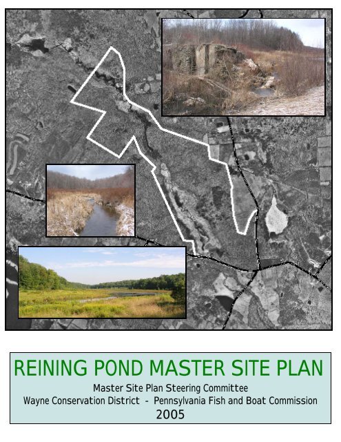
REINING POND MASTER SITE PLAN<br />
Master Site Plan Steering Committee<br />
Wayne Conservation District - <strong>Pennsylvania</strong> <strong>Fish</strong> <strong>and</strong> <strong>Boat</strong> <strong>Commission</strong><br />
2005
REINING POND<br />
MASTER SITE PLAN<br />
Cherry Ridge Township <strong>and</strong> Texas Township<br />
Wayne County, <strong>Pennsylvania</strong><br />
2005<br />
Prepared for<br />
Master Site Plan Steering Committee<br />
Wayne Conservation District<br />
<strong>Pennsylvania</strong> <strong>Fish</strong> <strong>and</strong> <strong>Boat</strong> <strong>Commission</strong><br />
Funding for this Master Site Plan provided by:<br />
<strong>Pennsylvania</strong> Community Conservation Partnership Program<br />
<strong>Pennsylvania</strong> Department of Conservation <strong>and</strong> Natural Resources<br />
Bureau of Recreation <strong>and</strong> Conservation<br />
Consultant<br />
Community Planning <strong>and</strong> Management, LLC<br />
Carson Helfrich<br />
Paupack, <strong>Pennsylvania</strong>
REINING POND MASTER SITE PLAN<br />
REINING POND STEERING COMMITTEE<br />
WAYNE CONSERVATION DISTRICT<br />
PENNSYLVANIA FISH AND BOAT COMMISSION<br />
with financial assistance from<br />
PENNSYLVANIA DEPARTMENT OF CONSERVATION AND NATURAL RESOURCES<br />
Bureau of Recreation And Conservation<br />
Community Conservation Partnership Program<br />
SUMMARY<br />
TABLE OF CONTENTS<br />
SECTION I - INTRODUCTION<br />
Page I -<br />
Purpose...................................................................1<br />
Reining Pond ..............................................................1<br />
Planning Process ...........................................................2<br />
Public Participation .........................................................2<br />
Action....................................................................2<br />
Steering Committee Sidebar ..................................................2<br />
SECTION II - COMMUNITY SETTING AND BACKGROUND INFORMATION<br />
Page II -<br />
Regional Location <strong>and</strong> Setting .................................................1<br />
Population <strong>and</strong> Housing Trends ................................................1<br />
Population ................................................................1<br />
Population Projections .......................................................4<br />
Housing Units .............................................................4<br />
Seasonal Housing <strong>and</strong> Population ..............................................4<br />
Need for Facilities <strong>and</strong> Services ...............................................5<br />
Community Plans <strong>and</strong> L<strong>and</strong> Use Controls........................................5<br />
Wayne County .............................................................5<br />
Local Comprehensive Plans...................................................7<br />
L<strong>and</strong> Use Controls ..........................................................7<br />
SECTION III - SITE INFORMATION AND ANALYSIS<br />
Page III-<br />
Reining Pond ..............................................................1<br />
Historical Perspective .......................................................1<br />
General Description <strong>and</strong> Current Uses ..........................................1<br />
Similar Recreation Areas in the Region .........................................1<br />
Site Characteristics .........................................................3<br />
Surrounding L<strong>and</strong> Use .......................................................3<br />
Access <strong>and</strong> Parking .........................................................3<br />
Reining Pond Master Site Plan 04-05
Reining Pond Master Site Plan Contents - 2<br />
Buildings <strong>and</strong> Structures .....................................................4<br />
Historic Resources .........................................................4<br />
Physical Features ...........................................................5<br />
Physiography <strong>and</strong> Geology ...................................................5<br />
Soils .....................................................................7<br />
Topography <strong>and</strong> Slope .......................................................8<br />
Watershed <strong>and</strong> Hydrology ...................................................10<br />
Forest Class <strong>and</strong> Age .......................................................11<br />
Farming History...........................................................11<br />
Forest Species ............................................................11<br />
Timber Size ..............................................................12<br />
Forest Health <strong>and</strong> Productivity ...............................................12<br />
Wetl<strong>and</strong>s Importance .......................................................13<br />
Reining Pond Wetl<strong>and</strong>s .....................................................14<br />
Wildlife - Wetl<strong>and</strong> .........................................................15<br />
Wildlife - Wetl<strong>and</strong>/Upl<strong>and</strong> Transition Zone .....................................16<br />
Wildlife - Upl<strong>and</strong> Forest ....................................................17<br />
<strong>Fish</strong>.....................................................................17<br />
Water Quality .............................................................18<br />
Floodplain ...............................................................18<br />
<strong>Pennsylvania</strong> Natural Diversity Index Search Results .............................18<br />
SECTION IV - POTENTIAL USES FOR THE REINING POND PROPERTY<br />
Page IV-<br />
Range of Potential Uses......................................................1<br />
Evaluation of Uses ..........................................................1<br />
Environmental Factors.......................................................1<br />
Soil Erosion <strong>and</strong> Sedimentation................................................1<br />
Storm Water Management ....................................................5<br />
Wetl<strong>and</strong> Disturbance ........................................................5<br />
Downstream Water Quality ...................................................6<br />
Sewage Disposal ...........................................................6<br />
Community Effects .........................................................6<br />
Available Funding ..........................................................6<br />
Long Term Ownership .......................................................6<br />
SECTION V - PUBLIC MEETING TO DISCUSS POTENTIAL USES<br />
Page V-<br />
Meeting Publicity..............................................................1<br />
Overview ....................................................................1<br />
Specific Comments ............................................................1<br />
Written Comments .............................................................3<br />
SECTION VI - PROPOSED USES AND RECOMMENDED ACTIONS<br />
Page VI-<br />
Potential Uses Revised..........................................................1<br />
Reining Pond Master Site Plan 04-05
Reining Pond Master Site Plan Contents - 3<br />
Proposed Uses ................................................................1<br />
Recommended Action ..........................................................1<br />
Community Organization........................................................3<br />
Short Term Actions - Management ................................................3<br />
Long Term Actions - Capital Expenditure ..........................................3<br />
Maintenance Actions ...........................................................3<br />
Future Considerations for Berm or Dam Construction .................................4<br />
Funding ...................................................................4<br />
Environmental ..............................................................5<br />
Diversity of Public Opinion ...................................................5<br />
Property Ownership ............................................................6<br />
APPENDIX<br />
<strong>Pennsylvania</strong> Natural Diversity Index Search Results<br />
Comment Letters<br />
Maps<br />
Regional Location Map<br />
Public Recreation Map<br />
Aerial Photo Comparison<br />
L<strong>and</strong> Use / L<strong>and</strong> Cover Analysis<br />
Topographic Map<br />
Soil Types<br />
Contours <strong>and</strong> Tax Map Parcels<br />
Water Features<br />
Agricultural Security Areas<br />
LIST OF FIGURES Page -<br />
Wayne County Population .................................................... II-3<br />
Population Growth in NE PA ................................................. II-3<br />
Wayne County Generalized Future L<strong>and</strong> Use ..................................... II-6<br />
Physiographic Divisions of <strong>Pennsylvania</strong> ........................................ III-5<br />
Physiographic Provinces of Eastern <strong>Pennsylvania</strong> ................................. III-6<br />
Glacial Deposits in <strong>Pennsylvania</strong> .............................................. III-6<br />
Soil Associations ........................................................... III-7<br />
Attendee List, December 14, 2004 Public Meeting ................................. V-2<br />
LIST OF TABLES Page -<br />
Historical Population <strong>and</strong> Growth Rates ......................................... II-1<br />
Population Growth in Northeast <strong>Pennsylvania</strong> .................................... II-3<br />
Wayne County Population Projections .......................................... II-4<br />
Housing Units ............................................................. II-4<br />
Seasonal, Permanent <strong>and</strong> Peak Populations ....................................... II-5<br />
L<strong>and</strong> Use Comparison ....................................................... III-2<br />
Soil Associations ........................................................... III-8<br />
<strong>Fish</strong> Species Survey - 1971 .................................................. III-17<br />
Reining Pond Master Site Plan Potential Uses ....................................IV-2<br />
Reining Pond Master Site Plan Proposed Uses ....................................VI-2<br />
Reining Pond Master Site Plan 04-05
REINING POND MASTER SITE PLAN<br />
Partnership <strong>and</strong> Purpose<br />
The 2005 Reining Pond Master Site Plan is a partnership of the Reining Pond Steering<br />
Committee, the Wayne Conservation District <strong>and</strong> the <strong>Pennsylvania</strong> <strong>Fish</strong> <strong>and</strong> <strong>Boat</strong><br />
<strong>Commission</strong>. The Plan is a long-range guide <strong>and</strong> action program for the conservation,<br />
continuing recreational use, environmental education, <strong>and</strong> appropriate development of<br />
the property to facilitate such activities.<br />
Goals<br />
The goals of the Master Site Plan include:<br />
• Conserve the environmental integrity, visual beauty <strong>and</strong> diverse natural<br />
resources of the Reining Pond property.<br />
• Enhance the outdoor recreation opportunities on the property for Wayne<br />
County <strong>and</strong> area residents <strong>and</strong> visitors.<br />
• Create environmental education opportunities for Wayne County <strong>and</strong> area<br />
residents <strong>and</strong> visitors., with a special focus on local students.<br />
• Foster public interest in, <strong>and</strong> support for, the Reining Pond property as a<br />
community resource.<br />
Stakeholders <strong>and</strong> Public Participation<br />
The Wayne Conservation District <strong>and</strong> the <strong>Fish</strong> <strong>and</strong> <strong>Boat</strong> <strong>Commission</strong><br />
recognized the local interest in the Reining Pond property <strong>and</strong> formed a<br />
Plan Steering Committee comprised of representatives of local residents,<br />
community organizations, local government <strong>and</strong> agencies. The Steering<br />
Committee assisted with assembling base information for the plan <strong>and</strong><br />
directed the planning process. Committee members conducted two public<br />
meetings <strong>and</strong> met with township <strong>and</strong> county officials <strong>and</strong> state<br />
representatives to discuss the details of the Plan.<br />
Reining Pond Property<br />
• 394 acres in Cherry Ridge <strong>and</strong> Texas Townships, Wayne County.<br />
• Owned by the Commonwealth <strong>and</strong> managed by <strong>Fish</strong> <strong>and</strong> <strong>Boat</strong> <strong>Commission</strong>.<br />
• Dam breached in 1985 due to safety concerns <strong>and</strong> 50-acre pond drained.<br />
• Existing beaver dam creates shallow pond with remnant fish populations.<br />
• Collins Brook, a high quality cold water fishery, drains the property.<br />
• A variety of l<strong>and</strong> forms <strong>and</strong> vegetation - wetl<strong>and</strong>s, shrubs, upl<strong>and</strong> forest.<br />
• Primary recreational use is hunting, with limited boating <strong>and</strong> fishing.<br />
Proposed Uses<br />
The Steering Committee identified potential uses ranging from no change to<br />
dam replacement <strong>and</strong> swimming beach development. Based on public<br />
comment the more intensive uses were eliminated with the following uses<br />
identified as proposed uses:<br />
Short Term Actions - Management<br />
• Wildlife <strong>and</strong> timber management with forest management demonstration.<br />
• Primitive hiking with no improvements except trail blazes.<br />
• Environmental education without buildings or other improvements<br />
• Manage existing wetl<strong>and</strong> with water level controller.<br />
Long Term Actions - Capital Expenditure<br />
• Small pond at level of existing beaver dam - $40-$60,000.<br />
• Replace dam <strong>and</strong> pond of original size - $1.5 - $2.0 million.<br />
Required Actions<br />
The creation of a formal Friends of Reining Pond group to shepherd the<br />
accomplishment of the Plan actions is recommended. This is particularly<br />
important for the long term capital expenditure actions where strong<br />
community support will be required. The short term management actions<br />
can be accomplished via formal agency <strong>and</strong> community group partnerships.
Section I – Introduction Page I-1<br />
Purpose<br />
The Reining Pond Master Site Plan is a longrange<br />
guide <strong>and</strong> action program for the<br />
conservation, continuing recreational use,<br />
environmental education, <strong>and</strong> appropriate,<br />
development of the property to facilitate such<br />
activities. The major goals of the planning<br />
project <strong>and</strong> subsequent implementation are:<br />
• Conserve the environmental integrity,<br />
visual beauty <strong>and</strong> diverse natural<br />
resources of the Reining Pond property.<br />
• Enhance the outdoor recreation<br />
opportunities on the property for Wayne<br />
County <strong>and</strong> area residents, <strong>and</strong> visitors.<br />
• Create environmental education<br />
opportunities for Wayne County <strong>and</strong> area<br />
residents <strong>and</strong> visitors., with a special focus<br />
on local students.<br />
• Foster public interest in, <strong>and</strong> support for,<br />
the Reining Pond property as a<br />
community resource.<br />
The basic tenet of the Master Site Plan is to<br />
evaluate alternatives for outdoor recreation<br />
<strong>and</strong> conservation education that will have a<br />
minimal effect on the ecology of the property<br />
<strong>and</strong> adjoining l<strong>and</strong>s. The long-term intent is<br />
to encourage those uses which will enhance<br />
the site's distinctive natural features <strong>and</strong><br />
recreational <strong>and</strong> educational potential, <strong>and</strong> fit<br />
well into the community while recognizing<br />
financial <strong>and</strong> regulatory limitations.<br />
Reining Pond<br />
The Reining Pond property is located along<br />
the Owego Turnpike <strong>and</strong> Prompton Road in<br />
Wayne County, with most of the 394 acres<br />
situated in Cherry Ridge Township <strong>and</strong> the<br />
northernmost part lying in Texas Township.<br />
The Commonwealth of <strong>Pennsylvania</strong> owns<br />
INTRODUCTION<br />
<strong>and</strong> the <strong>Pennsylvania</strong> <strong>Fish</strong> <strong>and</strong> <strong>Boat</strong><br />
<strong>Commission</strong> manages the property which<br />
originally contained a 50-acre impoundment<br />
created by a dam which spanned Collins<br />
Brook flowing through the property. The<br />
stream is part of the headwaters of Middle<br />
Creek, a tributary to the Lackawaxen River.<br />
Reining Pond supported warm water fish<br />
species typical to the area in the past <strong>and</strong> was<br />
used by many local <strong>and</strong> visiting sportsmen.<br />
However, based on dam safety concerns the<br />
Pond was drained <strong>and</strong> the dam was<br />
permanently breached in October of 1985.<br />
While the historic pond no longer exists, an<br />
extensive wetl<strong>and</strong> area with a small remnant<br />
pond remains. The balance of the 394 acres is<br />
wooded <strong>and</strong> is open to the public for hunting,<br />
fishing, hiking <strong>and</strong> other outdoor recreation<br />
activities. Over the years there has been some<br />
discussion about when, how, <strong>and</strong> if a new dam<br />
should be constructed, or if other viable<br />
recreation opportunities exist.<br />
There is strong local interest in seeing that the<br />
recreation potential for this site is fully<br />
realized, <strong>and</strong> the <strong>Pennsylvania</strong> <strong>Fish</strong> <strong>and</strong> <strong>Boat</strong><br />
<strong>Commission</strong> <strong>and</strong> the Wayne Conservation<br />
District are acting on the longst<strong>and</strong>ing<br />
community interest to optimize the<br />
recreational use of the property while<br />
conserving its natural features. In October of<br />
2002, the Conservation District, with the<br />
encouragement of the <strong>Fish</strong> <strong>and</strong> <strong>Boat</strong><br />
<strong>Commission</strong>, submitted a grant application to<br />
the <strong>Pennsylvania</strong> Department of Conservation<br />
<strong>and</strong> Natural Resources, Community<br />
Conservation Partnership Program. In May<br />
2003, the Conservation District received<br />
notice that the grant was approved. to develop<br />
a master site plan to investigate future<br />
development <strong>and</strong> management options for the<br />
property. The Plan will also establish the<br />
necessary base to secure funding for site<br />
Reining Pond Master Site Plan 04-05
Section I – Introduction Page I-2<br />
improvements <strong>and</strong> to implement management<br />
plan recommendations.<br />
Planning Process<br />
The planning process involved a partnership<br />
of community organizations <strong>and</strong> local<br />
agencies with an interest in Reining Pond.<br />
(See following sidebar.) This broad<br />
partnership, evolved into an organized Project<br />
Steering Committee. These stakeholders<br />
participated in the planning process, presented<br />
their concerns <strong>and</strong> ideas, <strong>and</strong> built a consensus<br />
for the future of the Reining Pond property.<br />
The Steering Committee also played an active<br />
<strong>and</strong> key role in assembling the base<br />
information for the Plan. Committee<br />
members with special expertise in their fields<br />
provided information on site characteristics,<br />
l<strong>and</strong> use, <strong>and</strong> physical features, <strong>and</strong><br />
environmental issues.<br />
Public Participation<br />
While the Steering Committee assembled the<br />
data <strong>and</strong> developed alternatives for the<br />
property, public participation in the process<br />
was essential for setting the final direction of<br />
the Plan. A series of news releases about the<br />
process were issued, <strong>and</strong> Plan information<br />
was posted on the Wayne County <strong>and</strong> <strong>Fish</strong><br />
<strong>and</strong> <strong>Boat</strong> <strong>Commission</strong> web sites. Most<br />
importantly, public meetings were conducted<br />
to present the Plan <strong>and</strong> receive comment<br />
about the proposed alternatives. In addition,<br />
Steering Committee members presented the<br />
draft Plan to local Township Supervisors <strong>and</strong><br />
the Wayne County Board of <strong>Commission</strong>ers<br />
to address local concerns <strong>and</strong> ensure<br />
consistency with local plans. Committee<br />
members also met with area state legislators<br />
to detail the Plan. This public <strong>and</strong> stakeholder<br />
input was vital to the development of a<br />
realistic plan for the property.<br />
Action<br />
Accomplishing the Master Plan will not be<br />
immediate. Instead, it will be phased over a<br />
number of years, <strong>and</strong> the full realization of<br />
the Plan will dem<strong>and</strong> both public <strong>and</strong> private<br />
cooperation <strong>and</strong> commitment. Clearly, the<br />
more ambitious elements of the Plan are<br />
dependent on funding <strong>and</strong> it will take<br />
considerable time <strong>and</strong> effort to build support<br />
<strong>and</strong> find the resources. Finally, as time<br />
passes, the Master Plan will likely require<br />
updating to meet changing conditions <strong>and</strong><br />
level of public expectations <strong>and</strong> support.<br />
REINING POND<br />
MASTER SITE PLAN<br />
STEERING COMMITTEE<br />
• David Adolfson, for Representative. Jerry<br />
Birmelin<br />
• Donald Chapman, <strong>Commission</strong>er, Wayne<br />
County<br />
• Edward Coar, Director, Wayne County<br />
Department of Planning<br />
• Scott J. Cope, Grant Coordinator, PA DCNR,<br />
Bureau of Recreation <strong>and</strong> Conservation<br />
• Annetta DeYoung, Executive Director, Wayne<br />
County Chamber of Commerce<br />
• Paul Edwards, Superintendent, Wayne<br />
Highl<strong>and</strong>s School District<br />
• Thomas Ford, Resource Planning Coordinator,<br />
PA <strong>Fish</strong> <strong>and</strong> <strong>Boat</strong> <strong>Commission</strong><br />
• Jack Gearhart, Forester, PA Department of<br />
Conservation <strong>and</strong> Natural Resources<br />
• Ian Gregg, Migratory Bird Biologist, PA Game<br />
<strong>Commission</strong><br />
• Carson Helfrich, Community Planning <strong>and</strong><br />
Management, LLC<br />
• David Kaneski, Waterways Conservation<br />
Officer, PA <strong>Fish</strong> <strong>and</strong> <strong>Boat</strong> <strong>Commission</strong><br />
• Robert M<strong>and</strong>er, Cherry Ridge Township<br />
Planning <strong>Commission</strong><br />
• William Manner, Acting Water Supply Manager,<br />
PA Department of Environmental Protection<br />
• James Murray, Texas Rod <strong>and</strong> Gun Club<br />
• William Pisechko, Bass Masters<br />
• Leon Reed, <strong>Commission</strong>er, PA <strong>Fish</strong> <strong>and</strong> <strong>Boat</strong><br />
<strong>Commission</strong><br />
• Scott Reinhart, Regional Biologist, Ducks<br />
Unlimited<br />
• Skane Renner, Trout Unlimited<br />
• William Rickard, Supervisor, Cherry Ridge<br />
Township<br />
• James Rodda, Local Hunter <strong>and</strong> Educator<br />
• Anthony Tur, Biologist, U.S. <strong>Fish</strong> <strong>and</strong> Wildlife<br />
Service<br />
• Grant Turano, Watershed Specialist, Wayne<br />
Conservation District<br />
Reining Pond Master Site Plan 04-05
Section II – Community Setting <strong>and</strong> Background Information Page II-1<br />
Regional Location <strong>and</strong> Setting<br />
The 394-acre Reining Pond property lies in<br />
south-central Wayne County less than five<br />
miles from the Borough of Honesdale, the<br />
Wayne County Seat. The property is within<br />
easy access of all of Wayne County, <strong>and</strong> much<br />
of Lackawanna County to the west <strong>and</strong> Pike<br />
County to the east. (See the Regional<br />
Location Map.)<br />
The recent completion of the Lackawanna<br />
Valley Industrial Highway, which links<br />
Wayne County to Route 81, has significantly<br />
shortened the travel time to the greater<br />
Scranton metropolitan area. The Industrial<br />
Highway connects to PA Route 6 just west of<br />
Waymart Borough, less than ten miles from<br />
Reining Pond. This not only suggests<br />
improved commercial opportunities for the<br />
area, particularly in the central part of Wayne<br />
County, but also reduced resident commuting<br />
time to employment in the metro area. More<br />
importantly for the potential use of Reining<br />
Pond, it is has shortened the travel time for<br />
Lackawanna County residents who have<br />
historically frequented the public streams <strong>and</strong><br />
lakes, <strong>and</strong> State Game L<strong>and</strong>s in Wayne<br />
County.<br />
Most of Wayne County remains undeveloped,<br />
with agricultural l<strong>and</strong> <strong>and</strong> forest l<strong>and</strong> the<br />
predominate elements of the rural l<strong>and</strong>scape.<br />
Population density in 2000 was 65.4 persons<br />
per square mile compared to 274 statewide.<br />
However, the County is in transition. As is<br />
the case with all of Northeastern<br />
<strong>Pennsylvania</strong>, the economic importance of<br />
agriculture in the County is declining. The<br />
number of farms decreased from some 920 in<br />
1969 to 565 in 1997 <strong>and</strong> the amount of farm<br />
l<strong>and</strong> decreased from 173,470 to 109,620 acres<br />
COMMUNITY SETTING<br />
AND<br />
BACKGROUND INFORMATION<br />
between 1969 <strong>and</strong> 1997. 1 Many of the less<br />
productive soils which once supported pasture<br />
have reverted to forest. The total market<br />
value of agricultural products in the County in<br />
1997 was $25,143,000. 2 While still<br />
significant, agriculture is less important<br />
economically than tourism which generated<br />
almost $170,000,000 in expenditures in 2000 3 ,<br />
<strong>and</strong> County-wide retail sales amounted to<br />
almost $400,00,000 in 1997. 4<br />
More <strong>and</strong> more dwellings are being built<br />
throughout the County, along with the retail<br />
<strong>and</strong> service establishments needed to meet the<br />
needs of the increasing population. Most<br />
commercial development is clustered in <strong>and</strong><br />
around Hamlin, Hawley, Honesdale, <strong>and</strong><br />
Waymart. While many residents find<br />
employment in the County, according to the<br />
2000 Census, almost 27% work in another<br />
county in <strong>Pennsylvania</strong> <strong>and</strong> 10% work in<br />
another state.<br />
Population <strong>and</strong> Housing Trends<br />
Population<br />
As shown in the Historical Population <strong>and</strong><br />
Growth Rates Table <strong>and</strong> the Wayne County<br />
Population Chart, Wayne County’s<br />
population has grown steadily since1960.<br />
1 Census of Agriculture, National<br />
Agricultural Statistics Service. The 1997 definition of<br />
farms was broadened, including the addition of<br />
Christmas tree farms.<br />
Reining Pond Master Site Plan 04-05<br />
2 Ibid.<br />
3 <strong>Pennsylvania</strong> Economic Impact Analysis,<br />
D.K. Shifflet & Associates, McLean Virginia.<br />
4<br />
Center for Rural <strong>Pennsylvania</strong>, County<br />
Demographic Profiles
Section II – Community Setting <strong>and</strong> Background Information Page II-2<br />
HISTORICAL POPULATION AND GROWTH RATES – U.S. CENSUS<br />
1950 1960 1970 1980 1990 2000 90-00 50-00<br />
Berlin Twp 971 1,010 1,109 1,676 1,777 2,188 23.1% 125.3%<br />
Bethany Boro 148 181 267 282 238 292 22.7% 97.3%<br />
Buckingham Twp 612 593 578 667 648 656 1.2% 7.2%<br />
Canaan Twp 1,838 1,831 1,470 928 1,267 1,916 51.2% 4.2%<br />
Cherry Ridge Twp 544 729 890 1,362 1,600 1,817 13.6% 234.0%<br />
Clinton Twp 1,266 1,132 1,105 1,399 1,582 1,926 21.7% 52.1%<br />
Damascus Twp 1,898 1,703 2,006 2,536 3,081 3,662 18.9% 92.9%<br />
Dreher Twp 691 654 705 743 1,022 1,280 25.2% 85.2%<br />
Dyberry Twp 584 594 706 898 1,223 1,353 10.6% 131.7%<br />
Hawley Boro 1,602 1,433 1,331 1,181 1,244 1,303 4.7% -18.7%<br />
Honesdale Boro 5,662 5,569 5,224 5,128 4,972 4,874 -2.0% -13.9%<br />
Lake Twp 1,506 1,621 1,755 2,453 3,287 4,361 32.7% 189.6%<br />
Lebanon Twp 363 300 363 417 479 645 34.7% 77.7%<br />
Lehigh Twp 446 533 637 884 1,178 1,639 39.1% 267.5%<br />
Manchester Twp 667 558 494 629 663 888 33.9% 33.1%<br />
Mt. Pleasant Twp 1,007 892 967 1,196 1,271 1,345 5.8% 33.6%<br />
Oregon Twp 344 322 348 518 606 745 22.9% 116.6%<br />
Palmyra Twp 514 568 528 773 905 1,127 24.5% 119.3%<br />
Paupack Twp 336 411 644 1,379 1,696 2,959 74.5% 780.7%<br />
Preston Twp 950 879 946 1,036 1,044 1,107 6.0% 16.5%<br />
Prompton Boro 197 204 224 249 238 243 2.1% 23.4%<br />
Salem Twp 1,289 1,324 1,581 2,538 2,933 3,664 24.9% 184.3%<br />
Scott Twp 473 447 604 576 590 669 13.4% 41.4%<br />
S. Canaan Twp 1,136 1,058 1,106 1,345 1,320 1,666 26.2% 46.7%<br />
Starrucca Boro 326 330 292 216 199 216 8.5% -33.7%<br />
Sterling Twp 440 490 576 730 974 1,251 28.4% 184.3%<br />
Texas Twp 1,598 1,765 2,003 2,250 2,570 2,501 -2.7% 56.5%<br />
Waymart Boro 1,068 1,106 1,122 1,248 1,337 1,429 6.9% 33.8%<br />
Wayne County 28,478 28,237 29,581 35,237 39,944 47,722 19.5% 67.6%<br />
PA (1,000's) 10,412 11,243 11,758 11,856 11,883 12,281 3.3% 18.0%<br />
Reining Pond Master Site Plan 04-05
Section II – Community Setting <strong>and</strong> Background Information Page II-3<br />
POPULATION GROWTH IN NORTHEAST PENNSYLVANIA - U.S. CENSUS<br />
2010 PROJECTIONS - PENNSYLVANIA STATE DATA CENTER<br />
1980 80-90 1990 90-00 2000 00-10 2010<br />
Carbon Co. 53,285 6.7% 56,846 3.4% 58,802 9.4% 64,310<br />
Lackawanna Co. 227,908 -3.9% 219,039 -2.6% 213,295 -0.9% 211,360<br />
Luzerne Co. 343,079 -4.4% 328,149 -2.7% 319,250 1.7% 324,520<br />
Monroe Co. 69,409 37.9% 95,709 44.9% 138,687 24.1% 172,170<br />
Pike Co. 18,271 53.1% 27,966 65.6% 46,302 29.7% 60,060<br />
Wayne Co. 35,237 13.4% 39,944 19.5% 47,722 4.3% 49,750<br />
Northeast PA 695,661 10.3% 767,653 7.3% 824,058 7.3% 884,180<br />
PA (1,000's) 11,865 0.2% 11,883 3.3% 12,281 1.0% 12,408<br />
Between 1990 <strong>and</strong> 2000 the County population<br />
increased by 19.5%, or almost 8,000 persons.<br />
Although this increase did not match the rapid<br />
population growth in Pike County <strong>and</strong> Monroe<br />
County, it far surpassed the growth rate for<br />
Northeastern <strong>Pennsylvania</strong> <strong>and</strong> the<br />
Commonwealth as a whole. (See the<br />
Population Growth in Northeast <strong>Pennsylvania</strong><br />
Table <strong>and</strong> Population Growth in NE PA Chart.)<br />
Wayne County, given its somewhat more<br />
distant location, has not experienced the level<br />
of development spurred by the migration of<br />
urbanites from the greater New Jersey <strong>and</strong> New<br />
York metropolitan area. During the same<br />
period, the population of Lackawanna County<br />
<strong>and</strong> Luzerne County, the more densely<br />
populated counties in Northeastern<br />
<strong>Pennsylvania</strong>, decreased slightly with many<br />
residents moving from urban areas to more rural<br />
municipalities.<br />
Population changes varied among the twentyeight<br />
municipalities in Wayne County<br />
depending on location <strong>and</strong> development<br />
pressure. For example, Paupack Township<br />
population increased by almost 75% between<br />
1990 <strong>and</strong> 2000 due in large part to the appeal<br />
of the Lake Wallenpaupack area <strong>and</strong> the<br />
conversion of second homes to permanent<br />
residences. Conversely, the population of<br />
50,000<br />
40,000<br />
30,000<br />
20,000<br />
10,000<br />
0<br />
Reining Pond Master Site Plan 04-05<br />
population<br />
70.0%<br />
60.0%<br />
50.0%<br />
40.0%<br />
30.0%<br />
20.0%<br />
10.0%<br />
0.0%<br />
-10.0%<br />
Wayne County Population<br />
1950 1960 1970 1980 1990 2000<br />
Population Growth in NE PA<br />
Carbon<br />
Lackawanna<br />
Luzerne<br />
Monroe<br />
Pike<br />
Wayne<br />
NE PA<br />
PA<br />
1990-2000 2000-2010
Section II – Community Setting <strong>and</strong> Background Information Page II-4<br />
Honesdale Borough <strong>and</strong> Texas Township,<br />
which contain much of the commercial<br />
development in the County, decreased<br />
somewhat. In Cherry Ridge Township, where<br />
most of the Reining Pond property is situated,<br />
the population increased by almost 220<br />
persons, or 14%, between 1990 <strong>and</strong> 2000.<br />
WAYNE COUNTY<br />
POPULATION PROJECTIONS<br />
PENNSYLVANIA STATE DATA CENTER<br />
Year Population # Increase % Increase<br />
2000 47,722 -- --<br />
2010 49,750 2,028 4.3%<br />
2020 51,330 1,580 3.2%<br />
Population Projections<br />
As shown on the Wayne County Population<br />
Projections Table, the <strong>Pennsylvania</strong> State<br />
Data Center projects Wayne County’s<br />
population will continue to increase, albeit at<br />
a much lower rate, reaching 49,750 persons<br />
by 2010, <strong>and</strong> 51,330 by 2020. The 1994<br />
Wayne County Comprehensive Plan predicted<br />
a more optimistic Year 2000 population of<br />
48,800 <strong>and</strong> a Year 2010 population of 57,400.<br />
While these projections vary considerably, it<br />
is obvious that the County population will<br />
continue to increase at least at the level<br />
predicted by the State Data Center. In any<br />
case, Wayne County will remain rural for<br />
many years, reaching a population density of<br />
only seventy-nine persons per square mile<br />
even if the County Plan prediction of 57,400<br />
persons is attained by 2010.<br />
1980<br />
Total<br />
Units<br />
HOUSING UNITS - U.S. CENSUS<br />
Number<br />
80-90<br />
Percent<br />
80-90<br />
Housing Units<br />
Between 1980 <strong>and</strong> 1990, the number of<br />
housing units in Wayne County increased by<br />
some 8,880 reaching a total of 28,480, a rate<br />
of increase of 45.3%. (See Housing Units<br />
Table.) An additional 2,113 units were added<br />
between 1990 <strong>and</strong> 2000, a much reduced rate<br />
of 7.4%, but moving the total to 39,953 units.<br />
An additional 837 units were added to the<br />
County tax rolls in 2000, 2001 <strong>and</strong> 2003.<br />
Similar to population, housing unit increases<br />
varied greatly among the County’s<br />
municipalities depending on location. Real<br />
housing construction has accounted for<br />
increased population in much of the County<br />
while the conversion of second homes to<br />
permanent residences has fueled much of the<br />
increased population in other areas, Paupack<br />
Township for example. While the number of<br />
new units will certainly not result in the<br />
suburbanization of the County, it will have a<br />
direct impact on the amount of open l<strong>and</strong>.<br />
Seasonal Housing <strong>and</strong> Population<br />
The second home population in Wayne<br />
County is important for two reasons. First,<br />
the seasonal population, which is greatest in<br />
the summer, places increased dem<strong>and</strong>s on<br />
community facilities <strong>and</strong> services; <strong>and</strong> second,<br />
the current seasonal population is a good<br />
indicator of future permanent population. The<br />
2000 Census <strong>report</strong>ed the number of vacant<br />
housing units for seasonal, recreational or<br />
occasional use, that is, the number of second<br />
homes. The Seasonal, Permanent <strong>and</strong> Peak<br />
Population Table presents the data for the<br />
County <strong>and</strong> several municipalities. Almost<br />
1990<br />
Total<br />
Units<br />
Number<br />
90-00<br />
Percent<br />
90-00<br />
2000<br />
Total<br />
Units<br />
Wayne County 19,598 8,882 45.3% 28,480 2,113 7.4% 30,593<br />
PA (1,000's) 4,596 342 7.4% 4,938 312 6.3% 5,250<br />
Reining Pond Master Site Plan 04-05
Section II – Community Setting <strong>and</strong> Background Information Page II-5<br />
SEASONAL, PERMANENT AND PEAK POPULATION - U.S. CENSUS<br />
2000<br />
Total<br />
Units<br />
% 2nd<br />
homes<br />
# 2nd<br />
homes<br />
Permanent<br />
population<br />
Estimated<br />
peak<br />
2nd Home<br />
population<br />
Estimated<br />
peak<br />
population.<br />
(2nd+perm)<br />
Wayne County 30,593 35.5% 10,855 47,722 32,565 80,287<br />
Cherry Ridge Twp 864 11.8% 102 1,817 306 2,123<br />
Honesdale Boro 2,414 1.6% 39 4,874 117 4,991<br />
Lehigh Twp 2,454 71.8% 1,763 1,639 5,289 6,928<br />
Paupack Twp 3,398 62.6% 2,126 2,959 6,378 9,337<br />
Texas Twp 1,062 4.0% 42 2,501 126 2,627<br />
36% percent of the housing units in Wayne<br />
County are second homes, with the highest<br />
proportion in the County found in Lehigh<br />
Township at almost 72%.<br />
The results of a survey of second home<br />
owners conducted by the Wayne County<br />
Planning <strong>Commission</strong> as part of the County<br />
Comprehensive Plan indicates the average<br />
size of a second home household is 3.34<br />
persons. Applying a conservative household<br />
size of three persons to the number of second<br />
homes in the County results in an estimated<br />
peak second home population of<br />
approximately 32,560 persons, a number<br />
which could be reached on a busy summer<br />
weekend when visitation rates <strong>and</strong> guest<br />
numbers are the highest. The impact of the<br />
potential second home population is obvious<br />
in terms of the requirement of additional<br />
facilities <strong>and</strong> services, as well as the effect on<br />
open l<strong>and</strong>. The Wayne County survey of<br />
second home owners revealed another<br />
interesting trend for second home owners.<br />
Almost 40% of the second home owners<br />
surveyed responded that they do plan on<br />
residing in Wayne County on a full-time basis<br />
sometime in the future. Of those who plan to<br />
settle in the County, about 50% expected to<br />
do so within ten years. The implications are<br />
clear, the County <strong>and</strong> most townships will<br />
continue to experience strong population<br />
growth.<br />
Need for Facilities <strong>and</strong> Services<br />
Increasing population, both permanent <strong>and</strong><br />
seasonal, translates into increased dem<strong>and</strong> for<br />
public facilities <strong>and</strong> services, including<br />
outdoor recreation <strong>and</strong> environmental<br />
education. Concurrently, increased<br />
development results in the loss of open l<strong>and</strong><br />
<strong>and</strong> heightens the importance of public l<strong>and</strong><br />
for outdoor recreation. The Reining Pond<br />
property is one element of the area’s public<br />
l<strong>and</strong> available for outdoor recreation, <strong>and</strong> its<br />
future use must be considered in terms of<br />
population growth <strong>and</strong> availability of other<br />
opportunities.<br />
Community Plans <strong>and</strong> L<strong>and</strong> Use Controls<br />
Local municipalities <strong>and</strong> counties in the<br />
Commonwealth plan <strong>and</strong> manage l<strong>and</strong> use<br />
under the terms of the <strong>Pennsylvania</strong><br />
Municipalities Planning Code. The Code<br />
authorizes the adoption of comprehensive<br />
plans, subdivision <strong>and</strong> l<strong>and</strong> development<br />
ordinances <strong>and</strong> zoning ordinances.<br />
Wayne County<br />
The Wayne County Comprehensive Plan was<br />
adopted by the County <strong>Commission</strong>ers in<br />
December of 1994. The Wayne County<br />
Generalized Future L<strong>and</strong> Use Diagram 1994,<br />
shows the information for Cherry Ridge<br />
Reining Pond Master Site Plan 04-05
Section II – Community Setting <strong>and</strong> Background Information Page II-6<br />
Township, Texas Township <strong>and</strong> surrounding<br />
municipalities, <strong>and</strong> is intended to provide a<br />
twenty-year generalized description of l<strong>and</strong><br />
use.<br />
The County Plan includes the Reining Pond<br />
<strong>and</strong> adjoining properties in the neighborhood<br />
development future l<strong>and</strong> use classification<br />
surrounded by the population center/corridor<br />
classification. The individual classifications<br />
are not defined but the County Plan envisions<br />
multi-based economic development for the<br />
County, which places the priority neither on<br />
tourism nor on residential development but<br />
rather on multi-based economic development,<br />
including not only tourism but also industrial<br />
development <strong>and</strong> commercial expansion. The<br />
other major (County) priority would be to<br />
create more <strong>and</strong> better paying jobs - the<br />
Wayne County Generalized Future L<strong>and</strong> Use<br />
objective being to raise the st<strong>and</strong>ard of living<br />
for all while maintaining <strong>and</strong> improving<br />
property values. Conservation of natural<br />
resources would also be an important part of<br />
the equation but in the context of a balanced<br />
approach.<br />
The County Plan (Volume 4, Page 152)<br />
includes two caveats related to the use <strong>and</strong><br />
development of Reining Pond, stating:<br />
• The emphasis of State <strong>and</strong> Federal<br />
managers of recreational facilities in the<br />
County (i.e., the <strong>Fish</strong> <strong>and</strong> <strong>Boat</strong><br />
<strong>Commission</strong>, the Game <strong>Commission</strong>, the<br />
National Park Service) should be on<br />
maintaining their existing facilities <strong>and</strong><br />
making them more available to meet local<br />
Reining Pond Master Site Plan 04-05
Section II – Community Setting <strong>and</strong> Background Information Page II-7<br />
needs as opposed to expansion or<br />
development of new areas.<br />
• The County is opposed to any<br />
condemnation of l<strong>and</strong> by the <strong>Pennsylvania</strong><br />
Game or <strong>Fish</strong> <strong>Commission</strong>s or other<br />
similar agencies. All l<strong>and</strong> additions<br />
should be on a “willing seller” basis.<br />
The continued use <strong>and</strong> improvement of the<br />
Reining Pond property, which is currently<br />
owned by the Commonwealth <strong>and</strong> managed<br />
by the <strong>Fish</strong> <strong>and</strong> <strong>Boat</strong> <strong>Commission</strong>, will be<br />
consistent with the Wayne County<br />
Comprehensive Plan provided the use is<br />
aimed at the conservation of natural resources<br />
<strong>and</strong> does not involve condemnation of<br />
additional l<strong>and</strong>. No condemnation or any l<strong>and</strong><br />
acquisition, for that matter, is anticipated or<br />
advocated in this plan for the Reining Pond<br />
property.<br />
Local Comprehensive Plans<br />
Local municipal comprehensive plans must, in<br />
accord with the <strong>Pennsylvania</strong> Municipalities<br />
Planning Code, be consistent with the adopted<br />
County Comprehensive Plan. Cherry Ridge<br />
Township has not adopted a comprehensive<br />
plan. In the case of Texas Township, a plan<br />
has been adopted. However, given that only<br />
a fraction of the Reining Pond property is<br />
situated in Texas Township, <strong>and</strong> that fraction<br />
is largely wetl<strong>and</strong> <strong>and</strong> inaccessible where no<br />
improvements are anticipated, no<br />
inconsistencies are expected with the Texas<br />
Township Comprehensive Plan.<br />
L<strong>and</strong> Use Controls<br />
The subdivision <strong>and</strong> l<strong>and</strong> development<br />
ordinance (SALDO) <strong>and</strong> the zoning ordinance<br />
are the two principal l<strong>and</strong> use controls<br />
authorized by the <strong>Pennsylvania</strong> Municipalities<br />
Planning Code. The SALDO governs how<br />
l<strong>and</strong> is divided <strong>and</strong> how commercial <strong>and</strong><br />
institutional buildings are developed. The<br />
zoning ordinance regulates how l<strong>and</strong> is used,<br />
typically by creating zoning districts <strong>and</strong><br />
applying development performance st<strong>and</strong>ards.<br />
Cherry Ridge Township <strong>and</strong> Texas Township<br />
each have adopted a SALDO <strong>and</strong> a zoning<br />
ordinance. The small part of the Reining<br />
Pond property <strong>and</strong> adjoining properties in<br />
Texas Township are included in the Rural<br />
Zoning District which allows low density<br />
residential development <strong>and</strong> typical<br />
agricultural <strong>and</strong> rural uses. Compliance with<br />
the Texas Township SALDO <strong>and</strong> zoning<br />
ordinance is not an issue given that no change<br />
in l<strong>and</strong> use in that part of the property is being<br />
considered.<br />
The Cherry Ridge Township portion of the<br />
property is included in the Rural Development<br />
District which has the stated purpose to<br />
provide for residential, industrial <strong>and</strong><br />
commercial development in areas of the<br />
Township which are largely rural in character<br />
<strong>and</strong> to provide compatibility with existing<br />
agricultural, residential <strong>and</strong> rural uses. It is<br />
also to provide for retail <strong>and</strong> service<br />
establishments designed to serve both the<br />
immediate area <strong>and</strong> surrounding region <strong>and</strong><br />
sufficient space in appropriate locations to<br />
meet future needs for light manufacturing.<br />
The Rural Development District classifies<br />
public recreation facilities as a principal<br />
permitted use, <strong>and</strong> public <strong>and</strong> semi-public<br />
uses as a special exception. Any new use<br />
proposed for the Reining Pond property would<br />
fall into one of these classifications. Provided<br />
all zoning ordinance st<strong>and</strong>ards are satisfied,<br />
permits for principal permitted uses are issued<br />
by the zoning officer <strong>and</strong> special exceptions<br />
by the zoning hearing board. No subdivision<br />
is being considered, but the SALDO would<br />
apply if any new principal structure is<br />
proposed on he Cherry Ridge area of the<br />
Reining Pond property.<br />
Reining Pond Master Site Plan 04-05
Section III – Site Information <strong>and</strong> Analysis Page III-1<br />
Intent<br />
Underst<strong>and</strong>ing the physical resources <strong>and</strong><br />
limitations of the Reining Pond property is<br />
critical to developing environmentally<br />
compatible alternatives. The baseline data in<br />
this section defines the site’s carrying<br />
capacity <strong>and</strong> provides the foundation to<br />
evaluate potential environmental impacts of<br />
the various potential uses for the property.<br />
Surrounding l<strong>and</strong> uses, neighborhood<br />
compatibility, <strong>and</strong> regulatory limitations may<br />
also limit the practicality of alternatives, <strong>and</strong><br />
must be considered in concert with the site’s<br />
physical resources.<br />
Historical Perspective<br />
The <strong>Fish</strong> <strong>and</strong> <strong>Boat</strong> <strong>Commission</strong> acquired the<br />
Reining Pond property for $7,500 on<br />
November 12, 1942, from the estate of Annie<br />
O. Reining. The site originally contained a<br />
fifty-acre lake created by a dam, 305 feet long<br />
<strong>and</strong> fifteen to twenty feet high, spanning<br />
Collins Brook. The small stream is part of the<br />
headwaters of Middle Creek, a tributary to the<br />
Lackawaxen River. With a maximum depth of<br />
some eleven feet, Reining Pond was well<br />
regarded as a warm water fishery.<br />
In 1952, the dam was repaired at a cost of<br />
$30,590. In the late 1970’s, studies were<br />
conducted to investigate the possibility of<br />
rebuilding the dam to address the inadequate<br />
flood control capacity that was associated<br />
with an inadequate emergency spillway. The<br />
study investigated the feasibility of enlarging<br />
the dam <strong>and</strong> the size of the lake to provide a<br />
viable fishery. When the study revealed that<br />
l<strong>and</strong> acquisition was required the project was<br />
ab<strong>and</strong>oned. The Pond was drained <strong>and</strong> the<br />
dam was permanently breached in October<br />
1985 due to the dam safety concerns.<br />
The Texas Rod <strong>and</strong> Gun Club is situated<br />
about a mile downstream from Reining Pond.<br />
SITE INFORMATION AND ANALYSIS<br />
The Club believes that the breaching of the<br />
dam in 1985 resulted in significant silting of<br />
Collins Brook <strong>and</strong> the pond on Club property;<br />
either from release of deposits behind the dam<br />
or from stream bank erosion caused by the<br />
water release <strong>and</strong> subsequent rain storms not<br />
controlled by the dam. The Club <strong>and</strong> the <strong>Fish</strong><br />
<strong>and</strong> <strong>Boat</strong> <strong>Commission</strong> disagreed on the cause<br />
of the siltation, however, the Club decided not<br />
to pursue legal action. In any case, current<br />
planning efforts cannot resolve past problems.<br />
Instead, it is critical that downstream effects<br />
be carefully considered in the evaluation of<br />
every alternative considered.<br />
General Description <strong>and</strong> Current Use<br />
While the historic pond no longer exists, an<br />
extensive wetl<strong>and</strong> area with a small remnant<br />
pond remains, <strong>and</strong> the balance of the 394<br />
acres is wooded. The property is currently<br />
open to the public for hunting, fishing, hiking<br />
<strong>and</strong> other passive recreation activities.<br />
Hunting is the principal use of the property,<br />
with the most intense use occurring during the<br />
deer hunting season. Details on the actual<br />
number of users are simply not available, but<br />
the number is low when considered in terms<br />
of the potential of the property. In reality,<br />
most area residents simply do not realize the<br />
property is open to the public.<br />
Similar Recreation Areas in the Region<br />
Wayne County <strong>and</strong> adjoining counties contain<br />
many thous<strong>and</strong>s of acres of open l<strong>and</strong>, miles<br />
of streams, <strong>and</strong> hundreds of lakes <strong>and</strong> ponds.<br />
However, most are private <strong>and</strong> not available<br />
for public recreation. Nevertheless, public<br />
l<strong>and</strong>, streams with public access, <strong>and</strong> a<br />
number of public lakes are found within easy<br />
driving distance to Reining Pond. The Area<br />
Public Recreation Map provides an overview.<br />
Public recreation l<strong>and</strong>s <strong>and</strong> lakes within<br />
fifteen miles of Reining Pond include:<br />
Reining Pond Master Site Plan 04-05
Section III – Site Information <strong>and</strong> Analysis Page III-2<br />
• Prompton State Park - fishing, boating,<br />
hiking, hunting, etc.<br />
• White Oak Pond, <strong>Fish</strong> <strong>and</strong> <strong>Boat</strong><br />
<strong>Commission</strong> Access - fishing, boating<br />
• Lackawaxen River - fishing, boating<br />
• Upper Woods Pond, <strong>Fish</strong> <strong>and</strong> <strong>Boat</strong><br />
<strong>Commission</strong> Access - fishing, boating<br />
• Duck Harbor Pond, <strong>Fish</strong> <strong>and</strong> <strong>Boat</strong><br />
<strong>Commission</strong> Access - fishing, boating<br />
• State Game L<strong>and</strong>s 159 with Dyberry<br />
Creek - hunting, fishing, hiking, etc.<br />
• State Game L<strong>and</strong>s 316 with Cobey Pond<br />
<strong>and</strong> Mast Hope Creek - hunting, fishing,<br />
hiking, etc.<br />
• State Game L<strong>and</strong>s 300 - hunting,<br />
fishing, hiking, etc<br />
• Chapman Lake, <strong>Fish</strong> <strong>and</strong> <strong>Boat</strong><br />
<strong>Commission</strong> Access - boating, fishing<br />
• State Game L<strong>and</strong>s 307 - hunting, hiking,<br />
etc.<br />
• Merli Sarnoski Park <strong>and</strong> Lake,<br />
Lackawanna County Park - fishing,<br />
hiking<br />
• Lackawanna River - fishing, Rails to<br />
Trails<br />
• State Game L<strong>and</strong>s 310 - hunting, hiking,<br />
etc.<br />
• Lake Wallenpaupack, <strong>Fish</strong> <strong>and</strong> <strong>Boat</strong><br />
<strong>Commission</strong> Access - fishing, boating<br />
• State Game L<strong>and</strong>s 183 with Decker<br />
Pond <strong>and</strong> Decker Brook - hunting,<br />
fishing, hiking, etc.<br />
LAND USE COMPARISON<br />
(0.5-MILE PERIMETER)<br />
WAYNE COUNTY DEPARTMENT OF PLANNING<br />
• Delaware State Forest <strong>and</strong> White Deer<br />
Lake - hunting, fishing, boating, hiking,<br />
etc.<br />
• Fairview Lake, <strong>Fish</strong> <strong>and</strong> <strong>Boat</strong><br />
<strong>Commission</strong> Access - fishing, boating<br />
acres % of total<br />
1959 1997 change 1959 1997<br />
residential 12 53 41 0.5% 2.4%<br />
crop l<strong>and</strong> 517 416 -101 23.4% 18.9%<br />
farmstead 26 23 -3 1.2% 1.0%<br />
pasture-brush 438 191 -247 19.9% 8.7%<br />
forest 1,015 1,308 293 46.0% 59.3%<br />
water 80 58 -22 3.6% 2.6%<br />
wetl<strong>and</strong> 117 155 38 5.3% 7.0%<br />
Reining Pond Master Site Plan 04-05
Section III – Site Information <strong>and</strong> Analysis Page III-3<br />
Houses Just West of Breached Dam <strong>and</strong> Parking Lot<br />
Site Characteristics<br />
Surrounding L<strong>and</strong> Use<br />
The Reining Pond L<strong>and</strong> Use Analysis Map<br />
shows the l<strong>and</strong> uses within one-half mile of<br />
the property in 1959 <strong>and</strong> 1997, the result of a<br />
county-wide study now being conducted by<br />
the Wayne County Department of Planning.<br />
The comparison shows the decrease in<br />
agricultural l<strong>and</strong> <strong>and</strong> the increase in the<br />
number of homes. Crop l<strong>and</strong> has fallen out of<br />
production <strong>and</strong> evolved to pasture-brush,<br />
which in turn has reverted to forest. The<br />
number of homes increased from thirteen to<br />
forty-eight. (See the L<strong>and</strong> Use Comparison<br />
Table for details.) Although the density of<br />
residential development nearby the Reining<br />
Property remains relatively low, potential<br />
exists for conflicts between the neighborhood<br />
<strong>and</strong> any uses which involve noise, significant<br />
increases in traffic, <strong>and</strong> similar nuisances.<br />
Access <strong>and</strong> Parking<br />
Access to the existing parking area is from the<br />
Owego Turnpike on the east side of Collins<br />
Brook. The Owego Turnpike is a well<br />
maintained state road, <strong>and</strong> although the<br />
moderate grades <strong>and</strong> sharp turns limit its<br />
capacity, traffic congestion is not an issue.<br />
The parking area is hard surfaced <strong>and</strong> can<br />
accommodate about twenty cars. Sight<br />
Existing Parking Area<br />
distance looking west on the Owego Turnpike<br />
is far better than looking to the east. Any<br />
improvement to the site involving significant<br />
traffic increases or a larger class of vehicle,<br />
buses for example, will require a highway<br />
occupancy permit from PennDOT. If the<br />
Reining Pond Master Site Plan 04-05
Section III – Site Information <strong>and</strong> Analysis Page III-4<br />
Sight Distance Looking East<br />
Sight Distance Looking west<br />
Breached Dam from Downstream<br />
access is moved to another location, perhaps<br />
to Prompton Road, a PennDOT permit will<br />
also be required.<br />
Access to the parts of the property not directly<br />
adjacent to the Owego Turnpike <strong>and</strong><br />
Prompton Road is difficult given steep slopes<br />
<strong>and</strong> the intervening wetl<strong>and</strong>. No well defined<br />
trails or old woods roads are found on the site.<br />
Buildings <strong>and</strong> Structures<br />
No buildings are found on the property <strong>and</strong><br />
the only structure is the breached dam.<br />
Situated less than 100 feet from the Owego<br />
Turnpike, the concrete structure has not been<br />
an issue in terms of safety or conflict with the<br />
use of the property, but it may be an issue if<br />
more intensive use of the property is planned.<br />
A new dam would, of course, involve the<br />
removal of the remnants, but this may also be<br />
required if environmental education is a<br />
component of the future use of the property.<br />
Historic Resources<br />
No known significant historical or<br />
archeological resources are found on the site.<br />
A <strong>Pennsylvania</strong> Historical <strong>and</strong> Museum<br />
Notification will be required at the time of any<br />
site disturbance.<br />
Reining Pond Master Site Plan 04-05
Section III – Site Information <strong>and</strong> Analysis Page III-5<br />
Physiographic Divisions of <strong>Pennsylvania</strong><br />
Physical Features<br />
Physiography <strong>and</strong> Geology<br />
The natural features of the site are a direct<br />
result of its geological past. Bedrock geology<br />
<strong>and</strong> glacial geology are key factors affecting<br />
the natural environment <strong>and</strong> development<br />
potential by providing the base for the<br />
formation of soils. The Reining Pond<br />
property <strong>and</strong> most of Wayne County lies in<br />
the Glaciated Low Plateau Section of the<br />
Appalachian Plateaus Province, one of the<br />
major physiographic divisions of the State.<br />
See the Physiographic Divisions of<br />
<strong>Pennsylvania</strong> 1 Figure <strong>and</strong> the Physiographic<br />
Provinces of Eastern <strong>Pennsylvania</strong> Figure. 2<br />
1 <strong>Pennsylvania</strong> Geology Summarized,<br />
<strong>Pennsylvania</strong> Topographic <strong>and</strong> Geologic Survey, B.<br />
Willard, 1968.<br />
2 Report 65, Groundwater Resources of Pike<br />
County, <strong>Pennsylvania</strong>, <strong>Pennsylvania</strong> Topographic<br />
<strong>and</strong> Geologic Survey, D. K. Davis, 1989.<br />
This area is underlain primarily by bedrock of<br />
the Devonian System which is some 350 to<br />
400 million years old, <strong>and</strong> comprised of shale,<br />
s<strong>and</strong>stone, limestone <strong>and</strong> chert.<br />
The Soil Survey of Wayne County <strong>report</strong>s that<br />
the Catskill continental group, which is Upper<br />
Devonian in age, is the oldest bedrock<br />
underlying glacial drift throughout about 95<br />
percent of Wayne County. It consists chiefly<br />
of red to brown s<strong>and</strong>stone <strong>and</strong> shale. The<br />
Catskill s<strong>and</strong>stone is used commercially as<br />
building stone. The Catskill formation is the<br />
most important source of ground water in<br />
Wayne County. More wells have been drilled<br />
into this formation than into any other<br />
bedrock formation. 3<br />
3 Soil Survey of Wayne County <strong>Pennsylvania</strong>,<br />
United State Department of Agriculture, 1985, p. 2.<br />
Reining Pond Master Site Plan 04-05
Section III – Site Information <strong>and</strong> Analysis Page III-6<br />
Physiographic Provinces of Eastern PA<br />
Glacial Deposits in <strong>Pennsylvania</strong><br />
Reining Pond Master Site Plan 04-05
Section III – Site Information <strong>and</strong> Analysis Page III-7<br />
Soils<br />
The geologic past of Wayne County,<br />
especially the glaciation of the area, has<br />
defined the soils that would be formed, or in<br />
many cases, not formed. Variables in the<br />
formation of soils include climate<br />
(precipitation <strong>and</strong> temperature affecting<br />
weathering), biological activity <strong>and</strong><br />
accumulation of organic material in the<br />
forming soil, the parent material (e.g., bedrock<br />
vs. glacial material) <strong>and</strong> formation <strong>and</strong><br />
movement of clay minerals, topography (e.g.,<br />
steep slopes vs. flood plain), <strong>and</strong> time. The<br />
most recent glacier to affect the County,<br />
called the Wisconsin Glacier, retreated about<br />
12,000 to 14,000 years ago, after having<br />
formed some 70,000 years ago). (See the<br />
Glacial Deposits in <strong>Pennsylvania</strong> Figure.)<br />
The effect of the glaciers cannot be<br />
overemphasized. Because of their great<br />
thickness, the pressure at the base of the ice<br />
sheets was very great. As the ice moved along<br />
with pieces of. rock it had picked up, it<br />
scraped the soil off the bedrock, scoured <strong>and</strong><br />
scratched the exposed rock, <strong>and</strong> pressed itself<br />
down into valleys, cutting them sometimes to<br />
great depths. The material picked up <strong>and</strong><br />
carried or pushed along by the ice, later to be<br />
deposited as till or outwash, was moved in<br />
some cases for hundreds of miles. Rocks<br />
picked up in Canada were mixed with rocks<br />
picked up in New York State <strong>and</strong> these in turn<br />
were mixed with rocks picked up in<br />
<strong>Pennsylvania</strong>. In deposits of glacial material<br />
in <strong>Pennsylvania</strong>, you will find many different<br />
kinds of rock <strong>and</strong> many types which do not<br />
occur in <strong>Pennsylvania</strong>. Igneous rocks, such<br />
as granite, that have come great distances,<br />
may be found. Pieces of copper ore, nickel<br />
ore, <strong>and</strong> even diamonds have been found in<br />
glacial deposits <strong>and</strong> none of these occur in the<br />
bedrock near where they were found in the<br />
glacial deposits. The ice, in moving south,<br />
overrode forests in some places <strong>and</strong> it is not<br />
unusual to find fossil wood mixed with the<br />
Soil Associations<br />
base of the till. 4<br />
Although this explanation is somewhat<br />
simplified, it is obvious that the formation of<br />
soil is a long-term, highly complex process.<br />
Given this complexity, it is underst<strong>and</strong>able<br />
that a number of soil series (i.e., groups of<br />
soils formed from a particular parent material<br />
<strong>and</strong> exhibiting similar soil horizons) <strong>and</strong> many<br />
different soil types are found in the County.<br />
Two of the seven major soil associations<br />
identified in Soil Survey of Wayne County are<br />
found on the Reining Pond property <strong>and</strong> are<br />
shown on the Soil Associations Figure <strong>and</strong> are<br />
described in the Soil Associations Table. (A<br />
detailed soil map <strong>and</strong> descriptions are<br />
included in the Appendix.)<br />
In terms of improvements to the Reining Pond<br />
property, the soil types in the southeast corner<br />
of the property are most critical. This area is<br />
most conducive for any development based on<br />
access <strong>and</strong> limiting effects on the balance of<br />
the property. According to the Soil Survey,<br />
4 <strong>Pennsylvania</strong> <strong>and</strong> the Ice Age,<br />
Commonwealth of <strong>Pennsylvania</strong>, 1962, p. 16.<br />
Reining Pond Master Site Plan 04-05
Section III – Site Information <strong>and</strong> Analysis Page III-8<br />
SOIL ASSOCIATIONS<br />
Association 1 -- Oquaga-Wellsboro-Arnot Association<br />
1. found on plateau areas that are dissected by streams<br />
2. formed in reddish glacial till<br />
3. shallow to deep, somewhat excessively to somewhat poorly drained<br />
4. sloping to steep soils on knobs <strong>and</strong> valley walls, some gently sloping areas on plateau tops<br />
5. most in woodl<strong>and</strong>, potential ranges from high to low<br />
6. tree harvesting difficult due to seep slopes <strong>and</strong> extremely stony surface<br />
7. only used for farming in a few areas, too steep <strong>and</strong> stony for pasture or crop l<strong>and</strong><br />
8. development limited by steep slopes, stony surface, <strong>and</strong> shallow to moderate depth to bedrock, bedrock<br />
outcrops<br />
9. potential for wildlife habitat <strong>and</strong> recreation<br />
10. Oquaga - 30% of association, moderately deep <strong>and</strong> well drained<br />
11. Wellsboro - 20% of association, deep <strong>and</strong> moderately well drained <strong>and</strong> somewhat poorly drained<br />
12. Arnot - 15% of association, shallow, somewhat excessively drained to well drained<br />
13. 35% of association - Lordstown, Morris, Norwich, Wyoming on upl<strong>and</strong>s<br />
Association 2 -- Morris-Wellsboro<br />
1. found on broad plateaus dissected by drainage ways<br />
2. formed in reddish glacial till<br />
3. primarily nearly level <strong>and</strong> gently sloping, some steeper soils on side slopes<br />
4. much have been cleared of trees <strong>and</strong> stones for farming<br />
5. cleared areas have medium to high potential for crops <strong>and</strong> pasture, with seasonal high water table a limitation<br />
6. non-cleared areas have extremely stony surface<br />
7. moderately high <strong>and</strong> high potential for woodl<strong>and</strong><br />
8. development limited by seasonal high water table, slow <strong>and</strong> very slow permeability, <strong>and</strong> extremely stony<br />
surface in some areas<br />
9. Morris - 40% of association, deep, somewhat poorly drained, fragipan <strong>and</strong> seasonal high water table<br />
10. Wellsboro - 32% of association, deep, moderately well drained <strong>and</strong> somewhat poorly drained, fragipan <strong>and</strong><br />
seasonal high water table<br />
11. 28% of association - Oquaga <strong>and</strong> Norwich on upl<strong>and</strong>s, Basher <strong>and</strong> Holly on floodplain, Medihemists <strong>and</strong><br />
Medifibrists in swamps<br />
the soil in the southeast corner is Arnot<br />
Channery Loam which is very rocky with<br />
slopes of 3% to 8%. The soil was formed in<br />
glacial till <strong>and</strong> is excessively to moderately<br />
well drained. Its principal limitation for onsite<br />
sewage disposal appears to be shallow<br />
depth to bedrock which is at seventeen inches.<br />
Topography <strong>and</strong> Slope<br />
Elevations of the property range from about<br />
1,300 feet above sea level at the low point<br />
where Collins Brook leaves the property to a<br />
some 1,400 feet along the eastern <strong>and</strong> western<br />
boundaries. (See the Topographic Features<br />
Map in the Appendix.) In general the<br />
topography of the property is gently rolling<br />
hills <strong>and</strong> swales, with most of the slopes<br />
facing either east or west. Slopes in the<br />
northern section of the property are gentle,<br />
falling toward the wetl<strong>and</strong>, <strong>and</strong> become<br />
somewhat steeper in the vicinity of the<br />
st<strong>and</strong>ing water where there is a greater<br />
elevation change from the property lines.<br />
This situation obviously was key to the<br />
construction of the original dam.<br />
There are several steep, rock outcrop ledges<br />
near the top of several of the ridges along with<br />
several areas with interesting bolder <strong>and</strong> rock<br />
outcrop formations. The soil surface varies<br />
from areas with a large amount of surface<br />
rock in the swales to relativity little visible<br />
surface rock on the slopes <strong>and</strong> terraces.<br />
Reining Pond Master Site Plan 04-05
Section III – Site Information <strong>and</strong> Analysis Page III-9<br />
Rock Outcrop Ledge<br />
View of Slope on East Section of Property<br />
Large Surface Boulder<br />
Reining Pond Master Site Plan 04-05
Section III – Site Information <strong>and</strong> Analysis Page III-10<br />
Collins Brook Downstream from Owego Turnpike<br />
Watershed <strong>and</strong> Hydrology<br />
As noted earlier, the property lies in the<br />
headwaters of Middle Creek, being drained by<br />
Collins Brook. The watershed area of the<br />
former dam is relatively small, containing a<br />
total of 3.88 square miles or 2,483 acres. (See<br />
the Topographic Features Map in the<br />
Appendix.) When it leaves the Reining Pond<br />
property, Collins Brook flows under the<br />
Owego Turnpike, onto the property of Joseph<br />
Coar <strong>and</strong> south to the Texas Road <strong>and</strong> Gun<br />
Club.<br />
Beaver Dam Looking North from Breached Dam<br />
A beaver dam near the location of the<br />
breached dam has created a pond of some<br />
three to five acres, above which the Collins<br />
Brook originates from wetl<strong>and</strong>s. Runoff from<br />
the small, undeveloped <strong>and</strong> well vegetated<br />
watershed is not significant <strong>and</strong> the beaver<br />
dam moderates any downstream effects.<br />
Several substantial drainage swales <strong>and</strong> small<br />
feeder streams on the site are not identified on<br />
the topographic map. Numerous spring seeps<br />
<strong>and</strong> runs are evident along all the slopes.<br />
Reining Pond Master Site Plan 04-05
Section III – Site Information <strong>and</strong> Analysis Page III-11<br />
Forest Class <strong>and</strong> Age 1<br />
The Reining Pond forest is classified as a<br />
Northern Hardwood Forest (beech, birch,<br />
maple), which is the most common forest type<br />
in Wayne County. There are also at least four<br />
small sections, less then five acres, classified<br />
as Eastern Hemlock. The most noteworthy<br />
found on a ridge just south of the interior<br />
stonewall in the east-central section of the<br />
property. Forest age varies with some sections<br />
in the 100-year plus category, while other<br />
sections are in the 50 to70 year class, <strong>and</strong> still<br />
others in the 30 to 40 year class. Most of the<br />
st<strong>and</strong>s are in the 50 to 70 year bracket. These<br />
upl<strong>and</strong> forests account for approximately 325<br />
acres of the property.<br />
Farming History<br />
There is evidence that at least a portion of<br />
Reining Pond tract has a farming history.<br />
Some of the forest has definite signs of having<br />
been open pasture, while other areas have<br />
subtle signs of being a wooded pasture in the<br />
early 1900's. A reverting field in the eastern<br />
section of the property is bounded by stone<br />
walls. Other sections have large bushy trees,<br />
twenty inches or more in diameter, indicating<br />
that it was a wooded pasture years ago.<br />
Between these trees is the 8 to 14 inch<br />
diameter class forest that regenerated after the<br />
pasture was ab<strong>and</strong>oned. This type of forest<br />
can be classified as a 2-age forest because, as<br />
the name infers, of the distinct difference in<br />
age. Old apple trees were also observed at<br />
several locations.<br />
Forest Species<br />
The most common tree species on the site are<br />
red maple, American beech, <strong>and</strong> sweet birch.<br />
These species make up an estimated 60% to<br />
1 Forest information adapted from a <strong>report</strong><br />
prepared by Jackson L. Gearhart, Service Forester,<br />
<strong>Pennsylvania</strong> Department of Conservation <strong>and</strong><br />
Natural resources, Bureau of Forestry, Wayne <strong>and</strong><br />
Lackawanna Counties.<br />
Old Foundation Near Parking Lot<br />
Stone Walls Bounding Reverting Field<br />
Reining Pond Master Site Plan 04-05
Section III – Site Information <strong>and</strong> Analysis Page III-12<br />
70% percent of the stocking. Of the three<br />
species, red maple is the most common.<br />
Sugar maple is next most common species,<br />
making up 10 to 15% of the stocking. White<br />
ash, yellow birch, black cherry, Eastern<br />
hemlock, American basswood, bigtooth aspen,<br />
quaking, aspen, <strong>and</strong> bitternut hickory are also<br />
common, but in far lesser number. Fire cherry<br />
<strong>and</strong> gray birch, remnants of the old-field<br />
forest, are present in some spots. Slippery<br />
elm <strong>and</strong> white pine are also present, but very<br />
uncommon. Norway spruce trees adorn the<br />
perimeter of the parking lot. The understory<br />
tree species consist of serviceberry,<br />
hophornbeam, hornbeam, <strong>and</strong> striped maple.<br />
All are native species except for the Norway<br />
spruce.<br />
The understory shrubs consist of highbush<br />
blueberry, arrowwood, witch hazel, silky<br />
dogwood, mountain winterberry, small<br />
patches of red <strong>and</strong> black raspberry, mountain<br />
laurel, gooseberry, current, Japanese barberry,<br />
<strong>and</strong> multi-flora rose. The Japanese barberry<br />
<strong>and</strong> multiflora rose are not native species <strong>and</strong><br />
are considered invasive. Highbush blueberry<br />
is the most common shrub in the reverting<br />
fields in the eastern section. The greatest<br />
shrub concentrations are found near the<br />
wetl<strong>and</strong>s.<br />
The groundcover is sparse to normal, the<br />
result of the dense hardwood forest <strong>and</strong> the<br />
high deer population. The species observed<br />
included hat scented fern, Christmas fern,<br />
woodfern, partridge berry, winterberry, tree<br />
clubmoss, ground cedar, running clubmoss,<br />
<strong>and</strong> mosses.<br />
Timber Size<br />
The size class of the forest also varies<br />
depending upon location. Most of the forest is<br />
in the 8 to 14 inch diameter class. There are<br />
also sections in the 6 to 12 inch class <strong>and</strong> the<br />
16 inch plus class. In timber management<br />
terms, the forest is fully stocked with a high<br />
percentage of good quality growing stock.<br />
There is no evidence of management or<br />
harvesting in the last thirty years, nor are there<br />
any signs of widespread tree mortality,<br />
blow-downs, or other catastrophic events.<br />
Forest Health <strong>and</strong> Productivity<br />
The timber quality varies depending upon the<br />
age class <strong>and</strong> species composition. The<br />
younger age class is of relatively good quality.<br />
On the other h<strong>and</strong>, the older age class is of<br />
relatively poor quality due to the past growth<br />
environment, market value, <strong>and</strong> age. The<br />
majority of the older age class is American<br />
beech, red maple, <strong>and</strong> white ash. The ash are<br />
long past prime, with branches <strong>and</strong> branch<br />
stubs <strong>and</strong> probably with a high percentage<br />
brown heart. The red maple <strong>and</strong> beech are<br />
similar, but with a much lower market value.<br />
There is a substantial amount of cull trees, due<br />
to defects, multiple stems, <strong>and</strong> rot. The<br />
exception to this is the financially mature<br />
black cherry which do not exhibit the defects<br />
of the other species. However, most of the<br />
black cherry is immature with room to<br />
increase in quality <strong>and</strong> value. The bulk of<br />
forest however is in the 6 to 12 <strong>and</strong> 8 to 14<br />
inch class, <strong>and</strong> it has a great deal of timber<br />
potential for the future.<br />
The forest health is relatively good except for<br />
several situations. Most of the American<br />
beech is infected with beech bark disease, a<br />
Grape Vines<br />
Reining Pond Master Site Plan 04-05
Section III – Site Information <strong>and</strong> Analysis Page III-13<br />
Beaver Pond <strong>and</strong> Wetl<strong>and</strong>s -- Northwest from Parking Area<br />
very common problem in all of Northeastern<br />
<strong>Pennsylvania</strong>. Grapevines threaten tree health<br />
<strong>and</strong> survival in some sections. There are also<br />
several areas where the dominant trees are<br />
either financially or physiologically mature<br />
<strong>and</strong> in need of a forest regeneration practice.<br />
The lack of adequate advance regeneration<br />
(tree seedlings) is a problem here as it is in<br />
most other parts of Wayne County. A major<br />
reason is the extremely high deer population<br />
over last forty years; the deer repeatedly<br />
browse the seedlings. Beech saplings are by<br />
far the most common species present,<br />
especially in the southern section. There were<br />
only a few small areas with sugar maple<br />
sapling regeneration. Most of the regeneration<br />
is in the seedling class. Sugar maple <strong>and</strong> white<br />
ash seedlings are present but probably not in<br />
the numbers needed to regenerate a forest.<br />
The productivity of the area is considered<br />
good for tree growth, about the st<strong>and</strong>ard for<br />
Wayne County. This is based on the soils <strong>and</strong><br />
the general topography of the l<strong>and</strong>. The only<br />
exceptions are the wetl<strong>and</strong>s <strong>and</strong> extreme tops<br />
of some of the ridges, where the soils are too<br />
wet or shallow for good tree growth <strong>and</strong><br />
survival. Almost all of the wooded areas have<br />
very satisfactory timber growth potential.<br />
Wetl<strong>and</strong>s Importance<br />
Wetl<strong>and</strong>s have in past times been considered<br />
wastel<strong>and</strong>s, <strong>and</strong>, as a result, it is estimated that<br />
over half of all wetl<strong>and</strong>s in the nation have<br />
been lost to development. In recent years, the<br />
identification <strong>and</strong> protection of wetl<strong>and</strong>s have<br />
surfaced as a key environmental issue. Three<br />
types of wetl<strong>and</strong>s have been identified in<br />
<strong>Pennsylvania</strong>: emergent, scrub-shrub, <strong>and</strong><br />
forested. Each type is classified according to<br />
vegetation type. Vegetation in emergent<br />
wetl<strong>and</strong>s includes freest<strong>and</strong>ing, non-woody<br />
plants such as cattails, reed canary grass, <strong>and</strong><br />
rushes. Scrub-shrub wetl<strong>and</strong>s are<br />
characterized by woody plants less than<br />
twenty feet in height. The presence of trees<br />
such as red maple, hemlock, yellow <strong>and</strong> river<br />
birch, pin oak <strong>and</strong> ash over twenty feet tall,<br />
indicate a forested wetl<strong>and</strong>. St<strong>and</strong>ing water,<br />
or even saturated soil, need not be present to<br />
qualify an area as a wetl<strong>and</strong>. A wetl<strong>and</strong>, as<br />
defined by the Federal Manual For<br />
Identifying <strong>and</strong> Delineating Jurisdictional<br />
Wetl<strong>and</strong>s is any area which supports<br />
hydrophytic plants (adapted to growth in<br />
saturated soil), contains hydric soils (wet<br />
soils) or where water is present at or near the<br />
surface of the soil at some time during the<br />
growing season.<br />
Reining Pond Master Site Plan 04-05
Section III – Site Information <strong>and</strong> Analysis Page III-14<br />
Collins Brook at Upstream Point of Wetl<strong>and</strong>s<br />
Reining Pond Wetl<strong>and</strong>s 2<br />
The Reining’s Pond property contains the<br />
southern end of a high-quality wetl<strong>and</strong><br />
complex that extends beyond the property<br />
boundaries approximately one mile to the<br />
north <strong>and</strong> two miles to the west. On the<br />
Reining Pond property, the wetl<strong>and</strong> corridor is<br />
associated with Collins Brook. This waterway<br />
me<strong>and</strong>ers through the length of the property,<br />
providing a mixture of wetl<strong>and</strong> types typical<br />
of wetl<strong>and</strong>s located in the glaciated Allegheny<br />
plateau physiographic area of northeastern<br />
<strong>Pennsylvania</strong>.<br />
Historic aerial photographs of the site<br />
demonstrate the tremendous influence beavers<br />
have had on the hydrology of the Reining<br />
2 Reining pond wetl<strong>and</strong> information adapted<br />
from a <strong>report</strong> prepared by Anthony Tur, Biologist,<br />
U.S. <strong>Fish</strong> <strong>and</strong> Wildlife Service.<br />
Pond property. For example, aerial<br />
photographs from May of 1981 show a<br />
relatively small area of open water habitat in<br />
the upper most reaches of the property. That<br />
same photograph shows a large emergent<br />
wetl<strong>and</strong> in the middle reach, <strong>and</strong> a large<br />
scrub-shrub <strong>and</strong> emergent area within the old<br />
impoundment area. By April of 1987, the<br />
middle reach was impounded by beavers,<br />
thereby converting this wetl<strong>and</strong> area to open<br />
water habitat. In the summer of 2002, beavers<br />
established a dam within the historic pool area<br />
of Reining Pond, thereby converting<br />
additional areas to open water habitat. The<br />
presence of beavers within the waterway<br />
provides a mosaic of habitat types that<br />
enhances the site productivity <strong>and</strong> value for<br />
wetl<strong>and</strong> wildlife. It is likely that beavers will<br />
continue to provide temporary <strong>and</strong> dramatic<br />
influences over the site's wetl<strong>and</strong><br />
communities.<br />
Reining Pond Master Site Plan 04-05
Section III – Site Information <strong>and</strong> Analysis Page III-15<br />
Beaver Pond -- West to East<br />
Wetl<strong>and</strong>s within the property exhibit<br />
vegetative communities that are typical of<br />
those associated with beaver dam ecosystems.<br />
Emergent areas are almost entirely comprised<br />
of early successional sedge (Carex sp.) <strong>and</strong><br />
scrub-shrub wetl<strong>and</strong> types. Scrub-shrub<br />
vegetation is dominated by meadowsweet<br />
(Spirea alba), grey birch (Betula gr<strong>and</strong>ifolia)<br />
<strong>and</strong> other saplings. There are additional areas<br />
of red maple (Acer rubrum) <strong>and</strong> hemlock<br />
(Tsuga canadensis) dominated forested<br />
wetl<strong>and</strong>s located on up-slope areas <strong>and</strong> along<br />
Collins Brook. The beaver impoundments<br />
have extensive beds of aquatic bed vegetation<br />
dominated by smart weed (Polygonurn sp.),<br />
the presence of which is evidenced by the<br />
pink colored flowers which appear in late<br />
summer. As the beaver ponds age the aquatic<br />
bed vegetation begins to die out.<br />
Wildlife - Wetl<strong>and</strong> 3<br />
The wetl<strong>and</strong>s on <strong>and</strong> adjacent to the Reining<br />
3 Wildlife information adapted from a <strong>report</strong><br />
prepared by Ian D. Gregg, Wildlife Biologist 2,<br />
Waterfowl <strong>and</strong> Migratory Game Bird Section, Bureau<br />
of Wildlife Management, <strong>Pennsylvania</strong> Game<br />
<strong>Commission</strong><br />
Pond tract are typical of the glaciated portions<br />
of Northeastern <strong>Pennsylvania</strong>. Such<br />
complexes are extremely valuable to<br />
waterfowl <strong>and</strong> other wetl<strong>and</strong> wildlife by<br />
providing a diversity of interconnected<br />
wetl<strong>and</strong> habitat types including bogs,<br />
emergent marshes, forested swamps, <strong>and</strong><br />
beaver ponds. Reining’s Pond itself is an<br />
example of the human-created open water<br />
areas now found as an additional feature in<br />
many of these wetl<strong>and</strong> complexes.<br />
The primary value of the Reining’s Pond area<br />
to waterfowl is as breeding habitat. A portion<br />
of the northern section of the property is<br />
surveyed for waterfowl once each spring by<br />
<strong>Pennsylvania</strong> Game <strong>Commission</strong> personnel as<br />
part of the Atlantic Flyway Breeding<br />
Waterfowl Survey. The Survey is conducted<br />
to obtain waterfowl population estimates used<br />
in setting annual hunting regulations. Results<br />
of these surveys indicate that the Reining<br />
Pond area is consistently used by breeding<br />
mallards, wood ducks, <strong>and</strong> resident Canada<br />
geese. Other species observed during the<br />
breeding season in some years include hooded<br />
merganser <strong>and</strong> American black duck.<br />
Breeding blue-winged <strong>and</strong> green-winged teal<br />
Reining Pond Master Site Plan 04-05
Section III – Site Information <strong>and</strong> Analysis Page III-16<br />
South Across Former Pool Area<br />
have not been observed on the site, but there<br />
are scattered breeding records of these species<br />
across Northeastern <strong>Pennsylvania</strong> <strong>and</strong> they<br />
could conceivably breed at the Reining Pond<br />
complex in the future.<br />
Breeding populations of each of the above<br />
waterfowl species in the Atlantic Flyway are<br />
stable to increasing. However, American<br />
black duck numbers, although currently<br />
stable, are significantly reduced from<br />
historical levels. Waterfowl biologists<br />
consider maintenance <strong>and</strong> enhancement of<br />
existing black duck breeding habitat to be an<br />
important priority throughout this species’<br />
range. In Northeastern <strong>Pennsylvania</strong>, which<br />
has traditionally supported the highest<br />
densities of breeding black ducks in the state,<br />
this is probably the top priority for waterfowl<br />
habitat conservation programs. Among the<br />
likely reasons for their historical population<br />
decline is that black ducks tend to be more<br />
sensitive to disturbance than many other<br />
waterfowl species. Encroachment of human<br />
residential, agricultural, industrial, <strong>and</strong><br />
recreational activities have diminished the<br />
suitability of many areas for black ducks, even<br />
where the wetl<strong>and</strong> habitats themselves are<br />
unaffected <strong>and</strong> populations of waterfowl more<br />
tolerant of disturbance are not reduced. Any<br />
management options for the Reining Pond<br />
property that would increase recreational use<br />
during the spring <strong>and</strong> summer months should<br />
take into consideration the potential negative<br />
effects of disturbance on breeding black ducks<br />
in the wetl<strong>and</strong> complex.<br />
As evidenced by its popularity with waterfowl<br />
hunters, the Reining Pond complex provides<br />
migration habitat for the various species listed<br />
above as well as ring-necked ducks <strong>and</strong><br />
occasional representatives of other dabbling<br />
<strong>and</strong> diving duck species. The area is of little<br />
value to wintering waterfowl because of the<br />
lack of available open water during this<br />
season.<br />
Other wetl<strong>and</strong>-dependent wildlife species<br />
either known to occur, or not recorded but<br />
very likely present, in the Reining Pond area<br />
include beaver, mink, great blue heron, <strong>and</strong><br />
red-winged blackbird.<br />
Wildlife - Wetl<strong>and</strong>/Upl<strong>and</strong> Transition Zone<br />
Most wildlife species associated with<br />
grassl<strong>and</strong>s <strong>and</strong> early successional habitats<br />
Reining Pond Master Site Plan 04-05
Section III – Site Information <strong>and</strong> Analysis Page III-17<br />
(shrub l<strong>and</strong>s <strong>and</strong> seedling/sapling stage forest<br />
cover) have declined in <strong>Pennsylvania</strong> <strong>and</strong> the<br />
eastern United States in recent decades as<br />
these habitats have reverted to mature forest<br />
or been converted to residential l<strong>and</strong> use or<br />
intensive row crop agriculture. At the Reining<br />
Pond site, there is some early successional<br />
habitat including aspen, alder, hawthorn,<br />
multiflora rose, <strong>and</strong> other shrub <strong>and</strong> small tree<br />
species interspersed with herbaceous<br />
vegetation in the formerly flooded basin on<br />
the southern half of the site, as well as in<br />
narrow b<strong>and</strong>s along the wetl<strong>and</strong>/upl<strong>and</strong><br />
interface in the northern half. Although no<br />
detailed inventories of breeding birds on the<br />
property are available, the shrubby to open<br />
areas provide habitat suitable for songbirds<br />
such as eastern towhee, rose-breasted<br />
grosbeak, northern cardinal, common<br />
yellowthroat, gray catbird, <strong>and</strong> possibly<br />
golden-winged warbler. With further<br />
succession <strong>and</strong>/or active management, these<br />
areas could be expected to fill in further with<br />
woody species <strong>and</strong> provide improved habitat<br />
for ruffed grouse.<br />
The American woodcock is an early<br />
successional game bird of significant<br />
management concern because populations<br />
have been steadily declining across most of its<br />
range for at least thirty years due to habitat<br />
loss <strong>and</strong> maturation. The vegetative<br />
composition of the existing early successional<br />
areas at the Reining Pond tract may be<br />
attractive to woodcock <strong>and</strong> could potentially<br />
be enhanced. However, the overall value of<br />
the site for this species is likely limited by the<br />
very rocky soil, which inhibits availability of<br />
earthworms, their preferred food.<br />
Wildlife - Upl<strong>and</strong> Forest<br />
The northern hardwood forest on the upl<strong>and</strong><br />
portions of the site provides habitat for a<br />
variety of woodl<strong>and</strong> birds <strong>and</strong> mammals.<br />
Among the species recorded or likely to occur<br />
on this portion of the site are black bear,<br />
white-tailed deer, raccoon, opossum, gray<br />
squirrel, eastern chipmunk, wild turkey,<br />
scarlet tanager, ovenbird, red-eyed vireo,<br />
wood thrush, white-breasted nuthatch, <strong>and</strong><br />
black-capped chickadee. Several valuable<br />
habitat components including den trees with<br />
hollow trunks <strong>and</strong>/or limbs), wild grape, <strong>and</strong><br />
barberry are present in these portions of the<br />
site. In addition to their utility for upl<strong>and</strong><br />
wildlife, the tree cavities likely provide<br />
nesting sites for wood ducks <strong>and</strong> hooded<br />
mergansers.<br />
FISH SPECIES SURVEY - 1971<br />
PA FISH AND BOAT COMMISSION<br />
Reining Pond Master Site Plan 04-05<br />
#<br />
avg size<br />
(inches)<br />
chain pickerel 2 12.0<br />
largemouth bass 4 5.1<br />
yellow perch 35 8.3<br />
bluegills 502 7.2<br />
pumpkinseeds 242 6.5<br />
yellow bullhead 21 7.8<br />
brown bullhead 14 11.2<br />
golden shiner 82 --<br />
<strong>Fish</strong><br />
A fish species survey of Reining Pond has not<br />
been conducted for many years. After the<br />
dam breaching in 1985, the remaining pool<br />
had little value as a sport fishery <strong>and</strong> found<br />
little fishing pressure. Any extant fish species<br />
would be remnant populations of those which<br />
inhabited the Pond prior to draining. The<br />
most recent <strong>Fish</strong> <strong>and</strong> <strong>Boat</strong> <strong>Commission</strong> fish<br />
survey of Reining Pond was conducted in<br />
1971. Although quite dated, the survey does<br />
identify the species found in Reining Pond at<br />
the time. The survey involved the use of three<br />
nets fished for a total of 200 hours, <strong>and</strong><br />
resulted in a total catch of 820 fish. (See the<br />
<strong>Fish</strong> Species survey - 1971 Table.)
Section III – Site Information <strong>and</strong> Analysis Page III-18<br />
Water Quality<br />
The streams in the vicinity of Reining Pond<br />
are classified as High Quality Coldwater<br />
<strong>Fish</strong>eries according to the <strong>Pennsylvania</strong><br />
Department of Environmental Protection’s<br />
Chapter 93 – Water Quality St<strong>and</strong>ards. The<br />
streams in the area were evaluated in 2003 by<br />
DEP staff under the unassessed water program<br />
<strong>and</strong> it was determined that the streams were<br />
not impaired for their intended uses. This<br />
means that the water in the streams would<br />
support aquatic life <strong>and</strong> would support a high<br />
quality cold water fishery, including Collins<br />
Brook. A review of DEP files revealed that<br />
there had been no previous sampling record of<br />
the waters in Collins Brook or Reining Pond<br />
<strong>and</strong> that there were no complaints related to<br />
water quality problems on either the stream or<br />
pond.<br />
The macroinvertebrate sampling conducted<br />
during 2003 by DEP Aquatic Biologists<br />
indicated a healthy population of aquatic<br />
macroinvertebrates with good habitat for these<br />
aquatic insects. The use of aquatic<br />
macroinvertebrates as a tool for determining<br />
water quality is now the primary method of<br />
evaluating water quality. This is due to the<br />
fact that chemical samples only indicate water<br />
quality conditions at a point in time when the<br />
sample is collected for analysis. Aquatic<br />
macroinvertebrates are present continuously<br />
in the water <strong>and</strong> react to long term changes in<br />
water quality <strong>and</strong> give a clearer picture of<br />
actual water quality conditions over time. 4<br />
Floodplain<br />
The floodplain on the Reining Property, as<br />
shown on the maps issued by the federal<br />
Emergency Management Agency is limited to<br />
the area immediately adjacent to the wetl<strong>and</strong>s<br />
<strong>and</strong> presents no limitations to the use of the<br />
4 Water quality information adapted from a<br />
<strong>report</strong> prepared William Manner, Acting Water<br />
Supply Manager, PA Department of Environmental<br />
Protection<br />
property.<br />
PNDI Search Results<br />
The <strong>Pennsylvania</strong> Natural Diversity Index<br />
(PNDI) includes data about plant <strong>and</strong> animal<br />
species of special concern, exemplary natural<br />
communities <strong>and</strong> unique geological features.<br />
The data base is intended to provide a means<br />
of assessing the effect of development<br />
projects on the species, natural communities<br />
<strong>and</strong> geologic features listed on the Index. A<br />
description of any project affecting anything<br />
on the Index must be submitted to the<br />
<strong>Pennsylvania</strong> Department of Conservation <strong>and</strong><br />
Natural Resources (DCNR) <strong>and</strong> must include<br />
the steps being taken to protect any listed<br />
elements.<br />
A PNDI computer screening of the Reining<br />
Pond property found two potential plant<br />
species of concern, the slender sedge <strong>and</strong> the<br />
umbrella flatsedge. A follow-up submission<br />
was made to DCNR with more detailed<br />
information about potential projects on the<br />
site. DCNR responded with a PA Natural<br />
Diversity Inventory Potential Conflict<br />
Response Form that <strong>report</strong>ed:<br />
NO IMPACT ON PLANTS OR NATURAL<br />
COMMUNITIES ANTICIPATED-The PNDI<br />
computer screening revealed hits on species<br />
of special concern. Based on the information<br />
submitted to us concerning the site we<br />
determined that there would be no impact on<br />
the species of special concern identified<br />
during the screening.<br />
(See the PNDI Internet Database Search<br />
Results <strong>and</strong> the PA Natural Diversity<br />
Inventory Potential Conflict Response Form<br />
included in the Appendix.)<br />
Reining Pond Master Site Plan 04-05
Section IV – Potential Uses Page IV-1<br />
POTENTIAL USES FOR REINING POND PROPERTY<br />
Range of Potential Uses<br />
The Steering Committee discussed a wide<br />
array of potential uses for the Reining Pond<br />
property. The uses ranged from the<br />
continuation of the existing condition with no<br />
changes, to the reconstruction of the dam <strong>and</strong><br />
lake similar in size to the original, to more<br />
intensive development including a public<br />
beach <strong>and</strong> environmental education center.<br />
The practicality, that is, the real possibility of<br />
being able to plan, fund, construct, operate<br />
<strong>and</strong> maintain any particular use, is dependent<br />
on a variety of interrelated factors. These<br />
factors are discussed in more detail later, but<br />
in general, are related to environmental<br />
considerations, community effects, available<br />
funding, <strong>and</strong> long term ownership.<br />
The various uses are included in the Potential<br />
Uses Table which follows. The Table<br />
summarizes the uses <strong>and</strong> related issues as a<br />
first step in the public participation process.<br />
The uses are not listed in any order of<br />
preference, but more or less increase in the<br />
level of intensity in terms of the number of<br />
users <strong>and</strong> amount of funding <strong>and</strong> operation<br />
<strong>and</strong> maintenance resources required. In<br />
addition, the uses are not mutually exclusive;<br />
instead, most could be combined with the<br />
others for a multi-use approach; <strong>and</strong>, more<br />
intensive uses would require more time to<br />
implement. In fact, a variety of compatible<br />
uses developed over time are included in the<br />
alternatives developed for the property.<br />
Evaluation of Uses<br />
The uses in the Table are described in terms<br />
of use, opportunities/benefits, constraints, <strong>and</strong><br />
cost. The potential use descriptions are<br />
self-explanatory, with the underst<strong>and</strong>ing that<br />
additional detail will be required for any use<br />
included in the final master site plan.<br />
Opportunities <strong>and</strong> benefits are related to how<br />
the use would maintain or improve the natural<br />
resource value of the property, the practicality<br />
of the use, <strong>and</strong> the recreational <strong>and</strong><br />
educational benefit associated with the use.<br />
Constraints focus on those factors which may<br />
be problematic to implementing the use.<br />
Although problematic, the constraint listing is<br />
not intended to imply that a particular use is<br />
inappropriate or cannot be achieved. The cost<br />
description is obviously very general, <strong>and</strong> is<br />
simply intended to describe the cost of each<br />
use relative to the cost of the other uses.<br />
Additional cost details for uses included in<br />
specific alternatives considered for the site are<br />
required.<br />
Environmental Factors<br />
One of the major goals of the planning<br />
process <strong>and</strong> use of the site is to conserve the<br />
environmental integrity, visual beauty <strong>and</strong><br />
diverse natural resources of the Reining Pond<br />
property. Of course, any development on the<br />
property must comply with all environmental<br />
regulations; but, as the level of development<br />
<strong>and</strong> intensity of use increase, the degree of<br />
environmental impacts also increases. Several<br />
issues arise from the range of potential uses<br />
for the property including soil erosion <strong>and</strong><br />
sedimentation, storm water management,<br />
wetl<strong>and</strong> disturbance, downstream water<br />
quality, <strong>and</strong> sewage disposal.<br />
Soil Erosion <strong>and</strong> Sedimentation<br />
Any of the potential uses which involve soil<br />
disturbance must comply with <strong>Pennsylvania</strong><br />
Department of Environmental Resources<br />
(DEP), Chapter 105 Rules <strong>and</strong> regulations in<br />
terms of controlling soil erosion <strong>and</strong><br />
sedimentation (E&S). Compliance can range<br />
from the preparation of a simple E&S plan to<br />
a full NPDES 1 permit if one or more acres is<br />
disturbed. E&S controls must be installed <strong>and</strong><br />
System<br />
1 National Pollutant Discharge Elimination<br />
Reining Pond Master Site Plan 04-05
Section IV – Potential Uses Page IV-2<br />
REINING POND MASTER SITE PLAN<br />
POTENTIAL USES<br />
# / USE OPPORTUNITIES / BENEFITS CONSTRAINTS $ COST<br />
1. existing uses - no<br />
change<br />
2. timber<br />
management<br />
3. existing uses -<br />
manage for wildlife<br />
<strong>and</strong> hunting via timber<br />
management, planting<br />
<strong>and</strong> mowing for food<br />
<strong>and</strong> habitat<br />
4. forest management<br />
demonstration area on<br />
public l<strong>and</strong>s to educate<br />
public about best<br />
management practices<br />
for timber <strong>and</strong> wildlife<br />
(currently none in<br />
Wayne County)<br />
5. manage existing<br />
wetl<strong>and</strong> (install<br />
Clemson leveler at<br />
beaver dam to enable<br />
water level regulation,<br />
limited or no site work)<br />
6. primitive hiking<br />
(trail blazes only, no<br />
other improvements)<br />
• no cost<br />
• existing uses are maintained but<br />
additional public benefits are<br />
limited<br />
• potential revenue source<br />
• easily combined with other uses<br />
• potential revenue source - timber<br />
sales<br />
• improve plant <strong>and</strong> animal species<br />
diversity<br />
• improve hunting access <strong>and</strong><br />
opportunities<br />
• easily combined with other uses<br />
• improve timber st<strong>and</strong><br />
• meet need for nearby area to<br />
demonstrate exemplary forest<br />
stewardship<br />
• potential revenue source - timber<br />
sales<br />
• improve wildlife habitat<br />
• improve hunting opportunities<br />
• easily combined with other uses<br />
• minimal cost<br />
• improve wetl<strong>and</strong> diversity<br />
• increase plant diversity<br />
• improve waterfowl habitat<br />
• improve woodcock habitat<br />
• increase wildlife species<br />
diversity<br />
• improve hunting opportunities<br />
• easily combined with other uses<br />
• no impact on plant species<br />
diversity including PNDI listed<br />
species<br />
• encourage use of entire property<br />
• would not encourage ATV use<br />
• limited long-term maintenance<br />
• expectations for more<br />
improvements<br />
• expectations for more<br />
improvements<br />
• timbering revenue would accrue<br />
to <strong>Fish</strong> & <strong>Boat</strong> <strong>Commission</strong><br />
general budget, not Reining<br />
• expectations for more<br />
improvements<br />
• timbering revenue would accrue<br />
to <strong>Fish</strong> & <strong>Boat</strong> <strong>Commission</strong><br />
general budget, not Reining<br />
• expectations for more<br />
improvements<br />
• restrictions on use of timber<br />
revenue on site<br />
• need for facilities on site for<br />
visitors<br />
• potential use by ATV’s on skid<br />
trails<br />
• expectations for more<br />
improvements<br />
• long-term maintenance<br />
• expectations for more<br />
improvements<br />
• none<br />
Reining Pond Master Site Plan 04-05<br />
•low<br />
•low<br />
•medium<br />
•low<br />
•low
Section IV – Potential Uses Page IV-3<br />
REINING POND MASTER SITE PLAN<br />
POTENTIAL USES<br />
# / USE OPPORTUNITIES / BENEFITS CONSTRAINTS $ COST<br />
7. walking trails<br />
(minimal width <strong>and</strong><br />
clearing)<br />
8. construct berm to<br />
create small pond<br />
(berm < 4' in height <strong>and</strong><br />
water depth of<br />
approximately 18",<br />
could be closer to<br />
headwaters)<br />
9. reconstruct dam<br />
for pond of<br />
approximately original<br />
size, with boat access<br />
• encourage use of entire property<br />
• easily combined with other uses<br />
• less costly than dam<br />
• improve wetl<strong>and</strong> diversity<br />
• increase plant diversity<br />
• improve waterfowl habitat<br />
• improve woodcock habitat<br />
• increase wildlife species<br />
diversity<br />
• improve hunting opportunities<br />
• potential for flood control<br />
• improve fishing opportunities<br />
(marginal)<br />
• provide boating opportunities<br />
(marginal)<br />
• improve fishing opportunities<br />
• potential for flood control<br />
• provide waterfowl habitat<br />
• provide boating opportunities<br />
• create additional open water<br />
habitat<br />
• increase fish species diversity<br />
• increase wildlife species<br />
diversity<br />
10. picnic area • easily combined with other uses<br />
• area available near parking lot<br />
• funding availability<br />
• potential use by ATV’s<br />
• long-term operation <strong>and</strong><br />
maintenance<br />
• need for facilities on site for<br />
visitors<br />
• effects on existing uses<br />
• funding availability<br />
• long-term ownership, operation<br />
<strong>and</strong> maintenance<br />
• environmental <strong>and</strong> dam safety<br />
permit requirements<br />
• EV wetl<strong>and</strong>s impact <strong>and</strong><br />
mitigation<br />
• downstream HQ water<br />
limitations - temperature <strong>and</strong><br />
benthic organisms cannot be<br />
impaired<br />
• impact on plant species diversity<br />
including PNDI listed species<br />
• possible need for<br />
access/easement for construction<br />
• funding availability<br />
• long-term ownership, operation<br />
<strong>and</strong> maintenance<br />
• environmental <strong>and</strong> dam safety<br />
permit requirements<br />
• need for facilities on site for<br />
visitors<br />
• potential for local youth hangout<br />
• EV wetl<strong>and</strong>s impact <strong>and</strong><br />
mitigation<br />
• downstream HQ water<br />
limitations - temperature <strong>and</strong><br />
benthic organisms cannot be<br />
impaired<br />
• impact on plant species diversity<br />
including PNDI listed species<br />
• need for access/easement for<br />
construction<br />
• long-term ownership, operation<br />
<strong>and</strong> maintenance<br />
• need for facilities on site for<br />
visitors<br />
• potential for local youth hangout<br />
• effect on neighboring properties<br />
•medium<br />
•medium<br />
•very<br />
high<br />
•medium<br />
Reining Pond Master Site Plan 04-05
Section IV – Potential Uses Page IV-4<br />
REINING POND MASTER SITE PLAN<br />
POTENTIAL USES<br />
# / USE OPPORTUNITIES / BENEFITS CONSTRAINTS $ COST<br />
11. environmental<br />
education without<br />
buildings<br />
12. environmental<br />
education center<br />
13. public beach <strong>and</strong><br />
associated amenities<br />
• work with school districts<br />
• 12 schools within easy access<br />
• many potential users<br />
• meet local need - current lack of<br />
facilities<br />
• improve area wide<br />
environmental education<br />
• easily combined with other uses<br />
• work with school districts<br />
• possible funding partnerships<br />
with school districts<br />
• 12 schools within easy access<br />
• many potential users<br />
• meet local need - current lack of<br />
facilities<br />
• improve area wide<br />
environmental education<br />
• use as Wayne Conservation<br />
District office<br />
• meet community need for public<br />
swimming beach<br />
• easily combined with other uses<br />
• need for facilities on site for<br />
visitors<br />
• funding availability<br />
• competition with other local<br />
similar efforts<br />
• long-term ownership, operation<br />
<strong>and</strong> maintenance<br />
• soil limitations for on-site<br />
sewage<br />
• effects on existing uses<br />
• effect on neighboring properties<br />
• funding availability<br />
• competition with other local<br />
similar efforts<br />
• long-term ownership, operation<br />
<strong>and</strong> maintenance<br />
• soil limitations for on-site<br />
sewage<br />
• limited space for new facilities<br />
• effects on existing uses<br />
• effect on neighboring properties<br />
• need for facilities on site for<br />
visitors<br />
• funding availability<br />
• competition with other local<br />
similar efforts<br />
• diversion of funds from other<br />
public park facilities (e.g.,<br />
Prompton State Park)<br />
• long-term ownership, operation<br />
<strong>and</strong> maintenance*<br />
• soil limitations for on-site<br />
sewage<br />
• limited space for new facilities<br />
• effects on existing uses<br />
• effect on neighboring properties<br />
*a transfer of ownership would be required because swimming is prohibited on <strong>Fish</strong> & <strong>Boat</strong> <strong>Commission</strong><br />
properties<br />
•medium<br />
•very<br />
high<br />
•very<br />
high<br />
Reining Pond Master Site Plan 04-05
Section IV – Potential Uses Page IV-5<br />
maintained during construction. Skid trails<br />
associated with timber harvesting operations<br />
are also regulated <strong>and</strong> the E&S plan would be<br />
included in the forest management plan. An<br />
NPDES permit would clearly be required in<br />
the case of the uses involving the construction<br />
of a dam, environmental education center, or<br />
beach.<br />
Storm Water Management<br />
The amount of storm water generated from a<br />
development project is related to the amount<br />
of impervious area created. An impervious<br />
surface is any area covered by buildings,<br />
pavement, or other manmade material which<br />
impedes the percolation of rain or snow melt<br />
into the soil. If storm water is not controlled<br />
on the development site it can result in<br />
downstream flooding. In accord with the<br />
<strong>Pennsylvania</strong> Storm Water Management Act,<br />
local regulations, in this case the Cherry<br />
Ridge Township Storm Water Management<br />
Ordinance, require on-site control of storm<br />
water for a specified storm frequency,<br />
typically the 10-year or 25-year storm. In<br />
short, storm water must be detained on site or<br />
infiltrated into the soil so that the amount of<br />
storm water leaving the site after development<br />
does not exceed that which occurred naturally<br />
from the site.<br />
Storm water management would be required<br />
for any potential uses which would result in<br />
the creation of impervious area on the Reining<br />
Pond property. The uses which would<br />
generate the most storm water would be the<br />
environmental education center, <strong>and</strong> any use<br />
requiring parking in excess of the existing<br />
parking area. The dam could conceivably be<br />
used to control storm water.<br />
Wetl<strong>and</strong> Disturbance<br />
Any potential use which involves the<br />
disturbance of wetl<strong>and</strong>s will require a permit<br />
from DEP. The first step in the process would<br />
be a complete delineation of all of the<br />
wetl<strong>and</strong>s on the property. This would be<br />
conducted by a person qualified to identify the<br />
wetl<strong>and</strong>s, <strong>and</strong> then a detailed map would be<br />
produced showing the extent <strong>and</strong> types of<br />
wetl<strong>and</strong>s. In addition, the U.S. Army Corps of<br />
Engineers will require any disturbed wetl<strong>and</strong>s<br />
to be replaced (mitigated) at a ratio of at least<br />
1.5 to 1. Replacement on site is preferred but<br />
a different location is possible. The<br />
construction of new buildings <strong>and</strong> installation<br />
of other improvements are typically designed<br />
around wetl<strong>and</strong>s to avoid the permit <strong>and</strong><br />
mitigation requirements.<br />
The construction of a berm <strong>and</strong> small pond<br />
<strong>and</strong> the replacement of the dam would have<br />
the potential for the greatest impact on<br />
wetl<strong>and</strong>s, with the smaller pond obviously<br />
having the lesser effect of inundation. The<br />
Reining Pond site does have the potential for<br />
the creation of new wetl<strong>and</strong>s to replace any<br />
disturbed wetl<strong>and</strong>s. A permit from the DEP<br />
Bureau of Waterways Engineering would also<br />
be required for both the berm <strong>and</strong> pond, <strong>and</strong><br />
the permit would not be issued if any<br />
exceptional value wetl<strong>and</strong> is disturbed.<br />
• A wetl<strong>and</strong> is considered exceptional value<br />
if it is:<br />
• in the watershed of a stream with wild<br />
trout.<br />
• in the watershed of an exceptional value<br />
stream (as designated by DEP).<br />
• in the watershed of a stream that serves<br />
as a public water supply.<br />
• in a state-listed natural area.<br />
• the habitat for any species of special<br />
concern identified by the <strong>Pennsylvania</strong><br />
Natural Diversity Index (PNDI).<br />
• Are the wetl<strong>and</strong>s on the Reining Pond<br />
property exceptional value?<br />
• Collins Brook does not support wild<br />
trout.<br />
• Collins brook is classified by DEP as<br />
high quality - cold water fishery, a step<br />
Reining Pond Master Site Plan 04-05
Section IV – Potential Uses Page IV-6<br />
below exceptional value.<br />
• Collins Brook does not serve as a public<br />
water supply.<br />
• the property is not located in a statelisted<br />
natural area.<br />
• a PNDI screening found two hits on<br />
species of special concern, but the<br />
Potential Conflict Response Form<br />
<strong>report</strong>ed no impact on plants or natural<br />
communities anticipated.<br />
This information suggests that the wetl<strong>and</strong>s on<br />
the reining Pond property are not exceptional<br />
value <strong>and</strong> the DEP permit for the berm <strong>and</strong><br />
pond would not be precluded. However,<br />
should any site specific wetl<strong>and</strong>s delineation<br />
or other studies find any species of special<br />
concern, DEP permits could not be obtained.<br />
Downstream Water Quality<br />
Temperature increases in Collins Brook <strong>and</strong><br />
effects on aquatic life would be an issue with<br />
the construction of a dam. With larger<br />
impoundments, the temperature of the water,<br />
when compared to the inflowing stream,<br />
would be higher due to heating by the sun.<br />
The increase in temperature may or may not<br />
be significant enough to affect downstream<br />
water quality. Any thermal effects could be<br />
addressed by installing a syphon tube to make<br />
cooler water releases from lower levels of the<br />
pond instead of a spillway release.<br />
Sewage Disposal<br />
Any use which would bring large or organized<br />
groups to the site would require sanitary<br />
facilities. The extent of the facilities would<br />
depend on the number of individuals visiting<br />
the site. Lower numbers, such as boaters <strong>and</strong><br />
fisherman visiting a new pond, could be<br />
served by portable toilets. For more intense<br />
uses which do not require a water supply,<br />
environmental education without a building or<br />
a forest management demonstration project,<br />
permanent holding tanks or composting toilets<br />
may be adequate. The more intense uses such<br />
as a public beach or environmental education<br />
center would require a water supply <strong>and</strong> an<br />
on-site sewage disposal system. Adequate<br />
soils for such system would have to be<br />
available on site.<br />
Community Effects<br />
The effects on surrounding properties <strong>and</strong> the<br />
community as a whole are also important to<br />
the consideration of potential uses for the<br />
Reining Pond property. One concern raised<br />
early in the process was the possibility of the<br />
condemnation of additional l<strong>and</strong> to enlarge the<br />
size of the property. This option has been<br />
ruled out by the Steering Committee because<br />
it would be inconsistent with the Wayne<br />
County Comprehensive Plan which states the<br />
County is opposed to any condemnation of<br />
l<strong>and</strong> by the <strong>Pennsylvania</strong> Game or <strong>Fish</strong> (<strong>and</strong><br />
<strong>Boat</strong>) <strong>Commission</strong> or other similar agencies.<br />
All l<strong>and</strong> additions should be on a “willing<br />
seller” basis. None of the identified potential<br />
uses involve the need for additional l<strong>and</strong>.<br />
Other community impacts include increases in<br />
traffic, possible trespass on adjoining<br />
properties, increased litter, <strong>and</strong> noise.<br />
Available Funding<br />
Funding of potential uses ranges from no or<br />
low cost, to very high cost. While low cost<br />
uses may be simpler to accomplish, the uses<br />
may not meet the expectations of the<br />
community. Securing the funding for more<br />
costly uses may be viewed as an<br />
insurmountable obstacle. On the other h<strong>and</strong>,<br />
the more costly use, if supported by the<br />
community, may simply be a longer term<br />
project requiring more time for planning <strong>and</strong><br />
building support. In addition to funding the<br />
actual development of the use, adequate<br />
financial capacity must also be established for<br />
the long term operation <strong>and</strong> maintenance of<br />
any capital improvements. In any case,<br />
funding is a key consideration in the viability<br />
of the range of potential uses.<br />
Long Term Ownership<br />
In addition to the initial development costs<br />
Reining Pond Master Site Plan 04-05
Section IV – Potential Uses Page IV-7<br />
associated with a particular use, the<br />
responsibility for long term ownership,<br />
operation <strong>and</strong> maintenance must be accepted<br />
by some organization or agency. The greater<br />
the intensity of the use, the greater the<br />
commitment in financial <strong>and</strong> administrative<br />
resources. In addition, the question of<br />
liability <strong>and</strong> costs of insurance must be<br />
addressed.<br />
A number of the uses could be conducted as a<br />
cooperative effort without a change in<br />
ownership of the property. For example, local<br />
school districts <strong>and</strong> the Wayne Conservation<br />
District could work with the <strong>Fish</strong> <strong>and</strong> <strong>Boat</strong><br />
<strong>Commission</strong> to use the property for<br />
environmental education student outings.<br />
Walking trails could be marked <strong>and</strong><br />
maintained by volunteers. At the other end of<br />
the spectrum of uses, an environmental<br />
education center goes beyond what is<br />
typically found on <strong>Fish</strong> <strong>and</strong> <strong>Boat</strong> <strong>Commission</strong><br />
managed property <strong>and</strong> would require a lease<br />
or transfer of property <strong>and</strong> substantial<br />
commitment from a local organization or<br />
agency.<br />
Reining Pond Master Site Plan 04-05
Section V – Public Meeting, 12-14-04 Page V-1<br />
PUBLIC MEETING TO DISCUSS POTENTIAL USES<br />
Meeting Publicity<br />
On December 14, 2004, the Reining Pond<br />
Steering Committee conducted the first public<br />
meeting to present <strong>and</strong> discuss the range of<br />
potential uses for the property. The meeting<br />
was held at the Honesdale High School. A<br />
news release was distributed to local area<br />
media as well as to all statewide contacts on<br />
the <strong>Fish</strong> <strong>and</strong> <strong>Boat</strong> <strong>Commission</strong> distribution<br />
list. A special invitation <strong>and</strong> a copy of the<br />
Plan information was sent to each Township<br />
Supervisor <strong>and</strong> Secretary of Cherry Ridge<br />
Township <strong>and</strong> Texas Township, <strong>and</strong> to each<br />
Wayne County <strong>Commission</strong>er <strong>and</strong> the County<br />
Chief Clerk. The Plan information was also<br />
available on the web sites of Wayne County,<br />
the <strong>Fish</strong> <strong>and</strong> <strong>Boat</strong> <strong>Commission</strong>, <strong>and</strong><br />
Community Planning <strong>and</strong> Management, LLC.<br />
Overview<br />
In addition to members of the Steering<br />
Committee, twenty-two individuals attended<br />
the meeting. The participants were largely<br />
from the immediate area around the Reining<br />
Pond property, <strong>and</strong> most expressed support<br />
for the reconstruction of the dam to create a<br />
pond similar in size to the original. In<br />
addition, the group, by <strong>and</strong> large, favored the<br />
continuation of the types of uses historically<br />
associated with the property as opposed to the<br />
more intense types of uses.<br />
Specific Comments<br />
Meeting participant comments <strong>and</strong> questions,<br />
along with the responses provided by Steering<br />
Committee members, are summarized below.<br />
Jim Kilgo<br />
Question: Any <strong>Fish</strong> <strong>Commission</strong> plans?<br />
Response: <strong>Commission</strong> has limited funding,<br />
one of many projects.<br />
Joe Coar<br />
Question: Can revenues from timbering on<br />
property go to improvements on property?<br />
Response: No separate timber management<br />
fund, only boat fund <strong>and</strong> fish fund<br />
Bob M<strong>and</strong>er<br />
Comment: Timber revenues are a possibility<br />
but not guaranteed.<br />
Jack Gearhart<br />
Comment: Revenues from timber sales on<br />
state forest l<strong>and</strong> go into the state’s general<br />
fund.<br />
Allen Brownell<br />
Question: Value of timber on property?<br />
Response: Has not been evaluated yet.<br />
Tom Atkinson<br />
Comment: Thanked committee for efforts.<br />
Question: What constitutes wetl<strong>and</strong>s?<br />
Response: Soils, plant life, <strong>and</strong> hydrology.<br />
Bob M<strong>and</strong>er<br />
Comment: Would like to see the pond<br />
reconstructed. Good place for kids to go <strong>and</strong><br />
catch fish.<br />
Leonard Swendson<br />
Comment: Agreed with Bob M<strong>and</strong>er.<br />
Brian Smith<br />
Comment: Put pond back to original size.<br />
Question: Is there any specific funding?<br />
Response: None identified to date.<br />
Brian O’Neill<br />
Question: Without the pond, how can there<br />
be any other uses such as hiking?<br />
Comment: <strong>Fish</strong>ermen make their own trails.<br />
Mike Coar<br />
Comment: There was a trail around the pond<br />
before; no need to spend money on new trails.<br />
Reining Pond Master Site Plan 04.05
Section V – Public Meeting, 12-14-04 Page V-2<br />
Tom VanOrden<br />
Comment: <strong>Fish</strong> <strong>Commission</strong> should tell public<br />
that the l<strong>and</strong> is available for public use.<br />
Tom Atkinson<br />
Comment: The Reining l<strong>and</strong> has been hunted<br />
since the dam was constructed. At Prompton,<br />
hunting is affected by other recreational uses.<br />
The east side would be dangerous during<br />
hunting season if no changes are made other<br />
than the lake.<br />
Brian O’Neill<br />
Question: Cost of replacing dam?<br />
Response: $1.5 to $2 million based on<br />
preliminary estimates.<br />
Allen Brownell<br />
Comment: The property should be managed<br />
for the people who pay for it -- purchasers of<br />
fishing <strong>and</strong> hunting licenses. Idea of potholing<br />
to improve waterfowl habitat. The<br />
property should be managed as a wildlife area.<br />
Reining Pond Master Site Plan 04.05
Section V – Public Meeting, 12-14-04 Page V-3<br />
Pete Snyder<br />
Question: Are we sure that a dam can even<br />
be rebuilt there?<br />
Response: This is a legitimate question.<br />
Would depend on DEP permit process in<br />
terms of safety <strong>and</strong> environmental effects.<br />
Tom VanOrden<br />
Comment: General feeling in country of<br />
wanting to remove dams instead of<br />
constructing new dams.<br />
Leon Reed<br />
Comment: <strong>Fish</strong> <strong>Commission</strong> initially<br />
contacted Game <strong>Commission</strong> <strong>and</strong> Ducks<br />
Unlimited to cooperate to rebuild the dam.<br />
More stringent dam construction requirements<br />
for flood control resulted in significant cost<br />
increase. The upper end of the property<br />
should be managed as a duck reserve. Would<br />
like to replace dam <strong>and</strong> have limited other<br />
improvements <strong>and</strong> duck reserve<br />
Al Snyder<br />
Comment: Suggested Get Hooked on <strong>Fish</strong>ing,<br />
Not on Drugs program. Consider limiting use<br />
of restored pond to children <strong>and</strong> seniors.<br />
Would be the only place in the state<br />
designated for such use.<br />
Bob M<strong>and</strong>er<br />
Comment: Even without the pond the site gets<br />
use. Nothing stopping people from using the<br />
area. Used heavily during hunting season.<br />
Cars in the parking lot everyday.<br />
Brian Smith<br />
Question: What happens with the beaver dam<br />
<strong>and</strong> will it get bigger?<br />
Response: The size <strong>and</strong> stability of the dam<br />
will vary depending on the natural life cycle<br />
of the beavers <strong>and</strong> available food supply.<br />
Joe Coar<br />
Comment: If dam is replaced it will improve<br />
water quality downstream.<br />
Response: A dam would retain sediment but<br />
downstream water quality can also be affected<br />
by temperature increases. Dam design would<br />
have to address downstream issues.<br />
Dave Arnold<br />
The dam will not affect aquatic migratory<br />
species.<br />
Ed Coar<br />
Comment: Suggested that removal of the<br />
remainder of the breached dam would be an<br />
improvement for the property.<br />
Bob Mueller<br />
Comment: Developing any of the proposed<br />
uses will involve time.<br />
Matt Coar<br />
Question: What is the Clemson Leveler?<br />
Response: A piping device used for<br />
controlling beaver dam water level for<br />
waterfowl management.<br />
Quinton Holl<br />
Question: How soon will the grants be<br />
applied for <strong>and</strong> be received?<br />
Response: Depends on planned use <strong>and</strong><br />
available funding.<br />
Tom Atkinson<br />
Comment: The dam should be reconstructed<br />
<strong>and</strong> the property should be used for the same<br />
uses as it has been.<br />
Written Comments<br />
In addition to the comments made at the<br />
public meeting, the Wayne Conservation<br />
District received comment letters from three<br />
area residents. The author of each of these<br />
letters supports maintaining the reining Pond<br />
property in its present state without<br />
reconstruction of a dam. The contents of each<br />
letter is summarized below.<br />
Jerry Arnold<br />
• maintain existing wetl<strong>and</strong><br />
• area population growth <strong>and</strong> loss of wild<br />
Reining Pond Master Site Plan 04.05
Section V – Public Meeting, 12-14-04 Page V-4<br />
places<br />
• keep Wayne County clean <strong>and</strong> green<br />
Dwight L<strong>and</strong>is<br />
• preference for restoration of natural stream<br />
<strong>and</strong> floodplain habitats<br />
• high cost of constructing <strong>and</strong> maintaining<br />
a dam<br />
• about half of wetl<strong>and</strong>s in state have been<br />
lost<br />
Barbara Leo<br />
• Regional Coordinator for 2 nd <strong>Pennsylvania</strong><br />
Breeding Bird Atlas<br />
• conserve integrity of the existing wetl<strong>and</strong><br />
• other fishing/boating areas nearby<br />
• enormous expense of new dam<br />
Reining Pond Master Site Plan 04.05
Section VI – Identified Uses <strong>and</strong> Recommended Actions Page VI-1<br />
PROPOSED USES AND RECOMMENDED ACTIONS<br />
Potential Uses Revised<br />
The Steering Committee revised the list of<br />
potential uses presented in Section IV based<br />
on the following:<br />
• Public, local official <strong>and</strong> county official<br />
comments received on the range of<br />
potential uses for the Reining Pond<br />
property.<br />
• Limited availability of funding for capital<br />
improvements.<br />
• Uncertainty of resources for operation <strong>and</strong><br />
maintenance of any improvements.<br />
With the exception of the reconstruction of<br />
the dam, those uses which would involve<br />
higher capital expenditures <strong>and</strong> operation <strong>and</strong><br />
maintenance costs, <strong>and</strong> more intensive use of<br />
the property, were eliminated. The citizens<br />
who participated in the public meeting largely<br />
preferred dam reconstruction over all other<br />
capital intensive uses. Given the public<br />
interest expressed at the public meeting for<br />
the reconstruction of the dam, this use, despite<br />
the high capital <strong>and</strong> operation <strong>and</strong><br />
maintenance costs, was included as a<br />
proposed use.<br />
Proposed Uses<br />
The revised uses are included in the Proposed<br />
Uses Table which follows. The Table<br />
summarizes the uses <strong>and</strong> related issues as a<br />
first step in the process of community <strong>and</strong><br />
agency action to move forward on the Reining<br />
Pond property. The uses are not listed in any<br />
order of preference, but more or less by the<br />
level of intensity in terms of the amount of<br />
funding <strong>and</strong> operation <strong>and</strong> maintenance<br />
resources required. In addition, the uses are<br />
not mutually exclusive; instead, most could be<br />
combined with the others for a multi-use<br />
approach. Obviously, the more intensive uses<br />
would require more time to implement. The<br />
Partnerships column of the Table suggests<br />
how the various involved agencies could work<br />
together to accomplish the specific use.<br />
Recommended Action<br />
The uses proposed for the Reining property<br />
fall into two basic categories – those requiring<br />
a change in management <strong>and</strong> those requiring<br />
a capital outlay. The key to the attainment of<br />
any of the proposed uses is the continued<br />
public focus on the property, individual <strong>and</strong><br />
community commitment to action, <strong>and</strong> agency<br />
interest in participating in its management.<br />
Without this, little will change at Reining<br />
Pond. Recommended actions include:<br />
• Continue Steering Committee participation<br />
<strong>and</strong> periodic meetings.<br />
• Adopt formal partnership agreements<br />
among interested agencies <strong>and</strong> groups<br />
using the Steering Committee members as<br />
a base.<br />
• Include the implementation of the Master<br />
Site Plan as the specific intent of the<br />
partnership agreements.<br />
• Provide support for non-agency Steering<br />
Committee members <strong>and</strong> interested citizens<br />
to create a local non-profit Friends of<br />
Reining Pond organization to serve as an<br />
advisory group <strong>and</strong> possible grant<br />
applicant.<br />
• Formalize relationship between Friends of<br />
Reining Pond <strong>and</strong> the <strong>Pennsylvania</strong> <strong>Fish</strong><br />
<strong>and</strong> <strong>Boat</strong> <strong>Commission</strong> as an element of the<br />
management of the property.<br />
• Wayne Conservation District to provide<br />
administrative support similar to assisting<br />
watershed association operation.<br />
Reining Pond Master Site Plan 04-05
Section VI – Identified Uses <strong>and</strong> Recommended Actions Page VI-2<br />
REINING POND MASTER SITE PLAN<br />
PROPOSED USES<br />
# / USE NOTES PARTNERSHIPS<br />
1. Existing uses - manage<br />
for wildlife <strong>and</strong> hunting via<br />
timber management,<br />
planting <strong>and</strong> mowing for food<br />
<strong>and</strong> habitat, <strong>and</strong> pot-holing to<br />
improve waterfowl habitat..<br />
Also use as a forest<br />
management demonstration<br />
area.<br />
2. Primitive hiking (trail<br />
blazes only, no other<br />
improvements)<br />
3. Environmental education<br />
without buildings or other<br />
improvements.<br />
4. Manage existing wetl<strong>and</strong><br />
(install Clemson leveler at<br />
beaver dam to enable water<br />
level regulation, limited or no<br />
site work.)<br />
5. Construct berm to create<br />
small pond (berm < 4' in<br />
height <strong>and</strong> water depth of<br />
approximately 18", could be<br />
closer to headwaters.)<br />
6. Reconstruct dam for pond<br />
of approximately original size,<br />
with boat access.<br />
• Proceeds from<br />
timber sale to be<br />
allocated to<br />
Reining property.<br />
• Combine with all<br />
other uses.<br />
• Combine with all<br />
other uses.<br />
• Combine with all<br />
other uses.<br />
• Least intensive<br />
water related use.<br />
• Medium intensity<br />
water related use.<br />
• Would preclude<br />
Use #4.<br />
• Most intensive<br />
water related use.<br />
• Would preclude<br />
Use #4 <strong>and</strong> Use #5.<br />
• Game <strong>Commission</strong> - wildlife management.<br />
• DCNR, Bureau of Forestry - timber management.<br />
• Conservation District - local partnership coordinator.<br />
• Friends of Reining Pond - advisory group <strong>and</strong><br />
volunteer labor to reduce costs.<br />
• Steering Committee - technical assistance.<br />
• DCNR, Bureau of Forestry - trail layout.<br />
• Conservation District - local partnership coordinator.<br />
• Friends of Reining Pond - trail marking <strong>and</strong><br />
maintenance.<br />
• School Districts - provide curriculum<br />
• Conservation District - local partnership coordinator.<br />
• Friends of Reining Pond - serve as guides for school<br />
classes.<br />
• Steering Committee - technical assistance<br />
• <strong>Fish</strong> <strong>and</strong> <strong>Boat</strong> <strong>Commission</strong> - provide authorization.<br />
• Conservation District - local partnership coordinator.<br />
• Friends of Reining Pond - advisory group <strong>and</strong><br />
volunteer labor to reduce costs; possibly serve as<br />
grant applicant.<br />
• Township/County - possibly serve as grant applicant.<br />
• Steering Committee - technical assistance.<br />
• <strong>Fish</strong> <strong>and</strong> <strong>Boat</strong> <strong>Commission</strong> - provide authorization;<br />
apply for permits; provide operation <strong>and</strong><br />
maintenance..<br />
• Conservation District - local partnership coordinator.<br />
• Friends of Reining Pond - advisory group <strong>and</strong><br />
volunteer labor to reduce costs; possibly serve as<br />
grant applicant.<br />
• Township/County - possibly serve as grant applicant.<br />
• Steering Committee - technical assistance.<br />
• <strong>Fish</strong> <strong>and</strong> <strong>Boat</strong> <strong>Commission</strong> - provide authorization;<br />
apply for permits; provide operation <strong>and</strong><br />
maintenance.<br />
• Conservation District - local partnership coordinator.<br />
• Friends of Reining Pond - advisory group <strong>and</strong><br />
volunteer labor to reduce costs; possibly serve as<br />
grant applicant.<br />
• Township/County - possibly serve as grant applicant.<br />
• Steering Committee - technical assistance.<br />
Reining Pond Master Site Plan 04-05
Section VI – Identified Uses <strong>and</strong> Recommended Actions Page VI-3<br />
• Agency participation funded under current<br />
agency budgets.<br />
• Administrative <strong>and</strong> operating expenses for<br />
the Friends of Reining Pond to be provided<br />
by membership dues, grants, <strong>and</strong>/or some<br />
agency support.<br />
Community Organization<br />
The creation of a community group, such as<br />
The Friends of Reining Pond, to build support<br />
for the long term management <strong>and</strong><br />
improvement of the Reining Pond property is<br />
critical. <strong>Fish</strong> <strong>and</strong> <strong>Boat</strong> <strong>Commission</strong> funds are<br />
limited, as are all government funds <strong>and</strong> grant<br />
programs. Limited public funds are typically<br />
directed to those projects with the greatest<br />
level of public support. Without a viable local<br />
organization to promote the management <strong>and</strong><br />
improvement of the Reining Pond property,<br />
<strong>and</strong> vie for funding, public resources will<br />
likely be directed to other projects. Agency<br />
participants on the Steering Committee can<br />
provide some technical assistance for<br />
organizing <strong>and</strong> supporting a community based<br />
organization, but only a well functioning,<br />
nonprofit corporation with a robust<br />
membership can hope to successfully achieve<br />
the goals of this Master Plan. In short, the<br />
creation of such a group will dependent on the<br />
action of motivated citizens.<br />
Short Term Actions - Management<br />
The initial focus should be on the<br />
management uses which can be accomplished<br />
via partnership agreements <strong>and</strong> interagency<br />
cooperation. The Steering Committee would<br />
play the key role in developing the details of<br />
each use, <strong>and</strong> each agency would act as<br />
specified in the partnership agreements.<br />
Funding requirements are minimal <strong>and</strong><br />
primarily would involve staff time provided<br />
out of existing participating agency budgets.<br />
Short term actions include:<br />
• Use #1 - Wildlife <strong>and</strong> timber management<br />
<strong>and</strong> forest management demonstration area.<br />
• Use #2 - Primitive hiking.<br />
• Use #3 - Environmental education with no<br />
site improvements.<br />
• Use #4 - Managing the existing wetl<strong>and</strong><br />
with a Clemson leveler.<br />
Long Term Actions - Capital Expenditure<br />
Based on the higher costs, environmental<br />
issues, <strong>and</strong> differing opinions about stream<br />
impoundment vs. ecosystem maintenance,<br />
consideration of capital expenditure uses<br />
should be undertaken only in the longer term.<br />
Once formed <strong>and</strong> functioning, the Friends of<br />
Reining Pond should serve as the advisory <strong>and</strong><br />
public information group to further consider<br />
the uses. If the local organization cannot<br />
garner the support for the capital expenditures<br />
the construction will likely not materialize. The<br />
capital expenditure uses include:<br />
• Use #5 - construction of a berm <strong>and</strong> small<br />
pond at the same level as the existing beaver<br />
dam, estimated cost of $40,000 to $60,000. 1<br />
• Use #6 - reconstruction of the dam <strong>and</strong> pond<br />
of original size at an estimated cost of<br />
$1,500,000 to $2,000,000. 2<br />
If the local community cannot successfully<br />
organize a Friends of Reining Pond to<br />
shepherd the development of either use, the<br />
<strong>Fish</strong> <strong>and</strong> <strong>Boat</strong> <strong>Commission</strong> could include the<br />
two uses in future capital budget for<br />
consideration in terms of cost vs. benefit along<br />
with all other agency improvements.<br />
Maintenance Actions<br />
Steering Committee discussions <strong>and</strong> public<br />
comments identified a number of actions which<br />
1 Estimate based on cost of $2,000 per acre<br />
<strong>and</strong> anticipated pool size of 20 to 30 acres.<br />
2<br />
Cost estimate provided by PA <strong>Fish</strong> <strong>and</strong> <strong>Boat</strong><br />
<strong>Commission</strong>.<br />
Reining Pond Master Site Plan 04-05
Section VI – Identified Uses <strong>and</strong> Recommended Actions Page VI-4<br />
the <strong>Fish</strong> <strong>and</strong> <strong>Boat</strong> <strong>Commission</strong> should<br />
consider at Reining Pond to enhance public<br />
use. These include:<br />
• Installing a st<strong>and</strong>ard <strong>Fish</strong> <strong>and</strong> <strong>Boat</strong><br />
<strong>Commission</strong> sign.<br />
• Mowing <strong>and</strong> cutting brush more frequently.<br />
• Sealing or resurfacing the parking area.<br />
• Removing the remaining parts of the dam.<br />
Future Considerations for Berm<br />
or Dam Construction<br />
As part of the planning process, a number of<br />
critical issues related to constructing either a<br />
berm <strong>and</strong> small pond, or reconstructing the<br />
dam were identified. While these issues are<br />
certainly not insurmountable, they must be<br />
addressed before any agency or organization<br />
could undertake either project. The issues are<br />
included here to serve as a checklist for future<br />
action.<br />
Funding<br />
• Near term <strong>Fish</strong> <strong>and</strong> <strong>Boat</strong> <strong>Commission</strong><br />
funding is not probable given the current<br />
forecast of some $150,000,000 required for<br />
current priority projects at <strong>Commission</strong><br />
facilities, including $85,000,000 in fish<br />
hatchery improvements <strong>and</strong> $58,000,000<br />
million in dam improvements.<br />
• Current <strong>Fish</strong> <strong>and</strong> <strong>Boat</strong> <strong>Commission</strong> goals do<br />
not include dam construction or l<strong>and</strong><br />
acquisition.<br />
• Local funding is simply not available from<br />
local or county governments due to limited<br />
resources <strong>and</strong> the need to focus on local<br />
community facility <strong>and</strong> service priorities.<br />
• Operation <strong>and</strong> maintenance costs would be<br />
in addition to construction costs.<br />
• Grant funds for the construction of a dam<br />
are limited given the high cost, commitment<br />
required for operation <strong>and</strong> maintenance, <strong>and</strong><br />
environmental considerations.<br />
• Grants would not include funds for<br />
operation <strong>and</strong> maintenance.<br />
• Potential funding sources for the berm <strong>and</strong><br />
small pond (Use #5) include:<br />
• North American Wetl<strong>and</strong>s Conservation<br />
Act Grants Program, U.S. <strong>Fish</strong> <strong>and</strong><br />
Reining Pond Master Site Plan 04-05
Section VI – Identified Uses <strong>and</strong> Recommended Actions Page VI-5<br />
Wildlife Service – intended to promote<br />
the long term conservation of wetl<strong>and</strong><br />
ecosystems, the funds may be used for<br />
the enhancement <strong>and</strong> restoration of<br />
wetl<strong>and</strong>s <strong>and</strong> upl<strong>and</strong>s associated with<br />
wetl<strong>and</strong>s. A local funding match is<br />
required. The program has been used<br />
successfully in Wayne County.<br />
• Ducks Unlimited, Inc. – This private<br />
nonprofit organization often provides<br />
funds <strong>and</strong> partners with other<br />
organizations for wetl<strong>and</strong>s enhancement<br />
which benefits waterfowl.<br />
• <strong>Pennsylvania</strong> Community Conservation<br />
Partnership Program, Small Community<br />
Development Projects, Department of<br />
Conservation <strong>and</strong> Natural Resources –<br />
funding of up to $40,000 for the<br />
development or rehabilitation of park,<br />
recreation <strong>and</strong> conservation areas.<br />
Municipal applicant <strong>and</strong> local match<br />
required for grants in excess of $20,000.<br />
Environmental<br />
• U.S. Environmental Protection Agency,<br />
U.S. <strong>Fish</strong> <strong>and</strong> Wildlife, U.S. Army Corps<br />
of Engineers, <strong>and</strong> the <strong>Pennsylvania</strong><br />
Department of Environmental Protection<br />
regulations would apply.<br />
• Key environmental concerns include<br />
wetl<strong>and</strong>s inundation <strong>and</strong> downstream water<br />
quality, including temperature. (See<br />
detailed discussion in Section IV.)<br />
• A permit would be required from the<br />
Department of Environmental Protection,<br />
Bureau of Waterways Engineering, . 3<br />
3 DEP regulations provide for certain waivers<br />
of permit requirements as detailed in §105.12 of<br />
DEP’s Rules <strong>and</strong> Regulations. The only waiver<br />
available to the Reining Pond uses would be for a<br />
dam not exceeding three feet in height within the<br />
• The DEP permit process is complex <strong>and</strong> the<br />
review <strong>and</strong> approval process typically takes<br />
one year from the time DEP receives a<br />
complete application.<br />
• The application requires a wide range of<br />
detailed information including, among<br />
others:<br />
• <strong>Pennsylvania</strong> Historical <strong>and</strong> Museum<br />
<strong>Commission</strong> notification<br />
• PNDI search.<br />
• Site plan with cross sections <strong>and</strong> location<br />
maps<br />
• Erosion <strong>and</strong> sedimentation control plan<br />
• Hydrologic <strong>and</strong> hydrualic analysis<br />
including dam break analysis<br />
• Environmental assessment form <strong>and</strong><br />
mitigation plan<br />
• Detailed construction drawings<br />
• Emergency action plan<br />
• Plan to address any dam settling or other<br />
structural compromise<br />
• Operation <strong>and</strong> maintenance manual<br />
• Certification by professional engineer<br />
Diversity of Public Opinion - As discussed in<br />
Section V, most citizens who commented at the<br />
December 14, 2004, public meeting supported<br />
the reconstruction of the dam. However, if<br />
such construction is specifically proposed, a<br />
number of issues may be raised by citizens<br />
who would not support construction of a dam<br />
or berm. These issues include: (See also the<br />
the three comment letter summaries at the end<br />
of Section V.)<br />
• The cost versus recreation benefit <strong>and</strong> use of<br />
limited tax revenues.<br />
• The availability of other, similar fishing<br />
areas.<br />
banks of the stream where the stream does not exceed<br />
fifty feet in width <strong>and</strong> no wild trout are not present. In<br />
the case of Collins Brook, the dam would produce only<br />
a minimal size pond.<br />
Reining Pond Master Site Plan 04-05
Section VI – Identified Uses <strong>and</strong> Recommended Actions Page VI-6<br />
• The need to maintain existing the stream<br />
<strong>and</strong> wetl<strong>and</strong> ecosystem.<br />
• The diversion of limited resources from<br />
other recreation areas.<br />
Property Ownership<br />
Continued Commonwealth ownership <strong>and</strong><br />
<strong>Fish</strong> <strong>and</strong> <strong>Boat</strong> <strong>Commission</strong> management of<br />
the Reining Pond property appears to be the<br />
only real option at this time for continued<br />
public use. Neither Cherry Ridge Township<br />
nor Texas Township have the financial<br />
resources or administrative capability, nor the<br />
interest, to assume ownership. In the case of<br />
Wayne County, the Board of <strong>Commission</strong>ers,<br />
in addition to normal operations, is currently<br />
in the process of constructing a jail <strong>and</strong><br />
working to develop a business park, <strong>and</strong> there<br />
is no interest in additional l<strong>and</strong> ownership. In<br />
addition, political support for either Township<br />
or County ownership is not likely to occur.<br />
Other options include the transfer to another<br />
state agency or to a non-profit organization.<br />
The <strong>Pennsylvania</strong> Department of<br />
Conservation <strong>and</strong> Natural Resources (DCNR)<br />
<strong>and</strong> the <strong>Pennsylvania</strong> Game <strong>Commission</strong><br />
(PGC) are the two most likely c<strong>and</strong>idates for<br />
the ownership of the Reining Pond property.<br />
However, these two agencies clearly do not<br />
hold dam construction as a project priority.<br />
Therefore, the Reining Pond should remain<br />
under management of the <strong>Fish</strong> <strong>and</strong> <strong>Boat</strong><br />
<strong>Commission</strong> to maintain dam construction as<br />
a long term option. In any case, similar to the<br />
<strong>Fish</strong> <strong>and</strong> <strong>Boat</strong> <strong>Commission</strong>, the DCNR <strong>and</strong><br />
the PGC, <strong>and</strong> other state agencies, have<br />
limited budgets <strong>and</strong> must carefully evaluate<br />
any additional costs for capital improvements<br />
<strong>and</strong> operation <strong>and</strong> maintenance. The Reining<br />
Pond property is not contiguous to any other<br />
state l<strong>and</strong>s, making it somewhat less<br />
appealing to either agency in terms of overall<br />
public benefit compared to long term cost.<br />
Non-profit organizations may, <strong>and</strong> often do,<br />
own <strong>and</strong> manage recreation <strong>and</strong> natural areas.<br />
The Nature Conservancy <strong>and</strong> the Natural<br />
L<strong>and</strong>s Trust are two such nationally known<br />
organizations. A local example is Lacawac<br />
Sanctuary in Paupack Township, where a nonprofit<br />
corporation owns <strong>and</strong> manages the 500acre<br />
which includes a glacial lake. National<br />
non-profit organizations now typically show<br />
interest only in properties with national<br />
significance <strong>and</strong> the Reining Pond property,<br />
while important locally, may not meet this<br />
criterion. Local non-profits can only be<br />
successful in owning <strong>and</strong> managing l<strong>and</strong> with<br />
a large financial endowment or a very broad<br />
base of community support for funding.<br />
Obviously, this type of support does not<br />
currently exist for the Reining property.<br />
Reining Pond Master Site Plan 04-05
REINING POND MASTER SITE PLAN<br />
APPENDIX<br />
<strong>Pennsylvania</strong> Natural Diversity Index Search Results<br />
Comment Letters<br />
Maps<br />
Regional Location Map<br />
Public Recreation Map<br />
Aerial Photo Comparison<br />
L<strong>and</strong> Use / L<strong>and</strong> Cover Analysis<br />
Topographic Map<br />
Soil Types<br />
Contours <strong>and</strong> Tax Map Parcels<br />
Water Features<br />
Agricultural Security Areas
REINING POND MASTER SITE PLAN<br />
APPENDIX<br />
<strong>Pennsylvania</strong> Natural Diversity Index Search Results
REINING POND MASTER SITE PLAN<br />
APPENDIX<br />
Comment Letters
REINING POND MASTER SITE PLAN<br />
APPENDIX<br />
Maps<br />
Regional Location Map<br />
Public Recreation Map<br />
Aerial Photo Comparison<br />
L<strong>and</strong> Use / L<strong>and</strong> Cover Analysis<br />
Topographic Map<br />
Soil Types<br />
Contours <strong>and</strong> Tax Map Parcels<br />
Water Features<br />
Agricultural Security Areas
¥§¦©¨¨¥¨¡£ ¤£ ¨¥£ ¨<br />
¢¡¤£<br />
¥£ <br />
¨<br />
¤£ £ ¦¦£ <br />
¤£<br />
¨£ £ ¥£ ¨¡<br />
¨¥<br />
¨£ ¥¡¨¨¦¦£ ¥¥£ <br />
¥¤¢¨¤£<br />
¨£ ¨¤¨¥¥£ ¥¨¦<br />
£¡£<br />
¨¨ ¦©¥ ¢¨£ ¨¨¨¤¥¥<br />
¥¤¢¨¤£<br />
¨¥ ¢¨£ ¨¡<br />
¨¨£<br />
¤<br />
¦¦¤£ ¥ ¨£ ¨ ¥¡¤£ ¥¨¦<br />
<br />
¢<br />
¤<br />
¤<br />
<br />
<br />
<br />
¤<br />
<br />
<br />
<br />
<br />
<br />
<br />
<br />
¤<br />
<br />
<br />
<br />
<br />
<br />
<br />
<br />
<br />
§ <br />
§ §¢ <br />
<br />
<br />
<br />
<br />
¢
¤ ¨ ¤ ¨ <br />
<br />
¦<br />
<br />
¨ <br />
<br />
<br />
<br />
¤ ¨ <br />
<br />
<br />
<br />
<br />
<br />
<br />
<br />
¨<br />
¡<br />
<br />
<br />
<br />
¤¨ ¨ <br />
<br />
<br />
<br />
<br />
©¨¨¥ £¨ §¨§¨¢¨ ©¥¨¢ ¨¨©¨¥ §¨<br />
¢¤£¦¥¨§<br />
¥§¥ §¨©¦ § ¥ ¥¨©¨¥¨<br />
<br />
<br />
¤ <br />
¦ ¤<br />
¤¤ ¦¤¤¤¤ ¤¦ ¤ <br />
¡<br />
¡<br />
¡
¡<br />
¡<br />
¢<br />
£<br />
¤<br />
¥<br />
¤<br />
¡<br />
¥<br />
¢<br />
¦<br />
£<br />
§¨<br />
©<br />
<br />
<br />
¨
¡<br />
¡<br />
¢<br />
£<br />
¤<br />
¥<br />
¤<br />
¡<br />
¥<br />
¢<br />
¦<br />
£<br />
§¨<br />
©<br />
<br />
<br />
¨
¥§¦©¨¨¥¨ ¡¤£ ¤£ ¤¨¥ ¢£ ¨<br />
¢¡¤£<br />
¥£ <br />
¨<br />
£ ¤ £ ¦¦©£ <br />
£<br />
£ £ ¥ £ ¨ ¡<br />
¨¤¥¨<br />
¨¤£ ¨£ ¥¡¨¨¦¦£ ¥¥£ <br />
¤¥<br />
¡£ ¨£ ¨¨¥¥£ ¥ ¨ ¦<br />
£<br />
¨¤£ ¨¨¦¤¥¨ £ ¨¨ ¨¥¥<br />
¤¥<br />
£ ¨¥¨ £ ¨ ¡<br />
¤¨¨<br />
¦¦©£ ¥¨ £ ¤¨ ¥¡¤£ ¥§¤¨¦<br />
<br />
¤¤ ¤<br />
<br />
<br />
©<br />
<br />
<br />
<br />
¢
¨ <br />
¨ <br />
¦ §<br />
£<br />
¦ <br />
¦ ¨ £<br />
©<br />
¨ ¤<br />
¤<br />
¨ ¢¥¤<br />
¨ ¢¥¤<br />
¨ ¤<br />
¤<br />
¨ ¢¥¤ ¨ ¢¥¤ <br />
¡£¢¥¤<br />
¨ ¢¥¤<br />
¤ ¤<br />
<br />
<br />
<br />
<br />
<br />
<br />
¡ <br />
<br />
£¢ <br />
<br />
<br />
<br />
¤<br />
© <br />
<br />
<br />
¦¤ §¢ <br />
¥¤<br />
<br />
¡£¢¥¤<br />
¤ <br />
¤ ¢ ¨<br />
¨¤ <br />
¥¤<br />
¨¤ £¢ <br />
©¤©<br />
<br />
¥<br />
<br />
<br />
<br />
<br />
<br />
§<br />
¨ ¤<br />
¨ ¢¥¤<br />
<br />
<br />
§ <br />
<br />
<br />
<br />
¤<br />
<br />
<br />
¥ <br />
<br />
§ §¥<br />
<br />
¥ <br />
<br />
¥ §<br />
<br />
¨<br />
¨ <br />
¨ ¢¥¤<br />
¤<br />
¨ ¤<br />
¡£¢¥¤<br />
<br />
¨ ¢¥¤<br />
¨ ¢¥¤<br />
¡£¢ <br />
¨ ¢¥¤<br />
¤<br />
¢ <br />
¨ ¢¥¤<br />
¤<br />
¤<br />
¡£¢ <br />
¨<br />
¤<br />
<br />
¨ ¤<br />
¨ ¢¥¤<br />
<br />
<br />
¤<br />
¤<br />
¤<br />
©<br />
<br />
¤<br />
¡£¢¥¤<br />
¤<br />
¡§¦£¤<br />
<br />
<br />
<br />
<br />
<br />
¨<br />
<br />
¡£¢ <br />
¡£¢ <br />
<br />
¤<br />
¨ ¢ ©<br />
¡£¢¥¤ ¢ <br />
¨ ¤ ¡£¢ <br />
<br />
¨ ¢¥¤<br />
¡£¢¥¤<br />
©<br />
¨ ¢¥¤<br />
<br />
<br />
<br />
¨ ¤<br />
<br />
¢ <br />
¨ ¤<br />
¨ ¢¥¤<br />
¨ ¢¥¤<br />
<br />
¨<br />
<br />
<br />
<br />
<br />
¨ ¢¥¤<br />
¢¥¤ ¨<br />
¤ ¨<br />
<br />
¤ <br />
¨ ¢¥¤<br />
¡£¢¥¤<br />
¢¥¤<br />
<br />
©<br />
¨ ¢ ©<br />
<br />
¨ ¤<br />
<br />
¡£¢ <br />
¨ ¤<br />
¨ ¤<br />
©<br />
¤ <br />
¢¥¤ ¨<br />
<br />
<br />
¨ ¢¥¤<br />
¨ ©<br />
¨ ¤ <br />
¨ ¢¥¤<br />
¢ © ¨<br />
¢¥¤ ¨<br />
¤<br />
¢¥¤ ¨<br />
¨ ¤<br />
¨ ¢ ©<br />
<br />
¤<br />
<br />
¨ ¤<br />
¤ ¨ ¢¥¤<br />
¢ <br />
£ ©<br />
¤<br />
©<br />
£ ¤<br />
<br />
<br />
<br />
¢ <br />
<br />
<br />
© <br />
<br />
<br />
<br />
¨ ¢¥¤<br />
¤ <br />
<br />
¢¥¤ ¨<br />
© ¢ ¨<br />
<br />
<br />
© <br />
<br />
<br />
<br />
<br />
¨ ¤<br />
<br />
<br />
<br />
<br />
<br />
¡£¢ <br />
¤ <br />
¡§¦£¤<br />
¨ ¢¥¤<br />
¡£¢<br />
<br />
¤¥¨¤ <br />
©<br />
¤<br />
¨¤ £ ¢ <br />
¤¦¤ <br />
<br />
<br />
¨¤ <br />
¨¤<br />
¨ <br />
<br />
¡ <br />
¨ ¡ <br />
¡ <br />
¡ ¨¤ <br />
¨ ¡ ¨¤ <br />
<br />
¡ ¨¤ § ¢ <br />
¤<br />
§ <br />
<br />
¨ ¤<br />
<br />
<br />
<br />
<br />
¤<br />
©<br />
¡§¦£¤<br />
¤<br />
<br />
<br />
<br />
¥<br />
<br />
<br />
<br />
¥ <br />
<br />
<br />
¨ ©<br />
¨ ¢¥¤
¤§<br />
© ¨<br />
<br />
<br />
<br />
<br />
<br />
<br />
<br />
¤¥¦§<br />
© © ¨<br />
<br />
¤¥§§<br />
¡£<br />
<br />
<br />
<br />
<br />
<br />
<br />
<br />
¡¢£<br />
¤¥¦§<br />
<br />
<br />
<br />
<br />
¡£
§ § § <br />
§<br />
<br />
<br />
§ <br />
<br />
<br />
§<br />
§ <br />
§<br />
<br />
<br />
§ § <br />
§<br />
<br />
§<br />
§ § §<br />
¢<br />
<br />
<br />
<br />
<br />
<br />
¥§¦§¨© ¦©§<br />
<br />
<br />
¡ ¡<br />
<br />
<br />
£ £ £ ¤<br />
§§§ <br />
§<br />
<br />
<br />
<br />
§
§§§§ § §¤ ¤ ¤§§ § §<br />
¤<br />
§§ §<br />
§§<br />
§¤§ §§ § <br />
<br />
§ §§ §<br />
¤§§<br />
§¤ §§§§ © §<br />
¤§§§<br />
§§§ ©§© § <br />
<br />
§¤ §§§§§§¤§§§ §§§ §§<br />
¤§§§<br />
§§§§§ §§ §<br />
¤§§§<br />
§ §§§§ §¤§ §§¤ §¤§<br />
<br />
<br />
<br />
<br />
<br />
¢¤£¤¥§¦©¨ £¦¤<br />
<br />
<br />
<br />
¤ ¤ <br />
<br />
<br />
<br />
<br />
¤ <br />
<br />
§© <br />
<br />
<br />
¡