australian terrestrial biodiversity assessment 2002 - Land and Water ...
australian terrestrial biodiversity assessment 2002 - Land and Water ...
australian terrestrial biodiversity assessment 2002 - Land and Water ...

Create successful ePaper yourself
Turn your PDF publications into a flip-book with our unique Google optimized e-Paper software.
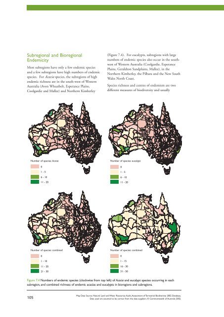
Subregional <strong>and</strong> Bioregional<br />
Endemicity<br />
Most subregions have only a few endemic species<br />
<strong>and</strong> a few subregions have high numbers of endemic<br />
species. For Acacia species, the subregions of high<br />
endemic richness are in the south-west of Western<br />
Australia (Avon Wheatbelt, Esperance Plains,<br />
Coolgardie <strong>and</strong> Mallee) <strong>and</strong> Northern Kimberley<br />
105<br />
Number of species: Acacia Number of species: eucalypt<br />
0<br />
1 - 5<br />
6 - 10<br />
11 - 20<br />
0<br />
1 - 10<br />
11 - 20<br />
21 - 30<br />
(Figure 7.4). For eucalypts, subregions with large<br />
numbers of endemic species also occur in the southwest<br />
of Western Australia (Coolgardie, Esperance<br />
Plains, Geraldton S<strong>and</strong>plains, Mallee), in the<br />
Northern Kimberley, the Pilbara <strong>and</strong> the New South<br />
Wales North Coast.<br />
Species richness <strong>and</strong> centres of endemism are two<br />
different measures of <strong>biodiversity</strong> <strong>and</strong> usually<br />
0<br />
1 - 5<br />
6 - 10<br />
11 - 20<br />
Number of species: combined Number of species: combined<br />
0<br />
1 - 15<br />
16 - 30<br />
31 - 50<br />
Figure 7.4 Numbers of endemic species (clockwise from top left) of Acacia <strong>and</strong> eucalypt species occurring in each<br />
subregion, <strong>and</strong> combined richness of endemic acacias <strong>and</strong> eucalypts in bioregions <strong>and</strong> subregions.<br />
Map Data Source: Natural <strong>L<strong>and</strong></strong> <strong>and</strong> <strong>Water</strong> Resources Audit,Assessment of Terrestrial Biodiversity <strong>2002</strong> Database.<br />
Data used are assumed to be correct from the data suppliers. © Commonwealth of Australia <strong>2002</strong>.
Eucalyptus crenulata,a rare small tree confined to<br />
swampy areas north <strong>and</strong> south of the Dividing<br />
Range,Victoria (CSIRO).<br />
provide different levels of information. Comparing<br />
subregional data for Acacia <strong>and</strong> eucalypts shows that<br />
the centres of endemism occupy fewer adjacent<br />
subregions <strong>and</strong> are more restricted in area than the<br />
centres of species richness, although there is some<br />
overlap. This is to be expected since the number of<br />
species of restricted distribution is only a fraction of<br />
all the acacias <strong>and</strong> eucalypts in Australia.<br />
The patterns of richness of endemic species for the<br />
combined Acacia <strong>and</strong> eucalypt data show that<br />
bioregions of high endemic richness are the Avon<br />
Wheatbelt, Esperance Plains, Coolgardie, Brigalow Belt<br />
South, <strong>and</strong> the Sydney Basin. Areas of moderately high<br />
endemic richness are the Geraldton S<strong>and</strong>plains,<br />
Western Mallee, Pilbara, Northern Kimberley <strong>and</strong> New<br />
South Wales North Coast (Figure 7.4).<br />
The number of endemic species in a subregion can<br />
be expressed by an index for endemicity. Bioregions<br />
<strong>and</strong> subregions that have higher values of this index<br />
have more species <strong>and</strong> more endemic species.<br />
By this method, those bioregions <strong>and</strong> subregions<br />
identified in Figure 7.4 remain highlighted <strong>and</strong><br />
other bioregions <strong>and</strong> subregions emerge as<br />
significant (Figure 7.5 <strong>and</strong> Table 7.1) - the Jarrah<br />
Forests, Warren, Swan Coastal Plain, Carnarvon,<br />
Central Kimberley, Pine Creek, Arnhem Plateau,<br />
Cape York Peninsula, Einasleigh Upl<strong>and</strong>s, Brigalow<br />
Belt North, South East Queensl<strong>and</strong>, New Engl<strong>and</strong><br />
Tablel<strong>and</strong>s, South East Coast <strong>and</strong> South Eastern<br />
Highl<strong>and</strong>s, South East Coastal Plain, Victorian<br />
Midl<strong>and</strong>s, Tasmania South East, Flinders Lofty<br />
Block, <strong>and</strong> Eyre Yorke Block. These bioregions are<br />
important because of the large numbers of endemic<br />
species they contain.<br />
Endemicity Index<br />
0 - 0.2<br />
0.21 - 0.8<br />
0.81 - 1.2<br />
1.2 - 2<br />
Map Data Source: Natural <strong>L<strong>and</strong></strong> <strong>and</strong> <strong>Water</strong> Resources Audit,Assessment of Terrestrial Biodiversity <strong>2002</strong> Database.<br />
Data used are assumed to be correct from the data suppliers. © Commonwealth of Australia <strong>2002</strong>.<br />
Figure 7.5 Endemicity Index for combined data of<br />
acacias <strong>and</strong> eucalypts in subregions (above) <strong>and</strong><br />
bioregions (below).<br />
Endemicity Index<br />
0 - 0.5<br />
0.51 - 1<br />
1 - 1.4<br />
1.4 - 2<br />
106<br />
Chapter 7
Table 7.1 Summary <strong>and</strong> comparison of different metrics used to examine the patterns of species richness,<br />
endemism <strong>and</strong> irreplacability for Acacia <strong>and</strong> eucalypts in bioregions. Double stars indicate highest values for<br />
bioregions for the combined Acacia <strong>and</strong> eucalypt data; single stars indicate moderately high values.<br />
107<br />
BIOREGIONS TOTAL NUMBER OF ENDEMICITY IRREPLACABILITY<br />
NUMBER OF ENDEMIC INDEX INDEX<br />
SPECIES SPECIES<br />
Arnhem Plateau * **<br />
Avon Wheatbelt ** * ** **<br />
Brigalow Belt North * * **<br />
Brigalow Belt South ** ** ** **<br />
Cape York Peninsula * **<br />
Carnarvon * **<br />
Central Kimberley * *<br />
Central Ranges *<br />
Coolgardie ** ** ** **<br />
Dampierl<strong>and</strong> *<br />
Desert Upl<strong>and</strong>s *<br />
Einasleigh Upl<strong>and</strong>s * * **<br />
Esperance Plains ** ** ** **<br />
Eyre Yorke Block * **<br />
Flinders Lofty Block * *<br />
Gascoyne *<br />
Geraldton S<strong>and</strong>plains ** ** **<br />
Great Victoria Desert * **<br />
Gulf Plains *<br />
Jarrah Forest * *<br />
Little S<strong>and</strong>y Desert *<br />
MacDonnell Ranges *<br />
Mallee ** * ** **<br />
Mitchell Grass Downs *<br />
Murchison * * *<br />
Murray Darling Depression *<br />
N<strong>and</strong>ewar *<br />
New Engl<strong>and</strong> Tablel<strong>and</strong> * **<br />
Northern Kimberley * ** **<br />
N.S.W. North Coast ** * ** **<br />
N.S.W. South Western Slopes *<br />
Ord Victoria Plain * *<br />
Pilbara * * **<br />
Pine Creek * *<br />
South East Coastal Plain * *<br />
South Eastern Highl<strong>and</strong>s ** * **<br />
South East Corner * * **<br />
South Eastern Queensl<strong>and</strong> * * **<br />
Swan Coastal Plain * **<br />
Sydney Basin ** **<br />
Tasmanian South East * *<br />
Victorian Midl<strong>and</strong>s * **<br />
Warren * *<br />
Wet Tropics *<br />
Yalgoo *
Red-flowering gum, Eucalyptus ficifolia, is restricted to an area south-east of Perth (CSIRO).<br />
Irreplacability<br />
Subregions with endemic species are important<br />
because they are the only places where these species<br />
are found. There are limitations with inferring<br />
conservation priorities from endemism. Importantly,<br />
endemicity is a scale-dependent attribute. For<br />
example, Figure 7.5 shows differences between areas<br />
of high endemism at the bioregional scale compared<br />
with the subregional scale. At the larger scales there<br />
will naturally be higher numbers of endemic species.<br />
To overcome this, an overall measure of<br />
irreplacability is assessed. This incorporates the<br />
significance of subregions in terms of both the<br />
number of species present <strong>and</strong> the proportion of<br />
those species that have restricted distributions.<br />
The Irreplacability Index is a relative measure of the<br />
degree to which the species complement of a<br />
bioregion or subregion can be substituted for by<br />
another region or regions. Subregions with more<br />
endemic species will have a higher score of the<br />
index. Large numbers of species in a bioregion or<br />
subregion also contribute to a higher score. Both<br />
large numbers of species <strong>and</strong> the substitutability of<br />
the species are combined in the Irreplacability Index.<br />
This Index encapsulates both the importance of a<br />
location for irreplaceable species <strong>and</strong> for potentially<br />
high habitat diversity associated with large numbers<br />
of species.<br />
Bioregions <strong>and</strong> subregions identified in Figures 7.4<br />
<strong>and</strong> 7.5 all have a high Irreplacability Index.<br />
Additional subregions are highlighted (Figure 7.6,<br />
Table 7.1). For acacias, some subregions of the<br />
Murchison, Cape York Peninsula <strong>and</strong> the South East<br />
Corner become more prominent (Figures 7.4 <strong>and</strong><br />
7.6). For eucalypts, some subregions of the<br />
Murchison, Great Victoria Desert, Central Ranges,<br />
Ord Victoria Plain, Einasleigh Upl<strong>and</strong>s, New South<br />
Wales South Western Slopes, <strong>and</strong> South East Corner<br />
become more prominent.<br />
Comparison of the Irreplacability Index of the<br />
combined Acacia <strong>and</strong> eucalypt patterns at<br />
bioregional scale (Figure. 7.6) with the Endemicity<br />
Index (Figure. 7.5), shows that the same general<br />
patterns emerge (Table 7.1). The most significant<br />
bioregions are the Avon Wheatbelt, Esperance<br />
Plains, Coolgardie, Mallee, Geraldton S<strong>and</strong>plains,<br />
Carnarvon, Pilbara, Northern Kimberley, Arnhem<br />
Plateau, Cape York Peninsula, Einasleigh Upl<strong>and</strong>s,<br />
Brigalow Belt North, Brigalow Belt South, South<br />
Eastern Queensl<strong>and</strong>, New South Wales North Coast,<br />
New Engl<strong>and</strong> Tablel<strong>and</strong>, Sydney Basin, South<br />
Eastern Highl<strong>and</strong>s, Victorian Midl<strong>and</strong>s, <strong>and</strong> the<br />
Eyre Yorke Block. Areas of moderately high<br />
irreplacability are the Jarrah Forest, Warren, Yalgoo,<br />
Murchison, Gascoyne, Little S<strong>and</strong>y Desert, Central<br />
Ranges, MacDonnell Ranges, Dampierl<strong>and</strong>, Central<br />
Kimberley, Ord Victoria Plain, Pine Creek, Wet<br />
Tropics, N<strong>and</strong>ewar, South East Coastal Plain,<br />
Tasmanian South East, <strong>and</strong> the Flinders Lofty Block.<br />
108<br />
Chapter 7
Number of species: Acacia Number of species: eucalypt<br />
109<br />
0 - 0.2<br />
0.21 - 0.5<br />
0.51 - 0.8<br />
0.81 - 1.6<br />
0 - 0.2<br />
0.21 - 0.5<br />
0.51 - 0.8<br />
0.81 - 1.6<br />
0 - 0.2<br />
0.21 - 0.5<br />
0.51 - 0.8<br />
0.81 - 1.6<br />
Number of species: combined Number of species: combined<br />
0 - 0.2<br />
0.21 - 0.5<br />
0.51 - 0.8<br />
0.81 - 1.6<br />
Figure 7.6 Irreplacability Indices (clockwise from top left) of Acacia <strong>and</strong> eucalypts in each subregion, <strong>and</strong><br />
combined data of acacias <strong>and</strong> eucalypts in bioregions <strong>and</strong> subregions.<br />
Condition <strong>and</strong> Trend of Bioregions<br />
<strong>and</strong> Subregions<br />
Subregions with high levels of endemism <strong>and</strong><br />
irreplacability were examined in the context of the<br />
condition of their l<strong>and</strong>scapes using the l<strong>and</strong>scape<br />
stress classes developed by the Audit (NLWRA<br />
2001a). This approach was used in lieu of an<br />
examination of condition <strong>and</strong> trend for each<br />
endemic species in a bioregion or subregion as this<br />
level of information is not yet available. Further<br />
<strong>assessment</strong> is required to link endemic species to<br />
ecosytems <strong>and</strong> identify the status, threatening<br />
processes <strong>and</strong> management needs for each ecosystem.<br />
The top two categories of the Irreplacability Index<br />
(greater than 0.5 in Figure 7.6) are shown with their<br />
stress class values in Figure 7.7.<br />
Many subregions of south-western Western Australia<br />
have a high level of irreplacability because they<br />
contain large numbers of Acacia <strong>and</strong> eucalypt<br />
species, <strong>and</strong> many endemic species of these taxa.<br />
Map Data Source: Natural <strong>L<strong>and</strong></strong> <strong>and</strong> <strong>Water</strong> Resources Audit,Assessment of Terrestrial Biodiversity <strong>2002</strong> Database.<br />
Data used are assumed to be correct from the data suppliers. © Commonwealth of Australia <strong>2002</strong>.
This region is also amongst the most degraded in<br />
Australia. There is a general lack of data describing<br />
the population trends <strong>and</strong> conservation status of<br />
species in these subregions <strong>and</strong> bioregions.<br />
Nevertheless it seems likely that they would be<br />
under moderate to high threat because of the<br />
pressures from clearing <strong>and</strong> fragmentation of native<br />
vegetation, increases in salinity <strong>and</strong> other threatening<br />
processes. This deficiency in knowledge should be<br />
addressed to assist their conservation.<br />
<strong>L<strong>and</strong></strong>scape Stress Class<br />
1 (high stress)<br />
2<br />
3<br />
4<br />
5<br />
6 (low stress)<br />
no data<br />
Low Irreplacability Index<br />
Map Data Source: Natural <strong>L<strong>and</strong></strong> <strong>and</strong> <strong>Water</strong> Resources Audit,Assessment of Terrestrial Biodiversity <strong>2002</strong> Database.<br />
Data used are assumed to be correct from the data suppliers. © Commonwealth of Australia <strong>2002</strong>.<br />
These bioregions <strong>and</strong> subregions are important for<br />
preserving the variety of Acacia <strong>and</strong> eucalypt species.<br />
Forty-two species of Acacia <strong>and</strong> 29 species of eucalypt<br />
occur only in these highly degraded bioregions <strong>and</strong><br />
subregions in south-western Australia. Parts of the<br />
New South Wales South Western Slopes, Brigalow<br />
Belt North <strong>and</strong> South, <strong>and</strong> Victoria also have a<br />
moderate rating of irreplacability <strong>and</strong> species there are<br />
likely to be threatened when compared with the<br />
overall <strong>assessment</strong> of l<strong>and</strong>scape health.<br />
Figure 7.7 Subregions with Irreplacability Indices<br />
greater than 0.5 for acacias (top left) <strong>and</strong> eucalypts<br />
(top right), <strong>and</strong> for combined data of acacias <strong>and</strong><br />
eucalypts (bottom) in subregions showing l<strong>and</strong>scape<br />
stress classes.<br />
Leafless rock wattle, Acacia aphylla, is listed as<br />
vulnerable <strong>and</strong> is endemic to south-west Western<br />
Australia near Perth (M. Fagg).<br />
110<br />
Chapter 7
CONCLUSIONS<br />
This <strong>assessment</strong> using two key plant groups, reveals<br />
a number of areas of significant diversity in addition<br />
to the regions of high diversity for a broad range of<br />
plant groups recognised in previous studies.<br />
It confirms that species with restricted ranges are not<br />
r<strong>and</strong>omly distributed across the l<strong>and</strong>scape, but are<br />
aggregated in bioregional centres (Figure 7.4). The<br />
most likely explanation for these patterns is that over<br />
evolutionary timescale, variable climatic regimes <strong>and</strong><br />
changing geological <strong>and</strong> geomorphological systems<br />
result in events which fragment species distributions<br />
<strong>and</strong> initiate speciation processes.<br />
The analysis shows that species-rich regions are only<br />
one indicator of conservation priorities. Because this<br />
measure does not indicate how species are<br />
distributed across the Australian l<strong>and</strong>scape, indices<br />
of endemism <strong>and</strong> irreplacability have been used in<br />
Eucalyptus erythrocorys occurs in subcoastal areas north of Perth (CSIRO).<br />
111<br />
this analysis to identify bioregions <strong>and</strong> subregions<br />
that are important for the restricted types of species<br />
they support.<br />
Areas (or parts thereof) of south-west Western<br />
Australia, the Kimberley, the ranges in north-eastern<br />
New South Wales, south-eastern Queensl<strong>and</strong> <strong>and</strong><br />
the Sydney S<strong>and</strong>stones were previously recognised as<br />
supporting significant numbers of endemic plants<br />
by Burbidge (1960) <strong>and</strong> more recently by Boden<br />
& Given (1995) <strong>and</strong> Crisp et al. (2001). The<br />
bioregions showing high levels of endemism for<br />
Acacia <strong>and</strong> eucalypts (Figure 7.5, Table 7.1) show<br />
some important differences from previous analyses.<br />
Some bioregions that have not been recognised in<br />
the past, were found to support high species richness<br />
<strong>and</strong> endemicity of Acacia <strong>and</strong> eucalypts: the<br />
Pilbara, Carnarvon, Great Victoria Desert <strong>and</strong>
Einasleigh Upl<strong>and</strong> bioregions. The differences<br />
observed from previous analyses are most likely<br />
due to the wide range of plant taxa included in the<br />
datasets of the various analyses. Besides species of<br />
Acacia <strong>and</strong> eucalypt, rainforest taxa, rare <strong>and</strong><br />
threatened species <strong>and</strong> other l<strong>and</strong> cover groups<br />
have been included in the previous studies. The<br />
results of the current study also do not emphasise<br />
plant communities that are not dominated by<br />
Acacia or eucalypts, such as rainforests <strong>and</strong><br />
heathl<strong>and</strong>s. Hence, these results should not be<br />
seen as representing patterns for all Australian<br />
flora. Similar analyses should be repeated for<br />
other taxonomic groups as the information on<br />
these taxa becomes available.<br />
Subregions of inl<strong>and</strong> Australia that have high levels<br />
of irreplacability were found to have low l<strong>and</strong>scape<br />
stress class values. This is not surprising as the<br />
stress class values are very strongly influenced by<br />
l<strong>and</strong> clearing <strong>and</strong> fragmentation, primarily features<br />
of agricultural bioregions <strong>and</strong> subregions. In<br />
inl<strong>and</strong> Australia, altered fire regimes <strong>and</strong> grazing<br />
by domestic stock are the primary variables driving<br />
species to the point of conservation concern, <strong>and</strong><br />
these drivers of change are not fully delineated by<br />
stress class categories. Consequently, this analysis<br />
may understate the conservation issues occurring<br />
in inl<strong>and</strong> Australia.<br />
Indices of endemism <strong>and</strong> irreplacability have been<br />
used to identify bioregions <strong>and</strong> subregions that are<br />
significant for the numbers <strong>and</strong> types of Acacia <strong>and</strong><br />
eucalypt species they support. These bioregions <strong>and</strong><br />
subregions contain a complement of species that<br />
cannot be represented anywhere else on the<br />
continent <strong>and</strong> so are irreplaceable natural features.<br />
Priorities for conservation need to also take into<br />
account the current status <strong>and</strong> threats to the<br />
species identified in this <strong>assessment</strong>. There is little<br />
specific information on the status <strong>and</strong> trends for<br />
acacias <strong>and</strong> eucalypts. This is also true for most<br />
other plant groups. Monitoring trends in key<br />
species <strong>and</strong> threatening processes in selected<br />
bioregions <strong>and</strong> subregions will build an<br />
underst<strong>and</strong>ing of the status of these elements of<br />
<strong>biodiversity</strong> at an Australia-wide scale, <strong>and</strong> greatly<br />
enhance the information required to support their<br />
conservation.<br />
Sydney golden wattle, Acacia longifolia, occurs in<br />
eastern Australia (ANBG).<br />
Gimlet, Eucalyptus salubris, is endemic to Western<br />
Australia (CSIRO).<br />
112<br />
Chapter 7
8. Reserves<br />
Chapter 8
ummary<br />
115<br />
Cradle Mountain National Park (P. Sattler)
SUMMARY<br />
Australia’s protected areas are central to the conservation of <strong>biodiversity</strong>. As of June 2001, a total of 9.2% of<br />
the continent was in protected areas. Data on native ecosytems was only available for 68 of 85 bioregions<br />
<strong>and</strong> in these regions approximately 67% of the regional ecosystem diversity is protected by national parks <strong>and</strong><br />
formal reserves (IUCN categories I – IV). An additional 5% of ecosystems occur in other protected areas that<br />
include covenants on private l<strong>and</strong> (IUCN categories V – VI). Seventy-one subregions have no protected areas.<br />
These figures are a measure of the Comprehensiveness of the reserve system <strong>and</strong> demonstrate that the reserve<br />
system is incomplete or biased in terms of ecosystems reserved.<br />
Analysis of the Comprehensiveness, Adequacy <strong>and</strong> Representativeness of protected areas <strong>and</strong> the degree of<br />
threatening processes suggests the following:<br />
• 42 bioregions are of high priority to consolidate Australia’s protected area system;<br />
• 20 bioregions are of intermediate priority; <strong>and</strong><br />
• 23 bioregions are of lower priority.<br />
The high priorities are predominantly more fertile l<strong>and</strong>s, particularly in the semi-arid woodl<strong>and</strong>, shrubl<strong>and</strong><br />
<strong>and</strong> grassl<strong>and</strong> regions of Australia. At an ecosystem scale, 1500 ecosystems have been specifically identified as<br />
a priority for reservation.<br />
The st<strong>and</strong>ard of protected area management is classed as fair for 53% of the 57 bioregions assessed.<br />
Whilst improved management is needed, there is not irretrievable resource degradation occurring in most<br />
protected areas. Systematic ecological monitoring of protected areas should be a component of enhanced<br />
management to improve management st<strong>and</strong>ards.<br />
The status of <strong>biodiversity</strong> <strong>and</strong> extent of threatening processes detailed elsewhere in this report (particularly the<br />
large number of <strong>terrestrial</strong> ecosystems regarded as being threatened <strong>and</strong> the 57 subregions with less than 30%<br />
remnant vegetation) implies that there is an urgent need to implement a strategic plan for consolidating<br />
Australia’s protected areas.<br />
ummary Chapter 8<br />
116
INTRODUCTION<br />
The development of a Comprehensive, Adequate <strong>and</strong><br />
Representative reserve system is the central strategy<br />
to conserve <strong>biodiversity</strong> in the National Strategy for<br />
the Conservation of Australia’s Biodiversity (ANZECC<br />
1996). To maintain ecosystem services <strong>and</strong> the<br />
conservation of the full range of <strong>biodiversity</strong>, reserves<br />
need to be complemented by ecologically sustainable<br />
management of other l<strong>and</strong>s <strong>and</strong> waters. This<br />
chapter concentrates on the protected areas<br />
component of <strong>biodiversity</strong> conservation.<br />
Protected areas such as nature reserves <strong>and</strong> national<br />
parks are cost-effective in terms of <strong>biodiversity</strong><br />
conservation compared with the cost of maintaining<br />
<strong>biodiversity</strong> in developed l<strong>and</strong>scapes (James et al.<br />
1999). This is particularly relevant as large parts of<br />
Australia continue to become extensively modified.<br />
The Commonwealth, State <strong>and</strong> Territory<br />
governments have successfully collaborated to<br />
exp<strong>and</strong> protected areas in each State <strong>and</strong> Territory<br />
through a policy framework developed by ANZECC<br />
that is known as the National Reserve System. The<br />
goal of the National Reserve System is to establish a<br />
Comprehensive, Adequate <strong>and</strong> Representative system<br />
of protected areas.<br />
More specifically, its priorities are to:<br />
Uluru – Kata Tjuta National Park protects one of Australia's icons (R. Lawson).<br />
117<br />
• sample all ecosystems identified at an<br />
appropriate regional scale;<br />
• consider the requirements of rare <strong>and</strong> threatened<br />
species <strong>and</strong> ecosystems; <strong>and</strong><br />
• consider the conservation needs of special groups<br />
of organisms such as species with specialised<br />
habitat requirements (Environment Australia<br />
in prep.).<br />
The biogeographic framework adopted for planning<br />
the expansion of the National Reserve System has<br />
been the Interim Biogeograhic Regionalisation of<br />
Australia (IBRA) (Thackway & Cresswell 1995).<br />
Since its inception, the regionalisation was updated<br />
<strong>and</strong> Version 5.1 developed. It now has 85<br />
biogeographic regions or bioregions (Environment<br />
Australia 2000) <strong>and</strong> 384 subregions. Subregions<br />
represent a finer, more homogenous l<strong>and</strong>scape unit<br />
that is closely associated with geomorphology <strong>and</strong><br />
other environmental factors. Reservation across<br />
subregions provides a means of capturing any<br />
variation that might occur within ecosystems that<br />
have broad distributions.
Previously, there has not been a quantitative<br />
<strong>assessment</strong> of the completeness of Australia’s reserve<br />
system in terms of Comprehensiveness, Adequacy<br />
<strong>and</strong> Representativeness criteria. The only metric<br />
available was the macro-scale analysis of area<br />
reserved per bioregion <strong>and</strong> subregion together with<br />
additional contextual information derived from the<br />
extent of remnant vegetation using the Audit’s<br />
<strong>L<strong>and</strong></strong>scape Health Assessment data (Cummings &<br />
Hardy 2001). An earlier review, using the best<br />
available data at the time, was undertaken by<br />
Specht et al. (1974).<br />
Comprehensiveness, Adequacy <strong>and</strong> Representativeness<br />
criteria in this <strong>assessment</strong> are defined as:<br />
- Comprehensiveness: the degree to which<br />
ecosystems identified at an appropriate regional<br />
scale are captured in the reserve system across each<br />
bioregion. This is recorded as the percent reserved.<br />
- Adequacy: the area (hectares <strong>and</strong> percent of the<br />
area of the bioregion) reserved in each bioregion,<br />
recognising that this does not address the<br />
complex issues of viability particularly for rare<br />
<strong>and</strong> threatened species <strong>and</strong> ecosystems, <strong>and</strong> other<br />
special organisms.<br />
- Representativeness: the degree that the inherent<br />
variation within an ecosystem is reserved.<br />
This is assessed by the degree to which<br />
ecosystems are captured in protected areas across<br />
THE ASSESSMENT<br />
This <strong>assessment</strong> has provided a review of the<br />
Comprehensiveness of Australia’s reserves. This<br />
includes both national parks <strong>and</strong> formal reserves<br />
(IUCN reserve categories I – IV) <strong>and</strong> other<br />
protected areas including covenants on private l<strong>and</strong>s<br />
(IUCN reserve categories V – VI).<br />
The priority ecosystems for reservation have been<br />
identified in each bioregion within the constraints of<br />
available information. These chiefly represent those<br />
unreserved or poorly reserved ecosystems (< 5% of<br />
their pre-European extent) that are also threatened<br />
or have special values.<br />
Representativeness information is only available for<br />
some parts of Australia, as the coarse scale or<br />
inadequate mapping of vegetation or ecosystems<br />
Cooloola National Park (P. Sattler).<br />
their geographic range as measured by their<br />
representation across subregions. This<br />
information is presented as a proportion of<br />
ecosystems that are represented across their<br />
whole subregional range (ie. 100% of their<br />
subregional range) <strong>and</strong> the proportion of<br />
regional ecosystems that are represented across<br />
50% or more of their subregional range.<br />
does not allow for meaningful analysis within some<br />
subregions (eg. in northern South Australia) <strong>and</strong> in<br />
Tasmania subregions are not identified.<br />
These criteria, together with the extent of<br />
threatening processes, have been used by the States<br />
<strong>and</strong> the Northern Territory to determine the priority<br />
bioregions for consolidating the National Reserve<br />
System <strong>and</strong> to assess the relative subregional<br />
priorities within each bioregion. This prioritisation<br />
builds upon an earlier analysis of the National<br />
Reserve System program priorities by Environment<br />
Australia (Cummings & Hardy 2001).<br />
118<br />
Chapter 8
This prioritization, based on relative area reserved<br />
per bioregion, categorized:<br />
• Priority 1 as
Terrestrial Protected Areas<br />
IUCN Categories I - IV<br />
IUCN Categories V - VI<br />
Figure 8.2 Protected areas that have been formally<br />
gazetted <strong>and</strong> allocated to an IUCN category.<br />
This analysis of Comprehensiveness is constrained<br />
as it is based on an <strong>assessment</strong> of 68 of the 85<br />
bioregions. Those bioregions not assessed contain a<br />
similiar proportion of reserved l<strong>and</strong> but it can not be<br />
assessed how representative the protected area system<br />
is in these bioregions. The availability of only a<br />
broad scale description of ecosystems in many parts<br />
of the continent means that a finer classification is<br />
likely to show additional gaps <strong>and</strong> a more<br />
conservative estimate of Comprehensiveness.<br />
Each State <strong>and</strong> the Northern Territory has determined<br />
the priority ecosystems in each bioregion for<br />
reservation. These amounted to over 1500 ecosystems<br />
Australia-wide requiring reservation. A number of<br />
these are identified at a broader scale than the<br />
ecosystems identified as threatened in Chapter 4.<br />
Representativeness values are not available Australiawide<br />
to ascertain the degree to which ecosystems are<br />
sampled across their subregional range.<br />
Map Data Source: Collaborative Australian Protected Areas Database (CAPAD) 2000.<br />
Data used are assumed to be correct from the data suppliers. © Commonwealth of Australia <strong>2002</strong>.<br />
In terms of a macro-scale analysis, 71 of the 384<br />
subregions have no reserves. Specific information on<br />
Representativeness is available for some bioregions<br />
<strong>and</strong> this is presented on the Australian Natural<br />
Resources Atlas.<br />
Lizard Isl<strong>and</strong> National Park (QEPA).<br />
120<br />
Chapter 8
Setting Priorities for the Further<br />
Consolidation of Australia’s<br />
Protected Areas<br />
Figure 8.3 <strong>and</strong> Table 8.1 show the bioregional<br />
priorities for consolidating Australia’s protected area<br />
system on a 1 to 5 priority scale (1 being the highest<br />
priority). Forty-two bioregions are poorly reserved<br />
(less than 5%) <strong>and</strong>/or are under significant threat<br />
leading to the irreversible loss of opportunities for a<br />
fully Comprehensive, Adequate <strong>and</strong> Representative<br />
reserve system (priorities 1 <strong>and</strong> 2). Twenty-one<br />
bioregions are identified as priority 3 where there is<br />
121<br />
Bioregional priorities<br />
1 High priority<br />
2<br />
3<br />
4<br />
5 Low priority<br />
Figure 8.3 Bioregional priorities for consolidating Australia’s protected area system.<br />
either some level of reservation (5 - 10%) or where<br />
the level of existing degradation or threatening<br />
processes are not yet as extensive as for priority 1<br />
<strong>and</strong> 2. Twenty-three bioregions are classed as<br />
priority 4 or 5 where reasonable levels of reservation<br />
occur (>10%).<br />
Within these bioregions, some subregions may<br />
have particular reservation needs owing to the<br />
disproportionate level of threat or the number of<br />
ecosystems or species requiring protection through<br />
reservation.<br />
Map Data Source: Natural <strong>L<strong>and</strong></strong> <strong>and</strong> <strong>Water</strong> Resources Audit,Assessment of Terrestrial Biodiversity <strong>2002</strong> Database.<br />
Data used are assumed to be correct from the data suppliers. © Commonwealth of Australia <strong>2002</strong>.
Table 8.1 Bioregional priorities to consolidate Australia’s protected area system.<br />
Reservation Reservation Reservation Reservation Reservation<br />
Priority 1 (Highest) Priority 2 Priority 3 Priority 4 Priority 5 (Lowest)<br />
Avon Wheatbelt Arnhem Coast Ben Lomond Arnhem Plateau Australian Alps<br />
Brigalow Belt Central Arnhem Broken Hill Cape York Esperance Plains<br />
North Complex Peninsula<br />
Brigalow Belt Carnarvon Central Mackay Darwin Coastal Great Victoria<br />
South Coast Desert<br />
Burt Plain Channel Country Coolgardie Flinders NSW North Coast<br />
Central Ranges Central Kimberley Eyre Yorke Block Gibson Desert Pine Creek<br />
Daly Basin Cobar Peneplain Gawler Geraldton<br />
S<strong>and</strong>plains<br />
Sydney Basin<br />
Dampierl<strong>and</strong> Desert Upl<strong>and</strong>s Gulf Fall <strong>and</strong><br />
Upl<strong>and</strong>s<br />
Hampton South East Corner<br />
Darling Riverine Davenport Jarrah Forest New Engl<strong>and</strong> South Eastern<br />
Plains Murchison Ranges Tablel<strong>and</strong> Highl<strong>and</strong>s<br />
Finke Einasleigh Kanmantoo Tasmanian Central Simpson Strzelecki<br />
Upl<strong>and</strong>s Highl<strong>and</strong>s Dunefields<br />
Gulf Coastal Flinders Lofty King Tasmanian Warren<br />
Block Southern Ranges<br />
Mitchell Grass Gascoyne MacDonnell Tasmanian West<br />
Downs Ranges<br />
Murchison Great S<strong>and</strong>y Desert Mallee Wet Tropics<br />
N<strong>and</strong>ewar Gulf Plains Northern<br />
Kimberley<br />
NSW South<br />
Western Slopes<br />
Little S<strong>and</strong>y Desert Nullarbor<br />
Riverina Murray Darling<br />
Depression<br />
Ord Victoria Plain<br />
Sturt Plateau Mount Isa Inlier South Eastern<br />
Queensl<strong>and</strong><br />
Tasmanian<br />
Northern<br />
Midl<strong>and</strong>s<br />
Mulga <strong>L<strong>and</strong></strong>s Swan Coastal Plain<br />
Victorian Naracoorte Tasmanian<br />
Volcanic Plain Coastal Plain Northern Slopes<br />
Pilbara Victoria Bonaparte<br />
South East<br />
Coastal Plain<br />
Victorian Midl<strong>and</strong>s<br />
Stony Plains Yalgoo<br />
Tanami<br />
Tiwi Cobourg<br />
Tasmanian<br />
South East<br />
122<br />
Chapter 8
Figure 8.4 shows the subregional priorities which<br />
should be considered within their bioregional<br />
priority context. They are classed as high, medium<br />
<strong>and</strong> low priority.<br />
An example is the Wet Tropics biroregion which is<br />
classed overall as having a bioregional priority of 4.<br />
This bioregion contains extensive national parks <strong>and</strong><br />
the World Heritage Area occuring over the upl<strong>and</strong><br />
subregions. However, the limited reservation,<br />
number of threatened species <strong>and</strong> ecosystems <strong>and</strong><br />
degree of threatening processes throughout the<br />
lowl<strong>and</strong>s identity these subregions as high priority<br />
for exp<strong>and</strong>ed reservation compared with low priority<br />
for a number of the upl<strong>and</strong> subregions. Additional<br />
reservation of lowl<strong>and</strong> alluvial ecosystems also will<br />
contribute significantly to the protection of wetl<strong>and</strong>s<br />
<strong>and</strong> fisheries.<br />
Subregional priorities<br />
Figure 8.4 Subregional priorities within their bioregional context for consolidating Australia’s protected area system.<br />
123<br />
High priority<br />
Medium<br />
Low priority<br />
Subregional priority not allocated<br />
No subregions identified for Tasmania<br />
In parts of Australia, the opportunity to implement<br />
a Comprehensive reserve system has been lost or is<br />
rapidly diminishing. An indication of this is given<br />
by the findings of the <strong>L<strong>and</strong></strong>scape Health Assessment<br />
(NLWRA 2001a) which found that within the<br />
intensive l<strong>and</strong> use zone 57 subregions (31%) had less<br />
than 30% remnant vegetation <strong>and</strong> in 88 subregions<br />
(48%), connectivity of vegetation remnants had<br />
broken down.<br />
Map Data Source: Natural <strong>L<strong>and</strong></strong> <strong>and</strong> <strong>Water</strong> Resources Audit,Assessment of Terrestrial Biodiversity <strong>2002</strong> Database.<br />
Data used are assumed to be correct from the data suppliers. © Commonwealth of Australia <strong>2002</strong>.
Surveying for the acquistion of Welford National<br />
Park: Mulga <strong>L<strong>and</strong></strong>s (P. Sattler).<br />
As an example of the <strong>assessment</strong> made for each<br />
bioregion, the Brigalow Belt South (extending across<br />
Queensl<strong>and</strong> <strong>and</strong> New South Wales) has 2.8% of its<br />
area reserved (Table 8.2). In terms of<br />
Comprehensiveness, only 54% of its ecosystems are<br />
reserved. As an indication of Representativeness,<br />
27% of its ecosystems are fully reserved across their<br />
subregional range with 39% reserved across half of<br />
their subregional range. This reflects that the largest<br />
areas reserved within the bioregion are located<br />
within only a few subregions on its northern<br />
extremity around the Carnarvon Range.<br />
The limited area reserved, the bias in ecosystems<br />
sampled <strong>and</strong> the degree of threatening processes<br />
means that this region is classified as priority 1 for<br />
consolidation of the protected area system.<br />
Bioregional priority 1<br />
Area of bioregion 26,926,569 ha<br />
Comprehensiveness 54 %<br />
Adequacy (I-VI) 2.8 %<br />
Representativeness<br />
(all subregions) 27 %<br />
Representativeness<br />
(>50% subregions) 39 %<br />
Reserve management<br />
st<strong>and</strong>ard rank Fair<br />
Table 8.2 Comprehensiveness,Adequacy <strong>and</strong><br />
Representativeness (CAR) of protected areas within the<br />
Brigalow Belt South bioregion <strong>and</strong> a ranking of reserve<br />
management st<strong>and</strong>ard.The bioregional priority for<br />
consolidating the protected area system is based on this<br />
CAR analysis <strong>and</strong> threat.<br />
Regional priorities for reservation in this bioregion<br />
must now focus on those poorly reserved ecosystems<br />
associated with the clay <strong>and</strong> alluvial plains.<br />
Unfortunately, the extensive clearing of these fertile<br />
areas means that the opportunities for a fully<br />
Comprehensive, Adequate <strong>and</strong> Representative<br />
reserve system in this bioregion no longer exists.<br />
An example of the detailed information on the priorities<br />
for reservation that is available on the Atlas is shown for<br />
the Gawler bioregion in South Australia. Table 8.3<br />
shows the subregional <strong>and</strong> ecosystem priorities for<br />
reservation together with the constraints for reservation.<br />
BIOREGIONAL SUBREGION ECOSYSTEM ECOSYSTEM CONSTRAINTS<br />
PRIORITY PRIORITIES PRIORITIES PRIORITY NOTES<br />
4 GAW1 (medium) Acacia aneura Low Poorly conserved. Competing l<strong>and</strong> use<br />
GAW2 (medium) Woodl<strong>and</strong> on s<strong>and</strong> Regeneration<br />
GAW3 (low) plains (SA0034) threatened by grazing<br />
GAW4 (high) Acacia calcicola Low Threatened by camel Competing l<strong>and</strong> use<br />
GAW5 (high) Woodl<strong>and</strong> on <strong>and</strong> rabbit grazing.<br />
calcareous soils of Occurrences few, small,<br />
breakaway tablel<strong>and</strong>s thinly spread <strong>and</strong><br />
(SA0036) widely scattered.<br />
Alectryon oleifolius Very little regeneration Competing l<strong>and</strong> use<br />
spp. canescens Tall occurring due to rabbit<br />
Shrubl<strong>and</strong> on alluvial <strong>and</strong> stock grazing,<br />
soils of plains <strong>and</strong> understorey<br />
(SA0040) severely degraded.<br />
Table 8.3 Bioregional, subregional <strong>and</strong> ecosystem priorities to consolidate the protected area system <strong>and</strong><br />
associated constraints: Gawler bioregion. Bioregional priorities are based on a scale of 1 to 5 (1 is the highest)<br />
<strong>and</strong> subregional priorities based on high, medium <strong>and</strong> low.<br />
124<br />
Chapter 8
Reserve Management<br />
Australia’s national parks <strong>and</strong> other protected areas<br />
are its premier investment in <strong>biodiversity</strong><br />
conservation. Adequate management of these areas<br />
(<strong>and</strong> adjoining l<strong>and</strong>s) is essential. The <strong>assessment</strong> of<br />
protected area management st<strong>and</strong>ards (Table 8.4)<br />
has indicated that reserves across 12% of assessed<br />
bioregions have a very good st<strong>and</strong>ard of<br />
management where a high proportion of reserves<br />
have management plans <strong>and</strong> ecological monitoring<br />
programs in place. However, the st<strong>and</strong>ard of<br />
management of most of Australia’s protected areas<br />
indicates that more can be done. In most bioregions<br />
(53%), the st<strong>and</strong>ard of management is only fair<br />
125<br />
though any resource degradation is retrievable, <strong>and</strong><br />
in 14% it is poor where permanent resource<br />
degradation is occurring. In 21% of bioregions<br />
reserve management is good <strong>and</strong> the major<br />
<strong>biodiversity</strong> issues are being addressed, though not<br />
necessarily in a structured context where systematic<br />
ecological monitoring programs are in place.<br />
In Canada, the monitoring of parks' natural<br />
integrity is a legislated requirement. This represents<br />
a desirable precedent to ensure park management<br />
incorporates the protection of <strong>biodiversity</strong> values as<br />
part of the enhanced effort required to improve<br />
overall park management st<strong>and</strong>ards.<br />
Management st<strong>and</strong>ard Very good Good Fair Poor<br />
Number of bioregions 7 (12%) 12 (21%) 30 (53%) 8 (14%)<br />
Table 8.4 Protected area management st<strong>and</strong>ards within Australia’s bioregions<br />
(based on 67% of bioregions assessed).<br />
Kosciuszko National Park (NSW NPWS)
CONCLUSIONS<br />
The incompleteness of Australia’s protected area<br />
system in reserving the full range of biota, as<br />
indicated by 42 bioregions being of high priority<br />
(priorities 1 <strong>and</strong> 2) for reservation <strong>and</strong><br />
Comprehensiveness assessed at 67% for IUCN<br />
reserves I – IV, means that a major commitment is<br />
required to consolidate the reserve system. Such<br />
action should build on the work of the successful<br />
National Reserve System initiative <strong>and</strong> other efforts<br />
to achieve secure protective status on private l<strong>and</strong>s.<br />
Additional effort is also required in terms of reserve<br />
management to protect Australia’s premier<br />
investment in <strong>biodiversity</strong> conservation.<br />
The degree of threatening processes as indicated by<br />
57 subregions now having less than 30% remnant<br />
native vegetation, means that action to consolidate<br />
the reserve system is urgent. In many parts of<br />
Australia the opportunities for a fully<br />
Comprehensive, Adequate <strong>and</strong> Representative<br />
reserve system no longer exist <strong>and</strong> elsewhere,<br />
particularly associated with areas being rapidly<br />
cleared, the options are rapidly diminishing.<br />
Consolidation of the reserve system is an integral<br />
component of any bioregional conservation strategy<br />
together with off-reserve conservation <strong>and</strong> integrated<br />
natural resource management. This is demonstrated<br />
through the case studies carried out for this<br />
Biodiversity Assessment (Chapter 10) where reserve<br />
consolidation is identified as a key part of the mix of<br />
the required conservation actions in all studies.<br />
Reporting on the improvement in the<br />
Comprehensiveness of Australia’s protected area<br />
system <strong>and</strong> the reduction in number of priority<br />
bioregions should be undertaken as part of Australia’s<br />
State of the Environment reporting every five years.<br />
Litchfield National Park (P. Sattler).<br />
Mt Kaputar National Park (NSW NPWS).<br />
126<br />
Chapter 8
9. Biodiversity conservation<br />
across the wider l<strong>and</strong>scape<br />
Chapter 9
ummary<br />
129<br />
Integrating wildlife conservation with agriculture (QEPA).
SUMMARY<br />
There are two broad groups of management responses for delivering <strong>biodiversity</strong> conservation. The first is<br />
protective management - across both public <strong>and</strong> private l<strong>and</strong>s. This is the most cost-effective management strategy<br />
because preventing degradation is easier than repair. The second management response is rehabilitation to recover<br />
threatened species <strong>and</strong> repair threatened ecosystems <strong>and</strong> ecological processes. This strategy is costly, but necessary in<br />
parts of Australia. Both groups of management responses rely upon effectively integrating <strong>biodiversity</strong> conservation<br />
into natural resource management.<br />
To assess where integrated natural resource management might effectively deliver conservation outcomes, subregions<br />
were assessed in terms of existing constraints <strong>and</strong> community capacity. The <strong>assessment</strong> indicated that capacity for<br />
integrating <strong>biodiversity</strong> conservation into natural resource management is severely constrained in 14% of Australia’s<br />
IBRA subregions. Major constraints include the extent of degradation, socio-economic issues <strong>and</strong> limited<br />
community capacity. In a further 33% of subregions, significant constraints are identified. There is an identified<br />
capacity to integrate <strong>biodiversity</strong> conservation as part of natural resource management activities in 29% of<br />
subregions <strong>and</strong> natural resource management actions are achieving conservation outcomes in 21% of subregions.<br />
Conservation is considered to be well integrated into production systems in only 1.5% of subregions.<br />
The specific measures required to deliver <strong>biodiversity</strong> outcomes as part of integrated natural resource management<br />
vary widely across Australia <strong>and</strong> need to be tailored to regional circumstances. Existing activities <strong>and</strong> opportunities<br />
for integrated natural resource management to achieve effective <strong>biodiversity</strong> conservation have been reviewed for<br />
each subregion.<br />
Compared to the high numbers of threatened species, only 338 Commonwealth, State <strong>and</strong> Territory recovery plans<br />
exist (approximately 20% of Commonwealth listed species) <strong>and</strong> the implementation of many of these is not funded.<br />
Given the size of the task of redressing this situation, threatened species recovery across Australia requires a more<br />
strategic approach that goes beyond planning <strong>and</strong> addresses implementation.<br />
Bioregional <strong>and</strong> subregional planning strategies <strong>and</strong> works that focus on multiple species may provide an<br />
appropriate mechanism for addressing recovery of threatened species. To assist in these activities, this <strong>assessment</strong> has<br />
identified recovery actions for threatened species in each subregion. Further work is needed to identify groups of<br />
threatened species for multiple species recovery, to foster links with other natural resource management initiatives<br />
<strong>and</strong> facilitate management orientated ecological research.<br />
Recovery planning for threatened ecosystems <strong>and</strong> other ecological communities has received relatively little<br />
attention. Notable exceptions are the Grassy White Box woodl<strong>and</strong>s in southern Australia, temperate native<br />
grassl<strong>and</strong>s in Victoria, Western Australia’s Yanchep Cave aquatic rootmat invertebrate communities <strong>and</strong> Sydney’s<br />
Cumberl<strong>and</strong> Plain woodl<strong>and</strong>s. Recovery actions for threatened ecosystems have been suggested for each subregion<br />
<strong>and</strong> are a key information layer for regional natural resource management planning.<br />
Overall, successful recovery outcomes for threatened species <strong>and</strong> ecosystems <strong>and</strong> identified community capacity to<br />
be involved in recovery planning is identified in only 20% of subregions. Comparatively modest conservation<br />
initiatives <strong>and</strong> investment levels will lead to significant <strong>biodiversity</strong> conservation gains in much of northern Australia<br />
such as the Northern Kimberley <strong>and</strong> Cape York Peninsula, <strong>and</strong> across central Australia (29% of all subregions).<br />
Investment in protective management in these bioregions is cost effective <strong>and</strong> a priority.<br />
Major constraints on achieving recovery of threatened ecosystems due to the high level of habitat loss <strong>and</strong> poor<br />
l<strong>and</strong>scape condition are identified for 43 or 11% of subregions. Significant effort is required in a further 34% of<br />
subregions but in these, limited community capacity <strong>and</strong> resource constraints exist.<br />
Investment required in many subregions is substantial <strong>and</strong> it is likely that only selected activities will be able to be<br />
implemented. For example, the cost to achieve the revegetation of the 57 subregions that now have less than 30%<br />
remnant vegetation to a 30% target, is estimated to be well in excess of $4.5 billion. This makes it imperative to<br />
protect remnant natural habitat in these subregions <strong>and</strong> strategically target any investment in repair. Key <strong>biodiversity</strong><br />
elements such as riparian zones <strong>and</strong> threatened ecosystems, are special priorities for rehabilitation in these l<strong>and</strong>scapes.<br />
ummary Chapter 9<br />
130
INTRODUCTION<br />
The protection of <strong>biodiversity</strong> across Australia<br />
requires the adoption of integrated natural resource<br />
management practices that specifically incorporate<br />
defined conservation objectives. One essential<br />
component is the need for targeted programs to<br />
recover threatened species <strong>and</strong> threatened ecosystems.<br />
Reserves play a critical role in protecting a<br />
Comprehensive <strong>and</strong> Representative sample of<br />
<strong>biodiversity</strong> but the maintenance of regional<br />
<strong>biodiversity</strong> <strong>and</strong> the protection of ecological<br />
processes across the wider l<strong>and</strong>scape requires<br />
complementary natural resource management<br />
activities. The identification of <strong>biodiversity</strong><br />
conservation needs in the development of natural<br />
resource management strategies is the first step in<br />
this process.<br />
The very large number of threatened species <strong>and</strong><br />
threatened ecosystems identified in the Biodiversity<br />
Assessment implies that highly strategic approaches<br />
are required to achieve extensive recovery. Generally<br />
though, resources available to implement recovery<br />
plans are limited. Considerable effort has focused on<br />
providing legislative protection <strong>and</strong> on developing<br />
individual species recovery plans. As of August <strong>2002</strong><br />
there were 145 recovery plans in place under the<br />
Environment Protection <strong>and</strong> Biodiversity Conservation<br />
Act 1999. The Commonwealth government is<br />
committed to the adoption of a recovery plan for<br />
every endangered <strong>and</strong> critically endangered species<br />
listed under the Act by 2005. State <strong>and</strong> Territory<br />
governments also prepare recovery plans under their<br />
legislation.<br />
One of the strategic responses required is to<br />
implement a regional <strong>and</strong> all-encompassing<br />
approach to threatened species <strong>and</strong> ecosystems as<br />
part of regional natural resource management<br />
activities. For example, the Western Australian<br />
Department of Conservation <strong>and</strong> <strong>L<strong>and</strong></strong> Management<br />
lists threatened species <strong>and</strong> ecological communities<br />
<strong>and</strong> broad recovery actions in each of their<br />
administrative regions to promote recovery planning<br />
initiatives. This initiative could be extended to the<br />
development of bioregional overviews, strategies <strong>and</strong><br />
works for the protection of rare <strong>and</strong> threatened<br />
species <strong>and</strong> ecosystems.<br />
131<br />
Such an approach would provide better linkages with<br />
on-ground ecological conditions <strong>and</strong> constraints <strong>and</strong><br />
other bioregional <strong>biodiversity</strong> conservation measures<br />
including the monitoring of the status of native<br />
ecosystems. The Biodiversity Assessment, through<br />
collating information on threatened species <strong>and</strong><br />
ecosystems across all subregions <strong>and</strong> bioregions, has<br />
provided the first step in developing this approach<br />
on a comprehensive basis.<br />
With the increasing emphasis being given to the<br />
regional delivery of integrated natural resource<br />
management that include <strong>biodiversity</strong> conservation<br />
programs, the Biodiversity Assessment has collated<br />
information on the effectiveness of existing natural<br />
resource management activities to deliver<br />
<strong>biodiversity</strong> outcomes <strong>and</strong> the various opportunities<br />
or constraints that might exist across subregions.<br />
Ecological research <strong>and</strong> recovery of threatened<br />
species - fitting a radio tracker to a Bilby (P. Sattler).
THE ASSESSMENT<br />
Threatened Species <strong>and</strong><br />
Ecosystems<br />
Important information needed at the regional level<br />
for <strong>biodiversity</strong> conservation is the occurrence of<br />
threatened species <strong>and</strong> ecosystems, their threatening<br />
processes, recommended recovery actions <strong>and</strong> the<br />
resources required to effect improvement. This<br />
information is vital for the development of catchment<br />
plans, local government plans <strong>and</strong> other instruments<br />
that seek to integrate <strong>biodiversity</strong> conservation with<br />
natural resource management activities.<br />
The Biodiversity Assessment has investigated the<br />
conservation status of ecosystems as one means of<br />
highlighting the need to maintain viable ecosystems<br />
for the protection of <strong>biodiversity</strong>. An attempt was also<br />
1. Habitat retention through reserves<br />
2. Habitat protection on private l<strong>and</strong>s<br />
3. Habitat protection on other public l<strong>and</strong>s<br />
4. Regrowth retention<br />
5. Fencing<br />
6. Weed control<br />
7. Feral animal control<br />
8. Revegetation<br />
To assist in the collation of results, a st<strong>and</strong>ardised list of<br />
recovery actions was provided to agencies (Figure 9.1).<br />
The existence of current State, Territory <strong>and</strong><br />
Commonwealth recovery plans are also recorded.<br />
The recovery of threatened species <strong>and</strong> ecosystems<br />
through inclusion in regional planning processes <strong>and</strong><br />
activities is dependent upon community capacity <strong>and</strong><br />
opportunity. It is also important to consider where<br />
comparatively modest investments in conservation<br />
measures might result in significant <strong>biodiversity</strong> gains.<br />
Subregions were ranked in terms of threatened species<br />
<strong>and</strong> ecosystems recovery opportunity within a series of<br />
classes shown in Figure 9.2.<br />
made to identify groups of threatened species based on<br />
similar distribution, association with particular<br />
ecosystems, similar threats or taxonomic affinity where<br />
efficiency of scales might be achieved in planning<br />
recovery actions, for example, grouping of threatened<br />
coastal heath species or threatened upl<strong>and</strong> rainforest<br />
frog species. The difficulties experienced by States <strong>and</strong><br />
Territories in compiling this information indicate that<br />
further work is needed if integrated management<br />
activities are to be a key part of the response.<br />
To contribute to regional recovery planning, the<br />
Biodiversity Assessment has identified the threatened<br />
species <strong>and</strong> ecosystems in each subregion based on<br />
species records held by States <strong>and</strong> the Territories.<br />
Where known, the range of recovery actions required<br />
for these species has been listed.<br />
9. Fire management<br />
10. Translocation<br />
11. Reinstatement of hydrology<br />
12. Research<br />
13. Capacity building required with community,<br />
l<strong>and</strong>holders, industry <strong>and</strong> institutions<br />
14. Other<br />
Figure 9.1 Range of recovery actions assessed for threatened species <strong>and</strong> ecosystems.<br />
1. Major constraints to achieve conservation<br />
outcomes e.g., due to level of habitat loss or<br />
l<strong>and</strong>scape condition<br />
2. Significant off-reserve effort needed,<br />
resource constraints, limited community<br />
capacity<br />
3. Relatively limited off-reserve effort will<br />
result in significant <strong>biodiversity</strong> gains<br />
4. Range of off-reserve measures required,<br />
capacity exists <strong>and</strong> some achieved<br />
<strong>biodiversity</strong> outcomes<br />
5. Off-reserve measures significantly in place<br />
Figure 9.2 Criteria used to rank opportunity for the recovery of threatened species <strong>and</strong> ecosystems across<br />
subregions.<br />
132<br />
Chapter 9
Integrated Natural Resource<br />
Management<br />
A wide range of mechanisms are identified to<br />
promote <strong>biodiversity</strong> conservation across private<br />
l<strong>and</strong>s (e.g. Young et al. 1996). The most<br />
appropriate mechanisms vary according to regional<br />
circumstances <strong>and</strong> the nature of the issues to be<br />
addressed, <strong>and</strong> continue to evolve. For example, a<br />
market-based incentive mechanism based on a<br />
tender system for l<strong>and</strong>holders to carry out<br />
environmental services is being trialed in Victoria<br />
through the BushTender initiative. Elsewhere,<br />
debate is occurring as to whether a basic duty of care<br />
for natural resource management should be<br />
legislated for <strong>and</strong> accompanied by a stewardship<br />
1. Incentives<br />
2. Legislation including duty of care for leasehold<br />
<strong>and</strong> other l<strong>and</strong>s<br />
3. Institutional reform e.g. rural reconstruction,<br />
industry reconstruction, new tenure <strong>and</strong><br />
management arrangements<br />
4. Valuing ecosystem services, tradeable rights<br />
5. Threat abatement planning as part of natural<br />
resource management e.g. vegetation<br />
management plans, pest management<br />
133<br />
payment for public conservation services over <strong>and</strong><br />
above private management obligations (e.g. Bates<br />
2001). This mechanism has been proposed to<br />
achieve rapid reform in vegetation management in<br />
Queensl<strong>and</strong> (Fensham & Sattler unpublished).<br />
To assist in identifying suitable mechanisms for regional<br />
planning, the Biodiversity Assessment has recorded the<br />
existing natural resource management actions that<br />
contribute significantly to <strong>biodiversity</strong> conservation.<br />
These were collated across subregions using a<br />
st<strong>and</strong>ardised list of natural resource management<br />
categories to aid compilation. The potential to<br />
implement such actions was also assessed, using the<br />
same categories, to assist in determining what might be<br />
priority activities for investment across subregions.<br />
6. Industry codes of practice<br />
7. Environmental management systems, ecological<br />
sustainable product marketing<br />
8. Capacity building required with community,<br />
l<strong>and</strong>holders, industry <strong>and</strong> institutions<br />
9. Other planning opportunities including local<br />
government planning<br />
10. Integration with property management<br />
planning, catchment planning <strong>and</strong> <strong>L<strong>and</strong></strong>care<br />
11. Other<br />
Figure 9.3 List of categories used to identify existing <strong>and</strong> potential natural resource management actions that<br />
could contribute significantly to <strong>biodiversity</strong> conservation.<br />
To complete the analysis, an Australia wide appraisal<br />
was carried out of the overall opportunities for<br />
integrated natural resource management to deliver<br />
effective <strong>biodiversity</strong> conservation outcomes. This<br />
included a ranking of subregions in terms of their<br />
constraints, capacity of regional communities, <strong>and</strong><br />
the degree to which defined <strong>biodiversity</strong> outcomes<br />
are currently being achieved through integrated<br />
natural resource management across Australia<br />
(Figure 9.4).<br />
1. Major constraints to implement effective natural resource management actions to achieve <strong>biodiversity</strong><br />
outcomes e.g. structural reform needed owing to extent of past degradation, l<strong>and</strong> capability, property<br />
size, social <strong>and</strong> economic disruption<br />
2. Significant constraints to integrate conservation as part of production / development systems<br />
3. Identified capacity for conservation to be integrated into natural resource management to achieve<br />
significant <strong>biodiversity</strong> outcomes<br />
4. Natural resource management instruments in place with some achieved <strong>biodiversity</strong> outcomes<br />
5. Conservation outcomes well integrated into production / development systems<br />
Figure 9.4 Criteria used to rank natural resource management opportunities for <strong>biodiversity</strong> conservation<br />
across subregions.
FINDINGS<br />
Threatened Species<br />
The type <strong>and</strong> frequency of recovery actions for<br />
threatened species across subregions was collated as<br />
part of the Biodiversity Assessment. Examples of the<br />
required recovery actions for threatened species<br />
across subregions are shown for two bioregions -<br />
Cobar Peneplain <strong>and</strong> South East Coastal Plain<br />
(Figure 9.5) - as examples of the information<br />
presented on the Atlas.<br />
Reserve consolidation <strong>and</strong> habitat protection on<br />
private l<strong>and</strong>s <strong>and</strong> on other State l<strong>and</strong>s were both<br />
consistently recorded as recovery actions required for<br />
threatened species on the Cobar Peneplain in<br />
western New South Wales. On the South East<br />
Coastal Plain of Victoria habitat protection on<br />
private l<strong>and</strong>s, capacity building, fencing, fire<br />
management <strong>and</strong> feral animal control are some of<br />
the frequently recorded measures required to protect<br />
threatened species. In both bioregions the need for<br />
research into the ecological requirements for<br />
threatened species recovery was identified across all<br />
subregions.<br />
The Richmond birdwing butterfly (Ornithoptera<br />
richmondia) is threatened. Community participation<br />
in the recovery plan through re-establishment of the<br />
host plant is greatly assisting in its survival (CSIRO).<br />
Table 9.1 gives an example of some of the<br />
supporting information on recommended recovery<br />
actions for threatened species within the Cobar<br />
Peneplain that is available on the Atlas.<br />
SPECIES NAME EPBC STATE RECOVERY RECOMMENDED RECOVERY ACTIONS<br />
LISTING LISTING PLAN<br />
Antechinomys - E No Research - Determine distribution <strong>and</strong><br />
laniger (Kultarr) habitat requirements as a primary action<br />
Nyctophilus V V No Research to determine more about the<br />
timoriensis (Greater<br />
Long-eared Bat)<br />
basic ecology of the species<br />
Ardeotis australis - E No Feral animal control - Control of foxes<br />
(Australian Bustard) in known breeding sites; Habitat retention<br />
No through reserves<br />
Chalinolobus picatus<br />
(Little Pied Bat)<br />
- V No<br />
Swainsona murrayana V V No Capacity building with stakeholders -<br />
(Slender Darling-pea) Management of populations with l<strong>and</strong>holders<br />
as well as along travelling stock routes<br />
Petrogale penicillata<br />
(Brush-tailed<br />
Rock-wallaby)<br />
V V No<br />
Acacia curranii<br />
(Curly-bark Wattle)<br />
V V No<br />
Table 9.1 Threatened species or species group in each subregion: their status, the existence of recovery plans<br />
<strong>and</strong> recommended recovery actions – Cobar Peneplain Atlas extract. (Endangered is denoted by E <strong>and</strong><br />
Vulnerable is denoted by V).<br />
134<br />
Chapter 9
135<br />
Warrnambool Plain<br />
Otway Plain<br />
Barnato Downs<br />
South East Coastal Plain<br />
Scale 1 : 3,000,000<br />
Boorindal Plains<br />
Griffith<br />
Canbelego Downs<br />
Cobar<br />
Nymagee-Rankins Springs<br />
Lachlan Plains<br />
Melbourne<br />
Gipsl<strong>and</strong> Plain<br />
Cobar Peneplain<br />
Scale 1 : 4,000,000<br />
Recovery actions<br />
Reserve consolidation<br />
Habitat protection on private l<strong>and</strong><br />
Habitat protection on other State l<strong>and</strong><br />
Regrowth retention<br />
Fencing<br />
Weed control<br />
Feral animal control<br />
Revegetation<br />
Fire management<br />
Translocation<br />
Reinstatement of hydrology<br />
Research<br />
Capacity building<br />
Other<br />
State border<br />
Figure 9.5 The type <strong>and</strong> frequency of recovery actions required for threatened species in subregions of the<br />
Cobar Peneplain <strong>and</strong> South East Coastal Plain bioregions. Pie charts do not convey relative importance of<br />
recovery needs but are an indication of frequency only.<br />
Map Data Source: Natural <strong>L<strong>and</strong></strong> <strong>and</strong> <strong>Water</strong> Resources Audit,Assessment of Terrestrial Biodiversity <strong>2002</strong> Database.<br />
Data used are assumed to be correct from the data suppliers. © Commonwealth of Australia <strong>2002</strong>.
In total, 338 recovery plans exist across Australia,<br />
though often, implementation of the plans has been<br />
limited due to lack of resources. This confirms the<br />
need for a more strategic approach to the recovery of<br />
threatened species.<br />
Threatened Ecosystems<br />
Bioregional recovery planning for threatened<br />
ecosystems is an important <strong>and</strong> strategic action that can<br />
be undertaken as part of regional natural resource<br />
management. Action has been taken in some States <strong>and</strong><br />
the Australian Capital Territory to provide legislative<br />
protection <strong>and</strong> regional planning frameworks for<br />
threatened ecosystems. The Commonwealth<br />
Environment Protection <strong>and</strong> Biodiversity Conservation<br />
Act, 1999 has listed 27 ‘endangered ecological<br />
communities’. Further activities are warranted. The<br />
recovery of threatened ecosystems has not yet been<br />
comprehensively addressed. For example, in some<br />
jurisdictions there is no legislative protection to the<br />
clearing of the regrowth of endangered ecosystems.<br />
The type <strong>and</strong> frequency of actions required for<br />
threatened ecosystem recovery across subregions was<br />
collated as part of the Biodiversity Assessment.<br />
Figure 9.6 identifies such measures for the Victoria<br />
Bonaparte <strong>and</strong> the Tasmanian Northern Slopes<br />
bioregions as examples of the information available<br />
for all bioregions on the Atlas.<br />
In the Victoria Bonaparte bioregion in northern<br />
Australia, fire management, weed control <strong>and</strong> feral<br />
animal controls are the recovery actions consistently<br />
identified for threatened ecosystems across each<br />
subregion. In contrast, on the Tasmanian Northern<br />
Slopes reserve consolidation, habitat protection on<br />
private l<strong>and</strong>s <strong>and</strong> a range of management activities<br />
including fencing are identified to protect <strong>and</strong><br />
recover threatened ecosystems.<br />
Table 9.2 identifies the recommended recovery<br />
actions for some threatened ecosystems within the<br />
Tasmanian Northern Slopes bioregion <strong>and</strong> is an<br />
extract from the Atlas.<br />
There is a growing trend for aspirational targets for<br />
the revegetation of native ecosystems back to 30% of<br />
their pre-clearing extent proposed in some recent<br />
catchment plans. For example, restoration targets of<br />
30% vegetation community extent is proposed for<br />
the Murray <strong>and</strong> Murrumbidgee Rivers in draft<br />
catchment blueprints to recover regional <strong>biodiversity</strong><br />
<strong>and</strong> to protect hydrological regimes.<br />
This target, if implemented Australia-wide, identifies<br />
two key issues for management <strong>and</strong> investment.<br />
Firstly, if a similar rehabilitation target is<br />
extrapolated across the 57 subregions that have less<br />
than 30% remnant vegetation (NLWRA 2001c), a<br />
total of nine million hectares will need to be<br />
revegetated. Greening Australia estimate that the<br />
cheapest revegetation cost, through direct seeding, is<br />
at least $500/ha. This means that the total repair<br />
bill to achieve this target would be at least $4.5<br />
billion across Australia.<br />
Rehabilitation costs may approach $10,000 /ha in<br />
ECOSYSTEM NAME RECOMMENDED RECOMMENDED RECOVERY<br />
STATUS ACTIONS<br />
Black peppermint forests on gravels (AI) Vulnerable Habitat protection on private l<strong>and</strong>s<br />
Black peppermint forests on s<strong>and</strong>stone (AS) Vulnerable Habitat protection on private l<strong>and</strong>s<br />
Brookers gum wet forests (BA) Vulnerable Habitat protection on private l<strong>and</strong>s<br />
Black peppermint woodl<strong>and</strong> on gravels (Eai) Vulnerable Habitat retention through reserves;<br />
Habitat protection on private l<strong>and</strong>s<br />
Black peppermint woodl<strong>and</strong> on s<strong>and</strong>stone (Eas) Vulnerable Habitat retention through reserves;<br />
Habitat protection on private l<strong>and</strong>s<br />
Black gum heathy woodl<strong>and</strong> (Eh) Endangered Habitat retention through reserves;<br />
Habitat protection on private l<strong>and</strong>s;<br />
Fencing; Weed control<br />
Table 9.2 List of threatened ecosystems in each bioregion <strong>and</strong> subregion, their recommended status <strong>and</strong><br />
recommended recovery actions – Tasmanian Northern Slopes Atlas extract.<br />
136<br />
Chapter 9
137<br />
Victoria Bonaparte<br />
Scale 1 : 3,500,000<br />
Kununurra<br />
Victoria Bonaparte P2<br />
Tasmanian Northern Slopes<br />
Scale 1 : 2,000,000<br />
Devonport<br />
Victoria Bonaparte P4<br />
Victoria Bonaparte P3<br />
Recovery actions<br />
Reserve consolidation<br />
Habitat protection on private l<strong>and</strong><br />
Habitat protection on other State l<strong>and</strong><br />
Regrowth retention<br />
Fencing<br />
Weed control<br />
Feral animal control<br />
Revegetation<br />
Fire management<br />
Translocation<br />
Reinstatement of hydrology<br />
Research<br />
Capacity building<br />
Other<br />
State border<br />
Figure 9.6 The type <strong>and</strong> frequency of recovery actions required for threatened ecosystems in subregions of<br />
the Victoria Bonaparte <strong>and</strong> Tasmanian Northern Slopes bioregions. Pie charts do not convey relative<br />
importance of recovery needs but are an indication of frequency only.<br />
Map Data Source: Natural <strong>L<strong>and</strong></strong> <strong>and</strong> <strong>Water</strong> Resources Audit,Assessment of Terrestrial Biodiversity <strong>2002</strong> Database.<br />
Data used are assumed to be correct from the data suppliers. © Commonwealth of Australia <strong>2002</strong>.
those situations where direct seeding is not suitable<br />
<strong>and</strong> effective. Thus the $4.5 billion figure represents<br />
a very conservative estimate for vegetation repair.<br />
This huge cost clearly demonstrates that protection<br />
<strong>and</strong> management of existing habitat must be the<br />
priority action rather than environmental<br />
remediation of past mistakes.<br />
Secondly, restoration in modified l<strong>and</strong>scapes must be<br />
targeted to achieve the greatest <strong>biodiversity</strong> return as<br />
well as the protection <strong>and</strong> rehabilitation of<br />
ecosystem services. Issues such as the recovery of<br />
riparian zones, threatened ecosystems <strong>and</strong> other<br />
special values as identified in this Biodiversity<br />
Assessment, would be part of this regional analysis.<br />
The analysis should also recognise that if<br />
revegetation is not carefully targeted, such activity<br />
could significantly draw upon scarce resources at the<br />
expense of other conservation strategies. Preferably,<br />
revegetation should be implemented only as part of a<br />
mix of strategies that ensure existing remnants are<br />
secure <strong>and</strong> management is funded.<br />
The complexity of rebuilding a functioning native<br />
ecosystem <strong>and</strong> additional logistical issues such as the<br />
availability of labour, expertise <strong>and</strong> local provenance<br />
seed in the quantities dem<strong>and</strong>ed by large scale<br />
revegetation works require careful consideration.<br />
Further research is needed into how large scale<br />
rehabilitation might be approached across<br />
bioregions.<br />
The northern gastric brooding frog, Rheobatrachus<br />
vitellinus, is endemic to the Central Mackay Coast<br />
bioregion. It has not been sighted for a number of<br />
years. It is one of only two gastric brooding frogs in<br />
the world <strong>and</strong> is of medical interest due to its<br />
peculiar gastric physiology (QEPA).<br />
Threatened Species <strong>and</strong> Ecosystem<br />
Recovery Opportunities<br />
The opportunities for threatened species ecosystem<br />
recovery across Australia in terms of constraints,<br />
regional capacity <strong>and</strong> where limited measures will<br />
result in significant <strong>biodiversity</strong> gains is shown in<br />
Figure 9.7.<br />
Key findings from this analysis include:<br />
• Subregions with major biophysical constraints -<br />
Throughout most of the Murray-Darling Basin<br />
including the Mulga <strong>L<strong>and</strong></strong>s of Queensl<strong>and</strong>, parts<br />
of Brigalow Belt North, the Victorian Volcanic<br />
Plain <strong>and</strong> South Coastal Plain, the Tasmanian<br />
Northern Slopes <strong>and</strong> Tasmanian Northern<br />
Midl<strong>and</strong>s, the Avon Wheatbelt <strong>and</strong> parts of the<br />
Mallee bioregions in Western Australia, there are<br />
major constraints to achieve effective threatened<br />
species <strong>and</strong> ecosystems recovery (11% of<br />
subregions).<br />
• Subregions with significant resource constraints<br />
<strong>and</strong> limited regional capacity - Across large parts<br />
of all States <strong>and</strong> Territories there is significant<br />
resource constraints <strong>and</strong> limited regional<br />
community capacity (34% of subregions).<br />
• Subregions where high levels of return are<br />
possible for limited investment - Throughout<br />
central <strong>and</strong> northern Australia, including Cape<br />
York Peninsula <strong>and</strong> the Northern Kimberley,<br />
limited conservation effort would result in<br />
significant <strong>biodiversity</strong> gains (29% of all<br />
subregions). This is a particularly significant<br />
finding in terms of achieving greater efficiency<br />
for investment in <strong>biodiversity</strong> conservation.<br />
• Subregions where capacity exists <strong>and</strong> some<br />
recovery measures in place - In 20% of<br />
subregions, a range of recovery measures are<br />
required though capacity exists <strong>and</strong> some<br />
<strong>biodiversity</strong> outcomes have been achieved.<br />
• Recovery measures significantly in place - In<br />
parts of the Wet Tropics, Central Mackay Coast,<br />
South East Queensl<strong>and</strong> <strong>and</strong> the Eyre Yorke Block<br />
bioregions, recovery measures are significantly in<br />
place (5% of subregions).<br />
138<br />
Chapter 9
Figure 9.7 Threatened species <strong>and</strong> ecosystems recovery opportunities<br />
Recovery opportunities<br />
139<br />
Major constraints to achieve conservation outcomes<br />
Significant effort needed re resources & capacity<br />
Range of measures required, some capacity exists<br />
Limited measures will result in significant gains<br />
Off-reserve measures significantly in place<br />
No data or not assessed<br />
Integrated natural resource<br />
management<br />
Increasingly, a whole of l<strong>and</strong>scape approach to<br />
natural resource management that includes<br />
<strong>biodiversity</strong> conservation is being advocated within<br />
regional, State <strong>and</strong> Commonwealth programs. This<br />
requires a broad range of management strategies to<br />
fit different environmental, l<strong>and</strong> use <strong>and</strong> community<br />
circumstances.<br />
Figure 9.8 shows the range of conservation measures<br />
currently being incorporated into two sample<br />
bioregions, the Gascoyne <strong>and</strong> Riverina bioregions. In<br />
the marginal rangel<strong>and</strong>s across the Gascoyne, structural<br />
adjustment of the pastoral industry is working towards<br />
<strong>biodiversity</strong> measures, such as reserve consolidation <strong>and</strong><br />
adoption of sustainable grazing regimes. Threat<br />
abatement planning that includes the adoption of codes<br />
of practice for sustainable pastoral management ensures<br />
a whole of l<strong>and</strong>scape approach is implemented.<br />
In the Riverina, vegetation management legislation,<br />
property management planning, incentives <strong>and</strong> a<br />
variety of planning instruments are some of the<br />
natural resource management actions contributing to<br />
<strong>biodiversity</strong> conservation.<br />
Table 9.3 gives examples of existing natural resource<br />
management measures for <strong>biodiversity</strong> conservation<br />
<strong>and</strong> Table 9.4 gives examples of feasible<br />
opportunities for integrated natural resource<br />
management measures to contribute to <strong>biodiversity</strong><br />
in each subregion.<br />
With increasing investment in natural resource<br />
management initiatives as a strategic vehicle for<br />
<strong>biodiversity</strong> conservation, it is important to assess<br />
where current measures are contributing effectively<br />
to <strong>biodiversity</strong> conservation <strong>and</strong> where there are<br />
constraints <strong>and</strong> issues of regional capacity.<br />
Map Data Source: Natural <strong>L<strong>and</strong></strong> <strong>and</strong> <strong>Water</strong> Resources Audit,Assessment of Terrestrial Biodiversity <strong>2002</strong> Database.<br />
Data used are assumed to be correct from the data suppliers. © Commonwealth of Australia <strong>2002</strong>.
NRM measures<br />
Incentives<br />
Ashburton<br />
Newman<br />
Augustus Carnegie<br />
Murray Scroll<br />
Legislation, including duty of care<br />
Institutional reform eg. structural adjustment<br />
Establishing markets for ecosystem services<br />
Mildura<br />
Robinvale<br />
Threat abatement planning eg. vegetation management plans<br />
Industry codes of practice<br />
Environmental management systems<br />
Capacity building<br />
Planning instruments eg. local government<br />
Integration with property management planning, etc.<br />
Other<br />
Unknown<br />
State Border<br />
Map Data Source: Natural <strong>L<strong>and</strong></strong> <strong>and</strong> <strong>Water</strong> Resources Audit,Assessment of Terrestrial Biodiversity <strong>2002</strong> Database.<br />
Data used are assumed to be correct from the data suppliers. © Commonwealth of Australia <strong>2002</strong>.<br />
Gascoyne<br />
Scale 1 : 6,000,000<br />
Murrumbidgee<br />
Lachlan<br />
Murray<br />
Victorian Riverina<br />
Shepparton<br />
Albury<br />
Wadonga<br />
Riverina<br />
Scale 1 : 4,500,000<br />
Figure 9.8 Frequency of existing projects contributing to <strong>biodiversity</strong> conservation as part of integrated<br />
natural resource management in the Gascoyne <strong>and</strong> Riverina bioregions. Pie charts do not convey relative<br />
importance of recovery needs but are an indication of frequency only.<br />
140<br />
Chapter 9
SUBREGION EXISTING EXISTING ASSESSED ASSESSED<br />
ACTIVITIES ACTIVITIES NOTES EFFECTIVENESS EFFECTIVENESS NOTES<br />
Mitchell Threat Threat abatement Major constraints With off park priority for<br />
(NK1) abatement planning as part of NRM. to implement some focussed areas (eg.<br />
planning Concerted <strong>and</strong> effective NRM Mitchell Plateau), limited off<br />
co-ordinated effort by the park measures will result in<br />
Department of Agriculture significant conservation gains.<br />
in the control of donkeys.<br />
Capacity <strong>L<strong>and</strong></strong> Conservation District Major constraints With off park priority for<br />
building Committees established to implement some focussed areas (eg.<br />
with <strong>and</strong> provide a venue for effective NRM Mitchell Plateau), limited off<br />
stakeholders discussion on conservation park measures will result in<br />
matters. significant conservation gains.<br />
Berkeley Legislation Pastoral lease inspections Major constraints A limited financial resource<br />
(NK2) including are undertaken by the to implement is a major constraint. The<br />
duty of Department of Agriculture effective NRM number of people available<br />
care for <strong>and</strong> leaseholders to implement strategies is a<br />
leasehold etc notified of any problems constraint. There is a need to<br />
via the Pastoral <strong>L<strong>and</strong></strong>s increase awareness of<br />
Board. conservation values<br />
throughout the community.<br />
Table 9.3 The contribution of existing projects to the protection of <strong>biodiversity</strong> as part of integrated natural<br />
resource management measures in each subregion <strong>and</strong> assessed effectiveness - Atlas extract for the Northern<br />
Kimberley bioregion.<br />
Figure 9.9 identifies that across much of the<br />
rangel<strong>and</strong>s of Western Australia, the Swan Coastal<br />
Plain, the Northern Kimberley, the wheat / sheep<br />
belt of New South Wales, parts of the Murray<br />
Darling Depression bioregion <strong>and</strong> the Mulga <strong>L<strong>and</strong></strong>s,<br />
major constraints to the implementation of effective<br />
natural resource management exist (14% of<br />
subregions).<br />
These constraints may include the extent of<br />
degradation, the need for structural reform, limited<br />
l<strong>and</strong> capability, small property size <strong>and</strong> the socialeconomic<br />
disruption that would be associated with<br />
implementing ecologically sustainable l<strong>and</strong> use<br />
practices. In addition, significant constraints to<br />
integrate conservation as part of production systems<br />
are identified for a further 33% of subregions.<br />
141<br />
Ooline, Cadellia pentastylis, <strong>and</strong> Brigalow, Acacia<br />
harpophylla, a threatened ecosystem – Tregole<br />
National Park: Brigalow Belt South (P. Sattler).
Table 9.4 Feasible opportunities for natural resource management to contribute to the protection of<br />
<strong>biodiversity</strong> in each subregion (Atlas extract for Mitchell (NK1) subregion).<br />
OPPORTUNITIES COMMENTS<br />
Legislation including duty of care for leasehold etc Improved implementation of existing legislation.<br />
Environmental management systems Environmental planning across tenure (weeds, fire <strong>and</strong><br />
feral animals) coordinated through LCDC.<br />
Research is needed on the mechanism <strong>and</strong> impacts of<br />
threatening processes. Outputs of this should assess<br />
potential cost/effective solutions.<br />
Capacity building with stakeholders (specify) Improved communication required between all<br />
stakeholders <strong>and</strong> an acknowledgment of differing l<strong>and</strong><br />
management objectives.<br />
Other planning opportunities Shire plan incorporating <strong>biodiversity</strong> objectives incorporating<br />
an acknowledgment of the worth of the natural environment<br />
eg tourism, <strong>and</strong> the cost of management.<br />
Integration with <strong>L<strong>and</strong></strong>care, catchment Development of catchment <strong>and</strong> regional plans<br />
& property planning involving all stakeholders.<br />
This accords with the findings of Australians <strong>and</strong><br />
Natural Resource Management (NLWRA <strong>2002</strong>b):<br />
• farmers are Australia’s front-line natural resource<br />
managers for at least 60% of the Australian<br />
l<strong>and</strong>scape; however<br />
• about 1% of the l<strong>and</strong> area contributes about 80%<br />
of the profit from agriculture at full equity; <strong>and</strong><br />
• 14 river basins out of a total 246 account for<br />
50% of the total profits from agriculture.<br />
This does not necessarily imply that other parts of the<br />
l<strong>and</strong>scape under agriculture <strong>and</strong> grazing are not<br />
profitable. Rather, it provides an insight into<br />
profitability per hectare, demonstrating quite clearly<br />
that for much of the agricultural <strong>and</strong> grazing l<strong>and</strong>scape,<br />
returns per hectare are low <strong>and</strong> that additional on farm<br />
management activities to deliver <strong>biodiversity</strong><br />
conservation outcomes may not be feasible.<br />
Capacity to integrate <strong>biodiversity</strong> conservation into<br />
natural resource management is identified for 29%<br />
of subregions <strong>and</strong> natural resource management<br />
instruments are achieving some <strong>biodiversity</strong><br />
outcomes across 21% of subregions. Conservation<br />
however, is well integrated into production in only<br />
1.5% of subregions.<br />
These results indicate while high expectations exist<br />
that integrated natural resource management is <strong>and</strong><br />
will deliver significant <strong>biodiversity</strong> outcomes, there<br />
are major constraints <strong>and</strong> limited regional capacity<br />
across a large part of Australia.<br />
Figures 9.7 <strong>and</strong> 9.9 indicate that significant effort is<br />
needed across rangel<strong>and</strong>s to integrate <strong>biodiversity</strong><br />
conservation with natural resource management in<br />
addition to current programs in the agricultural<br />
catchments.<br />
Distinctive riparian zone, Gregory River – vital for<br />
the maintenance of regional <strong>biodiversity</strong>: Mt Isa Inlier<br />
(P. Sattler).<br />
142<br />
Chapter 9
Figure 9.9 Integrated natural resource management opportunities for <strong>biodiversity</strong> conservation<br />
143<br />
NRM opportunities<br />
Major constraints eg. l<strong>and</strong>scape condition<br />
Significant constraints to integrate conservation<br />
Identified capacity to integrate conservation<br />
Natural resource management achieving some<br />
conservation outcomes<br />
Conservation well integrated into natural resource<br />
management<br />
No data or unknown<br />
Betsey Isl<strong>and</strong> Nature Reserve – planning for weed control:Tasmanian South East (R. Glazik).<br />
Map Data Source: Natural <strong>L<strong>and</strong></strong> <strong>and</strong> <strong>Water</strong> Resources Audit,Assessment of Terrestrial Biodiversity <strong>2002</strong> Database.<br />
Data used are assumed to be correct from the data suppliers. © Commonwealth of Australia <strong>2002</strong>.
CONCLUSIONS<br />
A whole of l<strong>and</strong>scape approach is essential if<br />
Australia is to address the decline in <strong>biodiversity</strong> <strong>and</strong><br />
maintain ecological processes.<br />
The size of the task of <strong>biodiversity</strong> conservation is<br />
large <strong>and</strong> growing, <strong>and</strong> requires a highly strategic<br />
approach as part of integrated natural resource<br />
management. In northern Australia <strong>and</strong> across the<br />
central Australia’s rangel<strong>and</strong>s, significant gains can be<br />
made for limited effort relative to the cost of repair in<br />
southern Australia. This includes the huge gains that<br />
can be made through promoting ecologically<br />
sustainable l<strong>and</strong> use <strong>and</strong> preventing degradation<br />
compared with the cost of rehabilitation.<br />
To achieve effective integrated natural resource<br />
management requires the clear identification of<br />
<strong>biodiversity</strong> conservation issues <strong>and</strong> targeted<br />
management responses.<br />
In many parts of Australia, there are significant<br />
constraints <strong>and</strong> limited capacity to incorporate<br />
<strong>biodiversity</strong> conservation measures. This means that<br />
governments have a key responsibility to provide a<br />
range of programs ranging from effective incentives<br />
to structural adjustment <strong>and</strong> market mechanisms to<br />
ensure that l<strong>and</strong> can be sustainably <strong>and</strong> viably<br />
managed whilst protecting <strong>biodiversity</strong>.<br />
Natural resource management (QEPA).<br />
Map Data Source: Natural <strong>L<strong>and</strong></strong> <strong>and</strong> <strong>Water</strong> Resources Audit,Assessment of Terrestrial Biodiversity <strong>2002</strong> Database.<br />
Data used are assumed to be correct from the data suppliers. © Commonwealth of Australia <strong>2002</strong>.<br />
The delivery of regionally focussed programs will<br />
need much support <strong>and</strong> includes:<br />
• providing information upon which to plan, such<br />
as the Terrestrial Biodiversity Assessment, the<br />
more detailed information on the Atlas <strong>and</strong> the<br />
other Audit <strong>assessment</strong>s;<br />
• coordinating monitoring <strong>and</strong> reporting on the<br />
changes to the condition of the l<strong>and</strong>scape so that<br />
programs can be evaluated, investment fine<br />
tuned <strong>and</strong> additional programs developed;<br />
• promoting the need to identify specific<br />
<strong>biodiversity</strong> conservation objectives as part of<br />
integrated natural resource management;<br />
• assisting regional groups develop cost effective<br />
<strong>and</strong> outcome orientated investment strategies<br />
that maximize return on the limited resources<br />
available;<br />
• facilitating management orientated research to<br />
enable cost effective recovery of threatened<br />
species <strong>and</strong> ecosystems; <strong>and</strong><br />
• underpinning <strong>and</strong> enabling regional<br />
management through a range of policy <strong>and</strong><br />
funding initiatives to ensure natural habitats are<br />
protectively managed <strong>and</strong> to encourage<br />
rehabilitation <strong>and</strong> repair.<br />
144<br />
Chapter 9
10. Regional <strong>biodiversity</strong><br />
management<br />
Chapter 10
ummary<br />
147<br />
Regional <strong>biodiversity</strong> management (QEPA)
SUMMARY<br />
Fourteen case study regions, stratified across the six l<strong>and</strong>scape stress classes <strong>and</strong> Australia’s major agroecological<br />
regions, provide the basis of an analysis of the breadth <strong>and</strong> depth of <strong>biodiversity</strong> conservation issues<br />
<strong>and</strong> management responses required across Australia. The case studies comprehensively <strong>and</strong> systematically<br />
identify <strong>biodiversity</strong> issues <strong>and</strong> priority actions for conservation. These studies provide direction for<br />
determining cost-effective conservation priorities <strong>and</strong> the development of l<strong>and</strong>scape management strategies.<br />
In all case studies, a mix of reserve consolidation, threatened species <strong>and</strong> ecosystem recovery <strong>and</strong> integrated<br />
natural resource management measures are identified as essential to achieve effective <strong>biodiversity</strong> conservation. In<br />
many case studies, the wide range of planning activities leads to conflicting messages to the community.<br />
Integrated bioregional <strong>and</strong> multi-institutional planning as part of a whole-of-Government approach is imperative.<br />
All 14 case studies identified that a significant increase of funding was necessary to achieve effective <strong>biodiversity</strong><br />
conservation outcomes. Of the 14, seven estimated the level of expenditure required to achieve a significant<br />
practical effect for <strong>biodiversity</strong> conservation. The range of increase was between 1.5 to 23.6 times current<br />
expenditure. This varies with needs of bioregions. For example, for Tiwi Coburg bioregion, current expenditure is<br />
$225,000 <strong>and</strong> an estimated increase of $52,500 would deliver substantial <strong>biodiversity</strong> benefits. In comparison,<br />
for Northern Kimberley 1 subregion, current expenditure is $250,000 <strong>and</strong> the required increase is $5,650,000 to<br />
achieve significant conservation outcomes. A similiar proportional increase is also indicated for the Isaac-Comet<br />
subregion where a different suite of threatening processes exist. Acquisition of reserves is identified as a priority in<br />
a number of case studies where significant threats to the remaining key natural areas exist.<br />
The case studies show that the investment required to deliver <strong>biodiversity</strong> conservation in predominantly<br />
natural bioregions is minimal compared to that required in the highly modified bioregions. Most of Australia's<br />
natural bioregions are in the rangel<strong>and</strong>s <strong>and</strong> tropical woodl<strong>and</strong>s. Therefore, a coordinated Australia-wide<br />
approach to <strong>biodiversity</strong> conservation for these bioregions is an investment priority.<br />
In the more disturbed case study areas, there are many planning activities, which are often focused on a single<br />
issue. Yet in many of these regions the overall condition of <strong>biodiversity</strong> continues to decline. Either there are<br />
limited resources <strong>and</strong> commitment to go beyond the planning phase to implementation or we lack the<br />
knowledge to solve the problem (eg. salinity) in an affordable way. In these regions, strategic selection <strong>and</strong><br />
funding of management activities may deliver higher returns than further planning activities. Planning under<br />
the Natural Heritage Trust extension <strong>and</strong> the National Action Plan for Salinity <strong>and</strong> <strong>Water</strong> Quality will need to<br />
be carefully coordinated so as to build on existing work <strong>and</strong> to focus on achieving well-defined outcomes.<br />
The case studies demonstrate that increased attention by government to provide a policy environment <strong>and</strong><br />
market drivers for <strong>biodiversity</strong> conservation on private l<strong>and</strong>s is likely to yield substantial benefits for<br />
<strong>biodiversity</strong> conservation. Associated with an increased emphasis <strong>and</strong> encouragement of off-reserve<br />
conservation, the need for brokers is identified in some case studies to promote <strong>and</strong> coordinate activities on<br />
private l<strong>and</strong>s to meet joint government <strong>and</strong> community targets for increased <strong>biodiversity</strong> conservation.<br />
Elsewhere it is indicated that little capacity exists to promote conservation without significant incentives.<br />
The relationship between the case study subregions <strong>and</strong> other subregions was tested to demonstrate where<br />
similar <strong>biodiversity</strong> conservation measures may be required <strong>and</strong> where subregions are irreplaceable in terms of<br />
their species <strong>and</strong> the need to implement <strong>biodiversity</strong> conservation actions. The full text for each case study is<br />
available on the Atlas. The case studies should be referred to in regional planning where similar l<strong>and</strong> use or<br />
l<strong>and</strong>scape health scenarios exist. They provide a rich array of the detailed approaches taken to <strong>biodiversity</strong><br />
conservation planning for different parts of Australia.<br />
ummary Chapter 10<br />
148
THE CASE STUDIES<br />
To ensure that the Biodiversity Assessment was<br />
grounded in regional needs <strong>and</strong> identified the<br />
breadth of <strong>biodiversity</strong> issues <strong>and</strong> conservation<br />
responses, 14 case studies were undertaken. The case<br />
study subregions, <strong>and</strong> in some cases, entire<br />
bioregions, were stratified across the six l<strong>and</strong>scape<br />
stress classes identified in the <strong>L<strong>and</strong></strong>scape Health<br />
Assessment (NLWRA 2001a) <strong>and</strong> Australia’s broad<br />
agro-ecological regions (Figure 10.1 <strong>and</strong> Table 10.1).<br />
Stratifying the case studies across Australia’s agroecological<br />
regions enables each to be related to<br />
different regional l<strong>and</strong> use patterns.<br />
These detailed case studies assist in quantifying the<br />
strategies <strong>and</strong> the resources required to achieve<br />
significant <strong>biodiversity</strong> outcomes from systematically<br />
assessing the needs of each subregion or bioregion.<br />
This approach accords with the bioregional planning<br />
activities of the States <strong>and</strong> Territories <strong>and</strong> the<br />
Environment Protection <strong>and</strong> Biodiversity<br />
Conservation Act, 1999, that has provisions to<br />
encourage bioregional planning.<br />
149<br />
Northern Kimberley 1<br />
Avon Wheatbelt 2<br />
<strong>L<strong>and</strong></strong>scape health class<br />
Highest stress (1)<br />
Lowest stress (6)<br />
Tiwi Coburg<br />
Mitchell Grass Downs<br />
(NT portion)<br />
Desert Upl<strong>and</strong>s<br />
Simpson-Strzelecki Dunefields<br />
Brigalow<br />
Belt North 11<br />
Riverina 2 Sydney Basin 8<br />
Kanmantoo 1<br />
Victorian Volcanic Plain 1<br />
South Eastern<br />
Highl<strong>and</strong>s 6<br />
Victorian Midl<strong>and</strong>s 1<br />
Tasmanian Northern Midl<strong>and</strong>s<br />
Figure 10.1 Location of the 14 case study regions <strong>and</strong> their<br />
l<strong>and</strong>scape stress class.<br />
All States <strong>and</strong> Territories requested that these case<br />
studies be an integral component of the Biodiversity<br />
Assessment to demonstrate the need for systematic<br />
analysis <strong>and</strong> the requirements to effectively<br />
implement bioregional conservation strategies.<br />
The case studies illustrate the benefits of integrated<br />
bioregional planning compared with the difficulties of<br />
dealing with a myriad of thematic or species-based<br />
strategies that may be planned in isolation to overall<br />
bioregional priorities. They demonstrate the<br />
importance of assessing the mix of conservation<br />
actions required at the bioregion or subregion level<br />
<strong>and</strong> the need for such <strong>assessment</strong> to inform regional<br />
planning <strong>and</strong> natural resource management programs.<br />
Information Collected on<br />
Case Study Regions<br />
To ensure a focus on outcomes rather than process<br />
<strong>and</strong> inputs, only a broad guiding structure for case<br />
study planning was outlined:<br />
Description - major characteristics of region (to help<br />
correlate to like subregions across Australia) <strong>and</strong><br />
special values.<br />
Condition/status <strong>and</strong> trend - of l<strong>and</strong>scapes, ecosystems<br />
<strong>and</strong> species including threatened species <strong>and</strong><br />
ecosystems, <strong>and</strong> other taxa of special <strong>biodiversity</strong> value.<br />
Threatening processes - extent, rate, <strong>and</strong> l<strong>and</strong> use<br />
changes.<br />
Methods - a description of methods to demonstrate the<br />
diversity of approaches across different environments.<br />
Management responses - detailing existing effort <strong>and</strong><br />
the proposed effort required that would be practical<br />
<strong>and</strong> produce a significant conservation outcome.<br />
This analysis included pie diagrams based on:<br />
• management priority amongst the three principal<br />
conservation strategies of reserve consolidation,<br />
species <strong>and</strong> ecosystem recovery <strong>and</strong> integrated<br />
natural resource management<br />
• timeframe, up to 5 years<br />
• existing conservation effort<br />
• effort required to produce a significant<br />
conservation result.
Limiting factors - constraints <strong>and</strong> opportunities.<br />
Future scenarios - for example, if action is not<br />
taken, what are the implications such as regional<br />
extinctions, increased extent of clearing, or increase<br />
in salinity affected l<strong>and</strong>scapes.<br />
Table 10.1 Case study areas, their agro-ecological region, l<strong>and</strong>scape stress class <strong>and</strong> State or Territory<br />
SUBREGION OR SUB- AGRO-ECOLOGICAL LANDSCAPE STATE<br />
BIOREGION NAME REGION REGION STRESS CLASS OR<br />
CODE TERRITORY<br />
Mitchell (Northern Kimberley 1) NK1 North-west wet/dry tropics 6 (lowest stress) WA<br />
Dieri (Simpson Strezelecki SSD3 Arid interior 6 (lowest stress) SA<br />
Dunefields 3)<br />
Desert Upl<strong>and</strong>s DEU 1, Semi-arid tropical/ 5 (second lowest stress) QLD<br />
2 & 3 subtropical plains<br />
Murrumbidgee (Riverina 2) RIV2 Temperate slopes 5 (second lowest stress) NSW<br />
<strong>and</strong> plains<br />
Tiwi-Coburg TIW Northern wet/dry tropics 5 (second lowest stress) NT<br />
1 & 2<br />
Kangaroo Isl<strong>and</strong> (Kanmantoo 1) KAN1 Wet temperate coasts 4 (third lowest stress) SA<br />
Mitchell Grass Downs (partial), MGD 1, Semi-arid tropical/ 3 (third highest stress) NT<br />
Barkly Tablel<strong>and</strong> (partial) <strong>and</strong> 2 & 3 subtropical plains<br />
Georgina Limestone (Mitchell<br />
Grass Downs 1, 2 & 3)<br />
Isaac – Comet Downs BBN11 Subtropical slopes 2 (second highest stress) QLD<br />
(Brigalow Belt North 11) <strong>and</strong> plains<br />
Avon Wheatbelt 2 AW2 Temperate slopes <strong>and</strong> plains 1 (highest stress) WA<br />
Cumberl<strong>and</strong> Plain SB8 Wet temperate coasts 1 (highest stress) NSW<br />
(Sydney Basin 8)<br />
Victorian Volcanic Plain 1 VVP1 Wet temperate coasts 1 (highest stress) VIC<br />
Murrumbateman SEH6 Temperate highl<strong>and</strong>s 1 (highest stress) NSW &<br />
(South Eastern Highl<strong>and</strong>s 6) ACT<br />
Tasmanian Northern Midl<strong>and</strong>s TNM Temperate highl<strong>and</strong>s 1 (highest stress) TAS<br />
Goldfields VM1 Temperate highl<strong>and</strong>s <strong>and</strong> 1 (highest stress) VIC<br />
(Victorian Midl<strong>and</strong>s 1) Temperate slopes <strong>and</strong> plains<br />
Major Issues Arising From<br />
the Case Studies<br />
In all case studies, a mix of reservation, species <strong>and</strong><br />
ecosystem recovery actions <strong>and</strong> integrated natural<br />
resource management measures were identified to<br />
achieve effective <strong>biodiversity</strong> conservation outcomes.<br />
Priority outcomes were determined from an analysis<br />
of <strong>biodiversity</strong> values, major threatening processes,<br />
management options available <strong>and</strong> major<br />
constraints. The difficulties in highlighting <strong>and</strong><br />
addressing sometimes competing priorities reinforces<br />
the need for integrated bioregional planning that<br />
enables an examination of the impacts of threatening<br />
processes in like environments <strong>and</strong> to include the<br />
full range of conservation strategies.<br />
All 14 case studies identified that a significant<br />
increase funding was necessary to achieve effective<br />
<strong>biodiversity</strong> conservation outcomes. Of the 14,<br />
seven estimated the level of expenditure required to<br />
achieve a significant practical effect for <strong>biodiversity</strong><br />
conservation. The range of increase was between<br />
1.5 to 23.6 times current expenditure. This varies<br />
with needs of bioregions. For example, for Tiwi<br />
Coburg bioregion, current expenditure is $225,000<br />
<strong>and</strong> an estimated increase of $52,500 would deliver<br />
substantial <strong>biodiversity</strong> benefits.<br />
150<br />
Chapter 10
In comparison, within the Tropical Savannas, for<br />
Northern Kimberley 1 subregion, the current<br />
expenditure is $250,000 <strong>and</strong> the required increase is<br />
$5,650,000. Similiarly, 21 times current<br />
expenditure is required within the Isaac-Comet<br />
subregion in the Brigalow Belt North bioregion to<br />
acquire key reserves, secure remaining vegetation on<br />
private l<strong>and</strong>s <strong>and</strong> recover threatened species <strong>and</strong><br />
ecosystems.<br />
Acquisition of reserves is identified as a priority in a<br />
number of case studies where significant threats to<br />
the remaining key natural areas exist. However, for<br />
the extensively developed parts of Australia reserve<br />
consolidation options are rapidly disappearing or<br />
may no longer exist.<br />
The case studies show that the investment required<br />
to deliver <strong>biodiversity</strong> conservation in predominantly<br />
natural bioregions is minimal compared to that<br />
required in the disturbed bioregions where recovery<br />
is unlikely owing to the extent of degradation or<br />
modification (eg salinity, urbanization) or may<br />
require planning horizons of at least 50 years. Most<br />
of Australia's natural bioregions are in the rangel<strong>and</strong>s<br />
<strong>and</strong> tropical woodl<strong>and</strong>s. Therefore, a coordinated<br />
Australia-wide approach to <strong>biodiversity</strong> conservation<br />
for these bioregions is imperative.<br />
Ordination Axis [2]<br />
151<br />
more N fertiliser use less<br />
more human population density less<br />
increase human population change decrease<br />
Major differences in terms of conservation options<br />
emerged owing to the extent of l<strong>and</strong>scape<br />
modification. In particular, the huge difference in<br />
the cost of <strong>biodiversity</strong> recovery <strong>and</strong> l<strong>and</strong>scape repair<br />
versus preventative action. In one instance,<br />
Tasmanian Northern Midl<strong>and</strong>s, it was assessed that<br />
restoration of 30% vegetation cover could cost<br />
$98 million whilst elsewhere within the Isaac-Comet<br />
Downs, extensive clearing is still occurring in a<br />
region with less than 30% remnant vegetation.<br />
In such circumstances, the cost of financial<br />
incentives to end clearing would be relatively minor<br />
in comparison with future restoration costs.<br />
Analysing Case Study Results<br />
Associating Subregions by Biodiversity<br />
Values <strong>and</strong> <strong>L<strong>and</strong></strong> Use Conditions<br />
Case study subregions were compared with all other<br />
subregions using nine condition <strong>and</strong> trend variables.<br />
Whilst this approach has not been taken further to<br />
examine the relativity of each case study <strong>and</strong> to<br />
identify common issues across similar subregions, it<br />
demonstrates the potential usefulness of such<br />
analyses in planning national <strong>biodiversity</strong><br />
conservation priorities.<br />
-6 -5 -4 AW2 -3 -2 -1 0 1 2 3<br />
VM1<br />
poor waterway condition good<br />
VVP1<br />
SB8<br />
BBN11<br />
more native vegetation clearing less<br />
high proportion of area grazed low<br />
high increase in areas salinised low<br />
SEH6<br />
TNM<br />
KAN1<br />
Ordination Axis [1]<br />
4<br />
2<br />
0<br />
-2<br />
MGD1, 2<br />
-4<br />
-6<br />
-8<br />
DEU1<br />
DEU3<br />
Figure 10.2 The fourteen case study regions (filled circles) relative to all other subregions (open circles) in ordination space.<br />
Abreviations for case study regions are shown in Table 10.1.<br />
RIV2<br />
DEU2<br />
TIW1<br />
NK1<br />
SSD3<br />
MGD3<br />
TIW2
Nine condition <strong>and</strong> trend variables were selected to<br />
demonstrate the approach. These variables were used<br />
to define axes in ordination space describing the<br />
range of states of all subregions with respect to these<br />
variables (Figure 10.2).<br />
The variables used to characterise l<strong>and</strong> use condition<br />
for subregions were:<br />
• river condition (NLWRA <strong>2002</strong>b);<br />
• human population density in 1997 (Australian<br />
Bureau of Statistics 2000);<br />
• l<strong>and</strong> cover change from 1990-1995 (Barson<br />
et al. 2000);<br />
• intensity of pastoral use given by the proportion<br />
of a subregion more than 6 km from an artificial<br />
stock watering point;<br />
• percent area of a subregion in a formal<br />
conservation reserve (this project);<br />
• percent increase in the area of l<strong>and</strong> to become<br />
salinised by 2050 (NLWRA 2001e);<br />
• percent of area cleared of native vegetation<br />
(NLWRA 2001c);<br />
• projected percent change in human population to<br />
2020 (Australian Bureau of Statistics 2000); <strong>and</strong><br />
• rate of addition of fertilizer to subregions<br />
(NLWRA 2001b).<br />
In the ordination depicted in Figure 10.2, Axis 1<br />
describes the proportion of l<strong>and</strong> cleared of native<br />
vegetation, the proportion that is within reach of<br />
domestic stock in the arid <strong>and</strong> semi-arid areas, <strong>and</strong> the<br />
likely increase in the proportion of area to become<br />
salinised. Large negative values on Axis 1 describes<br />
subregions that are either highly cleared <strong>and</strong> vulnerable<br />
to salinisation in the future (agricultural areas), or are<br />
highly developed for pastoralism (rangel<strong>and</strong> areas).<br />
Conversely large positive values of Axis 1 indicate<br />
regions that are relatively uncleared <strong>and</strong> lightly<br />
stocked. Axis 2 is a gradient of fertilizer inputs, river<br />
condition, <strong>and</strong> changing human population density<br />
(large negative values representing trends of greater<br />
<strong>biodiversity</strong> impact potential). Axis 1 correlates well<br />
with l<strong>and</strong>scape stress class values (correlation<br />
coefficient R = 0.82) <strong>and</strong> with the proportion of the<br />
subregion cleared of native vegetation.<br />
The case study regions are highlighted in the<br />
ordination space to indicate which non-case-study<br />
subregions are similar to the case study regions in terms<br />
of the l<strong>and</strong>scape threat <strong>and</strong> change variables used in the<br />
ordination analysis. Subregions that were within a<br />
The case studies demonstrate the cost-effectiveness<br />
of various management practices including improved<br />
fire regimes for relatively natural l<strong>and</strong>scapes across<br />
northern Australia.<br />
nominal distance of 0.8 units in the ordination space<br />
from the case study regions were considered to share a<br />
number of similar issues. Three examples of these<br />
associations are shown in Figure 10.3.<br />
Hence, the solutions identified in the case study reports<br />
are also likely to be relevant to similar subregions.<br />
Figure 10.3 shows that a number of subregions have<br />
similar l<strong>and</strong>scape threat <strong>and</strong> change scores to the<br />
North Kimberley 1 case study. These include other<br />
parts of the Tropical Savannas, the arid parts of<br />
Western Australia <strong>and</strong> the Channel Country. In<br />
these regions, similar l<strong>and</strong> uses, such as grazing, are<br />
affecting <strong>biodiversity</strong>. Other factors such as feral<br />
animals <strong>and</strong> changed fire regimes, not included in<br />
these analyses because of the lack of data, are also<br />
having a significant impact on irreplaceable elements<br />
of <strong>biodiversity</strong> including critical weight range<br />
mammals (see Chapter 6).<br />
A number of subregions are similar in l<strong>and</strong> use<br />
condition to the Avon Wheatbelt 2 case study:<br />
Southern Jarrah Forest, Goldfields <strong>and</strong> the Victorian<br />
Riverina in the south-eastern Murray-Darling Basin.<br />
This analysis reinforces the finding that for the<br />
intensively used agricultural parts of Australia,<br />
extensive effort in terms of l<strong>and</strong>scape repair <strong>and</strong><br />
restoration of ecological processes is required.<br />
152<br />
Chapter 10
Northern Kimberley 1 Avon Wheatbelt 2<br />
Sydney Basin 8<br />
No other subregions are similar to the Sydney Basin<br />
8 case study, where extensive urban <strong>and</strong> periurban<br />
development presents a unique set of <strong>biodiversity</strong><br />
conservation challenges.<br />
Using Irreplacability to Define<br />
Biodiversity Risk<br />
As indicated elsewhere in this report, subregions<br />
defined often in terms of their endemic or relictual<br />
<strong>biodiversity</strong> values are of special concern for planning<br />
<strong>biodiversity</strong> conservation. Using the data sets made<br />
available through this study, an initial analysis of the<br />
relative importance <strong>and</strong> risk for subregions was<br />
undertaken. A <strong>biodiversity</strong> value index based in<br />
Irreplacability was graphed against Axis 1 of the l<strong>and</strong><br />
use condition ordination (Figure 10.4). The analysis<br />
153<br />
Distance from case study<br />
in ordination space<br />
0 - 0.8<br />
0.81 - 2.5<br />
2.51 - 5<br />
5.01 - 12<br />
Figure 10.3 Subregions most similar to case study regions<br />
Northern Kimberley 1,Avon Wheatbelt 2 <strong>and</strong> Sydney Basin<br />
8 in terms of l<strong>and</strong>scape threat <strong>and</strong> change variables used in<br />
the ordination analysis.These are 'big-picture' relative risk<br />
maps <strong>and</strong> should not replace knowledge at scales<br />
appropriate to on-ground action.<br />
ranks subregions on the basis of their significance for<br />
the complement of species they harbour.<br />
Four risk categories are defined in Figure 10.4. Risk<br />
category 1 has subregions that:<br />
• contain the sets of species that are least<br />
substitutable (i.e., if they are lost from these<br />
regions then they are likely to be permanently<br />
extinct);<br />
• contain large numbers of species <strong>and</strong> therefore<br />
potentially large habitat diversity; <strong>and</strong><br />
• are the areas in which natural ecosystems <strong>and</strong><br />
species are most threatened by anthropogenic<br />
sources of l<strong>and</strong>scape change.<br />
Subregions with risk code 1 typically occur in highly<br />
modified agricultural areas.<br />
Map Data Source: Natural <strong>L<strong>and</strong></strong> <strong>and</strong> <strong>Water</strong> Resources Audit,Assessment of Terrestrial Biodiversity <strong>2002</strong> Database.<br />
Data used are assumed to be correct from the data suppliers. © Commonwealth of Australia <strong>2002</strong>.
Risk category 2 is assigned to subregions that also<br />
have highest irreplacability scores but score on the<br />
positive end of Axis 1 of the l<strong>and</strong> use condition<br />
ordination. Subregions with risk category 2 are<br />
typical of arid, semi-arid <strong>and</strong> tropical savanna<br />
rangel<strong>and</strong>s that are used for pastoralism. While it is<br />
tempting to think that these subregions are in<br />
“good” condition <strong>and</strong> should not be of concern,<br />
there are many threatening processes occurring in<br />
these subregions that were not included in the<br />
ordination variables because of a lack of data (e.g.,<br />
predation by introduced predators, invasion by<br />
exotic plants <strong>and</strong> animals, altered fire regimes). The<br />
irreplacability of the species in these subregions<br />
warrants substantial attention <strong>and</strong> efforts to reverse<br />
declining trends for species where they are apparent.<br />
Risk categories 3 <strong>and</strong> 4 are applied to subregions<br />
that score lower for irreplacability. While these<br />
subregions may still contain endemic species whose<br />
entire population occurs within the subregion, they<br />
tend to harbour a larger proportion of species which<br />
also occur in other subregions.<br />
Irreplacability Index (log10 [x+1])<br />
Hence, the population is spread over a larger area<br />
<strong>and</strong> the probability of extinction could be reduced<br />
because of this range. Subregions with lower<br />
irreplacability indices should not be thought of as<br />
having no special biological values - it is likely that<br />
all subregions of Australia harbour some endemic<br />
species which could be lost if threatening processes<br />
are ignored <strong>and</strong> these relative rankings only relate to<br />
broad brush overviews. Subregions with risk category<br />
3 are those of the slopes <strong>and</strong> plains west of the Great<br />
Dividing Range. Subregions with risk category 4 are<br />
those of inl<strong>and</strong> Australia <strong>and</strong> tropical savannas.<br />
These analyses show the similarity of case study<br />
subregions to other subregions <strong>and</strong> show the relative<br />
<strong>biodiversity</strong> value <strong>and</strong> risk to <strong>biodiversity</strong> for<br />
subregions. They facilitate the extrapolation of<br />
detailed information about each case study presented<br />
in the following section, to a broader range of<br />
subregions. They also inform us about which<br />
subregions have similar types of l<strong>and</strong> use problems,<br />
<strong>and</strong> hence may share similar types of solutions <strong>and</strong><br />
resourcing requirements.<br />
1 1.6<br />
2<br />
3<br />
AW2<br />
VVP1<br />
SB8<br />
VM1<br />
TNM<br />
1.4<br />
-6 -5 -4 -3 -2 -1 0 1 2 3<br />
BBN11<br />
SEH6<br />
KAN1<br />
Ordination Axis [1]<br />
1.2<br />
1.0<br />
0.8<br />
0.6<br />
0.4<br />
0.2<br />
0.0<br />
DEU1 MGD1, 2<br />
Figure 10.4 Irreplacability Index versus Axis 1 of the l<strong>and</strong> use condition ordination <strong>and</strong> partitioned into risk categories<br />
1 to 4. Subregions are shown as triangles <strong>and</strong> case study regions as filled circles.Abbreviations for case study regions are<br />
shown in Table 10.1.<br />
RIV2<br />
TIW1<br />
DEU2<br />
MGD3<br />
NK1<br />
DEU3<br />
SSD3<br />
TIW2<br />
4<br />
154<br />
Chapter 10
ase study The<br />
Mitchell (Northern Kimberley 1) Lowest stress class<br />
Mitchell subregion is the dissected plateau of<br />
the Kimberley Basin. Vegetation includes savannah<br />
woodl<strong>and</strong> over high sorghum grasses, <strong>and</strong> hummock<br />
grasses on shallow s<strong>and</strong>y soils on s<strong>and</strong>stone outcrops.<br />
Riparian closed forests of Melaleuca <strong>and</strong> P<strong>and</strong>anus<br />
occur along drainage lines. <strong>L<strong>and</strong></strong> uses include grazing<br />
on native pastures, Aboriginal use, mining, reserves<br />
<strong>and</strong> conservation.<br />
There are a variety of rare features in the subregion,<br />
including:<br />
• a sunken coastline with extensive coastal<br />
archipelagos that form a microcosm;<br />
• mound springs <strong>and</strong> swamp rainforests;<br />
• tropical laterite flora that includes a palmdominated<br />
l<strong>and</strong>scape unique in Western<br />
Australia;<br />
• <strong>and</strong> Airfield Swamp on the Mitchell Plateau, a<br />
large perched wetl<strong>and</strong> supporting paperbark<br />
forest.<br />
There are animals of special interest such as Isoodon<br />
auratus (Golden B<strong>and</strong>icoot), Wyulda squamicaudata<br />
(Scaly-tailed Possum), Petrogale burbidgei (Monjon),<br />
Peradorcas concinna (Nabarlek), Mesembriomys<br />
macrurus (Golden-backed Tree-rat), Zyzomys<br />
woodwardi (Kimberley Rock-rat), Morelia carinata<br />
(Rough-scaled Python), Amytornis housei (Black<br />
Grasswren). The subregion is fox- <strong>and</strong> rabbit-free<br />
<strong>and</strong> virtually uninhabited by humans. There are<br />
endemic species of possums, birds, reptiles <strong>and</strong> frogs.<br />
There are 12 endemic plants. Rainforest patches are<br />
particularly rich in endemic invertebrates, especially<br />
Camaenid l<strong>and</strong> snails <strong>and</strong> earthworms.<br />
Condition <strong>and</strong> trend<br />
Wetl<strong>and</strong>s <strong>and</strong> riparian zones within the subregion<br />
are in either good or near pristine condition.<br />
However, their trend is either unknown or declining.<br />
There are three threatened ecological communities<br />
<strong>and</strong> a further 14 ecosystems are considered to be at<br />
risk. Most are static or declining, although trends in<br />
some are unknown. Very little is known about trends<br />
<strong>and</strong> threatening processes affecting species at risk. Of<br />
the six that can be assessed, only the estuarine<br />
crocodile is improving; all others are declining. The<br />
north-western part of the sub-region is thought to<br />
155<br />
Open savanna woodl<strong>and</strong> on rugged s<strong>and</strong>stone <strong>and</strong><br />
vine thickets on scree slopes under escarpments in<br />
the Prince Frederick Harbour (N. L. McKenzie).<br />
have an intact mammal fauna, including its original<br />
component of critical weight range species.<br />
Threatening processes<br />
Parts of the subregion have been subject to a variety<br />
of threatening processes. The increasing incidence of<br />
late dry season fires is a matter of concern at the<br />
l<strong>and</strong>scape scale. Impacts include changes to the<br />
savannah’s perennial plant/annual grass dynamic,<br />
micro-hydrology, erosion processes <strong>and</strong> river<br />
dynamics. Rainforest patches are under threat from<br />
fire <strong>and</strong> stock. Ecosystems are simplifying as<br />
grassl<strong>and</strong>s become dominated by annual species.<br />
These problems are exacerbated by damage to soils<br />
<strong>and</strong> native grasses caused by stock <strong>and</strong> feral animals.<br />
Overall there is a reduction in productivity <strong>and</strong><br />
changes to the carrying capacity of the environment<br />
for critical weight range mammals <strong>and</strong> savannah<br />
birds. The subregion has a small but growing<br />
problem with weeds, <strong>and</strong> further introductions of<br />
exotic plant species are likely. Feral cats are common<br />
<strong>and</strong> other exotic predators pose potential threats,<br />
including Bufo marinatus <strong>and</strong> Rattus exulans.
The arrival of the cane toad is inevitable. Rapid<br />
increases in tourist visitation are also affecting parts<br />
of the subregion.<br />
Management responses<br />
Management responses have involved planning <strong>and</strong><br />
recovery actions for both ecosystems <strong>and</strong> species.<br />
Flora has generally been more of a problem than<br />
vertebrate fauna in the recovery planning process,<br />
because it requires far more extensive surveys to<br />
clarify status <strong>and</strong> to identify habitat associations <strong>and</strong><br />
potential threatening processes. No recovery plans<br />
exist yet for the ecosystems at risk, although research<br />
into the status <strong>and</strong> recovery for some ecosystems is<br />
being carried out. Fire, grazing pressure <strong>and</strong> other<br />
threatening processes are being addressed in a<br />
limited way, but need significant support <strong>and</strong><br />
encouragement to maintain <strong>and</strong> accelerate cultural<br />
change. Processes to encourage a perpetual<br />
commitment to <strong>biodiversity</strong> conservation must also<br />
be developed.<br />
There are opportunities for joint management<br />
arrangements between the State conservation agency<br />
<strong>and</strong> Aboriginal groups. Developing an involvement<br />
by the traditional owners in the management of this<br />
subregion is seen as a constructive step towards<br />
improving <strong>biodiversity</strong> conservation. In recent years,<br />
several pastoral leases have been purchased for<br />
tourism (eg Drysdale River) <strong>and</strong> protection of<br />
Bradshaw art sites (eg. Theda, Doongan).<br />
Limiting factors<br />
Twenty vegetation units <strong>and</strong> 10 ecosystems at risk<br />
are not captured by the bioregion’s reserve system;<br />
more than 66% of the region’s vegetation units are<br />
not reserved. The three main constraints on reserve<br />
acquisition are:<br />
1. Competing l<strong>and</strong> uses, mainly for pastoral<br />
production.<br />
2. High l<strong>and</strong> prices for pastoral leases.<br />
3. Insufficient resolution of <strong>biodiversity</strong> patterns to<br />
accurately define all acquisition priorities on the<br />
ground.<br />
Management capacity is constrained by resources<br />
available <strong>and</strong> a very low resident human population<br />
able to get involved in management activities <strong>and</strong>,<br />
associated with this, the lack of adequately trained<br />
personnel. There is also a need to increase awareness<br />
of conservation values throughout the community,<br />
<strong>and</strong> encourage a change in attitudes towards the<br />
value of conservation.<br />
Future scenarios<br />
Biodiversity conservation needs to be integrated with<br />
all l<strong>and</strong> use activities rather than being seen as an<br />
imposition.<br />
A quantitative survey <strong>and</strong> monitoring program for<br />
<strong>biodiversity</strong>, including pastoral l<strong>and</strong>s, is needed to<br />
assess condition <strong>and</strong> provide a benchmark for<br />
determining trends. Challenges include the vast <strong>and</strong><br />
remote nature of the areas involved, building<br />
capacity <strong>and</strong> adequate training, resources to tackle<br />
sustainability problems, <strong>and</strong> that the monitoring<br />
must be adopted by all stakeholders rather than<br />
being seen as a theoretical exercise undertaken by<br />
government. The program would yield a better<br />
underst<strong>and</strong>ing of sustainability of the various l<strong>and</strong>use<br />
activities at different levels of intensity. There is<br />
no code of practice for pastoralism. There has been<br />
an unwillingness to apply existing legislation aimed<br />
at protecting l<strong>and</strong> condition. Some relevant<br />
legislation needs to be revised, <strong>and</strong> corresponding<br />
institutional reforms adopted, including the need for<br />
an array of government departments, stakeholders<br />
<strong>and</strong> community groups to co-operate in planning<br />
<strong>and</strong> in initiating specific investigations into the<br />
types, mechanism, impacts <strong>and</strong> amelioration of<br />
threatening processes.<br />
NK1 current NK1 target<br />
21%<br />
($52.5K)<br />
26%<br />
($65K)<br />
53%<br />
($132.5K)<br />
Reserve consolidation<br />
Threatened species <strong>and</strong> ecosystems<br />
Other NRM<br />
12%<br />
15%<br />
($800K)<br />
($1,000K)<br />
73%<br />
($4,100K)<br />
Figure 10.5 The differences in resources required<br />
<strong>and</strong> resources currently available to ensure adequate<br />
<strong>biodiversity</strong> conservation.<br />
156<br />
Chapter 10
ase study The<br />
Dieri (Simpson-Strezelecki Dunefields 3) Lowest stress class<br />
Dieri subregion is dominated by a large expanse<br />
of red s<strong>and</strong> dunes of the southern Simpson <strong>and</strong><br />
Tirari Deserts, two large ephemeral salt lakes (Lake<br />
Eyre North <strong>and</strong> Lake Eyre South), local<br />
concentrations of pans with cracking clay soils in the<br />
southern Simpson Desert, <strong>and</strong> the lower reaches of<br />
two of Australia’s major inl<strong>and</strong> river systems –<br />
Warburton <strong>and</strong> Cooper Creeks.<br />
Lake Eyre is the terminus for one of the world’s largest<br />
endoreic drainage basins that occupies approximately<br />
16% of Australia <strong>and</strong> 35% of South Australia. It is the<br />
largest lake in Australia <strong>and</strong> the fifth largest terminal<br />
lake in the world. Although the Dieri subregion is in<br />
the driest part of the continent, with an annual rainfall<br />
of 100 to 150mm, the lake receives water from the<br />
Northern Territory <strong>and</strong> Queensl<strong>and</strong> where heavy <strong>and</strong><br />
regular monsoon rains fall.<br />
Condition <strong>and</strong> trend<br />
The Dieri subregion contains four ecosystems that<br />
have been identified as being at risk at the State<br />
level. The ecosystems are associated with major arid<br />
drainage lines <strong>and</strong> are:<br />
• Chenopodium auricomum shrubl<strong>and</strong> on<br />
cracking clay depressions subject to periodic<br />
waterlogging;<br />
• Eucalyptus coolabah ssp. arida woodl<strong>and</strong> on<br />
levees <strong>and</strong> channel banks of regularly inundated<br />
floodplains;<br />
• Acacia salicina, Eucalyptus coolabah ssp. arida,<br />
+/- Lysiphyllum gilvum woodl<strong>and</strong> of drainage<br />
lines <strong>and</strong> floodplains; <strong>and</strong><br />
• Atriplex nummularia ssp. nummularia open<br />
shrubl<strong>and</strong> with occasional emergent Eucalyptus<br />
camaldulensis var. obtusa or E. coolabah ssp.<br />
arida on low s<strong>and</strong>y rises of floodplains.<br />
Of the six nationally threatened species either<br />
occurring, or likely to occur, in the Dieri subregion<br />
three -Dasycercus hillieri (Ampurta), Pseudomys<br />
australis (Plains Rat) <strong>and</strong> Frankenia plicata<br />
(sea-heath) have been recorded within reserves.<br />
Insufficient information exists to provide an accurate<br />
<strong>assessment</strong> of the trend <strong>and</strong> condition of any of<br />
these species in this subregion.<br />
157<br />
S<strong>and</strong>hill canegrass, Zygochloa paradoxa, on a dune<br />
crest in the Simpson Desert (P. Canty).<br />
Threatening processes<br />
The three nationally threatened mammals of the<br />
dune country (Dasycercus hillieri, Pseudomys<br />
australis <strong>and</strong> Notomys fuscus) face common<br />
threatening processes such as:<br />
• habitat destruction by introduced herbivores<br />
such as camels, horses, donkeys <strong>and</strong> cattle;<br />
• competition for resources with mainly rabbits<br />
<strong>and</strong> house mice; <strong>and</strong><br />
• predation by foxes <strong>and</strong> cats.<br />
The main threats facing the three State-listed birds<br />
of the dune country (Neophema chrysostoma (Bluewinged<br />
Parrot), Phaps histrionica (Flock<br />
Bronzewing) <strong>and</strong> Ardeotis australis (Australian<br />
Bustard) are predation by foxes <strong>and</strong> cats <strong>and</strong> the loss<br />
of vegetation associated with rabbit <strong>and</strong> stock<br />
grazing. With large areas of habitat excluded from<br />
stock, <strong>and</strong> rabbit numbers at their lowest in years,<br />
the current conditions in the Dieri provide these<br />
species with a good opportunity to consolidate<br />
existing populations.<br />
The main threatening processes for ecosystems at<br />
risk are:<br />
• cattle <strong>and</strong> feral animal grazing (which has the<br />
potential to limit regeneration <strong>and</strong> establishment<br />
of seedlings of both overstorey <strong>and</strong> the main<br />
shrub layer);<br />
• rabbit grazing (by suppressing regeneration of<br />
perennials); <strong>and</strong>
• tourism (camping <strong>and</strong> vehicle use can contribute<br />
to vegetation loss through off-road driving,<br />
trampling, firewood collection, soil compaction<br />
<strong>and</strong> accelerated erosion).<br />
Special case<br />
The B<strong>and</strong>ed Stilt (Cladorhynchus leucocephalus) is<br />
an endemic Australian wader that inhabits saline<br />
wetl<strong>and</strong>s in coastal regions of southern Australia, but<br />
will opportunistically fly long distances inl<strong>and</strong> to<br />
breed on large ephemeral salt lakes such as Lake<br />
Eyre. Such breeding events occur irregularly <strong>and</strong><br />
only five times in the past 70 years <strong>and</strong> follow heavy<br />
rains that flood these inl<strong>and</strong> lakes.<br />
During the most recent flood event in Lake Eyre in<br />
early 2000, water persisted for several months<br />
enabling four breeding episodes of B<strong>and</strong>ed Stilts.<br />
However, Silver Gulls (Larus novaeholl<strong>and</strong>iae) were<br />
responsible for heavy predation on eggs <strong>and</strong> young,<br />
<strong>and</strong> by early April, no nests remained. In response,<br />
the National Parks <strong>and</strong> Wildlife Service conducted<br />
an extensive Gull control program in July. This was<br />
spectacularly successful <strong>and</strong> by late August the total<br />
B<strong>and</strong>ed Stilt population on Lake Eyre North was<br />
estimated at 100,000 birds. This action has led to<br />
the development of a breeding management action<br />
plan for B<strong>and</strong>ed Stilt populations in South Australia.<br />
Methods<br />
The approach taken to develop <strong>biodiversity</strong> strategies<br />
in the Dieri subregion involved consideration of the<br />
following:<br />
• A comprehensive, adequate <strong>and</strong> representative<br />
reserve <strong>assessment</strong>. This process identified four<br />
ecosystems as being priorities for inclusion in<br />
future reserves. It requires:<br />
- the inclusion within the reserve system of the<br />
full range of environmental associations<br />
described for the subregion;<br />
- inclusion within the reserve system of at least<br />
10% of the whole subregion <strong>and</strong> of each<br />
environmental association it contains; <strong>and</strong><br />
- the areas included from each environmental<br />
association reasonably reflect the <strong>biodiversity</strong> of<br />
the ecosystems present.<br />
• Identification of c<strong>and</strong>idate areas of these priority<br />
ecosystems for possible addition to the existing<br />
formal reserve system.<br />
• Identification of species <strong>and</strong>/or ecosystems<br />
suitable for multi-species recovery programs.<br />
Two clear groupings were defined – ‘species<br />
associated with longitudinal dunes <strong>and</strong> swales’<br />
<strong>and</strong> ‘species <strong>and</strong> ecosystems associated with<br />
major arid drainage lines’.<br />
• Development of recovery actions for the most<br />
threatened of the above two groups.<br />
• Identification of existing <strong>and</strong> possible integrated<br />
natural resource management actions that<br />
maximise conservation of the most threatened<br />
species <strong>and</strong> ecosystems.<br />
Management Responses<br />
Some of the key management responses include:<br />
• maintenance of Bushcare Grants Scheme as an<br />
incentive to pastoralists, in particular, a devolved<br />
grants scheme for on-ground works to be<br />
administered by the South Australian<br />
Rangel<strong>and</strong>s Soil Board Executive Committee;<br />
• continued provision of practical information <strong>and</strong><br />
knowledge to pastoralists;<br />
• ecologically sustainable use of major drainage<br />
channels <strong>and</strong> floodplains;<br />
• provision of a policy framework to underpin<br />
pastoral lease development, particularly with<br />
respect to the establishment of new water points;<br />
• efficient discharge <strong>and</strong> distribution of artesian<br />
water; <strong>and</strong><br />
• monitoring <strong>and</strong> control of feral animal <strong>and</strong> pest<br />
plant populations.<br />
5%<br />
SSD3 current SSD3 target<br />
15%<br />
80%<br />
Reserve consolidation<br />
Threatened species <strong>and</strong> ecosystems<br />
Other NRM<br />
30% 30%<br />
40%<br />
Figure 10. 6 The proportional difference among<br />
strategies of resources required <strong>and</strong> resources<br />
currently available to ensure adequate <strong>biodiversity</strong><br />
conservation.<br />
158<br />
Chapter 10
ase study The<br />
Desert Upl<strong>and</strong>s (1, 2 & 3) Second lowest stress class<br />
Desert Upl<strong>and</strong>s bioregion is dominated by<br />
woodl<strong>and</strong>s of Eucalyptus whitei, E. similis <strong>and</strong><br />
Corymbia trachyphloia. The semi-arid climate varies<br />
between the northern <strong>and</strong> southern parts of the<br />
bioregion, reflecting its extensive latitudinal extent<br />
with corresponding changes in vegetation. The<br />
bioregion has 73 ecosystems with influences from the<br />
Brigalow Belt, Mulga <strong>L<strong>and</strong></strong>s, Mitchell Grass Downs,<br />
Einasleigh Upl<strong>and</strong>s <strong>and</strong> Gulf-Carpentaria Plains.<br />
The Desert Upl<strong>and</strong>s is an area of very low soil<br />
fertility; phosphorous is particularly lacking in most<br />
soil types except in the alluvial systems. Large scale<br />
cattle grazing enterprises are the dominant industry,<br />
principally on the alluvial systems.<br />
The dominant feature of the bioregion is the<br />
internal drainage patterns resulting in Lakes<br />
Buchannan <strong>and</strong> Galilee. A number of Artesian <strong>and</strong><br />
Mound spring systems occur, <strong>and</strong> endemic species<br />
including fish <strong>and</strong> flora <strong>and</strong> snails have been<br />
recorded in these systems.<br />
Condition <strong>and</strong> trend<br />
While large areas of the Desert Upl<strong>and</strong>s still have<br />
tree canopies in place, the overall condition is fair<br />
<strong>and</strong> declining. The naturally restricted ecosystems<br />
are often grouped around lake margins <strong>and</strong> are<br />
usually in poorer condition.<br />
The Desert Upl<strong>and</strong>s has nineteen threatened species<br />
including the Red Goshawk, Julia Creek Dunnart,<br />
Eriocaulon carsonii <strong>and</strong> Edgbaston goby. Most of<br />
these species are declining in population numbers<br />
<strong>and</strong> range.<br />
Data collated for 1999 indicate that 87% of the<br />
bioregion remains uncleared, with 1% (102,250 ha)<br />
cleared in two years since 1997.<br />
Of 73 ecosystems, 44 are under threat. Nine of<br />
these are static, while 29 are declining <strong>and</strong> 6 are<br />
rapidly declining. Fifteen of the ecosystems are<br />
regarded as likely to completely lose <strong>biodiversity</strong><br />
values within the next 10-20 years while a further 29<br />
are likely to lose <strong>biodiversity</strong> values unless<br />
management responses occur.<br />
159<br />
Yellow jacket, Corymbia leichhardtii, woodl<strong>and</strong> with<br />
Acacia complanata on s<strong>and</strong>y earths associated with<br />
s<strong>and</strong>stone ranges (P. Sattler).<br />
Threatening processes<br />
Broad scale tree clearing, overgrazing <strong>and</strong><br />
fragmentation of alluvial systems are the main<br />
threatening processes for both ecosystems <strong>and</strong><br />
species. The threat of feral animals <strong>and</strong> changed<br />
hydrological regimes are also key threatening<br />
processes for fauna. Tree clearing is mainly occurring<br />
in the higher fertility areas in the south <strong>and</strong> along<br />
the floodplains of the alluvial systems. In particular<br />
the clay soils associated with Lake Galilee have been<br />
affected.<br />
Overgrazing occurs in many of the ecosystems.<br />
Alluvial systems, lake margins <strong>and</strong> river banks are<br />
particularly susceptible. Although a large percentage<br />
of the ecosystems remain uncleared, the vulnerable<br />
ecosystems are of particular <strong>biodiversity</strong> conservation<br />
interest due to their declining status.
Management responses<br />
Due to the rapid decline in condition of this<br />
substantially intact bioregion, a range of<br />
conservation measures is urgently required. These<br />
measures encompass all three principal <strong>biodiversity</strong><br />
conservation strategies including the consolidation of<br />
the national park estate, recovery of threatened<br />
species <strong>and</strong> ecosystems, <strong>and</strong> integrated natural<br />
resource management measures linked with<br />
structural adjustment of the pastoral industry.<br />
Long-st<strong>and</strong>ing national park proposals exist for<br />
Lake Buchanan, the threatened Aramac <strong>and</strong><br />
Doongmabulla artesian spring complexes <strong>and</strong><br />
associated poorly conserved woodl<strong>and</strong> <strong>and</strong> shrubl<strong>and</strong><br />
ecosystems. The Cape-Campaspe Plains subregion is<br />
unreserved.<br />
Specific recovery actions are required for some<br />
critically endangered species such as the fish species<br />
of the Aramac Springs. This extensively vegetated<br />
part of the Great Dividing Range is also an essential<br />
link for migratory bird species.<br />
The plight of the pastoral industry across this largely<br />
infertile region prompted a rural adjustment package<br />
to be put in place in recent years. This package has<br />
locally addressed a number of management issues.<br />
At the broader scale of natural resource<br />
management, there is an opportunity for the<br />
community at large to consider the relative value<br />
<strong>and</strong> costs of pastoral production versus the extensive<br />
range of ecosystem services that this largely intact<br />
region provides. These values relate to <strong>biodiversity</strong>,<br />
maintenance of the Great Artesian Basin, control of<br />
greenhouse gas emissions <strong>and</strong> prevention of salinity<br />
<strong>and</strong> other forms of l<strong>and</strong>scape degradation.<br />
Structural adjustment that achieved the retirement<br />
of the most threatened <strong>and</strong> lowest capability l<strong>and</strong>s to<br />
be managed for these multiple values would provide<br />
considerable benefits to society in the longer term.<br />
Australia-wide policy initiatives upon which to base<br />
such a long-term program are required. The<br />
resources required to achieve extensive structural<br />
adjustment are not reflected in Figure 10.7.<br />
Limiting factors<br />
Immediate opportunities include increased<br />
conservation covenants with property owners<br />
through the Desert Upl<strong>and</strong>s Build Up Committee<br />
<strong>and</strong> negotiated protected area agreements.<br />
Though a number of conservation agreements have<br />
been reached with devolved grant projects<br />
continuing incentives are required. Negotiation of<br />
key areas to consolidate the national park estate is<br />
constrained by the lack of resources for both<br />
acquisition <strong>and</strong> management.<br />
3.5%<br />
($25K)<br />
DEU current DEU target<br />
40%<br />
($300K)<br />
56.5%<br />
($420K)<br />
16.5%<br />
($2,500K)<br />
Reserve consolidation<br />
Threatened species <strong>and</strong> ecosystems<br />
Other NRM<br />
16.5%<br />
($2,500K) 67%<br />
($10,000K)<br />
Figure 10.7 The differences in resources required<br />
<strong>and</strong> resources currently available to ensure adequate<br />
<strong>biodiversity</strong> conservation.<br />
160<br />
Chapter 10
ase study The<br />
Murrumbidgee (Riverina 2) Second lowest stress class<br />
Murrumbidgee subregion is within the Western<br />
Riverina region in the south-west of NSW. The<br />
Murrumbidgee River dissects this subregion from<br />
Narr<strong>and</strong>era in the east to Balranald in the west,<br />
near the confluence of the Murray <strong>and</strong><br />
Murrumbidgee Rivers.<br />
A wide range of vegetation communities occurs in<br />
the subregion, some of which are unique to the<br />
Riverine Plain of NSW. The vegetation supports a<br />
diversity of species, including several endangered<br />
species. The Murrumbidgee subregion also contains<br />
extensive wetl<strong>and</strong> areas including the Lowbidgee<br />
Floodplain wetl<strong>and</strong>, the most extensive wetl<strong>and</strong> in<br />
the Murrumbidgee catchment.<br />
<strong>L<strong>and</strong></strong> tenure is mainly a mix of freehold <strong>and</strong><br />
leasehold. State Forest comprises less than 1% of<br />
l<strong>and</strong> <strong>and</strong> is principally along the Murrumbidgee<br />
River. The subregion is a highly productive<br />
agricultural area, particularly the irrigation areas<br />
adjacent to the Murrumbidgee River. Sheep grazing<br />
on native pastures is the dominant l<strong>and</strong> use (84% of<br />
the subregion). Approximately 6.8% is used for<br />
irrigated cultivation.<br />
Condition <strong>and</strong> trend<br />
About 25% of the l<strong>and</strong> has been cleared of native<br />
vegetation, mostly on floodplains where the<br />
l<strong>and</strong>scape is flat, soils are fertile <strong>and</strong> there is easy<br />
access to water. Compared to the whole bioregion,<br />
the Murrumbidgee subregion still retains areas of<br />
continuous native vegetation cover, as rainfall is<br />
lower <strong>and</strong> access to water more restricted. Condition<br />
is better to the west of the subregion, with native<br />
vegetation in the eastern portion more fragmented.<br />
Recent vegetation clearing information indicates that<br />
clearing rates are increasing to the west.<br />
Threatening processes<br />
Key threatening processes include:<br />
• clearing <strong>and</strong> overgrazing;<br />
• intensive agricultural production on l<strong>and</strong>s adjacent<br />
to the Murrumbidgee River, leading to altered<br />
hydrological regimes, water logging, salinity, l<strong>and</strong><br />
degradation, vegetation decline <strong>and</strong> fragmentation;<br />
161<br />
Murrumbidgee River (NSW NPWS).<br />
• feral animals - one of the great historical<br />
impacts on the region's <strong>biodiversity</strong> was the<br />
massive proliferation of rabbits from the 1870’s.<br />
This, combined with the droughts of 1883-85<br />
<strong>and</strong> 1890-95, severely reduced the extent <strong>and</strong><br />
condition of grass <strong>and</strong> herb species as well as<br />
those fauna species dependent on saltbush <strong>and</strong><br />
grassl<strong>and</strong>;<br />
• fragmentation <strong>and</strong> degradation of woodl<strong>and</strong><br />
habitat, which threatens a number of species <strong>and</strong><br />
ecosystems. Connectivity of woodl<strong>and</strong> habitat is<br />
important for species that have a limited range<br />
<strong>and</strong> do not tolerate disturbance around their nest<br />
sites; <strong>and</strong><br />
• illegal egg collection <strong>and</strong> trapping for the bird<br />
trade, especially parrot species.
Management responses<br />
The vegetation types that are reserved are not<br />
representative of the diversity of vegetation types or<br />
ecosystems that exist within the subregion, <strong>and</strong> are<br />
biased towards a few vegetation types. Two major<br />
planning process have the potential to assist reserve<br />
system design: Riverina Bioregional Conservation<br />
Planning; <strong>and</strong> Regional Vegetation Planning.<br />
Species recovery plans are being developed for three<br />
bird species (Plains-w<strong>and</strong>erer, Superb Parrot, Regent<br />
Parrot) <strong>and</strong> one orchid (Caladenia arenaria).<br />
Options to increase nature conservation on private<br />
l<strong>and</strong> will be investigated within the Riverina<br />
Bioregion Conservation Planning project. These<br />
include:<br />
• Voluntary Conservation Agreements (National<br />
Parks <strong>and</strong> Wildlife Service Act). These<br />
agreements are permanently binding on the l<strong>and</strong><br />
title <strong>and</strong> offer funding assistance <strong>and</strong> possible tax<br />
deductions as well as advice <strong>and</strong> support from<br />
NPWS staff.<br />
• Wildlife Refuges (National Parks <strong>and</strong> Wildlife<br />
Service Act). A temporary voluntary mechanism.<br />
This also has some general legal requirements<br />
governing the management of the l<strong>and</strong> while<br />
the refuge remains in place. It again offers the<br />
opportunity for advice <strong>and</strong> support from<br />
agency staff.<br />
• Property Agreements (Native Vegetation<br />
Conservation Act). These agreements may be<br />
permanently or temporarily binding. Technical<br />
<strong>and</strong> management advice is provided <strong>and</strong> funding<br />
assistance may be provided depending on the<br />
length of the agreement.<br />
The Conservation Trust Revolving Fund program<br />
will provide incentives for l<strong>and</strong>holders to protect<br />
areas of high conservation value on private property<br />
compensates for the loss of productive l<strong>and</strong>.<br />
Limiting factors<br />
The historically poor reservation status of both the<br />
Murrumbidgee <strong>and</strong> the Riverina is a consequence of<br />
several factors, namely the:<br />
• historical lack of systematic State <strong>and</strong> regionwide<br />
conservation reserve planning;<br />
• limited availability of Crown l<strong>and</strong> for<br />
incorporation into the reserve system; <strong>and</strong><br />
• limited opportunity to purchase l<strong>and</strong> due to<br />
high acquisition costs.<br />
Key impediments to progress include:<br />
• the overall lack of strategic coordination between<br />
government agencies, <strong>and</strong> between agencies <strong>and</strong> the<br />
private l<strong>and</strong> owner communities. A good example<br />
is the Plantations Code of Practice <strong>and</strong> the Interim<br />
Regional Vegetation Schedule for the Riverina<br />
Highl<strong>and</strong>s area that will allow for a further clearing<br />
of 40% of Yellow Box Woodl<strong>and</strong> <strong>and</strong> 40% of<br />
White Box Woodl<strong>and</strong>, without consent, as part of<br />
the government’s drive to encourage farmers to<br />
establish plantations at minimum cost;<br />
• available programs are not adequately resourced;<br />
<strong>and</strong><br />
• the plethora of target setting processes being<br />
undertaken by various agencies <strong>and</strong> groups for<br />
NSW l<strong>and</strong>scapes. These diverse, <strong>and</strong> at times<br />
competitive, target exercises do not necessarily<br />
relate easily to the overall achievement of<br />
l<strong>and</strong>scape conservation outcomes.<br />
Future scenarios<br />
Some significant gains in <strong>biodiversity</strong> conservation<br />
are expected to result from the Riverina Bioregional<br />
Conservation Planning Project. The current levels<br />
of degradation <strong>and</strong> loss of <strong>biodiversity</strong> will continue<br />
without considerable improvement in delivery of<br />
<strong>biodiversity</strong> conservation programs.<br />
RIV2 current RIV2 target<br />
50%<br />
10%<br />
40%<br />
40%<br />
Reserve consolidation<br />
Threatened species <strong>and</strong> ecosystems<br />
Other NRM<br />
35%<br />
25%<br />
Figure 10.8 The proportional difference among<br />
strategies of resources required <strong>and</strong> resources<br />
currently available to ensure adequate <strong>biodiversity</strong><br />
conservation.<br />
162<br />
Chapter 10
ase study Tiwi-Cobourg<br />
Tiwi-Cobourg (1 & 2) Second lowest stress class<br />
is a small coastal bioregion at the<br />
extreme north of the Northern Territory. It comprises<br />
one mainl<strong>and</strong> section (Cobourg Peninsula), the two<br />
large Tiwi Isl<strong>and</strong>s (Bathurst <strong>and</strong> Melville), Croker<br />
Isl<strong>and</strong>, <strong>and</strong> smaller satellite isl<strong>and</strong>s around these. All<br />
l<strong>and</strong>s in the bioregion fall under three parcels that are<br />
inalienable Aboriginal owned l<strong>and</strong>s. The population is<br />
about 2750. There is little commercial l<strong>and</strong> use in the<br />
bioregion, although this may change with projected<br />
major development of a forestry industry based on<br />
plantations of exotic timbers. The ecological fabric of<br />
the bioregion is influenced by the extremely seasonal<br />
climate, the highest rainfall in the Northern Territory,<br />
<strong>and</strong> frequent destructive cyclones.<br />
The principal vegetation type is extensive open forest<br />
dominated by Eucalyptus miniata, E. tetrodonta <strong>and</strong><br />
Corymbia nesophila. The eucalypt forests in this<br />
bioregion are the best developed in the Northern<br />
Territory. There are also large areas of “treeless<br />
plains” (shrubl<strong>and</strong>s <strong>and</strong> grassl<strong>and</strong>s dominated by<br />
Acacia, Banksia <strong>and</strong> Lophostemon species), a<br />
vegetation type unique to this bioregion. Monsoon<br />
rainforests are also unusually well developed in this<br />
region <strong>and</strong> their highly fragmented distribution<br />
poses particular management challenges. The<br />
bioregion also contains mangroves, coastal<br />
dunel<strong>and</strong>s, <strong>and</strong> small floodplains. Biodiversity<br />
information includes good documentation of<br />
traditional Aboriginal knowledge.<br />
The region has many conservation values, including:<br />
• at least 9 endemic plant species, 4 endemic<br />
invertebrate species, 8 endemic bird subspecies<br />
<strong>and</strong> 2 endemic mammal subspecies;<br />
• 34 taxa listed as threatened by the Northern<br />
Territory or the Commonwealth (including 14<br />
taxa listed under the Environment Protection<br />
<strong>and</strong> Biodiversity Conservation Act 1999);<br />
• many major nesting colonies of seabirds, <strong>and</strong><br />
colonial breeding sites of marine turtles; <strong>and</strong><br />
• one listed Ramsar wetl<strong>and</strong>.<br />
The major conservation value of the bioregion is<br />
more pervasive - the maintenance of large<br />
continuous tracts of relatively unmodified<br />
environments.<br />
163<br />
Coburg Peninsula coastline (PWCNT).<br />
The bioregion contains only one conservation<br />
reserve, the large (2207 km2) Garig Gunak Barlu<br />
(formerly Gurig) National Park, which occupies all<br />
of Cobourg Peninsula <strong>and</strong> its satellite isl<strong>and</strong>s. This<br />
park is Aboriginal owned <strong>and</strong> co-managed by<br />
Aboriginal owners <strong>and</strong> the Northern Territory<br />
conservation agency.<br />
Condition <strong>and</strong> trend<br />
The bioregion is in good condition, <strong>and</strong> without<br />
obvious acute loss or degradation. Notwithst<strong>and</strong>ing<br />
its apparent untouched naturalness, at least one bird<br />
species (the threatened Gouldian Finch) appears to<br />
have been lost over the last 150 years. There have<br />
been no recent records from Cobourg Peninsula for<br />
a further four bird species <strong>and</strong> one mammal species,<br />
<strong>and</strong> the endemic subspecies of Hooded Robin on<br />
Tiwi Isl<strong>and</strong>s may have disappeared in the last two<br />
decades.<br />
The apparent paradox of <strong>biodiversity</strong> loss within a<br />
superficially intact system is a recurring theme across<br />
much of remote Australia. The paradox is resolvable<br />
by recognition of the l<strong>and</strong>scape-wide degradation of<br />
habitat quality due to impacts of feral animals,<br />
spread of weeds <strong>and</strong> altered fire regimes.
Threatening processes<br />
The underlying management problem in the<br />
Tiwi-Cobourg bioregion is lack of resources. The<br />
economic base of the bioregion is so meagre that there<br />
is little that the l<strong>and</strong>owners can do to combat threats to<br />
<strong>biodiversity</strong>. Indeed, in many cases, l<strong>and</strong>owners will<br />
embrace l<strong>and</strong> uses or factors which are harmful to<br />
<strong>biodiversity</strong> but which may bring in resources<br />
(e.g. meat from, <strong>and</strong> trophy payments for, feral<br />
animals). Hence there is little incentive to control feral<br />
animals, <strong>and</strong> because their impacts may be subtle <strong>and</strong><br />
remote, there is no marked trigger for a management<br />
response. The most damaging of the ferals are pigs on<br />
Bathurst Isl<strong>and</strong>, Croker Isl<strong>and</strong> <strong>and</strong> Cobourg Peninsula,<br />
buffalo on Melville Isl<strong>and</strong>, horses on Croker Isl<strong>and</strong>,<br />
<strong>and</strong> banteng on Cobourg Peninsula. Feral cats may<br />
also be a major problem on the Tiwi Isl<strong>and</strong>s <strong>and</strong><br />
Croker, <strong>and</strong> their spread to Cobourg Peninsula is a<br />
potential problem. Weed impacts are relatively minor,<br />
but recently there has been a series of small infestations<br />
of several weeds with potential for major impacts.<br />
Traditional burning regimes have changed across almost<br />
all of the bioregion due to aggregation of Aboriginal<br />
people to a few settlements; less immediate dependence<br />
upon, <strong>and</strong> intimate care for, the l<strong>and</strong>; <strong>and</strong> some loss of<br />
traditional management knowledge. There is now a<br />
higher incidence of extensive, hot, late dry season fires,<br />
with more marked environmental costs.<br />
A major forestry industry on Melville Isl<strong>and</strong> has been<br />
approved. This will clear between 30,000 <strong>and</strong><br />
100,000 ha of high quality eucalypt forest <strong>and</strong> replace<br />
it with plantations of the exotic Acacia mangium.<br />
Management responses<br />
Although 22% of the bioregion is reserved, the<br />
reserves contain representation of only four of the<br />
11 mapped vegetation types, <strong>and</strong> no representation<br />
of most of the endemic <strong>and</strong> threatened taxa. It is<br />
relatively easy to design additional reserve(s) on the<br />
Tiwi Isl<strong>and</strong>s to remedy most of this inadequacy, but<br />
this is a futile exercise unlikely to be implemented<br />
unless the Tiwi l<strong>and</strong>owners can realise benefits from<br />
any new national parks. Benefits such as<br />
employment opportunities, training <strong>and</strong> income<br />
need to be clearly articulated. Given the sparsity of<br />
alternative economic options, a small investment in<br />
natural resource management <strong>and</strong> employment<br />
prospects is likely to be far more effective <strong>and</strong><br />
accepted in this bioregion than in more developed<br />
bioregions of temperate Australia. Management<br />
costs were estimated to include:<br />
• the establishment of a conservation reserve on<br />
the Tiwi Isl<strong>and</strong>s (with training <strong>and</strong> employment<br />
of some Tiwi l<strong>and</strong>owners);<br />
• support of community rangers on Croker Isl<strong>and</strong>;<br />
• actions to reduce feral animals;<br />
• removal of pioneer outbreaks of weeds <strong>and</strong><br />
maintain surveillance for new weeds; <strong>and</strong><br />
• restoration of traditional burning practices.<br />
Limiting factors<br />
The main constraint is the lack of resources required<br />
to achieve these management objectives. National<br />
conservation management resources in Australia have<br />
often been directed at highly imperiled or degraded<br />
fragments in temperate Australia. As evidenced in<br />
this bioregion, the less obvious management needs<br />
in remote Australia can be remedied far more<br />
effectively, efficiently <strong>and</strong> cheaply.<br />
Future scenarios<br />
The problem with ongoing gradual degradation is<br />
that there is no trigger. Without the resource<br />
contribution described in this case study, the highly<br />
significant conservation values will continue to<br />
diminish <strong>and</strong> Aboriginal l<strong>and</strong>owners will continue to<br />
look elsewhere for employment or income. Many of<br />
the proposed alternative l<strong>and</strong> uses may come at<br />
considerable cost to the region’s <strong>biodiversity</strong>.<br />
TIW current TIW target<br />
53%<br />
($120K)<br />
45%<br />
($100K)<br />
2%<br />
($5K)<br />
61%<br />
($200K)<br />
Reserve consolidation<br />
Threatened species <strong>and</strong> ecosystems<br />
Other NRM<br />
30%<br />
($100K)<br />
9%<br />
($30K)<br />
Figure 10.9 The differences in resources required<br />
<strong>and</strong> resources currently available to ensure adequate<br />
<strong>biodiversity</strong> conservation.<br />
164<br />
Chapter 10
ase study The<br />
Kangaroo Isl<strong>and</strong> (Kanmantoo 1) Third lowest stress class<br />
Kangaroo Isl<strong>and</strong> subregion comprises Kangaroo<br />
Isl<strong>and</strong> itself <strong>and</strong> several smaller satellite isl<strong>and</strong>s.<br />
Kangaroo Isl<strong>and</strong> is the most important area for<br />
nature conservation in the higher rainfall areas of<br />
South Australia. It retains the highest proportion of<br />
uncleared natural vegetation of the agricultural<br />
districts, but more importantly, rabbits <strong>and</strong> foxes<br />
have not been introduced to the isl<strong>and</strong>.<br />
Condition <strong>and</strong> trend<br />
Eight of the region's ecosystems are either listed as<br />
vulnerable or endangered at the State level. All are<br />
declining in condition.<br />
Four nationally threatened fauna species have been<br />
recorded on Kangaroo Isl<strong>and</strong>.<br />
• The Glossy Black-cockatoo (Calyptorhynchus<br />
lathami halmaturinus) has a recovery plan in<br />
place <strong>and</strong> is gradually increasing.<br />
• A recovery plan has been completed for the<br />
Kangaroo Isl<strong>and</strong> Dunnart (Sminthopsis aitkeni).<br />
• Many of the known populations of both the<br />
Dunnart <strong>and</strong> the Southern Brown B<strong>and</strong>icoot<br />
(Isoodon obesulus obesulus) are within reserves.<br />
While the trend for both is considered static,<br />
populations are low <strong>and</strong> recovery is likely to<br />
require significant management.<br />
• The Heath Rat (Pseudomys shortridgei) is only<br />
known on Kangaroo Isl<strong>and</strong> from a single 1967<br />
record <strong>and</strong> no information is available on its<br />
current status.<br />
Fourteen nationally threatened plant species are<br />
known to occur on Kangaroo Isl<strong>and</strong>. While all have<br />
been recorded within at least one protected area,<br />
most are poorly conserved with the largest<br />
populations occurring on roadsides in the extensively<br />
cleared agricultural areas of the eastern end of the<br />
isl<strong>and</strong>. Most are declining in condition <strong>and</strong> in need<br />
of management to ensure recovery.<br />
165<br />
The north coast of Kangaroo Isl<strong>and</strong> looking east<br />
towards Cape Torrens (P. Sattler).<br />
Threatening processes<br />
The nationally threatened flora species <strong>and</strong> Statelisted<br />
ecosystems face common threatening<br />
processes:<br />
• road maintenance activities;<br />
• fire frequency;<br />
• weed invasion;<br />
• limited remaining extent, making populations<br />
extremely vulnerable to catastrophe such as<br />
bushfire or disease;<br />
• grazing <strong>and</strong>, in the case of some eucalypt<br />
communities, koala browsing;<br />
• dryl<strong>and</strong> salinity; <strong>and</strong><br />
• the root rot fungus Phytophthora cinnamomi.<br />
Mammal species are threatened by:<br />
• habitat fragmentation;<br />
• predation by cats <strong>and</strong> dogs; <strong>and</strong><br />
• inappropriate fire regimes.<br />
The Glossy Black-cockatoo is threatened by:<br />
• nest hollow shortage <strong>and</strong> competition;<br />
• low breeding success;<br />
• nest predation;<br />
• limited food supply (drooping sheoaks);<br />
• fire, particularly where it reduces available nest<br />
hollows or drooping sheoaks; <strong>and</strong><br />
• suppression of drooping sheoak regeneration by<br />
stock grazing.
Special case<br />
Koalas (Phascolarctos cinereus) were introduced to<br />
Flinders Chase National Park in the 1920's. An<br />
<strong>assessment</strong> of Koala numbers <strong>and</strong> tree condition in<br />
1994 estimated the total population on the isl<strong>and</strong> to<br />
be between 3000 <strong>and</strong> 5000 individuals. More recent<br />
estimates are much higher. If Koala populations are<br />
not limited, over-population will not only continue<br />
to kill trees <strong>and</strong> degrade riparian habitats, but could<br />
also result in a food shortage for the Koalas, leading<br />
to starvation.<br />
A management program was developed that focussed<br />
on sterilisation, translocation, habitat protection <strong>and</strong><br />
restoration, <strong>and</strong> community education. Thus far the<br />
monitoring of tree health has indicated a general<br />
improvement in tree canopy condition in some areas<br />
where Koalas have been removed. Better integration<br />
of the annual monitoring, modelling <strong>and</strong><br />
management programs is required if amelioration of<br />
the impacts of Koala browsing at an isl<strong>and</strong>-wide<br />
scale is to occur.<br />
Methods<br />
The approach taken to develop <strong>biodiversity</strong> strategies<br />
in the Kangaroo Isl<strong>and</strong> subregion involved<br />
consideration of the following:<br />
• A comprehensive, adequate <strong>and</strong> representative<br />
reserve <strong>assessment</strong>. This process identified four<br />
environmental associations that are less than 7%<br />
conserved. Within those environmental<br />
associations with more than 10% of area<br />
conserved, a further four ecosystems <strong>and</strong> two<br />
threatened plant species were identified as<br />
inadequately represented within the reserve<br />
system.<br />
• Identification of a possible c<strong>and</strong>idate areas of<br />
these priorities for addition to the existing<br />
formal reserve system.<br />
• Identification of species <strong>and</strong>/or ecosystems<br />
suitable for multi-species recovery programs,<br />
such as nationally threatened plants of the<br />
Amberley Environmental Association.<br />
• Development of recovery actions.<br />
• Identification of existing <strong>and</strong> possible integrated<br />
natural resource management actions that<br />
maximise conservation of the most threatened<br />
species <strong>and</strong> ecosystems.<br />
Management responses<br />
Key management responses include:<br />
• maintenance of Bushcare Grants Scheme to<br />
provide incentives for l<strong>and</strong>holders to conduct<br />
on-ground works;<br />
• re-introduction of IBIS Award Scheme to<br />
encourage ecologically sustainable production;<br />
• whole-of-catchment response to salinity<br />
management;<br />
• maintenance of existing on-ground works aimed<br />
at arresting decline of native vegetation;<br />
• encouraging further initiatives such as Heritage<br />
Agreements <strong>and</strong> fencing grants to protect<br />
remnant native vegetation;<br />
• retention of viable threatened plant populations<br />
on roadsides;<br />
• revegetation of corridors to link remnants of<br />
threatened ecosystems;<br />
• coordinated weed control, particularly in areas of<br />
remnant native vegetation <strong>and</strong> coordinated feral<br />
animal control;<br />
• maintenance of threat abatement program for<br />
Phytophthora cinnamomi;<br />
• development of agricultural industry codes of<br />
practice that limit impact to flora <strong>and</strong> fauna; <strong>and</strong><br />
• recognising the Isl<strong>and</strong>’s special values <strong>and</strong><br />
support nomination as a biosphere reserve.<br />
KAN 1 current KAN 1 target<br />
20%<br />
25%<br />
55%<br />
Reserve consolidation<br />
Threatened species <strong>and</strong> ecosystems<br />
Other NRM<br />
30% 30%<br />
40%<br />
Figure 10.10 The proportional difference among<br />
strategies of resources required <strong>and</strong> resources<br />
currently available to ensure adequate <strong>biodiversity</strong><br />
conservation.<br />
166<br />
Chapter 10
ase study The<br />
Mitchell Grass Downs (Partial), Barkly Tablel<strong>and</strong> (Partial) <strong>and</strong> Georgina<br />
Limestone (Mitchell Grass Downs 1, 2 & 3) Third highest stress class<br />
bioregion occupies 92,680 km2 in the Northern<br />
Territory <strong>and</strong> Queensl<strong>and</strong>. This case study focuses<br />
on the Northern Territory portions. This area is<br />
characterised by relatively homogeneous plains of<br />
cracking clay soils that support Mitchell (Astrebla<br />
spp.) grassl<strong>and</strong>s, Coolibah (Eucalyptus microtheca)<br />
<strong>and</strong> Gidgee (Acacia georginae) woodl<strong>and</strong>s <strong>and</strong><br />
Bluebush (Chenopodium auricomum) swamps, as<br />
well as some large intermittent lakes. These<br />
communities have high pastoral value <strong>and</strong> virtually<br />
the entire bioregion (97.2%) is contained within<br />
pastoral leases <strong>and</strong> used for grazing cattle on native<br />
pastures. Five large pastoral companies hold more<br />
than 80% of the region.<br />
There are three small protected areas within the<br />
bioregion with a total area of 556km2 (0.6% of the<br />
bioregion area) although only Connell’s Lagoon<br />
Conservation Reserve is managed as an IUCN<br />
category I-IV reserve. The two other reserves are<br />
exposed to continual or intermittent grazing<br />
pressure. These reserves incorporate samples of 6<br />
of the 26 described vegetation types within the<br />
bioregion, <strong>and</strong> do not represent some vegetation<br />
types that are largely restricted to the bioregion.<br />
The reserve system is also inadequate in the<br />
representation of threatened species <strong>and</strong><br />
significant wetl<strong>and</strong>s.<br />
The conservation values include a series of large but<br />
mostly impermanent wetl<strong>and</strong>s of national<br />
significance, with some meeting criteria for<br />
international significance. These are important for<br />
waterbird populations. The region also has five<br />
threatened plants <strong>and</strong> animals, four of which are<br />
associated with wetl<strong>and</strong> riparian areas. The bioregion<br />
harbours distinctive biota, although there have been<br />
possible losses of some species associated with<br />
wetl<strong>and</strong>s <strong>and</strong> tall grassl<strong>and</strong>s, <strong>and</strong> declines for species,<br />
such as the Flock Bronzewing (Phaps histrionica),<br />
which has proven relatively intolerant to changes<br />
induced by grazing.<br />
Condition <strong>and</strong> trend<br />
Much of the region’s biota has been retained despite<br />
extensive pastoral l<strong>and</strong> use. The very sparse historical<br />
167<br />
Mitchell Grass Downs of Astrebla spp. <strong>and</strong> the annual<br />
Flinders grass, Iseilema spp. (P. Sattler).<br />
record suggests regional losses of at least three<br />
mammal species <strong>and</strong> substantial decline for the Flock<br />
Bronzewing pigeon. Recent studies of the response of<br />
invertebrates, vertebrates <strong>and</strong> plants to grazing<br />
gradients suggest that a suite of species is<br />
disadvantaged by grazing <strong>and</strong> has probably declined<br />
substantially. Nonetheless, grazing pressure in the<br />
Northern Territory portion of this bioregion is<br />
generally less intensive than that in the Queensl<strong>and</strong><br />
portion where paddock sizes are generally smaller, <strong>and</strong><br />
where areas are subjected to grazing by sheep.<br />
There is a trend for increased pressure on species<br />
disadvantaged by grazing, because of increased<br />
development in the Northern Territory portion<br />
through proliferation of artificial water points, <strong>and</strong><br />
more subdivision of paddocks.<br />
Threatening processes<br />
Pastoralism is the most pervasive factor affecting the<br />
region’s <strong>biodiversity</strong>, especially in chenopod<br />
shrubl<strong>and</strong>s (bluebush swamps) <strong>and</strong> mitchell<br />
grassl<strong>and</strong>s. Partly accompanying pastoral
management, the region’s biota may also be affected<br />
by altered fire regimes. There is almost no<br />
information available on the response of the region’s<br />
biota to fire, but the widespread aim of fire exclusion<br />
would be detrimental to some species.<br />
Several weed species, most notably parkinsonia<br />
(Parkinsonia aculeata), rubber bush (Calotropis<br />
procera), mesquite (Prosopis spp.) <strong>and</strong> noogoora burr<br />
(Xanthium occidentale) are generally increasing <strong>and</strong><br />
are of environmental significance. Prickly acacia<br />
(Acacia nilotica) is a major environmental <strong>and</strong> l<strong>and</strong><br />
use problem in the Queensl<strong>and</strong> portion of the<br />
bioregion, <strong>and</strong> has the potential to become a major<br />
pest in the Northern Territory portion.<br />
Feral cats occur at high densities, particularly around<br />
bores <strong>and</strong> other water sources. Other exotic animals<br />
recorded include: house sparrow, house mouse, red<br />
fox, rabbit <strong>and</strong> are generally more localised or<br />
present less serious problems.<br />
Management responses<br />
Many of the conservation values of the bioregion are<br />
likely to be retained under responsible pastoral<br />
management that aims to sustain high cover of<br />
native perennial grasses. Some of the region’s<br />
principal pastoral enterprises already operate under<br />
environmental codes of conduct which include this<br />
goal, <strong>and</strong> it is widely recognised within the area as<br />
the desirable <strong>and</strong> best practice.<br />
Increased reservation would provide a greater level of<br />
security to site-specific values, notably significant<br />
wetl<strong>and</strong>s <strong>and</strong> habitat for threatened species <strong>and</strong><br />
guarantee the maintenance of some diffuse values<br />
such as maintaining populations of grazing sensitive<br />
species. Although new reserves need not be large,<br />
this approach is likely to be problematical because of<br />
the high cost of acquiring pastoral l<strong>and</strong> <strong>and</strong><br />
opposition from l<strong>and</strong>holders.<br />
A complementary approach to achieving these goals<br />
is the development of management agreements with<br />
pastoral l<strong>and</strong>holders. This would guarantee the<br />
maintenance of a network of ungrazed or lightly<br />
grazed areas across the bioregion as on-property<br />
conservation areas. A system of management<br />
agreements based on existing water-remote areas may<br />
be achieved at relatively low cost. Costs would<br />
increase substantially if an adequate geographic <strong>and</strong><br />
environmental spread of on-property conservation<br />
areas is to be achieved, as well as the protection of<br />
some site-specific values. Incentives <strong>and</strong> a strategic<br />
approach to support management by l<strong>and</strong>holders is<br />
an essential first step.<br />
Enhanced conservation management will be best<br />
achieved in the context of a detailed l<strong>and</strong> use <strong>and</strong><br />
conservation plan. Studies over the last few years<br />
have provided a good foundation for such a regional<br />
plan <strong>and</strong> it is now timely to develop a planning<br />
process, involving community participation <strong>and</strong> the<br />
consideration of a range of l<strong>and</strong> use options <strong>and</strong><br />
incentive packages.<br />
Limiting factors<br />
The major limiting factor to <strong>biodiversity</strong><br />
conservation in this region is that the environments<br />
are the highest quality l<strong>and</strong>s for pastoralism in<br />
northern Australia. Removal of l<strong>and</strong>s from pastoral<br />
use to conservation reserves will be costly <strong>and</strong><br />
unlikely to gain local community support.<br />
Conservation efforts may need to be channelled into<br />
improved management of pastoral properties <strong>and</strong><br />
would be extremely cost effective. Here, the major<br />
limiting factor is the impact of such changed<br />
management upon pastoral profitability. There are<br />
few incentives currently available.<br />
MGD current MGD target<br />
88%<br />
($200K)<br />
11.5%<br />
($27K)<br />
0.5%<br />
($1K)<br />
Reserve consolidation<br />
Threatened species <strong>and</strong> ecosystems<br />
Other NRM<br />
72%<br />
($400K)<br />
23%<br />
($130K)<br />
Figure 10.11 The differences in resources required<br />
<strong>and</strong> resources currently available to ensure adequate<br />
<strong>biodiversity</strong> conservation.<br />
168<br />
5%<br />
($30K)<br />
Chapter 10
ase study The<br />
Isaac-Comet Downs (Brigalow Belt North 11) second highest stress class<br />
Isaac-Comet Downs subregion incorporates the<br />
Isaac, Comet, Upper MacKenzie Rivers as well as<br />
portions of the Fitzroy <strong>and</strong> Nogoa Rivers. <strong>L<strong>and</strong></strong> uses<br />
include grazing native pastures, grazing improved<br />
pastures <strong>and</strong> some cultivation.<br />
Predominant vegetation includes brigalow (Acacia<br />
harpophylla), Dawson gum (Eucalyptus<br />
cambageana) <strong>and</strong> residual vegetation including<br />
narrow-leaved ironbark (E. crebra), bendee (A.<br />
catenulata) or lancewood (A. shirleyi). Alluvium is<br />
dominated by brigalow or coolibah (E. coolabah).<br />
The subregion contains important habitat for a<br />
diverse range of fauna (particularly birds) <strong>and</strong><br />
habitat for rare <strong>and</strong> threatened species including star<br />
finches, platypus, turtles, the red goshawk <strong>and</strong><br />
golden tailed geckos. Several properties have<br />
important st<strong>and</strong>s of remnant brigalow, poplar box,<br />
ooline <strong>and</strong> bonewood, <strong>and</strong> possibly Bridled Nail-tail<br />
Wallaby populations. Important wetl<strong>and</strong>s support<br />
high fish diversity, Freckled Duck populations <strong>and</strong><br />
over 100 other waterbird species.<br />
Condition <strong>and</strong> trend<br />
Condition of riparian vegetation within the<br />
subregion is fair with a rapidly declining trend.<br />
Of the 82 ecosystems, 29 are listed as endangered in<br />
Queensl<strong>and</strong> <strong>and</strong> a further 19 considered as<br />
vulnerable but not protected on freehold l<strong>and</strong>. The<br />
majority of threatened ecosystems are eucalypt<br />
woodl<strong>and</strong>s with grassy understoreys <strong>and</strong> brigalow<br />
forest <strong>and</strong> woodl<strong>and</strong>s. Most of the threatened<br />
ecosystems in the region are still declining although<br />
clearing of endangered ecosystems has been halted<br />
by recent legislative changes in Queensl<strong>and</strong>.<br />
There are 25 threatened species in the subregion.<br />
This includes five vulnerable <strong>and</strong> one extinct bird,<br />
one vulnerable insect, two endangered mammals,<br />
four vulnerable reptiles <strong>and</strong> nine vulnerable <strong>and</strong><br />
three endangered plants. Threatened species are<br />
generally declining. For a large number of species,<br />
particularly plants, there is little information about<br />
their condition or trend.<br />
169<br />
Bottle tree, Brachychiton rupestre (P. Sattler).<br />
Threatening processes<br />
Broadscale vegetation clearing has resulted in less<br />
than 26% natural vegetation remaining <strong>and</strong> is a<br />
continuing, major threat to species. Grazing<br />
pressure, changed fire regimes <strong>and</strong> feral animals, in<br />
particular pigs, cats <strong>and</strong> foxes are additional threats<br />
to <strong>biodiversity</strong>. Extensive clearing has contributed to<br />
habitat fragmentation with many remnants below a<br />
size capable of retaining regional fauna diversity, has<br />
encouraged weeds, <strong>and</strong> changed hydrology. Those<br />
ecosystems occurring on alluvial soils <strong>and</strong> hills with<br />
shallow soils have the greatest number of threats.<br />
Management responses<br />
Isaac-Comet Downs' ecological health has been<br />
severely degraded <strong>and</strong> a coordinated strategy is<br />
imperative if some level of <strong>biodiversity</strong> conservation<br />
is to be achieved. The subregion, <strong>and</strong> indeed the<br />
whole bioregion, has the highest priority for reserve<br />
consolidation to secure the key remaining large areas<br />
of high conservation value. Lack of funding to<br />
quickly acquire <strong>and</strong> manage these remaining key<br />
areas is of serious concern.
Major constraints exist to achieve off park<br />
conservation outcomes. The degree <strong>and</strong> rate of l<strong>and</strong><br />
clearing <strong>and</strong> fragmentation means that existing<br />
remnant vegetation within the subregion must be<br />
protected <strong>and</strong> managed for <strong>biodiversity</strong> conservation.<br />
Restoration targets of 30% are now proposed in some<br />
catchment plans in parts of southern Australia to<br />
restore l<strong>and</strong>scape function <strong>and</strong> <strong>biodiversity</strong> (refer<br />
chapter 9). The cessation of clearing in the Isaac-<br />
Comet subregion, where less than 30% vegetation<br />
remains, is therefore a priority to avoid costly<br />
restoration in the future. Appropriate mechanisms to<br />
end clearing <strong>and</strong> to reward property owners who<br />
retain vegetation above what might be a reasonable<br />
duty of care should be considered as part of structural<br />
adjustment.<br />
BBN11 current BBN11 target<br />
34%<br />
($120K)<br />
9%<br />
($30K)<br />
57%<br />
($200K)<br />
27%<br />
($2,000K)<br />
26%<br />
($2,000K)<br />
Reserve consolidation<br />
Threatened species <strong>and</strong> ecosystems<br />
Other NRM<br />
47%<br />
($3,500K)<br />
Figure 10.12 The differences in resources required<br />
<strong>and</strong> resources currently available to ensure adequate<br />
<strong>biodiversity</strong> conservation.<br />
Incentives are needed to drive private l<strong>and</strong><br />
conservation. This includes encouraging the<br />
protection of regrowth to enhance key remnants, the<br />
management of habitat of threatened species <strong>and</strong><br />
recovery of endangered ecosystems. Further<br />
protection of habitat with fencing to manage grazing<br />
pressure, <strong>and</strong> control of feral animals <strong>and</strong> weeds are<br />
other important management actions required.<br />
A high number of species have no recovery plans or<br />
recovery actions identified <strong>and</strong> resources are needed<br />
for ecological research.<br />
170<br />
Chapter 10
ase study The<br />
Avon Wheatbelt 2 Highest stress class<br />
Avon Wheatbelt 2 subregion is within the<br />
south-west corner of Western Australia. The<br />
dominant vegetation includes woodl<strong>and</strong>s of<br />
W<strong>and</strong>oo, York Gum <strong>and</strong> Salmon Gum with Jam <strong>and</strong><br />
Casuarina <strong>and</strong> some areas of proteaceous scrubheaths.<br />
The subregion is rich in endemics, on<br />
residual lateritic upl<strong>and</strong>s <strong>and</strong> derived s<strong>and</strong>plains.<br />
Dominant l<strong>and</strong> use is a mixture of dryl<strong>and</strong><br />
agriculture <strong>and</strong> grazing. Smaller areas used for<br />
conservation, crown reserves, forestry <strong>and</strong> rural<br />
residential. Special values include critical weight<br />
range fauna, ecosystems of high diversity, centres of<br />
endemism <strong>and</strong> refugia.<br />
Condition <strong>and</strong> trend<br />
There are two threatened ecological communities<br />
<strong>and</strong> five ecosystems at risk. All communities are<br />
either declining or rapidly declining, including<br />
wetl<strong>and</strong>s of national importance <strong>and</strong> riparian zones.<br />
Species at risk are in fair or poor condition with a<br />
static or declining trend. The exceptions are two<br />
critical weight range mammals, Western Quoll<br />
(Dasyrus geoffroii) <strong>and</strong> the Black-footed Rockwallaby<br />
(Petrogale lateralis lateralis), that show an<br />
increasing size of population <strong>and</strong> range as they<br />
respond to predator control <strong>and</strong> translocation<br />
strategies.<br />
Threatening processes<br />
Historic broad scale clearing has affected 93% of the<br />
native vegetation. Extensive clearing has contributed<br />
to a number of other threatening processes that are<br />
also affecting <strong>biodiversity</strong>, including:<br />
• habitat fragmentation;<br />
• grazing pressure from domestic stock, rabbits,<br />
<strong>and</strong> kangaroos;<br />
• foxes <strong>and</strong> cats, which are the most important<br />
factors limiting populations of small mammals;<br />
• exotic weeds, which cause modifications to<br />
habitat structure, smother native species, outcompete<br />
them for nutrients, water <strong>and</strong> light,<br />
prevent regeneration, <strong>and</strong> alter fuel loads;<br />
• changed fire regimes;<br />
• pathogens such as Phytophthora spp., Armillaria<br />
<strong>and</strong> fungal stem cankers;<br />
171<br />
Proteaceous scrub with ‘Woody Pear’ on deep<br />
yellow s<strong>and</strong> deposits associated with upl<strong>and</strong>s of<br />
Tertiary plateau (N. L McKenzie).<br />
• secondary salinisation of soil <strong>and</strong> water,<br />
waterlogging of some areas <strong>and</strong> death to most<br />
plant species; <strong>and</strong><br />
• poisons, especially agricultural pesticides <strong>and</strong><br />
eutrophication of some wetl<strong>and</strong>s.<br />
Methods<br />
Given the extent of vegetation clearing across the<br />
wheatbelt, consolidating the reserve system to meet<br />
comprehensive, adequate <strong>and</strong> representative<br />
thresholds may not be possible to achieve<br />
<strong>biodiversity</strong> conservation goals.<br />
The Department of Conservation <strong>and</strong> <strong>L<strong>and</strong></strong><br />
Management is developing a conceptual framework<br />
for managing <strong>biodiversity</strong> in the wheatbelt using five<br />
key components:<br />
1. A description of the key elements of the<br />
wheatbelt environment, including the cycles that<br />
drive component interactions<br />
2. An aspirational goal <strong>and</strong> management goals that<br />
guide operational management<br />
3. Description of the biological assets that must be<br />
conserved to achieve the aspirational goal <strong>and</strong><br />
management goals<br />
4. Description of threats to goal achievement, <strong>and</strong><br />
their implications in ranking management
strategies, <strong>and</strong> identifying priority management<br />
units for action<br />
5. Monitoring <strong>and</strong> evaluation methods that link<br />
goals, on-ground outputs <strong>and</strong> outcomes<br />
Management responses<br />
The situation for Avon Wheatbelt 2 <strong>biodiversity</strong> is<br />
very serious. The full effects of secondary salinisation<br />
of l<strong>and</strong> <strong>and</strong> water, particularly in the eastern part of<br />
the subregion, will not be fully evident for another<br />
hundred years. There are a number of actions to<br />
prevent further loss of <strong>biodiversity</strong>, including:<br />
• continued broad scale feral predator control such<br />
as already underway through the Department of<br />
Conservation <strong>and</strong> <strong>L<strong>and</strong></strong> Management's Western<br />
Shield program to recover threatened species;<br />
• commercial industries aimed at revegetation of<br />
deep-rooted vegetation based on regionally<br />
native perennial plant species;<br />
• incentives, already involving revegetation <strong>and</strong><br />
remnant vegetation fencing <strong>and</strong> may include<br />
earthworks or financial assistance for on-farm<br />
remnant vegetation management;<br />
• legislation, with changes proposed to the<br />
Wildlife Conservation Act 1950 <strong>and</strong><br />
Conservation <strong>and</strong> <strong>L<strong>and</strong></strong> Management Act;<br />
• changing values <strong>and</strong> l<strong>and</strong> use pattern with the<br />
purchase of bushl<strong>and</strong> – this is already making a<br />
significant contribution to re-align l<strong>and</strong> use;<br />
• regional natural resource management groups,<br />
continuing restructure of some State agencies<br />
<strong>and</strong> establishment of Bush Brokers will add<br />
opportunities for improved conservation; <strong>and</strong><br />
• local government policies to apply State planning<br />
policy for the environment <strong>and</strong> natural resources<br />
to local decision-making.<br />
There are many planning activities underway or<br />
proposed. These include:<br />
• threat abatement planning <strong>and</strong> strategies<br />
implemented in the context of the State Salinity<br />
Strategy, Report of the Salinity Taskforce, Weed<br />
Management <strong>and</strong> Dieback Guidelines;<br />
• industry Codes of Practice - such as<br />
Environmental Code of Practice – Extractive<br />
Industries, Environmental Management in the<br />
WA Mining Industry, Code of Practice for<br />
Timber Plantations in Western Australia <strong>and</strong><br />
Roadside Conservation;<br />
• Environmental Management Systems <strong>and</strong><br />
ecological sustainable product marketing -<br />
the Wheatbelt Region of Department of<br />
Conservation <strong>and</strong> <strong>L<strong>and</strong></strong> Management is<br />
preparing an Environmental Management<br />
System to identify values, threats, goals <strong>and</strong><br />
prioritise management across the l<strong>and</strong>scape;<br />
• capacity building - with State agencies, regional<br />
natural resource management groups (eg. Avon<br />
Catchment Council), Greening Australia (WA)<br />
<strong>and</strong> World Wide Fund for Nature Australia<br />
(through Woodl<strong>and</strong> Watch in particular); <strong>and</strong><br />
• property management planning, catchment<br />
planning <strong>and</strong> <strong>L<strong>and</strong></strong>care <strong>and</strong> now regional natural<br />
resource management strategies under local<br />
planning instruments.<br />
A major difficulty is finding the resources to<br />
implement this suite of plans. On-ground actions by<br />
Department of Conservation <strong>and</strong> <strong>L<strong>and</strong></strong> Management<br />
represent a significant contribution to <strong>biodiversity</strong><br />
conservation in the sub-region at this time.<br />
Limiting factors<br />
A key constraint to <strong>biodiversity</strong> conservation is the<br />
lack of capacity including knowledge <strong>and</strong> available<br />
resources. The potential for incentives does exist,<br />
however for issues such as salinity, technical<br />
solutions that are economically viable to implement<br />
are a limiting factor. Legislation pertaining to the<br />
Wildlife Conservation Act 1950 is limiting <strong>and</strong> the<br />
cost of policing legislation is prohibitive.<br />
AW2 current AW2 target<br />
26%<br />
($370K)<br />
46%<br />
($640K)<br />
28%<br />
($390K)<br />
40%<br />
($1,300K)<br />
Reserve consolidation<br />
Threatened species <strong>and</strong> ecosystems<br />
Other NRM<br />
15%<br />
($1,100K)<br />
45%<br />
($1,830K)<br />
Figure 10.13 The differences in resources required<br />
<strong>and</strong> resources currently available to ensure adequate<br />
<strong>biodiversity</strong> conservation.<br />
172<br />
Chapter 10
ase study The<br />
Cumberl<strong>and</strong> Plain (Sydney Basin 8) Highest stress class<br />
Cumberl<strong>and</strong> Plain is the most highly developed<br />
portion of the Sydney Basin bioregion forming the<br />
major western area of greater Sydney. It is an area of<br />
gently undulating countryside <strong>and</strong> fertile soils<br />
developed for agriculture, <strong>and</strong> more recently,<br />
developed for residential <strong>and</strong> industrial uses as part<br />
of the expansion of Sydney.<br />
Condition <strong>and</strong> trend<br />
The Cumberl<strong>and</strong> Plain is amongst the most<br />
threatened regions in NSW, with only 13% of the<br />
native vegetation cover remaining. Another 12%<br />
contains scattered trees with some native understorey.<br />
Several ecological communities are listed as<br />
endangered by the NSW Scientific Committee under<br />
the Threatened Species Conservation Act 1995. Two of<br />
these ecological communities have also been listed<br />
under the Environment Protection <strong>and</strong> Biodiversity<br />
Conservation Act 1999. Much of the remaining<br />
vegetation is still under threat from rural, urban <strong>and</strong><br />
industrial expansion.<br />
The region has five nationally important wetl<strong>and</strong>s;<br />
Bicentennial Park, Longneck Lagoon, Newington<br />
Wetl<strong>and</strong>s, Pitt Town Lagoon <strong>and</strong> Thirlmere Lakes.<br />
Wetl<strong>and</strong>s of subregional importance include Baker’s<br />
Lagoon <strong>and</strong> Bushells Lagoon.<br />
Approximately 10% of the estimated extent of<br />
riparian vegetation remains. This remaining<br />
vegetation is important as habitat for species that<br />
only occur on riverbanks with deep alluvial soils<br />
close to the water table, <strong>and</strong> plays a significant role<br />
in maintaining aquatic ecosystems <strong>and</strong> riverbank<br />
stability. The riparian vegetation of the Cumberl<strong>and</strong><br />
Plain is highly significant as a wildlife corridor <strong>and</strong><br />
includes threatened species, such as Camden White<br />
gum (Eucalyptus benthamii).<br />
The NSW National Parks <strong>and</strong> Wildlife Service has<br />
identified <strong>and</strong> gazetted 10 endangered ecological<br />
communities. It is thought that all endangered<br />
ecological communities that occur on shale <strong>and</strong><br />
alluvium derived soils are endemic to the area.<br />
There are 85 species listed under the Threatened<br />
Species Conservation Act 1995 as endangered or<br />
vulnerable. The Commonwealth lists 35 species as<br />
endangered or vulnerable.<br />
173<br />
Leppington locality (NSW NPWS).<br />
Threatening Processes<br />
The largest threat to the ecosystems of the<br />
Cumberl<strong>and</strong> Plain is urbanisation. Threats associated<br />
with the encroaching rural, residential, <strong>and</strong><br />
industrial development are:<br />
• clearing of remnant vegetation;<br />
• further fragmentation of larger areas; <strong>and</strong><br />
• <strong>and</strong> exotic species, both plant <strong>and</strong> animal.<br />
There is also considerable <strong>and</strong> growing pressure for<br />
access to bushl<strong>and</strong> patches for formal <strong>and</strong> informal<br />
recreational purposes even where tree canopy is<br />
retained. Much of the perceived value of urban bush<br />
remnants is for sport – as green usable spaces, as<br />
opposed to conservation of <strong>biodiversity</strong> <strong>and</strong><br />
ecosystem services per se.
Management responses<br />
The National Parks <strong>and</strong> Wildlife Service is<br />
compiling a recovery plan for endangered ecological<br />
communities inside <strong>and</strong> outside of reserves. Planning<br />
NSW has an overall planning strategy for the region<br />
that covers the environment as well as planning areas<br />
of work, housing <strong>and</strong> access. The plan focuses on<br />
improved air <strong>and</strong> water quality, protection <strong>and</strong><br />
management of waterways <strong>and</strong> riverine corridors,<br />
development of open space resources to allow<br />
recreation <strong>and</strong> protect <strong>biodiversity</strong>, protect<br />
<strong>biodiversity</strong> outside reserves <strong>and</strong> protect significant<br />
l<strong>and</strong>scapes, European <strong>and</strong> Aboriginal heritage. At a<br />
local government level, the Biodiversity Planning<br />
Guide for NSW Local Government has been<br />
developed through funding from the NSW state<br />
Biodiversity Strategy. The guide helps councils to<br />
use existing planning mechanisms, such as local<br />
environmental plans, to achieve <strong>biodiversity</strong><br />
outcomes. It shows councils how to:<br />
• identify <strong>and</strong> assess <strong>biodiversity</strong> values;<br />
• use <strong>biodiversity</strong> information to map<br />
development constraints <strong>and</strong> find opportunities<br />
for conservation;<br />
• work out when planning <strong>and</strong> other tools are<br />
useful, <strong>and</strong> appropriate, to conserve <strong>biodiversity</strong>;<br />
• use development/conservation incentives;<br />
• choose from a range of options for on-theground<br />
management, such as fencing, fire<br />
controls, restrictions on access; <strong>and</strong><br />
• use planning tools <strong>and</strong> other mechanisms to<br />
conserve Aboriginal heritage, acknowledging the<br />
direct concern Aboriginal people have for<br />
<strong>biodiversity</strong> conservation <strong>and</strong> the overlap between<br />
Aboriginal cultural heritage <strong>and</strong> <strong>biodiversity</strong>.<br />
A pilot program to trial the development of the<br />
plans is currently being undertaken with a small<br />
number of local councils.<br />
In addition to two national parks, there are 9 nature<br />
reserves <strong>and</strong> 1 state recreation area, giving a total of<br />
1.5% reserved area. Other areas of reservation<br />
include regional parks <strong>and</strong> public l<strong>and</strong>s managed by<br />
local councils <strong>and</strong> the Commonwealth Government,<br />
including defence l<strong>and</strong>s <strong>and</strong> local parks. The<br />
ecosystems of the Cumberl<strong>and</strong> Plain are endemic,<br />
implying no possibilities for reservation outside the<br />
subregion. The potential to increase reservation is<br />
minimal because of the lack of remaining suitable<br />
l<strong>and</strong>. <strong>L<strong>and</strong></strong> that is suitable for formal reservation is<br />
often valued for other purposes <strong>and</strong> highly<br />
cost-prohibitive. The threatened communities are<br />
inadequately reserved <strong>and</strong> it is unlikely, recognising<br />
the pressures <strong>and</strong> alternate values, that recovery of<br />
<strong>biodiversity</strong> values will occur.<br />
Future scenarios<br />
Involvement of the local councils <strong>and</strong> communities<br />
through implementation of Local Government<br />
Biodiversity Action Plans <strong>and</strong> local community<br />
green corridors <strong>and</strong> open spaces provide<br />
opportunities to enhance <strong>biodiversity</strong> outcomes.<br />
Recognising the high value of the l<strong>and</strong> to competing<br />
uses a wide range of opportunities are being<br />
canvassed. These include:<br />
• public or grant-aided purchase of priority areas;<br />
• incentives to ensure protection;<br />
• Environmental Funding Programs;<br />
• agricultural l<strong>and</strong> set aside schemes;<br />
• wetl<strong>and</strong> reserves;<br />
• conservation easements;<br />
• cost-sharing/management agreements;<br />
• species enhancement schemes;<br />
• incentive payments for organic farming;<br />
• taxation measures;<br />
• international <strong>biodiversity</strong> transfers; <strong>and</strong><br />
• regular auditing <strong>and</strong> re-<strong>assessment</strong> of<br />
conservation priorities.<br />
SB8 current SB8 target<br />
40% 40%<br />
20%<br />
20%<br />
Reserve consolidation<br />
Threatened species <strong>and</strong> ecosystems<br />
Other NRM<br />
50%<br />
30%<br />
Figure 10.14 The proportional difference among<br />
strategies of resources required <strong>and</strong> resources<br />
currently available to ensure adequate <strong>biodiversity</strong><br />
conservation.<br />
174<br />
Chapter 10
ase study The<br />
Victorian Volcanic Plain 1 Highest stress class<br />
Victorian Volcanic Plain is an area of flat to<br />
undulating plains stretching from north of<br />
Melbourne to Portl<strong>and</strong> in Western Victoria. The<br />
region is characterised by fertile volcanic derived<br />
soils that was covered with open grassl<strong>and</strong>s <strong>and</strong><br />
grassy woodl<strong>and</strong>s, interspersed with stony rises <strong>and</strong><br />
numerous volcanic eruption points, large shallow<br />
lakes <strong>and</strong> wetl<strong>and</strong>s. Few major rivers cross the plain.<br />
The Victorian Volcanic Plain was one of the first<br />
areas settled for agriculture in Victoria. Originally<br />
the Volcanic Plain was developed as pasture.<br />
Cropping <strong>and</strong> plantation forestry are now major<br />
l<strong>and</strong> uses. There is very little public l<strong>and</strong>.<br />
Condition <strong>and</strong> trend<br />
Greater than 95% of all native vegetation has been<br />
cleared. Seventy-eight Ecological Vegetation Classes<br />
<strong>and</strong> floristic communities were mapped in the<br />
bioregion. Fifteen percent of these are probably<br />
extinct <strong>and</strong> 78% threatened. Plains Grassl<strong>and</strong> <strong>and</strong><br />
Grassy Woodl<strong>and</strong>s once covered three quarters of the<br />
subregion. Today only approximately 1% remains,<br />
<strong>and</strong> much of this is degraded.<br />
Sixty-five taxa are listed as nationally threatened <strong>and</strong><br />
173 as threatened in Victoria (15 mammals,<br />
61 birds, 4 reptiles, 1 frog, 8 fish, 2 invertebrates<br />
<strong>and</strong> 93 plants). Twelve are listed as extinct. Twenty<br />
taxa were assessed as having declining populations,<br />
18 as static <strong>and</strong> 6 as increasing.<br />
Nine lakes are included in the Ramsar convention of<br />
wetl<strong>and</strong>s of international importance. An additional<br />
twenty-six wetl<strong>and</strong>s are listed in the Directory of<br />
Important Wetl<strong>and</strong>s in Australia. Over 75% of<br />
shallow freshwater wetl<strong>and</strong>s have been modified or<br />
destroyed <strong>and</strong> while most of the deeper permanent<br />
freshwater wetl<strong>and</strong>s remain, their margins are often<br />
highly degraded. <strong>Water</strong>ways throughout the region<br />
are in poor health, with the majority of stream<br />
lengths being rated as in poor or very poor<br />
condition.<br />
Threatening processes<br />
The extreme depletion <strong>and</strong> relict nature of native<br />
vegetation <strong>and</strong> habitats including wetl<strong>and</strong>s <strong>and</strong> the<br />
175<br />
A high quality remnant of Basalt Plains Grassl<strong>and</strong>.<br />
This threatened ecosystem once covered over 75%<br />
of the subregion – approximately 1% remains <strong>and</strong><br />
much of this is degraded (V. Craigie).<br />
small size of the majority of remnants is the major<br />
threat to conservation of <strong>biodiversity</strong>. The impacts of<br />
severe fragmentation <strong>and</strong> lack of remaining habitat<br />
on vegetation communities <strong>and</strong> plant <strong>and</strong> animal<br />
populations are yet to be fully realised.<br />
Major threatening processes include:<br />
• dryl<strong>and</strong> salinity;<br />
• altered hydrological regimes,<br />
• erosion <strong>and</strong> sedimentation;<br />
• the modification or exclusion of fire regimes;<br />
• predation by foxes <strong>and</strong> cats;<br />
• environmental weed invasion; <strong>and</strong><br />
• prolonged intensive grazing by domestic stock,<br />
kangaroos, or rabbits.<br />
Management responses<br />
Nature conservation reserves occupy approximately<br />
1.3% of the Victorian Volcanic Plain. Approximately<br />
40% of ecological vegetation classes are represented<br />
in parks <strong>and</strong> reserves. <strong>L<strong>and</strong></strong> acquisition through the<br />
National Reserve System Program has increased the<br />
reservation level of Grassl<strong>and</strong> <strong>and</strong> Plains Grassy<br />
Woodl<strong>and</strong>. A comprehensive investigation of all<br />
known unreserved high priority vegetation remnants<br />
has been carried out <strong>and</strong> identifies priorities for<br />
further protection <strong>and</strong> reserve acquisition.
Biodiversity conservation will rely heavily on<br />
management on private l<strong>and</strong> <strong>and</strong> the network of<br />
road <strong>and</strong> rail reserves <strong>and</strong> other public l<strong>and</strong>.<br />
Threatened species recovery actions have been<br />
systematically documented at a l<strong>and</strong>scape scale for<br />
species identified as high priority in the Victorian<br />
Volcanic Plain as part of the bioregional Action Plan.<br />
An action statement under the Flora <strong>and</strong> Fauna<br />
Guarantee Act 1988 has been prepared for the<br />
Western (Basalt) Plains Grassl<strong>and</strong> Community,<br />
which was dominant across much of the subregion<br />
<strong>and</strong> is now extremely depleted. A process for<br />
prioritisation of protection, enhancement <strong>and</strong><br />
restoration of native vegetation will be implemented<br />
through the Regional Native Vegetation<br />
Management Plans when these are finalised.<br />
Recovery actions are an immediate priority given the<br />
widespread extent of threatening processes, the<br />
extreme depletion of native vegetation <strong>and</strong> the<br />
vulnerability due to small size <strong>and</strong> isolation or<br />
habitat remnants <strong>and</strong> the populations they contain.<br />
Integrated natural resource management activities are<br />
of great importance in the subregion to maintain basic<br />
ecosystem function <strong>and</strong> services <strong>and</strong> the <strong>biodiversity</strong><br />
that is essential for <strong>and</strong> dependant on these processes.<br />
These activities are primarily coordinated through the<br />
strategies <strong>and</strong> associated plans of Regional Catchment<br />
Management Authorities (Glenelg-Hopkins <strong>and</strong><br />
Corangamite) or the Port Phillip Catchment <strong>and</strong> <strong>L<strong>and</strong></strong><br />
Protection Board.<br />
Relatively large areas of forest occur in the southwest<br />
of the region <strong>and</strong> these are widely used for<br />
resources, conservation <strong>and</strong> recreation. The<br />
management of these areas is under a Regional<br />
Forest Agreement that includes an <strong>assessment</strong> of<br />
forestry management <strong>and</strong> its impact on threatened<br />
species <strong>and</strong> communities.<br />
Innovative projects with a <strong>biodiversity</strong> focus in the<br />
Victorian Volcanic Plains include a project to assess<br />
the potential impacts of raised bed cropping on<br />
<strong>biodiversity</strong>. This project will facilitate identification<br />
of areas where l<strong>and</strong> use change may be detrimental<br />
to <strong>biodiversity</strong>. A second project is developing a<br />
<strong>biodiversity</strong> module for environmental management<br />
systems that integrate <strong>biodiversity</strong> management<br />
objectives into farm grazing practices.<br />
The voluntary “<strong>L<strong>and</strong></strong> for Wildlife” <strong>and</strong> conservation<br />
covenant programs have resulted in significant<br />
conservation gains. Fencing incentive schemes are<br />
targeted for <strong>biodiversity</strong> protection outcomes.<br />
Other opportunities for improved natural resource<br />
management include incorporation of <strong>biodiversity</strong><br />
conservation objectives into Local Planning<br />
Schemes, wider use of overlays <strong>and</strong> local policies to<br />
highlight <strong>and</strong> protect significant <strong>biodiversity</strong> values,<br />
<strong>and</strong> full implementation of local government<br />
roadside conservation plans.<br />
Limiting factors<br />
Opportunities for improving the occurrence of many<br />
vegetation types within the conservation reserve system<br />
are constrained by the limited areas of these<br />
communities remaining <strong>and</strong> hence the options available<br />
for either reservation of public l<strong>and</strong> or purchase of<br />
private l<strong>and</strong>. The generally high l<strong>and</strong> prices across the<br />
Victorian Volcanic Plain, due to its suitability for<br />
agriculture or urban development, further limit<br />
opportunities for consolidating the reserve system.<br />
Community capacity to undertake recovery actions<br />
is variable across the bioregion. It may be<br />
particularly limited where declining commodity<br />
values have reduced the profitability of dominant<br />
farming practices <strong>and</strong> alternatives have yet to be<br />
found. Improved stewardship schemes <strong>and</strong> further<br />
public investment would provide opportunities to<br />
increase the actions undertaken <strong>and</strong> strengthen the<br />
viability of some farming businesses. Increased<br />
access to information, technical training <strong>and</strong> key<br />
resources would greatly add value to these efforts.<br />
VVP1 current VVP1 target<br />
34%<br />
42%<br />
24%<br />
37%<br />
Reserve consolidation<br />
Threatened species <strong>and</strong> ecosystems<br />
Other NRM<br />
16%<br />
47%<br />
Figure 10.15 The proportional difference among<br />
strategies of resources required <strong>and</strong> resources<br />
currently available to ensure adequate <strong>biodiversity</strong><br />
conservation.<br />
176<br />
Chapter 10
ase study The<br />
Murrumbateman (South Eastern Highl<strong>and</strong>s 6) Highest stress class<br />
Murrumbateman subregion is part of the South<br />
Eastern Highl<strong>and</strong>s bioregion <strong>and</strong> traverses the<br />
Australian Capital Territory <strong>and</strong> New South Wales<br />
border. <strong>L<strong>and</strong></strong> tenure is mainly private freehold l<strong>and</strong><br />
in New South Wales <strong>and</strong> leasehold in the Australian<br />
Capital Territory. The bioregion comprises grassl<strong>and</strong>s<br />
<strong>and</strong> grassy woodl<strong>and</strong>s, including some wetl<strong>and</strong> <strong>and</strong><br />
riparian communities. Much of the previous<br />
woodl<strong>and</strong> area has been cleared <strong>and</strong> sown to<br />
improved pastures for grazing.<br />
<strong>L<strong>and</strong></strong> use is dominated by grazing, horticulture (grapes<br />
<strong>and</strong> olives), plantation forestry, <strong>and</strong> urban development.<br />
Only a relatively small area is formally reserved.<br />
Management for <strong>biodiversity</strong> conservation is largely in<br />
the h<strong>and</strong>s of rural l<strong>and</strong>owners <strong>and</strong> leaseholders.<br />
Condition <strong>and</strong> trend<br />
The natural temperate grassl<strong>and</strong>s that are one of the<br />
dominant ecosystems in the Murrumbateman<br />
subregion is the most threatened ecosystem in<br />
Australia, having declined by 99.5% since European<br />
settlement. Similarly, the woodl<strong>and</strong>s of the South<br />
Eastern Highl<strong>and</strong>s bioregion are under threat from<br />
the combined factors of grazing, clearing, urban<br />
expansion <strong>and</strong> introduced plants.<br />
The once widespread Yellow Box/Red Gum<br />
(Eucalyptus melliodora / E. blakelyi) grassy<br />
woodl<strong>and</strong> community has been reduced in total area<br />
from 295,000 ha to 25,200 ha. A similar reduction<br />
has occurred with the native grassl<strong>and</strong> (Themeda sp<br />
/ Danthonia sp). The now highly fragmented<br />
distribution of these two communities mirrors the<br />
condition of all other native plant associations <strong>and</strong><br />
communities. Fragmentation of the dominant<br />
vegetation communities has also resulted in the loss<br />
of connectivity of the communities across the<br />
l<strong>and</strong>scape. Corridors between the larger areas of<br />
remnant native forest <strong>and</strong> woodl<strong>and</strong>s, <strong>and</strong> west to<br />
east links are almost absent in the sheep-wheat area<br />
within New South Wales.<br />
Associated with the decline of the formerly<br />
dominant grassl<strong>and</strong>s <strong>and</strong> grassy woodl<strong>and</strong>s is the<br />
reduction in abundance <strong>and</strong> distribution of many of<br />
the characteristic native plant <strong>and</strong> animal species.<br />
177<br />
Tinderry Nature Reserve from the Monaro Highway<br />
(NSW NPWS).<br />
The latest figures for approvals for clearing native<br />
vegetation in NSW indicate that clearing continues<br />
in the subregion within New South Wales.<br />
Threatening processes<br />
The identified threats to <strong>biodiversity</strong> conservation<br />
have arisen primarily from rural l<strong>and</strong> clearing <strong>and</strong><br />
more recent rural residential development <strong>and</strong><br />
urbanisation. Resulting impacts include:<br />
• changed hydrology from farm dams <strong>and</strong><br />
irrigation reducing water flow;<br />
• predation by domestic cats on native fauna;<br />
• grazing;<br />
• salinity, particularly in the Yass River catchment;<br />
• soil acidity in areas subject to pasture<br />
improvement <strong>and</strong> heavy application of artificial<br />
fertilisers; <strong>and</strong><br />
• reduction in groundwater <strong>and</strong> surface water<br />
quality following increased salinity <strong>and</strong> reduced<br />
surface run-off.<br />
Management responses<br />
Clearing of native vegetation should be immediately<br />
curtailed generally <strong>and</strong> specifically prohibited in<br />
those areas most greatly affected by past clearing, (eg<br />
the area of the sub-region in the sheep-wheat belt in<br />
New South Wales). There are few opportunities for<br />
acquisition of l<strong>and</strong>s for the formal reserve system,<br />
<strong>and</strong> achievement of a comprehensive, adequate <strong>and</strong><br />
representative reserve system is not likely to be
achievable in the South Eastern Highl<strong>and</strong>s<br />
bioregion. The emphasis for <strong>biodiversity</strong><br />
conservation will be on off-reserve initiatives<br />
including establishing conservation management<br />
networks <strong>and</strong> conservation partnerships with<br />
l<strong>and</strong>holders.<br />
Action plans for the two major endangered<br />
ecological communities in the Murrumbateman<br />
subregion have been prepared for the ACT portion<br />
only. Recovery plans are in preparation for Box<br />
woodl<strong>and</strong>s in NSW. The combined recovery<br />
programs will aim to assign conservation status at<br />
local <strong>and</strong> regional levels, <strong>and</strong> to identify<br />
opportunities for establishing conservation<br />
management networks.<br />
There is considerable scope <strong>and</strong> capacity for<br />
l<strong>and</strong>holder involvement <strong>and</strong> there is significant<br />
interest in doing so.<br />
Several off-reserve initiatives in the ACT contribute<br />
to <strong>biodiversity</strong> conservation, including:<br />
• urban open space (a statutory public l<strong>and</strong> use<br />
zone under the ACT’s territory plan);<br />
• Memor<strong>and</strong>ums of Underst<strong>and</strong>ing with<br />
Commonwealth Government agencies occupying<br />
l<strong>and</strong> with threatened species or threatened<br />
ecological communities; <strong>and</strong><br />
• l<strong>and</strong> management agreements covering leasehold<br />
rural l<strong>and</strong>.<br />
Limiting factors<br />
A key requirement for achieving better <strong>biodiversity</strong><br />
outcomes in the subregion is strategic coordination<br />
between government agencies, <strong>and</strong> between agencies<br />
<strong>and</strong> the private l<strong>and</strong> owner communities. Provision<br />
of adequate resources is essential to support<br />
emerging cross-border cooperative programs for<br />
<strong>biodiversity</strong> conservation in the region.<br />
Targeted rehabilitation <strong>and</strong> management programs<br />
are essential to support retention of existing areas<br />
with significant <strong>biodiversity</strong> values. The costs of<br />
revegetation can be prohibitively high. Using Yellow<br />
Box woodl<strong>and</strong> as an example, it is estimated that<br />
some 7 to 8 million trees would have to be planted<br />
to raise the status of the Yellow Box woodl<strong>and</strong> by<br />
about 1% from its current status of 4.5% extant<br />
occurrence. At about $2 per seedling planted, the<br />
costs would be a minimum of $14 to 16 million.<br />
Future scenarios<br />
Overall, the prognosis is for current levels of<br />
degradation <strong>and</strong> loss of <strong>biodiversity</strong> to continue<br />
unless there is considerable improvement in delivery<br />
of <strong>biodiversity</strong> conservation programs.<br />
A coordinated program could be established within<br />
the context of conservation within the area of the<br />
region within the sheep-wheat belt. Such a program<br />
could include:<br />
• activities to fully inform various decision making<br />
processes of the status <strong>and</strong> condition of<br />
<strong>biodiversity</strong> to NRM committees, <strong>L<strong>and</strong></strong>care,<br />
Local Government <strong>and</strong> other management<br />
groups <strong>and</strong> at the property level;<br />
• curtail of broad scale clearing generally, <strong>and</strong><br />
prohibit any further clearing in those areas most<br />
greatly affected by past clearing;<br />
• increased investment in conservation initiatives<br />
for both reserve <strong>and</strong> off-reserve l<strong>and</strong>s including<br />
tax <strong>and</strong> other financial incentives, covenants <strong>and</strong><br />
other conservation agreements;<br />
• support for programs that integrate conservation<br />
into l<strong>and</strong> management plans <strong>and</strong> activities <strong>and</strong><br />
provide management information across the<br />
l<strong>and</strong>scape; <strong>and</strong><br />
• building upon existing cross-border cooperation<br />
for <strong>biodiversity</strong> conservation planning by<br />
ensuring appointment of a lead independent<br />
agency to broker <strong>and</strong> coordinate activities across<br />
all parties.<br />
SEH6 current SEH6 target<br />
30% 30%<br />
40%<br />
45%<br />
Reserve consolidation<br />
Threatened species <strong>and</strong> ecosystems<br />
Other NRM<br />
15%<br />
40%<br />
Figure 10.16 The proportional difference among<br />
strategies of resources required <strong>and</strong> resources<br />
currently available to ensure adequate <strong>biodiversity</strong><br />
conservation.<br />
178<br />
Chapter 10
ase study Soils<br />
Tasmanian Northern Midl<strong>and</strong>s Highest stress class<br />
of the Northern Midl<strong>and</strong>s are diverse <strong>and</strong><br />
predominantly s<strong>and</strong>y, supporting extensive<br />
agriculture <strong>and</strong> forestry. More than 95% of the<br />
bioregion is in private ownership. Less than 30% of<br />
the area remains as native vegetation.<br />
The bioregion has significant <strong>biodiversity</strong><br />
conservation values, including:<br />
• 10 plant species endemic to the bioregion<br />
(including 7 endemic orchids);<br />
• two endemic freshwater mussels, <strong>and</strong> endemic<br />
freshwater snails <strong>and</strong> caddisflies;<br />
• 32 nationally threatened taxa;<br />
• more than 180 plant <strong>and</strong> animal species listed by<br />
the Tasmanian Threatened Species Protection<br />
Act 1995;<br />
• 24 nationally threatened plant species which<br />
have a restricted distribution in Tasmania, most<br />
of their range within the bioregion with very<br />
high regional conservation significance; <strong>and</strong><br />
• 12 wetl<strong>and</strong>s listed on the Directory of Important<br />
Wetl<strong>and</strong>s in Australia, <strong>and</strong> 10 wetl<strong>and</strong>s of<br />
regional significance.<br />
The comprehensiveness, adequacy <strong>and</strong><br />
representativeness of the reserve system are extremely<br />
low with most of the threatened ecosystems not<br />
protected in reserves. Less than 2% of the bioregion is<br />
protected (0.7% in reserves <strong>and</strong> 1% in nature refuges).<br />
Condition <strong>and</strong> trend<br />
The Northern Midl<strong>and</strong>s was the second area in<br />
Australia to be settled <strong>and</strong> there has been a history of<br />
vegetation clearance <strong>and</strong> degradation. Less than 30%<br />
of the original vegetation remains - much of it in<br />
scattered small remnants in poor condition. There<br />
has been significant loss or degradation of wetl<strong>and</strong>s<br />
<strong>and</strong> riparian vegetation is degraded <strong>and</strong> in decline.<br />
Threatening processes<br />
The past two decades have seen major changes in<br />
this l<strong>and</strong>scape with serious <strong>and</strong> continuing problems<br />
of vegetation loss <strong>and</strong> degradation, soil erosion,<br />
degraded river systems, dryl<strong>and</strong> salinity, rural tree<br />
decline, denuded north-facing slopes <strong>and</strong> weed<br />
invasion. There is widespread concern over the<br />
179<br />
The threatened lowl<strong>and</strong> Poa Tussock grassl<strong>and</strong><br />
ecosystem (L. Gilfedder).<br />
threat posed by weeds such as gorse (Ulex europaeus)<br />
<strong>and</strong> willows (Salix spp.).<br />
Threatening processes for riparian zones are broad<br />
scale vegetation clearing, increasing fragmentation<br />
<strong>and</strong> loss of remnants, firewood collection, grazing,<br />
feral animals, weeds, salinity, changed hydrology (instream<br />
<strong>and</strong> off-stream dams), pollution, increased<br />
sediment loads <strong>and</strong> bank erosion, <strong>and</strong> simplification<br />
of riparian vegetation.<br />
<strong>L<strong>and</strong></strong> clearance is often associated with the<br />
conversion of native grassl<strong>and</strong>s to crops such as<br />
opium poppies <strong>and</strong> potatoes. The region’s upper<br />
catchments are subject to timber harvest operations,<br />
<strong>and</strong> commercial firewood harvesting is widespread.<br />
Some lowl<strong>and</strong> forest ecosystems that have been<br />
identified as threatened continue to be cleared. The<br />
bioregion has some of the most severe dryl<strong>and</strong><br />
salinity in Tasmania, with over 60% of potentially<br />
affected l<strong>and</strong> systems in Tasmania occurring in this<br />
bioregion, <strong>and</strong> in excess of 30,000 ha potentially at<br />
risk. One of these potentially affected l<strong>and</strong> systems<br />
at Tunbridge in the south of the region contains 6<br />
key wetl<strong>and</strong>s <strong>and</strong> an important nature reserve.<br />
A recent spate of credible fox sightings in the region<br />
signals a new <strong>and</strong> potentially devastating threat to<br />
<strong>biodiversity</strong>. The persistence of some threatened<br />
vertebrates in Tasmania has been attributed to the<br />
absence of foxes. Were this pest to become established<br />
in the Northern Midl<strong>and</strong>s it might precipitate the<br />
extinction of species that are already in decline such as<br />
the Eastern Barred B<strong>and</strong>icoot, Southern Brown<br />
B<strong>and</strong>icoot, Tasmanian Bettong <strong>and</strong> Southern Bell Frog.
Management responses<br />
Tasmania Together is a long term strategic plan that<br />
has been developed by the community through<br />
wide-ranging consultation. Tasmania Together has<br />
established indicators <strong>and</strong> targets in a number of<br />
areas relating to <strong>biodiversity</strong> <strong>and</strong> natural resource<br />
management. Reservation benchmarks for forest <strong>and</strong><br />
non-forest vegetation are being established <strong>and</strong><br />
targets to 2010-2020 for the percentage of l<strong>and</strong> to<br />
be protected either by legislation, covenant or<br />
management agreements. In addition, the Tasmanian<br />
Government has developed a Tasmanian Natural<br />
Resource Management Strategy to guide the future<br />
management of natural resources across the State.<br />
With less than 2% of the bioregion reserved in the<br />
protected area network <strong>and</strong> little public l<strong>and</strong> in the<br />
area, the focus of conservation planning is off-reserve<br />
conservation initiatives. A total of 67,093 ha (56786<br />
ha forest <strong>and</strong> 10307 ha non-forest) has been<br />
identified as rare, vulnerable or endangered<br />
ecosystems or as ecosystems with a high conservation<br />
priority.<br />
The need for action to reverse the decline in the<br />
extent <strong>and</strong> condition of native vegetation in the<br />
region is urgent <strong>and</strong> is reflected in the formation of<br />
54 community-based groups who are trying to reverse<br />
the trend. Over $2m has been spent in the past year<br />
alone on natural resource management issues.<br />
A number of projects funded by the Natural<br />
Heritage Trust have achieved significant conservation<br />
outcomes <strong>and</strong> improved awareness of conservation<br />
issues:<br />
• Midl<strong>and</strong>s Bushweb - a devolved regional project,<br />
is implementing a Rate Rebate Scheme across 3<br />
councils <strong>and</strong> an Environmental Levy scheme is<br />
being investigated as a possible means of funding<br />
rate rebates beyond the life of the Natural<br />
Heritage Trust.<br />
• The Protected Areas on Private <strong>L<strong>and</strong></strong> Program has<br />
covenanted a total of 181 ha on three properties,<br />
<strong>and</strong> the Private Forest Reserves Program has 1106<br />
ha on nine properties <strong>and</strong> one management<br />
agreement covering 113 ha. Three purchases have<br />
also been made for a total of 775 ha.<br />
• <strong>L<strong>and</strong></strong> <strong>and</strong> <strong>Water</strong> Australia <strong>and</strong> Australian Wool<br />
Innovations are jointly funding a project to<br />
develop <strong>and</strong> promote the adoption of viable<br />
sheep grazing systems to provide for ecologically<br />
sustainable agriculture <strong>and</strong> protect <strong>biodiversity</strong> in<br />
the Northern Midl<strong>and</strong>s bioregion of Tasmania.<br />
A key issue is the integration of <strong>biodiversity</strong><br />
conservation into sustainable grazing systems.<br />
Limiting factors<br />
The lack of public l<strong>and</strong> in the bioregion means there<br />
is little opportunity to add to the protected area<br />
system without a significant acquisition program.<br />
It could cost over $46m to establish a protected area<br />
system using a mix of acquisition, covenants <strong>and</strong><br />
management agreements. Strategic revegetation to<br />
achieve 30% native vegetation cover on the lower<br />
slopes of the bioregion could cost over $98m <strong>and</strong><br />
take 50 years or more to achieve. Complementary<br />
initiatives will require voluntary participation from<br />
l<strong>and</strong>owners with incentives or stewardship schemes<br />
to facilitate voluntary participation.<br />
Future scenarios<br />
Severe degradation <strong>and</strong> loss of <strong>biodiversity</strong> will<br />
continue unless considerable resources are made<br />
available for recovery actions <strong>and</strong> reserve<br />
consolidation. Recent changes to legislation have led<br />
to vegetation clearance controls for forest vegetation.<br />
These need to be extended to non-forest ecosystems.<br />
Local government authorities will need to incorporate<br />
vegetation retention targets into their planning<br />
processes. Retiring l<strong>and</strong> from production may be an<br />
option for some producers, <strong>and</strong> agricultural<br />
accreditation, particularly in the wool industry, may<br />
be a real incentive for <strong>biodiversity</strong> protection <strong>and</strong><br />
improved environmental management.<br />
TNM current TNM target<br />
83%<br />
(1,600k)<br />
14.5%<br />
($280k)<br />
2.5%<br />
($50k)<br />
4%<br />
($500k)<br />
26%<br />
($3,000k)<br />
Reserve consolidation<br />
Threatened species <strong>and</strong> ecosystems<br />
Other NRM<br />
70%<br />
($8,000k)<br />
Figure 10.18 The differences in resources required<br />
<strong>and</strong> resources currently available to ensure adequate<br />
<strong>biodiversity</strong> conservation.<br />
180<br />
Chapter 10
ase study Grassy<br />
Goldfields (Victorian Midl<strong>and</strong>s 1) Highest stress class<br />
Woodl<strong>and</strong>s naturally dominated the<br />
Victorian Goldfields with Box Ironbark Forest,<br />
Heathy Dry Forest <strong>and</strong> Grassy Dry Forest<br />
ecosystems dominating the lower slopes or poorer<br />
soils. The Goldfields has a unique <strong>and</strong> relatively<br />
early history of European settlement due to the gold<br />
rushes. The l<strong>and</strong>scape has been radically changed<br />
within the last 150 years. Most of the region is<br />
private freehold used for agriculture. There are also<br />
large blocks of public l<strong>and</strong>.<br />
Condition <strong>and</strong> trend<br />
Native vegetation now covers around 28% of the<br />
Goldfields bioregion. Modelling of pre-1750 native<br />
vegetation indicates 41 different ecological<br />
vegetation classes would have been present. Thirtyfour<br />
of these have been identified in existing native<br />
vegetation, one is listed as probably extinct <strong>and</strong> six<br />
represent minor occurrences of an ecological<br />
vegetation class more typically found in adjacent<br />
bioregions. About 11% of the existing area of native<br />
vegetation is endangered, 6% vulnerable <strong>and</strong> 68%<br />
depleted. The condition of the threatened ecological<br />
vegetation classes is generally declining, <strong>and</strong> the<br />
condition of the majority of the box-ironbark<br />
vegetation is highly modified.<br />
Forty-three taxa listed as nationally threatened <strong>and</strong><br />
146 listed as threatened in Victoria have been<br />
recorded in the subregion (6 mammals, 42 birds,<br />
4 reptiles, 1 frog, 6 fish, 4 invertebrates <strong>and</strong><br />
87 plants). Of the taxa in the subregion 15 were<br />
assessed as having declining populations, 13 as static<br />
<strong>and</strong> 8 as increasing.<br />
Threatening processes<br />
The selective loss of the more fertile vegetation<br />
types, fragmentation of remnant native vegetation<br />
<strong>and</strong> the degraded nature of much of that which<br />
remains are the overarching issues which compound<br />
the impacts of the many other threatening processes<br />
in the Goldfields. Past clearing has resulted in the<br />
loss of most of the habitats on more fertile l<strong>and</strong> <strong>and</strong><br />
fragmented <strong>and</strong> isolated populations of taxa that<br />
survive in the box-ironbark remnants. The size <strong>and</strong><br />
condition of the remnant patches of native<br />
181<br />
Box Ironbark Forest: one of the dominant <strong>and</strong><br />
characteristic Ecological Vegetation Classes in the<br />
Goldfields (P. Kinchington).<br />
vegetation may be insufficient to support viable<br />
populations of many native plants <strong>and</strong> animals.<br />
Woodl<strong>and</strong> birds are declining across the bioregion.<br />
Clearing continues to have a minor impact,<br />
particularly associated with subdivision for rural<br />
living around regional centres.<br />
Key threats include:<br />
• grazing, both along watercourses, where it is<br />
often associated with weed invasion, <strong>and</strong> of those<br />
vegetation types where only relicts survive, often<br />
largely on private l<strong>and</strong> <strong>and</strong> linear reserves such as<br />
road <strong>and</strong> stock reserves;<br />
• over-browsing by kangaroos <strong>and</strong> vegetation<br />
destruction <strong>and</strong> erosion caused by rabbits;<br />
• predation by foxes <strong>and</strong> cats;.<br />
• timber <strong>and</strong> firewood harvesting changes the<br />
structure of the vegetation <strong>and</strong> can decrease habitat<br />
values by removing large old trees <strong>and</strong> dead timber;<br />
• changed fire regimes;<br />
• changed hydrological cycles, reduced stream<br />
flows, nutrient input <strong>and</strong> increased<br />
sedimentation <strong>and</strong> algal blooms; <strong>and</strong><br />
• mining <strong>and</strong> fossicking.<br />
A number of other threatening processes have been<br />
identified in the subregion.
• Recreational uses may conflict with conservation<br />
values on public l<strong>and</strong>, through physical<br />
disturbance or damage to flora populations.<br />
• Illegal removal of orchids is a significant impact<br />
for some taxa.<br />
• Eucalyptus oil production impacts upon<br />
relatively restricted mallee eucalypt species (e.g.<br />
Blue Mallee) which may be dominated locally by<br />
this high-disturbance, single-use activity.<br />
• Cinnamon Fungus, a water-borne root<br />
pathogen, has been detected in Rushworth State<br />
Forest within the bioregion.<br />
• The Goldfields bioregion contains numerous<br />
eucalypt species which, when in flower, are<br />
highly sought-after by apiarists. An ongoing issue<br />
is the potential competition for nectar resources<br />
between managed hive-bees <strong>and</strong> native nectarfeeders,<br />
but opinion is divided as to the level of<br />
ecological threat to the natural biota posed by<br />
managed honey bees.<br />
Management responses<br />
Approximately 3.5% of the Victorian Goldfields is<br />
within conservation reserves. About 60% of<br />
Ecological Vegetation Classes are represented in<br />
reserves. Reserve consolidation is a priority over the<br />
next 1 to 5 years. C<strong>and</strong>idate areas to improve the<br />
comprehensiveness, adequacy <strong>and</strong> representativeness<br />
of the reserve system have been identified <strong>and</strong> will<br />
be implemented through the Victorian<br />
Government’s response to the Environment<br />
Conservation Council’s final report on the Box-<br />
Ironbark Forests <strong>and</strong> Woodl<strong>and</strong>s. This will double<br />
the area of reservation.<br />
Threatened species recovery actions have been<br />
systematically documented at a l<strong>and</strong>scape scale for<br />
species identified as high priority in the Goldfields as<br />
part of the Bioregional Action Plan.<br />
Ecosystem recovery planning is at an earlier stage.<br />
A process for prioritisation of protection, enhancement<br />
<strong>and</strong> restoration of native vegetation will be implemented<br />
through the Regional Native Vegetation Management<br />
Plans. Recovery Actions are a priority over the next<br />
5 years given the rapid progress <strong>and</strong> widespread extent<br />
of threatening processes <strong>and</strong> the fragmentation <strong>and</strong><br />
coverage of remnant native vegetation.<br />
Four Catchment Management Strategies provide the<br />
framework for planning <strong>and</strong> action. <strong>L<strong>and</strong></strong>holders are<br />
generally receptive to conservation issues, time <strong>and</strong><br />
money being the principal obstacles to their fuller<br />
adoption. "Good Neighbour" programs for pest plant<br />
<strong>and</strong> animal control <strong>and</strong> cooperative management<br />
agreements address management issues across both<br />
public <strong>and</strong> private l<strong>and</strong>. The development of a<br />
<strong>biodiversity</strong> component for farm Environmental<br />
Management Systems is being trialed in the subregion.<br />
Incentive schemes, both the voluntary "<strong>L<strong>and</strong></strong> for<br />
Wildlife" <strong>and</strong> conservation covenant programs have<br />
resulted in significant <strong>biodiversity</strong> gains. BushTender,<br />
where l<strong>and</strong>holders tender to provide defined<br />
<strong>biodiversity</strong> benefits through management of<br />
significant remnants, has been successfully trialed.<br />
Increasing the capacity of local government has also<br />
been identified as an important step in enhanced<br />
<strong>biodiversity</strong> outcomes. The great majority of NRM<br />
actions are an immediate priority because of the high<br />
rate of l<strong>and</strong>scape degradation, vegetation loss, <strong>and</strong> the<br />
widespread nature of many threatening processes.<br />
Limiting factors<br />
Constraints to recovery actions on private l<strong>and</strong><br />
include the levels of funding available from various<br />
grant <strong>and</strong> incentive schemes, often with strong<br />
competition, which may lead to discouragement of<br />
unsuccessful applicants. This is compounded by the<br />
small number of extension officers with suitable<br />
knowledge of the diversity of funding sources to guide<br />
the planning <strong>and</strong> implementation of on-ground<br />
works. Increased coordination possibly through some<br />
form of brokering arrangements is essential.<br />
VM current VM target<br />
42%<br />
24%<br />
34%<br />
47%<br />
Reserve consolidation<br />
Threatened species <strong>and</strong> ecosystems<br />
Other NRM<br />
16%<br />
37%<br />
Figure 10.17 The proportional difference among<br />
strategies of resources required <strong>and</strong> resources<br />
currently available to ensure adequate <strong>biodiversity</strong><br />
conservation.<br />
182<br />
Chapter 10
11.Ways forward - providing the<br />
information to underpin effective <strong>biodiversity</strong> conservation<br />
Chapter 11
ummary<br />
185<br />
Ghost Gum, Eucalyptus papuana:<br />
Mt Isa Inlier (P. Sattler)
SUMMARY<br />
Each of the chapters in this report summarises some of the key management activities required for the<br />
conservation of Australia's <strong>biodiversity</strong>. Synthesising priorities in the context of policy <strong>and</strong> investment<br />
strategies is beyond the scope of this <strong>assessment</strong> <strong>and</strong> is a necessary follow-on activity by Australia's nature<br />
conservation agencies. This chapter concentrates on opportunities for collecting <strong>and</strong> enhancing information to<br />
monitor <strong>biodiversity</strong> <strong>and</strong> inform management priorities.<br />
To meet the increasing dem<strong>and</strong> on the use, productivity <strong>and</strong> health of our natural resources, Australia should<br />
implement an integrated <strong>and</strong> coordinated monitoring <strong>and</strong> <strong>assessment</strong> program, building on State <strong>and</strong><br />
Territory activities. For Australia’s <strong>terrestrial</strong> <strong>biodiversity</strong>, this would cover its condition <strong>and</strong> status, trend <strong>and</strong><br />
management needs using an hierarchical <strong>and</strong> l<strong>and</strong>scape based bioregional monitoring <strong>and</strong> <strong>assessment</strong> program<br />
that tracks change in species, populations <strong>and</strong> ecosystems, determines the impact of threatening processes,<br />
details management activities <strong>and</strong> assesses opportunities for improved management.<br />
The bioregional, subregional <strong>and</strong> ecosystem hierarchy that underpins the Terrestrial Biodiversity Assessment<br />
provides a sound scientific basis for monitoring condition <strong>and</strong> trend. Considerable support from partner<br />
agencies exists for the Biodiversity Assessment data to be further enhanced as a fully distributed <strong>and</strong> linked<br />
information system across jurisdictions.<br />
Distributed <strong>and</strong> linked information systems refer to a similar database operating in each jurisdiction with a<br />
st<strong>and</strong>ard set of fields but with the flexibility to add unique fields relevant to their particular needs. This type of<br />
information system allows for cost-effective, timely <strong>and</strong> relevant updates by State <strong>and</strong> Territory lead agencies.<br />
A strategic <strong>and</strong> systematic approach to monitoring <strong>and</strong> reporting on Australia’s <strong>terrestrial</strong> <strong>biodiversity</strong> requires<br />
a strategic analysis of the existing database in order to define <strong>and</strong> clarify information needs <strong>and</strong> link to other<br />
data sets.<br />
Coordination is best undertaken through the continued National <strong>L<strong>and</strong></strong> <strong>and</strong> <strong>Water</strong> Resources Audit with<br />
clearly identified partnership arrangements with Commonwealth, State <strong>and</strong> Territory agencies. The Audit<br />
would provide technical support through ensuring the database is part of <strong>and</strong> linked to other datasets within<br />
the Australian Natural Resources Data Library <strong>and</strong> corresponding State <strong>and</strong> Territory data library systems<br />
under the Australian Spatial Data Infrastructure. Information collated from the databases <strong>and</strong> linked to other<br />
natural resource information should be provided through the Australian Natural Resources Atlas <strong>and</strong><br />
corresponding State <strong>and</strong> Territory information systems.<br />
This <strong>assessment</strong> identified some necessary improvements to the existing <strong>biodiversity</strong> database:<br />
• an update where new data are known to be available but not yet included in the current national database<br />
• a review of cross border data <strong>and</strong> st<strong>and</strong>ardisation of qualitative components of the <strong>assessment</strong><br />
• better definition of the key attributes for threatening processes <strong>and</strong> for species <strong>and</strong> ecosystem management<br />
• refinement of the information on wetl<strong>and</strong>s, threatened ecosystems <strong>and</strong> threatened species<br />
Assessing <strong>and</strong> reporting on the condition of Australia’s <strong>terrestrial</strong> <strong>biodiversity</strong> needs to be an ongoing process.<br />
Five-yearly intervals are likely to be most cost-effective for Australia-wide <strong>assessment</strong> <strong>and</strong> reporting, working<br />
closely to the time scale of major management programs <strong>and</strong> maximising opportunities to inform these<br />
programs. Ongoing <strong>assessment</strong> at five-yearly intervals would also link to <strong>and</strong> inform the Australian State of the<br />
Environment reporting process<br />
ummary 186<br />
Chapter 11
Building Australia-wide Biodiversity<br />
Information<br />
The Terrestrial Biodiversity Assessment was limited<br />
in scope <strong>and</strong> resources. It was undertaken in one<br />
year with $1M. Within these limitations it has<br />
clearly shown the commitment of all States <strong>and</strong><br />
Territories to working collectively <strong>and</strong> with an<br />
Australia-wide focus to provide information.<br />
Most importantly, it has demonstrated the role of<br />
information in setting priorities for investment in<br />
<strong>biodiversity</strong> conservation at both national <strong>and</strong><br />
regional scales.<br />
The Audit’s Final Report (NLWRA <strong>2002</strong>c) details<br />
nine recommendations as to the way forward to<br />
assess <strong>and</strong> manage Australia’s natural resources<br />
based on information that set priorities <strong>and</strong> foster<br />
increased underst<strong>and</strong>ing of the key issues.<br />
In summary, these recommendations cover:<br />
• information, the currency for implementing<br />
sustainable development;<br />
• translating information into priorities <strong>and</strong><br />
actions;<br />
• tracking changes in natural resource condition<br />
<strong>and</strong> use;<br />
• integrating social, economic <strong>and</strong> biophysical<br />
components of natural resource management;<br />
• <strong>assessment</strong>s, the key to improving programs <strong>and</strong><br />
policies;<br />
• meeting changing client dem<strong>and</strong>s <strong>and</strong> providing<br />
information on emerging issues;<br />
• maximising returns on investment in data<br />
collection;<br />
• coordinating data collection <strong>and</strong> the provision of<br />
information; <strong>and</strong><br />
• establishing an Australia-wide natural resources<br />
information agency with a formal process of<br />
review <strong>and</strong> provision of strategic advice on<br />
natural resource priorities <strong>and</strong> investment.<br />
All of these components of a strategic approach to<br />
information delivery apply to <strong>terrestrial</strong> <strong>biodiversity</strong><br />
information activities.<br />
187<br />
Specifically, tracking changes in <strong>terrestrial</strong><br />
<strong>biodiversity</strong> is included in recommendation 3 of the<br />
Final Report as follows:<br />
To meet the increasing dem<strong>and</strong> for use, productivity<br />
<strong>and</strong> health information, Australia should implement<br />
an integrated <strong>and</strong> coordinated monitoring <strong>and</strong><br />
<strong>assessment</strong> program, building on State <strong>and</strong> Territory<br />
activities <strong>and</strong> covering:<br />
3.5 Australia’s <strong>terrestrial</strong> <strong>biodiversity</strong>, its condition<br />
<strong>and</strong> management needs using an hierarchal <strong>and</strong><br />
l<strong>and</strong>scape based bioregional monitoring <strong>and</strong><br />
<strong>assessment</strong> program that tracks change in species,<br />
populations <strong>and</strong> regional ecosystems, determines<br />
the impact of threatening processes, details<br />
management activities <strong>and</strong> assesses opportunities<br />
for improved management.<br />
Implementation of this recommendation could be<br />
part of the functions of the continuation of the<br />
Audit as part of natural resource monitoring <strong>and</strong><br />
should complement the range of existing processes<br />
relevant to <strong>biodiversity</strong> information <strong>and</strong> reporting.<br />
These include the National Framework for Natural<br />
Resource Management St<strong>and</strong>ards <strong>and</strong> Targets, the<br />
National Natural Resource Management Monitoring<br />
<strong>and</strong> Evaluation Framework <strong>and</strong> the National Action<br />
Plan <strong>and</strong> Natural Heritage Trust regional delivery<br />
model. The following sections detail the key<br />
activities required to meet this recommendation <strong>and</strong><br />
deliver information that will support investment in<br />
<strong>biodiversity</strong> management.<br />
Warrumbungle National Park (NSW NPWS).
A Bioregional Framework<br />
There has been a growing trend towards the more<br />
widespread use of bioregional planning by the States,<br />
Territories <strong>and</strong> Commonwealth since the inception<br />
of the Interim Biogeographic Regionalisation for<br />
Australia (IBRA) in 1995. The Biodiversity<br />
Assessment <strong>and</strong> several other <strong>assessment</strong>s undertaken<br />
by the Audit have utilised the IBRA framework <strong>and</strong><br />
the IBRA subregions as units for analysis. With<br />
each Audit <strong>assessment</strong> the States <strong>and</strong> Territories have<br />
increasingly committed to this bioregional approach<br />
for data collection <strong>and</strong> analysis because of its<br />
functionality <strong>and</strong> veracity for <strong>biodiversity</strong><br />
conservation planning. Two things have emerged<br />
from this process. Firstly, the clear benefits of the<br />
States <strong>and</strong> Territories being directly responsible for<br />
data collection <strong>and</strong> interpretation. Secondly, the<br />
importance of the agreed IBRA framework as a<br />
mechanism for unifying both data collection <strong>and</strong><br />
interpretation to enable continental overviews to be<br />
built up from local spatially referenced datasets.<br />
There is an array of regional frameworks for<br />
program delivery <strong>and</strong> other administrative purposes.<br />
To avoid unnecessary duplication <strong>and</strong> confusion,<br />
<strong>biodiversity</strong> monitoring should reflect an established<br />
ecological framework rather than contemporary<br />
administrative arrangements. Administrative<br />
arrangement can change dramatically over time <strong>and</strong><br />
thus provide limited benefits for<br />
the monitoring of Australia’s <strong>biodiversity</strong>.<br />
The bioregional, subregional <strong>and</strong> ecosystem<br />
hierarchy that underpins the Audit approach reflects<br />
patterns within the natural environment <strong>and</strong><br />
provides a sound scientific basis for monitoring<br />
trend <strong>and</strong> condition of <strong>terrestrial</strong> <strong>biodiversity</strong>.<br />
Distributed <strong>and</strong> Linked Information<br />
Systems<br />
Distributed information systems allow for costeffective,<br />
timely <strong>and</strong> relevant updates by State <strong>and</strong><br />
Territory lead agencies. Revision of the data collated<br />
for this <strong>assessment</strong> <strong>and</strong> Australia-wide adoption of<br />
an ongoing system for tracking the condition of<br />
<strong>terrestrial</strong> <strong>biodiversity</strong> requires the following steps:<br />
1. Strategic analysis of the existing database to:<br />
• reassess <strong>and</strong> define information needs <strong>and</strong><br />
therefore determine key data fields<br />
• specify <strong>and</strong> facilitate data queries <strong>and</strong> reporting<br />
that meets the client needs for information<br />
• identify information gaps<br />
• define links to other information within the<br />
Australian Natural Resources Data Library<br />
such as the National Vegetation Information<br />
System<br />
• define links to the National Frameworks for<br />
Monitoring <strong>and</strong> Evaluation <strong>and</strong> St<strong>and</strong>ards <strong>and</strong><br />
Targets<br />
• define process that allows State <strong>and</strong> Territory<br />
agencies to add additional fields to suit<br />
individual needs<br />
2. Design a revised database that:<br />
• meets the requirements specified in the<br />
strategic analysis<br />
• specifies agreed st<strong>and</strong>ards for data fields<br />
• is linked <strong>and</strong> distributed across jurisdictions<br />
with overall version control maintained by a<br />
lead agency<br />
3. Implementing an Australian <strong>terrestrial</strong> <strong>biodiversity</strong><br />
information system which will involve:<br />
• building the database structure<br />
• refining st<strong>and</strong>ards for data collection <strong>and</strong><br />
collation in all States <strong>and</strong> Territories<br />
• fostering commitment within key agencies as<br />
well as links to other data collection activities<br />
within States <strong>and</strong> Territories such as those for<br />
native vegetation, river condition <strong>and</strong> estuary<br />
condition<br />
• gaining resources to fill key gaps<br />
• undertaking <strong>assessment</strong> <strong>and</strong> reporting,<br />
demonstrating the role <strong>and</strong> management<br />
relevance of the system<br />
• determining processes for collation, <strong>assessment</strong>,<br />
distribution, client access <strong>and</strong> reporting<br />
Roles <strong>and</strong> Responsibilities<br />
Coordination of this set of tasks should be reviewed<br />
in terms of the proposed future direction of the<br />
National <strong>L<strong>and</strong></strong> <strong>and</strong> <strong>Water</strong> Resources Audit.<br />
Technical support will also need to be reviewed <strong>and</strong><br />
at least, the database should be linked to other<br />
datasets within the Australian Natural Resources<br />
Data Library <strong>and</strong> corresponding State <strong>and</strong> Territory<br />
information systems under the Australian Spatial<br />
Data Infrastructure.<br />
188<br />
Chapter 11
Provision of information collated from the databases<br />
<strong>and</strong> linked to other natural resource information is<br />
probably best provided through the Australian<br />
Natural Resources Atlas <strong>and</strong> corresponding State <strong>and</strong><br />
Territory information systems. Assessment <strong>and</strong><br />
reporting would meet various client needs <strong>and</strong> might<br />
be done Australia-wide as part of the next Australian<br />
State of the Environment Report in 2006-2007.<br />
Key Information Gaps <strong>and</strong><br />
Improvements to the Data Collated<br />
During this <strong>assessment</strong>, corrections were made<br />
directly to the maps <strong>and</strong> output tables. The original<br />
database needs to be updated to include these<br />
corrections <strong>and</strong> additional data that have since<br />
become available. Cost-effective version control of<br />
the database is required to ensure current <strong>and</strong> correct<br />
information is available to all clients.<br />
Differences in the scale of data available across State<br />
<strong>and</strong> Territory borders make Australia-wide<br />
<strong>assessment</strong>s difficult. As part of the process to update<br />
data sets <strong>and</strong> information for <strong>biodiversity</strong>-related<br />
decision-making, the report supports the progressive<br />
use of more quantitative data together with a<br />
collective review amongst all partners of the<br />
st<strong>and</strong>ards <strong>and</strong> methods. This approach is currently<br />
being used to develop measurement methods for<br />
performance indicators related to the National<br />
Monitoring <strong>and</strong> Evaluation Framework.<br />
Refining st<strong>and</strong>ards for updating <strong>biodiversity</strong> data is<br />
essential.<br />
Nocoleche Nature Reserve (J.Winters/NPWS).<br />
189<br />
For example, the qualitative rankings of condition<br />
<strong>and</strong> trend, <strong>and</strong> the interpretation of threats <strong>and</strong><br />
management constraints present opportunities for<br />
inconsistency of interpretation to occur. The<br />
progressive use of more quantitative tools together<br />
with a collective review amongst all partners of<br />
st<strong>and</strong>ards <strong>and</strong> methods is part of the process to<br />
upgrade data sets <strong>and</strong> information upon which<br />
management decisions can be made. Similarly, more<br />
comprehensive <strong>and</strong> compatible spatial data sets are<br />
required to inform <strong>assessment</strong>s.<br />
It is difficult to link changes in species distribution<br />
<strong>and</strong> population abundance with threatening processes.<br />
This knowledge is essential to plan species or<br />
ecosystem protection or recovery. Research activities<br />
ranging from comprehensive vegetation mapping <strong>and</strong><br />
monitoring of spatial change in vegetation, through to<br />
underst<strong>and</strong>ing life history <strong>and</strong> ecological requirements<br />
of particular species are required. In addition,<br />
systematic fauna survey <strong>and</strong> collection of floristic data<br />
are needed to assess the impacts of l<strong>and</strong>scape change.<br />
Findings of these research initiatives would inform the<br />
next <strong>assessment</strong> <strong>and</strong> specify further the key attributes<br />
to be monitored.<br />
Regionally significant wetl<strong>and</strong>s were identified Australiawide<br />
in most jurisdictions for the first time as part of<br />
this <strong>assessment</strong>. Completion of the identification of<br />
these wetl<strong>and</strong>s <strong>and</strong> further data on their <strong>biodiversity</strong><br />
values, condition, trend <strong>and</strong> management needs would<br />
be valuable for regional conservation <strong>and</strong> management<br />
initiatives, as would a more complete delineation of<br />
their spatial extent <strong>and</strong> occurance.
The provisional list of threatened ecosystems across<br />
Australia is one of the significant outputs of this<br />
<strong>assessment</strong>. The scale of delineation of threatened<br />
ecosystems varies. In some States <strong>and</strong> Territories it<br />
has not been possible to determine the proportion of<br />
threatened ecosystems across bioregions because of<br />
differing scales of ecosystem data available within the<br />
bioregion. More comparable delineation of<br />
ecosystems across bioregions <strong>and</strong> <strong>assessment</strong> of their<br />
condition require further investigation. In addition,<br />
the linking of these threatened ecosystems with the<br />
National Vegetation Information System’s Major<br />
Vegetation Subgroups provides the first broad<br />
grouping of threatened ecosystems to compare<br />
where strategic conservation effort is required.<br />
The grouping of threatened ecosystems into finer<br />
categories is desirable, as well as for on-ground<br />
interpretation of protection <strong>and</strong> recovery strategies,<br />
<strong>and</strong> this represents a key aspect for the future<br />
development of the National Vegetation Information<br />
System. This would contribute to the development<br />
of whole of l<strong>and</strong>scape <strong>biodiversity</strong> conservation<br />
planning.<br />
The database could be refined by further crossreferencing<br />
of threatened species with subregional<br />
trend <strong>and</strong> threatening processes <strong>and</strong> to identify<br />
groups of threatened species for multi-species<br />
recovery planning. This would assist in developing a<br />
more strategic approach to recovery planning.<br />
The eucalypts <strong>and</strong> acacias component of the<br />
<strong>assessment</strong> demonstrate the need to consider<br />
<strong>biodiversity</strong> values that are not specifically associated<br />
with threatened species issues, especially endemism,<br />
richness <strong>and</strong> irreplacability. Extension of this work<br />
to other taxa would be a useful addition to the<br />
Biodiversity Assessment <strong>and</strong> provide further<br />
information of relevance to management.<br />
A strategic review of priorities for further data<br />
collection would recognise the role of modeling to<br />
complement mapping <strong>and</strong> monitoring activities. The<br />
strategic review would also need to address the issues<br />
of distributed database systems <strong>and</strong> how any new<br />
Australia-wide system interfaced with or enhanced<br />
existing systems, such as the database developed to<br />
support the Environment Protection <strong>and</strong><br />
Biodiversity Conservation Act 1999.<br />
Integrated Natural Resource<br />
Information <strong>and</strong> Management<br />
While the Terrestrial Biodiversity Assessment may<br />
have been limited in scope <strong>and</strong> resources, it has<br />
demonstrated the importance of information in<br />
setting priorities for investment in <strong>biodiversity</strong><br />
conservation at both the national <strong>and</strong> regional levels.<br />
The information provided through the <strong>assessment</strong><br />
provides context for regions across Australia in the<br />
development of their plans in response to the<br />
requirements of both the National Action Plan for<br />
<strong>Water</strong> Quality <strong>and</strong> Salinity <strong>and</strong> the extension of the<br />
Natural Heritage Trust.<br />
The challenge before each of these regional groups is<br />
how best to utilize these various information sets to<br />
create a regional investment strategy, trading-off<br />
various values <strong>and</strong> determining the most costeffective<br />
<strong>and</strong> achievable activities to improve the<br />
productive <strong>and</strong> environmental quality of their<br />
l<strong>and</strong>scape, refer Box 11.1.<br />
The Australian Natural Resources Atlas will soon<br />
have the capability to subset relevant regional<br />
information from the Australia-wide information.<br />
The next step, requiring consideration as part of the<br />
Audit Phase 2, is the development of decision<br />
support tools <strong>and</strong> knowledge brokering activities<br />
that assist the regional groups translate these<br />
information sets into strategies <strong>and</strong> activities for<br />
their region <strong>and</strong> allow the evaluation of various<br />
investment options.<br />
Much remains to be done at the regional scale.<br />
The information provided through the Biodiversity<br />
Assessment provides the context for developing key<br />
<strong>biodiversity</strong> management strategies. In addition, it<br />
identifies where some major constraints to achieving<br />
effective <strong>biodiversity</strong> outcomes as part of integrated<br />
natural resource management may occur. It should<br />
be noted that the information reflects our current<br />
state of knowledge <strong>and</strong> data collection <strong>and</strong><br />
significant gaps remain. These constraints <strong>and</strong> any<br />
identified opportunities should be further<br />
investigated so as to inform the development of<br />
regional investment strategies.<br />
190<br />
Chapter 11
Box 11.1 Working towards integrated natural resource management<br />
Integrating total catchment management with<br />
bioregional planning for <strong>biodiversity</strong> can provide<br />
an effective framework for improved natural<br />
resource management <strong>and</strong> the achievement of<br />
<strong>biodiversity</strong> outcomes.<br />
A mix of tools is required to address natural<br />
resource management <strong>and</strong> <strong>biodiversity</strong> issues at a<br />
range of scales. These tools include:<br />
• preventative measures such as l<strong>and</strong> use<br />
planning that recognises the constraints <strong>and</strong><br />
capabilities of the l<strong>and</strong> <strong>and</strong> alternative market<br />
<strong>and</strong> non-market values;<br />
• protective measures that protect key natural<br />
areas managed principally for nature<br />
conservation <strong>and</strong> the maintenance of<br />
l<strong>and</strong>scape function;<br />
• rehabilitation measures that target key<br />
degraded resources <strong>and</strong> threatened <strong>biodiversity</strong><br />
values;<br />
• extension measures that build an<br />
underst<strong>and</strong>ing of how natural systems operate<br />
<strong>and</strong> of appropriate practices to maintain<br />
ecosystem function, <strong>biodiversity</strong> <strong>and</strong><br />
sustainable production;<br />
Coordination, Continuation<br />
<strong>and</strong> Sponsorship<br />
The Biodiversity Assessment is the first step in<br />
providing Australia-wide information on <strong>terrestrial</strong><br />
<strong>biodiversity</strong>. As well as additional information on<br />
the attributes collated <strong>and</strong> the inclusion of other<br />
aspects of <strong>biodiversity</strong>, <strong>biodiversity</strong> information<br />
needs to be related with other natural resource<br />
information that describes the Australian l<strong>and</strong>scape.<br />
Most importantly, collection <strong>and</strong> collation of<br />
<strong>biodiversity</strong> data <strong>and</strong> its interpretation need to be<br />
linked with other monitoring activities that are<br />
designated as part of Audit Phase 2 responsibilities.<br />
These include Australia-wide monitoring of<br />
rangel<strong>and</strong>s, soil condition, water quality, water use,<br />
river <strong>and</strong> estuary condition, native vegetation,<br />
resource accounting <strong>and</strong> dryl<strong>and</strong> salinity.<br />
The coordination role of Audit Phase 2 should be to<br />
continue the Australia-wide partnerships <strong>and</strong> to<br />
191<br />
• decision support systems that integrate<br />
biophysical, social <strong>and</strong> economic needs;<br />
• best practice management that seeks<br />
continuous improvement in natural resource<br />
management so that <strong>biodiversity</strong> outcomes are<br />
effectively integrated <strong>and</strong> external costs are<br />
minimised;<br />
• demonstration sites to provide examples of<br />
improvement as catalysts for change;<br />
• policy initiatives that translate natural<br />
resource management aspirations into<br />
outcomes;<br />
• incentives to off-set the costs that individuals<br />
often bear when implementing practices to<br />
manage <strong>and</strong> protect common property<br />
resources;<br />
• legislation <strong>and</strong> regulatory approaches to<br />
underpin natural resource outcomes; <strong>and</strong><br />
• monitoring <strong>and</strong> evaluation to assess progress<br />
of resource condition <strong>and</strong> program outcomes.<br />
ensure inter-relationships with other datasets so that<br />
Australia-wide information is provided to meet client<br />
needs. Sponsorship within the States <strong>and</strong> Territories,<br />
championing <strong>and</strong> leading the collection <strong>and</strong><br />
collation of <strong>biodiversity</strong> information for a particular<br />
jurisdiction is probably best undertaken through<br />
their lead nature conservation agency <strong>and</strong> will need<br />
to be formalised as part of Audit Phase 2.<br />
Assessment <strong>and</strong> reporting of the condition of<br />
Australia’s <strong>terrestrial</strong> <strong>biodiversity</strong> needs to be an<br />
ongoing process. Five-yearly intervals are likely to<br />
be most cost effective for Australia-wide <strong>assessment</strong><br />
<strong>and</strong> reporting, working closely to the time scale of<br />
major management programs <strong>and</strong> maximising<br />
opportunities to inform these programs. Ongoing<br />
<strong>assessment</strong> at five-yearly intervals would also link<br />
into <strong>and</strong> inform the Australian State of the<br />
Environment reporting process.
REFERENCES<br />
Australian Bureau of Statistics 2000, Integrated Regional<br />
Database, ABS Catalogue No. 1353.0, Canberra.<br />
Ahern L., Lowe K., Moorrees A., Park G. & Price R. 2001,<br />
A strategy for conserving <strong>biodiversity</strong> in the Goldfields bioregion,<br />
Victoria. Volume 1: Overview, unpublished draft report,<br />
Department of Natural Resources <strong>and</strong> Environment, Victoria.<br />
ANZECC (Australian <strong>and</strong> New Zeal<strong>and</strong> Environment <strong>and</strong><br />
Conservation Council) 1996, National Strategy for the<br />
Conservation of Australia’s Biological Diversity, Department of the<br />
Environment, Sport <strong>and</strong> Territories, Canberra.<br />
ANZECC (Australian <strong>and</strong> New Zeal<strong>and</strong> Environment <strong>and</strong><br />
Conservation Council) 2001a, Review of the National Strategy for<br />
the Conservation of Australia’s Biological Diversity, Environment<br />
Australia, Canberra.<br />
ANZECC (Australian <strong>and</strong> New Zeal<strong>and</strong> Environment <strong>and</strong><br />
Conservation Council) 2001b, A national approach to firewood<br />
collection <strong>and</strong> use in Australia, Environment Australia, Canberra.<br />
Barson M.M., R<strong>and</strong>all L.A. & Bordas V. 2000, ‘<strong>L<strong>and</strong></strong> cover<br />
change in Australia’, results of the Collaborative Bureau of Rural<br />
Sciences - State Agencies’ Project on Remote Sensing of <strong>L<strong>and</strong></strong><br />
Cover Change, Bureau of Rural Sciences, Canberra.<br />
Bates G. 2001, A duty of care for the protection of <strong>biodiversity</strong> on<br />
l<strong>and</strong>, consultancy report to the Productivity Commission,<br />
Ausinfo, Canberra.<br />
Blakers M., Davies S.J.J.F. & Reilly P.N. 1984, The Atlas of<br />
Australian Birds, RAOU <strong>and</strong> Melbourne University Press,<br />
Melbourne.<br />
Boden R. & Given D. 1995, ‘Regional overview: Australia <strong>and</strong><br />
New Zeal<strong>and</strong>’, in Davis, Heywood & Hamilton (eds), Centres<br />
of Plant Diversity: a Guide <strong>and</strong> Strategy for their Conservation,<br />
Vol. 2, Asia, Australasia <strong>and</strong> the Pacific, pp. 433-518,<br />
WWF/IUCN, Cambridge.<br />
Bradstock R.A., Williams J.E. & Gill A.M. (eds) <strong>2002</strong>,<br />
Flammable Australia: The Fire Regimes <strong>and</strong> Biodiversity of a<br />
Continent, Cambridge University Press.<br />
Burbidge N.T. 1960, ‘The phytogeography of the Australian<br />
region’, Australian Journal of Botany, vol. 8, pp. 75-211.<br />
Burbidge A.A. 1999, ‘Conservation values <strong>and</strong> management<br />
of Australian isl<strong>and</strong>s for non-volant mammal conservation’,<br />
Australian Mammalogy, vol. 21(1), pp. 67-74.<br />
Burbidge A.A. & McKenzie N.L. 1989, ‘Patterns in the modern<br />
decline of Western Australia’s vertebrate fauna: causes <strong>and</strong><br />
conservation implications’, Biological Conservation, vol. 50,<br />
pp. 143-198.<br />
Calder W.A. 1984, Size, Function <strong>and</strong> Life History, Harvard<br />
University Press, Cambridge, Mass.<br />
Crisp M.D., Laffan S., Linder H.P. & Monro A. 2001,<br />
‘Endemism in the Australian flora’, Journal of Biogeography,<br />
vol. 28, pp. 183-198.<br />
Cummings B.J. & Hardy A. 2001, Review of the National Reserve<br />
System Program, Priority IBRA Regions Phase 1. Internal<br />
Environment Australia report.<br />
Driscoll D.A., Milkovits G. & Freudenberger D. 2000, Impact<br />
<strong>and</strong> use of firewood in Australia, CSIRO Sustainable Ecosystems,<br />
Canberra.<br />
Environment Australia 2001, A Directory of Important Wetl<strong>and</strong>s in<br />
Australia, 3rd edition, Canberra.<br />
Environment Australia (in prep.) National Reserve System –<br />
Strategic Action Plan, draft report, Canberra.<br />
Environment Australia 2000, Revision of the Interim Biogeographic<br />
Regionalisation for Australia (IBRA) <strong>and</strong> Development of Version<br />
5.1, Environment Australia, Canberra.<br />
Environment Australia, 2001, Australia State of the Environment<br />
2001, Independent report to the Commonwealth Minister for<br />
the Environment <strong>and</strong> Heritage, CSIRO Publishing on behalf of<br />
the Department of the Environment <strong>and</strong> Heritage, Canberra.<br />
Fensham R.J. & Sattler P.S. (unpubl.) ‘A proposal for financial<br />
assistance <strong>and</strong> a duty of care to accompany leglislation<br />
controlling remnant native vegetation clearing on freehold l<strong>and</strong><br />
in Queensl<strong>and</strong>’, Brisbane.<br />
Ferrier S., Pressey R.L. & Barrett T.W. 2000, ‘A new predictor<br />
of irreplacability of areas for achieving a conservation goal, its<br />
application to real-world planning, <strong>and</strong> a research agenda for<br />
further refinement’, Biological Conservation, vol. 93, pp. 303-325.<br />
Franklin D.C. 1999, ‘Evidence of disarray amongst granivorous<br />
bird assemblages in the savannas of northern Australia, a region<br />
of sparse human settlement’, Biological Conservation, vol. 90,<br />
pp. 53-68.<br />
Garnett S.T. 1992, The Action Plan for Australian Birds. Australian<br />
National Parks <strong>and</strong> Wildlife Service, Canberra.<br />
Garnett S.T. & Crowley G.M. 2000, The Action Plan for<br />
Australian Birds 2000, Environment Australia, Canberra.<br />
Hardy A.M. (ed) 2001, Terrestrial Protected Areas in Australia:<br />
2000. Summary Statistics from the Collaborative Australian<br />
Protected Area Data Base (CAPAD), Environment Australia,<br />
Canberra.<br />
IUCN (International Union for Conservation) 2000, IUCN<br />
Red List categories, prepared by the IUCN Species Survival<br />
Commission, Gl<strong>and</strong>.<br />
James A.N., Gaston K.J. & Balmford A. 1999, ‘Balancing the<br />
Earth’s accounts’, Nature, vol. 401, pp. 323-324.<br />
Johnson K.A., Burbidge, A.A. & McKenzie, N.L. 1989,<br />
‘Australian Macropodoidea: causes of decline <strong>and</strong> future research<br />
<strong>and</strong> management’ in Grigg G.C., Jarman P.J. & Hume I.D.<br />
Kangaroos, wallabies <strong>and</strong> rat-kangaroos, Australian Mammal<br />
Society, Sydney, pp 641-657.<br />
Kinnear J.E., Onus M.L. & Bromilow R.N. 1988, ‘Fox control<br />
<strong>and</strong> rock wallaby population dynamics’, Australian Wildlife<br />
Research, vol. 15, pp. 435-477.<br />
Kinnear J.E., Onus M.L. & Sumner N.R. 1998, ‘Fox control <strong>and</strong><br />
rock-wallaby population dynamics - II. An update’, Australian<br />
Wildlife Research, vol. 25, pp. 81-88.<br />
McKenzie N.L., Gibson N., Keighery G.K. & Rolfe J.K. 2000,<br />
‘Patterns in the <strong>biodiversity</strong> of <strong>terrestrial</strong> environments in the<br />
southern Carnarvon Basin’, Records of the Western Australian<br />
Museum Supplement No. 61, pp. 511-546.<br />
McKenzie N.L., Hall N. & Muir W.P. 2000, ‘Non-volant<br />
mammals of the southern Carnarvon Basin, Western Australia’,<br />
Records of the Western Australian Museum Supplement No. 61,<br />
pp. 479-510.<br />
Morgan M.G., & Terrey, J. 1990, ‘Natural regions of western<br />
New South Wales <strong>and</strong> their use for environmental management’,<br />
Proceedings of the Ecological Society Australia, vol. 16, pp. 67-73.<br />
Morris K.D. 2000, ‘Fauna translocations in Western Australia<br />
1971 – 1999: an overview’, Pp. 64-74 in Biodiversity <strong>and</strong> reintroduction<br />
of native fauna at Uluru – Kata Tjuta National Park.<br />
(Eds Gillen J.S., Hamilton R. Low W.A. & Creagh C). Bureau<br />
of Rural Sciences, Canberra.<br />
192<br />
Chapter 11
Morton S., Bourne G., Crisofani p., Cullen P., Possingham H., &<br />
Young M. <strong>2002</strong>, Sustaining our Natural Systems <strong>and</strong> Biodiversity,<br />
an independent report to the Prime Minister’s Science,<br />
Engineering <strong>and</strong> Innovation Council, CSIRO <strong>and</strong> Environment<br />
Australia, Canberra.<br />
Morton S.R. 1990, ‘The impact of European settlement on the<br />
vertebrate animals of arid Australia: a conceptual model’,<br />
Proceedings of the Ecological Society of Australia, vol. 16,<br />
pp. 201-213.<br />
National <strong>L<strong>and</strong></strong> <strong>and</strong> <strong>Water</strong> Resources Audit (NLWRA) 2001a,<br />
<strong>L<strong>and</strong></strong>scape Health in Australia. A rapid <strong>assessment</strong> of the relative<br />
condition of Australia’s bioregions <strong>and</strong> subregions, Environment<br />
Australia <strong>and</strong> National <strong>L<strong>and</strong></strong> <strong>and</strong> <strong>Water</strong> Resources Audit,<br />
Canberra.<br />
National <strong>L<strong>and</strong></strong> <strong>and</strong> <strong>Water</strong> Resources Audit (NLWRA) 2001b,<br />
Australian Agricultural Assessment 2001, National <strong>L<strong>and</strong></strong> <strong>and</strong><br />
<strong>Water</strong> Resources Audit, Canberra.<br />
National <strong>L<strong>and</strong></strong> <strong>and</strong> <strong>Water</strong> Resources Audit (NLWRA) 2001c,<br />
Australian Native Vegetation Assessment 2001, National <strong>L<strong>and</strong></strong> <strong>and</strong><br />
<strong>Water</strong> Resources Audit, Canberra.<br />
National <strong>L<strong>and</strong></strong> <strong>and</strong> <strong>Water</strong> Resources Audit (NLWRA) 2001d,<br />
Rangel<strong>and</strong>s – Tracking Changes: Australian Rangel<strong>and</strong> Information<br />
System, National <strong>L<strong>and</strong></strong> <strong>and</strong> <strong>Water</strong> Resources Audit, Canberra.<br />
National <strong>L<strong>and</strong></strong> <strong>and</strong> <strong>Water</strong> Resources Audit (NLWRA) 2001e,<br />
Australian Dryl<strong>and</strong> Salinity Assessment 2000, National <strong>L<strong>and</strong></strong> <strong>and</strong><br />
<strong>Water</strong> Resources Audit, Canberra.<br />
National <strong>L<strong>and</strong></strong> <strong>and</strong> <strong>Water</strong> Resources Audit (NLWRA) <strong>2002</strong>a,<br />
Australian Catchment, River <strong>and</strong> Estuary Assessment <strong>2002</strong>,<br />
National <strong>L<strong>and</strong></strong> <strong>and</strong> <strong>Water</strong> Resources Audit, Canberra.<br />
National <strong>L<strong>and</strong></strong> <strong>and</strong> <strong>Water</strong> Resources Audit (NLWRA) <strong>2002</strong>b,<br />
Australians <strong>and</strong> Natural Resource Management <strong>2002</strong>, National<br />
<strong>L<strong>and</strong></strong> <strong>and</strong> <strong>Water</strong> Resources Audit, Canberra.<br />
National <strong>L<strong>and</strong></strong> <strong>and</strong> <strong>Water</strong> Resources Audit (NLWRA) <strong>2002</strong>c,<br />
Australia’s Natural Resources 1997-<strong>2002</strong> <strong>and</strong> beyond, National<br />
<strong>L<strong>and</strong></strong> <strong>and</strong> <strong>Water</strong> Resources Audit, Canberra.<br />
Noble J.C., Detling J., Hik D. & Whitford W.G. 1999, ‘Soil<br />
<strong>biodiversity</strong> <strong>and</strong> desertification in Acacia aneura woodl<strong>and</strong>s’,<br />
Proceedings of the VI International Rangel<strong>and</strong>s Congress, vol. 1,<br />
pp. 108-109.<br />
Peters R.H. 1983, The ecological implication of body size,<br />
Cambridge University Press, Cambridge.<br />
Possingham H., Ryan S., Baxter J. & Morton S. <strong>2002</strong>, Setting<br />
Biodiversity Priorities, a paper prepared as part of the activities of<br />
the working group producing the report Sustaining our Natural<br />
Systems <strong>and</strong> Biodiversity for the Prime Minister’s Science,<br />
Engineering <strong>and</strong> Innovation Council.<br />
Reid JW 1999, Threatened <strong>and</strong> declining birds in the New South<br />
Wales sheep-wheat belt: diagnosis, characteristics <strong>and</strong> management,<br />
report to NSW National Parks <strong>and</strong> Wildlife Service, Sydney.<br />
Robinson D. & Traill B.J. 1996, Conserving woodl<strong>and</strong> birds in the<br />
wheat <strong>and</strong> sheep belts of southern Australia, RAOU Conservation<br />
Statement 10.<br />
Russell-Smith J., Craig R., Gill A.M., Smith R. & Williams J.<br />
<strong>2002</strong>, Australian fire regimes: contemporary patterns (April<br />
1998 – March 2000) <strong>and</strong> changes since European settlement.<br />
Australia State of the Environment Second Technical Paper Series<br />
(Biodiversity), Department of the Environment <strong>and</strong> Heritage,<br />
Canberra. http://www.ea.gov.au/soe/techpapers/index.html<br />
193<br />
Sattler PS.. & Williams R.D. (eds) 1999, The conservation status<br />
of Queensl<strong>and</strong>’s bioregional ecosystems, Environment Protection<br />
Agency, Brisbane.<br />
Saunders D.A. & Ingram J.A. 1995, Birds of Southwestern<br />
Australia: An Atlas of Changes in the Distribution <strong>and</strong> Abundance<br />
of the Wheatbelt Avifauna, Surrey Beatty <strong>and</strong> Sons, Chipping<br />
Norton.<br />
Short J. & Smith A. 1994, ‘Mammal decline <strong>and</strong> recovery in<br />
Australia’, Journal of Mammalogy, vol. 75, pp. 288-297.<br />
Smith A.P. & Quinn D.G. 1996, ‘Patterns <strong>and</strong> causes of<br />
extinction <strong>and</strong> decline in Australian Conilurine rodents’,<br />
Biological Conservation, vol. 17, pp. 243-267.<br />
Smith S.J. 1981, The Tasmanian tiger: 1980, Wildlife Division<br />
Technical Report 81/1, National Parks <strong>and</strong> Wildlife Service,<br />
Hobart.<br />
Specht R.L., Roe E.M., & Boughton V.H. 1974, ‘Conservation of<br />
Major Plant Communities in Australia <strong>and</strong> Papua New Guinea’,<br />
Australia Journal of Botany, supplement no. 7.<br />
Stanton J. P. & Morgan G. 1977, The Rapid Selection <strong>and</strong><br />
Appraisal of Key Endangered Sites, report to the Department of<br />
Environment, Housing <strong>and</strong> Community Development,<br />
University of New Engl<strong>and</strong>, Armidale.<br />
SEAC (State of Environment Advisory Council) 1996, Australia:<br />
State of the Environment 1996, an independent report to the<br />
Commonwealth Minister for Environment, Department of<br />
Environment, Sport <strong>and</strong> Territories, CSIRO Publishing,<br />
Melbourne.<br />
Stattersfield A.J., Crosby M.J., Long A.J. & Wege D.C. 1998,<br />
Endemic Bird Areas of the World: Priorities for Biodiversity<br />
Conservation, BirdLife International, Cambridge.<br />
Thackway R. & Cresswell I.D. (eds) 1995. An Interim<br />
Biogeographic Regionalisation for Australia: a Framework for<br />
Establishing the National System of Reserves, Australian Nature<br />
Conservation Agency, Canberra.<br />
Wall J. 2000, ‘Fuelwood in Australia: impacts <strong>and</strong> opportunities’,<br />
in Temperate Eucalypt Woodl<strong>and</strong>s in Australia: Biology,<br />
conservation <strong>and</strong> management, Hobbs R. & Yates C. (eds), Surrey<br />
Beatty <strong>and</strong> Sons, Sydney, pp. 372-381.<br />
Woinarski J.C.Z. & Recher H.F. 1997, ‘Impact <strong>and</strong> response:<br />
A review of the effects of fire on the Australian avifauna’, Pacific<br />
Conservation Biology, vol. 3, pp. 183-205.<br />
Woinarski J.C.Z., Milne D.J. & Wanganeen, G. 2001, ‘Changes<br />
in mammal populations in relatively intact l<strong>and</strong>scapes of Kakadu<br />
National Park, Northern Territory, Australia’, Austral Ecology,<br />
vol. 26, pp. 360-370.<br />
Young M.D., Gunningham N., Elix J., Lambert J., Howard B.,<br />
Grabosky P. & McCrone E. 1996, Reimbursing the Future – an<br />
evaluation of motivational, voluntary, price-based, property-right,<br />
<strong>and</strong> regulatory incentives for the conservation of <strong>biodiversity</strong>, parts 1<br />
<strong>and</strong> 2. Biodiversity Series, paper no. 9, Department of<br />
Environment, Sport <strong>and</strong> Territories, Canberra.
ACKNOWLEDGMENTS<br />
The Australian Terrestrial Biodiversity Assessment <strong>2002</strong> report is a<br />
compilation of many contributions. The three specialty chapters<br />
were written by teams of experts <strong>and</strong> edited by the Audit.<br />
We would like to acknowledge the authors <strong>and</strong> contributors<br />
for these sections.<br />
Chapter 5 - Birds<br />
Primary authors:<br />
• Stephen T. Garnett,<br />
Queensl<strong>and</strong> Environment Protection Agency;<br />
• Gabriel M. Crowley;<br />
• Geoff Barrett, Birds Australia.<br />
This chapter could not have been produced without the<br />
support of several thous<strong>and</strong> birdwatchers around Australia<br />
who enthusiastically sent in records during the two Atlas<br />
periods. We are also indebted to Andrew Silcocks,<br />
Warwick Sayers, Jeanette Stevens <strong>and</strong> Rory Poulter for<br />
assistance with data manipulation <strong>and</strong> mapping <strong>and</strong> to<br />
Ross Cunningham for undertaking the analysis of national<br />
reporting rates. Valuable advice on bioregional trends <strong>and</strong><br />
idiosyncrasies of local data collection was received from<br />
Allan Burbidge, John Blyth, Don Franklin, Peter Menkhorst,<br />
<strong>and</strong> John Woinarski. Financial assistance <strong>and</strong> other<br />
logistical support were provided by the National <strong>L<strong>and</strong></strong> <strong>and</strong><br />
<strong>Water</strong> Resources Audit <strong>and</strong> the Queensl<strong>and</strong> Parks <strong>and</strong><br />
Wildlife Service. Rochelle Lawson, Paul Sattler, Jim Tait <strong>and</strong><br />
Jann Williams provided valuable comments on the text.<br />
Chapter 6 - Mammals<br />
Primary authors:<br />
• Norman L. McKenzie,<br />
Conservation <strong>and</strong> <strong>L<strong>and</strong></strong> Management, WA;<br />
• Andrew A. Burbidge,<br />
Conservation <strong>and</strong> <strong>L<strong>and</strong></strong> Management, WA.<br />
This chapter was compiled by Audit staff based on the<br />
scientific report by the primary authors. The State <strong>and</strong><br />
Territory collaborators were a vital component of this<br />
work. We thank John Woinarski, Greg Gorgon,<br />
Mike Cavanagh, Peter Menkhorst, Raymond Brereton <strong>and</strong><br />
Tony Robinson for their assistance. Alex Baynes of the<br />
Western Australian Museum provided information on the<br />
former distribution of many rare <strong>and</strong> extinct mammals<br />
from sub-fossil records <strong>and</strong> also contributed his<br />
comprehensive knowledge of historical records.<br />
Any errors <strong>and</strong> misinterpretations in this report are our<br />
own <strong>and</strong> not our collaborators’ responsibility.<br />
Rick Tomlinson <strong>and</strong> Robyn Wilson from the Western<br />
Australian Department of Conservation <strong>and</strong> <strong>L<strong>and</strong></strong><br />
Management’s Information Management Branch carried<br />
out all GIS compilations <strong>and</strong> analyses <strong>and</strong> we are very<br />
grateful for their help. Matt Williams of CALM’s Science<br />
Division assisted with the final regression analysis, that<br />
involved four independent variables.<br />
Some of the data on species’ distribution <strong>and</strong> conservation<br />
status provided by State <strong>and</strong> Territory collaborators was<br />
contributed by a variety of agencies, especially State<br />
museums. Several mammalogists helped with data on<br />
taxonomy <strong>and</strong> species characteristics, including Fred Ford,<br />
Peter Kendrick <strong>and</strong> Norah Cooper.<br />
Chapter 7 - Acacias <strong>and</strong> eucalypts<br />
Primary authors:<br />
• Judy West, CSIRO Plant Industry, Canberra;<br />
• Janine Kinloch,<br />
CSIRO Sustainable Ecosystems, Alice Springs;<br />
• Craig James,<br />
CSIRO Sustainable Ecosystems, Alice Springs;<br />
• AO Nicholls, CSIRO Sustainable Ecosystems, Canberra.<br />
These analyses were only made possible through the<br />
enthusiastic collaboration of the custodians of herbaria<br />
in each State <strong>and</strong> Territory. We acknowledge the<br />
cooperation of the Council of Heads of Australian<br />
Herbaria (CHAH) <strong>and</strong> thank the Directors of each of the<br />
following herbaria for making the data available:<br />
Australian National Herbarium, National Herbarium of<br />
New South Wales, National Herbarium of Victoria,<br />
Northern Territory Herbarium, Queensl<strong>and</strong> Herbarium,<br />
State Herbarium of South Australia, Tasmanian<br />
Herbarium, Western Australian Herbarium. Matt Bolton<br />
<strong>and</strong> Arthur Chapman of the ERIN Unit, Environment<br />
Australia provided valuable help with compiling <strong>and</strong><br />
cleaning the databases, <strong>and</strong> Vanessa Chewings assisted<br />
in writing programs for extracting data.<br />
Chapter 10 - Regional <strong>biodiversity</strong> management<br />
Case studies were written by States <strong>and</strong> Territories <strong>and</strong><br />
edited to fit a 2 page layout. The extensive work carried<br />
out in compiling these case studies is acknowledged <strong>and</strong><br />
in particular:<br />
• Western Australia: Brett Beecham, Gordon Graham,<br />
Norm McKenzie<br />
• Northern Territory: Bryan Baker, Alaric Fisher,<br />
John Woinarski<br />
• Queensl<strong>and</strong>: Sally Eagan, Andrea Leverington,<br />
Chris Mitchell<br />
• New South Wales: Jenny Bradford, Mike Cavanagh,<br />
Gary Koh, Geoffrey Metcalfe, Julianne Smart<br />
• Australian Capital Territory: David Shorthouse<br />
• Victoria: Leigh Ahern, Nevil Amos, Heather Anderson,<br />
Kim Lowe, Adrian Moorrees, David Parkes, James Ross<br />
• Tasmania: Peter Bosworth, Louise Gilfedder,<br />
Jonah Gouldthorpe, Rod Knight<br />
• South Australia: Tim Bond, Bob Inns, Brad Lay,<br />
Nick Neagle, Tony Robinson<br />
The extrapolation analysis of case studies was carried out<br />
by Craig James <strong>and</strong> A.O. Nichols of CSIRO <strong>and</strong> this work<br />
is gratefully acknowledged.<br />
194
Overall<br />
We would like to acknowledge the extensive contribution<br />
of those involved in completing the <strong>terrestrial</strong> <strong>biodiversity</strong><br />
<strong>assessment</strong> project. In particular, the inter-State/Territory<br />
coordinating team of John Woinarski (NT), Norm McKenzie<br />
(WA), Tony Robinson (SA), David Parkes (Vic), David<br />
Peters <strong>and</strong> Louise Gilfedder (Tas), Mike Cavanagh (NSW),<br />
David Shorthouse (ACT), <strong>and</strong> Andrea Leverington (Qld).<br />
Thank you to the members of the Audit Biodiversity<br />
Assessment Advisory Committee for their advice: Keiran<br />
McNamara (chair) (WA CALM), Gus McGown (Agforce),<br />
Ray Nias (WWF), Hugh Possingham (BDAC), Denis<br />
Saunders (CSIRO), Christine Schweizer (EA), Geoff Barrett<br />
(Birds Australia), Cynthia Maher (NFF), Stephen Hunter<br />
(Audit Advisory Council), <strong>and</strong> Phil Pritchard (AFFA).<br />
The difficult tasks of database integration <strong>and</strong> map<br />
production were accomplished by the Queensl<strong>and</strong><br />
Environmental Protection Agency team of Wayne Martin,<br />
Roger Thompson Sally Egan, Andrea Leverington <strong>and</strong><br />
Julia Playford.<br />
We are indebted to Bruce Cummings, Environment<br />
Australia, for his assistance with the reserves chapter, the<br />
list of threatened ecosystems by NVIS group <strong>and</strong> other<br />
generous support. David Carter, Environment Australia,<br />
for making available the SPRAT data <strong>and</strong> Geoff L’armour,<br />
Environment Australia, for comments on wetl<strong>and</strong><br />
<strong>assessment</strong> criteria.<br />
Thank you to Richard Kingsford for his contribution on<br />
waterbirds in the wetl<strong>and</strong> <strong>and</strong> riparian zones chapter.<br />
195
www.environment.gov.au/atlas