

Chapter 3: Existing Conditions - Augusta, Georgia
Chapter 3: Existing Conditions - Augusta, Georgia
Chapter 3: Existing Conditions - Augusta, Georgia

You also want an ePaper? Increase the reach of your titles
YUMPU automatically turns print PDFs into web optimized ePapers that Google loves.
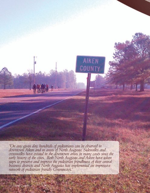
“On any given day, hundreds of pedestrians can be observed in<br />
downtown Aiken and in areas of North <strong>Augusta</strong>. Sidewalks and<br />
crosswalks have existed in the downtown areas in many cases since the<br />
early history of the cities. Both North <strong>Augusta</strong> and Aiken have taken<br />
steps to preserve and improve the pedestrian friendliness of their central<br />
business districts and North <strong>Augusta</strong> has implemented an impressive<br />
network of pedestrian friendly Greeneways.”<br />
20 | <strong>Existing</strong> <strong>Conditions</strong>
<strong>Existing</strong> <strong>Conditions</strong><br />
Overview<br />
This chapter provides an overview of the major<br />
components of the bicycling and walking<br />
environments of the urbanized area of Aiken<br />
County. The data required to assess existing<br />
conditions was collected primarily by gathering<br />
existing regional geographic information<br />
systems (GIS) data, requesting local information<br />
from Aiken County, conducting field work,<br />
and soliciting public input. Provided data was<br />
synthesized into regional databases, mapped<br />
with GIS, and analyzed through nonspatial<br />
and spatial tools, including spatial modeling.<br />
Additional analysis of existing conditions is<br />
provided in <strong>Chapter</strong>s 4 and 5 which summarize<br />
the quantitative and qualitative needs of<br />
bicyclists and pedestrians in the region.<br />
An overview of the primary sources for<br />
analyzing the existing conditions of the<br />
urbanized area of Aiken County is provided<br />
below. Figures 3-1 and 3-2 depict the existing<br />
bicycling and walking conditions in Aiken<br />
County.<br />
Data Inventory and Background Review<br />
The consulting team requested that ARTS,<br />
Aiken County, and its municipalities provide<br />
data related to the bicycling and walking<br />
environment of Aiken County. Specifically, the<br />
consulting team requested that each agency<br />
provide specific data related to the following<br />
broad categories of existing conditions:<br />
• Transportation (such as streets, bus stops,<br />
sidewalks, and traffic signal locations)<br />
• Land use and ownership (such as parcel<br />
boundaries, and zoning designations)<br />
• Points of interest (such as schools, parks,<br />
airports, and retail centers)<br />
<strong>Chapter</strong><br />
Three<br />
• Physical geography (such as wetlands and<br />
topography)<br />
• Administrative and jurisdictional boundaries<br />
(such as city and county borders)<br />
Additionally, a review of all relevant plans or<br />
planning documents related to bicycle and<br />
pedestrian activity in the region supplemented<br />
the data inventory. Appendix A provides the<br />
full review of documents and other information<br />
obtained from local governments across the<br />
region.<br />
Field Investigation<br />
The project team identified priority corridors<br />
and locations for field review, totaling more<br />
than 100 miles of roadway. Field work allows<br />
for roadway characteristics that may present<br />
opportunities or constraints for bicycle and<br />
pedestrian facilities, such as pavement width,<br />
shoulders, right of way, and driveways, to be<br />
inventoried and mapped. Areas targeted for<br />
field investigation are corridors and locations<br />
with:<br />
• high bicycle and/or pedestrian traffic,<br />
• key connectors between areas of high<br />
bicycle and/or pedestrian traffic,<br />
• areas of high bicycle and/or pedestrian<br />
collisions,<br />
• and primary corridors for accessing<br />
destinations, such as commercial land uses,<br />
transit centers, parks, trails, and schools or<br />
colleges.<br />
Additionally, at the project kick-off meeting,<br />
the steering committee noted a strong interest<br />
in providing connectivity between <strong>Augusta</strong>,<br />
GA and Aiken, SC. The corridors and locations<br />
prioritized for field review addressed the need<br />
for establishing regional connectivity between<br />
neighboring GA and SC communities, as well<br />
<strong>Existing</strong> <strong>Conditions</strong> | 21
Aiken County, South Carolina<br />
22 | <strong>Existing</strong> <strong>Conditions</strong><br />
Figure 3-1: ARTS/Aiken <strong>Existing</strong> <strong>Conditions</strong><br />
Proposed Facilities<br />
(from previous plans)<br />
! ! ! ! ! ! ! Greenway<br />
! ! ! ! ! ! ! Multi-Use Path (Under Construction)<br />
! ! ! ! ! ! ! Bike Lane<br />
! ! ! ! ! ! ! Bike Route<br />
! ! ! ! ! ! ! Side Path<br />
! ! ! ! ! ! ! Soft Surface Trail<br />
! ! ! ! ! ! ! Bikeway (Type to be determined)<br />
! ! ! ! ! ! ! Trails by Developer<br />
Cobbham Rd<br />
Mistletoe Rd<br />
! ! ! ! ! ! ! Sidewalks<br />
E White Oak Rd<br />
Mistletoe Park Rd<br />
<strong>Existing</strong> Bicycle and Pedestrian Facilities<br />
Greenway<br />
Side Path<br />
Connector<br />
Soft Surface Trail<br />
Other Trails<br />
Sidewalks<br />
Paved Shoulder ( 3 ft)<br />
Points of Interest<br />
n Schools<br />
# Parks<br />
!( Gardens<br />
#* Welcome Centers<br />
" <strong>Augusta</strong> Artist Row<br />
Æ_ Trailheads<br />
G River Access<br />
Æa Bus Stop<br />
Dozie r R d<br />
White Oak Rd<br />
Bohler Rd<br />
SC and GA Statewide Bike Tour Routes<br />
Central Route<br />
Savannah River Run<br />
Walter Ezell<br />
<strong>Georgia</strong> State Bike Route<br />
Roadway Features<br />
Major Roads<br />
Local Roads<br />
Creeks and Rivers<br />
Shopping Areas<br />
Historic Areas<br />
Greenspace<br />
Parks<br />
Savannah River Site<br />
Fort Gordon<br />
ARTS MPO Boundary<br />
LSCOG MPO<br />
City Limit<br />
County Boundary<br />
County Line Rd<br />
Tom Bartl es Rd<br />
Old Lincolnton Rd<br />
Ray Owens R d<br />
Rest Area Eb<br />
Cl ary C ut Rd<br />
Source: Data obtained from ARTS, LSCOG, SCDOT,<br />
<strong>Georgia</strong> CGIS and USC GIS Data Server<br />
Date: August 24, 2011<br />
Author: Anne Eshleman<br />
Eubank Dr<br />
S hucra ft Rd<br />
Appling Harlem Hwy<br />
W Milledgeville Rd<br />
Harlem Wrens Rd<br />
Ridge Rd<br />
Yelton Rd<br />
Lonergan Hulme Rd<br />
Old Appling Harlem Hwy<br />
Harlem<br />
Sellars Rd<br />
Natures Way<br />
Swint Rd<br />
Wrightsboro Rd<br />
Old U nion Rd<br />
G R Tucke r Rd<br />
S cotts F erry Rd<br />
Jefferson County<br />
Leitner Mill Rd<br />
Washington Rd<br />
Tubman Rd<br />
Louisville Rd<br />
Intermediate Road<br />
Clarks Hill Rd<br />
Baker Place Rd<br />
Harlem Grovetow n Rd<br />
Rockford Dr<br />
Old Au gusta Hwy<br />
Jaime Dr<br />
Rosemont Rd<br />
Chamblin Rd<br />
Gordon Hwy<br />
O ld Washington Rd<br />
Trudeau Trl<br />
Fort Gordon<br />
Ga 88 Hwy<br />
William Few P kwy<br />
Columbia County<br />
Newmantown Rd<br />
Whiskey Rd<br />
Lewiston Rd<br />
I20 Wb<br />
Lewiston Rd<br />
Grovetown<br />
Parham Rd<br />
Blythe<br />
§¨¦ 20<br />
Ga 88 Hwy<br />
McCormick County<br />
Riverwood Pkwy<br />
Blanchard Rd<br />
Hereford Farm Rd<br />
Hardy Mcmanus Rd<br />
Gi bbs Rd<br />
Wrightsboro Rd<br />
Bath Edie Rd<br />
Cox Rd<br />
Oakley Pirkle Rd<br />
Ba th-patterson Rd<br />
Burke County<br />
N B elair Rd<br />
S Belair Rd<br />
Keysville Rd<br />
Fulcher Rd<br />
S a v a n n a h R i v e r<br />
N Belair Rd<br />
Owe n s Rd<br />
Columbia Rd<br />
Wheeler Rd<br />
Jimmie Dyess Pkwy<br />
Southern Pines Dr<br />
Willis Fo reman Rd<br />
Mull ikin R d<br />
Old Evans Rd<br />
Flowing Wells Rd<br />
Gordo n Hwy<br />
Furys Ferry Rd<br />
T he Pass<br />
Old Petersburg Rd<br />
Bobby Jones Expy<br />
W heeler Rd<br />
Edgefield County<br />
Blackstone Camp Rd<br />
Evans To Locks Rd<br />
Davis Rd<br />
Hephzibah<br />
Baston Rd<br />
Windsor Spring Rd<br />
Ga 88 Hwy<br />
Storey Mill Rd<br />
Pleasant Home Rd<br />
Walton Way Ex<br />
Jackson Rd<br />
Meadowbrook Dr<br />
North Leg Rd<br />
Old Mcd uffie Rd<br />
Tobacco Rd<br />
W illis Fo reman Rd<br />
Mims Rd<br />
Hephzibah-mcbean Rd<br />
Sibley Rd<br />
Stevens Creek Rd<br />
Stevens Creek Rd<br />
Washington Rd<br />
§¨¦ 20<br />
Wheeler Rd<br />
Sibley Rd<br />
Golden Camp Rd<br />
Deans Bridge Rd<br />
§¨¦ 520<br />
Bransford Rd<br />
Highland A ve<br />
R iverwatch Pkwy<br />
Walton Way<br />
Milledgeville Rd<br />
Richmond Hill Rd<br />
Rosier Rd<br />
Berckman Rd<br />
See Inset Map<br />
Wrightsboro Rd<br />
Lumpkin Rd<br />
Phinizy Rd<br />
Mcdade Farm Rd<br />
Br own Rd<br />
Milledge Rd<br />
Louisville Rd<br />
Central Ave<br />
Olive R d<br />
Mike Padgett Hwy<br />
Tobacco Rd<br />
W Martintown Rd<br />
<strong>Georgia</strong> Ave<br />
§¨¦ 520<br />
<strong>Augusta</strong> - Richmond County<br />
Hep hzibah-mcbean Rd<br />
Old Waynesboro Rd<br />
See Inset Map<br />
North <strong>Augusta</strong><br />
Broad St<br />
Fifteenth St<br />
Old Savannah Rd<br />
Doug Barnard Pkwy<br />
Dixon A irline R d<br />
G osh en Rd<br />
Thirteenth St<br />
Brown Rd<br />
Telfair St<br />
Laney-walker Blvd<br />
Rollins Rd<br />
Knox Ave<br />
Reynolds St<br />
Gordon H wy<br />
Doug Barnard Pkwy<br />
Knox Ave<br />
Jefferson Davis Hwy<br />
Third St<br />
Edg efie ld Rd<br />
Edgefield Rd<br />
Edgefield Rd<br />
Palmetto Pkwy<br />
Laney-walker Blvd Ex<br />
Be nock Mill Rd<br />
A scauga Lake Rd<br />
<strong>Augusta</strong> Rd<br />
Sand Bar Ferry Rd<br />
Sand Bar Ferry Rd<br />
§¨¦ 20<br />
Redcliffe<br />
Historic Site<br />
Bettis Academy Rd<br />
Burnettown<br />
ARTS/Aiken County Regional Bicycle and Pedestrian Study<br />
- <strong>Existing</strong> <strong>Conditions</strong> -<br />
Jefferson Davis Hwy<br />
Aiken County<br />
Silver Bluff Rd<br />
Main St<br />
Canal St<br />
Pine Log Rd<br />
Edgefield Hwy<br />
Trolley Line Rd<br />
Jefferson Davis Hwy<br />
Jackson<br />
!I<br />
Robert M Bell Pkwy<br />
Johnston Hwy<br />
See Inset Map<br />
University Pkwy<br />
Richland Ave W<br />
Hitchcock Pkwy<br />
Atomic Rd<br />
Aiken<br />
Rutland Dr<br />
York St Ne<br />
L S C O G<br />
Camellia St Ne<br />
E Pine Log Rd Se<br />
Whiskey Rd<br />
Columbia Hwy N<br />
Rudy Mason Pkwy<br />
Richland Ave E<br />
N Main St<br />
S Main St<br />
S Main St<br />
New Ellenton<br />
Wire Rd<br />
Wagener Rd<br />
Montmorenci Rd<br />
Charleston Hwy<br />
Williston Rd<br />
Savannah River Site<br />
New Holland Rd<br />
0 10<br />
5<br />
Miles<br />
Central Route
Figure 3-2: ARTS/Aiken County <strong>Existing</strong> <strong>Conditions</strong> Inset Maps<br />
Proposed Facilities<br />
(from previous plans)<br />
! ! ! ! ! ! Greenway<br />
! ! ! ! ! ! Multi-Use Path (Under Construction)<br />
! ! ! ! ! ! Bike Lane<br />
! ! ! ! ! ! Bike Route<br />
! ! ! ! ! ! Side Path<br />
! ! ! ! ! ! Soft Surface Trail<br />
! ! ! ! ! ! Bikeway (Type to be determined)<br />
! ! ! ! ! ! Trails by Developer<br />
! ! ! ! ! ! Sidewalks<br />
<strong>Existing</strong> Bicycle and Pedestrian Facilities<br />
Greenway<br />
Side Path<br />
Connector<br />
Soft Surface Trail<br />
Other Trails<br />
Sidewalks<br />
Paved Shoulder ( 3 ft)<br />
Points of Interest<br />
n Schools<br />
# Parks<br />
!( Gardens<br />
#* Welcome Centers<br />
" <strong>Augusta</strong> Artist Row<br />
Æ_ Trailheads<br />
G River Access<br />
Æa Bus Stop<br />
SC and GA Statewide Bike Tour Routes<br />
Central Route<br />
Savannah River Run<br />
<strong>Georgia</strong> State Bike Route<br />
Roadway Features<br />
Major Roads<br />
Local Roads<br />
Creeks and Rivers<br />
Shopping Areas<br />
Historic Areas<br />
Greenspace<br />
Parks<br />
Savannah River Site<br />
Fort Gordon<br />
ARTS MPO Boundary<br />
LSCOG MPO<br />
City Limit<br />
County Boundary<br />
Levee Rd<br />
E isenhower Dr<br />
Source: Data obtained from ARTS, LSCOG, SCDOT,<br />
<strong>Georgia</strong> CGIS and USC GIS Data Server<br />
Date: August 24, 2011<br />
Author: Anne Eshleman<br />
S a v a n n a h R i v e r<br />
Forest Park Rd<br />
Persim mon Rd<br />
Apricot Ln<br />
Camelot Dr<br />
Bluebird Rd<br />
Red Bird Rd<br />
Papaya St<br />
Wood bine R d<br />
Redwood Dr<br />
Lak ewoo d Rd<br />
Overton Rd<br />
Westminster Ct<br />
Inset Map - North <strong>Augusta</strong><br />
Broad St<br />
Castlewood Dr<br />
Flythe Dr<br />
E ustis Dr<br />
L aurel Ln<br />
Ellis St<br />
Pund Ave<br />
Pikes Alley<br />
Park Ave<br />
Cardinal Dr<br />
Martin Ln<br />
Fox Spring Rd<br />
Bransford Rd<br />
Easy St<br />
Bluebird Rd<br />
Bedford Dr<br />
Lakemont Dr<br />
Milledge Rd<br />
Oleander Dr<br />
B St<br />
Welsh Ln<br />
Bergen Rd<br />
G oodrich St<br />
Ann St<br />
Mary Ave<br />
Lake Ave<br />
Wood St<br />
Lake Terrace Dr<br />
Taylors Ln<br />
Old Plantation Rd<br />
Savannah Barony Dr<br />
Ospr ey Pt<br />
Lake Shore Loop<br />
Division St<br />
Browns Ln<br />
Ellis St<br />
Greene St<br />
Hicks St<br />
Telfair St<br />
Curry St<br />
Eve St<br />
Grace St<br />
Plantation Dr<br />
Riverbluff Rd<br />
Goodrich St<br />
Welsh Ln<br />
Frontage Rd<br />
River Oak Dr<br />
Old Plantation Rd<br />
Brookview Ct<br />
Fiord Dr<br />
Medie Ave<br />
Savannah Pte<br />
Reams Rd<br />
Blair Dr<br />
Rive rbluff D r<br />
Dunbarto n Dr<br />
Riverview Dr<br />
Brooks Dr<br />
W Woodlawn Ave<br />
Merriweather Dr<br />
River View Park Dr<br />
Hamm onds Ferry Rd<br />
Kendrick Pl<br />
Inset Map - <strong>Augusta</strong><br />
Langford Dr<br />
Barrett Ln<br />
Lake Forest Dr<br />
Pine Needle Rd<br />
Myrtle Ave<br />
Happy Rd<br />
Martin Ct<br />
Wilkinson Cir<br />
Lamar Rd<br />
Coleman Rd<br />
Hawk St<br />
Damasc us Rd<br />
Vandivere R d<br />
Paris St<br />
Berry St<br />
Walton Pl<br />
Crepe Myrtle Dr<br />
Henry St<br />
Pine Needle Dr<br />
Aquinas Hs<br />
Oakland Ave<br />
Peachtree Rd<br />
Peachtree Rd<br />
Kelly St<br />
Mixon Ct<br />
Magnolia Ave<br />
Grady St<br />
Helen St<br />
Central Ave<br />
Ohio Ave<br />
Parkway Dr<br />
Walden Dr<br />
Henry St<br />
Bellevue Ave<br />
Hi lsinger Rd<br />
Rozella St<br />
Hopie Rd<br />
Royal St<br />
Hillcrest Ave<br />
Iris Dr<br />
Mimosa Dr<br />
Wilkinson Rd<br />
Days Dr<br />
Hazel St<br />
Henry St<br />
Farris St<br />
Regenc y Blvd<br />
Glenn Ave<br />
Pennsylvania Ave<br />
Maryland Ave<br />
Killingsworth Rd<br />
Hazel St<br />
Oakland Ave<br />
Monte Sano Ave<br />
Lackman Ln<br />
Thomas Ln<br />
Wheeler Rd<br />
Craig St<br />
Arsenal Ave<br />
Mcdowell St<br />
Barry Dr<br />
George Rd<br />
Allen St<br />
Schley St<br />
Trapp Ct<br />
Whitney St<br />
Lakewood Dr<br />
Haynie Dr<br />
Heath St<br />
Stovall St<br />
Wycliff St<br />
Mt Auburn St<br />
Berkeley Rd<br />
Birnam Pl<br />
Marschalk Dr<br />
Harrison Rd<br />
Weed St<br />
Foxhil Dr<br />
Bergen Rd<br />
Waccamaw Dr<br />
Socastee Dr<br />
Post Oa k Ln<br />
Campbellton Dr<br />
Columbus Ave<br />
Cumming Rd<br />
Katherine St<br />
Fitten St<br />
Queens Way<br />
Service Dr<br />
Kimberly Dr<br />
Lee St<br />
Johns Rd<br />
Raleigh Dr<br />
Darlin gton D r<br />
Polo Rd<br />
Davidson Dr<br />
Anthony Rd<br />
Essex Dr<br />
Murphey Rd<br />
Crystal Lake Dr<br />
Kenilworth Dr<br />
Br idle Path R d<br />
Holiday Dr<br />
Stanton Dr<br />
Grant Ave<br />
Pershing Dr<br />
Fallmouth St<br />
Gardner St<br />
Williams St<br />
Winter St<br />
Wingfield St<br />
P e ndleton R d<br />
Short St<br />
Alta Vista Ave<br />
Count ry Club Hill s Dr<br />
Lon gstreet Xing<br />
Macklin Ln<br />
Brookgreen Dr<br />
Pickens Rd<br />
King Woods Dr<br />
Kings Way<br />
Holly Hill Rd<br />
Greenwood Dr<br />
Wellington Rd<br />
Knobcone Ave<br />
By rne s Rd<br />
Hammond Dr<br />
San Salvador Dr<br />
Villag e Pkwy<br />
Madison St<br />
White Rd<br />
Pinewood Ct<br />
Quail Dr<br />
Hollis Ave<br />
Jackson Ave<br />
Bolin Rd<br />
Fairfield Ave<br />
W Buena Vista Ave<br />
Woodstone Way<br />
Cou lter Dr<br />
Oriole Ave<br />
Cres t view Dr<br />
Lake Ave<br />
W Pine Grove Ave<br />
Par k Ave<br />
Hickman Rd<br />
Wharton Dr<br />
Shirley Ave<br />
Roosevelt Dr<br />
Kennedy Dr<br />
Willis Dr<br />
Terrace Dr<br />
Overt on Rd<br />
Holt St<br />
Meigs St<br />
Brenda Dr<br />
Bolin Ct<br />
Cook Rd<br />
Tubman Home Rd<br />
Partridge Ln<br />
West Ave<br />
Bluff Ave<br />
Central Ave<br />
Curtis Dr<br />
W Clifton Ave<br />
Wells Rd<br />
Robin Rd<br />
Warren Ct<br />
Mayf iel d Dr<br />
Line Bars Dr<br />
Courtney Dr<br />
Possible Rd<br />
Paris Ave<br />
Courtney Dr<br />
Mountside Dr<br />
Bunting Dr<br />
Highview Ave<br />
Spruce Ct<br />
Hidden Hills Dr<br />
Broxten Dr<br />
Carolina Ave<br />
Pinion Rd<br />
W hit ebark Ave<br />
Jeffrey St<br />
North Hills Dr<br />
Pisgah Rd<br />
Ponderosa Dr<br />
Wren Rd<br />
White Pine Dr<br />
Fieldcrest Dr<br />
Clay St<br />
Spring Grove Ave<br />
E Pine Grove Ave<br />
E Clifton Ave<br />
Riverside Blvd<br />
Siskin Cir<br />
Slash Ct<br />
Bobolink Ave<br />
W Summit Ave<br />
Cadada Ct<br />
East Ave<br />
Green Forest Dr<br />
Vireo Dr<br />
Butler Ave<br />
Marshall Ave<br />
Roble Ave<br />
Amy Cir<br />
Lowe St<br />
Fox Ave<br />
Jersey Ave<br />
Plaza Place A pts<br />
Sikes Ave<br />
Tuscany Trce<br />
Bobbye Dr<br />
Raven Dr<br />
S a v a n n a h R i v e r<br />
Battle Row<br />
Heard Ave<br />
Russell St<br />
Welsh Ln<br />
Ellis St<br />
Greene St<br />
Telfair St<br />
Jordan Rd<br />
Baker Ave<br />
Warren St<br />
Heckle St<br />
Murphy St<br />
Merry St<br />
Eve St<br />
Starnes St<br />
Beman St<br />
Essie Mcintyre Blvd<br />
Third Ave<br />
Five Notch Rd<br />
Raborn Ct<br />
Ridgecrest Ave<br />
Dove St<br />
W Hugh St<br />
A r ch Dr<br />
Plank Rd<br />
Flint St<br />
Bama Ave<br />
Spring Oak Ln<br />
Goldman St<br />
Watkins St<br />
Fenwick St<br />
Jenkins St<br />
Oak DrAlley<br />
Cornell Dr<br />
Cherry Rd<br />
Pikes Alley<br />
Gary St<br />
Heard Ln<br />
Richmond Ave<br />
Turknett Spring Rd<br />
Ryan Rd<br />
Lanier Dr<br />
Randall Rd<br />
Clairmont Dr Sunset Villa<br />
Rose Ln<br />
Coral Ct<br />
Melton Rd<br />
East Ave<br />
Delano St<br />
Forster St<br />
Devere St<br />
Haynie Dr<br />
Leroy St<br />
Alley<br />
Leeway Landing<br />
Milledge Rd<br />
Troupe St<br />
Fayetteville Dr<br />
Montrose Ct<br />
Mcdowell St<br />
Meigs St<br />
Meigs St<br />
Lee St<br />
Myrtle Ln<br />
Gardner St<br />
Princeton Ln<br />
Bourne Pl<br />
Kratha Dr<br />
Calvary Dr<br />
Barrow Dr<br />
Beaufort Dr<br />
Adrian St<br />
Dade St<br />
Memory Dr<br />
Russell St<br />
Millview St<br />
Starnes St<br />
Eagles Way<br />
Wooten Rd<br />
Sullivan Rd<br />
Second Ave<br />
Barnes Rd<br />
Verdery St<br />
Slaton St<br />
Holden St<br />
Holden Dr<br />
Morgan St<br />
Koger Rd<br />
Laurel St<br />
Dyer St<br />
Fifteenth Ave<br />
Mcnally St<br />
Luckey St<br />
Spring Hill Ct<br />
Greenbriar Dr<br />
Summer Hill Dr<br />
Curry Dr<br />
Heil Dr<br />
Samuels Rd<br />
Scott Dr<br />
E Marion Ave<br />
Alpine Ave<br />
Kirby Dr<br />
Caretta St<br />
Burnside Ave<br />
Kip Rd<br />
Way of Peace<br />
Aroma Dr<br />
Edgewood Dr<br />
Heil Dr<br />
Nutgrove Dr<br />
Rosemary Ln<br />
Medlin St<br />
E Marion Ave<br />
Hicks St<br />
Crawford Ave<br />
Mulherin St<br />
Emmett St<br />
Government Rd<br />
Fern St<br />
Branch St<br />
Koger St<br />
First Ave<br />
W alke r St<br />
Twelfth Ave<br />
Thirteenth Ave<br />
Bolt Dr<br />
Parnell St<br />
Oak Ave<br />
De wit t St<br />
Eleventh Ave<br />
Fourteenth Ave<br />
Olive Rd<br />
Fire Lane<br />
Tenth Ave<br />
Tuttle St<br />
Cleveland St<br />
Burke St<br />
Welsh Ln<br />
High St<br />
Bleakley St<br />
Frank St<br />
Hunter St<br />
Hernlen St<br />
Ninth Ave<br />
Prep St<br />
Mccauley St<br />
Bohler Ave<br />
Chafee Ave<br />
Mcg Housing<br />
Ramp<br />
Poplar St<br />
Holley St<br />
Sycamore Dr<br />
Aiken Ave<br />
Lady St<br />
Royalette Ave<br />
Metz Dr<br />
Steiner Ave<br />
Eighth Ave<br />
Goodrich St<br />
Spellman St<br />
Dunns Ln<br />
Gordon Hwy<br />
Moore Ave<br />
Barton Rd<br />
Edgewood Dr<br />
Conifer Dr<br />
Orchard Way<br />
H And H St<br />
Norway Dr<br />
Whitlaws Rd<br />
Radiance Dr<br />
Julia Ave<br />
Turpin St<br />
Sixth Ave<br />
Seventh Ave<br />
Wrights Ave<br />
Pope Ave<br />
Roulette Ln<br />
Julius St<br />
Heil Dr<br />
Euclid Rd<br />
Skyview Dr<br />
Frances St<br />
Moton St<br />
Yardley Dr<br />
Sa m uels St<br />
Fairlane Dr<br />
Swiss Ct<br />
Drew Ave<br />
S t Luke St<br />
Goss Aly<br />
Clay St<br />
Garrett Ln<br />
Kent St<br />
Wise Dr<br />
Holloway Dr<br />
Truman Dr<br />
Brinson Ln<br />
Chafee Ave<br />
Fairview St<br />
Pinewood Rd<br />
Old Edgefield Rd<br />
E Buena Vista Ave<br />
Wall St<br />
Phi l pot Ln<br />
Gentry Ln<br />
Austin Graybill Rd<br />
Wooden Dr<br />
Celeste Ave<br />
Bradleyville Rd<br />
Womrath Rd<br />
Crestlyn Dr<br />
Clearmont Dr<br />
Seymour Dr<br />
We sto n St<br />
Oakdale Ave<br />
Victoria Dr<br />
Teresa Ave<br />
Rita Ave<br />
Elizabeth Ave<br />
Jesse Dee St<br />
Thurmond S t<br />
McKenzie St<br />
Austin St<br />
Possible<br />
Flee twood Dr<br />
Osler Ln<br />
Harper St<br />
Holley St<br />
Cushing Ln<br />
Mill St<br />
Kent St<br />
Ramp<br />
<strong>Augusta</strong> Ave<br />
Mill St<br />
Blount Ave<br />
Conklin Ave<br />
Swans Ln<br />
Grant St<br />
Roselle St<br />
Marks St<br />
Molly Pond Rd<br />
Nathanie Dr<br />
Rosemary St<br />
Front St<br />
Forest St<br />
Mercier St<br />
Gordon Hwy<br />
Jonquil Ln<br />
Wilde Ave<br />
Brigham Rd<br />
Alexander Dr<br />
Ware Dr<br />
Fairview Ave<br />
Ashley Cir<br />
Johnson Rd<br />
Kerr St<br />
St James St<br />
Border Dr<br />
Possible Road<br />
Palmetto Ave<br />
Carriage Ln<br />
Norman St<br />
Holly Ln<br />
Lee Dr<br />
Sterling Dr<br />
Melody Ln<br />
E Buena Vista Ave<br />
Young St<br />
Phillips St<br />
Wrightsboro Rd<br />
P inevie w Ave<br />
Lorraine Dr<br />
Carolina Springs Rd<br />
Elder St<br />
Dorr Dr<br />
Seaborn Dr<br />
Waters Edge Dr<br />
Thirteenth St<br />
Mauge St<br />
Perry Ave<br />
Camille St<br />
Ellis St<br />
Beech St<br />
Dantignac St<br />
Spring Dr<br />
Claypit Rd<br />
Belair Rd<br />
Edna St<br />
Belvedere Clearwater Rd<br />
Lehigh Ave<br />
Lucy Ave<br />
Nappier Ln<br />
Sanders Dr<br />
Sycamore St<br />
Twelfth St<br />
New Savannah Rd<br />
Haskell Rd<br />
Astor Ct<br />
Miller St<br />
Dugas St<br />
Hopkins St<br />
Picquet Ave<br />
Da niel S t<br />
Walker St<br />
Pine St<br />
Perry Ave<br />
Gregg St<br />
Telfair St<br />
Boyd Ln<br />
Tenth St<br />
Cedar St<br />
Maple St<br />
Glass Factory Ave<br />
Brickyard Pond Rd<br />
Ayr Dr<br />
Lantana Ln<br />
Holley Hill Dr<br />
Wildwood Dr<br />
Briarc l iff St<br />
Coral Way<br />
Bradley Dr<br />
Railroad Ave<br />
Carrie St<br />
Eleventh St<br />
Spruce St<br />
Hickory St<br />
Bryant Ave<br />
Rhomboid Pl<br />
McKinney Ln<br />
Southern Pines Dr<br />
Hamp t on Cir<br />
Monterey Ave<br />
Audubon Cir<br />
Kershaw D r<br />
Bradley Ct<br />
Woodberry Ln W<br />
Jones St<br />
Access Road<br />
Tenth St<br />
Talcot St<br />
Barnes Ln<br />
Adams St<br />
Hopkins St<br />
Summer St<br />
Gordon Park Rd<br />
A p ts<br />
Jacob Dr<br />
New Castle Ave<br />
Bradleyville Rd<br />
Powerhouse Rd<br />
Amos Ct<br />
Radio Station Rd<br />
King St<br />
Hall St<br />
Skyview Dr<br />
Tatnall St<br />
Walker St<br />
Eighth St<br />
P ete rs R d<br />
National Ave<br />
Ascauga Lake Rd<br />
Edisto Dr<br />
Cataw ba R d<br />
Kingstree Rd<br />
Possible<br />
Liberty Hill Rd<br />
Arcadia Ct<br />
Schultz Hill Dr<br />
East Shoreline Dr<br />
Twiggs St<br />
Byrum Aly<br />
Sixth St<br />
Fenwick St<br />
R idgefield Dr<br />
Lamback Way<br />
Liberty Bell Ln<br />
Vidot Ct<br />
Todd Ave<br />
Hale St<br />
Walton St<br />
Whitehall Rd<br />
Fir St<br />
Old Aiken Rd<br />
Revco Rd<br />
Elton Ave<br />
Cary Ave<br />
ARTS/Aiken County Regional Bicycle and Pedestrian Study<br />
- <strong>Existing</strong> <strong>Conditions</strong> - Inset Maps -<br />
Canton Dr<br />
Prince William Dr<br />
Broken Branch Rd<br />
Willow Springs Dr<br />
Borden Rd<br />
Dabbs Ln<br />
Goudy Ct<br />
Cherokee Dr<br />
Dogwood Dr<br />
Chestnut Ave<br />
Count ry Place Dr<br />
Tulip Dr<br />
Birch Cir<br />
Woo d land D r<br />
Holly Rd<br />
Windy Mill Dr<br />
Blanchard Rd<br />
Richland Rd<br />
Willo w Ln<br />
Birch St<br />
Sudlow Lake Rd<br />
Hillcrest Dr<br />
Apache Dr<br />
Seminole Dr<br />
Thompson Ave<br />
Teapot Rd<br />
Cherry Ave<br />
Pine B u tte Ln<br />
Corley Dr<br />
Gilmore Ave<br />
Second Ave<br />
Old Aiken Ext<br />
Hill St<br />
Frien dly Ln<br />
Old Sudlow Lake Rd<br />
Lynwood Dr<br />
Delehanty Ct<br />
Orange St<br />
West Dr<br />
Hillside Dr<br />
Avalon Ln<br />
Storm Branch Rd<br />
0 0.5<br />
1<br />
Miles<br />
Monument St<br />
Walker St<br />
Watkins St<br />
Brickyard Pond Rd<br />
Sand Pit Rd<br />
Ramp<br />
Fourth St<br />
Taylor St<br />
Arthern Rd<br />
Fifth St Brid ge Rd<br />
Ramp<br />
First St<br />
Forsythe St<br />
Foster Ln<br />
Philpot Ln<br />
Gentry Ln<br />
Sapelo Dr<br />
Reynolds St<br />
Sibley St<br />
Ellis St<br />
Second St<br />
Taylor St<br />
Hale St<br />
Forsythe St<br />
Walker St<br />
Watkins St<br />
E Taylor St<br />
E Hall St<br />
Hardy Ct<br />
Foster Rd<br />
Sibley St<br />
E Hale St<br />
Tyler Ave<br />
E Telfair St<br />
East Boundary St<br />
E Cedar St<br />
Wallace St<br />
Hamburg Rd<br />
Prep Phillips Dr<br />
Aiken St<br />
Albany Ave<br />
Brunswick Ave<br />
0 0.5<br />
1<br />
Red Maple Ct<br />
Center St<br />
Possible Road<br />
Ma plewood Dr<br />
Terrace Rd<br />
Forest Dr<br />
Patricia Dr<br />
Irene St<br />
Pa rker Dr<br />
Lee St<br />
Duncan Rd<br />
Northsid e Dr<br />
Gibson Dr<br />
Rivernorth Dr<br />
Audub on Rd<br />
Pineview Dr<br />
Fairview Rd<br />
Thomas Rd<br />
Hilltop Ct<br />
!I<br />
Altamaha Dr<br />
Riverfront Dr<br />
Oak St<br />
Colorado St<br />
Cherry Ave<br />
Hayes Dr<br />
Orange St<br />
Pollard Dr<br />
Setters Ct<br />
Windsor Dr<br />
Old Cherokee Dr<br />
Courtland Dr<br />
Eastview Dr<br />
Lovers Ln<br />
Grantto Ln<br />
Catenary Blvd<br />
Trolley Run Blvd<br />
Lokey Dr<br />
Dibble Rd<br />
L & L Ln<br />
St Charles A ve<br />
Belford Grove Dr<br />
Univer sity Ln<br />
Gregg Hwy NW<br />
Dyches Rd<br />
Retreat Pl<br />
Bay Meadows Dr SW<br />
Inset Map - Aiken<br />
Westcliff Dr<br />
Hitchcock Pkwy<br />
Hackamore Dr<br />
Coach man Dr<br />
Glenwood Dr<br />
University Pkwy<br />
Lundee Dr<br />
Casaba Dr<br />
Ric hardsons Lake Rd<br />
Beaver Creek Ln<br />
Trolley Line Rd<br />
Partridge Dr<br />
Hunts m an Dr S W<br />
Trail Pt<br />
Hudson Rd<br />
Citation Dr<br />
Plantation Dr<br />
Kennebec St<br />
Seminole St<br />
Gregg Ave NW<br />
Wildwood Rd<br />
Trail Ridge Rd<br />
Troon Way<br />
Seneca Ave<br />
Valley Rd<br />
Cherry Hills Dr SW<br />
Westmont Dr<br />
Varden Dr<br />
Alpine Dr<br />
Dibble Rd SW<br />
Town Creek Rd<br />
Edisto Ave<br />
Croft Mill Rd<br />
Highland Park Dr SW<br />
Whitney Drive Bridle Path<br />
Moultrie Dr<br />
Lloydtown Rd<br />
Northwood Dr<br />
Houndslake Dr SW<br />
Steeplechase Rd<br />
Vaucluse Rd<br />
Hampton Ave NW<br />
Church St<br />
Hayne Ave SW<br />
Williams Dr<br />
Silver Bluff Rd<br />
Orio le St<br />
Weaver St<br />
E Woodside Plantation Dr<br />
Holley Lake Rd SW<br />
Lincoln Ave<br />
Allison St<br />
Morgan St NW<br />
Barnwell Ave NW<br />
Dougherty R d SW<br />
Eastgate Dr<br />
Murrah Ave<br />
Hedge Rd<br />
South Boundary Ave SE<br />
Mead Ave<br />
Two Notch Rd SE<br />
Colleton Ave SE<br />
Chukker Creek Rd<br />
Henry St<br />
Twin La kes Dr<br />
Abbeville Ave NE<br />
Powderhouse Rd<br />
Beaufort St NE<br />
Park Ave SE<br />
Kaolin Rd<br />
Athol Ave<br />
Bicycle and Pedestrian Plan Update<br />
Citadel Dr<br />
Banks Mill Rd SE<br />
Vanderbilt Dr<br />
May Royal Dr<br />
Osbon Dr<br />
Wrights Mill Rd<br />
Woo dvalley D r Squire St<br />
Timberchase Ln<br />
Bates Rd<br />
Te legra p h Dr<br />
S carboro u gh Pass<br />
USC Aiken<br />
USC Aiken<br />
Longleaf Ct<br />
Woodruff Ct<br />
Vaucluse Rd<br />
Alumni Ct<br />
Unnamed Rd<br />
Creekside Dr<br />
Neibling Dr<br />
Bennie Rd<br />
Old Thicket P l<br />
Outing Club Rd Summit Dr<br />
Unnamed Rd<br />
Medical Park Dr<br />
Rutledge Rd SW<br />
Burgundy R d SW<br />
Hasty Rd<br />
Ruffian Rd<br />
High Town Trl<br />
Ebbwater Dr<br />
Spring Lake Rd<br />
Spring Dr<br />
Huntsman Dr SW<br />
Bridge Creek Trl<br />
Derby Ln<br />
Augustus Rd NW<br />
Hillsdale Dr<br />
Ridan Ct<br />
Deerwood Ct<br />
Waters Edge Dr<br />
Deerwood Dr<br />
Huntcli ff Trce<br />
W oodl ake Dr<br />
Landing Dr<br />
Lindsey Dr<br />
Meadow Dr<br />
Equine Ct<br />
Buckhead Ct SW<br />
Shawnee Dr<br />
Bella Vista Ln<br />
Iroqu ois St<br />
Rhone St<br />
Inwood Dr SW<br />
Huckleberry Ct<br />
Buckhorn Pt<br />
Woods Bend Dr<br />
Shad ow D r<br />
Huckleberry D r<br />
Branchwater Ln<br />
Fox Bluff Ln<br />
Anderson Pond Rd<br />
Lawson Rd<br />
Rollingwood Rd W<br />
Rollingwood Rd E<br />
St Andrews Way<br />
Waxhaw Dr<br />
Willard Ter<br />
Lakes i de Dr SW<br />
Hunting Hills Dr<br />
Central Building Rd<br />
Oak St<br />
Peninsula Pt<br />
Victoria Dr NW<br />
Whitemarsh Dr<br />
Springwood Dr<br />
Pascalis Pl<br />
Morningside Dr<br />
Avery Ln<br />
Residence Dr<br />
Forest Hill Dr SW<br />
Huron Dr SW<br />
Village Green Blv d<br />
Society Hill Dr<br />
Sandcroft Ct<br />
Cedar Ln<br />
Carolina Dr SW<br />
Riviera Rd<br />
Chabot Ln<br />
Clovis Pl<br />
Murray Ct<br />
Woodbin e Rd<br />
Magnolia Lake Rd<br />
Redd St NW<br />
Englewood Rd S W<br />
Kismet Dr<br />
Harden Dr<br />
Magnolia Lake Ct<br />
Loren St<br />
Vivion Dr<br />
Oakland Hills St<br />
Santee Ave<br />
Spyglass Dr<br />
Gibbon Ln<br />
Kalmia Cir<br />
Hartwell Dr SW<br />
Glenn Pl<br />
Whippoorwill Ct<br />
Chestnut Ct SW<br />
Grassy Creek Ln<br />
Yellow Pine Rd<br />
Quiet Oak Ct<br />
Mississippi Ave<br />
Tennessee Ln<br />
Eutaw St<br />
Red Oak Ln<br />
Pickens Ave NW<br />
Hickory Ridge Rd SW<br />
Inverness W<br />
Seven Oaks Dr<br />
Hemlock Dr SW<br />
Balfour Ct<br />
Enclave Dr SW<br />
Germany Pl<br />
Summer Place Dr<br />
Representative Dr<br />
President Dr NW<br />
C ardinal Dr S W<br />
Suffolk Dr<br />
Clark Rd SW<br />
Red Cedar Rd<br />
W<br />
Colony Dr<br />
es t Pleasant<br />
Gol d en Oak Dr<br />
Ra ven Cir<br />
Abbeville Ave NW<br />
Lee Ln SW<br />
Longw ood Dr<br />
Alpha Dr<br />
Cabinet Dr NW<br />
Evans R d S W<br />
Loving Dr<br />
Merlot Pl<br />
Darien Dr SW<br />
Laurel Oak Dr<br />
Valley Green Dr SW<br />
Idlewild Dr<br />
Aberdeen Dr SW<br />
Red Tip Ln<br />
Willow Lake Ct<br />
Wax Myrtle Ct<br />
Bridle Ln SW<br />
Sirius Dr<br />
Crescent Pte SW<br />
Arbutus Hills Dr NW<br />
Cody Ln SW<br />
Perrin St NW<br />
Bluff Pointe Way<br />
Medinah Dr<br />
Glass Pl<br />
Arcturus Dr<br />
Sea Grass Rd SW<br />
Foxhound Run SW<br />
Jack Jones St<br />
Grand Oaks Way<br />
Toole St NW<br />
Lancaster St SW<br />
Legar e Rd SW<br />
Gyles Rd SW<br />
Janet Rd<br />
Lady Banks Rd SW<br />
Fermata Pl SW<br />
Florence St SW<br />
Burden Lake R d SW<br />
Forest Pines Rd SW<br />
Ballto wn D r<br />
Pinecrest Ave<br />
McCormick St NW<br />
Lancaster St NW<br />
Laurens St SW<br />
Third Ave<br />
Whitney D r SW<br />
Evans R d SW<br />
Magnolia Dr<br />
Glencarin Dr SW<br />
Griggs St<br />
Wheeler Dr SW<br />
Greenville St NW<br />
Berrie Rd SW<br />
Hamilton Dr<br />
Sweetbay Dr<br />
Cushman Dr<br />
Pendleton St NW<br />
Park Ave SW<br />
Colony Pkwy<br />
Fore St SW<br />
Pine Log Rd<br />
Brooks Ave<br />
York St SE<br />
Dupree Pl SW<br />
Elon St<br />
Boxelder Dr SW<br />
Florence St NW<br />
First Ave<br />
Easy St SW<br />
Hitchcock Dr SW<br />
Limerick Dr<br />
Wren Pl<br />
Cardinal Dr<br />
Greenville St SW<br />
Newberry St SW<br />
Old Town Rd<br />
Sandstone Blvd<br />
Contract Dr<br />
Brown Ln NW<br />
Neilson St<br />
Wilds Ave<br />
Bedford Pl SW<br />
Magnolia St SE<br />
F abian Dr SW<br />
Cobbs Way<br />
Williams Ln<br />
Newberry St NW<br />
Brandy Rd SE<br />
Union Ch urch Ln<br />
Columbia Ave NW<br />
Price Ave<br />
Basswood Dr SW<br />
Crane Ct SW<br />
Arbor Ter<br />
Hoods Ln SW<br />
Pendleton St SW<br />
Colleton Ave SW<br />
Club Villa Dr E<br />
Balsam Ln SW<br />
Baldcypress Ct SW<br />
Trippi Ln<br />
Summer Squall Ln<br />
East Pleasant Colony Dr<br />
Gayle Ave NW<br />
Walker Ave SE<br />
Summerall Ct<br />
Teague St NW<br />
Grace Ave SE<br />
Knox Ave SE<br />
Barnard Ave SE<br />
Hickory Rd SE<br />
Shel by Dr<br />
Berringer Dr SW<br />
Woodside Plantation Dr<br />
Dupont Dr NW<br />
Fairfield St NE<br />
Cherry Dr SE<br />
Collier St<br />
Palm Dr SE<br />
E Pine Log Rd Se<br />
Tall Pine Dr<br />
River Birch Rd<br />
Archdale Dr SW<br />
Butler Cir<br />
Dogwood Rd SE<br />
Carriage Dr SE<br />
Buckhar Ln<br />
Clifton St<br />
Ola Hitt Ln<br />
Elbert St<br />
Scarlet Oak Pl<br />
Tyler St<br />
Christee Pl<br />
Spencer Dr<br />
Ashepoo Dr SW<br />
King St<br />
Chesterfield St NW<br />
Union St SE<br />
Melville Ln<br />
Kershaw St SE<br />
Union St NE<br />
Maple Dr SE<br />
Kershaw St NE<br />
Horry St SE<br />
Marion St SE<br />
Boardman Rd SE<br />
Corporate Pkwy<br />
Monterey Dr<br />
Spring Stone Ct<br />
Sumter St SE<br />
Winged Elm Cir<br />
Loganberry Ct<br />
Bramble Ridge Rd<br />
McKenzie Ln<br />
Columbia Ave NE<br />
Marlboro St SE<br />
Ellenton St SE<br />
Waites St<br />
Audubon Dr SE<br />
South Centennial Ave<br />
Sharyn Ln<br />
Beatty Ln<br />
Bennington Ln<br />
Southgate Dr<br />
Sumter St NE<br />
Chatham St SE<br />
Robinhood Trl<br />
Oak G r ove Rd<br />
Tamil Dr<br />
Robin Rd<br />
Brookhaven Dr<br />
Saluda St NE<br />
Marion St NE<br />
Ascot Dr SW<br />
Barway Dr<br />
Oak Brook Dr<br />
Williamsburg St NE<br />
Douglas Dr<br />
Photinia Dr<br />
Horry St NE<br />
Jack Russell Ln<br />
Northland Blvd<br />
Sundy Ave NE<br />
Sessions Dr<br />
Eastern Pl NE<br />
Hampton Ave NE<br />
Gwinnett St NE<br />
Marlboro St NE<br />
Orangeburg St SE<br />
Beaufort St SE<br />
Norman Pl<br />
Sunshine Cir<br />
Tower Pl<br />
Lyon Dr<br />
Gaston Rd NE<br />
Rutland Dr<br />
Thoroughbred Run<br />
Wed gewood Dr<br />
C restwood Dr<br />
Stratford Dr<br />
Lynn Dr<br />
Century Ln<br />
Orangeburg St NE<br />
Berkley St SE<br />
Charleston St SE<br />
Surrey Cir<br />
Crawford Ave<br />
Crosland Dr NE<br />
Martingale Ln<br />
George St NE<br />
Wyman S t NE<br />
Somme rs Ave NE<br />
Locke Ln<br />
G ilbert S t SE<br />
Aldrich St NE<br />
Gatewood Dr SE<br />
Ward Cir<br />
Surrey Park Dr<br />
Pebble Ln<br />
Sizem ore Cir<br />
A lfred St N E<br />
Rouse Pl<br />
Heather Way<br />
Horseshoe Bend<br />
Tulane Dr<br />
Vince nt Ave NE<br />
Hahn Ave NE<br />
Alderman St NE<br />
Brant Ct NE<br />
Jefferson Ter NE<br />
Carver Ter NE<br />
Timberlane Rd<br />
Dri ftwoo d Cir<br />
Woodwar d ia Glen<br />
Clemson Dr<br />
VFW Rd<br />
Croft Ave NE<br />
Warehouse Rd<br />
Joe R Ln<br />
Cherokee St SE<br />
Stone Dr<br />
Monet ta St SE<br />
Woodbridge Dr<br />
Bolton Ct SE<br />
Loudoun Dr<br />
Caldwell Ct<br />
Willis Ct<br />
Sparkleberry Ln<br />
Converse Dr<br />
Coker Dr<br />
Shakerag Rd<br />
Jaws Ln<br />
Wise Hollow Rd<br />
Craft Ln<br />
Ramblewood Rd<br />
Willow Run Rd<br />
Pine Hill Dr<br />
Capital Dr<br />
Old Powderhouse Rd<br />
Winthrop Dr<br />
Mi ke Cir<br />
Deep Run Rd<br />
Mid way Cir<br />
Jehoss e e Dr SE<br />
Southmeadows Blvd<br />
0 0.25 0.5 1<br />
Miles I<br />
Miles I<br />
Saturn Way<br />
Contract Dr<br />
York St SE<br />
Chesterfield St NW<br />
Umbria Ct<br />
Horry St NE<br />
Kershaw St NE<br />
Marlboro St SE<br />
Audubo n Dr SE<br />
Williams Sand Rd<br />
Mundy Rd<br />
Bears Rock Rd NE<br />
Martin St<br />
Wire Rd<br />
Melrose Dr<br />
Chappells Rd<br />
Barry Johnson Blvd<br />
Le gacy Ln<br />
Rodgers Rd<br />
Fox Lea Trl<br />
Gator Ln<br />
Damon St<br />
Willow Wo ods Dr<br />
Bainbridge Dr<br />
Rolling Rock Rd<br />
E merald Rdg<br />
Talatha Church Rd<br />
Vine St<br />
Gunt er Rd<br />
Old Airport Rd<br />
Coward Rd<br />
Wildhaven Dr<br />
Shrewsbury Ln<br />
Cheltenham Dr<br />
Weyanoke Ct<br />
Oxmoor Cir<br />
Wesson Dr<br />
Brashum Dr<br />
Old Wagener Rd<br />
Levels Church Rd<br />
Newman Cir<br />
Sand Fox Pl<br />
Implement Rd<br />
Syca m ore Dr<br />
New Bridge Rd<br />
Sad dlejump Pl<br />
Fox Haven Dr SE<br />
Starbuck Dr<br />
Pheasant Ru n<br />
Outaways Rd<br />
Pine Hollow Dr<br />
Smith s Lawn Dr<br />
Grandiflora Cir<br />
Unnamed<br />
Watsonia Dr<br />
Yarrow Way<br />
E nd R d<br />
DeLoac h Way<br />
Ilex Ln SE<br />
Cinnamon Dr<br />
Rushton Rd<br />
<strong>Existing</strong> <strong>Conditions</strong> | 23
Aiken County, South Carolina<br />
as the need for localized connectivity in urban<br />
environments.<br />
Public Outreach<br />
Extensive public outreach is essential to<br />
developing a regional bicycle and pedestrian<br />
plan that addresses the needs of community<br />
members. For this report public input acquired<br />
during multiple public workshops, targeted<br />
focus groups, booths at community events, and<br />
via the project website was analyzed to identify<br />
issues and constraints to bicycling walking in<br />
the urbanized area of Aiken County. <strong>Chapter</strong><br />
5 summarizes the results of the public outreach<br />
process.<br />
Bicycle Infrastructure<br />
Overview<br />
Multi-use trails, such as the North <strong>Augusta</strong><br />
Greeneway and the path along E. Pine Log<br />
Road, have been the primary investment in<br />
bicycling facilities in the urbanized area of<br />
Aiken County. The “Greeneway” is a popular<br />
7 mile regional greenway trail along a former<br />
rail line right-of-way in North <strong>Augusta</strong>. The<br />
land for the North <strong>Augusta</strong> Greeneway was<br />
purchased by the City under former mayor<br />
Thomas W. Greene, for whom the trail is named.<br />
These facilities provide a good foundation for<br />
a bicycle facility network. However, a majority<br />
of the roads in the study area pose numerous<br />
dangers to bicyclists as they travel to and from<br />
destinations. Some of these hazards include<br />
commercial corridors that are designed solely<br />
for motorized transportation, multiple lane<br />
high-speed roadways, and narrow roadways<br />
with little or no shoulders. There is also limited<br />
connectivity between existing facilities and<br />
some barriers to connectivity exist, notably<br />
cul de sacs that do not connect adjacent<br />
neighborhoods.<br />
Strengths of <strong>Existing</strong> Bicycle <strong>Conditions</strong><br />
Multi-use paths: Within the urbanized area<br />
of Aiken County, 18.4 miles of greenways<br />
(including the Greeneways of North <strong>Augusta</strong>)<br />
provide bicycling and walking opportunities for<br />
both recreation and transportation and have<br />
led to increased public support for investment<br />
in bicycling and walking infrastructure.<br />
Paved shoulders: The portion of Aiken County<br />
within the ARTS region bears 8.9 miles of rural<br />
24 | <strong>Existing</strong> <strong>Conditions</strong><br />
roads with paved shoulders. On many rural<br />
roads, paved shoulders are an appropriate tool<br />
for improving the safety of bicycling conditions.<br />
Roadway Network Opportunities<br />
Downtown grid network: Streets within the<br />
downtown areas of North <strong>Augusta</strong> and Aiken<br />
are on a good grid system for all transportation<br />
modes and many have low automobile<br />
speeds.<br />
Roadway/lane widths (Figure 3-3): Many<br />
roadways throughout the region are wide<br />
enough to offer bicycle lanes or other bicycle<br />
facilities without the need to add additional<br />
pavement width.<br />
Low-volume roads (Figure 3-4): The urbanized<br />
area of Aiken County has numerous residential<br />
areas with low-volume streets, low-speed travel,<br />
and inviting streetscapes. This type of existing<br />
network is suitable for bicycling activity, in<br />
particular, and often, walking, as well.<br />
Deficiencies of <strong>Existing</strong> Bicycle <strong>Conditions</strong><br />
Lack of connectivity (Figure 3-5): Though the<br />
City of North <strong>Augusta</strong> continues to develop<br />
Greeneway segments that improve overall<br />
trail connectivity, existing bicycling facilities<br />
are currently disconnected, or in some cases,<br />
isolated. The development of residential<br />
subdivisions that do not have a connected<br />
street grid has added further challenges to<br />
connectivity.<br />
Lack of signage: Limited to no signage is<br />
available to direct bicyclists from one existing<br />
bicycle facility to another or to identify<br />
preferable routes for bicyclists.<br />
Roadway Network Constraints<br />
Connectivity issues: There is a lack of<br />
connectivity between existing facilities and<br />
destinations.<br />
High-volume, high-speed roadways (Figure<br />
3-6): There are several wide high-volume<br />
commercial roadways in Aiken County with<br />
high speeds and little shoulder where bicyclists<br />
are not safe. These roadways are, at times,<br />
the only connection to numerous commercial,<br />
retail, and office destinations. Whiskey Road is<br />
a prime example.
Introduction oduction<br />
Photo Inventory of <strong>Existing</strong> Bicycling <strong>Conditions</strong><br />
Opportunity<br />
Figure 3-3: Many roadways throughout the county are<br />
wide enough to offer bicycle lanes or other bicycle<br />
facilities without the need to add additional pavement<br />
width.<br />
Opportunity<br />
Figure 3-5: Residential areas with low-volume streets,<br />
low-speed travel, and inviting streetscapes are suitable<br />
for bicycling activity in particular, and often walking as<br />
well.<br />
Opportunity<br />
Figure 3-7: Though the City of North <strong>Augusta</strong> continues<br />
to develop Greeneway segments that improve overall<br />
trail connectivity, existing bicycling facilities are currently<br />
disconnected, or in some cases, isolated.<br />
Constraint<br />
Bicycle and Pedestrian Plan Update<br />
Figure 3-4: There are several wide high-volume commercial<br />
roadways in Aiken County with high speeds<br />
and little shoulder where bicyclists are not safe. Whiskey<br />
Road is a prime example.<br />
Constraint<br />
Figure 3-6: There are also many roadways throughout<br />
the region that are too narrow for bicyclists to travel<br />
safely on them. These roads have little or no shoulder<br />
and have relatively high vehicle travel speeds which<br />
pose multiple hazards for bicyclists.<br />
<strong>Existing</strong> <strong>Conditions</strong> | 25
Aiken County, South Carolina<br />
Narrow roadways and lanes (Figure 3-7): There<br />
are also many roadways throughout the region<br />
that are too narrow for bicyclists to travel safely<br />
on them. These roads have little or no shoulder<br />
and have relatively high vehicle travel speeds<br />
which pose multiple hazards for bicyclists.<br />
Banks Mill Road in the City of Aiken is one<br />
example.<br />
Driveway access management: High frequency<br />
of driveways and parking lot curb-cuts present<br />
repeated hazards to cyclists as the automobile<br />
crosses the cyclists’ path of travel. Additionally,<br />
curb-cuts that stretch beyond standard<br />
ingress and egress width add to the hazardous<br />
conditions, making it difficult for a bicyclist to<br />
predicate motor vehicle turning movements.<br />
Roadways currently designed for automobile<br />
only: Many roads were designed around the<br />
automobile and need to be redesigned or<br />
re-striped to become more bicycle friendly.<br />
Narrowing existing lanes and adding planted<br />
medians, sidewalks, and shade trees could also<br />
help reduce speeding and the hazards that<br />
speeding presents to cyclists, pedestrians, and<br />
drivers.<br />
Pedestrian Infrastructure<br />
Overview<br />
The urbanized area of Aiken County features<br />
some areas that are pedestrian-friendly, and<br />
other areas that are not pedestrian-friendly.<br />
On any given day, hundreds of pedestrians<br />
can be observed in downtown Aiken and<br />
in areas of North <strong>Augusta</strong>. Sidewalks and<br />
crosswalks have existed in the downtown<br />
areas in many cases since the early history<br />
of the cities. Both North <strong>Augusta</strong> and Aiken<br />
have taken steps to preserve and improve the<br />
pedestrian friendliness of their central business<br />
districts and North <strong>Augusta</strong> has implemented<br />
an impressive network of pedestrian friendly<br />
Greeneways. Additionally, many intersections<br />
in the region have countdown signals and ADA<br />
accessible curb ramps. This is not the case for<br />
all intersections, however.<br />
Strengths of <strong>Existing</strong> Pedestrian <strong>Conditions</strong><br />
Sidewalks (Figure 3-8): Downtown environments<br />
have a pedestrian-friendly sidewalk<br />
infrastructure and buffered sidewalks exist near<br />
some schools.<br />
26 | <strong>Existing</strong> <strong>Conditions</strong><br />
Some enhancements in place: Many<br />
intersections already contain functional<br />
pedestrian elements including pedestrianactivated<br />
countdown signals. Streetscape<br />
improvements that affect the pedestrian<br />
environment are in place in many areas, as<br />
well.<br />
Downtown (Figure 3-9): The downtown<br />
environment Aiken, in particular, provides very<br />
pedestrian-friendly infrastructure. Sidewalks<br />
are wide and allow space for streetscape<br />
amenities, and pedestrian refuges exist at<br />
many downtown street crossings. Moreover,<br />
active storefronts and first-floor retail create an<br />
inviting ambiance for pedestrians.<br />
Multi-use paths (Figure 3-10): Aiken County<br />
communities have begun to significantly invest<br />
in greenways (and Greeneways) to provide<br />
transportation and recreation options for areas<br />
of existing and future development.<br />
Deficiencies of <strong>Existing</strong> Pedestrian<br />
<strong>Conditions</strong><br />
Lack of overall connectivity (Figure 3-11):<br />
Numerous gaps in the sidewalk system exist,<br />
especially extending away from downtown<br />
areas. This leaves some neighborhoods and<br />
destinations disconnected from other areas.<br />
Many school areas are lacking adequate<br />
pedestrian infrastructure.<br />
Inadequate crossing facilities (Figure<br />
3-12): Incomplete crossing facilities are<br />
commonplace lacking high-visibility crosswalks,<br />
adequate curb ramps, and countdown signals.<br />
Sidewalk condition: <strong>Existing</strong> sidewalk, in many<br />
locations, is cracking, overgrown, or otherwise<br />
in need of repair.<br />
Driveway access management (Figure<br />
3-13): There are a number of locations along<br />
commercial corridors that feature long, wide,<br />
and multiple driveway entrances for parking.<br />
This creates a situation in which a pedestrian<br />
must cross entrances too often.<br />
Policy Review<br />
The existing conditions for bicycling and<br />
walking in the urbanized area of Aiken County<br />
is impacted by existing codes, ordinances, and<br />
regulations. Appendix B of this Plan provides
Introduction oduction<br />
Photo Inventory of <strong>Existing</strong> Pedestrian <strong>Conditions</strong><br />
Opportunity<br />
Figure 3-8: Downtown environments have a pedestrianfriendly<br />
sidewalk infrastructure and buffered sidewalks<br />
exist near some schools.<br />
Opportunity<br />
Figure 3-9: Downtown Aiken provides very pedestrianfriendly<br />
infrastructure. Active storefronts and first-floor<br />
retail create an inviting ambiance for pedestrians.<br />
Opportunity<br />
Figure 3-10: Aiken County communities have begun to<br />
significantly invest in greenways (and Greeneways) to<br />
provide transportation and recreation options for areas<br />
of existing and future development.<br />
Constraint<br />
Bicycle and Pedestrian Plan Update<br />
Figure 3-11: Numerous gaps in the sidewalk system exist,<br />
especially extending away from downtown areas. This<br />
leaves some neighborhoods and destinations disconnected<br />
from other areas. Many school areas are lacking<br />
adequate pedestrian infrastructure.<br />
Constraint<br />
Figure 3-12: Incomplete crossing facilities are commonplace<br />
lacking high-visibility crosswalks, adequate curb<br />
ramps, and countdown signals (right of image).<br />
Constraint<br />
Figure 3-13: Many commercial corridors that feature<br />
long, wide, and multiple driveway entrances for parking.<br />
This creates a situation in which a pedestrian must<br />
cross entrances too often.<br />
<strong>Existing</strong> <strong>Conditions</strong> | 27
Aiken County, South Carolina<br />
a comprehensive review of development<br />
requirements related to bicycle and pedestrian<br />
facilities for Aiken County, the City of Aiken,<br />
and the City of North <strong>Augusta</strong>. As shown<br />
in Appendix B, the review was not limited<br />
to land development ordinances of each<br />
jurisdiction; some of these jurisdictions also<br />
have design guidelines associated with streets<br />
and North <strong>Augusta</strong> has a recently-completed<br />
Greeneway, Pedestrian, and Bicycle Master<br />
Plan, which was reviewed, as well.<br />
Key findings of the review are as follows:<br />
• None of the jurisdictions researched have<br />
a Complete Streets Policy nor guidelines<br />
specific to Complete Streets, although<br />
North <strong>Augusta</strong> includes Complete<br />
Streets principles in its Comprehensive<br />
Development Ordinance (CDO)<br />
• Both North <strong>Augusta</strong> and Aiken incorporate<br />
Form Based coding – citywide in North<br />
<strong>Augusta</strong> and in the Downtown District for<br />
Aiken<br />
• All communities still seem to have design<br />
guidelines geared primarily toward<br />
movement of vehicular traffic; however,<br />
North <strong>Augusta</strong> includes Complete Streets<br />
principles in text and tables, though has not<br />
yet followed through in design details or<br />
illustrative sections<br />
• None of the jurisdictions have explicit stateof-the-art<br />
guidance on the design and<br />
implementation of bicycle and pedestrian<br />
facilities in the form of a stand-alone set<br />
of design guidelines, although the topic<br />
is referenced in several of the documents<br />
reviewed<br />
• While the jurisdictions regulate block size<br />
and connectivity ( motorized and nonmotorized),<br />
only the guidelines written by<br />
North <strong>Augusta</strong> would consistently result in<br />
walkable communities, and only in TND “use<br />
28 | <strong>Existing</strong> <strong>Conditions</strong><br />
pattern” areas. In the City of Aiken, adding<br />
additional pedestrian-scale connectivity<br />
within long blocks is left to the discretion of<br />
planning and zoning staff rather than being<br />
required. The allowable maximum length of<br />
dead-end streets is also problematic for all<br />
but the City of North <strong>Augusta</strong>, where it has<br />
not been specified. However, Aiken, County<br />
and North <strong>Augusta</strong> do discourage the<br />
building of cul-de-sacs wherever possible<br />
• None of the jurisdictions reviewed<br />
considered elements such as multi-modal<br />
level of service as criteria for development<br />
review, although North <strong>Augusta</strong> does<br />
prioritize traffic mitigation measures for new<br />
development approvals that includes multimodal<br />
measures<br />
• None of the jurisdictions reviewed included<br />
any strategy for sidewalk or bicycle facility<br />
retrofits on existing facilities and<br />
• The jurisdictions have variable approaches<br />
to regulating automobile and bicycle<br />
parking. In no location is bicycle parking<br />
required by default, and in all but North<br />
<strong>Augusta</strong>, minimum automobile parking<br />
requirements appear to be excessive.<br />
Waivers to these minimums, tend to be<br />
limited to very small geographies in relation<br />
to the overall size of the jurisdictions.<br />
The policy evaluation indicates that Aiken<br />
County and its municipalities could benefit<br />
from guidance and direction related to<br />
strengthening many areas of policy. This<br />
concerns, in particular, the areas of complete<br />
streets, bicycle, and pedestrian facility<br />
requirements and enhancements within<br />
the context of development ordinances.<br />
Additional guidance geared toward retrofit<br />
of existing facilities is also recommended.<br />
Policy recommendations to address these<br />
opportunities are provided in <strong>Chapter</strong> 6.<br />
Table 3-1: Designated communities near Aiken County 1<br />
State Bicycle Friendly Communities Walk Friendly Communities<br />
South Carolina Bronze: Charleston, Columbia, Greenville,<br />
Spartanburg<br />
None<br />
Silver: Hilton Head<br />
1 List of designated communities is current, as of January 2012
Introduction<br />
Bicycle and Walk Friendly Community<br />
Assessment<br />
Overview of Bicycle and Walk Friendly<br />
Community Designations<br />
The Bicycle Friendly Community (BFC) and<br />
Walk Friendly Community (WFC) programs are<br />
two national initiatives intended to encourage<br />
cities and towns across the country to improve<br />
the bicycling and pedestrian environments in<br />
their community and to recognize communities<br />
who are successfully doing this. The programs<br />
provide communities with invaluable resources<br />
related to bicycle and pedestrian planning and<br />
also generate positive media attention at the<br />
national and local level for communities who<br />
earn a designation.<br />
The BFC program is administered by the League<br />
of American Bicyclists, a national bicycling<br />
advocacy organization based in Washington,<br />
D.C. Since the program began, the League<br />
has received 490 applications and awarded<br />
190 communities with “bicycle-friendly” status.<br />
In 2011, the Pedestrian and Bicycle Information<br />
Center, based in Chapel Hill, NC, announced<br />
the development of the WFC Program. There<br />
are currently 21 “walk-friendly” designated<br />
communities around the country (as of<br />
November 2011). Table 3-1 lists BFC and WFC<br />
designated communities in <strong>Georgia</strong> and South<br />
Carolina.<br />
Both the WFC and BFC program use the five<br />
“E’s” of bicycle and pedestrian planning as<br />
the framework for identifying successful biking<br />
and walking communities. The five “E’s” are:<br />
Engineering, Encouragement, Education,<br />
Enforcement, and Evaluation. Each program<br />
has its own detailed questionnaire that a city or<br />
town must complete online in order to apply for<br />
recognition. Four levels of award designation<br />
are possible: Bronze, Silver, Gold, and Platinum.<br />
Both programs offer an Honorable Mention<br />
category, as well.<br />
Currently, there are no BFC or WFC designated<br />
communities in the ARTS region. Opportunities<br />
to apply for designation are shown in Table 3-2.<br />
Bicycle and Pedestrian Plan Update<br />
Table 3-2: Review cycles and due dates for BFC<br />
and WFC programs.<br />
Review Cycle Bicycle<br />
Friendly<br />
Community<br />
Due Dates<br />
Spring Awards February 17,<br />
2012<br />
Walk Friendly<br />
Community<br />
Due Dates<br />
January 19,<br />
2012<br />
Fall Awards July 2012 2 June 15, 2012<br />
Achieving Bicycle and Walk Friendly<br />
Community Designations<br />
A BFC is described as a community that<br />
“welcomes cyclists by providing safe<br />
accommodation for cycling and encouraging<br />
people to bike for transportation and<br />
recreation.” 2 In order to achieve Bronze level<br />
status as a BFC, a community is expected<br />
to show a strong commitment to bicycling,<br />
even if that commitment is in its early stages.<br />
Bronze communities have “room to grow” and<br />
show potential for more successes in bicycle<br />
friendliness, but important steps in the right<br />
direction are already being taken.<br />
The League of American Bicyclists offers the<br />
following summary of characteristics that can<br />
be found in a Bronze level BFC:<br />
• Engineering Community recently<br />
implemented a policy to engineer<br />
streets with the consideration of bicyclists<br />
and/or is beginning to develop a trail<br />
network. Facilities conform to the currently<br />
recognized safety standards.<br />
• Education Community holds bicycle safety<br />
events, provides opportunities for bicycle<br />
education.<br />
• Encouragement Community hosts a Bike to<br />
Work Day or community ride.<br />
• Enforcement Officers are familiar with laws<br />
relating to bicyclists.<br />
• Evaluation & Planning The community is<br />
familiar with and responsive to the needs of<br />
1 A specific application due date for July 2012 is not yet<br />
available, as of January 2012.<br />
2 Source: http://www.bikeleague.org/programs/<br />
bicyclefriendlyamerica/communities/bfc_about.php<br />
<strong>Existing</strong> <strong>Conditions</strong> | 29
Aiken County, South Carolina<br />
cyclists. A bicycle master plan or chapter<br />
in another document has been developed<br />
and approved. Bicycle mode share is<br />
above average for U.S. communities. 3<br />
To achieve a designation level higher than<br />
Bronze, significant advances within each of<br />
the five E’s must occur. An honorable mention<br />
may be awarded to a community that shows its<br />
potential to fit the characterization of a Bronze<br />
community in the near future. In particular, a<br />
community that has not yet had time to realize<br />
the full impact of important recent successes<br />
would be a likely candidate for an honorable<br />
mention award.<br />
While there is no clear benchmark that<br />
identifies communities within the four levels of<br />
BFC designation, Table 3-3 outlines the average<br />
bicycle mode share found among designated<br />
BFCs around the country.<br />
Table 3-3: Average bicycle mode share among<br />
designated Bicycle Friendly Communities 4<br />
BFC Award Level Average Bicycle<br />
Mode Share<br />
Platinum 9.71%<br />
Gold 5.20%<br />
Silver 2.82%<br />
Bronze 1.10%<br />
Similarly, a WFC is described as “a city or town<br />
that has shown a commitment to improving<br />
walkability and pedestrian safety through<br />
comprehensive programs, plans and policies.” 5<br />
A community seeking Bronze level status as<br />
a WFC should fit a characterization similar to<br />
that of a Bronze level BFC, though relevant to<br />
pedestrian programs and infrastructure.<br />
Assessment of the City of Aiken<br />
This Plan includes completed applications<br />
for the BFC and WFC programs for the City<br />
of Aiken. Blank copies of the BFC and WFC<br />
applications are included in appendix c. By<br />
design, the process of filling-out the detailed<br />
questionnaires is an educational tool for<br />
communities seeking a national designation.<br />
Communities not only learn the variety of<br />
3 Source: League of American Bicyclists, Scoring<br />
Guidelines for Local Reviewers, 2010.<br />
4 Source: League of American Bicyclists, staff report.<br />
5 Source: www.walkfriendly.org.<br />
30 | <strong>Existing</strong> <strong>Conditions</strong><br />
programmatic, policy, and infrastructure<br />
initiatives that contribute to becoming bicycle-<br />
and walk-friendly, but also learn the areas<br />
in which the community excels or needs<br />
improvement. Table 3-4 outlines strengths and<br />
opportunities for the City of Aiken.<br />
The infrastructure and non-infrastructure<br />
recommendations of the Plan, provided in<br />
<strong>Chapter</strong>s 6 and 7 respectively, are based on<br />
the BFC and WFC assessments, as well as other<br />
analysis. <strong>Chapter</strong> 8 includes prioritized action<br />
steps and a timeline for the City of Aiken to<br />
pursue the BFC and WFC designations.
Introduction<br />
Table 3-4: Assessment of three BFC and WFC applications<br />
Community Bicycle Friendly Community<br />
Application Highlights<br />
City of Aiken<br />
Successes The Aiken Bicycle Club is an asset to the<br />
City of Aiken and recreational cycling is<br />
a relatively popular form of exercise in<br />
the area.<br />
Aiken’s Public Safety Office ensures that<br />
all officers receive bicycle training and<br />
maintains a bike patrol program, which<br />
has participated in bicycle rodeos.<br />
A local chapter of Eat Smart Move<br />
More SC and Safe Routes to School are<br />
active programs in the community, and<br />
a board member of Palmetto Cycling<br />
Coalition also serves as an advocate in<br />
Aiken.<br />
A League Cycling Instructor lives in<br />
Aiken.<br />
The local option sales tax provides an<br />
important source of funding that is<br />
already in place.<br />
Opportunities Improvements are needed within all<br />
five E’s.<br />
The City of Aiken has the necessary<br />
institutional infrastructure needed to<br />
excel in each category.<br />
Bicycle and Pedestrian Plan Update<br />
Walk Friendly Community Application<br />
Highlights<br />
The City of Aiken has a base of citizens<br />
supportive of walking and pedestrian<br />
infrastructure.<br />
Additionally, Aiken is successfully<br />
engaging the senior citizen and retired<br />
populations of the community.<br />
A local chapter of Eat Smart Move<br />
More SC and Safe Routes to School are<br />
active programs in the community.<br />
The downtown has a well-designed<br />
pedestrian wayfinding signage<br />
program.<br />
The infrastructure of downtown and<br />
nearby neighborhoods is friendly to<br />
pedestrians.<br />
The municipal code supports a<br />
walkable environment in downtown<br />
and requires sidewalks in many new<br />
road projects.<br />
The local option sales tax provides an<br />
important source of funding that is<br />
already in place.<br />
Improvements are needed within all<br />
five E’s.<br />
The City of Aiken has the necessary<br />
institutional infrastructure needed to<br />
excel in each category.<br />
<strong>Existing</strong> <strong>Conditions</strong> | 31