Majority Report of the Committee Constituted to ... - Forest Rights Act
Majority Report of the Committee Constituted to ... - Forest Rights Act
Majority Report of the Committee Constituted to ... - Forest Rights Act

You also want an ePaper? Increase the reach of your titles
YUMPU automatically turns print PDFs into web optimized ePapers that Google loves.
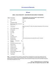
I. Physical Features.<br />
16. A detailed picture <strong>of</strong> <strong>the</strong> physical features <strong>of</strong> this forest block<br />
can be found in R.L Derry’s (District <strong>Forest</strong> Officer, Puri Division)<br />
inspection report <strong>of</strong> 2nd January, 1930. (Annexure B3, pages 34-37). He<br />
stated in this report that <strong>the</strong> area was a typical mangrove swamp<br />
formation along <strong>the</strong> coast. In <strong>the</strong> estate it forms a well defined band<br />
running <strong>the</strong> whole length <strong>of</strong> <strong>the</strong> eastern or coastal boundary. Derry<br />
stated that-<br />
“The forest in this tract is <strong>the</strong> typical mangrove formation found in<br />
estuaries subject <strong>to</strong> tidal inundation. Having no previous<br />
experience <strong>of</strong> <strong>the</strong>m I imagine <strong>the</strong>y resemble <strong>the</strong> forests <strong>of</strong> <strong>the</strong><br />
Sunderbans region <strong>of</strong> Bengal. In place, as near <strong>the</strong> old Garh-<br />
Kujang, it is hardly 2-3 miles broad. Higher up around Hooki<strong>to</strong>la<br />
and Falsepoint <strong>the</strong> band widens <strong>to</strong> a breadth <strong>of</strong> 8 or 10 miles. The<br />
tract is typical <strong>of</strong> deltaic swamps and consists largely <strong>of</strong> low marshy<br />
saline islands interlaced by a network <strong>of</strong> creeks and rivers. These<br />
islands are formed from accumulation <strong>of</strong> silt deposits brought down<br />
by many rivers <strong>of</strong> <strong>the</strong> Mahanadhi delta, and subsequently stabilized<br />
by <strong>the</strong> mangrove tidal forests that spring up. The older and higher<br />
group <strong>of</strong> <strong>the</strong> inside islands is <strong>of</strong>ten free from inundation at High<br />
tide and subject <strong>to</strong> partial inundation only at spring tides. On <strong>the</strong><br />
Western boundary, on <strong>the</strong> landward sides, <strong>the</strong> high ground<br />
gradually merges in<strong>to</strong> <strong>the</strong> cultivated alluvial formations behind.”<br />
II. Record <strong>of</strong> dependency <strong>of</strong> residents on forests.<br />
17. In <strong>the</strong> settlement report <strong>of</strong> 1893 <strong>the</strong> following are <strong>the</strong><br />
important revenue yielding forests supplying fuel and wood for building<br />
purposes <strong>of</strong> <strong>the</strong> residents <strong>of</strong> <strong>the</strong> estate :-<br />
1. Piasal Ptero carpus marsupium<br />
2. Sisu Dalbergia latifolia<br />
3. Kendu Diopyros melanoxylon<br />
4. Kurum Adina cardiflora<br />
5. Suam Soymida febrifuga<br />
6. Gambhari Gmelinaar arborea<br />
7. Tinia Albizzia lebbeck and<br />
procera<br />
8. Asan Terminalia <strong>to</strong>men<strong>to</strong>sa