Martis Valley Groundwater Management Plan - Placer County Water ...
Martis Valley Groundwater Management Plan - Placer County Water ...
Martis Valley Groundwater Management Plan - Placer County Water ...

Create successful ePaper yourself
Turn your PDF publications into a flip-book with our unique Google optimized e-Paper software.
<strong>Martis</strong> <strong>Valley</strong> <strong>Groundwater</strong> <strong>Management</strong> <strong>Plan</strong> Section 2<br />
the MVGB. The runoff regime is predominately snow-melt dominated, but with portions of the watershed<br />
covered with impervious surfaces such as roads and rooftops, rainfall events result in slightly more<br />
runoff and less infiltration and recharge from this watershed compared to others. A streamflow gage on<br />
Trout Creek was installed in January 2011 for the Truckee River <strong>Water</strong>shed Council so long-term<br />
streamflow statistics are not available.<br />
2.3.5 Prosser Creek<br />
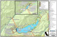
Prosser Creek’s approximately 32 square-mile watershed area includes Alder Creek and lies largely<br />
outside the MVGB. Prosser Creek Reservoir however, is entirely within the groundwater basin and is<br />
operated by the U.S. Bureau of Reclamation for water supply and flood control. Reservoir releases for<br />
flood control typically occur between September 1 and October 31 (Berris and others, 2001), as<br />
reflected in the pattern of average monthly flows depicted in Figure 2-6.<br />
2.3.6 Truckee Corridor<br />
The Truckee Corridor includes intervening areas that do not drain to the tributaries mentioned above.<br />
This includes the Union Creek subwatershed, which encompasses much of the Glenshire subdivision in<br />
the eastern portion of the MVGB, as well as urban and open space areas within the Town of Truckee.<br />
2.3.7 Other impoundments<br />
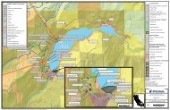
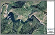
A number of small impoundments are located within the boundaries of the MVGB, including Union Mills<br />
Pond in the Glenshire subdivision, Dry Lake adjacent to the Waddle Ranch Preserve, and Gooseneck<br />
Reservoir, near the Lahontan Golf Club. Though originally constructed for cattle-grazing and/or millpond<br />
operations, these impoundments are now managed primarily for open space, recreational/aesthetic, or<br />
wildlife purposes.<br />
2.4 Geology<br />
The <strong>Martis</strong> <strong>Valley</strong> is located in the Sierra Nevada physiographic region, which is composed primarily of<br />
igneous and metamorphic rocks, with sedimentary rocks in its valleys. The MVGB’s complex geology is<br />
dominated by sedimentary deposits left by glaciations, volcanic rocks, and faulting. A component of the<br />
<strong>Martis</strong> GMP was the development of geologic cross-sections to improve the understanding of MVGB<br />
geology and stratigraphy.<br />
2.4.1 Geologic Database Development<br />
Approximately 200 well logs obtained from the DWR, TDPUD, PCWA, NCSD, and the Tahoe-Truckee<br />
Sanitation Agency (T-TSA) were interpreted to better understand depths and thicknesses of the various<br />
geologic formations comprising the MVGB. The filtered geologic and selected well data were entered<br />
into an ESRI ArcGIS Geodatabase, a spatially-referenced database. The benefit of the Geodatabase<br />
allowed a visual representation of the geologic data and was also used as the geologic framework for the<br />
DRI groundwater model that provides consistency between the GMP geologic interpretation and the<br />
groundwater model.<br />
The geochronology and stratigraphic relationships of water-bearing formations was based on Birkeland’s<br />
(1961; 1963; 1964) work, as well as subsequent investigations by Latham (1985), and Hydro-Search<br />
(1995), and mapping published by Saucedo (2005) and Melody (2009). The stratigraphic relationships,<br />
lithologies, and formation locations described in these studies, as well as through field observations,<br />
formed the basis for the designation of the primary hydrostratigraphic units, as displayed in Figure 2-7.<br />
Figure 2-8 shows the approximate locations of wells used to develop the geologic database.<br />
DRAFT for review purposes only. Use of contents on this sheet is subject to the limitations specified at the end of this document.<br />
P:\40000\140691 - PCWA <strong>Martis</strong> <strong>Valley</strong> GWP\GMP\Report\3rd Draft\<strong>Martis</strong> <strong>Valley</strong> GMP Draft 01-09-13.docx<br />
2-11