Land Mobile Mapping & Survey - Trimble
Land Mobile Mapping & Survey - Trimble
Land Mobile Mapping & Survey - Trimble

You also want an ePaper? Increase the reach of your titles
YUMPU automatically turns print PDFs into web optimized ePapers that Google loves.
4<br />
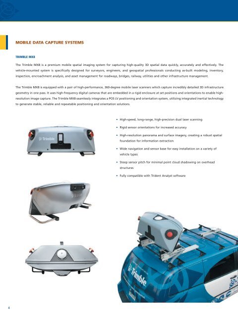
MobiLe daTa CapTure SySTeMS<br />
<strong>Trimble</strong> mX8<br />
The <strong>Trimble</strong> MX8 is a premium mobile spatial imaging system for capturing high-quality 3D spatial data quickly, accurately and effectively. The<br />
vehicle-mounted system is specifically designed for surveyors, engineers, and geospatial professionals conducting as-built modeling, inventory,<br />
inspection, encroachment analysis, and asset management for roadways, bridges, railway, utilities and other infrastructure management.<br />
The <strong>Trimble</strong> MX8 is equipped with a pair of high-performance, 360-degree mobile laser scanners which capture incredibly detailed 3D infrastructure<br />
geometry in one pass. It uses high-frequency digital cameras that are embedded in a rigid enclosure at set positions and orientations to enable highresolution<br />
image capture. The <strong>Trimble</strong> MX8 seamlessly integrates a POS LV positioning and orientation system, utilizing integrated inertial technology<br />
to generate stable, reliable and repeatable positioning and orientation solutions.<br />
• High-speed, long-range, high-precision dual laser scanning<br />
• Rigid sensor orientations for increased accuracy<br />
• High-resolution panorama and surface imagery, creating a robust spatial<br />
foundation for information extraction<br />
• Wide navigation and sensor base for easy installation on a variety of<br />
vehicle types<br />
• Steep sensor pitch for minimal point cloud shadowing on overhead<br />
structures<br />
• Fully compatible with Trident Analyst software