Landmark Gateway - City of Alexandria
Landmark Gateway - City of Alexandria
Landmark Gateway - City of Alexandria

You also want an ePaper? Increase the reach of your titles
YUMPU automatically turns print PDFs into web optimized ePapers that Google loves.
E)rlllBlT YO.<br />
\ .<br />
;:<br />
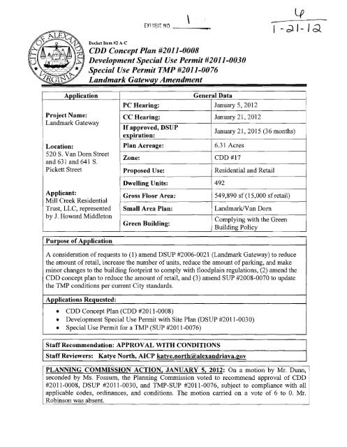
Docket Item #2 A-C<br />
CDD Concept Plan #2011-0008<br />
Development Special Use Permit #2011-0030<br />
A~~lication General Data 1<br />
Project Name:<br />
<strong>Landmark</strong> <strong>Gateway</strong><br />
Location:<br />
520 S. Van Dorn Street<br />
and 631 and 641 S.<br />
Pickett Street<br />
Applicant:<br />
Mill Creek Residential<br />
Trust, LLC, represented<br />
by J. Howard Middleton<br />
Purpose <strong>of</strong> Application<br />
1 PC Hearing:<br />
/ CC Hearing:<br />
1 January 5,201 2<br />
1 January 21,2012<br />
If approved, DSUP<br />
January 2 1,201 5 (36 months)<br />
expiration: I<br />
Plan Acreage:<br />
Zone:<br />
CDD #17<br />
1 Proposed Use: I Residential and Retail 1<br />
I Dwelling Units: 1 492<br />
6.3 1 Acres<br />
1 Gross Floor Area: / 549,890 sf (1 5,000 sf retail) 1<br />
/ Small Area Plan:<br />
1 Complying with the Green<br />
Green Building:<br />
Building Policv<br />
A consideration <strong>of</strong> requests to (1) amend DSUP #2006-0021 (<strong>Landmark</strong> <strong>Gateway</strong>) to reduce<br />
the amount <strong>of</strong> retail, increase the number <strong>of</strong> units, reduce the amount <strong>of</strong> parking, and make<br />
minor changes to the building footprint to comply with floodplain regulations, (2) amend the<br />
CDD concept plan to reduce the amount <strong>of</strong> retail, and (3) amend SUP #2008-0070 to update<br />
the TMP conditions per current <strong>City</strong> standards.<br />
Applications Requested:<br />
CDD Concept Plan (CDD #2011-0008)<br />
Development Special Use Permit with Site Plan @SUP #2011-0030)<br />
Special Use Permit for a TMP (SUP #2011-0076)<br />
Staff Recommendation: APPROVAL WITH CONDITIONS<br />
Staff Reviewers: Katye North, AICP katye.north@,alexandriava.gov<br />
PLANNING COMMISSION ACTION, JANUARY 5, 2012: On a motion by Mr. Dunn,<br />
seconded by Ms. Fossum, the Planning Commission voted to recommend approval <strong>of</strong> CDD<br />
#20 1 1-0008, DSUP #20 1 1-0030, and TMP-SUP #20 1 1-0076, subject to compliance with all<br />
applicable codes, ordinances, and conditions. The motion carried on a vote <strong>of</strong> 6 to 0. Mr.<br />
Robinson was absent.
Reason: The Planning Commission agreed with the staff analysis and recommendations.<br />
Speakers:<br />
Howard Middleton, attorney, representing the applicant.<br />
Mindy Lyle, resident <strong>of</strong> Cameroil Station and former boardmember <strong>of</strong> the Cameron Station<br />
Civic Association and HOA. She noted that the developer inet with the Civic Association<br />
extensively during the original review process starting as early as 2006, and the residents <strong>of</strong><br />
Cameron Station were very excited about the project. They were disappointed when the<br />
development stalled, but remain excited about the project as amended. She noted that there are<br />
traffic issues and will continue to be traffic issues for the larger area given the cut-through<br />
traffic from Fairfax County. She supports this project and requests that it be approved.<br />
Don Buch, resident <strong>of</strong> Cameron Station. He noted that a number <strong>of</strong> concerns had been raised<br />
about this project and appreciated that the applicant and staff had been responsive about<br />
discussing them. He expressed a concern about the traffic impacts for the larger area given the<br />
large amount <strong>of</strong> development that is planned for the rest <strong>of</strong> Block J and the plantling area, with<br />
little plan for implementing and paying for improvements. He also raised the issue <strong>of</strong><br />
inconsistencies between what was approved in the <strong>Landmark</strong> Van Dorn Plan and what is<br />
proposed for the <strong>Landmark</strong> <strong>Gateway</strong> development, including architecture style, building<br />
stepbacks, and green ro<strong>of</strong>s. He hopes the Planning Commission will support the amendment<br />
but will ensure that the specific design elements listed in the Plan are carried forward with<br />
future projects.<br />
Dak Hardwick, resident <strong>of</strong> Cameron Station and cui-rent president <strong>of</strong> the Cameron Station Civic<br />
Association. He expressed his appreciation to the applicant and staff for meeting to discuss<br />
some <strong>of</strong> their concerns. He noted that several things have changed since the original approval in<br />
2009, such as BRAC and cuts to transportation funding, which have driven the need by the<br />
community to reexamine some <strong>of</strong> the elements <strong>of</strong> the Plan and this development. He supports<br />
the project and the improvements that have been added in the last month, but noted that there<br />
are still a number <strong>of</strong> concerns from the residents, including building design, traffic impacts, and<br />
the viability <strong>of</strong> the rest <strong>of</strong> Block J to develop per the parameters in the Plan. He also stated that<br />
the multimodal bridge identified in the Plan is critical to this site, and questioned why the<br />
developer did not have to provide a contribution for it.<br />
PLANNING COMMISSION ACTION, December 6,2011: Prior to a public hearing for this<br />
case, the docket item was deferred at the request <strong>of</strong> the Planning Commission, with the<br />
applicant's consent, to give the applicant m
DSUP #2011-0030<br />
<strong>Landmark</strong> <strong>Gateway</strong> Amendment<br />
DSUP #2011-0030<br />
llU2012<br />
TMP SUP#2011-0076<br />
CDD CONCEPT PLAN #2011-0008
I. SUMMARY<br />
A. Recommendation and Summary <strong>of</strong> Issues<br />
DSUP #2011-0030<br />
<strong>Landmark</strong> <strong>Gateway</strong> Amendment<br />
Staff recommends approval <strong>of</strong> the proposed amendments to the <strong>Landmark</strong> <strong>Gateway</strong><br />
development, which was originally approved in January 2009. As part <strong>of</strong> this request, the<br />
applicant has requested the following amendments:<br />
Amend Development Special Use Permit #2006-0021 to reduce the amount <strong>of</strong> retail,<br />
increase the number <strong>of</strong> residential units, and reduce the amount <strong>of</strong> parking, as well as<br />
make minor adjustments to two buildings along South Picket Street to remove them<br />
from the floodplain;<br />
Amend the CDD Concept Plan (CDD #2008-0003) to reflect the reduction in the<br />
amount <strong>of</strong> retail;<br />
Amend the Transportation Management Plan Special Use Permit (SUP #2008-0070)<br />
to update the TMP per the current <strong>City</strong> Standards.<br />
Although the proposal is very similar to the original approval, there are several issues that were<br />
considered with this amendment, including:<br />
Consistency with the <strong>Landmark</strong>Nan Dorn Corridor Plan;<br />
Building design;<br />
Compliance with the floodplain requirements;<br />
Traffic impacts and improvements;<br />
Providing adequate parking; and<br />
Open space.<br />
This development will provide many public benefits including, perhaps the most important,<br />
implementation <strong>of</strong> the <strong>Landmark</strong>Nan Dorn Corridor Plan. This would be the first project<br />
developed in the planning area and could generate more interest for redevelopment <strong>of</strong> the<br />
surrounding sites. The proposal, even as amended, accomplishes many <strong>of</strong> the Plan's goals by<br />
creating walkable blocks, better vehicular circulation, open space, and rental housing.<br />
B. General Description <strong>of</strong> Amendment<br />
The original developer for this property, Green <strong>City</strong> Development, obtained approval for three<br />
five-story buildings comprised <strong>of</strong> 43 1 dwelling units and approximately 35,000 sf <strong>of</strong> retail. This<br />
amendment has been requested by a new developer for the site, Mill Creek Residential Trust,<br />
LLC. The overall concept for the development is consistent with the original proposal in that the<br />
site will still have three five-story residential buildings with some retail. However, the new<br />
developer has proposed some changes to the amount <strong>of</strong> retail and number <strong>of</strong> units within the<br />
buildings and the overall parking for the development. The retail has been reduced to 15,000 sf,<br />
which will be retained in the building on the prominent Van Dorn Street&. Pickett Street corner.<br />
The remaining areas originally slated for retail will be converted to residential units, increasing<br />
the total number <strong>of</strong> units to 492. The garage has been reconfigured for the site and the small<br />
partially above grade garage level has been eliminated so that all <strong>of</strong> the garage parking is<br />
provided in one, below grade level. Finally, although the original intent <strong>of</strong> the amendment was
DSUP #2011-0030<br />
<strong>Landmark</strong> <strong>Gateway</strong> Amendment<br />
to keep the building footprints the same, a small adjustment was needed to the two buildings<br />
along S. Pickett Street to address the revised floodplain boundary that now crosses the southern<br />
portion <strong>of</strong> the property. The buildings and garage below have been pulled back approximately 4<br />
feet fiom S. Pickett Street to stay out <strong>of</strong> the floodplain.<br />
11. BACKGROUND<br />
A. Site Context<br />
The 6.3 acre site is comprised <strong>of</strong> three parcels and is located at the northeast comer <strong>of</strong> the<br />
intersection <strong>of</strong> Van Dorn Street and S. Pickett Street. This is a heavily traveled intersection as it<br />
is less than a mile fiom the Van Dorn ramp onto the Capital Beltway and Pickett Street provides<br />
a link between Van Dorn Street and Duke Street. Currently there are three one-story brick<br />
warehouse buildings on site with surface parking and little to no vegetation. East <strong>of</strong> the site are<br />
more warehouse buildings similar to what exists on the site now. North <strong>of</strong> the site is a shopping<br />
center with a Giant grocery store and other retail shops and restaurants. A bank and restaurant<br />
are opposite the site across Van Dorn Street and there is a row <strong>of</strong> retail businesses across Pickett<br />
Street to the south.<br />
The site is situated at the southern end <strong>of</strong> the <strong>Landmark</strong>Nan Dorn Corridor Plan area in the<br />
neighborhood designated as Pickett Place. This area is seen as a gateway to the larger<br />
<strong>Landmark</strong>Nan Dorn area from the Beltway. Additionally, it is less than one mile from the<br />
<strong>Landmark</strong> Mall which is slated for a town center themed redevelopment in the Plan and less than<br />
one mile in the other direction fiom the Van Dorn Metro Station.<br />
B. Site History & Project Evolution<br />
For the last five decades, the site has been occupied by industrial uses, which is consistent with<br />
the surrounding area. The real estate assessments indicate that the three buildings were<br />
constructed in 1961. The buildings were used as a storage facility, an <strong>of</strong>fice supply service, and<br />
a marble wholesale/retail establishment. In the summer <strong>of</strong> 2004, in response to a concept plan to<br />
redevelop <strong>Landmark</strong> Mall, the <strong>City</strong> began the planning process for the larger <strong>Landmark</strong>Nan<br />
Dorn area. Soon after, in 2006, the original developer began discussions with the <strong>City</strong> for<br />
development <strong>of</strong> the <strong>Landmark</strong> <strong>Gateway</strong> site. The development was approved by the Planning<br />
Commission and <strong>City</strong> Council in January 2009, which was the same month the <strong>Landmark</strong>Nan<br />
Dorn Corridor Plan was reviewed (although it was approved a month later in February). Since<br />
that approval, the original applicant has been trying to secure financing for the project and has<br />
not yet submitted a final site plan. The new developer became involved with the project over the<br />
summer and has suggested the amendments that are the subject <strong>of</strong> this request in order to make<br />
the project viable.<br />
C. Detailed Project Description<br />
In 2009, the <strong>City</strong> Council approved a development proposal for this property that included three<br />
residential, five-story buildings, two <strong>of</strong> which included ground floor retail, and three new streets.<br />
Building 1 was located at the northwestern corner <strong>of</strong> the site, adjacent to Van Dorn Street,
DSUP #2011-0030<br />
<strong>Landmark</strong> <strong>Gateway</strong> Amendment<br />
Building 2 was located at the eastern portion <strong>of</strong> the site, and Building 3 was located at the<br />
southwestern corner <strong>of</strong> the site at the Van DodPickett Street intersection. This amendment<br />
keeps the same general layout and building heights, but proposes to change some <strong>of</strong> the uses<br />
within. A slight reduction to the footprints for Buildings 2 and 3 have been made to address the<br />
floodplain requirements that now affect this property (discussed more'under the Staff Analysis<br />
section).<br />
The original approval included 35,436 sf <strong>of</strong> retail that was split between Buildings 1 and 3. The<br />
bulk <strong>of</strong> the retail (approximately 30,000 sf) was proposed in Building 3 given the prominent<br />
location at the Van DordPickett Street intersection. The remaining 5,000 sf was proposed along<br />
the southern elevation <strong>of</strong> Building 1 facing the internal plaza and surface parking. Given the<br />
difficulty in leasing retail space, the current applicant is proposing to reduce the retail to 15,000<br />
sf which would remain in the comer portion <strong>of</strong> Building 3. A portion <strong>of</strong> the original retail space<br />
would be used for a leasing <strong>of</strong>fice and amenity space for the apartments, and the remaining retail<br />
area would be converted to residential units.<br />
The original approval included a level <strong>of</strong> partially above grade parking in Building 1. As part <strong>of</strong><br />
this amendment, that level will be removed and the below grade garage under all three buildings<br />
will be reconfigured to improve efficiency. Garage access is provided in Buildings 1 and 2 and<br />
both sides <strong>of</strong> the garage can be accessed below grade. The area that was previously a level <strong>of</strong><br />
parking will be converted to additional residential units.<br />
The additional residential units added to the former retail area and garage level increases the<br />
number <strong>of</strong> units from 43 1 to 492 units. The unit mix has expanded to include a studio option (58<br />
units), but overall the mix <strong>of</strong> units is still predominately 1-bedroom (259 units) and 2-bedroom<br />
(175 units). Most <strong>of</strong> these units are added to Buildings 1 and 3 since this is where the retail and<br />
garage have been eliminated, although the number <strong>of</strong> units in Building 2 has slightly increased<br />
due to an internal reconfiguration <strong>of</strong> the units.
111. ZONING<br />
DSUP #20 11-0030<br />
<strong>Landmark</strong> <strong>Gateway</strong> Amendment<br />
prosy ~dd&s: 520 Van Dorn Street, 63 1 S. Pickett Street, and 641 S. Pickett Street<br />
Total Site Area: 6.3 1 Acres (274,945 sf)<br />
Zone: CDD #17<br />
1 Current Use: Industrial1 warehouses<br />
Proposed Use: Residential with ground floor retail<br />
PemittedRequired Previously Approved Proposed<br />
1 FAR: ~ 2.0 ~ 2.0 1 2.0 I<br />
1 Height: ( 60 feet 1 60 feet I 60 feet I<br />
Parking:<br />
Total required by original<br />
approval: 803 spaces<br />
Total required by proposed<br />
amendment: 80 1<br />
Max allowed per the LND Plan<br />
I I (initial phase): 894 spaces / 1 I<br />
1 space per 20,000 sf <strong>of</strong> retail<br />
(35,436 sf): 2 loading spaces<br />
* parking reduction for 11 spaces<br />
**parking reduction for 56 spaces<br />
IV. STAFF ANALYSIS<br />
Garage: 739 spaces<br />
Surface: 53 spaces<br />
Total: 792 spaces*<br />
6 loading spaces<br />
A. Consistency with the Landmarwan Dorn Corridor Plan<br />
Garage: 692 spaces<br />
Surface: 53 spaces<br />
Total: 745 spaces**<br />
6 loading spaces<br />
The original proposal for this site achieved many <strong>of</strong> the goals outlined by the <strong>Landmark</strong>1 Van<br />
Dorn Corridor Plan. As previously noted, it provides an attractive gateway into the <strong>City</strong> and the<br />
Van Dorn Corridor; it breaks up a large parcel into walkable, pedestrian friendly blocks; it<br />
creates engaging street frontages by pulling the buildings up to the sidewalk and installing a<br />
standard streetscape with wider sidewalks and trees; and it provides the right-<strong>of</strong>-way necessary<br />
for future transit improvements along Van Dorn Street. Since the amendment maintains the<br />
original site layout and building use, the new proposal is still consistent with the Plan. Further<br />
details about the consistency with the Plan are provided below.<br />
An Attractive Gatewav<br />
At the southern end <strong>of</strong> the Plan's boundaries, providing an attractive gateway is particularly<br />
applicable to <strong>Landmark</strong> <strong>Gateway</strong>. The site is one <strong>of</strong> the first to be seen when entering the <strong>City</strong><br />
from the Capital Beltway via Van Dorn Street. As discussed further in the Building Design<br />
section, the applicant focused most <strong>of</strong> their budget for building design and materials on the
DSUP #2011-0030<br />
<strong>Landmark</strong> <strong>Gateway</strong> Amendment<br />
prominent corner <strong>of</strong> Van Dorn and Pickett Streets to create a visible and unique gateway.<br />
Additionally, 30 feet <strong>of</strong> their property will be dedicated to the <strong>City</strong> for improvements to Van<br />
Dorn Street and the Corridor C transitway. In the future, this site will be the start <strong>of</strong> Van Dorn<br />
Street as a green boulevard with transit.<br />
Pedestrian-Friendly Activity Centers<br />
An important component <strong>of</strong> this development will be the creation <strong>of</strong> three new streets to break up<br />
the existing super block into several smaller, pedestrian-friendly blocks. Additionally, all three<br />
<strong>of</strong> the proposed buildings are pulled up to the sidewalk along Pickett Street and Van Dorn Street<br />
to engage the pedestrians. Finally, retail will be provided at the corner <strong>of</strong> Van Dorn and Pickett<br />
to provide further interest and amenities for pedestrians, Special detail will be paid to<br />
developing attractive storefronts for a high quality pedestrian environment.<br />
A Multi-modal Transportation System<br />
The Plan places a strong emphasis on developing a multi-modal transportation system for the<br />
<strong>Landmark</strong>IVan Dorn area. With the creation <strong>of</strong> the new streets with this development, vehicular<br />
circulation is enhanced, as well as vastly improving the pedestrian environment. As mentioned,<br />
30 feet <strong>of</strong> the property will be dedicated to the <strong>City</strong> for improvements to Van Dorn Street and the<br />
Corridor C transitway. Per the Plan, these improvements will include the addition <strong>of</strong> dedicated<br />
lanes for transit and bike lanes. Finally, a TMP is proposed that will encourage residents to take<br />
advantage <strong>of</strong> alternate transportation options, including the nearby metro system.<br />
An Interconnected Open Space System<br />
The Plan calls for a variety <strong>of</strong> open space, ranging from larger public parks to smaller areas <strong>of</strong><br />
open space. While none <strong>of</strong> the larger parks are slated for this site, this proposal includes a<br />
central plaza area inside the development as an amenity to the shoppers and residents.<br />
Additional courtyards are also provided adjacent to the buildings for use by the residents.<br />
Quality Neighborhoods<br />
This proposal provides much needed rental housing in a redeveloping area near major<br />
transportation and transit corridors. The units will range from small studios to larger two<br />
bedroom units in order to provide a variety <strong>of</strong> options. In addition, the new retail adjacent to<br />
existing retail will provide many amenities for the new residents <strong>of</strong> the development.<br />
Environmentally and Economic Sustainable Development<br />
As with any new development, the project will include stormwater management improvements<br />
to address the run<strong>of</strong>f created by the development. This will greatly improve the environment in<br />
this area seeing as the site presently has little to no stormwater management facilities and is<br />
mostly impervious. In addition, the development will include new open space and new sanitary<br />
facilities. In terms <strong>of</strong> economic sustainability, the proposal creates a mixed-use development in<br />
close proximity to the metro and other transit options which is consistent with the<br />
recommendations <strong>of</strong> the Economic Sustainability Work Group.<br />
Land Uses - Retail and Residential Locations<br />
This property represents 25% <strong>of</strong> Block J (as identified by the Plan), which calls for a minimum<br />
<strong>of</strong> 250,000 sf <strong>of</strong> retail for the entire Block. The bulk <strong>of</strong> this retail is anticipated for the property
DSUP #2011-0030<br />
<strong>Landmark</strong> <strong>Gateway</strong> Amendment<br />
to the north, where the existing shopping center is currently located. Retail is required along the<br />
new main street that will cut through that property from east to west. For the <strong>Landmark</strong> <strong>Gateway</strong><br />
site, ground floor retail was shown in the Plan as preferred in various locations, including the<br />
corner <strong>of</strong> Van Dorn and Pickett. Since the developer is proposing to keep 15,000 sf <strong>of</strong> retail at<br />
this corner location, the amendment is still consistent with the overall Plan. Although the<br />
reduction <strong>of</strong> retail is not ideal, staff is well aware <strong>of</strong> the problems <strong>of</strong> creating successful retail<br />
locations and believes it is better to have good retail in key locations, rather than empty<br />
storefronts. Additionally, 15,000 sf <strong>of</strong> retail can provide excellent neighborhood services. As a<br />
comparison, the retail at Potomac Plaza on Slater's Lane is also 15,000 sf in size.<br />
With regard to residential floor area, the Plan allows for a minimum <strong>of</strong> 500,000 sf and a<br />
maximum <strong>of</strong> 1,450,000 sf for Block J. The slight increase in residential floor area brings Block J<br />
further above the minimum floor area for residential. However, future development on the<br />
remaining parcels within Block J will still have nearly 1,000,000 sf <strong>of</strong> residential floor area to<br />
use. Therefore, staff is comfortable that the increase <strong>of</strong> residential floor area for <strong>Landmark</strong><br />
<strong>Gateway</strong> is still consistent with the Plan and will still allow for successful redevelopment <strong>of</strong> the<br />
remaining properties within Block J.<br />
B. Building DesigdArch itecture<br />
During the initial review <strong>of</strong> the <strong>Landmark</strong> <strong>Gateway</strong> proposal, staff and the developer worked<br />
hard to ensure the design <strong>of</strong> the buildings would be appropriate for the gateway location and set<br />
the proper tone for future development in the planning area. The result was a scheme that built<br />
<strong>of</strong>f <strong>of</strong> the mid-2oth century character <strong>of</strong> the western part <strong>of</strong> the <strong>City</strong> rather than recalling Colonial<br />
architectural themes more appropriate for the historic districts. Staff agreed that resources for<br />
building materials should be focused on key locations, in particular the comer element <strong>of</strong><br />
Building 3 and the Van Dorn and S. Pickett Street frontages. This is consistent with the Plan that<br />
recommends the highest quality architectural faqade treatments for the building facades along<br />
"A" street frontages, such as Van Dorn and Pickett Streets.<br />
This amendment does not propose any changes to the overall building design. Minor changes to<br />
address the portions <strong>of</strong> the building that have been converted from retail to residential will be<br />
reviewed by staff during the final site plan review, but the goal will be to maintain the original<br />
intent for these elevations. In addition, portions <strong>of</strong> Buildings 2 and 3 along the Pickett Street<br />
frontage have been pulled back to remove the building from the revised floodplain boundary<br />
(discussed more in next section). More details about the design <strong>of</strong> each <strong>of</strong> the buildings is<br />
provided below.<br />
Building I<br />
Building 1 is a rectangular building located in the northwest corner <strong>of</strong> the site. The widest part<br />
<strong>of</strong> the structure faces private Street A (east-west street), but approximately 160 feet <strong>of</strong> the<br />
building fronts Van Dorn Street. The facade <strong>of</strong> Building 1 that faces Street A previously<br />
included a small amount <strong>of</strong> ground floor retail and residential amenities. This amendment<br />
proposes to eliminate the retail in this building and replace with residential units. The new<br />
residential units on the first floor will be approximately 3 feet above the grade <strong>of</strong> the sidewalk<br />
along Street A in order to accommodate changing grade for this building. The building will be
DSUP #2011-0030<br />
<strong>Landmark</strong> <strong>Gateway</strong> Amendment<br />
predominately brick with a lighter color material at the top story, although, an alternate material<br />
such as metal panels or rainscreen will be used to accentuate the main entrance on Street A.<br />
Building 2<br />
Building 2 is the easternmost building <strong>of</strong> the development. Located east <strong>of</strong> private Street By<br />
Building 2 stretches from Pickett Street to public Street C. Similar to Building 1, the building<br />
uses the change in grade across the site to bury most <strong>of</strong> the underground parking garage,<br />
although some is exposed at the lowest elevation along Pickett Street. Also similar to Building<br />
1, the loading area and garage entrance are located on Street C. The applicant has agreed to<br />
continue to work with staff during final site plan, subject to specific conditions listed in the Staff<br />
Recommendations (Condition 3), to further improve the architecture for this building. Since this<br />
building will eventually face a public street that will connect to the properties to the north, it will<br />
be important to ensure that the eastern faqade is appropriately designed with active elements such<br />
as building entrances, interesting building details, or public art.<br />
Building 3<br />
Located at the comer <strong>of</strong> Van Dorn and Pickett Streets, Building 3 is the most prominent building<br />
<strong>of</strong> this development and therefore a lot <strong>of</strong> design consideration went into this building. This<br />
building will be the first building a person sees when driving north on Van Dorn Street from the<br />
Beltway and therefore acts as gateway into the <strong>Landmark</strong>Nan Dorn planning area. The<br />
architecture <strong>of</strong> the building is reminiscent <strong>of</strong> an Art Moderne style with a curved wallldrum at<br />
the comer that connects to buildings facing Van Dorn and Pickett Streets. A building break<br />
roughly 200 feet from the Van Dorn intersection in the form <strong>of</strong> a glassy, recessed hyphen<br />
provides some relief to the overall length <strong>of</strong> this building and provides an architectural transition<br />
point to the second half <strong>of</strong> the building that faces Pickett Street and Street B. The hyphen also<br />
coincides with the driveway to the central plaza and surface parking area.<br />
Retail will be located on the ground floor <strong>of</strong> the western half <strong>of</strong> the building which will activate<br />
the building and the pedestrian environment. Through this amendment, residential units are<br />
proposed for the eastern half and are elevated approximately 2-3 feet above the grade <strong>of</strong> the<br />
sidewalk along Pickett Street. In addition, a small planter is provided between the sidewalk and<br />
the building to provide an additional <strong>of</strong>fset for the residential portion and address floodplain<br />
issues (see following section for more details). The entire building is "U" shaped, which<br />
surrounds the internal parking plaza and central green space.<br />
C. Floodplain Regulations<br />
On June 16, 20 1 1, the updated Flood Insurance Rate Maps (FIRMS) for the <strong>City</strong> were<br />
published. The modified 100-year floodplain boundary removed some properties which were<br />
previously in the floodplain, and also included a number <strong>of</strong> new properties that were previously<br />
not included, which is the case for <strong>Landmark</strong> <strong>Gateway</strong>. When the development was originally<br />
approved in 2009, no portion <strong>of</strong> the floodplain was within the boundaries <strong>of</strong> this property,<br />
although significant flooding had been documented on the property across Pickett Street. The<br />
201 1 update to the maps brought the floodplain boundary onto the <strong>Landmark</strong> <strong>Gateway</strong> site along<br />
the southern property line and within a portion <strong>of</strong> Buildings 2 and 3 and the garage
DSUP #2011-0030<br />
<strong>Landmark</strong> <strong>Gateway</strong> Amendment<br />
below. Although the amount <strong>of</strong> building area that was shown within the 201 1 floodplain is<br />
relatively small, the buildings and garage must comply with the floodplain regulations.<br />
In response, the applicant revised the plans to remove the below grade parking garage and<br />
Buildings 2 and 3 from the floodplain by cutting back the buildings a maximum <strong>of</strong> 4 feet and<br />
eliminating 5 spaces from the garage. In addition, a planter is proposed along the southern<br />
fagade <strong>of</strong> both buildings to act as a barrier to flood waters. Given that the finished floor<br />
elevation for these bu.ildings is 3-5 feet above the sidewalk elevation and flood elevation, the<br />
addition <strong>of</strong> the planters has the added benefits <strong>of</strong> s<strong>of</strong>tening the edge <strong>of</strong> the building along the<br />
public sidewalk and creating a setback for the residential units now at ground floor.<br />
D. Parking<br />
The original proposal was required to provide a minimum <strong>of</strong> 803 spaces, but only provided 792<br />
spaces. An 11 space parking reduction was approved as part <strong>of</strong> the overall approval. Of the 792<br />
spaces, 739 spaces were in the garages and 53 spaces were in the plaza and along the new private<br />
streets. Under the current parking standards in the Zoning Ordinance and the <strong>Landmark</strong>Nan<br />
Dorn Plan, the revised development is now required to provide a minimum <strong>of</strong> 801 spaces and a<br />
maximum <strong>of</strong> 894 spaces. As part <strong>of</strong> the revised plans, the number <strong>of</strong> spaces has been reduced to<br />
745 spaces. Of these, 692 spaces are within the garage and the original 53 surface spaces remain<br />
the same, resulting in a loss <strong>of</strong> 47 garage spaces. The applicant has requested approval <strong>of</strong> a new<br />
parking reduction for 56 spaces. The requirements for the Zoning Ordinance and both phases <strong>of</strong><br />
the <strong>Landmark</strong>/Van Dorn Plan for the original and proposal development are summarized in the<br />
table below.<br />
aProposed<br />
I I I<br />
Zoning<br />
Ordinance<br />
(minimum)<br />
1.3 spaces per studio/l -bed unit<br />
1.75 spaces per 2-bed unit<br />
1.2 spaces per 220 sf <strong>of</strong> retail<br />
Van<br />
1.725 spaces per unit<br />
Dorn Plan -<br />
3 spaces per 1,000 sf <strong>of</strong> retail<br />
Initial Phase<br />
(maximum) 1<br />
<strong>Landmark</strong>/ Van<br />
1.1 5 spaces per unit<br />
Dorn Plan -<br />
2 spaces per 1,000 sf <strong>of</strong> retail<br />
Later Phase<br />
(maximum)<br />
396<br />
222<br />
185<br />
Total: 803<br />
412<br />
307<br />
82<br />
Total: 801<br />
744 849<br />
106<br />
Total: 850<br />
496<br />
7 1<br />
Total: 567<br />
45<br />
Total: 894<br />
566<br />
30<br />
Total: 596<br />
Although this is a greater parking reduction, staff is comfortable with the request. The garage<br />
includes 8 tandems spaces and 11 on-street spaces on Pickett Street that are not counted towards<br />
the parking numbers, which means that there are 19 more spaces that can realistically be used by<br />
residents and retail patrons. The garage spaces will be designated for the residents <strong>of</strong> the site,<br />
which provides an overall parlung ratio <strong>of</strong> 1.4 spaces per unit (1.42 spaces per unit if the tandem<br />
spaces are included). This ratio is consistent with other residential developments in the <strong>City</strong>.<br />
I
DSUP #2011-0030<br />
<strong>Landmark</strong> <strong>Gateway</strong> Amendment<br />
The 53 surface spaces will be primarily used for the retail patrons. This is 29 spaces less than the<br />
Zoning Ordinance requires (only 18 spaces less if you include the parking along Pickett Street),<br />
although, 8 spaces more than the <strong>Landmark</strong>Nan Dorn Plan recommends as the maximum for<br />
retail during the initial phase. Given that many <strong>of</strong> the residents will also be the patrons for the<br />
retail, staff is comfortable with the amount <strong>of</strong> retail parking proposed. In addition, the project is<br />
required to implement a Transportation Management Plan which will help provide further<br />
reductions to the number <strong>of</strong> vehicles and trips to and from the site.<br />
E. TrafJic Impacts and Improvements<br />
Van Dorn and Pickett Intersection<br />
A detailed traffic analysis was provided with the original application in 2009. For this<br />
amendment, an update to that analysis was submitted to reflect the traffic impacts from an<br />
increase <strong>of</strong> residential units and decrease <strong>of</strong> retail. The results <strong>of</strong> the study found that the impact<br />
to traffic from this development would be less than the original proposal, since there is less retail<br />
and retail typically creates more traffic. However, the intersection <strong>of</strong> Van Dorn Street and<br />
Pickett Street currently functions at Level <strong>of</strong> Service (LOS) F and any additional trips added to<br />
the intersection will further degrade the intersection and increase the delay (see table below).<br />
There was considerable concern from the community about the additional traffic impacts to this<br />
intersection, which was the primary reason the Planning Commission deferred the case in<br />
December.<br />
'<br />
exist in^ and Future Conditions - Level <strong>of</strong>service and Delav fin seconds)<br />
201 2 without <strong>Landmark</strong> 201 2 with revised <strong>Landmark</strong><br />
Existing Conditions*<br />
<strong>Gateway</strong>*<br />
<strong>Gateway</strong> (no improvements)*<br />
AM PM AM PM AM PM<br />
F<br />
E<br />
F<br />
94.1 68.4 125.3<br />
* from updated traffic analysis dated December 8,201 1<br />
F<br />
82.6<br />
F<br />
133.8<br />
F<br />
100.9<br />
Based on the direction from the Planning Commission to study the traffic impacts, the traffic<br />
consultant for the developer analyzed the impact <strong>of</strong> two different road improvements on the level<br />
<strong>of</strong> service for the intersection. Option 1 was a separate westbound right turn lane on Pickett<br />
Street which would be accommodated within land along the <strong>Landmark</strong> <strong>Gateway</strong> site. Option 2<br />
was a separate northbound right turn lane on Van Dorn Street which would be accommodated<br />
within existing <strong>City</strong> right-<strong>of</strong>-way in that location. Upon analysis, Option 1 was found to have<br />
very little impact on the overall LOS for the intersection. However, the results showed that<br />
Option 2 would provide a significant improvement by cutting the delay in half and improving the<br />
overall LOS for the intersection to D in the morning peak hour and E in the evening peak hour<br />
(see table below).
Impact <strong>of</strong>lmprovement Options on Level <strong>of</strong> Service and Delay (in seconds)<br />
<strong>Landmark</strong> <strong>Gateway</strong> with<br />
Option 1 *<br />
<strong>Landmark</strong> <strong>Gateway</strong> with<br />
Option 2*<br />
AM<br />
PM<br />
AM<br />
PM<br />
F<br />
F<br />
D<br />
E<br />
133.8<br />
100.4<br />
52.5<br />
62.2<br />
* fiom updated traffic analysis dated December 8,20 1 1<br />
DSUP #20 1 1-0030<br />
<strong>Landmark</strong> <strong>Gateway</strong> Amendment<br />
The developer has agreed to install the new turn lane as part <strong>of</strong> the <strong>Landmark</strong> <strong>Gateway</strong><br />
development. The estimated cost <strong>of</strong> this turn lane improvement is approximately $360,000.<br />
Staff has revised Condition 95A to require the developer to construct the turn lane improvement<br />
in lieu <strong>of</strong> making an $1 80,000 contribution to an infrastructure fund. Staff believes construction<br />
<strong>of</strong> this improvement will be a greater and more immediate benefit than the originally proposed<br />
monetary contribution.<br />
Other Traffic Improvements<br />
In addition to the new turn lane, this development will provide a number <strong>of</strong> other enhancements<br />
that could improve traffic volumes and flows. The existing conditions along Pickett Street<br />
headed west are one lane <strong>of</strong> traffic until the double left turn lane at the intersection and parking<br />
allowed along the curb. With the new development, a second travel lane will be provided where<br />
the on-street parking is currently located for the length <strong>of</strong> the development frontage. The<br />
existing curb will be shifted north to accommodate the eleven on-street parking spaces. A<br />
bulbout will be provided at the existing bus stop location on Picket Street in the second travel<br />
lane, which will allow for continued traffic flow even when the bus makes a stop. As discussed<br />
in the original approval, the addition <strong>of</strong> three new streets (two private, one public) will help<br />
break up the block and distribute the traffic generated from the development. Finally, the<br />
development does not preclude a future public street along the eastern edge <strong>of</strong> the development,<br />
which could potentially be signalized and will provide more travel options for people traveling<br />
within and through the area.<br />
F. Coordination with Corridor C Improvements<br />
The Transportation Master Plan, which was approved in 2008, establishes three primary transit<br />
corridors for the <strong>City</strong>, one <strong>of</strong> which includes Van Dorn Street (Corridor C). In the last year, the<br />
<strong>City</strong> has started the process for determining the specific improvements to Corridor C, including<br />
the specific alignment, mode and runningway configuration. The general concept consists <strong>of</strong> a<br />
separate, dedicated travel lane in each direction within the median for transit, and complete<br />
street enhancements consistent with the <strong>City</strong>'s Complete Streets policy (approved in April, 201 1)<br />
which will include wider sidewalks, planting strips, and bike lanes. Since the LandmarldVan<br />
Dorn Plan was approved in 2009 before detailed analysis <strong>of</strong> the street section had begun, the<br />
Plan included a general sketch <strong>of</strong> a potential street section (page 137). For the portion <strong>of</strong> Van<br />
Dorn Street south <strong>of</strong> Edsall Road, the entire right-<strong>of</strong>-way, which includes travel lanes for transit<br />
and general traffic, bike lanes, planting strips, and sidewalks, was anticipated to be 160 feet<br />
wide. The existing right-<strong>of</strong>-way in this area is 100 feet, meaning an additional 60 feet would be<br />
required from property owners along this section (30 feet on each side <strong>of</strong> the street). As part <strong>of</strong>
DSUP #2011-0030<br />
<strong>Landmark</strong> <strong>Gateway</strong> Amendment<br />
the original <strong>Landmark</strong> <strong>Gateway</strong> approval, the developer agreed to provide the 30 feet needed<br />
along the east side <strong>of</strong> Van Dorn Street and designed their development outside <strong>of</strong> the future<br />
right-<strong>of</strong>-way.<br />
As discussed earlier in the report, the proposed changes do not impact the original building<br />
footprints (with the exception <strong>of</strong> the portion on Pickett Street that is affected by the floodplain).<br />
The 30 feet <strong>of</strong> right-<strong>of</strong>-way will still be provided with this development and the new buildings<br />
will be located outside <strong>of</strong> this area. Although the final configuration for the street section has not<br />
been finalized, the <strong>City</strong>'s consultant for Corridor C has analyzed how the <strong>Landmark</strong> <strong>Gateway</strong><br />
plan fits into the current plan for this segment <strong>of</strong> Van Dorn Street. They have confirmed that<br />
there is adequate space to provide the desired elements <strong>of</strong> the section and the streetscape<br />
improvements along the <strong>Landmark</strong> <strong>Gateway</strong> frontage, although the specific dimensions have not<br />
been finalized.<br />
G. Transportation Management Plan<br />
This application also includes an amendment to the approved transportation management plan.<br />
Per staffs suggestion, the applicant has agreed to update their TMP to reflect the current<br />
standards. This includes updating conditions related to identifying a TMP coordinator, providing<br />
annual reports, and paying an administrative fee to the <strong>City</strong> for lack <strong>of</strong> a timely response. While<br />
this does increase the initial residential rate from $60 to $80, the rate increase to $120 for the<br />
second part <strong>of</strong> this development is eliminated. Additionally, the retail rate is also reduced from<br />
$0.39 to $0.25 per leased square foot. Overall, this will provide some savings to the developer<br />
while upgrading the TMP to meet current <strong>City</strong> standards.<br />
H. Open Space<br />
The amount <strong>of</strong> open space for the site remains unchanged from the original approval. As noted<br />
in the original proposal, the site will provide a variety <strong>of</strong> open space areas, including the publicly<br />
accessible central plaza between Buildings 1 and 3, and private courtyards with Buildings 1 and<br />
2. However, as part <strong>of</strong> this amendment, a change to the private courtyards for Building 1 is<br />
proposed. Previously these two courtyards were elevated approximately 4 feet above the grade<br />
<strong>of</strong> the adjacent sidewalk due to the location on top <strong>of</strong> the above grade parking level. Since that<br />
garage level has been removed, the courtyards have been lowered. They are now 3-4 below the<br />
adjacent sidewalk with units fronting on three <strong>of</strong> the sides. Since this creates a better sidewalk<br />
condition, staff is supportive <strong>of</strong> the change to these areas.<br />
I. Green Building<br />
The <strong>City</strong> Council adopted the Green Building Policy for new development in April 2009, which<br />
occurred three months after the original <strong>Landmark</strong> <strong>Gateway</strong> approval. Under that development<br />
approval, the building was required to be designed to LEED certification standards, but did not<br />
require pro<strong>of</strong> <strong>of</strong> certification by a third party reviewer (in the case <strong>of</strong> LEED, this would have<br />
been the USGBC). Per the Policy, new developments are now required to obtain certification<br />
from a third party. With this amendment, the applicant has agreed to update the green building<br />
condition for the development and achieve a third party certification.
V. COMMUNITY<br />
DSUP #2011-0030<br />
<strong>Landmark</strong> <strong>Gateway</strong> Amendment<br />
The community surrounding this site was extensively involved in the design and review <strong>of</strong> the<br />
original development proposal, and in general was very supportive <strong>of</strong> the project. During the<br />
original review <strong>of</strong> the project, the developer met with the Cameron Station Civic Association and<br />
Cameron Station Homeowner's Association (the closest residential area to the development),<br />
Seminary Hill Civic Association, and Brookeville - Seminary Valley Civic Association several<br />
times between 2007 and the public hearings in 2009. In addition, the developer served as a<br />
member <strong>of</strong> the <strong>Landmark</strong>Nan Dorn Advisory Group and presented the proposal for this<br />
development at several Advisory Group meetings, all <strong>of</strong> which were open to the general public.<br />
There was very little public comment at the Planning Commission and <strong>City</strong> Council public<br />
hearings in January 2009, but the comments that were made were all supportive <strong>of</strong> the<br />
development and emphasized a strong desire to see development occur at this location (see<br />
speaker's comments the cover page <strong>of</strong> the original staff report).<br />
After discussing the proposed amendments to the approved plan with staff this past summer, the<br />
developer met with the Cameron Station Homeowner's Association in August to review the<br />
changes to the development. The project was also presented at the annual meeting for Cameron<br />
Station homeowners in early November, which had approximately 200 residents in attendance.<br />
In early December, a meeting was also held with the Cameron Station Civic Association. During<br />
this time, the developer also reached out to the Seminary Hill Civic Association and Brookeville<br />
- Seminary Valley Civic Association to alert them <strong>of</strong> the proposed changes to the approved<br />
development, and provided additional information as requested. Since the deferral <strong>of</strong> the case at<br />
the December 6th Planning Commission meeting, staff and the developer team met with three<br />
representatives <strong>of</strong> Cameron Station to discuss specific concerns with the development, including<br />
traffic impacts.<br />
VI. CONCLUSION<br />
Staff recommends approval <strong>of</strong> the development special use pennit with site plan and all related<br />
applications subject to compliance with all applicable codes and the following staff<br />
recommendations.
VII. GRAPHICS<br />
ProposedSllcPh-PIaurLewl<br />
15<br />
DSUP #2011-0030<br />
<strong>Landmark</strong> <strong>Gateway</strong> Amendment<br />
WILDINB . 2
DSUP #2011-0030<br />
<strong>Landmark</strong> <strong>Gateway</strong> Amendment
Original Building 2 Elevations<br />
DSUP #2011-0030<br />
<strong>Landmark</strong> <strong>Gateway</strong> Amendment
18<br />
Original Building 3 Elevat&m<br />
DSUP #2011-0030<br />
<strong>Landmark</strong> <strong>Gateway</strong> Amendment
W g M Perspeclive 1 fmm Van DoMkhY Irrlmeelion<br />
O?ginnl Pempecttve Zjiom Van DondPkhY InIrrseeriOn<br />
DSUP #2011-0030<br />
<strong>Landmark</strong> <strong>Gateway</strong> Amendment
DSW #2011-0030<br />
<strong>Landmark</strong> <strong>Gateway</strong> Amendment
VIII. STAFF RECOMMENDATIONS<br />
A. GENERAL:<br />
DSUP #2011-0030<br />
<strong>Landmark</strong> <strong>Gateway</strong> Amendment<br />
1. [CONDITION AMENDED BY STAFF] The applicant shall provide all improvements<br />
depicted on the preliminary site plan dated November 6, 2008 and as revised on plans<br />
dated November 14, 2011, and comply with the following conditions <strong>of</strong> approval.<br />
Additionally, the applicant shall comply with the <strong>Landmark</strong>IVan Dorn Corridor Plan,<br />
including any revisions that occur as a result <strong>of</strong> the guidance the Planning Commission<br />
provided to staff at the January 6,2009 public hearing. (P&Z) (PC) (DSUP 2006-0021)<br />
2. [CONDITION AMENDED BY STAFF] Notwithstanding any contrary provisions in<br />
the Zoning Ordinance, the development special use permit shall expire three (3) years<br />
after the date <strong>of</strong> the January 21,201 1 <strong>City</strong> Council approval if a building permit has not<br />
been issued for the first building to be constructed pursuant to the approved plan. (P&Z)<br />
(DSUP 2006-0021)<br />
B. B UZL DING:<br />
3. [CONDITION AMENDED BY STAFF] The massing, articulation, and overall design<br />
<strong>of</strong> the building(s) shall be generally consistent with the drawings and renderings dated<br />
December 10, 2008, prepared by Architects Collaborative, Inc. The final design and<br />
materials <strong>of</strong> the buildings shall be as provided in Attachments #I and 2 and shall also<br />
incorporate the following to the satisfaction <strong>of</strong> the Director <strong>of</strong> P&Z.<br />
Building 2<br />
a. The design <strong>of</strong> Building 2 (Phase 2) is illustrative and may change in the future<br />
depending on the circumstances at the time <strong>of</strong> construction. Minor changes to<br />
skin <strong>of</strong> the building may be approved by the Director <strong>of</strong> Planning and Zoning.<br />
Future development <strong>of</strong> Building 2 shall consider the following:<br />
i. The eastern face <strong>of</strong> the building is a very long faqade and the mass and<br />
scale <strong>of</strong> this faqade should be broken down and further articulated.<br />
Methods <strong>of</strong> achieving this may include:<br />
a building entrance shall be considered on the east elevation that<br />
provides a sidewalk connection to the future master plan street to<br />
the east, provided all the land for this street is dedicated;<br />
further highlighting the bays on this faqade by sheathing them in<br />
metal or another material that allows for a high level <strong>of</strong><br />
architectural detailing;<br />
creating a break in the faqade through changes in the building<br />
plane andlor materials; and/or<br />
exploring design options for different focal features at the ro<strong>of</strong><br />
line.<br />
Substantial amendments to the site or building shall be processed as a major<br />
amendment pursuant to Section 5-605 <strong>of</strong> the Zoning Ordinance.
DSUP #2011-0030<br />
<strong>Landmark</strong> <strong>Gateway</strong> Amendment<br />
Gener<br />
b.<br />
.a1<br />
The applicant shall provide detailed design drawings (enlarged plan, section, and<br />
elevation studies) to evaluate the building base, entrance canopies, and window<br />
treatment, including the final detailing, finish and color <strong>of</strong> these elements, during<br />
final site plan review. The applicant shall provide these detailed design drawings<br />
at a scale sufficient to fully explain the detailing and depth <strong>of</strong> facade treatment.<br />
Color architectural elevations (front, side and rear) shall be submitted with the<br />
final site plan for each building.<br />
All loading and garage doors shall be painted to match the color <strong>of</strong> the adjoining<br />
building material. Plan and section details <strong>of</strong> the conditions adjoining the garage<br />
and loading dock doors shall be provided as part <strong>of</strong> the final site plan. All loading<br />
and garage doors shall be an opaque screen or screen to minimize the projection<br />
<strong>of</strong> light from the garage onto the adjoining street.<br />
The applicant shall provide details including colors and materials for all<br />
balconies, decks, and ro<strong>of</strong>top spaces with the final site plans.<br />
The buildings shall be designed to incorporate a variety <strong>of</strong> fenestration as<br />
represented in the submitted plans and refined to match the architectural style<br />
emulated in each building.<br />
Storefront window systems shall be varied in appearance and shall vary in plane<br />
with some storefronts projecting into the sidewalk. Storefront awnings shall also<br />
vary between buildings.<br />
Interior storage cabinets, carts, window signs, posters, shelving, boxes, coat racks,<br />
storage bins, closets, and similar items shall not block the visibility <strong>of</strong> the interior<br />
<strong>of</strong> the store from the street. This condition, however, is not intended to prevent<br />
retailers from displaying their goods in display cases that are oriented towards the<br />
street frontage.<br />
An on-site mock-up panel shall be provided prior to the approval <strong>of</strong> the final<br />
selection <strong>of</strong> the brick and other building materials (stone base, synthetic stucco,<br />
metal panels, windows, etc).<br />
The applicant shall provide high quality windows for each building, consistent<br />
with discussions with staff during the application process, to the satisfaction <strong>of</strong><br />
the Director <strong>of</strong> P&Z and provide samples for approval.<br />
The applicant shall provide detailed design drawings showing all architectural<br />
metalwork (balcony rails, transformer enclosure, garage doors, courtyard/terrace<br />
fencing and rails) along with color and material samples for each.<br />
There shall be no visible wall penetrations or louvers for HVAC equipment; all<br />
such equipment shall be ro<strong>of</strong>top-mounted. No wall penetrations shall be allowed<br />
for kitchen vents lower than 10 feet above ground. The kitchen vents in units on<br />
the first floor shall be carried through the ro<strong>of</strong> and located where they are not<br />
visible from the public right-<strong>of</strong>-way. The kitchen vents for units above 10 feet<br />
shall be integrated into the design <strong>of</strong> the facade <strong>of</strong> the building, and painted to<br />
match the exterior <strong>of</strong> the building so that they are visually minimized from the<br />
public right-<strong>of</strong>-way. Dryer and bathroom vents shall be painted to match the<br />
building, and the portion visible on the exterior wall shall be subject to review and<br />
approval by the Director <strong>of</strong> P&Z.
4.<br />
DSUP #2011-0030<br />
<strong>Landmark</strong> <strong>Gateway</strong> Amendment<br />
m. Ro<strong>of</strong>top mechanical equipment shall be screened by ro<strong>of</strong> parapet from all public<br />
rights-<strong>of</strong>-way. Sight line studies shall be provided at final site plan to verify<br />
compliance.<br />
n. Minor modifications to the building elevations to accommodate the areas that<br />
have chan~ed from parking and retail to residential shall be reviewed and<br />
approved by staff. The overall desi~n concept for the buildings shall be<br />
consistent. (P&Z) (DSUP 2006-0021)<br />
[CONDITION AMENDED BY STAFF] -5E aemdked<br />
T&E& Per the <strong>City</strong>'s Green Building Policy adopted April 18,2009, achieve a Preen<br />
building certification level <strong>of</strong> LEED Certified or equivalent, such as, but not limited<br />
to the Earthcraft House Program or NAHB National Green Building Certification,<br />
to the satisfaction <strong>of</strong> the Directors <strong>of</strong> P&Z and T&ES. Diligent pursuance and<br />
achievement <strong>of</strong> this certification shall be monitored throu~h the following:<br />
a. Provide evidence <strong>of</strong> the proiect's registration with LEED with the submission<br />
<strong>of</strong> the first final site plan.<br />
b. Provide evidence <strong>of</strong> submission <strong>of</strong> materials for Design Phase credits to the<br />
U.S. Green Building Council (USGBC) prior to issuance <strong>of</strong> a certificate <strong>of</strong><br />
occupancy.<br />
c. Provide evidence <strong>of</strong> submission <strong>of</strong> materials for Construction Phase credits to<br />
USGBC within six months <strong>of</strong> obtaining a final certificate <strong>of</strong> occupancy.<br />
d. Provide documentation <strong>of</strong> LEED Certification from USGBC within two<br />
years <strong>of</strong> obtaining a final certificate <strong>of</strong> occupancy.<br />
e. Failure to achieve LEED Certification will be evaluated by <strong>City</strong> staff, and if<br />
staff determines that a good faith, reasonable, and documented effort was not<br />
made to achieve these certification levels, then any <strong>City</strong>-wide Green Building<br />
policies existing at the time <strong>of</strong> release <strong>of</strong> Final Site Plan will apply.<br />
(P&Z)(RP&CA)(T&ES) (DSUP 2006-002 1)<br />
5. [CONDITION AMENDED BY STAFF] Energy Star labeled appliances shall be<br />
installed in all multi-family residential units. Bathroom fixtures shall be Watersense or<br />
equivalent low flow fixtures -. In addition, the applicant shall explore the<br />
provision <strong>of</strong> a cistern to accommodate all irrigation needs <strong>of</strong> the proposed open space<br />
areas including the ro<strong>of</strong>-top open space areas. (P&Z)(RP&CA)(T&ES) (DSUP 2006-<br />
002 1)
DSUP #2011-0030<br />
<strong>Landmark</strong> <strong>Gateway</strong> Amendment<br />
6. [CONDITION AMENDED BY STAFF] The applicant shall work with the <strong>City</strong> for<br />
recvcline and/or reuse <strong>of</strong> the existing building materials as part <strong>of</strong> the demolition<br />
process, leftover, unused, and/or discarded building materials. (T&ES)(P&Z) (DSUP<br />
2006-002 1)<br />
C. RETAIL & RESTAURANT USES:<br />
Ground Floor Retail: Ground floor uses <strong>of</strong> areas designated as "retail" shall be limited to<br />
retail, personal service uses and restaurants as defined below.<br />
a. The ground floor retail floor area as depicted on the preliminary site plan shall be<br />
solely utilized by retail uses including: a store engaged in the sale <strong>of</strong> goods for<br />
personal use that shall include bakeries, barber shop/beauty salon, banks,<br />
bookstores, clothing, clothing accessories, copier/reproductions, drugstores, dry<br />
cleaners- (not dry cleaning plant), florists, health and sport clubs, groceries,<br />
jewelry and restaurants or other similar pedestrian-oriented uses as approved by<br />
the Director <strong>of</strong> P&Z to meet the intent <strong>of</strong> providing active pedestrian-oriented<br />
neighborhood-serving retail uses. Dry-cleaning (limited to pick-up only), optical<br />
centers, and banks are permitted if it does not adjoin another bank andlor dry-<br />
cleaning and/or optical center.<br />
b. On a case by case basis, some pr<strong>of</strong>essional <strong>of</strong>fice uses, such as realtors or<br />
accountants, may be permitted in the ground floor retail areas, subject to approval<br />
<strong>of</strong> the Director <strong>of</strong> P&Z.<br />
c. The floor-to-floor height <strong>of</strong> the retail space shall be a minimum <strong>of</strong> 14'-6" for each<br />
building(s) with ground floor retail. Exhaust vent shafts shall be located within<br />
the retail space for each building to accommodate ground floor restaurant uses<br />
and shall be depicted on the final site plan and all applicable building permits.<br />
d. Deliveries to businesses within residential buildings shall not take place before<br />
7:00 a.m. or after 10:OO p.m. Deliveries are prohibited on Van Dorn and Pickett<br />
Streets. (P&Z) (DSUP 2006-0021)<br />
8; [CONDITION AMENDED BY STAFF] -: F-<br />
m<br />
4.<br />
b.<br />
. . . . . .<br />
c."W<br />
s&ee%
DSUP #2011-0030<br />
<strong>Landmark</strong> <strong>Gateway</strong> Amendment<br />
Restaurants shall be permitted with an administrative special use permit provided<br />
they comply with Section 11-513(C), (L), and (M) <strong>of</strong> the Zoning Ordinance, with the<br />
following exceptions. Restaurants that do not meet these conditions may apply for a<br />
separate special use permit.<br />
a. The maximum number <strong>of</strong> indoor and outdoor seats allowed shall be<br />
determined by the Building Code.<br />
b. The hours <strong>of</strong> operation for the restaurant shall be limited to between 7:00 am<br />
and 11:OO pm Sunday through Thursday, and between 7:00 am and midnight<br />
Friday and Saturday.<br />
c. If entertainment is proposed consistent with the Zoning Ordinance, then it<br />
must be demonstrated by a aualified pr<strong>of</strong>essional that sufficient sound-<br />
pro<strong>of</strong>mg materials are provided so as to prevent the entertainment from<br />
disturbing: building residents. (Code) (P&Z) (T&ES) (DSUP 2006-0021)<br />
. .<br />
% [CONDITION DELETED BY STAFF] w: . .<br />
93-
DSUP #20 1 1-0030<br />
<strong>Landmark</strong> <strong>Gateway</strong> Amendment<br />
10. [CONDITION AMENDED BY STAFF] The applicant shall provide pedestrian<br />
improvements that at a minimum shall provide the level <strong>of</strong> improvements depicted on the<br />
Preliminary Plan and shall also provide the following to the satisfaction <strong>of</strong> the Directors<br />
<strong>of</strong> P&Z, RP&CA and T&ES:<br />
a. The sidewalk on Van Dorn Street shall be minimum 12 ft. wide unobstructed<br />
concrete sidewalk from the ultimate right-<strong>of</strong>-way with a 6 ft. wide landscape strip<br />
with street trees 3 ft. <strong>of</strong>f the edge <strong>of</strong> the sidewalk, spaced 30 ft. on center,<br />
consistent with the <strong>Landmark</strong> Van Dorn Plan. The landscape strip shall be<br />
connected by underground planting troughs that are a minimum <strong>of</strong> 300 cubic ft.<br />
per tree to provide sufficient arable soil volume to support adequate moisture for<br />
the trees. The area between the planting strip and the existing curb <strong>of</strong> Van Dorn<br />
shall be planted with grass. Explore planting additional street trees or landscaping<br />
in the planting strip.<br />
b. The sidewalk on Pickett Street shall be an 18-20 ft. wide concrete sidewalk from<br />
building face to curb from Van Dorn Street to the first access drive; a minimum<br />
15 ft. wide concrete sidewalk from face <strong>of</strong> building to curb from the access drive<br />
to Street B to accommodate parallel parking; and a minimum 12 ft. wide concrete<br />
sidewalk east <strong>of</strong> Street B to the property line with a 4-5 ft. planting bed adjacent<br />
to Building 2 with plant materials to screen the parking garage. The sidewalks<br />
shall be constructed to <strong>City</strong> standards with 4 ft. x 10 ft. wide tree wells spaced 30<br />
ft. on center at the curb. The tree wells shall be connected by underground
DSUP #2011-0030<br />
<strong>Landmark</strong> <strong>Gateway</strong> Amendment<br />
planting troughs that are a minimum <strong>of</strong> 300 cubic ft. per tree to provide sufficient<br />
arable soil volume to support adequate moisture for the trees.<br />
c. The sidewalk on both sides <strong>of</strong> Street A shall consist <strong>of</strong> minimum 14 ft. wide<br />
concrete sidewalks with 4 ft. by 10 ft. wide tree wells spaced 30 ft. on center. The<br />
tree wells shall be connected by underground planting troughs that are a minimum<br />
<strong>of</strong> 300 cubic ft. per tree to provide sufficient arable soil volume to support<br />
adequate moisture for the trees.<br />
d. The sidewalk on both sides <strong>of</strong> Street B shall consist <strong>of</strong> minimum 14 ft. wide<br />
concrete sidewalks with 4 ft. by 10 ft. wide tree wells space 30 ft. on center.<br />
Street trees shall be provided around the traffic circle. The tree wells shall be<br />
connected by underground planting troughs that are a minimum <strong>of</strong> 300 cubic ft.<br />
per tree to provide sufficient arable soil volume to support adequate moisture for<br />
the trees.<br />
e. The sidewalk on Street C shall consist <strong>of</strong> minimum 9.5 ft. wide concrete<br />
sidewalks with a 4 ft. continuous grass strip adjacent to the curb and with street<br />
trees spaced 30 ft. on center. The planting strip shall contain a minimum <strong>of</strong> 300<br />
cubic ft. per tree to provide sufficient arable soil volume to support adequate<br />
moisture for the trees.<br />
f. Provide decorative brick banding or different paving patterns to demarcate<br />
entrances to all retail stores and restaurants.<br />
g. Provide continuous uninterrupted and level sidewalks over all intersections with<br />
the sidewalk (streets, garage entrances, service areas, etc).<br />
h. Thermoplastic ladder style pedestrian cross walks at all crossings at the proposed<br />
development, except for special paving crossings shown on private streets.<br />
i. Install and maintain ADA accessible pedestrian crossings serving the site.<br />
j. Streetlights on Van Dorn Street, Pickett Street, and Street C shall consist <strong>of</strong> cobra<br />
heads unless it is determined by the Directors <strong>of</strong> T&ES and P&Z that decorative<br />
street lights will be required. In that case, if the applicant has not yet obtained<br />
approval <strong>of</strong> a building permit, decorative street lights shall be provided by the<br />
applicant on these public streets to the satisfaction <strong>of</strong> the Directors <strong>of</strong> T&ES and<br />
P&Z.<br />
k. Pedestrian improvements required for each building shall be completed prior to<br />
the issuance <strong>of</strong> a certificate <strong>of</strong> occupancy for that building, unless otherwise<br />
required herein.<br />
1. All newlv constructed curb ramps in <strong>Alexandria</strong> shall be concrete with<br />
detectable warninp and shall conform to current VDOT standards.<br />
(P&Z)(T&ES)(RP&CA) (DSUP 2006-002 1)<br />
1 1. [CONDITION AMENDED BY STAFF] The applicant shall provide 5822 residential<br />
bicycle parking IYH&S+~ spaces within the underground garage and 5 Qvisitor (short-<br />
term) bicycle wks, !? parking spaces on the surface for retail to the satisfaction <strong>of</strong> the<br />
Director <strong>of</strong> T&ES. The short term bicycle rack locations are preferably covered,<br />
grouped, and located within 50 feet <strong>of</strong> the main entrance. Bicycle parking racks shall be<br />
located in a manner that will not obstruct the existinglproposed sidewalks. Bicycle<br />
parking standards, acceptable rack types and details for acceptable locations for short-
DSUP #2011-0030<br />
<strong>Landmark</strong> <strong>Gateway</strong> Amendment<br />
term parking are available at: www.alexandriava.g;ov/bic~cl~arking. (TkES) (DSUP<br />
2006-002 1)<br />
12. The applicant shall provide $1,150 per receptacle to the Director <strong>of</strong> T&ES for purchase<br />
and installation <strong>of</strong> two (2) per block face, including public and private streets, Van Dorn,<br />
and Pickett Streets; Iron Site Bethesda Series, Model SD-42 decorative black metal trash<br />
cans by Victor Stanley. Receptacles shall be generally located along the property<br />
frontage and at strategic locations in the vicinity <strong>of</strong> the site as approved by the Director <strong>of</strong><br />
T&ES. Payment shall be made prior to site plan release. (TkES) (DSUP 2006-0021)<br />
13. [CONDITION AMENDED BY STAFF] All bus stops adjacent to the site (on Van<br />
Dorn Street and Pickett Street) must be made ADA complaint and shall include a 76 ft.<br />
(parallel to the curb) x 8 ft. (perpendicular to the curb) unobstructed concrete passenger<br />
loading padg. The padg shall connect the back-face <strong>of</strong> the curb to the sidewalk. The<br />
width <strong>of</strong> the sidewalk may be counted toward the 8ft. required for the passenger loading<br />
pad. The plan shows a concrete passenger loading pad for the stop on Van Dorn Street<br />
and shall be revised to show a concrete passenger loading pad for the stop on Pickett<br />
Street. (T&ES) (DSUP 2006-0021)<br />
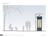
13A. [CONDITION ADDED BY STAFF] Install a new Citv standard bus shelter for the<br />
bus stor, located alonv the 500 block <strong>of</strong> northbound S Van Dorn & Pickett as shown<br />
on the prelim plan. Contact the Citv's Office <strong>of</strong> Transit Services to obtain the new<br />
<strong>City</strong> standard bus shelter detail and s~ecifications. Provide a ~ublic access<br />
easement for the bus shelter and bus shelter pad. Provide details on this bus shelter<br />
within the fmal site plan. (TkES)<br />
13B. [CONDITION ADDED BY STAFF] Install a bus sto~ bench for the bus stor, located<br />
along the 600 block <strong>of</strong> westbound Pickett & S Van Dorn Street. Provide details on<br />
this bench within the final site plan. The benches shall not be placed on the 7 foot bv<br />
8 foot land in^ pad. The bench detail shall be the Timberform Restoration Series<br />
manufactured bv Columbia Cascade or similar as ap~roved bv the Directors <strong>of</strong><br />
T&ES and P&Z. Bench seats shall be yellow cedar and the metal frames shall have<br />
a standard black, powdercoat finish. (T&ES)<br />
13C. [CONDITION ADDED BY STAFF] Ensure that the fiftv foot approach to all bus<br />
stops adiacent to the site have a minimum 12' clearance free from tree limbs, sims<br />
and anv other obstructions. (T&ES)<br />
13D. [CONDITION ADDED BY STAFF] Create a 120 foot "No Parking, Bus Stop Zone"<br />
if the bus stor, is located along the curbside. If the bus stop is located on a bulb out /<br />
extension into the roadwav, the 120 foot "No Parkinm Bus Sto~ Zonen shall not be<br />
required. (T&ES)<br />
13E. [CONDITION ADDED BY STAFF] Show all existinv bus stop adiacent to the site<br />
and pro~osed relocated or new bus stops with associated features, to include<br />
shelters, canodes, and benches in the vicinitv <strong>of</strong> the site on the final site plan. Any
DSLTP #20 1 1-0030<br />
<strong>Landmark</strong> <strong>Gateway</strong> Amendment<br />
proposed features shall be ADA compliant; all bus shelters shall include a bench,<br />
illumination (solar or electric), and the abilitv to accommodate future real time bus<br />
information LED screens and connections to the satisfaction <strong>of</strong> the Director <strong>of</strong><br />
T&ES. The final bus shelter, bus stop canopy, and bus stop bench design shall meet<br />
Citv standards and the approval <strong>of</strong> the Director <strong>of</strong> T&ES. (T&ES)<br />
14. [CONDITION DELETED BY STAFF]<br />
15. The following table sets forth the dimensions and elements for all street rights-<strong>of</strong>-ways<br />
and public access easements. All streets in the site as required herein shall be publicly<br />
dedicated streets/sidewalks or publicly accessible streets/sidewalks through the provision<br />
<strong>of</strong> a public access easement(s), and shall be consistent with the <strong>Landmark</strong>Nan Dom<br />
Corridor Plan. The applicant shall dedicate the streets as public streets or perpetual<br />
public access easements as required below, pursuant to the required timing herein. The<br />
applicant shall prepare all applicable deeds and a plat <strong>of</strong> dedication subject to the review<br />
and approval <strong>of</strong> the <strong>City</strong>. The deed and plat <strong>of</strong> dedication shall be recorded in the land<br />
records prior to release <strong>of</strong> the final site plan. The public use and access easement shall<br />
not obligate or require the <strong>City</strong> to construct or maintain the streets or sidewalks<br />
(maintenance shall be at the developer's sole cost and responsibility, including the<br />
responsibility for snow removal). The streets shall not be accepted for dedication until<br />
the completion <strong>of</strong> the project and determination by the <strong>City</strong> that the street complies with<br />
all applicable codes and standards. (P&Z) (T&ES) (DSUP 2006-0021)<br />
1 Van Dorn Street I 30 ft. I Dedicated Public right-<strong>of</strong>-way I<br />
1 Street A 1 60 ft. I Public Access Easement<br />
I Street B I 66 ft. I Public Access Easement I<br />
Street C 45 ft. / Dedicated Public right-<strong>of</strong>-way I<br />
16. The applicant shall be responsible for installation <strong>of</strong> all applicable streets signs prior to<br />
the issuance <strong>of</strong> the first certificate <strong>of</strong> occupancy permit. A detail <strong>of</strong> the proposed street<br />
signage shall be depicted on the final site plan and approved prior to the release <strong>of</strong> the<br />
final site plan. (P&Z) (DSUP 2006-002 1)
DSUP #20 1 1-0030<br />
<strong>Landmark</strong> <strong>Gateway</strong> Amendment<br />
A public access easement shall be provided for Street A and Street B and all sidewalks<br />
adjacent to these streets. The applicant shall notify prospective buyers in its marketing<br />
materials and homeowner documents that Street A and Street B are private streets with<br />
public access easements and shall not be maintained by the <strong>City</strong> <strong>of</strong> <strong>Alexandria</strong>. (P&Z)<br />
(T&ES) (DSUP 2006-002 1)<br />
The property thirty feet from the existing property line along Van Dorn Street shall be<br />
dedicated to the <strong>City</strong> for future improvements to Van Dorn Street. (P&Z) (T&ES)<br />
(DSUP 2006-002 1)<br />
The applicant shall explore providing a median, wide enough to support ornamental trees<br />
and shrubs and a pedestrian refuge, on Pickett Street from Van Dorn Street to beyond the<br />
first entrance into the development, subject to the following:<br />
a. Adequate WB-50 truck turning movements from northbound Van Dorn Street to<br />
eastbound Pickett Street without encroaching onto curbs or into the center lane <strong>of</strong><br />
northbound Van Dorn Street.<br />
b. Shifl the westbound lanes <strong>of</strong> Pickett Street to the north starting from existing<br />
stormdrain inlet #I 1 (to remain) to the first entrance to the east.<br />
c. Maintain a minimum 12 ft. lane width with 2 ft gutters for all lanes on Pickett<br />
Street.<br />
d. If it is determined that a median.can be provided that meets the above criteria, the<br />
applicant shall be responsible for the construction <strong>of</strong> the median. (P&Z) (T&ES)<br />
(DSUP 2006-002 1)<br />
All improvements to the <strong>City</strong>'s infrastructure shall be designed and constructed as per the<br />
<strong>City</strong> <strong>of</strong> <strong>Alexandria</strong> standards and specifications. (T&ES) (DSUP 2006-002 1)<br />
The applicant shall be responsible for construction~installation <strong>of</strong> missing or upgrading<br />
the existing public infrastructure, including but not limited, to streets, alleyways, sewers,<br />
street lighting, traffic and pedestrian signals, sidewalks, curb and gutter, and storm water<br />
drop inlet structures. (T&ES) (DSUP 2006-0021)<br />
All Traffic Control Device design plans, Work Zone Traffic Control plans, and Traffic<br />
Studies shall be signed and sealed by a pr<strong>of</strong>essional engineer, registered in the<br />
Commonwealth <strong>of</strong> Virginia. (T&ES) (DSUP 2006-002 1)<br />
Prior to the release <strong>of</strong> the final site plan, a Traffic Control Plan for construction detailing<br />
proposed controls to traffic movement, lane closures, construction entrances, haul routes,<br />
and storage and staging shall be provided for information purpose; however, an amended<br />
Traffic Control Plan, if required by the Director <strong>of</strong> Transportation and Environmental<br />
Services shall be submitted to the Director <strong>of</strong> T&ES along with the Building Permit<br />
Application. (T&ES) (DSUP 2006-0021)<br />
All private street signs that intersect a public street shall be marked with a fluorescent<br />
green strip to notify the plowing crews, both <strong>City</strong> and contractor, that they are not to plow<br />
those streets. (T&ES) (DSUP 2006-002 1)
DSUP #2011-0030<br />
<strong>Landmark</strong> <strong>Gateway</strong> Amendment<br />
25. The slope on parking ramps to garage entrances shall not exceed 12 percent. In case the<br />
slope varies between 10% and 12%, the applicant shall provide a trench drain connected<br />
to a storm sewer to eliminate or diminish the possibility <strong>of</strong> ice forming. (T&ES) (DSUP<br />
2006-002 1)<br />
26. Show turning movements <strong>of</strong> standard vehicles in the parking structure and parking lot.<br />
Show turning movements <strong>of</strong> delivery trucks for each loading dock. Turning movements<br />
shall meet AASHTO vehicular guidelines and shall be to the satisfaction <strong>of</strong> the Director<br />
<strong>of</strong> T&ES. (T&ES) (DSUP 2006-002 1)<br />
27. The applicant shall furnish and install two 4" conduits with pull wires, and junction boxes<br />
located at a maximum interval <strong>of</strong> 300 feet underneath the sidewalks on Van Dorn Street,<br />
Pickett Street, and Street C. These conduits shall terminate in an underground junction<br />
box at each <strong>of</strong> the four street corners <strong>of</strong> the site. The junction box cover shall have the<br />
word "TRAFFIC" engraved in it. (T&ES) (DSUP 2006-0021)<br />
E. OPEN SPACEIZANDSCAPING:<br />
28. The applicant shall develop, provide, install, and maintain an integrated Landscape Plan<br />
that is coordinated with other associated site conditions to the satisfaction <strong>of</strong> the Directors<br />
<strong>of</strong> P&Z, RP&CA, and T&ES. At a minimum the Landscape Plan shall:<br />
a. Provide an enhanced level <strong>of</strong> detail plantings throughout the site (in addition to<br />
street trees). Plantings shall include a simple mixture <strong>of</strong> seasonally variable,<br />
evergreen and deciduous shrubs, ornamental and shade trees, groundcovers and<br />
perennials that are horticulturally acclimatized to the Mid-Atlantic and<br />
Washington, DC National Capital Region.<br />
b. Ensure positive drainage in all planted areas.<br />
c. Provide detail, section and plan drawings <strong>of</strong> tree wells showing proposed<br />
plantings and associated materials, irrigation, adjacent curb/pavement<br />
construction, including edge restraint system, dimensions, drainage, and<br />
coordination with site utilities.<br />
d. Provide detail sections showing above and below grade conditions for plantings<br />
above structure. Applicant shall demonstrate that soil depth is a minimum <strong>of</strong> 4'<br />
per the <strong>City</strong> <strong>of</strong> <strong>Alexandria</strong> Landscape Guidelines.<br />
e. Provide planting details for all proposed conditions including street trees, multi-<br />
trunk trees, shrubs, perennials, and groundcovers. Details must comply with <strong>City</strong><br />
<strong>of</strong> <strong>Alexandria</strong> Landscape Guidelines. (P&Z)(RP&CA)(T&ES) (DSUP 2006-<br />
002 1)<br />
29. The following modifications to the landscape plan and supporting drawings are required:<br />
a. Plan shall be prepared and stamped by a landscape architect licensed to practice in<br />
the State <strong>of</strong> Virginia.<br />
b. Use industry standard symbology for depicting limits <strong>of</strong> garage such that garage<br />
limits can be seen when building lines overlap.<br />
c. All grass shall be sod.
DSUP #20 1 1-0030<br />
<strong>Landmark</strong> <strong>Gateway</strong> Amendment<br />
d. Provide individual detail drawings at a scale <strong>of</strong> 1" = 10' <strong>of</strong> the elevated courtyards<br />
and Street "A" plaza.<br />
e. Provide a solid row <strong>of</strong> evergreen trees in the 8 ft. wide planter along the northern<br />
property line, or some other design solution as approved by the Directors <strong>of</strong> P&Z<br />
and RP&CA, to screen the development from the adjacent commercial<br />
development as an interim condition. (P&Z) (RP&CA) (DSUP 2006-0021)<br />
0. The applicant shall provide 25% crown coverage, as depicted in Attachment #3, and shall<br />
include the following information on the final site plan:<br />
a. Provide an exhibit that demonstrates the site area before and after ROW<br />
dedication.<br />
b. Applicant shall provide large shade street trees along all ROW, including Van<br />
Dorn Street, Pickett Street, and proposed Street C.<br />
c. Street trees shall not be counted toward crown coverage on public streets.<br />
(RP&CA) (DSUP 2006-002 1)<br />
3 1. The central plaza between Buildings 1 and 3 shall be designed to function as high-quality<br />
publicly accessible open space and shall provide the level <strong>of</strong> detail and amenities<br />
depicted on the preliminary landscape plan. Amenities such as special paving surfaces,<br />
materials, benches, trash receptacles, landscaping, etc. shall also be provided to<br />
encourage its use. The plaza shall be complete prior to issuance <strong>of</strong> the final certificate <strong>of</strong><br />
occupancy for Building 1 or 3, whichever is later, and shall include the following<br />
improvements and amenities, to the satisfaction <strong>of</strong> the Directors <strong>of</strong> P&Z and RP&CA:<br />
a. Incorporate a public art element such as incising designs or quotes into the private<br />
sidewalk that is appropriate for the scale <strong>of</strong> the space into the central plaza or<br />
adjacent private sidewalks to the satisfaction <strong>of</strong> the Directors <strong>of</strong> P&Z and<br />
RP&CA. Maintenance <strong>of</strong> the public art element shall be the responsibility <strong>of</strong> the<br />
developerlproperty owner.<br />
b. All landscaping shall be maintained in good condition and replaced as needed.<br />
c. Low scale pathway or bollard lighting. (P&Z) (RP&CA) (DSUP 2006-0021)<br />
The courtyards for Buildings 1 and 2 shall be complete prior to the issuance <strong>of</strong> the final<br />
certificate <strong>of</strong> occupancy for each building and shall include the following improvements<br />
and amenities, to the satisfaction <strong>of</strong> the Directors <strong>of</strong> P&Z and RP&CA, prior to final site<br />
plan approval:<br />
a. Revise the design <strong>of</strong> the courtyard for Building 2 on the site plan to be consistent<br />
with the design shown in the revised landscape plans dated December 10, 2008.<br />
Additionally, explore integrating the landscape design with the street and building<br />
design, incorporating garden walls, pavers, construction materials and<br />
landscaping as part <strong>of</strong> the overall design. (P&Z) (RP&CA) (DSUP 2006-002 1)<br />
33. Provide a site irrigationlwater management plan developed installed and maintained to<br />
the satisfaction <strong>of</strong> the Directors <strong>of</strong> RP&CA and Code Administration.<br />
a. Plan shall demonstrate that all parts <strong>of</strong> the site can be accessed by a combination<br />
<strong>of</strong> building mounted hose bibs and ground set hose connections.
DSUP #20 1 1-0030<br />
<strong>Landmark</strong> <strong>Gateway</strong> Amendment<br />
b. Provide external water hose bibs continuous at perimeter <strong>of</strong> building. Provide at<br />
least one accessible external water hose bib on all building sides at a maximum<br />
spacing <strong>of</strong> 90 feet apart. Provide an exhibit demonstrating accessible water<br />
coverage including hose bib locations and 90' hose access radii.<br />
c. Hose bibs and ground set water connections must be fully accessible and not<br />
blocked by plantings, site utilities or other obstructions.<br />
d. All lines beneath paved surfaces shall be installed as sleeved connections. (Code<br />
Administration) (RP&CA) (DSUP 2006-0021)<br />
34. Provide an exhibit that demonstrates open space requirements and provide a narrative that<br />
demonstrates compliance with Open Space intentions <strong>of</strong> the <strong>Landmark</strong> Van Dorn<br />
Corridor Plan. (RP&CA) (DSUP 2006-0021)<br />
Continue to work with staff to develop a palette <strong>of</strong> site furnishings that is generally<br />
consistent with the Preliminary Plan submission.<br />
a. Provide location and specification for site furnishings that depicts the scale,<br />
massing and character <strong>of</strong> site furnishings.<br />
b. Site furnishings shall include benches, bicycle racks, trash receptacles, drinking<br />
fountains and other associated features and be developed to the satisfaction <strong>of</strong> the<br />
Directors <strong>of</strong> RP&CA, P&Z, and T&ES. (RP&CA)(P&Z)(T&ES) (DSUP 2006-<br />
002 1)<br />
36. Provide material, finishes, and architectural details for all retaining walls, seat walls,<br />
decorative walls, and screen walls. Indicate methods for grade transitions, handrails- if<br />
required by code, directional changes, above and below grade conditions. Coordinate<br />
with adjacent conditions. Design and construction <strong>of</strong> all walls shall be to the satisfaction<br />
<strong>of</strong> the Directors <strong>of</strong> RP&CA, P&Z, and T&ES. (RP&CA)(P&Z)(T&ES) (DSUP 2006-<br />
002 1)<br />
37. The applicant shall work with staff to explore opportunities to integrate aspects <strong>of</strong> the<br />
historic character <strong>of</strong> the property into the design <strong>of</strong> open space and provide and erect<br />
interpretive signage that highlights the history and archaeology <strong>of</strong> the project area. The<br />
open space design and the text and graphics for the signage shall be completed prior to<br />
release <strong>of</strong> the final site plan and shall be subject to approval by the Office <strong>of</strong> Historic<br />
<strong>Alexandria</strong>I<strong>Alexandria</strong> Archaeology, P&Z and RP&CA. (Archaeology)(P&Z)(RP&CA)<br />
(DSUP 2006-002 1)<br />
F. SITE PLAN:<br />
38. The plat <strong>of</strong> consolidation and subdivision and all applicable easements and dedications<br />
shall be submitted as part <strong>of</strong> the submission for first final site plan and shall be approved<br />
and recorded prior to the release <strong>of</strong> the final site plan. (P&Z) (DSUP 2006-0021)<br />
39. Coordinate location <strong>of</strong> above and below grade site utilities with other site conditions to<br />
the satisfaction <strong>of</strong> the Directors <strong>of</strong> RP&CA, P&Z, and T&ES. These items include:
DSUP #20 11-0030<br />
<strong>Landmark</strong> <strong>Gateway</strong> Amendment<br />
a. Location <strong>of</strong> site utilities including above grade service openings and required<br />
clearances for items such as transformers, telephone, HVAC units and cable<br />
boxes.<br />
b. Minimize conflicts with plantings, pedestrian areas and major view sheds.<br />
c. Do not locate above grade utilities in dedicated open space areas.<br />
d. All new electrical transformers shall be placed underground in vaults or within the<br />
building footprint which meet Virginia Power standards. These vaults may be<br />
placed in private streets, driveways or within the building envelope. Ventilation<br />
grates may not be located within public sidewalks or streets. The covers for the<br />
vaults shall match the material <strong>of</strong> the adjoining sidewalk and the grates, which<br />
shall be ADA compliant shall be located to minimize impacts on the pedestrian<br />
walkways to the greatest extent feasible to the satisfaction <strong>of</strong> the Directors <strong>of</strong><br />
TE&S and P&Z. (RP&CA)(P&Z)(T&ES) (DSUP 2006-002 1)<br />
40. All private utilities shall be located outside <strong>of</strong> the public right-<strong>of</strong>-way and public utility<br />
easements; however, the installation <strong>of</strong> below grade transformers and storm water<br />
management facilities in Private Street B shall be permitted to the satisfaction <strong>of</strong><br />
Dominion Virginia Power and the Director <strong>of</strong> Transportation and Environmental<br />
Services. (T&ES) (DSUP 2006-002 1)<br />
41. All the existing and proposed public and private utilities and easements shall be shown on<br />
the plan and a descriptive narration <strong>of</strong> various utilities shall be provided. (T&ES) (DSUP<br />
2006-002 1)<br />
42. Applicant shall underground all the secondary utility services serving the site and the cost<br />
<strong>of</strong> such undergrounding shall be the sole responsibility <strong>of</strong> the developer. (P&Z) (T&ES)<br />
(DSUP 2006-002 1)<br />
43. Provide a lighting plan with the final site plan to verify that lighting meets <strong>City</strong> standards.<br />
The plan shall be to the satisfaction <strong>of</strong> the Directors <strong>of</strong> T&ES, P&Z, and RP&CA in<br />
consultation with the Chief <strong>of</strong> Police and shall include the following:<br />
a. Clearly show location <strong>of</strong> all existing and proposed street lights and site lights,<br />
shading back less relevant information;<br />
b. A lighting schedule that identifies each type and number <strong>of</strong> all fixtures, mounting<br />
height, and strength <strong>of</strong> fixture in Lumens or Watts;<br />
c. Manufacturer's specifications and details for all proposed fixtures; and<br />
d. A photometric plan with lighting calculations that include all existing and<br />
proposed light fixtures, including any existing street lights located on the opposite<br />
side(s) <strong>of</strong> all adjacent streets. Photometric calculations must extend from<br />
proposed building face(s) to the opposite side(s) <strong>of</strong> all adjacent streets and/or 20<br />
feet beyond the property line on all adjacent properties.<br />
e. The walls and ceiling in the garage shall be painted white, <strong>of</strong>f-white or dyed<br />
concrete (white) to increase reflectivity and improve light levels at night. The<br />
fixtures should not be flush against the ceiling, unless there are no cross beams,<br />
but should hang down at least to the crossbeam to provide as much light spread as<br />
possible.
DSUP #2011-0030<br />
<strong>Landmark</strong> <strong>Gateway</strong> Amendment<br />
f. The lighting for the areas not covered by the <strong>City</strong> <strong>of</strong> <strong>Alexandria</strong> standards shall be<br />
designed to the satisfaction <strong>of</strong> Directors <strong>of</strong> T&ES and P&Z.<br />
g. Provide numeric summary for various areas (i.e. roadway, walkway/sidewalk,<br />
alley, and parking lot, etc.) in the proposed development.<br />
h. Detail information indicating proposed light pole and footing in relationship to<br />
adjacent grade or pavement. All light pole foundations shall be concealed from<br />
view.<br />
i. The site lighting plan shall be coordinated with architectural/building mounted<br />
lights, site lighting, street trees and street lights and minimize light spill into<br />
adjacent residential areas.<br />
j. Provide location <strong>of</strong> conduit routing between site lighting fixtures. Locate to avoid<br />
conflicts with street trees.<br />
k. Full cut-<strong>of</strong>f lighting shall be used at the development site to prevent light spill<br />
onto adjacent properties. (P&Z)(T&ES)(Police)(RP&CA) (DSUP 2006-0021)<br />
44. All condominium association covenants and/or rentalllease agreements shall be reviewed<br />
by the Director <strong>of</strong> P&Z and the <strong>City</strong> Attorney to ensure inclusion <strong>of</strong> all the conditions <strong>of</strong><br />
this DSUP prior to applying for the first certificate <strong>of</strong> occupancy permit for the project.<br />
The association covenants and/or rentalllease agreements shall include the conditions<br />
listed below, which shall be clearly expressed in a separate section <strong>of</strong> the<br />
covenants/agreements. The language shall establish and clearly explain that these<br />
conditions cannot be changed except by an amendment to this development special use<br />
permit approved by <strong>City</strong> Council.<br />
a. The principal use <strong>of</strong> the underground garage and parking spaces shall be for<br />
passenger vehicle parking only; storage which interferes with the use <strong>of</strong> a parking<br />
space for a motor vehicle is not permitted.<br />
b. The designated visitor parking spaces shall be reserved for the use <strong>of</strong> the guests,<br />
as provided in the shared parking study.<br />
c. All landscaping and open space areas within the development shall be maintained<br />
by the owners.<br />
d. Exterior building improvements or changes by future residents shall require the<br />
approval <strong>of</strong> the <strong>City</strong> Council, as determined by the Director <strong>of</strong> P&Z.<br />
e. The developer shall present a disclosure statement to all renters, and/or<br />
condominium owners signed prior to signing any lease or contract <strong>of</strong> purchase.<br />
The statement shall disclose the following: that the site is located within the heart<br />
<strong>of</strong> an urban area and proximate to the Metrorail track and other railway<br />
operations, the Capital Beltway and adjacent commercial and industrial uses.<br />
These uses could continue indefinitely and will generate noise, and heavy truck<br />
and vehicular traffic surrounding the project.<br />
f. The specific language <strong>of</strong> the disclosure statement to be utilized shall be provided<br />
- -<br />
to th; <strong>City</strong> for approval prior to release <strong>of</strong> any certificate <strong>of</strong> occupancy permit.<br />
(P&Z) (DSUP 2006-002 1)<br />
45. The applicant shall submit a unit numbering plan for each floor, identifying the locations<br />
<strong>of</strong> commercial and residential uses, with the first final site plan. (P&Z) (DSUP 2006-<br />
002 1)
G. SZGNAGE:<br />
DSUP #20 1 1-0030<br />
<strong>Landmark</strong> <strong>Gateway</strong> Amendment<br />
46. The colors and materials <strong>of</strong> the retail tenant signs shall be designed <strong>of</strong> high quality<br />
materials and shall be designed as an integral part <strong>of</strong> the building that shall relate in<br />
materials, color and scale to the remainder <strong>of</strong> the building and to the retail bay on which<br />
it is displayed to the satisfaction <strong>of</strong> the Director <strong>of</strong> P&Z and shall comply with applicable<br />
codes and ordinances as well as the following guidelines:<br />
a. Each retail tenant shall install a minimum <strong>of</strong> one sign for each storefront facade<br />
appropriate to the scale <strong>of</strong> each facade. In addition, each retail tenant shall<br />
provide a second pedestrian-oriented sign such as a projecting sign, blade sign or<br />
window sign.<br />
b. Retail tenants shall be allowed a maximum <strong>of</strong> 1 sf <strong>of</strong> sign area per linear foot <strong>of</strong><br />
tenant storefront or 50 sf <strong>of</strong> signage, whichever is greater.<br />
c. Retail signs shall be limited to a maximum height <strong>of</strong> 18 feet above the grade <strong>of</strong><br />
the adjoining sidewalk. The Director <strong>of</strong> P&Z may permit signage above 18 feet<br />
above the grade <strong>of</strong> the adjoining sidewalk and the signage may be illuminated<br />
provided that the illumination does not have an adverse impact on adjoining<br />
residential uses or roadways.<br />
d. Awnings shall be permitted to project up to four feet from the building; greater<br />
projections require approval <strong>of</strong> the Director <strong>of</strong> P&Z. Greater projections which<br />
encroach into the public street may require <strong>City</strong> Council approval <strong>of</strong> an<br />
encroachment.<br />
e. Signs projecting over the sidewalk shall be a minimum <strong>of</strong> eight feet (8') above the<br />
sidewalk.<br />
f. Signage shall be located to not obscure architectural design elements such as<br />
projections, cornices, or change <strong>of</strong> building material or pattern.<br />
Awnings<br />
g. Awnings, when projecting from the face <strong>of</strong> the building, shall allow a clearance <strong>of</strong><br />
9 ft. from the grade <strong>of</strong> the adjoining sidewalk.<br />
h. Fixed lightweight metal and glass structures are acceptable.<br />
i. Awning or canopy material shall be a woven fabric or other material that projects<br />
the natural material <strong>of</strong> canvas, metal, glass etc.<br />
Materials - Construction<br />
j. Neon signs will be considered based on creativity and the overall compatibility<br />
and character <strong>of</strong> the tenant storefront design.<br />
k. All methods <strong>of</strong> attachment including fasteners, mounting brackets and other<br />
mechanisms must be concealed from view.<br />
1. Letters and graphics mounted directly onto building facades shall be pin mounted<br />
at least 2 inches from the surface onto which the sign is mounted and provide<br />
dimensional returns.<br />
illumination- Lighting<br />
m. Back-lit, halo-lit illumination or reverse channel letters with halo illumination are<br />
encouraged.
DSUP #2011-0030<br />
<strong>Landmark</strong> <strong>Gateway</strong> Amendment<br />
n. Projecting signs may be internally illuminated if approved by the Director <strong>of</strong><br />
P&Z. Externally illuminated projecting signs shall have lighting fixtures that are<br />
complementary and integrated into the storefront design.<br />
o. Blade signs shall be externally illuminated with decorative bracketed lighting<br />
complimentary to the storefront.<br />
p. In general, lighting should be designed and located to accommodate public safety<br />
without creating glare or excessively high light levels. Fixtures should be chosen<br />
to control light trespass either vertically (toward the sky) or horizontally onto<br />
neighboring properties.<br />
q. High pressure sodium vapor (yellow orange) lighting is prohibited for exterior use<br />
including buildings, parking facilities, service areas, signage, etc. Such lighting is<br />
also prohibited inside parking garages or building entries where it would be<br />
visible from the outside.<br />
r. For any building or project, exterior light fixtures - their design, size, finish,<br />
location, etc. - should be compatible with, and appropriate for, the building<br />
architecture, materials and colors.<br />
Parking Signage<br />
s. All parking signage shall be a blue background with white letters. The channel<br />
letter parking signs shall be blue with a white border. The signs shall be circular<br />
and shall not include the project logo but rather limited to a "P" for public parking<br />
or public parking or a combination there<strong>of</strong>.<br />
Prohibited Signs<br />
t. Box signs and signs employing flickering rotating or moving lights andlor signs<br />
painted directly on the storefront other than window graphics.<br />
u. Flat panel signs and external raceways.<br />
v. All window coverings shall be open as much as possible and provide some<br />
interior accent lighting when the business is closed.<br />
w. Freestanding signs other than traffic/directional and wayfinding signs shall be<br />
prohibited.<br />
x. All banners relating to commercial promotions, leasing, hiring or advertising are<br />
prohibited, except for contractor signage as allowed by the Zoning Ordinance.<br />
Processing - Review<br />
y. Each tenant proceeding with permitting and/or fabrication tenants shall submit<br />
detailed drawings and samples to be approved by the Department <strong>of</strong> P&Z.<br />
General<br />
z. The sign on the drum <strong>of</strong> Building 3 at the corner <strong>of</strong> Van Dorn and Pickett, which<br />
projects above the ro<strong>of</strong>line, shall be permitted provided that the sign shall not be<br />
illuminated between the hours <strong>of</strong> 10:30 p.m. and 6:30 a.m., seven days per week,<br />
unless it can be demonstrated that the impact <strong>of</strong> the illumination <strong>of</strong> the sign on the<br />
adjacent residential uses during these hours will be minimized as approved by the<br />
Director <strong>of</strong> P&Z. The sign shall be metal and shall project from the drum <strong>of</strong> the<br />
building and shall be consistent with the "industrial" design <strong>of</strong> the building.<br />
aa. A project logo may be provided within the design <strong>of</strong> each <strong>of</strong> the signs to the<br />
satisfaction <strong>of</strong> the Director <strong>of</strong> P&Z.<br />
bb. The size and shape and colors <strong>of</strong> directional signs shall be consistent with the<br />
<strong>City</strong>'s way-finding program. (P&Z) (DSUP 2006-002 1)
DSUP #2011-0030<br />
<strong>Landmark</strong> <strong>Gateway</strong> Amendment<br />
47. All retail storefronts shall have their own storefronts as a way to express their individual<br />
identity provided that they comply with the following to the satisfaction <strong>of</strong> the Director <strong>of</strong><br />
P&Z.<br />
a. Storefronts shall provide an "individual" expression.<br />
b. Tenants shall avoid formulaic representations <strong>of</strong> their identity and create an<br />
expression that is complimentary to the architectural vocabulary <strong>of</strong> the project.<br />
c. Door placement shall provide a direct connection to the adjoining sidewalks and<br />
streets.<br />
d. Restaurants are encouraged to have operable (vertically or horizontally) movable<br />
store systems such as accordion system.<br />
e. Storefronts shall be predominantly glass, but glass shall not be the exclusive<br />
material.<br />
f. Opaque, reflective glass or comparable is prohibited. (P&Z) (DSUP 2006-0021)<br />
48. A freestanding subdivision or development sign shall be prohibited. (P&Z) (DSUP 2006-<br />
002 1 )<br />
49. A temporary informational sign shall be installed on the site prior to the approval <strong>of</strong> the<br />
final site plan for the project and shall be displayed until construction is complete or<br />
replaced with a marketing sign incorporating the required information; the sign shall<br />
notify the public <strong>of</strong> the nature <strong>of</strong> the upcoming project and shall provide a phone number<br />
for public questions regarding the project. (P&Z)(T&ES) (DSUP 2006-0021)<br />
50. All public notice signage erected by the applicant prior to the public hearing(s) shall be<br />
removed within 10 days <strong>of</strong> the completion <strong>of</strong> the public hearing process for the project.<br />
(P&Z) (DSUP 2006-002 1)<br />
50A. [CONDITION ADDED BY STAFF] Surface-installed storm water Best<br />
Management Practice (BMP) measures, i.e. Bio-Retention Filters, Tree Box Filters,<br />
Vegetated Swales, etc. that are emploved for this site, reauire installation <strong>of</strong><br />
descriptive signage to the satisfaction <strong>of</strong> the Director <strong>of</strong> T&ES. (T&ES)<br />
H. CONSTRUCTION/DE WLOPMENT PHASING:<br />
51. The applicant shall identify a person who will serve as a liaison to the community<br />
throughout the duration <strong>of</strong> construction. The name and telephone number, including an<br />
emergency contact number, <strong>of</strong> this individual, shall be provided in writing to residents,<br />
property managers, and business owners whose property abuts the site, and shall be<br />
placed on the project sign, to the Directors <strong>of</strong> P&Z, RP&CA and T&ES.<br />
(P&Z)(T&ES)(RP&CA) (DSUP 2006-0021)<br />
52. The applicant shall submit a detailed phasing and construction management plan for<br />
review and approval by the Directors <strong>of</strong> P&Z, T&ES and Code Administration with the<br />
submission <strong>of</strong> the first final site plan. At a minimum, the plan shall include the<br />
following:
DSUP #2011-0030<br />
<strong>Landmark</strong> <strong>Gateway</strong> Amendment<br />
Phase I<br />
a. The limits <strong>of</strong> Phase I development shall be revised to include the proposed new<br />
sidewalk and street trees along South Pickett Street from Street B to the eastern<br />
property line.<br />
Phase N<br />
b. During Phase I1 <strong>of</strong> the development, as the design proceeds, a limited amount <strong>of</strong><br />
street dedication may be required to the <strong>City</strong> to accommodate the future north-<br />
south road, per the <strong>Landmark</strong>Ivan Dorn Corridor Area Plan.<br />
c. Within 6 months <strong>of</strong> ceasing to use the area <strong>of</strong> Phase I1 for construction staging,<br />
the developer shall remove all construction related materials, grade the site and<br />
seed or sod the area so that it is usable for passive recreational use by the residents<br />
<strong>of</strong> the buildings constructed in Phase I until development <strong>of</strong> Phase I1 occurs. The<br />
property may be temporarily fenced with decorative fencing. Chain link fence<br />
shall not be permitted.<br />
General<br />
d. Designate a location for <strong>of</strong>f-street parking for all construction employees during<br />
all stages <strong>of</strong> construction, provided at no cost for the employee and may include<br />
applicable provisions such as shuttles or other methods deemed necessary by the<br />
<strong>City</strong>;<br />
e. Include a plan for temporary pedestrian and vehicular circulation;<br />
f. Include the overall schedule for construction and the hauling route;<br />
g. Copies <strong>of</strong> the plan shall be posted in the construction trailer and given to each<br />
subcontractor before they commence work;<br />
h. If the plan is found to be violated during the course <strong>of</strong> construction, citations will<br />
be issued for each infraction and a correction notice will be forwarded to the<br />
applicant. If the violation is not corrected within five (5) calendar days, a "stop<br />
work order" will be issued, with construction halted until the violation has been<br />
corrected. (P&Z)(T&ES)(Code) (DSUP 2006-002 1)<br />
53. Submit an approvable construction phasing plan to the satisfaction <strong>of</strong> the Director <strong>of</strong><br />
T&ES, which will allow review, approval and partial release <strong>of</strong> final the site plan. In<br />
addition, building and construction permits required for site preconstruction shall be<br />
permitted prior to release <strong>of</strong> the final site plan to the satisfaction <strong>of</strong> the Direction <strong>of</strong><br />
T&ES. (T&ES) (DSUP 2006-0021)<br />
54. No major construction staging shall be allowed along South Van Dorn Street and South<br />
Pickett Street. The Applicant shall meet with T&ES to discuss construction staging<br />
activities prior to release <strong>of</strong> any permits for ground disturbing activities. (T&ES) (DSUP<br />
2006-002 1)<br />
55. The sidewalks along South Van Dorn Street and South Pickett shall remain open during<br />
construction or pedestrian access shall be maintained to the satisfaction <strong>of</strong> the Director <strong>of</strong><br />
Transportation and Environmental Services throughout the construction <strong>of</strong> the project.<br />
(T&ES) (DSUP 2006-0021)
DSUP #2011-0030<br />
<strong>Landmark</strong> <strong>Gateway</strong> Amendment<br />
56. Prior to commencing clearing and grading <strong>of</strong> the site, the applicant shall hold a meeting<br />
with notice to all adjoining property owners and civic associations to review the location<br />
<strong>of</strong> construction worker parking, plan for temporary pedestrian and vehicular circulation,<br />
and hours and overall schedule for construction. The Departments <strong>of</strong> P&Z and T&ES<br />
shall be notified <strong>of</strong> the date <strong>of</strong> the meeting before the permit is issued. (P&Z)(T&ES)<br />
(DSUP 2006-0021)<br />
57. A pre-construction walk/survey <strong>of</strong> the site shall occur with Construction and Inspection<br />
Staff to document existing conditions prior to any land disturbing activity. If the curb,<br />
gutter, and side walk adjacent to the proposed development are damaged during<br />
construction then the applicant shall repair the same to the satisfaction <strong>of</strong> Director,<br />
Transportation and Environmental Services (T&ES). (T&ES) (DSUP 2006-002 1 )<br />
58. A "Certified Land Disturber" (CLD) shall be named in a letter to the Division Chief <strong>of</strong><br />
C&I prior to any land disturbing activities. If the CLD changes during the project, that<br />
change must be noted in a letter to the Division Chief. A note to this effect shall be<br />
placed on the Phase I Erosion and Sediment Control sheets on the site plan. (T&ES)<br />
(DSUP 2006-002 1)<br />
59. During the construction phase <strong>of</strong> this development, the site developer, their contractor,<br />
certified land disturber, or owners' other agent shall implement a waste and refuse control<br />
program. This program shall control wastes such as discarded building materials,<br />
concrete truck washout, chemicals, litter or trash, trash generated by construction workers<br />
or mobile food vendor businesses serving them, and all sanitary waste at the construction<br />
site and prevent <strong>of</strong>fsite migration that may cause adverse impacts to neighboring<br />
properties or to the environment to the satisfaction <strong>of</strong> Directors <strong>of</strong> T&ES and Code<br />
Administration. All wastes shall be properly disposed <strong>of</strong>fsite in accordance with all<br />
applicable federal, state and local laws. (T&ES) (DSUP 2006-0021)<br />
60. Temporary construction and sales trailer(s) shall be permitted and be subject to the<br />
approval <strong>of</strong> the Director <strong>of</strong> P&Z. The trailer(s) shall be removed prior to the issuance <strong>of</strong><br />
a certificate <strong>of</strong> occupancy permit for the building. (P&Z) (DSUP 2006-0021)<br />
61. The applicant shall submit a wall check to the Department <strong>of</strong> P&Z prior to the<br />
commencement <strong>of</strong> framing for the building(s). The wall check shall include the building<br />
footprint, as depicted in the approved final site plan, the top-<strong>of</strong>-slab elevation and the first<br />
floor elevation. The wall check shall be prepared and sealed by a registered engineer or<br />
surveyor, and shall be approved by the <strong>City</strong> prior to commencement <strong>of</strong> framing. (P&Z)<br />
(DSUP 2006-0021)<br />
62. As part <strong>of</strong> the request for a certificate <strong>of</strong> occupancy permit, the applicant shall submit a<br />
height certification and a location survey for all site improvements to the Department <strong>of</strong><br />
P&Z. The height certification and the location survey shall be prepared and sealed by a<br />
registered architect, engineer, or surveyor. The height certification shall state that the<br />
height was calculated based on all applicable provisions <strong>of</strong> the Zoning Ordinance. (P&Z)<br />
(DSUP 2006-0021)
PARKING:<br />
DSUP #20 I 1-0030<br />
<strong>Landmark</strong> <strong>Gateway</strong> Amendment<br />
A maximum <strong>of</strong> 739 parking spaces may be located in the underground garage for<br />
residents and retail per the <strong>Landmark</strong> / Van Dorn Corridor Plan. (P&Z) (DSUP 2006-<br />
002 1)<br />
The applicant shall provide controlled access into the underground garage. The controlled<br />
access to the garage shall be designed to allow convenient access to the underground<br />
parking for residents. (P&Z) (DSUP 2006-002 1)<br />
The applicant shall explore designing above and below grade parking facilities to<br />
accommodate future electric vehicles. (P&Z) (DSUP 2006-002 1)<br />
The applicant shall provide <strong>of</strong>f-street parking for all construction workers without charge.<br />
For the construction workers who use Metro, DASH, or another form <strong>of</strong> mass transit to<br />
the site, the applicant shall subsidize a minimum <strong>of</strong> 50% <strong>of</strong> the fees for mass transit.<br />
Compliance with this condition shall be based on a plan, which shall be submitted to the<br />
Department <strong>of</strong> P&Z and T&ES prior to the issuance <strong>of</strong> the ExcavatiodSheeting, and<br />
Shoring Permit. This plan shall:<br />
a. Establish the location <strong>of</strong> the parking to be provided at various stages <strong>of</strong><br />
construction, how many spaces will be provided, how many construction workers<br />
will be assigned to the work site, and mechanisms which will be used to<br />
encourage the use <strong>of</strong> mass transit.<br />
b. Provide for the location on the construction site at which information will be<br />
posted regarding Metro schedules and routes, bus schedules and routes.<br />
c. If the plan is found to be violated during the course <strong>of</strong> construction, a correction<br />
notice will be issued to the developer. If the violation is not corrected within ten<br />
(10) days, a "stop work order" will be issued, with construction halted until the<br />
violation has been corrected. (P&Z)(T&ES) (DSUP 2006-002 1)<br />
TRANSPOR TATION MANAGEMENT PLAN..<br />
The applicant is advised that a Transportation Management Plan Special Use Permit is<br />
required for the proposed development in pursuant to the provisions <strong>of</strong> 11-700 <strong>of</strong> the<br />
Zoning Ordinance based on the fact that the project is proposing 250 or more residential<br />
units. A Transportation Management Plan (TMP) is required to implement transportation<br />
strategies to lower the percentage <strong>of</strong> single occupant vehicles. The details <strong>of</strong> the Plan are<br />
included in Attachment #4. Below are the basic conditions from which other details<br />
originate. (T&ES) (DSUP 2006-0021)<br />
Any special use permit granted by <strong>City</strong> Council under this section 1 1-700, unless revoked<br />
or expired, shall run with the land and shall be mandatory and binding upon the applicant,<br />
all owners <strong>of</strong> the land and all occupants and upon all <strong>of</strong> their heirs, successors and<br />
assigns. Any use authorized by a special use permit granted under this section 11-700<br />
shall be operated in conformity with such permit, and failure to so operate shall be
DSUP #20 1 1-0030<br />
<strong>Landmark</strong> <strong>Gateway</strong> Amendment<br />
deemed grounds for revocation <strong>of</strong> such permit, after notice and hearing, by the city<br />
council. (T&ES) (DSUP 2006-002 1)<br />
69. Prior to any 'leaselpurchase agreements, the applicant shall prepare appropriate language<br />
to inform tenantslowners <strong>of</strong> the transportation management plan special use permit and<br />
conditions therein, as part <strong>of</strong> its leasinglpurchasing agreements; such language to be<br />
reviewed and approved by the <strong>City</strong> Attorney's <strong>of</strong>fice. (T&ES) (DSUP 2006-0021)<br />
70. <strong>Landmark</strong> <strong>Gateway</strong> shall integrate into the District Transit Management Program when it<br />
is organized. All TMP holders in the LandmarldVan Dorn Corridor Metro area will be<br />
part <strong>of</strong> this District. The objective <strong>of</strong> this district is to make optimum use <strong>of</strong><br />
transportation resources for the benefit <strong>of</strong> residents and employees through economies <strong>of</strong><br />
scale. (T&ES) (DSUP 2006-002 1)<br />
71. [CONDITION AMENDED BY STAFF] An annual TMP fund shall be created, based<br />
on the TMP reduction goal <strong>of</strong> 3022% <strong>of</strong> people not using single occupant vehicles<br />
during the peak hour, established for <strong>Landmark</strong> <strong>Gateway</strong>, based on the project's size<br />
and the benefits to be <strong>of</strong>fered to participating residents. The rate to be charged for this<br />
development shall be $8060 per occupied residential unit and $0.239 per leased square<br />
. .<br />
foot for Phase I <strong>of</strong> the <strong>Landmark</strong>Ivan Dorn Corridor Plan. P<br />
C13<br />
9<br />
Annually, to begin one year after the initial<br />
Certificate <strong>of</strong> Occupancy is issued, the rate shall increase by an amount equal to the rate<br />
<strong>of</strong> inflation in the Consumer Price Index (CPI) <strong>of</strong> the United States for the previous year,<br />
The TMP fund shall be used<br />
exclusively for the approved transportation activities detailed in Attachment #4. (T&ES)<br />
(DSUP 2006-0021)<br />
7.<br />
71A. [CONDITION ADDED BY STAFF] A TMP Coordinator shall be designated for the<br />
entire proiect upon application for the initial building permit. The name, location,<br />
email and telephone number <strong>of</strong> the coordinator will be provided to the Citv at that<br />
time. as well as anv changes occurring subsequentlv. This person will be responsible<br />
for implementing and managing all aspects <strong>of</strong> the TMP and the parking<br />
management program for the proiect. **(T&ES)<br />
71B. [CONDITION ADDED BY STAFF] The TMP Coordinator or Association will<br />
submit annual reports, fund reports and modes <strong>of</strong> transportation surveys to the<br />
Transportation Planning Division as detailed in the Attachment. (T&ES)<br />
71C. [CONDITION ADDED BY STAFF] The applicant shall participate in the revised<br />
Transportation Management Program if established. The revised program will<br />
include the elements outlined in the December 8,2010 docket memo to Citv Council<br />
and approved bv the Council. The revision to the program includes a periodic<br />
review <strong>of</strong> the TMP to determine if goals are being met and will provide an<br />
opportunitv to adiust the rates up or down up to a percentage cap. The revised<br />
TMP program will go before the Citv Council for approval. Participation in the
DSUP #20 1 1-0030<br />
<strong>Landmark</strong> <strong>Gateway</strong> Amendment<br />
program will not initiallv increase the base contribution established in this SUP,<br />
however, the base contribution would be subject to adjustment up or down, up to a<br />
percentape cap, based on the final revised TMP propram language to be ap~roved<br />
bv <strong>City</strong> Council at a future date. (T&ES)<br />
71D. [CONDITION ADDED BY STAFF] An administrative fee shall be assessed to the<br />
governing enti* for lack <strong>of</strong> timely compliance with the submission <strong>of</strong> the TMP<br />
mandatorv reports required in the attachment Cfund reports with supporting<br />
documentation, annual reports, suwev results with a minimum response rate <strong>of</strong><br />
SO%, and submission <strong>of</strong> raw data). The fee shall be in the amount <strong>of</strong> five hundred<br />
($500.00) for the first 30 (thirw) days late and two hundred and fiftv dollars<br />
($250.00) for everv subsequent month late. The amount <strong>of</strong> these administrative fees<br />
is for the base vear in which the TMP is apuroved and shall increase according to<br />
the Consumer Price Index (CPI) going forward. (T&ES)<br />
72. The Director <strong>of</strong> T&ES may require that the funds be paid to the <strong>City</strong> upon determination<br />
that the TMP Association has not made a reasonable effort to use the funds for TMP<br />
activities. As so determined, any unencumbered funds remaining in the TMP account at<br />
the end <strong>of</strong> each reporting year may be either reprogrammed for TMP activities during the<br />
ensuing year or paid to the <strong>City</strong> for use in transportation support activities. (T&ES)<br />
(DSUP 2006-0021)<br />
K. STORMWATER:<br />
All storm water designs that require analysis <strong>of</strong> pressure hydraulic systems, including but<br />
not limited to the design <strong>of</strong> flow control structures and storm water flow conveyance<br />
systems shall be signed and sealed by a pr<strong>of</strong>essional engineer, registered in the<br />
Commonwealth <strong>of</strong> Virginia. The design <strong>of</strong> storm sewer shall include the adequate outfall,<br />
inlet, and hydraulic grade line (HGL) analyses that shall be completed to the satisfaction<br />
<strong>of</strong> the Director <strong>of</strong> T&ES. Provide appropriate reference andlor source used to complete<br />
these analyses. If applicable, the Director <strong>of</strong> T&ES may require resubmission <strong>of</strong> all plans<br />
that do not meet this standard. (T&ES) (DSUP 2006-0021)<br />
74. The storm water collection system is located within the Backlick Run watershed. All on-<br />
site storm water curb inlets and public curb inlets within 50 feet <strong>of</strong> the property line shall<br />
be duly marked using standard <strong>City</strong> markers, or to the satisfaction <strong>of</strong> the Director <strong>of</strong><br />
T&ES. (T&ES) (DSUP 2006-0021)<br />
75. [CONDITION AMENDED BY STAFF] The <strong>City</strong> <strong>of</strong> <strong>Alexandria</strong>'s storm water<br />
management regulations regarding water quality are two-fold: first, phosphorus removal<br />
requirement and second, water quality volume default. Compliance with the phosphorus<br />
requirement does not relieve the applicant from the water quality default requirement.<br />
The water quality volume determined by the site's proposed impervious area shall be<br />
treated in a Best Management Practice (BMP) facility. In addition, this site is within the
DSUP #2011-0030<br />
<strong>Landmark</strong> <strong>Gateway</strong> Amendment<br />
<strong>Landmark</strong>Nan Dorn Small Area Plan. This application shall meet the stormwater<br />
requirements stated within that plan. (T&ES) (DSUP 2006-0021)<br />
.. .<br />
38; [CONDITION DELETED BY STAFF]<br />
77. Provide BMP narrative and complete pre and post development drainage maps that<br />
include areas outside that contribute surface run<strong>of</strong>f from beyond project boundaries to<br />
include adequate topographic information, locations <strong>of</strong> existing and proposed storm<br />
drainage systems affected by the development, all proposed BMP's and a completed<br />
Worksheet A or B and Worksheet C, as applicable. (T&ES) (DSUP 2006-0021)<br />
78. The storm water BMPs required for this project shall be constructed and installed under<br />
the direct supervision <strong>of</strong> the design pr<strong>of</strong>essional or his designated representative. Prior to<br />
release <strong>of</strong> the performance bond, or at the request for the first certificate <strong>of</strong> occupancy,<br />
whichever comes first, the design pr<strong>of</strong>essional shall submit a written certification to the<br />
Director <strong>of</strong> T&ES that the BMPs are:<br />
a. Constructed and installed as designed and in accordance with the approved Final<br />
Site Plan.<br />
b. Clean and free <strong>of</strong> debris, soil, and litter by either having been installed or brought<br />
into service after the site was stabilized. (T&ES) (DSUP 2006-0021)<br />
79. [CONDITION AMENDED BY STAFF] The applicant shall submit two originals <strong>of</strong> a<br />
storm water quality BMP Maintenance Agreement with the <strong>City</strong> to be reviewed as part <strong>of</strong><br />
the Final #2 Plan. The agreement must be executed and recorded with the Land<br />
Records Division <strong>of</strong> <strong>Alexandria</strong> Circuit Court prior to approval <strong>of</strong> the final site plan.<br />
(T&ES) (DSUP 2006-002 1)<br />
80. The applicant shall be responsible for maintaining storm water Best Management<br />
Practices (BMPs) until activation <strong>of</strong> the homeowner's association (HOA), if applicable,<br />
or until sale to a private owner. Prior to transferring maintenance responsibility for the<br />
BMPs to the HOA or owner, the Applicant shall execute a maintenance service contract<br />
with a qualified private contractor for a minimum <strong>of</strong> three years, and transfer the contract<br />
to the HOA or owner. A copy <strong>of</strong> the contract shall also be placed in the BMP Operation<br />
and Maintenance Manual. Prior to release <strong>of</strong> the performance bond, a copy <strong>of</strong> the<br />
maintenance contract shall be submitted to the <strong>City</strong>. (T&ES) (DSUP 2006-002 1)<br />
81. If units will be sold as individual units and a homeowner's association (HOA) established<br />
the following two conditions shall apply:<br />
a. The Applicant shall furnish the Homeowner's Association with an Owner'<br />
Operation and Maintenance Manual for all Best Management Practices (BMPs)<br />
used on site. The manual shall include at a minimum: an explanation <strong>of</strong> the<br />
functions and operations <strong>of</strong> the BMP(s); drawings and diagrams <strong>of</strong> the BMP(s)<br />
and any supporting utilities; catalog cuts on maintenance requirements including<br />
any mechanical or electrical equipment; manufacturer contact names and phone
DSUP #20 1 1-0030<br />
<strong>Landmark</strong> <strong>Gateway</strong> Amendment<br />
numbers; a copy <strong>of</strong> the executed maintenance service contract; and a copy <strong>of</strong> the<br />
maintenance agreement with the <strong>City</strong>.<br />
b. The Developer shall furnish each home purchaser with a brochure describing the<br />
storm water BMP(s) installed on the site, outlining the responsibilities <strong>of</strong> the<br />
homeowners and the Homeowner' Association (HOA) with respect to<br />
maintenance requirements. Upon activation <strong>of</strong> the HOA, the Developer shall<br />
furnish five copies <strong>of</strong> the brochure per unit to the HOA for distribution to<br />
subsequent homeowners.<br />
Otherwise the following condition applies:<br />
c. The Developer shall furnish the owners with an Owner's Operation and<br />
Maintenance Manual for all Best Management Practices (BMPs) on the project.<br />
The manual shall include at a minimum: an explanation <strong>of</strong> the functions and<br />
operations <strong>of</strong> the BMP(s); drawings and diagrams <strong>of</strong> the BMP(s) and any<br />
supporting utilities; catalog cuts on maintenance requirements including<br />
mechanical or electrical equipment; manufacturer contact names and phone<br />
numbers; a copy <strong>of</strong> the executed maintenance service contract; and a copy <strong>of</strong> the<br />
maintenance agreement with the <strong>City</strong>. (T&ES) (DSUP 2006-0021)<br />
82. Prior to release <strong>of</strong> the performance bond, a copy <strong>of</strong> the Operation and Maintenance<br />
Manual shall be submitted to the Division <strong>of</strong> Environmental Quality on digital media.<br />
(T&ES) (DSUP 2006-002 1)<br />
83. Prior to release <strong>of</strong> the performance bond, the Applicant is required to submit a<br />
certification by a qualified pr<strong>of</strong>essional to the satisfaction <strong>of</strong> the Director <strong>of</strong> T&ES that<br />
any existing storm water management facilities adjacent to the pro-ject and associated<br />
conveyance systems were not adversely affected by construction operations and that they<br />
are functioning as designed and are unaffected by construction activities. If maintenance<br />
<strong>of</strong> the facility or systems were required in order to make this certification, provide a<br />
description <strong>of</strong> the maintenance measures performed. (T&ES) (DSUP 2006-002 1)<br />
83A. [CONDITION ADDED BY STAFF] Furnish specific enpineering data and<br />
information, in addition to Zoning Ordinance Requirements, as to the effect <strong>of</strong> the<br />
proposed construction on future flood heights. No final site plan shall be released<br />
until the applicant has demonstrated that no increase in water surface elevation for<br />
the 100-year flood will result due to implementation <strong>of</strong> this proiect. Computations<br />
are to include backwater calculations starting at a downstream cross section to an<br />
upstream cross section. Computations shall be made by modifiing: the existing<br />
HEC-RAS model, as prepared by the U.S. Army Corps <strong>of</strong> Engineers, Baltimore<br />
District. (T&ES)<br />
L. WASTE WATER /SANITARY SE WERS:<br />
84. The site is currently served by Backlick Road Trunk interceptor sewer owned by Fairfax<br />
County; therefore, the applicant shall submit a letter <strong>of</strong> approval from Fairfax County for<br />
increase in sanitary flow prior to release <strong>of</strong> the final site plan. (T&ES) (DSUP 2006-<br />
002 1)
SOLID WASTE:<br />
DSUP #20 11-0030<br />
<strong>Landmark</strong> <strong>Gateway</strong> Amendment<br />
In the event that Section 5- 1 -2(12b) <strong>of</strong> the <strong>City</strong> Charter and Code is amended to designate<br />
multi-family dwellings in general, or multi-family dwellings when so provided by SUP,<br />
as Required User Property [as defined in 5-1-2(12b) <strong>of</strong> the <strong>City</strong> Charter and Code], then<br />
refuse collection shall be provided by the <strong>City</strong> for the condominium portion <strong>of</strong> this plan.<br />
(T&ES) (DSUP 2006-0021)<br />
CONTAMINATED LAND:<br />
The plan indicates there is no known soil and groundwater contamination present as<br />
required with all preliminary submissions. However, it states the development may be<br />
within 1,000 feet <strong>of</strong> a formal pump or disposal area. Should any unanticipated<br />
contamination, underground storage tanks, drums or containers be encountered at the site,<br />
the Applicant must immediately notify the <strong>City</strong> <strong>of</strong> <strong>Alexandria</strong> Department <strong>of</strong><br />
Transportation and Environmental Services, Division <strong>of</strong> Environmental Quality. (T&ES)<br />
(DSUP 2006-002 1 )<br />
NOISE:<br />
All exterior building mounted loudspeakers are prohibited. (T&ES) (DSUP 2006-0021)<br />
Due to the close proximity <strong>of</strong> the site to Van Dorn Street the following conditions shall<br />
be included in the development requirements:<br />
a. Applicant shall prepare a noise study identifying the levels <strong>of</strong> noise residents <strong>of</strong><br />
the project will be exposed to at the present time, and 10 years into the future in a<br />
manner consistent with the Noise Guidance Book used by the Department <strong>of</strong><br />
Housing and Urban Development (HUD).<br />
b. Identify available options to minimize noise exposure to future residents at the<br />
site, particularly in those units closest to Van Dorn Street, in units that fail to meet<br />
interior noise level recommendations set forth in the Noise Guidance Book used<br />
by HUD. Noise mitigation measures can include triple-glazing for windows,<br />
additional wall/ro<strong>of</strong>ing insulation, installation <strong>of</strong> resilient channels between<br />
interior gypsum board and wall studs, installation <strong>of</strong> a berm or sound wall and any<br />
other special construction methods to reduce sound transmission. If needed, the<br />
applicant shall install some combination <strong>of</strong> the above to the satisfaction <strong>of</strong> the<br />
Directors <strong>of</strong> P&Z and T&ES.<br />
c. The noise study shall be submitted and approved prior to final site plan approval.<br />
(T&ES) (DSUP 2006-0021)<br />
The Applicant shall present a disclosure statement to potential buyers disclosing the<br />
following to the satisfaction <strong>of</strong> the Director <strong>of</strong> P&Z and the <strong>City</strong> Attorney:<br />
a. That heavy industrial uses, Virginia Paving, Vulcan, the <strong>City</strong> Waste-To-Energy<br />
Plant, the Police Firing Range, Metrorail tracks and other railway operations are<br />
located near this project and are likely to continue indefinitely. They will
DSUP #2011-0030<br />
<strong>Landmark</strong> <strong>Gateway</strong> Amendment<br />
generate truck traffic, including empty garbage trucks emanating odors, on the<br />
public streets surrounding the project. (T&ES) (DSUP 2006-002 1)<br />
90. If a restaurant use is proposed, the use <strong>of</strong> loudspeakers or musicians outside is prohibited.<br />
(T&ES) (DSUP 2006-0021)<br />
90A. [CONDITION ADDED BY STAFF] Supply deliveries, loading; and unloading<br />
activities shall not occur between the hours <strong>of</strong> 11:OO pm and 7:00 am. (T&ES)<br />
P. AIR POLLUTION:<br />
91. If fireplaces are utilized in the development, the Applicant is required to install gas<br />
fireplaces to reduce air pollution and odors. Animal screens must be installed on<br />
chimneys. (T&ES) (DSUP 2006-0021)<br />
92. Contractors shall not cause or permit vehicles to idle for more than 10 minutes when<br />
parked. (T&ES) (DSUP 2006-002 1)<br />
Q. CODE:<br />
93. The applicant shall provide and locate two additional fire hydrants to the approval <strong>of</strong> the<br />
Director <strong>of</strong> Code Administration. (Code) (DSUP 2006-0021)<br />
R. HOUSING:<br />
94. [CONDITION AMENDED BY STAFF]<br />
a. The developer shall make a contribution <strong>of</strong> $1.50 per square foot on the first<br />
222,744 gross square feet <strong>of</strong> permitted ("by right") floor area for commercial and<br />
residential rental units ($334,116) and a contribution <strong>of</strong> $2.75 per square foot<br />
on the remaining 327,146 gross floor area <strong>of</strong> the project ($899,651). This<br />
results in a total contribution <strong>of</strong> $1,233,767 payable at certificate <strong>of</strong> occupancy<br />
as defined in (b). and provided the residential portion <strong>of</strong> such floor area is<br />
developed as rental. (The base contribution on the permitted gross floor area <strong>of</strong><br />
condominium development is $2.00 per square foot).<br />
b. The affordable housing contribution shall be paid as follows:<br />
i. At certificates <strong>of</strong> occupancv, the developer shall pay $1 per Sq. ft. <strong>of</strong><br />
all GFA = $549,890.<br />
ii. The balance <strong>of</strong> the contribution ($683,877) will be due upon<br />
determination bv the Citv that the <strong>Landmark</strong>Nan Dorn planning;<br />
area has entered Phase I1 as defined bv the Plan. Pavment <strong>of</strong> the<br />
balance due shall be made at the time <strong>of</strong> the first capital event (sale or<br />
refinancing) followine that determination.
C.<br />
DSUP #20 11-0030<br />
<strong>Landmark</strong> <strong>Gateway</strong> Amendment<br />
d. The developer shall promptly notify the Office <strong>of</strong> Housing when sale or<br />
refinancing that would trigger a deferred payment is imminent, and until all<br />
payments are made, shall also report annually to the Office <strong>of</strong> Housing to certify<br />
that no event triggering repayment <strong>of</strong> the unpaid amount has occurred during that<br />
. .<br />
year.<br />
-(Office <strong>of</strong> Housing) (PC) (CC) (DSUP 2006-0021)<br />
S. CONTRIBUTIONS<br />
95A. The developer shall install an 11 foot wide right turn lane and 6 foot wide sidewalk<br />
on northbound Van Dorn Street at the intersection with Pickett Street as<br />
conceptuallv shown in Attachment #5. Subiect to ap~roval by reviewing agencies,<br />
the improvements shall be completed prior to issuance <strong>of</strong> the first certificate <strong>of</strong><br />
occupancv.<br />
V + ) - + P & Z ) (T&ES)(DSUP 2006-002 1)<br />
T. ARCHAEOLOGY:<br />
95. The final Documentary Study for this project shall be completed prior to submission <strong>of</strong><br />
the final site plan for review. (Historic <strong>Alexandria</strong>) (DSUP 2006-0021)<br />
96. The applicantJdeveloper shall call <strong>Alexandria</strong> Archaeology immediately (703 -83 8-4399)<br />
if any buried structural remains (wall foundations, wells, privies, cisterns, etc.) or<br />
concentrations <strong>of</strong> artifacts are discovered during development. Work must cease in the<br />
area <strong>of</strong> the discovery until a <strong>City</strong> archaeologist comes to the site and records the finds.<br />
(Historic <strong>Alexandria</strong>) (DSUP 2006-0021)<br />
97. The applicant/developer shall not allow any metal detection to be conducted on the<br />
property, unless authorized by <strong>Alexandria</strong> Archaeology. (Historic <strong>Alexandria</strong>) (DSUP<br />
2006-002 1 )
CITY DEPARTMEKT CODE COMMEKTS<br />
DSUP #2011-0030<br />
<strong>Landmark</strong> <strong>Gateway</strong> Amendment<br />
Legend: C - code requirement R - recommendation S - suggestion F - finding<br />
Planning and Zoning<br />
F-1 [FINDING ADDED BY STAFF] Update the Zoning Calculations and building floor<br />
area tabulations on Sheet 2 to consistently show a maximum floor area <strong>of</strong> 549,890 sf.<br />
F-2 [FINDING ADDED BY STAFF] Update the park in^ Calculations to reflect 801<br />
parking: spaces is required for this development per the parking ratios established<br />
by the Zoning Ordinance.<br />
Transportation and Environmental Services<br />
F-1 [FINDING AMENDED BY STAFF] A contribution to the water quality improvement<br />
find shall be required because as designed =8;85 acres <strong>of</strong> impervious area is not<br />
treated. This would require the developer to pay a fee in lieu <strong>of</strong> treating the area <strong>of</strong> $2 per<br />
square foot or $57,49974,85;3. (T&ES)<br />
F-2 [FINDING DELETED BY STAFF]<br />
M<br />
F-3 [FINDING AMENDED BY STAFF] Filterra or Filterra-like BMP's have an efficiency<br />
rating <strong>of</strong> 25% in <strong>Alexandria</strong>. Update Worksheet C and Proiect Description Block.<br />
(T&ES)<br />
F-4 [FINDING DELETED BY STAFF] m ' z<br />
:ha4-be<br />
F-5 The plan shall show sanitary and storm sewer, and water line in plan and pr<strong>of</strong>ile in the<br />
first final submission and cross reference the sheets on which the plan and pr<strong>of</strong>ile is<br />
shown, if plan and pr<strong>of</strong>ile is not shown on the same sheet. Clearly label the sanitary and<br />
storm sewer, or water line plans and pr<strong>of</strong>iles. Provide existing and proposed grade<br />
elevations along with the rim and invert elevations <strong>of</strong> all the existing and proposed<br />
sanitary and storm sewer at manholes, and water line piping at gate wells on the<br />
respective pr<strong>of</strong>iles. Use distinctive stationing for various sanitary and storm sewers (if<br />
applicable or required by the plan), and water line in plan and use the corresponding<br />
stationing in respective pr<strong>of</strong>iles. (T&ES)<br />
F-6 The Plan shall include a dimension plan with all proposed features hlly dimensioned and<br />
the property line clearly shown. (T&ES)<br />
F-7 Include all symbols, abbreviations, and line types in the legend. (T&ES)
DSUP #2011-0030<br />
<strong>Landmark</strong> <strong>Gateway</strong> Amendment<br />
F-8 All storm sewers shall be constructed to the <strong>City</strong> <strong>of</strong> <strong>Alexandria</strong> standards and<br />
specifications. The minimum diameter for storm sewers shall be 18-inches in the public<br />
Right <strong>of</strong> Way (ROW) and the minimum size storm sewer catch basin lead kslwll-h 15".<br />
The acceptable pipe material will be AWWA C-151 (ANSI<br />
A21.51) Class 52 or Reinforced Concrete Pipe (RCP) ASTM C-76 Class IV. For ro<strong>of</strong><br />
drainage system, Polyvinyl Chloride (PVC) ASTM 3034-77 SDR 2635 and ASTM 1785-<br />
76 Schedule 40 pipes will be acceptable. The acceptable minimum and maximum<br />
velocities will be 2.05 fps and 15 fps, respectively. The storm sewers immediately<br />
upstream <strong>of</strong> the first manhole in the public Right <strong>of</strong> Way shall be owned and maintained<br />
privately (i.e., all storm drains not shown within an easement or in a public Right <strong>of</strong> Way<br />
shall be owned and maintained privately). (T&ES)<br />
F-9 [FINDING AMENDED BY STAFF] All sanitary sewers shall be constructed to the<br />
<strong>City</strong> <strong>of</strong> <strong>Alexandria</strong> standards and specifications. The minimum diameter <strong>of</strong> sanitary<br />
sewers shall be 10" in the public Right <strong>of</strong> Way and sanitary lateral 6" for all commercial<br />
and institutional developments; however, a 4" sanitary lateral will be acceptable for<br />
single family residences. The acceptable pipe materials will be Polyvinyl Chloride<br />
(PVC) ASTM 3034-77 SDR 2635, ASTM 1785-76 Schedule 40, Ductile Iron Pipe (DIP)<br />
AWWA C-151 (ANSI A21.51) Class 52, or reinforced concrete pipe ASTM C-76 Class<br />
IV (For 12" or larger diameters); bwwer, "CP C 76 Class 111 pipe may be acceptable on<br />
private properties. The acceptable minimum and maximum velocities will be 2.5 fps and<br />
10 fps, respectively. Lateral shall be connected to the sanitary sewer through a<br />
manufactured "Y" <strong>of</strong> "T" or approved sewer saddle. Where the laterals are being<br />
connected to existing ~erraco&a pipes, replace the section <strong>of</strong> main and provide<br />
manufactured "Y" or "T", or else install a manhole. (T&ES)<br />
,10 Lateral Separation <strong>of</strong> Sewers and Water Mains: A horizontal separation <strong>of</strong> 10' (edge to<br />
edge) shall be provided between a storm or sanitary sewer and a water line; however, if<br />
this horizontal separation cannot be achieved then the sewer and water main shall be<br />
installed in separate trenches and the bottom <strong>of</strong> the water main shall be at least 18" above<br />
<strong>of</strong> the top <strong>of</strong> the sewer. If both the horizontal and vertical separations cannot be achieved<br />
then the sewer pipe material shall be Ductile Iron Pipe (DIP) AWWA (2-151 (ANSI<br />
A21.51) Class 52 and pressure tested in place without leakage prior to installation.<br />
(T&ES)<br />
F-1 1 [FINDING AMENDED BY STAFF] Crossing<br />
Water Main Over and Under a Sanitary or Storm Sewer: When a water main over<br />
crosses or under crosses a sanitary/ storm sewer then the vertical separation between the<br />
bottom <strong>of</strong> one (i.e., sanitaw/ storm sewer or water main) to the top <strong>of</strong> the other (water<br />
main or sanitarvi storm sewer) shall be at least 18" for sanitarv sewer and 12" for<br />
storm sewer; however, if this cannot be achieved then both the water main and the<br />
sanitarvi storm sewer shall be constructed <strong>of</strong> Ductile Iron Pipe (DIP) AWWA C-151<br />
(ANSI A21.51) Class 52 with joints that are equivalent to water main standards for a<br />
distance <strong>of</strong> 10 feet on each side <strong>of</strong> the point <strong>of</strong> crossing. A section <strong>of</strong> water main pipe<br />
shall be centered at the point <strong>of</strong> crossing and the pipes shall be pressure tested in place<br />
without leakage prior to installation. Sewers crossing over the water main shall have
DSUP #2011-0030<br />
<strong>Landmark</strong> <strong>Gateway</strong> Amendment<br />
adequate structural support (concrete pier support andlor concrete encasement) to prevent<br />
damage to the water main. Sanitary sewers under creeks and storm sewer pipe crossings<br />
with less than 6" clearance shall be encased in concrete. (T&ES)<br />
F-12 [FINDING AMENDED BY STAFF] No water main pipe shall pass through or come in<br />
contact with any part <strong>of</strong> sanitary1 storm sewer manhole. Manholes shall be placed at<br />
least 10 feet horizontally from the water main whenever possible. When local conditions<br />
prohibit this horizontal separation, the manhole shall be <strong>of</strong> watertight construction and<br />
tested in place. (T&ES)<br />
F-13 [FINDING AMENDED BY STAFF] Crossing Existing or Proposed Utilities:<br />
Underground telephone, cable T.V., gas, and electrical duct banks shall be crossed<br />
maintaining a minimum <strong>of</strong> 12" <strong>of</strong> separation or clearance with water main, sanitary, or<br />
storm sewers. If this separation cannot be achieved then the sewer pipe material shall be<br />
Ductile Iron Pipe (DIP) AWWA C-151 (ANSI A21.51) Class 52 for a distance <strong>of</strong> 10 feet<br />
on each side <strong>of</strong> the point <strong>of</strong> crossing and pressure tested in place without leakage prior<br />
to installation. Sanitarvl stormSewers and water main crossing over the utilities shall<br />
have adequate structural support (pier support and/or concrete encasement) to prevent<br />
damage to the utilities. (T&ES)<br />
F-14 Dimensions <strong>of</strong> parking spaces, aisle widths, etc. within the parking lot and garage shall be<br />
provided on the plan. Note that dimensions in the garage shall not include column<br />
widths. (T&ES)<br />
F-15 Show the drainage divide areas on the grading plan or on a sheet showing reasonable<br />
information on topography along with the structures where each sub-area drains. (T&ES)<br />
F-16 Provide proposed elevations (contours and spot shots) in sufficient details on grading plan<br />
to clearly show the drainage patterns. (T&ES)<br />
F-17 All pedestrian, traffic, and way finding signage shall be provided in accordance with the<br />
Manual <strong>of</strong> Uniform Traflc Conaol Devices (MUTCD), latest edition to the satisfaction <strong>of</strong><br />
the Director <strong>of</strong> T&ES. (T&ES)<br />
F-18 [FINDING ADDED BY STAFF] The Final Site Plan must be ~re~ared Der the<br />
reauirements <strong>of</strong> Memorandum to Industrv 02-09 dated December 3, 2009, Design<br />
Guidelines for Site Plan Preparation, which is available at the <strong>City</strong>'s followinp web<br />
address:<br />
C-1 Per the requirements <strong>of</strong> the <strong>City</strong> <strong>of</strong> <strong>Alexandria</strong> Zoning Ordin'ance Article XI, the<br />
applicant shall complete a drainage study and adequate outfall analysis for the total<br />
drainage area to the receiving sewer that serves the site. If the existing storm system is
DSUP #20 1 1 -0030<br />
<strong>Landmark</strong> <strong>Gateway</strong> Amendment<br />
determined to be inadequate then the applicant shall design and build on-site or <strong>of</strong>f-site<br />
improvements to discharge to an adequate outfall; even if the post development storm<br />
water flow from the site is reduced from the pre-development flow. The Plan shall<br />
demonstrate to the satisfaction <strong>of</strong> the Director <strong>of</strong> T&ES that a non-erosive stonnwater<br />
outfall is present. (T&ES)<br />
C-2 [CODE REQUIREMENT AMENDED BY STAFF] Per the requirements <strong>of</strong> the <strong>City</strong> <strong>of</strong><br />
<strong>Alexandria</strong> Zoning Ordinance (AZO) Article XIII, the applicant shall comply with the<br />
peak flow requirements and prepare a Stormwater Management Plan so that from the site,<br />
the post-development peak run<strong>of</strong>f rate form a two-year storm and a ten-year storm,<br />
considered individually, shall not exceed their respective predevelopment rates. If<br />
combined uncontrolled and controlled stonnwater outfall is proposed, the peak flow<br />
requirements <strong>of</strong> the Zoning Ordinance shall be met. If the proiect site lies within the<br />
Braddock-West watershed then the applicant shall provide an additional 10%<br />
storage <strong>of</strong> the pre-development flows in this watershed to meet detention<br />
reauirements. (T&ES)<br />
C-3 Flow from downspouts, foundation drains, and sump pumps shall be discharged to the<br />
storm sewer outfall as per the requirements <strong>of</strong> Memorandum to the industry on<br />
Downspouts, Foundation Drains, and Sump Pumps, Dated June 18,2004 that is available<br />
on the <strong>City</strong> <strong>of</strong> <strong>Alexandria</strong>'s web site. The downspouts and sump pump discharges shall<br />
be piped to the storm sewer outfall, where applicable after treating for water quality as<br />
per the requirements <strong>of</strong> Article XI11 <strong>of</strong> <strong>Alexandria</strong> Zoning Ordinance (AZO). (T&ES)<br />
C-4 (CODE REQUIREMENT AMENDED BY STAFF] In compliance with the <strong>City</strong> <strong>of</strong><br />
<strong>Alexandria</strong> Zoning Ordinance Article XI, the applicant shall complete a sanitary sewer<br />
adequate outfall analysis as per the requirements <strong>of</strong> Memorandum to Industry No. 02-07<br />
New Sanitary Sewer Connection and Adequate Outfall Analysis dated June 1, 2007. The<br />
memorandum is available at the following web address <strong>of</strong> the Citv <strong>of</strong> <strong>Alexandria</strong><br />
(T&ES)<br />
C-5 [CODE REQUIREMENT DELETED BY STAFF]<br />
. ..<br />
C-6 [CODE REQUIREMENT AMENDED BY STAFF]<br />
-The applicant shall provide storage space for solid waste and recyclable<br />
materials containers as outlined in the <strong>City</strong>'s "Solid Waste and Recyclable Materials<br />
Storage Space Guidelines", or to the satisfaction <strong>of</strong> the Director <strong>of</strong> Transportation &<br />
Environmental Services. The plan shall show the turning movements <strong>of</strong> a trash truck and<br />
the trash truck shall not back up to collect trash. The <strong>City</strong>'s storage space guidelines and
DSUP #2011-0030<br />
<strong>Landmark</strong> <strong>Gateway</strong> Amendment<br />
required Recycling Implementation Plan forms are available at: www.alexandriava.gov or<br />
contact the <strong>City</strong>'s Solid Waste Division at 703-746-4410 or via email<br />
at commercialreevcling~alexandriava.no, for information about comdetin~ this<br />
form. (T&ES)<br />
-<br />
C-7 The applicant shall be responsible to deliver the solid waste, as defined by the <strong>City</strong><br />
Charter and Code <strong>of</strong> the <strong>City</strong> <strong>of</strong> <strong>Alexandria</strong>, to the Covanta Energy Waste Facility located<br />
at 5301 Eisenhower Avenue. A note to that effect shall be included on the plan. The<br />
developer further agrees to stipulate in any future lease or property sales agreement that<br />
all tenants and/or property owners shall also comply with this requirement. (T&ES)<br />
C-8 The applicants will be required to submit a Recycling Implementation Plan form to the<br />
Solid Waste Division, as outlined in Article H to Title 5 (Ordinance Number 4438),<br />
which requires all commercial properties to recycle. (T&ES)<br />
C-9 All private streets and alleys shall comply with the <strong>City</strong>'s Minimum Standards for Private<br />
Streets and Alleys. (T&ES)<br />
C-10 Bond for the public improvements must be posted prior to release <strong>of</strong> the plan. (T&ES)<br />
C-1 1 The sewer tap fee must be paid prior to release <strong>of</strong> the plan. (T&ES)<br />
C-12 All easements andlor dedications must be recorded prior to release <strong>of</strong> the plan. (T&ES)<br />
C-13 Plans and pr<strong>of</strong>iles <strong>of</strong> utilities and roads in public easements and/or public Right <strong>of</strong> Way<br />
must be approved prior to release <strong>of</strong> the plan. (T&ES)<br />
6-14 All drainage facilities must be designed to the satisfaction <strong>of</strong> the Director <strong>of</strong> T&ES.<br />
Drainage divide maps and computations must be provided for approval. (T&ES)<br />
C-15 Provide a phased erosion and sediment control plan consistent with grading and<br />
construction plan. (T&ES)<br />
C-16 Per the Memorandum To Industry, dated July 20,2005, the applicant is advised regarding<br />
a requirement that applicants provide as-built sewer data as part <strong>of</strong> the final as-built<br />
process. Upon consultation with engineering firms, it has been determined that initial site<br />
survey work and plans will need to be prepared using Virginia State Plane (North Zone)<br />
coordinates based on NAD 83 and NAVD 88. Control pointsBenchmarks which were<br />
used to establish these coordinates should be referenced on the plans. To insure that this<br />
requirement is achieved, the applicant is requested to prepare plans in this format<br />
including initial site survey work if necessary. (T&ES)<br />
C-17 The thickness <strong>of</strong> sub-base, base, and wearing course shall be designed using "California<br />
Method" as set forth on page 3-76 <strong>of</strong> the second edition <strong>of</strong> a book entitled, "Data Book<br />
for Civil Engineers, Volume One, Design" written by Elwyn E. Seelye. Values <strong>of</strong><br />
California Bearing Ratios used in the design shall be determined by field andlor
DSUP #2011-0030<br />
<strong>Landmark</strong> <strong>Gateway</strong> Amendment<br />
laboratory tests. An alternate pavement section for Emergency Vehicle Easements (EVE)<br />
to support H-20 loading designed using California Bearing Ratio (CBR) determined<br />
through geotechnical investigation and using Virginia Department <strong>of</strong> Transportation<br />
(VDOT) method (Vaswani Method) and standard material specifications designed to the<br />
satisfaction <strong>of</strong> the Director <strong>of</strong> Transportation and Environmental Services (T&ES) will be<br />
acceptable. (T&ES)<br />
C-18 No overhangs (decks, bays, columns, post or other obstructions) shall protrude into public<br />
Right <strong>of</strong> Ways, public easements, and pedestrian or vehicular travelways unless otherwise<br />
permitted by the <strong>City</strong> Code. (T&ES)<br />
C-19 All driveway entrances, sidewalks, curbing, etc. in the public ROW or abutting public<br />
ROW shall meet <strong>City</strong> design standards. (T&ES)<br />
C-20 All sanitary laterals andlor sewers not shown in the easements shall be owned and<br />
maintained privately. (T&ES)<br />
C-2 1 The applicant shall comply with the <strong>City</strong> <strong>of</strong> <strong>Alexandria</strong>'s Noise Control Code, Title 11,<br />
Chapter 5, which sets the maximum permissible noise level as measured at the property<br />
line. (T&ES)<br />
C-22 The applicant must comply with the Article XI11 <strong>of</strong> the <strong>City</strong> <strong>of</strong> <strong>Alexandria</strong> Zoning<br />
Ordinance, which includes requirements for storm water pollutant load reduction,<br />
treatment <strong>of</strong> the water quality volume default, and stonn water quantity management.<br />
(T&ES)<br />
C-23 The applicant must comply with the <strong>City</strong> <strong>of</strong> <strong>Alexandria</strong>, Erosion and Sediment Control<br />
Code, Section 5, Chapter 4. This includes naming a Responsible Land Disturber on the<br />
Erosion and Sediment Control sheets prior to engaging in land disturbing activities in<br />
accordance with Virginia Erosion and Sediment Control Law. (T&ES)<br />
C-24 All required permits from Virginia Department <strong>of</strong> Environmental Quality, Environmental<br />
Protection Agency, Army Corps <strong>of</strong> Engineers, Virginia Marine Resources must be in<br />
place for all project construction and mitigation work prior to release <strong>of</strong> the final site<br />
plan. This includes the state requirement for a VSMP permit for land disturbing activities<br />
greater than 2500 SF. (T&ES)<br />
C-25 [CODE REQUIREMENT ADDED BY STAFF] Per the requirements <strong>of</strong> Article 13-<br />
113 (d) <strong>of</strong> the AZO. all stormwater designs that require analysis <strong>of</strong> pressure<br />
hvdraulic systems, including but not limited to the design <strong>of</strong> flow control structures<br />
and storm water flow convevance svstems shall be signed and sealed bv a<br />
pr<strong>of</strong>essional engineer, re~istered in the Commonwealth <strong>of</strong> Virginia. The desig.n <strong>of</strong><br />
storm sewer shall include the adequate outfall, inlet, and hvdraulic made line MGL)<br />
analyses that shall be completed to the satisfaction <strong>of</strong> the Director <strong>of</strong> T&ES. Provide<br />
appropriate reference and/or source used to complete these analvses. (T&ESI
DSUP #2011-0030<br />
<strong>Landmark</strong> <strong>Gateway</strong> Amendment<br />
C-26 [CODE REQUIREMENT ADDED BY STAFF] The proposed development shall<br />
conform to all requirements and restructions set forth in Section 6-300 (Flood plain<br />
District) <strong>of</strong> Article VI (Special and Overlav Zones) <strong>of</strong> the Citv <strong>of</strong> <strong>Alexandria</strong> Zoning<br />
Ordinance. (T&ES)<br />
C-27 [CODE REQUIREMENT ADDED BY STAFF] Location <strong>of</strong> customer utility services<br />
and installation <strong>of</strong> transmission, distribution and main lines in the public rights <strong>of</strong><br />
way by any public service companv shall be governed by franchise apreement with<br />
the Citv in accordance with Title 5, Chapter 3, Section 5-3-2 and Section 5-3-3,<br />
respectivelv. The transformers, switch gears, and boxes shall be located outside <strong>of</strong><br />
the public right <strong>of</strong> wav. (T&ES)<br />
C-28 [CODE REQUIREMENT ADDED BY STAFF] (a) Per the requirements <strong>of</strong> Section<br />
5-3-2, Article A, Chapter 3 <strong>of</strong> the Citv <strong>of</strong> <strong>Alexandria</strong> Code, all new customer utility<br />
services, extensions <strong>of</strong> existing customer utility services and existing overhead<br />
customer utilitv services supplied by anv existing overhead facilities which are<br />
relocated undersound shall, after October 15, 1971 be installed below the surface<br />
<strong>of</strong> the ground except otherwise exempted by the <strong>City</strong> Code and to the satisfaction <strong>of</strong><br />
the Director, Department <strong>of</strong> Transportation and Environmental Services. (b) Per<br />
the requirements <strong>of</strong> Section 5-3-3, Article A, Chapter 3 <strong>of</strong> the Citv <strong>of</strong> <strong>Alexandria</strong><br />
Code, all new installation or relocation <strong>of</strong> poles, towers, wires, lines, cables,<br />
conduits, pipes, mains, and appurtenances used or intended to be used to transmit<br />
or distribute anv service such as electric current, telephone, telegraph, cable<br />
television, traffic control, fire alarm, police communication, gas, water, steam or<br />
petroleum, whether or not on the streets, alleys, or other public places <strong>of</strong> the Citv<br />
shall, after October 15, 1971, be installed below the surface <strong>of</strong> the ground or below<br />
the surface in the case <strong>of</strong> bridges and elevated highways except otherwise exempted<br />
bv the Citv Code and to the satisfaction <strong>of</strong> Director, Department <strong>of</strong> Transportation<br />
and Environmental Services. (T&ES)<br />
Virginia American Water Companv: [COMMENTS ADDED]<br />
1. Developer shall submit a Needed Fire Flow (NFF) calculation to Code<br />
Administration. After Code Administration ap~roves the calculation, developer<br />
shall send VAW a copv <strong>of</strong> the approved calculation with a Code Administration<br />
signature, in order to verify whether the existing and proposed water main layout<br />
can meet the NFF requirement.<br />
2. There is an existing 8" water main on the existing allev at the north <strong>of</strong> the property.<br />
Survev and show this water main, and annotate the clearance between the existing<br />
hvdrant and the proposed retaining wall.<br />
3. Indicate whether the building #3 (eastern) needs a new domestic and fire service<br />
line.<br />
-<br />
4. Indicate domestic and fire service line size.
DSUP #20 1 1-0030<br />
<strong>Landmark</strong> <strong>Gateway</strong> Amendment<br />
5. Relocate the proposed hydrant on Von Dorn Street to a public right-<strong>of</strong>-way.<br />
6. The proposed hydrant lateral Won Dorn Street & Pickett ST) is longer than 50',<br />
and needs an additional gate valve near the hydrant. Also, provide a pr<strong>of</strong>ile for each<br />
new hydrant lateral.<br />
7. The clearance between a water main and a sewer (sanitarv & storm) pipe shall meet<br />
the VDH waterworks repulation and DSUP approval conditions.<br />
8. If Street C is private, the new water main & hydrant needs a minimum 10 feet<br />
easement.<br />
9. The new water main at the east <strong>of</strong> the building #2 needs a minimum 10 feet<br />
easement.<br />
10. Do not run a sewer (sanitarv and storm) pipe parallel to a water main within a<br />
water main easement.<br />
11. Annotate the clearance between the proposed water main and the existing building<br />
JParcel067.02-02-04) at the east <strong>of</strong> the new building #2. If this existing building has<br />
an underground basement or garape, the proposed water main shall be minimum 10<br />
feet away from the building foundation.<br />
Note: Since the original approval in Januarv 2009, the Fire Department and Code<br />
Administration have become two separate departments. The original comments have been<br />
deleted and new comments for each department are provided.<br />
Code Administration:
Fa-<br />
. . . .<br />
DSUP #20 1 1-0030<br />
<strong>Landmark</strong> <strong>Gateway</strong> Amendment
DSUP #20 1 1-0030<br />
<strong>Landmark</strong> <strong>Gateway</strong> Amendment
DSUP #2011-0030<br />
<strong>Landmark</strong> <strong>Gateway</strong> Amendment
The following are new comments added by staff:<br />
DSUP #2011-0030<br />
<strong>Landmark</strong> <strong>Gateway</strong> Amendment<br />
F-1 The review by Code Administration is a preliminary review only. Once the applicant has<br />
filed for a building permit, code requirements will be based upon the building permit<br />
plans. If there are any auestions, the applicant may contact Thomas Sciulli, Plan Review<br />
Supervisor at thomas.sciulli~alexmdriava.gov or 703-746-4190. (Code)<br />
C- 1 A sevarate demolition pennit is reauired for the each building on each lot (USBC 108.1)<br />
C-2 Six sets <strong>of</strong> demolition construction documents shall be submitted uer the <strong>City</strong> <strong>of</strong><br />
<strong>Alexandria</strong> "Demolition Procedure Requirements".<br />
C-3 Plan 4 <strong>of</strong> 24 appears to contain three parcels. The new buildings appear to cross over<br />
existing property lines. Compliance with VCC is reuuired.<br />
C-4 Prior to the application for new Certificate <strong>of</strong> Occupancy, the applicant shall submit a<br />
building pennit. Six sets <strong>of</strong> drawings prepared by a licensed architect or pr<strong>of</strong>essional<br />
engineer shall accomm the permit application. The plans shall show proposed<br />
conditions and provide data by the design pr<strong>of</strong>essional which details how the proposed<br />
use will com~lv with the current edition <strong>of</strong> the Virginia Uniform Statewide Building<br />
Code for the new use in the area <strong>of</strong> structural strength, means <strong>of</strong> egress, passive and<br />
active fire protection, heating and ventilating systems. handicavved accessibilitv and<br />
plumbing facilities.
DSUP #2011-0030<br />
<strong>Landmark</strong> <strong>Gateway</strong> Amendment<br />
C-5 New construction must comply with the current edition <strong>of</strong> the Uniform Statewide<br />
Building Code (USBC).<br />
C-6 A soils report must be submitted with the building permit application.<br />
C-7 All exterior walls within 5 feet from an interior property line shall have a fire resistance<br />
rating <strong>of</strong> 1 hour. from both sides, with no openings permitted within the wall. As<br />
alternative, a 2 hour fire wall mav be provided.<br />
C-8 A fire prevention permit may be required for the proposed operation.<br />
C-9 A Certificate <strong>of</strong> Use <strong>of</strong> Occupancy is required prior to opening. Since this space will<br />
contain mixed uses, the certificate must state the purpose for which each space is to be<br />
used in its several parts.<br />
C-10 All structures contain mixed use groups CS-2 Storage, B-Business, M-Mercantile, R-2<br />
Residential, A-2 Assemblvl, and is subject to the mixed use and occupancy requirements<br />
<strong>of</strong> the USBC.<br />
C-11 The site and buildings must be accessible in accordance with USBC.<br />
C-12 Accessible uarking spaces for apartment and condominium developments shall remain in<br />
the same location(s) as on the approved site plan. Handicap parking spaces shall be<br />
properly signed and identified as to their purpose in accordance with the USBC and the<br />
Code <strong>of</strong> Virginia. Ownership and I or control <strong>of</strong> any handicap parking spaces shall<br />
remain under common ownership <strong>of</strong> the apartment management or condominium<br />
association and shall not be sold or leased to any single individual. Parkinn within any<br />
space identified as a handicap parking space shall be limited to only those vehicles which<br />
are properl~ registered to a handicap individual and the vehicle displays the appropriate<br />
license plates or window tag as defined by the Code <strong>of</strong> Virginia for handicap vehicles.<br />
The relocation, reduction or increase <strong>of</strong> any handicap parking space shall only be<br />
approved through an amendment to the approved site plan.<br />
C-13 The public parking garage floor must comply with USBC 406.2.6 and drain through oil<br />
separators or traps to avoid accumulation <strong>of</strong> explosive vapors in building drains or sewers<br />
as provided for in the plumbing code (USBC 2901). This parking garage is classified as<br />
an S-2. Group 2, public ,garage.<br />
C-14 Enclosed parking garages must be ventilated in accordance with USBC 406.4.2.<br />
C-15 The ap~licant shall comply with the applicable accessible signage requirements <strong>of</strong> USBC<br />
C-16 Means <strong>of</strong> egress shall comply with USBC.<br />
C-17 Fire Protection Systems shall be installed in accordance with the USBC.
DSW #20 1 1-0030<br />
<strong>Landmark</strong> <strong>Gateway</strong> Amendment<br />
18 Sheeting and shoring shall not extend beyond the property line; except when the<br />
developer has obtained a written release fiom adiacent property owners which has been<br />
recorded in the land records: or through an approved encroachment process.<br />
C-19 This structure contains mixed use groups and is subiect to the mixed use and occupancy<br />
reauirements <strong>of</strong> USBC 508.<br />
C-20 Reauired exits, parking, and accessibility for persons with disabilities must be provided<br />
to the building.<br />
C-21 A rodent control plan shall be submitted to this <strong>of</strong>fice for review and approval prior to<br />
occupancy. This vlan shall consist <strong>of</strong> the following:<br />
Ja) Measures to be taken to control the placement <strong>of</strong> litter on site and the trash<br />
storage and pickup schedule.<br />
Jb) How food stuffs will be stored on site.<br />
Jc) Rodent baiting vlan.<br />
C-22 Where a structure has been demolished or removed, the vacant lot shall be filled and<br />
maintained to the existing made (USBC 3303.4).<br />
C-23 Service utility connections shall be discontinued and capped approved rules and (USBC<br />
Fire De~artment:<br />
F-1 The following comments are for preliminary review only. Additional comments may be<br />
forthcoming once the applicant provides supplemental information for review. Please<br />
direct any questions to Maurice Jones at 703-746-4256 ' or<br />
maurice,i ones@,alexandriava. gov.<br />
C- 1 The aylicant shall vrovide a separate Fire Service Plan which illustrates where<br />
a~~licable: a) emergency inmess/egress routes to the site; b) two sufficiently remote fire<br />
department connections (FDC) to anv building over 50 feet; c) all existing and proposed<br />
fire hydrants where fire hydrants supplying FDC's are located between forty (40) and<br />
one hundred (100) feet <strong>of</strong> each FDC; d) on site fire hydrants spaced with a maximum<br />
distance <strong>of</strong> three hundred (300) feet between hydrants and the most remote point <strong>of</strong><br />
vehicular access on site: e) emergency vehicle easements (EVE) around the building with<br />
a width <strong>of</strong> eighteen (18) feet (one way) and twenty-two (22) feet for two-way traffic; f)<br />
the location and size <strong>of</strong> the separate fire line for each building fire service connection and<br />
fire hydrants g) all Fire Service Plan elements are subiect to the approval <strong>of</strong> the Fire<br />
Official.<br />
C- 2 The applicant shall urovide a building code analysis with the following building code<br />
data on the ~lan: a) use group; b) number <strong>of</strong> stories; c) tyve <strong>of</strong> construction; d) floor area
DSUP #2011-0030<br />
<strong>Landmark</strong> <strong>Gateway</strong> Amendment<br />
per floor; e) fire protection plan. This information will determine if item C-3<br />
requirements apply.<br />
C- 3 Buildings over 50 feet in height, it is required to have ladder truck access to 48%<br />
perimeter <strong>of</strong> the buildings by public roads or recorded emergency vehicle easements<br />
(EVE). For a building face to be considered accessible by a ladder truck the curb line<br />
shall be at least 15 feet and no more than 30 feet from the face <strong>of</strong> the building.<br />
Alternatives that demonstrate equivalency to this requirement will be considered on a<br />
case by case basis. All elevated structures used for this purpose shall be designed to<br />
AASHTO HS-20 loadings.<br />
C-4 The developer shall provide three wet stamped copies <strong>of</strong> the fire flow analysis performed<br />
by a certified licensed fire protection engineer to assure adequate water supply for the<br />
structure being considered. The three copies shall be submitted to <strong>Alexandria</strong> Fire<br />
Department, Fire Prevention, C/O A. Maurice Jones, Jr. 900 Second Street, <strong>Alexandria</strong>,<br />
Va. 223 14, not to the Site Plan Coordinator <strong>of</strong> Code Administration.<br />
C - 5 A Knox Box building key access system shall be installed to facilitate building entry by<br />
fire department personnel during an emergency.<br />
C - 6 The applicant <strong>of</strong> any building or structure constructed in excess <strong>of</strong> 10,000 square feet; or<br />
any building or structure which constructs an addition in excess <strong>of</strong> 10,000 square feet<br />
shall contact the <strong>City</strong> <strong>of</strong> <strong>Alexandria</strong> Radio Communications Manager prior to<br />
submission <strong>of</strong> final site plan. The proposed pro-iect shall be reviewed for compliance<br />
with radio requirements <strong>of</strong> the <strong>City</strong> <strong>of</strong> <strong>Alexandria</strong> to the satisfaction <strong>of</strong> the <strong>City</strong> <strong>of</strong><br />
<strong>Alexandria</strong> Radio Communications Manager prior to site plan approval. Such buildings<br />
and structures shall meet the following conditions:<br />
a)<br />
b)<br />
c)<br />
d)<br />
The building or structure shall be designed to support a frequency range between<br />
806 to 824 MHz and 850 to 869 MHz.<br />
The building or structure design shall support minimal signal transmission<br />
strennth <strong>of</strong> -95 dBm within 90 percent <strong>of</strong> each floor area.<br />
The building or structure design shall support a minimal signal reception strength<br />
<strong>of</strong> -95 dBm received from the radio system when transmitted from within 90<br />
percent <strong>of</strong> each floor area.<br />
The building or structure shall be tested annuallv for compliance with <strong>City</strong> radio<br />
communication requirements to the satisfaction <strong>of</strong> the Radio Communications<br />
Manager. A report shall be filed annually with the Radio Communications<br />
Manager which reports the test findings.<br />
If the building or structure fails to meet the above criteria, the applicant shall install to the<br />
satisfaction <strong>of</strong> the Radio Communications Manager such acceptable amplification<br />
systems incorporated into the building design which can aid in meeting the above<br />
requirements. Examples <strong>of</strong> such equipment are either a radiating cable system or an FCC<br />
approved type bi-directional amplifier. Final testing and acceptance <strong>of</strong> amplification<br />
systems shall be reviewed and approved by the Radio Communications Manager.
DSUP #20 11-0030<br />
<strong>Landmark</strong> <strong>Gateway</strong> Amendment<br />
C - 7 The final site plans shall show placement <strong>of</strong> emergency vehicle easement signs. See sign<br />
detail and placement requirements below. Current plans do not have correct simane.<br />
Emersencv Vehicle Easements<br />
Emeraencv Vehicle Easements. Emerqencv vehicle easements shall be a minimum <strong>of</strong> 22 feet across<br />
the travel lane. The emerqencv vehicle easement shall provide access to strateqic areas <strong>of</strong> the building<br />
and fire protection svstems. Curbinn and street components shall conform to the standards established<br />
bv Transportation and Environmental Services and this document for emerqencv vehicle easements.<br />
Sirrn Specifications. Emerqencv vehicle easement signs shall be metal construction, 12-inches wide<br />
and 18 inches in heiqht. Provide red letters on reflective white backqround with a %-inch red trim strip<br />
around the entire outer edqe <strong>of</strong> the siqn. The letterinq shall sav "NO PARKING," "EMERGENCY<br />
VEHICLE EASEMENT," "EM. VEH. EAS," and "Citv <strong>of</strong> Alex.," Letterinq size shall be as follows: "NO<br />
PARKING" - 2 inches. "EMERGENCY VEHICLE EASEMENT" - 2% inches. EM. VEH. EAS. - 1 inch,<br />
CITY OF ALEX. - % inch. Directional Arrows - 1 inch bv 6 inches solid shafl with solid head - 1% inches<br />
wide and 2 inches deep (For examples. see Fiqures 0102.1, 0102.2, and 0102.3). Sians shall be<br />
mounted with the bottom <strong>of</strong> the sian 7 feet above the roadwav, and shall be properlv attached to a<br />
sicln~ost or other approved structure such as desiqnated bv the fire <strong>of</strong>ficial. Posts for sians, when<br />
required, shall be metal and securelv mounted. Siqns shall be parallel to the direction <strong>of</strong> vehicle travel<br />
and posted so the directional arrows clearly show the boundaries and limits <strong>of</strong> the Emerqencv Vehicle<br />
Easement. In areas where emerqencv vehicle easements involve two-wav traffic, double mounted siqns<br />
shall be provided. The maximum distance between siqns shall be 100 feet. Other special siqns or<br />
modifications to ernerqencv vehicle easement siqns shall be approved by the fire <strong>of</strong>ficial.<br />
Fire Dept. Access LaneslMountable Curbs. Where curbinq is a component <strong>of</strong> the emerqencv vehicle<br />
easement, the curbina construction shall conform to weiqht and qrade requirements for vehicular traffic.<br />
In no circumstances shall a raised curb be located in the path <strong>of</strong> travel in an emerqencv vehicle<br />
easement. Where a mountable curb is provided as part <strong>of</strong> an emerqencv vehicle easement, emeraency<br />
vehicle easement siqns shall be posted at the point nearest the edne <strong>of</strong> the emerqencv vehicle<br />
easement, but in no case within the clear width <strong>of</strong> the emeraencv vehicle easement.<br />
I FlRE<br />
I LANE<br />
-<br />
PARKING<br />
I EM. VEH. EAS.<br />
CTTYOFALEX<br />
FlRE<br />
EM. VEH. EAS.<br />
CTTYOFALM.
Fire Lane Sian Left Arrow Fire Lane Sian Riaht Arrow<br />
DSUP #2011-0030<br />
<strong>Landmark</strong> <strong>Gateway</strong> Amendment<br />
C-8 Submit plan to show how fire department vehicle turning radius will be maintained to<br />
ensure fire department access to site during each phase <strong>of</strong> construction. Current submittal<br />
appears to use generic apparatus information. Use attached specifications to demonstrate<br />
turning radius.<br />
Aloxandrld Flra Drpirrlment<br />
tire Apparatus Spalralkn Inhrna(~on<br />
i Tractor Draw A.rl.1 L.ddUTnlckW)lOO LaUh<br />
Pypbrattrs I 0 Y -Truck 208<br />
Owmll I nngth - 678" (58'8")<br />
Llvermll WtrJtli - 138" (0 : -wfrn~rrors and QQ' (8') w:o mxrwn<br />
VJhesl Bases<br />
Trac:w 1SU CI 12 5-1 frnm fronts eer a& to dr~ve axle<br />
Tra ler 306" (25 b', frcm drlw axle to .-ear steer -1s<br />
GVN 64 COO#<br />
Mylr <strong>of</strong> Xppr~d.'t~'. Tractor 11 degrnnn and Tra~ler - f.I dearass<br />
W.gk <strong>of</strong> Oepanure- Tractcr - 11 degrees and rraller - 15 dwrees<br />
Rmw Droakovcr' Tractor- 6 deares and I rader - 12 dcirces<br />
~un/riq Hod us"- W8:hiIl 4Shwal[ to<br />
i Ru~ Mount brrd Ladder Twk<br />
Apparatus I D % Truck 204<br />
Owrafl Lenyth - 486" (41' 4")<br />
Overall VIldIh - 106' (9,) vdln1'rc.r~<br />
Wheel Rases<br />
Fron' Axlo lo Nc 1 Rear Pvfe (First A. s olTandem1 - 215" 1'7 117<br />
Fron- Arlo In Nr: Z Rrar Prlp ( S~cmd Alrk 01 Tandem) - 209' 122 4'1<br />
TRnCem Axle Spacrq - 5L" 14' 5 )<br />
QWJ 6WOU<br />
bwle o l ~ ~ l ' a 71 c denlee-:. ~<br />
AGIO 01 Dapilnlle< 10 d4&eas<br />
Ramp Orco
DSUP #20 1 1-0030<br />
<strong>Landmark</strong> <strong>Gateway</strong> Amendment<br />
minimum <strong>of</strong> 2 inches but no areater than 4 inches in heiaht. This information mav be stenciled directly<br />
onto the wall but all letterina must be <strong>of</strong> a color contrastina with the backaround stairwav wall color. (See<br />
Fiaure 1020.1.6.1)<br />
Footprint requirements. In buildinas areater than three stories where there is no CIraphic<br />
representation <strong>of</strong> the buildina footprint, a simplified buildina schematic must be displav in the lobbv. The<br />
simplified buildinn footprint shall be an overhead view <strong>of</strong> the buildinas exterior and the aeneral lavout <strong>of</strong><br />
the lobbv <strong>of</strong> the first floor. Stairwavs shall be denoted bv letter as stated in section 1020.1.6. (See Fiaure<br />
1020.1.6.2)<br />
STAIRWELL - A<br />
FLOOR - 12<br />
EXIT DISCHARGE<br />
FLOOR - I<br />
NO ROOF ACCESS<br />
Example Stainvav Identification Siqn
Fiqure 1020.1.6.2 Example Buildina Footprint Siqn<br />
DSUP #2011-0030<br />
<strong>Landmark</strong> <strong>Gateway</strong> Amendment<br />
R-1 For firefighting reasons it is recommended that all stairs extend thru the ro<strong>of</strong> so that door<br />
access to the ro<strong>of</strong> is provided.<br />
Archaeology:<br />
C-1 All required archaeological preservation measures shall be completed in compliance with<br />
Section 1 1-4 1 1 <strong>of</strong> the Zoning Ordinance.
DSUP #20 11-0030<br />
<strong>Landmark</strong> <strong>Gateway</strong> Amendment<br />
F- 1 Maps from the Civil War time period show an unidentified structure in the vicinity <strong>of</strong> this<br />
property. The development lots therefore had the potential to yield archaeological<br />
resources that could provide insight into activities outside <strong>of</strong> the town in the mid-19th<br />
century.<br />
F-2 A draft Documentary Study for this project has been completed by John Milner<br />
Associates, Inc. The documentary research indicates that previous grading activities have<br />
disturbed any significant archaeological resources that may have been present. No<br />
archaeological field work is required.<br />
Health Department:<br />
C-1 An <strong>Alexandria</strong> Health Department Permit is required for all regulated facilities.<br />
C-2 Permits are non-transferable.<br />
C-3 Permits must be obtained prior to operation.<br />
C-4 Six sets <strong>of</strong> plans must be submitted through the Permit Center and approved by this<br />
department prior to construction<br />
+- -f<br />
department.<br />
any facility regulated by the health<br />
C-5 Plans for food facilities must comply with the <strong>Alexandria</strong> <strong>City</strong> Code, Title 1 1, Chapter 2,<br />
Food and Food Establishments. There is a $135.00 fee for review <strong>of</strong> plans for food<br />
facilities.<br />
C-6 Pool plans must comply with Title 11, Chapter 11, Swimming Pools. Tourist<br />
establishment pools must have six (6) sets <strong>of</strong> plans submitted.<br />
C-7 Personal grooming facilities must comply with Title 11, Chapter 7, Personal Grooming<br />
Establishments.<br />
C-8 Tanning Salons must meet State Code Title 59.1, Chapter 24.1, Tanning Facilities.<br />
C-9 Massage facility plans must comply with Title 1 1, Chapter 4.2, Massage Regulations. All<br />
massage therapists must possess a current massage therapist certification, issued by the<br />
Commonwealth <strong>of</strong> Virginia in accordance with the Code <strong>of</strong> Virginia and must possess an<br />
<strong>Alexandria</strong> Massage permit in accordance with <strong>Alexandria</strong> <strong>City</strong> Code Title 11, Chapter<br />
4.2 prior to engaging in any massage activity.<br />
C!!? c c<br />
. .<br />
9 ,<br />
c-
DSUP #20 1 1-0030<br />
<strong>Landmark</strong> <strong>Gateway</strong> Amendment<br />
C-13 Food must be protected to the point <strong>of</strong> service at any outdoor dining facility.<br />
R-1 Provide a menu or list <strong>of</strong> foods to be handled at this facility to the Health Department<br />
prior to opening.
Attachment #I<br />
: Building 1 Materials<br />
DSUP #2011-0030<br />
<strong>Landmark</strong> <strong>Gateway</strong> Amendment
Attachment #2: Building 3 Materials<br />
DSUP #20 1 1-0030<br />
<strong>Landmark</strong> <strong>Gateway</strong> Amendment
Attachment #3: Crown Coverage<br />
DSUP #2011-0030<br />
<strong>Landmark</strong> <strong>Gateway</strong> Amendment
Attachment #4: Transportation Management Plan<br />
DSUP #2011-0030<br />
<strong>Landmark</strong> <strong>Gateway</strong> Amendment<br />
Note: Previous Transit inventory and Rate Calculation deleted. Revkions are noted by underline and<br />
strikethrough.<br />
A Transportation Management Plan shall be implemented to include strategies that persuade<br />
residents to take public transportation as opposed to driving their cars. Below are the basic<br />
conditions from where other details originate:<br />
1. The applicant has agreed to establish an ownersltenant's association (the TMP<br />
Association) to manage and implement the TMP on behalf <strong>of</strong> the residents <strong>of</strong> the project.<br />
The <strong>City</strong> <strong>of</strong> <strong>Alexandria</strong> -CT.-.'CP,Tran~portation<br />
and Environmental Services (T&ES) Transportation Planning Division may assist<br />
the TMP Association.<br />
2. A TMP Coordinator shall be designated for the entire project upon application for the<br />
initial building permit. The name, location, email address, and telephone number <strong>of</strong> the<br />
coordinator will be provided to the <strong>City</strong> at that time, as well as <strong>of</strong> any changes occurring<br />
subsequently. This person will be responsible for implementing and managing all aspects<br />
<strong>of</strong> the TMP and the parking management program for the project.<br />
3. An Annual Work Plan will be developed by the TMP Association and approved by the<br />
transportation Planning Division. This work<br />
plan will be due on 3&wq+ Julv 15 <strong>of</strong> every year. To fund the ongoing operation and<br />
management <strong>of</strong> the TMP, the TMP Association will assess each owner <strong>of</strong> property within<br />
the development following issuance <strong>of</strong> each building's certificate <strong>of</strong> occupancy. The<br />
annual rates for the fund are established in paragraph 11 <strong>of</strong> this same document. The<br />
rates will be adjusted yearly as per the consumer price index (CPI).<br />
4. Transit, ridesharing, staggered work hours1compressed workweeks, parlung restrictions<br />
and the other program elements shall be promoted to prospective owners and tenants.<br />
5. Printed information about transit, ridesharing, and other TMP elements shall be<br />
distributed and displayed to residents - including transit schedules, rideshare<br />
applications and information, incentive information, parking information, etc. This<br />
information shall be kept current. Displays <strong>of</strong> these brochures and applications shall be<br />
placed in a prominent location in the building and a web site with this information and<br />
appropriate links to transit providers will be provided and maintained.<br />
6. A ridesharing program shall be established that includes not only participation in the<br />
regional Metropolitan Washington Council <strong>of</strong> Governments Commuter Connections<br />
Program, but also site-specific matching efforts.<br />
7. Establish and promote a Guaranteed Ride Home Program as part <strong>of</strong> the ridesharing and<br />
transit marketing efforts.
DSUP #20 1 1-0030<br />
<strong>Landmark</strong> <strong>Gateway</strong> Amendment<br />
8. A carshare program shall be established as part <strong>of</strong> the ridesharing and transit marketing<br />
efforts for the building. At least two parking spaces should be reserved for the location <strong>of</strong><br />
carshare vehicles. These spaces should be in a convenient location for residents and the<br />
TMP Coordinator will arrange with any <strong>of</strong> the carshare companies for placement <strong>of</strong><br />
vehicles in this project. For those individuals who take transit, carpool, vanpool, walk, or<br />
bike to work, the TMP program will pay the initial registration and annual membership<br />
fees (not the usage fees) to use the carshare vehicles. Location <strong>of</strong> the carshare spaces<br />
shall be coordinated with P&Z and T&ES prior to final site plan approval.<br />
9. Discounted bus and rail fare media shall be sold on-site to residents <strong>of</strong> the project<br />
meidkg during hours that are convenient for them. The fare media to be sold will<br />
include, at a minimum, fare media for Metrorail, Metrobus, DASH and any other public<br />
transportation system fare media requested by residents andlor the M k e sf Trstftfi.t.<br />
ransp sport at ion Planning Division. The availability <strong>of</strong> this fare<br />
media will be prominently advertised. At a minimum, the initial discount will be 20%.<br />
10. <strong>Landmark</strong> <strong>Gateway</strong> shall integrate into the District Transit Management Program when it<br />
is organized. All TMP holders in the <strong>Landmark</strong>Nan Dorn Corridor area will be part <strong>of</strong><br />
this District. No increase in TMP contributions will be required as a result <strong>of</strong><br />
participation in the District TMP. The objective <strong>of</strong> this district is to make optimum use<br />
<strong>of</strong> transportation resources for the benefit <strong>of</strong> residents through economies <strong>of</strong> scale.<br />
The annual rate for the TMP Fund account is calculated based on the TMP goal<br />
established for <strong>Landmark</strong> <strong>Gateway</strong>, the project's size and the benefits to be <strong>of</strong>fered to<br />
participating residents. Based on a =a% non-SOV goal for the proposed project during<br />
peak hours, a monthly benefit rate is established at the initial annual contribution levels<br />
<strong>of</strong> $6888 per occupied residential unit and $0.392 per occupied square foot <strong>of</strong> leasable<br />
retail and restaurant space for Phase I <strong>of</strong> the <strong>Landmark</strong>Nan Dorn Corridor Plan. Tkif<br />
-These contributions will be adjusted yearly as per the consumer price index<br />
(CPI). The first payment to the fund shall be made with the issuance <strong>of</strong> initial Certificate<br />
<strong>of</strong> Occupancy. Payments shall be the responsibility <strong>of</strong> the developer until this<br />
responsibility is transferred by lease or other legal arrangement to the owners <strong>of</strong> the<br />
condominiums. Annually, to begin one year after the initial CO is issued, the rate shall<br />
increase by an amount equal to the rate <strong>of</strong> inflation for the previous year-<br />
-. The TMP fund shall be used exclusively for these<br />
approved activities:<br />
a. Discounting the cost <strong>of</strong> bus and transit fare media for owners and tenants.<br />
Exception: The fund shall not be utilized to subsidize the cost <strong>of</strong> transit for<br />
b.<br />
residents whose employers already reimburse them for their transit cost.<br />
. .<br />
-Ridesharing and carsharing incentive programs<br />
which mav include activities to encourage and assist the formation <strong>of</strong> car,<br />
van and bus pools, such as subsidies or preferential parking charges and<br />
parking space location, and other analogous incentive programs.
DSLTP #2011-0030<br />
<strong>Landmark</strong> <strong>Gateway</strong> Amendment<br />
c. Marketing activities, including advertising, promotional events, etc.<br />
d. Bicvcle and pedestrian incentive measures which mav include the provision<br />
<strong>of</strong> bicvcle parking, bike sharing station and/or storage facilities, the<br />
construction and extension <strong>of</strong> bicycle paths and pedestrian walkwavs, the<br />
provision <strong>of</strong> shower and locker facilities and similar incentive features<br />
g.<br />
k.<br />
Providing shuttle services or partnering with neighboring organizations for<br />
shuttle services.<br />
1. Any other TMP activities as may be proposed by the TMP Association and<br />
approved by the Director <strong>of</strong> T&ES as meeting goals similar to those targeted by<br />
the required TMP measures.<br />
12. Unencumbered Funds: The Director <strong>of</strong> T&ES may require that the funds be paid to the<br />
<strong>City</strong> upon determination that the TMP Association has not made a reasonable effort to<br />
use the funds for TMP activities. As so determined, any unencumbered funds remaining<br />
in the TMP account at the end <strong>of</strong> each reporting year may be either reprogrammed for<br />
TMP activities during the ensuing year or paid to the <strong>City</strong> for use in transportation<br />
support activities.<br />
13. The TMP Association shall provide semi-annual TMP Fund reports to the €H?HH&<br />
r,,,,,t.Transportation Planning Division. These reports will<br />
provide a summary <strong>of</strong> the contributions to the fund and all expenses and should be<br />
accompanied by supporting documentation. The first report shall be due six months<br />
following the issuance <strong>of</strong> the first certificate <strong>of</strong> occupancy.<br />
14. The TMP Association shall provide ..--....' annual reports to WSd@<br />
Transportation Planning: Division, including an assessment <strong>of</strong> the effects <strong>of</strong> TMP<br />
activities on carpooling, vanpooling, transit ridership and peak how traffic, the s+mmcq<br />
ww-kis distribution methods <strong>of</strong> the annual survey, together with the raw data, and a<br />
work program for the following year. The initial report shall be submitted 400 year<br />
fiom the time <strong>of</strong> the issuance <strong>of</strong> the first Certificate <strong>of</strong> Occupancy. The annual report<br />
shall identify, as <strong>of</strong> the end <strong>of</strong> the reporting period, the amount <strong>of</strong> units or square footage<br />
<strong>of</strong> occupied <strong>of</strong>fice and retail space. In conjunction with the survey, the TMP Association<br />
shall provide an annual report <strong>of</strong> the TMP program to the Director <strong>of</strong> T&ES, reviewing<br />
this TMP condition as well as compliance with the approved parking management<br />
program for the project.<br />
15. The TMP Coordinator shall distribute an annual survev to all emplovees and<br />
residents. The survev will be supplied bv the Transportation Planning Division.<br />
Survev results will be due on Julv 15 <strong>of</strong> everv year. A 50% response rate is required<br />
as approved by the Transportation Planning Division.<br />
16. The goals for transit mode share and auto occupancy established in paragraph 11 <strong>of</strong> this<br />
document, will be used in evaluating the performance and effectiveness <strong>of</strong> the TMP. The
DSUP #2011-0030<br />
<strong>Landmark</strong> <strong>Gateway</strong> Amendment<br />
annual survey will be used to continually determine whether the development is meeting<br />
these targets.<br />
17. The <strong>City</strong> <strong>of</strong> <strong>Alexandria</strong>, in conjunction with the TMP Association, will identify<br />
performance standards and objectives to measure the cost effectiveness and develop<br />
methodologies to monitor the performance <strong>of</strong> each element <strong>of</strong> the TMP. The performance<br />
<strong>of</strong> the development in meeting these objectives will be evaluated in the annual report<br />
prepared by the TMP Association, and will be used in developing the Annual Work Plan<br />
for the association.<br />
18. This TMP has been designed to be flexible and responsive to the inputs <strong>of</strong> these annual<br />
evaluations in prescribing Transportation Demand Management (TDM) and<br />
Transportation Supply Management (TSM) strategies and tactics to be implemented in<br />
the Annual Work Program. The combination <strong>of</strong> size, scale <strong>of</strong> buildings, mixed-uses and<br />
phasing <strong>of</strong> development and transportation infrastructure requires that the TMP have<br />
flexibility to respond to the various challenges posed by changes in tenant mix, supply <strong>of</strong><br />
parking, transit system capacity, transit fares, construction staging and traffic, he1 prices,<br />
regional transportation policies and projects, and changes in travel behaviors, prevalence<br />
<strong>of</strong> Metrochek subsidies, telework and flexible work hours, and changes in surrounding<br />
developments. By linking evaluation to work planning, the TMP standards <strong>of</strong><br />
performance will also change throughout the development cycle as the "right" solutions<br />
are adjusted in response and anticipation <strong>of</strong> changes in transportation conditions.<br />
19. Prior to any leaselpurchase agreements, the applicant shall prepare appropriate language<br />
to inform tenantslowners <strong>of</strong> the transportation management plan special use permit and<br />
conditions therein, as part <strong>of</strong> its leasinglpurchasing agreements; such language to be<br />
reviewed and approved by the <strong>City</strong> Attorney's <strong>of</strong>fice.<br />
20. The Director <strong>of</strong> T&ES may approve modifications to agreed TMP activities, provided<br />
that any changes are consistent with the goals <strong>of</strong> the TMP. (T&ES).<br />
21. As rewired bv Section 11-700 under Article XI <strong>of</strong> the Citv <strong>of</strong> <strong>Alexandria</strong> Zoning<br />
Ordinance, the special use permit and conditions attached thereto as granted bv<br />
Citv Council, unless revoked or amended, shall run with the land and shall be<br />
mandatorv and bind in^ upon the applicant, all owners <strong>of</strong> the land and all occupants<br />
and upon all heirs, successors and assigns with whom sale or lease agreements are<br />
executed subseuuent to the date <strong>of</strong> this approval.<br />
22. The applicant shall participate in the revised Transportation Management Program<br />
if established. The revised program will include the elements outlined in the<br />
December 8,2010 docket memo to Citv Council and a~proved bv the Council. The<br />
revision to the program includes a periodic review <strong>of</strong> the TMP to determine if goals<br />
are being met and will provide an opportunitv to adiust the rates up or down up to a<br />
percentage cap. The revised TMP program will go before the Citv Council for<br />
approval. Participation in the program will not initiallv increase the base<br />
contribution established in this SUP, however, the base contribution would be
DSUP #20 1 1-0030<br />
<strong>Landmark</strong> <strong>Gateway</strong> Amendment<br />
subiect to adjustment up or down, up to a percentage cap, based on the final revised<br />
TMP program language to be approved by Citv Council at a future date.<br />
23. An administrative fee shall be assessed to the governing entitv for lack <strong>of</strong> timelv<br />
compliance with the submission <strong>of</strong> the TMP mandatory reports required in the<br />
attachment (fund reports with supporting documentation, annual reports, survey<br />
results with a minimum response rate <strong>of</strong> 50%. and submission <strong>of</strong> raw data). The fee<br />
shall be in the amount <strong>of</strong> five hundred ($500.00) for the first 30 (thirtv) davs late<br />
and two hundred and fiftv dollars ($250.00) for everv subsequent month late. The<br />
amount <strong>of</strong> these administrative fees is for the base year in which the TMP is<br />
approved and shall increase according to the Consumer Price Index (CPT) going<br />
forward.
Attachment #5: Right Turn Lane Exhibit<br />
DSUP #2011-0030<br />
<strong>Landmark</strong> <strong>Gateway</strong> Amendment
DATE: DECEMBER 2 1,20 1 1<br />
<strong>City</strong> <strong>of</strong> <strong>Alexandria</strong>, Virginia<br />
MEMORANDUM<br />
TO: CHAIRMAN AND MEMBERS OF THE PLANNING COMMISSION<br />
Docket Item No. 2A-C<br />
DSUP #20 1 1-0030<br />
<strong>Landmark</strong> <strong>Gateway</strong> Amendment<br />
FROM: FAROLL HAMER, DIRECTOR, PLANhTING AND ZONING gbp@<br />
SUBJECT: LANDMARK GATEWAY - UPDATE TO THE STAFF REPORT<br />
At the December 6th Planning Commission meeting, the Planning Commission deferred the<br />
<strong>Landmark</strong> <strong>Gateway</strong> case, with the applicant's consent, prior to reviewing it during the public<br />
hearing. A number <strong>of</strong> concerns had been raised about the traffic impacts <strong>of</strong> the development<br />
and the Planning Commission asked the applicant to explore possible solutions. Over the last<br />
two weeks, the applicant and their traffic consultant analyzed two potential improvements at the<br />
Pickett StreetNan Dorn Street intersection and discussed the results with staff. A summary <strong>of</strong><br />
this analysis is provided in the updated report and Condition #95A has been amended to reflect<br />
the implementation <strong>of</strong> the recommended solution.<br />
In addition to the traffic concerns, several members <strong>of</strong> the community have raised other<br />
questions about the particular components <strong>of</strong> the development. Staff had originally focused the<br />
report on the proposed changes and how they fit within the original approval. However, the staff<br />
report has now been updated to address some <strong>of</strong> these concerns. Specifically, the sections below<br />
have been added or expanded upon from the December 6th staff report. The staff report for the<br />
original approval from January 2009 has also been included to provide additional background <strong>of</strong><br />
the development and the analysis that was done at that time.<br />
Consistency with the <strong>Landmark</strong>Nan Dorn Plan (expanded)<br />
Building DesigdArchitecture (expanded)<br />
Traffic Impacts and Improvements (added)<br />
Coordination with Corridor C Improvements (added)<br />
Green Building (added)<br />
Community(expanded)
APPLICATION<br />
[must use black ink or type]<br />
PROPERTY LOCATION: 520 South Van Dorn Street, 631 and 641 South Pickett Street<br />
TAX MAP REFERENCE: 67.02-02-05, 67.02-02-06, 67.02-02-07 ZONE: CDD*/~<br />
APPLICANT'S NAME: ADDRESS: Mill Creek Residential Trust, LLC<br />
61 10 Executive Blvd.. Suite 315<br />
Rockville, MD 20852<br />
PROPERTY OWNER NAME: Gatewav <strong>Landmark</strong> 1, LLC<br />
ADDRESS: 5403 Edsemoor Lane, Bethesda, MD 20814<br />
REQUEST: Approval <strong>of</strong> amendment to Development Concept Plan (<strong>Landmark</strong><br />
<strong>Gateway</strong> CDD 2008-0003) for a portion <strong>of</strong> CDD in the Landmarwan Dorn planning area, Sec. 5-604,<br />
Zonina Ordinance<br />
THE UNDERSIGNED hereby applies for CDD Development Concept Plan approval in accordance with<br />
the provisions <strong>of</strong> Section 5-600 <strong>of</strong> the 1992 Zoning Ordinance <strong>of</strong> the <strong>City</strong> <strong>of</strong> <strong>Alexandria</strong>, Virginia.<br />
THE UNDERSIGNED, having obtained permission from the property owner, hereby grants permission to<br />
the <strong>City</strong> <strong>of</strong> <strong>Alexandria</strong> to post placard notice on the property for which this application is requested,<br />
pursuant to Article XI, Section 11 -301 (8) <strong>of</strong> the 1992 Zoning Ordinance <strong>of</strong> the <strong>City</strong> <strong>of</strong> <strong>Alexandria</strong>, Virginia.<br />
THE UNDERSIGNED hereby attests that all <strong>of</strong> the information herein provided and specifically including<br />
all surveys, drawings, etc., required to be furnished by the applicant are true, correct and accurate to the<br />
best <strong>of</strong> their knowledge and belief. The applicant is hereby notified that any written materials, drawings or<br />
illustrations submitted in support <strong>of</strong> this application and any specific oral representations made to the<br />
Planning Commission or <strong>City</strong> Council in the course <strong>of</strong> public hearings on this application will be binding<br />
on the applicant unless those materials or representations are clearly stated to be non-binding or<br />
illustrative <strong>of</strong> general plans and intentions, subject to substantial revision, pursuant to Article XI, Section<br />
11-207(A)(10), <strong>of</strong> the 1992 Zoning Ordinance <strong>of</strong> the <strong>City</strong> <strong>of</strong> <strong>Alexandria</strong>, Virginia.<br />
J. Howard Middleton<br />
Print Name <strong>of</strong> Applicant or Agent<br />
31 10 Fairview Park Drive, Suite 1400 (703) 64 14225 (703) 64 1 -4340<br />
MailingIStreet Address Telephone # Fax #<br />
Falls Church, Virqinia 22042 October M, 201 1<br />
<strong>City</strong> and State Zip Code Date<br />
Application Received: Date and Fee Paid:<br />
ACTION - PLANNING COMMISSION: - ACTION - CITY COUNCIL
ATTACHMENT<br />
A. Applicant:<br />
B. Owner<br />
Mill Creek Residential Trust LLC<br />
MCRT Mid-Atlantic LLC<br />
<strong>Gateway</strong> Holding I, LLC<br />
MCRT - <strong>Landmark</strong> LLC<br />
<strong>Gateway</strong> Apartments I, LLC<br />
Ownership greater than 10%: Charles Brindell, Michael Collins,<br />
William MacDonald and Charles N. Bay<br />
<strong>Landmark</strong> <strong>Gateway</strong>, LLC (25%); O'Connor North America (75%)<br />
<strong>Landmark</strong> <strong>Gateway</strong>, LLC<br />
Michael E. McGuire<br />
5403 Edgemoor Lane<br />
Bethesda, MD 208 14<br />
Robert Pinkard<br />
2 Bethesda Metro Center, Suite 1320<br />
Bethesda, MD 208 14<br />
Fidelio <strong>Landmark</strong> LLC<br />
C/O Buverrno Properties, Inc.<br />
190 1 N. Moore Street, Suite 804<br />
Arlington, VA 22209<br />
None <strong>of</strong> the entities or persons named above have any business or financial relationship with any<br />
member <strong>of</strong> the <strong>City</strong> Council, Planning Commission, Board <strong>of</strong> Zoning Appeals or Board <strong>of</strong><br />
Architectural Review.
PROPERTY OWNER'S AUTHORIZATION<br />
As the property owner <strong>of</strong> 520 South Van Dom Street, 63 1 and 641 South Pickett Sbeet, known<br />
as <strong>Landmark</strong> <strong>Gateway</strong>, I hereby grant the applicant authorization to apply for land use i<br />
applications including amendments to CDD Development Concept Plan 2008-0003; DSUP'<br />
2006-0021; SUP for Parking Reduction 2008-0071; and application for extension <strong>of</strong> time for<br />
such approvals as described in this application.<br />
v$@<br />
Name: <strong>Gateway</strong> Holding 1, LLC Phone: ad/- 682 .I<br />
By: Michael McGuire Email:<br />
Address: 5403 Edgemoor Lane<br />
Bethesda, MI) 208 14<br />
Date<br />
r
Attachment to Concept Development Plan<br />
LANDMARK GATEWAY APPLICATION<br />
Narrative Description<br />
The <strong>Landmark</strong> <strong>Gateway</strong> development was planned and approved in response to the new LandmarWVan<br />
Dorn Area Plan. This area is anchored to the north by the <strong>Landmark</strong> Mall and to the south by the<br />
intersection <strong>of</strong> South Pickett Street and South Van Dorn Street and includes the vicinity <strong>of</strong> the Van Dorn<br />
Metro station on Eisenhower Avenue. The purpose <strong>of</strong> the LandmarldVan Dorn Area Plan is to establish<br />
a framework and urban planning principles for the redevelopment <strong>of</strong> this area, which consists today <strong>of</strong><br />
warehouse and industrial uses and a mix <strong>of</strong> retail and shopping center uses as well as residential<br />
buildings. In fact, the <strong>Landmark</strong> <strong>Gateway</strong> site is presently occupied by a storage facility, <strong>of</strong>fice supply<br />
service and/a marble wholesale/retail establishment.<br />
This application proposes a Concept Plan with minor changes from the approved plan with slightly<br />
different building footprints and calculations <strong>of</strong> the open space. Please refer to the Coordinated<br />
Development District Concept Plan prepared by Christopher Consultants dated October 14,201 1.<br />
This application also requests an extension <strong>of</strong> time <strong>of</strong> validity <strong>of</strong> approvals, if considered necessary.
REVISED<br />
w @<br />
Revised: November 15,201 1<br />
APPLICATION for<br />
DEVELOPMENT SPECIAL USE PERMIT with' SITE PLAN<br />
DSUP # 201 1-0030<br />
PRO.IECT NAME: <strong>Landmark</strong> <strong>Gateway</strong><br />
PROPERTY LOCATION: 520 South Van Dorn Street, 631 and 641 South Pickett Street<br />
TAX MAP REFERENCE: 67-02-02-05, 67.02-02-06. 67.02-02-07 ZONE: CDD<br />
APPLICANT Name: Mill Creek Residential Trust, LLC<br />
Address: 61 10 Executive Blvd, Suite 315. Rockville, MD 20852<br />
PROPERTY OWNER Name: Gatewav Holding 1, LLC<br />
Address: 5403 Edgemoor Lane, Bethesda, MD 20814<br />
SUMMARY OF PROPOSAL: Request a~proval <strong>of</strong> amendments to Preliminary Development Plan<br />
{DSUP 2006-0021) with Parkinq Reduction (SUP 2008-0071) for mixed use development consisting<br />
<strong>of</strong> retail and multi-family dwellings on 6.31 acres <strong>of</strong> land in the <strong>Landmark</strong>Nan Dorn Area Plan and<br />
extension <strong>of</strong> time <strong>of</strong> validity pursuant to Sec. 11-506(C)(2)(b) and Sec. 11-41 8A <strong>of</strong> the Zoninq<br />
MODIFICATIONS REQUESTED:<br />
SUP'S REQUESTED: Preliminary Development Plan with Amendments, Sec. 5-605, Zoning<br />
THE UNDERSIGNED hereby applies for Development Site Plan, with Special Use Permit, approval in<br />
accordance with the provisions <strong>of</strong> the Zoning Ordinance <strong>of</strong> the <strong>City</strong> <strong>of</strong> <strong>Alexandria</strong>, Virginia.<br />
THE UNDERSIGNED, having obtained permission from the property owner, hereby grants permission<br />
to the <strong>City</strong> <strong>of</strong> <strong>Alexandria</strong> to post placard notice on the property for which this application is requested, pursuant<br />
to Article XI, Section 11-301 (B) <strong>of</strong> the 1992 Zoning Ordinance <strong>of</strong> the <strong>City</strong> <strong>of</strong> <strong>Alexandria</strong>, Virginia.<br />
THE CINDERSIGNED also attests that all <strong>of</strong> the information herein provided and specifically including all<br />
surveys, drawings, etc., required <strong>of</strong> the applicant are true, cprrect and accurate to the best <strong>of</strong> his knowledge and<br />
belief.<br />
J. Howard Middleton<br />
Print Name <strong>of</strong> Applicant or Agent sigKa'tu're<br />
3110 Fairview Park Drive. suite 1400 /7(Ib) 641-4225 (703) 641 -4340<br />
MailingIStreet Address Telephone # Fax #<br />
Falls Church, VA 22042 November 15,201 1<br />
<strong>City</strong> and State Zip Code Date<br />
1 Application Received: Date and Fee Paid: $ I<br />
ACTION - PLANNING COMMISSION: ACTION - CITY COUNCIL I<br />
ACTION - PLANNING COMMISSION:<br />
ACTION - CITY COUNCIL:
Development Special Use Permit with Site Plan (DSUP) #<br />
All applicants must complete this form.<br />
Supplemental forms are required for child care facilities, restaurants, automobile oriented uses and<br />
freestanding signs requiring special use permit approval.<br />
1. The applicant is the (check one):<br />
[ ] Owner [ ] Contract Purchaser<br />
[ ] Lessee [X ] 0ther:developer<br />
State the name, address and percent <strong>of</strong> ownership <strong>of</strong> any person or entity owning an interest<br />
in the applicant, unless the entity is a corporation or partnership in which case identify each<br />
owner <strong>of</strong> more than ten percent.<br />
Attachment I<br />
If property owner or applicant is being represented by an authorized agent such as an<br />
attorney, realtor, or other person for which there is some form <strong>of</strong> compensation, does this<br />
agent or the business in which the agent is employed have a business license to operate in<br />
the <strong>City</strong> <strong>of</strong> <strong>Alexandria</strong>, Virginia?<br />
[X ] Yes. Provide pro<strong>of</strong> <strong>of</strong> current <strong>City</strong> business license<br />
[ J No. The agent shall obtain a business license prior to filing application, if required by the<br />
<strong>City</strong> Code.
Development Special Use Permit with Site Plan (DSUP) #<br />
NARRATIVE DESCRIPTION<br />
2. The applicant shall describe below the nature <strong>of</strong> the request in detail so that the Planning<br />
Commission and <strong>City</strong> Council can understand the nature <strong>of</strong> the operation and the use,<br />
including such items as the nature <strong>of</strong> the activity, the number and type <strong>of</strong> patrons, the number<br />
<strong>of</strong> employees, the hours, how parking is to be provided for employees and patrons, and<br />
whether the use will generate any noise. If not appropriate to the request, delete pages 4-7.<br />
(Attach additional sheets if necessary)<br />
See Attachment
Development Special Use Permit with Site Plan (DSUP) #<br />
3. How many patrons, clients, pupils and other such users do you expect? Specify time period<br />
(i.e., day, hour, or shift).<br />
Residents <strong>of</strong> 492 dwelling units and emplovees and customers for approximatelv 15,000<br />
square feet <strong>of</strong> retail space<br />
4. How many employees, staff and other personnel do you expect? Specify time period (i.e. day,<br />
hour, or shift).<br />
Normal business hours for retail use. The number <strong>of</strong> emplovees will be typical for residential<br />
and retail use.<br />
5. Describe the proposed hours and days <strong>of</strong> operation <strong>of</strong> the proposed use:<br />
Day Hours<br />
Residential use 24 hrs. day<br />
Retail use, normal business hrs.<br />
6. Describe any potential noise emanating from the proposed use:<br />
Day Hours<br />
A. Describe the noise levels anticipated from all mechanical equipment and patrons.<br />
N.A.<br />
How will the noise from patrons be controlled?<br />
N.A.<br />
7. Describe any potential odors emanating from the proposed use and plans to control them:<br />
Odors from restaurants will be contained with mechanical equipment
Development Special Use Permit with Site Plan (DSUP) #<br />
8. Provide information regarding trash and litter generated by the use:<br />
A. What type <strong>of</strong> trash and garbage will be generated by the use?<br />
Normal trash from residence and retail establishments<br />
B. How much trash and garbage will be generated by the use?<br />
Normal trash for aeneral retail and residential use<br />
How <strong>of</strong>ten will trash be collected?<br />
At least once a week. Each building has been provided with an enclosed loading<br />
area and dock within the building envelope and accessed bv a service entrance.<br />
There are two loading berths at each loadinn area for a total <strong>of</strong> six loadina berths.<br />
At each residential floor level a trash chute is provided that terminates at a trash<br />
compactor and trash room with rolling dumpsters adiacent to the loading docks.<br />
After trash is compacted, the dumpsters are wheeled from the trash rooms to the<br />
loadincl berths for removal bv truck. Trash rooms are provided at retail areas.<br />
Trash nenerated bv retail areas that are not adjacent to the loading docks is<br />
temporarilv stored in trash rooms and when necessarv, transported to the loading<br />
dock trash rooms for removal.<br />
How will you prevent littering on the property, streets and nearby properties?<br />
Policina <strong>of</strong> area bv emplovees <strong>of</strong> development<br />
9. Will any hazardous materials, as defined by the state or federal government, be handled,<br />
stored, or generated on the property?<br />
[ ] Yes. [XI No.<br />
If yes, provide the name, monthly quantity, and specific disposal method below:
Development Special Use Permit with Site Plan (DSUP) #<br />
10. Will any organic compounds, for example paint, ink, lacquer thinner, or cleaning or degreasing<br />
solvent, be handled, stored, or generated on the property?<br />
[ ] Yes. [XI No.<br />
If yes, provide the name, monthly quantity, and specific disposal method below:<br />
11. What methods are proposed to ensure the safety <strong>of</strong> residents, employees and .patrons?<br />
N.A.<br />
ALCOHOL SALES<br />
12. Will the proposed use include the sale <strong>of</strong> beer, wine, or mixed drinks?<br />
[ ] Yes.<br />
If yes, describe alcohol sales below, including if the ABC license will include on-premises<br />
and/or <strong>of</strong>f-premises sales. Existing uses must describe their existing alcohol sales andlor<br />
service and identify any proposed changes in that aspect <strong>of</strong> the operation.<br />
Possible sale by individual restaurants and retail stores.<br />
PARKING AND ACCESS REQUIREMENTS - Refer to application for approval <strong>of</strong> parking<br />
reduction<br />
13. Provide information regarding the availability <strong>of</strong> <strong>of</strong>f-street parking:<br />
A. How many parking spaces are required for the proposed use pursuant to section 8-200<br />
(A) <strong>of</strong> the zoning ordinance?<br />
801<br />
B. How many parking spaces <strong>of</strong> each type are provided for the proposed use:<br />
294 Standard spaces<br />
436 Compact spaces<br />
15 Handicapped accessible spaces<br />
8 tandem in structure and 11 on-street spaces Other.
Development Special Use Permit with Site Plan (DSUP) #<br />
C. Where is required parking located? (check one)<br />
[XI on-site [ ] <strong>of</strong>f-site.<br />
If the required parking will be located <strong>of</strong>f-site, where will it be located:<br />
Pursuant to section 8-200 (C) <strong>of</strong> the zoning ordinance, commercial and industrial uses<br />
may provide <strong>of</strong>f-site parking within 500 feet <strong>of</strong> the proposed use, provided that the <strong>of</strong>f-<br />
site parking is located on land zoned for commercial or industrial uses. All other uses<br />
must provide parking on-site, except that <strong>of</strong>f-street parking may be provided within 300<br />
feet <strong>of</strong> the use with a special use permit.<br />
D. If a reduction in the required parking is requested, pursuant to section 8-100 (A) (4) or<br />
(5) <strong>of</strong> the zoning ordinance, complete the PARKING REDUCTION SUPPLEMENTAL<br />
APPLICATION.<br />
14. Provide information regarding loading and unloading facilities for the use:<br />
A. How many loading spaces are required for the use, per section 8-200 (B) <strong>of</strong> the zoning<br />
ordinance? 2 required for retail use<br />
6. How many loading spaces are available for the use? 6 spaces for retail and residential<br />
C. Where are <strong>of</strong>f-street loading facilities located? within each buildinn as shown on the<br />
site plan<br />
D. During what hours <strong>of</strong> the day do you expect loading/unloading operations to occur?<br />
Normal business hours<br />
E. How frequently are loading/unloading operations expected to occur, per day or per<br />
week, as appropriate?<br />
As rewired bv retail and restaurants<br />
15. Is street access to the subject property adequate or are any street improvements, such as a<br />
new turning lane, necessary to minimize impacts on traffic flow?<br />
A public improvement plan for the Pickett Street portion <strong>of</strong> the PickeWan Dorn intersection as<br />
shown on the site plan.
ATTACHMENT<br />
A. Applicant:<br />
Mill Creek Residential Trust LLC<br />
B. Owner .<br />
MCRT Mid-Atlantic LLC<br />
<strong>Gateway</strong> Holding I, LLC<br />
MCRT - <strong>Landmark</strong> LLC<br />
<strong>Gateway</strong> Apartments I, LLC<br />
Ownership greater than 10%: Charles Brindell, Michael Collins,<br />
William MacDonald and Charles N. Bay<br />
<strong>Landmark</strong> <strong>Gateway</strong>, LLC (25%); O'Connor North America (75%)<br />
<strong>Landmark</strong> <strong>Gateway</strong>, LLC<br />
Michael E. McGuire<br />
5403 Edgemoor Lane<br />
Bethesda, MD 208 1 4<br />
Robert Pinkard<br />
2 Bethesda Metro Center, Suite 1320<br />
Bethesda, MD 20814<br />
Fidelio <strong>Landmark</strong> LLC<br />
C/O Buvenno Properties, Inc.<br />
1901 N. Moore Street, Suite 804<br />
Arlington, VA 22209<br />
None <strong>of</strong> the entities or persons named above have any business or financial relationship with any<br />
member <strong>of</strong> the <strong>City</strong> Council, Planning Commission, Board <strong>of</strong> Zoning Appeals or Board <strong>of</strong><br />
Architectural Review.<br />
US-ACTWE-107555855.1
PROPERTY OWNER'S AUTHORIZATION<br />
As the property owner <strong>of</strong> 520 South Van Dorn Street, 63 1 and 641 South Pickett Street, kn~m<br />
as <strong>Landmark</strong> <strong>Gateway</strong>, I hereby grant the applicant authorization to apply for land use i<br />
applications including amendments to CDD Development Concept Plan 2008-0003; DSUP'<br />
2006-0021; SUP for Parking Reduction 20084071; and application for eKtension <strong>of</strong> time f{r<br />
such approvals as described in this application.<br />
Name: <strong>Gateway</strong> Holding 1, LLC Phone: ad/- bbl .I ak?@<br />
By: Michael McGuke Email:<br />
Address: 5403 Edgemoor Lane<br />
Bethesda, h4D 208 14<br />
C .:<br />
Date I<br />
(1/r<br />
!
Attachment 2<br />
LANDMARK GATEWAY APPLICATION<br />
Narrative Description<br />
The <strong>Landmark</strong> <strong>Gateway</strong> development was planned and approved in response to the new<br />
<strong>Landmark</strong>Nan Dorn Area Plan. This area is anchored to the north by the <strong>Landmark</strong> Mall and to<br />
the south by the intersection <strong>of</strong> South Pickett Street and South Van Dorn Street and includes the<br />
vicinity <strong>of</strong> the Van Dorn Metro station on Eisenhower Avenue. The purpose <strong>of</strong> the<br />
<strong>Landmark</strong>Nan Dorn Area Plan is to establish a framework and urban planning principles for the<br />
redevelopment <strong>of</strong> this area, which consists today <strong>of</strong> warehouse and industrial uses and a mix <strong>of</strong><br />
retail and shopping center uses as well as residential buildings. In fact, the <strong>Landmark</strong> <strong>Gateway</strong><br />
site is presently occupied by a storage facility, <strong>of</strong>fice supply service andla marble<br />
wholesale/retail establishment.<br />
The <strong>Landmark</strong> <strong>Gateway</strong> development is poised at the southem gateway into the <strong>Landmark</strong>Nan<br />
Dorn area, at the prominent comer <strong>of</strong> South Van Dorn Street and South Pickett Street. The<br />
parcel <strong>of</strong> land consists <strong>of</strong> 6.3 1 acres and is the initial view <strong>of</strong> the city for persons arriving from<br />
the Van DornD3eltway interchange. The buildings will be 60-65 feet in height. The<br />
development, as approved, consists <strong>of</strong> approximately 15,000 sq. ft. <strong>of</strong> retail space in addition to<br />
the residential use in approximately 492 dwelling units, together with underground parking and<br />
surface parking adjacent to the retail stores within the courtyard. The major purpose <strong>of</strong> this<br />
application is to increase the number <strong>of</strong> residential units to 492 and decrease the retail to 15,510<br />
square feet. The total floor area permitted remains the same for an FAR <strong>of</strong> 2.0.<br />
The <strong>of</strong>f-street parking approved was 792 spaces, with most <strong>of</strong> the spaces constructed<br />
underground as reflected on the site plan with a parking reduction <strong>of</strong> 11 spaces. This revised
application provides for 745 legal on-site parking spaces, in structure and surface, with 8 tandem<br />
spaces and 11 on-street parking. 801 spaces are required, resulting in a need for a parking space<br />
reduction <strong>of</strong> 56 spaces. The analysis and justification for this request is found in "An Addendum<br />
to <strong>Landmark</strong> <strong>Gateway</strong> I Shared Parking Study," prepared by PHR&A.<br />
The mix <strong>of</strong> uses with pedestrian-friendly retail on the ground floor at the comer <strong>of</strong> South Pickett<br />
Street and South Van Dorn Street creates an attractive neighborhood character for those living<br />
and working on the site as well as for persons coming into the city from the south. The design,<br />
with the focus on the Van DornIPickett comer, provides a gateway into the <strong>City</strong> <strong>of</strong> <strong>Alexandria</strong>,<br />
and the rental apartments provide a needed housing type for this area <strong>of</strong> the city.<br />
The Area Plan also establishes goals for Transportation, Open Space and Civic Amenities, as<br />
follows:<br />
rn provide coordinated transit services throughout the area and increase transit ridership;<br />
rn create a safe, convenient, and attractive pedestrian and bicycle access; and<br />
rn provide <strong>of</strong>f-street dedicated pedestrian and bicycle paths.<br />
The proposed <strong>Landmark</strong> <strong>Gateway</strong> plan contributes to each <strong>of</strong> these community goals. With<br />
widened sidewalks and retail on the ground level, the project is pedestrian-friendly and enticing<br />
to the members <strong>of</strong> the community as well as the general public. It is also relatively close to the<br />
Van Dorn Metro station and will provide shuttle bus service to the station for residents. With the<br />
improvements at the intersection <strong>of</strong> South Pickett and South Van Dom Streets, along with an<br />
additional north-south street though the development and an east-west street parallel to Pickett<br />
Street, the <strong>Landmark</strong> <strong>Gateway</strong> plan creates a urban grid system in conformity not only with the
<strong>Landmark</strong>Nan Dorn Area Plan but also with general planning principles for the <strong>City</strong> <strong>of</strong><br />
<strong>Alexandria</strong>.<br />
This application also requests an extension <strong>of</strong> time <strong>of</strong> validity <strong>of</strong> the original approvals. It is the<br />
intent <strong>of</strong> the applicant to proceed immediately with a final site plan and building permit<br />
submittals.
APPLICATION Revised: November 15,201 I<br />
A I m<br />
SPECIAL USE PERMIT # C2.b 00'71<br />
PROPERTY LOCATION: 520 South Van Dorn Street, 631 and 641 South Pickett Street<br />
TAX MAP REFERENCE: 67.02-02-05, 67-02-02-06, 67.02-02-07 ZONE: CDD<br />
APPLICANT:<br />
Name: Mill Creek Residential Trust, LLC<br />
Address: 61 10 Executive Blvd., Suite 315, Rockville. MD 20852<br />
PROPOSED USE: Request for approval <strong>of</strong> parking reduction for <strong>Landmark</strong> Gatewav pursuant<br />
to Sec. 8-100(A)(4) and extension <strong>of</strong> time <strong>of</strong> validitv pursuant to Sec. 11-506(C(2)(b) and Sec.<br />
1 1-41 8A <strong>of</strong> the Zoning Ordinance<br />
[ ]THE UNDERSIGNED, hereby applies for a Special Use Permit in accordance with the provisions <strong>of</strong> Article XI,<br />
Section 4-1 1-500 <strong>of</strong> the 1992 Zoning Ordinance <strong>of</strong> the <strong>City</strong> <strong>of</strong> <strong>Alexandria</strong>, Virginia.<br />
[ ]THE UNDERSIGNED, having obtained permission from the property owner, hereby grants permission to the <strong>City</strong><br />
<strong>of</strong> <strong>Alexandria</strong> staff and Commission Members to visit, inspect, and photograph the building premises, land etc.,<br />
connected with the application.<br />
[ ]THE UNDERSIGNED, having obtained permission from the property owner, hereby grants permission to the <strong>City</strong><br />
<strong>of</strong> <strong>Alexandria</strong> to post placard notice on the property for which this application is requested, pursuant to Article IV,<br />
Section 4-1404(0)(7) <strong>of</strong> the 1992 Zoning Ordinance <strong>of</strong> the <strong>City</strong> <strong>of</strong> <strong>Alexandria</strong>, Virginia.<br />
[ ]THE UNDERSIGNED, hereby attests that all <strong>of</strong> the information herein provided and specifically including all<br />
surveys, drawings, etc., required to be furnished by the applicant are true, correct and accurate to the best <strong>of</strong> their<br />
knowledge and belief. The applicant is hereby notified that any written materials, drawings or illustrations submitted in<br />
support <strong>of</strong> this application and any specific oral representations made to the Director <strong>of</strong> Planning and Zoning on this<br />
application will be binding on the applicant unless those materials or representations are clearly stated to be non-<br />
binding or illustrative <strong>of</strong> general plans and intentions, subject to substantial revision, pursuant to Article XI, Section<br />
11-207(A)(lO), <strong>of</strong> the 1992 Zoning Ordinance <strong>of</strong> the <strong>City</strong> <strong>of</strong> <strong>Alexandria</strong>, Virginia.<br />
J. Howard Middleton . \<br />
Print Name <strong>of</strong> Applicant or Agent ~ignat$e<br />
31 10 Fairview Park Drive. Suite 1400 (703) 641 -4225 (703) 641 -4340<br />
MailinglStreet Address Telephone # Fax #<br />
Falls Church. Virainia 20242 November 15,201 1<br />
<strong>City</strong> and State Zip Code Date
PROPERTY OWNER'S AUTHORIZATION - See Attachment 1<br />
As the property owner <strong>of</strong> 520 South Van Dorn Street. 631 and 641 South Pickett Street , I hereby<br />
(Property Address)<br />
grant the applicant authorization to apply for the Transportation Manauement Plan Special Use Permit use as<br />
(use)<br />
described in this application.<br />
Name: Phone<br />
Please Print<br />
Address: Email:<br />
Signature: Date:<br />
1. Floor Plan and Plot Plan. As a part <strong>of</strong> this application, the applicant is required to submit<br />
a floor plan and plot or site plan with the parking layout <strong>of</strong> the proposed use. The SUP<br />
application checklist lists the requirements <strong>of</strong> the floor and site plans. The Planning<br />
Director may waive requirements for plan submission upon receipt <strong>of</strong> a written request<br />
which adequately justifies a waiver.<br />
[ ] Required floor plan and plotlsite plan attached.<br />
[ ] Requesting a waiver. See attached written request.<br />
2. The applicant is the (check one):<br />
[ ] Owner<br />
[ ] Contract Purchaser<br />
[ ] Lessee or<br />
[XI Other: Develo~er <strong>of</strong> the subject property.<br />
State the name, address and percent <strong>of</strong> ownership <strong>of</strong> any person or entity owning an interest in<br />
the applicant or owner, unless the entity is a corporation or partnership, in which case identify<br />
each owner <strong>of</strong> more than ten percent.
If property owner or applicant is being represented by an authorized agent such as an attorney, realtor, or<br />
other person for which there is some form <strong>of</strong> compensation, does this agent or the business in which the<br />
agent is employed have a business license to operate in the <strong>City</strong> <strong>of</strong> <strong>Alexandria</strong>, Virginia?<br />
[XI<br />
[ ]<br />
Yes. Provide pro<strong>of</strong> <strong>of</strong> current <strong>City</strong> business license<br />
No. The agent shall obtain a business license prior to filing application, if required by the <strong>City</strong><br />
Code.<br />
NARRATIVE DESCRIPTION<br />
3. The applicant shall describe below the nature <strong>of</strong> the request in detail so that the Planning<br />
Commission and <strong>City</strong> Council can understand the nature <strong>of</strong> the operation and the use. The<br />
description should fully discuss the nature <strong>of</strong> the activity. (Attach additional sheets if necessary.)<br />
The number <strong>of</strong> spaces required for both residential and retail use is 801 spaces; the<br />
site plan shows 745 legal parking spaces on site, includincl ~arkina in structure and<br />
surface; therefore rewiring approval <strong>of</strong> a reduction <strong>of</strong> 56 spaces. However, there are<br />
also 8 tandem spaces in structure and 11 spaces on the public street for a total <strong>of</strong> 764<br />
spaces available.<br />
The discussion <strong>of</strong> our parking analysis and iustification for the reduction is found in the<br />
studv, "An Addendum to the <strong>Landmark</strong> <strong>Gateway</strong> I Shared Parkina Studv," ~repared by<br />
PHR&A.
If property owner or applicant is being represented by an authorized agent such as an attorney, realtor, or<br />
other person for which there is some form <strong>of</strong> compensation, does this agent or the business" in which the<br />
agent is employed have a business license to operate in the <strong>City</strong> <strong>of</strong> <strong>Alexandria</strong>, Virginia?<br />
[XI<br />
[ ]<br />
Yes. Provide pro<strong>of</strong> <strong>of</strong> current <strong>City</strong> business license<br />
No. The agent shall obtain a business license prior to filing application, if required by the <strong>City</strong><br />
Code.<br />
NARRATIVE DESCRIPTION<br />
3. The applicant shall describe below the nature <strong>of</strong> the request in detail so that the Planning<br />
Commission and <strong>City</strong> Council can understand the nature <strong>of</strong> the operation and the use. The<br />
description should fully discuss the nature <strong>of</strong> the activity. (Attach additional sheets if necessary.)<br />
W'I<br />
The number <strong>of</strong> spaces required for both residential and retail use is* spaces; the<br />
site plan shows 745 lenal parking spaces on site, includinu parking in structure and<br />
surface; therefore reauirinn approval <strong>of</strong> a reduction <strong>of</strong> &? spaces. However, there are<br />
also 8 tandem spaces in structure and 11 spaces on the public street for a total <strong>of</strong> 764<br />
spaces available.<br />
The discussion <strong>of</strong> our parkinn analvsis and iustification for the reduction is found in the<br />
studv. "An Addendum to the <strong>Landmark</strong> Gatewav I Shared Parkinn Studv," prepared by
USE CHARACTERISTICS<br />
4. The proposed special use permit request is for (check one):<br />
[ ] a new use requirirrg a special use permit,<br />
[ j an expansion or change to an existing use without a special use permit,<br />
[ ] an expansion or change to an existing use with a special use permit,<br />
[XI other. Please describe: Parking reduction<br />
5. Please describe the capacity <strong>of</strong> the proposed use:<br />
A. How many patrons, clients, pupils and other such users do you expect? Specify<br />
time period (i.e., day, hour, or shift).<br />
Residents <strong>of</strong> 492 dwellina units and emplovees and customers for approximately<br />
15,000 sauare feet <strong>of</strong> retail space<br />
€3. How many employees, staff and other personnel do you expect? Specify time<br />
period (i.e., day, hour, or shift).<br />
Normal business hours for retail use. The number <strong>of</strong> emplovees will be tvpical<br />
for residential and retail use.<br />
6. Please describe the proposed hours and days <strong>of</strong> operation <strong>of</strong> the proposed use:<br />
Day: Hours:<br />
Residential use 24 hours a dav<br />
Retail use - normal business hours<br />
7. Please describe any potential noise emanating from the proposed use.<br />
A. Describe the noise levels anticipated from all mechanical equipment and patrons.<br />
NIA<br />
6. How will the noise be controlled?<br />
N/A<br />
8. Describe any potential odors emanating from the proposed use and plans to control<br />
them:<br />
Odors from restaurants will be contained with mechanical eauipment
9. Please provide information regarding trash and litter generated by the use.<br />
A. What type <strong>of</strong> trash and garbage will be generated by the use? (i.e. <strong>of</strong>fice paper,<br />
food wrappers)<br />
Normal trash from residence and retail establishments<br />
B. How much trash and garbage will be generated by the use? (i.e. #<strong>of</strong> bags or<br />
pounds per day or per week)<br />
Normal trash for cleneral retail and residential use<br />
- - -<br />
C. How <strong>of</strong>ten will trash be collected?<br />
At least once a week<br />
D. How will you prevent littering on the property, streets and nearby properties?<br />
Policinq <strong>of</strong> area by emplovees <strong>of</strong> develo~ment<br />
10. Will any hazardous materials, as defined by the state or federal government, be handled,<br />
stored, or generated on the property?<br />
[ 3 Yes. [XI No.<br />
If yes, provide the name, monthly quantity, and specific disposal method below:<br />
11. Will any organic compounds, for example paint, ink, lacquer thinner, or cleaning or<br />
degreasing solvent, be handled, stored, or generated on the property?<br />
[ ] Yes. [XI No.<br />
If yes, provide the name, monthly quantity, and specific disposal method below:
12. What methods are proposed to ensure the safety <strong>of</strong> nearby residents, employees and<br />
patrons?<br />
NIA<br />
ALCOHOL SALES<br />
A. Will the proposed use include the sale <strong>of</strong> beer, wine, or mixed drinks?<br />
I yes I IN0<br />
If yes, describe existing (if applicable) and proposed alcohol sales below, including if the<br />
ABC license will include on-premises andlor <strong>of</strong>f-premises sales.<br />
Possible sale by individual restaurants and retail stores
PARKING AND ACCESS REQUIREMENTS<br />
14. A. How many parking spaces <strong>of</strong> each type are provided for the proposed use:<br />
- 294 Standard spaces<br />
436 Compact spaces<br />
15 Handicapljed accessible spaces.<br />
8 tandem in structure: 11 on street spaces Other<br />
8. Where is required parking located? (check one)<br />
[XI on-site<br />
[ ] <strong>of</strong>f-site<br />
If the required parking will be located <strong>of</strong>f-site, where will it be located?<br />
PLEASE NOTE: Pursuant to Section 8-200 (C) <strong>of</strong> the Zoning Ordinance, commercial and<br />
industrial uses may provide <strong>of</strong>f-site parking within 500 feet <strong>of</strong> the proposed use, provided that<br />
the <strong>of</strong>f-site parking is located on land zoned for commercial or industrial uses. All other uses<br />
must provide parking on-site, except that <strong>of</strong>f-street parking may be provided within 300 feet <strong>of</strong><br />
the use with a special use permit.<br />
C. If a reduction in the required parking is requested, pursuant to Section 8-100 (A)<br />
(4) or (5) <strong>of</strong> the Zoning Ordinance, complete the PARKING REDUCTION<br />
SUPPLEMENTAL APPLICATION.<br />
D(1 Parking reduction requested; see attached supplemental form<br />
15. Please provide information regarding loading and unloading facilities for the use:<br />
A. How many loading spaces are available for the use? 6 spaces, 2 in each building<br />
for retail and residential
0. Where are <strong>of</strong>f-street loading facilities located? within each buildina as shown on<br />
the site plan<br />
C. During what hours <strong>of</strong> the day do you expect loading/unloading operations to<br />
occur?<br />
Normal business hours<br />
D. How frequently are loadinglunloading operations expected to occur, per day or<br />
per week, as appropriate?<br />
As required bv retail and restaurants<br />
16. Is street access to the subject property adequate or are any street improvements, such<br />
as a new turning lane, necessary to minimize impacts on traffic flow?<br />
A public improvement plan for the Pickett Street portion <strong>of</strong> the Picketman Dom<br />
intersection as shown on the site plan,<br />
SITE CHARACTERISTICS<br />
17. Will the proposed uses be located in an existing building? I 1 yes [ 1 No<br />
Do you propose to construct an addition to the building? []yes []No<br />
How large will the addition be? square feet.<br />
18. What will the total area occupied by the proposed use be?<br />
sq. ft. (existing) + sq, ft. (addition if any) = sq. ft. (total)<br />
19. The proposed use is located in: (check one)<br />
[ ] a stand alone building<br />
[ ] a house located in a residential zone<br />
[ ] a warehouse<br />
[ ] a shopping center. Please provide name <strong>of</strong> the center:<br />
[ ] an <strong>of</strong>fice building. Please provide name <strong>of</strong> the building:<br />
[XI other. Please describe: New mixed use development<br />
End <strong>of</strong> Application
PROPERTY OWNER'S AUTHORIZATION<br />
ATTACHMENT 1<br />
As the property owner <strong>of</strong> 520 South Van D m Street, 63 1 and 641 South Pick'ett Street, kntj6 . . . '<br />
as <strong>Landmark</strong> <strong>Gateway</strong>, I hereby grant the applicant authorization to apply for land use , i<br />
applications including amendments-to CDD Development Concept Plan 2008-0003; DSUP: . . ,<br />
2006-0021; SUP for Parking Reduction 2008-0071; and application for extension <strong>of</strong> time for<br />
such approvals as described in this application.<br />
.<br />
Name: <strong>Gateway</strong> Holding 1, LLC phone: .3/-662 &f'qB<br />
By: Michael McWe Email:<br />
Address: 5403 Edgernoor Lane<br />
Bethesda, MI3 20814<br />
Date<br />
@ .:m<br />
I<br />
!
ATTACHMENT<br />
A. Applicant:<br />
B. Owner<br />
Mill Creek Residential Trust LLC<br />
MCRT Mid-Atlantic LLC<br />
<strong>Gateway</strong> Holding I, LLC<br />
MCRT - <strong>Landmark</strong> LLC<br />
<strong>Gateway</strong> Apartments I, LLC<br />
Ownership greater than 10%: Charles Brindell, Michael Collins,<br />
William MacDonald and Charles N. Bay<br />
<strong>Landmark</strong> <strong>Gateway</strong>, LLC (25%); O'Connor North America (75%)<br />
<strong>Landmark</strong> <strong>Gateway</strong>, LLC<br />
Michael E. McGuire<br />
5403 Edgemoor Lane<br />
Bethesda, MD 208 24<br />
Robert Pinkard<br />
2 Bethesda Metro Center, Suite 1320<br />
Bethesda, MD 208 14<br />
Fidelio <strong>Landmark</strong> LLC<br />
C/O Buvemo Properties, Inc.<br />
1901 N. Moore Street, Suite 804<br />
Arlington, VA 22209<br />
None <strong>of</strong> the entities or persons named above have any business or financial relationship with any<br />
member <strong>of</strong> the <strong>City</strong> Council, Planning Commission, Board <strong>of</strong> Zoning Appeals or Board <strong>of</strong><br />
Architectural Review.
Application<br />
Project Name:<br />
<strong>Landmark</strong> <strong>Gateway</strong><br />
Location:<br />
526S+**&.<br />
and 63 1 and 641 S. Pickett<br />
Street<br />
Applicant:<br />
Green <strong>City</strong> Development,<br />
LLC, represented by J.<br />
Howard Middleton<br />
Purpose <strong>of</strong> Application<br />
Docket Item #3 A-F<br />
<strong>Landmark</strong> <strong>Gateway</strong><br />
520 South Van Dorn Street, 631 and 641 South Pickett Street<br />
- - - - - - - - - - -<br />
Approval for development <strong>of</strong> the first site within the <strong>Landmark</strong>Nan Dorn Corridor Plan<br />
planning area. The proposal includes three residential buildings with ground floor retail and<br />
implementation <strong>of</strong> the street network as outlined in the draft Plan.<br />
Special Use Permits, Modifications, and other Approvals Requested:<br />
1. Master Plan Amendment (MPA 2008-0007) Needed ifthe <strong>Landmark</strong>Wan Dorn Corridor<br />
-phT&W&-------------- -<br />
PC Hearing:<br />
General Data<br />
January 6,2009<br />
CC Hearing:<br />
January 24,2009<br />
If approved, DSUP<br />
expiration:<br />
January 24,2012 (36 months)<br />
Plan Acreage:<br />
6.3 1 Acres<br />
Zone:<br />
CG & I (current)<br />
CDD # 1 7 (rezoning)<br />
Proposed Use:<br />
Residential and Retail -----<br />
Dwelling Units:<br />
43 1<br />
Gross Floor Area:<br />
Small Area Plan:<br />
Green Building:<br />
2. Rezoning <strong>of</strong> property from CG and I to CDD #17 (REZ 2008-0002)<br />
3. CDD Concept Plan (CDD 2008-0003)<br />
4. Development Special Use Permit with Site Plan (DSUP 2006-0021)<br />
5. Special Use Permit for a lMP. (SUP 2008-0070)<br />
6. Special Use Permit for Parking Reduction (SUP 2008-0071)<br />
7. Street Name for new public street (Street Name 2008-0004)<br />
Staff Recommendation: APPROVAL WITH CONDITIONS<br />
549,558 sf (35,436 sf retail)<br />
LandmarIdVan Dorn<br />
Applying for LEED<br />
Certification<br />
Staff Reviewers: Katye Parker, AICP katve.~arker@alexandriava.~ov<br />
Gary Wagner, RLA garv.waener@alexandriava.mv -<br />
-
DSUP #2006-0021<br />
<strong>Landmark</strong> <strong>Gateway</strong><br />
I 1<br />
CITY COUNCIL ACTION, JANUARY 24, 2009: <strong>City</strong> Council approved the Planning<br />
Commission recommendation, with a correction to condition #94.c to delete the words "in the<br />
first instance and $1,337,539 in the second (with $180,107 <strong>of</strong> this total going to an<br />
infrastructure fund)" at the end <strong>of</strong> the sentence.<br />
PLANNING COMMISSION ACTION, JANUARY 6,2009: On a motion by Ms. Fossum,<br />
seconded by Mr. Komoroske, the Planning Commission voted to adopt Resolution MPA<br />
#2008-0007. The motion carried on a vote <strong>of</strong> 7 to 0.<br />
On a motion by Ms. Fossum, seconded by Mr. Komoroske, the Planning Commission voted to<br />
recommend approval <strong>of</strong> REZ #2008-0002. The motion carried on a vote <strong>of</strong> 7 to 0.<br />
On a motion by Ms. Fossum, seconded by Mr. Komoroske, the Planning Commission voted to<br />
recommend approval <strong>of</strong> CDD #2008-0003. The motion carried on a vote <strong>of</strong> 7 to 0.<br />
On a motion by Ms. Fossum, seconded by Mr. Komoroske, the Planning Commission voted to<br />
recommend approval <strong>of</strong> DSUP #2006-0021, TMP-SUP #2008-0070, and SUP #2008-0071,<br />
and voted to approve Street Name #2008-0004, subject to compliance with all applicable<br />
codes, ordinances, and conditions, including an amendment to condition 94 regarding the<br />
affordable housing condition and a potential infrastructure contribution, and provided nothing<br />
in the <strong>Landmark</strong> <strong>Gateway</strong> plan contradicts the guidance Planning Commission gave to staff<br />
during the January 6, 2009 public hearing regarding the <strong>Landmark</strong>Nan Dom Corridor Plan.<br />
This guidance dealt with height, FAR, transportation timing, residential mix, public<br />
expenditures for infrastructure, preservation <strong>of</strong> affordable/workforce housing, and schools. The<br />
motion carried on a vote <strong>of</strong> 7 to 0.<br />
Reason: The Planning Commission agreed with the staff analysis and recommendations.<br />
Speakers: Note: The public hearing for Docket Item #3 was combined with Docket Item #4<br />
(Text Amendment 2008-0009).<br />
Howard Middleton, attorney, represented the applicant. He stated that the development<br />
conforms to the draft <strong>Landmark</strong>Nan Dom Corridor Plan, contributes to the transportation<br />
improvements identified in the Plan, and the architecture is the result <strong>of</strong> many meetings with<br />
staff and the community. He stressed the importance to the applicant to be able to move<br />
forward for financing purposes and discussed the portion <strong>of</strong> the housing condition that the<br />
applicant did not agree with.<br />
Annabelle Fisher, resident <strong>of</strong> the West End, spoke in support <strong>of</strong> the development. She<br />
expressed some concerns that the proposal could have been approved sooner, but the applicant<br />
had to work with staff on underground parking and architecture issues. She asked that the<br />
applicant be allowed to add more surface parking, if he determined it was needed, and also<br />
asked that the community be permitted to provide input on any future architecture discussions.<br />
Mindy Lyle, resident <strong>of</strong> Cameron Station, spoke in support <strong>of</strong> the development. She stated that<br />
the residents <strong>of</strong> Cameron Station have been waiting patiently for a development such as this to<br />
be approved and she urged the Planning Commission to approve it.
DSUP #2006-002 1<br />
<strong>Landmark</strong> Gatewav<br />
Ingrid Sanden, president <strong>of</strong> the Cameron Station Civic Association, spoke in support <strong>of</strong> the<br />
development. She stated that the development is a good height, an appropriate use, and<br />
provides needed open space, retail, and sidewalks in this area. Furthermore, the residents <strong>of</strong><br />
Cameron Station are very excited about this proposal and would like to see it approved.<br />
CITY COUNCIL ACTION, JANUARY 24, 2009: <strong>City</strong> Council approved the Planning<br />
Commission recommendation, with a correction to condition #94c to delete the words "in the<br />
first instance and $1,337,539 in the second (with $180,107 <strong>of</strong> this total going to an<br />
infrastructure fund)" at the end <strong>of</strong> the sentence.
DSUP #2006-002 1<br />
<strong>Landmark</strong> <strong>Gateway</strong>
I. EXECUTIVE SUMMARY<br />
A. Recommendation<br />
DSUP #2006-0021<br />
<strong>Landmark</strong> <strong>Gateway</strong><br />
As the first development to be reviewed within the <strong>Landmark</strong>Nan Dorn Corridor Plan planning<br />
area, staff recommends approval <strong>of</strong> the Development Special Use Permit and all associated<br />
applications subject to compliance with the staff recommendations.<br />
There are several key issues that were considered with this proposal as discussed in more detail<br />
later in the report, including:<br />
o Consistency with the <strong>Landmark</strong>Ivan Dorn Corridor Plan;<br />
o Creation <strong>of</strong> a new street network;<br />
o Upgrading the pedestrian environment and streetscape;<br />
o Designing high quality buildings;<br />
o Providing adequate parking in appropriate locations; and<br />
o Addressing potential traffic issues.<br />
B. Summary <strong>of</strong> Issues<br />
The applicant, Green <strong>City</strong> Development, has submitted a proposal for development <strong>of</strong> <strong>Landmark</strong><br />
<strong>Gateway</strong>, located on property within the <strong>Landmark</strong>Nan Dorn Corridor Planning Area. The<br />
proposal consists <strong>of</strong> three five-story buildings comprised <strong>of</strong> 431 dwelling units and<br />
approximately 35,000 sf <strong>of</strong> retail. To construct this project, the applicant has requested approval<br />
<strong>of</strong> the following:<br />
o Master Plan amendment (only necessary if the <strong>Landmark</strong>Nan Dorn Corridor Plan is not<br />
approved at the same public hearing);<br />
o Rezoning <strong>of</strong> the subject property from CG and I to CDD #17;<br />
o CDD Concept Plan;<br />
o Development Special Use Permit with Site Plan;<br />
o Transportation Management Plan (through a special use permit);<br />
o Parking Reduction (through a special use permit); and<br />
o Street Name approval.<br />
This development will provide many public benefits including the following:<br />
o Implementation <strong>of</strong> the <strong>Landmark</strong>Nan Dorn Corridor Plan;<br />
o Pedestrian improvements through installation <strong>of</strong> sidewalks and other pedestrian amenities<br />
along Van Dorn and Pickett Streets;<br />
o Creation <strong>of</strong> three new streets to provide more walkable blocks and better vehicular<br />
circulation;<br />
o Retail for residential market;<br />
o Rental housing; and<br />
o Provision <strong>of</strong> open space where there is currently little to no green space.
11. BACKGROUND<br />
A. Site Context<br />
DSUP #2006-002 1<br />
<strong>Landmark</strong> <strong>Gateway</strong><br />
The 6.3 acre site is comprised <strong>of</strong> three parcels and is located at the northeast comer <strong>of</strong> the<br />
intersection <strong>of</strong> Van Dorn Street and Pickett Street. This is a heavily traveled intersection as it is<br />
less than a mile from the Van Dorn ramp onto the Capital Beltway and Pickett Street provides a<br />
link to Van Dorn Street from Duke Street. Currently on site are three one-story brick warehouse<br />
buildings with surface parking and little to no vegetation. East <strong>of</strong> the site are more warehouse<br />
buildings similar to what exists on the site now. North <strong>of</strong> the site is a shopping center with a<br />
Giant grocery store and other retail shops and restaurants. A bank and restaurant are opposite the<br />
site across Van Dorn Street and there is a row <strong>of</strong> retail businesses across Pickett Street to the<br />
south.<br />
Although the property is essentially flat in its current configuration, there are significant changes<br />
<strong>of</strong> grade impacting the site. At the northern property line there is a 6 foot grade change between<br />
this site and the shopping center to the north which is managed by a retaining wall and the<br />
buildings that are built into the slope. An additional 6 foot change in elevation occurs north <strong>of</strong><br />
the property line up to the shopping center service road, furthering the grade change. Along<br />
Pickett Street, there is a gradual 6 foot decrease in elevation fiom the Van Dorn Street<br />
intersection to the southeastern edge <strong>of</strong> the property which is the lowest spot on the site.<br />
The site is situated at the southern end <strong>of</strong> the <strong>Landmark</strong>Nan Dorn Corridor Plan area in the<br />
neighborhood designated as Pickett Place. This area is seen as a gateway to the larger<br />
<strong>Landmark</strong>Nan Dorn area from the Beltway. Additionally, it is less than one mile from the<br />
<strong>Landmark</strong> Mall which is slated for a town center themed redevelopment in the Plan and less than<br />
one mile in the other direction from the Van Dorn Metro Station.<br />
B. Site History<br />
For the last four decades, the site has been occupied by industrial uses, which is consistent with<br />
the surrounding area. The real estate assessments indicate that the three buildings were<br />
constructed in 1961. The buildings are currently used as a storage facility, an <strong>of</strong>fice supply<br />
service, and a marble wholesalelretail establishment. IVo sale activity has occurred for these<br />
properties until recently in 2007 with the sale to the applicant for this development proposal.<br />
In the summer <strong>of</strong> 2004, in response to a concept plan to redevelop <strong>Landmark</strong> Mall, the <strong>City</strong><br />
began the planning process for the larger <strong>Landmark</strong>Ivan Dorn area. Soon after, in 2006, the<br />
applicant began discussions with the <strong>City</strong> for development <strong>of</strong> the <strong>Landmark</strong> <strong>Gateway</strong> site. Since<br />
the development <strong>of</strong> the Plan was still underway and not yet adopted, staff agreed to work with<br />
the applicant during the planning process with the understanding that the project must comply<br />
with the resulting Plan. The applicant has been involved throughout the planning process for the<br />
Plan and has served as a member <strong>of</strong> the <strong>Landmark</strong>Nan Dorn Advisory Group. In anticipation <strong>of</strong><br />
the Plan's adoption, staff agreed to docket the case for the same public hearing.
111. PROJECT DESCRIPTION<br />
DSUP #2006-0021<br />
<strong>Landmark</strong> <strong>Gateway</strong><br />
Green <strong>City</strong> Development is requesting approval <strong>of</strong> what would be the first development to be<br />
constructed under the <strong>Landmark</strong>Nan Dorn Corridor Plan. Per the Plan, the proposal for this site<br />
is residential, consisting <strong>of</strong> three five-story buildings, two <strong>of</strong> which include ground floor retail.<br />
In addition to the three new buildings, three new streets will also be constructed as part <strong>of</strong> this<br />
development: an east-west private street approximately 200 feet north <strong>of</strong> the Van DornJPickett<br />
Street intersection (Street A), a north-south private street approximately 450 feet east <strong>of</strong> the Van<br />
DornIPickett Street intersection (Street B), and an east-west public street at the northern property<br />
line (Street C).<br />
Building I is located at the northwestern corner <strong>of</strong> the site, adjacent to Van Dorn Street and<br />
overlooking a central plaza. The building will include 160 units and approximately 5,000 sf <strong>of</strong><br />
retail. Building 2 is located at the eastern portion <strong>of</strong> the site, east <strong>of</strong> the new private Street B.<br />
The building will be solely residential with 123 units. Building 3 is located at the southwestern<br />
corner <strong>of</strong> the site at the Van DornIPickett Street intersection, with frontage on both streets in<br />
addition to two <strong>of</strong> the new streets and the central plaza. The building includes 148 units and the<br />
bulk <strong>of</strong> the retail with approximately 30,000 sf.<br />
A 544 space underground garage is proposed under Buildings 1 and 3 and a separate 195 space<br />
underground garage is proposed under Building 2. An additional 64 parking spaces are provided<br />
in the central plaza and on-street parking along Street A, Street B, and Pickett Street. Although<br />
803 spaces as required by the Zoning Ordinance are provided with this development, 11 <strong>of</strong> those<br />
spaces are located on the Pickett Street public right-<strong>of</strong>-way and can not count towards the<br />
parking requirement. Therefore a parking reduction special use permit has been requested.<br />
Additionally, the size <strong>of</strong> the development triggers a Transportation Management Plan (TMP) and<br />
the applicant has submitted an application for a TMP-special use permit.<br />
In order to develop at the proposed density, as part <strong>of</strong> this proposal the applicant is requesting to<br />
rezone the property to CDD, which is consistent with the <strong>Landmark</strong>Nan Dorn Corridor Plan. As<br />
a result, the applicant is also requesting approval <strong>of</strong> a CDD concept plan per the Zoning<br />
Ordinance. Finally, the applicant understands that the <strong>Landmark</strong>Nan Dorn Corridor Plan will be<br />
considered at the same public hearing, but in the event it is not adopted at this hearing, an<br />
application for a master plan amendment has also been submitted in order to ensure the project<br />
can move forward. Whether the Plan is acted on in January or not, staff felt it was important for<br />
the <strong>Landmark</strong>Nan Dorn Corridor Plan and this DSUP to be docketed for the same Planning<br />
Commission meeting, so that the context and overall vision for the area could be understood as<br />
the development project is reviewed.
IV. ZONING<br />
DSUP #2006-002 1<br />
<strong>Landmark</strong> <strong>Gateway</strong><br />
1 Property Address:<br />
I Total Site Area:<br />
520 Van Dorn Street, 63 1 Pickett Street, and 641 Pickett Street<br />
6.3 1 Acres (274,945 sf)<br />
Zone:<br />
I Current Use:<br />
Existing - CG and I<br />
Proposed - CDD # 1 7<br />
Industrial1 warehouses<br />
I Height: 1 I 50 feet<br />
50 feet I 60 feet<br />
Parking:<br />
1.3 spaces per 1 -bed unit (304 units):<br />
395.2 spaces<br />
1.75 space per 2-bed unit (1 27units):<br />
222.3 spaces<br />
1.2 spaces per 230 sf <strong>of</strong> retail (35,436<br />
sf): 184.9 spaces<br />
Total: 803 spaces<br />
Total ~115% Res. Visitor Parking:<br />
896 maces<br />
Garage: 739 spaces<br />
Plaza: 37 spaces<br />
Street: 16 spaces<br />
Total: 792 spaces*<br />
1 space per 20,000 sf <strong>of</strong> retail (35,436<br />
Loading spaces:<br />
sf): 2 loading spaces<br />
* parking reduction for 11 spaces requested<br />
6 loading spaces
V. STAFF ANALYSIS<br />
A. Master Plan Amendment and Rezoning Request<br />
DSUP #2006-0021<br />
<strong>Landmark</strong> <strong>Gateway</strong><br />
In order for the <strong>Landmark</strong> <strong>Gateway</strong> project to develop as proposed, a master plan amendment<br />
and a rezoning request must be approved to change the land uses allowed on the site. The 1992<br />
<strong>Landmark</strong>Nan Dorn Small Area Plan identifies the property as Industrial and the Zoning Map<br />
designates the site as Industrial (I) and Commercial General (CG). While these designations<br />
were appropriate at the time the Small Area Plan was created and the Zoning Ordinance revised,<br />
the entire <strong>Landmark</strong>Nan Dorn planning area will experience more density and a different type <strong>of</strong><br />
development with the implementation <strong>of</strong> the proposed <strong>Landmark</strong>Nan Dorn Corridor Plan.<br />
The <strong>Landmark</strong>Nan Dorn Corridor Plan proposes that this site be approved for greater density<br />
and height, in addition to being used for residential with ground floor retail rather than the<br />
current industrial uses that are allowed. The applicant has submitted an application for a master<br />
plan amendment to change the land use designation for this property in the event the Plan does<br />
not get approved at the same public hearing. Approval <strong>of</strong> the master plan amendment would<br />
allow the case to move forward even if the Plan is deferred. Additionally, the applicant has also<br />
requested that the property be rezoned to a CDD (Coordinated Development District)<br />
designation, which is consistent with the recommendations <strong>of</strong> the draft Plan.<br />
B. Consistency with the LandmarWan Durn Corridor Plan<br />
As discussed in the Background section, the <strong>Landmark</strong> <strong>Gateway</strong> development has been reviewed<br />
concurrently with the development <strong>of</strong> the <strong>Landmark</strong>Nan Dorn Corridor Plan and the applicant<br />
has served as a member <strong>of</strong> the Advisory Group. As such, the applicant has made a conscious<br />
effort to create a proposal that is consistent with the principles <strong>of</strong> the Plan. A summary <strong>of</strong> how<br />
this proposal is consistent with Plan is provided below and further discussed in the following<br />
sections <strong>of</strong> the Staff Analysis.<br />
An Attractive <strong>Gateway</strong><br />
At the southern end <strong>of</strong> the Plan's boundaries, providing an attractive gateway is particularly<br />
applicable to <strong>Landmark</strong> <strong>Gateway</strong>. The site is one <strong>of</strong> the first to be seen when entering the <strong>City</strong><br />
from the Capital Beltway via Van Dorn Street. As discussed further in the Building Design<br />
section, the applicant focused most <strong>of</strong> their budget for building design and materials on the<br />
prominent corner <strong>of</strong> Van Dorn and Pickett Streets to create a visible and unique gateway.<br />
Additionally, 30 feet <strong>of</strong> their property will be dedicated to the <strong>City</strong> for improvements to Van<br />
Dorn Street. In the future, this site will be the start <strong>of</strong> Van Dorn Street as a green boulevard.<br />
Pedestrian-Friendly Activity Centers<br />
An important component <strong>of</strong> this development will be the creation <strong>of</strong> three new streets to break up<br />
the existing super block into several smaller, pedestrian-friendly blocks. Additionally, all three<br />
<strong>of</strong> the proposed buildings are pulled up to the sidewalk along Pickett Street and Van Dorn Street<br />
to engage the pedestrians. Finally, over 30,000 sf <strong>of</strong> retail will be provided along these streets to<br />
provide further interest and amenities for pedestrians. Special detail will be paid to developing<br />
attractive storefronts for a high quality pedestrian environment.
DSUP #2006-0021<br />
<strong>Landmark</strong> <strong>Gateway</strong><br />
A Multi-modal Transportation System<br />
The Plan places a strong emphasis on developing a multi-modal transportation system for the<br />
<strong>Landmark</strong>Nan Dorn area. With the creation <strong>of</strong> the new streets with this development, vehicular<br />
circulation is enhanced, as well as vastly improving the pedestrian environment. As mentioned,<br />
30 feet <strong>of</strong> the property will be dedicated to the <strong>City</strong> for improvements to Van Dorn Street. Per<br />
the Plan, these improvements will include the addition <strong>of</strong> a transit only lane and a separate bike<br />
lane for the length <strong>of</strong> Van Dorn up to Duke Street. Finally, a TMP is proposed that will<br />
encourage residents to take advantage <strong>of</strong> alternate transportation options, including the nearby<br />
metro system.<br />
An Interconnected Open Space System<br />
The Plan calls for a variety <strong>of</strong> open space, ranging from larger public parks to smaller areas <strong>of</strong><br />
open space. While none <strong>of</strong> the larger parks are slated for this site, this proposal includes a<br />
central plaza area inside the development as an amenity to the shoppers and residents.<br />
Additional courtyards are also provided adjacent to the buildings for use by the residents.<br />
Quality Neighborhoods<br />
This proposal provides much needed rental housing in a redeveloping area near major<br />
transportation and transit corridors. The units will range from small studios to larger two<br />
bedroom units in order to provide a variety <strong>of</strong> options. In addition, the new retail adjacent to<br />
existing retail will provide many amenities for the new residents <strong>of</strong> the development.<br />
Environmentallv and Economic Sustainable Development<br />
As with any new development, the project will include stormwater management improvements<br />
to address the run<strong>of</strong>f created by the development. This will greatly improve the environment in<br />
this area seeing as the site presently has little to no stormwater management facilities and is<br />
mostly impervious. In addition, the development will include new open space and new sanitary<br />
facilities. In terms <strong>of</strong> economic sustainability, as discussed in more detail in the Economic<br />
Sustainability section, the proposal creates a mixed-use development in close proximity to the<br />
metro and other transit options which is consistent with the recommendations <strong>of</strong> the Economic<br />
Sustainability Work Group.<br />
C. Streets<br />
The <strong>Landmark</strong>Nan Dorn Corridor Plan is based on the idea <strong>of</strong> an interconnected network <strong>of</strong><br />
streets. As such, the Plan calls for the creation <strong>of</strong> several new streets to break up the super<br />
blocks that are typical <strong>of</strong> this area into a more pedestrian friendly environment. The <strong>Landmark</strong><br />
<strong>Gateway</strong> development has proposed three new streets: one north-south street and two east-west<br />
streets. Additionally, the proposal includes a dedication for street improvements to Van Dorn<br />
Street and a possible future dedication for a north-south street at the eastern boundary <strong>of</strong> the site.<br />
Public Right-<strong>of</strong>-way<br />
Consistent with the Plan, the development will construct and dedicate to the <strong>City</strong> an east-west<br />
street at the northern portion <strong>of</strong> the site (identified as Street C on the plans). This street will<br />
function as a service road whch is in keeping with the "C" street classification in the Plan and<br />
will provide access to the parking garage and loading areas for the northern buildings. Per the<br />
Plan, "C" streets provide a means <strong>of</strong> access and service entries to parking as well as tertialy
DSUP #2006-0021<br />
<strong>Landmark</strong> <strong>Gateway</strong><br />
streets through the neighborhood. With this proposal, the dedicated right-<strong>of</strong>-way will not<br />
include any on-street parking, but rather two eleven-foot travel lanes, a ten-foot sidewalk<br />
adjacent to Building 1 with a four-foot planting strip, and an eight-foot landscape strip to the<br />
north to allow for a substantial buffer along the retaining wall. This will allow for the remainder<br />
<strong>of</strong> the street to be dedicated and constructed by the property owner to the north when that<br />
property redevelops.<br />
In addition to Street C, the applicant will also dedicate land at the western edge <strong>of</strong> the property<br />
for improvements to Van Dorn Street (discussed in more detail in the Pedestrian and Streetscape<br />
Improvements section). The additional 30 feet <strong>of</strong> right-<strong>of</strong>-way for Van Dorn Street will allow<br />
for a dedicated transit lane, a bike lane, and new wider sidewalks. The Plan also proposes a new<br />
north-south street at the eastern edge <strong>of</strong> the <strong>Landmark</strong> <strong>Gateway</strong> site which would link Pickett<br />
Street with the new retail main street proposed a block north <strong>of</strong> the site. This street will widen<br />
north <strong>of</strong> the <strong>Landmark</strong> <strong>Gateway</strong> site to create Pickett Square, a one acre urban square in the<br />
center <strong>of</strong> this street. Although the exact location <strong>of</strong> this street has not been determined, the<br />
applicant may be required to dedicate a portion <strong>of</strong> their property to the east for construction <strong>of</strong><br />
this road. Additionally, Street C will be designed to allow for a connection to this street<br />
whenever it is constructed.<br />
Private Streets<br />
In addition to the new right-<strong>of</strong>-way that will be dedicated to the <strong>City</strong>, the proposal includes two<br />
new private streets. As shown in the Plan, a new north-south street (Street B) will connect<br />
Pickett Street to Street C and will separate Buildings 1 and 3 from Building 2. This street is<br />
classified as a "C" street as well and will also provide access to the parking garages and loading<br />
areas. A new east-west street (Street A) will be constructed between Buildings 1 and 3 that<br />
extends from Van Dorn Street to Street By where it will terminate in a rotary with a focal feature<br />
in the center. The central plaza parking area will be accessed <strong>of</strong>f <strong>of</strong> this street. On-street parking<br />
spaces will be provided on both <strong>of</strong> these streets where it can be accommodated.<br />
Street Names<br />
With the dedication <strong>of</strong> Street C, the Planning Commission must also approve the name <strong>of</strong> the<br />
street. Staff recommends McConnell Avenue, in honor <strong>of</strong> a former owner <strong>of</strong> the property,<br />
Alexander McConnell. According to historic records, he owned land which included this site in<br />
1798. Per <strong>City</strong> Code, this street is designated as an avenue since it runs in an east-west direction.<br />
D. Pedestrian and Streetscape Improvements<br />
The <strong>Landmark</strong>Nan Dorn Corridor Plan provides detailed design guidelines for each street type<br />
within the planning area. These guidelines dictate various streetscape elements including the<br />
sidewalk width, location <strong>of</strong> curb cuts, and landscapinglbuffers. By incorporating these<br />
guidelines, the <strong>Landmark</strong> <strong>Gateway</strong> development will provide numerous pedestrian and<br />
streetscape improvements that will be <strong>of</strong> great benefit to this area.<br />
Overall<br />
As discussed, the site currently includes warehouse buildings and wide expanses <strong>of</strong> surface<br />
parking lots with very little vegetation across the property. Additionally, the sidewalk, where it<br />
exists, is narrow and has no buffer fiom the high traffic volume on Van Dorn and Pickett Streets.
DSUP #2006-0021<br />
<strong>Landmark</strong> <strong>Gateway</strong><br />
With this development, the sidewalk along Van Dorn and Pickett Streets, as well as the new<br />
internal streets will be widened to allow for better pedestrian flow, with new street trees and<br />
landscaping added. Ground floor retail will be provided in Building 3 which will further<br />
enhance the Van Dorn and Pickett Streets streetscape. Additionally, the creation <strong>of</strong> the new<br />
street networks will break up these large blocks which will create more comfortable blocks for<br />
pedestrians. The overall effect will be a more pleasant pedestrian environment that encourages<br />
people to walk rather than drive.<br />
Van Dorn Street<br />
As one <strong>of</strong> the two main streets within the planning area, special attention has been paid to<br />
creating design guidelines for Van Dorn Street. In conjunction with dedication from other<br />
property owners in the area, the additional 30 feet <strong>of</strong> right-<strong>of</strong>-way from the <strong>Landmark</strong> <strong>Gateway</strong><br />
development will allow for several future improvements to be made to Van Dorn Street,<br />
consistent with the overall Plan. Ultimately, a transit only lane will be provided which may<br />
become part <strong>of</strong> the larger dedicated transit lane system for this portion <strong>of</strong> the <strong>City</strong>. Adjacent to<br />
the sidewalk will be a dedicated bike lane that is separated from traffic by a landscape buffer.<br />
Both <strong>of</strong> these will ultimately connect to the Van Dorn Metro Station providing multi-modal<br />
linkages for metro users. Finally, the additional right-<strong>of</strong>-way will allow for a landscaped median<br />
in the center <strong>of</strong> Van Dorn Street that will contribute to the goal <strong>of</strong> turning Van Dorn Street into a<br />
green boulevard.<br />
Pickett Street<br />
The Plan also establishes detailed design guidelines for the four A2 streets in the planning area,<br />
one <strong>of</strong> which is Pickett Street. The <strong>Landmark</strong> <strong>Gateway</strong> proposal provides the additional<br />
sidewalk width to support retail use and outdoor dining, and creates several new on-street<br />
parking spaces, convenient to retail users. There will be one curb cut along Pickett Street for<br />
direct access to the surface parking lot in the central plaza between Buildings 1 and 3 and it will<br />
function more as a driveway with right-inlright-out turning movements from and to Pickett<br />
Street. Additionally, staff is recommending that a 6-8 foot wide landscaped median be<br />
constructed to separate eastbound and westbound traffic along Pickett. This will significantly<br />
improve the look <strong>of</strong> an otherwise very industrial and auto-oriented street as well as provide a<br />
pedestrian refuge for the crosswalk at the Van Dorn intersection. The median will also prevent<br />
left turns directly into the central plaza area from eastbound Pickett Street and will direct traffic<br />
to Street B.<br />
E. Building Design<br />
In undertaking this project, the applicant has worked to develop a building design that will not be<br />
replicative <strong>of</strong> motifs found elsewhere in the <strong>City</strong> <strong>of</strong> <strong>Alexandria</strong>, but rather, will make a unique<br />
architectural statement reflective <strong>of</strong> the LandmarWVan Dorn area. Specifically, the applicant has<br />
worked to build <strong>of</strong>f <strong>of</strong> the mid-2oth century character <strong>of</strong> the western part <strong>of</strong> the <strong>City</strong> rather than<br />
recall Colonial architectural themes more appropriate for the historic districts. Given the fact<br />
that this proposal is the first development <strong>of</strong> this magnitude in the <strong>Landmark</strong>Nan Dorn area, the<br />
applicant is undertaking a certain amount <strong>of</strong> risk with this project. As such, cost <strong>of</strong> the project<br />
has been an important factor to consider. As a result, staff and the applicant agreed that the<br />
higher quality materials should be focused on the more prominent facades <strong>of</strong> the development<br />
such as the corner <strong>of</strong> Pickett Street and Van Dorn Street. The facades facing the interior private
DSUP #2006-0021<br />
<strong>Landmark</strong> <strong>Gateway</strong><br />
streets, while also important, were determined to be more secondary and therefore simplified<br />
material-wise. This is consistent with the Plan that recommends the highest quality architectural<br />
faqade treatments for the building facades along "A" street frontages, such as Van Dorn and<br />
Pickett Streets.<br />
Buildinz 1<br />
Building 1 is a rectangular building located in the northwest comer <strong>of</strong> the site. The widest part<br />
<strong>of</strong> the structure faces private Street A, but approximately 160 feet <strong>of</strong> the building fronts Van<br />
Dorn Street. The facade <strong>of</strong> Building 1 that faces Street A will include some ground floor retail<br />
and amenities for the residents <strong>of</strong> the development. Approximately 35 feet <strong>of</strong> the retail will be<br />
visible along Van Dorn Street, but given the grade change <strong>of</strong> about 5 feet from Van Dorn Street<br />
into the site, the entrance will be located <strong>of</strong>f <strong>of</strong> Street A. However, there is an opportunity for<br />
signage at this comer to highlight the retail. The remainder <strong>of</strong> the Van Dom Street frontage <strong>of</strong><br />
Building 1 will be parking garage. As discussed previously, there is a significant grade change<br />
across the site and the garage tries to use this to its advantage.<br />
Building 2<br />
Building 2 is the easternmost building <strong>of</strong> the development and part <strong>of</strong> the second phase <strong>of</strong><br />
construction. Located east <strong>of</strong> private Street B, Building 2 stretches from Pickett Street to public<br />
Street C. Similar to Building I, the building uses the change in grade across the site to bury most<br />
<strong>of</strong> the underground parking garage, although some is exposed at the lowest elevation along<br />
Pickett Street. Also similar to Building 1, the loading area and garage entrance are located on<br />
Street C. Given that this building is part <strong>of</strong> a later phase <strong>of</strong> construction, the architecture has not<br />
been fully developed. However, the general footprint and height <strong>of</strong> the structure is appropriate<br />
for this development and the larger area. The applicant has agreed to continue to work with staff<br />
during final site plan, subject to specific conditions listed in the Staff Recommendations, to<br />
further improve the architecture for this building.<br />
Building 3<br />
Located at the comer <strong>of</strong> Van Dorn and Pickett Streets, Building 3 is the most prominent building<br />
<strong>of</strong> this development and therefore a lot <strong>of</strong> design consideration went into this building. This<br />
building will be the first building a person sees when driving north on Van Dorn Street from the<br />
Beltway and therefore acts as gateway into the <strong>Landmark</strong>Nan Dorn planning area. The<br />
architecture <strong>of</strong> the building is reminiscent <strong>of</strong> an Art Moderne style with a curved wall/drurn at<br />
the comer that connects to buildings facing Van Dorn and Pickett Streets. A building break<br />
roughly 200 feet from the Van Dom intersection in the form <strong>of</strong> a glassy, recessed hyphen<br />
provides some relief to the overall length <strong>of</strong> this building and provides an architectural transition<br />
point to the second half <strong>of</strong> the building that faces Pickett Street and Street B. The hyphen also<br />
coincides with the driveway to the central plaza and surface parking area. Retail will be located<br />
on the ground floor which will activate the building and the pedestrian environment. The entire<br />
building is "U" shaped, which surrounds the internal parking plaza and central green space.<br />
Staff strongly supports the architectural design <strong>of</strong> Building 3; however, staff is aware that some<br />
members <strong>of</strong> the community are very concerned about the design. Staff would support additional<br />
coordination with the community during the final site plan process to further refine some <strong>of</strong> the<br />
architectural details for this building.
I? Parking<br />
DSUP #2006-0021<br />
<strong>Landmark</strong> <strong>Gateway</strong><br />
There is no question that a development <strong>of</strong> this size will generate a higher parking demand than<br />
the existing warehouse uses. Currently there are 50 parking spaces on the site, although as a<br />
warehouse use with many large trucks coming and going from the site, the entire site <strong>of</strong>ten<br />
appears to be a parking lot. The change in use and increase in density inevitability means more<br />
parking is needed and it is important that this issue be adequately analyzed.<br />
Parking Requirements<br />
Under the current parking standards in the Zoning Ordinance, the development is required to<br />
provide 803 parking spaces on-site. Additionally, staff typically recommends that developments<br />
provide an additional 15% <strong>of</strong> the total residential requirement for visitor parking, bringing the<br />
total to 896 parking spaces. However, the <strong>Landmark</strong>Nan Dorn Corridor Plan has recognized the<br />
fact that providing more parking than is needed typically encourages people to drive and<br />
exacerbates the traffic problems. Therefore, the Plan recommends using maximums rather than<br />
minimums for the parking requirement. Based on the recommendations <strong>of</strong> the Plan, this<br />
development would be permitted to provide up to 753 spaces.<br />
Pro~osed Parking<br />
The parking for this development has evolved from a completely above grade, wrapped parking<br />
structure, to a predominately underground garage that takes advantage <strong>of</strong> the grade change across<br />
the site. With the exception <strong>of</strong> Street B and Street C, the entire site is occupied by the<br />
underground parking garage. One large garage with 544 spaces is located under Buildings 1 and<br />
3 and Street A. The upper level <strong>of</strong> the garage is partially above grade within Building 1 along<br />
Street A, but is screened by retail and residential uses. A second garage with 195 spaces is<br />
located under Building 2. In addition to the garage parking, the central plaza that is located<br />
between Buildings 1 and 3 provides an additional 37 surface parking spaces which will serve the<br />
retail uses. Finally, 16 on-street parking spaces are provided with the construction <strong>of</strong> Street A<br />
and Street By and 1 1 spaces are created along Pickett Street.<br />
Parking Reduction<br />
The applicant is requesting approval <strong>of</strong> a parking reduction special use permit. Although the<br />
required 803 parking spaces will be provided with this development, 11 <strong>of</strong> these spaces will be<br />
provided on Pickett Street on <strong>City</strong> right-<strong>of</strong>-way and therefore do not count towards the parking<br />
requirement. There are several justifications for approving this request. First, a reduction is<br />
consistent with what is proposed in the Plan, given that the Plan is recommends a maximum<br />
parking requirement. The proposal actually provides 39 more spaces than recommended by the<br />
Plan. Second, the developer will be implementing a Transportation Management Plan (TMP)<br />
until such a time as a District-wide TMP is established (see the following section) which will<br />
help reduce the number <strong>of</strong> vehicles and trips to and from the site. Third, the applicant provided<br />
shared parking study that used methodology by the Urban Land Institute (ULI). This study<br />
found that by taking into account the different times users <strong>of</strong> the residential and retail spaces will<br />
be using the parking spaces and the likelihood that the residents will use the retail and therefore<br />
not need a space, a 5% reduction from the <strong>City</strong> standards could be applied to this site.
G. Transportation Management Plan<br />
DSUP #2006-0021<br />
<strong>Landmark</strong> <strong>Gateway</strong><br />
An important justification for approving a parking reduction is adopting an aggressive<br />
transportation management plan (TMP) for the development. Additionally, similar to the<br />
Braddock Metro Neighborhood Plan, the <strong>Landmark</strong>Nan Dorn Corridor Plan calls for the<br />
development <strong>of</strong> a Transportation Demand Management District for the planning area. The<br />
district-wide TMP would draw on the resources <strong>of</strong> each development within the area for support<br />
in implementing an area-wide set <strong>of</strong> actions. At this time this District has not been established.<br />
Therefore a separate TMP is required for this development, but the developer will be required to<br />
integrate their TMP with the District when it is established.<br />
Overall, the TMP is designed to provide disincentives to single-occupant auto use for commuting<br />
into the <strong>Landmark</strong> Van Dorn area, while making transit and other options as inexpensive and<br />
easy as possible. The conditions for approval outline a detailed set <strong>of</strong> TMP incentives and<br />
disincentives that include:<br />
• Establishment <strong>of</strong> a TMP Fund with an initial annual contribution rate <strong>of</strong> $60 per occupied<br />
residential unit and $0.39 per leased square foot during Phase I <strong>of</strong> the <strong>Landmark</strong>Nan<br />
Dorn Corridor Plan. The rate will increase to $120 per occupied residential unit and<br />
$0.39 per leased square foot during Phase I1 <strong>of</strong> the Plan. The amount will increase<br />
annually equal to the CPI Index;<br />
• Discounted bus and rail fare media;<br />
• A goal <strong>of</strong> 22% <strong>of</strong> people not using single occupant vehicles;<br />
• A carshare program;<br />
• Participation in Ozone Action Days and other regionally sponsored clean air transit, and<br />
traffic mitigation promotions; and<br />
Configuring the units for high-speed and wireless internet access to promote teleworking.<br />
H. Traffic<br />
Area Traffic Impacts<br />
The development <strong>of</strong> mixed use residentiallretail on this parcel corresponds to the draft<br />
<strong>Landmark</strong>Nan Dorn Corridor Plan. A traffic evaluation was conducted to determine what<br />
additional impacts would result from the proposed development plan. Based on the applicant's<br />
traffic study, the development will generate 379 AM peak hour trips and 559 PM peak hour trips.<br />
These numbers include a 19% vehicle reduction based on the proposed transportation demand<br />
management (TDM) strategy for the development.<br />
Comparison <strong>of</strong> Peak Hour Traffic Conditions<br />
The applicant also analyzed peak hour volumes using appropriate procedures, as detailed in the<br />
2000 Edition <strong>of</strong> the Highway Capacity Manual. Traffic analysis results are summarized in the<br />
table below for key area intersections. Although the 2012 traffic conditions with the <strong>Landmark</strong><br />
<strong>Gateway</strong> project are higher than the existing conditions and 2012 without <strong>Landmark</strong> <strong>Gateway</strong><br />
conditions, these estimated volumes do not take into account the larger traffic improvements that<br />
will be implemented as part <strong>of</strong> the <strong>Landmark</strong>Nan Dorn Corridor Plan. These improvements,<br />
including new streets to relieve traffic volumes on the main streets, improved transit, and<br />
potential additional lanes, will have a positive impact on the traffic flow for this area.
I. Open Space<br />
DSUP #2006-0021<br />
<strong>Landmark</strong> <strong>Gateway</strong><br />
1<br />
Peak Hour Level <strong>of</strong> Service and Delay,for Key <strong>Landmark</strong> <strong>Gateway</strong> Intersections<br />
20 12 without 20 12 with<br />
Existing<br />
Study Intersection<br />
<strong>Landmark</strong> <strong>Landmark</strong><br />
Conditions<br />
Gatewav Gatewav<br />
I<br />
, 7<br />
AM ) PM<br />
Van Dom Street and Pickett E E AM F<br />
Street 76 -----<br />
68.7 94.3 83.6 116.1 118.4<br />
Van Dom Street and Edsall F D F D F E<br />
Road<br />
85.6 49.0 97.3<br />
Van Dom Street and<br />
Eisenhower Avenue<br />
F<br />
81.3<br />
D<br />
53.2<br />
F<br />
91.7<br />
E<br />
62.4 73.3<br />
The <strong>Landmark</strong>Nan Dom Corridor Plan has identified a few areas within the planning area where<br />
large parks or open space should be created. None <strong>of</strong> these areas falls within the <strong>Landmark</strong><br />
<strong>Gateway</strong> property, but the proposed Pickett Square, the one acre urban square will be<br />
immediately northeast <strong>of</strong> the site and undoubtedly be an asset to the residents <strong>of</strong> this<br />
development.<br />
The Plan also recommends that all projects provide at least 25% ground level open space for<br />
each site. For the <strong>Landmark</strong> <strong>Gateway</strong> site, a total <strong>of</strong> 29% open space is provided although 5% is<br />
technically above grade in the form <strong>of</strong> the two 6,500 sf courtyards for Building 1. These two<br />
courtyards are approximately 4 feet above grade. The rest <strong>of</strong> the open space is located in the<br />
central plaza in between Buildings 1 and 3, the ground level courtyard in front <strong>of</strong> Building 2, and<br />
sidewalk and buffer areas within the site. The plans for the central plaza and the courtyards for<br />
Buildings 1 and 2 are still being developed and staff has added recommendations that set<br />
minimum standards for the design and amenities. As the only large open space areas for this 6<br />
acre site, these areas must be appropriately designed to provide the most benefit to the residents<br />
and retail patrons.<br />
The Plan also recommends that an open space fund be established and developers provide<br />
contributions to this fund at the time <strong>of</strong> redevelopment. The money from this fund would be<br />
used to acquire, design, and construct the four parks identified in the planning area, similar to the<br />
funds established in Eisenhower East and Braddock Metro. However, as a catalyst project, the<br />
developer <strong>of</strong> <strong>Landmark</strong> <strong>Gateway</strong> will not be required to provide a contribution to this fund.<br />
J. Economic Sustainability and Fiscal Impact<br />
The Economic Sustainability Work Group was established in 2006 to discuss and make<br />
recommendations on improving the economic sustainability <strong>of</strong> the <strong>City</strong>. In 2007, the Workgroup<br />
presented their recommendations, which included promoting transit oriented development,<br />
encouraging more commercial uses, such as retail, and supporting mixed use development at<br />
metro stations. Although this development is predominately residential, the 35,000 sf <strong>of</strong><br />
proposed retail does coincide with the recommendations <strong>of</strong> the Work Group. Additionally, the<br />
overall proposal <strong>of</strong> creating a mix <strong>of</strong> uses (residential and retail) close to a metro station further<br />
promotes these recommendations. Overall, the increased tax benefit that will be generated by
DSUP #2006-0021<br />
<strong>Landmark</strong> <strong>Gateway</strong><br />
this project as well as the benefit from other developments that will move forward once the Plan<br />
has begun to be implemented through this project is consistent with the <strong>City</strong>'s goals <strong>of</strong> becoming<br />
more economically sustainable.<br />
The projected fiscal impact for all <strong>of</strong> the development proposed by the <strong>Landmark</strong>Nan Dorn<br />
Corridor Plan was analyzed as part <strong>of</strong> the larger planning process. The study determined that at<br />
the full buildout <strong>of</strong> 13.5 million square feet, $34.6 million <strong>of</strong> new tax revenues will be generated.<br />
Setting aside one-third for service expenditures would result in $23.2 million <strong>of</strong> new tax revenue<br />
at full build-out. Additional information on the fiscal impact <strong>of</strong> the development occurring in the<br />
entire planning area is included in the <strong>Landmark</strong>Nan Dorn Corridor Plan.<br />
K. Affordable Housing Contribution (additional in formation added<br />
after Planning Commission)<br />
Given that this site is a catalyst project, staff worked with the applicant to develop an appropriate<br />
affordable housing contribution and payment schedule. In general, the <strong>City</strong> has agreed to<br />
provide some flexibility with the timing and amount <strong>of</strong> the contribution (see Condition 94 for<br />
specific details). Using the three phases identified by the Corridor Plan, the majority <strong>of</strong> the<br />
applicant's contribution will not become due until after the <strong>Landmark</strong>Nan Dorn area enters its<br />
second development phase, and a portion <strong>of</strong> staffs originally recommended housing contribution<br />
(which the Planning Commission determined should be devoted to infrastructure rather than<br />
housing) for the applicant's final phase <strong>of</strong> development becomes due only if construction <strong>of</strong> the<br />
applicant's final phase commences after this trigger point has occurred.<br />
In the event the Corridor Plan does not get approved before the applicant submits the first final<br />
site plan for review, the applicant and staff shall develop a mutually agreeable trigger point,<br />
consistent with the intent <strong>of</strong> the current trigger point, for the obligation to make the deferred<br />
payments and, if applicable, the additional payment that the Planning Commission directed be<br />
used for infrastructure. If a revised trigger point becomes necessary, staff and the applicant<br />
agree to establish this trigger point, to the satisfaction <strong>of</strong> the Director <strong>of</strong> Housing and the<br />
Director <strong>of</strong> Planning and Zoning, within 90 days <strong>of</strong> submission <strong>of</strong> the first final site plan for<br />
review. Should Council consider it advisable to do so, this course <strong>of</strong> action for addressing the<br />
timing <strong>of</strong> the housing contribution in the absence <strong>of</strong> an approved <strong>Landmark</strong>Nan Dorn Plan can<br />
be added as a condition <strong>of</strong> the land use approval.<br />
VI. COMMUNITY<br />
The community surrounding this site has been extensively involved in the design and review <strong>of</strong><br />
this development. Over the last year, the developer has met with the Cameron Station Civic<br />
Association (the closest residential area to the development), Seminary Hill Civic Association,<br />
and Brookeville - Seminary Valley Civic Association. In addition, the developer has served as a<br />
member <strong>of</strong> the <strong>Landmark</strong>Nan Dorn Advisory Group and has presented the proposal for h s<br />
development at several Advisory Group meetings, all <strong>of</strong> which are open to the general public.<br />
Overall, the public sentiment for this proposal is very positive and many residents are excited at
DSUP #2006-002 1<br />
<strong>Landmark</strong> <strong>Gateway</strong><br />
the prospect <strong>of</strong> new construction, including retail, at this site. However, there continues to be<br />
concern about the architectural design <strong>of</strong> the project and staff is recommending that the applicant<br />
continue to work with the community on this issue during the final site plan process.<br />
VII. CONCLUSION<br />
Staff recommends approval <strong>of</strong> the development special use permit with site plan and all related<br />
applications subject to compliance with all applicable codes and the following staff<br />
recommendations.<br />
Staff: Faroll Harner, Director, Planning and Zoning;<br />
Jeffrey Farner, Deputy Director, Planning and Zoning;<br />
Gwen Wright, Chief, Development;<br />
Gary Wagner, Principal Planner;<br />
Katye Parker, AICP, Urban Planner; and<br />
Matt Melkerson, T&ES.
Mr. John I(omoroske<br />
Chair, <strong>Alexandria</strong> Planning Commission<br />
<strong>Alexandria</strong> <strong>City</strong> Hall<br />
301 King Street<br />
<strong>Alexandria</strong>, VA 22314<br />
December 5,2011<br />
coa #201 I-0000<br />
DSUP #2011-0030<br />
(SUP TMP#2011-0076<br />
I am writing you in my capacity as President <strong>of</strong> the Cameron Station Civic Association. On<br />
behalf <strong>of</strong> the Civic Association's Board <strong>of</strong> Directors, I would like to provide you with comments<br />
regarding the proposed amendment to the previously approved <strong>Landmark</strong> <strong>Gateway</strong><br />
redevelopment project, located at the corner <strong>of</strong> South Van Dorn Street and South Pickett Street<br />
in West <strong>Alexandria</strong>. We appreciate this opportunity to <strong>of</strong>fer our perspective on this vitally<br />
important redevelopment and loolc forward to doing what we can to advance this project.<br />
While we understand this correspondence may be reaching you on short notice, we would ask<br />
that you recognize the related staff report only became available to the public before the<br />
Thanksgiving holiday. On very short notice Howard Middleton, his clients (Mike McGwire and<br />
Chip Bay) were kind enough to meet with us and help us better understand the project and the<br />
proposed amendments. Gwen Wright and Donna Fossum also contributed to that discussion<br />
and we sincerely appreciate the responsiveness from all involved.<br />
Overall, the Civic Association remains very supportive <strong>of</strong> the <strong>Landmark</strong> <strong>Gateway</strong> project. We<br />
believe this development is an important first step that will be a major catalyst and ultimately<br />
lead to wholesale rehab'ilitation <strong>of</strong> the <strong>Landmark</strong>/Van Dorn corridor. However, there remain<br />
some ur~resolved and lingering concerns that the Civic Association Board believes should be<br />
addressed before Planning Commission adopts any amendment to the existing approvals.<br />
Those concerns are detailed below:<br />
Retail -We are comfortable with the proposed 15,000 square feet <strong>of</strong> retail space, given the<br />
retail requirements for the balance <strong>of</strong> Blocl< J. We understand the developer is constructing<br />
some ground-level space in Building 3 that will initially be used for housing, but may later be<br />
available for conversation to retail space once the market demands such retail space. We<br />
strongly support this approach.<br />
Traffic Mitigation - One <strong>of</strong> our primary concerns regarding this project involves the associated<br />
traffic generated from the addition <strong>of</strong> nearly 500 housing units at the South Pickett Street and<br />
South Van Dorn Street intersection. To that end, we do not believe the impact <strong>of</strong> traffic at this<br />
intersection has been adequately addressed and are very concerned that the traffic load will be<br />
greater than the existing road capacity will allow. We received the updated traffic study<br />
provided by the developer to the Department <strong>of</strong> Planning and Zoning on December 2nd and, at<br />
best, remain skeptical <strong>of</strong> the consultant's conclusion.
Traffic mitigation at South Pickett Street and South Van Dorn Street is absolutely critical to<br />
Cameron Station residents. This intersection is used by our neighborhood's Transportation<br />
Management Plan (TMP)-required shuttle to provide approximately 800 rides per day to the<br />
Van Dorn Street Metro station. Any further degradation in Levels <strong>of</strong> Service (LOS) at this<br />
intersection as a result <strong>of</strong> the <strong>Landmark</strong> <strong>Gateway</strong> project could potentially threaten the viability<br />
<strong>of</strong> the Cameron Station shuttle which is, arguably, the most successful TMP program in the city.<br />
Before any approval <strong>of</strong> the amendment occurs, we believe additional traffic mitigation<br />
measures should be examined at this critical intersection. Simply tatting the word <strong>of</strong> the<br />
developer-retained consultant that an additional 2,949 vehicle trips per day "will have little<br />
impact on the existing road network" does not, in our opinion, meet the standard necessary to<br />
approve an amendment <strong>of</strong> this scope and scale. We have detailed our analysis <strong>of</strong> the existing<br />
conditions as daily users <strong>of</strong> the intersection in an attachment to this letter and have posed<br />
critical questions we would like addressed before Planning Commission maltes any<br />
recommendation to <strong>City</strong> Council.<br />
Coordination with Corridor C Transit Planning - Our examination <strong>of</strong> the staff report does not<br />
show any mention <strong>of</strong> the Corridor C transit planning approved by <strong>City</strong> Council earlier this year.<br />
Are the building setbaclts noted in the staff report sufficient to comfortably accommodate the<br />
installation <strong>of</strong> additional transit lanes on South Van Dorn Street? ts the <strong>City</strong> doing the<br />
necessarily planning to ensure this project is in line with the overall transit plan for Corridor C?<br />
If so, what specific coordination steps have been taken? We believe this project, as well as<br />
future redevelopment projects throughout the <strong>Landmark</strong>Ivan Dorn plan area, should explicitly<br />
state how they are being fully integrated into the Corridor C transitway planning.<br />
Design Aesthetics - We continue to be very concerned, and generally unimpressed, with the<br />
design aesthetics <strong>of</strong> the proposed development, especially given its prominent position as the<br />
gateway to the western part <strong>of</strong> our <strong>City</strong>. the staff report notes that the proposed architecture<br />
"ensure(s) the design <strong>of</strong> the building would be appropriate for the gateway location and set the<br />
proper tone for future development in the planning area." While recognizing the inherently<br />
subjective nature <strong>of</strong> our response, we nevertheless strongly disagree. The staff report also<br />
notes that the standard is "built <strong>of</strong>f <strong>of</strong> the mid-20th century character <strong>of</strong> the western part <strong>of</strong><br />
the <strong>City</strong>." Most West <strong>Alexandria</strong> residents generally find the current architectural style (much<br />
less that <strong>of</strong> the 1940s-50s-60s) in the western part <strong>of</strong> the <strong>City</strong> to be unimaginative and quite<br />
utilitarian, with few exceptions, one certainly being the Charles Beatley Library.<br />
Overall, we find the proposed development to be architecturally bland and would aslt that a<br />
more active, interesting, unique and identifiable architectural style be considered/proposed.<br />
For example, many residents have indicated favorability toward the inter-war period styles<br />
(1920s-1940s) including Art Deco and Streamline Moderne, rather than the mid-2oth Century<br />
approach proposed in the amendment. This is, after all, the cornerstone <strong>of</strong> a major area <strong>of</strong><br />
redevelopment and will stand as the entry to our <strong>City</strong> for years to come.
Ro<strong>of</strong> Condensers - We note that the current design <strong>of</strong> the project requires the placement <strong>of</strong><br />
approximately 500 condensers on the ro<strong>of</strong> into to provide HVAC for the units. We agree with<br />
the placement <strong>of</strong> these units on the ro<strong>of</strong>, but are concerned that, without adequate ro<strong>of</strong>top<br />
screening, the condensers may be viewable from atop the apex <strong>of</strong> the South Van Dorn Street<br />
Bridge. Considering this will be the first major development that can be seen when traveling<br />
northbound on South Van Dorn Street and will set the tone for the rest <strong>of</strong> the redevelopment in<br />
the area, we strongly recommend that the <strong>City</strong> ensure the screening for the condensers shields<br />
them both from the street level as well as from the Van Dorn Street Bridge apex.<br />
Activating the Street -With the loss <strong>of</strong> ground level retail, it is our desire to ensure that the<br />
housing units facing South Pickett Street have active entrances in order to maintain pedestrian<br />
activity. Our experience in Cameron Station speaks to this desire. In our own community, the<br />
primary entrance for most <strong>of</strong> the homeowners is their garage, located in the exterior <strong>of</strong> the<br />
townhomes. This results in those owners only infrequently using their front entrance and, as a<br />
direct consequence, the sidewall< and frontage lacl
Sincerely,<br />
n<br />
Dal< Hardwick<br />
President<br />
Cameron Station Civic Association<br />
Attachments:<br />
Comments Relating to Current and Potentially Increasing Traffic Congestion At and Around the<br />
Van Dorn StreetIPickett Street Intersection<br />
CC:<br />
Cameron Station Civic Association Board <strong>of</strong> Directors<br />
<strong>Alexandria</strong> Planning Commission<br />
Sheryl Gorsuch, Chair, <strong>Alexandria</strong> School Board<br />
IVlorton Sherman, Ed.D, Superintendent <strong>of</strong> Schools<br />
Howard Middleton, ReedSmith<br />
Mike McGwire, <strong>Gateway</strong> Holding<br />
Chip Bay, Mill Creek Residential Trust<br />
Nick Giannotti, President, Cameron Station Community Association<br />
Faroll Hamer, Director, Planning and Zoning<br />
Rich Baier, Director, Transportation and Environmental Services<br />
Abi Lerner, Deputy Director, Transportation and Environmental Services<br />
Gwen Wright, Chief, Development, Planning and Zoning<br />
Gary Wager, Principal Planner, Planning and Zoning<br />
I
Comments Relating to Current and Potentiallv Increasing Traffic Congestion<br />
At and Around the Van Dorn StreetIPickett Street Intersection<br />
(As Impacted by the Proposed <strong>Landmark</strong> <strong>Gateway</strong> Development)<br />
Note: In the absence <strong>of</strong> detailed and scaled drawings, many <strong>of</strong> the below comments are unfortunately<br />
based only upon a layman's estimate <strong>of</strong> distances. It appears that most drawings throughout the<br />
studies are clearly marked "Not to Scale", hindering one's ability to perhaps more clearly understand<br />
them.<br />
Westbound Pickett from Edsall to Van Dorn:<br />
1. Current Structure/Design:<br />
1.1. There is a traffic light on Pickett at Edsall and then (on westbound Pickett) no light or stop sign<br />
until one reaches Van Dorn (perhaps 1500 feet away).<br />
1.2. Parking is allowed along both sides <strong>of</strong> most <strong>of</strong> Picltett but not overnight (which is not a time<br />
when one needs to worry about congestion).<br />
1.3. Parked cars (and frequently numerous trucks, large and small) generally confine Picltett to one<br />
traffic lane in each direction (but for 11:OO pm to 7:00 am).<br />
1.4. As one approaches Van Dorn (maybe 200 feet, perhaps 8 car lengths, from Van Dorn?)<br />
curbside parking is no longer permitted and the street widens to three westbound lanes - the<br />
curbside one for traffic proceeding straight or turning right and the other two both left turn<br />
lanes (onto southbound Van Dorn).<br />
1.5. The "cycle time" (that is the time from it first turning green, then turning yellow, red and then<br />
again turning green) for the left turn signal from westbound Pickett onto southbound Van<br />
Dorn is generally 3 minutes (exactly). The green portion <strong>of</strong> that cycle is 15 seconds.<br />
1.6. On neither side <strong>of</strong> Pickett are there are curb-side cut-outs for busses nor are there earmarked<br />
"no parking" curbside areas to allow busses to pull over at the bus stops. Consequently, when<br />
there are cars parked curbside (most <strong>of</strong> the day), the busses stop in the only remaining traffic<br />
lane to load and unload their passengers and traffic in that direction stops until the bus moves<br />
on.<br />
1.7. In many places, the configuration (curvature) <strong>of</strong> the street makes it very difficult for people<br />
entering the street to see oncoming vehicles, especially when vehicles are allowed to park<br />
(curbside on Picltett) within a very few feet <strong>of</strong> the entering driveway/parking lot exit.<br />
2. Current Consequences/Reality:<br />
2.1. Traffic frequently stops, mid-block, as a result <strong>of</strong> stopped busses.<br />
2.2. Vehicles parked curbside confine traffic to one (westbound) traffic lane <strong>of</strong>ten resulting in<br />
lengthy backups during rush hours and significantly reducing the value <strong>of</strong> the three lanes<br />
provided (on westbound Picltett) immediately before reaching Van Dorn.<br />
2.3. The extensive congestion on southbound Van Dorn, particularly over the PM rush hours,<br />
frequently means that only 3 or 4 cars can turn from westbound Pickett onto southbound Van<br />
Dorn over the course <strong>of</strong> one traffic light cycle. It is not uncommon to have to endure 3 or 4<br />
cycles (<strong>of</strong> 2+ minutes each) to make this turn. One assumes that this already qualifies the<br />
intersection for an LOS <strong>of</strong> F.<br />
2.4. Even when southbound Van Dorn is flowing somewhat more smoothly, it is not uncommon to<br />
see backups on (westbound) Pickett at least half way back to Edsall/Cameron Station Blvd. On<br />
some occasions the backup has extended as far back as the "Home Depot" light on Picltett.<br />
Van DornIPickett Traffic Issues December 5,2011
2.5. Eastbound Pickett is not nearly as congested although it has the same "busses bloclcing the<br />
only traffic lane" issue -especially at a bus stop on Picltett only (perhaps) 200 feet east <strong>of</strong> Van<br />
Dorn (and directly across the street from Landmarlc <strong>Gateway</strong>).<br />
2.6. At this point in time there is seldom cause for anyone to want to turn (from eastbound<br />
Piclcett) across the westbound Picltett traffic (i.e, turning in to the Landmarlc <strong>Gateway</strong> site),<br />
although the occasional tractor/trailer wanting to access the current parlting lot tends to<br />
cause havoc in both directions, depending on the time <strong>of</strong> day.<br />
3. Concerns About the Impact <strong>of</strong> <strong>Landmark</strong> <strong>Gateway</strong> ("LG"):<br />
3.1. Apparently there is a plan to add 11 curbside parking spaces along the north (LG) side <strong>of</strong> west<br />
Picltett. That has to increase congestion considerably not only by removing a traffic lane but<br />
as a consequence <strong>of</strong> vehicles entering and leaving parallel parlting spaces in an already over-<br />
congested area.<br />
3.2. When westbound Picltett Street traffic is already baclted up "for bloclts", vehicles attempting<br />
to enter Piclcett from LG will seemingly be at the mercy <strong>of</strong> finding a Good Samaritan to let<br />
them in.<br />
3.3. It is suggested that having three access points from LG onto westbound Picltett will somehow<br />
mitigate the access problem. On the contrary, it would seem to simply mean that three<br />
different people will be seeking three Good Samaritans all at the same time. It still means<br />
more vehicles attempting to get through an intersection that is already at LOS F.<br />
3.4, Will people exiting LG onto Pickett be able to turn left (to head east)? That would presumably<br />
just make the issues even more challenging.<br />
3.5. Will people exiting LG onto westbound Piclcett be able to (attempt to, in a very short space)<br />
weave across traffic to turn south on Van Dorn? If so, will that not only make matters worse?<br />
3.6. Will vehicles coming from Van Dorn, eastbound on Picket, be able to turn left into LG? If so,<br />
how long might it realistically talte them to find their way across three lanes <strong>of</strong> bumper-to-<br />
bumper and frequently stopped traffic? In the meantime, assuming curb-side parking on the<br />
south side <strong>of</strong> Picltett, these vehicles waiting to turn (left) into LG will then be blocking the only<br />
available lane <strong>of</strong> eastbound Pickett.<br />
Northbound Van Dorn from Picltett Toward Edsall:<br />
4. Current Structure/Design:<br />
4.1. At present northbound Van Dorn curves to the right as one proceeds from Picltett to the "Van<br />
Dorn Station" retail complex.<br />
4.2. Perhaps 100 feet north <strong>of</strong> Picltett (on northbound Van Dorn) is another bus stop.<br />
4.3. Just beyond the bus stop is first an entrance to the Van Dorn Station retail area and<br />
immediately after that an entrance onto Van Dorn from those shops.<br />
5. Current Consequences/Reality:<br />
5.1. As a result <strong>of</strong> "the curve", a driver exiting the Van Dorn Station onto northbound Van Dorn has<br />
to hope that cars coming around the somewhat blind curve (from his left, headed north on<br />
Van Dorn) are doing so at a rate <strong>of</strong> speed that safely allows him to enter the street. At rush<br />
hour, given the bumper-to-bumper traffic, one is simply again left at the mercy <strong>of</strong> Good<br />
Samaritans.<br />
5.2. There is also a repeat <strong>of</strong> Picltett's "bus stop problem". Busses stop in the right hand traffic<br />
lane <strong>of</strong> northbound Van Dorn to load and unload. This leads to irritated drivers trying to push<br />
into the congested left hand lane and to those who don't move to the left frequently backing<br />
Van Dorn/Pickett Traffic Issues December 5,2011<br />
1'3 \
up sufficiently far to bloclc Pickett Street traffic in all directions, especially if the light changes<br />
at "the wrong" time.<br />
5.3. Frustrated drivers who do succeed in getting around the stopped bus <strong>of</strong>ten abruptly cut back<br />
into the right hand lane, providing a further safety challenge to anyone searching for an<br />
opportunity to enter the street from Van Dorn Station.<br />
6. Concerns About the Impact <strong>of</strong> <strong>Landmark</strong> <strong>Gateway</strong>:<br />
6.1. To have LG add another two access points from/onto northbound Van Dorn in this very<br />
confined and <strong>of</strong>ten very congested space can only exacerbate the current challenges.<br />
6.2. It appears that when "Transit Corridor C" takes a right-<strong>of</strong>-way <strong>of</strong> 30 feet (wide) along the east<br />
side <strong>of</strong> Van Dorn that will cut into a portion <strong>of</strong> the currently proposed LG structures. A<br />
detailed architectural drawing would help clarify this,<br />
7. Conclusions:<br />
7.1. The essence <strong>of</strong> the conclusions drawn in the traffic study provided by LG is that they "will have<br />
little impact on the existing road networlO1.<br />
7.1.1. That is difficult to accept. Yes, LOS "F" is as bad as you can get so there is downside<br />
protection against getting a "G" or an "H". That hardly means we should accept<br />
additional gridlocl
SPEAKER'S FORM<br />
DOCKET ITEM NO. 6<br />
PLEASE COMPLETE THlS FORM AND GIVE IT TO THE C IN CLERK<br />
BEFORE YOU SPEAK ON A DOCKET ITEM.<br />
PLEASE ANNOUNCE THE INFORMATION SPECIFIED BELOW PRIOR TO SPEAKING.<br />
1. NAME: Howard Middleton<br />
2. ADDRESS: Reedsmith, LLP, 31 10 Fairview Park Dr., Falls, Chu<br />
TELEPHONE NO. 703 641 -4225 E-MAIL: jmiddleton@reedsmith.com<br />
3. WHOM DO YOU REPRESENT, IF OTHER THAN YOURSELF?<br />
applicant<br />
4. WHAT IS YOUR POSITION ON THE ITEM?<br />
For<br />
5. NATURE OF YOUR INTEREST IN ITEM (PROPERTY OWNER, ATTORNEY,<br />
LOBBYIST, CIVIC INTEREST, ETC.):<br />
attorney<br />
6. ARE YOU RECEIVING COMPENSATION FOR THlS APPEARANCE BEFORE<br />
COUNCIL?<br />
Yes<br />
This form shall be kept as a part <strong>of</strong> the permanent record in those instances where financial interest or<br />
compensation is indicated by the speaker.<br />
A maximum <strong>of</strong> three minutes will be allowed for your presentation, except that one <strong>of</strong>ficer or other<br />
designated member speaking on behalf <strong>of</strong> each bona fide neighborhood civic association or unit owners'<br />
association desiring to be heard on a docket item shall be allowed five minutes. In order to obtain five<br />
minutes, you must identify yourself as a designated speaker, and identify the neighborhood civic association<br />
or unit owners' association you represent, at the start <strong>of</strong> your presentation. If you have a prepared statement,<br />
please leave a copy with the Clerk.<br />
Additional time not to exceed 15 minutes may be obtained with the consent <strong>of</strong> the majority <strong>of</strong> the council<br />
present; provided notice requesting additional time with reasons stated is filed with the <strong>City</strong> Clerk in writing<br />
before 5:00 p.m. <strong>of</strong> the day preceding the meeting.<br />
The public normally may speak on docket items only at public hearing meetings, and not at regular legislative<br />
meetings. Public hearing meetings are usually held on the Saturday following the second Tuesday in each<br />
month; regular legislative meetings on the second and fourth Tuesdays in each month. The rule with respect<br />
to when a person may speak to a docket item at a legislative meeting can be waived by a majority vote <strong>of</strong><br />
council members present but such a waiver is not normal practice. When a speaker is recognized, the rules <strong>of</strong><br />
procedures for speakers at public hearing meetings shall apply. If an item is docketed forpublic hearing at a<br />
regular legislative meeting, the public may speak to that item, and the rules <strong>of</strong> procedures for speakers at<br />
public hearing meetings shall apply.