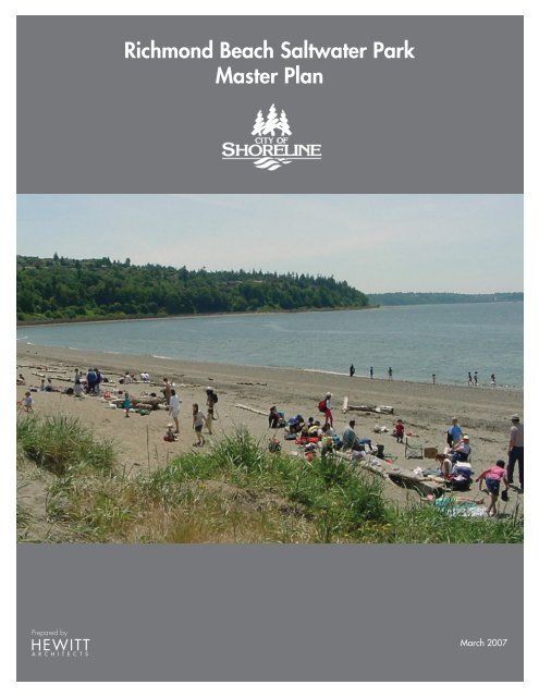
Richmond Beach Saltwater Park Master Plan
Richmond Beach Saltwater Park Master Plan
Richmond Beach Saltwater Park Master Plan

You also want an ePaper? Increase the reach of your titles
YUMPU automatically turns print PDFs into web optimized ePapers that Google loves.
Prepared by<br />
<strong>Richmond</strong> <strong>Beach</strong> <strong>Saltwater</strong> <strong>Park</strong><br />
<strong>Master</strong> <strong>Plan</strong><br />
March 2007
TABLE OF CONTENTS<br />
Purpose<br />
Process and Public Involvement<br />
Site Assessment<br />
Potential Improvement<br />
Concept <strong>Plan</strong><br />
Project Priorities and Phasing<br />
Phase One Projects<br />
Future Projects<br />
1. <strong>Park</strong> Entrance Improvements<br />
2. <strong>Park</strong> Road Improvements<br />
3. Steep Slope Stairs & Trails<br />
4. Steep Slope Stabilization<br />
5. Bridge Access and Safety Improvements<br />
6. <strong>Beach</strong> Wash-Down Area<br />
7. Overlook <strong>Park</strong>ing Across from Caretaker’s Residence<br />
8. Mid-Level Terrace<br />
9. Signage and Interpretation<br />
Acknowledgements<br />
<strong>Richmond</strong> <strong>Beach</strong> <strong>Saltwater</strong> <strong>Park</strong> <strong>Master</strong> <strong>Plan</strong> | iii<br />
1<br />
5<br />
11<br />
21<br />
29<br />
37<br />
43<br />
46<br />
47<br />
48<br />
49<br />
50<br />
51<br />
52<br />
53<br />
54<br />
57<br />
61
PURPOSE
PURPOSE<br />
Background and Brief History<br />
<strong>Saltwater</strong> <strong>Park</strong> is a treasured resource in the Shoreline<br />
community. The park comprises 42 acres on Puget Sound,<br />
offering a wide sandy beach and spectacular views of the<br />
Sound and the Olympic Mountains. The park offers facilities<br />
for individual, family and group gatherings, picnics, beach<br />
barbecues, walking trails, paths and much more. <strong>Saltwater</strong><br />
<strong>Park</strong> is the only park in the City of Shoreline with direct public<br />
access to the saltwater shoreline.<br />
The large, bowl-shaped form of the park was created in<br />
the early 1900’s by the <strong>Richmond</strong> <strong>Beach</strong> Sand and Gravel<br />
Company, who mined the site for sand and gravel materials<br />
for a decade. The site was purchased in 1952 by King<br />
County for use as a regional park. Jurisdiction of the park<br />
was transferred to the City of Shoreline following the City’s<br />
incorporation in 1995.<br />
The City of Shoreline has made signifi cant improvements at<br />
<strong>Saltwater</strong> <strong>Park</strong> in recent years. A new picnic shelter and play<br />
area were built in 1998. Reconfi guration of the “bluff trail”<br />
happened in 1999 and an additional picnic shelter was<br />
built in 2002. However, there has not been a master plan<br />
to guide both short and long-term capital improvements and<br />
programming opportunities for <strong>Richmond</strong> <strong>Beach</strong> <strong>Saltwater</strong> <strong>Park</strong>.<br />
Reason for a <strong>Master</strong> <strong>Plan</strong><br />
<strong>Saltwater</strong> <strong>Park</strong> is a popular attraction that offers year-round<br />
recreational and leisure opportunities for Shoreline residents.<br />
While picnics and group gatherings are fun in summer months,<br />
the park is also popular for beach walks year-round during<br />
low tidal periods and during winter storm conditions. With the<br />
exception of the main access road, parking facilities, picnic<br />
shelters and some lawn, the park remains essentially a natural<br />
place.<br />
The City’s Board of <strong>Park</strong>s, Recreation and Cultural Services<br />
(<strong>Park</strong> Board) has generally concurred that <strong>Saltwater</strong> <strong>Park</strong> should<br />
remain a more natural place with improved opportunities for<br />
interpretive walks, trails, and habitat enhancement. To test<br />
these assumptions and to consider possible directions for<br />
future park use, the City determined that a <strong>Master</strong> <strong>Plan</strong> would<br />
be an important tool to guide short and long-term capital<br />
improvements, program initiatives and proposals for<br />
<strong>Saltwater</strong> <strong>Park</strong>.<br />
Vicinity Map<br />
PUGET SOUND<br />
20TH AVE NW<br />
RICHMOND<br />
BEACH<br />
PARK<br />
NW 195TH ST<br />
8TH AVE NW100TH AVE W<br />
NW 205TH ST<br />
NW 185TH ST<br />
EDMONDS WAY<br />
AURORA AVE N<br />
<strong>Richmond</strong> <strong>Beach</strong> <strong>Saltwater</strong> <strong>Park</strong> <strong>Master</strong> <strong>Plan</strong> | 1<br />
MERIDIAN AVE N<br />
I-5<br />
N
<strong>Master</strong> <strong>Plan</strong> Goals<br />
The development of this <strong>Master</strong> <strong>Plan</strong> has been guided by<br />
the following goals:<br />
1. Preserve and protect <strong>Saltwater</strong> <strong>Park</strong> as<br />
a community asset and amenity for the<br />
citizens of Shoreline.<br />
2. Improve accessibility to the beach and<br />
amenities of the <strong>Park</strong> and to views of<br />
Puget Sound.<br />
3. Improve the overall appearance of the<br />
<strong>Park</strong> without signifi cantly altering its<br />
existing character.<br />
4. Upgrade existing site improvements to<br />
improve their safety and durability, extend<br />
their useful life and integrate their design.<br />
5. Implement a series of selective site<br />
improvements and a program of restoration<br />
ecology to control erosion and eliminate<br />
invasive plant species.<br />
6. Increase the capacity of the park by<br />
providing improved, safe and convenient<br />
access and circulation to all parts of the park.<br />
2 | <strong>Richmond</strong> <strong>Beach</strong> <strong>Saltwater</strong> <strong>Park</strong> <strong>Master</strong> <strong>Plan</strong>
PROCESS & PUBLIC INVOLVEMENT
PROCESS & PUBLIC INVOLVEMENT<br />
The process of preparing a master plan for <strong>Saltwater</strong> <strong>Park</strong> took<br />
over a year and involved a wide range of participants with the<br />
goal to arrive at a common understanding about the best way<br />
to preserve and protect this signifi cant community resource. The<br />
diagram below illustrates the process, with public involvement<br />
activities shown on the upper portion of the diagram and work<br />
tasks and products shown on the lower portion.<br />
The process began with two concurrent activities: a site<br />
assessment and stakeholder interviews. First, the site assessment<br />
involved an inventory and analysis of existing conditions<br />
on and adjacent to the park site. This provided the master<br />
planning team with a fundamental understanding of how<br />
the park is used and helped identify both opportunities and<br />
constraints for future improvements. The site assessment is<br />
summarized in the next section of this report.<br />
The second activity involved detailed interviews with key<br />
Shoreline stakeholders, including members of the Shoreline<br />
<strong>Park</strong> Board, community representatives and selected residents<br />
living adjacent to <strong>Saltwater</strong> <strong>Park</strong>. It was important to better<br />
understand how the community uses the park, how it views<br />
the long-term potential of the park and what future park<br />
improvements would best serve this long-term vision. The results<br />
of these interviews are as follows:<br />
• <strong>Beach</strong> access is the most important aspect of<br />
the park to the community.<br />
• Stakeholders personally value a combination<br />
of park features including the views, trail and<br />
beach access.<br />
• The park is viewed as three distinct segments:<br />
several stakeholders recommended improvement at<br />
the 1) beach level, 2) mid-area and 3) Upper Bluff.<br />
Most believe the upper bluff should be left in its<br />
existing state.<br />
Needs Assessment<br />
MASTER PLAN WORK TASKS & PRODUCTS PUBLIC INVOLVEMENT<br />
Stakeholder<br />
Interviews<br />
<strong>Park</strong> Board<br />
Briefing<br />
<strong>Plan</strong>ning<br />
Commision<br />
Briefing<br />
<strong>Park</strong> Board<br />
Presentation<br />
OCTOBER NOVEMBER DECEMBER<br />
Site Assessment Phase One Report<br />
Visual Survey<br />
Existing Vegetation<br />
Steep Slopes<br />
Existing Utilities<br />
Phase One Report<br />
<strong>Richmond</strong> <strong>Beach</strong> <strong>Saltwater</strong> <strong>Park</strong> <strong>Master</strong> <strong>Plan</strong> | 5
Open house attendees reviewing park plans with staff<br />
• Make improvements that enhance and<br />
elevate the uses at the park and create an<br />
even more aesthetically pleasing surrounding.<br />
• Encourage respectful use and communication<br />
between the park and adjacent residents.<br />
• Retain the natural character of the park.<br />
The team presented the results of the stakeholder interviews and<br />
site assessment to the <strong>Park</strong> Board and <strong>Plan</strong>ning Commission in<br />
December 2005.<br />
Potential Improvement Projects<br />
Shoreline<br />
Enterprise<br />
JANUARY<br />
Currents<br />
Questionaire<br />
Echo Lake<br />
Community<br />
Association<br />
Presentation<br />
Bond<br />
Presentation<br />
Identification of Potential<br />
Improvements Projects<br />
Habitat Restoration, Signing, Interpretation<br />
<strong>Park</strong>ing, <strong>Beach</strong> and Wetlands<br />
Activity Areas<br />
OPEN HOUSE<br />
March 18, 2006<br />
FEBRUARY MARCH<br />
Entry & Connections<br />
6 | <strong>Richmond</strong> <strong>Beach</strong> <strong>Saltwater</strong> <strong>Park</strong> <strong>Master</strong> <strong>Plan</strong><br />
Bond<br />
Presentation<br />
In February, a questionnaire was mailed to residents in the<br />
vicinity of the park and made available within the park, to<br />
solicit opinions regarding the most important aspects of the<br />
park and suggestions for potential improvements. Articles<br />
inviting participation in the master planning process and<br />
requesting suggestions about the park were placed in the<br />
“Shoreline Enterprise” and in “Currents”, the City newsletter.<br />
On March 18, 2006 over 50 community members<br />
participated in an open house at the <strong>Richmond</strong> <strong>Beach</strong> Library.<br />
Site tour participants at <strong>Saltwater</strong> <strong>Park</strong><br />
Concepts and Priorities<br />
Questionaire<br />
APRIL<br />
Concept <strong>Plan</strong><br />
Bond<br />
Presentation<br />
<strong>Park</strong> Board<br />
Presentation<br />
Concept <strong>Plan</strong><br />
Bond<br />
Issue Approval<br />
May 16<br />
2006<br />
Articles<br />
Postcards<br />
mailed<br />
Projects for Further Study<br />
Projects for Design Development<br />
N<br />
OPEN HOUSE<br />
July 29, 2006<br />
MAY JUNE JULY<br />
Project Priorties<br />
annoucing<br />
OPEN<br />
HOUSE<br />
July 29<br />
Projects for Early Implementation<br />
F<br />
E<br />
C<br />
D<br />
D<br />
D<br />
C<br />
B<br />
A<br />
D
The open house was designed to inform community members<br />
about the master plan process and existing conditions at the<br />
park, as well as to present 16 potential improvement projects<br />
developed in response to community feedback and existing<br />
needs. Participants also had the opportunity to take site tours<br />
to review park conditions and discuss<br />
areas of potential improvement with<br />
City staff. A number of participants<br />
provided verbal comments to staff or<br />
via comment forms or surveys that were<br />
later summarized for consideration by<br />
planners and decision makers.<br />
In response to comments received, the<br />
planning team prepared a concept<br />
master plan for the park. The plan<br />
showed the park as it might look if all of<br />
the potential projects were implemented.<br />
On May 16, 2006 voters approved<br />
a city-wide <strong>Park</strong>s Bond Issue which<br />
included over $2.6 million allocated for<br />
<strong>Saltwater</strong> <strong>Park</strong>. Following the approval<br />
of the <strong>Park</strong>s Bond, it became a high<br />
priority to identify projects that could be implemented with these<br />
funds. To determine the overall project program the potential<br />
improvement projects for <strong>Saltwater</strong> <strong>Park</strong> were preliminarily<br />
grouped into three categories:<br />
<strong>Master</strong> <strong>Plan</strong><br />
AUGUST<br />
Draft <strong>Master</strong> <strong>Plan</strong><br />
<strong>Park</strong> Board<br />
Briefing<br />
Sept 6, 2006<br />
Draft <strong>Plan</strong><br />
Council Briefing<br />
and Approval of Early<br />
Implementation Projects<br />
Oct 2, 2006<br />
SEPTEMBER OCTOBER<br />
1) projects for early implementation,<br />
2) projects for design development, and<br />
3) projects for further study.<br />
The City then hosted<br />
a second open house<br />
at the park on July<br />
29, 2006 to present<br />
the concept plan and<br />
to confi rm the park<br />
projects that were<br />
of highest priority. In<br />
order to encourage<br />
community participation<br />
and receive a diverse<br />
variety of feedback,<br />
the City distributed<br />
meeting notifi cation<br />
announcements in<br />
several forms. Meeting<br />
notifi cation strategies<br />
included distributing postcards to area residents, issuing a<br />
notice in the Shoreline Enterprise, and posting a meeting<br />
announcement on the City website and cable television station.<br />
The community members at this open house helped reshape<br />
some projects and adjust project priorities.<br />
Community members reviewing potential improvements<br />
at the July 29, 2006 open house<br />
Design of Projects for<br />
Early Implementation<br />
Present<br />
Draft <strong>Master</strong><br />
<strong>Plan</strong> to <strong>Park</strong><br />
Board<br />
Oct 26, 2006<br />
Adoption and Implementation<br />
Council Briefing<br />
and Approval of Early<br />
Implementation Projects<br />
Nov 6, 2006<br />
NOVEMBER<br />
Final <strong>Master</strong> <strong>Plan</strong><br />
Design of<br />
Projects for<br />
Early Implementation<br />
Council Adopt<br />
<strong>Master</strong> <strong>Plan</strong><br />
Final <strong>Master</strong> <strong>Plan</strong><br />
DECEMBER 2007<br />
Project Implementation<br />
<strong>Richmond</strong> <strong>Beach</strong> <strong>Saltwater</strong> <strong>Park</strong> <strong>Master</strong> <strong>Plan</strong> | 7
At the September 21, 2006 <strong>Park</strong> Board meeting the master<br />
planning team presented and discussed the concept plan and<br />
a revised list of recommended phase one projects with cost<br />
estimates. With some revisions, the <strong>Park</strong> Board approved the<br />
concept plan and sent a recommendation to the City Council<br />
to proceed with the design and construction of nine potential<br />
projects, utilizing funds allocated for <strong>Saltwater</strong> <strong>Park</strong> in the <strong>Park</strong>s<br />
Bond Issue. The Draft <strong>Master</strong> <strong>Plan</strong> and recommended phase<br />
one projects were presented at the November 9, 2006 City<br />
Council meeting.<br />
8 | <strong>Richmond</strong> <strong>Beach</strong> <strong>Saltwater</strong> <strong>Park</strong> <strong>Master</strong> <strong>Plan</strong>
SITE ASSESSMENT
SITE ASSESSMENT<br />
Looking South across <strong>Park</strong><br />
To provide a basis for subsequent work and to inform the<br />
process for developing a master plan for <strong>Richmond</strong> <strong>Beach</strong><br />
<strong>Saltwater</strong> <strong>Park</strong>, a fi rst phase of work was conducted consisting<br />
of two fundamental tasks: a fairly detailed assessment of<br />
site conditions and a series of interviews to develop a better<br />
understanding of how the public views the park. The site<br />
assessment documents existing conditions on and adjacent to<br />
the site.<br />
Using aerial photographs and topographic maps, four<br />
categories of information were researched and recorded:<br />
• Visual Survey – An onsite visual survey documents<br />
all visible features of the site and adjacent properties,<br />
including all existing site improvements like roads,<br />
structures and trails. Generalized vegetation<br />
groupings, slope and use areas are noted, along<br />
with prominent landmarks and visual features.<br />
Views and viewpoints and signifi cant site<br />
amenities are also recorded.<br />
• Vegetation Identifi cation and Mapping – Utilizing<br />
site aerial photography and onsite observation,<br />
existing plant communities have been mapped and<br />
invasive species located. <strong>Plan</strong>t species observed in<br />
each community are identifi ed along with dominant<br />
species in each strata, and an evaluation of plant<br />
communities was prepared.<br />
• Geotechnical Site Assessment – Utilizing available<br />
geologic, soils and geotechnical information<br />
supplemented by fi eld reconnaissance, soil and<br />
geologic units were mapped. Areas of erosion and<br />
instability are also noted.<br />
• Civil Engineering Site Assessment – The location and<br />
adequacy of existing utilities was mapped and verifi ed<br />
with City staff and validated onsite.<br />
The site assessment was documented with the drawings that<br />
are included here, as well as with technical memoranda and<br />
a summary of stakeholder interviews that are attached as<br />
appendices to this report. All of this information was also<br />
documented in a Phase One report issued in December 2005.<br />
<strong>Richmond</strong> <strong>Beach</strong> <strong>Saltwater</strong> <strong>Park</strong> <strong>Master</strong> <strong>Plan</strong> | 11
0 50 100 200<br />
12 | <strong>Richmond</strong> <strong>Beach</strong> <strong>Saltwater</strong> <strong>Park</strong> <strong>Master</strong> <strong>Plan</strong><br />
N<br />
Aerial Photograph
0 50 100 200<br />
N<br />
Topography<br />
<strong>Richmond</strong> <strong>Beach</strong> <strong>Saltwater</strong> <strong>Park</strong> <strong>Master</strong> <strong>Plan</strong> | 13
MID-LEVEL ACTIVITY TERRACE<br />
1<br />
2<br />
3<br />
4<br />
5<br />
PICNIC SHELTER WITH TABLES,<br />
BARBECUES AND TRELLIS<br />
PICNIC AREA WITH PICNIC<br />
TABLES AND CURVED SEAT WALL<br />
CHILDREN’S PLAY AREA WITH<br />
PLAY APPARATUS<br />
RESTROOM BUILDING AT<br />
PARKING LOT LEVEL<br />
SAND AND GRAVEL<br />
ACTIVITY TERRACE<br />
EVIDENCE OF UNSTABLE SOIL CONDITIONS<br />
AND EROSION ON HILLSIDE EAST OF<br />
PARKING AREA<br />
BEACH MOUND<br />
LACED WITH UNIMPROVED TRAILS<br />
SCOTS BROOM<br />
OCCASIONAL SANDY CLEARINGS<br />
EVIDENCE OF INFORMAL FIRE PITS<br />
BEACH<br />
GRAVEL AND SAND<br />
VERY ACCESSIBLE<br />
POPULAR FOR WALKING<br />
GOOD VIEWS<br />
SHALLOW WATER AT LOW TIDE<br />
WINDY AT TIMES<br />
GOOD SUN EXPOSURE<br />
LONG OPEN FETCH TO SOUTHWEST<br />
EROSION CONTROL NEEDED<br />
BEACH IS ACCESSIBLE OFF SITE TO NORTH<br />
AND SOUTH EXCEPT AT HIGH TIDE<br />
LOTS OF DRIFTWOOD AND EVIDENCE OF<br />
BEACH FIRES<br />
BEACH ACTIVITY AREA<br />
RESTROOM BUILDING<br />
PICNIC SHELTER WITH TABLES,<br />
BARBECUES AND BENCHES<br />
FIRE PIT<br />
NATIVE AMERICAN SCULPTURE<br />
INTERPRETIVE SIGNS<br />
VOLLEYBALL COURT<br />
LEGEND<br />
DESIGNATED TRAILS<br />
UNIMPROVED TRAILS<br />
STAIRS<br />
ROCK RIP-RAP<br />
CULVERT<br />
KINGSTON<br />
LOWLAND DECIDIOUS<br />
SANDY CLEARING<br />
OLYMPICS<br />
Visual Survey<br />
LOW AREA WITH<br />
LANDMARK TREE<br />
BAINBRIDGE<br />
MEADOW IMPENETRABLE EDGE<br />
STEEP SLOPES<br />
INVASIVE VEGETATION<br />
14 | <strong>Richmond</strong> <strong>Beach</strong> <strong>Saltwater</strong> <strong>Park</strong> <strong>Master</strong> <strong>Plan</strong><br />
P<br />
NW RICHMOND BEACH DR NW<br />
PARKING<br />
LOW AREA<br />
NW 191ST PL<br />
CULVERT/STREAM<br />
NW 190TH PL<br />
EVIDENCE OF RECENT<br />
SLOPE STABILIZATION<br />
WEST POINT<br />
BNRR<br />
22ND AVE NW<br />
21ST AVE NW<br />
NW 190TH ST<br />
P<br />
SAND SLOPE<br />
(GOOD SUN<br />
EXPOSURE)<br />
1<br />
4<br />
5<br />
3<br />
2<br />
20TH AVE NW<br />
PEDESTRIAN BRIDGE<br />
FUNCTIONAL<br />
APPROACH SLOPES TOO<br />
STEEP FOR ADA<br />
RUSTED CHAINLINK FENCING<br />
DETERIORATING ASPHALT PAVING<br />
NEEDS STRUCTURAL EVALUATION<br />
NOT AN ATTRACTIVE STRUCTURE<br />
UPLAND VIEWPOINT<br />
ENTRANCE IMPROVED SIDEWALK, SEATING AND VIEWPOINTS<br />
P<br />
17TH PL NW<br />
P<br />
GATED TRAILHEAD<br />
17TH AVE NW<br />
PEDESTRIAN ENTRY AT 190TH AND 21ST STREETS<br />
GOOD VIEWS ACROSS PARK AND TO WATER<br />
PICNIC AREA - TERRACE #1<br />
PICNIC TABLES<br />
CURVED SEAT WALLS<br />
LEVEL SAND BASE<br />
UNIMPROVED AREA TO SOUTH USED FOR PARKING<br />
CARETAKERS RESIDENCE TERRACE<br />
CURRENTLY OCCUPIED<br />
ONE STORY WOOD FRAME STRUCTURE<br />
WITH DETACHED GARAGE<br />
IRRIGATED LAWN/YARD<br />
BLUFF TRAIL<br />
FOLLOWS CREST OF SLOPE<br />
GREAT VIEWS OF WATER, ISLANDS AND MOUNTAINS<br />
GRAVEL TRAIL, QUITE LEVEL<br />
SLIGHTLY LOWER THAN HOMES TO EAST<br />
ACCESS ONLY ON NORTH END<br />
DEAD END TRAIL<br />
PICNIC AREA - TERRACE #2<br />
PAVED PARKING FOR +/- 16 CARS<br />
SAND TRAIL TO PICNIC AREA<br />
PICNIC TABLES<br />
CURVED CONCRETE SEAT WALLS<br />
SLIGHTLY LOW PICNIC AREA SURROUNDED BY<br />
GROVE OF DISTRESSED TREES<br />
POTENTIAL TO CONNECT PICNIC AREA TO<br />
BLUFF TRAIL WITH STRUCTURED TRAIL IMPROVEMENT<br />
UPLAND MEADOW<br />
OPEN TURF AREA<br />
GENTLY SLOPING UNDULATED TOPOGRAPHY<br />
SEVERAL PERMANENT DECIDIUOS TREES<br />
ORNAMENTAL/CULTIVATED AREA<br />
AT ENTRANCE TO PARKING LOT<br />
IRRIGATED<br />
INTRODUCED ORNAMENTAL PLANT MATERIAL<br />
ADJACENT RESIDENCES<br />
CULTIVATED YARDS ABUT PARK PROPERTY<br />
UNOBSTRUCTED VIEWS FROM HOUSES<br />
AND YARDS<br />
HOMES ARE SLIGHTLY ABOVE BLUFF TRAIL (5-6’)<br />
VIEWPOINT WITH MEMORIAL BENCHES<br />
BEACH TRAILHEAD<br />
LOW AREA WITH ALDER GROVE<br />
STREAM<br />
GRAVEL PATH FROM PARKING TO PED BRIDGE<br />
PAVED TRAIL ON UPPER EAST PERIMETER<br />
FROM PARKING TO BRIDGE<br />
PICNIC TABLES ON SLOPE NEXT TO<br />
PARKING LOT
LEGEND<br />
AREA 1 - Maintained Lawn and Landscaping<br />
AREA 2 - Invasive Species Community<br />
AREA 3 - Pacific Madrone in Formal <strong>Park</strong> Area<br />
AREA 4 - N/A<br />
AREA 5 - Pacific Madrone Community on Steep,<br />
Undisturbed Slope<br />
AREA 6 - Douglas Fir in Formal <strong>Park</strong> Area<br />
AREA 7 - Big-Leaf Maple<br />
AREA 8 - Ornamental Shrub Community<br />
AREA 9 - Populus Community<br />
AREA 10 - Dunegrass Community<br />
AREA 11 - Deciduous Forest Community<br />
AREA 12 - Willow Community<br />
AREA 13 - Oregon Grape-Dominated Community<br />
0 50 100 200<br />
N<br />
NW RICHMOND BEACH DR NW<br />
NW 191ST<br />
2<br />
NW 190TH PL<br />
3 3<br />
2<br />
8<br />
10<br />
1<br />
1<br />
BNRR<br />
22ND AVE NW<br />
11<br />
9<br />
8<br />
3<br />
6<br />
6<br />
2<br />
12<br />
2<br />
2<br />
3<br />
2<br />
21ST AVE NW<br />
NW 190TH ST<br />
6<br />
10<br />
6 1<br />
1<br />
12<br />
11<br />
1<br />
2<br />
10<br />
11<br />
1<br />
6<br />
2<br />
7<br />
5<br />
2<br />
6<br />
2<br />
20TH AVE NW<br />
1<br />
13<br />
17TH PL NW<br />
Existing Vegetation<br />
<strong>Richmond</strong> <strong>Beach</strong> <strong>Saltwater</strong> <strong>Park</strong> <strong>Master</strong> <strong>Plan</strong> | 15<br />
2<br />
2<br />
3<br />
3<br />
3<br />
1<br />
2<br />
3<br />
1<br />
1
LEGEND<br />
15% - 40%<br />
40% ><br />
GULLIES/ SURFACE EROSION<br />
STEEP; POTENTIALLY UNSTABLE ZONE<br />
0 50 100 200<br />
N<br />
NW RICHMOND BEACH DR NW<br />
NW 191S<br />
16 | <strong>Richmond</strong> <strong>Beach</strong> <strong>Saltwater</strong> <strong>Park</strong> <strong>Master</strong> <strong>Plan</strong><br />
NW 190TH PL<br />
22ND AVE NW<br />
BNRR<br />
21ST AVE NW<br />
NW 190TH ST<br />
LOOSE SURFACE SOILS<br />
20TH AVE NW<br />
17TH PL NW<br />
17TH AVE NW<br />
Steep Slopes/Erosion
0 50 100 200<br />
N<br />
NW RICHMOND BEACH DR NW<br />
NW 191S<br />
NW 190TH PL<br />
BNRR<br />
22ND AVE NW<br />
SSFM<br />
SSFM<br />
PEDESTRIAN BRIDGE<br />
21ST AVE NW<br />
NW 190TH ST<br />
SD<br />
SD<br />
SD<br />
20TH AVE NW<br />
8”W<br />
METRO SS<br />
17TH PL NW<br />
Existing Utilities<br />
<strong>Richmond</strong> <strong>Beach</strong> <strong>Saltwater</strong> <strong>Park</strong> <strong>Master</strong> <strong>Plan</strong> | 17<br />
17TH AVE NW
<strong>Park</strong> Entrance<br />
Erosion along edge of road<br />
Vegetation<br />
18 | <strong>Richmond</strong> <strong>Beach</strong> <strong>Saltwater</strong> <strong>Park</strong> <strong>Master</strong> <strong>Plan</strong><br />
Road down to lower parking area<br />
View across site<br />
Bridge over Railroad<br />
Photos of Existing Conditions
POTENTIAL IMPROVEMENT
POTENTIAL IMPROVEMENT<br />
Stakeholder interviews and response to the community<br />
questionnaire made it clear that almost everyone wants to<br />
preserve and enhance the existing character of the park and<br />
make improvements that will enhance the activities and uses at<br />
<strong>Richmond</strong> <strong>Beach</strong> <strong>Saltwater</strong> <strong>Park</strong>. The site assessment identifi ed<br />
a number of conditions needing to be addressed in order to<br />
sustain the quality of experience and types of uses that people<br />
in Shoreline have come to value at <strong>Saltwater</strong> <strong>Park</strong>. Taking<br />
into consideration the results of the site assessment and in<br />
discussions with park users, neighbors, City staff, members<br />
of the <strong>Park</strong> Board and other residents, sixteen potential<br />
improvement projects were identifi ed that would enable the<br />
goals of the master plan to be realized and sustained.<br />
These projects were grouped into four categories. The location<br />
of each project was shown on a plan of the park along with an<br />
outline description of each potential project. This information<br />
was then presented at a public open house on March 18,<br />
2006. Two walking tours of the park were conducted during<br />
the open house, during which the potential improvement<br />
projects were described and discussed. The drawings<br />
presented at the open house are illustrated on the next page.<br />
The following sixteen projects were identifi ed:<br />
Entry and Connections<br />
• <strong>Park</strong> Entrance Improvements<br />
• <strong>Park</strong> Road Improvements<br />
• Bridge Over Railroad<br />
• Steep Slope Stairs and Trails<br />
Activity Areas<br />
• Caretaker’s Residence<br />
• Mid-Level Terrace<br />
• Central Activity Area<br />
• <strong>Beach</strong> Activity Area<br />
Upper Terrace, Trailhead, <strong>Park</strong>ing and Overlook<br />
• <strong>Park</strong> Entrance Improvements<br />
• Overlook <strong>Park</strong>ing Across from Caretaker’s Residence<br />
• <strong>Beach</strong> Trailhead<br />
• Wetland Overlooks<br />
Habitat Restoration, Signage and Interpretation<br />
• Steep Slope Stabilization<br />
• Lower Wetland Restoration<br />
• <strong>Beach</strong> and Dune Restoration<br />
• Signage and Interpretation<br />
Note: Project numbers on following are not intended to<br />
indicate priorities.<br />
<strong>Richmond</strong> <strong>Beach</strong> <strong>Saltwater</strong> <strong>Park</strong> <strong>Master</strong> <strong>Plan</strong> | 21
Entry and Connections<br />
22 | <strong>Richmond</strong> <strong>Beach</strong> <strong>Saltwater</strong> <strong>Park</strong> <strong>Master</strong> <strong>Plan</strong>
Activity Areas<br />
<strong>Richmond</strong> <strong>Beach</strong> <strong>Saltwater</strong> <strong>Park</strong> <strong>Master</strong> <strong>Plan</strong> | 23
Upper Terrace, Trailhead, <strong>Park</strong>ing and Overlook<br />
24 | <strong>Richmond</strong> <strong>Beach</strong> <strong>Saltwater</strong> <strong>Park</strong> <strong>Master</strong> <strong>Plan</strong>
Habitat Restoration, Signage and Interpretation<br />
<strong>Richmond</strong> <strong>Beach</strong> <strong>Saltwater</strong> <strong>Park</strong> <strong>Master</strong> <strong>Plan</strong> | 25
CONCEPT PLAN
CONCEPT PLAN<br />
The <strong>Master</strong> <strong>Plan</strong> for <strong>Saltwater</strong> <strong>Park</strong> is based on fi ve principles:<br />
1. Protecting and maintaining existing park assets<br />
2. Building on and improving existing facilities<br />
3. Connecting the different areas of the park<br />
4. Creating a cohesive park experience<br />
5. Establishing appropriate vegetation and habitat<br />
<strong>Park</strong> improvements included in the <strong>Master</strong> <strong>Plan</strong> and illustrated<br />
on the accompanying drawing consist of the following:<br />
1. <strong>Park</strong> Entrance Improvements – Create a sense of<br />
arrival, anticipate the turn in the road as the grade<br />
drops, slow down vehicles and improve safety for<br />
pedestrians and vehicles.<br />
2. <strong>Park</strong> Road Improvements – Stabilize the existing<br />
roadway and control drainage and surface water<br />
runoff. Provide a pedestrian path adjacent to the<br />
driving lanes and separated from them. Control<br />
access to steep slopes and accommodate some<br />
overfl ow parallel parking near the lower end<br />
of the road.<br />
3. Upper Terrace and Bluff Trail – Incorporate<br />
planned and committed landscape improvements in<br />
the northeast corner. Consider resurfacing the existing<br />
pathway with crushed rock to accommodate<br />
wheelchairs, and seek appropriate locations to<br />
add unobtrusive interpretive elements.<br />
4. Overlook <strong>Park</strong>ing Across from Caretaker’s<br />
Residence – Create a new paved parking area on<br />
the existing terrace west of the road across from the<br />
caretaker’s residence. Provide a place to park and<br />
look at the view. Provide parking for users of the bluff<br />
trail and for activities at the caretaker’s residence and<br />
the mid-level terrace.<br />
5. Caretaker’s Residence – Evaluate the long-term<br />
feasibility of maintaining a caretaker’s residence and<br />
consider alternative uses for the site, including:<br />
adapting the building for group activities and events,<br />
creating a picnic area with a picnic shelter and<br />
restrooms, and developing a facility and exhibits<br />
for interpretation. This is a good location for an<br />
activity area with a lawn and irrigated landscape,<br />
but vegetation or structures likely to affect views from<br />
the bluff trail should be avoided. Consider a stair<br />
connection to parking at the mid-level terrace.<br />
6. Mid- Level Terrace – Improve this area to<br />
accommodate more intensive use, including providing<br />
a lawn for informal recreation and an irrigated<br />
landscape to provide an oasis of green in an<br />
otherwise arid natural habitat. Consider creating a<br />
place to accommodate private gatherings with a<br />
picnic area. Expand the existing parking area and<br />
control access to steep slopes.<br />
<strong>Richmond</strong> <strong>Beach</strong> <strong>Saltwater</strong> <strong>Park</strong> <strong>Master</strong> <strong>Plan</strong> | 29
7. Central Activity Area – Enhance and supplement<br />
existing improvements to create a central focal point or<br />
“heart” for the park. Expand existing facilities and<br />
incorporate new ones in a way that organizes the<br />
area and creates a sense of place. Create a sense of<br />
entry from the parking lot. Create terraces for activities<br />
and direct circulation with paved surfaces. Contain<br />
any cultivated landscape and control access to areas<br />
with steep slopes and to vegetated areas without<br />
irrigation. Control drainage and surface water runoff.<br />
Incorporate interpretive and educational elements.<br />
8. <strong>Beach</strong> Trailhead – Provide access for all park<br />
visitors from the parking lot to the bridge over the<br />
railroad. Protect the existing stream and cluster of<br />
trees and control access to steep slopes.<br />
9. Bridge Over Railroad – Make safety improvements<br />
to the existing bridge to enhance its usability and<br />
appearance for the foreseeable future. Consider<br />
alternative locations and designs for an eventual<br />
replacement bridge.<br />
10. <strong>Beach</strong> Activity Center – Renovate existing facilities as<br />
needed and provide expanded picnic facilities.<br />
Provide access for all park users from the bridge<br />
to the beach activity area. Protect natural vegetation<br />
and beach dunes. Provide a beach wash-down area.<br />
11. Steep Slope Stairs and Trails – Control access to<br />
steep fragile slopes to reduce erosion and protect<br />
vegetation. Improve connections to activity areas<br />
across steep slopes by constructing raised stairs and<br />
boardwalks in selected locations. Incorporate<br />
intermittent platforms with seating to pause and enjoy<br />
views. Allow the uninterrupted ground plane and<br />
vegetation to continue beneath stair and<br />
trail structures.<br />
12. Wetland Overlooks – Build one or two structures to<br />
provide views into and over the lower wetland area<br />
east of the railroad. Control access to the wetland<br />
and slope leading down to it. Provide access for all<br />
visitors to the park to the overlook structures from the<br />
parking lot. Include interpretive signing<br />
and exhibits.<br />
13. Steep Slope Stabilization - Implement a program of<br />
removing invasive plants and replacing them with<br />
dune grass and other native plant species tolerant<br />
of dry, sandy and gravelly soils. Create a community<br />
participation program to involve volunteers in this<br />
effort, to be coordinated by a city staff person. Work<br />
with the University of Washington Restoration Ecology<br />
Network in this program. Establish an ongoing<br />
program to restore and maintain this park habitat.<br />
30 | <strong>Richmond</strong> <strong>Beach</strong> <strong>Saltwater</strong> <strong>Park</strong> <strong>Master</strong> <strong>Plan</strong><br />
14. Lower Wetland Restoration - Implement a program<br />
to remove blackberry and replant the bank east of<br />
the railroad with woody native species to provide<br />
shade to suppress weeds and improve stream water<br />
quality. Remove invasive plant species and nurture<br />
native species in the wetland at the base of the slope<br />
(this will require the cooperation of the railroad).<br />
Create a community participation program to involve<br />
volunteers in this effort. Work with the University of<br />
Washington Restoration Ecology Network in this<br />
program. Establish an ongoing program to restore<br />
and maintain this park habitat.<br />
15. <strong>Beach</strong> and Dune Restoration – Implement a program<br />
to remove invasive plant species from the west bank<br />
of the railroad right-of-way and replace them with<br />
native species (this will require the cooperation of<br />
the railroad). Implement a program to remove<br />
invasive plant species from the beach dune area and<br />
replace them with native species (this is unlikely to be<br />
successful unless invasive species are also removed<br />
from the west bank of the railroad right-of-way).<br />
Establish an ongoing program to restore and maintain<br />
this park habitat.<br />
16. Signage and Interpretation - Design and install a series<br />
of interpretive signs and exhibits at appropriate<br />
locations in the park to explain history, natural features<br />
and site ecology. Develop a system of directional and<br />
informational signs for the park.
<strong>Park</strong> Entry<br />
Access Road – Section<br />
<strong>Richmond</strong> <strong>Beach</strong> <strong>Saltwater</strong> <strong>Park</strong> <strong>Master</strong> <strong>Plan</strong> | 31
LEGEND<br />
1<br />
2<br />
3<br />
4<br />
5<br />
6<br />
7<br />
8<br />
9<br />
10<br />
11<br />
12<br />
13<br />
14<br />
15<br />
0 30 60 120<br />
<strong>Park</strong> Entrance Improvements<br />
<strong>Park</strong> Road Improvements<br />
Upper Terrace and Bluff Trail<br />
Overlook <strong>Park</strong>ing Across from<br />
Caretaker’s Residence<br />
Caretaker’s Residence<br />
Mid-Level Terrace<br />
Central Activity Area<br />
<strong>Beach</strong> Trailhead<br />
Bridge Over Railroad<br />
<strong>Beach</strong> Activity Center<br />
Steep Slope Stairs and Trails<br />
Wetland Overlooks<br />
Steep Slope Stabilization<br />
Lower Wetland Restoration<br />
<strong>Beach</strong> and Dune Restoration<br />
N<br />
32 | <strong>Richmond</strong> <strong>Beach</strong> <strong>Saltwater</strong> <strong>Park</strong> <strong>Master</strong> <strong>Plan</strong><br />
15<br />
10<br />
14<br />
13<br />
12
9<br />
12<br />
8<br />
7<br />
11<br />
1<br />
4<br />
13<br />
2<br />
6<br />
3<br />
5<br />
<strong>Master</strong> <strong>Plan</strong> Concept<br />
<strong>Richmond</strong> <strong>Beach</strong> <strong>Saltwater</strong> <strong>Park</strong> <strong>Master</strong> <strong>Plan</strong> | 33
Trellis at Mid-Level Terrace<br />
Floating Stairs<br />
34 | <strong>Richmond</strong> <strong>Beach</strong> <strong>Saltwater</strong> <strong>Park</strong> <strong>Master</strong> <strong>Plan</strong>
PROJECT PRIORITIES & PHASING
PROJECT PRIORITIES & PHASING<br />
In response to comments received regarding the concept<br />
<strong>Master</strong> <strong>Plan</strong> and the potential projects that were identifi ed to<br />
implement the plan, a grouping of projects indicating priorities<br />
for implementation was presented at the July 29, 2006 open<br />
house. Projects that might be implemented with funds from<br />
the <strong>Park</strong>s Bond Issue were of particular interest. Since cost<br />
estimates for project implementation were not yet prepared,<br />
projects for early implementation were selected based on the<br />
following criteria:<br />
• Funds will be available to implement the project in<br />
the near future.<br />
• The project is highly visible and will make a<br />
noticeable improvement.<br />
• The project will be relatively easy to implement.<br />
• The project is broadly supported and not very<br />
controversial.<br />
• The project sets the stage for other improvements.<br />
• The project addresses a situation that will continue<br />
to get worse and cost more to fi x if postponed.<br />
The grouping of projects presented at the July 29, 2006<br />
Open House was as follows:<br />
Projects Recommended for Early Implementation<br />
Projects that address an immediate need, for which an<br />
agreed-upon solution has been developed, and that should be<br />
constructed as soon as possible:<br />
• <strong>Park</strong> Entrance Improvements<br />
• <strong>Park</strong> Road Improvements<br />
• Steep Slope Stairs and Trails<br />
• Steep Slope Stabilization<br />
• Bridge Safety and Appearance<br />
• <strong>Beach</strong> Wash-Down Area<br />
Projects Recommended for Design Development<br />
Projects for which a design concept has been proposed and<br />
generally agreed to, and for which the design should be<br />
completed to enable construction within the next 2-3 years:<br />
• Upper Terrace and Bluff Trail<br />
• Overlook <strong>Park</strong>ing<br />
• Mid-Level Terrace<br />
• Wetland Overlook<br />
• Lower Wetland Restoration<br />
• <strong>Beach</strong> Trailhead<br />
• <strong>Beach</strong> Activity Center<br />
• <strong>Beach</strong> and Dune Restoration<br />
• Signage and Interpretation<br />
Projects Recommended for Further Study<br />
Projects which need further analysis and defi nition as part of the<br />
master plan:<br />
• Caretaker’s Residence<br />
• Central Activity Area<br />
• Bridge Over Railroad<br />
<strong>Richmond</strong> <strong>Beach</strong> <strong>Saltwater</strong> <strong>Park</strong> <strong>Master</strong> <strong>Plan</strong> | 37
Projects Recommended for Early Implementation<br />
38 | <strong>Richmond</strong> <strong>Beach</strong> <strong>Saltwater</strong> <strong>Park</strong> <strong>Master</strong> <strong>Plan</strong>
Projects Recommended for Design Development<br />
<strong>Richmond</strong> <strong>Beach</strong> <strong>Saltwater</strong> <strong>Park</strong> <strong>Master</strong> <strong>Plan</strong> | 39
Projects Recommended for Further Study<br />
40 | <strong>Richmond</strong> <strong>Beach</strong> <strong>Saltwater</strong> <strong>Park</strong> <strong>Master</strong> <strong>Plan</strong>
PHASE ONE PROJECTS
PHASE ONE PROJECTS<br />
After estimating the total project cost of each potential<br />
improvement project, the master plan concept and a revised<br />
list of recommended phase one projects with cost estimates<br />
was presented to the <strong>Park</strong> Board. The <strong>Park</strong> Board endorsed<br />
the <strong>Master</strong> <strong>Plan</strong> and recommended the following projects for<br />
design and construction within the near future, utilizing funds<br />
designated for <strong>Saltwater</strong> <strong>Park</strong> in the <strong>Park</strong>s Bond Issue:<br />
• <strong>Park</strong> Entrance Improvements<br />
• <strong>Park</strong> Road Improvements<br />
• Steep Slope Stairs and Trails<br />
• Steep Slope Stabilization<br />
• Bridge Access and Safety Improvements<br />
• <strong>Beach</strong> Wash- Down Area<br />
• Overlook <strong>Park</strong>ing Across from<br />
Caretaker’s Residence<br />
• Mid-Level Terrace<br />
• Signage and Interpretation<br />
These projects are located on the Phase 1 Projects - Key <strong>Plan</strong>,<br />
and described on the following pages.<br />
Note: Project numbers on following are not intended to<br />
indicate priorities.<br />
<strong>Richmond</strong> <strong>Beach</strong> <strong>Saltwater</strong> <strong>Park</strong> <strong>Master</strong> <strong>Plan</strong> | 43
LEGEND<br />
1<br />
2<br />
3<br />
4<br />
5<br />
6<br />
7<br />
8<br />
9<br />
0 30 60 120<br />
<strong>Park</strong> Entrance Improvements<br />
Pedestrian, Bike and <strong>Park</strong><br />
Road Improvements<br />
Steep Slope Stairs & Trails<br />
Steep Slope Stabilization<br />
Bridge Access & Safety Improvements<br />
<strong>Beach</strong> Wash-Down Area<br />
Overlook <strong>Park</strong>ing Across from<br />
Caretaker’s Residence<br />
Mid-Level Terrace<br />
Signage and Interpretation<br />
44 | <strong>Richmond</strong> <strong>Beach</strong> <strong>Saltwater</strong> <strong>Park</strong> <strong>Master</strong> <strong>Plan</strong><br />
N<br />
6<br />
4
5<br />
3<br />
3<br />
2<br />
1<br />
7<br />
4<br />
8<br />
Phase One Projects – Key <strong>Plan</strong><br />
<strong>Richmond</strong> <strong>Beach</strong> <strong>Saltwater</strong> <strong>Park</strong> <strong>Master</strong> <strong>Plan</strong> | 45
1. PARK ENTRANCE IMPROVEMENTS<br />
• Create a safe and inviting path for pedestrians along<br />
20th avenue NW.<br />
• Provide a new park entrance sign and perhaps a<br />
pylon or similar landmark.<br />
• Create a landscaped median at the park<br />
entrance to slow down vehicles and improve<br />
safety for pedestrians.<br />
• Provide an overlook with seating at the top of the bluff.<br />
• Provide bike racks.<br />
Estimated Cost: $85,000 – $100,000<br />
46 | <strong>Richmond</strong> <strong>Beach</strong> <strong>Saltwater</strong> <strong>Park</strong> <strong>Master</strong> <strong>Plan</strong><br />
4<br />
<strong>Park</strong> Entry<br />
3<br />
1<br />
7
2. PEDESTRIAN, BIKE AND PARK ROAD<br />
IMPROVEMENTS<br />
• Stabilize the existing roadway.<br />
• Control drainage and surface water runoff by sloping<br />
the road toward a curb at the hillside, and explore<br />
zero to low-impact construction options.<br />
• Provide a parallel pedestrian path on the outside of<br />
the roadway with bollards to separate the path from<br />
the driving surface.<br />
• Provide a defi ned edge to the path to control access<br />
to fragile steep slopes.<br />
• make the roadway wide enough in a few places to<br />
accommodate overlow parallel parking.<br />
• Provide safe access for bikes.<br />
Estimated Cost: $550,000 – $680,000<br />
Roadway Section<br />
3<br />
3<br />
2<br />
7<br />
4<br />
8<br />
<strong>Richmond</strong> <strong>Beach</strong> <strong>Saltwater</strong> <strong>Park</strong> <strong>Master</strong> <strong>Plan</strong> | 47
3. STEEP SLOPE STAIRS & TRAILS<br />
• Control access to steep fragile slopes to reduce<br />
erosion and protect vegetation.<br />
• Improve connections to activity areas across steep<br />
slopes by constructing raised stairs and boardwalks<br />
in selected locations.<br />
• Incorporate intermittent platforms with seating to pause<br />
and enjoy views.<br />
• Allow the uninterrupted ground plane and vegetation<br />
to continue beneath stair and trail structures.<br />
• One priority location should be addressed: Connect<br />
the park entrance with the central activity area and the<br />
lower parking lot.<br />
Floating Stairs<br />
Estimated Cost: $250,000 – $340,000<br />
48 | <strong>Richmond</strong> <strong>Beach</strong> <strong>Saltwater</strong> <strong>Park</strong> <strong>Master</strong> <strong>Plan</strong><br />
4<br />
3<br />
2<br />
3<br />
7
4. STEEP SLOPE STABILIZATION<br />
• Implement a program of removing invasive plants and<br />
replacing them with dune grass and other native plant<br />
species tolerant of dry, sandy and gravelly soils.<br />
• Create a community participation program to involve<br />
volunteers in this effort, to be coordinated by a city<br />
staff person.<br />
• Work with the university of Washington Restoration<br />
Ecology Network in this program.<br />
Estimated Cost: $50,000 – $70,000<br />
6<br />
4<br />
5<br />
3<br />
3<br />
2<br />
1<br />
<strong>Richmond</strong> <strong>Beach</strong> <strong>Saltwater</strong> <strong>Park</strong> <strong>Master</strong> <strong>Plan</strong> | 49<br />
7<br />
4<br />
8
5. BRIDGE ACCESS & SAFETY<br />
IMPROVEMENTS<br />
• Make safety improvements to the existing bridge, such<br />
as a new walking surface, new fencing, guard rails<br />
and paint.<br />
• Provide access for all park visitors from the parking lot<br />
to the bridge over the railroad.<br />
• Protect the existing stream and cluster of trees.<br />
• Control access to steep slopes.<br />
Estimated Cost: $425,000 – $600,000<br />
50 | <strong>Richmond</strong> <strong>Beach</strong> <strong>Saltwater</strong> <strong>Park</strong> <strong>Master</strong> <strong>Plan</strong><br />
6<br />
5
6. BEACH WASH-DOWN AREA<br />
• Provide a convenient and accessible facility for<br />
washing adjacent to the beach.<br />
• Provide an outdoor shower and hose connection.<br />
• Provide a bench or platform to place cleaned<br />
equipment.<br />
• Control drainage and runoff.<br />
Estimated Cost: $17,000 – $25,000<br />
6<br />
5<br />
<strong>Richmond</strong> <strong>Beach</strong> <strong>Saltwater</strong> <strong>Park</strong> <strong>Master</strong> <strong>Plan</strong> | 51<br />
4
7. OVERLOOK PARKING ACROSS FROM<br />
CARETAKER’S RESIDENCE<br />
• Create a new paved parking area on the terrace on<br />
the west side of the road across from the<br />
caretaker’s residence.<br />
• Provide a place to park and look at the view.<br />
• Provide parking for users of the bluff trail.<br />
• Provide parking for activities at the caretaker’s<br />
residence and the mid-level terrace.<br />
• Provide bike racks.<br />
Estimated Cost: $100,000 – $130,000<br />
52 | <strong>Richmond</strong> <strong>Beach</strong> <strong>Saltwater</strong> <strong>Park</strong> <strong>Master</strong> <strong>Plan</strong><br />
3<br />
3<br />
7
8. MID-LEVEL TERRACE<br />
Trellis<br />
• Expand existing parking area.<br />
• Consider creating a place to accommodate<br />
private gatherings.<br />
• Potential picnic area.<br />
• Potential lawn area for informal recreation.<br />
• Potential for cultivated and irrigated landscape.<br />
• Control access to steep slopes.<br />
• Provide bike racks.<br />
Estimated Cost: $300,000 – $425,000<br />
2<br />
7<br />
4<br />
8<br />
<strong>Richmond</strong> <strong>Beach</strong> <strong>Saltwater</strong> <strong>Park</strong> <strong>Master</strong> <strong>Plan</strong> | 53
9. SIGNAGE AND INTERPRETATION<br />
• Design and install a series of interpretive signs and<br />
exhibits at appropriate locations in the park to explain<br />
history, natural features and site ecology.<br />
• Develop a system of direction and informational signs<br />
for the park.<br />
Estimated Cost: $100,000 – $130,000<br />
54 | <strong>Richmond</strong> <strong>Beach</strong> <strong>Saltwater</strong> <strong>Park</strong> <strong>Master</strong> <strong>Plan</strong><br />
6<br />
4<br />
5<br />
3<br />
3<br />
2<br />
1<br />
7<br />
4<br />
8
FUTURE PROJECTS
FUTURE PROJECTS<br />
Some of the improvement projects recommended in the <strong>Master</strong><br />
<strong>Plan</strong> will need to be deferred to the future. In some cases this<br />
is due to a lack of available resources, for others the need is<br />
not so critical, and for others additional study and discussion<br />
is necessary. The following projects are suggested as Future<br />
Projects for <strong>Saltwater</strong> <strong>Park</strong> in this <strong>Master</strong> <strong>Plan</strong>:<br />
• Upper Terrace and Bluff Trail – The need for immediate<br />
improvements here is not as great as at other locations<br />
in the park. The area is very pleasant and usable in<br />
its current condition. Wheelchair access could be<br />
accommodated in the future as funds<br />
become available.<br />
• Additional Steep Slope Stairs and Trails – The<br />
most heavily used routes will be improved as part of<br />
Phase One. Construction of improvements on other<br />
routes can be undertaken as funds become available.<br />
• Ongoing Steep Slope Stabilization – This program<br />
will be initiated in Phase One, but requires ongoing<br />
funding and management to be expanded and<br />
sustained in all areas needing attention.<br />
10. Caretaker’s Residence – More discussion is needed<br />
to determine the long-term viability of maintaining<br />
a caretaker’s residence on site. If a decision is made<br />
to discontinue its use for that purpose, alternative uses<br />
should be considered for this highly visible and<br />
attractive site.<br />
11. Wetland Overlooks – The overlooks will become most<br />
desirable as the lower wetland area is restored and<br />
should be considered as that project is implemented.<br />
12. Lower Wetland Restoration – Additional analysis,<br />
funding and coordination with the railroad are<br />
necessary for this project to proceed.<br />
13. <strong>Beach</strong> Activity Center – This is one of the most popular<br />
areas of the park. It could use improvement, but it<br />
works pretty well in its current condition. Since<br />
regrading will likely be necessary to provide access<br />
for all park visitors from the bridge to the beach,<br />
signifi cant improvements in the beach area should<br />
perhaps be delayed until a decision is made<br />
regarding bridge-to-beach access.<br />
14. <strong>Beach</strong> and Dune Restoration – Additional analysis,<br />
funding and coordination with the railroad are<br />
necessary for this project to proceed.<br />
15. Central Activity Area – The central activity area<br />
is already heavily used and while it has the potential<br />
for additional improvement, the scope of work<br />
required to realize that potential would be best<br />
undertaken as a single project, and as such is likely<br />
to involve a signifi cant investment.<br />
16. Replacement Bridge Over Railroad – The existing<br />
bridge does not need to be replaced in the near<br />
future, particularly with the safety and access<br />
improvements that will be made as part of Phase<br />
One. Access from the bridge to the beach, however,<br />
will not be improved in Phase One, and it is likely that<br />
at some time the bridge will need to be replaced.<br />
<strong>Richmond</strong> <strong>Beach</strong> <strong>Saltwater</strong> <strong>Park</strong> <strong>Master</strong> <strong>Plan</strong> | 57
LEGEND<br />
10<br />
11<br />
12<br />
13<br />
14<br />
15<br />
16<br />
0 30 60 120<br />
Upper Terrace abd Bluff Trail<br />
Wetland Overlooks<br />
Lower Wetland Restoration<br />
<strong>Beach</strong> Activity Center<br />
<strong>Beach</strong> and Dune Restoration<br />
Central Activity Area<br />
Replacement Bridge Over Railroad<br />
N<br />
14<br />
13<br />
58 | <strong>Richmond</strong> <strong>Beach</strong> <strong>Saltwater</strong> <strong>Park</strong> <strong>Master</strong> <strong>Plan</strong><br />
16<br />
11<br />
12<br />
11<br />
16<br />
15<br />
10<br />
Future Projects Key Map
ACKNOWLEDGEMENTS
ACKNOWLEDGEMENTS<br />
Shoreline City Council<br />
Bob Ransom, Mayor<br />
Maggie Fimia, Deputy Mayor<br />
Keith McGlashan<br />
Rich Gustafson<br />
Ron Hansen<br />
Cindy Ryu<br />
Janet Way<br />
<strong>Park</strong>s, Recreation and Cultural Services Board<br />
William Clements, Chair<br />
Patricia Hale, Co-Chair<br />
Carolyn Ballo<br />
Larry Blake<br />
Margaret Boyce<br />
Herb Bryce<br />
Londa Jacques<br />
William Martin<br />
Dwight Stevens<br />
Kevin McAuliffe, Alternate<br />
<strong>Plan</strong>ning Commission<br />
Rocky Piro, Chair<br />
Sid Kuboi, Vice Chair<br />
Michael Broili<br />
Will Hall<br />
David Harris<br />
Robin McClelland<br />
Chakorn Phisuthikol<br />
David Pyle<br />
Michelle Wagner<br />
City Staff<br />
Bob Olander, City Manager<br />
Julie Modrzejeski, Assitant City Manager<br />
Dick Deal, <strong>Park</strong>s, Recreation & Cultural Services Director<br />
Kirk Peterson, <strong>Park</strong>s Superintendent<br />
Dave Buchan, Capitol Projects Manager<br />
Maureen Colaizzi, <strong>Park</strong>s Projects Coordinator<br />
Contributing Consultants<br />
Kris Snider, Pricipal-in-Charge, Hewitt Architects<br />
Jerry Ernst, Project Manager, Ernst & Associates<br />
Jeff Benesi, Landscape Designer, Hewitt Architects<br />
Dave Seman, Civil Engineer, KPFF<br />
Kern Ewing, UW - College of Forest Resources<br />
Diane Brewster, Touchstone EcoServices<br />
Dennis Stettler, Landau Associates<br />
Ken McCarty, Graphics, Hewitt Architects<br />
<strong>Richmond</strong> <strong>Beach</strong> <strong>Saltwater</strong> <strong>Park</strong> <strong>Master</strong> <strong>Plan</strong> | 61