Chapter 5: Weather
Chapter 5: Weather
Chapter 5: Weather

You also want an ePaper? Increase the reach of your titles
YUMPU automatically turns print PDFs into web optimized ePapers that Google loves.
sections<br />
1 What is weather?<br />
2 <strong>Weather</strong> Patterns<br />
3 <strong>Weather</strong> Forecasts<br />
Lab Reading a <strong>Weather</strong> Map<br />
Lab Measuring Wind Speed<br />
Virtual Lab How do<br />
meteorologists predict the<br />
weather?<br />
(bkgd.)Reuters NewMedia Inc/CORBIS<br />
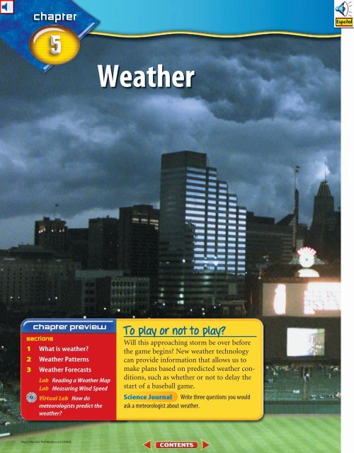
<strong>Weather</strong><br />
To play or not to play?<br />
Will this approaching storm be over before<br />
the game begins? New weather technology<br />
can provide information that allows us to<br />
make plans based on predicted weather conditions,<br />
such as whether or not to delay the<br />
start of a baseball game.<br />
Science Journal Write three questions you would<br />
ask a meteorologist about weather.
What causes rain?<br />
How can it rain one day and be sunny the<br />
next? Powered by heat from the Sun, the air<br />
that surrounds you stirs and swirls. This constant<br />
mixing produces storms, calm weather,<br />
and everything in between. What causes rain<br />
and where does the water come from? Do the<br />
lab below to find out. WARNING: Boiling<br />
water and steam can cause burns.<br />
1. Bring a pan of<br />
water to a boil on<br />
a hot plate.<br />
2. Carefully hold<br />
another pan containing<br />
ice cubes<br />
about 20 cm above the boiling water. Be<br />
sure to keep your hands and face away<br />
from the steam.<br />
3. Keep the pan with the ice cubes in place<br />
until you see drops of water dripping from<br />
the bottom.<br />
4. Think Critically In your Science Journal,<br />
describe how the droplets formed. Infer<br />
where the water on the bottom of the pan<br />
came from.<br />
Start-Up Activities<br />
<strong>Weather</strong> When information is<br />
grouped into clear categories, it<br />
is easier to make sense of what<br />
you are learning. Make the following Foldable to<br />
help you organize your thoughts about weather.<br />
STEP 1<br />
STEP 2<br />
STEP 3<br />
STEP 4<br />
Collect 2 sheets of<br />
paper and layer<br />
them about 1.25 cm<br />
apart vertically. Keep<br />
the edges level.<br />
Fold up the bottom<br />
edges of the paper to<br />
form 4 equal tabs.<br />
Fold the papers and<br />
crease well to hold the<br />
tabs in place. Staple<br />
along the fold.<br />
Label the tabs<br />
<strong>Weather</strong>, What is<br />
weather?, <strong>Weather</strong><br />
Patterns, and<br />
Forecasting <strong>Weather</strong><br />
as shown.<br />
<strong>Weather</strong><br />
What is weather?<br />
<strong>Weather</strong> Patterns<br />
Forecasting <strong>Weather</strong><br />
Summarize As you read the chapter, summarize<br />
what you learn under the appropriate tabs.<br />
Preview this chapter’s content<br />
and activities at<br />
green.msscience.com<br />
117<br />
(bkgd.)Reuters NewMedia Inc/CORBIS, (inset)KS Studios
■ Explain how solar heating and<br />
water vapor in the atmosphere<br />
affect weather.<br />
■ Discuss how clouds form and<br />
how they are classified.<br />
■ Describe how rain, hail, sleet,<br />
and snow develop.<br />
<strong>Weather</strong> changes affect your daily<br />
activities.<br />
Review Vocabulary<br />
factor: something that influences<br />
a result<br />
New Vocabulary<br />
• weather •<br />
dew point • humidity • fog<br />
• relative • precipitation<br />
humidity<br />
118 CHAPTER 5 <strong>Weather</strong><br />
Kevin Horgan/Stone/Getty Images<br />
What is weather?<br />
<strong>Weather</strong> Factors<br />
It might seem like small talk to you, but for farmers, truck<br />
drivers, pilots, and construction workers, the weather can have a<br />
huge impact on their livelihoods. Even professional athletes,<br />
especially golfers, follow weather patterns closely. You can<br />
describe what happens in different kinds of weather, but can you<br />
explain how it happens?<br />
<strong>Weather</strong> refers to the state of the atmosphere at a specific<br />
time and place. <strong>Weather</strong> describes conditions such as air pressure,<br />
wind, temperature, and the amount of moisture in the air.<br />
The Sun provides almost all of Earth’s energy. Energy from<br />
the Sun evaporates water into the atmosphere where it forms<br />
clouds. Eventually, the water falls back to Earth as rain or snow.<br />
However, the Sun does more than evaporate water. It is also a<br />
source of heat energy. Heat from the Sun is absorbed by Earth’s<br />
surface, which then heats the air above it. Differences in Earth’s<br />
surface lead to uneven heating of Earth’s atmosphere. Heat is<br />
eventually redistributed by air and water currents. <strong>Weather</strong>, as<br />
shown in Figure 1, is the result of heat and Earth’s air and water.<br />
Figure 1 The Sun provides the energy that drives Earth’s weather.<br />
Identify storms in this image.
Molecules in air Molecules in air<br />
Wind<br />
Temperature<br />
Pressure<br />
When air is heated, it expands and becomes less dense.<br />
This creates lower pressure.<br />
Air Temperature During the summer when the Sun is hot<br />
and the air is still, a swim can be refreshing. But would a swim<br />
seem refreshing on a cold, winter day? The temperature of air<br />
influences your daily activities.<br />
Air is made up of molecules that are always moving randomly,<br />
even when there’s no wind. Temperature is a measure of<br />
the average amount of motion of molecules. When the temperature<br />
is high, molecules in air move rapidly and it feels warm.<br />
When the temperature is low, molecules in air move less rapidly,<br />
and it feels cold.<br />
Wind Why can you fly a kite on some days but not others? Kites<br />
fly because air is moving. Air moving in a specific direction is<br />
called wind. As the Sun warms the air, the air expands and<br />
becomes less dense. Warm, expanding air has low atmospheric<br />
pressure. Cooler air is denser and tends to sink, bringing about<br />
high atmospheric pressure. Wind results because air moves from<br />
regions of high pressure to regions of low pressure. You may<br />
have experienced this on a small scale if you’ve ever spent time<br />
along a beach, as in Figure 2.<br />
Many instruments are used to measure wind direction and<br />
speed. Wind direction can be measured using a wind vane. A<br />
wind vane has an arrow that points in the direction from which<br />
the wind is blowing. A wind sock has one open end that catches<br />
the wind, causing the sock to point in the direction toward<br />
which the wind is blowing. Wind speed can be measured using<br />
an anemometer (a nuh MAH muh tur). Anemometers have<br />
rotating cups that spin faster when the wind is strong.<br />
Molecules making up air are closer together in cooler<br />
temperatures, creating high pressure. Wind blows<br />
from higher pressure toward lower pressure.<br />
Temperature<br />
Figure 2 The temperature of air<br />
can affect air pressure. Wind is air<br />
moving from high pressure to low<br />
pressure.<br />
Infer In the above picture, which<br />
way would the wind move at night<br />
if the land cooled?<br />
Body Temperature Birds<br />
and mammals maintain a<br />
fairly constant internal<br />
temperature, even when<br />
the temperature outside<br />
their bodies changes. On<br />
the other hand, the internal<br />
temperature of fish<br />
and reptiles changes<br />
when the temperature<br />
around them changes.<br />
Infer from this which<br />
group is more likely to<br />
survive a quick change<br />
in the weather.<br />
SECTION 1 What is weather? 119<br />
Pressure<br />
Fabio Colombini/Earth Scenes
Figure 3 Warmer air can have<br />
more water vapor than cooler air<br />
can because water vapor doesn’t<br />
easily condense in warm air.<br />
Determining Dew<br />
Point<br />
Procedure<br />
1. Partially fill a metal can<br />
with room-temperature<br />
water. Dry the outer<br />
surface of the can.<br />
2. Place a stirring rod in the<br />
water.<br />
3. Slowly stir the water and<br />
add small amounts of ice.<br />
4. Make a data table in your<br />
Science Journal. With a<br />
thermometer, note the<br />
exact water temperature<br />
at which a thin film of<br />
moisture first begins to<br />
form on the outside of the<br />
metal can.<br />
5. Repeat steps 1 through 4<br />
two more times.<br />
6. The average of the three<br />
temperatures at which the<br />
moisture begins to appear<br />
is the dew point<br />
temperature of the air<br />
surrounding the metal<br />
container.<br />
Analysis<br />
1. What determines the dew<br />
point temperature?<br />
2. Will the dew point change<br />
with increasing<br />
temperature if the amount<br />
of moisture in the air<br />
doesn’t change? Explain.<br />
120 CHAPTER 5 <strong>Weather</strong><br />
Water<br />
vapor molecules<br />
Water vapor molecules in warm air<br />
move rapidly. The molecules can’t<br />
easily come together and condense.<br />
Water<br />
droplets<br />
As air cools, water molecules in air<br />
move closer together. Some of<br />
them collide, allowing condensation<br />
to take place.<br />
Humidity Heat evaporates water into the atmosphere. Where<br />
does the water go? Water vapor molecules fit into spaces among<br />
the molecules that make up air. The amount of water vapor<br />
present in the air is called humidity.<br />
Air doesn’t always contain the same amount of water vapor.<br />
As you can see in Figure 3, more water vapor can be present<br />
when the air is warm than when it is cool. At warmer temperatures,<br />
the molecules of water vapor in air move quickly and<br />
don’t easily come together. At cooler temperatures, molecules in<br />
air move more slowly. The slower movement allows water vapor<br />
molecules to stick together and form droplets of liquid water.<br />
The formation of liquid water from water vapor is called condensation.<br />
When enough water vapor is present in air for condensation<br />
to take place, the air is saturated.<br />
Why can more water vapor be present in warm<br />
air than in cold air?<br />
Relative Humidity On a hot, sticky afternoon, the weather<br />
forecaster reports that the humidity is 50 percent. How can the<br />
humidity be low when it feels so humid? <strong>Weather</strong> forecasters<br />
report the amount of moisture in the air as relative humidity.<br />
Relative humidity is a measure of the amount of water vapor<br />
present in the air compared to the amount needed for saturation<br />
at a specific temperature.<br />
If you hear a weather forecaster say that the relative humidity<br />
is 50 percent, it means that the air contains 50 percent of the<br />
water needed for the air to be saturated.<br />
As shown in Figure 4, air at 25°C is saturated when it contains<br />
22 g of water vapor per cubic meter of air. The relative<br />
humidity is 100 percent. If air at 25°C contains 11 g of water<br />
vapor per cubic meter, the relative humidity is 50 percent.
Dew Point<br />
When the temperature drops, less water<br />
vapor can be present in air. The water<br />
vapor in air will condense to a liquid or<br />
form ice crystals. The temperature at which<br />
air is saturated and condensation forms is<br />
the dew point. The dew point changes with<br />
the amount of water vapor in the air.<br />
You’ve probably seen water droplets<br />
form on the outside of a glass of cold milk.<br />
The cold glass cooled the air next to it to its<br />
dew point. The water vapor in the surrounding<br />
air condensed and formed water droplets<br />
on the glass. In a similar way, when air near<br />
the ground cools to its dew point, water<br />
vapor condenses and forms dew. Frost may<br />
form when temperatures are near 0°C.<br />
Amount of water vapor in g/m 3 of air<br />
90<br />
80<br />
70<br />
60<br />
50<br />
40<br />
30<br />
20<br />
10<br />
0<br />
Dew Point<br />
0 5 10 15 20 25 30 35 40 45 50<br />
Temperature (C)<br />
Figure 4 This graph shows that as the temperature of air<br />
increases, more water vapor can be present in the air.<br />
Calculate Percent<br />
DEW POINT One summer day, the relative humidity is 80 percent and the temperature is 35°C. Use<br />
Figure 4 to find the dew point reached if the temperature falls to 25°C?<br />
Solution<br />
This is what you know:<br />
This is what you need to find out:<br />
Air Temperature<br />
(°C)<br />
Amount of Water Vapor<br />
Needed for Saturation (g/m3 )<br />
35 37<br />
25 22<br />
15 14<br />
x amount of water vapor in 35°C air at 80 percent<br />
relative humidity. Is x 22 g/m 3 or is x 22 g/m 3 ?<br />
This is how you solve the problem: x .80 (37 g/m 3 )<br />
x 29.6 g/m 3 of water vapor<br />
29.6 g/m 3 22 g/m 3 , so the dew point is<br />
reached and dew will form.<br />
1. If the relative humidity is 50 percent and the air temperature is 35°C, will the dew point<br />
be reached if the temperature falls to 20°C?<br />
2. If the air temperature is 25°C and the relative humidity is 30 percent, will the dew point<br />
be reached if the temperature drops to 15°C?<br />
For more practice, visit<br />
green.msscience.com/<br />
math_practice<br />
SECTION 1 What is weather? 121
Figure 5 Clouds form when<br />
moist air is lifted and cools. This<br />
occurs where air is heated, at<br />
mountain ranges, and where cold<br />
air meets warm air.<br />
Moist warm air<br />
122 CHAPTER 5 <strong>Weather</strong><br />
Forming Clouds<br />
Why are there clouds in the sky? Clouds form as warm air is<br />
forced upward, expands, and cools. Figure 5 shows several ways<br />
that warm, moist air forms clouds. As the air cools, the amount<br />
of water vapor needed for saturation decreases and the relative<br />
humidity increases. When the relative humidity reaches 100 percent,<br />
the air is saturated. Water vapor soon begins to condense<br />
in tiny droplets around small particles such as dust and salt.<br />
These droplets of water are so small that they remain suspended<br />
in the air. Billions of these droplets form a cloud.<br />
Classifying Clouds<br />
Clouds are classified mainly by shape and height. Some<br />
clouds extend high into the sky, and others are low and flat.<br />
Some dense clouds bring rain or snow, while thin, wispy clouds<br />
appear on mostly sunny days. The shape and height of clouds<br />
vary with temperature, pressure, and the amount of water vapor<br />
in the atmosphere.<br />
Damp earth<br />
Moist warm air<br />
As moist air moves over mountains, it is lifted and cools.<br />
Clouds formed in this way can cover mountains for long<br />
periods of time.<br />
Heat<br />
Rays from the Sun heat the<br />
ground and the air next to it.<br />
The warm air rises and cools.<br />
If the air is moist, some water<br />
vapor condenses and forms<br />
clouds.<br />
When cool air meets warm, moist air, the warm air is<br />
lifted and cools.<br />
Explain what happens to the water vapor when the dew<br />
point is reached.
Shape The three main cloud types<br />
are stratus, cumulus, and cirrus.<br />
Stratus clouds form layers, or smooth,<br />
even sheets in the sky. Stratus clouds<br />
usually form at low altitudes and may<br />
be associated with fair weather or rain<br />
or snow. When air is cooled to its dew<br />
point near the ground, it forms a stratus<br />
cloud called fog, as shown in<br />
Figure 6.<br />
Cumulus (KYEW myuh lus)<br />
clouds are masses of puffy, white<br />
clouds, often with flat bases. They<br />
sometimes tower to great heights and<br />
can be associated with fair weather or thunderstorms.<br />
Cirrus (SIHR us) clouds appear fibrous or curly. They are<br />
high, thin, white, feathery clouds made of ice crystals. Cirrus<br />
clouds are associated with fair weather, but they can indicate<br />
approaching storms.<br />
Height Some prefixes of cloud names describe the height of<br />
the cloud base. The prefix cirro- describes high clouds, altodescribes<br />
middle-elevation clouds, and strato- refers to clouds at<br />
low elevations. Some clouds’ names combine the altitude prefix<br />
with the term stratus or cumulus.<br />
Cirrostratus clouds are high clouds, like those in Figure 7.<br />
Usually, cirrostratus clouds indicate fair weather, but they also<br />
can signal an approaching storm. Altostratus clouds form at<br />
middle levels. If the clouds are not too thick, sunlight can filter<br />
through them.<br />
Figure 6 Fog surrounds the<br />
Golden Gate Bridge, San Francisco.<br />
Fog is a stratus cloud near the<br />
ground.<br />
Think Critically Why do you think<br />
fog is found in San Francisco Bay?<br />
Figure 7 Cirrostratus clouds are<br />
made of ice crystals and form high<br />
in Earth’s atmosphere.<br />
SECTION 1 What is weather? 123<br />
(t)Charles O'Rear/CORBIS, (b)Joyce Photographics/Photo Researchers
Figure 8 Water<br />
vapor in air collects<br />
on particles to form<br />
water droplets or ice<br />
crystals. The type<br />
of precipitation that<br />
is received on the<br />
ground depends on<br />
the temperature<br />
of the air.<br />
124 CHAPTER 5 <strong>Weather</strong><br />
Warm<br />
Raindrops<br />
(l)Roy Morsch/The Stock Market/CORBIS, (r)Mark McDermott<br />
Cloud<br />
droplets<br />
Warm<br />
When the air is warm, water vapor forms<br />
raindrops that fall as rain.<br />
Ice<br />
crystals<br />
Cold<br />
Cloud<br />
droplets<br />
Snowflakes<br />
Cold<br />
When the air is cold, water vapor forms<br />
snowflakes.<br />
Rain- or Snow-Producing Clouds Clouds associated with<br />
rain or snow often have the word nimbus attached to them. The<br />
term nimbus is Latin for “dark rain cloud” and this is a good<br />
description, because the water content of these clouds is so high<br />
that little sunlight can pass through them. When a cumulus<br />
cloud grows into a thunderstorm, it is called a cumulonimbus<br />
(kyew myuh loh NIHM bus) cloud. These clouds can tower to<br />
nearly 18 km. Nimbostratus clouds are layered clouds that can<br />
bring long, steady rain or snowfall.<br />
Precipitation<br />
Water falling from clouds is called precipitation. Precipitation<br />
occurs when cloud droplets combine and grow large<br />
enough to fall to Earth. The cloud droplets form around small<br />
particles, such as salt and dust. These particles are so small that<br />
a puff of smoke can contain millions of them.<br />
You might have noticed that raindrops are not all the same<br />
size. The size of raindrops depends on several factors. One factor<br />
is the strength of updrafts in a cloud. Strong updrafts can<br />
keep drops suspended in the air where they can combine with<br />
other drops and grow larger. The rate of evaporation as a drop<br />
falls to Earth also can affect its size. If the air is dry, the size of<br />
raindrops can be reduced or they can completely evaporate<br />
before reaching the ground.<br />
Air temperature determines whether water forms rain, snow,<br />
sleet, or hail—the four main types of precipitation. Figure 8<br />
shows these different types of precipitation. Drops of water<br />
falling in temperatures above freezing fall as rain. Snow forms<br />
when the air temperature is so cold that water vapor changes<br />
directly to a solid. Sleet forms when raindrops pass through a<br />
layer of freezing air near Earth’s surface, forming ice pellets.<br />
What are the four main types of precipitation?
Warm<br />
Cold<br />
Cloud<br />
droplets<br />
Ice<br />
When the air near the ground is cold, sleet,<br />
which is made up of many small ice pellets,<br />
falls.<br />
Summary<br />
<strong>Weather</strong><br />
•<br />
Factors<br />
<strong>Weather</strong> is the state of the atmosphere at a<br />
•<br />
specific time and place.<br />
Temperature, wind, air pressure, dew point,<br />
and humidity describe weather.<br />
•Clouds<br />
•<br />
Warm, moist air rises, forming clouds.<br />
The main types of clouds are stratus, cumulus,<br />
and cirrus.<br />
•Precipitation<br />
•<br />
Water falling from clouds is called precipitation.<br />
Air temperature determines whether water<br />
forms rain, snow, sleet, or hail.<br />
Cloud<br />
droplet<br />
Partial<br />
melting Hail<br />
Warm<br />
Hail Hail is precipitation in the form of lumps of ice. Hail forms<br />
in cumulonimbus clouds of a thunderstorm when water freezes<br />
in layers around a small nucleus of ice. Hailstones grow larger as<br />
they’re tossed up and down by rising and falling air. Most hailstones<br />
are smaller than 2.5 cm but can grow larger than a softball.<br />
Of all forms of precipitation, hail produces the most damage<br />
immediately, especially if winds blow during a hailstorm. Falling<br />
hailstones can break windows and destroy crops.<br />
If you understand the role of water vapor in the atmosphere,<br />
you can begin to understand weather. The relative humidity of<br />
the air helps determine whether a location will have a dry day or<br />
experience some form of precipitation. The temperature of the<br />
atmosphere determines the form of precipitation. Studying<br />
clouds can add to your ability to forecast weather.<br />
green.msscience.com/self_check_quiz<br />
Ice<br />
crystal<br />
Hailstones are pellets of ice that form inside<br />
a cloud.<br />
Self Check<br />
1. Explain When does water vapor in air condense?<br />
2. Compare and contrast humidity and relative humidity.<br />
3. Summarize how clouds form.<br />
4. Describe How does precipitation occur and what determines<br />
the type of precipitation that falls to Earth?<br />
5. Think Critically Cumulonimbus clouds form when<br />
warm, moist air is suddenly lifted. How can the same<br />
cumulonimbus cloud produce rain and hail?<br />
6. Use Graphs If the air temperature is 30°C and the relative<br />
humidity is 60 percent, will the dew point be<br />
reached if the temperature drops to 25°C? Use the<br />
graph in Figure 4 to explain your answer.<br />
SECTION 1 What is weather? 125<br />
(l)Mark E. Gibson/Visuals Unlimited, (r)EPI Nancy Adams/Tom Stack & Assoc.
■ Describe how weather is<br />
associated with fronts and highand<br />
low-pressure areas.<br />
■ Explain how tornadoes develop<br />
from thunderstorms.<br />
■ Discuss the dangers of severe<br />
weather.<br />
Air masses, pressure systems, and<br />
fronts cause weather to change.<br />
Review Vocabulary<br />
barometer: instrument used to<br />
measure atmospheric pressure<br />
New Vocabulary<br />
• air mass • hurricane<br />
• front • blizzard<br />
• tornado<br />
Figure 9 Six major air masses<br />
affect weather in the United<br />
States. Each air mass has the same<br />
characteristics of temperature and<br />
moisture content as the area over<br />
which it formed.<br />
126 CHAPTER 5 <strong>Weather</strong><br />
<strong>Weather</strong> Patterns<br />
<strong>Weather</strong> Changes<br />
When you leave for school in the morning, the weather<br />
might be different from what it is when you head home in the<br />
afternoon. Because of the movement of air and moisture in the<br />
atmosphere, weather constantly changes.<br />
Air Masses An air mass is a large body of air that has properties<br />
similar to the part of Earth’s surface over which it develops.<br />
For example, an air mass that develops over land is dry<br />
compared with one that develops over water. An air mass that<br />
develops in the tropics is warmer than one that develops over<br />
northern regions. An air mass can cover thousands of square<br />
kilometers. When you observe a change in the weather from one<br />
day to the next, it is due to the movement of air masses. Figure 9<br />
shows air masses that affect the United States.<br />
Cool/<br />
Moist<br />
Warm/<br />
Moist<br />
Hot/<br />
Dry<br />
Cold/<br />
Dry<br />
Warm/<br />
Moist<br />
Cool/<br />
Moist
Highs and Lows Atmospheric<br />
pressure varies over<br />
Earth’s surface. Anyone who has watched a<br />
weather report on television has heard about<br />
high- and low-pressure systems. Recall that<br />
winds blow from areas of high pressure to areas<br />
of low pressure. As winds blow into a lowpressure<br />
area in the northern hemisphere, Earth’s<br />
rotation causes these winds to swirl in a counterclockwise<br />
direction. Large, swirling areas of low<br />
pressure are called cyclones and are associated<br />
with stormy weather.<br />
How do winds move in a cyclone?<br />
Winds blow away from a center of high pressure. Earth’s<br />
rotation causes these winds to spiral clockwise in the northern<br />
hemisphere. High-pressure areas are associated with fair<br />
weather and are called anticyclones. Air pressure is measured<br />
using a barometer, like the one shown in Figure 10.<br />
Variation in atmospheric pressure affects the weather. Low<br />
pressure systems at Earth’s surface are regions of rising air.<br />
Clouds form when air is lifted and cools. Areas of low pressure<br />
usually have cloudy weather. Sinking motion in high-pressure<br />
air masses makes it difficult for air to rise and clouds to form.<br />
That’s why high pressure usually means good weather.<br />
Fronts<br />
A boundary between two air masses of different density,<br />
moisture, or temperature is called a front. If you’ve seen a<br />
weather map in the newspaper or on the evening news, you’ve<br />
seen fronts represented by various types of curving lines.<br />
Cloudiness, precipitation, and storms sometimes occur at<br />
frontal boundaries. Four types of fronts include cold, warm,<br />
occluded, and stationary.<br />
Cold and Warm Fronts A cold front, shown on a map as a<br />
blue line with triangles , occurs when colder air advances<br />
toward warm air. The cold air wedges under the warm air like a<br />
plow. As the warm air is lifted, it cools and water vapor condenses,<br />
forming clouds. When the temperature difference<br />
between the cold and warm air is large, thunderstorms and even<br />
tornadoes may form.<br />
Warm fronts form when lighter, warmer air advances over<br />
heavier, colder air. A warm front is drawn on weather maps as a<br />
red line with red semicircles .<br />
Figure 10 A barometer measures<br />
atmospheric pressure. The red<br />
pointer points to the current pressure.<br />
Watch how atmospheric<br />
pressure changes over time when<br />
you line up the white pointer to<br />
the one indicating the current<br />
pressure each day.<br />
Topic: Atmospheric<br />
Pressure<br />
Visit green.msscience.com for Web<br />
links to information about the<br />
current atmospheric pressure of<br />
your town or nearest city.<br />
Activity Look up the pressure of<br />
a city west of your town and the<br />
pressure of a city to the east.<br />
Compare the pressures to local<br />
weather conditions. Share your<br />
information with the class.<br />
SECTION 2 <strong>Weather</strong> Patterns 127<br />
Van Bucher/Science Source/Photo Researchers
Figure 11 Cold, warm,<br />
occluded, and stationary fronts<br />
occur at the boundaries of air<br />
masses.<br />
Describe what type of weather<br />
occurs at front boundaries.<br />
Cold air<br />
Cold air<br />
128 CHAPTER 5 <strong>Weather</strong><br />
Warm air<br />
A cold front can advance rapidly. Thunderstorms often<br />
form as warm air is suddenly lifted up over the cold air.<br />
Occluded and Stationary Fronts An occluded front<br />
involves three air masses of different temperatures—colder air,<br />
cool air, and warm air. An occluded front may form when a cold<br />
air mass moves toward cool air with warm air between the two.<br />
The colder air forces the warm air upward, closing off the warm<br />
air from the surface. Occluded fronts are shown on maps as<br />
purple lines with triangles and semicircles .<br />
A stationary front occurs when a boundary between air<br />
masses stops advancing. Stationary fronts may remain in the<br />
same place for several days, producing light wind and precipitation.<br />
A stationary front is drawn on a weather map as an alternating<br />
red and blue line. Red semicircles point toward the cold<br />
air and blue triangles point toward the warm air . Figure 11<br />
summarizes the four types of fronts.<br />
Warm air<br />
Cool air<br />
The term occlusion means “closure.” Colder air forces<br />
warm air upward, forming an occluded front that<br />
closes off the warm air from the surface.<br />
Warm air<br />
Cold air<br />
Cold air<br />
Warm air slides over colder air along a warm front,<br />
forming a boundary with a gentle slope. This can lead<br />
to hours, if not days, of wet weather.<br />
Warm air<br />
A stationary front results when neither cold air nor<br />
warm air advances.
Jeffrey Howe/Visuals Unlimited<br />
Severe <strong>Weather</strong><br />
Despite the weather, you usually can do your daily activities.<br />
If it’s raining, you still go to school. You can still get there even<br />
if it snows a little. However, some weather conditions, such as<br />
those caused by thunderstorms, tornadoes, and blizzards, prevent<br />
you from going about your normal routine. Severe weather<br />
poses danger to people, structures, and animals.<br />
Thunderstorms In a thunderstorm, heavy rain falls, lightning<br />
flashes, thunder roars, and hail might fall. What forces<br />
cause such extreme weather conditions?<br />
Thunderstorms occur in warm, moist air masses and along<br />
fronts. Warm, moist air can be forced upward where it cools and<br />
condensation occurs, forming cumulonimbus clouds that can<br />
reach heights of 18 km, like the one in Figure 12. When rising<br />
air cools, water vapor condenses into water droplets or ice crystals.<br />
Smaller droplets collide to form larger ones, and the<br />
droplets fall through the cloud toward Earth’s surface. The<br />
falling droplets collide with still more droplets and grow larger.<br />
Raindrops cool the air around them. This cool, dense air then<br />
sinks and spreads over Earth’s surface. Sinking, rain-cooled air<br />
and strong updrafts of warmer air cause the strong winds associated<br />
with thunderstorms. Hail also may form as ice crystals<br />
alternately fall to warmer layers and are lifted into colder layers<br />
by the strong updrafts inside cumulonimbus clouds.<br />
Thunderstorm Damage Sometimes thunderstorms can stall<br />
over a region, causing rain to fall heavily for a period of time.<br />
When streams cannot contain all<br />
the water running into them, flash<br />
flooding can occur. Flash floods<br />
can be dangerous because they<br />
occur with little warning.<br />
Strong winds generated by<br />
thunderstorms also can cause damage.<br />
If a thunderstorm is accompanied<br />
by winds traveling faster than<br />
89 km/h, it is classified as a severe<br />
thunderstorm. Hail from a thunderstorm<br />
can dent cars and the aluminum<br />
siding on houses. Although<br />
rain from thunderstorms helps<br />
crops grow, hail has been known to<br />
flatten and destroy entire crops in a<br />
matter of minutes.<br />
Figure 12 Tall cumulonimbus<br />
clouds may form quickly as warm,<br />
moist air rapidly rises.<br />
Identify some things these clouds<br />
are known to produce.<br />
SECTION 2 <strong>Weather</strong> Patterns 129
Figure 13 This time-elapsed<br />
photo shows a thunderstorm over<br />
Arizona.<br />
Topic: Lightning<br />
Visit green.msscience.com for Web<br />
links to research the number of<br />
lightning strikes in your state<br />
during the last year.<br />
Activity Compare your findings<br />
with data from previous years.<br />
Communicate to your class what<br />
you learn.<br />
130 CHAPTER 5 <strong>Weather</strong><br />
Roy Johnson/Tom Stack & Assoc.<br />
Lightning and Thunder<br />
What are lightning and thunder?<br />
Inside a storm cloud, warm<br />
air is lifted rapidly as cooler air<br />
sinks. This movement of air can<br />
cause different parts of a cloud<br />
to become oppositely charged.<br />
When current flows between<br />
regions of opposite electrical<br />
charge, lightning flashes. Lightning,<br />
as shown in Figure 13, can<br />
occur within a cloud, between<br />
clouds, or between a cloud and<br />
the ground.<br />
Thunder results from the<br />
rapid heating of air around a<br />
bolt of lightning. Lightning can<br />
reach temperatures of about 30,000°C, which is more than five<br />
times the temperature of the surface of the Sun. This extreme<br />
heat causes air around the lightning to expand rapidly. Then it<br />
cools quickly and contracts. The rapid movement of the molecules<br />
forms sound waves heard as thunder.<br />
Tornadoes Some of the most severe thunderstorms produce<br />
tornadoes. A tornado is a violently rotating column of air in<br />
contact with the ground. In severe thunderstorms, wind at different<br />
heights blows in different directions and at different<br />
speeds. This difference in wind speed and direction, called wind<br />
shear, creates a rotating column parallel to the ground. A thunderstorm’s<br />
updraft can tilt the rotating column upward into the<br />
thunderstorm creating a funnel cloud. If the funnel comes into<br />
contact with Earth’s surface, it is called a tornado.<br />
What causes a tornado to form?<br />
A tornado’s destructive winds can rip apart buildings and<br />
uproot trees. High winds can blow through broken windows.<br />
When winds blow inside a house, they can lift off the roof and blow<br />
out the walls, making it look as though the building exploded. The<br />
updraft in the center of a powerful tornado can lift animals, cars,<br />
and even houses into the air. Although tornadoes rarely exceed<br />
200 m in diameter and usually last only a few minutes, they often<br />
are extremely destructive. In May 1999, multiple thunderstorms<br />
produced more than 70 tornadoes in Kansas, Oklahoma, and Texas.<br />
This severe tornado outbreak caused 40 deaths, 100 injuries, and<br />
more than $1.2 billion in property damage.
Figure 14<br />
Tornadoes are extremely rapid,<br />
rotating winds that form at the<br />
base of cumulonimbus clouds.<br />
Smaller tornadoes may even form<br />
inside larger ones. Luckily,<br />
most tornadoes remain on<br />
the ground for just a few<br />
minutes. During that<br />
time, however, they can<br />
cause considerable—and<br />
sometimes strange—<br />
damage, such as driving<br />
a fork into a tree.<br />
F0<br />
F1<br />
F2<br />
F3<br />
F4<br />
F5<br />
Tornadoes often form from a type<br />
of cumulonimbus cloud called a wall<br />
cloud. Strong, spiraling updrafts of<br />
warm, moist air may form in these<br />
clouds. As air spins upward, a lowpressure<br />
area forms, and the cloud<br />
descends to the ground in a funnel.<br />
The tornado sucks up debris as it<br />
moves along the ground, forming<br />
a dust envelope.<br />
The Fujita Scale<br />
Global Warming Some scientists<br />
hypothesize that<br />
Earth’s ocean temperatures<br />
are increasing due to global<br />
warming. In your Science<br />
Journal, predict what might<br />
happen to the strength of<br />
hurricanes if Earth’s oceans<br />
become warmer.<br />
Figure 15 In this hurricane<br />
cross section, the small, red arrows<br />
indicate rising, warm, moist air.<br />
This air forms cumulus and<br />
cumulonimbus clouds in bands<br />
around the eye. The green arrows<br />
indicate cool, dry air sinking in the<br />
eye and between the cloud bands.<br />
Spiral rain bands<br />
132 CHAPTER 5 <strong>Weather</strong><br />
Hurricanes The most powerful storm is the hurricane. A<br />
hurricane, illustrated in Figure 15, is a large, swirling, lowpressure<br />
system that forms over the warm Atlantic Ocean. It is<br />
like a machine that turns heat energy from the ocean into wind.<br />
A storm must have winds of at least 119 km/h to be called a<br />
hurricane. Similar storms are called typhoons in the Pacific<br />
Ocean and cyclones in the Indian Ocean.<br />
Hurricanes are similar to low-pressure systems on land, but<br />
they are much stronger. In the Atlantic and Pacific Oceans, low<br />
pressure sometimes develops near the equator. In the northern<br />
hemisphere, winds around this low pressure begin rotating<br />
counterclockwise. The strongest hurricanes affecting North<br />
America usually begin as a low-pressure system west of Africa.<br />
Steered by surface winds, these storms can travel west, gaining<br />
strength from the heat and moisture of warm ocean water.<br />
When a hurricane strikes land, high winds, tornadoes, heavy<br />
rains, and high waves can cause a lot of damage. Floods from the<br />
heavy rains can cause additional damage. Hurricane weather<br />
can destroy crops, demolish buildings, and kill people and other<br />
animals. As long as a hurricane is over water, the warm, moist air<br />
rises and provides energy for the storm. When a hurricane<br />
reaches land, however, its supply of energy disappears and the<br />
storm loses power.<br />
Outflow<br />
Eye<br />
Descending air<br />
Warm, moist air<br />
NASA/Science Photo Library/Photo Researchers
Blizzards Severe storms also can occur<br />
in winter. If you live in the northern<br />
United States, you may have awakened<br />
from a winter night’s sleep to a cold,<br />
howling wind and blowing snow, like the<br />
storm in Figure 16. The National<br />
<strong>Weather</strong> Service classifies a winter storm<br />
as a blizzard if the winds are 56 km/h,<br />
the temperature is low, the visibility is<br />
less than 400 m in falling or blowing<br />
snow, and if these conditions persist for<br />
three hours or more.<br />
Severe <strong>Weather</strong> Safety When severe<br />
weather threatens, the National <strong>Weather</strong><br />
Service issues a watch or warning. Watches are issued when conditions<br />
are favorable for severe thunderstorms, tornadoes, floods,<br />
blizzards, and hurricanes. During a watch, stay tuned to a radio or<br />
television station reporting the weather. When a warning is issued,<br />
severe weather conditions already exist. You should take immediate<br />
action. During a severe thunderstorm or tornado warning, take<br />
shelter in the basement or a room in the middle of the house away<br />
from windows. When a hurricane or flood watch is issued, be prepared<br />
to leave your home and move farther inland.<br />
Blizzards can be blinding and have dangerously low temperatures<br />
with high winds. During a blizzard, stay indoors.<br />
Spending too much time outside can result in severe frostbite.<br />
Summary<br />
<strong>Weather</strong> Changes<br />
• Air<br />
• Winds<br />
masses tend to have temperature and<br />
moisture properties similar to Earth’s surface.<br />
blow from areas of high pressure to<br />
areas of lower pressure.<br />
•Fronts<br />
A boundary between different air masses is<br />
called a front.<br />
•Severe <strong>Weather</strong><br />
The National <strong>Weather</strong> Service issues watches<br />
or warnings, depending on the severity of the<br />
storm, for people’s safety.<br />
green.msscience.com/self_check_quiz<br />
Figure 16 Blizzards can be<br />
extremely dangerous because of<br />
their high winds, low temperatures,<br />
and poor visibility.<br />
Self Check<br />
1. Draw Conclusions Why is fair weather common during<br />
periods of high pressure?<br />
2. Describe how a cold front affects weather.<br />
3. Explain what causes lightning and thunder.<br />
4. Compare and contrast a watch and a warning. How<br />
can you keep safe during a tornado warning?<br />
5. Think Critically Explain why some fronts produce<br />
stronger storms than others.<br />
6. Recognize Cause and Effect Describe how an<br />
occluded front may form over your city and what<br />
effects it can have on the weather.<br />
SECTION 2 <strong>Weather</strong> Patterns 133<br />
Fritz Pölking/Peter Arnold, Inc
■ Explain how data are collected<br />
for weather maps and forecasts.<br />
■ Identify the symbols used in a<br />
weather station model.<br />
<strong>Weather</strong> observations help you<br />
predict future weather events.<br />
Review Vocabulary<br />
forecast: to predict a condition or<br />
event on the basis of observations<br />
New Vocabulary<br />
• meteorologist • isotherm<br />
• station model • isobar<br />
Figure 17 A meteorologist uses<br />
Doppler radar to track a tornado.<br />
Since the nineteenth century, technology<br />
has greatly improved<br />
weather forecasting.<br />
134 CHAPTER 5 <strong>Weather</strong><br />
Howard Bluestein/Science Source/Photo Researchers<br />
<strong>Weather</strong> Forecasts<br />
<strong>Weather</strong> Observations<br />
You can determine current weather conditions by checking<br />
the thermometer and looking to see whether clouds are in the<br />
sky. You know when it’s raining. You have a general idea of the<br />
weather because you are familiar with the typical weather where<br />
you live. If you live in Florida, you don’t expect snow in the forecast.<br />
If you live in Maine, you assume it will snow every winter.<br />
What weather concerns do you have in your region?<br />
A meteorologist (mee tee uh RAH luh jist) is a person who<br />
studies the weather. Meteorologists take measurements of temperature,<br />
air pressure, winds, humidity, and precipitation. Computers,<br />
weather satellites, Doppler radar shown in Figure 17, and<br />
instruments attached to balloons are used to gather data. Such<br />
instruments improve meteorologists’ ability to predict the<br />
weather. Meteorologists use the information provided by<br />
weather instruments to make weather maps. These maps are<br />
used to make weather forecasts.<br />
Forecasting <strong>Weather</strong><br />
Meteorologists gather information about current weather<br />
and use computers to make predictions about future weather<br />
patterns. Because storms can be dangerous, you do not want to<br />
be unprepared for threatening weather. However, meteorologists<br />
cannot always predict the<br />
weather exactly because conditions<br />
can change rapidly.<br />
The National <strong>Weather</strong> Service<br />
depends on two sources for its information—data<br />
collected from the<br />
upper atmosphere and data collected<br />
on Earth’s surface. Meteorologists of<br />
the National <strong>Weather</strong> Service collect<br />
information recorded by satellites,<br />
instruments attached to weather balloons,<br />
and from radar. This information<br />
is used to describe weather<br />
conditions in the atmosphere above<br />
Earth’s surface.
Station Models When meteorologists gather data from<br />
Earth’s surface, it is recorded on a map using a combination of<br />
symbols, forming a station model. A station model, like the one<br />
in Figure 18, shows the weather conditions at a specific location<br />
on Earth’s surface. Information provided by station models and<br />
instruments in the upper atmosphere is entered into computers<br />
and used to forecast weather.<br />
Temperature and Pressure In addition to station models,<br />
weather maps have lines that connect locations of equal temperature<br />
or pressure. A line that connects points of equal temperature<br />
is called an isotherm (I suh thurm). Iso means “same” and<br />
therm means “temperature.” You probably have seen isotherms<br />
on weather maps on TV or in the newspaper.<br />
An isobar is a line drawn to connect points of equal atmospheric<br />
pressure. You can tell how fast wind is blowing in an area<br />
by noting how closely isobars are spaced. Isobars that are close<br />
together indicate a large pressure difference over a small area. A<br />
large pressure difference causes strong winds. Isobars that are<br />
spread apart indicate a smaller difference in pressure. Winds in<br />
this area are gentler. Isobars also indicate the locations of highand<br />
low-pressure areas.<br />
NEW<br />
MEXICO<br />
MEXICO<br />
How do isobars indicate wind speed?<br />
TEXAS<br />
OKLAHOMA<br />
Dallas<br />
Type of middle clouds<br />
Temperature(°F)<br />
Type of precipitation<br />
ARKANSAS<br />
76<br />
70<br />
LOUISIANA<br />
---<br />
19.4<br />
+2<br />
Dew point temperature<br />
Type of low clouds<br />
Measuring Rain<br />
Procedure<br />
1. You will need a straightsided<br />
container, such as a<br />
soup or coffee can, duct<br />
tape, and a ruler.<br />
2. Tape the ruler to the inner<br />
wall of your container.<br />
3. Place the container on a<br />
level surface outdoors,<br />
away from buildings or<br />
plants.<br />
4. Measure the amount of<br />
water in your container<br />
after it rains. Continue to<br />
take measurements for<br />
a week.<br />
Analysis<br />
1. What was the average<br />
daily rainfall?<br />
2. Why is it necessary to<br />
use containers with<br />
straight<br />
sides?<br />
Figure 18 A station model<br />
shows the weather conditions at<br />
one specific location.<br />
Type of high clouds<br />
Barometric pressure in millibars<br />
with initial 9 or 10 omitted<br />
Change in barometric pressure in<br />
last 3 hours(in tenths of millibars)<br />
Wind speed and direction<br />
SECTION 3 <strong>Weather</strong> Forecasts 135
1000<br />
1008<br />
1016<br />
1024<br />
HIGH<br />
1024<br />
▲<br />
▲<br />
1000 1008<br />
▲<br />
▲<br />
Figure 19 Highs, lows, isobars,<br />
and fronts on this weather map<br />
help meteorologists forecast the<br />
weather.<br />
Summary<br />
<strong>Weather</strong> Observations<br />
• Meteorologists are people who study the<br />
weather and make weather maps.<br />
Forecasting <strong>Weather</strong><br />
• Meteorologists gather information about<br />
current weather and make predictions about<br />
future weather patterns.<br />
• A station model shows weather conditions at<br />
a specific location on Earth’s surface by using<br />
symbols to record meteorological data.<br />
• On weather maps, isotherms are lines that<br />
connect points of equal temperature.<br />
• An isobar is a line drawn on a weather map<br />
that connects points of equal atmospheric<br />
pressure.<br />
136 CHAPTER 5 <strong>Weather</strong><br />
▲<br />
75<br />
67<br />
San Diego<br />
76<br />
70<br />
▲<br />
130<br />
+4<br />
194<br />
+2<br />
▲<br />
▲<br />
1008<br />
▲<br />
89<br />
28<br />
1016<br />
LOW<br />
Portland<br />
LOW<br />
-4<br />
1024<br />
172<br />
1016 1024<br />
▲<br />
Denver<br />
HIGH<br />
76<br />
57<br />
▲<br />
183<br />
+0<br />
▲<br />
▲<br />
▲<br />
Tucson Dallas<br />
LOW<br />
1016<br />
71<br />
68<br />
▲<br />
▲<br />
1032<br />
HIGH<br />
Duluth<br />
217<br />
-6<br />
▲<br />
41<br />
35<br />
Springfield<br />
HIGH<br />
Little Rock<br />
▲<br />
64<br />
54<br />
▲<br />
269<br />
+16<br />
227<br />
+10<br />
▲<br />
58<br />
54<br />
▲<br />
074<br />
+26<br />
▲<br />
▲<br />
▲<br />
▲<br />
▲<br />
▲<br />
79<br />
76<br />
1024<br />
HIGH<br />
1032<br />
1008<br />
1000<br />
LOW<br />
125<br />
-20<br />
Nashville<br />
<strong>Weather</strong> Maps On a weather map like the one in Figure 19,<br />
pressure areas are drawn as circles with the word High or Low in<br />
the middle of the circle. Fronts are drawn as lines and symbols.<br />
When you watch weather forecasts on television, notice how<br />
weather fronts move from west to east. This is a pattern that<br />
meteorologists depend on to forecast weather.<br />
Self Check<br />
1. List some instruments that are used to collect<br />
weather data.<br />
2. Describe at least six items of data that might be<br />
recorded in a station model.<br />
3. Explain how the National <strong>Weather</strong> Service makes<br />
weather maps.<br />
▲<br />
4. Explain what closely spaced isobars on a weather map<br />
indicate.<br />
5. Think Critically In the morning you hear a meteorologist<br />
forecast today’s weather as sunny and warm. After school,<br />
it is raining. Why is the weather so hard to predict?<br />
6. Concept Map Using a computer, make an events-chain<br />
concept map for how a weather forecast is made.<br />
▲<br />
84<br />
75<br />
1024<br />
1008<br />
LOW<br />
Miami<br />
134<br />
-8<br />
85<br />
75<br />
▲<br />
244<br />
-4<br />
Legend<br />
Cold front<br />
Warm front<br />
Occluded front<br />
Stationary front<br />
Isobar<br />
Precipitation<br />
1016<br />
▲<br />
Columbia<br />
▲<br />
▲<br />
▲<br />
▲<br />
▲<br />
▲<br />
▲<br />
▲<br />
▲<br />
▲<br />
HIGH<br />
▲<br />
▲<br />
▲<br />
1016<br />
1024<br />
green.msscience.com/self_check_quiz
Meteorologists use a series of symbols to provide<br />
a picture of local and national weather conditions.<br />
With what you know, can you interpret weather<br />
information from weather map symbols?<br />
Real-World Question<br />
How do you read a weather map?<br />
Materials<br />
magnifying lens<br />
<strong>Weather</strong> Map Symbols Appendix<br />
Figure 19 (<strong>Weather</strong> Map)<br />
Goals<br />
■ Learn how to read a weather map.<br />
■ Use information from a station model and a<br />
weather map to forecast weather.<br />
Procedure<br />
Use the information provided in the questions<br />
below and the <strong>Weather</strong> Map Symbols Appendix<br />
to learn how to read a weather map.<br />
1. Find the station models on the map for<br />
Portland, Oregon, and Miami, Florida. Find<br />
the dew point, wind direction, barometric<br />
pressure, and temperature at each location.<br />
2. Looking at the placement of the isobars, determine<br />
whether the wind would be stronger at<br />
Springfield, Illinois, or at San Diego, California.<br />
Record your answer. What is another way to<br />
determine the wind speed at these locations?<br />
3. Determine the type of front near Dallas,<br />
Texas. Record your answer.<br />
4. The triangles or half-circles are on the side<br />
of the line toward the direction the front is<br />
moving. In which direction is the cold front<br />
located over Washington state moving?<br />
Reading a <strong>Weather</strong> Map<br />
Conclude and Apply<br />
1. Locate the pressure system over southeast<br />
Kansas. Predict what will happen to the<br />
weather of Nashville, Tennessee, if this pressure<br />
system moves there.<br />
2. Prevailing westerlies are winds responsible<br />
for the movement of much of the weather<br />
across the United States. Based on this,<br />
would you expect Columbia, South Carolina,<br />
to continue to have clear skies? Explain.<br />
3. The direction line on the station model<br />
indicates the direction from which the wind<br />
blows. The wind is named for that direction.<br />
Infer from this the name of the wind blowing<br />
at Little Rock, Arkansas.<br />
Pretend you are a meteorologist for a local<br />
TV news station. Make a poster of your<br />
weather data and present a weather<br />
forecast to your class.<br />
LAB 137<br />
Mark Burnett
Goals<br />
■ Invent an instrument<br />
or devise a system<br />
for measuring wind<br />
speeds using common<br />
materials.<br />
■ Devise a method for<br />
using your invention<br />
or system to compare<br />
different wind speeds.<br />
Possible Materials<br />
paper<br />
scissors<br />
confetti<br />
grass clippings<br />
meterstick<br />
*measuring tape<br />
*Alternate materials<br />
Safety Precautions<br />
Data Source<br />
Refer to Section 1 for<br />
more information about<br />
anemometers and other<br />
wind speed instruments.<br />
Consult the data table<br />
for information about<br />
Beaufort’s wind speed<br />
scale.<br />
138 CHAPTER 5 <strong>Weather</strong><br />
(t)Marc Epstein/DRK Photo, (b)Timothy Fuller<br />
Model and Invent<br />
Measuring Wind Speed<br />
Real-World Question<br />
When you watch a gust of wind blow leaves down the street, do you<br />
wonder how fast the wind is moving? For centuries, people could only<br />
guess at wind speeds, but in 1805, Admiral Beaufort of the British<br />
navy invented a method for estimating wind<br />
speeds based on their effect on sails. Later,<br />
Beaufort’s system was modified for use on land.<br />
Meteorologists use a simple instrument called an<br />
anemometer to measure wind speeds, and they<br />
still use Beaufort’s system to estimate the speed<br />
of the wind. What type of instrument or system<br />
can you invent to measure wind speed? How<br />
could you use simple materials to invent an<br />
instrument or system for measuring wind speeds?<br />
What observations do you use to estimate the<br />
speed of the wind?<br />
Make a Model<br />
1. Scan the list of possible<br />
materials and choose the<br />
materials you will need to<br />
devise your system.<br />
2. Devise a system to measure<br />
different wind speeds. Be certain<br />
the materials you use are<br />
light enough to be moved by<br />
slight breezes.
Check the Model Plans<br />
1. Describe your plan to your teacher. Provide a sketch of<br />
your instrument or system and ask your teacher how<br />
you might improve its design.<br />
2. Present your idea for measuring wind speed to the<br />
class in the form of a diagram or poster. Ask your classmates<br />
to suggest improvements in your design that<br />
will make your system more accurate or easier to use.<br />
Test Your Model<br />
1. Confetti or grass clippings that are all the same size can<br />
be used to measure wind speed by dropping them<br />
from a specific height. Measuring the distances they<br />
travel in different strength winds will provide data for<br />
devising a wind speed scale.<br />
2. Different sizes and shapes of paper also could be<br />
dropped into the wind, and the strength of the wind<br />
would be determined by measuring the distances traveled<br />
by these different types of paper.<br />
Analyze Your Data<br />
1. Develop a scale for your method.<br />
2. Compare your results with Beaufort’s wind speed scale.<br />
3. Analyze what problems may exist in the design of<br />
your system and suggest steps you could take to<br />
improve your design.<br />
Conclude and Apply<br />
1. Explain why it is important for meteorologists to measure<br />
wind speeds.<br />
2. Evaluate how well your system worked in<br />
gentle breezes and strong winds.<br />
Beaufort's Wind Speed Scale<br />
Description<br />
Wind Speed<br />
(km/h)<br />
calm—smoke drifts up less than 1<br />
light air— 1–5<br />
smoke drifts with wind<br />
light breeze— 6–11<br />
leaves rustle<br />
gentle breeze— 12–19<br />
leaves move constantly<br />
moderate breeze— 20–29<br />
branches move<br />
fresh breeze— 30–39<br />
small trees sway<br />
strong breeze— 40–50<br />
large branches move<br />
moderate gale— 51–61<br />
whole trees move<br />
fresh gale—twigs break 62–74<br />
strong gale— 75–87<br />
slight damage to houses<br />
whole gale— 88–101<br />
much damage to houses<br />
storm— 102–120<br />
extensive damage<br />
hurricane— more than<br />
extreme damage 120<br />
Demonstrate your system for the class.<br />
Compare your results and measurements<br />
with the results of other classmates.<br />
LAB 139
You listen to a meteorologist give the<br />
long-term weather forecast. Another week<br />
with no rain in sight. As a farmer, you are<br />
concerned that your crops are withering in the<br />
fields. Home owners’ lawns are turning brown.<br />
Wildfires are possible. Cattle are starving. And,<br />
if farmers’ crops die, there could be a shortage<br />
of food and prices will go up for consumers.<br />
Meanwhile, several states away, another<br />
farmer is listening to the weather report calling<br />
for another week of rain. Her crops are getting<br />
so water soaked that they are beginning to rot.<br />
<strong>Weather</strong>. Can’t scientists find a way to<br />
better control it? The answer is...not exactly.<br />
Scientists have been experimenting with methods<br />
to control our weather since the 1940s.<br />
And nothing really works.<br />
Cloud seeding is one such<br />
attempt. It uses technology<br />
to enhance the natural<br />
rainfall process.<br />
The idea has been<br />
used to create rain<br />
where it is needed or<br />
to reduce hail damage.<br />
Government officials<br />
SCIENCE AND<br />
Society<br />
Debate Learn more about cloud seeding and other methods of<br />
changing weather. Then debate whether or not cloud seeding can<br />
be considered “rain theft.”<br />
SCIENCE<br />
ISSUES<br />
THAT AFFECT<br />
YOU!<br />
Rainmakers<br />
Cloud seeding is an inexact science<br />
Flares are lodged under a plane. The pilot<br />
will drop them into potential rain clouds.<br />
(bkgd.)Erik Rank/Photonica, (b)courtesy <strong>Weather</strong> Modification Inc.<br />
also use cloud seeding or weather modification<br />
to try to reduce the force of a severe storm.<br />
Some people seed a cloud by flying a plane<br />
above it and releasing highway-type flares with<br />
chemicals, such as silver iodide. Another method<br />
is to fly beneath the cloud and spray a chemical<br />
that can be carried into the cloud by air currents.<br />
Cloud seeding doesn’t work with clouds<br />
that have little water vapor or are not near<br />
the dew point. Seeding chemicals must be<br />
released into potential rain clouds. The chemicals<br />
provide nuclei for water molecules to<br />
cluster around. Water then falls to Earth as<br />
precipitation.<br />
Cloud seeding does have its critics. If you<br />
seed clouds and cause rain for your area,<br />
aren’t you preventing rain from falling in<br />
another area? Would that be considered “rain<br />
theft” by people who live in places where the<br />
cloudburst would naturally occur? What about<br />
those cloud-seeding agents? Could the cloudseeding<br />
chemicals, such as silver iodide and<br />
acetone, affect the environment in a harmful<br />
way? Are humans meddling with nature and<br />
creating problems in ways that haven’t been<br />
determined?<br />
For more information, visit<br />
green.msscience.com/time
What is weather?<br />
1. Factors that determine weather include<br />
air pressure, wind, temperature, and the<br />
amount of moisture in the air.<br />
2. More water vapor can be present in warm<br />
air than in cold air. Water vapor condenses<br />
when the dew point is reached. Clouds are<br />
formed when warm, moist air rises and<br />
cools to its dew point.<br />
3. Rain, hail, sleet, and snow are types of<br />
precipitation.<br />
<strong>Weather</strong> Patterns<br />
1. Fronts form when air masses with different<br />
characteristics meet. Types of fronts include<br />
cold, warm, occluded, and stationary fronts.<br />
2. High atmospheric pressure at Earth’s<br />
surface usually means good weather.<br />
Cloudy and stormy weather occurs<br />
under low pressure.<br />
3. Tornadoes, thunderstorms, hurricanes, and<br />
blizzards are examples of severe weather.<br />
<strong>Weather</strong> Forecasts<br />
1. Meteorologists use information from<br />
radar, satellites, computers, and other<br />
weather instruments to forecast the<br />
weather.<br />
2. <strong>Weather</strong> maps include information about<br />
temperature and air pressure. Station<br />
models indicate weather at a particular<br />
location.<br />
Copy and complete the following concept map about air temperature, water vapor, and pressure.<br />
is<br />
Less dense<br />
has<br />
temperature<br />
holds<br />
More water<br />
vapor<br />
Air near<br />
Earth’s Surface<br />
green.msscience.com/interactive_tutor<br />
temperature<br />
Colder<br />
is<br />
has<br />
holds<br />
High pressure<br />
CHAPTER STUDY GUIDE 141<br />
(l)George D. Lepp/Photo Researchers, (r)Janet Foster/Masterfile
air mass p. 126<br />
blizzard p. 133<br />
dew point p. 121<br />
fog p. 123<br />
front p. 127<br />
humidity p. 120<br />
hurricane p. 132<br />
isobar p. 135<br />
Explain the differences between the vocabulary<br />
words in each of the following sets.<br />
1. air mass—front<br />
2. humidity—relative humidity<br />
3. relative humidity—dew point<br />
4. dew point—precipitation<br />
5. hurricane—tornado<br />
6. blizzard—fog<br />
7. meteorologist—station model<br />
8. precipitation—fog<br />
9. isobar—isotherm<br />
10. isobar—front<br />
Choose the word or phrase that best answers the<br />
question.<br />
11. Which term refers to the amount of water<br />
vapor in the air?<br />
A) dew point C) humidity<br />
B) precipitation D) relative humidity<br />
12. What does an anemometer measure?<br />
A) wind speed C) air pressure<br />
B) precipitation D) relative humidity<br />
13. Which type of air has a relative humidity<br />
of 100 percent?<br />
A) humid C) dry<br />
B) temperate D) saturated<br />
142 CHAPTER REVIEW<br />
Ruth Dixon<br />
isotherm p. 135<br />
meteorologist p. 134<br />
precipitation p. 124<br />
relative humidity p. 120<br />
station model p. 135<br />
tornado p. 130<br />
weather p. 118<br />
Use the photo below to answer question 14.<br />
14. Which type of the following clouds are<br />
high feathery clouds made of ice crystals?<br />
A) cirrus C) cumulus<br />
B) nimbus D) stratus<br />
15. What is a large body of air that has the<br />
same properties as the area over which it<br />
formed called?<br />
A) air mass C) front<br />
B) station model D) isotherm<br />
16. At what temperature does water vapor in<br />
air condense?<br />
A) dew point C) front<br />
B) station model D) isobar<br />
17. Which type of precipitation forms when<br />
water vapor changes directly into a solid?<br />
A) rain C) sleet<br />
B) hail D) snow<br />
18. Which type of front may form when cool<br />
air, cold air, and warm air meet?<br />
A) warm C) stationary<br />
B) cold D) occluded<br />
19. Which is issued when severe weather conditions<br />
exist and immediate action should<br />
be taken?<br />
A) front C) station model<br />
B) watch D) warning<br />
20. What is a large, swirling storm that forms<br />
over warm, tropical water called?<br />
A) hurricane C) blizzard<br />
B) tornado D) hailstorm<br />
green.msscience.com/vocabulary_puzzlemaker
21. Explain the relationship between temperature<br />
and relative humidity.<br />
22. Describe how air, water, and the Sun interact<br />
to cause weather.<br />
23. Explain why northwest Washington often<br />
has rainy weather and southwest Texas<br />
is dry.<br />
24. Determine What does it mean if the relative<br />
humidity is 79 percent?<br />
25. Infer Why don’t hurricanes form in Earth’s<br />
polar regions?<br />
26. Compare and contrast the weather at a cold<br />
front and the weather at a warm front.<br />
27. Interpret Scientific Illustrations Use the cloud<br />
descriptions in this chapter to describe<br />
the weather at your location today. Then<br />
try to predict tomorrow’s weather.<br />
28. Compare and contrast tornadoes and thunderstorms.<br />
Include information about wind<br />
location and direction.<br />
29. Concept Map Copy and complete the<br />
sequence map below showing how<br />
precipitation forms.<br />
Air cools.<br />
Earth’s Surface<br />
Precipitation<br />
occurs.<br />
green.msscience.com/chapter_review<br />
30. Observe and Infer You take a hot shower. The<br />
mirror in the bathroom fogs up. Infer<br />
from this information what has happened.<br />
31. Board Game Make a board game using<br />
weather terms. You could make cards to<br />
advance or retreat a token.<br />
32. Design your own weather station. Record<br />
temperature, precipitation, and wind<br />
speed for one week.<br />
Use the table below to answer question 33.<br />
Air Temperature Amount of Water Vapor<br />
(°C) Needed for Saturation (g/m3 )<br />
25 22<br />
20 15<br />
33. Dew Point If the air temperature is 25°C and<br />
the relative humidity is 55 percent, will the dew<br />
point be reached if the temperature drops to<br />
20°C?<br />
34. Rising Temperature If the air temperature is<br />
30°C and the relative humidity is 60 percent,<br />
will the dew point be reached if the temperature<br />
rises to 35°C? Use the graph in Figure 4<br />
to explain your answer.<br />
CHAPTER REVIEW 143<br />
Bob Daemmrich
Record your answers on the answer sheet<br />
provided by your teacher or on a sheet of paper.<br />
Use the table and paragraph below to answer<br />
questions 1 and 2.<br />
Hurricanes are rated on a scale based on their wind<br />
speed and barometric pressure. The table below lists<br />
hurricane categories.<br />
Hurricane Rating Scale<br />
Category<br />
Wind Speed<br />
(km/h)<br />
Barometric<br />
Pressure<br />
(millibars)<br />
1 119–154 980<br />
2 155–178 965–980<br />
3 179–210 945–964<br />
4 211–250 920–944<br />
5 250 920<br />
1. Hurricane Mitch, with winds of 313 km/h<br />
and a pressure of 907 mb, struck the east<br />
coast of Central America in 1998. What category<br />
was Hurricane Mitch?<br />
A. 2 C. 4<br />
B. 3 D. 5<br />
2. Which of the following is true when categorizing<br />
a hurricane?<br />
A. Storm category increases as wind<br />
increases and pressure decreases.<br />
B. Storm category increases as wind<br />
decreases and pressure increases.<br />
C. Storm category increases as wind and<br />
pressure increase.<br />
D. Storm category decreases as wind and<br />
pressure decrease.<br />
Fill In All Blanks Never leave any answer blank.<br />
144 STANDARDIZED TEST PRACTICE<br />
3. Which of the following instruments is used<br />
to measure air pressure?<br />
A. anemometer C. barometer<br />
B. thermometer D. rain gauge<br />
4. Which of the following is a description of a<br />
tornado?<br />
A. a large, swirling, low-pressure system<br />
that forms over the warm Atlantic Ocean<br />
B. a winter storm with winds at least<br />
56 km/h and low visibility<br />
C. a violently rotating column of air in contact<br />
with the ground<br />
D. a boundary between two air masses of different<br />
density, moisture, or temperature<br />
Use the figure below to answer questions 5 and 6.<br />
Madison 1,008<br />
1,000<br />
▲<br />
▲<br />
1,024<br />
1,016<br />
Toledo<br />
26 1<br />
Cold front<br />
Warm front<br />
Isobar<br />
5. What is the atmospheric pressure in the<br />
city of Madison, Wisconsin?<br />
A. 1024 mb C. 1008 mb<br />
B. 1016 mb D. 1000 mb<br />
6. What type of front is near Toledo, Ohio?<br />
A. cold front<br />
B. warm front<br />
C. stationary front<br />
D. occluded front<br />
7. Which of the following terms is used to<br />
describe a person studies the weather?<br />
A. meteorologist<br />
B. geologist<br />
C. biologist<br />
D. paleontologist<br />
▲
Record your answer on the answer sheet<br />
provided by your teacher or on a sheet of paper.<br />
8. Compare and contrast the formation of<br />
stratus clouds, cumulus clouds and cirrus<br />
clouds.<br />
Use the graph below to answer questions 9 and 10.<br />
Amount of water vapor in g/m 3 of air<br />
90<br />
80<br />
70<br />
60<br />
50<br />
40<br />
30<br />
20<br />
10<br />
0<br />
Dew Point<br />
0 5 10 15 20 25 30 35 40 45 50<br />
Temperature (C)<br />
9. What amount of water vapor is in air at a<br />
temperature of 45°C?<br />
10. On a fall day, the relative humidity is<br />
72 percent and the temperature is 30°C.<br />
Will the dew point be reached if the temperature<br />
drops to 20°C? Why or why not?<br />
11. Describe weather conditions during which<br />
hailstones form and the process by which<br />
they form.<br />
12. What effects do high-pressure systems<br />
have on air circulation and weather? What<br />
effects do low-pressure systems have on<br />
weather?<br />
13. Explain the relationship between differences<br />
in atmospheric pressure and wind<br />
speed.<br />
green.msscience.com/standardized_test<br />
Record your answers on a sheet of paper.<br />
14. Explain the relationship between lightning<br />
and thunder.<br />
15. Describe how a hurricane in the Northern<br />
Hemisphere forms.<br />
16. Explain why hurricanes lose power once<br />
they reach land.<br />
Use the figure below to answer question 17.<br />
Warm air<br />
Cold air<br />
17. What type of front is shown? How does<br />
this type of front form?<br />
18. Explain what type of weather occurs at<br />
front boundaries.<br />
19. List the safety precautions you should take<br />
during a severe weather alert, including<br />
tornado warnings, flood watches, and blizzards,<br />
respectively.<br />
20. Explain how the Sun’s heat energy creates<br />
Earth’s weather.<br />
21. What are the four main types of precipitation?<br />
Describe the differences between<br />
each type.<br />
STANDARDIZED TEST PRACTICE 145