Prospecting for safe (low fluoride) - Hydrology and Earth System ...
Prospecting for safe (low fluoride) - Hydrology and Earth System ...
Prospecting for safe (low fluoride) - Hydrology and Earth System ...

You also want an ePaper? Increase the reach of your titles
YUMPU automatically turns print PDFs into web optimized ePapers that Google loves.
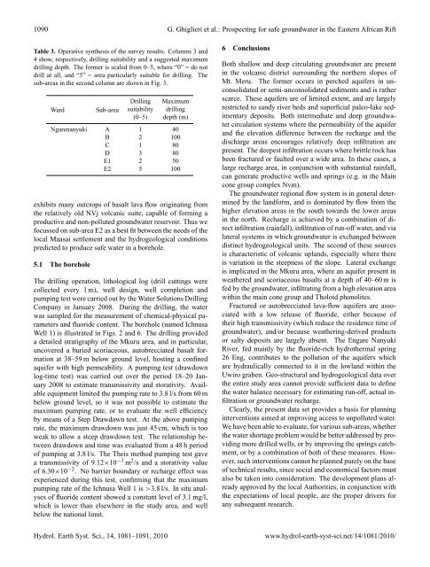
1090 G. Ghiglieri et al.: <strong>Prospecting</strong> <strong>for</strong> <strong>safe</strong> groundwater in the Eastern African Rift<br />
Table 3. Operative synthesis of the survey results. Columns 3 <strong>and</strong><br />
4 show, respectively, drilling suitability <strong>and</strong> a suggested maximum<br />
drilling depth. The <strong>for</strong>mer is scaled from 0–5, where “0” = do not<br />
drill at all, <strong>and</strong> “5” = area particularly suitable <strong>for</strong> drilling. The<br />
sub-areas in the second column are shown in Fig. 3.<br />
Ward Sub-area<br />
Drilling Maximum<br />
suitability drilling<br />
(0–5) depth (m)<br />
Ngarenanyuki A 1 40<br />
B 2 100<br />
C 1 80<br />
D 3 80<br />
E1 2 50<br />
E2 5 100<br />
exhibits many outcrops of basalt lava f<strong>low</strong> originating from<br />
the relatively old NVj volcanic suite, capable of <strong>for</strong>ming a<br />
productive <strong>and</strong> non-polluted groundwater reservoir. Thus we<br />
focussed on sub-area E2 as a best fit between the needs of the<br />
local Maasai settlement <strong>and</strong> the hydrogeological conditions<br />
predicted to produce <strong>safe</strong> water in a borehole.<br />
5.1 The borehole<br />
The drilling operation, lithological log (drill cuttings were<br />
collected every 1 m), well design, well completion <strong>and</strong><br />
pumping test were carried out by the Water Solutions Drilling<br />
Company in January 2008. During the drilling, the water<br />
was sampled <strong>for</strong> the measurement of chemical-physical parameters<br />
<strong>and</strong> <strong>fluoride</strong> content. The borehole (named Ichnusa<br />
Well 1) is illustrated in Figs. 2 <strong>and</strong> 6. The drilling provided<br />
a detailed stratigraphy of the Mkuru area, <strong>and</strong> in particular,<br />
uncovered a buried scoriaceous, autobrecciated basalt <strong>for</strong>mation<br />
at 38–59 m be<strong>low</strong> ground level, hosting a confined<br />
aquifer with high permeability. A pumping test (drawdown<br />
log-time test) was carried out over the period 18–20 January<br />
2008 to estimate transmissivity <strong>and</strong> storativity. Available<br />
equipment limited the pumping rate to 3.8 l/s from 60 m<br />
be<strong>low</strong> ground level, so it was not possible to estimate the<br />
maximum pumping rate, or to evaluate the well efficiency<br />
by means of a Step Drawdown test. At the above pumping<br />
rate, the maximum drawdown was just 45 cm, which is too<br />
weak to al<strong>low</strong> a steep drawdown test. The relationship between<br />
drawdown <strong>and</strong> time was evaluated from a 48 h period<br />
of pumping at 3.8 l/s. The Theis method pumping test gave<br />
a transmissivity of 9.12×10 −3 m 2 /s <strong>and</strong> a storativity value<br />
of 6.30×10 −2 . No barrier boundary or recharge effect was<br />
experienced during this test, confirming that the maximum<br />
pumping rate of the Ichnusa Well 1 is >3.8 l/s. In situ analyses<br />
of <strong>fluoride</strong> content showed a constant level of 3.1 mg/l,<br />
which is <strong>low</strong>er than elsewhere in the study area, <strong>and</strong> well<br />
be<strong>low</strong> the national limit.<br />
6 Conclusions<br />
Both shal<strong>low</strong> <strong>and</strong> deep circulating groundwater are present<br />
in the volcanic district surrounding the northern slopes of<br />
Mt. Meru. The <strong>for</strong>mer occurs in perched aquifers in unconsolidated<br />
or semi-unconsolidated sediments <strong>and</strong> is rather<br />
scarce. These aquifers are of limited extent, <strong>and</strong> are largely<br />
restricted to s<strong>and</strong>y river beds <strong>and</strong> superficial paleo-lake sedimentary<br />
deposits. Both intermediate <strong>and</strong> deep groundwater<br />
circulation systems where the permeability of the aquifer<br />
<strong>and</strong> the elevation difference between the recharge <strong>and</strong> the<br />
discharge areas encourages relatively deep infiltration are<br />
present. The deepest infiltration occurs where brittle rock has<br />
been fractured or faulted over a wide area. In these cases, a<br />
large recharge area, in conjunction with substantial rainfall,<br />
can generate productive wells <strong>and</strong> springs (e.g. in the Main<br />
cone group complex Nvm).<br />
The groundwater regional f<strong>low</strong> system is in general determined<br />
by the l<strong>and</strong><strong>for</strong>m, <strong>and</strong> is dominated by f<strong>low</strong> from the<br />
higher elevation areas in the south towards the <strong>low</strong>er areas<br />
in the north. Recharge is achieved by a combination of direct<br />
infiltration (rainfall), infiltration of run-off water, <strong>and</strong> via<br />
lateral systems in which groundwater is exchanged between<br />
distinct hydrogeological units. The second of these sources<br />
is characteristic of volcanic upl<strong>and</strong>s, especially where there<br />
is variation in the steepness of the slope. Lateral exchange<br />
is implicated in the Mkuru area, where an aquifer present in<br />
weathered <strong>and</strong> scoriaceous basalts at a depth of 40–60 m is<br />
fed by the groundwater, infiltrating from a high elevation area<br />
within the main cone group <strong>and</strong> Tholoid phonolites.<br />
Fractured or autobrecciated lava-f<strong>low</strong> aquifers are associated<br />
with a <strong>low</strong> release of <strong>fluoride</strong>, either because of<br />
their high transmissivity (which reduce the residence time of<br />
groundwater), <strong>and</strong>/or because weathering-derived products<br />
or salty deposits are largely absent. The Engare Nanyuki<br />
River, fed mainly by the <strong>fluoride</strong>-rich hydrothermal spring<br />
26 Eng, contributes to the pollution of the aquifers which<br />
are hydraulically connected to it in the <strong>low</strong>l<strong>and</strong> within the<br />
Uwiro graben. Geo-structural <strong>and</strong> hydrogeological data over<br />
the entire study area cannot provide sufficient data to define<br />
the water balance necessary <strong>for</strong> estimating run-off, actual infiltration<br />
or groundwater recharge.<br />
Clearly, the present data set provides a basis <strong>for</strong> planning<br />
interventions aimed at improving access to unpolluted water.<br />
We have been able to evaluate, <strong>for</strong> various sub-areas, whether<br />
the water shortage problem would be better addressed by providing<br />
more drilled wells, or by improving the springs catchment,<br />
or by a combination of both of these measures. However,<br />
such interventions cannot be planned purely on the base<br />
of technical results, since social <strong>and</strong> economical factors must<br />
also be taken into consideration. The development plans already<br />
approved by the local Authorities, in conjunction with<br />
the expectations of local people, are the proper drivers <strong>for</strong><br />
any subsequent research.<br />
Hydrol. <strong>Earth</strong> Syst. Sci., 14, 1081–1091, 2010 www.hydrol-earth-syst-sci.net/14/1081/2010/