Arctron 3 D 3D Scanning Systems
Arctron 3 D 3D Scanning Systems
Arctron 3 D 3D Scanning Systems

You also want an ePaper? Increase the reach of your titles
YUMPU automatically turns print PDFs into web optimized ePapers that Google loves.
� Expertise in Three Dimensions...<br />
Precise Surveying Using Innovative<br />
<strong>3D</strong> <strong>Scanning</strong> <strong>Systems</strong><br />
•<br />
•<br />
•<br />
•<br />
•<br />
•<br />
Topographical Recordings<br />
Object Scans<br />
Archaeology & Cultural Heritage<br />
Architectural Recordings<br />
Documentation of Industrial Facilities<br />
Mining / Cavity Surveys<br />
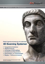
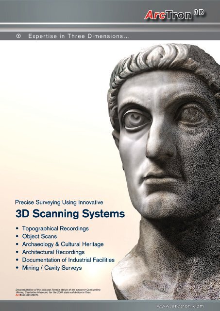
Documentation of the colossal Roman statue of the emperor Constantine<br />
(Rome, Capitoline Museum) for the 2007 state exhibition in Trier.<br />
ArcTron <strong>3D</strong> (2007).<br />
ArcTron <strong>3D</strong><br />
www.arctron.com
� <strong>3D</strong> Reconstruction � <strong>3D</strong> Reproduction � <strong>3D</strong> Multimedia<br />
<strong>3D</strong> SCANNING<br />
SERVICES<br />
ArcTron <strong>3D</strong> GmbH<br />
Your Centre of Excellence for <strong>3D</strong> Documentation<br />
ArcTron <strong>3D</strong> is an expert service provider with a long history of experience<br />
in the application of various <strong>3D</strong> technologies for topographical surveys,<br />
architectural recordings and industrial facility documentation. We specialise<br />
in photo-realistic high-resolution <strong>3D</strong> documentation for archaeology, architectural<br />
and art heritage as well as general <strong>3D</strong> object recording.<br />
Over the last 8 years, ArcTron <strong>3D</strong> has become increasingly well-known, due, in<br />
particular, to our documentation projects on a variety of prominent national and<br />
international monuments.<br />
We consider <strong>3D</strong> scanning and the generation of three dimensional worlds to be<br />
amongst the key new technologies. We have been awarded various innovation<br />
prizes for our achievements and developments in this area, amongst others, the<br />
“denkmal” gold medal in 2004.<br />
Using this technology, our scientists and engineers have recorded numerous<br />
significant and spectacular historic buildings, works of art, artefacts and objects<br />
from various eras in three dimensions.<br />
Over the last few years, we have carried out a range of pioneering and sensational<br />
projects in Germany and abroad, creating high-resolution, photo-realistic documentation<br />
of valuable cultural goods including object surveys in Germany (the<br />
Bavaria in Munich, the Nebra Sky Disc), Luxembourg (Vianden Castle, Useldingen<br />
Castle), Turkey (the Ephesus Octagon), Italy (fragments of the Constantine Colossus)<br />
and in China (several warriors from the Terracotta Army).
ArcTron <strong>3D</strong><br />
� <strong>3D</strong> Hardware � <strong>3D</strong> Surveying � <strong>3D</strong> Software Development<br />
Working with our team of in-house specialists from a wide range of fields, (archaeology,<br />
architecture, art history and restoration) we develop individual documentation<br />
concepts for every object and project.<br />
We have used this approach to complete a multitude of ambitious documen-<br />
tation projects comprising both photo-realistic <strong>3D</strong> recordings and the two and<br />
three dimensional plans needed for everyday evaluation.<br />
Our particular speciality is the development of custom documentation concepts.<br />
Using a combination of standard surveying, tacheometry, <strong>3D</strong> scanning and 2D<br />
and <strong>3D</strong> photogrammetry, we devise strategies which are optimised to suit both<br />
the object in question and the respective budget. This can only succeed if the<br />
configuration of available technology is appropriate for the item being recorded.<br />
For this reason, we apply assorted <strong>3D</strong> technologies which provide the best<br />
possible foundation for a wide range of objectives. From coins to castles or even<br />
entire historical sites, our methods deliver optimum documentation results.<br />
Our team would be delighted to be of service to you in the future as<br />
dedicated professional partners in all areas of <strong>3D</strong> documentation.<br />
www.arctron.com
� <strong>3D</strong> Reconstruction � <strong>3D</strong> Reproduction � <strong>3D</strong> Multimedia<br />
Cost-Effective 2D & <strong>3D</strong> Data Evaluation<br />
Seamlessly Integrated into your Existing Software <strong>Systems</strong><br />
<strong>3D</strong> scanning considerably reduces the duration, and consequently the cost,<br />
of fieldwork and surveying tasks. Data capture is a one-time job after which all<br />
further measurements can be carried out on the model. Repeated surveying on<br />
site is no longer necessary.<br />
Our specialists from the fields of CAD & GIS-supported data evaluation, <strong>3D</strong> visualisation,<br />
media design, computer animation and virtual reality prepare the retrieved<br />
data for use in a wide range of technical, scientific and planning applications.<br />
The data can be delivered in any desired, current format.<br />
Ground plans, elevations, cross sections, rectified orthophotos and all fundamental<br />
elements of comprehensive 2D and <strong>3D</strong> visualisations can be produced<br />
from the scan data. AEC objects such as walls, supports and ceilings can be<br />
modelled for architectural applications and used as a basis for generating realistic<br />
digital <strong>3D</strong> buildings.<br />
Using the same data, we can also create multimedia solutions or sophisticated<br />
film projects with computer animations for effective public presentations.<br />
Working in close collaboration with our customers, we develop custom concepts<br />
for maintaining and managing all survey data and for client-specific, structured<br />
data evaluation. The data can be easily integrated into total station or<br />
photogrammetry documentation and linked to CAD, GIS or facility management<br />
systems.<br />
Vianden castle<br />
(Luxembourg). Photo-realistic<br />
<strong>3D</strong> model of the entire<br />
castle complex.
ArcTron <strong>3D</strong><br />
� <strong>3D</strong> Hardware � <strong>3D</strong> Surveying � <strong>3D</strong> Software Development<br />
Topography and Terrain Recordings<br />
Bartholomaeberg - Bronze Age settlement (Austria)<br />
Detailed, large-area topographical recordings can be made<br />
extremely quickly using airborne laser scanning and/or terrestrial<br />
mid-range scanners.<br />
The unstructured scan data is converted into standardised<br />
topographical plans, contour line plans and <strong>3D</strong> models using<br />
specialist software.<br />
Object Scans<br />
Hérisson Oppidum (France) Saalburg Roman Fort (Germany)<br />
Terracotta army (Xian, China) Nebra Sky Disc (Germany)<br />
The Bavaria (Munich, Germany)<br />
Using high-resolution structured light scanners and/or <strong>3D</strong><br />
computer tomography, we generate <strong>3D</strong> scans with an accuracy<br />
of around one tenth of a millimetre. These scanners<br />
are ideal for recording smaller objects in three dimensions<br />
with extreme precision.<br />
Scan data is converted into photo-realistic <strong>3D</strong> models which<br />
can then be used for analysis during further investigations.<br />
By comparing DSM data (digital surface models) and DTM<br />
data (digital terrain models), plans can be compiled which<br />
show both the current conditions (including vegetation and<br />
buildings) and the actual terrain (without vegetation and<br />
buildings).<br />
These models also provide a sound basis for high-precision<br />
reproductions to be manufactured using, for instance, CNC<br />
milling or rapid prototyping techniques.<br />
Our particular speciality is rendering <strong>3D</strong> models with highresolution<br />
photo-realistic textures using seamlessly-fitting<br />
real surface recordings.<br />
www.arctron.com
� <strong>3D</strong> Reconstruction � <strong>3D</strong> Reproduction � <strong>3D</strong> Multimedia<br />
Architecture & Monuments<br />
Historic riding arena (Luxembourg) Useldingen Castle (Luxembourg)<br />
Schottenportal (Regensburg, Germany)<br />
<strong>3D</strong> scanning technology is an outstanding method of rapidly<br />
generating reliable records of existing conditions. For<br />
construction projects and architectural recordings, and in<br />
particular for the field of heritage conservation, it is beyond<br />
compare. We employ a combination of mid and close range<br />
scanners, selected to suit the complexity of the object.<br />
Thus the quality of our high-resolution <strong>3D</strong> recordings is<br />
maintained, even for intricate architectural sculptures and<br />
ornaments. Our scanning systems are 100% softwarecompatible<br />
ensuring that evaluation of raw data and conversion<br />
into <strong>3D</strong> is as accurate as possible.<br />
Archaeology & Cultural Heritage<br />
As specialists with more than 15 years of experience in<br />
archaeological surveying, we provide comprehensive photo-realistic<br />
<strong>3D</strong> documentation of even the most complex excavations.<br />
This allows all the various phases of a dig to be<br />
realistically visualised in three dimensions.<br />
The information can also be converted into 2D and <strong>3D</strong> CAD<br />
data (all current standards), including ground plans, elevations<br />
and cross sections, which can be used directly in your<br />
own software environment. Point clouds are converted into<br />
building–specific AEC (Architectural Engineering Construction)<br />
objects such as walls, beams and roofs.<br />
This data provides the foundation for generating realistic<br />
and clearly-structured digital <strong>3D</strong> building models. Laser<br />
scanning has enormous potential benefits for a variety of<br />
tasks within object monitoring and maintenance and can be<br />
incorporated into facility management systems.<br />
Chateau Mansfeld (Luxembourg) Ephesus Octagon (Turkey) Celtic grave, Reinheim (Germany)<br />
Our <strong>3D</strong> information system (<strong>3D</strong>-GIS) was especially conceived<br />
and developed for the purposes of archaeology. By<br />
linking data to this system, detailed scientific analyses and<br />
issues can be resolved and visualised directly on the <strong>3D</strong><br />
model.
ArcTron <strong>3D</strong><br />
� <strong>3D</strong> Hardware � <strong>3D</strong> Surveying � <strong>3D</strong> Software Development<br />
Industrial Facilities<br />
Arbed Furnaces (Luxembourg)<br />
Detailed <strong>3D</strong> recordings of industrial facilities fulfil all essential<br />
spatial planning requirements. Depending on accuracy<br />
specifications, we use mid-range and/or close-range scanners<br />
with integrated digital cameras.<br />
Point clouds and photogrammetry data can then be jointly<br />
evaluated in CAD systems using a technique known as<br />
Mining & Cavity Modelling<br />
<strong>3D</strong> laser scanning is a swift and reliable method of assessing<br />
resource depletion in open-cast mining facilities (opencast<br />
mines, quarries, sand and gravel pits, spoil heaps etc.)<br />
and of making accurate calculations of volume and mass.<br />
The same methods can be used to survey subterranean<br />
mines and other cavities such as galleries, caves, wells,<br />
monoplotting.<br />
Even very complex production sites can be surveyed extremely<br />
quickly using these methods.<br />
During data processing, geometric data retrieved from buildings<br />
or machines etc. can be converted into standardised<br />
CAD plans.<br />
Open-cast mine, Suedchemie (Bavaria) Mining galleries, Doihl (Luxembourg)<br />
Cellar Langquaid (Bavaria)<br />
cellars etc. During processing, information concerning the<br />
edges of slopes and terraces is extracted from the survey<br />
data.<br />
Digital terrain models, contour line plans and complex <strong>3D</strong><br />
cavity models are also generated.<br />
www.arctron.com
� <strong>3D</strong> Surveying & Software Development Consultants<br />
<strong>3D</strong> Technologies for any Size of Object<br />
From coins … to castles … to entire landscapes<br />
The engineering consultants ArcTron <strong>3D</strong> GmbH are pioneering new and innovative<br />
methods of rapidly recording existing conditions in three dimensions. This<br />
is achieved using a variety of complementary <strong>3D</strong> scanning techniques.<br />
The combined application of diverse scanning technologies enables us to implement<br />
high-precision <strong>3D</strong> surveys of objects from the smallest artefacts to large<br />
areas of terrain.<br />
We provide:<br />
For landscapes, architecture and large objects<br />
- Airborne laser scanning<br />
- Terrestrial <strong>3D</strong> laser scanning<br />
For smaller objects such as industrial products, design models, statues, architectural<br />
sculpture etc.<br />
- Close-range scanning (structured light scanning)<br />
- <strong>3D</strong> X-ray computer tomography<br />
Aside from close-range scanning for high-precision recording of small items and<br />
<strong>3D</strong> computer tomography which x-rays the recorded objects (for authentication,<br />
materials research etc.), we use a range of terrestrial laser scanners. These are<br />
employed to document larger objects, such as those encountered in the field<br />
of architecture. Large-scale terrain recordings are carried out by combining terrestrial<br />
laser and airborne laser scanning or by generating topographical documentation<br />
purely on the basis of airborne scanner data, depending on requirements.<br />
The scanning solutions which we employ produce versatile and comprehensive<br />
<strong>3D</strong> recordings of the objects and spatial geometries whilst maintaining a maximum<br />
of data content and unrivalled precision. In the method we use, photographic<br />
information is simultaneously recorded as standard, using high-resolution,<br />
calibrated digital cameras. This allows the data to be evaluated in photogrammetry<br />
environments and converted into detailed, <strong>3D</strong> images.<br />
Non-contact recording techniques are indispensable, not only when documenting<br />
monuments. They furthermore enable hazardous areas to be easily recorded<br />
from a safe distance. We provide new alternative methods of recording<br />
existing conditions in <strong>3D</strong>; for preserving evidence and temporary object conditions,<br />
for planning visualisations and for project monitoring tasks.<br />
ArcTron<br />
Long range: Airborne laser scanner.<br />
Resolution: