Disaster management strategy for potential slide zones of Kumarkhera in Narendra Nagar township of Tehri Garhwal district, Uttarakhand, India
Disaster management strategy for potential slide zones of Kumarkhera in Narendra Nagar township of Tehri Garhwal district, Uttarakhand, India
Disaster management strategy for potential slide zones of Kumarkhera in Narendra Nagar township of Tehri Garhwal district, Uttarakhand, India

Create successful ePaper yourself
Turn your PDF publications into a flip-book with our unique Google optimized e-Paper software.
Geology<br />
The extension <strong>of</strong> Krol-Chandpur Nappe <strong>of</strong> Himanchal Pradesh is found <strong>in</strong> <strong>Narendra</strong><br />
<strong>Nagar</strong>, Mussoorie and Na<strong>in</strong>ital syncl<strong>in</strong>es occurr<strong>in</strong>g <strong>in</strong> one cont<strong>in</strong>uous belt. <strong>Narendra</strong><br />
<strong>Nagar</strong> syncl<strong>in</strong>e is en echelon to the Mussoorie syncl<strong>in</strong>e with an <strong>in</strong>terven<strong>in</strong>g anti<strong>for</strong>m <strong>in</strong><br />
the core <strong>of</strong> which the underly<strong>in</strong>g rocks are seen as a “w<strong>in</strong>dow”. The <strong>Narendra</strong> <strong>Nagar</strong><br />
syncl<strong>in</strong>e is highly compressed <strong>in</strong> the vic<strong>in</strong>ity <strong>of</strong> <strong>Narendra</strong> <strong>Nagar</strong> town (Ra<strong>in</strong>a, 1978).<br />
The rocks constitut<strong>in</strong>g this area are those <strong>of</strong> Krol <strong>for</strong>mation. Accord<strong>in</strong>g to Valdiya<br />
(1980) the Krol <strong>for</strong>mation comprises alternat<strong>in</strong>g limestone and green slates <strong>in</strong> the lower<br />
part and th<strong>in</strong>ly bedded purple and maroon shale with subord<strong>in</strong>ate bands <strong>of</strong> dolomite <strong>in</strong><br />
the middle part. However upper Krol comprises grey and blue limestone and lenses <strong>of</strong><br />
flat pebble conglomerate.<br />
Geomorphology<br />
The geomorphic setup <strong>of</strong> <strong>Kumarkhera</strong> and surround<strong>in</strong>g area is def<strong>in</strong>ed by highly<br />
dissected denudo-structural hills that have witnessed large-scale gravity transport <strong>in</strong><br />
the past. The present landscape <strong>of</strong> the area has been shaped by denudation <strong>of</strong> hills and<br />
large-scale gravity transport <strong>in</strong> the past. The first and second order streams (nalas) are<br />
<strong>Disaster</strong><br />
<strong>management</strong><br />
<strong>strategy</strong><br />
363<br />
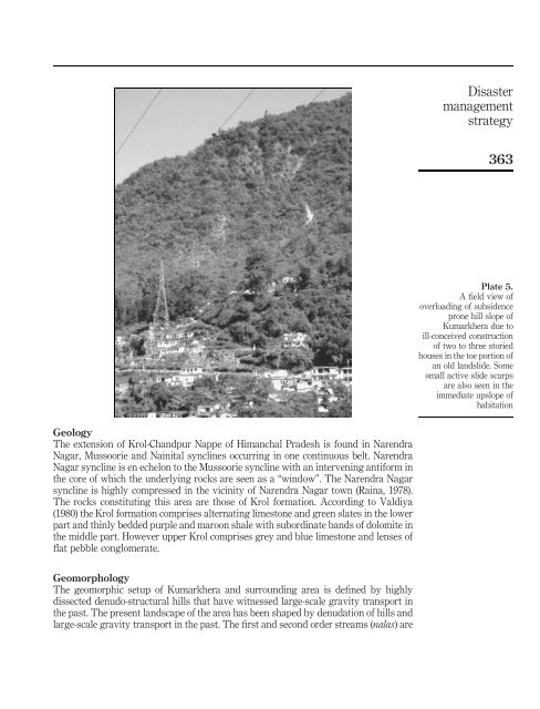
Plate 5.<br />
A field view <strong>of</strong><br />
overload<strong>in</strong>g <strong>of</strong> subsidence<br />
prone hill slope <strong>of</strong><br />
<strong>Kumarkhera</strong> due to<br />
ill-conceived construction<br />
<strong>of</strong> two to three storied<br />
houses <strong>in</strong> the toe portion <strong>of</strong><br />
an old land<strong>slide</strong>. Some<br />
small active <strong>slide</strong> scarps<br />
are also seen <strong>in</strong> the<br />
immediate upslope <strong>of</strong><br />
habitation