

Desktop Environmental, Hydrological and Geotechnical Study
Desktop Environmental, Hydrological and Geotechnical Study
Desktop Environmental, Hydrological and Geotechnical Study

You also want an ePaper? Increase the reach of your titles
YUMPU automatically turns print PDFs into web optimized ePapers that Google loves.
Precinct Structure Plan Area 25<br />
Growth Areas Authority<br />
<strong>Desktop</strong> <strong>Environmental</strong>, <strong>Hydrological</strong><br />
<strong>and</strong> <strong>Geotechnical</strong> <strong>Study</strong><br />
Reference: 230243-001<br />
Prepared for: Growth<br />
Areas Authority<br />
Revision: 2<br />
13 September 2012
Contents<br />
Glossary of terms 1<br />
Executive summary 1<br />
1. Introduction <strong>and</strong> objectives 1<br />
1.1 Background 1<br />
1.2 Objectives 1<br />
1.3 Scope of work 1<br />
1.3.1 <strong>Desktop</strong> review 1<br />
1.3.2 Site inspection 2<br />
1.3.3 Reporting 2<br />
1.4 Legislative requirements <strong>and</strong> relevant assessment guidelines 2<br />
1.5 Limitations 3<br />
2. Site identification 4<br />
2.1 Location <strong>and</strong> description 4<br />
2.2 Site features 7<br />
2.3 Surrounding l<strong>and</strong> use 7<br />
2.4 Proposed l<strong>and</strong> use 7<br />
2.5 Topography 7<br />
2.6 Geology 7<br />
2.7 Soil characteristics 7<br />
2.8 Acid sulphate soils 8<br />
2.9 Historical mining activity 8<br />
2.10 Inferred geological conditions 8<br />
2.11 Identified l<strong>and</strong>forms <strong>and</strong> geomorphological features 9<br />
2.12 Identified geotechnical hazards 9<br />
2.13 Hydrology <strong>and</strong> hydrogeology 10<br />
2.13.1 General site assessment 10<br />
2.13.2 Surface water assessment 10<br />
2.13.3 Groundwater assessment 11<br />
2.13.4 Groundwater resources <strong>and</strong> usage 12<br />
2.14 Review of Wetl<strong>and</strong>s databases <strong>and</strong> sites of National <strong>Environmental</strong> Significance 13<br />
2.14.1 General 13<br />
2.14.2 Directory of Important Wetl<strong>and</strong>s in Australia 13<br />
2.14.3 DSE Biodiversity Interactive Map 13<br />
3. Records review 14<br />
3.1 Search of public records 14<br />
Project 230243-001-01 | File 20120912 PSP25 <strong>Desktop</strong> 230243.docx | 13 September 2012 | Revision 2<br />
p 1
3.1.1 Certificates of title 14<br />
3.1.2 <strong>Environmental</strong> Protection Authority 14<br />
3.1.3 Local government records 15<br />
3.1.4 Other government records 15<br />
3.1.5 Aerial photographs 15<br />
3.1.6 Australian heritage databases 18<br />
3.1.7 Previous reports <strong>and</strong> documents 19<br />
3.2 Summary of historic contamination potential 19<br />
4. Site inspection 21<br />
4.1 General 21<br />
4.2 Significant issues 21<br />
4.3 Areas of environmental concern 21<br />
5. <strong>Environmental</strong> risk 23<br />
5.1 General 23<br />
5.2 Site characterisation - conceptual site model 23<br />
5.2.1 General 23<br />
5.2.2 Contaminants of concern 23<br />
5.2.3 Exposure pathways 24<br />
5.2.4 Potential receptors 24<br />
5.2.5 <strong>Environmental</strong> considerations 25<br />
5.3 Qualitative risk assessment 25<br />
5.4 Risk assessment summary 27<br />
6. Summary 38<br />
6.1 Site contamination 38<br />
6.2 <strong>Geotechnical</strong> 38<br />
6.3 Hydrology 39<br />
6.4 Wetl<strong>and</strong>s 39<br />
6.5 Heritage sites 40<br />
7. Recommendations 41<br />
7.1 Contamination 41<br />
7.2 <strong>Geotechnical</strong> 42<br />
7.3 Hydrology <strong>and</strong> wetl<strong>and</strong>s 42<br />
8. References 48<br />
Project 230243-001-01| File 20120912 PSP25 <strong>Desktop</strong> 230243.docx | 13 September 2012 | Revision 2<br />
p 2
Index of Tables<br />
Table 1 Site property details .................................................................................................................... 4<br />
Table 2 Summary of key geotechnical constraints .................................................................................. 9<br />
Table 3 Registered groundwater bores in vicinity of the site ................................................................. 12<br />
Table 4 Crown allotment l<strong>and</strong> ................................................................................................................ 14<br />
Table 5 Significant site title information ................................................................................................. 14<br />
Table 6 Aerial photographs reviewed .................................................................................................... 15<br />
Table 7 Aerial photograph review summary .......................................................................................... 16<br />
Table 8 Heritage site summary ............................................................................................................. 19<br />
Table 9 Summary of site AECs ............................................................................................................. 21<br />
Table 10 Potential receptors <strong>and</strong> pathways .......................................................................................... 24<br />
Table 11 <strong>Environmental</strong> considerations ................................................................................................ 25<br />
Table 12 Derivation of risk classes ........................................................................................................ 25<br />
Table 13 Risk classifications ................................................................................................................. 26<br />
Table 14 Overall risk matrix ................................................................................................................... 26<br />
Table 15 Qualitative risk assessment, PSP Area 25 ............................................................................. 28<br />
Table 16 Assessment recommendations by property, PSP Area 25 .................................................... 43<br />
Appendices<br />
Appendix A<br />
Figures<br />
Appendix B<br />
Certificates of titles<br />
Appendix C<br />
Regulatory records documentation<br />
Appendix D<br />
Aerial photography<br />
Appendix E<br />
Site photographs<br />
Appendix F<br />
<strong>Geotechnical</strong> category of investigation<br />
Project 230243-001-01| File 20120912 PSP25 <strong>Desktop</strong> 230243.docx | 13 September 2012 | Revision 2<br />
p 3
Glossary of terms<br />
AEC Area of <strong>Environmental</strong> Concern<br />
ANZECC Australian <strong>and</strong> New Zeal<strong>and</strong> Environment <strong>and</strong> Conservation Council<br />
bgl Below Ground Level<br />
BTEX Benzene, Toluene, Ethylbenzene, <strong>and</strong> Xylenes<br />
DSE Department of Sustainability <strong>and</strong> Environment<br />
EPA Environment Protection Authority<br />
GAA Growth Areas Authority<br />
GIS Geographic Information System<br />
Ha hectares<br />
IWRG Industrial Waste Resource Guidelines<br />
km kilometres<br />
MSL Mean Sea Level<br />
NEPM National Environment Protection Measure<br />
NHMRC National Health <strong>and</strong> Medical Research Council<br />
PAH Polycyclic Aromatic Hydrocarbons<br />
PSP Precinct Structure Plan<br />
SEPP State <strong>Environmental</strong> Planning Policy<br />
TPH Total Petroleum Hydrocarbons<br />
UFZ Urban Floodway Zone<br />
Project 230243-001-01 | File 20120912 PSP25 <strong>Desktop</strong> 230243.docx | 13 September 2012 | Revision 2<br />
p 1
Executive summary<br />
Background<br />
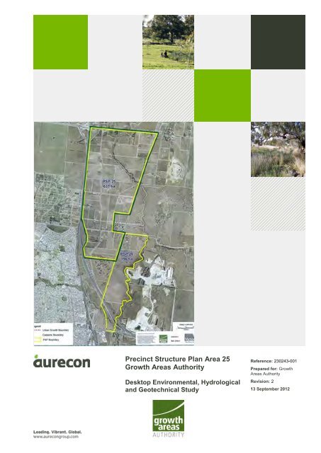
The Growth Areas Authority (GAA) is preparing a Precinct Structure Plan (PSP) for Area 25,<br />
comprised of approximately 637 hectares (ha) of l<strong>and</strong> on 54 separate properties located east of the<br />
Hume Freeway near Craigieburn, Kalkallo <strong>and</strong> Donnybrook, in the Hume City <strong>and</strong> City of Whittlesea<br />
local government areas, Victoria, Australia. Limited information regarding future l<strong>and</strong> uses within PSP<br />
Area 25 was provided by GAA for the purposes of this assessment. This assessment will inform the<br />
design of the urban structure of PSP 25 in terms of suitability of nominated l<strong>and</strong> uses. Historical<br />
research, document review <strong>and</strong> site assessment activities were conducted during the weeks of 29<br />
June <strong>and</strong> 20 July 2012.<br />
Scope of work<br />
The scope of works called for:<br />
• A desktop review to determine previous l<strong>and</strong> uses <strong>and</strong> implications for environmental<br />
contamination, hydrology <strong>and</strong> geology.<br />
• A desktop review of soil, geological <strong>and</strong> hydrogeological conditions on the site.<br />
• Review of Wetl<strong>and</strong>s databases <strong>and</strong> sites of National <strong>Environmental</strong> Significance.<br />
• Performance of a site inspection limited to publicly accessible areas of the site.<br />
Site contamination<br />
In general, the following past or present site activities, with the potential to cause soil or groundwater<br />
contamination, were identified in proximity to the PSP 25 Area:<br />
• An apparent out of production market garden on parcel 502095 (810 Summerhill Road).<br />
• Farm equipment <strong>and</strong> ab<strong>and</strong>oned automobiles stored on a number of site properties (eg 780<br />
Donnybrook Road, 295 Brookville Drive <strong>and</strong> 220 Brookville Drive).<br />
• Large scale intensive farming operations where fertilisers, pesticides, <strong>and</strong> herbicides may have<br />
been used (eg 30 Amaroo Road, 185 <strong>and</strong> 295 Brookville Drive).<br />
• Small scale intensive farming operations where fertilisers, pesticides, <strong>and</strong> herbicides may have<br />
been used (eg 800 Donnybrook Road, 245 <strong>and</strong> 275 Brookville Drive, 770, 790, 835 <strong>and</strong> 840<br />
Summerhill Road).<br />
• Areas where ab<strong>and</strong>oned vehicles, farm equipment, debris or dumping of unspecified materials<br />
have occurred (eg 720 Donnybrook Road, 30 Amaroo Road, 220 <strong>and</strong> 295 Brookville Drive,<br />
920/920A Hume Highway <strong>and</strong> 60 Kinloch Court).<br />
• Structures that may contain asbestos <strong>and</strong> have lead based paint <strong>and</strong> septic systems.<br />
• A large truck stop service station, constructed between 2006 <strong>and</strong> 2010, is located on the<br />
southwest corner of the interchange of Hume Freeway <strong>and</strong> Donnybrook Road.<br />
• Potential transport of contamination from off-site sources hydraulically upgradient of the Area<br />
onto the site via Merri Creek or Kalkallo Creek.<br />
Project 230243-001-01 | File 20120912 PSP25 <strong>Desktop</strong> 230243.docx | 13 September 2012 | Revision 2<br />
p 1
Recommendations for assessment of individual site properties based on use <strong>and</strong> potential for<br />
contamination are summarized in the report. Recommendations are made in accordance with the<br />
Victoria DSE Potentially Contaminated L<strong>and</strong>, General Practice Note, 2005 (DSE, 2005). Where l<strong>and</strong><br />
has been identified as potentially contaminated, a further investigation is necessary as part of the next<br />
stage of the planning process such as planning permit application or planning scheme amendment on<br />
a property by property basis (DSE, 2005).<br />
Of the fifty-four (54) site properties, further assessment is recommended for twenty-two (22)<br />
properties, with recommendations for environmental audits on four additional properties. In general,<br />
recommendations for assessment were made based on sensitive l<strong>and</strong> use, such as large-scale<br />
intensive agriculture. The presence of significant (more than 0.5 ha) small-scale agriculture,<br />
ab<strong>and</strong>oned vehicles, farm equipment or unidentified debris was considered secondary indicators of<br />
the need for assessment in the case of sensitive l<strong>and</strong> use. <strong>Environmental</strong> audits were recommended<br />
for the former market garden at 810 Summerhill Road <strong>and</strong> properties used for large-scale intensive<br />
agriculture at 30 Amaroo Road, 185 Brookville Drive <strong>and</strong> 295 Brookville Drive, each of which was<br />
considered at high potential for contamination based on past <strong>and</strong> present l<strong>and</strong> use. Due to the limited<br />
nature of the site inspection, additional site properties may be recommended for assessment in the<br />
future based on receipt of additional information not available at the time of this assessment.<br />
Intrusive sampling <strong>and</strong> analysis should be undertaken in accordance with National Environment<br />
Protection (Assessment of Site Contamination) Measure (1999 NEPM) <strong>and</strong> draft 2011 NEPM,<br />
Australian St<strong>and</strong>ard (2005) Guide to the investigation <strong>and</strong> sampling of sites with potentially<br />
contaminated soil Part 1: Non-volatile <strong>and</strong> semi-volatile compounds (AS 4482.1-2005), Australian<br />
St<strong>and</strong>ard (1999) Guide to the sampling <strong>and</strong> investigation of potentially contaminated soil Part 2:<br />
Volatile substances (AS 4482.2-1999) <strong>and</strong> Victoria Environment Protection Authority, Industrial Waste<br />
Resource Guidelines (IWRG) Soil Sampling, 2009. The results of the sampling <strong>and</strong> analysis would be<br />
compared with guideline values for protection of human health <strong>and</strong> the environment as well as waste<br />
disposal criteria (as applicable).<br />
In addition, hazardous materials surveys should be carried out for structures identified for demolition<br />
or relocation. The surveys should address asbestos, lead-based paint, polychlorinated biphenyls in<br />
electrical fixtures, <strong>and</strong> hazardous materials storage. Should asbestos containing material be<br />
encountered during future investigations or construction, the testing, inspection <strong>and</strong> removal of<br />
asbestos materials are required by law to be undertaken by a suitably qualified <strong>and</strong> licensed asbestos<br />
specialist/removalist.<br />
<strong>Geotechnical</strong><br />
Limited geotechnical data are available for the site. The geology of PSP Area 25 is predominantly<br />
Pleistocene <strong>and</strong> Miocene basalts with minor scoria <strong>and</strong> ash belonging to the Newer Volcanic Group,<br />
overlain by Holocene quaternary alluvial deposits of gravel, s<strong>and</strong> <strong>and</strong> silt concentrated along existing<br />
creek courses. The site is predominantly overlain by sodosol-type soils which are found to vary in<br />
texture <strong>and</strong> depth though generally comprises clay <strong>and</strong> s<strong>and</strong> loam. Sodosols have a high clay content<br />
<strong>and</strong> high sodium which sometimes leads to dispersion <strong>and</strong> instability. Localised fill or natural reworked<br />
material deposits are likely to be present on site, especially around areas of recent development,<br />
however further investigation will be required to identify <strong>and</strong> delineate these occurrences.<br />
In general, PSP Area 25 is gently undulating <strong>and</strong> soil cover is expected to be relatively thin. As such<br />
the risk of geotechnical hazards are considered low to moderate though a thorough underst<strong>and</strong>ing of<br />
the geological model will be required prior to development. The key geotechnical constraints that may<br />
affect the development of PSP Area 25 are:<br />
Project 230243-001-01| File 20120912 PSP25 <strong>Desktop</strong> 230243.docx | 13 September 2012 | Revision 2<br />
p 2
• Differential settlement of overlying residual clay in localised areas of extremely weathered basalt.<br />
Alluvial clay <strong>and</strong> silt deposits <strong>and</strong> localised un-engineered fill material may result in settlement of<br />
proposed road formations <strong>and</strong> structures. The alluvial sediments tend to be concentrated along<br />
existing creek courses, such as Merri Creek <strong>and</strong> Kalkallo Creek on PSP Area 25.<br />
• Shallow soil failure (soil creep, slumping, collapse) in areas of increased gradient. Although PSP<br />
Area 25 is of a relatively gentle gradient, steeper slopes are noted in close proximity to surface<br />
water bodies such as Merri Creek. Weathered alluvial or residual material can be susceptible to<br />
shallow soil failure (soil creep, slumping <strong>and</strong> collapse) in areas of increased gradient.<br />
• The presence of voids in scoria could result in the loss of stability or localised collapse hazard.<br />
• Low bearing capacity within soft clay material or unconsolidated alluvial material can result in a<br />
loss of stability or potential collapse of structures during the construction phase of the<br />
development. The presence of soft material encountered at depth may result in a bearing<br />
capacity or settlement hazard for any proposed foundations.<br />
• Clay likely to be derived from basalt rock is likely to be subject to considerable shrinkage or<br />
swelling in response to change in moisture content. Highly expansive clay can cause unexpected<br />
ground movements that are able to damage to building foundations, structures <strong>and</strong> road<br />
infrastructure. The published soils map indicates that the Area is predominantly overlain by<br />
sodosol-type soils which are found to vary in texture <strong>and</strong> depth though generally comprise clay<br />
<strong>and</strong> s<strong>and</strong> loam. Sodosols have a high clay content <strong>and</strong> high sodium which sometimes leads to<br />
dispersion <strong>and</strong> instability.<br />
• Ephemeral creeks, primarily draining into Merri Creek, could serve as drainage channels during<br />
flood events, resulting in erosion of soft sediment <strong>and</strong> bedrock. Similar conditions could develop<br />
within the main channels of Merri Creek <strong>and</strong> Kalkallo Creek on PSP Area 25.<br />
• The presence of zones of deeper residual soils or swamp conditions may affect footing design <strong>and</strong><br />
performance.<br />
It is recommended that further geotechnical assessment be undertaken across the site to aid the<br />
detailed design process for future construction in the PSP area on a project by project basis (ie road<br />
works <strong>and</strong> services on a PSP level or at the property development level for residences etc.). The<br />
purpose of the geotechnical assessment will be to undertake intrusive investigation to obtain<br />
information for the purposes of:<br />
• Determining a better underst<strong>and</strong>ing of the sub-surface geological profile <strong>and</strong> hydrogeological<br />
conditions to develop an accurate geological model.<br />
• Develop baseline geotechnical parameters to aid design, settlement <strong>and</strong> slope stability modelling<br />
(where required).<br />
• Determine depth to rock head <strong>and</strong> degree of weathering within the upper layers of the bedrock.<br />
• Determine the nature of factures <strong>and</strong> jointing within the underlying volcanic material.<br />
• Determine the presence of voids within the underlying basalt material.<br />
Hydrology <strong>and</strong> wetl<strong>and</strong>s<br />
Two semi-ephemeral creeks, Merri Creek <strong>and</strong> Kalkallo Creek. are located on the northern half of the<br />
site. An unnamed semi-ephemeral creek is located in the northwest corner of the property <strong>and</strong> drains<br />
into Kalkallo Creek. Occasional small ponds are located along each of these creeks. The site is within<br />
the 396 square kilometres (km 2 ) Merri Creek catchment, a major tributary of the Yarra River Basin.<br />
The creeks are fed from catchments in the north, flowing to the south where the Merri Creek<br />
eventually joins the Yarra River. No water level data for Merri Creek was available from Melbourne<br />
Water.<br />
Project 230243-001-01| File 20120912 PSP25 <strong>Desktop</strong> 230243.docx | 13 September 2012 | Revision 2<br />
p 3
There is an Urban Floodway Zone (UFZ) at a minimum of 100 m either side of Merri Creek <strong>and</strong><br />
Kalkallo Creek. This area has been identified as having a greater risk of flooding. A permit is required<br />
to carry out works in this area <strong>and</strong> must be consistent with the local Floodplain Development Plan.<br />
No groundwater level information was available for the boreholes located on the site. The closest<br />
borehole to the site for which groundwater level data was available was borehole B68888, located<br />
approximately 665 m south of site southern boundary, at 95-135 Amaroo Road. This borehole showed<br />
a groundwater depth on 1 April 2009 of 15.71 m below ground level (bgl). Aerial photographs show<br />
exposed groundwater in numerous irrigation ponds on the Area. Although depth to groundwater is<br />
difficult to assess in the aerial photographs, this is believed to be indicative of a depth to groundwater<br />
of less than 5 m on the site. This ground water is not believed to represent a perched water table.<br />
Groundwater beneath the site is present in two main aquifers, the upper Newer Volcanics aquifer, a<br />
fractured rock basalt aquifer, <strong>and</strong> a deeper regional aquifer within the Silurian aged formation. The<br />
Victorian Water Resources Data Warehouse <strong>and</strong> GeoVic GIS tools identified 30 registered boreholes<br />
within 1 km of the site. Borehole usage was primarily domestic <strong>and</strong> agricultural water supply with a<br />
small number of extractive industries boreholes.<br />
No nationally important wetl<strong>and</strong>s, wetl<strong>and</strong> sites of National <strong>Environmental</strong> Significance or sites of state<br />
significance were identified within the PSP area.<br />
The following recommendations are made regarding hydrology <strong>and</strong> wetl<strong>and</strong>s:<br />
• UFZs should remain free of any significant development as they are at risk of flooding.<br />
• Flood modelling should be undertaken to determine hydrologic effects that any new developments<br />
will have on the existing creek system, in particular existing culvert <strong>and</strong> bridge flow capacities.<br />
• Waterways, including Merri Creek <strong>and</strong> Kalkallo Creek <strong>and</strong> associated low-lying areas will require<br />
feature surveys to provide detail of drainage patterns <strong>and</strong> inform planning for urban drainage<br />
systems.<br />
• Drainage paths will need to be either maintained or diverted to ensure all areas are well drained<br />
during <strong>and</strong> after any development.<br />
Project 230243-001-01| File 20120912 PSP25 <strong>Desktop</strong> 230243.docx | 13 September 2012 | Revision 2<br />
p 4
1. Introduction <strong>and</strong> objectives<br />
1.1 Background<br />
The Growth Areas Authority (GAA) is preparing a Precinct Structure Plan (PSP) for Area 25,<br />
comprised of approximately 637 hectares (ha) of l<strong>and</strong> on 54 separate properties located east of the<br />
Hume Freeway near Craigieburn, Kalkallo <strong>and</strong> Donnybrook, in the Hume City <strong>and</strong> City of Whittlesea<br />
local government areas, Victoria, Australia. This assessment will inform the design of the urban<br />
structure of PSP 25 in terms of suitability of nominated l<strong>and</strong> uses. Historical research, document<br />
review <strong>and</strong> site assessment activities were conducted during the weeks of 29 June <strong>and</strong> 20 July 2012.<br />
1.2 Objectives<br />
The overall objective of this desktop environmental, hydrological <strong>and</strong> geotechnical study is to identify<br />
the potential for ground contamination within the study area <strong>and</strong> the nature of likely contaminants to be<br />
encountered during detailed design <strong>and</strong> construction.<br />
The key objectives of this assessment were to conduct a desktop study <strong>and</strong> site inspection to:<br />
• Confirm suitability of properties for sensitive uses <strong>and</strong> provide advice regarding what level of<br />
further assessment would be required to determine suitability of properties for sensitive uses in<br />
accordance with the Potentially Contaminated L<strong>and</strong> General Practice Note 2005 (eg.<br />
<strong>Environmental</strong> Audit, Site Assessment).<br />
• Identify data gaps <strong>and</strong> outline future testing requirements <strong>and</strong> the need for more detailed<br />
investigations (if required).<br />
• Provide a plan of the study area clearly showing which properties were included in the desktop<br />
study <strong>and</strong> which properties have low, medium <strong>and</strong> high risk of contamination.<br />
• Prepare a report of findings that will be used to inform the design of precinct structure plans for<br />
the study area (in terms of suitability of l<strong>and</strong> uses nominated for each location/area) <strong>and</strong> to<br />
identify key issues that should be addressed during the detailed design phase <strong>and</strong> construction.<br />
1.3 Scope of work<br />
1.3.1 <strong>Desktop</strong> review<br />
A desktop review was conducted to evaluate current <strong>and</strong> previous l<strong>and</strong> uses <strong>and</strong> to assess the<br />
implications for environmental contamination, hydrology <strong>and</strong> geology. The desktop review included:<br />
• Assessment of historical aerial photography for the precinct <strong>and</strong> surrounding areas.<br />
• Consultation with relevant agencies as required, including:<br />
o EPA for review of records including the ‘Priority Sites Registry’ (EPA Victoria, 2012a) <strong>and</strong> the<br />
list of issued ‘Certificates <strong>and</strong> Statements of <strong>Environmental</strong> Audit’ (EPA Victoria 2012b).<br />
o Department of Sustainability <strong>and</strong> Environment, Port Phillip & Westernport Catchment<br />
Management Authority, Southern Rural water, City West Water <strong>and</strong> Melbourne Water for<br />
hydrographs, groundwater <strong>and</strong> drainage information <strong>and</strong> other relevant data.<br />
• Soil, geology <strong>and</strong> hydrogeology conditions desktop review, including survey, mapping <strong>and</strong> other<br />
base data as available from relevant authority <strong>and</strong> agency data sets <strong>and</strong> maps. This is aimed at<br />
identifying potential shortcomings in data coverage.<br />
• Review <strong>and</strong> summary of any previous reports or studies regarding environmental, geological or<br />
groundwater conditions, in or within the vicinity of the study area.<br />
Project 230243-001-01 | File 20120912 PSP25 <strong>Desktop</strong> 230243.docx | 13 September 2012 | Revision 2<br />
p 1
• Compilation of known groundwater borehole/well locations <strong>and</strong> testing results.<br />
• Groundwater well databases.<br />
• Review of Wetl<strong>and</strong>s databases <strong>and</strong> sites of National <strong>Environmental</strong> Significance.<br />
• Review of Australian Heritage Databases.<br />
• Obtainment <strong>and</strong> analysis of current titles for all properties in the study area.<br />
• Historical title search of any properties where further historical l<strong>and</strong> use information is needed to<br />
establish potential for contamination.<br />
• Review of Victoria Department of Primary Industries online GIS system, GeoVic.<br />
1.3.2 Site inspection<br />
Aurecon performed a site inspection of the study area, evaluating properties from existing roadways<br />
<strong>and</strong> publicly accessible areas. At the Client’s request, no on-site inspection of properties within PSP<br />
Area 25 was performed. The site inspection was conducted once the desktop review had been<br />
completed <strong>and</strong> was used to focus on-site observations.<br />
1.3.3 Reporting<br />
Based on the findings of this desktop assessment, Aurecon prepared this report including the<br />
following:<br />
• Summary of findings <strong>and</strong> recommendations of the desktop review <strong>and</strong> site inspection for each<br />
discipline area (environmental, hydrology <strong>and</strong> geotechnical assessment).<br />
• Issues summary <strong>and</strong> resultant recommendations for management <strong>and</strong>/or remediation in terms of<br />
environmental contamination, geology/geotechnical <strong>and</strong> hydrology/groundwater.<br />
• Outline of any future testing requirements <strong>and</strong> the need for more detailed investigations if<br />
recommended.<br />
• Evaluation (to the extent practicable within limitations) of the suitability of properties for sensitive<br />
uses <strong>and</strong> what level of further assessment would be required to determine suitability of properties<br />
for sensitive uses in accordance with the Potentially Contaminated L<strong>and</strong> General Practice Note<br />
2005 (eg <strong>Environmental</strong> Audit, Site Assessment).<br />
• A plan of the study area clearly showing which properties were included in the desktop study <strong>and</strong><br />
which properties have low, medium <strong>and</strong> high potential for contamination.<br />
• Clear <strong>and</strong> concise drawings/maps, to illustrate existing conditions <strong>and</strong> support report as required.<br />
It should be noted that this report is a limited desktop assessment of the site <strong>and</strong> no sampling was<br />
performed for this assessment.<br />
1.4 Legislative requirements <strong>and</strong> relevant assessment guidelines<br />
The scope of work for this desktop environmental, hydrological <strong>and</strong> geotechnical assessment of the<br />
site has been performed in general accordance with requirements outlined in the following documents:<br />
• Victoria <strong>Environmental</strong> Protection Act 1970<br />
• State Environment Protection Policy (SEPP), Groundwaters of Victoria, December 1997,<br />
No. S160.<br />
• SEPP, Prevention <strong>and</strong> Management of Contaminated L<strong>and</strong>, June 2002, No. S95.<br />
• SEPP, Waters of Victoria, October 2004, No. S210.<br />
• EPA Victoria 2009a. Industrial Waste Resource Guidelines - Sampling <strong>and</strong> Analysis of Waters,<br />
Wastewaters, Soils <strong>and</strong> Wastes, June 2009, IWRG701.<br />
Project 230243-001-01 | File 20120912 PSP25 <strong>Desktop</strong> 230243.docx | 13 September 2012 | Revision 2<br />
p 2
• EPA Victoria 2009b, Industrial Waste Resource Guidelines - Soil Sampling, June 2009,<br />
IWRG702.<br />
• Australian <strong>and</strong> New Zeal<strong>and</strong> Guideline for the Assessment <strong>and</strong> Management of Contaminated<br />
Sites, published by Australian <strong>and</strong> New Zeal<strong>and</strong> Environment <strong>and</strong> Conservation Council<br />
(ANZECC) <strong>and</strong> the National Health <strong>and</strong> Medical Research Council (NHMRC), January 1992.<br />
• Guide to the investigation <strong>and</strong> sampling of sites with potentially contaminated soil, Part 1: Nonvolatile<br />
<strong>and</strong> semi-volatile compounds, AS 4482.1-2005, St<strong>and</strong>ards Australia.<br />
• Guide to the sampling <strong>and</strong> investigation of potentially contaminated soil, Part 2: Volatile<br />
substances, AS 4482.2-1999, St<strong>and</strong>ards Australia.<br />
• National Environment Protection (Assessment of Site Contamination) Measure, 1999.<br />
• National Environment Protection (Assessment of Site Contamination) Measure, draft 2011.<br />
• <strong>Environmental</strong> Protection Authority, A Guide to the Sampling <strong>and</strong> Analysis of Waters,<br />
Wastewaters, Soils <strong>and</strong> Wastes, March 2000, Publication 441.<br />
• Native Vegetation Management Framework 2002.<br />
• Wildlife Act 1975.<br />
1.5 Limitations<br />
Aurecon Australia Pty Ltd (ABN 54 005 139 873) has prepared this report (the "Report") for the<br />
exclusive use of GAA (the "Client"), regulatory authorities, auditors <strong>and</strong> others approved by the Client<br />
for the purpose of desktop environmental, hydrological, <strong>and</strong> geotechnical study for PSP Area 25.<br />
The Report must be read in light of:<br />
• The limited readership <strong>and</strong> purposes for which it was intended.<br />
• Its reliance upon information provided to Aurecon by the Client <strong>and</strong> others which has not been<br />
verified by Aurecon <strong>and</strong> over which Aurecon has no control.<br />
• The limitations <strong>and</strong> assumptions referred to throughout the Report.<br />
• The cost <strong>and</strong> other constraints imposed on the Report (such as limited site access).<br />
• Other relevant issues which are not within the scope of the Report.<br />
Subject to the limitations referred to above, Aurecon has exercised all due care in the preparation of<br />
the Report <strong>and</strong> believes that the information, conclusions, interpretations <strong>and</strong> recommendations of the<br />
Report are both reasonable <strong>and</strong> reliable.<br />
Aurecon makes no warranty or representation to the Client or third parties (express or implied) in<br />
respect of the Report, particularly with regard to any commercial investment decision made on the<br />
basis of the Report. Use of the Report by the Client or third parties shall be at their own risk <strong>and</strong><br />
extracts from the Report may only be published with permission of Aurecon.<br />
This disclaimer must accompany every copy of the Report, which is an integral document <strong>and</strong> must be<br />
read in its entirety.<br />
Project 230243-001-01 | File 20120912 PSP25 <strong>Desktop</strong> 230243.docx | 13 September 2012 | Revision 2<br />
p 3
2. Site identification<br />
2.1 Location <strong>and</strong> description<br />
The site is comprised of 54 separate properties totalling approximately 637 ha in area <strong>and</strong> designated<br />
as PSP Area 25 in the Craigieburn, Kalkallo <strong>and</strong> Donnybrook, in the Hume City <strong>and</strong> City of Whittlesea<br />
local government areas, Victoria, Australia. Site properties are summarized in<br />
Table 1.<br />
Table 1 Site property details<br />
No.<br />
Appendix B<br />
Page No.<br />
23341 1<br />
23358 10<br />
23366 17<br />
26997 25<br />
27003 30<br />
27011 35<br />
40<br />
27037 44<br />
66548 48<br />
397661 52<br />
411710 57<br />
501719 64<br />
501720 68<br />
501721 73<br />
501722 80<br />
501723 87<br />
501724 96<br />
Address Legal description<br />
780 Donnybrook Road<br />
CRAIGIEBURN VIC 3064<br />
800 Donnybrook Road<br />
CRAIGIEBURN VIC 3064<br />
804 Donnybrook Road<br />
CRAIGIEBURN VIC 3064<br />
45 English Street<br />
DONNYBROOK VIC 3064<br />
65 English Street<br />
DONNYBROOK VIC 3064<br />
90 English Street<br />
DONNYBROOK VIC 3064<br />
80 English Street<br />
DONNYBROOK VIC 3064<br />
80 English Street<br />
DONNYBROOK VIC 3064<br />
25 Norman Road<br />
DONNYBROOK VIC 3064<br />
750 Donnybrook Road<br />
CRAIGIEBURN VIC 3064<br />
810 Donnybrook Road<br />
CRAIGIEBURN VIC 3064<br />
25 Amaroo Road<br />
CRAIGIEBURN 3064<br />
65 Amaroo Road<br />
CRAIGIEBURN 3064<br />
85 Amaroo Road<br />
CRAIGIEBURN 3064<br />
30 Amaroo Road<br />
CRAIGIEBURN 3064<br />
50 Amaroo Road<br />
CRAIGIEBURN 3064<br />
105 Brookville Drive<br />
CRAIGIEBURN VIC 3064<br />
Project 230243-001-01 | File 20120912 PSP25 <strong>Desktop</strong> 230243.docx | 13 September 2012 | Revision 2<br />
p 4<br />
Title<br />
(Volume/Folio)<br />
Area<br />
(ha)<br />
Lot 1 LP 119619 9271/196 8.2<br />
Lot 2 LP 119619 9538/269 8.2<br />
Lot 1 TP 423925 8806/645 0.4<br />
Lot 3 LP 119619 9227/855 8.1<br />
Lot 4 LP 119619 9214/672 8.4<br />
CP 174104 10016/031 33.3<br />
Lot 1 TP 844886 10822/940<br />
Lot 1 TP 844886 10822/950 30.9<br />
CP 172167 RESERVE 9944/068 16.1<br />
Lot 1 TP 125838 9017/631 26.1<br />
CP 159200 9737/864 0.3<br />
Lot 4 LP 205880 9769/309 12.9<br />
Lot 7 LP 205880 9769/312 12.1<br />
Lot 8 LP 205880 9769/313 11.9<br />
Lot 2 PS 518232 9769/307 8.0<br />
Lot 3 PS 518232 9769/306 7.6<br />
Lot 1 PS 518231 9769/550 12.7
Table 1 Site property details<br />
No.<br />
Appendix B<br />
Page No.<br />
501725 105<br />
501726 112<br />
501727 120<br />
501728 128<br />
501729 137<br />
501730 144<br />
501731 150<br />
501732 160<br />
501733 170<br />
501734 177<br />
501735 186<br />
501779 192<br />
501781 197<br />
501782 212<br />
501783 236<br />
501784 239<br />
501785 273<br />
501955 283<br />
501956 283<br />
501904 291<br />
Address Legal description<br />
165 Brookville Drive<br />
CRAIGIEBURN VIC 3064<br />
185 Brookville Drive<br />
CRAIGIEBURN VIC 3064<br />
225 Brookville Drive<br />
CRAIGIEBURN VIC 3064<br />
245 Brookville Drive<br />
CRAIGIEBURN VIC 3064<br />
275 Brookville Drive<br />
CRAIGIEBURN VIC 3064<br />
295 Brookville Drive<br />
CRAIGIEBURN VIC 3064<br />
180 Brookville Drive<br />
CRAIGIEBURN VIC 3064<br />
220 Brookville Drive<br />
CRAIGIEBURN VIC 3064<br />
230 Brookville Drive<br />
CRAIGIEBURN VIC 3064<br />
270 Brookville Drive<br />
CRAIGIEBURN VIC 3064<br />
Project 230243-001-01 | File 20120912 PSP25 <strong>Desktop</strong> 230243.docx | 13 September 2012 | Revision 2<br />
p 5<br />
Title<br />
(Volume/Folio)<br />
Area<br />
(ha)<br />
Lot 10 LP 205835 9769/551 12.1<br />
Lot 6 LP 205834 9818/414 20.9<br />
Lot 5 LP 205834 9818/413 9.0<br />
Lot 24 PS 616391 9818/409 8.7<br />
Lot 23 PS 616391 9818/408 8.4<br />
Lot 22 PS 616391 9818/407 7.8<br />
Lot 7 LP 205834 9818/415 20.9<br />
Lot 8 LP 205834 9818/416 20.6<br />
Lot 9 LP 205833 9818/417 8.9<br />
Lot 10 LP 205833 9818/410 9.0<br />
184 Lot RD1 LP 205833 9818/412<br />
290 Brookville Drive<br />
CRAIGIEBURN VIC 3064<br />
315 Brookville Drive<br />
CRAIGIEBURN VIC 3064<br />
310 Brookville Drive<br />
CRAIGIEBURN VIC 3064<br />
670 Donnybrook Road<br />
CRAIGIEBURN VIC 3064<br />
700 Donnybrook Road<br />
CRAIGIEBURN VIC 3064<br />
714 Donnybrook Road<br />
CRAIGIEBURN VIC 3064<br />
720 Donnybrook Road<br />
CRAIGIEBURN VIC 3064<br />
920A Hume Highway<br />
CRAIGIEBURN 3064<br />
920 Hume Highway<br />
CRAIGIEBURN 3064<br />
980 Hume Highway<br />
CRAIGIEBURN 3064<br />
Lot 11 LP 205833 9818/411 9.1<br />
Lot 21 PS 616391 10111/889 3.7<br />
Lot 20 PS 616397 9693/576 9.6<br />
Lot 1 TP 324690<br />
RES1 PS 616393<br />
MUNICIPAL RESERVE<br />
RES2 LP 133012<br />
8553/206,<br />
11179/674,<br />
11046/035<br />
15.7<br />
Lot 1 LP 71220 10877/977 2.9<br />
Lot 1 LP 70557 8611/630 0.5<br />
Lot 1 TP 411428 8143/793 0.8<br />
Lot 2 PS 518231 9828/775 17.1<br />
Lot 2 PS 518231 9828/775 17.1<br />
Lot 1 TP 830130 9706/679 9.6
Table 1 Site property details<br />
No.<br />
Appendix B<br />
Page No.<br />
501953 303<br />
501984 310<br />
501985 316<br />
501986 323<br />
501987 329<br />
501988 336<br />
501989 343<br />
501990 371<br />
501991 379<br />
502087 387<br />
502088 391<br />
502089 394<br />
502093 399<br />
502094 406<br />
502095 412<br />
502096 419<br />
502097 428<br />
671180 440<br />
Address Legal description<br />
70 Amaroo Road<br />
CRAIGIEBURN 3064<br />
10 Kinloch Court<br />
CRAIGIEBURN 3064<br />
20 Kinloch Court<br />
CRAIGIEBURN 3064<br />
30 Kinloch Court<br />
CRAIGIEBURN 3064<br />
40 Kinloch Court<br />
CRAIGIEBURN 3064<br />
50 Kinloch Court<br />
CRAIGIEBURN 3064<br />
60 Kinloch Court<br />
CRAIGIEBURN 3064<br />
70 Kinloch Court<br />
CRAIGIEBURN 3064<br />
80 Kinloch Court<br />
CRAIGIEBURN 3064<br />
745 Summerhill Road<br />
CRAIGIEBURN 3064<br />
755 Summerhill Road<br />
CRAIGIEBURN 3064<br />
835 Summerhill Road<br />
CRAIGIEBURN 3064<br />
770 Summerhill Road<br />
CRAIGIEBURN 3064<br />
790 Summerhill Road<br />
CRAIGIEBURN 3064<br />
810 Summerhill Road<br />
CRAIGIEBURN 3064<br />
840 Summerhill Road<br />
CRAIGIEBURN 3064<br />
860 Summerhill Road<br />
CRAIGIEBURN 3064<br />
620 Donnybrook Road<br />
CRAIGIEBURN VIC 3064<br />
Project 230243-001-01 | File 20120912 PSP25 <strong>Desktop</strong> 230243.docx | 13 September 2012 | Revision 2<br />
p 6<br />
Title<br />
(Volume/Folio)<br />
Area<br />
(ha)<br />
Lot 4 PS 518232 9769/314 6.5<br />
Lot 11 LP 205835 9769/552 13.2<br />
Lot 12 LP 205835 9769/553 12.3<br />
Lot 13 LP 205835 9769/554 12.3<br />
Lot 14 LP 205835 9769/555 12.3<br />
Lot 15 LP 205835 9769/556 14.3<br />
Lot 16 LP 205835<br />
10191/894,<br />
9769/557<br />
13.5<br />
Lot 17 LP 205835 9769/558 12.8<br />
Lot 18 LP 205835 9769/559 14.3<br />
Lot 6 LP 205880 9769/311 12.1<br />
Lot 5 LP 205880 9769/310 12.0<br />
Lot 1 PS 518232 6769/308 8.9<br />
Lot 3 LP 143296 9546/805 12.3<br />
Lot 4 LP 143296 9546/806 12.4<br />
Lot 5 LP 143296 9546/807 12.3<br />
Lot 6 LP 143296 9546/808 12.4<br />
Lot 3 PS 518231T 9546/809 9.1<br />
RES1 PS 616391<br />
ROADS<br />
CORPORATION<br />
RESERVE<br />
445 Lot RD1 LP 205880 9769/315<br />
447 Lot RD1 LP 205835 9769/560<br />
447 Lot RD2 LP 205835 9769/560<br />
449 Lot RD1 LP 143296 9546/811<br />
11144/826 9.2
2.2 Site features<br />
The properties that comprise the site are generally rural residential properties with small-scale<br />
agriculture, agricultural properties with relatively intensive cultivation or undeveloped property. An<br />
electricity transmission line crosses the site from east to west, approximately 1.5 km south of the<br />
northern Area boundary. The site is bounded to the south by undeveloped l<strong>and</strong>; to the west by the<br />
Hume Freeway, to the north by Donnybrook Road, <strong>and</strong> to the east by the North Eastern Railway line<br />
<strong>and</strong> agricultural l<strong>and</strong>. Site location <strong>and</strong> features are presented on Figure 1 in Appendix A.<br />
2.3 Surrounding l<strong>and</strong> use<br />
The surrounding area is characterized by generally rolling plains used primarily for residential<br />
properties <strong>and</strong> non-intensive agricultural purposes such as livestock grazing <strong>and</strong> livestock feed<br />
production. The l<strong>and</strong> uses directly adjacent to the site are as follows:<br />
• West – Hume Freeway, across which lies dry non-intensive agricultural l<strong>and</strong> with farm<br />
residences, rural residential properties <strong>and</strong> a truck stop service station.<br />
• North – Donnybrook Road, across which lies non-intensive agricultural l<strong>and</strong>, rural residential<br />
properties <strong>and</strong> a railway station.<br />
• East – Dry non-intensive agricultural l<strong>and</strong> <strong>and</strong> the North Eastern Railway line, across which lies<br />
agricultural l<strong>and</strong> with farm residences.<br />
• South – Undeveloped l<strong>and</strong>.<br />
2.4 Proposed l<strong>and</strong> use<br />
This desktop study is part of the pre-planning process for PSP Area 25, with l<strong>and</strong> uses to be decided<br />
in the future. For purposes of the risk assessment, Aurecon has considered all potential l<strong>and</strong> use<br />
categories listed in the L<strong>and</strong> State <strong>Environmental</strong> Planning Policy (SEPP) <strong>and</strong> Groundwater SEPP.<br />
2.5 Topography<br />
The topography of the site slopes gently toward the southeast across the site from approximately<br />
226 m above mean sea level (MSL) in the northwest corner to approximately 208 m above MSL in the<br />
southeast corner. The majority of the site comprises undulating hills <strong>and</strong> ridges on volcanic plain with<br />
stony rises. The stream valleys of Merri Creek <strong>and</strong> Kalkallo Creek comprise the main elements of relief<br />
<strong>and</strong> terrain variation, with river valley cliffs <strong>and</strong> bluffs, <strong>and</strong> provide exposure of underlying geology.<br />
2.6 Geology<br />
The Melbourne sheet (SJ 55-5 Edition 2) in the 1:250,000 Geological Map Series 1997 (V<strong>and</strong>enberg,<br />
1997) indicates that the geology of PSP Area 25 is predominantly Pleistocene Quaternary to Miocene<br />
Neogene basalts of the Newer Volcanic Group with minor scoria <strong>and</strong> ash (tholeiitic to alkaline). The<br />
map indicates that the geology on the site also includes Holocene Quaternary fluvial alluvium, gravel,<br />
s<strong>and</strong> <strong>and</strong> silt confined to existing rivers <strong>and</strong> streams. The southwestern portion of PSP Area 25 is<br />
underlain by Pridoli to Ludlow Silurian age marine sedimentary deposits of the Dargile Formation,<br />
consisting of marine siltstone <strong>and</strong> thin-bedded s<strong>and</strong>stone. An area geology map is presented on<br />
Figure 2 in Appendix A.<br />
2.7 Soil characteristics<br />
The Digital Atlas of Australian Soils (NRIC 1991), based on Atlas of Australian Soils, Sheets 1 to 10<br />
(Northcote et al. 1960-68) identifies the soils beneath PSP Area 25 to be Sodosols [SO] classification.<br />
Project 230243-001-01 | File 20120912 PSP25 <strong>Desktop</strong> 230243.docx | 13 September 2012 | Revision 2<br />
p 7
Sodosols are a soil order of the Australian Soil Classification (Isbell, 2002) with an abrupt or clear<br />
change in texture at the B2 horizon. The B2 horizon in sodosols is sodic <strong>and</strong> not strongly acidic. These<br />
soils are often brightly coloured <strong>and</strong> have a pH of 5.5 (water) or greater in the upper B2 horizon.<br />
2.8 Acid sulphate soils<br />
The Digital Atlas of Australian Soils (NRIC 1991), based on Atlas of Australian Soils, Sheets 1 to 10<br />
(Northcote et al. 1960-68), indicates that PSP Area 25 has an extremely low probability of being at risk<br />
from Acid Sulphate Soils.<br />
2.9 Historical mining activity<br />
A review of the Victoria Dept. Primary Industries online geographic information system (GIS), GeoVic<br />
(DPI, 2012) indicates that PSP Area 25 has not been subjected to historical mining activity.<br />
2.10 Inferred geological conditions<br />
The published geological setting <strong>and</strong> existing information describes Holocene quaternary alluvial<br />
deposits overlying Pleistocene <strong>and</strong> Miocene basalts with minor scoria <strong>and</strong> ash belonging to the Newer<br />
Volcanic Group. The alluvial sediments tend to be concentrated along existing creek courses.<br />
The reported geological profile recorded by the existing borehole database confirms the published<br />
geological setting. Reported lithologies, from bore logs available in the Victorian Water Resources<br />
Data Warehouse, identify a layer of surficial fill or topsoil approximately 0.30 m to 0.50 m thick,<br />
overlying a layer of residual clay with a basalt bedrock surface generally ranging in depth between<br />
0.50 m <strong>and</strong> 3.0 m. The residual clay <strong>and</strong> extremely weathered rock (soil like) typically contain basalt<br />
cobbles <strong>and</strong> boulders. The transition between the soil/clay <strong>and</strong> rock is typically sharp.<br />
The south-western part of the site, as delineated in the geological plan (see Figure xx) is underlain by<br />
the Dargile Formation which comprises Silurian-age deep-water derived alternating beds of<br />
sedimentary mudstone <strong>and</strong> fine-grained s<strong>and</strong>stone. The Dargile Formation is typically folded into<br />
synclines or anticlines that dip at a gradient of between 45° <strong>and</strong> 70°. They are noted to be intruded<br />
locally by granite with accompanying tabular dykes.<br />
Basaltic lava is typically interbedded with minor scoria, lapilli <strong>and</strong> tuff deposits. Basaltic lava flows are<br />
typically very hard with polygonal vertical fractures near the upper <strong>and</strong> lower horizons. Vesicles are<br />
usually present in the upper surface. Fossil soil horizons can also develop on the surface of flows<br />
during a non-eruptive period, which have been buried by subsequent flows; Residual basaltic clay is<br />
typically of high plasticity <strong>and</strong> has reactive properties.<br />
Scoria deposits comprise typically angular to sub-angular, poorly sorted, gravel to boulder size basalt<br />
fragments that can form either welded rootless lava flows, or indistinct unwelded blocky deposits.<br />
Scoria <strong>and</strong> ash deposits typically weather to soft to very soft s<strong>and</strong>, silt <strong>and</strong> clay of medium to high<br />
plasticity. Tuff deposits typically comprised thin graded beds of unconsolidated basaltic s<strong>and</strong> <strong>and</strong> silt<br />
sized particles.<br />
Holocene alluvial deposits typically comprise undifferentiated interbedded poorly compacted gravel,<br />
s<strong>and</strong> <strong>and</strong> silt deposits. Cohesive material is typically very soft to firm, while granular material is<br />
typically very loose to loose, poorly consolidated angular to rounded basalt <strong>and</strong> s<strong>and</strong>stone derived<br />
from externally sourced bedrock.<br />
Colluvial deposits have also been documented along Merri Creek which comprise poorly to well sorted<br />
silt, s<strong>and</strong> <strong>and</strong> gravel.<br />
Project 230243-001-01 | File 20120912 PSP25 <strong>Desktop</strong> 230243.docx | 13 September 2012 | Revision 2<br />
p 8
The published soils map indicates the site is predominantly overlain by sodosol-type soils which are<br />
found to vary in texture <strong>and</strong> depth though generally comprise clay <strong>and</strong> s<strong>and</strong> loam. Sodosols have a<br />
high clay content <strong>and</strong> high sodium which sometimes leads to dispersion <strong>and</strong> instability.<br />
Localised fill or natural reworked material deposits are likely to be present on site, especially around<br />
areas of recent development, however further investigation will be required to identify <strong>and</strong> delineate<br />
these occurrences. In addition to the general subsurface profile, a review of aerial photography<br />
indicates some dry river or stream channels that may indicate the presence of localised pockets of<br />
soft, unconsolidated alluvial sediments that are not shown as being present on the geological map.<br />
Previous experience has shown that the basalt rock is generally permeable. The ground water table<br />
fluctuates seasonally due to rainfall <strong>and</strong> generally flows south towards Port Phillip Bay. A perched<br />
water table may be present within the soil layer at the interface between the residual clay/extremely<br />
weathered basalt <strong>and</strong> highly weathered basalt interface.<br />
2.11 Identified l<strong>and</strong>forms <strong>and</strong> geomorphological features<br />
The following l<strong>and</strong>forms have been identified within the study area:<br />
• Gently undulating hills <strong>and</strong> ridges<br />
• Undulating volcanic plain with stony rises<br />
• River valley cliffs <strong>and</strong> bluffs<br />
• Valley side slopes<br />
• Stream terraces, both bedrock <strong>and</strong> alluvial<br />
• Modern floodplain <strong>and</strong> stream channels<br />
These l<strong>and</strong> forms may have been significantly altered through anthropological l<strong>and</strong> use <strong>and</strong><br />
development in the previous 200 years, typically for flood protection though it is noted that regrading of<br />
slopes <strong>and</strong> replacement of natural soil may have occurred on site. A number of quarries are also<br />
noted in close proximity to the development area.<br />
2.12 Identified geotechnical hazards<br />
The identified geotechnical hazards considered to be appropriate for the site are summarised in<br />
Table 2.<br />
Table 2 Summary of key geotechnical constraints<br />
Constraints Discussion<br />
Settlement of<br />
proposed road<br />
formations <strong>and</strong><br />
structures<br />
Voids<br />
Slope stability<br />
Quaternary alluvial clay <strong>and</strong> silt deposits are typically poorly consolidated <strong>and</strong> un-lithified<br />
so may settle if unsupported or overloaded. The presence of localised un-engineered fill<br />
material may also result in a differential settlement hazard. Dependent on the state of<br />
weathering, localised areas of extremely weathered basalt may result in differential<br />
settlement of overlying residual clay.<br />
Where scoria is identified beneath the site, the presence of voids cannot be ruled out. The<br />
presence of unidentified voids within the scoria may present a hazard to shallow footings.<br />
The presence of voids could result in the loss of stability or localised collapse hazard.<br />
Although the PSP area is of a relatively gentle gradient, steeper slopes are noted in close<br />
proximity to surface water bodies. Weathered alluvial or residual material can be<br />
susceptible to shallow soil failure (soil creep, slumping <strong>and</strong> collapse) in areas of increased<br />
gradient.<br />
Project 230243-001-01 | File 20120912 PSP25 <strong>Desktop</strong> 230243.docx | 13 September 2012 | Revision 2<br />
p 9
Table 2 Summary of key geotechnical constraints<br />
Constraints Discussion<br />
Bearing capacity<br />
Shrink-swelling<br />
Erosion<br />
Irregular residual<br />
profile<br />
Low bearing capacity within soft clay material or unconsolidated alluvial material can<br />
result in a loss of stability or potential collapse of structures during the construction phase<br />
of the development. The presence of soft material encountered at depth may result in a<br />
bearing capacity or settlement hazard for any proposed foundations.<br />
Although basalt bedrock is relatively competent the bearing capacity may be significantly<br />
reduced if it is vesicular or has been subject to significant weathering processes.<br />
Clay derived from basalt rock is likely to be moderately to highly reactive, <strong>and</strong> subject to<br />
considerable shrinkage or swelling in response to change in moisture content. Highly<br />
expansive clay can cause unexpected ground movements that are able to damage to<br />
building foundations, structures <strong>and</strong> road infrastructure, especially in the vicinity of semimature<br />
<strong>and</strong> mature trees.<br />
A number of ephemeral creeks are located across the site (generally oriented north to<br />
south). It is possible that, during flood events, these creeks could serve as drainage<br />
channels for storm water, resulting in the erosion of soft sediment <strong>and</strong> bedrock. Brown<br />
sodosols, which are prevalent in this region of Victoria, are noted to be susceptible to<br />
gully <strong>and</strong> tunnel erosion<br />
Zones of deeper residual soils or in some places swamp conditions may exist where the<br />
topography impeded complete drainage out of depressions in the surface of the lava flow.<br />
These irregularities might affect footing design <strong>and</strong> performance.<br />
In general, PSP Area 25 is flat or gently undulating <strong>and</strong> soil cover is expected to be relatively thin. As<br />
such the risk of geotechnical hazards are considered low to moderate though a thorough<br />
underst<strong>and</strong>ing of the geological model will be required prior to development.<br />
2.13 Hydrology <strong>and</strong> hydrogeology<br />
2.13.1 General site assessment<br />
Information regarding hydrology of the site <strong>and</strong> surrounding area is based solely on a desktop study.<br />
No chemical or groundwater elevation evaluation of groundwater was performed for this assessment.<br />
Merri Creek runs from Donnybrook Road on the north boundary of the site, between parcels 501785<br />
<strong>and</strong> 397661, to the eastern boundary of the site where it crosses under the North Eastern Railway line<br />
between parcels 66548 <strong>and</strong> 501986. Kalkallo Creek enters the northwest corner of the site <strong>and</strong><br />
continues east until joining with Merri Creek on parcel 501782. Based on the concentration of<br />
vegetation along the creeks, Merri Creek <strong>and</strong> Kalkallo Creek are believed to be semi-ephemeral with a<br />
few areas of ponding, particularly near culverts at road crossings, <strong>and</strong> groundwater generally near the<br />
surface. An unnamed semi-ephemeral creek is located on property numbers 501730 <strong>and</strong> 501779, east<br />
of Hume Freeway, in the northwest corner of the property, <strong>and</strong> drains into Kalkallo Creek.<br />
2.13.2 Surface water assessment<br />
The site is within the 396 square kilometres (km 2 ) Merri Creek catchment, a major tributary of the<br />
Yarra River Basin. The creeks are fed from catchments in the north, flowing to the south where the<br />
Merri Creek eventually joins the Yarra River. No water level data for Merri Creek were available from<br />
Melbourne Water.<br />
There is an Urban Floodway Zone (UFZ) at a maximum of 100 m either side of Merri Creek <strong>and</strong><br />
Kalkallo Creek. This area has been identified as having a greater risk of flooding. A permit is required<br />
to carry out works in this area <strong>and</strong> must be consistent with the local Floodplain Development Plan.<br />
Project 230243-001-01 | File 20120912 PSP25 <strong>Desktop</strong> 230243.docx | 13 September 2012 | Revision 2<br />
p 10
Drainage paths have been determined for the area from the contour plan. The drainage paths are<br />
areas of likely surface water flows during rainfall events <strong>and</strong> appropriate drainage infrastructure will be<br />
required to manage these flows if developing in these areas. Drainage paths are depicted on Figure 2<br />
presented in Appendix A.<br />
2.13.3 Groundwater assessment<br />
The Victorian Water Resources Data Warehouse (DSE, 2012b) <strong>and</strong> GeoVic (DPI, 2012) GIS tools<br />
identified 30 registered boreholes within 1 km of the site. No groundwater level information was<br />
available for the boreholes located on the site. The closest borehole to the site for which groundwater<br />
level data was available was borehole B68888, located approximately 665 m south of site southern<br />
boundary, at 95-135 Amaroo Road. This borehole shows a groundwater depth on 1 April 2009 of<br />
15.71 m below ground level (bgl).<br />
Groundwater beneath the site is present in two main aquifers, the upper Newer Volcanics aquifer, a<br />
fractured rock basalt aquifer, <strong>and</strong> a deeper regional aquifer within the Silurian aged formation.<br />
Exposed groundwater is visible in numerous irrigation ponds on the Area. This is indicative of a depth<br />
to groundwater of less than 5 m on the site. A general snapshot of groundwater depths in the area is<br />
shown in the figure below.<br />
Water table depths (Department of Sustainability <strong>and</strong> Environment, 2012a)<br />
Project 230243-001-01 | File 20120912 PSP25 <strong>Desktop</strong> 230243.docx | 13 September 2012 | Revision 2<br />
p 11
2.13.4 Groundwater resources <strong>and</strong> usage<br />
Borehole usage was primarily domestic <strong>and</strong> agricultural water supply with a small number of extractive<br />
industries boreholes. The registered boreholes are summarized in Table 3. This suggests that<br />
groundwater is shallow enough for extraction but deep enough to pose no significant risk to<br />
construction.<br />
Table 3 Registered groundwater bores in vicinity of the site<br />
Bore ID Position in relation to site Depth (m) Purpose<br />
310871 Northwest corner (23341) 42.37 Groundwater<br />
68867 Northern margin 13.72 General Geological<br />
68829 Northern margin (23341) 24.5 Groundwater<br />
68852 Northern margin (501781) 22 Groundwater<br />
68860 Northwest corner (501781) 29 Groundwater<br />
68796 Northwest corner (23358) 19.81 Groundwater<br />
68831 Northwest corner (23358) 30.5 Groundwater<br />
68827 Northern portion (26997) 18.2 -<br />
68830 Northwest portion (174104) 61 Groundwater<br />
68826 Northwest portion (27003) 18.5 Groundwater<br />
68846 Northern central (27037) 15.24 Groundwater<br />
68875 Northern central (27037) 26 Groundwater<br />
68886 Southwest portion (502094) 41 Groundwater<br />
68821 Southwest portion (501719) 59.5 Groundwater<br />
68797 Southwest corner 48.8 Groundwater<br />
S61198/1 Northern margin - -<br />
68915 Northern margin (501782) 26 Groundwater<br />
68903 Northern margin (501782) 47 Groundwater<br />
68912 Northern margin (501782) 23 Groundwater<br />
68908 Northwest corner (501781) 124 Groundwater<br />
68910 Northwest portion (501984) 38 Groundwater<br />
68914 Northeast portion (27011) 80 Groundwater<br />
68944 Western portion (501988) 83.8 Groundwater<br />
68873 Central portion (501991) 16.7 Groundwater<br />
68919 Southwest portion (502095) 50 Groundwater<br />
68902 Southwest portion (502096) 111 Groundwater<br />
68922 Southern portion (502094) 50 Groundwater<br />
68920 Southwest portion (501724) 47 Groundwater<br />
Project 230243-001-01 | File 20120912 PSP25 <strong>Desktop</strong> 230243.docx | 13 September 2012 | Revision 2<br />
p 12
2.14 Review of Wetl<strong>and</strong>s databases <strong>and</strong> sites of National <strong>Environmental</strong><br />
Significance<br />
2.14.1 General<br />
Searches of the Directory of Important Wetl<strong>and</strong>s in Australia <strong>and</strong> the DSE Biodiversity Interactive Map<br />
for Victoria (DSEWPC, 2010) were conducted, in order to determine whether there were any sites of<br />
National <strong>Environmental</strong> Significance within PSP Area 25.<br />
2.14.2 Directory of Important Wetl<strong>and</strong>s in Australia<br />
The Directory describes wetl<strong>and</strong>s that have qualified as nationally important <strong>and</strong> includes a<br />
breakdown of nationally important wetl<strong>and</strong>s by State <strong>and</strong> Territory. Wetl<strong>and</strong> classification <strong>and</strong> mapping<br />
was undertaken across Victoria from 1980 onwards culminating in a Statewide wetl<strong>and</strong> inventory <strong>and</strong><br />
publication of a report assessing Victoria’s wetl<strong>and</strong>s in 1992 <strong>and</strong> completion of a geospatial wetl<strong>and</strong>s<br />
layer in 1994. The inventory lists approximately 13,000 naturally occurring wetl<strong>and</strong>s (over one hectare<br />
in size). Wetl<strong>and</strong>s are identified within each of Victoria’s bioregions. The South East Coastal Plain is<br />
the relevant bioregion for PSP Area 25.<br />
No nationally important wetl<strong>and</strong>s are listed for the PSP 25 Area.<br />
2.14.3 DSE Biodiversity Interactive Map<br />
The DSE Biodiversity Interactive Map provides information on the biodiversity of Victoria <strong>and</strong> displays<br />
flora <strong>and</strong> fauna data. The search was conducted for the following map layers:<br />
• Ramsar Sites<br />
• Important Wetl<strong>and</strong>s<br />
• 1788 Wetl<strong>and</strong> Categories<br />
• 1994 Wetl<strong>and</strong> Categories<br />
No wetl<strong>and</strong> sites of national environmental significance or sites of state significance were identified<br />
within PSP Area 25.<br />
Project 230243-001-01 | File 20120912 PSP25 <strong>Desktop</strong> 230243.docx | 13 September 2012 | Revision 2<br />
p 13
3. Records review<br />
3.1 Search of public records<br />
3.1.1 Certificates of title<br />
L<strong>and</strong> ownership records were reviewed to obtain evidence of previous l<strong>and</strong> uses on the various<br />
parcels of l<strong>and</strong> as the occupation of l<strong>and</strong> owners is often included. While an occupation does not<br />
necessarily denote l<strong>and</strong> use for a property, it can give a good indication of potential l<strong>and</strong> use.<br />
Current certificates of title for all site properties were requested from the Department of Sustainability<br />
<strong>and</strong> Environment (DSE). Crown allotment l<strong>and</strong> for which titles could not be obtained is listed in<br />
Table 4.<br />
Table 4 Crown allotment l<strong>and</strong><br />
Street Address Legal Description Location<br />
Donnybrook Road CRAIGIEBURN 3064 CA 2003 Kalkallo Parish The Merri Creek channel<br />
Site title information for significant parcels is listed in Table 5. Copies of current certificates of title are<br />
presented in Appendix B.<br />
Table 5 Significant site title information<br />
Volume/<br />
Folio<br />
9769/ 307<br />
9818/414<br />
9546/807<br />
9706/679<br />
9769/309<br />
10016/031<br />
Property<br />
30 Amaroo Road<br />
(501722)<br />
185 Brookville<br />
Drive (501726)<br />
810 Summerhill<br />
Road (502095)<br />
980 Hume<br />
Highway (501904)<br />
25 Amaroo Road<br />
(501719)<br />
90 English St<br />
(27011)<br />
Legal<br />
Description<br />
Lot 2 PS<br />
518232<br />
Lot 6 LP<br />
205824<br />
Lot 5 LP<br />
143296<br />
Lot 1 on TP<br />
830130<br />
Lot 4 LP<br />
205880<br />
Date Registered Proprietor<br />
Project 230243-001-01 | File 20120912 PSP25 <strong>Desktop</strong> 230243.docx | 13 September 2012 | Revision 2<br />
p 14<br />
Area<br />
(ha)<br />
17/09/87 Fabio Luele (Intensive agriculture) 8.0<br />
09/05/01 Nadim Soueid (Market garden) 20.9<br />
01/03/84<br />
02/07/07<br />
CP174104S 08/05/91<br />
3.1.2 <strong>Environmental</strong> Protection Authority<br />
M.A.V.M. Nominees Pty Ltd<br />
(Market garden)<br />
Zaysung Pty Ltd (Gasoline<br />
Service Stations company)<br />
12.3<br />
9.6<br />
14/07/89 Borsato Constructions Pty Ltd 12.9<br />
Lavender Rain Pty Ltd (Cattle <strong>and</strong><br />
sheep breeders <strong>and</strong> sellers)<br />
A search of Victoria EPA records, including the Priority Sites Register (EPA Victoria, 2012a) <strong>and</strong> the<br />
list of issued Certificates <strong>and</strong> Statements of <strong>Environmental</strong> Audit (EPA Victoria, 2012b), was<br />
performed to identify subject site or vicinity properties that have been listed as having been issued a<br />
cleanup notice or pollution abatement notice (relative to l<strong>and</strong> <strong>and</strong>/or groundwater) or undergone a<br />
statutory environmental audit. No locations were identified on PSP Area 25 or within 2 km of the site.<br />
33.3
3.1.3 Local government records<br />
The Hume City Council <strong>and</strong> City of Whittlesea council do not maintain contaminated site registers <strong>and</strong><br />
requests for specific properties of interest based on review of historic aerial photographs or<br />
observations made during the site visit provided no information regarding potential on site or vicinity<br />
property contamination.<br />
3.1.4 Other government records<br />
WorkSafe Victoria was contacted on 10 July 2012 regarding Dangerous Goods Licenses for site<br />
properties <strong>and</strong> responded that a Letter of Authorisation would be required from each property owner<br />
before a record search for that property could be conducted. Dangerous Goods Licenses permit<br />
storage <strong>and</strong> h<strong>and</strong>ling of dangerous goods, including flammable <strong>and</strong> combustible liquids, as defined in<br />
the 2000 Victoria Code of Practice for the Storage <strong>and</strong> H<strong>and</strong>ling of Dangerous Goods. Letters of<br />
Authorisation from the site property owners have not been, <strong>and</strong> are not anticipated to be, provided for<br />
this desktop study <strong>and</strong> the lack of data regarding Dangerous Goods Licenses is considered to be a<br />
data gap.<br />
3.1.5 Aerial photographs<br />
Aerial photographs dating back to 1963 were either provided by United Photo <strong>and</strong> Graphics in<br />
Blackburn, Victoria or viewed on Google Earth <strong>and</strong> reviewed to obtain information on the historic<br />
use <strong>and</strong> development of the site. No aerial photographic coverage was available for the northern third<br />
of the Area until 1979. A listing of the aerial photographs reviewed is presented in Error! Reference<br />
source not found.. Table 7 summarizes notable observations from each photograph. Copies of the<br />
historical aerial photographs from 1963 to 1998 are presented in Appendix D of this report.<br />
Table 6 Aerial photographs reviewed<br />
Date Identification Scale Source<br />
1963 M13 360 1:9600<br />
1968 M25N 656 1:9600<br />
1979 782216 7822 1:25000<br />
1989 7822NL4 2004 1:15000<br />
1998 UPG 1:16,000<br />
2006 Unknown Unknown<br />
2010 Unknown Unknown<br />
United Photo <strong>and</strong> Graphics<br />
Project 230243-001-01 | File 20120912 PSP25 <strong>Desktop</strong> 230243.docx | 13 September 2012 | Revision 2<br />
p 15<br />
©2010 Google Earth<br />
Image ©2012 DigitalGlobe<br />
Image ©2012 Sinclair Knight<br />
Mertz & Fugro<br />
©2012 Whereis® Sensis Pty Ltd
Table 7 Aerial photograph review summary<br />
Aerial<br />
Photograph<br />
1963<br />
1968<br />
1979<br />
Comments<br />
No photographic coverage was available for the portion of the Area north of<br />
present day Kinloch Court. Hay field cultivation is evident on the northern half of<br />
parcel 502088 (755 Summerhill Road) <strong>and</strong> on a small portion of parcel 502087<br />
(745 Summerhill Road). A residence <strong>and</strong> several large farm sheds (several<br />
corresponding to present day) are evident on parcel 501955 <strong>and</strong> 501956 (920<br />
<strong>and</strong> 920A Hume Highway). A barn corresponding to present day is evident on<br />
parcel 501719 (25 Amaroo Road) <strong>and</strong> a house, barn <strong>and</strong> various outbuildings<br />
(with the house corresponding to present day) are evident on parcel 501722 (30<br />
Amaroo Road). Non-intensive agriculture evident on parcels 501724, 501955<br />
<strong>and</strong> 501956. The remainder of the visible Area is undeveloped.<br />
Off site: Hume Highway is evident to the west, across which is largely<br />
undeveloped l<strong>and</strong>. The North Eastern Railroad tracks form the eastern border of<br />
the Area.<br />
No photographic coverage was available for the portion of the Area north of<br />
parcel 501732 (220 Brookville Drive). A large barn <strong>and</strong> shed are evident on the<br />
western margin of parcel 502097 (860 Summerhill Road). A farmhouse, several<br />
large barns, three round water tanks <strong>and</strong> 12 livestock pens with small sheds are<br />
evident on parcels 501955 <strong>and</strong> 501956 (920 <strong>and</strong> 920A Hume Highway).<br />
The farmhouse, water tanks <strong>and</strong> several outbuildings correspond to present<br />
day. Non-intensive agriculture is evident over most of the remainder of the Area.<br />
A cricket ground <strong>and</strong> associated buildings corresponding to present day is<br />
evident on the eastern half of parcel 501783 (700 Donnybrook Road). A<br />
residence, several farm buildings <strong>and</strong> tanks/silos corresponding to present day<br />
are evident on parcel 27003 (65 English Street). Residential buildings are<br />
evident on parcel 501722 (30 Amaroo Road). A barn structure <strong>and</strong> water<br />
tank/silo corresponding to present day is evident on parcel 501719 (25 Amaroo<br />
Road).<br />
Residential <strong>and</strong> farm buildings corresponding to present day are evident on<br />
parcel 23366 (804 Donnybrook Road) <strong>and</strong> farm buildings corresponding to<br />
present day is evident on parcel 411710 (810 Donnybrook Road). Non-intensive<br />
agriculture evident on parcels 502093 to 502096, 501988, <strong>and</strong> 501989.<br />
Additional farm structures <strong>and</strong> 15 additional livestock pens with small sheds are<br />
evident on parcels 501955 <strong>and</strong> 501956 (920 <strong>and</strong> 920A Hume Highway).<br />
Fence line or roads are evident on parcels 66548 (25 Norman Road) <strong>and</strong> 27011<br />
(90 English Street).A barn corresponding to present day <strong>and</strong> many hay bales<br />
are evident on the northwest corner of parcel 27011. Oblong dirt racetracks<br />
corresponding to present day are evident on parcels 27037 (80 English Street)<br />
<strong>and</strong> 397661 (750 Donnybrook Road).<br />
Numerous farm structures corresponding to present day <strong>and</strong> a residence are<br />
evident on the northern half of parcel 397661. Residences <strong>and</strong> farm structures<br />
roughly corresponding to present day are evident on parcels 501783, 501785<br />
<strong>and</strong> 501782 (720, 714 <strong>and</strong> 670 Donnybrook Road, respectively). A line of power<br />
pylons are evident crossing the Area from east to west on the northern margins<br />
of parcels 501904, 501725 <strong>and</strong> 501984 to 501986.<br />
Off site: Some non-intensive agriculture <strong>and</strong> a large quarry are evident east of<br />
the railroad tracks northeast of the Area.<br />
Project 230243-001-01 | File 20120912 PSP25 <strong>Desktop</strong> 230243.docx | 13 September 2012 | Revision 2<br />
p 16
Table 7 Aerial photograph review summary<br />
Aerial<br />
Photograph<br />
1989<br />
1998<br />
2006<br />
Comments<br />
Additional farm buildings, tanks/silos <strong>and</strong> paddocks with small structures<br />
corresponding to present day are evident on parcel 27003 (65 English Street).<br />
One residence <strong>and</strong> a large farm building corresponding to present day are<br />
evident on parcel 501722 (30 Amaroo Road). Amaroo Road is evident as a pave<br />
road oriented north to south on the lower third of the Area. Kinloch Court is<br />
evident as a paved road branching east from Amaroo Road. Brookville Drive is<br />
evident as a paved road running from Kinloch Court to Donnybrook Road.<br />
Residential <strong>and</strong>/or farm buildings corresponding to present day are evident on<br />
the northeast corner of parcel 27011 (90 English Street), parcel 27003 (65<br />
English Street), parcel 26997 (45 English Street), parcel 23341 (780<br />
Donnybrook Road), parcel 501781 (310 Brookville Drive), parcel 501982 (670<br />
Donnybrook Road), <strong>and</strong> parcel 501729 (275 Brookville Drive). Additional farm<br />
buildings are evident on parcels 501955 <strong>and</strong> 501956 (920 <strong>and</strong> 920A Hume<br />
Highway). A grove is evident on parcel 502096 (840 Summerhill Road) <strong>and</strong> a<br />
small structure is evident on parcel 671180 (620 Donnybrook Road). Nonintensive<br />
agriculture evident on many of the Area parcels.<br />
Off site: A petrol station <strong>and</strong> market are evident on the southwest corner of the<br />
intersection of Hume Freeway <strong>and</strong> Donnybrook Road. Some scattered<br />
residential development evident north of Donnybrook Road.<br />
Additional residences <strong>and</strong> farm buildings corresponding to present day are<br />
evident on the northeast corner of parcel 27011 (90 English Street). An<br />
additional cricket ground corresponding to present day is evident on the western<br />
half of parcel 501783 (700 Donnybrook Road). Additional farm buildings<br />
corresponding to present day are evident on parcel 23366 (804 Donnybrook<br />
Road) <strong>and</strong> parcel 411710 (810 Donnybrook Road). Farm buildings<br />
corresponding to present day are evident on parcel 501730 (295 Brookville<br />
Drive) <strong>and</strong> parcel 501733 (230 Brookville Drive). Miscellaneous small farm<br />
structures corresponding to present day are evident on parcel 501734 (270<br />
Brookville Drive). A roughly rectangular dirt racetrack <strong>and</strong> small structure are<br />
evident on parcel 66548 (25 Norman Road).<br />
Several farm structures corresponding to present day are evident on the eastern<br />
sides of parcel 501726 (185 Brookville Drive) <strong>and</strong> parcel 501728 (245 Brookville<br />
Drive), parcel 501732 (220 Brookville Drive), parcel 501986 (30 Kinloch Court)<br />
<strong>and</strong> on the northern margins of parcels 501988 to 501991 (50, 60, 70 <strong>and</strong> 80<br />
Kinloch Court, respectively). A residence corresponding to present day is<br />
evident on parcel 501719 (25 Amaroo Road).<br />
Additional market garden development is evident on parcel 502095 (810<br />
Summerhill Road). Groves are evident on parcel 502093 (770 Summerhill<br />
Road), parcel 502094 (790 Summerhill Road), parcel 502089 (835 Summerhill<br />
Road) <strong>and</strong> parcel 501722 (30 Amaroo Road).<br />
Groves are evident on parcel 23358 (800 Donnybrook Road) <strong>and</strong> parcel 501729<br />
(275 Brookville Drive). A grove, a residence <strong>and</strong> multiple ab<strong>and</strong>oned vehicles<br />
corresponding to present day are evident on parcel 501730 (295 Brookville<br />
Drive). A residence corresponding to present day is evident on parcel 501728<br />
(245 Brookville Drive). A grove is evident on parcel 501729 (275 Brookville<br />
Drive). Groves are evident on parcel 501726 (185 Brookville Drive). A residence<br />
corresponding to present day is evident on parcel 501724 (105 Brookville Drive).<br />
A small non-residential structure is evident on parcel 501735 (290 Brookville<br />
Drive).<br />
Project 230243-001-01 | File 20120912 PSP25 <strong>Desktop</strong> 230243.docx | 13 September 2012 | Revision 2<br />
p 17
Table 7 Aerial photograph review summary<br />
Aerial<br />
Photograph<br />
2006<br />
2010<br />
Comments<br />
A residence corresponding to present day is evident on the southeast quadrant<br />
of parcel 502095 (810 Summerhill Drive). Groves are evident on parcel 501723<br />
(50 Amaroo Road) <strong>and</strong> a small structure corresponding to present day is evident<br />
on parcel 501953 (70 Amaroo Road). Several residential structures are evident<br />
on parcel 501720 (65 Amaroo Road). Several structures are evident on parcel<br />
501984 (10 Kinloch Court). A small structure corresponding to a present day<br />
well pump house is evident on parcel 502087 (745 Summerhill Road). Debris<br />
<strong>and</strong> ab<strong>and</strong>oned vehicles evident on parcel 501732 (220 Brookville Drive).<br />
Off site: Hume Freeway is evident along the western boundary of the Area.<br />
Significant residential development is evident to the southwest of the Area,<br />
across Hume Freeway. The quarry evident northeast of the Area has exp<strong>and</strong>ed<br />
operations.<br />
Small-scale non-intensive agriculture is evident on parcel 23366 (804<br />
Donnybrook Road) <strong>and</strong> parcel 411710 (810 Donnybrook Road). The former<br />
structure on parcel 671180 has been demolished <strong>and</strong> replaced with a traffic<br />
circle <strong>and</strong> on-ramp to Hume Freeway. Groves are evident on parcel 501728<br />
(245 Brookville Drive). Additional structures <strong>and</strong> debris are visible on parcel<br />
501984 (10 Kinloch Court). The livestock pens with small sheds <strong>and</strong> some farm<br />
structures formerly on parcels 501955 <strong>and</strong> 501956 (920 <strong>and</strong> 920A Hume<br />
Highway) are no longer evident.<br />
Unidentified debris <strong>and</strong> soil piles are evident on parcel 501721 (85 Amaroo<br />
Road). A residence <strong>and</strong> tank or silo is evident on the southeast corner of parcel<br />
501725 (165 Brookville Drive). The market garden on parcel 502095 (810<br />
Summerhill Road) no longer appears active. The structures formerly on parcel<br />
501720 (65 Amaroo Road) are no longer visible but scattered debris is evident.<br />
Off site: The intersection of Hume Freeway <strong>and</strong> Donnybrook Road has been<br />
exp<strong>and</strong>ed into a major interchange. The petrol station <strong>and</strong> market formerly<br />
located on the southwest corner of Hume Freeway <strong>and</strong> Donnybrook Road has<br />
been relocated approximately 100 m to the southwest <strong>and</strong> exp<strong>and</strong>ed into a<br />
major truck stop.<br />
3.1.6 Australian heritage databases<br />
A search of Australian heritage databases was performed to located sites of historic significance on<br />
the site. The following heritage databases were searched:<br />
• Hume <strong>and</strong> Whittlesea Planning Schemes – Heritage Overlay (sites of National, State, regional<br />
<strong>and</strong> local significance)<br />
• Victoria Heritage Register/Database (Heritage Victoria, 2012)<br />
• Australian Heritage Database<br />
• Protected Matters Search Tool (Department of Sustainability, Environment, Water, Population<br />
<strong>and</strong> Communities)<br />
o Includes; Protected areas, Commonwealth Heritage Places, World Heritage Properties,<br />
National Heritage Places<br />
Although no heritage sites were identified on PSP Area 25, five specific heritage sites were identified<br />
immediately adjacent to PSP Area 25 <strong>and</strong> are summarized in Table 8.<br />
Project 230243-001-01 | File 20120912 PSP25 <strong>Desktop</strong> 230243.docx | 13 September 2012 | Revision 2<br />
p 18
Table 8 Heritage site summary<br />
Name Location Map Reference Description<br />
Railway<br />
Bridge<br />
Victoria<br />
Bridge<br />
Nelsons<br />
Farmhouse<br />
Amaroo<br />
Road 1<br />
Occupation<br />
Stock<br />
Crossing<br />
Site<br />
Over Merri Creek,<br />
Craigieburn. Located<br />
immediately beyond the<br />
eastern boundary of PSP<br />
Area 25, immediately east of<br />
the northeast corner of<br />
property no. 501987.<br />
Donnybrook Road (over<br />
Kalkallo Creek), Kalkallo.<br />
Immediately north of<br />
northeast corner of 671180.<br />
Donnybrook Road (north<br />
side), Kalkallo.<br />
95-135 Amaroo Road,<br />
Craigieburn. Approximately<br />
200 m south of property<br />
number 501721.<br />
650 Summerhill Road <strong>and</strong> 50<br />
Kinloch Court, Craigieburn,<br />
Hume City. Located<br />
immediately beyond the<br />
eastern boundary of PSP<br />
Area 25, approximately 125<br />
m northeast of the south<br />
corner of property number<br />
501988.<br />
HO230<br />
HO1 External paint controls apply.<br />
HO244<br />
Heritage<br />
Inventory No.<br />
D7822-0844<br />
Heritage<br />
Inventory No.<br />
H7822-0731<br />
External paint controls apply. Prohibited<br />
uses may be permitted.<br />
The site comprises of a large clearance<br />
cairn composed of collected basalt<br />
fieldstones. The cairn is elliptical in shape<br />
<strong>and</strong> approximately 0.5 m high by 20 m x 10<br />
m. The cairn is partially overgrown.<br />
A pair of rectangular platforms constructed<br />
of basalt blocks, designed to enable stock<br />
to cross the railway tracks. The central<br />
portion has been removed for track<br />
upgrades.<br />
Locations of heritage sites are presented on Figure 3 in Appendix A <strong>and</strong> copies of documents relevant<br />
to the heritage search are presented in Appendix C. No evidence was found that historic l<strong>and</strong> use on<br />
heritage sites located on PSP Area 25 represents a significant environmental concern to the Area or<br />
would have any adverse impact, other than potential preservation requirements, on the potential for<br />
development of PSP Area 25.<br />
3.1.7 Previous reports <strong>and</strong> documents<br />
No previous reports of investigations or environmental audits conducted on the site or within 2 km of<br />
the site were available in searched databases or provided by the client.<br />
3.2 Summary of historic contamination potential<br />
The historical data search including the aerial photograph review provided limited information<br />
regarding potential historical source areas on the site. Specific l<strong>and</strong> use patterns including market<br />
gardens or large-scale intensive agriculture on parcel 501722 (30 Amaroo Road), parcel 501726 (185<br />
Brookville Drive), parcel 501730 (295 Brookville Drive) <strong>and</strong> parcel 502095 (810 Summerhill Road); a<br />
collection of ab<strong>and</strong>oned automobiles on parcel 501730 (295 Brookville Drive), small scale intensive<br />
agriculture, such as family-owned olive groves on a number of parcels, aboveground storage tanks,<br />
structures with possible septic systems, debris <strong>and</strong> dumping provide the potential for on-site sources<br />
of contamination. In addition, the lack of availability of aerial photographs dated prior to 1963 limited<br />
our ability to evaluate the historic uses of the site prior to 1963.<br />
Project 230243-001-01 | File 20120912 PSP25 <strong>Desktop</strong> 230243.docx | 13 September 2012 | Revision 2<br />
p 19
The potential for off-site sources of contamination migrating to the site via surface <strong>and</strong> sub-surface<br />
pathways such as watercourses <strong>and</strong> groundwater exists. The nature, extent <strong>and</strong> mobility of any<br />
potential contamination depend on the type of activities that have historically been undertaken in the<br />
context of the local geological <strong>and</strong> hydrogeological environments.<br />
Project 230243-001-01 | File 20120912 PSP25 <strong>Desktop</strong> 230243.docx | 13 September 2012 | Revision 2<br />
p 20
4. Site inspection<br />
4.1 General<br />
A site walkover was performed by Jacqueline McLeod on 9 July 2012. No access to site properties<br />
was granted for this desktop study <strong>and</strong> the site inspection was therefore limited to what was visible<br />
from adjacent roadside areas. Aerial photographs <strong>and</strong> other sources were used to identify specific<br />
sites where l<strong>and</strong> use may need investigation. Select site photographs are presented in Appendix E.<br />
4.2 Significant issues<br />
Significant issues noted during the site visit are summarized below:<br />
• An apparent out of production market garden on parcel 502095 (810 Summerhill Road).<br />
• Farm equipment <strong>and</strong> ab<strong>and</strong>oned automobiles stored on a number of site properties (eg 780<br />
Donnybrook Road, 220 <strong>and</strong> 295 Brookville Drive).<br />
• Large scale intensive farming operations where fertilisers, pesticides, <strong>and</strong> herbicides may have<br />
been used (eg 30 Amaroo Road, 185 <strong>and</strong> 295 Brookville Drive).<br />
• Small scale intensive farming operations where fertilisers, pesticides, <strong>and</strong> herbicides may have<br />
been used (eg 800 Donnybrook Road, 245 <strong>and</strong> 275 Brookville Drive, 770, 790, 835 <strong>and</strong> 840<br />
Summerhill Road).<br />
• Areas where ab<strong>and</strong>oned vehicles, farm equipment, debris or dumping of unspecified materials<br />
have occurred (eg 720 Donnybrook Road, 30 Amaroo Road, 220 <strong>and</strong> 295 Brookville Drive,<br />
920/920A Hume Highway <strong>and</strong> 60 Kinloch Court).<br />
• Structures that may contain asbestos <strong>and</strong> have lead based paint <strong>and</strong> septic systems.<br />
• Waterways, including Merri Creek <strong>and</strong> Kalkallo Creek subject to flooding are present on the site.<br />
4.3 Areas of environmental concern<br />
Based on review of available historical sources <strong>and</strong> the site visit, a number of Areas of <strong>Environmental</strong><br />
Concern (AECs) were identified as being present on PSP Area 25. The AECs are summarised in<br />
Error! Reference source not found..<br />
Table 9 Summary of site AECs<br />
Areas of <strong>Environmental</strong> Concern Potentially contaminating activity<br />
Large-scale agriculture (market<br />
gardens, intensive agriculture)<br />
Structures (with possible asbestos,<br />
lead based paint <strong>and</strong> septic tanks)<br />
Historical aerial photographs indicate the presence of market gardens <strong>and</strong><br />
relatively large scale intensive agricultural activities, including medium-sized<br />
(greater than 0.5 ha) olive or fruit groves.<br />
Contaminants of concern are heavy metals, pesticides, herbicides <strong>and</strong><br />
fertilisers.<br />
Historical aerial photographs indicate that existing residential <strong>and</strong> farm<br />
structures were present on some Area parcels in 1963.<br />
Contaminants of concern are lead, asbestos, pesticides, herbicides <strong>and</strong><br />
faecal coliforms.<br />
Project 230243-001-01 | File 20120912 PSP25 <strong>Desktop</strong> 230243.docx | 13 September 2012 | Revision 2<br />
p 21
Table 9 Summary of site AECs<br />
Areas of <strong>Environmental</strong> Concern Potentially contaminating activity<br />
Ab<strong>and</strong>oned vehicles, equipment<br />
<strong>and</strong> debris<br />
Fuel <strong>and</strong> solvent usage <strong>and</strong> storage<br />
Small-scale agriculture<br />
Animal husb<strong>and</strong>ry<br />
Off-site sources<br />
Historical aerial photographs indicate the presence of ab<strong>and</strong>oned vehicles<br />
<strong>and</strong> farm <strong>and</strong> other equipment on a number of site parcels.<br />
Contaminants of concern are heavy metals, petroleum hydrocarbons, VOCs<br />
<strong>and</strong> asbestos.<br />
Fuel storage <strong>and</strong> vehicle <strong>and</strong> equipment maintenance activities may have<br />
been associated with commercial, residential <strong>and</strong> agricultural activities on<br />
the site.<br />
Contaminants of concern are heavy metals, petroleum hydrocarbons <strong>and</strong><br />
volatile organic compounds (VOCs).<br />
Historical aerial photographs indicate the presence of agricultural activities,<br />
including residential produce production <strong>and</strong> maintenance of small (less<br />
than 0.5 ha) olive or fruit groves.<br />
Contaminants of concern are heavy metals, pesticides, herbicides <strong>and</strong><br />
fertilisers.<br />
Small unidentified farm structures present on Area parcels may have been<br />
used to raise pigs, goats or chickens.<br />
Contaminants of concern are nutrients, hormones <strong>and</strong> antibiotics.<br />
A large truck stop service station, constructed between 2006 <strong>and</strong> 2010, is<br />
located on the southwest corner of the interchange of Hume Freeway <strong>and</strong><br />
Donnybrook Road. Non-intensive agricultural l<strong>and</strong> is located adjacent to the<br />
Area to the west, north <strong>and</strong> east. There is a potential for transport of<br />
contamination from off-site sources located hydraulically upgradient of the<br />
Area on to the site via Merri Creek or Kalkallo Creek.<br />
Contaminants of concern are heavy metals, petroleum hydrocarbons,<br />
pesticides, herbicides, fertilisers <strong>and</strong> VOCs.<br />
Project 230243-001-01 | File 20120912 PSP25 <strong>Desktop</strong> 230243.docx | 13 September 2012 | Revision 2<br />
p 22
5. <strong>Environmental</strong> risk<br />
5.1 General<br />
A contaminant is a substance that has the potential to cause harm to environmental receptors. The<br />
simple environmental risk assessment is based on a source of contamination – pathway – receptor<br />
methodology.<br />
Source:<br />
Pathway:<br />
Receptor:<br />
Sources can include particular ground conditions, for example redundant footings in<br />
the ground, which have the potential to impact on redevelopment proposals.<br />
The route by which the source is brought into contact with the receptor. This can<br />
include the transport of contamination via water (surface <strong>and</strong> groundwater), wind<br />
borne dust, vapours, excavation <strong>and</strong> deposition.<br />
Human beings, other living organisms, physical systems <strong>and</strong> built structures that<br />
could be affected by the source. A receptor will only be affected if a pathway from the<br />
source to the receptor is present. Groundwater <strong>and</strong> surface water systems can be<br />
considered as receptors in their own right as their quality is regulated by statutory<br />
bodies, as well as being pathways for contaminant migration to other receptors.<br />
The source-pathway-receptor relationship allows an assessment of potential environmental risk to be<br />
determined, based on the nature of the source, the degree of exposure of a receptor to a source <strong>and</strong><br />
the sensitivity of the receptor. On this basis an assessment is made of the environmental liabilities<br />
associated with the risk. These can be expressed for example, in terms of additional costs associated<br />
with site redevelopment or remedial measures, the potential for costs, fines or penalties imposed for<br />
breaches of environmental legislation or third party claims, <strong>and</strong> loss of l<strong>and</strong> value.<br />
The identified potential environmental liabilities have been evaluated with respect to the potential<br />
impacts on:<br />
• surface water bodies<br />
• groundwater<br />
• sensitive sites <strong>and</strong> ecosystems<br />
• construction <strong>and</strong> maintenance workforce<br />
• current <strong>and</strong> future site users<br />
• current <strong>and</strong> future adjacent site users<br />
5.2 Site characterisation - conceptual site model<br />
5.2.1 General<br />
Central to the requirements for the assessment of risk is the development of a conceptual site model<br />
based on the available information.<br />
5.2.2 Contaminants of concern<br />
Sources of potential contamination were identified on the site <strong>and</strong> the following contaminants may<br />
potentially be present:<br />
• Petroleum hydrocarbons, such as total petroleum hydrocarbons (TPH); benzene, toluene,<br />
ethylbenzene <strong>and</strong> xylenes (BTEX), phenols <strong>and</strong> polycyclic aromatic hydrocarbons (PAH).<br />
• Heavy metals.<br />
Project 230243-001-01 | File 20120912 PSP25 <strong>Desktop</strong> 230243.docx | 13 September 2012 | Revision 2<br />
p 23
• Organochlorine <strong>and</strong> organophosphate pesticides (OCP/OPP).<br />
• Volatile organic compounds (VOC).<br />
• Asbestos.<br />
• Hormones <strong>and</strong> antibiotics.<br />
• Nutrients (Nitrogen, Phosphorus <strong>and</strong> Potassium)<br />
5.2.3 Exposure pathways<br />
The potential pathways for contaminant exposure to both people <strong>and</strong> the environment are interwoven<br />
<strong>and</strong> include:<br />
• Site drainage <strong>and</strong> underground service pits, vaults <strong>and</strong> conduits<br />
• Release through the air (particularly if disturbed during demolition <strong>and</strong> excavation)<br />
• Groundwater<br />
• Direct contact with soil (which can lead to dermal absorption)<br />
• Soil vapour inhalation<br />
• Nearby watercourses<br />
The potential exists for the migration of contaminants onto the site from contamination sources via<br />
groundwater <strong>and</strong>/or drainage. Airborne release <strong>and</strong> soil vapour can result from demolition <strong>and</strong><br />
excavation activities, <strong>and</strong> dermal absorption can occur via direct contact with contaminated material.<br />
Contaminated soil can reach off site locations during transportation or movement of stockpiles.<br />
The dispersal <strong>and</strong> migration of chemical contaminants resulting from inputs associated with the<br />
contaminants of concern will generally be controlled by sub surface conditions (e.g. soil type <strong>and</strong><br />
moisture content) along with physical <strong>and</strong> chemical properties of individual contaminants <strong>and</strong> weather.<br />
Other factors that may impact the movement <strong>and</strong> migration of contaminants on the site include:<br />
• Erosion of disturbed <strong>and</strong> cleared areas that contribute to sediment transport <strong>and</strong> deposition<br />
• Stripping of topsoil material<br />
• On-site movement of light vehicles <strong>and</strong> machinery that will contribute to shallow soils being<br />
disturbed<br />
• The presence of naturally occurring erodible soils<br />
• The presence of drainage culverts forming preferential migration pathways downgradient of<br />
identified Areas of <strong>Environmental</strong> Concern (AECs)<br />
• Rainfall conditions<br />
5.2.4 Potential receptors<br />
Potential receptors <strong>and</strong> pathways from identified sources are summarized in Table 10.<br />
Table 10 Potential receptors <strong>and</strong> pathways<br />
Receptor Pathway<br />
Current site users Dermal contact, ingestion <strong>and</strong> inhalation<br />
Adjacent site users Dermal contact, ingestion <strong>and</strong> inhalation<br />
Future site users (including site workers during<br />
development)<br />
Dermal contact, ingestion <strong>and</strong> inhalation<br />
Groundwater Leaching from soil, transport in perched groundwater<br />
Surface water Transport in perched groundwater, surface run-off<br />
Project 230243-001-01 | File 20120912 PSP25 <strong>Desktop</strong> 230243.docx | 13 September 2012 | Revision 2<br />
p 24
Table 10 Potential receptors <strong>and</strong> pathways<br />
Receptor Pathway<br />
Ecosystems Uptake through soil, direct contact<br />
Buried services Chemical attack, vapour migration<br />
5.2.5 <strong>Environmental</strong> considerations<br />
The desktop review <strong>and</strong> site inspection identified several environmental factors to be considered in<br />
designing the Conceptual Site Model. These factors are summarized in Table 11.<br />
Table 11 <strong>Environmental</strong> considerations<br />
Receptor Pathway<br />
Surface water<br />
Groundwater<br />
On-site sources of contamination<br />
5.3 Qualitative risk assessment<br />
Surface water <strong>and</strong> run off from rain <strong>and</strong> dust settlement activities may<br />
mobilise contaminants (dissolved <strong>and</strong> particulate) <strong>and</strong> therefore may<br />
contribute to migration of contamination.<br />
Exposed groundwater is visible in numerous irrigation ponds across the<br />
Area. This is indicative of a general depth to groundwater of less than 5 m<br />
on the site <strong>and</strong> an increasing depth to groundwater toward the south.<br />
There are a number of parcels historically used for market gardens or<br />
intensive agriculture as well as small-scale intensive agriculture <strong>and</strong><br />
areas of debris or ab<strong>and</strong>oned automobiles on the site that may have led<br />
to contamination, predominantly in the form of pesticides <strong>and</strong> heavy<br />
metals. It is possible that asbestos containing material may be present on<br />
site.<br />
A qualitative risk assessment was conducted considering the sources of potential contamination<br />
identified above, <strong>and</strong> the series of potential receptors identified, together with linking pathways. This<br />
assessment also takes account of specific chemicals of concern or groups of similar chemicals of<br />
concern. It is implicit that, where a source has been identified during the desktop study, it has been<br />
included within the list. The derivation of the risk classes is presented in Table 12.<br />
Table 12 Derivation of risk classes<br />
Classification Human health Ground/surface water Ecological Built environment<br />
Severe<br />
Moderate<br />
Mild<br />
Irreversible<br />
damage to<br />
human health<br />
Nonpermanent<br />
health effects<br />
to humans<br />
Slight short<br />
term health<br />
effects to<br />
humans<br />
Substantial pollution of<br />
sensitive water resources<br />
Substantial pollution of<br />
non-sensitive water<br />
resources or small scale<br />
pollution of sensitive<br />
water resources<br />
Slight pollution to nonsensitive<br />
water resources<br />
Significant change to<br />
the number of one or<br />
more species or<br />
ecosystems<br />
Change to population<br />
densities of nonsensitive<br />
species.<br />
Some change to<br />
population densities but<br />
with no negative effects<br />
on the function of the<br />
ecosystem.<br />
Project 230243-001-01 | File 20120912 PSP25 <strong>Desktop</strong> 230243.docx | 13 September 2012 | Revision 2<br />
p 25<br />
Irreparable damage to<br />
buildings, structures or<br />
the environment<br />
Damage to sensitive<br />
buildings, structures or<br />
the environment<br />
Easily repairable<br />
effects of damage to<br />
buildings or structures
Table 12 Derivation of risk classes<br />
Classification Human health Ground/surface water Ecological Built environment<br />
Negligible<br />
No<br />
measurable<br />
health effects<br />
to humans<br />
Insubstantial pollution to<br />
non-sensitive water<br />
resources<br />
No significant changes<br />
to population densities<br />
in the environment or in<br />
any ecosystem.<br />
Project 230243-001-01 | File 20120912 PSP25 <strong>Desktop</strong> 230243.docx | 13 September 2012 | Revision 2<br />
p 26<br />
Very slight nonstructural<br />
damage or<br />
cosmetic harm to<br />
buildings or structures.<br />
The ‘Classification’ column is an overall assessment of the actual risk, which considers the likely effect<br />
on a given receptor, taking account of both of the previous rankings (ie consequence <strong>and</strong> likelihood).<br />
The risk classifications are defined in Table 13.<br />
Table 13 Risk classifications<br />
Classification Descriptions<br />
Very High<br />
High<br />
Moderate<br />
Low<br />
Negligible<br />
There is a high probability that severe harm to a designated receptor could arise<br />
from an identified source without appropriate remedial action.<br />
A designated receptor is likely to experience significant harm from an identified<br />
source without remedial action.<br />
It is possible that harm could arise to a specific receptor, but it is unlikely<br />
that such harm would be significant.<br />
It is possible that harm could arise to a designated receptor from an<br />
identified source though this is likely to be mild or unlikely.<br />
The presence of the identified source does not give rise to the potential to cause<br />
significant harm<br />
An overall risk matrix is presented in Table 14. In the column entitled ‘Likelihood’, an assessment is<br />
made of the probability of the selected source <strong>and</strong> receptor being linked by the identified pathway.<br />
This assessment is ranked based on site-specific conditions as follows:<br />
• Very unlikely 0 to 5%<br />
• Unlikely 5 to 45%<br />
• Possible 45 to 55%<br />
• Likely 55 to 95%<br />
• Almost Certain 95 to 100% (ie impact noted during the investigation)<br />
In cases of physical features, such as foundations <strong>and</strong> underground services, harm is defined as<br />
impact which would result in non-serviceability of the identified receptor or extra over build costs<br />
associated with redevelopment. On this basis, overall risk is assigned using the following overall risk<br />
matrix:<br />
Table 14 Overall risk matrix<br />
Potential<br />
Consequence<br />
Likelihood<br />
Very Unlikely Unlikely Possible Likely Almost Certain<br />
Severe Low Low Moderate High Very High<br />
Moderate Negligible Low Moderate Moderate High<br />
Mild Negligible Low Low Moderate Moderate<br />
Negligible Negligible Negligible Negligible Low Low
In Table 15, a two stage assessment has been carried out based on the identified sources, pathways<br />
<strong>and</strong> receptors. Initially, the column designated as ‘Potential Consequence of Contaminant - Receptor<br />
Linkage’, gives an indication of the sensitivity of a given receptor to a particular source or contaminant<br />
of concern under consideration. It is a worst case classification <strong>and</strong> is based on full exposure via the<br />
particular linkage being examined.<br />
5.4 Risk assessment summary<br />
The qualitative risk assessment identified a high risk to construction workers during demolition <strong>and</strong><br />
excavations from the historical or current bulk storage <strong>and</strong> use of hydrocarbons, potentially asbestos<br />
containing structures <strong>and</strong> equipment, uncontrolled filling <strong>and</strong> electrical transformers. Assessed risk to<br />
other critical receptors for these <strong>and</strong> other activities is considered to range from negligible to moderate<br />
<strong>and</strong> is not believed to represent a significant environmental concern to the site. Contamination<br />
potential for individual site properties, in accordance with the Victoria DSE Potentially Contaminated<br />
L<strong>and</strong>, General Practice Note, 2005 (DSE, 2005) are summarized in Table 16 <strong>and</strong> indicated on<br />
Figure 4 presented in Appendix A.<br />
Project 230243-001-01 | File 20120912 PSP25 <strong>Desktop</strong> 230243.docx | 13 September 2012 | Revision 2<br />
p 27
Table 15 Qualitative risk assessment, PSP Area 25<br />
Source Activity Contaminant Critical Receptor Pathway<br />
Large-scale<br />
agriculture (market<br />
gardens, intensive<br />
agriculture)<br />
Large-scale<br />
agriculture (market<br />
gardens, intensive<br />
agriculture)<br />
Large-scale<br />
agriculture (market<br />
gardens, intensive<br />
agriculture)<br />
Large-scale<br />
agriculture (market<br />
gardens, intensive<br />
agriculture)<br />
Large-scale<br />
agriculture (market<br />
gardens, intensive<br />
agriculture)<br />
Heavy metals,<br />
pesticides, herbicides,<br />
fertilisers<br />
Heavy metals,<br />
pesticides, herbicides,<br />
fertilisers<br />
Heavy metals,<br />
pesticides, herbicides,<br />
fertilisers<br />
Heavy metals,<br />
pesticides, herbicides,<br />
fertilisers<br />
Heavy metals,<br />
pesticides, herbicides,<br />
fertilisers<br />
Human (Current<br />
Site Users)<br />
Human (Future<br />
Site Users<br />
including<br />
construction<br />
workers)<br />
Human (Adjacent<br />
Site Users)<br />
Groundwater<br />
Surface water<br />
Dermal Contact,<br />
Ingestion,<br />
Inhalation<br />
Dermal Contact,<br />
Ingestion,<br />
Inhalation<br />
Dermal Contact,<br />
Ingestion,<br />
Inhalation<br />
Permeation<br />
through Soil<br />
Profile<br />
Perched<br />
Groundwater<br />
Flow, Surface<br />
run-off<br />
Potential<br />
Effects<br />
Toxic,<br />
Carcinogenic,<br />
Hazardous to<br />
Human Health<br />
Toxic,<br />
Carcinogenic,<br />
Hazardous to<br />
Human Health<br />
Toxic,<br />
Carcinogenic,<br />
Hazardous to<br />
Human Health<br />
Groundwater<br />
Contamination<br />
Surface Water<br />
Contamination<br />
Potential<br />
Consequence of<br />
Contaminant-<br />
Receptor Linkage<br />
Project 230243-001-01 | File 20120912 PSP25 <strong>Desktop</strong> 230243.docx | 13 September 2012 | Revision 2<br />
p 28<br />
Likelihood<br />
of Source-<br />
Receptor<br />
Linkage<br />
Risk<br />
Classification<br />
Severe Possible Moderate<br />
Severe Likely High<br />
Severe Unlikely Low<br />
Severe Possible Moderate<br />
Severe Possible Moderate<br />
Comments<br />
Risk of<br />
exposure for<br />
construction<br />
workers
Table 15 Qualitative risk assessment, PSP Area 25<br />
Source Activity Contaminant Critical Receptor Pathway<br />
Large-scale<br />
agriculture (market<br />
gardens, intensive<br />
agriculture)<br />
Large-scale<br />
agriculture (market<br />
gardens, intensive<br />
agriculture)<br />
Structures (with<br />
possible asbestos,<br />
lead based paint<br />
<strong>and</strong> septic tanks)<br />
Structures (with<br />
possible asbestos,<br />
lead based paint<br />
<strong>and</strong> septic tanks)<br />
Structures (with<br />
possible asbestos,<br />
lead based paint<br />
<strong>and</strong> septic tanks)<br />
Heavy metals,<br />
pesticides, herbicides,<br />
fertilisers<br />
Heavy metals,<br />
pesticides, herbicides,<br />
fertilisers<br />
Lead, asbestos,<br />
hazardous materials,<br />
pesticides, herbicides,<br />
faecal coliforms<br />
Lead, asbestos,<br />
hazardous materials,<br />
pesticides, herbicides,<br />
faecal coliforms<br />
Lead, asbestos,<br />
hazardous materials,<br />
pesticides, herbicides,<br />
faecal coliforms<br />
Flora <strong>and</strong> Fauna<br />
Services/<br />
Infrastructure<br />
Human (Current<br />
Site Users)<br />
Human (Future<br />
Site Users<br />
including<br />
construction<br />
workers)<br />
Human (Adjacent<br />
Site Users)<br />
Leaching <strong>and</strong><br />
uptake<br />
Permeation<br />
through Soil<br />
Profile<br />
Dermal Contact,<br />
Ingestion,<br />
Inhalation<br />
Dermal Contact,<br />
Ingestion,<br />
Inhalation<br />
Dermal Contact,<br />
Ingestion,<br />
Inhalation<br />
Potential<br />
Effects<br />
Toxic,<br />
phytotoxic<br />
Physical <strong>and</strong><br />
chemical<br />
damage to<br />
structures<br />
Toxic,<br />
Carcinogenic,<br />
Hazardous to<br />
Human Health<br />
Toxic,<br />
Carcinogenic,<br />
Hazardous to<br />
Human Health<br />
Toxic,<br />
Carcinogenic,<br />
Hazardous to<br />
Human Health<br />
Potential<br />
Consequence of<br />
Contaminant-<br />
Receptor Linkage<br />
Project 230243-001-01 | File 20120912 PSP25 <strong>Desktop</strong> 230243.docx | 13 September 2012 | Revision 2<br />
p 29<br />
Likelihood<br />
of Source-<br />
Receptor<br />
Linkage<br />
Risk<br />
Classification<br />
Severe Possible Moderate<br />
Mild Very Unlikely Negligible<br />
Severe Possible Moderate<br />
Severe Possible Moderate<br />
Severe Unlikely Low<br />
Comments
Table 15 Qualitative risk assessment, PSP Area 25<br />
Source Activity Contaminant Critical Receptor Pathway<br />
Structures (with<br />
possible asbestos,<br />
lead based paint<br />
<strong>and</strong> septic tanks)<br />
Structures (with<br />
possible asbestos,<br />
lead based paint<br />
<strong>and</strong> septic tanks)<br />
Structures (with<br />
possible asbestos,<br />
lead based paint<br />
<strong>and</strong> septic tanks)<br />
Structures (with<br />
possible asbestos,<br />
lead based paint<br />
<strong>and</strong> septic tanks)<br />
Ab<strong>and</strong>oned<br />
vehicles,<br />
equipment <strong>and</strong><br />
debris<br />
Lead, asbestos,<br />
hazardous materials,<br />
pesticides, herbicides,<br />
faecal coliforms<br />
Lead, asbestos,<br />
hazardous materials,<br />
pesticides, herbicides,<br />
faecal coliforms<br />
Lead, asbestos,<br />
hazardous materials,<br />
pesticides, herbicides,<br />
faecal coliforms<br />
Lead, asbestos,<br />
hazardous materials,<br />
pesticides, herbicides,<br />
faecal coliforms<br />
Heavy metals,<br />
petroleum<br />
hydrocarbons, solvents,<br />
asbestos<br />
Groundwater<br />
Surface water<br />
Flora <strong>and</strong> Fauna<br />
Services/<br />
Infrastructure<br />
Human (Current<br />
Site Users)<br />
Permeation<br />
through Soil<br />
Profile<br />
Perched<br />
Groundwater<br />
Flow, Surface<br />
run-off<br />
Leaching <strong>and</strong><br />
uptake<br />
Permeation<br />
through Soil<br />
Profile<br />
Dermal Contact,<br />
Ingestion,<br />
Inhalation<br />
Potential<br />
Effects<br />
Groundwater<br />
Contamination<br />
Surface Water<br />
Contamination<br />
Toxic,<br />
phytotoxic<br />
Physical <strong>and</strong><br />
chemical<br />
damage to<br />
structures<br />
Toxic,<br />
Carcinogenic,<br />
Hazardous to<br />
Human Health<br />
Potential<br />
Consequence of<br />
Contaminant-<br />
Receptor Linkage<br />
Project 230243-001-01 | File 20120912 PSP25 <strong>Desktop</strong> 230243.docx | 13 September 2012 | Revision 2<br />
p 30<br />
Likelihood<br />
of Source-<br />
Receptor<br />
Linkage<br />
Risk<br />
Classification<br />
Severe Possible Moderate<br />
Severe Unlikely Low<br />
Moderate Unlikely Low<br />
Mild Very Unlikely Negligible<br />
Severe Possible Moderate<br />
Comments
Table 15 Qualitative risk assessment, PSP Area 25<br />
Source Activity Contaminant Critical Receptor Pathway<br />
Ab<strong>and</strong>oned<br />
vehicles,<br />
equipment <strong>and</strong><br />
debris<br />
Ab<strong>and</strong>oned<br />
vehicles,<br />
equipment <strong>and</strong><br />
debris<br />
Ab<strong>and</strong>oned<br />
vehicles,<br />
equipment <strong>and</strong><br />
debris<br />
Ab<strong>and</strong>oned<br />
vehicles,<br />
equipment <strong>and</strong><br />
debris<br />
Ab<strong>and</strong>oned<br />
vehicles,<br />
equipment <strong>and</strong><br />
debris<br />
Heavy metals,<br />
petroleum<br />
hydrocarbons, VOCs,<br />
asbestos<br />
Heavy metals,<br />
petroleum<br />
hydrocarbons, VOCs,<br />
asbestos<br />
Heavy metals,<br />
petroleum<br />
hydrocarbons, VOCs,<br />
asbestos<br />
Heavy metals,<br />
petroleum<br />
hydrocarbons, VOCs,<br />
asbestos<br />
Heavy metals,<br />
petroleum<br />
hydrocarbons, VOCs,<br />
asbestos<br />
Human (Future<br />
Site Users<br />
including<br />
construction<br />
workers)<br />
Human (Adjacent<br />
Site Users)<br />
Groundwater<br />
Surface Water<br />
Flora <strong>and</strong> Fauna<br />
Dermal Contact,<br />
Ingestion,<br />
Inhalation<br />
Dermal Contact,<br />
Ingestion,<br />
Inhalation<br />
Permeation<br />
through Soil<br />
Profile<br />
Perched<br />
Groundwater<br />
Flow, Surface<br />
run-off<br />
Leaching <strong>and</strong><br />
uptake<br />
Potential<br />
Effects<br />
Toxic,<br />
Carcinogenic,<br />
Hazardous to<br />
Human Health<br />
Toxic,<br />
Carcinogenic,<br />
Hazardous to<br />
Human Health<br />
Groundwater<br />
Contamination<br />
Surface Water<br />
Contamination<br />
Toxic,<br />
phytotoxic<br />
Potential<br />
Consequence of<br />
Contaminant-<br />
Receptor Linkage<br />
Project 230243-001-01 | File 20120912 PSP25 <strong>Desktop</strong> 230243.docx | 13 September 2012 | Revision 2<br />
p 31<br />
Likelihood<br />
of Source-<br />
Receptor<br />
Linkage<br />
Risk<br />
Classification<br />
Severe Likely High<br />
Severe Unlikely Low<br />
Severe Possible Moderate<br />
Severe Possible Moderate<br />
Moderate Possible Moderate<br />
Comments<br />
Risk of<br />
exposure to<br />
construction<br />
workers
Table 15 Qualitative risk assessment, PSP Area 25<br />
Source Activity Contaminant Critical Receptor Pathway<br />
Ab<strong>and</strong>oned<br />
vehicles,<br />
equipment <strong>and</strong><br />
debris<br />
Fuel <strong>and</strong> solvent<br />
usage <strong>and</strong> storage<br />
Fuel <strong>and</strong> solvent<br />
usage <strong>and</strong> storage<br />
Fuel <strong>and</strong> solvent<br />
usage <strong>and</strong> storage<br />
Fuel <strong>and</strong> solvent<br />
usage <strong>and</strong> storage<br />
Heavy metals,<br />
petroleum<br />
hydrocarbons, VOCs,<br />
asbestos<br />
Heavy metals,<br />
petroleum<br />
hydrocarbons, VOCs<br />
Heavy metals,<br />
petroleum<br />
hydrocarbons, VOCs<br />
Heavy metals,<br />
petroleum<br />
hydrocarbons, VOCs<br />
Heavy metals,<br />
petroleum<br />
hydrocarbons, VOCs<br />
Services/<br />
Infrastructure<br />
Human (Current<br />
Site Users)<br />
Human (Future<br />
Site Users<br />
including<br />
construction<br />
workers)<br />
Human (Adjacent<br />
Site Users)<br />
Groundwater<br />
Permeation<br />
through Soil<br />
Profile<br />
Dermal Contact,<br />
Ingestion,<br />
Inhalation<br />
Dermal Contact,<br />
Ingestion,<br />
Inhalation<br />
Dermal Contact,<br />
Ingestion,<br />
Inhalation<br />
Permeation<br />
through Soil<br />
Profile<br />
Potential<br />
Effects<br />
Physical <strong>and</strong><br />
chemical<br />
damage to<br />
structures<br />
Toxic,<br />
Carcinogenic,<br />
Hazardous to<br />
Human Health<br />
Toxic,<br />
Carcinogenic,<br />
Hazardous to<br />
Human Health<br />
Toxic,<br />
Carcinogenic,<br />
Hazardous to<br />
Human Health<br />
Groundwater<br />
Contamination<br />
Potential<br />
Consequence of<br />
Contaminant-<br />
Receptor Linkage<br />
Project 230243-001-01 | File 20120912 PSP25 <strong>Desktop</strong> 230243.docx | 13 September 2012 | Revision 2<br />
p 32<br />
Likelihood<br />
of Source-<br />
Receptor<br />
Linkage<br />
Risk<br />
Classification<br />
Mild Very unlikely Negligible<br />
Severe Possible Moderate<br />
Severe Possible Moderate<br />
Severe Unlikely Low<br />
Severe Possible Moderate<br />
Comments
Table 15 Qualitative risk assessment, PSP Area 25<br />
Source Activity Contaminant Critical Receptor Pathway<br />
Fuel <strong>and</strong> solvent<br />
usage <strong>and</strong> storage<br />
Fuel <strong>and</strong> solvent<br />
usage <strong>and</strong> storage<br />
Fuel <strong>and</strong> solvent<br />
usage <strong>and</strong> storage<br />
Small-scale<br />
agriculture<br />
Small-scale<br />
agriculture<br />
Heavy metals,<br />
petroleum<br />
hydrocarbons, VOCs<br />
Heavy metals,<br />
petroleum<br />
hydrocarbons, VOCs<br />
Heavy metals,<br />
petroleum<br />
hydrocarbons, VOCs<br />
Heavy metals,<br />
pesticides, herbicides,<br />
fertilisers<br />
Heavy metals,<br />
pesticides, herbicides,<br />
fertilisers<br />
Surface water<br />
Flora <strong>and</strong> Fauna<br />
Services/<br />
Infrastructure<br />
Human (Current<br />
Site Users)<br />
Human (Future<br />
Site Users<br />
including<br />
construction<br />
workers)<br />
Perched<br />
Groundwater<br />
Flow, Surface<br />
run-off<br />
Leaching <strong>and</strong><br />
uptake<br />
Permeation<br />
through Soil<br />
Profile<br />
Dermal Contact,<br />
Ingestion,<br />
Inhalation<br />
Dermal Contact,<br />
Ingestion,<br />
Inhalation<br />
Potential<br />
Effects<br />
Surface Water<br />
Contamination<br />
Toxic,<br />
phytotoxic<br />
Physical <strong>and</strong><br />
chemical<br />
damage to<br />
structures<br />
Toxic,<br />
Carcinogenic,<br />
Hazardous to<br />
Human Health<br />
Toxic,<br />
Carcinogenic,<br />
Hazardous to<br />
Human Health<br />
Potential<br />
Consequence of<br />
Contaminant-<br />
Receptor Linkage<br />
Project 230243-001-01 | File 20120912 PSP25 <strong>Desktop</strong> 230243.docx | 13 September 2012 | Revision 2<br />
p 33<br />
Likelihood<br />
of Source-<br />
Receptor<br />
Linkage<br />
Risk<br />
Classification<br />
Severe Possible Moderate<br />
Moderate Unlikely Low<br />
Mild Very unlikely Negligible<br />
Severe Unlikely Low<br />
Severe Unlikely Low<br />
Comments<br />
Based on<br />
quantities of<br />
contaminants<br />
likely used
Table 15 Qualitative risk assessment, PSP Area 25<br />
Source Activity Contaminant Critical Receptor Pathway<br />
Small-scale<br />
agriculture<br />
Small-scale<br />
agriculture<br />
Small-scale<br />
agriculture<br />
Small-scale<br />
agriculture<br />
Small-scale<br />
agriculture<br />
Animal husb<strong>and</strong>ry<br />
Heavy metals,<br />
pesticides, herbicides,<br />
fertilisers<br />
Heavy metals,<br />
pesticides, herbicides,<br />
fertilisers<br />
Heavy metals,<br />
pesticides, herbicides,<br />
fertilisers<br />
Heavy metals,<br />
pesticides, herbicides,<br />
fertilisers<br />
Heavy metals,<br />
pesticides, herbicides,<br />
fertilisers<br />
Nutrients, hormones,<br />
antibiotics<br />
Human (Adjacent<br />
Site Users)<br />
Groundwater<br />
Surface water<br />
Flora <strong>and</strong> Fauna<br />
Services/<br />
Infrastructure<br />
Human (Current<br />
Site Users)<br />
Dermal Contact,<br />
Ingestion,<br />
Inhalation<br />
Permeation<br />
through Soil<br />
Profile<br />
Perched<br />
Groundwater<br />
Flow, Surface<br />
run-off<br />
Leaching <strong>and</strong><br />
uptake<br />
Permeation<br />
through Soil<br />
Profile<br />
Dermal Contact,<br />
Ingestion,<br />
Inhalation<br />
Potential<br />
Effects<br />
Toxic,<br />
Carcinogenic,<br />
Hazardous to<br />
Human Health<br />
Groundwater<br />
Contamination<br />
Surface Water<br />
Contamination<br />
Toxic,<br />
phytotoxic<br />
Physical <strong>and</strong><br />
chemical<br />
damage to<br />
structures<br />
Potentially<br />
hazardous to<br />
human health<br />
Potential<br />
Consequence of<br />
Contaminant-<br />
Receptor Linkage<br />
Project 230243-001-01 | File 20120912 PSP25 <strong>Desktop</strong> 230243.docx | 13 September 2012 | Revision 2<br />
p 34<br />
Likelihood<br />
of Source-<br />
Receptor<br />
Linkage<br />
Risk<br />
Classification<br />
Severe Unlikely Low<br />
Severe Unlikely Low<br />
Severe Unlikely Low<br />
Severe Unlikely Low<br />
Mild Very unlikely Negligible<br />
Moderate Possible Moderate<br />
Comments<br />
Based on<br />
quantities of<br />
contaminants<br />
likely used
Table 15 Qualitative risk assessment, PSP Area 25<br />
Source Activity Contaminant Critical Receptor Pathway<br />
Animal husb<strong>and</strong>ry<br />
Animal husb<strong>and</strong>ry<br />
Animal husb<strong>and</strong>ry<br />
Animal husb<strong>and</strong>ry<br />
Animal husb<strong>and</strong>ry<br />
Animal husb<strong>and</strong>ry<br />
Nutrients, hormones,<br />
antibiotics<br />
Nutrients, hormones,<br />
antibiotics<br />
Nutrients, hormones,<br />
antibiotics<br />
Nutrients, hormones,<br />
antibiotics<br />
Nutrients, hormones,<br />
antibiotics<br />
Nutrients, hormones,<br />
antibiotics<br />
Human (Future<br />
Site Users<br />
including<br />
construction<br />
workers)<br />
Human (Adjacent<br />
Site Users)<br />
Groundwater<br />
Surface water<br />
Flora <strong>and</strong> Fauna<br />
Services/<br />
Infrastructure<br />
Dermal Contact,<br />
Ingestion,<br />
Inhalation<br />
Dermal Contact,<br />
Ingestion,<br />
Inhalation<br />
Permeation<br />
through Soil<br />
Profile<br />
Perched<br />
Groundwater<br />
Flow, Surface<br />
run-off<br />
Leaching <strong>and</strong><br />
uptake<br />
Permeation<br />
through Soil<br />
Profile<br />
Potential<br />
Effects<br />
Potentially<br />
hazardous to<br />
human health<br />
Potentially<br />
hazardous to<br />
human health<br />
Groundwater<br />
Contamination<br />
Surface Water<br />
Contamination<br />
Toxicity <strong>and</strong><br />
antibiotic<br />
resistance<br />
Physical <strong>and</strong><br />
chemical<br />
damage to<br />
structures<br />
Potential<br />
Consequence of<br />
Contaminant-<br />
Receptor Linkage<br />
Project 230243-001-01 | File 20120912 PSP25 <strong>Desktop</strong> 230243.docx | 13 September 2012 | Revision 2<br />
p 35<br />
Likelihood<br />
of Source-<br />
Receptor<br />
Linkage<br />
Risk<br />
Classification<br />
Moderate Unlikely Low<br />
Moderate Unlikely Low<br />
Moderate Unlikely Low<br />
Moderate Unlikely Low<br />
Moderate Unlikely Low<br />
Negligible Very unlikely Negligible<br />
Comments
Table 15 Qualitative risk assessment, PSP Area 25<br />
Source Activity Contaminant Critical Receptor Pathway<br />
Off-site sources<br />
Off-site sources<br />
Off-site sources<br />
Off-site sources<br />
Heavy metals,<br />
petroleum<br />
hydrocarbons,<br />
pesticides, herbicides,<br />
asbestos, VOCs<br />
Heavy metals,<br />
petroleum<br />
hydrocarbons,<br />
pesticides, herbicides,<br />
asbestos, VOCs<br />
Heavy metals,<br />
petroleum<br />
hydrocarbons,<br />
pesticides, herbicides,<br />
asbestos, VOCs<br />
Heavy metals,<br />
petroleum<br />
hydrocarbons,<br />
pesticides, herbicides,<br />
asbestos, VOCs<br />
Human (Current<br />
Site Users)<br />
Human (Future<br />
Site Users<br />
including<br />
construction<br />
workers)<br />
Human (Adjacent<br />
Site Users)<br />
Groundwater<br />
Dermal Contact,<br />
Ingestion,<br />
Inhalation<br />
Dermal Contact,<br />
Ingestion,<br />
Inhalation<br />
Dermal Contact,<br />
Ingestion,<br />
Inhalation<br />
Permeation<br />
through Soil<br />
Profile<br />
Potential<br />
Effects<br />
Potentially<br />
hazardous to<br />
human health<br />
Potentially<br />
hazardous to<br />
human health<br />
Potentially<br />
hazardous to<br />
human health<br />
Groundwater<br />
Contamination<br />
Potential<br />
Consequence of<br />
Contaminant-<br />
Receptor Linkage<br />
Project 230243-001-01 | File 20120912 PSP25 <strong>Desktop</strong> 230243.docx | 13 September 2012 | Revision 2<br />
p 36<br />
Likelihood<br />
of Source-<br />
Receptor<br />
Linkage<br />
Risk<br />
Classification<br />
Severe Possible Moderate<br />
Severe Possible Moderate<br />
Severe Possible Moderate<br />
Severe Possible Moderate<br />
Comments<br />
Age of truck<br />
stop (post<br />
2006) limits risk<br />
from that<br />
source
Table 15 Qualitative risk assessment, PSP Area 25<br />
Source Activity Contaminant Critical Receptor Pathway<br />
Off-site sources<br />
Off-site sources<br />
Off-site sources<br />
Heavy metals,<br />
petroleum<br />
hydrocarbons,<br />
pesticides, herbicides,<br />
asbestos, VOCs<br />
Heavy metals,<br />
petroleum<br />
hydrocarbons,<br />
pesticides, herbicides,<br />
asbestos, VOCs<br />
Heavy metals,<br />
petroleum<br />
hydrocarbons,<br />
pesticides, herbicides,<br />
asbestos, VOCs<br />
Surface water<br />
Flora <strong>and</strong> Fauna<br />
Services/<br />
Infrastructure<br />
Perched<br />
Groundwater<br />
Flow, Surface<br />
run-off<br />
Leaching <strong>and</strong><br />
uptake<br />
Permeation<br />
through Soil<br />
Profile<br />
Potential<br />
Effects<br />
Surface Water<br />
Contamination<br />
Toxicity <strong>and</strong><br />
antibiotic<br />
resistance<br />
Physical <strong>and</strong><br />
chemical<br />
damage to<br />
structures<br />
Potential<br />
Consequence of<br />
Contaminant-<br />
Receptor Linkage<br />
Project 230243-001-01 | File 20120912 PSP25 <strong>Desktop</strong> 230243.docx | 13 September 2012 | Revision 2<br />
p 37<br />
Likelihood<br />
of Source-<br />
Receptor<br />
Linkage<br />
Risk<br />
Classification<br />
Severe Possible Moderate<br />
Severe Possible Moderate<br />
Mild Very unlikely Negligible<br />
Comments<br />
Age of truck<br />
stop (post<br />
2006) limits risk<br />
from that<br />
source
6. Summary<br />
6.1 Site contamination<br />
Review of the collected data indicates that the site has historic <strong>and</strong> current l<strong>and</strong> use activities that<br />
have the potential to cause residual contamination in soils, surface water <strong>and</strong> groundwater. Specific<br />
potentially contaminating activities <strong>and</strong> potential areas of concern that were identified on PSP Area 25<br />
include:<br />
• An apparent out of production market garden on parcel 502095 (810 Summerhill Road).<br />
• Farm equipment <strong>and</strong> ab<strong>and</strong>oned automobiles stored on a number of site properties (eg 780<br />
Donnybrook Road, 295 Brookville Drive <strong>and</strong> 220 Brookville Drive).<br />
• Large scale intensive farming operations where fertilisers, pesticides, <strong>and</strong> herbicides may have<br />
been used (eg 30 Amaroo Road, 185 <strong>and</strong> 295 Brookville Drive).<br />
• Small scale intensive farming operations where fertilisers, pesticides, <strong>and</strong> herbicides may have<br />
been used (eg 800 Donnybrook Road, 245 <strong>and</strong> 275 Brookville Drive, 770, 790, 835 <strong>and</strong> 840<br />
Summerhill Road).<br />
• Areas where ab<strong>and</strong>oned vehicles, farm equipment, debris or dumping of unspecified materials<br />
have occurred (eg 720 Donnybrook Road, 30 Amaroo Road, 220 <strong>and</strong> 295 Brookville Drive,<br />
920/920A Hume Highway <strong>and</strong> 60 Kinloch Court).<br />
• Structures that may contain asbestos <strong>and</strong> have lead based paint <strong>and</strong> septic systems.<br />
Specific off-site potentially contaminating activities <strong>and</strong> potential AECs that were identified in proximity<br />
to PSP Area 25 include:<br />
• A large truck stop service station, constructed between 2006 <strong>and</strong> 2010, is located on the<br />
southwest corner of the interchange of Hume Freeway <strong>and</strong> Donnybrook Road.<br />
• Potential transport of contamination from off-site sources hydraulically upgradient of the Area<br />
onto the site via Merri Creek or Kalkallo Creek.<br />
6.2 <strong>Geotechnical</strong><br />
Limited geotechnical data are available for the site. The geology of PSP Area 25 is predominantly<br />
Pleistocene <strong>and</strong> Miocene basalts with minor scoria <strong>and</strong> ash belonging to the Newer Volcanic Group,<br />
overlain by Holocene quaternary alluvial deposits of gravel, s<strong>and</strong> <strong>and</strong> silt concentrated along existing<br />
creek courses. The site is predominantly overlain by sodosol-type soils which are found to vary in<br />
texture <strong>and</strong> depth though generally comprises clay <strong>and</strong> s<strong>and</strong> loam. Sodosols have a high clay content<br />
<strong>and</strong> high sodium which sometimes leads to dispersion <strong>and</strong> instability. Localised fill or natural reworked<br />
material deposits are likely to be present on site, especially around areas of recent development,<br />
however further investigation will be required to identify <strong>and</strong> delineate these occurrences. The key<br />
geotechnical constraints that may affect the development of PSP Area 25 are:<br />
• Differential settlement of overlying residual clay in localised areas of extremely weathered basalt.<br />
Alluvial clay <strong>and</strong> silt deposits <strong>and</strong> localised un-engineered fill material may result in settlement of<br />
proposed road formations <strong>and</strong> structures. The alluvial sediments tend to be concentrated along<br />
existing creek courses, such as Merri Creek <strong>and</strong> Kalkallo Creek on PSP Area 25.<br />
Project 230243-001-01 | File 20120912 PSP25 <strong>Desktop</strong> 230243.docx | 13 September 2012 | Revision 2<br />
p 38
• Shallow soil failure (soil creep, slumping, collapse) in areas of increased gradient. Although PSP<br />
Area 25 is of a relatively gentle gradient, steeper slopes are noted in close proximity to surface<br />
water bodies such as Merri Creek. Weathered alluvial or residual material can be susceptible to<br />
shallow soil failure (soil creep, slumping <strong>and</strong> collapse) in areas of increased gradient.<br />
• The presence of voids in scoria could result in the loss of stability or localised collapse hazard.<br />
• Low bearing capacity within soft clay material or unconsolidated alluvial material can result in a<br />
loss of stability or potential collapse of structures during the construction phase of the<br />
development. The presence of soft material encountered at depth may result in a bearing<br />
capacity or settlement hazard for any proposed foundations.<br />
• Clay likely to be derived from basalt rock is likely to be subject to considerable shrinkage or<br />
swelling in response to change in moisture content. Highly expansive clay can cause unexpected<br />
ground movements that are able to damage to building foundations, structures <strong>and</strong> road<br />
infrastructure. The published soils map indicates that the Area is predominantly overlain by<br />
sodosol-type soils which are found to vary in texture <strong>and</strong> depth though generally comprise clay<br />
<strong>and</strong> s<strong>and</strong> loam. Sodosols have a high clay content <strong>and</strong> high sodium which sometimes leads to<br />
dispersion <strong>and</strong> instability.<br />
• Ephemeral creeks, primarily draining into Merri Creek, could serve as drainage channels during<br />
flood events, resulting in erosion of soft sediment <strong>and</strong> bedrock. Similar conditions could develop<br />
within the main channels of Merri Creek <strong>and</strong> Kalkallo Creek on PSP Area 25.<br />
In general, PSP Area 25 is flat or gently undulating <strong>and</strong> soil cover is expected to be relatively thin. As<br />
such the risk of geotechnical hazards are considered low to moderate though a thorough<br />
underst<strong>and</strong>ing of the geological model will be required prior to development.<br />
6.3 Hydrology<br />
Two semi-ephemeral creeks, Merri Creek <strong>and</strong> Kalkallo Creek, are located on the northern half of the<br />
site. An unnamed semi-ephemeral creek is located on property numbers 501730 <strong>and</strong> 501779, east of<br />
Hume Freeway, in the northwest corner of the property, <strong>and</strong> drains into Kalkallo Creek. Occasional<br />
small ponds are located along each of these creeks, which generally drain toward the south. The site<br />
is within the Merri Creek catchment, a major tributary of the Yarra River Basin.<br />
There is an UFZ at a minimum of 100 m either side of Merri Creek <strong>and</strong> Kalkallo Creek. This area has<br />
been identified as having a greater risk of flooding. A permit is required to carry out works in this area<br />
<strong>and</strong> must be consistent with the local Floodplain Development Plan.<br />
Groundwater beneath the site is present in two main aquifers, the upper Newer Volcanics aquifer, a<br />
fractured rock basalt aquifer, <strong>and</strong> a deeper regional aquifer within the Silurian aged formation.<br />
Groundwater depth for the majority of the site is believed to be less than approximately 5 m.<br />
The Victorian Water Resources Data Warehouse identified 30 registered boreholes within 1 km of the<br />
site. Borehole usage was primarily domestic <strong>and</strong> agricultural water supply with a small number of<br />
extractive industries boreholes.<br />
6.4 Wetl<strong>and</strong>s<br />
Searches were conducted of the Directory of Important Wetl<strong>and</strong>s in Australia <strong>and</strong> the DSE Biodiversity<br />
Interactive Map for Victoria. The South East Coastal Plain is the relevant bioregion for the Craigieburn<br />
PSP areas. No nationally important wetl<strong>and</strong>s are listed for the PSP area.<br />
The DSE Biodiversity Interactive Map provides information on the biodiversity of Victoria <strong>and</strong> displays<br />
flora <strong>and</strong> fauna data. The search was conducted for Ramsar Sites, Important Wetl<strong>and</strong>s, 1788 Wetl<strong>and</strong><br />
Project 230243-001-01 | File 20120912 PSP25 <strong>Desktop</strong> 230243.docx | 13 September 2012 | Revision 2<br />
p 39
Categories <strong>and</strong> 1994 Wetl<strong>and</strong> Categories. No wetl<strong>and</strong> sites of National <strong>Environmental</strong> Significance or<br />
sites of state significance were identified within PSP Area 25.<br />
6.5 Heritage sites<br />
A search of the Hume Planning Scheme Heritage Overlay (sites of National, State, regional <strong>and</strong> local<br />
significance), Victoria Heritage Register/Database, Australian Heritage Database, Protected Matters<br />
Search Tool (Department of Sustainability, Environment, Water, Population <strong>and</strong> Communities) was<br />
performed to located sites of historic significance on the site. Although no heritage sites were identified<br />
on PSP Area 25, five specific heritage sites were identified immediately adjacent to PSP Area 25.<br />
Project 230243-001-01 | File 20120912 PSP25 <strong>Desktop</strong> 230243.docx | 13 September 2012 | Revision 2<br />
p 40
7. Recommendations<br />
7.1 Contamination<br />
Based upon our environmental desktop evaluation <strong>and</strong> a review of the publicly available information,<br />
we note that potential for site contamination may exist <strong>and</strong> as such further site investigations should<br />
be conducted for the subject site known as the PSP 25 Area near Craigieburn in the City of Hume,<br />
Victoria. In accordance with the Victoria DSE Potentially Contaminated L<strong>and</strong>, General Practice Note,<br />
2005 (DSE, 2005) recommendations for future assessment of individual site properties, based on use<br />
<strong>and</strong> potential for contamination are summarized in Table 16 <strong>and</strong> indicated on Figure 4 presented in<br />
Appendix A. Where l<strong>and</strong> has been identified as potentially contaminated, a further investigation is<br />
necessary as part of the next stage of the planning process such as planning permit application or<br />
planning scheme amendment on a property by property basis (DSE, 2005).<br />
Of the fifty-four (54) site properties, further assessment is recommended for twenty-two (22)<br />
properties, with recommendations for environmental audits on four additional properties. In general,<br />
recommendations for assessment were made based on sensitive l<strong>and</strong> use, such as large-scale<br />
intensive agriculture. The presence of significant (more than 0.5 ha) small-scale agriculture,<br />
ab<strong>and</strong>oned vehicles, farm equipment or unidentified debris was considered secondary indicators of<br />
the need for assessment in the case of sensitive l<strong>and</strong> use. <strong>Environmental</strong> audits were recommended<br />
for the former market garden at 810 Summerhill Road <strong>and</strong> properties used for large-scale intensive<br />
agriculture at 30 Amaroo Road, 185 Brookville Drive <strong>and</strong> 295 Brookville Drive, each of which was<br />
considered at high potential for contamination based on past <strong>and</strong> present l<strong>and</strong> use. Due to the limited<br />
nature of the site inspection, additional site properties may be recommended for assessment in the<br />
future based on receipt of additional information not available at the time of this assessment.<br />
Intrusive sampling <strong>and</strong> analysis should be undertaken in accordance with National Environment<br />
Protection (Assessment of Site Contamination) Measure (1999 NEPM) <strong>and</strong> draft 2011 NEPM,<br />
Australian St<strong>and</strong>ard (2005) Guide to the investigation <strong>and</strong> sampling of sites with potentially<br />
contaminated soil Part 1: Non-volatile <strong>and</strong> semi-volatile compounds (AS 4482.1-2005), Australian<br />
St<strong>and</strong>ard (1999) Guide to the sampling <strong>and</strong> investigation of potentially contaminated soil Part 2:<br />
Volatile substances (AS 4482.2-1999) <strong>and</strong> Victoria Environment Protection Authority, Industrial Waste<br />
Resource Guidelines (IWRG) Soil Sampling, 2009. The results of the sampling <strong>and</strong> analysis would be<br />
compared with guideline values for protection of human health <strong>and</strong> the environment as well as waste<br />
disposal criteria (as applicable).<br />
In addition, hazardous materials surveys should be carried out for structures identified for demolition<br />
or relocation. The surveys should address asbestos, lead-based paint, polychlorinated biphenyls in<br />
electrical fixtures, <strong>and</strong> hazardous materials storage. Should asbestos containing material be<br />
encountered during future investigations or construction, the testing, inspection <strong>and</strong> removal of<br />
asbestos materials are required by law to be undertaken by a suitably qualified <strong>and</strong> licensed asbestos<br />
specialist/removalist.<br />
Project 230243-001-01 | File 20120912 PSP25 <strong>Desktop</strong> 230243.docx | 13 September 2012 | Revision 2<br />
p 41
7.2 <strong>Geotechnical</strong><br />
It is recommended that further geotechnical assessment be undertaken across the site to aid the<br />
detailed design process for future construction in the PSP area on a project by project basis (ie road<br />
works <strong>and</strong> services on a PSP level or at the property development level for residences etc.). The<br />
purpose of the geotechnical assessment will be to undertake intrusive investigation to obtain<br />
information for the purposes of:<br />
• Determining a better underst<strong>and</strong>ing of the sub-surface geological profile <strong>and</strong> hydrogeological<br />
conditions to develop an accurate geological model.<br />
• Develop baseline geotechnical parameters to aid design, settlement <strong>and</strong> slope stability<br />
modelling (where required).<br />
• Determine depth to rock head <strong>and</strong> degree of weathering within the upper layers of the<br />
bedrock.<br />
• Determine the nature of factures <strong>and</strong> jointing within the underlying volcanic material.<br />
• Determine the presence of voids within the underlying basalt material.<br />
Appendix F (Look, 2007) provides a model to derive suitable intrusive investigation dependent on<br />
likely geological conditions <strong>and</strong> proposed structure. It is expected that all investigation within PSP<br />
Area 90 be categorised as GC1 or possibly GC2 where larger commercial structures may be required<br />
as part of the design.<br />
7.3 Hydrology <strong>and</strong> wetl<strong>and</strong>s<br />
• UFZs should remain free of any significant development as they are at risk of flooding.<br />
• Flood modelling should be undertaken to determine hydrologic effects that any new<br />
developments will have on the existing creek system, in particular existing culvert <strong>and</strong> bridge flow<br />
capacities.<br />
• Waterways, including Merri Creek <strong>and</strong> Kalkallo Creek <strong>and</strong> associated low-lying areas will require<br />
feature surveys to provide detail of drainage patterns <strong>and</strong> inform planning for urban drainage<br />
systems.<br />
• Drainage paths will need to be either maintained or diverted to ensure all areas are well drained<br />
during <strong>and</strong> after any development.<br />
Project 230243-001-01 | File 20120912 PSP25 <strong>Desktop</strong> 230243.docx | 13 September 2012 | Revision 2<br />
p 42
Table 16 Assessment recommendations by property, PSP Area 25<br />
Property No. Address Legal description Area (ha) Historic Activities<br />
23341<br />
23358<br />
23366<br />
780 Donnybrook Road CRAIGIEBURN VIC<br />
3064<br />
800 Donnybrook Road CRAIGIEBURN VIC<br />
3064<br />
804 Donnybrook Road CRAIGIEBURN VIC<br />
3064<br />
Lot 1 LP 119619 8.2<br />
Lot 2 LP 119619 8.2<br />
Lot 1 TP 423925 0.4<br />
26997 45 English Street DONNYBROOK VIC 3064 Lot 3 LP 119619 8.1<br />
27003 65 English Street DONNYBROOK VIC 3064 Lot 4 LP 119619 8.4<br />
Project 230243-001-01 | File 20120912 PSP25 <strong>Desktop</strong> 230243.docx | 13 September 2012 | Revision 2<br />
p 43<br />
Large farm buildings, small<br />
scale agriculture<br />
Residential, farm buildings,<br />
small scale agriculture<br />
Residential, farm buildings,<br />
small scale agriculture<br />
Residential, farm buildings,<br />
small scale agriculture<br />
Residential, farm buildings,<br />
tanks, animal husb<strong>and</strong>ry<br />
Contamination Potential<br />
Sensitive Uses Other Uses<br />
Medium - B Medium - C<br />
Medium - B Medium - C<br />
Medium - B Medium - C<br />
Medium - B Medium - C<br />
Medium - B Medium - C<br />
27011 90 English Street DONNYBROOK VIC 3064 CP 174104 33.3 Small scale agriculture Low - C Low - C<br />
27037 80 English Street DONNYBROOK VIC 3064 Lot 1 TP 844886 30.9 Oval dirt racetrack Low - C Low - C<br />
66548 25 Norman Road DONNYBROOK VIC 3064 CP 172167 RESERVE 16.1<br />
397661<br />
411710<br />
750 Donnybrook Road CRAIGIEBURN VIC<br />
3064<br />
810 Donnybrook Road CRAIGIEBURN VIC<br />
3064<br />
Lot 1 TP 125838 26.1<br />
CP 159200 0.3<br />
501719 25 Amaroo Road CRAIGIEBURN 3064 Lot 4 LP 205880 12.9<br />
Non-residential building <strong>and</strong><br />
oval dirt racetrack<br />
Residential, farm buildings,<br />
tanks, animal husb<strong>and</strong>ry<br />
Farm buildings, small scale<br />
agriculture<br />
Residential <strong>and</strong> farm<br />
buildings<br />
Low - C Low - C<br />
Medium - B Medium - C<br />
Medium - B Medium - C<br />
Low - C Low - C<br />
501720 65 Amaroo Road CRAIGIEBURN 3064 Lot 7 LP 205880 12.1 Residential buildings, debris Low - C Low - C
Table 16 Assessment recommendations by property, PSP Area 25<br />
Property No. Address Legal description Area (ha) Historic Activities Contamination Potential<br />
501721 85 Amaroo Road CRAIGIEBURN 3064 Lot 8 LP 205880 11.9<br />
501722 30 Amaroo Road CRAIGIEBURN 3064 Lot 2 PS 518232 8.0<br />
Project 230243-001-01 | File 20120912 PSP25 <strong>Desktop</strong> 230243.docx | 13 September 2012 | Revision 2<br />
p 44<br />
Debris <strong>and</strong> soil piles, smallscale<br />
agriculture<br />
Residential, farm buildings,<br />
intensive agriculture, debris<br />
Medium - B Medium - C<br />
High - A High - B<br />
501723 50 Amaroo Road CRAIGIEBURN 3064 Lot 3 PS 518232 7.6 Intensive agriculture Medium - B Medium - C<br />
501724 105 Brookville Drive CRAIGIEBURN VIC 3064 Lot 1 PS 518231 12.7<br />
501725 165 Brookville Drive CRAIGIEBURN VIC 3064 Lot 10 LP 205835 12.1<br />
501726 185 Brookville Drive CRAIGIEBURN VIC 3064 Lot 6 LP 205834 20.9<br />
501727 225 Brookville Drive CRAIGIEBURN VIC 3064 Lot 5 LP 205834 9.0<br />
501728 245 Brookville Drive CRAIGIEBURN VIC 3064 Lot 24 PS 616391 8.7<br />
501729 275 Brookville Drive CRAIGIEBURN VIC 3064 Lot 23 PS 616391 8.4<br />
501730 295 Brookville Drive CRAIGIEBURN VIC 3064 Lot 22 PS 616391 7.8<br />
Residential buildings, smallscale<br />
agriculture<br />
Residential buildings, smallscale<br />
agriculture<br />
Farm buildings, market<br />
garden<br />
Residential, farm buildings,<br />
small scale agriculture<br />
Residential, farm buildings,<br />
small scale agriculture<br />
Farm buildings, small scale<br />
agriculture<br />
Residential, farm buildings,<br />
small scale agriculture,<br />
ab<strong>and</strong>oned automobiles<br />
Low - C Low - C<br />
Low - C Low - C<br />
High - A High - B<br />
Medium - B Medium - C<br />
Medium - B Medium - C<br />
Medium - B Medium - C<br />
High - A High - B<br />
501731 180 Brookville Drive CRAIGIEBURN VIC 3064 Lot 7 LP 205834 20.9 Small-scale agriculture Low - C Low - C<br />
501732 220 Brookville Drive CRAIGIEBURN VIC 3064 Lot 8 LP 205834 20.6<br />
Farm buildings, ab<strong>and</strong>oned<br />
vehicles, debris<br />
Medium - B Medium - C
Table 16 Assessment recommendations by property, PSP Area 25<br />
Property No. Address Legal description Area (ha) Historic Activities Contamination Potential<br />
501733 230 Brookville Drive CRAIGIEBURN VIC 3064 Lot 9 LP 205833 8.9<br />
501734 270 Brookville Drive CRAIGIEBURN VIC 3064 Lot 10 LP 205833 9.0<br />
501735 290 Brookville Drive CRAIGIEBURN VIC 3064 Lot 11 LP 205833 9.1<br />
Project 230243-001-01 | File 20120912 PSP25 <strong>Desktop</strong> 230243.docx | 13 September 2012 | Revision 2<br />
p 45<br />
Non-residential building,<br />
small-scale agriculture<br />
Non-residential building,<br />
small-scale agriculture<br />
Non-residential building,<br />
small-scale agriculture<br />
Low - C Low - C<br />
Low - C Low - C<br />
Low - C Low - C<br />
501779 315 Brookville Drive CRAIGIEBURN VIC 3064 Lot 21 PS 616391 3.7 Small-scale agriculture Low - C Low - C<br />
501781 310 Brookville Drive CRAIGIEBURN VIC 3064 Lot 20 PS 616397 9.6<br />
501782<br />
501783<br />
501784<br />
501785<br />
670 Donnybrook Road CRAIGIEBURN VIC<br />
3064<br />
700 Donnybrook Road CRAIGIEBURN VIC<br />
3064<br />
714 Donnybrook Road CRAIGIEBURN VIC<br />
3064<br />
720 Donnybrook Road CRAIGIEBURN VIC<br />
3064<br />
Lot 1 TP 324690<br />
RES1 PS 616393<br />
MUNICIPAL RESERVE<br />
RES2 LP 133012<br />
Lot 1 LP 71220 2.9<br />
Farm building, small-scale<br />
agriculture<br />
Low - C Low - C<br />
15.7 Cricket ground <strong>and</strong> building Low - C Low - C<br />
Residential <strong>and</strong> farm<br />
buildings, small-scale<br />
agriculture<br />
Low - C Low - C<br />
Lot 1 LP 70557 0.5 Residential buildings Low - C Low - C<br />
Lot 1 TP 411428 0.8<br />
501955 920A Hume Highway CRAIGIEBURN 3064 Lot 2 PS 518231 17.1<br />
Residential, miscellaneous<br />
dumping<br />
Residential, farm buildings,<br />
small scale agriculture,<br />
tanks, debris<br />
Medium - B Medium - C<br />
Medium - B Medium - C
Table 16 Assessment recommendations by property, PSP Area 25<br />
Property No. Address Legal description Area (ha) Historic Activities Contamination Potential<br />
501956 920 Hume Highway CRAIGIEBURN 3064 Lot 2 PS 518231 17.1<br />
Project 230243-001-01 | File 20120912 PSP25 <strong>Desktop</strong> 230243.docx | 13 September 2012 | Revision 2<br />
p 46<br />
Residential, farm buildings,<br />
small scale agriculture,<br />
tanks, debris<br />
Medium - B Medium - C<br />
501904 980 Hume Highway CRAIGIEBURN 3064 Lot 1 TP 830130 9.6 Small-scale agriculture Low - C Low - C<br />
501953 70 Amaroo Road CRAIGIEBURN 3064 Lot 4 PS 518232 6.5<br />
501984 10 Kinloch Court CRAIGIEBURN 3064 Lot 11 LP 205835 13.2<br />
501985 20 Kinloch Court CRAIGIEBURN 3064 Lot 12 LP 205835 12.3<br />
501986 30 Kinloch Court CRAIGIEBURN 3064 Lot 13 LP 205835 12.3<br />
Farm building, small-scale<br />
agriculture<br />
Farm buildings, small-scale<br />
agriculture<br />
Farm building, ab<strong>and</strong>oned<br />
equipment, debris<br />
Residential <strong>and</strong> farm<br />
buildings, small-scale<br />
agriculture<br />
Low - C Low - C<br />
Low - C Low - C<br />
Medium - B Medium - C<br />
Low - C Low - C<br />
501987 40 Kinloch Court CRAIGIEBURN 3064 Lot 14 LP 205835 12.3 Small-scale agriculture Low - C Low - C<br />
501988 50 Kinloch Court CRAIGIEBURN 3064 Lot 15 LP 205835 14.3<br />
501989 60 Kinloch Court CRAIGIEBURN 3064 Lot 16 LP 205835 13.5<br />
501990 70 Kinloch Court CRAIGIEBURN 3064 Lot 17 LP 205835 12.8<br />
501991 80 Kinloch Court CRAIGIEBURN 3064 Lot 18 LP 205835 14.3<br />
Residential <strong>and</strong> farm<br />
buildings, small-scale<br />
agriculture<br />
Non-residential buildings,<br />
debris, dumping<br />
Farm building, small-scale<br />
agriculture<br />
Farm building, small-scale<br />
agriculture<br />
Low - C Low - C<br />
Medium - B Medium - C<br />
Low - C Low - C<br />
Low - C Low - C
Table 16 Assessment recommendations by property, PSP Area 25<br />
Property No. Address Legal description Area (ha) Historic Activities Contamination Potential<br />
502087 745 Summerhill Road CRAIGIEBURN 3064 Lot 6 LP 205880 12.1 Well building Low - C Low - C<br />
502088 755 Summerhill Road CRAIGIEBURN 3064 Lot 5 LP 205880 12.0 Small-scale agriculture Low - C Low - C<br />
502089 835 Summerhill Road CRAIGIEBURN 3064 Lot 1 PS 518232 8.9<br />
502093 770 Summerhill Road CRAIGIEBURN 3064 Lot 3 LP 143296 12.3<br />
502094 790 Summerhill Road CRAIGIEBURN 3064 Lot 4 LP 143296 12.4<br />
502095 810 Summerhill Road CRAIGIEBURN 3064 Lot 5 LP 143296 12.3<br />
502096 840 Summerhill Road CRAIGIEBURN 3064 Lot 6 LP 143296 12.4<br />
502097 860 Summerhill Road CRAIGIEBURN 3064 Lot 7 LP 143296 9.0<br />
671180<br />
620 Donnybrook Road CRAIGIEBURN VIC<br />
3064<br />
RES1 PS 616391<br />
ROADS CORPORATION<br />
RESERVE<br />
Project 230243-001-01 | File 20120912 PSP25 <strong>Desktop</strong> 230243.docx | 13 September 2012 | Revision 2<br />
p 47<br />
9.2<br />
Farm buildings, small scale<br />
agriculture<br />
Residential <strong>and</strong> farm<br />
buildings, small scale<br />
agriculture<br />
Residential <strong>and</strong> farm<br />
buildings, tanks, small scale<br />
agriculture<br />
Residential <strong>and</strong> farm<br />
buildings, market garden<br />
Farm buildings, small scale<br />
agriculture<br />
Residential <strong>and</strong> farm<br />
buildings<br />
Non-residential building,<br />
road right of way<br />
Notes: Under Section 12(2)(b) <strong>and</strong> Section 60(1)(a)(iii) of the Planning <strong>and</strong> Environment Act 1987 <strong>and</strong> Victoria DSE Potentially Contaminated L<strong>and</strong>, General Practice Note, 2005;<br />
A - requires an environmental audit<br />
B - requires a site assessment<br />
C – no assessment required<br />
Medium - B Medium - C<br />
Medium - B Medium - C<br />
Medium - B Medium - C<br />
High - A High - B<br />
Medium - B Medium - C<br />
Low - C Low - C<br />
Low - C Low - C
8. References<br />
Australian <strong>and</strong> New Zeal<strong>and</strong> Environment <strong>and</strong> Conservation Council (ANZECC) & National Health <strong>and</strong><br />
Medical Research Council (NHMRC), 1992, Guidelines for the Assessment <strong>and</strong> Management of<br />
Contaminated Sites, January.<br />
Australian St<strong>and</strong>ards, 1999, Guide to the sampling <strong>and</strong> investigation of potentially contaminated soil<br />
Part 2: Volatile substances (AS 4482.2-1999).<br />
Australian St<strong>and</strong>ards, 2005, Guide to the investigation <strong>and</strong> sampling of sites with potentially<br />
contaminated soil Part 1: Non-volatile <strong>and</strong> semi-volatile compounds (AS 4482.1-2005).<br />
Department of Sustainability <strong>and</strong> Environment (DSE), 2005. Potentially Contaminated L<strong>and</strong>, General<br />
Practice Note, June 2005.<br />
DSE, 2012a. Watertable Depth, [Online]. © The State of Victoria, 1996 – 2012. Available:<br />
http://www.water.vic.gov.au/__data/assets/pdf_file/0012/55011/691S_Atlas-map_WT-depth.pdf, 16<br />
July 2012.<br />
DSE, 2012b. Victoria Water Resource Data Warehouse. © The State of Victoria, 1996 – 2012.<br />
Available: http://www.vicwaterdata.net/vicwaterdata/home.aspx Last updated 1 July 2012 .<br />
Department of Sustainability, Environment, Water, Population <strong>and</strong> Communities (DSEWPC), 2010.<br />
Australian Wetl<strong>and</strong>s Database. © Commonwealth of Australia. Available:<br />
http://www.environment.gov.au/water/topics/wetl<strong>and</strong>s/database/diwa.html Last updated 10 May 2010.<br />
DSEWPC, 2011. Protected Matters Search Tool – Interactive Map. © Commonwealth of Australia.<br />
Available: http://www.environment.gov.au/arcgis-framework/apps/pmst/pmst.jsf Last updated 15<br />
November 2011<br />
DSEWPC, 2012. Australian Heritage Database. © Commonwealth of Australia. Available:<br />
http://www.environment.gov.au/cgi-bin/ahdb/search.pl<br />
Environment Protection Authority (EPA) Victoria 2009a. Industrial Waste Resource Guidelines -<br />
Sampling <strong>and</strong> Analysis of Waters, Wastewaters, Soils <strong>and</strong> Wastes, June 2009, IWRG701.<br />
EPA Victoria 2009b, Industrial Waste Resource Guidelines - Soil Sampling, June 2009, IWRG702.<br />
EPA Victoria, 2012a. Priority Sites Register. © The State of Victoria, 1996 – 2012. Available:<br />
http://www.epa.vic.gov.au/l<strong>and</strong>/docs/PSR-access-register.pdf Date generated 23 May 2012.<br />
EPA Victoria, 2012b. Issued Certificates <strong>and</strong> Statements of <strong>Environmental</strong> Audits. © The State of<br />
Victoria, 1996 – 2012. Available: http://www.epa.vic.gov.au/envaudit/search-environmental-audits.asp<br />
Last updated: 31 May 2012.<br />
Heritage Victoria, 2012. Victorian Heritage Database. Available: http://vhd.heritage.vic.gov.au/ Build<br />
91 (26489). 5 July 2012.<br />
Isbell, R. F. 2002. The Australian Soil Classification. Revised Edition. CSIRO Publishing, Melbourne.<br />
Look, Burt, 2007. H<strong>and</strong>book of <strong>Geotechnical</strong> Investigation <strong>and</strong> Design Tables. Taylor &<br />
Francis/Balkema, London, UK.<br />
National Environment Protection Council (NEPC). 1999. National Environment Protection<br />
(Assessment of Site Contamination) Measure (NEPM), 1999.<br />
230243-001-01 | File 20120912 PSP25 <strong>Desktop</strong> 230243.docx | 13 September 2012 | Revision 2<br />
p 48
NEPC, 2011 National Environment Protection (Assessment of Site Contamination) Measure (NEPM),<br />
draft 2011.<br />
National Resource Information Centre (NRIC) (1991). The Digitial Atlas of Australian Soils – scanned<br />
tracings. (unpublished).<br />
New South Wales Department of Environment, Climate Change <strong>and</strong> Water, 1994, Guidelines for<br />
Assessing Service Station Sites, December.<br />
Northcote, K. H. with Beckmann, G. G., Bettenay, E., Churchward, H. M., Van Dijk, D. C., Dimmock,<br />
G. M., Hubble, G. D., Isbell, R. F., McArthur, W. M., Murtha, G. G., Nicolls, K. D., Paton, T. R.,<br />
Thompson, C. H., Webb, A. A. <strong>and</strong> Wright, M. J. (1960-1968). Atlas of Australian Soils, Sheets 1 to 10.<br />
With explanatory data (CSIRO Aust. <strong>and</strong> Melbourne University Press: Melbourne).<br />
Planning Maps Online, Department of Planning <strong>and</strong> Community Development (DPCD) (1996-2011),<br />
[Online], Available: http://services.l<strong>and</strong>.vic.gov.au/maps/pmo.jsp, 6 July 2011.<br />
State Environment Protection Policy (SEPP), Groundwaters of Victoria, December 1997, No. S160.<br />
State Environment Protection Policy (SEPP), Prevention <strong>and</strong> Management of Contaminated L<strong>and</strong>,<br />
June 2002, No. S95.<br />
State Environment Protection Policy (SEPP), Waters of Victoria, October 2004, No. S210.<br />
V<strong>and</strong>enberg, A.H.M., 1997. Melbourne SJ 55-5 Edition 2, 1:250 000 Geological Map Series 1:250,000<br />
geological map. Geological Survey of Victoria.<br />
Victoria, 2000, Code of Practice for the Storage <strong>and</strong> H<strong>and</strong>ling of Dangerous Goods, No. 27, 8<br />
December.<br />
Victoria Department of Primary Industries (DPI), 2012. GIS system, GeoVic version 2. Available:<br />
http://mapshare2.dse.vic.gov.au/MapShare2EXT/imf.jsp?site=geovic © The State of Victoria, 2002 –<br />
2012. Last update: 2012/02/08<br />
Project 230243-001-01 | File 20120912 PSP25 <strong>Desktop</strong> 230243.docx | 13 September 2012 | Revision 2<br />
p 49


