Virtual 3D Urban Design - HDS - Leica Geosystems
Virtual 3D Urban Design - HDS - Leica Geosystems
Virtual 3D Urban Design - HDS - Leica Geosystems

You also want an ePaper? Increase the reach of your titles
YUMPU automatically turns print PDFs into web optimized ePapers that Google loves.
A r t i c l e<br />
Modernizing an Old Conference Hall<br />
<strong>Virtual</strong> <strong>3D</strong> <strong>Urban</strong> <strong>Design</strong><br />
The Inselhalle in Lindau, Germany, a conference center on an island in Lake Constance, was to be<br />
refurbished and extended to meet modern requirements. Since only incomplete records of the original<br />
building existed, project organizers decided to capture the existing features of this old conference hall<br />
and its surroundings using laser scanning. The acquired data is now available to architectural consultants<br />
for their designs and for virtual “tours”.<br />
By Konrad Saal<br />
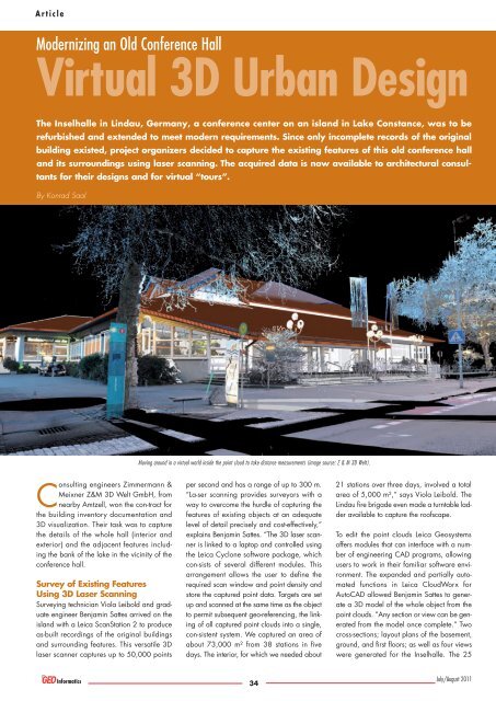
Moving around in a virtual world inside the point cloud to take distance measurements (image source: Z & M <strong>3D</strong> Welt).<br />
Consulting engineers Zimmermann &<br />
Meixner Z&M <strong>3D</strong> Welt GmbH, from<br />
nearby Amtzell, won the con-tract for<br />
the building inventory documentation and<br />
<strong>3D</strong> visualization. Their task was to capture<br />
the details of the whole hall (interior and<br />
exterior) and the adjacent features including<br />
the bank of the lake in the vicinity of the<br />
conference hall.<br />
Survey of Existing Features<br />
Using <strong>3D</strong> Laser Scanning<br />
Surveying technician Viola Leibold and graduate<br />
engineer Benjamin Sattes arrived on the<br />
island with a <strong>Leica</strong> ScanStation 2 to produce<br />
as-built recordings of the original buildings<br />
and surrounding features. This versatile <strong>3D</strong><br />
laser scanner captures up to 50,000 points<br />
per second and has a range of up to 300 m.<br />
“La-ser scanning provides surveyors with a<br />
way to overcome the hurdle of capturing the<br />
features of existing objects at an adequate<br />
level of detail precisely and cost-effectively,”<br />
explains Benjamin Sattes. “The <strong>3D</strong> laser scanner<br />
is linked to a laptop and controlled using<br />
the <strong>Leica</strong> Cyclone software package, which<br />
con-sists of several different modules. This<br />
arrangement allows the user to define the<br />
required scan window and point density and<br />
store the captured point data. Targets are set<br />
up and scanned at the same time as the object<br />
to permit subsequent geo-referencing, the linking<br />
of all captured point clouds into a single,<br />
con-sistent system. We captured an area of<br />
about 73,000 m² from 38 stations in five<br />
days. The interior, for which we needed about<br />
21 stations over three days, involved a total<br />
area of 5,000 m²,” says Viola Leibold. The<br />
Lindau fire brigade even made a turntable ladder<br />
available to capture the roofscape.<br />
To edit the point clouds <strong>Leica</strong> <strong>Geosystems</strong><br />
offers modules that can interface with a number<br />
of engineering CAD programs, allowing<br />
users to work in their familiar software environment.<br />
The expanded and partially automated<br />
functions in <strong>Leica</strong> CloudWorx for<br />
AutoCAD allowed Benjamin Sattes to generate<br />
a <strong>3D</strong> model of the whole object from the<br />
point clouds. “Any section or view can be generated<br />
from the model once complete.” Two<br />
cross-sections; layout plans of the basement,<br />
ground, and first floors; as well as four views<br />
were generated for the Inselhalle. The 25<br />
34<br />
July/August 2011
A r t i c l e<br />
architectural consultancies selected for the<br />
design competition used the model as the<br />
basis for their designs. With a maximum deviation<br />
of one centi-metre from the actual dimensions<br />
of the building, the data is considered<br />
equivalent to surveys of the high-est quality.<br />
<strong>3D</strong> Visualization and <strong>Virtual</strong> Tours<br />
“The particular aim of the exercise was to capture<br />
the features of the Inselhalle at such a level<br />
of detail and precision that the architects<br />
would have access to a robust and comprehensive<br />
survey of the existing building and<br />
would not have to produce one themselves,”<br />
explains Benjamin Sattes. “At the same time,<br />
we were able to use <strong>Leica</strong> <strong>Geosystems</strong>’ free<br />
Internet based visualization software TruView<br />
to allow people to take a virtual tour of the<br />
Inselhalle.” <strong>Leica</strong> TruView can be used to analyze<br />
and take measurements within large point<br />
clouds in a CAD or other <strong>3D</strong> technology environment,<br />
even for users without <strong>3D</strong> laser scanning<br />
experience. The point clouds are presented<br />
as photorealistic images. Architects can<br />
move around in a virtual world inside the point<br />
cloud, measure distances, highlight details,<br />
make annotations, and save the results. The<br />
project participants can also use the processed<br />
data to communicate effectively over<br />
the Internet. Using 2D layouts and a <strong>3D</strong> model<br />
of the existing building, and with TruView as<br />
a substitute for a site visit with the additional<br />
feature of being able to take measurements,<br />
each architect has the optimum basis for<br />
expressing his ideas and designs.<br />
Linking <strong>Design</strong>s to the Real<br />
World<br />
Thanks to the visualization concept developed<br />
inhouse by Z&M <strong>3D</strong> Welt, the architects, civil<br />
engineers, and landscape planners can see<br />
how their proposals and plans would look in<br />
the context of the real situa-tion. The design<br />
results can be delivered to Z&M <strong>3D</strong> Welt as<br />
<strong>3D</strong> models or 2D views. The company will<br />
then develop <strong>3D</strong> models from the 2D drawings<br />
or directly import the <strong>3D</strong> models created<br />
in the customer’s own choice of software module.<br />
The data is visualized in three-dimensional<br />
space with a new road layout, open space<br />
design, landscape architecture, and the existing<br />
real buildings and features. The process<br />
is particularly interesting because of its costeffectiveness<br />
compared to previous methods:<br />
Z&M <strong>3D</strong> Welt is able to visualize the real environment<br />
from the raw laser scanning results.<br />
The captured point clouds visualize the existing<br />
objects and do not have to undergo further<br />
processing into <strong>3D</strong> models with the customary<br />
loss of detail and accuracy.<br />
The Sustainability of Using <strong>3D</strong><br />
Models<br />
Users are often faced with the question of<br />
how best to make data available for future<br />
use with minimum cost and effort. The data<br />
obtained from laser scanning can be<br />
accessed immediately to provide measurements<br />
from the <strong>3D</strong> model and pass them on<br />
to the judging committee. The competitors<br />
particularly appre-ciate the ease of operation<br />
– it is so easy that no experience is<br />
needed to move about freely within the<br />
model.<br />
Konrad Saal is a surveying engineer and Marketing Communications<br />
Manager with <strong>Leica</strong> <strong>Geosystems</strong> in Heerbrugg, Switzerland.<br />
The future designs and animations for the “Inselhalle Lindau” project<br />
can be found at: www.zm-3dwelt.de/inselhalle.<br />
Z & M <strong>3D</strong> Welt is an innovative organization that has its origin in the<br />
surveying business. A sustainable investment policy and engagement<br />
in scientific research institutes, organizations, allowed the company to<br />
develop a new approach of surveying and visualizing of any construction<br />
work. The core business of Z & M <strong>3D</strong> Welt is virtual <strong>3D</strong> urban<br />
design, heritage protection, industrial and plant engineering, facility<br />
mana-gement and building surveying for renovation works.<br />
Thanks to Konrad Saal for providing the article and imagery.<br />
Latest News? Visit www.geoinformatics.com July/August 2011<br />
35