Windermere ASP Consolidation - City of Edmonton
Windermere ASP Consolidation - City of Edmonton
Windermere ASP Consolidation - City of Edmonton

You also want an ePaper? Increase the reach of your titles
YUMPU automatically turns print PDFs into web optimized ePapers that Google loves.
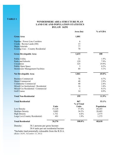
TABLE 1<br />
WINDERMERE AREA STRUCTURE PLAN<br />
LAND USE AND POPULATION STATISTICS<br />
BYLAW 16291<br />
Area (ha)<br />
% <strong>of</strong> GDA<br />
Gross Area 1,801<br />
Pipeline / Power Line Corridors 6<br />
Creeks / Ravine Lands (ER) 15<br />
Major Arterials 77<br />
Existing Uses – Country Residential 70<br />
Gross Developable Area 1,633 100<br />
Public Utility 31 1.9%<br />
Parks and Schools 129 7.9%<br />
Circulation 325 19.9%<br />
Public Open Space 3 0.2%<br />
Stormwater Management Facilities 84 5.1%<br />
Net Developable Area 1,061 65.0%<br />
Business Commercial 76 4.7%<br />
Major Commercial 48 2.9%<br />
Community Commercial 40 2.4%<br />
Mixed-Use Institutional / Residential 16 1.0%<br />
Mixed-Use Residential / Commercial 1 0.1%<br />
Golf Course 14 0.9%<br />
Total Non-Residential 195 11.9%<br />
Total Residential 867 53.1%<br />
% <strong>of</strong> Total<br />
Units<br />
Units<br />
Population<br />
Low Density 15,128 57.4% 44,265<br />
Medium Density 9,005 34.2% 20,403<br />
High Density 1,752 6.6% 2,575<br />
Large Lot (Country Residential) 491 1.9% 1,375<br />
Total Residential 26,376 100.0% 68,618<br />
Density: 38.1 persons per gross hectare<br />
30.4 units per net residential hectare<br />
*Includes land potentially releasable from the R.D.A.<br />
(Bylaw 16291, November 13, 2012)