Wilcox, D.A, Thompson, T.A., Booth, R.K., and Nicholas, J.R., Lake ...
Wilcox, D.A, Thompson, T.A., Booth, R.K., and Nicholas, J.R., Lake ...
Wilcox, D.A, Thompson, T.A., Booth, R.K., and Nicholas, J.R., Lake ...

You also want an ePaper? Increase the reach of your titles
YUMPU automatically turns print PDFs into web optimized ePapers that Google loves.
16 <strong>Lake</strong>-Level Variability <strong>and</strong> Water Availability in the Great <strong>Lake</strong>s<br />
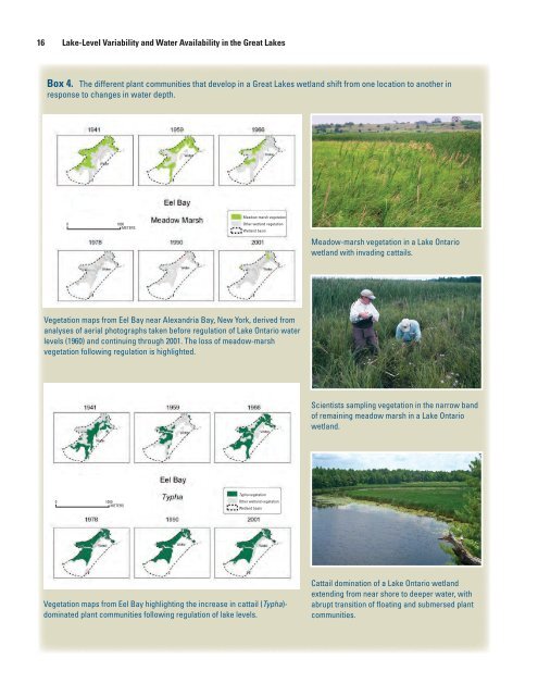
Box 4. The different plant communities that develop in a Great <strong>Lake</strong>s wetl<strong>and</strong> shift from one location to another in<br />
response to changes in water depth.<br />
0<br />
1000<br />
METERS<br />
Meadow-marsh vegetation<br />
Other wetl<strong>and</strong> vegetation<br />
Wetl<strong>and</strong> basin<br />
Meadow-marsh vegetation in a <strong>Lake</strong> Ontario<br />
wetl<strong>and</strong> with invading cattails.<br />
Vegetation maps from Eel Bay near Alex<strong>and</strong>ria Bay, New York, derived from<br />
analyses of aerial photographs taken before regulation of <strong>Lake</strong> Ontario water<br />
levels (1960) <strong>and</strong> continuing through 2001. The loss of meadow-marsh<br />
vegetation following regulation is highlighted.<br />
Scientists sampling vegetation in the narrow b<strong>and</strong><br />
of remaining meadow marsh in a <strong>Lake</strong> Ontario<br />
wetl<strong>and</strong>.<br />
0<br />
1000<br />
METERS<br />
Typha vegetation<br />
Other wetl<strong>and</strong> vegetation<br />
Wetl<strong>and</strong> basin<br />
Vegetation maps from Eel Bay highlighting the increase in cattail (Typha)-<br />
dominated plant communities following regulation of lake levels.<br />
Cattail domination of a <strong>Lake</strong> Ontario wetl<strong>and</strong><br />
extending from near shore to deeper water, with<br />
abrupt transition of floating <strong>and</strong> submersed plant<br />
communities.
Relation to Human Activities 17<br />
Figure 12. Profile of a typical coastal marsh from lake to upl<strong>and</strong> showing changes in plant communities related to lake-level history<br />
(from Environment Canada, 2002).<br />
High lake levels destabilize coastal bluffs <strong>and</strong> make s<strong>and</strong> available<br />
to leeward perched dunes. Intervening periods of lower<br />
lake levels <strong>and</strong> relative s<strong>and</strong> starvation permit forestation <strong>and</strong><br />
soil development on the dunes (Anderton <strong>and</strong> Loope, 1995;<br />
Loope <strong>and</strong> McEachern, 1998; Loope <strong>and</strong> Arbogast, 2000).<br />
Relation to Human Activities<br />
Human activities are also affected by water-level changes,<br />
<strong>and</strong> it is these health <strong>and</strong> economic activities that receive the<br />
most attention. Water-level changes can affect the production<br />
of electricity at hydropower facilities, especially those at the<br />
outlets of <strong>Lake</strong>s Superior, Erie, <strong>and</strong> Ontario. Extreme low<br />
water levels in the Great <strong>Lake</strong>s can jeopardize water-intake<br />
structures associated with municipal <strong>and</strong> industrial watersupply<br />
facilities, especially those structures that were built<br />
without knowledge of the long-term natural variability in lake<br />
levels. Although cargo ships have little difficulty traversing the<br />
waters of the Great <strong>Lake</strong>s proper, even during low lake-level<br />
periods, reduced water depths in the connecting channels <strong>and</strong><br />
the lower St. Lawrence River can limit the amount of cargo<br />
What are the relative magnitudes of natural <strong>and</strong> humaninduced<br />
effects on Great <strong>Lake</strong>s water levels?<br />
Effects of natural <strong>and</strong> human factors on water levels<br />
differ from lake to lake, but the following example for<br />
<strong>Lake</strong>s Michigan <strong>and</strong> Huron gives a sense of relative<br />
magnitudes of changes. Except for the Detroit/St. Clair<br />
channel modifications, which induced a change that was<br />
comparable to seasonal variability, natural factors are<br />
dominant—particularly over the long term.<br />
Long Lac-Ogoki Diversions (inflows)<br />
Chicago Diversion (outflow)<br />
Well<strong>and</strong> Canal<br />
Detroit/St. Clair channel modifications<br />
Niagara River outlet<br />
Existing consumptive uses (1993)<br />
Seasonal variability<br />
Climate variability (recorded)<br />
Climate variablility (last 2,000 years)<br />
11 cm<br />
-6 cm<br />
-6 cm<br />
-40 cm<br />
3 cm<br />
-5 cm<br />
±1.3 ft<br />
±6 ft<br />
±7 ft<br />
(Values in centimeters (cm) are from International Joint Commission<br />
(1999), <strong>and</strong> those in feet (ft) are from figure 9 of this report.)
18 <strong>Lake</strong>-Level Variability <strong>and</strong> Water Availability in the Great <strong>Lake</strong>s<br />
After Baedke & <strong>Thompson</strong> 2000 (composite of four hydrographs)<br />
Figure 13. Inferred late-Holocene levels of <strong>Lake</strong> Michigan compared with peaks in<br />
probability of inferred dune building. Gray bars show how composite peaks in inferred<br />
dune building (graph F) compare with the inferred lake levels. (Modified from Loope <strong>and</strong><br />
Arbogast, 2000.)<br />
they carry. Extreme flows in those channels during high-water<br />
periods can also hamper navigability. The recreational boating<br />
industry in the Great <strong>Lake</strong>s has grown in recent decades, with<br />
more marinas to accommodate the boats <strong>and</strong> larger boats that<br />
require deeper water. Some marinas, especially those built during<br />
high-lake-level periods, cannot operate as planned when<br />
lake levels are low. Boats of all sizes face greater risk of hitting<br />
lake bottom or submerged structures when lake levels are<br />
low, especially when traveling routes that were otherwise passable<br />
during high-water periods. In contrast, high water levels<br />
create problems for lakeshore property owners <strong>and</strong> industries<br />
that have structures in the flood-hazard zone (see box 5).<br />
Regulation of water levels on <strong>Lake</strong>s Superior <strong>and</strong> Ontario<br />
at their outlets seeks to reduce the occurrence of both high <strong>and</strong><br />
low lake levels. Regulation of water levels creates problems<br />
for wetl<strong>and</strong>s; it reduces the diversity of wetl<strong>and</strong> plant communities<br />
<strong>and</strong> alters habitat values for wetl<strong>and</strong> fauna (<strong>Wilcox</strong> <strong>and</strong><br />
Meeker, 1991, 1992). This problem is especially evident on<br />
<strong>Lake</strong> Ontario, where regulation began with operation of the St.<br />
Lawrence Seaway in about 1960 (<strong>Wilcox</strong> <strong>and</strong> Meeker, 1995;<br />
<strong>Wilcox</strong> <strong>and</strong> Whillans, 1999). Before regulation, the range of<br />
fluctuations during the 20th century was about 6.5 ft (fig. 6).<br />
After regulation began, the range was reduced slightly during<br />
1960–76, but low water-supply conditions in the mid-1960s<br />
<strong>and</strong> high supplies in the mid-1970s maintained much of the<br />
range. Regulation reduced the range to about 4.4 ft in the years<br />
after 1973. The lack of alternating flooded <strong>and</strong> dewatered<br />
conditions, especially the lack of low lake levels, resulted in<br />
establishment of extensive st<strong>and</strong>s of cattail at the expense of<br />
other plant community types, mostly the sedge/grass community<br />
at upper elevations in the wetl<strong>and</strong>s (fig. 14) (<strong>Wilcox</strong> <strong>and</strong><br />
Meeker, 1995; <strong>Wilcox</strong> <strong>and</strong> others, 2005). New regulation plans<br />
for <strong>Lake</strong> Ontario are currently being evaluated by the International<br />
Joint Commission (Hudon <strong>and</strong> others, 2006).<br />
Water levels on <strong>Lake</strong> Superior have been regulated since<br />
the early years of the 20th century, but the range of fluctuations<br />
<strong>and</strong> the cyclic nature of high <strong>and</strong> low lake levels were<br />
not altered as dramatically as on <strong>Lake</strong> Ontario. Since 1930,<br />
however, low lake levels that occurred on the unregulated<br />
lakes did not occur on <strong>Lake</strong> Superior (fig. 6). Wetl<strong>and</strong> plant
Relation to Human Activities 19<br />
ELEVATION, IN METERS<br />
75.0<br />
74.0<br />
73.0<br />
183.5<br />
ELEVATION, IN METERS<br />
183.0<br />
182.5<br />
182.0<br />
Figure 14. Schematic sections depicting the structural habitat provided by plant communities characteristic of regulated<br />
<strong>Lake</strong>s Ontario <strong>and</strong> Superior (modified from <strong>Wilcox</strong> <strong>and</strong> Meeker, 1995).<br />
communities on <strong>Lake</strong> Superior have seemingly been prone to<br />
fewer problems than those on <strong>Lake</strong> Ontario (fig. 14), although<br />
further studies are needed to make that determination. The<br />
International Joint Commission has prepared a plan of study to<br />
review of the regulation plan for <strong>Lake</strong> Superior in the future.<br />
In addition to having adverse effects on wetl<strong>and</strong> plant<br />
communities, reduction of water-level fluctuations can affect<br />
wetl<strong>and</strong> faunal communities (<strong>Wilcox</strong> <strong>and</strong> Meeker, 1992).<br />
Periodic high water levels (that is, levels above the historical<br />
long-term mean) increase fish access to spawning <strong>and</strong> nursery<br />
habitat in emergent vegetation <strong>and</strong> increase the hemi-marsh<br />
habitat preferred by waterfowl. Detrital plant materials are also<br />
colonized by invertebrates that are fed on by fish <strong>and</strong> waterfowl.<br />
Although periodic low water levels can jeopardize fish<br />
spawning <strong>and</strong> reduce waterfowl nesting area, they provide the<br />
opportunity for regeneration of the plant communities that are<br />
the foundation of the habitat.<br />
Compression of the range of lake-level fluctuations does<br />
not reduce erosion—it simply focuses it within a narrower<br />
elevation range. A common response to the threat of erosion<br />
along the shoreline associated with water-level fluctuations in<br />
the Great <strong>Lake</strong>s is to construct revetments, groins, breakwalls,<br />
<strong>and</strong> other hard structures along the shore, with the added intent<br />
of reducing flooding (fig. 15). By disrupting natural erosion<br />
processes, these structures also reduce the supply of sediments<br />
that naturally nourishes the shoreline <strong>and</strong> replaces eroded sediments<br />
that are lost during storms (Silvester <strong>and</strong> Hsu, 1991).<br />
Barrier-beach wetl<strong>and</strong>s may lose the protection of a barrier<br />
beach. Hard shoreline structures also shift wave energy further<br />
downshore <strong>and</strong> may locally accelerate erosion of beaches<br />
<strong>and</strong> wetl<strong>and</strong>s elsewhere. When revetments are constructed<br />
along the gently sloping shore of a wetl<strong>and</strong>, a “backstopping”<br />
effect can result (<strong>Wilcox</strong> <strong>and</strong> Whillans, 1999). Wave energy<br />
can scour sediments from in front of the revetment, leaving<br />
an abrupt boundary between upl<strong>and</strong> <strong>and</strong> deep water <strong>and</strong> no<br />
migrating, sloping shoreline with the required water depths<br />
for various wetl<strong>and</strong> plant communities. Although diking of<br />
wetl<strong>and</strong>s is considered a solution to management problems<br />
under circumstances where protection from water-level change<br />
<strong>and</strong> wave action is required, dikes also create problems for<br />
wetl<strong>and</strong>s (<strong>Wilcox</strong> <strong>and</strong> Whillans, 1999). Isolation from lake<br />
waters <strong>and</strong> the surrounding l<strong>and</strong>scape results in elimination or<br />
reduction of many of the functional values of wetl<strong>and</strong>s, including<br />
flood conveyance, flood storage, sediment control, <strong>and</strong><br />
improvement of water quality.
20 <strong>Lake</strong>-Level Variability <strong>and</strong> Water Availability in the Great <strong>Lake</strong>s<br />
Box 5. Human activities are also affected by waterlevel<br />
changes, <strong>and</strong> it is these activities that receive<br />
the most attention.<br />
Freighter passing through the Soo Locks, the outlet of<br />
<strong>Lake</strong> Superior near Sault Ste. Marie, Michigan.<br />
Moses Saunders Power Dam on the St. Lawrence River<br />
between Massena, New York, <strong>and</strong> Cornwall, Ontario.<br />
Mouth of the Salmon River, a <strong>Lake</strong> Ontario drownedriver-mouth<br />
wetl<strong>and</strong> near Pulaski, New York, showing<br />
housing development along the lakeshore <strong>and</strong> marina<br />
development along the river channel.<br />
Figure 15. Armored shoreline on <strong>Lake</strong> Ontario that disrupts<br />
natural coastal processes <strong>and</strong> generally results in accelerated<br />
erosion.<br />
Summary<br />
In this report, we present recorded <strong>and</strong> reconstructed<br />
(pre-historical) changes in water levels in the Great <strong>Lake</strong>s,<br />
relate them to climate changes of the past, <strong>and</strong> highlight<br />
major water-availability implications for storage, coastal<br />
ecosystems, <strong>and</strong> human activities. “Water availability,” as<br />
conceptualized herein, includes a recognition that water<br />
must be available for human <strong>and</strong> natural uses, but the<br />
balancing of how much should be set aside for which use<br />
is not discussed.<br />
The Great <strong>Lake</strong>s Basin covers a large area of North<br />
America. The lakes capture <strong>and</strong> store great volumes of<br />
water that are critical in maintaining human activities<br />
<strong>and</strong> natural ecosystems. Water enters the lakes mostly in<br />
the form of precipitation <strong>and</strong> streamflow. Although flow<br />
through the connecting channels is a primary output from<br />
the lakes, evaporation is also a major output. Water levels<br />
in the lakes vary naturally on timescales that range from<br />
hours to millennia; storage of water in the lakes changes at<br />
the seasonal to millennial scales in response to lake-level<br />
changes. Short-term changes result from storm surges<br />
<strong>and</strong> seiches <strong>and</strong> do not affect storage. Seasonal changes<br />
are driven by differences in net basin supply during the<br />
year related to snowmelt, precipitation, <strong>and</strong> evaporation.<br />
Annual to millennial changes are driven by subtle to<br />
major climatic changes affecting both precipitation (<strong>and</strong><br />
resulting streamflow) <strong>and</strong> evaporation. Rebounding of the<br />
Earth’s surface in response to loss of the weight of melted<br />
glaciers has differentially affected water levels. Rebound<br />
rates have not been uniform across the basin, causing the<br />
hydrologic outlet of each lake to rise in elevation more<br />
rapidly than some parts of the coastlines. The result is a<br />
long-term change in lake level with respect to shoreline<br />
features that differs from site to site.