Management Plan - Chowder Bay, Part 2 (PDF - 1.26 MB) - Sydney ...
Management Plan - Chowder Bay, Part 2 (PDF - 1.26 MB) - Sydney ...
Management Plan - Chowder Bay, Part 2 (PDF - 1.26 MB) - Sydney ...

Create successful ePaper yourself
Turn your PDF publications into a flip-book with our unique Google optimized e-Paper software.
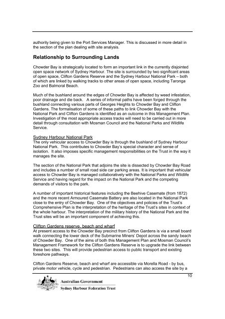
authority being given to the Port Services Manager. This is discussed in more detail in<br />
the section of the plan dealing with site analysis.<br />
Relationship to Surrounding Lands<br />
<strong>Chowder</strong> <strong>Bay</strong> is strategically located to form an important link in the currently disjointed<br />
open space network of <strong>Sydney</strong> Harbour. The site is surrounded by two significant areas<br />
of open space, Clifton Gardens Reserve and the <strong>Sydney</strong> Harbour National Park – both<br />
of which are linked by walking tracks to other areas of open space, including Taronga<br />
Zoo and Balmoral Beach.<br />
Much of the bushland around the edges of <strong>Chowder</strong> <strong>Bay</strong> is affected by weed infestation,<br />
poor drainage and die back. A series of informal paths have been forged through the<br />
bushland connecting various parts of Georges Heights to <strong>Chowder</strong> <strong>Bay</strong> and Clifton<br />
Gardens. The formalisation of some of these paths to link <strong>Chowder</strong> <strong>Bay</strong> with the<br />
National Park and Clifton Gardens is identified as an outcome in this <strong>Management</strong> <strong>Plan</strong>.<br />
Investigation of the most appropriate access tracks will need to be carried out in more<br />
detail through consultation with Mosman Council and the National Parks and Wildlife<br />
Service.<br />
<strong>Sydney</strong> Harbour National Park<br />
The only vehicular access to <strong>Chowder</strong> <strong>Bay</strong> is through the bushland of <strong>Sydney</strong> Harbour<br />
National Park. This contributes to <strong>Chowder</strong> <strong>Bay</strong>’s special character and sense of<br />
isolation. It also imposes specific management responsibilities on the Trust in the way it<br />
manages the site.<br />
The section of the National Park that adjoins the site is dissected by <strong>Chowder</strong> <strong>Bay</strong> Road<br />
and includes a number of small road side car parking areas. It is important that vehicular<br />
access to <strong>Chowder</strong> <strong>Bay</strong> is managed collaboratively with the National Parks and Wildlife<br />
Service and having regard for the impact on the National Park and the competing<br />
demands of visitors to the park.<br />
A number of important historical features including the Beehive Casemate (from 1872)<br />
and the more recent Armoured Casemate Battery are also located in the National Park<br />
close to the entry of <strong>Chowder</strong> <strong>Bay</strong>. One of the objectives and policies of the Trust’s<br />
Comprehensive <strong>Plan</strong> is the interpretation of the heritage of the Trust’s sites in context of<br />
the whole harbour. The interpretation of the military history of the National Park and the<br />
Trust sites will be an important component of achieving this.<br />
Clifton Gardens reserve, beach and wharf<br />
At present access to the <strong>Chowder</strong> <strong>Bay</strong> precinct from Clifton Gardens is via a small board<br />
walk connecting the lower deck of the Submarine Miners’ Depot across the sandy beach<br />
of <strong>Chowder</strong> <strong>Bay</strong>. One of the aims of both this <strong>Management</strong> <strong>Plan</strong> and Mosman Council’s<br />
<strong>Management</strong> Framework for the Clifton Gardens Reserve is to upgrade the link between<br />
these two sites. This will provide pedestrian access to public transport and existing<br />
foreshore pathways.<br />
Clifton Gardens Reserve, beach and wharf are accessible via Morella Road - by bus,<br />
private motor vehicle, cycle and pedestrian. Pedestrians can also access the site by a<br />
10
walking track that links Taronga Zoo ferry wharf to the reserve through <strong>Sydney</strong> Harbour<br />
National Park. Charter boats, ferries and private vessels also provide access to both the<br />
wharf and bay.<br />
Site Analysis<br />
Heritage Conservation – Archaeology, Buildings, Places and <strong>Plan</strong>tings<br />
The <strong>Chowder</strong> <strong>Bay</strong> Barracks group of buildings is listed on the Register of the National<br />
Estate – see Australian Heritage Commission Database Number 2876. This is in<br />
recognition of its historical significance as one of the locations of major defence works<br />
for <strong>Sydney</strong> Harbour during the 19 th and 20 th centuries as well as subsequent military<br />
occupation of the site.<br />
The precinct’s initial development and operation by the Submarine Miners’ Corps was a<br />
major defence undertaking of the late nineteenth century. It represents the most<br />
advanced military technology available at that time and one the earliest uses of electric<br />
technology in a military situation.<br />
The Submarine Miners’ Depot is believed the most intact in the world and to be the sole<br />
surviving mine laboratory in Australia.<br />
The four phases of military development and building use represented at <strong>Chowder</strong> <strong>Bay</strong><br />
are:<br />
• Phase 1 - 1892 to1922. The establishment of the Submarine Miners’ Depot in<br />
1892 to maintain an electronically triggered minefield within <strong>Sydney</strong> Harbour as a<br />
defence against enemy ships.<br />
This phase included the construction of the stone masonry mine stores,<br />
workshops, Sergeants Major’s cottage, small brick explosive magazines, cable<br />
pond and boatshed. The majority of this development is intact and is set on<br />
various terraced levels leading down to the waterfront.<br />
• Phase 2 - 1922 to 1974. During this phase the Depot was occupied by various<br />
groups of the Royal Australian Engineers – the Fortress Engineers, the Transport<br />
Service and the Australian Water Transport.<br />
From the middle to the end of this phase new barrack and mess buildings were<br />
constructed along the eastern section of the entry road. These buildings were<br />
constructed for both short and long term accommodation for base personnel and<br />
training course attendees.<br />
It was also during this time that the Naval refueling facilities were established.<br />
This included the two tanks located above the Depot, refueling wharf, pipe line<br />
and buildings to accommodate pumps etc.<br />
• Phase 3 - 1974 to 1997. This was the final phase of military occupation. During<br />
this time the site was used as the Army Maritime School. The school trained<br />
personnel in water transport.<br />
11
In the late 1980’s several buildings from the earlier phases were demolished to<br />
provide new accommodation for the school.<br />
• Phase 4 - 1998 to present. During this phase management of the site was<br />
transferred to the <strong>Sydney</strong> Harbour Federation Trust and the Trust has located its<br />
offices in three of the former school buildings - buildings 22, 23 and 24.<br />
The buildings and structures remaining from these phases of occupation are shown in<br />
Figure 4<br />
In July 2003 the Trust engaged architects, Brian McDonald & Associates, to prepare a<br />
Conservation <strong>Management</strong> <strong>Plan</strong> (CMP) for the <strong>Chowder</strong> <strong>Bay</strong> precinct.<br />
This study assessed all of the built items including buildings, workshops, barracks and<br />
has provided a statement of significance and recommendations for each building.<br />
The study recommended that all existing buildings and structures under Trust control be<br />
maintained. It recommended that buildings 7, 10, 11, 11a, 13, 14, 15, 17, 18, 18a, the<br />
dry cotton store and their associated infrastructure should be conserved and that<br />
buildings 1, 2, 12, 19, 20, 22, 23, 24 & 25 could be modified. The recommendations<br />
suggest a range of modifications for different buildings for example, adaptive re-use of<br />
buildings 22, 23 and 24, and external appearance changes to buildings 1,2,19 and 20 if<br />
creating a more harmonious relationship with the harbour-side setting.<br />
The study also noted that buildings N2, N3 & N4 (the pump house and associated<br />
buildings) are aesthetically intrusive and recommended that if possible they should be<br />
removed. However, buildings N2 and N3 are under the control of the Department of<br />
Defence and are essential to the functioning of the Navy fuelling depot. Building N4 is<br />
not an essential part of this of this complex and it is proposed that it and the surrounding<br />
crib wall are removed.<br />
The study noted that in preparing the <strong>Management</strong> <strong>Plan</strong> for the site it should be borne in<br />
mind that the primary significance of the place depends on its development as part of the<br />
defence network for <strong>Sydney</strong> Harbour. Therefore, any interpretation should include an<br />
interpretation of the support buildings that no longer exist.<br />
Aboriginal Heritage<br />
The language group of indigenous people is thought to be part of the Guringai and the<br />
clan group the Borogegal, with <strong>Chowder</strong> <strong>Bay</strong> being recorded as "Koree" and the stretch<br />
of water between <strong>Chowder</strong> <strong>Bay</strong> and Obelisk Beach recorded as "Taliangy".<br />
There are two recorded Aboriginal sites located on Trust land at <strong>Chowder</strong> <strong>Bay</strong>. Both<br />
sites are registered with the NSW National Parks and Wildlife Service. Site 45 – 6- 2331<br />
is a shelter site with midden while Site 45-6-2327 is an open midden. The Trust will<br />
ensure that any future development will not impact on these sites.<br />
In June 2003, the Trust commissioned the Australian Museum Business Services<br />
(A<strong>MB</strong>S) to carry out an Aboriginal Heritage Survey of the Trust lands at Middle Head<br />
Georges Heights and <strong>Chowder</strong> <strong>Bay</strong>. Stage one of the survey included a survey of<br />
12
<strong>Plan</strong> Area Boundary<br />
Phase 1<br />
Phase 2<br />
Phase 3<br />
Buildings and infrastructure to<br />
be retained for Defence use<br />
Fig. 4 HERITAGE - Existing buildings and structures <strong>Chowder</strong> <strong>Bay</strong> N