Volcanoes - Ministry of Civil Defence and Emergency Management
Volcanoes - Ministry of Civil Defence and Emergency Management
Volcanoes - Ministry of Civil Defence and Emergency Management

Create successful ePaper yourself
Turn your PDF publications into a flip-book with our unique Google optimized e-Paper software.
In about 1315AD Tarawera volcano erupted with enormous<br />
force, depositing rhyolitic ash over much <strong>of</strong> the northern<br />
part <strong>of</strong> the North Isl<strong>and</strong>. This was the Kaharoa eruption.<br />
Columns <strong>of</strong> ash may have continued for days or weeks, <strong>and</strong><br />
these were followed by slow extrusion <strong>of</strong> lava domes, with<br />
intermittent ash eruptions, which may have continued for<br />
four years (Nairn et al., 2001). If such an event occurred<br />
today it would cause major disruption to the surrounding<br />
area, as indicated in Table 1. Evacuation <strong>of</strong> some areas will<br />
be inevitable.<br />
The distribution <strong>of</strong> ash will largely depend on<br />
the wind direction at the time <strong>of</strong> the eruption, <strong>and</strong> in an<br />
eruption <strong>of</strong> this magnitude wind direction will change<br />
several times. In the 1315 Kaharoa eruption, ash first<br />
travelled southeastwards, <strong>and</strong> then northwestwards,<br />
covering an area from Northl<strong>and</strong> to Mahia Peninsula<br />
with a layer <strong>of</strong> ash, with the greatest thickness occurring<br />
between Tauranga <strong>and</strong> Murupara (Fig 1). The dominant<br />
high level wind direction is from the west, therefore<br />
areas to the east <strong>of</strong> the volcano are more likely to be<br />
covered with ash, even small amounts <strong>of</strong> which will<br />
cause severe disruption to all forms <strong>of</strong> transportation<br />
(Table 2).<br />
EVACUATION ZONES<br />
The next eruption <strong>of</strong> this type in the Bay <strong>of</strong><br />
Plenty will most probably be from Tarawera or from<br />
Haroharo volcano to the north. When this happens,<br />
Thickness<br />
<strong>of</strong> ash<br />
0-2mm<br />
2-20mm<br />
Effects on roads<br />
Road markings obscured, traction reduced (wet <strong>and</strong><br />
dry ash), visibility reduced as dry ash is remobilised<br />
by traffic <strong>and</strong> wind. Steep hills difficult for 2WD<br />
vehicles to climb.<br />
Moderate hills become difficult for 2WD vehicles<br />
to climb, steep hills impossible. Drifts cause larger<br />
humps in road. Once dampened <strong>and</strong> compacted it<br />
becomes firmer, easier to drive on.<br />
Fig 1. Proximal distribution <strong>of</strong> Kaharoa ashfall deposits; isopach<br />
values in cms (from Johnston et al. 2002)<br />
the highest risk is within a 10km zone around the vent<br />
area, <strong>and</strong> this becomes a Primary Evacuation Zone (Fig<br />
2), including the Rotorua Lakes district (bordering Lakes<br />
Rotokakahi, Tikitapu, Okareka, Tarawera <strong>and</strong> Okataina).<br />
Residents <strong>of</strong> this area would have to be evacuated prior<br />
to commencement <strong>of</strong> the eruption.<br />
Residents on the north shore <strong>of</strong> Lake Tarawera<br />
(along Spencer Road) would be the most vulnerable<br />
to any eruption from Tarawera (Fig 3). This area is<br />
likely to be completely devastated in a Kaharoa-type<br />
eruption from Tarawera or Haroharo, particularly from<br />
ballistic ejecta <strong>and</strong> thick near-vent ashfalls. Therefore,<br />
it is imperative that this area evacuates pre-eruption.<br />
An added problem is the single evacuation route into<br />
<strong>and</strong> out <strong>of</strong> the area. Spencer Road ends at the edge <strong>of</strong><br />
20-100mm<br />
100-<br />
300mm<br />
Slight inclines may be impassable to 2WD vehicles,<br />
4WD vehicles need differential or hub locks to climb<br />
moderate hills. Larger drifts (eg 300mm) may hinder<br />
or stop 2WD vehicles on flat roads.<br />
Uneven surfaces in the ash stop any 2WD vehicles,<br />
compacted damp ash on flat surfaces is still able to<br />
be driven on. 4WD utility type vehicles (not cars) may<br />
be able to slowly progress on the flat. Drifts may need<br />
to be cleared. Moderate inclines difficult, but may be<br />
possible for experienced 4WD drivers. Steep inclines<br />
generally impassable. Ruts easily formed on hills.<br />
>300mm<br />
Compacted ash may be driven on by 4WD vehicles,<br />
s<strong>of</strong>ter patches may easily bog vehicles. Gradual<br />
inclines possible on compacted ash, but after a few<br />
vehicles, ruts in the ash will form, hindering uphill<br />
progress for further vehicles.<br />
Table 2. Ashfall effects on road transportation (from Barnard, 2003)<br />
Fig 2. Evacuation Zones: Zone 1 = 10km radius (primary) zone;<br />
Zone 2 = 40km radius (secondary) zone; Zone 3 = 100km radius<br />
(potentially 'unsafe') zone.<br />
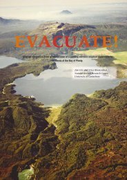
A view looking northeast along the vents <strong>of</strong> the 1886 AD eruption, from Frying Pan Lake in the foreground<br />
to Mt. Tarawera <strong>and</strong> in the background, the cone <strong>of</strong> Mt Edgecumbe. Photo: GNS Lloyd Homer.<br />
47<br />
TEPHRA<br />
June 2004