Section Inputs Project Scope Country Philippines ... - RarePlanet
Section Inputs Project Scope Country Philippines ... - RarePlanet
Section Inputs Project Scope Country Philippines ... - RarePlanet

You also want an ePaper? Increase the reach of your titles
YUMPU automatically turns print PDFs into web optimized ePapers that Google loves.
<strong>Section</strong><br />
<strong>Project</strong> <strong>Scope</strong><br />
<strong>Country</strong><br />
Province<br />
Municipality<br />
Barangays<br />
Site Description<br />
<strong>Philippines</strong><br />
Negros Oriental<br />
Ayungon<br />
<strong>Inputs</strong><br />
* Iniban * Anibong<br />
* Awa-an * Calagcalag<br />
* Tampocon I * Tiguib<br />
* Tampocon II<br />
Ayungon is one of the 20 municipalities of Negros Oriental. It is located along the<br />
coast of Tañon Strait and is 82 kilometers north of Dumaguete City, the provincial<br />
capital. It is bounded on the north by Tayasan, on the south by Bindoy, southwest<br />
by Mabinay, the west by Kabankalan (Negros Ociidental) and at the east by<br />
Tañon Strait. The coastline is around 16 kilometers and the municipal waters<br />
cover an area of approximately 240 km 2 .<br />
Ayungon lies in the central part of Negros Oriental, along the coastal road from<br />
Dumaguete to Bacolod. The set of the Municipality was a previous swampland,<br />
converted later into fishponds and residential areas. Toward the western part of<br />
the Municipality are rugged mountains of volcanic terrain, characterized by<br />
ridges, gullies, constricted valleys and plateaus. These are covered by secondary<br />
growth forests, cocoland and agricultural crops such as rice, corn and sugarcanes.<br />
Ayungon has a total land area of 28, 163 hectares. Twenty-four barangays<br />
comprises the munivipality namely: Anibong, Awa-an, Amdus, Atabay, Banban,<br />
Calagcalag, Candana-ay, Carol-an, Gomentoc, Inacban, Iniban, Jabdalamanon,<br />
Kilaban, Lamigan, Maaslum, Mabato, Manogtong, Nabhang, Tambo, Tibyawan,<br />
Tiguin, Tampocon I, Tampocon II and Poblacion.<br />
Climate<br />
The Municipality of Ayungon belongs to the 3 rd type of climate and that the<br />
frequency of the occurrence of tropical cyclones is low at 7%, indicating that the<br />
Municipality enjoys a generally fair weather throughout the year.<br />
There are two monsoon winds affecting the municipality: Habagat (June–<br />
September) and Amihan (November–March). Amihan is characterized by strong,<br />
big waves and wind while Habagat brings frequent rainfall and typhoons.<br />
The temperature ranges in Ayungon are slight, whereas temperature averages are<br />
high. The latitudinal position of Ayungon is largely responsible for tropical<br />
temperate conditions. Even during the warmest part of the year, evenings are<br />
pleasantly cool. Average monthly temperature from January to December is<br />
26.67°C.
Biodiversity Features<br />
Biodiversity<br />
Area<br />
Municipal land: 28, 163 hectares<br />
Municipal waters: 240 km 2<br />
Coral Reef Area: 99.68 hectares<br />
Seagrass area: 11.5 hectares<br />
Mangrove Area: 74.64 hectares<br />
Biodiversity<br />
Background<br />
Source: CLUP, 2005-2015<br />
Coral reef<br />
The mean live hard coral in Ayungon<br />
Negros Oriental was 65.22% in 2007, a<br />
20.59% change in the mean live coral<br />
cover of 44.63% last CY 2002<br />
assessment data. Based in the<br />
Manthachitra Index Scale, the reef of<br />
Ayungon had high mortality, very good<br />
development, in good condition and<br />
very low succession of algae and other<br />
animals which falls to Conservation<br />
Class Value No. 3 (Alonzo,N., Ranay,<br />
N., Famor,G.& Niones, G., 2007).<br />
Corals are important because they provide food and shelter to different kind of species.<br />
Not only are they important to the creatures of the sea but also, they help prevent the<br />
shoreline form eroding.<br />
Seagrass<br />
The seagrass was measured to have an area of 11.5 hectares. There was no known<br />
study of classifying the seagrass in the municipality. Seagrasses are a source of food for<br />
the green sea turtles that are also living in the area. It also serves as nursery to different<br />
kinds of fish species.<br />
Mangrove Ecosystem<br />
The Municipality has a total of 74.64<br />
hectares of mangroves. The species of<br />
mangrove found in the municipality are<br />
Sonneratia alba (Pagatpat), Avicennia<br />
marina (Miapi), Rhizophora mucronata<br />
(Bakhaw) and Nipa fruticans (Nipa).<br />
Mangrove planting is done every year by<br />
the members of the POs assisted by<br />
BFAR. Mangroves are important because<br />
they help protect the coast against erosion<br />
and serves as a nursery for different kinds of organisms including fish and shellfish. It<br />
also serves as shelter for the birds.
Protected Area Information<br />
MPA overview<br />
Name: Habitat Type: Area(has):<br />
*Iniban Marine Sanctuary Coral reef 27.86<br />
*Awa-an Marine Sanctuary Coral reef 15.54<br />
Tampocon II Marine Sanctuary Seagrass bed 2.00<br />
Tampocon I Marine Sanctuary Seagrass bed & coral reef 17.00<br />
Anibong Marine Snctuary Seagrass bed & coral reef 7.137<br />
Calagcalag Marine Sanctuary Seagrass bed & coral reef 15.29<br />
Tiguib Marine Sanctuary Seagrass bed & coral reef 15.14<br />
Source: MPA Plan, 2007-2012<br />
Technical<br />
Description of<br />
MPAs<br />
Iniban Marine Sanctuary<br />
1. N 9.89272 4. N 9.89329 7. N 9.88938<br />
E 123. 14685 E 123.15146 E 123.14763<br />
2. N 9.89294 5. N 9.88998 8. N 9.88946<br />
E 123.14730 E 123.15267 E 123.14654<br />
3. N 9.89347 6. N 9.88906 9. N 9.89198<br />
E 123.14826 E 123.15058 E 123.14589<br />
Awa-an Marine Sanctuary<br />
1. N 9.87011 3. N 9.87257<br />
E 123.14767 E 123.15282<br />
2. N 9.86991 4. N 9.87291<br />
E 123.15220 E 123.14811<br />
Tampocon I Marine Sanctuary<br />
1. N 9.84311 4. N 9.83505 7. N 9.84273<br />
E 123. 14300 E 123.14729 E 123.14501<br />
2. N 9.83854 5. N 9.83579 8. N 9.84309<br />
E 123.14495 E 123.14826 E 123.14413<br />
3. N 9.83534 6. N 9.83900<br />
E 123.14633 E 123.14645
Anibong Marine Sanctuary<br />
1. N 9.83471 4. N 9.83362<br />
E 123. 14180 E 123.14788<br />
2. N 9.83474 5. N 9.83380<br />
E 123.14627 E 123.14407<br />
3. N 9.83558<br />
E 123.14828<br />
Calagcalag Marine Sanctuary<br />
1. N 9.81764 4. N 9.81359 7. N 9.81638<br />
E 123.14586 E 123.14815 E 123.14855<br />
2. N 9.81568 5. N 9.81249 8. N 9.81693<br />
E 123.14730 E 123.14815 E 123.14681<br />
3. N 9.81459 6. N 9.81464<br />
E 123.14438 E 123.14852<br />
Tiguib Marine Sanctuary<br />
1. N 9.80263 4. N 9.79865 7. N 9.80244<br />
E 123.16621 E 123.16593 E 123.16839<br />
2. N 9.80036 5. N 9.79865<br />
E 123.16526 E 123.16585<br />
3. N 9.79931 6. N 9.80025<br />
E 123.16570 E 123.169<br />
Source: MPA Plan, 2007-2012
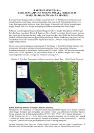
Site Map<br />
Reference<br />
Protected Area<br />
Categories<br />
Red- List<br />
Species<br />
The MPAs are established under Municipal Ordinance No. 3 Series of 2008.<br />
Some of the noteworthy species that the Municipality has are listed below.<br />
1. Rhincodon typus (Whale Shark)<br />
Status: Vulnerable<br />
Pop. trend: decreasing<br />
The Whale Shark (Rhincodon typus) is a<br />
cosmopolitan tropical and warm temperate<br />
species and is the world’s largest living<br />
chondrichthyan. Its life history is poorly<br />
understood, but it is known to be highly<br />
fecund and to migrate extremely large<br />
distances. Populations appear to have been<br />
depleted by harpoon fisheries in Southeast Asia and perhaps incidental capture in other<br />
fisheries. High value in international trade, a K-selected life history, highly migratory<br />
nature and normally low abundance make this species vulnerable to commercial<br />
fishing. Dive tourism involving this species has recently developed in a number of<br />
locations around the world, demonstrating that it is far more valuable alive than fished
(Norman, B, 2005).<br />
2. Chelonia mydas (Green<br />
Turtle)<br />
Status: Endangered<br />
Pop. trend: decreasing<br />
Analysis of historic and<br />
recent published accounts<br />
indicate extensive<br />
subpopulation declines in all<br />
major ocean basins over the<br />
last three generations as a<br />
result of overexploitation of<br />
eggs and adult females at<br />
nesting beaches, juveniles<br />
and adults in foraging areas, and, to a lesser extent, incidental mortality relating to<br />
marine fisheries and degradation of marine and nesting habitats. Analyses of<br />
subpopulation changes at 32 Index Sites distributed globally show a 48% to 67%<br />
decline in the number of mature females nesting annually over the last 3–generations.<br />
Green turtles, like other sea turtle species, are particularly susceptible to population<br />
declines because of their vulnerability to anthropogenic impacts during all life-stages:<br />
from eggs to adults. Perhaps the most detrimental human threats to green turtles are the<br />
intentional harvests of eggs and adults from nesting beaches and juveniles and adults<br />
from foraging grounds (Seminoff, J.A., 2004).<br />
3. Tridacna squamosa<br />
(Fluted Giant Clam)<br />
Status: Least Concern (Wells, S., 1996)<br />
Primary<br />
Threats<br />
Secondary<br />
Threats<br />
The Municipality’s primary threats as classified by IUCN includes the following:<br />
1.2 Mining & quarrying<br />
5.1 Hunting & collecting terrestrial animals<br />
5.1.1 Intentional use (species being assessed is the target)<br />
5.4 Fishing & harvesting aquatic resources<br />
5.4.1 Intentional use: subsistence/small scale (species being assessed is the target)<br />
[harvest]<br />
9.2.2 Seepage from mining<br />
The Municipality’s secondary threats as classified by IUCN are as follows:<br />
3.1 Oil & gas drilling
History of the<br />
MPA<br />
Previous and<br />
Existing<br />
Management<br />
Strategies<br />
8.1 Invasive non-native/alien species/diseases<br />
8.1.2 Named species<br />
The decline in fish is causing the fishermen to fear and worry as this depletion is<br />
threatening their livelihood. The government is aware of the situation; hence, it decided<br />
to create a program for the sustainable development of the marine resources. Through<br />
community consultations and organization of the coastal residents, the people agreed to<br />
establish marine sanctuaries for the restoration and protection of marine habitats, such<br />
as corals reefs, seagrass and mangroves, as well as fishery stocks and other marine<br />
organisms. In doing so, the progress and livelihood for the people are ensured. This<br />
vision of making a Marine Protected Area came true through the Municipal Ordinance<br />
No. 3 Series of 2008.<br />
Source: MPA Plan, 2007-2012<br />
1. Seaweeds Culture (Awa-an and Calagcalag)<br />
Objective: To provide alternative livelihood to the members of both the AMA<br />
(Awa-an Mananagat Association) and CAFA (Calagcalag Fishermen Association)<br />
Funder: BFAR<br />
Amount given: P 120,000<br />
Start/End Date: September 9 – October 24, 2011<br />
Completed<br />
2. Fish Pots (Iniban)<br />
Objective: To provide alternative livelihood to the members of IFA (Iniban<br />
Fishermen Association)<br />
Funder: BFAR<br />
Amount given: P 28,000<br />
Start/End Date: As of August 30, 2012, the MOA has been approved as is<br />
only waiting for the materials to be served.<br />
3. Lying-in pen for rabbit fish, blue crab and sea cucumber (Anibong)<br />
Objective: To provide alternative livelihood to the members of the AFA<br />
(Anibong Fishermen Association)<br />
Funder: BFAR<br />
Amount given: P 167,000<br />
Start/End Date: As of August 30, 2012, the MOA has been approved as is<br />
only waiting for the materials to be served.<br />
4. Mangrove planting (Tampocon I)<br />
Objective: To increase the number of mangroves planted in the shore of<br />
barangay Tampocon I.<br />
Funder: BFAR<br />
Amount given: P 19, 998<br />
Start/End Date: July 23- August 3, 2012<br />
Completed
5. Drift Gill Net for Big Eyed Scad/1 motorized boat (Awa-an)<br />
Objective: To provide alternative livelihood to the members of AMA (Awa-an<br />
Mananagat Association)<br />
Funder: DOLE<br />
Amount given: P 146,000<br />
Start/End Date: June 20 – August 23, 2012<br />
Completed<br />
Previous and<br />
Existing<br />
Environmental<br />
Education<br />
Work<br />
Solid Waste Management<br />
The education campaign for the solid waste management started in the year 2007 and is<br />
present until now. During the first year of the campaign, there were stickers and posters<br />
that were placed in strategic places that show how to segregate the garbage. In the<br />
succeeding years, the IEC was only done through the word of mouth.<br />
Anti-smoking Campaign<br />
The anti-smoking campaign was started in the year 2010 as is still on going up to the<br />
present. During the launching of the campaign, schools from the different coastal<br />
barangays were present. A poster making contest on the hazards of smoking was<br />
conducted in order to inform the students and the community of the hazards that<br />
smoking brings. Posters and billboards showing the negative effects it brings to man’s<br />
health were placed in the strategic places. A no smoking sign is placed in every<br />
government office. Every year, during the charter day celebration, the same activities<br />
are done in order to inform the people of the negative effects it brings.<br />
Human Stakeholders<br />
Human<br />
Stakeholder The total population of the Municipality as of 2007 is 42,643 (NSO, 2007). There are 7<br />
Population costal barangays in the Municipality, each having an MPA of its own. The Barangays<br />
Size<br />
and its population are as follows:<br />
Iniban - 1167<br />
Awa-an - 2259<br />
Tampocon I - 1853<br />
Tampocon II -1724<br />
Anibong -2020<br />
Calagcalag -1759<br />
Tiguib -2484<br />
Other noteworthy barangays include Barangays Poblacion, Inacban and Kilaban. It is in<br />
Barangay Poblacion were the public market is located and were the fish caught from<br />
the coastals barangays are sold. The inhabitants of barangays Inacban and Kilaban<br />
mostly depend on the sea for their food and as a source of income.<br />
Poblacion - 1868<br />
Kilaban - 661<br />
Inacban – 1258<br />
Source: NCSB,2007
Historical<br />
Description<br />
In the pre-Spanish period, Ayungon was small settlement along the coast of Tañon<br />
Strait. The Spanish religious missionaries discovered this community in the 1800’s and<br />
was annexed to the Tayasan parish as part of the church’s religious jurisdiction. On<br />
June 12, 1924, Ayungon, upon the recommendation of the Provincial Gov. Enrique<br />
Villanueva, it was proclaimed a Municipality by Governor–General Leonard Wood,<br />
through General Order No. 31, s. 1924. With the proclamation, Benito Sanchez was<br />
installed the first municipal president and Timoteo Perez, the municipal vice-president.<br />
Upon the proclamation of the Municipality of Ayungon in 1924, Benito Sanchez and<br />
Timoteo Perez were respectively installed as Municipal President and Vice-President.<br />
Sanchez succeeded by Apolonio Deguit as President in 1927. In its first political<br />
election in 1928, Julian Villanueva was elected Mayor and was succeeded by Maximo<br />
Enardecido, who remained Mayor when World War II broke out.<br />
Source: CLUP, 2005-2015<br />
Campaign's<br />
Social Context<br />
Historical Growth of the Population<br />
The Municipality of Ayungon has no population data before 1939. In the year 2005,<br />
however, the population trend shows a steady increase, although the growth rate varies<br />
for every censual period.<br />
Starting with an average growth rate of 1.64 in 1948, it increased to 3.18 in 1960. Then<br />
the population started to decline registering a lowest growth rate of 0.41 in 1975. It<br />
started to rise again having its highest at 3.19 in 1980. The remaining decades, up to<br />
2000, was a see saw, lowering to 1.88 in 1990; rose again to 2.08 in 2000, and declined<br />
to 1.99 in 2005. The reasons for the decline in the 70’s were due to the peace and order<br />
problem of the Municipality and the cancellation of the logging concession in the area.<br />
The rebel elements and a religious sect had an armed conflict with the government<br />
during the martial law years, especially in the hinterland causing out migration. When<br />
the logging concession in the area was also cancelled by the national government in the<br />
seventies, many of the workers left Ayungon and some went deep into the forest to<br />
start kaingin activities. And these people were not included in the census.<br />
Out of the 24 barangays, five (5) are considered urban and the rest are rural. The urban<br />
barangays are Anibong, Awa-an, Tampocon I, Tampocon II and Poblacion.<br />
Population by Age<br />
Ayungon has a relatively young population. As shown in Table 3.3.1, the total number<br />
of people below 15 years old in 2005 was 17,538; while the total population of 65 years<br />
and above was only 1,470. And when computed, the total population of the residents<br />
with ages ranging from 15-64 years old was 21,733. The young dependency ratio is<br />
computed to be 80.66. The old dependency ratio on the other hand is 6.76%. When<br />
computed, the total dependency ratio is arrived at 87.42%. This means that 87.42% of<br />
the total population is dependent upon the 12.58% working population.
Urbanization<br />
Among the rural barangays, Carol-an is the largest in terms of area and population. In<br />
the year 2005, the total population of Carol-an was 3,245 scattered in an area of<br />
5,598.14 hectares. The smallest rural barangay in terms of area and population is<br />
Kilaban. Kilaban is a mountainous barangay, located around 4 kilometers northwest of<br />
Poblacion.<br />
There were no records pertaining to urban population in the censual periods that<br />
were conducted in the year 1939 to 1990. From 1990 to 2005, the tempo of<br />
urbanization shows a negative rate. This is the reason why the Municipality remains<br />
basically rural. In fact, population growth rate is faster at the rural barangays like<br />
Tambo, Banban, Tiguib and Mabato than the urban barangays. Another reason is that<br />
these urban barangays which are located along the national highway has a very limited<br />
plain for built-up expansion. When the timber concession was cancelled, the workers<br />
chose to remain in the hinterland barangays of Tambo, Banban, Mabato and Carol-an<br />
and engaged in illegal logging and kaingin farming at the forestland.<br />
Build-up Density<br />
The Planning standards classify population density into low, medium, and high. Low<br />
density areas have at least 150 persons per hectare; medium density areas have 151 to<br />
250 persons per hectare and more than 251 persons per hectare for high density areas.<br />
Built-up density is the total population in the built-up area over total built-up area.<br />
The total urban population is 3,494 and the total urban built-up area is 439 hectares.<br />
Therefore, the average built-up density in the urban area is 6 persons per hectare. All<br />
the urban barangays in the Municipality, therefore, are considered as low density areas.<br />
The average rural density is 3.06 per hectare. All of the rural barangays in the<br />
Municipality, therefore, are also considered low density areas.<br />
For the whole municipality, the average rural density is 4.54 persons per hectare. The<br />
ratio of urban to rural density therefore is 1.96 or there are roughly 2 persons living in<br />
the urban area for every 1 person living in the rural area.<br />
Religious Affiliation<br />
Around 51% of the total household populace in Ayungon are Roman Catholics, this is<br />
followed by the Aglipayans with 22.79% and a Protestant denomination that belongs to<br />
the United Church of Christ in the <strong>Philippines</strong> (UCCP) follows at 14%. The malefemale<br />
ratio in religious affiliation is almost even at 50%.<br />
Literacy Rate<br />
Literacy is defined as the ability to read and write a simple message. Literacy rate is<br />
the percentage of the population who has at least completed a year in elementary
education.<br />
The total population of Ayungon, 10 years old and over in the year 2005 was 25,974.<br />
Out of this total, 20,770 or around 80% are literate. The literacy rate for both male and<br />
female is almost equal. There is a wide gap in the literacy rate between the rural and<br />
urban area. In the rural area, the literacy rate is 80% while it is 97% in the urban area.<br />
The data shows that out of the total population of 40,744, there were 26,397 household<br />
population of the 7 years and over. Out of this total only 472 or 1.8% are academic<br />
degree holders. Around 67% or 17,715 are of elementary level and 11,043 or 42%<br />
attended schools from 1 st to 4 th grades. Only 12% reaches high school. Around 10% of<br />
the household population whose age ranges from 45 years old and over is of<br />
elementary level and around 5% of the same age bracket have no grade completed. For<br />
ages 7 to 45 and over, there were 3,810 or 14% who have no grades completed. These<br />
figures show that though the literacy rate of 80% and 97% respectively for the rural and<br />
urban areas is quite only 1.8% are academic degree holders. The high rate of literacy is<br />
due to the fact that Ayungon has a very young population.<br />
Source: CLUP, 2005-2015<br />
Legislative<br />
Context<br />
Listed below are the conservation related legislations that the Municipality has.<br />
SB Resolution No. 124-1989 Prohibiting the catching of danggit fry and all other<br />
similar species<br />
No. 178-2008 MOA-LGU Ayungon and DENR relative to the Forest Land Use Plan<br />
No. 117-2007 Adoption of solid waste management plan of Ayungon<br />
No. 61-1998-ordinance #5 Anti Littering ordinance<br />
No. 153-2009-ordinance #4 Ayungon Animal Code<br />
No. 121-2009-ordinance #3 regulating the use and application of pesticides<br />
No. 59-2008 Organization of Marine Protected Areas<br />
No. 154-2007 Approval of the 5-year Marine protected Area Management Plan<br />
No. 190-1999 Adopting the strategic agriculture and fisheries development zone map<br />
of Ayungon<br />
No. 52-1993-Ordinance #5 Municipal Fishery Code of 1993
Campaign <strong>Project</strong> Team<br />
Name<br />
Role in<br />
Campaign<br />
Organization<br />
Title/Position<br />
in<br />
organization<br />
Responsibility<br />
or function<br />
this person<br />
might have in<br />
the Pride<br />
Campaign<br />
% of time<br />
allocated to<br />
Pride<br />
campaign<br />
Edgar L.<br />
Martinez<br />
Supervisor<br />
LGU-<br />
Ayungon<br />
MPDC<br />
Guides the CF<br />
with the tasks<br />
that are to be<br />
completed.<br />
40%<br />
Mary Marjurie<br />
Abella-Elhag<br />
Sorayno D.<br />
Docot<br />
Conservation<br />
Fellow<br />
Alternate CF<br />
LGU-<br />
Ayungon<br />
LGU-<br />
Ayungon<br />
AT<br />
AT<br />
The bridge<br />
between the<br />
LGU and<br />
RARE in<br />
order to get<br />
the much<br />
needed<br />
results.<br />
Assists the<br />
CF with<br />
whatever<br />
works RARE<br />
would want to<br />
accomplish.<br />
100%<br />
50%<br />
Key Partner Support<br />
Name of<br />
Partner/Group<br />
RARE<br />
BFAR<br />
BATMAN (Alliance)<br />
Role(s) Contact Name Phone/email contact<br />
The main partner of<br />
the LGU to attain its<br />
goal of increased<br />
number of corals, fish<br />
and invertebrates.<br />
Helps the LGU with<br />
the technical support.<br />
Helps the LGU in<br />
safeguarding the<br />
municipal waters. The<br />
alliance, especially<br />
the Municipality of<br />
Brooke Sadowsky 09297293324<br />
Emerita Calibat 422-5850<br />
Richard Balauro 09264037785
ENRD<br />
Bindoy will work as<br />
one to insure the<br />
success of the<br />
campaign. The CF’s<br />
would share their<br />
experiences with one<br />
another in order to<br />
correct each one’s<br />
mistakes.<br />
Helps the LGU with<br />
the technical support<br />
and provides data that<br />
they have gathered<br />
which the LGU does<br />
not have a copy of.<br />
Also, they will assist<br />
the LGU if the LGU<br />
will conduct<br />
biophysical<br />
assessments.<br />
Vivien Arrieta 09061470952
APPENDICES<br />
Literature Cited<br />
Alonzo, N., Ranay, N., Famor,G. & Niones, G.(2007).Terminal Monitoring of the Fish<br />
Sanctuaries under CBRMP-coverd Municipalities.<br />
Municipality of Ayungon.(2005-2015).Comprehensive land use plan.<br />
Municipality of Ayungon.(2007-2012).MPA Plan.<br />
Norman, B. (2005). Rhincodon typus. In: IUCN 2012. IUCN red list of threatened species.<br />
Version 2012.1. . Downloaded on 15 August 2012.<br />
Philippine National Statistical Coodination Board.http://www.nscb.gov.ph/activestats/psgc/<br />
municipality.asp?muncode=074602000®code=07&provcode=46<br />
Seminoff, J.A. (Southwest Fisheries Science Center, U.S.) 2004. Chelonia mydas. In: IUCN<br />
2012. IUCN red list of threatened species. Version 2012.1. .<br />
Downloaded on 15 August 2012.<br />
The IUCN redlist of threatened species.Threats Classification Scheme (Version 3.1).<br />
http://www.iucnredlist.org/technical-documents/classification-schemes/threatsclassification-scheme.<br />
Wells, S. 1996. Tridacna squamosa. In: IUCN 2012. IUCN Red List of Threatened Species.<br />
Version 2012.1. . Downloaded on 16 September 2012.
IUCN Threats Classification Scheme (Version 3.1)<br />
1 Residential & commercial development<br />
o<br />
o<br />
o<br />
1.1 Housing & urban areas<br />
1.2 Commercial & industrial areas<br />
1.3 Tourism & recreation area<br />
2 Agriculture & aquaculture<br />
o<br />
o<br />
o<br />
o<br />
2.1 Annual & perennial non-timber crops<br />
• 2.1.1 Shifting agriculture<br />
• 2.1.2 Small-holder farming<br />
• 2.1.3 Agro-industry farming<br />
• 2.1.4 Scale Unknown/Unrecorded<br />
2.2 Wood & pulp plantations<br />
• 2.2.1 Small-holder plantations<br />
• 2.2.2 Agro-industry plantations<br />
• 2.2.3 Scale Unknown/Unrecorded<br />
2.3 Livestock farming & ranching<br />
• 2.3.1 Nomadic grazing<br />
• 2.3.2 Small-holder grazing, ranching or farming<br />
• 2.3.3 Agro-industry grazing, ranching or farming<br />
• 2.3.4 Scale Unknown/Unrecorded<br />
2.4 Marine & freshwater aquaculture<br />
• 2.4.1 Subsistence/artisinal aquaculture<br />
• 2.4.2 Industrial aquaculture<br />
• 2.4.3 Scale Unknown/Unrecorded<br />
3 Energy production & mining<br />
o<br />
o<br />
o<br />
3.1 Oil & gas drilling<br />
3.2 Mining & quarrying<br />
3.3 Renewable energy<br />
4 Transportation & service corridors<br />
o<br />
o<br />
o<br />
o<br />
4.1 Roads & railroads<br />
4.2 Utility & service lines<br />
4.3 Shipping lanes<br />
4.4 Flight paths<br />
5 Biological resource use<br />
o<br />
5.1 Hunting & collecting terrestrial animals<br />
• 5.1.1 Intentional use (species being assessed is the target)
o<br />
o<br />
o<br />
• 5.1.2 Unintentional effects (species being assessed is not the target)<br />
• 5.1.3 Persecution/control<br />
• 5.1.4 Motivation Unknown/Unrecorded<br />
5.2 Gathering terrestrial plants<br />
• 5.2.1 Intentional use (species being assessed is the target)<br />
• 5.2.2 Unintentional effects (species being assessed is not the target)<br />
• 5.2.3 Persecution/control<br />
• 5.2.4 Motivation Unknown/Unrecorded<br />
5.3 Logging & wood harvesting<br />
• 5.3.1 Intentional use: subsistence/small scale (species being assessed is the<br />
target) [harvest]<br />
• 5.3.2 Intentional use: large scale (species being assessed is the target)<br />
[harvest]<br />
• 5.3.3 Unintentional effects: subsistence/small scale (species being<br />
assessed is not the target) [harvest]<br />
• 5.3.4 Unintentional effects: large scale (species being assessed is not the<br />
target) [harvest]<br />
• 5.3.5 Motivation Unknown/Unrecorded<br />
5.4 Fishing & harvesting aquatic resources<br />
• 5.4.1 Intentional use: subsistence/small scale (species being assessed is the<br />
target) [harvest]<br />
• 5.4.2 Intentional use: large scale (species being assessed is the target)<br />
[harvest]<br />
• 5.4.3 Unintentional effects: subsistence/small scale (species being<br />
assessed is not the target) [harvest]<br />
• 5.4.4 Unintentional effects: large scale (species being assessed is not the<br />
target) [harvest]<br />
• 5.4.5 Persecution/control<br />
• 5.4.6 Motivation Unknown/Unrecorded<br />
6 Human intrusions & disturbance<br />
o<br />
o<br />
o<br />
6.1 Recreational activities<br />
6.2 War, civil unrest & military exercises<br />
6.3 Work & other activities<br />
7 Natural system modifications<br />
o<br />
o<br />
7.1 Fire & fire suppression<br />
• 7.1.1 Increase in fire frequency/intensity<br />
• 7.1.2 Suppression in fire frequency/intensity<br />
• 7.1.3 Trend Unknown/Unrecorded<br />
7.2 Dams & water management/use<br />
• 7.2.1 Abstraction of surface water (domestic use)<br />
• 7.2.2 Abstraction of surface water (commercial use)<br />
• 7.2.3 Abstraction of surface water (agricultural use)
o<br />
• 7.2.4 Abstraction of surface water (unknown use)<br />
• 7.2.5 Abstraction of ground water (domestic use)<br />
• 7.2.6 Abstraction of ground water (commercial use)<br />
• 7.2.7 Abstraction of ground water (agricultural use)<br />
• 7.2.8 Abstraction of ground water (unknown use)<br />
• 7.2.9 Small dams<br />
• 7.2.10 Large dams<br />
• 7.2.11 Dams (size unknown)<br />
7.3 Other ecosystem modifications<br />
8 Invasive & other problematic species, genes & diseases<br />
o<br />
o<br />
o<br />
o<br />
o<br />
o<br />
8.1 Invasive non-native/alien species/diseases<br />
• 8.1.1 Unspecified species<br />
• 8.1.2 Named species<br />
8.2 Problematic native species/diseases<br />
• 8.2.1 Unspecified species<br />
• 8.2.2 Named species<br />
8.3 Introduced genetic material<br />
8.4 Problematic species/diseases of unknown origin<br />
• 8.4.1 Unspecified species<br />
• 8.4.2 Named species<br />
8.5 Viral/prion-induced diseases<br />
• 8.5.1 Unspecified "species" (disease)<br />
• 8.5.2 Named "species" (disease)<br />
8.6 Diseases of unknown cause<br />
9 Pollution<br />
o<br />
o<br />
o<br />
o<br />
o<br />
9.1 Domestic & urban waste water<br />
• 9.1.1 Sewage<br />
• 9.1.2 Run-off<br />
• 9.1.3 Type Unknown/Unrecorded<br />
9.2 Industrial & military effluents<br />
• 9.2.1 Oil spills<br />
• 9.2.2 Seepage from mining<br />
• 9.2.3 Type Unknown/Unrecorded<br />
9.3 Agricultural & forestry effluents<br />
• 9.3.1 Nutrient loads<br />
• 9.3.2 Soil erosion, sedimentation<br />
• 9.3.3 Herbicides and pesticides<br />
• 9.3.4 Type Unknown/Unrecorded<br />
9.4 Garbage & solid waste<br />
9.5 Air-borne pollutants<br />
• 9.5.1 Acid rain<br />
• 9.5.2 Smog
o<br />
• 9.5.3 Ozone<br />
• 9.5.4 Type Unknown/Unrecorded<br />
9.6 Excess energy<br />
• 9.6.1 Light pollution<br />
• 9.6.2 Thermal pollution<br />
• 9.6.3 Noise pollution<br />
• 9.6.4 Type Unknown/Unrecorded<br />
10 Geological events<br />
o<br />
o<br />
o<br />
10.1 Volcanoes<br />
10.2 Earthquakes/tsunamis<br />
10.3 Avalanches/landslides<br />
11 Climate change & severe weather<br />
o<br />
o<br />
o<br />
o<br />
o<br />
11.1 Habitat shifting & alteration<br />
11.2 Droughts<br />
11.3 Temperature extremes<br />
11.4 Storms & flooding<br />
11.5 Other impacts<br />
12 Other options<br />
o<br />
12.1 Other threat