March 2004 - Society for California Archaeology
March 2004 - Society for California Archaeology
March 2004 - Society for California Archaeology

Create successful ePaper yourself
Turn your PDF publications into a flip-book with our unique Google optimized e-Paper software.
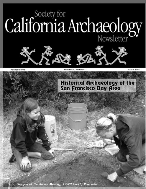
Founded 1966 Volume 38, Number 1<br />
<strong>March</strong> <strong>2004</strong><br />
See you at the Annual Meeting, 17-20 <strong>March</strong>, Riverside!
○ ○ ○ ○ ○ ○ ○ ○ ○ ○ ○ ○ ○ ○ ○ ○ ○ ○ ○ ○ ○ ○ ○ ○ ○ ○ ○ ○ ○ ○ ○ ○ ○ ○ ○ ○ ○ ○ ○ ○ ○ ○ ○ ○ ○ ○ ○ ○ ○ ○ ○ ○ ○ ○ ○ ○ ○ ○ ○ ○ ○ ○ ○ ○ ○ ○ ○ ○ ○ ○ ○ ○ ○ ○ ○ ○ ○ ○ ○ ○ ○ ○ ○ ○ ○ ○ ○ ○<br />
2<br />
<strong>Society</strong> <strong>for</strong> Cali<strong>for</strong>nia <strong>Archaeology</strong> Newsletter<br />
Volume 38, Number 1, <strong>March</strong> <strong>2004</strong><br />
A quarterly newsletter of articles and in<strong>for</strong>mation essential<br />
to Cali<strong>for</strong>nia archaeology. Contributions are welcome.<br />
Lead articles should be 1,500-2,000 words. Longer articles<br />
may appear in installments. Send submissions as hard<br />
copy or on diskette to: SCA Newsletter, Department of<br />
Anthropology, CSU Chico, Chico CA 95929-0400 or as<br />
email or attachments to:<br />
<br />
The SCA Executive Board encourages publication of a<br />
wide range of opinions on issues pertinent to Cali<strong>for</strong>nia<br />
archaeology. Opinions, commentary, and editorials<br />
appearing in the Newslette represent the views of the<br />
authors, and not necessarily those of the Board or Editor.<br />
Lead article authors should be aware that their articles<br />
may appear on the SCA web site, unless they request<br />
otherwise.<br />
Editorial Staff<br />
Managing Editor . . . . . . . Greg White (530) 898-4360<br />
Editorial Assistance . Melinda Pacheco (530) 898-5733<br />
Contributing Editors<br />
Avocational News . . . . . Jerry Dudley/Myra Herrmann<br />
Curation . . . . . . . . . . . . . . . . . . . . . . Cindy Stankowski<br />
Education . . . . . . . . . . . . . . . . . . . . . . . . . Mary Gorden<br />
Federal Agency News . . . . . . . . . . . . . Russ Kaldenberg<br />
Historical <strong>Archaeology</strong> . . . . . . . . . . . . . . . . . . . . . . open<br />
In<strong>for</strong>mation Centers . . . . . . . . . . . . . . . . Lynn Compas<br />
Membership . . . . . . . . . . . . . . . . Stacy Schneyder Case<br />
New Publications . . . . . . . . . . . . . . . . . Denise Thomas<br />
OHP . . . . . . . . . . . . . . . . . . . . . . . . . . Michael McGuirt<br />
Legislation . . . . . . . . . . . . . . . . . . . . . . . Stephen Bryne<br />
CASSP . . . . . . . . . . . . . . . . . . . . . Chris and Beth Padon<br />
State Agency News . . . . . . . . . . . . . . . . . . . . . . . . . open<br />
Newsletter Deadlines<br />
For Issue . . . . . . . . . . . . . . . . . . . . . . . . . . . . . Deadline<br />
<strong>March</strong> . . . . . . . . . . . . . . . . . . . . . . . . . . . . . February 20<br />
June . . . . . . . . . . . . . . . . . . . . . . . . . . . . . . . . . . May 20<br />
September . . . . . . . . . . . . . . . . . . . . . . . . . . . August 20<br />
December . . . . . . . . . . . . . . . . . . . . . . . . November 20<br />
Calendar Submissions<br />
position open: . . . . . . . . . . . temporarily send submissions<br />
to gwhite@csuchico.edu<br />
Advertising Rates<br />
1/4 page . . . . . . . . . . . . . . . . . . . . . . . . . . . . . . . . . . $70<br />
1/2 page . . . . . . . . . . . . . . . . . . . . . . . . . . . . . . . . . $100<br />
Full page . . . . . . . . . . . . . . . . . . . . . . . . . . . . . . . . . $175<br />
Ads that run three or more consecutive issues receive a<br />
15% discount.<br />
Regular Features<br />
From the President<br />
Elena Nilsson . . . . . . . . . . . . . . . . . . . . . . . . . . . . . . . . . . . . . . . . . . . . . . . . . . . . . . . . . . . . . . . . 3<br />
SCA Business and Activities<br />
Native American Programs . . . . . . . . . . . . . . . . . . . . . . . . . . . . . . . . . . . . . . . . . . . . . . . . . . . . . 4<br />
Legislative Liaison Report . . . . . . . . . . . . . . . . . . . . . . . . . . . . . . . . . . . . . . . . . . . . . . . . . . . . . . 4<br />
Site Stewardship . . . . . . . . . . . . . . . . . . . . . . . . . . . . . . . . . . . . . . . . . . . . . . . . . . . . . . . . . . . . . 7<br />
News and Announcements<br />
Table Bluff Rancheria THPO . . . . . . . . . . . . . . . . . . . . . . . . . . . . . . . . . . . . . . . . . . . . . . . . . . 8<br />
New ACHP Web Page . . . . . . . . . . . . . . . . . . . . . . . . . . . . . . . . . . . . . . . . . . . . . . . . . . . . . . . 10<br />
11 th Annual SIL Conference . . . . . . . . . . . . . . . . . . . . . . . . . . . . . . . . . . . . . . . . . . . . . . . . . . 10<br />
75 th Annual SWAA Conference . . . . . . . . . . . . . . . . . . . . . . . . . . . . . . . . . . . . . . . . . . . . . . . . 10<br />
Field Notes . . . . . . . . . . . . . . . . . . . . . . . . . . . . . . . . . . . . . . . . . . . . . . . . . . . . . . . . . . . . . . . . . 14<br />
Annual Meeting Update . . . . . . . . . . . . . . . . . . . . . . . . . . . . . . . . . . . . . . . . . . . . . . . . . . . . . . 16<br />
Advertisements . . . . . . . . . . . . . . . . . . . . . . . . . . . . . . . . . . . . . . . . . . . . . . . . . . . . . . . . . . . . . . 44<br />
Out of the Pits<br />
Comment on Indian Pass,<br />
Imperial County, Cali<strong>for</strong>nia . . . . . . . . . . . . . . . . . . . . . . . . . . . . . . . . . . . . . . . . . . . . . . . . . . . 12<br />
Articles<br />
Angel Island Immigration Station<br />
Trish Fernandez . . . . . . . . . . . . . . . . . . . . . . . . . . . . . . . . . . . . . . . . . . . . . . . . . . . . . . . . . . . . 18<br />
Indians’ Hidden Paintings Open Window to<br />
San Francisco’s Sacred Past<br />
Carl Nolte . . . . . . . . . . . . . . . . . . . . . . . . . . . . . . . . . . . . . . . . . . . . . . . . . . . . . . . . . . . . . . . . . . 24<br />
Preliminary Condition Assessment<br />
Building 50, Presidio of San Francisco, Cali<strong>for</strong>nia<br />
Anthony Crosby, Sannie Kenton Osborn, Vance Bente’, Leo Barker,<br />
Megan Wilkinson, Eric Blind . . . . . . . . . . . . . . . . . . . . . . . . . . . . . . . . . . . . . . . . . . . . . . . . . . 25<br />
Culture Contact at El Presidio De San Francisco:<br />
The Tennessee Hollow Watershed <strong>Archaeology</strong> Project<br />
Barbara Voss . . . . . . . . . . . . . . . . . . . . . . . . . . . . . . . . . . . . . . . . . . . . . . . . . . . . . . . . . . . . . . . 29<br />
The San Francisco West Approach Project:<br />
Unearthing San Francisco’s Accidental 19 th Century Time Capsules<br />
Jack McIlroy . . . . . . . . . . . . . . . . . . . . . . . . . . . . . . . . . . . . . . . . . . . . . . . . . . . . . . . . . . . . . . . . 34<br />
A Brief History of Russell City, Cali<strong>for</strong>nia<br />
Megan Wilkinson . . . . . . . . . . . . . . . . . . . . . . . . . . . . . . . . . . . . . . . . . . . . . . . . . . . . . . . . . . . 34<br />
SCA Newsletter 38(1)
3<br />
I’m looking <strong>for</strong>ward to seeing all of<br />
you <strong>March</strong> 17-21 st at the SCA 38 th<br />
Annual Meeting in Riverside. The<br />
Annual Meeting is the <strong>Society</strong>’s<br />
principal event and a time <strong>for</strong> all<br />
members to reacquaint themselves<br />
with friends, share their research, learn<br />
of new projects and studies, and honor<br />
those who have made a lasting<br />
contribution to our profession. Mike<br />
Lerch, Program and Local<br />
Arrangement Chairperson, has<br />
diligently crafted an impressive<br />
program of some 15 organized<br />
symposia and more than 120 papers,<br />
in<strong>for</strong>mative workshops, and a host of<br />
social events <strong>for</strong> all to enjoy.<br />
Highlights of the Annual Meeting<br />
include Thursday’s plenary session on<br />
DNA Contributions to <strong>Archaeology</strong><br />
and the all-day Saturday session<br />
commemorating the 20th anniversary<br />
of major contributions to Cali<strong>for</strong>nia<br />
archaeology by Michael Moratto and<br />
Joseph and Kerry Chartkoff. The<br />
Saturday session will be open to the<br />
public and will conclude with a<br />
reception where SCA members and<br />
the public may visit with the original<br />
authors and current speakers. Thursday<br />
evening, the Silent Auction will be<br />
held in nearby Redlands at the offices<br />
and courtyard of Statistical Research,<br />
located in a restored 1890 brick<br />
warehouse in the Santa Fe Depot<br />
National Register District. The Friday<br />
night Awards Banquet will feature<br />
keynote speaker Dr. John Rick, who<br />
will present a program on his research<br />
at Chavín de Huántar, Peru. Don’t<br />
miss out on all the great papers,<br />
events, and socializing with your<br />
friends.<br />
The long-awaited Volume 14 of the<br />
Proceedings has been delivered to the<br />
printer, and we anticipate its<br />
distribution at the Annual Meeting,<br />
along with Volume 17, the<br />
compendium of last year’s Annual<br />
Meeting Papers. Just two more reasons<br />
why you should make sure you come<br />
to Riverside.<br />
The Committee <strong>for</strong> Advanced<br />
Annual Meeting Planning (CAAMP),<br />
spearheaded by Tom Origer, has been<br />
hard at work securing hotels <strong>for</strong> future<br />
meetings. Through their ef<strong>for</strong>ts, the<br />
2005 Annual Meeting will be held at<br />
the Hyatt Regency in Sacramento and<br />
the 2006 Annual Meeting at the<br />
Marriott in Ventura. Potential sites are<br />
being considered <strong>for</strong> the 2007 and<br />
2008 Annual Meetings, and given the<br />
high energy of the CAAMP members,<br />
I’m sure it won’t be long until you see<br />
final venues being reported.<br />
By now, many of you have visited<br />
the SCA’s new website and have found<br />
its content and layout much improved<br />
over its predecessor. The first phase of<br />
the retooling ef<strong>for</strong>t focused on<br />
uploading and updating basic<br />
elements, such as in<strong>for</strong>mation<br />
regarding the SCA, membership,<br />
meetings and events, and job<br />
resources. Subsequent phases will<br />
include pages on the <strong>Society</strong>’s awards,<br />
careers in archaeology, interviews with<br />
past key note speakers, volunteer<br />
opportunities, field schools, links to<br />
other historic preservation and<br />
archaeology home pages, government<br />
affairs/laws and regulations, and<br />
Native American issues. The new<br />
website is has been realized through<br />
the collective ef<strong>for</strong>ts of Greg White,<br />
SCA Business Office Manager, Past<br />
President Dana McGowan, and<br />
Southern Vice-President Terry Jones,<br />
all of whom worked diligently to<br />
ensure its on-line arrival in January.<br />
The SCA Executive Board held its<br />
quarterly Board Meeting in January,<br />
where the <strong>2004</strong> Budget was a primary<br />
topic of<br />
(continued page 15)<br />
From the President<br />
SCA Executive Board 2002-2003 2003-<strong>2004</strong><br />
President: Elena Dana Nilsson, McGowan, URS Jones&Stokes Corporation, Associates, 1550<br />
2600 Humboldt V Street, Road, Sacramento, Suite #2, Chico, CA 95818; CA 95928;<br />
W: (916) (530) 739-3095; 893-9675. email: dmcgowan@jsanet.com<br />
elena_nilsson@urscorp.com<br />
Immediate Past President: Sannie Dana McGowan, K. Osborn, Presidio<br />
Trust Jones&Stokes Building, Associates, 230 Gorgas 2600 Avenue, V Street, P.O. Sacramento, Box 29052, CA San<br />
Francisco, 95818; W: CA (916) 94129-0052; 739-3095; W: (415) 561-5090.<br />
email: sosborn@presidiotrust.gov<br />
dmcgowan@jsanet.com<br />
President-Elect: Elena Amy Gilreath, Nilsson, Far URS Western Corporation, 1550<br />
Humboldt Anthropological Road, Research Suite #2, Chico, Group, CA Inc., 95928; 2727 Del Rio<br />
W: Place, (530) Suite 893-9675. A, Davis, email: CA 95616; elena_nilsson@urscorp.com<br />
W: (530) 756-3941. email: amyj@farwestern.com<br />
Southern Vice-President: Thomas L. Wheeler, Caltrans<br />
SLO, Southern 50 Higuera Vice-President: Street, San Terry Luis Jones, Obispo, Social CA 93401; Sciences<br />
W Department, (805) 549-3777; CalPoly, H (805) San Luis 547-0763; Obispo, 1 Grand Avenue,<br />
Fax: San Luis (805) Obispo, 549-3233; CA 93407; email: 2thomas@cwo.com<br />
W (805) 756-2523; email: tljones@calpoly.edu<br />
Northern Vice-President: Richard Fitzgerald, Caltrans,<br />
District Northern 04, Vice-President: 111 Grand Ave., Richard Oakland Fitzgerald, , CA; 94623-0660 Caltrans,<br />
(W) District 51004, 622-1747; 111 Grand (H) Ave., 925 Oakland 335-2454; , CA; email: 94623-0660<br />
richard_fitzgerald@dot.ca.gov<br />
(W) 510 622-1747; (H) 925 335-2454; email:<br />
richard_fitzgerald@dot.ca.gov<br />
Secretary: Vicki Beard, Tom Origer And Associates,<br />
P.O. Secretary: Box 1531, Vicki Rohnert Beard, Tom Park, Origer CA; 94927; And Associates,<br />
(W) P.O. Box (707)792-2797; 1531, Rohnert email: Park, vbeard@origer.com<br />
CA; 94927;<br />
(W) (707)792-2797; email: vbeard@origer.com<br />
Treasurer: Trish Fernandez, c/o SCA Business Office,<br />
Department Treasurer: Stacy of Anthropology, Schneyder Case, Cali<strong>for</strong>nia Jones&Stokes State University,<br />
Chico, Associates, Chico, 2600 CA V Street, 95929-0401 Sacramento, ; CA 95818; W:<br />
SCAOffice@csuchico.edu, (916) 739-3000; email: SCase@jsanet.com<br />
ATTN: SCA Treasurer.<br />
SCA Business Office: Greg White, Department of<br />
Anthropology, CSU Chico, Chico, CA 95929-001;<br />
(530) 898-4360; email: gwhite@csuchico.edu<br />
Visit our web site:<br />
www.scanet.org<br />
SCA Business Office<br />
Department of Anthropology<br />
Cali<strong>for</strong>nia State University, Chico<br />
Chico, CA 95929-0401<br />
Ph (530) 898-5733<br />
Fx (530) 898-4220<br />
M/Th 8:00-5:00<br />
W 12:00-5:00<br />
SCAOffice@csuchico.edu<br />
SCA Newsletter 38(1)
4<br />
SCA Business and Activities<br />
SCA Committees 2002-2003<br />
<strong>Archaeology</strong> Month Representative<br />
Mark Hylkema (415) 330-6328; mhylk@parks.ca.gov<br />
Annual Meeting Planning and Agenda, <strong>2004</strong><br />
Mike Lerch (909) 335-1896; mlerch@sricrm.com<br />
Avocational <strong>Society</strong> Representative<br />
Myra Herrmann (619) 446-5372; mherrmann@sandiego.gov<br />
Jerry Dudley (831) 663-2036; jtdudley@aol.com<br />
Bennyhoff Memorial Award<br />
Richard Hughes (415) 851-1410; rehughes@silcon.com<br />
Curation Representative<br />
Cindy Stankowski (619) 239-1868; cski@cts.com<br />
Education Committee<br />
Mary Gorden (209) 597-2373; magorden@email.msn.com<br />
Anne Duffield-Stoll (909) 621-7521; annestoll@sricrm.com<br />
In<strong>for</strong>mation Center Liaison<br />
Lynn Compas (916) 739-8356;<br />
guntherbarbed@hotmail.com<br />
Legislative Liaison<br />
Stephen Bryne (415) 458-5803; sbryne@garciaandassociates.com<br />
Membership<br />
Stacy Schneyder Case (916) 737-3000; scase@jsanet.com<br />
Native American Programs<br />
Janet Eidsness (530) 629-3153; jpeidsness@yahoo.com<br />
OHP Liaison<br />
Michael McGuirt (916) 653-8920; mmcguirt@ohp.parks.ca.gov<br />
Proceedings<br />
Donna Day (530) 478-6214; day@jps.net<br />
Professional Standards and Guidelines<br />
Lynn Gamble (760) 371-1320; lgamble@mail.sdsu.edu<br />
Publicity<br />
Breck Parkman; BParkman@compuserve.com<br />
SCA Webmaster<br />
Kristina Roper (559) 561-6011; kroper@ix.netcom.com<br />
Site Stewardship Committee<br />
Chris Padon; cpadon@discoveryworks.com<br />
Beth Padon; bpadon@discoveryworks.com<br />
Tom King Award<br />
Russ Kaldenberg (916) 978-4635; Russell_Kaldenberg@ca.blm.gov<br />
SCA Business Office<br />
Melinda Pacheco<br />
ph (530) 898-5733; fax (530) 898-4220<br />
SCAoffice@csuchico.edu<br />
Committee Reports<br />
Native American<br />
Programs Committee<br />
Janet P. Eidsness<br />
On October 11, 2003 at the 18 th<br />
Annual Cali<strong>for</strong>nia Indian Conference<br />
(CIC) hosted by Cabrillo College in<br />
Watsonville, SCA Native American<br />
Programs Committee (NAPC)<br />
presented a symposium entitled<br />
“Cali<strong>for</strong>nia Tribal Programs in<br />
Heritage Resources Management.”<br />
Following opening comments on<br />
Amah Mustun Tribal Band history by<br />
Ed Ketchum, this session featured<br />
talks by THPOs Thomas Gates (Yurok<br />
Tribe) and Marnie Atkins (Table Bluff<br />
Reservation-Wiyot Tribe), Wiyot<br />
Tribal Chairperson Cheryl A. Seidner,<br />
attorney <strong>for</strong> the Quechan Tribe<br />
Courtney Ann Coyle, and Larry Myers,<br />
Executive Secretary of the Native<br />
American Heritage Commission.<br />
About 50 updated Sourcebooks (4 th<br />
Edition) were distributed, and<br />
donation monies were put back into<br />
the Committee’s coffers to make<br />
additional copies. At a fine BBQ<br />
dinner hosted by the Amah Mutsun<br />
Tribal Band, President-Elect Amy<br />
Gilreath announced that Larry Myers<br />
was named the 2003 recipient of the<br />
SCA Cali<strong>for</strong>nia Indian Heritage<br />
Preservation Award. In addition, the<br />
NAPC provided support to Chumash<br />
undergraduate student Maria Cordero,<br />
who delivered a paper on “Juridical<br />
Subordination of Cali<strong>for</strong>nia Indians<br />
From Statehood (1850) to Civil Rights<br />
Movement (1960).” We are<br />
encouraging her to publish her paper,<br />
which she will soon present to<br />
legislators as Maria was selected as<br />
one of two students to represent UC-<br />
Santa Barbara at the <strong>March</strong> 8-9, <strong>2004</strong><br />
UC Day in Sacramento. As a sign that<br />
‘what goes around comes around’ and<br />
‘we must be doing something right,’<br />
after reconciling their books the CIC<br />
organizing committee donated $250 to<br />
support NAPC activities! Congrats to<br />
Rob Edwards and CIC 18 organizers, as<br />
this event appeared to have the most<br />
Native American attendees and<br />
presenters—a good sign!<br />
We are busy planning CRM<br />
workshops in partnership with the<br />
Amah Mutsun Tribal Band (to be held<br />
<strong>March</strong> 6-7) and the 12 bands of the Pit<br />
River Tribe (to be held in mid-April).<br />
These are exciting days!<br />
On Thursday, <strong>March</strong> 18, <strong>2004</strong><br />
(4:30-5:30 p.m.—but check Program!),<br />
please join us in Riverside <strong>for</strong> the<br />
open meeting of the Native American<br />
Programs Committee at the SCA<br />
Annual Meeting. We are always<br />
looking <strong>for</strong> new members to network<br />
with, and new ideas on how we may<br />
best partner with Indian communities<br />
to meet our common goals! Look <strong>for</strong><br />
our table in the Book Room, where<br />
we’ll have copies of the Sourcebook<br />
available.<br />
Legislative Liaison Report<br />
Stephen Bryne<br />
108th U.S. Congress 2003-<strong>2004</strong><br />
Cali<strong>for</strong>nia’s hopes <strong>for</strong> a big jobs<br />
boost from a new federal highway and<br />
transit spending program were fading<br />
fast amid signs that Congress and the<br />
White House were worried about its<br />
cost. The House voted 421-0 to<br />
extend the current six-year, $217<br />
billion bill <strong>for</strong> four more months. If<br />
the Senate goes along, it would be the<br />
second extension <strong>for</strong> the old program,<br />
which was due to expire on Sept. 30.<br />
The Senate is bogged down in debate<br />
over the proposed $318 billion bill,<br />
which President Bush says he won’t<br />
support in an election year in which he<br />
has vowed to hold the line on<br />
domestic spending. His<br />
administration has proposed a $256<br />
billion. The House Transportation<br />
Committee wants a $375 billion bill.<br />
Congress’ failure to make quick<br />
progress on the legislation is a major<br />
disappointment to members who<br />
hoped it would create a boost in new<br />
jobs during an election year. The<br />
SCA Newsletter 38(1)
5<br />
SCA Business and Activities<br />
Senate bill faces a filibuster from<br />
members who fear the proposal would<br />
increase the budget deficit, which is<br />
already projected to top half a trillion<br />
dollars. Senate Majority Leader Bill<br />
Frist, R-Tenn., has suggested trimming<br />
the bill to $290 billion, but supporters<br />
of the bill don’t like that idea. “It is<br />
disappointing that some around here<br />
want to stop this bill,” said Sen.<br />
Barbara Boxer, D-Calif., according to a<br />
transcript of her remarks scheduled <strong>for</strong><br />
Feb. 12 on the Senate floor. “I will be<br />
fighting <strong>for</strong> it because it is extremely<br />
important <strong>for</strong> our country and my state<br />
of Cali<strong>for</strong>nia.” Boxer, who is<br />
campaigning <strong>for</strong> re-election, leaves no<br />
doubt that she views the program as a<br />
jobs generator, as well as a way to fix<br />
crumbling roads and bridges and<br />
relieve traffic congestion. The Senate<br />
proposal would create an estimated<br />
87,000 construction jobs in Cali<strong>for</strong>nia<br />
and 800,000 nationally. Cali<strong>for</strong>nia’s<br />
share of the proposed spending would<br />
be $21.4 billion over the next six<br />
years, up $6.1 billion from the current<br />
program. Meanwhile, in the House, a<br />
$375 billion transportation bill is being<br />
debated.<br />
With Gov. Arnold Schwarzenegger<br />
proposing cuts in state transportation<br />
spending to help deal with Cali<strong>for</strong>nia’s<br />
budget deficit, officials have been<br />
hoping <strong>for</strong> an increased infusion of<br />
federal funds to keep projects on track.<br />
But under the House extension, the<br />
funding will remain at current levels.<br />
Rep. Ellen Tauscher, D-Walnut Creek,<br />
a member of the House Transportation<br />
Committee, says the state has $2<br />
billion in projects ready to go, just<br />
waiting <strong>for</strong> federal funds that it can’t<br />
get until the new bill passes.<br />
In the agencies, final regulations<br />
from the Advisory Council on Historic<br />
Preservation dealing with certain<br />
portions of Section 106 are due in<br />
January. The Advisory Council is<br />
currently in the process of amending<br />
its Section 106 rules. In addition, the<br />
Federal Communications Commission<br />
(FCC) is considering a nationwide<br />
programmatic agreement that would<br />
govern the Section 106 process <strong>for</strong><br />
communication facilities. The recent<br />
comment period <strong>for</strong> the revised<br />
Advisory Council regulations has<br />
ended. President Nixon, in the<br />
interest of streamlining the Section<br />
106 process and to fulfill the intent of<br />
Congress, ordered that eligible sites<br />
should be given the same protection as<br />
listed sites, thus eliminating the added<br />
work and time required to get them<br />
listed.<br />
Representatives Pombo (Chair of<br />
the House Resources Committee) and<br />
Radanovich from Cali<strong>for</strong>nia, also in the<br />
interest of streamlining, have<br />
submitted comments that support the<br />
idea that eligible sites should no<br />
longer be given the same<br />
consideration as sites actually listed on<br />
the National Register. How this will<br />
streamline the process is unclear,<br />
unless there is no attempt made to<br />
place eligible sites on the register at<br />
all. Representative Pombo, in a letter<br />
to John Nau, Chairman of the Advisory<br />
Council, states, “In 1966, there were<br />
12,000 properties on the National<br />
Register. Today, the Register lists over<br />
77,000 properties with another 9,458<br />
more on the list of properties<br />
determined eligible by the Keeper of<br />
the National Register…. In contrast,<br />
the number of properties that “meet<br />
the National Register criteria” is<br />
unknowable, but is probably in the<br />
many tens of millions, and none have<br />
been vetted <strong>for</strong> significance or the<br />
eligibility criteria of listed properties.”<br />
Cali<strong>for</strong>nia Legislature:<br />
2003-<strong>2004</strong> Session<br />
Historical Preservation: Cali<strong>for</strong>nia<br />
Cultural and Historical Endowment<br />
(A.B. 393)<br />
Author: Cindy Montañez (D-39 th )<br />
Summary: This bill establishes the<br />
Cali<strong>for</strong>nia Urban Historical<br />
Preservation Revolving Loan Fund<br />
under the administration of the<br />
Cali<strong>for</strong>nia Cultural and Historical<br />
Endowment, to the extent that funding<br />
is available. Although the endowment<br />
has broad authority to enact a similar<br />
program, the goal of this measure is to<br />
ensure that funds are available <strong>for</strong><br />
historic preservation, on an ongoing<br />
basis, through a revolving loan fund.<br />
Specifically, this bill would create a<br />
fund from which loans will be provided<br />
to encourage the development of a<br />
systematic and coordinated<br />
assemblage of buildings, sites,<br />
artifacts, museums, cultural landscapes,<br />
illustrations, written materials, and<br />
displays and interpretive centers to<br />
preserve and tell the stories of<br />
Cali<strong>for</strong>nia as a unified society and of<br />
the many groups of people that<br />
together comprise historic and modern<br />
Cali<strong>for</strong>nia. In September, 2002<br />
In September 2002, Governor Davis<br />
signed “The Cali<strong>for</strong>nia Cultural and<br />
Historical Endowment Act” (act)<br />
which established the Cali<strong>for</strong>nia<br />
Cultural and Historical Endowment<br />
under the administration of the<br />
Cali<strong>for</strong>nia State Library (AB 716,<br />
Firebaugh, Chapter 1126, Statutes of<br />
2002). The act authorizes the<br />
endowment to make grants and loans<br />
to public agencies and nonprofit<br />
organizations to protect and preserve<br />
Cali<strong>for</strong>nia’s cultural and historic<br />
resources. Although the endowment<br />
was created in 2002 it was not funded<br />
until August 2003 when $128 million<br />
in Proposition 40 bond funds were<br />
allocated to the endowment in the<br />
Budget Act of 2003.<br />
Status: Referred to Committee on<br />
Appropriations on January 16, <strong>2004</strong>.<br />
Cali<strong>for</strong>nia <strong>for</strong> Preservation Action,<br />
Cali<strong>for</strong>nia Preservation Foundation,<br />
National Trust <strong>for</strong> Historic<br />
Preservation, Los Angeles<br />
Conservancy, Pasadena Heritage, San<br />
Francisco Architectural Heritage, Save<br />
Our Heritage Organization (San<br />
Diego), Napa County Landmarks, and<br />
the Cali<strong>for</strong>nia Mainstreet Alliance<br />
have registered their support of this<br />
bill.<br />
Cali<strong>for</strong>nia Racial Mascots Act: Athletic<br />
Team Names and Mascots (A.B. 858)<br />
Author: Jackie Goldberg (D-45 th )<br />
Summary: This bill establishes the<br />
Cali<strong>for</strong>nia Racial Mascots Act that<br />
SCA Newsletter 38(1)
6<br />
SCA Business and Activities<br />
would prohibit public schools from<br />
using certain specified terms as a<br />
school or athletic team name, mascot,<br />
or nickname. Specifically, this bill<br />
prohibits all public schools are from<br />
using any of the following school or<br />
athletic team names, mascots, or<br />
nicknames: a) Redskins; b) Indians; c)<br />
Braves; d) Chiefs; e) Apaches; f)<br />
Comanches; g) Papooses; h) Warriors, if<br />
accompanied by Native American<br />
imagery, including, but not limited to,<br />
a mascot; i) Sentinels, if accompanied<br />
by Native American imagery,<br />
including, but not limited to, a mascot;<br />
and, j) any other Native American<br />
tribal name.<br />
Previous legislation, AB 2115<br />
(Goldberg) of 2002, required that all<br />
public schools, community colleges,<br />
the Cali<strong>for</strong>nia State University (CSU),<br />
and the University of Cali<strong>for</strong>nia (UC)<br />
[if agreed upon by UC] be prohibited<br />
from using specified American Indian<br />
names <strong>for</strong> school or athletic team,<br />
names, mascots, or nicknames. The<br />
bill failed passage on the Assembly<br />
Floor.<br />
According to the author, “public<br />
schools in Cali<strong>for</strong>nia are obligated to<br />
provide equal educational opportunity<br />
to all students, regardless of race,<br />
ethnicity, or national origin. They are<br />
also required to promote diversity and<br />
respect <strong>for</strong> different cultures.<br />
However, the use of team names that<br />
single out an ethnic group, such as<br />
“Redskins” or “Indians,” as well as<br />
names referring specifically to<br />
American Indian tribes, such as<br />
“Apaches” or “Comanches,” is<br />
inconsistent with those requirements.<br />
This measure is necessary to ensure<br />
that schools do not send a mixed<br />
message about the acceptability of<br />
racial stereotypes.”<br />
Some contend that the decision to<br />
change a school name, nickname, or<br />
mascot should be made at the local<br />
level. While Los Angeles Unified<br />
School District and many schools and<br />
colleges across the country have<br />
voluntarily changed their<br />
discriminatory names, nicknames or<br />
mascots; some individuals maintain<br />
that a school mascot is a source of<br />
pride and symbolizes a strong tradition<br />
not only <strong>for</strong> the school, but the<br />
community and families as well and<br />
thus have chosen not to change their<br />
mascot. The author contends that the<br />
decision to change a school mascot is<br />
often preceded by a lengthy, costly<br />
and divisive local debate, during<br />
which Native American children and<br />
parents are frequently the targets of<br />
blame and harassment. Direction from<br />
the state will enable schools to act in<br />
the best interest of students without<br />
undue pressure from alumni.<br />
As of the last census, 330,000 Native<br />
Americans were living in Cali<strong>for</strong>nia,<br />
more than any other state.<br />
Status: On Jan. 21, <strong>2004</strong>, this bill was<br />
removed from the inactive file and to a<br />
third reading, the stage at which bills<br />
are eligible <strong>for</strong> floor debate and final<br />
vote.<br />
Coastal Zone: Archaeological and<br />
Paleontological Resources (A.B. 974)<br />
Author: Joe Nation (D-6 th )<br />
Summary: Existing law requires<br />
reasonable mitigation of impacts to<br />
sites that contain archaeological or<br />
paleontological resources identified<br />
by the State Historic Preservation<br />
Officer (SHPO). Existing law<br />
establishes the Native American<br />
Heritage Commission (NAHC) to<br />
preserve and protect areas of<br />
significance to Native Americans, such<br />
as burial and other sacred sites. The<br />
Cali<strong>for</strong>nia Environmental Quality Act<br />
(CEQA) requires an environmental<br />
impact report (EIR) when state action<br />
impacts areas of cultural significance<br />
to the state’s history. This bill:<br />
1. Requires that sites containing<br />
significant Native American<br />
cultural resources be protected<br />
from impacts in the same manner<br />
as sites containing archaeological<br />
or paleontological resources.<br />
2. Requires that the SHPO consult<br />
with appropriate local Native<br />
Americans and the NAHC when<br />
identifying sites significant to<br />
Native Americans.<br />
3. Requires “all feasible” measures to<br />
be taken to avoid adverse impact,<br />
and reasonable mitigation where<br />
that impact cannot be avoided.<br />
4. Requires sites identified as sacred<br />
sites by appropriate local Native<br />
Americans and the NAHC to be<br />
protected against significant<br />
disruption.<br />
5. Requires local coastal plans to<br />
contain protection <strong>for</strong> sites of<br />
significance to Native Americans.<br />
6. Defines “appropriate local Native<br />
Americans” as federally<br />
recognized tribe, Rancheria, or<br />
Mission Band of Indians, or a tribe<br />
or band identified by the NAHC.<br />
According to the author’s office, the<br />
purpose of this bill is to include Native<br />
Americans in land-use decisions that<br />
affect their heritage, and to recognize<br />
that many sites that are of the greatest<br />
significance to Native Americans do<br />
not include discrete artifacts that can<br />
be subjected to scientific analysis.<br />
Some of the most important sites are<br />
those where cultural and religious<br />
activities occurred, but these sites are<br />
not clearly included within the<br />
resources that are protected under<br />
current law. The NAHC is currently<br />
charged with protection of culturally<br />
significant sites, which it defines as,<br />
“These are areas which have been,<br />
and often continue to be, of economic<br />
and/or religious significance to<br />
peoples today. They include Native<br />
American sacred areas where religious<br />
ceremonies are practiced or which are<br />
central to their origins as a people.”<br />
Status: Placed on inactive file on<br />
motion of Senator Chesbro.<br />
Cali<strong>for</strong>nia Cultural and Historical<br />
Endowment (A.B. 1149)<br />
Author: Marco Firebaugh (D-50 th )<br />
Summary: This bill would allocate<br />
funding from the Cali<strong>for</strong>nia Clean<br />
SCA Newsletter 38(1)
7<br />
Water, Clean Air, Safe Neighborhood<br />
Parks, and Coastal Protection Fund<br />
(Proposition 40, enacted <strong>March</strong> 2002)<br />
to the Cali<strong>for</strong>nia State Library (CSL)<br />
<strong>for</strong> purposes of funding the Cali<strong>for</strong>nia<br />
Cultural and Historical Endowment<br />
Act.<br />
Status: In committee: Set, first<br />
hearing. Held under submission.<br />
Traditional Tribal Cultural Sites (S.B.<br />
18)<br />
Author: John Burton (D-03)<br />
Summary: Creates a procedure in the<br />
Cali<strong>for</strong>nia Environmental Quality Act<br />
(CEQA) <strong>for</strong> the Native American<br />
Heritage Commission (NAHC), in<br />
consultation with Native American<br />
tribes and other interested parties, to<br />
determine whether a proposed project<br />
may adversely change a traditional<br />
tribal cultural site and to recommend<br />
project changes and mitigation<br />
measures to avoid or reduce those<br />
changes. Revises the duties and<br />
composition of NAHC, creates<br />
procedures <strong>for</strong> NAHC and Native<br />
American tribes to participate in local<br />
land use planning, and allows Native<br />
American tribes to take title to<br />
conservation easements.<br />
Status: Reconsideration granted on<br />
January 8, <strong>2004</strong>. Placed on inactive<br />
file on request of Assembly Member<br />
Chan.<br />
Native American Sacred Sites (SB 447)<br />
Summary: SB 987 would appropriate an<br />
unspecified amount of Proposition 40<br />
bond funds to the Department of Parks<br />
and Recreation (DPR) <strong>for</strong> allocation as<br />
a grant to the Cali<strong>for</strong>nia Missions<br />
Foundation (CMF, a nonprofit<br />
organization).<br />
Status: Set, first hearing. Held in<br />
committee and under submission.<br />
References Cited or Consulted<br />
Lindsay, David<br />
2003 SAA Government Affairs<br />
Program: Monthly Washington,<br />
D.C. Update December 2003.<br />
<strong>Society</strong> <strong>for</strong> American<br />
<strong>Archaeology</strong>, Government<br />
Affairs Program.<br />
San Francisco Chronicle [San Francisco,<br />
Cali<strong>for</strong>nia]<br />
<strong>2004</strong> Congress returns to unsettled<br />
business: Both chambers remain<br />
deeply divided on key bills. 19<br />
January.<br />
204 Highway bill bogged down –<br />
state’s projects in jeopardy. 12<br />
February.<br />
Contacting Your Representatives<br />
SCA Business and Activities<br />
Site Stewardship<br />
Committee<br />
Beth and Chris Padon<br />
We are very pleased to announce<br />
that the Cali<strong>for</strong>nia Archaeological Site<br />
Stewardship Program (CASSP)<br />
received funding <strong>for</strong> <strong>2004</strong> through a<br />
Bureau of Land Management (BLM)<br />
grant from the Division of Off-<br />
Highway Motor Vehicle Recreation<br />
(OHMVR), Department of Parks and<br />
Recreation. The CASSP funding is<br />
administered by the SCA, under<br />
agreement with the Cali<strong>for</strong>nia State<br />
Office of the BLM. We sincerely<br />
appreciate the support and interest that<br />
these sponsors express <strong>for</strong> CASSP. We<br />
thank Steve Horne and Jim Keeler of<br />
the BLM <strong>for</strong> preparing and presenting<br />
a successful grant application. We also<br />
thank the volunteers and agency<br />
participants who wrote letters of<br />
support <strong>for</strong> the <strong>2004</strong> grant; these letters<br />
contributed greatly to this grant<br />
application ef<strong>for</strong>t.<br />
At the SCA Annual Meeting in<br />
Riverside, CASSP volunteers will be<br />
Cali<strong>for</strong>nia State Assembly www.assembly.ca.gov<br />
Cali<strong>for</strong>nia State Senate<br />
www.senate.ca.gov<br />
U.S. House of Representatives www.house.gov<br />
U.S. Senate<br />
www.senate.gov<br />
Governor Arnold Schwarzenegger www.governor.ca.gov/state/govsite/gov_homepage<br />
President George W. Bush www.whitehouse.gov<br />
Author: Dennis Hollingsworth (R-36)<br />
Summary: Under existing law, the<br />
Native American Heritage<br />
Commission has various powers and<br />
duties with regard to Native American<br />
sites and sacred places. This bill would<br />
state the intent of the Legislature to<br />
establish a grant program <strong>for</strong> the<br />
preservation of Native American<br />
sacred sites.<br />
Status: To Senate Committee on<br />
Rules.<br />
Cali<strong>for</strong>nia Missions (SB 987)<br />
Author: Bruce McPherson (R-15)<br />
Websites<br />
http://www.leginfo.ca.gov<br />
http://thomas.loc.gov<br />
http://acra-crm.org<br />
Contact Your SCA Legislative Liaison<br />
sbryne@garciaandassociates.com<br />
SCA Newsletter 38(1)
8<br />
News and Announcements<br />
giving papers on their work at<br />
various sessions. Just prior to the<br />
meetings, a CASSP advanced<br />
workshop on flintknapping will be<br />
held from 1:00 to 5:00, on<br />
Wednesday afternoon, <strong>March</strong> 17. It<br />
will feature archaeologists/<br />
flintknappers Tim Gross and Bob<br />
Yohe. Only CASSP volunteers are<br />
eligible to attend. There is no fee,<br />
but registration is required; contact<br />
Beth Padon by phone (562-432-<br />
1801) or e-mail<br />
(bpadon@discoveryworks.com) or<br />
regular mail (Discovery Works Inc.,<br />
235 East Broadway, Suite 980, Long<br />
Beach CA 90802) Please register by<br />
<strong>March</strong> 10, because space is limited.<br />
Participants in the advanced<br />
workshop and other CASSP<br />
volunteers are encouraged to attend<br />
the opening reception of the SCA<br />
meetings on Wednesday evening.<br />
After this reception, CASSP<br />
volunteers and other SCA members<br />
who are interested in site<br />
stewardship are invited to an<br />
in<strong>for</strong>mal and sponsored pizza dinner<br />
at the Riverside Brewing Company.<br />
Pizza will be provided by Discovery<br />
Works, but you will have to buy your<br />
own beverages. The restaurant is<br />
located at 3397 Seventh Street<br />
(Mission Inn Avenue), which is two<br />
blocks from the Mission Inn and four<br />
blocks from the convention center.<br />
Avocational Committee<br />
Jerry Dudley & Myra Herrmann<br />
Well it’s that time of year<br />
looking <strong>for</strong>ward to the annual SCA<br />
meeting. Mark your calendars <strong>for</strong> the<br />
dates in <strong>March</strong>, 17 through 20. Also<br />
our annual Avocational <strong>Society</strong><br />
meeting will be a luncheon on<br />
Friday <strong>March</strong> 19 from 11:30 AM to<br />
1:00 PM. This is a great time <strong>for</strong> the<br />
societies to get together and discuss<br />
problems and share in<strong>for</strong>mation<br />
about our many activities. Please let<br />
us know if you will be attending this<br />
session.<br />
Announcements<br />
Table Bluff Reservation-Wiyot Tribe<br />
Establishes Tribal Historic Preservation Office<br />
Marnie Atkins<br />
The Table Bluff Reservation - Wiyot Tribe (Wiyot Tribe) has worked hard the past<br />
year and a half to establish and maintain a Cultural Department and Tribal Historic<br />
Preservation Program. Its success is founded upon the support of tribal members, the<br />
tribal council, other tribes (locally and far away), and numerous people and agencies.<br />
The reservation <strong>for</strong> the Wiyot Tribe is found in Humboldt County, Cali<strong>for</strong>nia, twenty<br />
minutes south of Eureka.<br />
The mission of the Cultural Department and Tribal Historic Preservation Office is<br />
to Protect, Promote, and Perpetuate Wiyot culture and history.<br />
Cultural Department<br />
Be<strong>for</strong>e the Cultural Department was established, the employees of the<br />
Environmental Department were handling cultural resource protection. Due to the<br />
budget constraints of EPA funding, the Environmental Department staff could not<br />
dedicate sufficient time to this important goal. They also found that they were<br />
working the hours of a full time person, and the outlook that more and more<br />
consultation and protection would be needed was on the horizon.<br />
Our Treasurer and Environmental Director attended an environmental meeting in<br />
Reno in early 2002 where there was a presentation by an Oregon tribe about a<br />
successful tribal cultural resource management program. At that time, they realized<br />
that with the right management and support of the tribal council and membership, we<br />
too could have a designated person that would give voice to the Wiyot Tribe’s cultural<br />
resource protection and management issues. After the meeting in Reno, the<br />
Environmental Director spoke to our tribal council about what was learned at the<br />
meeting and proposed the idea of hiring a staff person. Initially, the Environmental<br />
Director suggested that the person hired would fall under the Tribe’s Environmental<br />
Department in regards to work assignment, direction, and supervision. However, the<br />
tribal council thought that if a cultural program were to be successful, the person hired<br />
would need to have the ability to speak on important issues of protection and<br />
repatriation, and provide consultation on behalf of the Tribe. There<strong>for</strong>e, the tribal<br />
council <strong>for</strong>med a separate department and created the Cultural Director position. In<br />
May 2002, Marnie Atkins was hired as the Cultural Director.<br />
With the designation of a new department within the Tribe comes the difficult task<br />
of finding money to secure a position. The council asked the fiscal department to look<br />
in our budget to see if there was anyway a position could be funded. The Fiscal<br />
Manager found money in our General Fund that could be reallocated to fund the<br />
Cultural Director position. However, the funding would only last the rest of 2002, and<br />
the incumbent would need to find other sources of funding to secure the future of a<br />
successful program. In October of last year, we received a Revenue Sharing Trust<br />
Fund (RSTF) check. As a way to fund the Cultural Department, Atkins submitted a<br />
draft budget to the tribal council that listed some of the needs of the department. The<br />
tribal council approved $28,200.00 to fund the Cultural Department from the RSTF<br />
check the Tribe had received. This was a tremendous help to the program then and<br />
now.<br />
SCA Newsletter 38(1)
9<br />
News and Announcements<br />
The Cultural Department was established to educate,<br />
protect, promote, and perpetuate the Wiyot culture and<br />
history. The Department works in important areas such as:<br />
repatriation; reviewing, commenting and consulting with our<br />
local, state, and federal agencies regarding projects in our<br />
ancestral lands; supporting legislation to better protect and<br />
aid tribes; establishing classes, such as a language and basket<br />
weaving, <strong>for</strong> tribal members; negotiating memorandums of<br />
understanding or agreement with agencies to insure adequate<br />
and continued access to lands <strong>for</strong> traditional cultural practices<br />
or gathering of materials <strong>for</strong> basket making, medicines, or<br />
subsistence; overseeing the cultural monitoring program; and<br />
“other duties as assigned.” Currently, Atkins is the only full<br />
time employee in the department, in addition to six part time<br />
cultural monitors.<br />
The cultural monitoring program is a tool <strong>for</strong> the Tribe to<br />
protect or relocate important culturally significant sites. It has<br />
had a slow start, but increasingly agencies are calling us to<br />
request monitors on work sites where excavation will occur.<br />
We are continually working on county, state, and federal<br />
projects, with more and more monitoring of private industry<br />
projects.<br />
In January 2002, the SCA and the Tribe partnered to<br />
present a Cultural Resource Training session. This session<br />
was instrumental in training tribal members from several<br />
different tribes, while establishing working relationships with<br />
many of the federal and state agency representatives that<br />
presented and attended. Some of the subjects discussed<br />
were: the general history of cultural resource management<br />
laws; burial protection; repatriation; records and archival<br />
research; and monitoring. Field visits to culturally significant<br />
sites were incorporated into the session to encourage<br />
stewardship as part of cultural resource management.<br />
Tribal Historic Preservation Program<br />
During the summer of 2002, we began the process to<br />
submit our Tribal Historic Preservation Program Plan to the<br />
National Park Service. This was a convoluted process<br />
because there wasn’t, and still isn’t, any clear application or<br />
plan submittal process.<br />
While writing the Tribal Historic Preservation Program<br />
Plan to be submitted to the NPS, Atkins looked to the Yurok<br />
Tribe’s Tribal Heritage Preservation Officer, Dr. Thomas<br />
Gates, <strong>for</strong> guidance, help, and a good sounding board. He<br />
was, and still is, a very patient and gracious mentor.<br />
Especially, when she sought input or had questions about the<br />
THPO plan process.<br />
Section 101(d)(2) of the National Historic Preservation<br />
Act of 1966 creates a provision that tribes can assume the<br />
functions of a State Historic Preservation Officer on tribal<br />
lands. A Tribal Historic Preservation Officer is a person who<br />
is officially designated by a federally recognized tribe to<br />
direct a program that has been approved by the National Park<br />
Service that assumes the SHPO’s functions on tribal lands. In<br />
other words, by having a plan approved, the tribe assumes<br />
management of their cultural resources on their tribal lands.<br />
THPOs are able to give more emphasis and importance to<br />
protecting valuable cultural resources of the tribe by<br />
combining traditional beliefs and practices with current<br />
methods when documenting and managing cultural<br />
properties.<br />
Our Tribal Historic Preservation Program Plan was<br />
approved on October 5, 2002. We are the 3 rd tribe in the state<br />
of Cali<strong>for</strong>nia, the Yurok and Timbisha Shoshone Tribes being<br />
the other two, and the 33 rd tribe to achieve THPO status.<br />
If your tribe is interested in gaining THPO status a good<br />
place to start is with the National Association of Tribal<br />
Historic Preservation Officers. They can be found on the<br />
web at www.nathpo.org.<br />
In the future …<br />
- We will be working with one of our basket weavers to start<br />
a basket class to teach interested adults and eventually<br />
those adults will teach our children.<br />
- A language committee has been established and meets<br />
regularly to discuss how to find and acquire funding to hire<br />
or consult with a person to help us create a curriculum to<br />
teach children and adults our language.<br />
- We are investigating the logistics of building a cultural<br />
center on the reservation. This facility would house the<br />
cultural department, interpretative center, tribal archives,<br />
classes, and enlarge our tribal library.<br />
- In the future, we would like to hire at least one full time<br />
cultural monitor and an assistant. However, with our plans<br />
<strong>for</strong> growth we expect to hire more staff to work in the<br />
tribal archives, cultural center, and cultural monitoring<br />
program.<br />
- We would like to upgrade our technology to create a<br />
database of culturally significant sites and to create and<br />
document oral history, photos, and important family and<br />
tribal papers.<br />
Now <strong>for</strong> some thoughts to leave you with ….<br />
- In the past year and five months, the department has<br />
grown rapidly. It seems that the more people that know<br />
the Tribe has a Cultural Department and a Tribal Historic<br />
Preservation Officer, the more they consult with us.<br />
- As we all know, tribes often have little funding, and<br />
employees of the tribal government often wear many hats<br />
and juggle several projects at a time. Often, tribal staff<br />
per<strong>for</strong>ms the same work and more, that private industry<br />
and federally funded counter parts do <strong>for</strong> higher pay and<br />
less responsibilities. Keep your head up and don’t get<br />
discouraged.<br />
SCA Newsletter 38(1)
10<br />
News and Announcements<br />
- Atkins urges members of tribal councils and partnership<br />
agencies to continue supporting cultural programs, not<br />
only financially, but always with the idea of preserving the<br />
future of unique indigenous peoples.<br />
- Atkins encourages all tribes to establish a cultural<br />
protection program. Don’t let this important task fall to an<br />
assistant that works in another program who doesn’t have a<br />
lot of time to dedicate to the protection of the culture and<br />
history of your tribe.<br />
- The in<strong>for</strong>mation in this article may give the impression<br />
that the process to establish a successful Cultural<br />
Department and Tribal Historic Preservation Program<br />
seems quick and easy, but as you can see, the success is<br />
owed to the many people that believed that it was<br />
important to the Wiyot people that the Tribe have a voice<br />
in protecting their culture and history.<br />
About the author: Marnie Atkins serves as the Cultural Director<br />
and Tribal Historic Preservation Officer <strong>for</strong> the Table Bluff<br />
Reservation - Wiyot Tribe. She is a tribal member and previously<br />
served on the tribal council. She presented this topic on October 11,<br />
2003 in Watsonville at the 18 th Annual Cali<strong>for</strong>nia Indian<br />
Conference, <strong>for</strong> the symposium “Cali<strong>for</strong>nia Tribal Programs in<br />
CRM” organized by SCA Native American Programs Committee<br />
Chairperson Janet Eidsness.<br />
New ACHP Web Page About Organization<br />
of the Office of Federal Agency Programs<br />
In response to a number of requests, the ACHP has<br />
developed an expanded discussion of the new organizational<br />
structure of the Office of Federal Agency Programs (OFAP)<br />
<strong>for</strong> our website (attached). Using a Frequently Asked<br />
Questions <strong>for</strong>mat, the web page provides in<strong>for</strong>mation on how<br />
our Section 106 work is delegated among the staff, how best<br />
to reach our staff, new services we are hoping to provide<br />
Section 106 users in the field, and in<strong>for</strong>mation regarding the<br />
role of our newly created Federal agency liaison positions.<br />
We hope this in<strong>for</strong>mation will make it easier <strong>for</strong> you to work<br />
with our office. Any questions or suggestions about how this<br />
website could be further improved would be welcome.<br />
Please link to the following web page <strong>for</strong> further in<strong>for</strong>mation.<br />
http://www.achp.gov/ofap-faq.html<br />
Language is Life: 11th Annual Stabilizing<br />
Indigenous Languages Conference at<br />
University of Cali<strong>for</strong>nia at Berkeley<br />
June 11-13, <strong>2004</strong><br />
Hosted by The Advocates <strong>for</strong> Indigenous Cali<strong>for</strong>nia<br />
Language Survival and the Survey of Cali<strong>for</strong>nia and Other<br />
Indian Languages (Department of Linguistics, University of<br />
Cali<strong>for</strong>nia at Berkeley)<br />
The Stabilizing Indigenous Languages Steering<br />
committee invites interested individuals and groups to give<br />
presentations at SILC this year, either in the <strong>for</strong>m of a 15-<br />
minute talk (or less), a 1 1/2 hour workshop, or else to join<br />
one of our suggested panels, which will be 1 1/2 hours in<br />
length. Suggested panels include:<br />
Master-apprentice programs<br />
Immersion schools<br />
Archives and intellectual property rights<br />
Developing and using new writing systems<br />
Revitalizing languages without speakers<br />
We will also make time and space <strong>for</strong> the showing of films<br />
on language loss and language revitalization, if you have<br />
anything you’d like to show. See either of the following<br />
websites <strong>for</strong> the registration and presentation <strong>for</strong>ms<br />
www.aicls.org or http://jan.ucc.nau.edu/~jar/<br />
SIL9brochure.html<br />
Prof. Leanne Hinton<br />
Chair, Dept. of Linguistics<br />
1203 Dwinelle Hall<br />
University of Cali<strong>for</strong>nia<br />
Berkeley, CA 94720-2650<br />
SWAA 75th Annual Conference<br />
April 15, 16, 17, <strong>2004</strong><br />
Jan English-Lueck, President<br />
Southwestern Anthropological Association<br />
I would like to invite you to the 75th Jubilee meeting of<br />
the Southwestern Anthropological Association. SWAA is the<br />
oldest regional association in the West, and has gone from<br />
being a unit of the AAA to an independent organization<br />
consisting of professionals, academics and students from<br />
Cali<strong>for</strong>nia, Nevada, Arizona and New Mexico. Over the<br />
years the organization has reinvented itself to serve the<br />
various constituencies of academic anthropology.<br />
Anthropology itself has changed. This year, the President-<br />
Elect, Margaret Graham of Santa Clara University, and I<br />
would like to extend our invitation to all anthropologists,<br />
whether they are faculty, graduate students, senior<br />
undergraduates, emeriti and alumni. We are eager to include<br />
anthropologists who are not employed in academia. We<br />
encourage you to pass this invitation on to other<br />
anthropologists who might be interested.<br />
San Jose State University’s Department of Anthropology<br />
is co-hosting, along with Santa Clara University, the 75th<br />
Annual Conference of the Southwestern Anthropological<br />
Association on April 15, 16, 17, <strong>2004</strong>. The conference theme<br />
is “Making it Work: Global and Local Applied
11<br />
Anthropology.” Forensic anthropologists, cultural resource<br />
managers, applied linguists and cultural anthropologists use<br />
their knowledge to grapple with many different issues. The<br />
greater Southwest is a center <strong>for</strong> anthropological application<br />
and training. This annual meeting is an opportunity to<br />
enliven and enlighten our anthropological communities.<br />
Academics, practitioners and students will discuss: What are<br />
our different practices? How do we contend with the practical<br />
and ethical constraints of our craft? How do we teach the next<br />
generation of practitioners to create effective communities of<br />
practice? The keynote speaker will be Dr. Susan Squires, the<br />
<strong>for</strong>mer president of the National Association of<br />
Practicing Anthropologists, and a noted applied<br />
anthropologist. Her lecture will be open to the public on<br />
Saturday, April 17.<br />
The submission deadline <strong>for</strong> the conference is <strong>March</strong> 1,<br />
<strong>2004</strong>. Registration <strong>for</strong> paper sessions, panels, workshops,<br />
roundtables or film screening, student paper guidelines and<br />
general meeting in<strong>for</strong>mation can be found at<br />
<br />
Please be patient in accessing our site, our host web<br />
server has been up and down with tedious regularity. We<br />
request that you submit your abstract twice: both in hard copy<br />
to Jonathan Karpf, Program Chair, Department of<br />
Anthropology, San Jose State University, San Jose CA 95192-<br />
0113 with your registration <strong>for</strong>m and check(s) <strong>for</strong><br />
consideration and in electronic <strong>for</strong>m to the program editor,<br />
Karl Lueck, <strong>for</strong> inclusion on the website. The electronic<br />
submission may be done by clicking the “submit <strong>for</strong>m”<br />
button on the online <strong>for</strong>m be<strong>for</strong>e you print it out. This should<br />
cause your mail program to open a window with all of the<br />
abstract <strong>for</strong>m’s in<strong>for</strong>mation already entered. If this fails to<br />
happen, simply place the text of your abstract into an email<br />
to swaa@att.net .<br />
If you have any questions, please contact:<br />
Jan English-Lueck<br />
Department of Anthropology<br />
One Washington Square<br />
San Jose State University<br />
San Jose CA 95192-0113<br />
(408) 924-5347<br />
○ ○ ○ ○ ○ ○ ○ ○ ○ ○ ○ ○ ○ ○ ○ ○ ○ ○ ○ ○ ○ ○ ○ ○ ○ ○ ○ ○ ○ ○ ○ ○ ○ ○ ○ ○ ○ ○ ○ ○ ○ ○ ○ ○ ○ ○ ○ ○ ○ ○ ○ ○ ○ ○ ○ ○ ○ ○ ○ ○ ○ ○ ○ ○ ○ ○ ○ ○ ○ ○ ○ ○ ○ ○ ○ ○ ○ ○ ○ ○ ○ ○<br />
News and Announcements<br />
Web Sites of Interest<br />
SCA’s New Home on the Internet<br />
http://www.SCAHome.org/<br />
NPS Southeastern Archeological Center<br />
http://www.cr.nps.gov/seac/<br />
NPS Special Report: Managing Archeological Collections<br />
http://www.cr.nps.gov/aad/collections/index.htm<br />
Canadian Archaeological Association:<br />
<strong>Archaeology</strong> at the Crossroads Conference<br />
http://www.umanitoba.ca/outreach/conferences/<br />
canadian_archaeology/index.html<br />
Cali<strong>for</strong>nia Spatial In<strong>for</strong>mation Library,<br />
Digital Raster Graphics, 7.5 Minute (O) Series<br />
http://casil.ucdavis.edu/casil/gis.ca.gov/drg/<br />
7.5_minute_series_albers_nad27_trimmed/<br />
Department of Anthropology, University of Alabama<br />
Guide to Diffusionism and Acculturation<br />
http://www.as.ua.edu/ant/Faculty/murphy/diffusion.htm<br />
Northern CA Horseshoe Pitchers Association<br />
http://www.horseshoepitching.com/nchpa/index.html<br />
Southern CA Horseshoe Pitchers Association<br />
http://www.horseshoepitching.com/links/CA_Sinf.html<br />
Editor’s e-mail:<br />
gwhite@csuchico.edu
12<br />
Out of the Pits<br />
Out of the Pits:<br />
Guest Editorials on Problems and<br />
Prospects in Professional <strong>Archaeology</strong><br />
—in Cali<strong>for</strong>nia and Beyond<br />
A Comment on Indian Pass,<br />
Imperial County, Cali<strong>for</strong>nia<br />
Dr. Jackson Underwood<br />
EDAW, Inc., San Diego<br />
In the September, 2003 issue of the Newsletter, Courtney A.<br />
Coyle, offered an update about the ongoing struggle<br />
between environmentalists and the Quechan Indians on<br />
the one hand, and the Bush Administration on the other, over<br />
a proposed heap/leach gold mine west of Indian Pass, eastern<br />
Imperial County, Cali<strong>for</strong>nia. Coyle is an attorney <strong>for</strong> the<br />
Quechan Indian Nation, and predictably, she used the<br />
Newsletter article to <strong>for</strong>ward her position. Un<strong>for</strong>tunately, she<br />
included some factual errors. Coyle began (2003:14) by<br />
stating that:<br />
The Quechan Indian Nation has lived since time<br />
immemorial at the juncture (sic) of what is now known<br />
as the borders of Cali<strong>for</strong>nia, Arizona and Baja<br />
Cali<strong>for</strong>nia (Coyle 2003:14).<br />
This statement stands in stark contrast to the ethnohistoric<br />
and ethnographic records and the oral tradition of the<br />
Quechan.<br />
The first Spanish entrada into the Lower Colorado area<br />
began when Alarcón sailed, poled, and rowed his boats up the<br />
river to perhaps as far as the Parker, Arizona area in 1540. In<br />
the same year, Melchior Diaz marched from Sonora, Mexico<br />
to the confluence of the Colorado and Gila. They noted a<br />
number of very closely related Native American groups<br />
living along the Lower Colorado River (Kroeber 1925:782;<br />
McGuire 1982:68). However, the Quechan, often in the past<br />
called the Yuma Indians (e.g. Kroeber 1925, Rogers 1936,<br />
1945), were not noted at the confluence of the Colorado and<br />
the Gila Rivers in 1540 by either Alarcón or Diaz (Forde<br />
1931:98; Kroeber 1920:483). Likewise, the Quechan were not<br />
mentioned by Juan de Oñate, who marched to the Colorado<br />
River from New Mexico in 1605 (he would later become its<br />
first Governor). At the confluence of the Gila and Colorado<br />
Rivers, Oñate found a non-Yuman people whom he called the<br />
Ozaras or Osera. Their identity is problematic. Kroeber<br />
suggests, “The most convincing explanation is that they were<br />
the Pima or Papago, or at least some Piman division, who<br />
then lived farther down the Gila than subsequently”<br />
(1920:483). At that time, the Matxalycadom or Halchidhoma<br />
lived below the Gila (Kroeber 1920:483).<br />
There are some plausible explanations of where the<br />
Quechan were in 1540 and 1605 when the Spanish first<br />
visited Colorado River.<br />
Oñate’s failure to encounter the Yuman may be simply<br />
explained by the assumption that they were at that time<br />
living exclusively on the west bank where they have always<br />
been most numerous. Oñate did not cross the Colorado and it<br />
is expressly stated that the east bank people did not cross the<br />
river “because those on the other side were enemies<br />
although of the same nation” (Forde 1931:99, citing Zarate-<br />
Sameron in Bolton 1916:277)<br />
Another explanation relates to Lake Cahuilla. At the time<br />
of the Alarcón and Melchior Diaz expeditions (1540), and<br />
Oñate’s expeditions (1605) Lake Cahuilla may have been<br />
full. For example, Waters (1980), suggests that the last<br />
lakestand occurred from about 1430 to 1540; and recently<br />
Schaefer (1994) suggests a final partial filling of the lake from<br />
about 1516 to 1659. The Alarcón and Diaz expeditions would<br />
have taken place at the end of Water’s proposed last filling<br />
episode and in the middle of Schaefer’s; the Oñate<br />
expedition would have taken place after the last lakestand of<br />
Waters, but within that of Schaefer. Since the timing and<br />
number of Lake Cahuilla lakestands is only poorly<br />
documented at this time, it could be that the Quechan were at<br />
Lake Cahuilla during the Spanish visits of 1540 and 1605.<br />
A third explanation is offered by Forbes (1965:103-4),<br />
who argues that the Quechan were just south of the Mojave at<br />
the time of Oñate visit (1605). Oñate traveled from New<br />
Mexico by way of Jerome, Arizona, arriving at the Colorado at<br />
the Bill Williams Fork. He first visited the Mojave in that<br />
area, then traveled south in their company past what is now<br />
known as the Chemehuevi Valley, where at the time, the<br />
Mojave also had settlements. South of the Mojave were<br />
people Oñate called the Bahacecha or Vacecha. Forbes<br />
argues that the Bahacechas were actually the Quechan<br />
primarily because, in the Oñate account, the Bahacechas were<br />
on very friendly relations with the Mojave, their language<br />
was very close to the Mojave, and their head chief was known<br />
as the Cohota, which corresponds to the Quechan term<br />
Kwoxot or coxot (Forbes 1965:103). Forbes argues that<br />
Oñate’s term <strong>for</strong> these people, the Bahacecha, may have<br />
been a lineage term, Pa’vaxa’s, trans<strong>for</strong>med into Bahacechas<br />
by the Spanish (1965:104).<br />
A fourth explanation is that the people the Spanish called<br />
the Halchidhoma were actually a part of the greater Quechan
13<br />
Out of the Pits<br />
group and that the Spanish were actually giving groups of<br />
Quechan lineages different tribal names (Lorey Cachora,<br />
personal communication, 1997).<br />
In 1701-1702, Kino visited the Colorado from the Gila<br />
south. At that time, he found the Matxalycadom<br />
(Halchidhoma) above, not below the confluence; he did not<br />
mention how far north their settlements were, but later they<br />
were found in the Blythe area. The Quechan were in what<br />
became their traditional territory at the confluence, as well as<br />
up the Gila <strong>for</strong> some distance. Below the Quechan were the<br />
Halyikwamai. Nearby and probably associated with them<br />
were the Kohuana (Kroeber 1920:484).<br />
We see from this very brief review of the Quechan<br />
ethnographic and ethnohistoric literatures, that the first time<br />
the Quechan were documented at the confluence of the Gila<br />
and Colorado Rivers was 1701. Where the Quechan were<br />
be<strong>for</strong>e that is a matter of some speculation. However, it is<br />
fairly clear that they were not at the confluence of the Gila<br />
and Colorado Rivers “since time immemorial” unless by that<br />
Coyle actually means since 1701 or so.<br />
If we turn to the oral traditions of the Quechan,, we see<br />
that the origin myths do not say that they have been at the<br />
confluence of the Gila and Colorado Rivers “since time<br />
immemorial” either. All the Colorado River tribes: the<br />
Mojave, Halchidhoma, Quechan, Kamia, Cocopa, Maricopa<br />
and others, trace their origins in various stories and songs to a<br />
single event and a single place: they were created by the god<br />
Kukumat on the sacred mountain Avikwaame. This 5,639 foot<br />
mountain is located approximately 10 miles northwest of<br />
Laughlin, Nevada (Forde 1931:214-244). (There are several<br />
different spellings of Avikwaame; the one we are using is<br />
based on the suggestion of Lorey Cachora, Quechan cultural<br />
resources consultant).<br />
After the death of the god Kukumat, his body was<br />
cremated and his house burned. His divine son, Kumastamxo<br />
sat quietly and listened while the people talked of their sad<br />
loss. Some of these early people were spirits, pipa’tuats<br />
(“people who have come to an end”). They were the agents<br />
of Kukumat in animal <strong>for</strong>ms. These first people gave their<br />
names to the animals we know today so that all later people<br />
should respect the animals and keep them in mind. These<br />
pipa’tuats, or animal avatars, now live on the various<br />
mountains surrounding the Lower Colorado River area.<br />
Traditional Quechan and other Yuman peoples visit these<br />
mountains by means of dream travel and seek the counsel of<br />
the pipa’tuats, or first people. One can readily understand<br />
why mountains hold such special spiritual significance to the<br />
Quechan and other Yuman peoples.<br />
The events associated with the beginning of the world are<br />
re-enacted and memorialized in the traditional Keruk<br />
ceremony (Forde 1931:223). This mourning and memorial<br />
ceremony sometimes included Quechan pilgrimages on trails<br />
from Pilot Knob, near Yuma, Arizona, through the Indian Pass<br />
area, to Avikwaame, northwest of Laughlin, Nevada. Dream<br />
travel among the Quechan also stressed visits to Avikwaame,<br />
where one might witness various creation events in dream<br />
time and ask Kukumat, his son, Kumastamxo and the pipa’tuats<br />
<strong>for</strong> advice and guidance. This is one reason why the trail<br />
system in the Indian Pass area has such spiritual significance<br />
to traditional Quechan.<br />
Coyle also misleads her readers somewhat by calling the<br />
area in question Quechan Indian Pass. This is unjustified<br />
archaeologically since research suggests that at least some of<br />
the trails in the pass itself pre-date the arrival of the Quechan<br />
by several thousand years (e.g., Rogers n.d.). While I would<br />
encourage archaeologists both amateur and professional to<br />
visit the area at their earliest opportunity, do not look <strong>for</strong><br />
Quehcan Indian Pass on maps. From Interstate 8 or Highway<br />
78, get on Ogilby Road and turn east on the plainly marked<br />
Indian Pass Road. I am not suggesting that Indian Pass is a<br />
particularly good name, it is just the real name. We might<br />
well remember that almost all passes in North American are<br />
Indian passes and that all but the most heavily engineered<br />
roads follow Indian trails.<br />
References Cited<br />
Coyle, Courtney A.<br />
2003 Sacred Places Are More Precious Than Gold: Update<br />
on the Struggle to Protect Quechan Indian Pass and<br />
Recent Legislative Re<strong>for</strong>ms. <strong>Society</strong> <strong>for</strong> Cali<strong>for</strong>nia<br />
<strong>Archaeology</strong> Newsletter 37(3):14.<br />
Forbes, Jack D.<br />
1965 Warriors of the Colorada: The Yumas of the Quechan<br />
Nation and Their Neighbors. University of Oklahoma<br />
Press, Norman.<br />
Forde, Daryll C.<br />
1931 Ethnography of the Yuma Indians. University of<br />
Cali<strong>for</strong>nia (Berkeley) Publications in American <strong>Archaeology</strong><br />
and Ethnology 28(4):83-278.<br />
Kroeber, A. L.<br />
1920 Yuman Tribes of the Lower Colorado. University of<br />
Cali<strong>for</strong>nia (Berkeley) Publications in American <strong>Archaeology</strong><br />
and Ethnology 16(8):475-485.<br />
1925 Handbook of the Indians of Cali<strong>for</strong>nia. Dover<br />
Publications, New York.<br />
McGuire, Randall H.<br />
1982 Environmental Background. In Randall H. McGuire<br />
and Michael B. Schiffer (eds) Hohokam and Patayan:<br />
Prehistory of Southwestern Arizona. Academic Press,<br />
New York, pp. 13-56.<br />
Rogers, Malcolm J.<br />
1936 Yuman Pottery Making. San Diego Museum of Man<br />
Papers No. 2<br />
1945 Outline of Yuman Prehistory. Southwestern Journal of<br />
Anthropology 1:167-198.<br />
n.d. Fieldnotes, Colorado Desert Region. On file at the San<br />
Diego Museum of Man.<br />
(continued page 15)
14<br />
Field Notes<br />
Field Notes<br />
Michael Sampson<br />
Karin Anderson is the new Cultural<br />
Resources Program Manager <strong>for</strong> Redwood<br />
National and State Parks, located in the NW<br />
corner of our state. Cari Kreshak assumed the<br />
Heritage Resource duties at beautiful Lassen<br />
Volcanic National Park in early 2002. Nelson Siefkin has<br />
taken a new position within the National Park Service as the<br />
Archaeologist-Fire Management Specialist <strong>for</strong> the Pacific<br />
West Region, Pacific Great Basin Support Office. Nelson<br />
generally works from home, where he has an agricultural<br />
enterprise and a new baby on the way. Lynn Compas now<br />
works <strong>for</strong> PG & E (Sacramento) as a cultural resource<br />
specialist. James Barnes has taken a position as an<br />
archaeologist with the Bureau of Land Management, Folsom<br />
Field Office. Denise Thomas recently vacated her position<br />
as Environmental Planner with Caltrans Fresno to accept an<br />
appointment with Cali<strong>for</strong>nia State Parks as Associate State<br />
Archaeologist in the Sierra District, an office located on Lake<br />
Tahoe (tough duty!). The purview of Denise’s new job will<br />
include parks in the Lake Tahoe area, world-famous Bodie<br />
State Historic Park, and Plumas-Eureka State Park. Barbara<br />
Voss, who received her Ph. D. from UC Berkeley in 2002, is<br />
now serving as an Assistant Professor in the Department of<br />
Cultural and Social Anthropology, Stan<strong>for</strong>d University. Far<br />
Western has announced that Kimberly Carpenter and Jeff<br />
Rosenthal have become junior partners in the Davis cultural<br />
resources consulting firm. Far Western opened a new branch<br />
in Virginia City, Nevada under the direction of Dr. D. Craig<br />
Young; this new office is staffed by Daron Duke, Steve<br />
Neidig, and Teresa Wriston. Brian Ramos has been promoted<br />
to District Branch Chief <strong>for</strong> Cultural Resources, Mitigation<br />
and Monitoring at Caltrans District 4 (Oakland). Dan Bell,<br />
long-time archaeologist with Cali<strong>for</strong>nia State Parks, now<br />
works <strong>for</strong> the US Army Corps of Engineers in Sacramento.<br />
Jelmer Eerkens, with Ph. D. in hand from UCSB, has joined<br />
the faculty of the Anthropology Department at UC Davis as<br />
an Assistant Professor. Jelmer has been involved in several<br />
important projects in recent years, including, a<br />
comprehensive study (with Jeff Rosenthal) of obsidian usepatterns<br />
through time at the Coso Volcanic Fields.<br />
Bill Hildebrandt and Kelly McGuire have been<br />
continuing debates with Frank Bayham and Jack Broughton<br />
about the rise of big-game hunting in Cali<strong>for</strong>nia prehistory in<br />
American Antiquity. Whether one agrees with either side or<br />
neither one, we can all agree that articles and comments in<br />
regional and national journals reflect well upon the health of<br />
<strong>Archaeology</strong> in Cali<strong>for</strong>nia. The important discussion by Rick<br />
Fitzgerald and Terry Jones about the Cross Creek Site and the<br />
recent works of Bob Bettinger, Brian Fagan, Lynn Gamble,<br />
Glenn<br />
Russell, Jeanne<br />
Arnold, John<br />
Johnson, Glenn Farris,<br />
and many others in national and international journals<br />
provide additional evidence of the significance of Cali<strong>for</strong>nia<br />
in a global sense. Bill Hildebrandt and Kim Carpenter<br />
submitted a draft of “Native Hunting Adaptations in<br />
Cali<strong>for</strong>nia: Changing Patterns of Resource Use from Deep in<br />
the Prehistoric Past to European Contact” to the editors of<br />
Volume 3 of the Smithsonian Handbook of North American<br />
Indians. Bob Bettinger and Eric Wohlgemuth submitted a<br />
draft chapter entitled “Cali<strong>for</strong>nia Plant Use.” The subjects of<br />
Volume 3 of the Handbook series will be environment,<br />
origins, and population.<br />
Governor Schwarzeneggar appointed Michael Chrisman<br />
Secretary of the Resources Agency and Karen Scarborough as<br />
Undersecretary in recent months. This office is important to<br />
the affairs of <strong>Archaeology</strong> in Cali<strong>for</strong>nia, as the Resources<br />
Agency has authority over several land-managing state<br />
agencies, conservancies, commissions, and boards. They<br />
include, Cali<strong>for</strong>nia State Parks, CDF, Water Resources,<br />
Cali<strong>for</strong>nia Fish & Game, the Cali<strong>for</strong>nia Coastal Commission,<br />
and many more. In other Sacramento agency news, Steade<br />
Craigo left his position as Cultural Resources Division Chief<br />
at Cali<strong>for</strong>nia State Parks, and now works in the Grants Unit of<br />
OHP. Walter Gray, <strong>for</strong>merly head of the Cali<strong>for</strong>nia State<br />
Archives, has assumed the position of Cultural Resources<br />
Division Chief at State Parks.<br />
Michael Hilton has taken a job as the Assistant Forest<br />
Archaeologist <strong>for</strong> the Inyo National Forest. Ann Huston is the<br />
new Cultural Resources Specialist at Channel Islands<br />
National Park in Ventura, an office with land managing duties<br />
over the northern Channel Islands. It is our understanding<br />
Channel Islands NP also has a new Archaeologist, but, we<br />
could not confirm a name at this time. Twenty-Nine Palms<br />
Marine Base has a new Base Archaeologist, Meg McDonald;<br />
Marie Cottrell, <strong>for</strong>merly in that position, has promoted up<br />
within the Base command structure. Stan Berryman moved<br />
back to his old position as Base Archaeologist at Camp<br />
Pendleton from a short-lived job at the Cleveland National<br />
Forest. The Cleveland NF position is now vacant. Darrell<br />
SCA Newsletter 38(1)
15<br />
Field Notes<br />
Gundrum left Fort Irwin to work at the US Navy Southwest<br />
Division office in San Diego. Jan Townsend, <strong>for</strong>merly at the<br />
National Register Office, has promoted to head of the<br />
Cultural and Natural Resources Program at Southwest<br />
Division. Rod McLean has vacated his position at US Army<br />
Corps, Los Angeles to join LSA Associates as a project<br />
manager. Sources tell us John Killeen will assume the Rod’s<br />
archaeology duties at the LA Corps. Andy Yatsko has taken on<br />
new responsibilities <strong>for</strong> the US Navy’s cultural resources<br />
program in southern Cali<strong>for</strong>nia, though, we could not confirm<br />
their scope at this time.<br />
Deborah McLean has received a nice promotion to<br />
Principal at LSA Associates, an employee-owned consultant<br />
firm in Irvine. The Irvine office of LSA does a lot of work in<br />
Orange County and the immediate region. Steve James<br />
joined the Anthropology faculty at Cal State University,<br />
Fullerton in the Fall 2003. Steve previously had worked <strong>for</strong><br />
Cali<strong>for</strong>nia State Parks in Sacramento. CSU Fullerton now<br />
have two active Cali<strong>for</strong>nia Archaeologists on their teaching<br />
staff, with the earlier hiring of Colleen Delaney-Rivera. (We<br />
hope this trend can be followed by other Cali<strong>for</strong>nia colleges.)<br />
Philippe Lapin has transferred from Caltrans District 12 in<br />
Orange County to District 4 in Oakland. Tim Gross, Principal<br />
Archaeologist at Affinis Environmental Services of San<br />
Diego, has become President of the Board of Trustees <strong>for</strong> the<br />
San Diego Archaeological Center. The Center, located in the<br />
San Pasqual Valley, provides curation services and public<br />
outreach <strong>for</strong> San Diego County and beyond. Carmen Zepeda-<br />
Herman, <strong>for</strong>merly at Cali<strong>for</strong>nia State Parks, has taken a fulltime<br />
staff archaeologist position at Recon, a consultant firm in<br />
San Diego. Shannon Gilbert earlier joined the archaeology<br />
staff at BF Smith and Associates in San Diego. SWCA<br />
Environmental Consultants has opened an office in San<br />
Diego; Alex Wesson is their Program Director <strong>for</strong> cultural<br />
resources.<br />
This year marks the 40 th year of operation <strong>for</strong> the Malki<br />
Museum in Banning, the oldest Indian-managed museum in<br />
Cali<strong>for</strong>nia. They are planning a celebration of this milestone<br />
on Memorial Day Weekend. Katherine Siva Saubel,<br />
respected Cahuilla Elder and past SCA Honoree, was a<br />
founder of the Museum and serves as President of the<br />
Museum Board. The Malki Museum Press has joined <strong>for</strong>ces<br />
with Ballena Press to publish and market their books. Both<br />
organizations publish works significant to Cali<strong>for</strong>nia<br />
Ethnology and Cali<strong>for</strong>nia <strong>Archaeology</strong>.<br />
We will end this column with sad news. Scott Fulmer, a<br />
long-time personality in San Diego County <strong>Archaeology</strong> and<br />
historic preservation planning, passed away in January. Scott<br />
helped <strong>for</strong>m one of the earliest cultural resources consultant<br />
companies operating in San Diego County, ASM Affiliates.<br />
An obituary <strong>for</strong> Scott is planned <strong>for</strong> an upcoming issue of the<br />
Out of the Pits (continued from page 13)<br />
Schaefer, Jerry<br />
1994 Stuff of Creation: Recent Approaches to Ceramics<br />
Analysis in the Colorado Desert. In Joseph A. Ezzo<br />
(ed.) Recent Research Along the Lower Colorado<br />
River: Proceedings from a Symposium Presented at the<br />
59th Annual Meeting of the <strong>Society</strong> <strong>for</strong> American<br />
<strong>Archaeology</strong>, Anaheim, Cali<strong>for</strong>nia, April 1994.<br />
Statistical Research Technical Series No. 51, Tucson, pp.<br />
81-100.<br />
Waters, Michael R.<br />
1980 Lake Cahuilla: Late Quaternary Lacustrine History of the<br />
Salton Trough, Cali<strong>for</strong>nia. Master’s thesis, Department<br />
of Geosciences, University of Arizona.<br />
From the President (continued from page 3)<br />
discussion. I’m pleased to in<strong>for</strong>m the membership that,<br />
through stringent financial planning and cost cutting ef<strong>for</strong>ts,<br />
this year’s operating budget provides adequate funding to<br />
finance the <strong>Society</strong>’s activities and functions. To keep pace<br />
with operating costs, however, annual membership rates will<br />
be raised effective <strong>March</strong> 17, <strong>2004</strong>. The new rates will be<br />
implemented at the Annual Meeting Membership desk, and<br />
will be posted to membership page of the SCA website.<br />
This is my final “From the President” column and, at times,<br />
it’s difficult to believe how quickly the year has passed. It has<br />
been both my honor and my pleasure to have served as the<br />
<strong>Society</strong>’s president and, in this role, represent its scientific<br />
and educational goals of research, understanding,<br />
interpretation, and conservation of Cali<strong>for</strong>nia’s rich cultural<br />
heritage. During this past year, I learned first and <strong>for</strong>emost<br />
that the SCA exists through the collective ef<strong>for</strong>ts of many<br />
dedicated professionals and colleagues—it truly does take a<br />
village to keep our organization running smoothly. I extend<br />
my deepest thanks and gratitude to the Executive Board—<br />
Dana, Amy, Terry, Rick, Vicki, and Stacy—<strong>for</strong> their abiding<br />
support and unfailing assistance in all matters. Also, many<br />
thanks to Greg White and the SCA Business Office staff <strong>for</strong><br />
their dedication and timely execution of all tasks they were<br />
asked they undertake. I would also like to acknowledge the<br />
friendship and support of past Executive Board members<br />
Sannie Osborn, Tom Origer, Ken Wilson, and Greg Greenway,<br />
who were always there to help with recreating “historical<br />
memory” and were great sounding boards. To my URS<br />
colleagues, particularly Mike Kelly, know that I sincerely<br />
appreciated the daily encouragement you provided this past<br />
year. Those of you who know me well know that I cannot<br />
leave office without extending my thanks to Rachel who, in a<br />
way only a daughter can, provided my greatest source of<br />
spiritual support. Thank you all <strong>for</strong> a truly memorable year.<br />
Amy, the chair is yours.<br />
— Elena Nilsson<br />
SCA Newsletter 38(1)
16<br />
<strong>2004</strong> Annual Meeting<br />
SCA 38th Annual Meeting<br />
<strong>March</strong> 17–20, <strong>2004</strong>,<br />
Riverside, Cali<strong>for</strong>nia<br />
WORKING SCHEDULE<br />
(AS OF FEBRUARY 29, <strong>2004</strong>)<br />
Golf tournament (Dan Foster and Donn Grenda)<br />
Wednesday afternoon<br />
12:00–6:00 SCA Board Meeting (Elena Nilsson).<br />
1:00–5:00 Early Registration.<br />
1:00–5:00 Exhibitor Set-up.<br />
1:00–4:00 CAAMP Meeting (Tom Origer).<br />
1:00–5:00 CASSP Training Session <strong>for</strong> Volunteers (Beth Padon).<br />
Wednesday evening<br />
6:00–8:00 Early Registration (continued).<br />
6:00–9:00 Reception <strong>for</strong> early arrivals (no-host bar).<br />
7:00–10:00 Pizza dinner and social hosted by CASSP (Beth Padon).<br />
Thursday morning<br />
8:00–9:00 Volunteer orientation and breakfast (Debbie McClean and Terri Fulton).<br />
9:30–10:00 Welcome and Awards (Elena Nilsson, SCA President).<br />
10:00–12:00 Plenary Session, DNA Analysis and <strong>Archaeology</strong>–From Times Ancient to<br />
CurrentCommunities (Amy Gilreath and Randall Milliken).<br />
Thursday afternoon<br />
1:30–4:30 Theoretical/Methodological Contributions to Cali<strong>for</strong>nia <strong>Archaeology</strong><br />
(Joseph Chartkoff).<br />
1:30–4:30 Archaeological Science (Robert Yohe).<br />
1:30–4:30 Material Culture in Historical <strong>Archaeology</strong> (Karen Swope).<br />
1:00–5:00 Workshop 1, Consulting with SHPO<br />
(John Sharp, Mike McGuirt, Jennifer Darcangelo, Andrea Galvin, OHP)<br />
4:30–5:30 SCA Native American Programs Committee (Janet Eidsness).<br />
Thursday evening<br />
6:30–10:30 Silent Auction and Party, Gourmet Mexican Food and Music by De Nada. SRI,<br />
Redlands.<br />
Friday all day<br />
8:00–5:00 Poster Session (Mark Allen).<br />
8:00–5:00 Wine country tour to Temecula Wineries (Debbie Cogan).<br />
Friday morning<br />
7:00–9:00 CASSP Breakfast (Beth Padon).<br />
9:00–12:00 Returning to the Source I: The Ethnographical Layer of<br />
Archaeological and Historical Research I (Shelly Davis-King).<br />
9:00–12:00 Cultural Landscape, Lower Colorado Desert (Rebecca Apple, EDAW).<br />
9:00–12:00 <strong>Archaeology</strong> of Fortifications and Families, San Francisco Presidio<br />
(Sannie Osborn)<br />
9:00–12:00 Holocene Adaptations at Goleta Slough (Clay Lebow).<br />
Friday lunch<br />
11:30–1:00 Avocational Committee Workshop and Luncheon (Myra Herrmann).<br />
Friday afternoon<br />
1:30–5:00 Returning to the Source II: The Ethnographical Layer<br />
of Archaeological and Historical Research (John Johnson).<br />
1:30–5:00 China Lake, Papers in honor of Carolyn Shepherd (Russ Kaldenberg).<br />
1:30–4:30 Newport Bay <strong>Archaeology</strong> (Pam Maxwell).<br />
1:30–4:30 <strong>Archaeology</strong> and Public Interpretation in Cali<strong>for</strong>nia<br />
(Lee Panich, Kent Lightfoot).<br />
1:00–5:00 Workshop 2, Remote Sensing (Lew Somers).<br />
4:30–6:00 SCA General Meeting.<br />
Friday evening<br />
6:30–11:00 Awards Banquet<br />
Keynote Speaker Dr. . John Rick, “<strong>Archaeology</strong> at Chavín de Huántar, , Peru.”<br />
Saturday all day<br />
9:00–4:00 Demonstrations of Native American Technology and Arts:<br />
Basketry, Pottery, Flintknapping, Storytelling, Music.<br />
Saturday morning<br />
7:00–8:00 SCA Board Meeting (incoming President Amy Gilreath) continental breakfast<br />
9:00–10:00 SCA Proceedings–Authors’ Meeting (Amy Gilreath)<br />
8:00–12:15 Cali<strong>for</strong>nia <strong>Archaeology</strong> and Prehistory <strong>2004</strong>: I (Terry Jones).<br />
9:00–12:00 Papers in Honor of Jay von Werlhof I (Russ Kaldenberg).<br />
9:00–12:00 Current Investigations in the Santa Rosa/San Jacinto National Monument<br />
(Wanda Raschkow)<br />
9:00–12:00 General Session, Northern and Central Cali<strong>for</strong>nia <strong>Archaeology</strong>.<br />
9:00–12:00 Jobs Fair.<br />
Saturday afternoon<br />
1:15–5:30 Cali<strong>for</strong>nia <strong>Archaeology</strong> and Prehistory <strong>2004</strong>: II (Terry Jones).<br />
1:30–4:30 Papers in Honor of Jay von Werlhof II (Russ Kaldenberg).<br />
1:30–4:30 Special Baja Cali<strong>for</strong>nia Session (Ken Wilson and Matt des Lauries)<br />
1:30–4:30 General Session, Southern Cali<strong>for</strong>nia <strong>Archaeology</strong> (Mike Kelly).<br />
Saturday evening<br />
5:30–7:00 Closing Reception with Speakers, Authors of “Cali<strong>for</strong>nia <strong>Archaeology</strong> in <strong>2004</strong>”<br />
SCA Newsletter 38(1)
17<br />
<strong>2004</strong> Annual Meeting<br />
Ongoing Activities<br />
Thursday–Saturday, 8:00 am–5 pm<br />
Registration.<br />
Thursday–Saturday, 8:00 am–6 pm<br />
SCA Café, Bar, and Grill.<br />
Thursday–Saturday, 8:00 am–5 pm<br />
Exhibitors/Books.<br />
Thursday–Saturday, 8:00 am–5 pm<br />
Quiet Room <strong>for</strong> Parents and Infants.<br />
Thursday–Saturday, 8:00 am–5 pm<br />
Slide Preview Room.<br />
Thursday–Saturday, 8:00 am–5 pm<br />
SCA Office and Membership Renewal.<br />
Sunday<br />
Field trip to Little Petroglyph Canyon, China Lake NAWS (Amy Gilreath)<br />
The 38th Annual Meeting of the <strong>Society</strong> <strong>for</strong> Cali<strong>for</strong>nia<br />
<strong>Archaeology</strong> will be held at the Riverside Convention<br />
Center, located just a few blocks from the junction of the 60<br />
and 91 freeways, and 20 miles east of Ontario International<br />
Airport (ONT):<br />
Riverside Marriott<br />
3400 Market Street, Riverside, CA, 92501, USA<br />
Phone: 1 909-784-8000 Fax: 1 909-369-7127<br />
International Toll-Free: 1-800-228-9290<br />
Mission Inn<br />
3649 Mission Inn Avenue, Riverside, CA, 92501, USA<br />
Phones: 1 909-784-0300 Fax: 1 909-784-5525<br />
International Toll-Free: 1-800-843-7755<br />
Annual Meeting Registration Forms<br />
Annual Meeting <strong>2004</strong> registration <strong>for</strong>ms in doc and pdf <strong>for</strong>mat<br />
at www.SCAHome.org/events/index.html. Please fill out all<br />
three pages, then return the <strong>for</strong>m by mail to:<br />
SCA Business Office<br />
CSU Chico<br />
Chico CA 95929-401<br />
Visit<br />
SCAHome.org!<br />
Check www.SCAHome.org<br />
<strong>for</strong> up-to-the-minute Annual<br />
Meeting updates, including<br />
schedule details, and<br />
in<strong>for</strong>mation on events, field<br />
trips, banquet items,<br />
accommodations, and<br />
meeting arrangements.<br />
Direct your Annual Meeting<br />
questions to Michael K.<br />
Lerch, Local Arrangements<br />
and Program Chair:<br />
Mike Lerch<br />
Statistical Research, Inc.<br />
Redlands, Cali<strong>for</strong>nia<br />
(909) 335-1896,<br />
mlerch@sricrm.com.<br />
SCA Newsletter 38(1)
18<br />
Articles<br />
Angel Island<br />
Immigration<br />
Station<br />
Trish Fernandez<br />
Pacific Legacy, Inc.<br />
Pacific Legacy, under contract with Environmental<br />
Science Associates and the Cali<strong>for</strong>nia Department of<br />
Parks and Recreation (DPR), excavated the site of the<br />
Angel Island Immigration Station (AIIS), located in the San<br />
Francisco Bay. The project is part of a plan to preserve and<br />
interpret the history of the Immigration Station, which was in<br />
use between 1910 and 1940 and was the main Pacific Coast<br />
entry <strong>for</strong> Asian immigrants, particularly Chinese. The current<br />
study was aimed at identifying the subsurface remains of the<br />
Administration Building to determine if and how those<br />
remains might contribute to the interpretive program. One of<br />
the aims of the interpretive program is to convey how Angel<br />
Island exemplifies the history of immigration policy and<br />
compare this station with the major east coast immigration<br />
station, Ellis Island. Key parties in the development of the<br />
program are the DPR, the AIIS Foundation, the Golden Gate<br />
National Recreation Area, and the National Park Service<br />
(NPS).<br />
Historic Context<br />
Immigration Policy<br />
With the population increase from the Cali<strong>for</strong>nia Gold<br />
Rush, labor became more competitive in the western United<br />
States and couched in terms of distinctions between<br />
nationalities. Eventually, the Chinese became scapegoats <strong>for</strong><br />
the growing pains of America’s industrialization and<br />
capitalization, including the depression of the 1870s (Figure<br />
1). Anti-immigration sentiment swept through the country<br />
and the Chinese Exclusion Act was enacted in 1882. The act<br />
excluded Chinese from obtaining American citizenship, but<br />
exempted merchants, diplomats, ministers, travelers,<br />
students, and children of American citizens. Chinese<br />
attempting to immigrate under these exemptions were<br />
heavily scrutinized by U.S. officials. Contributing further to<br />
this scrutiny, many vital records were destroyed during the<br />
San Francisco Earthquake, enabling Chinese residents in the<br />
SCA Newsletter 38(1)
19<br />
Articles<br />
U.S. to claim they had more<br />
children than they actually<br />
Figure 1<br />
did and thereby assisting<br />
“illegal” immigration.<br />
Between 1888 and 1943,<br />
congressional amendments, treaties, and<br />
acts effectively extended the Chinese<br />
Exclusion Act, which led to interrogations,<br />
hearings, appeals, and extended detentions<br />
<strong>for</strong> Asian immigrants. In 1943, when China<br />
became a wartime ally of the United States,<br />
the Chinese Exclusion Act was repealed.<br />
The immigration process at Angel<br />
Island began in the San Francisco Bay, as<br />
immigration officers boarded ships to<br />
inspect passengers’ documents. Those with<br />
questionable documents were ferried to<br />
Angel Island <strong>for</strong> further examination. At<br />
the island, “whites” were separated from<br />
other races and the Asian population was<br />
separated into Chinese, Japanese, and<br />
“other.” Men and women were kept apart<br />
and not allowed to communicate with each<br />
other until cleared <strong>for</strong> admission. During<br />
the first years of the station’s operation, the average waiting<br />
period could stretch into months. After complaints by leaders<br />
of the Chinese community in the 1920s, however, the<br />
average waiting time reduced to approximately three weeks.<br />
Figure 2<br />
Site History<br />
The AIIS was touted as the Ellis Island of the West;<br />
however, it was also known as the Guardian of the Western<br />
Gate, as it was overtly designed to control the flow of Chinese<br />
into the country. The station, which officially opened in 1910,<br />
consisted of an administration building, power house,<br />
hospital, wharf, baggage shed, carpentry shop, recreation<br />
areas, water tanks, a reservoir, a mule barn, a separate<br />
detention barracks <strong>for</strong> Chinese, and three managers’ houses<br />
and nine smaller employee houses designed by Julia Morgan<br />
(Figure 2). The steep topography of the site required the<br />
construction of a total of 27 retaining walls. In 1910, a tenperson<br />
privy was constructed in the Chinese recreation area,<br />
but was removed in 1920 after flush toilets were added to the<br />
barracks. A guard house was constructed northwest of the<br />
Chinese detention barracks in 1930.<br />
The Administration Building was located close to<br />
the wharf, <strong>for</strong>ming the threshold to the AIIS (Figure<br />
3). This building was the largest structure at the<br />
facility and occupied the majority of the flat portion of<br />
the site. It was an imposing, three-story building that<br />
housed a registration room, general office, medical<br />
examination room, Inspector and Doctor’s offices, kitchen,<br />
separate “Chinese” and “European” dining rooms,<br />
employee dormitories, and detention quarters <strong>for</strong> 100<br />
European immigrants (Figure 4).<br />
An accidental fire destroyed the Administration Building<br />
in 1940. Between 1941 and 1946, the U.S. Army constructed<br />
several new buildings at the site, including a 1600-person<br />
SCA Newsletter 38(1)
20<br />
Articles<br />
mess hall and kitchen. In<br />
1966, most of the island was<br />
Figure 3<br />
under DPR management.<br />
Three years later, the U.S.<br />
Army Corps of Engineers destroyed and<br />
buried the mess hall and kitchen and by<br />
1973 the site had been leveled. The<br />
nine employee cottages designed by<br />
Julia Morgan were razed in the 1970s.<br />
During this time of destruction, the<br />
Chinese detention barracks were spared<br />
because Alexander Weis, a park ranger,<br />
noted poems carved on the walls by the<br />
detainees (Figure 5). These carvings can<br />
be viewed by participating in the public<br />
tour on the island and are a poignant<br />
reminder of the despair Chinese<br />
immigrants experienced during <strong>for</strong>ced<br />
detainment. In 1997, as a result of ef<strong>for</strong>ts<br />
by the Angel Island Immigration Station<br />
Foundation, the site was declared a<br />
National Historic Landmark.<br />
Methods<br />
The most prominent remains of the<br />
Administration Building are along the<br />
west end of the <strong>for</strong>mer building and<br />
consist of concrete retaining walls,<br />
pathways, and exterior stem walls. The<br />
footprint of the <strong>for</strong>mer building is<br />
approximately 200 feet north/south by<br />
100 feet east/west. The trace of the<br />
foundation is defined by materials on the<br />
south, east, and west sides of the lawn.<br />
The primary purpose of the<br />
excavation was to determine the<br />
presence or absence of intact foundations<br />
and cultural deposits associated with the<br />
Administration Building and to<br />
determine if those remains might be<br />
integrated into the station’s interpretive<br />
plan. It was expected that the episodic<br />
ground disturbance from construction,<br />
fire, destruction, and burial of structures<br />
between 1908 and 1973 left layers of<br />
thick rubble underground. As such, we<br />
began our ef<strong>for</strong>t by using historic plans of<br />
the foundation and the first floor to mark<br />
the corners of the building with wooden<br />
stakes. Dr. Lawrence Conyers of the<br />
University of Colorado,<br />
Denver, then conducted a<br />
Figure 4<br />
Ground Penetrating Radar<br />
(GPR) survey of the building<br />
SCA Newsletter 38(1)
21<br />
Articles<br />
Figure 5<br />
site. Data were gathered from 0-220 cm throughout the entire<br />
building outline in increments of 20 cm. The GPR data were<br />
then electronically overlain on the historic foundation plan. A<br />
total of seven trenches were excavated in areas offering the<br />
highest potential <strong>for</strong> the discovery of subsurface remains<br />
(Figure 4). The depth of each of the backhoe trenches was<br />
determined by reconciling the materials being recovered<br />
with the GPR data and historic plans. These two sources of<br />
data were integral to the efficient excavation of the site.<br />
Cultural materials were recorded in the profiles and spoil<br />
piles of the backhoe trenches; cultural deposits were recorded<br />
but left in place. The nature of the soils inspected, depths of<br />
deposits, constituents, disturbances, and other pertinent<br />
observations were also recorded. Documentation included<br />
field notes, trench records, feature records, context records,<br />
digital photographs, and a photograph log. Plan and profile<br />
drawings were made <strong>for</strong> each trench and a soil sample from<br />
each stratigraphic context was collected <strong>for</strong> controlled<br />
description in the lab. Cultural materials were documented on<br />
the feature and context records and a small sample (n=7) of<br />
materials was collected. All trenches, the GPR grid, and the<br />
provenience of structural and cultural materials were recorded<br />
with a transit and stadia rod. Cultural materials removed from<br />
the field were processed, cataloged, and photographed at<br />
Angel Island by Michelle St. Clair of Pacific Legacy.<br />
Summary of Findings<br />
Intact structural remains were discovered from 1 ft. to 4 ft.<br />
9 in. below the surface and included concrete walkways,<br />
steam heating pipes, and concrete walls and stairways. The<br />
range in depth of structural materials is attributed to the<br />
terraced character of the building, the slope of the natural<br />
topography, and the two major phases of construction at the<br />
site. Structural materials attributed to the AIIS era include<br />
context 17 (Trench D); and contexts 35, 30, and 29 (Trench<br />
C). The structural materials in Trench C include the concrete<br />
entrance steps that correspond with the foundation plans, and<br />
the iron pipe that corresponds with the directional location of<br />
the steam pipe (Mathews n.d.). The structural remains in<br />
Trench D consist of the concrete stem wall. These structural<br />
materials are overlain by a soil matrix that includes burned<br />
materials or, as in Trench C, black organic material mixed<br />
with sand that has a distinct marbled appearance. This<br />
marbled sand and black or burned material appears to be the<br />
result of rapid water action, which may be from naturally<br />
SCA Newsletter 38(1)
22<br />
Articles<br />
occurring wave action, but is more likely from high pressure<br />
water hoses used to help put out the burning building.<br />
Structural materials attributed to the WWII-era mess hall<br />
(Trenches A and B: context 22 and 23) were found<br />
approximately 1 ft. 7 in. below the surface, and 5 in. above<br />
the nearest and shallowest identified Administration Building<br />
remains (Trench C: context 35). The presence of gravel and<br />
asphaltum in Trenches A and B indicates the area was leveled<br />
and used as a road after the WW II buildings were<br />
demolished.<br />
The structural materials in Trenches E, F, and G cannot be<br />
positively attributed to either the WW II era or the AIIS era<br />
because of the lack of burned material in the trenches that<br />
would indicate the level at which the Administration<br />
Building was burned. However, the paved walkways<br />
(contexts 2 and 8) in Trenches F and G appear to be similar to<br />
those that appear above ground near the retaining walls and<br />
that are associated with the Administration Building.<br />
Conclusions and Recommendations<br />
The excavation of the Administration Building reveals<br />
that the site contains intact, though minimal, subsurface<br />
structural remains. In terms of how these remains might<br />
contribute to the interpretive program, the overall low<br />
percentage of subsurface remains and the depth at which they<br />
exist do not lend themselves to a feasible, meaningful, or safe<br />
reconstruction or interpretation of the site. These conclusions<br />
have assisted the DPR in ruling out the inclusion of<br />
subsurface remains in the interpretation of the site, and allow<br />
them to focus on what remains of the site above ground. In<br />
addition to the standing structures (the power house, hospital,<br />
and detention barracks), the above-ground remains include an<br />
extensive retaining wall system, as well as the foundations of<br />
the employee cottages and the large void where the<br />
Administration Building once stood.<br />
These voids are not simply the absence of structures; they<br />
have shape and substance both physically and historically.<br />
Artistically speaking, negative space plays an important role<br />
in defining the subject. The fact that the Administration<br />
Building is lost and that the employee cottages were<br />
destroyed can itself be integrated into the interpretive<br />
program. These negative spaces are a result of a lack of active<br />
preservation of this important site, illustrating the ignorance<br />
and ambivalence with which the site has been regarded. This<br />
disregard is in stark contrast to our historic treatment of Ellis<br />
Island—which has been preserved, maintained, and is a<br />
widely recognized and familiar site to the general public<br />
(Figure 6). These disparate conditions prompt us to ask<br />
ourselves what the different treatments of Ellis Island and<br />
Angel Island reflect. Is it a result of the focus on our country’s<br />
history “from east to west”? Does it suggest that, while Irish<br />
and Italian immigrants on the east coast were persecuted, the<br />
racism toward the Asian population was, and may still be,<br />
endemic throughout the country? The negative spaces at the<br />
AIIS can speak as loudly as standing structures, conveying the<br />
history of exclusionary policy, ignorance, and racism in the<br />
United States and how this history shapes our contemporary<br />
world.<br />
The power of the negative spaces can be maintained in<br />
the interpretive program while also creating an interpretive<br />
exhibit through the site of the Administration Building. This<br />
exhibit would include pathways to simulate the processing of<br />
immigrants through the site, which would introduce visitors to<br />
the social, physical, and psychological impact that<br />
en<strong>for</strong>cement of the exclusion laws had on immigrants. Each<br />
room of the building could be outlined with a low profile<br />
stone or concrete wall, and a pathway could be delineated<br />
Figure 6<br />
SCA Newsletter 38(1)
23<br />
Articles<br />
that guides the visitor along numbered interpretive panels,<br />
moving the visitor through the immigration process. Two<br />
different pathways could diverge, indicating the different<br />
processes a Chinese immigrant and a European immigrant<br />
would have experienced (Moore 2002).<br />
Recommendations <strong>for</strong> Further Research<br />
The Angel Island Immigration Station is a lens through<br />
which broad contemporary issues of immigration, diversity,<br />
culture, and class conflict can be examined with historical<br />
perspective; its legacy serves as a touchstone <strong>for</strong><br />
personalizing and humanizing the complicated intersections<br />
of race, immigration, and our American identity (Moore<br />
2002). As such, the structural and archaeological remains of<br />
the station offer additional venues <strong>for</strong> interpretation of these<br />
ideas to the public.<br />
Although a significant portion of the AIIS has been lost,<br />
the remaining portion of the built environment holds<br />
potential <strong>for</strong> future research and interpretation. Specifically,<br />
the functional and aesthetic aspects of the overall built<br />
environment should be studied and presented in terms of the<br />
communication of power and control through the use of<br />
imposing facades, panoptic architectural features, and ordered<br />
landscape vegetation and walkways (Leone 1995). As Moore<br />
(2002) states: “The design and construction of the barracks,<br />
Administration Building, and hospital, with segregated areas<br />
<strong>for</strong> Asian and European immigrants, reflects the<br />
institutionalized prejudice of the Bureau of Immigration<br />
toward Asian immigrants in the early 20 th century”. Pacific<br />
Legacy will be presenting a paper at the <strong>2004</strong> SHA Meeting<br />
that discusses these themes.<br />
Davison and Meier (2002) suggest that the remains of the<br />
employee cottages be studied in terms of their archaeological<br />
remains. The two different sets of employee cottages appear<br />
to represent two different types of employees. The set of<br />
nine cottages near the hospital are smaller and closer together<br />
than the three larger “cottages” near the power house,<br />
indicating that individuals of higher status probably lived in<br />
the larger and more spacious cottages. The study of<br />
archaeological remains associated with these residences has<br />
the potential to shed light on the lives and hierarchy of the<br />
employees.<br />
In addition, the privy that existed in the recreation yard of<br />
the Chinese detention barracks offers a plethora of data<br />
regarding these segregated detainees. The privy was built to<br />
accommodate 10 people at one time and was in use when the<br />
AIIS first opened in 1910. It may have been discontinued as<br />
early as 1912, when the bathrooms were added to the<br />
detention barracks, but it was certainly not in use by 1920,<br />
when the privy had been demolished. This privy potentially<br />
contains 10 discrete deposits, with a known period of use and<br />
a known population. The study of the cottages, in<br />
combination with the study of the privies and the dominant<br />
constructed landscape, would provide outstanding data by<br />
which to more clearly understand the lives of the people<br />
detained, living, and working at the Angel Island<br />
Immigration Station, and the ways in which they related to<br />
one another in terms of culture and class conflict.<br />
Portions of this report are adapted from Architectural Resources<br />
Group (2002); Davison and Meier (2002); Soennichsen (2001);<br />
and Moore (2002). Special thanks to Nick Franco, Superintendent<br />
of the Angel Island Immigration Station State Park; Alisa Moore<br />
of Environmental Science Associates; Jeff Brooke, Cali<strong>for</strong>nia State<br />
Parks Archaeologist; Frank Ross of the Federated Indians of<br />
Graton Rancheria; Dr. Lawrence Conyers of the University of<br />
Colorado; Dr. Lori Hager and Roberta Jewitt of the Archaeological<br />
Research Facility (ARF) at UC Berkeley; and John Holson,<br />
Jennifer Burns, Michelle St. Clair, and Dr. Michael Bever at<br />
Pacific Legacy.<br />
References<br />
Architectural Resources Group<br />
2002 Hospital Building Historic Structure Report, Angel<br />
Island Immigration Station. San Francisco, CA.<br />
Davison, M. and L. Meier<br />
2002 Cultural Landscape Report <strong>for</strong> Angel Island<br />
Immigration Station, Volume 1-3: Site History,<br />
Existing Conditions, and Treatment. Prepared by<br />
National Park Service, Olmsted Center <strong>for</strong> Landscape<br />
Preservation, in collaboration with the Pacific Great<br />
Basin Support Office <strong>for</strong> the Cali<strong>for</strong>nia Department of<br />
Parks and Recreation and the Angel Island<br />
Immigration Station Foundation, San Francisco, CA.<br />
Leone, M.<br />
1995 A Historical <strong>Archaeology</strong> of Capitalism. American<br />
Anthropologist 97(2):251-268.<br />
Mathews, W.<br />
n.d. Foundation Plan. Main Administration Building, U.S.<br />
Immigration Station, Angel Island, San Francisco,<br />
Cali<strong>for</strong>nia. On file at the Angel Island State Park<br />
Superintendent’s Office.<br />
Moore, D.<br />
2002 Interpretive Strategy: Angel Island Immigration<br />
Station. Cali<strong>for</strong>nia State Parks, Sacramento.<br />
Soennichsen, J.<br />
2001 Miwoks to Missiles: A History of Angel Island. Angel<br />
Island Association, Tiburon, Cali<strong>for</strong>nia.<br />
○ ○ ○ ○ ○ ○ ○ ○ ○ ○ ○ ○ ○ ○ ○ ○ ○ ○ ○ ○ ○ ○ ○ ○ ○ ○ ○ ○ ○ ○ ○<br />
○ ○ ○ ○ ○ ○ ○ ○ ○ ○ ○ ○ ○ ○ ○ ○ ○ ○ ○ ○ ○ ○ ○ ○ ○ ○ ○ ○ ○ ○ ○ ○ ○ ○ ○ ○<br />
○<br />
SCA Newsletter 38(1)
24<br />
Articles<br />
Indians’ Hidden<br />
Paintings Open<br />
Window Into S.F.’s<br />
Sacred Past<br />
Carl Nolte, Chronicle Staff Writer<br />
Reprinted by permission<br />
from the San Francisco Chronicle<br />
Kristina Craw<strong>for</strong>d<br />
Two young men, one an artist, the other an<br />
archaeologist, crawled over the ancient redwood<br />
beams of San Francisco’s Mission Dolores earlier<br />
this month, opened a trap door, lowered an electric light into<br />
a space behind the main altar — and stared into the 18th<br />
century. There, in a space thick with the dust of centuries and<br />
dark as a tomb, is a wall of nearly <strong>for</strong>gotten religious murals,<br />
painted in red, black and yellow by Native Americans in<br />
1791 and hidden from public view <strong>for</strong> 208 years.<br />
The two — freelance artist Ben Wood, 23, and Presidio of<br />
San Francisco archaeologist Eric Blind, 29 — have<br />
rediscovered the old murals, have taken digital photographs<br />
of them, and are projecting the images on the inside of the<br />
dome of the modern Mission Dolores Basilica next door <strong>for</strong><br />
all to see. The display runs through Feb. 7.<br />
Only part of the murals has been photographed, and the<br />
pictures show two representations of the Sacred Heart of<br />
Jesus, penetrated by swords and daggers. There are also<br />
decorative swirls and patterns, and apparently more Roman<br />
Catholic religious symbols are still hidden in the dark. Some<br />
niches there contained statues at one time. The murals,<br />
apparently painted with colors made from natural dyes on the<br />
site, are the work of the native people of San Francisco,<br />
Ohlone and other tribes that lived at the Spanish mission.<br />
The murals have been seen only by a handful of people since<br />
they were blocked from view when a new and elaborate<br />
altarpiece was installed with great ceremony in 1796. The old<br />
murals were left in the dark, effectively walled off. Only<br />
workers and extraordinarily nimble clergy or historians could<br />
even find them.<br />
Now, Blind said, anyone can see them. “They are a<br />
fascinating look into the nexus of history,’’ he said.<br />
Displaying the work “is of extraordinary significance,’’ said<br />
Brother Guire Cleary, curator of Mission Dolores. “It is the<br />
best-preserved example of art from the period of first contact<br />
with Europeans that I am aware of,’’ said Andrew Galvan, an<br />
Ohlone Indian who will succeed Cleary as curator next<br />
month.<br />
Mission San Francisco de Asis was founded in June 1776<br />
near an Indian village on a lagoon the Spanish called Nuestra<br />
Senora de los Dolores — Our Lady of Sorrows. Franciscan<br />
friars, using native labor, built a permanent mission building<br />
in 1790 at the corner of what is now 16th and Dolores streets.<br />
At that time, San Francisco was the northern frontier of the<br />
Spanish empire, the very edge of the European world in<br />
North America. Mission Dolores, as it came to be called, was<br />
built of adobe with roof beams of redwood tied together with<br />
rawhide thongs.<br />
“It was built by Ohlone slave labor,’’ said Galvan, who is<br />
descended from an Indian baptized in Mission Dolores in<br />
1801. The original redwood beams are still visible in the<br />
mission attic, tied together with rawhide. “My ancestors did<br />
good work,’’ he said.<br />
SCA Newsletter 38(1)
○ ○ ○ ○ ○ ○ ○ ○ ○ ○ ○ ○ ○ ○ ○ ○ ○ ○ ○ ○ ○ ○ ○ ○ ○ ○ ○ ○ ○ ○ ○ ○ ○ ○ ○ ○<br />
25<br />
Articles<br />
The mural was painted behind the main altar about a year<br />
after the mission opened, but in 1796, a brand-new structure<br />
— called a reredos and carved in Mexico — arrived by ship. It<br />
came in pieces, and when it was assembled, it was pleasing to<br />
the eye of the priests: grand and ornate, elaborately carved<br />
with statues of the Archangel Michael and the Blessed Virgin,<br />
flanked by her parents, whom the Spanish called Santa Ana<br />
and San Joaquin.<br />
The new reredos was so splendid it was placed in front of<br />
the murals, where it stands to this day. The old murals were<br />
eclipsed. “They were hidden since 1796,’’ Cleary said. “You<br />
could only see them by climbing up there and looking<br />
through a trap door. If that’s not hidden, I don’t know the<br />
definition of the word.’’<br />
The murals were never really lost. They were always<br />
there, like a <strong>for</strong>gotten treasure. In<strong>for</strong>mation about them<br />
surfaced from time to time, most notably in the 1980s, when<br />
historian Norman Neuerburg made his way up the wooden<br />
spiral staircase to the choir loft, climbed a ladder into the<br />
attic, crossed over the interior roof of the mission to the trap<br />
door, and lowered himself on a rope ladder to see the murals.<br />
He had black-and-white sketches made. “He may have been<br />
the first person to see the murals in perhaps a century, ‘’<br />
Cleary said. Then, late last year, along came artist Wood, an<br />
Englishman who is interested in art and history in equal<br />
doses. He heard the story of the murals from Cleary and<br />
enlisted Blind in the enterprise of using modern digital<br />
photography to document the murals. Cleary gave his<br />
permission, Galvan gave his encouragement, and the job was<br />
on.<br />
Wood and Blind had to figure out a way to get into the<br />
space without touching the murals, which have crumbled in<br />
some places. Finally, they rigged up a series of ropes and<br />
pulleys and found a way build a cradle to lower their camera<br />
and lights into the 3-by-3-foot opening. They put the digital<br />
images on the computer, and there it was: the world of 1791,<br />
when a handful of Europeans in an adobe mission and a few<br />
soldiers in a windblown Presidio clung to a Spanish colony on<br />
the far side of the world. “You can only imagine what these<br />
people were thinking to be put to work painting a wall with<br />
completely alien symbols,” Blind said.<br />
The mural images will be on display in the Basilica from<br />
10 a.m. to 4 p.m. every day through Feb. 7. There is no<br />
admission charge. After that, Wood and Blind will pack up<br />
their equipment. They’d like to do more, but so far this has<br />
been unpaid work, a labor of love. “Perhaps,’’ Wood said,<br />
“someone will give us a grant.”<br />
○ ○ ○ ○ ○ ○ ○ ○ ○ ○ ○ ○ ○ ○ ○ ○ ○ ○ ○ ○ ○ ○ ○ ○ ○ ○ ○ ○ ○ ○ ○ ○<br />
Preliminary Condition Assessment,<br />
Building 50, Presidio of<br />
San Francisco, Cali<strong>for</strong>nia<br />
Anthony Crosby, Architectural Conservation LLC, Denver, Colorado<br />
Sannie Kenton Osborn, Presidio Trust<br />
Vance Bente’ URS Corporation<br />
Leo Barker, National Park Service<br />
Megan Wilkinson, Presidio Trust<br />
Eric Blind, Presidio Trust<br />
This article documents a preliminary investigation to<br />
assess the condition of the Officers’ Club (Building<br />
50), part of which encapsulates the last remaining<br />
adobe building on the Presidio of San Francisco, Cali<strong>for</strong>nia.<br />
The Officers’ Club is a contributing property to the Presidio<br />
National Historic Landmark District and by virtue of its<br />
significance <strong>for</strong>med the basis of the original landmark<br />
nomination in 1963. El Presidio de San Francisco was founded<br />
in 1776, one of four 18 th century Spanish military garrisons in<br />
Alta Cali<strong>for</strong>nia, along with San Diego, Monterey, and Santa<br />
Barbara. The Presidio was the longest continuously occupied<br />
military installation in the western United States (Spain 1776-<br />
1821, Mexico 1821-1848, U.S. 1848-1994) until its transfer to<br />
civilian use in 1994 and is now jointly administered by the<br />
Presidio Trust and National Park Service. Additional<br />
in<strong>for</strong>mation on the Presidio’s history can be found in many of<br />
the references below.<br />
The study of the adobe and related architectural features<br />
is being conducted by the senior author working as a<br />
subcontractor to URS Corporation to provide in<strong>for</strong>mation<br />
regarding the condition of the adobe structures and their<br />
related building systems and the extent of the historic fabric.<br />
Fabric in<strong>for</strong>mation related to the history of the structure and<br />
its evolution will be collected as appropriate, but is not the<br />
thrust of this project. Archaeological investigations in support<br />
of the condition assessment are being carried out as a<br />
collaborative ef<strong>for</strong>t between the Presidio Trust, National Park<br />
Service URS archaeologist Vance Bente’. The initial<br />
investigations took place in November 2003.<br />
Purpose<br />
The purpose of Crosby’s site visit was to begin the<br />
condition recording phase of the project, to meet with other<br />
project team members (Sannie Osborn, Eric Blind, Megan<br />
Wilkinson of the Presidio Trust, Leo Barker of the National<br />
Park Service, Bente’, and structural engineer Roy Tolles, and<br />
to review the results of the archaeological investigation that<br />
began in advance of Crosby’s assessment. Crosby worked<br />
together with the archaeologists discussing the overall<br />
project, reviewing the foundations exposed on the interior<br />
and of the building, and investigating the exposed adobe<br />
walls and roof from the attic level.<br />
SCA Newsletter 38(1)
26<br />
Articles<br />
already begun with the archaeological investigation and the<br />
prior removal of some of the wall coverings in the east part of<br />
the Mesa Room.<br />
Foundations<br />
To understand the adobe structural system it is necessary<br />
to have the most in<strong>for</strong>mation possible on the foundation<br />
system. The foundation at the southeast corner of the Mesa<br />
Room is in the process of being excavated on the interior and<br />
the exterior. Figure 1 shows the interior condition.<br />
Figure 1: Detail of the foundation of the south wall at the southeast corner.<br />
A piece of flooring is at the top of the exposed stone foundation.<br />
Figure 2: A line of vertical holes drilled through the exterior hard stucco.<br />
This location is on the north side of the north wall of the Mesa Room.<br />
Discussion<br />
The original intent of Crosby’s site visit was to undertake<br />
only the condition recording phase, which is a non-invasive<br />
part of the documentation of the existing conditions. The<br />
subsequent stage of fabric investigation that will include a<br />
more comprehensive investigation of the building fabric and<br />
system analysis was to have taken place on a subsequent site<br />
visit. However, the condition of the structure with the<br />
principal building fabric and systems covered by stucco<br />
renderings and interior wood siding, paneling and gypsum<br />
board restricted the amount of in<strong>for</strong>mation available from the<br />
initial non-invasive approach. Consequently, we began the<br />
deconstruction phase and more comprehensive fabric<br />
investigation by drilling holes through the exterior stucco in<br />
several locations. In fact this deconstruction phase had<br />
The coursing of the unshaped rocks is very uneven with<br />
large gaps and without a clear edge line. This character of this<br />
section of the foundation could have resulted from a casual<br />
construction approach. The other possibility, and a more<br />
likely one is that disturbance that may have occurred after the<br />
construction of the feature that altered the original condition.<br />
The excavation has not exposed the actual base, so any<br />
additional analysis at this point is premature. An extension of<br />
the excavation to the west of this area between the adjoining<br />
fireplace and the closed doorway may yield additional<br />
in<strong>for</strong>mation. A comparison of foundations that had been<br />
previously exposed to the east of this structure, part of which<br />
may be an extension, may also yield important comparable<br />
in<strong>for</strong>mation. The exterior excavation at the southeast corner<br />
was in an area that had been extensively disturbed previously<br />
and provided no additional in<strong>for</strong>mation about the corner<br />
condition or evidence of an extension of the south wall<br />
foundation to the east. There is evidence that the present<br />
exterior east wall is an original interior wall, as the south end<br />
of the east wall did not appear to have any foundation stones<br />
with the adobes placed directly on the ground. This east wall<br />
is also approximately two feet thick, another characteristic of<br />
an interior wall. From the standpoint of developing a more<br />
clear understanding of the condition of the building, it will be<br />
important to continue the investigation of the foundations.<br />
Adobe Walls<br />
Although the fabric investigation is in its early stages, it<br />
does appear that the four walls of the Mesa room are adobe<br />
construction. There appears to be one missing section of<br />
adobe in the south wall and there are other sections where the<br />
adobe wall has been altered. The specific extent of these<br />
missing sections and alterations will be identified further in<br />
subsequent work associated with this project. The evidence<br />
of the adobe was available from observations in the attic of<br />
both adobe rooms as well as from the attics of the adjacent<br />
rooms to the south of the Mesa Room.<br />
There are also some missing sections in the adobe walls<br />
of the De Anza Room as well, but the majority of the wall<br />
fabric of all four walls of this room is adobe construction.<br />
The existence of the adobe was also confirmed by drilling<br />
holes through the hard exterior stucco in several locations of<br />
SCA Newsletter 38(1)
27<br />
Articles<br />
both buildings. The purpose of drilling the holes was<br />
primarily to determine the extent of the hard stucco, identify<br />
the wall material and collect in<strong>for</strong>mation on the condition of<br />
the immediate substrate. Figure 2 shows one of the areas<br />
where holes were drilled through the stucco.<br />
The holes were drilled with a power drill with a 1/2”<br />
masonry drill until the stucco was penetrated. At that point,<br />
the drilling continued at a reduced rate and the materials from<br />
the drill holes were examined. Later each hole was probed<br />
with a steel probe and a brass tube. The brass tube was used to<br />
extract small material samples in some cases. The brass probe<br />
was pushed into the substrate by hand, and this also provided<br />
an idea of the relative softness of the substrate materials.<br />
Additional holes will be drilled to provide more of the basic<br />
in<strong>for</strong>mation available through this process.<br />
The preliminary results from the drilling are (1) the stucco<br />
appears to be reasonably uni<strong>for</strong>m in material and thickness,<br />
(2) the walls are composed of adobe masonry, (3) there is<br />
some variation in the dampness of the adobe walls, and (4)<br />
the north walls of the two adobes are damper than is the east<br />
end wall. The relative dampness was not unexpected, as the<br />
north side appears to be the wettest side of the structure. The<br />
location and extent of the dampness also appears to indicate<br />
that there is not a systemic ground moisture problem that<br />
affects the integrity of the adobe walls, but rather is localized<br />
and probably the results of watering and the accumulation of<br />
surface runoff along the front of the structures. There are two<br />
important pieces of additional in<strong>for</strong>mation that will help to<br />
understand the threat of moisture to the adobe walls more<br />
comprehensively. First is the effect that the wet season or a<br />
wetter year will have; second is the actual subsurface<br />
condition of the site. Additional testing and research will<br />
provide this in<strong>for</strong>mation.<br />
The results of the drilling indicates that to better<br />
understand the wall conditions in some areas, some of the<br />
hard stucco will have to be removed. The result of the<br />
drilling was discussed with project team members and several<br />
areas were identified where the stucco would need to be<br />
removed to expose more of the actual wall fabric. The two<br />
initial areas are to be on the east of the Mesa Room.<br />
The purpose of the stucco removal at this location is<br />
primarily to determine the condition of the adobe wall and<br />
the connection of the east and south walls. Stucco on this<br />
same east wall near the northeast corner will be removed in a<br />
similar way and <strong>for</strong> the same purposes. In this latter case, the<br />
stucco should be removed to the existing ground line and an<br />
excavation unit should be placed at the same location. The<br />
drilling showed evidence of stone at the base of the wall,<br />
which is somewhat inconsistent with the present<br />
understanding of this wall derived from the interior<br />
excavation. The excavation should also provide additional<br />
in<strong>for</strong>mation on the foundations systems in general.<br />
The exterior wall surfaces were also mapped on sketch<br />
drawings, locating wall bulges, stucco patches, cracks and<br />
Figure 4: A detail of the top of the south wall near the fireplace and the<br />
closed doorway in the Mesa Room showing the location of a deep<br />
structural crack that is on axis with the wall plane. The view is looking<br />
directly down on the top of the wall<br />
other indications of wall conditions. The interior wall surfaces<br />
were not mapped as all the interior walls are covered with<br />
combinations of wood siding and gypsum board. Several<br />
cracks were located and mapped on the elevation drawings.<br />
Most were very typical and do not appear to reflect a response<br />
to a severe structural condition. One crack does appear to be<br />
active and a crack monitor will be installed on that crack in<br />
the future.<br />
The adobe wall was investigated from several different<br />
areas of the attic, but the access was extremely limited<br />
because of the configuration of the roof system. Eric Blind<br />
examined the gable of the east wall and we both were able to<br />
check the top of the south wall of the Mesa Room. In order to<br />
gain a greater understanding of the walls more areas need to<br />
be accessed and examined. There is some evidence that the<br />
adobe wall has suffered structural trauma in the past. The<br />
short section of wall between the fireplace and the closed<br />
door in the east part of the Mesa Room had what appeared to<br />
be a significant crack and a deep fissure. The top of the wall<br />
was partially cleaned, but more cleaning and the exposure of<br />
more of this wall is needed. This will be done during the next<br />
site visit. Figure 3 is a detail of this part of the wall.<br />
Roy Tolles, project structural engineer visited the site on<br />
Thursday and after an initial examination we decided that,<br />
rather than returning immediately to complete his<br />
investigation, it was more practical to wait until more of the<br />
adobe wall was exposed. This will be coordinated with the<br />
next site visit, which will probably take place in <strong>March</strong>.<br />
Roof System<br />
The existing roof system is a combination of what appears<br />
to be a mid-19 th century roof and modifications to the ca.<br />
SCA Newsletter 38(1)
28<br />
Articles<br />
1934 roof when the building was “restored” and the tile roof<br />
was added. Some of the earlier rafters were left in place and<br />
others were partially removed and new roof trusses installed.<br />
The existing system appears to be in good condition,<br />
although the details of the wall connections, a critical factor,<br />
may not be adequate – additional investigation and analysis<br />
is necessary to determine the adequacy of this part of the roof<br />
system.<br />
A 19 th century ceiling exists above the west part of the<br />
cafeteria located adjacent to the south adobe wall. Several<br />
19 th century buildings are known to have existed in this area<br />
prior to the construction of the current structures attached on<br />
the south side and this ceiling is probably the remains of one<br />
of those structures.<br />
Summary<br />
The condition recording, including fabric investigation<br />
based on a de-construction approach, will continue during the<br />
next site visit, tentatively planned during the spring of <strong>2004</strong>.<br />
This will include the drilling of additional holes through the<br />
hard exterior stucco and the removal of selected small<br />
portions of the stucco on the exterior as well as very limited<br />
exposure of the ceiling system in the Mesa Room. Tony<br />
Crosby will also expose more of the top of the adobe wall<br />
where possible. Prior to that, the additional archaeological<br />
investigations will be undertaken.<br />
The continued investigation in the east part of the Mesa<br />
Room will proceed over the next two months. This may<br />
include the excavation of the foundation near the closed<br />
doorway in the south wall, the continuing excavation of the<br />
south wall foundation near the southeast corner, and<br />
completing the excavation and cleaning of the south end of<br />
the east wall. Excavation of the foundation on the exterior<br />
near the northeast corner of the Mesa Room may also occur in<br />
order to collect more in<strong>for</strong>mation about the foundation<br />
system of both the north wall and the east wall.<br />
The interior deconstruction may proceed with the<br />
removal of a portion of the wall covering and siding on the<br />
interior wall near the southeast corner where the process has<br />
begun with the removal of the gypsum board in this area.<br />
Prior to the actual deconstruction, the project team will<br />
consult and determine the most effective approach.<br />
Because of the difficulty of accessing the attic spaces<br />
above both the adobe rooms, an additional access way will<br />
need to be cut in the ceiling of both rooms, near the west<br />
ends. The new access ways should be constructed similarly to<br />
the existing ones.<br />
Additional historical research should concentrate on the<br />
period between 1885 and ca. 1935, where a gap presently<br />
exists. In addition, the collection of all available historical<br />
photographs should be completed and made available.<br />
References Cited<br />
Alley, Paul, et al<br />
1993 Presidio of San Francisco National Historic Landmark<br />
District. National Register of Historic Places<br />
Registration Form. National Park Service, San<br />
Francisco<br />
Architectural Resources Group<br />
2002 Building 50, Presidio Officers’ Club Historic Structures<br />
Report. Prepared <strong>for</strong> the Presidio Trust.<br />
Association <strong>for</strong> Preservation Technology<br />
2001 Conservation of Historic Adobe Workshop Handbook.<br />
APT Conference, Asilomar, Cali<strong>for</strong>nia<br />
Barker, Leo<br />
1997 The Presidio within the Presidio: Historical<br />
<strong>Archaeology</strong> in a NHL. CRM 20:9<br />
Foster, Lee, Jerry Fuentes, and Sannie Kenton Osborn<br />
1997 The Presidio of San Francisco: A Study in Interagency<br />
Cooperation. CRM 20:13<br />
National Park Service<br />
1976 The Presidio of San Francisco 1776-1976: A<br />
Collection of Historical Source Materials. Western<br />
Regional Office<br />
Osborn, Sannie Kenton and Robert Wallace<br />
2001 New Frontiers, New Soliders of Preservation – The<br />
Presidio of San Francisco under Civilian Control.<br />
CRM 24:3 or http://www.cr.nps.gov/crm><br />
Langellier, John and Daniel Rosen<br />
1996 El Presidio de San Francisco: A History under Spain<br />
and Mexico 1776-1846. The Arthur H. Clark<br />
Company, Spokane.<br />
Tolles, E. Leroy, Frederick A. Webster, Anthony Crosby, and<br />
Edna E. Kimbro<br />
1996 Survey of Damage to Historic Adobe Buildings after<br />
the January 1994 Northridge Earthquake. Getty<br />
Conservation Institute<br />
Voss, Barbara<br />
2002 The <strong>Archaeology</strong> of El Presidio de San Francisco:<br />
Culture Contact, Gender, and Ethnicity in a Spanish-<br />
Colonial Military Community. PhD dissertation,<br />
Department of Anthropology, U.C. Berkeley<br />
Voss, Barbara and Vance Bente’<br />
1996 Archaeological Discovery and Investigation of the<br />
Historic Presidio de San Francisco. Woodward Clyde<br />
Consultants, prepared <strong>for</strong> Sacramento District Corps of<br />
Engineers.<br />
○ ○ ○ ○ ○ ○ ○ ○ ○ ○ ○ ○ ○ ○ ○ ○ ○ ○ ○ ○ ○ ○ ○ ○ ○ ○ ○ ○ ○ ○ ○<br />
○ ○ ○ ○ ○ ○ ○ ○ ○ ○ ○ ○ ○ ○ ○ ○ ○ ○ ○ ○ ○ ○ ○ ○ ○ ○ ○ ○ ○ ○ ○ ○ ○ ○ ○ ○<br />
○<br />
SCA Newsletter 38(1)
29<br />
Articles<br />
Culture Contact<br />
at El Presidio De<br />
San Francisco:<br />
The Tennessee<br />
Hollow Watershed<br />
<strong>Archaeology</strong><br />
Project<br />
Dr. Barbara Voss, Assistant Professor<br />
Department of Cultural and Social<br />
Anthropology, Stan<strong>for</strong>d University<br />
This past summer, Stan<strong>for</strong>d University began a new<br />
phase of archaeological research at El Presidio de<br />
San Francisco: The Tennessee Hollow Watershed<br />
<strong>Archaeology</strong> Project. Founded by the Anza expedition in<br />
1776, El Presidio de San Francisco was the Spain’s<br />
northernmost military outpost in Cali<strong>for</strong>nia (Figure 1). Its<br />
archaeological remains were first discovered in 1993, and<br />
since then the Presidio Trust, National Park Service, and the<br />
Army Corps of Engineers have led an active research program<br />
to better understand the history and culture of this important<br />
settlement. Stan<strong>for</strong>d participates in this overall research<br />
program as an educational partner, along with several other<br />
universities and colleges in Northern Cali<strong>for</strong>nia.<br />
Our investigations this summer marked the beginning of a<br />
new chapter in this research. To date, most of the work that<br />
archaeologists have done at El Presidio de San Francisco has<br />
focused on the settlement’s main quadrangle – the nucleus of<br />
the presidio (e.g., Barker, et al. 1997, Voss 2002, Voss and<br />
Bente 1996). But the daily life of the settlement extended far<br />
beyond the walls of the quadrangle, and both colonists and<br />
Native Cali<strong>for</strong>nians established residences and work camps in<br />
the surrounding landscape. This project – perhaps the first<br />
Figure 1: Map of San Francisco Bay regions<br />
showing locations of major Spanish, Mexican, and<br />
Russian colonial settlements.<br />
systematic investigation of extramural residences at any<br />
presidio site in North America – promises to generate new<br />
in<strong>for</strong>mation about the historic presidial community and<br />
provide a broader perspective <strong>for</strong> the interpretation of<br />
presidial settlements. Its ultimate goal is to better understand<br />
the complex interactions between colonial and native<br />
populations that occurred at El Presidio de San Francisco, and<br />
to trace the emergence of the City of San Francisco from its<br />
origins at the Presidio.<br />
SCA Newsletter 38(1)
30<br />
Articles<br />
Early Investigations: Predictive Models<br />
and Archaeological Survey<br />
The site of El Presidio de San Francisco is unusual in that<br />
both the quadrangle site itself and the surrounding landscape<br />
have been managed since 1847 by Federal agencies. It thus<br />
provides an unparalleled opportunity to investigate the<br />
presidial settlement from a holistic perspective, one in which<br />
the presidio’s main quadrangle is viewed as the military,<br />
economic, and administrative nucleus of a much broader<br />
network of ancillary <strong>for</strong>tifications, residential areas,<br />
infrastructure facilities, and agricultural and resource<br />
extraction operations.<br />
My preparations <strong>for</strong> the Tennessee Hollow Watershed<br />
<strong>Archaeology</strong> Project began in 1996. Then a graduate student<br />
at UC Berkeley, I approached National Park Service<br />
archaeologist Leo Barker with a proposal to conduct an<br />
archaeological survey of lands within the Presidio of San<br />
Francisco to try to identify the remains of these extramural<br />
activities and households. Working from Barker’s models of<br />
predicted locations of archaeological resources at the Presidio<br />
of San Francisco (Barker 1989, Barker 1992), we identified<br />
the valley floor of the Tennessee Hollow Watershed as a<br />
promising area <strong>for</strong> further research.<br />
The Tennessee Hollow Watershed is a sheltered valley<br />
located immediately east of El Presidio de San Francisco’s<br />
main quadrangle. Tennessee Hollow is rich in both historical<br />
and ecological significance. The year-round presence of fresh<br />
water supports diverse plant and animal communities. During<br />
the Spanish and Mexican periods, the valley floors were used<br />
<strong>for</strong> farming and grazing, and the serpentine bedrock outcrops<br />
on some of the watershed’s slopes were quarried <strong>for</strong> stones<br />
used to make the foundations of adobe buildings at El<br />
Presidio de San Francisco.<br />
Typical of other areas in the present-day park, the valley<br />
floor today is a patchwork of intensely developed residential<br />
areas interspersed by heavily vegetated open space covered<br />
with brush, <strong>for</strong>est, and grasslands. Earlier archaeological<br />
survey at the Presidio of San Francisco found that surface<br />
visibility in the park is near zero (Ivey 1991). Ultimately, I<br />
chose to use shovel probe survey as a method to detect<br />
colonial-era sites.<br />
The shovel probe survey of the valley floor was<br />
completed in the summers of 1997 and 1998, with students<br />
from the University of Cali<strong>for</strong>nia, Berkeley serving as field<br />
crew (Voss 1999). (Figure 2) Our methods were<br />
straight<strong>for</strong>ward: having divided the valley floor into several<br />
survey zones using both natural and cultural features, we<br />
excavated shovel probes at the nodes of a thirty-foot grid.<br />
Each probe was excavated to a diameter of twelve inches and<br />
to a depth of twenty-four inches; excavated soils were<br />
screened through 1/8” mesh to recover any artifacts that<br />
might be present. Because of the indurated, clay-rich soil<br />
found in the valley floor, this process was very labor-intensive<br />
– on average, each survey crew member was able to cover<br />
only about 0.15 acre per day. Despite this slow pace, the<br />
shovel probe survey method was highly effective in<br />
identifying the locations of near-surface deposits that would<br />
not have been detected with the naked eye. In all, three<br />
Spanish-colonial/Mexican period deposits were discovered<br />
(Figure 3). The general location of one residential area – El<br />
Polín Springs – was known through historic documents, but<br />
the other two deposits – named the MacArthur Avenue<br />
deposit and the Lovers Lane Bridge deposit – are not<br />
recorded in any historic sources and would not have been<br />
discovered without systematic subsurface survey.<br />
Artifacts collected from the shovel probe survey indicated<br />
the research promise of the deposits. They included many<br />
artifacts typical of Spanish-colonial deposits: construction tile<br />
tejas and ladrillos, household ceramics such as majolicas,<br />
galeras, and British creamwares and pearlwares, wrought<br />
ferrous artifacts like nails, spikes, and hinges; and bottle glass.<br />
In addition the survey recovered artifacts typically associated<br />
with colonial-era Native Cali<strong>for</strong>nian lifeways: flaked stone<br />
and flaked glass artifacts and debitage, fragments of<br />
groundstone tools, glass beads, and cut and shaped shell<br />
artifacts.<br />
Current Excavations:<br />
Reconstructing Life in the Valley<br />
The Tennessee Hollow Watershed <strong>Archaeology</strong> Project is<br />
currently scheduled <strong>for</strong> five years. Our ef<strong>for</strong>ts are centered on<br />
two of the three deposits discovered during the 1997-1998<br />
survey: El Polín Springs and Lovers Lane Bridge<br />
(un<strong>for</strong>tunately it appears that much of the MacArthur Avenue<br />
deposit has been disturbed by modern construction, limiting<br />
its research potential). We plan to excavate <strong>for</strong> two summers<br />
at each site – first, a series of test excavations, followed by<br />
areal exposures and data recovery excavations of the deposits<br />
encountered by the test excavations.<br />
El Polín Springs<br />
We began this research at El Polín Springs (Figure 4). El<br />
Polín is a bowl-shaped valley located at the southern end of<br />
the watershed, with at least three springs that emerge from<br />
the valley slope and gather into a small stream. This<br />
historically-important water source is located only a short<br />
five-minute walk from the main quadrangle along the trail<br />
that used to lead from the Presidio to Mission San Francisco<br />
de Asís (Mission Dolores).<br />
As noted above, El Polín Springs is the only deposit in the<br />
valley <strong>for</strong> which historical documentation exists. From<br />
archival studies, we know that by the 1810s, El Polín had<br />
become the home of a large extended colonial family headed<br />
by Marcos Briones and at least three of his adult daughters,<br />
María de Guadalupe Briones (married to Calendario<br />
Miramontes), Juana Briones (married to Apolinario Miranda),<br />
SCA Newsletter 38(1)
31<br />
Articles<br />
As noted above, the shovel probe survey recovered numerous<br />
artifacts related to traditional Native Cali<strong>for</strong>nian material<br />
culture: debris from crafting flaked chert tools, a cut and<br />
shaped trapezoidal abalone shell, and fragments of<br />
groundstone tools. From military documents, Milliken (1995)<br />
has shown that there were many Native Cali<strong>for</strong>nians who<br />
labored at colonial El Presidio de San Francisco. It appears<br />
that some of these may have worked and perhaps lived at El<br />
Polín Springs alongside the Briones family.<br />
Our Summer 2003 research at El Polín Springs used a<br />
dispersed pattern of test excavations to develop baseline<br />
stratigraphic in<strong>for</strong>mation about the deposits located there.<br />
Using density plots of different classes of artifacts recovered<br />
through the shovel probe survey, test units were placed in<br />
Figure 3: Map showing the locations of archaeological deposits<br />
discovered during the 1997-1998 shovel probe survey.<br />
Figure 2: UC Berkeley graduate student Erica<br />
Radewagen excavating a shovel probe in 1998.<br />
and the widow María de la Luz. Marcos Briones<br />
and his daughters all had large families, and at<br />
least thirty children were raised at El Polín<br />
Springs. We don’t know why the Briones family<br />
chose to live at El Polín rather than in the main<br />
quadrangle with the rest of the colonial settlers.<br />
Marcos Briones’s wife, Maria Ygnacia Ysadora<br />
Tapía, had just died, and some people that I have<br />
talked to have suggested that perhaps the family<br />
wanted to be together. Others have pointed<br />
attention to the fact that the women in the Briones<br />
family were noted healers, midwives, and<br />
herbalists, and that they may have wanted to live<br />
at El Polín Springs because of the diversity of<br />
plants there. I also think it is possible that the<br />
Briones family was stationed at El Polín Springs by<br />
the Spanish-colonial military, perhaps to oversee<br />
or coordinate farming, ranching, and quarrying<br />
activities in the valley.<br />
While historic research provides much<br />
in<strong>for</strong>mation about the Briones family, it is largely<br />
silent about the other people who contributed to<br />
the El Polín Springs deposit: Native Cali<strong>for</strong>nians.<br />
SCA Newsletter 38(1)
32<br />
Articles<br />
history of El Polín Springs. We learned that the<br />
present-day picnic area was once a patchwork of<br />
different micro-environments, including low-lying<br />
wetlands and ponds, sand dunes, and gentle slopes<br />
of clay loam. In many cases these different<br />
geological <strong>for</strong>mations occur in spaces of as little as<br />
10 meters from another, and in no case were soil<br />
profiles continuous from one test block to the next.<br />
We are expanding the scope of our planned<br />
investigations in Summer <strong>2004</strong> to include<br />
geomorphology and palyntology studies that can<br />
further refine these initial findings.<br />
Together the test excavations recovered over<br />
100,000 archaeological specimens. Project<br />
researchers are currently working on cataloging<br />
Figure 5: The Summer 2003 research team posted<br />
in front of our most important discovery – the<br />
stone foundation of this adobe house.<br />
Figure 4: El Polín Springs as it looks today, a popular<br />
picnic area and trailhead <strong>for</strong> park visitors.<br />
both high- and low-density areas to explore the<br />
full range of deposits that might be present.<br />
The most significant finding of the test<br />
excavations was the discovery of the stone<br />
foundation of a Spanish-colonial/Mexican<br />
period adobe house (Figure 5). We quickly<br />
amended our research plan to trace the<br />
orientation and size of this structure. This<br />
foundation feature – termed Building 1 <strong>for</strong> the<br />
purposes of our investigation – is surprisingly<br />
well-preserved. Although the collapsed adobe<br />
walls above the stone foundation have been<br />
largely removed by American-period grading,<br />
the foundations retain the upper leveling course<br />
of stone, mud mortar, and adobe brick<br />
fragments. Both this and the presence of what<br />
appear to be roof collapse deposits indicate that<br />
floor surfaces might still be preserved within<br />
this structure. We also discovered what may be<br />
the opening of a pit or well feature immediate<br />
east of Building 1, and verified the presence of<br />
intact yard deposits to the west of the structure.<br />
Both the interior of Building 1 and the yard and<br />
pit deposits on the structure’s exterior will be<br />
further excavated in Summer <strong>2004</strong>.<br />
The test excavations also provided<br />
substantial in<strong>for</strong>mation about the environmental<br />
Figure 6: Project crew chief Ingrid Newquist explains the<br />
archaeological process to one of our many visitors.<br />
SCA Newsletter 38(1)
33<br />
Articles<br />
and analyzing this collection at the Stan<strong>for</strong>d <strong>Archaeology</strong><br />
Center laboratories. We are joined in our ef<strong>for</strong>ts by<br />
zooarchaeologist Cheryl Smith at UC Berkeley,<br />
archaeobotanist Virginia Popper at UCLA, and lithic analyst<br />
Kathleen Hull at San Jose State University. The findings of<br />
both field and laboratory studies will be compiled in an<br />
annual progress report to be produced in May <strong>2004</strong>.<br />
A Holistic Approach to Research on Culture Contact<br />
The Tennessee Hollow Watershed <strong>Archaeology</strong> Project<br />
integrates oral history, ethnography, and archival research<br />
with archaeology in the study of culture contact. This past<br />
spring, I began an oral history study to locate and interview<br />
people whose heritage is related to the Spanish-colonial/<br />
Mexican era at the Presidio of San Francisco generally, and to<br />
El Polín Spring specifically. Twenty-nine interviews have<br />
been conducted to date, with more scheduled <strong>for</strong> the months<br />
ahead. We are also <strong>for</strong>tunate to benefit from archival research<br />
being conducted by US/ICAMOS Visiting Scholar Veronica<br />
Dado, who has been transcribing and translating Spanishcolonial/Mexican<br />
era documents related to the history of El<br />
Presidio de San Francisco (Dado 2003).<br />
Our project also includes a vigorous public interpretation<br />
component with interpretive stations and tours <strong>for</strong> on-site<br />
visitors (Figure 6). About 1,000 people visited the<br />
excavations in Summer 2003 and a project website provides<br />
regular project updates and opportunities <strong>for</strong> public comment<br />
on our research (www.stan<strong>for</strong>d.edu/group/presidio).<br />
Because both archaeological and ethnohistoric research<br />
are still in very early stages, it is premature to speculate on<br />
what the conclusions of this investigation might be. Already,<br />
however, we have found that the extramural residential areas<br />
at El Presidio de San Francisco survive in the <strong>for</strong>m of wellpreserved<br />
archaeological deposits, and we anticipate that the<br />
findings of this investigation will result in a more holistic<br />
understanding of the dynamics and outcomes of culture<br />
contact at colonial military settlements.<br />
The Tennessee Hollow Watershed <strong>Archaeology</strong> Project is directed by<br />
Dr. Barbara L. Voss through a research partnership between<br />
Stan<strong>for</strong>d University and the Presidio Trust in cooperation with the<br />
National Park Service. Funding <strong>for</strong> this research has been<br />
provided by several Stan<strong>for</strong>d University programs, including<br />
Urban Studies, Feminist Studies, the Office of Technology Licensing,<br />
the Vice Provost <strong>for</strong> Undergraduate Education, and the Iris F. Litt,<br />
M.D., Fund.<br />
References Cited<br />
Barker, L.<br />
1989 Archaeological Resources: Presidio of SF NHL<br />
District Nomination., NPS, Western Regional Office,<br />
National Register Programs, San Francisco, CA.<br />
1992 Presidio of San Francisco National Historic Landmark<br />
District Predicted Archaeological Features and<br />
Historic Forest Plantation. Western Regional Office,<br />
San Francisco, Cali<strong>for</strong>nia.<br />
Barker, L. R., C. What<strong>for</strong>d and V. Bente<br />
1997 Unraveling the Archeological Structure of the Presidio<br />
of San Francisco. Paper presented at the <strong>Society</strong> <strong>for</strong><br />
Cali<strong>for</strong>nia <strong>Archaeology</strong> 31st Annual Meeting, Rohnert<br />
Park, Cali<strong>for</strong>nia.<br />
Dado, V.<br />
2003 El Presidio de San Francisco: Spanish Colonial<br />
Documentation Translation Project. Report submitted to<br />
the Presidio Trust and the National Park Service,<br />
Golden Gate National Recreation Area.<br />
Ivey, J.<br />
1991 Inventory of Potential Archaeological Resources of Presido<br />
[sic] San Francisco. Report submitted to the National<br />
Park Service.<br />
Milliken, R.<br />
1995 A Time of Little Choice. Ballena Press Anthropological<br />
Papers. Ballena Press, Menlo Park.<br />
Voss, B. L.<br />
1999 Report on Archaeological Shovel Probe Survey at the<br />
Presidio of San Francisco, 1997-1998. Report submitted<br />
to the Golden Gate National Recreation Area,<br />
National Park Service.<br />
2002 The <strong>Archaeology</strong> of El Presidio de San Francisco: Culture<br />
Contact, Gender, and Ethnicity in a Spanish-colonial<br />
Military Community. Ph.D. Dissertation, University of<br />
Cali<strong>for</strong>nia, Department of Anthropology.<br />
Voss, B. L. and V. G. Bente<br />
1996 Archaeological Discovery and Investigation of the Historic<br />
Presidio de San Francisco. Woodward-Clyde Consultants.<br />
Report submitted to U.S. Army Corps of Engineers.<br />
○ ○ ○ ○ ○ ○ ○ ○ ○ ○ ○ ○ ○ ○ ○ ○ ○ ○ ○ ○ ○ ○ ○ ○ ○ ○ ○ ○ ○ ○ ○<br />
○ ○ ○ ○ ○ ○ ○ ○ ○ ○ ○ ○ ○ ○ ○ ○ ○ ○ ○ ○ ○ ○ ○ ○ ○ ○ ○ ○ ○ ○ ○ ○ ○ ○ ○ ○<br />
○<br />
See you at the Annual Meeting Banquet,<br />
Friday, 19 <strong>March</strong> <strong>2004</strong><br />
in Riverside...<br />
SCA Newsletter 38(1)
34<br />
Articles<br />
The San Francisco<br />
West Approach<br />
Project:<br />
Unearthing<br />
San Francisco’s<br />
Accidental<br />
19 th Century<br />
Time Capsules<br />
Jack Mc Ilroy<br />
Anthropological Studies Center<br />
Sonoma State University<br />
Figure 1: Crew working on a well inside the<br />
slide-rail shoring box on Block 10.<br />
From May 2001 until January 2003 ASC archaeologists<br />
from the Anthropological Studies Center (ASC) at<br />
Sonoma State University carried out open area<br />
excavation on six city blocks in downtown San Francisco.<br />
The project was the result of a long planned research ef<strong>for</strong>t<br />
that initially targeted fourteen blocks. It was part of the<br />
seismic retrofit of the West Approach to the San Francisco-<br />
Oakland Bay Bridge undertaken by the Cali<strong>for</strong>nia<br />
Department of Transportation (Caltrans) Toll Bridge Program.<br />
Detailed historical research and analysis of the development<br />
history of each block indicated there was nothing left in the<br />
impact areas in the eight blocks that didn’t make the cut, due<br />
principally to disturbance from modern construction. Strolling<br />
through the city you could have walked past the sites a few<br />
blocks from Market Street and the financial district and not<br />
known what was going on behind the black plastic covered<br />
chain-link fence that keep the dust in. To the world outside, it<br />
must have looked like any other downtown construction job.<br />
Specific excavation sites were chosen based on the<br />
historical research. Commuters were evicted from their<br />
parking lots under the elevated section of Interstate Freeway<br />
80 where it cut through the heart of downtown. This did not<br />
endear the archaeologists, Caltrans, or Balfour Beatty, the<br />
international construction company we worked with, to the<br />
hapless drivers. Large areas, and sometimes all, of a city<br />
block were fenced off. Security guards were employed to<br />
keep the bad guys from looting features as we dug.<br />
Archaeologically Sensitive Areas (ASAs) were marked out<br />
and the homeless drunks lying paralytic on the asphalt<br />
politely escorted off the block. Sticking their heads over the<br />
fence the homeless were to be our most frequent spectators,<br />
advising the odd passerby (they can be very odd in San<br />
Francisco) on the progress of the excavation. We were later to<br />
be thankful to them when the field director drove off the site<br />
with his laptop sitting on the lowered tailgate of his truck. A<br />
group of homeless people recovered it after a following car<br />
had run over it. They were camped on the sidewalk<br />
discussing the potential impact on the hard drive that had<br />
miraculously survived (it was a Dell Inspiron) when the<br />
hapless field director stumbled upon them. He had been<br />
roaming the streets, looking <strong>for</strong> his lost computer. Data<br />
SCA Newsletter 38(1)
35<br />
Articles<br />
rescued and the finders rewarded, he bade farewell to his<br />
benefactors thinking unemployed Silicon Valley dotcommers<br />
had to wind up somewhere and wasn’t it lucky <strong>for</strong><br />
him they wound up where they did.<br />
A hardy and dedicated crew then set out to uncover the<br />
inadvertent time capsules left behind by the earliest and<br />
often <strong>for</strong>gotten inhabitants of this city. These were the pits,<br />
privies, and wells in residential, commercial, and institutional<br />
back yards on lots occupied in some cases from the 1850s.<br />
After water and sewer lines were hooked up, generally no<br />
later than the 1880s, they were no longer needed, and they<br />
became convenient receptacles <strong>for</strong> all sorts of unwanted<br />
household materials, as well as accidentally dropped objects.<br />
Even back then, no-one wanted open pits in their backyards<br />
<strong>for</strong> children or older family members to fall into, so these<br />
features would usually be rapidly filled and sealed with a<br />
clean layer of sand, turning them into the time capsules they<br />
were never intended to be. When combined with census and<br />
city directory data, which often enabled the residents on<br />
specific lots to be identified across a time spectrum, the<br />
excavation opened a window into San Francisco’s past with a<br />
view from an angle different to that provided by written<br />
documents alone.<br />
With each city block from the original fourteen assigned<br />
an identifying number, the excavation started on Block 9<br />
(Harrison, Bryant, Second and Third). The site was down near<br />
Third Street between the small side streets of Perry and<br />
Stillman (<strong>for</strong>merly Silver Street). Situated on the western<br />
slope of Rincon Hill, the highest land<strong>for</strong>m in the downtown<br />
area, this ASA was where the undisturbed surface was found<br />
closest to modern street elevation, at only about 2 ft. depth.<br />
On much of the rest of the project, particularly to the west<br />
sloping down toward the 1850s bay marsh, the undisturbed<br />
ground surface was up to 8 ft. deep. This was due to sand fill<br />
pushed in from nearby dunes and in some cases hauled in<br />
from way up Market Street where the modern hill rises en<br />
route to the Castro district.<br />
Sandwiched between the broader thoroughfares of<br />
Harrison and Bryant, the Block 9 ASA was where Kate<br />
Wiggins, author of ‘Rebecca of Sunningdale Farm’, opened<br />
the Silver Street Kindergarten in 1878. Like almost all of the<br />
project area and a large part of old San Francisco, it burned<br />
down in the fire that followed the 1906 earthquake. The 1906<br />
disaster was marked by debris and burn layers of brick and<br />
concrete building rubble, melted, twisted bottles, and black<br />
charred wood with the underlying sand burnt red. This 1906<br />
horizon varied from about 3 ft. to 6 ft. depth across the project<br />
area.<br />
Residents in the apartment block overlooking the site<br />
were annoyed by the noise and din of the heavy equipment<br />
used to break up the asphalt surface of the Block 9 parking lot<br />
at seven in the morning. Negotiations prevailed and Caltrans<br />
presented the tenants’ association with a copy of the detailed<br />
historical research on the block. The irritated locals<br />
eventually got to like both us and their front row view of the<br />
project as the ASC crew delved into the depths of Block 9<br />
through the fire and earthquake horizon and unearthed the<br />
remains of the Silver Street Kindergarten. Its old wood-lined<br />
privies were filled with the slate pencils and tablets used by<br />
the children. Other privies and wells were excavated<br />
associated with the working class homes crowded in along<br />
Silver and Perry streets from the 1850s. Excavation of deep<br />
wells was achieved with the use of slide-rail shoring. Once<br />
inserted around a well, this created a safe work zone about 14<br />
ft. square. The bucket from a backhoe or a tracked excavator<br />
was then lowered into the shored area. The hand-excavated<br />
well deposits, which had been stored in five gallon buckets<br />
were loaded into the machine bucket, the archaeologists got<br />
safely out of the way and the archaeological materials were<br />
brought to the surface <strong>for</strong> processing. Once we had excavated<br />
four feet of well deposit, the crew came out of the shored area<br />
and the heavy equipment was used to lower the surface<br />
around the well by another four feet. An RKI Eagle electronic<br />
air monitor was then used to assess contamination levels<br />
be<strong>for</strong>e the crew entered the deep shoring box trench. This<br />
process was repeated until bottom was reached at around 25<br />
ft. depth. At about $2000 a week to rent, the shoring system<br />
was expensive but well worth it from the safety angle.<br />
The excavation then moved to Block 5 (Howard,<br />
Folsom, First and Second) on the northern slope of Rincon<br />
Hill targeting the Folsom Street frontage near the<br />
intersection with modern Essex Street. This residential block<br />
was developed in the late 1850s and then devastated by the<br />
1906 earthquake and fire which destroyed everything on it.<br />
More of the logistical problems associated with working<br />
within the freeway right-of-way in an urban environment<br />
became evident. A well was uncovered in a lot that was built<br />
on in the 1850s. It had the potential to contain some of the<br />
earliest historic period artifacts found in San Francisco. But it<br />
was within three feet of a concrete footing supporting a<br />
column holding up the Fremont Street exit-ramp from the<br />
Bay Bridge. After consultation with Caltrans engineers, it was<br />
decided that even with shoring there was the potential <strong>for</strong><br />
excavation to destabilize the overhead ramp and the well had<br />
to be abandoned after being excavated to only 4 ft. depth. On<br />
the house lots where we were able to excavate, it was clear,<br />
based on the high quality of the ceramics and glassware<br />
found, that the <strong>for</strong>mer inhabitants were fairly up-market.<br />
Block 7 (Harrison, Bryant, First and Second0 was next in<br />
line. This was the site of the Saint Mary’s Hospital complex<br />
built in 1869 on the east slope of Rincon Hill. Run by the<br />
Sisters of Mercy, the four-story buildings of this charitable<br />
institution survived the 1906 earthquake but not the fire that<br />
followed. The ASAs targeted included the Dead House, the<br />
Greenhouse, the Sisters’ Sleeping Rooms, the oven, and part<br />
of the Museum. Initial exploration uncovered substantial<br />
brick wall foundations beneath demolition debris and fire<br />
deposits at depths from 9ft. to 11 ft. Had the foundations been<br />
shallower we would have continued. But other foundations<br />
and associated privies or wells could have been much deeper.<br />
SCA Newsletter 38(1)
36<br />
Articles<br />
Enormous quantities of soil would have<br />
needed to be removed and stockpiled and<br />
there would have been excessive heavy<br />
equipment and crew costs involved. It was<br />
decided that the budget could be spent more<br />
efficiently on the remaining city blocks. We<br />
had to be content with demonstrating that<br />
the wall foundations of St. Mary’s were solid,<br />
intact, and deep.<br />
Block 10 (Harrison, Bryant, Third and<br />
Fourth) presented a different challenge.<br />
Located on the edge of the 1850s bay marsh<br />
this block saw the largest excavation area cut<br />
a swathe through the historical remains of<br />
what had been the most densely crowded<br />
19th century housing in the project area.<br />
Below as much as eight feet of landfill, 1906<br />
fire-scarred building foundations survived<br />
along with many privies and two deep wells<br />
that produced the bulk of artifacts recovered<br />
during the project. Innovation was the rule<br />
on this block. Ground penetration radar was<br />
used to attempt to peer through six feet or<br />
more of landfill in advance of excavation. Two ASAs were<br />
selected and a Caltrans crew from Sacramento brought in state<br />
of the art GPR equipment to probe beneath the post-1906<br />
sand and rubble fill near the Third Street edge of Block 10.<br />
Initial results indicated that the fill deposits may have<br />
attenuated and bounced the signal around substantially but<br />
these results are being refined and reanalyzed. Final data will<br />
become available as soon as a Caltrans GPR backlog related<br />
to other construction projects has been cleared.<br />
Based on its location close to the edge of the bay marsh<br />
and on the proximity of a known prehistoric site, Block 10<br />
was considered the most likely to harbor Native American<br />
sites. A layer of shell midden was located at a depth of about<br />
8 ft., about 200 ft. from the 1850s marsh edge close to the<br />
Third Street end of the block. Only about 9 inches thick, it<br />
spread over an area of 25 ft. x 7 ft. and was cut through by a<br />
19 th century brick lined well. It contained dense<br />
accumulations of marine mollusk shells, mammal, bird, and<br />
fish bones, and small quantities of fire-cracked rock,<br />
groundstone, and obsidian and chert debitage. Approximately<br />
three cubes of midden soil were excavated. Given its position<br />
adjacent to the historic period marsh, it is anticipated that the<br />
site will be no more than a few hundred years old. Carbon<br />
dating will help resolve the true age.<br />
In the fall of 2002, the crew moved on to Block 4<br />
(Howard, Folsom, First and Fremont), targeting the Miner’s<br />
Hotel, homes on Fremont Street, and the small, cramped and<br />
overcrowded houses set on 25ft. by 25 ft. lots on narrow<br />
Baldwin Court, which used to run downhill off Folsom.<br />
Located on the shore of Yerba Buena Cove in the 1850s<br />
be<strong>for</strong>e landfilling began, this block developed as a mix of<br />
industrial and residential lots. By the 1880s it was dominated<br />
Figure 2: Excavation of the shell midden which is cut by a brick lined well. The tracked<br />
excavator in the background is placing slide-rail shoring around another well.<br />
by the Golden State Miner’s Iron Works that overshadowed<br />
Baldwin Court. With the pollution associated with that<br />
industry, it can’t have been the healthiest place to live.<br />
Privies began to emerge in unexpectedly high numbers at<br />
about 3 ft. depth along Baldwin Court.<br />
Based on results from this alleyway alone, ‘Life on a San<br />
Francisco Side Street’ could be one of the chapters in the<br />
final report. Privies were also located at the Miner’s Hotel<br />
and on Fremont Street, one of the latter over 6 ft. deep, an<br />
unusual depth <strong>for</strong> a privy when you remember that be<strong>for</strong>e we<br />
find them, they have all been truncated by later<br />
development.<br />
A puzzling feature in the project was connected with<br />
Privy 1326, found on Block 4. Seemingly a typical privy,<br />
when fully excavated it was found to be resting on a rather<br />
elaborate granite base <strong>for</strong> which there was no obvious<br />
explanation. It remains unexplained.<br />
US Coast survey maps from the 1850s and other<br />
documentation indicated that much of Block 4 was filled in<br />
with sand after the Gold Rush. This raised the possibility that<br />
Gold Rush shacks and associated features might have<br />
survived buried deeply on this block. Three trenches were<br />
opened with a backhoe in an attempt to determine where the<br />
old Gold Rush period surface was located. It was possible to<br />
dig in this way to about 15 ft. depth be<strong>for</strong>e the sandy soil<br />
collapsed back into the trench and made further excavation<br />
pointless. There was some indication of a possible earlier<br />
surface at about 14 ft. depth in the trench nearest First Street<br />
but <strong>for</strong> safety reasons it was not possible to enter the trench.<br />
Looking <strong>for</strong> early Gold Rush camps on this block would<br />
require excavating the sand to near mean sea level. This<br />
SCA Newsletter 38(1)
37<br />
Articles<br />
firing two security firms, we finally got it<br />
right with the third and the looting stopped.<br />
The potential <strong>for</strong> mainstream media<br />
coverage to attract looters to the excavation<br />
was one reason such coverage was not<br />
encouraged. However Caltrans journalists<br />
visited the site, interviewed the crew, and<br />
wrote an article in the July/August 2002<br />
Cali<strong>for</strong>nia Department of Transportation<br />
Journal (“Digging up San Francisco’s<br />
History” by Gene Berthelsen and Janet<br />
Pape).<br />
Figure 3: Privies crowded together at the rear of Baldwin Court on Block 4.<br />
The crew worked through the cool of<br />
spring and on into the dog days of summer<br />
when the ground hardened and the wind<br />
blew dust everywhere. And it can get hot in<br />
summer in downtown San Francisco despite<br />
what Mark Twain said. For those of you who<br />
live far from the Golden State the famed<br />
scribe and professional cynic proclaimed<br />
that ‘the coldest winter he ever endured was<br />
a summer’s day in San Francisco’. Tourists<br />
would have involved moving a large amount of material and<br />
shoring the entire area of the excavation. If the City of San<br />
Francisco opens Block 4 to development at a later date, that<br />
would be the time to take a closer look <strong>for</strong> what could then be<br />
the earliest historic period material to emerge from under the<br />
city.<br />
The once diverse and crowded Block 11 (Harrison,<br />
Bryant, Fourth and Fifth) was all that was left. Project impacts<br />
and logistical problems with getting heavy equipment under<br />
the elevated freeway as it came down to ground level limited<br />
the ASA to a small area. Two privies were located where a<br />
gold miner lived on the inner block Perry Street in 1880. He<br />
may have been a flamboyant character, parts of a gold watch<br />
and a gold tipped cane were among the items recovered.<br />
These privies were excavated during some of the worst<br />
weather encountered on the project and like most features<br />
found on adjacent Block 10, they were uncovered below<br />
about 7ft. to 8ft. of fill.<br />
That was the fieldwork. And then there were the looters.<br />
Few things are as disturbing as arriving on site in the early<br />
morning hours to find features dug through and artifacts<br />
scattered across the surface, obviously the work of looters, and<br />
a security guard with a deadpan ‘It wasn’t on my shift, buddy’<br />
look upon his face. Looters hit the project on three occasions.<br />
They were usually looking <strong>for</strong> valuable old bottles and even<br />
with security guards on site<br />
after hours, they would still<br />
climb the fence after dark<br />
and take their chances. Not<br />
that I would suggest the<br />
guards ever dozed off. After<br />
Figure 4: Privy 1326 on Block<br />
4. To all purposes a typical<br />
privy. Ceramic artifacts<br />
towards the bottom with ash<br />
and lime deposits higher up.<br />
SCA Newsletter 38(1)
38<br />
Articles<br />
will understand. Summer faded into the misty fall – the<br />
archaeologists’ least favored season as leaves are <strong>for</strong>ever<br />
blowing across the site, usually just as everything has been<br />
cleaned up <strong>for</strong> a photo. Fall turned to winter, and rain<br />
hammered down like oversized buckshot as a deluge of miniwaterfalls<br />
cascaded from the elevated freeway above our<br />
heads. While the freeway provided some shelter, the climatic<br />
assault intensified when tractor-trailers speeding through<br />
puddles overhead sent huge jets of spray over the entire crew.<br />
Still, covered head to foot<br />
with yellow oilskins and red<br />
Gore-tex, they got on with<br />
the job. So thanks to the<br />
hard-line core crew of Mike<br />
Meyer, Mike Stoyka, Maria<br />
Ribeiro, and Brian Mischke.<br />
And also to Don Bignell,<br />
Melinda Button, Chris<br />
Caputo, Gina George,<br />
Suzanne Howard Carter,<br />
Christian Gabriel, Ginger<br />
Hellmann, Damon Haydu,<br />
Maria LaCalle, Sandra<br />
Massey, Mike Newland,<br />
Sunshine Posta, Annita<br />
Waghorn, Mark Walker, and<br />
Grace Ziesing (editor of our<br />
almost 700 page project<br />
Research Design and<br />
Treatment Plan). They got<br />
their hopes high, their hands<br />
dirty, and their designer (or<br />
thrift store) work gear<br />
covered in mud. And my<br />
belated apologies to the crew<br />
on Block 7 who were nearly<br />
deafened by the roar of traffic<br />
noise as the commute<br />
assailed the Bay Bridge just a<br />
few feet away and the winds<br />
wafted exhaust fumes all<br />
over the site. Thanks to the<br />
historic researchers, Nancy<br />
Olmsted, the late Roger<br />
Olmsted, and Elaine-Maryse<br />
Solari, whose detailed work<br />
Figure 5: The granite base below Privy 1326 on Block 4.<br />
paved the way <strong>for</strong> the<br />
project. And then the<br />
prehistoric whiz kids -<br />
Thomas Martin – who dealt with the remains of the Native<br />
American site discovered near Third Street and<br />
geoarchaeologist Jack Meyer who fearlessly descended into<br />
the depths of Pleistocene sands below the city in narrow 15 ft.<br />
deep trenches, recording stratigraphic deposits never be<strong>for</strong>e<br />
seen by human eyes. Thanks go also to Erica Gibson’s back<br />
room boys - actually mostly the opposite gender – in the lab<br />
at the ASC who dealt with the thousands of artifacts that were<br />
shipped back in an almost endless stream. And thanks finally<br />
to Dani Renan, our safety and hazardous site training<br />
consultant who made sure everything on the project was<br />
CALOSHA kosher and<br />
the crew emerged at the<br />
end of the day with the<br />
same number of digits<br />
they had at the<br />
beginning.<br />
Was it fun? In parts.<br />
We recorded the<br />
excavation of the old<br />
days of subterranean San<br />
Francisco on video.<br />
When the twenty hours<br />
of tape is edited to<br />
something manageable<br />
and hopefully broadcast<br />
on public television,<br />
those of you who weren’t<br />
there will be able to<br />
judge <strong>for</strong> yourselves.<br />
And the future will have<br />
a record of the social<br />
history of the project.<br />
But intriguing though<br />
the occupation of<br />
archaeologist may sound<br />
and dedicated though<br />
your crew may be, there<br />
were times, yes, there<br />
were times. They were<br />
usually around 7am on a<br />
winter’s morning, when<br />
the frigid bay winds<br />
howled through the<br />
tunnel of the columns<br />
holding up the freeway,<br />
like Mark Twain’s ghost<br />
riding on the back of<br />
some demented<br />
banshee. And then we<br />
hunkered down and froze and cursed both our <strong>for</strong>tune and the<br />
ancient residents of this city and their scattered time capsules.<br />
Next Issue: The Cali<strong>for</strong>nia Grizzly...<br />
○ ○ ○ ○ ○ ○ ○ ○ ○ ○ ○ ○ ○ ○ ○ ○ ○ ○ ○ ○ ○ ○ ○ ○ ○ ○ ○ ○ ○ ○ ○ ○<br />
○ ○ ○ ○ ○ ○ ○ ○ ○ ○ ○ ○ ○ ○ ○ ○ ○ ○ ○ ○ ○ ○ ○ ○ ○ ○ ○ ○ ○ ○ ○ ○ ○ ○ ○ ○<br />
SCA Newsletter 38(1)
39<br />
Articles<br />
A Brief History of<br />
Russell City, Cali<strong>for</strong>nia<br />
Megan Wilkinson<br />
Presidio Trust, San Francisco<br />
Russell City, Cali<strong>for</strong>nia emerged as a small Danish<br />
farming community in the mid-1800s. The<br />
demographics of Russell City changed over time, and<br />
by the late 1930s it became predominately African American<br />
and Latino American. It was never an incorporated entity, had<br />
no sewer system and residents relied on well water up until<br />
the 1960s, yet Russell City provided some of its own civic<br />
services. In its latter years, Russell City was considered a<br />
blight to surrounding towns and in 1963 Alameda County<br />
began the <strong>for</strong>ced relocation of its tenants, bulldozed the<br />
entire community, and turned it into an industrial park.<br />
Post Spanish contact, the Yrgin territory fell under Mission<br />
San Jose’s domain. While some Yrgin members participated<br />
in the mission system willingly, others were coerced<br />
(Milliken 1995: 1-2). Mission San Jose was<br />
considered successful in its<br />
founding intent so much<br />
so that, “in the<br />
number of its<br />
No comprehensive history of Russell City existed prior to<br />
this research. To chronicle the events leading up to the<br />
town’s demise, I conducted interviews of ex-residents<br />
and built an archive of newspaper accounts relating<br />
to the city. I also created two maps, one of<br />
landownership circa 1963-1968 and another<br />
representing renter and business in<strong>for</strong>mation.<br />
This project is essential to reconstruct<br />
Russell City’s past and is meant to provide<br />
the background data <strong>for</strong> additional projects<br />
that will help secure Russell City’s place<br />
in history.<br />
The Early Years of Russell City:<br />
Pre-Contact Until 1900<br />
The land that was to become Russell City<br />
was originally home Yrgin Native Americans<br />
(Milliken 1995: 261). They were members of<br />
the Penutian linguistic group (Miller et al 1978:<br />
6) and some historians have considered them to<br />
be the same group later known as the Jalquin<br />
(Milliken 1995: 261). Sustaining themselves on the<br />
ample natural biodiversity of the Bay Area, the Yrgin<br />
and the neighboring Tuibun coastal group also took<br />
advantage of the naturally occurring salt ponds around<br />
southern San Francisco Bay to help preserve their food<br />
and cure hides (Sandoval 1945). Later, European settlers<br />
milled the same ponds to initiate the town’s economy.<br />
Figure 1: Joel Russell, 1866<br />
Prohibitionist Party<br />
candidate <strong>for</strong> Governor.<br />
SCA Newsletter 38(1)
40<br />
Articles<br />
Figure 2: Russell City Railroad Station.<br />
Indian converts; in the number of horses, sheep, and cattle; in<br />
the extent of its agricultural and mechanical productions, the<br />
Mission San Jose far excelled the neighboring missions of<br />
Santa Clara and San Francisco” (Thompson and West 1878:<br />
14).<br />
After their revolution in 1822 and the subsequent<br />
claiming of Alta Cali<strong>for</strong>nia, the Mexican government decreed<br />
that missions secularize. Mission holdings were then divided<br />
up into land grants, or rancheros, and most Native Americans<br />
went to work <strong>for</strong> the new landowners (Basin 1993:3,<br />
Thompson and West 1878: 14-15). The land that was to<br />
become Russell City was part of such a land grant given to<br />
Francisco and Barbara Soto on October 10, 1842 by<br />
Governors Alvarado and Micheltorena (Wood 1883: 433,<br />
Basin 1993: 3). Their Rancho San Lorenzo covered 6,658 acres<br />
(Basin 1993: 3).<br />
Cali<strong>for</strong>nia became American territory in 1846 (Chavez<br />
1979: 11) and squatters began moving onto the Soto land in<br />
the early 1850s. Some offered to purchase sections of the<br />
ranchero when, in 1856, the Land Commission decreed the<br />
land legally belonged to the Soto family. Squatter Joel<br />
Russell, <strong>for</strong> whom Russell City was named, bought a oneseventh<br />
share from the Sotos and sold about 700 of those<br />
acres to several Danish families. The city had so many<br />
Danish settlers it became known as ‘Little Copenhagen.’<br />
Other prominent founding families included the Johnsons,<br />
Pestdorfs, Jensens, Hansons, and the Christensens.<br />
Joel Russell came to the Bay area after several failed<br />
attempts at gold mining in Northern Cali<strong>for</strong>nia’s Shasta<br />
region. He held a teaching degree from Bethel Academy in<br />
Massachusetts and was elected as a Justice of the Peace in<br />
1854. Russell farmed his property while studying law and<br />
earned admittance to the Cali<strong>for</strong>nia State Bar. An activist that<br />
opposed slavery, Joel Russell joined the Prohibitionist Party<br />
after the Civil War (Figure 1). It was with this party that he<br />
was nominated <strong>for</strong> Governor in 1866 (Baker 1914: 506-507).<br />
His bid <strong>for</strong> the state house was unsuccessful but Russell was<br />
again nominated on the Prohibitionist Ticket, this time <strong>for</strong><br />
Presidency (Sandoval 1991: 289). Russell received very few<br />
votes nationwide and subsequently remained in Cali<strong>for</strong>nia.<br />
Joel Russell died Feb. 19, 1888 (Baker 1914: 508).<br />
Captain Andrew Johnson, the first mayor of Russell City,<br />
moved to the town in 1885. Soon after settling, Johnson<br />
retired as a barge operator and became the station agent at the<br />
crossing of the South Coast Pacific Railroad and Russell Road<br />
(Figure 2). He also founded the first market in Russell City.<br />
Johnson served in these various community roles until his<br />
death in 1921. (Sandoval 1945)<br />
During this time another enterprise was taking foot: salt<br />
milling. Exploiting the same salt flats as the Yrgin, the new<br />
tenants evaporated and then shipped salt to San Francisco and<br />
abroad. “Most Danish families had their own salt ponds in the<br />
marshes outside their home plots… about 50 to 100 acres per<br />
SCA Newsletter 38(1)
41<br />
Articles<br />
family…. (Brightside 1980: 2). The Pestdorf and Jessen<br />
families had the largest salt production sites in the area<br />
(Sandoval 1974, Moore 1978).<br />
In 1895, Russell City <strong>for</strong>med its own school district,<br />
separating from neighboring Mt. Eden’s school district. The<br />
first school in this new district was built on land donated by<br />
the Russell family (Sandoval 1988: 134). With a school<br />
system intact, its own commercial opportunities and a train<br />
depot, Russell City was a bustling community.<br />
1900-1930: Plans to Make Russell City the Biggest City<br />
on San Francisco Bay<br />
After the 1906 earthquake there was great excitement<br />
over the potential of Russell City. Real estate agents<br />
promoted the idea that Russell City could be the largest city<br />
on San Francisco Bay (Figure 3). Realtors convinced the heirs<br />
of the Russell and Pestdorf families to combine their<br />
properties <strong>for</strong> sale. One thousand acres were secured and by<br />
the year 1908, 700 lots had been sold. (Sandoval 1945)<br />
However, only some lots were actually were built upon.<br />
Williams finds that ultimately, homes were only built on half<br />
of Joel Russell’s original holdings (1958).<br />
The Great Depression of the 1930s severely impacted<br />
Russell City. At this time professional development halted<br />
and some residents were <strong>for</strong>ced to build their own homes.<br />
The community grew in a haphazard fashion. Helen Russell<br />
McCallum, Joel Russell’s granddaughter, remembered that<br />
during this time, “lots were being sold <strong>for</strong> as little as $10.00”<br />
but even at that price “few lots were sold and no one made<br />
any money” (Brightside 1980: 2,3).<br />
By 1941, Russell City had a population of 1200, palm<br />
lined streets, and its own volunteer fire department. While<br />
the residents of Russell City relied on the Alameda County<br />
Sheriff’s Office <strong>for</strong> official policing, interviewee Dave<br />
Bassard recalls that theirs was a community that policed itself.<br />
The town also had a school, a motel, churches, restaurants,<br />
stores, gas stations, and bars. The area was semi-agricultural<br />
and some residents grew gardens and raised farm animals.<br />
Russell City had no <strong>for</strong>mal mayor, but many interviewees<br />
considered Mr. Buster Brooks the unofficial mayor. Still<br />
others remembered that fellow resident Nick Milekovich<br />
proclaimed himself mayor.<br />
African American migrants to Russell City brought with<br />
them cultural customs rooted in the south, including a rich<br />
blues musical tradition. In the years that followed, Russell<br />
City became a center <strong>for</strong> the West Coast style of blues.<br />
Legends such as Big Momma Thorton, Jimmy McCracklin,<br />
Jimmy Witherspoon, and Billy Dunn per<strong>for</strong>med in Russell<br />
City (Arts 1994). Blues artist Johnny “Waters” Sanifer<br />
recollects that, “Russell City was a blues capital” (Figone<br />
1988: 86) and Ronnie Stewart of the Bay Area Blues <strong>Society</strong><br />
purports that people worldwide recognize Russell City <strong>for</strong> its<br />
Figure 3: Russell City Real Estate Advertisement.<br />
The War Years: The 1940s in Russell City<br />
The 1940s marked a transition <strong>for</strong> Russell City. Jobs made<br />
available by the War Ef<strong>for</strong>t meant that thousands of people<br />
migrated to the area. Because Russell City did not have<br />
restrictive housing covenants, a large percentage of its new<br />
residents were African Americans from the South, poor White<br />
farmers displaced by effects of the Dust Bowl, and Mexicans<br />
and Mexican-Americans from Southern Cali<strong>for</strong>nia. In fact,<br />
Russell City was one of the few places where these groups<br />
were encouraged to buy. Interviewee Mary Tolefree Johnigan<br />
states that the reason many non-White residents bought in<br />
Russell City was because of “old-boy networking.” They<br />
were always subtle, she says, but the suggestion was there to<br />
buy in Russell City rather than Hayward. In Robert de Roos’<br />
article on Russell City a resident asserts, “lots are cheap and a<br />
man can own a place of his own in Russell City- a man who<br />
might happen to be a Negro or a Puerto Rican or a Mexican.<br />
People like that are not always welcome in other<br />
communities” (1951: 18). During this time, ex-resident Sam<br />
Nava estimates that the demographics of Russell City<br />
amounted to 45% Black, 45% Hispanic, and less than 10%<br />
Caucasian.<br />
SCA Newsletter 38(1)
42<br />
Articles<br />
contributions to the Blues.<br />
Yet the streets remained unpaved, housing was haphazard,<br />
and there was no water or sewage system. A Housing and<br />
Sanitation Survey on Russell City published in 1940<br />
describes the streets as “unleveled and full of ditches. During<br />
rainy seasons many sections of Russell City are not accessible<br />
to auto traffic because of the deep, soft mud and water filled<br />
holes” (Dierup and Firestone 1940: 3). The same survey<br />
expresses the shelter situation as, “Some of these people<br />
were able to obtain lumber and materials, but most of them<br />
built temporary shelters that have long since become<br />
permanent” (Dierup and Firestone 1940: 5). Indeed, exresident<br />
Les Johnigan’s remembers living in a converted<br />
chicken shack. Reverend Green recalls that families without<br />
electricity relied on kerosene lamps while Sam Nava<br />
recollects that he had never seen a clear ice cube until he left<br />
Russell City. Additionally, Mary Tolefree Johnigan shares that<br />
when their cesspool would overflow and contaminate their<br />
well water they would have to tote potable water in from out<br />
of town. Health hazards posed by such living situations were<br />
serious. At least one death in 1949 was attributed to dysentery<br />
due to contaminated well water (de Roos 1951: 18).<br />
The 1950s and Russell City’s New Status as a Blight<br />
Between the years 1951 and 1957, Russell City attempted<br />
several times to bring sewer lines into the town. They<br />
approached Hayward, the neighboring Oro Loma Sanitary<br />
District, Alameda County, and even the state about the<br />
possibility. In each case, Russell City was denied. City<br />
Manager of Hayward John Ficklin explained, “Hayward<br />
neither wishes to annex Russell City from an aesthetic point<br />
of view nor is it able to extend all municipal services to the<br />
area because the assessed valuation is not sufficient to return<br />
any portion of such an expense” (de Roos 1951: 18). Instead,<br />
the Oro Loma Sanitary District and Alameda County<br />
suggested that Russell City apply <strong>for</strong> federal funds earmarked<br />
<strong>for</strong> urban renewal (Monto 1957). To that end, Alameda<br />
County officially designated Russell City a blighted area.<br />
In <strong>March</strong> 1958, Alameda began considering rebuilding<br />
Russell City as an industrial park. At that time a study was<br />
conducted “concerning the type of industrial activity that<br />
would be suitable <strong>for</strong> the area” (Joachim 1958). Citizens<br />
petitioned the county to zone the area <strong>for</strong> residential use to<br />
no avail. In August 1958, the prospect of relocating the<br />
residents was publicly discussed. Also at this time, Hayward<br />
accepted bids to build two industrial parks just east of Russell<br />
City, near the Hayward Airport and Clawiter Road (Daily<br />
Review 1958).<br />
In response to Hayward’s advancement, several citizens<br />
<strong>for</strong>med a committee to discuss incorporation in August 1959.<br />
This group tried three times to incorporate that year: twice<br />
with neighboring Mt. Eden and once on their own. All three<br />
ef<strong>for</strong>ts failed. The committee’s ef<strong>for</strong>ts suffered from lack of<br />
consistent legal representation and an inability to generate<br />
and file proper petitions with the county.<br />
The Last Days of Russell City, 1960-1968<br />
Alameda County granted Hayward responsibility <strong>for</strong><br />
Russell City’s redevelopment in <strong>March</strong> 1961 (Ward 1961). In<br />
July 1961 a 17 member Russell City Redevelopment<br />
Committee was <strong>for</strong>med. The Redevelopment Committee<br />
went on to oversee the purchase or condemnation of Russell<br />
City homes and the relocation of its 1,107 residents, 13<br />
businesses and seven churches (Oakland Tribune 1963). Most<br />
residents were moved to homes in Hayward, North, East and<br />
Central Oakland, Freemont, Newark, Union City, Castro<br />
Valley, San Leandro, and Livermore (Oakland Tribune 1964).<br />
Formal demolition of the remains of Russell City began in<br />
October 1965, when the Redevelopment Agency began<br />
bulldozing structures (Daily Review 1965).<br />
Throughout the last days of Russell City, a series of arson<br />
attacks plagued the town. By December 1966 over 100<br />
structures had been burned, including some of the<br />
neighborhood’s well-known landmarks such as the Russell<br />
City Hotel and the Country Club blues bar (Oakland Tribune<br />
1966). No one was injured during these attacks and no<br />
arsonists were ever caught. Almost all of the buildings<br />
destroyed by the fires were already empty.<br />
In 1968, Alameda County accepted a $2.45 million dollar<br />
bid <strong>for</strong> the land from Cabot, Cabot and Forbes (Oakland<br />
Tribune 1968). Other businesses soon followed and the area<br />
became added to Hayward’s city limits. Today, the 200-acre<br />
area that was Russell City is still an industrial park. The last<br />
vestige of Russell City, the Russell City School, was turned<br />
into an adult continuation school after the residents relocated.<br />
It, too, was destroyed in 1983, replaced by industrial<br />
construction.<br />
Recommendations and Conclusions<br />
The purpose of compiling this history is twofold: to<br />
establish Russell City in the annals of history and to<br />
encourage future investigations into its past. Russell City<br />
physically does not exist but its stories, traditions, and<br />
material culture do and should be documented accordingly.<br />
The maps created in association with this research should<br />
guide any archaeological testing in the area and the oral<br />
history accounts provided should be used as background <strong>for</strong><br />
additional interviews.<br />
References Cited<br />
Arts; A Hayward Arts Council Publication. Winter/Spring 1994.<br />
“The Birth of West Coast Blues: Remembering Russell<br />
City.” Vol. 8, Number 1.<br />
SCA Newsletter 38(1)
43<br />
Articles<br />
Baker, Joseph, ed.<br />
1914 Past and Present of Alameda County, Cali<strong>for</strong>nia. Vol. II.<br />
Chicago IL: S.J. Clarke Publishing Company.<br />
Basin Research Associates<br />
1993 Zone 4, Line A Tidegate Improvement Project. Report S-<br />
14888 on file at the Northwest In<strong>for</strong>mation Center of<br />
the Cali<strong>for</strong>nia Historical Resources In<strong>for</strong>mation<br />
System, Sonoma State University, Rohnert Park, CA.<br />
Bassard, Claudia<br />
2001 Phone interview with the author. Transcripts including<br />
interviewee’s telephone number and present address<br />
are in the possession of the author.<br />
Bassard, Dave<br />
2001 Interview with the author at the First Baptist Church of<br />
Castro Valley. Transcripts including interviewee’s<br />
telephone number and present address are in the<br />
possession of the author.<br />
Brightside. May 25, 1980. “Once There was Russell City…<br />
Now There are Only Memories.” The Daily Review.<br />
Newspaper clipping archived at the Hayward Area<br />
Historical <strong>Society</strong>.<br />
Chavez, David<br />
1979 Cultural Resources Evaluation <strong>for</strong> the East Bay<br />
Dischargers Authority Reclamation Reuse EIR, Alameda<br />
County, CA. Report S-1479 on file at the Northwest<br />
In<strong>for</strong>mation Center of the Cali<strong>for</strong>nia Historical<br />
Resources In<strong>for</strong>mation System, Sonoma State<br />
University, Rohnert Park, CA.<br />
The Daily Review. October 24, 1965. “Demolition Begins.”<br />
Unpaginated newspaper clipping archived at the<br />
Hayward Area Historical <strong>Society</strong>.<br />
______________. October 3, 1958. “Huge Park <strong>for</strong> Industry<br />
in Hayward: $80,000,000 Project to Start Early Next<br />
Year.” Unpaginated newspaper clipping archived at the<br />
Hayward Area Historical <strong>Society</strong>.<br />
de Roos, Robert. June 3, 1951. “Hope <strong>for</strong> Alameda Fever<br />
Spot—Russell City: Tin and Tar Paper Town Trying to<br />
Vote Itself Sewers, Water.” San Francisco Chronicle.<br />
Unpaginated newspaper clipping archived at the<br />
Hayward Area Historical <strong>Society</strong>.<br />
Dierup, Anne and Bernie Firestone<br />
1940 Russell City Survey: Housing and Sanitation. Los<br />
Angeles CA: State Division of Immigration and<br />
Housing.<br />
Figone, John<br />
1988 The Growth of the San Francisco Bay Area’s Black Music<br />
Community During World War II. Master of Arts, Social<br />
Science: Interdisciplinary Studies. San Francisco State<br />
University.<br />
Garron, Henry<br />
2001 Phone interview with author. Transcripts including<br />
interviewee’s telephone number and present address<br />
are in the possession of the author.<br />
Green, Rev. Albert<br />
2001 Phone interview with author. Transcripts including<br />
interviewee’s telephone number and present address<br />
are in the possession of the author.<br />
Hernandez, Frank<br />
2001 Interview with the author at his home. Hayward, CA.<br />
Transcripts including interviewee’s telephone number<br />
and present address are in the possession of the author.<br />
Joachim, Leland. <strong>March</strong> 6, 1958. “Wide Effect Due in<br />
Russell City Planning Study.” The Daily Review.<br />
Unpaginated newspaper clipping archived at the<br />
Hayward Area Historical <strong>Society</strong>.<br />
Johnigan, Leslie “Les” Leroy<br />
2001 Phone interview with the author. Transcripts including<br />
interviewee’s telephone number and present address<br />
are in the possession of the author.<br />
Johnigan, Mary Tolefree<br />
2001 Phone interview with the author. Transcripts including<br />
interviewee’s telephone number and present address<br />
are in the possession of the author.<br />
Lozoya, Salome and Mary Miranda<br />
2001 Interview with author at their home. Hayward, CA.<br />
Transcripts including interviewees’ telephone numbers<br />
and present addresses are in the possession of the<br />
author.<br />
“Map of Russell City.” November 8, 1907. Book 23 of Maps,<br />
Page 51 in the Office of the County Recorder of<br />
Alameda County.<br />
Miller, George, Michael Sawyer, Diane Watts, E.B. Parkman,<br />
Patricia Ogrey, and Robert Harmon<br />
1978 An Archaeological Reconnaissance of the Hayward-San<br />
Leandro Transportation Corridor, Alameda County, CA.<br />
Report S-1743 on file at the Northwest In<strong>for</strong>mation<br />
Center of the Cali<strong>for</strong>nia Historical Resources<br />
In<strong>for</strong>mation System, Sonoma State University, Rohnert<br />
Park, CA.<br />
Milliken, Randall<br />
1995 A Time of Little Choice: The Disintegration of Tribal<br />
Culture in the San Francisco Bay Area 1769-1810. Menlo<br />
Park CA: Ballena Press<br />
Mills, Zenobia Kimble and Dorothy Kimble<br />
2001 Phone interview with the author. Transcripts including<br />
interviewees’ telephone numbers and present<br />
addresses are in the possession of the author.<br />
Monto, Frank. Feb. 7, 1957. “Russell City Citizens Hold<br />
Key to Help.” The Daily Review. Unpaginated<br />
newspaper clipping archived at the Hayward Area<br />
Historical <strong>Society</strong>.<br />
Moreno, Gloria Anguiano<br />
2001 Interview with the author in her home. Hayward, CA.<br />
Transcripts including interviewee’s telephone number<br />
and present address are in the possession of the author.<br />
SCA Newsletter 38(1)
44<br />
Articles<br />
Nava, Sam<br />
2001 Phone interview with the author. Transcripts including<br />
interviewee’s telephone number and present address<br />
are in the possession of the author.<br />
The Oakland Tribune. January 9, 1968. “Russell City Sold by<br />
County.” Unpaginated newspaper clipping archived at the<br />
Oakland Public Library.<br />
_________________. December 22, 1966. “Russell City<br />
Requiem … Few Morn Its Death.” Unpaginated<br />
newspaper clipping archived at the Hayward Area<br />
Historical <strong>Society</strong>.<br />
_________________. May 18, 1964. “Renewal Project:<br />
Land Acquisition Ahead of Schedule.” Unpaginated<br />
newspaper clipping archived at the Hayward Area<br />
Historical <strong>Society</strong>.<br />
_________________. January 16, 1963. “Residents of<br />
Russell City Denounce ‘Blighted’ Label.”<br />
Unpaginated newspaper clipping archived at the<br />
Oakland Public Library.<br />
Sandoval, John<br />
1991 The Rancho of Don Guillermo: The Early Years: 1843-<br />
1890. Hayward CA: Mt. Eden Historical Publishers.<br />
____________. 1988. Mt. Eden: Cradle of the Salt Industry in<br />
Cali<strong>for</strong>nia. Hayward CA: Mt. Eden Historical<br />
Publishers.<br />
____________. November 24, 1974. “Salt-making has Rich<br />
History in South County.” The Daily Review.<br />
Unpaginated newspaper clipping archived at the<br />
Hayward Area Historical <strong>Society</strong>.<br />
____________. April 5, 1945. “Brief History of Hayward.”<br />
The Hayward Journal. Unpaginated newspaper clipping<br />
archived at the Hayward Area Historical <strong>Society</strong>.<br />
Thompson and West<br />
1878 New Historical Atlas of Alameda County, Cali<strong>for</strong>nia,<br />
Illustrated. Fresno CA: Valley Publishers (Reprinted in<br />
1976).<br />
Tingley, Frances Maita<br />
2001 Phone interview with the author. Transcripts including<br />
interviewee’s telephone number and present address<br />
are in the possession of the author.<br />
Ward, Leona. October 3, 1961. “Industrial Park: County Acts<br />
on Changing Russell City.” The Daily Review.<br />
Unpaginated newspaper clipping archived at the<br />
Hayward Area Historical <strong>Society</strong>.<br />
Williams, Wayne. August 3, 1958. “Once Utopian Russell<br />
City May Become Industry Area.” The Oakland<br />
Tribune. Unpaginated newspaper clipping archived at<br />
the Oakland Historical <strong>Society</strong>.<br />
Wood, M.W.<br />
1883 History of Alameda County, Cali<strong>for</strong>nia, Illustrated.<br />
Oakland CA: M. W. Wood, Publisher.<br />
○ ○ ○ ○ ○ ○ ○ ○ ○ ○ ○ ○ ○ ○ ○ ○ ○ ○ ○ ○ ○ ○ ○ ○ ○ ○ ○ ○ ○ ○ ○ ○ ○ ○ ○ ○ ○ ○ ○ ○ ○ ○ ○ ○ ○ ○ ○ ○ ○ ○ ○ ○ ○ ○ ○ ○ ○ ○ ○ ○ ○ ○ ○ ○ ○ ○ ○ ○ ○ ○ ○ ○ ○ ○ ○ ○ ○ ○ ○ ○ ○ ○ ○<br />
SCA Newsletter 38(1)
45<br />
SCA Newsletter 38(1)
46<br />
Education<br />
Research<br />
Preservation<br />
Meetings<br />
Publications<br />
SCA Membership (good until 03-16-04)<br />
Check One<br />
___Student . . . . . . . . . . . $25.00<br />
___Senior . . . . . . . . . . . . $25.00<br />
___Spouse . . . . . . . . . . . $25.00<br />
___Regular . . . . . . . . . . . $60.00<br />
___Institutional . . . . . . . . $75.00<br />
___Contributing . . . . . . . $100.00<br />
___Corporate . . . . . . . . $250.00<br />
___Life . . . . . . . . . . . . . $600.00<br />
New Member___/___Renewal<br />
Please Complete<br />
Name<br />
Address<br />
Mail this membership <strong>for</strong>m and address changes to:<br />
<strong>Society</strong> <strong>for</strong> Cali<strong>for</strong>nia <strong>Archaeology</strong><br />
Business Office<br />
Department of Anthropology, CSU Chico<br />
Chico, CA 95929-0401<br />
City/State/Zip<br />
Phone ( )<br />
FAX ( )<br />
e-mail<br />
Membership good <strong>for</strong> one year on receipt of application.<br />
Visit the Membership Desk at the Annual Meeting, and<br />
Order SCA Gear and Publications*<br />
*Limited stock - while supplies last!<br />
Make your SCA Gear<br />
and Publications<br />
check payable to:<br />
CSU, Chico<br />
Research Foundation<br />
SCA Newsletter 38(1)
47<br />
SCA Newsletter 38(1)
<strong>Society</strong> <strong>for</strong> Cali<strong>for</strong>nia <strong>Archaeology</strong><br />
Business Office<br />
Department of Anthropology, CSU Chico<br />
Chico, CA 95929-0401<br />
Time Sensitive Material<br />
Address Service Requested<br />
<strong>Society</strong> <strong>for</strong><br />
Cali<strong>for</strong>nia <strong>Archaeology</strong><br />
Newsletter<br />
Volume 38, No. 1