longitudinal seif dunes and wind patterns of the - Keck Geology ...
longitudinal seif dunes and wind patterns of the - Keck Geology ...
longitudinal seif dunes and wind patterns of the - Keck Geology ...

Create successful ePaper yourself
Turn your PDF publications into a flip-book with our unique Google optimized e-Paper software.
LONGITUDINAL SEIF DUNES AND WIND PATTERNS OF<br />
THE TAVAN HAR METEOR CRATER, GOBI, MONGOLIA<br />
JONAH STINSON<br />
Whitman College<br />
ERDENBAT ODONTUYA<br />
Mongolia University <strong>of</strong> Science <strong>and</strong> Technology<br />
Sponsor: Robert J. Carson<br />
INTRODUCTION<br />
Seif <strong>dunes</strong>, a sinuous variety <strong>of</strong> <strong>longitudinal</strong><br />
s<strong>and</strong> <strong>dunes</strong>, are one <strong>of</strong> <strong>the</strong> many types <strong>of</strong><br />
eolian l<strong>and</strong>forms found in Mongolia’s <strong>wind</strong>y<br />
Gobi Desert. Located within <strong>the</strong> sou<strong>the</strong>astern<br />
Dornogovi province, <strong>the</strong> Tavan Har field site<br />
is situated at latitude 44° 7’ 38” N <strong>and</strong><br />
longitude 109° 38’ 56” E. The site is host to a<br />
large meteor crater blasted into Proterozoic (?)<br />
metamorphic rocks. Here, peaks <strong>of</strong> <strong>the</strong> eroded<br />
Tavan Har crater rim act like a snow fence to<br />
cause deposition <strong>of</strong> s<strong>and</strong> down<strong>wind</strong>, resulting<br />
in more than 20 sub-parallel, sharp-crested <strong>seif</strong><br />
<strong>dunes</strong> draping eastward <strong>of</strong>f <strong>the</strong> crater (figure<br />
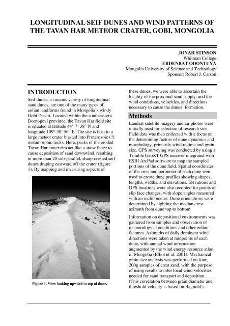
1). By mapping <strong>and</strong> measuring aspects <strong>of</strong><br />
Figure 1. View looking upward to top <strong>of</strong> dune.<br />
<strong>the</strong>se <strong>dunes</strong>, we were able to ascertain <strong>the</strong><br />
locality <strong>of</strong> <strong>the</strong> proximal s<strong>and</strong> supply, <strong>and</strong> <strong>the</strong><br />
<strong>wind</strong> conditions, velocities, <strong>and</strong> directions<br />
necessary to cause <strong>the</strong> <strong>dunes</strong>’ formation.<br />
Methods<br />
L<strong>and</strong>sat satellite imagery <strong>and</strong> air photos were<br />
initially used for selection <strong>of</strong> research site.<br />
Field data was <strong>the</strong>n collected with a focus on<br />
<strong>the</strong> determining factors <strong>of</strong> dune dynamics <strong>and</strong><br />
morphology, primarily <strong>wind</strong> regime <strong>and</strong> grain<br />
size. GPS surveying was conducted by using a<br />
Trimble GeoXT GPS receiver integrated with<br />
ESRI ArcPad s<strong>of</strong>tware to map <strong>the</strong> sampled<br />
portions <strong>of</strong> <strong>the</strong> dune field. Spatial coordinates<br />
<strong>of</strong> <strong>the</strong> crest <strong>and</strong> perimeter <strong>of</strong> each dune were<br />
used to create dune pr<strong>of</strong>iles showing shapes,<br />
lengths, widths, <strong>and</strong> elevations. Elevations <strong>and</strong><br />
GPS locations were also recorded for points <strong>of</strong><br />
slip face changes, with slope angles measured<br />
with an inclinometer. Dune orientations were<br />
determined by sighting <strong>the</strong> median crest<br />
azimuth from dune top to bottom.<br />
Information on depositional environments was<br />
ga<strong>the</strong>red from samples <strong>and</strong> observation <strong>of</strong><br />
meteorological conditions <strong>and</strong> o<strong>the</strong>r eolian<br />
features. Azimuths <strong>of</strong> daily dominant <strong>wind</strong><br />
directions were taken at midpoints <strong>of</strong> each<br />
dune, with annual <strong>wind</strong> information<br />
augmented by <strong>the</strong> <strong>wind</strong> energy resource atlas<br />
<strong>of</strong> Mongolia (Elliot et al. 2001). Mechanical<br />
grain size analysis was performed on four,<br />
200g samples <strong>of</strong> crest s<strong>and</strong>, with <strong>the</strong> purpose<br />
<strong>of</strong> using results to infer local <strong>wind</strong> velocities<br />
needed for s<strong>and</strong> transport <strong>and</strong> deposition.<br />
(This correlation between grain diameter <strong>and</strong><br />
threshold velocity is based on Bagnold’s
curve, 1941). In order to determine <strong>the</strong> extent<br />
<strong>of</strong> lateral dune migration, distances were<br />
measured from <strong>the</strong> dune perimeters to edges <strong>of</strong><br />
remnant, organic rich cross-beds (figure2).<br />
Along <strong>the</strong> rim <strong>of</strong> <strong>the</strong> crater, azimuths <strong>and</strong><br />
locations were recorded for sub-parallel, s<strong>and</strong>abraded<br />
grooves found in 33 outcrops <strong>of</strong> green<br />
schist (figure 3).<br />
Figure 2. Remnants <strong>of</strong> former <strong>dunes</strong>, with existing<br />
dune to <strong>the</strong> left. GPS for scale.<br />
RESULTS<br />
Each individual dune, approximately 1 km<br />
long, decreases in size <strong>and</strong> elevation as it<br />
<strong>wind</strong>s eastward to a low narrow “tail” that<br />
seasonally shifts north <strong>and</strong> south by<br />
approximately 10 m (figure 4). Maximum<br />
heights <strong>of</strong> 10 m <strong>and</strong> widths <strong>of</strong> 35 m occur near<br />
<strong>the</strong> <strong>seif</strong>s’ up<strong>wind</strong> or westward ends in <strong>the</strong><br />
<strong>wind</strong> shadows <strong>of</strong> peaks along <strong>the</strong> crest <strong>of</strong> <strong>the</strong><br />
eroded meteor crater. Daily observations show<br />
<strong>the</strong> multiple slip faces <strong>of</strong> each dune shift from<br />
north to south in time <strong>and</strong> space, with steep<br />
(35°) slopes opposite gentle (10-20°) slopes.<br />
Results from mechanical grain size analysis <strong>of</strong><br />
crest s<strong>and</strong>s reveal <strong>the</strong> majority <strong>of</strong> <strong>the</strong> wellsorted<br />
s<strong>and</strong> grains to be approximately 2.5 phi<br />
units (0.177 mm), thus classifying <strong>the</strong>m as fine<br />
s<strong>and</strong>.<br />
After averaging crest orientations <strong>of</strong> 16 <strong>dunes</strong>,<br />
it was found that <strong>the</strong> <strong>dunes</strong> run sub-parallel to<br />
one ano<strong>the</strong>r at approximately S74°E (figure<br />
5). This data is remarkably similar to that <strong>of</strong><br />
<strong>the</strong> crater rim’s s<strong>and</strong>-abraded grooves, which<br />
average S81°E (figure 6).<br />
DISCUSSION<br />
Results <strong>of</strong> this study suggest that moderate<br />
<strong>wind</strong>s are fairly common in this region, <strong>and</strong><br />
are <strong>of</strong> high enough velocities to significantly<br />
alter <strong>the</strong> l<strong>and</strong>scape. By comparing average<br />
grain size results with Bagnold’s curve (1941)<br />
<strong>of</strong> threshold <strong>and</strong> impact velocities, it was<br />
concluded that <strong>wind</strong>s speeds <strong>of</strong> approximately<br />
4 m/s are necessary to initiate s<strong>and</strong> movement<br />
Figure 3. S<strong>and</strong> abraded grooves in crater rim<br />
bedrock.<br />
Figure 4. View looking downhill <strong>of</strong> sinuous dune.
Figure 5. Rose diagram <strong>of</strong> dune orientations.<br />
Figure 6. Rose diagram <strong>of</strong> s<strong>and</strong>-abraded grooves<br />
along crater rim.<br />
along <strong>the</strong> <strong>dunes</strong>. Such findings correspond to<br />
regional observations by Elliot et al. 2001,<br />
who noted similar <strong>wind</strong> speeds in this<br />
province six months <strong>of</strong> <strong>the</strong> year.<br />
Analogous results <strong>of</strong> orientations <strong>of</strong> <strong>dunes</strong> <strong>and</strong><br />
s<strong>and</strong>-abraded grooves strongly indicate <strong>the</strong>y<br />
are concordant with <strong>the</strong> approximate mean<br />
annual <strong>wind</strong> direction <strong>of</strong> S80°E. Two possible<br />
<strong>wind</strong> regimes account for this resultant<br />
orientation, as <strong>the</strong>se dune-forming conditions<br />
could consist <strong>of</strong> ei<strong>the</strong>r: 1) a dominant<br />
unimodal westerly <strong>wind</strong> with minor modifying<br />
north <strong>and</strong> south seasonal <strong>wind</strong>s necessary to<br />
preserve <strong>the</strong> <strong>dunes</strong>’ characteristically sinuous<br />
shape, or (2) semi-oblique bimodal <strong>wind</strong><br />
directions from <strong>the</strong> northwest <strong>and</strong> southwest<br />
which converge in a net direction parallel to<br />
<strong>the</strong> crest line. Both <strong>wind</strong> models are supported<br />
by L<strong>and</strong>sat satellite imagery which shows<br />
large areas <strong>of</strong> unconsolidated sediment 5-15<br />
km to <strong>the</strong> west <strong>and</strong> northwest <strong>of</strong> <strong>the</strong> dune site:<br />
westerly <strong>wind</strong>s transport <strong>the</strong> s<strong>and</strong> from this<br />
source area (via surface creep <strong>and</strong> saltation)<br />
<strong>and</strong> deposit it on <strong>the</strong> leeward side <strong>of</strong> <strong>the</strong> crater<br />
as <strong>wind</strong> speed diminishes.<br />
As little is known today about <strong>the</strong> kinematics<br />
<strong>of</strong> <strong>seif</strong> dune morphology, this study is unique<br />
in that it provides an assessment <strong>of</strong> both dune<br />
characteristics <strong>and</strong> <strong>the</strong> environmental<br />
conditions essential for dune formation <strong>and</strong><br />
preservation. Much information can be<br />
ascertained in <strong>the</strong> future by examining dune<br />
characteristics at o<strong>the</strong>r <strong>seif</strong> fields.<br />
REFERENCES CITED<br />
Bagnold, R.A., 1941, The Physics <strong>of</strong> blown s<strong>and</strong> <strong>and</strong><br />
desert <strong>dunes</strong>: London, Mathuen <strong>and</strong> Co.<br />
Elliott, D., Schwartz, M., Scott, G., Haymes, S.,<br />
Heimiller, D., George, R., 2001, Wind energy<br />
resource atlas <strong>of</strong> Mongolia: National Renewable<br />
Energy Laboratory.<br />
Tseo, George, 1993, Two types <strong>of</strong> <strong>longitudinal</strong> dune<br />
fields <strong>and</strong> possible mechanisms for <strong>the</strong>ir<br />
development: Earth Surface Processes <strong>and</strong><br />
L<strong>and</strong>forms: <strong>the</strong> Journal <strong>of</strong> <strong>the</strong> British<br />
Geomorphological Research Group, v. 18, no. 7, p.<br />
627-643.<br />
Tsoar, Haim, 1982, Internal structure <strong>and</strong> surface<br />
geometry <strong>of</strong> <strong>longitudinal</strong> (<strong>seif</strong>) <strong>dunes</strong>: Journal <strong>of</strong><br />
Sedimentary Petrology, v. 52, no. 3, p. 823-831.<br />
Tsoar, Haim, 1983, Dynamic processes acting on a<br />
<strong>longitudinal</strong> (<strong>seif</strong>) dune: Sedimentology, v. 30, no.<br />
4, p. 567-578.<br />
Verstappen, H., 1968, On <strong>the</strong> origin <strong>of</strong> <strong>longitudinal</strong><br />
(<strong>seif</strong>) <strong>dunes</strong>: Annals <strong>of</strong> Geomorphology, v. 12, no. 2<br />
p. 200-220