Patapsco River - Captain John Smith Chesapeake National Historic ...
Patapsco River - Captain John Smith Chesapeake National Historic ...
Patapsco River - Captain John Smith Chesapeake National Historic ...

Create successful ePaper yourself
Turn your PDF publications into a flip-book with our unique Google optimized e-Paper software.
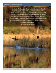
EXPLORING THE UPPER BAY<br />
TRAILHEADS<br />
ON THE PATAPSCO RIVER<br />
BALTIMORE MARINAS<br />
Search “Baltimore Marinas” online for a list of nearly a dozen<br />
commercial facilities in various parts of the Harbor.<br />
PUBLIC LAUNCH RAMPS<br />
Visit the online Boating Access Guide of the Maryland<br />
Department of Natural Resources. Click on the Baltimore City<br />
and Baltimore County reference maps.<br />
www.dnr.state.md.us/boating/boatramps.asp<br />
The easiest ramp for the Inner Harbor is:<br />
Canton Park<br />
39° 16' 36" N, 76° 34' 21" W<br />
(located on Boston Street, no launch fee)<br />
For the outer <strong>Patapsco</strong>:<br />
Fort Armistead Park<br />
39° 12' 31" N, 76° 31' 57" W<br />
(no launch fee)<br />
NOTE: Trailheads indicate access points for the suggested itineraries.<br />
<strong>River</strong> maps indicate trailheads as either private or public. All launch<br />
sites are open to the public. Those listed as private are part of privately<br />
owned businesses. Public trailheads are located on local, state, or<br />
federally managed properties. Fees may be charged at any of the<br />
launch sites and are subject to change. Contact the site directly for the<br />
latest information.<br />
Trip Itineraries<br />
HARBOR CIRCUMNAVIGATION<br />
ONE-WAY, 50 MILES<br />
You’ll travel about 50 miles to circumnavigate the<br />
<strong>Patapsco</strong> and Baltimore’s Harbor from any convenient<br />
starting point. It’s probably not a great kayak project,<br />
and making the trip entirely under sail would be<br />
challenging, but it’s an interesting full-day exploration<br />
in a cruising boat, a good-sized skiff, or a capable<br />
runabout. Take it at one time or cut it into shorter<br />
segments. These include:<br />
• A complete circle of the Inner Harbor;<br />
• A quick look into the Middle Branch (Gwynns<br />
Falls) and the <strong>Patapsco</strong>’s silted-in main stem at the<br />
Hanover Street Bridge;<br />
• A run out to the mouth of Curtis Bay, on the south<br />
side of the Inner Harbor;<br />
• A round trip up into Curtis Creek, past the U.S.<br />
Coast Guard Yard to Tanyard Cove and back;<br />
• A run out under the Key Bridge to Bodkin Point;<br />
• A ride across the <strong>Patapsco</strong> into Old Road Bay on<br />
the north side and around the old steel mill at<br />
Sparrows Point;<br />
• A careful run past the Dundalk Marine Terminal,<br />
with its giant cranes; and<br />
• A good look at the Fort McHenry <strong>National</strong><br />
Monument and <strong>Historic</strong> Shrine on the way back<br />
into the Inner Harbor.<br />
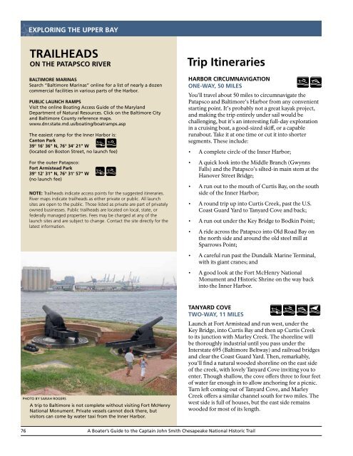
Photo by Sarah Rogers<br />
A trip to Baltimore is not complete without visiting Fort McHenry<br />
<strong>National</strong> Monument. Private vessels cannot dock there, but<br />
visitors can come by water taxi from the Inner Harbor.<br />
TANYARD COVE<br />
TWO-WAY, 11 MILES<br />
Launch at Fort Armistead and run west, under the<br />
Key Bridge, into Curtis Bay and then up Curtis Creek<br />
to its junction with Marley Creek. The shoreline will<br />
be thoroughly industrial until you pass under the<br />
Interstate 695 (Baltimore Beltway) and railroad bridges<br />
and clear the Coast Guard Yard. Then, remarkably,<br />
you’ll find a natural wooded shoreline on the east side<br />
of the creek, with lovely Tanyard Cove inviting you to<br />
enter. Though shallow, the cove offers three to four feet<br />
of water far enough in to allow anchoring for a picnic.<br />
Turn left coming out of Tanyard Cove, and Marley<br />
Creek offers a similar channel south for two miles. The<br />
west side is full of houses, but the east side remains<br />
wooded for most of its length.<br />
76<br />
A Boater’s Guide to the <strong>Captain</strong> <strong>John</strong> <strong>Smith</strong> <strong>Chesapeake</strong> <strong>National</strong> <strong>Historic</strong> Trail