Tentsmuir Time Line Trail - Scottish Natural Heritage
Tentsmuir Time Line Trail - Scottish Natural Heritage
Tentsmuir Time Line Trail - Scottish Natural Heritage

You also want an ePaper? Increase the reach of your titles
YUMPU automatically turns print PDFs into web optimized ePapers that Google loves.
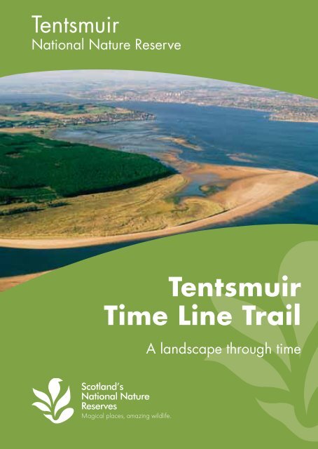
<strong>Tentsmuir</strong><br />
National Nature Reserve<br />
<strong>Tentsmuir</strong><br />
<strong>Time</strong> <strong>Line</strong> <strong>Trail</strong><br />
A landscape through time
2 3<br />
A landscape through time<br />
Take a walk through <strong>Tentsmuir</strong> National Nature Reserve and Forest<br />
and you are, quite literally, stepping back in time. 9,000 years ago<br />
the shoreline lay about three miles further inland, close to Morton<br />
Lochs. As sand gradually built up, the shoreline extended eastwards<br />
over the centuries. 1,000 years ago the sea would still have reached<br />
deep within the present-day forest. It was not until the end of the 18th<br />
century that the shore finally reached the point where the forest’s<br />
eastern edge is found today.<br />
<strong>Tentsmuir</strong> is one the most<br />
dynamic coastlines in Scotland.<br />
The mighty River Tay is one of the power sources giving unusual<br />
thrust for growth and change. The Tay disgorges more water and<br />
sediment than any river in Britain. When it finally flows into the North<br />
Sea swirling currents and turning tides constantly move the sand<br />
from one place to another. This shifting sand, constantly growing<br />
and retreating, makes <strong>Tentsmuir</strong> an important site for studying how<br />
beaches and coasts develop and change.<br />
Please take care if you are walking out on the sands and don’t let the<br />
rising tide cut you off. Tides can change very quickly here. Watch the<br />
sea and be aware of tides behind you.<br />
<strong>Tentsmuir</strong> sand dunes
4 5<br />
This map shows you the locations of the ten<br />
sculptures and existing features throughout<br />
<strong>Tentsmuir</strong> National Nature Reserve. You can<br />
follow the paths through the Reserve, forest and<br />
along the coastline to reach each of the sites.<br />
On your journey you will witness one of<br />
Scotland’s most dynamic landscapes. Swirling<br />
currents and turning tides constantly move the<br />
sand and create new shorelines and sandbars.<br />
The red dotted lines on the map indicate where<br />
<strong>Tentsmuir</strong>’s coast once lay and show just how<br />
dynamic this coastline is.<br />
7500BC<br />
Morton<br />
Lochs<br />
5000BC<br />
Tayport<br />
Heath<br />
AD 800-1054<br />
3<br />
1057-1298<br />
4<br />
1600s<br />
5<br />
1850s<br />
10<br />
6<br />
<strong>Tentsmuir</strong><br />
Point<br />
1950s<br />
We hope you enjoy your visit. Have fun, take<br />
care and leave <strong>Tentsmuir</strong> as beautiful as you<br />
found it for others to enjoy too.<br />
1<br />
2<br />
<strong>Tentsmuir</strong><br />
Forest<br />
7 8<br />
9<br />
Coastline<br />
then<br />
Coastline<br />
now
6 7<br />
First People<br />
The first people arrived here during the Mesolithic era, 9,000 years<br />
ago. At that time, this area was probably a low-lying island cut off<br />
from the mainland at high tide. These early people were huntergatherers<br />
who survived on a diet of shellfish, fish, fowl and local<br />
plants. They probably occupied the area for over 1,000 years.<br />
Evidence of their lives survives in the tools, shells, bones<br />
and arrowheads they left behind.<br />
9,000 years ago the coastline probably reached about 2 miles<br />
inland to where Morton Lochs lie today. An area close to<br />
Morton Lochs would have been an island in the sea.<br />
1 7500 BC 2 5000 BC 3 AD 80-1054 4 1057-1298 5 1636-1845 6 1794 7 1850s 8 1941 9 1950s 10 Today
8 9<br />
The Tsunami Strikes<br />
Around 7,000 years ago a tsunami struck this area. The huge 21<br />
metre (70ft) wave was caused by a massive underwater earthquake<br />
off the coast of Norway. The effect of the tsumani would have been<br />
catastrophic for the early Mesolithic people who had settled here.<br />
7,000 years ago, the sea reached inland to the Morton Lochs area.<br />
When the tsunami struck, it would have dramatically changed<br />
the coastline.<br />
1 7500 BC 2 5000 BC 3 AD 80-1054 4 1057-1298 5 1636-1845 6 1794 7 1850s 8 1941 9 1950s 10 Today
10 11<br />
Romans, Picts and Vikings<br />
The moorland here was once rich in game and wildfowl. Wetlands,<br />
freshwater lochs and the sea provided a plentiful supply of fish and<br />
shellfish. Berries and nuts grew all around. The Romans established<br />
camps in the moorland here around 80AD. Several centuries later<br />
the Picts used parts of <strong>Tentsmuir</strong> as pasture for their animals. And in<br />
the 9th century Vikings arrived, and some settled here attracted by<br />
the rich resources of the land.<br />
During the first millenium, the coastline was gradually<br />
growing eastwards, closer to where it lies today.<br />
1 7500 BC 2 5000 BC 3 AD 80-1054 4 1057-1298 5 1636-1845 6 1794 7 1850s 8 1941 9 1950s 10 Today
12 13<br />
Devils, Bears and Oxen<br />
Medieval <strong>Tentsmuir</strong> was a marshy and isolated place. During this<br />
time, the area became inhabited by shipwrecked sailors and gained<br />
a reputation as a wild place, home to outlaws and vagabonds.<br />
A monk surveying these lands, which belonged to St Andrews<br />
Cathedral in the 12th century described a lawless region<br />
populated by ‘devils, bears and oxen’.<br />
In the Middle Ages the eastern coastline of <strong>Tentsmuir</strong> probably cut<br />
right through the present day forest.<br />
1 7500 BC 2 5000 BC 3 AD 80-1054 4 1057-1298 5 1636-1845 6 1794 7 1850s 8 1941 9 1950s 10 Today
14 15<br />
Putting <strong>Tentsmuir</strong> on the Map<br />
Up until the 1600s this area was more or less unchartered territory.<br />
In 1636, Robert Gordon of Straloch produced one of the first maps<br />
of the region. A century later, in the 1780s, a Danish fleet was<br />
shipwrecked off this coast. Some of the sailors settled here, living<br />
in tents on the moor, which gave rise to the name ‘Tents Moor’. 60<br />
years later the arrival of the railway, put <strong>Tentsmuir</strong> well and truly<br />
on the map.<br />
The first maps of the area give us a better idea of how <strong>Tentsmuir</strong>’s<br />
coast has changed. 400 years ago the sea probably reached inland<br />
by about mile.<br />
1 7500 BC 2 5000 BC 3 AD 80-1054 4 1057-1298 5 1636-1845 6 1794 7 1850s 8 1941 9 1950s 10 Today
16 17<br />
The March Stone and Ice House<br />
The March Stone and the Ice House first appear on a plan of the<br />
salmon fishings, drawn in 1852. At that time the high water mark<br />
was very close to the structures. Over the years as the foreshore built<br />
eastward, the Ice House and March Stone have become further<br />
from the sea.<br />
The March Stone was erected as a<br />
boundary marker for fishing rights in<br />
1794. The term ‘march stone’ comes<br />
from the 16th-century meaning of<br />
‘march’ as a boundary.<br />
The beaches and estuaries around <strong>Tentsmuir</strong> were important for<br />
salmon fishing. The Ice House you see here was originally built<br />
around 1852 to store ice, gathered from local ponds in winter. The<br />
ice was used to preserve the fish before shipping it south. Layers of<br />
heather or straw, packed around the ice provided insulation,<br />
creating a primitive, but effective, deep-freeze.<br />
The inscriptions on the stone read:<br />
‘This stone was set up in the year 1794.’<br />
‘The march between the Shanwell and Old<br />
Muirs salmon fishing is a straight line from<br />
the top of Norman’s Law to the low water.<br />
This march stone stands in the said<br />
straight line’.<br />
1 7500 BC 2 5000 BC 3 AD 80-1054 4 1057-1298 5 1636-1845 6 1794 7 1850s 8 1941 9 1950s 10 Today
18 19<br />
Moving Targets<br />
In 2010 a Second World War railway wagon was discovered<br />
buried in the sand on <strong>Tentsmuir</strong> beach. It was originally used to<br />
transport ammunitions and supplies as well as for gunner practice by<br />
the air force training unit from nearby Leuchars. A target, mounted<br />
on the wagon, was powered by a small motor. It travelled along<br />
a section of railway track forming a moving target for the aircraft<br />
gunners to practise their shots.<br />
In 2010 a narrow gauge railway wagon, used during the Second<br />
World War, which had lain buried in the sand dunes for decades<br />
was uncovered by storms and the erosional effect of the sea.<br />
1 7500 BC 2 5000 BC 3 AD 80-1054 4 1057-1298 5 1636-1845 6 1794 7 1850s 8 1941 9 1950s 10 Today
20 21<br />
Hungry Herds<br />
<strong>Scottish</strong> <strong>Natural</strong> <strong>Heritage</strong> has managed and conserved this fragile<br />
environment since 1954 when <strong>Tentsmuir</strong> Point became a National<br />
Nature Reserve. If left entirely to nature, scrub would take over<br />
the sand dune and heathland habitat, turning the entire area to<br />
woodland. Reserve staff and volunteers work to clear much of the<br />
heathland of saplings and scrub. You might also see our hungry<br />
herd of cattle grazing the dunes to keep them free from tree cover.<br />
The coastline near the highland cow sculpture is now eroding at an<br />
alarming rate. The shoreline would have reached inland to here in<br />
the 1850s.<br />
1 7500 BC 2 5000 BC 3 AD 80-1054 4 1057-1298 5 1636-1845 6 1794 7 1850s 8 1941 9 1950s 10 Today
22 23<br />
Shifting Sands<br />
<strong>Tentsmuir</strong> is the fastest growing natural land mass in Scotland. This<br />
dynamic coastline is constantly changing as the sea moves and<br />
deposits sand. The concrete blocks you can see along the coast were<br />
placed here for defence by the Polish army during World War II,<br />
along what was then the high water mark. Since then, the shoreline<br />
here has grown further and further away from the blocks, at a rate of<br />
about five metres each year.<br />
The eastern coastline at Tenstmuir is growing and eroding in different<br />
places. The WWII tank traps mark the high water line of the 1940s.<br />
In some places they are far from the sea while in others they are<br />
under water.<br />
1 7500 BC 2 5000 BC 3 AD 80-1054 4 1057-1298 5 1636-1845 6 1794 7 1850s 8 1941 9 1950s 10 Today
For more information please contact:<br />
<strong>Scottish</strong> <strong>Natural</strong> <strong>Heritage</strong>,<br />
46 Crossgate, Cupar KY15 5HS.<br />
Tel: 01334 654038<br />
www.nnr-scotland.org.uk<br />
www.tentsmuir.org<br />
Photography: Lorne Gill/SNH; Ken Barry Photography<br />
© <strong>Scottish</strong> <strong>Natural</strong> <strong>Heritage</strong> 2011<br />
ISBN 978-1-85397-758-9 Print code: BP10k0511