FEMA Approved LMS Plan - Tampa Bay Regional Planning Council
FEMA Approved LMS Plan - Tampa Bay Regional Planning Council
FEMA Approved LMS Plan - Tampa Bay Regional Planning Council

You also want an ePaper? Increase the reach of your titles
YUMPU automatically turns print PDFs into web optimized ePapers that Google loves.
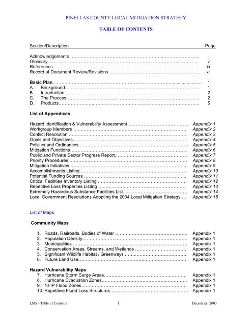
PINELLAS COUNTY LOCAL MITIGATION STRATEGY<br />
TABLE OF CONTENTS<br />
Section/Description<br />
Acknowledgements ……………………………………………………..……………………<br />
Glossary …………………………………………………………………………...………….<br />
References…………………………………………………………………….………. …….<br />
Record of Document Review/Revisions ……………………………………………………<br />
Page<br />
iii<br />
v<br />
ix<br />
xi<br />
Basic <strong>Plan</strong> ……………………………………………………………………........................ 1<br />
A. Background…………………………………………………………………………….. 1<br />
B. Introduction……………………………………………………………………………... 2<br />
C. The Process…………………………….. …………………………………………….. 2<br />
D. Products……………….…..……………………………………………………………. 5<br />
List of Appendices<br />
Hazard Identification & Vulnerability Assessment …………………………………. Appendix 1<br />
Workgroup Members ………………………………………………………………… Appendix 2<br />
Conflict Resolution ……………………………………………………………………. Appendix 3<br />
Goals and Objectives…………………………………………………………………. Appendix 4<br />
Policies and Ordinances ……………………………………………………………… Appendix 5<br />
Mitigation Functions…………………………………………………………………… Appendix 6<br />
Public and Private Sector Progress Report………………………………………… Appendix 7<br />
Priority Procedures …………………………………………………………………… Appendix 8<br />
Mitigation Initiatives ………………………………………………………………….. Appendix 9<br />
Accomplishments Listing ……………………………………………………………. Appendix 10<br />
Potential Funding Sources ………………………………………………………….. Appendix 11<br />
Critical Facilities Inventory Listing …………………………………………………. Appendix 12<br />
Repetitive Loss Properties Listing …………………………………………………. Appendix 13<br />
Extremely Hazardous Substance Facilities List …………………………………… Appendix 14<br />
Local Government Resolutions Adopting the 2004 Local Mitigation Strategy … Appendix 15<br />
List of Maps<br />
Community Maps<br />
1. Roads, Railroads, Bodies of Water ………………………………………… Appendix 1<br />
2. Population Density………………….………………………………………… Appendix 1<br />
3. Municipalities ……………………….………………………………………… Appendix 1<br />
4. Conservation Areas, Streams, and Wetlands ……………………………. Appendix 1<br />
5. Significant Wildlife Habitat / Greenways …….……………………………. Appendix 1<br />
6. Future Land Use……………………………………..………………………. Appendix 1<br />
Hazard Vulnerability Maps<br />
7. Hurricane Storm Surge Areas………………………………………………. Appendix 1<br />
8. Hurricane Evacuation Zones……………………………………..…………. Appendix 1<br />
9. NFIP Flood Zones……………………………………………………………. Appendix 1<br />
10. Repetitive Flood Loss Structures……………………………………………. Appendix 1<br />
<strong>LMS</strong> - Table of Contents i December 2003
PINELLAS COUNTY LOCAL MITIGATION STRATEGY<br />
TABLE OF CONTENTS<br />
11. Sinkhole Distribution …………………………………………………………. Appendix 1<br />
12. Hazardous Material Storage Sites…………………………………………... Appendix 1<br />
13. Urban Wildfire Vulnerability (Pine flatwoods, high pine or sandhill<br />
ecosystems - Booker Creek area) ……………………………………………. Appendix 1<br />
14. Bike Ways/Managed Areas ………………………………………………….. Appendix 1<br />
15. Wind Zones…………………………………………………… ………………. Appendix 1<br />
Critical Facility Maps<br />
16. Response/Staging Areas/ Emergency Operations Centers……………….. Appendix 12<br />
17. Federal, State and Local Buildings………………………….……………….. Appendix 12<br />
18. Fire/Rescue Stations ………………………………………….……………….. Appendix 12<br />
19. Hospitals/Medical Clinics ……………………………………………..……….. Appendix 12<br />
20. Water Treatment Facilities..……………………………………………….….. Appendix 12<br />
21. Sewer Systems Lift/Treatment <strong>Plan</strong>ts ……………………………………….. Appendix 12<br />
22. Public/Private Schools.……………. ………………………………………….. Appendix 12<br />
23. Nursing Homes/Adult Living Facilities ……………………………………….. Appendix 12<br />
24. Shelters (2003 ) …………………………….……………………………..….. Appendix 12<br />
25. Ice Manufacturing Facilities ……………………………………….………….. Appendix 12<br />
26. Airports …………………………………..………………………………….….. Appendix 12<br />
27. Communications - Radio/TV/Weather Towers ……………………….…….. Appendix 12<br />
28. Debris Sites……………………………………… …………………………….. Appendix 12<br />
<strong>LMS</strong> - Table of Contents ii December 2003
ACKNOWLEDGEMENTS<br />
The development of the Pinellas County Local Mitigation Strategy (<strong>LMS</strong>) was accomplished<br />
through the support of the Pinellas County Board of County Commissioners and the City<br />
<strong>Council</strong>s of the 23 municipalities within the jurisdiction.<br />
The <strong>LMS</strong> was developed and approved by the overall Local Mitigation Strategy Working<br />
Group, which included the (24) representatives from each municipality and the county, as<br />
well as the (31) representatives from public and private sector agencies, organizations and<br />
corporations. The <strong>LMS</strong> was coordinated and prepared by the Pinellas County Office of<br />
Emergency Management. The following persons and agencies have contributed to the<br />
development of this project.<br />
Agency<br />
Representative<br />
Belleair,<br />
Richard Deininger<br />
Belleair Beach,<br />
Bob Park<br />
Belleair Bluffs,<br />
Steve Langere<br />
Belleair Shore<br />
Clearwater,<br />
Randy Hinder<br />
Dunedin,<br />
Jeffrey Dow<br />
East Lake Fire,<br />
Jeff Parks<br />
Gulfport,<br />
Brian Brooks<br />
Indian Rocks Bch.,<br />
Thomas Brobeil<br />
Indian Shores,<br />
E. D. Williams<br />
Kenneth City,<br />
Albert Carrier<br />
Largo,<br />
J. P. Oberoi<br />
Lealman Fire Dist.,<br />
David Brown<br />
Madeira Beach,<br />
Derryl O’neal<br />
N. Redington Bch.<br />
Oldsmar,<br />
Scott Mcguff<br />
Pinellas Park,<br />
Bob Bray, Jr.<br />
P. C. E. M. (Chair/Vice), G. Vickers/E. Kelly<br />
P. C. <strong>Plan</strong>ning, Mike Taylor<br />
P. C. School Board, Kim Griffith<br />
Redington Beach,<br />
Tim Gregson<br />
Redington Shores,<br />
Mike Nadeau<br />
Palm Harbor Fire,<br />
James Angle<br />
Safety Harbor,<br />
Ron Pianta<br />
Seminole,<br />
Ed Mullins<br />
South Pasadena,<br />
Bill Naylor<br />
St. Pete Beach,<br />
Peter Cavalli<br />
St. Petersburg,<br />
L. O’Hearn/R. Ballou<br />
Tarpon Springs,<br />
K Bowman/R Butcher<br />
Treasure Island,<br />
Charles Fant<br />
FDEM Area 4 Rep.,<br />
Ken Rudnicki<br />
FL DCA Liaison,<br />
Roger Fall<br />
Clearwater Gas,<br />
Keith Downs<br />
Red Cross,<br />
Bill Groff<br />
Red Cross,<br />
Delta Green<br />
Paul Sierra Construction,<br />
John J. Edenbo<br />
Progress Energy,<br />
Marvin Pinkard<br />
<strong>LMS</strong>-Acknowledgments iii October 2003
<strong>Tampa</strong> <strong>Bay</strong> RPC,<br />
Verizon Communications,<br />
<strong>Council</strong> Of Neighborhood Associations<br />
Florida Renovators,<br />
Fed. Mobile Home Owners,<br />
Banker’s Insurance Co.,<br />
Fl. Assoc. Asst. Living<br />
Child Care Industry<br />
Business Contingency <strong>Plan</strong>ners<br />
Morton <strong>Plan</strong>t Mease Hosp.,<br />
Veterans Adm. Med. Ctr.,<br />
United Way,<br />
Salvation Army<br />
Gulf Beaches Chamber of Commerce<br />
Clearwater Chamber of Commerce<br />
Oldsmar Chamber of Commerce<br />
Safety Harbor Chamber of Commerce<br />
Seminole Chamber,<br />
Tarpon Springs Chamber<br />
St. Petersburg Chamber of Commerce,<br />
Palm Harbor Chamber of Commerce<br />
Dunedin Chamber of Commerce,<br />
Largo Chamber of Commerce<br />
Betti Johnson/ Bill Lofgren<br />
Lonny McCurdy<br />
Dean Jarvis<br />
Don Hazelton<br />
Claudette Cope<br />
Ed Smolik<br />
Ronald Hall<br />
Patricia Schmorantz<br />
Kathy Oathout<br />
Robert Bellavance<br />
<strong>LMS</strong>-Acknowledgments iv October 2003
Glossary<br />
Base Flood Elevation (BFE): The highest elevation, expressed in feet above sea level, of the<br />
level of flood waters occurring in the regulatory base flood (i.e. 100-year flood event).<br />
Building Codes: Regulations adopted by local government that establish standards for<br />
construction, modification, and repair of buildings and other structures.<br />
Coastal High Hazard Area (CHA): Evacuation zone for a Category 1 hurricane as established in<br />
the <strong>Tampa</strong> <strong>Bay</strong> <strong>Regional</strong> <strong>Plan</strong>ning <strong>Council</strong>’s Hurricane Evacuation Study.<br />
Community Development Block Grants (CDBG): The objective of the CDBG program is the<br />
development of viable urban communities by providing decent housing and a suitable living<br />
environment and expanding economic opportunities primarily for persons of low- and moderateincomes.<br />
Funds must be used so as to give maximum feasible priority to activities which will<br />
carry out one of the three broad national objectives of: benefit to low- and moderate-income<br />
families; or aid in the prevention or elimination of slums or blight; or activities designed to meet<br />
other community development needs having a particular urgency because existing conditions<br />
pose a serious and immediate threat to the health or welfare of the community where other<br />
financial resources are not available to meet such needs.<br />
Community Rating System (CRS): An initiative of the Federal Insurance Administration to<br />
encourage increased efforts in the reduction of flood losses, facilitate accurate insurance ratings<br />
and promote the awareness of flood insurance.<br />
Comprehensive Emergency Management <strong>Plan</strong> (CEMP): Required by Florida Statutes and<br />
addresses the four inter-related phases of emergency management: preparedness, response,<br />
recovery and mitigation.<br />
Critical Facilities: A structure from which essential services and functions for victim survival,<br />
continuation of public safety actions, and/or disaster recovery are performed or provided.<br />
Cultural Facilities: Establishments such as museums or art galleries of an historic, educational<br />
or cultural interest that are not operated commercially.<br />
Development: The carrying out of any building activity or mining operation, the making of any<br />
material change in the use or appearance of any structure or land, or the dividing of land into<br />
three or more parcels.<br />
Disaster: Any natural, technological, or civil emergency that causes damage of sufficient<br />
severity and magnitude to result in a declaration of a state of emergency by a county, the<br />
Governor, or the President of the United States. Disasters shall be identified by the severity of<br />
resulting damage, as follows:<br />
• Minor Disaster - A disaster that is likely to be within the response capabilities of local<br />
government and to result in only a minimal need for State or Federal assistance.<br />
• Major Disaster - A disaster that will likely exceed local capabilities and require a<br />
broad range of State and Federal assistance.<br />
• Catastrophic Disaster - A disaster that will require massive state and federal<br />
assistance, including immediate military involvement.<br />
v
Drainage: Surface water runoff or the removal of surface water or groundwater from land by<br />
drains, grading or other means.<br />
Emergency Management, Preparedness and Assistance (EMPA) Trust Fund Grant Program:<br />
Competitive grant for the state or regional agencies, local governments and private non-profit<br />
organizations for the implementation of projects that will further state and local emergency<br />
management objectives.<br />
Evacuation Routes: Routes designated by Pasco County Office of Emergency Management<br />
and the <strong>Tampa</strong> <strong>Bay</strong> <strong>Regional</strong> <strong>Plan</strong>ning <strong>Council</strong> for the movement of persons to safety in the<br />
event of a hurricane.<br />
Floodplain Management <strong>Plan</strong>: The operation of a program containing corrective and preventive<br />
measures for reducing flood damage including, but not limited to, flood control projects,<br />
floodplain land use regulations, floodproofing of buildings and emergency preparedness plans.<br />
Floodprone Areas: Areas inundated during a 100-year event or areas identified by the National<br />
Flood Insurance Program as an “A Zone” on Flood Insurance Rate Maps or Flood Hazard<br />
Boundary Maps.<br />
Goal: Long-term end toward which programs or activities are ultimately directed.<br />
Habitat: The particular natural community or communities that typically support a population of<br />
a particular plant or animal species.<br />
Hazardous Material: Any substance or material in a quantity or form which may be harmful to<br />
humans, animals, crops, water systems, or other elements of the environment if accidentally<br />
released. Hazardous materials include: explosives, gases (compressed, liquefied, or<br />
dissolved), flammable and combustible liquids, flammable solids or substances, oxidizing<br />
substances, poisonous and infectious substances, radioactive materials, and corrosives.<br />
Hazard Mitigation Grant Program (HMGP): The program operates under the authority of Public<br />
Law 100-707, the Robert T. Stafford Disaster Relief and Emergency Assistance Act. (The<br />
Hazard Mitigation Grant Program (HMPG) will be replaced in 2004 by Pre-Disaster Mitigation<br />
(PDM.) Section 404 provides 75/25 matching funds to eligible applicants to implement<br />
immediate and long-term hazard mitigation measures. A total of up to 15 percent of the<br />
combined public assistance and individual assistance programs are available to fund hazard<br />
mitigation projects. Section 406 is site-specific mitigation that is written if authorized by the<br />
federal/state/local officials and is in accordance with any applicable rules and regulations. This<br />
type of mitigation receives 75 percent federal money and requires a state/local match of 25<br />
percent.<br />
Historic Resources: All areas, districts or sites containing properties listed on the Florida Master<br />
Site File, the National Register of Historic Places, or designated by a local government as<br />
historically, architecturally, or archaeologically significant.<br />
Hurricane Shelter: A structure which meets the shelter selection guidelines, designated by local<br />
officials to be pre-identified for sheltering residents during a hurricane.<br />
Infrastructure: Man-made structures which serve the common needs of the population, such as:<br />
sewage disposal systems, potable water systems, potable water wells serving a system, solid<br />
vi
waste disposal sites or retention areas, stormwater systems, utilities, piers, docks, wharves,<br />
breakwaters, bulkheads, seawalls, bulwarks, revetments, causeways, marinas, navigation<br />
channels, bridges, and roadways.<br />
Local Mitigation Strategy (<strong>LMS</strong>): <strong>Plan</strong> developed to minimize negative impacts (potential loss of<br />
life or property damage) from a natural, man-made or technological disaster.<br />
Long-Term Temporary Housing: Tents, mobile homes, suitable rental housing, or other readily<br />
fabricated dwellings set-up for residents to live in until they are able to return to their own homes<br />
or find new homes. Utilization of this type of housing can last up to two weeks or longer.<br />
Mitigate: To offset or reduce negative impacts through measures such as, but not limited to, the<br />
following:<br />
• Not taking action or parts of a certain action.<br />
• Limiting the degree or magnitude of the action.<br />
• Repairing, rehabilitating, or restoring the affected resources.<br />
• Preserving and maintaining operations over time during the life of the action, and<br />
• Replacing or providing substitute resources or environment.<br />
Mobile Home: A structure, transportable in one or more sections, twelve (12) body feet or more<br />
in width, and over forty (40) feet in length, which is built upon an integral chassis and designed<br />
to be used as a dwelling unit with or without a permanent foundation when connected to the<br />
required utilities, and includes the plumbing, heating, air conditioning, and electrical systems<br />
contained herein. If fabricated after June 15, 1976, each section shall bear a HUD label<br />
certifying that it was built in compliance with Federal Manufacturing Home Construction and<br />
Safety Standards 42 USC 5401 and 24 CR 3282 and 3283.<br />
Mobile Home Park: A mobile home development consisting of a parcel of land under single<br />
ownership which has been, or is proposed to be, planned and improved for the placement of<br />
mobile homes for nontransient use.<br />
Mobile Home Space: A plot of land for placement of a single mobile home within a mobile<br />
home park.<br />
National Flood Insurance Program (NFIP): A federal program, which authorizes the sale of<br />
federally subsidized flood insurance in communities that agree to adopt and implement flood<br />
mitigation strategies and regulations.<br />
Objective: A specific, measurable, intermediate end that is achievable and marks progress<br />
toward a goal.<br />
Open Space: Undeveloped lands suitable for passive recreation or conservation uses.<br />
Post-Disaster Recovery: Long-term activity designed to return life to normal or improved levels<br />
following a disaster.<br />
Project Impact: Federal Emergency Management Agency (<strong>FEMA</strong>) initiative that challenges<br />
communities to take actions that protect families, businesses and property by reducing the<br />
effects of natural disasters.<br />
vii
Public Facilities: Transportation systems or facilities, sewer systems or facilities, solid waste<br />
systems or facilities, drainage systems or facilities, potable water systems or facilities,<br />
educational systems or facilities, parks and recreation systems or facilities and public health<br />
systems or facilities.<br />
Recreational Vehicle: Vehicle-type unit primarily designed as temporary living quarters for<br />
recreational, camping, or travel use, which either has its own motive power or is mounted on or<br />
drawn by another vehicle.<br />
Recreational Vehicle (RV) Park: Place set aside and offered by a person, for either direct or<br />
indirect remuneration of the owner, leaser, or operator of such place, for the parking,<br />
accommodation, or rental of five or more recreational vehicles or tents; and the group camping<br />
and similar recreational facilities.<br />
Retrofit: Corrective measures taken on an existing structure to minimize damage caused by<br />
water, wind and fire.<br />
Runoff: The part of the rainfall that travels to surface streams and water bodies via surface<br />
or subsurface routes.<br />
Storm Surge: The abnormal rise in water level caused by the wind and pressure forces of a<br />
hurricane or tropical storm. Storm surge produces most of the flood damage and drowning<br />
associated with storms that make landfall or that closely approach the coastline.<br />
Stormwater: Flow of water resulting from a rainfall event.<br />
Subdivision: The division of land, lot, tract, or parcel into two or more lots, parcels, plats, or<br />
sites, or other divisions of land for the purpose of sale, lease, offer, or development, whether<br />
immediate or future. The term also includes the division of residential, commercial, industrial,<br />
agricultural, or other land whether by deed, metes and bounds description, lease, map, plat, or<br />
other instrument.<br />
Wetlands: Areas that are inundated or saturated by surface water or ground water at a<br />
frequency and duration sufficient to support, and under normal circumstances do support, a<br />
prevalence of vegetation typically adapted for life in saturated soils.<br />
viii
References<br />
Pinellas County Comprehensive <strong>Plan</strong> and Land Development Code<br />
Belleair Comprehensive <strong>Plan</strong> and Land Development Code<br />
Belleair Beach Comprehensive <strong>Plan</strong> and Land Development Code<br />
Belleair Bluffs Comprehensive <strong>Plan</strong> and Land Development Code<br />
Belleair Shore Comprehensive <strong>Plan</strong> and Land Development Code<br />
Clearwater Comprehensive <strong>Plan</strong> and Land Development Code<br />
Dunedin Comprehensive <strong>Plan</strong> and Land Development Code<br />
Gulfport Comprehensive <strong>Plan</strong> and Land Development Code<br />
Indian Rocks Beach Comprehensive <strong>Plan</strong> and Land Development Code<br />
Indian Shores Comprehensive <strong>Plan</strong> and Land Development Code<br />
Kenneth City Comprehensive <strong>Plan</strong> and Land Development Code<br />
Largo Comprehensive <strong>Plan</strong> and Land Development Code<br />
Madeira Beach Comprehensive <strong>Plan</strong> and Land Development Code<br />
North Redington Beach Comprehensive <strong>Plan</strong> and Land Development Code<br />
Oldsmar Comprehensive <strong>Plan</strong> and Land Development Code<br />
Pinellas Park Comprehensive <strong>Plan</strong> and Land Development Code<br />
Redington Beach Comprehensive <strong>Plan</strong> and Land Development Code<br />
Redington Shores Comprehensive <strong>Plan</strong> and Land Development Code<br />
Safety Harbor Comprehensive <strong>Plan</strong> and Land Development Code<br />
St. Petersburg Comprehensive <strong>Plan</strong> and Land Development Code<br />
St. Pete Beach Comprehensive <strong>Plan</strong> and Land Development Code<br />
Seminole Comprehensive <strong>Plan</strong> and Land Development Code<br />
South Pasadena Comprehensive <strong>Plan</strong> and Land Development Code<br />
Tarpon Springs Comprehensive <strong>Plan</strong> and Land Development Code<br />
Treasure Island Comprehensive <strong>Plan</strong> and Land Development Code<br />
"Breaking the Cycle, Strengthening Florida Before Disaster Strikes", Florida Department of<br />
Community Affairs, Tallahassee, FL, February 1999.<br />
“State and Local Mitigation <strong>Plan</strong>ning How-to-Guide, Version 1.0”, Federal Emergency<br />
Management Agency, August 2001.<br />
“State and Local <strong>Plan</strong> Interim Criteria Under the Disaster Mitigation Act of 2000”, Federal<br />
Emergency Management Agency, March 26, 2002.<br />
"The Local Mitigation Strategy: A Guidebook for Florida Cities and Counties", James F.<br />
Murley, Secretary, Florida Department of Community Affairs, June 1997.<br />
"The Local Mitigation Strategy: A Guidebook for Florida Cities and Counties, Vulnerability<br />
Assessment, Supplement, Part 1", James F. Murley, Secretary, Florida Department of<br />
Community Affairs, April 1998.<br />
"The Local Mitigation Strategy: A Guidebook for Florida Cities and Counties, Vulnerability<br />
Assessment, Supplement, Part 2", Steven M. Seibert, Secretary, Florida Department of<br />
Community Affairs, February 1999.<br />
“2000 Census”, US Bureau of the Census.<br />
ix
“2002 Employment Estimates by Industry-Pinellas County”, U.S. Department of Labor.<br />
“Understanding Your Risks, Identifying Hazards and Estimating Losses”, <strong>FEMA</strong>, August<br />
2001.<br />
x
RECORD OF DOCUMENT REVISIONS<br />
Revision Number<br />
Date of<br />
Revision<br />
Text<br />
Section/Page(s)<br />
Amended<br />
Map<br />
Section/Page(s)<br />
Amended<br />
1-Update May 2004 All sections/all pages All maps/all pages<br />
xi
This page intentionally left blank.<br />
xii
PINELLAS COUNTY<br />
LOCAL MITIGATION STRATEGY PLAN<br />
BACKGROUND<br />
In early 1998, The State Department of Community Affairs requested that Pinellas County and<br />
its municipalities develop a unified, community-wide local mitigation strategy. Their request was<br />
aimed at controlling the skyrocketing costs of disasters. Most of the burdens of recovering from<br />
a disaster fall squarely on the shoulders of local government. A major disaster can bring<br />
extraordinary hardship to citizens, devastate the economic base, and diminish its quality of life<br />
for years to come. Disaster events create enormous pressure for local government to take<br />
action, and that action must be taken quickly. Therefore, it is critical to rebuild communities in<br />
ways that will guarantee that the same destruction and hardship will not be repeated in future<br />
disasters.<br />
The purpose of this local mitigation strategy is to develop a “blueprint” or guide intended to<br />
provide a unified and consistent course of action needed to eliminate or reduce the impact of<br />
disasters that threaten Pinellas County and its municipalities. This strategy was developed in<br />
accordance with the Florida Department of Community Affairs publication, The Local Mitigation<br />
Strategy: A Guidebook for Florida Cities and Counties, and other applicable guidance promoted<br />
by the Department of Community Affairs and the Federal Emergency Management Agency.<br />
The Department of Community Affairs, through a contractual agreement with Pinellas County as<br />
grantee, provided Grant funding for this effort. Municipal participation in the process was<br />
funded through subcontract agreements between Pinellas County and those municipalities that<br />
voluntarily agreed to produce a single, unified Local Mitigation Strategy.<br />
In addition to county and municipal government representation, the local mitigation strategy<br />
process included a broad range of private and public sector interests: The <strong>Regional</strong> <strong>Plan</strong>ning<br />
<strong>Council</strong>, chambers of commerce, public utilities, health care, public transportation, community<br />
associations, the insurance industry, business contingency planners, volunteer and communitybased<br />
organizations, construction industry, and education.<br />
At the inception of the workgroup, it was decided that it would be divided into two groups, voting<br />
members and non-voting members. The voting members were the twenty-three (23)<br />
municipalities which officially committed to the process via their subcontract with Pinellas<br />
County and the Pinellas County <strong>Plan</strong>ning Department. The non-voting members were the<br />
remaining thirty-one (31) partners from the private and public sectors, who agreed to participate<br />
to share their insights and recommendations on the topics relevant to their areas of expertise.<br />
The workgroup conducted its first meeting on March 11, 1998. Over the ensuing fifteen months,<br />
a total of twenty-two (22) meetings took place to produce the deliverables required by contract.<br />
Pinellas County and its municipalities developed a unified Local Mitigation Strategy during the<br />
late nineties. This 2004 Update to the Local Mitigation Strategy has been prompted by the<br />
Disaster Mitigation Act of 2000. By developing the Local Mitigation Strategy, Pinellas County<br />
can increase the resiliency of the community to the disruption and hardship of disasters and<br />
attempt to reduce the potential and actual costs of their impact.<br />
1
PINELLAS COUNTY<br />
LOCAL MITIGATION STRATEGY PLAN<br />
INTRODUCTION<br />
The nation and the State of Florida can no longer afford to bear the extraordinarily high human<br />
and economic costs of disasters. All levels of government must take steps to decrease the<br />
vulnerability of their citizens, businesses, infrastructure, and institutions to the impact from these<br />
events. Every Florida community will always be vulnerable to hurricanes, other natural<br />
disasters, technological hazards, and man-made emergencies. However, the state’s counties<br />
and municipalities do not have to remain unnecessarily vulnerable to these consequences. The<br />
development of a community-wide local mitigation strategy is a good first step in the effort to<br />
reduce or eliminate the costs of disasters and plan for an organized and timely post-disaster<br />
redevelopment.<br />
The purpose of the Local Mitigation Strategy is to establish an ongoing process that will make<br />
hazard mitigation part of the daily functioning of the entire community. The Local Mitigation<br />
Strategy serves as a bridge between local governments’ comprehensive growth management<br />
plans, the county comprehensive emergency management plan, land development regulations,<br />
and relevant ordinances and codes such as those for floodplain management. It may also fulfill<br />
some of the requirements of Florida Statutes Chapter 163, “Comprehensive Growth<br />
Management <strong>Plan</strong>,” and Florida Administrative Codes “9J-5” and “9G-22”. This strategy<br />
integrates mitigation initiatives established through various policies, programs, and regulations<br />
into a single stand-alone working document.<br />
THE PROCESS<br />
The creation of the local mitigation strategy is determined by who should be involved, defining<br />
how the process is going to work, and understanding how the process facilitates the production<br />
of the final product. With the inception of Administrative Rule 9G-22, the Local Mitigation<br />
Strategy Workgroup has re-defined itself and its methodology to meet the intention of the new<br />
rule.<br />
The <strong>Plan</strong>ning Organization - The development of a mitigation strategy requires the involvement<br />
of representatives from the public, private, and governmental sectors. Therefore, every attempt<br />
has been made to include the following entities in the Workgroup membership: interested local<br />
municipalities, private organizations, civic organizations, Native American Tribes or authorized<br />
tribal organizations, water management districts, independent special districts, and non-profit<br />
organizations. Through the involvement of the members of the Local Mitigation Strategy<br />
Workgroup, the <strong>LMS</strong> was developed in coordination with neighboring communities, local and<br />
regional agencies involved in hazard mitigation activities agencies that have development<br />
review authority, businesses, academia and other private and non-private interests. All<br />
representatives are brought together to form the Pinellas County Local Mitigation Strategy<br />
Workgroup.<br />
The Local Mitigation Strategy Workgroup affirmed that it would be divided into two groups,<br />
voting members and non-voting members. The voting members will remain the twenty-three<br />
(23) municipalities who were initially committed to the process via their participation in the<br />
formation of the initial Local Mitigation Strategy in cooperation with Pinellas County. The nonvoting<br />
members will be the remaining partners from the private and public sectors, who agreed<br />
to participate to share their insights and recommendations on those topics relevant to their<br />
areas of expertise and organizational interests and concerns. The <strong>LMS</strong> Workgroup, at its<br />
2
PINELLAS COUNTY<br />
LOCAL MITIGATION STRATEGY PLAN<br />
regular annual meeting on November 6, 2001, elected a Chairperson and Vice-Chairperson.<br />
Currently, the <strong>LMS</strong> Workgroup meets on a monthly basis, as there is a large amount of work to<br />
be accomplished in re-writing this plan. However, the <strong>LMS</strong> Workgroup voted that the group<br />
should meet at least every quarter with additional meetings to be scheduled as the workload<br />
dictates. All business conducted by the <strong>LMS</strong> Workgroup is submitted for approval to the voting<br />
members and is passed or defeated by majority vote. The meeting calendar is provided in<br />
Appendix 2 and reflects the committee work through the development and the revision of the<br />
<strong>LMS</strong>.<br />
Participation –The representatives’ acceptance of the invitation and agreement to become<br />
committee members initiated their commitment to the effort. The representatives committed<br />
their time and available resources to develop a mitigation strategy that would protect life,<br />
property, and the environment as well as contribute to the economic well being of the county.<br />
The implication of the Hazard Mitigation <strong>Plan</strong>ning and Hazard Mitigation Grant Program Interim<br />
Final Rule is that each of the jurisdictions and representatives on the committee must show<br />
participation in the planning process to qualify for HMGP, Pre-Disaster Mitigation Program<br />
(PDM) and Flood Mitigation Assistance Program (FMA) funding. The definition of participation<br />
as determined by the committee is the mandatory attendance of two meetings during the year<br />
and/or submittal of a ranked mitigation initiative. Each member signed in at each meeting. This<br />
data was used to document participation. A CDROM is provided with the document which<br />
includes the meeting notice, agenda, sign-in sheet, and minutes of all meetings. Refer to<br />
Appendix 2 for the list of committee members and their jurisdiction/ association.<br />
Community Involvement – In the initial phase, several approaches were taken to solicit<br />
community involvement in the development of the strategy. The approaches included sending<br />
letters to a variety of organizations, associations, and businesses; conducting county and city<br />
meetings on the topic of mitigation; using public service announcements and advertisements;<br />
scheduling interviews and speaking engagements; and including mitigation issues on<br />
governmental Internet home pages. Attendance by the private sector was intermittent based on<br />
the meeting agendas. They attended when the subject matter was relevant to their particular<br />
interests; although, they were kept informed throughout the process by facsimiles, mailings, and<br />
electronic messages. This approach is still in use today and attendance continues to be highly<br />
selective, depending on the subjects posted on the agenda.<br />
Requirements - The State Department of Community Affairs and the Federal Emergency<br />
Management Agency define the local mitigation strategy requirements. The State requires that<br />
the Local Mitigation Strategy will provide the processes for application, project selection, and<br />
distribution of funds under the Hazard Mitigation Grant Program.<br />
Under new Administrative Rule 9G-22, the Local Mitigation Strategy Workgroup must meet<br />
several new conditions to maintain compliance.<br />
These requirements are:<br />
1. No later than the last working weekday of each January, the Chairperson of the Board of<br />
County Commissioners shall submit to the Florida State Division of Emergency<br />
Management, a list of the members of the Local Mitigation Strategy Workgroup and its<br />
designated chairperson and vice-chairperson.<br />
2. The Workgroup shall include, at a minimum, representatives from various agencies of<br />
county government, representatives from all interested municipalities in the county, and<br />
representatives from interested private and civic organizations, Native American tribes or<br />
3
PINELLAS COUNTY<br />
LOCAL MITIGATION STRATEGY PLAN<br />
organizations, trade and commercial support groups, property owners associations,<br />
water management districts, regional planning councils, independent special districts,<br />
and non-profit groups.<br />
3. The county shall submit documentation that indicates that, within the preceding year, it<br />
has issued a written invitation to each group as specified above in #2.<br />
4. The Local Mitigation Strategy Workgroup shall be charged with the responsibilities of<br />
designating a Chairperson and Vice-Chairperson; developing and revising the Local<br />
Mitigation Strategy as necessary; coordinating all mitigation activities within the County;<br />
setting an order of priority for local mitigation projects, and submitting an annual <strong>LMS</strong><br />
update to the Florida State Division of Emergency Management by the last working<br />
weekday in January of each year. The update shall include changes to the hazard<br />
assessment, project priority list, critical facilities list, repetitive loss list, and revisions to<br />
all maps.<br />
Supporting Analyses - One of the most important tasks required of the Local Mitigation<br />
Workgroup is to conduct, and maintain a hazard identification and vulnerability assessment.<br />
The information provided by the assessment is the foundation on which decisions about future<br />
mitigation initiatives are based. An analysis of both natural and technological hazards is ongoing.<br />
The hazard identification and vulnerability assessment data is gathered from the <strong>Tampa</strong><br />
<strong>Bay</strong> <strong>Regional</strong> <strong>Plan</strong>ning <strong>Council</strong> (TBRPC); the National Hurricane Center SLOSH (Sea Lake<br />
Overland Surge in Hurricanes) model; the Laser Infrared Detection and Ranging system<br />
(LIDAR); the Municipalities and their departments; and Pinellas County Departments of<br />
Emergency Management, <strong>Plan</strong>ning, Building, Information Systems, Public Works, Utilities, and<br />
Developmental Review Services.<br />
The Pinellas County 1999 LIDAR survey provided the workgroup with current and accurate<br />
hurricane evacuation information.<br />
Mitigation Opportunities and Initiatives - The process of developing the local mitigation strategy<br />
culminated in the identification of mitigation opportunities and initiatives. Each workgroup<br />
member is required to review, evaluate, and analyze his or her current policies and ordinances<br />
regarding mitigation. The information is then shared and compared with the other members of<br />
the workgroup. This allows for the exchange of good ideas, accomplishments, and past<br />
experiences both successful and unsuccessful. The process also identifies any inconsistencies<br />
between communities. The most successful policies limit public expenditures in areas subject to<br />
repetitive damage from disasters; protect critical facilities and infrastructure; preserve, restore<br />
and enhance natural resources that can mitigate hazards; encourage economic diversification<br />
as protection from the loss of any one asset; encourage structural retrofitting, property<br />
acquisition and relocation; and identify procedures to expedite post-disaster recovery and<br />
permitting.<br />
Because of the education gained from this process, the workgroup is better prepared to<br />
determine the future mitigation initiatives that should be or need to be pursued. Some of the<br />
needed mitigation initiatives require unified intergovernmental coordination and participation.<br />
Other initiatives can be accomplished on an individual community basis. Pinellas County and<br />
each of the twenty-three (23) participating municipalities submit a list of their unfunded<br />
mitigation initiatives. The initiatives are then placed on a consolidated county-wide list, which is<br />
divided into categories relevant to specific objectives.<br />
4
PINELLAS COUNTY<br />
LOCAL MITIGATION STRATEGY PLAN<br />
These categories are:<br />
• Critical Facilities<br />
• Public Shelter<br />
• Drainage, Storm Water Management, and Flood Control<br />
• Vegetative Management, Beach Management, and Soil Stabilization<br />
• New Construction<br />
• Infrastructure Protection<br />
• Property Acquisition<br />
• <strong>Plan</strong>ning Projects/Community Outreach<br />
• Elevation of Flood Prone Structures<br />
The philosophy of the workgroup was that each government would be encouraged to apply for a<br />
grant annually for at least one of their mitigation initiatives. Therefore, if each year at least one<br />
mitigation initiative were successfully completed, the county would be making more progress in<br />
the mitigation arena than it is today. To reach the goal of a disaster resistant community such<br />
planning and commitments will be required.<br />
Adoption of the Strategy - The Local Mitigation Strategy Update will be adopted by the Pinellas<br />
County Board of County Commissioners and each participating city council by local resolution<br />
(See Appendix 15).<br />
Strategy Maintenance and Enhancement - The Pinellas County Local Mitigation Strategy serves<br />
as a guide for hazard mitigation activities on a community-wide basis. The strategy is intended<br />
to be a dynamic document that will be updated regularly. It will also be further refined as more<br />
experience is gained in the implementation of mitigation initiatives and regulations intended to<br />
reduce vulnerability to hazards are enacted.<br />
The Local Mitigation Strategy Workgroup will meet to update and review the effectiveness of the<br />
local mitigation strategy and will submit annual Local Mitigation Strategy updates to the Florida<br />
Division of Emergency Management no later than the last working weekday of each January. If<br />
implementation experience indicates a need to modify the strategy, a special meeting of the<br />
workgroup may be called. Any workgroup member may request a special meeting. Pinellas<br />
County Emergency Management will coordinate scheduling and notification of workgroup<br />
meetings. A minimum of thirty (30) days advance notice will be given for annual meetings. As<br />
much advance notice as possible will be given for regular and special meetings.<br />
On an ongoing basis, new initiatives will be considered by the workgroup for inclusion into the<br />
strategy. Completed initiatives, termed Accomplishments, will be removed from the Initiatives<br />
List and detailed in the Accomplishments Listing. The new initiatives will be added as they are<br />
identified and approved by the Workgroup. Every five years, or after any major change, the<br />
strategy will be resubmitted to municipal councils/commissions and to the Board of County<br />
Commissioners for re-adoption.<br />
PRODUCTS<br />
Appendix One: Hazard Identification & Vulnerability Assessment - The Local Mitigation Strategy<br />
Workgroup conducts and maintains an analysis of Pinellas County’s hazard vulnerabilities. The<br />
analysis includes a general geographic description, population and housing estimates,<br />
5
PINELLAS COUNTY<br />
LOCAL MITIGATION STRATEGY PLAN<br />
economic indicators, transportation routes and methods, and threats from natural and<br />
technological hazards. Captured in the documentation of each hazard analysis is a brief history<br />
that includes information about any significant related events, the probability of the specific<br />
hazard occurring in Pinellas County, the impact it would have, and an example to illustrate the<br />
maximum threat.<br />
Appendix Two: Workgroup Members - The local mitigation strategy workgroup is comprised of<br />
representatives from the public, private and governmental sectors, in accordance with<br />
Administrative Rule 9G-22. Documentation that such invitation has occurred will be included in<br />
each annual update of the plan and detailed in Appendix Two. All members are encouraged to<br />
consistently attend the workgroup meetings.<br />
Appendix Three: Conflict Resolution - Conflict resolution within the workgroup will focus on<br />
issues which are opposed by 50% or more of the voting workgroup. Some items can be<br />
deferred for future evaluation. However, for items that need immediate resolution, a majority<br />
vote will be required.<br />
Appendix Four: Goals & Objectives - The goals and objectives of the workgroup are to serve as<br />
guidance in the planning of future hazard mitigation initiatives. The goals and objectives are<br />
applicable to both pre-disaster and post-disaster efforts. The three goals established were:<br />
increase public awareness regarding mitigation; create a disaster resistant community; and<br />
maintain a program of intergovernmental and interagency coordination, cooperation, and<br />
partnership to mitigate disasters, evaluate existing mitigation measures, and propose new or<br />
modified mitigation measures.<br />
Appendix Five: Policies & Ordinances - Pinellas County and each municipality evaluated and<br />
compared existing local policies and ordinances regarding mitigation. Commonalities among<br />
jurisdictions were evident in floodplain management, restrictions on expansion of infrastructure<br />
and building densities in the Coastal High Hazard Area, and compliance with or exceeding<br />
requirements established by the Federal Emergency Management Agency (<strong>FEMA</strong>).<br />
The inconsistencies between jurisdictions are primarily a result of geographic locations. Those<br />
municipalities located completely in the coastal high hazard areas were understandably more<br />
lenient toward building and development in the coastal high hazard area.<br />
The workgroup has approved the following suggestions for strengthening policies and<br />
ordinances to achieve the stated mitigation goals:<br />
• Improve policies that address retrofitting older buildings<br />
• Require window protection for new construction<br />
• Provide incentives to homeowners for retrofitting<br />
• Redefine the coastal high hazard area using one foot elevation lines<br />
• Add more extensive wind loading and impact resistant opening requirements<br />
• Review plans for new public buildings for potential additional shelter space, pending the<br />
appropriate mitigation actions.<br />
Appendix Six: Mitigation Functions - Pinellas County and each of the municipalities identifies<br />
the local hazard mitigation functions that are being practiced on a daily basis. The identification<br />
of these functions serve to complement the evaluation of the policies and procedures that have<br />
6
PINELLAS COUNTY<br />
LOCAL MITIGATION STRATEGY PLAN<br />
been conducted. The performance of these functions indicates that mitigation is a part of our<br />
daily operations.<br />
Appendix Seven: Private & Public Sector Progress Report - To develop an effective mitigation<br />
strategy, partnerships between the private and public sectors have been formed. Businesses<br />
and citizens needed to understand the importance of building disaster resistant communities<br />
BEFORE a disaster strikes. A wide variety of different sizes of businesses and organizations is<br />
always invited to participate, as directed in Administrative Rule 9G-22.<br />
Appendix Eight: Priority Procedures - Pinellas County and each municipality are responsible for<br />
submitting all of their unfunded mitigation initiatives to the workgroup annually. The workgroup,<br />
with the assistance of a subcommittee, has established a prioritization procedure that is to be<br />
used in the selection process. The procedures allow the local representatives to assign points<br />
to their initiatives, so that they can then rank them and determine which initiatives to submit.<br />
Appendix Nine: Mitigation Initiatives - The list of mitigation initiatives reflects all of the initiatives<br />
submitted by the County and each municipality. The list has been divided into three separate<br />
funding groups:<br />
• Initiatives estimated to cost up to, but no more than $50,000<br />
• Initiatives estimated to cost at least $50,000 but no more than $300,000<br />
• Initiatives that are estimated to cost more than $300,000<br />
The Initiatives are then grouped into the following categories:<br />
• Critical Facilities<br />
• Public Shelter<br />
• Drainage, Storm Water Management, and Flood Control<br />
• Vegetative Management, Beach Management, and Soil Stabilization<br />
• New Construction<br />
• Infrastructure Protection<br />
• Property Acquisition<br />
• <strong>Plan</strong>ning Projects/Community Outreach<br />
• Elevation of Flood Prone Structures<br />
The primary reason that the lists were separated is because many major mitigation projects<br />
would exceed local government capabilities as well as the funding caps of existing grant<br />
programs. The most likely grant programs that could be pursued for mitigation have the<br />
previously mentioned funding caps:<br />
• The Emergency Management Preparedness and Assistance Trust Fund (EMPA)<br />
Municipal Grant - $50,000 cap<br />
• The Emergency Management Preparedness and Assistance Trust Fund (EMPA) Open<br />
Grant - $300,000 cap.<br />
The Pre-Disaster Mitigation Program (PDM) authorized by Section §203 of the Robert T.<br />
Stafford Disaster Relief and Emergency Assistance Act (Stafford Act), will provide funding for<br />
mitigation efforts with a $3 million cap awarded on a competitive basis (national total of<br />
$118,000,000 in 2003). Funding for initiatives costing more than $300,000 may be awarded<br />
7
PINELLAS COUNTY<br />
LOCAL MITIGATION STRATEGY PLAN<br />
after a disaster, at which time Hazard Mitigation Grant Program (HMGP) funding would become<br />
available.<br />
Pinellas County and the twenty-three (23) municipalities placed all of their initiatives on each of<br />
the applicable funding lists. All governmental entities should actively pursue funds to<br />
accomplish as many initiatives as possible each year.<br />
Note: The Flood Mitigation Assistance Program (FMAP) provides annual pre-disaster funds that<br />
are available to assist private property owners. Application for these funds is the responsibility<br />
of the property owner. Pinellas County and the municipalities will encourage eligible applicants<br />
to apply annually. The local governments will provide support through the administrative<br />
facilitation of the program. Since this program is dependent upon a private third party, it is not<br />
considered appropriate to list it for the prioritized mitigation initiatives.<br />
If an unexpected amount of mitigation funds is made available to the Pinellas County area, the<br />
workgroup would refer to the Initiatives List and identify those that could be accomplished with<br />
the given funds. Next, the governments of those identified initiatives would be asked if they<br />
were interested and prepared to apply. Each entity must consider that it is likely that the<br />
applicant may need to provide some matching funds. If there is more interest than available<br />
funds, the workgroup will be convened to evaluate and rank the initiatives using the established<br />
prioritization procedures.<br />
The Initiative List will be updated each year as part of the annual review process. Initiatives that<br />
have been accomplished shall be moved to the Accomplishments List.<br />
The Initiative List and any prioritization procedures may also be updated following a major<br />
disaster event, a change in funding sources, or as determined appropriate by the workgroup.<br />
Appendix Ten: Accomplishments Listing – An accounting of completed projects detailed by<br />
municipality and showing cost data, an estimate of the total benefit and potential source of<br />
funding.<br />
Appendix Eleven: Potential Funding Sources - Many potential funding sources exist for hazard<br />
mitigation projects. While Administrative Rule 9G-22 requires that “associated funding sources”<br />
are to be listed, this is difficult to accomplish in reality. The workgroup conducted research of<br />
the various state and federal grant programs, to become better educated about all potential<br />
options. The findings of the research indicate that a variety of programs is only available prior to<br />
a disaster, and others are only available following a disaster. Therefore, the workgroup’s list of<br />
potential funding sources is divided into pre-disaster and post-disaster sections. If and/or when<br />
a funding source is identified, the workgroup will meet and decide, by majority vote, which<br />
project/s will be accomplished. It is the goal of the workgroup to continually survey programs for<br />
potential sources of mitigation funding.<br />
Appendix Twelve: Critical Facilities Inventory Listing – A print out of the Critical Facilities<br />
Inventory (CFI) Database for the entire county.<br />
Appendix Thirteen: Repetitive Loss Properties Listing – A record of all of the Repetitive Loss<br />
Properties in Pinellas County, including a map depicting the special distribution of those parcels.<br />
Appendix Fourteen: Extremely Hazardous Substance Facility Listing – A record of all of the<br />
Section 302 – Extremely Hazardous Substance Sites in Pinellas County.<br />
8
PINELLAS COUNTY<br />
LOCAL MITIGATION STRATEGY PLAN<br />
Appendix Fifteen: Resolutions Adopting the Local Mitigation Strategy – A copy of the (24)<br />
resolutions supporting mitigation programs and initiatives in the county and adopting the Local<br />
Mitigation Strategy, as revised, as a blueprint for mitigation activities.<br />
CONCLUSION<br />
The main goals of the Pinellas County Local Mitigation Strategy Workgroup are:<br />
• Elevation of the criticality of mitigation to both public and private sectors<br />
• Coordination between local governments and businesses on mitigation initiatives<br />
• Motivation of local governments in seeking grant funding to accomplish mitigation<br />
projects<br />
The establishment of the Pinellas County Local Mitigation Strategy Workgroup will improve the<br />
probability that local mitigation strategy grant applications will receive higher ratings.<br />
Participation in the local mitigation strategy has become a prerequisite to apply for grants.<br />
Therefore, the Pinellas County Local Mitigation Strategy will effectively facilitate local<br />
governments in accessing all available hazard mitigation funding sources.<br />
9
Appendix 1<br />
Hazard Identification and Vulnerability Assessment<br />
In order to minimize loss of life, human suffering, damage to public and private property, and<br />
economic loss we must have complete knowledge of the types of hazards that affect Pinellas<br />
County. This Hazard Identification and Vulnerability Assessment is a vital component in the<br />
development of a county-wide Local Mitigation Strategy. Through the information gathered, we<br />
will be better able to determine and prioritize mitigation initiatives.<br />
The Hazard Identification and Vulnerability Assessment include types of hazards, location, and<br />
population affected. The information was compiled by Pinellas County Emergency<br />
Management, Pinellas County <strong>Plan</strong>ning Department, Pinellas County Communications, Pinellas<br />
County Economic Development, Pinellas County Environmental Management, St. Petersburg<br />
Clearwater Airport, Albert Whitted Airport, Port Authority <strong>Tampa</strong>, FAA, Clearwater Airpark,<br />
National Weather Service, State of Florida DOT, Pinellas County Parks, U.S. Geological<br />
Survey, National Climatic Data Center, Local Mitigation Strategy Workgroup, and other sources.<br />
Consistent with Federal and State <strong>Plan</strong>s and the County Comprehensive Emergency<br />
Management <strong>Plan</strong> (CEMP), the Pinellas County <strong>LMS</strong> reflects an “All-Hazards” approach to<br />
mitigation. Therefore, the <strong>LMS</strong> Work Group researched technological and societal hazards, as<br />
well as natural hazards, that may confront the county.<br />
General Description of Pinellas County<br />
Pinellas County is a peninsula located on the west central coast of Florida, bordered on the<br />
west by the Gulf of Mexico, and on the east and south, by <strong>Tampa</strong> <strong>Bay</strong>. It is the second smallest<br />
county in Florida, based on geographic size, with a land area of 280 square miles or 179,314<br />
acres and is the most densely populated. Pinellas County has a total of 587.77 miles of<br />
coastline.<br />
NATURAL FEATURES: The elevation of Pinellas County ranges from Mean Sea Level (MSL)<br />
to 97 feet. The County is divided into five different topographic features that also correspond to<br />
elevation: the ridge, which consists of gently rolling hills, with elevations between 40 and 97<br />
feet; the transition area, with elevations between ten and 40 feet; the flood plain, with elevations<br />
between zero and ten feet; the barrier islands, with elevations between zero and ten feet; and<br />
the coastal filled areas, that have elevations between zero and five feet. The filling of selected<br />
waterfront areas in Pinellas County began in 1920, as a means of providing commercial and<br />
residential real estate for construction. Since that time, approximately 4,790 acres of water<br />
surrounding the Pinellas Peninsula, have been filled. The most extensive filling was done in<br />
Boca Ciega <strong>Bay</strong>, where 25% of the <strong>Bay</strong>, or approximately 2,506 acres were filled. This practice<br />
has been discontinued.<br />
RIVERS, CREEKS AND LAKES: Pinellas County has only one river, the Anclote. It exits into<br />
the Gulf of Mexico and is located in the extreme northern portion of the County, in the Tarpon<br />
Springs vicinity. There are numerous creeks and drainage channels in the county.<br />
Lake Tarpon is the largest lake in the County, covering 2,534 acres. It is fed by groundwater<br />
and at the surface by Brooker Creek. Until 1967, the lake was connected hydrologically to<br />
Spring <strong>Bay</strong>ou (eventually flowing into the Anclote River) but was subsequently damned off by<br />
the US Army Corps Of Engineers in order to control saltwater intrusion into Lake Tarpon. A<br />
controlled height canal is an outfall for the lake into <strong>Tampa</strong> <strong>Bay</strong> near the City of Safety Harbor<br />
and is used to maintain the water level at approximately 3.1 feet above mean sea level. Lake<br />
1-1
Seminole is 980 acres in surface area and was formerly an estuary at the end of Long <strong>Bay</strong>ou.<br />
Only about five feet deep, many outfalls from the western shoreline empty into the lake. Lake<br />
Maggiore is 380 acres in size and ten feet deep. Other large lakes in the County include: Salt<br />
Lake 220 acres; Lake Del Oro 75 acres; Alligator Lake 77 acres; Lake St. George and Lake<br />
Chautaugua each about 50 acres.<br />
ISLANDS: There are a series of barrier islands in close proximity to the mainland coast. These<br />
islands extend about 34 miles along the western coastline of the County. With the exception of<br />
Caladesi Island and Anclote Key, all barrier islands are connected to the mainland by a series of<br />
14 causeways and bridges. With the exception of Honeymoon and Caladesi Islands, the barrier<br />
islands are densely populated and completely built out. Their population consists of singlefamily<br />
houses, hotels/motels, condominiums and mobile home parks.<br />
CLIMATE: The climate in Pinellas County is subtropical marine, characterized by long, humid<br />
summers and mild winters. Rainfall is abundant, especially during the summer months. The<br />
annual average rainfall is 51.9 inches, mostly occurring during June through September. The<br />
driest months of the year are April and November. Snowfall in Pinellas County is rare. The<br />
maximum recorded monthly accumulation was two inches in January, 1977.<br />
The average annual temperature is 74.1 degrees Fahrenheit. The average high is 81.7<br />
Fahrenheit and the average low is 60.6. In the winter months, the normal daily fluctuation in<br />
temperatures is from the low 50s to the low 70s. In the summer months, the temperatures<br />
range from the low 70s to the high 90s.<br />
The number of freezes recorded, at <strong>Tampa</strong> International Airport, is an average of 3.3 days at 32<br />
degrees Fahrenheit or below per year. Due to Pinellas County’s exposure to shoreline, our<br />
average number of freezes may be less than those recorded at <strong>Tampa</strong> International Airport.<br />
Pinellas County has a very active thunderstorm season during the summer. There is an<br />
average of 85.1 thunderstorms a year. Most occur during the months of June through<br />
September. The hurricane season extends from June 1 through November 30.<br />
POPULATION: Pinellas County has the fifth largest population in Florida, with an estimated<br />
899,445 permanent residents, 42,575 seasonal residents, and 88,629 tourists for a total of<br />
933,994 persons (2002). Pinellas County hosts an annual total of 4.7 million tourists throughout<br />
the year. The current population density is 3,292 persons per square mile. A large percentage<br />
of residents live in coastal communities. It is estimated that by the year 2030, the total county<br />
resident population will be 1,103,027.<br />
Permanent Population Estimates (2002)<br />
Belleair 4,089<br />
Belleair Beach 1,633<br />
Belleair Bluffs 2,238<br />
Belleair Shore 71<br />
Clearwater 109,719<br />
Dunedin 36,865<br />
Gulfport 12,578<br />
Indian Rocks Beach 5,210<br />
Indian Shores 1,716<br />
Kenneth City 4,440<br />
Largo 70,234<br />
Madeira Beach 4,521<br />
North Redington Beach 1,558<br />
Oldsmar 12,701<br />
Pinellas Park 46,534<br />
Redington Beach 1,558<br />
Redington Shores 2,337<br />
Safety Harbor 17,479<br />
St. Petersburg 250,354<br />
St. Pete Beach 9,968<br />
Seminole 17,085<br />
South Pasadena 5,800<br />
Tarpon Springs 22,326<br />
Treasure Island 7,503<br />
Unincorporated 285,490<br />
1-2
Population Living in Hurricane Evacuation Levels<br />
An estimated 676,250 residents will have to evacuate for a worst-case hurricane scenario. The<br />
figures below depict the cumulative numbers of people who would have to evacuate based on<br />
the severity or category of the hurricane.<br />
Level A Level B Level C Level D Level E<br />
Cat 1 Cat 2 Cat 3 Cat 4 Cat 5<br />
392,010 482,190 581,000 647,190 676,250<br />
Economic Indicators<br />
• 2002 Annual Average Unemployment Rate was 2.6%<br />
• Income County Ranking in State:<br />
#4 Total personal income ($27.8 billion in 2002)<br />
#7 Total earned income ($16.3 billion in 2002)<br />
#8 Per capita income ($27,311 in 1996)<br />
• Pinellas County ranks first in the State in total retail sales, food stores, general<br />
merchandise stores, automobile dealerships, and building material/hardware<br />
establishments.<br />
• The Pinellas County School district is the 7th largest school district in Florida.<br />
• Tourism has continued to grow through 2000. Over 4.7 million people visited Pinellas<br />
County in 2000, spending an estimated $2.56 billion. (2000 is the most recent year for<br />
which actual data is available.)<br />
HOUSING: There are 481,573 housing units in Pinellas County. There are 49,493 mobile<br />
manufactured housing units, 77,930 condominiums, and 76,280 apartments.<br />
The median sale price for existing single family homes in Pinellas County is $137,500.<br />
TRANSPORTATION: Pinellas County is serviced by five major highways, I-275, US Highway<br />
19, US 19A, US 92, and Highway 60. Other major transportation routes are as follows: Tarpon<br />
Avenue/SR582, <strong>Tampa</strong> Road/752-SR584, Curlew Road/SR586, East <strong>Bay</strong>/SR686, Ulmerton<br />
Road/SR688, Park Boulevard/Gandy Boulevard, CR611, SR580, SR 693 and Gulf<br />
Boulevard/SR699.<br />
Airports There are three airports located in Pinellas County, the St. Petersburg-Clearwater<br />
International Airport which houses the largest Coast Guard Air Station in the country, Albert<br />
Whitted Municipal Airport, and the Clearwater Airpark. Additionally, in close proximity, in<br />
Hillsborough County, are <strong>Tampa</strong> International Airport and MacDill Air Force Base.<br />
Bus There are two bus lines operating in Pinellas County. One bus line, the Pinellas Suncoast<br />
Transit Authority with a fleet of 143 buses, provides intra-county public transportation. The<br />
other bus line, Greyhound, provides inter-state service. Additionally, the Pinellas County School<br />
Board operates a fleet of 573 school buses for the movement of students.<br />
1-3
Railroad CSX operates a single line freight rail service through mostly industrial areas in<br />
Pinellas County. Most of the railway in Pinellas County has been converted into the Pinellas<br />
Trail, a recreational thoroughfare that traverses the county.<br />
Waterways Pinellas County has two ports, Port of St. Petersburg and Port Tarpon for shallow<br />
draft ships. Deep draft ships must use Port <strong>Tampa</strong> in Hillsborough County or Port Manatee in<br />
Manatee County. In 1998, Port <strong>Tampa</strong> recorded 4,077 operations. The majority shipped<br />
fertilizer and phosphates. The total number of barges in <strong>Tampa</strong>’s operations is 1,251 and the<br />
total number of vessels and tugs are 1,172. There are several smaller ports and terminals<br />
throughout <strong>Tampa</strong> <strong>Bay</strong>.<br />
The following are significant historical waterway accidents: 1980 Black Thorn and Capricorn<br />
both sunk, 1980 Summit Venture and the Skyway Bridge with major fatalities, and 1993 three<br />
vessels collided which caused a significant oil spill. There have been several groundings with<br />
no pollution.<br />
SPECIAL FACILITIES/POPULATIONS:<br />
There are 16 hospitals with 1 in evacuation Level A, 1 in evacuation Level C, 3 in evacuation<br />
Level E, and 10 in non-evacuation zones.<br />
There are 79 nursing homes. 3 are in evacuation Level A, 8 are in evacuation Level B, 9 are in<br />
evacuation Level C, 11 are in evacuation Level D, 4 are in evacuation Level E, and 44 are in<br />
non-evacuation zones.<br />
There are 265 assisted living facilities (ALF). 15 are in an evacuation Level A, 26 are in<br />
evacuation Level B, 29 are in evacuation Level C, 23 are in evacuation Level D, 18 are in<br />
evacuation Level E, and 154 are in non-evacuation zones.<br />
There are 19 ambulatory surgical centers (ASC). 1 is in evacuation Level A, 4 are in evacuation<br />
Level B, and 2 are in evacuation Level D, with 11 situated in non-evacuation zones.<br />
The following is an estimated number of patients who would require evacuation for the various<br />
levels/categories of hurricanes:<br />
LEVEL A B C D E No Evac<br />
Hospital 260 0 60 0 772 2311<br />
Nursing<br />
Home<br />
293 910 1060 1603 478 4836<br />
ALF 420 2839 1931 434 669 4960<br />
ASC 10 85 0 30 0 172<br />
TOTAL 983 3834 3051 2067 1919 12279<br />
There are approximately 30,000 people receiving home health care and 1,200 receiving<br />
Hospice Care in Pinellas County. To date, we have 2,000 registered in the Special Needs<br />
Program meaning they have no means of transportation in the event of a disaster.<br />
1-4
HAZARDS VULNERABILITY ANALYSIS MATRIX<br />
Hazard – Natural Probability Impact Frequency Distribution<br />
Avalanche None None N/A N/A<br />
Coastal Erosion High Major Several a year<br />
Dam Failure None None N/A N/A<br />
Coastal areas and<br />
barrier islands 1<br />
Drought Low Minor 5-10 years County-wide<br />
Earthquake Low Major Unknown County-wide<br />
Extreme Heat Low Minor 5-10 years County-wide<br />
Coastal Flooding Moderate Minor 5-10 years<br />
Coastal areas and<br />
barrier islands<br />
Flooding – Rainfall Moderate Minor 5-10 years Localized 2<br />
Freezes Low Minor 3 years County-wide<br />
Hailstorm Low Minor 10 years Localized<br />
Hurricane/Tropical<br />
Storm<br />
Minor Impact<br />
Hurricane/Tropical<br />
Storm<br />
Major Impact<br />
High Minor 2 years County-wide<br />
High Major 50 years<br />
Landslide None None N/A N/A<br />
Severe Winter Storm None None N/A N/A<br />
County-wide and<br />
<strong>Regional</strong><br />
Sinkholes Moderate Minor Several a year Localized<br />
Tornado High Major 2-3 a year Localized<br />
Tsunami Low Major Unknown County-wide<br />
Volcano None None N/A N/A<br />
1 Coastal barrier islands include 13 incorporated jurisdictions and portions of St. Petersburg and the City of<br />
Clearwater. Due to their low elevation, restricted access to the mainland and direct location along the Gulf of<br />
Mexico, these areas are much more vulnerable to coastal flooding, erosion, severe winds, tropical storms and winter<br />
storms. See GIS Map for jurisdictional boundaries.<br />
2 See GIS Maps which illustrate the NFIP Flood Zones and Repetitive Loss Properties for specific area vulnerability.<br />
1-5
Urban Wildfire High Minor Several a year Localized<br />
Hazard - Technological Vulnerability Impact Frequency Distribution<br />
Aircraft Incident High Minor Several a year Localized<br />
Hazardous Materials<br />
Transportation<br />
Hazardous Materials<br />
Fixed Facility<br />
Major Transportation<br />
Incident<br />
Power Failure<br />
Major<br />
High Moderate 50-100 a year Localized<br />
High Major 5-10 years Localized<br />
High Major Several a year<br />
County-wide and<br />
<strong>Regional</strong><br />
High Major Unknown County-wide<br />
Terrorism Moderate Minor Unknown Localized<br />
1-6
The Hazards Vulnerability Analysis Matrix provides an overview of the probability, impact, frequency and distribution of natural hazards<br />
within the County. The table below specifically identifies each jurisdiction and its vulnerability to specific hazards. In Pinellas County, the<br />
primary difference in vulnerability relates to coastal vs. inland flooding. The table below color-codes the jurisdictions by location. Yellow<br />
indicates a barrier island community; blue denotes jurisdictions on the mainland with significant coastal areas and more inland<br />
communities subject only to inland flooding are coded green.<br />
JURISDICTIONAL VARIABILITY IN VULNERABILITY<br />
Natural and Manmade<br />
Hazards<br />
Unincorporated<br />
Belleair<br />
Belleair Beach<br />
Belleair Bluffs<br />
Belleair Shore<br />
Clearwater<br />
Clearwater Beach area<br />
Dunedin<br />
Guilfport<br />
Indian Rocks Beach<br />
Indian Shores<br />
Kenneth City<br />
Largo<br />
Madeira Beach<br />
North Redington Beach<br />
Oldsmar<br />
Pinellas Park<br />
Redington Beach<br />
Redington Shores<br />
Safety Harbor<br />
St. Petersburg<br />
St. Pete Beach<br />
Seminole<br />
South Pasadena<br />
Tarpon Springs<br />
Treasure island<br />
Avalanche N N N N N N N N N N N N N N N N N N N N N N N N N N<br />
Coastal M L H N H M H M M H H N N H H M N H H M M H L M H H<br />
Erosion<br />
Dam Failure N N N N N N N N N N N N N N N N N N N N N N N N N N<br />
Drought L L L L L L L L L L L L L L L L L L L L L L L L L L<br />
Earthquake L L L L L L L L L L L L L L L L L L L L L L L L L L<br />
Extreme heat L L L L L L L L L L L L L L L L L L L L L L L L L L<br />
Coastal M M H M H M H M M H H N N H H M L H H M M H M M H H<br />
Flooding<br />
Flooding – M M M M M M M M M M M M M M M M M M M M M M M M M M<br />
Rainfall<br />
Freezes L L L L L L L L L L L L L L L L L L L L L L L L L L<br />
Hailstorm L L L L L L L L L L L L L L L L L L L L L L L L L L<br />
Minor<br />
Hurricane/<br />
Tropical Storm<br />
M L H L H L H M M H H L L H H M L H H M M H M M M H<br />
1-7
Major<br />
H M H M H M H H H H H M M H H H M H H H H H M H H H<br />
Hurricane<br />
Landslide N N N N N N N N N N N N N N N N N N N N N N N N N N<br />
Severe Winter L L M L M L M L L M M L L M M L L M M L L M L L L M<br />
Storm<br />
Sinkholes M L L L L M L M L L L L M L L M M L L M M L M L L L<br />
Tornado M M M M M M M M M M M M M M M M M M M M M M M M M M<br />
Tsunami L L L L L L L L L L L L L L L L L L L L L L L L L L<br />
Haz Mat/ M L L L L M L M M L L M M L L M M L L M M L M M M L<br />
transportation<br />
Haz Mat Open M L M L M L M L L M M L L M M M L M M M M M L M M M<br />
Water spills<br />
Terrorism L L L L L L L L L L L L L L L L L L L L L L L L L L<br />
Utility Failure L L L L L L L L L L L L L L L L L L L L L L L L L L<br />
□<br />
□<br />
□<br />
Barrier Island Communities<br />
Jurisdictions with significant coastal areas<br />
Inland communities with some chance of flooding<br />
H= High – Likely to experience threat, effect, or reoccurrence of event.<br />
M = Moderate – Average to better than average likelihood of experiencing threat, effect or reoccurrence of event.<br />
L = Low – Below average likelihood of experiencing threat, effect or reoccurrence of event.<br />
N= Very little or no likelihood threat will occur.<br />
1-8
Natural Hazards Affecting Pinellas County<br />
Coastal Erosion<br />
History: Pinellas County is a peninsula on the Florida Peninsula and has a total of 587.77 miles<br />
of coastline. Pinellas County also has 35 miles of fine sand beaches. The tourism industry is the<br />
largest industry in the county, with a median hotel occupation rate of about 73%, year round.<br />
Additionally, densely populated barrier islands run almost the entire length on the county’s Gulf<br />
Coast. Coastal erosion events occur on an annual basis, including many small events and an<br />
occasional large impact event.<br />
Probability: Based on historical trends, occurs several times each year.<br />
Vulnerability: Almost the entire length of Pinellas County on the Gulf Coast is lined with fine,<br />
white sandy beaches. These beaches, a main tourism attraction, are highly vulnerable to<br />
erosion from coastal events as well as inland coastal exposures along the county coastline.<br />
These events typically have caused considerable loss of the beach front and wide spread<br />
damage to structures that line those beaches. Thus, the vulnerability to a coastal erosion event<br />
is high.<br />
Maximum Threat: A worst-case scenario would be a pounding of the coastline from a category<br />
3, 4, or 5 storm that was motionless or moving at a very slow forward speed on a parallel line to<br />
the beaches. Past events have caused almost complete loss of the beachfront at certain<br />
locations, which has a major economic impact on Pinellas County’s tourism industry. It also has<br />
a major impact on the collection of tourism development tax, which is approximately $1.3 million<br />
per month.<br />
Drought<br />
History: Drought occurs every few years even after periods of heavy rain. They can become<br />
severe if several months pass without significant precipitation. During such droughts,<br />
restrictions have been placed on water usage. As a result, alternative water sources, such as<br />
desalination plants, are being studied.<br />
Probability: Based on historical trends, the frequency of drought in Florida is every five to ten<br />
years. Fortunately, the geographic location of Florida places it at far less risk for drought than<br />
the western states, because Florida remains humid, even with less than average rainfall. Thus,<br />
the occurrence of drought is considered to be low.<br />
Vulnerability: Pinellas County does not have much open wildland. That which does exist is<br />
located mostly in the northern areas of the County; Safety Harbor, East Lake, and Oldsmar.<br />
When such wildland becomes parched, it becomes more susceptible to wildfires.<br />
Pinellas County is surrounded by water, thus at first glance one might think that the area could<br />
never suffer from drought. Unfortunately, the water is saltwater and is not currently available for<br />
human consumption or daily uses. When considering how densely populated the County has<br />
become, and the high demands placed on the water supply daily, the area can be moderately<br />
vulnerable to drought.<br />
1-9
Maximum Threat: A prolonged drought combined with sunny and warm conditions resulting in<br />
very low water levels and the need for water rationing.<br />
Earthquake<br />
The probability of an earthquake is very low, however the impact would be major throughout the<br />
county. None has ever been recorded in Pinellas County.<br />
Flooding - Coastal<br />
History: Pinellas County is a peninsula with a total of 587.77 miles of coastline, which makes it<br />
extremely vulnerable to coastal flooding. The County has experienced a number of damaging<br />
coastal floods caused by wind-driven water associated with an astronomical high tide.<br />
June 1972: Hurricane Agnes, although well out in the Gulf of Mexico, caused a wind-driven<br />
high tide of 5.6 feet, which struck Pinellas County on June 19, 1972. It caused an estimated 12<br />
million dollars in damages to public and private property.<br />
June 1982: On June 18, 1982, Pinellas County was struck by severe coastal flooding from the<br />
“no-name” storm. The highest recorded winds from the storm were 49 mph and rainfall<br />
amounts were between four to six inches. The estimated public and private property damage<br />
from the “no-name” storm were over 16 million dollars.<br />
March 1993: The “Storm of the Century” was a very powerful winter storm which generated<br />
Category 1 “hurricane - like” storm surges. A 7.7ft above normal reading was taken on<br />
Clearwater Beach.<br />
Between 2000 and 2003, there were six relatively minor flooding events. The most notable<br />
occurred July 23, 2001 when a slow moving and persistent low pressure system, west of the<br />
mouth of <strong>Tampa</strong> <strong>Bay</strong>, produced coastal flooding, very heavy rain, sustained winds of 20 to 30<br />
mph with occasional higher gusts of up to 50 mph, from <strong>Tampa</strong> south to Ft. Myers, along the<br />
West coast of Florida. In Pinellas County approximately 4 feet of coastal flooding caused an<br />
estimated $1.7 million in property damage.<br />
Jurisdiction Date Property Injuries<br />
Damage<br />
Treasure Island 6/08/2002 $0 1<br />
St. Petersburg 12/24/2002 $25,000 0<br />
St. Pete Beach 4/266/2003 $30,000 0<br />
Pass-a-Grille 9/14/2001 $350,000 0<br />
area (county)<br />
Source: NCDC, 2004<br />
Probability: Serious coastal flooding has occurred in Pinellas County three times in the last 26<br />
years. Statistically, the frequency of occurrence of tidal water elevation, based on a study<br />
conducted by the Coastal and Oceanographic Engineering Laboratory is shown below:<br />
1-10
Water Level Elevation<br />
Above MSL:<br />
Frequency:<br />
3 feet or higher Once in 3 - 5 years<br />
4 feet or higher Once in 20 years<br />
5 feet of higher Once in 25 - 30 years<br />
6 feet or higher Once in 30 - 50 years<br />
7 feet or higher Once in 60 - 90 years<br />
8 feet or higher Once in 90 - 100 years<br />
Statistics indicate a high tide above five feet only once in 25 to 30 years, however, there have<br />
been three incidents of coastal flooding in the last 26 years, caused by a high tide of between<br />
five and six feet. This indicates that Pinellas County might expect severe coastal flooding once<br />
every 8.7 years. The probability of major coastal flooding is considered to be high.<br />
Vulnerability: Based on historical information, Pinellas County remains highly vulnerable to wind<br />
blown high tide on the barrier islands and in other low lying areas along the coastline. The risk<br />
to both population and property continues to grow with development of vulnerable areas.<br />
The location of repetitive loss structures also identifies specific areas in the community where<br />
flooding continues to be a problem and where mitigation efforts should be concentrated. For<br />
many of these coastal areas, mitigation will involve significant property owner investment and<br />
will probably be delayed until redevelopment/ reconstruction occurs. New construction or<br />
significant remodeling will require adherence to current floodplain management regulations will<br />
be enforced. ( See Appendix 13)<br />
Clearwater<br />
Unincorporated<br />
Pinellas County<br />
(primarily<br />
Crystal Beach,<br />
Ozona and<br />
Palm Harbor<br />
areas)<br />
St.<br />
Petersburg<br />
Dunedin<br />
Tarpon<br />
Springs<br />
Largo<br />
Seminole<br />
South<br />
Pasadena<br />
No. of<br />
Repetitive<br />
Loss<br />
Properties<br />
6 61 11 2 1 2 6 1<br />
Maximum Threat: The maximum threat to Pinellas County is a storm generation gale force wind<br />
from the west or southwest, striking the coastline during an astronomical high tide. This would<br />
place over 60,000 persons at risk, as well as 30,000 dwelling units. Estimated damages would<br />
be between 30 and 40 million dollars.<br />
Flooding - Rainfall<br />
History: Fresh water flooding problems due to rainfall are evident in many sections of Pinellas<br />
County. Rapid development during the past twenty years has aggravated this problem,<br />
especially in areas of poor drainage. Prolonged periods of rainfall have shown increased<br />
potential for causing damage to property and evacuation of residents due to flooding. This<br />
problem becomes more severe if the heavy rainfall occurs at the same time as the astronomical<br />
high tide, which prevents much of the rainwater from flowing through the drainage system into<br />
the Gulf of Mexico or <strong>Tampa</strong> <strong>Bay</strong>. Pinellas County has experienced a number of damaging<br />
floods during the past twenty years. The most significant are:<br />
1-11
June 1974: During the period of June 22 through June 30, 1974, Pinellas County received<br />
between 20 and 30 inches of rain. Damage to public and private property totaled more than<br />
twenty million dollars.<br />
May 1979: Pinellas County was hit by torrential rains during the period of May 7-8, 1979.<br />
Portions of the County received between ten and 18 inches of rainfall during a 12-hour period.<br />
The City of Pinellas Park was particularly hard-hit. In several areas of the County, the rainfall<br />
surpassed the 100-year level. The amount of damage to Pinellas County resulted in<br />
Presidential Disaster Declaration 586.<br />
September 1979: During the months of August and September 1979, Central Florida, including<br />
Pinellas County, experienced the most significant period of rainfall in over three decades. In<br />
some areas, the two month rainfall totaled more than 40 inches.<br />
September 1988: After a week of light to moderate rains, flooding began to occur county-wide.<br />
Areas of Pinellas Park, Clearwater and Dunedin were hardest hit. 13.25 inches of rain were<br />
recorded.<br />
On the morning of September 17, 2000, Pinellas Park again saw flooding which caused<br />
$150,000 in damages.<br />
Probability: Serious flooding has occurred four times in the past 20 years, with one incident,<br />
May 8, 1979, causing a Presidential Disaster Declaration. Although the drainage system has<br />
been greatly improved as a result of the past flooding, there is potential for the situation to occur<br />
again during periods of higher than normal rainfall. Based on past history, Pinellas County can<br />
expect heavy rainfall to cause flooding once every 3.3 years. Therefore, the probability for<br />
major flooding is considered to be high during any given year.<br />
Vulnerability: With the high probability of fresh water flooding and the continued development<br />
throughout Pinellas County, both on low ground and high ground, the vulnerability of population<br />
and property must also be considered as high. Historically, the older sections of Pinellas Park,<br />
Dunedin, and Clearwater have shown a vulnerability to fresh water type flooding.<br />
Maximum Threat: The maximum threat to Pinellas County would be a May 8, 1979 type of<br />
storm, which deposited almost 18 inches of rainfall in the lower central part of the County during<br />
a 12-hour period. The situation would become more critical if the storm was preceded by a long<br />
period of rainfall over a one to two month period, or if accompanied by a high tide situation.<br />
Although drainage has been improved, it is estimated that homes would still be at risk for<br />
potential flooding in the Pinellas Park and North St. Petersburg areas.<br />
Freezes<br />
History: Pinellas County is subject to frost and/or freezing temperatures from November through<br />
March each year. Since 1962, there have been 15 freezes that have affected Pinellas County.<br />
The month and year are shown below:<br />
December 1962 January 1981 December 1985 Dec. 2000<br />
November 1970 January 1982 January 1986 Jan. 2001<br />
January 1977 January 1985 February 1989 Jan. 2003<br />
1-12
Probability: Freezes have occurred in Pinellas County 15 times during the last 42<br />
years. Therefore, the County can expect a freeze once every three years. The<br />
probability of a freeze is considered as high.<br />
Vulnerability: Pinellas County is primarily an urban County with almost no acreage devoted to<br />
agriculture. However, the population most vulnerable to freeze is the elderly population. Past<br />
freezes have caused power outages in several areas. This has required the electrical power<br />
companies to institute rolling “brown-outs”, and have required the opening of shelters.<br />
Maximum Threat: The maximum threat for Pinellas County would be a sustained period of low<br />
temperatures below 30 degrees in December or January. This main threat would be due to<br />
power outages. Only selected areas of the population would be at risk.<br />
Hurricane/Tropical Storm<br />
History: Historically, hurricanes are the natural disasters that pose the greatest threat to Florida<br />
and Pinellas County. They have caused the greatest amount of property damage and as more<br />
people move to Pinellas County, and more development takes place, the potential for hurricanerelated<br />
deaths and damages, increases each year.<br />
Pinellas County has experienced the effects (wind damage, beach erosion, etc) from a number<br />
of hurricanes since 1886. A total of five hurricanes have affected Pinellas County within the last<br />
13 years. They were Hurricane Elena, Hurricane Erin, Hurricane Opal, Hurricane Earl, and<br />
Hurricane Georges.<br />
Hurricane Georges threatened Central and Southwest Florida in the end of September 1998.<br />
From September 21st through the 30th, Hurricane Georges left a trail of destruction in the<br />
Caribbean region and across the southern U.S. Gulf coast. As the Hurricane threatened the<br />
Keys and Southwest Florida the potential threat to Pinellas County continued to develop. On<br />
Wednesday September 23 rd the County activated the Citizens Information Center to answer the<br />
flood of calls from concerned citizens. On September 24 th preparedness and response actions<br />
and planning accelerated. A final meeting of the Disaster Advisory Committee was held at 9:30<br />
AM. The County EOC was partially activated at 11:00 AM. The Board of County Commissioners<br />
met in Emergency Session at 11:30 AM and declared a State of Local Emergency and issued a<br />
Mandatory A Level Evacuation, to be effective at 6 AM on September 25 th . At 6 PM the<br />
National Weather Service issued a Flood Watch and at 11PM the National Hurricane Center<br />
issued A Tropical Storm Warning. On September 25 th the State of Local Emergency became<br />
effective at 6 AM. County Offices and schools were closed and 55 Public Shelters were opened<br />
with a total capacity of 83,560 spaces. As the threat of Georges began to appear to lessen<br />
shelter operations were consolidated to relieve the load on first responders and management<br />
staff. By noon on the 25 th of September the President of the United States declared a State of<br />
Emergency for Florida. On September 26 th the threat to West Central Florida continued to<br />
lessen. Tropical Storm Warnings and Tornado Watches for Pinellas County were canceled. The<br />
Mandatory A Level Evacuation Order was lifted and by noon the Shelters were closed and the<br />
EOC deactivated.<br />
On September 17, 2000 Hurricane Gordon moved northeast across the eastern Gulf of Mexico<br />
and brought 30 to 40 mph sustained winds and 50 to nearly 70 mph tropical storm force wind<br />
gusts to mainly coastal areas of Southwest and West Central Florida throughout the daylight<br />
1-13
hours of the 17th. Hurricane Gordon produced maximum storm tides above mean sea level of 4<br />
to 5.5 feet along the Pinellas and Hillsborough county coastlines. In Pinellas County, nearly a<br />
foot of water covered coastal roads from St. Pete Beach to Clearwater. The Courtney Campbell<br />
Parkway, separating Pinellas and Hillsborough counties, was closed for approximately 4 hours<br />
due to storm surge flooding. Beach erosion was minor to moderate over Pinellas County. In<br />
Pinellas County, 51 single-family homes, 32 mobile homes, 27 multi-family homes and 24<br />
businesses sustained minor wind or water damage. Estimated cost of the damage in Pinellas<br />
County was $500,000 dollars.<br />
Tropical Storm Gabrielle began to affect the Southwest Florida coast during the pre-dawn hours<br />
of September 14 th , 2001 with sustained winds of 40 to 50 mph along the coasts of Sarasota,<br />
Manatee, Charlotte and Lee counties. By sunrise, high end tropical storm force wind gusts of 60<br />
to 70 mph were common from the mouth of <strong>Tampa</strong> <strong>Bay</strong> south to Charlotte Harbor. Gabrielle<br />
continued to move northeast and made landfall, south of Venice, in Sarasota County, between<br />
6:45 and 7:00 a.m. EST In Pinellas and Hillsborough counties, northeast wind gusts of 50 to 65<br />
mph were common across most of <strong>Tampa</strong> <strong>Bay</strong> and the southern portions of the counties. Storm<br />
tide values of up to three feet were common on the Pinellas county side (west) of <strong>Tampa</strong> <strong>Bay</strong>,<br />
from the Gandy Bridge south to Pinellas Point. Most wind damage and flooding were minor<br />
across Pinellas and Hillsborough counties. The most significant impact for Pinellas County was<br />
overhead power distribution lines brought down by falling tree limbs particularly in the City of St.<br />
Petersburg.<br />
Probability: Based on the history of hurricane affecting the <strong>Tampa</strong> <strong>Bay</strong> area, Pinellas County<br />
can expect a hurricane to affect us at least once every 2.6 years. It is considered that the<br />
occurrence of a hurricane in the <strong>Tampa</strong> <strong>Bay</strong> area on an annual basis is high.<br />
Vulnerability: The vulnerability of Pinellas County to potential hazards from hurricanes is<br />
analyzed prior to each storm. The population at risk and potential for property/economic<br />
damages is based on the specific characteristics of the threatening hurricane.<br />
The principle tool for analyzing the expected hazards from potential hurricanes that may affect<br />
the <strong>Tampa</strong> <strong>Bay</strong> Region, is the Sea, Lake, Overland Surges from Hurricanes (SLOSH) numerical<br />
storm surge model. The SLOSH model predicts the tidal surge heights that result from test data<br />
about hypothetical hurricanes with various combinations of pressure, size, forward speed, track<br />
and winds.<br />
Hurricane Hazards:<br />
The three major hazards produced by a hurricane are the storm surge, high winds and rainfall.<br />
Storm Surge: The storm surge is by far the most dangerous of the three hazards,<br />
historically causing nine out of ten hurricane related deaths. This surge, when<br />
coupled with the breaking waves, will cause great destruction. The more intense the<br />
hurricane, and the closer to perpendicular its track is, in relation to the coastline, the<br />
higher the storm surge and resulting destruction will be. Also impacting on the height<br />
of storm surge is the depth of the water along a threatened coastline. Because of<br />
the high shoaling factor (shallow water and gradual slope of the Gulf bottom) off the<br />
central west coast of Florida, Pinellas County will receive higher surges than those<br />
indicated in the generalized Saffir/Simpson Hurricane Scale.<br />
High Winds: High winds will also render segments of the population vulnerable to<br />
the passing hurricane. Throughout Pinellas County, the approximately 56,000<br />
mobile and manufactured homes will be unable to withstand hurricane force winds.<br />
1-14
High winds will also have an impact on the timing of the evacuation order, since they<br />
arrive at the coastline several hours before the eye of the storm makes landfall. All<br />
evacuation activities must be completed prior to the arrival of sustained gale force<br />
winds (40 mph with significantly higher gusts).<br />
Rainfall: Since the structure of every hurricane is unique, there is no way to<br />
determine the rate and distribution of the expected six to twelve inches of rainfall<br />
generally accompanying the storm. However, it is known that the rainfall has only a<br />
minor influence on the storm surge water levels. Rainfall, in itself, will not normally<br />
require the emergency evacuation of large numbers of residents during the passage<br />
of a hurricane as does the storm surge. However, rain may cause the slowing of<br />
traffic, it may sever evacuation routes which could severely reduce the number of<br />
hours available for the overall evacuation.<br />
Maximum Threat: The worst case scenario for Pinellas County is a Category 5 Hurricane<br />
heading northeast at less than 15 miles per hour that makes landfall at high tide near New Port<br />
Richey. A 24 foot storm surge would inundate almost half of the County while the winds would<br />
destroy hundreds if not thousands of homes and cause damage to thousands more.<br />
Lightning & Thunderstorms<br />
History: The State of Florida has an unusually high incidence of lightning strikes and<br />
thunderstorms causing death and injury.<br />
Lightning occurs mostly in the months of May through October. Between 1999 and 2003,<br />
lightning caused $2,731,000 in damage with 19 injuries in Pinellas County.<br />
In 1998, there were a recorded 645 severe thunderstorms in Florida. They caused two deaths,<br />
two injuries and $13,244 million dollars in damages. Pinellas County had an estimated 175<br />
severe thunderstorms from 1959-2003. Since 2000, 22 severe thunderstorms have caused<br />
about $450,000 in property damage.<br />
Probability: There is a high probability that lightning strikes and thunderstorms will continue to<br />
occur in Pinellas County. However, the risk to the population is relatively low concerning injury<br />
and death.<br />
Vulnerability: Because of the very frequent occurrences, Pinellas County has a high vulnerability<br />
to these incidents. Additionally, with the waters of <strong>Tampa</strong> <strong>Bay</strong> and the Gulf of Mexico<br />
surrounding Pinellas County, there is an added vulnerability to fisherman, swimmers, and<br />
boaters.<br />
Maximum Threat: The maximum threat is the potential for a lightning strike hitting a group of<br />
spectators during a large outdoor sporting event, or possibly, a strike into a group of sunbathers.<br />
In this situation, a number of individuals could be injured or killed.<br />
1-15
Tornado<br />
History: The tornado, potentially the most violent storm produced in nature, is a common<br />
occurrence in Florida and Pinellas County. In the past 20 years only two outbreaks of strong<br />
tornadoes have occurred, one in May of 1979 and the other in October of 1992. In 1998, there<br />
were 118 tornadoes, 42 deaths, 305 injuries and $461 million dollars in damages in the United<br />
States. The last major event occurred in Pinellas County on October 3, 1992.<br />
From 1959 to 1997, Pinellas County recorded 99 tornado incidents, some minor, but all causing<br />
varying degrees of property loss, some ranging in the millions. The most severe incident<br />
occurred on May 4, 1978, when a tornado struck Highpoint Elementary School during a school<br />
day. Three children were killed, 15 hospitalized and another 84 injured, with property damages<br />
totaling $4 million dollars. The last major event occurred October 3, 1992, when tornadoes<br />
damaged and destroyed a subdivision of homes and a mobile home park in the City of Pinellas<br />
Park. Four were killed, 130 were injured; the property damages totaled 37 million dollars.<br />
On August 12, 2000, two waterspouts caused approximately $35,000 total in property damage<br />
with no injuries.<br />
Probability: Based on historical trend of the past 13 years, Pinellas County can expect to receive<br />
2.2 tornado touchdowns per year. Thus, the occurrence of a tornado touchdown on an annual<br />
basis would be considered high. The expected tornado size would be approximately 100 yards<br />
wide, with a two to three mile path moving from the southwest to northeast. Most tornadoes are<br />
expected to touchdown for relatively short periods of time in a bounce type pattern.<br />
Vulnerability: Because of the high frequency and unpredictable pattern of tornadoes, all of<br />
Pinellas County is vulnerable to tornado induced damages. The damage potential is high<br />
because of the population density, and also due to the large number of mobile homes and<br />
manufactured housing units throughout the County. Because of their construction, the<br />
estimated 56,000 mobile homes and manufactured housing units are especially vulnerable to<br />
the high winds of a tornado.<br />
Maximum Threat: A worst case scenario involving a tornado incident in Pinellas County would<br />
call for multiple tornadoes numbering at least f4 on the Fujita Tornado Intensity Scale, touching<br />
down in the central part of the County, and moving on a southwest to northwest track for about<br />
three to four miles. This would be very similar to the series of tornadoes that moved through the<br />
central part of the County on May 8, 1979.<br />
Tsunami<br />
The probability is very low, however the impact would be tremendous. Tsunamis offer little or no<br />
warning of the pending coastal flooding. Such an unexpected event would cause a large loss of<br />
life and property.<br />
Wildfire<br />
History: In the last five years, there has been an average of 200 wildfires per year in Pinellas<br />
County, despite the fact that the county is almost “built out”. The East Lake area near the power<br />
line corridor is the most likely location for wildfires to occur. The County does conduct<br />
controlled burning in the entire northeast corner of the County and small burns at county parks<br />
1-16
and other properties throughout the year. The State also conducts annual controlled burns at<br />
state parks located within the county.<br />
In March of 2000, the City of Clearwater experienced minor property damage ($5000) from a<br />
small wildfire. Between May 23 rd and May 25 th , 2001, the County did experience smoke from<br />
fires in adjacent counties. Luckily there were no damages and no injuries.<br />
Probability: Based on an analysis of recent fire histories, Pinellas County can expect about 200<br />
small wildfires each year. This number will probably decrease as the remaining brush areas are<br />
developed.<br />
Vulnerability: Vulnerability is low. The highest risk is found primarily in the wildland/urban<br />
interface developments located at various sites throughout the county. Wildfires are usually kept<br />
small and extinguished quickly.<br />
Maximum Threat: A worst case scenario would involve damage to or the destruction of two or<br />
three adjacent homes, most likely in the wildland/urban interface setting.<br />
Urban Fire<br />
History: The following table breaks down the past five years of response to structure fires and<br />
those that were determined by responding units to be Working Fires. Working Fires are defined<br />
as those that caused significant damage to at least the structure of origin.<br />
Year Responses Working Fires<br />
1999 2372 272<br />
2000 2592 292<br />
2001 2408 288<br />
2002 2308 284<br />
2003 2253 242<br />
5 Year Total 11933 1378<br />
Source: Pinellas County Emergency Communications<br />
Probability: The likelihood of urban fire is high and the potential impact major. Because of<br />
aggressive fire prevention and suppression efforts, the effects have been minimized.<br />
Additionally, quick response and a large number of firefighting resources contribute to mitigate<br />
the impact of such an occurrence.<br />
Vulnerability: Vulnerability is high due to the age of the structures in St. Petersburg, Clearwater,<br />
and Largo.<br />
Maximum Threat: The maximum threat is most likely to be a fire incident in an older large highrise<br />
building with an elderly population. Many of the older structures are still without<br />
fire suppression sprinkler systems. Most of these buildings are required to be retrofitted in the<br />
next few years.<br />
1-17
Sinkholes<br />
History: Sinkholes, a common occurrence in many parts of Florida, have a history of occurring in<br />
Pinellas County. A geological survey conducted for the Pinellas County General <strong>Plan</strong> (1979)<br />
indicates that the central and northern portions of the County are more prone to sinkhole<br />
development due to the heavy limestone composition of the substrate in the area.<br />
Sinkholes in Pinellas County have generally developed rather slowly and are fairly shallow and<br />
small in diameter. From January 1989 through December 2003 there have been an estimated<br />
1400 occurrences of subsidence resulting in damage to structures. Only a small percentage of<br />
these reports were determined to be actual sinkholes. Most were subsidence resulting from clay<br />
shrinkage or fill deterioration. However, virtually all occurrences of subsidence are generally,<br />
and, incorrectly identified as sinkholes<br />
Probability: There is a high probability that sinkholes will develop in the sinkhole-prone areas of<br />
the County. However, there is a low probability that these sinkholes will be large enough to<br />
cause extensive damage or causalities.<br />
Vulnerability: Based on historical and geological information, Pinellas County is vulnerable to<br />
sinkhole occurrences. However, the population-at-risk is moderate, due to the nature of<br />
sinkhole development.<br />
Maximum Threat: A sinkhole of unprecedented size, similar to the one that developed in Winter<br />
Park, Florida, in 1981, occurring in downtown Clearwater in the vicinity of Gulf-to-<strong>Bay</strong> Blvd. and<br />
North Ft. Harrison Ave., during a working day. With a depth of 100 feet, a sinkhole of this size<br />
would cause an enormous amount of property damage and possible fatalities and injuries to the<br />
work force in the area.<br />
Technological Hazards Affecting Pinellas County<br />
Aircraft Incidents<br />
History: St. Petersburg-Clearwater International Airport and its tenants currently employ a total<br />
of 1600 people on site. As of the end of 2003, its annual economic impact was estimated to be<br />
$ 783 million. In 2003 a total of 997,761 domestic and international passengers and 18,471 tons<br />
of air cargo traveled through the airport. An estimated 212,714 aircraft operations (take off and<br />
landings) occurred at the facility. From May 1994 to present, there have been eight accidents<br />
resulting in three deaths and eight injuries to crew and passengers.<br />
Albert Whitted Municipal Airport is a general aviation facility. It supports general, specialized and<br />
charter aviation. User agencies include <strong>Bay</strong>Flite medical air transport, Florida Highway Patrol air<br />
services, and a local banner towing company. In 2003 the airport averaged 100,000 aircraft<br />
operations which included 2,500 charter flights. Since 1995, there have been three aircraft<br />
accidents involving landings in the water of <strong>Tampa</strong> <strong>Bay</strong>. There have been no fatalities during<br />
this same time.<br />
Clearwater Airpark is a general aviation airport with mostly piston airplanes, two corporate<br />
airplanes and one helicopter. They do an average of 60,000 operations annually. In 1988, an<br />
1-18
airplane crashed into the side of a house near the airport; the pilot died. In 1997, a student pilot<br />
ran an airplane into a ditch; there were no injuries. In 2002 a twin engine aircraft crashed in a<br />
residential area while on final approach. Of the three people on board, two were fatalities. In<br />
January of 2004 two single engine aircraft collided near the airport. One was approaching the<br />
facility while the other was departing. One of the aircraft crashed in a field adjacent to a<br />
recreation facility killing the pilot. The other aircraft was able to make a safe landing at the<br />
airport.<br />
Probability: The probability of minor aircraft accidents in Pinellas County is high and of major<br />
accidents, low.<br />
Vulnerability: Although the entire County must be considered vulnerable, the areas with the<br />
highest vulnerability are along the designated flight paths of the three airports in Pinellas County<br />
and <strong>Tampa</strong> International Airport in Hillsborough County. A greater vulnerability exists on the<br />
flight paths for the St. Petersburg-Clearwater International Airport and <strong>Tampa</strong> International,<br />
simply because of the high volume of large passenger and cargo aircraft that utilize each facility.<br />
Maximum Threat: The crash of a large passenger aircraft into a densely populated area in either<br />
St. Petersburg or Pinellas Park, represents the maximum threat in the southern portion of the<br />
County. In the north, the same situation exists if a large aircraft would crash in Safety Harbor,<br />
or striking the Countryside High School, during a school day. In either case, the crash would<br />
threaten 50 to 100 homes and 200-400 people. The crash of a large aircraft into Countryside<br />
High School would place over 2,700 staff and students at risk. In this situation, it is expected<br />
that fatalities and injuries would be extremely high.<br />
Hazardous Materials (fixed facility)<br />
History: One hundred and twenty sites in the county produce, store, or use extremely hazardous<br />
substances in reportable quantities. The Pinellas County Hazardous Materials Response Team<br />
responded to 450 incidents in 2002 and 419 in 2003. The majority of these releases are small,<br />
affecting only the building of origin and, in a few instances, immediately adjacent buildings.<br />
Probability: The probability of a release or spill is high. Chlorine is the most abundant extremely<br />
hazardous substance stored and used in Pinellas County. In recent years, the number of<br />
facilities with extremely hazardous materials has significantly dropped as many users of chlorine<br />
have converted to less toxic materials. Approximately half of both Clearwater and St. Petersburg<br />
facilities (Waste Treatment <strong>Plan</strong>ts, community pools, etc.) have converted from chlorine.<br />
Vulnerability: Vulnerability to a release or spill is moderate, depending on the amount and type<br />
of material, and the location of the release. The Pinellas County Hazardous Materials Response<br />
Team has 105 members trained to the technician level, 25-35 of whom are on duty at any time.<br />
The Haz Mat Team’s capabilities are instrumental in minimizing the effects of spills and/or<br />
releases on the citizens of the County.<br />
Maximum Threat: The largest threat is from Brenntag Mid-South, a facility that stores<br />
approximately 360,000 pounds of chlorine on site. The chlorine is repackaged at the facility into<br />
containers of various sizes, contributing to the possibility for a leak or other release to occur.<br />
The facility is located in the center of the County. A release of the worst case would be the<br />
failure of one of the largest containers, on a day with high humidity, little to no wind, and during<br />
tourist season. This would be a 180,000 pound (one rail car) release at 1.0 miles per hour wind<br />
1-19
speed, atmospheric stability class D that would generate a vulnerability zone of at least a 10<br />
mile radius from the site. The potential number of citizens affected by this incident could be well<br />
over 500,000 persons, depending on time of day and year.<br />
Hazardous Materials (transportation)<br />
History: Spills or releases from road transport vehicles are common. Maritime accidents have<br />
occurred, but are rare. There have been no rail incidents in the last 10 years.<br />
Probability: The probability of a hazardous materials transportation incident is moderate. The<br />
event most likely to occur is a road transport vehicle accident, conceivably a tanker truck.<br />
Vulnerability: Five major roadway corridors service the County from the north, east, and south.<br />
Marine delivery routes border the county on the east, south, and west. One main railroad<br />
corridor services the county. Thus the county is vulnerable to a transportation accident.<br />
Maximum Threat: Rail deliveries of chlorine to Clearwater pose the largest threat. The threat<br />
would exactly duplicate the Hazardous Materials (fixed facility) scenario above, except that<br />
the location would be unknown. This incident could occur at any point along the rail delivery<br />
corridor throughout the northern half of the county.<br />
Power Failure<br />
History: Pinellas County receives its power from the Crystal River Power <strong>Plan</strong>t that is located<br />
approximately 100 miles north of the County. The power is brought into the County via a single<br />
power corridor. To date, the County has never experienced a total loss of power. However, in<br />
December 1989, as a result of severely cold temperatures, the demand for power exceeded<br />
availability. The power company rationed the power by conducting “rolling brown-outs.” This<br />
procedure alternated the power supply temporarily to parts of the County on a grid by grid basis.<br />
Probability: There is a low probability that a total power failure will occur in Pinellas County/<br />
although, if it were to happen, the impact would be extremely high. Since the County is so<br />
densely populated, and there is a high number of elderly who are electrically dependent, an<br />
extended period without power would have a significant impact.<br />
Vulnerability: The single power corridor spans approximately 100 miles above ground from the<br />
power plant to Pinellas County. This main transmission line that serves the County is<br />
vulnerable to being damaged or destroyed by wildfire, tornado, aircraft crash, acts of terror, and<br />
extremely hot or cold temperatures.<br />
Maximum Threat: The maximum threat that is likely to affect Pinellas County’s power source is,<br />
a large segment of the power corridor being destroyed by tornado (es).<br />
Terrorism<br />
History: There has never been a known terrorist incident in Pinellas County.<br />
Probability: The probability of a terrorism incident in the County is low.<br />
1-20
Vulnerability: Vulnerability to an incident of terrorism is moderate. The County recently has<br />
conducted and been involved in numerous large scale multi-jurisdictional terrorism exercises.<br />
Joint planning efforts with a number of response agencies are currently under way. It is<br />
expected that resultant changes in a number of procedures will ultimately minimize the potential<br />
effects of a terror incident, should one occur.<br />
Maximum Threat: Considering the large population concentration in the County, the likelihood<br />
of affecting a large number of persons is great. The threat increases with the large influx of<br />
tourists during the winter months. In 2004, approximately 4 million persons visited the County.<br />
Water Supply<br />
History: Most of Pinellas County receives its potable water from a regional water supply system,<br />
<strong>Tampa</strong> <strong>Bay</strong> Water, which draws from sources in Pinellas, Pasco, and Hillsborough Counties.<br />
Water is transmitted to the County through 84", 36" and 48" transmission mains. The cities of<br />
Dunedin and Belleair have their own water supply and transmission systems, which do not<br />
require dependence on sources outside of the County. Clearwater and Tarpon Springs also<br />
have their own resources to a lesser extent, although they continue to rely on Pinellas County<br />
Utilities to provide potable water. The County and cities have agreements to exchange water on<br />
an emergency basis. To date, Pinellas County’s water source has never been totally severed.<br />
However scheduled and unscheduled repairs have occurred. Normally when repairs are<br />
scheduled, interconnections with municipal systems can be used as a backup to minimize the<br />
impact on the availability of water and water pressure.<br />
Probability: There is a low probability that total failure in the water system will occur in Pinellas<br />
County. Interconnections between municipal, regional, and County transmission lines help to<br />
maintain the availability of potable water, albeit at a reduced rate. Many prudent actions have<br />
been taken to protect the integrity of the system, such as multiple generators being connected<br />
to the system to ensure the power source is not interrupted.<br />
Vulnerability: Pinellas County is extremely vulnerable since almost all (96%) current sources are<br />
from outside the County’s control and the daily demand is extremely high.<br />
Maximum Threat: The maximum threat that is likely to occur to Pinellas County’s water source<br />
is the intentional contamination of the water supply. However, such an act of terrorism would<br />
require great planning and access to tremendous resources and would be very difficult to<br />
execute effectively.<br />
Estimating Potential Dollar Losses<br />
Describing vulnerability in terms of potential dollar loss provides the local government, the State<br />
and the federal government with a common framework with which to quantitatively measure the<br />
effects of hazards on the community and more accurately determine the benefit-cost ratio of<br />
investments in mitigation activities. It is an essential component to risk assessment and the<br />
ability to implement a strategy to prevent or reduce future losses. In Florida, it is a vital tool for<br />
decision-makers who must make the sometimes difficult decisions regarding growthmanagement,<br />
land development regulations, and funding for infrastructure and mitigation<br />
projects.<br />
1-21
Hazard Modeling Using TAOS<br />
The Florida Department of Community Affairs funded an update of the comprehensive storm<br />
hazard modeling project using the TAOS model as part of the Local Mitigation Strategy. Storm<br />
hazard modeling using TAOS is part of an effort to produce a consistent state-wide assessment<br />
of storm hazard risk. It is useful to have a calculation of property risk that is consistent<br />
throughout the state.<br />
The TAOS model is an integrated hazards model that will enhance the local government's ability<br />
to do effective hazard mitigation planning. The TAOS model can perform calculations of hazard<br />
risk for the county, jurisdictions or specific sections (Zip Codes) s well as the entire state, and<br />
the results are available for addition to the GIS data base.<br />
The new TAOS model data also includes components to assess damage potential from not only<br />
storm surge, but inland flooding and severe winds. It also looks at risk from sinkholes,<br />
earthquake and wildfire. When interfaced with the most current Property Appraiser files, local<br />
governments are able to more accurately determine the total number and type of structures at<br />
risk, property values and potential loss. This greatly enhances the information available to local<br />
governments and enhances the opportunity to implement a strategic mitigation program.<br />
<strong>LMS</strong> Mapping Data Sets Methodology Quick Reference<br />
The following describes the methodology used for developing the TAOS model for the <strong>LMS</strong><br />
mapping data sets.<br />
1. Hurricanes/Winter Storms<br />
Historical storms (past 153 years for tropical cyclones and past 50 years for<br />
winter storms) were simulated using the TAOS model, version 10.2. Winds,<br />
wave, rainfall, and storm surge perils were computed, and hazard zones created.<br />
Flood zones and wind layers were created, and tables were created based on<br />
percent damage expected. Additionally, <strong>FEMA</strong> Flood Insurance Rate Map<br />
(FIRM) data was ingested, and the tabular data sets were run for comparison.<br />
2. Tornadoes<br />
Tornado track data since 1950 from the National Weather Service was analyzed<br />
to determine the annual probability that a tornado would cause damage to a<br />
structure in each 90m grid cell in Florida. The data was stratified into four annual<br />
probability classes: High risk (1 in 100 or greater), Medium risk (1 in 101 to 1 in<br />
250), or low (1 in 250 to 1 in 500 chance).<br />
3. Tsunami<br />
Tsunami risk in Florida is difficult to assess, as there are minimal reliable<br />
historical records. Consequently, simulation techniques were used. Three<br />
classes of initiating events were simulated: Caribbean volcanic events,<br />
Caribbean and Central American earthquakes, and East Atlantic (Azores)<br />
volcanic events. In general, in north Florida, these events produced at worst a 4<br />
1-22
meter wave, while in some parts of south Florida this value grew to nearly 6<br />
meters. Expert Opinion suggests that this would be approximately a 1 in 500<br />
year event. Note that these tsunami zones are all smaller than those of a<br />
category 5 hurricane, which is probably an event of comparable frequency.<br />
However, a tsunami wave from the Azores would more than likely inundate<br />
virtually all of the Atlantic coastline, as opposed to only a few dozen miles of<br />
coastline in the case of a hurricane.<br />
4. Wildfire Potential<br />
The wildfire potential map was created by reclassifying the land cover data sets<br />
created for the hydrologic models. These data sets were reclassified to equate<br />
the Anderson Level II classification to fuel models used in the National Fire<br />
Danger Rating System (Burgan et al, 2000). These fuel models are an indication<br />
of the ability of a fire to start and spread in the given terrain type, and are used as<br />
the input to the Fire Potential Index as well as fire spreading models. The<br />
resulting map was compared with the NFDR Fuel Model Map created by the US<br />
Forest Service (USFS). The NFDR Fuel Model Map is used for the next<br />
generation fire danger rating system being developed by USFS, and is a<br />
nationwide map at a resolution of 1000 meters per grid cell based on data from<br />
1997. The KAC developed map for Florida is at a resolution of 90 meters, and<br />
compares well the much more general national map while providing a great deal<br />
of additional detail, as well as being more up to date due to land cover changes.<br />
Each of the fuel models was assigned to a risk code of “low”, “medium”, or “high”,<br />
based on fire spreading potential during a climatologically “dry” year, and<br />
processed with the statewide parcel data base to create the tables supplied with<br />
the <strong>LMS</strong> analysis. The mode of the fuel types within 500 meters of the parcel was<br />
used to determine risk category for the parcel.<br />
5. Sinkhole Potential<br />
Sinkhole potential was determined according to points assigned to each 90m grid<br />
cell in the state. Three classes of points were assigned, for distance to historic<br />
sinkholes, geology, and soils:<br />
2 points if cell was within 2000m of an existing sinkhole;<br />
1 point if cell between 2000m and 5000m of an existing sinkhole;<br />
1 point if the cell was in the same USGS surface geologic unit as<br />
an existing sinkhole;<br />
1 point if the cell was in the same NRCS soil unit as an existing s<br />
sinkhole.<br />
Thus, each cell as assigned a value from 0 to 4:<br />
0: no significant risk<br />
1: low risk<br />
2: moderate risk<br />
3: high risk<br />
4: very high risk.<br />
1-23
6. Earthquake Risk<br />
The USGS 50 year 10% likelihood data set was used to assign earthquake risk.<br />
The peak ground acceleration (PGS) value was used to create four zones:<br />
< 0.01g Almost none<br />
0.01g Minimal (0.01, 0.02)<br />
0.02g Very low (0.02, 0.03)<br />
0.03g Low (0.03, and higher)<br />
Note that the earthquake risk, even in the “highest” risk zone in the state, is quite<br />
small.<br />
7. Exposure Data Base<br />
The 2000 Department of Revenue Tax Records and Census 2000 data sets were<br />
used to create the structure inventory data base. First, the DOR records were<br />
address matched against the TIGER Road files. This resulted in positions for<br />
approximately 70% of the records statewide. The remaining records were either<br />
partial matched (15%), matched to the zip code (5%), or to the nearest TRS point<br />
(10%).<br />
TAOS Results for Pinellas County<br />
According to the information obtained from the TAOS model, Pinellas County has a total<br />
exposure to structural losses from hazardous events of nearly $29 billion. In terms of average<br />
annual loss to wind, the model estimates the economic loss to be nearly $48 million while that<br />
for flood is nearly $601 million. The following is a summary of the results of the application of<br />
the TAOS model to Pinellas County by hazardous event. The detailed TAOS report, by hazard<br />
event can be found at the conclusion of this section.<br />
TAOS Economic/Structural Impacts<br />
TAOS Flood Events<br />
Number Buildings<br />
Flood Event<br />
Damaged/Value 10 Year 25 Year 50 Year 100 Year<br />
In Wave/Current 0 106 4,254 19,045<br />
Value 0 $5,488,800 $301,399,552 $1,523,712,000<br />
In Flood Zone 61,692 89,724 112,495 120,187<br />
Value $5,989,857,280 $8,733,334,528 $10,567,171,072 $10,987,724,800<br />
Not in Flood Zone 311,954 283,816 256,897 234,414<br />
Value $22,536,259,584 $19,787,161,600 $17,657,769,984 $16,014,903,296<br />
1-24
TAOS Wind Zone<br />
Number Buildings<br />
Wind Zone<br />
Damaged/Value 10 Year 25 year 50 Year 100 Year<br />
Moderate (10 -<br />
0 0 0 26,112<br />
30%)<br />
Value 0 0 0 $2,730,704,384<br />
Light (
Identified on <strong>FEMA</strong> FIRM<br />
Flood Zone # Buildings Value<br />
AE 108,082 $9,048,147,968<br />
X500 30,684 $2,332,444,160<br />
X 206,222 $14,204,961,792<br />
A 5,356 $556,370,752<br />
VE 16,437 $1,799,094,016<br />
Undesignated 4,895 $497,659,072<br />
AO 33 $1,762,100<br />
D 95 $5,199,000<br />
AH 1,842 $80,531,920<br />
Identified by TAOS as Subject to<br />
Miscellaneous Flood Hazards<br />
Zone # Buildings Value<br />
None (>100 year) 371,676 $28,201,773,056<br />
Frequent (2 year) 1,970 $324,922,368<br />
1-26
Population identified by TAOS subject to<br />
Tornado Risk, Sinkhole Potential, Wildlife Potential, 500+<br />
Year Tsunami Zone, and<br />
USGS 50-year Ground Motion<br />
Event # Buildings Value<br />
Tornado Risk<br />
1 in 200 373,646 $28,526,643,200<br />
Sinkhole Potential<br />
Very Low 343 $48,594,100<br />
Low 267,416 $20,060,301,312<br />
Medium 103,262 $8,097,209,856<br />
High 2,624 $320,108,608<br />
Very High 1 $101,900<br />
Wildfire Potential<br />
Low 323,582 $23,421,229,056<br />
Medium 15,263 $1,526,660,096<br />
High 34,801 $3,578,16,736<br />
500+ Yr Tsunami Zone<br />
Out of Zone 214,482 $15,023,659,008<br />
1 in 500 159,164 $13,502,939,136<br />
USGS 50-yr Ground Motion<br />
Minimal (0.01g) 373,646 $28,526,643,200<br />
1-27
Vulnerable Population<br />
Using the County's 2000 population, the TAOS model was able to generate a listing of the<br />
population at risk to the hazards previously described. The following tables identify the<br />
vulnerable population by hazard event.<br />
Event<br />
Affected<br />
Population<br />
Population in TAOS Flood Zone<br />
Minority<br />
Elderly<br />
(65+)<br />
Disabled<br />
Below<br />
Poverty<br />
10 Year<br />
Wave/Current 0 0 0 0 0 0<br />
Flood 128,559 8,398 35,538 44,463 8,507 2,438<br />
None 792,923 121,973 172,025 323,377 81,552 29,269<br />
25 Year<br />
Wave/Current 764 69 177 271 177 21<br />
Flood 188,426 20,489 46,932 64,631 14,710 4,874<br />
None 732,292 109,813 160,454 302,938 75,172 26,812<br />
50 Year<br />
Wave/Current 17,177 4,353 5,090 7,839 2,158 602<br />
Flood 236,420 28,356 54,522 79,574 17,800 6,545<br />
None 667,885 97,662 147,951 280,427 70,101 24,560<br />
100 Year<br />
Wave/Current 23,665 4,537 6,861 10,136 2,632 691<br />
Flood 268,048 37,245 62,320 93,586 20,681 7,604<br />
None 629,769 88,589 138,382 264,118 66,746 23,412<br />
Event/Damage<br />
Population in TAOS Wind Zone<br />
Affected<br />
Population<br />
Minority<br />
Elderly<br />
(65+)<br />
Disabled<br />
Below<br />
Poverty<br />
Singleparent<br />
Singleparent<br />
10 Year<br />
Moderate (10 - 30%) 0 0 0 0 0 0<br />
Light (
Category<br />
Affected<br />
Population<br />
Population in TAOS Flood Zone by Category<br />
Minority<br />
Elderly<br />
(65+)<br />
Disabled<br />
Below<br />
Poverty<br />
Singleparent<br />
1<br />
Wave/Current 14,180 4,207 4,786 6,944 2,004 509<br />
Flood 240,924 30,005 55,483 82,739 18,374 6,761<br />
None 666,378 96,159 147,294 278,157 69,681 24,437<br />
2<br />
Wave/Current 27,409 4,994 7,216 11,421 2,937 852<br />
Flood 296,843 38,876 70,117 104,669 22,474 8,314<br />
None 597,230 86,501 130,230 251,750 64,648 22,541<br />
3<br />
Wave/Current 103,922 17,317 25,178 37,666 8,783 2,828<br />
Flood 319,853 39,087 71,913 117,866 25,855 10,159<br />
None 497,707 73,967 110,472 212,308 55,421 18,720<br />
4<br />
Wave/Current 231,417 35,768 54,262 86,134 20,012 6,886<br />
Flood 259,131 30,874 55,756 96,432 21,662 8,813<br />
None 430,934 63,729 97,545 185,274 48,385 16,008<br />
5<br />
Wave/Current 286,385 45,560 65,432 103,732 23,272 8,868<br />
Flood 232,683 27,288 49,687 91,278 23,762 8,536<br />
None 402,414 57,523 92,444 172,830 43,025 14,303<br />
1-29
Category/Damage<br />
Population in TAOS Wind Zone by Category<br />
Affected<br />
Population<br />
Minority<br />
Elderly<br />
(65+)<br />
Disabled<br />
Below<br />
Poverty<br />
Single-<br />
Parent<br />
1<br />
Light () 0 0 0 0 0 0<br />
2<br />
Light () 0 0 0 0 0 0<br />
3<br />
Light () 0 0 0 0 0 0<br />
4<br />
Light () 0 0 0 0 0 0<br />
5<br />
Light () 855,203 124,233 192,010 344,935 84,744 29,713<br />
1-30
Population identified by TAOS on <strong>FEMA</strong> FIRM<br />
Flood Zone Affected<br />
Population<br />
Minority Elderly<br />
(65+)<br />
Disabled Below<br />
Poverty<br />
Single-<br />
Parent<br />
AE 182,459 20,138 42,711 65,981 14,656 5,248<br />
X500 76,569 12,158 15,636 28,852 5,918 2,608<br />
X 59,284 91,045 123,884 239,235 62,637 21,457<br />
A 33,393 2,036 6,701 8,544 1,411 811<br />
VE 43,910 1,389 11,322 14,424 2,954 787<br />
Undesignated 14,647 2,498 5,388 6,289 1,399 379<br />
AH 8,252 995 1,144 3,453 921 371<br />
Off FIRM 2,968 112 777 1,062 163 46<br />
Population identified by TAOS subject Miscellaneous Flood Hazards<br />
Zone<br />
Affected<br />
Population<br />
Minority Elderly<br />
(65+)<br />
Disabled Below<br />
Poverty<br />
Single-<br />
Parent<br />
None (>100 year) 901,957 128,836 203,638 361,718 89,072 31,231<br />
Frequent (2 year) 19,525 1,535 3,925 6,122 987 476<br />
Population identified by TAOS subject to Tornado Risk, Sinkhole Potential,<br />
Wildfire Potential, 500+ Year Tsunami Zone, and USGS 50-year Ground Motion<br />
Event<br />
Affected<br />
Population<br />
Minority Elderly<br />
(65+)<br />
Disabled Below<br />
Poverty<br />
Single-<br />
Parent<br />
Tornado Risk<br />
1 in 200 921,482 130,371 207,563 367,840 90,059 31,707<br />
Sinkhole Potential<br />
Very Low 2,658 94 392 454 89 33<br />
Low 659,635 108,385 146,155 278,335 71,205 24,161<br />
Medium 257,583 21,819 60,578 88,782 18,710 7,501<br />
High 1,606 73 438 269 55 12<br />
Wildfire Potential<br />
Low 777,974 110,915 178,988 316,983 78,250 27,055<br />
Medium 27,148 4,044 6,349 11,779 3,156 860<br />
High 116,360 15,412 22,226 39,078 8,653 3,792<br />
500+ Yr Tsunami Zone<br />
Out of Zone 565,502 76,515 126,297 236,485 58,179 20,353<br />
1 in 500 355,980 53,856 81,266 131,355 31,880 11,354<br />
USGS 50-yr Ground<br />
Motion<br />
Minimal (0.01g) 21,482 130,371 207,563 367,840 90,059 31,707<br />
1-31
For more detailed analysis and maps, go online to www.Pinellas<strong>LMS</strong>.org.<br />
Pinellas County will continue to work with the State of Florida to develop a model with a<br />
consistent methodology to address other specific hazards before the next update of the <strong>LMS</strong><br />
and to better assess the potential impacts of future development.<br />
1-32
Appendix 2<br />
Workgroup Members<br />
Membership Requirements<br />
Florida Administrative Rule 9G-22 stipulates membership of the local mitigation strategy<br />
workgroup with the following excerpt. The Workgroup shall include, at a minimum,<br />
representatives from various agencies of county government, representatives from all<br />
interested municipalities in the county, and representatives from interested private and civic<br />
organizations, Native American tribes or organizations, trade and commercial support<br />
groups, property owners associations, water management districts, regional planning<br />
councils, independent special districts, and non-profit groups. In the revision and update of<br />
the <strong>LMS</strong>, adjacent communities including Hillsborough, Manatee and Pasco County were<br />
also invited to participate.<br />
Meeting Notification<br />
All agencies, regardless of voting status are invited to every meeting either via a fax or via e-<br />
mail notification.<br />
Voting Members<br />
Each participating municipality in Pinellas County has one voting member. Additionally, the<br />
Pinellas County <strong>Plan</strong>ning Department also has one vote, as a representative of the<br />
unincorporated areas of Pinellas County.<br />
The cities that have a voting member that sit as the Local Mitigation Strategy Workgroup, in<br />
alphabetical order, are: Belleair, Belleair Beach, Belleair Bluffs, Clearwater, Dunedin,<br />
Gulfport, Indian Rocks Beach, Indian Shores, Kenneth City, Largo, Madeira Beach, North<br />
Redington Beach, Oldsmar, Pinellas Park, Redington Beach, Redington Shores, Safety<br />
Harbor, Seminole, South Pasadena, St. Pete Beach, St. Petersburg, Tarpon Springs, and<br />
Treasure Island.<br />
Independent Special Districts<br />
All special districts not otherwise represented by a municipal entity are also invited, although<br />
they are not voting members.<br />
These districts are: Lealman Fire Control District, Indian Rocks Special Fire Control District,<br />
Palm Harbor Special Fire Control District, and the East Lake Special Fire Control District.<br />
County Government<br />
The following Pinellas County government agencies are invited to each meeting:<br />
Pinellas County Building Department, Development Review Services, Emergency<br />
Communications Radio Systems, Public Works, and Utilities.<br />
2-1
Native American tribes or organizations<br />
No Native American tribes or organizations have been identified for the Pinellas County<br />
area.<br />
Non-Voting Members<br />
This list includes a number of trade and commercial support groups, representatives from<br />
interested private and civic organizations, interested non-profit groups, and state<br />
government.<br />
The agencies, listed in no particular order, are invited via either fax or e-mail to all meetings:<br />
Local Red Cross Chapter, Florida Department of Emergency Management Area 4<br />
representative, Florida Department of Community Affairs <strong>LMS</strong> Liaison, Paul J. Sierra<br />
Construction Co., Banker’s Insurance, Child Care Associates, Dunedin Chamber of<br />
Commerce, Florida Renovators, Florida Federation of Mobile Home Owners, Morton <strong>Plan</strong>t<br />
Mease Healthcare, Greater Seminole Area Chamber of Commerce, Verizon<br />
Communications, Pinellas County United Way, and Insurance Industry Representatives.<br />
Several interested citizens are also invited to the Local Mitigation Strategy Workgroup<br />
meeting, as the meetings are open to the public. The meeting calendar is provided below<br />
and reflects the committee planning process throughout the development and the revision of<br />
the <strong>LMS</strong>.<br />
Participation –The representatives’ acceptance of the invitation and agreement to become<br />
committee members initiated their obligation to the effort. The representatives committed<br />
their time and available resources to develop a mitigation strategy that would protect life,<br />
property, and the environment as well as contribute to the economic well being of the<br />
county. The implication of the Hazard Mitigation <strong>Plan</strong>ning and Hazard Mitigation Grant<br />
Program Interim Final Rule is that each of the jurisdictions represented on the committee<br />
must show participation in the planning process to qualify for HMGP, Pre-Disaster Mitigation<br />
Program (PDM) and Flood Mitigation Assistance Program (FMA) funding. The definition of<br />
participation as determined by the committee is the mandatory attendance of two meetings<br />
during the year and/or submittal of a ranked mitigation initiative. Each member signed in at<br />
each meeting. This data was used to document participation and is provided along with<br />
meeting notices, agendas, minutes on the CDROM enclosed.<br />
2-2
Pinellas County <strong>LMS</strong> Meeting Calendar<br />
1998<br />
March 11, 1998 July 22, 1998<br />
March 25, 1998 August 12, 1998<br />
April 8, 1998 September 16, 1998<br />
April 22, 1998 October 7, 1998<br />
May 6, 1998 October 21, 1998<br />
June 24, 1998 December 9, 1998<br />
July 8, 1998<br />
1999<br />
January 13, 1999 April 14, 1999<br />
February 3, 1999 April 21, 1999<br />
February 17, 1999 April 28, 1999<br />
March 3, 1999 June 30, 1999<br />
March 31, 1999<br />
2000<br />
January 21, 2000<br />
February 9, 2000<br />
2001<br />
November 6, 2001<br />
November 27, 2001<br />
December 11, 2001<br />
2002<br />
2003<br />
January 8, 2002 September 10, 2002<br />
January 29, 2002 October 8, 2002<br />
March 12, 2002 November 12, 2002<br />
May 15, 2002 November 26, 2002<br />
June 18, 2002<br />
February 11, 2003 October 14, 2003<br />
June 17, 2003 October 28, 2003<br />
July 15, 2003<br />
2004 (Scheduled)<br />
January 13, 2004<br />
April 13, 2004<br />
July 13, 2004<br />
October 12, 2004<br />
2-3
Appendix 3<br />
Mitigation Strategy Conflict Resolution<br />
At every point of this process, the workgroup will be advised of the status and consulted on<br />
future actions. Workgroup members are welcomed to participate in all meetings to help reach a<br />
compromise. Every effort will be made to reach a compromise before proceeding to the next<br />
step. Progression to the next step will only occur, if the workgroup deems it appropriate and<br />
necessary.<br />
Non-Contractual Issues<br />
If any non-contractual issue is opposed by 50% or more of the voting workgroup, the item will be<br />
deferred and recorded for future planning and evaluation purposes.<br />
For any issue that is opposed by less than 50% of the voting workgroup, resolution will be<br />
attempted utilizing the below steps:<br />
• A separate meeting/conference call will be scheduled with those opposed to the issue. The<br />
meeting will focus on identifying the root cause(s) of the opposition and determine if a<br />
compromise is possible.<br />
• If the first meeting/conference call is unsuccessful, a second attempt will be scheduled. This<br />
meeting will include representatives from county administration and the managers from the<br />
municipalities involved. The meeting will focus on confirming whether or not compromise is<br />
possible.<br />
• If a resolution appears possible, but further discussion is needed, a third meeting may be<br />
scheduled between a representative of the BCC and the mayors of the municipalities<br />
opposed.<br />
• The last attempt at resolution will be a meeting with the entire BCC and the<br />
councils/commissions involved. This step will only be utilized when a very small minority of<br />
the workgroup remains opposed to an issue and more than 75% of the voting workgroup<br />
recommends taking it to this level.<br />
Opposition to issues from non-governmental entities will be handled in a similar manner.<br />
Contractual Issues<br />
If any contractual issue is opposed by any member of the workgroup, they will be provided a<br />
copy of the contract requirement.<br />
If 50% of the voting workgroup requests interpretation of the contract language or intent, the<br />
State Contract Coordinator will be contacted to provide clarification.<br />
The full workgroup will be provided the clarification. If 50% of the voting workgroup<br />
recommends additional attempts be made, the State Director of Emergency Management will<br />
be contacted.<br />
Relief from contractual issues can only be approved by the State Division of Emergency<br />
Management.<br />
3-1
Appendix 4<br />
Local Mitigation Strategy Goals and Objectives<br />
The first step in the <strong>LMS</strong> planning process was the development of definitive, realistic goals and<br />
objectives, and the examination of existing County and municipal policies. Pinellas County<br />
currently has several existing programs and plans related to hazard mitigation and post-disaster<br />
redevelopment. These programs and plans include the Comprehensive Emergency<br />
Management <strong>Plan</strong> (CEMP), the (24) Local Government Comprehensive <strong>Plan</strong>s and Local Land<br />
Development Regulations, the National Flood Insurance Program Floodplain Management<br />
<strong>Plan</strong>s and Community Rating System <strong>Plan</strong>s and Stormwater Management <strong>Plan</strong>s (See Appendix<br />
5).<br />
Pinellas County and all 23 of its municipalities participate in the National Flood Insurance<br />
Program and are participating in the Flood Plain Modernization Program following a<br />
comprehensive restudy of the county in 2002. Once received, the new digital <strong>FEMA</strong> flood maps<br />
with a “look up” capability will be available to the public via the County web site. The review of<br />
existing programs and resources provided the foundation necessary to identify additional<br />
planning and regulatory requirements necessary.<br />
Mitigation tools and techniques fall into three broad categories: structural techniques including<br />
design and construction; environmental interventions and non-structural interventions. Structural<br />
mitigation projects include strengthening of vulnerable structures and public facilities to<br />
withstand wind, fire and other forces, elevation of structures to protect them from flood damage,<br />
construction of storm water control facilities and drainage improvements. Environmental<br />
intervention refers to actions that reduce the vulnerability of communities by armoring them<br />
against the elements. This term includes beach restoration and stabilization projects. Nonstructural<br />
mitigation refers to policies for avoiding hazard impacts, applying zoning restrictions,<br />
land acquisition in the floodplain, promoting citizen awareness and public education initiatives.<br />
The implementation of a mitigation program is a key component in the achievement of a<br />
“sustainable community”, one in which citizens, businesses and institutions are protected from<br />
the disruptions and impacts of disasters. In an urbanized metropolitan county such as Pinellas<br />
County, coordination among and between levels of government is critical to the success of the<br />
program.<br />
The <strong>LMS</strong> established the following goals and objectives as a foundation of the countywide<br />
mitigation strategy.<br />
PUBLIC EDUCATION<br />
GOAL: INCREASE PUBLIC AWARENESS REGARDING MITIGATION<br />
a. Objective: Provide information on proven mitigation projects to churches, non-profit and<br />
civic organizations.<br />
b. Objective: Provide education and information to property and business owners about<br />
storm damage and ways to properly protect structures.<br />
c. Objective: Raise the awareness of the need for mitigation and develop ways to better<br />
educate the public and elected officials.<br />
d. Objective: Utilize print media, television, radio, and computer technology to educate the<br />
public on mitigation.<br />
4-1
e. Objective: Provide an ongoing mitigation educational campaign.<br />
PHYSICAL PROPERTY AND INFRASTRUCTURE ISSUES<br />
GOAL: CREATE A DISASTER RESISTANT COMMUNITY<br />
a. Objective: Reduce the number of repetitive loss properties.<br />
b. Objective: Review and improve existing land development regulations.<br />
c. Objective: Protect existing public facilities and infrastructure and construct new public<br />
facilities and infrastructure to be disaster resistant.<br />
d. Objective: Enhance building codes to reduce structural failures.<br />
e. Objective: Design all new publicly owned buildings as public shelters or for other<br />
emergency purposes.<br />
f. Objective: Provide incentives for improving substandard properties and for eliminating<br />
non-conforming uses as it applies to hazard mitigation.<br />
g. Objective: Protect the shoreline by natural and man-made systems that are designed to<br />
reduce potential damages and erosion.<br />
h. Objective: Limit residential density increases within the coastal high hazard area.<br />
I. Objective: Identify hazardous substances located within the coastal high hazard area<br />
and measures taken to minimize the risk of releases.<br />
j. Objective: Retrofit existing schools to public shelter standards and construct all new<br />
schools to public shelter standards.<br />
k. Objective: Use mitigation techniques to reduce the economic impacts of natural<br />
disasters.<br />
COORDINATION ISSUES<br />
GOAL: MAINTAIN A PROGRAM OF INTERGOVERNMENTAL AND INTERAGENCY<br />
COORDINATION, COOPERATION AND PARTNERSHIP TO MITIGATE DISASTERS,<br />
EVALUATE EXISTING MITIGATION MEASURES, AND PROPOSE NEW OR MODIFIED<br />
MITIGATION MEASURES<br />
a. Objective: Establish frequent coordination among local governments and other groups<br />
regarding mitigation issues.<br />
b. Objective: Establish an intergovernmental and interagency group to evaluate the<br />
effectiveness of existing mitigation measures after the occurrence of a disaster and<br />
propose modifications to existing mitigation measures and/or propose new mitigation<br />
measures and strategies.<br />
c. Objective: Develop strategies to have cooperation between the municipalities, the<br />
County, the School Board and other public and quasi-public entities within the County to<br />
coordinate mitigation efforts.<br />
4-2
d. Objective: Develop and coordinate strategies to locate funding mechanisms and<br />
financial incentives to promote mitigation efforts.<br />
e. Objective: Develop channels of communication, programs, and partnerships with the<br />
business community to promote mitigation efforts.<br />
4-3
Appendix 5<br />
Policies and Ordinances<br />
Pinellas County<br />
PINELLAS COUNTY COMPREHENSIVE PLAN<br />
FUTURE LAND USE<br />
1.2 Pinellas County shall annually review, and amend as necessary, land use and<br />
development code provisions which restrain development and redevelopment in<br />
areas such as hurricane velocity zones and flood-prone areas to comply with the<br />
most recent standards of the National Flood Insurance Program and all other<br />
applicable federal and state regulations, including any relevant findings derived<br />
from interagency hazard mitigation reports, in order to protect property and the<br />
health, safety and welfare of all residents.<br />
Evaluation Limits development in the Coastal High Hazard Area (CHHA) as defined by the<br />
evacuation zone for a category 1 hurricane (Evacuation Level “A”); reduces flood<br />
damage and repetitive loss by requiring new structures and structures with<br />
substantial improvements to be built to more stringent standards.<br />
1.2.1 Development or redevelopment in storm impact areas shall be restricted based<br />
upon the Natural Disaster <strong>Plan</strong>ning objectives and policies listed in the Coastal<br />
Management Element. The policies associated with those objectives shall be<br />
consistent with the criteria in the National Flood Insurance Program, and the<br />
County's Flood Damage Prevention and Flood Plain Management provisions of<br />
the Land Development Code.<br />
Evaluation Limits development in the CHHA; reduces flood damage and repetitive loss by<br />
requiring new structures and structures with substantial improvements to be built<br />
to more stringent standards.<br />
1.2.2. The Land Development Code provisions regulating development or<br />
redevelopment in flood-prone areas shall be reviewed and amended as<br />
necessary based upon the criteria in the National Flood Insurance Program.<br />
Evaluation Allows County to update building requirements to help mitigate potential damage.<br />
1.2.3. The Local <strong>Plan</strong>ning Agency shall review those interagency hazard mitigation<br />
report recommendations addressing the elimination or reduction of land uses that<br />
are susceptible to damage by natural hazard, and shall recommend to the Board<br />
of County Commissioners any changes to the Pinellas County Future Land Use<br />
Map and/or <strong>Plan</strong> policies considered critical to reducing, or mitigating, such<br />
hazards.<br />
Evaluation There have been no recommendations from recent hazard mitigation reports that<br />
direct the county to take such actions.<br />
2.2.1. Significant wetlands and twenty-five year floodplains shall continue to be<br />
protected and conserved by their existing designations of Preservation on the<br />
Future Land Use Map (FLUM), as adopted by the Board and based upon the<br />
comprehensive assessments performed by Pinellas County to evaluate, and<br />
5-1
Evaluation<br />
subsequently identify, those wetland and floodplain resources with significant<br />
value or function.<br />
Protecting and conserving significant wetlands and twenty-five year floodplains<br />
helps to reduce the hazard of flooding.<br />
2.2.5. Shorelines shall be protected by preservation land use designations, aquatic<br />
preserves, development setbacks, public acquisitions, or other measures as<br />
deemed necessary.<br />
Evaluation Protection of shorelines helps to mitigate hazards by preserving a buffer between<br />
waves resulting from storm surge and developed upland areas.<br />
NATURAL, HISTORIC AND CULTURAL RESOURCES<br />
7.1. Pinellas County shall continue to protect floodplains, flood ways, and all other<br />
natural areas having functional hydrological characteristics.<br />
Evaluation By protecting these areas through their designation as Preservation on the<br />
Future Land Use Map of the Pinellas County Comprehensive <strong>Plan</strong>, as well as<br />
through the implementation of related measures in the County’s Land<br />
Development Regulations, the County is able to mitigate hazards by restricting<br />
development in floodplains, flood ways, and similar natural areas.<br />
7.1.1 All construction in floodplains and flood ways shall be required to comply with<br />
Federal Emergency Management Agency or Federal Insurance Administration<br />
standards and county building codes.<br />
Evaluation Reduces damage to structures constructed in floodplains and floodways; reduces<br />
potential for repetitive loss. This policy is implemented through the County’s Land<br />
Development Regulations.<br />
7.1.2. Developers shall be required, through the site plan review process, to incorporate<br />
those wetland portions of sites which are within 100-year floodplains as<br />
conservation easements.<br />
Evaluation Restricts new development in 100-year floodplains, also reduces the chance of<br />
structures adjacent to the 100-year floodplain from being damaged by floods.<br />
7.1.3. Construction in floodplains shall continue to be limited by the enforcement of<br />
Section 158, the Pinellas County Floodplain Management portion of the Land<br />
Development Code, as amended.<br />
Evaluation Restricts development in floodplains; reduces damage to structures due to<br />
flooding; reduces chance for repetitive loss.<br />
7.1.4. Pinellas County shall not approve any request to increase residential density<br />
above 5.0 units per acre on the Future Land Use Element for areas within l00<br />
year floodplains.<br />
Evaluation Limits development within the 100-year floodplain; directs concentration of<br />
population away from the 100-year floodplain.<br />
7.1.5. Wetlands and floodplains shall continue to be preserved through such means as<br />
a preservation on the Future Land Use Map, and shall be protected as<br />
conveyance systems, as well as wildlife and vegetative habitat.<br />
Evaluation Helps to establish the Future Land Use Map of the Comprehensive <strong>Plan</strong> as a<br />
hazard mitigation tool.<br />
5-2
COASTAL MANAGEMENT<br />
1.1 Pinellas County shall continue to implement its Post-Disaster Redevelopment<br />
<strong>Plan</strong> as part of the Pinellas County Comprehensive Emergency Management<br />
<strong>Plan</strong> (CEMP), and shall continue to implement hazard mitigation measures to<br />
reduce the exposure of human life and public and private property to natural<br />
hazards.<br />
Evaluation Assists Pinellas County with pre-disaster and post-disaster redevelopment<br />
decisions. Specific explanations in the associated policies.<br />
1.1.1 The Redevelopment <strong>Plan</strong> shall distinguish between the immediate emergency<br />
period actions needed to protect the public health and safety and long-range<br />
restoration activities.<br />
Evaluation A procedure has been established in the Comprehensive Emergency<br />
Management <strong>Plan</strong> (CEMP). In that procedure, essential services that need to be<br />
restored immediately after a disaster are identified, and which organizations are<br />
responsible for assisting in the restoration of those services.<br />
1.1.2. The Redevelopment <strong>Plan</strong> shall establish who will be responsible for making<br />
crucial decisions after a natural disaster regarding repair, reconstruction,<br />
relocation and hazard mitigation; this body could take the form of a recovery task<br />
force.<br />
Evaluation The <strong>Plan</strong> has yet to be utilized; however, it would allow decisions that could<br />
result in the reduction of loss to be made in a timely manner. The post-disaster<br />
redevelopment task force identified in the CEMP would also make<br />
recommendations to the Board of County Commissioners (BCC) regarding longrange<br />
redevelopment and reconstruction.<br />
1.1.4 The Redevelopment <strong>Plan</strong> shall establish procedures for evaluating the<br />
effectiveness of current hazard mitigation measures at preventing damage.<br />
Evaluation These procedures have been developed and are part of both the County’s Post-<br />
Disaster Redevelopment <strong>Plan</strong> (PDRP) and the CEMP.<br />
1.1.5. The Post-Disaster Redevelopment <strong>Plan</strong> shall establish procedures for utilizing<br />
information obtained from damage assessment teams in expediting post-disaster<br />
recovery.<br />
Evaluation These procedures have been developed and are part of both the PDRP and the<br />
CEMP.<br />
1.1.6. The Post-Disaster Redevelopment <strong>Plan</strong> shall contain provisions for enactment of<br />
a temporary restriction on issuing permits for reconstruction and repair not<br />
immediately needed to protect the public health, safety and welfare.<br />
Evaluation Potential value is to help ensure that non-conforming structures that sustain<br />
substantial damage are rebuilt to current standards.<br />
5-3
1.1.7 The Post-Disaster Redevelopment <strong>Plan</strong> shall establish criteria for evaluating the<br />
options for repairing, replacing, modifying or relocating public and private<br />
facilities and infrastructure within Coastal High Hazard Areas. Any actions<br />
chosen by Pinellas County to repair, replace, modify, or relocate public facilities<br />
and infrastructure within the Coastal High Hazard Area shall be consistent with<br />
federal and state funding standards.<br />
Evaluation Potential value is to reduce repetitive loss to facilities and infrastructure and<br />
possibly reduce the chances of service interruption due to a catastrophic<br />
disaster.<br />
1.1.8. The Post-Disaster Redevelopment <strong>Plan</strong> shall establish that structures damaged<br />
by fire or natural forces to the extent that the cost of reconstruction or repair<br />
exceeds 50 percent of the market value of the structure before the damage<br />
occurred shall be rebuilt to meet all applicable federal, state and local<br />
regulations.<br />
Evaluation Should result in the reduction of repetitive loss properties.<br />
1.1.9. The Post-Disaster Redevelopment <strong>Plan</strong> shall include guidelines and criteria for<br />
determining priorities for the acquisition of storm-damaged property in the<br />
Coastal High Hazard Area. These guidelines shall give priority to eliminating<br />
unsafe conditions and inappropriate uses. These guidelines/criteria will also be<br />
used to prioritize potential coastal acquisitions through the State’s land<br />
acquisition program.<br />
Evaluation If the acquisition of storm-damaged property results in the removal of any<br />
structures on the property, this could provide for additional protection of<br />
structures on adjacent properties and for the reduction of the number of repetitive<br />
loss areas. Presently, additional criteria are being developed and will be included<br />
within the PDRP to recognize pristine coastal properties or properties of<br />
significant or important environmental sensitivity.<br />
1.1.10. Pinellas County shall continue to implement its existing hazard mitigation<br />
programs that include shoreline restoration and enhancement, building code and<br />
floodplain regulations, development management techniques such as land use,<br />
zoning, and subdivision regulations, and other applicable hazard mitigation<br />
measures. Recommendations from interagency hazard mitigation reports may be<br />
incorporated, at the discretion of the County. These mitigation programs shall be<br />
amended, as necessary, to remain consistent with federal and state<br />
requirements.<br />
Evaluation Restricts development in the Coastal High Hazard Area. Reduces the potential<br />
for repetitive loss.<br />
1.1.11. Pinellas County will use its Comprehensive <strong>Plan</strong>, its Land Development Code,<br />
and other applicable hazard mitigation measures, including appropriate<br />
recommendations from interagency hazard mitigation reports, to reduce unsafe<br />
conditions and inappropriate uses as opportunities arise, and to limit<br />
redevelopment in areas of repeated damage.<br />
Evaluation Restricts development in the Coastal High Hazard Area. Reduces potential for<br />
repetitive loss.<br />
5-4
1.1.12. Pinellas County shall re-visit both its Post Disaster Redevelopment <strong>Plan</strong> and its<br />
Comprehensive <strong>Plan</strong> within six months of completion of the Local Mitigation<br />
Strategy in order to determine if any amendments or revisions are required in<br />
order to facilitate implementation of the final strategies.<br />
Evaluation Defines area in which development is to be limited or restricted. This policy<br />
reflects a State requirement.<br />
1.3. Pinellas County shall restrict development within the Coastal High Hazard Area,<br />
and shall direct population concentrations out of the Coastal High Hazard Area.<br />
Evaluation Limits development in the Coastal High Hazard Area.<br />
1.3.1. The Coastal High Hazard Area (CHHA) shall be the Evacuation Level “A” areas<br />
identified in the most recent regional hurricane evacuation study.<br />
Evaluation Defines Coastal High Hazard Area in accordance with State requirements.<br />
1.3.2. Pinellas County shall prohibit the location of new or expansion of existing<br />
hospitals, nursing homes, and assisted living facilities within the Coastal High<br />
Hazard Area. The County shall discourage the siting of these facilities within the<br />
Evacuation Level “B” area.<br />
Evaluation Limits the development of these facilities within the Coastal High Hazard Area.<br />
Reduces risk to special needs population.<br />
1.3.3. Pinellas County shall not approve any request for residential density above 5.0<br />
units per gross acre on the Future Land Use Element for areas within the Coastal<br />
High Hazard Area.<br />
Evaluation Restricts development within the Coastal High Hazard Area. Directs<br />
concentration of population away from the Coastal High Hazard Area.<br />
1.3.4. Pinellas County shall prohibit the siting of new or the expansion of existing<br />
mobile home development within the Coastal High Hazard Area.<br />
Evaluation Restricts development within the Coastal High Hazard Area, especially for a kind<br />
of development that is more likely to be damaged or destroyed than other<br />
structures.<br />
1.3.5. On an annual basis, the County's existing hazard mitigation programs, including<br />
those within the Land Development Code, shall be reviewed and revised if<br />
necessary to reduce the vulnerability of future development in Coastal High<br />
Hazard Areas. This review shall evaluate the recommendations of existing<br />
interagency hazard mitigation reports and the mitigation functions chapter of the<br />
Pinellas County Comprehensive Emergency Management <strong>Plan</strong>.<br />
Evaluation Strengthens Land Development Code, restricts development in Coastal High<br />
Hazard Area, reduces possibilities of damage to structures constructed within the<br />
Coastal High Hazard Area.<br />
5-5
1.3.6. Consistent with the goals, objectives and policies of this Element and the<br />
availability of budgeted funds, the County shall evaluate the acquisition of<br />
storm-damaged property in the Coastal High Hazard Area.<br />
Evaluation Potential to reduce repetitive damage through the acquisition of storm-damaged<br />
property. If as a result of the County’s acquisition of storm-damaged property any<br />
structures on the site are either removed or not rebuilt, this could result in the<br />
possible reduction of damage to structures on surrounding properties. This could<br />
also result in a reduction in repetitive loss properties.<br />
1.3.7. By December 31, 1998, Pinellas County shall evaluate the feasibility of limiting<br />
the capacity of hospitals, nursing homes, and assisted living facilities proposed to<br />
be located within the Evacuation Level “B” area, as identified within the most<br />
recent regional evacuation study.<br />
Evaluation This project has yet to be started.<br />
1.4 Pinellas County shall restrict public expenditures that subsidize development in<br />
the Coastal High Hazard Area.<br />
Evaluation The intent of this objective is to limit development within the Coastal High Hazard<br />
Area. It is a State requirement that this objective be included within the Pinellas<br />
County Comprehensive <strong>Plan</strong>. In actuality, the County’s Coastal High Hazard<br />
Area is fully developed with infrastructure.<br />
1.4.1. County-funded infrastructure shall be prohibited within the Coastal High Hazard<br />
Area except for the following:<br />
a. the expenditure for the maintenance, repair or<br />
b. replacement of existing facilities; or<br />
c. the expenditure for restoration or enhancement of natural resources or public<br />
access; or<br />
d. the expenditure needed to address an existing deficiency identified in the<br />
Pinellas County Comprehensive <strong>Plan</strong>; or<br />
e. the expenditure for the retrofitting of stormwater management facilities for<br />
water quality enhancement of stormwater runoff; or<br />
f. the expenditure for the development or improvement of public roads and<br />
bridges identified in the Transportation Element of the Pinellas County<br />
Comprehensive <strong>Plan</strong>; or<br />
g. the expenditure for a public facility of overriding public interest to ensure<br />
public health and safety.<br />
Evaluation Restricts development of County-funded infrastructure in the Coastal High<br />
Hazard Area. As a result, infrastructure that would support additional private<br />
residential development in the Coastal High Hazard Area would not be available,<br />
and this would discourage the concentration of population in the Coastal High<br />
Hazard Area. In actuality, the County’s Coastal High Hazard Area is fully<br />
developed with infrastructure.<br />
5-6
1.4.2. When public infrastructure within the Coastal High Hazard Area is destroyed or<br />
receives damage that equals or exceeds 50 percent of the cost of replacing the<br />
facility at its current location, the County shall analyze the feasibility of relocating<br />
this infrastructure landward of the Coastal High Hazard Area. This requirement<br />
is included within the Pinellas County Post-Disaster Redevelopment <strong>Plan</strong> as<br />
adopted within the Pinellas County Comprehensive Emergency Management<br />
<strong>Plan</strong>.<br />
Evaluation While this policy has not yet been applied, it could result in the reduction of<br />
damage to public infrastructure, as well as the possibility that in the event of a<br />
disaster that services will either not be interrupted or would only be interrupted<br />
for a brief period of time.<br />
1.4.3. Pinellas County shall not construct bridges or causeways to barrier islands not<br />
serviced by such infrastructure at the time of the Pinellas County Comprehensive<br />
<strong>Plan</strong> adoption.<br />
Evaluation Prohibits development in such areas. This is a State requirement, as the barrier<br />
islands within the County that can be developed have been developed.<br />
3.1.6. Pinellas County shall utilize the guidelines in the Pinellas County Post Disaster<br />
Redevelopment <strong>Plan</strong> to prioritize potential coastal acquisitions through the<br />
State’s land acquisition program. Additional criteria will be developed and<br />
included in the Post Disaster Redevelopment <strong>Plan</strong> by January 31, 1998 to<br />
recognize pristine coastal properties or properties of significant or important<br />
environmental sensitivity.<br />
Evaluation Potential to reduce repetitive damage through the acquisition of storm-damaged<br />
property. Potential to reduce the possibility of damage to surrounding properties.<br />
HOUSING<br />
1.5.8. The Pinellas County land development regulations may allow a density bonus for<br />
affordable housing developments as specified in the County's adopted Affordable<br />
Housing Incentive <strong>Plan</strong>, and subject to program guidelines and specifications as<br />
well as compatibility with surrounding development, site constraints, and other<br />
appropriate consideration as determined through the Pinellas County<br />
Comprehensive Zoning Regulations and the site plan review process. Subject to<br />
the above constraints and considerations, any density bonus allowed for an<br />
affordable housing development shall not exceed 50 percent of the existing<br />
allowable density on a property as determined by the Future Land Use Map or<br />
the applicable land development regulations, whichever is more restrictive. A<br />
density bonus shall not be allowed for affordable housing developments located<br />
within the Coastal High Hazard Area or the Evacuation Level “A” area.<br />
Evaluation Restricts development of affordable housing in the Coastal High Hazard Area.<br />
Helps reduce the concentration of population in the Coastal High Hazard Area.<br />
5-7
1.5.16. Affordable Housing Developments (AHD), as defined in the Pinellas County<br />
Affordable Housing Incentive <strong>Plan</strong> (AHIP) and in the Pinellas County<br />
Comprehensive Zoning Regulations and certified by the County as an AHD, may<br />
be permitted at densities up to 10 units per acre in the Residential/Office/Retail,<br />
Residential/Office General, Commercial Neighborhood and Commercial General<br />
land use categories. The permitting of affordable housing developments within<br />
these land use categories shall be subject to program guidelines and<br />
specifications as well as compatibility with surrounding development, site<br />
constraints, and other appropriate considerations as determined through the<br />
Pinellas County Comprehensive Zoning Regulations and the site plan review<br />
process. Where an affordable housing development occurs as upper stories to<br />
underlying development in these land use categories, the allowable floor area<br />
permitted for the underlying use is not required to be reduced. Application of this<br />
affordable housing incentive shall not be allowed within the Coastal High Hazard<br />
Area or the Evacuation Level “A” area.<br />
Evaluation Restricts development of affordable housing in the Coastal High Hazard Area.<br />
Helps reduce the concentration of population within the Coastal High Hazard<br />
Area.<br />
1.7.1. The County shall continue to allow for licensed group homes and foster care<br />
facilities in all residential districts, and shall encourage their location where there<br />
is adequate supporting infrastructure and medical and public facilities; provided<br />
that they are not located within a specified distance of a similar facility, hurricane<br />
vulnerability area, Evacuation Level “A” Zones and areas where potential for<br />
flooding exists.<br />
Evaluation Restricts the location of group homes and foster care facilities.<br />
CAPITAL IMPROVEMENTS ELEMENT<br />
1.2. Public expenditures that subsidize development in the Coastal High Hazard Area<br />
shall be limited to those improvements that are consistent with applicable goals,<br />
objectives, and policies in the Coastal Management, Future Land Use, Surface<br />
Water Management, and Natural, Historic and Cultural Resources Elements of<br />
the Pinellas County Comprehensive <strong>Plan</strong>.<br />
Evaluation Limits development of infrastructure within the Coastal High Hazard Area. This,<br />
in turn, limits private development within the Coastal High Hazard Area.<br />
1.2.1. County-funded infrastructure shall be prohibited within the Coastal High Hazard<br />
Area except for the following:<br />
a. the expenditure is for the maintenance, repair or replacement of existing<br />
facilities; or<br />
b. the expenditure is for restoration or enhancement of natural resources or<br />
public access; or<br />
c. the expenditure is needed to address an existing deficiency identified in the<br />
Pinellas County Comprehensive <strong>Plan</strong>; or<br />
d. the expenditure is for the retrofitting of stormwater management facilities for<br />
water quality enhancement of stormwater runoff; or<br />
5-8
Evaluation<br />
e. the expenditure is for the development or improvement of public roads and<br />
bridges identified in the Transportation Element of the Pinellas County<br />
Comprehensive <strong>Plan</strong>; or<br />
f. the expenditure is for a public facility of overriding public interest as<br />
determined by the Board of County Commissioners.<br />
Restricts development of County-funded infrastructure in the Coastal High<br />
Hazard Area. As a result, infrastructure that would support additional private<br />
residential development in the Coastal High Hazard Area would not be available,<br />
and this would discourage the concentration of population in the Coastal High<br />
Hazard Area. In actuality, the County’s Coastal High Hazard Area is fully<br />
developed with infrastructure. See Coastal Management Policy 1.4.1.<br />
1.5.3. Amendments to the Pinellas County Comprehensive <strong>Plan</strong> and requests for new<br />
development or redevelopment shall be evaluated according to the following<br />
guidelines:<br />
a. contribute to a condition of public hazard as described in the Surface Water<br />
Management, Coastal Management, Natural, Historic and Cultural Resources,<br />
Water Supply, Future Land Use, Transportation, Sanitary Sewer, and/or Solid<br />
Waste and Resource Recovery Elements.<br />
b. aggravate any existing condition of public facility deficiencies, as described in<br />
the Surface Water Management, Water Supply, Recreation and Open Space,<br />
Sanitary Sewer, Solid Waste and Resource Recovery, and Transportation<br />
Elements.<br />
c. generate public facility demands that may exceed capacity increases planned<br />
in the Six Year Schedule of Improvements.<br />
d. conform with land uses as shown on the Future Land Use Map of the Future<br />
Land Use Element.<br />
e. accommodate public facility demands based upon adopted level of service<br />
standards and attempts to meet specified measurable objectives when public<br />
facilities are provided by developers.<br />
f. demonstrate financial feasibility, subject to the Capital Improvements Element<br />
of the Pinellas County Comprehensive <strong>Plan</strong>, when public facilities will be<br />
provided, in part or whole, by Pinellas County.<br />
g. affect on state agencies’ and the Southwest Florida Water Management<br />
District’s facility plans.<br />
Evaluation Prohibits, restricts, or limits new development or redevelopment that would<br />
contribute to a public hazard or aggravate existing facility deficits in accordance<br />
with the BCC’s Comprehensive <strong>Plan</strong>, as well as in accordance with any local<br />
department’s or State agencies’ facility plans.<br />
ANALYSIS OF POLICIES AND ORDINANCES<br />
Upon analyzing all of policies and ordinances, the workgroup observed the following:<br />
• We have a lot of policies/ordinances pertaining to flooding.<br />
• Several are administratively outdated.<br />
• All discuss reducing infrastructure in the Coastal High Hazard Area.<br />
• None for wind damage, however, a few accidentally benefit mitigating wind damage<br />
(sign ordinances).<br />
5-9
• All discuss reducing densities in the Coastal High Hazard Area.<br />
• All are in compliance and some exceed <strong>FEMA</strong> requirements.<br />
• Land Development and Land Use Policies have loopholes.<br />
• The barrier island municipalities have a number of policies regarding beach/ dune<br />
renourishment projects and beach/seawall stabilization projects.<br />
• Few policies address public education or better intergovernmental coordination<br />
The workgroup offered these suggestions on strengthening our policies and ordinances to better<br />
achieve our mitigation goals:<br />
• Policies addressing retrofitting older buildings<br />
• Require window protection for new construction<br />
• Providing incentives to homeowners for retrofitting<br />
• Redefine the Coastal High Hazard Area (Category One Evacuation Zone) using one<br />
foot contours<br />
• More extensive wind loading and impact resistant opening requirements<br />
• All plans for new public buildings should be reviewed to consider if a mitigation<br />
measure was appropriate to obtain additional shelter space<br />
• Develop policies regarding excessive heat, drought and water shortage<br />
• Develop policies regarding wildfires<br />
• Develop policies that adequately address repetitive loss areas and properties<br />
Belleair<br />
Fire Dept.<br />
Evaluation<br />
Building<br />
Evaluation<br />
The Town of Belleair follows national fire protection codes 101, life safety code,<br />
and the Southern Building Codes<br />
Ensure safety of citizens and structures through enforcement of codes<br />
Adopts <strong>FEMA</strong>, NFPA, Southern Building Codes<br />
Ensures minimization of loss caused by various disasters, wind and other storm<br />
events.<br />
Belleair Beach<br />
Code Chapter. . .<br />
3 provides a uniform system of code enforcement to deal with possible<br />
violations of flood regulations<br />
Evaluation has insured that reviews for flood code violations are done continually<br />
5 provides standards for marine construction which reduce the possibility of<br />
property damage during a storm event<br />
Evaluation has prevented the construction of unsafe marine structures which could be<br />
damaged or cause damage during a storm event<br />
6 provides for regulation of contractors and the requirement of building permits<br />
5-10
Evaluation<br />
which enables proper enforcement of flood regulations<br />
has prevented improper construction methods and materials in the City and<br />
insured flood codes are followed during the construction phase<br />
10 FLOOD PROTECTION REGULATIONS<br />
Evaluation enforcement of which prevents/reduces threat to public safety and property<br />
12 requires contractor licensing<br />
Evaluation has enhanced City’s ability to enforce flood codes by regulating contractors<br />
22 provides a uniform system of subdivision review for approval, at which time<br />
consideration can be made of the flood zone and the proper controls to<br />
reduce flood damage for new subdivisions<br />
Evaluation has provided the opportunity to analyze the flood vulnerabilities of new<br />
development<br />
27 provides for construction materials and standards in conformance with<br />
SBCCI and high-wind and flood zones in the City<br />
Evaluation has prevented loss to new construction which is built higher, stronger and<br />
better in order to withstand storm events<br />
City Emergency Operations <strong>Plan</strong><br />
provides a plan for emergencies involving threats to public safety and<br />
property, notification for evacuation and property protection/removal<br />
Evaluation notification allows for increased property protection measures and<br />
evacuation which has reduced the threat to public safety and reduced<br />
property damage<br />
Comp. <strong>Plan</strong><br />
Evaluation<br />
includes elements such as the City’s storm water system, identification of<br />
shoreline land use conflicts, hurricane evacuation analysis, a coastal<br />
hazards inventory, post disaster redevelopment policies and coastal<br />
construction code and siting requirements.<br />
allows for analysis of current infrastructure and provides planning for<br />
improvements to infrastructure in the key elements, allows for analysis of<br />
City vulnerabilities to threats to public safety and property and planning for future<br />
events.<br />
Belleair Bluffs<br />
Statement<br />
Evaluation<br />
Belleair Bluffs follows National Fire Protection Agency 101 Life Safety and the<br />
Southern Building Code through Pinellas County.<br />
Insure safety of residents and structures through enforcement of codes<br />
5-11
Clearwater<br />
Chapter15<br />
Evaluation<br />
Chapter 30<br />
sec.30.006<br />
Evaluation<br />
Emergency Management - It is the intent of this chapter to provide the necessary<br />
organization, and authority to enable the timely and effective use of all available<br />
city resources to prepare for, respond to, and recover from emergencies, natural<br />
and manmade, likely to effect the security, safety or health of the city and it’s<br />
residents, whether such events occur within or without the corporate limits of the<br />
city.<br />
Provides ongoing planning for and coordination of those actions necessary to<br />
ensure continuous service during and after a disaster.<br />
Detouring Traffic - At the advice of the city manager shall deem it advisable for<br />
public safety or convenience, temporarily alter traffic flow to meet the needs of<br />
the city during a possible evacuation period.<br />
Provides better evacuation control and service in a timely manner.<br />
Chapter 32, article VI. Sec. 32.246 Storm water Utility Fund<br />
Chapter 32, article X. sec. 32.391<br />
Storm water Systems - Maintain efficient, economic and safe operation of the<br />
storm water system, and to protect the health, safety, and general welfare of the<br />
public within the City of Clearwater.<br />
Evaluation Reduces the possibility of flood due to storm water retention.<br />
Chapter 40, sec. 40.621<br />
Floodplain Overlay District -The floodplain overlay district is created to recognize<br />
interior riverine, lacustrine and palustrine systems in the city for which the 100<br />
year storm event probability floodplain has been identified.<br />
Evaluation Regulates the use of land, alteration of the landform and all development<br />
activities consistent with the hazards and limitations of such designation.<br />
Chapter 42, article II. Sec. 42.29<br />
Coastal Construction control line -The line of reference from which setback shall<br />
be measured from the Gulf of Mexico.<br />
Evaluation Provides a safer coastal environment.<br />
Chapter 42, article II. Sec. 42.33<br />
Storm water Detention Facilities - Provides developmental standards and design<br />
specifications relating to storm water drainage and detention.<br />
Evaluation Establishes proper detention of storm water areas.<br />
Chapter 46, article III. Sec. 46.74<br />
Storm water drainage and retention - Ensures that proper design factors are<br />
used to provide proper retention and /or drainage of storm water run-off.<br />
Evaluation Reduces possible damage to structures due to flooding with proper drainage and<br />
retention areas.<br />
5-12
Chapter 47, article I. Sec. 47.005<br />
Minimum Floor Elevation provides that all new or additional structures will have a<br />
floor line of a minimum one-foot above the crown of the road.<br />
Evaluation Reduces possible flooding.<br />
Chapter 47, article I. Sec. 47.004<br />
Exception to Coastal Construction Zone; Flood proofing Certification -<br />
Certification shall be preformed by a professional engineer or/ architect<br />
Evaluation Reduces flooding<br />
Chapter 50, article II. Sec. 50.41<br />
Erosion and Siltation Control - Minimizes the impact of land alteration,<br />
development and construction activities on storm water and surface water<br />
systems.<br />
Evaluation Protects the public health, safety and welfare; and conserve wildlife and aquatic<br />
habitats.<br />
Chapter 51,<br />
Evaluation<br />
Flood Damage Prevention - it is the purpose of this chapter to promote the public<br />
health, safety and general welfare and to minimize public and private losses due<br />
to flood condition in specific by provisions designed to: Restrict, Require, Control,<br />
Prevent.<br />
Reduces flooding<br />
Chapter 53, article I. Sec. 53.03<br />
Minimum Elevation of Seawalls on Clearwater Harbor - The elevation of the<br />
seawalls on the west shore of Clearwater harbor or/ Clearwater bay shall be not<br />
less than six (6) feet above mean sea level.<br />
Evaluation Reduces erosion and flood problems along the harbor area.<br />
Policy, Basic Emergency <strong>Plan</strong><br />
The citizen of the City of Clearwater expect their government to help prepare<br />
them to recognize, avoid where possible, plan for and cope with the<br />
consequences of disasters and emergencies.<br />
Evaluation Provide mitigation efforts.<br />
Executive Order Number 80-29<br />
“Disaster Preparedness” - Provides the authority for any governing body of a<br />
political subdivision of the State to order an evacuation.<br />
Evaluation Saves lives.<br />
5-13
Dunedin<br />
Comprehensive <strong>Plan</strong> . . .<br />
CCM, IV-A-1 Strictly enforce building and construction codes in accordance with<br />
<strong>FEMA</strong> standards and the National Flood Insurance Program's<br />
(NFIP) regulations and all state, regional and county standards.<br />
Evaluation Requires elevation within flood zones.<br />
CCM, IV-A-2<br />
Evaluation<br />
CCM, IV-A-3<br />
Evaluation<br />
CCM, IV-A-4<br />
As part of the City's post-disaster redevelopment practices, address<br />
stormwater management, wastewater collection and treatment,<br />
land use and other infrastructure elements to evaluate hazard<br />
mitigation. Practices shall include, but not be limited to, the<br />
following:<br />
a. Prioritize immediate repair and cleanup actions and permitting<br />
activities subsequent to a natural disaster by collecting and<br />
analyzing storm damage data and basing the tasking of essential<br />
activities based on this data;<br />
b. Relocate habitable structures which have incurred damage from<br />
a natural disaster, where damage is greater than 50 percent of their<br />
assessed value, to new locations outside the coastal high hazard<br />
area, provided that sufficient land is available on the subject parcel<br />
for such relocation;<br />
c. Any disturbance of natural shoreline resources that provide<br />
shoreline stabilization and protect landward areas from effects of<br />
storm events shall not be allowed if the disturbance would cause<br />
shoreline destabilization or increase storm risk to landward areas<br />
as compared to pre-development conditions;<br />
d. Prohibit the construction of new seawalls and limit the repair or<br />
reconstruction of seawalls unless no other alternative shore<br />
stabilization techniques are available which afford reasonable<br />
property protection.<br />
While there are no local statistics available, activities in subparagraphs<br />
b and c would have the most effect.<br />
Apply appropriate in-place procedures for professional and timely<br />
post-storm damage assessment.<br />
Provides for assessments potentially leading to mitigation activities.<br />
City-funded infrastructure shall be prohibited within the coastal high<br />
hazard area except for the following:<br />
a. The expenditure for the maintenance, repair or replacement of<br />
existing facilities; or<br />
b. The expenditure for restoration or enhancement of natural<br />
resources or public access; or<br />
5-14
Evaluation<br />
CCM, IV-A-5<br />
Evaluation<br />
CCM, IV-C-1<br />
Evaluation<br />
CCM, IV-C-2<br />
Evaluation<br />
CCM, IV-C-3<br />
Evaluation<br />
CCM, IV-D-1<br />
Evaluation<br />
CCM, IV-D-2<br />
c. The expenditure needed for the maintenance and reconstruction<br />
of existing City facilities; or<br />
d. The expenditure for retrofitting for water quality enhancement of<br />
stormwater runoff; or<br />
Evaluation. The expenditure for a public facility of overriding public<br />
interest to ensure public health and safety.<br />
Limits new infrastructure in the coastal high hazard area except in<br />
the public interest.<br />
The City shall prohibit the construction of hospitals, nursing homes<br />
and additional, or expansions to, mobile home parks within the<br />
coastal high hazard area. The City shall prohibit the construction of<br />
adult congregate living facilities within the coastal high hazard area.<br />
The City shall prohibit new ACLFs and the expansion of the existing<br />
ACLFs within the CHHA. This provision shall not be in conflict with<br />
the mandates of Chapter 419, Florida Statutes, Community<br />
Residential Homes.<br />
Has not allowed new or expanded facilities in the coastal high<br />
hazard area.<br />
Apply infrastructure standards that recognize high hazard zone<br />
potentials.<br />
No local statistics available, but has great potential to enhance<br />
infrastructure to withstand storm effects.<br />
Limit or delete consideration of non-essential public projects.<br />
No local statistics available, but provides potential for eliminating<br />
projects within the coastal high hazard area (and elsewhere) if they<br />
are termed not essential.<br />
By the year 2001, investigate the feasibility of an Urban Forestry<br />
Program.<br />
This sets the stage for the study of an Urban Forestry Program<br />
which would inventory trees in relation to infrastructure and take<br />
steps to prevent trees from damaging such infrastructure if they<br />
were to fall.<br />
Post-disaster redevelopment plans shall identify areas requiring<br />
redevelopment (e.g., CRA District) and shall eliminate unsafe<br />
conditions and inappropriate uses as opportunities arise and may<br />
include temporary measures to reduce impacts.<br />
Sets the stage for mitigation practices following a disaster.<br />
Infrastructure design shall account for wave, wind and flooding<br />
damage potentials.<br />
5-15
Evaluation<br />
CCM, IV-D-3<br />
Evaluation<br />
CCM, IV-D-4<br />
Evaluation<br />
FLU, I-1<br />
Evaluation<br />
Uniform Dev.Code<br />
Section 122-85<br />
No local statistics available, but has great potential to enhance<br />
infrastructure to withstand storm effects.<br />
Private development standards shall be closely monitored for<br />
damage mitigation.<br />
Allows for review of site plans for development. Very effective.<br />
To prepare the post-disaster redevelopment plan, the City shall<br />
utilize strategies and techniques outlined in the Pinellas County<br />
Comprehensive Emergency <strong>Plan</strong>, and shall consider the<br />
recommendations contained in any hazard mitigation reports.<br />
Sets the stage for the creation of a post-disaster redevelopment<br />
plan. Pursuant to results of Hazard Mitigation Study, such<br />
mitigation measures should be included in the redevelopment plan.<br />
During the development review process, any additional residential<br />
development within the City's hurricane vulnerability area shall be<br />
examined carefully vis-a-vis the hurricane evacuation plan.<br />
Development or redevelopment that poses serious threats to the<br />
efficacy of the hurricane evacuation plan shall be denied.<br />
Would effectively limit those few remaining vacant areas in the<br />
coastal high hazard area to the existing land use density.<br />
The Floodplain Management Ordinance provides for the following:<br />
a. "All new construction and substantial improvement to structures<br />
shall be required to comply with all related sections of the Standard<br />
Building Code, as adopted by the city in chapter 98 of this code,<br />
pertaining to methods, materials and anchorage, so as to minimize<br />
flood damage, with the pertinent rules and regulations established<br />
by the Federal Emergency Management Agency...as they exist as<br />
of the date of this article, or as they may be amended in the<br />
future...."<br />
b. Prohibits encroachments, new construction or substantial<br />
improvements within a floodway.<br />
c. Sets down specific standards in A-zones, including requirements<br />
for elevated buildings and for manufactured/mobile homes.<br />
d. Sets down specific standards in V-zones, including requirements<br />
for elevated buildings and for manufactured/mobile homes.<br />
Evaluation. Minimum flood proofing requirements for electrical and<br />
gas systems, potable water connections, backflow preventers, and<br />
sanitary sewer and storm drainage systems.<br />
f. Minimum consideration for development goals which states, "The<br />
formulation of community development goals following the<br />
occurrence of a flood disaster shall consider at least the following:<br />
5-16
Evaluation<br />
(1)Preservation of the floodprone areas for open space<br />
purposes.<br />
(2)Relocation of occupants away from floodprone areas<br />
(3)Acquisition of land or land development rights for public<br />
purposes consistent with the policy of minimization of future<br />
property losses.<br />
(4)Acquisition of frequently flood-damaged structures.”<br />
g. Review of subdivision proposals to ensure that they are<br />
consistent with the need to minimize flood damage to both property<br />
and public utilities, and to ensure that adequate drainage is<br />
provided.<br />
h. Requires "new or replacement water supply systems and/or<br />
sanitary sewer systems to be designed to minimize or eliminate<br />
infiltration of floodwaters into the system and discharges from the<br />
systems into floodwaters and require on-site disposal systems to be<br />
located so as to avoid impairment of them or contamination from<br />
them during flooding."<br />
i. The granting of variances "with extreme caution."<br />
Has been very effective in enforcing the <strong>FEMA</strong> requirements for<br />
new construction or substantial improvement.<br />
The originally revised adopted Floodplain Management <strong>Plan</strong> (1999)<br />
The revised Floodplain Management <strong>Plan</strong>, prepared pursuant to<br />
Community Rating System (CRS) guidelines provides for the<br />
following activities to be implemented through the Action <strong>Plan</strong>:<br />
a. Preventive Activities<br />
-Continue the extensive use of open space throughout the City and<br />
particularly within the floodplain. This includes Hammock Park, Fisher<br />
Field and the Dunedin Country Club.<br />
-Continue the enforcement of Article 6 of the Uniform Development<br />
Code entitled "Stormwater Management," particularly as it relates<br />
to the construction of systems regulating stormwater runoff.<br />
-Continue the maintenance of the City's drainage system. This includes<br />
routine inspection, removal of debris, repairs, top and slope mowing, and<br />
aquatic maintenance.<br />
b. Property Protection Activities<br />
-Continue the mail-out of flood proofing information to the residents<br />
of each repetitive loss area.<br />
-Encourage the elevation/retrofitting of structures to <strong>FEMA</strong><br />
requirements through then enforcement of the 50% rule, through<br />
the distribution of information to repetitive loss areas, and through<br />
obtaining federal funds for such structural work.<br />
-Investigate by December 31, 1998, the feasibility of offering a<br />
design for a "dry flood proofing barrier" for use in repetitive loss<br />
areas. This would also include provisions for technical assistance.<br />
5-17
c. Natural Resource Protection Activities<br />
-Complete and submit the Edgewater Drive Shoreline Stabilization<br />
Dredge and Fill Permit Application by December 31, 2001.<br />
d. Emergency Services Measures<br />
-Continue the cooperative implementation of the Comprehensive<br />
Emergency Management <strong>Plan</strong> with Pinellas County.<br />
-Send letters to owners of structures or facilities which produce, use<br />
or store highly volatile, flammable, explosive, toxic and/or waterreactive<br />
materials. These letters should encourage the owners or<br />
operators to follow proper procedures in the event of an impending<br />
disaster.<br />
-Continue the annual distribution of the All Hazards Guide or<br />
Hurricane Guide for as long as it is produced and made available to<br />
residents and local governments.<br />
-Continue advising the Florida Department of Transportation of the critical<br />
nature of the Alternate US 19/Curlew Road intersection. Request that<br />
some type of improvement to the elevation conditions at this location be<br />
made.<br />
-Inventory existing and, if appropriate, develop additional methods<br />
of storm notification by September 30, 1999.<br />
e. Structural Projects<br />
-Continue the permitting of erosion protection projects as outlined in<br />
Section 27-8-8 of the Uniform Development Code.<br />
-Continue the enforcement of Article 6 of the Uniform Development<br />
Code entitled "Stormwater Management," particularly as it relates<br />
to the construction of systems regulating stormwater runoff.<br />
f. Public Information Activities<br />
-Continue to provide the Map Determination Service, including the<br />
publicizing of the service.<br />
-Develop brochures and reproducible forms by December 31, 1999,<br />
for real estate agencies regarding information relating to flood<br />
hazards of property.<br />
-Continue to maintain and publicize the Flood Library documents<br />
available at the Dunedin Public Library.<br />
-Continue to provide technical assistance where possible on flood<br />
issues.<br />
-Continue to publish, update and make available the Urban<br />
Stormwater Improvement Guidance booklet.<br />
Evaluation The vast majority of activities have been effectively<br />
implemented for several years, providing for a more disaster-resistant<br />
community. Many of the activities carry out the various policies and<br />
requirements of the comprehensive plan and the Uniform Development<br />
Code.<br />
An update of the Action <strong>Plan</strong> in 2003 lead to the inclusion of all of<br />
the above activities, with the following changes:<br />
5-18
-Continue providing information for a "dry flood proofing barrier" for<br />
use in repetitive loss areas. (The concept having been developed<br />
and sketched.)<br />
-Determine the necessity and most efficacious manner of stabilizing<br />
the Edgewater Drive Shoreline. (The original 1994 Dredge and Fill<br />
Application is very much out of date.)<br />
-The storm notification requirement was deleted, having been<br />
completed in 1999.<br />
-Continue to develop and send brochures and reproducible forms to<br />
real estate agencies regarding information relating to flood hazards of<br />
property. (The initial brochure being created earlier.)<br />
The Local Mitigation Strategy (<strong>LMS</strong>) with the City’s Action <strong>Plan</strong> included<br />
as an appendix, now serves as the City’s Floodplain Management <strong>Plan</strong>.<br />
5-19
Gulfport<br />
2. Periodic inspections of storm water control structures are conducted to<br />
ensure proper function and maintenance.<br />
Evaluation Reduces flooding<br />
Obj. 4<br />
Evaluation<br />
Policy 4.2<br />
Evaluation<br />
Policy 4.3<br />
Evaluation<br />
Policy 4.4<br />
Evaluation<br />
The City shall ensure that development activities in coastal high hazard<br />
areas are carried out in a manner which minimizes danger and/or damage to<br />
private and public property and human life. Development within high hazard<br />
areas shall be restricted and public funding for facilities within coastal high<br />
hazard areas shall be limited.<br />
Reduces storm vulnerability to new development<br />
High density developments in areas projected to receive major hurricane<br />
damage from coastline storms surges shall be avoided.<br />
Reduces flooding<br />
New residential developments and/or redevelopment within the Coastal High<br />
Hazard Area shall not be permitted to exceed the density provided for on the<br />
Future Land Use Map, as amended from time to time.<br />
Reduces flooding<br />
The City shall review its development regulations to ensure at a minimum<br />
that the requirements of the State’s Model Coastal Development Code are<br />
met.<br />
Reduces flooding<br />
Policy 4.5 The City shall, at a minimum, require building elevations at or above the 100<br />
year flood plain as defined by the National Flood Insurance Rate Maps.<br />
Evaluation Reduces flooding<br />
Policy 4.7<br />
Evaluation<br />
Policy 4.8<br />
Evaluation<br />
Policy 7.2<br />
Evaluation<br />
The City shall restrict the expenditure of public funds for facility development<br />
in coastal high hazard areas, unless the facility is for public access or<br />
resource restoration.<br />
Protect infrastructure<br />
The City shall continue to implement <strong>FEMA</strong> requirements through continued<br />
participation in the National Flood Insurance Program.<br />
Reduces flooding<br />
The City shall review and amend its development regulations to ensure<br />
hazard mitigation measures for all reconstruction in severely damaged<br />
coastal areas are included.<br />
Reduces flooding.<br />
5-20
Indian Rocks Beach<br />
Comprehensive <strong>Plan</strong><br />
FLUE 1.3.5<br />
Evaluation<br />
CME 1.2.1<br />
Evaluation<br />
INFR 4.1.5<br />
Evaluation<br />
CME 1.2.5<br />
Evaluation<br />
The land development regulations shall ensure that residential land<br />
uses are located and designed to protect life and property from<br />
natural and manmade hazards such as flooding, excessive traffic,<br />
subsidence, noxious odors, noise, and deterioration of structures.<br />
Reduces exposure of residential properties to flooding<br />
New development or redevelopment approvals shall require that postdevelopment<br />
runoff rates, volumes, and pollutant loads do not exceed<br />
predevelopment conditions.<br />
Prevents new development and redevelopment from creating additional<br />
local flooding problems<br />
The land development regulation shall contain provisions which, at a<br />
minimum, protect natural drainage features found within the city as<br />
follows:<br />
• The flood-carrying and flood storage capacity of the 100-year<br />
flood plain shall be maintained;<br />
• Development along the Intracoastal Waterway shall have<br />
sufficient setbacks to maintain any existing areas of natural<br />
coastal/marine habitat;<br />
• The prevention of erosion, retardation of runoff, and protection of<br />
natural functions of the floodplain shall be enforced through land<br />
development regulations; and<br />
• The City shall require development or redevelopment proposals to<br />
be consistent with the performance standards regulating<br />
development within the designated floodplain.<br />
Prevents the creation of additional areas subject to flooding<br />
Recognizing that the entire community is located within the Hurricane<br />
Vulnerability Zone and the 100-year floodplain, the City shall continue<br />
to strictly enforce all appropriate federal, state, and local coastal<br />
construction codes, coastal setback requirements, special Coastal<br />
Construction Control Line facility siting restrictions, and floodplain<br />
management regulations.<br />
Reduces risk by limiting exposure of structures to hydrodynamic forces<br />
during a storm event<br />
FLUE 1.7.8<br />
Evaluation<br />
The Land Development Regulations shall require the protection of coastal<br />
vegetative communities, coastal wildlife habitats, and dune systems from<br />
the adverse effects of development.<br />
Protects dunes which serve as a barrier against storm surge<br />
5-21
CME 1.9.3<br />
Evaluation<br />
FLUE 1.2.4<br />
The City shall adopt and enforce a beach management plan which<br />
shall prohibit excavations, destruction of native vegetation, and<br />
activities which affect the natural fluctuation of the dunes.<br />
Protects dunes which serve as a barrier against storm surge<br />
The City shall continue to enforce land development regulations that<br />
contain specific and detailed provisions required to implement this<br />
comprehensive plan, which, at a minimum shall:<br />
• Regulate the subdivision of land;<br />
• Protect the limited amount of marine wetlands remaining in the<br />
community and those lands designated as Preservation on the<br />
Future Land Use Map and in the Coastal Management and<br />
Conservation Element;<br />
• Regulate signage;<br />
• Ensure that all development is consistent with National Flood<br />
Insurance Program regulations;<br />
• Ensure that all development is consistent with those coastal<br />
construction regulations as may be adopted and/or amended by the<br />
State of Florida, Pinellas County, or the City of Indian Rocks Beach;<br />
• Ensure the compatibility of adjacent land uses and provide for<br />
adequate and appropriate buffering;<br />
• Ensure that development orders and permits are issued only when it<br />
is documented that such development is consistent with the level of<br />
service standards for the affected public facilities adopted by this<br />
comprehensive plan;<br />
• Provide for drainage and stormwater management, based on the<br />
minimum criteria established by the Southwest Florida Water<br />
Management District, as may be amended, the City of Indian Rocks<br />
Beach, or other appropriate governmental agencies, and the<br />
Pinellas County Master Drainage <strong>Plan</strong> (1976, as amended);<br />
• Provide requirements for the provision of open space, and safe and<br />
convenient on-site traffic flow and parking requirements;<br />
• Encourage the use of native vegetation in the landscaping of<br />
multifamily and commercial developments;<br />
• Provide provisions for the control of erosion and runoff from<br />
construction sites; and<br />
• Encourage land development which highlights scenic amenities and<br />
ensures public access to the waterfront.<br />
Evaluation<br />
CME 1.9.1<br />
Evaluation<br />
Maintains beaches, coastal berms, and dunes to provide protection against<br />
storm surge.<br />
Land development regulations shall require the use of native<br />
vegetation to stabilize nonseawalled shorelines, where feasible.<br />
Maintains beaches, coastal berms, and dunes to provide protection against<br />
storm surge by minimizing erosion of coastline<br />
5-22
CME 1.9<br />
Evaluation<br />
CME 2.3<br />
Evaluation<br />
CME 2.4<br />
Evaluation<br />
FLUE 1.2.3<br />
Evaluation<br />
CME 1.2.3<br />
Evaluation<br />
INFR 4.1.4<br />
The City of Indian Rocks Beach shall protect and maintain its<br />
beaches, dunes, and natural systems, and establish construction<br />
standards which minimize the impacts of man-made structures on<br />
these systems.<br />
Maintains beaches, coastal berms, and dunes to provide protection against<br />
storm surge<br />
The City shall maintain or reduce hurricane evacuation times.<br />
Reduces losses to life or property by maintaining a timely and orderly<br />
evacuation during evacuation<br />
The City shall reduce the risk of exposure of human life and public<br />
and private property to natural disasters through preparedness<br />
planning and implementation of hazard mitigation measures, and<br />
through annual update of the Indian Rocks Beach Emergency<br />
Response Manual.<br />
Reduces risk exposure and losses by reducing hazard exposure<br />
The City shall adopt land development regulations which recognize<br />
the limitations of development on a barrier island (e.g., 100-year<br />
floodplain, vulnerability to tropical storms, topography and soil<br />
conditions).<br />
Reduces risk exposure and losses by reducing hazard exposure<br />
The City shall protect the natural functions of the 100-year floodplain<br />
so that the flood-carrying and flood-storage capacities are<br />
maintained.<br />
Reduces exposure to flood by restricting development in areas subject to<br />
flooding<br />
The following management techniques shall be incorporated into the<br />
city’s land development regulations or operating budget:<br />
• No more than 70 percent of a non-residential lot shall be<br />
covered by impervious surface, except as indicated in<br />
Objective 1.1 of the Future Land Use Elements;<br />
• Expansion and regular maintenance of gutters and drains<br />
adjacent to city roadways;<br />
• Use of front, rear, and side lot line swales in new development<br />
and redevelopment;<br />
• Use of erosion and runoff control devices during construction;<br />
• Where necessary, consider construction of drainage retention<br />
areas in the public right-of-way and acquisition of property for<br />
drainage retention purposes;<br />
• The replacement material for failed or damaged existing<br />
concrete seawalls shall be rip-rap or planting of native marine<br />
5-23
Evaluation<br />
CME 1.3.1<br />
Evaluation<br />
CME 1.4.3<br />
Evaluation<br />
vegetation, e.g. mangroves and marsh grass, where<br />
technically feasible; and<br />
• Where possible, adopt vegetation and planting practices<br />
encouraging the strengthening of seawall areas.<br />
Reduces the potential for flooding by maintaining areas necessary for<br />
percolation<br />
Mangroves and marsh areas shall be designated Preservation land<br />
on Map LU-4: Future Land Use.<br />
Maintains mangroves to prevent coastal erosion<br />
Land development regulations shall encourage shorelines lacking<br />
wetland vegetation to be planted with native vegetation in order to<br />
minimize potential flood damage, stabilize the shoreline, trap<br />
sediments and other non-point source pollutants, and provide<br />
additional habitat for fish and wildlife.<br />
Maintains mangroves and other durable native vegetation to prevent coastal<br />
erosion and provides protection against storm surge<br />
CME 1.6.2<br />
Evaluation<br />
CM 1.6.3<br />
Evaluation<br />
CME 1.6.4<br />
Evaluation<br />
CME 1.9.2<br />
Evaluation<br />
CME 2.3.1<br />
The City shall support the Pinellas County Pollution Prevention (P2)<br />
Program to regulate small generators of hazardous wastes, in order<br />
to protect natural resources and public health.<br />
Reduces the amount of hazardous waste stored in the City which may be<br />
released into the environment during severe storm events<br />
The City shall promote the recycling of hazardous waste products<br />
such as oils, solvents, and paints.<br />
Reduces the amount of hazardous waste stored in the City which may be<br />
released into the environment during severe storm events<br />
The City, in conjunction with Pinellas County and the neighboring<br />
local governments, shall continue using regular bill mailings to inform<br />
residents of effective methods to safely store and dispose of<br />
household and commercial hazardous material and of procedures to<br />
follow in emergencies.<br />
Reduces the amount of hazardous waste stored in the City which may be<br />
released into the environment during severe storm events<br />
Land development regulations shall require that the replacement<br />
material for failed or damaged existing concrete seawalls be rip-rap<br />
or planted native vegetation, e.g., mangroves and marsh grasses,<br />
where feasible.<br />
Provides protection against storm surge by minimizing erosion of coastline<br />
Coordinating with the Metropolitan <strong>Plan</strong>ning Organization (MPO), the<br />
City shall ensure that major evacuation routes are adequately<br />
5-24
Evaluation<br />
CME 2.3.2<br />
Evaluation<br />
CME 2.3.3<br />
Evaluation<br />
CME 3.3.1<br />
Evaluation<br />
CME 3.3.2<br />
Evaluation<br />
INFR 4.1.1<br />
Evaluation<br />
maintained and, when necessary, improved to facilitate an efficient<br />
and safe evacuation.<br />
Reduces potential loss of life by promoting a fast and orderly evacuation of<br />
the City when threatened by a hurricane<br />
The City, in cooperation with the Pinellas County Department of<br />
Emergency Management and the South Pinellas County Chapter of<br />
the American Red Cross, shall sponsor annual hurricane<br />
preparedness seminars to increase hurricane awareness.<br />
Reduces potential losses of life and to property by providing hurricane<br />
preparedness training<br />
City emergency response personnel and volunteers shall coordinate<br />
with county and state emergency response agencies in emergency<br />
planning, including communications, traffic control, and warning<br />
operations, in order to effect a safe and efficient evacuation.<br />
Reduces potential loss of life by promoting a fast and orderly evacuation of<br />
the City when threatened by a hurricane<br />
Where feasible, property which has received recurring hurricane<br />
damage from storm surge may be publicly acquired or designated<br />
Preservation on Map LU-4: Future Land Use, to prevent<br />
redevelopment of the property to its pre- disaster land use.<br />
Provides a buffer against storm surge and prevents losses from future storm<br />
events<br />
The City shall consider one or more of the following strategies in<br />
those areas which receive major or moderate damage:<br />
Reconstruction according to more stringent building and construction<br />
standards; and Public acquisition of damaged areas.<br />
Provides a buffer against storm surge and prevents losses from future storm<br />
events<br />
Stormwater management systems shall be designed to<br />
accommodate a 10-year, 60 minute storm event.<br />
Reduces damages caused by local flooding.<br />
FLUE=Future Land Use Element<br />
CME=Coastal management and Conservation Element<br />
INFR=Infrastructure Element<br />
5-25
Indian Shores<br />
Indian Shores<br />
Comp. <strong>Plan</strong><br />
Evaluation:<br />
Indian Shores<br />
Comp. <strong>Plan</strong><br />
Evaluation:<br />
Establishes impervious surface ratio on construction projects.<br />
Run-off flooding more manageable.<br />
Sets land use desist/intensity standards.<br />
Reduces potential for severe weather/flood damage and repetitive loss.<br />
1993 Repetitive Comprehensive guide describing how the town deals with flood problems.<br />
Loss <strong>Plan</strong><br />
Evaluation: Reduced level of repetitive loss properties.<br />
NFIP CRS<br />
Evaluation:<br />
Code 26-38<br />
Evaluation:<br />
Code 86-40<br />
Evaluation:<br />
Code 86-41<br />
Evaluation<br />
Code 86-87<br />
Evaluation<br />
Code 86-88<br />
Evaluation:<br />
Code 90-56<br />
Evaluation:<br />
Code 90-130<br />
Evaluation:<br />
Code 110-4<br />
Evaluation:<br />
Resolution 14-92<br />
Evaluation:<br />
Establishes formal activities to reduce flood losses.<br />
Compliance measures resulted in rating of seven. Flood<br />
insurance premium reduced 15%.<br />
Requires comprehensive emergency management plan.<br />
Evacuation clearance times should be reduced.<br />
Establishes methods of reducing flood losses.<br />
Varies with type and degree<br />
Imposes new construction standards on structures suffering more than<br />
50% damage.<br />
Reduces non-conforming structures/damages.<br />
Construction standards to minimize wind and flood damage in special<br />
flood hazard and coastal high hazard zones.<br />
Addresses weakness in material/application historically identified.<br />
Requires new construction and substantial improvements be elevated<br />
11MSL.<br />
Raises flooding threshold by one foot/two foot freeboard.<br />
Intergovernmental coastal planning<br />
Participation in Sand Key Master Drainage <strong>Plan</strong>/Flood Management<br />
Restricts town expenditures in coastal high hazard areas.<br />
Vulnerability recognition through policy/ordinance<br />
Requires non-conforming structure to come into compliance/conditions<br />
Flood reduction through elevation<br />
Adopt Pinellas County Hurricane Evacuation Guide NFIP/CRS Flood<br />
plans.<br />
Appointment of staff coordinator<br />
5-26
Resolution 11-91<br />
Evaluation:<br />
Resolution 4-88<br />
Evaluation;<br />
Resolution 5-88<br />
Evaluation:<br />
Resolution 6-88<br />
Evaluation<br />
Resolution 1-87<br />
Evaluation<br />
Resolution 11-85<br />
Evaluation<br />
Resolution 3-84<br />
Evaluation<br />
Resolution 3-98<br />
Evaluation<br />
Resolution 7-97<br />
Evaluation<br />
Resolution 2-97<br />
Evaluation<br />
Resolution 14-96<br />
Evaluation<br />
Resolution 2-95<br />
Evaluation<br />
Resolution 14-94<br />
Evaluation<br />
Resolution 9-94<br />
Evaluation<br />
Resolution 10-93<br />
Evaluation<br />
NWS modernization of equipment. Support AWIPS<br />
Early warning enhancement<br />
Endorsement of State’s Beach Restoration Management <strong>Plan</strong><br />
Beach nourishment<br />
Request Pinellas County schedule a plan for erosion control<br />
Wide stable beach as protection barrier in hurricane<br />
Request Pinellas County solicit funds for dune construction<br />
Beach nourishment<br />
Supporting development, evaluation and revision of local comprehensive<br />
plan<br />
Public participation<br />
Requesting Pinellas County initiate beach restoration project<br />
establish erosion control line<br />
Request US Corps of engineers develop storm protection plan<br />
erosion control/public safety<br />
Intent to revitalize and develop town square district<br />
Improved storm water drainage, encourage retrofit (elevation) or repetitive<br />
loss property<br />
Supports FDOT study of Park/Gandy Boulevard as evacuation routes<br />
Critical regional evacuation route<br />
Urging Florida legislature to dedicate funding source to statewide beach<br />
Recognize beach sand as first management/line protection against<br />
hurricanes<br />
Adopt Southern Building Code Model<br />
Uniformity in Statewide Building Regulations<br />
Comprehensive <strong>Plan</strong> Resolution<br />
Changes to future land use map<br />
Request PPC amend countywide future land use plan<br />
Determination of consistency<br />
Statewide Mutual Aid Agreement for catastrophic disaster<br />
Pooled resources and assistance<br />
Adopting repetitive loss plan<br />
Enact and enforce floodplain regulation<br />
5-27
Kenneth City<br />
Comprehensive <strong>Plan</strong> Future Land Use Element Policies ...<br />
1.1.3 Requires location to guard against flooding<br />
Evaluation<br />
Reduces loss from flood water damage<br />
1.4.1/1.4.2 Requires development to respect ecological function and suitability<br />
Evaluation<br />
Preserves natural function of flood plain<br />
1.5.2 Requires recognizing SWFWMD conservation standards<br />
Evaluation<br />
Reduces flood risk during storm events to insure pervious area for<br />
percolation<br />
1.6.1 Requires new development to manage storm water runoff so that post<br />
development rates do not exceed pre-development rates<br />
Evaluation<br />
Reduce loss associated with new construction<br />
Kenneth City Building Codes/Coastal & Conservative Elements ...<br />
62-73(e)<br />
Requires compliance with standards in comprehensive plan city code<br />
section 70 article v<br />
Evaluation<br />
Reduce damage due to storm induced flooding<br />
70-161/70-181/70-167<br />
Adopts the National Flood Insurance Program and Related<br />
Regulations<br />
Evaluation<br />
Provides flood insurance and lower rates for residents<br />
70-170 Building director responsible for compliance with standards<br />
Evaluation<br />
Insures that flood reduction policies are adhered to<br />
70-172 Requires flood proofing of all structures<br />
Evaluation<br />
Reduces loss due to flooding<br />
70-174 Outlines general standards for flood damage control<br />
Evaluation<br />
Explains in laymen terms the structural requirements for flood control<br />
70-175 Specific standards for flood damage control<br />
Evaluation<br />
Requires that structures meet minimum standards in order to reduce<br />
flood damage<br />
28
LARGO<br />
FUTURE LAND USE ELEMENT<br />
POLICIES<br />
It shall be the policy of the City to:<br />
2.1.1: Restrict developed land areas in coastal high hazard areas from redeveloping at<br />
residential densities of greater than 7.5 units per acre, or to redevelop as industrial uses.<br />
The City may designate developed land areas in coastal high hazard areas with residential<br />
densities of less than 7.5 units per acre. The Coastal High Hazard Areas are depicted on<br />
Figure NR-5 of the Natural Resources Element.<br />
Evaluation: Limits development in the coastal high hazard area.<br />
2.1.2: Prohibit vacant land areas in coastal high hazard areas from developing at residential<br />
densities of greater than 2.5 units per acre or as industrial uses. The City may designate<br />
vacant land areas in coastal high hazard areas with residential densities of less than 2.5<br />
units per acre.<br />
Evaluation: Limits development in the coastal high hazard area.<br />
2.1.3: Coordinate Future Land Use Map amendments with the TBRPC's Hurricane<br />
Evacuation <strong>Plan</strong>.<br />
Evaluation: Limits development in the coastal high hazard area.<br />
2.1.4: Prohibit care and rehabilitative uses from locating in Coastal High Hazard Areas.<br />
Evaluation: Limits development in the coastal high hazard area. Reduces or eliminates the<br />
exposure of human life and property to natural hazards.<br />
2.1.5: Prohibit critical facilities (hospitals, nursing homes, police and fire stations, vital public<br />
utilities, etc.) from locating within Coastal High Hazard Areas, 100-year floodplains or other<br />
Special Flood Hazard Areas, as designated by the Federal Emergency Management<br />
Agency.<br />
Evaluation: Limits development in the coastal high hazard area. Reduces or eliminates the<br />
exposure of human life and property to natural hazards.<br />
2.1.6: Prohibit mobile homes within Coastal High Hazard Areas.<br />
Evaluation: Limits development in the coastal high hazard area.<br />
2.1.7: Encourage the transfer of development rights out of Coastal High Hazard Areas and<br />
100-year floodplains, and other areas determined to be environmentally sensitive, and<br />
prohibit these areas from receiving transfers of additional development rights or housing<br />
density bonuses.<br />
29
Evaluation: Limits development in the coastal high hazard area.<br />
2.1.8: Continue to meet or exceed the flood damage prevention standards set forth by the<br />
Federal Emergency Management Agency.<br />
Evaluation: Limits development in the coastal high hazard area. Reduces or eliminates the<br />
exposure of human life and property to natural hazards.<br />
TRANSPORTATION ELEMENT<br />
POLICIES<br />
It shall be the policy of the City to:<br />
1.1.16: Ensure the availability of adequate transportation facilities for the safe and timely<br />
evacuation of high risk areas, consistent with the Hurricane Evacuation <strong>Plan</strong>, as depicted in<br />
Figure T-7. Following the completion of the <strong>Tampa</strong> <strong>Bay</strong> <strong>Regional</strong> <strong>Council</strong>'s hurricane<br />
evacuation study of the <strong>Tampa</strong> <strong>Bay</strong> Region, which is scheduled to occur in 1999, the City<br />
will work with Pinellas County to utilize the study information to assess the adequacy of its<br />
transportation system to provide for the evacuation of the public, and make appropriate<br />
amendments to the Comprehensive <strong>Plan</strong>, including existing and future hurricane evacuation<br />
routes and shelters as depicted in Figures T-5 and T-11, to ensure consistency and<br />
adequate protection of the public.<br />
Evaluation: Strives to maintain or improve hurricane evacuation times and reduce or<br />
eliminate the exposure of human life to natural hazards.<br />
DRAINANGE SUBELEMENT<br />
POLICIES<br />
It shall be the policy of the City to:<br />
1.3.12: Maintain open ditches, and other aspects of the stormwater management system, to<br />
enhance its overall function.<br />
Evaluation: Reduces or eliminates the exposure of human life and property to natural<br />
hazards.<br />
1.3.13: Ensure that post-development stormwater flow does not exceed pre-development<br />
stormwater flow for projects pursued within the City.<br />
Evaluation: Prohibit development and redevelopment that would contribute to a public<br />
hazard or aggravate existing drainage facility deficits.<br />
1.5.1: Actively participate on drainage basin committees with Pinellas County and<br />
surrounding communities in order to ensure that stormwater management system<br />
improvements for various drainage basins are coordinated.<br />
Evaluation: Coordinate planning and implementation of multi-jurisdictional drainage facility<br />
improvements.<br />
30
1.5.2: Coordinate with Southwest Florida Water Management District (SWFWMD), the US<br />
Army Corps of Engineers, Pinellas County Environmental Management, Florida Department<br />
of Transportation (FDOT), Department of Environmental Protection (DEP), and the<br />
Environmental Protection Agency (EPA) to comply with the NPDES and other local, state,<br />
and federal regulations governing stormwater quality and quantity.<br />
Evaluation: Promote use of best management practices. Coordinate planning and<br />
implementation of multi-jurisdictional drainage facility improvements. Prohibit development<br />
and redevelopment that would contribute to a public hazard or aggravate existing drainage<br />
facility deficits.<br />
1.5.3: Conduct and share methods of data collection, analysis, and modeling of stormwater<br />
management systems to prevent flooding, monitor stormwater quality, and maintain<br />
stormwater facilities.<br />
Evaluation: Promote use of best management practices. Coordinate planning and<br />
implementation of multi-jurisdictional drainage facility maintenance and improvements.<br />
1.5.4: Pursue partnership projects with the SWFWMD and other public and private entities.<br />
Evaluation: Coordinate planning and implementation of multi-jurisdictional drainage facility<br />
maintenance and improvements.<br />
NATURAL RESOURCES ELEMENT<br />
It shall be the policy of the City to:<br />
POLICIES<br />
2.1.1: Avoid the siting of non-water dependent public structures in CHHA.<br />
Evaluation: Minimizes expenditure of public funds within the coastal high hazard area.<br />
Minimizes exposure of public facilities to potential damage by natural hazards.<br />
2.1.2: Minimize damage through the design and retrofit of public facilities located in the<br />
CHHA.<br />
Evaluation: Minimizes exposure of public facilities to potential damage by natural hazards.<br />
2.1.3: Design capital improvement projects in the CHHA to assist in restoring or enhancing<br />
natural resources.<br />
Evaluation: Minimizes exposure of public facilities to potential damage by natural hazards<br />
by maintaining or restoring natural vegetative buffers in the coastal high hazard area.<br />
2.1.4: Maintain the City's Class 7 rating of the National Flood Insurance Program<br />
(NFIP)Community Rating System (CRS.)<br />
31
Evaluation: Third-party evaluation of the City of Largo's effectiveness at enacting,<br />
implementing, and monitoring codes and policies that limit development and redevelopment<br />
of flood-prone structures in the coastal high hazard area and flood zone. Reduces or<br />
eliminates the exposure of human life and property to natural hazards.<br />
2.1.5: Insure consistency between the standards of the Comprehensive Development Code<br />
(CDC)and the NFIP.<br />
Evaluation: Promote use of best management practices.<br />
2.1.6: Limit residential development in the CHHA.<br />
Evaluation: Limits development in the coastal high hazard area.<br />
2.1.7: Promote the retrofitting of mobile home park assembly facilities to meet Red Cross<br />
Standards for shelter locations.<br />
Evaluation: Reduces or eliminates the exposure of human life to natural hazards.<br />
2.2.1: Jointly adopt and implement a countywide Local Mitigation Strategy (<strong>LMS</strong>).<br />
Evaluation: Promote use of best management practices. Coordinate multi-jurisdictional<br />
hazard mitigation planning and implementation.<br />
2.2.2: Insure consistency among citywide regulations, the Emergency Operations <strong>Plan</strong><br />
(EOP),and the <strong>LMS</strong>.<br />
Evaluation: Strives to maintain and improve coordination between all City departments and<br />
other local jurisdictions. Assists with the preparation and adoption of pre- and post-disaster<br />
redevelopment plans which reduces or eliminates the exposure of human life to natural<br />
hazards.<br />
2.2.3: Annually assess the EOP to ensure proper response to natural disasters.<br />
Evaluation: Strives to maintain and improve coordination between all City departments and<br />
other local jurisdictions. Assists with the preparation and adoption of pre- and post-disaster<br />
redevelopment plans which reduces or eliminates the exposure of human life to natural<br />
hazards.<br />
2.2.4: Actively participate in hurricane evacuation planning with Pinellas County and other<br />
local, regional, and state organizations in order to improve existing evacuation routes and<br />
shelter spaces as depicted on maps T-5 and T-11 of the map series for the Transportation<br />
Element.<br />
Evaluation: Strives to maintain and improve coordination between all City departments and<br />
other local jurisdictions. Strives to maintain or improve hurricane evacuation times and<br />
reduce or eliminate the exposure of human life to natural hazards.<br />
2.2.5: Direct public investment away from the CHHA.<br />
32
Evaluation: Minimizes expenditure of public funds on public and private development or<br />
redevelopment within the coastal high hazard area. Minimizes exposure of public facilities<br />
to potential damage by natural hazards.<br />
2.2.6: Distinguish, in the <strong>LMS</strong>, between the immediate emergency period actions needed to<br />
protect the public health, safety, and welfare and those associated with long-range recovery<br />
activities.<br />
Evaluation: Assists with the preparation and adoption of pre- and post-disaster<br />
redevelopment plans which reduces or eliminates the exposure of human life to natural<br />
hazards.<br />
2.2.7: Establish temporary restrictions in the <strong>LMS</strong> for the issuance of building permits for<br />
reconstruction and repair work that is not immediately necessary for the protection of the<br />
public health, safety and welfare during periods following a disaster.<br />
Evaluation: Assists with the preparation and adoption of pre- and post-disaster<br />
redevelopment plans which reduces or eliminates the exposure of human life to natural<br />
hazards.<br />
2.2.8: Establish criteria in the <strong>LMS</strong> for the evaluation of alternatives for the repair,<br />
replacement, modification, or relocation of public and private facilities and infrastructure<br />
within the coastal high-hazard area which are consistent with the Pinellas County Post-<br />
Disaster Redevelopment <strong>Plan</strong> and federal funding provisions.<br />
Evaluation: Assists with the preparation and adoption of pre- and post-disaster<br />
redevelopment plans which reduces or eliminates the exposure of human life to natural<br />
hazards.<br />
2.2.9: Utilize the Largo Comprehensive <strong>Plan</strong>, Comprehensive Development Code, and<br />
other appropriate techniques to reduce unsafe conditions and inappropriate uses and limit<br />
redevelopment in areas of repeated damage caused by natural events.<br />
Evaluation: Assists with the preparation and adoption of pre- and post-disaster<br />
redevelopment plans which reduces or eliminates the exposure of human life to natural<br />
hazards.<br />
CAPITAL IMPROVEMENTS ELEMENT<br />
It shall be the policy of the City to:<br />
POLICIES<br />
1.2.1: Maintain, but limit the expansion of, existing public infrastructure and facilities located<br />
in CHHAs except those services necessary to protect the health, safety, or welfare of the<br />
community.<br />
Evaluation: Minimizes expenditure of public funds within the coastal high hazard area.<br />
Minimizes exposure of public facilities to potential damage by natural hazards.<br />
33
1.2.2: Design and retrofit public facilities located in CHHAs to minimize potential damage<br />
from natural events.<br />
Evaluation: Minimizes expenditure of public funds within the coastal high hazard area.<br />
Minimizes exposure of public facilities to potential damage by natural hazards.<br />
1.2.3: Maintain a reserve emergency fund earmarked for expenditures to repair public<br />
facilities damaged during natural events.<br />
Evaluation: Assists with the implementation of post-disaster redevelopment plans which<br />
reduce or eliminate the exposure of human life to natural hazards.<br />
1.2.4: Design drainage projects in CHHAs and SFHAs to lessen the potential for flood<br />
damage.<br />
Evaluation: Assists with the implementation of drainage facility improvements which reduce<br />
or eliminate the exposure of human life to natural hazards.<br />
1.2.5: Cooperate with Southwest Florida Water Management District (SWFWMD) and other<br />
agencies in the study and mitigation of drainage problems in CHHAs and SFHAs.<br />
Evaluation: Promote use of best management practices. Coordinate planning and<br />
implementation of multi-jurisdictional drainage facility improvements.<br />
Madeira Beach<br />
Coastal Management and Conservation Elements . . .<br />
1.2.1 Redevelopment approvals shall require that post-development runoff<br />
rates, volumes and pollutant loads do not exceed pre-development<br />
conditions.<br />
Evaluation<br />
Reduce future loss<br />
1.2.2 Recognize that the community is located within the 100-year flood<br />
plain, the City strictly enforces all appropriate federal, state, and<br />
regional coastal construction codes and coastal setback regulations.<br />
Evaluation<br />
Reduces loss associated with new construction<br />
1.2.3 The City shall protect the natural functions of the 100-year flood plain<br />
so that the flood carrying and flood storage capacity are maintained.<br />
Evaluation<br />
Preserves the Natural Beneficial function of the flood plain<br />
1.4.3 Land development regulations shall encourage shorelines lacking<br />
wetland vegetation to be planted with native vegetation in order to<br />
minimize potential flood damage.<br />
Evaluation<br />
Native vegetation helps stabilize shorelines<br />
34
1.6.4 Amnesty Days and other methods shall be used to facilitate the<br />
collection and disposal of individual and small business hazardous<br />
waste.<br />
Evaluation<br />
Reduces stock piling of hazardous materials and waste<br />
1.8.1 No new point sources shall be permitted to discharge from the City of<br />
Madeira Beach into Boca Ceiga <strong>Bay</strong> or into ditches or canals that flow<br />
into the above named water body except for the correcting of existing<br />
inefficient sources to protect the area from rainwater flooding.<br />
Evaluation<br />
Controls future construction<br />
2.1.1 As of the effective date of this Comprehensive <strong>Plan</strong>, the City of<br />
Madeira Beach shall designate the Coastal High Hazard Area as that<br />
portion of the community which is seaward of the Department of<br />
Natural Resources (DNR) Coastal Construction Control Line and the<br />
Federal Emergency Management Agency (<strong>FEMA</strong>) Velocity Zone (V-<br />
Zone).<br />
Evaluation<br />
Controls future construction<br />
2.1.2 The City shall not support or finance new local transportation corridors<br />
which lie within the Coastal High Hazard Area, although existing<br />
corridors may be maintained or improved as necessary to protect the<br />
health, safety and welfare or residents.<br />
Evaluation<br />
Reduces infrastructure cost, maintains current densities<br />
2.1.3 The City shall not finance and does not finance and does not support<br />
sewer and water line extensions or expansions within the Coastal<br />
High Hazard Area which will encourage future growth/higher densities<br />
in those vulnerable areas.<br />
Evaluation<br />
Reduces infrastructure investment, discourages high density growth<br />
2.2.2 The City shall maintain or reduce allowable density in the Hurricane<br />
Vulnerability Zone (the entire Island community) consistent with the<br />
Future Land Use Map of this Comprehensive <strong>Plan</strong>.<br />
Evaluation<br />
Maintains or reduces densities<br />
2.2.3 The City of Madeira Beach shall continue to implement the growth<br />
management directives which prohibit; development other than<br />
recreational purposes within the Coastal High Hazard Area consistent<br />
with the Future Land Use Map of the Comprehensive <strong>Plan</strong>.<br />
Evaluation<br />
Reduces infrastructure cost, reduces loss from development<br />
2.4.4 Recognizing that the entire community is located within the Hurricane<br />
Vulnerability Zone and the 100-year flood plain, the City shall adopt<br />
and strictly enforce all appropriate federal, state, and local coastal<br />
construction codes, coastal setback requirements, special CCCL<br />
facility siting restrictions and floodplain management.<br />
Evaluation<br />
Limits potential loss<br />
35
2.4.5 Special care facilities shall not be located in the Coastal High Hazard<br />
Area. Special care facilities are discouraged in the Hurricane<br />
Vulnerability Zone unless adequate provisions for safe and efficient<br />
evacuation and shelter are ensured.<br />
Evaluation<br />
Reduces potential life loss, reduces evacuation problems<br />
3.3.1 Where financially feasible, property which has received recurring<br />
major hurricane damage from storm surge should be publicity<br />
acquired or designated preservation or conservation on the Future<br />
Land Use Map to prevent redevelopment of the property to its prehurricane<br />
land use.<br />
Evaluation<br />
Reduces land available for development in vulnerable areas<br />
3.3.3 The City shall interrelate hazard and non-hazard mitigation goals<br />
during reconstruction decision-making including the following<br />
objectives; Enhancement of local recreational and open space<br />
opportunities; Enhancement of local public beach access;<br />
Enhancement and restoration of local natural ecosystems; Reduction<br />
of traffic congestion, noise, and other transportation related problem;<br />
and Enhancement of the long-term economic vitally of the local<br />
commercial base.<br />
Evaluation<br />
Reduces available land for development, reduces densities, provides<br />
for post disaster policies reducing future loss<br />
North Redington Beach<br />
Ord 6-16<br />
Evaluation<br />
Only structures meeting requirements of Building Code are allowed to<br />
be built within Town. No mobile homes are permitted. Additions and<br />
structures must meet 110 M.P.H. wind loads and floodplain<br />
regulations.<br />
Reduces amount of damage from coastal flooding, storm surge and<br />
wind.<br />
Hurricane Evacuation Implementation Guide; Disaster <strong>Plan</strong> - In General<br />
Policies and working procedures for effective coordination of property<br />
protection and life saving efforts made before, during and after a<br />
disaster.<br />
Evaluation<br />
Educates residents about threats to the Town and steps needed to<br />
protect themselves and property from natural and man-made<br />
disasters.<br />
Chapter 9<br />
Evaluation<br />
Flood prevention and control chapter; Requires all new or<br />
substantially improved construction to be above base flood elevation.<br />
Limits the number of structures damaged by coastal flooding and<br />
storm surge.<br />
36
Policy 101.601<br />
Evaluation<br />
Policy 101.1001<br />
Evaluation<br />
Policy 101.1201<br />
Evaluation<br />
Policy 301.203<br />
Evaluation<br />
Policy 403.103<br />
Evaluation<br />
Policy 403.104<br />
Evaluation<br />
Policy 403.105<br />
Evaluation<br />
Policy 501.203<br />
Evaluation<br />
Policy 502.102<br />
Evaluation<br />
Policy 502.103<br />
Evaluation<br />
Require all uses requesting development authorization to submit a<br />
site plan for review with particular emphasis on drainage retention and<br />
storm water management, open space and flood protection.<br />
Allows the Town to monitor and implement storm water management<br />
to reduce flooding within the Town.<br />
Encourage adjacent coastal communities to reduce allowed densities<br />
and protect road carrying capacities.<br />
Reduces densities in coastal areas and enhances evacuation routes,<br />
evacuation times, and evacuation shelter space availability.<br />
Review methods and techniques for development which reduce land<br />
coverage, storm water runoff, etc.<br />
Reduces flooding potential by limiting impervious surfaces.<br />
Rigidly enforce building and safety codes.<br />
Reduces amount of damage from coastal flooding, storm surge and<br />
wind.<br />
Require pervious paving for all non-required parking area and<br />
temporary drive areas.<br />
Reduces flooding potential by limiting impervious surfaces.<br />
Reduce paving requirement where practical.<br />
Reduces flooding potential by limiting impervious surfaces.<br />
The Town shall maintain a storm water drainage system which is<br />
capable of providing a LOS sufficient to handle a 25-year, 6-hour<br />
storm event during normal tide levels.<br />
Provides for storm water retention to reduce flooding potential.<br />
Storm water management systems shall be required of all new<br />
development and for substantial redevelopment.<br />
Offsets storm water quantity and water quality impacts created by new<br />
development.<br />
Proposed or requested increases in residential densities in evacuation<br />
areas shall document the availability of adequate public shelter<br />
spaces for the additional residents before they are approved.<br />
Limits the number of persons that inhabit evacuation areas, and<br />
reduces demand for public shelter spaces.<br />
Town shall designate an official of the Town to coordinate with the<br />
county and state in the development of emergency management<br />
plans and the dissemination of pertinent information.<br />
Provides updated emergency management information to the Town to<br />
aid in its protection, and improves upon coordination during storm<br />
events.<br />
37
Policy 502.201<br />
Evaluation<br />
Policy 502.202<br />
Evaluation<br />
Policy 502.204<br />
Evaluation<br />
Policy 502.205<br />
Evaluation<br />
Policy 502.207<br />
Evaluation<br />
Policy 502.303<br />
Evaluation<br />
Policy 502.404<br />
Continue to participate in the federal flood insurance program (<strong>FEMA</strong>)<br />
including the maintenance of flood proofing development standards<br />
and by designating all areas seaward of the coastal construction line<br />
or <strong>FEMA</strong> designated V (Velocity) zones as coastal high hazard areas,<br />
limiting development in these areas through rezoning and reduction of<br />
allowed density.<br />
Reduces or eliminates potential loss of life and property caused by<br />
coastal storms.<br />
Preserve mangrove areas as protective buffers against storm winds<br />
and waves through development of protective ordinances.<br />
Provides a buffer for the Town from storm surge, coastal flooding and<br />
improves erosion control.<br />
Expansion of public infrastructure will be permitted in the coastal highhazard<br />
areas only for the purpose of water-dependent recreation or<br />
resources restoration, to protect the health, welfare and safety of<br />
existing residents, or where there are no alternatives for meeting<br />
infrastructure deficiencies identified in the local comprehensive plan.<br />
Where possible, infrastructure shall be replaced or relocated away<br />
from these areas.<br />
Limits infrastructure subject to damage in high-hazard areas.<br />
Since no unsafe conditions or inappropriate uses presently exist in the<br />
coastal high hazard area, the Town’s Building Inspector shall conduct<br />
an inspection annually to determine if any structures within the coastal<br />
high hazard area are in need of redevelopment or the correction or<br />
elimination of unsafe conditions or inappropriate uses.<br />
Reduces or eliminates potential loss of life and property caused by<br />
coastal storms.<br />
The Town shall adopt and enforce all appropriate federal, state and<br />
regional coastal construction codes, coastal setback requirements,<br />
and the state minimum building code as it deals with coastal areas.<br />
Reduces amount of damage from coastal flooding, storm surge and<br />
wind.<br />
Following a natural disaster, the Town shall appoint damage<br />
assessment teams who shall assess the effectiveness of current<br />
hazard mitigation measures and give a report on their findings to<br />
those making redevelopment decisions.<br />
Provides an evaluation of existing hazard mitigation strategies to be<br />
used to improve upon responses to future natural disasters.<br />
As a part of the development review process on all developments<br />
which are proposed for subdivision and transfer by deeds for sale, the<br />
Town shall require the developer to disclose by written statement to<br />
the purchaser, the property’s relative probability of damage from<br />
hurricane surge.<br />
38
Evaluation<br />
Policy 506.101<br />
Evaluation<br />
Policy 506.201<br />
Evaluation<br />
Policy 506.202<br />
Evaluation<br />
Policy 701.301<br />
Evaluation<br />
Policy 901.401<br />
Evaluation<br />
Provides purchaser with knowledge of potential damage in area<br />
allowing them to anticipate construction costs associated with<br />
development in these areas as well as providing them with an<br />
opportunity to reduce their exposure to coastal storms and flooding.<br />
North Redington Beach shall continue to support and foster a countywide<br />
program for restoring and renourishing sandy beaches and<br />
dunes.<br />
Provides protection from storm surge and coastal flooding.<br />
New development shall be prohibited in the frontal dune and beach<br />
area within North Redington Beach.<br />
Limits area of construction and regulates the type of construction<br />
allowed reducing potential damage from storm surge and coastal<br />
flooding.<br />
Vehicle and foot traffic over the frontal dune systems (both natural<br />
and artificial) shall be restricted so as not to destabilize these unstable<br />
natural features.<br />
Protects dune systems that provide a natural buffer from storm surge<br />
and coastal flooding.<br />
Acquire where possible vacant land for additional public<br />
recreation/open space lands.<br />
Open space limits construction and provides additional area for<br />
absorption of storm water. It also provides protection from storm surge<br />
and coastal flooding.<br />
North Redington Beach shall discourage any future development in<br />
high hazard coastal areas and where possible shall remove these<br />
areas from development through purchase or development transfer.<br />
Limits population and development within the high-hazard coastal<br />
areas and reduces or eliminates potential loss of life and property<br />
caused by coastal storms.<br />
39
Oldsmar<br />
Comprehensive <strong>Plan</strong> . . .<br />
22.4 Infrastructure New development and redevelopment comply with all 25 year<br />
frequency storm event<br />
Evaluation<br />
Reduces flooding and potential flooding<br />
1.2.1 Coastal Cons. Strictly enforce federal, state and regional coastal construction codes<br />
and setbacks<br />
Evaluation<br />
Minimize flood damage and structure damage<br />
1.2.3 Coastal Protect natural function of 100 year floodplain<br />
Evaluation<br />
Maintain floodplain as active system<br />
2.2 Coastal Direct population concentrations away from the designated CHHA<br />
Evaluation<br />
Minimize population in CHHA and potential damage<br />
6.2.3 Land Dev<br />
Flood Control<br />
Evaluation<br />
New construction and substantial improvement within SFHA to require<br />
BFE one foot above <strong>FEMA</strong> minimum<br />
Increase free board in SFHA<br />
Pinellas Park<br />
Land Development Codes . . .<br />
Article 2<br />
Sets forth the drainage requirements for the City of Pinellas Park<br />
Evaluation<br />
All new or substantially altered structures or properties must comply<br />
18-901 Adoption of Building, Life Safety, Electrical, Gas, Mechanical,<br />
Plumbing and Housing Codes.<br />
Evaluation<br />
Requires that structures meet minimum building standards so that<br />
damage is reduced<br />
18-911 Requires that all new structures be at 24 inches and above the<br />
highest elevation of any abutting road, but not less than the base flood<br />
elevation<br />
Evaluation<br />
Moves new structures out of the floodplain<br />
Article 11<br />
Evaluation<br />
Article 8<br />
Evaluation<br />
Article 15<br />
Evaluation<br />
Adoption of National Fire Prevention Codes<br />
Requires that structures meet the minimum fire codes<br />
Adoption of a Floodplain Management Ordinance<br />
Requires that new construction or substantial improvements meet<br />
specific requirements to mitigate flood damage<br />
Adoption of Zoning Codes<br />
Promotes appropriate utilization of land; limits nuisance and harmful<br />
impacts upon abutting properties<br />
40
Article 1<br />
Evaluation<br />
Adoption of Subdivision Codes<br />
Promotes appropriate utilization of land; limits nuisance and harmful<br />
impacts upon abutting properties<br />
Comprehensive <strong>Plan</strong> . . .<br />
POLICY D.1.2.2 Drainage channels serving drainage basins greater than one square<br />
mile shall be sized to contain a 25-year/24-hour storm event within the<br />
channel banks. Peak post-development runoff shall not exceed peak<br />
pre-development runoff rates.<br />
Evaluation<br />
Reduces threat of low level and street flooding during the rainy<br />
season<br />
POLICY D.1.2.3<br />
Evaluation<br />
POLICY D.1.2.4<br />
Evaluation<br />
POLICY D.1.2.5<br />
Evaluation<br />
POLICY D.1.2.6<br />
Evaluation<br />
POLICY D.1.2.7<br />
Evaluation<br />
POLICY D.1.2.10<br />
Closed conduit (storm sewer) systems serving drainage basins<br />
greater than one square mile shall be sized so that the hydraulic<br />
grade-line is no higher than the inlet grate, inlet throat or rim<br />
elevations for a 25-year/24-hour storm event. No surcharging will be<br />
allowed.<br />
Reduces threat of low level and street flooding during the rainy<br />
season<br />
Drainage channels serving drainage basins less than one square mile<br />
shall be sized to contain a 10-year/24-hour storm event within the<br />
channel banks. Peak post-development runoff shall not exceed peak<br />
pre-development runoff rates.<br />
Reduces threat of low level and street flooding during the rainy<br />
season<br />
Closed conduit (storm sewer) systems serving drainage basins less<br />
than one square mile shall be sized so that the hydraulic grade-line is<br />
no higher the inlet grate, inlet throat or rim elevations for a 10-year/24-<br />
hour storm event. No surcharging will be allowed.<br />
Reduces threat of low level and street flooding during the rainy<br />
season<br />
Retention or detention facilities shall be sized so that the postdevelopment<br />
condition discharge amount does not exceed the predevelopment<br />
condition discharge amount for a 25-year/24 hour storm<br />
event and one foot of freeboard is maintained.<br />
Reduces threat of low level and street flooding during the rainy<br />
season<br />
The 100-year/24-hour storm event shall be confined to streets and<br />
yards for all new construction in order to protect human life and<br />
minimize structural damage.<br />
Reduces property loss due to 100-year flood; insures consistency with<br />
NFIP policies<br />
Continue to control encroachment in the 100-year floodplain.<br />
41
Evaluation<br />
POLICY D.1.3.9<br />
Evaluation<br />
POLICY D.1.5.4<br />
OBJECTIVE D.1.7<br />
Evaluation<br />
POLICY D.1.7.1<br />
Evaluation<br />
POLICY D.1.7.2<br />
Evaluation<br />
POLICY D.1.7.3<br />
Evaluation<br />
POLICY D.1.7.4<br />
Evaluation<br />
Reduces property loss due to 100-year flood; insures consistency with<br />
NFIP policies<br />
The City through the land use planning and development review<br />
processes, shall control encroachment into the 100 year floodplain.<br />
Ensures new or redeveloped properties implement flood protection<br />
measures; reduces property loss<br />
Development shall be prohibited in areas where there is insufficient<br />
drainage facilities, unless improvements will be in place at the time of<br />
development impact. Reduces property loss through accommodating<br />
drainage before development<br />
The City of Pinellas Park shall continue to guide floodplain<br />
construction, reconstruction and redevelopment within the City.<br />
Ensures new or redeveloped properties meet/implant flood protection<br />
measures<br />
The City of Pinellas Park shall implement the Floodplain Management<br />
<strong>Plan</strong> which describes ongoing activities to disseminate information<br />
about flood hazards of the area to residents.<br />
Through education and implementation the public is instructed on how<br />
to prepare for and avoid damage due to flood<br />
The Floodplain Management <strong>Plan</strong> will focus on: Availability of Public<br />
Information; Mapping and Regulatory Activities; Flood Damage<br />
Reduction Activities; and Flood Preparedness.<br />
Educates the public on how to prepare or avoid damage due to flood<br />
The City of Pinellas Park shall complete elevation certificates based<br />
upon Finished Floor Surveys (actual construction) for all buildings<br />
located within the Special Flood Hazard Area(SFHA). These<br />
completed certificates shall be maintained in hard copy form and on<br />
computer format, as provided by the Insurance Services Office (ISO).<br />
Documentation of elevations in accordance with NFIP/CRS program<br />
provides for flood insurance and lower flood insurance rates for<br />
residents<br />
The City of Pinellas Park shall provide flood zone determinations from<br />
the latest Flood Insurance Rate Maps (FIRM) to all inquirers for<br />
property located within the corporate limits of Pinellas Park.<br />
Provision of information in accordance with NFIP/CRS program<br />
provides for flood insurance and lower flood insurance rates for<br />
residents<br />
42
POLICY D.1.7.5<br />
Evaluation<br />
POLICY D.1.7.6<br />
Evaluation<br />
POLICY D.1.7.7<br />
Evaluation<br />
OBJECTIVE D.1.8<br />
Evaluation<br />
POLICY D.1.8.1<br />
Evaluation<br />
POLICY D.1.8.2<br />
Evaluation<br />
POLICY D.1.8.3<br />
Evaluation<br />
POLICY D.1.8.4<br />
The City of Pinellas Park shall provide inquirers, upon request,<br />
verbally or in written form, the following information from the latest<br />
FIRM: Community Number; Panel Number and Suffix; Map Revision<br />
Date; The FIRM Zone; Base Flood Elevation.<br />
Provision of information in accordance with NFIP/CRS program<br />
provides for flood insurance and lower flood insurance rates for<br />
residents<br />
All properties located in an SFHA, the City of Pinellas Park shall<br />
inform the inquirer that the purchase of flood insurance is mandatory<br />
according to the Flood Disaster Protection Act of 1973.<br />
Provision of information in accordance with NFIP/CRS program<br />
provides for flood insurance and lower flood insurance rates for<br />
residents<br />
The City of Pinellas Park shall be responsible for the review of all<br />
development and redevelopment site plans and construction plans for<br />
compliance with Stormwater Management regulations.<br />
Reduces loss due to flood<br />
The City shall continue to educate the community and enhance<br />
residents' awareness and preparedness of flood hazards in the City of<br />
Pinellas Park in accordance with <strong>FEMA</strong> Regulations.<br />
Provision of information in accordance with NFIP/CRS program<br />
provides for flood insurance and lower flood insurance rates for<br />
residents<br />
The City of Pinellas Park shall conduct outreach projects which are<br />
produced and distributed throughout the community to enhance<br />
residents awareness and preparedness of flood hazards.<br />
Provision of information in accordance with NFIP/CRS program<br />
provides for flood insurance and lower flood insurance rates for<br />
residents<br />
A floodplain information section of the City of Pinellas Park Newsletter<br />
shall be mailed annually to all addresses within the City.<br />
Provision of information in accordance with NFIP/CRS program<br />
provides for flood insurance and lower flood insurance rates for<br />
residents<br />
A Floodplain Notice will be prepared and mailed annually to all<br />
addresses within the City located in an SFHA. The distribution of this<br />
document shall coincide with the start of the rainy season.<br />
Provision of information in accordance with NFIP/CRS program<br />
provides for flood insurance and lower flood insurance rates for<br />
residents<br />
The Floodplain Notice shall contain information on the following<br />
subjects: Local Flood Hazard; Local Flood Hazard Map; Local Flood<br />
Warning System; Flood Safety; Flood Insurance; Property Protection;<br />
5-43
Evaluation<br />
POLICY D.1.8.5<br />
Evaluation<br />
POLICY D.1.8.6<br />
Evaluation<br />
POLICY D.1.8.7<br />
Evaluation<br />
POLICY D.1.8.8<br />
Permit Requirements Substantial Improvement Requirements; and<br />
Drainage Maintenance.<br />
Provision of information in accordance with NFIP/CRS program<br />
provides for flood insurance and lower flood insurance rates for<br />
residents<br />
The City of Pinellas Park shall maintain and annually update in the<br />
Reference Section of the public library the following information: a<br />
copy of the Flood Insurance Rate Map with an explanation of its use;<br />
documents on flood insurance; documents on retrofitting flood prone<br />
buildings; documents on community floodplain management and flood<br />
hazard mitigation; and a directory of addresses and telephone<br />
numbers of local offices that can provide additional information on the<br />
above topics.<br />
Provision of information in accordance with NFIP/CRS program<br />
provides for flood insurance and lower flood insurance rates for<br />
residents<br />
The City of Pinellas Park shall provide the following flood protection<br />
assistance:<br />
a. Site-specific flood and flood related data such as floor elevations,<br />
data on historical flooding in the neighborhood, or other similar<br />
information that is available;<br />
b. Information on how to select a qualified contractor and what<br />
recourse people have if they are dissatisfied with a contractor's<br />
performance.<br />
c. Site visits to review flooding, drainage and storm sewer problems<br />
and provide one-on-one guidance to the property owner.<br />
d. Guidance and assistance on retrofitting techniques to the property<br />
owner.<br />
Provision of information in accordance with NFIP/CRS program<br />
provides for flood insurance and lower flood insurance rates for<br />
residents<br />
The City of Pinellas Park shall develop and maintain digitized FIRM<br />
maps. These maps shall be updated to include all new revisions to the<br />
City's FIRMs, Letters of Map Amendments and Letters of Map<br />
Revisions and any changes as appropriate.<br />
Ensures that the public is informed about flood hazard and how to<br />
address flood hazards<br />
The City of Pinellas Park shall maintain a database in which the<br />
following information is tracked:<br />
a. Whether the property is located in an SFHA;<br />
b. The specific flood zone of the property; and<br />
c. The base flood elevation, if applicable.<br />
This information shall be updated to include all new revisions to the<br />
City's FIRMs, Letters of Map Amendments, Letters of Map Revisions<br />
and any changes as appropriate.<br />
5-44
Evaluation<br />
POLICY D.1.8.10<br />
Evaluation<br />
OBJECTIVE D.1.9<br />
Evaluation<br />
POLICY D.1.9.1<br />
Evaluation<br />
POLICY D.1.9.2<br />
Evaluation<br />
POLICY D.1.9.3<br />
Evaluation<br />
POLICY LU.1.6.1<br />
Evaluation<br />
Ensures that best possible data is used regarding new development<br />
and redevelopment in the City. Use of this data ensures that<br />
appropriate construction methods are used and insurance purchased<br />
The City of Pinellas Park shall update the Pinellas Park Disaster<br />
Operations <strong>Plan</strong> annually.<br />
Ensures coordination with Pinellas County Emergency Management<br />
The City shall continue to maintain an operationally effective drainage<br />
system through inspections and routine maintenance.<br />
Ensures a properly functioning drainage system that won’t back up<br />
and cause flooding<br />
The City of Pinellas Park shall be responsible for inspection,<br />
maintenance, and removal of debris from the City's drainage system<br />
and shall include those canals, ditches, channels, stream enclosures,<br />
culverts, bridge openings, street gutters, underground storm sewers,<br />
inlets, catch basins and any retention basins over which the City has<br />
jurisdictional authority.<br />
Ensures a properly functioning drainage system that won’t back up<br />
and cause flooding<br />
The City of Pinellas Park will conduct annual inspections of the<br />
drainage system and maintain records of inspections and debris<br />
removal.<br />
Ensures a properly functioning drainage system that won’t back up<br />
and cause flooding<br />
The City of Pinellas Park shall prohibit anyone from throwing any<br />
garbage, trash or refuse in any stream or other body of water.<br />
Ensures a properly functioning drainage system that won’t back up<br />
and cause flooding<br />
The density and/or intensity of use shall not be increased within flood<br />
hazard areas.<br />
Limits the exposure to flood damage<br />
OBJECTIVE LU.1.16 In recognition of the fact that a portion of the City of Pinellas Park is<br />
located within the Coastal High Hazard Area (CHHA), as defined by<br />
Section 9J-5.003(19), F.A.C., the City shall, to the extent practical,<br />
limit public expenditures that subsidize development only to existing<br />
or future development which is consistent with the Future Land Use<br />
Map adopted with this plan.<br />
Evaluation<br />
Limits the exposure to flood damage<br />
POLICY LU.1.16.1<br />
Evaluation<br />
Recognizing that the CHHA within the City of Pinellas Park lies within<br />
the 100 year floodplain of the Cross <strong>Bay</strong>ou Canal, the City shall<br />
enforce all appropriate federal, state, and local construction codes<br />
appropriate for such location.<br />
Limits the exposure to flood damage<br />
5-45
POLICY LU.1.16.2<br />
Evaluation<br />
POLICY LU.1.16.3<br />
Evaluation<br />
The City shall maintain the adopted densities or intensities and<br />
continue to implement growth management measures which limit<br />
densities or intensities of use within the CHHA consistent with the<br />
Future Land Use Element of this Comprehensive <strong>Plan</strong>.<br />
Limits the exposure to flood damage<br />
The City shall not finance new local transportation corridors or sewer<br />
and water line extensions which would encourage increased densities<br />
or intensities that lie within the CHHA, except as necessary to protect<br />
the health, safety, and welfare of the public.<br />
Limits the exposure to flood damage<br />
Redington Beach<br />
Resolution 91-40<br />
Evaluation<br />
Ordinance Sec. 10<br />
Evaluation<br />
Ordinance 10-72<br />
Evaluation<br />
Ordinance 15-56<br />
Evaluation<br />
Ordinance 7-3<br />
Evaluation<br />
Ordinance 15-58<br />
Evaluation<br />
Ordinance 19-4<br />
Evaluation<br />
Ordinance 6-59<br />
Evaluation<br />
Substantial Improvement Policy<br />
Cumulative 50% rule over five year period/reduce risk, flood damage<br />
Flood Prevention and Protection<br />
Protect human life, health, and property. Minimize damage to public<br />
facilities, sewer lines, and utilities<br />
Elevation above BFE<br />
Reduce vulnerability to natural disasters. Protect lives and property.<br />
Adoption of Comprehensive <strong>Plan</strong><br />
Establishes policies and procedures, future land use map, land use<br />
definitions<br />
Level of Service Standards<br />
Potable water, solid waste, sanitary sewers, as set forth in the<br />
Comprehensive <strong>Plan</strong><br />
Water Management Regulations<br />
Control and storage of all surface water, flood prevention and<br />
protection<br />
Use of Swale Areas<br />
Control flooding, drainage by percolation<br />
Submission of Drainage <strong>Plan</strong><br />
Required building permit for new construction and major alterations<br />
5-46
Redington Shores<br />
Comprehensive <strong>Plan</strong> . . .<br />
Establishes current and future land use<br />
Evaluation<br />
Restricts density levels on all future development<br />
Evaluation<br />
Ordinance 82-3<br />
Evaluation<br />
Defines impervious surface percentage on construction<br />
Assist in storm water management<br />
Creates recreation and open space Capital Asset Fund<br />
Removes land from higher density development and reduces risk of<br />
loss of property and life from natural disaster<br />
Resolutions . . .<br />
10-92 Repetitive Loss <strong>Plan</strong><br />
Evaluation<br />
Assists and educates homeowners in building methods available to<br />
remove their property from repetitive loss list<br />
5-94 Mutual Aid Compact for Disaster Recovery <strong>Plan</strong><br />
Evaluation<br />
Not tested at this time<br />
11-94 Sand Key Renourishment Project<br />
Evaluation<br />
Provides additional protection along beaches from natural disasters<br />
13-95 Federal Assistance in restoring storm ravaged beaches<br />
Evaluation<br />
Provides additional protection along beaches from natural disasters<br />
2-96 Florida Legislature to provide funds for preservation and repair of<br />
State beaches<br />
Evaluation<br />
Makes coastal communities less vulnerable to natural disasters and<br />
protects the economy of these areas<br />
5-97 To create a dedicated funding source for Statewide Beach<br />
Management<br />
Evaluation<br />
Provide storm protection for coastal area and properties. Protects<br />
against critical erosion<br />
9-97 Supports FDOT in improvements to Gandy/Park Boulevard’s<br />
evacuation corridor<br />
Evaluation<br />
Critical regional hurricane/natural disaster evacuation route<br />
16-97 New sanitary sewer lines<br />
Evaluation<br />
Will enhance continued operations during flooding and in resuming<br />
sewer operations in post disaster recovery.<br />
17-97 Floodplain Management <strong>Plan</strong><br />
Evaluation<br />
Will ensure compliance with P&Z Board of Adjustments and Building<br />
Codes and establish goals to make the community less vulnerable to<br />
natural disasters<br />
5-47
3-98 Extension of Pennies for Pinellas<br />
Evaluation<br />
Will provide funds to build new public facilities and refurbish existing<br />
ones so they will be in conformance with current NFIP/<strong>FEMA</strong><br />
Requirements<br />
Building Codes<br />
Evaluation<br />
Floodplain Mgt<br />
Evaluation<br />
Floodplain Mgt.<br />
Evaluation<br />
Conforms with wind load, substantial improvement, substantial<br />
damage, building materials, NFIP and <strong>FEMA</strong> Requirements<br />
Makes the community less vulnerable to natural disasters<br />
Actively seeks out and assists owners of repetitive loss properties to<br />
apply for grants to put their property in conformance with current<br />
NFIP/<strong>FEMA</strong> Standards<br />
Forwarded 10-15 applications under FMAP. Awarded $44,000 grant<br />
for this purpose<br />
To engineer necessary improvements in storm water runoff and seek<br />
state assistance in funding.<br />
Currently a finalist for a $400,000 grant for this purpose<br />
Safety Harbor<br />
Comprehensive <strong>Plan</strong> Future Land Use Element Policies . . .<br />
1.8.2 Requires review of soil suitability as part of development review<br />
Evaluation<br />
Ensures protection measures where unsuitable soils exist<br />
1.8.9 Requires preservation of stream corridors and coastal vegetation<br />
Evaluation<br />
Natural functions of these areas preserved<br />
1.9.1 1.9.2 1.9.4 Requires compliance with National Flood Insurance Program for flood<br />
plains & flood ways<br />
Evaluation<br />
Reduce loss associated with new construction<br />
2.1.2 Directs population away from coastal high hazard areas<br />
Evaluation<br />
reduces densities in coastal high hazard areas; ensures that densities<br />
stay low<br />
2.1.4 Requires preparedness planning and implementation of hazard<br />
mitigation techniques<br />
Evaluation<br />
Reduces exposure through disaster planning and hazard mitigation<br />
2.1.5 Requires use of available Hazard Mitigation Reports<br />
Evaluation<br />
Provides for learning from hazard experiences of other jurisdictions<br />
Comprehensive <strong>Plan</strong> Future Land Use Element Policies/Coastal & Conservative Elements .<br />
. .<br />
1.1.1;1.8 15 2.2 Minimize development in high risk areas, such as hurricane velocity<br />
zone.<br />
Evaluation<br />
Requires low intensity development in hazardous areas<br />
5-48
1.8.5;1.8.6 Requires preservation of wetlands<br />
1.3.3;1.3.4<br />
Evaluation<br />
Natural functions of wetlands preserved<br />
1.9.3 1.3.7 1.4.3 Encourages use of native vegetation to stabilize shorelines<br />
1.8.1 1.8.2<br />
Evaluation<br />
Reduces damage from manmade erosion control structures (i.e.<br />
seawalls)<br />
2.1.1 2.1 Limits public expenditures in coastal high hazard areas<br />
Evaluation<br />
Reduces investment in infrastructure<br />
Comprehensive <strong>Plan</strong> Infrastructure Element . . .<br />
1.5 Requires Hazardous Waste Ordinance<br />
Evaluation<br />
provides inventory and containment of known hazardous waste sites<br />
for Fire Officials<br />
2.1 Requires Master Drainage <strong>Plan</strong><br />
Evaluation<br />
Studies and capital improvements to improve drainage corridors and<br />
reduce flooding<br />
2.3.3 Requires use of Storm water Utility Fee<br />
Evaluation<br />
Provides dedicated funding for improved maintenance of drainage<br />
system.<br />
Comprehensive <strong>Plan</strong> & Coastal Conservation Element . . .<br />
1.2 Requires enforcement of Flood Protection Ordinance<br />
Evaluation<br />
Reduces loss from inappropriate development in the flood plain<br />
1.2.7 Requires participation in the NFIP/CRS Program<br />
Evaluation<br />
Provides incentive for voluntary programs to reduce loss and reduce<br />
coast of flood insurance<br />
2.1.1 Designates coastal high hazard area as that area which evacuates in<br />
a Category One storm<br />
Evaluation<br />
Provides geographic area for coastal high hazard area policies<br />
2.2.1; 2.2.2 Defines an area vulnerable to hurricanes and requires the<br />
maintenance or reduction of densities<br />
Evaluation<br />
Maintains or reduces densities<br />
2.2.4 Implements a public land acquisition program in vulnerable areas<br />
Evaluation<br />
Reduces amount of land area available for development in vulnerable<br />
areas<br />
2.4.4 Prohibits new special care facilities in coastal high hazard areas and<br />
places restrictions in vulnerable areas<br />
Evaluation<br />
Limits new facilities that are difficult to evacuate in hazardous areas<br />
3.3.1 Encourages purchasing property that has recurring damage from<br />
storms<br />
5-49
Evaluation<br />
Reduces future losses<br />
2.4.6 2.4.7 Establishes strategies for post disaster redevelopment<br />
3.1.2 3.3.3<br />
Evaluation<br />
Implements post disaster mitigation policies to reduce future loss<br />
Land Development Code Sections . . .<br />
53.00-53.01 Establishes wetlands protection measures and shoreline buffers<br />
Evaluation<br />
Preserves natural functions of floodplain and increases setbacks for<br />
structures along water bodies/wetlands<br />
170.00 Establishes criteria for hurricane evacuation impact study<br />
Evaluation<br />
Requires use of structure mitigation and other mitigation strategies<br />
where shelter deficit exists<br />
City Code . . .9 Flood Prevention and Control Ordinance<br />
Evaluation Requirements for construction/reconstruction in 100 year floodplain -<br />
designed to reduce loss<br />
9.04 Requires cumulative substantial improvement over the life of the<br />
structure (50%) rule<br />
Evaluation<br />
Protects additions from greater loss<br />
9.18 Requires any addition regardless of 50 % rule to meet base flood<br />
elevation<br />
Evaluation<br />
Protects additions from greater loss<br />
SWFWMD Permit<br />
Evaluation<br />
Requires no net encroachment in 100 year floodplain<br />
Preserves natural beneficial function of floodplain<br />
Seminole<br />
Comp. <strong>Plan</strong> ‘98<br />
Evaluation<br />
Emerg. Ops ‘97<br />
Evaluation<br />
Land Dev. 5-91<br />
Evaluation<br />
The City of Seminole Comprehensive <strong>Plan</strong> is under extensive revision<br />
due to EAR Process, but is similar to Safety Harbor<br />
Generally and specifically seeks to minimize the threat to health,<br />
welfare, and safety posed by hazards, incompatible land use, and<br />
environmental degradation.<br />
Establishes City’s officially adopted mitigation, preparedness,<br />
response, and recovery plans for all hazards<br />
Identifies documents and coordinates City’s official emergency<br />
management play by Ordinance June 27, 1997.<br />
Restricts zoning, land use and development consistent in <strong>FEMA</strong>/FIRM<br />
Reduces vulnerability to health, welfare, and safety due to flooding in<br />
designated areas.<br />
5-50
South Pasadena<br />
502.308 To the maximum extent feasible redevelopment in the V zone should<br />
be transferred outside of V zone<br />
Evaluation<br />
Limits potential loss<br />
502.309 Post disaster redevelopment of structure with 50% damage must<br />
consider removal relocation and structural modification<br />
Evaluation<br />
Limits potential loss<br />
Comp. <strong>Plan</strong> 502.4<br />
Evaluation<br />
Discourage redevelopment in the V zone<br />
504.104 Require review procedure to examine proposed project impact on<br />
area evacuation times<br />
Evaluation<br />
901.103 Eliminating hazard to public safety shall be top priority in funding<br />
capital improvements<br />
Evaluation<br />
Ch 108 City Code<br />
Evaluation<br />
Ch 130 CC 69-76<br />
Evaluation<br />
Flood damage Prevention Chapter City Code requires elevation of<br />
residential structures and elevation for flood proofing of commercial<br />
structures<br />
Storm water runoff control requires retrofit of all redevelopment to<br />
retain storm water on site.<br />
Reduces flooding<br />
502.207 Stringently enforce all adopted building codes<br />
Evaluation<br />
Results in construction of structures which can survive storms<br />
502.301 Post disaster permitting shall require Commission review if 50% or<br />
more of a structure is damaged<br />
Evaluation<br />
Reduces repetitive loss by requiring<br />
502.302 Consider temporary moratorium on permits following a natural<br />
disaster<br />
Evaluation<br />
502.303 Appoint a damage assessment team<br />
Evaluation<br />
Ensures structure damaged more than 50% are not built back or built<br />
to higher standards<br />
502.304 Establishes repair priorities beginning with repair of immediate<br />
hazards, public infrastructure damaged property<br />
Evaluation<br />
Ensures structure damaged more than 50% are not built back or built<br />
to higher standards<br />
5-51
502.305 Limits repair of infrastructure to pre-disaster capacity<br />
Evaluation<br />
Limits potential loss<br />
502.306 Limits redevelopment to areas where public services and facilities<br />
have been restored<br />
Evaluation<br />
Limits potential loss<br />
502.307 Requires expertise in damage assessment team membership<br />
Evaluation<br />
Limits potential loss<br />
502.104 Participate in developing emergency management plans<br />
Evaluation<br />
Reduces likelihood of loss of life<br />
502.105 Consider the evacuation level and location of any proposed<br />
development<br />
Evaluation<br />
Reduces likelihood of loss of life<br />
502.201 Stringent enforcement of minimum elevation and flood proofing<br />
standards of City Code<br />
Evaluation<br />
Has limited the number of homes and businesses in flood plain<br />
502.202 Preserve mangrove areas as protective buffers against storm winds<br />
and waves<br />
Evaluation<br />
Reduces storm damage<br />
502.203 Encourage state funding for public acquisition of property damaged in<br />
natural disasters<br />
Evaluation<br />
Reduces repetitive loss<br />
502.204 Limit expansion of public infrastructure in coastal high hazard areas<br />
Evaluation<br />
Limits potential loss<br />
502.205 Redevelopment in coastal high hazard areas shall emphasize the use<br />
of hazard mitigation measures including relocation of structures<br />
Evaluation<br />
Limits potential loss<br />
502.206 New development in coastal high hazard are shall be designated as<br />
suitable only for reduced density<br />
Evaluation<br />
Limits potential loss<br />
403.103 Require pervious paving for all non required parking<br />
Evaluation<br />
Reduced potential flooding<br />
403.104 Require 10% of required parking to be permeable paving<br />
Evaluation<br />
Reduced potential flooding<br />
403.204 The City shall maintain a storm water drainage system capable of<br />
providing an LOS sufficient to handle a 25 year 6 hour storm event<br />
Evaluation<br />
Reduced potential flooding<br />
5-52
403.206 Post development peak rate of surface discharge shall not exceed<br />
historic rates<br />
Evaluation<br />
Reduced potential flooding<br />
403.302 Storm water management systems shall be required for all new<br />
development or redevelopment involving more than 25% of building<br />
site<br />
Evaluation<br />
Reduced potential flooding<br />
502.101 Support MPO in construction of improvements to critical links in<br />
evacuation routes<br />
Evaluation<br />
Reduces likelihood of loss of life<br />
502.102 Develop and quip an emergency fallen tree and pole removal team for<br />
evacuation routes<br />
Evaluation<br />
Reduces likelihood of loss of life<br />
502.103 Appoint a representative to work with TBRPC and County to assure<br />
adequate shelter space<br />
Evaluation<br />
Reduces likelihood of loss of life<br />
101.402 All requests for land use amendments shall consider potential hazards<br />
such as flooding<br />
Evaluation<br />
101.601 Require site on drainage retention, storm water management flood<br />
protection<br />
Evaluation<br />
Has limited the number of homes and businesses subject to flooding<br />
101.802 Consider the purchase of properties which provide undesired<br />
densities<br />
Evaluation<br />
Has resulted in high density property located in the V zone being<br />
acquired<br />
101.1001 Deny development authorization to any development which would<br />
impede existing emergency evacuation systems<br />
Evaluation<br />
No such projects have been proposed<br />
101.1002 Coordinate coastal areas population with regional hurricane<br />
evacuation plan<br />
Evaluation<br />
City population has risen less than 3% in past decade<br />
101.1404 The reconstruction of any legally non-conforming residential structure<br />
shall adhere to all development regulation in effect at the time the<br />
development order is issued<br />
Evaluation<br />
Has limited the number of structure subject to flooding<br />
5-53
401.101 Replace one City lift station every other year until all lift stations are<br />
flood proof. Provide sealed manholes in flood prone area<br />
Evaluation<br />
Two lift station out of six have been flood proofed<br />
401.201/401.101 Require on site retention for all new and remodeled development in<br />
the City<br />
Evaluation<br />
Reduced potential flooding.<br />
St. Pete Beach<br />
[The city’s comprehensive plan is currently under compliance review by the DCA]<br />
FUTURE LAND USE ELEMENT<br />
GOAL 2<br />
The promoting of sound coastal management shall be encouraged to<br />
ensure that maximum long-term benefits are attained in the use of the<br />
coastal zone by the residents of and visitors to the City of St. Pete<br />
Beach.<br />
EVALUATION Ensures the long-term protection and stability of the coastal area.<br />
Objective 2.1<br />
EVALUATION<br />
Policy 2.1.1<br />
EVALUATION<br />
Policy 2.1.2<br />
EVALUATION<br />
Policy 2.1.3<br />
EVALUATION<br />
Policy 2.1.4<br />
The City shall continue to participate with the City of Treasure Island<br />
and Pinellas County, and appropriate state and federal agencies in<br />
the implementation of a coastal management plan.<br />
Ensures intergovernmental cooperation and coordination of efforts to<br />
protect the coastal area.<br />
Through the implementation of land development code regulations,<br />
beach areas will continue to be protected and restored to their natural<br />
state to the fullest extent possible, while only encouraging beach renourishment<br />
projects that are in the overall public interest.<br />
Provides for a mechanism to ensure the protection of the coastal<br />
areas.<br />
The land development regulations shall ensure that all development<br />
along the coastline is in accordance with the Coastal Construction<br />
Control Line as established by the State of Florida, City of St. Pete<br />
Beach, or other appropriate governmental agencies.<br />
Includes the both the City of St. Pete Beach and the State Coastal<br />
Construction Control Line regulations as part of the local land<br />
development regulations.<br />
The City of St. Pete Beach will re-evaluate its Coastal Construction<br />
Control Line from time to time in order to measure its effectiveness.<br />
Ensures the continued effectiveness of the local Coastal Construction<br />
Control Line.<br />
The land development regulations shall ensure that all development<br />
or any other activities which disturb the coastal dune system are<br />
prohibited except when a proper permit has been issued that will<br />
include provisions to ensure that the dune system is maintained<br />
through restoration and enhancement.<br />
5-54
EVALUATION<br />
Policy 2.1.5<br />
EVALUATION<br />
Policy 2.1.6<br />
EVALUATION<br />
Policy 2.1.7<br />
EVALUATION<br />
Policy 2.1.8<br />
EVALUATION<br />
Policy 2.1.9<br />
EVALUATION<br />
GOAL 3<br />
EVALUATION<br />
Objective 3.1<br />
EVALUATION<br />
Policy 3.1.1<br />
Ensures the reparation of damaged dunes and the enhancement of<br />
the dune system where needed.<br />
The Beach Management Regulations shall be enforced to ensure for<br />
the restoration and maintenance of the coastal dune system on new<br />
developments or redevelopment projects.<br />
Sets forth the timing of restoration and enhancement of dunes.<br />
Sensitive coastal resources shall be protected, through provisions<br />
contained in the land development regulations, from degradation and<br />
erosion resulting from improper development practices and<br />
recreational misuse.<br />
Protects the beaches from damage caused by development and<br />
misuse.<br />
Beach stabilization projects, using appropriate vegetation as the<br />
stabilizing medium, shall be incorporated into development plans,<br />
where appropriate.<br />
Encourages the use of appropriate stabilizing vegetation to protect the<br />
coastal areas.<br />
The land development regulations shall include provisions whereby<br />
sand dunes are protected and enhanced and native vegetation shall<br />
be planted to stabilize shorelines and protect upland areas from<br />
flooding hazards.<br />
Ensures that measures will be taken to stabilize shorelines and<br />
mitigate flood damage.<br />
The City shall protect the public health, safety and welfare by<br />
requiring that development in high-risk areas, such as the hurricane<br />
velocity zone, meets all current construction standards and by fully<br />
supporting Coastal Construction Zone limitations.<br />
Ensures that construction standards will be used to mitigate coastal<br />
hazards.<br />
The City, in cooperation with Pinellas County and neighboring<br />
communities, establish an effective and workable hurricane<br />
evacuation plan.<br />
Ensures intergovernmental cooperation and coordination with respect<br />
to hurricane evacuation planning.<br />
Recognizing its vulnerability to the effects of tropical storms, the City<br />
shall maintain an up-to-date hurricane evacuation plan.<br />
Ensures the on-going updating and maintenance of an effective<br />
hurricane evacuation plan for the City.<br />
Because the entire community is located within the identified coastal<br />
high hazard area, as redefined by Rule 9J-5, Florida Administrative<br />
Code, the City shall, to the extent practical, limit public expenditures<br />
that subsidize development only to existing development or new<br />
5-55
EVALUATION<br />
Policy 3.1.2<br />
EVALUATION<br />
Policy 3.1.3<br />
EVALUATION<br />
development, thus limiting population growth, consistent with the<br />
Future Land Use Map.<br />
Ensures that the City will limit public expenditures in the coastal high<br />
hazard area where possible.<br />
The Hurricane Evacuation <strong>Plan</strong> will set forth hurricane clearance<br />
times which will either be maintained or reduced.<br />
Ensures an on-going effort to reduce evacuation times.<br />
The risk of exposure of human life and public and private property to<br />
natural disasters shall be reduced through preparedness planning and<br />
implementation of hazard mitigation measures.<br />
Ensures a continuous effort to work towards hazard mitigation<br />
measures.<br />
Policy 3.1.4<br />
EVALUATION<br />
Policy 4.1.1<br />
EVALUATION<br />
Policy 4.1.2<br />
The City shall coordinate plans for evacuation of coastal area<br />
populations with appropriate local or regional hurricane evacuation<br />
plans.<br />
Ensures intergovernmental coordination of hurricane planning<br />
The City shall adopt and implement land development regulations<br />
which recognize the limitations of development on a barrier island,<br />
including its location in the 100-year flood plain, its vulnerability to<br />
tropical storms, and its topography and soil conditions.<br />
Ensures that the land development regulations recognize the need to<br />
include regulations appropriate to hazard mitigation.<br />
The City shall adopt and implement land development regulations that<br />
contain specific and detailed provisions required to implement this<br />
comprehensive plan, as amended, which, at a minimum shall:<br />
- Regulate the subdivision of land:<br />
- Protect the limited amount of marine wetlands remaining in the<br />
community and those lands designated as Preservation on the<br />
Future Land Use Map;<br />
- Regulate signs<br />
- Ensure that all future development is consistent with<br />
Federal Emergency Management Agency regulation<br />
- Ensure that all future development is consistent with any<br />
coastal construction control regulations as may be adopted<br />
and/or amended by the State of Florida, Pinellas County, or<br />
the City of St. Pete Beach<br />
- Ensure the compatibility of adjacent land uses by requiring<br />
adequate and appropriate buffering between potentially<br />
incompatible uses<br />
- Ensure that development permits are issued only when it has<br />
been documented that such development is consistent with<br />
the level of service standards for the affected public facilities<br />
adopted by this comprehensive plan<br />
5-56
- Provide for improved drainage and storm water management<br />
by requiring compliance with the minimum criteria established<br />
by the Southwest Florida Water Management District, the City<br />
of St. Pete Beach Drainage Ordinance, the regulations of other<br />
appropriate governmental agencies and the Pinellas County<br />
Master Drainage <strong>Plan</strong><br />
- Provide requirements for the provision of open space safe and<br />
convenient on-site traffic flow and parking requirements<br />
- Encourage the use of native vegetation in the landscaping of<br />
multi-family and commercial developments<br />
- Provide regulations requiring the control of erosion and runoff<br />
from construction sites<br />
- Encourage land development which highlights scenic<br />
amenities and ensures public access to the waterfront<br />
EVALUATION<br />
Policy 4.1.3<br />
EVALUATION<br />
Ensures that the City will implement land development regulations<br />
that are consistent with hazard mitigation policies of the<br />
Comprehensive <strong>Plan</strong> and other agencies’ policies.<br />
The City shall adopt land development regulations that shall prohibit<br />
the re-platting of existing recorded platted lots for the purpose of<br />
increasing the development density within existing single-family<br />
residential areas.<br />
Ensures that single-family densities will not be increased through the<br />
platting process.<br />
COASTAL AND CONSERVATION ELEMENT<br />
Objective 1.2<br />
EVALUATION<br />
Policy 1.2.1<br />
EVALUATION<br />
Policy 1.2.2<br />
EVALUATION<br />
Policy 1.2.3<br />
EVALUATION<br />
Regulations for development within the 100-year flood plain<br />
shall be strictly enforced.<br />
Ensures enforcement of flood hazard mitigation measures.<br />
New development or redevelopment approvals shall require that postdevelopment<br />
run-off rates, volumes and pollutant loads do not exceed<br />
redevelopment conditions.<br />
Ensures that new development projects will not increase flood<br />
hazards.<br />
Recognizing that the community is located within the 100-year flood<br />
plain, the City shall adopt and strictly enforce all appropriate federal,<br />
state, and regional coastal construction codes and coastal setback<br />
regulations.<br />
Ensures implementation of measures to enforced all regulations and<br />
policies relating to hazard mitigation.<br />
The City shall protect the natural functions of the 100-year flood plain<br />
so that the flood-carrying and flood storage capacity are maintained.<br />
Ensures the protection of natural flood mitigation.<br />
5-57
Policy 1.4.3<br />
EVALUATION<br />
Objective 1.9<br />
EVALUATION<br />
Policy 1.9.1<br />
EVALUATION<br />
Policy 1.9.2<br />
EVALUATION<br />
Policy 1.9.3<br />
EVALUATION<br />
Policy 1.9.4<br />
Evaluation<br />
Goal 2<br />
EVALUATION<br />
Objective 2.1<br />
The City shall encourage shorelines lacking wetland vegetation to be<br />
planted with native vegetation in order to minimize potential flood<br />
damage, stabilize the shoreline and trap sediments and other nonpoint<br />
source pollutants, and provide additional habitat for fish and<br />
wildlife.<br />
Ensures measures to protect the natural shoreline and water quality.<br />
In accordance with this Comprehensive <strong>Plan</strong>, the City of St. Pete<br />
Beach shall protect and restore its beaches, dunes and natural<br />
system and establish construction standards which minimize the<br />
impacts of man-made structures on these systems through the land<br />
development regulations.<br />
Ensures that regulatory measures will protect the coastal areas.<br />
Construction seaward of the Coastal Construction Control Line shall<br />
be subject to the permitting procedures pursuant to Chapter 161 of<br />
the Florida Statutes.<br />
Ensures that state permits will be required for activities seaward of the<br />
Coastal Construction Control Line.<br />
Where existing waterways are not sea walled, native marine<br />
vegetation shall be used for shoreline stabilization where technically<br />
feasible.<br />
Ensures that, where feasible, native marine vegetation will be used to<br />
stabilize the shoreline.<br />
Dune preservation shall be required by development regulations to<br />
protect the primary dunes, and which shall address prohibitions on<br />
excavations, destruction of native vegetation, and other activities<br />
which affect the natural fluctuation of the dunes.<br />
Ensures the preservation of the dunes along the Gulf of Mexico within<br />
the City.<br />
The City shall continue a program for the restoration and maintenance<br />
of the coastal dune system. The program shall include:<br />
- Stabilization projects utilizing native vegetation<br />
- Develop an educational program emphasizing the need to<br />
protect the coastline<br />
- Construction of dune walkover structures<br />
Ensures the City will continue it’s program to restore and enhance the<br />
public beaches.<br />
The City shall provide a set of guidelines for development that<br />
protects the lives and property of its residents from the effects of<br />
natural disasters.<br />
Ensures that the City will continue its program to implement measures<br />
aimed at the protection of life and property from natural hazards.<br />
In recognition of the fact that the entire community is located within<br />
the identified coastal high hazard area, as redefined by Rule 9J-5,<br />
5-58
EVALUATION<br />
Policy 2.1.1<br />
EVALUATION<br />
Policy 2.1.2<br />
EVALUATION<br />
Policy 2.1.3<br />
EVALUATION<br />
Policy 2.1.4<br />
EVALUATION<br />
Objective 2.2<br />
EVALUATION<br />
Policy 2.2.1<br />
EVALUATION<br />
Florida Administrative Code, the City shall, to the extent practical, limit<br />
public expenditures that subsidize development only to existing<br />
development or new development, thus limiting population growth,<br />
consistent with the Future Land Use Map as adopted<br />
Ensures that public moneys will not serve to subsidize overdevelopment<br />
of the coastal areas.<br />
As of the effective date of this Comprehensive <strong>Plan</strong>, the City of St.<br />
Pete Beach shall designate the coastal high hazard area as that<br />
portion of the community which is seaward of the State Coastal<br />
Construction Control Line and the Federal Emergency Management<br />
Agency (<strong>FEMA</strong>) Velocity Zone (V-Zone).<br />
Sets forth the designated coastal high hazard area.<br />
The City shall not support or finance new local transportation corridors<br />
which lie within the coastal high hazard area, although existing<br />
corridors may be maintained or improved as necessary to protect the<br />
health, safety and welfare of existing residents.<br />
Ensures that while existing transportation corridors will be maintained,<br />
no new corridors will be created; thereby limiting increased population<br />
growth in the coastal high hazard area.<br />
The City shall not support or finance sewer and water line extensions<br />
or expansions within the coastal high hazard area, which will<br />
encourage future growth/higher densities in those vulnerable areas<br />
Ensures that other infrastructure construction will be used to promote<br />
increased development in the coastal high hazard area.<br />
The City shall continue to plan and fund infrastructure and services<br />
consistent with the level of service adopted herein and shall ensure<br />
that permits for development and redevelopment activities are issued<br />
only if public facilities necessary to meet the level of service standards<br />
adopted pursuant to this Comprehensive <strong>Plan</strong> are available<br />
concurrent with the impacts of the development.<br />
Ensures that public expenditures on infrastructure will only maintain<br />
level of services standards and not promote increased development<br />
activities.<br />
Because the entire community is located within the coastal high<br />
hazard area, the City shall require appropriate development and<br />
construction standards to mitigate the adverse effects of coastal<br />
hazards<br />
Ensures that new construction will address hazard mitigation<br />
strategies.<br />
The City of St. Pete Beach, acknowledging its particular vulnerability<br />
to coastal hazards as a barrier island community, recognizes the<br />
entire City within the "Hurricane Vulnerability Zone" and the first<br />
geographic area to be evacuated in the event of a hurricane threat<br />
Ensures the City’s awareness of its vulnerability to coastal hazards.<br />
5-59
Objective 2.3<br />
EVALUATION<br />
Policy 2.3.1<br />
EVALUATION<br />
Policy 2.3.2<br />
EVALUATION<br />
Policy 2.3.3<br />
EVALUATION<br />
Policy 2.2.2<br />
EVALUATION<br />
Policy 2.2.3<br />
EVALUATION<br />
Objective 2.4<br />
EVALUATION<br />
Policy 2.4.1<br />
EVALUATION<br />
Policy 2.4.2<br />
The City shall maintain or reduce hurricane evacuation times.<br />
Ensures an on-going program to reduce storm vulnerability.<br />
The City shall coordinate with state, regional and county agencies to<br />
ensure that major evacuation routes are adequately maintained and,<br />
when necessary, improved to facilitate an efficient and safe<br />
evacuation.<br />
Ensures intergovernmental cooperation in hazard mitigation planning.<br />
The City, in cooperation with the Pinellas County Department of Civil<br />
Emergency Services and the South Pinellas County Chapter of the<br />
American Red Cross shall sponsor annual hurricane preparedness<br />
seminars to increase hurricane awareness.<br />
Ensures that the City will provide annual programs to provide public<br />
awareness of the coastal hazard.<br />
City emergency response personnel and volunteers shall coordinate<br />
with county and state emergency response agencies in emergency<br />
planning, including communications, traffic control and warning<br />
operations, to effect a safe and efficient evacuation of the City<br />
Ensures inter-agency cooperation and coordination of emergency<br />
response activities relating to hurricane evacuations.<br />
The City shall maintain allowable densities in the Hurricane<br />
Vulnerability Zone (the entire island community) consistent with the<br />
Future Land Use Map of this Comprehensive <strong>Plan</strong>.<br />
Ensures that the City will not increase development densities beyond<br />
those called for by the Comprehensive <strong>Plan</strong>.<br />
The City shall require a coastal hazard disclosure statement on all<br />
real estate transfers or leases.<br />
Ensures that new residents will be made aware of the coastal hazard<br />
areas.<br />
The City shall continue to try to reduce the risk of exposure of human<br />
life and public and private property to natural disasters through<br />
preparedness planning and implementation of hazard mitigation<br />
measures.<br />
Ensures an on-going effort by the City to reduce hazard vulnerability.<br />
The City, in coordination with other agencies, shall continue to<br />
maintain and update its local Hurricane <strong>Plan</strong>.<br />
Ensures annual updates to hazard mitigation measures.<br />
The emergency management coordinator, as designated by the City,<br />
shall oversee the maintenance and ongoing updates of the hurricane<br />
plan; act as a liaison between state, regional, county and city<br />
emergency response and planning agencies; and ensure coordination<br />
between emergency management and development activities in the<br />
City.<br />
5-60
EVALUATION<br />
Policy 2.4.3<br />
EVALUATION<br />
Policy 2.4.4<br />
EVALUATION<br />
Policy 2.4.5<br />
EVALUATION<br />
Policy 2.4.6<br />
EVALUATION<br />
Goal 3<br />
EVALUATION<br />
Appoints a City Official to assume the responsibility for coordinating<br />
hazard mitigation strategies.<br />
The City shall periodically review existing coastal construction building<br />
codes and implement changes to the standards as are found<br />
appropriate and useful.<br />
Ensures maintenance of high construction standards relating to the<br />
mitigation of hazards.<br />
Recognizing the entire community is located within the Hurricane<br />
Vulnerability Zone and the 100-year flood plain, the City shall adopt<br />
and strictly enforce all appropriate federal, state, and local coastal<br />
construction codes, and coastal setback requirements, as amended.<br />
Ensures enforcement of the hazard mitigation regulations and<br />
requirements of other agencies in addition to local requirements.<br />
Special care facilities shall be permitted with the City provided that<br />
verification is provided that adequate provisions for safe and efficient<br />
evacuation and sheltering are assured.<br />
Limits the location of special care facilities within the hazard area.<br />
The City shall continue to participate, through available programs,<br />
with other federal, state and local agencies in seeking, developing,<br />
improving and implementing hazard mitigation strategies.<br />
Ensures an intergovernmental effort to find and implement hazard<br />
mitigation strategies.<br />
The City shall work to expedite post-disaster recovery and reduce the<br />
future risk to human life, and public and private property from natural<br />
hazards through recovery and redevelopment strategies<br />
Ensures that emergency procedures will be in place to handle postdisaster<br />
recovery.<br />
Objective 3.1<br />
EVALUATION<br />
Policy 3.1.1<br />
EVALUATION<br />
Policy 3.1.2<br />
The City shall have a Recovery Task Force to provide preliminary<br />
damage assessments and direct post-disaster recovery and<br />
redevelopment activities.<br />
Provides for the establishment of task force to oversee post-disaster<br />
recovery.<br />
The Recovery Task Force shall consist of the City Emergency<br />
Management Coordinator, the Building and Inspection Department<br />
and other members as appointed by the City Commission.<br />
Establishes who will serve on the recovery task force.<br />
The Recovery Task Force shall fulfill the following responsibilities, as<br />
well as others deemed necessary:<br />
- Asses preliminary damage reports<br />
- Take necessary steps to seek financial assistance from the<br />
appropriate state and federal agencies<br />
5-61
Evaluation<br />
Objective 3.2<br />
EVALUATION<br />
Policy 3.2.1<br />
EVALUATION<br />
Policy 3.2.2<br />
EVALUATION<br />
Objective 3.3<br />
EVALUATION<br />
Policy 3.3.1<br />
EVALUATION<br />
- Authorize immediate clean-up and repairs necessary to protect<br />
the public health, safety and welfare,<br />
- Identify areas within the community where minor, moderate<br />
and major damage has occurred<br />
- Recommend to the City Commission appropriate hazard<br />
mitigation policies that should be implemented in response to<br />
the disaster<br />
- Prepare a report evaluating post-disaster redevelopment<br />
responses and make recommendations for necessary<br />
changes to this Comprehensive <strong>Plan</strong><br />
Sets forth the responsibilities of the post-disaster recovery task force.<br />
In order to effectively manage the timing and sequence of<br />
reconstruction, the City will establish, in advance, a set of<br />
reconstruction permitting procedures and shall continue to review key<br />
reconstruction and redevelopment strategies which will be considered<br />
to promote hazard mitigation.<br />
Ensures that special permitting procedures will be in place during<br />
emergency situations.<br />
Following a major hurricane event, the City <strong>Council</strong> will adopt a<br />
temporary post-disaster building moratorium to allow sufficient time for<br />
immediate damage assessment, the identification of redevelopment<br />
opportunities, and hazard mitigation policy implementation. The time<br />
period and type of moratorium will be decided by the City Commission.<br />
Ensures that proper damage assessments can be made prior to the<br />
recovery process beginning.<br />
The City shall adopt a post-disaster procedure that will expedite<br />
permitting for minor repairs. The procedure shall include development<br />
plan review, engineering approval and building permitting and shall<br />
provide that all permitting is coordinated with the appropriate agencies<br />
and consistent with the objectives of this Comprehensive <strong>Plan</strong>.<br />
Provides for separate measures are in place to permit minor repairs<br />
that will limit additional damage to properties.<br />
The City shall enact key reconstruction and redevelopment strategies<br />
which will promote hazard mitigation applicable to St. Pete Beach.<br />
Ensures that the City will implement hazard mitigation strategies<br />
during the post-disaster recovery process.<br />
Where feasible, property which has received recurring major<br />
hurricane damage from storm surge should be publicly acquired or<br />
designated conservation on the Future Land Use Map to prevent<br />
redevelopment of the property to its pre-hurricane land use.<br />
Ensures that measures will be implemented where possible to reduce<br />
repetitive losses.<br />
5-62
Policy 3.3.2<br />
Evaluation<br />
Policy 3.3.3<br />
Evaluation<br />
Policy 3.3.4<br />
EVALUATION<br />
The City shall consider one or more of the following strategies in<br />
those areas which receive major or moderate damage:<br />
- Relocation further inland (away from the coast)<br />
- Reconstruction according to more stringent building and<br />
construction standards<br />
Sets forth basic strategies to implement mitigation<br />
The City shall interrelate hazard and non-hazard mitigation goals<br />
during reconstruction decision-making including the following<br />
objectives:<br />
- Enhancement of local recreational and open space<br />
opportunities;<br />
- Enhancement of local public beach access;<br />
- Enhancement and restoration of local natural ecosystems<br />
- Reduction of traffic congestion, noise and other transportation<br />
related problems<br />
- Enhancement of the long-term economic vitality of the local<br />
commercial base.<br />
Ensures that hazard mitigation requirements during post-disaster<br />
reconstruction will not conflict with the public interests in other<br />
facilities.<br />
The City shall establish performance standards which allow for the<br />
redevelopment of sensitive historic resources providing some portion<br />
of the said resource is still existing and can safely be returned to it's<br />
natural pre-hurricane state.<br />
Ensures that post-disaster recovery effort will include procedures so<br />
that historic resources will not be lost.<br />
CAPITAL IMPROVEMENTS ELEMENT<br />
Objective 1.4 In recognition of the fact the entire community is located within<br />
the identified coastal high hazard area, as redefined by Rule 9J-<br />
5, F.A.C., public expenditures that subsidize development in<br />
coastal high hazard areas shall be limited, to the extent<br />
practical, to those improvements necessary to existing<br />
development or new development that is consistent with the<br />
Future Land Use Map, adopted in 1998.<br />
EVALUATION Restates the City’s determination to limit public expenditures that<br />
might subsidize increases in development intensities within coastal<br />
areas.<br />
Policy 1.4.1<br />
EVALUATION<br />
The City shall expend funds in coastal high hazard areas only for<br />
existing development or new development that is consistent with the<br />
Future Land Use Map.<br />
Limits public expenditures in the coastal high hazard area.<br />
5-63
City of St. Pete Beach CRS Policies<br />
ACTIVITY 240 - FLOODPLAIN MANAGEMENT<br />
On January 30, 1992, the City of St. Pete Beach submitted a Floodplain Management <strong>Plan</strong><br />
for credit under the Community Rating System. This plan was primarily an extension of the<br />
City's Municipal Comprehensive <strong>Plan</strong> and utilized policies previously adopted by the City<br />
Commission. These policies cover essentially four major areas of concern; 1) Controlling<br />
development seaward of the Coastal Construction Control Line (CCCL), 2) Encouraging the<br />
development of a coastal dune system to aid in protection from storm events, 3)<br />
Enforcement of strict construction codes, and 4) Implementation of the city’s Master Storm<br />
water Drainage <strong>Plan</strong>.<br />
CONTROLLING DEVELOPMENT SEAWARD OF THE CCCL<br />
St. Pete Beach has two CCCL's which are utilized to control development activities. The<br />
City has its own CCCL, which was enacted prior to the development of a State CCCL. All<br />
activities seaward of either line are controlled through Section 12.J. of the Land<br />
Development Code. Construction activities landward of these lines are prohibited when they<br />
involve any excavation of beach materials.<br />
The Velocity Zone, as identified in the 1983 Flood Insurance Rate Maps, correlates with the<br />
State CCCL. Less than 2 percent of the structures built on the Gulf front are in the Velocity<br />
Zone. All of these are post FIRM with no new development being allowed seaward of the<br />
CCCL. All new structures within 300 feet of the CCCL (State coastal zone 2) are<br />
constructed in accordance with Velocity Zone standards.<br />
ENCOURAGING THE DEVELOPMENT OF A COASTAL DUNE SYSTEM<br />
The City has required new commercial Gulf front properties to submit, as part of the site plan<br />
review process, a dune mitigation plan. This plan will show excavation activities and<br />
sediment relocation for existing systems. Properties with no dune system are required to<br />
indicate dune fence locations and vegetative details along with proposed dune walkover<br />
structure locations.<br />
The City is continuing its efforts to promote Coastal resource protection through an<br />
aggressive dune development and maintenance program, public education and technical<br />
assistance. The City's <strong>Plan</strong>ning Department in conjunction with the City's Local <strong>Plan</strong>ning<br />
Agency developed a Beach Management <strong>Plan</strong>. The mission of this plan is "the systematic<br />
conservation, maintenance, and reconstruction of the natural beach ecosystem of St. Pete<br />
Beach...". This plan was adopted on January 17, 1995.<br />
ENFORCEMENT OF STRICT CONSTRUCTION CODES<br />
The City continues to actively enforce Chapter 39 of the Pinellas County Building Code.<br />
The chapter was developed for the Barrier Islands in Pinellas County to provide minimum<br />
standards for the design and construction of residential structures, enclosed commercial<br />
structures or other substantial structures of a semi-permanent nature. These standards<br />
specifically address design features which affect the structural stability under design storm<br />
conditions and which affect the stability of the beach, dunes, and topography of the adjacent<br />
property. In the wake of Hurricane Andrew in August of 1992, the City has been an active<br />
participant in all seminars for the development and modification of building codes, as well as<br />
seminars sponsored by <strong>FEMA</strong>. All new structures within 300 feet of the CCCL (State<br />
coastal zone 2) are constructed in accordance with Velocity Zone standards.<br />
5-64
IMPLEMENTING THE STORMWATER DRAINAGE PLAN<br />
The City developed a Master Storm water Drainage <strong>Plan</strong> with the assistance of <strong>Tampa</strong> <strong>Bay</strong><br />
Engineering Inc. Twenty-five drainage basins were identified as problem areas for a<br />
comprehensive analysis. These areas were identified by the amount of flooding, which<br />
occurred during significant storm events. Repetitive losses were then utilized to determine a<br />
priority ranking for funding of improvements as part of the City's Capital Improvement<br />
Program.<br />
ACTIVITY 510 - REPETITIVE LOSS<br />
St. Pete Beach completed its Master Storm water Drainage <strong>Plan</strong> in early summer of 1993.<br />
This plan analyzes drainage basins, which have experienced flooding during significant<br />
storm events. Through the utilization of a Geographical Information Mapping System (GIS),<br />
insurance claim data was overlaid onto the City's drainage basins. This analysis was used<br />
to locate areas that are not only seeing flood damage, but repetitive damage as well.<br />
The level of service was determined utilizing a 25 year storm event. Infrastructure<br />
improvements were identified for each basin and priorities have been set based on the<br />
number of repetitive losses and the overall cost per repetitive loss. The improvements<br />
specified in the Master Drainage <strong>Plan</strong> have been identified in the City's 5 year Capital<br />
Improvements <strong>Plan</strong> (CIP). The schedule for the reconstruction of storm sewers is based on<br />
an annual estimated budget of $100,000 per fiscal year. Additionally, the city is developing a<br />
repetitive loss plan to be completed by October 1998.<br />
ACTIVITY 610 - FLOOD WARNING PROGRAM<br />
The City was actively involved with the relief effort following Hurricane Andrew. Staff<br />
members were sent to the south Florida area the day after this storm event occurred to<br />
observe relief efforts and assist as needed.<br />
The information and experience obtained from this event has proven invaluable in updating<br />
the City's Hurricane <strong>Plan</strong>. Not only has this proven valuable in planning efforts, but the<br />
video and photographic documentation was assembled for presentation purposes. City staff<br />
members have made numerous presentations to citizen and homeowner groups stressing<br />
the importance of building structures to withstand high winds and wave activity.<br />
Since Hurricane Andrew, the City has been the host community in association with the<br />
<strong>Tampa</strong> <strong>Bay</strong> <strong>Regional</strong> <strong>Plan</strong>ning <strong>Council</strong>, for the continued development of pre and post<br />
disaster plans; these seminars are ongoing. The City has made several modifications to its<br />
own Disaster <strong>Plan</strong> - Standard Operating Procedures to fine tune the process, and continues<br />
to have training sessions for all Emergency Operations Center personnel.<br />
The City continues to provide information to the residents of this community by regularly<br />
holding public information seminars. Prior to the "No Name Storm" which hit this region in<br />
March 1993, the City hosted a seminar with guest speakers from the Public Utility<br />
Companies, the County Emergency Operations Coordinator, ABC (local affiliate)<br />
Weatherman, and officials from the City's Emergency Operations Center. This seminar<br />
stressed the need for early preparation in order to reduce losses to life and property. Since<br />
the storm events in 1993, the City has increased its efforts for early warning and evacuation<br />
(when necessary), and has increased the distribution and availability of public information on<br />
preparing for storm events. Printed information is provided to the residents at no charge in<br />
public buildings. Presentations are advertised in the newspaper as well as over the local<br />
5-65
cable channel 15 via the City's graphic generator. This channel is dedicated for City use.<br />
The actual presentations are televised on channel 15 for Citywide viewing.<br />
St. Petersburg<br />
Comprehensive <strong>Plan</strong> . . .<br />
D1.2 The City of St. Petersburg will continue to update the prioritized<br />
municipal drainage improvement projects based on current EPA, DEP<br />
and SWFWMD requirements.<br />
Evaluation<br />
Projects are ongoing to address flood prone areas. The Engineering<br />
and Storm water Department lists priority storm water projects subject<br />
to change due to appropriations, permitting and actual costs.<br />
D1.4 St. Petersburg will continue to undertake special studies of drainage<br />
areas with specific problems. Recommendations from such studies<br />
may influence review criteria and design storm requirements for<br />
drainage systems in those areas.<br />
Evaluation<br />
The City periodically reviews areas in need of drainage improvement<br />
projects and implements necessary mitigation measures. Paymentin-lieu<br />
of site specific drainage improvements has been implemented<br />
in areas to transfer the responsibility of storm water improvements<br />
from developers to the City which allows the creation of an overall<br />
basin treatment program.<br />
D2.2 The City will seek and consider the recommendations of regional,<br />
state and federal agencies and other City Departments in the design<br />
and construction of these projects.<br />
Evaluation<br />
FDOT runoff standards and SWFWMD permit requirements are used<br />
for design criteria to limit storm water runoff.<br />
D2.4 Priority in drainage improvement projects will be given to areas which<br />
have existing flooding conditions, or impact hurricane evacuation<br />
routes.<br />
Evaluation<br />
Flood improvement projects in areas with existing flood conditions are<br />
given priority.<br />
D3.1 The City will continue to implement the storm water utility fee as a<br />
dedicated source of funding for the Storm water Management Master<br />
<strong>Plan</strong>.<br />
Evaluation<br />
Since 1990, the City has collected a storm water utility fee from utility<br />
customers to implement the Storm water Management Master <strong>Plan</strong><br />
and construct drainage improvement projects.<br />
D4.2 The City will continue perfecting the backflow prevention device to<br />
replace the flap gates where storm water out falls into surface waters.<br />
Evaluation<br />
Backflow prevention vaults have been designed and patented by the<br />
City Engineering and Storm water Department to hold tidal water and<br />
5-66
subsurface drainage pushed into the streets by high tide overflows.<br />
These vaults store water until the tide subsides.<br />
D4.3 The City will continue an ongoing maintenance program for lakes,<br />
creeks, canals and other storm water retention and conveyance<br />
features in a manner which protects the natural drainage features and<br />
adjacent natural resources.<br />
Evaluation<br />
Aquatic weed control, machine and hand ditch cleaning programs<br />
improve the quantity of water retention which reduces flooding.<br />
5-67
D5.3 Drainage improvements will utilize best management practices to<br />
reduce potential for adverse environmental impacts.<br />
Evaluation<br />
These management practices maximize water retention of drainage<br />
areas.<br />
D5.4 Coordination among local, regional, state and federal environmental<br />
regulation agencies will continue to be sought by St. Petersburg in<br />
relation to drainage improvements.<br />
Evaluation<br />
Various local, state and federal agencies are consulted on drainage<br />
improvements when necessary.<br />
D5.5 St. Petersburg will continue to seek permits from appropriate regional,<br />
state and federal agencies relating to dredge and fill, water quality,<br />
drainage system maintenance and other environmental issues.<br />
Evaluation<br />
Various local, state and federal agencies are consulted on drainage<br />
improvements when necessary.<br />
D6.1 The City shall require redeveloped sites, other than single family lots<br />
up to a quadruplex that are not part of a larger common plan of<br />
development, to incorporate water quantity and quality controls,<br />
recognizing case by case limitations or payments in lieu of<br />
improvements. All sites are required to retrofit for water quality to the<br />
degree it is being redeveloped.<br />
Evaluation<br />
The City requires either site specific drainage improvements or<br />
payments-in-lieu.<br />
D6.2 As a condition of municipal development approval, applicants shall be<br />
required to obtain a SWFWMD surface water management system<br />
permit or letter of exemption.<br />
Evaluation<br />
The City requires the appropriate SWFWMD review for the design and<br />
construction of drainage projects to meet quantity standards.<br />
D6.9 The City will continue to implement the Street Sweeping program to<br />
reduce debris entering the municipal drainage system.<br />
Evaluation<br />
The drainage system is at a higher capacity when debris is limited.<br />
CM1.3<br />
Evaluation<br />
CM2.4<br />
Evaluation<br />
CM6.10<br />
Mitigation and restoration sites shall be recorded as developed<br />
preservation and/or conservation easements within which no further<br />
development will be permitted.<br />
Limits development in flood hazard areas.<br />
The City shall support the purchase and preservation of endangered<br />
waterfront lands, particularly those being considered for acquisition<br />
under the Pinellas County Endangered Lands program, including the<br />
Clam <strong>Bay</strong>ou tracts.<br />
Limits development in flood hazard areas.<br />
The City shall participate in the development and implementation,<br />
within watersheds of the City, of the Surface Water Improvement<br />
Management (SWIM) basin plans.<br />
5-68
Evaluation<br />
CM6.11<br />
Evaluation<br />
CM6.16<br />
Evaluation<br />
CM7.4<br />
Evaluation<br />
CM10.4<br />
Evaluation<br />
CM10.6<br />
Evaluation<br />
CM11.1<br />
Evaluation<br />
CM11.2<br />
Evaluation<br />
CM11.3<br />
Evaluation<br />
CM11.4<br />
These plans intend to reduce the quantity of storm water runoff.<br />
Natural drainage characteristics will be retained, restored and<br />
enhanced, where possible, for filtration of pollutants, control of runoff<br />
rates and aquifer recharge.<br />
Maintains the holding capacity of natural drainage features.<br />
The issuance of municipal development approval shall be conditioned<br />
upon the applicant securing a SWFWMD surface water management<br />
permit, where applicable.<br />
SWFWMD permit requirements limit storm water runoff.<br />
Dredging and filling below the mean high water line to create<br />
developable land shall only be permitted where the applicant can<br />
document an overriding public interest.<br />
Eliminates or significantly reduces the development of new sites along<br />
coastal high hazard areas.<br />
Expanded infrastructure in the coastal high hazard area shall only be<br />
permitted as is necessary to protect the public health, welfare and<br />
safety, including storm water and sewer improvements and to service<br />
the demand generated by the planned for development identified in<br />
the Future Land Use <strong>Plan</strong>.<br />
Reduces the intensity of development and vulnerability in the CHHA.<br />
The City shall direct population concentrations away from known or<br />
predicted coastal high hazard areas by not locating water line<br />
extensions in the coastal high hazard area, beyond that which is<br />
necessary to service planned zoning densities as identified in the<br />
adopted Land Use <strong>Plan</strong>.<br />
Reduces the intensity of development and vulnerability in the CHHA.<br />
Variances to required flood elevations shall not be approved unless<br />
documented to be in the best interest of the public health, safety and<br />
welfare.<br />
Limits the vulnerability of new development in the floodplain.<br />
The City shall enforce applicable recommendations of Post-Disaster<br />
Hazard Mitigation plans, required under Section 406 of the Disaster<br />
Relief Act of 1974.<br />
Intended to improve hazard mitigation.<br />
The City shall minimize the disturbance of natural shorelines which<br />
provide stabilization and protect landward areas from storm impacts.<br />
Reduces the proximity and intensity of development along coastal<br />
areas.<br />
Comprehensive plan amendments shall consider the effect on hazard<br />
mitigation.<br />
5-69
Evaluation<br />
CM11.5<br />
Evaluation<br />
CM11.7<br />
Evaluation<br />
CM11.11<br />
Evaluation<br />
CM12.3<br />
Evaluation<br />
CM12.6<br />
Evaluation<br />
Intended to improve hazard mitigation.<br />
Solid waste and commercial hazardous waste management facilities,<br />
including regional storage, treatment or transfer sites shall not be<br />
located in the hurricane vulnerability zone.<br />
Reduces the storm vulnerability of waste facilities and contamination<br />
risk.<br />
Site plan review criteria shall consider flood potential and hurricane<br />
hazards, including evacuation levels and sheltering, in a<br />
comprehensive manner.<br />
Reduces the storm vulnerability of development.<br />
The City shall maintain an inventory of repetitive loss properties and<br />
target hazard mitigation programs to these properties.<br />
Repetitive loss properties are provided flood mitigation information.<br />
Temporary building moratoriums may be declared in the coastal high<br />
hazard area when 50% or more homes have been destroyed in order<br />
to assess impacts and feasibility of redevelopment.<br />
The City intends to decrease future storm vulnerability through<br />
compliance with applicable state, county and regional coastal<br />
construction guidelines.<br />
The City shall identify properties recommended for acquisition after a<br />
storm.<br />
Reduces vulnerability of post-disaster redevelopment by not<br />
rebuilding on selected sites. These properties are not currently<br />
identified.<br />
C1.1 The City will actively enforce minimum building standards identified in<br />
the adopted Flood Damage Prevention Ordinance for construction<br />
within the 100-year flood plain.<br />
Evaluation<br />
The City attempts to reduce the potential for property damage and<br />
safety hazards caused by storm flooding through complying with or<br />
exceeding minimum <strong>FEMA</strong> standards.<br />
C1.2 The City will cooperate with the Federal Emergency Management<br />
Agency to regularly update the 100-year flood plain and to continue<br />
<strong>FEMA</strong> regulations.<br />
Evaluation<br />
The City attempts to reduce the potential for property damage and<br />
safety hazards caused by storm flooding through complying with or<br />
exceeding minimum <strong>FEMA</strong> standards.<br />
C4<br />
The City of St. Petersburg shall protect green open space areas and<br />
the native vegetation and wildlife in St. Petersburg in the manner<br />
identified in the Recreation/Open Space Element of the<br />
Comprehensive <strong>Plan</strong> so as to maintain a citywide total of 50% green<br />
permeable open space.<br />
5-70
Evaluation<br />
C6<br />
Evaluation<br />
Reduces the intensity of development in all areas of the City including<br />
the floodplain and allows for natural drainage.<br />
The City of St. Petersburg shall conserve and protect preservation<br />
areas through implementation of Section 29-208 of the City Code, as<br />
revised.<br />
Reduces the intensity of development in all areas of the City including<br />
the floodplain and allows for natural drainage.<br />
H4.1 The City shall review and issue permits for mobile homes that meet<br />
the requirements of the Building Code and Zoning Ordinance.<br />
Evaluation<br />
The City allows mobile homes in existing mobile home parks when<br />
vacancies exist and but does not allows mobile home parks to be<br />
developed or expanded in the Coastal High Hazard area.<br />
H5.1 Community-based residential care facilities licensed by the State of<br />
Florida Health Care Administration shall be permitted at convenient,<br />
adequate and non-isolated sites within the residential or institutional<br />
areas of the City, where there is adequate infrastructure; provided<br />
they meet all the requirements of the Zoning Ordinance including the<br />
specified spacing to another facility, are not within the Coastal High<br />
Hazard Area or susceptible to documented or anticipated flooding.<br />
Evaluation<br />
Reduces density in flood prone areas and the CHHA.<br />
LU6.1<br />
Evaluation<br />
LU6.2<br />
Evaluation<br />
LU6.3<br />
Evaluation<br />
LU6.4<br />
Evaluation<br />
Residential density increases in Hurricane Evacuation Level A and B<br />
Zones shall not be approved unless adequate evacuation and shelter<br />
facilities are available or appropriate mitigation is provided consistent<br />
with the goals, objectives, and policies of the Coastal Management<br />
Element.<br />
Reduces the density in flood prone areas.<br />
All approval of new proposed development will consider the hurricane<br />
evacuation level/location of the proposed development, and provide<br />
appropriate mitigation.<br />
Reduces the storm vulnerability of new development.<br />
Prohibit the new construction of hospitals, nursing homes, and<br />
convalescent homes in Evacuation Level A Zones, discourage the<br />
siting or expansion of these facilities in Evacuation Level B Zones and<br />
limit the expansion of existing sites to the boundaries of the currently<br />
developed lot.<br />
Reduces the storm vulnerability of new and existing hospitals, nursing<br />
homes and convalescent homes.<br />
Prohibit the siting of new mobile home parks within the Evacuation<br />
Level A Zone and limit the expansion of existing sites to the<br />
boundaries of the currently developed lot.<br />
Reduces the storm vulnerability of new and existing mobile home<br />
parks.<br />
5-71
LU6.5<br />
Evaluation<br />
LU6.6<br />
Evaluation<br />
LU6.7<br />
Evaluation<br />
City Code...<br />
Chap 8, Article 2<br />
Evaluation<br />
Chap 16<br />
Evaluation<br />
Chap 16<br />
Evaluation<br />
Chap 18, Article 3<br />
Evaluation<br />
Chap 27, Article 6<br />
Evaluation<br />
Chap 29<br />
Evaluation<br />
Requests for residential density increases beyond the planned<br />
densities on the FLUP Map in the <strong>FEMA</strong> V Zone shall not be<br />
approved.<br />
Reduces the storm vulnerability of new residential development.<br />
Opportunities to decrease residential development potentials on the<br />
remaining vacant tracts in the <strong>FEMA</strong> V Zone through plan<br />
amendments to less intensive uses, land purchase or transfer of<br />
development rights shall be considered.<br />
Reduces the storm vulnerability of new development.<br />
The City will encourage the mitigation, reduction or elimination of uses<br />
that are inconsistent with any interagency hazard mitigation report<br />
recommendations that the City determines appropriate.<br />
Reduces the storm vulnerability of new development.<br />
Building Code<br />
Minimum building standards reduce storm damage.<br />
Land Development Code: Drainage and Surface Water Management<br />
Regulates and controls the management and storage of all drainage<br />
and surface waters to reduce flooding.<br />
Land Development Code: Flood Damage Prevention<br />
Minimizes public and private losses due to flood conditions in special<br />
flood hazard areas and the Coastal High Hazard Area.<br />
Anchoring and Blocking Mobile Homes<br />
Reduces storm vulnerability for mobile homes.<br />
Storm water Management System<br />
Maintains an operational drainage system to limit backflows.<br />
Zoning<br />
These regulations reduce the storm vulnerability of development.<br />
This Chapter also establishes various commissions. The <strong>Plan</strong>ning<br />
Commission, Environmental Development Commission and Board of<br />
Adjustment each review development and site plans to ensure<br />
compliance with the Comprehensive <strong>Plan</strong> and all ordinances including<br />
Drainage and Surface Water Management.<br />
5-72
Tarpon Springs<br />
2-180 City Code Provides for declaration of emergency; provides for designated<br />
official(s) to declare a state of emergency; provides for the effect of a<br />
declaration of emergency; provides penalties for violation<br />
Evaluation<br />
Requires updating from time to time in response to changing<br />
plans at the State, County, and local level.<br />
Coastal Management Element . . .<br />
Policy 12<br />
Implement <strong>FEMA</strong> Regulations<br />
Evaluation<br />
Requires finished floor grades to be at or above FIRM base flood<br />
elevations<br />
Policy 13<br />
Evaluation<br />
Comply with the hazard mitigation annex of the Local Peacetime<br />
Emergency <strong>Plan</strong><br />
This appears to be an obsolete reference and the Local Mitigation<br />
Strategy and TBRPC’s Post Disaster Recovery <strong>Plan</strong> are more<br />
appropriate<br />
Policy 14<br />
Implement selected provisions of the Pinellas County Post Disaster<br />
Redevelopment <strong>Plan</strong>, as adopted.<br />
Evaluation This document has not yet been adopted. In addition, Chapter 163<br />
FS now requires the City to adopt its own Post Disaster Recovery<br />
<strong>Plan</strong>.<br />
Policy 16<br />
Evaluation<br />
Policy 18<br />
Evaluation<br />
Policy 19<br />
Evaluation<br />
Policy 20<br />
Evaluation<br />
Policy 22<br />
Restrict the development of new nursing facilities, hospitals, and ALFs<br />
with greater than 15 residents from Evacuation Levels A and B.<br />
Effective implementation of proposed new facilities.<br />
Require new development proposals which would in evacuation<br />
Levels A, B and C to provide an analysis which assesses the impact<br />
of the development on available shelter spaces and provide<br />
appropriate mitigation measures where a shelter deficit is projected.<br />
This is addressed in the City’s adopted concurrency management<br />
system. It has resulted in financial contributions for early warning<br />
and/or shelter construction.<br />
Require new mobile home parks to provide on-site shelter space at<br />
the ratio of 10 to 20 square feet per park resident.<br />
This standard has been adopted as part of the concurrency<br />
management system, however, there have been no new mobile<br />
homes proposed.<br />
Coordinate with the Pinellas County MPO in order to schedule<br />
improvements to hurricane evacuation routes.<br />
This factor has been considered by the MPO. It was a consideration<br />
in lobbying the County to restore funding for the expansion of<br />
Keystone Rd. between US 19 and East Lake Rd.<br />
All hurricane evacuation routes will be clearly posted.<br />
5-73
Evaluation<br />
Policy 23<br />
Evaluation<br />
Policy 24<br />
Evaluation<br />
Policy 25<br />
Evaluation<br />
Policy 26<br />
Evaluation<br />
Policy 27<br />
Evaluation<br />
Policy 28<br />
Evaluation<br />
Policy 29<br />
Evaluation<br />
Policy 30<br />
damage.<br />
These are posted and the City’s Emergency <strong>Plan</strong> calls for Police Dept<br />
traffic control during an evacuation.<br />
Fire Dept. to implement public awareness campaign to discuss<br />
hurricane procedures.<br />
The Fire Dept. does coordinate with and disseminate information to<br />
civic groups, homeowners, residents, associations, nursing home and<br />
ALF managers and the general public.<br />
Update Comprehensive Hurricane Evacuation <strong>Plan</strong> on an annual<br />
basis.<br />
In 1997, the Fire Dept. Issued a comprehensive rewrite entitled<br />
Hurricane Implementation Guide.<br />
Establish a damage assessment team.<br />
The Emergency Operations <strong>Plan</strong> provides for such damage<br />
assessment team.<br />
Damage assessment turned over to Pinellas County Dept. Of Civil<br />
Emergency Services.<br />
This is standard procedure after a declaration of an emergency. The<br />
appropriate agency is now known as Emergency Management.<br />
Institute emergency repair and cleanup actions following a natural<br />
disaster.<br />
In case of a disaster, it would be a priority of the City to institute<br />
immediate emergency repair and emergency cleanup actions as<br />
needed.<br />
Institute long range restoration activities in accordance with the<br />
Pinellas County Post Disaster Redevelopment <strong>Plan</strong>.<br />
This plan has not yet been adopted. The Local Mitigation Strategy of<br />
which this table is part my provide guidance in this area.<br />
Require removal or structural modification in accordance with the<br />
<strong>FEMA</strong> 50% rule.<br />
This is part of the standard flood plain management ordinance<br />
required for participation in the National Flood Insurance Program and<br />
is also a state law.<br />
Remove or modify any infrastructure that experiences repeated storm<br />
5-74
Evaluation<br />
Policy 33<br />
Evaluation<br />
The <strong>LMS</strong> may provide guidance in this area.<br />
Define the CHHA as the FIRM “V” Zone.<br />
In 1995, this definition was superseded by Chp. 163, FS.<br />
Policy 35<br />
Evaluation<br />
Policy 21<br />
Conservation<br />
Make no infrastructure investments in the CHHA.<br />
As the newly defined CHHA encompasses 70% of the City, this not a<br />
realistic policy.<br />
Designate properties eligible for acquisition through Federal and State<br />
programs.<br />
Evaluation Using funding from the Florida Communities Trust, the City acquired 77<br />
acres of high density residential land which will be passive park and<br />
nature center.<br />
Future Land Use . . .<br />
Policy 27<br />
Evaluation<br />
Policy 29<br />
Evaluation<br />
Require development proposals to comply with the local hurricane<br />
evacuation needs, shelter space, and local/regional disaster<br />
preparedness plans.<br />
Shelter space is addressed through the City’s concurrency management<br />
system.<br />
Restrict further intensification of development in flood prone areas, except<br />
in areas designated for redevelopment.<br />
All new development is required to comply with <strong>FEMA</strong> base flood<br />
elevations. Redevelopment in flood prone areas is generally limited to<br />
commercial structures which are eligible for flood proofing.<br />
Policy 6 Intergovernmental<br />
Coord. Element Designate the Fire Dept. As the local agency for natural disaster planning.<br />
Evaluation<br />
The Fire Chief plays a leading role in emergency management and<br />
planning.<br />
Tarpon Springs Hurricane Implementation Guide . . .<br />
Designates Fire Chief as the Executive Director of Emergency<br />
Management.<br />
Evaluation<br />
Engages in constant training, preparation and update.<br />
Fire/EMS Dept.<br />
Evaluation<br />
Police Dept.<br />
Provides staffing assignments, warning and evacuation duties, response<br />
protocol, and severe weather checklist for the Fire Dept.’s role preceding,<br />
during and after a hurricane.<br />
The Fire Dept. Conducts annual training classes in preparation for the<br />
beginning of each hurricane season. Additional information is provided in<br />
the “Municipal Departments and Mitigation Functions” table.<br />
Provides staffing assignments, warning and evacuation duties, traffic<br />
control, severe weather and support checklists for the Police Dept.’s role<br />
preceding, during and after a hurricane.<br />
5-75
Evaluation<br />
All other Dept.<br />
Evaluation<br />
The Fire Dept. conducts annual training classes in preparation for the<br />
beginning of each hurricane season. Additional information is provided in<br />
the “Municipal Departments and Mitigation Functions” table.<br />
Provides functions, staffing needs and severe weather checklist for role in<br />
warning, evacuation, securing of property and post-hurricane damage<br />
assessment and clean up.<br />
The Fire Dept. conducts annual training classes in preparation for the<br />
beginning of each hurricane season. Additional information is provided in<br />
the “Municipal Departments and Mitigation Functions” table.<br />
Treasure Island<br />
Emergency Preparedness Ordinance creates emergency management agency, adopts<br />
emergency action guide, defines authority, state of emergency, emergency measures, curfew,<br />
use of water, price gouging.<br />
Storm water Ordinance regulates discharge into storm water system and establishes a storm<br />
water system.<br />
Land Development Regulations adopt building, plumbing, electrical, mechanical, and fire codes<br />
for safety of citizens.<br />
Housing Code adopted to ensure safety and maintenance of dwelling structures.<br />
Flood Control Ordinance adopted to regulate new construction and substantial improvements to<br />
existing structures for compliance with flood regulations.<br />
Land Use Regulations adopted to regulate density, land use, setbacks, building heights, on-site<br />
storm water retention, and previous areas.<br />
Marine Structures Ordinance regulates the construction of seawalls.<br />
<strong>Plan</strong>ning and Zoning Ordinance regulates site plan review, variances, and planning, and zoning<br />
board activities.<br />
Utilities Ordinance regulates connections to the sewer system.<br />
ANALYSIS OF POLICIES AND ORDINANCES<br />
Upon analyzing all of the policies and ordinances, the workgroup observed the following:<br />
• We have a lot of policies/ordinances pertaining to flooding.<br />
• Several are administratively outdated.<br />
• All discuss reducing infrastructure in the coastal high hazard area.<br />
• None for wind damage, however, a few accidentally benefit mitigating wind damage<br />
(sign ordinances).<br />
• All discuss reducing densities in the coastal high hazard area.<br />
• All are in compliance and some exceed <strong>FEMA</strong> requirements.<br />
5-76
• Land Development and Land Use Policies have loopholes.<br />
• The barrier island municipalities have a number of policies regarding beach/ dune<br />
renourishment projects and beach/seawall stabilization projects.<br />
• Few policies address public education or better intergovernmental coordination<br />
The workgroup offered these suggestions on strengthening our policies and ordinances to better<br />
achieve our mitigation goals:<br />
• Policies addressing retrofitting older buildings<br />
• Require window protection for new construction<br />
• Providing incentives to homeowners for retrofitting<br />
• Redefine the coastal high hazard area (Cat. One Evacuation Zone) using one foot<br />
contours<br />
• More extensive wind loading and impact resistant opening requirements<br />
• All plans for new public buildings should be reviewed to consider if a mitigation<br />
measure was appropriate to obtain additional shelter space<br />
• Develop policies regarding excessive heat, drought and water shortage<br />
• Develop policies regarding wildfires<br />
5-77
Appendix 6<br />
County Departments and their Mitigation Functions<br />
<strong>Plan</strong>ning<br />
Loss Reduction<br />
Building<br />
Loss Reduction<br />
Maintain the Pinellas County Comprehensive <strong>Plan</strong>.<br />
Identify how the County will implement policies, and evaluate<br />
proposed amendments/policies.<br />
Assess damages and determine level of safety and habitability.<br />
Expedite issuance of permits.<br />
Protects victims from unsafe situations and gets them back into their<br />
homes/businesses in a timely manner.<br />
Environmental Management<br />
Housing Code Enforcement PC Code Chapter 22-256 Et Seq.<br />
Loss Reduction Requires repair or removal of unsafe residential structures.<br />
Loss Reduction<br />
Loss Reduction<br />
Loss Reduction<br />
Loss Reduction<br />
Loss Reduction<br />
Habitat Management Code Enforcement PC Code Chap. 166-36 Et.<br />
Seq.<br />
Protects and encourages vegetated shorelines, protects wetlands,<br />
encourages removal of undesirable trees, i.e. diseased or exotic.<br />
Water & Navigation Code Enforcement PC Code 166241 Et. Seq.<br />
Requires removal of unsafe dock structures, requires construction<br />
standards for docks and seawall, and protects wetlands.<br />
Pollution Prevention/Hazardous Waste Reduction Program<br />
Works with local business and industry to insure environmental<br />
compliance re: Resource Conservation and Recovery Act (RCRA)<br />
and waste minimization.<br />
Zoning Code Enforcement PC Code 138 Et. Seq.<br />
Insures development is compatible with land use classification<br />
standards, i.e. structure height, setback use. Sign Code Enforcement<br />
minimizes wind driven projectiles.<br />
Air Quality Code Enforcement PC Code 58-86 Et. Seq.<br />
Minimizes off site contamination to the atmosphere, land or water by<br />
toxic substances by insuring proper storage.<br />
6-1
Loss Reduction<br />
Trash and Debris Code Enforcement PC Code Chap. 58-301 Et. Seq.<br />
Minimizes wind and water driven projectiles and vermin infestation.<br />
Developmental Review Services<br />
Engineer<br />
Floodplain Management.<br />
Loss Reduction Preserve stormwater storage capability, minimizing flood drainage.<br />
Engineer<br />
Loss Reduction<br />
Zoning<br />
Loss Reduction<br />
Water Quality Mitigation.<br />
Allow water quality treatment at secondary niter, where unattainable<br />
or unreasonable on primary nite, assuming compliance with various<br />
requirements (National Pollutant Discharge Elimination System,<br />
NPDES, permits, etc.).<br />
Regulate development in evacuation areas.<br />
Prohibit development of hospitals, Assisted Living Facilities (ALF),<br />
mobile parks, nursing homes in Evacuation “A” Zones.<br />
6-2
Municipal Departments and their Mitigation Functions<br />
Belleair Beach<br />
Legislative<br />
Loss Reduction<br />
Administrative<br />
Loss Reduction<br />
Public Safety<br />
Loss Reduction<br />
Code Enforcement<br />
Loss Reduction<br />
Supports beach nourishment by providing public access<br />
Establishes, enforces and maintains city codes<br />
Oversees a complete review of emergency management policies<br />
Establishes long-range mitigation guidelines<br />
Establishes data gathering plan for after storm events<br />
Provides for comprehensive planning<br />
beach nourishment reduces vulnerability of property to storm surge<br />
Full implementation of codes insures increased standards for<br />
buildings<br />
Insures that proposed actions are consistent with emergency needs<br />
Provides for review of mitigation strategies for effectiveness<br />
Insures that data gathering is done after storm event<br />
Provides review of zoning which might be vulnerable to losses<br />
Insures that emergency plans and policies are implemented<br />
<strong>Plan</strong>s and manages communication process for emergencies<br />
Writes and proposes emergency plans and plan amendments<br />
Maintains contacts with emergency coordinators in other agencies<br />
Administers plan activities before and during storm events<br />
Provides review of variance requests<br />
Provides for Repetitive Loss Committee to oversee loss reduction<br />
Provides for public outreach activities on flood risks<br />
Minimizes danger to individuals and property damage<br />
Insures effectiveness of plan activities during emergency<br />
Insures that experiences and new data are part on ongoing plans<br />
Insures effective coordination with other agencies during event<br />
Insures effective coordination with the City during storm event<br />
Insures that variances are not granted which might be detrimental to<br />
repetitive loss reduction efforts<br />
Provides repetitive loss reduction planning documentation<br />
Insures public awareness of flood risks and mitigation strategies<br />
Enforces emergency management policies during storm event<br />
Tracks citizens with special evacuation needs throughout the year<br />
Reduces danger to safety and property through evacuation<br />
Reduces danger to safety through advanced evacuation<br />
Prepares and updates repetitive loss plan<br />
Identifies <strong>FEMA</strong> grant opportunities<br />
Maintains and upgrades community rating system<br />
Periodically inspects sea walls<br />
Updates storm and repetitive loss data<br />
Reduces repetitive loss to properties in the City<br />
6-3
Assists homeowners to bring properties up to new flood standards<br />
thereby reducing future repetitive losses<br />
Increases public awareness of risks and aids loss reduction<br />
Provides follow up data to aid in adjusting repetitive loss plans<br />
Public Works<br />
Loss Reduction<br />
Continuously evaluates physical condition of storm drain system<br />
Initiates post recovery activities<br />
Maintenance of beach vegetation<br />
Insures that system is ready for storm events<br />
Quick action in recovery phase will reduce losses<br />
Aids in soil retention and beach stability, a natural surge barrier<br />
6-4
Belleair Bluffs<br />
Administration,<br />
Mayor, Comm.<br />
Loss Reduction<br />
Fire Dept.<br />
Loss Reduction<br />
Police Dept.<br />
Loss Reduction<br />
Public Works<br />
Loss Reduction<br />
Promulgate plan for safeguarding of life and property of the citizens of<br />
the city.<br />
Insure city departments plan and train to support emergency<br />
procedures for disasters before, after, and during an emergency<br />
Coordinate with Pinellas County Emergency <strong>Plan</strong> and insure<br />
education and training of personnel<br />
Minimize suffering, loss of life, personal injury, and damage to<br />
property resulting from emergency and disaster situations<br />
Pinellas County Sheriff’s Department is policing agency and is<br />
responsible for evacuation and reentry procedures<br />
Maintain law and order throughout any disaster and coordinate traffic<br />
throughout a disaster situation<br />
<strong>Plan</strong>s and procedures to ensure safety of city personnel, equipment,<br />
and property and the protection of infrastructure and have a debris<br />
clearance plan.<br />
Assets available for recovery and reconstruction operations following<br />
the disaster, clear roads to assure movement of traffic and personnel,<br />
and coordinate and control debris clearance and removal operations.<br />
6-5
Belleair<br />
Fire Dept.<br />
Loss Reduction<br />
Police Dept.<br />
Loss Reduction<br />
Public Works<br />
Loss Reduction<br />
Building Dept.<br />
Loss Reduction<br />
Coordinate with Pinellas County, Town of Belleair, emergency plans,<br />
and insure proper training and education to all personnel<br />
Minimize suffering, loss of life, personal injury, and damage to<br />
property resulting from emergency and disaster conditions<br />
Emergency Operations <strong>Plan</strong>ning/High Clearance Police Vehicle<br />
Establishes policy and procedures for emergency operations and<br />
recall procedures for police personnel and assessment/Reduces the<br />
flooding and submerging of police vehicles during a disaster/flood<br />
through higher body clearance<br />
Emergency Management planning related to streets and drainage,<br />
solid waste and wastewater<br />
Establishes policies and procedures to protect town infrastructure and<br />
restore same following a disaster<br />
To assure that all permitted construction complies with new codes and<br />
standards for debris prevention; and minimization of property damage.<br />
All new and retrofit construction adheres to the mist stringent<br />
permitting requirements contained in adopted building codes<br />
6-6
Clearwater<br />
City Manager<br />
Loss Reduction<br />
Clearwater Gas<br />
Loss Reduction<br />
Information Mgt.<br />
Loss Reduction<br />
Police Dept.<br />
Loss Reduction<br />
Coordinates mitigation policies with city commission.<br />
Establishes mechanism for policy review and approval.<br />
Coordinates policies and procedures for protecting lives and property<br />
against natural or propane gas releases or/ other potential hazards.<br />
Establishes policies and procedures for protecting natural and<br />
propane gas facilities from external damage caused by natural or<br />
man-made disaster.<br />
Coordinates the protection of city computer systems and data.<br />
Provides public communications and marketing, broadcast public<br />
information via city cable television channel. Up to and after any<br />
disaster.<br />
Establishes proper procedures. Provides communication equipment to<br />
city facilities, which assist in the relaying of more accurate information<br />
to both city/county government as well as local citizens.<br />
Provides assistance to the fire department with evacuation areas in<br />
danger of sustaining substantial damage or loss of human life.<br />
Conducts traffic control along designated evacuation routes.<br />
Secures evacuated areas by establishing a perimeter and allowing<br />
access only to designated persons.<br />
Maintain security at designated evacuation shelters.<br />
Maintain the emergency operations center.<br />
Established procedures to perform in a disaster type operation. Asst.<br />
in the Coordination of the city evacuation plans and procedures.<br />
Patrols the city for vandalism after evacuation, which could create<br />
additional loss to both citizens and the city of Clearwater.<br />
Fire & Rescue/ Emergency Management Office<br />
Establishes emergency management planning Provides coordination<br />
and training including public education. Coordinates all activities<br />
within the EOC. Helps coordinate the dept./divisions preparation<br />
planning.<br />
Loss Reduction Reduces the affects of a disaster through preparedness, response<br />
and recovery planning. Reviews the city in general through testing<br />
and evaluation of their action plan. Also reviews the city for any area<br />
of protection that may be identified prior to a disaster helping with<br />
damage and possible loss to city infrastructure.<br />
Fire & Rescue<br />
Provides response to fire, medical emergencies, and all other rescue<br />
operations. Performs initial evacuation procedures. Assist in staffing<br />
evacuation shelters with medical personnel and supplies. Establishes<br />
fire and life safety codes and code enforcement, hazardous materials<br />
and public education.<br />
6-7
Loss Reduction<br />
Loss Reduction<br />
Central Permitting<br />
Loss Reduction<br />
Library Dept.<br />
Loss Reduction<br />
Solid Waste Dept.<br />
Loss Reduction<br />
Marina<br />
Loss Reduction<br />
Protection against loss of Life and Property. Providing continuous<br />
EMS care and response. Performance of building inspections and<br />
damage assessments to help mitigate the hazard impact. Provides<br />
public education for mitigation initiatives.<br />
Finance Department Maintains the financial aspect of an overall<br />
disaster program for the city that combines financial administration,<br />
accounting, treasury, purchasing, payroll, insurance, and safety. It<br />
incorporates the financial and assessment needs both during and<br />
after the disaster strikes. It includes a concerted effort to maintain and<br />
manage a disaster from the financial aspect.<br />
Maintain proper accountability, funding availability. Provides a risk and<br />
business impact analysis, City-wide program of loss control, a series<br />
of emergency response procedures, and insurance coverage tailored<br />
specifically to the City’s needs.<br />
Coordinates polices and procedures for hazard mitigation efforts with<br />
the building and fire safety codes, flood plain management codes,<br />
land development codes, and comprehensive plan. Provides an<br />
inspection process to ensure that each structure within the city is<br />
constructed to the standard building codes identified by the City of<br />
Clearwater. Provides inspectors that would review/oversee<br />
rehabilitation efforts and ensure the structure design mitigates hazard<br />
impacts.<br />
Provides the review of developmental projects in the city to ensure the<br />
proposed plans meet the code requirements to mitigate hazard<br />
impacts. Also coordinates Inspections and corrective action of existing<br />
buildings, which are in poor condition to mitigate hazard impact. This<br />
process will provide the city with less of a loss in structural damage<br />
and loss of work time to its community.<br />
Coordinates the acquisition and distribution of food supplies to<br />
designated facilities for the feeding of City staff on duty during a<br />
hazard/emergency.<br />
Provides the quality of ongoing service without interruption.<br />
Coordinates and implements mutual-aid agreements with the cities of<br />
St.Petersburg and the city of Largo. Provides debris removal teams.<br />
Performs pre and post disaster solid waste removal.<br />
Provides debris removal mitigation, allowing the city to return to<br />
normal operation in a timely manner.<br />
Oversees small fuel spills (less than 250 gal.), providing booms and<br />
diking material for control measures. Coordinates with a contractor the<br />
cleanup effort for those spills of more than 250 gal. . Also provides<br />
video pre and post incident for damage assessment during a<br />
disaster/emergency within the marina.<br />
Provides a damage assessment and mitigates small fuel spills within<br />
the marina area.<br />
6-8
City Auditors<br />
Loss Reduction<br />
City Clerk<br />
Loss Reduction<br />
Engineering<br />
Loss Reduction<br />
Public Services<br />
Loss Reduction<br />
Employee Dev.<br />
Loss Reduction<br />
Building & Maint.<br />
Loss Reduction<br />
Tourism Office<br />
Loss reduction<br />
Assist with the accumulating cost, etc. for submission to the Federal<br />
and State Governments for reimbursement.<br />
Assist in collection procedures of lost revenue to the City.<br />
Preserves City records<br />
Mitigates loss of city records through microfilming and requesting that<br />
all departments develop a disaster plan for records in their<br />
departments.<br />
The site plan review section of production assures that all new<br />
developments comply with traffic concurrency requirements. Also<br />
assures that finished floor elevations are in conformance with <strong>FEMA</strong><br />
requirements and assure that flooding will not be increased. The<br />
design section (PD& Evaluation) designs all city facilities to the above<br />
criteria; plans & designs flood control projects; shoreline protection;<br />
bridge replacements; traffic improvements, and upgrade the airpark.<br />
PD& Evaluation also has hazmat expertise in case of spills, crashes,<br />
etc.<br />
Provide plans and inspection to control possible loss too private and<br />
city facilities.<br />
Has provided a hurricane preparedness plan but is basically for pre &<br />
post activities by WPC employees at the plants. Provided emergency<br />
back-up power supply’s to maintain facility operation’s required by<br />
FDEP.<br />
Ensures continuous overall service operations.<br />
Provide general information and explains the role that employees<br />
serve in the emergency plan in the event of an<br />
emergency.(specifically, a hurricane)<br />
Helps address the needs of the employee, in relation to there<br />
activities during a disaster.<br />
Asst. installing shutters systems for city facilities, Provides inspection<br />
procedures for damage assessment after a disaster<br />
Helps reduce damage to structures throughout the city<br />
Serves as a point of contact/ liaison for certain business industries<br />
within the city.<br />
Coordinates mitigation policies with hotel / motel industry related<br />
businesses.<br />
6-9
Dunedin<br />
Comm. Services<br />
Loss Reduction<br />
Library<br />
Loss Reduction<br />
Leisure Services<br />
Loss Reduction<br />
Building<br />
Loss Reduction<br />
Fire Department<br />
Loss Reduction<br />
Wastewater<br />
Loss Reduction<br />
Community Rating System Tasks.<br />
Advertises Map Determination Service. Sends flood protection and<br />
insurance information annually to repetitive loss areas.<br />
Flood Protection Library.<br />
Provides information on flood protection, insurance, and mitigation.<br />
Maintain open space areas.<br />
Retain open space areas in the coastal high hazard area.<br />
Ensure <strong>FEMA</strong> requirements are met.<br />
Elevates structures above flood levels.<br />
Emergency Management <strong>Plan</strong>ning/ Public education presentations<br />
Est. procedures for mitigation activities and post disaster<br />
recovery/Educating the public on how to minimize damage to private<br />
property.<br />
Sealing of lift station vent pipes and hatch covers<br />
Reduces damages to lift stations<br />
6-10
Gulfport<br />
Public Services/<br />
<strong>Plan</strong>ning<br />
Loss Reduction<br />
Maintenance and implementation of the City Comprehensive<br />
Development <strong>Plan</strong>.<br />
Minimizes future risk from natural events and assures redevelopment<br />
supports the objectives and policies of the City’s Comp <strong>Plan</strong>.<br />
Administrative Service<br />
Accntng & Finance assist with the financing of mitigation projects.<br />
Loss Reduction Minimizes the potential damage to City owned properties caused by<br />
natural events through physical improvements<br />
Mgt. Info. Srvc.<br />
Loss Reduction<br />
Risk Mgt.<br />
Loss Reduction<br />
Maintain and protect the City’s computer hardware and software.<br />
Minimizes potential damage to the City’s computer network caused by<br />
natural events.<br />
Secures appropriate insurance<br />
Insures against financial losses associated with damage to City<br />
owned properties caused by natural events.<br />
6-11
Indian Rocks Beach<br />
Public Srv.<br />
Loss Reduction<br />
City Clerk<br />
Loss Reduction<br />
Public Srv.<br />
Loss Reduction<br />
Comm. Dev.<br />
Loss Reduction<br />
Public Serv.<br />
Loss Reduction<br />
Comm. Dev.<br />
Loss Reduction<br />
Finance<br />
Loss Reduction<br />
Administration<br />
Loss Reduction<br />
Public Srv.<br />
Loss Reduction<br />
Public Srv.<br />
Loss Reduction<br />
Public Srv.<br />
Loss Reduction<br />
Catch basin clearing<br />
Helps prevent flooding<br />
Records Management <strong>Plan</strong> (i.e. microfilming and off-site storage)<br />
Ensures protection of vital records<br />
Sanitary sewer storm water/sewer line rehabilitation<br />
Reduces infiltration during storm water events to prevent<br />
environmental impact<br />
Implementation of the Flood Damage Protection and Prevention<br />
Ordinance<br />
The City’s building inspection program reduces the amount of<br />
valuation permitted below BFE which is subject to flooding<br />
Design and construction of additional storm water drainage systems<br />
Reduces exposure to local flooding during storm events<br />
Building permitting and inspection program<br />
Reduces losses due to wind load and flooding by ensuring that<br />
buildings are in compliance with building and flood damage protection<br />
and prevention ordinances<br />
EDP Disaster Recovery<br />
Ensures that the City’s personnel and financial systems could<br />
continue to operate after a storm event support recovery efforts<br />
Purchase of low lying environmentally sensitive property<br />
Reduces property damage by ensuring that such land will not permit<br />
high density development<br />
Sand bag program<br />
Reduces flood damage by providing limited flood proofing materials<br />
which can be used on a temporary basis<br />
Beach maintenance<br />
Programs designed to minimize the amount of sand erosion to provide<br />
a sand barrier against storm surge<br />
Hurricane evacuation<br />
Reduces losses to life and property by promoting the orderly<br />
evacuation of the islands population before a storm event<br />
6-12
City Mgr Scetry<br />
Loss Reduction<br />
Comm. Dev.<br />
Loss Reduction<br />
Public Srv.<br />
Loss Reduction<br />
Comm. Dev.<br />
Loss Reduction<br />
Comm. Dev.<br />
Loss Reduction<br />
Comm. Dev.<br />
Loss Reduction<br />
Public Srv.<br />
Loss Reduction<br />
Monitoring of storm advisories<br />
Notifies city staff of NOAA weather radio advisories to provide as<br />
much advance warning of a potential storm<br />
Implementation of the Flood Plain Management <strong>Plan</strong><br />
Public education programs educate residents on actions that can be<br />
taken that can reduce exposure to storm hazards on their properties<br />
Back up and auxiliary pumping capabilities for sanitary sewer<br />
Ensures that the sanitary sewer collection system continues to work<br />
during flood events and during power outages<br />
Building maintenance standards<br />
Reduces potential losses by ensuring that existing structures are<br />
structurally sound and maintained, reducing losses caused by wind,<br />
storm and flooding.<br />
Code Enforcement Program<br />
Reduces potential damages caused by trash and debris becoming<br />
projectiles and causing additional damage<br />
Commercial site plan standards<br />
Reduces potential flooding by establishing maximum impervious<br />
surface area and requiring on site retention for new development<br />
Hazard Clean up Days<br />
Reduces the volume of hazardous waste stored on properties in the<br />
city that may be released during a storm event.<br />
6-13
Indian Shores<br />
Town <strong>Council</strong><br />
Loss Reduction<br />
Town <strong>Council</strong><br />
Loss Reduction<br />
Town <strong>Council</strong><br />
Loss Reduction<br />
<strong>Plan</strong>ning, Zoning,<br />
Building Comm<br />
Loss Reduction<br />
Building Official<br />
Loss Reduction<br />
Building Official<br />
Loss Reduction<br />
Building Official<br />
Loss Reduction<br />
Building Official<br />
Loss Reduction<br />
Police Chief<br />
Loss Reduction<br />
Town Clerk<br />
Loss Reduction<br />
Public Works<br />
Loss Reduction<br />
Public Works<br />
Loss Reduction<br />
Supported gulf beach nourishment and renourishment<br />
Reduced vulnerability to storm wave action and tidal surge<br />
Establishment and oversight of revitalization of Town Square District<br />
Improved storm water drainage and retrofit of non-conforming<br />
structure and regional storm water retention<br />
Property acquisition<br />
Two non-conforming structure removals/storm water management<br />
enhanced<br />
Designated as flood damage control administration<br />
Through permit review, approval, and interpretation of flood hazard<br />
boundary maps<br />
Updates and coordinates with NFIP/CRS<br />
Establishes policies and procedures for flood damage reduction<br />
Prepares and administers repetitive loss plan<br />
Repetitive loss reduction<br />
Develop update and enforce local Comprehensive <strong>Plan</strong><br />
Ensures appropriate land use/storm water management<br />
Assists with FMAP Grant applications<br />
Elevates non-conforming structures/reduces flooding<br />
Emergency Management Coordination<br />
Provides evacuation assistance/reduces loss of life potential<br />
Disaster Outreach Program CRS<br />
Provides preventive measures to public<br />
Vegetation establishment and control<br />
Encourage dune development<br />
Seawall inspection/repair/replace<br />
Erosion control<br />
6-14
Kenneth City<br />
Police Department/<br />
Chief of Police<br />
Loss Reduction<br />
Coordinate mitigation Policies with Mayor and City <strong>Council</strong><br />
Provide traffic control and re-entry control<br />
Coordinate post disaster recovery with Lealman Fire Department<br />
Sets up EOC, controls traffic, helps Fire Department Coordinate<br />
evacuation<br />
City Clerks Office/<br />
Finance Department Act as information officer during emergency. Provides information to<br />
general public, the EOC and employees families. Insures food and<br />
supplies available in community hall for employees required to work<br />
and their families.<br />
Loss Reduction Insures police officers and public works employees available for traffic<br />
and re-entry control<br />
Building<br />
Regulations/Codes<br />
Loss Reduction<br />
Public Works<br />
Loss Reduction<br />
Enforces flood protection ordinances and building codes<br />
Provides regulations for new construction and post disaster rebuilding<br />
Maintain city facilities, maintain storm drain system. <strong>Plan</strong>s upgrades<br />
to storm drain system.<br />
Secures city facilities prior to a storm. <strong>Plan</strong>s and oversees upgrades<br />
to the storm drain system. <strong>Plan</strong>s for protection and providing<br />
emergency power to EOC.<br />
6-15
Largo<br />
Public Works<br />
Facilities Mgmt<br />
Loss Reduction<br />
Assists in securing all City facilities and preparing buildings for<br />
emergencies<br />
Minimizes potential damage to City-owned facilities caused by natural<br />
events through physical improvements including storm windows and<br />
emergency generators.<br />
Community Development Department . . .<br />
Maintenance and implementation of the Comprehensive Development<br />
Code;<br />
Loss Reduction<br />
Minimizes future risk from natural events and assures that<br />
redevelopment supports the Objectives and Policies of the City's<br />
Comprehensive <strong>Plan</strong>.<br />
Assist in disaster planning, including the design of a Local Mitigation<br />
Strategy.<br />
Loss Reduction<br />
Eliminates redundant disaster preparation efforts by coordinating intra<br />
and inter-municipal activities through the identification of common<br />
problems and the creation of common solutions.<br />
Management Services Department . . .<br />
Acct & Finance<br />
Loss Reduction<br />
Mgt Info Srv<br />
Loss Reduction<br />
Risk Mgt.<br />
Loss Reduction<br />
Assist with the financing of mitigation projects.<br />
Minimizes potential damage to City-owned facilities caused by natural<br />
events through physical improvements including storm windows and<br />
emergency generators.<br />
Maintain and protect the City's computer hardware and software.<br />
Minimizes potential damage to the City's computer network caused by<br />
natural events.<br />
Ensure that appropriate insurance coverage is in place;<br />
Insures against financial losses associated with damage to Cityowned<br />
facilities caused by natural events.<br />
6-16
Madeira Beach<br />
City Mgr. Office<br />
Loss Reduction<br />
Building<br />
Loss Reduction<br />
Building/<strong>Plan</strong>ning<br />
Loss Reduction<br />
Building/City Mgr.<br />
Loss Reduction<br />
Public Works<br />
Loss Reduction<br />
Public Wks/Cty Mgr<br />
Loss Reduction<br />
Fire Dept.<br />
Loss Reduction<br />
Fire Dept/City Mgr<br />
Loss Reduction<br />
Fire Dept/City Mgr<br />
Loss Reduction<br />
Coordinate mitigation policies with Commission/Capital improvement<br />
planning<br />
Establishes mechanism for policy review and approval/Provides<br />
mitigation improvements for city infrastructure<br />
Enforces local, State and Federal Codes, Ordinances, and Programs<br />
Provides regulation for new construction pre and post disaster<br />
rebuilding<br />
Administers Comprehensive <strong>Plan</strong><br />
Post disaster redevelopment<br />
Capital improvement planning<br />
Provides mitigation improvements for city infrastructure<br />
Maintains city infrastructure<br />
Secures infrastructure prior to disaster, if possible plans for upgrading<br />
and protection of infrastructure<br />
Capital improvement planning and scheduling<br />
Schedules mitigation improvements for city facilities and infrastructure<br />
Comprehensive emergency management planning<br />
Link to Pinellas County Environmental Management to coordinate pre<br />
and post disaster mitigation and post disaster recovery<br />
Develop and institute city emergency management plan<br />
Capital improvement planning<br />
Provides mitigation improvements for city infrastructure<br />
6-17
North Redington Beach<br />
Emergency Mgt<br />
Loss Reduction<br />
Emergency Mgt<br />
Loss Reduction<br />
Brd of Commrs<br />
Loss Reduction<br />
Building<br />
Loss Reduction<br />
Fire Department<br />
Loss Reduction<br />
Police Department<br />
Loss Reduction<br />
Public Works<br />
Loss Reduction<br />
Comprehensive Emergency Management <strong>Plan</strong>ning.<br />
Establishes policies and procedures for mitigation efforts and provides<br />
for structured post disaster redevelopment.<br />
Coordinates with Pinellas County Emergency Management to assure<br />
the safe evacuation and orderly return of residents.<br />
Reduces loss of life, prepares citizens as to proper manner of<br />
evacuation and educates them as to what to take out.<br />
Promulgates plans for keeping citizens and property within the<br />
community safe.<br />
Town personnel know procedures for disasters before, after and<br />
during an emergency.<br />
Enforces building codes and <strong>FEMA</strong> regulations. Estimates damage<br />
and ensures rebuilding done to meet proper codes.<br />
Buildings built to withstand 110 MPH wind; built to base flood<br />
elevation; roofs have proper hurricane tie-downs.<br />
Conducts evacuation. Coordinates with county. Moves equipment to<br />
secondary center on higher ground.<br />
Saves lives and property taken off premises. Saves fire equipment<br />
from coastal flooding.<br />
Conducts evacuation. Patrols Town. Calls in public service and<br />
business personnel for repairs, as needed.<br />
Saves lives and property taken off premises. Saves police equipment<br />
from coastal flooding. Saves costlier repairs of infrastructure by<br />
catching early.<br />
Prepares buildings and equipment for evacuation i.e. shutters, window<br />
covers, elevation wherever possible, removal of Town vehicles and<br />
equipment to higher ground. Regularly removes debris from storm<br />
drains.<br />
Reduces wind damage to municipal buildings; and saves equipment<br />
from coastal flooding. Allows storm water entry in storm drains with<br />
less backup.<br />
6-18
Oldsmar<br />
Fire Department<br />
Loss Reduction<br />
Community Dev.<br />
Loss Reduction<br />
Public Works<br />
Loss Reduction<br />
Emergency Management <strong>Plan</strong>ning<br />
Establishes policies and procedures for emergency situations<br />
Post-Disaster Redevelopment<br />
Enforces SFHA Rules for redevelopment<br />
Facilities location planning and construction<br />
Establishes policies and procedures to construct new facilities above<br />
flood hazard areas<br />
6-19
Pinellas Park<br />
Community Development Department . . .<br />
<strong>Plan</strong>ning . . .<br />
Maintains the Comprehensive <strong>Plan</strong><br />
Loss Reduction Establishes policies for development and redevelopment<br />
Loss Reduction<br />
Loss Reduction<br />
Loss Reduction<br />
Zoning Division<br />
Loss Reduction<br />
Schedules the Capital Improvements Program<br />
Provides for timely scheduling and coordination of capital projects<br />
Maintains the Disaster Response and Recovery <strong>Plan</strong><br />
Ensures plan coordination with Pinellas County<br />
Coordinates local activities relative to the Community Rating System<br />
(CRS) / National Flood Insurance Program (NFIP)<br />
Educates citizens to flood hazards and means of protection; reduces<br />
flood insurance costs<br />
Implements the Land Development Code<br />
Reduces threats to people and structures; reduces potential loss<br />
Building Development Division . . .<br />
Implements the Building Codes<br />
Loss Reduction Reduces threats to people and structures; reduces potential loss<br />
Loss Reduction<br />
Loss Reduction<br />
Recreation Division<br />
Loss Reduction<br />
Economic Dev.<br />
Loss Reduction<br />
Implements the Floodplain Management Ordinance<br />
Reduces threats to people and structures; reduces potential loss<br />
Implements CRS/NFIP requirements<br />
Reduces threat to people, structures, and property; maintains<br />
consistency with NFIP requirements; reduces flood insurance costs<br />
Maintains the City Employee Shelter<br />
Ensures readiness of local forces to respond quickly<br />
Acquires property for mitigation measures<br />
Reduces threat through acquisition; implementation tool for mitigation<br />
projects, such as retention ponds<br />
Public Works Department . . .<br />
Traffic Division Maintains traffic control devices, signals, signs, and markings;<br />
maintains street lights Loss Reduction reduces manmade hazards by<br />
providing a structured environment for safe transportation and travel<br />
6-20
Water Division<br />
Loss Reduction<br />
Loss Reduction<br />
Parks Division<br />
Loss Reduction<br />
Loss Reduction<br />
Bldg Maintenance<br />
Loss Reduction<br />
Loss Reduction<br />
Loss Reduction<br />
Sanitary Sewer<br />
Loss Reduction<br />
Streets & Drainage<br />
Loss Reduction<br />
Loss Reduction<br />
Engineering Srvc<br />
Loss Reduction<br />
Loss Reduction<br />
City Clerk’s Office<br />
Maintains water reservoir structures and telemetry controlled<br />
pumping system<br />
Ensures sufficient water reserves and pressure are<br />
available to provide fire fighting ability<br />
Maintains bacteriological levels of the Potable Water System<br />
Reduces threat of contamination to and/ or illness from the potable<br />
water supply<br />
Maintains drainage retention facilities<br />
Ensures capacity; reduces potential for flooding<br />
Employees trained on hazardous materials<br />
Reduces potential for mishap; reduces costs of clean up<br />
Maintains fire, police, and public works fleet readiness<br />
Ensures all fleet vehicles are in peak readiness to respond in<br />
emergency situations<br />
Maintains operating condition of all emergency generators in City<br />
Ensures ability of City facilities to maintain operations<br />
Maintains operating system of all shuttering systems in City<br />
Reduces threat to public structures<br />
Maintains continuous operation and proper functioning of Sanitary<br />
Sewer System<br />
Reduces threat to people, structures, and property; reduces threat to<br />
infrastructure and ground water systems<br />
Maintains Secondary Drainage Network<br />
Reduces threat of flooding<br />
Monitors discharges into the Storm water System<br />
Ensures compliance with water quality standards; reduces threat from<br />
hazardous materials<br />
Maintains floodplain maps and drainage atlas<br />
Reduces loss through participation in NFIP; provides accurate data<br />
when developing properties<br />
Monitors compliance with drainage requirements for municipal<br />
projects<br />
Ensures threat of flood risk does not increase<br />
Maintains City records<br />
6-21
Loss Reduction<br />
Mgt Info Srv<br />
Loss Reduction<br />
Loss Reduction<br />
Fire Department<br />
Loss Reduction<br />
Loss Reduction<br />
Police Department<br />
Loss Reduction<br />
Loss Reduction<br />
Reduces potential loss of critical data; increases ability to<br />
maintain/regain normal operations<br />
Maintains electronic records<br />
Reduces potential loss of critical data; increases ability to<br />
maintain/regain normal operations<br />
Maintains telephone and computer communications<br />
Ensures readiness of communications equipment between City<br />
buildings in the event of an emergency event; ensures quick recovery<br />
after an event<br />
Addresses daily emergency management activation<br />
Provides fire and EMS service<br />
Provides information and educational programs on hazards<br />
Educates citizens of hazards and how to prepare for them<br />
Addresses daily civil security and communication<br />
Provides for a secure, stable environment in which to live and work<br />
Maintains an Emergency Operations Center<br />
Ensures readiness to respond quickly<br />
Finance Department . . .<br />
Accounting Maintains financial records<br />
Loss Reduction Ensures sufficient funds for recovery operations; provides quick return<br />
to operations after an event<br />
Purchasing<br />
Loss Reduction<br />
Library<br />
Loss Reduction<br />
Utility Billing<br />
Loss Reduction<br />
Loss Reduction<br />
Risk Management<br />
Loss Reduction<br />
Oversees all City purchases; implements direct purchase procedure in<br />
times of emergency<br />
Ensures purchases meet legal requirements; allows City to respond<br />
quickly to an event without a bid process<br />
Maintains reference area of hazard data, including preparation and<br />
response information<br />
Educates citizens, thereby increasing awareness and reducing<br />
potential threat<br />
Maintains utility account records<br />
Provides for a quicker return of operations after an event<br />
Responsible for distribution of hazard preparedness materials<br />
Educates the public and increases awareness, thereby reducing<br />
threat<br />
Assesses local hazards and liabilities; determines extent of exposure;<br />
maintains sufficient insurance coverage for the City<br />
Reduces exposure and costs to the City; allows the City to return to<br />
normal operations more quickly after an event<br />
6-22
City Manager’s Ofc<br />
Loss Reduction<br />
Loss Reduction<br />
Responsible for all functions of the community<br />
Establishes and formalizes administrative policies and procedures of<br />
the City<br />
Produces and distributes information to the public regarding<br />
preparedness<br />
Educates the public and increases awareness, thereby reducing<br />
threat<br />
6-23
Redington Beach<br />
<strong>Plan</strong>ning Board/<strong>Plan</strong>ning Agency . . .<br />
Future land Use Elements Comprehensive <strong>Plan</strong> and Hurricane<br />
Hazard Analysis<br />
Loss Reduction Establishes policies and procedures for mitigation efforts. Provide for<br />
redevelopment<br />
Loss Reduction<br />
Public Works . . .<br />
Loss Reduction<br />
Loss Reduction<br />
Loss Reduction<br />
Loss Reduction<br />
Loss Reduction<br />
Loss Reduction<br />
Recovery <strong>Plan</strong><br />
Post Disaster Redevelopment <strong>Plan</strong>ning<br />
Calibrated monthly flow meter sealed unit master station below<br />
ground level submersible pumps<br />
Maintains integrity of system/reduce loss<br />
Wet well two submersible pumps at each lift station total three lift<br />
stations<br />
Maintains integrity of system/reduce loss<br />
Electrical panel box 5' to 6' above ground<br />
Maintains integrity of system/reduce loss<br />
Done quarterly maintenance of swales<br />
Controls flooding drainage by percolation<br />
Maintenance of storm sewer outfall installed duck bill valve<br />
Elevate problem of tides backing up control flooding<br />
Liner inside manhole covers<br />
Prevents infiltration<br />
Building Department . . .<br />
Standard Building Code of 1994<br />
Loss Reduction Rules and regulations for construction, alteration, removal, demolition,<br />
etc.<br />
Updates on storm events and repetitive loss data<br />
Loss Reduction National Flood Insurance Program CRS Cycle 12/97<br />
Loss Reduction<br />
Emergency Mgt.<br />
Loss Reduction<br />
Enforces Building Codes Ordinances etc.<br />
Protect human life health and property, reduce risk of flood damage<br />
Repetitive loss, inform public, outreach projects<br />
An entire package of flood facts and flood information delivered to all<br />
residents two times a year.<br />
6-24
Redington Shores<br />
Board of Commissioners . . .<br />
Property Acquisition<br />
Loss Reduction Purchased parcel zoned for development and nonconforming<br />
structure, changed to Town Park and continue to look for property to<br />
acquire<br />
& Floodplain Mgt.<br />
Loss Reduction<br />
Loss Reduction<br />
Loss Reduction<br />
Loss Reduction<br />
Building Off.<br />
Loss Reduction<br />
Building Off.<br />
Loss Reduction<br />
Building Off.<br />
Loss Reduction<br />
Building Official<br />
Loss Reduction<br />
<strong>Plan</strong>ning/Zoning<br />
Loss Reduction<br />
Brd of Adjustments<br />
Loss Reduction<br />
Floodplain Management <strong>Plan</strong> in conformance with NFIP<br />
Public education on hazard mitigation with assistance in<br />
removing/elevating structures through FMAP and other programs.<br />
Continuous support of State and Federal Beach Renourishment<br />
Projects.<br />
Provides our Town with first and best line of defense against high<br />
tides and natural disasters<br />
Establishes and provides oversight to all Storm water Management<br />
Activities<br />
Reduces flooding in certain flood prone areas of our community<br />
Responsible for the public safety of all citizens<br />
Establishes policies and necessary procedures to reduce loss of life<br />
and property from natural disasters<br />
Educates permit applicants on current NFIP/<strong>FEMA</strong> building<br />
regulations<br />
More residents are making modifications to existing structure in<br />
conformance with regulations<br />
Assists with FMAP Grant Application<br />
Elevates non-conforming structures above BFE in accordance with<br />
FIRM<br />
Coordinates with P&Z Board & Board of Adjustments on current and<br />
new building regulations<br />
Insures compliance with current hazard mitigation techniques as<br />
applied to development and additions<br />
The Community Rating System Coordinator<br />
Coordinates Floodplain Management requirements with necessary<br />
town employees, officials, and citizens.<br />
Reviews all requests concerning changes to the Comprehensive <strong>Plan</strong><br />
Controls further development throughout the Floodplain Area<br />
Reviews all requests for variances to existing building codes<br />
Ensures compliance with Floodplain Management <strong>Plan</strong><br />
6-25
Police Chief<br />
Loss Reduction<br />
Seminole FD<br />
Loss Reduction<br />
Sewer<br />
Loss Reduction<br />
Emergency Management Coordinator<br />
Provides early warning and evacuation control/assistance. Reduces<br />
loss of life and property.<br />
Emergency Management Coordinator<br />
Assists in evacuation of citizens with specific needs during flooding<br />
and natural disasters<br />
Responsible for continuous operation of sanitary facilities<br />
Reduces risk of flooding and to resume operations in post-disaster<br />
environment<br />
6-26
Safety Harbor<br />
City Managers Ofc.<br />
Loss Reduction<br />
Fire Dept.<br />
Loss Reduction<br />
Building Dept.<br />
Loss Reduction<br />
<strong>Plan</strong>ning Dept.<br />
Loss Reduction<br />
Engineering Dept.<br />
Loss Reduction<br />
Leisure Services<br />
Loss Reduction<br />
Public Works<br />
Loss Reduction<br />
Coordinates mitigation policies with City Commission<br />
Establishes mechanism for policy review and approval<br />
Comprehensive Emergency Management <strong>Plan</strong>ning<br />
Direct link with Pinellas County Emergency Management to<br />
coordinate county wide mitigation efforts and post disaster recovery.<br />
Enforces Flood Protection Ordinance and administers NFIP/CRS<br />
Program<br />
Provides regulations for new construction and post disaster rebuilding<br />
Administers Comprehensive <strong>Plan</strong> and growth management<br />
policies/requirements<br />
Coordinates post disaster redevelopment planning with other<br />
development activities and departments<br />
Capital Improvement Program planning<br />
Schedules mitigation improvements for city facilities and infrastructure<br />
Maintains city facilities<br />
Secures city facilities prior to a storm, plans for protection and<br />
upgrading these facilities<br />
Maintain city facilities<br />
Secures city facilities prior to a storm, plans for protection and<br />
upgrading these facilities<br />
6-27
Seminole<br />
City Established first Emergency Management <strong>Plan</strong>, June 27, 1998.<br />
Loss Reduction Documents coordinated plans and procedures for emergencies to<br />
minimize losses.<br />
Comm. Dev./Fire<br />
Dept.<br />
Loss Reduction<br />
Comm. Dev./Fire<br />
Dept.<br />
Loss Reduction<br />
Comm. Dev.<br />
Loss Reduction<br />
City Engineer<br />
Loss Reduction<br />
City Engineer<br />
Loss Reduction<br />
Public Works<br />
Loss Reduction<br />
Local Mitigation Strategy<br />
Produces coordinated city/county/state emergency plan.<br />
Grants for essential facilities: shutters/hardening<br />
Emergency Operations/Shelters able to operate during worse<br />
emergencies<br />
During Building permit reviews request higher design wind velocities<br />
for “critical” facilities.<br />
Reduce shelter deficit per Comprehensive <strong>Plan</strong> increase refuges of<br />
last resort and improve recovery capability<br />
Assist with paving and drainage of unimproved roadways<br />
Keeps roadways open & accessible longer during emergencies<br />
Request updated water and sewer utilities to meet current standards<br />
Protect public facilities and environment during emergencies of any<br />
type<br />
Check evacuation route signs<br />
Facilitate evacuation during declared emergencies<br />
6-28
South Pasadena<br />
Administration<br />
Loss Reduction<br />
Public Safety<br />
Loss Reduction<br />
Public Works<br />
Loss Reduction<br />
Community Impr.<br />
Loss Reduction<br />
Finance<br />
Loss Reduction<br />
Provide personnel to answer phones and disseminate public<br />
information pre and post disaster. Secures City records<br />
Limits loss of life and property<br />
Preparation and updates of City’s Emergency Action Guide.<br />
Represent City and Fire District on PC Disaster Advisory Comm.<br />
Evacuation of residents who have no transportation. Direct Civil<br />
Defense Comm. Sheriff provides traffic control and Search and<br />
Rescue.<br />
Limits loss of life<br />
Pre-disaster preparation including fueling vehicles, moving equipment<br />
to EOC, securing City buildings and lift stations. Keeping trees<br />
trimmed in Hurricane Season. Post disaster debris removal, hazard<br />
identification, damage assessment of Public Infrastructure.<br />
Emergency repair of sanitary sewer lines.<br />
Limits damage to City property<br />
Post disaster building Off. and Code Enforcement Officer shall be<br />
members of Damage Assessment Team. Coordinate City’s<br />
participation in CRS.<br />
Ensures that structures damaged more than 50% undergo review for<br />
possible relocation and flood proofing.<br />
Prepares all necessary documentation for emergency acquisition of<br />
equipment and supplies for disaster operations. Maintain records of<br />
expenditures and personnel during disaster and post disaster<br />
Increase likelihood of receiving Federal Funds<br />
6-29
St. Pete Beach<br />
Legislative:<br />
Loss Reduction:<br />
Legislative:<br />
Loss Reduction<br />
Community Ser.<br />
Loss Reduction<br />
Adoption of policies that relate to emergency operations; adoption of<br />
necessary ordinances and resolutions to implement St. Pete Beach<br />
Emergency Management Standard Operating Procedures, Pinellas<br />
County's Comprehensive Emergency Management <strong>Plan</strong>, St. Pete<br />
Beach Municipal Comprehensive <strong>Plan</strong> and associated land<br />
development regulations.<br />
Establishes procedures and conduct for city operation before during<br />
and after an emergency; establishes recovery and redevelopment<br />
policy,<br />
Support and actively pursue beach re-nourishment funds and<br />
projects.<br />
Reduces potential losses from flooding due to storm surge.<br />
Assists all departments in securing all City facilities, records &<br />
equipment and preparing buildings for emergencies.<br />
Minimizes potential damage to City owned facilities.<br />
<strong>Plan</strong>ning & Dev Maintenance and implementation of comprehensive plan, land<br />
development codes, building codes, code enforcement and CRS<br />
program.<br />
Loss Reduction Minimizes future risk from natural disaster; and assures a<br />
redevelopment strategy that supports federal, state and city objectives<br />
and policies for barrier island communities and floodplain<br />
management.<br />
Finance<br />
Loss Reduction<br />
Risk Management<br />
Loss Reduction<br />
Prepares documentation for emergency acquisition of equipment and<br />
supplies for disaster operations. Maintains records of expenditures<br />
and personnel costs for post disaster reimbursement.<br />
Insures against documentation loss<br />
Ensures that appropriate insurance coverage is in place for all city<br />
facilities and equipment.<br />
Insures against Financial losses associated with damage caused by<br />
natural disasters.<br />
City Manager<br />
Overall management of City functions and activities, Interact with the<br />
City Commission for overall direction of the City, Ensures that<br />
appropriate insurance coverage is in place for all City facilities and<br />
equipment<br />
City Clerk<br />
Ensure City codes, ordinance and policies are followed regarding a<br />
state of emergency declaration. Record actions of the City<br />
Commission. Ensure policies of the City Commission are<br />
6-30
implemented. Ensure electronic records are made and retained in<br />
accordance with record retention laws and policies<br />
City<br />
Commission<br />
Review and adoption of policies relating to emergency operations.<br />
Adoption of necessary ordinances and resolutions necessary to<br />
implement the City of St. Pete Beach’s Emergency Management<br />
Standard Operating Procedures (SOPs). Adoption of necessary<br />
ordinances and resolutions necessary to implement Pinellas County’s<br />
Comprehensive Emergency Management <strong>Plan</strong> (CEMP). Adoption of<br />
necessary ordinances and resolutions necessary to implement the<br />
City of St. Pete Beach’s Municipal Comprehensive <strong>Plan</strong>. Adoption of<br />
necessary ordinances associated the City’s Land Development<br />
Codes. Support and actively pursue beach renourishment funds and<br />
projects. Reducing potential losses form flooding due to storm surge.<br />
Support and actively support policies favoring loss prevention<br />
resulting from, mitigation against the damaging effects from,<br />
planning/preparation for, and the recovery from emergencies using a<br />
all hazards approach.<br />
Community<br />
Development<br />
Maintenance and implementation of the comprehensive plan, land<br />
development codes, building codes, municipal codes and other<br />
policies as they relate to emergency management focused primarily<br />
on construction, permitting, code enforcement, and redevelopment.<br />
Implement requirements of the <strong>FEMA</strong> National Flood Insurance<br />
Program – Community Rating System (CRS). Regularly review the<br />
<strong>FEMA</strong> National Flood Insurance Program – Community Rating<br />
System (CRS) to determine whether required compliance issues are<br />
properly addressed and whether or not to further implement activities<br />
that will lead to a higher class rating and provide additional flood<br />
management protection. Perform damage assessments and<br />
estimates after a emergency. Coordinate any permitting process that<br />
may be necessary before and after an emergency event.<br />
Finance<br />
Fire<br />
Prepares documentation for emergency acquisition of equipment and<br />
supplies for disaster operations. Maintains records of expenses and<br />
personnel costs for post disaster reimbursement. Maintain functions<br />
of Accounts Receivable (A/R) and Accounts Payable (A/P) and<br />
payroll. Assist managers in the determination of financially<br />
appropriate actions.<br />
Coordinate and manage all activities related to and surrounding an<br />
emergency event (Fire Chief is the City’s Emergency Operation<br />
Manager). Coordinate training related to the four phases of<br />
6-31
emergency management (Mitigation, Preparedness, <strong>Plan</strong>ning and<br />
Recovery).<br />
Leisure Services<br />
Assist the City’s Public Works Department with tasks as become<br />
necessary<br />
Police<br />
Within the physics of the environment, respond to life threatening<br />
incidents/situations as they occur<br />
Public Works<br />
Clear streets of debris and other hazards, providing a means of<br />
transportation throughout the City. Coordinate solid waste collections<br />
with our service provider. Maintain and manage the extensive records<br />
which accompany an emergency situation. Maintain wastewater<br />
systems minimizing the effects of flooding and environmental hazards.<br />
Maintain and operate City-owned facilities as needed realizing the<br />
potential uses in emergency situations. Maintain and operate the<br />
stormwater drainage system is such a way that promotes .<br />
6-32
St. Petersburg<br />
Fire & Rescue/<br />
Emerg. Mgt Ofc.<br />
Loss Reduction<br />
Fire & Rescue/<br />
Fire Marshall<br />
Loss Reduction<br />
Development Srv./<br />
<strong>Plan</strong>ning Programs<br />
Loss Reduction<br />
Comprehensive emergency management planning, coordination and<br />
training including public education.<br />
Reduces the affects of natural hazards through preparedness.<br />
Promotes mitigation plans and initiatives.<br />
Fire and life safety codes and code enforcement, hazardous<br />
materials, public education<br />
Reviews building plans and inspects buildings to mitigate hazard<br />
impacts. Provides public education for mitigation initiatives.<br />
Mitigation <strong>Plan</strong>ning<br />
Coordinates policies and procedures for natural hazard mitigation<br />
efforts including floodplain management and comprehensive planning.<br />
<strong>Plan</strong>ning Commission<br />
Recommends approval of land use and Comprehensive <strong>Plan</strong><br />
changes.<br />
Development Srv./<br />
Deve. Review<br />
Loss Reduction<br />
Site <strong>Plan</strong> Review<br />
Coordinates the review of development to ensure site design<br />
mitigates hazard impacts.<br />
Environmental Development Commission<br />
Review and approves site plans and ensures compliance with the<br />
drainage and surface water ordinance.<br />
Board of Adjustment<br />
Reviews and approves variances to flood elevations.<br />
Development Srv./Permitting and Construction Srv.<br />
Building plan review<br />
Loss Reduction Coordinates the review of building construction to ensure building<br />
design mitigates hazard impacts. Assists with FMAP grant<br />
applications.<br />
NFIP/CRS Coordinator<br />
Maintains the National Flood Insurance’s Community Rating System.<br />
6-33
Building Official<br />
Responsible for substantial improvements, building codes and<br />
elevation certificates.<br />
Building Inspectors<br />
Enforce construction and building codes.<br />
Engineering and Storm water<br />
Storm water maintenance, planning and engineering<br />
Loss Reduction Establishes and coordinates storm water projects to alleviate flooding.<br />
Maintains storm water drainage systems including all water bodies.<br />
6-34
Tarpon Springs<br />
Exec. Dir.<br />
Fire/EMS<br />
Loss Reduction<br />
Police Dept.<br />
Loss Reduction<br />
Building Dept.<br />
Loss Reduction<br />
Building Main.<br />
Loss Reduction<br />
Comm. Officer/<br />
MIS Director<br />
Engineering<br />
Loss Reduction<br />
Public Srv./Wks/<br />
Utilities<br />
Loss Reduction<br />
Purchasing<br />
Loss Reduction<br />
<strong>Plan</strong>ning/Zoning<br />
Coordinate planning, response, recovery and mitigation phases<br />
Activate and conduct operations of the EOC, represent City at the<br />
Pinellas County Disaster Advisory Board, keep abreast of all<br />
information concerning potential problems requiring action form the<br />
Municipal EOC, transport disabled to shelters<br />
Responsible for traffic control evacuation, policing of shelters<br />
Commands/supervise field operations, communications and police<br />
building, supervise support and services details, assist Fired Dept. To<br />
set up EOC, helps coordinate evacuation process<br />
Assist transportation officer, damage assessment<br />
Implements <strong>FEMA</strong> - Flood Insurance base floor elevations for new<br />
construction and substantial improvements, alert and brief personnel<br />
on storm, assist with evacuation, lead damage assessment in<br />
recovery phase<br />
Secure City buildings, prepare City Hall for shelter<br />
Secure City Hall, procure emergency supplies from purchasing,<br />
secure other City buildings, assist Personnel Director with family<br />
shelter at City Hall<br />
Acquire, maintain, communication equipment; coordinate with<br />
departments for communication needs<br />
Identify location of utilities, provide damage assessment in<br />
response/recovery phase<br />
Coordinate Community Rating System (CRS) program, review road<br />
elevations, develops and maintain necessary reference material for<br />
response/recovery from severe weather, Consultant to emergency<br />
response personnel, member of Damage Assessment Team<br />
Open streets for evacuation, secure City grounds<br />
Secure sandbags/barricades for mitigation damage, clear roadways<br />
for emergency vehicles, cleanup of debris, post disaster<br />
Provide equipment and supplies for response<br />
Order, stock emergency supplies requested by other City<br />
departments, maintain emergency contract for necessary purchases<br />
Coordinate transportation for patients in health care facilities, special<br />
needs people, and citizens without transportation to shelters<br />
6-35
Loss Reduction<br />
Implementation and update of Comprehensive <strong>Plan</strong> including Coastal<br />
Management element, prepare mitigation plan in response to<br />
repetitive loss designation by <strong>FEMA</strong>, Relay City’s transportation<br />
needs to the <strong>Plan</strong>ning Division of County Civil Emergency Services,<br />
coordinate the delivery of buses from School Board, Notify health care<br />
facilities of transport schedule to shelters<br />
6-36
Treasure Island<br />
Mayor/Comm.<br />
Loss Reduction<br />
Mayor/Comm.<br />
Loss Reduction<br />
Administration<br />
Loss Reduction<br />
Administration<br />
Loss Reduction<br />
Administration<br />
Loss Reduction<br />
Fire/EMS<br />
Loss Reduction<br />
Fire/EMS<br />
Loss Reduction<br />
Fire/EMS<br />
Loss Reduction<br />
Formulation of policy for conduct of emergency operations, adopt<br />
necessary ordinances and resolutions to implement emergency action<br />
guide plans, comprehensive plan, and land development regulations.<br />
Establishes procedures for conduct of city operations before, during,<br />
and after an emergency. Comprehensive plan and land development<br />
regulations establish procedures for development and redevelopment<br />
to reduce future damage.<br />
Supports beach nourishment/re-nourishment projects.<br />
Reduces loss from flooding and tidal surges.<br />
Implementation of procedures established in emergency action guide<br />
and land development regulations.<br />
Emergency procedures provide coordination of city departments in<br />
order to effect evacuation of citizens as well as city equipment and<br />
personnel and recovery plan to return to normal operations. Land<br />
development regulations affect density and construction/reconstruction<br />
for compliance with flood regulations.<br />
Established and maintains an internet web site with local information<br />
on emergency preparedness, ordinances, meeting schedules, etc.<br />
Informs citizens on hurricane awareness, land development<br />
regulations, flood hazard reduction, special needs registration., etc.<br />
Established Information Technology divisions to broadcast local<br />
information, meetings, scheduled events, emergency management<br />
information, and live updates via local cable channel.<br />
Informs citizens on preparedness information and actions necessary<br />
to protect lives and property.<br />
Fire Chief/Emergency Management Coordinator responsible for<br />
development and updating of emergency action guide. Participation<br />
in Pinellas Disaster Advisory Committee and coordination with<br />
Pinellas County Emergency Management Department.<br />
Emergency procedures provide coordination of city departments in<br />
order to effect evacuation of citizens as well as city equipment and<br />
personnel and recovery plan to return to normal operations.<br />
Evacuation assistance for special needs registrants.<br />
Reduces loss of life potential.<br />
Annual Hurricane Awareness Programs<br />
Reduces loss due to greater public awareness of damage/loss of life<br />
potential, preparedness information, flood reduction information.<br />
6-37
Fire/EMS & Police<br />
Loss Reduction<br />
Police<br />
Loss Reduction<br />
Public notification of evacuation order/recommendation.<br />
Reduced loss of life and damage potential due to early notification.<br />
Evacuation traffic control.<br />
Aids in controlling flow and direction of evacuation traffic for effective<br />
and efficient evacuation of city.<br />
6-38
Public Works<br />
Loss Reduction<br />
Storm drain maintenance and street sweeping.<br />
Reduces exposure to flooding.<br />
Public Works<br />
Loss Reduction<br />
Public Works<br />
Loss Reduction<br />
Public Works<br />
Loss Reduction<br />
Building<br />
Loss Reduction<br />
Building<br />
Loss Reduction<br />
Building<br />
Loss Reduction<br />
City Clerk<br />
Loss Reduction<br />
Public Works<br />
Loss Reduction<br />
Transportation<br />
Loss Reduction<br />
Transportation<br />
Loss Reduction<br />
Finance<br />
Construction/maintenance of dune line along beachfront.<br />
Reduces exposure to flooding, tidal surges, and erosion.<br />
Maintains fire, police, public works vehicles and equipment.<br />
Ensures vehicles and equipment are operational to respond in<br />
emergency situations.<br />
Maintains operational condition of sewer system.<br />
Reduces infiltration of sewer system, health hazard, and potential<br />
backups into buildings, streets, and storm water system.<br />
Implementation of Land Development Regulations.<br />
Reduces losses due to density controls, compliance with flood<br />
regulations, building codes, and site planning requirements.<br />
Building permitting and inspection program.<br />
Reduces loss due to wind and flooding by ensuring buildings comply<br />
with codes.<br />
Participation in Community Rating System.<br />
Reduces loss by increased public awareness of flood damage<br />
reduction, identification of repetitive loss properties, and enforcement<br />
of flood regulations.<br />
Maintains city records.<br />
Reduces loss of critical date necessary for daily operation and return<br />
to normal operation following disaster.<br />
Operates local buses used during evacuation.<br />
Reduces loss of life potential by providing necessary transportation<br />
during evacuation.<br />
Operation of causeway drawbridge and toll facility.<br />
Control of drawbridge and elimination of toll collection during<br />
evacuation permits effective and efficient evacuation.<br />
Replacement of Treasure Island Causeway bridges that serve as<br />
designated evacuation route to mainland. Two fixed bridges currently<br />
under construction; drawbridge in planning and design stages for<br />
expected replacement in 2005-20007.<br />
Improved evacuation of island due to higher elevation bridges with<br />
wider traffic lanes.<br />
Provides for normal and emergency Purchase of services and<br />
supplies for city operations.<br />
6-39
Loss Reduction<br />
<strong>Plan</strong>ning/ Zoning<br />
Loss Reduction<br />
All Departments<br />
Loss Reduction<br />
Ensures purchases to allow daily and emergency operations of city<br />
government.<br />
Site plan review, review of variance requests, serves as local planning<br />
commission.<br />
Ensures compliance with land development regulations, reviews and<br />
recommends updates to comprehensive plan and land development<br />
regulations<br />
Responsible for implementing procedures in emergency action guide<br />
and designation of important records and equipment that must be<br />
removed to prevent loss or damage.<br />
Ensures emergency procedures are followed, reduces loss of records<br />
and equipment and permits return to normal operations quicker.<br />
6-40
Appendix 7<br />
Private/Public Sector Progress Report<br />
• The Workgroup Adheres to “Sunshine Regulations” for Open Meetings.1<br />
• All documents are public and made available at Pinellas County Emergency<br />
Management’s Office and the local municipalities.<br />
• Pinellas County Emergency Management invited many organizations/ departments to<br />
help in the planning process:<br />
American Red Cross<br />
Bankers Insurance<br />
Business Contingency<br />
Child Care Association<br />
City of Belleair<br />
City of Belleair Beach<br />
City of Belleair Bluffs<br />
City of Clearwater<br />
City of Dunedin<br />
City of Gulfport<br />
City of Indian Rocks Beach<br />
City of Indian Shores<br />
City of Largo<br />
City of Madeira Beach<br />
City of Oldsmar<br />
City of Pinellas Park<br />
City of Safety Harbor<br />
City of St. Petersburg<br />
City of St. Pete Beach<br />
City of Seminole<br />
City of South Pasadena<br />
City of Tarpon Springs<br />
City of Treasure Island<br />
Clearwater Chamber<br />
Clearwater Gas<br />
Communities Association Institute<br />
<strong>Council</strong> of Neighborhood Assoc.<br />
County Building<br />
County Communications<br />
County Community Development<br />
County Construction Licensing<br />
County Development Review Services<br />
County Economic Development<br />
County <strong>Plan</strong>ning<br />
County Public Works<br />
County Utilities<br />
Dunedin Chamber<br />
Fed. Mobile Home Owners<br />
First Floridian Auto & Home Ins. Co.<br />
Florida Assisted Living<br />
Florida Power<br />
Florida Renovators<br />
GTE<br />
Gulf Beaches Chamber<br />
Gulfport Chamber<br />
Insurance Management Solutions<br />
Group<br />
Largo Chamber<br />
Morton <strong>Plan</strong>t<br />
Palm Harbor Chamber<br />
1 Florida is renowned for putting a high priority on the public's right of access to governmental<br />
meetings and records. In fact, the principles of open government are embodied not only in Florida<br />
statutes, but also guaranteed in the state Constitution. Reference Florida’s Government in the<br />
Sunshine Manual.<br />
7-1
Paul Sierra Construction<br />
Pinellas Park Chamber<br />
Pinellas Suncoast Transit Authority<br />
<strong>Regional</strong> <strong>Plan</strong>ning <strong>Council</strong><br />
Safety Harbor Chamber<br />
St. Petersburg Chamber<br />
Salvation Army<br />
Tarpon Springs Chamber<br />
TECO/Peoples Gas<br />
Town of Kenneth City<br />
Town of North Redington Beach<br />
Town of Redington Beach<br />
Town of Redington Shores<br />
United Way<br />
Veterans Medical Center<br />
School Board<br />
Seminole Chamber<br />
• We engaged Public Affairs’ interest in activities and publicizing meetings. The meeting<br />
information is disseminated to interest citizens, homeowner groups, and all local media.<br />
Meetings are also noticed on the County’s Community Calendar and web site<br />
(www.pinellascounty.org.<br />
• Emergency Management has developed a mitigation handbook for homeowners on how<br />
to protect their homes.<br />
• We provide agendas and minutes to the following participants and interested parties to<br />
insure their continued participation:<br />
American Red Cross<br />
Bankers Insurance<br />
Business Contingency<br />
Child Care Association<br />
City of Belleair<br />
City of Belleair Beach<br />
City of Belleair Bluffs<br />
City of Clearwater<br />
City of Dunedin<br />
City of Gulfport<br />
City of Indian Rocks Beach<br />
City of Indian Shores<br />
City of Largo<br />
City of Madeira Beach<br />
City of Oldsmar<br />
City of Pinellas Park<br />
City of Safety Harbor<br />
City of St. Petersburg<br />
City of St. Pete Beach<br />
City of Seminole<br />
City of South Pasadena<br />
City of Tarpon Springs<br />
City of Treasure Island<br />
Clearwater Gas<br />
Communities Association Institute<br />
County Building<br />
County Communications<br />
County Construction Licensing<br />
County <strong>Plan</strong>ning<br />
County Public Works<br />
County Utilities<br />
Dunedin Chamber<br />
Fed. Mobile Home Owners<br />
First Floridian Auto & Home Ins. Co.<br />
Florida Power<br />
Florida Renovators<br />
GTE<br />
Gulf Beaches Chamber<br />
Insurance Management Solutions Group<br />
Largo Chamber<br />
Morton <strong>Plan</strong>t<br />
Paul Sierra Construction<br />
Pinellas Suncoast Transit Authority<br />
<strong>Tampa</strong> <strong>Bay</strong> <strong>Regional</strong> <strong>Plan</strong>ning <strong>Council</strong><br />
Safety Harbor Chamber<br />
St. Petersburg Chamber<br />
School Board<br />
Seminole Chamber<br />
TECO/Peoples Gas<br />
Town of Kenneth City<br />
Town of North Redington Beach<br />
Town of Redington Beach<br />
Town of Redington Shores<br />
United Way<br />
Veterans Medical Center<br />
• The workgroup has acquired the assistance of Bankers Insurance Group to reach out<br />
and set an example of private industry mitigation actions.<br />
2
• Through this process, we have insured the interest and viability for the Wind Mitigation<br />
Home Center. The center will model state of the art building technology designed for<br />
wind resistance. The center will have areas left unfinished, or open for viewing the<br />
construction techniques and materials used.<br />
• Through presentations to large homeowner groups, we have discussed the Local<br />
Mitigation Strategy and the importance of personal mitigation and had the opportunity to<br />
receive citizen input.<br />
• Since 1998 Pinellas County has hosted an annual Hurricane Expo to provide<br />
preparedness and mitigation information free to the public. This well-attended event<br />
typically draws over 1,000 residents. Participation is sought from home improvement<br />
stores, the construction industry, and vendors as well as state and local agencies with<br />
emergency response or regulatory responsibilities. We will have hands-on exhibits<br />
demonstrating everything from gabled roofs to plywood shutters.<br />
• There were several Expos/Home Shows held annually, exhibiting mitigation methods<br />
using a “Hurricane Alley.” It demonstrated the best practices in fortifying your home and<br />
gave another opportunity for citizen input on mitigation practices. Several <strong>LMS</strong><br />
Members including the planning department and <strong>Tampa</strong> <strong>Bay</strong> <strong>Regional</strong> <strong>Plan</strong>ning <strong>Council</strong><br />
helped staff these events.<br />
• Emergency Management has added mitigation tips, the importance of mitigation, and the<br />
ability to join the Local Mitigation Strategy Process to our web site. We will have an<br />
interactive web site by September, for citizens to access the proposed revised strategy<br />
and provide comment. (www.Pinellas <strong>LMS</strong>.org)<br />
• The Local Mitigation Strategy Update will be adopted in a public forum with the Pinellas<br />
County Public Affairs conducting a public education campaign to solicit input and<br />
participation.<br />
• Since the adoption of the Local Mitigation Strategy in 1998, the County assisted in<br />
developing a County Flood Management <strong>Plan</strong>, which was approved by the Insurance<br />
Services Office and <strong>FEMA</strong>, to satisfy a Community Rating System Requirement. The<br />
County conducted several meetings at public libraries from Treasure Island to Palm<br />
Harbor to receive citizen input and questions regarding the flood hazard and mitigation<br />
opportunities.<br />
• Since the adoption of the <strong>LMS</strong> in 1998, the County has also spearheaded the Flood<br />
Mitigation Assistance Program for the unincorporated areas. Meetings were held to<br />
inform citizens of the program, the need to take precautionary action to prevent future<br />
damages and to receive citizen input. Like meetings were held in many of the<br />
participating NFIP/CRS communities as well.<br />
• Many municipalities have established Community Emergency Response Team (CERT)/<br />
Citizen Corps programs to train residents how to prepare and respond to emergencies<br />
when public emergency forces are serving more critical areas. The personal protection<br />
of their home is included as part of their training.<br />
• TBRPC has developed a web site (www.Pinellas<strong>LMS</strong>.org) which discusses the <strong>LMS</strong><br />
planning process and the importance of mitigation in our community. The site will link<br />
directly to the Pinellas County Emergency Management web site, as well as <strong>FEMA</strong> and<br />
the State of Florida. This new web site, contains an executive summary, .pdf version of<br />
3
asic plan and a public forum feedback section for interested citizens to respond back to<br />
the <strong>LMS</strong> workgroup.<br />
• Pinellas County participates in a regional public education campaign on the importance<br />
of mitigation and preparedness for all types of disasters. The RPC and the County<br />
coordinate to produce and distribute brochures, press releases and power point<br />
presentations.<br />
• Pinellas County also participates with private sector partners including the utilities,<br />
chambers of commerce and economic development agencies in the development and<br />
distribution of a Small Business Disaster <strong>Plan</strong>ning Kit which features an interactive<br />
CDROM, guidebook, template and web site.<br />
7-4
Appendix 8<br />
Priority Procedures<br />
Based upon the Hazards Analysis and Vulnerability Assessment, the <strong>LMS</strong><br />
Prioritization Procedures outlines below are utilized to identify and prioritize projects<br />
and programs that appear to (1) have technical merit, (2) be cost beneficial, and (3) be<br />
environmentally sound and acceptable to the public upon implementation. Annually,<br />
new projects are brought forward and evaluated y the Committee for inclusion in the<br />
Local Mitigation Strategy. The total score is then used as the basis for the preliminary<br />
ranking of projects and programs on the list.<br />
Local Mitigation Strategy Prioritization Procedures<br />
Criteria High - 6 points Medium - 3 points Low - 1 point<br />
Health and Safety<br />
Immediate<br />
Concern<br />
Intermediate Concern<br />
Long term Concern<br />
Hazard Vulnerability<br />
Analysis<br />
High Vulnerability Medium Vulnerability Low Vulnerability<br />
Critical Facilities<br />
or Services<br />
Alleviates Existing<br />
Safety Hazard<br />
Alleviates Potential<br />
Safety Hazard<br />
Promotes or<br />
Maintains Safety<br />
Life<br />
Expectancy<br />
Long Term<br />
10+ years<br />
5 - 10 years Less than 5 years<br />
<strong>LMS</strong> Goals<br />
and Objectives<br />
Emergency<br />
Management Goals<br />
and Objectives<br />
Meets 3 or more Meets 2 Meets 1<br />
Meets 3 or more Meets 2 Meets 1<br />
Cost<br />
Effectiveness 1<br />
Potential for<br />
Return on<br />
Investment<br />
Cost Effective<br />
Can not be Readily<br />
Computed<br />
1 Points are awarded based on a positive Benefit Cost Ratio (BCR). The BCR is obtained by dividing<br />
the estimated value of the project benefit(s) by the estimated project costs (i.e. Benefit = $100,000,<br />
Cost = $50,000, BCR = 2.0) Projects with a BCR of 1.0 or greater will be awarded a high of 6 points.<br />
If the BCR can not be computed at this time, only 1 point is awarded. Projects with a BCR less than<br />
1.0, applying for PDM or HMGP funding, will need to provide additional information during the grant<br />
application process.<br />
8-1
Coincidental Benefits - Tie Breakers: receive one point for each<br />
Economic Development<br />
Protection of Natural Resources<br />
Preserve Open Space<br />
Consistent with Local Government Comprehensive <strong>Plan</strong><br />
Shown in Local Government Capital Improvement Program<br />
Local Community Participates in NFIP Program<br />
Project Recommended by Storm water Master <strong>Plan</strong> or Watershed<br />
Management <strong>Plan</strong><br />
Cooperative Effort Between Public and Private Interests<br />
Within Coastal High Hazard Area<br />
Eliminates Repetitive Loss Problem<br />
Complies With Floodplain Requirements<br />
TOTAL<br />
8-2
!"#$#%& <br />
"' (<br />
) " <br />
,-& <br />
! "#$%&!'&<br />
( )' *<br />
&& +<br />
) ") * <br />
%! !+ '+) + + ,01&2 <br />
. ! )) <br />
* + /+!<br />
+' ' + + <br />
* ! + <br />
'+ ++! <br />
) ")++ <br />
% !%' ,-2& <br />
34! <br />
"," <br />
4! %#5 # <br />
,81& <br />
6 7 <br />
- <br />
99 +6 ! 9 &12<br />
,02& <br />
6 *:&%' &2-06 9 9+;
"' (<br />
/ 0) * <br />
6 !( + ! ,0& <br />
+';!!) ! !+ '<br />
! ') !<br />
' ' ) <br />
+ +) : +'<br />
! ) ! ! <br />
+ !>+' ! ' !' <br />
!& ) ' ++<br />
) * &<br />
( &&:& +'! ) <br />
! <br />
! +) )() ><br />
+' ! <br />
? ' !> +<br />
! ) !!+) ! <br />
!*" <br />
+ .' + ,88&-22 <br />
% 3 '& &82@ +<br />
54 ! +'.! ,8& <br />
! .&82@ +<br />
#%9 ! ) * <br />
,2& <br />
A ' 9<br />
1* <br />
!! #$% %' ,-B& <br />
#$% :%<br />
") * <br />
%' &#'99 ,02& <br />
C! '#$%< * ,2& <br />
?<br />
2"*/) * <br />
99D+ !!E ! / ,-2& <br />
) * ! !! ' <br />
+ +0 <br />
34 " <br />
#'! '9) '<br />
,& <br />
!! '+! !<br />
5+/ +$ #$%/39 ,8& <br />
F2-<br />
4/ ++!!!&') ,2& <br />
!) + $ % :%%'<br />
/!!'& '+')G<br />
"' (<br />
"0 <br />
: ' ! & ,2& <br />
<br />
/) * <br />
6++ ! ,-B& <br />
&%' 2B-: <br />
/!*" <br />
3!+;.6 +'<br />
,2& <br />
221-:# 3#6:I:09<br />
!+ ! *! +.) '<br />
+ ?<br />
/+ + <br />
+ !'7 ! <br />
+ '<br />
+!3#6: 8&+!+<br />
) + !(221-:<br />
!+5"6" <br />
%! )' ? +!) ,82& <br />
'!) + ? <br />
& <br />
5! + ) +! * <br />
,2& <br />
) ) > + '&<br />
5)'%&! * ) &888:
"' (<br />
A *$9'/@ ,82&<br />
) %' * +!@9'! <br />
! + ' ) <br />
&! )*&' &<br />
!* <br />
,2& <br />
++ #$%++ ,0&&<br />
! ! ,8&&$ A '9<br />
8"!" <br />
3 ) !* ! *<br />
,& <br />
! ) '! + <br />
<br />
"6B+) + + + ,0& <br />
++<br />
9!+ )' "<br />
,J& <br />
!'<br />
A %!!B+ ,00& <br />
#7 ! ,02& <br />
'<br />
)! !0) )'! <br />
,82& <br />
+<br />
- ' <br />
,--& <br />
+<br />
8"" <br />
3 ! !! + )'<br />
,2& <br />
9 !% ) <br />
!:! !( ! <br />
& + & & &<br />
! & & <br />
!( & +& ) <br />
#&%&%% <br />
<br />
<br />
<br />
<br />
<br />
<br />
<br />
<br />
-
!"#%&$#9&<br />
"' (<br />
) ") * <br />
4! !! + <br />
,0J8&2 <br />
!+!'! <br />
! )) + ! -2 &<br />
' ) <br />
) *+!&+ & &! !& <br />
: !& ) *+! <br />
+! !+'<br />
"," <br />
+%'; 39)'! + ,8& <br />
' <br />
- <br />
+ ) '3 '008 ,2& <br />
4 +/%=B<br />
.+" <br />
% +) <br />
' +! +A +5!4<br />
,B& <br />
) *+! ,0& <br />
' +! A 54<br />
391 !! ) '& ,& <br />
+3: 02!K<br />
<br />
/ 0) * <br />
6 !!( ,2& <br />
) !!+) ! <br />
! <br />
#)+ ' <br />
& ++ ' <br />
' ) *& <br />
& &!+&<br />
! % '% 6 4<br />
! !' ! ) '<br />
++ & ) * &<br />
( &&! ! !<br />
! ) ! ! <br />
! +) )(<br />
) !! ! !<br />
? ' <br />
!# %,2&2L %' +<br />
+,&&<br />
!*" <br />
5 + )' ! <br />
' '! <br />
,& <br />
<br />
<br />
2
"' (<br />
1* <br />
5! &*& ! !M%' ,8& <br />
94 9' <br />
* % ' M%' <br />
4.9<br />
" <br />
)A * ) )' ,J&2 <br />
' <br />
+' )A *#$%<br />
#<br />
,J&2 <br />
) )' <br />
' +'#<br />
9#$%<br />
:7 + ! !! 6M ' ,8& <br />
:;%*+ + +<br />
9$!! 6M '%*)<br />
! 08<br />
+5!!!++! A <br />
+ !! 7 &%' <br />
!! <br />
! !+++ <br />
") * <br />
03 ! ) * ! ,2& <br />
2"*/) * <br />
9#A #5
"' (<br />
!7"6" <br />
39A 49!( ,02& <br />
++! ! )'<br />
!! ! ) <br />
46 39-22J99& *9<br />
F882:9&
"' (<br />
8"" <br />
&3& )A *4! + ,12& <br />
)' + <br />
++! <br />
+<br />
<br />
A !3 *#9 ,-& 6@<br />
! <br />
A !#'9% ,-& 6@<br />
! <br />
A !#'94 ,-& 6@<br />
! <br />
A !##9 ,BJ&J 6@<br />
! <br />
#&%9&: <br />
<br />
<br />
<br />
<br />
J
!"#9&; <br />
"' (<br />
) ") * <br />
%! ) + !+ ,--& <br />
) )'!'+.! )) <br />
%' <br />
+ <br />
>! + ! ) <br />
+> + !! <br />
! )* + ) <br />
)7 ' !+ !! )'+<br />
+7 ' ! )& <br />
) #.%' ) <br />
"," <br />
% + '! ) ,&& <br />
% '39 ! <br />
+'! 1
"' (<br />
" <br />
%' && #$%) )' ,80&0J2 <br />
& ) <br />
7 !++& ' <br />
+ ++%';<br />
! &+'%'; ?!&<br />
! & ) '<br />
' ,J2&10 <br />
) +A <br />
; )'! !+ <br />
") * <br />
3!+.%' !. 86 ! ,8& <br />
4&+!+ )A *4! <br />
) 3A <br />
2"*/) * <br />
C
"' (<br />
!+5"6" <br />
5! .' <br />
,22& <br />
/! ' +<br />
9 :
"' (<br />
H 46 C CC ,-&0& <br />
'H 46 <br />
)!!+'C <br />
!!+' ) <br />
! <br />
3!++++.%' !. ,8&2& <br />
11 % 4&:<br />
!* <br />
C C & ,8&2& <br />
:&@ +!&9 49,&2& <br />
' ,0&&<br />
8"!" <br />
!+ !! <br />
,&0& <br />
% +!+'4 <br />
"6&!! !!! <br />
D !!' E)) )' ! ,82& <br />
9!#$% !!! '!<br />
& ! *!(<br />
) ) +<br />
02! 8029# )9!.<br />
8"" <br />
:!!.5 + % ' ,2&& <br />
) )! )) 8% '<br />
+1&-! J& <br />
&.) 7 ! )(<br />
+ %,2&&!( <br />
,26<br />
<br />
A ! ) DE ,2& <br />
! <br />
#9&& <br />
<br />
Appendix 10<br />
Local Mitigation Strategy Accomplishments<br />
Project Status Cost Funding<br />
Clearwater<br />
Purchase Friendly Village of Kapok Mobile Home Park to<br />
eliminate repetitive flood losses. A nature park will be created<br />
on the site along with storm water development for the area to<br />
prevent flooding.<br />
Develop a CERT that is trained on How to Educate<br />
Under way $17,000,000 Local and<br />
State<br />
Complete<br />
$37,000 Local and<br />
State<br />
Homeowners on Mitigation Techniques.<br />
Dunedin<br />
Lake Earl to Skyeloch Piping. Complete $35,000 State<br />
Lake Sperry pipe lining. Complete $150,000 State<br />
Elevated five (5) repetitive loss structures. Complete $307,268 State<br />
Retrofit 2 structures to reduce flood damage potential. Underway $174,872 State<br />
Rebuild 1 Structure. Complete $119,746 State<br />
Indian Rocks Beach<br />
Demolished ten (10) pre-FIRM non-conforming structures and<br />
replaced them with conforming structures.<br />
Complete<br />
$2,432,000 Private<br />
27th Ave. and 1st St. drainage project to mitigate local flooding<br />
and provide treatment of local storm water run off.<br />
Complete $260,000 Local and<br />
State<br />
Design 11th Ave. through 13th Ave. drainage project to Complete $290,000 Local<br />
mitigate local flooding.<br />
Reclamation of 1.2 acres of wetlands to act as a flood buffer. Complete $100,000 Local<br />
Indian Shores<br />
Storm water management in redevelopment area to control<br />
and mitigate flooding. FY 97/98<br />
Complete $60,000 Local and<br />
State<br />
FMAP elevation of existing repetitive loss structure. FY 97/98 Complete $22,500 Private and<br />
State<br />
FMAP acquisition and demolition of repetitive loss structure.<br />
FY 97/98<br />
Complete $26,797 Local and<br />
State<br />
Installed new seawall to mitigate flooding. FY 97/98 Complete $16,770 Local and<br />
State<br />
Installed new seawall and replaced seawall cap. FY 97/98 Complete $5,080 Local<br />
Storm water management at 19305 Gulf Blvd. (Town Hall<br />
complex)<br />
FY 97/98<br />
Complete<br />
$80,000 Local and<br />
State<br />
FMAP elevation of repetitive loss existing structure. FY 00/01 Complete $41,683 Local and<br />
State<br />
Development of Town master drainage plan FY01/02 Complete $80,000 Local and<br />
State<br />
Purchase property in redevelopment area for potential site of<br />
future retention pond. FY01/02<br />
Complete<br />
$40,000 Local<br />
10-1
Implement Town-wide storm water master plan. FY 02/03 Under way $300,000 Local and<br />
State<br />
Largo<br />
Initiative: Hardening the new Public Works administration Completed $89,151<br />
building by adding storm shutters and installing emergency<br />
generators. This facility contains the Public Works Emergency<br />
Operations Center.<br />
Benefit: Averting wind damage would minimize or eliminate<br />
post-disaster disruption of municipal services. The Public<br />
Works administration structure is valued at $1.1 million.<br />
Initiative: Hardening the new Environmental Services (sewer)<br />
administration building by adding storm shutters and installing<br />
emergency generators. This facility contains the<br />
Environmental Services Emergency Operations Center.<br />
Benefit: Averting wind damage would minimize or eliminate<br />
post-disaster disruption of municipal services. The<br />
Environmental Services administration structure is valued at<br />
$1.8 million.<br />
Initiative: Installing an emergency generator at the new<br />
administration building for the Wastewater Treatments <strong>Plan</strong>t.<br />
The generator will insure the <strong>Plan</strong>t’s ability to provide<br />
continuous service during power failures.<br />
Benefit: Keeping the WWTP fully operational would help avoid<br />
sanitary sewer conveyance system backup that could cause<br />
significant damage to private properties in the event of a<br />
power failure caused by a natural or man-made disaster event.<br />
Initiative: Hardening the Largo City Hall, Police, and<br />
Emergency Operations Center buildings by adding storm<br />
shutters, removing abandoned air conditioning equipment from<br />
the roof, and installing emergency generators. In addition to<br />
housing the administrations of more than half of the City’s<br />
departments, this facility contains the City’s centralized<br />
telephone, computer, and broadcasting systems.<br />
Benefit: Averting wind damage would minimize or eliminate<br />
post-disaster disruption of municipal services, including the<br />
EOC, police, fire, permitting, and planning operations. The<br />
Largo Municipal Complex structures are valued at $10.9<br />
million.<br />
Completed $89,151<br />
Completed $859,072<br />
Completed $321,285<br />
Oldsmar<br />
Relocate fire station/EOC outside the special flood hazard Complete $965,000 Local<br />
area (100 year floodplain), increase the BFE to a non<br />
evacuation level, structure and glazing elements to withstand<br />
Category 4 wind load; other construction/site activities to keep<br />
station action as EOC during emergency events.<br />
Pinellas County<br />
Shelter Retrofit at Hopkins MS to add 3400 spaces. Complete $185,526 Local<br />
10-2
Shelter Retrofit at Safety Harbor MS add 1400 spaces. Complete $35,558 Local<br />
Shelter Retrofit at Kennedy MS to add 1700 spaces. Complete $40,286 Local<br />
Shelter Retrofit at Seminole MS to add 1100 spaces. Complete $25,888 Local<br />
Shelter Retrofit at Bauder ES to add 950 spaces. Complete $35,340 Local<br />
Shelter Retrofit at Largo HS to add 1400 spaces. Complete $35,626 Local<br />
Shelter Retrofit at Sexton ES to add 1350 spaces. Complete $81,888 Local<br />
Shelter Retrofit at East Lake HS to add 2850 spaces. Complete $271,000 State<br />
Shelter Retrofit at Largo MS to add 1850 spaces. Complete $40,000 Federal<br />
Shelter Retrofit at Countryside HS to add 400 spaces. Complete $32,000 State<br />
Shelter Retrofit at Palm Harbor UHS to add 2300 spaces. Complete $44,000 State<br />
Shelter Retrofit at St. Petersburg HS to add 2950 spaces. Complete $257,500 State<br />
Shelter Retrofit at Pinellas Park HS to add 1400 spaces. Complete $30,000 State<br />
Shelter Retrofit at McMullen Booth ES to add 1350 spaces. Complete $92,760 State<br />
Shelter Retrofit at Tarpon Springs MS to add 1250 spaces. Complete $43,000 Local<br />
Shelter Retrofit at Palm Harbor MS to add 1800 spaces. Complete $44,000 State<br />
Shelter Retrofit at Bardmoor ES to add 1100 spaces. Complete $25,000 Local<br />
Shelter Retrofit at Kennedy MS to add 1000 spaces. Complete $40,000 Local<br />
Shelter Retrofit at Carwise MS to add 3400 spaces. Complete $225,000 State<br />
Add back up generator to Ambulance Dispatch Center/Back Complete $175,000 State<br />
up 911 Center.<br />
Install hurricane roll-up doors on 18 EMS Garage Doors. Complete $65,000 Local<br />
Pinellas Park<br />
Mobile Hazard Mitigation House - This project adapted a Complete $31,747 State<br />
mobile home to illustrate means to better protect homes and<br />
MH's from various natural hazards as well as fire. The unit is<br />
also equipped to make multimedia presentations and be used<br />
to demonstrate home escape measures. FY 00/01<br />
Home Disaster Mitigation Handbook – This document is Complete $50,000 State<br />
currently being produced. It is an easy to read and understand<br />
booklet that explains the basic means to protect homes and<br />
can help homeowner’s mitigate for those storm events<br />
common to central Florida. This document will be produced in<br />
a CD-ROM format for other communities to replicate.<br />
Purchase of Land for Drainage Retention. The City has Complete $796,000 Local<br />
entered into a contract to purchase property near Park Blvd<br />
and 40th St. N. The property will be used for storm water<br />
retention at Park Blvd and 43rd St. N.<br />
94th Avenue N. widening: This is a roadway project with a<br />
drainage component. A collector road is to be widened to a<br />
two lane divided facility between 58th St. N. and 49th St. N. It<br />
has been designed to address local drainage issues and those<br />
of the surrounding neighborhoods. Completion is anticipated in<br />
FY 03/04.<br />
Under way $2,200,000 Local<br />
10-3
60th St. N. ditch mitigation project is to install a major box<br />
culvert<br />
system along 60th St N. between 70th Avenue N. and the<br />
Pinellas Park Water Management District Channel 4. This<br />
project will promote a greater flow of storm water from the<br />
secondary drainage system into the primary drainage facility<br />
and reduce localized street and structure flooding and<br />
eliminate a dangerous open ditch situation that currently<br />
exists.<br />
Park Blvd./66th St. N. intersection improvement. Florida<br />
Department of Transportation has recently completed this<br />
project which included a drainage component to address<br />
flooding up to a 25 year storm event.<br />
Redington Beach<br />
Improvement of storm drainage to have the remainder of the<br />
Town’s storm sewer system upgraded and add on to serve<br />
growth in the community.<br />
Under way<br />
Complete<br />
Complete<br />
$1,067,000 Local<br />
$1,600,000 State and<br />
Federal<br />
$250,000 Local<br />
Redington Shores<br />
Construct elevated Town Hall. Complete $600,000 Local<br />
Storm water retrofit project for areas east of Gulf Blvd. Complete $600,000 Local and<br />
State<br />
Safety Harbor<br />
Harden Fire Station #53 and upgrade EOC. Complete $250,000 Local<br />
South Green Springs - improvements to minimize street Complete $1,500,000 Local<br />
flooding.<br />
Street and Yard Flooding - 2nd Ave N Complete $1,300,000 Local<br />
Street Flooding improvement - Bailey Street. Complete $430,000 Local<br />
Fire Station #53, Replace Ladder Truck and Special<br />
Complete $510,000 Local<br />
Equipment.<br />
Bishop Creek Erosion and Storm Water Control. Complete $1,300,000 Local and<br />
State<br />
St. Petersburg<br />
Mitigated 3 waterfront properties on <strong>Bay</strong>ou Grande Blvd. NE to<br />
prevent damage from flooding.<br />
Complete<br />
$289,237 Federal<br />
and Local<br />
1st St. N. storm water project. Complete $5,788,000 Local<br />
Highland St. storm water project. Complete $844,000 Local<br />
Nebraska Ave. NE storm water project. Complete $200,000 Local<br />
3rd St. <strong>Bay</strong>boro storm water project. Complete $3,668,000 Local<br />
4th St. S <strong>Bay</strong>boro storm water project. Complete $2,369,000 Local<br />
Floral Lake storm water project. Complete $308,000 Local<br />
Mirror Lake alum injection system. Complete $553,000 Local<br />
Booker Creek Maintenance at Tropicana Dome. Complete $203,000 Local<br />
8th St. drain storm water project. Complete $2,558,000 Local<br />
67th St. drain storm water project. Complete $681,000 Local<br />
Lake Winston storm water project. Complete $2,261,000 Local<br />
31st St. S storm water project. Complete $576,000 Local<br />
Tinney Creek Rehab. Project. Complete $194,000 Local<br />
Ponds Ditch Rehab. Project Complete $30,000 Local<br />
Clam <strong>Bay</strong>ou retrofit project. Complete $286,000 Local<br />
10-4
Ditch piping project – 4 locations throughout the city. Complete $3,578,000 Local<br />
<strong>Bay</strong>ou Grande Blvd. NE project. Complete $398,000 Local<br />
Roser Park Creek project. Complete $1,000,000 Local<br />
King St. N. drainage improvements. Complete $2,966,000 Local<br />
Oak St. NE drainage improvements. Complete $344,000 Local<br />
Tarpon Springs<br />
Design and develop a new EOC, 444 S. Huey. Complete $50,000 Local<br />
Harden city building for emergency operations and public Complete $225,000 Local<br />
shelter, 444 Huey and 400 S. Walton.<br />
Treasure Island<br />
Elevated three structures above the base floor elevation. Complete $100,000 Private<br />
Demolished three structures and replaced with conforming Complete $1,500,000 Private<br />
structures.<br />
Demolished one structure in flood area. Complete $800,000 Local and<br />
State<br />
Applications pending to elevate two structures above the base<br />
floor elevation.<br />
Under way $210,000 Private and<br />
State<br />
Drainage improvements in the Sunset Beach neighborhood to<br />
reduce flooding.<br />
Complete $300,000 Local and<br />
State<br />
TOTAL AS OF September 30, 2002 $69,228,390<br />
10-5
Appendix 11<br />
Potential Funding Sources<br />
Pre-Disaster<br />
Pre-Disaster Mitigation (PDM) competitive grants<br />
The PDM program was authorized by Section §203 of the Robert T. Stafford Disaster Relief and<br />
Emergency Assistance Act (Stafford Act), as amended by Section §102 of the Disaster<br />
Mitigation Act of 2000, to assist communities to implement hazard mitigation programs designed<br />
to reduce overall risk to the population and structures before the next disaster occurs. Eligible<br />
projects include:<br />
· Property acquisition or relocation;<br />
· Structural and non-structural retrofitting (e.g. elevation, storm shutters and hurricane clips);<br />
· Minor structural hazard control on protection (e.g. culverts, floodgates, retention basins); and<br />
· Localized flood control projects that are designed to protect critical facilities and are not part of<br />
a larger flood control system.<br />
Ineligible activities include:<br />
· Major flood control projects;<br />
· Engineering designs not integral to a proposed project;<br />
· Feasibility and drainage studies that are not integral to a proposed project;<br />
· Flood studies that are not and mapping; and<br />
· Response and communication equipment (e.g. warning systems, generators that are not<br />
integral to a proposed project).<br />
Florida Department of Community Affairs<br />
Division of Emergency Management<br />
2555 Shumard Oak Blvd.,<br />
Tallahassee, FL 32399-2100<br />
(850) 413-9966<br />
Community Assistance Program State Support Services Element (CAP-SSSE)<br />
To ensure that communities participating in the National Flood Insurance Program (NFIP) are<br />
achieving flood loss reduction measures consistent with program direction. The CAP-SSEE is<br />
intended to identify, prevent and resolve floodplain management issues in participating<br />
communities before they develop into problems requiring enforcement action.<br />
Federal Emergency Management Agency<br />
Mitigation Directorate<br />
Program Implementation Division<br />
500 C Street SW<br />
Washington, DC 20472<br />
(202) 646-2719<br />
Community Development Block Grant (also see post-disaster funding)<br />
The Community Development Block Grants (CDBG) provide for long-term needs, such as<br />
acquisition, rehabilitation or reconstruction of damaged properties and facilities and<br />
redevelopment of disaster-affected areas. Funds may also be used for emergency response<br />
activities, such as debris clearance and demolition, extraordinary increases in the level of<br />
necessary public services. Eligible projects include the following:<br />
11-1
• Voluntary acquisition or if appropriate, elevation of storm damaged structures (can be<br />
used as match for FMA projects in low income areas);<br />
• Relocation payments for displaced people and businesses;<br />
• Rehabilitation or reconstruction of residential and commercial buildings;<br />
• Assistance to help people buy homes, including down payment assistance and interest<br />
rate subsidies; and<br />
• Improvement to public sewer and water facilities<br />
Department of Housing and Urban Development<br />
Community <strong>Plan</strong>ning and Development<br />
451 7 th Street, SW<br />
Washington, D.C. 20410<br />
(202) 708-3587<br />
www.hud.gov<br />
Community Facilities Loan Program (10.423)<br />
To construct, enlarge, extend, or otherwise improve community facilities providing essential<br />
services to rural residents.<br />
Rural Economic and Community Development<br />
4440 NW 25th Place<br />
PO Box 147010<br />
Gainesville, FL 32614-7010<br />
(904) 334-3440<br />
Conservation and Recreation Lands (CARL)<br />
This grant program is intended to conserve environmentally endangered lands and provide<br />
resource conservation measures for other types of lands.<br />
Florida Department of Environmental Protection<br />
Division of State Lands<br />
Marjory Stoneman Douglas Bldg.<br />
3900 commonwealth Blvd., MS 100<br />
Tallahassee, FL 32399-3000<br />
(850) 245-2555<br />
www.dep.state.fl.us/lands/<br />
Emergency Advance Measures For Flood Prevention<br />
To perform activities prior of flooding or flood fight that would assist in protecting against loss of<br />
life and damages to property due to flooding.<br />
US Army Corps of Engineers<br />
Attn: CECW - OE<br />
Washington, DC 20314<br />
(202) 272-0251<br />
Emergency Management Program Assistance (EMPA)<br />
Purpose of program is to administer the Emergency Management Preparedness and Assistant<br />
Trust Fund, count base grants, and incoming federal, state, or private funding. Within this<br />
program is the Municipal grant Program. Cities can apply for up to $50,000 worth of grant<br />
money. Also included, is the Open Competitive Grant Program in which cities, counties, not for<br />
profits, etc. can apply for up to $300,000 in grant money.<br />
11-2
Emergency Management Program Assistance (EMPA) Dept. Of Community Affairs<br />
2555 Shumard Oaks Blvd..<br />
Tallahassee, FL 32399-2100<br />
(850) 413-9966<br />
Expanded Local Management Hazardous Waste Program<br />
The primary purpose of this fund is to cover costs incurred to establish the expanded local<br />
hazardous waste management program as stated in FS403.7238 including training for county<br />
personnel, materials & equipment for educational activities.<br />
Florida Dept. Of Environmental Protection<br />
2600 Blair Stone Rd.<br />
Tallahassee, FL 32399-2400<br />
(850) 488-0300<br />
The Federal Assistance for Beach Renourishment Program<br />
Provides up to 65% of the costs to renourish beaches and for up to 50 years of periodic<br />
maintenance.<br />
Southeast Atlantic Division<br />
US Army Corps of Engineers<br />
Jacksonville District<br />
(904) 232-1697<br />
Flood Control Projects<br />
To reduce flood damages through projects not specifically authorized by Congress.<br />
Commander<br />
US Army Corps of Engineers<br />
Attn: CECW - OE<br />
Washington, DC 20314<br />
(202) 272-1975<br />
Flood Mitigation Assistance<br />
To fund cost effective measures to States and communities that reduce or eliminate the long<br />
term risk of flood damage to buildings, manufactured homes, and other insurable structures.<br />
Program Implementation Division<br />
Federal Emergency Management Agency<br />
500 C Street SW<br />
Washington, DC 20472<br />
(202) 646-3619<br />
note: We did not include FMAP Projects on the mitigation list due to the owner of the property<br />
has to agree and apply.<br />
Flood Plain Management Services<br />
To promote appropriate recognition of flood hazards in land and water use planning and<br />
development through the provision of flood and flood plain related data, technical services, and<br />
guidance.<br />
11-3
US Army Corps of Engineers<br />
Attn: CECW - PF<br />
Washington, DC 20314-1000<br />
(202) 272-0169<br />
Flood Prevention, Emergency Advance Measures<br />
To mitigate, before an event, the potential loss of life and damages to property due to floods.<br />
USACE<br />
CECW-OE<br />
DoD<br />
Washington, DC 20314<br />
(202) 761-0251<br />
Florida Communities Trust (FCT)<br />
This grant program facilitates the purchase of lands for conservation and/or recreation purposes<br />
by local governments. This land acquisition program helps to implement conservation,<br />
recreation, open space, and coastal elements of local comprehensive plans. The Board of<br />
Florida Communities Trust has latitude to consider innovative financing arrangement, loans, and<br />
land swaps. However, most of the Trust’s funding is for land acquisition. Land acquisition<br />
projects in which matching funds are available will receive more favorable consideration,<br />
although a portion of available funds may be awarded on outright grants.<br />
Florida Department of Community Affairs<br />
Florida Communities Trust<br />
2555 Shumard Oaks Blvd.<br />
Tallahassee, FL 32399<br />
(850) 922-2207<br />
www.dca.state.fl.us/ffct/ florida_forever.htm<br />
Grants & Loans for Public Works & Development Facilities<br />
To provide financial assistance for the construction of public facilities needed to initiate and<br />
encourage the creation or retention of permanent jobs in the private sector in designated areas<br />
where economic growth is lagging.<br />
Economic Development Administration<br />
The Federal Building<br />
Room 423<br />
80 N. Hughey Ave.<br />
Orlando, FL 32801 (407) 648-6572<br />
Hazardous Materials Training Program for Implementation of the Superfund Amendment<br />
and Reauthorization Act (SARA) of 1986<br />
The goal of the SARA Title III Training Program is to make funding available to support<br />
programs of State, local, and Tribal governments, and university sponsored programs designed<br />
to improve emergency planning, preparedness, mitigation, response, and recovery capabilities.<br />
These programs must provide special emphasis on emergencies associated with hazardous<br />
chemicals.<br />
Federal Emergency Management Agency<br />
Support Systems Branch, Training Division<br />
11-4
16825 S. Seton Ave.<br />
Emmitsburg, MD 21727<br />
(301) 447-1142<br />
Hurricane Program<br />
To reduce the loss of life, property, economic disruption, and disaster assistance costs resulting<br />
from hurricanes.<br />
Director<br />
Program Implementation Division<br />
Mitigation Directorate<br />
<strong>FEMA</strong><br />
500 C Street SW<br />
Washington, DC 20472<br />
(202) 646-4621<br />
11-5
Insurance Program, National Flood (NFIP)<br />
To enable individuals to purchase insurance against losses from physical damage to or loss<br />
of buildings and or contents therein caused by floods, mudflow, or flood-related erosion, and<br />
to promote wise floodplain management practices in the nation=s flood prone areas.<br />
Claims and Underwriting Division<br />
FIA<br />
<strong>FEMA</strong><br />
500 C Street SW<br />
Washington, DC 20472<br />
(202) 646-3422<br />
Payments to States in Lieu of Real Estate Taxes<br />
To compensate local taxing units for the loss of taxes from federally acquired lands, 75<br />
percent of all monies received or deposited in the Treasury during any fiscal year for the<br />
account of leasing of lands acquired by the United States for flood control, navigation and<br />
allied purposes, including the development of hydroelectric power, are paid at the end of<br />
each year to the States in which such property is situated.<br />
Headquarters<br />
US Army Corps of Engineers<br />
Attn: CERM - FC<br />
20 Massachusetts Ave. NW<br />
Washington, DC 20314-1000<br />
(202) 272-1931<br />
Protection, Clearing and Straightening Channels<br />
To restore channels for purposes of navigation or flood control.<br />
Commander<br />
US Army Corps of Engineers<br />
Attn: CECW - OD<br />
Washington, DC 20314-1000<br />
(202) 272-8835<br />
Protection of Essential Highways, Highway Bridge Approaches, and Public Works<br />
To provide bank protection of highways, highway bridges, essential public works, churches,<br />
hospitals, schools, and other nonprofit public services endangered by flood caused erosion.<br />
US Army Corps of Engineers<br />
Attn: CECW - PM<br />
Washington, DC 20314-1000<br />
(202) 272-1975<br />
Public Works Impact Projects Program (PWIP) (11.304)<br />
To provide financial assistance in the construction of public facilities for the purpose of<br />
providing immediate useful work to unemployed and underemployed persons in designated<br />
project areas.<br />
11-6
Economic Development Administration<br />
The Federal Building, Room 423<br />
80 N. Hughey Ave.<br />
Orlando, FL 32801<br />
(407) 648-6572<br />
Snagging and Clearing for Flood Control<br />
To reduce flood damage.<br />
US Army Corps of Engineers<br />
Attn: CECW - PM<br />
Washington, DC 20314-1000<br />
(202) 272-1975<br />
Post - Disaster<br />
Community Development Block Grants (CDBG)/Entitlement Grants<br />
To develop viable urban communities by providing decent housing and a suitable living<br />
environment, and by expanding economic opportunities, principally for low to moderate<br />
income individuals.<br />
Entitlement Communities Division<br />
Office of Block Grant Assistance<br />
CPD, HUD<br />
451 7th Street SW<br />
Washington, DC 20410-7000<br />
(202) 708-3587<br />
Community Development Block Grants (CDBG)/State’s Program<br />
To develop viable urban communities by providing decent housing and a suitable living<br />
environment, and by expanding economic opportunities, principally for low to moderate<br />
income individuals.<br />
State and Small Cities Division<br />
Office of Block Grant Assistance<br />
CPD, HUD<br />
451 7th Street SW<br />
Washington, DC 20410-7000<br />
(202) 708-3587<br />
Cora C. Brown Fund<br />
To assist disaster victims for unmet disaster related needs. When Cora C. Brown of Kansas<br />
City, Missouri, died in 1977, she left a portion of her estate to the Federal Government as a<br />
special fund to be used solely for the relief of human suffering caused by disasters.<br />
11-7
Human Services Division<br />
Response and Recovery Directorate<br />
<strong>FEMA</strong><br />
500 C Street SW<br />
Washington, DC 20472<br />
(202) 646-3642<br />
Disaster Emergency Loans - Farmer Programs<br />
To provide financial assistance to eligible applicants to help them overcome the adverse<br />
effects of a natural disaster to their farm operation.<br />
Rural Economic and Community Development<br />
4440 NW 25th Place<br />
PO Box 147010<br />
Gainesville, FL 32614-7010<br />
(904) 334-3440<br />
Disaster Reserve Assistance<br />
To provide emergency feed assistance to eligible livestock owners, in a State, county, or<br />
area approved by the Secretary or designee, where because of disease, insect infestation,<br />
flood, drought, fire, hurricane, earthquake, hail storm, hot weather, cold weather, freeze,<br />
snow, ice, and winterkill, or other natural disaster, a livestock emergency has been<br />
determined to exist. The program provides assistance to eligible livestock producers for<br />
losses of feed grain crops, forage, and grazing.<br />
Dept of Agriculture<br />
Farm Service Agency<br />
Emergency and Noninsured Assistance Program Division<br />
STOP 0526<br />
1400 Independence Ave. SW<br />
Washington, DC 20250-0526<br />
(202) 720-3168<br />
Economic Injury Disaster Loans (EIDL)<br />
To assist business concerns suffering economic injury as a result of certain presidential,<br />
Secretary of Agriculture, and/or SBA declared disasters.<br />
Office of Disaster Assistance<br />
SBA<br />
409 3rd Street SW<br />
Washington, DC 20416<br />
(202) 205-6734<br />
Emergency Conservation Program<br />
To enable farmers to perform emergency conservation measures to control wind erosion on<br />
farmlands, or to rehabilitate farmlands damaged by wind erosion, floods, hurricanes, or<br />
other natural disasters and to carry out emergency water conservation or water enhancing<br />
measures during periods of severe drought.<br />
11-8
Consolidated Farm Service Agency<br />
Dept. Of Agriculture<br />
PO Box 2415<br />
Washington, DC 20013<br />
(202) 720-6221<br />
Emergency Operations Flood Response and Post Flood Response<br />
To provide emergency flood response and post flood response assistance as required to<br />
supplement State and local efforts and capabilities in time of flood coastal storm.<br />
Commander<br />
US Army Corps of Engineers<br />
Attn: CECW - OE<br />
Washington, DC 20314-1000<br />
(202) 272-0251<br />
Emergency Rehabilitation of Flood Control Works or Federally Authorized Coastal<br />
Protection Works<br />
To assist in the repair and restoration of flood control works damaged by flood, or federally<br />
authorized hurricanes flood and shore protection works damaged by extraordinary wind,<br />
wave, or water action.<br />
Commander<br />
US Army Corps of Engineers<br />
Attn: CECW - OE<br />
Washington, DC 20314<br />
(202) 272-0251<br />
Emergency Shelter Grants Program (ESG)<br />
To provide financial assistance to renovate or convert buildings for use as emergency<br />
shelters for the homeless. Grant funds may also be used to operate the shelter (excluding<br />
staff) and pay for certain support services.<br />
Community <strong>Plan</strong>ning & Development<br />
Dept. Of Housing & urban Development<br />
325 West Adams Street<br />
Jacksonville, FL 32202-4303<br />
(904) 232-2626<br />
Federal Emergency Shelter Grants Program For the Homeless<br />
Grants for the provision of emergency shelter and essential support services to the<br />
homeless. Funds may be used for structural improvements to shelters, shelter operating<br />
expenses, furnishings and equipment, and other services.<br />
Benefit Recovery & Special Program<br />
Economic Services Program<br />
1317 Winewood Blvd.<br />
Tallahassee, FL 32399-0700<br />
(850) 487-2966<br />
11-9
Hazard Mitigation Grant Program (HMGP)<br />
To prevent future losses of lives and property due to disasters; to implement State or local<br />
hazard mitigation plans; to enable mitigation measures to be implemented during immediate<br />
recovery from a disaster; and to provide funding for previously identified mitigation<br />
measures to benefit the disaster area.<br />
Director<br />
Program Implementation Division<br />
Mitigation Directorate<br />
<strong>FEMA</strong><br />
500 C Street SW<br />
Washington, DC 20472<br />
(202) 646-4621<br />
Physical Disaster Loans (Business)<br />
To provide loans to businesses affected by declared physical type disasters for uninsured<br />
losses.<br />
Office of Disaster Assistance<br />
SBA<br />
409 3rd Street SW<br />
Washington, DC 20416<br />
(202) 205-6734<br />
Public Assistance Program<br />
To provide supplemental assistance to States, local governments, and certain private<br />
nonprofit organizations to alleviate suffering and hardship resulting from major disasters or<br />
emergencies declared by the President.<br />
Infrastructure Support Division<br />
Response and Recovery Directorate<br />
<strong>FEMA</strong><br />
500 C Street SW<br />
Washington, DC 20472<br />
(202) 646-3026<br />
Other Federal Domestic Assistance Available:<br />
Beach Erosion Control Projects<br />
CFDA # 12.101<br />
Business and Industrial Loans<br />
CFDA # 10.768<br />
Coastal Zone Management Administration Awards<br />
CFDA # 11.419<br />
Watershed Protection and Flood Prevention<br />
CFDA # 10.904<br />
11-10
© <br />
<br />
Pasco County<br />
Pinellas County<br />
<strong>LMS</strong><br />
<br />
Population Density<br />
1 Dot = 25<br />
1<br />
0<br />
Lake Tarpon<br />
0<br />
Hillsborough County<br />
N<br />
0.5 0 0.5 1 1.5 Miles<br />
!<br />
January 2004<br />
<br />
¥<br />
<br />
2<br />
,<br />
/<br />
)<br />
-<br />
Gulf<br />
of<br />
Mexico<br />
)<br />
<br />
.<br />
<br />
&<br />
,<br />
* &<br />
<br />
+<br />
+<br />
<br />
Old<br />
<strong>Tampa</strong><br />
<strong>Bay</strong><br />
(<br />
<br />
"<br />
'<br />
$ &<br />
%<br />
<br />
#<br />
<br />
<br />
!<br />
<br />
<br />
¥<br />
<br />
<br />
<br />
<br />
"<br />
<br />
<br />
¨<br />
<br />
<br />
§ <br />
<br />
<br />
<br />
<br />
£<br />
<br />
<br />
¨<br />
© £<br />
¥<br />
¦<br />
§<br />
£<br />
¢<br />
¤<br />
¡ ¡<br />
<strong>Tampa</strong><br />
<strong>Bay</strong><br />
©
Risk Analysis<br />
A. Estimating Potential Dollar Losses<br />
Describing vulnerability in terms of potential dollar loss provides the local<br />
government, the State and the federal government with a common framework<br />
with which to quantitatively measure the effects of hazards on the community and<br />
more accurately determine the benefit-cost ratio of investments in mitigation<br />
activities. It is an essential component to risk assessment and the ability to<br />
implement a strategy to prevent or reduce future losses. In Florida, it is a vital<br />
tool for decision-makers who must make the sometimes difficult decisions<br />
regarding growth-management, land development regulations, and funding for<br />
infrastructure and mitigation projects.<br />
B. Storm Hazard Modeling Using TAOS and SLOSH<br />
The Florida Department of Community Affairs funded an update of the<br />
comprehensive storm hazard modeling project using the TAOS model as part of<br />
the Local Mitigation Strategy. Storm hazard modeling using TAOS is part of an<br />
effort to produce a consistent state-wide assessment of storm hazard risk. It is<br />
useful to have a calculation of property risk that is consistent throughout the<br />
state.<br />
The TAOS model is an integrated hazards model that will enhance the local<br />
government's ability to do effective hazard mitigation planning. The TAOS model<br />
can perform calculations of hazard risk for the county, jurisdictions or specific<br />
sections (Zip Codes) s well as the entire state, and the results are available for<br />
addition to the GIS data base.<br />
The new TAOS model data also includes components to assess damage<br />
potential from not only storm surge, but inland flooding and severe winds. It also<br />
looks at risk from sinkholes, earthquake and wildfire. When interfaced with the<br />
most current property appraiser files, local governments are able to more<br />
accurately determine the total number and type of structures at risk, property<br />
values and potential loss. This greatly enhances the information available to<br />
local governments and enhances the opportunity to implement a strategic<br />
mitigation program.<br />
C. <strong>LMS</strong> Mapping Data Sets Methodology Quick Reference<br />
The following describes the methodology used for developing the TAOS model<br />
for the <strong>LMS</strong> mapping data sets.
1. Hurricanes/Winter Storms<br />
Historical storms (past 153 years for tropical cyclones and past 50 years<br />
for winter storms) were simulated using the TAOS model, version 10.2.<br />
Winds, wave, rainfall, and storm surge perils were computed, and hazard<br />
zones created. Flood zones and wind layers were created, and tables<br />
were created based on percent damage expected. Additionally, <strong>FEMA</strong><br />
Flood Insurance Rate Map (FIRM) data was ingested, and the tabular data<br />
sets were run for comparison.<br />
2. Tornadoes<br />
Tornado track data since 1950 from the National Weather Service was<br />
analyzed to determine the annual probability that a tornado would cause<br />
damage to a structure in each 90m grid cell in Florida. The data was<br />
stratified into four annual probability classes: High risk (1 in 100 or<br />
greater), Medium risk (1 in 101 to 1 in 250), or low (1 in 250 to 1 in 500<br />
chance).<br />
3. Tsunami<br />
Tsunami risk in Florida is difficult to assess, as there are minimal reliable<br />
historical records. Consequently, simulation techniques were used. Three<br />
classes of initiating events were simulated: Caribbean volcanic events,<br />
Caribbean and Central American earthquakes, and East Atlantic (Azores)<br />
volcanic events. In general, in north Florida, these events produced at<br />
worst a 4 meter wave, while in some parts of south Florida this value grew<br />
to nearly 6 meters. Expert Opinion suggests that this would be<br />
approximately a 1 in 500 year event. Note that these tsunami zones are<br />
all smaller than those of a category 5 hurricane, which is probably an<br />
event of comparable frequency. However, a tsunami wave from the<br />
Azores would more than likely inundate virtually all of the Atlantic<br />
coastline, as opposed to only a few dozen miles of coastline in the case of<br />
a hurricane.<br />
4. Wildfire Potential<br />
The wildfire potential map was created by reclassifying the land cover data<br />
sets created for the hydrologic models. These data sets were reclassified<br />
to equate the Anderson Level II classification to fuel models used in the<br />
National Fire Danger Rating System (Burgan et al, 2000). These fuel<br />
models are an indication of the ability of a fire to start and spread in the<br />
given terrain type, and are used as the input to the Fire Potential Index as<br />
well as fire spreading models. The resulting map was compared with the<br />
NFDR Fuel Model Map created by the US Forest Service (USFS). The<br />
NFDR Fuel Model Map is used for the next generation fire danger rating
system being developed by USFS, and is a nationwide map at a resolution<br />
of 1000 meters per grid cell based on data from 1997. The KAC<br />
developed map for Florida is at a resolution of 90 meters, and compares<br />
well the much more general national map while providing a great deal of<br />
additional detail, as well as being more up to date due to land cover<br />
changes.<br />
Each of the fuel models was assigned to a risk code of “low”, “medium”, or<br />
“high”, based on fire spreading potential during a climatologically “dry”<br />
year, and processed with the statewide parcel data base to create the<br />
tables supplied with the <strong>LMS</strong> analysis. The mode of the fuel types within<br />
500 meters of the parcel was used to determine risk category for the<br />
parcel.<br />
5. Sinkhole Potential<br />
Sinkhole potential was determined according to points assigned to each<br />
90m grid cell in the state. Three classes of points were assigned, for<br />
distance to historic sinkholes, geology, and soils:<br />
2 points if cell was within 2000m of an existing sinkhole;<br />
1 point if cell between 2000m and 5000m of an existing sinkhole;<br />
1 point if the cell was in the same USGS surface geologic unit as<br />
an existing sinkhole;<br />
1 point if the cell was in the same NRCS soil unit as an existing s<br />
sinkhole.<br />
Thus, each cell as assigned a value from 0 to 4:<br />
0: no significant risk<br />
1: low risk<br />
2: moderate risk<br />
3: high risk<br />
4: very high risk.<br />
6. Earthquake Risk<br />
The USGS 50 year 10% likelihood data set was used to assign<br />
earthquake risk. The peak ground acceleration (PGS) value was used to<br />
create four zones:<br />
< 0.01g Almost none<br />
0.01g Minimal (0.01, 0.02)<br />
0.02g Very low (0.02, 0.03)<br />
0.03g Low (0.03, and higher)
Note that the earthquake risk, even in the “highest” risk zone in the state,<br />
is quite small.<br />
7. Exposure Data Base<br />
The 2000 Department of Revenue Tax Records and Census 2000 data<br />
sets were used to create the structure inventory data base. First, the DOR<br />
records were address matched against the TIGER Road files. This<br />
resulted in positions for approximately 70% of the records statewide. The<br />
remaining records were either partial matched (15%), matched to the zip<br />
code (5%), or to the nearest TRS point (10%).<br />
D. TAOS Results for Pinellas County<br />
According to the information obtained from the TAOS model, Pinellas County has<br />
a total exposure to structural losses from hazardous events of nearly $29 billion.<br />
In terms of average annual loss to wind, the model estimates the economic loss<br />
to be nearly $48 million while that for flood is nearly $601 million. The following<br />
is a summary of the results of the application of the TAOS model to Pinellas<br />
County by hazardous event. The detailed TAOS report, by hazard event can be<br />
found at the conclusion of this section.<br />
Pinellas County will continue to work with the State of Florida to develop a model<br />
with a consistent methodology to address other specific hazards before the next<br />
update of the <strong>LMS</strong> and to better assess the potential impacts of future<br />
development.
Vulnerable Population<br />
Using the County's 2000 population, the TAOS model was able to generate a listing of<br />
the population at risk to the hazards previously described. The following tables identify<br />
the vulnerable population by hazard event.<br />
Event<br />
Affected<br />
Population<br />
Population in TAOS Flood Zone<br />
Minority Elderly Disabled<br />
(65+)<br />
Below<br />
Poverty<br />
10 Year<br />
Wave/Current 0 0 0 0 0 0<br />
Flood 128,559 8,398 35,538 44,463 8,507 2,438<br />
None 792,923 121,973 172,025 323,377 81,552 29,269<br />
25 Year<br />
Wave/Current 764 69 177 271 177 21<br />
Flood 188,426 20,489 46,932 64,631 14,710 4,874<br />
None 732,292 109,813 160,454 302,938 75,172 26,812<br />
50 Year<br />
Wave/Current 17,177 4,353 5,090 7,839 2,158 602<br />
Flood 236,420 28,356 54,522 79,574 17,800 6,545<br />
None 667,885 97,662 147,951 280,427 70,101 24,560<br />
100 Year<br />
Wave/Current 23,665 4,537 6,861 10,136 2,632 691<br />
Flood 268,048 37,245 62,320 93,586 20,681 7,604<br />
None 629,769 88,589 138,382 264,118 66,746 23,412<br />
Event/Damage<br />
Population in TAOS Wind Zone<br />
Minority Elderly Disabled<br />
(65+)<br />
Affected<br />
Population<br />
Below<br />
Poverty<br />
Singleparent<br />
Singleparent<br />
10 Year<br />
Moderate (10 - 30%) 0 0 0 0 0 0<br />
Light (
Category<br />
Population in TAOS Flood Zone by Category<br />
Minority Elderly Disabled<br />
(65+)<br />
Affected<br />
Population<br />
Below<br />
Poverty<br />
Singleparent<br />
1<br />
Wave/Current 14,180 4,207 4,786 6,944 2,004 509<br />
Flood 240,924 30,005 55,483 82,739 18,374 6,761<br />
None 666,378 96,159 147,294 278,157 69,681 24,437<br />
2<br />
Wave/Current 27,409 4,994 7,216 11,421 2,937 852<br />
Flood 296,843 38,876 70,117 104,669 22,474 8,314<br />
None 597,230 86,501 130,230 251,750 64,648 22,541<br />
3<br />
Wave/Current 103,922 17,317 25,178 37,666 8,783 2,828<br />
Flood 319,853 39,087 71,913 117,866 25,855 10,159<br />
None 497,707 73,967 110,472 212,308 55,421 18,720<br />
4<br />
Wave/Current 231,417 35,768 54,262 86,134 20,012 6,886<br />
Flood 259,131 30,874 55,756 96,432 21,662 8,813<br />
None 430,934 63,729 97,545 185,274 48,385 16,008<br />
5<br />
Wave/Current 286,385 45,560 65,432 103,732 23,272 8,868<br />
Flood 232,683 27,288 49,687 91,278 23,762 8,536<br />
None 402,414 57,523 92,444 172,830 43,025 14,303
Category/Damage<br />
Population in TAOS Wind Zone by Category<br />
Affected Minority Elderly Disabled<br />
Population<br />
(65+)<br />
Below<br />
Poverty<br />
Single-<br />
Parent<br />
1<br />
Light () 0 0 0 0 0 0<br />
2<br />
Light () 0 0 0 0 0 0<br />
3<br />
Light () 0 0 0 0 0 0<br />
4<br />
Light () 0 0 0 0 0 0<br />
5<br />
Light () 855,203 124,233 192,010 344,935 84,744 29,713
Population identified by TAOS on <strong>FEMA</strong> FIRM<br />
Flood Zone Affected<br />
Population<br />
Minority Elderly<br />
(65+)<br />
Disabled Below<br />
Poverty<br />
Single-<br />
Parent<br />
AE 182,459 20,138 42,711 65,981 14,656 5,248<br />
X500 76,569 12,158 15,636 28,852 5,918 2,608<br />
X 59,284 91,045 123,884 239,235 62,637 21,457<br />
A 33,393 2,036 6,701 8,544 1,411 811<br />
VE 43,910 1,389 11,322 14,424 2,954 787<br />
Undesignated 14,647 2,498 5,388 6,289 1,399 379<br />
AH 8,252 995 1,144 3,453 921 371<br />
Off FIRM 2,968 112 777 1,062 163 46<br />
Population identified by TAOS subject Miscellaneous Flood Hazards<br />
Zone<br />
Affected<br />
Population<br />
Minority Elderly<br />
(65+)<br />
Disabled Below<br />
Poverty<br />
Single-<br />
Parent<br />
None (>100 year) 901,957 128,836 203,638 361,718 89,072 31,231<br />
Frequent (2 year) 19,525 1,535 3,925 6,122 987 476<br />
Population identified by TAOS subject to Tornado Risk, Sinkhole Potential,<br />
Wildfire Potential, 500+ Year Tsunami Zone, and USGS 50-year Ground Motion<br />
Event<br />
Affected<br />
Population<br />
Minority Elderly<br />
(65+)<br />
Disabled Below<br />
Poverty<br />
Single-<br />
Parent<br />
Tornado Risk<br />
1 in 200 921,482 130,371 207,563 367,840 90,059 31,707<br />
Sinkhole Potential<br />
Very Low 2,658 94 392 454 89 33<br />
Low 659,635 108,385 146,155 278,335 71,205 24,161<br />
Medium 257,583 21,819 60,578 88,782 18,710 7,501<br />
High 1,606 73 438 269 55 12<br />
Wildfire Potential<br />
Low 777,974 110,915 178,988 316,983 78,250 27,055<br />
Medium 27,148 4,044 6,349 11,779 3,156 860<br />
High 116,360 15,412 22,226 39,078 8,653 3,792<br />
500+ Yr Tsunami Zone<br />
Out of Zone 565,502 76,515 126,297 236,485 58,179 20,353<br />
1 in 500 355,980 53,856 81,266 131,355 31,880 11,354<br />
USGS 50-yr Ground
Motion<br />
Minimal (0.01g) 21,482 130,371 207,563 367,840 90,059 31,707
TAOS Economic/Structural Impacts<br />
TAOS Flood Events<br />
Number Buildings<br />
Flood Event<br />
Damaged/Value 10 Year 25 Year 50 Year 100 Year<br />
In Wave/Current 0 106 4,254 19,045<br />
Value 0 $5,488,800 $301,399,552 $1,523,712,000<br />
In Flood Zone 61,692 89,724 112,495 120,187<br />
Value $5,989,857,280 $8,733,334,528 $10,567,171,072 $10,987,724,800<br />
Not in Flood Zone 311,954 283,816 256,897 234,414<br />
Value $22,536,259,584 $19,787,161,600 $17,657,769,984 $16,014,903,296<br />
TAOS Wind Zone<br />
Number Buildings<br />
Wind Zone<br />
Damaged/Value 10 Year 25 year 50 Year 100 Year<br />
Moderate (10 -<br />
0 0 0 26,112<br />
30%)<br />
Value 0 0 0 $2,730,704,384<br />
Light (
TAOS Wind Zone by Category<br />
Number Damaged<br />
Category<br />
Buildings/Value 1 2 3 4 5<br />
Light () 0 0 0 0 352,656<br />
Value ($000) 0 0 0 0 $26,515,257<br />
Identified on <strong>FEMA</strong> FIRM<br />
Flood Zone # Buildings Value<br />
AE 108,082 $9,048,147,968<br />
X500 30,684 $2,332,444,160<br />
X 206,222 $14,204,961,792<br />
A 5,356 $556,370,752<br />
VE 16,437 $1,799,094,016<br />
Undesignated 4,895 $497,659,072<br />
AO 33 $1,762,100<br />
D 95 $5,199,000<br />
AH 1,842 $80,531,920
Identified by TAOS as Subject to<br />
Miscellaneous Flood Hazards<br />
Zone # Buildings Value<br />
None (>100 year) 371,676 $28,201,773,056<br />
Frequent (2 year) 1,970 $324,922,368<br />
Population identified by TAOS subject to<br />
Tornado Risk, Sinkhole Potential, Wildlife Potential,<br />
500+ Year Tsunami Zone, and<br />
USGS 50-year Ground Motion<br />
Event # Buildings Value<br />
Tornado Risk<br />
1 in 200 373,646 $28,526,643,200<br />
Sinkhole Potential<br />
Very Low 343 $48,594,100<br />
Low 267,416 $20,060,301,312<br />
Medium 103,262 $8,097,209,856<br />
High 2,624 $320,108,608<br />
Very High 1 $101,900<br />
Wildfire Potential<br />
Low 323,582 $23,421,229,056<br />
Medium 15,263 $1,526,660,096<br />
High 34,801 $3,578,16,736<br />
500+ Yr Tsunami Zone<br />
Out of Zone 214,482 $15,023,659,008<br />
1 in 500 159,164 $13,502,939,136<br />
USGS 50-yr Ground Motion<br />
Minimal (0.01g) 373,646 $28,526,643,200
10-Year Surge
10-Year Wind
25-Year Surge
25-Year Wind
50-Year Surge
50-Year Wind
100-Year Surge
100-Year Wind
Additional Flood Vulnerability
Category-1 Surge
Category-1 Wind
Cagtegory-2 Surge
Category-2 Wind
Category-3 Surge
Category-3 Wind
Category-4 Surge
Category-4 Wind
Category-5 Surge
Category-5 Wind
Earthquake Potential
<strong>FEMA</strong> FIRM
Hail Damage
Hurricane Tracks
Sinkhole Inventory
Sinkhole Potential
Thunderstorm Damage
Tornado Potential
Tornado Tracks
Tsunami
Wildfire Potential
Annual Economic Loss Estimates for PINELLAS County.txt<br />
Annual Economic Loss Estimates for PINELLAS CountyAnnual Economic Loss Estimates<br />
for PINELLAS County<br />
Total Structures Total Exposure Ave. Annual Loss (Wind) Ave. Annual Loss<br />
(Water) 5mph Wind Mitigation 1ft Flood Mitigation Sinkhole Losses<br />
Earthquake Losses Wildland Fire Losses<br />
Total: 373,646 $ 28,526,643,200 $ 48,132,344 $ 600,854,848 $ 35,461,756 $<br />
470,760,352 $ 2,315,379 $ 94,138 $ 242,759<br />
Value of structures in each zone by DOR Use Code<br />
DOR CodeTotal Structures Total Exposure Ave. Annual Loss (Wind) Ave.<br />
Annual Loss (Water) 5mph Wind Mitigation 1ft Flood Mitigation Sinkhole<br />
Losses Earthquake Losses Wildland Fire Losses<br />
Vacant Residential 8,966 $ 640,172,032 $ 1,219,716 $ 27,312,256 $ 902,974<br />
$ 20,237,296 $ 30,560 $ 2,112 $ 3,113<br />
Single Family 235,918 $ 13,567,053,824 $ 22,581,446 $ 230,454,768 $<br />
16,642,346 $ 184,441,696 $ 1,291,949 $ 44,771 $ 107,274<br />
Mobile Homes 14,739 $ 169,640,592 $ 422,518 $ 3,791,297 $ 312,092 $<br />
3,229,807 $ 15,797 $ 559 $ 1,222<br />
Multi-family 780 $ 1,087,981,568 $ 1,630,004 $ 27,192,436 $ 1,189,714 $<br />
21,776,374 $ 83,714 $ 3,590 $ 18,555<br />
Condominia 80,587 $ 5,259,876,352 $ 9,713,998 $ 173,615,056 $ 7,196,273 $<br />
132,260,792 $ 351,600 $ 17,358 $ 35,479<br />
Cooperatives 1,492 $ 42,022,400 $ 78,612 $ 862,017 $ 58,404 $ 635,801 $<br />
1,921 $ 138 $ 125<br />
Retirement Homes 0 $ 0 $ 0 $ 0 $ 0 $ 0 $ 0 $ 0 $ 0<br />
Boarding Homes (Institutional 263 $ 9,278,700 $ 15,174 $ 68,261 $ 11,161 $<br />
56,248 $ 768 $ 30 $ 52<br />
Multi-family less than 10 un 13,610 $ 676,236,800 $ 1,134,249 $ 11,772,895<br />
$ 833,733 $ 9,208,740 $ 41,101 $ 2,231 $ 3,193<br />
Undefined reserved for DOR 0 $ 0 $ 0 $ 0 $ 0 $ 0 $ 0 $ 0 $ 0<br />
Vacant Commercial 670 $ 8,191,700 $ 12,615 $ 274,720 $ 9,186 $ 207,327 $<br />
436 $ 27 $ 41<br />
Stores One-Story 2,674 $ 792,143,872 $ 1,309,362 $ 10,920,627 $ 963,669 $<br />
8,672,218 $ 62,297 $ 2,614 $ 8,032<br />
Mixed Use, i.e., Store and Of 348 $ 32,158,400 $ 55,397 $ 665,819 $ 40,781<br />
$ 510,625 $ 1,991 $ 106 $ 156<br />
Department Stores 2 $ 3,581,200 $ 5,506 $ 179 $ 4,006 $ 161 $ 107 $ 11 $ 0<br />
Supermarket 0 $ 0 $ 0 $ 0 $ 0 $ 0 $ 0 $ 0 $ 0<br />
<strong>Regional</strong> Shopping Malls 23 $ 214,246,784 $ 353,110 $ 1,126,251 $ 260,216 $<br />
937,901 $ 15,550 $ 707 $ 264<br />
Community Shopping Centers 44 $ 100,418,792 $ 158,061 $ 1,127,390 $<br />
115,829 $ 877,826 $ 8,301 $ 331 $ 999<br />
One-Story Non-Professional Of 1,499 $ 294,896,064 $ 469,894 $ 4,036,106 $<br />
344,643 $ 3,181,924 $ 21,709 $ 973 $ 3,253<br />
Multi-Story Non-Professional 237 $ 494,529,536 $ 661,623 $ 17,333,854 $<br />
475,948 $ 13,235,875 $ 28,441 $ 1,631 $ 8,069<br />
Professional Service Building 852 $ 191,183,664 $ 311,842 $ 3,476,010 $<br />
228,806 $ 2,825,795 $ 12,921 $ 630 $ 1,245<br />
Airports, Marinas, Bus Termin 54 $ 30,618,800 $ 53,067 $ 1,223,334 $<br />
38,967 $ 946,304 $ 2,072 $ 101 $ 147<br />
Restaurants, Cafeterias 527 $ 92,084,912 $ 159,346 $ 2,319,619 $ 117,618 $<br />
1,842,701 $ 7,017 $ 303 $ 656<br />
Drive-in Restaurants 224 $ 34,892,100 $ 55,470 $ 465,344 $ 40,680 $<br />
372,162 $ 2,619 $ 115 $ 287<br />
Financial Institutions 247 $ 79,117,792 $ 133,644 $ 1,533,084 $ 98,508 $<br />
1,199,946 $ 5,721 $ 261 $ 486<br />
DOR CodeTotal Structures Total Exposure Ave. Annual Loss (Wind) Ave.<br />
Annual Loss (Water) 5mph Wind Mitigation 1ft Flood Mitigation Sinkhole<br />
Losses Earthquake Losses Wildland Fire Losses<br />
Insurance Company Offices 62 $ 9,699,700 $ 16,054 $ 119,895 $ 11,820 $<br />
100,132 $ 657 $ 32 $ 46<br />
Page 1
Annual Economic Loss Estimates for PINELLAS County.txt<br />
Repair Service Shops 106 $ 8,785,700 $ 14,548 $ 116,995 $ 10,696 $ 91,132<br />
$ 541 $ 28 $ 110<br />
Service Stations 259 $ 21,232,900 $ 33,559 $ 298,555 $ 24,585 $ 235,670 $<br />
1,382 $ 70 $ 181<br />
Automotive Repair, Service, a 1,164 $ 129,488,944 $ 201,043 $ 1,695,866 $<br />
147,151 $ 1,393,005 $ 9,432 $ 427 $ 1,396<br />
Parking Lots, Mobile Home Sal 326 $ 288,566,656 $ 462,930 $ 5,415,651 $<br />
340,315 $ 4,422,122 $ 18,927 $ 952 $ 3,568<br />
Wholesale, Manufacturing, and 33 $ 3,119,900 $ 4,727 $ 25,048 $ 3,450 $<br />
20,405 $ 173 $ 10 $ 26<br />
Florist, Greenhouses 55 $ 2,141,700 $ 3,621 $ 28,136 $ 2,667 $ 22,688 $<br />
155 $ 7 $ 16<br />
Drive-in Theaters, Open Stadi 3 $ 701,000 $ 1,076 $ 4,469 $ 790 $ 3,509 $<br />
41 $ 2 $ 5<br />
Enclosed Theaters, Auditorium 14 $ 8,639,500 $ 13,943 $ 67,893 $ 10,274 $<br />
54,325 $ 751 $ 28 $ 50<br />
Night Clubs, Bars, and Cockta 139 $ 13,144,600 $ 22,502 $ 260,803 $ 16,592<br />
$ 205,809 $ 999 $ 43 $ 120<br />
Bowling Alleys, Skating Rings 33 $ 16,331,800 $ 26,516 $ 142,912 $ 19,530<br />
$ 113,191 $ 1,460 $ 53 $ 263<br />
Tourist Attractions 25 $ 12,184,600 $ 16,665 $ 161,556 $ 12,026 $ 130,116<br />
$ 607 $ 40 $ 34<br />
Camps 0 $ 0 $ 0 $ 0 $ 0 $ 0 $ 0 $ 0 $ 0<br />
Race Horse, Auto, and Dog Tra 0 $ 0 $ 0 $ 0 $ 0 $ 0 $ 0 $ 0 $ 0<br />
Golf Courses 53 $ 38,905,700 $ 67,099 $ 1,029,057 $ 49,724 $ 888,600 $<br />
6,147 $ 128 $ 446<br />
Hotels, Motels 691 $ 379,366,976 $ 688,371 $ 12,905,772 $ 507,679 $<br />
9,578,218 $ 20,529 $ 1,251 $ 2,912<br />
Vacant Industrial 85 $ 1,135,900 $ 1,685 $ 23,762 $ 1,234 $ 19,476 $ 129 $<br />
3 $ 12<br />
Light Manufacturing 2,038 $ 580,360,128 $ 878,272 $ 7,920,256 $ 642,216 $<br />
6,346,015 $ 39,744 $ 1,915 $ 11,253<br />
Heavy Manufacturing 136 $ 88,566,200 $ 133,690 $ 1,081,317 $ 97,718 $<br />
841,950 $ 6,052 $ 292 $ 2,308<br />
Lumber Yards, Sawmills, <strong>Plan</strong>n 34 $ 8,857,400 $ 15,023 $ 70,299 $ 11,073 $<br />
59,543 $ 409 $ 29 $ 210<br />
Fruit, Vegetables, and Meat P 11 $ 1,311,800 $ 2,422 $ 10,703 $ 1,803 $<br />
9,148 $ 97 $ 4 $ 8<br />
Canneries, Distilleries, and 6 $ 4,040,800 $ 7,762 $ 44,192 $ 5,782 $<br />
40,107 $ 475 $ 13 $ 0<br />
Other Food Processing 55 $ 15,656,600 $ 20,998 $ 203,026 $ 15,100 $<br />
166,399 $ 818 $ 51 $ 341<br />
Mineral Processing 16 $ 2,760,200 $ 4,177 $ 18,057 $ 3,047 $ 14,348 $ 249<br />
$ 9 $ 135<br />
Warehouses, and Distribution 583 $ 221,732,896 $ 338,967 $ 2,719,191 $<br />
248,085 $ 2,174,280 $ 15,176 $ 731 $ 2,883<br />
Industrial Storage (Fuel, Equ 101 $ 6,715,500 $ 10,054 $ 67,212 $ 7,322 $<br />
51,653 $ 434 $ 22 $ 122<br />
DOR CodeTotal Structures Total Exposure Ave. Annual Loss (Wind) Ave.<br />
Annual Loss (Water) 5mph Wind Mitigation 1ft Flood Mitigation Sinkhole<br />
Losses Earthquake Losses Wildland Fire Losses<br />
Improved Agriculture 3 $ 3,705,200 $ 5,997 $ 416 $ 4,426 $ 372 $ 469 $ 12<br />
$ 0<br />
Cropland Soil Class 1 0 $ 0 $ 0 $ 0 $ 0 $ 0 $ 0 $ 0 $ 0<br />
Cropland Soil Class 2 0 $ 0 $ 0 $ 0 $ 0 $ 0 $ 0 $ 0 $ 0<br />
Cropland Soil Class 3 0 $ 0 $ 0 $ 0 $ 0 $ 0 $ 0 $ 0 $ 0<br />
Timberland 0 $ 0 $ 0 $ 0 $ 0 $ 0 $ 0 $ 0 $ 0<br />
Timberland 0 $ 0 $ 0 $ 0 $ 0 $ 0 $ 0 $ 0 $ 0<br />
Timberland 0 $ 0 $ 0 $ 0 $ 0 $ 0 $ 0 $ 0 $ 0<br />
Timberland 0 $ 0 $ 0 $ 0 $ 0 $ 0 $ 0 $ 0 $ 0<br />
Timberland 0 $ 0 $ 0 $ 0 $ 0 $ 0 $ 0 $ 0 $ 0<br />
Timberland 5 $ 1,120,600 $ 2,145 $ 56 $ 1,600 $ 50 $ 57 $ 3 $ 33<br />
Page 2
Annual Economic Loss Estimates for PINELLAS County.txt<br />
Grazing Land Soil Class 1 64 $ 33,522,700 $ 52,078 $ 823,213 $ 38,493 $<br />
693,161 $ 8,136 $ 110 $ 607<br />
Grazing Land Soil Class 2 0 $ 0 $ 0 $ 0 $ 0 $ 0 $ 0 $ 0 $ 0<br />
Grazing Land Soil Class 3 0 $ 0 $ 0 $ 0 $ 0 $ 0 $ 0 $ 0 $ 0<br />
Grazing Land Soil Class 4 1 $ 295,800 $ 477 $ 2,002 $ 356 $ 1,710 $ 87 $ 0<br />
$ 10<br />
Grazing Land Soil Class 5 0 $ 0 $ 0 $ 0 $ 0 $ 0 $ 0 $ 0 $ 0<br />
Grazing Land Soil Class 6 0 $ 0 $ 0 $ 0 $ 0 $ 0 $ 0 $ 0 $ 0<br />
Orchard, Groves, Citrus 25 $ 9,987,500 $ 17,868 $ 23,806 $ 13,260 $ 21,021<br />
$ 992 $ 32 $ 3<br />
Poultry, Bees, Tropical Fish, 2 $ 59,400 $ 95 $ 1,953 $ 70 $ 1,728 $ 3 $ 0<br />
$ 1<br />
Dairies, Feed Lots 0 $ 0 $ 0 $ 0 $ 0 $ 0 $ 0 $ 0 $ 0<br />
Ornamentals, Misc. Agricultur 62 $ 12,091,300 $ 19,101 $ 164,568 $ 14,003<br />
$ 135,912 $ 871 $ 39 $ 114<br />
Vacant Institutional 104 $ 5,143,900 $ 7,756 $ 79,790 $ 5,636 $ 61,665 $<br />
248 $ 16 $ 86<br />
Churches 1,012 $ 443,072,544 $ 722,528 $ 4,890,976 $ 530,658 $ 3,913,188 $<br />
31,108 $ 1,462 $ 2,728<br />
Private Schools 174 $ 53,675,800 $ 86,323 $ 780,449 $ 63,114 $ 612,839 $<br />
2,806 $ 177 $ 250<br />
Private Hospitals 21 $ 224,673,696 $ 381,274 $ 2,060,228 $ 280,584 $<br />
1,601,516 $ 12,533 $ 741 $ 1,106<br />
Homes for Aged 231 $ 359,686,432 $ 598,403 $ 4,418,581 $ 440,853 $<br />
3,534,518 $ 27,425 $ 1,186 $ 2,404<br />
DOR CodeTotal Structures Total Exposure Ave. Annual Loss (Wind) Ave.<br />
Annual Loss (Water) 5mph Wind Mitigation 1ft Flood Mitigation Sinkhole<br />
Losses Earthquake Losses Wildland Fire Losses<br />
Orphanages 297 $ 72,159,696 $ 110,280 $ 782,028 $ 80,506 $ 599,909 $ 3,742<br />
$ 238 $ 1,052<br />
Mortuaries, Cemeteries 68 $ 17,547,500 $ 27,697 $ 160,580 $ 20,270 $<br />
122,811 $ 1,040 $ 57 $ 44<br />
Clubs, Lodges, and Union Hall 168 $ 46,591,700 $ 70,257 $ 376,866 $ 51,150<br />
$ 305,572 $ 2,899 $ 153 $ 1,335<br />
Sanitariums, Convalescent, an 74 $ 137,915,424 $ 221,771 $ 1,986,025 $<br />
162,932 $ 1,682,310 $ 10,753 $ 455 $ 1,151<br />
Cultural Organizations 22 $ 9,903,900 $ 13,996 $ 366,799 $ 10,114 $<br />
296,446 $ 595 $ 32 $ 69<br />
Undefined 0 $ 0 $ 0 $ 0 $ 0 $ 0 $ 0 $ 0 $ 0<br />
Military 0 $ 0 $ 0 $ 0 $ 0 $ 0 $ 0 $ 0 $ 0<br />
Forest, Park, and Recreationa 22 $ 5,130,000 $ 9,281 $ 91,397 $ 6,881 $<br />
70,621 $ 333 $ 16 $ 6<br />
Public Schools 199 $ 478,782,016 $ 776,676 $ 5,387,563 $ 571,267 $<br />
4,605,279 $ 43,265 $ 1,579 $ 7,054<br />
Colleges 3 $ 4,824,000 $ 6,427 $ 84,061 $ 4,605 $ 64,937 $ 329 $ 15 $ 120<br />
Public Hospitals 73 $ 135,997,872 $ 198,959 $ 1,415,644 $ 144,253 $<br />
1,113,044 $ 5,744 $ 448 $ 1,264<br />
Other Counties 215 $ 201,240,720 $ 394,860 $ 11,425,206 $ 294,562 $<br />
8,843,673 $ 16,308 $ 664 $ 79<br />
Other State 32 $ 25,994,300 $ 37,174 $ 869,218 $ 26,830 $ 640,403 $ 1,021<br />
$ 85 $ 94<br />
Other Federal 22 $ 34,075,900 $ 58,749 $ 1,228,704 $ 43,339 $ 930,327 $<br />
1,640 $ 112 $ 74<br />
Other Municipal 568 $ 261,713,056 $ 418,179 $ 5,023,044 $ 306,076 $<br />
3,914,549 $ 15,748 $ 863 $ 1,266<br />
Gov. Owned Leased by Non-Gov. 172 $ 220,318,560 $ 314,687 $ 3,222,458 $<br />
227,278 $ 2,491,766 $ 12,409 $ 727 $ 1,586<br />
Utilities 141 $ 38,275,300 $ 53,442 $ 1,180,179 $ 38,585 $ 870,603 $ 2,399<br />
$ 126 $ 937<br />
Mini 0 $ 0 $ 0 $ 0 $ 0 $ 0 $ 0 $ 0 $ 0<br />
Subsurface Rights 0 $ 0 $ 0 $ 0 $ 0 $ 0 $ 0 $ 0 $ 0<br />
Rights-of-Way Streets, Roads, 29 $ 2,002,600 $ 2,546 $ 48,451 $ 1,817 $<br />
Page 3
Annual Economic Loss Estimates for PINELLAS County.txt<br />
35,387 $ 77 $ 6 $ 113<br />
Rivers, Lakes, and Submerged 33 $ 1,019,900 $ 1,654 $ 38,271 $ 1,211 $<br />
32,488 $ 47 $ 3 $ 0<br />
Sewage Disposal, Borrow Pits, 11 $ 1,339,900 $ 1,939 $ 50,452 $ 1,416 $<br />
40,332 $ 215 $ 4 $ 40<br />
Outdoor Recreational 1 $ 68,800 $ 138 $ 3 $ 103 $ 3 $ 3 $ 0 $ 0<br />
Centrally Assessed 0 $ 0 $ 0 $ 0 $ 0 $ 0 $ 0 $ 0 $ 0<br />
Acreage not Zoned for Agricul 8 $ 294,500 $ 457 $ 18,303 $ 335 $ 15,468 $<br />
19 $ 0 $ 2<br />
Note:<br />
Values and number of buildings as reported by the Florida Dept. of Revenue for<br />
2000.<br />
See documentation for details.<br />
Page 4
Event Based Loss Estimates (Wind) for PINELLAS County.txt<br />
Event Based Loss Estimates (Wind) for PINELLAS CountyEvent Based Loss Estimates<br />
(Wind) for PINELLAS County<br />
Total Structures Total Exposure Cat 1 Cat 2 Cat 3 Cat 4 Cat 5 Cat 1 Mit<br />
Cat 2 Mit Cat 3 Mit Cat 4 Mit Cat 5 Mit<br />
Total: 373,646 $ 28,526,643,200 $ 1,491,899,136 $ 4,229,541,376 $<br />
9,459,751,936 $ 19,566,073,856 $ 28,400,158,720 $ 1,026,977,280 $<br />
3,263,412,224 $ 7,772,764,672 $ 16,816,545,792 $ 27,638,278,144<br />
Value of structures in each zone by DOR Use Code<br />
DOR CodeTotal Structures Total Exposure Cat 1 Cat 2 Cat 3 Cat 4 Cat 5 Cat<br />
1 Mit Cat 2 Mit Cat 3 Mit Cat 4 Mit Cat 5 Mit<br />
Vacant Residential 8,966 $ 640,172,032 $ 37,888,164 $ 104,304,736 $<br />
230,356,768 $ 481,256,320 $ 639,599,104 $ 26,498,546 $ 81,164,120 $<br />
190,355,744 $ 414,970,912 $ 632,933,184<br />
Single Family 235,918 $ 13,567,053,824 $ 692,028,288 $ 1,967,360,128 $<br />
4,428,114,944 $ 9,221,175,296 $ 13,486,886,912 $ 475,212,288 $<br />
1,515,873,664 $ 3,636,444,928 $ 7,911,776,256 $ 13,142,378,496<br />
Mobile Homes 14,739 $ 169,640,592 $ 25,685,964 $ 65,165,700 $ 137,187,648<br />
$ 169,640,592 $ 169,640,592 $ 18,475,718 $ 51,350,388 $ 114,106,216 $<br />
169,640,592 $ 169,640,592<br />
Multi-family 780 $ 1,087,981,568 $ 50,824,944 $ 147,181,632 $ 331,094,816<br />
$ 695,806,144 $ 1,080,246,272 $ 34,478,700 $ 112,668,160 $ 270,568,192 $<br />
594,997,696 $ 1,029,604,672<br />
Condominia 80,587 $ 5,259,876,352 $ 291,781,792 $ 815,936,192 $<br />
1,818,154,880 $ 3,764,014,848 $ 5,241,884,672 $ 202,520,928 $ 632,369,024<br />
$ 1,498,601,088 $ 3,237,943,808 $ 5,128,927,232<br />
Cooperatives 1,492 $ 42,022,400 $ 2,305,581 $ 6,822,517 $ 14,581,000 $<br />
31,069,896 $ 42,020,132 $ 1,596,520 $ 5,306,556 $ 12,019,161 $ 26,766,594<br />
$ 41,650,248<br />
Retirement Homes 0 $ 0 $ 0 $ 0 $ 0 $ 0 $ 0 $ 0 $ 0 $ 0 $ 0 $ 0<br />
Boarding Homes (Institutional 263 $ 9,278,700 $ 458,837 $ 1,321,668 $<br />
2,978,505 $ 6,305,775 $ 9,250,371 $ 313,592 $ 1,016,261 $ 2,442,651 $<br />
5,409,112 $ 8,989,823<br />
Multi-family less than 10 un 13,610 $ 676,236,800 $ 35,867,296 $<br />
101,410,032 $ 224,854,032 $ 469,276,064 $ 675,620,928 $ 24,739,466 $<br />
78,343,608 $ 184,853,360 $ 403,001,984 $ 662,139,136<br />
Undefined reserved for DOR 0 $ 0 $ 0 $ 0 $ 0 $ 0 $ 0 $ 0 $ 0 $ 0 $ 0 $ 0<br />
Vacant Commercial 670 $ 8,191,700 $ 416,580 $ 1,215,181 $ 2,636,401 $<br />
5,526,258 $ 8,171,860 $ 285,730 $ 937,811 $ 2,162,514 $ 4,738,960 $<br />
7,819,540<br />
Stores One-Story 2,674 $ 792,143,872 $ 40,210,768 $ 114,954,712 $<br />
257,452,768 $ 535,596,864 $ 789,965,120 $ 27,581,348 $ 88,557,808 $<br />
211,330,592 $ 459,349,728 $ 765,456,576<br />
Mixed Use, i.e., Store and Of 348 $ 32,158,400 $ 1,725,100 $ 4,915,262 $<br />
10,861,578 $ 22,600,308 $ 32,142,010 $ 1,191,743 $ 3,803,756 $ 8,938,560 $<br />
19,421,574 $ 31,533,334<br />
Department Stores 2 $ 3,581,200 $ 204,527 $ 545,838 $ 1,258,264 $<br />
2,661,196 $ 3,581,200 $ 142,334 $ 422,155 $ 1,037,927 $ 2,293,240 $<br />
3,581,200<br />
Supermarket 0 $ 0 $ 0 $ 0 $ 0 $ 0 $ 0 $ 0 $ 0 $ 0 $ 0 $ 0<br />
<strong>Regional</strong> Shopping Malls 23 $ 214,246,784 $ 10,874,472 $ 31,380,118 $<br />
67,985,672 $ 147,562,768 $ 213,491,584 $ 7,460,812 $ 24,187,688 $<br />
55,713,140 $ 126,693,384 $ 205,788,224<br />
Community Shopping Centers 44 $ 100,418,792 $ 4,862,003 $ 14,067,315 $<br />
31,708,788 $ 65,395,152 $ 99,558,328 $ 3,314,764 $ 10,801,452 $ 25,975,574<br />
$ 55,973,920 $ 94,862,936<br />
One-Story Non-Professional Of 1,499 $ 294,896,064 $ 14,779,420 $<br />
41,654,772 $ 94,075,528 $ 195,471,744 $ 294,140,992 $ 10,120,810 $<br />
32,010,824 $ 77,123,096 $ 167,471,392 $ 283,759,552<br />
Multi-Story Non-Professional 237 $ 494,529,536 $ 21,590,860 $ 65,043,352 $<br />
144,032,192 $ 297,339,072 $ 491,317,312 $ 14,500,858 $ 49,649,612 $<br />
117,317,440 $ 253,398,736 $ 454,047,264<br />
Professional Service Building 852 $ 191,183,664 $ 9,809,802 $ 28,519,520 $<br />
Page 1
Event Based Loss Estimates (Wind) for PINELLAS County.txt<br />
62,795,772 $ 130,243,896 $ 190,814,320 $ 6,735,928 $ 22,020,728 $<br />
51,578,180 $ 111,740,488 $ 187,450,512<br />
Airports, Marinas, Bus Termin 54 $ 30,618,800 $ 1,740,189 $ 4,930,937 $<br />
10,719,967 $ 22,564,368 $ 30,607,308 $ 1,210,849 $ 3,832,527 $ 8,842,262 $<br />
19,437,388 $ 30,059,222<br />
Restaurants, Cafeterias 527 $ 92,084,912 $ 4,788,748 $ 13,568,208 $<br />
30,361,540 $ 63,151,400 $ 91,602,304 $ 3,296,403 $ 10,467,469 $ 24,948,228<br />
$ 54,203,412 $ 88,798,920<br />
Drive-in Restaurants 224 $ 34,892,100 $ 1,729,495 $ 4,973,168 $ 11,078,018<br />
$ 23,144,632 $ 34,812,760 $ 1,182,448 $ 3,824,496 $ 9,078,276 $ 19,829,494<br />
$ 33,460,244<br />
Financial Institutions 247 $ 79,117,792 $ 4,060,017 $ 11,737,323 $<br />
25,972,906 $ 53,854,588 $ 78,981,376 $ 2,787,999 $ 9,058,975 $ 21,332,732<br />
$ 46,202,072 $ 76,697,728<br />
DOR CodeTotal Structures Total Exposure Cat 1 Cat 2 Cat 3 Cat 4 Cat 5 Cat<br />
1 Mit Cat 2 Mit Cat 3 Mit Cat 4 Mit Cat 5 Mit<br />
Insurance Company Offices 62 $ 9,699,700 $ 502,050 $ 1,418,090 $ 3,219,677<br />
$ 6,554,361 $ 9,685,825 $ 345,121 $ 1,092,946 $ 2,646,322 $ 5,620,737 $<br />
9,414,375<br />
Repair Service Shops 106 $ 8,785,700 $ 460,950 $ 1,288,659 $ 2,911,438 $<br />
6,010,748 $ 8,780,410 $ 317,420 $ 993,480 $ 2,392,810 $ 5,157,773 $<br />
8,636,212<br />
Service Stations 259 $ 21,232,900 $ 1,038,727 $ 3,001,288 $ 6,766,281 $<br />
13,923,577 $ 21,055,948 $ 709,499 $ 2,307,614 $ 5,548,615 $ 11,925,272 $<br />
20,284,206<br />
Automotive Repair, Service, a 1,164 $ 129,488,944 $ 6,182,049 $ 17,864,508<br />
$ 40,430,724 $ 83,364,288 $ 128,948,368 $ 4,205,768 $ 13,698,005 $<br />
33,096,382 $ 71,313,176 $ 122,734,384<br />
Parking Lots, Mobile Home Sal 326 $ 288,566,656 $ 14,144,564 $ 40,082,736<br />
$ 89,776,648 $ 185,567,776 $ 287,506,304 $ 9,652,937 $ 30,749,392 $<br />
73,467,312 $ 158,721,216 $ 275,678,592<br />
Wholesale, Manufacturing, and 33 $ 3,119,900 $ 156,964 $ 437,650 $ 985,436<br />
$ 2,078,345 $ 3,119,900 $ 107,447 $ 335,988 $ 807,158 $ 1,780,914 $<br />
3,019,330<br />
Florist, Greenhouses 55 $ 2,141,700 $ 112,127 $ 315,877 $ 715,029 $<br />
1,470,894 $ 2,139,344 $ 77,211 $ 243,689 $ 587,968 $ 1,262,488 $ 2,103,569<br />
Drive-in Theaters, Open Stadi 3 $ 701,000 $ 31,105 $ 85,597 $ 212,821 $<br />
435,906 $ 701,000 $ 20,922 $ 64,856 $ 173,831 $ 372,112 $ 653,189<br />
Enclosed Theaters, Auditorium 14 $ 8,639,500 $ 414,756 $ 1,252,461 $<br />
2,677,595 $ 5,627,638 $ 8,639,500 $ 282,167 $ 964,475 $ 2,190,498 $<br />
4,816,716 $ 8,244,275<br />
Night Clubs, Bars, and Cockta 139 $ 13,144,600 $ 692,408 $ 1,947,139 $<br />
4,381,892 $ 9,120,113 $ 13,123,550 $ 477,254 $ 1,502,879 $ 3,603,052 $<br />
7,832,432 $ 12,794,364<br />
Bowling Alleys, Skating Rings 33 $ 16,331,800 $ 822,253 $ 2,347,686 $<br />
5,305,461 $ 10,983,350 $ 16,305,318 $ 563,062 $ 1,806,617 $ 4,354,208 $<br />
9,416,473 $ 15,944,788<br />
Tourist Attractions 25 $ 12,184,600 $ 559,319 $ 1,559,039 $ 3,743,988 $<br />
7,285,760 $ 12,163,601 $ 378,183 $ 1,186,872 $ 3,060,729 $ 6,207,705 $<br />
11,257,050<br />
Camps 0 $ 0 $ 0 $ 0 $ 0 $ 0 $ 0 $ 0 $ 0 $ 0 $ 0 $ 0<br />
Race Horse, Auto, and Dog Tra 0 $ 0 $ 0 $ 0 $ 0 $ 0 $ 0 $ 0 $ 0 $ 0 $ 0 $<br />
0<br />
Golf Courses 53 $ 38,905,700 $ 1,983,286 $ 5,701,976 $ 12,606,728 $<br />
26,215,568 $ 38,693,076 $ 1,360,796 $ 4,396,602 $ 10,345,432 $ 22,478,236<br />
$ 37,883,152<br />
Hotels, Motels 691 $ 379,366,976 $ 21,363,448 $ 60,282,800 $ 131,996,152 $<br />
273,927,488 $ 378,192,640 $ 14,854,157 $ 46,820,360 $ 108,840,768 $<br />
235,736,720 $ 370,051,808<br />
Vacant Industrial 85 $ 1,135,900 $ 53,987 $ 158,952 $ 358,439 $ 716,020 $<br />
1,134,478 $ 36,693 $ 122,019 $ 293,614 $ 611,787 $ 1,089,974<br />
Page 2
Event Based Loss Estimates (Wind) for PINELLAS County.txt<br />
Light Manufacturing 2,038 $ 580,360,128 $ 27,827,720 $ 78,331,712 $<br />
179,325,792 $ 371,895,520 $ 578,634,048 $ 18,937,822 $ 59,937,872 $<br />
146,681,760 $ 318,047,488 $ 551,948,736<br />
Heavy Manufacturing 136 $ 88,566,200 $ 4,230,026 $ 12,087,742 $ 28,008,472<br />
$ 56,730,008 $ 88,495,960 $ 2,876,621 $ 9,257,360 $ 22,945,178 $<br />
48,512,420 $ 84,945,552<br />
Lumber Yards, Sawmills, <strong>Plan</strong>n 34 $ 8,857,400 $ 472,722 $ 1,311,114 $<br />
3,095,017 $ 6,063,526 $ 8,853,992 $ 326,152 $ 1,011,449 $ 2,552,637 $<br />
5,202,980 $ 8,807,894<br />
Fruit, Vegetables, and Meat P 11 $ 1,311,800 $ 73,700 $ 204,264 $ 455,862<br />
$ 947,277 $ 1,311,800 $ 51,192 $ 158,364 $ 375,852 $ 815,122 $ 1,311,070<br />
Canneries, Distilleries, and 6 $ 4,040,800 $ 217,815 $ 638,070 $ 1,383,484<br />
$ 2,892,798 $ 4,040,800 $ 150,522 $ 495,194 $ 1,139,425 $ 2,488,016 $<br />
3,937,064<br />
Other Food Processing 55 $ 15,656,600 $ 714,838 $ 2,077,836 $ 4,692,286 $<br />
9,867,398 $ 15,640,001 $ 483,229 $ 1,587,321 $ 3,829,859 $ 8,431,041 $<br />
15,113,786<br />
Mineral Processing 16 $ 2,760,200 $ 124,645 $ 368,155 $ 854,707 $<br />
1,750,122 $ 2,755,846 $ 84,200 $ 281,412 $ 699,273 $ 1,495,906 $ 2,674,901<br />
Warehouses, and Distribution 583 $ 221,732,896 $ 10,684,595 $ 30,403,420 $<br />
69,494,168 $ 143,005,648 $ 221,160,544 $ 7,276,442 $ 23,295,950 $<br />
56,899,128 $ 122,338,840 $ 211,567,296<br />
Industrial Storage (Fuel, Equ 101 $ 6,715,500 $ 332,471 $ 940,079 $<br />
2,132,641 $ 4,379,601 $ 6,706,869 $ 227,215 $ 721,690 $ 1,747,658 $<br />
3,748,733 $ 6,420,988<br />
DOR CodeTotal Structures Total Exposure Cat 1 Cat 2 Cat 3 Cat 4 Cat 5 Cat<br />
1 Mit Cat 2 Mit Cat 3 Mit Cat 4 Mit Cat 5 Mit<br />
Improved Agriculture 3 $ 3,705,200 $ 172,364 $ 502,907 $ 1,132,624 $<br />
2,411,159 $ 3,684,665 $ 116,682 $ 384,846 $ 925,490 $ 2,063,275 $<br />
3,587,332<br />
Cropland Soil Class 1 0 $ 0 $ 0 $ 0 $ 0 $ 0 $ 0 $ 0 $ 0 $ 0 $ 0 $ 0<br />
Cropland Soil Class 2 0 $ 0 $ 0 $ 0 $ 0 $ 0 $ 0 $ 0 $ 0 $ 0 $ 0 $ 0<br />
Cropland Soil Class 3 0 $ 0 $ 0 $ 0 $ 0 $ 0 $ 0 $ 0 $ 0 $ 0 $ 0 $ 0<br />
Timberland 0 $ 0 $ 0 $ 0 $ 0 $ 0 $ 0 $ 0 $ 0 $ 0 $ 0 $ 0<br />
Timberland 0 $ 0 $ 0 $ 0 $ 0 $ 0 $ 0 $ 0 $ 0 $ 0 $ 0 $ 0<br />
Timberland 0 $ 0 $ 0 $ 0 $ 0 $ 0 $ 0 $ 0 $ 0 $ 0 $ 0 $ 0<br />
Timberland 0 $ 0 $ 0 $ 0 $ 0 $ 0 $ 0 $ 0 $ 0 $ 0 $ 0 $ 0<br />
Timberland 0 $ 0 $ 0 $ 0 $ 0 $ 0 $ 0 $ 0 $ 0 $ 0 $ 0 $ 0<br />
Timberland 5 $ 1,120,600 $ 64,430 $ 171,682 $ 387,263 $ 779,291 $<br />
1,120,600 $ 44,867 $ 132,831 $ 319,094 $ 669,190 $ 1,120,600<br />
Grazing Land Soil Class 1 64 $ 33,522,700 $ 1,542,728 $ 4,446,615 $<br />
10,108,754 $ 21,299,566 $ 32,156,534 $ 1,046,588 $ 3,399,542 $ 8,258,231 $<br />
18,210,516 $ 30,220,356<br />
Grazing Land Soil Class 2 0 $ 0 $ 0 $ 0 $ 0 $ 0 $ 0 $ 0 $ 0 $ 0 $ 0 $ 0<br />
Grazing Land Soil Class 3 0 $ 0 $ 0 $ 0 $ 0 $ 0 $ 0 $ 0 $ 0 $ 0 $ 0 $ 0<br />
Grazing Land Soil Class 4 1 $ 295,800 $ 12,778 $ 38,955 $ 94,747 $ 199,656<br />
$ 295,800 $ 8,560 $ 29,724 $ 77,669 $ 171,180 $ 295,800<br />
Grazing Land Soil Class 5 0 $ 0 $ 0 $ 0 $ 0 $ 0 $ 0 $ 0 $ 0 $ 0 $ 0 $ 0<br />
Grazing Land Soil Class 6 0 $ 0 $ 0 $ 0 $ 0 $ 0 $ 0 $ 0 $ 0 $ 0 $ 0 $ 0<br />
Orchard, Groves, Citrus 25 $ 9,987,500 $ 515,720 $ 1,534,376 $ 3,339,273 $<br />
7,062,545 $ 9,982,205 $ 354,451 $ 1,188,077 $ 2,745,982 $ 6,071,164 $<br />
9,814,101<br />
Poultry, Bees, Tropical Fish, 2 $ 59,400 $ 2,424 $ 7,921 $ 16,406 $ 33,920<br />
$ 59,400 $ 1,611 $ 6,051 $ 13,309 $ 28,822 $ 53,831<br />
Dairies, Feed Lots 0 $ 0 $ 0 $ 0 $ 0 $ 0 $ 0 $ 0 $ 0 $ 0 $ 0 $ 0<br />
Ornamentals, Misc. Agricultur 62 $ 12,091,300 $ 609,570 $ 1,694,723 $<br />
3,834,003 $ 8,216,615 $ 12,040,050 $ 417,693 $ 1,301,339 $ 3,141,437 $<br />
7,048,568 $ 11,805,974<br />
Vacant Institutional 104 $ 5,143,900 $ 259,960 $ 787,393 $ 1,712,227 $<br />
3,438,558 $ 5,143,887 $ 178,109 $ 609,209 $ 1,407,457 $ 2,946,878 $<br />
5,050,664<br />
Page 3
Event Based Loss Estimates (Wind) for PINELLAS County.txt<br />
Churches 1,012 $ 443,072,544 $ 22,670,584 $ 64,776,716 $ 144,542,752 $<br />
300,038,720 $ 442,333,664 $ 15,561,601 $ 49,929,676 $ 118,667,392 $<br />
257,332,032 $ 430,671,552<br />
Private Schools 174 $ 53,675,800 $ 2,981,135 $ 8,044,970 $ 18,272,548 $<br />
37,926,804 $ 53,622,476 $ 2,069,084 $ 6,214,738 $ 15,044,922 $ 32,602,128<br />
$ 52,910,980<br />
Private Hospitals 21 $ 224,673,696 $ 11,445,479 $ 35,036,964 $ 75,801,072<br />
$ 155,851,760 $ 224,673,696 $ 7,846,281 $ 27,154,380 $ 62,363,224 $<br />
133,822,992 $ 223,328,768<br />
Homes for Aged 231 $ 359,686,432 $ 17,970,912 $ 52,822,616 $ 115,828,376 $<br />
242,244,560 $ 358,784,352 $ 12,301,191 $ 40,733,976 $ 95,013,792 $<br />
207,713,344 $ 350,233,888<br />
DOR CodeTotal Structures Total Exposure Cat 1 Cat 2 Cat 3 Cat 4 Cat 5 Cat<br />
1 Mit Cat 2 Mit Cat 3 Mit Cat 4 Mit Cat 5 Mit<br />
Orphanages 297 $ 72,159,696 $ 3,641,545 $ 10,202,117 $ 23,088,340 $<br />
47,147,020 $ 72,081,584 $ 2,496,206 $ 7,840,014 $ 18,932,156 $ 40,362,868<br />
$ 69,875,424<br />
Mortuaries, Cemeteries 68 $ 17,547,500 $ 879,315 $ 2,493,730 $ 5,630,308 $<br />
11,721,608 $ 17,542,278 $ 602,202 $ 1,917,349 $ 4,617,659 $ 10,046,515 $<br />
16,970,142<br />
Clubs, Lodges, and Union Hall 168 $ 46,591,700 $ 2,286,836 $ 6,640,899 $<br />
14,651,724 $ 31,264,212 $ 46,567,364 $ 1,561,163 $ 5,106,409 $ 11,999,494<br />
$ 26,800,138 $ 44,936,416<br />
Sanitariums, Convalescent, an 74 $ 137,915,424 $ 6,902,011 $ 19,995,244 $<br />
43,883,944 $ 92,076,336 $ 137,766,048 $ 4,723,054 $ 15,399,386 $<br />
35,966,224 $ 78,908,600 $ 135,040,704<br />
Cultural Organizations 22 $ 9,903,900 $ 453,302 $ 1,353,101 $ 2,973,459 $<br />
6,368,055 $ 9,892,534 $ 306,718 $ 1,036,841 $ 2,427,223 $ 5,446,661 $<br />
9,289,576<br />
Undefined 0 $ 0 $ 0 $ 0 $ 0 $ 0 $ 0 $ 0 $ 0 $ 0 $ 0 $ 0<br />
Military 0 $ 0 $ 0 $ 0 $ 0 $ 0 $ 0 $ 0 $ 0 $ 0 $ 0 $ 0<br />
Forest, Park, and Recreationa 22 $ 5,130,000 $ 261,120 $ 715,587 $<br />
1,723,311 $ 3,426,419 $ 5,126,742 $ 179,040 $ 549,227 $ 1,417,497 $<br />
2,936,363 $ 5,093,652<br />
Public Schools 199 $ 478,782,016 $ 24,181,666 $ 68,525,728 $ 155,229,792 $<br />
322,149,312 $ 478,102,720 $ 16,573,287 $ 52,717,316 $ 127,393,728 $<br />
276,212,096 $ 465,387,744<br />
Colleges 3 $ 4,824,000 $ 225,206 $ 712,143 $ 1,543,293 $ 3,094,459 $<br />
4,824,000 $ 152,549 $ 549,246 $ 1,265,059 $ 2,645,985 $ 4,712,841<br />
Public Hospitals 73 $ 135,997,872 $ 6,720,277 $ 20,021,488 $ 42,760,872 $<br />
90,545,792 $ 135,997,872 $ 4,588,114 $ 15,437,319 $ 35,014,532 $<br />
77,580,472 $ 133,817,784<br />
Other Counties 215 $ 201,240,720 $ 11,222,028 $ 32,811,894 $ 72,416,584 $<br />
145,533,872 $ 201,240,720 $ 7,786,767 $ 25,532,040 $ 59,839,080 $<br />
125,232,488 $ 200,404,208<br />
Other State 32 $ 25,994,300 $ 1,264,190 $ 3,710,350 $ 8,104,895 $<br />
16,669,687 $ 25,990,926 $ 861,708 $ 2,852,995 $ 6,633,041 $ 14,255,427 $<br />
24,489,020<br />
Other Federal 22 $ 34,075,900 $ 1,871,776 $ 5,194,980 $ 11,893,237 $<br />
23,921,876 $ 34,075,900 $ 1,296,953 $ 4,018,800 $ 9,809,037 $ 20,555,746 $<br />
33,134,516<br />
Other Municipal 568 $ 261,713,056 $ 13,648,542 $ 38,932,228 $ 85,257,144 $<br />
179,401,616 $ 261,251,168 $ 9,391,296 $ 30,051,688 $ 69,986,768 $<br />
153,962,144 $ 253,717,728<br />
Gov. Owned Leased by Non-Gov. 172 $ 220,318,560 $ 11,152,500 $ 31,125,516<br />
$ 68,285,400 $ 151,272,976 $ 220,095,968 $ 7,640,986 $ 23,914,704 $<br />
55,862,636 $ 129,827,888 $ 215,696,896<br />
Utilities 141 $ 38,275,300 $ 1,862,049 $ 5,499,161 $ 11,783,518 $<br />
25,187,026 $ 38,269,952 $ 1,269,021 $ 4,231,311 $ 9,634,800 $ 21,568,616 $<br />
36,545,812<br />
Mini 0 $ 0 $ 0 $ 0 $ 0 $ 0 $ 0 $ 0 $ 0 $ 0 $ 0 $ 0<br />
Subsurface Rights 0 $ 0 $ 0 $ 0 $ 0 $ 0 $ 0 $ 0 $ 0 $ 0 $ 0 $ 0<br />
Page 4
Event Based Loss Estimates (Wind) for PINELLAS County.txt<br />
Rights-of-Way Streets, Roads, 29 $ 2,002,600 $ 94,889 $ 260,494 $ 591,273<br />
$ 1,251,696 $ 1,986,548 $ 64,527 $ 198,702 $ 482,188 $ 1,069,190 $<br />
1,878,738<br />
Rivers, Lakes, and Submerged 33 $ 1,019,900 $ 50,757 $ 151,612 $ 324,271 $<br />
678,998 $ 1,019,900 $ 34,709 $ 117,064 $ 265,749 $ 581,807 $ 982,345<br />
Sewage Disposal, Borrow Pits, 11 $ 1,339,900 $ 65,434 $ 190,331 $ 411,391<br />
$ 861,968 $ 1,329,481 $ 44,650 $ 146,360 $ 336,340 $ 737,268 $ 1,281,750<br />
Outdoor Recreational 1 $ 68,800 $ 4,231 $ 10,540 $ 25,604 $ 49,280 $<br />
68,800 $ 2,972 $ 8,155 $ 21,200 $ 42,382 $ 68,800<br />
Centrally Assessed 0 $ 0 $ 0 $ 0 $ 0 $ 0 $ 0 $ 0 $ 0 $ 0 $ 0 $ 0<br />
Acreage not Zoned for Agricul 8 $ 294,500 $ 12,847 $ 37,756 $ 87,629 $<br />
170,662 $ 285,337 $ 8,633 $ 28,750 $ 71,503 $ 145,161 $ 260,925<br />
Note:<br />
Values and number of buildings as reported by the Florida Dept. of Revenue for<br />
2000.<br />
See documentation for details.<br />
Page 5
Event Based Loss Estimates (Water) for PINELLAS County.txt<br />
Event Based Loss Estimates (Water) for PINELLAS CountyEvent Based Loss Estimates<br />
(Water) for PINELLAS County<br />
Total Structures Total Exposure Cat 1 Cat 2 Cat 3 Cat 4 Cat 5 Cat 1 Mit<br />
Cat 2 Mit Cat 3 Mit Cat 4 Mit Cat 5 Mit<br />
Total: 373,646 $ 28,526,643,200 $ 4,234,698,752 $ 7,573,191,168 $<br />
10,699,344,896 $ 13,482,140,672 $ 14,643,486,720 $ 3,257,075,200 $<br />
6,451,607,552 $ 9,571,002,368 $ 12,598,968,320 $ 13,887,725,568<br />
Value of structures in each zone by DOR Use Code<br />
DOR CodeTotal Structures Total Exposure Cat 1 Cat 2 Cat 3 Cat 4 Cat 5 Cat<br />
1 Mit Cat 2 Mit Cat 3 Mit Cat 4 Mit Cat 5 Mit<br />
Vacant Residential 8,966 $ 640,172,032 $ 198,498,096 $ 385,458,624 $<br />
466,034,464 $ 522,650,016 $ 534,492,736 $ 152,110,400 $ 339,569,664 $<br />
436,729,760 $ 500,141,024 $ 524,508,064<br />
Single Family 235,918 $ 13,567,053,824 $ 1,553,664,256 $ 2,877,703,680 $<br />
4,269,411,072 $ 5,614,242,816 $ 6,209,070,592 $ 1,188,969,728 $<br />
2,409,524,224 $ 3,757,419,008 $ 5,190,598,144 $ 5,819,883,520<br />
Mobile Homes 14,739 $ 169,640,592 $ 19,498,730 $ 28,737,700 $ 41,831,268 $<br />
61,095,044 $ 70,491,408 $ 15,804,030 $ 24,414,360 $ 36,370,944 $<br />
54,341,524 $ 62,764,356<br />
Multi-family 780 $ 1,087,981,568 $ 174,388,544 $ 295,089,760 $ 435,073,728<br />
$ 567,126,784 $ 624,038,656 $ 129,849,504 $ 242,054,128 $ 378,129,120 $<br />
527,385,472 $ 584,676,352<br />
Condominia 80,587 $ 5,259,876,352 $ 1,289,754,880 $ 2,255,185,920 $<br />
2,963,096,320 $ 3,494,207,744 $ 3,663,910,144 $ 996,692,864 $<br />
1,965,783,296 $ 2,693,441,792 $ 3,313,414,400 $ 3,539,560,192<br />
Cooperatives 1,492 $ 42,022,400 $ 8,397,750 $ 13,756,160 $ 19,204,540 $<br />
20,746,700 $ 21,867,070 $ 6,291,650 $ 11,587,500 $ 17,649,450 $ 19,787,920<br />
$ 20,831,200<br />
Retirement Homes 0 $ 0 $ 0 $ 0 $ 0 $ 0 $ 0 $ 0 $ 0 $ 0 $ 0 $ 0<br />
Boarding Homes (Institutional 263 $ 9,278,700 $ 187,990 $ 531,970 $<br />
1,176,220 $ 1,824,780 $ 2,090,670 $ 133,170 $ 409,430 $ 964,950 $<br />
1,660,140 $ 1,886,740<br />
Multi-family less than 10 un 13,610 $ 676,236,800 $ 86,827,096 $<br />
148,043,104 $ 221,234,288 $ 287,332,992 $ 318,661,088 $ 66,572,208 $<br />
124,399,200 $ 196,330,704 $ 267,919,936 $ 301,583,584<br />
Undefined reserved for DOR 0 $ 0 $ 0 $ 0 $ 0 $ 0 $ 0 $ 0 $ 0 $ 0 $ 0 $ 0<br />
Vacant Commercial 670 $ 8,191,700 $ 2,314,320 $ 3,574,010 $ 4,473,330 $<br />
4,989,060 $ 5,245,720 $ 1,904,650 $ 3,129,430 $ 4,288,890 $ 4,830,560 $<br />
5,110,480<br />
Stores One-Story 2,674 $ 792,143,872 $ 85,534,952 $ 146,767,184 $<br />
223,371,904 $ 303,628,160 $ 342,058,080 $ 65,510,784 $ 123,463,416 $<br />
197,686,528 $ 276,974,080 $ 319,406,752<br />
Mixed Use, i.e., Store and Of 348 $ 32,158,400 $ 4,270,490 $ 7,413,800 $<br />
11,063,150 $ 14,254,370 $ 15,420,610 $ 3,212,450 $ 6,212,710 $ 9,964,540 $<br />
13,309,790 $ 14,663,930<br />
Department Stores 2 $ 3,581,200 $ 0 $ 0 $ 0 $ 0 $ 0 $ 0 $ 0 $ 0 $ 0 $ 0<br />
Supermarket 0 $ 0 $ 0 $ 0 $ 0 $ 0 $ 0 $ 0 $ 0 $ 0 $ 0 $ 0<br />
<strong>Regional</strong> Shopping Malls 23 $ 214,246,784 $ 4,505,500 $ 6,212,400 $<br />
12,025,300 $ 25,790,000 $ 30,981,560 $ 3,604,400 $ 4,649,700 $ 9,003,000 $<br />
22,911,900 $ 29,466,930<br />
Community Shopping Centers 44 $ 100,418,792 $ 11,705,240 $ 19,333,350 $<br />
26,859,820 $ 32,622,390 $ 35,601,568 $ 8,830,300 $ 16,562,860 $ 24,980,410<br />
$ 30,295,940 $ 33,291,090<br />
One-Story Non-Professional Of 1,499 $ 294,896,064 $ 42,837,704 $<br />
67,050,168 $ 96,331,472 $ 120,886,320 $ 131,418,800 $ 35,303,328 $<br />
58,103,148 $ 87,794,904 $ 113,717,264 $ 125,097,024<br />
Multi-Story Non-Professional 237 $ 494,529,536 $ 148,699,664 $ 252,519,216<br />
$ 338,582,912 $ 379,548,224 $ 392,227,776 $ 114,978,344 $ 218,059,344 $<br />
316,632,768 $ 373,464,832 $ 388,331,648<br />
Professional Service Building 852 $ 191,183,664 $ 22,126,620 $ 31,331,540<br />
$ 39,953,024 $ 50,919,476 $ 59,088,616 $ 18,831,490 $ 28,071,060 $<br />
36,944,324 $ 47,459,224 $ 54,898,964<br />
Page 1
Event Based Loss Estimates (Water) for PINELLAS County.txt<br />
Airports, Marinas, Bus Termin 54 $ 30,618,800 $ 12,696,180 $ 20,398,100 $<br />
25,158,330 $ 28,248,250 $ 28,650,730 $ 10,479,830 $ 17,984,420 $<br />
23,817,750 $ 27,524,430 $ 28,405,740<br />
Restaurants, Cafeterias 527 $ 92,084,912 $ 13,333,150 $ 24,409,300 $<br />
35,435,700 $ 45,111,672 $ 49,050,164 $ 10,120,890 $ 20,604,160 $<br />
31,487,750 $ 42,207,724 $ 46,542,844<br />
Drive-in Restaurants 224 $ 34,892,100 $ 4,254,600 $ 7,074,710 $ 11,414,620<br />
$ 14,653,920 $ 16,475,520 $ 3,227,030 $ 5,848,300 $ 10,117,710 $<br />
13,356,820 $ 15,476,650<br />
Financial Institutions 247 $ 79,117,792 $ 13,006,020 $ 21,194,940 $<br />
29,656,440 $ 34,898,424 $ 37,411,620 $ 10,137,190 $ 18,110,380 $<br />
27,259,640 $ 32,785,630 $ 35,512,312<br />
DOR CodeTotal Structures Total Exposure Cat 1 Cat 2 Cat 3 Cat 4 Cat 5 Cat<br />
1 Mit Cat 2 Mit Cat 3 Mit Cat 4 Mit Cat 5 Mit<br />
Insurance Company Offices 62 $ 9,699,700 $ 793,360 $ 1,555,690 $ 2,085,270<br />
$ 3,694,540 $ 4,450,560 $ 586,370 $ 1,337,990 $ 1,814,610 $ 3,160,870 $<br />
3,910,140<br />
Repair Service Shops 106 $ 8,785,700 $ 773,180 $ 1,475,730 $ 2,157,220 $<br />
3,047,930 $ 3,417,660 $ 608,070 $ 1,264,130 $ 1,913,950 $ 2,793,800 $<br />
3,192,710<br />
Service Stations 259 $ 21,232,900 $ 2,812,760 $ 4,743,840 $ 6,785,520 $<br />
8,765,520 $ 9,548,510 $ 2,157,910 $ 4,001,750 $ 6,028,730 $ 8,126,810 $<br />
8,971,340<br />
Automotive Repair, Service, a 1,164 $ 129,488,944 $ 12,014,950 $<br />
25,595,610 $ 38,897,584 $ 51,307,384 $ 56,337,148 $ 9,018,810 $ 21,779,200<br />
$ 34,778,756 $ 48,430,000 $ 53,596,344<br />
Parking Lots, Mobile Home Sal 326 $ 288,566,656 $ 47,281,928 $ 75,753,840<br />
$ 105,411,800 $ 138,510,608 $ 150,699,680 $ 37,526,112 $ 63,229,532 $<br />
93,382,880 $ 127,469,744 $ 139,534,880<br />
Wholesale, Manufacturing, and 33 $ 3,119,900 $ 130,640 $ 222,350 $ 492,810<br />
$ 883,310 $ 1,052,540 $ 106,320 $ 172,890 $ 382,730 $ 731,530 $ 913,920<br />
Florist, Greenhouses 55 $ 2,141,700 $ 119,030 $ 283,720 $ 490,690 $<br />
746,160 $ 869,630 $ 77,250 $ 237,460 $ 411,450 $ 673,480 $ 818,920<br />
Drive-in Theaters, Open Stadi 3 $ 701,000 $ 0 $ 0 $ 0 $ 117,720 $ 353,160<br />
$ 0 $ 0 $ 0 $ 58,860 $ 294,300<br />
Enclosed Theaters, Auditorium 14 $ 8,639,500 $ 1,368,230 $ 1,865,250 $<br />
3,019,280 $ 4,789,960 $ 5,373,970 $ 1,105,630 $ 1,448,030 $ 2,443,980 $<br />
4,214,660 $ 5,000,930<br />
Night Clubs, Bars, and Cockta 139 $ 13,144,600 $ 1,812,560 $ 3,299,360 $<br />
5,033,810 $ 6,771,140 $ 7,514,140 $ 1,314,840 $ 2,770,480 $ 4,499,990 $<br />
6,226,570 $ 7,105,450<br />
Bowling Alleys, Skating Rings 33 $ 16,331,800 $ 1,186,510 $ 3,200,250 $<br />
4,875,300 $ 5,933,610 $ 7,171,340 $ 679,970 $ 2,553,980 $ 4,276,670 $<br />
5,408,490 $ 6,466,460<br />
Tourist Attractions 25 $ 12,184,600 $ 175,770 $ 425,380 $ 4,306,750 $<br />
9,238,920 $ 10,047,640 $ 82,420 $ 321,920 $ 3,245,050 $ 8,117,010 $<br />
9,711,810<br />
Camps 0 $ 0 $ 0 $ 0 $ 0 $ 0 $ 0 $ 0 $ 0 $ 0 $ 0 $ 0<br />
Race Horse, Auto, and Dog Tra 0 $ 0 $ 0 $ 0 $ 0 $ 0 $ 0 $ 0 $ 0 $ 0 $ 0 $<br />
0<br />
Golf Courses 53 $ 38,905,700 $ 3,357,420 $ 7,217,320 $ 10,675,590 $<br />
20,185,450 $ 26,105,550 $ 2,200,090 $ 6,029,150 $ 9,170,390 $ 18,092,500 $<br />
24,009,850<br />
Hotels, Motels 691 $ 379,366,976 $ 76,856,472 $ 159,658,544 $ 241,385,856<br />
$ 290,948,736 $ 306,080,256 $ 54,816,368 $ 131,904,752 $ 210,950,144 $<br />
275,479,136 $ 293,862,688<br />
Vacant Industrial 85 $ 1,135,900 $ 368,410 $ 506,990 $ 631,150 $ 822,730 $<br />
889,790 $ 318,370 $ 438,910 $ 572,440 $ 780,630 $ 870,310<br />
Light Manufacturing 2,038 $ 580,360,128 $ 56,967,396 $ 115,023,304 $<br />
198,799,168 $ 273,556,320 $ 307,396,384 $ 41,810,476 $ 94,326,736 $<br />
172,517,888 $ 250,400,832 $ 287,530,848<br />
Heavy Manufacturing 136 $ 88,566,200 $ 7,898,180 $ 15,521,780 $ 20,808,840<br />
Page 2
Event Based Loss Estimates (Water) for PINELLAS County.txt<br />
$ 31,048,600 $ 37,955,968 $ 6,108,190 $ 12,725,360 $ 17,992,010 $<br />
27,066,990 $ 33,625,552<br />
Lumber Yards, Sawmills, <strong>Plan</strong>n 34 $ 8,857,400 $ 289,020 $ 568,550 $<br />
1,187,160 $ 1,505,130 $ 1,832,640 $ 240,850 $ 385,360 $ 1,004,050 $<br />
1,331,970 $ 1,624,680<br />
Fruit, Vegetables, and Meat P 11 $ 1,311,800 $ 137,760 $ 221,290 $ 291,250<br />
$ 312,690 $ 323,620 $ 108,460 $ 191,990 $ 259,110 $ 301,760 $ 312,690<br />
Canneries, Distilleries, and 6 $ 4,040,800 $ 0 $ 40,000 $ 100,000 $<br />
791,500 $ 1,832,200 $ 0 $ 20,000 $ 80,000 $ 499,100 $ 1,539,800<br />
Other Food Processing 55 $ 15,656,600 $ 1,582,590 $ 3,654,170 $ 6,644,810<br />
$ 8,848,840 $ 9,458,850 $ 1,052,100 $ 3,108,740 $ 5,828,870 $ 8,471,610 $<br />
9,331,710<br />
Mineral Processing 16 $ 2,760,200 $ 215,820 $ 394,020 $ 535,020 $ 709,730<br />
$ 1,525,450 $ 185,110 $ 330,750 $ 502,460 $ 683,960 $ 1,382,100<br />
Warehouses, and Distribution 583 $ 221,732,896 $ 18,462,280 $ 41,403,408 $<br />
72,071,504 $ 100,368,224 $ 112,751,440 $ 13,500,990 $ 33,458,930 $<br />
61,937,324 $ 91,195,168 $ 104,748,384<br />
Industrial Storage (Fuel, Equ 101 $ 6,715,500 $ 469,330 $ 1,172,690 $<br />
1,981,200 $ 2,574,530 $ 2,945,960 $ 338,910 $ 960,970 $ 1,736,480 $<br />
2,362,680 $ 2,717,150<br />
DOR CodeTotal Structures Total Exposure Cat 1 Cat 2 Cat 3 Cat 4 Cat 5 Cat<br />
1 Mit Cat 2 Mit Cat 3 Mit Cat 4 Mit Cat 5 Mit<br />
Improved Agriculture 3 $ 3,705,200 $ 0 $ 0 $ 8,550 $ 8,550 $ 8,550 $ 0 $ 0<br />
$ 6,840 $ 6,840 $ 6,840<br />
Cropland Soil Class 1 0 $ 0 $ 0 $ 0 $ 0 $ 0 $ 0 $ 0 $ 0 $ 0 $ 0 $ 0<br />
Cropland Soil Class 2 0 $ 0 $ 0 $ 0 $ 0 $ 0 $ 0 $ 0 $ 0 $ 0 $ 0 $ 0<br />
Cropland Soil Class 3 0 $ 0 $ 0 $ 0 $ 0 $ 0 $ 0 $ 0 $ 0 $ 0 $ 0 $ 0<br />
Timberland 0 $ 0 $ 0 $ 0 $ 0 $ 0 $ 0 $ 0 $ 0 $ 0 $ 0 $ 0<br />
Timberland 0 $ 0 $ 0 $ 0 $ 0 $ 0 $ 0 $ 0 $ 0 $ 0 $ 0 $ 0<br />
Timberland 0 $ 0 $ 0 $ 0 $ 0 $ 0 $ 0 $ 0 $ 0 $ 0 $ 0 $ 0<br />
Timberland 0 $ 0 $ 0 $ 0 $ 0 $ 0 $ 0 $ 0 $ 0 $ 0 $ 0 $ 0<br />
Timberland 0 $ 0 $ 0 $ 0 $ 0 $ 0 $ 0 $ 0 $ 0 $ 0 $ 0 $ 0<br />
Timberland 5 $ 1,120,600 $ 0 $ 0 $ 0 $ 0 $ 0 $ 0 $ 0 $ 0 $ 0 $ 0<br />
Grazing Land Soil Class 1 64 $ 33,522,700 $ 969,120 $ 5,810,460 $<br />
7,767,530 $ 9,569,360 $ 10,046,530 $ 714,900 $ 5,154,830 $ 7,071,590 $<br />
9,015,820 $ 9,258,970<br />
Grazing Land Soil Class 2 0 $ 0 $ 0 $ 0 $ 0 $ 0 $ 0 $ 0 $ 0 $ 0 $ 0 $ 0<br />
Grazing Land Soil Class 3 0 $ 0 $ 0 $ 0 $ 0 $ 0 $ 0 $ 0 $ 0 $ 0 $ 0 $ 0<br />
Grazing Land Soil Class 4 1 $ 295,800 $ 0 $ 0 $ 0 $ 0 $ 88,740 $ 0 $ 0 $ 0<br />
$ 0 $ 59,160<br />
Grazing Land Soil Class 5 0 $ 0 $ 0 $ 0 $ 0 $ 0 $ 0 $ 0 $ 0 $ 0 $ 0 $ 0<br />
Grazing Land Soil Class 6 0 $ 0 $ 0 $ 0 $ 0 $ 0 $ 0 $ 0 $ 0 $ 0 $ 0 $ 0<br />
Orchard, Groves, Citrus 25 $ 9,987,500 $ 40,600 $ 148,980 $ 376,310 $<br />
623,270 $ 659,900 $ 20,300 $ 119,620 $ 310,320 $ 586,640 $ 659,900<br />
Poultry, Bees, Tropical Fish, 2 $ 59,400 $ 47,060 $ 58,940 $ 59,400 $<br />
59,400 $ 59,400 $ 41,120 $ 58,480 $ 59,400 $ 59,400 $ 59,400<br />
Dairies, Feed Lots 0 $ 0 $ 0 $ 0 $ 0 $ 0 $ 0 $ 0 $ 0 $ 0 $ 0 $ 0<br />
Ornamentals, Misc. Agricultur 62 $ 12,091,300 $ 962,800 $ 1,557,430 $<br />
2,624,680 $ 3,514,440 $ 4,467,680 $ 772,620 $ 1,353,190 $ 2,286,880 $<br />
3,150,550 $ 3,678,180<br />
Vacant Institutional 104 $ 5,143,900 $ 1,714,600 $ 2,224,790 $ 2,484,490 $<br />
2,521,200 $ 2,541,650 $ 1,465,880 $ 1,976,070 $ 2,482,420 $ 2,510,520 $<br />
2,531,510<br />
Churches 1,012 $ 443,072,544 $ 30,449,480 $ 53,680,864 $ 84,239,792 $<br />
129,266,560 $ 149,237,600 $ 22,459,870 $ 45,187,236 $ 75,853,120 $<br />
118,304,000 $ 138,619,904<br />
Private Schools 174 $ 53,675,800 $ 12,076,300 $ 19,659,540 $ 23,957,590 $<br />
29,391,110 $ 31,160,960 $ 10,018,600 $ 16,582,890 $ 21,842,830 $<br />
27,532,610 $ 29,541,070<br />
Private Hospitals 21 $ 224,673,696 $ 16,223,620 $ 18,520,300 $ 20,945,700<br />
$ 27,366,510 $ 30,015,510 $ 14,369,530 $ 18,077,710 $ 20,344,500 $<br />
25,470,600 $ 27,562,000<br />
Page 3
Event Based Loss Estimates (Water) for PINELLAS County.txt<br />
Homes for Aged 231 $ 359,686,432 $ 51,580,960 $ 71,729,600 $ 93,232,896 $<br />
114,698,320 $ 124,732,432 $ 42,168,088 $ 64,381,308 $ 84,310,000 $<br />
106,164,400 $ 116,658,976<br />
DOR CodeTotal Structures Total Exposure Cat 1 Cat 2 Cat 3 Cat 4 Cat 5 Cat<br />
1 Mit Cat 2 Mit Cat 3 Mit Cat 4 Mit Cat 5 Mit<br />
Orphanages 297 $ 72,159,696 $ 4,851,860 $ 14,080,620 $ 22,563,820 $<br />
29,163,420 $ 31,778,540 $ 3,062,460 $ 11,475,810 $ 19,709,990 $ 27,586,990<br />
$ 30,456,790<br />
Mortuaries, Cemeteries 68 $ 17,547,500 $ 1,229,020 $ 2,295,790 $ 3,927,980<br />
$ 5,339,320 $ 6,176,810 $ 929,160 $ 1,833,860 $ 3,482,120 $ 4,918,870 $<br />
5,650,970<br />
Clubs, Lodges, and Union Hall 168 $ 46,591,700 $ 3,879,530 $ 9,664,220 $<br />
14,966,780 $ 22,540,770 $ 24,163,480 $ 2,006,740 $ 7,795,350 $ 12,962,370<br />
$ 20,657,870 $ 23,508,120<br />
Sanitariums, Convalescent, an 74 $ 137,915,424 $ 13,279,240 $ 20,796,860 $<br />
36,895,048 $ 49,041,268 $ 59,780,128 $ 9,984,840 $ 17,233,340 $ 31,698,210<br />
$ 42,905,240 $ 53,906,448<br />
Cultural Organizations 22 $ 9,903,900 $ 1,897,030 $ 4,709,690 $ 5,599,650<br />
$ 6,794,600 $ 6,879,040 $ 1,568,840 $ 4,049,250 $ 5,175,580 $ 6,409,440 $<br />
6,826,130<br />
Undefined 0 $ 0 $ 0 $ 0 $ 0 $ 0 $ 0 $ 0 $ 0 $ 0 $ 0 $ 0<br />
Military 0 $ 0 $ 0 $ 0 $ 0 $ 0 $ 0 $ 0 $ 0 $ 0 $ 0 $ 0<br />
Forest, Park, and Recreationa 22 $ 5,130,000 $ 151,370 $ 216,960 $ 284,810<br />
$ 369,660 $ 376,400 $ 128,720 $ 192,340 $ 253,470 $ 358,020 $ 376,400<br />
Public Schools 199 $ 478,782,016 $ 29,111,480 $ 63,636,156 $ 104,448,976 $<br />
152,832,640 $ 182,207,200 $ 21,573,420 $ 51,296,292 $ 90,456,192 $<br />
135,944,128 $ 167,364,288<br />
Colleges 3 $ 4,824,000 $ 2,452,800 $ 3,247,400 $ 3,973,000 $ 4,160,600 $<br />
4,160,600 $ 2,102,400 $ 2,803,200 $ 3,879,200 $ 4,066,800 $ 4,066,800<br />
Public Hospitals 73 $ 135,997,872 $ 28,692,240 $ 37,451,004 $ 41,904,048 $<br />
43,144,832 $ 43,156,840 $ 24,260,132 $ 33,018,900 $ 41,483,480 $<br />
42,728,720 $ 42,740,728<br />
Other Counties 215 $ 201,240,720 $ 2,059,730 $ 4,299,550 $ 5,482,340 $<br />
6,030,580 $ 6,698,450 $ 1,548,070 $ 3,790,910 $ 5,297,320 $ 5,846,950 $<br />
6,199,750<br />
Other State 32 $ 25,994,300 $ 9,032,770 $ 14,000,590 $ 16,100,270 $<br />
16,603,520 $ 16,854,140 $ 7,506,220 $ 12,448,290 $ 15,759,210 $ 16,545,330<br />
$ 16,824,520<br />
Other Federal 22 $ 34,075,900 $ 16,833,320 $ 24,999,120 $ 28,526,180 $<br />
29,670,670 $ 30,071,400 $ 14,129,600 $ 22,364,230 $ 28,274,390 $<br />
29,371,890 $ 29,861,410<br />
Other Municipal 568 $ 261,713,056 $ 41,388,560 $ 68,988,464 $ 97,548,472 $<br />
107,006,080 $ 116,275,592 $ 32,572,290 $ 60,244,332 $ 91,154,544 $<br />
102,976,256 $ 111,986,632<br />
Gov. Owned Leased by Non-Gov. 172 $ 220,318,560 $ 19,870,820 $ 36,768,480<br />
$ 57,430,320 $ 73,241,432 $ 76,733,776 $ 15,538,950 $ 32,385,020 $<br />
51,871,744 $ 72,182,480 $ 75,903,664<br />
Utilities 141 $ 38,275,300 $ 12,393,230 $ 15,964,940 $ 20,323,380 $<br />
24,557,320 $ 26,403,570 $ 10,137,150 $ 13,640,450 $ 18,693,270 $<br />
23,217,330 $ 25,940,980<br />
Mini 0 $ 0 $ 0 $ 0 $ 0 $ 0 $ 0 $ 0 $ 0 $ 0 $ 0 $ 0<br />
Subsurface Rights 0 $ 0 $ 0 $ 0 $ 0 $ 0 $ 0 $ 0 $ 0 $ 0 $ 0 $ 0<br />
Rights-of-Way Streets, Roads, 29 $ 2,002,600 $ 940,440 $ 1,303,680 $<br />
1,712,800 $ 1,895,200 $ 1,895,200 $ 750,920 $ 1,174,320 $ 1,588,700 $<br />
1,895,200 $ 1,895,200<br />
Rivers, Lakes, and Submerged 33 $ 1,019,900 $ 437,660 $ 724,850 $ 846,400<br />
$ 962,570 $ 992,850 $ 349,650 $ 644,840 $ 795,140 $ 947,910 $ 979,850<br />
Sewage Disposal, Borrow Pits, 11 $ 1,339,900 $ 354,760 $ 735,660 $ 901,890<br />
$ 1,085,250 $ 1,087,230 $ 268,510 $ 635,860 $ 807,740 $ 1,051,930 $<br />
1,054,300<br />
Outdoor Recreational 1 $ 68,800 $ 0 $ 0 $ 0 $ 0 $ 0 $ 0 $ 0 $ 0 $ 0 $ 0<br />
Centrally Assessed 0 $ 0 $ 0 $ 0 $ 0 $ 0 $ 0 $ 0 $ 0 $ 0 $ 0 $ 0<br />
Page 4
Event Based Loss Estimates (Water) for PINELLAS County.txt<br />
Acreage not Zoned for Agricul 8 $ 294,500 $ 182,280 $ 192,600 $ 212,600 $<br />
235,950 $ 245,340 $ 179,120 $ 188,600 $ 208,600 $ 228,530 $ 241,920<br />
Note:<br />
Values and number of buildings as reported by the Florida Dept. of Revenue for<br />
2000.<br />
See documentation for details.<br />
Page 5