Pilotage Manual - Belfast Harbour
Pilotage Manual - Belfast Harbour
Pilotage Manual - Belfast Harbour

Create successful ePaper yourself
Turn your PDF publications into a flip-book with our unique Google optimized e-Paper software.
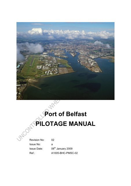
Port of <strong>Belfast</strong><br />
PILOTAGE MANUAL<br />
Revision No: 02<br />
Issue No: a<br />
Issue Date: 08 th January 2009<br />
Ref.:<br />
A1005-BHC-PMSC-02
Section: i Rev No. 02<br />
Title: Document Control Issue No. a<br />
Document Control<br />
Document Name/Reference: Port of <strong>Belfast</strong> – <strong>Pilotage</strong> <strong>Manual</strong><br />
Revision Number: 02<br />
Issue Number:<br />
A<br />
Revision Date: 8 th January 2009<br />
Copy Holder (in red pen):<br />
Copy Number (in red pen):<br />
Signed (Document Controller):<br />
The Document Controller shall:<br />
Document Distribution<br />
Distribute copies of this document and future updates to all relevant persons.<br />
Allocate copy numbers in red pen.<br />
Maintain a distribution list of copy-holders and their number.<br />
Ensure that superseded or obsolete copies are removed from circulation and<br />
destroyed.<br />
The current list of copy-holders is presented below:<br />
Copy No. Copy Holder Role Organisation<br />
Electronically Intranet<br />
Port of <strong>Belfast</strong><br />
Date: 08.01.09 Page: i<br />
Doc: MSMS-<strong>Pilotage</strong> <strong>Manual</strong>
Section: ii Rev No. 02<br />
Title: Table of Contents Issue No. a<br />
TABLE OF CONTENTS<br />
1. GENERAL PILOTAGE INFORMATION ................................................................... 1<br />
1.1 INTRODUCTION ........................................................................................................... 1<br />
1.2 RESPONSIBILITIES ....................................................................................................... 2<br />
1.3 REQUIREMENT FOR PILOTAGE AND PILOTAGE DIRECTIONS ........................................ 2<br />
1.4 CONDITIONS GOVERNING THE PROVISION OF PILOTAGE SERVICES (PILOT AND<br />
PILOTING RESPONSIBILITIES) ................................................................................................... 3<br />
1.5 CRITERIA FOR EXPECTED SHIP STATUS ....................................................................... 3<br />
1.6 CONTACTS VHF/TELEPHONE – PROCEDURES (TO ORDER A PILOT) ............................ 4<br />
2. PILOTAGE PROCEDURES .......................................................................................... 5<br />
2.1 ARRANGEMENT OF A PILOT ........................................................................................ 5<br />
2.2 PREPARATION ............................................................................................................. 5<br />
2.3 PILOT BOARDING AND DISEMBARKING POINTS .......................................................... 6<br />
2.4 TRANSIT TO A VESSEL UNDERWAY ............................................................................. 6<br />
2.5 TRANSIT TO BERTHED VESSEL .................................................................................... 7<br />
2.6 EMBARKING/DISEMBARKING A VESSEL UNDERWAY .................................................. 7<br />
2.7 EMBARKING/DISEMBARKING A BERTHED VESSEL ...................................................... 8<br />
2.8 ASSESSING THE VESSEL CONDITION AND STANDARD OF CREW .................................. 8<br />
2.9 PILOT/MASTER EXCHANGE OF INFORMATION ............................................................. 8<br />
2.10 TRANSITING THE PILOTAGE DISTRICT ......................................................................... 9<br />
2.11 BERTHING AND UNBERTHING ................................................................................... 10<br />
2.12 WORKING WITH TUGS ............................................................................................... 10<br />
2.13 COMMUNICATIONS .................................................................................................... 10<br />
2.14 REMOTE PILOTAGE ................................................................................................... 10<br />
2.15 OVERCARRIAGE OF PILOTS ....................................................................................... 10<br />
2.16 NUMBER OF PILOTS ................................................................................................... 10<br />
2.17 SAFETY EQUIPMENT ................................................................................................. 10<br />
3. ANCHORAGES, PROHIBITED, RECOMMENDED, AUTHORISED ................. 11<br />
3.1 GAS PIPELINES .......................................................................................................... 11<br />
3.2 CONTINGENCY PLAN ................................................................................................. 11<br />
4. AREAS OF SPECIAL CONCERNS ............................................................................ 13<br />
4.1 BARNETT DOCK ........................................................................................................ 13<br />
4.2 TURNING CIRCLE TO RICHARDSON WHARF .............................................................. 13<br />
4.3 DANGERS AND SHOALS ............................................................................................. 13<br />
5. TIDAL CONSIDERATIONS, RANGE AND RATE ................................................. 14<br />
5.1 FRESH/CURRENT EFFECT ........................................................................................... 14<br />
6. TUGS ............................................................................................................................... 15<br />
6.1 MINIMUM TUG REQUIREMENTS ................................................................................ 15<br />
7. NOTICE TO MARINERS AND STANDING ORDERS ........................................... 16<br />
7.1 NOTICES TO MARINERS CURRENTLY IN FORCE FOR BELFAST ................................... 16<br />
Date: 08.01.09 Page: i<br />
Doc: MSMS-<strong>Pilotage</strong> <strong>Manual</strong>
Section: ii Rev No. 02<br />
Title: Table of Contents Issue No. a<br />
7.2 STANDING ORDERS CURRENTLY IN FORCE FOR BELFAST ......................................... 16<br />
8. BELFAST HARBOUR SPECIAL COLLISION REGULATIONS ......................... 17<br />
8.1 REDUCED VISIBILITY – ONE WAY PILOTAGE ............................................................. 17<br />
8.2 TOWAGE PROCEDURE IN REDUCED VISIBILITY .......................................................... 17<br />
8.3 CHANNEL PRIORITIES................................................................................................ 17<br />
9. PASSAGE PLANS ......................................................................................................... 19<br />
9.1 INTRODUCTION ......................................................................................................... 19<br />
9.2 RE-ASSESSING THE PLAN .......................................................................................... 19<br />
10. PILOT ROSTER PATTERN.................................................................................... 20<br />
11. PROMULGATION OF PILOTAGE INFORMATION ........................................ 21<br />
12. AUTHORISATION OF PILOTS ............................................................................. 22<br />
12.1 STANDARD PILOT AUTHORISATION (COPY).............................................................. 23<br />
12.2 TERMS AND CONDITIONS OF WHICH AN AUTHORISATION IS MADE ........................... 24<br />
13. TRAINING EXAMINATION AND RECRUITMENT ......................................... 26<br />
13.1 PILOT AUTHORISATION PROCEDURE ......................................................................... 26<br />
13.2 EXAMINATION CRITERIA ........................................................................................... 30<br />
13.3 EXAMINATION BOARD .............................................................................................. 31<br />
13.4 ONGOING TRAINING IDENTIFICATION/CONTINUED COMPETENCE ............................. 31<br />
13.5 RECRUITMENT .......................................................................................................... 31<br />
14. PILOT EXEMPTION CERTIFICATE ................................................................... 32<br />
14.1 PILOT EXEMPTION CERTIFICATE PROCEDURE ........................................................... 32<br />
14.2 MANAGEMENT OF PECS ........................................................................................... 33<br />
15. ACCIDENT/INCIDENT REPORT ......................................................................... 38<br />
15.1 PROCEDURES ............................................................................................................ 38<br />
15.2 MARINE ACCIDENT INVESTIGATION PROCESS .......................................................... 39<br />
16. PERFORMANCE MONITORING AND SYSTEM AUDIT ................................ 40<br />
APPENDIXES ...................................................................................................................... 1-1<br />
1. PILOTAGE DIRECTIONS ........................................................................................ 1-1<br />
1.1 LIMIT OF COMPULSORY PILOTAGE AREA ................................................................ 1-1<br />
1.2 PILOTAGE REQUIREMENTS ...................................................................................... 1-2<br />
2. NAVIGATION CHANNELS & BERTHS IN THE PORT OF BELFAST ........... 2-1<br />
2.1 INTRODUCTION ....................................................................................................... 2-1<br />
2.2 NAVIGATION CHANNELS & BERTHS ....................................................................... 2-1<br />
2.3 CONTROLLING DEPTHS ............................................................................................ 2-3<br />
3. BERTHING RISK ASSESSMENT ............................................................................ 3-1<br />
3.1 INTRODUCTION ....................................................................................................... 3-1<br />
Date: 08.01.09 Page: ii<br />
Doc: MSMS-<strong>Pilotage</strong> <strong>Manual</strong>
Section: ii Rev No. 02<br />
Title: Table of Contents Issue No. a<br />
3.2 RISK ASSESSMENT METHODOLOGY ........................................................................ 3-1<br />
3.3 RESULTS – BERTHING RISK ASSESSMENT ............................................................... 3-3<br />
4. NAVIGATIONAL RISK ASSESSMENT ................................................................. 4-1<br />
4.1 INTRODUCTION ....................................................................................................... 4-1<br />
4.2 METHODOLOGY ...................................................................................................... 4-1<br />
4.3 RESULTS ................................................................................................................. 4-5<br />
4.4 2008 REVIEW PROCESS ........................................................................................... 4-6<br />
4.5 RECOMMENDATIONS ............................................................................................... 4-6<br />
4.6 ADDITIONAL COMMENTS MADE ............................................................................. 4-9<br />
4.7 RISK ASSESSMENT RECORDS ................................................................................ 4-11<br />
5. BELFAST PILOT/MASTER EXCHANGE FORM ................................................ 5-1<br />
6. PASSAGE PLAN PRO-FORMA ............................................................................... 6-1<br />
7. PASSAGE PLANS ....................................................................................................... 7-1<br />
7.1 INBOUND PASSAGE PLAN FROM PILOT BOARDING POINT 1 MILE E OF THE FW/B:.... 7-1<br />
7.2 OUTBOUND PASSAGE PLAN TO THE FAIRWAY BUOY .............................................. 7-3<br />
8. PILOT PROGRESSION LOG ................................................................................... 8-1<br />
9. INFORMATION FOR PEC ....................................................................................... 9-1<br />
9.1 BELFAST LOUGH AND VICTORIA CHANNEL - LIGHTS ON NORTH SIDE .................... 9-1<br />
9.2 BELFAST LOUGH AND VICTORIA CHANNEL - LIGHTS ON SOUTH SIDE .................... 9-2<br />
9.3 DOCK ENTRANCES AND CHANNELS ......................................................................... 9-6<br />
10. PILOTAGE EXEMPTION CERTIFICATE CHECKLIST ............................. 10-1<br />
11. PEC TRIPPING LOG ........................................................................................... 11-1<br />
12. PILOT EXEMPTION CERTIFICATE QUESTIONNAIRE ............................ 12-1<br />
13. MARINE SAFETY REPORT .............................................................................. 13-1<br />
14. THE EMBARKATION AND DISEMBARKATION OF PILOTS – CODE OF<br />
SAFE PRACTICE ............................................................................................................. 14-1<br />
15. PILOT’S BRIDGE RESOURCE ASSESSMENT .............................................. 15-1<br />
16. SYLLABUS FOR MARINE PILOT TRAINING .............................................. 16-1<br />
Date: 08.01.09 Page: iii<br />
Doc: MSMS-<strong>Pilotage</strong> <strong>Manual</strong>
Section: 1 Rev No. 02<br />
Title: General <strong>Pilotage</strong> Information Issue No. a<br />
1. GENERAL PILOTAGE INFORMATION<br />
1.1 Introduction<br />
This <strong>Manual</strong> considers the powers and duties that harbour authorities have to<br />
provide a <strong>Pilotage</strong> service as well as detailing most of the required pilot information<br />
and requirements in use. The Code recommends that the use of the harbour<br />
authority’s powers follow these general principles:<br />
A. <strong>Harbour</strong> authorities are accountable for the duty to provide an efficient<br />
pilotage service; and for keeping the need for <strong>Pilotage</strong> and the service<br />
provided under constant and formal review.<br />
B. <strong>Harbour</strong> authorities should therefore exercise control over the provision of the<br />
service, including the use of <strong>Pilotage</strong> directions, and the authorisation,<br />
examination, employment status and training of pilots, as per existing<br />
contract.<br />
C. <strong>Pilotage</strong> should be fully integrated with other port safety services under<br />
harbour authority control.<br />
D. Authorised pilots are accountable to their authorising authority for the use they<br />
make of their authorisation: harbour authorities should have contracts with<br />
authorised pilots, regulating the conditions under which they work – including<br />
procedures for resolving disputes.<br />
Date: 08.01.09 Page: 1<br />
Doc: MSMS-<strong>Pilotage</strong> <strong>Manual</strong>
Section: 1 Rev No. 02<br />
Title: General <strong>Pilotage</strong> Information Issue No. a<br />
1.2 Responsibilities<br />
The <strong>Harbour</strong> Master has the overall responsibility for the operational aspects of<br />
managing pilotage within the Port of <strong>Belfast</strong>. However, the ultimate responsibility<br />
and accountability lie with the <strong>Harbour</strong> Commissioners to ensure that all the<br />
necessary systems are in place to support this process.<br />
SAFETY SECURITY AND<br />
ENVIROMENT COMMITEE<br />
BELFAST HARBOUR<br />
COMMISSIONERS<br />
DUTY HOLDER<br />
(OPERATIONS DIRECTOR)<br />
HARBOUR MASTER<br />
PILOTS<br />
Figure 1-1<br />
Responsibilities Overview for <strong>Pilotage</strong><br />
1.3 Requirement for <strong>Pilotage</strong> and <strong>Pilotage</strong> Directions<br />
The requirement for <strong>Pilotage</strong> within the Port of <strong>Belfast</strong> is determined using risk<br />
assessment, which forms the basis for preparing the <strong>Pilotage</strong> Directions (Appendix<br />
1).<br />
Risk assessments like Berthing Risk Assessment (Appendix 3) or Navigational Risk<br />
Assessment (Appendix 4) and the directions are reviewed to give account to<br />
changes in Port operations and any variations in navigational practices within the<br />
Port limits. The maximum period between each review is 3 years.<br />
Before issuing a revision to the requirement for <strong>Pilotage</strong> or the <strong>Pilotage</strong> directions,<br />
the Port of <strong>Belfast</strong> consults with ship owners that use the Port, and those who<br />
conduct operations within the Port, including towage companies, pilot boat<br />
coxswains and the pilots. The process is undertaken through correspondence and<br />
workshops with feedback and findings being retained for audit.<br />
The requirement for <strong>Pilotage</strong> and the <strong>Pilotage</strong> directions are circulated through the<br />
Admiralty List of Radio Signals (ALRS). In addition they can be obtained from Port<br />
Operations upon request and the Port’s website www.belfast-harbour.co.uk.<br />
Date: 08.01.09 Page: 2<br />
Doc: MSMS-<strong>Pilotage</strong> <strong>Manual</strong>
Section: 1 Rev No. 02<br />
Title: General <strong>Pilotage</strong> Information Issue No. a<br />
1.4 Conditions Governing the Provision of <strong>Pilotage</strong> Services (Pilot and<br />
Piloting Responsibilities)<br />
The pilots are responsible to the <strong>Harbour</strong> Master; however, during the act of <strong>Pilotage</strong><br />
they are also responsible to the Master of the vessel being piloted.<br />
As part of the agreement with the Master they are entrusted with the safety of the<br />
vessel they are in conduct of and the safe direction of vessels in support, It is noted<br />
that the Masters and crew of these vessels hold ultimate responsibility for their own<br />
vessel and crew.<br />
1.5 Criteria for Expected Ship Status<br />
A pilot may require the Master of any ship he/she is piloting to declare its draught,<br />
length and beam, and such other information relating to the ship or its cargo as the<br />
Pilot specifies and is necessary to enable him/her to carry his/her pilot duties.<br />
The Master of a ship must bring to the pilots attention defects or matters particular to<br />
the ship and its machinery and equipment, which are known to him/her and likely to<br />
affect the navigation of the ship.<br />
An authorised pilot engaged in the berthing and unberthing of a vessel in the U.K.,<br />
must immediately inform the <strong>Harbour</strong> Authority whenever they learn in the course of<br />
their normal duties that there are deficiencies which may prejudice the safe<br />
navigation of the vessel, or which may pose a threat of harm to the environment the<br />
<strong>Harbour</strong> Authority shall immediately inform the MCA.<br />
Date: 08.01.09 Page: 3<br />
Doc: MSMS-<strong>Pilotage</strong> <strong>Manual</strong>
Section: 1 Rev No. 02<br />
Title: General <strong>Pilotage</strong> Information Issue No. a<br />
1.6 Contacts VHF/Telephone – Procedures (to Order a Pilot)<br />
In order to book a pilot call <strong>Belfast</strong> <strong>Harbour</strong> on VHF Channel 12 or phone numbers<br />
+44(0)28 9055 3016 or +44(0)28 9055 3504.<br />
Date: 08.01.09 Page: 4<br />
Doc: MSMS-<strong>Pilotage</strong> <strong>Manual</strong>
Section: 2 Rev No. 02<br />
Title: <strong>Pilotage</strong> Procedures Issue No. a<br />
2. PILOTAGE PROCEDURES<br />
2.1 Arrangement of a Pilot<br />
The arrangement of a pilot is co-ordinated by the VTS operator using the Marine<br />
Information System at the Port of <strong>Belfast</strong>. The MIS holds the ETAs and ETDs for all<br />
vessel entering moving within and departing the Port, detailing the characteristics of<br />
the vessel, its <strong>Pilotage</strong> and Towage requirements and whether pilotage is from the<br />
inner or outer pilot boarding/disembarking point.<br />
If it is impractical to provide a pilot at the designated boarding point, the vessel is<br />
delayed until this can be done.<br />
No vessel requiring a pilot is permitted to navigate within Port limits without a pilot<br />
unless in exceptional circumstances which is always under the direction of the<br />
<strong>Harbour</strong> Master and is recorded as an unusual operation.<br />
2.2 Preparation<br />
Once assigned to a vessel, the pilot acquires the relevant data to facilitate the act of<br />
<strong>Pilotage</strong>. This includes collecting information on:<br />
The vessel,<br />
Any defects,<br />
The environmental conditions,<br />
The vessel’s intentions and requirements,<br />
The forecast,<br />
Any other factors affecting the passage and berth<br />
Information on the vessel and its requirements can be obtained from the MIS, and<br />
the vessel’s pre-arrival form (ADCF).<br />
This preparation is co-ordinated with the VTS operator who signs a checklist to<br />
confirm that all systems will be in place when required. Only then is the vessel<br />
allowed to enter Port limits, otherwise, it is delayed.<br />
The vessel will also be delayed if for any reason the pilot is uncomfortable about the<br />
proposed operation. In this instance a review is held with the <strong>Harbour</strong> Master to find<br />
a safe solution. This process is recorded on an IRIMS report.<br />
In instances when a pilot is required to go directly from one ship to another, the VTS<br />
operator will plan the operation and issue the pilot with the required details. If critical<br />
information cannot be provided, the vessel is delayed until the pilot has all the<br />
required information.<br />
Date: 08.01.09 Page: 5<br />
Doc: MSMS-<strong>Pilotage</strong> <strong>Manual</strong>
Section: 2 Rev No. 02<br />
Title: <strong>Pilotage</strong> Procedures Issue No. a<br />
2.3 Pilot Boarding and Disembarking Points<br />
The designated boarding and disembarking points at the Port of <strong>Belfast</strong> are seaward<br />
of beacon 12 and 1 mile East of the Fairway buoy. These points are reviewed as part<br />
of the planning for each act of <strong>Pilotage</strong> and if considered inappropriate for any<br />
reason the pilot will arrange an alternative boarding point through consultation with<br />
the <strong>Harbour</strong> Master and the vessel Master. This process is reported by the VTS<br />
using the IRIMS report and forwarded to the <strong>Harbour</strong> Master.<br />
ETA to the Fairway Buoy called in by arriving vessels 2 hours before arrival at the<br />
Fairway Buoy giving required details, and vessels should then continuously monitor<br />
channel 12. Vessels will then be instructed to call again 15 minutes before arrival on<br />
channel 12 for traffic clearance to pass to their specific berth.<br />
Pilot Boarding Position:<br />
Pilot boards in a position a minimum of 1 mile east of the Fairway Buoy, there being<br />
sufficient sea room for manoeuvre, a reasonable and steady depth of water and,<br />
where normally, the area is sheltered from the more exposed elements of<br />
predominant winds and weather.<br />
Vessels with a LOA of less than 100m, not carrying hazardous goods in bulk, may<br />
opt for boarding at no 12 beacon; however a full pilotage may be imposed at the<br />
<strong>Harbour</strong>master’s discretion.<br />
Pilot boarding will be arranged between vessel and the VTS. It should be noted, and<br />
taken into consideration, that vessels may not be able to give an effective lee when<br />
in the channel at no.12 beacon.<br />
VTS will arrange with the vessel the side and height for placing of the pilot ladder,<br />
and whether the vessel might be expected to have to give the pilot boat a lee.<br />
The master and Pilot shall ensure that all vessels have sufficient water, compared to<br />
their draught, to make passage to their berth, always taking into account any<br />
adjustments for Squat. All vessels will have a minimum clearance under the keel of<br />
10% or 1m whichever is the greater. However, some azipod vessels may require a<br />
greater under keel clearance, as experienced with some cruise liners requiring 1.8m.<br />
If not passing in on arrival, a “pass in” time may be given to the vessel due to<br />
congestion, tidal or any other operational constraints.<br />
Pilot boarding should be as per the THE EMBARKATION AND DISEMBARKATION<br />
OF PILOTS, CODE OF SAFE PRACTICE Revised March 2007.<br />
2.4 Transit to a Vessel Underway<br />
Transit to a vessel will not commence until authorisation is received from the VTS<br />
operator. This will only be given following confirmation that planning has been<br />
performed and all systems will be in place when required. There is a Code of Safe<br />
Date: 08.01.09 Page: 6<br />
Doc: MSMS-<strong>Pilotage</strong> <strong>Manual</strong>
Section: 2 Rev No. 02<br />
Title: <strong>Pilotage</strong> Procedures Issue No. a<br />
Practice: The Embarkation and Disembarkation of Pilots which gives guidance to the<br />
best of safe practice to all those involved in the <strong>Pilotage</strong> service (12).<br />
During transit the coxswain of the pilot board radios the vessel to:<br />
Confirm the vessel’s required course and speed;<br />
Confirm the side of boarding/disembarking and ensure the ladder is in position<br />
at the appropriate height;<br />
Arrange for a lee to be made available by the vessel.<br />
During outward passage to board the pilot remains inside the cabin until the pilot<br />
boat is at reduced speed and in the lee of the vessel. The pilot also monitors the Port<br />
Control VHF channel while in the cabin to ensure familiarity with other movements in<br />
the area and any change in circumstances that may occur.<br />
When en route to board a vessel the pilot should attempt to evaluate the conduct of<br />
the vessel prior to boarding. This is achieved through assessment of indicators such<br />
as:<br />
Shortcomings in communications and language problems<br />
The vessel’s navigation and signal lights<br />
The condition and rigging of the pilot ladder<br />
In the event of the coxswain considering the approach or holding of position<br />
alongside the vessel unsafe he has the authority to abort the operation.<br />
The pilot has the authority to abort the operation if conditions are such that boarding<br />
is considered unsafe.<br />
2.5 Transit to Berthed Vessel<br />
Transit to a berthed vessel is either by car or pilot boat. During transit the pilot<br />
adheres to the regulations set by the Port of <strong>Belfast</strong> for all users.<br />
2.6 Embarking/Disembarking a Vessel Underway<br />
VHF communication is maintained between the coxswain and Master of the vessel at<br />
all times during the embarking or disembarking of the vessel.<br />
The weather and sea state conditions are monitored and if conditions are considered<br />
to be unsafe as per the Code of Safe Practice for Marine Pilots (Appendix 14) the<br />
operation is aborted. The pilot boat coxswain and pilot both have the authority to<br />
abort the proposed operation.<br />
Pilot transfer is only performed once a responsible crew member, who is in direct<br />
communication with the ship’s bridge, is stationed at the ladder or point of access to<br />
the ship’s deck.<br />
Date: 08.01.09 Page: 7<br />
Doc: MSMS-<strong>Pilotage</strong> <strong>Manual</strong>
Section: 2 Rev No. 02<br />
Title: <strong>Pilotage</strong> Procedures Issue No. a<br />
If the ladder is not placed in a safe position the Master of the vessel is asked to<br />
reposition it and if required delays the vessel. This event is reported to the <strong>Harbour</strong><br />
Master using an IRISM report.<br />
Once pilot transfer is complete the pilot boat moves away from the vessel and the<br />
coxswain radios confirmation to the vessel’s Master.<br />
If for any reason it is not possible to transfer the pilot onboard an inbound vessel, the<br />
vessel is delayed (or contingency measure implemented if vessel is inbound at No.<br />
12) until an alternative course of action is agreed.<br />
A pilot will not leave the vessel until the act of <strong>Pilotage</strong> is completed and he has the<br />
authorisation of the Master of the vessel.<br />
2.7 Embarking/Disembarking a Berthed Vessel<br />
Prior to embarking/disembarking a berthed vessel the pilot must confirm through the<br />
VTS that the vessel is safely moored.<br />
The pilot must transfer by a proper gangway and at night the pilot should ensure that<br />
suitable lighting is available to embark/disembark safely. If suitable lighting is not<br />
provided this should be reported to the Port Controllers so they can start an IRIMS<br />
report.<br />
2.8 Assessing the Vessel Condition and Standard of Crew<br />
During the Act of <strong>Pilotage</strong> the pilot will observe the condition of the vessel and the<br />
standard of the crew and report any deficiencies observed to the Port Controllers,<br />
who will start an IRIMS report.<br />
Typically the pilot may observe issues relating to:<br />
General appearance of the vessel;<br />
Efficiencies of the boarding arrangements;<br />
State of bridge and standard of equipment (including a Port of <strong>Belfast</strong> chart);<br />
Language skills and co-operation of the bridge personnel;<br />
Extent of vessel’s own passage plan;<br />
Number of persons on bridge.<br />
The pilot will decide whether any observations require him to revise his passage plan<br />
before he commences the act of <strong>Pilotage</strong>.<br />
2.9 Pilot/Master Exchange of Information<br />
Once on the bridge, the pilot confirms the ship’s position, course and speed with the<br />
Master.<br />
Date: 08.01.09 Page: 8<br />
Doc: MSMS-<strong>Pilotage</strong> <strong>Manual</strong>
Section: 2 Rev No. 02<br />
Title: <strong>Pilotage</strong> Procedures Issue No. a<br />
The Port of <strong>Belfast</strong> Pilot/Master Exchange Form (Appendix 5) is completed and<br />
signed to ensure both parties are aware of the proposed operation. As part of this<br />
process the passage plan (Appendix 6) proposed for the act of <strong>Pilotage</strong> is reviewed<br />
and agreed by the two parties. This information is also made known to other<br />
personnel on the bridge of the vessel.<br />
The check of passage plan should occur as soon as possible, after boarding vessel<br />
and arriving on the Bridge, so that both Master and Pilot are in agreement. The initial<br />
Pilot/Master exchange should include sighting the Pilot Card, information regarding<br />
navigational procedures, prevailing conditions and practices, and the ship’s<br />
characteristics. This exchange is usually a continuous process and may continue<br />
throughout the act of <strong>Pilotage</strong>. (A960) “It should be clearly understood that any<br />
passage plan is a basic indication of preferred intention and both the Pilot and<br />
Master should be prepared to depart from it when circumstances so dictate”. (A960).<br />
Minimum support expected for the pilot from the bridge team.<br />
It is important that, upon the pilot boarding the vessel, and before the pilotage<br />
commences, the Pilot, the Master and the bridge personnel are aware of their<br />
respective roles in the safe passage of the ship as detailed by the best practices of<br />
Bridge Resource Management. A clear understanding of who is conducting the shiphandling<br />
manoeuvre, is necessary, with all alterations to engines, bowthruster and<br />
helm to be confirmed verbally. It should be established what abort procedures are<br />
available, and, after the final point of commitment, (Abort Line), what, if any,<br />
contingency plans are available. All communications between the Master and any<br />
other person involved in the manoeuvre are to be in English. (A960).<br />
If during this process it is established that the information from the agent is incorrect<br />
and the pilot is not authorised to conduct the vessel, the vessel will be delayed until<br />
an authorised pilot becomes available. This will be reported using the pro forma<br />
Marine Safety Report form (Appendix 13).<br />
During the passage it is the responsibility of the pilot to keep the bridge team and the<br />
VTS operator informed of this intentions.<br />
2.10 Transiting the <strong>Pilotage</strong> District<br />
Once in the <strong>Pilotage</strong> District, the pilot operates under the International Regulations<br />
for Prevention of Collision at Sea.<br />
For a vessel arriving in the Port of <strong>Belfast</strong>, on nearing the berth the pilot contacts the<br />
boatmen to ensure that they are prepared to moor the vessel. In the event that they<br />
are not available, the vessel’s speed will be reduced to provide sufficient time or the<br />
vessel will be taken alongside the berth if this is considered safe practice. In the<br />
event of a vessel being inbound to No. 12, contingency measures may be<br />
implemented. In either case this event is reported by the VTS using the IRIMS report<br />
and forwarded to the <strong>Harbour</strong> Master.<br />
Date: 08.01.09 Page: 9<br />
Doc: MSMS-<strong>Pilotage</strong> <strong>Manual</strong>
Section: 2 Rev No. 02<br />
Title: <strong>Pilotage</strong> Procedures Issue No. a<br />
2.11 Berthing and Unberthing<br />
The provision of boatmen is organised by the vessel’s agent in accordance with the<br />
Code of Practice for Boatmen. If the pilot considers that the task has not been<br />
carried out in a safe manner he is required to report this using the Port’s Marine<br />
Safety Report form (Appendix 13) and forwarded to the <strong>Harbour</strong> Master.<br />
2.12 Working with Tugs<br />
A component of the Pilot’s authorisation process is the level of familiarity with the<br />
operation of tugs. It is the responsibility of the pilot to maintain this knowledge, which<br />
is assessed as part of the <strong>Pilotage</strong> Exam (Appendix 16).<br />
2.13 Communications<br />
The pilots have a portable radio, which is their main means of communication with<br />
other vessels, services and Port Control. Sound and light signals can also be used<br />
when appropriate. Mobile phones are not to be switched on or used onboard any<br />
vessels, without the authorisation of the master.<br />
2.14 Remote <strong>Pilotage</strong><br />
Remote pilotage is not standard practice at the Port of <strong>Belfast</strong>. If required this is<br />
planned as an unusual operation and formally recorded for auditing purposes.<br />
2.15 Overcarriage of Pilots<br />
Overcarriage of pilots can result when it is considered unsafe to perform a pilot<br />
transfer form an outbound vessel. In this event a review is held between the <strong>Harbour</strong><br />
Master, Pilot and Pilot boat coxswain to determine the best course of action, which<br />
will also give consideration to providing cover for the overcarried pilot. All<br />
arrangements for the repatriation of an overcarried pilot are the responsibility of the<br />
ship’s agent. This process is recorded using the pro forma Marine Safety Report<br />
form (Appendix 13).<br />
2.16 Number of Pilots<br />
Almost all vessel entering and departing the Port of <strong>Belfast</strong> under <strong>Pilotage</strong> require<br />
one pilot. Any vessel requiring more than one pilot will be considered as an unusual<br />
operation.<br />
2.17 Safety Equipment<br />
The pilots are in possession of:<br />
Approved pilot coat<br />
Light<br />
Portable VHF<br />
Protective shoes and trousers<br />
Date: 08.01.09 Page: 10<br />
Doc: MSMS-<strong>Pilotage</strong> <strong>Manual</strong>
Section: 3 Rev No. 02<br />
Title: Anchorages, Prohibited, Recommended, Authorised Issue No. a<br />
3. ANCHORAGES, PROHIBITED, RECOMMENDED,<br />
AUTHORISED<br />
There are no designated anchorages in <strong>Belfast</strong> Lough. Vessels are free to anchor<br />
anywhere they deem to be safe Eastward of the <strong>Harbour</strong> limits.<br />
3.1 Gas Pipelines<br />
It must be noted that a gas pipeline crosses the Channel between and just east of<br />
no.9 beacon and no.10 beacon and that any emergency use of the anchor in this<br />
area is prohibited.<br />
3.2 Contingency Plan<br />
Due to shallower water close by to the north, vessels of deeper draught may prefer<br />
to abort their passage inbound by turning to the south before buoys no.3 + 4, limited<br />
by 8.8m below C.D. or before beacons no.5 + 6, dependent on their draught, limited<br />
to 5m below C.D.<br />
When committed to the Channel her contingency planning will be limited. A vessel of<br />
short enough LOA, may be able to turn short round, whereas a vessel of greater<br />
LOA may have to consider going to the Turning Circle to turn.<br />
Tugs are available in the Port of <strong>Belfast</strong> having various powers, and various periods<br />
of notice.<br />
Prior to the Pilot boarding, the vessel shall have her engines ready for immediate<br />
manoeuvre; her anchors cleared for immediate use and, with Pilot onboard, shall<br />
proceed at a safe speed appropriate to the prevailing circumstances and conditions.<br />
Prior to passing the Fairway Buoy, Pilot and Master shall ensure that the vessel has<br />
Traffic Clearance from the VTS to proceed to its berth. They may ask for a Traffic<br />
Report, for the visibility, wind speed and direction in the harbour and the height of<br />
tide if relevant. If required by the vessel they will also ensure that any tugs assigned<br />
are ready and available and will meet the ship as directed, at No.14 beacon, or, if<br />
deemed necessary, at the Fairway Buoy. It may also be prudent at this time to ask<br />
the VTSO if the berth is clear and if boatmen are ready for the vessel.<br />
As the vessel passes the Fairway Buoy, report the fact to the VTS on channel 12,<br />
the normal working / traffic VHF channel.<br />
If the vessel has a catastrophic failure of propulsion then she may have to consider<br />
for example a running moor, or any other manoeuvre which should lead to a safe<br />
conclusion.<br />
Date: 08.01.09 Page: 11<br />
Doc: MSMS-<strong>Pilotage</strong> <strong>Manual</strong>
Section: 3 Rev No. 02<br />
Title: Anchorages, Prohibited, Recommended, Authorised Issue No. a<br />
It must be noted that a gas pipeline crosses the Channel between and just east<br />
of no.9 beacon and no.10 beacon and that any emergency use of the anchor in<br />
this area is prohibited.<br />
Vessels will report inbound at no.12 beacon where they receive a traffic update from<br />
the VTS. Vessels will ensure their speed is reduced appropriately for the passing of<br />
vessels on berths OB4, and VT4 in particular.<br />
Vessels will further report to the VTS when making any unusual manoeuvres.<br />
On approaching the berth vessels will make contact with their boatmen and ensure<br />
that they are ready for their arrival, and that both parties have the same berthing<br />
instructions.<br />
Finally vessels will report to the VTS when made fast alongside her berth.<br />
Date: 08.01.09 Page: 12<br />
Doc: MSMS-<strong>Pilotage</strong> <strong>Manual</strong>
Section: 4 Rev No. 02<br />
Title: Areas of special concerns Issue No. a<br />
4. AREAS OF SPECIAL CONCERNS<br />
4.1 Barnett Dock<br />
When approaching Barnett Dock it must be remembered that vessels may<br />
experience a northerly cross current as they approach the cut, especially after heavy<br />
rain, or during the height of the Ebb.<br />
When approaching Barnett Dock it must be remembered that anchors must not be<br />
used until clear of the fiber optic cable across the cut.<br />
4.2 Turning Circle to Richardson Wharf<br />
The Pilot should recommend that if any vessel is turning, with tugs in attendance, in<br />
the vicinity of OB4, or Richardson’s Wharf, or any other berth, where vessels<br />
carrying hazardous cargo in bulk are likely to be berthed, that these tugs be made<br />
fast to that vessel.<br />
4.3 Dangers and Shoals<br />
Vessels whose passage plan places them in the vicinity of the shoals in way of<br />
no.20, no.21, Daisy and M2, or in the vicinity of the shallower water off the SRQ shall<br />
be mindful of the dangers, and inform the Master of the potential interactions that<br />
may be encountered.<br />
Date: 08.01.09 Page: 13<br />
Doc: MSMS-<strong>Pilotage</strong> <strong>Manual</strong>
Section: 5 Rev No. 02<br />
Title: Tidal Considerations, Range and Rate Issue No. a<br />
5. TIDAL CONSIDERATIONS, RANGE AND RATE<br />
Table 5-1<br />
Levels of Tides at <strong>Belfast</strong><br />
Above <strong>Harbour</strong> Datum<br />
Feet Metres<br />
Mean High Water, Spring Tides 11.4 3.5<br />
Mean High Water, Neap Tides 9.7 2.9<br />
Mean Low Water, Spring Tides 1.4 0.4<br />
Mean Low Water, Neap Tides 3.5 1.1<br />
Highest Spring Tide on Record:<br />
5 th January 1991 16.07 4.9<br />
Average Range of Tide:<br />
(At Spring Tides) 10.0 3.1<br />
(At Neap Tides) 6.2 1.9<br />
Time of High Water at the full and change of the moon, 10h 35m.<br />
The Tidal current runs at the rate of 0.33 knots on Spring tides, and 0.25 knots on<br />
Neap tides.<br />
<strong>Harbour</strong> and Ordnance Datum:<br />
<strong>Harbour</strong> Datum Level of No. 2 Clarendon Dry Dock Sill, which is also Admiralty Chart<br />
Datum.<br />
Ordnance Datum (1958)<br />
6.61 feet (2.0 metres) above <strong>Harbour</strong> datum<br />
Information taken from Port of <strong>Belfast</strong> Tide Table 2008<br />
5.1 Fresh/current effect<br />
Currents in the Port of <strong>Belfast</strong> are estimated to be a maximum of 1 – 1.5 knots.<br />
Date: 08.01.09 Page: 14<br />
Doc: MSMS-<strong>Pilotage</strong> <strong>Manual</strong>
Section: 6 Rev No. 02<br />
Title: Tugs Issue No. a<br />
6. TUGS<br />
6.1 Minimum Tug Requirements<br />
Notice to Mariners num. 4 of 2.009.<br />
Date: 08.01.09 Page: 15<br />
Doc: MSMS-<strong>Pilotage</strong> <strong>Manual</strong>
Section: 7 Rev No. 02<br />
Title: Notice to Mariners Issue No. a<br />
7. NOTICE TO MARINERS AND STANDING ORDERS<br />
7.1 Notices to Mariners Currently in Force for <strong>Belfast</strong><br />
Notices to Mariners currently in force for the Port of <strong>Belfast</strong> are shown at the Port’s<br />
website www.belfast-harbour.co.uk.<br />
7.2 Standing Orders Currently in Force for <strong>Belfast</strong><br />
There is not any Standing Order currently in force for <strong>Belfast</strong> <strong>Harbour</strong>.<br />
Date: 08.01.09 Page: 16<br />
Doc: MSMS-<strong>Pilotage</strong> <strong>Manual</strong>
Section: 8 Rev No. 02<br />
Title: <strong>Belfast</strong> <strong>Harbour</strong> Special Collision Regulations Issue No. a<br />
8. BELFAST HARBOUR SPECIAL COLLISION REGULATIONS<br />
8.1 Reduced Visibility – One way pilotage<br />
When visibility drops below 1 nautical mile activate the foghorns in the area of low<br />
visibility and record this action in the Port Control Log.<br />
If visibility falls or is expected to fall below 0.5 nautical mile contact the duty Deputy<br />
<strong>Harbour</strong> Master to obtain authorisation to implement a one-way traffic movement<br />
system within the entire channel. Record this action in the Port Control Log.<br />
Implement the one-way system with a Securité Broadcast, inform affected vessels<br />
and organise traffic accordingly. Pilot boats and tugs are exempt from complying with<br />
one way system whilst in force. However, these vessels shall proceed at a safe<br />
speed adapted to the prevailing circumstances and conditions of restricted visibility,<br />
and comply with the Collision Regs in particular Rule 19.<br />
Other adverse conditions are considered on a case-by-case basis and the<br />
appropriate measures are implemented based on the instruction of the <strong>Harbour</strong><br />
Master.<br />
8.2 Towage procedure in reduced visibility<br />
Towage is only to be undertaken when visibility is greater than 0.5 miles, and it is not<br />
decreasing.<br />
If visibility reduces below 0.5 miles after the operation has been started, the vessel<br />
must be slowed to minimum safe speed, other vessel movements are to be<br />
suspended and towage must be re-assessed between the Master, Pilot and Tug<br />
Master. VTS/<strong>Harbour</strong> Master must be advised of proposed towage attachments and<br />
intended actions.<br />
A contingency plan should be discussed between Master and Pilot prior to entering<br />
the port during the Master/Pilot exchange, which should include named free berths<br />
which are suitable for that size of vessel. These berths should allow 24 hour access<br />
to boatmen.<br />
No act of <strong>Pilotage</strong> requiring tugs to be undertaken in reduced visibility, without a full<br />
discussion with the tugs, as per the Tug Company’s Operational Guidelines. It is<br />
recommended that, in conditions of reduced visibility, the forward tug only be made<br />
fast in Push/Pull mode to prevent overrunning it.<br />
8.3 Channel Priorities<br />
Passenger vessels will be deemed to be vessels operated with the following<br />
categories: Seacats, Stena Conventional, Stena HSS, Norfolkline, cruise<br />
Date: 08.01.09 Page: 17<br />
Doc: MSMS-<strong>Pilotage</strong> <strong>Manual</strong>
Section: 8 Rev No. 02<br />
Title: <strong>Belfast</strong> <strong>Harbour</strong> Special Collision Regulations Issue No. a<br />
liners, but not vessels carrying less than 12 passengers with no Passenger<br />
Certificate.<br />
All passenger vessels have priority on arrival or sailing under normal<br />
conditions.<br />
When two passenger vessels have priority then vessel on schedule or closest<br />
after schedule will have priority over the other passenger vessel under normal<br />
conditions. Priority will hold past scheduled time until next scheduled vessel<br />
is likely to be affected, then priority ceases and goes to second vessel.<br />
Conventional ferries can be overtaken within port limits by fast ferries.<br />
Fast Ferries passing each other within port limits will do so at a prudent<br />
speed, consistent with safety of vessel and passengers.<br />
Fast Ferries will not attempt to overtake other Fast Ferries unless agreement<br />
has been reached with the Fast Ferry to be overtaken and Port Control has<br />
been informed of the intended manoeuvre.<br />
All passenger vessels will agree passing or overtaking procedure with each<br />
other prior to execution of manoeuvre.<br />
All passenger vessels will communicate with Port Control when entering or<br />
leaving port limits and at No 12 beacon. On arrival they will indicate their<br />
expected swinging area when passing No 12 beacon. On departure they will<br />
give 20 minutes and 5 minutes notice of their intent to sail. All passenger<br />
vessels will keep constant listening watch on Channel 12 to receive shipping<br />
information relating to themselves or other vessels.<br />
All passenger vessels, when occupying an operational berth, will provide Port<br />
Control with means of communication to a responsible officer at all times.<br />
All passenger vessels may pass or overtake tankers in port waters with due<br />
regard to safety of navigation.<br />
A vessel not operating as a passenger ship can overtake a gas carrier.<br />
Gas carriers will only be allowed to pass passenger vessels when<br />
circumstances indicate that unreasonable delay would result from any other<br />
planned movement.<br />
Priorities for passenger vessels will be maintained whenever practicable in<br />
poor weather but safety of navigation is paramount. In fog, port operations<br />
may apply a one way system for shipping movements. Passenger vessels<br />
will have priority in such a system. In strong winds passenger vessel at<br />
greatest risk will have priority over all other vessels.<br />
The <strong>Harbour</strong> Master may temporarily suspend or amend any of these<br />
directions from time to time, without notice, as, in his opinion, may be<br />
necessary.”<br />
Vessels are not permitted to pass or overtake in Herdman or Musgrave<br />
Channels.<br />
Date: 08.01.09 Page: 18<br />
Doc: MSMS-<strong>Pilotage</strong> <strong>Manual</strong>
Section: 9 Rev No. 02<br />
Title: Passage Plans Issue No. a<br />
9. PASSAGE PLANS<br />
9.1 Introduction<br />
Passage Plans should be formalised for each channel, approach and berth<br />
(Appendix 7), in certain simple cases it should give general guidance for any entry<br />
into <strong>Belfast</strong>, in other cases elaborated for particular berths, ships sizes, cargoes,<br />
conditions, tidal constraints, tug allocation, etc.. Particular attention should be paid to<br />
critical port movements i.e. deep drafted vessels to particular berths and awkward<br />
construction that use <strong>Belfast</strong> <strong>Harbour</strong> such as Rig movements.<br />
Passage plans are not immutable. It is important not to restrict the pilots need to<br />
react to unforeseen circumstances, deviations from an agreed plan should be<br />
discussed with the master and VTS when relevant and recorded with reasons,<br />
records need to be kept and simple documents completed by the pilot.<br />
As part of the passage plan the following points must be checked:<br />
• The vessel has sufficient water to transit to the berth.<br />
• There are any diving operations in the port, or any other ongoing operations,<br />
which might impact on the passage plan.<br />
• There any current local Notices to Mariners relevant to the passage.<br />
• There any other vessels that might be relevant to the passage, as on VT1- 4,<br />
OB4, RW, SRQ, or on adjacent berths to the assigned berth.<br />
• Confirmation from the VTSO that the assigned berth is clear and that there is<br />
sufficient room for tugs, if assisting, to manoeuvre.<br />
• All participants (e.g. Master, crew, VTS, tug Skippers and boatmen) know<br />
what is expected of them in carrying out the Passage Plan.<br />
• If the Passage needs a special Risk Assessment.<br />
• Considering a special movement as “Any port movement which requires<br />
resources beyond those normally available within the port and/or a cargo or<br />
vessel, which due to its nature, posses a higher risk than normally managed”.<br />
All Special Movements require a meeting between all parties involved to<br />
clarify all aspects of the Passage Plan and complete operation.<br />
9.2 Re-assessing the Plan<br />
During the act of <strong>Pilotage</strong> itself (enroute to vessel and while on board) it is the<br />
responsibility of the pilot to review the preparations and <strong>Pilotage</strong> plan on an ongoing<br />
basis to ascertain if any amendments are necessary.<br />
If a deviation from the plan is considered VTS are to be informed and circumstances<br />
recorded.<br />
Date: 08.01.09 Page: 19<br />
Doc: MSMS-<strong>Pilotage</strong> <strong>Manual</strong>
Section: 10 Rev No. 02<br />
Title: Pilot Roster Pattern Issue No. a<br />
10. PILOT ROSTER PATTERN<br />
The Port of <strong>Belfast</strong> Pilot roster plan has been established per contractual agreement<br />
as follows:<br />
There must always be two pilots available.<br />
Third pilot available by prior two hours notice.<br />
Fourth pilot available by prior 24 hours notice.<br />
Date: 08.01.09 Page: 20<br />
Doc: MSMS-<strong>Pilotage</strong> <strong>Manual</strong>
Section: 11 Rev No. 02<br />
Title: Promulgation of <strong>Pilotage</strong> Information Issue No. a<br />
11. PROMULGATION OF PILOTAGE INFORMATION<br />
The following mechanisms are used to increase awareness and improve<br />
communications between the <strong>Harbour</strong> and its users:<br />
<strong>Harbour</strong> Directions<br />
Standing orders<br />
Notices to Mariners<br />
ALRS<br />
Marine publications<br />
Newsletter<br />
Advisory Committees<br />
Port website<br />
User groups<br />
Clubs<br />
The <strong>Pilotage</strong> directions are circulated through the ALRS and are available on the<br />
Internet. In addition the directions are issued to all the agents and are available on<br />
request from Port Operations.<br />
Date: 08.01.09 Page: 21<br />
Doc: MSMS-<strong>Pilotage</strong> <strong>Manual</strong>
Section: 12 Rev No. 02<br />
Title: Authorisation of Pilots Issue No. a<br />
12. AUTHORISATION OF PILOTS<br />
A contract for services exists between <strong>Belfast</strong> <strong>Harbour</strong> Commissioners and <strong>Belfast</strong><br />
Lough <strong>Pilotage</strong> Services Limited and details all aspects of recruitment policy.<br />
The Port of <strong>Belfast</strong> has strict procedures governing the authorisation of Pilots to<br />
ensure they are competent for their <strong>Pilotage</strong> duties. The authorities may determine<br />
the qualification in respect of age, physical fitness, time of service, local knowledge,<br />
skill, character and otherwise to be required from persons applying for authorisation<br />
and provide for the examination of such persons.<br />
Authorities should have procedures for re-validating authorisations not less than<br />
every 5 years and should consider re-assessing any authorised pilot who has not<br />
been active for any reason if it considers competence may be in question, authorities<br />
should not allow pilot authorisations to be held by persons who have not been<br />
rostered as a working pilot for more than two years.<br />
The <strong>Harbour</strong> Master maintains a list (Appendix 8) of the restrictions applied to any<br />
pilots operating within the Port of <strong>Belfast</strong>, which is also recorded on the individual<br />
pilot cards and at Port Control.<br />
Date: 08.01.09 Page: 22<br />
Doc: MSMS-<strong>Pilotage</strong> <strong>Manual</strong>
Section: 12 Rev No. 02<br />
Title: Authorisation of Pilots Issue No. a<br />
12.1 Standard Pilot Authorisation (Copy)<br />
BELFAST HARBOUR COMMISSIONERS<br />
The <strong>Belfast</strong> <strong>Harbour</strong> Commissioners, as the Competent <strong>Harbour</strong> Authority for the<br />
Port of <strong>Belfast</strong> and its approaches, in pursuance, and by virtue of, the powers given<br />
them for that purpose in and by the <strong>Pilotage</strong> Act 1987, hereby authorise:<br />
…………………………………………………………………………<br />
to act as a 1 st / 2 nd / 3 rd Class Pilot for the Port of <strong>Belfast</strong> and its approaches.<br />
Signed ………………………………… Date of Issue ……………………………….<br />
<strong>Harbour</strong> Master<br />
Date: 08.01.09 Page: 23<br />
Doc: MSMS-<strong>Pilotage</strong> <strong>Manual</strong>
Section: 12 Rev No. 02<br />
Title: Authorisation of Pilots Issue No. a<br />
12.2 Terms and Conditions of which an Authorisation is made<br />
BELFAST HARBOUR COMMISSIONERS<br />
BELFAST PILOTAGE AREA – AUTHORISATION OF PILOTS<br />
Terms and conditions on which an offer of authorisation is made<br />
An applicant to be authorised as a pilot for the port of <strong>Belfast</strong> and its approaches<br />
shall agree to be bound by the following terms and conditions:<br />
1. That he shall be admitted to membership of <strong>Belfast</strong> Lough <strong>Pilotage</strong> Services<br />
Limited.<br />
2. That he shall reside in a location as being suitable to enable him to attend to his<br />
Duties.<br />
3. That, save as may happen in exceptional circumstances, he shall, so as far as<br />
practicable, take his turn for the pilotage of vessels in accordance with the Working<br />
Rules and according to his class.<br />
4. That, if for any reason, he shall have been boarded on a vessel requiring a pilot of<br />
a superior class; he shall take all steps immediately to advise VTS so that they might<br />
effect a suitable relief.<br />
5. He shall at all times, conduct himself respectfully towards any person who<br />
requires or accepts his services, and shall not use abusive or improper language to<br />
any such person, to any representative of the CHA or to any other pilot and conduct<br />
himself when on duty so as not to bring the pilotage service into disrepute.<br />
6. That he shall not, without any valid reason assigned, fail to join a ship to which he<br />
has been appointed; and that he shall not be intoxicated either when he is required<br />
for duty or when he is on duty.<br />
7. He shall on all occasions whenever an accident or incident has happened to, or<br />
been caused by a vessel while in his charge, report the facts fully and truthfully in<br />
writing, if possible not later than 24 hours following the accident or incident, on the<br />
prescribed form to the <strong>Harbour</strong> Master.<br />
8. That he shall, having observed that a wreck or alteration in a sand bank or<br />
channel has occurred, or that a wreck marking vessel, light ship, light float, buoy,<br />
beacon or perches has been driven away or damaged, or that anything is out of<br />
place or is likely to affect the safety of navigation, report the same as soon as<br />
possible to VTS.<br />
Date: 08.01.09 Page: 24<br />
Doc: MSMS-<strong>Pilotage</strong> <strong>Manual</strong>
Section: 12 Rev No. 02<br />
Title: Authorisation of Pilots Issue No. a<br />
9. That he will hold a valid Medical Certificate (ENG1) and Class 1 unlimited<br />
(STCW95)<br />
10. That he will not wilfully damage any property belonging to the CHA or its<br />
customers that he will take precautions to ensure his own safety while carrying out<br />
his pilotage duties.<br />
Date: 08.01.09 Page: 25<br />
Doc: MSMS-<strong>Pilotage</strong> <strong>Manual</strong>
Section: 13 Rev No. 02<br />
Title: Training Examination and Recruitment Issue No. a<br />
13. TRAINING EXAMINATION AND RECRUITMENT<br />
13.1 Pilot Authorisation Procedure<br />
13.1.1 Pilot Restrictions<br />
The following Pilot restrictions apply within <strong>Belfast</strong>:<br />
(a) A Third Class Pilot may only pilot vessels not exceeding 2000 gross tonnes<br />
(GT)<br />
(b) A Second Class Pilot may only pilot vessels not exceeding 4500 GT<br />
(c) A First Class Pilot may only:<br />
i). During the first 6 months, vessels not exceeding 8000 GT<br />
ii). During the second 6 months, vessels not exceeding 12000 GT<br />
iii). During the third 6 months, vessels not exceeding 20000 GT<br />
(d) After 18 months as a First Class Pilot a pilot may pilot vessels of any size<br />
anywhere within the ports limits.<br />
13.1.2 Pilot Induction<br />
The Pilot probationary period will be not greater than 6 months, length of training will<br />
vary depending on experience and progression of the candidate, but the period will<br />
not be less than 3 months. At the start of this period the probationary pilot receives<br />
an induction interview to support his progression to a Class 1 pilot.<br />
The induction interview includes the following information:<br />
An overview of the port with Channels, navigational aids, depths and critical<br />
measurements present;<br />
Details of working vessels within the port;<br />
Details of the Pilots responsibilities;<br />
Occupational standard and other relevant legislation;<br />
Details of the port Byelaws, Directions, Standing Orders, Codes of Practice<br />
and Guidelines;<br />
Port Operations <strong>Manual</strong>;<br />
VTS induction and training;<br />
Pro forma Marine Safety Report;<br />
Port Emergency Plans;<br />
Port Passage Plan and Pilot boarding book;<br />
Safety gear and equipment, with briefing on use of equipment;<br />
Details on the requirements for progressing through the Classes;<br />
A Pilots logbook;<br />
Blank tripping certificates;<br />
Date: 08.01.09 Page: 26<br />
Doc: MSMS-<strong>Pilotage</strong> <strong>Manual</strong>
Section: 13 Rev No. 02<br />
Title: Training Examination and Recruitment Issue No. a<br />
Checklist for submission to the examination panel during the first exam.<br />
A familiarisation with <strong>Belfast</strong> <strong>Harbour</strong>`s Safety Officer will precede any training. This<br />
will include familiarisation with the Pilot boats and an emergency man overboard drill<br />
(wet drill) using the dummy and pilot boat retrieval gear. Familiarisation with a pilot<br />
coat to include pre-donning checks and personal checks.<br />
13.1.3 Pilots Progression<br />
Any Pilot wishing to progress through the stages of probationary, Third Class,<br />
Second Class and First Class Pilot must pass an examination at each stage.<br />
13.1.4 Progression to a Class 3 Pilot<br />
To progress to a Third Class Pilot following the probationary period, a probationary<br />
Pilot must pass an examination which is held by the <strong>Harbour</strong> Master or Deputy<br />
<strong>Harbour</strong> Master and attended by a First Class Pilot.<br />
At the examination the probationary Pilot shall produce certificates signed by a First<br />
Class Pilot certifying that during his training he has accompanied a First Class Pilot<br />
on a minimum of 100 movements with the following breakdown:<br />
A minimum of 50% of the movements were performed each in daylight<br />
and darkness;<br />
At least 60% of movements were inward and 25 outward bound;<br />
A minimum of 25% of movements were carried out in each channel;<br />
There was a minimum of 5 vessel shifts;<br />
A minimum of 10% of the movements were carried out with tug/workboat<br />
assistance;<br />
A minimum of 24 hours familiarisation in the V.T.S.<br />
The trainee pilot is advised to gain experience to all berths and with all<br />
pilots to maximise his general knowledge;<br />
The trainee pilot will be expected to be familiar with:<br />
Port Marine Safety Code<br />
E.T.C.S. Training Code and Guidelines<br />
The Guide to Good Practice<br />
The C.H.A.`s Marine Safety Management System<br />
The C.H.A.`s Emergency Procedure Guide<br />
<strong>Pilotage</strong> Operations <strong>Manual</strong><br />
Knowledge of the Port of <strong>Belfast</strong>`s website and information<br />
available<br />
Survey information for the Port of <strong>Belfast</strong><br />
<strong>Pilotage</strong> and Law<br />
In addition, the checklist from the induction pack must be completed and signed to<br />
certify that the probationary Pilot has met all the additional requirements to progress<br />
to a Class 3 Pilot.<br />
Date: 08.01.09 Page: 27<br />
Doc: MSMS-<strong>Pilotage</strong> <strong>Manual</strong>
Section: 13 Rev No. 02<br />
Title: Training Examination and Recruitment Issue No. a<br />
On completion of training the candidate will give 7 days notice of readiness to <strong>Belfast</strong><br />
<strong>Harbour</strong> Commissioners and <strong>Belfast</strong> <strong>Harbour</strong> Pilots Limited. An examination date<br />
will then be set by mutual consent.<br />
Prior to giving notice of readiness for examination the trainee pilot will perform a<br />
minimum of 6 acts of pilotage under the supervision of an unlimited tonnage Pilot.<br />
The Pilot will monitor and examine the candidate’s performance. Where possible,<br />
the acts should be performed on the class of vessel relevant to his intended<br />
authorisation. These acts will involve:<br />
Inward bound vessel<br />
A swinging manoeuvre<br />
Manoeuvring in darkness<br />
Backing up<br />
Manoeuvring on a conventional ship<br />
A shift<br />
If successful the candidate will be duly authorised by the C.H.A. He/she will be<br />
offered a commencement date with <strong>Belfast</strong> Pilots, as soon possible after<br />
examination. He/she will also join the <strong>Belfast</strong> Pilots Co-operative.<br />
13.1.5 Progression to a Class 2 Pilot<br />
To progress to a Second Class Pilot a Third Class Pilot must pass an examination<br />
which is held by the <strong>Harbour</strong> Master or Deputy <strong>Harbour</strong> Master and attended by a<br />
First Class Pilot.<br />
At the examination the Third Class Pilot shall produce certificates signed by First<br />
Class Pilots certifying that during the 6 months immediately preceding the<br />
examination he has accompanied a First Class Pilots as follows:<br />
On 6 occasions when a vessel has been piloted in the Herdman Channel and<br />
assisted by tugs (3 inward and 3 outward);<br />
On 6 occasions when a vessel has been piloted in the Victoria Channel and<br />
South of the turning circle and assisted by tugs (3 inward and 3 outward);<br />
On 6 occasions when a vessel has been piloted in the Musgrave Channel and<br />
assisted by tugs (3 inward and 3 outward)<br />
Each certificate produced at the exam shall state that the pilot for examination has<br />
been with the Pilot in charge of the vessel, and has heard his directions and noted<br />
the carrying out of operations.<br />
He shall also produce certificates signed by First Class Pilots that, during the<br />
previous six months he has piloted 6 vessels of the size exceeding 2000 GT under<br />
their supervision and to their satisfaction. Of these 6 movements, 3 are required to<br />
be inbound and 3 outbound. In addition, where possible each of the 3 channels will<br />
have been piloted under supervision.<br />
Date: 08.01.09 Page: 28<br />
Doc: MSMS-<strong>Pilotage</strong> <strong>Manual</strong>
Section: 13 Rev No. 02<br />
Title: Training Examination and Recruitment Issue No. a<br />
13.1.6 Progression to a Class 1 Pilot<br />
To progress to a First Class Pilot a Second Class Pilot must pass an examination<br />
which is held by the <strong>Harbour</strong> Master or Deputy <strong>Harbour</strong> Master and attended by a<br />
First Class Pilot.<br />
At the examination, the Second Class Pilot shall produce certificates signed by First<br />
Class Pilots certifying that during the 6 months immediately preceding the<br />
examination he has accompanied a First Class Pilots as follows:<br />
On 2 occasions when a vessel with draught of 7.5m or over has been piloted in<br />
Herdman Channel;<br />
On 2 occasions when a vessel with draught of 7.5m or over has been piloted<br />
South of the turning circle;<br />
On 2 occasions when a vessel with draught of 7.5m or over has been piloted in<br />
the Musgrave Channel;<br />
On 2 occasions when a vessel with draught of 9.0m or over has been piloted in<br />
the Victoria channel seaward of the turning circle;<br />
He shall also produce certificates signed by First Class Pilots that, during the<br />
previous six months he has piloted 6 vessels of size exceeding 4500 GT under their<br />
supervision and to their satisfaction. Of these 6 movements, 3 are required to be<br />
inbound and 3 outbound. In addition, where possible each of the 3 channels will<br />
have been piloted under supervision.<br />
13.1.7 Progression to an Unlimited Class 1 level<br />
As a First Class Pilot the following restrictions apply:<br />
During the first 6 months, vessels not exceeding 8000 GT<br />
During the second 6 months, vessels not exceeding 12000 GT<br />
During the third 6 months, vessels not exceeding 20000 GT<br />
After 18 months as a First Class Pilot a pilot becomes an Unlimited First Class Pilot<br />
and may pilot vessels of any size anywhere with the ports limits with the following<br />
exceptions:<br />
Oil rigs transiting the port as a lead pilot<br />
Two pilot vessels as a lead pilot<br />
A pilot who has acted as a 2 nd pilot on each of the examples above will be<br />
assumed authorised to pilot specialist ships of these types.<br />
The First Class Pilot is assessed every 5 years for renewal of his classification.<br />
There will be a triennial review of all the Pilots consisting in a trip with the <strong>Harbour</strong><br />
Master or the Deputy Habour Master on board to check the preparation of the Pilot<br />
Job (Appendix 15)<br />
Date: 08.01.09 Page: 29<br />
Doc: MSMS-<strong>Pilotage</strong> <strong>Manual</strong>
Section: 13 Rev No. 02<br />
Title: Training Examination and Recruitment Issue No. a<br />
13.1.8 Re-assessing Pilots<br />
Pilots can be re-assessed at any time at the request of the <strong>Harbour</strong> Master. This<br />
may follow an extended period out of service or following an incident at the port.<br />
13.1.9 Re-sitting Examinations<br />
If a Pilot fails any of the examinations or fails to produce the certificates required to<br />
progress to the next Class, it will be the responsibility of the examination board to<br />
determine the optimal course of action and will be documented within the<br />
examination records.<br />
13.2 Examination Criteria<br />
<strong>Belfast</strong> <strong>Harbour</strong> Commissioners Syllabus for marine pilot training is based on the<br />
national occupational standards for marine pilots, which is divided into nine units<br />
(Appendix 16).<br />
The BHC examination criteria are as follows:<br />
1. Planning an act of pilotage<br />
2. Embarking and dis-embarking.<br />
3. Assessing standards on the piloted vessel.<br />
4. Co-operating with the bridge team and functioning within it.<br />
5. Liaising and communicating within the port.<br />
6. Transiting the pilotage district.<br />
7. Manoeuvring vessels in harbours and their approaches.<br />
8. Reacting and responding to problems and emergency situations.<br />
9. Managing personal and professional conduct and development.<br />
10. Knowledge of <strong>Belfast</strong> <strong>Harbour</strong> Commissioners Marine Safety Management<br />
System.<br />
11. <strong>Pilotage</strong> and the law.<br />
General Knowledge is required of the following pertaining to <strong>Belfast</strong>:<br />
1. Lights.<br />
2. Courses and distances.<br />
3. Fog signals.<br />
4. General widths for swinging.<br />
5. Dry-docks sizes and features.<br />
6. Contour lines 5 metre and 10 metre.<br />
7. Channel depths within the harbour.<br />
8. Berth depths.<br />
9. Layout of the port (door & bollard numbers and distances between bollards).<br />
10. Fendering in the harbour.<br />
11. VHF Channels used in the harbour.<br />
12. Notice to Mariners & Standing Orders.<br />
13. BHC MSMS & PMSC, Emergency Plans and Procedures.<br />
14. Knowledge of Port Bye-laws, Directions, and Code of Practices/Guidelines.<br />
Date: 08.01.09 Page: 30<br />
Doc: MSMS-<strong>Pilotage</strong> <strong>Manual</strong>
Section: 13 Rev No. 02<br />
Title: Training Examination and Recruitment Issue No. a<br />
15. Piloting – Check and Observation.<br />
i). Prior to leaving the pilot station to pilot inward vessel.<br />
ii). Approaching the vessel on pilot launch.<br />
iii). Boarding the vessel.<br />
iv). Having boarded the vessel – Pilot/Master interchange.<br />
v). Procedure inwards.<br />
vi). Approaching the berth.<br />
16. Types of Anchors.<br />
17. Types of rudders including transverse thrust.<br />
18. Use of tugs and mooring/line boats.<br />
13.3 Examination Board<br />
The Examination panel will consist of the <strong>Harbour</strong> Master and/or Deputy <strong>Harbour</strong><br />
Master and a representative of <strong>Belfast</strong> <strong>Harbour</strong> Pilots Limited.<br />
13.4 Ongoing Training Identification/Continued Competence<br />
It may be the case, following a Risk Assessment, that a pilot would be required to<br />
undergo specialised training.<br />
The number of pilots required to attend and the nature of training will be decided<br />
after consultation between the pilots and the <strong>Harbour</strong> Authority.<br />
13.4.1 Simulators<br />
Simulator training is available at approved Nautical Colleges, which could be used<br />
for class progression, risk assessment and continued competence.<br />
13.5 Recruitment<br />
Recruitment as per current <strong>Belfast</strong> <strong>Harbour</strong> Commissioners and <strong>Belfast</strong> Lough<br />
<strong>Pilotage</strong> Services Limited Agreement.<br />
Date: 08.01.09 Page: 31<br />
Doc: MSMS-<strong>Pilotage</strong> <strong>Manual</strong>
Section: 14 Rev No. 02<br />
Title: Pilot Exemption Certificate Issue No. a<br />
14. PILOT EXEMPTION CERTIFICATE<br />
14.1 Pilot Exemption Certificate Procedure<br />
The following procedure should be followed when applying for a PEC:-<br />
Candidate to be provided with a PEC pack (including Appendix 9).<br />
(Which can be collected from Port Operations Tel: 028 90553014)<br />
Candidate to visit harbour prior to examination to set date and discuss<br />
requirements for the examination.<br />
(Appointment required)<br />
Prior to arranging for examination date the following must be<br />
completed:<br />
(i)<br />
(ii)<br />
(iii)<br />
(iv)<br />
Qualifying trips<br />
<strong>Harbour</strong> familiarisation trip<br />
Tug familiarisation trip<br />
Proof trip with harbour pilot<br />
Documents to be supplied before examination:<br />
(i) Valid Medical<br />
(ii) Valid Certificate of Competency<br />
(iii) Letter of suitability from employer<br />
(iv) Tripping log (Appendix 11)<br />
(Form available from harbour)<br />
Contact Port Operations to arrange an examination date giving at least<br />
one week notice.<br />
Confirm examination with Port Operations 24 hours prior.<br />
The whole procedure is recorded in the <strong>Pilotage</strong> Exemption Certificate Checklist<br />
(Appendix 10).<br />
Date: 08.01.09 Page: 32<br />
Doc: MSMS-<strong>Pilotage</strong> <strong>Manual</strong>
Section: 14 Rev No. 02<br />
Title: Pilot Exemption Certificate Issue No. a<br />
14.2 Management of PECs<br />
I. A Pilot Exemption Certificate for the Port of <strong>Belfast</strong> may be granted by the<br />
<strong>Belfast</strong> <strong>Harbour</strong> Commissioners (hereinafter referred to as the Authority) to a<br />
person who is the bona fide master or chief mate of a ship, provided he satisfies<br />
the following criteria:<br />
1. He produces records endorsed by the Master or Senior Master of the vessel<br />
showing that he has made at least 6 inwards and 6 voyages outwards within<br />
the 12-month period prior to his application. The following conditions apply:<br />
a. The trips must not all be performed in a one month period;<br />
b. 8 trips must be in the 6 months prior to the application;<br />
c. A First Class Pilot must attend one trip and a report issued;<br />
d. It is preferable for 25% of the trips to be in darkness.<br />
2. He produces written assurance satisfactory to the Authority from the owner of<br />
the ship or ships that they have found him to be competent. This is also to be<br />
supported by details on the time he has been with the company and been<br />
Master or Chief Mate of the ship(s). A copy of his resume is also required and<br />
details of other PEC’s held.<br />
3. He holds a certificate of competency from an Authority recognised by the<br />
International Maritime Organisation entitling him to act as Master or Chief<br />
Mate of such a ship.<br />
4. He has a reasonable command of English.<br />
5. He produces a medical certificate acceptable to the Authority that he is of<br />
sound health.<br />
6. He has undertaken a boat trip to familiarise himself with the port and visited<br />
the Operations room to become familiar with VTS operations.<br />
7. He is familiar with towage services if it is likely that he may require these<br />
services within the Port (tugs or workboats).<br />
8. He passes the PEC exam before the <strong>Harbour</strong> Master or appropriate<br />
representative and a First Class Pilot.<br />
II. Pilot Certificates granted shall not continue in force beyond the 31 st of July<br />
following the date of the certificate. The certificate may be renewed annually on<br />
the 1 st of August provided that the Certificated Officer has made at least 12 trips<br />
within the Port of <strong>Belfast</strong> within 12 months preceding the expiry of his<br />
Certificate. The same conditions apply to these trips as listed under point I, III,<br />
IV and VI.<br />
Date: 08.01.09 Page: 33<br />
Doc: MSMS-<strong>Pilotage</strong> <strong>Manual</strong>
Section: 14 Rev No. 02<br />
Title: Pilot Exemption Certificate Issue No. a<br />
III. A <strong>Pilotage</strong> Certificate shall not be renewed without re-examination unless<br />
application for renewal is made within one month of the expiry of the Certificate.<br />
In any event each PEC holder will be reassessed every 5 years.<br />
IV. Pilot Exemption Certificates may be suspended if the holder is found to have<br />
performed an act of negligence, incompetence or misconduct. Before doing so,<br />
prior written warning of the suspension or revocation will be given, as will the<br />
right to make representation.<br />
V. If an applicant fails to meet the standards set by the examination panel (more<br />
than two marks failed), the PEC will not be issued and a time period will be set<br />
whereby the applicant may not reapply.<br />
VI. A list of the PEC holders will be kept at the VTS and it will be reviewed<br />
annually.<br />
Date: 08.01.09 Page: 34<br />
Doc: MSMS-<strong>Pilotage</strong> <strong>Manual</strong>
Section: 14 Rev No. 02<br />
Title: Pilot Exemption Certificate Issue No. a<br />
14.2.1 Contributions from Masters and Mates<br />
The owner of every vessel, the Master or Mate of which for the time being holds a<br />
<strong>Pilotage</strong> Certificate, shall on every occasion that such Master or Mate shall navigate<br />
his vessel within the limits of the Port pay to the Authority 20 per cent of the <strong>Pilotage</strong><br />
Dues which would have been payable in the Port, if the Master or Mate had not held<br />
a <strong>Pilotage</strong> Certificate, up to a maximum of 200 acts. No such contribution shall be<br />
payable in respect of such vessels moving within the Inner <strong>Harbour</strong> for the purpose<br />
of changing from one berth to another berth or of being taken into or out of any Dry<br />
Dock.<br />
14.2.2 Monthly Returns by Masters and Mates<br />
A Certified Officer shall within fourteen days next after the expiry of each calendar<br />
month, make a return in writing to the <strong>Harbour</strong> Master of the occasions during the<br />
calendar month immediately preceding on which he shall have navigated vessels<br />
within the limits of the Port with the names and all needful particulars of the vessels<br />
so navigated. To facilitate the making of these returns pre-printed forms are available<br />
from the <strong>Harbour</strong> Office.<br />
14.2.3 Charges for <strong>Pilotage</strong> Exemption Certificates as per BHC Schedule of Charges<br />
book.<br />
Any Certificated Officer who has lost his Certificate shall forthwith give notice thereof<br />
to the <strong>Harbour</strong> Master stating the circumstances under which the Certificate was lost<br />
and the <strong>Harbour</strong> Master may, if he thinks fit, issue to such Certificated Officer a<br />
duplicate certificate.<br />
14.2.4 Accident or Damage<br />
A Certified Officer, if any accident or damage has happened to or been caused by a<br />
vessel in his charge whilst within the limits of the Port shall as soon as practicable<br />
report the facts in writing to the <strong>Harbour</strong> Master.<br />
14.2.5 Reporting<br />
A Certified Officer who shall observe any alteration in any of the banks or channels,<br />
or that any buoys, beacons or perches have been driven away, broken down,<br />
damaged, or are out of place, or any circumstance affecting the safety of navigation<br />
shall, as soon as practicable, report the fact to the <strong>Harbour</strong> Master.<br />
Date: 08.01.09 Page: 35<br />
Doc: MSMS-<strong>Pilotage</strong> <strong>Manual</strong>
Section: 14 Rev No. 02<br />
Title: Pilot Exemption Certificate Issue No. a<br />
14.2.6 Examination Criteria<br />
An exam (Appendix 12) will take place after checking the ticket validity, the<br />
acceptable medical fitness certificate and the discharge book to prove that the<br />
candidate is Master or Mate on vessel.<br />
General Knowledge is required of the following:<br />
1. Knowledge of vessel.<br />
1.1. LOA<br />
1.2. Draft<br />
1.3. Thrusters<br />
1.4. Any unusual manoeuvring characteristics.<br />
1.5. Air draft (if applicable).<br />
1.6. Description of usual berth.<br />
2. Entry requirements for arrival at <strong>Belfast</strong>.<br />
2.1. Reporting procedures, ETA, dangerous goods, defects.<br />
2.2. ISPS.<br />
2.3. Notice to Mariners.<br />
2.4. Knowledge of MSMS and its implications.<br />
2.5. Waste<br />
2.6. Passage plan (Appendix 6).<br />
3. Arrival into Lough. Lights (Appendix 9), anchor positions, other traffic.<br />
3.1. Transit into harbour giving lights on one side of channel.<br />
3.2. Navigation marks number 5 and 9.<br />
3.3. Courses and distances.<br />
3.4. Lights in the turning circle.<br />
3.5. And one channel to the South.<br />
3.6. One-way system. What is it? When?<br />
3.7. Gas pipeline and Contingency Plan.<br />
3.8. Turning circle sizes.<br />
4. Traffic knowledge, Ferries and Berths (Appendix 2).<br />
4.1. Dry docks.<br />
4.2. Alternative berths and port geography.<br />
4.3. Tide ranges, rates, fresh effect.<br />
4.4. Reduced visibility.<br />
5. Pilots manoeuvring questions.<br />
5.1. Shifting to lay-by berth.<br />
6. Channel priorities.<br />
6.1. Areas of special concern; Barnett’s cut, Richardson Wharf (acid).<br />
7. Tugs and boats available for use.<br />
7.1. Fending differences.<br />
8. Departure procedure.<br />
9. PEC requirements for reporting defects, alterations, dangerous occurrences.<br />
10. Blind pilotage and bridge manning.<br />
Date: 08.01.09 Page: 36<br />
Doc: MSMS-<strong>Pilotage</strong> <strong>Manual</strong>
Section: 14 Rev No. 02<br />
Title: Pilot Exemption Certificate Issue No. a<br />
There can be some other questions from pilots, after what the candidate will be<br />
excused so the decision can be make.<br />
Date: 08.01.09 Page: 37<br />
Doc: MSMS-<strong>Pilotage</strong> <strong>Manual</strong>
Section: 15 Rev No. 02<br />
Title: Accident / Incident Report Issue No. a<br />
15. ACCIDENT/INCIDENT REPORT<br />
Reporting of any accidents, incidents or observations is made by anyone involved in<br />
the act of <strong>Pilotage</strong> including the:<br />
Pilot<br />
Bridge crew<br />
Tug crew<br />
Boatmen<br />
VTS operator<br />
Any report is made on the Port’s pro forma Marine Safety Report form (Appendix 13)<br />
and submitted to the <strong>Harbour</strong> Master. It is the responsibility of the <strong>Harbour</strong> Master to<br />
follow this up to an appropriate level, which is recorded on an IRIMS Report.<br />
15.1 Procedures<br />
In the event of an accident or incident the <strong>Harbour</strong> Master should be informed via the<br />
VTS either by VHF or telephone. Within 24 hours, a written report will be forwarded<br />
to the <strong>Harbour</strong> Master.<br />
Date: 08.01.09 Page: 38<br />
Doc: MSMS-<strong>Pilotage</strong> <strong>Manual</strong>
E-MAIL<br />
E-MAIL<br />
Section: 15 Rev No. 02<br />
Title: Accident / Incident Report Issue No. a<br />
15.2 Marine Accident Investigation Process<br />
MARINE ACCIDENT INVESTIGATION<br />
VTS<br />
INCIDENT<br />
OBSERVED<br />
OR<br />
REPORTED<br />
OPEN IRIMS FORM<br />
DHM<br />
INITIAL<br />
INVESTIGATION<br />
INTO EVENT<br />
TRIVIAL<br />
SIGNIFICANT<br />
CLOSE OUT WITH<br />
COMMENTS<br />
MAIB<br />
MCA<br />
EHS<br />
POLREP<br />
COLLECT<br />
STATEMENTS AND<br />
RECOMMEND<br />
ACTIONS<br />
MONITOR<br />
MSMS<br />
CLOSE<br />
OUT<br />
HM<br />
MONITOR<br />
PROGRESS &<br />
INFORM SEC /<br />
OPERATIONS<br />
DIRECTOR &<br />
STAKEHOLDERS<br />
AGREES CLOSE<br />
OUT ACTION<br />
CLOSE OUT<br />
SIGNIFICANT<br />
SEC<br />
REVIEW &<br />
MONITOR<br />
PROGRESS<br />
CONFIRM<br />
CLOSE OUT<br />
PORT<br />
OPS<br />
CONFIRM<br />
DETAILS /<br />
IRIMS FORM<br />
COMPLETE<br />
CLOSE OUT &<br />
CONFIRM<br />
RECORDS /<br />
MSMS UPDATES<br />
Figure 15-1 Marine Accident Investigation<br />
Doc:<br />
Date: 08.01.09 Page: 39<br />
MSMS-<strong>Pilotage</strong> <strong>Manual</strong>
Section: 16 Rev No. 02<br />
Title: Performance Monitoring and System Audit Issue No. a<br />
16. PERFORMANCE MONITORING AND SYSTEM AUDIT<br />
Details of the performance monitoring and system audit procedures adopted by the<br />
Port of <strong>Belfast</strong> are provided by the Health and Safety Department. The audit process<br />
will include an assessment of whether the procedures documented in this manual<br />
are being carried out in the appropriate manner and any deviations/failings will be<br />
documented.<br />
Date: 08.01.09 Page: 40<br />
Doc: MSMS-<strong>Pilotage</strong> <strong>Manual</strong>
Section: Front cover Rev No. 02<br />
Title: Appendixes Issue No. a<br />
APPENDIXES<br />
Date: 08.01.09 Page: 1-1<br />
Doc: MSMS-<strong>Pilotage</strong> <strong>Manual</strong>
Section: Appendix 1 Rev No. 02<br />
Title: <strong>Pilotage</strong> Directions Issue No. a<br />
1. <strong>Pilotage</strong> Directions<br />
These <strong>Pilotage</strong> Directions are laid down by <strong>Belfast</strong> <strong>Harbour</strong> Commissioners in the<br />
pursuance of their obligations under section 7 of the <strong>Pilotage</strong> Act 1987 to provide<br />
pilotage in the Port of <strong>Belfast</strong> and its approaches.<br />
1.1 Limit of Compulsory <strong>Pilotage</strong> Area<br />
1 Compulsory pilotage will apply to all ships navigating inside the port limits,<br />
i.e. inside a line joining Grey Point and Carrickfergus Castle, subject to the<br />
following exemptions:<br />
a) Ships less than 75 m in overall length;<br />
b) Ships under 75 m and above, but under 100 m in overall length<br />
navigating in the outer harbour, i.e. seaward of No 12 beacon;<br />
c) H M ships and foreign warships;<br />
d) General Lighthouse Authority tenders;<br />
e) Ships that are moving from one berth to another within a dock or within<br />
the same channel<br />
f) Ships navigating to or from Carrickfergus <strong>Harbour</strong><br />
2 The exemption contained in sub-sections 1(a) and (b) will not apply to:<br />
a) Ships with a Passenger Certificate<br />
b) Ships carrying hazardous cargoes in bulk<br />
c) Ships in ballast that are not gas free<br />
d) Ships not fitted with a working radar installation when due to fog mist<br />
falling snow or heavy rainstorm or any other similar causes, visibility is<br />
less than 2.5 cables.<br />
e) Ships or their tows, if any, having one of the following defects:-<br />
i. Are unseaworthy in any respect, or<br />
ii. Have defects to main engine, steering gear, or auxiliary<br />
machinery which may affect the manoeuvring of the ship, or<br />
Date: 08.01.09 Page: 1-1<br />
Doc: MSMS-<strong>Pilotage</strong> <strong>Manual</strong>
Section: Appendix 1 Rev No. 02<br />
Title: <strong>Pilotage</strong> Directions Issue No. a<br />
iii. Have inoperable capstan, windlass, mooring winches or anchors<br />
that are not cleared or ready for user, or<br />
iv. Have a list of over 5 degrees or are excessively out of trim, or<br />
v. Have any hull or machinery damage which may effect the safety<br />
of the ship or the containment or safety of the cargo or bunkers<br />
3 The <strong>Harbour</strong> Master may temporarily suspend any of these directions<br />
from time to time, without notice, as in his opinion, may be necessary.<br />
1.2 <strong>Pilotage</strong> Requirements<br />
Any commercial operation carrying passengers will be covered by <strong>Pilotage</strong><br />
Regulations.<br />
Date: 08.01.09 Page: 1-2<br />
Doc: MSMS-<strong>Pilotage</strong> <strong>Manual</strong>
Section: Appendix 2 Rev No. 02<br />
Title: Navigation Channels & Berths in the Port of <strong>Belfast</strong> Issue No. a<br />
2. Navigation Channels & Berths in the Port of <strong>Belfast</strong><br />
2.1 Introduction<br />
This section presents an overview of the navigation channels and berths in the Port<br />
of <strong>Belfast</strong>. Information is presented on the depths of the channels, lengths and<br />
depths of berths as well as the widths of dock entrances and turning circles.<br />
2.2 Navigation Channels & Berths<br />
The maintained depths in each of the channels are summarised as follows:<br />
Fairway Buoy to Oil Berth 4: 9.1m<br />
Oil Berth 4 to South end of Stormont Wharf: 8.7m<br />
South end Stormont Wharf to Barnet Dock: 6.4m<br />
Barnett Dock to Southern Limit of Port: 5.5m<br />
Herdman Channel: 7.3m<br />
Musgrave Channel: 7.3m<br />
Details of each of the berths within the respective channels in the Port of <strong>Belfast</strong> are<br />
presented in the following tables:<br />
Table 2-1<br />
Berths Located Within Victoria Channel<br />
Name of Berth Type Length Depth<br />
Oil Berth 4 Liquid Bulk 74m 11.3m<br />
Victoria Terminal 1 (VT1) RO-RO 155m 7.9m<br />
Victoria Terminal 2 (VT2) RO-RO 190m 7.9m<br />
Victoria Terminal 3 (VT3) Container 375m 9.0m<br />
Victoria Terminal 4 (VT4) North Ferries 200m 6.0m<br />
Victoria Terminal 4 (VT4) South Ferries 150m 6.0m<br />
West Twin Wharf Dry Bulk 212m 10.2m<br />
York Dock 1 Container/General 225m 7.3m<br />
Donegal Quay 1,2 & 3 Non-Commercial 5.5m<br />
Donegal Quay 4 RO-RO 137m 5.5m<br />
Donegal Quay 5 RO-RO 120m 5.5m<br />
Stormont Wharf N, C & S Dry Bulk/General 580m 10.2m<br />
Barnet Dock 1 Lay-by 90m 4.0m<br />
Barnett Dock 2 Dry Bulk 187.5m 8.5m<br />
Albert Quay Ferries 350m 5.5m<br />
Ballast Quay Ferries 100m 5.8m<br />
York Dock 1 Steel 237.5m 7.3m<br />
York Dock A Tugs & plant (N) & Lay-by (S) 225m 7.3m<br />
Queens Quay Non-Commercial 250m 5.5m<br />
Ship Repair Quay Ship repair 430m 8.6m<br />
Date: 08.01.09 Page: 2-1<br />
Doc: MSMS-<strong>Pilotage</strong> <strong>Manual</strong>
Section: Appendix 2 Rev No. 02<br />
Title: Navigation Channels & Berths in the Port of <strong>Belfast</strong> Issue No. a<br />
Milewater Basin Pilot boats/harbour boat 50m 4.0m<br />
Abercorn Basin Construction /miscellaneous 190m 2.0/3.0m<br />
Table 2-2<br />
Berths Located Within Herdman Channel<br />
Name of Berth Type Length Depth<br />
Richardson Wharf Dry Bulk/Liquid bulk 152m 8.5m<br />
Pollock Dock 5 Dry Bulk 130m 8.5m<br />
Pollock Dock 6 Liquid Bulk/General 177m 8.5m<br />
Pollock Dock 7 Container/General 122m 8.5m<br />
Pollock Dock 8 Lay-by Berth 38m 8.5m<br />
Pollock Dock B Dry Bulk/General 171m 8.5m<br />
Pollock Dock C Dry Bulk 152m 8.5m<br />
Pollock Dock D Dry Bulk/General 97m 8.5m<br />
Herdman Channel West RO-RO 267m 7.9m<br />
Gotto Wharf 1 Dry Bulk/General/Boatmen 90m 6.4m<br />
Gotto Wharf Dry Bulk/General 438m 8.5m<br />
Sinclair Wharf Bulk 373m 8.5m<br />
Herdman Channel A Dry Bulk 124m 7.0m<br />
Divis Berth Boatmen Berth 93m 4.5m<br />
Table 2-3<br />
Berths Located Within Musgrave Channel<br />
Name of Berth Type Length Depth<br />
Musgrave Scrap Wharf Dry Bulk 78m 8.5m<br />
Oil berth 1 Liquid Bulk 62m 8.5m<br />
Oil berth 2 Liquid Bulk 69m 8.5m<br />
Oil berth 3 Liquid Bulk 136m 8.5m<br />
Navy Berth Naval vessels N/A 7.3m<br />
Outfit Quay Harlands Shipbuilding 220m 8.5m<br />
Steel Delivery Wharf Dry Bulk 107m 6.4m<br />
There are also a number of dry docks located within the <strong>Harbour</strong>, which includes the<br />
Harland and Wolff shipbuilding dock. The following table presents an overview of the<br />
dry docks within <strong>Belfast</strong> <strong>Harbour</strong>.<br />
Table 2-4<br />
Dry Docks Located in Port of <strong>Belfast</strong><br />
Dry Dock<br />
Normal<br />
Length<br />
Channel Width Extended<br />
Length<br />
<strong>Belfast</strong> 335m Victoria 50m N/A<br />
Clarendon Dry Dock No. 1 72m N/A 8.15m N/A<br />
Clarendon Dry Dock No. 2 87m N/A 10.4m N/A<br />
Date: 08.01.09 Page: 2-2<br />
Doc: MSMS-<strong>Pilotage</strong> <strong>Manual</strong>
Section: Appendix 2 Rev No. 02<br />
Title: Navigation Channels & Berths in the Port of <strong>Belfast</strong> Issue No. a<br />
Harland & Wolff Shipbuilding Dock 556m Musgrave 93m 556m<br />
The following table presents the widths in metres of dock entrances, channels and<br />
turning circles.<br />
Table 2-5<br />
Docks Entrances, Channels & Turning Circle Widths<br />
Dock Entrance/Channel/Turning Circle<br />
Length/Width (M)<br />
Barnett Dock 41.75<br />
York Dock 30.48<br />
Milewater Basin 44.80<br />
Clarendon Lock 9.5<br />
Pollock Dock 85.64<br />
Pollock Basin 3 to Pollock Basin A 169.15<br />
Pollock Basin 4 to Gotto Wharf 5 229.20 (diagonal 225.54)<br />
Turning Circle 426.70<br />
Turning Circle @OB4 316.00<br />
Turning Circle @ Thompson 364.00<br />
Turning Circle @ Pollock Basin 150.00<br />
Turning Circle @ OB1/OB2 256.00<br />
Victoria Channel 219.00<br />
Victoria Channel Off East Twin Light 114.29<br />
Victoria Channel Off North end Thompson Wharf 259.07<br />
River Lagan Off Albert Quay 85.34<br />
River Lagan Off Albert Quay Ramp 50.00<br />
River Lagan Off Queens Quay 10 152.39<br />
River Lagan Off Donegal Quay 6 152.39<br />
Herdman Channel Off Sinclair Wharf 146.30<br />
Herdman Channel West 112.77<br />
Musgrave Channel 91.43<br />
2.3 Controlling depths<br />
Table 2-6<br />
Berths Located Within Victoria Channel<br />
Name of Berth<br />
Controlling Depth<br />
Oil Berth 4 9.1m<br />
Victoria Terminal 1 (VT1) 7.9m<br />
Victoria Terminal 2 (VT2) 7.9m<br />
Victoria Terminal 3 (VT3) 9.0m<br />
Victoria Terminal 4 (VT4) North 6.0m<br />
Date: 08.01.09 Page: 2-3<br />
Doc: MSMS-<strong>Pilotage</strong> <strong>Manual</strong>
Section: Appendix 2 Rev No. 02<br />
Title: Navigation Channels & Berths in the Port of <strong>Belfast</strong> Issue No. a<br />
Victoria Terminal 4 (VT4) South 6.0m<br />
Stormont Wharf N, C & S 8.7m<br />
West Twin Wharf 8.7m<br />
Ship Repair Quay 8.6m<br />
York Dock 1 6.4m<br />
York Dock A 6.4m<br />
Barnet Dock 1 6.4m<br />
Barnett Dock 2 6.4m<br />
Albert Quay 5.5m<br />
Ballast Quay 5.5m<br />
Donegal Quay 1,2 & 3 5.5m<br />
Donegal Quay 4 5.5m<br />
Donegal Quay 5 5.5m<br />
Queens Quay 5.5m<br />
Abercorn Basin 3.0m<br />
Table 2-7<br />
Berths Located Within Herdman Channel<br />
Name of Berth<br />
Controlling Depth<br />
Richardson Wharf 7.3m<br />
Pollock Dock 5 7.3m<br />
Pollock Dock 6 7.3m<br />
Pollock Dock 7 7.3m<br />
Pollock Dock 8 7.3m<br />
Pollock Dock B 7.3m<br />
Pollock Dock C 7.3m<br />
Pollock Dock D 7.3m<br />
Herdman Channel West 7.3m<br />
Gotto Wharf 1 7.3m<br />
Gotto Wharf 7.3m<br />
Sinclair Wharf 7.3m<br />
Herdman Channel A 7.3m<br />
Divis Berth 4.5m<br />
Table 2-8<br />
Berths Located Within Musgrave Channel<br />
Name of Berth<br />
Controlling Depth<br />
Musgrave Scrap Wharf 7.3m<br />
Oil berth 1 7.3m<br />
Oil berth 2 7.3m<br />
Date: 08.01.09 Page: 2-4<br />
Doc: MSMS-<strong>Pilotage</strong> <strong>Manual</strong>
Section: Appendix 2 Rev No. 02<br />
Title: Navigation Channels & Berths in the Port of <strong>Belfast</strong> Issue No. a<br />
Oil berth 3 7.3m<br />
Outfit Quay Harlands 6.4m<br />
Steel Delivery Wharf 6.4m<br />
Table 2-9<br />
Dry Docks Located in Port of <strong>Belfast</strong><br />
Dry Dock<br />
Controlling Depth<br />
<strong>Belfast</strong> 8.7m<br />
Clarendon Dry Dock No. 1 5.5m<br />
Clarendon Dry Dock No. 2 5.5m<br />
Harland & Wolff Shipbuilding Dock<br />
6.4m/4.9m<br />
“These controlling depths will be in use when calculating pass-in/out in normal<br />
operating conditions”<br />
Date: 08.01.09 Page: 2-5<br />
Doc: MSMS-<strong>Pilotage</strong> <strong>Manual</strong>
Section: Appendix 3 Rev No. 02<br />
Title: Berthing Risk Assessment Issue No. a<br />
3. Berthing Risk Assessment<br />
3.1 Introduction<br />
As part of the Port of <strong>Belfast</strong>’s commitment to managing risk, a risk assessment on<br />
the berths within the Port was performed. The aim of this assessment was to identify<br />
any berth related hazards and where necessary to identify risk-reducing measures to<br />
ensure they are well managed.<br />
3.2 Risk Assessment Methodology<br />
The methodology adopted involved holding a workshop with the appropriate<br />
personnel based on their experience in this field. The attendees were as follows:<br />
Table 3-1<br />
Attendees at Berth Risk Assessment<br />
Name<br />
Michael Evans<br />
John Wilson<br />
Graham Campbell<br />
Company/Organisation Name<br />
Deputy <strong>Harbour</strong> Master<br />
Marine Pilot<br />
Marine Pilot<br />
Each of the berths within the Port of <strong>Belfast</strong> was discussed and any comments made<br />
were recorded.<br />
Date: 08.01.09 Page: 3-1<br />
Doc: MSMS-<strong>Pilotage</strong> <strong>Manual</strong>
Section: Appendix 3 Rev No. 02<br />
Title: Berthing Risk Assessment Issue No. a<br />
Table 3-2<br />
Berths considered within Risk Assessment<br />
Berth ID Description<br />
1 VT1, 2 and 4<br />
2 VT3<br />
3 Oil Berth 4<br />
4 West Twin & Stormont Wharf<br />
5 Ballast Quay / All fast ferries berths<br />
6 Barnett Dock<br />
7 York Dock<br />
8 Albert Quay<br />
9 Donegal Quay 1, 2 & 3<br />
10 Donegal Quay 4 & 5<br />
11 Clarendon Dock<br />
12 Queens Quay<br />
13 Abercorn Basin<br />
14 Ship Repair Quay<br />
15 <strong>Belfast</strong> Dry Dock<br />
16 Musgrave Scrap Wharf<br />
17 Outfit Harlands Quay / Commissioning Quay<br />
18 Steel Delivery Wharf<br />
19 Building Dock<br />
20 Oil Berth 1 & Oil Berth 2<br />
21 Oil Berth 3<br />
22 Herdman Channel West<br />
23 Divis Berth<br />
24 Gotto Wharf<br />
25 Pollock Basin<br />
26 Pollock 5<br />
27 Pollock 6<br />
28 Pollock 7<br />
29 Pollock 8<br />
30 Sinclair Wharf<br />
31 Herdman Channel A<br />
Date: 08.01.09 Page: 3-2<br />
Doc: MSMS-<strong>Pilotage</strong> <strong>Manual</strong>
Section: Appendix 3 Rev No. 02<br />
Title: Berthing Risk Assessment Issue No. a<br />
3.3 Results – Berthing Risk Assessment<br />
The workshop discussions are recorded in Table 3-4. The following table<br />
summarizes the risk levels assigned to each of the berths.<br />
Table 3-3<br />
Risk Ranking<br />
High<br />
Summary of Berthing Risk Assessment Results<br />
Description<br />
Oil Berth 1, Oil Berth 2, Oil Berth 3, Herdman Channel<br />
West, Pollock Basin, Pollock 5, Pollock 7.<br />
Moderate<br />
Low<br />
VT1, VT2, VT4, Oil Berth 4, West Twin, Stormont Wharf,<br />
Barnett Dock, York Dock, Donegal Quay 4 & 5, Ship<br />
Repair Quay, <strong>Belfast</strong> Dry Dock, Musgrave Scrap Wharf,<br />
Harlands Quay, Steel Delivery Wharf, Sinclair Wharf.<br />
Ballast Quay, Albert Quay, Donegal Quay 1, 2 &3,<br />
Clarendon Dock, Queens Quay, Abercorn Basin, Divis<br />
Berth, Gotto Wharf, Pollock 6, Pollock 8, Herdman<br />
Channel A.<br />
All these berths risk assessments are depending on Minimum Towage<br />
Requirements, which can be found on Notice to Mariners No 4 of 2009.<br />
Date: 08.01.09 Page: 3-3<br />
Doc: MSMS-<strong>Pilotage</strong> <strong>Manual</strong>
Section: Appendix 3 Rev No. 02<br />
Title: Berthing Risk Assessment Issue No. a<br />
Table 3-4<br />
Results from Berthing Risk Assessment<br />
VT1<br />
VT2<br />
VT4<br />
VT3<br />
Berth Description Controls Rank<br />
The RO/ROs swing when inward bound and then head straight out.<br />
Berthing under control of VTS.<br />
Vessels using this berth are generally operated with a PEC.<br />
Radio communications as per VTS.<br />
Berth for container operations. Varying vessels sizes from 80 to 90 m. in excess<br />
of over 100 m.<br />
Berthing can be highly restricted by gantries.<br />
Regular monitoring of Dockers’ proficiency should be<br />
carried out. The Dockers should be aware of the<br />
weather conditions.<br />
All communications references, berthing and mooring<br />
operations as per VTS guidelines.<br />
Berthing to be controlled by agreed Coastal<br />
procedures and VTS manual.<br />
Moderate<br />
Oil Berth 4<br />
Initial positioning and direction by terminal.<br />
Tankers using this berth either swing off the berth or in the turning circle.<br />
Passage plan to be confirmed by the VTS when passing the Fairway Buoy. One<br />
of the main issues raised here was the wash from ferries, which can cause surge<br />
on the quay. The berth was considered to be good but it was noted that there<br />
was not a lot of water available behind the quay (low tide) so boatmen could be<br />
caught by the wash from the tugs and pushed up the beach although thrusters<br />
could also have this effect. In general there were no problems associated with<br />
turning these vessels or boatman operations and there was the possibility to run<br />
extra lines in extreme weather.<br />
A speed restriction should be set in the Port. The<br />
estimate at the workshop was for all vessels to be<br />
restricted to safe speed when in Port limits unless<br />
they had made special arrangements with the Port to<br />
go beyond this. Obvious arrangements were Fast<br />
Ferries, Navy RIBS. For any vessel permitted to<br />
exceed the standard limit the effect of this needs to<br />
be monitored to ensure the faster speeds do not pose<br />
a problem to the other Port users.<br />
Moderate<br />
The mooring arrangements should be investigated to<br />
ensure the people performing this task are<br />
appropriately trained and aware of their duties and<br />
responsibilities. They should also conform to the<br />
boatman guidelines in place at the Port. Mooring for<br />
tankers at OB4 should be appropriated with regard to<br />
the prevailing conditions as the proximity of the<br />
channel or the proximity of ferries operations.<br />
Ensure that any surge experienced at the berth is<br />
reported to VTS.<br />
West Twin & The larger ships use this berth, e.g. Panamax, and are mostly tug assisted. They The piles and facings should be inspected. Moderate<br />
Date: 08.01.09 Page: 3-4<br />
Doc: MSMS-<strong>Pilotage</strong> <strong>Manual</strong>
Section: Appendix 3 Rev No. 02<br />
Title: Berthing Risk Assessment Issue No. a<br />
Berth Description Controls Rank<br />
Stormont Wharf<br />
can either berth bow in or bow out (turning performed in turning circle). In both<br />
instances there were no major problems noted. The fendering was considered to<br />
be in fair condition although an issue was raised over the piles and facing pieces<br />
which warranted inspection. The ladders were also considered to be in poor<br />
condition and it was agreed that they should be inspected along with all other<br />
ladders within the Port. One further observation made was that the plant is<br />
relatively close to the quay which could create minor problems when<br />
berthing/mooring a vessel.<br />
Due to the pile construction, care should be exercised on any vessels on this<br />
quay. Piles should be inspected regularly. Any damaged pile should be reported<br />
and rectified promptly.<br />
The ladders for the entire Port should be inspected.<br />
Were to be possible, shore plant should be positioned<br />
clear of the berthing area wherever possible.<br />
VTS should remind Pilot Boat Operators of potential<br />
disruption to small vessels working at Stormont<br />
South.<br />
Ballast Quay/<br />
All fast ferries<br />
berths<br />
Barnett Dock<br />
Presently not in operation. Berthing inspection required prior to any lay-by berth. Low<br />
Vegetable oil berth and lay-by berth. Presently hinterland would not support<br />
carnage operations.<br />
The fibre optic cable is appropriately marked on the<br />
quay and on the Approaches to <strong>Belfast</strong> Chart.<br />
Moderate<br />
York Dock<br />
It was highlighted that there is a fibre optic cable crossing which could be<br />
hazardous to vessel anchoring or during dredging which should be signed.<br />
The vessels are mostly piloted (some PEC holders in the past but not at present)<br />
and in some cases a line boat is used to turn a vessel in Barnett Dock before<br />
proceeding in.<br />
Crane boom only affects large vessels. Maximum size at York Dock will be 115<br />
m.<br />
The maximum length for a vessel expected to use<br />
this berth will be 115 m. Vessels with a length greater<br />
that this will require a risk assessment.<br />
Air draft to be confirmed prior to berthing if<br />
appropriate.<br />
South end of YD1 to be marked where the clear berth<br />
initiates.<br />
Moderate<br />
Presently only YD1 is generally used as berth for small coasters.<br />
YDA is presently used for tugs and plant storage.<br />
Albert Quay Presently used as lay-by berth. Prior berth inspection required to any vessel using it<br />
as lay-by berth.<br />
Donegal Quay Recreational and special use lay-by berth.<br />
Use of these berths requires close communications<br />
1, 2 & 3<br />
with state stakeholders. Removable handrails for<br />
gangway access required. Only suitable for vessels<br />
Low<br />
Low<br />
Date: 08.01.09 Page: 3-5<br />
Doc: MSMS-<strong>Pilotage</strong> <strong>Manual</strong>
Section: Appendix 3 Rev No. 02<br />
Title: Berthing Risk Assessment Issue No. a<br />
Berth Description Controls Rank<br />
large enough to set pile to pile.<br />
Prior permission from the <strong>Harbour</strong> Master is required.<br />
Donegal Quay 4<br />
& 5<br />
Seasonal fast ferry berth with winter lay-by berth facility.<br />
Lay-by vessels at this berth require a minimum<br />
manning standard to be decided by <strong>Harbour</strong> Master.<br />
Clarendon Dock Clarendon dock is mostly used for public relations exercises. Aside from this, the Use of this dock requires prior permission from the<br />
workboats sometimes use this area to access the dry docks. Care should be <strong>Harbour</strong> Master. Opening and closing of these gates<br />
taken at the extensive sill surrounding the dock.<br />
is subjected to tide restrictions.<br />
Queens Quay Use for high profile pre-arranged and long commercial visits.<br />
Use of this quay only by prior arranged permission by<br />
the <strong>Harbour</strong> Master.<br />
No fendering in position on this quay. Berthing subjected to limited access and<br />
bollard provision.<br />
Abercorn Basin Presently <strong>Belfast</strong> <strong>Harbour</strong> only approved recreational facility. Presently Use of these facilities as per <strong>Belfast</strong> <strong>Harbour</strong><br />
comprising one pontoon with disabled access and 4 ground moorings. Quay Commissioners recreational users’ guide.<br />
access only permitted by a pontoon. No mooring facilities on quay face or top.<br />
Ship Repair Quay Use of this quay under control of Harland and Wolff. Close coordination required between H&W and VTS.<br />
Moderate<br />
Low<br />
Low<br />
Moderate<br />
Moderate<br />
Regular monitoring of Dockers should be carried out.<br />
Monitoring of manning levels and mooring<br />
arrangements to be confirmed with H&W.<br />
<strong>Belfast</strong> Dry Dock It’s operative. All vessels going to this berth should be considered<br />
special operations.<br />
Musgrave Scrap Almost entirely used for loading and discharging scrap, with associated risks to Port Control to inform vessels of operational depth<br />
Wharf<br />
gangway access, berth fouling, quay damage and services provision.<br />
prior passing or shifting. Operational depth to be<br />
updated to Port Control by the <strong>Harbour</strong> Master.<br />
Moderate<br />
Moderate<br />
Outfit Quay<br />
Harlands /<br />
Commissioning<br />
Quay<br />
Steel Delivery<br />
Wharf<br />
Under the operation of H&W.<br />
Vessels to berth this quay may impact on access to the Building Dock.<br />
Regular berth inspection to be carried out. Regular<br />
soundings and protective access to be maintained.<br />
Bunkering to be restricted.<br />
Close communications between H&W and Port<br />
Control are required.<br />
Moderate<br />
No longer commercially operated. Occasionally used by H&W as lay-by berth. Inspect the fendering at the wharf. Moderate<br />
Date: 08.01.09 Page: 3-6<br />
Doc: MSMS-<strong>Pilotage</strong> <strong>Manual</strong>
Section: Appendix 3 Rev No. 02<br />
Title: Berthing Risk Assessment Issue No. a<br />
Berth Description Controls Rank<br />
Building Dock<br />
Presently ships building suspended. Dock being used for demolition and project<br />
cargo.<br />
Control depth access in this berth.<br />
Bollards to be used during berthing and cranes to be<br />
cleared of the area.<br />
No berthing or unberthing prior arrangement with<br />
H&W.<br />
Anchoring not permitted within the docks.<br />
Oil Berth 1 & Oil<br />
Berth 2<br />
Oil Berth 3<br />
Vessels using these berths and requiring towage assistance must berth bow<br />
South.<br />
Bitumen and LPG berth.<br />
Higher level of towage requirements for vessels without bow thrusters.<br />
Berthing procedure to be stated by H&W.<br />
Plant control of all manifold positions to be produced<br />
and placed in Port Control.<br />
Plant control of all manifold positions to be produced<br />
and placed in Port Control.<br />
High<br />
High<br />
Herdman<br />
Channel West<br />
Divis Berth<br />
Bitumen berth can result in long overhangs.<br />
Good fendering.<br />
North end used as containers terminal.<br />
South end used for stone, scrap, coal and clinker.<br />
L.O.A. for Herdman Channel South is 130 m.<br />
The boatmen (Waterfront and McLoughlin) use this berth. No safety issues were<br />
raised.<br />
Lay-by use of North end to be informed to BCT.<br />
When vessels over 115 metres LOA are berthed, the<br />
off quay pawl at the South end must be used which<br />
requires the boatmen to have arranged a method of<br />
access.<br />
Vessel mooring to be monitored and responsibility to<br />
be defined.<br />
High<br />
Low<br />
Gotto Wharf<br />
Lay-by berth for fishing boats.<br />
All vessel types use this wharf (PEC, Pilot, exempt). The swinging points used<br />
vary and can be the turning circle, off the berth or in Pollock basin.<br />
North end used by boatmen to be monitored to avoid<br />
conflict with cement discharge.<br />
Low<br />
Defined as <strong>Harbour</strong>’s main timber terminal.<br />
Pollock Basin Turning basin for Sinclair and Gotto Wharf and Pollock Dock. Pole position to be improved. High<br />
Pollock 5 Paper terminal under construction. Fendering and bollards require review. High<br />
Pollock 6 Paper terminal. N/a Low<br />
Date: 08.01.09 Page: 3-7<br />
Doc: MSMS-<strong>Pilotage</strong> <strong>Manual</strong>
Section: Appendix 3 Rev No. 02<br />
Title: Berthing Risk Assessment Issue No. a<br />
Berth Description Controls Rank<br />
Pollock 7 Berth considered adequate. N/a High<br />
Pollock 8<br />
This is the cross berth and is not used often. On this basis no safety issues were If this berth is to be used more its suitability will Low<br />
raised.<br />
require review.<br />
Sinclair Wharf The fendering and mooring bollards at Sinclair were described as reasonable,<br />
although there was restricted access due to a pipeline on the quay. It was noted<br />
that mooring to the North of the quay is tidal and that vessels coming in on a Low<br />
Tide could not be moored properly (these were usually tied up using springs and<br />
then moored properly during high tide).<br />
Inspect fendering and mooring equipment and<br />
investigate the level of obstruction posed by the<br />
pipeline on the quayside.<br />
Look at effects of mooring vessel in low tides and<br />
where appropriate take measure to overcome the<br />
difficulties associated with this (a walkway may offer<br />
Moderate<br />
Herdman<br />
Channel A<br />
solution).<br />
Never used. Not to be used without major refurbishment. Low<br />
Date: 08.01.09 Page: 3-8<br />
Doc: MSMS-<strong>Pilotage</strong> <strong>Manual</strong>
Section: Appendix 4 Rev No. 02<br />
Title: Navigational Risk Assessment Issue No. a<br />
4. Navigational Risk Assessment<br />
4.1 Introduction<br />
As part of the Port of <strong>Belfast</strong>’s commitment to managing the risks within the Port, Anatec<br />
UK Ltd were commissioned to perform a risk assessment on navigational issues within the<br />
Port. In line with the requirements of the Port Marine Safety Code, both navigation within<br />
Port limits and the approaches to the limits were considered.<br />
The aim of the work was to review existing directions and procedures and also to perform<br />
a quantitative risk assessment to identify any higher risk issues to ensure that the hazards<br />
were prioritised for effective management.<br />
The following section provides details on the methodology adopted for both these<br />
assessments:<br />
Procedural Risk Review<br />
Navigational Risk Assessment<br />
4.2 Methodology<br />
Both the assessments involved holding a series of workshops with the appropriate<br />
personnel based on their experience in this field. The attendees were as follows:<br />
Table 4-1<br />
Attendees to Navigation Risk Assessment<br />
Name<br />
Bob Murray<br />
Harold Boyle<br />
Jack Richmond<br />
Bill Bennet<br />
Alan Pritchard<br />
Paul Downie<br />
Norman McKinney<br />
John Ewing<br />
Terry Griffiths<br />
Colin Fleming<br />
Justin Ferran<br />
Raymond O’prey<br />
Michael Cain<br />
Alasdair MacDonald<br />
John Wilson<br />
Stewart Macdonald<br />
Company/Organisation Name<br />
Stena Line<br />
RYA <strong>Belfast</strong><br />
Wjismuller Tug Company<br />
MCA<br />
MCA<br />
Pilot Boat Crew<br />
Marine Pilot/Marine Officer<br />
Ewings Shipping Agents<br />
Stena Line<br />
SeaCat<br />
Ferrans Boating Company<br />
Opreys Boating Services<br />
Anatec UK Ltd.<br />
Anatec UK Ltd.<br />
Marine Pilot/Marine Officer<br />
Deputy <strong>Harbour</strong> Master<br />
Date: 08.01.09 Page: 4-1<br />
Doc: MSMS-<strong>Pilotage</strong> <strong>Manual</strong>
Section: Appendix 4 Rev No. 02<br />
Title: Navigational Risk Assessment Issue No. a<br />
Within the procedural review the attendees discussed the following procedures and the<br />
main findings and recommendations were recorded:<br />
Standing order 1<br />
Standing order 2<br />
<strong>Pilotage</strong> Directions<br />
Minimum Guidelines for Towage<br />
Code of Practice for Boatmen<br />
After the 2008 Review Process, Standing Orders have been taken out and the Minimun<br />
Requirements for Towage and the Code of Practice for Boatmen have been amended.<br />
For the numeric analysis on navigational risk, the Port was subdivided into areas and the<br />
hazards associated with each area were identified and ranked. To increase the sensitivity<br />
of the risk assessment a number of different vessel types were considered. This allowed<br />
more detailed definition of the event consequences, which could vary considerably<br />
between different vessel types.<br />
Table 4-2 provides an overview of the areas considered within this study. Following this,<br />
Table 4-3 provides details on the various vessel types considered.<br />
Table 4-2<br />
Areas Considered within Navigation Risk Assessment<br />
Area ID<br />
Description<br />
1 1nm East of the Fairway to Oil Berth 4 and VT1, 2 and 3.<br />
2 The turning circle<br />
Table 4-3<br />
Vessel Types Considered within the Risk Assessment<br />
Vessel<br />
ID<br />
1 Ferry<br />
2 Tanker<br />
3 General Cargo/Bulk<br />
Description<br />
4 Small Craft, e.g. yacht, fishing vessel<br />
Navigation in the inner Port channels (Victoria, Herdman and Musgrave) and the<br />
associated berths are not included within this assessment. The risks associated with the<br />
berths in these areas are documented within the Berthing Risk Assessment, which is<br />
contained within Appendix 3.<br />
The following flow diagram represents the process that was followed:<br />
Date: 08.01.09 Page: 4-2<br />
Doc: MSMS-<strong>Pilotage</strong> <strong>Manual</strong>
Section: Appendix 4 Rev No. 02<br />
Title: Navigational Risk Assessment Issue No. a<br />
Select an<br />
Area<br />
List all hazards<br />
associated with<br />
the area<br />
List accidents<br />
associated with<br />
each hazard<br />
Select an<br />
accident<br />
List potential<br />
causes of the<br />
accident<br />
Rank the<br />
accidents<br />
frequency<br />
Select next<br />
area<br />
Select next<br />
accident<br />
Rank the<br />
accidents<br />
consequence<br />
Discuss risk<br />
management<br />
strategy<br />
Discuss<br />
Emergency<br />
Response<br />
Record<br />
Recommendations<br />
for improvement<br />
No<br />
No<br />
Are all<br />
accidents<br />
covered<br />
Yes<br />
Are all areas<br />
covered<br />
Yes<br />
END<br />
Figure 4-1<br />
Flow Diagram of Navigation Risk Assessment Methodology<br />
In terms of ranking the frequency of each event, the following definitions were applied:<br />
Date: 08.01.09 Page: 4-3<br />
Doc: MSMS-<strong>Pilotage</strong> <strong>Manual</strong>
Frequency<br />
Section: Appendix 4 Rev No. 02<br />
Title: Navigational Risk Assessment Issue No. a<br />
Table 4-4<br />
Frequency Definitions used in Navigation Risk Assessment<br />
Rank<br />
1 Extremely unlikely<br />
2 Unlikely<br />
3 Reasonably Foreseeable<br />
4 Has occurred<br />
5 Frequent event<br />
Definition<br />
Four consequence categories were considered (people, asset, environment and business)<br />
with the following definitions used:<br />
Table 4-5<br />
Consequence Definitions used in Navigation Risk Assessment<br />
Definition<br />
Rank People Asset Environment Business impact<br />
1<br />
No injury or singular<br />
minor injury<br />
2<br />
Multiple minor injury or<br />
singular major injury<br />
3<br />
Multiple major injury or<br />
singular fatality<br />
Negligible (£2M)<br />
Risk is the product of frequency and consequence. On this basis the scale for each<br />
consequence category is 0 to 25 (see Table 4-6). However, it is noted that for the four<br />
consequence categories used for this assessment the scale becomes a summation of<br />
each, i.e., 0 to 100 point scale.<br />
Table 4-6<br />
Risk Matrix used in Navigation Risk Assessment<br />
5 5 10 15 20 25<br />
4 4 8 12 16 20<br />
3 3 6 9 12 15<br />
2 2 4 6 8 10<br />
1 1 2 3 4 5<br />
1 2 3 4 5<br />
Consequence<br />
Date: 08.01.09 Page: 4-4<br />
Doc: MSMS-<strong>Pilotage</strong> <strong>Manual</strong>
Section: Appendix 4 Rev No. 02<br />
Title: Navigational Risk Assessment Issue No. a<br />
In terms of ranking the results the following scales were applied:<br />
Table 4-7<br />
Rank<br />
Scales applied for ranking the Navigational Risks<br />
Individual<br />
Category<br />
Scale<br />
Combined Total<br />
Very High 20 80<br />
High 12 and < 20 48 and < 80<br />
Moderate 6 and < 12 24 and < 48<br />
Low 3 and < 6 12 and < 24<br />
Very Low < 3 < 12<br />
4.3 Results<br />
The discussions from the quantitative assessment on navigational risk are presented in the<br />
tables towards the end of this report. The following tables summarise the rankings<br />
determined for each of the scenarios considered within this assessment.<br />
Table 4-8<br />
Summary of Navigational Risk Assessment Results – combined scores<br />
Ranking Score Description<br />
Very High -- No scenarios<br />
High<br />
Moderate<br />
Low<br />
58 Aircraft ditching in outer Lough or within Port limits<br />
57 Tanker collision in turning circle<br />
38 Ferry collision in Channel, Tanker collision in Channel, Ferry<br />
fire and explosion in Channel, Tanker fire and explosion in<br />
Channel, Ferry foundering in Channel, Tanker foundering in<br />
Channel, Ferry collision in Turning Circle, Ferry fire and<br />
explosion in Turning Circle, Tanker fire and explosion within<br />
Turning Circle, Ferry foundering in Turning Circle, Tanker<br />
foundering in Turning Circle,<br />
30 General cargo/bulk vessel collision in Channel, General<br />
cargo/bulk vessel fire and explosion in Channel, General<br />
cargo/bulk vessel foundering in Channel, General cargo/bulk<br />
vessel collision in Turning Circle, General cargo/bulk vessel<br />
fire and explosion in Turning Circle, General cargo/bulk<br />
vessel foundering within Turning Circle<br />
18 Small vessel collision in Channel, Small vessel fire and<br />
explosion in Channel, Small vessel foundering in Channel<br />
Date: 08.01.09 Page: 4-5<br />
Doc: MSMS-<strong>Pilotage</strong> <strong>Manual</strong>
Section: Appendix 4 Rev No. 02<br />
Title: Navigational Risk Assessment Issue No. a<br />
16 Small vessel collision in Turning Circle, Small vessel fire and<br />
explosion in Turning Circle, Small vessel foundering within<br />
Turning Circle.<br />
Very Low -- No scenarios<br />
4.4 2008 Review Process<br />
In the process of reviewing the risk assessments for the port; account has been taken of<br />
the changing nature of communications and developments within the port namely:<br />
The introduction of a fully Authorised VTS with operations manual.<br />
The change of employment Status of the pilots and the development of an<br />
appropriate <strong>Pilotage</strong> <strong>Manual</strong>.<br />
The development of a Memorandum of Understanding with the M.C.A to address<br />
issues in the Outer Lough and the recognition that the <strong>Harbour</strong> will not extend its<br />
area of responsibility.<br />
The development of a co-ordinated Emergency plan by the Safety Department.<br />
The introduction of AIS systems on most vessels using the port.<br />
4.5 Recommendations<br />
4.5.1 Quantitative Navigational Risk Assessment<br />
The following recommendations were made during the quantitative navigational risk<br />
assessment workshops for each of the high-ranking scenarios.<br />
All the raised workshops recommendations have been addressed to different manuals<br />
such as <strong>Pilotage</strong> <strong>Manual</strong>, VTS <strong>Manual</strong>, Emergency Response Plan, Leisure Guide, etc.:<br />
Table 4-9<br />
Actions taken by BHC<br />
RECOMMENDATION<br />
Those conducting operations at the<br />
Jetties in the Lough should be made<br />
aware that ferries are required to pass<br />
berthed vessels at a range of 1.5 nm. In<br />
consequence of this they should be<br />
requested to provide accurate<br />
information on their ETA and ETD to the<br />
VTS in good time and the VTS operator<br />
should ensure the fast ferries are well<br />
ACTION TAKEN BY BHC<br />
Addressed by MOU.<br />
Date: 08.01.09 Page: 4-6<br />
Doc: MSMS-<strong>Pilotage</strong> <strong>Manual</strong>
Section: Appendix 4 Rev No. 02<br />
Title: Navigational Risk Assessment Issue No. a<br />
informed on this issue.<br />
It was identified that recreational craft<br />
sometimes pose a problem to the<br />
navigation of the ferries and on this basis<br />
<strong>Belfast</strong> Port agreed to prepare some<br />
guidance for Recreational Users<br />
navigating within the Lough.<br />
It was agreed that a similar document be<br />
prepared for the fishing industry as<br />
increasing activity was likely to occur due<br />
to the introduction of licensing areas<br />
which have been acquired by the<br />
mariculture industry. This booklet should<br />
also cover recreational fishing.<br />
Consideration should also be given to<br />
requesting that vessels report to the VTS<br />
prior to entering the Lough.<br />
Consideration should be given to<br />
extending the Port limits. A number of<br />
reasons for this were noted:<br />
To provide a means of more<br />
formal control in these waters as<br />
during this discussion reference<br />
was made to a number of<br />
incidents that may have been<br />
prevented if VTS control had been<br />
extended;<br />
To issue formal pilotage directions<br />
for Cloghan jetty so they can be<br />
managed and enforced;<br />
To formalise the responsibilities of<br />
the VTS operators so advice could<br />
be given to vessels in the Lough<br />
and to allow vessels at anchor<br />
within these waters to be tagged<br />
and actively monitored.<br />
It was recommended that discussion be<br />
held with the RNLI and the fire tug<br />
operator to review the fire fighting<br />
capabilities to ensure they are adequate<br />
for such events. This should give<br />
consideration to equipment (suitable<br />
vessels and equipment to be held), and<br />
the personnel requirement including<br />
training levels.<br />
A Leisure Guide has been produced.<br />
N/A.<br />
N/A due to AIS.<br />
Consideration has been given to<br />
establishing a MOU and it has been<br />
agreed with the MCA to have only a<br />
monitoring role.<br />
Only monitoring.<br />
Not under BHC’s control.<br />
Included in VTS <strong>Manual</strong> and<br />
MOU.<br />
As per Emergency Response Plan.<br />
Date: 08.01.09 Page: 4-7<br />
Doc: MSMS-<strong>Pilotage</strong> <strong>Manual</strong>
Section: Appendix 4 Rev No. 02<br />
Title: Navigational Risk Assessment Issue No. a<br />
The Port of <strong>Belfast</strong> should establish how<br />
busy the Cloghan jetty is and obtain a<br />
better understanding of vessel operations<br />
at this Jetty. It should also be confirmed<br />
whether there are constraints imposed<br />
upon vessels approaching this jetty and if<br />
so details should be obtained along with<br />
the procedure for enforcement.<br />
The mooring standards should be<br />
reviewed to ensure that they are<br />
adequate and the risks of a vessel<br />
drifting from Cloghan Jetty into the Lough<br />
is minimised.<br />
Definition of designated anchorage areas<br />
and/or areas where anchorage is<br />
prohibited.<br />
It was also recommended that any<br />
vessels that are considered to be at<br />
anchor too close to shore be reported to<br />
the MCA.<br />
Consideration should be given to<br />
establishing speed restrictions within the<br />
Port with special arrangements being<br />
necessary for vessels wishing to exceed<br />
this. Obvious special arrangements were<br />
Fast Ferries, Navy RIBS and the Lough<br />
link. For any vessel permitted to exceed<br />
the standard limit the effect of this needs<br />
to be monitored to ensure the faster<br />
speeds do not pose a problem to the<br />
other Port users.<br />
The procedure for taking vessels in and<br />
turning them in fog should be reviewed<br />
and if considered an unsafe action this<br />
should be prohibited and the vessel can<br />
either be delayed until conditions<br />
improve or be instructed to go to berth<br />
without turning.<br />
The Port of <strong>Belfast</strong> needs to review the<br />
previous aircraft ditching as it was<br />
suggested that emergency response<br />
issues stemming from this incident still<br />
require to be addressed.<br />
The Port should also have a meeting with<br />
the airport to ensure there is a sound<br />
Not under <strong>Belfast</strong> <strong>Harbour</strong><br />
Commissioners’ control.<br />
Not inside <strong>Belfast</strong> <strong>Harbour</strong> Area.<br />
As per MOU.<br />
As per MOU.<br />
VTS <strong>Manual</strong>.<br />
Navy RIBS and the Lough Link not to be<br />
considered as they are not coming to<br />
<strong>Belfast</strong>.<br />
All movements in fog should be risk<br />
assessed.<br />
How to respond has been included in<br />
<strong>Belfast</strong> Emergency Response Plan.<br />
Completed.<br />
Date: 08.01.09 Page: 4-8<br />
Doc: MSMS-<strong>Pilotage</strong> <strong>Manual</strong>
Section: Appendix 4 Rev No. 02<br />
Title: Navigational Risk Assessment Issue No. a<br />
understanding of each other’s<br />
emergency response plans and the<br />
interface is well organised.<br />
The risk assessment should be used to<br />
identify higher risk events and use them<br />
to prioritise the emergency response<br />
exercises which take place at the Port.<br />
Special movements to be risk assessed.<br />
There are further suggestions for reducing risk (medium and low risk scenarios) listed in<br />
the recording sheets within this appendix. It is recommended that these also be reviewed<br />
and where reasonably practicable they should be implemented. When performing this<br />
review it is recommended that consideration also be given to scenarios that may have a<br />
low combined score but a high individual score for any individual consequence category.<br />
4.6 Additional Comments Made<br />
During the course of the berthing risk assessment, a number of additional comments were<br />
made relating to safety within the Port of <strong>Belfast</strong>. These are summarised below with the<br />
actions taken by BHC.<br />
Table 4-10<br />
Additional Actions taken by BHC<br />
RECOMMENDATION<br />
The Incident Control Room is not<br />
equipped sufficiently, which needs further<br />
attention.<br />
The Permit to Work system needs to be<br />
extended to cover Diving Operations.<br />
This is to be supported by a means of<br />
recording this at Port Control and<br />
informing other users so they are aware<br />
that they should pass at an appropriate<br />
speed/distance.<br />
An agreed procedure needs to be<br />
developed with the Navy so there is a<br />
unified understanding of how their RIBS<br />
will operate within Port limits. This relates<br />
to speed, passing distances and their<br />
presence within the main navigational<br />
channel, which should only occur when<br />
they are boarding a vessel.<br />
A hazard manual should be developed to<br />
ensure that there is a standardised<br />
approach towards dealing with<br />
emergencies. This should be made<br />
available to all appropriate personnel,<br />
especially those likely to deal with the<br />
ACTION TAKEN BY BHC<br />
As per Emergency Response Plan.<br />
As per Emergency Response Plan.<br />
N/A.<br />
As per Emergency Response Plan.<br />
Date: 08.01.09 Page: 4-9<br />
Doc: MSMS-<strong>Pilotage</strong> <strong>Manual</strong>
Section: Appendix 4 Rev No. 02<br />
Title: Navigational Risk Assessment Issue No. a<br />
initial response, e.g., Port Control.<br />
The emergency response manual should<br />
address ordinance within the Port.<br />
An inspection procedure needs to be<br />
developed for the pilots’ PPE. This<br />
should encompass a frequent self-check<br />
and a supplier service at appropriate<br />
intervals. This system should be<br />
developed and monitored by the Health<br />
and Safety Manager for the Port of<br />
<strong>Belfast</strong>. The interval for the self-check<br />
was suggested at one month during the<br />
pilots’ safety group meeting, which is in<br />
the process of being initiated. A card<br />
should be signed to ensure this has been<br />
done.<br />
The benefits of EPIRBS and<br />
transponders on the pilots and pilot boats<br />
should be assessed.<br />
The time available for performing the<br />
Pilot/Master exchange needs to be<br />
monitored to ensure that the existing<br />
boarding points are suitable.<br />
Lighting on the quayside needs to be<br />
reviewed to ensure it offers safe boarding<br />
and disembarking.<br />
An assessment of pilot workload and<br />
fatigue needs to be conducted. This<br />
should also give consideration to the<br />
requirements of the EMPA code, which<br />
states that pilots should come to work<br />
well rested.<br />
As per Emergency Response Plan.<br />
<strong>Belfast</strong> Lough <strong>Pilotage</strong> Services<br />
subcontracted, it’s their responsibility.<br />
Not required.<br />
As per <strong>Pilotage</strong> <strong>Manual</strong>.<br />
On going.<br />
As per <strong>Pilotage</strong> <strong>Manual</strong>.<br />
Date: 08.01.09 Page: 4-10<br />
Doc: MSMS-<strong>Pilotage</strong> <strong>Manual</strong>
Section: Appendix 4 Rev No. 02<br />
Title: Navigational Risk Assessment Issue No. a<br />
4.7 Risk Assessment Records<br />
RISK ASSESSMENT RECORD<br />
1 SCENARIO DESCRIPTION<br />
Area<br />
Vessel<br />
1 nm E of Fairway to Oil<br />
Berth 4 and VT1,2 and 3<br />
All vessels (general discussion)<br />
2 CAUSES<br />
1. Watch keeper failure<br />
2. Not conforming to IMO collision avoidance regulations<br />
Hazard Other Vessels Event Collision<br />
3 POTENTIAL RISK RANKING<br />
With regard to risk ranking for collision in this area of the port, as there have been no incidents in the port<br />
the frequency it would usually ranked at 2. However as there are extensive risk management procedures<br />
in place within this area of the port it has been reduced to 2. For consequences ranking the rankings<br />
from collision in the Lough have been applied however the business risk has been increased as a<br />
collision within the channel is likely to result in greater loss to the port due to the potential for delaying or<br />
stopping trade.<br />
4 DISCUSSION<br />
1 nm to the E of the Fairway buoy was recognised to be a pinch point that the majority of vessels<br />
headed for before entering the channel or after leaving it. Because of this “congestion” it was recognised<br />
as a sensitive area in terms of navigational risk.<br />
The users of the port and the pilots attending the workshop both indicated that pleasure boats, jet skis<br />
and canoeists have posed a problem during this area of the port. The tendency was for recreational<br />
users to be encountered between 3 and 4 and the Fairway, especially during regattas.<br />
Fishing vessels were considered to behave in a well-managed manner however slight concern was<br />
expressed, as the level of fishing activity was likely to increase.<br />
Vessels at anchor in this area were also identified to pose some problems to vessel navigating this area<br />
of the entrance to the port. Identification of these vessels was considered to the difficult by the VTS and<br />
hence their management was not as efficient as it could be.<br />
5 RISK MANAGEMENT<br />
Date: 08.01.09 Page: 4-11<br />
Doc: MSMS-<strong>Pilotage</strong> <strong>Manual</strong>
Section: Appendix 4 Rev No. 02<br />
Title: Navigational Risk Assessment Issue No. a<br />
Vessel cannot enter the port without authorisation and being “tagged” on the VTS, as traffic in the port is<br />
regulated by the VTS. In the event that this does not happen, a marine safety notice is raised and the<br />
incident is formally investigated.<br />
All vessels are required to have a passage plan and submit a port entry form prior to entering the port<br />
limit. A component of this is a check that all equipment is in order. A vessel without a passage plan is<br />
delayed until this is addressed or takes a pilot.<br />
Routeing guidance is presented in the ALRS, which indicates the preference for inbound vessels to pass<br />
to the North of the fairway and outbound vessels to pass to the South. This posed a problem to the<br />
ferries, which need to pass 1.5 nm from Cloghan and Kilroot jetties when a vessel is berthed, and hence<br />
to the South of the Fairway buoy when inbound<br />
PEC’s are issued to larger vessels following examination and a required number of visits to the port. This<br />
process is documented and well managed and operates on the basis of educating regular users about<br />
safe navigational practices in the port<br />
The VTS and VHF also offer a means of managing the risk in the area by monitoring the traffic<br />
movements and offering advice to traffic in this area.<br />
The channel sounded and dredged to ensure its depth is preserved. It is also marked with navigational<br />
aids and there are standing orders in place to promote the safe passage of vessels.<br />
There is also an adverse weather procedure whereby channel navigation will reduced to one way traffic<br />
in reduced visibility.<br />
There are pilotage directions in place which are regulated and enforced by the Port of <strong>Belfast</strong>.<br />
6 EMERGENCY RESPONSE<br />
In terms of emergency response to a collision scenario in this area there as 2 tugs available on a 24 hour<br />
basis and on 2 hours response<br />
In addition there is RNLI presence at Bangor, which will be used to assist in an emergency scenario in<br />
cooperation with the Habour. The pilot boats would also offer assistance in this event.<br />
7 RECOMMENDATIONS<br />
Date: 08.01.09 Page: 4-12<br />
Doc: MSMS-<strong>Pilotage</strong> <strong>Manual</strong>
Section: Appendix 4 Rev No. 02<br />
Title: Navigational Risk Assessment Issue No. a<br />
Discussion needs to be held with the ferry companies to investigate their procedure for passing 1.5 nm<br />
from the Jetties. The basis requires investigation as this results in the incoming vessel passing to the<br />
South of the Fairway, which increases the risk of head on encounters with outbound traffic.<br />
It should be procedure for vessels to call in to the VTS when they reach the area between New Island<br />
and Black head. This will allow them to be tagged on the VTS well in advance of reaching the Fairway<br />
and will also assist VTS communications in the more congested waters. This would also overcome the<br />
problem associated with not being able to identify vessels at anchor, mainly solved now with the AIS.<br />
Prohibited areas should also be marked in proximity to the Fairway where vessels are not permitted to<br />
anchor. This will help reduce congestion.<br />
Consideration should be given to moving the Fairway buoy further to the SE. This would provide the<br />
required clearance that the ferries require from the jetties, which will reduce confusion in the area and<br />
result in a more orderly flow of traffic. In addition this would also allow vessels to line up for the channel<br />
prior to reaching No.’s 3 and 4.<br />
Monitor the pilotage operations to investigate whether this boarding point provides sufficient time for the<br />
Pilot/Master exchange now that a more formal procedure has been implemented.<br />
A protocol should be developed for recreational users and fishing vessels to ensure they navigate in a<br />
safe manner and understand the risks they present to other port users. As part of this protocol<br />
consideration should be given to restricting these users from entering the channel until 15 and when<br />
outbound to requiring them to leave the channel at no. 12. This will keep the main navigation channel<br />
clear for large vessels using the port. Also if they must enter/cross the channel this has to be done under<br />
authorisation of the VTS and must be done under power.<br />
At the time of vessels reporting their ETA they should be provided with information on the outbound<br />
vessels they are likely to encounter and details on vessels currently at anchor.<br />
All vessels should be required to obtain permission to enter or leave the channel, which will improve the<br />
management of the traffic.<br />
8 RISK SUMMARY<br />
The following summarises the risk results from this assessment.<br />
Vessel Type People Asset Environment Business Total<br />
Ferry 10 10 8 10 38<br />
Tanker 8 10 10 10 38<br />
Merchant 8 8 6 8 30<br />
Small Vessel 8 4 2 4 18<br />
Date: 08.01.09 Page: 4-13<br />
Doc: MSMS-<strong>Pilotage</strong> <strong>Manual</strong>
Section: Appendix 4 Rev No. 02<br />
Title: Navigational Risk Assessment Issue No. a<br />
RISK ASSESSMENT RECORD<br />
1 SCENARIO DESCRIPTION<br />
Area<br />
Vessel<br />
1 nm E of Fairway to Oil<br />
Berth 4 and VT1,2 and 3<br />
All vessels (general discussion)<br />
2 CAUSES<br />
1. Crew error, e.g. ships galley<br />
2. Engine Failure<br />
Hazard Fuel Event Fire and Explosion<br />
3. Passenger error<br />
3 POTENTIAL RISK RANKING<br />
With regard to risk ranking for fire and explosion in this area of the port, a rank of 2 has been applied as<br />
this event has never occurred in this area and also there are some management procedures in relation<br />
to this event. The consequence rankings used were the same as those for fire and explosion in the<br />
Lough although the business risk was increased, as a fire and explosion event within the channel is likely<br />
to result in greater loss to the port due to the potential for delaying or stopping trade.<br />
4 DISCUSSION<br />
There has not been a fire within the Lough although such events have occurred in industry (frequency<br />
ranking of 3). In terms of consequence if this event did occur it was estimated that the there is potential<br />
for this event to result in a high level of fatalities, and for the entire asset to be lost. The environmental<br />
consequence of this event was considered to be a Tier 2 regional response and to have the potential to<br />
cause serious damage. In terms of business this event would have a serious effect on the Port of<br />
<strong>Belfast</strong>.<br />
5 RISK MANAGEMENT<br />
With regard to the risk management of this event, there is limited that the port can do. However there is a<br />
system check requested prior to port entry.<br />
6 EMERGENCY RESPONSE<br />
In terms of responding to a fire or explosion onboard a vessel in the Lough, the port has access to a firefighting<br />
tug. The main role of the tug is advisory and to supply additional fire fighting equipment to the<br />
vessel to assist controlling the fire. In addition to this the RNLI will provide response and have the<br />
equipment required for establishing safe refuge (life rafts) to allow the vessel crew/passengers to be<br />
evacuated quickly, which is the priority. It is noted that ferries are specialised vessels and are designed<br />
for the quick and safe evacuation of passengers.<br />
There are no offshore fire fighting facilities at <strong>Belfast</strong> with the nearest being Wales.<br />
7 RECOMMENDATIONS<br />
Date: 08.01.09 Page: 4-14<br />
Doc: MSMS-<strong>Pilotage</strong> <strong>Manual</strong>
Section: Appendix 4 Rev No. 02<br />
Title: Navigational Risk Assessment Issue No. a<br />
It was recommended that discussion be held with the RNLI and the fire tug operator to review the fire<br />
fighting capabilities to ensure they are adequate for events such as this. This should give consideration<br />
to equipment (suitable vessels and equipment to be held), and the personnel requirement including<br />
training levels.<br />
This scenario should be considered as an exercise for emergency response as it will require<br />
coordination with the MCA, Port of <strong>Belfast</strong> and the Vessel company.<br />
8 RISK SUMMARY<br />
The following summarises the risk results from this assessment.<br />
Vessel Type People Asset Environment Business Total<br />
Ferry 10 10 8 10 38<br />
Tanker 8 10 10 10 38<br />
Merchant 8 8 6 8 30<br />
Small Vessel 8 4 2 4 18<br />
Date: 08.01.09 Page: 4-15<br />
Doc: MSMS-<strong>Pilotage</strong> <strong>Manual</strong>
Section: Appendix 4 Rev No. 02<br />
Title: Navigational Risk Assessment Issue No. a<br />
RISK ASSESSMENT RECORD<br />
1 SCENARIO DESCRIPTION<br />
Area<br />
Vessel<br />
1 nm E of Fairway to Oil<br />
Berth 4 and VT1, 2 and 3<br />
All vessels (general discussion)<br />
2 CAUSES<br />
1. Vessel not sea-worthy<br />
2. Poor consideration to environmental conditions<br />
Hazard Fuel Event Foundering<br />
3 POTENTIAL RISK RANKING<br />
With regard to risk ranking for fire and foundering in this area of the port, a frequency ranking of 2 has<br />
been applied as there are a number of measures in place in the port to manage this event. The<br />
consequence rankings used were the same as those for foundering in the Lough although the business<br />
risk was increased, as a vessel foundering within the channel is likely to result in greater loss to the port<br />
due to the potential for delaying or stopping trade.<br />
4 DISCUSSION<br />
Foundering in the Lough was most likely to result from bad weather although the wash from the fast<br />
ferries could have similar effect on smaller vessels such as yachts. In general it was agreed that the port<br />
could not mange the risk of this event as the causation factors related to the seaworthiness of the<br />
vessels and the decision of the Master to sail in adverse conditions. It was noted that guidance on the<br />
operation of small vessels (recreational users) could be useful to ensure they maintain a safe distance to<br />
fast ferries.<br />
Ferry foundering was not considered to be a likely event on the due to the familiarity of the ferries with<br />
the port and hence the understanding of the environmental effects in the Lough. Also the ferry will have<br />
access to up to date weather forecasts and operates within a strict SMS that will have an adverse<br />
weather policy. The frequency for foundering was ranked as 3, i.e. it has occurred within industry, and<br />
the consequences were considered to be comparable to ferry collision.<br />
5 RISK MANAGEMENT<br />
In terms of risk management the main issues discussed were the port entry check, which requires details<br />
that all systems on the vessel are operational. In addition there is an adverse weather policy which<br />
potentially can be used to close the port in extreme conditions. Further there are pilots on board the<br />
vessel who are likely to be better placed to determine the status of the vessel and provide early alarm for<br />
tug assistance if a vessel is in difficulties.<br />
6 EMERGENCY RESPONSE<br />
Date: 08.01.09 Page: 4-16<br />
Doc: MSMS-<strong>Pilotage</strong> <strong>Manual</strong>
Section: Appendix 4 Rev No. 02<br />
Title: Navigational Risk Assessment Issue No. a<br />
In the event of a foundering in the Lough the response is likely to be co-ordinated by the MCA, in cooperation<br />
with the Port of <strong>Belfast</strong>. The ferries are well equipped and hence if evacuation is required it is<br />
likely that this will be achieved in a controlled manner.<br />
7 RECOMMENDATIONS<br />
It is recommended that weather forecast details be made available to the vessels upon request.<br />
Consideration should also be given to using this as an emergency response exercise to ensure there is a<br />
good interface/understanding between the MCA, the Company and the Port of <strong>Belfast</strong>.<br />
A recreational user’s guide should be developed for these vessels ensure they are aware of the effect of<br />
fast ferries on their navigation and also safe practices within these waters.<br />
8 RISK SUMMARY<br />
The following summarises the risk results from this assessment.<br />
Vessel Type People Asset Environment Business Total<br />
Ferry 10 10 8 10 38<br />
Tanker 8 10 10 10 38<br />
Merchant 8 8 6 8 30<br />
Small Vessel 8 4 2 4 18<br />
Date: 08.01.09 Page: 4-17<br />
Doc: MSMS-<strong>Pilotage</strong> <strong>Manual</strong>
Section: Appendix 4 Rev No. 02<br />
Title: Navigational Risk Assessment Issue No. a<br />
RISK ASSESSMENT RECORD<br />
1 SCENARIO DESCRIPTION<br />
Area Turning Circle Hazard General discussion of all Event<br />
Collision, Fire and explosion,<br />
Grounding.<br />
Vessel<br />
General<br />
2 CAUSES<br />
1. Various (see previous sheets)<br />
3 POTENTIAL RISK RANKING<br />
The scenarios considered here were collision, foundering and fire and explosion. The risk rankings<br />
applied in the 1 nm E of Fairway to Oil Berth 4 and VT1, 2 and 3 were applied to this section although<br />
the frequency assessment for tanker collision was raised to rank 3 as this event has occurred within the<br />
turning circle.<br />
4 DISCUSSION<br />
The most likely events associated with this area were collision with another area and collision with a<br />
berth, Richardson’s and <strong>Belfast</strong> Dry Dock being the most exposed. 2 incidents have occurred in the past;<br />
one with a tanker discharging ammonia and the other with a molasses tanker. There has also been a<br />
collision with the Dry Dock gate which was caused due to disorientation when turning the vessel in fog.<br />
Convergence of traffic was an obvious issue. The VTS operator manages this.<br />
5 RISK MANAGEMENT<br />
Date: 08.01.09 Page: 4-18<br />
Doc: MSMS-<strong>Pilotage</strong> <strong>Manual</strong>
Section: Appendix 4 Rev No. 02<br />
Title: Navigational Risk Assessment Issue No. a<br />
The main risk management is<br />
Since the ammonia incident navigation aids have been positioned to indicate the centre of the turning<br />
circle and an exclusion zone has been created. The effectiveness of the exclusion zone was not<br />
considered to be of any benefit if the vessel was coming in to turn and something went wrong en route,<br />
e.g. tug breakdown or too much speed.<br />
PEC examinations improve safety awareness of operations in this area of the port.<br />
VTS management of traffic allow only one vessel in the turning circle at any one time.<br />
Radio communications are compulsory.<br />
There is a transit light to ensure vessel know they are centred in the turning circle.<br />
Tugs are turning larger vessel and offer response in the event of something going wrong (passive<br />
towage). In active towing they are a preventative measure and offer more control during navigation.<br />
6 EMERGENCY RESPONSE<br />
In terms of emergency response this is covered under the port emergency response plan.<br />
7 RECOMMENDATIONS<br />
The following recommendations were made:<br />
Consideration should be given to establishing speed restrictions within the port with special<br />
arrangements being necessary for vessel wishing to exceed this. For any vessel permitted to exceed the<br />
standard limit the effect of this needs to be monitored to ensure the faster speeds do not pose a problem<br />
to the other port users.<br />
The procedure for taking vessel in and turning them in fog should be reviewed and if considered an<br />
unsafe action this should be prohibited and the vessel can either be delayed until conditions improve or<br />
instructed to go to berth without turning.<br />
8 RISK SUMMARY<br />
Date: 08.01.09 Page: 4-19<br />
Doc: MSMS-<strong>Pilotage</strong> <strong>Manual</strong>
Section: Appendix 4 Rev No. 02<br />
Title: Navigational Risk Assessment Issue No. a<br />
The following summarises the risk results from this assessment.<br />
Collision<br />
Vessel Type People Asset Environment Business Total<br />
Ferry 10 10 8 10 38<br />
Tanker 12 15 15 15 57<br />
Merchant 8 8 6 8 30<br />
Small Vessel 8 4 2 4 16<br />
Fire and Explosion<br />
Vessel Type People Asset Environment Business Total<br />
Ferry 10 10 8 10 38<br />
Tanker 8 10 10 10 38<br />
Merchant 8 8 6 8 30<br />
Small Vessel 8 4 2 4 16<br />
Foundering<br />
Vessel Type People Asset Environment Business Total<br />
Ferry 10 10 8 10 38<br />
Tanker 8 10 10 10 38<br />
Merchant 8 8 6 8 30<br />
Small Vessel 8 4 2 4 16<br />
As with the 1 nm E of Fairway to Oil Berth 4 and VT1, 2 and 3 analysis grounding was not considered to<br />
be a relevant incident for assessment.<br />
Date: 08.01.09 Page: 4-20<br />
Doc: MSMS-<strong>Pilotage</strong> <strong>Manual</strong>
Frequency<br />
Frequency<br />
Frequency<br />
Frequency<br />
Section: Appendix 4 Rev No. 02<br />
Title: Navigational Risk Assessment Issue No. a<br />
RISK ASSESSMENT RECORD<br />
1 SCENARIO DESCRIPTION<br />
Area Lough and inside port limits Hazard Aircraft Event Ditching<br />
Vessel<br />
General Traffic<br />
2 CAUSES<br />
1. Human error<br />
2. Equipment failure<br />
3 POTENTIAL RISK RANKING<br />
People Asset Environment Business<br />
5<br />
5<br />
4 4 4 4<br />
3 3 3 3<br />
2 2 2 2<br />
1 1 1 1<br />
1 2 3 4 5 1 2 3 4 5 1 2 3 4 5 1 2 3 4 5<br />
Consequence Consequence Consequence Consequence<br />
4 DISCUSSION<br />
An aircraft has ditched in the Lough and hence the event frequency is ranked at 4. In terms of<br />
consequence it was agreed that there is likely to be multiple fatalities. In terms of asset the consequence<br />
was considered to be major (rank 5). The environmental consequence was agreed to be moderate and<br />
Tier 2 as the fuel is likely to burn off. In terms of business consequence a serious rank was considered<br />
appropriate.<br />
5 RISK MANAGEMENT<br />
In terms of risk management it was agreed that there is limited action the port can take to reduce the<br />
frequency of this event.<br />
6 EMERGENCY RESPONSE<br />
In the event of an emergency involving a plane ditching in the Lough, the response will be co-ordinated<br />
by the PSNI in liaison with the Port, the MCA and the Airport.<br />
7 RECOMMENDATIONS<br />
The Port of <strong>Belfast</strong> needs to review the previous aircraft ditching as it was suggested that there are<br />
emergency response issues stemming from this incident still required to be addressed.<br />
The port should also have a meeting with the airport to ensure there is a sound understanding of each<br />
other’s emergency response plans and the interface is well organised.<br />
5<br />
5<br />
RISK<br />
SCORE<br />
58<br />
Date: 08.01.09 Page: 4-21<br />
Doc: MSMS-<strong>Pilotage</strong> <strong>Manual</strong>
Section: Appendix 5 Rev No. 02<br />
Title: <strong>Belfast</strong> Pilot/Master Exchange Form Issue No. a<br />
5. <strong>Belfast</strong> Pilot/Master Exchange Form<br />
Figure 5-1 Pilot/Master Exchange Form – Sheet 1<br />
Date: 08.01.09 Page: 5-1<br />
Doc: MSMS-<strong>Pilotage</strong> <strong>Manual</strong>
Section: Appendix 5 Rev No. 02<br />
Title: <strong>Belfast</strong> Pilot/Master Exchange Form Issue No. a<br />
Figure 5-2 Pilot/Master Exchange Form – Sheet 2<br />
Date: 08.01.09 Page: 5-2<br />
Doc: MSMS-<strong>Pilotage</strong> <strong>Manual</strong>
Section: Appendix 5 Rev No. 02<br />
Title: <strong>Belfast</strong> Pilot/Master Exchange Form Issue No. a<br />
Figure 5-3 Pilot/Master Exchange Form – Sheet 3<br />
Date: 08.01.09 Page: 5-3<br />
Doc: MSMS-<strong>Pilotage</strong> <strong>Manual</strong>
Section: Appendix 6 Rev No. 02<br />
Title: Passage Plan Pro-forma Issue No. a<br />
<br />
<br />
<br />
<br />
6. Passage Plan Pro-forma<br />
PASSAGE PLAN<br />
Ships Name<br />
Berth<br />
Last Port Port Alongside Starboard Alongside<br />
Next Port High Water Low Water<br />
LDA<br />
Depth at Berth<br />
Arrival Departure Shift Vessel to Swing Yes No<br />
Full <strong>Pilotage</strong> Inner <strong>Pilotage</strong> No of Tugs<br />
Schedule 2 handed to Pilot<br />
VHF Channels<br />
Time Boarded<br />
Notes<br />
Time Disembarked<br />
Any Defects<br />
Masters Name<br />
Pilots Name<br />
Date<br />
Signature<br />
Signature<br />
Time<br />
Date: 08.01.09 Page: 6-1<br />
Doc: MSMS-<strong>Pilotage</strong> <strong>Manual</strong>
Section: Appendix 7 Rev No. 02<br />
Title: Passage Plans Issue No. a<br />
7. Passage Plans<br />
7.1 Inbound passage plan from pilot boarding point 1 mile E of the FW/B:<br />
Table 7-1<br />
To Stormont Wharf South<br />
Way Pt. Latitude N Longitude W Navigation Mark Bearing Distance Course Distance DTG<br />
In 1V 54° 41.91’ 005° 44.36’ Grey Point 180° 1.260’ 260° 1.050’ 7.730’<br />
In 2V 54° 41.73’ 005° 46.22’ Fairway Buoy 180° 0.075’ 240° 1.430’ 6.680’<br />
In 3V 54° 41.00’ 005° 48.35’ No.3 By Abm S 330° 0.045’ 235° 1.000’ 5.250’<br />
In 4V 54° 40.44’ 005° 49.77’ No.5 Bn Abm S 325° 0.045’ 216° 1.035’ 4.250’<br />
In 5V 54° 39.60’ 005° 50.83’ No.9 Bn Abm S 306° 0.035’ 216° 0.720’ 3.215’<br />
In 6V 54° 39.03’ 005° 51.55’ No.12 Bn Abm P 126° 0.100’ 216° 0.860’ 2.495’<br />
In 7V 54° 38.33’ 005° 52.43’ No.15 Bn Abm S 306° 0.030’ 216° 0.915’ 1.635’<br />
In 8V 54° 37.59’ 005° 53.39’ No.19 Bn Abm S 306° 0.100’ 218° 0.720 0.720’<br />
In 9V 54° 37.02’ 005° 54.11’ S End STW shed 308° 0.070’<br />
Table 7-2<br />
Pollock Dock Entrance<br />
Way Pt. Latitude N Longitude W Navigation Mark Bearing Distance Course Distance DTG<br />
In 1V 54° 41.91’ 005° 44.36’ Grey Point 180° 1.260’ 260° 1.050’ 8.175’<br />
In 2V 54° 41.73’ 005° 46.22’ Fairway Buoy 180° 0.075’ 240° 1.430’ 7.125’<br />
In 3V 54° 41.00’ 005° 48.35’ No.3 By Abm S 330° 0.045’ 235° 1.000’ 5.695’<br />
In 4V 54° 40.44’ 005° 49.77’ No.5 Bn Abm S 325° 0.045’ 216° 1.035’ 4.695’<br />
In 5V 54° 39.60’ 005° 50.83’ No.9 Bn Abm S 306° 0.035’ 216° 0.720’ 3.660’<br />
In 6V 54° 39.03’ 005° 51.55’ No.12 Bn Abm P 126° 0.100’ 216° 0.860’ 2.940’<br />
In 7V 54° 38.33’ 005° 52.43’ No.15 Bn Abm S 306° 0.030’ 216° 0.915’ 2.080’<br />
In 8V 54° 37.59’ 005° 53.39’ No.19 Bn Abm S 306° 0.100’ 238° 0.345’ 1.165’<br />
In 9H 54° 37.41’ 005° 53.86’ H3 Bn Abm S 328° 0.030’ 237° 0.470’ 0.820’<br />
In 10H 54° 37.15’ 005° 54.53’ SWN Corner Abm P 147° 0.045’ 219° 0.350’ 0.350’<br />
In 11H 54° 36.88 005° 54.92 Entrance to Pollock Dock<br />
Date: 08.01.09 Page: 7-1<br />
Doc: MSMS-<strong>Pilotage</strong> <strong>Manual</strong>
Section: Appendix 7 Rev No. 02<br />
Title: Passage Plans Issue No. a<br />
Table 7-3<br />
To <strong>Belfast</strong> Building Dock<br />
Way Pt. Latitude N Longitude W Navigation Mark Bearing Distance Course Distance DTG<br />
In 1V 54° 41.91’ 005° 44.36’ Grey Point 180° 1.260’ 260° 1.050’ 8.120’<br />
In 2V 54° 41.73’ 005° 46.22’ Fairway Buoy 180° 0.075’ 240° 1.430’ 7.070’<br />
In 3V 54° 41.00’ 005° 48.35’ No.3 By Abm S 330° 0.045’ 235° 1.000’ 5.640’<br />
In 4V 54° 40.44’ 005° 49.77’ No.5 Bn Abm S 325° 0.045’ 216° 1.035’ 4.640’<br />
In 5V 54° 39.60’ 005° 50.83’ No.9 Bn Abm S 306° 0.035’ 216° 0.720’ 3.605’<br />
In 6V 54° 39.03’ 005° 51.55’ No.12 Bn Abm P 126° 0.100’ 216° 0.860’ 2.885’<br />
In 7V 54° 38.33’ 005° 52.43’ No.15 Bn Abm S 306° 0.030’ 216° 0.915’ 2.025’<br />
In 8V 54° 37.59’ 005° 53.39’ No.19 Bn Abm S 306° 0.100’ 173° 0.330’ 1.110’<br />
In 9M 54° 37.26’ 005° 53.30’ M1 Abm S 263° 0.030’ 180° 0.260’ 0.780’<br />
In 10M 54° 37.00’ 005° 53.30’ S End of MSW 270° 0.055’ 220° 0.520’ 0.520’<br />
BBD 54° 36.60’ 005° 53.88’ BBD Entrance Sill<br />
Table 7-4 To Oil Berth No. 1<br />
Way Pt. Latitude N Longitude W Navigation Mark Bearing Distance Course Distance DTG<br />
In 1V 54° 41.91’ 005° 44.36’ Grey Point 180° 1.260’ 260° 1.050’ 7.800’<br />
In 2V 54° 41.73’ 005° 46.22’ Fairway Buoy 180° 0.075’ 240° 1.430’ 6.750’<br />
In 3V 54° 41.00’ 005° 48.35’ No.3 By Abm S 330° 0.045’ 235° 1.000’ 5.320’<br />
In 4V 54° 40.44’ 005° 49.77’ No.5 Bn Abm S 325° 0.045’ 216° 1.035’ 4.320’<br />
In 5V 54° 39.60’ 005° 50.83’ No.9 Bn Abm S 306° 0.035’ 216° 0.720’ 3.285’<br />
In 6V 54° 39.03’ 005° 51.55’ No.12 Bn Abm P 126° 0.100’ 216° 0.860’ 2.565’<br />
In 7V 54° 38.33’ 005° 52.43’ No.15 Bn Abm S 306° 0.030’ 216° 0.915’ 1.705’<br />
In 8V 54° 37.59’ 005° 53.39’ No.19 Bn Abm S 306° 0.100’ 173° 0.330’ 0.790’<br />
In 9M 54° 37.26’ 005° 53.30’ M1 Abm S 263° 0.030’ 180° 0.260’ 0.460’<br />
In 10M 54° 37.00’ 005° 53.30’ S End of MSW 270° 0.055’ 180° 0.200’ 0.200’<br />
OB1 54° 36.80’ 005° 53.30’ Off the Berth<br />
Date: 08.01.09 Page: 7-2<br />
Doc: MSMS-<strong>Pilotage</strong> <strong>Manual</strong>
Section: Appendix 7 Rev No. 02<br />
Title: Passage Plans Issue No. a<br />
7.2 Outbound Passage Plan to the Fairway Buoy<br />
Table 7-5<br />
Outbound from Stormont Wharf<br />
Way Pt. Latitude N Longitude W Navigation Mark Bearing Distance Course Distance DTG<br />
Out 1V 54º 37.02’ 005º 54.11’ STW Shed S End 308º 0.070’ 038º 0.400’ 6.585’<br />
Out 2V 54º 37.33’ 005º 53.71’ W Twin Beacon 308º 0.030’ 043º 0.550’ 6.185’<br />
Out 3V 54º 37.74’ 005º 53.06’ No. 20 Beacon 133º 0.040’ 036º 0.575 5.635’<br />
Out 4V 54º 38.21’ 005º 52.47’ No. 16 Bn Abm S 126º 0.045’ 036º 0.975’ 5.060’<br />
Out 5V 54º 38.99’ 005º 51.47’ No.12 Bn Abm S 126º 0.040’ 036º 0.975’ 4.085’<br />
Out 6V 54º 39.83’ 005º 50.42’ No. 8 Bn Abm S 126º 0.040’ 038º 0.580’ 3.110’<br />
Out 7V 54º 40.29’ 005º 49.80’ No. 6 Bn Abm S 128º 0.075’ 051º 1.090’ 2.530’<br />
Out 8V 54º 40.97’ 005º 48.33’ No. 4 Buoy Abm S 141º 0.075’ 061º 1.440’ 1.440’<br />
Out 9V 54º 41.66’ 005º 40.16’ Fairway Buoy Abm P 331º 0.065’<br />
Table 7-6<br />
Outbound from <strong>Belfast</strong> Building Dock<br />
Way Pt. Latitude N Longitude W Navigation Mark Bearing Distance Course Distance DTG<br />
BBD 54º 36.60’ 005º 53.88’ BBD Entrance Sill 040º 0.520’ 6.945’<br />
Out 2M 54º 37.00’ 005º 53.30’ MSW S End 270º 0.055’ 360º 0.580’ 6.425’<br />
Out 3M 54º 37.58’ 005º 53.30’ No. 22 Bn Abm S 090º 0.075’ 043º 0.210’ 5.845’<br />
Out 3V 54º 37.74’ 005º 53.06’ No. 20 Beacon 133º 0.040’ 036º 0.575’ 5.635’<br />
Out 4V 54º 38.21’ 005º 52.47’ No. 16 Bn Abm S 126º 0.045’ 036º 0.975’ 5.060’<br />
Out 5V 54º 38.99’ 005º 51.47’ No.12 Bn Abm S 126º 0.040’ 036º 0.975’ 4.085’<br />
Out 6V 54º 39.83’ 005º 50.42’ No. 8 Bn Abm S 126º 0.040’ 038º 0.580’ 3.110’<br />
Out 7V 54º 40.29’ 005º 49.80’ No. 6 Bn Abm S 128º 0.075’ 051º 1.090’ 2.530’<br />
Out 8V 54º 40.97’ 005º 48.33’ No. 4 Buoy Abm S 141º 0.075’ 061º 1.440’ 1.440’<br />
Out 9V 54º 41.66’ 005º 40.16’ Fairway Buoy Abm P 331º 0.065’<br />
Table 7-7 Outbound from Oil Berth No. 1<br />
Way Pt. Latitude N Longitude W Navigation Mark Bearing Distance Course Distance DTG<br />
OB1 54º 36.80’ 005º 53.30’ Off OB1 360º 0.780’ 6.625’<br />
Out 3M 54º 37.58’ 005º 53.30’ No. 22 Bn Abm S 090º 0.075’ 043º 0.210’ 5.845’<br />
Out 3V 54º 37.74’ 005º 53.06’ No. 20 Beacon 133º 0.040’ 036º 0.575’ 5.635’<br />
Out 4V 54º 38.21’ 005º 52.47’ No. 16 Bn Abm S 126º 0.045’ 036º 0.975’ 5.060’<br />
Out 5V 54º 38.99’ 005º 51.47’ No.12 Bn Abm S 126º 0.040’ 036º 0.975’ 4.085’<br />
Out 6V 54º 39.83’ 005º 50.42’ No. 8 Bn Abm S 126º 0.040’ 038º 0.580’ 3.110’<br />
Out 7V 54º 40.29’ 005º 49.80’ No. 6 Bn Abm S 128º 0.075’ 051º 1.090’ 2.530’<br />
Out 8V 54º 40.97’ 005º 48.33’ No. 4 Buoy Abm S 141º 0.075’ 061º 1.440’ 1.440’<br />
Out 9V 54º 41.66’ 005º 40.16’ Fairway Buoy Abm P 331º 0.065’<br />
Date: 08.01.09 Page: 7-3<br />
Doc: MSMS-<strong>Pilotage</strong> <strong>Manual</strong>
Section: Appendix 7 Rev No. 02<br />
Title: Passage Plans Issue No. a<br />
Table 7-8<br />
Outbound from Pollock Dock<br />
Way Pt. Latitude N Longitude W Navigation Mark Bearing Distance Course Distance DTG<br />
Out 1H 54º 36.88’ 005º 54.92’ End of Pollock Dock 039º 0.350’ 7.045’<br />
Out 2H 54º 37.15’ 005º 54.53’ SWN N End 147º 0.045’ 057º 0.470’ 6.695’<br />
Out 3H 54º 37.41’ 005º 53.86’ H3 Abm Port 327º 0.030’ 066º 0.300’ 6.225’<br />
Out 4H 54º 37.53’ 005º 53.40’ No.19 Abm Port 336º 0.125’ 043º 0.290’ 5.925’<br />
Out 3V 54º 37.74’ 005º 53.06’ No. 20 Beacon 133º 0.040’ 036º 0.575’ 5.635’<br />
Out 4V 54º 38.21’ 005º 52.47’ No. 16 Bn Abm S 126º 0.045’ 036º 0.975’ 5.060’<br />
Out 5V 54º 38.99’ 005º 51.47’ No.12 Bn Abm S 126º 0.040’ 036º 0.975’ 4.085’<br />
Out 6V 54º 39.83’ 005º 50.42’ No. 8 Bn Abm S 126º 0.040’ 038º 0.580’ 3.110’<br />
Out 7V 54º 40.29’ 005º 49.80’ No. 6 Bn Abm S 128º 0.075’ 051º 1.090’ 2.530’<br />
Out 8V 54º 40.97’ 005º 48.33’ No. 4 Buoy Abm S 141º 0.075’ 061º 1.440’ 1.440’<br />
Out 9V 54º 41.66’ 005º 40.16’ Fairway Buoy Abm P 331º 0.065’<br />
Figure 7-1<br />
<strong>Belfast</strong> <strong>Harbour</strong> Chart<br />
Date: 08.01.09 Page: 7-4<br />
Doc: MSMS-<strong>Pilotage</strong> <strong>Manual</strong>
Section: Appendix 7 Rev No. 02<br />
Title: Passage Plans Issue No. a<br />
Figure 7-2<br />
<strong>Belfast</strong> Docks Chart<br />
Date: 08.01.09 Page: 7-5<br />
Doc: MSMS-<strong>Pilotage</strong> <strong>Manual</strong>
Section: Appendix 8 Rev No. 02<br />
Title: Pilot Progression Log Issue No. a<br />
8. Pilot Progression Log<br />
The following log is used to monitor the progression of Pilots within the Port of <strong>Belfast</strong>.<br />
PILOT PROGRESSION LOG<br />
Name<br />
Induction<br />
Class<br />
3<br />
Class<br />
2<br />
Class<br />
1<br />
Up to<br />
12,000<br />
GRT<br />
Up to<br />
20,000<br />
GRT<br />
Unlimited<br />
Date: 08.01.09 Page: 8-1<br />
Doc: MSMS-<strong>Pilotage</strong> <strong>Manual</strong>
Section: Appendix 9 Rev No. 02<br />
Title: Information for PEC Issue No. a<br />
9. Information for PEC<br />
9.1 <strong>Belfast</strong> Lough and Victoria Channel - Lights on North Side<br />
Table 9-1<br />
<strong>Belfast</strong> Lough and Victoria Channel – Lights on North Side<br />
Name and Description Character Vis Fog Signal General Remarks<br />
Black Head Light House Fl White light every 3 27 White octagonal tower Ht<br />
seconds<br />
Cloghan Jetty Buoy Quick Fl. Green Radar Refl. Green Conical<br />
Buoy (Position 1.9m X<br />
184° T) from Black Head<br />
Light House<br />
Cloghan Pt Jetty N E Corner Fl. Green every 3 secs 2 Horn every 15 secs<br />
Cloghan Pt Jetty S W Corner Fl. Green every 3 secs 2<br />
Kilroot Point Jetty Lt Occ Green every 10 secs 9 Jetty Lt. Ht. 6.5 m<br />
Kilroot Power St Unloading 2 Fixed Green (Vert) 2<br />
Berth<br />
Kilroot Power St Jetty<br />
Occ Green every 4 secs<br />
Kilroot Power St Chimney 2 Quick Fl. Red<br />
Carrickfergus E Pier Fl. Green every 7.5 secs 4<br />
Carrickfergus W Pier Fl. Red every 7.5 sec 4<br />
Carrickfergus Marina E Side Quick Fl. Green 3<br />
Carrickfergus Marina W Side Quick Fl. Red 3<br />
Fairway Buoy L. Fl. W every 10 secs 7 Horn every 16 secs<br />
RACON (G)<br />
Pillar Buoy. Red and<br />
white vertical stripes and<br />
red sphere topmark.<br />
Radar Reflector Position<br />
Date: 08.01.09 Page: 9-1<br />
Doc: MSMS-<strong>Pilotage</strong> <strong>Manual</strong>
Section: Appendix 9 Rev No. 02<br />
Title: Information for PEC Issue No. a<br />
Lat. 54°41.7’ N Long 5°<br />
46.2 W<br />
No 3 Fl (3) Green every 7.5 secs Green Conical Buoy.<br />
No 5 Quick Fl Green Horn every 20 secs Green Tubular Steel Pile<br />
No 7 Fl Green every 3 secs Green Tubular Steel Pile<br />
No 9 Fl (3) Green every 5 secs Green Tubular Steel Pile<br />
No 11 Fl Green every 3 secs Green Tubular Steel Pile<br />
No 13 Fl (3) Green every 5 secs Green Tubular Steel Pile<br />
No 15 Fl Green every 3 secs Green Tubular Steel Pile<br />
VT4 North Berth End 2 Fixed Vertical Green Pier Light<br />
VT4 North Ramp Dolphin 2 Fixed Vertical Green Pier Light<br />
VT4 South Berth End 2 Fixed Vertical Green Pier Light<br />
VT4 South Ramp 2 Fixed Vertical Green Pier Light<br />
No 17 Fl. Green every 3 secs Green Conical Buoy.<br />
VT3 Quay North<br />
2 Fixed Vertical Green<br />
VT1 Dolphin<br />
2 Fixed Vertical Green<br />
No 19 Quick Fl. Green Pile Green.<br />
Green Triangle Topmark<br />
Radar Reflector.<br />
9.2 <strong>Belfast</strong> Lough and Victoria Channel - Lights on South Side<br />
Table 9-2<br />
<strong>Belfast</strong> Lough and Victoria Channel – Lights on South Side<br />
Name and Description Character Vis Fog Signal General Remarks<br />
Mew Island Lt. House Fl. (4) W 30 secs 24 Black tower with white<br />
band. Ht 37 m<br />
Date: 08.01.09 Page: 9-2<br />
Doc: MSMS-<strong>Pilotage</strong> <strong>Manual</strong>
Section: Appendix 9 Rev No. 02<br />
Title: Information for PEC Issue No. a<br />
RACON (0)<br />
Briggs Buoy Fl (2) R 10 secs Red Can Buoy<br />
Radar Reflector<br />
Bangor North Pier Red iso. Lt. Every 12 secs 14 Red concrete structure on<br />
North Pier Head<br />
No 4 Lt. Buoy Fl. (2) R every 5 secs Red Can Conical Buoy<br />
Radar Reflector<br />
No 6 Quick fl. Red 5 Red Tubular Steel Pile<br />
No 8, 10 Fl. (2) R every 6 secs 7 Red Tubular Steel Pile<br />
No 12 Fl. (4) R every 6 secs Horn (2) 20 secs Red Tubular Steel Pile<br />
Reporting Point<br />
No 14, 16 and 18 Fl. (2) R every 6 secs 8 Red Tubular Steel Pile<br />
No 20 Fl. (4) R every 6 secs Red Can on wooden twin<br />
pile<br />
No 22 Fl. (2) R every 3 secs Red Can on wooden twin<br />
pile<br />
Table 9-3<br />
Inward Courses<br />
Inward Courses Course Distance<br />
Fairway to buoy 3 239 (T) 1.42 miles<br />
No 3 to 5 235 (T) 1.00 miles<br />
No 5 to 17 216 (T) 2.97 miles<br />
Daisy Buoy to OB1<br />
180 (T)<br />
Herdman Channel to Gotto Wharf<br />
236 ½ (T)<br />
Inner <strong>Harbour</strong> beacons are 18.3 m out of channel<br />
Seaward of turning circle piles are 22m out of channel<br />
Table 9-4<br />
Outward Courses<br />
Date: 08.01.09 Page: 9-3<br />
Doc: MSMS-<strong>Pilotage</strong> <strong>Manual</strong>
Section: Appendix 9 Rev No. 02<br />
Title: Information for PEC Issue No. a<br />
Outward Courses Course Distance<br />
No 18 to 8 036 (T) 2.25 miles<br />
No 8 to 6 041 (T) 0.6 miles<br />
No 6 to 4 051 (T) 1.10 miles<br />
No 4 to Fairway buoy 059 (T) 1.42 miles<br />
Table 9-5<br />
Lights on other Channels<br />
Name and Description Character Vis Fog Signal General Remarks<br />
Musgrave Channel East Side<br />
Daisy Transit Lt<br />
Fl. (2) R 5 secs<br />
Daisy Lt. Beacon Fl. Red 5 secs Red Can Beacon<br />
Red Triangle Topmark<br />
M2 Lt. Beacon Fl. (4) R every 6 secs Red Square on pile<br />
structure<br />
Shorts Beacon Fl. (2) R every 6 secs 2 Red Can on pile structure<br />
Outfit Quay N’ly Dolphin<br />
2 Fixed Red<br />
Outfit Quay S’ly Dolphin<br />
2 Fixed Red<br />
West Side<br />
M1 Pile Qk. Fl. Green 2 Twin wooden pile<br />
Green Triangle Topmark<br />
M3 Pile Fl. Green 4 secs 2 Twin wooden pile<br />
Green Triangle Topmark<br />
Herdman Channel North Side<br />
H1 Pile Fl. Green 2 ½ secs Light on single pile<br />
Green Triangle Topmark<br />
H3 Pile Occ. Green 4 secs Light on single pile<br />
Date: 08.01.09 Page: 9-4<br />
Doc: MSMS-<strong>Pilotage</strong> <strong>Manual</strong>
Section: Appendix 9 Rev No. 02<br />
Title: Information for PEC Issue No. a<br />
HC Ramp Lt Fl. (3) Green 6 secs Light on single pile<br />
H5 Pile Fl. Green 2 secs Light on twin pile<br />
Green triangle topmark<br />
South Side<br />
H2 Pile Occ. Red 4 secs Light on pile<br />
H4 Fl. Red 4 secs Red Can on twin pile<br />
Power Station Intake<br />
Qk. Fl. Red<br />
River Lagan Victoria Channel<br />
(Port Hand)<br />
East Twin Beacon Qk. Fl. (6) R 9 secs Red Can Beacon<br />
Horn 3 blasts every 15<br />
secs<br />
(Fog Horn located NW<br />
Corner Dry Dock Building)<br />
Thompson Dock Entrance Fl. Red every 1 ½ secs 1<br />
Thompson North Fl. (2) W 5 secs Black Red Black isolated<br />
Danger Mark<br />
Topmark: 2 black spheres<br />
North Queens Fl. Red every 5 secs 2 Light on pile structure<br />
Speed notice 5 knots<br />
South Queens Quick Fl. Red 2 Light on pile structure<br />
River Lagan Victoria Channel<br />
(Starboard Hand)<br />
West Twin Beacon Fl. Green every 4 secs 2 Green Conical Beacon<br />
Green Triangle Topmark<br />
Barnett Dock Dolphin 2 Fixed Red Vert Visible from 040 to 270 (T)<br />
From Seawards<br />
Albert Quay Ramp<br />
2 Fixed Vertical Green Pier Light<br />
Temporarily extinguished<br />
Outward Seaward Corner<br />
Donegal Quay 4 Ramp 2 Fixed Vertical Green 2 Pier Light<br />
Date: 08.01.09 Page: 9-5<br />
Doc: MSMS-<strong>Pilotage</strong> <strong>Manual</strong>
Section: Appendix 9 Rev No. 02<br />
Title: Information for PEC Issue No. a<br />
9.3 Dock entrances and channels<br />
Metres<br />
Barnett Dock 41.75<br />
York Dock 30.48<br />
Milewater Basin 44.80<br />
Clarendon Dock 14.48<br />
Pollock Dock 85.64<br />
Pollock Basin<br />
Maximum swinging distance<br />
135.00<br />
Diagonal 225.54<br />
Turning Circle 426.70<br />
Victoria Channel 220.00<br />
Victoria Channel 380.00 Between Pile 5 and Pile 6<br />
Victoria Channel 114.29 Off East Twin Lt<br />
Victoria Channel 245.00 Off Thompson North isolated danger<br />
Victoria Channel 200.00 Off North End Alexandra Dock<br />
River Lagan 55.00 Off Albert Quay Ramp<br />
River Lagan 152.39 Off Queens Quay<br />
Herdman Channel 146.30 Off Sinclair Wharf<br />
Herdman Channel 112.77 Off Container Terminal<br />
Musgrave Channel 91.43<br />
9.3.1 Dry Docks<br />
Date: 08.01.09 Page: 9-6<br />
Doc: MSMS-<strong>Pilotage</strong> <strong>Manual</strong>
Section: Appendix 9 Rev No. 02<br />
Title: Information for PEC Issue No. a<br />
Table 9-6<br />
<strong>Belfast</strong> Dry Dock BDD<br />
Length 1100’ 10” 335.0m<br />
Width of gate 165’ 00’’ 50.0m<br />
Sill Height - 26’ 06’’ - 8.1 m<br />
Bearing 194°T<br />
Floor Width 167’ 00’’ 51.0m<br />
Table 9-7<br />
<strong>Belfast</strong> Building Dock BBD<br />
Length 1825’ 00” 556.39m<br />
Width of gate 305’ 00’’ 92.96m<br />
Sill Height - 16’ 01’’ - 4.91 m<br />
Bearing 220°T<br />
Floor is curved down to each side, with an 8.0m flat ridge in the middle, which is<br />
1.5m below the sill height.<br />
Building Dock Gate has a draft of 6.6m when floating and a Beam of 9.04m.<br />
Table 9-8<br />
Intermediate Gate Positions<br />
Position To Main Gate To Head Wall<br />
1 544.14m<br />
2 279.33m 267.92m<br />
3 352.48m 194.76m<br />
4 416.49m 130.76m<br />
5 108.00m 439.35m<br />
Date: 08.01.09 Page: 9-7<br />
Doc: MSMS-<strong>Pilotage</strong> <strong>Manual</strong>
Section: Appendix 10 Rev No. 02<br />
Title: <strong>Pilotage</strong> Exemption Certificate Checklist Issue No. a<br />
10. <strong>Pilotage</strong> Exemption Certificate Checklist<br />
NAME OF APPLICANT<br />
NAME OF SHIP<br />
DATE OF APPLICATION FOR<br />
EXAMINATION/RENEWAL:<br />
DATES OF QUALIFYING TRIPS<br />
CHECKED BY:<br />
DATE OF PROOF TRIP<br />
SUIBABILITY OF<br />
APPLICANT OBSERVED BY<br />
DATE OF PORT FAMILIARISATION BY<br />
BOATING COMPANY<br />
DATE OF TUG FAMILIARISATION<br />
VISIT TO VTS<br />
EXAMINATION CARRIED OUT BY 1.<br />
2.<br />
PEC ISSUED/RENEWED/APPLICANT<br />
FAILED<br />
Date: 08.01.09 Page: 10-1<br />
Doc: MSMS-<strong>Pilotage</strong> <strong>Manual</strong>
Section: Appendix 11 Rev No. 02<br />
Title: PEC Tripping Log Issue No. a<br />
11. PEC Tripping Log<br />
PEC TRIPPING LOG<br />
Date Time Vessel Name<br />
Movement type<br />
Arrival Depart Shift<br />
port/berth From port/berth To Tugs Signature<br />
Date: 08.01.09 Page: 11-1<br />
Doc: MSMS-<strong>Pilotage</strong> <strong>Manual</strong>
Section: Appendix 12 Rev No. 02<br />
Title: Pilot Exemption Certificate Questionnaire Issue No. a<br />
12. PILOT EXEMPTION CERTIFICATE QUESTIONNAIRE<br />
1. Document Check<br />
Ticket Valid<br />
Medical Valid<br />
Discharge book to prove Master or Mate on Vessel<br />
2. Knowledge of Vessel<br />
LOA<br />
Draft<br />
Thrusters<br />
Any unusual manoveirng characteristics<br />
Air Draft (if applicable)<br />
3. Entry requirements for arrival at <strong>Belfast</strong><br />
Reporting procedures ETA, Dangerous goods, Defects<br />
ISPS<br />
Notice to Mariners. Tell me about last notice<br />
Knowledge of MSMS, and its implications<br />
Waste<br />
Knowledge of VTS<br />
4. Arrival into Lough. Lights, anchor positions other traffic<br />
Transit into harbour giving lights on one side of channel<br />
Note number 5 and number 9<br />
Courses and distances<br />
Lights in turning circle<br />
And one channel to the south<br />
One-way system? What is it and when<br />
Gas pipeline and contingency plan<br />
Turning circle sizes<br />
5. Traffic knowledge Ferries and berths<br />
Dry docks<br />
Alternative berths and port geography<br />
Tides ranges, rates, fresh effect<br />
Reduced visibility<br />
Blind pilotage<br />
Date: 08.01.09 Page: 12-1<br />
Doc: MSMS-<strong>Pilotage</strong> <strong>Manual</strong>
Section: Appendix 12 Rev No. 02<br />
Title: Pilot Exemption Certificate Questionnaire Issue No. a<br />
6. Pilots manovering questions<br />
Shifting to lay by berth<br />
7. Channel priorities<br />
Areas of special concern Barnets cut, Richardsons Wharf (acid)<br />
Dangers and shoals<br />
8. Tugs and boats available for use<br />
Fending differences<br />
9. Departure procedure<br />
10. P.E.C requirements for reporting defects, alterations, dangerous<br />
occurrences.<br />
Any other questions from pilots<br />
Candidate to be excused and decision made.<br />
Date: 08.01.09 Page: 12-2<br />
Doc: MSMS-<strong>Pilotage</strong> <strong>Manual</strong>
Section: Appendix 13 Rev No. 02<br />
Title: Marine Safety Report Issue No. a<br />
13. Marine Safety Report<br />
MARINE SAFETY REPORT<br />
Date of Record: Time: Author:<br />
1a OBSERVER DETAILS 1b VESSEL DETAILS (if relevant)<br />
Name<br />
Title<br />
Company<br />
Contact Tel<br />
Contact Fax<br />
Other<br />
Other<br />
Other<br />
Name<br />
Port of Reg.<br />
Length<br />
GRT<br />
Master<br />
Agent<br />
MMSI No.<br />
Flag<br />
2 ENVIRONMENTAL CONDITIONS<br />
Tide<br />
Wind Direction<br />
Wind Force<br />
Visibility<br />
Other:<br />
3 DESCRIPTION (please an additional sheet it required)<br />
4 SUBMISSION DETAILS<br />
Please send the completed form to <strong>Harbour</strong> Master (Fax 02890-553017).<br />
Date: 08.01.09 Page: 13-1<br />
Doc: MSMS-<strong>Pilotage</strong> <strong>Manual</strong>
Section: Appendix 13 Rev No. 02<br />
Title: The Embarkation and Disembarkation of Pilots – Code of Safe Practice Issue No. a<br />
14. The Embarkation and Disembarkation of Pilots – Code of Safe<br />
Practice<br />
Date: 08.01.09 Page: 14-1<br />
Doc: MSMS-<strong>Pilotage</strong> <strong>Manual</strong>
Section: Appendix 13 Rev No. 02<br />
Title: The Embarkation and Disembarkation of Pilots – Code of Safe Practice Issue No. a<br />
Date: 08.01.09 Page: 14-2<br />
Doc: MSMS-<strong>Pilotage</strong> <strong>Manual</strong>
Section: Appendix 13 Rev No. 02<br />
Title: The Embarkation and Disembarkation of Pilots – Code of Safe Practice Issue No. a<br />
Date: 08.01.09 Page: 14-3<br />
Doc: MSMS-<strong>Pilotage</strong> <strong>Manual</strong>
Section: Appendix 13 Rev No. 02<br />
Title: The Embarkation and Disembarkation of Pilots – Code of Safe Practice Issue No. a<br />
Date: 08.01.09 Page: 14-4<br />
Doc: MSMS-<strong>Pilotage</strong> <strong>Manual</strong>
Section: Appendix 13 Rev No. 02<br />
Title: The Embarkation and Disembarkation of Pilots – Code of Safe Practice Issue No. a<br />
Date: 08.01.09 Page: 14-5<br />
Doc: MSMS-<strong>Pilotage</strong> <strong>Manual</strong>
Section: Appendix 13 Rev No. 02<br />
Title: The Embarkation and Disembarkation of Pilots – Code of Safe Practice Issue No. a<br />
Date: 08.01.09 Page: 14-6<br />
Doc: MSMS-<strong>Pilotage</strong> <strong>Manual</strong>
Section: Appendix 13 Rev No. 02<br />
Title: The Embarkation and Disembarkation of Pilots – Code of Safe Practice Issue No. a<br />
Date: 08.01.09 Page: 14-7<br />
Doc: MSMS-<strong>Pilotage</strong> <strong>Manual</strong>
Section: Appendix 13 Rev No. 02<br />
Title: The Embarkation and Disembarkation of Pilots – Code of Safe Practice Issue No. a<br />
Date: 08.01.09 Page: 14-8<br />
Doc: MSMS-<strong>Pilotage</strong> <strong>Manual</strong>
Section: Appendix 13 Rev No. 02<br />
Title: The Embarkation and Disembarkation of Pilots – Code of Safe Practice Issue No. a<br />
Date: 08.01.09 Page: 14-9<br />
Doc: MSMS-<strong>Pilotage</strong> <strong>Manual</strong>
Section: Appendix 13 Rev No. 02<br />
Title: The Embarkation and Disembarkation of Pilots – Code of Safe Practice Issue No. a<br />
Date: 08.01.09 Page: 14-10<br />
Doc: MSMS-<strong>Pilotage</strong> <strong>Manual</strong>
Section: Appendix 13 Rev No. 02<br />
Title: The Embarkation and Disembarkation of Pilots – Code of Safe Practice Issue No. a<br />
Date: 08.01.09 Page: 14-11<br />
Doc: MSMS-<strong>Pilotage</strong> <strong>Manual</strong>
Section: Appendix 13 Rev No. 02<br />
Title: The Embarkation and Disembarkation of Pilots – Code of Safe Practice Issue No. a<br />
Date: 08.01.09 Page: 14-12<br />
Doc: MSMS-<strong>Pilotage</strong> <strong>Manual</strong>
Section: Appendix 13 Rev No. 02<br />
Title: The Embarkation and Disembarkation of Pilots – Code of Safe Practice Issue No. a<br />
Date: 08.01.09 Page: 14-13<br />
Doc: MSMS-<strong>Pilotage</strong> <strong>Manual</strong>
Section: Appendix 13 Rev No. 02<br />
Title: The Embarkation and Disembarkation of Pilots – Code of Safe Practice Issue No. a<br />
Date: 08.01.09 Page: 14-14<br />
Doc: MSMS-<strong>Pilotage</strong> <strong>Manual</strong>
Section: Appendix 13 Rev No. 02<br />
Title: The Embarkation and Disembarkation of Pilots – Code of Safe Practice Issue No. a<br />
Date: 08.01.09 Page: 14-15<br />
Doc: MSMS-<strong>Pilotage</strong> <strong>Manual</strong>
Section: Appendix 14 Rev No. 02<br />
Title: Pilot’s Bridge Resource Assessment Issue No. a<br />
15. Pilot’s Bridge Resource Assessment<br />
Date:<br />
Vessel:<br />
Master:<br />
Pilot:<br />
<strong>Harbour</strong> Master Representative:<br />
PREPARATION BY PILOT:<br />
Passage Plan<br />
Vessel Details<br />
Towage Requirements<br />
Berthing Instructions<br />
PILOT’S BRIDGE RESOURCE<br />
ASSESSMENT<br />
MASTER/PILOT EXCHANGE:<br />
Forms exchange<br />
Pilot Card<br />
Manoeuvre Agreement<br />
Thrusters<br />
Helm<br />
Defects<br />
Passage Plan including stand by conditions<br />
Bridge Manning<br />
COMMUNICATION CHOICES:<br />
PBRA No.<br />
RADIO<br />
INTERNAL<br />
EXTERNAL<br />
LANGUAGE<br />
AGREEMENT<br />
COMMENTS:<br />
PILOT’S SIGNATURE<br />
BHC’S SIGNATURE<br />
Date: 08.01.09 Page: 15-1<br />
Doc: MSMS-<strong>Pilotage</strong> <strong>Manual</strong>
Section: Appendix 15 Rev No. 02<br />
Title: Syllabus for Marine Pilot Training Issue No. a<br />
16. Syllabus for Marine Pilot Training<br />
Date: 08.01.09 Page: 16-1<br />
Doc: MSMS-<strong>Pilotage</strong> <strong>Manual</strong>