

Admiralty Notices to Mariners - United Kingdom Hydrographic Office
Admiralty Notices to Mariners - United Kingdom Hydrographic Office
Admiralty Notices to Mariners - United Kingdom Hydrographic Office

You also want an ePaper? Increase the reach of your titles
YUMPU automatically turns print PDFs into web optimized ePapers that Google loves.
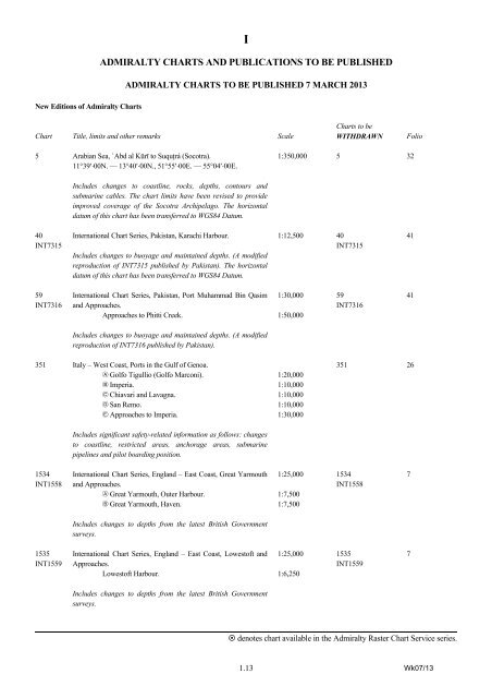
I<br />
ADMIRALTY CHARTS AND PUBLICATIONS TO BE PUBLISHED<br />
ADMIRALTY CHARTS TO BE PUBLISHED 7 MARCH 2013<br />
New Editions of <strong>Admiralty</strong> Charts<br />
Chart Title, limits and other remarks Scale<br />
Charts <strong>to</strong> be<br />
WITHDRAWN<br />
Folio<br />
5 Arabian Sea, `Abd al Kūrī <strong>to</strong> Suquţrá (Socotra).<br />
11°39′⋅00N. — 13°40′⋅00N., 51°55′⋅00E. — 55°04′⋅00E.<br />
1:350,000 5 32<br />
Includes changes <strong>to</strong> coastline, rocks, depths, con<strong>to</strong>urs and<br />
submarine cables. The chart limits have been revised <strong>to</strong> provide<br />
improved coverage of the Socotra Archipelago. The horizontal<br />
datum of this chart has been transferred <strong>to</strong> WGS84 Datum.<br />
40<br />
INT7315<br />
International Chart Series, Pakistan, Karachi Harbour.<br />
Includes changes <strong>to</strong> buoyage and maintained depths. (A modified<br />
reproduction of INT7315 published by Pakistan). The horizontal<br />
datum of this chart has been transferred <strong>to</strong> WGS84 Datum.<br />
1:12,500 40<br />
INT7315<br />
41<br />
59<br />
INT7316<br />
International Chart Series, Pakistan, Port Muhammad Bin Qasim<br />
and Approaches.<br />
Approaches <strong>to</strong> Phitti Creek.<br />
1:30,000<br />
1:50,000<br />
59<br />
INT7316<br />
41<br />
Includes changes <strong>to</strong> buoyage and maintained depths. (A modified<br />
reproduction of INT7316 published by Pakistan).<br />
351 Italy – West Coast, Ports in the Gulf of Genoa.<br />
A Golfo Tigullio (Golfo Marconi).<br />
B Imperia.<br />
C Chiavari and Lavagna.<br />
D San Remo.<br />
E Approaches <strong>to</strong> Imperia.<br />
Includes significant safety-related information as follows: changes<br />
<strong>to</strong> coastline, restricted areas, anchorage areas, submarine<br />
pipelines and pilot boarding position.<br />
1:20,000<br />
1:10,000<br />
1:10,000<br />
1:10,000<br />
1:30,000<br />
351 26<br />
1534<br />
INT1558<br />
International Chart Series, England – East Coast, Great Yarmouth<br />
and Approaches.<br />
A Great Yarmouth, Outer Harbour.<br />
B Great Yarmouth, Haven.<br />
1:25,000<br />
1:7,500<br />
1:7,500<br />
1534<br />
INT1558<br />
7<br />
Includes changes <strong>to</strong> depths from the latest British Government<br />
surveys.<br />
1535<br />
INT1559<br />
International Chart Series, England – East Coast, Lowes<strong>to</strong>ft and<br />
Approaches.<br />
Lowes<strong>to</strong>ft Harbour.<br />
1:25,000<br />
1:6,250<br />
1535<br />
INT1559<br />
7<br />
Includes changes <strong>to</strong> depths from the latest British Government<br />
surveys.<br />
denotes chart available in the <strong>Admiralty</strong> Raster Chart Service series.<br />
1.13 Wk07/13


