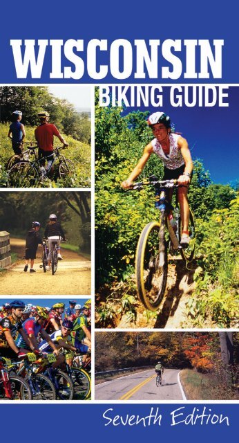
View the Wisconsin Biking Guide - Wisconsin Department of Tourism
View the Wisconsin Biking Guide - Wisconsin Department of Tourism
View the Wisconsin Biking Guide - Wisconsin Department of Tourism

You also want an ePaper? Increase the reach of your titles
YUMPU automatically turns print PDFs into web optimized ePapers that Google loves.
Contents<br />
Using <strong>the</strong> <strong>Guide</strong> 2-3<br />
On-Road Tours 4-25<br />
Mountain Bike Trails 26-47<br />
Bike Touring Trails 48-69<br />
More <strong>Wisconsin</strong> <strong>Biking</strong> Trails 70-71<br />
<strong>Wisconsin</strong> Bike Events<br />
72-IBC
Using <strong>the</strong> <strong>Guide</strong><br />
<strong>Wisconsin</strong> and biking were<br />
made for each o<strong>the</strong>r! The<br />
Badger State is recognized<br />
as a national leader in recreational<br />
biking. An excellent road system,<br />
coupled with outstanding <strong>of</strong>f-road<br />
terrain, make <strong>Wisconsin</strong> a true biking<br />
adventure for everyone.<br />
The <strong>Wisconsin</strong> <strong>Biking</strong> <strong>Guide</strong> ga<strong>the</strong>rs<br />
a sampling <strong>of</strong> <strong>the</strong> wonderful biking<br />
experiences <strong>Wisconsin</strong> has to <strong>of</strong>fer.<br />
Rides are divided into three categories,<br />
based on riding interest: on-road tours,<br />
mountain bike trails, and bike touring<br />
trails.<br />
Often, a geographic area <strong>of</strong>fers<br />
more than one type <strong>of</strong> ride. The map<br />
on page 3 shows <strong>the</strong> location <strong>of</strong> ten<br />
on-road tours, ten mountain bike trails,<br />
and ten bike touring trails. Pick a destination,<br />
<strong>the</strong>n check out <strong>the</strong> many ride<br />
options along <strong>the</strong> way.<br />
This is <strong>the</strong> seventh edition <strong>of</strong> <strong>the</strong><br />
<strong>Wisconsin</strong> <strong>Biking</strong> <strong>Guide</strong>. The thirty<br />
trails and tours on <strong>the</strong>se pages are a<br />
part <strong>of</strong> more than 100 in our on-line<br />
collection. You can access <strong>the</strong> collection<br />
and <strong>the</strong>ir accompanying maps at<br />
www.travelwisconsin.com. (On <strong>the</strong><br />
landing page, click on “The Great<br />
Outdoors,” <strong>the</strong>n “<strong>Biking</strong>,” choose<br />
your favorite ride category.) You can<br />
also click on “Maps & <strong>Guide</strong>s” at <strong>the</strong><br />
top <strong>of</strong> <strong>the</strong> page and flip-through an<br />
electronic version <strong>of</strong> <strong>the</strong> <strong>Wisconsin</strong><br />
<strong>Biking</strong> <strong>Guide</strong>. Or, you can key in one<br />
<strong>of</strong> <strong>the</strong> “O<strong>the</strong>r Tours” suggested in <strong>the</strong><br />
“Just The Facts” listing for each ride in<br />
this guide.<br />
SAFETY FIRST<br />
When riding, always act in <strong>the</strong> best<br />
interest <strong>of</strong> yourself and your companions.<br />
Be sure to:<br />
■ Obey specific bicycle and general traffic<br />
regulations.<br />
■ Use <strong>of</strong>f-road riding etiquette, (see<br />
IMBA trail rules on page 27).<br />
■ Show courtesy to all road or trail<br />
users.<br />
■ Wear appropriate gear, including a<br />
well-adjusted helmet.<br />
■ Maintain your bicycle in excellent<br />
operating condition.<br />
■ Choose routes within <strong>the</strong> ability <strong>of</strong><br />
you and your companions.<br />
■ Carry sufficient food, drink, first aid<br />
supplies, and tools.<br />
2<br />
Map Legend<br />
94 Interstate Highway<br />
51 US Highway<br />
68 State Highway<br />
G County Highway<br />
Town Road (Paved)<br />
Town Road (Gravel)<br />
Bike Route: on State Highways<br />
Bike Route: on County Highways<br />
Bike Route: on Town Roads (Paved)<br />
Bike Route: on Town Roads (Gravel)<br />
Bike Touring Trail (Paved)<br />
Bike Touring Trail (Unpaved)<br />
Off-road: Easy<br />
Off-road: Moderate<br />
Off-road: Difficult<br />
Off-road: Single-Track<br />
Hiking Trail/O<strong>the</strong>r Trail<br />
ATV Trail<br />
County Lines<br />
Railroad<br />
Park Boundary<br />
Parking Lot<br />
2.9 Mileage Indicators<br />
Trailhead<br />
Trailhead with Parking Lot<br />
Trailhead with On-Street Parking<br />
Parking Lot<br />
All Services<br />
Some Services<br />
Tavern<br />
Bicycle Service<br />
Shelter<br />
Point <strong>of</strong> Interest<br />
Unincorporated Town<br />
Incorporated Town<br />
Telephone<br />
Lodging<br />
Public Campground<br />
Private Campground<br />
Food Service<br />
Grocery<br />
Showers<br />
Water<br />
Flush Toilet<br />
Pit Toilet<br />
Hiking Only Trail<br />
Wayside Park<br />
Playground<br />
Historical Marker or Museum<br />
Swimming<br />
Underpass<br />
State Park<br />
County Park
On-Road Tours<br />
Enjoy scenic routes that enhance <strong>the</strong> adventure<br />
<strong>of</strong> <strong>the</strong> open road. Quiet, lightly traveled roads<br />
are used wherever possible. Most tours can be<br />
ridden in a single day. Some are easy cruises,<br />
o<strong>the</strong>rs take-on tough hills. All are exceptional<br />
experiences.<br />
Pages<br />
1 Around <strong>the</strong> Horn Tour 6-7<br />
2 Sand Lake Tour 8-9<br />
3 Marinette-Peshtigo Tour 10-11<br />
4 Cave Point Tour 12-13<br />
5 Buena Vista Tour 14-15<br />
6 Top <strong>of</strong> <strong>the</strong> World Tour 16-17<br />
7 Prairie du Chien Tour 18-19<br />
8 Merrimac Ferry Tour 20-21<br />
9 Waterloo Tour 22-23<br />
10 Lima Center Tour 24-25<br />
Mountain Bike Trails<br />
Give <strong>of</strong>f-road riding a try. Pedaling natural<br />
terrain can be a challenging test or a pleasant<br />
roll through <strong>the</strong> woods. Ride to beautiful places<br />
you’d never see on <strong>the</strong> road. This section<br />
includes trails for novices and experts; now<br />
everyone can enjoy <strong>of</strong>f-road adventure.<br />
Bike Touring Trails<br />
Sample a <strong>Wisconsin</strong> original. By converting an<br />
abandoned rail bed into <strong>the</strong> Elroy-Sparta Trail,<br />
<strong>the</strong> state kicked-<strong>of</strong>f a nationwide boom in<br />
motor vehicle-free trails. They aren’t physically<br />
demanding; novices and families love <strong>the</strong>m.<br />
On-Road Tours<br />
see page 4-25<br />
Mountain Bike Trails<br />
see page 26-47<br />
Bike Touring Trails<br />
see page 48-69<br />
1 Rock Lake CAMBA Trail 28-29<br />
2 Nicolet Roche Trail 30-31<br />
3 Peninsula State Park Trails 32-33<br />
4 Lowes Creek Trail 34-35<br />
5 Greenbush Trails 36-37<br />
6 Devil’s Lake State Park Trails 38-39<br />
7 Human Powered Trails 40-41<br />
8 Cam-Rock Trails 42-43<br />
9 Milwaukee Alpha Trail 44-45<br />
10 John Muir & Emma Carlin Trails 46-47<br />
1 Three Eagles Trail 50-51<br />
2 Mariners-Rawley Point Trails 52-53<br />
3 Elroy-Sparta State Trail 54-55<br />
4 Pine River Trail 56-57<br />
5 Military Ridge State Trail 58-59<br />
6 Eisenbahn State Trail 60-61<br />
7 Interurban Trail 62-63<br />
8 Oak Leaf Trail 64-65<br />
9 White River State Trail 66-67<br />
10 Badger State Trail 68-69<br />
1<br />
1<br />
1<br />
2<br />
2 3<br />
3<br />
4<br />
5 6<br />
7<br />
3<br />
2<br />
5<br />
4<br />
6 8 6 7<br />
7 5 8 9<br />
10 9 8<br />
10 10 9<br />
4<br />
3
On-Road<br />
BikeTours<br />
4<br />
DON ABRAMS
Bicycle speed is just right for taking<br />
in all <strong>Wisconsin</strong> has to <strong>of</strong>fer;<br />
fast enough to get you <strong>the</strong>re,<br />
slow enough so you won’t miss<br />
a thing.<br />
<strong>Wisconsin</strong>’s secondary road system is<br />
among <strong>the</strong> best in <strong>the</strong> nation. In this section,<br />
we’ve selected a variety <strong>of</strong> on-road<br />
tours. We’ll take you down country lanes<br />
where wild flowers grow to <strong>the</strong> edge <strong>of</strong><br />
<strong>the</strong> pavement; through forests that<br />
canopy <strong>the</strong> roadway; along <strong>the</strong> sandy<br />
shores <strong>of</strong> <strong>the</strong> Great Lakes; and along <strong>the</strong><br />
banks <strong>of</strong> <strong>the</strong> St. Croix and <strong>Wisconsin</strong><br />
Rivers.<br />
<strong>Wisconsin</strong>’s extensive rural road system<br />
was born <strong>of</strong> necessity – as a means<br />
to move product from farm to market.<br />
With <strong>the</strong> advent <strong>of</strong> divided highways and<br />
high-speed travel, many <strong>of</strong> <strong>the</strong>se rural<br />
byways are nearly forgotten; perfect for<br />
relaxing biking.<br />
The map on this page locates and<br />
indexes all <strong>the</strong> on-road tours in this section.<br />
We’ve made a real effort to select<br />
lightly-trafficked roads and scenic byways<br />
for your enjoyment. But always keep in<br />
mind that safety in shared-roadway situations<br />
depends on alertness, obeying <strong>the</strong><br />
rules <strong>of</strong> <strong>the</strong> road, and courtesy.<br />
For more information about bicycling<br />
on <strong>Wisconsin</strong> roadways, consider<br />
purchasing <strong>the</strong> <strong>Wisconsin</strong> State Bike<br />
Map, (details on <strong>the</strong> inside back cover <strong>of</strong><br />
this guide).<br />
On-Road Bike Tours Legend<br />
68<br />
G<br />
Trailhead<br />
Trailhead with Parking Lot<br />
Trailhead with On-Street Parking<br />
State Highway<br />
County Highway<br />
Paved Town Road<br />
Recommended Route Paved<br />
Recommended Route Gravel<br />
For a complete listing <strong>of</strong> all map icons, see page 2.<br />
Pay attention to <strong>the</strong>se on-road<br />
biking tips:<br />
■<br />
■<br />
■<br />
■<br />
■<br />
■<br />
1<br />
2 3 4<br />
5 6<br />
7 8 910<br />
Pages<br />
1 Around <strong>the</strong> Horn Tour 6-7<br />
2 Sand Lake Tour 8-9<br />
3 Marinette-Peshtigo Tour 10-11<br />
4 Cave Point Tour 12-13<br />
5 Buena Vista Tour 14-15<br />
6 Top <strong>of</strong> <strong>the</strong> World Tour 16-17<br />
7 Prairie du Chien Tour 18-19<br />
8 Merrimac Ferry Tour 20-21<br />
9 Waterloo Tour 22-23<br />
10 Lima Center Tour 24-25<br />
All <strong>the</strong> on-road tours follow<br />
public roadways open to<br />
shared bicycle/motor vehicle<br />
use.<br />
Obey all general and bikespecific<br />
traffic regulations.<br />
Wear a helmet and layered,<br />
comfortable bike clothing.<br />
Make sure <strong>the</strong> route you<br />
select is suited to <strong>the</strong> ability <strong>of</strong><br />
everyone in your group.<br />
Make sure your bike is in<br />
excellent working order.<br />
Bring water and bike tools.<br />
5
Around <strong>the</strong> Horn Tour<br />
BAYFIELD<br />
COUNTY<br />
1JUST THE FACTS<br />
DISTANCE: 53 miles<br />
DIFFICULTY: Very difficult, but a moderate<br />
out-and-back route is an option.<br />
TRAILHEAD LOCATION: In Washburn<br />
at Thompson’s West End Park at <strong>the</strong><br />
end <strong>of</strong> 8th Ave, .4 miles south <strong>of</strong> Hwy.<br />
13/Bayfield St.<br />
ATTRACTIONS: Apostle Islands<br />
National Lakeshore, Big Top<br />
Chautauqua, Madeline Island Historical<br />
Museum, Bayfield Maritime Museum,<br />
Washburn Historical Museum,<br />
Madeline Island Ferry, Big Bay State<br />
Park, boat tours, sea kayaking.<br />
CAUTION: The entire route is on public<br />
roadways open to shared<br />
bicycle/motor vehicle use. Be sure to<br />
use <strong>the</strong> paved shoulder on Hwy. 13<br />
between Cty. K and Washburn. Some<br />
slopes are long and steep; take care to<br />
control your downhill speed.<br />
LEGEND: For a complete listing <strong>of</strong> all<br />
map icons, see page 2.<br />
OTHER TOURS IN THIS REGION: Go<br />
to www.travelwisconsin.com. In <strong>the</strong><br />
search box, key in Chequamegon Bay<br />
Tour, Chequamegon-Nicolet Forest<br />
Tour, or Tiger Cat Tour.<br />
FOR MORE INFORMATION:<br />
Bayfield Chamber <strong>of</strong> Commerce<br />
800/447-4094, 715/779-3335<br />
www.bayfield.org<br />
Bayfield County <strong>Tourism</strong> & Recreation<br />
800/472-6338, 715/373-6125<br />
www.travelbayfieldcounty.com<br />
Madeline Island Chamber <strong>of</strong> Commerce<br />
888/475-3386, 715/747-2801<br />
www.madelineisland.com<br />
Washburn Area Chamber <strong>of</strong> Commerce<br />
800/253-4495, 715/373-5017<br />
www.washburnchamber.com<br />
Here’s a chance to test your legs on a<br />
challenging route “around <strong>the</strong><br />
horn” <strong>of</strong> <strong>the</strong> Bayfield Peninsula. It<br />
pays <strong>of</strong>f with a jackpot <strong>of</strong> scenery<br />
and attractions at <strong>the</strong> very top <strong>of</strong> <strong>the</strong> state.<br />
The course pr<strong>of</strong>ile shows some tough<br />
hills on this ride. If you ‘round <strong>the</strong> horn<br />
clockwise, <strong>the</strong> last eight miles into<br />
Cornucopia are one <strong>of</strong> <strong>the</strong> best downhill runs<br />
anywhere; pedaling is purely optional on<br />
some stretches. But, be prepared: <strong>the</strong>re are<br />
no services available on <strong>the</strong> long hauls<br />
between Washburn and Cornucopia or on to<br />
Red Cliff.<br />
If that pay<strong>of</strong>f doesn’t seem worth <strong>the</strong><br />
considerable effort <strong>of</strong> <strong>the</strong> long climb on Cty.<br />
C, you might consider a more modest 26-<br />
mile ride out-and-back on Hwy 13 between<br />
Washburn and Bayfield. There are plenty <strong>of</strong><br />
great views along that part <strong>of</strong> <strong>the</strong> route too.<br />
The “Around <strong>the</strong> Horn” tour is from a<br />
collection <strong>of</strong> 19 great on-road routes presented<br />
in <strong>the</strong> Ashland & Bayfield County Bicycle<br />
Map available from <strong>the</strong> area contacts listed.<br />
The map includes tours as short as 11 miles,<br />
some on easy terrain, to premier challenges<br />
like this tour.<br />
Summer fun in this neck <strong>of</strong> <strong>the</strong><br />
Northwoods is <strong>of</strong>ten defined by <strong>the</strong> performance<br />
schedule <strong>of</strong> Big Top Chautauqua. For<br />
more than two decades <strong>the</strong> “Carnegie Hall<br />
<strong>of</strong> tent shows” has brought a series <strong>of</strong><br />
national headliners and original productions<br />
to <strong>the</strong>ir blue canvas tent atop Mt. Ashwabay<br />
(performances June-LD+, 888/244-8368 or<br />
www.bigtop.org).<br />
No visit to <strong>the</strong> Bayfield Peninsula would<br />
be complete without getting out on <strong>the</strong> lake.<br />
Boat tours and sea kayaking are popular and<br />
readily available. A ride on <strong>the</strong> Madeline<br />
Island Ferry to La Pointe with your bike, car<br />
or on foot is an easy way to take in <strong>the</strong><br />
sights (operating Apr-Jan 15, 715/747-2051<br />
or www.madferry.com).<br />
Just a few steps from <strong>the</strong> ferry dock is<br />
<strong>the</strong> palisade <strong>of</strong> <strong>the</strong> reconstructed fur trading<br />
post that houses <strong>the</strong> Madeline Island<br />
Historical Museum (open daily MD-early Oct;<br />
10am-5pm; 866/944-7483 or www.wisconsinhistory.org/madelineisland).<br />
Six miles east<br />
<strong>of</strong> La Pointe <strong>the</strong> quiet beauty <strong>of</strong> Big Bay State<br />
Park beckons (715/747-6425 or<br />
www.wiparks.net).<br />
Back on <strong>the</strong> mainland in Bayfield you<br />
can visit <strong>the</strong> Apostle Islands National<br />
Lakeshore Visitor Center in <strong>the</strong> old county<br />
courthouse (open daily May-Oct, 8am-5pm,<br />
715/779-3397 or www.nps.gov/apis/) and<br />
6
<strong>the</strong> Bayfield Maritime Museum (June, Sep &<br />
Oct daily, 10am-5pm; July & Aug 10am-7pm,<br />
715/779-9919 or www.bayfield.org).<br />
The lore and legend <strong>of</strong> <strong>the</strong> area’s native<br />
Ojibwe, French fur traders and missionaries,<br />
sailors, shipwrecks and lumberjacks is displayed<br />
at <strong>the</strong> Washburn Historical Museum<br />
(Open daily, Apr-Aug 10am-4pm; Mon-Sat,<br />
Sep-Dec 10am-2pm, 715/373-5591). The<br />
museum is located in a striking 19th Century<br />
bank building built with locally quarried<br />
sandstone, <strong>the</strong> same stone used in many <strong>of</strong><br />
New York City’s famous brownstones.<br />
At <strong>the</strong> end <strong>of</strong> <strong>the</strong> day you’ll agree that<br />
<strong>the</strong> beautiful Bayfield Peninsula is indeed a<br />
horn <strong>of</strong> plenty.<br />
1,400<br />
Elevation in Feet<br />
1,200<br />
1,000<br />
800<br />
Cornucopia<br />
Bayfield<br />
Washburn<br />
600<br />
Washburn<br />
0 10 20 30 40 50<br />
Distance in Miles<br />
APOSTLE ISLANDS<br />
Little<br />
Sand Bay<br />
NATIONAL LAKESHORE<br />
Lake Superior<br />
K<br />
13<br />
21.3<br />
Cornucopia<br />
Siskiwit Falls<br />
Red<br />
Cliff<br />
Orchards<br />
J<br />
Siskwit<br />
Lake<br />
C<br />
Mt. Ashwabay<br />
Big Top Chautaugua<br />
SKI HILL RD<br />
13<br />
12.9<br />
Bayfield<br />
Maritime<br />
Museum<br />
Ferry<br />
La Pointe<br />
Bayfield<br />
Madeline Island<br />
Historical<br />
Museum<br />
H<br />
18.0<br />
CHEQUAMEGON -<br />
NICOLET NATIONAL<br />
FOREST<br />
Washburn<br />
Historical<br />
Museum<br />
Washburn<br />
Thompson’s<br />
West End Park<br />
Chequamegon Bay<br />
0 1 2 3 4 5 6 Miles<br />
7
2Sand Lake Tour<br />
BARRON<br />
JUST THE FACTS<br />
DISTANCE: 23 miles.<br />
DIFFICULTY: Easy.<br />
TRAILHEAD LOCATION: At<br />
Cumberland Tourist Park & Beach three<br />
blocks west <strong>of</strong> Hwy 63 on Lake St.<br />
ATTRACTIONS: Lake, river and woodland<br />
scenery.<br />
CAUTION: The entire route is on public<br />
roads open to shared bicycle/motor<br />
vehicle use.<br />
LEGEND: For a complete listing <strong>of</strong> all<br />
map icons, see page 2.<br />
OTHER TOURS IN THIS REGION:<br />
Go to www.travelwisconsin.com. In<br />
<strong>the</strong> search box, enter Chetek Tour or<br />
Tiger Cat Tour.<br />
FOR MORE INFORMATION:<br />
Cumberland Chamber <strong>of</strong> Commerce<br />
715/822-3378<br />
www.cumberland-wisconsin.com<br />
Healthier Cumberland Coalition<br />
www.healthiercumberland.org<br />
(for Bike Cumberland map pdf file)<br />
COUNTY<br />
Just because pedaling around Sand<br />
Lake is an easy ride, doesn’t mean it’s<br />
flat. There’s just enough elevation -<br />
nearly 100 feet – to keep <strong>the</strong> riding<br />
interesting and give your legs a work out.<br />
The Sand Lake Tour is one <strong>of</strong> four scenic and<br />
lightly trafficked routes shown on <strong>the</strong> Bike<br />
Cumberland map that was produced by <strong>the</strong><br />
Healthier Cumberland Coalition (see left).<br />
They also have ano<strong>the</strong>r map that shows easy,<br />
shorter rides in-town.<br />
As you pedal across <strong>the</strong> rolling landscape<br />
west <strong>of</strong> Cumberland, you’ll catch<br />
glimpses <strong>of</strong> Beaver Dam Lake and Sand Lake<br />
through <strong>the</strong> trees. They were once channels<br />
in <strong>the</strong> course <strong>of</strong> a mighty glacial river. The<br />
legacy <strong>of</strong> that old river is Cumberland’s<br />
moniker as “The Island City.” Most <strong>of</strong> <strong>the</strong><br />
town is situated on an island that once split<br />
<strong>the</strong> river into two channels. That ancient ice<br />
sheet also left <strong>the</strong> surrounding land spotted<br />
with lakes that give <strong>the</strong> town its “vacationland”<br />
character. There are more than fifty<br />
lakes within a ten-mile radius <strong>of</strong><br />
Cumberland. The town is right on <strong>the</strong> edge<br />
<strong>of</strong> <strong>Wisconsin</strong>’s great Northwoods.<br />
At <strong>the</strong> north end <strong>of</strong> <strong>the</strong> route you can<br />
ride up to <strong>the</strong> Hilltop Retreat Restaurant, <strong>the</strong><br />
only service <strong>of</strong> any type you’ll find along <strong>the</strong><br />
route (open weekend evenings). This short<br />
side trip is worthwhile anytime for <strong>the</strong> scenic<br />
Moonrise over a Barron County Lake.<br />
TOURISM PHOTO FILE<br />
8
1 ST<br />
1.3<br />
BLVD<br />
views <strong>of</strong> <strong>the</strong> Sand Creek valley. Following <strong>the</strong><br />
numerical streets and avenues, as <strong>the</strong> town<br />
roads are named, is an adventure in itself.<br />
Don’t bo<strong>the</strong>r adding <strong>the</strong>m up.<br />
The humble rutabaga has become<br />
Cumberland’s <strong>of</strong>ficial symbol for its annual<br />
festival held <strong>the</strong> weekend before Labor Day.<br />
Probably brought to <strong>the</strong> area by Scandinavian<br />
settlers, <strong>the</strong> rutabaga is a kind <strong>of</strong> turnip.<br />
Rutabaga Fest is a community celebration; a<br />
chance to have some summer fun with a hot<br />
pepper eating contest, children’s’ Olympics, a<br />
carnival, run/walk/race, and a Sunday parade.<br />
In town, stately Victorian homes and an<br />
imposing classical revival opera house that is<br />
now an apartment house testify to<br />
Cumberland’s prosperous early years. The<br />
river and great stands <strong>of</strong> pine made it an<br />
ideal location for sawmills. The railroad<br />
arrived in 1878 and soon added to its importance.<br />
This once rough-and-tumble lumbering<br />
town began to clean up its image a hundred<br />
years ago. According to local lore, <strong>the</strong> town’s<br />
toughest saloonkeeper touted himself as <strong>the</strong><br />
“King <strong>of</strong> Cumberland.” The town fa<strong>the</strong>rs<br />
imported a marshal who challenged <strong>the</strong><br />
saloonkeeper to a fistfight with <strong>the</strong> condition<br />
<strong>the</strong> loser left town. The saloonkeeper lost<br />
and he left.<br />
Today, Cumberland is a thriving community<br />
<strong>of</strong> 2,300 that combines industry with<br />
quality <strong>of</strong> life. Its full-service downtown<br />
combines with area cafés, restaurants,<br />
antique shops, and motels to make your stay<br />
enjoyable. The city operates an eighteen-hole<br />
golf course with lounge and restaurant, a<br />
swimming beach at Tourist Park, and a campground<br />
at Eagle Point with 23 sites, electricity<br />
and showers.<br />
Cumberland makes it easy in and out <strong>of</strong><br />
<strong>the</strong> saddle.<br />
1/2 ST<br />
Lower<br />
Waterman<br />
Lake<br />
Horseshoe<br />
Lake<br />
2 1/2 ST 1<br />
63<br />
28TH AVE<br />
28TH AVE<br />
27<br />
1/2 AVE<br />
H<br />
Kirby<br />
Lake<br />
Sand<br />
Lake<br />
27TH AVE<br />
4.5<br />
4TH ST<br />
5TH ST<br />
26 AVE<br />
5.0<br />
Scott<br />
Lake<br />
2ND ST<br />
25 3 /4 AVE<br />
Little Sand<br />
Lake<br />
Little<br />
Lake<br />
H<br />
26TH AVE<br />
5TH ST<br />
H<br />
26<br />
25 1 /2 AVE<br />
1/2 AVE<br />
Spring<br />
Lake<br />
5.2<br />
6TH ST<br />
Wildcat<br />
Lake<br />
63<br />
Granite<br />
Lake<br />
26 1/2 AVE 24<br />
1/2 AVE<br />
24TH AVE<br />
48<br />
6.3<br />
Beaver<br />
Dam<br />
JEFFERY<br />
H<br />
2ND ST<br />
23RD AVE<br />
3RD ST<br />
5TH ST<br />
Cumberland<br />
ROBINSON ST<br />
23RD AVE<br />
3RD<br />
LAKE ST<br />
Lake<br />
North<br />
Lake<br />
63<br />
48<br />
0 1 2<br />
3 Miles<br />
9
3Marinette-Peshtigo Tour<br />
MARINETTE COUNTY<br />
JUST THE FACTS<br />
DISTANCE: 30 miles.<br />
DIFFICULTY: Easy.<br />
TRAILHEAD LOCATIONS: Red Arrow<br />
Park, 2.5 miles east <strong>of</strong> Hwy 41.<br />
ATTRACTIONS: Marinette Historical<br />
Museum, Peshtigo Fire Museum, river,<br />
lake and farmland scenery.<br />
CAUTION: The entire route is on public<br />
roads open to shared bicycle/motor<br />
vehicle use.<br />
LEGEND: For a complete listing <strong>of</strong> all<br />
map icons, see page 2.<br />
OTHER TOURS IN THIS REGION:<br />
Go to www.travelwisconsin.com. In <strong>the</strong><br />
search box, enter High Falls Tour or<br />
Shore-to-Shore Tour. Or, in this guide<br />
see <strong>the</strong> Cave Point Tour (pages 12-13).<br />
FOR MORE INFORMATION:<br />
Marinette County <strong>Tourism</strong> Alliance<br />
800/236-6681<br />
www.marinettecounty.com<br />
Marinette/Menominee Area Chamber<br />
<strong>of</strong> Commerce<br />
800/236-6681, 715/735-6681<br />
www.marinettechamber.com<br />
Peshtigo Fire Museum.<br />
10<br />
GARY KNOWLES<br />
Here’s an easy ride sandwiched<br />
between two interesting communities<br />
and two rivers. Expansive views<br />
<strong>of</strong> Green Bay dotted with sailboats,<br />
pleasure boats and huge freighters add to an<br />
enjoyable day <strong>of</strong> riding. It’s just one <strong>of</strong> <strong>the</strong><br />
routes shown on <strong>the</strong> Marinette County<br />
Official Bicycle Routes Map which you can<br />
request from <strong>the</strong>ir tourism <strong>of</strong>fice. O<strong>the</strong>r rides<br />
showcase <strong>the</strong> county’s fourteen scenic waterfalls,<br />
bolstering Marinette County’s claim as<br />
<strong>the</strong> “Waterfalls Capital <strong>of</strong> <strong>Wisconsin</strong>.”<br />
Red Arrow Park at <strong>the</strong> outlet <strong>of</strong> <strong>the</strong><br />
Menominee River is a pleasant place to start<br />
and finish your ride. A bike/ped path follows<br />
<strong>the</strong> channel back into town. There, on<br />
Stephenson Island, you can learn more about<br />
<strong>the</strong> area’s past at <strong>the</strong> Marinette Historical<br />
Museum (open MD-Sept Tue-Sat 10am-<br />
4:30pm, Sun & hol noon-4pm; 715/732-<br />
0831). Museum exhibits illuminate <strong>the</strong> area’s<br />
Native American history, early trading posts,<br />
lumbering, and maritime legacy. Nearby on<br />
Bridge Street, stop at <strong>the</strong> <strong>Wisconsin</strong><br />
Welcome Center for more things to do and<br />
see in <strong>the</strong> Badger State (open Apr-Oct daily<br />
8am-5pm; 715/732-4333).<br />
You get three changes <strong>of</strong> scenery on<br />
this ride. Pedaling south from Marinette<br />
you’ll catch big-water views <strong>of</strong> Green Bay.<br />
You’ll see that water levels have dropped<br />
recently giving shoreline owners an extra fifty<br />
meters <strong>of</strong> property. Turning inland, lake<br />
scenes turn to river scenes as <strong>the</strong> route follows<br />
<strong>the</strong> Peshtigo River as it meanders<br />
through <strong>the</strong> roadside woods. Cutting across<br />
on Rader Road, <strong>the</strong> terrain changes yet again<br />
as you pass through easy rolling farmland.<br />
This route is <strong>the</strong> shortest loop <strong>of</strong> <strong>the</strong> annual<br />
Menominee River Century ride. The June outing<br />
has been pleasing cyclists for more than<br />
a quarter century with a formula <strong>of</strong> easy<br />
pedaling and post-ride fun.<br />
The Menominee River, <strong>the</strong> boundary<br />
between <strong>Wisconsin</strong> and Michigan, <strong>of</strong>fers a<br />
clue to <strong>the</strong> form <strong>of</strong> <strong>the</strong> land before <strong>the</strong> last<br />
glacial epoch. Today it empties into Green<br />
Bay. But in pre-glacial times geologists<br />
believe it continued east. Look at <strong>the</strong> state<br />
map and you can see that directly across <strong>the</strong><br />
bay is <strong>the</strong> Sturgeon Bay Ship Canal. It was<br />
once part <strong>of</strong> <strong>the</strong> river channel before huge<br />
glacial ice sheets, split by <strong>the</strong> Door Peninsula,<br />
gouged out <strong>the</strong> bay and Lake Michigan.<br />
A much more tragic history lesson lies at<br />
<strong>the</strong> west end <strong>of</strong> <strong>the</strong> route. The city <strong>of</strong><br />
Peshtigo is forever linked to <strong>the</strong> worst forest<br />
fire in North America. It is little known, however,<br />
because it occurred on <strong>the</strong> same day as
White Pelicans on <strong>the</strong> shore <strong>of</strong> Green Bay.<br />
<strong>the</strong> great Chicago Fire. On October 8, 1971<br />
conditions were ideal for both conflagrations.<br />
A prolonged drought and a cyclonic windstorm<br />
were key ingredients. In Chicago,<br />
buildings fueled <strong>the</strong> fire; in Peshtigo is was<br />
“slash” left by pervasive lumbering.<br />
The Peshtigo firestorm raged through<br />
parts <strong>of</strong> Upper Michigan, down to Green Bay<br />
ALAN ORR<br />
and over most <strong>of</strong> <strong>the</strong> lower part <strong>of</strong> <strong>the</strong> Door<br />
County Peninsula. Millions <strong>of</strong> dollars worth<br />
<strong>of</strong> property and timberland were lost as well<br />
as an estimated 1,200-2,400 lives; five to ten<br />
times as many perished in <strong>Wisconsin</strong> as in<br />
Chicago.<br />
The fire was named for Peshtigo since it<br />
bore <strong>the</strong> greatest loss <strong>of</strong> life with as many as<br />
800 victims. An old church, <strong>the</strong> first rebuilt<br />
after <strong>the</strong> fire, is now <strong>the</strong> Peshtigo Fire<br />
Museum (open daily MD-Oct 8 9am-5pm;<br />
715/582-3244). There are few artifacts from<br />
<strong>the</strong> fire as hardly anything survived. The<br />
adjoining cemetery has a mass grave holding<br />
hundreds <strong>of</strong> unidentified fire victims.<br />
The actual origin <strong>of</strong> <strong>the</strong> fire is unknown,<br />
but if <strong>the</strong>re was a culprit <strong>the</strong> equivalent <strong>of</strong><br />
Mrs. O’Leary’s cow, it didn’t survive to tell<br />
<strong>the</strong> tale.<br />
Menominee<br />
M I C H I G A N<br />
180<br />
41<br />
Menominee<br />
64<br />
64<br />
River<br />
41<br />
D<br />
Peshtigo<br />
Peshtigo<br />
Fire Museum<br />
SCHACHT RD<br />
41<br />
CLEVELAND AVE<br />
OLD PESHTIGO RD<br />
T<br />
RADER RD<br />
6.3<br />
T<br />
Marinette<br />
B<br />
BB<br />
BAY<br />
OGDEN ST<br />
3.5<br />
SHORE RD<br />
Red<br />
Arrow<br />
Park<br />
Peshtigo<br />
HALE RD<br />
2.5<br />
B<br />
River<br />
BB<br />
SCHACHT RD<br />
B<br />
KRAUSE RD<br />
KRAUSE RD<br />
4.9<br />
Little River<br />
Boat Launch<br />
Michael’s Park<br />
HARBOR RD<br />
HALE SCHOOL RD<br />
BB<br />
6.6<br />
BB<br />
Green Bay<br />
HALE RD<br />
POND RD<br />
Peshtigo<br />
Point<br />
0 1 2<br />
3 Miles<br />
11
4Cave Point Tour<br />
DOOR<br />
JUST THE FACTS<br />
DISTANCE: 40 miles<br />
DIFFICULTY: Easy<br />
TRAILHEAD LOCATION: In Sturgeon<br />
Bay at Sunset Bay Park on County B (N.<br />
3rd Ave.).<br />
ATTRACTIONS: Door County<br />
Maritime Museum, Door County<br />
Historical Society, Miller Art Museum,<br />
Third Avenue Playhouse, Sturgeon Bay<br />
Ship Canal & Lighthouse, Whitefish<br />
Dunes State Park, Cave Point County<br />
Park, Door Peninsula Winery.<br />
CAUTION: The entire route is on public<br />
streets and roads open to shared<br />
bicycle/motor vehicle use.<br />
LEGEND: For a complete listing <strong>of</strong> all<br />
map icons, see page 2.<br />
OTHER TOURS IN THIS REGION: Go<br />
to www.travelwisconsin.com. In <strong>the</strong><br />
search box, key in Shore to Shore Tour,<br />
Czech Heritage Tour, or Two Rivers<br />
Tour.<br />
FOR MORE INFORMATION:<br />
Door County Chamber <strong>of</strong> Commerce<br />
800/527-3529, 920/743-4456<br />
www.doorcounty.com<br />
Cave Point County Park.<br />
12<br />
RJ & LINDA MILLER<br />
COUNTY<br />
There’s no place like Cave Point,<br />
especially when <strong>the</strong> wind is strong<br />
<strong>of</strong>f <strong>the</strong> lake. Then you’ll hear Cave<br />
Point before you actually see it. It<br />
may be a cloudless day, but a sound like<br />
thunder will filter through <strong>the</strong> woods as you<br />
pedal towards <strong>the</strong> point. Reaching <strong>the</strong> park<br />
you’ll understand <strong>the</strong> power <strong>of</strong> Lake<br />
Michigan as waves pound against <strong>the</strong> shore<br />
shooting spray high above <strong>the</strong> bluff’s edge.<br />
Over eons, <strong>the</strong> waves have hollowed-out<br />
caves in <strong>the</strong> point increasing both <strong>the</strong> hydrodynamics<br />
and <strong>the</strong> noise level. You can feel<br />
<strong>the</strong> rock shudder beneath your feet.<br />
Cave Point County Park is one destination<br />
on this pleasant tour <strong>of</strong> <strong>the</strong> lake-edge<br />
forest and quiet farm roads <strong>of</strong> Door County.<br />
You won’t find better biking anywhere. And,<br />
you start and finish <strong>the</strong> tour in <strong>the</strong> fascinating<br />
ship building city <strong>of</strong> Sturgeon Bay. You’ll<br />
see every type <strong>of</strong> vessel <strong>the</strong>re from tugboats,<br />
to sleek sailing yachts, to huge ocean-going<br />
ships.<br />
The trailhead at Sunset Bay Park is right<br />
next to Bay Shipbuilding Company, <strong>the</strong> only<br />
facility on <strong>the</strong> Great Lakes that can handle<br />
gigantic 1,000-foot freighters. In fact, Bay<br />
Shipbuilding built many <strong>of</strong> <strong>the</strong>se monstrous<br />
boats. The enormous steel crane in <strong>the</strong> shipyard<br />
gives some idea <strong>of</strong> <strong>the</strong> scale <strong>of</strong> <strong>the</strong><br />
operation.<br />
Located at <strong>the</strong> mid-point <strong>of</strong> <strong>the</strong> Door<br />
County peninsula, <strong>the</strong> bay <strong>of</strong> Sturgeon Bay<br />
was once <strong>the</strong> channel <strong>of</strong> <strong>the</strong> Menomonee<br />
River – before glacial ice sheets carved out<br />
Green Bay and Lake Michigan. Check it out<br />
on a state map; you can easily see <strong>the</strong> alignment.<br />
In 1882 a mile-long canal was cut<br />
from <strong>the</strong> bay to Lake Michigan saving ships<br />
from <strong>the</strong> perilous journey around <strong>the</strong> tip <strong>of</strong><br />
<strong>the</strong> peninsula called by <strong>the</strong> French, Porte des<br />
Morts – “Death’s Door” - <strong>the</strong> term which<br />
gave <strong>the</strong> county its name. The tour route<br />
takes you along <strong>the</strong> canal levee where a<br />
stop at Overlook Trail will give you a great<br />
view <strong>of</strong> <strong>the</strong> boats plying <strong>the</strong> channel<br />
between <strong>the</strong> lake and bay. Where <strong>the</strong> canal<br />
meets <strong>the</strong> lake, <strong>the</strong> Coast Guard’s North<br />
Pierhead Lighthouse is a wonderful photo<br />
opportunity.<br />
Riding north, <strong>the</strong> route winds through<br />
fragrant lakeside cedars before arriving at<br />
Whitefish Dunes State Park which invites you<br />
to spend some time <strong>of</strong>f <strong>the</strong> bike on its threemile,<br />
crescent-shaped sand beach. Just<br />
beyond is Cave Point County Park. An excellent<br />
interpretive display will explain <strong>the</strong><br />
forces that formed this wonder <strong>of</strong> nature.
5.2<br />
Heading back to Sturgeon Bay you’ll<br />
cross <strong>the</strong> scenic gently rolling farmland that<br />
is still a big part <strong>of</strong> Door County’s prosperity.<br />
Evidence <strong>of</strong> this agricultural bounty can be<br />
found just a few miles <strong>of</strong>f-route at <strong>the</strong> Door<br />
Peninsula Winery where <strong>the</strong> product <strong>of</strong> local<br />
orchards is turned into wines and juices<br />
(open daily 9am-5pm; 800/551-5049,<br />
www.dcwine.com).<br />
In Sturgeon Bay you can immerse yourself<br />
in <strong>the</strong> lore <strong>of</strong> <strong>the</strong> lake at <strong>the</strong> Door<br />
County Maritime Museum. Learn about<br />
shipbuilding, see <strong>the</strong> history <strong>of</strong> <strong>the</strong> county’s<br />
many lighthouses, and even survey <strong>the</strong> harbor<br />
through a submarine periscope (open<br />
daily 10am-5pm year-round, MD-Oct 31<br />
9am-6pm; 920/743-5958, www.dcmm.org).<br />
The museum is on <strong>the</strong> south side <strong>of</strong> <strong>the</strong> ship<br />
channel and can be reached from <strong>the</strong> tour<br />
route via <strong>the</strong> ped/bikeway along <strong>the</strong> east<br />
side <strong>of</strong> <strong>the</strong> bridge.<br />
The Door County Historical Museum<br />
traces <strong>the</strong> county’s history from <strong>the</strong> Paleo<br />
Indians and early settlement to <strong>the</strong> present<br />
(open daily May-Oct 10am-4:30pm;<br />
920/743-5809). Nearby, <strong>the</strong> Miller Art<br />
Museum displays a permanent collection <strong>of</strong><br />
<strong>Wisconsin</strong> art as well as changing exhibits<br />
(open Mon-Thur 10am-8pm, Fri & Sat 10am-<br />
5pm; 920/746-0707). For performing arts,<br />
local and pr<strong>of</strong>essional performances are<br />
staged year-round at <strong>the</strong> Third Avenue<br />
Playhouse in Sturgeon Bay’s historic downtown<br />
(920/743-1760, www.thirdavenueplayhouse.com).<br />
Door County – a perfect blend <strong>of</strong> nautical<br />
and nice.<br />
Door Peninsula<br />
Winery<br />
I<br />
T<br />
57<br />
Clark<br />
Lake<br />
CAVE POINT RD<br />
3.2<br />
SCHAUERRD<br />
Cave Point<br />
County Park<br />
CLARK LAKE<br />
RD<br />
4.3 2.6<br />
WD<br />
NELSON LANE<br />
WHITEFISH<br />
DUNES<br />
STATE PARK<br />
42<br />
Institute<br />
P<br />
Valmy<br />
T<br />
WHITEFISH<br />
BAY RD<br />
N. 3RD AVE<br />
B<br />
Sunset Bay<br />
Park<br />
Sturgeon<br />
Bay<br />
Door County<br />
Maritime<br />
Museum<br />
MICHIGAN ST<br />
MEMORIAL DR<br />
42<br />
57<br />
57<br />
42<br />
8.6<br />
S. 18TH PLACE<br />
LILY<br />
BAY RD<br />
MATHEY RD<br />
3.7<br />
UTAH ST<br />
COVE RD<br />
Overlook<br />
CANAL RD<br />
57<br />
T<br />
TT<br />
LAKE FOREST PK RD<br />
4.5<br />
LAKE MICHIGAN DR<br />
North Pierhead Lighthouse<br />
GLIDDEN DR<br />
T<br />
8.2<br />
Whitefish<br />
Point<br />
Lake Michigan<br />
0 1 2 3<br />
4 Miles<br />
13
5Buena Vista Tour<br />
BUFFALO<br />
JUST THE FACTS<br />
DISTANCE: 19 miles.<br />
DIFFICULTY: Very difficult.<br />
TRAILHEAD LOCATION: Buena Vista<br />
Park, 2.5 miles east <strong>of</strong> Hwy 35 via Cty E<br />
and Park Road.<br />
ATTRACTIONS: Buena Vista Park,<br />
Alma Museum, Wings Over Alma, Lock<br />
and Dam No. 4, Upper Mississippi<br />
Wildlife & Fish Refuge, river, valley and<br />
farmland scenery.<br />
CAUTION: The entire route is on public<br />
roads open to shared bicycle/motor<br />
vehicle use. Be sure to use <strong>the</strong> paved<br />
shoulder on Hwy 35. All descents are<br />
extremely steep; make sure your bike<br />
is in safe working order and control<br />
your downhill speed.<br />
LEGEND: For a complete listing <strong>of</strong> all<br />
map icons, see page 2.<br />
OTHER TOURS IN THIS REGION: Go<br />
to www.travelwisconsin.com. In <strong>the</strong><br />
search box, enter Great River Road<br />
North Tour, Great River Road South<br />
Tour, or Black Hawk’s Retreat Tour.<br />
FOR MORE INFORMATION:<br />
Alma Chamber <strong>of</strong> Commerce<br />
608/685-4445<br />
www.almawisconsin.com<br />
Buena Vista Park.<br />
14<br />
CAROL KNABE<br />
COUNTY<br />
The view from Buena Vista Park is<br />
awesome. From atop <strong>the</strong> 550-foot<br />
bluffs, <strong>the</strong> Mississippi River below is<br />
a broad ribbon <strong>of</strong> black. To <strong>the</strong> south<br />
it courses among islands <strong>of</strong> emerald green;<br />
to <strong>the</strong> north it pools still and dark behind<br />
Lock & Dam No. 4. Hugging <strong>the</strong> bluff bottom,<br />
<strong>the</strong> city <strong>of</strong> Alma and a pair <strong>of</strong> railroad<br />
tracks race <strong>the</strong> river in ei<strong>the</strong>r direction. For<br />
man, machine and bird, this is one <strong>of</strong> <strong>the</strong><br />
busiest transportation corridors in <strong>the</strong> world.<br />
The river valley here is part <strong>of</strong> <strong>the</strong> 261-<br />
mile Upper Mississippi Wildlife & Fish Refuge<br />
that stretches from Wabasha, Minnesota to<br />
Rock Island, Illinois. Created in 1924 to preserve<br />
<strong>the</strong> great migratory flyway, it is used by<br />
40% <strong>of</strong> <strong>the</strong> waterfowl in <strong>the</strong> U.S. and now<br />
encompasses more than 240,000 acres. It<br />
welcomes 2,700 bald eagles, harbors 167<br />
resident eagle nests, 5,000 great blue<br />
herons, and 15 egret colonies.<br />
In <strong>the</strong> middle <strong>of</strong> town, Lock & Dam No.<br />
4 muscles <strong>the</strong> river. <strong>View</strong>ed from <strong>the</strong> water’s<br />
edge, it’s an engineering marvel; from atop<br />
<strong>the</strong> bluff, it’s downright majestic. Built in<br />
1934, <strong>the</strong> lock is 600 feet long by 110 feet<br />
wide. It raises and lowers river traffic seven<br />
feet. The dam is 6,867 feet long, including<br />
1,367 feet <strong>of</strong> moveable gate sections. Dam<br />
keepers use bikes to traverse <strong>the</strong> mile-and-aquarter<br />
structure.<br />
River traffic is a busy mix <strong>of</strong> pleasure<br />
craft and working “tows” – multiple river<br />
barges tied toge<strong>the</strong>r and pushed by five<br />
thousand horsepower towboats. They wind<br />
through <strong>the</strong> channel and squeeze into <strong>the</strong><br />
lock, <strong>of</strong>ten unhitching half <strong>the</strong> barges to do<br />
it. Each barge holds 1500 tons, <strong>the</strong> equivalent<br />
<strong>of</strong> 15 railroad cars or 58 semi trailers.<br />
On <strong>the</strong> paired tracks that parallel <strong>the</strong><br />
river, <strong>the</strong> Burlington Nor<strong>the</strong>rn-Santa Fe<br />
Railroad runs as many as 40 freight trains a<br />
day. The roadway running through town is<br />
Highway 35, <strong>the</strong> Great River Road, an<br />
increasingly popular scenic highway. This is a<br />
very busy transportation corridor indeed. As<br />
you ride Hwy 35, stick to <strong>the</strong> paved shoulder.<br />
Remember, you’re <strong>the</strong> slowest thing out<br />
<strong>the</strong>re.<br />
There’s no question that this route is<br />
one tough climb. Ride counterclockwise and<br />
you’ll pay later with a knee-busting ending<br />
climb back up to <strong>the</strong> park. Better to go<br />
clockwise and begin by enjoying <strong>the</strong> sweeping<br />
downhill curves into Alma where you’ll<br />
appreciate good brakes. Then your legs will<br />
have plenty <strong>of</strong> easy riding before <strong>the</strong> necessary,<br />
but gentler climb up <strong>the</strong> valley <strong>of</strong> Fimian
VALLEY<br />
Creek. You may not think it’s so easy when<br />
you round <strong>the</strong> last curve and see what looks<br />
like a wall. But conquer that and you’re in<br />
for easy rolling on top <strong>of</strong> Alma Ridge.<br />
You’ll want to spend time exploring <strong>the</strong><br />
city <strong>of</strong> Alma. This is fairly easily done, as <strong>the</strong><br />
town is only two streets wide. Alma is tucked<br />
so tight against <strong>the</strong> bluffs <strong>the</strong>re’s only room<br />
for Main Street and, one block east and up,<br />
Second Street. Both are lined with <strong>the</strong> historic<br />
homes and buildings <strong>of</strong> this nineteenth<br />
century river town.<br />
Access to Second Street is <strong>of</strong>ten via stairways<br />
ra<strong>the</strong>r than side streets. Perched up<br />
<strong>the</strong>re you’ll find <strong>the</strong> Alma Museum where you<br />
can learn about <strong>the</strong> town’s colorful history<br />
including its early Swiss settlers (open May-Oct<br />
Sat 1-3pm, Sun 1-4pm; 608/685-4013). They<br />
were pioneers who knew how to build on hillsides.<br />
There’s even a walking trail from Second<br />
Street up to Buena Vista Park.<br />
Just south <strong>of</strong> <strong>the</strong> locks, Wings Over<br />
Alma provides a 50-foot-high viewing deck<br />
in back <strong>of</strong> a storefront building (open daily<br />
10am-5pm; 608/685-3303<br />
www.wingsoveralma.org). The building is a<br />
gallery for local artists. The deck is a great<br />
spot to see an eagle swooping down to grab<br />
a fish in its talons. Binoculars and spotting<br />
scopes are provided.<br />
If <strong>the</strong> wea<strong>the</strong>r holds in late October or<br />
early November, you’ll be treated to <strong>the</strong><br />
annual tundra swan migration. Thousands <strong>of</strong><br />
<strong>the</strong>se great white birds congregate in Beef<br />
Slough where <strong>the</strong> Buffalo River joins <strong>the</strong><br />
Mississippi. There’s an observation deck at<br />
Rieck’s Lake Park just north <strong>of</strong> town<br />
(www.almaswanwatch.org).<br />
Yes, Alma’s a great place for birds. As<br />
you pedal up <strong>the</strong> neighboring bluffs, you’ll<br />
wish you had wings too.<br />
Elevation in Feet<br />
1,400<br />
1,200<br />
1,000<br />
Buena Vista<br />
Park<br />
800<br />
Alma<br />
600<br />
0 2 4 6 8 10 12 14 16 18<br />
Distance in Miles<br />
Alma<br />
Ridge<br />
Buena Vista<br />
Park<br />
RD<br />
River<br />
37<br />
35<br />
I<br />
BADLANDS<br />
Buffalo<br />
4.8<br />
37<br />
S<br />
Mill<br />
JOST<br />
Fimian<br />
7.4<br />
Creek<br />
S<br />
R I D G E<br />
N<br />
Mississippi River<br />
35<br />
Reisch<br />
RD<br />
RD<br />
A L M A<br />
Creek<br />
Lock & Dam #4<br />
Alma<br />
Buena Vista<br />
Park<br />
1.3<br />
REISCH<br />
Creek<br />
N<br />
BURMEISTER<br />
E<br />
RD<br />
MINNESOTA<br />
WISCONSIN<br />
35<br />
E<br />
4.2<br />
N<br />
CHURCH<br />
RD<br />
0 1 2<br />
3 Miles<br />
15
6Top <strong>of</strong> <strong>the</strong> World Tour<br />
TREMPEALEAU COUNTY<br />
JUST THE FACTS<br />
DISTANCE: 23 miles<br />
DIFFICULTY: Very difficult, but a moderate<br />
out-and-back route is an option.<br />
TRAILHEAD LOCATION: Municipal<br />
parking lot across from historic<br />
Whitehall Train Depot at <strong>the</strong> intersection<br />
<strong>of</strong> Hwys. 53 & 121 in Whitehall.<br />
ATTRACTIONS: St. Peter and Paul<br />
Catholic Church, Independence City<br />
Hall and Opera House, Perrot State<br />
Park, Loc & Dam No. 6.<br />
CAUTION: The entire route is on public<br />
roadways open to shared<br />
bicycle/motor vehicle use. Be sure to<br />
use <strong>the</strong> paved shoulder on Hwy. 121.<br />
Some slopes are long and steep; take<br />
care to control your downhill speed.<br />
LEGEND: For a complete listing <strong>of</strong> all<br />
map icons, see page 2.<br />
OTHER TOURS IN THIS REGION: Go<br />
to www.travelwisconsin.com. In <strong>the</strong><br />
search box, key in Peaceful Kingdom<br />
Ride, Great River Road South Tour or<br />
Great River Road North Tour.<br />
FOR MORE INFORMATION:<br />
Trempealeau County <strong>Tourism</strong> Council<br />
800/927-5339, 608/534-6615<br />
www.trempealeaucountytourism.com<br />
Bicycle Club <strong>of</strong> Trempealeau County<br />
715/538-2311, ext 205.<br />
www.ridebctc.com<br />
C<strong>of</strong>fee break, downtown Whitehall.<br />
16<br />
PHIL VAN VALKENBERG<br />
You’ll feel like you’re on top <strong>of</strong> <strong>the</strong><br />
world when you pedal this high-flyin’<br />
route in one <strong>of</strong> <strong>the</strong> most bicyclingfriendly<br />
parts <strong>of</strong> <strong>the</strong> state. The route<br />
is part <strong>of</strong> <strong>the</strong> course for an annual event <strong>of</strong><br />
<strong>the</strong> same name held each August and part <strong>of</strong><br />
<strong>the</strong> welcome mat Trempealeau County rolls<br />
out for bicyclists.<br />
Trempealeau County is rural and folksy.<br />
Its largest town barely tops 2,000. So, when<br />
someone says “Hi, we’re glad you came”<br />
<strong>the</strong>y really mean it. The county’s unique Trail<br />
Steward Program links hundreds <strong>of</strong> places<br />
you’re welcome to stop for water, fix a<br />
mechanical problem, use a phone, or just<br />
take a break. Marked by a blue circle/bike silhouette<br />
Trail Steward sign, <strong>the</strong>se sites are a<br />
nice touch that says “welcome.”<br />
In ano<strong>the</strong>r nice touch, <strong>the</strong> Bicycle Club<br />
<strong>of</strong> Trempealeau County has produced a system<br />
<strong>of</strong> 383 on-road miles in 14 loop tours<br />
that showcase <strong>the</strong> best <strong>the</strong> county has to<br />
<strong>of</strong>fer. Appealing routes like “Ride with <strong>the</strong><br />
Eagles,” “The Peaceful Kingdom,” “Big Sky<br />
Country,” and “The Daydream Trail” put<br />
plenty <strong>of</strong> bikes on car racks headed back to<br />
Trempealeau County. The route names only<br />
hint at how good your experience will be. To<br />
help you choose a route, handy color-coded<br />
bar graphs show <strong>the</strong> amount <strong>of</strong> easy, moderate<br />
and difficult riding as well as mileage.<br />
In a rural county like Trempealeau <strong>the</strong><br />
attractions are mainly pastoral. Pleasant small<br />
towns augment <strong>the</strong> superb scenery. In<br />
Whitehall <strong>the</strong> old train depot is being<br />
restored as <strong>the</strong> cornerstone <strong>of</strong> its Main Street<br />
revival that now features a café/deli in <strong>the</strong><br />
old bank building. At <strong>the</strong> south end <strong>of</strong> town<br />
<strong>the</strong> Oak Park Inn, an incredible garden spot<br />
and Classic Revival mansion, is now a B&B.<br />
While a quick glance at this course’s<br />
pr<strong>of</strong>ile makes it clear that it’s not an easy<br />
ride, you can lower <strong>the</strong> bar a bit by riding<br />
out-and-back between Whitehall and<br />
Independence. That 14-mile round trip is a<br />
pleasant roll through <strong>the</strong> flat bottomland <strong>of</strong><br />
<strong>the</strong> Trempealeau River valley.<br />
As in Whitehall, architectural gems are a<br />
highlight <strong>of</strong> your ride through Independence.<br />
St. Peter and Paul Catholic Church, noted for<br />
its glorious stained glass windows, has been<br />
a linchpin <strong>of</strong> <strong>the</strong> community’s Polish population<br />
for more than 100 years. The spectacular<br />
City Hall and Opera House has been<br />
refurbished as a community center.<br />
Following <strong>the</strong> loop south <strong>of</strong><br />
Independence, it’s up, up and away as you<br />
climb nearly 400 feet to Cty. N & D. The four
4.5<br />
VALLEY<br />
miles you ride atop Square Bluff bring some<br />
<strong>of</strong> <strong>the</strong> best views anywhere; literally a new<br />
vista around every bend. Of course, <strong>the</strong><br />
descents are plenty <strong>of</strong> fun too. At <strong>the</strong> intersection<br />
<strong>of</strong> Cty. N & D, Fagerness Church<br />
stands out as a picturesque ridge-top beacon.<br />
Back in Whitehall, you’re only 38 miles<br />
from Trempealeau and <strong>the</strong> Mississippi River.<br />
There, Perrot State Park <strong>of</strong>fers riverside<br />
camping, fishing, boating and mountain biking<br />
among <strong>the</strong> park’s scenic 500-foot bluffs<br />
(608/534-6409 or www.wiparks.net). In<br />
town, you can watch river traffic lockthrough<br />
Lock & Dam No. 6. The observation<br />
platform is a perfect vantage to see river tugs<br />
push rafts <strong>of</strong> 110-foot barges through <strong>the</strong><br />
lock.<br />
This “Top <strong>of</strong> <strong>the</strong> World” tour is typical<br />
<strong>of</strong> <strong>the</strong> quality <strong>of</strong> <strong>the</strong> bicycling opportunities<br />
in Trempealeau County. If it’s your first ride<br />
here, it won’t be your last. You’ll return<br />
again and again to this quintessentially bicycle-friendly<br />
part <strong>of</strong> <strong>the</strong> state.<br />
1,200<br />
Elevation in Feet<br />
1,100<br />
1,000<br />
900<br />
800<br />
Whitehall<br />
Independence<br />
Cty N & D<br />
Whitehall<br />
700<br />
0 5<br />
10 15 20<br />
Distance in Miles<br />
93<br />
NORTH<br />
RIVER<br />
RD<br />
River<br />
7.0<br />
121<br />
53<br />
121<br />
X<br />
Q<br />
Bugle<br />
Lake Trempealeau<br />
Indepenence<br />
121<br />
HUGHES RD<br />
Q<br />
Q<br />
Whitehall<br />
53<br />
93<br />
Q<br />
D<br />
KURTH<br />
Plum<br />
RD<br />
7.9<br />
JACKSON<br />
RD<br />
SQUARE<br />
CARSTON<br />
RD<br />
Creek<br />
BLUFF<br />
4.0<br />
RD<br />
Square<br />
Bluff<br />
NELSON RD<br />
SQUARE<br />
BLUFF<br />
N<br />
RD<br />
N<br />
D<br />
95<br />
0 1 2 3 Miles<br />
17
7Prairie du Chien Tour<br />
VERNON<br />
JUST THE FACTS<br />
DISTANCE: 23 miles<br />
DIFFICULTY: Very difficult, but easy<br />
out-and-back riding is possible north<br />
and south <strong>of</strong> Prairie du Chien.<br />
TRAILHEAD LOCATION: On Feriole<br />
Island <strong>of</strong>f <strong>of</strong> Washington St. a half-mile<br />
west <strong>of</strong> Hwy 35.<br />
ATTRACTIONS: Villa Louis, Mississippi<br />
River Sculpture Park, Fort Crawford<br />
Museum, Wyalusing State Park, exceptional<br />
river and farmland scenery.<br />
CAUTION: Almost <strong>the</strong> entire route is<br />
on public roads open to shared bicycle/motor<br />
vehicle use. Be sure to use<br />
<strong>the</strong> bike path on <strong>the</strong> south side <strong>of</strong> Hwy<br />
18/35 and <strong>the</strong> paved shoulder to <strong>the</strong><br />
east. Some slopes are long and steep;<br />
take care to control your downhill<br />
speed.<br />
LEGEND: For a complete listing <strong>of</strong> all<br />
map icons, see page 2.<br />
OTHER TOURS IN THIS REGION:<br />
Go to www.travelwisconsin.com. In <strong>the</strong><br />
search box, enter Great River Road<br />
South, Black Hawk’s Retreat Tour, or<br />
Westby Amish Tour.<br />
FOR MORE INFORMATION:<br />
Prairie du Chien Area Chamber <strong>of</strong><br />
Commerce<br />
800/732-1673, 608/326-8555<br />
www.prairieduchien.org<br />
Scenic Vernon County.<br />
18<br />
COUNTY<br />
Long before <strong>the</strong> invention <strong>of</strong> bicycles,<br />
trains or automobiles, Prairie du Chien<br />
was a crossroads <strong>of</strong> travel in <strong>the</strong> heart<br />
<strong>of</strong> <strong>the</strong> continent. Located at <strong>the</strong> confluence<br />
<strong>of</strong> <strong>the</strong> Mississippi and <strong>Wisconsin</strong><br />
Rivers, Prairie du Chien was a popular trading<br />
or rendezvous spot for <strong>the</strong> Native Americans<br />
who used <strong>the</strong> rivers as canoe highways. All<br />
<strong>the</strong> early French explorers – Marquette, Joliet,<br />
LaSalle and Perrot – passed here.<br />
Several effigy mounds from <strong>the</strong> area’s<br />
pre-European era are preserved in Wyalusing<br />
State Park located just south <strong>of</strong> <strong>the</strong> city<br />
across <strong>the</strong> <strong>Wisconsin</strong> River. Wyalusing is one<br />
<strong>of</strong> <strong>the</strong> state’s most popular parks with stunning,<br />
bluff side overlooks, 109 family campsites,<br />
and 2,600 acres <strong>of</strong> fun (608/996-2261,<br />
www.wiparks.net).<br />
Founded in 1673, Prairie du Chien is<br />
<strong>Wisconsin</strong>’s second oldest community. The<br />
British ceded it to our new nation at its birth,<br />
some say due to a distorted map that made<br />
<strong>the</strong> area stretching west to <strong>the</strong> Mississippi<br />
look much smaller than it actually was. The<br />
British realized <strong>the</strong>ir mistake and returned to<br />
build Fort Shelby here during <strong>the</strong> War <strong>of</strong><br />
1812. Americans attacked and burned <strong>the</strong><br />
fort in 1814 in <strong>the</strong> only battle <strong>of</strong> <strong>the</strong> war<br />
fought in <strong>Wisconsin</strong>. In 1816, <strong>the</strong> US Army<br />
built Fort Crawford on <strong>the</strong> ruins <strong>of</strong> Fort<br />
Shelby.<br />
Both forts were built on St. Feriole<br />
Island, <strong>the</strong> city’s most historic district. The<br />
ruins <strong>of</strong> both forts were leveled in 1843 to<br />
construct Villa Louis, <strong>the</strong> home <strong>of</strong> <strong>Wisconsin</strong>’s<br />
first millionaire fur trader, Hercules Dousman.<br />
Rebuilt in 1871, Villa Louis is today one <strong>of</strong><br />
<strong>the</strong> premier <strong>Wisconsin</strong> State Historical Society<br />
sites (open daily May 5–Oct 31, 10am-5pm<br />
for one-hour guided tours; 608/326-2721 or<br />
www.wisconsinhistory.org/villalouis). Historic<br />
military, carriage and fur trade rendezvous reenactments<br />
are popular annual events on <strong>the</strong><br />
Villa’s grounds. Nearby, <strong>the</strong> Mississippi River<br />
Sculpture Park, which will eventually feature<br />
two-dozen life-size historic figures, displays<br />
several bronze statues including a likeness <strong>of</strong><br />
Sauk Chief Black Hawk.<br />
The city is also home to <strong>the</strong> Fort<br />
Crawford Museum (open daily May-Oct,<br />
10am-4pm; 608/326-6960). The museum<br />
tells <strong>the</strong> story <strong>of</strong> Dr. William Beaumont, who<br />
was able to study <strong>the</strong> human digestive<br />
RJ & LINDA MILLER<br />
process via an unhealed bullet hole in <strong>the</strong><br />
stomach <strong>of</strong> a young voyageur. Also stationed<br />
at <strong>the</strong> fort were two future American presidents:<br />
Colonel Zachary Taylor would go on to<br />
become <strong>the</strong> 12th President <strong>of</strong> <strong>the</strong> United<br />
States while his son-in-law, Lieutenant
BOUSKA<br />
Wyalusing State Park.<br />
Jefferson Davis, ended up being <strong>the</strong> first and<br />
only President <strong>of</strong> <strong>the</strong> Confederate States during<br />
<strong>the</strong> Civil War.<br />
Riding east from Prairie du Chien you<br />
can take advantage <strong>of</strong> <strong>the</strong> paved bike path<br />
on <strong>the</strong> south side <strong>of</strong> Hwy 18/35 before veering<br />
up a side valley <strong>of</strong> <strong>the</strong> <strong>Wisconsin</strong> River on<br />
Bouska Road. At <strong>the</strong> top <strong>of</strong> <strong>the</strong> climb you’ll<br />
have a fantastic view <strong>of</strong> <strong>the</strong> river valley to <strong>the</strong><br />
sou<strong>the</strong>ast. You’ll plunge <strong>of</strong>f <strong>the</strong> ridge into<br />
<strong>the</strong> deep, narrow valley <strong>of</strong> Gran Grae Creek<br />
before an even steeper climb back up to <strong>the</strong><br />
RJ & LINDA MILLER<br />
bluff-top farmland on Wachuta Road. The<br />
short unpaved stretch on Wachuta Road is<br />
nearly dead flat and should pose no riding<br />
problem for any type <strong>of</strong> bike.<br />
Contour farming, where <strong>the</strong> crops are<br />
planted in horizontal bands to prevent erosion,<br />
takes advantage <strong>of</strong> <strong>the</strong> scarce tillable<br />
land here. It makes for scenic agrarian photoops<br />
as <strong>the</strong> ridges fall away in every direction<br />
into steep forested valleys. After an initially<br />
steep descent on Limery Road you can relax<br />
a bit and enjoy <strong>the</strong> view as an ever-widening<br />
scene <strong>of</strong> <strong>the</strong> valley <strong>of</strong> America’s mightiest<br />
river unfolds.<br />
Riding around historic Prairie du Chien is<br />
not only fun and scenic, it’s great exercise<br />
too. If your legs are up to it, <strong>the</strong>re are more<br />
routes to choose from than those shown<br />
here. The Crawford County Bicycle Map<br />
includes eight more loops from 14 to 44<br />
miles in length. You can download it at<br />
www.crawfordcountywi.com. The county is<br />
known for its incredible system <strong>of</strong> lightly<br />
traveled, super-scenic back roads.<br />
Elevation in Feet<br />
1,200<br />
1,000<br />
800<br />
Irish Ridge<br />
600<br />
0 4 8 12 16<br />
Distance in Miles<br />
Limery Ridge<br />
GRAN<br />
K<br />
LIMERY<br />
27<br />
GRAE<br />
RD<br />
CRAWFORD CO<br />
Mississippi<br />
K<br />
35<br />
LIMERY RD<br />
RIDGE<br />
9.2<br />
WACHUTA<br />
GRAN<br />
RD<br />
GRAE<br />
DR<br />
76<br />
St. Feriole<br />
Island<br />
IRISH<br />
RD<br />
IRISH<br />
WASHINGTON ST<br />
27<br />
7.9<br />
RIDGE<br />
Villa Louis<br />
18<br />
BLACKHAWK AVE<br />
MAIN ST<br />
Prairie du Chien<br />
Fort Crawford<br />
Medical Museum<br />
VINEYARD<br />
RD<br />
RD<br />
SOUTH<br />
RIDGE<br />
RD<br />
River<br />
340<br />
MINNESOTA<br />
WISCONSIN<br />
LA POINTE ST<br />
6.0<br />
WARD<br />
RD<br />
18<br />
35<br />
60<br />
<strong>Wisconsin</strong> River<br />
CRAWFORD CO<br />
GRANT CO<br />
0 1 2<br />
3 Miles<br />
19
8Merrimac Ferry Tour<br />
SAUK & COLUMBIA COUNTIES<br />
JUST THE FACTS<br />
DISTANCE: 45 miles total; 26 for <strong>the</strong><br />
north loop, 19 for <strong>the</strong> south loop.<br />
DIFFICULTY: Moderate to difficult.<br />
The nor<strong>the</strong>rn loop has long, steep<br />
climbs.<br />
TRAILHEAD LOCATIONS: In Baraboo<br />
at <strong>the</strong> Circus World Museum parking<br />
lot on Water Street (Hwy. 113); and at<br />
<strong>the</strong> Merrimac Ferry parking lot at<br />
Hwys. 188 & 113.<br />
ATTRACTIONS: Baraboo Range<br />
scenery, Circus World Museum, Al<br />
Ringling Theatre, International Crane<br />
Foundation, Devil’s Lake State Park,<br />
plus <strong>the</strong> many nearby amusements <strong>of</strong><br />
<strong>Wisconsin</strong> Dells.<br />
CAUTION: The entire route is on public<br />
streets and roads open to shared<br />
bicycle/motor vehicle use. Riding <strong>the</strong><br />
separate bike trail along Hwy. 123<br />
south <strong>of</strong> Baraboo is advised.<br />
LEGEND: For a complete listing <strong>of</strong> all<br />
map icons, see page 2.<br />
OTHER TOURS IN THIS REGION: Go<br />
to www.travelwisconsin.com. In <strong>the</strong><br />
search box, key in Baraboo Range Tour<br />
or Frank Lloyd Wright Heritage Tour.<br />
Or, in this guide check-out <strong>the</strong><br />
Waterloo Tour (pages 22-23).<br />
FOR MORE INFORMATION:<br />
Baraboo Area Chamber <strong>of</strong> Commerce<br />
800/227-2266, 608/356-8333<br />
www.baraboo.com<br />
Lodi Chamber <strong>of</strong> Commerce<br />
608/592-4412<br />
www.lodiwisconsin.com<br />
The Merrimac Ferry.<br />
20<br />
RJ & LINDA MILLER<br />
If you’re ready to take on <strong>the</strong> tough<br />
cycling terrain on this tour you’ll be<br />
rewarded with some <strong>of</strong> <strong>the</strong> most outstanding<br />
scenery in <strong>Wisconsin</strong>.<br />
Do you think you can climb more than<br />
half a mile on your bike? Ride all 45 miles <strong>of</strong><br />
this tour and you’ll pedal up 2,944 vertical<br />
feet. The 26-mile nor<strong>the</strong>rn loop has <strong>the</strong> lion’s<br />
share with 1,827 feet. That’s where you’ll<br />
cross <strong>the</strong> Baraboo Range - <strong>the</strong> remnant core<br />
<strong>of</strong> an ancient mountain - twice. Blessedly,<br />
one <strong>of</strong> <strong>the</strong> crossings will be through <strong>the</strong> gap<br />
at Devil’s Lake State Park where you’ll enjoy<br />
some <strong>of</strong> <strong>the</strong> best scenery east <strong>of</strong> <strong>the</strong> Rockies.<br />
Of course, what goes up must come down;<br />
<strong>the</strong>re’s more than a half-mile <strong>of</strong> thrilling<br />
downhill riding too.<br />
The sou<strong>the</strong>rn loop will be a bit easier on<br />
your legs, but <strong>the</strong>re’s not much flat road until<br />
you near <strong>the</strong> pleasant town <strong>of</strong> Lodi. Along<br />
<strong>the</strong> way you’ll have a great view <strong>of</strong> Gibraltar<br />
Rock, a sandstone monolith popular with<br />
area climbers. You may even spot ant-like<br />
climbers working <strong>the</strong>ir way across <strong>the</strong> rock’s<br />
Amphi<strong>the</strong>ater Wall or up <strong>the</strong> Rhombus Head.<br />
With a variety <strong>of</strong> eating options and a pleasant<br />
main street, Lodi makes a good rest stop.<br />
You’ll cross <strong>the</strong> <strong>Wisconsin</strong> River aboard<br />
<strong>the</strong> Merrimac Ferry, in operation since 1848.<br />
The ride is free. The ferryboat is <strong>the</strong> ColSac<br />
III, named for <strong>the</strong> counties on ei<strong>the</strong>r side <strong>of</strong><br />
<strong>the</strong> river – Columbia and Sauk. While cars<br />
and trucks queue up and may have to wait<br />
several trips for <strong>the</strong> 5-minute crossing, <strong>the</strong>re<br />
is always room for bikes and pedestrians. If<br />
you need a sugar boost, <strong>the</strong>re’s an ice cream<br />
stand on ei<strong>the</strong>r shore.<br />
The real nasty grades are on <strong>the</strong> nor<strong>the</strong>rn<br />
loop. If you ride it clockwise, you’ll face a<br />
half-mile climb as you leave Devil’s Lake on a<br />
twisting 8% slope. Circling <strong>the</strong> o<strong>the</strong>r direction<br />
you’ll pedal up for 2.5 miles and climb<br />
650 feet at an average grade <strong>of</strong> more than<br />
5%. The first half-mile from <strong>the</strong> entrance to<br />
Devil’s Head Resort is a whopping 10% pitch.<br />
These are <strong>the</strong> sorts <strong>of</strong> grades you’d find in<br />
<strong>the</strong> Alps.<br />
A visit to Baraboo is a big part <strong>of</strong> riding<br />
<strong>the</strong> nor<strong>the</strong>rn loop. Baraboo was <strong>the</strong> boyhood<br />
home <strong>of</strong> <strong>the</strong> Ringling Bro<strong>the</strong>rs – five<br />
<strong>Wisconsin</strong> youngsters with circus in <strong>the</strong>ir<br />
blood.<br />
On <strong>the</strong> tour route you’ll pass Circus<br />
World Museum sited on land that was once<br />
<strong>the</strong> winter headquarters <strong>of</strong> <strong>the</strong> Ringling<br />
Bro<strong>the</strong>rs Circus. Today it celebrates American<br />
circus heritage with live Big Top performances,<br />
animal acts, exhibits and memorabilia,
and a fabulous collection <strong>of</strong> 150 restored circus<br />
wagons, (open MD-LD daily 9am-6pm;<br />
LD-MD Mon-Sat 10am-4pm, Sun 11am-4pm;<br />
866/693-1500,<br />
www.circusworldmuseum.com).<br />
Downtown, <strong>the</strong> Al Ringling Theater was<br />
once <strong>the</strong> most opulent in <strong>the</strong> state. It’s<br />
unique oval interior hosts movies and a performing<br />
art series.<br />
The International Crane Foundation<br />
(open Apr 15-Oct 31, 9am-5pm daily;<br />
608/356-9462, www.savingcranes.org) is just<br />
north <strong>of</strong> Baraboo. On a guided tour (<strong>of</strong>fered<br />
MD-LD at 10am, 1 & 3pm) you can learn<br />
about all fifteen species <strong>of</strong> <strong>the</strong>se ancient<br />
birds.<br />
You may not soar like <strong>the</strong> cranes as you<br />
pedal <strong>the</strong> steep Baraboo bluffs, but riding<br />
<strong>the</strong>se tough roads is a real fea<strong>the</strong>r in your<br />
cycling cap.<br />
Elevation in Feet<br />
1,600<br />
1,400<br />
1,200<br />
Merrimac<br />
1,000<br />
800<br />
Devil's Lake<br />
North Loop<br />
Baraboo<br />
Tower Road<br />
600<br />
0 4 8 12 16 20 24<br />
Distance in Miles<br />
Merrimac<br />
12<br />
33<br />
12<br />
WATER ST<br />
159<br />
SOUTH<br />
WALNUT ST<br />
SHORE RD<br />
Baraboo<br />
123<br />
OLD<br />
LAKE RD<br />
Devil's<br />
Lake<br />
7.9<br />
33<br />
Circus World<br />
Museum<br />
EFFINGER RD<br />
KESSLER RD<br />
DL<br />
DEVIL'S LAKE<br />
STATE PARK<br />
6.3<br />
113<br />
SOUTH LAKE RD<br />
Baraboo<br />
W<br />
MANCHESTER RD<br />
NEUMAN<br />
RD<br />
78<br />
River<br />
TOWER<br />
3.7<br />
BLUFF<br />
B A R A B O O<br />
113<br />
DL<br />
MARSH RD<br />
Merrimac<br />
33<br />
RD<br />
RD<br />
7.5<br />
BLUFF RD<br />
R A N G E<br />
Devil's<br />
Head<br />
DL<br />
SUAK CO<br />
78<br />
COULUMBIA CO<br />
Merrimac<br />
Ferry<br />
W<br />
Lake <strong>Wisconsin</strong><br />
12<br />
78<br />
Prairie<br />
du Sac<br />
Sauk City<br />
78<br />
<strong>Wisconsin</strong><br />
60<br />
188<br />
River<br />
188 J<br />
W HARMON RD<br />
O' CONNER RD<br />
CEMETERY ST<br />
188<br />
3.4<br />
VAN<br />
60<br />
J<br />
ESS<br />
1.3<br />
V<br />
COLUMBIA CO<br />
DANE CO<br />
RD<br />
J<br />
113<br />
V<br />
Gibralter<br />
Rock<br />
6.1<br />
REYNOLDS<br />
CHRISLER RD<br />
J<br />
6.9<br />
RD<br />
Lodi<br />
SAUK ST<br />
J<br />
113<br />
60<br />
78<br />
12<br />
0 1 2 3 4 5 Miles<br />
21
9Waterloo Tour<br />
DODGE<br />
JUST THE FACTS<br />
DISTANCE: 33 miles<br />
DIFFICULTY: Easy<br />
TRAILHEAD LOCATIONS: In Lake<br />
Mills at Commons Park at N. Main St.<br />
(Hwy. 89) & W. Madison St. (County B).<br />
ATTRACTIONS: TREK USA bicycle factory,<br />
Tyranena Brewery, Aztalan State<br />
Park.<br />
CAUTION: The entire route is on public<br />
roadways open to shared<br />
bicycle/motor vehicle use. Be sure to<br />
use <strong>the</strong> paved shoulders on Hwy. 89<br />
and County B.<br />
LEGEND: For a complete listing <strong>of</strong> all<br />
map icons, see page 2.<br />
OTHER TOURS IN THIS REGION: Go<br />
to www.travelwisconsin.com. In <strong>the</strong><br />
search box, key in Kettle Moraine Tour,<br />
Sharon to Fontana Tour, Freedom<br />
Heritage Tour, Baraboo Range Tour,<br />
Frank Lloyd Wright Heritage Tour, or<br />
Covered Bridge Tour. Or, in this guide<br />
check-out <strong>the</strong> Merrimac Ferry Tour<br />
(pages 20-21).<br />
FOR MORE INFORMATION:<br />
Lake Mills Area Chamber <strong>of</strong> Commerce<br />
920/648-3585<br />
www.lakemills.org<br />
Waterloo is <strong>the</strong> home <strong>of</strong> Trek USA.<br />
22<br />
TREK USA<br />
COUNTY<br />
This pleasant roll through <strong>the</strong> farm<br />
fields <strong>of</strong> Jefferson County combines<br />
a great bike tour with <strong>the</strong> chance to<br />
tour a great <strong>Wisconsin</strong> bike manufacturer<br />
– TREK USA.<br />
You can start from <strong>the</strong> parking lot <strong>of</strong><br />
charming Commons Park in Lake Mills. This<br />
shaded village green with its gleaming white<br />
bandstand is surrounded by small town businesses,<br />
including interesting eateries.<br />
Riding east <strong>of</strong> town you’ll soon come to<br />
Aztalan State Park, one <strong>of</strong> <strong>Wisconsin</strong>’s most<br />
significant archeological sites. Once <strong>the</strong><br />
nor<strong>the</strong>rnmost outpost <strong>of</strong> <strong>the</strong> Middle<br />
Mississipian Culture, Aztalan was a fortified<br />
village whose culture thrived from 1000 to<br />
1300AD. But by <strong>the</strong> time <strong>of</strong> Columbus, <strong>the</strong><br />
site was deserted leaving only its pyramidshaped<br />
ceremonial mounds. While many <strong>of</strong><br />
its mysteries remain unsolved, recent studies<br />
conclude that at least some <strong>of</strong> its people<br />
came from <strong>the</strong> Cahokia area, a large mound<br />
city near East St. Louis and <strong>the</strong> center <strong>of</strong> <strong>the</strong><br />
culture.<br />
Today Aztalan is a peaceful spot to take<br />
a rest from pedaling and enjoy a picnic<br />
lunch. You can exercise your arms pumping<br />
cool fresh water from an iron hand pump or<br />
climb to <strong>the</strong> top <strong>of</strong> a restored diamondshape<br />
pyramid, a great spot for kite flying.<br />
Back on <strong>the</strong> tour, <strong>the</strong> gently rolling<br />
farmland yields easily to your pedal strokes.<br />
Scenic roads lead you past picture-perfect<br />
farms where cows and horses graze, through<br />
marshlands where waterfowl take wing, and<br />
by wood lots with glimpses <strong>of</strong> darting songbirds.<br />
Just east <strong>of</strong> Waterloo, along Island<br />
Church Road you see tiny St. Wenceslas<br />
Church, about as simple and picturesque a<br />
place <strong>of</strong> worship as you could imagine.<br />
Waterloo is <strong>the</strong> <strong>Wisconsin</strong> home <strong>of</strong><br />
TREK USA, manufacturer <strong>of</strong> <strong>the</strong> sleek racing<br />
bicycles that Lance Armstrong and <strong>the</strong><br />
Discovery Channel Team have ridden to victory<br />
in <strong>the</strong> Tour de France. TREK has been<br />
building top-quality bikes in Waterloo since<br />
1976. If you visit on Wednesdays or Fridays<br />
you can tour <strong>the</strong> TREK plant (801 W.<br />
Madison Street, 920-478-4678); tours start<br />
at 10am.<br />
West <strong>of</strong> town, <strong>the</strong> tour loops south<br />
through a thin slice <strong>of</strong> Dane County before<br />
turning sou<strong>the</strong>ast back to Lake Mills. North<br />
<strong>of</strong> town, at Tyranena Park, you can swim in<br />
<strong>the</strong> spring-fed waters <strong>of</strong> Rock Lake. The lake<br />
hides a local mystery; stories going back to<br />
pioneer days tell <strong>of</strong> strange stone pyramids<br />
beneath its waters.
7.0<br />
In town, you can toast <strong>the</strong> end <strong>of</strong> your<br />
ride at <strong>the</strong> Tyranena Brewery. The brewery is<br />
open for touring and tasting on a regular<br />
basis (tasting Wed & Thurs 4:30-mid, Fri &<br />
Sat 3pm-mid, tours Sat at 1:30pm; 920/648-<br />
8699). On <strong>the</strong> first weekend <strong>of</strong> October, beer<br />
and bicycles blend on <strong>the</strong> Tyranena<br />
Oktoberfest Bike Ride. Starting and finishing<br />
at <strong>the</strong> brewery, riders choose from three different<br />
routes, all leading to <strong>the</strong> TREK factory<br />
in Waterloo where <strong>the</strong>y can tour <strong>the</strong> plant<br />
before returning to <strong>the</strong> brewery for <strong>the</strong><br />
Oktoberfest celebration, (see <strong>Wisconsin</strong><br />
<strong>Biking</strong> Events, page 72).<br />
Where else but <strong>Wisconsin</strong> could you<br />
combine a great road tour, a great bike manufacturer<br />
and a great beer?<br />
PHIL VAN VALKENBERG<br />
Rock Lake near Lake Mills.<br />
CHERRY LANE<br />
6.6<br />
CANAL RD<br />
BOX ELDER RD<br />
MADISON ST<br />
19<br />
DANE CO<br />
JEFFERSON CO<br />
Trek<br />
USA<br />
O<br />
19<br />
89<br />
Waterloo<br />
89<br />
ISLAND RD<br />
ISLAND CHURCH RD<br />
G<br />
G<br />
River<br />
Crawfish<br />
Q<br />
G<br />
VEITH RD<br />
NEWVILLE RD<br />
O<br />
BB<br />
London<br />
O<br />
94<br />
B<br />
Glacial Drumlin State Trail<br />
CEMETERY RD<br />
S<br />
S<br />
6.7<br />
B<br />
ROCK<br />
LAKE<br />
RD<br />
Lake<br />
Mills<br />
Rock<br />
Lake<br />
MUD LAKE RD<br />
A<br />
Sandhill<br />
Station State<br />
Campground<br />
Tyranena<br />
Park<br />
W. MADISON<br />
MAIN ST<br />
89<br />
7.9<br />
Tyranena<br />
Brewery<br />
Commons<br />
Park<br />
E. LAKE ST<br />
MANSKE RD<br />
V<br />
Glacial Drumlin<br />
89<br />
A<br />
OWEN ST<br />
B<br />
State Trail<br />
.8<br />
Q<br />
Milford<br />
Q<br />
94<br />
AZTALAN<br />
STATE PARK<br />
0 1 2 3<br />
4 Miles<br />
23
10<br />
Lima Center Tour<br />
JEFFERSON, ROCK & WALWORTH COUNTIES<br />
JUST THE FACTS<br />
DISTANCE: 33 miles.<br />
DIFFICULTY: Easy.<br />
TRAILHEAD LOCATION: Clavath<br />
Lakefront Park at South 2nd St &<br />
Whitewater St, two blocks south <strong>of</strong><br />
Main Street (Bus Hwy 12) in<br />
Whitewater.<br />
ATTRACTIONS: Kettle Moraine State<br />
Forest, Old World <strong>Wisconsin</strong>,<br />
Whitewater Historical Society, farm<br />
scenery.<br />
CAUTION: The entire route is on public<br />
roads open to shared bicycle/motor<br />
vehicle use.<br />
LEGEND: For a complete listing <strong>of</strong> all<br />
map icons, see page 2.<br />
OTHER TOURS IN THIS REGION:<br />
Go to www.travelwisconsin.com. In <strong>the</strong><br />
search box, enter Kettle Moraine Tour,<br />
Freedom Heritage Tour or Sharon to<br />
Fontana Tour. Or, in this guide check<br />
out <strong>the</strong> Waterloo Tour (pages 22-23).<br />
FOR MORE INFORMATION:<br />
Whitewater <strong>Tourism</strong> Council<br />
866/499-8687, 262/473-4005<br />
www.discoverwhitewater.org<br />
Kettle Moraine State Forest – Sou<strong>the</strong>rn<br />
Unit<br />
262/594-6200<br />
www.wiparks.net<br />
Explore quiet country roads in three<br />
counties as you roll across <strong>the</strong> flat<br />
expanse <strong>of</strong> a great outwash plain,<br />
skirt <strong>the</strong> edge <strong>of</strong> <strong>the</strong> Kettle Moraine<br />
State Forest, and wind through distinctive<br />
drumlin fields. This tour is one <strong>of</strong> six rides <strong>of</strong><br />
15 to 45 miles detailed in <strong>the</strong> Whitewater<br />
Area <strong>Biking</strong> Map available from <strong>the</strong><br />
Whitewater <strong>Tourism</strong> Council. The map<br />
includes route cue sheets, plus interesting<br />
information on local history and points <strong>of</strong><br />
interest.<br />
The Historic Train Depot at Cravath<br />
Lakefront Park is <strong>the</strong> starting point for this<br />
and all <strong>of</strong> <strong>the</strong> Whitewater rides. The ornate<br />
depot is home to <strong>the</strong> Whitewater Historical<br />
Society that showcases <strong>the</strong> past <strong>of</strong> this<br />
quaint community (open May-Oct, Thurs &<br />
Sun, hours vary; 262/473-6820). The setting<br />
on <strong>the</strong> edge <strong>of</strong> Cravath Lake is idyllic.<br />
The picturesque town is a collection <strong>of</strong><br />
distinctive cream brick homes and storefront<br />
buildings that testify to its nineteenth century<br />
prosperity. The first cross-state railroad, <strong>the</strong><br />
Milwaukee & Mississippi, brought commerce<br />
and industry. Whitewater Normal School,<br />
founded as a teacher’s college but now <strong>the</strong><br />
University <strong>of</strong> <strong>Wisconsin</strong>-Whitewater, added<br />
to <strong>the</strong> town’s prestige.<br />
Heading south from Whitewater on<br />
Clover Valley Road, you’ll roll across <strong>the</strong> nearly<br />
flat outwash plain left from a flood <strong>of</strong><br />
melting glacial ice. Ahead, <strong>the</strong> dark silhouette<br />
<strong>of</strong> <strong>the</strong> Kettle Moraine State Forest<br />
stretches across <strong>the</strong> horizon. Thirty miles long<br />
and encompassing more than 20,000 acres,<br />
Autumn along a Walworth County road.<br />
DON ABRAMS<br />
24
RD<br />
MC CORD RD<br />
CLOVER<br />
VALLEY RD<br />
TAYLOR RD<br />
ENGEL RD<br />
<strong>the</strong> forest <strong>of</strong>fers remarkable scenic and recreational<br />
opportunities. On your way <strong>the</strong>re<br />
you’ll pass a flowing artesian well hand-dug<br />
to a depth <strong>of</strong> 55 feet in 1895 by Adam<br />
Channing. To this day, it gushes with cold,<br />
clear water.<br />
At <strong>the</strong> end <strong>of</strong> Clover Valley Road you’ll<br />
follow <strong>the</strong> edge <strong>of</strong> Rice and Whitewater<br />
Lakes. Nearby is <strong>the</strong> state forest’s Whitewater<br />
Lake Recreational Area <strong>of</strong>fering camping, picnic<br />
areas and a clean swimming beach.<br />
On <strong>the</strong> o<strong>the</strong>r side <strong>of</strong> <strong>the</strong> Kettle<br />
Moraine’s ridge is Old World <strong>Wisconsin</strong>, <strong>the</strong><br />
largest outdoor museum <strong>of</strong> historic rural life<br />
in <strong>the</strong> nation. Here, more than sixty historic<br />
buildings built by <strong>Wisconsin</strong> pioneers <strong>of</strong><br />
almost every ethnic hue serve as a living<br />
museum where crafts and skills <strong>of</strong> <strong>the</strong> past<br />
come alive (open daily May-Oct, hours vary;<br />
262/594-6300,<br />
www.wisconsinhistory.org/oww). The rustic<br />
octagonal Clausing Barn serves as <strong>the</strong> Visitor<br />
Center and a cafeteria.<br />
Just as <strong>the</strong> terrain really starts to roll<br />
along Kettle Moraine Drive, <strong>the</strong> route turns<br />
west across gentler terrain to <strong>the</strong> crossroads<br />
villages <strong>of</strong> Utters Corners and Lima Center.<br />
Around <strong>the</strong>se towns you’ll be treated to<br />
<strong>Wisconsin</strong> farm scenery at its best.<br />
As you approach Cold Spring, you’ll<br />
wind your way through a drumlin field.<br />
Characterized by <strong>the</strong>ir teardrop-shape, <strong>the</strong>se<br />
hills are all oriented in <strong>the</strong> direction <strong>of</strong> <strong>the</strong><br />
flow <strong>of</strong> <strong>Wisconsin</strong>’s last glacial ice sheet.<br />
Cold Spring has one major claim to fame. In<br />
July <strong>of</strong> 1832, future president Abraham<br />
Lincoln was a captain in <strong>the</strong> Illinois Militia<br />
that had come north to pursue <strong>the</strong> Sauk<br />
leader Blackhawk and his band. When hostilities<br />
ceased and it was time to go home,<br />
Lincoln had to walk <strong>the</strong> 200 miles back to<br />
Illinois. His horse had been stolen. The incident<br />
is commemorated at Cold Spring<br />
Creamery Park.<br />
When you visit, be sure to bring your<br />
bike lock.<br />
M<br />
26<br />
PEOPPLE<br />
HACKBARTH RD<br />
STAR SCHOOL RD<br />
MC INTYRE<br />
K<br />
K<br />
RD<br />
12<br />
89<br />
Cold<br />
Spring<br />
BUCKING HAM<br />
CARNES RD<br />
MESKE RD<br />
COLD SPRING RD<br />
N<br />
FREMONT<br />
RD<br />
6.8<br />
STOUPE RD<br />
FREMONT RD<br />
MARSHALL<br />
PIPER RD<br />
D<br />
U<br />
RD<br />
D<br />
PIPER RD<br />
HOWARD RD<br />
11.8<br />
Whitewater<br />
59<br />
JEFFERSON CO<br />
KK<br />
KK<br />
HOBBS<br />
RD<br />
BOWERS LAKE RD<br />
Lima<br />
Center<br />
WILLOW DR<br />
COUNTY LINE RD<br />
N<br />
SALISBURY DR<br />
BERG RD<br />
PIONEER<br />
TOWN LINE<br />
59<br />
RD<br />
COUNTY RD<br />
STURTEVANT RD<br />
Utters<br />
Corners<br />
RD<br />
12<br />
ROCK CO<br />
WALWORTH CO<br />
BUS<br />
12<br />
S<br />
89<br />
ISLAND RD<br />
STADER RD<br />
89<br />
Cravath<br />
Lake<br />
WILLIS<br />
RICHMOND- WHITEWATER<br />
TOWN LINE RD<br />
RAY RD<br />
VALLEY RD<br />
Flowing<br />
Well<br />
Whitewater<br />
Tripp<br />
Lake<br />
WISCONSIN ST<br />
MILLIS<br />
CLOVER<br />
KETTLE<br />
MORAINE RD<br />
14.9<br />
BUS<br />
12<br />
Creek<br />
RD<br />
BLUFF RD<br />
P<br />
WALWORTH CO<br />
12<br />
KETTLE MORAINE<br />
STATE FOREST<br />
SOUTHERN UNIT<br />
Whitewater<br />
Lake<br />
P<br />
Whitewater<br />
Lake Rec.<br />
Area<br />
LIMA CENTER RD<br />
COUNTY LINE RD<br />
0 1 2 3 4 Miles<br />
25
Mountain<br />
BikeTrails<br />
26<br />
KEITH OLSEN
People have pedaled <strong>the</strong> snowmobile<br />
trails and lumber roads <strong>of</strong><br />
<strong>Wisconsin</strong> since <strong>the</strong> mountain<br />
bike was invented a short three<br />
decades ago. Now, well-marked and<br />
maintained mountain bike trail systems<br />
throughout <strong>Wisconsin</strong> allow you to<br />
enjoy <strong>the</strong> beautiful outdoors in a trafficfree<br />
environment.<br />
In this section, we’ve chosen a variety<br />
<strong>of</strong> trails to ensure wonderful adventures<br />
for riders <strong>of</strong> every ability. You can<br />
explore beautiful Northwoods lake country;<br />
ride <strong>the</strong> roller coaster landscape <strong>of</strong><br />
<strong>the</strong> Kettle Moraine State Forest; take-on<br />
<strong>the</strong> challenge <strong>of</strong> hills and bluffs in <strong>the</strong><br />
state’s rugged “driftless” area; and get<br />
acquainted with fantastic nor<strong>the</strong>rn trail<br />
systems <strong>of</strong>fering hundreds <strong>of</strong> miles <strong>of</strong><br />
fun.<br />
Fat tires are always appropriate for<br />
<strong>of</strong>f-roading. Some trails will require<br />
excellent bike handling skills to deal with<br />
rocks, roots, loose surface, steep grades<br />
and narrow trails. O<strong>the</strong>rs <strong>of</strong>fer an easy<br />
roll. Find your comfort level, <strong>the</strong>n enjoy!<br />
The map on this page locates and<br />
indexes all <strong>the</strong> trails in this mountain<br />
bike trail section.<br />
Mountain Bike Trails Legend<br />
Trailhead<br />
Trailhead Parking Lot<br />
Trailhead On-Street Parking<br />
Easy Off-Road Trail: Requires few <strong>of</strong>froad<br />
skills. Gear changing, braking, and <strong>the</strong><br />
ability to ride s<strong>of</strong>t surfaces are necessary.<br />
Moderate Off-Road Trail: Requires <strong>the</strong><br />
ability to change gears under pressure and<br />
control speed by braking. Rougher surfaces.<br />
Difficult Off-Road Trail: A real challenge<br />
to physical riding ability. Gear<br />
changes under great pressure; braking safely<br />
on steep surfaces, handling a bike at<br />
high speeds. Very rough surfaces.<br />
Extreme Off-Road Trail: Requires<br />
advanced riding skills. Extremely rough surfaces;<br />
very steep grades; requires physical<br />
strength and maximum bike handling skills.<br />
Off-Road Trail Single-Track: All <strong>the</strong><br />
caveats above, plus a very narrow track.<br />
On-Road or Paved Trail Segment:<br />
On-road sections are shared with motor<br />
vehicles.<br />
For a complete listing <strong>of</strong> all map icons, see page 2.<br />
4<br />
1<br />
7<br />
6<br />
2<br />
5<br />
8 9<br />
10<br />
1<br />
Pages<br />
Rock Lake CAMBA Trail 28-29<br />
2 Nicolet Roche Trail 30-31<br />
3 Peninsula State Park Trails 32-33<br />
4 Lowes Creek Trail 34-35<br />
5 Greenbush Trails 36-37<br />
6 Devil’s Lake State Park Trails 38-39<br />
7 Human Powered Trails 40-41<br />
8 Cam-Rock Trails 42-43<br />
9 Milwaukee Alpha Trail 44-45<br />
10 John Muir & Emma Carlin Trails 46-47<br />
Pay attention to <strong>the</strong>se mountain<br />
biking tips:<br />
■<br />
■<br />
■<br />
■<br />
■<br />
■<br />
■<br />
Always wear a helmet, eye<br />
protection, and ride with a<br />
companion.<br />
Call ahead to make sure<br />
specific trails are open.<br />
Control your bike; don’t ride<br />
“over your head.”<br />
Ride on open trails only;<br />
o<strong>the</strong>rs may be illegal.<br />
Always yield <strong>the</strong> trail; most<br />
trails are shared.<br />
Never spook animals.<br />
Leave no trace; be sensitive to<br />
trail surfaces.<br />
3<br />
27
1Rock Lake CAMBA Trail<br />
BAYFIELD COUNTY<br />
JUST THE FACTS<br />
DISTANCE: 12.1 miles for entire loop,<br />
10.1 miles via <strong>the</strong> Emerson Cut<strong>of</strong>f, also<br />
6.6 Mile Cut<strong>of</strong>f & 5 Mile Cut<strong>of</strong>f.<br />
DIFFICULTY: Moderate to extreme.<br />
The Hildebrand Lake Loop has <strong>the</strong><br />
most extreme sections with some purpose-built<br />
rock gardens and a narrow<br />
plank bridge.<br />
SURFACE TYPE: Hardpack forest<br />
floor, rocks, roots, some s<strong>of</strong>t surface<br />
and narrow passage.<br />
SIGNAGE: Blue and white CAMBA<br />
trail signs and frequent “you-are-here”<br />
map signs. Forest Service roads are<br />
marked with small, low brown signs<br />
with yellow lettering.<br />
TRAILHEAD LOCATION: 7.5 miles<br />
east <strong>of</strong> Cable/Hwy. 63 on Cty. M.<br />
ATTRACTIONS: The Cable Natural<br />
History Museum, CAMBA mountain<br />
bike trail system, and <strong>the</strong><br />
Chequamegon-Nicolet National Forest.<br />
FEES: Daily or annual National Forest<br />
motor vehicle parking fee is required.<br />
Donations or memberships for CAMBA<br />
accepted.<br />
NOTE: Ride on trails signed for mountain<br />
biking only. Cross-country ski trails<br />
are now <strong>of</strong>f limits to mountain biking<br />
unless marked.<br />
CAUTION: The trail is also used by<br />
hikers; always yield to pedestrians and<br />
don’t spook animals.<br />
LEGEND: For a complete listing <strong>of</strong> all<br />
map icons, see page 2.<br />
OTHER TRAILS IN THIS REGION: Go<br />
to www.travelwisconsin.com. In <strong>the</strong><br />
search box, key in Chequamegon Area<br />
Trails, CAMBA Single-Track Trails,<br />
CAMBA Namekagon Trail, or Copper<br />
Falls State Park Trails.<br />
FOR MORE INFORMATION:<br />
Cable Area Chamber <strong>of</strong> Commerce<br />
715/798-3833; 800/533-7454<br />
www.cable4fun.com or www.cambatrails.org<br />
Chequamegon-Nicolet National Forest<br />
715/762-2461<br />
www.fs.fed.us/r9/cnnf/<br />
28<br />
Get ready for some <strong>of</strong> <strong>the</strong> best <strong>of</strong>froad<br />
riding <strong>the</strong> Northwoods has to<br />
<strong>of</strong>fer. Part <strong>of</strong> <strong>the</strong> Chequamegon Area<br />
Mountain Bike Association’s<br />
(CAMBA) 300-plus mile system <strong>of</strong> trails, <strong>the</strong><br />
Rock Lake Trails have been a favorite for a<br />
decade.<br />
The forest is so dense that you <strong>of</strong>ten<br />
ride in a tunnel <strong>of</strong> trees. The mix <strong>of</strong> pines,<br />
spruce, birch, oak and maple fill <strong>the</strong> air with<br />
a fragrance as pure as creation. When you<br />
burst into <strong>the</strong> open at Rock Lake, <strong>the</strong><br />
panorama will surely bring a “Wow!” to<br />
your lips. In autumn, <strong>the</strong> changing colors<br />
against <strong>the</strong> blue sky and lake are truly spectacular.<br />
It’s a good spot to listen for <strong>the</strong> eerie<br />
call <strong>of</strong> <strong>the</strong> loon. These ancient birds love pristine,<br />
isolated places. They survive through<br />
<strong>the</strong>ir fishing ability and, unlike most birds,<br />
have dense bones that allow <strong>the</strong>m to swim<br />
swiftly underwater. Mo<strong>the</strong>r loons can be<br />
seen carrying <strong>the</strong>ir little ones on <strong>the</strong>ir backs.<br />
Bald eagles are ano<strong>the</strong>r fishing visitor to <strong>the</strong><br />
lake. Expect to hear some loud squawking<br />
from mo<strong>the</strong>r loon if one comes along.<br />
The Rock Lake trail system was originally<br />
a cross-country ski trail that became popular<br />
with mountain bikers in <strong>the</strong> 1980s; too popular<br />
as it turned out. Never designed for<br />
wheeled vehicles, overuse soon caused erosion<br />
problems. Attempts to solve <strong>the</strong> rapid<br />
water run<strong>of</strong>f with rubber water bars produced<br />
mixed results and a less-pleasing ride.<br />
Then, a few years ago, CAMBA undertook<br />
an extensive project to create a single-track<br />
trail system that would replace <strong>the</strong> erosionprone<br />
ski trail sections. These are <strong>the</strong> trails<br />
you now enjoy.<br />
Single-track riding on <strong>the</strong> Rock Lake system<br />
varies from moderate to extreme. For<br />
most riders it’s actually less demanding than<br />
<strong>the</strong> cross-country ski trails that <strong>of</strong>ten took<br />
<strong>the</strong> most direct ascents and descents – <strong>the</strong><br />
“fall lines” <strong>the</strong> terrain <strong>of</strong>fered. The new trail<br />
design switches back on slopes at relatively<br />
low grades making riding easier and keeping<br />
water from building erosion-producing<br />
speed.<br />
That doesn’t mean <strong>the</strong>re isn’t plenty <strong>of</strong><br />
challenge here. Rock Lake riding is full <strong>of</strong><br />
twists and turns, rocks, roots and frequent<br />
grade changes. On <strong>the</strong> fur<strong>the</strong>st loop around<br />
Hildebrand Lake, <strong>the</strong> CAMBA trail designdemons<br />
chose to pitch some warp-10 difficulty<br />
at riders tough enough to get that far.<br />
As if <strong>the</strong>re weren’t enough rocks in <strong>the</strong> original<br />
trail, designers strategically placed more
Cruisin’ <strong>the</strong> CAMBA Trails.<br />
PHIL VAN VALKENBERG<br />
stone to increase <strong>the</strong> difficulty. In places<br />
you’ll find multi-step drops, narrow passages,<br />
thread-thin side hill sections, and <strong>the</strong> crowning<br />
glory, a single-plank bridge at <strong>the</strong> lake’s<br />
outlet. Now that’s taking single-track riding<br />
to <strong>the</strong> extreme.<br />
The Cable area is known for its comfortable<br />
resorts and fine restaurants. You’ll want<br />
to allow some time to enjoy <strong>the</strong>m. The Cable<br />
Natural History Museum is an amazing<br />
resource to find in a tiny community (open<br />
Tues-Sat 10am-4pm, Sun 10am-2pm in summer;<br />
715/798-3890 or<br />
www.cablemuseum.org). Their award-winning<br />
original exhibits will help you appreciate<br />
<strong>the</strong> magnificent wilderness you just rode<br />
through.<br />
M<br />
M<br />
Namekagon<br />
Lake<br />
Lakewoods<br />
Resort<br />
GAR MIS CH RD<br />
ROCK<br />
Forest Lodge<br />
Nature Trails<br />
LAKE<br />
Hidden<br />
Lake<br />
RD<br />
CHEQUAMEGON-NICOLET<br />
NATIONAL FOREST<br />
5 Mile<br />
Cut<strong>of</strong>f<br />
NFR 203<br />
Rock<br />
Lake<br />
6.6 Mile<br />
Cut<strong>of</strong>f<br />
Easy<br />
Moderate<br />
Difficult<br />
Hildebrand<br />
Lake<br />
Hildebrand<br />
Lake Loop<br />
Emerson<br />
Cut<strong>of</strong>f<br />
Spring<br />
Lake<br />
Extreme<br />
Single-Track<br />
BAYFIELD CO<br />
SAWYER CO<br />
Patsy<br />
Lake<br />
0 .25 .5 .75 1 Mile<br />
29
2Nicolet Roche Trails<br />
LANGLADE<br />
JUST THE FACTS<br />
DISTANCE: 14 miles total with 13<br />
miles <strong>of</strong> single-track.<br />
DIFFICULTY: Moderate to difficult.<br />
SURFACE TYPE: Mostly loamy soil,<br />
some sand, rocks and roots.<br />
SIGNAGE: Brown mountain bike silhouette<br />
and “You are here” map signs.<br />
TRAILHEAD LOCATIONS: On <strong>the</strong><br />
south end at Boulder Lake<br />
Campground & Boat Landing 1.8 miles<br />
nor<strong>the</strong>ast <strong>of</strong> Hwy 55 via Cty WW and<br />
Forest Road 2116. On <strong>the</strong> north end on<br />
Hwy 64, 3.3 miles east <strong>of</strong> Langlade.<br />
ATTRACTIONS: Nicolet National<br />
Forest, Depot Museum, paddling<br />
opportunities.<br />
FEES: None, but donations to LAMBA<br />
can be made at Bear Paw Inn.<br />
NOTE: Salvage logging in <strong>the</strong> blowdown<br />
area may be going on at times.<br />
Check with <strong>the</strong> Forest Service for possible<br />
trail section closings.<br />
CAUTION: The trails are two-way.<br />
When extreme obstacles are encountered<br />
obvious bypasses exist. Hikers<br />
may also use <strong>the</strong> trails; always yield to<br />
pedestrians and don’t spook animals.<br />
LEGEND: For a complete listing <strong>of</strong> all<br />
map icons, see page 2.<br />
OTHER TRAILS IN THIS REGION: Go<br />
to www.travelwisconsin.com. In <strong>the</strong><br />
search box, enter Washburn Lake<br />
Trails, Reforestation Camp Trails, or<br />
Ed’s Lake Trail.<br />
FOR MORE INFORMATION:<br />
Antigo/Langlade County Chamber <strong>of</strong><br />
Commerce<br />
888/526-4523, 715/623-4134<br />
www.antigochamber.com<br />
Wolf River Territory <strong>Tourism</strong><br />
Association<br />
715/493-0922<br />
www.wolfriverterritory.com<br />
Chequamegon-Nicolet National Forest<br />
715/362-1300<br />
www.fs.fed.us/r9/cnnf<br />
30<br />
COUNTY<br />
There’s a bit <strong>of</strong> a French connection in<br />
this part <strong>of</strong> <strong>the</strong> state. The Nicolet<br />
unit <strong>of</strong> <strong>the</strong> vast Chequamegon-<br />
Nicolet National Forest is named for<br />
Jean Nicolet, <strong>the</strong> French explorer acknowledged<br />
as <strong>the</strong> first European in <strong>Wisconsin</strong>.<br />
Fur trader Sieur Charles Michel de Langlade<br />
is <strong>the</strong> county’s namesake. Fitting <strong>the</strong>n that<br />
when LAMBA (Landglade Area Mountain<br />
Bicycling Association) members chose a name<br />
for <strong>the</strong>ir new trail’s most distinguishing characteristic<br />
<strong>the</strong>y decided on “roche,” <strong>the</strong><br />
French word for rock.<br />
The rocks you’ll find here are not just<br />
any stones, though <strong>the</strong>re are plenty <strong>of</strong> those<br />
too. Expect encounters with megaliths in a<br />
half-dozen trail sections. One section is even<br />
named MOAB – “Mo<strong>the</strong>r Of All Boulders”–<br />
what a treat! These huge boulders dot <strong>the</strong><br />
forest floor and <strong>of</strong>fer high skill, low consequence<br />
challenges. If you’re riding technique<br />
is not up to tackling <strong>the</strong>se stone monsters<br />
<strong>the</strong>re are always obvious bypasses.<br />
Beyond <strong>the</strong> boulder fields you’ll find<br />
more fun riding with short steep sections traversing<br />
20 to 50 feet <strong>of</strong> elevation. The riding<br />
here is a bit easier. Even though trail section<br />
names like Beast, Gravity Cavity and Psycho<br />
Path suggest a certain amount <strong>of</strong> whimsy in<br />
choosing titles, <strong>the</strong>re may be more than a bit<br />
<strong>of</strong> truth in <strong>the</strong>m as well. For beginners, or<br />
just an easy warm-up, mountain biking is<br />
allowed on <strong>the</strong> Boulder Lake Campground<br />
Trail, a mile-and-a-half ride around a bog on<br />
<strong>the</strong> s<strong>of</strong>t forest floor and boardwalks.<br />
The Nicolet lobe <strong>of</strong> <strong>the</strong> Chequamegon-<br />
Nicolet is gigantic. It encompasses more than<br />
660,000 acres. That’s more than 1,000<br />
square miles. It covers <strong>the</strong> most thinly populated<br />
part <strong>of</strong> <strong>the</strong> state, perfect for getting<br />
away from it all. The nearest sizable town is<br />
Antigo, more than 20 miles to <strong>the</strong> west.<br />
There are services available at <strong>the</strong> tiny towns<br />
<strong>of</strong> Langlade and White Lake. In White Lake<br />
you can learn more about local history at <strong>the</strong><br />
Depot Museum (open MD-LD Sat 9am-3pm,<br />
Sun noon-3pm; 715/882-8581).<br />
More recent history has challenged<br />
LAMBA members and local residents. On<br />
June 7, 2007 an F4 tornado sliced through<br />
<strong>the</strong> forest. The satellite photos <strong>of</strong> <strong>the</strong> damage<br />
are amazing. They show a 35-mile long,<br />
half-mile wide slash running southwest to<br />
nor<strong>the</strong>ast across <strong>the</strong> emerald green forest.<br />
It looks like a gigantic bowling ball rolled<br />
through, flattening everything. This “mo<strong>the</strong>r<br />
<strong>of</strong> all strikes” tracked right across <strong>the</strong> trail’s<br />
central loop. The good news is <strong>the</strong> boulders
FR 2116<br />
CAMPGROUND RD<br />
came through just fine and some nice<br />
overviews are expected.<br />
The tornado destroyed <strong>the</strong> nearby Bear<br />
Paw Outdoor Adventure Resort, a popular<br />
rider hangout (715/882-3502, www.bearpawoutdoors.com).<br />
The resort’s lodge, campground,<br />
restaurant and store have been<br />
rebuilt and opened for business in April<br />
2008. Bear Paw also caters to paddlers<br />
attracted to <strong>the</strong> Wolf River, known as one <strong>of</strong><br />
<strong>the</strong> best whitewater rivers in <strong>the</strong> Midwest.<br />
In <strong>the</strong> area, you’ll find a number <strong>of</strong> rafting<br />
outfitters and o<strong>the</strong>r paddling schools. If<br />
easy paddling is your thing, you can put in<br />
on placid Boulder Lake that is sheltered by<br />
<strong>the</strong> forest and 100-foot-high bluffs. No matter<br />
how much fun <strong>the</strong> biking is, it would be<br />
a shame to visit and not enjoy <strong>the</strong> water too.<br />
Future LAMBA plans call for 10 to 15<br />
miles <strong>of</strong> new trail near Bear Paw. Rock on!<br />
64<br />
To Langlade<br />
LANGLADE CO<br />
OCONTO CO<br />
South<br />
River<br />
Branch<br />
Easy<br />
VAN ALSTINE RD<br />
Oconto<br />
Moderate<br />
Difficult<br />
NICOLET<br />
NATIONAL<br />
FOREST<br />
Extreme<br />
Single-Track<br />
Spring<br />
Lake<br />
To Langlade<br />
Bear Paw<br />
Resort<br />
Boulder<br />
Lake<br />
MARKTON RD<br />
55<br />
EASY<br />
ST<br />
Wolf<br />
River<br />
WW<br />
W<br />
0 .5 1 Mile<br />
31
3Peninsula State Park Trails<br />
DOOR COUNTY<br />
JUST THE FACTS<br />
DISTANCE: 12.5 miles total including<br />
<strong>the</strong> .3-mile out-and-back section on<br />
<strong>the</strong> Sunset Trail between <strong>the</strong> park<br />
<strong>of</strong>fice trailhead and <strong>the</strong> mountain bike<br />
trail.<br />
DIFFICULTY: Mostly easy on <strong>the</strong> wider<br />
trails with a few rocky stretches, easy<br />
or moderate on <strong>the</strong> single-track section.<br />
SURFACE TYPE: Hard pack forest<br />
floor with some rocks and roots.<br />
SIGNAGE: Well marked with green &<br />
white bike silhouette signs. White &<br />
red no biking signs on hiking trails.<br />
Periodic “you are here” maps.<br />
TRAILHEAD LOCATIONS: At <strong>the</strong><br />
Sunset Trail parking lot across Shore<br />
Road from <strong>the</strong> Park Office; and a second<br />
trailhead one-quarter mile north<br />
<strong>of</strong> Hwy. 42 on Highland Road.<br />
NEARBY ATTRACTIONS: Eagle Bluff<br />
Lighthouse Museum, Eagle<br />
Observation Tower, Peninsula Players<br />
Theatre in a Garden, American<br />
Folklore Theatre, Historic Noble House,<br />
Anderson Barn Museum, Anderson<br />
Store Museum, Pioneer School House.<br />
FEES: A daily or annual State Park<br />
Vehicle Admission sticker is required,<br />
as well as a daily or annual State Trail<br />
Pass.<br />
NOTE: Fines apply for riding on hiking-only<br />
trails.<br />
CAUTION: Hikers also use <strong>the</strong> trail;<br />
always yield to pedestrians and don’t<br />
spook animals.<br />
LEGEND: For a complete listing <strong>of</strong> all<br />
map icons, see page 2.<br />
OTHER TRAILS IN THIS REGION: Go<br />
to www.travelwisconsin.com. In <strong>the</strong><br />
search box, key in Potawatomi Trail or<br />
Reforestation Camp Trails.<br />
FOR MORE INFORMATION:<br />
Door County Chamber <strong>of</strong> Commerce<br />
800/527-3529, 920/743-4456<br />
www.doorcounty.com<br />
32<br />
<strong>Wisconsin</strong>’s Door County has more<br />
state parks than any o<strong>the</strong>r county<br />
in <strong>the</strong> nation. And, when it<br />
comes to natural beauty,<br />
Peninsula State Park can match any park anywhere.<br />
Fragrant white cedars line <strong>the</strong> shore<br />
and bright Niagara Dolomite cliffs rise in <strong>the</strong><br />
background to a forested bluff top. At 3,775<br />
acres <strong>the</strong> park is huge, as is its enchantment.<br />
Inland <strong>the</strong> hemlock, white birch, basswood,<br />
beach and oak forest is home to a pr<strong>of</strong>usion<br />
<strong>of</strong> wild critters and birds. An aroma that can<br />
only be experienced in a midwestern upland<br />
forest floats through <strong>the</strong> air.<br />
A mountain bike is your ticket for<br />
exploring <strong>the</strong> easy riding trails that wind<br />
through <strong>the</strong> quiet interior <strong>of</strong> <strong>the</strong> park. Most<br />
<strong>of</strong> <strong>the</strong> trails are on old paths and roads that<br />
allow you to enjoy <strong>the</strong> scenery as you pedal.<br />
Old stone fences mark <strong>the</strong> edges <strong>of</strong> early<br />
pioneer efforts to farm <strong>the</strong> thin soil.<br />
The 4.4-mile Sunset Trail <strong>of</strong>fers ano<strong>the</strong>r<br />
opportunity for easy pedaling and some<br />
great views <strong>of</strong> <strong>the</strong> bay. But don’t expect <strong>the</strong><br />
solitude <strong>of</strong> <strong>the</strong> mountain bike trails; <strong>the</strong><br />
Sunset Trail is very popular.<br />
The challenge on <strong>the</strong> park’s mountain<br />
bike trails comes shortly after leaving <strong>the</strong><br />
Sunset Trail. A short, steep climb <strong>of</strong> 50 feet<br />
up <strong>the</strong> rocky edge <strong>of</strong> <strong>the</strong> limestone bedrock<br />
sets you up for miles <strong>of</strong> easy riding on wellmarked<br />
trails. Ano<strong>the</strong>r challenge comes on<br />
<strong>the</strong> new single-track loop north <strong>of</strong> Middle<br />
Road. There <strong>the</strong> trail twists and undulates<br />
over rocks and roots through dense stands <strong>of</strong><br />
hemlock, birch and oak.<br />
The park’s trails are great for a work<br />
out, but a visit doesn’t have to be all panting<br />
and gear grinding. There are lots <strong>of</strong> things to<br />
do <strong>of</strong>f <strong>the</strong> bike. The 75-foot Eagle<br />
Observation Tower is a breathtaking chance<br />
to enjoy a panoramic view <strong>of</strong> <strong>the</strong> park, <strong>the</strong><br />
islands in <strong>the</strong> bay and <strong>the</strong> harbor at Ephraim.<br />
Touring <strong>the</strong> Eagle Bluff Lighthouse explores<br />
<strong>the</strong> history <strong>of</strong> this 1868 beacon built to guide<br />
sailors to safe harbor (open Sat & Sun only<br />
May 19-Jun 10, 10am-4pm; <strong>the</strong>n daily June<br />
12-Oct 22, 10am-4:30pm; guided tours every<br />
hour and half-hour). In <strong>the</strong> park <strong>the</strong><br />
American Folklore Theatre presents pr<strong>of</strong>essional<br />
musical <strong>the</strong>ater under <strong>the</strong> stars (performances<br />
mid-June to mid-Oct; 920/854-<br />
6117 or www.folklore<strong>the</strong>atre.com).<br />
A few miles south <strong>of</strong> Fish Creek <strong>the</strong><br />
Peninsula Players have performed original<br />
and classic plays in <strong>the</strong> Theatre in <strong>the</strong> Garden<br />
since 1935 - <strong>the</strong> oldest pr<strong>of</strong>essional resident<br />
summer <strong>the</strong>ater in <strong>the</strong> country (performances
mid-June to mid-Oct; 920/868-3287 or<br />
www.peninsulaplayers.com).<br />
Fish Creek and Ephraim are treasure<br />
troves for art lovers. The two villages have<br />
more than a dozen galleries between <strong>the</strong>m<br />
and host several summer music festivals.<br />
Food - bicycling fuel - is part <strong>of</strong> <strong>the</strong> ambience<br />
too with everything from ice cream shops to<br />
fine dining. A stroll through <strong>the</strong>se communities<br />
is a great way to soak it all up; <strong>the</strong> high<br />
volume <strong>of</strong> tourist-season motor vehicle traffic<br />
and <strong>the</strong> quaint character <strong>of</strong> <strong>the</strong> streets may<br />
convince you to lock your bike and enjoy a<br />
walking tour.<br />
In Fish Creek you can visit Historic Noble<br />
House, an 1875 restored Victorian home <strong>of</strong><br />
one <strong>of</strong> <strong>the</strong> village’s founders (open daily mid-<br />
May to mid-Oct 11am-4pm; 920/868-2091).<br />
Ephraim has its share <strong>of</strong> historic sites<br />
too. The Anderson Barn Museum displays<br />
<strong>the</strong> past with artifacts, photos and stories as<br />
well as a hands-on children’s exhibit titled “A<br />
Year in <strong>the</strong> Life <strong>of</strong> Ephraim.” At <strong>the</strong><br />
Anderson Store Museum visitors can tour an<br />
1858 general store. On hilly Moravia Street<br />
you can visit Pioneer School House used from<br />
1880 to 1949. These three attractions are all<br />
open 10:30am-4pm mid-June through <strong>the</strong><br />
summer season.<br />
Peninsula State Park and Door County -<br />
sure to draw you back again and again.<br />
Easy<br />
Moderate<br />
Difficult<br />
Eagle Bluff<br />
Lighthouse<br />
Museum<br />
SHORE RD<br />
Sunset Trail<br />
Nicolet<br />
Bay<br />
Extreme<br />
Single-Track<br />
Tennison<br />
Bay<br />
SHORE RD<br />
Eagle<br />
Observation<br />
Tower<br />
SKYLINE DR<br />
SKYLINE DR<br />
BLUFF<br />
RD<br />
PENINSULA<br />
SHORE RD<br />
HIGHLAND RD<br />
HEMLOCK RD<br />
STATE<br />
PARK<br />
MIDDLE RD<br />
RD<br />
MIDDLE RD<br />
MIDDLE<br />
SHORE RD<br />
Mountain<br />
Bike Trails<br />
Sunset Trail<br />
42<br />
Fish Creek<br />
Harbor<br />
A<br />
Fish<br />
Creek<br />
Park<br />
Office<br />
42<br />
GIBRALTER RD<br />
0 .25 .5 .75 1Mile<br />
33
4Lowes Creek Trail<br />
EAU<br />
JUST THE FACTS<br />
DISTANCE: 9 miles <strong>of</strong> single-track and<br />
5 miles <strong>of</strong> X-C ski trails.<br />
DIFFICULTY: Easy to difficult.<br />
SURFACE TYPE: Mostly hardpack<br />
with some sand, roots, rocks, log<br />
obstacles and narrow wooden bridges.<br />
SIGNAGE: Black & white signs with<br />
trail names.<br />
TRAILHEAD LOCATION: At Lowes<br />
Creek County Park just south <strong>of</strong> Eau<br />
Claire. From <strong>the</strong> I-94 & Hwy 93 interchange,<br />
travel south on Hwy 93 two<br />
miles to Cty II, west one mile to Lowes<br />
Creek Road, <strong>the</strong>n north 1.5 miles to<br />
<strong>the</strong> park.<br />
ATTRACTIONS: Carson Park,<br />
Chippewa Valley Museum, Chippewa<br />
Valley Railroad, Carson Park Stadium,<br />
James Newman Clark Bird Museum,<br />
woods and steam scenery.<br />
FEES: Daily or annual county park<br />
parking fee.<br />
NOTE: Hikers also use <strong>the</strong> trails;<br />
always yield to pedestrians.<br />
CAUTION: All single-track is two way<br />
with <strong>the</strong> exception <strong>of</strong> a few steep sections.<br />
LEGEND: For a complete listing <strong>of</strong> all<br />
map icons, see page 2.<br />
OTHER TRAILS IN THIS REGION:<br />
Go to www.travelwisconsin.com. In<br />
<strong>the</strong> search box, enter Black River State<br />
Forest Trails or Levis Mound Trails.<br />
FOR MORE INFORMATION:<br />
Chippewa Valley Convention & Visitors<br />
Bureau<br />
888/523-3866, 715/831-2345<br />
www.chippewavalley.net<br />
Eau Claire County Parks and Forests<br />
Dept.<br />
715/839-4783<br />
www.co.eau-claire.wi.us<br />
Chippewa Off Road Bike Association<br />
(CORBA)<br />
715/839-7178<br />
www.chippewa<strong>of</strong>froad.org<br />
34<br />
CLAIRE COUNTY<br />
Riders always come away with smiles<br />
after biking <strong>the</strong> trails at Lowes<br />
Creek. With its miles <strong>of</strong> cross-country<br />
ski trails, this pleasant little 250-<br />
acre county park has long been a great place<br />
to pedal a mountain bike. In recent years it’s<br />
gotten even better with <strong>the</strong> creation <strong>of</strong> fun<br />
and challenging single-track trails for all abilities.<br />
Local mountain bikers got toge<strong>the</strong>r and<br />
formed CORBA (Chippewa Off Road Bike<br />
Association) and with <strong>the</strong> support <strong>of</strong> <strong>the</strong><br />
county parks department clocked nearly<br />
1,000 hours in <strong>the</strong> last several years building<br />
trails to IMBA (International Mountain<br />
Bicycling Association) standards. COBRA<br />
might have been a more descriptive name for<br />
<strong>the</strong>ir group <strong>the</strong> way <strong>the</strong> trails snake around.<br />
But when you cram this many miles into such<br />
a small footprint, <strong>the</strong>re’s bound to be a lot <strong>of</strong><br />
twists and turns.<br />
The pay<strong>of</strong>f has been kudos from visitors<br />
near and far. Riders like <strong>the</strong> true, fast-riding<br />
single-track in <strong>the</strong> heavily wooded area.<br />
Narrow turns and tight up-and-down pitches<br />
add to <strong>the</strong> challenge. The “cluster” arrangement<br />
<strong>of</strong> <strong>the</strong> trail sections and two-way travel<br />
allow riders to vary <strong>the</strong>ir experience almost<br />
infinitely. You can almost completely avoid<br />
<strong>the</strong> double-track cross-country ski trails, or<br />
use <strong>the</strong>m to take a break from <strong>the</strong> concentration<br />
needed on <strong>the</strong> single-track.<br />
There’s only fifty feet <strong>of</strong> elevation relief<br />
in <strong>the</strong> park. The CORBA trail builders made<br />
maximum use <strong>of</strong> every foot by winding trails<br />
up and down <strong>the</strong> valley side and creating<br />
side cut sections and <strong>of</strong>f-camber turns.<br />
Riders rave about <strong>the</strong> “flow” <strong>of</strong> <strong>the</strong> trails and<br />
<strong>the</strong> technical skills involved in pedaling here.<br />
A beginner skills area is in <strong>the</strong> works next to<br />
<strong>the</strong> parking lot.<br />
The Lowes Creek trails have been featured<br />
as <strong>the</strong> top system in <strong>the</strong> state by a<br />
national mountain bike magazine. The annual<br />
Chippewa Valley Firecracker race, held<br />
here on <strong>the</strong> weekend nearest July 4th, draws<br />
<strong>the</strong> highest attendance <strong>of</strong> any WORS<br />
(<strong>Wisconsin</strong> Off-Road Series) event, (see page<br />
72).<br />
Ano<strong>the</strong>r great thing about riding at<br />
Lowes Creek is that all <strong>the</strong> fun and attractions<br />
<strong>of</strong> Eau Claire are just a short distance<br />
away. Lowes Creek Road overpasses I-94<br />
and takes you right <strong>the</strong>re. You’re not far<br />
from Carson Park with its beautiful limestone<br />
baseball stadium. Hank Aaron began his pr<strong>of</strong>essional<br />
career on a minor league team at<br />
<strong>the</strong> park. A statue out front honors him.
Paul Bunyan Logging Camp, Eau Claire.<br />
Also in Carson Park, <strong>the</strong> Chippewa<br />
Valley Museum (open daily, hours vary;<br />
715/834-7871 or www.cvmuseum.com) and<br />
<strong>the</strong> Paul Bunyan Camp (open daily Apr thru<br />
Sept 10am-4:30pm; 715/835-6200 or<br />
www.paulbunyancamp.org) showcase <strong>the</strong><br />
Native American, European and logging heritage<br />
<strong>of</strong> <strong>the</strong> area. The statues <strong>of</strong> Paul Bunyan<br />
and Babe <strong>the</strong> Blue Ox are popular photo<br />
opportunities. On summer Sundays <strong>the</strong><br />
Chippewa Valley Railroad hauls kids on<br />
miniature steam train rides.<br />
The UW-Eau Claire is also on <strong>the</strong> south<br />
side <strong>of</strong> <strong>the</strong> city. There you can visit <strong>the</strong> James<br />
Newman Clark Bird Museum (open Mon-Fri<br />
8am-5pm, Sat 8am-noon; 715/836-3523,<br />
www.uwec.edu/biology). This remarkable circular<br />
museum displays more than 500 bird<br />
species.<br />
The riding at Lowes Creek is hard to<br />
match, but with Eau Claire’s amenities at its<br />
doorstep, <strong>the</strong>re’s a lot more to do when you<br />
visit than pedal your bike. No wonder everyone’s<br />
smiling.<br />
TOURISM PHOTO FILE<br />
Easy<br />
Moderate<br />
Lowes<br />
Creek<br />
Difficult<br />
Extreme<br />
Single-Track<br />
To I-94<br />
LOWES CREEK<br />
COUNTY PARK<br />
93<br />
LOWES<br />
PALOMINO RD<br />
CREEK RD<br />
SINDELAR DR<br />
EVERGREEN TERRACE<br />
Lowes<br />
Creek<br />
0 .25 .5 Miles<br />
35
5Greenbush Trails<br />
SHEBOYGAN<br />
JUST THE FACTS<br />
DISTANCE: Currently 4 miles <strong>of</strong> single-track<br />
are in place (Loops 1 & 2) and<br />
an additional 5 miles are being constructed<br />
(Loops 3 & 4).<br />
DIFFICULTY: Easy to very difficult.<br />
SURFACE TYPE: Mostly hardpack<br />
with some rocks, roots and log obstacles.<br />
SIGNAGE: Is pending completion <strong>of</strong><br />
<strong>the</strong> trail system.<br />
TRAILHEAD LOCATIONS: On weekends,<br />
you can use <strong>the</strong> parking area at<br />
<strong>the</strong> group campground shelter 2.5<br />
miles south <strong>of</strong> Greenbush via Cty T &<br />
Kettle Moraine Drive; or use <strong>the</strong> picnic<br />
area 0.5 mile fur<strong>the</strong>r at anytime.<br />
ATTRACTIONS: Nor<strong>the</strong>rn Unit <strong>of</strong> <strong>the</strong><br />
Kettle Moraine State Forest, <strong>the</strong> Wade<br />
House, Plymouth Historical Society,<br />
John Michael Kohler Arts Center, forest<br />
scenery and interesting towns.<br />
FEES: Daily or annual State Trail Pass<br />
is required for riders 16 and older.<br />
Self-pay stations are located at trailhead<br />
parking lots.<br />
NOTE: Riding on <strong>the</strong> existing 8 miles<br />
<strong>of</strong> cross country ski trails is currently<br />
legal, but discouraged and will be prohibited<br />
when all <strong>the</strong> single-track is in<br />
place.<br />
CAUTION: The trail loops are intended<br />
for one-way travel. They cross <strong>the</strong><br />
Ice Age Trail used by hikers, and a<br />
horse trail. Always yield to pedestrians<br />
and don’t spook animals.<br />
LEGEND: For a complete listing <strong>of</strong> all<br />
map icons, see page 2.<br />
OTHER TRAILS IN THIS REGION: Go<br />
to www.travelwisconsin.com. In <strong>the</strong><br />
search box, enter Hartman Creek State<br />
Park Trails or Calumet Park Trails.<br />
FOR MORE INFORMATION:<br />
Plymouth Chamber <strong>of</strong><br />
Commerce/Visitor Information Center<br />
888/693-8263, 920/893-0079<br />
www.plymouthwisconsin.com<br />
Sheboygan County Convention &<br />
Visitors Bureau<br />
920/457-9495<br />
www.sheboygan.org<br />
Kettle Moraine State Forest, Nor<strong>the</strong>rn<br />
Unit<br />
262/626-2116<br />
www.wiparks.net<br />
36<br />
DON ABRAMS<br />
COUNTY<br />
The Nor<strong>the</strong>rn Unit <strong>of</strong> <strong>Wisconsin</strong>’s<br />
Kettle Moraine State Forest has<br />
everything a mountain biker could<br />
want – exciting terrain, plenty <strong>of</strong><br />
room to expand, and a beautiful forest setting.<br />
All that was lacking was a first-rate,<br />
purpose-built trail system. Now you’ll find<br />
that here too. Four miles <strong>of</strong> single-track are<br />
already in place and ano<strong>the</strong>r five are in <strong>the</strong><br />
works.<br />
When <strong>of</strong>f-road riding boomed in <strong>the</strong><br />
mid-’80s <strong>the</strong>re were no restrictions; you<br />
could ride almost anywhere on public lands.<br />
But conflicts with o<strong>the</strong>r trail users soon<br />
changed that policy. Bikers were restricted to<br />
only those trails explicitly designated. Crosscountry<br />
ski trails seemed to be ideal. But that<br />
concentrated throngs <strong>of</strong> riders on relatively<br />
few miles <strong>of</strong> trail never designed to handle<br />
<strong>the</strong> impact <strong>of</strong> knobby-tired bikes. Erosion<br />
problems became endemic.<br />
IMBA (<strong>the</strong> International Mountain<br />
Bicycling Association) solved <strong>the</strong> erosion puzzle<br />
with demanding design standards coupled<br />
with new trail building materials and<br />
techniques. In <strong>the</strong> Kettle Moraine, scores <strong>of</strong><br />
volunteers and dedicated <strong>Wisconsin</strong> DNR<br />
staff pitched in. Now you can enjoy exciting,<br />
challenging riding on sustainable single-track<br />
trails without harming <strong>the</strong> environment. The<br />
trails take full advantage <strong>of</strong> <strong>the</strong> relief <strong>of</strong> <strong>the</strong><br />
famous steep-sided “kettles” that range<br />
from 20 to 70 feet deep.<br />
When you ride, visit <strong>the</strong> Wade House in<br />
<strong>the</strong> village <strong>of</strong> Greenbush (open daily mid<br />
May-mid Oct 10am-5pm; 866/944-7483,<br />
www.wisconsinhistory.org/wadehouse). This<br />
1850 stagecoach inn served travelers on <strong>the</strong><br />
plank road between Sheboygan and Fond du<br />
Fall color in <strong>the</strong> Nor<strong>the</strong>rn Kettle Moraine.
Ice<br />
Off-roading through <strong>the</strong> Kettle Moraine.<br />
Lac. The white, three-story Greek Revival inn<br />
has a two-story veranda and 27 period-furnished<br />
rooms.<br />
Operated by <strong>the</strong> <strong>Wisconsin</strong> Historical<br />
Society, <strong>the</strong> Wade House complex includes<br />
<strong>the</strong> Wesley Jung Carriage Museum, a blacksmith<br />
shop and a water-powered sawmill.<br />
The carriage museum displays nearly 100 carriages,<br />
wagons and sleighs. Annual events at<br />
Wade House include a spectacular Civil War<br />
re-enactment, an historic trades weekend,<br />
Easy<br />
PHIL VAN VALKENBERG<br />
and monthly baseball games played with<br />
1860’s rules and equipment.<br />
On <strong>the</strong> east side <strong>of</strong> Greenbush you can<br />
access <strong>the</strong> Old Plank Road Trail that runs 17<br />
miles east to Sheboygan. This paved trail parallels<br />
Hwy 23. In just four miles you’ll come<br />
to Plymouth, a pleasant community with<br />
dozens <strong>of</strong> restaurants and cafes, charming<br />
B&Bs and a half-dozen antique shops. The<br />
Plymouth Historical Society displays <strong>the</strong><br />
town’s heritage (open Thur-Sat 10am-2pm;<br />
920/893-1876).<br />
If you make it all <strong>the</strong> way to Sheboygan<br />
you can visit <strong>the</strong> John Michael Kohler Arts<br />
Center (open Mon-Wed-Fri 10am-5pm, Tues<br />
& Thur 10am-8pm, Sat & Sun 10am-4pm;<br />
920/458-6144, www.jmkac.com). The<br />
JMKAC houses one <strong>of</strong> <strong>the</strong> country’s largest<br />
collections (5,000 pieces) <strong>of</strong> artist-environment<br />
builders. These folk artists transform<br />
<strong>the</strong>ir homes and yards into complex works <strong>of</strong><br />
art. The Center’s bathrooms will amaze you.<br />
If you’ve brought <strong>the</strong> kids, check-out<br />
<strong>the</strong> Above & Beyond Children’s Museum<br />
(open 10am-5pm Mon-Sat; 920/458-4623,<br />
www.abkids.org), or <strong>the</strong> Triple Play Fun Zone<br />
(open Mon 3-9pm, Sun-Tue-Wed-Thur 10am-<br />
9pm, Fri & Sat 10am-10pm; 920/694-0287,<br />
www.tripleplayfunzone.com).<br />
Moderate<br />
T<br />
Difficult<br />
Extreme<br />
Single-Track<br />
Trail<br />
Group<br />
Campground Loop 1<br />
Age<br />
DR<br />
To Greenbush<br />
W<br />
N<br />
S<br />
E<br />
Hiking Trail<br />
HILLTOP LANE<br />
MORAINE<br />
Little<br />
Round<br />
Lake<br />
(Loops 3 & 4 under<br />
construction in 2008)<br />
Loop 3<br />
Loop 2<br />
KETTLE<br />
U<br />
Bear Lake<br />
Marsh<br />
Loop 4<br />
Ice<br />
Age<br />
Greenbush<br />
Kettle<br />
SUMMIT RD<br />
Trail<br />
Bear<br />
Lake<br />
KETTLE MORAINE STATE FOREST<br />
KETTLE MORAINE DR<br />
FOREST DR<br />
U 67<br />
0 .25 .5 .75 1 Miles<br />
37
6Devil’s Lake State Park Trails<br />
SAUK COUNTY<br />
JUST THE FACTS<br />
Distance: 6 miles including out-andback<br />
on <strong>the</strong> trail to <strong>the</strong> amphi<strong>the</strong>atre.<br />
Difficulty: The trail section between<br />
<strong>the</strong> amphi<strong>the</strong>atre and <strong>the</strong> main loop is<br />
difficult, and <strong>the</strong>re is one difficult climb<br />
on <strong>the</strong> loop.<br />
Surface type: Grassy XC ski trails with<br />
a hardpack track, bare forest floor, old<br />
gravel road, and rocks and roots on<br />
steep slopes.<br />
Signage: Periodic green & white or<br />
brown & white mountain bike signs.<br />
White & red no-biking signs on hiking<br />
trails.<br />
Trailhead locations: On <strong>the</strong> bluff top<br />
on Cty. DL 1.5 miles east <strong>of</strong> <strong>the</strong> north<br />
shore park entrance. Or, use <strong>the</strong> north<br />
shore trailhead at <strong>the</strong> beach/concession<br />
building parking area; follow signs to<br />
<strong>the</strong> Ice Age Campground.<br />
Fees: A daily or annual State Park<br />
Vehicle Admission Sticker, and a daily or<br />
annual State Trail Pass for riders 16 &<br />
older are required.<br />
Note: Fines apply for riding on hikingonly<br />
trails. Always phone ahead to<br />
make sure trails are open for riding.<br />
Caution: Downhill sections are fast<br />
and rough. Control your speed at all<br />
times. Hikers also use <strong>the</strong> trail; always<br />
yield to pedestrians and don’t spook<br />
animals.<br />
Attractions: Devil’s Lake State Park,<br />
Circus World Museum, <strong>the</strong> Al Ringling<br />
Theater, and <strong>the</strong> many attractions <strong>of</strong><br />
<strong>Wisconsin</strong> Dells.<br />
Legend: For a complete listing <strong>of</strong> all<br />
map icons, see page 2.<br />
O<strong>the</strong>r trails in this region: Go to<br />
www.travelwisconsin.com. In <strong>the</strong> search<br />
box, key in Blue Mound State Park<br />
Trails, Governor Dodge State Park Trails,<br />
Kickapoo Valley Reserve Trail, or Black<br />
River State Forest Trails.<br />
For more information:<br />
Baraboo Area Chamber <strong>of</strong> Commerce<br />
800/227-2266, 608/356-8333<br />
www.baraboo.com/chamber<br />
Devil’s Lake State Park<br />
608/356-8301<br />
www.wiparks.net<br />
<strong>Wisconsin</strong> Dells VCB<br />
800/223-3557, 608/254-4636<br />
www.wisdells.com<br />
38<br />
RJ & LINDA MILLER<br />
Avisit to Devil’s Lake State Park is a<br />
trip deep into our planet’s history.<br />
The pale quartzite bluffs that cradle<br />
<strong>the</strong> lake in a purple-silver glow have<br />
<strong>the</strong>ir tales to tell. So do <strong>the</strong> animal-shaped<br />
effigy mounds Native Americans left along<br />
<strong>the</strong> shore - sure signs that <strong>the</strong>y held sacred<br />
this place <strong>of</strong> incredible beauty.<br />
Quartzite is one tough rock. It’s <strong>the</strong><br />
product <strong>of</strong> a billion-year-old ocean bottom<br />
thrust up and morphed into mountains. Eons<br />
<strong>of</strong> erosion wore down <strong>the</strong> peaks leaving <strong>the</strong><br />
fantastic terrain and stone sculptures that are<br />
<strong>the</strong> hallmark <strong>of</strong> Devil’s Lake today. All this<br />
translates into some wonderful riding for<br />
mountain bikers.<br />
If pedaling uphill for nearly a mile is<br />
your idea <strong>of</strong> fun, start riding near <strong>the</strong> north<br />
shore beach. You’ll climb more than 200<br />
feet in a mile to get to <strong>the</strong> bluff top. If uphill<br />
isn’t for you, begin your ride on top at <strong>the</strong><br />
Cty. DL trailhead. The trails up <strong>the</strong>re aren’t<br />
all flat ei<strong>the</strong>r, but <strong>the</strong> longest climb you’ll<br />
make is a half-mile midway on <strong>the</strong> loop<br />
through <strong>the</strong> deep pine, maple and hickory<br />
forest. At <strong>the</strong> top, your reward will be a<br />
breathtaking overlook.<br />
The <strong>Wisconsin</strong> River once flowed where<br />
Devil’s Lake now lies. In its last gasp, <strong>the</strong><br />
continental glacier blocked both ends <strong>of</strong> <strong>the</strong><br />
river’s quartzite gorge with moraine (rocks<br />
and boulders). The clean blue lake and rocky<br />
bluffs left behind make Devil’s Lake one <strong>of</strong><br />
Fall color in Devil’s Lake State Park.
Devil’s Lake State Park.<br />
<strong>the</strong> most scenic spots in <strong>the</strong> state. Looking<br />
to <strong>the</strong> right at <strong>the</strong> overlook, you can clearly<br />
see <strong>the</strong> rising plug <strong>of</strong> moraine that contains<br />
<strong>the</strong> lake. Bet you wish you could patch a tire<br />
that well!<br />
BOB QUEEN<br />
Ano<strong>the</strong>r thing you’ll like about Devil’s<br />
Lake is <strong>the</strong> easy biking access to nearby<br />
Baraboo. A paved bike trail connects <strong>the</strong><br />
park’s north shore entrance with <strong>the</strong> town. A<br />
pleasant two-mile ride is all it takes to get to<br />
<strong>the</strong> shops, restaurants and attractions <strong>of</strong> this<br />
historic circus town.<br />
Baraboo was once <strong>the</strong> winter headquarters<br />
for <strong>the</strong> Ringling Bro<strong>the</strong>rs Circus. You can<br />
relive those “Big Top” days at Circus World<br />
Museum, (open MD-LD daily 9am-6pm; LD-<br />
MD Mon-Sat 10am-4pm, Sun 11am-4pm;<br />
866/693-1500,<br />
www.circusworldmuseum.com). Ten miles<br />
west <strong>of</strong> Baraboo, at <strong>the</strong> classic 1894 North<br />
Freedom Depot, you can board a vintage<br />
diesel for a 45-minute round-trip train ride at<br />
<strong>the</strong> Mid-Continent Railway Museum (open<br />
May 8-Oct 17, call for train times; 800/930-<br />
1385, www.midcontinent.org).<br />
For on-road riding in <strong>the</strong> Baraboo area,<br />
see <strong>the</strong> “Merrimac Ferry Tour” on pages 20-<br />
21.<br />
1400<br />
1400<br />
Elevation in Feet<br />
1300<br />
1200<br />
1100<br />
1000<br />
0<br />
123<br />
Amphi<strong>the</strong>atre<br />
B<br />
Scenic<br />
Overlook<br />
1000<br />
0.5 1 1.5 2 2.5 3 3.5 4 4.5 5 5.5 6<br />
Distance in Miles<br />
To Baraboo<br />
2 Miles<br />
B<br />
Amphi<strong>the</strong>atre<br />
1300<br />
1200<br />
1100<br />
Easy<br />
Moderate<br />
Difficult<br />
Extreme<br />
Single-Track<br />
Hiking Trail<br />
OLD LAKE RD<br />
Ice Age<br />
Campground<br />
113<br />
SOUTH SHORE RD<br />
Park<br />
Office<br />
Nor<strong>the</strong>rn Lights<br />
Campground<br />
Amphi<strong>the</strong>atre<br />
B<br />
DL<br />
Trail<br />
TOWER RD<br />
Stenke<br />
DEVIL'S LAKE<br />
STATE PARK<br />
113<br />
Devils<br />
Lake<br />
Scenic Overlook<br />
SOUTH LAKE RD<br />
0 .25 .5 .75 1 Mile<br />
39
7Human Powered TrailsLA CROSSE COUNTY<br />
JUST THE FACTS<br />
DISTANCE: 11 miles <strong>of</strong> trails including<br />
<strong>the</strong> TNT connector trail to <strong>the</strong> Hixon<br />
Forest trailhead.<br />
DIFFICULTY: Easy to very difficult.<br />
SURFACE TYPE: Grass with hard pack<br />
on <strong>the</strong> easy trail. Hardpack with some<br />
rocks, roots and obstacles on <strong>the</strong> single-track<br />
trails.<br />
SIGNAGE: Locator map signs and<br />
color-coded trail-name arrows.<br />
TRAILHEAD LOCATIONS: Main trailhead<br />
on Cty FA, currently reached via<br />
Hwy 33 and Cty F (pending reconstruction<br />
<strong>of</strong> Bliss Road). Or, on Milson Court<br />
at <strong>the</strong> Hixon Forest trailhead 1 mile<br />
east <strong>of</strong> Hwy 16.<br />
ATTRACTIONS: Grandad Bluff, Hixon<br />
House, Myrick Park Zoo, Hixon Forest,<br />
bluff, river valley and city scenery.<br />
FEES: Donations encouraged at main<br />
trailhead or on website.<br />
NOTE: No riding on hiking trails in <strong>the</strong><br />
Hixon Forest.<br />
CAUTION: Obstacles and narrow passage<br />
on <strong>the</strong> advanced trails require<br />
high technical riding ability. The TNT<br />
and easy trails are two-way. Horses<br />
may be encountered on <strong>the</strong> easy trails.<br />
All trails are open to hikers and runners.<br />
Be careful not to spook animals<br />
and always yield to pedestrians.<br />
LEGEND: For a complete listing <strong>of</strong> all<br />
map icons, see page 2.<br />
OTHER TRAILS IN THIS REGION: Go<br />
to www.travelwisconsin.com. In <strong>the</strong><br />
search box, enter Kickapoo Valley<br />
Reserve Trail and Black River Falls State<br />
Forest Trail.<br />
FOR MORE INFORMATION:<br />
La Crosse Area Convention & Visitors<br />
Bureau<br />
800/658-9424, 608/782/2366<br />
www.explorelacrosse.com<br />
Human Powered Trails<br />
www.humanpoweredtrails.com<br />
40<br />
Human powered trails - what a concept!<br />
La Crosse mountain bikers<br />
were looking for a place to ride. In<br />
2000, <strong>the</strong>y convinced <strong>the</strong> city<br />
fa<strong>the</strong>rs to turn <strong>the</strong>m loose on public land on<br />
<strong>the</strong> city’s east side to create a trail system for<br />
riders, runners and hikers. Horse riding by<br />
permit would also be allowed on <strong>the</strong> easier<br />
trails. The purpose-built system that resulted<br />
is remarkable; trails that meet local demand<br />
and attract riders from Minnesota and Iowa.<br />
Mountain bike trails constructed using<br />
IMBA design standards (International<br />
Mountain Bicycling Association) minimize<br />
erosion, a common problem on many popular<br />
trails. In 2007, La Crosse was deluged<br />
with a very wet year… <strong>the</strong> proverbial 300-<br />
year rain. Despite <strong>the</strong> rain and steep terrain,<br />
<strong>the</strong> impact on <strong>the</strong> HPT Trails was hardly<br />
noticeable. By comparison, Bliss Road – <strong>the</strong><br />
paved road leading up to Grandad Bluff and<br />
<strong>the</strong> HPT Trails – washed out.<br />
Consequently, until <strong>the</strong> road is fixed –<br />
and this is not necessarily imminent – you’ll<br />
have to take a ra<strong>the</strong>r roundabout way up <strong>the</strong><br />
bluff to <strong>the</strong> trailhead. An alternate route via<br />
Hwy 33 and Cty F adds about four miles to<br />
<strong>the</strong> direct route up Bliss Road. Or, you can<br />
tackle things on a bike by riding <strong>the</strong> two-way<br />
TNT Trail from <strong>the</strong> Hixon Forest trailhead at<br />
<strong>the</strong> bottom <strong>of</strong> <strong>the</strong> bluff. But be ready for a<br />
very tough climb <strong>of</strong> 500+ feet.<br />
If you check <strong>the</strong> wea<strong>the</strong>r for La Crosse<br />
before your ride, you’ll know exactly what<br />
<strong>the</strong> conditions on <strong>the</strong> Human Powered Trails<br />
will be. The trailhead is right next to <strong>the</strong><br />
NOAA (National Oceanic and Atmospheric<br />
Administration) wea<strong>the</strong>r station. In fact, <strong>the</strong><br />
big white radar dome is an easy way to find<br />
<strong>the</strong> trailhead.<br />
When local bikers started to build <strong>the</strong><br />
HPT system, city <strong>of</strong>ficials were amazed at<br />
how fast <strong>the</strong>y got trail mileage online. The<br />
trail builders were like kids in a candy store<br />
and <strong>the</strong> bluffs were <strong>the</strong>ir playground. They<br />
made a facility that’s fun for everyone.<br />
Beginners can ride on wide-open, grassy<br />
trails on moderate slopes. Riders with more<br />
skill are challenged with narrower intermediate<br />
and somewhat hillier trails. Advanced riders<br />
can knock <strong>the</strong>ir sprockets <strong>of</strong>f with steep<br />
slopes, obstacles, narrow bridges and technical<br />
trail with some passages barely wider<br />
than <strong>the</strong>ir handlebars.<br />
The mostly one-way system is so compact<br />
that bailing out onto an easier trail is<br />
almost always an option. While <strong>the</strong>re are<br />
some challenging sections and fast stretches,<br />
typical average speeds are about six miles per
MILSON CT<br />
Grandad Bluff.<br />
hour, which adds a big safety net in <strong>the</strong> freefall<br />
world <strong>of</strong> bluff country.<br />
Grandad Bluff has long been a must for<br />
visitors to La Crosse. With <strong>the</strong> city laid out<br />
540 feet below, <strong>the</strong> view takes in three<br />
states. The bluff is less than two miles from<br />
<strong>the</strong> HPT trailhead. Along <strong>the</strong> way, <strong>the</strong> Alpine<br />
Inn is a popular rider’s hangout. At <strong>the</strong> base<br />
<strong>of</strong> <strong>the</strong> bluff, Myrick Park Zoo displays eighteen<br />
species <strong>of</strong> animals (open daily May-Oct<br />
8am-8pm; 608/789-7190).<br />
Easy<br />
Moderate<br />
Historic downtown La Crosse has undergone<br />
a major revitalization in recent years.<br />
With architecture from Victorian to Art Deco,<br />
it’s a great destination for shopping, dining<br />
and entertainment. In town you can also visit<br />
Hixon House, <strong>the</strong> classic Victorian home <strong>of</strong><br />
Gideon Hixon, <strong>the</strong> lumber baron who once<br />
owned <strong>the</strong> forest that now bears his name<br />
(open daily MD-LD 10am-5pm, LD-mid Oct<br />
Sat-Sun 1-5pm; 608/782-1980, www.lchsweb.org).<br />
There’s a lot to enjoy when you visit La<br />
Crosse. It doesn’t have to be all mud, sweat<br />
and gears.<br />
RJ & LINDA MILLER<br />
To I-90<br />
Difficult<br />
Extreme<br />
Single-Track<br />
FA<br />
16<br />
RIM<br />
OF THE<br />
CITY<br />
RD<br />
BLUFF PASS RD<br />
TNT Trail<br />
QUARRY<br />
HIXON FOREST<br />
PARK<br />
RD<br />
LOSEY BLVD<br />
La Crosse<br />
FA<br />
BLISS<br />
RD<br />
MAIN ST<br />
Grandad<br />
Bluff<br />
GRANDAD<br />
BLUFF<br />
RD<br />
F<br />
0 .25 .5<br />
.75 Miles<br />
41
8Cam-Rock Trails<br />
DANE<br />
JUST THE FACTS<br />
DISTANCE: 1.8 miles at Cam-Rock 2;<br />
2.6 miles at Cam-Rock 3; and 2.3 miles<br />
for Cam-Rock 1 and <strong>the</strong> connector to<br />
Cam-Rock 3.<br />
DIFFICULTY: Easy to very difficult.<br />
SURFACE TYPE: Grassy with hardpack<br />
track at Cam-Rock 1 & 2; Grassy with<br />
hardpack track on wider trails and<br />
hardpack, rocks, roots and logs on single-track<br />
at Cam-Rock 3.<br />
SIGNAGE: Brown-and-white mountain<br />
bike signs.<br />
TRAILHEAD LOCATIONS: In<br />
Cambridge at Westside Park on Cty PQ.<br />
Also, 1 mile south <strong>of</strong> Cambridge on Cty<br />
B for Cam-Rock 1, and 1.9 miles south<br />
for Cam-Rock 2. For Cam-Rock 3, follow<br />
Cty B to Rockdale and take Jones<br />
Street 0.4 miles north immediately<br />
after crossing Koshkonong Creek.<br />
ATTRACTIONS: Cambridge Historic<br />
Museum, Matt Kenseth Museum, Cam-<br />
Rock County Park, Ripley Park, crafts<br />
tourism, marsh, creek and woodland<br />
scenery.<br />
FEES: A daily or annual Dane County<br />
Parks trail fee is required for Cam-Rock<br />
2 and 3. Self-pay stations are located<br />
at <strong>the</strong>ir trailheads.<br />
NOTE: These trails are also used by<br />
walkers and hikers, particularly Cam-<br />
Rock 1; always yield to pedestrians.<br />
CAUTION: Be cautious <strong>of</strong> some deep<br />
rutting in <strong>the</strong> grassy section <strong>of</strong> trail at<br />
Cam-Rock 3. Single-track trails at Cam-<br />
Rock 3 and <strong>the</strong> trails at Cam-Rock 2 are<br />
one-way. The connector trail at Cam-<br />
Rock 1 is two-way.<br />
LEGEND: For a complete listing <strong>of</strong> all<br />
map icons, see page 2.<br />
OTHER TRAILS IN THIS REGION:<br />
See <strong>the</strong> John Muir & Emma Carlin Trails<br />
(pages 46-47).<br />
FOR MORE INFORMATION:<br />
Cambridge Chamber <strong>of</strong> Commerce<br />
608/423-3780<br />
www.cambridgewi.com<br />
42<br />
COUNTY<br />
If <strong>the</strong>re was ever a something-for-everybody<br />
mountain bike trail system, it’s<br />
Cam-Rock County Park. From an easy<br />
riding railbed trail at <strong>the</strong> north end to<br />
loop systems on moderate cross-country ski<br />
trails at Cam-Rock 2 to extreme single-track<br />
at Cam-Rock 3, it’s an area for novice and<br />
expert alike.<br />
On <strong>the</strong> north end <strong>of</strong> Cam-Rock County<br />
Park, Cambridge is a picturesque community<br />
known for its pottery works and small town<br />
charm. Cafes, a bakery, B&Bs and antique<br />
stores make visitors feel welcome. The town<br />
has been a summer destination for a century<br />
thanks to <strong>the</strong> clean waters <strong>of</strong> Lake Ripley.<br />
The Davidsons <strong>of</strong> Harley-Davidson once had<br />
a summer home here.<br />
A railbed trail runs south from town to<br />
Cam-Rock 1. It’s an extension <strong>of</strong> a spur line<br />
originally built to connect Cambridge to <strong>the</strong><br />
village <strong>of</strong> London three miles north where a<br />
larger rail line connected Chicago to <strong>the</strong> Twin<br />
Cities along what is now <strong>the</strong> Glacial Drumlin<br />
State Trail. There, <strong>the</strong> “Cambridge<br />
Cannonball” picked up vacationers and<br />
brought <strong>the</strong>m to Lake Ripley. Future plans<br />
call for a bike/hike trail to London and a connection<br />
to <strong>the</strong> Glacial Drumlin.<br />
Located just south <strong>of</strong> <strong>the</strong> park, Rockdale<br />
is <strong>the</strong> smallest incorporated town in<br />
<strong>Wisconsin</strong>. With just 235 residents, it may<br />
lead <strong>the</strong> nation in mountain bike trails per<br />
capita. The trails at Cam-Rock 2 present riders<br />
with a few short steep slopes. It’s a fun<br />
ride that can introduce novices to handling<br />
gears and brakes on climbs and descents.<br />
Things really get interesting at Cam-<br />
Rock 3 where trail builders had more than<br />
100 feet <strong>of</strong> relief to work with. Single-track<br />
always challenges riding ability, but here <strong>the</strong><br />
WORBA (<strong>Wisconsin</strong> Off-Road Bicycling<br />
Association) trail designers had rock outcroppings,<br />
gullies and o<strong>the</strong>r obstacles as well.<br />
They made <strong>the</strong> most <strong>of</strong> it. Expect to use all<br />
your skills and plenty <strong>of</strong> body English to get<br />
around with out dabbing a foot. On <strong>the</strong><br />
newest and nor<strong>the</strong>rnmost loop, riders will<br />
find an extreme six-foot drop and totally<br />
wacko spin cycle.<br />
The area around Cambridge, known as<br />
<strong>the</strong> Koshkonong Prairie, was once <strong>the</strong> largest<br />
Norwegian settlement in <strong>the</strong> country. You<br />
can learn more about <strong>the</strong> area’s early settlers<br />
at <strong>the</strong> Cambridge Historic Museum (open<br />
Tues-Sat 10am-3pm; 608-423-3327,<br />
www.cambridgehistoricmuseum.org).<br />
Downtown, visit <strong>the</strong> Rowe Pottery<br />
Works Company Store (open Mon-Thur 9am-<br />
5pm, Fri & Sat 9am-6pm, Sun 11am-5pm;
608/423-3935, www.rowepottery.com). The<br />
store <strong>of</strong>fers Rowe’s full line <strong>of</strong> renowned<br />
handmade salt-glazed stoneware and redware<br />
pottery.<br />
You may notice lots <strong>of</strong> yellow #17 flags<br />
around Cambridge. They’re for NASCAR racing<br />
hero Matt Kenseth, former Rookie <strong>of</strong> <strong>the</strong><br />
Year and Winston Cup Champion. He’s a<br />
local boy, one <strong>of</strong> few nor<strong>the</strong>rners to make it<br />
big in <strong>the</strong> good-old-boy racing world <strong>of</strong><br />
NASCAR. You can learn all about it, and get<br />
your own #17 flag, at <strong>the</strong> Matt Kenseth<br />
Museum and Fan Headquarters on <strong>the</strong> north<br />
side <strong>of</strong> town (open daily, Mon-Fri 10am-6pm,<br />
Sat 9am-5pm, Sun 10am-4pm; 866/878-<br />
1717, www.mattkenseth.com).<br />
If you’re a NASCAR wannabe, just<br />
clo<strong>the</strong>spin a baseball card to your spokes and<br />
whisper “Vroom-vroom.”<br />
12<br />
18<br />
134<br />
JEFFERSON ST<br />
18<br />
12<br />
Lake<br />
Ripley<br />
PQ<br />
Westside Park<br />
WATER ST<br />
SPRING ST<br />
Cambridge<br />
MAIN ST<br />
12<br />
PARK RD<br />
Ripley<br />
Park<br />
.8<br />
B<br />
HIGHLAND DR<br />
Cam-Rock<br />
Area 1<br />
Easy<br />
Moderate<br />
Difficult<br />
Extreme<br />
1.2<br />
Single-Track<br />
Koshkonong Creek<br />
Cam-Rock<br />
Area 2<br />
OAKLAND RD<br />
B<br />
Cam-Rock<br />
Area 3<br />
B<br />
Rockdale<br />
E ROCKDALE RD<br />
DANE CO<br />
JEFFERSON CO<br />
0 .5 1 Miles<br />
43
9Alpha Trail<br />
MILWAUKEE<br />
JUST THE FACTS<br />
DISTANCE: 5.5 miles for all trails: 3<br />
miles in <strong>the</strong> river bottom, 2.5 miles on<br />
<strong>the</strong> ski hill.<br />
DIFFICULTY: The river bottom trail is<br />
easy aerobically and moderately difficult<br />
due to narrow passage and tight<br />
turns near <strong>the</strong> river. The ski hill is difficult<br />
both aerobically and technically.<br />
SURFACE TYPE: Hardpack forest<br />
floor, some s<strong>of</strong>t surface, some grassy<br />
surface, roots, and some rocks.<br />
SIGNAGE: Red & white direction<br />
signs.<br />
TRAILHEAD LOCATION: In Hales<br />
Corners on 92nd St. .6 miles north <strong>of</strong><br />
Cty. BB (Rawson Ave.). Park in <strong>the</strong><br />
Whitnall Golf Course parking lot on<br />
<strong>the</strong> west side <strong>of</strong> 92nd St. Then, cross<br />
92nd St. to <strong>the</strong> toboggan hill where<br />
trail signage begins.<br />
ATTRACTIONS: Whitnall Park,<br />
Boerner Botanical Gardens, Wehr<br />
Nature Center.<br />
FEES: None required. WORBA membership<br />
encouraged<br />
(www.WORBA.org).<br />
NOTE: A Wednesday evening race<br />
series is held on <strong>the</strong>se trails.<br />
CAUTION: The trail is also used by<br />
hikers; always yield to pedestrians.<br />
LEGEND: For a complete listing <strong>of</strong> all<br />
map icons, see page 2.<br />
OTHER TRAILS IN THIS REGION: Go<br />
to www.travelwisconsin.com. In <strong>the</strong><br />
search box, key in New Fane Trails. Or,<br />
in this guide check out <strong>the</strong> Greenbush<br />
Trails (pages 36-37), Cam-Rock Trails<br />
(pages 42-43) or John Muir & Emma<br />
Carlin Trails (pages 46-47).<br />
FOR MORE INFORMATION:<br />
VISIT Milwaukee<br />
800/554-1448, 414/273-7222<br />
www.milwaukee.org<br />
Milwaukee County Dept. <strong>of</strong> Parks,<br />
Recreation & Culture<br />
414/257-7275<br />
www.county.milwaukee.gov<br />
COUNTY<br />
Milwaukee mountain bikers are<br />
delighted to have high-quality<br />
single-track riding right in <strong>the</strong><br />
metro area. The trails here are<br />
<strong>the</strong> result <strong>of</strong> <strong>the</strong> tenacity and energy <strong>of</strong> <strong>the</strong><br />
Metro Mountain Bikers and <strong>the</strong> local WORBA<br />
(<strong>Wisconsin</strong> Off-Road Bicycling Association)<br />
chapter. For <strong>the</strong> past ten years, <strong>the</strong>y’ve<br />
worked to make legal, compatible and sustainable<br />
mountain bike riding a reality in <strong>the</strong><br />
Milwaukee County Parks system. The Alpha<br />
Trail may be <strong>the</strong> first fruit <strong>of</strong> <strong>the</strong>ir labor, but<br />
it’s certainly not <strong>the</strong> last.<br />
You’ll find two distinct terrain characteristics<br />
here. Flat riding in <strong>the</strong> bottomland <strong>of</strong><br />
<strong>the</strong> Root River <strong>of</strong>fers narrow passages, tight<br />
turns and occasional rocks and roots. There<br />
are some nice views <strong>of</strong> <strong>the</strong> river if you can<br />
take your eyes <strong>of</strong>f <strong>the</strong> trail long enough to<br />
look. The wild critters love this isolated spot<br />
too.<br />
In contrast, <strong>the</strong> Crystal Ridge ski slope<br />
makes you climb – up a 200-foot, steep,<br />
double-track road to <strong>the</strong> top where a variety<br />
<strong>of</strong> tricky trails await. As <strong>the</strong> highest spot in<br />
<strong>the</strong> county, <strong>the</strong> ski hill is worth <strong>the</strong> climb just<br />
for <strong>the</strong> views. Tucked in <strong>the</strong> southwest corner<br />
amid <strong>the</strong> tight loops in O’Malley’s<br />
Woods, you might catch a glimpse <strong>of</strong> wildlife<br />
framed by <strong>the</strong> golden arches <strong>of</strong> a nearby<br />
McDonalds’.<br />
From May to mid-September, <strong>the</strong> Metro<br />
Mountain Bikers host a Wednesday evening<br />
race series at Crystal Ridge that also uses <strong>the</strong><br />
river bottom trails. In mid-July one <strong>of</strong> <strong>the</strong><br />
most popular races <strong>of</strong> <strong>the</strong> WORS series is<br />
held on <strong>the</strong> trail system.<br />
When you ride <strong>the</strong> Alpha Trail you’re<br />
right next to two <strong>of</strong> Milwaukee County’s<br />
showpiece attractions. The Boerner Botanical<br />
Gardens has delighted visitors for more than<br />
a half-century (open May-Oct 8am-sunset;<br />
414/525-5600, www.boernerbotanicalgardens.org).<br />
This 50-acre formal garden <strong>of</strong>fers<br />
eleven varying garden walks. On Thursday<br />
evenings in July and August, free concerts<br />
are held in this delightful setting.<br />
The Wehr Nature Center is also located<br />
in Whitnall Park (open daily 8am-4:30pm;<br />
414/425-8500, www.countyparks.com).<br />
Seven trails loop through woodlands, prairie,<br />
oak savanna, lake and marsh environments<br />
with habitat for a diversity <strong>of</strong> wildlife.<br />
How can all this fun fit into one county<br />
park? Whitnall Park is an urban wonder. The<br />
park and adjacent Root River Parkway <strong>of</strong>fer<br />
more than six square miles <strong>of</strong> public land.<br />
The late Charles Whitnall was instrumental in<br />
44
Root<br />
A colorful ride on <strong>the</strong> Alpha Trail.<br />
PHIL VAN VALKENBERG<br />
<strong>the</strong> planning <strong>of</strong> <strong>the</strong> park system nearly 100<br />
years ago. His goal was to make <strong>the</strong> serenity<br />
and beauty <strong>of</strong> nature accessible to city<br />
dwellers.<br />
The Alpha Trail does just that <strong>of</strong>fering<br />
one more piece <strong>of</strong> adventure to <strong>the</strong> city’s<br />
recreational mosaic. It’s a perfect fit with <strong>the</strong><br />
mission <strong>of</strong> <strong>the</strong> Milwaukee County Parks.<br />
Easy<br />
COLLEGE<br />
AVE<br />
Moderate<br />
Difficult<br />
Extreme<br />
76TH ST<br />
Single-Track<br />
Wehr<br />
Nature<br />
Center<br />
Tobogan Run<br />
River<br />
U<br />
Whitnall Park<br />
Golf Course<br />
Crystal<br />
Ridge<br />
Ski Area<br />
92ND ST<br />
K<br />
RAWSON AVE<br />
36<br />
0 .25 .5 .75 1 Mile<br />
45
10<br />
John Muir & Emma Carlin Trails<br />
WALWORTH & JEFFERSON COUNTIES<br />
JUST THE FACTS<br />
DISTANCE: 25 miles for <strong>the</strong> outer circuit<br />
<strong>of</strong> both trail systems and <strong>the</strong> connector<br />
trail. On <strong>the</strong> John Muir Trails:<br />
blue loop = 10 miles, red = 1.5 miles,<br />
white = 4 miles, orange = 5.3 miles, &<br />
green = 6.8 miles. On <strong>the</strong> Emma Carlin<br />
Trails: green loop = 4 miles, orange =<br />
2.4 miles, & red = 2 miles. The<br />
Connector Trail is 5.1 miles one-way.<br />
DIFFICULTY: Mostly moderate to difficult<br />
with some extreme sections.<br />
SURFACE TYPE: Hardpack forest floor,<br />
rocks, roots and some s<strong>of</strong>t surface.<br />
Occasional sections are crushed limestone<br />
over plastic trail-stabilizer.<br />
SIGNAGE: Color-coded loop markers<br />
on posts & trees; frequent “you are<br />
here” map signs; white & red “no biking”<br />
signs on hiking and horse trails.<br />
TRAILHEAD LOCATIONS: For <strong>the</strong><br />
John Muir Trails at <strong>the</strong> parking lot on<br />
<strong>the</strong> west side <strong>of</strong> Cty H, 1.5 miles north<br />
<strong>of</strong> La Grange/Hwy 12 with additional<br />
parking across Cty H in <strong>the</strong> Nordic Trails<br />
parking lot. For <strong>the</strong> Emma Carlin Trails<br />
at <strong>the</strong> parking lot on <strong>the</strong> west side <strong>of</strong><br />
Cty Z, .6 miles south <strong>of</strong> Hwy 59.<br />
ATTRACTIONS: Old World <strong>Wisconsin</strong>,<br />
and <strong>the</strong> Kettle Moraine State Forest.<br />
FEES: Daily or annual State Park<br />
Vehicle Admission Sticker required, plus<br />
a daily or annual State Trail Pass for riders<br />
16 and older. Self-pay stations at<br />
<strong>the</strong> trailheads.<br />
NOTE: Fines apply for riding on trails<br />
o<strong>the</strong>r than those signed for biking.<br />
CAUTION: There is two-way bike traffic<br />
near <strong>the</strong> parking lots and on <strong>the</strong><br />
Connector Trail. A short on-road section<br />
open to motor vehicles is used to<br />
join <strong>the</strong> John Muir Trails to <strong>the</strong><br />
Connector Trail. The trails are also used<br />
by hikers; always yield to pedestrians.<br />
LEGEND: For a complete listing see<br />
page 2.<br />
OTHER TRAILS IN THIS REGION: Go<br />
to www.travelwisconsin.com. In <strong>the</strong><br />
search box, key in New Fane Trails. Or,<br />
in this guide see Cam-Rock Trails (pages<br />
42-43) or Alpha Trail (pages 44-45).<br />
FOR MORE INFORMATION:<br />
Kettle Moraine State Forest, Sou<strong>the</strong>rn<br />
Unit<br />
262/594-6200<br />
www.wiparks.net<br />
46<br />
Apair <strong>of</strong> high-quality trail systems<br />
near both Madison and Milwaukee<br />
make <strong>the</strong>se trails <strong>the</strong> most popular<br />
in <strong>the</strong> state. Add top-notch trailhead<br />
facilities, ample rider services in area<br />
communities, plus <strong>the</strong> attractions and hospitality<br />
<strong>of</strong> <strong>the</strong> region and you’ve got an<br />
unbeatable riding destination.<br />
Over <strong>the</strong> years, <strong>the</strong> Muir and Carlin trails<br />
have been continually improved to cope with<br />
<strong>the</strong> intense use that fills <strong>the</strong>ir parking lots on<br />
any good riding weekend. A big part <strong>of</strong> <strong>the</strong><br />
attraction is mostly one-way trails in <strong>the</strong> challenging<br />
terrain <strong>of</strong> <strong>the</strong> beautiful Kettle<br />
Moraine State Forest.<br />
The one-way trails make <strong>the</strong> experience<br />
seem almost private. You may pass or be<br />
passed by a few people, but you won’t<br />
believe you’re sharing <strong>the</strong> trails with a thousand<br />
o<strong>the</strong>r riders. The rugged terrain, hills<br />
and kettle-like depressions make for some<br />
tough riding, and may not be for everyone.<br />
But for riders looking for challenging, technical<br />
riding - this is <strong>the</strong> place. (The red-signed<br />
loop near <strong>the</strong> John Muir trailhead does <strong>of</strong>fer<br />
some easier pedaling for those just getting<br />
<strong>the</strong> hang <strong>of</strong> it.)<br />
In recent years, local WORBA members<br />
have put in thousands <strong>of</strong> volunteer hours<br />
reworking <strong>the</strong> trails from erosion-prone<br />
cross-country ski trails to purpose-built, single-track<br />
trails. From a strength standpoint,<br />
<strong>the</strong>y’re now easier to ride because <strong>the</strong>y traverse<br />
<strong>the</strong> elevation ra<strong>the</strong>r than attacking it.<br />
Much <strong>of</strong> <strong>the</strong> challenge now comes from tight<br />
turns, narrow passages and rough trail surface.<br />
You can support <strong>the</strong> trail work and have<br />
even more fun by entering <strong>the</strong> annual Kettle<br />
Moraine Fall Color Festival<br />
(www.FallColorFestival.org), usually <strong>the</strong> last<br />
Saturday in September or <strong>the</strong> first in October.<br />
Riders compete individually in timed runs.<br />
This festive, limited entry event raises lots <strong>of</strong><br />
money for trail improvements.<br />
The conversion from XC ski trails to single-track<br />
is nearly complete. Included in <strong>the</strong><br />
project was <strong>the</strong> construction <strong>of</strong> a parallel trail<br />
in <strong>the</strong> 5-mile Connector Trail section to eliminate<br />
two-way bike traffic. If you ride <strong>the</strong><br />
outer loops <strong>of</strong> <strong>the</strong> Muir and Carlin trails and<br />
<strong>the</strong> Connector, you’ll log 25 miles. Do it<br />
twice in one day and you’ll become a mountain<br />
biking legend.<br />
You’ll want to save some energy to<br />
enjoy <strong>the</strong> area’s hospitality and attractions.<br />
The tiny village <strong>of</strong> La Grange is a popular<br />
ga<strong>the</strong>ring place; its General Store caters to<br />
riders with food, beverages, bicycle service
and rentals. The nearby towns <strong>of</strong><br />
Whitewater, Palmyra and Eagle are also<br />
great spots for R&R and dining.<br />
Near Eagle you can visit Old World<br />
<strong>Wisconsin</strong>, <strong>the</strong> State Historical Society’s<br />
showcase <strong>of</strong> pioneer architecture and culture<br />
(open daily May-Oct, hours vary with season;<br />
866/944-7483 or<br />
www.wisconsinhistory.org/oww). Craft<br />
demonstrations, ethnic settlements, costumed<br />
guides, tram service, food and special<br />
events make this a fun peek into <strong>Wisconsin</strong>’s<br />
pioneer past.<br />
So <strong>the</strong>re it is – challenging riding, popular<br />
spot, close at hand, lots to do. Sounds<br />
like a perfect Kettle Moraine weekend.<br />
Easy<br />
Moderate<br />
Difficult<br />
106<br />
E<br />
Extreme<br />
Single-Track<br />
59<br />
Palmyra<br />
Spring<br />
Lake<br />
C<br />
59<br />
1100<br />
EMMA CARLIN TRAILS<br />
1100<br />
Green<br />
Loop<br />
Red<br />
Loop<br />
Elevation in Feet<br />
1000<br />
900<br />
C<br />
800<br />
D<br />
1000<br />
900<br />
800<br />
Trail<br />
LITTLE<br />
Emma Carlin<br />
Trails<br />
PRAIRIE<br />
D<br />
Orange<br />
Loop<br />
Z<br />
RD<br />
700<br />
0<br />
700<br />
.25 .5 .75 1 1.25<br />
Distance in Miles<br />
Connector<br />
KETTLE MORAINE<br />
STATE FOREST<br />
YOUNG RD<br />
TOWER RD<br />
JEFFERSON CO<br />
WAUKESHA CO<br />
WALWORTH CO<br />
A<br />
BLUFF RD<br />
DUFFIN RD<br />
John Muir<br />
Trails<br />
Orange<br />
Loop<br />
Blue<br />
Loop<br />
Green<br />
Loop<br />
B<br />
Red<br />
Loop<br />
White<br />
Loop<br />
H<br />
Nordic Trails<br />
(hiking only)<br />
TAMARACK RD<br />
Elevation in Feet<br />
1100<br />
1000<br />
900<br />
800<br />
700<br />
0<br />
A<br />
JOHN MUIR TRAILS<br />
67<br />
.25 .5 .75<br />
Distance in Miles<br />
1<br />
1100<br />
1000<br />
900<br />
B<br />
800<br />
700<br />
1.25<br />
GREENING RD<br />
67<br />
12<br />
La Grange<br />
12<br />
20<br />
0 .5<br />
1 1.5 Miles<br />
47
Bike<br />
Touring<br />
Trails<br />
48<br />
RJ & LINDA MILLER
Forty years ago, <strong>Wisconsin</strong> capitalized<br />
on two seemingly unrelated<br />
phenomena: The rebirth <strong>of</strong> an<br />
interest in bicycling and <strong>the</strong><br />
abandonment <strong>of</strong> railroad lines. By <strong>the</strong><br />
early ‘70s, <strong>the</strong> Elroy-Sparta railbed trail<br />
was attracting throngs <strong>of</strong> biking enthusiasts.<br />
Today, <strong>the</strong>re are more than 1,000<br />
miles <strong>of</strong> dedicated, motor vehicle-free<br />
state, county and municipal bike trails in<br />
<strong>Wisconsin</strong>. And <strong>the</strong> mileage grows each<br />
year.<br />
Choose from ten touring trails<br />
<strong>of</strong>fered here. All have attractive scenery<br />
and interesting towns or rest stops. Few<br />
have any significant grades, so riding is<br />
easy. Most have a finely-crushed stone<br />
surface; a good roll for medium or fat<br />
tire bikes. Some are asphalt-paved.<br />
We’ve even identified playgrounds along<br />
<strong>the</strong> way (see icon in legend) for trailered<br />
or bike-seat kids.<br />
Wind, wea<strong>the</strong>r and distance are <strong>the</strong><br />
only obstacles you might face. All aboard<br />
for fun on <strong>the</strong>se reborn transportation<br />
corridors!<br />
The map on this page locates and<br />
indexes all <strong>the</strong> trails in this bike touring<br />
trail section.<br />
Bike Touring Trails Legend<br />
Trailhead<br />
Trailhead Parking Lot<br />
Trailhead On-Street Parking<br />
Paved Bike Touring Trail: Indicates a<br />
designated, motor vehicle-free trail with a<br />
hard surface which provides good allwea<strong>the</strong>r<br />
riding. Trails may be shared with<br />
o<strong>the</strong>r users such as horseback riders, inline<br />
skaters and hikers.<br />
Crushed-Rock Bike Touring Trail:<br />
Indicates a designated, motor vehicle-free<br />
trail which will usually have a fine-screen<br />
limestone or rotten granite surface. These<br />
may be dusty when dry or somewhat<br />
muddy when wet. Watch for washouts,<br />
loose surface, or animal holes. Trails may<br />
be shared with o<strong>the</strong>r users such as horseback<br />
riders and hikers.<br />
On-Road Segments<br />
Intermediate Distances<br />
Railroad Tracks<br />
For a complete listing <strong>of</strong> all map icons, see page 2.<br />
1<br />
3 2<br />
4 6 7 5 8<br />
10 9<br />
Pages<br />
1 Three Eagles Trail 50-51<br />
2 Mariners-Rawley Point Trails 52-53<br />
3 Elroy-Sparta State Trail 54-55<br />
4 Pine River Trail 56-57<br />
5 Military Ridge State Trail 58-59<br />
6 Eisenbahn State Trail 60-61<br />
7 Interurban Trail 62-63<br />
8 Oak Leaf Trail 64-65<br />
9 White River State Trail 66-67<br />
10 Badger State Trail 68-69<br />
Remember <strong>the</strong>se bike touring trail<br />
tips:<br />
■<br />
■<br />
Trail fees <strong>of</strong>ten apply on <strong>the</strong>se<br />
touring trails.<br />
Watch out for hikers, in-line<br />
skaters, runners and horseback<br />
riders; always yield to<br />
pedestrians.<br />
■ Stop at trail intersections —<br />
many cross busy<br />
thoroughfares.<br />
■<br />
■<br />
■<br />
Some trail sections require<br />
travel on city streets or county<br />
highways — watch for traffic.<br />
Wear a helmet and<br />
comfortable clothing.<br />
Make sure your bike is in<br />
excellent working condition.<br />
49
1Three Eagles Trail<br />
ONEIDA<br />
JUST THE FACTS<br />
DISTANCE: 11 miles one-way.<br />
SURFACE TYPE: Crushed limestone<br />
with a connector section on a paved<br />
road.<br />
TRAILHEAD LOCATIONS: In Three<br />
Lakes at Don Burnside Park two blocks<br />
south <strong>of</strong> Cty A on Stanzil Street. In<br />
Eagle River on Sundstein Road (trailhead<br />
pending development).<br />
FEES: None.<br />
ATTRACTIONS: Three Lakes Winery,<br />
Three Lakes Historical Society Museum,<br />
Northwoods Petroleum Museum,<br />
Northwoods Children’s Museum, Trees<br />
for Tomorrow, forest scenery.<br />
CAUTION: A section is on public road<br />
open to shared bicycle/motor vehicle<br />
use. Hikers also use <strong>the</strong> trail; always<br />
yield to pedestrians.<br />
LEGEND: For a complete listing <strong>of</strong> all<br />
map icons, see page 2.<br />
OTHER TRAILS IN THIS REGION: Go<br />
to www.travelwisconsin.com. In <strong>the</strong><br />
search box, enter BATS-Crystal Lake<br />
Trail.<br />
FOR MORE INFORMATION:<br />
Eagle River Area Chamber <strong>of</strong><br />
Commerce & Visitors Center<br />
800/359-6315, 715/479-6400<br />
www.eagleriver.org<br />
Three Lakes Information Bureau<br />
800/972-6103, 715/546-3344<br />
www.threelakes.com<br />
Fall color on a Vilas County Lake.<br />
50<br />
BRIAN MALLOY<br />
& VILAS COUNTIES<br />
While <strong>the</strong> odds <strong>of</strong> seeing three<br />
eagles on this trail are excellent,<br />
<strong>the</strong> trail takes its name not from<br />
any eagle count, but from a<br />
melding <strong>of</strong> <strong>the</strong> names <strong>of</strong> its two anchor communities.<br />
The sight <strong>of</strong> our national symbol soaring<br />
gracefully above <strong>the</strong> pines is as inspiring as<br />
your trek through this Northwoods lake<br />
country. The Eagle River/Three Lakes Chain <strong>of</strong><br />
Lakes is <strong>the</strong> largest system <strong>of</strong> freshwater<br />
lakes in <strong>the</strong> world. Twenty-eight lakes with<br />
more than six square miles <strong>of</strong> water surface<br />
and 68 miles <strong>of</strong> shoreline combine to make<br />
this unique natural wonder.<br />
The Three Eagles Trail is getting raves<br />
from local riders and visitors. At present it<br />
consists <strong>of</strong> three distinct segments. The<br />
sou<strong>the</strong>rn third is on an abandoned railbed<br />
running north from Three Lakes. The middle<br />
section winds through forests and bogs on<br />
smooth crushed limestone logging roads,<br />
crossing two long boardwalks with scenic<br />
overlooks. The nor<strong>the</strong>rn section runs on<br />
asphalt-paved Sundstein Road to <strong>the</strong> outskirts<br />
<strong>of</strong> Eagle River. A final, short <strong>of</strong>f-road<br />
connector trail between Sundstein Road and<br />
<strong>the</strong> town is in <strong>the</strong> planning stages.<br />
Kids love <strong>the</strong> adventure and excitement<br />
<strong>of</strong> trails like <strong>the</strong> Three Eagles. In Eagle River<br />
<strong>the</strong>y’ll also enjoy <strong>the</strong> Northwoods Children’s<br />
Museum (MD-LD, Mon-Sat 10am-5pm, Sun<br />
noon-5pm; LD-MD Tues-Fri 10am-3pm, Sat<br />
10am-5pm, Sun noon-5pm; 715/479-4623,<br />
www.northwoodschildrensmuseum.com).<br />
Here <strong>the</strong>y can tackle hands-on exhibits<br />
including a mini-log cabin and a fishing<br />
pond. A stop at <strong>the</strong> Eagle River Historical<br />
Museum <strong>of</strong>fers insight into local history<br />
(open June-Oct, 10am-3pm; 715/479-2396).<br />
Near Eagle River you can also visit Trees<br />
for Tomorrow, an environmental education<br />
center that tells <strong>the</strong> fascinating story <strong>of</strong> <strong>the</strong><br />
Northwoods’ many ecosystems (open daily<br />
8am-4:30pm, call for tour times; 800/838-<br />
9472, www.treesfortomorrow.com). Tours<br />
include <strong>the</strong> campus, forest and wildlife trail.<br />
On <strong>the</strong> sou<strong>the</strong>rn end <strong>of</strong> <strong>the</strong> trail, you’re<br />
not likely to miss <strong>the</strong> Three Lakes Winery; it’s<br />
right on <strong>the</strong> connector trail to Burnside Park<br />
(open May-Oct Mon-Sat 9am-4pm, Sun<br />
10am-4:30pm; 800/944-5434, www.cranberrywine.com).<br />
Fruit wines are <strong>the</strong>ir specialty.<br />
Nearby is <strong>the</strong> Three Lakes Historical Society<br />
Museum where you can see artifacts from<br />
<strong>the</strong> area’s bygone logging era in <strong>the</strong> reconstructed<br />
barracks <strong>of</strong> a 1930’s CCC camp<br />
(open MD-LD, Tues-Sat 11am-3pm; 715/546-<br />
2295, www.threelakes.com).
3.4<br />
Right along <strong>the</strong> trail north <strong>of</strong> Three<br />
Lakes is <strong>the</strong> Northwoods Petroleum Museum<br />
(open Mon-Fri noon-4pm, Sat 10am-2pm;<br />
715/617-0566). You’ll think you’ve stepped<br />
back in time among <strong>the</strong> colorful gas pumps,<br />
signs and memorabilia from many long gone<br />
petroleum brands.<br />
But your transportation is pedal-powered,<br />
not petro-powered. So, get back on <strong>the</strong><br />
trail and keep counting those eagles.<br />
70<br />
Eagle<br />
45<br />
32<br />
17<br />
River<br />
Yellow<br />
Birch<br />
Lake<br />
SILVER<br />
LAKE<br />
45 32 70<br />
Eagle<br />
River<br />
RD<br />
EAGLE<br />
Otter<br />
Lake<br />
LAKE<br />
RD<br />
CATFISH<br />
Eagle<br />
Lake<br />
LAKE<br />
Dollar<br />
Lake<br />
RD<br />
Catfish<br />
Lake<br />
Scattering<br />
Rice<br />
Lake<br />
Voyager<br />
Lake<br />
70<br />
Tumbling<br />
Lake<br />
Cranberry<br />
Lake<br />
Carpenter<br />
Lake<br />
Eagle<br />
Lake<br />
RD<br />
VILAS CO<br />
ONEIDA CO<br />
SUNDSTEIN RD<br />
LOON LAKE RD<br />
Mud<br />
Loon<br />
Lake<br />
BLOOM RD<br />
Gordon<br />
Lake<br />
Creek<br />
Spring<br />
Lake<br />
45<br />
Black Spruce<br />
Boardwalk<br />
32<br />
Meta<br />
Lake<br />
BARRISH RD<br />
Squash<br />
Lake<br />
ONEIDA FARMS RD<br />
BARRISH RD<br />
Perch<br />
Lake<br />
VAN BUSSMAN RD<br />
GREEN BASS RD<br />
DAN<br />
Long<br />
Lake<br />
ONEIL RD<br />
Columbus<br />
Lake<br />
Cranberry<br />
Boardwalk<br />
4.4<br />
One Stone<br />
Lake<br />
Clearwater<br />
Lake<br />
LIGHTHOUSE LODGE<br />
Planting Ground<br />
Lake<br />
RD<br />
Round<br />
Lake<br />
Northwoods<br />
Petroleum<br />
Museum<br />
Long<br />
Lake<br />
Island<br />
Lake<br />
Rice<br />
Lake<br />
RICE LAKE RD<br />
3.2<br />
Range Line<br />
Lake<br />
Townline<br />
Lake<br />
HWY X RD<br />
Medicine<br />
Lake<br />
Thunder<br />
Lake<br />
Burnside<br />
Park<br />
45<br />
32<br />
Maple<br />
Lake<br />
Three<br />
Lakes<br />
WINKLER RD<br />
32<br />
Spirit<br />
Lake<br />
45<br />
A<br />
0 1 2<br />
3 Miles<br />
51
2Mariners & Rawley Point Trails<br />
MANITOWOC COUNTY<br />
JUST THE FACTS<br />
DISTANCE: 5.5 miles one-way for <strong>the</strong><br />
Mariners Trail. 5.8 miles one-way for<br />
<strong>the</strong> Rawley Point Trail. 14 miles oneway<br />
from <strong>the</strong> <strong>Wisconsin</strong> Maritime<br />
Museum to <strong>the</strong> Point Beach State<br />
Forest concession building.<br />
SURFACE TYPE: 5.5 miles <strong>of</strong> paved<br />
asphalt on <strong>the</strong> Mariners Trail. 5.3 miles<br />
<strong>of</strong> crushed limestone with several<br />
boardwalk sections and .5 miles <strong>of</strong><br />
asphalt pavement on <strong>the</strong> Rawley Point<br />
Trail.<br />
TRAILHEAD LOCATIONS: At <strong>the</strong><br />
Manitowoc Marina parking lot on<br />
Hwy. 42 (Maritime Drive) in<br />
Manitowoc. At Neshotah Park at Pierce<br />
St. and Cty O (22nd St.) in Two Rivers,<br />
or in Point Beach State Forest.<br />
FEES: No biking fee is required for<br />
ei<strong>the</strong>r trail, but a daily or annual<br />
<strong>Wisconsin</strong> State Park Vehicle Admission<br />
Sticker is required to park at Point<br />
Beach State Forest.<br />
NEARBY ATTRACTIONS: Two Rivers<br />
History Museum, Historic Washington<br />
Hotel, Ed Berner’s Ice Cream Parlor,<br />
Rogers Street Fishing Village. In<br />
Manitowoc, <strong>the</strong> S.S. Badger car ferry,<br />
<strong>Wisconsin</strong> Maritime Museum, and <strong>the</strong><br />
Rahr-West Art Museum.<br />
CAUTION: Sections connecting <strong>the</strong><br />
trails in Two Rivers are on public<br />
streets open to shared bicycle/motor<br />
vehicle use. Hikers and in-line skaters<br />
also use <strong>the</strong> trails; always yield to<br />
pedestrians. The Rawley Point Trail has<br />
a steep section that may be prone to<br />
erosion. Wider tires are recommended.<br />
LEGEND: For a complete listing <strong>of</strong> all<br />
map icons, see page 2.<br />
OTHER TRAILS IN THIS REGION:<br />
Go to www.travelwisconsin.com. In <strong>the</strong><br />
search box, key in Ahnapee State Trail,<br />
Fox River State Trail, Old Plank Road<br />
Trail, or Wild Goose State Trail. Or, in<br />
this guide check-out <strong>the</strong> Interurban<br />
Trail (pages 62-63).<br />
FOR MORE INFORMATION:<br />
Manitowoc Area Visitor & Convention<br />
Bureau<br />
800/627-4896, 920/683-4388<br />
www.manitowoc.info<br />
Manitowoc Two-Rivers Area Chamber<br />
<strong>of</strong> Commerce<br />
800/262-7892, 920/684-5575<br />
www.manitowocchamber.com<br />
52<br />
It’s a tale <strong>of</strong> two cities and a tale <strong>of</strong> two<br />
trails.The cities <strong>of</strong> Manitowoc and Two<br />
Rivers have always been tied to <strong>the</strong><br />
grandeur <strong>of</strong> Lake Michigan for both<br />
commerce and tourism. Now <strong>the</strong>y are <strong>the</strong><br />
location <strong>of</strong> two recently completed bike trails<br />
that link <strong>the</strong> cities with beautiful Point Beach<br />
State Forest.<br />
The trails <strong>of</strong>fer totally different bicycling<br />
experiences. The paved Mariners Trail runs<br />
between Manitowoc and Two Rivers hugging<br />
<strong>the</strong> shoreline where white gulls and black<br />
cormorants reel above <strong>the</strong> sand and rocks. By<br />
comparison, <strong>the</strong> Rawley Point Trail is mostly<br />
crushed limestone. It winds through <strong>the</strong><br />
inland dunes and woods <strong>of</strong> <strong>the</strong> Point Beach<br />
State Forest.<br />
As you pedal <strong>the</strong> Mariners Trail, you can<br />
focus on Great Lakes shipping; free telescopes<br />
at a wayside and an overlook allow<br />
you to zero-in on huge freighters, sailboats<br />
or bobbing commercial fishing boats plying<br />
<strong>the</strong> lake.<br />
In Two Rivers you’ll literally “bridge <strong>the</strong><br />
gap” between <strong>the</strong> Mariners Trail and Rawley<br />
Point Trail; a pair <strong>of</strong> bridges along <strong>the</strong> wellsigned<br />
on-street route take you across <strong>the</strong><br />
West and East Twin Rivers to pleasant<br />
Neshotah Park with its beautiful sandy swimming<br />
beach.<br />
Across County O from <strong>the</strong> park your<br />
ride on <strong>the</strong> Rawley Point Trail begins on a<br />
paved portion winding through fields and<br />
neighborhoods. Crossing County O again<br />
you’ll plunge into <strong>the</strong> cedars, hemlock, pines<br />
and birches <strong>of</strong> <strong>the</strong> 2,900-acre Point Beach<br />
State Forest. Initially you’ll cross half-a-dozen<br />
boardwalk bridges through cedar bogs.<br />
Fur<strong>the</strong>r on, <strong>the</strong> crushed limestone trail rises<br />
and falls as it follows <strong>the</strong> ridges <strong>of</strong> inland<br />
dunes. When you hit <strong>the</strong> paved park road<br />
you’re just a short haul from <strong>the</strong> lakeshore<br />
and <strong>the</strong> picturesque Rawley Point Lighthouse.<br />
The 113-foot light was built in 1894 to warn<br />
vessels <strong>of</strong> <strong>the</strong> dangers <strong>of</strong> <strong>the</strong> point that has<br />
claimed 26 ships.<br />
On your return trip, you’ll find plenty <strong>of</strong><br />
fascinating attractions in Two Rivers and<br />
Manitowoc. You can sample <strong>the</strong> dessert that<br />
made Two Rivers famous at Ed Berner’s Ice<br />
Cream Parlor in <strong>the</strong> Historic Washington<br />
Hotel (open May-Oct 9am-9pm daily, Nov-<br />
Apr 9am-5pm daily; 920/793-2490,<br />
www.lhinn.com/history.html). The ice cream<br />
sundae was invented <strong>the</strong>re in 1881. The Two<br />
Rivers History Museum (open daily, 10am-<br />
4pm; 920/793-1103, www.lhinn.com/history.html)<br />
has seasonal art displays and historical<br />
exhibits. The Rogers Street Fishing Village
& Museum invites you to explore <strong>the</strong> vintage<br />
boats <strong>of</strong> French Canadian fisherman who<br />
settled Two Harbors (open May-Oct 10am-<br />
4pm daily; 920/793-5905,<br />
www.rogersstreet.com).<br />
In Manitowoc, <strong>the</strong> <strong>Wisconsin</strong> Maritime<br />
Museum (open daily MD-LD 9am-6pm, LD-<br />
MD 9am-5pm; 866/724-2356, www.wimaritimemuseum.org)<br />
displays <strong>the</strong> city’s boat<br />
building past and <strong>of</strong>fers a tour <strong>of</strong> <strong>the</strong> USS<br />
Cobia, a WWII submarine just like those built<br />
in Manitowoc during <strong>the</strong> war. Manitowoc is<br />
also <strong>the</strong> home port <strong>of</strong> <strong>the</strong> S.S. Badger, a ferry<br />
that takes passengers, bikes and cars on 4-<br />
hour lake crossings daily to Ludington on <strong>the</strong><br />
Michigan shore (operating mid-May to mid-<br />
Oct; 800/841-4243, www.ssbadger.com).<br />
The Rahr-West Art Museum (open Mon-<br />
Fri 10am-4pm, Wed ’til 8pm, Sat & Sun<br />
11am-4pm; 920/683-4501, www.rahrwestartmuseum.org)<br />
exhibits contemporary<br />
American art in a 19th Century Victorian<br />
Mansion.<br />
Two great cities – two great trails.<br />
Mishicot<br />
V<br />
V<br />
East<br />
B<br />
Twin<br />
POINT BEACH<br />
STATE FOREST<br />
42<br />
Rawley<br />
Point<br />
Lighthouse<br />
West<br />
147<br />
River<br />
O<br />
4.3<br />
Twin<br />
Shoto<br />
VV<br />
VV<br />
River<br />
1.5<br />
Rawley Point<br />
Trail<br />
310<br />
Little<br />
B<br />
Mariners Trail<br />
5.5<br />
Overlook<br />
1.1<br />
Two<br />
Rivers<br />
Neshotah<br />
Park<br />
42<br />
Wayside<br />
River<br />
10<br />
42<br />
10<br />
Manitowoc<br />
Marina<br />
<strong>Wisconsin</strong><br />
Maritime Museum<br />
Tourist<br />
Information<br />
Center<br />
Lake Michigan<br />
151<br />
Manitowoc<br />
Manitowoc North<br />
Breakwater Light<br />
0 1 2 3 4 Miles<br />
53
3Elroy-Sparta State Trail<br />
JUNEAU & VERNON COUNTIES<br />
JUST THE FACTS<br />
DISTANCE: 34 miles one-way between<br />
Elroy Commons and <strong>the</strong> Sparta Depot.<br />
SURFACE TYPE: Crushed limestone.<br />
TRAILHEAD LOCATIONS: At <strong>the</strong><br />
Elroy Commons at Main and Franklin<br />
Streets; or <strong>the</strong> Sparta Depot at 111<br />
Milwaukee St. and S. Water St.<br />
FEES: A daily or annual State Trail Pass<br />
is required for ages 16 & older.<br />
ATTRACTIONS: The Deke Slayton<br />
Memorial Space & Bike Museum and<br />
“World’s Largest Bicycle” sculpture in<br />
Sparta; trail tunnels, bluff & valley<br />
scenery, pleasant small towns.<br />
CAUTION: Dismount and walk bikes<br />
through <strong>the</strong> tunnels. The tunnels are<br />
always cool and sometimes wet; windbreakers,<br />
flashlights and caps are recommended.<br />
A short section near<br />
Sparta is open to shared bicycle/motor<br />
vehicle use. Hikers also use <strong>the</strong> trail;<br />
always yield to pedestrians.<br />
LEGEND: For a complete listing <strong>of</strong> all<br />
map icons, see page 2.<br />
O<strong>the</strong>r trails in this region: Go to<br />
www.travelwisconsin.com. In <strong>the</strong><br />
search box, key in Lacrosse River State<br />
Trail, Great River State Trail, Omaha<br />
Trail, “400” State Trail. Or, in this guide<br />
see <strong>the</strong> Pine River Trail (pages 56-57).<br />
FOR MORE INFORMATION:<br />
Elroy-Sparta Trail HQ-Kendall Depot<br />
608/463-7109<br />
www.elroy-sparta-trail.com<br />
Elroy Commons Bike Trails and Tourist<br />
Information<br />
888/606-2453, 608/462-2410<br />
www.elroywi.com<br />
Sparta Area Chamber <strong>of</strong> Commerce<br />
800/354-2453, 608/269-4123<br />
www.bikesparta.com<br />
This is <strong>the</strong> granddaddy <strong>of</strong> <strong>the</strong>m all!<br />
The Elroy-Sparta Trail was <strong>the</strong> first<br />
rails-to-trails conversion in <strong>the</strong> country<br />
and it is perennially one <strong>of</strong> <strong>the</strong><br />
most popular bicycling destinations in <strong>the</strong><br />
state. Located in a scenic part <strong>of</strong> <strong>Wisconsin</strong>,<br />
<strong>the</strong> trail is one <strong>of</strong> <strong>the</strong> few flat surfaces in a<br />
land <strong>of</strong> narrow valleys and steep wooded<br />
bluffs.<br />
Three tunnels are a big part <strong>of</strong> <strong>the</strong> trail’s<br />
appeal. The longest, between Sparta and<br />
Norwalk, is more than three-quarters <strong>of</strong> a<br />
mile long. Walking through <strong>the</strong> tunnels, (you<br />
can’t ride <strong>the</strong>m), is an adventure in itself. The<br />
small towns en-route all have a bike-friendly<br />
atmosphere; after all, <strong>the</strong> trail has made<br />
<strong>the</strong>m famous.<br />
As you’d guess, railroad and bicycling<br />
history meld in trail communities. Historic<br />
depots and railroad buildings serve riders in<br />
Elroy, Kendall and Sparta. Elroy Commons is<br />
a pleasant village green with a visitor’s center.<br />
It’s a great place to base your ride. The<br />
restored Kendall Depot is <strong>the</strong> <strong>of</strong>ficial trail<br />
headquarters and a museum <strong>of</strong> railroad his-<br />
27<br />
Sparta<br />
IGLOO RD<br />
Sparta<br />
Depot<br />
Little<br />
X<br />
21<br />
DEERFIELD<br />
16<br />
River<br />
27<br />
COURT<br />
13.0<br />
A<br />
La Crosse<br />
X<br />
Silver<br />
River<br />
A<br />
KAYAK<br />
RD<br />
XU<br />
FORT MCCOY<br />
MILITARY<br />
Creek<br />
Tunnel<br />
No. 3<br />
71<br />
U<br />
RESERVA<br />
A<br />
Melvina<br />
F<br />
U<br />
F<br />
U<br />
33<br />
Cashton<br />
33<br />
On<br />
54
MONROE CO<br />
JUNEAU CO<br />
Elroy-Sparta State Trail.<br />
tory. Between Memorial Day and Labor Day,<br />
<strong>the</strong> Wilton Lions Club’s Sunday morning pancake<br />
breakfasts in <strong>the</strong> village park are a popular<br />
tradition for riders and campers.<br />
In Sparta, <strong>the</strong>re’s a must-do photo op at<br />
<strong>the</strong> “World’s Largest Bicycle,” a giant sculpture<br />
<strong>of</strong> <strong>the</strong> mythical Ben Biken pedaling an<br />
DOUG ALFT<br />
old high-wheeler. You can also visit <strong>the</strong> Deke<br />
Slayton Memorial Space & Bike Museum,<br />
(open May-Sep, Mon-Sat 10am-4:30pm, Sun<br />
1-4pm; Oct-Apr, Mon-Fri, 10am-4pm;<br />
888/200-5302, www.dekeslayton.com). The<br />
museum honors Mercury astronaut Deke<br />
Slayton, a Sparta hometown hero. It displays<br />
Slayton’s astronaut memorabilia and a collection<br />
<strong>of</strong> antique and historically significant<br />
bicycles.<br />
The Elroy-Sparta State Trail is <strong>the</strong> midsection<br />
<strong>of</strong> a terrific <strong>Wisconsin</strong> trail system.<br />
Three trails junction at Elroy: you can ride<br />
north on <strong>the</strong> Omaha Trail to Camp Douglas,<br />
or sou<strong>the</strong>ast on <strong>the</strong> “400” State Trail to<br />
Reedsburg. At Sparta you can connect with<br />
<strong>the</strong> La Crosse River State Trail west to<br />
Onalaska; <strong>the</strong>n north on <strong>the</strong> Great River<br />
State Trail following <strong>the</strong> Mississippi to<br />
Marshland (visit travelwisconsin.com for<br />
maps and details).<br />
From Reedsburg, just south <strong>of</strong><br />
<strong>Wisconsin</strong> Dells, to Marshland on <strong>the</strong><br />
Mississippi – that’s a total <strong>of</strong> 101 miles <strong>of</strong><br />
easy railbed ridin.’<br />
TION<br />
T<br />
Fork<br />
16<br />
Lemonweir<br />
M<br />
River<br />
90<br />
131<br />
A<br />
C<br />
N<br />
16<br />
W<br />
12<br />
94<br />
C<br />
90<br />
H<br />
Camp<br />
Douglas<br />
South<br />
H<br />
T<br />
Moore<br />
Norwalk<br />
T<br />
Creek<br />
5.4<br />
U<br />
Tunnel<br />
No. 2<br />
Wilton<br />
M<br />
MM<br />
Z<br />
River<br />
Kickapoo<br />
131<br />
Tunnel<br />
Trail<br />
Campground<br />
V<br />
Tunnel<br />
No. 1<br />
P<br />
71<br />
9.0<br />
N<br />
EDGEWOOD CT<br />
Kendall<br />
W<br />
W<br />
Kendall<br />
Depot<br />
A<br />
Baraboo<br />
P<br />
Hustler<br />
H<br />
Omaha<br />
Trail<br />
S<br />
80<br />
tario<br />
131<br />
P<br />
Z<br />
P<br />
V<br />
W<br />
WW<br />
71<br />
6.4<br />
River<br />
PP<br />
Elroy<br />
Commons<br />
O<br />
400<br />
State Trail<br />
82<br />
CEDAR ST<br />
Elroy<br />
0 1 2<br />
3 Miles<br />
55
4Pine River Trail<br />
RICHLAND<br />
JUST THE FACTS<br />
DISTANCE: 16 miles one-way.<br />
SURFACE TYPE: The two miles nearest<br />
Richland Center is asphalt paved,<br />
<strong>the</strong> remainder is crushed limestone.<br />
TRAILHEAD LOCATIONS: Krouskop<br />
Park on Hwy. 14.<br />
FEES: None.<br />
ATTRACTIONS: Downtown Richland<br />
Center, Lower <strong>Wisconsin</strong> State<br />
Riverway, Frank Lloyd Wright Visitor<br />
Center, House on <strong>the</strong> Rock, American<br />
Players Theatre, bluff and river scenery.<br />
CAUTION: Some sections are on public<br />
streets open to shared bicycle/motor<br />
vehicle use. Hikers also use <strong>the</strong> trail;<br />
always yield to pedestrians.<br />
LEGEND: For a complete listing <strong>of</strong> all<br />
map icons, see page 2.<br />
OTHER TRAILS IN THIS REGION: Go<br />
to www.travelwisconsin.com. In <strong>the</strong><br />
search box, enter “400” State Trail. Or,<br />
in this guide check out <strong>the</strong> Military<br />
Ridge State Trail (pages 58-59).<br />
FOR MORE INFORMATION:<br />
Richland Center Area Chamber/Main<br />
Street<br />
800/422-1318, 608/647-6205<br />
www.richlandchamber.com<br />
Spring Green Chamber <strong>of</strong> Commerce<br />
800/588-2042, 608/588-2054<br />
www.springgreen.com<br />
Pedestrian bridge, Richland Center..<br />
56<br />
TOURISM PHOTO FILE<br />
COUNTY<br />
<strong>Wisconsin</strong> scenery doesn’t get any<br />
better than <strong>the</strong> bluff country<br />
around Richland Center. The<br />
Ocooch Mountains, “Spirit<br />
Mountains” to <strong>the</strong> Indians, are forested tapestries<br />
lining winding valleys. On this railbed<br />
roll, <strong>the</strong> valleys <strong>of</strong> <strong>the</strong> Pine and <strong>Wisconsin</strong><br />
Rivers will unfold before your wheels. You’ll<br />
cross 15 wood-planked bridges including a<br />
gracefully curved one that’s 241 feet long.<br />
These crossings are prime spots to sight<br />
egrets, great blue herons and turtles.<br />
Pre- or post-ride, downtown Richland<br />
Center is worth a look. The community<br />
thrived in <strong>the</strong> late nineteenth century, but<br />
suffered several disastrous fires that consumed<br />
its wooden buildings. They rebuilt<br />
with brick. Today that legacy is <strong>the</strong> lasting<br />
character <strong>of</strong> dozens <strong>of</strong> <strong>the</strong> city’s historic<br />
homes and buildings.<br />
Richland Center is <strong>the</strong> birthplace <strong>of</strong><br />
Frank Lloyd Wright who went on to became<br />
one <strong>of</strong> <strong>the</strong> most celebrated architects in <strong>the</strong><br />
world. Design components we take for<br />
granted like <strong>the</strong> picture window, <strong>the</strong> carport<br />
and <strong>the</strong> kitchen island were all Wright innovations.<br />
In 1915 he designed a warehouse for<br />
Albert Dell German, a Richland Center merchant.<br />
The four-story AD German building is<br />
still <strong>the</strong> most imposing structure in town<br />
(tours by appointment only, 608/647-2808).<br />
Located at 300 S. Church Street, <strong>the</strong> top <strong>of</strong><br />
<strong>the</strong> red brick building sports an impressive<br />
concrete frieze <strong>of</strong> geometric patterns. Wright<br />
built <strong>the</strong> warehouse with a cork base for<br />
shock absorption, a device he later used in<br />
<strong>the</strong> Imperial Hotel in Tokyo, which survived<br />
<strong>the</strong> 1923 earthquake that leveled most <strong>of</strong><br />
that city.<br />
From <strong>the</strong> nor<strong>the</strong>rn trailhead in Krouskop<br />
Park in Richland Center you’ll start by riding<br />
a short distance on <strong>the</strong> Otto Bellman Trail. It<br />
runs on top <strong>of</strong> <strong>the</strong> river levee before crossing<br />
Hwy 14 to <strong>the</strong> Pine River Recreation Trail. A<br />
bit fur<strong>the</strong>r on, you’ll pass a unique cable-suspended<br />
wooden footbridge built in 1912<br />
crossing <strong>the</strong> Pine River to <strong>the</strong> west. It’s not<br />
meant for bikes, but you may want to venture<br />
out on foot for a chance to spot wildlife<br />
and feel <strong>the</strong> sway.<br />
Along <strong>the</strong> trail you’ll find pleasant town<br />
parks in Gotham and Lone Rock. At<br />
Fireman’s Park in Lone Rock you can even<br />
swim in a backwater slough <strong>of</strong> <strong>the</strong> <strong>Wisconsin</strong><br />
River. The river runs today as wild as it did<br />
when Marquette and Joliet first canoed it<br />
more than 300 years ago. The Lower<br />
<strong>Wisconsin</strong> State Riverway protects and pre-
serves 93 free-flowing miles <strong>of</strong> <strong>the</strong> river and<br />
80,000 acres <strong>of</strong> adjoining land between<br />
Prairie du Sac and <strong>the</strong> Mississippi River.<br />
While Lone Rock is <strong>the</strong> end <strong>of</strong> <strong>the</strong> Pine<br />
River Trail, Spring Green and its many attractions<br />
are just ano<strong>the</strong>r eight miles down <strong>the</strong><br />
road. Wright made his initial fame in<br />
Chicago, but chose to settle near Spring<br />
Green. At a horseshoe bend in <strong>the</strong> <strong>Wisconsin</strong><br />
River, Wright used two huge steel girders salvaged<br />
from a WWII aircraft carrier in <strong>the</strong><br />
design <strong>of</strong> a restaurant that is today <strong>the</strong> Frank<br />
Lloyd Wright Visitor Center and Riverview<br />
Terrace Restaurant (open daily May-Oct 9am-<br />
5:30pm; 608/588-4507, www.taliesinpreservation.org).<br />
You can also tour his <strong>Wisconsin</strong><br />
home, Taliesin, and o<strong>the</strong>r remarkable buildings<br />
on <strong>the</strong> 600-acre grounds.<br />
Nearby is <strong>the</strong> House on <strong>the</strong> Rock and it’s<br />
extensive collections (open daily May-Oct,<br />
hours vary; 608/935-3639, www.<strong>the</strong>houseon<strong>the</strong>rock.com).<br />
Begun in <strong>the</strong> 1940’s as a<br />
unique home on a chimney rock, it expanded<br />
into an eclectic exhibit that includes <strong>the</strong><br />
world’s largest carrousel.<br />
On summer evenings, you can enjoy<br />
American Players Theatre, which performs<br />
Shakespeare and o<strong>the</strong>r classic plays in a<br />
unique outdoor amphi<strong>the</strong>ater. For nearly<br />
three decades <strong>the</strong>y have introduced audiences<br />
to <strong>the</strong> timeless quality <strong>of</strong> great <strong>the</strong>ater<br />
(shows June-Sept; 608/588-2361,<br />
www.playin<strong>the</strong>woods.org).<br />
So, ride <strong>the</strong> Pine River Trail, and <strong>the</strong>n<br />
see all <strong>the</strong> Wright stuff.<br />
14<br />
80<br />
Krouskop<br />
Park<br />
N<br />
NN<br />
N<br />
58<br />
Ithaca<br />
N<br />
RICHLAND CO<br />
SAUK CO<br />
Richland<br />
Center<br />
T<br />
80<br />
OO<br />
14<br />
58<br />
B<br />
T<br />
O<br />
Pine<br />
6.9<br />
River<br />
BB<br />
130<br />
Twin<br />
Bluffs<br />
B<br />
O<br />
TB<br />
OO<br />
3.8<br />
B<br />
130<br />
FULTON ST<br />
Gotham<br />
JJ<br />
RICHLAND CO<br />
IOWA CO<br />
80 133<br />
60<br />
<strong>Wisconsin</strong> River<br />
Avoca<br />
133<br />
14<br />
5.7<br />
60<br />
130<br />
Lone<br />
Rock<br />
COMMERCIAL ST<br />
COUNTY LINE RD<br />
14 60<br />
KENNEDY RD<br />
80<br />
N<br />
130<br />
0 1 2 3 Miles<br />
57
5Military Ridge State Trail<br />
DANE & IOWA COUNTIES<br />
JUST THE FACTS<br />
DISTANCE: 40 miles one-way.<br />
SURFACE TYPE: Crushed limestone<br />
with some asphalt-hardened sections<br />
near Ridgeway.<br />
TRAILHEAD LOCATIONS: On <strong>the</strong><br />
east end, on Cty PB just south <strong>of</strong> Hwy<br />
18/151 east <strong>of</strong> Verona. On <strong>the</strong> west<br />
end, on Cty YZ 1/4-mile east <strong>of</strong> Hwy 23<br />
on <strong>the</strong> north side <strong>of</strong> Dodgeville.<br />
FEES: A daily or annual State Trail Pass<br />
is required for riders 16 and older.<br />
Self-pay stations are located at trailhead<br />
parking lots.<br />
ATTRACTIONS: Blue Mound State<br />
Park, Governor Dodge State Park, Cave<br />
<strong>of</strong> <strong>the</strong> Mounds, Little Norway, Mount<br />
Horeb Mustard Museum, Folklore<br />
Village, overviews <strong>of</strong> farm and valley<br />
scenery.<br />
CAUTION: The trail deviates from <strong>the</strong><br />
old rail bed for several miles west <strong>of</strong><br />
Ridgeway where it is partially hard surfaced<br />
and follows rolling terrain. The<br />
connector trails into <strong>the</strong> State Parks<br />
are very steep. The trails are also used<br />
by hikers; always yield to pedestrians.<br />
LEGEND: For a complete listing <strong>of</strong> all<br />
map icons, see page 2.<br />
OTHER TRAILS IN THIS REGION: Go<br />
to www.travelwisconsin.com. In <strong>the</strong><br />
search box, enter Capital City Trail. Or,<br />
in this guide check out <strong>the</strong> Badger<br />
State Trail (pages 68-69) and <strong>the</strong> Pine<br />
River Trail (pages 56-57).<br />
In <strong>Wisconsin</strong>’s “Driftless Area” – <strong>the</strong><br />
southwest corner <strong>of</strong> <strong>the</strong> state<br />
untouched by <strong>the</strong> great continental glaciers<br />
– <strong>the</strong> Military Ridge Trail was once<br />
<strong>the</strong> only way to go. In this land <strong>of</strong> up-anddown<br />
ridges and valleys, this ridge-top trail<br />
was <strong>the</strong> only level east-west route for<br />
migrating animals, Native Americans,<br />
streams <strong>of</strong> pioneers, <strong>the</strong> railroad and <strong>the</strong><br />
automobile. It once connected a string <strong>of</strong><br />
military forts in frontier <strong>Wisconsin</strong>, hence <strong>the</strong><br />
name. Today, this former railbed trail is a 40-<br />
mile delight for bicyclists and hikers <strong>of</strong>fering<br />
grand overviews <strong>of</strong> farmland and valleys to<br />
<strong>the</strong> north and south.<br />
On it’s eastern end, <strong>the</strong> trail connects<br />
conveniently to <strong>the</strong> Capital City State Trail<br />
(via a few blocks on-street) and <strong>the</strong> heart <strong>of</strong><br />
Madison. Pending development <strong>of</strong> <strong>the</strong> last<br />
segment <strong>of</strong> <strong>the</strong> new Badger State Trail, riders<br />
will be able to enjoy no-traffic bicycling all<br />
<strong>the</strong> way to Freeport in nor<strong>the</strong>rn Illinois.<br />
As a rule, railbed trails are usually flat<br />
and <strong>of</strong>fer easy pedaling. That’s true for most<br />
<strong>of</strong> <strong>the</strong> Military Ridge State Trail, but a threemile<br />
section east <strong>of</strong> Mount Horeb is <strong>the</strong><br />
exception. Here, <strong>the</strong> elevation changes 240<br />
feet. But because <strong>the</strong> surrounding slopes are<br />
so steep, <strong>the</strong> grade change is difficult to see.<br />
If you’re heading west you’ll wonder if your<br />
tires are going flat, while riding east you’ll<br />
question your new-found leg strength.<br />
Ei<strong>the</strong>r way, <strong>the</strong>re’s <strong>the</strong> Riley Tavern at <strong>the</strong><br />
bottom, or <strong>the</strong> Grumpy Troll brewpub at <strong>the</strong><br />
top (Mt. Horeb) to brag about it.<br />
In Mt. Horeb, <strong>the</strong>y call Main Street <strong>the</strong><br />
“Trollway.” You’ll spot colorful, hand-carved<br />
Norwegian trolls on nearly every block.<br />
23<br />
ZZ<br />
GOVERNOR<br />
DODGE<br />
STATE PARK<br />
Z<br />
9.7<br />
Ridgeway<br />
YZ<br />
18<br />
18 Dodgeville<br />
151<br />
BB<br />
CH<br />
Folklore<br />
Village<br />
23 151 191<br />
Y<br />
Z<br />
Y<br />
ZZ<br />
H<br />
H<br />
HHH<br />
5.6<br />
H<br />
HH<br />
T<br />
Memorial Park<br />
Barneveld<br />
T<br />
K<br />
K<br />
BLUE MOUND<br />
STATE PARK<br />
Blue<br />
Mounds<br />
3.9<br />
151<br />
18<br />
Cave <strong>of</strong> <strong>the</strong><br />
Mounds<br />
F<br />
IOWA CO<br />
ID<br />
DANE CO<br />
Z<br />
F<br />
Brigham<br />
Park<br />
Little<br />
Norw<br />
5.3<br />
58
Downtown, Shubert’s Old Fashioned Cafe<br />
and Bakery is a favorite stop (608/437-3393).<br />
The Mount Horeb Mustard Museum exhibits<br />
and sells a collection <strong>of</strong> 3,200 kinds <strong>of</strong> mustard<br />
(open daily, 10am-5pm; 608/437-3986,<br />
www.mustardmuseum.com). That’s a<br />
<strong>Wisconsin</strong> original for sure. The Mount<br />
Horeb Area Museum features exhibits <strong>of</strong><br />
local and Dane County history (open Fri &<br />
Sat 10am-4pm, Sun 12:30-4pm).<br />
Between Mt. Horeb and Blue Mounds<br />
you can access two more outstanding<br />
<strong>Wisconsin</strong> attractions. Little Norway is nestled<br />
in a lush side valley on Cty JG (open<br />
daily, hours vary; 608/437-8211, www.littlenorway.com).<br />
It is a reproduction <strong>of</strong> rural<br />
life in old Norway complete with a sodro<strong>of</strong>ed<br />
cabin and a Stavkirke, an old Norse<br />
church with dragonhead carvings on <strong>the</strong><br />
gable peaks. Nearby on Cty F you’ll find Cave<br />
<strong>of</strong> <strong>the</strong> Mounds, a fascinating, colorful show<br />
cave (open daily, hours vary; 608/437-3038,<br />
www.cave<strong>of</strong><strong>the</strong>mounds.com). In a constant<br />
year-round temperature <strong>of</strong> 50 degrees you<br />
can take a guided tour through amazing stalactites<br />
and stalagmites. Kids love to pan for<br />
fossils or gems outside in a recreated miner’s<br />
sluice.<br />
Just west <strong>of</strong> Blue Mounds, <strong>the</strong> trail skirts<br />
<strong>the</strong> sou<strong>the</strong>rn edge <strong>of</strong> Blue Mound State Park,<br />
<strong>the</strong> highest point in sou<strong>the</strong>rn <strong>Wisconsin</strong> with<br />
terrific views <strong>of</strong> <strong>the</strong> surrounding countryside<br />
(open year-round 6am-11pm, 608/437-5711,<br />
www.wiparks.net).<br />
Riding west into Barneveld, you’ll find a<br />
comfortable town park right along <strong>the</strong> trail.<br />
In Ridgeway, <strong>the</strong> next town down <strong>the</strong> trail, a<br />
newly restored railroad depot <strong>of</strong>fers shelter<br />
and conveniences. Just south <strong>of</strong> <strong>the</strong> trail near<br />
Dodgeville on Cty BB is Folklore Village,<br />
where <strong>the</strong> artistic and musical heritage <strong>of</strong><br />
<strong>Wisconsin</strong> comes alive with weekend programs<br />
held throughout <strong>the</strong> riding season<br />
(608/924-4000, www.folklorevillage.org).<br />
You can even kick up your heels at a real<br />
barn dance.<br />
When you reach Dodgeville, you’re on<br />
<strong>the</strong> north side <strong>of</strong> one <strong>of</strong> <strong>the</strong> state’s most historic<br />
communities. A side trip into town is a<br />
stroll (you may find yourself walking <strong>the</strong> bike<br />
on some <strong>of</strong> <strong>the</strong> steeper streets) past distinctive<br />
pioneer architecture. The 1859 Iowa<br />
County Courthouse is a fine example <strong>of</strong> classic<br />
Greek Revival architecture.<br />
Nor<strong>the</strong>ast <strong>of</strong> town, Governor Dodge<br />
State Park covers 5,200 acres – <strong>the</strong> secondlargest<br />
park in <strong>the</strong> state’s impressive park system<br />
(608/935-2315, www.wiparks.net). It<br />
<strong>of</strong>fers 270 campsites, a pair <strong>of</strong> lakes, and a<br />
waterfall.<br />
On <strong>the</strong> Dodgeville website you’ll find a<br />
landform map <strong>of</strong> recommended bicyclefriendly<br />
side roads in Iowa County. If it doesn’t<br />
entice you <strong>of</strong>f <strong>the</strong> trail into <strong>the</strong> steep side<br />
valleys, it will at least make you grateful for<br />
<strong>the</strong> easy pedaling up on <strong>the</strong> ridge.<br />
FOR MORE INFORMATION:<br />
Dodgeville Area Chamber <strong>of</strong><br />
Commerce<br />
877/863-6343, 608/935-5993<br />
www.dodgeville.com<br />
Mount Horeb Area Chamber <strong>of</strong><br />
Commerce<br />
888/765-5929, 608/437-5914<br />
www.trollway.com<br />
JJ<br />
ay<br />
JG<br />
E<br />
J<br />
Stewart<br />
Park<br />
Mount<br />
Horeb<br />
78<br />
78<br />
JG<br />
ID<br />
92<br />
J<br />
S<br />
6.4<br />
P<br />
P<br />
PD<br />
J<br />
S<br />
J<br />
Riley<br />
7.1<br />
PD<br />
Verona<br />
151 18<br />
MV<br />
G<br />
69<br />
M<br />
PB<br />
12<br />
14<br />
PD<br />
18<br />
151<br />
Madison<br />
Southwest<br />
Bike Path<br />
2.8<br />
PD<br />
12<br />
18<br />
Capital City<br />
State Trail<br />
Future<br />
Extension<br />
Badger<br />
State<br />
Trail<br />
D<br />
14<br />
151<br />
M<br />
0 1 2 3 4 5 6 Miles<br />
59
6Eisenbahn State Trail<br />
WASHINGTON & FOND DU LAC COUNTIES<br />
JUST THE FACTS<br />
DISTANCE: 24.6 miles one-way.<br />
SURFACE TYPE: Asphalt paved for 5<br />
miles on <strong>the</strong> sou<strong>the</strong>rn end in West<br />
Bend; <strong>the</strong> balance is crushed limestone.<br />
TRAILHEAD LOCATIONS: In West<br />
Bend at Barton Park 1.5 miles north <strong>of</strong><br />
Washington St. (Hwy 33) via Schmidt &<br />
Salisbury Roads. (After restoration, <strong>the</strong><br />
railroad depot just south <strong>of</strong><br />
Washington St. will become an <strong>of</strong>ficial<br />
trailhead.) In Kewaskum on Main St.<br />
(Hwy 28). And at <strong>the</strong> Eden Community<br />
Park on Reagan Dr. about .4 mile south<br />
<strong>of</strong> Eden via Cty. V and Shady Lane.<br />
FEES: Daily or annual State Trail Pass<br />
is required for riders 16 and older.<br />
ATTRACTIONS: Old Courthouse & Old<br />
Jailhouse Museums, and <strong>the</strong> Museum<br />
<strong>of</strong> <strong>Wisconsin</strong> Art in West Bend;<br />
Lakeside Park, <strong>the</strong> Galloway House,<br />
and Lakeside Spirit Cruises in Fond du<br />
Lac, city & farmland scenery.<br />
CAUTION: The trail is also used by<br />
hikers, walkers and inline skaters;<br />
always yield to pedestrians.<br />
LEGEND: For a complete listing <strong>of</strong> all<br />
map icons, see page 2.<br />
OTHER TRAILS IN THIS REGION:<br />
Go to www.travelwisconsin.com. In <strong>the</strong><br />
search box, enter Old Plank Road Trail<br />
or Wild Goose State Trail. Or, check<br />
out <strong>the</strong> Interurban Trail (pages 62-63)<br />
in this guide.<br />
FOR MORE INFORMATION:<br />
West Bend Area Chamber <strong>of</strong><br />
Commerce<br />
888/338-8666, 262/338-2666<br />
www.wbachamber.org<br />
Fond du Lac CVB<br />
800/937-9123<br />
www.fdl.com<br />
Ridge Run Park.<br />
60<br />
DON ABRAMS<br />
This rail-trail conversion once carried<br />
<strong>the</strong> streamlined passenger trains <strong>of</strong><br />
<strong>the</strong> Chicago & North Western<br />
Railroad all <strong>the</strong> way to <strong>the</strong> Upper<br />
Peninsula <strong>of</strong> Michigan. Today, it transports<br />
bicyclists out for leisurely pedaling through<br />
city and countryside on <strong>the</strong> “Iron Road,” <strong>the</strong><br />
Eisenbahn State Trail.<br />
The Eisenbahn is a pleasant roll north<br />
from West Bend in Washington County to<br />
Eden in Fond du Lac County. West Bend has<br />
embraced <strong>the</strong> Eisenbahn and is developing its<br />
old C&NW depot as an <strong>of</strong>ficial trailhead in <strong>the</strong><br />
center <strong>of</strong> <strong>the</strong> city. Exploring this picturesque<br />
city is a highlight <strong>of</strong> <strong>the</strong> trail experience.<br />
Towering over <strong>the</strong> downtown is <strong>the</strong> old<br />
county courthouse, an imposing nineteenth<br />
century Romanesque Revival masterpiece<br />
now home to <strong>the</strong> Old Courthouse Museum<br />
and <strong>the</strong> Old Jailhouse Museum (open Wed-<br />
Fri 11am-5pm, Sat 9am-1pm, Sun 1-4:30pm,<br />
262/335-4678).<br />
Nearby, <strong>the</strong> Museum <strong>of</strong> <strong>Wisconsin</strong> Art<br />
exhibits <strong>the</strong> work <strong>of</strong> Carl von Marr as well as<br />
that <strong>of</strong> 1,800 o<strong>the</strong>r Badger State artists<br />
(open Wed–Sat 10am-4:30pm, Sun 1-4pm,<br />
262/334-9638). West Bend also displays a<br />
large collection <strong>of</strong> outdoor sculpture<br />
(www.westbendsculpture.org); ten pieces can<br />
be seen along <strong>the</strong> city’s Riverwalk, (biking is a<br />
permitted use <strong>of</strong> <strong>the</strong> path).<br />
From West Bend, <strong>the</strong> Eisenbahn parallels<br />
Hwy 45 north five miles to Kewaskum. In<br />
town <strong>the</strong>re is available parking between Hwy<br />
28 (Main Street) and Second Street next to<br />
<strong>the</strong> trail. The trail also runs adjacent to River<br />
Hills Park within <strong>the</strong> village.<br />
Just north <strong>of</strong> Kewaskum <strong>the</strong> trail crosses<br />
Hwy 45 to pick up Cty V into Fond du Lac<br />
County. It’s an easy five miles into<br />
Campbellsport where, a half-block south <strong>of</strong><br />
North Barton Road, Fireman’s Park <strong>of</strong>fers<br />
some limited parking, a shelter, seasonal<br />
bathrooms and a drinking fountain.<br />
The final 7.6 miles north to Eden are a<br />
pastoral roll through <strong>Wisconsin</strong> farm fields.<br />
The trail ends in Eden Community Park on<br />
<strong>the</strong> east side <strong>of</strong> Reagan Drive. There’s a parking<br />
area, seasonal restrooms and a drinking<br />
fountain.<br />
Eden is just eight miles south <strong>of</strong> Fond<br />
du Lac, where <strong>the</strong>re’s a lot to see and do <strong>of</strong>f<br />
<strong>the</strong> bike. If you’ve brought <strong>the</strong> kids, Lakeside<br />
Park is marvelous with a lighthouse to climb,<br />
a deer park, even a carousel, bumper boats<br />
and miniature train ride in summer (rides<br />
MD-LD, Mon-Sat 11am-8:30pm, Sun 10am-<br />
8pm, 800/937-9123). History thrives at <strong>the</strong><br />
Galloway House and Village complex <strong>of</strong> 30
uildings including <strong>the</strong> Blakely Museum<br />
(open June-Aug daily 10am-4pm plus Sat &<br />
Sun in Sept, 920/922-1166,<br />
www.fdl.com/history). The Lakeside Spirit<br />
<strong>of</strong>fers cruises on Lake Winnebago (May-Sep,<br />
800/937-9123, www.fdl.com).<br />
Unless you’ve spotted a car at both<br />
ends <strong>of</strong> <strong>the</strong> trail, it’s now time to turn <strong>the</strong><br />
bikes around and ride <strong>the</strong> “Iron Road” home<br />
again.<br />
Eden<br />
45<br />
B<br />
Twin<br />
Eden<br />
Community Lakes<br />
Park<br />
W<br />
B<br />
Long<br />
Lake<br />
67<br />
FOND DU LAC CO<br />
V<br />
F<br />
7.6<br />
V<br />
F<br />
Milwaukee<br />
W<br />
F<br />
Kettle<br />
Moraine<br />
Lake<br />
River<br />
W<br />
F<br />
A<br />
SS<br />
KETTLE<br />
West<br />
Fireman’s<br />
Park<br />
67<br />
67<br />
Campbellsport<br />
4.6<br />
2.0<br />
MORAINE<br />
SS<br />
STATE FOREST<br />
NORTHERN<br />
A<br />
Branch<br />
W<br />
Milwaukee<br />
V<br />
Y<br />
45<br />
River<br />
G<br />
UNIT<br />
S<br />
HH<br />
A<br />
W<br />
BB<br />
New<br />
Fane<br />
DD<br />
D<br />
SHEBOYGAN CO<br />
S<br />
East<br />
Milwaukee<br />
Branch<br />
River<br />
WASHINGTON CO<br />
28<br />
H<br />
MAIN ST<br />
Kewaskum<br />
28<br />
144<br />
W<br />
45<br />
41<br />
B<br />
5.3<br />
D<br />
W<br />
DW<br />
Allenton<br />
33<br />
175<br />
WW<br />
D<br />
Barton<br />
Park<br />
B<br />
Bend<br />
33 144<br />
33<br />
Ridge Run<br />
County<br />
Park<br />
I<br />
Z Lucas<br />
Depot Trailhead<br />
144<br />
Lake<br />
Pending<br />
45<br />
Development<br />
5.1<br />
144<br />
Barton<br />
West<br />
A<br />
Lizard Mound<br />
County Park<br />
S<br />
83<br />
41<br />
Big Cedar<br />
Lake<br />
Silver<br />
Lake<br />
NN<br />
P<br />
RUSCO DR<br />
G<br />
0 1 2 3 4 5 Miles<br />
61
7Interurban Trail<br />
OZAUKEE<br />
JUST THE FACTS<br />
DISTANCE: 30 miles one-way<br />
SURFACE TYPE: Asphalt paved<br />
TRAILHEAD LOCATIONS: In Mequon<br />
at Loggamon Community Center on<br />
Hwy. 167 (Mequon Rd.); in Grafton at<br />
Veterans Park at 13th St. & Hwy. 60<br />
(Washington St.); and in Belgium at<br />
Baum Heritage Park on County KW<br />
(Middle Rd.) two blocks south <strong>of</strong><br />
County D (Main St.).<br />
FEES: None<br />
ATTRACTIONS: Historic Cedarburg &<br />
Port Washington, Cedar Creek<br />
Settlement, Great <strong>Wisconsin</strong> Birding<br />
Trail, Harrington Beach State Park,<br />
woodland, marsh and farmland<br />
scenery.<br />
CAUTION: Some sections are on public<br />
streets open to shared bicycle/motor<br />
vehicle use. Hikers and inline skaters<br />
also use <strong>the</strong> trail; always yield to<br />
pedestrians and don’t spook animals.<br />
LEGEND: For a complete listing <strong>of</strong> all<br />
map icons, see page 2.<br />
OTHER TRAILS IN THIS REGION:<br />
Go to www.travelwisconsin.com. In <strong>the</strong><br />
search box, key in Old Plank Road Trail,<br />
Wild Goose State Trail, Bugline Trail,<br />
Glacial Drumlin State Trail – East,<br />
Glacial River Trail, or Pike Bike Trail.<br />
Or, check-out <strong>the</strong> Mariners & Rawley<br />
Point Trails (page 52-53) and Oak Leaf<br />
Trail (pages 64-65) in this guide.<br />
FOR MORE INFORMATION:<br />
Cedarburg Chamber <strong>of</strong> Commerce &<br />
Visitor Center<br />
800/237-2874, 262/377-9620<br />
www.cedarburg.org<br />
Ozaukee County <strong>Tourism</strong> Council<br />
800/403-9898, 262/284-9288<br />
www.ozaukeetourism.com<br />
Port Washington Chamber <strong>of</strong><br />
Commerce<br />
800/719-4881, 262/284-0900<br />
www.portwashingtonchamber.com<br />
COUNTY<br />
Across <strong>the</strong> nation <strong>the</strong>re is much talk<br />
today about “light rail.” It’s a good<br />
idea, but hardly a new one; at <strong>the</strong><br />
turn <strong>of</strong> <strong>the</strong> 20th century light rail<br />
hubs were <strong>the</strong> transportation heart <strong>of</strong> every<br />
city in <strong>the</strong> country.<br />
From 1908-48 <strong>the</strong> Milwaukee Electric<br />
Railway operated a bustling interurban trolley<br />
system that radiated throughout Milwaukee<br />
County and beyond. Indeed, its Nor<strong>the</strong>rn<br />
Route ran fifty miles up <strong>the</strong> lakeshore all <strong>the</strong><br />
way to Sheboygan. But alas, after WWII it all<br />
went <strong>the</strong> way <strong>of</strong> <strong>the</strong> buggy whip when <strong>the</strong><br />
automobile became America’s transport <strong>of</strong><br />
choice.<br />
Now, interest in accessible urban recreation<br />
trails has given <strong>the</strong> old Nor<strong>the</strong>rn Route<br />
new life. Spanning Ozaukee County, <strong>the</strong> new<br />
Interurban Trail (www.interurbantrail.us) is a<br />
30-mile asphalt ribbon from <strong>the</strong> Milwaukee<br />
County line north to <strong>the</strong> Sheboygan County<br />
line. Bright green and yellow “trolley” signs<br />
identify <strong>the</strong> trail and <strong>the</strong> six communities that<br />
enjoy this renewed connection.<br />
One nice aspect <strong>of</strong> <strong>the</strong> Interurban is <strong>the</strong><br />
ability to pick and choose your Ozaukee<br />
County experience. Using trail towns as<br />
bases you can ride out and back on segments<br />
with unique character. For instance,<br />
near <strong>the</strong> sou<strong>the</strong>rn end in Mequon <strong>the</strong> trail<br />
passes <strong>the</strong> scenic Trinity Creek Wetland<br />
Restoration. North <strong>of</strong> Belgium you’ll ride<br />
through a U.S. Fish & Wildlife Waterfowl<br />
Production Area. A side trip just three miles<br />
east <strong>of</strong> Belgium takes you to Harrington<br />
Beach State Park and its mile-long Lake<br />
Michigan beach. Between Grafton and Port<br />
Washington <strong>the</strong> trail crosses <strong>the</strong> Milwaukee<br />
River on an impressive new iron bridge, a<br />
great place to spot wildlife.<br />
Cedarburg and Port Washington are<br />
popular tourism destinations you can enjoy<br />
along <strong>the</strong> route.<br />
Cedarburg is best known for its artisans,<br />
antiques and eateries located in sturdy stone<br />
buildings that give <strong>the</strong> town its unique architectural<br />
character. Cedar Creek Settlement<br />
houses thirty shops, galleries and a winery in<br />
an 1864 woolen mill building. (Shops, including<br />
<strong>the</strong> Cedar Creek Winery, are open Mon-<br />
Sat 10am-5pm, Sun 11am-5pm; 866/626-<br />
7005, www.cedarcreeksettlement.com.) The<br />
Interurban Bridge just <strong>of</strong>f <strong>of</strong> Washington<br />
Avenue downtown is part <strong>of</strong> <strong>the</strong> trail and a<br />
wonderful spot to view <strong>the</strong> 1855 Cedarburg<br />
Mill, a five-story limestone masonry masterpiece.<br />
62
In Port Washington <strong>the</strong> focus is on Lake<br />
Michigan. Picturesque homes and church<br />
spires cover <strong>the</strong> bluff above <strong>the</strong> historic<br />
downtown, harbor and marina. For a good<br />
view you can walk out on <strong>the</strong> breakwater to<br />
<strong>the</strong> harbor’s striking art deco lighthouse.<br />
Ashore, <strong>the</strong> city’s historic 1860 light station<br />
also houses <strong>the</strong> local historical society museum<br />
(open Apr-Oct, Sat 11am-5pm, Sun<br />
noon-5pm; 262/284-7240, www.portlightstation.org).<br />
The city has long been a center for<br />
sportfishing on <strong>the</strong> big lake; more than a<br />
dozen boats are available for charter prowling<br />
<strong>the</strong> deep waters <strong>of</strong> Lake Michigan for<br />
trophy salmon and lake trout.<br />
144<br />
SHEBOYGAN CO<br />
OZAUKEE CO<br />
Random<br />
Lake<br />
K<br />
LL<br />
WASHINGTON CO<br />
H<br />
I<br />
57<br />
D<br />
Belgium<br />
3.4<br />
43<br />
D<br />
HARRINGTON BEACH<br />
STATE PARK<br />
Waubeka<br />
A<br />
Y<br />
I<br />
Milwaukee<br />
57<br />
Fredonia<br />
H<br />
B<br />
8.7<br />
A<br />
P<br />
LL<br />
43<br />
32<br />
Y<br />
33<br />
I<br />
O<br />
43<br />
Port<br />
Washington<br />
River<br />
33<br />
Saukville<br />
I<br />
O<br />
43<br />
57<br />
6.0<br />
32<br />
C<br />
OAKLAND AVE<br />
RIDGEWOOD RD<br />
ULAO PKWY<br />
NN<br />
Community<br />
Pool<br />
2.8<br />
60<br />
C<br />
N<br />
W<br />
Grafton<br />
1ST AVE 60<br />
3.1<br />
57<br />
Cedarburg<br />
C<br />
Q<br />
C<br />
Lake Michigan<br />
5.7<br />
N<br />
RD<br />
GREEN BAY<br />
Thiensville<br />
W<br />
43<br />
32<br />
167<br />
Loggamon<br />
Community<br />
Center<br />
181<br />
2.2<br />
Mequon<br />
OZAUKEE CO<br />
MILWAUKEE CO<br />
TOWN LINE RD<br />
0 1 2 3 4 5 Miles<br />
63
8Oak Leaf Trail<br />
MILWAUKEE<br />
JUST THE FACTS<br />
DISTANCE: 20 miles one-way<br />
SURFACE TYPE: Asphalt or concrete<br />
paved<br />
SIGNAGE: Brown & gold Oak Leaf<br />
Trail signs.<br />
TRAILHEAD LOCATIONS: On <strong>the</strong><br />
north end exit I-43 west on Good Hope<br />
Rd. to River Rd. south to Greentree Rd.<br />
and Kletzsch Park. In downtown<br />
Milwaukee exit I-743 on Van Buren<br />
north to Michigan Ave, <strong>the</strong>n east to<br />
O’Donnell Park parking garage. On<br />
<strong>the</strong> south end exit I-43 east on College<br />
Ave. (Cty. ZZ) to Lake Dr. (Hwy. 32),<br />
<strong>the</strong>n south to Hawthorne Ave. and<br />
east to <strong>the</strong> Rawson Park Golf Course<br />
parking lot.<br />
FEES: None required.<br />
ATTRACTIONS: Urban Ecology Center,<br />
Lakefront Brewery, North Point<br />
Lighthouse, Villa Terrace Decorative<br />
Arts Museum, Iroquois Boat Tour,<br />
Milwaukee Art Museum, Discovery<br />
World at Pier <strong>Wisconsin</strong>, Milwaukee<br />
Public Market, G. Groppi Food Market,<br />
and o<strong>the</strong>rs too numerous to mention.<br />
CAUTION: Some sections are on public<br />
streets open to shared bicycle/motor<br />
vehicle use. Walkers and inline skaters<br />
also use <strong>the</strong> trail; always yield to<br />
pedestrians.<br />
LEGEND: For a complete listing <strong>of</strong> all<br />
map icons, see page 2.<br />
OTHER TRAILS IN THIS REGION: Go<br />
to www.travelwisconsin.com. In <strong>the</strong><br />
search box, key in Glacial Drumlin<br />
Trail, Bugline Trail, Pike Bike Trail, Old<br />
Plank Road Trail. Or, in this guide refer<br />
to <strong>the</strong> Interurban Trail (pages 62-63).<br />
FOR MORE INFORMATION:<br />
VISIT Milwaukee<br />
800/554-1448, 414/273-7222<br />
www.milwaukee.org<br />
Milwaukee County Dept. <strong>of</strong> Parks,<br />
Recreation & Culture<br />
414/257-7275<br />
www.county.milwaukee.gov<br />
COUNTY<br />
Parks along <strong>the</strong> Milwaukee River and<br />
<strong>the</strong> city’s lakefront are <strong>the</strong> framework<br />
for <strong>the</strong> Milwaukee Oak Leaf Trail;<br />
thirty miles <strong>of</strong> north-south fun with<br />
fully fifteen miles <strong>of</strong> <strong>the</strong> trail <strong>of</strong>f-street and<br />
traffic free.<br />
In a major improvement, a beautiful<br />
new overpass bridge links Juneau Park and<br />
<strong>the</strong> lakeside trails with <strong>the</strong> popular restaurants<br />
<strong>of</strong> Brady Street and <strong>the</strong> rail-bed portion<br />
<strong>of</strong> <strong>the</strong> Oak Leaf trail that continues north to<br />
Estabrook Park. A trail on-<strong>of</strong>f ramp at North<br />
Avenue allows access to this convenient area<br />
for restaurants, shopping and entertainment.<br />
Nearby, across <strong>the</strong> Locust Street Bridge,<br />
<strong>the</strong> new Beer Line Trail follows <strong>the</strong> river to a<br />
unique new bicycle/pedestrian bridge that is<br />
suspended underneath <strong>the</strong> venerable Holton<br />
Street Bridge. Right below is <strong>the</strong> Lakefront<br />
Brewery (tours MD-LD daily 2 & 3pm, LD-MD<br />
Fri at 3pm, Sat 1, 2 & 3pm; 414/372-8800 or<br />
www.lakefrontbrewery.com). At Riverside<br />
Park, <strong>the</strong> new Urban Ecology Center (open<br />
Mon-Thurs 9am-7pm, Fri & Sat 9am-5pm,<br />
Sun noon-5pm; 414/964-8505 or<br />
www.UrbanEcologyCenter.org) helps residents<br />
and visitors alike appreciate <strong>the</strong> wildlife<br />
haven <strong>the</strong> river and its shores afford.<br />
Riding east, <strong>the</strong> focus is on <strong>the</strong> lakefront.<br />
Looping through Lake Park you’ll pass<br />
scenic North Point Lighthouse and <strong>the</strong> gorgeous<br />
gardens <strong>of</strong> Villa Terrace Decorative<br />
Arts Museum (open Wed-Sun 1-5pm;<br />
414/271-3656 or www.cavtmuseums.org).<br />
A bit fur<strong>the</strong>r south <strong>the</strong> trail passes <strong>the</strong><br />
Milwaukee Art Museum whose 20,000<br />
works include a Georgia O’Keefe Gallery<br />
(open daily 10am-5pm, Thur ‘til 8pm;<br />
414/224-3200 or www.mam.org).<br />
Riding south you’ll pass Henry Maier<br />
Festival Park, home to Summerfest. A few<br />
blocks away is <strong>the</strong> new Milwaukee Public<br />
Market (Tues-Fri 10am-7pm, Sat 8am-5pm,<br />
Sun 8am-4pm; 414/336-1111 or www.milwaukeepublicmarket.org)<br />
where dozens <strong>of</strong><br />
vendors invite you to sample <strong>Wisconsin</strong>’s<br />
unique flavors.<br />
At <strong>the</strong> south end <strong>of</strong> a section <strong>of</strong> onstreet<br />
bike lanes you’ll pass <strong>the</strong> G. Groppi<br />
Food Market on Russell Avenue, a great<br />
place to stop for a bite to eat or just take in<br />
<strong>the</strong> ambiance <strong>of</strong> a neighborhood grocery<br />
from days gone by.<br />
When you return to <strong>the</strong> trail, you’ll<br />
enjoy a different experience as you wind<br />
south past <strong>the</strong> beaches and bluffs <strong>of</strong> <strong>the</strong><br />
lakeshore.<br />
64
DR<br />
RIVER RD<br />
PP<br />
GOOD HOPE RD<br />
Kletzsch Park<br />
GREEN TREE RD<br />
32<br />
Milwaukee<br />
57<br />
LAKE DR<br />
SILVER SPRING DR<br />
Whitefish<br />
Bay<br />
Estabrook Park<br />
Lincoln Park<br />
River<br />
Shorewood<br />
145<br />
190<br />
M I L W A U K E E<br />
57<br />
CAPITOL<br />
9.0<br />
43<br />
LOCUST AVE<br />
Beer Line<br />
Trail<br />
NORTH AVE<br />
DR<br />
Riverside Park<br />
Urban Ecology<br />
Center<br />
Lake Park<br />
North Point Lighthouse<br />
18<br />
Menominee<br />
41<br />
94<br />
River<br />
Hank Aaron<br />
State Trail<br />
Iroquois<br />
Boat Line<br />
O’Donnell<br />
Park<br />
2ND ST<br />
4.4<br />
794<br />
BAY ST<br />
RUSSELL AVE<br />
McKinley Beach<br />
Juneau Park<br />
Veterans Park<br />
Milwaukee Art Museum<br />
Discovery World at Pier <strong>Wisconsin</strong><br />
Milwaukee Public Market<br />
LAKESHORE<br />
STATE PARK<br />
Lake Express<br />
High Speed Ferry<br />
Cupertino Park<br />
Lake Michigan<br />
KINNICKINNIC AVE<br />
94<br />
Groppi<br />
Food Market<br />
South Shore Park<br />
Bay <strong>View</strong> Park<br />
HOWARD AVE<br />
894<br />
St. Francis<br />
LAYTON AVE<br />
LAKE<br />
Sheridan Park<br />
6.7<br />
General Mitchell<br />
International Airport<br />
Cudahy<br />
32<br />
Warnimont Park<br />
ZZ<br />
COLLEGE AVE<br />
Grant Park<br />
41<br />
HAWTHORNE AVE<br />
South<br />
Milwaukee<br />
Rawson Park<br />
0 1 2 3<br />
4<br />
5 Miles<br />
65
9White River State Trail<br />
WALWORTH COUNTY<br />
JUST THE FACTS<br />
DISTANCE: 11.5 miles one-way.<br />
SURFACE TYPE: Crushed limestone.<br />
TRAILHEAD LOCATIONS: On Cty. H<br />
just east <strong>of</strong> Elkhorn; or southwest <strong>of</strong><br />
Burlington on Spring Valley Road, .6<br />
miles south <strong>of</strong> Hwy. 36.<br />
FEES: Daily or annual State Trail Pass<br />
is required for riders age 16 and older.<br />
NEARBY ATTRACTIONS: Webster<br />
House Museum, Chocolate Experience<br />
Museum, Tall Tales Trail, Lake Geneva<br />
Cruise Line, Lake Geneva Museum,<br />
Yerkes Observatory, Big Foot Beach<br />
State Park.<br />
CAUTION: Trail is also used by hikers;<br />
always yield to pedestrians.<br />
LEGEND: For a complete listing <strong>of</strong> all<br />
map icons, see page 2.<br />
OTHER TRAILS IN THIS REGION:<br />
Go to www.travelwisconsin.com. In <strong>the</strong><br />
search box, key in Sugar River State<br />
Trail, Pike Bike Trail, Glacial River Trail,<br />
or Capital City Trail. Or, in this guide,<br />
check out <strong>the</strong> Oak Leaf Trail (pages 64-<br />
65).<br />
FOR MORE INFORMATION:<br />
Lake Geneva Area CVB<br />
800/345-1020, 262/248-4416<br />
www.lakegenevawi.com<br />
Walworth County Visitor’s Bureau<br />
800/395-8687, 262/723-3980<br />
www.visitwalworthcounty.com<br />
Breaktime along <strong>the</strong> White River Trail.<br />
66<br />
PHIL VAN VALKENBERG<br />
The White River State Trail is one <strong>of</strong><br />
<strong>the</strong> state’s newest. It follows an<br />
abandoned Milwaukee Road rail-bed<br />
between Elkhorn and Burlington just<br />
north <strong>of</strong> <strong>the</strong> lake Geneva area. The rural<br />
character <strong>of</strong> <strong>the</strong> trail and <strong>the</strong> two sleepy villages<br />
along its route belie <strong>the</strong> fact that <strong>the</strong><br />
area is a tourism hotspot. So bring your bike<br />
and enjoy <strong>the</strong> quiet experience <strong>of</strong> riding <strong>the</strong><br />
trail plus all <strong>the</strong> fun <strong>the</strong> resorts, attractions,<br />
restaurants and shops have to <strong>of</strong>fer.<br />
Old railroad grades are havens for songbirds<br />
and remnant native plants; trailside<br />
brush <strong>of</strong>fers shelter from <strong>the</strong> wind.<br />
Overpasses on <strong>the</strong> two major highways that<br />
cross <strong>the</strong> White River Trail keep <strong>the</strong> ride<br />
relaxing.<br />
At <strong>the</strong> trail’s midpoint in <strong>the</strong> tiny village<br />
<strong>of</strong> Springfield, <strong>the</strong> old red wooden grain elevator<br />
is a striking landmark. But it’s <strong>the</strong> old<br />
depot that’s <strong>the</strong> real attraction. Today it<br />
houses a cafe and bike rental operation that<br />
also preserves <strong>the</strong> character <strong>of</strong> <strong>the</strong> railroad’s<br />
bygone days. In Lyons you’ll find ano<strong>the</strong>r<br />
trailside café. You can’t beat that – two cafes<br />
in just three miles.<br />
The area’s roots in bicycling are deep<br />
too. The first annual road race <strong>of</strong><br />
Burlington’s Derby Cycling Club was held in<br />
1895. Herman Lock <strong>of</strong> Lyons won. While<br />
Herman did not go on to become <strong>the</strong> Lance<br />
Armstrong <strong>of</strong> <strong>the</strong> 19th Century, <strong>the</strong> race did<br />
pre-date <strong>the</strong> first Tour de France by eight<br />
years.<br />
When you visit this area, you’ll find<br />
plenty to see and do. In Elkhorn you can visit<br />
<strong>the</strong> Webster House Museum (open June-Oct,<br />
Wed-Sun 1-5pm; 262/723-4248). This<br />
charming 1836 Greek Revival cottage features<br />
period furnishings, a carriage house<br />
and <strong>the</strong> original elk antlers for which <strong>the</strong><br />
town is named. Kids <strong>of</strong> all ages will enjoy a<br />
visit to Watson’s Wild West Museum, an<br />
1880’s general store <strong>of</strong> <strong>the</strong> American West<br />
with tours, tall tales, cowboy poetry and<br />
shootin’ irons (open May-Oct, Tues-Sat<br />
10am-5pm, Sun 11am-5pm, 262/723-7505,<br />
www.watsonswildwestmuseum.com).<br />
On <strong>the</strong> eastern end <strong>of</strong> <strong>the</strong> trail,<br />
Burlington is <strong>the</strong> “Chocolate City” thanks to<br />
<strong>the</strong> Nestle Chocolate & Confection Company<br />
headquarters located <strong>the</strong>re. At <strong>the</strong> Chocolate<br />
Experience Museum (open Fri 9am-5pm, Sat<br />
10am-2pm) you can learn all about chocolate,<br />
surely an inspiration for any cyclist. You<br />
can also stroll <strong>the</strong> Tall Tales Trail in downtown<br />
Burlington. The town is famous as <strong>the</strong> home<br />
<strong>of</strong> <strong>the</strong> Burlington Liars’ Club, which annually
chooses a top lie among entries from around<br />
<strong>the</strong> world. Plaques on local buildings recall<br />
winning whoppers from <strong>the</strong> club’s 70-year<br />
history.<br />
In nearby Lake Geneva you can take to<br />
<strong>the</strong> water on a variety <strong>of</strong> boat tours <strong>of</strong>fered<br />
by <strong>the</strong> Lake Geneva Cruise Line (daily cruises<br />
May-Oct; 800/588-5911, www.cruiselakegeneva.com).<br />
Big Foot Beach State Park<br />
<strong>of</strong>fers 271 acres <strong>of</strong> lakeside camping in 100<br />
lovely sites (262/248-2528 or<br />
www.wiparks.net).<br />
The Geneva Lake Area Museum <strong>of</strong><br />
History <strong>of</strong>fers a glimpse at <strong>the</strong> history <strong>of</strong><br />
<strong>Wisconsin</strong>’s “Riviera” with exhibits about<br />
Potawatomi lore, lake yachts, historic mansions,<br />
and <strong>the</strong> 142-foot-deep lake itself<br />
(open summer, Thur-Mon 1-5pm spring &<br />
fall, Sat & Sun 1-5pm; 262-248-6060).<br />
Yerkes Observatory near Williams Bay is<br />
<strong>the</strong> home <strong>of</strong> <strong>the</strong> world’s largest lens-type telescopes<br />
(tours on Sat only from 10am-noon;<br />
262/245-5555,<br />
www.astro.uchicago.edu/yerkes). Yerkes was<br />
used by many <strong>of</strong> <strong>the</strong> great scientists <strong>of</strong> <strong>the</strong><br />
twentieth century to expand our knowledge<br />
<strong>of</strong> <strong>the</strong> universe. One-hour tours <strong>of</strong> this truly<br />
unique observatory are <strong>of</strong>fered on Saturdays<br />
only.<br />
And that’s Walworth County – where<br />
bicycles ride <strong>the</strong> rails, lies are covered with<br />
chocolate, and history is shot fulla holes.<br />
PHIL VAN VALKENBERG<br />
Pit stop on <strong>the</strong> White River State Trail.<br />
12<br />
67<br />
43<br />
H<br />
Elkhorn<br />
43<br />
Williams<br />
Bay<br />
50<br />
67<br />
Yerkes<br />
Observatory<br />
H<br />
Lake<br />
NN<br />
MCLEAN RD<br />
Como<br />
5.9<br />
Lake Geneva<br />
50<br />
NN<br />
Lake<br />
Geneva<br />
120<br />
120<br />
36<br />
3.0<br />
Springfield<br />
12<br />
BIG FOOT BEACH<br />
STATE PARK<br />
White<br />
Lyons<br />
River<br />
SPRING<br />
11<br />
36<br />
2.6<br />
VALLEY RD<br />
Burlington<br />
50<br />
WALWORTH CO<br />
P<br />
36<br />
83<br />
Fox R.<br />
RACINE CO<br />
KENOSHA CO<br />
0 1 2 3 4 5 Miles<br />
67
10<br />
Badger State Trail<br />
DANE<br />
JUST THE FACTS<br />
DISTANCE: Currently 33 miles oneway<br />
from Purcell Road (south <strong>of</strong><br />
Fitchburg) south to <strong>the</strong> <strong>Wisconsin</strong>-<br />
Illinois state line. (Seven additional<br />
miles are pending development from<br />
Purcell Road north to Madison). The<br />
Badger State Trail connects with <strong>the</strong><br />
23-mile Sugar River State Trail at<br />
Monticello. At <strong>the</strong> state line, it connects<br />
and <strong>the</strong> 12-mile Jane Adams Trail<br />
south to Freeport, Illinois.<br />
SURFACE TYPE: Crushed limestone.<br />
TRAILHEAD LOCATIONS: In<br />
Belleville at Library Park at <strong>the</strong> junction<br />
<strong>of</strong> Hwys 69 & 92. In Monroe at<br />
Twining Park two blocks west <strong>of</strong> Bus<br />
Hwy 11 via 6th Street & 14th Avenue.<br />
FEES: A daily or annual State Trail Pass<br />
is required for riders 16 and older. Selfpay<br />
stations are located at trailhead<br />
parking lots.<br />
ATTRACTIONS: The Stewart Tunnel,<br />
New Glarus Brewing, Sugar River State<br />
Trail, Historic Cheesemaking Center,<br />
Minhas Craft Brewery, New Glarus<br />
Woods State Park, Swiss Historical<br />
Village, farm and hill country scenery.<br />
CAUTION: The Stewart Tunnel is<br />
always damp and cool. Bring a windbreaker<br />
and flashlight, and walk your<br />
bike through <strong>the</strong> tunnel. Hikers also<br />
use <strong>the</strong> trail; always yield to pedestrians.<br />
LEGEND: For a complete listing <strong>of</strong> all<br />
map icons, see page 2.<br />
OTHER TRAILS IN THIS REGION:<br />
Go to www.travelwisconsin.com. In <strong>the</strong><br />
search box, enter Capital City State<br />
Trail. Or, in this guide see <strong>the</strong> Military<br />
Ridge State Trail (pages 58-59).<br />
FOR MORE INFORMATION:<br />
Green County <strong>Tourism</strong><br />
888/222-9111, 608/328-1838<br />
www.greencounty.org<br />
68<br />
& GREEN COUNTIES<br />
<strong>Wisconsin</strong>’s newest rail-trail threads<br />
its way through Green County,<br />
<strong>the</strong> heart <strong>of</strong> <strong>the</strong> state’s cheesemaking<br />
country. Even better, this<br />
rural roll includes an opportunity to tour two<br />
<strong>of</strong> <strong>the</strong> state’s finest craft breweries.<br />
While 33 miles <strong>of</strong> <strong>the</strong> Badger State Trail<br />
are now complete, <strong>the</strong> nor<strong>the</strong>rnmost seven<br />
miles are not yet ready for biking. That<br />
seven-mile section is slated to be asphalt<br />
paved in 2009 connecting <strong>the</strong> Badger with<br />
<strong>the</strong> Capital City State Trail and Madison.<br />
Pedaling south from <strong>the</strong> Belleville trailhead,<br />
you’ll meet <strong>the</strong> Stewart Tunnel in a<br />
short three miles. This 120-year-old beauty is<br />
ra<strong>the</strong>r unique. Finished in 1887, <strong>the</strong> Stewart<br />
Tunnel curves. That’s right – it means you<br />
can’t see <strong>the</strong> light at <strong>the</strong> end <strong>of</strong> <strong>the</strong> tunnel.<br />
As you exit <strong>the</strong> tunnel, friendly New<br />
Glarus lies just to <strong>the</strong> west. You can access<br />
<strong>Wisconsin</strong>’s “Little Switzerland,”via <strong>the</strong> Sugar<br />
River State Trail, or take a short cut to <strong>the</strong><br />
west on Exeter Crossing Road, <strong>the</strong> first road<br />
south <strong>of</strong> <strong>the</strong> tunnel. Enjoy self-guided tours<br />
<strong>of</strong> New Glarus Brewing (open Mon-Fri 10am-<br />
5pm, Sat & Sun 1-5pm, 608/527-5850,<br />
www.newglarusbrewing.com). Their brandnew<br />
home for <strong>the</strong> Spotted Cow is on a hilltop<br />
across from New Glarus Woods State<br />
Park (608/527-2335, www.wiparks.net). The<br />
431-acre park <strong>of</strong>fers cool camping in 32<br />
wooded, secluded sites. The Swiss Historical<br />
Village displays local heritage in fourteen historic<br />
buildings (open daily May-Oct 10am-<br />
4pm; 608/527-2317, www.swisshistoricalvillage.com).<br />
Pedaling <strong>the</strong> easy rolling railroad grade<br />
south through Monticello to Monroe, you’ll<br />
be treated to views <strong>of</strong> valley farmland and<br />
steep green hills. Along <strong>the</strong> way you’ll cross<br />
forty trestle bridges where <strong>the</strong>re’s always a<br />
chance to spot wildlife.<br />
Say “cheese” in this part <strong>of</strong> <strong>Wisconsin</strong><br />
and everybody smiles. Monroe boasts six<br />
cheese factories and retail outlets – all <strong>of</strong>fering<br />
tastings or tours. Downtown, <strong>the</strong> Green<br />
County Courthouse, a Romanesque-style<br />
building dating from 1891 with a 120-foot<br />
clock tower, graces <strong>the</strong> town square.<br />
Nearby, you can tour <strong>the</strong> Historic<br />
Cheesemaking Center (open daily 9am-4pm,<br />
608/325-4636). Later, you can wash <strong>the</strong><br />
cheese down with a glass <strong>of</strong> Lazy Mutt on a<br />
tour <strong>of</strong> <strong>the</strong> Minhas Craft Brewery (tours Fri<br />
1pm, Sat 1& 3pm, 608/325-3191,<br />
www.MinhasBrewery.com).<br />
Monroe’s beer and cheese are sure to<br />
fortify you as you “tunnel” your way back to<br />
Belleville.
78<br />
Mount<br />
Horeb<br />
H<br />
A<br />
J<br />
J<br />
JG<br />
JG<br />
West<br />
G<br />
39<br />
J<br />
S<br />
92<br />
H<br />
12 14<br />
151<br />
18<br />
Madison<br />
J<br />
12<br />
M Southwest<br />
Bike Path<br />
Riley<br />
P<br />
PD<br />
151<br />
Capital City<br />
PD<br />
18<br />
State Trail<br />
Verona<br />
18 151 Future D 14<br />
Extension<br />
MM<br />
A<br />
Branch<br />
New<br />
Glarus<br />
NEW GLARUS<br />
WOODS<br />
STATE PARK<br />
G<br />
Military<br />
Ridge<br />
State Trail<br />
92<br />
Sugar<br />
W<br />
Sugar River<br />
State Trail<br />
6.3<br />
New<br />
Glarus<br />
Brewery<br />
69<br />
Badger<br />
River<br />
Sugar<br />
A<br />
69<br />
Belleville<br />
9.3<br />
69<br />
Paoli<br />
State<br />
Stewart<br />
Tunnel<br />
PB<br />
5.5<br />
D<br />
C<br />
Trail<br />
River<br />
7.2<br />
SUN VALLEY PKWY<br />
D<br />
92<br />
D<br />
A<br />
E<br />
M<br />
DANE CO<br />
GREEN CO<br />
E<br />
Oregon<br />
CC<br />
MM<br />
104<br />
138<br />
14<br />
C<br />
Monticello<br />
Sugar<br />
EE<br />
River<br />
9.5<br />
State<br />
Trail<br />
Albany<br />
10.6<br />
State<br />
Trail<br />
59<br />
6.8<br />
59<br />
59<br />
J<br />
69<br />
E<br />
104<br />
81<br />
Twining<br />
Park<br />
Badger<br />
59<br />
S<br />
F<br />
11<br />
Brodhead<br />
11<br />
Historic<br />
Cheesemaking<br />
Center<br />
B<br />
Minhas<br />
Craft<br />
Brewery<br />
7.9<br />
Monroe<br />
K<br />
Juda<br />
S<br />
11 81<br />
G<br />
81<br />
69<br />
To Jane Adams Trail<br />
(Illinois)<br />
K<br />
GREEN CO<br />
ROCK CO<br />
STATE OF ILLINOIS<br />
0 1 2 3 4 5 Miles<br />
69
More <strong>Wisconsin</strong> <strong>Biking</strong> Trails<br />
Here’s a list <strong>of</strong> thirty-six additional designated<br />
linear bike-touring trails designed<br />
for <strong>Wisconsin</strong> family fun. All include contact<br />
phone numbers; call ahead for trail<br />
maps and information. Trail names<br />
marked with an * have maps and details<br />
available on <strong>the</strong> <strong>Department</strong> <strong>of</strong> <strong>Tourism</strong>’s<br />
Web site at www.travelwisconsin.com.<br />
1. Ahnapee State Trail*<br />
Enjoy <strong>the</strong> Lake Michigan ports <strong>of</strong> Sturgeon Bay<br />
and Algoma on this 31-mile crushed limestone<br />
hiking/biking/horseback-riding trail in Door and<br />
Kewaunee counties. 920/746-9959.<br />
2. BATS-Crystal Lake Trail*<br />
Enjoy prime Northwoods lake and forest scenery<br />
on <strong>the</strong> 16-mile asphalt-paved roll between<br />
Boulder Junction and Sayner in Vilas County.<br />
You’ll skirt Trout Lake and pass five state forest<br />
campgrounds. 800/466-8759, 888/722-3789.<br />
3. Bearskin/Hiawatha Trails*<br />
These crushed-stone hiking/biking trails showcase<br />
Northwood’s lake and forestland. The<br />
Bearskin runs 18 miles south from Minocqua,<br />
while <strong>the</strong> Hiawatha travels 6 miles north from<br />
Tomahawk. 800/446-6784 or 800/569-2160.<br />
4. Brookfield Greenway Trails<br />
Suburban Brookfield is laced with 12 miles <strong>of</strong><br />
asphalt-paved trails plus additional on-street<br />
routes. Ano<strong>the</strong>r 7 miles are proposed. The<br />
Greenway connects to Milwaukee County’s Oak<br />
Leaf Trail near <strong>the</strong> county zoo and State Fair<br />
Park. 262/796-6675.<br />
5. Bugline Trail*<br />
This 12-mile crushed-limestone trail follows a<br />
twisting railbed past <strong>the</strong> famous Lannon limestone<br />
quarries. Connecting downtown<br />
Menomonee Falls with <strong>the</strong> rural village <strong>of</strong><br />
Merton, <strong>the</strong> trail passes three attractive parks.<br />
262/548-7801.<br />
6. CAMBA Wild River Trail<br />
Mountain bikes are recommended for this 5-<br />
mile loop that includes 2.5 miles on <strong>the</strong> old<br />
Chicago & Northwestern railbed. From <strong>the</strong><br />
trailhead in Cable <strong>the</strong> route follows <strong>the</strong><br />
unimproved railroad grade to a high<br />
trestle above <strong>the</strong> Namekagon River.<br />
800/533-7454.<br />
11<br />
7. Chippewa River State Trail*<br />
Connecting Eau Claire on <strong>the</strong> east<br />
with Durand on <strong>the</strong> west end, this<br />
26-mile mostly hard-surfaced<br />
railbed trail plunges deep into <strong>the</strong><br />
wild bottomland along <strong>the</strong><br />
Chippewa River. En-route it also<br />
connects to <strong>the</strong> Red Cedar State<br />
Trail. 888/523-3866.<br />
8. Eau Claire City Trails*<br />
Pedal four miles <strong>of</strong> paved trails<br />
through <strong>the</strong> city’s revitalized downtown.<br />
Cross <strong>the</strong> Chippewa River on an iron trestle,<br />
visit museums in Carson Park and <strong>the</strong> ballpark<br />
where Hank Aaron began his pr<strong>of</strong>essional<br />
career. 888/523-3866.<br />
9. “400” State Trail*<br />
Following <strong>the</strong> meandering Baraboo River, this<br />
22-mile crushed-limestone hiking/biking trail<br />
joins Reedsburg and Elroy. Eleven bridges, five<br />
trail towns, and its connection to <strong>the</strong> Hillsboro,<br />
Elroy-Sparta and Omaha trails make <strong>the</strong> “400”<br />
a popular choice. 800/844-3507.<br />
70<br />
27<br />
10. Fox River State Trail*<br />
The Fox River is <strong>Wisconsin</strong>’s historic gateway to<br />
<strong>the</strong> world. You can follow this water highway<br />
on a 14-mile partially asphalt-paved and<br />
crushed-limestone railbed trail. Green Bay’s<br />
many attractions are nearby. 920/448-6242.<br />
11. Gandy Dancer State Trail*<br />
Named for <strong>the</strong> hardy workers who built <strong>the</strong> railroad<br />
and kept it running, this 47-mile crushedlimestone<br />
trail cuts across <strong>the</strong> northwest corner<br />
<strong>of</strong> <strong>the</strong> state from St. Croix Falls in Polk County<br />
to Danbury in Burnett County. 800/222-7655 or<br />
800/788-3164.<br />
12. Glacial Drumlin State Trail*<br />
One <strong>of</strong> <strong>the</strong> state’s longest hiking/biking trails,<br />
this 53-mile crushed-limestone/asphalt-paved<br />
trail connects Waukesha and Cottage Grove in<br />
sou<strong>the</strong>astern <strong>Wisconsin</strong>. The trail crosses scenic<br />
Rock Lake and winds through drumlin hills in<br />
<strong>the</strong> west. 920/648-8774.<br />
13. Glacial River Trail*<br />
Cultural and historical attractions highlight this<br />
8-mile paved and crushed limestone trail that<br />
runs from Fort Atkinson to <strong>the</strong> Jefferson/Rock<br />
County line. South <strong>of</strong> Fort you can visit Indian<br />
Mounds & Trail Park and ride through a covered<br />
bridge. 888/733-3678.<br />
14. Great River State Trail*<br />
Cruising 24-miles through wildlife refuges along<br />
<strong>the</strong> mighty Mississippi, this crushed-limestone<br />
hiking/biking trail ties scenic Perrot State Park<br />
with Trempealeau, Onalaska and <strong>the</strong> La Crosse<br />
River State Trail. 800/873-1901.<br />
15. Hillsboro State Trail<br />
This 4.3-mile hiking, snowmobile and mountain<br />
bike trail runs between Hillsboro and <strong>the</strong> “400”<br />
State Trail at Union Center. Enjoy views <strong>of</strong><br />
woods, farms and wetlands. 608/489-2350.<br />
16. Janesville – Spring Brook Trail*<br />
From a downtown trailhead, this trail <strong>of</strong>fers 5<br />
miles <strong>of</strong> asphalt-paved riding<br />
along a peaceful stream. The<br />
trail passes Palmer Park and <strong>the</strong><br />
city’s beautiful Rotary Gardens.<br />
Ano<strong>the</strong>r 5 miles <strong>of</strong> city trails<br />
can be enjoyed. 800/487-<br />
2757.<br />
6<br />
24<br />
30 8<br />
7<br />
14<br />
17<br />
2<br />
3<br />
29<br />
33<br />
20<br />
36<br />
31<br />
1<br />
34 10<br />
35<br />
26 19<br />
15<br />
9 25<br />
21 5<br />
22 1312<br />
4 23<br />
32 16 18 28
17. La Crosse River State Trail*<br />
Passing through scenic marsh and farmland, this<br />
21-mile crushed-limestone hiking/biking trail<br />
connects <strong>the</strong> Great River State Trail with <strong>the</strong><br />
famed Elroy-Sparta State Trail. 800/354-2453.<br />
18. Lake Country Recreation Trail<br />
This 8-mile recreation trail parallels I-94<br />
between Waukesha and Delafield. The trail is a<br />
former railbed surfaced with limestone chips.<br />
Parking and trail access is available at <strong>the</strong><br />
Landsberg Center in Waukesha, Naga-Waukee<br />
Park and Cushing Park in Delafield. 262/548-<br />
7801.<br />
19. Mascoutin Valley State Trail<br />
A work in progress, this crushed-limestone<br />
railbed trail winds through Green, Winnebago<br />
and Fond du Lac Counties. Currently, a 10-mile<br />
section links Berlin with Ripon, and a 9-mile section<br />
connects Rosendale with <strong>the</strong> western edge<br />
<strong>of</strong> Fond du Lac. 920/929-3135.<br />
20. Mountain Bay State Trail*<br />
You can cover nearly half <strong>of</strong> central <strong>Wisconsin</strong><br />
on this 81-mile crushed-limestone hiking/biking<br />
trail. Passing through Shawano-area vacationland,<br />
it connects Wausau and Green Bay.<br />
800/236-3976, 800/235-8528, or 888/948-<br />
4748.<br />
21. New Berlin Recreation Trail<br />
This 6mile, limestone chip trail on a former<br />
railbed runs from South 124th Street at <strong>the</strong><br />
Milwaukee/Waukesha County Line to Springdale<br />
Road in Waukesha. It connects with <strong>the</strong> Oak<br />
Leaf Trail in Greenfield Park, and with <strong>the</strong><br />
Glacial Drumlin State Trail in Waukesha.<br />
262/5487801.<br />
22. Nine Springs & Capital City State<br />
Trail*<br />
Pedal 18 miles on traffic-free, asphalt-paved<br />
trails among Madison’s many attractions including<br />
<strong>the</strong> Monona Terrace Community Center,<br />
Camp Randall Stadium and <strong>the</strong> Henry Vilas Zoo.<br />
At its west end it joins <strong>the</strong> Military Ridge State<br />
Trail. 800/373-6376.<br />
23. Oak Leaf Trail*<br />
Explore Milwaukee on this collection <strong>of</strong> 34 miles<br />
<strong>of</strong> paved <strong>of</strong>f-road bike trails and 31 miles <strong>of</strong><br />
parkway drives and connecting city streets. The<br />
loop totals 90 miles and visits beautiful lakefront<br />
and riverway parklands. 800/554-1448.<br />
24. Old Abe State Trail*<br />
Named after <strong>the</strong> Civil War mascot <strong>of</strong> <strong>the</strong> 8th<br />
<strong>Wisconsin</strong> Regiment, this paved 16.9-mile trail<br />
links Chippewa Falls with Cornell and Brunet<br />
Island State Park. Near <strong>the</strong> trail’s midpoint at Jim<br />
Falls, you’ll find a statue honoring Old Abe.<br />
888/723-0024.<br />
25. Old Plank Road Trail*<br />
This popular 17-mile asphalt-paved trail parallels<br />
Hwy 23 between <strong>the</strong> western edge <strong>of</strong><br />
Sheboygan and <strong>the</strong> historic village <strong>of</strong><br />
Greenbush. The trail follows <strong>the</strong> route <strong>of</strong> a pioneer<br />
planked road. 800/457-9497.<br />
26. Omaha Trail*<br />
Tying <strong>the</strong> I-90/94 community <strong>of</strong> Camp Douglas<br />
with Elroy where it junctions with <strong>the</strong> “400”<br />
and Elroy-Sparta State Trails, this 13-mile hardsurfaced<br />
hiking/biking trail traverses beautiful<br />
ridge and valley terrain, passes through a tunnel,<br />
and crosses a high trestle. 608/847-9389.<br />
27. Osaugie Trail*<br />
This 5-mile asphalt-paved trail is an easy ride<br />
along Lake Superior’s busy harbor. The trail<br />
passes under <strong>the</strong> massive Burlington Ore Dock,<br />
past <strong>the</strong> Fairlawn Mansion Museum, <strong>the</strong> S.S.<br />
Meteor Museum, and <strong>the</strong> Richard I. Bong WWII<br />
Heritage Center. 800/942-5313.<br />
28. Pike Trail*<br />
This 9.4-mile railbed trail links <strong>the</strong> Nor<strong>the</strong>rn<br />
Kenosha County Trail leading to Racine, and <strong>the</strong><br />
Sou<strong>the</strong>rn Kenosha County Trail leading to Lake<br />
County, Illinois. Trail highlights include <strong>the</strong> oldest<br />
operating velodrome in <strong>the</strong> nation. 800/654-<br />
7309.<br />
29. Pine Line Recreation Trail<br />
A 28-mile trail that follows a former railbed<br />
from Medford to Prentice in northcentral<br />
<strong>Wisconsin</strong>. Five miles <strong>of</strong> <strong>the</strong> trail have been surfaced<br />
with limestone screenings, with <strong>the</strong><br />
remainder in crushed gravel. 800/269-4505.<br />
30. Red Cedar State Trail*<br />
This 15-mile crushed limestone trail traces <strong>the</strong><br />
Red Cedar River from Menomonie to its junction<br />
with <strong>the</strong> Chippewa River and <strong>the</strong> Chippewa<br />
River State Trail. Highlights include <strong>the</strong> massive<br />
.75-mile-long iron bridge over <strong>the</strong> Chippewa<br />
River. 888/523-3866.<br />
31. Stevens Point Green Circle*<br />
Circling <strong>the</strong> city <strong>of</strong> Stevens Point, this 24-mile<br />
route combines gravel, natural surface and<br />
asphalt-paved trail with on-street links to show<br />
<strong>of</strong>f <strong>the</strong> city’s beautiful natural areas. 800/236-<br />
4636.<br />
32. Sugar River State Trail*<br />
This 22-mile crushed limestone trail connects<br />
<strong>the</strong> beautiful Swiss town <strong>of</strong> New Glarus with<br />
<strong>the</strong> railroad town <strong>of</strong> Brodhead. Along <strong>the</strong> way it<br />
traces <strong>the</strong> Sugar River through <strong>the</strong> pleasant villages<br />
<strong>of</strong> Monticello and Albany. 800/527-6838<br />
or 608/897-8411.<br />
33. Sunset Trail*<br />
Winding along <strong>the</strong> shore <strong>of</strong> Green Bay in popular<br />
Peninsula State Park, this limestone-surfaced<br />
4.4-mile trail lives up to its name with glorious<br />
sunsets seen through <strong>the</strong> bayside cedar trees.<br />
920/868-3258.<br />
34. Tomorrow River State Trail*<br />
Covering 21 miles and two distinct landscapes<br />
in Portage and Waupaca Counties, this new,<br />
crushed limestone trail crosses <strong>the</strong> sandy plain<br />
east <strong>of</strong> Plover, through <strong>the</strong> rolling hills <strong>of</strong><br />
Waupaca County to <strong>the</strong> pleasant village <strong>of</strong><br />
Scandinavia. 800/236-4636.<br />
35. Trestle-Friendship & Wiowash Trail*<br />
With 31 miles <strong>of</strong> crushed limestone and paved<br />
trails, this is your ticket to Oshkosh, Neenah,<br />
Menasha and plenty <strong>of</strong> quiet countryside.<br />
Nearly 1/3-mile long, <strong>the</strong> trestle spans Little<br />
Lake Butte des Morts in Menasha. 800/236-<br />
6673, 877/303-9200.<br />
36. Wiouwash State Trail – North Unit<br />
Winding through western Shawano County, this<br />
16-mile crushed-limestone railbed trail links<br />
Tigerton with Birnamwood. At <strong>the</strong> village <strong>of</strong><br />
Eland, it connects with <strong>the</strong> Mountain Bay State<br />
Trail. 800/235-8528.<br />
71
<strong>Wisconsin</strong> <strong>Biking</strong> Events<br />
In <strong>the</strong> course <strong>of</strong> a season, more than<br />
300 bicycle events and rides take place<br />
in <strong>Wisconsin</strong>. The following is a sampling<br />
<strong>of</strong> tours and races. For a complete<br />
list <strong>of</strong> <strong>Wisconsin</strong> bicycle events,<br />
visit www.travelwisconsin.com.<br />
WISPORT Series<br />
608/273-4733<br />
www.wisport.org<br />
The Midwest’s only “citizens” road racing<br />
series features friendly competition, camaraderie<br />
and fun for athletically-minded everyday<br />
riders who want to test <strong>the</strong>ir legs in mass<br />
start events or individual time trials. Thirty<br />
events are held throughout <strong>the</strong> state for men<br />
and women in age categories from 13 to 80<br />
from April to September. Overall series<br />
awards are based on points.<br />
WORS (<strong>Wisconsin</strong> Off-Road Series)<br />
715/592-5095<br />
www.wors.org<br />
America’s largest state mountain bike race<br />
series is right here in <strong>Wisconsin</strong>. Races can be<br />
contested individually or as a series. Ei<strong>the</strong>r<br />
way WORS can take you to some wonderful<br />
and wild venues in every corner <strong>of</strong> <strong>the</strong><br />
Badger state with events from May to<br />
October. Points determine overall series<br />
awards.<br />
GRABAAW (Great Annual Bicycle<br />
Adventure Along <strong>the</strong> <strong>Wisconsin</strong> River)<br />
608-843-8412<br />
www.bikewisconsin.org<br />
A week-long, late-June, 400-plus-mile, onroad<br />
tour that traces <strong>the</strong> <strong>Wisconsin</strong> River<br />
from its headwaters to <strong>the</strong> Mississippi. An<br />
annual must-ride event for hundreds, this pilgrimage<br />
from <strong>the</strong> Northwoods to Dairyland<br />
takes in many local attractions.<br />
SAGBRAW (Sprocket’s Annual Great<br />
Bicycle Ride Across <strong>Wisconsin</strong>)<br />
608-843-8412<br />
www.bikewisconsin.org<br />
More than 30 years old and still pedaling,<br />
this early-August cross-state tour covers 360<br />
miles <strong>of</strong> prime <strong>Wisconsin</strong> scenery in seven<br />
days. The starting point varies year-to-year,<br />
but <strong>the</strong> finish is always in <strong>the</strong> Milwaukee<br />
area. A family-oriented ride with great services,<br />
it covers manageable distances each day.<br />
Badger State Games – Madison<br />
608/226-4780<br />
www.sportsinwisconsin.com<br />
The Badger State Games feature cycling road<br />
races and time trials in <strong>the</strong> Madison area in<br />
late June. The Games <strong>of</strong>fer Olympic-style<br />
competition for <strong>Wisconsin</strong> residents <strong>of</strong> all<br />
ages and abilities. Awards and pageantry are<br />
all part <strong>of</strong> what has grown to be <strong>the</strong> state’s<br />
largest sports festival.<br />
Chequamegon Fat Tire Festival – Cable<br />
715/798-3594<br />
www.cheqfattire.com<br />
Begun with 27 riders, this two-decade-old,<br />
mid-September weekend <strong>of</strong> point-to-point<br />
mountain bike races and low-key games has<br />
grown into <strong>the</strong> largest <strong>of</strong>f-road event in <strong>the</strong><br />
nation. Set in <strong>the</strong> towering forests <strong>of</strong> nor<strong>the</strong>rn<br />
<strong>Wisconsin</strong>, <strong>the</strong> weekend’s feature events<br />
are <strong>the</strong> Chequamegon 40, a 40-mile race<br />
from Hayward to Telemark Resort, and <strong>the</strong><br />
Short & Fat, a 15-mile race from Cable to<br />
Telemark Resort. The races are limited to<br />
2,500 riders chosen by lottery in mid-March,<br />
but <strong>the</strong>re is always room for spectators or<br />
riders who want to tour <strong>the</strong> area’s<br />
CAMBA Trails (see page 28-29).<br />
Chippewa Valley Firecracker – Eau Claire<br />
715/379-8304<br />
www.chippewa<strong>of</strong>froad.org<br />
This something-for-everyone mountain bike<br />
race is held on <strong>the</strong> weekend nearest <strong>the</strong> 4th<br />
<strong>of</strong> July at Lowes Creek County Park on <strong>the</strong><br />
outskirts <strong>of</strong> Eau Claire. One <strong>of</strong> <strong>the</strong> most popular<br />
WORS races, it includes lots <strong>of</strong> fun for<br />
families. As you might expect, in <strong>the</strong> evening<br />
<strong>the</strong>re’s a great fireworks show.<br />
Firehouse 50 – Grandview<br />
715/763-3333<br />
www.firehouse50.org<br />
Held in association with <strong>the</strong> town’s annual<br />
Fireman’s Homecoming on <strong>the</strong> first weekend<br />
<strong>of</strong> August, <strong>the</strong> 50-mile individual or team<br />
time trial or mass-start road race has become<br />
<strong>the</strong> premier “citizens” race in <strong>the</strong> state.<br />
Riders can also opt for <strong>the</strong> Fantasy 50, a 50-<br />
kilometer race/tour. All events start and finish<br />
in scenic Grandview and travel through <strong>the</strong><br />
lake country <strong>of</strong> <strong>the</strong> Chequamegon-Nicolet<br />
National Forest.<br />
Highground Bicycle Tour – Neillsville<br />
715/743-4224<br />
www.<strong>the</strong>highground.org<br />
Six routes <strong>of</strong>fer bicyclists from every corner <strong>of</strong><br />
<strong>Wisconsin</strong> <strong>the</strong> opportunity to ride 150-350<br />
miles on this mid-August tour to The<br />
Highground Veterans’ Memorial Park near<br />
Neillsville. The tour is dedicated to <strong>the</strong> sacrifices<br />
<strong>of</strong> American veterans <strong>of</strong> all wars and<br />
services.<br />
Kettle Moraine Fall Color Festival – Eagle<br />
800/362-4537, 414/529-6600<br />
www.FallColorFestival.org<br />
A late-September/early-October celebration<br />
<strong>of</strong> mountain biking amid <strong>the</strong> glorious color<br />
<strong>of</strong> <strong>the</strong> Sou<strong>the</strong>rn Kettle Moraine State Forest’s<br />
John Muir Trails (see page 46-47). This time<br />
trial event raises funds for trail maintenance<br />
and future development. Awards, raffles,<br />
food and great riding attract top racers and<br />
weekend warriors to this limited-entry event.<br />
Menominee River Century – Marinette<br />
800/236-6681<br />
www.mrcride.com<br />
Known for great food and entertainment<br />
during and after <strong>the</strong> ride, this last-Sunday-in-<br />
72
June event is based in Marinette and sister<br />
city Menominee. It attracts more than 1,000<br />
riders annually to 15, 40, 80 and 120-mile<br />
routes along <strong>the</strong> easy-pedaling terrain <strong>of</strong> its<br />
namesake river.<br />
Miller Lite Ride for <strong>the</strong> Arts – Milwaukee<br />
414/276-RIDE (7433)<br />
www.millerliteride.com<br />
An early-June tour through <strong>the</strong> Milwaukee<br />
Metro area celebrates more than a quartercentury<br />
<strong>of</strong> support for <strong>the</strong> nation’s largest<br />
performing arts fund. This popular mass<br />
event features routes from 5 to 50 miles and<br />
plenty <strong>of</strong> <strong>the</strong> gemutlichkeit Milwaukee is<br />
famous for. Prizes, celebrities and festivities<br />
are highlights.<br />
Scenic Shore 150<br />
800/261-7399<br />
www.leukemia-lymphoma.org<br />
Pedal along <strong>the</strong> scenic shore <strong>of</strong> Lake<br />
Michigan on this 150-mile, two-day tour in<br />
late July. Starting in Mequon, near<br />
Milwaukee, riders overnight in Manitowoc<br />
before reaching <strong>the</strong>ir day-two destination at<br />
Potawatomi State Park in Door County. All<br />
proceeds benefit <strong>the</strong> Leukemia and<br />
Lymphoma Society.<br />
Top <strong>of</strong> <strong>the</strong> World Bicycle Tour – Whitehall<br />
715/538-2311, ext 205<br />
www.ridebctc.com<br />
Bicyclists who love ridge and valley scenery<br />
and quiet back roads find this third weekend<br />
<strong>of</strong> August on-road ride just <strong>the</strong>ir cup <strong>of</strong> tea.<br />
Set in <strong>the</strong> scenic Trempealeau County countryside,<br />
<strong>the</strong> 16, 23 & 37-mile loops around<br />
<strong>the</strong> town <strong>of</strong> Whitehall make for a perfect day<br />
<strong>of</strong> bicycling.<br />
TREK 100 – Milwaukee<br />
800/248-TREK, 414/456-5830<br />
www.maccfund.org/trek100<br />
A mid-June, one-day, on-road benefit tour<br />
through <strong>the</strong> scenic sou<strong>the</strong>rn Kettle Moraine<br />
State Forest on loops <strong>of</strong> 20, 37, 62 or 100<br />
miles. These showcase events are sponsored<br />
by TREK, <strong>Wisconsin</strong>’s hometown bicycle manufacturer.<br />
They support <strong>the</strong> state’s homegrown<br />
cancer-fighting MACC Fund. The rides<br />
feature prizes, ride support, refreshments,<br />
and festivities - all for a great cause.<br />
Tyranena Oktoberfest Bike Ride<br />
920/648-8699<br />
www.tyranena.com/bikeride/<br />
Ride <strong>the</strong> gentle roads <strong>of</strong> Dane and Jefferson<br />
Counties in early October in <strong>the</strong> company <strong>of</strong><br />
U.S. Postal Cycling Team riders, tour <strong>the</strong><br />
TREK factory where <strong>the</strong>ir incredible bikes are<br />
made, and finish it all up with a real<br />
Oktoberfest celebration at <strong>the</strong> Tyranena<br />
Brewery in Lake Mills. Routes <strong>of</strong> 25, 47 & 65<br />
miles are your ticket to a great time on two<br />
wheels.<br />
Comprehensive & reliable...<br />
The <strong>Wisconsin</strong><br />
State Bike Map<br />
Working with <strong>the</strong> <strong>Wisconsin</strong><br />
<strong>Department</strong> <strong>of</strong><br />
Transportation, <strong>the</strong> Bicycle<br />
Federation <strong>of</strong> <strong>Wisconsin</strong><br />
(BFW) has produced a<br />
“new and improved”<br />
version <strong>of</strong> <strong>the</strong> <strong>Wisconsin</strong><br />
State Bike Map. Actually<br />
a set <strong>of</strong> four maps, <strong>the</strong><br />
<strong>Wisconsin</strong> State Bike<br />
Map classifies all state<br />
and county roads in<br />
terms <strong>of</strong> conditions<br />
for bicycling,<br />
identifies recreational bicycle<br />
trails and mountain bike facilities, and<br />
provides contacts for local bicycle route<br />
information.<br />
Maps are now available at bicycle shops<br />
throughout <strong>Wisconsin</strong>. Individual maps<br />
are $5 each or get <strong>the</strong> complete set <strong>of</strong><br />
four maps for $18. If your local bicycle<br />
shop doesn’t sell <strong>the</strong> maps, you can order<br />
<strong>the</strong>m by calling 1-800/362-4537.<br />
(Shipping and handling = $3 for each<br />
map or $5 for all four maps.)<br />
For more great rides, visit<br />
travelwisconsin.com<br />
This is <strong>the</strong> seventh edition <strong>of</strong> <strong>the</strong><br />
<strong>Wisconsin</strong> <strong>Biking</strong> <strong>Guide</strong>. The 100+<br />
trails and tours from <strong>the</strong> previous<br />
six editions are available on <strong>the</strong><br />
Web site <strong>of</strong> <strong>the</strong> <strong>Wisconsin</strong><br />
<strong>Department</strong> <strong>of</strong> <strong>Tourism</strong> at<br />
travelwisconsin.com.<br />
WISCONSIN<br />
<strong>Wisconsin</strong> <strong>Department</strong> <strong>of</strong> <strong>Tourism</strong><br />
This publication was produced by <strong>the</strong><br />
<strong>Wisconsin</strong> <strong>Department</strong> <strong>of</strong> <strong>Tourism</strong>, Kelli A.<br />
Trumble, Secretary, under <strong>the</strong> direction <strong>of</strong> Jim<br />
Bach, Project Coordinator. Edited by Phil Van<br />
Valkenberg. Design by John Cronin.<br />
Published May, 2008<br />
<strong>Wisconsin</strong> <strong>Department</strong> <strong>of</strong> <strong>Tourism</strong><br />
201 W. Washington Avenue<br />
P.O. Box 8690<br />
Madison, WI 53708-8690<br />
608/266-2161<br />
800/432-8747<br />
www.travelwisconsin.com<br />
This publication is printed on recycled paper,<br />
underscoring <strong>Wisconsin</strong> <strong>Tourism</strong>’s commitment to<br />
<strong>the</strong> environment and to fostering stronger<br />
recycling markets in <strong>Wisconsin</strong>.