Conservation Area Assessments Erbistock - PDF format 4.4Mb
Conservation Area Assessments Erbistock - PDF format 4.4Mb
Conservation Area Assessments Erbistock - PDF format 4.4Mb

Create successful ePaper yourself
Turn your PDF publications into a flip-book with our unique Google optimized e-Paper software.
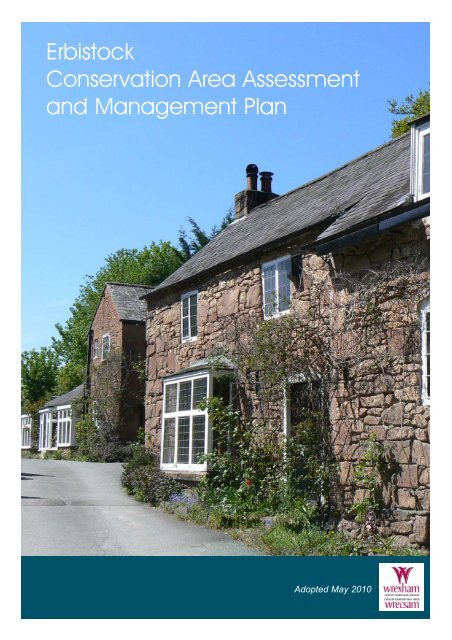
<strong>Erbistock</strong><br />
<strong>Conservation</strong> <strong>Area</strong> Assessment<br />
and Management Plan<br />
Adopted May 2010
Contact<br />
For more in<strong>format</strong>ion or advice contact:<br />
Chief Planning Officer<br />
Planning Department<br />
Wrexham County Borough Council<br />
Lambpit Street<br />
Wrexham<br />
LL11 1AR<br />
Telephone: 01978 292019<br />
email: planning@wrexham.gov.uk<br />
www.wrexham.gov.uk/planning<br />
This document is available in welsh and in alternative <strong>format</strong>s on<br />
request. It is also available on the Council’s website
contents<br />
Part I - Character Assessment 1<br />
1.0 Introduction 3<br />
2.0 History and Development 5<br />
3.0 Summary of Special Character 8<br />
4.0 Character in Detail 10<br />
5.0 Summary of Negative Features 18<br />
Part II - Management Plan 15<br />
6.0 Enhancement Plan 16<br />
7.0 Design Guidance 17<br />
8.0 <strong>Conservation</strong> <strong>Area</strong> Controls 19<br />
9.0 Sources of Funding 21<br />
Appendix 1 22<br />
Listed Buildings<br />
Appendix 2 23<br />
<strong>Conservation</strong> Policy Guidance<br />
Appendix 3 24<br />
Glossary of Architectural Terms<br />
Figures<br />
Figure 1 - <strong>Erbistock</strong> <strong>Conservation</strong> <strong>Area</strong> 2<br />
Figure 2 - <strong>Erbistock</strong> Historic Map 1899 5<br />
Figure 3 - <strong>Erbistock</strong> <strong>Conservation</strong> <strong>Area</strong> Character Map 10
Ariel View <strong>Erbistock</strong> <strong>Conservation</strong> <strong>Area</strong>
Part 1<br />
Character Assessment<br />
1
Figure 1: <strong>Erbistock</strong> <strong>Conservation</strong> <strong>Area</strong><br />
<br />
Ordnance Survey (mapping) © Crown copyright. All rights reserved. 100023429. 2010<br />
2
introduction<br />
<strong>Conservation</strong> <strong>Area</strong> Designation<br />
1.1 Section 69 of the Planning (Listed Buildings and<br />
<strong>Conservation</strong> <strong>Area</strong>s) Act 1990 requires Local Authorities to<br />
identify "areas of special architectural or historic interest the<br />
character or appearance of which it is desirable to preserve or<br />
enhance" for designation as conservation areas.<br />
Purpose<br />
1.2 The purpose of the <strong>Conservation</strong> <strong>Area</strong> Assessment and<br />
Management Plan is:<br />
●<br />
●<br />
●<br />
●<br />
●<br />
To provide a clear definition of the area's special<br />
architectural or historic interest<br />
To identify ways in which their unique characteristics<br />
can be preserved and enhanced through the<br />
Enhancement Plan<br />
To strengthen the justification for designation<br />
To create a clear context for future development in<br />
accordance with conservation area policies in the<br />
development plan<br />
To provide a vehicle for engagement and awareness<br />
raising<br />
<strong>Erbistock</strong> <strong>Conservation</strong> <strong>Area</strong><br />
1.3 This Assessment and Management Plan aims to<br />
promote and support developments that are in keeping with,<br />
or enhance, the character of the <strong>Erbistock</strong> <strong>Conservation</strong> <strong>Area</strong>.<br />
It is not an attempt to stifle change. The aim is to strike a<br />
balance so that the interests of conservation are given their<br />
full weight against the needs for change and development.<br />
The <strong>Erbistock</strong> <strong>Conservation</strong> <strong>Area</strong> was first designated in<br />
August 1975 and its boundary amended in April 2000. This<br />
document is concerned with the reasons for designation,<br />
defining the qualities that make up its special architectural<br />
and historic interest, character and appearance. The omission<br />
of any reference to a particular building, feature or space<br />
should not be taken to imply that it is of no interest.<br />
1 introduction<br />
Planning Context<br />
1.4 This Statement should be read in conjunction with the<br />
adopted Wrexham Unitary Development Plan 2005, and<br />
national planning policy guidance, in particular Welsh Office<br />
Circular 61/96 Planning and the Historic Environment:<br />
Historic Buildings and <strong>Conservation</strong> <strong>Area</strong>s.<br />
Location<br />
1.5 <strong>Erbistock</strong> is one of many hamlets and villages which<br />
exist along the banks of the River Dee. At <strong>Erbistock</strong> the<br />
River flows through the last section of dramatic steep sided<br />
valley before it meanders north across its low lying and<br />
gently undulating floodplain towards Chester. <strong>Erbistock</strong> is<br />
2km to the west of the village of Overton and is reached<br />
down a network of narrow winding country lanes off the<br />
Overton to Wrexham Road. <strong>Erbistock</strong> <strong>Conservation</strong> <strong>Area</strong> is<br />
centred on the area around the Church, which sits on the<br />
bank of the River Dee at the foot of a 45 metre high<br />
sandstone escarpment, set against a background of mature<br />
trees. The surrounding area is rural in character, dominated<br />
by pasture fields. The majority of the <strong>Conservation</strong> <strong>Area</strong> lies<br />
within the designated flood plain as identified by the<br />
Environment Agency.<br />
Geology<br />
1.6 The geology is a mix of Permian and Triassic (Red)<br />
Sandstone and Carboniferous Millstone grit (yellow<br />
sandstone). The dominance of the red sandstone as a<br />
principal building material within the <strong>Conservation</strong> <strong>Area</strong><br />
creates a sense of local distinctiveness.<br />
Consultation<br />
1.7 Community Councils, Council members and a range of<br />
organisations and groups with an interest in the historic<br />
environment and the local area were consulted on this<br />
document. Statutory bodies such as Cadw were also<br />
consulted. Public consultation was undertaken during March<br />
2010.<br />
3
4<br />
introduction
history and development<br />
Figure 2: <strong>Erbistock</strong> Historic Map 1899<br />
<br />
Ordnance Survey (mapping) © Crown copyright. All rights reserved. 100023429. 2010<br />
2 History and Development<br />
2.1 The area is recorded as 'Erpestock' in the Domesday<br />
Book of 1086. The name is likely to be a derivative of the<br />
old English name 'stoc' meaning 'dairy farm', combined<br />
with a corruption of Erbin, the Saint's name given to the<br />
original church. It has become '<strong>Erbistock</strong>' with the passage<br />
of time.<br />
2.2 The present settlement pattern has remained largely<br />
unchanged from that shown on an Estate Map of 1770-71.<br />
It shows a cluster of buildings around the church and<br />
riverbank, with other dispersed farm buildings and cottages.<br />
The stimuli for settlement may lie in the origins of St<br />
Hilary's Church, the ferry crossing over the River Dee and<br />
the good surrounding agricultural land.<br />
2.3 The church<br />
may have been<br />
originally<br />
founded in the<br />
6th century by a<br />
monk from the<br />
Celtic settlement<br />
at Bangor Is-y-<br />
Coed, charged<br />
with giving safe<br />
passage to<br />
travelling monks from other nearby monasteries. The<br />
isolated setting of the Church, close to the riverbank is<br />
typical of early medieval church sites in Wales. This early<br />
church is likely to have been deserted when the Bangor<br />
settlement was sacked in the 7th Century.<br />
2.4 A 13th century record of a church on this site states<br />
that it was dedicated to St Erbin, a Celtic Saint. St Erbin<br />
may have been connected to King Erbin of Cornwall,<br />
whose brother, Digain, is said to have founded another<br />
church in Denbighshire. It is unclear when the rededication<br />
to St Hilary, who shares the same feast day as St Erbin, may<br />
have occurred.<br />
2.5 The first description of the church building is in the<br />
Vestry Book of 1692, which recorded a 'building of timber<br />
frame and thatch construction.' The continuing decay and<br />
the constant need for the repair and upkeep of this church<br />
resulted in it being completely rebuilt between 1859 and<br />
1861, through the benefaction of Mrs Caroline Boates of<br />
nearby Rose Hill, in memory of her husband Lt Colonel<br />
Henry Ellis Boates. Following her death it was completed<br />
by their daughter Gertrude and is the design of an unnamed<br />
architect.<br />
2.6 To the east of the church is the Old Rectory,<br />
mentioned in 1685 and the Bishop's visitations of 1709.<br />
The Rectory formed part of the parish's glebe, or land<br />
belonging to the church, that provided revenue for its<br />
upkeep. Other glebe property recorded includes a tithe<br />
barn, gardens, orchards and other land and tenements. The<br />
glebe lands were divided into long narrow strips called<br />
'quillets,' which were marked out by meer stones with the<br />
letter 'G' on them. The quillets and meer stones are noted<br />
on the 1844 Tithe Map to identify holders of land so that<br />
one tenth of their income or produce could be paid to the<br />
Church. The availability of prime agricultural land in the<br />
surrounding<br />
countryside<br />
contributed to<br />
the continued<br />
prosperity and<br />
growth of the<br />
area.<br />
2.7 The<br />
Rectory was<br />
originally<br />
5
history and development<br />
6<br />
considered 'an old scattered building,' too big for the Rector<br />
to maintain. However by 1876, it had been extended to<br />
include a coach house, stables, dairy, potting shed, cattle<br />
shed and pig sty. The inclusion of servants' quarters and<br />
reception rooms hints at the lifestyle of the Rector, who may<br />
have entertained wealthy landowners and visiting parish<br />
dignitaries. They also signify the growth in population and<br />
wealth of the parish in its ability to support such a large<br />
Rectory. The coach house has since been separated from the<br />
Old Rectory and is now a dwelling. The Old Rectory itself<br />
has retained much of its original character, despite later<br />
additions and remodelling.<br />
2.8 The ford and ferry crossing are two of the few safecrossing<br />
points along the River Dee. It would have been<br />
strategically important to local commerce and perhaps to the<br />
warring factions of earlier times. There is evidence that local<br />
people used coracles to cross the river at their own<br />
convenience. The building of the Overton Bridge, a mile and<br />
a half down stream in the 17th century reduced the<br />
importance of the ford and ferry not least because of their<br />
dependence on water levels, resulting in <strong>Erbistock</strong> retaining<br />
its secluded and rural feel right up to the present day.<br />
2.9 The picturesque setting of the ferry crossing<br />
contributed to the area becoming a popular Sunday excursion<br />
for visitors in the Victorian era. The development of rail<br />
transport and the passing of the Bank Holidays Act of 1871<br />
meant day-trippers from Liverpool, Manchester and<br />
Birmingham were attracted to the area, so that by 1896 the<br />
ferry carried up to 10,000 people a year. Tourists would have<br />
travelled from nearby railway stations to <strong>Erbistock</strong> by horse<br />
and cart and paid a one old penny fee to cross the Dee.<br />
2.10 The ferry was hauled by a two-rope windlass system.<br />
Although the service ceased in 1939, it was temporarily<br />
revived as a tourist attraction in the 1990's by the Boat Inn's<br />
gardener. The winch that pulled the original ferry can still be<br />
seen in the gardens at the front of the Inn. The landing stage<br />
and river wall have been replaced by gardens after a high<br />
flood in 1947. Originally consisting of two stepped levels,<br />
the stone steps leading down to the river are still visible on<br />
both sides of the riverbank.<br />
2.11 The ferry gives its name to the Boat Inn, which stands<br />
above the banks of the Dee. It is likely to have been<br />
established to provide refreshment for ferry passengers, local<br />
agricultural workers and possibly churchgoers. The Inn<br />
originally comprised two dwellings with a barn built at right<br />
angles to the river. One of these dwellings may have been<br />
used as a workhouse for a short period of time in the early<br />
19th century. An additional single storey, thatched roofed<br />
building existed in front of the barn, may have been used as a<br />
waiting room for ferry passengers.<br />
2.12 The two original dwellings are now incorporated into a<br />
single structure,<br />
housing the pub and<br />
restaurant; however the<br />
original frontage has<br />
remained largely<br />
unchanged. A further<br />
20th Century extension<br />
links the main building<br />
to the barn.<br />
2.13 The character of the area is significantly drawn from<br />
the continued use of the Boat as an inn serving travellers,<br />
tourists and the local community through the centuries. It<br />
remains a popular pub and restaurant today, with its image<br />
little changed from the scene depicted on postcards of the<br />
area from the 1870's.
history and development<br />
7
summary of special character<br />
3 Summary of Special Character<br />
3.1 The special character of <strong>Erbistock</strong> <strong>Conservation</strong> <strong>Area</strong><br />
derives from its unspoilt<br />
rural setting and the easy<br />
integration of the historic<br />
buildings into the<br />
picturesque and dramatic<br />
riverside landscape. The<br />
area has barely changed<br />
over time with very little<br />
modern development.<br />
Arriving along a narrow<br />
winding country lane with<br />
high grass verges and<br />
hedgerows, there is a strong<br />
sense of enclosure further<br />
accentuated by the topography of the landscape with high<br />
and wooded sandstone escarpments on the north and<br />
south banks of the river. There is an atmosphere of<br />
quiet isolation and seclusion with the grand flow<br />
and curve of the River Dee through the<br />
valley and around Llan y Cefn Wood<br />
creating a certain sense of tranquillity.<br />
Llan y Cefn woods<br />
3.2 This area is a protected<br />
woodland and designated<br />
wildlife site containing<br />
important tree species such as<br />
ash, oak and sycamore and<br />
important habitats for<br />
wildlife. The woods form<br />
an important backdrop to<br />
the conservation area.<br />
The River Dee<br />
3.3 The River Dee is a designated Site of Special Scientific<br />
Interest (SSSI) and a European Special <strong>Area</strong> of <strong>Conservation</strong><br />
(SAC). The open green banks on the north side of the river<br />
contribute to the setting of the Church, and allow views of<br />
the river valley to the east and west and the Llan y Cefn<br />
Woods. The mature oak, lime, willow, birch and yew trees<br />
within the <strong>Conservation</strong> <strong>Area</strong> further enhance the setting and<br />
provide an important backdrop to the settlement.<br />
St Hilary's Church<br />
3.4 Sited on elevated ground, the church is the most<br />
prominent building on the riverfront<br />
and a central focus for<br />
the area.<br />
8
summary of special character<br />
Buildings<br />
3.5 <strong>Erbistock</strong> <strong>Conservation</strong> <strong>Area</strong> is very small. Its few<br />
buildings are,<br />
with one<br />
exception,<br />
historic and<br />
three are listed.<br />
Individually the<br />
buildings have<br />
special character<br />
and as a group<br />
they add<br />
strength and cohesiveness to the area.<br />
Red Sandstone<br />
3.6 The use of local red sandstone as a building material,<br />
quarried from the embankment behind the Boat Inn adds to<br />
local distinctiveness of the area and contributes greatly to<br />
the sense of place and integration of the built with the<br />
natural environment. This is further enhanced by the<br />
predominance of sandstone boundary walls to enclose<br />
public and private spaces. The use of cobbles in surface<br />
detailing retains the unspoilt rural feel of the area.<br />
Vernacular Detail<br />
3.7 Building<br />
details such as<br />
pitched slate roofs<br />
with flush eaves<br />
and verges, dressed<br />
sandstone quoins,<br />
and sandstone<br />
copings and<br />
kneelers provide a<br />
visual link between<br />
buildings, increasing the sense of harmony between<br />
structures and further increasing local distinctiveness.<br />
The Boat Inn<br />
3.8 The continued use of the Boat Inn over the centuries<br />
as a meeting place adds an element of stability and<br />
permanence to the area. It is this use which provides a<br />
certain ambience, transforming the area from a quiet<br />
backwater on weekdays, to a popular location for visitors at<br />
the weekend.<br />
9
Figure 3: <strong>Erbistock</strong> <strong>Conservation</strong> <strong>Area</strong> Character Map<br />
character in detail<br />
<br />
<strong>Conservation</strong> <strong>Area</strong> Boundary<br />
Listed Buildings<br />
Protected Woodland<br />
Trees Forming Important Backdrop<br />
Strong Enclosure by Trees and Vegetation<br />
Important Individual Trees<br />
Buildings of Visual Interest<br />
Important Approach<br />
Important Stretch of Stone Boundary<br />
Ordnance Survey (mapping) © Crown copyright. All rights reserved. 100023429. 2010<br />
4 Character in Detail<br />
The Old Rectory and Rutters Farm<br />
4.1 The <strong>Conservation</strong> <strong>Area</strong> is approached from the north<br />
east down a<br />
narrow country<br />
lane with grass<br />
verges and<br />
hedgerows. A<br />
dog-leg bend in<br />
the lane marks<br />
the start of the<br />
<strong>Conservation</strong><br />
<strong>Area</strong>, the<br />
enclosure this affords providing the visitor with a sense of<br />
arrival. On the right hand side of the entrance into the<br />
<strong>Conservation</strong> <strong>Area</strong>, there is a sandstone rubble wall,<br />
overhung with mature vegetation after which the lane is<br />
bounded by mature hedges on both sides of the road. There<br />
is a magnificent mature specimen sycamore tree at the<br />
entrance to the<br />
Old Rectory and<br />
further examples<br />
in the grounds.<br />
The drive entrance<br />
has a simple<br />
wooden gate and<br />
post and rail fence<br />
typical of its quiet<br />
rural setting.<br />
4.2 Further along the lane, the gable end of the stable<br />
building at Rutters Farm creates a strong focal point. A<br />
further stone barn and attached carthovel, are positioned<br />
directly onto the lane and together with the high sandstone<br />
wall to the former Rectory Coach House immediately<br />
10<br />
opposite, increases the sense of enclosure and intimacy and<br />
directs the eye towards the farmhouse and Church beyond.<br />
Built from local red sandstone, the appearance of the farm<br />
buildings has largely remained unaltered. Both buildings<br />
have slate roofs with sandstone ridge tiles, flush eaves and<br />
verges, ventilation slits and hay doors in the gable ends.<br />
However the stable building nearest to the house is more<br />
prestigious, having carved sandstone copings and kneelers.<br />
This structure probably housed the trap horse for the family<br />
transport. The other building is more simple and utilitarian<br />
in design, probably<br />
built to house the<br />
plough and<br />
carthorses.<br />
4.3 The Rutters<br />
Farmyard forms a<br />
picturesque group<br />
of late 18th and<br />
early 19th Century<br />
stone and late 19th<br />
Century brick farm buildings. The cobbled yard is enclosed<br />
by a sandstone wall with soldier course coping, which<br />
enhances the setting of the stables and pigsties. The farm<br />
buildings are of an intimate small scale, which is very much<br />
a part of their special charm.<br />
4.4 Rutter's Farmhouse circa late 18th/early 19th century is<br />
set back from the road with an open frontage and gravel and<br />
cobbled yard. The absence of a front boundary fence or wall<br />
creates an open feel which contributes to the intimate setting<br />
of the <strong>Conservation</strong> <strong>Area</strong>. The house is built on a fine<br />
sandstone plinth with brick walls of English Garden Wall<br />
bond, a dentilled eaves line and, like the barns, stone coping<br />
and kneelers to the gable ends. Windows have timber
casements with cast iron transoms and are flush to the<br />
external wall. The boarded, wooden front door, is reached by<br />
worn sandstone steps beneath a canopy porch on curved<br />
brackets. A sliding sash Georgian window is seen in the<br />
southern gable.<br />
4.5 The Old Rectory is a Grade II listed building, originally<br />
dating from the late 17th/early 18th century. The oldest part<br />
was probably built originally in red sandstone rubble and<br />
later refaced in red brick; this is the two-storey block at the<br />
rear facing the road which is now covered in painted rough<br />
render. In the late 18th century an extension was added at<br />
the front (the riverfront elevation) in Flemish bond<br />
brickwork, then in the mid 19th century it was considerably<br />
remodelled with an attic storey and three 18-paned sliding<br />
sash windows added. In the 18th century the canted bay was<br />
also constructed in sandstone and brick. Originally the bay<br />
was single storey with three open arches, two of which are<br />
now blocked up or 'blind' and the central one has been<br />
converted to a doorway. The upper floor windows contain<br />
two blind windows and one 16 paned sash window.<br />
4.6 The Rectory is set in substantial grounds, which<br />
contain a variety of mature trees including a yew close to the<br />
south elevation subject to a tree preservation order and a<br />
particularly fine sycamore at its entrance gate. The gravel<br />
drive enhances its attractive<br />
setting.<br />
St Hilary's Church<br />
4.7 St Hilary's Church, listed<br />
Grade II is built in the Gothic<br />
Revival Style with Decorated<br />
and Early English elements. It<br />
was erected between 1859 and<br />
1861 in red sandstone ashlar<br />
with a slate roof and red clay<br />
crested ridge tiles, which are<br />
unusual for this area. The<br />
bellcote at the west end has 3<br />
bells and a crucifix finial, and<br />
this together with the polygonal apsidal chancel make the<br />
Church particularly distinctive. The cast iron guttering,<br />
downspouts and hoppers have been retained and are dated<br />
1861. There is a<br />
decorative cornice<br />
freeze under the<br />
overhanging eaves of<br />
the apse. The nave<br />
windows have<br />
Decorated style<br />
tracery and hoodmoulds with<br />
foliated stops. Chancel<br />
windows are cusped lancets<br />
with hoodmoulds with stops in<br />
the form of male and female<br />
heads. These may be images of<br />
people who were patrons of the<br />
Church.<br />
4.8 Inside the nave and aisles<br />
are under one roof of an<br />
character in detail<br />
exposed scissor braced timber construction. There is a<br />
Norman Caen stone pulpit with recessed quatrefoil designs<br />
and incised texts and an octagonal font of similar design.<br />
The patronage of the Boates family is recorded in the many<br />
memorials visible in the church today; and others of<br />
particular note are the list of parish Rectors, and the broken<br />
obelisk to Ann<br />
Vaughan of 1791.<br />
4.9 The Church<br />
is approached via a<br />
gravel path from<br />
the north-eastern<br />
corner of the<br />
churchyard and by<br />
sets of worn<br />
sandstone steps<br />
from the south-west, and southeastern<br />
corners. Wooden gates and<br />
mature yew trees act as sentinels at<br />
each entrance. The Church is set in<br />
an elevated position within its<br />
terraced graveyard which is almost<br />
rectangular in shape. Fine views of<br />
the river are afforded from its<br />
elevated position. A sandstone wall<br />
surrounds the churchyard, which is overgrown with<br />
vegetation, softening its appearance and once again assisting<br />
in the integration of the built with the natural environment.<br />
The wall is integral to the setting<br />
and views of the church.<br />
4.10 Other features of interest<br />
are the Victorian metal shoe<br />
scraper which remains at the<br />
entrance to the south porch as<br />
well as the nearby sundial, which<br />
has a 19th century stone pillar<br />
and plinth and a modern metal<br />
gnomon. To the rear of the<br />
churchyard sandstone steps and a<br />
wooden gate invite you to a<br />
public footpath, which gives rear<br />
views of the buildings and river and leads to the graveyard<br />
extension. The footpath continues its course through to the<br />
nursery and gardens of Garden House, which are open to the<br />
public.<br />
4.11 From the north-eastern entrance into the Churchyard,<br />
the lane takes a tight right<br />
angled bend, bounded on the<br />
east by the high Coach house<br />
wall, to reveal the remaining<br />
part of the <strong>Conservation</strong><br />
<strong>Area</strong>. From this point the<br />
<strong>Conservation</strong> <strong>Area</strong> opens out<br />
to offer impressive views of<br />
the River Dee and the steep<br />
sided escarpment of Llan y<br />
Cefn woods in direct contrast<br />
to the narrow confines of the<br />
lane.<br />
11
character in detail<br />
The Boat Inn<br />
4.12 Early O.S. maps show the lane continuing straight<br />
ahead at this point down to a ford in the river. Today the<br />
area is grassed over but it is possible to see where the ford<br />
crossed to the opposite river bank.<br />
4.13 A separate entrance with wooden gates has been<br />
created to The<br />
Coach House. At<br />
the entrance of the<br />
driveway to the<br />
Boat Inn, a 5 bar<br />
wooden gate and<br />
post and rail fence<br />
have been erected.<br />
These simple<br />
boundary treatments reflect the rural character of the area.<br />
The Boat Inn is a Grade II listed building set in a wonderful<br />
position overlooking the River Dee. Formerly two cottages<br />
of 17th Century origin it is built of random courses of red<br />
sandstone rubble. The pitched slate roof has flush verges<br />
and sandstone ridges. The east building has 19th century<br />
additions in the form of brick chimneys and dormer<br />
windows. Windows<br />
are cast iron multipaned<br />
casements<br />
with cills flush to<br />
the external wall and<br />
later low brick<br />
arches on the lower<br />
storey. The brick<br />
arch is mirrored<br />
above the original central entrance, which has a panelled<br />
door and is reached by sandstone steps. A low entrance to<br />
the basement lies<br />
to the left of the<br />
steps. The left<br />
hand building also<br />
has cast iron multipaned<br />
casements,<br />
with cills flush to<br />
the external wall<br />
with 19th century<br />
additions including<br />
a wooden, six panelled door and a box bay window to the<br />
ground floor.<br />
4.14 The setting of<br />
the Inn is enhanced<br />
by the cobbled<br />
frontage. An<br />
historic stone<br />
mounting block<br />
survives at the front<br />
right hand corner of<br />
the Inn which would<br />
have been used by guests and ferry passengers mounting or<br />
dismounting their horses or carts. Landscaped gardens lead<br />
down to the River, with topiary bushes which add formality<br />
without detracting from the rural feel. The outdoor seating<br />
area is sympathetic to its surroundings due to its low-key<br />
appearance and the use of natural materials such as wooden<br />
benches, gravel pathways and sandstone edgings.<br />
Interesting features include the original windlass for the<br />
ferry located at the top of the original stone ferry steps<br />
which lead down to the river on both riverbanks.<br />
4.15 The exposed, locally distinctive red sandstone<br />
escarpment to the rear of The Inn creates a dramatic<br />
backdrop, which enhances the setting.<br />
4.16 The Boat Inn<br />
has been extended<br />
by linking the public<br />
house to the adjacent<br />
19th century barn<br />
with a glass and<br />
sandstone extension.<br />
It has been designed<br />
to be in sympathy<br />
with the original buildings, respecting their character scale<br />
and detailing. The two-storey barn is set at right angles to<br />
the other buildings, built of sandstone rubble with quoins,<br />
pitched slate roof, flush verges and sandstone ridge tiles.<br />
Windows are a mixture of cast iron casements and timber<br />
frames. A single storey extension runs at 90 degrees to the<br />
barn with two box bays and a third box bay French window.<br />
4.17 The adjacent open fields are important in retaining<br />
views of the valley and the River Dee. They can be crossed<br />
by a public footpath running alongside the riverbank. A<br />
wooden post and rail fence marks the southern boundary of<br />
the car park once again reflecting the rural character of the<br />
area.<br />
12
summary of negative features<br />
5 Summary of Negative Features<br />
The Boat Inn Car Park<br />
5.1 The large macadam surfaced car park to the Boat Inn<br />
marks the western edge of the conservation area.<br />
Unfortunately, the unbroken expansiveness of the area neither<br />
preserves nor enhances the special character of this part of the<br />
conservation area, and represents an opportunity for<br />
enhancement.<br />
Salmons Leap<br />
5.2 The 20th Century design and<br />
materials used in the construction of<br />
this building and the<br />
floodlighting attached to<br />
the front elevation are<br />
unsympathetic to its<br />
historic rural setting.<br />
The property, located<br />
at the western edge<br />
of the<br />
<strong>Conservation</strong><br />
<strong>Area</strong>, stands in<br />
a prominent<br />
elevated<br />
position<br />
which<br />
unduly<br />
raises its<br />
status within<br />
the wider<br />
views of the<br />
<strong>Conservation</strong><br />
<strong>Area</strong>. It is a<br />
benefit that the<br />
property is largely screened from the approach into the<br />
<strong>Conservation</strong> <strong>Area</strong> by vegetation and the curvature of the<br />
access. The car park which it overlooks is an expansive area<br />
of macadam, inappropriate in this predominantly natural<br />
environment.<br />
13
14<br />
summary of negative features
Part 2<br />
Management Plan<br />
15
6.1<br />
GENERAL<br />
management plan<br />
PROPOSALS FOR PRESERVATION AND ENHANCEMENT<br />
Trees<br />
Archaeology<br />
Boundary Details<br />
Alterations and New Development<br />
Highway Improvements<br />
Trees which are considered to make a significant contribution to the character and<br />
appearance of the area have been identified on Figure 3 of this document. Tree<br />
works that may be considered detrimental to local character will be resisted.<br />
Where removal is essential then an appropriate re-planting scheme will be<br />
encouraged.<br />
Archaeological mitigation may be required in response to development proposals<br />
within the <strong>Conservation</strong> <strong>Area</strong>. Early consultation with the Clwyd-Powys<br />
Archaeological Trust in relation to any proposed new dwelling or extension is<br />
encouraged to prevent delay at the application submission stage.<br />
The total demolition or removal of traditional boundary details will be resisted.<br />
The use of traditional methods of construction and materials including the use of<br />
lime mortar is encouraged in all schemes of repair and reinstatement or new work.<br />
Proposals must be designed in accordance with Design Guidance as contained<br />
within Section 7.0 of this document.<br />
Highway works should be designed in accordance with guidelines as set out in<br />
Section 7.0 of this document and must have special regard to the desirability of<br />
retaining the special rural character of the area through the preservation of grass<br />
verges and by limiting the use of hard surfacing, kerbs, road signage and road<br />
markings.<br />
6.2<br />
GENERAL PROPOSALS FOR PRESERVATION AND ENHANCEMENT<br />
The following have been identified as opportunities for the enhancement of the <strong>Conservation</strong> <strong>Area</strong>. The undertaking of these<br />
works is dependent upon the availability of funding or grant assistance:<br />
ENHANCEMENT PROPOSALS<br />
Boat Inn Car Park - The car park could benefit from some<br />
simple, informal landscaping or tree planting to break up the<br />
expanse of hard surfacing. A softer or more natural<br />
surface treatment to both the car park and driveway would<br />
enhance the setting of both the Boat Inn and the Church<br />
and be more sympathetic to the rural surroundings.<br />
Waste/Service <strong>Area</strong> to the rear of the Boat Inn -<br />
This area would benefit from screening in order to hide<br />
the skips and waste bins.<br />
Salmons Leap - The two large floodlights could be<br />
removed and replaced with much more subtle lighting<br />
in the car park itself. Salmons Leap would benefit from<br />
either redevelopment of the site or from a sensitive<br />
landscaping and planting scheme.<br />
RESPONSIBLE BODY<br />
Private land owner<br />
Private land owner<br />
Private land owner<br />
16
design guidance<br />
7 Design Guidance<br />
7.1 The character of the individual buildings, which<br />
together form the <strong>Conservation</strong> <strong>Area</strong>, derives from a number<br />
of factors, to which the following design guidance relates.<br />
Within these parameters there is scope for high quality<br />
architectural invention, provided that this is sympathetic to<br />
the existing character in terms of the following:<br />
Proportion<br />
7.2 Older building styles followed traditional systems of<br />
proportion. In most of the buildings within the <strong>Conservation</strong><br />
<strong>Area</strong>, the relationship between windows, doors, floor heights<br />
and the<br />
relationship of<br />
solid to void in<br />
the design of<br />
elevations is<br />
crucial.<br />
Traditional<br />
proportions<br />
should be<br />
emulated in new<br />
development.<br />
Roofs<br />
7.3 The roof line is nearly always a dominant feature of a<br />
building and retention of the original shape, pitch, verge and<br />
eaves detail and ornamentation is essential. Heights and<br />
shapes of roofs are important; flat roofs are alien to local<br />
tradition and generally unacceptable. Chimney-stacks are<br />
important features of the roof-scape and should be retained<br />
even if no longer required. Where roofing materials are to be<br />
replaced they should match the colour, size and texture of the<br />
original. Roofs should be roofed or re-roofed in traditional<br />
materials on a like for like basis where historically<br />
appropriate. If ventilation of the void is required, this should<br />
be achieved by inconspicuous means. Under eaves<br />
ventilation would be acceptable, but visible roof vents would<br />
not.<br />
External Walls<br />
7.4 Any alteration or repair<br />
to external walls should<br />
respect the existing building<br />
materials and match them in<br />
texture, quality and colour.<br />
Every effort should be made<br />
to retain or re-use facing<br />
brickwork or stonework,<br />
which must not be rendered,<br />
pebble-dashed or painted.<br />
Re-pointing should be carried<br />
out with a mortar to match<br />
the existing in colour, type<br />
and texture and historically would have consisted of lime and<br />
sand. Modern hard cement mortar and renders prevent the<br />
evaporation of moisture which can accumulate within the<br />
wall causing damp internally. When appropriate, hard<br />
cement renders should be replaced with a lime alternative.<br />
Rainwater Goods<br />
7.5 Rainwater goods should be repaired if original or<br />
reinstated in original materials. Plastic guttering is not<br />
appropriate on Listed Buildings and buildings in<br />
<strong>Conservation</strong> <strong>Area</strong>s. It is not historically correct, and it does<br />
not enhance a building's character. Cast iron guttering can<br />
last for a lifetime, if properly maintained, repaired and<br />
installed.<br />
17
design guidance<br />
Windows<br />
7.6 These are important features which should be<br />
correctly proportioned, well related to each other and<br />
adjoining buildings and should respect the existing<br />
openings. Any repair or replacement should always match<br />
the original. This includes not only structural elements of<br />
the window but also the historic glass and original window<br />
furniture. Particularly important is the method of opening,<br />
the recessed depth within the reveal and the sections of<br />
glazing bars. Vertically sliding sash or side hung casement<br />
windows are the most typical style of window within this<br />
<strong>Conservation</strong> <strong>Area</strong>. Replacement of timber or iron<br />
windows in a PVCu alternative, no matter what the pattern,<br />
is unacceptable. All windows must have a traditional<br />
painted finish rather than a modern stained alternative.<br />
Doors<br />
7.7 Original door-cases, doors and door furniture should<br />
be retained wherever possible. Replacements must match<br />
the original in proportion, style and materials and should<br />
have a painted finish. Porches should be designed within<br />
the overall context and architectural style of the building<br />
and in reference to any appropriate nearby styles. They<br />
should not dominate the front elevation.<br />
Boundary Treatment<br />
7.8 The removal or alteration of boundary walls will not<br />
be viewed favourably. Repair should be carried out using<br />
identical materials and in the same style or bond and<br />
missing copings replaced to match the existing. The use of<br />
a hard cement mortar to re-point joints is unacceptable,<br />
increasing the rate of deterioration of sandstone in<br />
particular.<br />
Surfaces<br />
7.9 The overuse of insensitive macadam finishes should<br />
be avoided and the opportunity taken to lay traditional<br />
materials, their colour, texture and pattern in sympathy<br />
with the character of the area and sensitive to adjacent<br />
buildings. Existing areas of cobbles should be retained and<br />
repaired.<br />
Highway Works<br />
7.10 Redundant or unnecessary street furniture such as<br />
signs or poles should be removed to reduce the effects of<br />
street clutter. Any new items such as sign-posts, etc must<br />
be carefully integrated within the streetscape and respect<br />
adjacent buildings and the area as a whole. The number<br />
and size of road signs must be kept to a minimum and only<br />
illuminated where essential. Backing plates should be grey<br />
or black and luminous yellow must be avoided. Where<br />
road lines are essential they must be of a restricted width<br />
within the <strong>Conservation</strong> <strong>Area</strong>.<br />
Micro Energy Generation<br />
7.1 Whilst the use of micro energy generation systems is<br />
to be encouraged, they will not be accepted where<br />
equipment is fixed to building frontages or main or visible<br />
elevations where they would have a negative visual impact<br />
upon the <strong>Conservation</strong> <strong>Area</strong> or where the fabric or setting<br />
of a Listed Building is detrimentally affected.<br />
18
conservation area controls<br />
8 <strong>Conservation</strong> <strong>Area</strong> Controls<br />
Special Controls<br />
8.1 In order to protect the special environment, stricter<br />
controls exist within the <strong>Conservation</strong> <strong>Area</strong>. These are not<br />
intended as a hindrance to change, but as positive<br />
management to safeguard the character of the area as a<br />
whole. These include:<br />
●<br />
●<br />
●<br />
Additional powers of control to dwelling houses for<br />
extensions, roof extensions and alterations, cladding,<br />
garages and satellite dish location.<br />
Most works involving total demolition require<br />
<strong>Conservation</strong> <strong>Area</strong> Consent. Consent for demolition<br />
will not normally be granted until it is known what<br />
form redevelopment will take.<br />
Work to trees requires six weeks notice to be given<br />
to the Council.<br />
With all proposals for development and the display of<br />
advertisements in a <strong>Conservation</strong> <strong>Area</strong>, greater care is<br />
necessary to ensure that schemes enhance and preserve the<br />
area's special character. Design and choice of materials are<br />
of particular importance in this respect.<br />
Listed Buildings<br />
8.2 A Listed Building is a building that is considered to be<br />
of 'special architectural or historic interest' and as such<br />
requires special protection. Once listed, a building is<br />
protected under the Planning (Listed Buildings and<br />
<strong>Conservation</strong> <strong>Area</strong>s) Act 1990. The Listing protects the<br />
building both externally and internally irrespective of the<br />
reason for listing as well as any object or structure fixed to<br />
the building (whether or not mentioned in the listing<br />
description). The listing also extends to any object or<br />
structure within the 'curtilage' of the building, which has<br />
existed since before 1st July 1948. This is to ensure that the<br />
special character of both the building and its setting are<br />
protected.<br />
8.3 Where works are proposed to a Listed Building, it is<br />
always advisable to check with the Council's Planning<br />
Department whether Listed Building Consent is required. In<br />
any works proposed, special regard must be given to the<br />
desirability of preserving the building, its setting and special<br />
features of interest.<br />
8.4 In considering any works to a Listed Building the<br />
principle objective must be to retain all original features and<br />
fabric of the building wherever possible. Listed Building<br />
Consent is required for the demolition of a listed building or<br />
for alteration, which would affect the building's character,<br />
integrity or special interest. This could include changing<br />
windows and doors, changing roofing materials, painting<br />
brickwork, moving or removing internal walls or<br />
plasterwork, fireplaces, floorboards or staircases. Like for<br />
like repairs may not need consent but it is always advisable<br />
to check prior to undertaking any works as the carrying out<br />
of works without the necessary consent is a criminal offence<br />
with significant penalties for those involved following a<br />
successful prosecution.<br />
Commercial Buildings<br />
8.5 Properties in commercial use do not have Permitted<br />
Development Rights under the Town and Country Planning<br />
(General Permitted Development) Order 1995. Therefore the<br />
only works that may be carried out without Planning<br />
Permission are works of repair and maintenance and internal<br />
alterations, provided the building is not a Listed Building.<br />
19
Special Landscape <strong>Area</strong><br />
8.6 The area is part of a Special Landscape <strong>Area</strong>,<br />
within which priority is given to the conservation<br />
and enhancement of the landscape. Development<br />
other than for agriculture, small-scale farm based<br />
and other rural enterprises, and essential operational<br />
development by utility service providers, will be<br />
strictly controlled. Development will be required to<br />
conform to a high standard of design and<br />
landscaping, and special attention will be paid to<br />
minimising its visual impact both from nearby and<br />
distant viewpoints.<br />
Site of Special Scientific Interest<br />
and Special <strong>Area</strong> of <strong>Conservation</strong><br />
8.7 The River Dee at <strong>Erbistock</strong> is designated as a<br />
Site of Special Scientific Interest (SSSI) and a<br />
Special <strong>Area</strong> of <strong>Conservation</strong> (SAC). SSSI's are the<br />
country's very best wildlife and geographical sites<br />
and are legally protected under the Wildlife and<br />
Countryside Act 1981, as amended by the<br />
Countryside and Rights of Way (CROW) Act 2000<br />
and the Natural Environment and Rural<br />
Communities (NERC) Act 2006. This legislation<br />
gives The Countryside Council for Wales powers to<br />
ensure better protection and management of SSSIs<br />
and safeguard their existence into the future.<br />
8.8 SACs are strictly protected sites designated<br />
under the EC Habitats Directive, and are of<br />
European importance. Particular features of<br />
importance on the River Dee include the migration<br />
route and breeding areas of Atlantic salmon, the<br />
presence of floating water-plantain, three species of<br />
lamprey, otters and bullhead.<br />
8.9 Watercourses such as the River Dee form<br />
important wildlife corridors, allowing the movement<br />
of species between fragmented areas and connecting<br />
different riverbank habitats.<br />
conservation area controls<br />
20
sources of funding<br />
9 Sources of Funding<br />
A fundamental principle of all grant schemes is that grant<br />
cannot be offered after the work has been started. All grants<br />
are discretionary and rates may vary. Early consultation with<br />
possible providers is essential.<br />
Cadw: Welsh Historic Monuments<br />
Cadw is the principal public agency offering grant aid for<br />
historic buildings in Wales. The key grant schemes<br />
summarise as:<br />
Historic Buildings Grant<br />
For the repair and restoration of historic fabric of building's<br />
of 'outstanding' architectural or historic interest. Grants are<br />
normally paid in instalments or on completion of the work.<br />
The percentage of the total eligible cost of repair payable<br />
through grant aid is dependent on the building type, for<br />
example:<br />
Religious 50%<br />
Trusts and Charities 40%<br />
Domestic/Private 30%<br />
Commercial/Industrial 30%<br />
Public 30%<br />
Conditions of the grant may require a specialist to undertake<br />
and oversee the works and allow a degree of public access to<br />
the property once works are completed. The owner must<br />
also ensure that the property is kept in good condition and<br />
take out and maintain adequate insurance cover for the<br />
property.<br />
<strong>Conservation</strong> <strong>Area</strong>s Grant<br />
For works to the external structure or appearance of historic<br />
buildings, which significantly enhance a <strong>Conservation</strong> <strong>Area</strong>.<br />
Grants are again paid by instalments or on completion of the<br />
work based on the following rates:<br />
Religious 40%<br />
Trusts and Charities 30%<br />
Domestic/Private 25%<br />
Commercial/Industrial 25%<br />
Public 25%<br />
Similar to the Historic Building Grant, conditions may<br />
require a specialist to undertake and oversee the works. The<br />
owner must also ensure that the property is kept in good<br />
condition and take out and maintain adequate insurance<br />
cover for the property.<br />
21
Appendix 1<br />
Listed Buildings<br />
Listed Building<br />
The Old Rectory<br />
The Church of St. Hilary<br />
The Boat Inn Public House<br />
Grade<br />
II<br />
II<br />
II<br />
22
Appendix 2<br />
<strong>Conservation</strong> Policy Guidance<br />
Main Legislation National Policy Guidance Local Policy<br />
Town and Country Planning Policy Wales Wrexham Unitary Development<br />
Planning Act 1990 Plan (LDP in preparation 2009)<br />
Planning (Listed Buildings Welsh Office Circular 61/96: Local Planning Guidance Note 4:<br />
and <strong>Conservation</strong> <strong>Area</strong>s) Planning and the Historic Environment: <strong>Conservation</strong> <strong>Area</strong>s<br />
Act 1990<br />
Historic Buildings and <strong>Conservation</strong><br />
<strong>Area</strong>s<br />
Ancient Monuments and Welsh Office Circular 1/98: Planning<br />
Archaeological <strong>Area</strong>s Act 1979 and the Historic Environment: Directions<br />
by the Secretary of State for Wales<br />
Technical Advice Note 12: Design<br />
Welsh Office Circular 60/96:<br />
Planning and the Historic Environment:<br />
Archaeology<br />
23
Appendix 3<br />
Glossary of Architectural Terms<br />
Ashlar<br />
Canted<br />
Casement<br />
Coping<br />
Coracle<br />
Cornice<br />
Cusped Lancets<br />
Dentilled Eaves<br />
Dormer<br />
Escarpment<br />
Fanlights<br />
Finial<br />
Flemish Bond<br />
Foliated<br />
Ford<br />
French Windows<br />
Gnomon<br />
Gothic<br />
Hoodmould<br />
Kneeler<br />
Obelisk<br />
Pastiche<br />
Quoin<br />
Render<br />
Sash Windows<br />
Soldier Course<br />
Topiary<br />
Tracery<br />
Transom<br />
The best grade of masonry comprised of blocks of accurately dressed stone with<br />
extremely fine bed and end joints<br />
Angled at the sides, as in bay windows<br />
A window where the opening lights are hung on hinges<br />
A sloping or curved overhanging section of stone on top of a wall or parapet,<br />
designed to protect the masonry from rain water<br />
A small round boat which is made by stretching animal skin over a wooden frame<br />
Moulded ledge, projecting along the top of a building. Also a decorative moulding<br />
in the angle between a wall and ceiling<br />
Slender single-light pointed-arched window with decorative edging<br />
Small cubic projections at the top of the wall under the roof-line under the roof line<br />
A window set in a sloping roof often with its own sloping or pitched roof<br />
A steep slope or cliff, such as one which marks the edge of a range of hills<br />
A glazed opening over a door<br />
A decorative piece to finish off a building element, commonly used on railings and<br />
roofs<br />
Method of brick laying consisting of alternating headers and stretchers along each<br />
course with the headers centred on the stretchers above and below<br />
Decorated, especially carved with leaves<br />
Stream or river which crosses over a road<br />
A pair of glazed doors, usually opening from the back of a house into its garden<br />
The part of a sundial that casts the shadow in order to tell the time<br />
Period of medieval architecture characterised by the use of the pointed arch<br />
Projecting moulding shown above an arch or lintel to throw off rainwater<br />
Horizontal projecting stone at the base of each side of a gable on which the inclined<br />
coping stones rest<br />
Tapering pillar of square plan and ending pyramidally<br />
A piece of architecture which intentionally copies the style of another period<br />
Dressed stones which are bonded to the corners of buildings<br />
The plastering of a surface with plaster, stucco or another finish<br />
A window with opening parts (sashes) moving vertically in grooves, either with<br />
one frame fixed (single hung) or both moving (double hung)<br />
Method of bricklaying where the bricks are stood end on<br />
Hedges, usually 'box' or 'Yew', which are trimmed into shapes<br />
Delicately carved stonework usually seen in gothic style windows<br />
A Horizontal bar dividing a window<br />
24<br />
Reference Material<br />
The St Asaph Diocesan Resource Centre. St. Hilary's Church <strong>Erbistock</strong>, Nr Wrexham.<br />
W J Britnell, March 2003. Maelor Saesneg Historic Landscape Characterisation. Clwyd-Powys Archaeological Trust.<br />
Gordon Emery, 1994. Curious Clwyd. A Photographic Album of Oddities from Northeast Wales.<br />
Gordon Emery, 1996. Curious Clwyd A Second Photographic Album of Oddities from Northeast Wales.<br />
Sunter Harrison, 1988. <strong>Erbistock</strong>.<br />
Edward Hubbard 1986. The Buildings of Wales Clwyd (Denbighshire and Flintshire).<br />
Cadw Listing Descriptions<br />
Royal Commission on the Ancient Historic Monuments of Wales. National Monuments Record of Wales.<br />
www.cpat.demon.co.uk/projects/longer/churches/wrexham/16776.htm Wrexham Churches Survey, Church of St<br />
Hilary, <strong>Erbistock</strong>.
Guidance on <strong>Conservation</strong> <strong>Area</strong> Appraisals, English Heritage, 2005<br />
Guidance on the Management of <strong>Conservation</strong> <strong>Area</strong>s, English Heritage, 2005<br />
Useful Contacts<br />
The Institute of Historic Building <strong>Conservation</strong> - www.ihbc.org.uk<br />
Cadw: Welsh Historic Monuments - www.cadw.wales.gov.uk<br />
The Royal Institute of British Architects - www.riba.org<br />
The Society for the Protection of Ancient Buildings - www.spab.org.uk<br />
The Royal Institution of Chartered Surveyors - www.rics.org.uk<br />
The Georgian Group - www.georgiangroup.org.uk<br />
The Victorian Society - www.victorian-society.org.uk<br />
Clwyd Powys Archaeological Trust - www.cpat.org.uk