London's rivers and streams resource - Wildpro
London's rivers and streams resource - Wildpro
London's rivers and streams resource - Wildpro

Create successful ePaper yourself
Turn your PDF publications into a flip-book with our unique Google optimized e-Paper software.
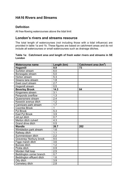
HA16 Rivers <strong>and</strong> Streams<br />
Definition<br />
All free-flowing watercourses above the tidal limit<br />
London’s <strong>rivers</strong> <strong>and</strong> <strong>streams</strong> <strong>resource</strong><br />
The total length of watercourses (not including those with a tidal influence) are<br />
provided in table 1a <strong>and</strong> 1b. These figures are based on catchment areas <strong>and</strong> do not<br />
include all watercourses or small watercourses such as drainage ditches.<br />
Table 1a: Catchment area <strong>and</strong> length of fresh water <strong>rivers</strong> <strong>and</strong> <strong>streams</strong> in SE<br />
London<br />
Watercourse name Length (km) Catchment area (km 2 )<br />
Hogsmill 9.9 73<br />
Surbiton stream 6.0<br />
Bonesgate stream 5.0<br />
Horton stream 5.3<br />
Greens lane stream 1.8<br />
Ewel court stream 2.7<br />
Hogsmill stream 0.5<br />
Beverley Brook 14.3 64<br />
Kingsmere stream 3.1<br />
Penponds overflow 1.3<br />
Queensmere stream 2.4<br />
Keswick avenue ditch 1.2<br />
Cannizaro park stream 1.7<br />
Coombe Brook 1<br />
Pyl Brook 5.3<br />
East Pyl Brook 3.9<br />
old pyl ditch 0.7<br />
Merton ditch culvert 4.3<br />
Gr<strong>and</strong> drive ditch 0.5<br />
W<strong>and</strong>le 26.7 202<br />
Wimbledon park stream 1.6<br />
Railway ditch 1.1<br />
Summerstown ditch 2.2<br />
Graveney/ Norbury brook 9.5<br />
Figgs marsh ditch 3.6<br />
Bunces ditch 1.2<br />
Pickle ditch 0.9<br />
Morden Hall loop 2.5<br />
Beddington corner branch 0.7<br />
Beddington effluent ditch 1.6<br />
Oily ditch 3.9<br />
Cemetery ditch 2.8
Therapia ditch 0.9<br />
Micham road new culvert 2.1<br />
Station farm ditch 0.7<br />
Ravenbourne 17.4 180<br />
Quaggy (kyd Brook) 5.6<br />
Quaggy hither green 1<br />
Grove park ditch 0.5<br />
Milk street ditch 0.3<br />
Ravensbourne honor oak 1.9<br />
Pool river 5.1<br />
Chaffinch Brook 4.4<br />
Spring Brook 1.6<br />
The Beck 7.8<br />
St James stream 2.8<br />
Nursery stream 3.3<br />
Konstamm ditch 0.4<br />
River Cray 12.6 45<br />
River Shuttle 6.4<br />
Wincham Stream 5.6<br />
Marsh Dykes (combined) 17.8 37<br />
Upper Bedon Stream 2.3<br />
Table 1b: Catchment area <strong>and</strong> length of main fresh water <strong>rivers</strong> <strong>and</strong> <strong>streams</strong> in<br />
SE London<br />
Watercourse name Length (km) Catchment area (km 2 )<br />
Roding 22.5 342 (whole)<br />
Brookhouse Brook 4.7<br />
Ingrebourne 43.3<br />
Rainham Creek 1.7<br />
Carters Brook 1.21<br />
Paines Brook 2.2<br />
Weald Brook 4.3<br />
Aveley Sewer 1.0<br />
Ferry Lane Sewer 1.8<br />
Havering New Sewer 1.2<br />
Ingrebourne Branch 0.4<br />
Low Level Sewer 1.1<br />
Pooles Sewer 1.9<br />
Rainham Cross & Main Sewer 2.5<br />
Reed Bed Sewer 0.7<br />
Southall Sewer 2.1<br />
Wennington Branch Sewer (N, 3.9<br />
W & E)<br />
Wennington Main Sewer 2.4<br />
Beam 6.3<br />
Dagenham Branch 1.0<br />
River Rom 3.2<br />
2
Wantz Stream 1.2<br />
Loxford Water (Seven Kings 11.7<br />
Water)<br />
Hog Hill Ditch 2.3<br />
Lee 33 1420 (whole)<br />
Lee Navigation 22.9<br />
Pymmes Brook 15.6<br />
Salmon Brook 13.2<br />
Turkey Brook 13.3<br />
Brent 17.9 151<br />
Folly Brook 4.4<br />
Crane 13.6 110<br />
Dollis Brook 1.8<br />
Silk Stream 5.3<br />
Duke’s River 13.6<br />
Yeading Brook 25.8<br />
Colne 18 1016 (whole)<br />
Potters Bar Brook 3.3<br />
Mimmshall Brook 9.8<br />
Frays 9.0<br />
Colne Brook 15<br />
Wraysbury 4.7<br />
Pinn 19.9<br />
Hogsmill - The source of the Hogsmill is a chalk spring at Ewell in Surrey. Its main<br />
tributary is Bonesgate Stream which rises near Malden Rushett to the south of<br />
Chessington <strong>and</strong> flows into the Hogsmill upstream of Tolworth Court Bridge. The<br />
Hogsmill River joins the River Thames close to the centre of Kingston-upon-Thames.<br />
Beverley Brook - This rises from the Southern edge of the London Clay basin<br />
between Stoneleigh <strong>and</strong> Sutton in Surrey <strong>and</strong> flows into the River Thames at Barn<br />
Elms. Its main tributaries are Pyl Brook, East Pyl Brook <strong>and</strong> Coombe Brook.<br />
Beverley Brook flows through Wimbledon Common <strong>and</strong> Richmond Park. Two relief<br />
culverts (piped underground channels) carry storm flows into the Thames upstream<br />
of Barnes Bridge.<br />
W<strong>and</strong>le - The upper part of the river consists of two branches: the Carshalton<br />
branch, which rises from the chalk springs at Carshalton; <strong>and</strong> the Croydon branch,<br />
fed by chalk springs at Waddon, Croydon <strong>and</strong> Purley. The other main sources are<br />
Carshalton Ponds <strong>and</strong> Waddon Ponds. A tributary of the W<strong>and</strong>le called the<br />
Graveney, rises just to the west of Croydon <strong>and</strong> joins the W<strong>and</strong>le near Colliers<br />
Wood. In its upper reaches the Graveney is known as Norbury Brook. The W<strong>and</strong>le<br />
joins the River Thames to the north of W<strong>and</strong>sworth.<br />
Ravensbourne - This rises at Caesar’s Well on Keston Common <strong>and</strong> joins the<br />
Thames at Deptford Creek. Its tributaries include the Pool River, which joins the<br />
Ravensbourne at Catford, <strong>and</strong> the Quaggy River (known as Kyd Brook upstream of<br />
Sundridge Park), which joins at Lewisham. Both the River Beck <strong>and</strong> Chaffinch Brook<br />
flow into the Pool River. The source of the east branch of the River Ravensbourne<br />
3
<strong>and</strong> of the Quaggy River all lie within an area to the east of Keston Common. The<br />
South branch of the Ravensbourne <strong>and</strong> the tributaries of the Pool have their sources<br />
between Addiscombe <strong>and</strong> West Wickham.<br />
River Cray - The river Cray rises in the Priory gardens <strong>and</strong> flows north through St.<br />
Mary Cray (historically South Cray), St. Paul’s Cray <strong>and</strong> on through Foots Cray <strong>and</strong><br />
Crayford to join the Darent north of Dartford.<br />
Marsh Dykes - These man-made dykes, drain the low lying areas previously used<br />
for grazing. The main watercourses are Thamesmead Canals on the former<br />
Plumstead Marshes; Great Breach <strong>and</strong> Green Level Dykes on Erith Marshes; <strong>and</strong><br />
Crayford Dyke on the Crayford Marshes. The only river from an upl<strong>and</strong> area here is<br />
the Wickham Valley Watercourse, with its source in Oxleas Wood on Shooter’s Hill.<br />
Roding - The Roding rises at Molehill Green, just east of Stanstead Airport in Essex<br />
<strong>and</strong> flows south to Chipping Ongar where it is joined by one of its main tributaries<br />
(Cripsey Brook). South of Chipping Ongar the river me<strong>and</strong>ers in a south westerly<br />
direction to Passingford Bridge under the M25 <strong>and</strong> on to Loughton. A small number<br />
of tributaries join it through this section. From Loughton downstream the Roding is<br />
essentially an urban river, being joined by small tributaries through Woodford,<br />
Wanstead, Ilford <strong>and</strong> East Ham to join the Thames at Barking Creek. The lower<br />
reaches have tidal influences.<br />
Ingrebourne - The Ingrebourne rises near Brentwood <strong>and</strong> is soon joined by the<br />
Weald Brook, Carters Brook <strong>and</strong> Paines Brook before flowing south for a long way<br />
before splitting into the southern tributaries of Raineham Creek <strong>and</strong> Wennington<br />
Sewers complex. The River flows through a relatively non-urbanised corridor, with<br />
much of the corridor dedicated to public open space <strong>and</strong> culminates in Raineham<br />
Creek just to the west of Rainham Marshes at its junction with the Thames at Ferry<br />
Lane.<br />
Beam - The Beam rises near Navestock as the Bourne Brook, before becoming the<br />
River Rom <strong>and</strong> subsequently the River Beam. All of the tributaries such as the<br />
Wantz Stream <strong>and</strong> the Dagenham Branch for example, join the river at its<br />
downstream end. The catchment is heavily urbanised but does run through a green<br />
corridor separating Dagenham from Hornchurch, much of it public open space. The<br />
Beam joins the Thames s<strong>and</strong>wiched between the Ford Industrial Park <strong>and</strong><br />
Hornchurch Marshes.<br />
Lee - The Lee rises in Luton in a southerly direction through Bedfordshire,<br />
Hertfordshire <strong>and</strong> London, joining the River Thames at Canning Town. Tributaries<br />
joining the Lee include Pymmes Brook <strong>and</strong> Cobbins Brook. The Lee Navigation<br />
starts at Hertford, <strong>and</strong> in places becomes the main river channel or runs roughly<br />
parallel with the main channel to its confluence with the Thames. The Lee flows<br />
through a shallow open valley through Hertford before flowing through a wide open<br />
plain to the Thames.<br />
Brent - The River Brent derives most of its flow from ‘run-off’ from the urbanised<br />
areas through which it flows with some additional <strong>resource</strong>s coming from<br />
groundwater from localised gravel aquifers. The main tributaries of the Brent are the<br />
4
Silk Stream, Mutton Brook, Dollis Brook, Wealdstone Brook, Costons Brook,<br />
Clitterhouse Ditch, Deans Brook, Decoy Brook, Edgeware Brook, Edwarebury Brook,<br />
Kenton Brook, Mitchell Brook <strong>and</strong> Wembley Brook. The Brent becomes tidal at<br />
Brentford Lock, shortly before joining the Thames at Brentford, opposite Kew<br />
Gardens.<br />
Crane - The source of the Crane is taken to be a point south of North Hyde Road in<br />
Hayes from where the river flows in a southerly direction to join the Thames at<br />
Isleworth. The River Crane, as with the Brent derives most of its flow from ‘run-off’<br />
from the urbanised areas through which it flows with some additional <strong>resource</strong>s<br />
coming from groundwater from localised gravel aquifers. Tributaries of the Crane<br />
include the Yeading Brook East, Yeading Brook West, the Duke of Northumberl<strong>and</strong>’s<br />
River, the Longford River, Roxbourne, Hounslow Ditch, Whitton Brook, Cranford<br />
Park Brook, Frogs Ditch, Hayes Park Stream, Yeading Tributary, Greenhill Stream &<br />
Ickenham Stream. The man-made watercourses of the Duke’s River <strong>and</strong> the<br />
Longford River are a particular feature of the Crane catchment. Both of these <strong>rivers</strong><br />
take water from the Colne catchment <strong>and</strong> then cross into the Crane catchment. The<br />
Longford River goes to Hampton Court, while the Duke’s River links the Colne at<br />
Harmondsworth with the River Crane at Hounslow Heath before branching off to the<br />
Thames at Syon Park. The Crane is tidal for a short distance before its confluence<br />
with the Thames.<br />
Colne - The Colne rises near Colney Heath in Hertfordshire <strong>and</strong> flows down the<br />
slopes of the Chiltern Hills. The lower Colne is divided into several distinct channels<br />
including the Frays River, Colne Brook <strong>and</strong> the Wraysbury River. Near Uxbridge the<br />
River Pinn flows into the Frays which then rejoins the Colne, which finally flows into<br />
the Thames at Staines. The Duke of Northumberl<strong>and</strong> <strong>and</strong> the Longford Rivers are<br />
both man-made <strong>and</strong> split off from the Colne flowing eastward into the Crane<br />
catchment.<br />
Geology<br />
The catchments of South London’s urban <strong>rivers</strong> lie within the London Basin which,<br />
towards the South, is an area of Chalk overlain successively by Thanet S<strong>and</strong>, s<strong>and</strong>y<br />
gravels of the Woolwich <strong>and</strong> Reading Beds, Blackheath Beds <strong>and</strong> London Clay. In<br />
the Southern part of the Hogsmill, Beverley, W<strong>and</strong>le <strong>and</strong> Ravensbourne catchments,<br />
these top layers have been sufficiently eroded to reveal chalk. Between the London<br />
Clay area in the Northern parts of the catchment <strong>and</strong> the chalk of the southern parts,<br />
the narrow b<strong>and</strong>s of Thanet S<strong>and</strong> <strong>and</strong> the Woolwich <strong>and</strong> Reading Beds are exposed.<br />
The underlying solid geology of north London is almost exclusively London Clay.<br />
This clay deposited 55 million years ago is virtually impermeable <strong>and</strong> ranges from<br />
10m thick in the North to 120m in the South. Beneath the London Clay are a series<br />
of s<strong>and</strong>, silt <strong>and</strong> clay beds known as the London Lower Tertiaries. These beds are in<br />
hydraulic continuity with the Chalk that underlies them, which enables <strong>rivers</strong> such as<br />
the Brent & Crane to receive supplementary flow from groundwater.<br />
Topography<br />
5
The South London catchments are bounded by the River Thames to the north <strong>and</strong><br />
the North Downs to the south, a distance of approximately 25km, although the Marsh<br />
Dykes catchment only extends southwards 6km to Shooter’s Hill. The North Downs<br />
rise to a height of some 260m above sea level.<br />
The main <strong>rivers</strong> in the North of London drain in a general southerly direction towards<br />
the River Thames. However, in built up areas like London, much of the surface<br />
water goes into the surface water drains before being discharged into <strong>rivers</strong>. The<br />
topography of the North London area varies in height from approximately 10m Above<br />
Ordnance Datum (AOD) by the River Thames to 115m AOD in Epping Forest. Most<br />
of the London area is lower lying l<strong>and</strong>, typically 30-60m AOD.<br />
HA16: Map to illustrate the extent of watercourses in Greater London<br />
Nature Conservation Importance<br />
The catchment of London <strong>rivers</strong> is mainly urban <strong>and</strong> these <strong>rivers</strong> provide a valuable<br />
green corridor within the built environment. The mosaic of features found in <strong>rivers</strong><br />
<strong>and</strong> <strong>streams</strong> support a diverse range of plants <strong>and</strong> animals. Grey wagtails <strong>and</strong><br />
kingfishers can been seen feeding <strong>and</strong> nesting along London’s watercourses.<br />
Diverse assemblages of wetl<strong>and</strong> plants can also be seen such as brooklime, water<br />
mint, sedges <strong>and</strong> watercress. Watercourses also provide links between various sites<br />
of conservation interest including Special Areas of Conservation, Special Protected<br />
Areas, Sites of Special Scientific Interest, Local Nature Reserves <strong>and</strong> Sites of<br />
Metropolitan, Borough <strong>and</strong> Local Importance, thus connecting plants <strong>and</strong> animal<br />
communities that would otherwise be isolated.<br />
6
Important populations of common <strong>and</strong> nationally rare fish species are present within<br />
London’s <strong>rivers</strong>. Growing pollution <strong>and</strong> habitat loss combined to destroy fisheries in<br />
the early nineteenth century, however since the 1960’s there have been major<br />
improvement in waste water treatment <strong>and</strong> improved river water quality. Fish<br />
populations are generally recovering but still remain fragile. There are small<br />
populations of minnows (Phoxinus phoxinus) <strong>and</strong> bullhead (Cottus gobio). Recent<br />
enhancement schemes <strong>and</strong> river restorations, for example those on the<br />
Ravensbourne, have found elvers as far upstream as Norman Park in Bromley.<br />
The water vole has declined by 90 per cent throughout Britain while in Greater<br />
London it has disappeared from over 72 per cent of the sites occupied prior to 1997.<br />
However, Greater London does support some strongholds for water voles with<br />
significant populations at Rainham Marshes, the River Cray, Lee Valley, Crayford,<br />
River Crane <strong>and</strong> Erith Marshes. The Marsh Dykes display some of the finest<br />
examples of floodplain grazing marsh <strong>and</strong> are rich in bird life, plants <strong>and</strong> mammals.<br />
Threats <strong>and</strong> Opportunities<br />
Threats<br />
A consequence of urbanisation resulting in the loss of floodplain <strong>and</strong> associated river<br />
corridors, has been to increase the “flashiness” of its <strong>rivers</strong>, meaning that river levels<br />
rise very quickly following heavy rain. Historically, the response to an increased<br />
dem<strong>and</strong> for l<strong>and</strong> for development <strong>and</strong> infrastructure has been to culvert, straighten<br />
<strong>and</strong> artificially reinforce the river channels, thereby losing natural features <strong>and</strong><br />
habitats. Plants <strong>and</strong> animals including fish are simply washed away in the concrete<br />
channels during times of heavy flow.<br />
There are also a number of exotic invasive plant species that have been introduced<br />
<strong>and</strong> subsequently naturalised into London waterways <strong>and</strong> wetl<strong>and</strong>s at the expense<br />
of more natural vegetation. Plants such as floating pennywort (Hydrocotyle<br />
ranunculoides) <strong>and</strong> New Zeal<strong>and</strong> pygmyweed (Crassula helmsii) can form large<br />
mats of floating vegetation that cover <strong>and</strong> choke the water surface. Within Greater<br />
London, floating pennywort is now widespread on the River Lee, River Roding,<br />
W<strong>and</strong>le <strong>and</strong> Marsh Dykes. Japanese knotweed (Fallopia japonica), giant hogweed<br />
(Heracleum mantegazzianum) <strong>and</strong> other species are also spreading along the banks<br />
of our <strong>rivers</strong>. The introduced Chinese mitten crab (Eriocheir sinensis,) which burrow<br />
into river banks, can severely erode them leading to eventual collapse of the banks.<br />
These can be found on the Ravensbourne, River Quaggy, River W<strong>and</strong>le, Hogsmill<br />
River, River Roding, River Lee, River Crane <strong>and</strong> River Brent <strong>and</strong> are another<br />
potential threat to freshwater habitats <strong>and</strong> their native species.<br />
Pollution from many different sources including misconnections within domestic<br />
drains impact on the ecology of our London watercourses.<br />
Furthermore, habitat fragmentation is a problem in London, as elsewhere in Britain.<br />
It is therefore important to improve degraded habitats to help link existing sites <strong>and</strong><br />
make them viable.<br />
Climate change may also impact upon the biodiversity of London. The recent<br />
colonisation <strong>and</strong> exp<strong>and</strong>ing distribution of certain insect species in the south <strong>and</strong><br />
east of Engl<strong>and</strong> for example insects such as Roesel’s bush cricket (Metrioptera<br />
7
oeselii) <strong>and</strong> the Long-winged conehead (Conocephalus discolor) are rapidly<br />
exp<strong>and</strong>ing their range in a north westerly direction across Britain. Birds too are<br />
reflecting subtle changes in the climate. This means that in order to protect <strong>and</strong><br />
enhance London’s importance wildlife these changes should be reflected in future<br />
proposals to improve the watercourses.<br />
Opportunities<br />
There are, however, significant opportunities to restore <strong>and</strong> enhance our <strong>rivers</strong> as<br />
part of urban regeneration. In order that regeneration is sustainable it will have to<br />
recognise the environmental, economic <strong>and</strong> social benefits of river restoration.<br />
Examples of such restoration work can be seen within all our London river<br />
catchments.<br />
Data Sources<br />
Environment Agency (2001) State of the Environment Report for London 2001.<br />
Information Booklet.<br />
Environment Agency (undated) fact file for South London Rivers. Information<br />
Booklet.<br />
Environment Agency (1999) Local Environment Agency Plan for North London.<br />
Information Booklet.<br />
Environment Agency (undated) 20 case studies in London. Information Booklet.<br />
Environment Agency (undated) A Stepping Stone to Urban Regeneration<br />
Highlighting the Opportunities in London. Information Booklet.<br />
8