Abu Dhabi Urban Planning Council Magazine Issue 6 April 2012
Abu Dhabi Urban Planning Council Magazine Issue 6 April 2012
Abu Dhabi Urban Planning Council Magazine Issue 6 April 2012
Create successful ePaper yourself
Turn your PDF publications into a flip-book with our unique Google optimized e-Paper software.
ADSIC<br />
<strong>Abu</strong> <strong>Dhabi</strong> Systems<br />
& Information<br />
Centre<br />
VISION<br />
AD-SDI is to empower<br />
government and society with<br />
convenient, open access to<br />
high quality and up-to-date<br />
geographic information and<br />
spatially enabled e-government<br />
services.<br />
MISSION<br />
To promote, facilitate, coordinate<br />
and support the development<br />
of a dynamic and flexible<br />
geospatial environment that will:<br />
• Provide for online access to<br />
a wide range of geographic<br />
information and services<br />
• Facilitate information sharing<br />
across boundaries<br />
• Protect information rights and<br />
privileges<br />
• Facilitate and support the<br />
adoption of standards to<br />
ensure compatibility and<br />
interoperability through the<br />
government systems<br />
• Promote government<br />
transparency and public rights to<br />
information access<br />
• Provide decision-makers with<br />
a full range of geographic data<br />
and spatial analysis<br />
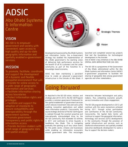
Developed and sponsored by <strong>Abu</strong> <strong>Dhabi</strong> Systems<br />
and Information Centre, the e-Government<br />
Strategy has enabled the implementation of<br />
<strong>Abu</strong> <strong>Dhabi</strong> government’s far-reaching vision<br />
of delivering high performance services for<br />
the benefit of all its customers and the wider<br />
community as part of the transition to a<br />
knowledge-based economy.<br />
ADSIC has been maintaining a persistent<br />
drive to create an advanced e-government<br />
infrastructure in the Emirate of <strong>Abu</strong> <strong>Dhabi</strong>. It<br />
Going forward<br />
As depicted in the AD-SDI vision, mission, and<br />
strategic plan 2010-2014, the AD-SDI Program<br />
provides a common governance framework for<br />
the spatial enablement of government services<br />
which reduces investment risks and costs while<br />
enabling innovative applications and added<br />
value information products. Concurrently, the<br />
sound strategic direction of the AD-SDI Program<br />
is realized through the constant proactive and<br />
internationally acknowledged drive by the<br />
AD-SDI Community that exceeded 50 entities<br />
in 2011 and continues to strive towards a<br />
GeoMature <strong>Abu</strong> <strong>Dhabi</strong>. This is instigating<br />
gradually the opening up of new value chains<br />
for the public sector, citizens and businesses<br />
while enabling an information ecosystem<br />
around government data. This encourages<br />
launched and completed several key projects<br />
that laid the foundations for technological<br />
development in the Emirate.<br />
One of ADSIC’s key initiatives is the ABU DHABI<br />
SPATIAL DATA INFRASTRUCTURE (AD-SDI).<br />
The AD-SDI is a programme of the Government<br />
of <strong>Abu</strong> <strong>Dhabi</strong>, administered within the <strong>Abu</strong><br />
<strong>Dhabi</strong> Systems and Information Centre (ADSIC)<br />
e-government programme to facilitate the<br />
sharing of geospatial data among government<br />
agencies and other stakeholders.<br />
interaction between technologists and policy<br />
makers; thus unleashing economic growth,<br />
service innovation and citizen engagement.<br />
The AD-SDI program developments in <strong>2012</strong> will<br />
continue with the same momentum achieved<br />
during 2011 through active participation<br />
and contribution of the AD-SDI Community.<br />
Concurrently, the Spatial Data Centre will<br />
continue to support the geospatial information,<br />
technology and services (GITS) developments<br />
in the community through the provision of<br />
spatial infrastructure and services such as<br />
GeoPortal enhancements and spatially enabled<br />
executive dashboards development to name a<br />
few to support the decision makers.<br />
20 VISION MAGAZINE ISSUE SIX


