Algorithm Theoretical Based Document (ATBD) - CESBIO
Algorithm Theoretical Based Document (ATBD) - CESBIO
Algorithm Theoretical Based Document (ATBD) - CESBIO

Create successful ePaper yourself
Turn your PDF publications into a flip-book with our unique Google optimized e-Paper software.
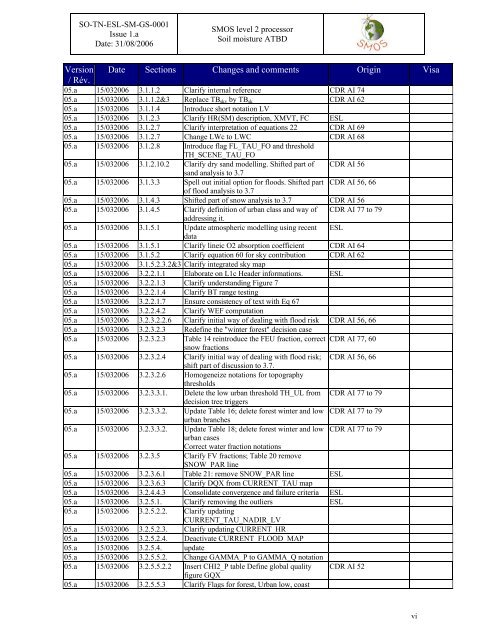
SO-TN-ESL-SM-GS-0001<br />
Issue 1.a<br />
Date: 31/08/2006<br />
SMOS level 2 processor<br />
Soil moisture <strong>ATBD</strong><br />
Version Date Sections Changes and comments Origin Visa<br />
/ Rév.<br />
05.a 15/032006 3.1.1.2 Clarify internal reference CDR AI 74<br />
05.a 15/032006 3.1.1.2&3 Replace TB sky by TB sk CDR AI 62<br />
05.a 15/032006 3.1.1.4 Introduce short notation LV<br />
05.a 15/032006 3.1.2.3 Clarify HR(SM) description, XMVT, FC ESL<br />
05.a 15/032006 3.1.2.7 Clarify interpretation of equations 22 CDR AI 69<br />
05.a 15/032006 3.1.2.7 Change LWc to LWC CDR AI 68<br />
05.a 15/032006 3.1.2.8 Introduce flag FL_TAU_FO and threshold<br />
TH_SCENE_TAU_FO<br />
05.a 15/032006 3.1.2.10.2 Clarify dry sand modelling. Shifted part of CDR AI 56<br />
sand analysis to 3.7<br />
05.a 15/032006 3.1.3.3 Spell out initial option for floods. Shifted part CDR AI 56, 66<br />
of flood analysis to 3.7<br />
05.a 15/032006 3.1.4.3 Shifted part of snow analysis to 3.7 CDR AI 56<br />
05.a 15/032006 3.1.4.5 Clarify definition of urban class and way of CDR AI 77 to 79<br />
addressing it.<br />
05.a 15/032006 3.1.5.1 Update atmospheric modelling using recent ESL<br />
data<br />
05.a 15/032006 3.1.5.1 Clarify lineic O2 absorption coefficient CDR AI 64<br />
05.a 15/032006 3.1.5.2 Clarify equation 60 for sky contribution CDR AI 62<br />
05.a 15/032006 3.1.5.2.3.2&3 Clarify integrated sky map<br />
05.a 15/032006 3.2.2.1.1 Elaborate on L1c Header informations. ESL<br />
05.a 15/032006 3.2.2.1.3 Clarify understanding Figure 7<br />
05.a 15/032006 3.2.2.1.4 Clarify BT range testing<br />
05.a 15/032006 3.2.2.1.7 Ensure consistency of text with Eq 67<br />
05.a 15/032006 3.2.2.4.2 Clarify WEF computation<br />
05.a 15/032006 3.2.3.2.2.6 Clarify initial way of dealing with flood risk CDR AI 56, 66<br />
05.a 15/032006 3.2.3.2.3 Redefine the "winter forest" decision case<br />
05.a 15/032006 3.2.3.2.3 Table 14 reintroduce the FEU fraction, correct<br />
snow fractions<br />
05.a 15/032006 3.2.3.2.4 Clarify initial way of dealing with flood risk;<br />
shift part of discussion to 3.7.<br />
05.a 15/032006 3.2.3.2.6 Homogeneize notations for topography<br />
thresholds<br />
05.a 15/032006 3.2.3.3.1. Delete the low urban threshold TH_UL from<br />
decision tree triggers<br />
05.a 15/032006 3.2.3.3.2. Update Table 16; delete forest winter and low<br />
urban branches<br />
05.a 15/032006 3.2.3.3.2. Update Table 18; delete forest winter and low<br />
urban cases<br />
Correct water fraction notations<br />
05.a 15/032006 3.2.3.5 Clarify FV fractions; Table 20 remove<br />
SNOW_PAR line<br />
05.a 15/032006 3.2.3.6.1 Table 21: remove SNOW_PAR line ESL<br />
05.a 15/032006 3.2.3.6.3 Clarify DQX from CURRENT_TAU map<br />
05.a 15/032006 3.2.4.4.3 Consolidate convergence and failure criteria ESL<br />
05.a 15/032006 3.2.5.1. Clarify removing the outliers ESL<br />
05.a 15/032006 3.2.5.2.2. Clarify updating<br />
CURRENT_TAU_NADIR_LV<br />
05.a 15/032006 3.2.5.2.3. Clarify updating CURRENT_HR<br />
05.a 15/032006 3.2.5.2.4. Deactivate CURRENT_FLOOD_MAP<br />
05.a 15/032006 3.2.5.4. update<br />
05.a 15/032006 3.2.5.5.2. Change GAMMA_P to GAMMA_Q notation<br />
05.a 15/032006 3.2.5.5.2.2 Insert CHI2_P table Define global quality<br />
figure GQX<br />
05.a 15/032006 3.2.5.5.3 Clarify Flags for forest, Urban low, coast<br />
CDR AI 77, 60<br />
CDR AI 56, 66<br />
CDR AI 77 to 79<br />
CDR AI 77 to 79<br />
CDR AI 77 to 79<br />
CDR AI 52<br />
vi