GCSE Tectonics Ans1 - practise with past papers and mark schemes
GCSE Tectonics Ans1 - practise with past papers and mark schemes
GCSE Tectonics Ans1 - practise with past papers and mark schemes

Create successful ePaper yourself
Turn your PDF publications into a flip-book with our unique Google optimized e-Paper software.
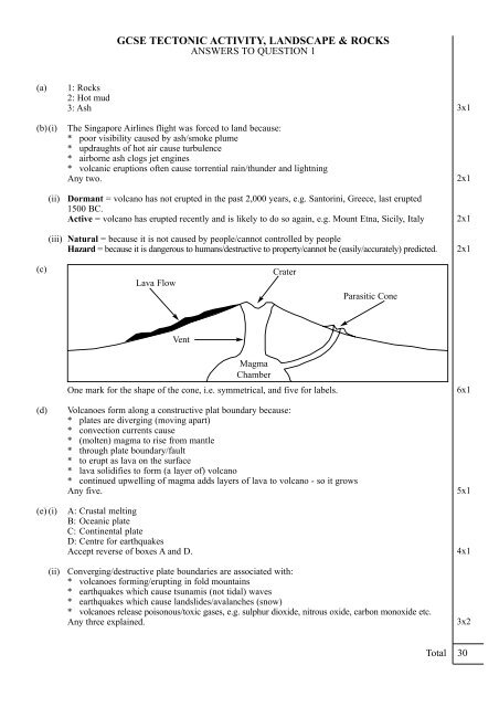
<strong>GCSE</strong> TECTONIC ACTIVITY, LANDSCAPE & ROCKS<br />
ANSWERS TO QUESTION 1<br />
(a)<br />
(b)(i)<br />
(ii)<br />
(iii)<br />
1: Rocks<br />
2: Hot mud<br />
3: Ash<br />
The Singapore Airlines flight was forced to l<strong>and</strong> because:<br />
* poor visibility caused by ash/smoke plume<br />
* updraughts of hot air cause turbulence<br />
* airborne ash clogs jet engines<br />
* volcanic eruptions often cause torrential rain/thunder <strong>and</strong> lightning<br />
Any two.<br />
Dormant = volcano has not erupted in the <strong>past</strong> 2,000 years, e.g. Santorini, Greece, last erupted<br />
1500 BC.<br />
Active = volcano has erupted recently <strong>and</strong> is likely to do so again, e.g. Mount Etna, Sicily, Italy<br />
Natural = because it is not caused by people/cannot controlled by people<br />
Hazard = because it is dangerous to humans/destructive to property/cannot be (easily/accurately) predicted.<br />
3x1<br />
2x1<br />
2x1<br />
2x1<br />
(c)<br />
Lava Flow<br />
Crater<br />
Parasitic Cone<br />
Vent<br />
(d)<br />
(e) (i)<br />
(ii)<br />
One <strong>mark</strong> for the shape of the cone, i.e. symmetrical, <strong>and</strong> five for labels.<br />
Volcanoes form along a constructive plat boundary because:<br />
* plates are diverging (moving apart)<br />
* convection currents cause<br />
* (molten) magma to rise from mantle<br />
* through plate boundary/fault<br />
* to erupt as lava on the surface<br />
* lava solidifies to form (a layer of) volcano<br />
* continued upwelling of magma adds layers of lava to volcano - so it grows<br />
Any five.<br />
A: Crustal melting<br />
B: Oceanic plate<br />
C: Continental plate<br />
D: Centre for earthquakes<br />
Accept reverse of boxes A <strong>and</strong> D.<br />
Magma<br />
Chamber<br />
Converging/destructive plate boundaries are associated <strong>with</strong>:<br />
* volcanoes forming/erupting in fold mountains<br />
* earthquakes which cause tsunamis (not tidal) waves<br />
* earthquakes which cause l<strong>and</strong>slides/avalanches (snow)<br />
* volcanoes release poisonous/toxic gases, e.g. sulphur dioxide, nitrous oxide, carbon monoxide etc.<br />
Any three explained.<br />
6x1<br />
5x1<br />
4x1<br />
3x2<br />
Total 30
<strong>GCSE</strong> TECTONIC ACTIVITY, LANDSCAPE & ROCKS<br />
ANSWERS TO QUESTION 2<br />
(a) (i)<br />
(ii)<br />
(iii)<br />
(iv)<br />
(b)(i)<br />
(ii)<br />
Examples of volcanoes on different continents include:<br />
*Mount Etna, Europe<br />
*Mount St. Helens, North America<br />
*Mount Kilimanjaro, Africa<br />
*Chimborazo, South America<br />
*Mount Fujiyama, Asia<br />
The distribution of volcanoes in the world is:<br />
*widely distributed<br />
*but not everywhere<br />
*in long narrow belts (called active zones)<br />
*mostly on edges of continents<br />
*also in oceans<br />
*not in shield areas<br />
Any four. Accept maximum of two for a list of named areas only, e.g. west coast South America,<br />
Mediterranean Sea.<br />
The only volcanoes found in North America are in a 300 kilometre wide chain running down the<br />
west coast of that continent because:<br />
*there is a plate boundary between the North American Plate <strong>and</strong> Pacific Plate<br />
*it is an active zone - where volcanoes form<br />
*the rest of North America is a stable continental shield area<br />
There is an apparent association between volcanoes, earthquake belts <strong>and</strong> fold mountains because:<br />
*they all occur along plate boundaries because -<br />
*plate movement is involved in all their formation<br />
*volcanoes form where converging plates cause subduction <strong>and</strong> melting of crust<br />
*or where diverging plates allow magma to rise through faults/plate boundaries<br />
*earthquakes occur when plates ‘lock’, tension builds <strong>and</strong> is then released as plates ‘jump’<br />
*fold mountains are formed as destructive margins or collision margins squeeze ocean sediment upwards<br />
Any five.<br />
Reasons why people live close to volcanoes include:<br />
*volcanoes were dormant when settlement occurred<br />
*volcanic rocks <strong>and</strong> ash weathers to form fertile soil<br />
*volcanoes provide employment through tourism<br />
*volcanoes provide geothermal heat <strong>and</strong> power<br />
*volcanic liquids <strong>and</strong> gases solidify to form industrial minerals, precious metals <strong>and</strong> gemstones<br />
*volcanoes form isl<strong>and</strong>s amidst vast oceans = l<strong>and</strong>falls<br />
*scientists/vulcanologists/seismologists live close to/study volcanoes<br />
*tourist attractions so people earn a living from tourist facilities<br />
Any four.<br />
Case study example: Mount Fujiyama, Honshu Isl<strong>and</strong>, Japan<br />
Benefits brought to people by Mount Fujiyama’s volcanic activity include:<br />
*tourist attraction <strong>and</strong> winter snow skiing<br />
*people bathe in hot ashes to ease rheumatism<br />
*drink mineralised water for health reasons<br />
*fertile slopes are farmed = rice terraces<br />
*runs a geothermal power station<br />
*tin, silver, gold <strong>and</strong> rubies mined<br />
Any three or four. F = one <strong>mark</strong> for named example + 3 = 4, H = one <strong>mark</strong> for named example + 4 = 5<br />
4x1<br />
4x1<br />
3x1<br />
5x1<br />
4x1<br />
5x1
(b)(iii) Problems suffered by people living in a volcanic area:<br />
*lava flow destroys buildings/engulfs property/farmlamd<br />
*volcanoes trigger l<strong>and</strong>slides/avalanches of snow<br />
*volcanoes release poisonous/toxic gases, e.g. sulphur dioxide, nitrous oxide <strong>and</strong> carbon<br />
monoxide<br />
Any two.<br />
2x1<br />
(c)<br />
Ways in which people can be protected from the damaging effects of volcanic activity include:<br />
*volcano watchers/scientists employed in many Asian countries to warn of/predict eruptions, e.g.<br />
Tambora, Indonesia<br />
*digging channels/culverts to lead lava flows away from towns, e.g. Mt. Etna, Sicily, Italy<br />
*hose/douse hot lava flows <strong>with</strong> sea water to cool - solidify - stop/halt, e.g. Haiemey, Icel<strong>and</strong><br />
*Italian Air Force bombed lava flows to redirect lava flow away from towns, e.g. Mt. Etna,<br />
Sicily, Italy<br />
*pre-arranged/organised/<strong>practise</strong>d evacuation procedures, e.g. Montserrat, Caribbean Sea<br />
*build dams/walls near settlements to redirect mud flows (lahars), e.g. Nevado del Ruiz,<br />
Columbia<br />
F = Any 3 x 2, H = any 4 x 2.<br />
8x1<br />
Total 35
<strong>GCSE</strong> TECTONIC ACTIVITY, LANDSCAPE & ROCKS<br />
ANSWERS TO QUESTION 3<br />
(a) (i)<br />
(ii)<br />
(iii)<br />
(iv)<br />
(v)<br />
(b)(i)<br />
(ii)<br />
(iii)<br />
(c) (i)<br />
(ii)<br />
Osaka or Kyoto (not Tarumi, Wakayama or Nara)<br />
40km<br />
The destructive effects of an earthquake are normally greatest near(est) to epicentre/in dense urban areas.<br />
Earthquake zones are hazardous places to live because:<br />
* buildings collapse/become unstable<br />
* bridges, tunnels <strong>and</strong> viaducts can collapse<br />
* gas/oil pipes fracture = explosions/fire<br />
* people can be hit by falling objects/debris<br />
* submarine earthquakes cause tsunamis (not tidal waves)<br />
Any two.<br />
Groups of people who might have been reluctant to leave Kobe despite earthquake warnings include:<br />
* Armed forces/emergency services (police, ambulance, doctors etc): sense of duty/orders from superiors<br />
* Shopkeepers/house owners: wish to protect business/property from damage/looting<br />
* Elderly/infirm: mobility difficulties<br />
* Sceptics: they have experienced minor/less intense earthquakes before<br />
Any 2 x 2<br />
A tectonic plate is a large piece of the Earth’s crust, which ‘floats’ on the mantle beneath.<br />
Pacific Plate moves west/left but the Eurasian Plate moves east/right.<br />
Pacific sinks/subducted but Eurasian Plate is buoyant/floats.<br />
Award <strong>mark</strong> only if comparison made, i.e. mentions both plates per statement.<br />
* Eurasian continental plate <strong>and</strong> oceanic Pacific Plate converge<br />
* heavier Pacific (oceanic) Plate subducted <strong>and</strong> ‘locks’ <strong>with</strong> continental plate<br />
* tension builds as crustal movement prevented<br />
* eventually extreme tension causes plates to ‘jump’ - the ‘flicking back’ of the lighter continental plate<br />
* point of earthquake inside crust is called focus<br />
* seismic waves/tremors spread out from epicentre (point on surface above focus)<br />
* earthquake was so devastating because (i) focus was ‘shallow’ <strong>and</strong> (ii) epicentre was close to Kobe<br />
H = any 5, F = any 4.<br />
An earthquake may cause more damage in an urban area than in a rural area because:<br />
* urban areas are more enclosed by tall/composite structures (more liable to collapse) than countryside<br />
* densely built city centres/CBDs have little/no open space to escape to<br />
* ‘domino’ effect = one tall/multi-storey building may fall on to another, which falls on to another<br />
<strong>and</strong> so on - effect of earthquake spreads<br />
* falling debris/masonry is more of a danger in urban areas<br />
* urban areas have gas/oil pipes which may fracture/leak <strong>and</strong> explode/start fires<br />
* urban areas have more overhead electricity cables = can electrocute if brought down.<br />
H =any 3, F = any 2<br />
An earthquake may cause more damage in an LEDC than in an MEDC because:<br />
* denser buildings less well constructed/made from flimsier materials = collapse/fires spread more<br />
easily, e.g. in shanty towns<br />
* badly built/inadequate access roads (e.g. in shanty towns) cause difficulties for emergency services<br />
* settlements in LEDCs built on steep/unsuitable slopes<br />
* LEDCs do not have sophisticated seismic equipment/satellites to detect/predict earthquakes<br />
* earthquake-prone MEDCs build earthquake-proof buildings <strong>and</strong> roads<br />
* MEDCs have disaster plans/<strong>practise</strong> evacuation procedures <strong>and</strong> stockpile emergency provisions<br />
1<br />
1<br />
1<br />
2x1<br />
2x2<br />
2x1<br />
2x1<br />
5x1<br />
3x1<br />
Place<br />
Los Angeles<br />
India<br />
Year<br />
1994<br />
1993<br />
Time<br />
05.00hrs<br />
05.00hrs<br />
Richter Scale<br />
6.6<br />
6.4<br />
Deaths<br />
57<br />
22,000<br />
4x1<br />
Total 25
<strong>GCSE</strong> TECTONIC ACTIVITY, LANDSCAPE & ROCKS<br />
ANSWERS TO QUESTION 4<br />
(a) (i)<br />
(ii)<br />
(b)(i)<br />
(ii)<br />
(iii)<br />
(iv)<br />
(v)<br />
Igneous<br />
Sedimentary rocks are changed into metamorphic rocks by:<br />
* igneous activity, e.g. sedimentary rocks melt as magma rises through them<br />
* then cool - solidify - reform as different rocks, e.g. limestone/chalk - marble<br />
* (tectonic) plate collision causes folding/faulting of sedimentary rocks<br />
* intense pressure restructures minerals so rocks alter/reform<br />
* e.g. shale - slate - schist - gneiss (increasing pressure)<br />
Sedimentary<br />
The map shows that s<strong>and</strong>stone is the least resistant rock to erosion because:<br />
* mean height above sea level is only 30 metres<br />
* compared to 70 - 80 - 115 - 360 - 380 - 460 metres above sea level<br />
* must have been eroded/denuded/lowered the most<br />
* so less resistant than limestones, coal measures <strong>and</strong> millstone grit/others<br />
Any two.<br />
The term permeable means that it allows water to pass through (reject any reference to porous/porosity)<br />
Carboniferous limestone is permeable because it has bedding planes, fractures (faults) <strong>and</strong> joints<br />
(vertical <strong>and</strong> horizontal).<br />
Reservoirs are only found in the millstone grit area because:<br />
* millstone grit is impermeable = it does not let water pass through<br />
* all other rocks on the map are permeable or porous<br />
1<br />
6x1<br />
1<br />
2x1<br />
1<br />
2x1<br />
2x1<br />
(vi)<br />
new red s<strong>and</strong>stone<br />
Rock Type<br />
building material<br />
Economic Use<br />
coal<br />
fuel<br />
limestones (carboniferous or magnesium)<br />
cement, roadstone, flux, agricultural lime<br />
Any three.<br />
millstone grit<br />
metal sharpener, wheat milling,<br />
ornamental cladding<br />
3x1<br />
(c) (i)<br />
Economic uses for igneous rocks include:<br />
* building stone (Aberdeen known as ‘the granite city’)<br />
* decorative cladding (for outside of buildings, e.g. banks, fireplaces)<br />
* chemically weathers to china clay/kaolin - pottery <strong>and</strong> paper glaze<br />
* bedding for railway tracks<br />
* sea defences, harbour walls etc<br />
* sites for reservoirs<br />
* grouse moors<br />
* tourism - Dartmoor National Park<br />
Properties:<br />
* impermeable<br />
* very resistant/hard<br />
* chemically stable<br />
* colourful/pretty minerals<br />
H = Any 3 uses <strong>and</strong> any 3 properties = 6, F = 3 + 2 = 5<br />
6x1
(c) (ii)<br />
There is little agriculture in areas of igneous <strong>and</strong> metamorphic rock because:<br />
* igneous/metamorphic rocks are very resistant so weathers very slowly so produce very thin soils<br />
* minerals in igneous/metamorphic rocks, e.g. quartz, weather to form acidic soils/low pH<br />
* often weather to form s<strong>and</strong>y/porous/dry/’hungry’ soils<br />
* because they are very resistant they form upl<strong>and</strong>s = steep slopes, cold, wet, marshy<br />
* so agriculture is very limited, e.g. sheep/<strong>past</strong>ure/hill farming<br />
There is quarrying in areas of igneous <strong>and</strong> metamorphic rock because:<br />
* igneous/metamorphic rocks have many commercial uses - for igneous uses see answer to (c)(iv)<br />
* metamorphic uses = slate - roofing material<br />
* schist/gneiss = sea defences, ballast<br />
Maximum <strong>mark</strong>s only if a balanced answer, i.e. c<strong>and</strong>idate addresses all three parts of answer = why<br />
so little agriculture, what agriculture, why quarrying, max F3/H5 if not. F = 4, H = 6.<br />
6x1<br />
Total 30
<strong>GCSE</strong> TECTONIC ACTIVITY, LANDSCAPE & ROCKS<br />
ANSWERS TO QUESTION 5<br />
(a) (i)<br />
(ii)<br />
(b)(i)<br />
(ii)<br />
(iii)<br />
(c)<br />
(d)<br />
1. Limestone<br />
2. Swallow hole<br />
3. Resurgent stream (spring)<br />
4. Scar<br />
5. Gorge<br />
There is little surface water in limestone areas because:<br />
* limestone contains bedding planes, fractures (faults) <strong>and</strong> joints (vertical <strong>and</strong> horizontal)<br />
* so it is pervious<br />
* i.e. allows water to pass through it<br />
Reject any reference to porosity/limestone being porous.<br />
Underground features commonly found in limestone areas include:<br />
* cavern<br />
* stalactite<br />
* stalagmite<br />
* limestone pillar<br />
* swallow hole or sink<br />
* underground/subterranean stream<br />
Any two.<br />
Limestone solution is:<br />
* the name of the weathering process of limestone/karst scenery/l<strong>and</strong>scapes<br />
* dissolved calcium bicarbonate in (rain) water<br />
Underground features are the result of limestone solution <strong>and</strong> chemical weathering because:<br />
* process of chemical weathering which attacks/dissolves limestone - is called carbonation/solution<br />
* rain water absorbs carbon dioxide as it passes through atmosphere/soaks into soil<br />
* to become a weak/dilute carbonic acid (carbon dioxide now in solution)<br />
* carbonic acid reacts <strong>with</strong>/dissolves calcium carbonate - the main mineral in Carboniferous Limestone<br />
* to make calcium bicarbonate, which is transported in solution<br />
* so the bedding planes, faults (fractures) <strong>and</strong> joints in the limestone are widened<br />
* rock is dissolved at a rate of approx 4 centimetres per year<br />
H = any 6, F = any four<br />
Reasons for the course of of the stream shown in the field sketch include:<br />
* source is/flows over impermeable rock<br />
* then disappears down swallow hole in permeable limestone<br />
* flows as a subterranean/underground stream through caverns<br />
* reaches impermeable bedrock/strata below permeable limestone<br />
* so emerges as a resurgent stream/Vauclusian spring<br />
Any four.<br />
Economic activities which make use of limestone areas include:<br />
* tourism - caving, hiking etc.<br />
* quarrying - roadstone. agricultural lime<br />
* hill farming<br />
* bottling spring/mineral water<br />
Any two.<br />
5x1<br />
3x1<br />
2x1<br />
2x1<br />
6x1<br />
4x1<br />
2x1<br />
(e)<br />
Limestone l<strong>and</strong>scapes produced by weathering processes attract many visitors because:<br />
* limestone/karst scenery is spectacular - limestone pavements, scars, caverns <strong>and</strong> gorges attract sightseers<br />
* limestone scenery form national parks, e.g. Yorkshire Dales <strong>and</strong> Peak District are popular day trip venues<br />
* limestone (pavements) habitats are rare so home to rare wildflowers <strong>and</strong> birds - which attract<br />
botanists <strong>and</strong> ornothologists<br />
* limestone l<strong>and</strong>scapes provide a wide variety of recreational activities, e.g. caving, canyoning, 6x1<br />
rock climbing, hang-gliding etc.<br />
H any 3 x 2, F = any 2 x 2.<br />
Total 30
<strong>GCSE</strong> TECTONIC ACTIVITY, LANDSCAPE & ROCKS<br />
ANSWERS TO QUESTION 6<br />
(a) (i)<br />
(ii)<br />
(iii)<br />
(iv)<br />
(b)(i)<br />
(ii)<br />
(c) (i)<br />
(ii)<br />
(iii)<br />
(d)(i)<br />
(ii)<br />
A: Scarp<br />
B: Dip<br />
Escarpment or cuesta<br />
Water table<br />
Clay or alluvium<br />
1. A spring may occur:<br />
* at the junction of the porous chalk <strong>and</strong> impermeable clay<br />
* or where the water table outcrops/reaches the surface<br />
2. How this may affect settlements:<br />
* spring-line settlements/villages occur along the foot of the scarp<br />
* for water supply, i.e. wet-point sites (chalk is dry, clay flood-liable)<br />
3. The best site for the village:<br />
* along the spring-line/scarp foot (= water supply <strong>and</strong> shelter)<br />
A spring appears because:<br />
* porous (water-bearing) chalk lies over<br />
* non-porous/impermeable clay<br />
* (rain) water percolates down through chalk<br />
* but cannot pass through clay so emerges as a spring<br />
Any three.<br />
A dry valley is a river (eroded/formed) valley <strong>with</strong>out (or which rarely has) a river/stream flowing<br />
through it.<br />
Dry valleys occur because:<br />
* formed during ice ages when chalk was permanently frozen<br />
* so behaved like an impermeable rock<br />
* rivers flowed during (brief) arctic summer <strong>and</strong> eroded/formed valleys<br />
* river soaked away/absorbed when ice age ended<br />
Alternative theory = prolonged saturation of chalk during a wetter climate<br />
There is little surface water on chalk upl<strong>and</strong>s because:<br />
* chalk is porous (not permeable)<br />
* so water soaks into/absorbed into pore/air spaces in rock<br />
* so water is underground/contained in aquifers<br />
People who would favour the new chalk quarry include:<br />
* local builders<br />
* cement companies<br />
* local unemployed<br />
* farmer selling mineral/quarry rights<br />
Any one.<br />
People who would be against the development of the chalk quarry include:<br />
* nearby residents<br />
* nearby quarry owner<br />
* conservation groups, e.g. R.S.P.B,<br />
* Ramblers Association<br />
* local farmer<br />
Any one.<br />
2x1<br />
1<br />
1<br />
1<br />
1<br />
2x1<br />
1<br />
3x1<br />
1<br />
4x1<br />
3x1<br />
1<br />
1
(d)(ii)<br />
(iii)<br />
FOR the chalk quarry:<br />
* provide employment for locals<br />
* profits for l<strong>and</strong>owner/local builders<br />
* can afford to take some farml<strong>and</strong> out of production<br />
* l<strong>and</strong> will have other/more uses, e.g. l<strong>and</strong>fill <strong>with</strong> domestic refuse<br />
* l<strong>and</strong> can be reclaimed/restored afterwards<br />
Any four.<br />
AGAINST the chalk quarry:<br />
* unsightly/eyesore<br />
* extra lorry traffic = congestion, air pollution, vibration<br />
* noise <strong>and</strong> dust from quarry<br />
* loss of farml<strong>and</strong><br />
* habitat/l<strong>and</strong>scape destruction<br />
* local house prices fall<br />
Any four.<br />
4x1<br />
4x1<br />
Total 30