A History of Geothermal Energy Research and Development in the ...
A History of Geothermal Energy Research and Development in the ...
A History of Geothermal Energy Research and Development in the ...

You also want an ePaper? Increase the reach of your titles
YUMPU automatically turns print PDFs into web optimized ePapers that Google loves.
GEOTHERMAL TECHNOLOGIES PROGRAM<br />
Exploration<br />
1976 – 2006<br />
A <strong>History</strong> <strong>of</strong> <strong>Geo<strong>the</strong>rmal</strong> <strong>Energy</strong><br />
<strong>Research</strong> <strong>and</strong> <strong>Development</strong><br />
<strong>in</strong> <strong>the</strong> United States
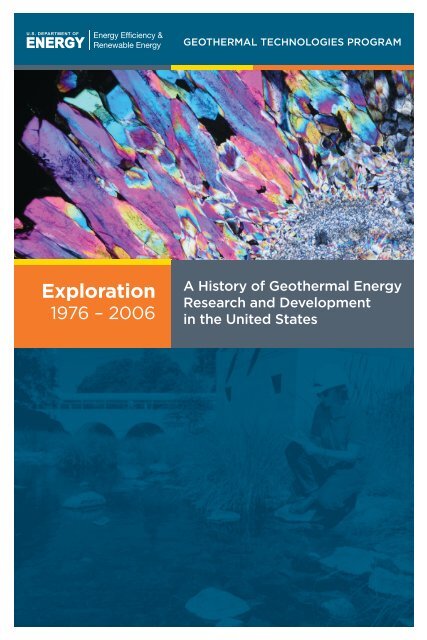
Cover Photo Credit<br />
Photomicrograph <strong>of</strong> quartz sampled from a depth <strong>of</strong> 948 feet <strong>in</strong> Lake City Observation Hole-1,<br />
Lake City geo<strong>the</strong>rmal system, California. The image was taken under crossed nicols. The vibrant<br />
birefr<strong>in</strong>gence colors are due to <strong>the</strong> section be<strong>in</strong>g extra thick. The field <strong>of</strong> view is 0.07 <strong>in</strong>ches across.<br />
(Courtesy: Joseph N. Moore)
EXPLORATION<br />
This history <strong>of</strong> <strong>the</strong> U.S. Department <strong>of</strong> <strong>Energy</strong>’s <strong>Geo<strong>the</strong>rmal</strong> Program<br />
is dedicated to <strong>the</strong> many government employees at Headquarters <strong>and</strong> at<br />
<strong>of</strong>fices <strong>in</strong> <strong>the</strong> field who worked diligently for <strong>the</strong> program’s success. Those<br />
men <strong>and</strong> women are too numerous to mention <strong>in</strong>dividually, given <strong>the</strong><br />
history’s 30-year time span. But <strong>the</strong>y deserve recognition none<strong>the</strong>less for<br />
<strong>the</strong>ir pr<strong>of</strong>essionalism <strong>and</strong> exceptional drive to make geo<strong>the</strong>rmal technology<br />
a viable option <strong>in</strong> solv<strong>in</strong>g <strong>the</strong> Nation’s energy problems. Special recognition<br />
is given here to those persons who assumed <strong>the</strong> leadership role for <strong>the</strong><br />
program <strong>and</strong> all <strong>the</strong> duties <strong>and</strong> responsibilities perta<strong>in</strong><strong>in</strong>g <strong>the</strong>reto:<br />
• Eric Willis, 1976-77<br />
• James Bresee, 1977-78<br />
• Bennie Di Bona, 1979-80<br />
• John Salisbury, 1980-81<br />
• John “Ted” Mock, 1982-94<br />
• Allan Jelacic, 1995-1999<br />
• Peter Goldman, 1999-2003<br />
• Lel<strong>and</strong> “Roy” M<strong>in</strong>k, 2003-06<br />
These leaders, along with <strong>the</strong>ir able staffs, are commended for a job<br />
well done. The future <strong>of</strong> geo<strong>the</strong>rmal energy <strong>in</strong> <strong>the</strong> United States is<br />
brighter today than ever before thanks to <strong>the</strong>ir tireless efforts.<br />
A <strong>History</strong> <strong>of</strong> <strong>Geo<strong>the</strong>rmal</strong> <strong>Energy</strong> <strong>Research</strong> <strong>and</strong> <strong>Development</strong> <strong>in</strong> <strong>the</strong> United States | Exploration i
EXPLORATION<br />
ii<br />
A <strong>History</strong> <strong>of</strong> <strong>Geo<strong>the</strong>rmal</strong> <strong>Energy</strong> <strong>Research</strong> <strong>and</strong> <strong>Development</strong> <strong>in</strong> <strong>the</strong> United States | Exploration
EXPLORATION<br />
Table <strong>of</strong> Contents<br />
Preface. . . . . . . . . . . . . . . . . . . . . . . . . . . . . . . . . . . . . . . . . . . . . . . . . . . . . . . . . . . . . . . . . . . . . . . . . . . . . . . . . . . . . . . . . vii<br />
Acknowledgements.. . . . . . . . . . . . . . . . . . . . . . . . . . . . . . . . . . . . . . . . . . . . . . . . . . . . . . . . . . . . . . . . . . . . . . . . . . . . . ix<br />
Introduction. . . . . . . . . . . . . . . . . . . . . . . . . . . . . . . . . . . . . . . . . . . . . . . . . . . . . . . . . . . . . . . . . . . . . . . . . . . . . . . . . . . . . . 1<br />
Accomplishments <strong>and</strong> Impacts. . . . . . . . . . . . . . . . . . . . . . . . . . . . . . . . . . . . . . . . . . . . . . . . . . . . . . . . . . . . . . . . . . 5<br />
Major <strong>Research</strong> Projects. . . . . . . . . . . . . . . . . . . . . . . . . . . . . . . . . . . . . . . . . . . . . . . . . . . . . . . . . . . . . . . . . . . . . . . . . 11<br />
1.0 Early Studies.. . . . . . . . . . . . . . . . . . . . . . . . . . . . . . . . . . . . . . . . . . . . . . . . . . . . . . . . . . . . . . . . . . . . . . . . . . . . . . 13<br />
2.0 Industry Cooperative Exploration <strong>and</strong> Drill<strong>in</strong>g.. . . . . . . . . . . . . . . . . . . . . . . . . . . . . . . . . . . . . . . . . . . 15<br />
2.1 The Industry-Coupled Case Studies Program. . . . . . . . . . . . . . . . . . . . . . . . . . . . . . . . . . . 15<br />
2.2 Case Studies <strong>of</strong> Low- to Moderate-Temperature<br />
Hydro<strong>the</strong>rmal <strong>Energy</strong> Developmen. . . . . . . . . . . . . . . . . . . . . . . . . . . . . . . . . . . . . . . . . . . . . 25<br />
2.3 The Cascades I <strong>and</strong> II Cost-Shared Programs.. . . . . . . . . . . . . . . . . . . . . . . . . . . . . . . . . . . 25<br />
2.4 The GRED I, II <strong>and</strong> III Cost-Shared Programs .. . . . . . . . . . . . . . . . . . . . . . . . . . . . . . . . . . . 27<br />
3.0 State Cooperative Programs. . . . . . . . . . . . . . . . . . . . . . . . . . . . . . . . . . . . . . . . . . . . . . . . . . . . . . . . . . . . . . 31<br />
3.1 State-Coupled Program.. . . . . . . . . . . . . . . . . . . . . . . . . . . . . . . . . . . . . . . . . . . . . . . . . . . . . . . . 31<br />
3.2 State-Cooperative Reservoir Analysis Program. . . . . . . . . . . . . . . . . . . . . . . . . . . . . . . . . 32<br />
3.3 Low-Temperature Resource Program. . . . . . . . . . . . . . . . . . . . . . . . . . . . . . . . . . . . . . . . . . . 32<br />
4.0 Selected Hydro<strong>the</strong>rmal System Studies.. . . . . . . . . . . . . . . . . . . . . . . . . . . . . . . . . . . . . . . . . . . . . . . . . . 35<br />
4.1 Ascension Isl<strong>and</strong>, South Atlantic Ocean.. . . . . . . . . . . . . . . . . . . . . . . . . . . . . . . . . . . . . . . . 35<br />
4.2 Coso Hot Spr<strong>in</strong>gs, California.. . . . . . . . . . . . . . . . . . . . . . . . . . . . . . . . . . . . . . . . . . . . . . . . . . . . 37<br />
4.3 The Geysers Cor<strong>in</strong>g Project: The Geysers, California.. . . . . . . . . . . . . . . . . . . . . . . . . . . . 38<br />
4.4 Dixie Valley, Nevada . . . . . . . . . . . . . . . . . . . . . . . . . . . . . . . . . . . . . . . . . . . . . . . . . . . . . . . . . . . 40<br />
4.5 The Salton Sea Scientific Drill<strong>in</strong>g Program, California .. . . . . . . . . . . . . . . . . . . . . . . . . . 45<br />
5.0 Geological Technique <strong>Development</strong>. . . . . . . . . . . . . . . . . . . . . . . . . . . . . . . . . . . . . . . . . . . . . . . . . . . . . 49<br />
5.1 The Evolution <strong>of</strong> <strong>the</strong> Salton Sea <strong>Geo<strong>the</strong>rmal</strong> Field, California.. . . . . . . . . . . . . . . . . . . 49<br />
5.2 Structural Controls on <strong>Geo<strong>the</strong>rmal</strong> Systems.. . . . . . . . . . . . . . . . . . . . . . . . . . . . . . . . . . . . 51<br />
5.3 Applied Terrestrial Remote Sens<strong>in</strong>g Technology. . . . . . . . . . . . . . . . . . . . . . . . . . . . . . . . 52<br />
5.4 A Conceptual Model <strong>of</strong> Volcano-Hosted<br />
Vapor-Dom<strong>in</strong>ated <strong>Geo<strong>the</strong>rmal</strong> Systems . . . . . . . . . . . . . . . . . . . . . . . . . . . . . . . . . . . . . . . . 56<br />
5.5 Significance <strong>of</strong> Hydro<strong>the</strong>rmal Alteration Assemblages.. . . . . . . . . . . . . . . . . . . . . . . . . 58<br />
5.6 Duration <strong>and</strong> Age <strong>of</strong> Hydro<strong>the</strong>rmal Activity . . . . . . . . . . . . . . . . . . . . . . . . . . . . . . . . . . . . 61<br />
6.0 Geochemical Technique Analysis. . . . . . . . . . . . . . . . . . . . . . . . . . . . . . . . . . . . . . . . . . . . . . . . . . . . . . . . . 63<br />
6.1 Trace-Element Analyses <strong>of</strong> Soils <strong>and</strong> Rocks. . . . . . . . . . . . . . . . . . . . . . . . . . . . . . . . . . . . . 63<br />
6.2 Soil-Gas <strong>and</strong> Gas-Flux Measurements.. . . . . . . . . . . . . . . . . . . . . . . . . . . . . . . . . . . . . . . . . . 63<br />
6.3 Geochemical Analyses <strong>of</strong> <strong>Geo<strong>the</strong>rmal</strong> Fluids .. . . . . . . . . . . . . . . . . . . . . . . . . . . . . . . . . . 64<br />
6.4 Fluid Inclusion Studies. . . . . . . . . . . . . . . . . . . . . . . . . . . . . . . . . . . . . . . . . . . . . . . . . . . . . . . . . . 65<br />
7.0 Geophysical Technique <strong>Development</strong>.. . . . . . . . . . . . . . . . . . . . . . . . . . . . . . . . . . . . . . . . . . . . . . . . . . . 69<br />
7.1 Seismic Methods . . . . . . . . . . . . . . . . . . . . . . . . . . . . . . . . . . . . . . . . . . . . . . . . . . . . . . . . . . . . . . . 69<br />
7.2 Aeromagnetic Methods .. . . . . . . . . . . . . . . . . . . . . . . . . . . . . . . . . . . . . . . . . . . . . . . . . . . . . . . . 72<br />
7.3 Gravity Methods. . . . . . . . . . . . . . . . . . . . . . . . . . . . . . . . . . . . . . . . . . . . . . . . . . . . . . . . . . . . . . . . 73<br />
A <strong>History</strong> <strong>of</strong> <strong>Geo<strong>the</strong>rmal</strong> <strong>Energy</strong> <strong>Research</strong> <strong>and</strong> <strong>Development</strong> <strong>in</strong> <strong>the</strong> United States | Exploration iii
EXPLORATION<br />
7.4 Thermal Methods. . . . . . . . . . . . . . . . . . . . . . . . . . . . . . . . . . . . . . . . . . . . . . . . . . . . . . . . . . . . . . . 74<br />
7.5 Geophysical Well Log Interpretation <strong>and</strong> High-Temperature Tool <strong>Development</strong>.. . 76<br />
7.6 Electrical Methods. . . . . . . . . . . . . . . . . . . . . . . . . . . . . . . . . . . . . . . . . . . . . . . . . . . . . . . . . . . . . . 77<br />
7.7 Borehole Geophysics Studies .. . . . . . . . . . . . . . . . . . . . . . . . . . . . . . . . . . . . . . . . . . . . . . . . . . 81<br />
7.8 Measurement <strong>of</strong> Active Deformation . . . . . . . . . . . . . . . . . . . . . . . . . . . . . . . . . . . . . . . . . . . 83<br />
7.9 Relat<strong>in</strong>g Geophysical Results to Properties <strong>of</strong> Interest. . . . . . . . . . . . . . . . . . . . . . . . . . 85<br />
7.10 Coupled Reservoir Simulation <strong>and</strong> Geophysical Surveys. . . . . . . . . . . . . . . . . . . . . . . . 86<br />
8.0 Exploration Strategies.. . . . . . . . . . . . . . . . . . . . . . . . . . . . . . . . . . . . . . . . . . . . . . . . . . . . . . . . . . . . . . . . . . . . 87<br />
9.0 National <strong>and</strong> Regional Resource Assessments.. . . . . . . . . . . . . . . . . . . . . . . . . . . . . . . . . . . . . . . . . . . 89<br />
10.0 Magma <strong>Energy</strong> Studies.. . . . . . . . . . . . . . . . . . . . . . . . . . . . . . . . . . . . . . . . . . . . . . . . . . . . . . . . . . . . . . . . . . 91<br />
10.1 Magma <strong>Energy</strong> <strong>Research</strong> Program (1975 – 1982) .. . . . . . . . . . . . . . . . . . . . . . . . . . . . . . . 91<br />
10.2 Magma <strong>Energy</strong> Extraction Program (1984 – 1990) .. . . . . . . . . . . . . . . . . . . . . . . . . . . . . 92<br />
10.3 Exploratory Well. . . . . . . . . . . . . . . . . . . . . . . . . . . . . . . . . . . . . . . . . . . . . . . . . . . . . . . . . . . . . . . . 94<br />
Conclusion.. . . . . . . . . . . . . . . . . . . . . . . . . . . . . . . . . . . . . . . . . . . . . . . . . . . . . . . . . . . . . . . . . . . . . . . . . . . . . . . . . . . . . 95<br />
Appendix A: Budget history <strong>of</strong> <strong>the</strong> federal geo<strong>the</strong>rmal research program, 1976 – 2006.. . . . . . . . 97<br />
Abbreviations & Acronyms.. . . . . . . . . . . . . . . . . . . . . . . . . . . . . . . . . . . . . . . . . . . . . . . . . . . . . . . . . . . . . . . . . . . . 103<br />
References Organized by Major <strong>Research</strong> Project Area .. . . . . . . . . . . . . . . . . . . . . . . . . . . . . . . . . . . . . . . 107<br />
Numbered References . . . . . . . . . . . . . . . . . . . . . . . . . . . . . . . . . . . . . . . . . . . . . . . . . . . . . . . . . . . . . . . . . . . . . . . . . 131<br />
List <strong>of</strong> Figures<br />
Figure 1. Locations <strong>of</strong> selected geo<strong>the</strong>rmal systems <strong>in</strong> <strong>the</strong> western United States.. . . . . . . . . 18<br />
Figure 2. Photograph <strong>of</strong> <strong>the</strong> Cove Fort-Sulphurdale geo<strong>the</strong>rmal power plant, Utah.. . . . . . . . 20<br />
Figure 3. Geologic map <strong>of</strong> <strong>the</strong> Cove Fort-Sulphurdale geo<strong>the</strong>rmal area.. . . . . . . . . . . . . . . . . . . . 21<br />
Figure 4. Schematic conceptual model <strong>of</strong> <strong>the</strong> Cove Fort-Sulphurdale geo<strong>the</strong>rmal area.. . . . 22<br />
Figure 5. The Blundell geo<strong>the</strong>rmal power plant at Roosevelt Hot Spr<strong>in</strong>gs, Utah. . . . . . . . . . . . 24<br />
Figure 6. <strong>Geo<strong>the</strong>rmal</strong> Resource Exploration <strong>and</strong> Def<strong>in</strong>ition Program (GRED)<br />
I project locations.. . . . . . . . . . . . . . . . . . . . . . . . . . . . . . . . . . . . . . . . . . . . . . . . . . . . . . . . . . . . . . . . 29<br />
Figure 7. <strong>Geo<strong>the</strong>rmal</strong> Resource Exploration <strong>and</strong> Def<strong>in</strong>ition Program (GRED)<br />
II project locations. . . . . . . . . . . . . . . . . . . . . . . . . . . . . . . . . . . . . . . . . . . . . . . . . . . . . . . . . . . . . . . . 29<br />
Figure 8. <strong>Geo<strong>the</strong>rmal</strong> Resource Exploration <strong>and</strong> Def<strong>in</strong>ition Program (GRED)<br />
III project locations.. . . . . . . . . . . . . . . . . . . . . . . . . . . . . . . . . . . . . . . . . . . . . . . . . . . . . . . . . . . . . . . 30<br />
Figure 9. Block diagrams <strong>of</strong> The Geysers geo<strong>the</strong>rmal field show<strong>in</strong>g <strong>the</strong> top <strong>of</strong><br />
<strong>the</strong> steam reservoir (top) <strong>and</strong> <strong>the</strong> top <strong>of</strong> <strong>the</strong> plutonic complex (felsite). . . . . . . . . . . 38<br />
Figure 10. Geologic sett<strong>in</strong>g <strong>of</strong> <strong>the</strong> Dixie Valley geo<strong>the</strong>rmal system.. . . . . . . . . . . . . . . . . . . . . . . . . . 41<br />
Figure 11. Idealized structural model <strong>of</strong> <strong>the</strong> Dixie Valley geo<strong>the</strong>rmal field, Nevada.. . . . . . . . . . 42<br />
Figure 12. Magnetotelluric section across <strong>the</strong> Dixie Valley geo<strong>the</strong>rmal field.. . . . . . . . . . . . . . . . . 43<br />
Figure 13. Location <strong>of</strong> <strong>the</strong> State 2-14 well, Salton Sea <strong>Geo<strong>the</strong>rmal</strong> Field.. . . . . . . . . . . . . . . . . . . . . 46<br />
Figure 14. ASTER <strong>and</strong> fused imagery, Silver Peak range, Nevada. . . . . . . . . . . . . . . . . . . . . . . . . . . . 55<br />
iv<br />
A <strong>History</strong> <strong>of</strong> <strong>Geo<strong>the</strong>rmal</strong> <strong>Energy</strong> <strong>Research</strong> <strong>and</strong> <strong>Development</strong> <strong>in</strong> <strong>the</strong> United States | Exploration
EXPLORATION<br />
Figure 15. Conceptual model <strong>of</strong> <strong>the</strong> Karaha-Telaga Bodas geo<strong>the</strong>rmal system, Indonesia.. . . 57<br />
Figure 16. Photomicrograph from <strong>the</strong> Bulalo geo<strong>the</strong>rmal field, Philipp<strong>in</strong>es, show<strong>in</strong>g<br />
chalcedony (cha) overpr<strong>in</strong>ted by epidote (ep) <strong>and</strong> <strong>the</strong>n anhydrite (anhy). . . . . . . . 59<br />
Figure 17. Progressive formation <strong>of</strong> silica polymorphs result<strong>in</strong>g from<br />
catastrophic reservoir boil<strong>in</strong>g. . . . . . . . . . . . . . . . . . . . . . . . . . . . . . . . . . . . . . . . . . . . . . . . . . . . 60<br />
Figure 18. Map <strong>of</strong> 3He/4He ratios for Western geo<strong>the</strong>rmal areas, expressed<br />
as Ro/Ra (<strong>the</strong> air-corrected sample ratio normalized to <strong>the</strong> ratio <strong>in</strong> air). .. . . . . . . . 65<br />
Figure 19. Examples <strong>of</strong> fluid <strong>in</strong>clusions from Karaha-Telaga Bodas, Indonesia. .. . . . . . . . . . . . . 66<br />
Figure 20. Fluid <strong>in</strong>clusion temperatures <strong>and</strong> sal<strong>in</strong>ities from Matalibong-25,<br />
Tiwi, Philipp<strong>in</strong>es. Comparison <strong>of</strong> <strong>the</strong> homogenization <strong>and</strong> measured<br />
temperatures documents heat<strong>in</strong>g s<strong>in</strong>ce <strong>the</strong> <strong>in</strong>clusions were trapped.. . . . . . . . . . . . . 67<br />
Figure 21. The Coso magnetotelluric survey . . . . . . . . . . . . . . . . . . . . . . . . . . . . . . . . . . . . . . . . . . . . . . . 80<br />
Figure 22. The Geo-BILT logg<strong>in</strong>g tool be<strong>in</strong>g deployed <strong>in</strong> an oil field.. . . . . . . . . . . . . . . . . . . . . . . . . 82<br />
Figure 23. Annualized InSAR surface vertical displacements at Steamboat geo<strong>the</strong>rmal<br />
field, Nevada, compared to <strong>in</strong>itial Fahrenheit iso<strong>the</strong>rms at +4,000 feet (msl). . . . . 84<br />
Figure 24. Schematic <strong>of</strong> energy extraction from magma.. . . . . . . . . . . . . . . . . . . . . . . . . . . . . . . . . . . . 93<br />
List <strong>of</strong> Tables<br />
Table 1.<br />
Table 2.<br />
Table 3.<br />
Table 4.<br />
Table 5.<br />
Major advances result<strong>in</strong>g from <strong>the</strong> Department <strong>of</strong> <strong>Energy</strong>’s geo<strong>the</strong>rmal<br />
exploration research <strong>and</strong> development program, 1976 – 2006. . . . . . . . . . . . . . . . . . . . . 5<br />
Publically-Available Data Ga<strong>the</strong>red Under <strong>the</strong> Industry-Coupled<br />
Case Studies Program. . . . . . . . . . . . . . . . . . . . . . . . . . . . . . . . . . . . . . . . . . . . . . . . . . . . . . . . . . . . 17<br />
Data available from <strong>the</strong> <strong>Energy</strong> & Geoscience Institute result<strong>in</strong>g<br />
from <strong>the</strong> Cascade I <strong>and</strong> II Cost-Shared Programs. . . . . . . . . . . . . . . . . . . . . . . . . . . . . . . . . 27<br />
<strong>Geo<strong>the</strong>rmal</strong> Resource Exploration <strong>and</strong> Def<strong>in</strong>ition Program (GRED)<br />
I, II, <strong>and</strong> III awardees <strong>and</strong> locations. . . . . . . . . . . . . . . . . . . . . . . . . . . . . . . . . . . . . . . . . . . . . . . . 28<br />
Number <strong>of</strong> Known <strong>Geo<strong>the</strong>rmal</strong> Occurrences <strong>in</strong> 1995 Compared with<br />
<strong>the</strong> Number <strong>of</strong> Previously Known Occurrences, Given by State. . . . . . . . . . . . . . . . . . . 33<br />
A <strong>History</strong> <strong>of</strong> <strong>Geo<strong>the</strong>rmal</strong> <strong>Energy</strong> <strong>Research</strong> <strong>and</strong> <strong>Development</strong> <strong>in</strong> <strong>the</strong> United States | Exploration v
EXPLORATION<br />
vi<br />
A <strong>History</strong> <strong>of</strong> <strong>Geo<strong>the</strong>rmal</strong> <strong>Energy</strong> <strong>Research</strong> <strong>and</strong> <strong>Development</strong> <strong>in</strong> <strong>the</strong> United States | Exploration
EXPLORATION<br />
Preface<br />
In <strong>the</strong> 1970s, <strong>the</strong> publicly available <strong>in</strong>formation about geo<strong>the</strong>rmal systems was<br />
woefully <strong>in</strong>adequate. The underst<strong>and</strong><strong>in</strong>g <strong>of</strong> geo<strong>the</strong>rmal resources <strong>and</strong> <strong>the</strong> means for<br />
<strong>the</strong>ir optimum development was primitive. Much <strong>of</strong> <strong>the</strong> extant <strong>in</strong>formation was<br />
held <strong>in</strong> private company files. Lack <strong>of</strong> <strong>in</strong>formation meant only a few companies<br />
<strong>in</strong>vested <strong>in</strong> exploration <strong>and</strong> resource development. Utilities did not underst<strong>and</strong> <strong>the</strong><br />
geo<strong>the</strong>rmal resource, especially <strong>the</strong> risks <strong>and</strong> costs <strong>of</strong> development, <strong>and</strong> <strong>the</strong>y were<br />
<strong>the</strong>refore reluctant to sign long-term geo<strong>the</strong>rmal power purchase agreements. For<br />
<strong>the</strong> same reasons, f<strong>in</strong>ancial <strong>in</strong>stitutions were wary <strong>of</strong> fund<strong>in</strong>g geo<strong>the</strong>rmal energy<br />
projects. <strong>Development</strong> <strong>of</strong> <strong>the</strong> large resource base <strong>in</strong> <strong>the</strong> United States, apart from<br />
The Geysers <strong>in</strong> California, was essentially stagnant. This was <strong>the</strong> environment<br />
<strong>in</strong> which <strong>the</strong> U.S. Government’s geo<strong>the</strong>rmal research <strong>and</strong> development (R&D)<br />
program began.<br />
The <strong>in</strong>tent <strong>of</strong> <strong>the</strong> geo<strong>the</strong>rmal program was to underst<strong>and</strong> geo<strong>the</strong>rmal resources,<br />
improve geo<strong>the</strong>rmal science <strong>and</strong> eng<strong>in</strong>eer<strong>in</strong>g technology, <strong>and</strong> ensure that<br />
<strong>in</strong>formation was publicly available to geo<strong>the</strong>rmal stakeholders, such as developers,<br />
utilities, f<strong>in</strong>ancial <strong>in</strong>stitutions, regulators, <strong>and</strong> o<strong>the</strong>rs necessary to spur development<br />
<strong>of</strong> a vital, progressive geo<strong>the</strong>rmal <strong>in</strong>dustry. As this report will demonstrate, <strong>the</strong><br />
<strong>in</strong>tent was achieved, to <strong>the</strong> benefit not only <strong>of</strong> geo<strong>the</strong>rmal energy development <strong>in</strong><br />
<strong>the</strong> United States but also around <strong>the</strong> world.<br />
This report is one <strong>of</strong> a series issued by <strong>the</strong> U.S. Department <strong>of</strong> <strong>Energy</strong> (<strong>the</strong><br />
Department) to document <strong>the</strong> many <strong>and</strong> varied accomplishments stemm<strong>in</strong>g from<br />
<strong>the</strong> Government’s sponsorship <strong>of</strong> geo<strong>the</strong>rmal research s<strong>in</strong>ce 1976. The reports<br />
represent a history <strong>of</strong> <strong>the</strong> major research programs <strong>and</strong> projects that have had<br />
a last<strong>in</strong>g impact on <strong>the</strong> use <strong>of</strong> geo<strong>the</strong>rmal energy <strong>in</strong> <strong>the</strong> United States or which<br />
promise to have an impact. We have not attempted to write <strong>the</strong> def<strong>in</strong>itive history<br />
<strong>of</strong> <strong>the</strong> <strong>Geo<strong>the</strong>rmal</strong> Program <strong>and</strong> <strong>the</strong> $1.3 billion that were expended through<br />
2006 on geo<strong>the</strong>rmal research. Ra<strong>the</strong>r, we have brought toge<strong>the</strong>r <strong>the</strong> collective<br />
memories <strong>of</strong> those who participated <strong>in</strong> <strong>the</strong> program to highlight advances which<br />
<strong>the</strong> participants deem worthy <strong>of</strong> special recognition.<br />
In particular, this report exam<strong>in</strong>es <strong>the</strong> work done <strong>in</strong> one key area <strong>of</strong> geo<strong>the</strong>rmal<br />
technology development: Exploration. Companion reports cover work <strong>in</strong> o<strong>the</strong>r<br />
areas, <strong>in</strong>clud<strong>in</strong>g <strong>Energy</strong> Conversion, Drill<strong>in</strong>g, <strong>and</strong> Reservoir Eng<strong>in</strong>eer<strong>in</strong>g. The<br />
history focuses on <strong>the</strong> period 1976-2006, when <strong>the</strong> Department <strong>of</strong> <strong>Energy</strong><br />
was <strong>the</strong> lead agency for geo<strong>the</strong>rmal technology research as m<strong>and</strong>ated by <strong>the</strong><br />
<strong>Geo<strong>the</strong>rmal</strong> <strong>Research</strong>, <strong>Development</strong> <strong>and</strong> Demonstration Act <strong>of</strong> 1974. The<br />
A <strong>History</strong> <strong>of</strong> <strong>Geo<strong>the</strong>rmal</strong> <strong>Energy</strong> <strong>Research</strong> <strong>and</strong> <strong>Development</strong> <strong>in</strong> <strong>the</strong> United States | Exploration vii
EXPLORATION<br />
earlier, groundbreak<strong>in</strong>g work by precursor agencies, such as <strong>the</strong> National Science<br />
Foundation, Atomic <strong>Energy</strong> Commission, United States Geological Survey, <strong>and</strong> <strong>the</strong><br />
<strong>Energy</strong> <strong>Research</strong> <strong>and</strong> <strong>Development</strong> Adm<strong>in</strong>istration, is cited as appropriate but is by<br />
no means complete.<br />
Those wish<strong>in</strong>g to learn more about certa<strong>in</strong> topics discussed here<strong>in</strong> should consult<br />
<strong>the</strong> references listed <strong>in</strong> <strong>the</strong> report. These sources give <strong>the</strong> reader access to a much<br />
larger body <strong>of</strong> literature that covers <strong>the</strong> topics <strong>in</strong> greater detail. Ano<strong>the</strong>r useful source<br />
<strong>of</strong> <strong>in</strong>formation about <strong>the</strong> Department’s geo<strong>the</strong>rmal research can be found <strong>in</strong> <strong>the</strong><br />
<strong>Geo<strong>the</strong>rmal</strong> Technologies Legacy Collection (www.osti.gov/geo<strong>the</strong>rmal/)<br />
ma<strong>in</strong>ta<strong>in</strong>ed by <strong>the</strong> Office <strong>of</strong> Science <strong>and</strong> Technology Information.<br />
The budget history <strong>of</strong> <strong>the</strong> federal geo<strong>the</strong>rmal research program dur<strong>in</strong>g <strong>the</strong> 30-year<br />
period documented here is <strong>in</strong>cluded as Appendix A. That portion <strong>of</strong> <strong>the</strong> budget<br />
devoted to exploration is highlighted <strong>and</strong> amounts to about $190 million <strong>in</strong> actual<br />
dollars. Fund<strong>in</strong>g for work <strong>in</strong> exploration ended <strong>in</strong> fiscal year 2006 with a decision<br />
by <strong>the</strong> Department to refocus limited fund<strong>in</strong>g resources on higher priority needs<br />
with<strong>in</strong> <strong>the</strong> Office <strong>of</strong> <strong>Energy</strong> Efficiency <strong>and</strong> Renewable <strong>Energy</strong>. That decision did<br />
not preclude future work <strong>in</strong> this area, as <strong>the</strong> needs for geo<strong>the</strong>rmal technology<br />
development are assessed. This report summarizes <strong>the</strong> products <strong>and</strong> benefits <strong>of</strong><br />
that earlier research <strong>in</strong>vestment.<br />
viii<br />
A <strong>History</strong> <strong>of</strong> <strong>Geo<strong>the</strong>rmal</strong> <strong>Energy</strong> <strong>Research</strong> <strong>and</strong> <strong>Development</strong> <strong>in</strong> <strong>the</strong> United States | Exploration
EXPLORATION<br />
Acknowledgements<br />
While <strong>the</strong> many contributors to U.S. Department <strong>of</strong> <strong>Energy</strong>-supported<br />
geo<strong>the</strong>rmal exploration research <strong>and</strong> development over <strong>the</strong> years are too<br />
numerous to acknowledge by name, we wish to mention those who participated<br />
<strong>in</strong> writ<strong>in</strong>g this report. The primary authors were Joseph N. Moore, Howard<br />
P. Ross (retired), <strong>and</strong> Phillip Michael Wright (retired) all <strong>of</strong> <strong>the</strong> <strong>Energy</strong> &<br />
Geoscience Institute, University <strong>of</strong> Utah. Contribut<strong>in</strong>g authors <strong>in</strong>cluded<br />
Clayton R. Nichols (retired), U.S. Department <strong>of</strong> <strong>Energy</strong>; Paul Kasameyer<br />
(retired), Lawrence Livermore National Laboratory; <strong>and</strong> Joel Renner (retired),<br />
Idaho National Laboratory. Elizabeth C. Battocletti served as <strong>the</strong> report’s<br />
technical editor. These persons deserve credit for assembl<strong>in</strong>g a history <strong>of</strong><br />
impressive accomplishment that will cont<strong>in</strong>ue to reap benefits for many<br />
years to come. To <strong>the</strong> <strong>in</strong>dividuals whose efforts are not specifically identified<br />
<strong>in</strong> this report, <strong>the</strong> Department <strong>and</strong> authors <strong>of</strong>fer <strong>the</strong>ir s<strong>in</strong>cere gratitude.<br />
A <strong>History</strong> <strong>of</strong> <strong>Geo<strong>the</strong>rmal</strong> <strong>Energy</strong> <strong>Research</strong> <strong>and</strong> <strong>Development</strong> <strong>in</strong> <strong>the</strong> United States | Exploration ix
EXPLORATION<br />
x<br />
A <strong>History</strong> <strong>of</strong> <strong>Geo<strong>the</strong>rmal</strong> <strong>Energy</strong> <strong>Research</strong> <strong>and</strong> <strong>Development</strong> <strong>in</strong> <strong>the</strong> United States | Exploration
EXPLORATION<br />
Introduction<br />
This report summarizes significant research projects performed by <strong>the</strong> U.S.<br />
Department <strong>of</strong> <strong>Energy</strong> (DOE) 1 over 30 years to overcome challenges <strong>in</strong><br />
exploration <strong>and</strong> to make generation <strong>of</strong> electricity from geo<strong>the</strong>rmal resources<br />
more cost-competitive. At <strong>the</strong> onset <strong>of</strong> DOE’s efforts <strong>in</strong> <strong>the</strong> 1970s, several<br />
national laboratories, universities, <strong>and</strong> private contractors conducted exploration<br />
research. Beg<strong>in</strong>n<strong>in</strong>g <strong>in</strong> <strong>the</strong> late 1970s, this research was undertaken largely by<br />
<strong>the</strong> Lawrence Berkeley National Laboratory (LBNL), <strong>the</strong> Lawrence Livermore<br />
National Laboratory (LLNL), <strong>and</strong> <strong>the</strong> Earth Science Laboratory <strong>of</strong> <strong>the</strong> University<br />
<strong>of</strong> Utah <strong>Research</strong> Institute (ESL/UURI). In addition, <strong>the</strong> Idaho National<br />
Laboratory (INL), Los Alamos National Laboratory (LANL), Oak Ridge<br />
National Laboratory (ORNL), <strong>and</strong> S<strong>and</strong>ia National Laboratories (S<strong>and</strong>ia) also<br />
performed exploration research. Throughout <strong>the</strong> years, many o<strong>the</strong>r groups,<br />
<strong>in</strong>clud<strong>in</strong>g <strong>the</strong> Great Bas<strong>in</strong> Center for <strong>Geo<strong>the</strong>rmal</strong> <strong>Energy</strong> at <strong>the</strong> University <strong>of</strong><br />
Nevada, Reno, geo<strong>the</strong>rmal developers <strong>and</strong> consult<strong>in</strong>g groups, <strong>the</strong> U.S. Geological<br />
Survey (USGS), <strong>and</strong> state geological surveys contributed to <strong>the</strong> program.<br />
Beg<strong>in</strong>n<strong>in</strong>g <strong>in</strong> <strong>the</strong> early 1970s, DOE supported research to develop solid scientific<br />
underp<strong>in</strong>n<strong>in</strong>gs <strong>and</strong> new technology to locate <strong>and</strong> characterize geo<strong>the</strong>rmal<br />
resources. This research has greatly advanced <strong>the</strong> state <strong>of</strong> geo<strong>the</strong>rmal science<br />
<strong>and</strong> technology, benefitt<strong>in</strong>g <strong>the</strong> development <strong>of</strong> this clean, plentiful, renewable<br />
energy resource <strong>in</strong> <strong>the</strong> United States <strong>and</strong> around <strong>the</strong> world. At <strong>the</strong> end <strong>of</strong> 2007,<br />
<strong>the</strong> <strong>in</strong>stalled electric generat<strong>in</strong>g capacity from geo<strong>the</strong>rmal energy worldwide was<br />
9,728 megawatts-electric (MWe). 2 In <strong>the</strong> United States alone, <strong>the</strong> <strong>in</strong>stalled electric<br />
generat<strong>in</strong>g capacity at <strong>the</strong> end <strong>of</strong> 2008 was 2,960 MWe, 3 nearly a six-fold <strong>in</strong>crease<br />
<strong>in</strong> generat<strong>in</strong>g capacity s<strong>in</strong>ce <strong>the</strong> DOE <strong>Geo<strong>the</strong>rmal</strong> Program began. An additional<br />
29,000 megawatts-<strong>the</strong>rmal (MWt) from geo<strong>the</strong>rmal resources worldwide is<br />
used for bath<strong>in</strong>g, space heat<strong>in</strong>g <strong>and</strong> cool<strong>in</strong>g, agriculture, aquaculture, <strong>in</strong>dustrial<br />
processes, <strong>and</strong> geo<strong>the</strong>rmal heat pumps. 4 Despite this level <strong>of</strong> development,<br />
however, <strong>the</strong> worldwide geo<strong>the</strong>rmal resource base is vastly underutilized today.<br />
DOE’s goal <strong>in</strong> geo<strong>the</strong>rmal energy research has been to decrease <strong>the</strong> costs <strong>and</strong><br />
risks <strong>of</strong> economically utiliz<strong>in</strong>g geo<strong>the</strong>rmal resources primarily for electrical<br />
power generation. A l<strong>in</strong>chp<strong>in</strong> <strong>of</strong> DOE’s approach to realiz<strong>in</strong>g <strong>the</strong>ir goals<br />
has been strong work<strong>in</strong>g relationships with <strong>the</strong> private sector. Program<br />
priorities have been driven by <strong>the</strong> technical barriers to economically viable<br />
geo<strong>the</strong>rmal development as identified by <strong>the</strong> <strong>in</strong>dustry, as well as <strong>the</strong> results <strong>of</strong><br />
economic sensitivity model<strong>in</strong>g to identify those elements <strong>in</strong> <strong>the</strong> geo<strong>the</strong>rmal<br />
development process with <strong>the</strong> greatest potential for lower<strong>in</strong>g costs <strong>and</strong> risks.<br />
A <strong>History</strong> <strong>of</strong> <strong>Geo<strong>the</strong>rmal</strong> <strong>Energy</strong> <strong>Research</strong> <strong>and</strong> <strong>Development</strong> <strong>in</strong> <strong>the</strong> United States | Exploration 1
EXPLORATION<br />
Initially, <strong>the</strong> <strong>in</strong>dustry identified lower<strong>in</strong>g well-field costs <strong>and</strong> improv<strong>in</strong>g drill<strong>in</strong>g<br />
technology as two high priority areas for research. DOE’s geo<strong>the</strong>rmal drill<strong>in</strong>g<br />
research <strong>and</strong> development (R&D) program is covered <strong>in</strong> a companion report.<br />
DOE supported R&D <strong>in</strong> exploration whose purpose was to more quickly locate<br />
resources <strong>in</strong> <strong>the</strong> subsurface <strong>and</strong> to more reliably site exploration <strong>and</strong> reservoir<br />
confirmation boreholes, production wells, <strong>and</strong> <strong>in</strong>jection wells. The strong<br />
cooperative work<strong>in</strong>g relationship with <strong>the</strong> private sector has fostered efficient<br />
technology transfer, result<strong>in</strong>g <strong>in</strong> rapid implementation <strong>of</strong> research advances.<br />
Early <strong>in</strong> DOE’s program, <strong>the</strong> public <strong>in</strong>formation base for high-temperature<br />
geo<strong>the</strong>rmal areas was woefully <strong>in</strong>adequate. Lack <strong>of</strong> <strong>in</strong>formation <strong>in</strong>hibited new<br />
resource companies from <strong>in</strong>vest<strong>in</strong>g <strong>in</strong> exploration <strong>and</strong> resource development,<br />
<strong>and</strong> prevented utilities from underst<strong>and</strong><strong>in</strong>g <strong>the</strong> geo<strong>the</strong>rmal resource <strong>and</strong> <strong>the</strong><br />
risks <strong>and</strong> costs <strong>of</strong> its development. Utilities were <strong>the</strong>refore reluctant to sign<br />
geo<strong>the</strong>rmal power purchase agreements. Due to this lack <strong>of</strong> <strong>in</strong>formation, lend<strong>in</strong>g<br />
<strong>in</strong>stitutions were also wary <strong>of</strong> fund<strong>in</strong>g geo<strong>the</strong>rmal energy projects. This was <strong>the</strong><br />
environment <strong>in</strong> which DOE’s <strong>in</strong>itial geo<strong>the</strong>rmal R&D began <strong>in</strong> <strong>the</strong> late 1970s.<br />
In 1977, DOE <strong>in</strong>itiated <strong>the</strong> Industry-Coupled Drill<strong>in</strong>g Case Studies<br />
Program, discussed more fully <strong>in</strong> Section 2.1. The objectives <strong>of</strong> this<br />
program were to: 1) accelerate exploration <strong>of</strong> new high-temperature<br />
areas by furnish<strong>in</strong>g a cost-share for <strong>the</strong> drill<strong>in</strong>g <strong>of</strong> reservoir-confirmation<br />
boreholes, <strong>and</strong> 2) obta<strong>in</strong> data held as confidential <strong>in</strong> company files for<br />
public release. In exchange for <strong>the</strong> cost-share, <strong>the</strong> company proposed a data<br />
package which DOE could use <strong>in</strong> its research <strong>and</strong> release <strong>in</strong> open file.<br />
The Industry-Coupled Drill<strong>in</strong>g Case Studies Program was an outst<strong>and</strong><strong>in</strong>g<br />
success <strong>in</strong> meet<strong>in</strong>g its objectives. Of <strong>the</strong> 14 areas explored under <strong>the</strong> program,<br />
eight were subsequently developed by <strong>the</strong> private sector, produc<strong>in</strong>g 137 MWe <strong>of</strong><br />
baseload power today. The eight areas are Roosevelt Hot Spr<strong>in</strong>gs <strong>and</strong> Cove Fort-<br />
Sulphurdale <strong>in</strong> Utah, <strong>and</strong> Beowawe, San Emidio, Soda Lake, Stillwater, Dixie<br />
Valley, <strong>and</strong> Desert Peak <strong>in</strong> Nevada. In each <strong>of</strong> <strong>the</strong>se areas, geological, geochemical,<br />
<strong>and</strong> geophysical surveys were carried out by DOE researchers to supplement<br />
<strong>the</strong> company data packages, <strong>and</strong> detailed case studies were published. The large<br />
amount <strong>of</strong> data result<strong>in</strong>g from <strong>the</strong> program, as well as o<strong>the</strong>r similar programs,<br />
helped utilities <strong>and</strong> <strong>the</strong> f<strong>in</strong>ancial sector better underst<strong>and</strong> high-temperature<br />
systems <strong>and</strong> feel more comfortable <strong>in</strong> deal<strong>in</strong>g with geo<strong>the</strong>rmal developers.<br />
While <strong>the</strong> majority <strong>of</strong> this report focuses on high-temperature geo<strong>the</strong>rmal<br />
resources, part <strong>of</strong> DOE’s exploration program was directed toward low- to<br />
moderate-temperature resources. DOE supported exploration <strong>and</strong> resource<br />
def<strong>in</strong>ition for systems suitable for direct use through <strong>the</strong> State-Coupled<br />
<strong>Geo<strong>the</strong>rmal</strong> Mapp<strong>in</strong>g Program, described <strong>in</strong> Section 3.1. As a result <strong>of</strong> this<br />
program, <strong>the</strong> <strong>in</strong>ventory <strong>of</strong> known geo<strong>the</strong>rmal occurrences <strong>in</strong> many states<br />
2 A <strong>History</strong> <strong>of</strong> <strong>Geo<strong>the</strong>rmal</strong> <strong>Energy</strong> <strong>Research</strong> <strong>and</strong> <strong>Development</strong> <strong>in</strong> <strong>the</strong> United States | Exploration
EXPLORATION<br />
was vastly exp<strong>and</strong>ed, result<strong>in</strong>g <strong>in</strong> a more comprehensive view <strong>of</strong> <strong>the</strong> total<br />
geo<strong>the</strong>rmal resource base <strong>in</strong> <strong>the</strong> United States. The State-Coupled program<br />
also built state-level expertise <strong>in</strong> geo<strong>the</strong>rmal energy <strong>and</strong> its potential uses.<br />
DOE exploration activities focused primarily on <strong>the</strong> western United States.<br />
However, <strong>in</strong> <strong>the</strong> late 1970s, DOE supported limited exploration <strong>of</strong> <strong>the</strong> eastern<br />
U.S., specifically verification <strong>of</strong> a geologic model developed by scientists at Virg<strong>in</strong>ia<br />
Polytechnic Institute <strong>and</strong> State University (VPI). In parts <strong>of</strong> <strong>the</strong> Atlantic coastal<br />
pla<strong>in</strong>, granitic <strong>in</strong>trusions conta<strong>in</strong><strong>in</strong>g naturally occurr<strong>in</strong>g radioactive uranium,<br />
thorium, <strong>and</strong> potassium are known from surface outcrops. Decay <strong>of</strong> <strong>the</strong> radioactive<br />
elements <strong>in</strong> <strong>the</strong>se granites produces heat. VPI researchers postulated that buried<br />
granites hav<strong>in</strong>g similar characteristics also existed, covered by <strong>the</strong>rmally <strong>in</strong>sulat<strong>in</strong>g<br />
sedimentary rocks such as shales. If <strong>the</strong> radioactive m<strong>in</strong>eral content <strong>of</strong> <strong>the</strong>se granite<br />
plutons were high enough <strong>and</strong> <strong>the</strong> <strong>the</strong>rmal blanket good enough, temperatures<br />
<strong>in</strong> <strong>the</strong> granites might exceed 150°C (302°F), sufficient to generate power.<br />
DOE funded drill<strong>in</strong>g <strong>of</strong> 50 wells, each about 300 meters (1,000 feet) deep, to<br />
determ<strong>in</strong>e geology, measure <strong>the</strong>rmal gradients with depth, <strong>and</strong> calculate heat flow <strong>in</strong><br />
<strong>the</strong> Atlantic Coastal Pla<strong>in</strong> from New Jersey to sou<strong>the</strong>rn Georgia. In 1979, a largediameter,<br />
1,220-meter deep well (4,000 feet) was drilled near Crisfield, Maryl<strong>and</strong><br />
to test a heat-flow anomaly detected by <strong>the</strong> VPI program. The test well encountered<br />
an aquifer with a temperature <strong>of</strong> 56°C (133°F) at total depth (TD). Although<br />
this well failed to f<strong>in</strong>d a commercial resource, <strong>the</strong> VPI model is still considered<br />
valid from a geologic viewpo<strong>in</strong>t. Exploration to f<strong>in</strong>d o<strong>the</strong>r buried granites <strong>in</strong><br />
<strong>the</strong> eastern U. S., followed by drill test<strong>in</strong>g may be warranted <strong>in</strong> <strong>the</strong> future.<br />
Throughout much <strong>of</strong> <strong>the</strong> 1980s, DOE did not identify geo<strong>the</strong>rmal exploration<br />
research as a separate program per se; exploration elements were <strong>in</strong>cluded<br />
under <strong>the</strong> reservoir eng<strong>in</strong>eer<strong>in</strong>g program. The reason<strong>in</strong>g was that similar or<br />
identical techniques could be useful both for exploration <strong>and</strong> to del<strong>in</strong>eate<br />
<strong>and</strong> characterize geo<strong>the</strong>rmal reservoirs. As a result, DOE funded cont<strong>in</strong>uous<br />
research <strong>in</strong> geological, geochemical, <strong>and</strong> geophysical techniques <strong>in</strong> geo<strong>the</strong>rmal<br />
areas even though that fund<strong>in</strong>g came from various geo<strong>the</strong>rmal programs.<br />
Beg<strong>in</strong>n<strong>in</strong>g <strong>in</strong> 1985, DOE <strong>and</strong> <strong>the</strong> U.S. geo<strong>the</strong>rmal <strong>in</strong>dustry undertook costshared<br />
drill<strong>in</strong>g <strong>of</strong> five deep exploration core holes <strong>in</strong> <strong>the</strong> High Cascades prov<strong>in</strong>ce<br />
<strong>in</strong> Oregon. The presence <strong>of</strong> active volcanism <strong>and</strong> <strong>the</strong> high measured temperature<br />
gradients with depth <strong>in</strong> exist<strong>in</strong>g wells argued strongly that <strong>the</strong> area has potential<br />
for large, high-temperature hydro<strong>the</strong>rmal convection systems. The <strong>the</strong>ory, still<br />
widely held, was that downward migration <strong>of</strong> cold meteoric water <strong>in</strong> <strong>the</strong> Cascades<br />
Mounta<strong>in</strong>s suppressed surface <strong>the</strong>rmal manifestations, conceal<strong>in</strong>g hydro<strong>the</strong>rmal<br />
systems. Many occurrences <strong>of</strong> <strong>the</strong>rmal spr<strong>in</strong>gs on <strong>the</strong> marg<strong>in</strong>s <strong>of</strong> <strong>the</strong> Cascades were<br />
thought to be lateral outflow from <strong>the</strong>se hydro<strong>the</strong>rmal systems. The objectives<br />
A <strong>History</strong> <strong>of</strong> <strong>Geo<strong>the</strong>rmal</strong> <strong>Energy</strong> <strong>Research</strong> <strong>and</strong> <strong>Development</strong> <strong>in</strong> <strong>the</strong> United States | Exploration 3
EXPLORATION<br />
<strong>of</strong> DOE’s program were to: 1) accelerate exploration <strong>of</strong> <strong>the</strong> region by costshar<strong>in</strong>g<br />
exploration drill<strong>in</strong>g with <strong>the</strong> private sector; 2) obta<strong>in</strong> samples <strong>and</strong> data<br />
to characterize <strong>the</strong> deep hydro<strong>the</strong>rmal environment; <strong>and</strong> 3) develop analytical<br />
<strong>and</strong> <strong>in</strong>terpretive tools to help <strong>in</strong>dustry locate <strong>and</strong> evaluate geo<strong>the</strong>rmal reservoirs<br />
<strong>in</strong> young volcanic regions <strong>in</strong> general. The program is described <strong>in</strong> Section 2.3.<br />
From <strong>the</strong> beg<strong>in</strong>n<strong>in</strong>g <strong>of</strong> DOE’s geo<strong>the</strong>rmal exploration program, <strong>in</strong>dustrycoupled<br />
exploratory drill<strong>in</strong>g <strong>and</strong> field verification <strong>of</strong> new technology were high<br />
priorities. More recently, <strong>the</strong> DOE-sponsored <strong>Geo<strong>the</strong>rmal</strong> Resources Exploration<br />
<strong>and</strong> Def<strong>in</strong>ition (GRED) program helped to identify <strong>and</strong> verify <strong>the</strong> performance<br />
<strong>of</strong> new resources. DOE made a total <strong>of</strong> 26 contract awards under <strong>the</strong> GRED<br />
program. A total <strong>of</strong> 14 slim holes were drilled, lead<strong>in</strong>g to numerous productionsized<br />
wells be<strong>in</strong>g drilled; several <strong>of</strong> <strong>the</strong> projects have power purchase agreements<br />
associated with <strong>the</strong>m. GRED I, II, <strong>and</strong> III programs are covered <strong>in</strong> Section 2.4<br />
DOE’s exploration research program also supported cooperative work with<br />
geo<strong>the</strong>rmal developers from o<strong>the</strong>r countries where <strong>the</strong> benefits <strong>of</strong> do<strong>in</strong>g so were<br />
clear. In many, but not all cases, <strong>the</strong> developer <strong>in</strong>volved was a U.S. company.<br />
One requirement for such support was that geo<strong>the</strong>rmal data <strong>and</strong> subsurface<br />
samples would be released for use <strong>and</strong> publication by DOE researchers. This<br />
research on foreign geo<strong>the</strong>rmal systems enabled <strong>the</strong> program to develop a much<br />
broader range <strong>of</strong> <strong>in</strong>formation on <strong>the</strong> nature <strong>and</strong> occurrence <strong>of</strong> geo<strong>the</strong>rmal<br />
energy than would have been possible from <strong>the</strong> study only <strong>of</strong> U. S. occurrences.<br />
The results <strong>of</strong> this work are presented <strong>in</strong> several sections <strong>of</strong> this report.<br />
As a result <strong>of</strong> DOE’s long history <strong>of</strong> cooperative work with <strong>the</strong> private sector,<br />
thous<strong>and</strong>s <strong>of</strong> technical papers have been published <strong>in</strong> a wide variety <strong>of</strong> journals.<br />
<strong>Geo<strong>the</strong>rmal</strong> reports were issued by most <strong>of</strong> <strong>the</strong> DOE national laboratories,<br />
universities, state agencies, <strong>and</strong> geo<strong>the</strong>rmal companies. Drill cutt<strong>in</strong>gs <strong>and</strong><br />
core samples obta<strong>in</strong>ed dur<strong>in</strong>g <strong>the</strong> research were stored at <strong>the</strong> <strong>Geo<strong>the</strong>rmal</strong><br />
Sample Library at <strong>the</strong> <strong>Energy</strong> <strong>and</strong> Geoscience Institute (EGI) at <strong>the</strong> University<br />
<strong>of</strong> Utah — currently <strong>the</strong> largest exist<strong>in</strong>g repository <strong>of</strong> geo<strong>the</strong>rmal samples,<br />
conta<strong>in</strong><strong>in</strong>g more than 1.3 million meters (4.3 million feet) <strong>of</strong> core <strong>and</strong> cutt<strong>in</strong>gs.<br />
The collection conta<strong>in</strong>s samples from every high-temperature geo<strong>the</strong>rmal<br />
system <strong>in</strong> <strong>the</strong> western United States, as well as important systems <strong>in</strong> Canada,<br />
Mexico, Guatemala, Indonesia, <strong>and</strong> <strong>the</strong> Philipp<strong>in</strong>es. The EGI <strong>Geo<strong>the</strong>rmal</strong><br />
Sample Library has been <strong>and</strong> rema<strong>in</strong>s an important resource for researchers.<br />
4 A <strong>History</strong> <strong>of</strong> <strong>Geo<strong>the</strong>rmal</strong> <strong>Energy</strong> <strong>Research</strong> <strong>and</strong> <strong>Development</strong> <strong>in</strong> <strong>the</strong> United States | Exploration
EXPLORATION<br />
Accomplishments<br />
<strong>and</strong> Impacts<br />
Table 1 summarizes <strong>the</strong> major advances result<strong>in</strong>g from DOE R&D <strong>in</strong> geo<strong>the</strong>rmal<br />
exploration from 1976 through 2006. They are not ranked <strong>in</strong> any particular<br />
order <strong>of</strong> importance or priority. Each has made a contribution to fulfill<strong>in</strong>g<br />
<strong>the</strong> federal geo<strong>the</strong>rmal exploration R&D program’s goals <strong>and</strong> objectives.<br />
Table 1. Major advances result<strong>in</strong>g from <strong>the</strong> Department <strong>of</strong> <strong>Energy</strong>’s geo<strong>the</strong>rmal<br />
exploration research <strong>and</strong> development program, 1976 – 2006<br />
Technical Area Accomplishment Significance Industry Measure<br />
Industry<br />
Cooperative<br />
Exploration<br />
<strong>and</strong> Drill<strong>in</strong>g<br />
The <strong>in</strong>dustry was<br />
encouraged to<br />
move ahead with<br />
drill-test<strong>in</strong>g <strong>of</strong><br />
high-temperature<br />
geo<strong>the</strong>rmal areas by<br />
DOE’s cost-share for<br />
drill<strong>in</strong>g confirmation<br />
wells.<br />
A very large amount<br />
<strong>of</strong> new data was generated,<br />
<strong>in</strong>terpreted,<br />
<strong>and</strong> released to <strong>the</strong><br />
public. Numerous<br />
geological, geochemical,<br />
<strong>and</strong> geophysical<br />
methods were<br />
tested, adapted, <strong>and</strong><br />
improved specifically<br />
for <strong>the</strong> geo<strong>the</strong>rmal<br />
environment.<br />
Industry’s exploration<br />
was accelerated, <strong>and</strong> <strong>the</strong><br />
new public knowledge<br />
enabled both <strong>the</strong><br />
utility <strong>in</strong>dustry <strong>and</strong> <strong>the</strong><br />
f<strong>in</strong>ancial sector to feel<br />
more comfortable <strong>in</strong><br />
participat<strong>in</strong>g <strong>in</strong> projects<br />
for geo<strong>the</strong>rmal power<br />
generation.<br />
New exploration<br />
technology developed<br />
under this program<br />
has allowed <strong>the</strong> private<br />
sector to explore<br />
for, locate, confirm,<br />
characterize <strong>and</strong><br />
drill <strong>in</strong>to subsurface<br />
resources much more<br />
cost effectively than<br />
was possible before.<br />
Industry was able to<br />
br<strong>in</strong>g onl<strong>in</strong>e 8 <strong>of</strong> <strong>the</strong><br />
14 geo<strong>the</strong>rmal power<br />
plants studied <strong>in</strong> <strong>the</strong><br />
Industry-Coupled<br />
Case Studies<br />
Program, <strong>the</strong> <strong>in</strong>itial<br />
program under this<br />
umbrella.<br />
As <strong>the</strong> program<br />
cont<strong>in</strong>ued with <strong>the</strong><br />
GRED program, an<br />
additional 6 sites<br />
have been explored<br />
<strong>and</strong> new power<br />
plants are be<strong>in</strong>g<br />
considered at several<br />
<strong>of</strong> <strong>the</strong>se sites.<br />
Samples <strong>of</strong> drill cutt<strong>in</strong>gs<br />
<strong>and</strong> cores from<br />
geo<strong>the</strong>rmal systems<br />
have been preserved<br />
at EGI, <strong>and</strong> this collection<br />
has been used by<br />
researchers from <strong>the</strong><br />
public <strong>and</strong> private U.S.<br />
sectors <strong>and</strong> by foreign<br />
researchers.<br />
A <strong>History</strong> <strong>of</strong> <strong>Geo<strong>the</strong>rmal</strong> <strong>Energy</strong> <strong>Research</strong> <strong>and</strong> <strong>Development</strong> <strong>in</strong> <strong>the</strong> United States | Exploration 5
EXPLORATION<br />
Technical Area Accomplishment Significance Industry Measure<br />
State<br />
Cooperative<br />
Programs<br />
A comprehensive<br />
<strong>in</strong>ventory <strong>of</strong><br />
geo<strong>the</strong>rmal resources<br />
was prepared <strong>and</strong><br />
published <strong>in</strong> <strong>the</strong> form<br />
<strong>of</strong> maps <strong>and</strong> reports<br />
for 26 states. This<br />
work exp<strong>and</strong>ed <strong>the</strong><br />
number <strong>and</strong> extent<br />
<strong>of</strong> known geo<strong>the</strong>rmal<br />
resource areas.<br />
<strong>Geo<strong>the</strong>rmal</strong> expertise<br />
was developed <strong>in</strong><br />
each <strong>of</strong> <strong>the</strong> <strong>in</strong>volved<br />
states for provision<br />
<strong>of</strong> assistance to<br />
potential developers<br />
<strong>of</strong> resources <strong>of</strong> all<br />
temperatures.<br />
The data <strong>and</strong> maps<br />
result<strong>in</strong>g from this<br />
program have spurred<br />
development <strong>of</strong><br />
low- <strong>and</strong> moderatetemperature<br />
applications<br />
throughout <strong>the</strong> West.<br />
The maps produced<br />
by this program<br />
are used today for<br />
l<strong>and</strong>-use plann<strong>in</strong>g by<br />
federal, state, <strong>and</strong> local<br />
governments.<br />
The state geo<strong>the</strong>rmal<br />
maps provide<br />
one base used by<br />
<strong>the</strong> <strong>in</strong>dustry to<br />
plan geo<strong>the</strong>rmal<br />
exploration, <strong>and</strong><br />
to del<strong>in</strong>eate areas<br />
hav<strong>in</strong>g geo<strong>the</strong>rmal<br />
potential.<br />
Direct use <strong>of</strong><br />
geo<strong>the</strong>rmal<br />
resources has been<br />
accelerated <strong>in</strong> <strong>the</strong><br />
entire western <strong>and</strong><br />
several central<br />
states s<strong>in</strong>ce <strong>the</strong><br />
<strong>in</strong>ception <strong>of</strong> <strong>the</strong><br />
State Cooperative<br />
programs.<br />
Selected<br />
Hydro<strong>the</strong>rmal<br />
System Studies<br />
<strong>Geo<strong>the</strong>rmal</strong> environments<br />
studied<br />
<strong>in</strong>cluded volcanic<br />
ocean isl<strong>and</strong>s, <strong>the</strong><br />
Bas<strong>in</strong> <strong>and</strong> Range, <strong>the</strong><br />
Salton trough, <strong>and</strong> <strong>the</strong><br />
environment host<strong>in</strong>g<br />
The Geysers field,<br />
among o<strong>the</strong>rs.<br />
DOE researchers<br />
performed exploration<br />
surveys <strong>and</strong> compiled<br />
databases allow<strong>in</strong>g<br />
detailed subsurface<br />
reservoir models to<br />
be constructed for<br />
several geological<br />
environments. In<br />
conjunction with<br />
comprehensive<br />
system studies,<br />
various geological,<br />
geochemical<br />
<strong>and</strong> geophysical<br />
techniques were<br />
tested <strong>and</strong> improved.<br />
These studies<br />
serve as a basis for<br />
underst<strong>and</strong><strong>in</strong>g <strong>the</strong><br />
character <strong>of</strong> geo<strong>the</strong>rmal<br />
systems <strong>in</strong> diverse<br />
geologic regimes.<br />
They also provide <strong>the</strong><br />
necessary database<br />
for evaluat<strong>in</strong>g <strong>and</strong><br />
improv<strong>in</strong>g exploration<br />
techniques for specific<br />
environments.<br />
The studies have<br />
been used by<br />
<strong>in</strong>dustry to help<br />
guide development<br />
<strong>and</strong> management<br />
<strong>of</strong> such geo<strong>the</strong>rmal<br />
fields as The Geysers,<br />
Salton Sea, Dixie<br />
Valley <strong>and</strong> o<strong>the</strong>rs.<br />
6 A <strong>History</strong> <strong>of</strong> <strong>Geo<strong>the</strong>rmal</strong> <strong>Energy</strong> <strong>Research</strong> <strong>and</strong> <strong>Development</strong> <strong>in</strong> <strong>the</strong> United States | Exploration
EXPLORATION<br />
Technical Area Accomplishment Significance Industry Measure<br />
Geological<br />
Technique<br />
<strong>Development</strong><br />
<strong>Research</strong>ers performed<br />
detailed<br />
geologic mapp<strong>in</strong>g <strong>in</strong><br />
<strong>the</strong> Bas<strong>in</strong> <strong>and</strong> Range<br />
prov<strong>in</strong>ce <strong>and</strong> demonstrated<br />
<strong>the</strong>ir utility to<br />
form<strong>in</strong>g subsurface<br />
exploration models.<br />
Studies documented<br />
<strong>the</strong> importance <strong>of</strong><br />
mapp<strong>in</strong>g <strong>the</strong> distribution<br />
<strong>of</strong> hydro<strong>the</strong>rmal<br />
alteration <strong>in</strong> 3 dimensions<br />
on underst<strong>and</strong><strong>in</strong>g<br />
<strong>the</strong> permeability<br />
distribution <strong>and</strong> fluid<br />
flow, <strong>and</strong> on its effect<br />
on geophysical<br />
measurements.<br />
Underst<strong>and</strong><strong>in</strong>g <strong>the</strong><br />
evolution <strong>and</strong> flow<br />
paths <strong>in</strong> geo<strong>the</strong>rmal<br />
systems is important<br />
for guid<strong>in</strong>g exploration<br />
<strong>and</strong> <strong>the</strong> successful<br />
management <strong>of</strong><br />
developed fields.<br />
Remote sens<strong>in</strong>g<br />
techniques allow<br />
rapid regional <strong>and</strong> site<br />
specific collection,<br />
<strong>and</strong> <strong>in</strong>terpretation <strong>of</strong><br />
geologic <strong>in</strong>formation.<br />
Industry has used<br />
<strong>the</strong>se models<br />
for successful<br />
exploration <strong>in</strong><br />
volcanic-hosted<br />
systems.<br />
Industry utilizes<br />
remote sens<strong>in</strong>g<br />
techniques <strong>in</strong><br />
ongo<strong>in</strong>g exploration<br />
projects.<br />
Conceptual models<br />
<strong>of</strong> volcanic-hosted<br />
geo<strong>the</strong>rmal systems<br />
were developed.<br />
Geochemical<br />
Technique<br />
Analysis<br />
<strong>Research</strong>ers developed<br />
<strong>the</strong> application <strong>of</strong><br />
fluid-<strong>in</strong>clusion analyses<br />
to underst<strong>and</strong><strong>in</strong>g<br />
<strong>the</strong> evolution <strong>of</strong><br />
hydro<strong>the</strong>rmal systems,<br />
<strong>and</strong> demonstrated <strong>the</strong><br />
use <strong>of</strong> <strong>the</strong>se techniques<br />
<strong>in</strong> form<strong>in</strong>g better<br />
system models.<br />
Trace element<br />
distributions <strong>and</strong><br />
soil gas fluxes over<br />
geo<strong>the</strong>rmal systems<br />
have been measured.<br />
Analyses <strong>of</strong> helium<br />
isotope distribution <strong>in</strong><br />
<strong>the</strong> Bas<strong>in</strong> <strong>and</strong> Range<br />
have been published.<br />
Fluid <strong>in</strong>clusions are<br />
one <strong>of</strong> <strong>the</strong> few tools<br />
available to <strong>in</strong>terpret<br />
<strong>the</strong> <strong>the</strong>rmal <strong>and</strong> fluid<br />
chemistry history <strong>of</strong><br />
geo<strong>the</strong>rmal systems.<br />
The data document a<br />
relationship between<br />
surface chemistry <strong>and</strong><br />
active faults <strong>and</strong> <strong>in</strong>dicate<br />
where hydro<strong>the</strong>rmal<br />
convection is<br />
a possibility.<br />
Helium isotopes<br />
suggest that some<br />
geo<strong>the</strong>rmal systems<br />
<strong>in</strong> <strong>the</strong> Bas<strong>in</strong> <strong>and</strong><br />
Range may have fluid<br />
circulation from depths<br />
as great at <strong>the</strong> mantle.<br />
Industry now uses<br />
fluid <strong>in</strong>clusion studies<br />
to determ<strong>in</strong>e <strong>the</strong><br />
evolution <strong>of</strong> geo<strong>the</strong>rmal<br />
systems.<br />
Industry rout<strong>in</strong>ely<br />
uses soil surveys as<br />
an exploration tool.<br />
Helium isotope<br />
studies can be used<br />
to locate deeply penetrat<strong>in</strong>g<br />
fault zones.<br />
Additional benefits<br />
are likely <strong>in</strong> <strong>the</strong> future<br />
from <strong>the</strong>se data.<br />
A <strong>History</strong> <strong>of</strong> <strong>Geo<strong>the</strong>rmal</strong> <strong>Energy</strong> <strong>Research</strong> <strong>and</strong> <strong>Development</strong> <strong>in</strong> <strong>the</strong> United States | Exploration 7
EXPLORATION<br />
Technical Area Accomplishment Significance Industry Measure<br />
Geophysical<br />
Technique<br />
<strong>Development</strong><br />
DOE researchers performed<br />
geophysical<br />
surveys <strong>in</strong> more than<br />
50 geo<strong>the</strong>rmal areas<br />
for <strong>the</strong> purpose <strong>of</strong><br />
test<strong>in</strong>g <strong>and</strong> improv<strong>in</strong>g<br />
techniques.<br />
Computer-based<br />
model<strong>in</strong>g programs<br />
were developed<br />
for high-priority<br />
methods to quantify<br />
<strong>in</strong>terpretation <strong>of</strong><br />
geophysical data<br />
<strong>and</strong> better develop<br />
geological <strong>and</strong><br />
geochemical models<br />
<strong>of</strong> <strong>the</strong> subsurface.<br />
Improvements <strong>in</strong><br />
geophysical techniques<br />
result<strong>in</strong>g from DOEfunded<br />
research<br />
have vastly extended<br />
<strong>the</strong> capabilities<br />
<strong>of</strong> geophysical<br />
techniques to del<strong>in</strong>eate<br />
<strong>and</strong> characterize<br />
geo<strong>the</strong>rmal systems<br />
<strong>and</strong> have improved <strong>the</strong><br />
cost-effectiveness <strong>of</strong><br />
<strong>the</strong>se techniques.<br />
Industry rout<strong>in</strong>ely<br />
utilizes <strong>the</strong> improved<br />
geophysical tools<br />
<strong>and</strong> <strong>in</strong>terpretation<br />
methods for<br />
exploration.<br />
Magnetotelluric<br />
surveys have become<br />
<strong>the</strong> electrical method<br />
<strong>of</strong> choice for <strong>the</strong><br />
exploration <strong>of</strong><br />
high temperature<br />
geo<strong>the</strong>rmal systems.<br />
Their application to<br />
lower temperature<br />
systems is be<strong>in</strong>g<br />
tested.<br />
Techniques<br />
developed <strong>and</strong> tested<br />
for geo<strong>the</strong>rmal<br />
application <strong>in</strong>clude<br />
seismic, aeromagnetic<br />
<strong>and</strong> magnetic, gravity,<br />
<strong>the</strong>rmal, electrical,<br />
borehole geophysics,<br />
well-logg<strong>in</strong>g, radar,<br />
<strong>and</strong> global position<strong>in</strong>g<br />
systems (GPS).<br />
Exploration<br />
Strategies<br />
Strategies for<br />
exploration were<br />
developed <strong>and</strong><br />
published, primarily<br />
for <strong>the</strong> Bas<strong>in</strong> <strong>and</strong><br />
Range prov<strong>in</strong>ce.<br />
Such exploration<br />
strategies are<br />
important especially<br />
for newcomers to<br />
geo<strong>the</strong>rmal exploration<br />
to create exploration<br />
programs, hav<strong>in</strong>g <strong>the</strong><br />
highest benefit to cost<br />
ratio.<br />
Industry has utilized<br />
many <strong>of</strong> <strong>the</strong> methods<br />
<strong>and</strong> strategies to<br />
f<strong>in</strong>d new geo<strong>the</strong>rmal<br />
resources.<br />
8 A <strong>History</strong> <strong>of</strong> <strong>Geo<strong>the</strong>rmal</strong> <strong>Energy</strong> <strong>Research</strong> <strong>and</strong> <strong>Development</strong> <strong>in</strong> <strong>the</strong> United States | Exploration
EXPLORATION<br />
Technical Area Accomplishment Significance Industry Measure<br />
National <strong>and</strong><br />
Regional<br />
Resource<br />
Assessments<br />
DOE co-funded USGS These resource<br />
assessments <strong>of</strong> <strong>the</strong><br />
geo<strong>the</strong>rmal potential<br />
<strong>of</strong> <strong>the</strong> United States <strong>in</strong><br />
1975, 1978, <strong>and</strong> 1982. 5<br />
assessments provide<br />
<strong>in</strong>dustry <strong>and</strong> <strong>the</strong><br />
government with<br />
def<strong>in</strong>itive <strong>in</strong>formation<br />
on <strong>the</strong> amount<br />
<strong>of</strong> both identified<br />
<strong>and</strong> undiscovered<br />
geo<strong>the</strong>rmal energy<br />
<strong>in</strong> <strong>the</strong> United States.<br />
The assessments have<br />
<strong>in</strong>cluded both hightemperature<br />
resources<br />
>150°C (>302°F) <strong>and</strong><br />
lower-temperature<br />
resources
EXPLORATION<br />
10 A <strong>History</strong> <strong>of</strong> <strong>Geo<strong>the</strong>rmal</strong> <strong>Energy</strong> <strong>Research</strong> <strong>and</strong> <strong>Development</strong> <strong>in</strong> <strong>the</strong> United States | Exploration
EXPLORATION<br />
Major <strong>Research</strong> Projects<br />
While this document briefly discusses research done <strong>in</strong> <strong>the</strong> 1970s, primary<br />
emphasis has been placed on work done beg<strong>in</strong>n<strong>in</strong>g <strong>in</strong> <strong>the</strong> 1980s, <strong>in</strong> 10 specific<br />
areas perta<strong>in</strong><strong>in</strong>g to geo<strong>the</strong>rmal exploration:<br />
1. Early Studies.<br />
2. Industry Cooperative Exploration <strong>and</strong> Drill<strong>in</strong>g.<br />
3. State Cooperative Programs.<br />
4. Selected Hydro<strong>the</strong>rmal System Studies.<br />
5. Geological Technique <strong>Development</strong>.<br />
6. Geochemical Technique Analysis.<br />
7. Geophysical Technique <strong>Development</strong>.<br />
8. Exploration Strategies.<br />
9. National <strong>and</strong> Regional Resource Assessments.<br />
10. Magma <strong>Energy</strong> Studies.<br />
In general, <strong>the</strong> research summarized <strong>in</strong> each <strong>of</strong> <strong>the</strong>se areas is cited <strong>in</strong><br />
chronological order.<br />
A <strong>History</strong> <strong>of</strong> <strong>Geo<strong>the</strong>rmal</strong> <strong>Energy</strong> <strong>Research</strong> <strong>and</strong> <strong>Development</strong> <strong>in</strong> <strong>the</strong> United States | Exploration 11
EXPLORATION<br />
12 A <strong>History</strong> <strong>of</strong> <strong>Geo<strong>the</strong>rmal</strong> <strong>Energy</strong> <strong>Research</strong> <strong>and</strong> <strong>Development</strong> <strong>in</strong> <strong>the</strong> United States | Exploration
EARLY STUDIES / 1<br />
1.0<br />
Early Studies<br />
Spurred by <strong>the</strong> energy crisis <strong>of</strong> <strong>the</strong> 1970s, <strong>the</strong> DOE exploration technology research<br />
program evolved from consolidat<strong>in</strong>g <strong>in</strong>dividual geo<strong>the</strong>rmal <strong>in</strong>itiatives be<strong>in</strong>g<br />
conducted by several federal agencies. The Department <strong>of</strong> Interior—through <strong>the</strong><br />
U.S. Geological Survey, <strong>the</strong> Bureau <strong>of</strong> M<strong>in</strong>es, <strong>and</strong> <strong>the</strong> Bureau <strong>of</strong> Reclamation—<br />
conducted geo<strong>the</strong>rmal research prior to <strong>the</strong> passage <strong>of</strong> <strong>the</strong> <strong>Geo<strong>the</strong>rmal</strong> Steam Act<br />
<strong>of</strong> 1970. With passage <strong>of</strong> <strong>the</strong> Steam Act, along with <strong>in</strong>creased <strong>in</strong>terest by a nascent<br />
U.S. geo<strong>the</strong>rmal <strong>in</strong>dustry, <strong>the</strong> Atomic <strong>Energy</strong> Commission (AEC), a precursor to<br />
DOE, advanced research <strong>in</strong>to geo<strong>the</strong>rmal technologies <strong>and</strong> established geo<strong>the</strong>rmal<br />
resource utilization programs at Los Alamos National Laboratory (LANL),<br />
Lawrence Berkeley National Laboratory (LBNL), Lawrence Livermore National<br />
Laboratory (LLNL), <strong>and</strong> Idaho National Eng<strong>in</strong>eer<strong>in</strong>g Laboratory (now INL). 6<br />
In 1972, Aerojet Nuclear Corporation, <strong>the</strong> operat<strong>in</strong>g contractor for AEC at <strong>the</strong><br />
National Reactor Test Station (NRTS) near Idaho Falls, Idaho, began explor<strong>in</strong>g<br />
<strong>the</strong> potential for geo<strong>the</strong>rmal energy demonstration projects. Recogniz<strong>in</strong>g that<br />
successful geo<strong>the</strong>rmal site selection <strong>and</strong> reservoir characterization depended<br />
on expertise <strong>in</strong> exploration technology that AEC contractors lacked, Aerojet<br />
partnered with <strong>the</strong> USGS <strong>and</strong> Boise State University (<strong>the</strong>n Boise State College)<br />
to provide technical assistance for exploration technology <strong>and</strong> resource<br />
def<strong>in</strong>ition research to support its demonstration project aspirations.<br />
Some <strong>of</strong> <strong>the</strong> AEC’s early work dealt with a concept to artificially create geo<strong>the</strong>rmal<br />
reservoirs by fractur<strong>in</strong>g underground rock at depths <strong>of</strong> thous<strong>and</strong>s <strong>of</strong> feet us<strong>in</strong>g<br />
nuclear devices. The concept orig<strong>in</strong>ated <strong>in</strong> <strong>the</strong> Plowshare Project, a federal effort<br />
to demonstrate peacetime uses <strong>of</strong> nuclear explosives, <strong>and</strong> <strong>in</strong>volved m<strong>in</strong><strong>in</strong>g both<br />
<strong>the</strong> natural heat <strong>of</strong> <strong>the</strong> Earth <strong>and</strong> <strong>the</strong> residual heat from <strong>the</strong> nuclear explosion<br />
us<strong>in</strong>g fluids <strong>in</strong>jected for heat recovery. The <strong>the</strong>ory that nuclear explosions would<br />
create extensively fractured volumes <strong>of</strong> rock was shown to be false. Instead, <strong>the</strong><br />
nuclear explosions created a cavity <strong>in</strong> <strong>the</strong> location <strong>of</strong> <strong>the</strong> explosive <strong>and</strong> greatly<br />
compressed <strong>the</strong> rocks outside <strong>the</strong> cavity with significantly reduced permeability<br />
<strong>and</strong> porosity. Little fractur<strong>in</strong>g occurred outside <strong>the</strong> zone <strong>of</strong> compression.<br />
With <strong>the</strong> creation <strong>of</strong> <strong>the</strong> <strong>Energy</strong> <strong>Research</strong> <strong>and</strong> <strong>Development</strong> Adm<strong>in</strong>istration<br />
(ERDA) <strong>in</strong> 1975, <strong>the</strong> Plowshare program was term<strong>in</strong>ated before any possible<br />
geo<strong>the</strong>rmal application could be demonstrated. O<strong>the</strong>r aspects <strong>of</strong> AEC’s<br />
geo<strong>the</strong>rmal programs, however, were dramatically exp<strong>and</strong>ed, <strong>and</strong> are described<br />
<strong>in</strong> <strong>the</strong> companion report on DOE’s reservoir eng<strong>in</strong>eer<strong>in</strong>g R&D program.<br />
<strong>Geo<strong>the</strong>rmal</strong> programs at <strong>the</strong> National Science Foundation (NSF), <strong>the</strong> Bureau <strong>of</strong><br />
M<strong>in</strong>es, <strong>and</strong> <strong>the</strong> Bureau <strong>of</strong> Reclamation were consolidated <strong>in</strong>to <strong>the</strong> AEC to form<br />
A <strong>History</strong> <strong>of</strong> <strong>Geo<strong>the</strong>rmal</strong> <strong>Energy</strong> <strong>Research</strong> <strong>and</strong> <strong>Development</strong> <strong>in</strong> <strong>the</strong> United States | Exploration 13
EXPLORATION<br />
<strong>the</strong> ERDA <strong>Geo<strong>the</strong>rmal</strong> Program. In 1975, ERDA <strong>and</strong> <strong>the</strong> USGS, recogniz<strong>in</strong>g<br />
<strong>the</strong> value <strong>of</strong> close collaboration between <strong>the</strong> two agencies <strong>in</strong> geo<strong>the</strong>rmal research,<br />
agreed to work toge<strong>the</strong>r to use ERDA pilot demonstration projects as case<br />
studies <strong>in</strong> exploration technology. The Raft River Pilot Project resulted from this<br />
agreement, becom<strong>in</strong>g a showcase for <strong>the</strong> development <strong>and</strong> application <strong>of</strong> USGS<br />
exploration expertise. Cooperative projects <strong>in</strong>itiated at Raft River <strong>and</strong> Boise,<br />
Idaho <strong>in</strong>volved significant exploration technology development <strong>and</strong> applications,<br />
<strong>and</strong> were later <strong>in</strong>corporated <strong>in</strong>to ERDA. The geo<strong>the</strong>rmal program grew fur<strong>the</strong>r<br />
<strong>in</strong> 1977 with <strong>the</strong> establishment <strong>of</strong> <strong>the</strong> U.S. Department <strong>of</strong> <strong>Energy</strong> (DOE), at<br />
which time federal geo<strong>the</strong>rmal research was transferred from ERDA to DOE.<br />
In response to <strong>the</strong> federal government’s national goal <strong>of</strong> develop<strong>in</strong>g alternate<br />
energy sources <strong>in</strong> <strong>the</strong> early 1970s, Lawrence Berkeley National Laboratory<br />
(LBNL) conducted a brief (1975–1979) assessment <strong>of</strong> sites <strong>in</strong> nor<strong>the</strong>rn Nevada<br />
for a proposed geo<strong>the</strong>rmal electrical generation demonstration plant. <strong>Research</strong>ers<br />
thought that demonstrat<strong>in</strong>g <strong>the</strong> viability <strong>of</strong> geo<strong>the</strong>rmal power generation would<br />
encourage <strong>the</strong> private sector to move forward on its own. LBNL’s program<br />
<strong>in</strong>cluded efforts to develop <strong>and</strong> improve exist<strong>in</strong>g geophysical exploration methods,<br />
i.e., electrical, electromagnetic, <strong>and</strong> seismic techniques. Test<strong>in</strong>g <strong>and</strong> verification<br />
<strong>of</strong> <strong>the</strong> results were conducted at various o<strong>the</strong>r geo<strong>the</strong>rmal sites as part <strong>of</strong> this<br />
resource assessment, <strong>in</strong>clud<strong>in</strong>g <strong>in</strong> Mount Hood <strong>and</strong> Klamath Falls, Oregon.<br />
LBNL also conducted geophysical studies at Cerro Prieto <strong>in</strong> Baja California,<br />
Mexico <strong>in</strong> an <strong>in</strong>tegrated geophysical program under a jo<strong>in</strong>t U.S.-Mexico<br />
agreement. The geophysical work helped def<strong>in</strong>e reservoir boundaries, determ<strong>in</strong>e<br />
reservoir rock parameters, <strong>and</strong> launch seismic <strong>and</strong> subsidence monitor<strong>in</strong>g <strong>of</strong> <strong>the</strong><br />
Cerro Prieto field. At <strong>the</strong> same time, LLNL undertook geologic <strong>in</strong>vestigation<br />
<strong>of</strong> <strong>the</strong> Salton Sea field <strong>in</strong> sou<strong>the</strong>rn California as part <strong>of</strong> a program to assist<br />
<strong>in</strong> develop<strong>in</strong>g energy conversion systems for <strong>the</strong> hyper-sal<strong>in</strong>e fluids.<br />
Dur<strong>in</strong>g <strong>the</strong> 1970s, <strong>the</strong> geo<strong>the</strong>rmal <strong>in</strong>dustry was largely dom<strong>in</strong>ated by petroleum<br />
companies who were us<strong>in</strong>g exploration tools <strong>and</strong> techniques modified from <strong>the</strong><br />
petroleum <strong>and</strong> m<strong>in</strong><strong>in</strong>g <strong>in</strong>dustries. Unocal had exploration success <strong>in</strong> locat<strong>in</strong>g<br />
geo<strong>the</strong>rmal prospects with drill<strong>in</strong>g <strong>of</strong> temperature gradient holes as deep as<br />
500 meters (1,600 feet). O<strong>the</strong>r exploration companies also used this technique,<br />
<strong>and</strong> thous<strong>and</strong>s <strong>of</strong> holes were drilled <strong>in</strong> <strong>the</strong> western United States. Companies<br />
were look<strong>in</strong>g for large geo<strong>the</strong>rmal reservoirs capable <strong>of</strong> 250 MWe or more<br />
<strong>of</strong> electrical generation at depths <strong>of</strong> less than 2,000 meters (6,000 feet).<br />
14 A <strong>History</strong> <strong>of</strong> <strong>Geo<strong>the</strong>rmal</strong> <strong>Energy</strong> <strong>Research</strong> <strong>and</strong> <strong>Development</strong> <strong>in</strong> <strong>the</strong> United States | Exploration
INDUSTRY COOPERATIVE EXPLORATION AND DRILLING / 2<br />
2.0<br />
Industry Cooperative<br />
Exploration <strong>and</strong> Drill<strong>in</strong>g<br />
One <strong>of</strong> <strong>the</strong> prime objectives <strong>of</strong> <strong>the</strong> DOE geo<strong>the</strong>rmal exploration research program<br />
was to help lower <strong>the</strong> costs <strong>of</strong> geo<strong>the</strong>rmal exploration <strong>and</strong> production drill<strong>in</strong>g. In<br />
close cooperation with <strong>the</strong> private sector, programs were undertaken to 1) improve<br />
drill<strong>in</strong>g technology; 2) more effectively select drill sites to decrease <strong>the</strong> <strong>in</strong>cidence <strong>of</strong><br />
unproductive or o<strong>the</strong>rwise failed wells; <strong>and</strong> 3) share <strong>the</strong> cost <strong>of</strong> drill<strong>in</strong>g, especially<br />
for reservoir confirmation wells, <strong>and</strong> thus decrease up-front expenditures. <strong>Research</strong><br />
to improve drill<strong>in</strong>g technology is covered <strong>in</strong> <strong>the</strong> companion report on Drill<strong>in</strong>g.<br />
Programs to address <strong>the</strong> second <strong>and</strong> third objectives are described <strong>in</strong> this report.<br />
2.1 The Industry-Coupled Case Studies Program<br />
Prior to <strong>the</strong> Industry-Coupled Case Studies Program, <strong>in</strong>formation <strong>in</strong> <strong>the</strong> public<br />
doma<strong>in</strong> about high-temperature geo<strong>the</strong>rmal systems was limited <strong>in</strong> two ways.<br />
First, on a regional scale, <strong>the</strong> locations <strong>of</strong> resources outside <strong>of</strong> The Geysers field<br />
<strong>in</strong> California were little known. Second, on a site-specific scale, data on <strong>the</strong><br />
lateral extent, depth, temperature, <strong>and</strong> productivity <strong>of</strong> <strong>in</strong>dividual resources were<br />
largely kept private by companies. Given <strong>the</strong> competitive nature <strong>of</strong> geo<strong>the</strong>rmal<br />
development, this situation was entirely underst<strong>and</strong>able. At <strong>the</strong> same time,<br />
however, a lack <strong>of</strong> public data caused problems for utilities with which <strong>the</strong><br />
developers were try<strong>in</strong>g to negotiate power purchase agreements s<strong>in</strong>ce <strong>the</strong> utilities<br />
had no objective way to judge <strong>the</strong> viability <strong>of</strong> specific geo<strong>the</strong>rmal systems as<br />
reliable energy sources. In addition, <strong>the</strong> f<strong>in</strong>ancial sector was reluctant to make<br />
loans for resources with which <strong>the</strong>y had little <strong>in</strong>formation or experience.<br />
DOE <strong>in</strong>itiated <strong>the</strong> Industry-Coupled Case Studies Program <strong>in</strong> 1978 to help<br />
private <strong>in</strong>dustry accelerate <strong>the</strong> pace <strong>of</strong> develop<strong>in</strong>g high-temperature geo<strong>the</strong>rmal<br />
resources. The program was designed to <strong>of</strong>fset high <strong>in</strong>itial development costs by<br />
reduc<strong>in</strong>g <strong>the</strong> f<strong>in</strong>ancial risks <strong>in</strong>herent <strong>in</strong> exploration <strong>and</strong> reservoir confirmation<br />
through cost-shared drill<strong>in</strong>g with <strong>in</strong>dustry partners. An important additional<br />
feature <strong>of</strong> <strong>the</strong> program was <strong>the</strong> study <strong>and</strong> publication <strong>of</strong> data from hightemperature<br />
hydro<strong>the</strong>rmal convection systems. In order to participate, companies<br />
had to propose a data package perta<strong>in</strong><strong>in</strong>g to <strong>the</strong> area be<strong>in</strong>g drilled that could<br />
be released publicly. Prior to <strong>the</strong> Industry-Coupled program, much <strong>of</strong> <strong>the</strong><br />
A <strong>History</strong> <strong>of</strong> <strong>Geo<strong>the</strong>rmal</strong> <strong>Energy</strong> <strong>Research</strong> <strong>and</strong> <strong>Development</strong> <strong>in</strong> <strong>the</strong> United States | Exploration 15
EXPLORATION<br />
data on high-temperature hydro<strong>the</strong>rmal systems was proprietary <strong>and</strong> held <strong>in</strong><br />
private company files. The program shared drill<strong>in</strong>g costs for new holes <strong>and</strong><br />
purchased data from specific prospects or wells that had already been drilled.<br />
Under <strong>the</strong> Industry-Coupled program, DOE researchers studied specific areas<br />
<strong>and</strong> topics <strong>in</strong>-depth to aid exploration <strong>and</strong> development, assess <strong>and</strong> improve<br />
exist<strong>in</strong>g exploration technology, <strong>and</strong> <strong>in</strong>crease general knowledge <strong>of</strong> geo<strong>the</strong>rmal<br />
reservoirs. The University <strong>of</strong> Utah <strong>Research</strong> Institute (UURI, now <strong>the</strong> <strong>Energy</strong> <strong>and</strong><br />
Geoscience Institute [EGI]) at <strong>the</strong> University <strong>of</strong> Utah provided scientific expertise<br />
to <strong>the</strong> program. This group comprised scientists with m<strong>in</strong>eral-<strong>in</strong>dustry experience<br />
who applied <strong>the</strong>ir knowledge to <strong>the</strong> closely related geo<strong>the</strong>rmal environment.<br />
O<strong>the</strong>r universities <strong>and</strong> <strong>the</strong> national laboratories participated as well. All technical<br />
data obta<strong>in</strong>ed under <strong>the</strong> program were provided to DOE for publication. In<br />
addition, a substantial amount <strong>of</strong> previously exist<strong>in</strong>g data, generally emphasiz<strong>in</strong>g<br />
early-stage exploration <strong>in</strong> <strong>the</strong> areas <strong>in</strong> question, were acquired <strong>and</strong> published.<br />
<strong>Geo<strong>the</strong>rmal</strong> <strong>in</strong>vestigations were conducted at 14 sites <strong>in</strong> Utah <strong>and</strong> Nevada.<br />
Exploratory wells <strong>and</strong> <strong>the</strong>rmal gradient holes were drilled; new <strong>and</strong> exist<strong>in</strong>g<br />
geological, geochemical, <strong>and</strong> geophysical data acquired <strong>and</strong> compiled.<br />
Interpretation techniques were developed <strong>and</strong> honed on this large data set. The<br />
<strong>in</strong>formation was quickly published as open-file reports <strong>and</strong> later <strong>in</strong> peer-reviewed<br />
literature. As a result, more than 50 topical reports were generated, more than<br />
12 exploration techniques evaluated, 15 deep exploration wells drilled, <strong>and</strong> 25<br />
drill<strong>in</strong>g histories written. All <strong>of</strong> <strong>the</strong> data generated dur<strong>in</strong>g <strong>the</strong> program, <strong>in</strong>clud<strong>in</strong>g<br />
company exploration data packages <strong>and</strong> core <strong>and</strong> cutt<strong>in</strong>g samples from costshared<br />
<strong>and</strong> o<strong>the</strong>r wells, were released to <strong>the</strong> public. They are preserved <strong>and</strong> still<br />
available at EGI. A summary <strong>of</strong> <strong>the</strong> data placed <strong>in</strong> <strong>the</strong> public doma<strong>in</strong> as a result<br />
<strong>of</strong> <strong>the</strong> Industry-Coupled Case Studies Program is presented <strong>in</strong> Table 2. A detailed<br />
<strong>in</strong>ventory <strong>of</strong> <strong>the</strong>se data, as well <strong>the</strong> data itself, may be obta<strong>in</strong>ed by contact<strong>in</strong>g EGI. 7<br />
*Key For Companies In Table 2:<br />
AO = Am<strong>in</strong>oil USA Inc. AM = AMAX Exploration C = Chevron Resources Co.<br />
EP = Earth Power Production G = Getty Oil Co P = Phillips Petroleum Co.<br />
SR = Southl<strong>and</strong> Royalty Co. U = Union Oil Co.<br />
^ Companies active at Roosevelt Hot Spr<strong>in</strong>gs:<br />
Getty Oil Co., Philips Petroleum Co., Thermal Power Co., AMAX Exploration<br />
16 A <strong>History</strong> <strong>of</strong> <strong>Geo<strong>the</strong>rmal</strong> <strong>Energy</strong> <strong>Research</strong> <strong>and</strong> <strong>Development</strong> <strong>in</strong> <strong>the</strong> United States | Exploration
INDUSTRY COOPERATIVE EXPLORATION AND DRILLING / 2<br />
Table 2. Publically-Available Data Ga<strong>the</strong>red Under <strong>the</strong> Industry-Coupled Case Studies Program<br />
E = exist<strong>in</strong>g data;<br />
X = generated from<br />
program;<br />
R = UURI case-study<br />
<strong>in</strong>vestigation<br />
Baltazor<br />
Tuscarora<br />
McCoy<br />
Leach H.S.<br />
Colorado<br />
Beowawe<br />
Beowawe<br />
San Emidio<br />
Soda Lake<br />
Stillwater<br />
Dixie Valley<br />
Desert Peak<br />
Humboldt House<br />
Cove Fort – Sulphurdale (UT)<br />
Roosevelt H.S (UT)<br />
Company* EP AM AM AO G G C C C U SR P P U ^<br />
Gravity ER X X E E X E E E E E<br />
Ground Magnetic<br />
Survey<br />
E X E<br />
Aeromagnetic Survey E X X E E E E<br />
Electrical Resistivity<br />
Magnetotelluric<br />
Survey<br />
Audiomagnetotelluric<br />
Survey<br />
R<br />
RX X X E E E E E E E<br />
Self Potential R X X E E<br />
Seismic Emission<br />
Monitor<strong>in</strong>g<br />
Micro-Earthquake<br />
Surveys<br />
Seismic Reflection<br />
Survey (weight drop)<br />
Seismic Reflection<br />
Survey (COP 12 or<br />
24 fold)<br />
E X X E<br />
E<br />
E E E X<br />
E E E<br />
X X X E E X<br />
Geology ER R R E R R R ER R R EX E ER ER RX<br />
Geochemistry E R E R R R E ER R<br />
Shallow Temperature<br />
Measurement<br />
Shallow Thermal<br />
Gradient<br />
Measurements<br />
Deep Thermal<br />
Gradient<br />
Measurements<br />
E EX EX X EX X E E E E E EX<br />
X X X X X X EX EX E E<br />
Exploration Well X X X X X X E E E E X X X EX EX<br />
Flow Test X X X X X X X X X X X X X<br />
X<br />
A <strong>History</strong> <strong>of</strong> <strong>Geo<strong>the</strong>rmal</strong> <strong>Energy</strong> <strong>Research</strong> <strong>and</strong> <strong>Development</strong> <strong>in</strong> <strong>the</strong> United States | Exploration 17
EXPLORATION<br />
Of <strong>the</strong> 14 areas studied under <strong>the</strong> program, seven currently produce electrical<br />
power. The seven are Roosevelt Hot Spr<strong>in</strong>gs <strong>in</strong> Utah, <strong>and</strong> Beowawe, San Emidio,<br />
Soda Lake, Stillwater, Dixie Valley, <strong>and</strong> Desert Peak <strong>in</strong> Nevada. Cove Fort-<br />
Sulphurdale <strong>in</strong> Utah produced electricity between 1985 <strong>and</strong> 2003 <strong>and</strong> may be<br />
brought back onl<strong>in</strong>e <strong>in</strong> <strong>the</strong> future. Today, 137 MWe <strong>of</strong> <strong>in</strong>stalled capacity exist<br />
at <strong>the</strong>se 14 areas. DOE’s Industry-Coupled program helped <strong>the</strong> geo<strong>the</strong>rmal<br />
<strong>in</strong>dustry move forward at a time when only very limited development activity<br />
was tak<strong>in</strong>g place, <strong>and</strong> contributed enormously to <strong>the</strong> amount <strong>of</strong> scientific<br />
data available <strong>in</strong> <strong>the</strong> public doma<strong>in</strong>. Figure 1 shows <strong>the</strong> locations <strong>of</strong> selected<br />
geo<strong>the</strong>rmal systems <strong>in</strong> <strong>the</strong> Western United States (modified from 8 ).<br />
Figure 1. Locations <strong>of</strong> selected geo<strong>the</strong>rmal systems <strong>in</strong> <strong>the</strong> western United States<br />
18 A <strong>History</strong> <strong>of</strong> <strong>Geo<strong>the</strong>rmal</strong> <strong>Energy</strong> <strong>Research</strong> <strong>and</strong> <strong>Development</strong> <strong>in</strong> <strong>the</strong> United States | Exploration
INDUSTRY COOPERATIVE EXPLORATION AND DRILLING / 2<br />
Two case studies from <strong>the</strong> Industry-Coupled Case Studies Program are briefly<br />
summarized below: Cove Fort-Sulphurdale <strong>and</strong> Roosevelt Hot Spr<strong>in</strong>gs, both<br />
located <strong>in</strong> Utah.<br />
CASE STUDY<br />
2.1.1 Cove Fort–Sulphurdale, Utah<br />
The Cove Fort-Sulphurdale geo<strong>the</strong>rmal system lies with<strong>in</strong> a large <strong>the</strong>rmal anomaly<br />
<strong>in</strong> <strong>the</strong> Tushar Mounta<strong>in</strong>s <strong>and</strong> adjacent alluvial pediment on <strong>the</strong> eastern edge <strong>of</strong><br />
<strong>the</strong> Bas<strong>in</strong> <strong>and</strong> Range Prov<strong>in</strong>ce <strong>in</strong> south-central Utah. The field differs <strong>in</strong> several<br />
respects from its sister hydro<strong>the</strong>rmal system at nearby Roosevelt Hot Spr<strong>in</strong>gs.<br />
Cove Fort is cooler, with maximum measured temperatures <strong>of</strong> 178°C (352°F);<br />
<strong>and</strong> conta<strong>in</strong>s a small, natural producible steam cap, a rare occurrence. In addition,<br />
young gravitational glide blocks (l<strong>and</strong>slide deposits) form an effective cap rock over<br />
<strong>the</strong> eastern part <strong>of</strong> <strong>the</strong> system—a feature not recognized until UURI geologists<br />
performed detailed geologic mapp<strong>in</strong>g under <strong>the</strong> Industry-Coupled Case Studies<br />
Program. Surface manifestations <strong>in</strong>clude numerous sulfur deposits, acid-altered<br />
ground <strong>and</strong> gas seeps—features typical <strong>of</strong> vapor-dom<strong>in</strong>ated geo<strong>the</strong>rmal resources.<br />
Between 1975 <strong>and</strong> 1979, Union (Unocal) <strong>Geo<strong>the</strong>rmal</strong> Division undertook<br />
exploration studies, drill<strong>in</strong>g 53 <strong>the</strong>rmal gradient boreholes <strong>and</strong> four deep<br />
exploration wells, <strong>the</strong> deepest to 2,358 meters (7,736 feet), <strong>in</strong> <strong>and</strong> around<br />
<strong>the</strong> surface features. Unocal proposed to release all data <strong>in</strong> exchange for DOE<br />
cost-shar<strong>in</strong>g exploration expenses, <strong>and</strong> a contract agreement was subsequently<br />
reached between DOE <strong>and</strong> Unocal (non-Unocal data were not <strong>in</strong>cluded <strong>in</strong> <strong>the</strong><br />
agreement). O<strong>the</strong>r companies hold<strong>in</strong>g leases surround<strong>in</strong>g Unocal’s property<br />
also conducted geologic <strong>and</strong> <strong>the</strong>rmal gradient surveys. All told, more than 200<br />
<strong>the</strong>rmal gradient holes were drilled <strong>in</strong> an area <strong>of</strong> 260 square kilometers (km 2 ),<br />
document<strong>in</strong>g a shallow <strong>the</strong>rmal anomaly over an area <strong>of</strong> more than 181 km 2 . 9-11<br />
The Cove Fort–Sulphurdale project resulted <strong>in</strong> an extensive data base that<br />
<strong>in</strong>cluded detailed geologic mapp<strong>in</strong>g, geologic logg<strong>in</strong>g <strong>and</strong> geochemical analyses<br />
<strong>of</strong> drill cutt<strong>in</strong>gs, <strong>in</strong>terpretation <strong>of</strong> well logs, electrical-resistivity surveys, regional<br />
gravity <strong>and</strong> magnetic surveys, <strong>and</strong> micro-earthquake monitor<strong>in</strong>g. The data<br />
<strong>and</strong> studies yielded a comprehensive picture <strong>of</strong> <strong>the</strong> geo<strong>the</strong>rmal system that was<br />
quite different from <strong>the</strong> model <strong>in</strong>itially used by Unocal to guide exploration.<br />
Figure 2 is a photograph <strong>of</strong> <strong>the</strong> Cove Fort-Sulphurdale geo<strong>the</strong>rmal power plant.<br />
The facility had an <strong>in</strong>stalled capacity <strong>of</strong> approximately 11 MWe. The <strong>in</strong>set<br />
shows <strong>the</strong> locations <strong>of</strong> <strong>the</strong> major topographic features. The edge <strong>of</strong> <strong>the</strong> Cove<br />
Fort volcano can be seen on <strong>the</strong> skyl<strong>in</strong>e at <strong>the</strong> left edge <strong>of</strong> <strong>the</strong> larger image.<br />
A <strong>History</strong> <strong>of</strong> <strong>Geo<strong>the</strong>rmal</strong> <strong>Energy</strong> <strong>Research</strong> <strong>and</strong> <strong>Development</strong> <strong>in</strong> <strong>the</strong> United States | Exploration 19
EXPLORATION<br />
Figure 2. Photograph <strong>of</strong> <strong>the</strong> Cove Fort-Sulphurdale geo<strong>the</strong>rmal power plant, Utah<br />
Geologic studies at Cove Fort-Sulphurdale discovered large-scale gravitational<br />
glide blocks, soled (bounded below) by low-angle faults, <strong>and</strong> composed<br />
<strong>of</strong> volcanic rocks that formed a cap rock over <strong>the</strong> geo<strong>the</strong>rmal system.<br />
Figure 3 is a geologic map <strong>of</strong> <strong>the</strong> Cove Fort-Sulphurdale geo<strong>the</strong>rmal<br />
area, <strong>and</strong> Figure 4 is a schematic conceptual model <strong>of</strong> <strong>the</strong> area. 7<br />
Over much <strong>of</strong> <strong>the</strong> system, <strong>the</strong> exposed geology was not a good <strong>in</strong>dicator <strong>of</strong><br />
what lies vertically below. The steam cap, fed by a deeper liquid-dom<strong>in</strong>ated<br />
resource, occurred <strong>in</strong> fractured s<strong>and</strong>stone above <strong>the</strong> water table. Areas <strong>of</strong><br />
surface leakage were characterized by anomalously high <strong>the</strong>rmal gradients,<br />
pronounced soil-mercury anomalies, <strong>in</strong>tense acid leach<strong>in</strong>g <strong>and</strong> deposits <strong>of</strong><br />
native sulfur. Extrapolation <strong>of</strong> <strong>the</strong> measured shallow <strong>the</strong>rmal gradients to <strong>the</strong><br />
depth <strong>of</strong> <strong>the</strong> water table suggested that temperatures may be high enough to<br />
cause boil<strong>in</strong>g under atmospheric conditions, but <strong>the</strong> gradients provided no<br />
<strong>in</strong>formation on <strong>the</strong> true reservoir temperature. Such large-scale gravitational<br />
glide blocks <strong>in</strong> geo<strong>the</strong>rmal fields, <strong>and</strong> <strong>the</strong>ir <strong>in</strong>fluence on shallow temperature<br />
measurements, had not previously been documented, although <strong>the</strong>y were well<br />
known to m<strong>in</strong><strong>in</strong>g companies explor<strong>in</strong>g <strong>the</strong> Bas<strong>in</strong> <strong>and</strong> Range prov<strong>in</strong>ce.<br />
20 A <strong>History</strong> <strong>of</strong> <strong>Geo<strong>the</strong>rmal</strong> <strong>Energy</strong> <strong>Research</strong> <strong>and</strong> <strong>Development</strong> <strong>in</strong> <strong>the</strong> United States | Exploration
INDUSTRY COOPERATIVE EXPLORATION AND DRILLING / 2<br />
Figure 3. Geologic map <strong>of</strong> <strong>the</strong> Cove Fort-Sulphurdale geo<strong>the</strong>rmal area<br />
A <strong>History</strong> <strong>of</strong> <strong>Geo<strong>the</strong>rmal</strong> <strong>Energy</strong> <strong>Research</strong> <strong>and</strong> <strong>Development</strong> <strong>in</strong> <strong>the</strong> United States | Exploration 21
EXPLORATION<br />
Figure 4. Schematic conceptual model <strong>of</strong> <strong>the</strong> Cove Fort-Sulphurdale geo<strong>the</strong>rmal area<br />
In <strong>the</strong> studies cited above, <strong>the</strong> distribution <strong>of</strong> <strong>the</strong>rmal fluids <strong>and</strong> hydro<strong>the</strong>rmally<br />
altered rocks at depths to 600 meters (2,000 feet) was most clearly shown by<br />
<strong>in</strong>terpretation <strong>of</strong> electrical-resistivity survey data, not presented here. Resistivities<br />
<strong>of</strong> 4 to 5 ohm-meters occur over an area <strong>of</strong> more than 5 km 2 centered on <strong>the</strong><br />
Sulphurdale sulfur pit, an area <strong>of</strong> <strong>in</strong>tense acid leach<strong>in</strong>g. Narrow zones <strong>of</strong> low<br />
resistivity to <strong>the</strong> north <strong>and</strong> south appear to mark fault zones. Deep, through-go<strong>in</strong>g<br />
structural zones below <strong>and</strong> disconnected from <strong>the</strong> glide blocks are most clearly<br />
reflected <strong>in</strong> <strong>the</strong> magnetic <strong>and</strong> gravity data. The value <strong>of</strong> micro-earthquake data<br />
was uncerta<strong>in</strong>. Most <strong>of</strong> <strong>the</strong> micro-earthquake activity occurred <strong>in</strong> swarms with<br />
focal depths <strong>of</strong> less than 5 kilometers (3 miles) <strong>in</strong> an area to <strong>the</strong> north <strong>of</strong> <strong>the</strong> ma<strong>in</strong><br />
<strong>the</strong>rmal features.<br />
The Industry-Coupled data <strong>and</strong> support<strong>in</strong>g studies provided <strong>the</strong> basis for<br />
exploration <strong>and</strong> development <strong>of</strong> <strong>the</strong> Cover Fort-Sulphurdale field after Unocal<br />
concluded <strong>in</strong> 1980 that <strong>the</strong> field was not suitable for large-scale electric-power<br />
production. Mo<strong>the</strong>r Earth Industries, Inc. (MEI) acquired <strong>the</strong> property,<br />
<strong>in</strong>itiat<strong>in</strong>g a new round <strong>of</strong> drill<strong>in</strong>g <strong>and</strong> exploration <strong>in</strong> 1983, 10 based on <strong>the</strong> data<br />
from <strong>the</strong> Industry-Coupled program. The first well encountered a dry-steam<br />
resource hav<strong>in</strong>g a pressure <strong>of</strong> 690 Kpa <strong>and</strong> a temperature <strong>of</strong> 177°C (351°F).<br />
However, <strong>the</strong> well blew out <strong>and</strong> had to be capped. O<strong>the</strong>r wells were subsequently<br />
22 A <strong>History</strong> <strong>of</strong> <strong>Geo<strong>the</strong>rmal</strong> <strong>Energy</strong> <strong>Research</strong> <strong>and</strong> <strong>Development</strong> <strong>in</strong> <strong>the</strong> United States | Exploration
INDUSTRY COOPERATIVE EXPLORATION AND DRILLING / 2<br />
drilled, <strong>and</strong> a power plant was eventually <strong>in</strong>stalled that operated on dry steam<br />
from <strong>the</strong> resource. By 1991, however, decl<strong>in</strong><strong>in</strong>g pressures dictated <strong>the</strong> need<br />
for supplemental steam sources. A well was drilled <strong>in</strong>to Paleozoic limestone<br />
beneath <strong>the</strong> steam cap <strong>and</strong> encountered a potentially large liquid-dom<strong>in</strong>ated<br />
resource at a temperature <strong>of</strong> 157°C (315°F)—<strong>the</strong> source <strong>of</strong> <strong>the</strong> steam.<br />
Recurrent Resources purchased <strong>the</strong> Cove Fort-Sulphurdale field <strong>and</strong> plant<br />
<strong>in</strong> 2003 <strong>and</strong> subsequently decommissioned <strong>the</strong> plant. Enel North America,<br />
Inc. (ENA), 12 <strong>the</strong> subsequent owner, used data obta<strong>in</strong>ed under <strong>the</strong> Industry-<br />
Coupled Program <strong>in</strong> its development program to br<strong>in</strong>g <strong>the</strong> field back to<br />
active production <strong>and</strong> electrical-power generation. Although exploration<br />
results have not been released, it is understood that <strong>the</strong> drill<strong>in</strong>g was successful<br />
<strong>and</strong> that <strong>the</strong> results are consistent with previously developed models <strong>of</strong> <strong>the</strong><br />
field. Resumption <strong>of</strong> power generation from this field is anticipated.<br />
CASE STUDY<br />
2.1.2 Roosevelt Hot Spr<strong>in</strong>gs, Utah<br />
Roosevelt Hot Spr<strong>in</strong>gs is <strong>the</strong> most extensively developed <strong>and</strong> hottest geo<strong>the</strong>rmal<br />
resource <strong>in</strong> <strong>the</strong> eastern Bas<strong>in</strong> <strong>and</strong> Range prov<strong>in</strong>ce. The system is located near <strong>the</strong><br />
town <strong>of</strong> Milford <strong>in</strong> west-central Utah, near <strong>the</strong> border between <strong>the</strong> Bas<strong>in</strong> <strong>and</strong><br />
Range prov<strong>in</strong>ce <strong>and</strong> <strong>the</strong> Colorado Plateau prov<strong>in</strong>ce. The reservoir is developed<br />
<strong>in</strong> Tertiary granitic <strong>and</strong> Precambrian metamorphic basement rocks heated by<br />
young <strong>in</strong>trusions. The field produces 36 MWe from a comb<strong>in</strong>ation <strong>of</strong> flash <strong>and</strong><br />
b<strong>in</strong>ary plants. Figure 5 is a photograph <strong>of</strong> <strong>the</strong> Blundell geo<strong>the</strong>rmal power plant at<br />
Roosevelt Hot Spr<strong>in</strong>gs. Drill<strong>in</strong>g for an additional 36 MWe was proposed but not<br />
yet undertaken. Temperatures as high as 268°C (514°F) have been encountered. 13-14<br />
Beg<strong>in</strong>n<strong>in</strong>g <strong>in</strong> <strong>the</strong> early 1970s, Roosevelt Hot Spr<strong>in</strong>gs was <strong>the</strong> focus <strong>of</strong> numerous<br />
<strong>in</strong>vestigations by exploration companies, ma<strong>in</strong>ly Phillips Petroleum, Thermal<br />
Power, Getty Oil, <strong>and</strong> AMAX Exploration. Between 1977 <strong>and</strong> 1979, an<br />
extensive suite <strong>of</strong> geoscientific data from <strong>the</strong> area was made public under<br />
DOE’s Industry-Coupled Case Studies Program. A wide range <strong>of</strong> geological,<br />
geochemical, <strong>and</strong> geophysical <strong>in</strong>vestigations was undertaken <strong>in</strong> support <strong>of</strong> <strong>the</strong><br />
program pr<strong>in</strong>cipally by <strong>the</strong> University <strong>of</strong> Utah Department <strong>of</strong> Geology <strong>and</strong><br />
Geophysics <strong>and</strong> UURI. Field <strong>and</strong> laboratory surveys were conducted <strong>in</strong>clud<strong>in</strong>g<br />
detailed geologic mapp<strong>in</strong>g, 15 new electrical resistivity surveys, 16 reflection<br />
seismic pr<strong>of</strong>il<strong>in</strong>g, 14 a comprehensive evaluation <strong>of</strong> <strong>the</strong> reservoir fluid chemistry<br />
<strong>and</strong> its relationship to <strong>the</strong> hydro<strong>the</strong>rmal alteration <strong>of</strong> <strong>the</strong> reservoir rocks <strong>and</strong><br />
regional groundwater regime, 17 <strong>and</strong> trace element analyses <strong>of</strong> <strong>the</strong> altered rocks<br />
<strong>and</strong> soils. 18 The conclusion was reached that <strong>of</strong> all <strong>the</strong> electrical survey methods<br />
tested, dipole-dipole resistivity survey<strong>in</strong>g, <strong>in</strong> comb<strong>in</strong>ation with geologic data,<br />
provided <strong>the</strong> best representation <strong>of</strong> <strong>the</strong> resistivity structure for a given cost. 14<br />
A <strong>History</strong> <strong>of</strong> <strong>Geo<strong>the</strong>rmal</strong> <strong>Energy</strong> <strong>Research</strong> <strong>and</strong> <strong>Development</strong> <strong>in</strong> <strong>the</strong> United States | Exploration 23
EXPLORATION<br />
The Roosevelt Hot Spr<strong>in</strong>gs case study outl<strong>in</strong>ed a basic exploration strategy that<br />
could be applied <strong>in</strong> o<strong>the</strong>r Bas<strong>in</strong> <strong>and</strong> Range areas. The study also made apparent <strong>the</strong><br />
need for research to develop better technologies <strong>in</strong> four key areas: 1) detect<strong>in</strong>g <strong>and</strong><br />
del<strong>in</strong>eat<strong>in</strong>g fault systems <strong>in</strong> which <strong>the</strong>rmal fluids circulate; 2) evaluat<strong>in</strong>g <strong>the</strong> size,<br />
productivity, <strong>and</strong> feasible longevity <strong>of</strong> fracture-dom<strong>in</strong>ated geo<strong>the</strong>rmal reservoirs;<br />
3) identify<strong>in</strong>g <strong>the</strong> fluid-rock <strong>in</strong>teractions <strong>and</strong> <strong>the</strong>ir effect on hydro<strong>the</strong>rmal<br />
system evolution <strong>and</strong> fluid circulation; <strong>and</strong> 4) identify<strong>in</strong>g <strong>the</strong> source <strong>of</strong> heat.<br />
While significant progress <strong>and</strong> technological advances have been made <strong>in</strong> each<br />
<strong>of</strong> <strong>the</strong>se four areas as a result <strong>of</strong> DOE’s geo<strong>the</strong>rmal exploration program, more<br />
rema<strong>in</strong>s to be done before rout<strong>in</strong>e answers to <strong>the</strong>se questions can be given. 9/13<br />
Figure 5. The Blundell geo<strong>the</strong>rmal power plant at Roosevelt Hot Spr<strong>in</strong>gs, Utah<br />
(Photo: R. Blackett)<br />
24 A <strong>History</strong> <strong>of</strong> <strong>Geo<strong>the</strong>rmal</strong> <strong>Energy</strong> <strong>Research</strong> <strong>and</strong> <strong>Development</strong> <strong>in</strong> <strong>the</strong> United States | Exploration
INDUSTRY COOPERATIVE EXPLORATION AND DRILLING / 2<br />
2.2 Case Studies <strong>of</strong> Low- to Moderate-Temperature<br />
Hydro<strong>the</strong>rmal <strong>Energy</strong> <strong>Development</strong><br />
To stimulate <strong>the</strong> development <strong>of</strong> direct use geo<strong>the</strong>rmal projects, DOE issued<br />
Program Opportunity Notices (PONs) <strong>in</strong> 1977 <strong>and</strong> 1978 for contracts <strong>in</strong> costshared<br />
exploration <strong>and</strong> drill<strong>in</strong>g <strong>of</strong> low- to moderate-temperature geo<strong>the</strong>rmal<br />
systems. DOE selected 22 applicants on a competitive basis to participate <strong>in</strong><br />
cost-shared projects. While <strong>the</strong> program was primarily directed toward evaluat<strong>in</strong>g<br />
<strong>the</strong> quality <strong>of</strong> <strong>the</strong> geo<strong>the</strong>rmal resources based on hydrologic <strong>and</strong> well-test<br />
data, a variety <strong>of</strong> geological, geophysical, <strong>and</strong> geochemical <strong>in</strong>vestigations was<br />
conducted to support <strong>the</strong>se efforts. Case studies were published on resources at<br />
St. Mary’s, South Dakota; White Sulphur Spr<strong>in</strong>gs, Montana; Pagosa Spr<strong>in</strong>gs,<br />
Colorado; Utah Roses <strong>and</strong> City <strong>of</strong> Monroe, Utah; <strong>and</strong> Susanville, California. 19<br />
At White Sulphur Spr<strong>in</strong>gs, Montana, soil temperatures at a depth <strong>of</strong> 0.6-meters<br />
(1.9 feet) were measured, <strong>and</strong> resistivity <strong>and</strong> reflection-seismic surveys conducted.<br />
At Pagosa Spr<strong>in</strong>gs, Colorado, dipole-dipole <strong>and</strong> dipole-bipole electrical-resistivity<br />
surveys were run. 20 Low resistivities <strong>of</strong> 30 to 50 ohm-meters were mapped<br />
along North 30° East zones that parallel mapped faults near <strong>the</strong> hot spr<strong>in</strong>gs.<br />
Vibroseis <strong>and</strong> mercury soil surveys did not yield any additional <strong>in</strong>formation on<br />
<strong>the</strong> resource. At Monroe, Utah, magnetic, gravity, <strong>and</strong> dipole-dipole resistivity<br />
surveys were run, <strong>and</strong> 11 <strong>the</strong>rmal gradient holes were drilled to depths up to<br />
100 meters (300 feet). 21-22 The surveys provided <strong>in</strong>formation on <strong>the</strong> Sevier<br />
Fault thought to control <strong>the</strong> hot spr<strong>in</strong>g system. Gradient wells encountered a<br />
maximum temperature <strong>of</strong> 63°C (145°F), <strong>and</strong> production wells were subsequently<br />
drilled. The geo<strong>the</strong>rmal district heat<strong>in</strong>g system envisaged, however, was not<br />
constructed although <strong>the</strong> Monroe resource rema<strong>in</strong>s potentially viable.<br />
The Utah Roses, Utah project resulted <strong>in</strong> drill<strong>in</strong>g wells at <strong>the</strong> extreme south end<br />
<strong>of</strong> <strong>the</strong> Salt Lake valley, near Utah State Prison, where a resource had previously<br />
been found <strong>and</strong> was be<strong>in</strong>g used to heat several prison build<strong>in</strong>gs. Wells drilled<br />
to depths <strong>of</strong> up to 300 meters (1,000 feet) produced geo<strong>the</strong>rmal water with a<br />
temperature <strong>of</strong> 88°C (190°F). Four projects are currently operat<strong>in</strong>g at <strong>the</strong> site.<br />
Bluffdale Flowers (formally Utah Roses) utilizes <strong>the</strong> resource to heat 250,000<br />
sq ft <strong>of</strong> greenhouses for cut roses. At Utah State Prison, geo<strong>the</strong>rmal water heats<br />
332,000 sq ft <strong>of</strong> build<strong>in</strong>g space. Two aquaculture operations, Hi-Tech Fisheries<br />
<strong>and</strong> Steve Davis Aquaculture, use discharge water to raise tropical fish. 23<br />
2.3 The Cascades I <strong>and</strong> II Cost-Shared Programs<br />
Despite a lack <strong>of</strong> surface <strong>the</strong>rmal manifestations, <strong>the</strong> Cascades volcanic prov<strong>in</strong>ce,<br />
extend<strong>in</strong>g roughly north-south through west-central Oregon <strong>and</strong> Wash<strong>in</strong>gton,<br />
has long been considered to have significant geo<strong>the</strong>rmal potential due to its<br />
similarities to o<strong>the</strong>r geo<strong>the</strong>rmal prov<strong>in</strong>ces occurr<strong>in</strong>g along <strong>the</strong> Pacific Rim. The<br />
A <strong>History</strong> <strong>of</strong> <strong>Geo<strong>the</strong>rmal</strong> <strong>Energy</strong> <strong>Research</strong> <strong>and</strong> <strong>Development</strong> <strong>in</strong> <strong>the</strong> United States | Exploration 25
EXPLORATION<br />
absence <strong>of</strong> hydro<strong>the</strong>rmal manifestations was generally thought to reflect mask<strong>in</strong>g by<br />
downward <strong>and</strong> laterally flow<strong>in</strong>g, cold meteoric water (<strong>the</strong> so-called “ra<strong>in</strong> curta<strong>in</strong>”).<br />
Many <strong>the</strong>rmal spr<strong>in</strong>gs issue along <strong>the</strong> contacts <strong>of</strong> Cascades volcanic rocks with<br />
<strong>the</strong> underly<strong>in</strong>g strata, <strong>in</strong>dicat<strong>in</strong>g that deep <strong>the</strong>rmal waters <strong>in</strong> <strong>the</strong> Cascades may be<br />
diverted laterally. A significant question was <strong>the</strong> nature <strong>of</strong> <strong>the</strong> underly<strong>in</strong>g rocks,<br />
namely whe<strong>the</strong>r <strong>the</strong>ir permeability was destroyed by alteration or whe<strong>the</strong>r <strong>the</strong>y were<br />
embrittled <strong>in</strong> places by higher temperatures, <strong>and</strong> <strong>the</strong>refore may susta<strong>in</strong> fractures to<br />
form a plumb<strong>in</strong>g system for hydro<strong>the</strong>rmal circulation. A fur<strong>the</strong>r significant question<br />
was <strong>the</strong> thickness <strong>of</strong> <strong>the</strong> ra<strong>in</strong> curta<strong>in</strong> (i.e., how deep exploration holes would<br />
have to be to reach below <strong>the</strong> <strong>in</strong>fluence <strong>of</strong> downward mov<strong>in</strong>g meteoric water).<br />
DOE’s Cascades I <strong>and</strong> II Cost-Shared Programs were designed to help answer<br />
<strong>the</strong>se questions <strong>and</strong> to encourage <strong>the</strong> private sector to explore <strong>the</strong> Cascades. The<br />
effort <strong>in</strong>cluded acquir<strong>in</strong>g core <strong>and</strong> cutt<strong>in</strong>gs samples <strong>and</strong> lithologic, hydro<strong>the</strong>rmal,<br />
geophysical <strong>and</strong> hydrologic data with<strong>in</strong> <strong>and</strong> below <strong>the</strong> shallow groundwater regime;<br />
<strong>in</strong>terpret<strong>in</strong>g <strong>the</strong> data; <strong>and</strong> plac<strong>in</strong>g all data, drill samples, <strong>and</strong> technical reports<br />
<strong>in</strong> <strong>the</strong> public doma<strong>in</strong>. UURI provided <strong>the</strong> technical <strong>in</strong>terface between <strong>the</strong> DOE<br />
<strong>Geo<strong>the</strong>rmal</strong> Program <strong>and</strong> <strong>the</strong> private sector <strong>and</strong> performed much <strong>of</strong> <strong>the</strong> research,<br />
although o<strong>the</strong>r research groups, <strong>in</strong>clud<strong>in</strong>g Sou<strong>the</strong>rn Methodist University <strong>and</strong><br />
<strong>the</strong> Oregon Department <strong>of</strong> Geology <strong>and</strong> M<strong>in</strong>eral Industries, were also <strong>in</strong>volved.<br />
In Oregon, deep core holes to depths <strong>of</strong> 400 to 1,500 meters (1,300 to 4,900<br />
feet) were drilled on <strong>the</strong> nor<strong>the</strong>rn <strong>and</strong> sou<strong>the</strong>rn flanks <strong>of</strong> <strong>the</strong> Newberry<br />
Caldera (N-1, N-3), on <strong>the</strong> north slope <strong>of</strong> Mount Jefferson near Breitenbush<br />
Hot Spr<strong>in</strong>gs (CTGH-1), <strong>and</strong> near Santiam Pass <strong>in</strong> <strong>the</strong> Deschutes National<br />
Forest (SP 77-24). In addition, a well was drilled to a depth <strong>of</strong> 400 meters<br />
(1,300 feet) on <strong>the</strong> east side <strong>of</strong> Crater Lake National Park (CL-1).<br />
<strong>Research</strong> was undertaken to describe <strong>the</strong> drill<strong>in</strong>g histories <strong>and</strong> <strong>the</strong> data made<br />
available from CTGH-1, N-1 <strong>and</strong> N-3; 24 provide an analysis <strong>of</strong> <strong>the</strong> <strong>the</strong>rmal data<br />
obta<strong>in</strong>ed from CL-1 <strong>and</strong> o<strong>the</strong>r nearby wells; 25 discuss <strong>the</strong> drill<strong>in</strong>g history <strong>of</strong><br />
SP 77-24; 26 <strong>and</strong> describe <strong>the</strong> <strong>the</strong>rmal results 27 <strong>and</strong> <strong>the</strong> petrology, stratigraphy,<br />
<strong>and</strong> rock ages. 28<br />
Significantly, all <strong>of</strong> <strong>the</strong> wells yielded high-temperature gradients below <strong>the</strong> ra<strong>in</strong><br />
curta<strong>in</strong>, exceed<strong>in</strong>g 65°C (149°F) per kilometer, <strong>and</strong> <strong>the</strong> thickness <strong>of</strong> <strong>the</strong> iso<strong>the</strong>rmal<br />
layer with<strong>in</strong> <strong>the</strong> ra<strong>in</strong> curta<strong>in</strong>, due to downward-mov<strong>in</strong>g ground water, ranged from<br />
a few meters to 500 to 700 meters (1,600 to 2,300 feet). The higher figure probably<br />
establishes a m<strong>in</strong>imum limit that planners can use for exploration drill<strong>in</strong>g <strong>in</strong> this<br />
volcanic prov<strong>in</strong>ce. Subsequent drill<strong>in</strong>g <strong>of</strong> a production-size well at Newberry caldera<br />
by California <strong>Energy</strong> Company, Inc. (Cal<strong>Energy</strong>) found very high temperatures<br />
but no productivity <strong>in</strong> lower Cascade rocks, apparently due to limited permeability.<br />
Davenport Power, LLC drilled two additional deep wells that were reported to have<br />
found high temperature but little productivity, <strong>in</strong>dicat<strong>in</strong>g low permeability at depth.<br />
26 A <strong>History</strong> <strong>of</strong> <strong>Geo<strong>the</strong>rmal</strong> <strong>Energy</strong> <strong>Research</strong> <strong>and</strong> <strong>Development</strong> <strong>in</strong> <strong>the</strong> United States | Exploration
INDUSTRY COOPERATIVE EXPLORATION AND DRILLING / 2<br />
The Cascade Cost-Shared Programs provided very useful <strong>in</strong>formation for fur<strong>the</strong>r<br />
exploration <strong>of</strong> <strong>the</strong> Cascades prov<strong>in</strong>ce. While none <strong>of</strong> <strong>the</strong> holes discovered a<br />
producible resource, <strong>the</strong>re is little doubt that extensive heat sources underlie <strong>the</strong><br />
Cascades, as proven by <strong>the</strong> active volcanism. Future exploration work <strong>in</strong> this region<br />
may eventually result <strong>in</strong> development <strong>of</strong> geo<strong>the</strong>rmal power generation as well as<br />
direct uses. Table 3 summarizes data available from EGI from <strong>the</strong> Cascade I <strong>and</strong> II<br />
Cost-Shared Programs. 21<br />
Table 3. Data available from <strong>the</strong> <strong>Energy</strong> & Geoscience Institute result<strong>in</strong>g<br />
from <strong>the</strong> Cascade I <strong>and</strong> II Cost-Shared Programs<br />
Operator<br />
CTGH-1 N-1 N-3 SP 77-24 CL-1<br />
Thermal<br />
Power Co.<br />
GEO<br />
Operator<br />
Corp.<br />
GEO<br />
Operator<br />
Corp.<br />
DOGAMI*<br />
Oxbow<br />
California<br />
<strong>Energy</strong><br />
Depth (meters) 1,465 1,226 1,220 928 405<br />
Completion history X X<br />
Lithologic log X X X X<br />
Geophysical logs X X X<br />
Temperature log X X X X X<br />
Secondary m<strong>in</strong>eralogy X X X<br />
Max. temperature, °C (°F) 96 (205) 74 (165) 57 (135) 25 (77) 107 (225)<br />
Avg. gradient (°C/Km) 82 84 53 116 at bottom 250<br />
*Oregon Dept. <strong>of</strong> Geology <strong>and</strong> M<strong>in</strong>eral Industries<br />
2.4 The GRED I, II <strong>and</strong> III Cost-Shared Programs<br />
The DOE-supported <strong>Geo<strong>the</strong>rmal</strong> Resource Exploration <strong>and</strong> Def<strong>in</strong>ition (GRED)<br />
Program ran from 2000 to 2007. DOE selected seven projects for GRED I,<br />
<strong>the</strong> first round <strong>of</strong> fund<strong>in</strong>g. Of <strong>the</strong> seven, about 100 MWe <strong>of</strong> resources were<br />
postulated to exist <strong>in</strong> <strong>the</strong> four projects that completed drill<strong>in</strong>g. At Blue Mounta<strong>in</strong>,<br />
Nevada (supported under GRED I <strong>and</strong> II) <strong>the</strong> construction <strong>of</strong> a 49.5-MWe<br />
plant was scheduled for completion by <strong>the</strong> end <strong>of</strong> 2009. The Steamboat Spr<strong>in</strong>gs,<br />
Nevada geo<strong>the</strong>rmal field was enlarged due to work done under two GRED<br />
projects. Exploration cont<strong>in</strong>ued at <strong>the</strong> Cove Fort-Sulphurdale, Utah geo<strong>the</strong>rmal<br />
prospect. <strong>Development</strong> <strong>of</strong> GRED projects at Glass Mounta<strong>in</strong> <strong>in</strong> California was<br />
delayed due to environmental issues. Of <strong>the</strong> eight GRED II projects, a power<br />
plant was built at Raft River, Idaho, <strong>and</strong> <strong>the</strong> Bureau <strong>of</strong> L<strong>and</strong> Management<br />
leased additional l<strong>and</strong> to developers at <strong>the</strong> Truckhaven, California project.<br />
A <strong>History</strong> <strong>of</strong> <strong>Geo<strong>the</strong>rmal</strong> <strong>Energy</strong> <strong>Research</strong> <strong>and</strong> <strong>Development</strong> <strong>in</strong> <strong>the</strong> United States | Exploration 27
EXPLORATION<br />
Additional <strong>in</strong>formation on <strong>the</strong> GRED projects is provided <strong>in</strong> Table 4 which lists <strong>the</strong><br />
awardees <strong>and</strong> locations under GRED I, II, <strong>and</strong> III. Figures 6, 7, <strong>and</strong> 8 are maps <strong>of</strong><br />
<strong>the</strong> GRED I, II, <strong>and</strong> III project sites. Reports for many <strong>of</strong> <strong>the</strong> projects can be found<br />
on <strong>the</strong> DOE Office <strong>of</strong> Scientific <strong>and</strong> Technical Information (OSTI) website. 29<br />
Table 4. <strong>Geo<strong>the</strong>rmal</strong> Resource Exploration <strong>and</strong> Def<strong>in</strong>ition Program (GRED)<br />
I, II, <strong>and</strong> III awardees <strong>and</strong> locations<br />
GRED I Location State<br />
Presco <strong>Energy</strong>, LLC Rye Patch Nevada<br />
Noramex Corp. Blue Mounta<strong>in</strong> Nevada<br />
Utah Municipal Power Agency Cove Fort / Sulphurdale Utah<br />
Calp<strong>in</strong>e Siskiyou <strong>Geo<strong>the</strong>rmal</strong><br />
Partners, LP<br />
Fourmile Hill<br />
California<br />
SB Geo, Inc. Steamboat Spr<strong>in</strong>gs Nevada<br />
Coso Operat<strong>in</strong>g Company, LLC U-Boat Nevada<br />
Lightn<strong>in</strong>g Dock <strong>Geo<strong>the</strong>rmal</strong>, Inc. Lightn<strong>in</strong>g Dock New Mexico<br />
GRED II Location State<br />
U.S. <strong>Geo<strong>the</strong>rmal</strong>, Inc. Raft River Idaho<br />
Noramex Corp. Blue Mounta<strong>in</strong> Nevada<br />
Calp<strong>in</strong>e Corporation Glass Mounta<strong>in</strong> California<br />
Lake City <strong>Geo<strong>the</strong>rmal</strong>, LLC Lake City California<br />
AmeriCulture Animas Valley New Mexico<br />
Advanced Thermal Systems Fly Ranch Nevada<br />
Layman <strong>Energy</strong> Associates Truckhaven California<br />
Nor<strong>the</strong>rn Arizona University San Francisco Mounta<strong>in</strong> Arizona<br />
GRED III Location State<br />
Ormat Nevada, Inc. Grass Valley Nevada<br />
Earth Power Resources Hot Sulfur Spr<strong>in</strong>gs Nevada<br />
Esmeralda <strong>Energy</strong> Co. Emigrant Nevada<br />
Noramex Corp. Pumpernickel Valley Nevada<br />
AMP Resources Cove Fort – Sulphurdale Utah<br />
New Mexico Tech Socorro Mounta<strong>in</strong> New Mexico<br />
Fort Bidwell Indian Community Fort Bidwell California<br />
Western <strong>Geo<strong>the</strong>rmal</strong> Partners Reese River Nevada<br />
NGP Power Corp. Upper Hot Creek Ranch Nevada<br />
Arizona Public Service Clifton Arizona<br />
Chena Hot Spr<strong>in</strong>gs Resort, LLC Chena Hot Spr<strong>in</strong>gs Alaska<br />
28 A <strong>History</strong> <strong>of</strong> <strong>Geo<strong>the</strong>rmal</strong> <strong>Energy</strong> <strong>Research</strong> <strong>and</strong> <strong>Development</strong> <strong>in</strong> <strong>the</strong> United States | Exploration
INDUSTRY COOPERATIVE EXPLORATION AND DRILLING / 2<br />
Fourmile Hill<br />
Blue Mounta<strong>in</strong><br />
Rye Patch<br />
Rye Patch<br />
Cove Fort/Sulphurdale<br />
Steamboat<br />
Lighten<strong>in</strong>g Dock<br />
Figure 6. <strong>Geo<strong>the</strong>rmal</strong> Resource Exploration <strong>and</strong> Def<strong>in</strong>ition Program (GRED) I<br />
project locations<br />
Glass Mounta<strong>in</strong><br />
Lake City<br />
Raft River<br />
Fly Ranch<br />
Blue Mounta<strong>in</strong><br />
San Francisco Mt.<br />
Truckhaven<br />
Animas Valley<br />
Figure 7. <strong>Geo<strong>the</strong>rmal</strong> Resource Exploration <strong>and</strong> Def<strong>in</strong>ition Program (GRED) II<br />
project locations<br />
A <strong>History</strong> <strong>of</strong> <strong>Geo<strong>the</strong>rmal</strong> <strong>Energy</strong> <strong>Research</strong> <strong>and</strong> <strong>Development</strong> <strong>in</strong> <strong>the</strong> United States | Exploration 29
EXPLORATION<br />
Fort Bidwell<br />
Indian Reservation<br />
Hot Sulfur Spr<strong>in</strong>gs<br />
Pumpernickel Valley<br />
Upper Hot Creek Ranch<br />
Reese River<br />
Grass Valley<br />
Em<strong>in</strong>grant<br />
Cove Fort/Sulphurdale<br />
Clifton<br />
Socorro Mounta<strong>in</strong><br />
Chena Hot Spr<strong>in</strong>gs<br />
Figure 8. <strong>Geo<strong>the</strong>rmal</strong> Resource Exploration <strong>and</strong> Def<strong>in</strong>ition Program (GRED) III<br />
project locations<br />
30 A <strong>History</strong> <strong>of</strong> <strong>Geo<strong>the</strong>rmal</strong> <strong>Energy</strong> <strong>Research</strong> <strong>and</strong> <strong>Development</strong> <strong>in</strong> <strong>the</strong> United States | Exploration
STATE COOPERATIVE PROGRAMS / 3<br />
3.0<br />
State Cooperative Programs<br />
3.1 State-Coupled Program<br />
In 1977, DOE founded <strong>the</strong> State-Coupled Program to provide support to state<br />
agencies, national laboratories, <strong>and</strong> university earth-science groups <strong>in</strong> 26 states with<br />
known geo<strong>the</strong>rmal potential. The objectives <strong>of</strong> <strong>the</strong> State-Coupled Program were:<br />
1) to fund <strong>the</strong> compilation <strong>and</strong> verification <strong>of</strong> exist<strong>in</strong>g geo<strong>the</strong>rmal <strong>in</strong>formation<br />
<strong>and</strong> collect new data on geo<strong>the</strong>rmal resource locations, depths, temperatures, <strong>and</strong><br />
heat flow; <strong>and</strong> 2) to foster <strong>the</strong> development <strong>of</strong> state-level expertise <strong>in</strong> agencies <strong>and</strong><br />
universities that could <strong>in</strong> turn provide technical assistance to potential developers.<br />
The State-Coupled Program’s ultimate goal was to promote private-sector<br />
development <strong>of</strong> geo<strong>the</strong>rmal resources by mak<strong>in</strong>g <strong>in</strong>formation <strong>and</strong> technical<br />
resources widely available <strong>in</strong> <strong>the</strong> states.<br />
Gruy Federal (GRUY-Arl<strong>in</strong>gton, VA) coord<strong>in</strong>ated <strong>the</strong> activities <strong>of</strong> eight eastern <strong>and</strong><br />
sou<strong>the</strong>astern states. LANL coord<strong>in</strong>ated <strong>the</strong> Arizona <strong>and</strong> New Mexico state programs.<br />
The rema<strong>in</strong><strong>in</strong>g 16 western state programs were coord<strong>in</strong>ated <strong>and</strong> supported by <strong>the</strong><br />
geo<strong>the</strong>rmal group at UURI. In addition, UURI provided technical <strong>and</strong> contract<br />
support services to all state resource teams, hosted annual technical <strong>and</strong> coord<strong>in</strong>ation<br />
meet<strong>in</strong>gs, <strong>and</strong> provided geophysical, geochemical, <strong>and</strong> geologic services. UURI also<br />
facilitated cooperation between <strong>the</strong> states, <strong>the</strong> USGS, <strong>and</strong> <strong>the</strong> National Oceanic <strong>and</strong><br />
Atmospheric Adm<strong>in</strong>istration (NOAA).<br />
Data compiled under this program was submitted to <strong>the</strong> USGS for <strong>in</strong>clusion <strong>in</strong> <strong>the</strong><br />
national geo<strong>the</strong>rmal resource database (GEOTHERM) <strong>and</strong> used <strong>in</strong> a new assessment<br />
<strong>of</strong> <strong>the</strong> low-temperature geo<strong>the</strong>rmal resource base. 30 In addition, each state prepared<br />
<strong>in</strong>formation that was converted by NOAA <strong>in</strong>to state geo<strong>the</strong>rmal resource maps.<br />
NOAA’s map-mak<strong>in</strong>g facilities were deemed to be state-<strong>of</strong>-<strong>the</strong>-art <strong>and</strong> <strong>the</strong> staff<br />
highly skilled. The State-Coupled Program produced a series <strong>of</strong> high-resolution,<br />
high-quality geo<strong>the</strong>rmal resource maps <strong>and</strong> more than 80 technical reports. 31 The<br />
maps have s<strong>in</strong>ce been used by federal, state, <strong>and</strong> local government agencies <strong>in</strong> l<strong>and</strong>use<br />
plann<strong>in</strong>g as well as by private companies <strong>and</strong> <strong>in</strong>dividuals <strong>in</strong>terested <strong>in</strong> geo<strong>the</strong>rmal<br />
energy use. Many <strong>of</strong> <strong>the</strong> participat<strong>in</strong>g states still ma<strong>in</strong>ta<strong>in</strong> local geo<strong>the</strong>rmal expertise,<br />
which is used by potential developers.<br />
A <strong>History</strong> <strong>of</strong> <strong>Geo<strong>the</strong>rmal</strong> <strong>Energy</strong> <strong>Research</strong> <strong>and</strong> <strong>Development</strong> <strong>in</strong> <strong>the</strong> United States | Exploration 31
EXPLORATION<br />
3.2 State-Cooperative Reservoir Analysis Program<br />
When <strong>the</strong> State-Coupled Program formally ended with <strong>the</strong> publication <strong>of</strong> state<br />
resource maps <strong>in</strong> 1983, DOE cont<strong>in</strong>ued to support state teams <strong>in</strong> those states<br />
judged to have <strong>the</strong> most promis<strong>in</strong>g resource potential <strong>and</strong> high-priority projects.<br />
New temperature <strong>and</strong> heat-flow data were obta<strong>in</strong>ed for <strong>the</strong> Cascades <strong>and</strong> North<br />
<strong>and</strong> South Dakota, <strong>and</strong> detailed reservoir studies were made public. A geo<strong>the</strong>rmal<br />
resource map for <strong>the</strong> state <strong>of</strong> South Dakota was compiled, complet<strong>in</strong>g <strong>the</strong> resource<br />
map base for <strong>the</strong> western United States. 32 The State-Cooperative Reservoir Analysis<br />
Program was cont<strong>in</strong>ued at decreas<strong>in</strong>g levels <strong>of</strong> support through <strong>the</strong> 1980s <strong>and</strong> f<strong>in</strong>ally<br />
ended <strong>in</strong> 1990. 33<br />
3.3 Low-Temperature Resource Program<br />
Aware that a great deal <strong>of</strong> new data on geo<strong>the</strong>rmal resources had been developed,<br />
<strong>and</strong> that low- <strong>and</strong> moderate-temperature resources were still greatly underutilized,<br />
UURI, <strong>the</strong> Idaho Water Resources <strong>Research</strong> Institute (IWRRI), <strong>and</strong><br />
<strong>the</strong> Oregon Institute <strong>of</strong> Technology’s Geo-Heat Center (OIT-GHC) proposed<br />
a new low-temperature program <strong>in</strong> 1990-1991. Fund<strong>in</strong>g limitations restricted<br />
<strong>the</strong> program to <strong>the</strong> 10 states deemed to have <strong>the</strong> greatest potential to <strong>in</strong>crease<br />
<strong>the</strong>ir total geo<strong>the</strong>rmal resource base <strong>and</strong> br<strong>in</strong>g new direct-use projects onl<strong>in</strong>e:<br />
Arizona, California, Colorado, Idaho, Montana, Nevada, New Mexico, Oregon,<br />
Utah, <strong>and</strong> Wash<strong>in</strong>gton. The program engaged previously established state teams,<br />
lead<strong>in</strong>g to <strong>the</strong> fur<strong>the</strong>r development <strong>of</strong> <strong>in</strong>-state expertise. UURI coord<strong>in</strong>ated<br />
<strong>and</strong> managed <strong>the</strong> activities <strong>of</strong> <strong>the</strong> state teams. OIT-GHC provided a critical<br />
component with <strong>the</strong>ir state-level direct-use <strong>in</strong>ventory, which <strong>the</strong>y used to<br />
correlate identified geo<strong>the</strong>rmal resources with <strong>the</strong> nearest potential market.<br />
Under <strong>the</strong> Low-Temperature Resource Program, a database <strong>of</strong> more than<br />
9,278 <strong>the</strong>rmal spr<strong>in</strong>gs <strong>and</strong> wells rang<strong>in</strong>g from 20°C to 150°C (68°F to 302°F)<br />
was compiled. The number <strong>of</strong> resources identified <strong>in</strong> <strong>the</strong> new assessment was<br />
85 percent greater than previous compilations. The program emphasized<br />
geo<strong>the</strong>rmal resources located near potential users. In California, for example, 56<br />
communities were identified as be<strong>in</strong>g located with<strong>in</strong> 8 kilometers (5 miles) <strong>of</strong><br />
a known geo<strong>the</strong>rmal resource with a temperature <strong>of</strong> at least 50°C (122°F). 34<br />
The database <strong>in</strong>cluded <strong>the</strong> locations <strong>of</strong> <strong>the</strong>rmal features, descriptive data,<br />
physical <strong>and</strong> chemical parameters, <strong>and</strong> references for data sources. Computergenerated<br />
maps were created for each state. Direct-heat use <strong>of</strong> geo<strong>the</strong>rmal fluids<br />
was documented at more than 350 sites, <strong>in</strong>clud<strong>in</strong>g commercial <strong>and</strong> municipal<br />
build<strong>in</strong>gs, greenhouse <strong>and</strong> aquaculture <strong>in</strong>dustries, <strong>and</strong> major space-heat<strong>in</strong>g districts<br />
<strong>in</strong> California, Colorado, Idaho, Oregon, Nevada, <strong>and</strong> Utah. 35 More than 50 highpriority<br />
resource study areas were identified, along with high potential for nearterm<br />
direct heat utilization at 150 new sites. The state teams recommended more<br />
32 A <strong>History</strong> <strong>of</strong> <strong>Geo<strong>the</strong>rmal</strong> <strong>Energy</strong> <strong>Research</strong> <strong>and</strong> <strong>Development</strong> <strong>in</strong> <strong>the</strong> United States | Exploration
STATE COOPERATIVE PROGRAMS / 3<br />
comprehensive resource <strong>and</strong> prelim<strong>in</strong>ary eng<strong>in</strong>eer<strong>in</strong>g studies for over 50 sites to<br />
advance near-term utilization. Digital database reports on this work are available<br />
from OIT-GHC <strong>and</strong> also as open file reports for each state team listed <strong>in</strong> Table 5. 32<br />
The <strong>in</strong>crease <strong>in</strong> known occurrences is due primarily to <strong>the</strong> 1992–1994 program.<br />
Table 5. Number <strong>of</strong> Known <strong>Geo<strong>the</strong>rmal</strong> Occurrences <strong>in</strong> 1995 Compared with<br />
<strong>the</strong> Number <strong>of</strong> Previously Known Occurrences, Given by State<br />
State<br />
PGA*<br />
AZ<br />
1982<br />
CA<br />
1980<br />
CO<br />
1980<br />
ID<br />
1980<br />
MT<br />
1981<br />
NV<br />
1983<br />
NM<br />
1980<br />
OR<br />
1982<br />
UT<br />
1980<br />
WA<br />
1981<br />
Thermal Wells/<br />
Spr<strong>in</strong>gs<br />
1995<br />
PGA<br />
1,003<br />
501<br />
979<br />
635<br />
157<br />
125<br />
912<br />
899<br />
267<br />
68<br />
455<br />
796<br />
265<br />
312<br />
2,193<br />
998<br />
964<br />
315<br />
975<br />
368<br />
Moderate Temp.<br />
Wells/Spr<strong>in</strong>gs<br />
(100°C
EXPLORATION<br />
34 A <strong>History</strong> <strong>of</strong> <strong>Geo<strong>the</strong>rmal</strong> <strong>Energy</strong> <strong>Research</strong> <strong>and</strong> <strong>Development</strong> <strong>in</strong> <strong>the</strong> United States | Exploration
DRILLING FLUIDS AND WELLBORE INTEGRITY / 4<br />
4.0<br />
Selected Hydro<strong>the</strong>rmal<br />
System Studies<br />
Throughout DOE’s exploration program, opportunities to exam<strong>in</strong>e specific<br />
geological environments occasionally arose. <strong>Research</strong> on <strong>the</strong>se specific<br />
hydro<strong>the</strong>rmal environments aided <strong>the</strong> underst<strong>and</strong><strong>in</strong>g <strong>of</strong> geo<strong>the</strong>rmal systems<br />
as a whole. Such studies were usually conducted by <strong>in</strong>terdiscipl<strong>in</strong>ary research<br />
teams, <strong>and</strong> <strong>the</strong>y resulted <strong>in</strong> a great deal <strong>of</strong> new <strong>in</strong>formation. Geological,<br />
geochemical, <strong>and</strong> geophysical <strong>in</strong>vestigations were undertaken, contribut<strong>in</strong>g not<br />
only to underst<strong>and</strong><strong>in</strong>g <strong>the</strong> <strong>in</strong>dividual systems but also test<strong>in</strong>g <strong>the</strong> techniques<br />
<strong>the</strong>mselves. The follow<strong>in</strong>g section highlights five topical studies conducted<br />
to evaluate five high-temperature geo<strong>the</strong>rmal systems <strong>and</strong> environments:<br />
1. Ascension Isl<strong>and</strong>, a mid-oceanic volcanic geo<strong>the</strong>rmal system;<br />
2. Coso Hot Spr<strong>in</strong>gs, California, a cont<strong>in</strong>ental silicic volcanic system;<br />
3. The Geysers, California, a plutonically driven vapor-dom<strong>in</strong>ated<br />
geo<strong>the</strong>rmal system; 36<br />
4. Dixie Valley, Nevada, a fault-controlled deep circulation system; <strong>and</strong><br />
5. The Salton Sea, California, an active rift-valley system geo<strong>the</strong>rmal field.<br />
At two <strong>of</strong> <strong>the</strong>se sites—Salton Sea <strong>and</strong> The Geysers—a large portion <strong>of</strong> <strong>the</strong> research<br />
focussed on data from wells drilled for scientific purposes. Salton Sea geo<strong>the</strong>rmal<br />
well State 2-14 was <strong>the</strong> first major well drilled <strong>in</strong> a geo<strong>the</strong>rmal field under <strong>the</strong><br />
U.S. Cont<strong>in</strong>ental Scientific Drill<strong>in</strong>g Program. Results from those drill<strong>in</strong>g<br />
projects are discussed <strong>in</strong> this section. Additional work at <strong>the</strong>se fields can be<br />
found throughout this report.<br />
4.1 Ascension Isl<strong>and</strong>, South Atlantic Ocean<br />
Strategically located <strong>in</strong> <strong>the</strong> South Atlantic Ocean near <strong>the</strong> mid-Atlantic Ridge<br />
with a volcanic orig<strong>in</strong>, British-ruled Ascension Isl<strong>and</strong> is used primarily for military<br />
purposes. A U.S. airfield on <strong>the</strong> isl<strong>and</strong> is used by both <strong>the</strong> Royal <strong>and</strong> U.S. Air<br />
Forces; missiles are tracked from <strong>the</strong> isl<strong>and</strong>. Ascension Isl<strong>and</strong> is also a British<br />
Broadcast<strong>in</strong>g Corporation relay station.<br />
A <strong>History</strong> <strong>of</strong> <strong>Geo<strong>the</strong>rmal</strong> <strong>Energy</strong> <strong>Research</strong> <strong>and</strong> <strong>Development</strong> <strong>in</strong> <strong>the</strong> United States | Exploration 35
EXPLORATION<br />
In <strong>the</strong> early 1980s, <strong>the</strong> U.S. Air Force (USAF) asked that DOE undertake<br />
exploration <strong>of</strong> Ascension Isl<strong>and</strong> to determ<strong>in</strong>e whe<strong>the</strong>r geo<strong>the</strong>rmal energy could<br />
generate some or all <strong>of</strong> its electrical-power requirements. The USAF was generat<strong>in</strong>g<br />
power by burn<strong>in</strong>g jet fuel <strong>in</strong> diesel generators. DOE provided supplementary<br />
support for research on <strong>the</strong> volcanic isl<strong>and</strong>. The exploration project <strong>in</strong>cluded<br />
geologic mapp<strong>in</strong>g, geophysical <strong>and</strong> geochemical surveys, develop<strong>in</strong>g an exploration<br />
model, <strong>and</strong> drill<strong>in</strong>g <strong>the</strong>rmal-gradient <strong>and</strong> test wells. 37<br />
Geologic mapp<strong>in</strong>g documented <strong>the</strong> presence <strong>of</strong> young felsic volcanic rocks,<br />
<strong>in</strong>dicat<strong>in</strong>g <strong>the</strong> possibility <strong>of</strong> a shallow magmatic heat source. 38 Due to <strong>the</strong><br />
presence <strong>of</strong> young volcanic cover, aeromagnetic <strong>and</strong> electrical-resistivity surveys<br />
were conducted to locate buried faults that might be conduits for hydro<strong>the</strong>rmal<br />
convection. The aeromagnetic survey identified east- <strong>and</strong> northwest-trend<strong>in</strong>g<br />
magnetic sources <strong>in</strong>terpreted as mafic dikes emplaced along structures that fed<br />
<strong>the</strong> volcanic centers peripheral to <strong>the</strong> central core <strong>of</strong> <strong>the</strong> isl<strong>and</strong>. 39 Nor<strong>the</strong>ast-,<br />
northwest-, <strong>and</strong> north-trend<strong>in</strong>g magnetic signatures <strong>and</strong> low electrical resistivities<br />
(5-10 ohm-meters) were observed <strong>in</strong> <strong>the</strong> weakly magnetic central part <strong>of</strong> <strong>the</strong><br />
isl<strong>and</strong>. 40 These geophysical signatures were <strong>in</strong>terpreted to reflect <strong>the</strong> presence <strong>of</strong><br />
altered rocks <strong>and</strong> possibly geo<strong>the</strong>rmal fluids at depth.<br />
Seven core holes were drilled to depths <strong>of</strong> about 500 meters (1,600 feet) to obta<strong>in</strong><br />
subsurface samples, measure temperature gradient <strong>and</strong> heat flow, <strong>and</strong> site a deep<br />
exploration test well. Test well Ascension #1 was drilled at production diameter to<br />
a depth <strong>of</strong> 3,126 meters (10,256 feet). 38/41 The well encountered a temperature <strong>of</strong><br />
247°C (477°F) <strong>in</strong> propylitically altered rocks at total depth (TD). A subsequent<br />
flow test showed that flow rates were sub-commercial <strong>and</strong> production could not be<br />
susta<strong>in</strong>ed. Temperature, pressure, gamma-ray, sonic, <strong>and</strong> dipmeter logs were run<br />
<strong>in</strong> <strong>the</strong> well. The well encountered acidic fluids at TD, <strong>in</strong>dicated by high hydrogen<br />
sulfide (H 2<br />
S), carbon dioxide (CO 2<br />
), hydrogen-2 (H 2<br />
), <strong>and</strong> methane (CH 4<br />
)<br />
<strong>in</strong> <strong>the</strong> return l<strong>in</strong>e. As a result, <strong>the</strong> bit <strong>and</strong> bottom-hole assembly were severely<br />
corroded. The well was plugged back for a sidetrack but was lost <strong>in</strong> <strong>the</strong> sidetrack<strong>in</strong>g<br />
effort. The exploration program was term<strong>in</strong>ated at that po<strong>in</strong>t by <strong>the</strong> USAF.<br />
Many reports documented <strong>the</strong> exploration <strong>of</strong> <strong>the</strong> <strong>in</strong>terest<strong>in</strong>g environment on<br />
Ascension Isl<strong>and</strong>. The core <strong>and</strong> cutt<strong>in</strong>gs as well as orig<strong>in</strong>al data are housed at EGI.<br />
The exploration project discovered <strong>and</strong> documented <strong>the</strong> existence <strong>of</strong> temperatures<br />
high enough for power generation. There rema<strong>in</strong>s <strong>the</strong> possibility that a permeable<br />
part <strong>of</strong> <strong>the</strong> heat source could be found by fur<strong>the</strong>r exploration. The area would<br />
also seem to be a potential c<strong>and</strong>idate for Enhanced <strong>Geo<strong>the</strong>rmal</strong> System (EGS)<br />
development. Fur<strong>the</strong>r exploration may be warranted if <strong>and</strong> when development<br />
<strong>of</strong> a local energy source for baseload power generation becomes a higher priority.<br />
36 A <strong>History</strong> <strong>of</strong> <strong>Geo<strong>the</strong>rmal</strong> <strong>Energy</strong> <strong>Research</strong> <strong>and</strong> <strong>Development</strong> <strong>in</strong> <strong>the</strong> United States | Exploration
DRILLING FLUIDS AND WELLBORE INTEGRITY / 4<br />
4.2 Coso Hot Spr<strong>in</strong>gs, California<br />
Situated with<strong>in</strong> <strong>the</strong> Ch<strong>in</strong>a Lake Naval Air Weapons Station <strong>in</strong> <strong>the</strong> Mojave Desert<br />
<strong>of</strong> California, Coso Hot Spr<strong>in</strong>gs is <strong>in</strong> <strong>the</strong> largest <strong>and</strong> hottest known geo<strong>the</strong>rmal<br />
system <strong>in</strong> <strong>the</strong> Bas<strong>in</strong> <strong>and</strong> Range prov<strong>in</strong>ce (see Figure 21). Four geo<strong>the</strong>rmal power<br />
plants at Coso produce about 200 MWe. Production has decl<strong>in</strong>ed because<br />
<strong>the</strong> high production rates are dry<strong>in</strong>g out <strong>the</strong> reservoir. A shallow groundwater<br />
<strong>in</strong>jection system to recharge <strong>the</strong> reservoir became operational <strong>in</strong> 2009.<br />
Geologically, Coso Hot Spr<strong>in</strong>gs shares a number <strong>of</strong> similarities with Roosevelt Hot<br />
Spr<strong>in</strong>gs <strong>in</strong> Utah. Consequently, <strong>in</strong>vestigat<strong>in</strong>g <strong>the</strong> Coso field was a complementary<br />
test case for this class <strong>of</strong> system. Fluid circulation <strong>in</strong> both <strong>the</strong> Coso <strong>and</strong> Roosevelt<br />
fields is driven by young, shallow magma chambers that have given rise to rhyolite<br />
domes with<strong>in</strong> <strong>the</strong> last half million years (my). Both reservoirs are developed<br />
<strong>in</strong> granitic rocks where fluid flow is structurally controlled by networks <strong>of</strong><br />
<strong>in</strong>terconnected fractures. Present-day surface expressions are limited to fumarolic<br />
activity. Hot spr<strong>in</strong>g deposits are present but <strong>the</strong> spr<strong>in</strong>gs are no longer active,<br />
although <strong>the</strong>y were <strong>in</strong> <strong>the</strong> historic past.<br />
DOE-supported exploration research at Coso Hot Spr<strong>in</strong>gs was conducted <strong>in</strong> <strong>the</strong> late<br />
1970s <strong>and</strong> early 1980s—before <strong>the</strong> field was developed for power generation—<strong>and</strong><br />
from 2005 to 2007 when <strong>the</strong> field was selected for EGS technology R&D. Work<br />
related to <strong>the</strong> Coso EGS project is summarized <strong>in</strong> <strong>the</strong> Reservoir Eng<strong>in</strong>eer<strong>in</strong>g report,<br />
a companion volume to this report. In <strong>the</strong> late 1970s, development <strong>of</strong> <strong>the</strong> Coso Hot<br />
Spr<strong>in</strong>gs geo<strong>the</strong>rmal resource was just beg<strong>in</strong>n<strong>in</strong>g. Few wells had been drilled. These<br />
early results can be compared with what is now known about <strong>the</strong> Coso system.<br />
DOE-supported <strong>in</strong>vestigators 42 syn<strong>the</strong>sized <strong>the</strong> results <strong>of</strong> <strong>the</strong> early geological<br />
<strong>and</strong> geophysical <strong>in</strong>vestigations. They exam<strong>in</strong>ed <strong>the</strong> results <strong>of</strong> geological studies, 43<br />
<strong>the</strong>rmal-gradient mapp<strong>in</strong>g, 44-45 dipole-dipole resistivity, 46 <strong>and</strong> aeromagnetic 47<br />
<strong>and</strong> seismic surveys. 44/48 <strong>Research</strong>ers found an overall correlation between <strong>the</strong><br />
distribution <strong>of</strong> such geo<strong>the</strong>rmal manifestations as hot spr<strong>in</strong>g deposits, fumaroles<br />
<strong>and</strong> acid-altered ground, calcite- <strong>and</strong> opal-filled ve<strong>in</strong>lets, with 1) heat-flow values<br />
> 42 milliwatts per square meter (mW/m 2 ); 2) near-surface electrical resistivities<br />
< 30 ohm-meters; 3) ground temperatures at 2 meters (6 feet) > 26°C (79°F); <strong>and</strong><br />
4) a magnetic low <strong>of</strong> amplitude 800 gammas. The geophysical anomalies were<br />
<strong>in</strong>terpreted to express a large, high-temperature geo<strong>the</strong>rmal resource extend<strong>in</strong>g<br />
southward from <strong>the</strong> area <strong>of</strong> active <strong>the</strong>rmal features where a few wells had been<br />
drilled. Investigators noted, however, that <strong>the</strong> heat-flow anomaly extended<br />
north <strong>of</strong> both o<strong>the</strong>r geophysical anomalies as well as <strong>the</strong> nor<strong>the</strong>rn boundary<br />
<strong>of</strong> active <strong>the</strong>rmal features. Thus, <strong>the</strong> heat-flow data might reflect northward<br />
movement <strong>of</strong> <strong>the</strong>rmal fluids at shallow depth. The significance <strong>of</strong> <strong>the</strong> geophysical<br />
anomalies has s<strong>in</strong>ce been verified with temperature <strong>and</strong> production data from<br />
more than 125 wells, some drilled to depths <strong>of</strong> near 4 kilometers (2.5 miles).<br />
A <strong>History</strong> <strong>of</strong> <strong>Geo<strong>the</strong>rmal</strong> <strong>Energy</strong> <strong>Research</strong> <strong>and</strong> <strong>Development</strong> <strong>in</strong> <strong>the</strong> United States | Exploration 37
EXPLORATION<br />
4.3 The Geysers Cor<strong>in</strong>g Project: The Geysers, California<br />
The Geysers <strong>in</strong> California is one <strong>of</strong> <strong>the</strong> largest produc<strong>in</strong>g geo<strong>the</strong>rmal systems <strong>in</strong> <strong>the</strong><br />
world, <strong>and</strong> one <strong>of</strong> <strong>the</strong> few that is vapor-dom<strong>in</strong>ated. The reservoir occurs primarily <strong>in</strong><br />
a thick succession <strong>of</strong> Franciscan (Mesozoic) metagraywacke that underlies a chaotic<br />
suite <strong>of</strong> serpent<strong>in</strong>ite, argillite, chert, <strong>and</strong> greenstone. 49 Formation <strong>of</strong> <strong>the</strong> modern<br />
geo<strong>the</strong>rmal system began with <strong>the</strong> emplacement <strong>of</strong> The Geysers felsite, a granitic<br />
<strong>in</strong>trusion that underlies <strong>the</strong> field, at 1.2 to 1.1 million years ago. 50 Figure 9 shows<br />
two block diagrams <strong>of</strong> The Geysers geo<strong>the</strong>rmal field. The top diagram illustrates <strong>the</strong><br />
top <strong>of</strong> <strong>the</strong> steam reservoir; <strong>the</strong> bottom, <strong>the</strong> top <strong>of</strong> <strong>the</strong> plutonic complex (felsite). 51<br />
Figure 9. Block diagrams <strong>of</strong> The Geysers geo<strong>the</strong>rmal field show<strong>in</strong>g <strong>the</strong> top<br />
<strong>of</strong> <strong>the</strong> steam reservoir (top) <strong>and</strong> <strong>the</strong> top <strong>of</strong> <strong>the</strong> plutonic complex (felsite)<br />
38 A <strong>History</strong> <strong>of</strong> <strong>Geo<strong>the</strong>rmal</strong> <strong>Energy</strong> <strong>Research</strong> <strong>and</strong> <strong>Development</strong> <strong>in</strong> <strong>the</strong> United States | Exploration
DRILLING FLUIDS AND WELLBORE INTEGRITY / 4<br />
When The Geysers Cor<strong>in</strong>g Project began <strong>in</strong> 1998, production across <strong>the</strong> field<br />
had decl<strong>in</strong>ed from a high <strong>of</strong> nearly 2,000 MWe <strong>in</strong> 1987 to about 1,000 MWe by<br />
1995. Stabiliz<strong>in</strong>g production by <strong>in</strong>creas<strong>in</strong>g <strong>and</strong> optimiz<strong>in</strong>g <strong>in</strong>jection was critical.<br />
The Geysers Cor<strong>in</strong>g Project <strong>the</strong>refore had three ma<strong>in</strong> objectives: 1) to collect<br />
cont<strong>in</strong>uous core from <strong>the</strong> steam reservoir for scientific study; 2) to develop a better<br />
underst<strong>and</strong><strong>in</strong>g <strong>of</strong> <strong>the</strong> reservoir’s porosity, permeability, fluid flow, <strong>and</strong> storage; <strong>and</strong><br />
3) to ref<strong>in</strong>e exist<strong>in</strong>g models <strong>of</strong> <strong>the</strong> field’s evolution. These goals provided valuable<br />
data <strong>and</strong> <strong>and</strong> models needed for <strong>the</strong> design <strong>and</strong> <strong>in</strong>terpretation <strong>of</strong> exploration<br />
surveys <strong>in</strong> vapor-dom<strong>in</strong>ated systems.<br />
Well SB-15-D was drilled <strong>in</strong> <strong>the</strong> Sulphur Bank area, <strong>in</strong> <strong>the</strong> west-central part <strong>of</strong><br />
<strong>the</strong> field, near <strong>the</strong> nor<strong>the</strong>rn extent <strong>of</strong> <strong>the</strong> felsite. It was completed as a sidetrack<br />
to an exist<strong>in</strong>g Unocal production well <strong>and</strong> cored to a TD <strong>of</strong> 488 meters (1,601<br />
feet) below <strong>the</strong> sidetrack. Despite drill<strong>in</strong>g difficulties, 237 meters (777 feet) <strong>of</strong><br />
cont<strong>in</strong>uous core were collected that penetrated <strong>the</strong> transition zone between <strong>the</strong><br />
uppermost steam reservoir <strong>and</strong> <strong>the</strong> overly<strong>in</strong>g low-permeability cap rock. The well<br />
was drilled dom<strong>in</strong>antly with<strong>in</strong> Franciscan metagraywacke. Intrusive rocks were<br />
not encountered.<br />
The Geysers Cor<strong>in</strong>g Project achieved all <strong>of</strong> its key objectives. The core from<br />
SB-15-D tripled <strong>the</strong> amount <strong>of</strong> core collected <strong>in</strong> <strong>the</strong> previous 35 years <strong>of</strong><br />
operation from <strong>the</strong> entire field. 52 Hydrologic <strong>and</strong> reservoir properties were<br />
measured, <strong>in</strong>clud<strong>in</strong>g:<br />
• Capillary-pressure curves <strong>and</strong> gas permeabilities, 53<br />
• The effects <strong>of</strong> capillarity on <strong>the</strong> electrical resistivity <strong>of</strong> <strong>the</strong> rocks, 54<br />
• Water adsorption at high temperatures, 55 <strong>and</strong><br />
• Indigenous water saturation. 54<br />
The Geysers field was described <strong>in</strong> a series <strong>of</strong> papers published by <strong>the</strong> <strong>Geo<strong>the</strong>rmal</strong><br />
Resources Council as Special Report 17. 56 Additional details <strong>of</strong> <strong>the</strong> geologic<br />
sett<strong>in</strong>g <strong>and</strong> hydro<strong>the</strong>rmal history <strong>of</strong> <strong>the</strong> system were presented <strong>in</strong> a fur<strong>the</strong>r<br />
series <strong>of</strong> papers. 57-60<br />
<strong>Research</strong>ers 61 comb<strong>in</strong>ed m<strong>in</strong>eralogic <strong>and</strong> fluid-<strong>in</strong>clusion data from SB-15-D with<br />
observations from o<strong>the</strong>r wells to characterize <strong>the</strong> changes that occurred dur<strong>in</strong>g<br />
<strong>the</strong> transition from liquid- to vapor-dom<strong>in</strong>ated conditions. They concluded<br />
that <strong>the</strong> geo<strong>the</strong>rmal system was liquid-dom<strong>in</strong>ated from its <strong>in</strong>ception at 1.2 Ma<br />
until approximately 0.3 Ma, when <strong>the</strong> modern vapor-dom<strong>in</strong>ated regime formed.<br />
O<strong>the</strong>rs 62 documented <strong>the</strong> clay m<strong>in</strong>eralogy <strong>of</strong> <strong>the</strong> core samples. The clay samples<br />
yielded potassium-argon (K-Ar) dates <strong>of</strong> 105.5 Ma to 1.5 Ma, with most fall<strong>in</strong>g<br />
<strong>in</strong> <strong>the</strong> range <strong>of</strong> 35.4 Ma to 19.4 Ma. Thus, <strong>the</strong>se ages record a long history <strong>of</strong><br />
<strong>the</strong>rmal activity.<br />
A <strong>History</strong> <strong>of</strong> <strong>Geo<strong>the</strong>rmal</strong> <strong>Energy</strong> <strong>Research</strong> <strong>and</strong> <strong>Development</strong> <strong>in</strong> <strong>the</strong> United States | Exploration 39
EXPLORATION<br />
The <strong>the</strong>rmal evolution <strong>of</strong> <strong>the</strong> system was numerically simulated. 51 The simulations<br />
were constra<strong>in</strong>ed by a 0.57 Ma 40 Ar/ 39 Ar age <strong>of</strong> adularia from <strong>the</strong> core, 59 vitr<strong>in</strong>itereflectance<br />
<strong>and</strong> fluid-<strong>in</strong>clusion temperatures, 59/61 <strong>the</strong> geometry <strong>of</strong> <strong>the</strong> felsite, 57-58<br />
<strong>and</strong> a felsite emplacement age <strong>of</strong> 1.2 Ma to 1.1 Ma. 50 Models <strong>in</strong>dicate that a felsite<br />
<strong>in</strong>truded at 1.2 Ma to 1.1 Ma would have cooled below <strong>the</strong> modern reservoir<br />
temperatures encountered <strong>in</strong> SB-15-D by 0.5 Ma. Thus, subsequent heat<strong>in</strong>g events<br />
must have occurred. O<strong>the</strong>rs 63 modeled heat, fluid- <strong>and</strong> oxygen-isotope transport<br />
<strong>in</strong> <strong>the</strong> system, support<strong>in</strong>g conclusions 51 that isotopic alteration reflected multiple<br />
episodes <strong>of</strong> heat<strong>in</strong>g with a recent <strong>the</strong>rmal pulse. Fur<strong>the</strong>rmore, <strong>the</strong> models suggested<br />
that <strong>the</strong> strong oxygen isotopic <strong>in</strong>terchange between water <strong>and</strong> rock along <strong>the</strong> flank<br />
<strong>of</strong> <strong>the</strong> felsite reflects <strong>the</strong> <strong>in</strong>flux <strong>of</strong> fluid from distal portions <strong>of</strong> <strong>the</strong> system, whereas<br />
weak alteration <strong>in</strong> <strong>the</strong> discharge zones above <strong>the</strong> felsite is limited by <strong>the</strong> presence <strong>of</strong><br />
an unbroken caprock.<br />
The results <strong>of</strong> this project added significantly to exist<strong>in</strong>g <strong>in</strong>formation about The<br />
Geysers field. It enabled new physical property data to be obta<strong>in</strong>ed which will be<br />
<strong>of</strong> cont<strong>in</strong>u<strong>in</strong>g use for future field development, especially <strong>in</strong> reservoir eng<strong>in</strong>eer<strong>in</strong>g<br />
work. Based on project results <strong>and</strong> previously exist<strong>in</strong>g data, new models <strong>of</strong> <strong>the</strong><br />
<strong>the</strong>rmal evolution <strong>of</strong> <strong>the</strong> field were developed that contribute to a much better<br />
underst<strong>and</strong><strong>in</strong>g <strong>of</strong> this important geo<strong>the</strong>rmal resource.<br />
4.4 Dixie Valley, Nevada<br />
Located <strong>in</strong> central Nevada, east <strong>of</strong> <strong>the</strong> Stillwater Range, <strong>the</strong> Dixie Valley geo<strong>the</strong>rmal<br />
system is <strong>the</strong> hottest deep-circulation system known <strong>in</strong> <strong>the</strong> Bas<strong>in</strong> <strong>and</strong> Range, <strong>and</strong><br />
it is arguably <strong>the</strong> most <strong>in</strong>tensely studied. Figure 10 is an illustration <strong>of</strong> <strong>the</strong> geologic<br />
sett<strong>in</strong>g <strong>of</strong> <strong>the</strong> Dixie Valley geo<strong>the</strong>rmal system. 66-67 With an <strong>in</strong>stalled capacity <strong>of</strong><br />
63 MWe, <strong>the</strong> field has been <strong>in</strong> cont<strong>in</strong>uous production for nearly 20 years.<br />
In many respects, <strong>the</strong> Dixie Valley geo<strong>the</strong>rmal system typifies o<strong>the</strong>r fault-controlled<br />
Bas<strong>in</strong> <strong>and</strong> Range geo<strong>the</strong>rmal fields that are driven by deep circulation <strong>of</strong> ground<br />
waters. At Dixie Valley, fluid movement is controlled by <strong>the</strong> Stillwater fault zone that<br />
bounds <strong>the</strong> east side <strong>of</strong> <strong>the</strong> Stillwater Range. The reservoir is developed <strong>in</strong> Mesozoic<br />
rocks exposed <strong>in</strong> <strong>the</strong> adjacent range, specifically <strong>in</strong> Jurassic sedimentary <strong>and</strong> igneous<br />
rocks that <strong>in</strong>clude quartz arenite <strong>and</strong> metamorphosed ophiolitic rocks. 64-65<br />
Reservoir fluids are low-sal<strong>in</strong>ity waters with temperatures <strong>of</strong> 241°C (466°F), 66<br />
temperatures near <strong>the</strong> upper end <strong>of</strong> most Bas<strong>in</strong> <strong>and</strong> Range geo<strong>the</strong>rmal systems.<br />
Production depths ranged from 2.4 to 2.7 kilometers (1.5 to 1.7 miles). However,<br />
unexpected temperatures as high as 285°C (545°F) were found at a depth <strong>of</strong><br />
three kilometers (1.86 miles) <strong>in</strong> a well five kilometers (3.1 miles) south <strong>of</strong> <strong>the</strong><br />
produc<strong>in</strong>g area at Dixie Valley along <strong>the</strong> same fault zone. 67 These high temperatures<br />
demonstrated significant gaps <strong>in</strong> underst<strong>and</strong><strong>in</strong>g <strong>the</strong> Dixie Valley geo<strong>the</strong>rmal system.<br />
40 A <strong>History</strong> <strong>of</strong> <strong>Geo<strong>the</strong>rmal</strong> <strong>Energy</strong> <strong>Research</strong> <strong>and</strong> <strong>Development</strong> <strong>in</strong> <strong>the</strong> United States | Exploration
DRILLING FLUIDS AND WELLBORE INTEGRITY / 4<br />
Investigations <strong>of</strong> Dixie Valley were undertaken to: 1) better characterize Bas<strong>in</strong> <strong>and</strong><br />
Range fault-bounded geo<strong>the</strong>rmal systems, 2) develop a better underst<strong>and</strong><strong>in</strong>g <strong>of</strong><br />
why some parts <strong>of</strong> faults are permeable <strong>and</strong> o<strong>the</strong>rs are not, <strong>and</strong> 3) determ<strong>in</strong>e which<br />
exploration techniques are best suited to locat<strong>in</strong>g <strong>and</strong> characteriz<strong>in</strong>g deep, faultcontrolled<br />
systems.<br />
Figure 10. Geologic sett<strong>in</strong>g <strong>of</strong> <strong>the</strong> Dixie Valley geo<strong>the</strong>rmal system.<br />
The geology <strong>of</strong> <strong>the</strong> Stillwater Range (SR) has been generalized to show <strong>the</strong> major rock types <strong>and</strong><br />
structures. Abbreviations <strong>of</strong> rock units from youngest to oldest; Qal = Quaternary alluvium; Tvu = Tertiary<br />
volcanic rocks; Kgr = Cretaceous granite; Jh = Jurassic Humbolt igneous complex; Jbq = Jurassic Boyer<br />
Ranch Formation (quartzite); Trs = Triassic Sedimentary rocks. Normal faults are shown by <strong>the</strong> solid black<br />
or hachured l<strong>in</strong>es; thrust faults are denoted by solid half circles or teeth. O<strong>the</strong>r abbreviations: DC = Dixie<br />
Comstock m<strong>in</strong>e; DV = Dixie Valley; DVF = Dixie Valley fault zone; FT = Fencemaker Thrust.<br />
A <strong>History</strong> <strong>of</strong> <strong>Geo<strong>the</strong>rmal</strong> <strong>Energy</strong> <strong>Research</strong> <strong>and</strong> <strong>Development</strong> <strong>in</strong> <strong>the</strong> United States | Exploration 41
EXPLORATION<br />
Recent <strong>in</strong>vestigations <strong>of</strong> Dixie Valley clarified <strong>the</strong> structural <strong>and</strong> <strong>the</strong>rmal sett<strong>in</strong>g<br />
<strong>of</strong> <strong>the</strong> geo<strong>the</strong>rmal system to a much greater extent than previously known.<br />
<strong>Research</strong>ers considered <strong>the</strong> portion <strong>of</strong> <strong>the</strong> Stillwater fault zone extend<strong>in</strong>g from<br />
<strong>the</strong> production area to Dixie Hot Spr<strong>in</strong>gs, a distance <strong>of</strong> about 30 kilometers<br />
(18.6 miles) to represent a s<strong>in</strong>gle geo<strong>the</strong>rmal system. Hot spr<strong>in</strong>gs to <strong>the</strong> north<br />
were thought to represent separate, <strong>in</strong>dependent geo<strong>the</strong>rmal systems. <strong>Research</strong>ers<br />
concluded that 1) <strong>the</strong> Dixie Valley fault zone is one to two kilometers (0.6 to 1.2<br />
miles) wide with multiple str<strong>and</strong>s, 2) production is from bl<strong>in</strong>d valley segments<br />
<strong>of</strong> <strong>the</strong> fault zone, <strong>and</strong> 3) <strong>the</strong> water <strong>and</strong> heat are not magmatic <strong>in</strong> orig<strong>in</strong>. 67 Figure<br />
11 shows an idealized structural model <strong>of</strong> <strong>the</strong> Dixie Valley geo<strong>the</strong>rmal field. 68<br />
The presence <strong>of</strong> multiple permeable fault str<strong>and</strong>s greatly <strong>in</strong>creases <strong>the</strong> potential<br />
number <strong>of</strong> drill targets <strong>and</strong> reservoir size, compared to a s<strong>in</strong>gle-fault model.<br />
Figure 11. Idealized structural model <strong>of</strong> <strong>the</strong> Dixie Valley geo<strong>the</strong>rmal field, Nevada<br />
42 A <strong>History</strong> <strong>of</strong> <strong>Geo<strong>the</strong>rmal</strong> <strong>Energy</strong> <strong>Research</strong> <strong>and</strong> <strong>Development</strong> <strong>in</strong> <strong>the</strong> United States | Exploration
DRILLING FLUIDS AND WELLBORE INTEGRITY / 4<br />
Numerical simulation <strong>of</strong> <strong>the</strong>rmal data 69-70 led to <strong>the</strong> conclusion that <strong>the</strong>rmal flow<br />
has been active for <strong>the</strong> last 50,000 to 500,000 years, <strong>and</strong> must persist to depths <strong>of</strong><br />
at least six kilometers (3.7 miles) to generate <strong>the</strong> observed temperature <strong>and</strong> heat<br />
flow values. The faults were thought to dip primarily at high angles, although<br />
low-angle faults that bound gravitational glide blocks may be present. 71 These<br />
low-angle faults, however, could not expla<strong>in</strong> <strong>the</strong> <strong>the</strong>rmal structure <strong>of</strong> <strong>the</strong> system. 67<br />
Gravity, aeromagnetic, magnetotelluric, <strong>and</strong> reflection-seismic surveys have<br />
been run over <strong>the</strong> Dixie Valley system. Of <strong>the</strong>se, gravity <strong>and</strong> magnetic data<br />
were <strong>the</strong> most useful <strong>and</strong> cost effective <strong>in</strong> def<strong>in</strong><strong>in</strong>g <strong>the</strong> reservoir’s structural<br />
sett<strong>in</strong>g <strong>and</strong> fault locations. 67 The utility <strong>of</strong> <strong>the</strong> gravity data was due to <strong>the</strong> large<br />
displacement between <strong>the</strong> range <strong>and</strong> <strong>the</strong> low-density valley fill. Gravity studies<br />
may be less useful, however, <strong>in</strong> o<strong>the</strong>r places where displacements are less or<br />
density contrasts are lower. Aeromagnetic data, when compared to surface maps,<br />
showed that faults with a strong surface expression are marked by a strong<br />
aeromagnetic signal, but not all aeromagnetic anomalies appear to signify faults.<br />
Magnetotelluric measurements across <strong>the</strong> geo<strong>the</strong>rmal field <strong>and</strong> through<br />
Cottonwood Canyon were <strong>in</strong>tegrated with regional-transect magnetotelluric<br />
data. 72-76 Inversion <strong>of</strong> <strong>the</strong> data revealed a deep, subvertical conductor <strong>in</strong>tersect<strong>in</strong>g<br />
<strong>the</strong> base <strong>of</strong> Dixie Valley from <strong>the</strong> middle crust (see Figure 12 75 ). Reflection<br />
seismic surveys, while account<strong>in</strong>g for <strong>the</strong> greatest percentage <strong>of</strong> <strong>the</strong> overall<br />
geophysical survey costs, were less useful than o<strong>the</strong>r methods because <strong>the</strong><br />
data were two-dimensional while <strong>the</strong> velocity sett<strong>in</strong>g is three-dimensional.<br />
Figure 12. Magnetotelluric section across <strong>the</strong> Dixie Valley geo<strong>the</strong>rmal field.<br />
(Abbreviations: BO = Boliva M<strong>in</strong>e; CC = Cottonwood Canyon; SP = Shoshone Po<strong>in</strong>t).<br />
A <strong>History</strong> <strong>of</strong> <strong>Geo<strong>the</strong>rmal</strong> <strong>Energy</strong> <strong>Research</strong> <strong>and</strong> <strong>Development</strong> <strong>in</strong> <strong>the</strong> United States | Exploration 43
EXPLORATION<br />
Surface geology, alteration, <strong>and</strong> hydrologic features were mapped us<strong>in</strong>g aerial<br />
photographs (black <strong>and</strong> white <strong>and</strong> color <strong>in</strong>frared images), hyperspectral data<br />
(HyVista’s HyMap hyperspectral imagery), 77 <strong>and</strong> Airborne Visible-Infrared<br />
Imag<strong>in</strong>g Spectrometer data (AVIRIS). 78 Analysis <strong>of</strong> <strong>the</strong> AVIRIS data showed that<br />
some <strong>of</strong> <strong>the</strong> buried piedmont faults are marked by concentrations <strong>of</strong> calcium<br />
carbonate <strong>and</strong> kaol<strong>in</strong>ite. Interferometric syn<strong>the</strong>tic aperture radar (InSAR)<br />
images 79 were used to map subsidence <strong>in</strong> <strong>the</strong> geo<strong>the</strong>rmal field <strong>and</strong> def<strong>in</strong>e a<br />
west-northwest trend<strong>in</strong>g l<strong>in</strong>eament that may have structural significance.<br />
Radiometric dat<strong>in</strong>g (carbon-14 [ 14 C], uranium-thorium [U-Th], <strong>and</strong><br />
protact<strong>in</strong>ium-231) <strong>of</strong> spr<strong>in</strong>g deposits recorded a long period <strong>of</strong> episodic<br />
activity <strong>and</strong> fluid flow. 80-83 This research demonstrated that hot-spr<strong>in</strong>g<br />
activity <strong>in</strong> <strong>the</strong> area extended over at least 100,000 years (100 kiloannum<br />
[ka]). The oldest deposits were travert<strong>in</strong>e, <strong>the</strong> youngest s<strong>in</strong>ters deposited at<br />
approximately 2 to 2.5 ka, a few kilometers north <strong>of</strong> <strong>the</strong> produc<strong>in</strong>g field.<br />
Episodes <strong>of</strong> spr<strong>in</strong>g activity were documented at approximately 3.6-7, 4, 5,<br />
11, 39, 54, <strong>and</strong> 100 ka, although ve<strong>in</strong>s as old as 182 ka occurred adjacent to<br />
<strong>the</strong> oldest deposits. A U-Th disequilibrium age <strong>of</strong> 287 ± 16 ka was reported<br />
for a silicified zone on <strong>the</strong> Dixie Valley fault system at The Mirrors. 67<br />
Geochemical <strong>in</strong>vestigations <strong>in</strong>cluded chemical analyses <strong>of</strong> <strong>the</strong> spr<strong>in</strong>g, fumarole,<br />
<strong>and</strong> well samples, <strong>and</strong> identification <strong>of</strong> <strong>the</strong> hydro<strong>the</strong>rmal alteration m<strong>in</strong>erals <strong>in</strong><br />
<strong>the</strong> well cutt<strong>in</strong>gs. Stable-isotope analyses <strong>in</strong>dicated that <strong>the</strong> <strong>the</strong>rmal waters are<br />
Pleistocene <strong>in</strong> age. 84 <strong>Research</strong>ers documented elevated helium-3 to helium-4<br />
( 3 He/ 4 He) ratios <strong>of</strong> 0.70-0.76 <strong>in</strong> reservoir fluids. 85 While <strong>the</strong> ratios were higher<br />
than expected for a purely crustal source (0.2 Ra), <strong>the</strong>y were much lower than<br />
those found <strong>in</strong> geo<strong>the</strong>rmal systems driven by mid- to upper-level crustal magma<br />
chambers on <strong>the</strong> marg<strong>in</strong>s <strong>of</strong> <strong>the</strong> Bas<strong>in</strong> <strong>and</strong> Range (e.g., 3 He/ 4 He ratios <strong>of</strong> 2-6 Ra at<br />
Steamboat Spr<strong>in</strong>gs, Long Valley, Coso Hot Spr<strong>in</strong>gs, <strong>and</strong> Roosevelt Hot Spr<strong>in</strong>gs).<br />
Investigators concluded that that <strong>the</strong> helium must be derived from deep with<strong>in</strong><br />
<strong>the</strong> crust <strong>and</strong> <strong>the</strong> crust-mantle boundary. 85 Both helium ratios <strong>and</strong> hydro<strong>the</strong>rmal<br />
fluid temperatures were <strong>the</strong> highest <strong>of</strong> <strong>the</strong> known Bas<strong>in</strong> <strong>and</strong> Range fault-controlled<br />
systems. The high permeabilities implied by <strong>the</strong>se data are consistent with <strong>the</strong><br />
deep through-go<strong>in</strong>g fault zone imaged <strong>in</strong> <strong>the</strong> magnetotelluric (MT) data.<br />
Borehole imag<strong>in</strong>g <strong>and</strong> hydraulic fractur<strong>in</strong>g experiments were also undertaken,<br />
with <strong>the</strong> conclusion that production occurs where fractures were optimally<br />
oriented with a strike <strong>of</strong> N 45°E <strong>and</strong> a dip <strong>of</strong> 60°SE, <strong>and</strong> critically stressed<br />
<strong>in</strong> <strong>the</strong> present stress field. 86-87 Maximum horizontal stress varies along <strong>the</strong><br />
fault zone <strong>and</strong> is greater to <strong>the</strong> south <strong>in</strong> <strong>the</strong> vic<strong>in</strong>ity <strong>of</strong> two unproductive<br />
wells. 87 Consequently, <strong>the</strong> range-front fault appears to be severely misaligned<br />
with respect to <strong>the</strong> present stress field <strong>in</strong> <strong>the</strong> sou<strong>the</strong>rnmost well, result<strong>in</strong>g <strong>in</strong><br />
a fault that is frictionally stable <strong>and</strong> <strong>in</strong> which fluid flow is suppressed.<br />
44 A <strong>History</strong> <strong>of</strong> <strong>Geo<strong>the</strong>rmal</strong> <strong>Energy</strong> <strong>Research</strong> <strong>and</strong> <strong>Development</strong> <strong>in</strong> <strong>the</strong> United States | Exploration
DRILLING FLUIDS AND WELLBORE INTEGRITY / 4<br />
4.5 The Salton Sea Scientific Drill<strong>in</strong>g Program, California<br />
The Salton Sea geo<strong>the</strong>rmal field <strong>in</strong> sou<strong>the</strong>rn California is a hot, magmatically<br />
driven hypersal<strong>in</strong>e geo<strong>the</strong>rmal system formed <strong>in</strong> deltaic sediments deposited by<br />
<strong>the</strong> Colorado River <strong>in</strong> <strong>the</strong> Salton Trough, an actively subsid<strong>in</strong>g rift bas<strong>in</strong>. Several<br />
o<strong>the</strong>r hydro<strong>the</strong>rmal systems are known <strong>in</strong> <strong>the</strong> Salton Trough prov<strong>in</strong>ce. There is<br />
significant potential for fur<strong>the</strong>r development, both at <strong>the</strong> Salton Sea field itself<br />
<strong>and</strong> at o<strong>the</strong>r locations. The Salton Sea Scientific Drill<strong>in</strong>g Program (SSSDP) was<br />
designed to <strong>in</strong>vestigate <strong>the</strong> roots <strong>of</strong> this important geo<strong>the</strong>rmal system <strong>and</strong> form<br />
a better underst<strong>and</strong><strong>in</strong>g <strong>of</strong> hydro<strong>the</strong>rmal reservoirs with<strong>in</strong> <strong>the</strong> Salton Trough.<br />
It was a jo<strong>in</strong>t effort conducted under <strong>the</strong> Interagency Accord on Cont<strong>in</strong>ental<br />
Scientific Drill<strong>in</strong>g, a cooperative agreement between DOE, <strong>the</strong> USGS, <strong>and</strong> <strong>the</strong><br />
NSF. Forty-one science <strong>and</strong> technology projects were funded under <strong>the</strong> SSSDP. 88<br />
The focal po<strong>in</strong>t <strong>of</strong> <strong>the</strong> SSSDP was drill<strong>in</strong>g a well, State 2-14, for scientific<br />
study just east <strong>of</strong> <strong>the</strong> ma<strong>in</strong> <strong>the</strong>rmal anomaly at <strong>the</strong> Salton Sea geo<strong>the</strong>rmal field,<br />
to a depth <strong>of</strong> 3,220 meters (10,564 feet). Figure 13 shows <strong>the</strong> location <strong>of</strong> <strong>the</strong><br />
State 2-14 well, o<strong>the</strong>r well locations <strong>and</strong> <strong>the</strong> area <strong>of</strong> a shallow <strong>the</strong>rmal-gradient<br />
anomaly. 89 Drill<strong>in</strong>g began <strong>in</strong> October 1985; <strong>the</strong> well was completed <strong>in</strong> 160 days.<br />
State 2-14 achieved its <strong>in</strong>itial scientific goal <strong>of</strong> <strong>in</strong>vestigat<strong>in</strong>g <strong>the</strong> subsurface <strong>the</strong>rmal,<br />
chemical, <strong>and</strong> m<strong>in</strong>eralogical environments <strong>of</strong> <strong>the</strong> geo<strong>the</strong>rmal site. 90 Due to fund<strong>in</strong>g<br />
limitations <strong>and</strong> location, however, <strong>the</strong> well did not reach <strong>the</strong> deep roots <strong>of</strong> <strong>the</strong><br />
system. Never<strong>the</strong>less, it encountered temperatures <strong>of</strong> 355°C ± 10°C (671°F ± 18°F).<br />
Measured flow rates <strong>of</strong> 350 tons/hour demonstrated <strong>the</strong> commercial potential <strong>of</strong> <strong>the</strong><br />
deep resource. A total <strong>of</strong> 224 meters (735 feet) <strong>of</strong> core was obta<strong>in</strong>ed. Br<strong>in</strong>e samples<br />
with sal<strong>in</strong>ities <strong>of</strong> 25 weight percent total dissolved solids (TDS) were collected;<br />
temperature <strong>and</strong> downhole geophysical measurements were made. The extent <strong>of</strong> this<br />
effort was limited by severe borehole conditions below 1,800 meters (5,900 feet).<br />
State 2-14 encountered two mafic <strong>in</strong>trusions cut by ve<strong>in</strong>s <strong>of</strong> epidote, sulfides,<br />
quartz, <strong>and</strong> act<strong>in</strong>olite.<br />
The Salton Sea geo<strong>the</strong>rmal field is an example <strong>of</strong> a sulfide-bear<strong>in</strong>g m<strong>in</strong>eral deposit<br />
<strong>in</strong> <strong>the</strong> process <strong>of</strong> formation. <strong>Research</strong> f<strong>in</strong>d<strong>in</strong>gs are <strong>of</strong> <strong>in</strong>terest to <strong>the</strong> m<strong>in</strong>erals<br />
exploration sector, as well as <strong>the</strong> geo<strong>the</strong>rmal exploration sector. A key f<strong>in</strong>d<strong>in</strong>g<br />
with implications for commercial resource development was that, despite <strong>the</strong><br />
decrease <strong>in</strong> porosity <strong>and</strong> <strong>in</strong>crease <strong>in</strong> rock <strong>in</strong>duration with depth, permeabilitycontroll<strong>in</strong>g<br />
fractures <strong>in</strong>crease with depth. 91-92 Temperatures are high enough <strong>in</strong><br />
<strong>the</strong> deltaic sediments to embrittle <strong>the</strong> rocks <strong>and</strong> enable <strong>the</strong>m to susta<strong>in</strong> fractures.<br />
Flow-rate tests were completed through multiple flow zones at depths <strong>of</strong> 1,860<br />
to 3,220 meters (6,120 to 10,560 feet), <strong>in</strong>dicat<strong>in</strong>g high fluid-production rates.<br />
Results suggest productive resource potential at both shallow <strong>and</strong> deep levels. 93-94<br />
Drill core from <strong>the</strong> State 2-14 well demonstrated <strong>the</strong> presence <strong>of</strong> higher-grade<br />
metamorphism (low amphibolite facies) at temperatures <strong>and</strong> pressures lower than<br />
expected for that metamorphic grade. 95-97 The core samples obta<strong>in</strong>ed supported:<br />
A <strong>History</strong> <strong>of</strong> <strong>Geo<strong>the</strong>rmal</strong> <strong>Energy</strong> <strong>Research</strong> <strong>and</strong> <strong>Development</strong> <strong>in</strong> <strong>the</strong> United States | Exploration 45
EXPLORATION<br />
1) pioneer<strong>in</strong>g research studies <strong>of</strong> petrophysical properties ; 97-99 2) analyses <strong>of</strong><br />
sedimentary <strong>and</strong> evaporitic facies; 100-103 3) determ<strong>in</strong>ation <strong>of</strong> <strong>the</strong> source <strong>of</strong> salts <strong>in</strong> <strong>the</strong><br />
br<strong>in</strong>es; 101 4) evaluation <strong>of</strong> structural relationships; 100/92 5) identification <strong>of</strong> igneous<strong>in</strong>trusive<br />
units; 104 6) resolution <strong>of</strong> m<strong>in</strong>eral-paragenesis <strong>and</strong> ve<strong>in</strong>-deposition sequences<br />
related to ore-body emplacement; 102/105-107 <strong>and</strong> 7) identification <strong>of</strong> sulfur sources. 100-101<br />
Evidence suggested that <strong>the</strong> system has cooled <strong>in</strong> <strong>the</strong> vic<strong>in</strong>ity <strong>of</strong> State 2-14, possibly<br />
<strong>in</strong>dicat<strong>in</strong>g that <strong>the</strong>re is an older system <strong>in</strong> <strong>the</strong> same area or east <strong>of</strong> <strong>the</strong> present system.<br />
Figure 13. Location <strong>of</strong> <strong>the</strong> State 2-14 well, Salton Sea <strong>Geo<strong>the</strong>rmal</strong> Field<br />
46 A <strong>History</strong> <strong>of</strong> <strong>Geo<strong>the</strong>rmal</strong> <strong>Energy</strong> <strong>Research</strong> <strong>and</strong> <strong>Development</strong> <strong>in</strong> <strong>the</strong> United States | Exploration
DRILLING FLUIDS AND WELLBORE INTEGRITY / 4<br />
Earlier work based on studies <strong>of</strong> drill<strong>in</strong>g chips recovered from geo<strong>the</strong>rmal wells<br />
<strong>in</strong> <strong>the</strong> SSGS identified progressive metamorphism up to greenschist facies, 107-108<br />
imply<strong>in</strong>g metamorphism under low-temperature conditions. Laboratory<br />
petrophysical measurements <strong>of</strong> porosity, density, <strong>and</strong> primary-wave (P-wave)<br />
seismic velocity correlated well with downhole well-logg<strong>in</strong>g values. 98-99 Vertical<br />
seismic pr<strong>of</strong>il<strong>in</strong>g showed strong reflectance <strong>and</strong> scatter<strong>in</strong>g effects that agreed<br />
with fracture zones encountered by <strong>the</strong> borehole. 92 Innovative measurements<br />
with a high-temperature borehole gravimeter determ<strong>in</strong>ed that high densities<br />
seen <strong>in</strong> <strong>the</strong> borehole extend a few kilometers from <strong>the</strong> borehole. 109<br />
As a part <strong>of</strong> <strong>the</strong> drill<strong>in</strong>g program, gravity <strong>and</strong> magnetic data were comb<strong>in</strong>ed with<br />
conductive heat-flow data to 1) ref<strong>in</strong>e <strong>the</strong> boundaries <strong>of</strong> <strong>the</strong> local, <strong>in</strong>tense <strong>the</strong>rmal<br />
anomalies responsible for <strong>the</strong> rate <strong>of</strong> heat flux for <strong>the</strong> entire Salton Trough, 90/110<br />
<strong>and</strong> 2) confirm earlier work that <strong>in</strong>ferred that <strong>the</strong> SSGS is about 10,000 years old. 95<br />
Fur<strong>the</strong>r research work on <strong>the</strong> Salton Sea system is described <strong>in</strong> Section 5.1.<br />
A <strong>History</strong> <strong>of</strong> <strong>Geo<strong>the</strong>rmal</strong> <strong>Energy</strong> <strong>Research</strong> <strong>and</strong> <strong>Development</strong> <strong>in</strong> <strong>the</strong> United States | Exploration 47
EXPLORATION<br />
48 A <strong>History</strong> <strong>of</strong> <strong>Geo<strong>the</strong>rmal</strong> <strong>Energy</strong> <strong>Research</strong> <strong>and</strong> <strong>Development</strong> <strong>in</strong> <strong>the</strong> United States | Exploration
GEOLOGICAL TECHNIQUE DEVELOPMENT / 5<br />
5.0<br />
Geological Technique<br />
<strong>Development</strong><br />
Without a good underst<strong>and</strong><strong>in</strong>g <strong>of</strong> <strong>the</strong> geology <strong>of</strong> a prospect area, exploration is<br />
merely guesswork. Three-dimensional geological models are <strong>the</strong> foundation <strong>of</strong><br />
geo<strong>the</strong>rmal exploration <strong>and</strong> <strong>the</strong> <strong>in</strong>terpretation <strong>of</strong> geochemical <strong>and</strong> geophysical<br />
signatures <strong>of</strong> geo<strong>the</strong>rmal systems. These models are formed from detailed<br />
geologic mapp<strong>in</strong>g supplemented with geochemical <strong>and</strong> geophysical data<br />
collection, both surface <strong>and</strong> subsurface. Because most geo<strong>the</strong>rmal fields are <strong>the</strong><br />
result <strong>of</strong> active hydrological, <strong>the</strong>rmal <strong>and</strong> mechanical processes, <strong>the</strong> geological<br />
models <strong>of</strong>ten <strong>in</strong>clude <strong>the</strong>oretical or numerical calculations <strong>of</strong> <strong>the</strong>se phenomena.<br />
Initial models are tested, supplemented, <strong>and</strong> ref<strong>in</strong>ed by fur<strong>the</strong>r field work.<br />
The process cont<strong>in</strong>ues until a hopefully reliable model is achieved. Detailed<br />
surface <strong>and</strong> subsurface mapp<strong>in</strong>g, structural analysis <strong>of</strong> faults, <strong>in</strong>terpretation <strong>of</strong><br />
satellite images, analysis <strong>and</strong> evaluation <strong>of</strong> m<strong>in</strong>eral distributions, age-dat<strong>in</strong>g <strong>of</strong><br />
geo<strong>the</strong>rmal manifestations, <strong>and</strong> many o<strong>the</strong>r techniques have been applied at<br />
numerous sites <strong>and</strong> wells under <strong>the</strong> DOE geo<strong>the</strong>rmal exploration technology<br />
development research program. The major accomplishments <strong>of</strong> <strong>the</strong>se geological<br />
techniques along with <strong>the</strong>ir significance <strong>in</strong> reduc<strong>in</strong>g <strong>the</strong> cost <strong>and</strong> risk <strong>of</strong><br />
geo<strong>the</strong>rmal exploration <strong>and</strong> resource development are highlighted below.<br />
5.1 The Evolution <strong>of</strong> <strong>the</strong> Salton Sea<br />
<strong>Geo<strong>the</strong>rmal</strong> Field, California<br />
The Salton Sea geo<strong>the</strong>rmal system is one <strong>of</strong> <strong>the</strong> largest geo<strong>the</strong>rmal systems <strong>in</strong> <strong>the</strong><br />
world. Estimates <strong>of</strong> its electric generat<strong>in</strong>g potential exceed 2,000 MWe. 111 Because<br />
<strong>of</strong> <strong>the</strong> importance <strong>of</strong> this resource, DOE supported exploration <strong>and</strong> characterization<br />
studies <strong>of</strong> this field for over 30 years. In <strong>the</strong> 1970’s, public doma<strong>in</strong> electrical <strong>and</strong><br />
<strong>the</strong>rmal logs, cutt<strong>in</strong>gs, <strong>and</strong> available geophysical data were analyzed to provide a<br />
description <strong>of</strong> <strong>the</strong> upper kilometer <strong>of</strong> SSGS. This study quantified <strong>the</strong> thicknesses<br />
<strong>of</strong> impermeable caprock, unaltered reservoir, <strong>and</strong> altered reservoir throughout<br />
<strong>the</strong> accessible portion <strong>of</strong> <strong>the</strong> system. Wellbore temperatures were comb<strong>in</strong>ed with<br />
<strong>the</strong>rmal conductivity estimates from electric logs to estimate <strong>the</strong> variations <strong>of</strong><br />
vertical conductive heat with depth across <strong>the</strong> drilled portion <strong>of</strong> <strong>the</strong> system. A broad<br />
area <strong>of</strong> nearly constant heatflow is underla<strong>in</strong> by a higher temperature zone with low<br />
vertical gradients, presumably caused by hydro<strong>the</strong>rmal circulation.<br />
A <strong>History</strong> <strong>of</strong> <strong>Geo<strong>the</strong>rmal</strong> <strong>Energy</strong> <strong>Research</strong> <strong>and</strong> <strong>Development</strong> <strong>in</strong> <strong>the</strong> United States | Exploration 49
EXPLORATION<br />
A generalized model <strong>of</strong> this hydro<strong>the</strong>rmal circulation was developed. The flow was<br />
assumed to be driven by <strong>the</strong> heat from recent <strong>in</strong>trusions (<strong>and</strong> small extrusions)<br />
evidenced by a somewhat circular magnetic anomaly. The temperature at <strong>the</strong><br />
top <strong>of</strong> <strong>the</strong> convective zone was l<strong>in</strong>early correlated with <strong>the</strong> size <strong>of</strong> <strong>the</strong> surface<br />
magnetic anomaly at each well. If <strong>the</strong> magnetic anomaly size is viewed as a proxy<br />
for proximity to <strong>the</strong> driv<strong>in</strong>g force, this result suggests <strong>the</strong> fluid flow is primarily<br />
horizontal away from <strong>the</strong> <strong>in</strong>trusions. A simple k<strong>in</strong>ematic model <strong>of</strong> horizontal flow<br />
was compared to <strong>the</strong> <strong>the</strong>rmal data from <strong>the</strong> cap rock, <strong>and</strong> <strong>the</strong> duration <strong>of</strong> this pulse<br />
<strong>of</strong> horizontal flow was estimated. That duration is controlled by <strong>the</strong> expanse <strong>of</strong> area<br />
with nearly constant heat flow, <strong>and</strong> <strong>the</strong> abrupt transition to normal heatflow at its<br />
boundary. The range <strong>of</strong> possible ages for <strong>the</strong> system was found to be between 3,000<br />
<strong>and</strong> 20,000 years. 119-120<br />
After <strong>the</strong> Salton Sea Scientific Drill<strong>in</strong>g Program, DOE supported a series <strong>of</strong><br />
studies 112-117 that provided a detailed analysis <strong>of</strong> <strong>the</strong> geology <strong>and</strong> history <strong>of</strong> <strong>the</strong><br />
geo<strong>the</strong>rmal system, exp<strong>and</strong><strong>in</strong>g on earlier <strong>in</strong>vestigations. 118-119 <strong>Research</strong>ers 120-121 based<br />
<strong>the</strong>ir models on <strong>the</strong> lithologic logg<strong>in</strong>g <strong>of</strong> more than 3,000 <strong>in</strong>dividual samples from<br />
12 wells; an evaluation <strong>of</strong> geophysical logs, <strong>the</strong>rmal conditions, regional <strong>and</strong> local<br />
seismicity, reservoir-fluid chemistry, <strong>and</strong> <strong>the</strong> distribution <strong>of</strong> hydro<strong>the</strong>rmal m<strong>in</strong>erals;<br />
<strong>and</strong> studies previously cited <strong>in</strong> Section 4.5. The follow<strong>in</strong>g is an abbreviated<br />
summary <strong>of</strong> DOE-supported exploration R&D <strong>and</strong> results at <strong>the</strong> Salton Sea.<br />
Thick <strong>in</strong>tervals up to 400 meters (1,300 feet) <strong>of</strong> buried extrusive rhyolite were<br />
found <strong>in</strong> wells <strong>in</strong> <strong>the</strong> central part <strong>of</strong> <strong>the</strong> Salton Sea field where temperatures at<br />
depth are also highest. The thicknesses <strong>of</strong> <strong>the</strong>se concealed felsic volcanics <strong>and</strong><br />
<strong>the</strong> lack <strong>of</strong> correspond<strong>in</strong>g <strong>in</strong>termediate-composition igneous rocks imply coeval<br />
granitic magmas that orig<strong>in</strong>ated by crustal melt<strong>in</strong>g ra<strong>the</strong>r than by differentiation<br />
<strong>of</strong> gabbroic magma. Results <strong>of</strong> numerical model<strong>in</strong>g suggested that active magmahydro<strong>the</strong>rmal<br />
processes disperse energy from an <strong>in</strong>trusive complex approximately<br />
20 km 2 <strong>in</strong> areal extent. 116 Individual plutons with<strong>in</strong> this complex were estimated<br />
to be a few kilometers <strong>in</strong> diameter, at least 2 kilometers (1.2 miles) thick, with<br />
tops <strong>in</strong> <strong>the</strong> depth range <strong>of</strong> 5 to 6 kilometers (3.1 to 3.7 miles). The ages <strong>of</strong> <strong>the</strong><br />
plutons, based on numerical models (10 to 50 ka) 116 <strong>and</strong> U-Th dat<strong>in</strong>g <strong>of</strong> zircons<br />
(30 ± 13 to 9 ± 7 ka) 117 suggested that <strong>the</strong> modern system is no older than a few<br />
tens <strong>of</strong> thous<strong>and</strong>s <strong>of</strong> years. Analysis <strong>of</strong> <strong>the</strong> temperature pr<strong>of</strong>iles <strong>in</strong> wells <strong>in</strong>dicated<br />
that portions <strong>of</strong> <strong>the</strong> current Salton Sea hydro<strong>the</strong>rmal system are still <strong>the</strong>rmally<br />
prograd<strong>in</strong>g, whereas o<strong>the</strong>r parts <strong>of</strong> <strong>the</strong> system have reached <strong>the</strong>rmal maturity.<br />
The wealth <strong>of</strong> scientific data <strong>and</strong> result<strong>in</strong>g field models developed through DOEsupported<br />
research will enable field developers to make <strong>the</strong> best decisions <strong>in</strong> fur<strong>the</strong>r<br />
field expansion, <strong>and</strong> also be useful <strong>in</strong> <strong>the</strong> development <strong>of</strong> o<strong>the</strong>r <strong>the</strong>rmal systems <strong>in</strong><br />
<strong>the</strong> Salton trough.<br />
50 A <strong>History</strong> <strong>of</strong> <strong>Geo<strong>the</strong>rmal</strong> <strong>Energy</strong> <strong>Research</strong> <strong>and</strong> <strong>Development</strong> <strong>in</strong> <strong>the</strong> United States | Exploration
GEOLOGICAL TECHNIQUE DEVELOPMENT / 5<br />
5.2 Structural Controls on <strong>Geo<strong>the</strong>rmal</strong> Systems<br />
Fluid flow with<strong>in</strong> geo<strong>the</strong>rmal systems is <strong>of</strong>ten controlled by faults <strong>and</strong> fractures.<br />
DOE-funded <strong>in</strong>vestigations <strong>of</strong> <strong>the</strong> structural controls <strong>of</strong> geo<strong>the</strong>rmal systems focused<br />
primarily on determ<strong>in</strong><strong>in</strong>g fault distributions us<strong>in</strong>g a variety <strong>of</strong> field geological <strong>and</strong><br />
geophysical techniques, <strong>in</strong>clud<strong>in</strong>g geologic mapp<strong>in</strong>g, remote sens<strong>in</strong>g, satellite imagery,<br />
<strong>the</strong>rmal <strong>in</strong>frared images, <strong>and</strong> aerial photographs. Studies were documented at<br />
Roosevelt Hot Spr<strong>in</strong>gs, 122 Cove Fort-Sulphurdale, 123 Dixie Valley, 124 Steamboat Hot<br />
Spr<strong>in</strong>gs, 125 <strong>and</strong> Desert Peak-Brady. 126<br />
The develop<strong>in</strong>g field <strong>of</strong> geomechanics has not yet been applied to any significant<br />
extent <strong>in</strong> geo<strong>the</strong>rmal research, <strong>and</strong> is a fertile field for <strong>in</strong>vestigation. This is especially<br />
true for development <strong>of</strong> EGS, <strong>in</strong> which <strong>the</strong> geomechanics <strong>of</strong> <strong>the</strong> area play a vital role<br />
<strong>in</strong> system development. To date, few geomechanical <strong>in</strong>vestigations <strong>of</strong> geo<strong>the</strong>rmal fault<br />
systems have been conducted due to limited availability <strong>of</strong> data. To help remedy this<br />
situation, researchers evaluated <strong>the</strong> k<strong>in</strong>ematics <strong>of</strong> faults at <strong>the</strong> Karaha-Telaga Bodas<br />
field <strong>in</strong> Indonesia by analyz<strong>in</strong>g image logs <strong>and</strong> determ<strong>in</strong><strong>in</strong>g <strong>the</strong> relative directions <strong>of</strong><br />
movement on fault planes <strong>in</strong> cont<strong>in</strong>uous core samples. 127-130<br />
In 2000, KarahaBodas Co. Ltd gave EGI data <strong>and</strong> subsurface rock samples from<br />
<strong>the</strong> Karaha-Telaga Bodas geo<strong>the</strong>rmal system for research work. Subsequent analyses<br />
<strong>of</strong> structural <strong>and</strong> petrologic data showed that <strong>the</strong> base <strong>of</strong> <strong>the</strong> permeability cap is<br />
controlled by: 1) <strong>the</strong> distribution <strong>of</strong> <strong>in</strong>itially low-permeability lithologies above <strong>the</strong><br />
reservoir; 2) <strong>the</strong> extent <strong>of</strong> pervasive clay alteration that had significantly reduced<br />
primary rock permeabilities; 3) <strong>the</strong> distribution <strong>of</strong> secondary m<strong>in</strong>erals deposited<br />
by descend<strong>in</strong>g waters; <strong>and</strong> 4) locally, a downward change from a strike-slip to an<br />
extensional stress regime, attributed to <strong>the</strong> <strong>in</strong>creased thickness <strong>of</strong> <strong>the</strong> overburden.<br />
Productive fractures display <strong>the</strong> greatest tendency to slip <strong>and</strong> dilate under <strong>the</strong> presentday<br />
stress conditions. The effective base <strong>of</strong> <strong>the</strong> reservoir is controlled ei<strong>the</strong>r by <strong>the</strong><br />
boundary between brittle <strong>and</strong> ductile deformational regimes or by <strong>the</strong> closure <strong>and</strong><br />
collapse <strong>of</strong> fractures with<strong>in</strong> volcanic rocks located above <strong>the</strong> brittle/ductile transition.<br />
Geomechanical analyses were also performed on wells <strong>in</strong> <strong>the</strong> Coso geo<strong>the</strong>rmal<br />
system. The results <strong>of</strong> this work are summarized <strong>in</strong> <strong>the</strong> companion volume to this<br />
report on Reservoir Eng<strong>in</strong>eer<strong>in</strong>g <strong>and</strong> <strong>in</strong> several o<strong>the</strong>r reports. 131-132 Apparently,<br />
geomechanical studies can be quite important <strong>in</strong> underst<strong>and</strong><strong>in</strong>g fluid flow <strong>in</strong><br />
specific geo<strong>the</strong>rmal systems.<br />
A <strong>History</strong> <strong>of</strong> <strong>Geo<strong>the</strong>rmal</strong> <strong>Energy</strong> <strong>Research</strong> <strong>and</strong> <strong>Development</strong> <strong>in</strong> <strong>the</strong> United States | Exploration 51
EXPLORATION<br />
5.3 Applied Terrestrial Remote Sens<strong>in</strong>g Technology<br />
EGI, <strong>the</strong> Great Bas<strong>in</strong> Center for <strong>Geo<strong>the</strong>rmal</strong> <strong>Energy</strong> at <strong>the</strong> University <strong>of</strong> Nevada,<br />
Reno (GBC), <strong>and</strong> LLNL, among o<strong>the</strong>rs performed DOE-sponsored remote sens<strong>in</strong>g<br />
studies to support geo<strong>the</strong>rmal exploration <strong>and</strong> <strong>the</strong> geologic characterization <strong>of</strong><br />
geo<strong>the</strong>rmal systems. Studies covered topics rang<strong>in</strong>g from geologic mapp<strong>in</strong>g to <strong>the</strong><br />
<strong>in</strong>direct identification <strong>of</strong> bl<strong>in</strong>d hydro<strong>the</strong>rmal systems, <strong>and</strong> are grouped <strong>in</strong> four<br />
general categories: 1) geo<strong>the</strong>rmal exploration model development, 2) exploration<br />
for bl<strong>in</strong>d systems, 3) geologic characterization <strong>of</strong> geo<strong>the</strong>rmal areas, <strong>and</strong> 4) <strong>the</strong>rmalanomaly<br />
mapp<strong>in</strong>g.<br />
5.3.1 <strong>Geo<strong>the</strong>rmal</strong> Exploration Model <strong>Development</strong><br />
DOE-supported scientists developed a knowledge-based digital geo<strong>the</strong>rmal<br />
exploration model that covers most <strong>of</strong> <strong>the</strong> Great Bas<strong>in</strong>. The model used analysis<br />
<strong>of</strong> several spatially correlative data sets based on a geographic <strong>in</strong>formation system<br />
(GIS). 131 Input data <strong>in</strong>cluded hydro<strong>the</strong>rmal alteration maps <strong>and</strong> l<strong>in</strong>eament-fault<br />
maps derived from L<strong>and</strong>Sat Thematic Mapper data 132 , gravity data, aeromagnetic<br />
data, geochemical data, locations <strong>of</strong> m<strong>in</strong><strong>in</strong>g districts, locations <strong>of</strong> young igneous<br />
lithologic units, heat-flow data, known geo<strong>the</strong>rmal occurrences, <strong>and</strong> topography.<br />
Data were weighted <strong>and</strong> quantified us<strong>in</strong>g a GIS <strong>in</strong>to a f<strong>in</strong>al geo<strong>the</strong>rmal potential<br />
map. The results <strong>in</strong>dicated that known geo<strong>the</strong>rmal systems could be located with<br />
such a system. However, anomalies generated from such analyses always require<br />
field-verification. Use <strong>of</strong> such a technique could <strong>in</strong> pr<strong>in</strong>ciple, speed explorationarea<br />
selection <strong>and</strong> reduce costs. Such techniques can be generally applied to benefit<br />
geo<strong>the</strong>rmal exploration programs <strong>in</strong> any geologic environment.<br />
5.3.2 Exploration for Bl<strong>in</strong>d Systems<br />
Apply<strong>in</strong>g remote sens<strong>in</strong>g to locate bl<strong>in</strong>d geo<strong>the</strong>rmal systems—those with no evident<br />
physical surface manifestations—focused on: 1) identify<strong>in</strong>g vegetation affected<br />
by upwardly migrat<strong>in</strong>g geo<strong>the</strong>rmal gasses (e.g., H 2<br />
S <strong>and</strong> CO 2<br />
) which are vented<br />
at <strong>the</strong> Earth’s surface via fault <strong>and</strong> fracture systems; 2) geochemical anomalies<br />
<strong>in</strong> soil produced from geo<strong>the</strong>rmal systems; 3) detection <strong>and</strong> characterization<br />
<strong>of</strong> hydro<strong>the</strong>rmal-alteration m<strong>in</strong>eralogy; <strong>and</strong> 4) detection <strong>and</strong> mapp<strong>in</strong>g surface<br />
evaporite m<strong>in</strong>erals that may be related to hydro<strong>the</strong>rmal convection.<br />
Vegetation was analyzed us<strong>in</strong>g hyperspectral imag<strong>in</strong>g—imag<strong>in</strong>g which uses<br />
hundreds to thous<strong>and</strong>s <strong>of</strong> spectral b<strong>and</strong>s—at: 1) several Nevada geo<strong>the</strong>rmal sites<br />
where greasewood is <strong>the</strong> predom<strong>in</strong>ant vegetation, <strong>in</strong>clud<strong>in</strong>g Kyle Hot Spr<strong>in</strong>gs,<br />
Gabbs Valley, <strong>and</strong> Dixie Valley, Nevada; 2) Cove Fort-Sulphurdale, Utah, where big<br />
sagebrush is <strong>the</strong> dom<strong>in</strong>ant vegetation type, 131/133-137 <strong>and</strong> 3) at Long Valley Caldera. 138<br />
Significant vegetal-spectral differences were found near <strong>and</strong> over Kyle Hot Spr<strong>in</strong>gs<br />
<strong>and</strong> over faults <strong>in</strong> Dixie Valley near <strong>the</strong> current Terra-Gen Power production<br />
area. Additionally, a vegetation anomaly was detected <strong>in</strong> Dixie Valley us<strong>in</strong>g data<br />
52 A <strong>History</strong> <strong>of</strong> <strong>Geo<strong>the</strong>rmal</strong> <strong>Energy</strong> <strong>Research</strong> <strong>and</strong> <strong>Development</strong> <strong>in</strong> <strong>the</strong> United States | Exploration
GEOLOGICAL TECHNIQUE DEVELOPMENT / 5<br />
from <strong>the</strong> French AVIRIS airborne hyperspectral system. The anomaly showed<br />
few visual surface effects at first, but eventually became a complete die-<strong>of</strong>f <strong>of</strong><br />
surface vegetation. The event was related to a reservoir pressure-drop that led<br />
to production-<strong>in</strong>duced boil<strong>in</strong>g, with vent<strong>in</strong>g <strong>of</strong> steam <strong>and</strong> gases <strong>in</strong> <strong>the</strong> kill<br />
area. Vegetal-spectral anomalies were also identified over a bl<strong>in</strong>d hydro<strong>the</strong>rmal<br />
convection system, located serendipitously by m<strong>in</strong>eral exploration drill<strong>in</strong>g, <strong>in</strong><br />
Gabbs Valley. 131<br />
For <strong>in</strong>terpretation <strong>of</strong> Cove Fort-Sulphurdale data, new s<strong>of</strong>tware was developed<br />
to automate spectral-parameter calculations for <strong>the</strong> position <strong>of</strong> <strong>the</strong> visible green<br />
maximum, <strong>the</strong> po<strong>in</strong>t-<strong>of</strong>-<strong>in</strong>flection <strong>of</strong> <strong>the</strong> spectral red-edge, <strong>and</strong> a ratio parameter <strong>of</strong><br />
<strong>the</strong> spectral red-edge. 137 Anomalies were statistically determ<strong>in</strong>ed us<strong>in</strong>g <strong>the</strong> st<strong>and</strong>arddeviation<br />
method from <strong>the</strong> spectral parameters. The classified results were <strong>the</strong>n<br />
mapped <strong>in</strong> a GIS, along with faults from geologic maps <strong>and</strong> geophysical surveys,<br />
to determ<strong>in</strong>e if spatial correlations existed. <strong>Research</strong>ers discovered that a significant<br />
cluster<strong>in</strong>g <strong>of</strong> spectral anomalies <strong>in</strong> sagebrush occurred along strike co<strong>in</strong>cident with<br />
<strong>the</strong> range-front fault system. Smaller anomalies were also associated with o<strong>the</strong>r<br />
faults <strong>and</strong> an obvious H 2<br />
S gas seep. The anomalies were thought to be related to soil<br />
changes, such as acidification, related to gas seepage. In some small areas, flora was<br />
affected directly by degass<strong>in</strong>g.<br />
Long Valley has a large area <strong>of</strong> tree kills due to CO 2<br />
leakage. Ground-based<br />
measurements with a h<strong>and</strong>-held hyperspectral imager showed that <strong>the</strong> method was<br />
able to detect stress caused by hydro<strong>the</strong>rmal emanations before <strong>the</strong> effects were<br />
visible. However, to detect <strong>the</strong>se effects from <strong>the</strong> air requires f<strong>in</strong>e-enough resolution<br />
that <strong>the</strong> vegetation is homogeneous <strong>in</strong> a s<strong>in</strong>gle pixel. A HyMap survey was flown<br />
with <strong>the</strong> desired resolution, <strong>and</strong> <strong>the</strong> plant stress was mapped. The kill area <strong>in</strong>ferred<br />
from <strong>the</strong> airborne survey matched published descriptions <strong>of</strong> <strong>the</strong> kill area. The<br />
airborne survey also identified o<strong>the</strong>r areas <strong>of</strong> pre-morbid plant stress that may po<strong>in</strong>t<br />
to flow paths out <strong>of</strong> <strong>the</strong> system. 139<br />
<strong>Research</strong> suggested that field vegetal-spectral surveys could be useful, cost-effective<br />
tools <strong>in</strong> local exploration efforts <strong>and</strong> that airborne hyperspectral data would no<br />
doubt be useful <strong>in</strong> exploration over larger areas with moderate to dense vegetation<br />
cover. However, vegetal-spectral analysis for discovery <strong>of</strong> bl<strong>in</strong>d systems is a first-pass,<br />
reconnaissance exploration method, <strong>and</strong> field check<strong>in</strong>g is needed to corroborate <strong>the</strong><br />
results. This be<strong>in</strong>g stated, <strong>the</strong> technique can help f<strong>in</strong>d targets <strong>of</strong> <strong>in</strong>terest that may be<br />
missed o<strong>the</strong>rwise. It also has <strong>the</strong> potential to reveal unknown faults.<br />
Soil geochemistry is <strong>of</strong>ten found to be affected by underly<strong>in</strong>g geo<strong>the</strong>rmal systems.<br />
Buried fossil s<strong>in</strong>ters, fumaroles, <strong>and</strong> hydro<strong>the</strong>rmally altered material <strong>in</strong> faults <strong>and</strong><br />
fractures can produce localized geochemical halo effects <strong>in</strong> soils. Hyperspectral<br />
AVIRIS data cover<strong>in</strong>g Dixie Valley over <strong>and</strong> near <strong>the</strong> production field were tested<br />
to determ<strong>in</strong>e if any such halos existed. 140-141 Evaluation <strong>of</strong> <strong>the</strong>se data revealed both<br />
calcite <strong>and</strong> kaol<strong>in</strong>ite anomalies that correlated with <strong>the</strong> buried piedmont fault<br />
A <strong>History</strong> <strong>of</strong> <strong>Geo<strong>the</strong>rmal</strong> <strong>Energy</strong> <strong>Research</strong> <strong>and</strong> <strong>Development</strong> <strong>in</strong> <strong>the</strong> United States | Exploration 53
EXPLORATION<br />
believed to be associated with production. The fault also acted as a conduit <strong>in</strong> <strong>the</strong><br />
development <strong>of</strong> new fumaroles dur<strong>in</strong>g a period <strong>of</strong> decreas<strong>in</strong>g reservoir pressure<br />
<strong>and</strong> boil<strong>in</strong>g, <strong>in</strong>dicat<strong>in</strong>g that <strong>the</strong> fault was permeable <strong>and</strong> <strong>in</strong> communication with<br />
<strong>the</strong> hydro<strong>the</strong>rmal convection system. This suggested that <strong>the</strong> anomalies were likely<br />
related to older fumarole-related m<strong>in</strong>eralization or buried hot-spr<strong>in</strong>g deposits along<br />
<strong>the</strong> fault. Hyperspectral data could be used <strong>in</strong> regional surveys to p<strong>in</strong>po<strong>in</strong>t similar<br />
anomalies that may lead to <strong>the</strong> discovery <strong>of</strong> new bl<strong>in</strong>d geo<strong>the</strong>rmal systems.<br />
Hyperspectral data were also used for hydro<strong>the</strong>rmal-alteration m<strong>in</strong>eral mapp<strong>in</strong>g,<br />
ano<strong>the</strong>r potential technique for discovery <strong>of</strong> bl<strong>in</strong>d geo<strong>the</strong>rmal systems. Successful<br />
efforts were made <strong>in</strong> Dixie Valley us<strong>in</strong>g hyperspectral imag<strong>in</strong>g data 142-145 <strong>and</strong> at <strong>the</strong><br />
Pyramid Lake Piute Reservation. 146 Identification <strong>and</strong> mapp<strong>in</strong>g <strong>of</strong> hydro<strong>the</strong>rmal<br />
alteration m<strong>in</strong>erals formed by fossil systems may show temperature-controlled<br />
m<strong>in</strong>eral zon<strong>in</strong>g, <strong>in</strong>dicat<strong>in</strong>g where structures have been permeable <strong>in</strong> <strong>the</strong> past.<br />
Hydro<strong>the</strong>rmal alteration can identify areas where fur<strong>the</strong>r work is warranted <strong>in</strong> <strong>the</strong><br />
search for bl<strong>in</strong>d systems. However, field verification must determ<strong>in</strong>e whe<strong>the</strong>r <strong>the</strong><br />
alteration <strong>and</strong> m<strong>in</strong>eralogy are recent enough to <strong>in</strong>dicate current hydro<strong>the</strong>rmal activity.<br />
Hyperspectral data were also used to identify evaporite m<strong>in</strong>erals that may be<br />
associated with geo<strong>the</strong>rmal systems. 147-149 It rema<strong>in</strong>s to be determ<strong>in</strong>ed by field<br />
studies, however, whe<strong>the</strong>r alkali m<strong>in</strong>erals identified us<strong>in</strong>g hyperspectral imagery<br />
are unique <strong>in</strong>dicators <strong>of</strong> geo<strong>the</strong>rmal activity or if <strong>the</strong>y have o<strong>the</strong>r orig<strong>in</strong>s.<br />
5.3.3 Geologic Characterization <strong>of</strong> <strong>Geo<strong>the</strong>rmal</strong> Areas<br />
DOE supported <strong>the</strong> test<strong>in</strong>g <strong>of</strong> multispectral, hyperspectral, panchromatic, <strong>and</strong><br />
light detection <strong>and</strong> rang<strong>in</strong>g (LIDAR) techniques to characterize <strong>the</strong> geology <strong>of</strong><br />
geo<strong>the</strong>rmal areas. L<strong>and</strong>Sat Thematic Mapper multispectral data were used for<br />
structural characterization <strong>in</strong> a study that led to a new conceptual model for <strong>the</strong><br />
structural evolution <strong>of</strong> The Geysers geo<strong>the</strong>rmal system <strong>in</strong> California. 150<br />
Investigators used Advanced Spaceborne Thermal Emission <strong>and</strong> Reflection<br />
Radiometer (ASTER) multispectral imagery with 15-meters to 30-meters (49-<br />
feet to 100-feet) spatial resolution, fused with digital panchromatic orthophotos<br />
(DOQs) at 1-meter (3-feet) spatial resolution, for geologic mapp<strong>in</strong>g. 151-152 Due to<br />
<strong>the</strong> residual spectral qualities <strong>in</strong> <strong>the</strong> fused imagery, <strong>the</strong> resultant image was found<br />
to be superior to traditional color aerial photography as a geologic mapp<strong>in</strong>g base.<br />
The imagery better facilitated <strong>the</strong> discrim<strong>in</strong>ation <strong>of</strong> lithology <strong>in</strong> areas with low or<br />
moderate vegetation cover <strong>and</strong> also aided <strong>in</strong> structural mapp<strong>in</strong>g. The imagery was<br />
particularly useful when draped over 10-meter (33-feet) resolution digital elevation<br />
models to create a three-dimensional scene. A good deal <strong>of</strong> mapp<strong>in</strong>g can be done<br />
prior to field work, thus shorten<strong>in</strong>g <strong>the</strong> time <strong>and</strong> cost <strong>of</strong> field geologic mapp<strong>in</strong>g.<br />
However, field work is still necessary to validate <strong>the</strong> results <strong>in</strong>terpreted from <strong>the</strong><br />
imagery <strong>and</strong> to help answer questions generated from <strong>the</strong> <strong>in</strong>itial mapp<strong>in</strong>g effort.<br />
54 A <strong>History</strong> <strong>of</strong> <strong>Geo<strong>the</strong>rmal</strong> <strong>Energy</strong> <strong>Research</strong> <strong>and</strong> <strong>Development</strong> <strong>in</strong> <strong>the</strong> United States | Exploration
GEOLOGICAL TECHNIQUE DEVELOPMENT / 5<br />
Figure 14 shows an example <strong>of</strong> ASTER <strong>and</strong> fused imagery at <strong>the</strong> Silver Peak Range<br />
<strong>in</strong> Nevada. The top image is ASTER multispectral 15-meters (49 feet) spatial<br />
resolution data. The bottom image shows fused 1-meter imagery overla<strong>in</strong> on <strong>the</strong><br />
orig<strong>in</strong>al ASTER image (pixilated) for comparison. The 1-meter data corresponds<br />
spatially with <strong>the</strong> small white box <strong>in</strong> <strong>the</strong> top image. The white box encompasses an<br />
area near <strong>the</strong> mouth <strong>of</strong> Emigrant Canyon <strong>in</strong> <strong>the</strong> nor<strong>the</strong>rn Silver Peak Range.<br />
DOE researchers also used<br />
high spatial-resolution data for<br />
geologic characterization. 153<br />
This research was applied to<br />
develop advanced remote<br />
sens<strong>in</strong>g methods that could<br />
screen large spatial regions <strong>and</strong><br />
p<strong>in</strong>po<strong>in</strong>t promis<strong>in</strong>g locations<br />
for traditional geo<strong>the</strong>rmal<br />
exploration <strong>and</strong> exist<strong>in</strong>g field<br />
expansion. Several l<strong>in</strong>es <strong>of</strong><br />
<strong>in</strong>vestigation were followed,<br />
<strong>in</strong>clud<strong>in</strong>g: 1) evaluat<strong>in</strong>g <strong>the</strong><br />
utility <strong>of</strong> high-resolution<br />
QuickBird satellite imagery<br />
<strong>and</strong> compar<strong>in</strong>g its results to<br />
airborne hyperspectral imagery<br />
results for subtle fault system<br />
mapp<strong>in</strong>g; <strong>and</strong>, 2) evaluat<strong>in</strong>g<br />
<strong>the</strong> use <strong>of</strong> LIDAR highresolution<br />
digital elevation<br />
models (DEMs) to locate subtle<br />
fault systems.<br />
Figure 14. ASTER <strong>and</strong> fused imagery,<br />
Silver Peak range, Nevada<br />
Satellite data are useful for<br />
mapp<strong>in</strong>g important structures,<br />
such as cross-cutt<strong>in</strong>g fault<br />
systems <strong>and</strong> rotated block-fault<br />
systems, <strong>and</strong> provid<strong>in</strong>g an<br />
overview <strong>of</strong> <strong>the</strong> geomorphology<br />
<strong>of</strong> <strong>the</strong> exploration region. By<br />
target<strong>in</strong>g traditional geo<strong>the</strong>rmal<br />
exploration through terrestrial<br />
remote sens<strong>in</strong>g, costs may be<br />
lowered <strong>and</strong> <strong>the</strong> probability<br />
<strong>in</strong>creased <strong>in</strong> f<strong>in</strong>d<strong>in</strong>g new<br />
geo<strong>the</strong>rmal power resources.<br />
A <strong>History</strong> <strong>of</strong> <strong>Geo<strong>the</strong>rmal</strong> <strong>Energy</strong> <strong>Research</strong> <strong>and</strong> <strong>Development</strong> <strong>in</strong> <strong>the</strong> United States | Exploration 55
EXPLORATION<br />
5.3.4 Thermal Anomaly Mapp<strong>in</strong>g<br />
DOE supported research <strong>in</strong>to airborne detection <strong>of</strong> <strong>the</strong>rmal anomalies as early as<br />
<strong>the</strong> 1970s. Airborne detection would allow more extensive <strong>and</strong> rapid surveys than<br />
<strong>the</strong> st<strong>and</strong>ard approach <strong>of</strong> measur<strong>in</strong>g heat-flow <strong>in</strong> boreholes. In one experiment,<br />
pre-dawn aerial dual-b<strong>and</strong> <strong>in</strong>frared surveys <strong>of</strong> parts <strong>of</strong> Long Valley were corrected<br />
us<strong>in</strong>g scattered surface measurements to obta<strong>in</strong> a detailed map <strong>of</strong> true l<strong>and</strong> surface<br />
temperature. This approach identified <strong>the</strong> same anomalous area as had been<br />
previously identified by st<strong>and</strong>ard heat flow measurements. 45/154<br />
In <strong>the</strong> 1990s, remotely-sensed <strong>the</strong>rmal-<strong>in</strong>frared (TIR) imagery was tested <strong>in</strong> Dixie<br />
Valley, Nevada, to determ<strong>in</strong>e its utility <strong>in</strong> geo<strong>the</strong>rmal exploration <strong>and</strong> system<br />
characterization. 155-156 Data were used to: 1) map heret<strong>of</strong>ore unknown <strong>the</strong>rmal<br />
anomalies associated with <strong>the</strong> hydro<strong>the</strong>rmal convection system, 2) calculate heat<br />
flow, <strong>and</strong> 3) develop a hydrologic model for <strong>the</strong> shallow <strong>the</strong>rmal regime.<br />
With DOE support, researchers exam<strong>in</strong>ed <strong>the</strong> use <strong>of</strong> relatively high spatial-resolution<br />
(approximately 10 meters [30-feet]) airborne <strong>the</strong>rmal <strong>in</strong>frared multispectral scanner<br />
<strong>and</strong> relatively low spatial-resolution (90 meters [290 feet]) ASTER TIR data for<br />
mapp<strong>in</strong>g <strong>the</strong>rmal anomalies at Steamboat Spr<strong>in</strong>gs, Nevada. They determ<strong>in</strong>ed<br />
that <strong>the</strong> <strong>in</strong>tegration <strong>of</strong> calculated <strong>the</strong>rmal <strong>in</strong>ertia <strong>and</strong> slope corrections enhanced<br />
<strong>the</strong>rmal anomalies by an order <strong>of</strong> magnitude. 157 ASTER TIR data were also used <strong>in</strong><br />
a similar study at Railroad Valley, Nevada. 158 Use <strong>of</strong> a <strong>the</strong>rmal-<strong>in</strong>ertial image, which<br />
is compared to a nighttime k<strong>in</strong>etic-temperature image derived from <strong>the</strong> ASTER TIR<br />
imagery, was found to be crucial <strong>in</strong> identify<strong>in</strong>g anomalies. The method facilitated<br />
mapp<strong>in</strong>g <strong>the</strong>rmal anomalies, corroborat<strong>in</strong>g earlier work. 157<br />
Thermal-anomaly mapp<strong>in</strong>g us<strong>in</strong>g ASTER data can be applied over relatively large<br />
areas cost-effectively, potentially mak<strong>in</strong>g it a good first-pass exploration method.<br />
However, it must be noted that o<strong>the</strong>r natural phenomena, such as vegetationdensity<br />
anomalies associated with shallow ground water, can cause phantom<br />
<strong>the</strong>rmal anomalies. Therefore, as <strong>in</strong> all remote-sens<strong>in</strong>g based mapp<strong>in</strong>g efforts,<br />
field work is required to substantiate <strong>the</strong> results <strong>of</strong> analysis.<br />
5.4 A Conceptual Model <strong>of</strong> Volcano-Hosted<br />
Vapor-Dom<strong>in</strong>ated <strong>Geo<strong>the</strong>rmal</strong> Systems<br />
Vapor-dom<strong>in</strong>ated geo<strong>the</strong>rmal systems are highly prized due to <strong>the</strong>ir high energy<br />
value per unit <strong>of</strong> fluid produced at <strong>the</strong> surface <strong>and</strong> simpler power plant requirements.<br />
In-depth <strong>in</strong>vestigation <strong>of</strong> volcano-hosted geo<strong>the</strong>rmal systems 159-164 resulted <strong>in</strong><br />
significant new <strong>in</strong>sights <strong>in</strong>to <strong>the</strong> time-temperature-composition histories <strong>of</strong> volcanohosted<br />
geo<strong>the</strong>rmal systems. DOE-funded studies concluded that volcanic-hosted,<br />
vapor-dom<strong>in</strong>ated geo<strong>the</strong>rmal systems evolved from liquid-dom<strong>in</strong>ated resources <strong>and</strong><br />
consequently displayed <strong>the</strong> same hydro<strong>the</strong>rmal features. Thus, methods used to<br />
explore for liquid-dom<strong>in</strong>ated reservoirs, such as magnetotelluric <strong>and</strong> o<strong>the</strong>r electrical<br />
geophysical surveys, can also be used for vapor-dom<strong>in</strong>ated regimes.<br />
56 A <strong>History</strong> <strong>of</strong> <strong>Geo<strong>the</strong>rmal</strong> <strong>Energy</strong> <strong>Research</strong> <strong>and</strong> <strong>Development</strong> <strong>in</strong> <strong>the</strong> United States | Exploration
GEOLOGICAL TECHNIQUE DEVELOPMENT / 5<br />
DOE researchers developed a five-stage conceptual model to describe <strong>the</strong> formation<br />
<strong>of</strong> vapor-dom<strong>in</strong>ated conditions based on <strong>the</strong>se studies. 162/164 Stage 1 <strong>in</strong>volves <strong>the</strong><br />
formation <strong>of</strong> an over-pressured, liquid-dom<strong>in</strong>ated geo<strong>the</strong>rmal system soon after<br />
magmatic <strong>in</strong>trusion. In Stages 2 <strong>and</strong> 3, pressures progressively decrease, <strong>and</strong> a curta<strong>in</strong><br />
<strong>of</strong> steam-heated water develops surround<strong>in</strong>g a magmatic vapor-dom<strong>in</strong>ated chimney<br />
at 350°C (662°F) <strong>and</strong> 14 ± 2 MPa. The relatively low pressure near <strong>the</strong> base <strong>of</strong><br />
<strong>the</strong> chimney causes liquid <strong>in</strong>flow adjacent to <strong>the</strong> <strong>in</strong>trusion <strong>and</strong> <strong>the</strong> development<br />
<strong>of</strong> a secondary marg<strong>in</strong>al vapor-dom<strong>in</strong>ated zone. In Stage 4, <strong>the</strong> magmatic vapor<br />
discharged from <strong>the</strong> <strong>in</strong>trusion becomes small, vapor pressure decl<strong>in</strong>es; <strong>the</strong> secondary<br />
vapor-dom<strong>in</strong>ated zone exp<strong>and</strong>s above <strong>the</strong> <strong>in</strong>trusion. In Stage 5, <strong>the</strong> vapor-dom<strong>in</strong>ated<br />
zone floods because heat from <strong>the</strong> <strong>in</strong>trusion is <strong>in</strong>sufficient to boil all liquid <strong>in</strong>flow. A<br />
more common, liquid-dom<strong>in</strong>ated volcanic-hosted system <strong>the</strong>n develops.<br />
As part <strong>of</strong> this <strong>in</strong>vestigation, more than 3,900 meters (12,800 feet) <strong>of</strong> cont<strong>in</strong>uous core<br />
<strong>and</strong> 14,800 meters (48,600 feet) <strong>of</strong> cutt<strong>in</strong>gs, along with temperature, pressure <strong>and</strong><br />
lithologic logs, geochemical analyses <strong>in</strong>clud<strong>in</strong>g major <strong>and</strong> m<strong>in</strong>or components, stable<br />
isotope compositions, 3 He/ 4 He ratios, <strong>and</strong> gravity <strong>and</strong> magnetotelluric data were<br />
graciously provided to DOE researchers by <strong>the</strong> KarahaBodas Co. Ltd <strong>in</strong> Indonesia.<br />
As a result <strong>of</strong> <strong>the</strong> donation <strong>of</strong> this mounta<strong>in</strong> <strong>of</strong> data, Karaha-Telaga Bodas is <strong>the</strong> best<br />
documented <strong>and</strong> drilled volcanic-hosted system for which data are currently available<br />
<strong>in</strong> <strong>the</strong> public doma<strong>in</strong>. Rock samples from Karaha-Telaga Bodas are stored at <strong>the</strong> EGI<br />
<strong>Geo<strong>the</strong>rmal</strong> Sample Library <strong>and</strong> are available for research purposes. Figure 15 shows a<br />
conceptual model <strong>of</strong> <strong>the</strong> Karaha-Telaga Bodas geo<strong>the</strong>rmal system <strong>in</strong> Indonesia. 164<br />
Figure 15. Conceptual model <strong>of</strong> <strong>the</strong> Karaha-Telaga Bodas geo<strong>the</strong>rmal system, Indonesia<br />
A <strong>History</strong> <strong>of</strong> <strong>Geo<strong>the</strong>rmal</strong> <strong>Energy</strong> <strong>Research</strong> <strong>and</strong> <strong>Development</strong> <strong>in</strong> <strong>the</strong> United States | Exploration 57
EXPLORATION<br />
5.5 Significance <strong>of</strong> Hydro<strong>the</strong>rmal<br />
Alteration Assemblages<br />
The distribution <strong>and</strong> characteristics <strong>of</strong> hydro<strong>the</strong>rmal m<strong>in</strong>erals with<strong>in</strong> a geo<strong>the</strong>rmal<br />
system have a major effect on <strong>the</strong> porosity <strong>and</strong> permeability distributions<br />
<strong>and</strong> structural behavior <strong>of</strong> hydro<strong>the</strong>rmal systems. Because clay m<strong>in</strong>erals are<br />
electrically conductive, <strong>the</strong> geophysical signatures <strong>of</strong> geo<strong>the</strong>rmal systems are<br />
also dependent to a large degree on <strong>the</strong> distribution <strong>of</strong> hydro<strong>the</strong>rmal m<strong>in</strong>erals.<br />
<strong>Research</strong>ers concluded that five factors <strong>in</strong>fluence m<strong>in</strong>eral deposition: temperature,<br />
pressure, rock type, permeability, <strong>and</strong> fluid composition. 165 The relative ages <strong>of</strong><br />
<strong>the</strong> secondary m<strong>in</strong>erals provides an additional dimension to underst<strong>and</strong><strong>in</strong>g <strong>the</strong><br />
evolution <strong>of</strong> geo<strong>the</strong>rmal activity.<br />
<strong>Research</strong>ers supported by <strong>the</strong> DOE <strong>Geo<strong>the</strong>rmal</strong> Program found that <strong>the</strong> modern<br />
high-temperature <strong>the</strong>rmal regime at Coso was superimposed on an earlier lowertemperature<br />
geo<strong>the</strong>rmal system with well-def<strong>in</strong>ed caprock <strong>and</strong> reservoir sections,<br />
<strong>and</strong> that <strong>the</strong> present production was from <strong>the</strong> older reservoir section. 166 This older<br />
caprock is as much as 2,500 meters (8,200 feet) thick <strong>in</strong> <strong>the</strong> eastern part <strong>of</strong> <strong>the</strong><br />
field. The modern system may have formed very recently (see Section 5.6).<br />
Detailed paragenetic <strong>in</strong>vestigations <strong>of</strong> <strong>the</strong> volcanic system at Karaha-Telaga Bodas<br />
led to <strong>the</strong> recognition <strong>of</strong> four dist<strong>in</strong>ct assemblages. The earliest assemblages<br />
reflected peak <strong>the</strong>rmal conditions <strong>in</strong> liquid-dom<strong>in</strong>ated geo<strong>the</strong>rmal systems. With<br />
<strong>in</strong>creas<strong>in</strong>g distance from <strong>the</strong> heat source, <strong>the</strong> diagnostic m<strong>in</strong>erals were tourmal<strong>in</strong>e,<br />
biotite, act<strong>in</strong>olite, epidote, illite, <strong>in</strong>terlayered illite-smectite, <strong>and</strong> smectite. Epidote,<br />
characteristic <strong>of</strong> propylitically altered rocks (temperatures > 240-260°C [464-<br />
500°F]) typically marked <strong>the</strong> top <strong>of</strong> <strong>the</strong> reservoir zone. Chalcedony, followed<br />
rapidly by quartz, was found to have <strong>the</strong> high-temperature assemblages (>250°C<br />
[482°F]) <strong>of</strong> several volcanic systems. Figure 16 is a photomicrograph from <strong>the</strong><br />
Bulalo geo<strong>the</strong>rmal field, Philipp<strong>in</strong>es, show<strong>in</strong>g chalcedony (cha) overpr<strong>in</strong>ted<br />
by epidote (ep) <strong>and</strong> <strong>the</strong>n anhydrite (anhy). 161 Figure 17 shows <strong>the</strong> progressive<br />
formation <strong>of</strong> silica polymorphs result<strong>in</strong>g from catastrophic reservoir boil<strong>in</strong>g. 164<br />
Chalcedony typically occurs only at temperatures less than approximately 180°C<br />
(356°F). Its appearance at high temperatures is <strong>in</strong>terpreted to represent catastrophic<br />
decompression <strong>and</strong> boil<strong>in</strong>g <strong>of</strong> <strong>the</strong> reservoir fluids caused by flank failure <strong>of</strong> <strong>the</strong><br />
volcano or by fault<strong>in</strong>g. 161 Such an event can trigger <strong>the</strong> formation <strong>of</strong> vapordom<strong>in</strong>ated<br />
regimes <strong>in</strong> systems with low to moderate permeabilities.<br />
58 A <strong>History</strong> <strong>of</strong> <strong>Geo<strong>the</strong>rmal</strong> <strong>Energy</strong> <strong>Research</strong> <strong>and</strong> <strong>Development</strong> <strong>in</strong> <strong>the</strong> United States | Exploration
GEOLOGICAL TECHNIQUE DEVELOPMENT / 5<br />
ep <br />
cha <br />
anhy <br />
Figure 16. Photomicrograph from <strong>the</strong> Bulalo geo<strong>the</strong>rmal field, Philipp<strong>in</strong>es,<br />
show<strong>in</strong>g chalcedony (cha) overpr<strong>in</strong>ted by epidote (ep) <strong>and</strong> <strong>the</strong>n anhydrite (anhy)<br />
The third assemblage recorded <strong>the</strong> <strong>in</strong>flux <strong>of</strong> CO 2<br />
- <strong>and</strong> sulfate (SO 4<br />
)-rich steamheated<br />
waters as temperatures <strong>and</strong> pressures decl<strong>in</strong>ed. These fluids deposited<br />
anhydrite <strong>and</strong> calcite at shallow to moderate depths <strong>in</strong> <strong>the</strong> fractures, limit<strong>in</strong>g fur<strong>the</strong>r<br />
recharge through marg<strong>in</strong>al fractures. Wairakite was deposited where steam-heated<br />
waters mixed with <strong>in</strong> situ reservoir fluids <strong>in</strong> <strong>the</strong> deeper parts <strong>of</strong> <strong>the</strong> system. In<br />
regions <strong>of</strong> low permeability that dry out completely <strong>in</strong> response to production or<br />
through <strong>the</strong> formation <strong>of</strong> vapor-dom<strong>in</strong>ated regimes, <strong>the</strong> f<strong>in</strong>al assemblage would be<br />
represented by precipitates <strong>of</strong> sodium chloride (NaCl), potassium chloride (KCl),<br />
<strong>and</strong> iron chlorides (FeCl x<br />
) on rock surfaces <strong>and</strong> <strong>the</strong> discharge <strong>of</strong> hydrogen chloride<br />
(HCl)-bear<strong>in</strong>g steam.<br />
A <strong>History</strong> <strong>of</strong> <strong>Geo<strong>the</strong>rmal</strong> <strong>Energy</strong> <strong>Research</strong> <strong>and</strong> <strong>Development</strong> <strong>in</strong> <strong>the</strong> United States | Exploration 59
EXPLORATION<br />
Figure 17. Progressive formation <strong>of</strong> silica polymorphs result<strong>in</strong>g<br />
from catastrophic reservoir boil<strong>in</strong>g.<br />
Photomicrographs (A-D) <strong>and</strong> scann<strong>in</strong>g electron microscope (SEM) images (E, F) are from Karaha-Telaga<br />
Bodas. A) At <strong>the</strong> lowest temperatures, <strong>the</strong> silica was deposited as alternat<strong>in</strong>g layers <strong>of</strong> amorphous<br />
silica (amor) <strong>and</strong> chalcedony (chal). B) Chalcedony is <strong>the</strong> only silica polymorph present at <strong>in</strong>termediate<br />
temperatures (250°C chalcedony is overpr<strong>in</strong>ted by quartz<br />
(qtz). Traces <strong>of</strong> epidote (ep), act<strong>in</strong>olite (act), <strong>and</strong> pyrite (py) are present. E-F) SEM images <strong>of</strong> quartz after<br />
chalcedony. Calcite (cal) was deposited after quartz <strong>in</strong> E.<br />
60 A <strong>History</strong> <strong>of</strong> <strong>Geo<strong>the</strong>rmal</strong> <strong>Energy</strong> <strong>Research</strong> <strong>and</strong> <strong>Development</strong> <strong>in</strong> <strong>the</strong> United States | Exploration
GEOLOGICAL TECHNIQUE DEVELOPMENT / 5<br />
5.6 Duration <strong>and</strong> Age <strong>of</strong> Hydro<strong>the</strong>rmal Activity<br />
The presence <strong>of</strong> young volcanic rocks (< 1 my <strong>in</strong> age) was found to be among <strong>the</strong><br />
best diagnostic criteria for locat<strong>in</strong>g potential geo<strong>the</strong>rmal resources. From this,<br />
researchers <strong>in</strong>ferred that geo<strong>the</strong>rmal activity typically spanned long time periods. 167<br />
More recent studies, however, suggested that geo<strong>the</strong>rmal activity was frequently<br />
episodic <strong>and</strong> that <strong>in</strong>dividual pulses could be relatively short-lived.<br />
S<strong>in</strong>ter deposits at Roosevelt Hot Spr<strong>in</strong>gs <strong>and</strong> Steamboat Hot Spr<strong>in</strong>gs were<br />
dated. 168-169 Carbon-14 ages <strong>of</strong> organic material encapsulated <strong>in</strong> <strong>the</strong> deposits were<br />
much younger than volcanic rocks at <strong>the</strong> same locations. Dates obta<strong>in</strong>ed on <strong>the</strong><br />
basal portions <strong>of</strong> two s<strong>in</strong>ters at <strong>the</strong> Opal Mound at Roosevelt Hot Spr<strong>in</strong>gs yielded<br />
ages <strong>of</strong> 1,630 ± 90 <strong>and</strong> 1,920 ± 160 y BP. Dat<strong>in</strong>g <strong>of</strong> a 15-meters (49-feet) thick<br />
sequence <strong>of</strong> s<strong>in</strong>ter deposits at Steamboat Hot Spr<strong>in</strong>gs suggested that activity<br />
began at approximately 11,493 ± 70 y BP. An important observation was that<br />
<strong>the</strong> transformation <strong>of</strong> amorphous silica to quartz may have occurred very rapidly,<br />
with<strong>in</strong> a few thous<strong>and</strong> years, <strong>and</strong> that this transformation could not be used to<br />
estimate <strong>the</strong> age <strong>of</strong> hot spr<strong>in</strong>g activity.<br />
O<strong>the</strong>r studies constra<strong>in</strong>ed <strong>the</strong> ages <strong>of</strong> geo<strong>the</strong>rmal activity <strong>in</strong> two volcanic systems—<br />
Tiwi, Philipp<strong>in</strong>es <strong>and</strong> Karaha-Telaga Bodas, Indonesia. 163/170 Argon 40/39<br />
( 40 Ar/ 39 Ar) spectrum dat<strong>in</strong>g <strong>of</strong> ve<strong>in</strong> adularia from Tiwi, when comb<strong>in</strong>ed with fluid<strong>in</strong>clusion<br />
temperatures, documented a complex <strong>the</strong>rmal history that began with<br />
adularia deposition between approximately 314 <strong>and</strong> 279 ka. 170 Between 279 <strong>and</strong><br />
200 ka, temperatures <strong>of</strong> at least 300°C were reached <strong>in</strong>termittently <strong>in</strong> response to a<br />
short-term (e.g. 20,000 y) <strong>the</strong>rmal pulse(s) or were ma<strong>in</strong>ta<strong>in</strong>ed by slow cool<strong>in</strong>g. A<br />
long period <strong>of</strong> quiescence last<strong>in</strong>g from 200 to 50 ka followed. The present system is<br />
no older than 10 to 50 ka. It is significant that fracture zones, which are permeable<br />
dur<strong>in</strong>g <strong>the</strong> early phase <strong>of</strong> geo<strong>the</strong>rmal activity, also control fluid flow today.<br />
14<br />
C ages <strong>of</strong> altered lake beds <strong>in</strong> <strong>the</strong> volcanic-hosted system at Karaha-Telaga Bodas<br />
also documented recent <strong>the</strong>rmal activity. In this case, hydro<strong>the</strong>rmal <strong>and</strong> magmatic<br />
activity was found to be no older than approximately 5,910 ± 76 y. 163 Similarly, recent<br />
heat<strong>in</strong>g events were suggested by prelim<strong>in</strong>ary 40 Ar/ 39 Ar spectrum dat<strong>in</strong>g <strong>of</strong> rocks from<br />
Coso, <strong>in</strong>dicat<strong>in</strong>g that <strong>the</strong> present temperatures may not have persisted for more than<br />
10 ka. 171 In ano<strong>the</strong>r <strong>in</strong>stance, young <strong>the</strong>rmal pulses at <strong>the</strong> Salton Sea were implied<br />
by zircons with uranium-thorium (U-Th) ages between 30 ± 13 <strong>and</strong> 9 ± 7 ka. 172<br />
DOE scientists used geochemistry <strong>in</strong> <strong>the</strong> exploration stages <strong>of</strong> a geo<strong>the</strong>rmal<br />
program to estimate reservoir temperatures, locate permeable fault zones, trace fluid<br />
sources, <strong>and</strong> evaluate past fluid temperatures <strong>and</strong> sal<strong>in</strong>ities. Toward <strong>the</strong>se goals, <strong>the</strong><br />
trace-element, stable-isotope <strong>and</strong> noble-gas compositions <strong>of</strong> soils, rocks <strong>and</strong> fluids<br />
were analyzed. Changes <strong>in</strong> <strong>the</strong> <strong>the</strong>rmal <strong>and</strong> geochemical conditions with<strong>in</strong> reservoirs<br />
were monitored by <strong>in</strong>tegrat<strong>in</strong>g m<strong>in</strong>eral distributions with micro<strong>the</strong>rmometric<br />
measurements on <strong>the</strong> fluid <strong>in</strong>clusions trapped with<strong>in</strong> <strong>the</strong>se m<strong>in</strong>erals.<br />
A <strong>History</strong> <strong>of</strong> <strong>Geo<strong>the</strong>rmal</strong> <strong>Energy</strong> <strong>Research</strong> <strong>and</strong> <strong>Development</strong> <strong>in</strong> <strong>the</strong> United States | Exploration 61
EXPLORATION<br />
Although <strong>the</strong> development <strong>of</strong> chemical geo<strong>the</strong>rmometers was historically<br />
done by <strong>the</strong> USGS <strong>and</strong> research groups <strong>in</strong> New Zeal<strong>and</strong> <strong>and</strong> Icel<strong>and</strong>, DOE<br />
provided funds for collect<strong>in</strong>g <strong>and</strong> analyz<strong>in</strong>g water <strong>and</strong> gas samples. The USGS,<br />
OIT-GHC, GBC, Utah Geological Survey, <strong>and</strong> o<strong>the</strong>rs ma<strong>in</strong>ta<strong>in</strong> databases<br />
<strong>of</strong> geochemical analyses. These databases are updated as new <strong>in</strong>formation<br />
becomes available. Geo<strong>the</strong>rmometer temperatures, measured temperatures,<br />
<strong>and</strong> o<strong>the</strong>r well data can be accessed electronically through <strong>the</strong>se databases.<br />
62 A <strong>History</strong> <strong>of</strong> <strong>Geo<strong>the</strong>rmal</strong> <strong>Energy</strong> <strong>Research</strong> <strong>and</strong> <strong>Development</strong> <strong>in</strong> <strong>the</strong> United States | Exploration
GEOCHEMICAL TECHNIQUE ANALYSIS / 6<br />
6.0<br />
Geochemical<br />
Technique Analysis<br />
6.1 Trace-Element Analyses <strong>of</strong> Soils <strong>and</strong> Rocks<br />
The application <strong>of</strong> trace-element distributions to geo<strong>the</strong>rmal exploration was based<br />
on <strong>the</strong> success <strong>of</strong> m<strong>in</strong>eral exploration programs that had documented <strong>the</strong> presence<br />
<strong>of</strong> multi-element haloes around ore deposits. The technique was ref<strong>in</strong>ed <strong>and</strong> fur<strong>the</strong>r<br />
adapted for geo<strong>the</strong>rmal use by analyz<strong>in</strong>g soils <strong>and</strong> cutt<strong>in</strong>gs samples from Beowawe<br />
<strong>and</strong> Colado <strong>in</strong> Nevada, Cove Fort-Sulphurdale <strong>and</strong> Roosevelt Hot Spr<strong>in</strong>gs <strong>in</strong><br />
Utah, The Geysers <strong>in</strong> California, <strong>and</strong> Meager Mounta<strong>in</strong> <strong>in</strong> British Columbia. 173-178<br />
These studies showed that <strong>the</strong> distribution <strong>of</strong> mercury (Hg) <strong>in</strong> soil samples could<br />
be used to map <strong>the</strong> locations <strong>of</strong> permeable structures connected to a geo<strong>the</strong>rmal<br />
reservoir. O<strong>the</strong>r elements such as arsenic (As), antimony (Sb), <strong>and</strong> beryllium<br />
(Be) were locally enriched, but <strong>the</strong>ir distributions were <strong>in</strong>consistent. At depth,<br />
anomalous concentrations <strong>of</strong> Hg were found <strong>in</strong> wells where temperatures were<br />
below 200°C (392°F) but at higher temperatures, Hg was not fixed <strong>in</strong> <strong>the</strong> rocks. 176<br />
<strong>Research</strong>ers reported that alkali m<strong>in</strong>erals such as borates were associated with hidden<br />
geo<strong>the</strong>rmal systems <strong>in</strong> <strong>the</strong> Bas<strong>in</strong> <strong>and</strong> Range. 179 While imagery like ASTER data<br />
could be a potentially useful exploration tool, m<strong>in</strong>eralogy may also be related to<br />
<strong>the</strong> evaporation <strong>of</strong> Pleistocene playa waters with sources distant from <strong>the</strong> evaporate<br />
m<strong>in</strong>erals. Field work is necessary to confirm any remotely sensed anomalies.<br />
6.2 Soil-Gas <strong>and</strong> Gas-Flux Measurements<br />
<strong>Research</strong>ers employed analyses <strong>of</strong> soil-gases <strong>and</strong> measurements <strong>of</strong> gas-fluxes at<br />
several geo<strong>the</strong>rmal sites. Analyz<strong>in</strong>g radon gas at Roosevelt Hot Spr<strong>in</strong>gs located<br />
mapped faults that communicated with <strong>the</strong> reservoir. 180 Scientists conducted a<br />
detailed mercury soil-gas survey at Desert Peak <strong>and</strong> analyzed a broad range <strong>of</strong> soil<br />
gases at Steamboat Spr<strong>in</strong>gs <strong>and</strong> Brady’s Hot Spr<strong>in</strong>gs. 181 The Desert Peak study<br />
fur<strong>the</strong>r demonstrated <strong>the</strong> utility <strong>of</strong> mercury surveys <strong>in</strong> trac<strong>in</strong>g concealed permeable<br />
structures. Carbon dioxide (CO 2<br />
), water (H 2<br />
O), sulfur gases, boron (B), <strong>and</strong> radon<br />
(Rn) were also measured at <strong>the</strong> two o<strong>the</strong>r sites dur<strong>in</strong>g <strong>the</strong> study.<br />
A <strong>History</strong> <strong>of</strong> <strong>Geo<strong>the</strong>rmal</strong> <strong>Energy</strong> <strong>Research</strong> <strong>and</strong> <strong>Development</strong> <strong>in</strong> <strong>the</strong> United States | Exploration 63
EXPLORATION<br />
Gas-fluxes were measured at Dixie Valley, 182-183 Roosevelt Hot Spr<strong>in</strong>gs, <strong>and</strong> Cove<br />
Fort-Sulphurdale. 184 At Dixie Valley, high CO 2<br />
fluxes were measured <strong>in</strong> an area <strong>of</strong><br />
recent plant kill <strong>and</strong> along recently formed ground fractures at <strong>the</strong> base <strong>of</strong> <strong>the</strong> kill<br />
zone. The high flux was related to reservoir pressure decl<strong>in</strong>es that <strong>in</strong>duced boil<strong>in</strong>g <strong>of</strong><br />
an outflow plume. In <strong>the</strong> latter two studies, fluxes <strong>of</strong> CO 2<br />
, CH 4<br />
, <strong>and</strong> nitrous oxide<br />
(N 2<br />
O) were measured. Although geo<strong>the</strong>rmally derived CO 2<br />
was detected <strong>in</strong> soil gas<br />
<strong>and</strong> soil-gas fluxes, <strong>in</strong>terpretation <strong>of</strong> <strong>the</strong> data was complicated by soil respiration<br />
<strong>and</strong> biological processes, especially dur<strong>in</strong>g <strong>the</strong> summer months.<br />
6.3 Geochemical Analyses <strong>of</strong> <strong>Geo<strong>the</strong>rmal</strong> Fluids<br />
Geochemical analyses, particularly <strong>of</strong> helium isotopes, are significant potential tools<br />
<strong>in</strong> exploration for high-quality geo<strong>the</strong>rmal resources, beyond <strong>the</strong>ir application as<br />
geo<strong>the</strong>rmometers. The 3 He/ 4 He ratios <strong>of</strong> geo<strong>the</strong>rmal fluids from fault-bounded<br />
Bas<strong>in</strong> <strong>and</strong> Range geo<strong>the</strong>rmal systems were measured to determ<strong>in</strong>e if a deep mantle<br />
signature was present (see Figure 18). 185-187 <strong>Research</strong>ers documented elevated<br />
3<br />
He/ 4 He ratios <strong>in</strong> three areas:<br />
1. On <strong>the</strong> western marg<strong>in</strong> <strong>of</strong> <strong>the</strong> Bas<strong>in</strong> <strong>and</strong> Range where recent magmatic<br />
activity occurred along <strong>the</strong> Cascade volcanic cha<strong>in</strong> <strong>and</strong> Walker Lane<br />
shear zone;<br />
2. In <strong>the</strong> northwestern Bas<strong>in</strong> <strong>and</strong> Range, Snake River Pla<strong>in</strong>, <strong>and</strong> Idaho<br />
Batholith where <strong>the</strong>re was no evidence <strong>of</strong> young volcanic activity; <strong>and</strong><br />
3. At isolated sites with<strong>in</strong> <strong>the</strong> <strong>in</strong>terior <strong>of</strong> <strong>the</strong> Bas<strong>in</strong> <strong>and</strong> Range that lacked<br />
young volcanic rocks, <strong>in</strong>clud<strong>in</strong>g Dixie Valley, Black Rock Desert,<br />
Diamond Valley, <strong>and</strong> Monte Neva.<br />
These elevated 3 He/ 4 He ratios were believed to be evidence <strong>of</strong> deep<br />
permeability <strong>and</strong> possibly deeper, higher-temperature fluid reservoirs. The<br />
results could be used to identify extensional faults with deep permeability<br />
that would be most suitable for future exploration projects.<br />
DOE supported studies to measure <strong>the</strong> isotopic compositions <strong>of</strong> Dixie Valley<br />
waters, <strong>in</strong>clud<strong>in</strong>g deuterium (D), oxygen-18 ( 18 O), carbon-14 ( 14 C), <strong>and</strong><br />
<strong>the</strong> ratios strontium-87/strontium-86 ( 87 Sr/ 86 Sr), <strong>and</strong> carbon-13/carbon-12<br />
( 13 C/ 12 C), to help determ<strong>in</strong>e fluid-source regions <strong>and</strong> circulation paths. 188<br />
<strong>Research</strong>ers concluded that <strong>the</strong> <strong>the</strong>rmal waters evolved from dilute valley<br />
waters, perhaps <strong>in</strong> a Pleistocene lake, 11,000 to 20,000 years ago. There was<br />
little lateral flow <strong>in</strong>to <strong>the</strong> production zone; <strong>in</strong>stead, most <strong>of</strong> <strong>the</strong> flow occurred<br />
upward with<strong>in</strong> <strong>the</strong> Dixie Valley fault zone, which hosted <strong>the</strong> production zone.<br />
64 A <strong>History</strong> <strong>of</strong> <strong>Geo<strong>the</strong>rmal</strong> <strong>Energy</strong> <strong>Research</strong> <strong>and</strong> <strong>Development</strong> <strong>in</strong> <strong>the</strong> United States | Exploration
GEOCHEMICAL TECHNIQUE ANALYSIS / 6<br />
Figure 18. Map <strong>of</strong> 3 He/ 4 He ratios for Western geo<strong>the</strong>rmal areas, expressed<br />
as Ro/Ra (<strong>the</strong> air-corrected sample ratio normalized to <strong>the</strong> ratio <strong>in</strong> air).<br />
Symbol shapes identify <strong>the</strong> type <strong>of</strong> <strong>the</strong>rmal area. Tectonic zones are outl<strong>in</strong>ed: red, nor<strong>the</strong>rn Bas<strong>in</strong> <strong>and</strong><br />
Range (B&R); yellow, <strong>the</strong> Walker Lane transtensional zone (WL) <strong>and</strong> <strong>the</strong> central Nevada seismic belt<br />
(CNSB); green, <strong>the</strong> Sierra Nevada batholith (SN); <strong>and</strong> light blue, <strong>the</strong> Cascades volcanic zone; TZ = transition<br />
zone between <strong>the</strong> Cascades, WL <strong>and</strong> B&R.<br />
Ano<strong>the</strong>r study analyzed concentrations <strong>of</strong> rare-earth elements <strong>in</strong> waters to assess<br />
<strong>the</strong>ir application as an exploration tool. 189 However, sampl<strong>in</strong>g <strong>and</strong> analysis <strong>of</strong><br />
rare-earth elements from <strong>the</strong>rmal systems were difficult <strong>and</strong> <strong>the</strong> results <strong>of</strong> <strong>the</strong><br />
study were <strong>in</strong>conclusive.<br />
<strong>Research</strong>ers analyzed <strong>the</strong> distribution <strong>of</strong> 14 chemical constituents <strong>in</strong> ground<br />
waters from <strong>the</strong> Great Bas<strong>in</strong> to determ<strong>in</strong>e if <strong>the</strong>ir distributions could be useful <strong>in</strong><br />
geo<strong>the</strong>rmal exploration. 190 While most <strong>of</strong> <strong>the</strong> constituents displayed some degree <strong>of</strong><br />
correlation with geo<strong>the</strong>rmal activity, fluor<strong>in</strong>e, boron, arsenic, <strong>and</strong> silica were found<br />
to have <strong>the</strong> highest spatial correlation with high-temperature geo<strong>the</strong>rmal systems.<br />
6.4 Fluid Inclusion Studies<br />
Fluid <strong>in</strong>clusions are micrometer-sized cavities trapped <strong>in</strong> many m<strong>in</strong>eral species<br />
at <strong>the</strong> time <strong>of</strong> m<strong>in</strong>eral formation. They conta<strong>in</strong> samples <strong>of</strong> <strong>the</strong> liquids <strong>and</strong> vapors<br />
present with<strong>in</strong> a geo<strong>the</strong>rmal system at different times dur<strong>in</strong>g its evolution. Figure<br />
19 shows examples <strong>of</strong> fluid <strong>in</strong>clusions from Karaha-Telaga Bodas, Indonesia.<br />
A <strong>History</strong> <strong>of</strong> <strong>Geo<strong>the</strong>rmal</strong> <strong>Energy</strong> <strong>Research</strong> <strong>and</strong> <strong>Development</strong> <strong>in</strong> <strong>the</strong> United States | Exploration 65
EXPLORATION<br />
Inclusions generally conta<strong>in</strong> a liquid phase <strong>and</strong> a gas phase, <strong>the</strong> latter seen as a<br />
bubble under <strong>the</strong> microscope. The temperature <strong>of</strong> <strong>the</strong> <strong>in</strong>clusion’s formation is<br />
considered <strong>the</strong> temperature at which heat<strong>in</strong>g causes <strong>the</strong> fluid to homogenize<br />
(i.e. <strong>the</strong> bubble to disappear). By freez<strong>in</strong>g <strong>the</strong> fluid <strong>in</strong> <strong>the</strong> <strong>in</strong>clusion, a measure<br />
<strong>of</strong> freez<strong>in</strong>g-po<strong>in</strong>t depression can be obta<strong>in</strong>ed <strong>and</strong> related to <strong>the</strong> sal<strong>in</strong>ity <strong>of</strong> <strong>the</strong><br />
conta<strong>in</strong>ed fluid. Temperatures <strong>and</strong> sal<strong>in</strong>ities, calculated as equivalent weight<br />
percent NaCl, can be <strong>in</strong>terpreted <strong>in</strong> terms <strong>of</strong> boil<strong>in</strong>g, cool<strong>in</strong>g, <strong>and</strong> mix<strong>in</strong>g <strong>in</strong> much<br />
<strong>the</strong> same way as chemical analyses <strong>of</strong> well <strong>and</strong> spr<strong>in</strong>g waters are evaluated. 191<br />
<strong>Research</strong>ers used fluid-<strong>in</strong>clusion data to characterize <strong>the</strong> <strong>the</strong>rmal <strong>and</strong> geochemical<br />
structures <strong>of</strong> geo<strong>the</strong>rmal systems. 192-193 Measurements on fluid <strong>in</strong>clusions from<br />
more than 15 wells at Coso Hot Spr<strong>in</strong>gs demonstrated that hydro<strong>the</strong>rmal fluids<br />
on <strong>the</strong> western side <strong>of</strong> <strong>the</strong> field moved upward <strong>and</strong> northward from an upflow<br />
zone <strong>in</strong> <strong>the</strong> south. Present-day flow <strong>and</strong> geochemical patterns are similar to<br />
those def<strong>in</strong>ed by <strong>the</strong> fluid-<strong>in</strong>clusion data; fluid-<strong>in</strong>clusion sal<strong>in</strong>ities <strong>in</strong>dicated<br />
<strong>the</strong> presence <strong>of</strong> low-sal<strong>in</strong>ity groundwater not present <strong>in</strong> <strong>the</strong> field today.<br />
Figure 19. Examples <strong>of</strong> fluid <strong>in</strong>clusions from Karaha-Telaga Bodas, Indonesia.<br />
(A) Homogenization temperatures <strong>and</strong> sal<strong>in</strong>ities <strong>of</strong> fluid-<strong>in</strong>clusion populations <strong>in</strong> a s<strong>in</strong>gle crystal <strong>of</strong> quartz. (B)<br />
Primary vapor-rich <strong>in</strong>clusions. (C) Secondary planes <strong>of</strong> all liquid- <strong>and</strong> all vapor-rich fluid <strong>in</strong>clusions. (D-E) A liquid-rich<br />
fluid <strong>in</strong>clusion conta<strong>in</strong><strong>in</strong>g a daughter crystal <strong>of</strong> fluorite at room temperature (D) <strong>and</strong> after heat<strong>in</strong>g <strong>and</strong> cool<strong>in</strong>g (E).<br />
66 A <strong>History</strong> <strong>of</strong> <strong>Geo<strong>the</strong>rmal</strong> <strong>Energy</strong> <strong>Research</strong> <strong>and</strong> <strong>Development</strong> <strong>in</strong> <strong>the</strong> United States | Exploration
GEOCHEMICAL TECHNIQUE ANALYSIS / 6<br />
At The Geysers <strong>and</strong> Karaha-Telaga Bodas, fluid-<strong>in</strong>clusion temperatures <strong>and</strong> sal<strong>in</strong>ities<br />
provided a unique <strong>and</strong> o<strong>the</strong>rwise <strong>in</strong>visible record <strong>of</strong> <strong>the</strong> transition from liquidto<br />
vapor-dom<strong>in</strong>ated conditions. 163-164/194 At Tiwi <strong>in</strong> <strong>the</strong> Philipp<strong>in</strong>es, compar<strong>in</strong>g<br />
measured <strong>and</strong> present-day temperatures provides <strong>in</strong>sight <strong>in</strong>to short time-scale<br />
variations <strong>and</strong> <strong>in</strong>dicates that <strong>the</strong> system is hotter now than it was <strong>in</strong> <strong>the</strong> recent past<br />
(see Figure 19). 164/170<br />
Gaseous species trapped <strong>in</strong> <strong>the</strong> <strong>in</strong>clusions can be determ<strong>in</strong>ed by quadrupole<br />
mass spectrometry. 195 Under <strong>the</strong> DOE-sponsored exploration R&D program,<br />
analytical techniques were ref<strong>in</strong>ed <strong>and</strong> new <strong>in</strong>terpretational methods were<br />
developed to use such <strong>in</strong>formation. Scientists used gas ratios as tracers to<br />
dist<strong>in</strong>guish fluids derived from meteoric, magmatic, <strong>and</strong> connate sources. 196-198<br />
Fluid <strong>in</strong>clusions that trapped boil<strong>in</strong>g fluids were shown to be enriched <strong>in</strong> gases<br />
with low solubilities <strong>in</strong>clud<strong>in</strong>g methane (CH 4<br />
), hydrogen (H 2<br />
), argon (Ar),<br />
nitrogen (N 2<br />
), <strong>and</strong> helium (He). 170/198 Fluid <strong>in</strong>clusions showed that differences<br />
<strong>in</strong> <strong>the</strong> gas ratios <strong>of</strong> various fluid-<strong>in</strong>clusion populations reflected <strong>the</strong> degree <strong>of</strong><br />
boil<strong>in</strong>g <strong>and</strong> whe<strong>the</strong>r boil<strong>in</strong>g occurred under open- or closed-system conditions.<br />
Figure 20 shows <strong>the</strong> fluid <strong>in</strong>clusion temperatures <strong>and</strong> sal<strong>in</strong>ities from<br />
Matalibong-25, Tiwi, Philipp<strong>in</strong>es, compar<strong>in</strong>g <strong>the</strong> homogenization <strong>and</strong> measured<br />
temperatures documents heat<strong>in</strong>g s<strong>in</strong>ce <strong>the</strong> <strong>in</strong>clusions were trapped. 170<br />
Figure 20. Fluid <strong>in</strong>clusion temperatures <strong>and</strong> sal<strong>in</strong>ities from Matalibong-25,<br />
Tiwi, Philipp<strong>in</strong>es. Comparison <strong>of</strong> <strong>the</strong> homogenization <strong>and</strong> measured temperatures<br />
documents heat<strong>in</strong>g s<strong>in</strong>ce <strong>the</strong> <strong>in</strong>clusions were trapped.<br />
A <strong>History</strong> <strong>of</strong> <strong>Geo<strong>the</strong>rmal</strong> <strong>Energy</strong> <strong>Research</strong> <strong>and</strong> <strong>Development</strong> <strong>in</strong> <strong>the</strong> United States | Exploration 67
EXPLORATION<br />
68 A <strong>History</strong> <strong>of</strong> <strong>Geo<strong>the</strong>rmal</strong> <strong>Energy</strong> <strong>Research</strong> <strong>and</strong> <strong>Development</strong> <strong>in</strong> <strong>the</strong> United States | Exploration
GEOPHYSICAL TECHNIQUE DEVELOPMENT / 7<br />
7.0<br />
Geophysical Technique<br />
<strong>Development</strong><br />
A large <strong>and</strong> varied array <strong>of</strong> geophysical methods is used <strong>in</strong> m<strong>in</strong>eral <strong>and</strong><br />
petroleum exploration <strong>and</strong> by earth science researchers. It was important to<br />
test many <strong>of</strong> <strong>the</strong>se methods <strong>in</strong> <strong>the</strong> geo<strong>the</strong>rmal environment to determ<strong>in</strong>e<br />
which methods were useful, how <strong>the</strong>y should be applied, <strong>and</strong> how <strong>the</strong>y can<br />
be adapted <strong>and</strong> improved. This section documents some <strong>of</strong> <strong>the</strong>se efforts.<br />
7.1 Seismic Methods<br />
S<strong>in</strong>ce <strong>the</strong> days <strong>of</strong> <strong>the</strong> AEC, <strong>the</strong> geo<strong>the</strong>rmal exploration program sponsored<br />
research on seismic methods related to exploration <strong>and</strong> reservoir monitor<strong>in</strong>g,<br />
with research cont<strong>in</strong>u<strong>in</strong>g to <strong>the</strong> present. The role <strong>of</strong> seismic methods <strong>in</strong><br />
geo<strong>the</strong>rmal reservoir def<strong>in</strong>ition has been under <strong>in</strong>vestigation for many years<br />
as a part <strong>of</strong> <strong>the</strong> LBNL geo<strong>the</strong>rmal exploration technology program; a great<br />
deal has been accomplished. In <strong>the</strong> early 1970s, a primary research goal was<br />
to evaluate <strong>the</strong> several seismic techniques <strong>in</strong> general use for application to<br />
geo<strong>the</strong>rmal exploration. Exploration seismology is composed <strong>of</strong> several methods.<br />
Microearthquake <strong>and</strong> ground-noise surveys are most relevant to geo<strong>the</strong>rmal<br />
exploration. Active seismic pr<strong>of</strong>il<strong>in</strong>g was also studied, with some success.<br />
7.1.1 Active Seismic Studies<br />
Reflection <strong>and</strong>, less commonly, refraction seismic survey<strong>in</strong>g us<strong>in</strong>g explosive or<br />
pneumatically driven energy sources (active seismic surveys) are <strong>the</strong> ma<strong>in</strong>stay <strong>of</strong><br />
petroleum exploration, <strong>and</strong> have been very highly developed over many years for<br />
use <strong>in</strong> petroleum geologic environments. When accurately conducted <strong>in</strong> <strong>the</strong> right<br />
environments, <strong>the</strong> <strong>in</strong>terpretation <strong>of</strong> seismic surveys can form a highly detailed <strong>and</strong><br />
reliable picture <strong>of</strong> <strong>the</strong> subsurface structure, with resolution unatta<strong>in</strong>able by most<br />
o<strong>the</strong>r geophysical methods. Such a picture would be highly desirable <strong>in</strong> geo<strong>the</strong>rmal<br />
exploration to guide drill<strong>in</strong>g. However, <strong>the</strong> geo<strong>the</strong>rmal environment differs radically<br />
from <strong>the</strong> petroleum environment (e.g., see discussion <strong>of</strong> seismic survey<strong>in</strong>g <strong>in</strong><br />
difficult, hard-rock environments 199 ).<br />
In most petroleum bas<strong>in</strong>s <strong>the</strong> strata are flat or gently dipp<strong>in</strong>g <strong>and</strong> seismic velocity<br />
generally <strong>in</strong>creases with depth. In <strong>the</strong> geo<strong>the</strong>rmal environment, structures such<br />
as rock contacts <strong>and</strong> faults are <strong>of</strong>ten steeply dipp<strong>in</strong>g, <strong>and</strong> <strong>the</strong> seismic velocities<br />
A <strong>History</strong> <strong>of</strong> <strong>Geo<strong>the</strong>rmal</strong> <strong>Energy</strong> <strong>Research</strong> <strong>and</strong> <strong>Development</strong> <strong>in</strong> <strong>the</strong> United States | Exploration 69
EXPLORATION<br />
<strong>of</strong> <strong>the</strong> various units may not be orderly. These characteristics result <strong>in</strong> a highly<br />
complex data set that is <strong>of</strong>ten very difficult or ambiguous to <strong>in</strong>terpret. Due to <strong>the</strong><br />
high cost <strong>of</strong> active seismic surveys <strong>and</strong> geo<strong>the</strong>rmal systems’ complexity, researchers<br />
<strong>and</strong> <strong>in</strong>dustry have conducted little research <strong>and</strong> test<strong>in</strong>g <strong>of</strong> active seismic methods<br />
<strong>in</strong> geo<strong>the</strong>rmal environments. In most geo<strong>the</strong>rmal environments, <strong>the</strong> challenge <strong>of</strong><br />
us<strong>in</strong>g seismic methods has been to separate <strong>the</strong> “background” natural complexity<br />
<strong>and</strong> heterogeneity <strong>of</strong> <strong>the</strong> host rock from <strong>the</strong> fracture/fault heterogeneity controll<strong>in</strong>g<br />
<strong>the</strong> fluid flow. Ideally, <strong>the</strong> objective is not only to f<strong>in</strong>d fractures, but those specific<br />
fractures which control fluid flow.<br />
Early <strong>in</strong> <strong>the</strong> DOE <strong>Geo<strong>the</strong>rmal</strong> Program, LLNL conducted a large-scale seismic<br />
refraction survey <strong>of</strong> <strong>the</strong> Salton Sea geo<strong>the</strong>rmal field, performed by <strong>the</strong> University<br />
<strong>of</strong> California at Riverside. 200 LBNL performed seismic studies <strong>of</strong> <strong>the</strong> Cerro<br />
Prieto, Mexico field as part <strong>of</strong> a reservoir def<strong>in</strong>ition <strong>and</strong> evaluation study. This<br />
work is summarized <strong>in</strong> <strong>the</strong> companion DOE report on Reservoir Eng<strong>in</strong>eer<strong>in</strong>g.<br />
DOE funded an attempt to <strong>in</strong>terpret old seismic data obta<strong>in</strong>ed from <strong>the</strong> Dixie<br />
Valley geo<strong>the</strong>rmal field utiliz<strong>in</strong>g modern data analysis. 201 Several active seismic<br />
studies were undertaken by <strong>in</strong>dustry. Although <strong>the</strong> method could help to solve<br />
specific, well-posed problems, broad use <strong>of</strong> <strong>the</strong> method was not justified. Not until<br />
a project at Rye Patch, Nevada was selected as part <strong>of</strong> an exploration solicitation<br />
<strong>in</strong> 1997 did DOE fund a new active seismic reflection study, conducted at Rye<br />
Patch, Nevada.<br />
In 1998, a 3-D surface seismic survey was conducted over <strong>the</strong> Rye Patch geo<strong>the</strong>rmal<br />
reservoir to determ<strong>in</strong>e if modern seismic techniques could be successfully applied<br />
<strong>in</strong> geo<strong>the</strong>rmal environments. The <strong>in</strong>tent was to map <strong>the</strong> structural features that<br />
controlled geo<strong>the</strong>rmal production <strong>in</strong> <strong>the</strong> reservoir. The results suggested <strong>the</strong><br />
presence <strong>of</strong> at least one dom<strong>in</strong>ant fault responsible for <strong>the</strong> migration <strong>of</strong> fluids <strong>in</strong><br />
<strong>the</strong> reservoir. 202-203 In addition to surface receivers, a three-component seismometer<br />
was deployed <strong>in</strong> a borehole at a depth <strong>of</strong> 1,200 meters (3,900 feet) with<strong>in</strong> <strong>the</strong><br />
basement below <strong>the</strong> reservoir, <strong>and</strong> recorded <strong>the</strong> waves generated by all surface<br />
sources. 204-205 Gravity, magnetic, <strong>and</strong> self potential data were also collected over<br />
<strong>the</strong> Rye Patch area. Gravity data revealed a Bouguer residual anomaly <strong>in</strong>dicat<strong>in</strong>g a<br />
broad region <strong>of</strong> constant values bounded by steep negative gravity gradients to <strong>the</strong><br />
northwest <strong>and</strong> sou<strong>the</strong>ast. The results supported <strong>the</strong> <strong>in</strong>terpretation <strong>of</strong> higher density<br />
or excess mass <strong>in</strong> <strong>the</strong> central region around <strong>the</strong> wells, surrounded by less dense<br />
material (e.g., an elevated high density basement may represent a fitt<strong>in</strong>g model). 206<br />
DOE has also supported active seismic tomography experiments where portable<br />
seismometers record signals from widely spaced explosives. In <strong>the</strong> late 1980s, DOE<br />
cooperated with <strong>the</strong> USGS to generate seismic velocity <strong>and</strong> attenuation images <strong>of</strong><br />
Medic<strong>in</strong>e Lake Volcano <strong>and</strong> Newberry Crater. These images def<strong>in</strong>ed possible twophase<br />
or steam drill<strong>in</strong>g targets. 207-208<br />
70 A <strong>History</strong> <strong>of</strong> <strong>Geo<strong>the</strong>rmal</strong> <strong>Energy</strong> <strong>Research</strong> <strong>and</strong> <strong>Development</strong> <strong>in</strong> <strong>the</strong> United States | Exploration
GEOPHYSICAL TECHNIQUE DEVELOPMENT / 7<br />
In <strong>the</strong> early 2000s, researchers began develop<strong>in</strong>g a seismic-velocity model <strong>of</strong><br />
<strong>the</strong> Great Bas<strong>in</strong>. 209 The model consisted <strong>of</strong> simplified, rule-based representations<br />
<strong>of</strong> some <strong>of</strong> <strong>the</strong> region’s crust to 50 kilometers (31 miles) depth, with more<br />
detailed characterization <strong>of</strong> geo<strong>the</strong>rmal areas <strong>and</strong> sedimentary bas<strong>in</strong>s. One<br />
goal <strong>of</strong> <strong>the</strong> project was to determ<strong>in</strong>e if parameters such as crustal thickness<br />
could serve as regional <strong>in</strong>dicators <strong>of</strong> geo<strong>the</strong>rmal potential. Conclusions<br />
one way or <strong>the</strong> o<strong>the</strong>r <strong>in</strong> this regard were not established by this project.<br />
7.1.2 Passive Seismic Studies<br />
Due to <strong>the</strong>ir lower cost <strong>and</strong> <strong>the</strong> postulated association <strong>of</strong> seismicity with<br />
hydro<strong>the</strong>rmal-convection systems, <strong>the</strong> DOE geo<strong>the</strong>rmal exploration program<br />
placed greater emphasis on passive seismic techniques. Early <strong>in</strong> DOE’s program,<br />
researchers hypo<strong>the</strong>sized that hydro<strong>the</strong>rmal convection might produce detectable<br />
cont<strong>in</strong>uous seismic noise, provid<strong>in</strong>g an <strong>in</strong>expensive means to locate fluid<br />
up-flow zones. 210<br />
The method, however, did not live up to its promise <strong>and</strong> has been replaced by<br />
microseismic monitor<strong>in</strong>g <strong>in</strong> which advanced electronics <strong>and</strong> comput<strong>in</strong>g provide<br />
direction <strong>and</strong> magnitude for <strong>the</strong> seismic sources. Natural seismicity reflects<br />
<strong>the</strong> physical processes occur<strong>in</strong>g with<strong>in</strong> an unexploited area. DOE supported<br />
microseismic monitor<strong>in</strong>g at a large number <strong>of</strong> unexploited sites, <strong>in</strong>clud<strong>in</strong>g<br />
some <strong>in</strong> Utah, Nevada, Nicaragua, Kenya, <strong>and</strong> o<strong>the</strong>rs. 211-214 Although not all<br />
geo<strong>the</strong>rmal systems have microseimicity, it is sometimes helpful <strong>in</strong> explor<strong>in</strong>g<br />
for systems that are closely coupled to <strong>in</strong>trusions or localized extension.<br />
Passive record<strong>in</strong>gs <strong>of</strong> earthquake signals can be used to learn much more than<br />
<strong>the</strong> locations <strong>of</strong> earthquakes; <strong>the</strong>y can also be used to learn about <strong>the</strong> mechanical<br />
properties <strong>of</strong> <strong>the</strong> earth between <strong>the</strong> earthquakes <strong>and</strong> <strong>the</strong> seismographs. Passive<br />
seimic tomography is less expensive than active-source seismic tomography,<br />
particularly if <strong>the</strong> record<strong>in</strong>gs are required for o<strong>the</strong>r reasons, such as environmental<br />
monitor<strong>in</strong>g. Passive imag<strong>in</strong>g has <strong>the</strong> advantage that <strong>the</strong> sources can occur<br />
below <strong>the</strong> area <strong>of</strong> <strong>in</strong>terest. However, <strong>the</strong> location <strong>and</strong> time <strong>of</strong> <strong>the</strong> sources<br />
cannot be controlled, so <strong>the</strong> quality <strong>of</strong> <strong>the</strong> results is not predictable.<br />
Scientists from LBNL conducted a seismic monitor<strong>in</strong>g program over many years at<br />
The Geysers field. Although this data collection effort was driven by environmental<br />
regulations, it provided significant opportunities to test <strong>and</strong> validate exploration<br />
methods. Microseismicity associated with production <strong>and</strong>, more importantly,<br />
<strong>in</strong>jection <strong>of</strong> fluids was used by LBNL to <strong>in</strong>terpret <strong>in</strong>jection pathways <strong>in</strong> The<br />
Geysers. 207-208/219 The same data were used by o<strong>the</strong>r groups to image <strong>the</strong> geological<br />
structure, saturation conditions <strong>and</strong> fracture orientations at that field. 207-208<br />
Groups from University <strong>of</strong> North Carol<strong>in</strong>a <strong>and</strong> Duke University used <strong>the</strong><br />
three-dimensional propagation <strong>of</strong> shear waves to <strong>in</strong>fer <strong>the</strong> orientation <strong>of</strong><br />
fractures throughout <strong>the</strong> Geysers <strong>Geo<strong>the</strong>rmal</strong> Field. 215-217 LLNL augmented<br />
A <strong>History</strong> <strong>of</strong> <strong>Geo<strong>the</strong>rmal</strong> <strong>Energy</strong> <strong>Research</strong> <strong>and</strong> <strong>Development</strong> <strong>in</strong> <strong>the</strong> United States | Exploration 71
EXPLORATION<br />
this dataset <strong>and</strong> used it to cont<strong>in</strong>ue <strong>the</strong> imag<strong>in</strong>g work described <strong>in</strong> <strong>the</strong> Section<br />
7.1.1 on Active Seismic Studies. Three-dimensional images <strong>of</strong> compressional<br />
wave velocity <strong>and</strong> attenuation throughout <strong>the</strong> entire geo<strong>the</strong>rmal field were<br />
generated. 218 The <strong>in</strong>terpretation <strong>of</strong> <strong>the</strong>se images is descibed <strong>in</strong> Section 7.1.1.<br />
Techniques tested with The Geysers seismic data have been applied <strong>and</strong> developed<br />
fur<strong>the</strong>r at o<strong>the</strong>r fields. At <strong>the</strong> Coso geo<strong>the</strong>rmal field, <strong>the</strong> crack geometries modeled<br />
with shear-wave splitt<strong>in</strong>g were <strong>in</strong> good to excellent agreement with drill-core<br />
data, tracer tests, locally mapped fractures, <strong>and</strong> <strong>the</strong> regional tectonic sett<strong>in</strong>gs at<br />
both sites. 215-224 At <strong>the</strong> Coso geo<strong>the</strong>rmal field, <strong>the</strong> crack geometries modeled with<br />
shear-wave splitt<strong>in</strong>g were <strong>in</strong> good to excellent agreement with drill-core data, tracer<br />
tests, locally mapped fractures, <strong>and</strong> <strong>the</strong> regional tectonic sett<strong>in</strong>gs at both sites.<br />
7.2 Aeromagnetic Methods<br />
The aeromagnetic method is a well-developed exploration technique long used by<br />
<strong>the</strong> petroleum <strong>and</strong> m<strong>in</strong><strong>in</strong>g <strong>in</strong>dustries for both regional <strong>and</strong> prospect-scale costeffective<br />
exploration. 221 The technique can be used for structural <strong>and</strong> lithologic<br />
mapp<strong>in</strong>g, bas<strong>in</strong>-fill thickness determ<strong>in</strong>ation, extension <strong>of</strong> geologic mapp<strong>in</strong>g<br />
under younger alluvial or volcanic cover, <strong>and</strong> direct detection <strong>of</strong> concentrations <strong>of</strong><br />
magnetic m<strong>in</strong>erals <strong>and</strong> ore bodies. Magnetic surveys, ei<strong>the</strong>r ground or airborne,<br />
have been conducted at many geo<strong>the</strong>rmal areas, <strong>of</strong>ten with <strong>the</strong> <strong>in</strong>tent <strong>of</strong> mapp<strong>in</strong>g<br />
decreases <strong>in</strong> rock magnetization caused by hydro<strong>the</strong>rmal alteration <strong>of</strong> magnetite<br />
to pyrite. 222 <strong>Research</strong>ers discussed <strong>the</strong> determ<strong>in</strong>ation <strong>of</strong> Curie-iso<strong>the</strong>rm depths<br />
from regional aeromagnetic data, not<strong>in</strong>g some <strong>of</strong> <strong>the</strong> method’s limitations, 223-224<br />
<strong>and</strong> that this technique has not proven to be useful <strong>in</strong> geo<strong>the</strong>rmal exploration.<br />
Regional aeromagnetic survey data are available for many areas <strong>in</strong> <strong>the</strong> western<br />
United States. Commonly obta<strong>in</strong>ed at high elevations <strong>and</strong> wide flight-l<strong>in</strong>e spac<strong>in</strong>gs,<br />
however, <strong>the</strong> data may not be suitable for <strong>in</strong>terpret<strong>in</strong>g geologic features important<br />
to geo<strong>the</strong>rmal exploration at <strong>the</strong> prospect level. DOE, <strong>of</strong>ten <strong>in</strong> conjunction<br />
with <strong>the</strong> USGS, funded several low-level, detailed aeromagnetic surveys over<br />
geo<strong>the</strong>rmal areas <strong>of</strong> <strong>in</strong>terest to <strong>in</strong>dustry. One example is <strong>the</strong> aeromagnetic<br />
survey<strong>in</strong>g <strong>of</strong> <strong>the</strong> Raft River area dur<strong>in</strong>g <strong>the</strong> <strong>in</strong>itial exploration <strong>of</strong> <strong>the</strong> field. 225<br />
The locations <strong>of</strong> faults, fracture zones, <strong>in</strong>trusive rock, silicic domes, <strong>and</strong> major<br />
alteration areas were noted on detailed aeromagnetic surveys flown at Coso<br />
Hot Spr<strong>in</strong>gs, California; 226 at Baltazor, Tuscarora, McCoy, Beowawe, <strong>and</strong> Dixie<br />
Valley, Nevada; <strong>and</strong> at Cove Fort-Sulphurdale <strong>and</strong> Roosevelt Hot Spr<strong>in</strong>gs, Utah.<br />
Much <strong>of</strong> this data came from Industry-Coupled Program data packages or were<br />
developed under <strong>the</strong> program. 227 Studies described <strong>the</strong> relation <strong>of</strong> <strong>in</strong>terpreted<br />
aeromagnetic features closely related to <strong>the</strong> Opal Mound fault <strong>and</strong> <strong>the</strong> production<br />
zone at Roosevelt Hot Spr<strong>in</strong>gs, Utah 228 as well as probable structural controls<br />
<strong>in</strong>terpreted from aeromagnetic data at Cove Fort-Sulphurdale, Utah. 228 DOE<br />
also funded <strong>in</strong>terpretative efforts <strong>and</strong> computer-program development to assist<br />
72 A <strong>History</strong> <strong>of</strong> <strong>Geo<strong>the</strong>rmal</strong> <strong>Energy</strong> <strong>Research</strong> <strong>and</strong> <strong>Development</strong> <strong>in</strong> <strong>the</strong> United States | Exploration
GEOPHYSICAL TECHNIQUE DEVELOPMENT / 7<br />
<strong>the</strong> geo<strong>the</strong>rmal community <strong>in</strong> more quantitative <strong>in</strong>terpretations, such as complex<br />
three-dimensional model<strong>in</strong>g. 229 Such models are required due to <strong>the</strong> complex<br />
geological structure, <strong>the</strong> magnetic nature <strong>of</strong> igneous rocks, <strong>and</strong> <strong>the</strong> <strong>in</strong>fluence<br />
<strong>of</strong> hydro<strong>the</strong>rmal alteration on <strong>the</strong> distribution <strong>of</strong> magnetite <strong>in</strong> <strong>the</strong> geo<strong>the</strong>rmal<br />
environment. Partly due to this project, such three-dimensional magnetic model<strong>in</strong>g<br />
is now undertaken rout<strong>in</strong>ely, <strong>and</strong> s<strong>of</strong>tware for such model<strong>in</strong>g is widely available.<br />
DOE funded <strong>the</strong> modification <strong>and</strong> upgrad<strong>in</strong>g <strong>of</strong> a compact, transportable<br />
“button-on” aeromagnetic survey system, donated to UURI by Kennecott<br />
Exploration, Inc. UURI used this equipment to complete regional <strong>and</strong> detailed<br />
magnetic surveys from fixed-w<strong>in</strong>g <strong>and</strong> helicopter aircraft at Los Azufres,<br />
Mexico. 230 The equipment was also used at Ascension Isl<strong>and</strong> <strong>in</strong> <strong>the</strong> South Atlantic<br />
Ocean, where a detailed aeromagnetic survey was completed <strong>in</strong> support <strong>of</strong><br />
<strong>the</strong> geo<strong>the</strong>rmal exploration program, us<strong>in</strong>g helicopter tra<strong>in</strong><strong>in</strong>g missions <strong>of</strong> <strong>the</strong><br />
British Royal Navy helicopter group. 231 In <strong>the</strong>se cases, mobilization <strong>of</strong> contract<br />
survey aircraft for research purposes would have been far too expensive to allow<br />
collection <strong>of</strong> aeromagnetic data.<br />
More recently, high-resolution aeromagnetic surveys flown over <strong>the</strong> Albuquerque<br />
bas<strong>in</strong> <strong>of</strong> <strong>the</strong> Rio Gr<strong>and</strong>e rift, New Mexico, have demonstrated that aeromagnetic<br />
methods can successfully map concealed <strong>and</strong> poorly exposed faults <strong>in</strong> a bas<strong>in</strong><br />
environment. 232 To better underst<strong>and</strong> <strong>the</strong> fault patterns near <strong>the</strong> Dixie Valley<br />
geo<strong>the</strong>rmal resource area, DOE contracted <strong>the</strong> USGS to acquire <strong>and</strong> process a highresolution,<br />
helicopter-borne magnetic survey. The high-resolution aeromagnetic<br />
data showed many subtle, generally nor<strong>the</strong>ast-strik<strong>in</strong>g, l<strong>in</strong>ear to s<strong>in</strong>uous features<br />
that are superposed on large-amplitude anomalies produced by magnetic bedrock<br />
consist<strong>in</strong>g <strong>of</strong> gabbroic-complex <strong>and</strong> volcanic rocks. 233-234 Thus, <strong>the</strong>se anomalies<br />
can be used to extend faults beyond <strong>the</strong>ir mapped surface exposure or to <strong>in</strong>fer<br />
previously unknown faults where <strong>the</strong>y are covered by th<strong>in</strong> surface deposits.<br />
7.3 Gravity Methods<br />
The gravity method is ano<strong>the</strong>r established geophysical technique with a history<br />
<strong>of</strong> development by <strong>the</strong> petroleum <strong>and</strong> m<strong>in</strong><strong>in</strong>g <strong>in</strong>dustries. 221 In pr<strong>in</strong>ciple, density<br />
contrasts among rock units permit <strong>the</strong> method to map <strong>in</strong>trusive rocks, fault<strong>in</strong>g,<br />
deep valley fill, <strong>and</strong> geologic structures <strong>in</strong> general. In <strong>the</strong> Bas<strong>in</strong> <strong>and</strong> Range prov<strong>in</strong>ce<br />
<strong>and</strong> similar geologic sett<strong>in</strong>gs, <strong>the</strong> gravity method was a relatively <strong>in</strong>expensive way to<br />
determ<strong>in</strong>e <strong>the</strong> thickness <strong>of</strong> alluvium overly<strong>in</strong>g bedrock on <strong>the</strong> pediments, <strong>and</strong> <strong>the</strong><br />
location <strong>of</strong> covered structures. Studies discussed positive gravity anomalies related<br />
to <strong>the</strong> densification <strong>of</strong> porous sediments as a result <strong>of</strong> geo<strong>the</strong>rmal activity. 235-237<br />
Regional-scale gravity data are <strong>of</strong>ten available from state survey projects, university<br />
<strong>the</strong>ses, or USGS bas<strong>in</strong> mapp<strong>in</strong>g activities. Gravity surveys were used <strong>in</strong> early work<br />
by LBNL <strong>in</strong> <strong>the</strong> Imperial Valley <strong>in</strong> sou<strong>the</strong>rn California 238 <strong>and</strong> <strong>in</strong> Nevada. 238<br />
A <strong>History</strong> <strong>of</strong> <strong>Geo<strong>the</strong>rmal</strong> <strong>Energy</strong> <strong>Research</strong> <strong>and</strong> <strong>Development</strong> <strong>in</strong> <strong>the</strong> United States | Exploration 73
EXPLORATION<br />
Regional gravity data available for Bas<strong>in</strong> <strong>and</strong> Range geo<strong>the</strong>rmal areas <strong>of</strong>ten<br />
suggested buried structures, but <strong>the</strong> data were typically too widely spaced, without<br />
adequate topographic corrections, to be suitable for detailed <strong>in</strong>terpretation at<br />
<strong>the</strong> prospect level. DOE supported a number <strong>of</strong> detailed studies <strong>in</strong> Industry-<br />
Coupled Program study areas. These surveys were run us<strong>in</strong>g a greater station<br />
density <strong>and</strong> more precise location <strong>and</strong> elevation control than is usual <strong>in</strong> regional<br />
work. Full topographic corrections were made, yield<strong>in</strong>g a good data set. 239<br />
UURI developed <strong>in</strong>teractive computer model<strong>in</strong>g programs for 2½-dimensional <strong>and</strong><br />
three-dimensional geometries, <strong>and</strong> made <strong>the</strong>se available to <strong>the</strong> geo<strong>the</strong>rmal <strong>in</strong>dustry<br />
<strong>and</strong> geophysical contractors work<strong>in</strong>g with <strong>the</strong> <strong>in</strong>dustry. 240-241 These programs were<br />
also used to enhance <strong>the</strong> geologic <strong>in</strong>terpretation for a number <strong>of</strong> geo<strong>the</strong>rmal areas,<br />
<strong>in</strong>clud<strong>in</strong>g San Emidio 242 <strong>and</strong> <strong>the</strong> Baltazor Known <strong>Geo<strong>the</strong>rmal</strong> Resource Area<br />
(KGRA) <strong>in</strong> Nevada. 243<br />
A quantitative <strong>in</strong>terpretation <strong>of</strong> detailed gravity data at Roosevelt Hot Spr<strong>in</strong>gs,<br />
Utah noted <strong>the</strong> absence <strong>of</strong> a large displacement <strong>in</strong> <strong>the</strong> bedrock surface along<br />
any s<strong>in</strong>gle normal fault, but ra<strong>the</strong>r a gradual dip to <strong>the</strong> west, <strong>and</strong> possibly<br />
several m<strong>in</strong>or faults near <strong>the</strong> Opal Mound fault <strong>and</strong> outcropp<strong>in</strong>g range front. 228<br />
In contrast, a detailed gravity survey <strong>of</strong> <strong>the</strong> Cove Fort-Sulphurdale area, 240<br />
enhanced by three-dimensional model<strong>in</strong>g 244 def<strong>in</strong>ed <strong>the</strong> north end <strong>of</strong> <strong>the</strong> Beaver-<br />
Cove Fort graben, with 1 to 2 kilometers <strong>of</strong> low-density volcanic <strong>and</strong> alluvial<br />
fill, <strong>and</strong> a north-trend<strong>in</strong>g range-front fault with perhaps several kilometers <strong>of</strong><br />
displacement, along <strong>the</strong> marg<strong>in</strong> <strong>of</strong> <strong>the</strong> Colorado Plateau. Similar structural<br />
<strong>in</strong>terpretations could be cited for o<strong>the</strong>r Bas<strong>in</strong> <strong>and</strong> Range <strong>and</strong> Imperial Valley<br />
geo<strong>the</strong>rmal areas. Gravity surveys, <strong>in</strong> particular, were used to great advantage<br />
<strong>in</strong> help<strong>in</strong>g to <strong>in</strong>terpret <strong>the</strong> subsurface geology at Dixie Valley, Nevada. 68<br />
7.4 Thermal Methods<br />
Several <strong>the</strong>rmal methods respond directly to high rock <strong>and</strong> fluid temperature—<strong>the</strong><br />
most direct <strong>in</strong>dication <strong>of</strong> a geo<strong>the</strong>rmal resource. While temperature gradient <strong>and</strong> heat<br />
flow are most commonly used, shallow-temperature surveys, snow-melt photography,<br />
<strong>and</strong> <strong>the</strong>rmal-<strong>in</strong>frared imagery have also been used. (See Section 5.3.4 for a discussion<br />
<strong>of</strong> <strong>the</strong> aerial <strong>in</strong>fra-red work funded by DOE.) Temperature gradient holes also<br />
provide useful geological, hydrological, <strong>and</strong> occasionally geochemical <strong>in</strong>formation.<br />
USGS researchers 245-247 provided much <strong>of</strong> <strong>the</strong> early database for <strong>the</strong> western United<br />
States; o<strong>the</strong>r work 248 related heat flow to lithospheric thickness. Francis Birch, <strong>the</strong><br />
“gr<strong>and</strong> old man” <strong>of</strong> cont<strong>in</strong>ental heat flow studies, po<strong>in</strong>ted out <strong>the</strong> need for terra<strong>in</strong><br />
corrections to heat-flow data 249 <strong>and</strong> devised a method <strong>of</strong> mak<strong>in</strong>g <strong>the</strong>m. O<strong>the</strong>r early<br />
researchers discussed <strong>the</strong> effect <strong>of</strong> terra<strong>in</strong> on heat flow, 250 <strong>the</strong> <strong>the</strong>rmal effects <strong>of</strong><br />
regional groundwater flow, 251 <strong>and</strong> reported heat-flow studies on selected geo<strong>the</strong>rmal<br />
resource areas. 252-253<br />
74 A <strong>History</strong> <strong>of</strong> <strong>Geo<strong>the</strong>rmal</strong> <strong>Energy</strong> <strong>Research</strong> <strong>and</strong> <strong>Development</strong> <strong>in</strong> <strong>the</strong> United States | Exploration
GEOPHYSICAL TECHNIQUE DEVELOPMENT / 7<br />
A large amount <strong>of</strong> temperature-gradient <strong>and</strong> heat-flow data was made available<br />
through <strong>the</strong> Industry-Coupled Program <strong>and</strong> has been <strong>in</strong>corporated <strong>in</strong>to <strong>the</strong><br />
national database. Through <strong>the</strong> State Cooperative Program, DOE drill<strong>in</strong>g projects<br />
added many new data po<strong>in</strong>ts to temperature gradient/heat flow databases. The<br />
results <strong>of</strong> several projects <strong>in</strong> <strong>the</strong> Cascades have been reported, 254-255 as well as <strong>the</strong>rmal<br />
results for drill<strong>in</strong>g programs <strong>in</strong> Nebraska, North Dakota, <strong>and</strong> South Dakota. 256-258<br />
The USGS, <strong>the</strong> geo<strong>the</strong>rmal <strong>in</strong>dustry, <strong>and</strong> DOE have supported a number <strong>of</strong> studies<br />
<strong>and</strong> data acquisition efforts to obta<strong>in</strong> exploration-quality, near-surface temperature<br />
<strong>in</strong>formation at reduced costs <strong>and</strong> drill<strong>in</strong>g time. <strong>Research</strong> reports described <strong>the</strong><br />
early use <strong>of</strong> 1-meter (3.3-feet) depth observations <strong>in</strong> Nevada 259 <strong>and</strong> temperature<br />
surveys at 2-meter (6.6-feet) depths. 260-261 O<strong>the</strong>r work describes 3-meter (9.8-feet)<br />
deep temperature measurements that agree well with <strong>the</strong>rmal anomalies outl<strong>in</strong>ed<br />
by deeper holes at McCoy <strong>and</strong> Dixie Valley, Nevada although seasonal temperature<br />
variations must be considered. 262 Multiple studies found that properly corrected<br />
shallow-temperature data <strong>of</strong>ten provided an exploration-quality outl<strong>in</strong>e <strong>of</strong> a<br />
resource area, substantially reduc<strong>in</strong>g <strong>the</strong> number <strong>of</strong> deeper temperature-gradient<br />
holes required to evaluate <strong>the</strong> resource prior to drill<strong>in</strong>g exploration wells.<br />
In addition to work<strong>in</strong>g with <strong>the</strong> USGS, DOE funded heat-flow <strong>and</strong> temperaturegradient<br />
studies by Sou<strong>the</strong>rn Methodist University (SMU) <strong>and</strong> <strong>the</strong> Nevada Bureau<br />
<strong>of</strong> M<strong>in</strong>es. The SMU geo<strong>the</strong>rmal program collected temperature data from exist<strong>in</strong>g<br />
wells as <strong>the</strong> opportunity arose <strong>and</strong> temperature <strong>and</strong> heat-flow data from <strong>in</strong>dustry<br />
exploration programs. 263 In addition, SMU collected subsurface geologic data <strong>in</strong><br />
order to project <strong>the</strong>rmal gradients to basement. These data were used extensively<br />
<strong>in</strong> prepar<strong>in</strong>g <strong>the</strong> estimates <strong>of</strong> heat available <strong>in</strong> a recent Massachusetts Institute <strong>of</strong><br />
Technology (MIT) study. 264 SMU researchers also edited a heat flow map <strong>of</strong> North<br />
America. 265 The Nevada Bureau <strong>of</strong> M<strong>in</strong>es <strong>and</strong> Geology collected <strong>and</strong> cataloged all<br />
temperature data publicly available <strong>in</strong> Nevada. 266 These data are <strong>in</strong>cluded <strong>in</strong> <strong>the</strong><br />
SMU geo<strong>the</strong>rmal database. Heat-flow studies were also performed <strong>in</strong> <strong>the</strong><br />
Cascades by SMU. 25<br />
The USGS collaborated with DOE to digitize <strong>the</strong>rmal data from exploration<br />
projects <strong>in</strong> <strong>the</strong> Bas<strong>in</strong> <strong>and</strong> Range. 267 The Great Bas<strong>in</strong> <strong>of</strong> <strong>the</strong> southwestern United<br />
States was <strong>the</strong> focus <strong>of</strong> concerted exploration <strong>and</strong> leas<strong>in</strong>g activity by <strong>the</strong> geo<strong>the</strong>rmal<br />
power <strong>in</strong>dustry beg<strong>in</strong>n<strong>in</strong>g <strong>in</strong> <strong>the</strong> 1970s. Comb<strong>in</strong>ed, Chevron <strong>Geo<strong>the</strong>rmal</strong> <strong>and</strong><br />
Phillips Petroleum Company evaluated more than 75 geo<strong>the</strong>rmal prospects with a<br />
potential for accessible temperatures <strong>of</strong> 150°C (302°F) or greater. O<strong>the</strong>r companies<br />
assessed more than 25 o<strong>the</strong>r sites, br<strong>in</strong>g<strong>in</strong>g <strong>the</strong> total number <strong>of</strong> potentially hightemperature<br />
sites evaluated by <strong>in</strong>dustry to more than 100. Dur<strong>in</strong>g <strong>the</strong> summer <strong>of</strong><br />
1998, USGS personnel <strong>in</strong>ventoried <strong>the</strong> Cal<strong>Energy</strong> hold<strong>in</strong>gs, <strong>and</strong> INL collected<br />
subsurface temperature data from several hundred holes. The USGS subsequently<br />
digitized <strong>the</strong> data, mak<strong>in</strong>g <strong>the</strong>m available through <strong>the</strong> USGS publication website. 268<br />
A <strong>History</strong> <strong>of</strong> <strong>Geo<strong>the</strong>rmal</strong> <strong>Energy</strong> <strong>Research</strong> <strong>and</strong> <strong>Development</strong> <strong>in</strong> <strong>the</strong> United States | Exploration 75
EXPLORATION<br />
In <strong>the</strong> late 1970s, DOE sponsored exploration <strong>in</strong> <strong>the</strong> eastern United States through<br />
a grant to Virg<strong>in</strong>ia Polytechnic Institute <strong>and</strong> State University (VPI). An exploration<br />
model for possible high-temperature geo<strong>the</strong>rmal occurrences was proposed based<br />
on <strong>the</strong> known occurrences <strong>in</strong> <strong>the</strong> East <strong>of</strong> granitic plutons hav<strong>in</strong>g above average<br />
<strong>in</strong>ternal heat generation due to radioactive decay <strong>of</strong> naturally occurr<strong>in</strong>g uranium,<br />
thorium, <strong>and</strong> potassium. 269-270 On <strong>the</strong> Atlantic coastal pla<strong>in</strong>, rocks hav<strong>in</strong>g low<br />
<strong>the</strong>rmal conductivity, such as shales, have been deposited on top <strong>of</strong> <strong>the</strong>se eroded<br />
granitic plutons, form<strong>in</strong>g a <strong>the</strong>rmal blanket. VPI postulated that temperatures <strong>in</strong><br />
granite buried beneath shales might be sufficient for electrical power generation<br />
from resources at reasonable drill<strong>in</strong>g depth. Through DOE contracts between<br />
1976 <strong>and</strong> 1982, VPI analyzed available geological, gravity <strong>and</strong> aeromagnetic data<br />
to help <strong>in</strong>fer <strong>the</strong> presence <strong>of</strong> buried granites, <strong>and</strong> collected additional data where<br />
needed. Anomalies were tested through gradient-hole drill<strong>in</strong>g <strong>of</strong> sites hav<strong>in</strong>g<br />
anomalously low gravity—an <strong>in</strong>dication <strong>of</strong> an underly<strong>in</strong>g granitic body. 271<br />
Fifty wells, each about 300 meters (1,000 feet) deep, were drilled to measure<br />
<strong>the</strong>rmal gradients <strong>and</strong> to calculate heat flow <strong>in</strong> <strong>the</strong> Atlantic Coastal Pla<strong>in</strong> from New<br />
Jersey to sou<strong>the</strong>rn Georgia. In this way, <strong>the</strong> VPI program identified several <strong>the</strong>rmal<br />
anomalies thought to be associated with buried granitic plutons. The program<br />
culm<strong>in</strong>ated with <strong>the</strong> drill<strong>in</strong>g <strong>of</strong> a test hole about 1,200 meters (4,000 feet) deep,<br />
near Crisfield, Maryl<strong>and</strong>. The temperature at depth was somewhat lower than<br />
hoped, however, <strong>and</strong> <strong>the</strong> low measured fluid flow rate was not sufficient for power<br />
generation at commercial levels. The exploration model, however, rema<strong>in</strong>s valid.<br />
DOE also supported a heat-flow survey <strong>of</strong> <strong>the</strong> portion <strong>of</strong> <strong>the</strong> Salton Sea <strong>Geo<strong>the</strong>rmal</strong><br />
Field that is submerged. The results are discussed <strong>in</strong> relation to <strong>the</strong> Salton Sea<br />
Scientific Drill<strong>in</strong>g Project <strong>in</strong> Section 4.5.<br />
7.5 Geophysical Well Log Interpretation <strong>and</strong><br />
High-Temperature Tool <strong>Development</strong><br />
The cost <strong>of</strong> geo<strong>the</strong>rmal exploration <strong>and</strong> production wells is typically high. Thus,<br />
it is crucial to extract as much geologic <strong>in</strong>formation as possible from every well,<br />
whe<strong>the</strong>r production quality or not. The technology for <strong>in</strong>terpret<strong>in</strong>g geophysical<br />
well-log data <strong>in</strong> sedimentary petroleum environments is well-developed.<br />
Extrapolat<strong>in</strong>g <strong>the</strong> technology to geo<strong>the</strong>rmal environments has lagged. Lost<br />
circulation, poor cutt<strong>in</strong>gs return, <strong>and</strong> unfamiliar rock <strong>and</strong> alteration-m<strong>in</strong>eral types<br />
were common obstacles to a good underst<strong>and</strong><strong>in</strong>g <strong>of</strong> geo<strong>the</strong>rmal wells. As a result,<br />
DOE has long recognized <strong>the</strong> value <strong>of</strong> improv<strong>in</strong>g well-log <strong>in</strong>terpretation, start<strong>in</strong>g<br />
as early as 1979. 272 DOE supported an effort at UURI to develop algorithms<br />
for <strong>in</strong>tegrated well-log <strong>in</strong>terpretation, cross-plot analysis <strong>of</strong> rock <strong>and</strong> m<strong>in</strong>eral<br />
identification, <strong>and</strong> accurate depth measurement for fractures <strong>and</strong> production zones.<br />
76 A <strong>History</strong> <strong>of</strong> <strong>Geo<strong>the</strong>rmal</strong> <strong>Energy</strong> <strong>Research</strong> <strong>and</strong> <strong>Development</strong> <strong>in</strong> <strong>the</strong> United States | Exploration
GEOPHYSICAL TECHNIQUE DEVELOPMENT / 7<br />
Interpretative efforts by geologists <strong>and</strong> experienced well-log analysts enhanced<br />
<strong>the</strong> <strong>in</strong>terpretation <strong>of</strong> well logs from many geo<strong>the</strong>rmal wells completed under<br />
<strong>the</strong> Industry-Coupled Program, result<strong>in</strong>g <strong>in</strong> better identification <strong>and</strong> location <strong>of</strong><br />
fractures, production zones, <strong>and</strong> host rock type. Some novel cross-plot techniques<br />
provided new <strong>in</strong>sights <strong>in</strong>to <strong>the</strong> presence <strong>of</strong> <strong>and</strong> earlier identification <strong>of</strong> hydrous<br />
m<strong>in</strong>erals. 273 Algorithms developed dur<strong>in</strong>g <strong>the</strong> program were released to <strong>the</strong> public<br />
doma<strong>in</strong> with support provided for <strong>the</strong>ir use.<br />
<strong>Geo<strong>the</strong>rmal</strong> exploration benefited greatly from <strong>the</strong> development <strong>of</strong> hightemperature<br />
logg<strong>in</strong>g tools with more robust electronics <strong>and</strong> cables. Much <strong>of</strong> this<br />
work was done at S<strong>and</strong>ia National Laboratories, <strong>and</strong> is described <strong>in</strong> depth <strong>in</strong> <strong>the</strong><br />
companion report on <strong>the</strong> DOE R&D drill<strong>in</strong>g program. In short, <strong>the</strong> development<br />
<strong>of</strong> “memory tools” with solid-state electronic memory <strong>and</strong> with temperature<br />
shield<strong>in</strong>g (Dewar hous<strong>in</strong>gs) allowed <strong>the</strong> logg<strong>in</strong>g <strong>of</strong> very high temperature<br />
(above 300°C [572°F]) geo<strong>the</strong>rmal exploration wells without <strong>the</strong> constra<strong>in</strong>t <strong>of</strong><br />
temperature-limited electronic cables to <strong>the</strong> surface. Many <strong>of</strong> <strong>the</strong> high-temperature<br />
logg<strong>in</strong>g tools carry <strong>the</strong> pressure-temperature-sp<strong>in</strong>ner comb<strong>in</strong>ation <strong>of</strong> sensors to<br />
provide <strong>the</strong> basic <strong>in</strong>formation <strong>of</strong> velocity <strong>and</strong> direction <strong>of</strong> flow<strong>in</strong>g geo<strong>the</strong>rmal fluid<br />
<strong>in</strong> a well. The experimental high-temperature acoustic televiewer developed with<br />
DOE fund<strong>in</strong>g <strong>and</strong> operated by <strong>the</strong> USGS acquires <strong>in</strong>formation on stress directions<br />
<strong>in</strong> a geo<strong>the</strong>rmal reservoir from <strong>the</strong> imag<strong>in</strong>g <strong>of</strong> fractures on <strong>the</strong> sides <strong>of</strong> a well.<br />
7.6 Electrical Methods<br />
Electrical methods comprise a highly varied collection <strong>of</strong> techniques, all <strong>of</strong> which<br />
basically seek to determ<strong>in</strong>e <strong>the</strong> electrical properties <strong>of</strong> <strong>the</strong> subsurface <strong>in</strong> three<br />
dimensions, <strong>and</strong> sometimes, with time. Resistivity <strong>and</strong> its <strong>in</strong>verse, conductivity<br />
(how well <strong>the</strong> earth conducts electricity) are perhaps <strong>the</strong> most important <strong>of</strong> <strong>the</strong>se<br />
electrical properties. Electrical resistivity anomalies are arguably <strong>the</strong> most diagnostic<br />
geophysical property <strong>of</strong> hydro<strong>the</strong>rmal systems. 274 The dom<strong>in</strong>ant reservoir properties<br />
that determ<strong>in</strong>e electrical conductivity are: <strong>the</strong> presence <strong>and</strong> type <strong>of</strong> hydro<strong>the</strong>rmal<br />
alteration, particularly low-resistivity clay m<strong>in</strong>erals (i.e., smectite, <strong>in</strong>ter-layered illitesmectite,<br />
<strong>and</strong> chlorite-smectite); <strong>the</strong> temperature <strong>and</strong> sal<strong>in</strong>ity <strong>of</strong> <strong>the</strong> <strong>the</strong>rmal fluids;<br />
<strong>the</strong> degree <strong>of</strong> liquid saturation; <strong>the</strong> state <strong>of</strong> <strong>the</strong> reservoir fluid (steam or liquid); <strong>and</strong><br />
<strong>the</strong> porosity <strong>and</strong> hydraulic permeability <strong>of</strong> <strong>the</strong> rock. All <strong>the</strong>se reservoir properties are<br />
<strong>of</strong> direct <strong>in</strong>terest <strong>in</strong> geo<strong>the</strong>rmal exploration <strong>and</strong> reservoir test<strong>in</strong>g. Rocks conta<strong>in</strong><strong>in</strong>g<br />
low-resistivity alteration m<strong>in</strong>erals, <strong>in</strong>clud<strong>in</strong>g clays <strong>and</strong> zeolites, <strong>and</strong> <strong>the</strong>rmal fluids<br />
with <strong>in</strong>creased sal<strong>in</strong>ities typically exhibit much lower electrical resistivity (higher<br />
conductivity) than <strong>the</strong> surround<strong>in</strong>g host rock. The 3D distribution <strong>of</strong> resistivity<br />
<strong>in</strong> <strong>the</strong> subsurface <strong>of</strong>ten can be <strong>in</strong>terpreted <strong>in</strong> terms <strong>of</strong> <strong>the</strong>se m<strong>in</strong>eral <strong>and</strong> fluid<br />
properties, help<strong>in</strong>g to form a picture to guide exploration <strong>and</strong> production drill<strong>in</strong>g.<br />
A <strong>History</strong> <strong>of</strong> <strong>Geo<strong>the</strong>rmal</strong> <strong>Energy</strong> <strong>Research</strong> <strong>and</strong> <strong>Development</strong> <strong>in</strong> <strong>the</strong> United States | Exploration 77
EXPLORATION<br />
Electrical methods as typically used for geo<strong>the</strong>rmal exploration were previously<br />
developed <strong>and</strong> applied by <strong>the</strong> m<strong>in</strong><strong>in</strong>g <strong>in</strong>dustry. 275 Techniques for measur<strong>in</strong>g <strong>the</strong><br />
electrical properties <strong>of</strong> <strong>the</strong> earth <strong>in</strong>clude:<br />
1. Galvanic resistivity, <strong>in</strong> which electrodes are emplaced at <strong>the</strong> surface or <strong>in</strong><br />
boreholes <strong>and</strong> used to <strong>in</strong>ject current at various frequencies <strong>in</strong> certa<strong>in</strong> locations,<br />
<strong>and</strong> to measure result<strong>in</strong>g voltages at o<strong>the</strong>r po<strong>in</strong>ts.<br />
2. Induced polarization (IP) methods, which measure <strong>the</strong> buildup <strong>and</strong> decay<br />
<strong>of</strong> chemical membrane potentials <strong>in</strong> response to an <strong>in</strong>jected current. IP effects<br />
<strong>of</strong>ten result from metallic m<strong>in</strong>erals or from clay <strong>and</strong> zeolites m<strong>in</strong>erals <strong>in</strong> <strong>the</strong><br />
subsurface.<br />
3. Self-potential methods, which measure naturally occurr<strong>in</strong>g ~DC voltages<br />
hav<strong>in</strong>g various causes, <strong>in</strong>clud<strong>in</strong>g subsurface fluid flow <strong>and</strong> oxidation <strong>of</strong> sulfide<br />
ore m<strong>in</strong>erals, among o<strong>the</strong>rs.<br />
4. Electromagnetic (EM) methods, <strong>in</strong> which an alternat<strong>in</strong>g current is used to<br />
<strong>in</strong>duce an electromagnetic response from <strong>the</strong> earth <strong>and</strong> from which resistivity<br />
structure can be <strong>in</strong>terpreted.<br />
5. Magnetotelluric (MT) methods, which measure naturally occurr<strong>in</strong>g electrical<br />
<strong>and</strong> associated magnetic fields that range <strong>in</strong> frequency from roughly 0.001 Hz<br />
to > 10,000 Hz. Methods us<strong>in</strong>g <strong>the</strong> higher parts <strong>of</strong> this frequency range are<br />
referred to as audiomagnetotelluric (AMT) methods.<br />
S<strong>in</strong>ce <strong>the</strong> late 1970s, <strong>the</strong> DOE geo<strong>the</strong>rmal exploration research program has funded<br />
studies <strong>of</strong> almost all <strong>of</strong> <strong>the</strong> electrical methods. Consequently, <strong>the</strong>se methods are<br />
rout<strong>in</strong>ely used <strong>in</strong> most geo<strong>the</strong>rmal exploration programs by <strong>in</strong>dustry. The sections<br />
immediately below give a sampl<strong>in</strong>g <strong>of</strong> <strong>the</strong> work done <strong>in</strong> <strong>the</strong> program area.<br />
7.6.1 Galvanic Resistivity<br />
Early geo<strong>the</strong>rmal characterization <strong>and</strong> exploration studies by <strong>the</strong> USGS verified <strong>the</strong><br />
potential worth <strong>of</strong> electrical resistivity techniques <strong>in</strong> geo<strong>the</strong>rmal exploration. 276-277<br />
DOE <strong>and</strong> its predecessor agencies, AEC <strong>and</strong> ERDA, funded resistivity studies<br />
<strong>of</strong> geo<strong>the</strong>rmal sites <strong>in</strong> <strong>the</strong> nor<strong>the</strong>rn Great Bas<strong>in</strong> related to complementary DOE<br />
geo<strong>the</strong>rmal R&D activities. These studies strongly <strong>in</strong>dicated a need for us<strong>in</strong>g<br />
optimum electrode arrays <strong>and</strong> quantitative <strong>in</strong>terpretation techniques.<br />
Initial studies by UURI <strong>in</strong>cluded evaluat<strong>in</strong>g various electrical resistivity arrays<br />
<strong>and</strong> new ground surveys at various sites, <strong>in</strong>clud<strong>in</strong>g Roosevelt Hot Spr<strong>in</strong>gs. 278-283 A<br />
state-<strong>of</strong>-<strong>the</strong>-art, f<strong>in</strong>ite-element numerical model<strong>in</strong>g program, IP2D, was developed<br />
for <strong>the</strong> <strong>in</strong>terpretation <strong>of</strong> dipole-dipole resistivity surveys <strong>in</strong> support <strong>of</strong> <strong>the</strong> Industry-<br />
Coupled Case Studies Program. 284 The IP2D model<strong>in</strong>g program was published<br />
<strong>and</strong> technical support made available. Detailed <strong>in</strong>terpretations were completed<br />
for resistivity surveys at several areas <strong>and</strong> <strong>the</strong> results distributed to <strong>the</strong> geo<strong>the</strong>rmal<br />
78 A <strong>History</strong> <strong>of</strong> <strong>Geo<strong>the</strong>rmal</strong> <strong>Energy</strong> <strong>Research</strong> <strong>and</strong> <strong>Development</strong> <strong>in</strong> <strong>the</strong> United States | Exploration
GEOPHYSICAL TECHNIQUE DEVELOPMENT / 7<br />
<strong>in</strong>dustry. In addition, quantitative <strong>in</strong>terpretation algorithms were developed for<br />
<strong>the</strong> Schlumberger vertical sound<strong>in</strong>g (VES) array <strong>and</strong> for topographic effects on<br />
resistivity survey data. 285<br />
7.6.2 Electromagnetic <strong>and</strong> Magnetotelluric Methods<br />
Electromagnetic (EM) <strong>and</strong> magnetotelluric (MT) methods are typically used<br />
to map resistivities at depths greater than 500 meters (1,600 feet). Several<br />
limitations <strong>of</strong> <strong>the</strong> methods were identified: high noise levels for natural field<br />
signals, high cost per MT station which discouraged <strong>the</strong> close station spac<strong>in</strong>g<br />
needed for detailed surveys, <strong>and</strong> <strong>in</strong>adequate <strong>in</strong>terpretation algorithms for<br />
complex subsurface geometries. 286-288 Recogniz<strong>in</strong>g <strong>the</strong>se problems, DOE<br />
supported <strong>the</strong> development <strong>of</strong> improved survey techniques, <strong>in</strong>clud<strong>in</strong>g controlledsource<br />
methods, remote-reference MT observations for noise reduction, new<br />
<strong>in</strong>terpretation algorithms that take advantage <strong>of</strong> ever-grow<strong>in</strong>g comput<strong>in</strong>g power,<br />
<strong>and</strong> a number <strong>of</strong> detailed demonstration surveys <strong>in</strong> support <strong>of</strong> geo<strong>the</strong>rmal<br />
prospects <strong>of</strong> <strong>in</strong>terest to <strong>in</strong>dustry. Much <strong>of</strong> this work was conducted by <strong>the</strong> USGS,<br />
LBNL, <strong>and</strong> <strong>the</strong> University <strong>of</strong> Utah. The success <strong>of</strong> <strong>the</strong>se efforts is reflected<br />
<strong>in</strong> <strong>the</strong> <strong>in</strong>creased acceptance <strong>and</strong> use <strong>of</strong> <strong>the</strong> methods <strong>and</strong> <strong>the</strong> dissem<strong>in</strong>ation<br />
<strong>of</strong> results through numerous reports <strong>and</strong> major journal publications. 72-77<br />
7.6.3 Imag<strong>in</strong>g Multi-Dimensional Electrical Resistivity<br />
MT surveys are currently <strong>the</strong> method <strong>of</strong> choice for many exploration programs.<br />
Recent advances <strong>in</strong> data collection, resolution <strong>and</strong> <strong>in</strong>terpretation, <strong>in</strong>clud<strong>in</strong>g <strong>the</strong><br />
development <strong>of</strong> new algorithms that allow 3-D model<strong>in</strong>g <strong>of</strong> <strong>the</strong> data, have greatly<br />
improved <strong>the</strong> utility <strong>of</strong> <strong>the</strong> method. Investigations <strong>of</strong> <strong>the</strong> Coso geo<strong>the</strong>rmal field<br />
illustrate <strong>the</strong> current “state-<strong>of</strong>-<strong>the</strong>-art.”<br />
In early 2002, EGI acquired a dense MT pr<strong>of</strong>ile plus 101 five-channel MT<br />
sound<strong>in</strong>gs <strong>of</strong> approximately 500 meters (1,600 feet) average spac<strong>in</strong>g. Figure 21<br />
shows <strong>the</strong> Coso MT survey. The upper left image shows <strong>the</strong> location <strong>of</strong> <strong>the</strong> MT<br />
survey with respect to <strong>the</strong> geology <strong>of</strong> <strong>the</strong> Coso field. The remote reference sites are<br />
shown on <strong>the</strong> lower left; <strong>the</strong> results <strong>of</strong> <strong>the</strong> model<strong>in</strong>g on <strong>the</strong> right. 289<br />
In-field electromagnetic noise due to production <strong>of</strong> fluids <strong>and</strong> power generation<br />
from <strong>the</strong> Coso field comb<strong>in</strong>ed with non plane-wave effects associated with <strong>the</strong><br />
Bonneville Power Adm<strong>in</strong>istration DC Intertie power l<strong>in</strong>e a few miles to <strong>the</strong> west<br />
necessitated novel, remote-reference MT process<strong>in</strong>g techniques. The Parkfield,<br />
California MT observatory time-series data recorded 260 kilometers (161 miles)<br />
west <strong>of</strong> Coso were employed to reference <strong>the</strong> MT responses <strong>of</strong> <strong>the</strong> first field<br />
survey. The second survey utilized a reference established by Quantec Geoscience<br />
Inc. near Socorro New Mexico; 965 kilometers (599 miles) to <strong>the</strong> east with <strong>the</strong><br />
time series l<strong>in</strong>ked through high-speed <strong>in</strong>ternet file transfer protocol (ftp).<br />
A <strong>History</strong> <strong>of</strong> <strong>Geo<strong>the</strong>rmal</strong> <strong>Energy</strong> <strong>Research</strong> <strong>and</strong> <strong>Development</strong> <strong>in</strong> <strong>the</strong> United States | Exploration 79
EXPLORATION<br />
Two-dimensional <strong>in</strong>version <strong>of</strong> <strong>the</strong> dense array pr<strong>of</strong>ile across <strong>the</strong> East Flank <strong>of</strong><br />
<strong>the</strong> Coso field revealed a steeply west-dipp<strong>in</strong>g conductor under <strong>the</strong> west-central<br />
portion <strong>of</strong> <strong>the</strong> survey area. Subsequent 3-D f<strong>in</strong>ite-difference <strong>in</strong>version by LBNL<br />
confirmed north-south cont<strong>in</strong>uity <strong>of</strong> <strong>the</strong> steep conductor under most <strong>of</strong> <strong>the</strong> East<br />
Flank, but not extend<strong>in</strong>g north <strong>of</strong> Coso Hot Spr<strong>in</strong>gs. In cooperation with Kyushu<br />
University <strong>of</strong> Japan, EGI carried out 3-D f<strong>in</strong>ite difference <strong>in</strong>versions on a personal<br />
computer (PC) <strong>and</strong> replicated <strong>the</strong> ma<strong>in</strong> features <strong>of</strong> <strong>the</strong> steep conductor, us<strong>in</strong>g a<br />
half-space start<strong>in</strong>g model. This low resistivity zone could represent <strong>the</strong> presence<br />
<strong>of</strong> high-sal<strong>in</strong>ity magmatic fluids, high-sal<strong>in</strong>ity residual fluids from boil<strong>in</strong>g, or,<br />
less likely, cryptic acid sulphate alteration fluids, <strong>in</strong> a steep fracture network. 289<br />
Figure 21. The Coso magnetotelluric survey<br />
The upper left image shows <strong>the</strong> location <strong>of</strong> <strong>the</strong> magnetotelluric survey with respect to <strong>the</strong> geology <strong>of</strong> <strong>the</strong><br />
Coso field. The remote reference sites are shown on <strong>the</strong> lower left; <strong>the</strong> results <strong>of</strong> <strong>the</strong> model<strong>in</strong>g are on <strong>the</strong> right.<br />
80 A <strong>History</strong> <strong>of</strong> <strong>Geo<strong>the</strong>rmal</strong> <strong>Energy</strong> <strong>Research</strong> <strong>and</strong> <strong>Development</strong> <strong>in</strong> <strong>the</strong> United States | Exploration
GEOPHYSICAL TECHNIQUE DEVELOPMENT / 7<br />
7.6.4 Self-Potential Methods<br />
The Self-Potential (SP) geophysical method is an established geophysical technique<br />
that measures naturally occurr<strong>in</strong>g voltage differences at <strong>the</strong> surface <strong>of</strong> <strong>the</strong> earth.<br />
SP has been used <strong>in</strong>creas<strong>in</strong>gly for eng<strong>in</strong>eer<strong>in</strong>g, hydrologic, environmental, <strong>and</strong><br />
geo<strong>the</strong>rmal applications s<strong>in</strong>ce <strong>the</strong> early 1970s. <strong>Research</strong>ers completed several<br />
surveys over geo<strong>the</strong>rmal areas <strong>in</strong> <strong>the</strong> western United States, publish<strong>in</strong>g a l<strong>and</strong>mark<br />
paper describ<strong>in</strong>g <strong>the</strong> geo<strong>the</strong>rmal expressions <strong>and</strong> physical property basis for<br />
<strong>the</strong>se anomalies. 290 Under DOE fund<strong>in</strong>g, <strong>the</strong> physical basis for <strong>the</strong> geo<strong>the</strong>rmal<br />
SP anomalies was extended. 291 An algorithm for <strong>the</strong> quantitative numerical<br />
model<strong>in</strong>g <strong>of</strong> SP data was developed <strong>and</strong> forms <strong>the</strong> basis for many programs used<br />
by geophysical contractors <strong>and</strong> <strong>in</strong>dustry today. The results <strong>of</strong> a survey at Roosevelt<br />
Hot Spr<strong>in</strong>gs, which supported <strong>the</strong> Industry-Coupled Program database for <strong>the</strong> area,<br />
were reported. 292<br />
The frequent association <strong>of</strong> SP anomalies with geo<strong>the</strong>rmal occurrences, simplicity<br />
<strong>of</strong> data acquisition, low cost, <strong>and</strong> low environmental impact <strong>of</strong> survey work<br />
<strong>in</strong>dicated <strong>the</strong> method was appropriate for low- <strong>and</strong> moderate-temperature<br />
geo<strong>the</strong>rmal exploration. Efforts were made by <strong>the</strong> University <strong>of</strong> Utah to fur<strong>the</strong>r<br />
develop <strong>the</strong> technique, reduce survey costs <strong>and</strong> noise levels, <strong>and</strong> improve <strong>the</strong> SP<br />
data quality for typical surveys. At Newcastle, Utah, scientists mapped a welldef<strong>in</strong>ed<br />
negative 108-millivolt (mV) anomaly that corresponded closely with<br />
<strong>the</strong> heat-flow distribution <strong>and</strong> was <strong>in</strong>terpreted as be<strong>in</strong>g due to upflow <strong>of</strong> <strong>the</strong>rmal<br />
fluids—lend<strong>in</strong>g confidence <strong>in</strong> <strong>the</strong> prospect <strong>and</strong> contribut<strong>in</strong>g to fur<strong>the</strong>r development<br />
<strong>of</strong> <strong>the</strong> geo<strong>the</strong>rmal system. 293 Subsequent surveys were conducted <strong>in</strong> support <strong>of</strong> State<br />
Cooperative <strong>and</strong> Low-Temperature program teams <strong>in</strong> Utah <strong>and</strong> New Mexico, <strong>and</strong><br />
<strong>in</strong> cooperation with <strong>in</strong>dustry at Cove Fort-Sulphurdale <strong>and</strong> Newcastle <strong>in</strong> Utah, <strong>and</strong><br />
at Blue Mounta<strong>in</strong> <strong>and</strong> Carson Lake <strong>in</strong> Nevada. The SP method cont<strong>in</strong>ues to be<br />
used for geo<strong>the</strong>rmal exploration.<br />
7.7 Borehole Geophysics Studies<br />
Borehole-to-borehole <strong>and</strong> borehole-to-surface resistivity methods were recognized at<br />
an early stage <strong>of</strong> geo<strong>the</strong>rmal exploration research as a potential means <strong>of</strong> improv<strong>in</strong>g<br />
fracture identification <strong>and</strong> del<strong>in</strong>eation. Several new algorithms us<strong>in</strong>g f<strong>in</strong>ite elements<br />
<strong>and</strong> <strong>in</strong>tegral equations were developed to model various electrode arrays <strong>and</strong><br />
reservoir geometries, primarily at UURI. 294-295<br />
An important project <strong>in</strong> DOE’s borehole geophysical research program was <strong>the</strong><br />
development by Electromagnetic Instruments Inc. (EMI) <strong>of</strong> a high-temperature<br />
(>250°C [482°F]) borehole EM tool for geo<strong>the</strong>rmal exploration. The new device,<br />
termed <strong>Geo<strong>the</strong>rmal</strong> Borehole Induction Logg<strong>in</strong>g Tool (Geo-BILT), provided<br />
high-quality 3-D EM data <strong>in</strong> a s<strong>in</strong>gle-borehole environment. With Geo-BILT,<br />
EMI collected data at a Chevron oil field <strong>in</strong> sou<strong>the</strong>rn California dur<strong>in</strong>g a CO 2<br />
pilot<br />
A <strong>History</strong> <strong>of</strong> <strong>Geo<strong>the</strong>rmal</strong> <strong>Energy</strong> <strong>Research</strong> <strong>and</strong> <strong>Development</strong> <strong>in</strong> <strong>the</strong> United States | Exploration 81
EXPLORATION<br />
<strong>in</strong>jection project. EMI was purchased by Schlumberger <strong>and</strong> has been used <strong>in</strong> steamflood,<br />
oil operations. Geo-BILT, however, has not yet been used <strong>in</strong> geo<strong>the</strong>rmal<br />
applications o<strong>the</strong>r than at Dixie Valley, Nevada dur<strong>in</strong>g tool development. Figure<br />
22 is a photograph <strong>of</strong> <strong>the</strong> Geo-BILT logg<strong>in</strong>g tool be<strong>in</strong>g deployed <strong>in</strong> an oil field.<br />
Figure 22. The Geo-BILT logg<strong>in</strong>g tool be<strong>in</strong>g deployed <strong>in</strong> an oil field<br />
DOE also supported <strong>the</strong> development <strong>of</strong> an <strong>in</strong>novative way to characterize<br />
fractures at a great distance from a borehole. It is well known that <strong>the</strong> level <strong>of</strong><br />
fluid <strong>in</strong> wells fluctuates <strong>in</strong> response to earth stra<strong>in</strong> due to barometric loads <strong>and</strong> to<br />
tidal forces. The tidal forces are directional <strong>and</strong> <strong>the</strong> orientation <strong>of</strong> <strong>the</strong> maximum<br />
compression varies with time. Fractured rock is more compliant than unfractured<br />
rock, <strong>and</strong> it is most compliant when <strong>the</strong> compression is perpendicular to a planar<br />
fracture. Fluid pressure fluctuations can be measured <strong>in</strong>expensively <strong>in</strong> wells.<br />
LLNL developed an algorithm to determ<strong>in</strong>e fracture orientation from <strong>the</strong>se<br />
observations, 296 <strong>and</strong> subsequent development <strong>and</strong> commercialization was done by<br />
Terrra Tek <strong>Research</strong>. Because this method is sensitive to <strong>the</strong> fracture orientation<br />
far from <strong>the</strong> well, it supplements near-wellbore <strong>in</strong>formation from televiewer logs.<br />
82 A <strong>History</strong> <strong>of</strong> <strong>Geo<strong>the</strong>rmal</strong> <strong>Energy</strong> <strong>Research</strong> <strong>and</strong> <strong>Development</strong> <strong>in</strong> <strong>the</strong> United States | Exploration
GEOPHYSICAL TECHNIQUE DEVELOPMENT / 7<br />
7.8 Measurement <strong>of</strong> Active Deformation<br />
Geologists have long known that recent <strong>and</strong> ongo<strong>in</strong>g tectonic activity appears<br />
to be associated with geo<strong>the</strong>rmal systems. 297 <strong>Geo<strong>the</strong>rmal</strong> geoscientists have<br />
postulated that geo<strong>the</strong>rmal systems need to be situated <strong>in</strong> active structural<br />
regimes <strong>in</strong> order for permeability to be ma<strong>in</strong>ta<strong>in</strong>ed through fractur<strong>in</strong>g, <strong>and</strong><br />
for <strong>the</strong> system to be cont<strong>in</strong>uously active over long periods <strong>of</strong> time. It is not<br />
known, however, whe<strong>the</strong>r such tectonic activity is a necessary condition for<br />
a geo<strong>the</strong>rmal reservoir. 298 Interferometric syn<strong>the</strong>tic aperture radar (InSAR)<br />
<strong>and</strong> GPS studies were <strong>in</strong>itiated to determ<strong>in</strong>e whe<strong>the</strong>r crustal movement<br />
could be measured <strong>in</strong> <strong>and</strong> around exist<strong>in</strong>g geo<strong>the</strong>rmal systems <strong>and</strong>, if so,<br />
whe<strong>the</strong>r that movement <strong>in</strong>dicated <strong>the</strong> presence <strong>of</strong> <strong>the</strong> geo<strong>the</strong>rmal system.<br />
LBNL <strong>and</strong> LLNL jo<strong>in</strong>tly <strong>in</strong>vestigated InSAR’s use <strong>in</strong> geo<strong>the</strong>rmal<br />
exploration. Initial studies focused on <strong>the</strong> Dixie Valley geo<strong>the</strong>rmal field 79<br />
as part <strong>of</strong> ongo<strong>in</strong>g <strong>in</strong>vestigations <strong>in</strong>to that geo<strong>the</strong>rmal system as an<br />
analogue <strong>of</strong> o<strong>the</strong>r Bas<strong>in</strong> <strong>and</strong> Range geo<strong>the</strong>rmal systems. Studies found<br />
that <strong>the</strong> method could be used to monitor elevation changes with<strong>in</strong> an<br />
operat<strong>in</strong>g geo<strong>the</strong>rmal reservoir. The Dixie Valley studies correlated well<br />
with geologic <strong>in</strong>terpretations based on detailed surface mapp<strong>in</strong>g. InSAR<br />
may be useful <strong>in</strong> <strong>in</strong>terpret<strong>in</strong>g <strong>the</strong> geology beneath an operat<strong>in</strong>g field <strong>and</strong> <strong>in</strong><br />
reservoir monitor<strong>in</strong>g. The LBNL/LLNL studies were discont<strong>in</strong>ued without<br />
conclusively determ<strong>in</strong><strong>in</strong>g <strong>the</strong> utility <strong>of</strong> InSAR as an exploration tool.<br />
More recently, similar studies were conducted at <strong>the</strong> Steamboat geo<strong>the</strong>rmal<br />
field with similar results. 299 Figure 23 shows annualized InSAR surface vertical<br />
displacements at <strong>the</strong> Steamboat geo<strong>the</strong>rmal field <strong>in</strong> Nevada, compared to <strong>in</strong>itial<br />
Fahrenheit iso<strong>the</strong>rms from June 23, 2004 through November 30, 2005. 277<br />
A custom-designed global position<strong>in</strong>g observation system that measures<br />
stra<strong>in</strong> accumulation with < 1 mm/yr accuracy was used to measure relative<br />
movement <strong>of</strong> surface rocks <strong>in</strong> <strong>the</strong> Great Bas<strong>in</strong> to determ<strong>in</strong>e whe<strong>the</strong>r<br />
areas <strong>of</strong> ongo<strong>in</strong>g movement <strong>in</strong>dicated active geo<strong>the</strong>rmal systems. 300 The<br />
method may provide regional data <strong>of</strong> <strong>in</strong>terest to geo<strong>the</strong>rmal exploration,<br />
but a very closely spaced set <strong>of</strong> receivers would be necessary <strong>in</strong> order to<br />
provide sufficient data for locat<strong>in</strong>g exploration boreholes. In addition,<br />
detailed studies may be valuable <strong>in</strong> determ<strong>in</strong><strong>in</strong>g reservoir properties<br />
dur<strong>in</strong>g exploitation, as well as useful when sit<strong>in</strong>g <strong>and</strong> develop<strong>in</strong>g EGS.<br />
A <strong>History</strong> <strong>of</strong> <strong>Geo<strong>the</strong>rmal</strong> <strong>Energy</strong> <strong>Research</strong> <strong>and</strong> <strong>Development</strong> <strong>in</strong> <strong>the</strong> United States | Exploration 83
EXPLORATION<br />
Figure 23. Annualized InSAR surface vertical displacements at Steamboat<br />
geo<strong>the</strong>rmal field, Nevada, compared to <strong>in</strong>itial Fahrenheit iso<strong>the</strong>rms (magenta<br />
heavy dashed contours) at +4,000 feet (msl).<br />
The ground surface elevation is approximately 4,700 to 5,200 feet (msl). ENVISAT InSAR vertical<br />
downward displacement (solid color) contoured at 1 mm per year change (th<strong>in</strong> black contours) from<br />
June 23, 2004 through November 30, 2005.<br />
84 A <strong>History</strong> <strong>of</strong> <strong>Geo<strong>the</strong>rmal</strong> <strong>Energy</strong> <strong>Research</strong> <strong>and</strong> <strong>Development</strong> <strong>in</strong> <strong>the</strong> United States | Exploration
GEOPHYSICAL TECHNIQUE DEVELOPMENT / 7<br />
7.9 Relat<strong>in</strong>g Geophysical Results<br />
to Properties <strong>of</strong> Interest<br />
The geophysical techniques discussed above allow us to <strong>in</strong>fer physical<br />
characteristics, such as rock density, seismic velocity, or electrical resistivity. The<br />
goal <strong>of</strong> an exploration survey is to identify economically useful attributes <strong>in</strong> <strong>the</strong><br />
ground, such as permeability, saturation, <strong>the</strong>rmal <strong>and</strong> chemical state, or cap rock<br />
structures. Consequently, an additional step is required to get from <strong>the</strong> results <strong>of</strong><br />
<strong>the</strong> exploration survey to <strong>the</strong> identification <strong>of</strong> <strong>the</strong> useful drill<strong>in</strong>g targets. DOE<br />
has supported research <strong>in</strong> three approaches to this part <strong>of</strong> <strong>the</strong> problem: 1) <strong>the</strong><br />
development <strong>of</strong> geological <strong>and</strong> geo<strong>the</strong>rmal system models, discussed <strong>in</strong> Sections 4<br />
<strong>and</strong> 5 <strong>of</strong> this report, 2) <strong>the</strong> coupl<strong>in</strong>g <strong>of</strong> reservoir models to geophysical exploration,<br />
discussed <strong>in</strong> a subsequent part <strong>of</strong> Section 7, <strong>and</strong> 3) laboratory, field, <strong>and</strong> <strong>the</strong>oretical<br />
studies relat<strong>in</strong>g <strong>the</strong> measured physical properties to <strong>the</strong> desired attributes. The third<br />
area is discussed here.<br />
The petroleum <strong>in</strong>dustry has performed extensive laboratory, field, <strong>and</strong> <strong>the</strong>oretical<br />
studies <strong>of</strong> <strong>the</strong> relationship <strong>of</strong> measurable physical properties <strong>of</strong> rocks to reservoir<br />
properties. These rules have been applied to <strong>in</strong>terpret geophysical data from<br />
geo<strong>the</strong>rmal areas. For example, at Medic<strong>in</strong>e Lake Volcano, an active seismic survey<br />
produced images <strong>of</strong> seismic velocity <strong>and</strong> attenuation. Laboratory studies <strong>of</strong> Berea<br />
S<strong>and</strong>stone dur<strong>in</strong>g boil<strong>in</strong>g were used with those images to identify a potential<br />
boil<strong>in</strong>g zone. 207-208<br />
DOE supported research <strong>in</strong> <strong>the</strong> physical properties <strong>of</strong> materials from geo<strong>the</strong>rmal<br />
fields, because geo<strong>the</strong>rmal fields, unlike oil <strong>and</strong> gas fields, <strong>of</strong>ten are found<br />
<strong>in</strong> crystall<strong>in</strong>e or highly altered rocks. Inferences drawn from measurements<br />
on sedimentary rocks may be mislead<strong>in</strong>g. This fact was quantified through<br />
measurements on core obta<strong>in</strong>ed from The Geysers, show<strong>in</strong>g that <strong>in</strong>creas<strong>in</strong>g <strong>the</strong><br />
saturation <strong>in</strong> <strong>the</strong>se highly altered rocks changes <strong>the</strong> bulk <strong>and</strong> shear modulus much<br />
more than is seen for sedimentary rocks. 301-302<br />
This behavior is related to <strong>the</strong> structure <strong>of</strong> microcracks <strong>in</strong> <strong>the</strong> sample. The results<br />
were comb<strong>in</strong>ed with <strong>the</strong>oretical models <strong>of</strong> <strong>the</strong> behavior <strong>of</strong> fractured solids with<br />
pressure <strong>in</strong> order to develop expected pr<strong>of</strong>iles <strong>of</strong> velocity <strong>and</strong> attenuation at The<br />
Geysers. Seismic tomography identified areas where <strong>the</strong> pressure <strong>and</strong> saturation<br />
effects caused deviations from this pr<strong>of</strong>ile. The result<strong>in</strong>g anomalies correlate very<br />
well with <strong>the</strong> contours <strong>of</strong> pressure drawdown due to production. 218<br />
Electrical resistivity <strong>and</strong> ultrasonic velocity images <strong>and</strong> permeability measurements<br />
were made on core from <strong>the</strong> Salton Sea Scientific Drill<strong>in</strong>g Project. These<br />
measurements were used to relate velocity <strong>and</strong> electrical anisotropy to permeability<br />
caused by micro cracks. 98 Additional measurements on core from The Geysers<br />
SB-15-D hole <strong>and</strong> from <strong>the</strong> Awibengkok <strong>Geo<strong>the</strong>rmal</strong> field identified large changes<br />
<strong>in</strong> electrical resistivity as fractured rocks undergo <strong>the</strong> boil<strong>in</strong>g process. 303-304<br />
A <strong>History</strong> <strong>of</strong> <strong>Geo<strong>the</strong>rmal</strong> <strong>Energy</strong> <strong>Research</strong> <strong>and</strong> <strong>Development</strong> <strong>in</strong> <strong>the</strong> United States | Exploration 85
EXPLORATION<br />
7.10 Coupled Reservoir Simulation<br />
<strong>and</strong> Geophysical Surveys<br />
DOE supported research to assess <strong>the</strong> feasibility <strong>of</strong> f<strong>in</strong>d<strong>in</strong>g “hidden” or “bl<strong>in</strong>d”<br />
geo<strong>the</strong>rmal reservoirs us<strong>in</strong>g a comb<strong>in</strong>ation <strong>of</strong> exist<strong>in</strong>g electrical exploration<br />
methods <strong>and</strong> reservoir simulations to predict fluid flow with<strong>in</strong> a geo<strong>the</strong>rmal<br />
system <strong>and</strong> <strong>the</strong> result<strong>in</strong>g geophysical signal generated by that flow. 305-306 Beowawe<br />
<strong>and</strong> Dixie Valley were used as test cases. The study 1) <strong>the</strong>oretically <strong>in</strong>vestigated<br />
<strong>the</strong> feasibility <strong>of</strong> f<strong>in</strong>d<strong>in</strong>g “hidden” geo<strong>the</strong>rmal reservoirs <strong>in</strong> <strong>the</strong> Bas<strong>in</strong> <strong>and</strong> Range<br />
us<strong>in</strong>g electrical surveys, 2) identified operat<strong>in</strong>g geo<strong>the</strong>rmal fields <strong>in</strong> <strong>the</strong> Bas<strong>in</strong><br />
<strong>and</strong> Range for which both electrical exploration surveys <strong>and</strong> adequate reservoir<br />
<strong>in</strong>formation are available, <strong>and</strong> 3) exam<strong>in</strong>ed <strong>the</strong> correlation between <strong>the</strong> subsurface<br />
geo<strong>the</strong>rmal reservoir <strong>and</strong> <strong>the</strong> surface electrical surveys us<strong>in</strong>g detailed numerical<br />
model<strong>in</strong>g. The studies established <strong>the</strong> potential utility <strong>of</strong> coupl<strong>in</strong>g reservoir<br />
simulation <strong>and</strong> electrical surveys.<br />
DOE also supported <strong>the</strong> development <strong>of</strong> a statistical approach to <strong>in</strong>tegrate <strong>the</strong><br />
different model constra<strong>in</strong>ts provided by disparate geophysical, geological, <strong>and</strong><br />
geochemical data <strong>in</strong> a rigorous <strong>and</strong> consistent manner by formal jo<strong>in</strong>t <strong>in</strong>version.<br />
<strong>Research</strong>ers identified how this approach could be applied at Dixie Valley <strong>and</strong> <strong>the</strong><br />
Salton Sea <strong>Geo<strong>the</strong>rmal</strong> Field. 307<br />
86 A <strong>History</strong> <strong>of</strong> <strong>Geo<strong>the</strong>rmal</strong> <strong>Energy</strong> <strong>Research</strong> <strong>and</strong> <strong>Development</strong> <strong>in</strong> <strong>the</strong> United States | Exploration
EXPLORATION STRATEGIES / 8<br />
8.0<br />
Exploration Strategies<br />
From its earliest days, DOE recognized <strong>the</strong> importance <strong>of</strong> hav<strong>in</strong>g <strong>and</strong> follow<strong>in</strong>g<br />
a strategy to m<strong>in</strong>imize cost <strong>and</strong> maximize success <strong>in</strong> explor<strong>in</strong>g for <strong>and</strong> evaluat<strong>in</strong>g<br />
geo<strong>the</strong>rmal resources. It was important to determ<strong>in</strong>e which <strong>of</strong> <strong>the</strong> techniques used<br />
for geo<strong>the</strong>rmal exploration did not identify a geo<strong>the</strong>rmal system. DOE funded<br />
several geo<strong>the</strong>rmal companies to discuss both failed <strong>and</strong> successful techniques.<br />
<strong>Geo<strong>the</strong>rmal</strong> exploration strategies were developed along l<strong>in</strong>es similar to those<br />
used <strong>in</strong> explor<strong>in</strong>g for metallic m<strong>in</strong>erals, which proved very helpful to <strong>the</strong> nascent<br />
geo<strong>the</strong>rmal <strong>in</strong>dustry. The results were presented <strong>in</strong> a series <strong>of</strong> sem<strong>in</strong>al papers<br />
on geo<strong>the</strong>rmal exploration. These papers <strong>in</strong>cluded case studies <strong>of</strong> <strong>in</strong>dividual<br />
geo<strong>the</strong>rmal systems, exploration strategies, <strong>the</strong> application <strong>and</strong> limitations <strong>of</strong><br />
<strong>in</strong>dividual techniques, <strong>and</strong> conceptual models <strong>of</strong> geo<strong>the</strong>rmal systems. 13/199/227/308-312<br />
A <strong>History</strong> <strong>of</strong> <strong>Geo<strong>the</strong>rmal</strong> <strong>Energy</strong> <strong>Research</strong> <strong>and</strong> <strong>Development</strong> <strong>in</strong> <strong>the</strong> United States | Exploration 87
EXPLORATION<br />
88 A <strong>History</strong> <strong>of</strong> <strong>Geo<strong>the</strong>rmal</strong> <strong>Energy</strong> <strong>Research</strong> <strong>and</strong> <strong>Development</strong> <strong>in</strong> <strong>the</strong> United States | Exploration
NATIONAL AND REGIONAL RESOURCE ASSESSMENTS / 9<br />
9.0<br />
National <strong>and</strong> Regional<br />
Resource Assessments<br />
In <strong>the</strong> development <strong>of</strong> any natural resource, <strong>the</strong> critical first step is <strong>the</strong> quantitative<br />
determ<strong>in</strong>ation <strong>of</strong> <strong>the</strong> location <strong>and</strong> extent <strong>of</strong> <strong>the</strong> resource base, especially <strong>the</strong> portion<br />
<strong>of</strong> <strong>the</strong> resource base that can potentially be developed. The <strong>Geo<strong>the</strong>rmal</strong> Steam<br />
Act <strong>of</strong> 1970 gave <strong>the</strong> USGS <strong>the</strong> responsibility for assess<strong>in</strong>g <strong>the</strong> geo<strong>the</strong>rmal energy<br />
resource base. DOE <strong>and</strong> its predecessor, ERDA, traditionally provided f<strong>in</strong>ancial<br />
support to <strong>the</strong> USGS for such assessments. The l<strong>and</strong>mark first assessment was<br />
published <strong>in</strong> 1975 313 <strong>and</strong> updated a few years later. 314 DOE also supported an<br />
assessment <strong>of</strong> low-temperature geo<strong>the</strong>rmal resources. 315 These publications rema<strong>in</strong><br />
<strong>the</strong> st<strong>and</strong>ard references for geo<strong>the</strong>rmal potential <strong>in</strong> <strong>the</strong> United States, <strong>and</strong> <strong>the</strong>y have<br />
been widely used by <strong>the</strong> private sector. Over 30 years later, <strong>the</strong> <strong>in</strong>itial results from a<br />
new assessment <strong>of</strong> U.S. geo<strong>the</strong>rmal resources by <strong>the</strong> USGS partially supported by<br />
DOE were released <strong>in</strong> late 2008. 316-317<br />
A <strong>History</strong> <strong>of</strong> <strong>Geo<strong>the</strong>rmal</strong> <strong>Energy</strong> <strong>Research</strong> <strong>and</strong> <strong>Development</strong> <strong>in</strong> <strong>the</strong> United States | Exploration 89
EXPLORATION<br />
90 A <strong>History</strong> <strong>of</strong> <strong>Geo<strong>the</strong>rmal</strong> <strong>Energy</strong> <strong>Research</strong> <strong>and</strong> <strong>Development</strong> <strong>in</strong> <strong>the</strong> United States | Exploration
MAGMA ENERGY STUDIES / 10<br />
10.0<br />
Magma <strong>Energy</strong> Studies<br />
The possibility <strong>of</strong> extract<strong>in</strong>g energy directly from crustal molten rock or magma<br />
was considered <strong>in</strong> <strong>the</strong> early 1970s. Beg<strong>in</strong>n<strong>in</strong>g <strong>in</strong> 1975, <strong>the</strong> DOE Office <strong>of</strong><br />
Basic <strong>Energy</strong> Sciences (OBES) funded <strong>the</strong> Magma <strong>Energy</strong> <strong>Research</strong> Program.<br />
A major impetus for <strong>the</strong> program was <strong>the</strong> potential size <strong>of</strong> <strong>the</strong> magma resource.<br />
In 1979, <strong>the</strong> USGS estimated that <strong>the</strong> total <strong>the</strong>rmal energy <strong>in</strong> molten or<br />
partially molten rock with<strong>in</strong> 10 kilometers (6.2 miles) <strong>of</strong> <strong>the</strong> Earth’s surface was<br />
between 50,000 <strong>and</strong> 500,000 quads (1 quad = 1 quadrillion British <strong>the</strong>rmal<br />
units [btu]). 318 In comparison, annual energy consumption <strong>in</strong> <strong>the</strong> United States<br />
from all energy sources is approximately 100 quads. Although quantify<strong>in</strong>g<br />
<strong>the</strong> size <strong>and</strong> energy content <strong>of</strong> a specific magma body is problematic, us<strong>in</strong>g<br />
st<strong>and</strong>ard plant performance parameters, <strong>the</strong> calculated energy content <strong>of</strong> 2 cubic<br />
kilometers <strong>of</strong> magma would supply a 1,000 MWe power plant for 30 years.<br />
DOE’s studies <strong>of</strong> magma energy were divided <strong>in</strong>to two phases: 1) <strong>the</strong> “scientific”<br />
phase (1975-1982) <strong>and</strong> 2) <strong>the</strong> “eng<strong>in</strong>eer<strong>in</strong>g” phase (1984-1990). The DOE<br />
OBES funded <strong>the</strong> scientific phase; <strong>the</strong> DOE <strong>Geo<strong>the</strong>rmal</strong> Program funded <strong>the</strong><br />
eng<strong>in</strong>eer<strong>in</strong>g phase under <strong>the</strong> name “Magma <strong>Energy</strong> Extraction Program.”<br />
10.1 Magma <strong>Energy</strong> <strong>Research</strong> Program (1975 – 1982)<br />
The scientific phase addressed whe<strong>the</strong>r any fundamental physical barrier to<br />
<strong>the</strong> magma energy concept existed. Approximately five years <strong>of</strong> analysis <strong>and</strong><br />
experiments culm<strong>in</strong>ated with drill<strong>in</strong>g <strong>in</strong>to <strong>the</strong> rema<strong>in</strong><strong>in</strong>g melt (at a temperature<br />
exceed<strong>in</strong>g 1,000°C [1,832°F]) <strong>in</strong> Kilauea Iki Lava Lake, Hawaii, <strong>and</strong> perform<strong>in</strong>g<br />
energy extraction experiments <strong>in</strong> <strong>the</strong> still-molten lava. The drill<strong>in</strong>g used nearconventional<br />
cor<strong>in</strong>g equipment, operat<strong>in</strong>g under <strong>the</strong> pr<strong>in</strong>ciple that enough<br />
water could be circulated <strong>in</strong>to <strong>the</strong> hole to temporarily freeze <strong>the</strong> molten lava <strong>in</strong>to<br />
enough solidity to be drilled. More than 100 meters (300 feet) <strong>of</strong> lava core were<br />
retrieved, <strong>and</strong> <strong>the</strong> bits <strong>and</strong> core rods were essentially undamaged. After <strong>the</strong> hole was<br />
completed, water was <strong>in</strong>jected <strong>in</strong>to it <strong>and</strong> calorimetric experiments measured <strong>the</strong><br />
energy content from <strong>the</strong> steam emitted. These scientific activities were extensively<br />
documented <strong>in</strong> a number <strong>of</strong> comprehensive summary reports. 319-322 The scientific<br />
phase concluded that <strong>the</strong> magma energy extraction concept was viable. At this<br />
po<strong>in</strong>t, <strong>the</strong> program was transferred from OBES to <strong>the</strong> <strong>Geo<strong>the</strong>rmal</strong> Division.<br />
A <strong>History</strong> <strong>of</strong> <strong>Geo<strong>the</strong>rmal</strong> <strong>Energy</strong> <strong>Research</strong> <strong>and</strong> <strong>Development</strong> <strong>in</strong> <strong>the</strong> United States | Exploration 91
EXPLORATION<br />
10.2 Magma <strong>Energy</strong> Extraction Program (1984 – 1990)<br />
The eng<strong>in</strong>eer<strong>in</strong>g phase was aimed at ascerta<strong>in</strong><strong>in</strong>g <strong>the</strong> economic viability <strong>of</strong> a<br />
magma energy project, consider<strong>in</strong>g four specific aspects <strong>of</strong> <strong>the</strong> project’s feasibility:<br />
1. Geophysics: Could magma bodies at drillable depth be reliably located?<br />
2. Drill<strong>in</strong>g: Could <strong>the</strong> technology be developed for drill<strong>in</strong>g to significant depth<br />
at extremely high temperature?<br />
3. <strong>Energy</strong> Extraction: Could fluid be circulated <strong>and</strong> heat brought to <strong>the</strong> surface<br />
<strong>in</strong> sufficient quantity <strong>and</strong> for an adequate length <strong>of</strong> time?<br />
4. Geochemistry: Did materials exist that could withst<strong>and</strong> <strong>the</strong> extremely high<br />
temperatures <strong>and</strong> corrosive chemicals expected to be characteristic <strong>of</strong> most<br />
magma bodies?<br />
10.2.1 Geophysics<br />
Several geophysical techniques can be used to explore for magma bodies, but <strong>the</strong>ir<br />
results are <strong>of</strong>ten ambiguous. For example, consider Long Valley Caldera, one <strong>of</strong><br />
<strong>the</strong> most heavily <strong>in</strong>strumented, observed, <strong>and</strong> <strong>in</strong>vestigated locations <strong>in</strong> <strong>the</strong> world.<br />
One type <strong>of</strong> seismic <strong>in</strong>vestigation—shear-wave shadow<strong>in</strong>g (i.e., <strong>the</strong> notion that<br />
a liquid or semi-liquid magma body could transmit pressure waves but not shear<br />
waves)—<strong>in</strong>ferred that a magma body lay beneath <strong>the</strong> caldera at potentially drillable<br />
depth, (i.e., 5 to 6 kilometers [3.1 to 3.7 miles]) beneath <strong>the</strong> valley floor. O<strong>the</strong>r<br />
seismic <strong>in</strong>vestigations us<strong>in</strong>g active refraction, primary-wave (P-wave) tomography,<br />
<strong>and</strong> teleseismic reflection, gave a general structure <strong>of</strong> <strong>the</strong> caldera, imply<strong>in</strong>g a major<br />
anomaly at approximately 6 kilometers (3.7 miles) under <strong>the</strong> resurgent dome.<br />
Horizontal stra<strong>in</strong> measurements showed spread<strong>in</strong>g across <strong>the</strong> Long Valley dome 30<br />
to 50 times higher than that <strong>of</strong> <strong>the</strong> San Andreas Fault system. Gravity surveys showed<br />
that <strong>the</strong> dome’s center rose more than half a meter (1.6 feet) between 1975 <strong>and</strong> 1987.<br />
Both <strong>of</strong> <strong>the</strong>se measurements were believed to be <strong>the</strong> result <strong>of</strong> magma <strong>in</strong>flation <strong>of</strong> a<br />
chamber beneath <strong>the</strong> center <strong>of</strong> <strong>the</strong> resurgent dome. The volume <strong>of</strong> <strong>the</strong> chamber was<br />
variously estimated from a few tens <strong>of</strong> cubic kilometers to as much as 1,000 km 3 .<br />
10.2.2 Drill<strong>in</strong>g<br />
Drill<strong>in</strong>g <strong>in</strong>to molten rock at temperatures exceed<strong>in</strong>g 1,000°C (1,832°F) has<br />
consequences unlike conventional geo<strong>the</strong>rmal drill<strong>in</strong>g. Many materials, <strong>and</strong> especially<br />
drill<strong>in</strong>g fluids, will fail relatively quickly under <strong>the</strong>se conditions. Pore fluids <strong>in</strong> <strong>the</strong><br />
formation are expected to be highly corrosive, which is also exacerbated by <strong>the</strong><br />
temperature. A major reason for <strong>the</strong> success at Kilauea Iki was that <strong>the</strong> hole was<br />
relatively shallow <strong>and</strong> <strong>the</strong> molten lava could be “frozen” readily by cold water pumped<br />
from <strong>the</strong> surface (this also was <strong>of</strong> great benefit <strong>in</strong> protect<strong>in</strong>g <strong>the</strong> bits <strong>and</strong> core rods.)<br />
In a well deep enough to reach most known magma bodies, however, <strong>the</strong> fluid will<br />
92 A <strong>History</strong> <strong>of</strong> <strong>Geo<strong>the</strong>rmal</strong> <strong>Energy</strong> <strong>Research</strong> <strong>and</strong> <strong>Development</strong> <strong>in</strong> <strong>the</strong> United States | Exploration
MAGMA ENERGY STUDIES / 10<br />
travel for a long distance <strong>in</strong> a hot wellbore, mak<strong>in</strong>g drill<strong>in</strong>g much more difficult.<br />
Many <strong>of</strong> <strong>the</strong> predicted problems could be mitigated or elim<strong>in</strong>ated by us<strong>in</strong>g <strong>in</strong>sulated<br />
drill pipe; much <strong>of</strong> <strong>the</strong> planned technology development centered on this concept.<br />
10.2.3 <strong>Energy</strong> Extraction<br />
<strong>Energy</strong> extraction, as shown <strong>in</strong> Figure 24, relies on ma<strong>in</strong>ta<strong>in</strong><strong>in</strong>g a pen<strong>in</strong>sula<br />
(or column) <strong>of</strong> solidified rock protrud<strong>in</strong>g <strong>in</strong>to a magma chamber, with liquid<br />
magma convectively circulat<strong>in</strong>g around <strong>the</strong> column’s exterior. Immediately after<br />
drill<strong>in</strong>g, <strong>the</strong> radius <strong>of</strong> this column will grow until it reaches an equilibrium<br />
value determ<strong>in</strong>ed by <strong>the</strong> rate <strong>of</strong> heat extraction from <strong>the</strong> well. Because rock is<br />
a poor <strong>the</strong>rmal conductor, any useful rate <strong>of</strong> heat extraction requires a large<br />
fractured zone to expose <strong>the</strong> heat-transfer fluid to a sufficient area <strong>of</strong> heated rock.<br />
However, <strong>the</strong>re must still be a solid (although plastic) boundary to conta<strong>in</strong> <strong>the</strong><br />
process. The scenario raised questions about whe<strong>the</strong>r <strong>the</strong> physical model was<br />
realistic, <strong>and</strong> how energy production from a given well could be optimized.<br />
S<strong>and</strong>ia National Laboratories (SNL) conducted several experiments us<strong>in</strong>g a<br />
terpene phenolic res<strong>in</strong> that s<strong>of</strong>tened at about 125°C (257°F). When a cooled<br />
central probe was <strong>in</strong>serted <strong>in</strong>to res<strong>in</strong> heated to 160°C (320°F), simulat<strong>in</strong>g<br />
drill<strong>in</strong>g <strong>in</strong>to a magma body, it formed a highly fractured zone around <strong>the</strong> probe,<br />
conta<strong>in</strong>ed by a plastic boundary, just as predicted for <strong>the</strong> actual magma drill<strong>in</strong>g<br />
case. In <strong>the</strong> scientific phase <strong>of</strong> <strong>the</strong> program, SNL built a rock-melt<strong>in</strong>g furnace<br />
<strong>and</strong> test chamber to measure convective heat-transfer coefficients for molten<br />
rock. The work showed an extreme variation <strong>in</strong> viscosity with temperature.<br />
In <strong>the</strong> eng<strong>in</strong>eer<strong>in</strong>g phase, SNL performed a convection experiment us<strong>in</strong>g corn syrup<br />
as a magma simulant, deriv<strong>in</strong>g a viscosity correction factor that could be used with<br />
st<strong>and</strong>ard heat-transfer<br />
models for analysis <strong>of</strong><br />
<strong>the</strong> energy extraction. 323<br />
SNL modeled fluid<br />
temperature variation<br />
with flow rate <strong>and</strong><br />
comb<strong>in</strong>ed that with<br />
an assumed Rank<strong>in</strong>ecycle<br />
power plant to<br />
provide guidel<strong>in</strong>es<br />
for optimum plant<br />
production. <strong>Research</strong>ers<br />
aga<strong>in</strong> concluded that<br />
energy extraction from<br />
magma was feasible.<br />
Figure 24. Schematic <strong>of</strong> energy extraction from magma<br />
A <strong>History</strong> <strong>of</strong> <strong>Geo<strong>the</strong>rmal</strong> <strong>Energy</strong> <strong>Research</strong> <strong>and</strong> <strong>Development</strong> <strong>in</strong> <strong>the</strong> United States | Exploration 93
EXPLORATION<br />
10.2.4 Materials<br />
Corrosion-resistant materials for a downhole heat exchanger <strong>and</strong>, to a lesser<br />
degree, drill<strong>in</strong>g equipment, are crucial for magma energy extraction. Material<br />
selection was complicated by <strong>the</strong> wide variation <strong>in</strong> magma compositions expected<br />
at different locations. Magma <strong>in</strong> <strong>the</strong> Long Valley Caldera, for example, is thought<br />
to be rhyolitic <strong>and</strong> <strong>the</strong>refore much different from <strong>the</strong> basaltic magma found <strong>in</strong><br />
Hawaii—particularly with regard to <strong>the</strong> volatiles dissolved <strong>in</strong> <strong>the</strong> magma at high<br />
pressure. Rhyolitic magmas are more oxidiz<strong>in</strong>g than basaltic magmas. Oxidation is<br />
<strong>the</strong> pr<strong>in</strong>cipal corrosion mechanism at very high temperatures for many materials.<br />
SNL tested a number <strong>of</strong> alloys <strong>in</strong> a re-constituted rhyolitic magma at 850°C (1,562°F)<br />
<strong>and</strong> 150 Mega Pascal (MPa) pressure. Scientists found that conventional carbon<br />
steels had an unacceptably high corrosion rate under <strong>the</strong>se conditions. Several<br />
high-chromium (Cr) alloys <strong>and</strong> super-alloys were identified that gave excellent<br />
performance. Knowledge <strong>of</strong> <strong>the</strong> specific geochemistry <strong>of</strong> a potential magma energy site<br />
is critical to a successful design <strong>of</strong> heat exchangers <strong>and</strong> selection <strong>of</strong> drill<strong>in</strong>g equipment.<br />
10.3 Exploratory Well<br />
After extensively evaluat<strong>in</strong>g c<strong>and</strong>idate sites, 324 SNL selected Long Valley Caldera <strong>in</strong><br />
California for an exploratory well, primarily to test <strong>the</strong> hypo<strong>the</strong>sis that a magma body<br />
existed at drillable depth (6,100 to 7,600 meters [20,000 to 25,000 feet]) beneath <strong>the</strong><br />
caldera. The International Cont<strong>in</strong>ental Scientific Drill<strong>in</strong>g Program (ICDP), with funds<br />
from <strong>the</strong> California <strong>Energy</strong> Commission, DOE, <strong>and</strong> USGS, supported <strong>the</strong> project.<br />
The well would be drilled <strong>in</strong> four phases, end<strong>in</strong>g at 6,100 meters (20,000 feet)<br />
or a bottom-hole temperature <strong>of</strong> 500°C (932°F), whichever came first. Phase 1<br />
was drilled <strong>in</strong> 1989, reach<strong>in</strong>g <strong>the</strong> planned depth <strong>of</strong> just below 760 meters (2,500<br />
feet). Chang<strong>in</strong>g research priorities led DOE to close out <strong>the</strong> Magma <strong>Energy</strong><br />
Program <strong>in</strong> 1990. Additional deep drill<strong>in</strong>g at Long Valley Caldera <strong>in</strong> 1991 <strong>and</strong><br />
1998 reached a f<strong>in</strong>al depth <strong>of</strong> 3,000 meters (9,800 feet). Fur<strong>the</strong>r discussion<br />
<strong>of</strong> Phase III drill<strong>in</strong>g can be found <strong>in</strong> <strong>the</strong> companion drill<strong>in</strong>g history report.<br />
While a great deal <strong>of</strong> useful scientific <strong>in</strong>formation was derived from <strong>the</strong> later<br />
drill<strong>in</strong>g at Long Valley, <strong>the</strong> borehole temperature rema<strong>in</strong>ed disappo<strong>in</strong>t<strong>in</strong>gly cool<br />
at approximately 100°C (212°F) at f<strong>in</strong>al depth. The conclusion was that a magma<br />
body, if any, beneath <strong>the</strong> resurgent dome is much deeper <strong>and</strong> smaller than orig<strong>in</strong>ally<br />
hypo<strong>the</strong>sized. Although <strong>the</strong>re is no doubt that a substantial heat source exists<br />
somewhere beneath <strong>the</strong> caldera—a commercial geo<strong>the</strong>rmal power plant near <strong>the</strong><br />
bas<strong>in</strong>’s edge draws 200°C (392°F) br<strong>in</strong>e from a depth <strong>of</strong> less than 300 meters<br />
(1,000 feet)—<strong>the</strong> structure <strong>of</strong> <strong>the</strong> central feature is not yet well understood.<br />
A concise but comprehensive description <strong>of</strong> <strong>the</strong> Magma <strong>Energy</strong> Program is available<br />
from <strong>the</strong> <strong>Geo<strong>the</strong>rmal</strong> Resources Council. 325-327 Ultimately, <strong>the</strong> <strong>in</strong>ability <strong>of</strong> exploration<br />
methods to locate an accessible magma body led to <strong>the</strong> demise <strong>of</strong> this program.<br />
94 A <strong>History</strong> <strong>of</strong> <strong>Geo<strong>the</strong>rmal</strong> <strong>Energy</strong> <strong>Research</strong> <strong>and</strong> <strong>Development</strong> <strong>in</strong> <strong>the</strong> United States | Exploration
EXPLORATION<br />
Conclusion<br />
At <strong>the</strong> beg<strong>in</strong>n<strong>in</strong>g <strong>of</strong> DOE’s geo<strong>the</strong>rmal R&D program, <strong>the</strong> U.S. geo<strong>the</strong>rmal <strong>in</strong>dustry<br />
was small <strong>and</strong> struggl<strong>in</strong>g to ga<strong>in</strong> acceptance from utilities <strong>and</strong> f<strong>in</strong>ancial <strong>in</strong>stitutions,<br />
which had only a rudimentary underst<strong>and</strong><strong>in</strong>g <strong>of</strong> <strong>the</strong> costs <strong>and</strong> risks associated with<br />
geo<strong>the</strong>rmal energy projects. There was little solid data <strong>in</strong> <strong>the</strong> public doma<strong>in</strong> on which<br />
reliable analyses <strong>of</strong> geo<strong>the</strong>rmal reservoirs as viable energy resources could be based.<br />
Reluctance to support geo<strong>the</strong>rmal projects f<strong>in</strong>ancially was caus<strong>in</strong>g stagnation <strong>in</strong><br />
<strong>the</strong> nascent geo<strong>the</strong>rmal <strong>in</strong>dustry. In addition, <strong>the</strong>re was only limited underst<strong>and</strong><strong>in</strong>g<br />
<strong>of</strong> <strong>the</strong> nature <strong>of</strong> geo<strong>the</strong>rmal systems <strong>and</strong> <strong>of</strong> how <strong>the</strong>y could be ga<strong>in</strong>fully used.<br />
The DOE-funded research on exploration described <strong>in</strong> this report—along with<br />
<strong>the</strong> work described <strong>in</strong> companion reports on Drill<strong>in</strong>g, <strong>Energy</strong> Conversion, <strong>and</strong><br />
Reservoir Eng<strong>in</strong>eer<strong>in</strong>g—had an immediate <strong>and</strong> pr<strong>of</strong>oundly positive effect by<br />
stimulat<strong>in</strong>g development <strong>of</strong> <strong>the</strong> modern geo<strong>the</strong>rmal <strong>in</strong>dustry. This achievement<br />
was realized through performance <strong>of</strong> collaborative projects <strong>in</strong> which DOE-funded<br />
scientists <strong>and</strong> eng<strong>in</strong>eers from <strong>the</strong> national laboratories, academic <strong>in</strong>stitutions, <strong>and</strong><br />
<strong>the</strong> private sector worked with colleagues <strong>in</strong> companies, o<strong>the</strong>r government agencies,<br />
<strong>and</strong> <strong>in</strong>stitutions <strong>in</strong> o<strong>the</strong>r countries to address <strong>the</strong> full range <strong>of</strong> problems <strong>in</strong>hibit<strong>in</strong>g<br />
economic geo<strong>the</strong>rmal development. <strong>Research</strong> priorities were cont<strong>in</strong>ually assessed<br />
<strong>and</strong> updated <strong>in</strong> close collaboration with <strong>in</strong>dustry to ensure that project results<br />
would be <strong>of</strong> practical use. The success <strong>of</strong> DOE’s program can be seen <strong>in</strong> today’s vital<br />
<strong>and</strong> progressive geo<strong>the</strong>rmal <strong>in</strong>dustry.<br />
Over three decades, from 1976 to 2006, <strong>the</strong> Department’s supported a wide<br />
range <strong>of</strong> R&D to overcome challenges <strong>in</strong> exploration with <strong>the</strong> goal <strong>of</strong> mak<strong>in</strong>g<br />
geo<strong>the</strong>rmal electricity more cost-competitive. Over three decades, DOE’s support <strong>of</strong><br />
exploration R&D focused on areas such as <strong>in</strong>dustry <strong>and</strong> state cooperative programs,<br />
geological <strong>and</strong> geophysical technique development, geochemical technique analysis,<br />
exploration strategies <strong>and</strong> national <strong>and</strong> regional resource assessments. This work<br />
contributed to a decrease <strong>in</strong> <strong>the</strong> cost <strong>of</strong> geo<strong>the</strong>rmally generated electricity, <strong>and</strong> many<br />
<strong>of</strong> <strong>the</strong> government-supported technologies were adopted <strong>and</strong> commercialized by <strong>the</strong><br />
U.S. geo<strong>the</strong>rmal <strong>in</strong>dustry.<br />
The Department cont<strong>in</strong>ues to support research <strong>and</strong> development activities <strong>and</strong><br />
<strong>in</strong>dustry partnerships to encourage <strong>and</strong> help <strong>the</strong> U.S. geo<strong>the</strong>rmal community to<br />
meet <strong>the</strong>se challenges, build<strong>in</strong>g on <strong>the</strong> technical research base <strong>of</strong> <strong>the</strong> past 30 years.<br />
This technical base provides <strong>the</strong> <strong>in</strong>formation <strong>and</strong> underst<strong>and</strong><strong>in</strong>g necessary to create<br />
more efficient, reliable, <strong>and</strong> economic technologies, enabl<strong>in</strong>g <strong>the</strong> U.S. geo<strong>the</strong>rmal<br />
<strong>in</strong>dustry to compete for baseload electricity generation. Hopefully, this summary<br />
<strong>of</strong> prior work <strong>in</strong> exploration R&D will allow future geo<strong>the</strong>rmal developers <strong>and</strong><br />
researchers to translate past efforts <strong>in</strong>to future accomplishments.<br />
A <strong>History</strong> <strong>of</strong> <strong>Geo<strong>the</strong>rmal</strong> <strong>Energy</strong> <strong>Research</strong> <strong>and</strong> <strong>Development</strong> <strong>in</strong> <strong>the</strong> United States | Exploration 95
EXPLORATION<br />
96 A <strong>History</strong> <strong>of</strong> <strong>Geo<strong>the</strong>rmal</strong> <strong>Energy</strong> <strong>Research</strong> <strong>and</strong> <strong>Development</strong> <strong>in</strong> <strong>the</strong> United States | Exploration
EXPLORATION<br />
Appendix A:<br />
Budget history <strong>of</strong> <strong>the</strong> federal<br />
geo<strong>the</strong>rmal research program,<br />
1976 – 2006<br />
Notes on Budget Table<br />
The follow<strong>in</strong>g discussion is provided to clarify <strong>the</strong> mean<strong>in</strong>g <strong>and</strong> <strong>in</strong>tent beh<strong>in</strong>d <strong>the</strong> estimates<br />
given <strong>in</strong> <strong>the</strong> <strong>Geo<strong>the</strong>rmal</strong> Program budget table (Fiscal Years 1976 – 2006). Despite <strong>the</strong> precision<br />
<strong>of</strong> <strong>the</strong> table, <strong>the</strong> reader is cautioned not to accept <strong>the</strong> amounts quoted <strong>in</strong> any s<strong>in</strong>gle fiscal year<br />
as a fully accurate representation <strong>of</strong> <strong>the</strong> funds spent on a given technical area. The reasons for<br />
this caution will become apparent from <strong>the</strong> notes. However, over <strong>the</strong> entire period covered by<br />
this history, <strong>the</strong> totals are considered reasonably accurate.<br />
1. The fund<strong>in</strong>g history covers FY 1976 through FY 2006 <strong>in</strong>clusive. FY 1976 <strong>in</strong>cludes fund<strong>in</strong>g<br />
for <strong>the</strong> “transition quarter” <strong>in</strong> which <strong>the</strong> Federal fiscal year was advanced three months<br />
from June 30 to September 30. All funds are <strong>in</strong> current year dollars <strong>in</strong> thous<strong>and</strong>s; no<br />
adjustments were made to cover <strong>the</strong> time value <strong>of</strong> money.<br />
2. The Program budgets were divided among <strong>the</strong> four major technical research topics<br />
compris<strong>in</strong>g <strong>the</strong> focus <strong>of</strong> <strong>the</strong> history: Exploration, Drill<strong>in</strong>g, Reservoir Eng<strong>in</strong>eer<strong>in</strong>g, <strong>and</strong><br />
<strong>Energy</strong> Conversion. For convenience, subsets <strong>of</strong> Reservoir Eng<strong>in</strong>eer<strong>in</strong>g---Geopressured-<br />
<strong>Geo<strong>the</strong>rmal</strong>, Hot Dry Rock <strong>and</strong> Enhanced <strong>Geo<strong>the</strong>rmal</strong> Systems—are listed separately to<br />
identify funds spent on those topics versus Hydro<strong>the</strong>rmal Reservoir Eng<strong>in</strong>eer<strong>in</strong>g. The<br />
technical areas covered by <strong>the</strong>se research topics are summarized <strong>in</strong> <strong>the</strong> Table <strong>of</strong> Contents<br />
<strong>of</strong> each history.<br />
3. Additional l<strong>in</strong>e items are <strong>in</strong>cluded for completeness. They lie outside <strong>the</strong> four research<br />
areas as def<strong>in</strong>ed, but <strong>the</strong>y appear <strong>in</strong> <strong>the</strong> Program budget for extended periods. Those l<strong>in</strong>e<br />
items are mentioned briefly here:<br />
• Capital Equipment – Tools <strong>and</strong> equipment needed to carry out research, typically<br />
at <strong>the</strong> national laboratories, are identified as capital equipment. Over time, this l<strong>in</strong>e<br />
was ei<strong>the</strong>r reported <strong>in</strong>dependently with<strong>in</strong> each program area (e.g., equipment for<br />
Geopressured Resources) or <strong>in</strong>cluded as an aggregate total for <strong>the</strong> entire program.<br />
The aggregate total is used <strong>in</strong> this budget table. In some <strong>in</strong>stances this may lead to<br />
discrepancies <strong>in</strong> budget amounts between what is listed here <strong>and</strong> amounts given<br />
by o<strong>the</strong>r sources. The differences are m<strong>in</strong>or, s<strong>in</strong>ce capital equipment was typically<br />
a small percentage <strong>of</strong> <strong>the</strong> total budget for any l<strong>in</strong>e item.<br />
• Program Direction – This l<strong>in</strong>e covers <strong>the</strong> personnel expenses <strong>of</strong> DOE staff used to<br />
plan, implement, <strong>and</strong> manage <strong>the</strong> <strong>Geo<strong>the</strong>rmal</strong> Program. After FY 1995, Program<br />
Direction was aggregated at <strong>the</strong> level <strong>of</strong> <strong>the</strong> Office <strong>of</strong> <strong>Energy</strong> Efficiency <strong>and</strong><br />
Renewable <strong>Energy</strong>, elim<strong>in</strong>at<strong>in</strong>g this l<strong>in</strong>e from <strong>the</strong> Program budget.<br />
A <strong>History</strong> <strong>of</strong> <strong>Geo<strong>the</strong>rmal</strong> <strong>Energy</strong> <strong>Research</strong> <strong>and</strong> <strong>Development</strong> <strong>in</strong> <strong>the</strong> United States | Exploration 97
EXPLORATION<br />
• Baca Demonstration Plant – This major project was planned as <strong>the</strong> first<br />
commercial-scale (50 MWe) liquid-dom<strong>in</strong>ated hydro<strong>the</strong>rmal power plant <strong>in</strong> <strong>the</strong><br />
U.S. The project was located at <strong>the</strong> Valles Caldera, New Mexico, as a government<strong>in</strong>dustry<br />
partnership. The <strong>in</strong>dustry partners were Unocal <strong>Geo<strong>the</strong>rmal</strong> <strong>and</strong> Public<br />
Service <strong>of</strong> New Mexico. The project was canceled <strong>in</strong> 1983 after attempts to f<strong>in</strong>d<br />
adequate hydro<strong>the</strong>rmal resources to support <strong>the</strong> 50 MWe plant were unsuccessful.<br />
• Environmental Control – Dur<strong>in</strong>g <strong>the</strong> formative years <strong>of</strong> <strong>the</strong> Program, research was<br />
sponsored on a number <strong>of</strong> environmental topics that could have a detrimental<br />
impact on geo<strong>the</strong>rmal development. Topics studied to vary<strong>in</strong>g degrees <strong>in</strong>cluded:<br />
hydrogen sulfide emissions, o<strong>the</strong>r non-condensible gas emissions, liquid effluents,<br />
l<strong>and</strong> use, noise, <strong>in</strong>duced seismicity, <strong>and</strong> subsidence. Environmental monitor<strong>in</strong>g<br />
networks were established, notably at The Geysers, Imperial Valley, <strong>and</strong> <strong>the</strong> Gulf<br />
Coast, to collect data on subsidence <strong>and</strong> seismicity. <strong>Research</strong> was performed on<br />
environmental mitigation technology, especially hydrogen sulfide abatement.<br />
• <strong>Geo<strong>the</strong>rmal</strong> Heat Pumps – While use <strong>of</strong> heat pumps had been a m<strong>in</strong>or secondary<br />
topic for much <strong>of</strong> <strong>the</strong> Program’s history, <strong>the</strong> topic became a major program<br />
element for a five-year period (FY 1995 – FY1999) when a large education <strong>and</strong><br />
outreach effort was conducted to acqua<strong>in</strong>t <strong>the</strong> public with <strong>the</strong> environmental<br />
<strong>and</strong> efficiency benefits <strong>of</strong> this technology. <strong>Research</strong> on heat pump technology<br />
was limited but did <strong>in</strong>clude advancements <strong>in</strong> impervious grouts <strong>and</strong> improved<br />
performance models.<br />
• GeoPower<strong>in</strong>g <strong>the</strong> West – This was an education, outreach, <strong>and</strong> technical support<br />
effort, launched <strong>in</strong> 2000 <strong>and</strong> patterned after <strong>the</strong> successful W<strong>in</strong>d Power<strong>in</strong>g<br />
America <strong>in</strong>itiative.<br />
• O<strong>the</strong>r – A potpourri <strong>of</strong> activities not covered elsewhere are <strong>in</strong>cluded here, such as<br />
policy, plann<strong>in</strong>g, <strong>and</strong> analysis done by <strong>the</strong> Program <strong>and</strong> short-lived projects such<br />
as non-electric (direct use) demonstrations. These activities are not covered <strong>in</strong><br />
this history.<br />
4. The source <strong>of</strong> <strong>the</strong> budget amounts reported here is <strong>the</strong> annual DOE budget request<br />
to Congress, <strong>of</strong>ten referred to as <strong>the</strong> President’s Request or <strong>the</strong> Congressional Budget<br />
Request (CBR). In most cases, <strong>the</strong> amounts shown are “Actual” funds budgeted for a<br />
given l<strong>in</strong>e item as stated <strong>in</strong> <strong>the</strong> CBR. The “Actual” funds are not necessarily <strong>the</strong> amounts<br />
appropriated by Congress for that fiscal year—differences can arise due to reductions,<br />
rescissions, or o<strong>the</strong>r adjustments to <strong>the</strong> budget subsequent to <strong>in</strong>itial appropriations.<br />
5. The CBR is submitted early <strong>in</strong> <strong>the</strong> calendar year, shortly after <strong>the</strong> President’s State <strong>of</strong> <strong>the</strong><br />
Union message, <strong>in</strong> order to give Congress <strong>the</strong> time needed to prepare appropriations bills<br />
before <strong>the</strong> start <strong>of</strong> <strong>the</strong> new fiscal year on October 1. Due to this schedul<strong>in</strong>g <strong>of</strong> <strong>the</strong> CBR,<br />
“Actual” expenditures are reported with a two-year lag. For example, if we wished to<br />
know <strong>the</strong> actual amounts budgeted <strong>in</strong> FY 1989, <strong>the</strong>y would be found <strong>in</strong> <strong>the</strong> FY 1991 CBR.<br />
FY 1989 would have ended on September 30, 1989, four months before <strong>the</strong> submission<br />
<strong>of</strong> <strong>the</strong> FY 1991 CBR to Congress. Sufficient time would have elapsed to allow a f<strong>in</strong>al<br />
account<strong>in</strong>g <strong>of</strong> FY 1989 expenditures, <strong>in</strong> most cases to <strong>the</strong> nearest dollar. This expla<strong>in</strong>s why<br />
98 A <strong>History</strong> <strong>of</strong> <strong>Geo<strong>the</strong>rmal</strong> <strong>Energy</strong> <strong>Research</strong> <strong>and</strong> <strong>Development</strong> <strong>in</strong> <strong>the</strong> United States | Exploration
EXPLORATION<br />
<strong>the</strong> funds are typically reported to 4-5 significant figures, rounded to thous<strong>and</strong>s. Note<br />
that <strong>in</strong> this example <strong>the</strong> FY 1990 CBR would not be a source <strong>of</strong> complete <strong>in</strong>formation<br />
about FY 1989 expenditures because <strong>the</strong> FY 1990 CBR would have been submitted <strong>in</strong><br />
early 1989, before <strong>the</strong> end <strong>of</strong> FY 1989. Therefore, <strong>the</strong> “Actual” funds reported <strong>in</strong> <strong>the</strong> CBR<br />
are considered <strong>the</strong> best source <strong>of</strong> expenditures for <strong>the</strong> fiscal year <strong>in</strong> question.<br />
6. A major problem <strong>in</strong> us<strong>in</strong>g “Actual” CBR amounts stems from <strong>the</strong> fact that nei<strong>the</strong>r <strong>the</strong><br />
Program nor <strong>the</strong> CBR were constant over <strong>the</strong> course <strong>of</strong> time. The Program’s organization<br />
changed on a number <strong>of</strong> occasions dur<strong>in</strong>g its 30-year history, <strong>and</strong> <strong>the</strong> format <strong>and</strong> content<br />
<strong>of</strong> <strong>the</strong> CBR changed as well. Probably <strong>the</strong> greatest impact on recreat<strong>in</strong>g <strong>the</strong> budgets<br />
for <strong>the</strong> topical research areas was <strong>the</strong> fact that <strong>in</strong> many cases <strong>the</strong> amounts spent on<br />
exploration, drill<strong>in</strong>g, reservoir eng<strong>in</strong>eer<strong>in</strong>g, <strong>and</strong> energy conversion were aggregated under<br />
some generic title. For example, dur<strong>in</strong>g <strong>the</strong> 1980s <strong>the</strong> major categories <strong>of</strong> <strong>Geo<strong>the</strong>rmal</strong><br />
Program fund<strong>in</strong>g were: Hydro<strong>the</strong>rmal Industrialization, Geopressured Resources, <strong>and</strong><br />
<strong>Geo<strong>the</strong>rmal</strong> Technology <strong>Development</strong>. Hydro<strong>the</strong>rmal Industrialization <strong>in</strong>cluded subtopics<br />
such as field demonstrations, test facilities, state resource assessments, <strong>and</strong><br />
<strong>in</strong>dustry-coupled drill<strong>in</strong>g. Technology <strong>Development</strong> covered many diverse research subtopics<br />
such as hot dry rock, advanced drill<strong>in</strong>g, geochemical eng<strong>in</strong>eer<strong>in</strong>g <strong>and</strong> materials,<br />
energy conversion, <strong>and</strong> geoscience. In some cases, <strong>the</strong> expenditures for <strong>the</strong>se topical<br />
areas (e.g., hot dry rock) were reported, <strong>and</strong> <strong>the</strong> budgeted amounts could be properly<br />
allocated. However, <strong>the</strong> CBR did not always report “Actual” expenditures to that level <strong>of</strong><br />
detail, <strong>and</strong> <strong>the</strong> amounts had to be <strong>in</strong>ferred from <strong>the</strong> “Request” amount given <strong>in</strong> <strong>the</strong> CBR<br />
for <strong>the</strong> fiscal year <strong>in</strong> question. These amounts could become problematic when CBR<br />
formats changed or major programmatic reorganizations were <strong>in</strong>stituted between <strong>the</strong><br />
year <strong>of</strong> <strong>the</strong> “Request” <strong>and</strong> <strong>the</strong> “Actual” report<strong>in</strong>g year.<br />
7. Ano<strong>the</strong>r complicat<strong>in</strong>g factor was <strong>the</strong> merg<strong>in</strong>g <strong>of</strong> technical areas under a generic topical<br />
area. For example, <strong>the</strong> l<strong>in</strong>e item, “Geoscience Technology,” subsumed <strong>the</strong> research<br />
topics <strong>of</strong> exploration <strong>and</strong> reservoir eng<strong>in</strong>eer<strong>in</strong>g. The amount <strong>of</strong> budget devoted to each<br />
element was usually not specified <strong>in</strong> <strong>the</strong> CBR. The problem is particularly vex<strong>in</strong>g for<br />
budgets dat<strong>in</strong>g from FY 1999 when budget l<strong>in</strong>e items such as “University <strong>Research</strong>”,<br />
“Core <strong>Research</strong>”, “Technology Deployment”, <strong>and</strong> “Systems <strong>Development</strong>” came <strong>in</strong>to<br />
use. Fortunately, Program budget records apart from <strong>the</strong> CBR for this period are fairly<br />
complete, allow<strong>in</strong>g assignment <strong>of</strong> fund<strong>in</strong>g to <strong>the</strong> appropriate research areas.<br />
8. Despite <strong>the</strong> aforementioned caveats, many <strong>of</strong> <strong>the</strong> budget estimates are judged to be<br />
accurate. Geopressured-<strong>Geo<strong>the</strong>rmal</strong> was a unique l<strong>in</strong>e item <strong>in</strong> <strong>the</strong> budget that could<br />
be easily tracked from year to year <strong>in</strong> <strong>the</strong> CBR. Fund<strong>in</strong>g for Hot Dry Rock was reported<br />
separately for <strong>the</strong> life <strong>of</strong> that program. The same can be said for Capital Equipment,<br />
Program Direction, Baca Plant, <strong>and</strong> <strong>Geo<strong>the</strong>rmal</strong> Heat Pumps. Of <strong>the</strong> four research topical<br />
areas, Drill<strong>in</strong>g Technology had <strong>the</strong> best record <strong>of</strong> budget representation over time,<br />
followed by <strong>Energy</strong> Conversion. Due to <strong>the</strong>ir technological similarities, Exploration <strong>and</strong><br />
Reservoir Eng<strong>in</strong>eer<strong>in</strong>g could be difficult to dist<strong>in</strong>guish. As stated above, <strong>the</strong> fund<strong>in</strong>g for<br />
<strong>the</strong> topical areas <strong>in</strong> any given year may reflect some uncerta<strong>in</strong>ty, but <strong>the</strong> aggregate totals<br />
over 30 years do provide a good estimate <strong>of</strong> relative fund<strong>in</strong>g levels.<br />
A <strong>History</strong> <strong>of</strong> <strong>Geo<strong>the</strong>rmal</strong> <strong>Energy</strong> <strong>Research</strong> <strong>and</strong> <strong>Development</strong> <strong>in</strong> <strong>the</strong> United States | Exploration 99
EXPLORATION<br />
<strong>Geo<strong>the</strong>rmal</strong><br />
Program<br />
Annual Budget<br />
($000)<br />
Exploration<br />
Drill<strong>in</strong>g<br />
Reservoir Eng<strong>in</strong>eer<strong>in</strong>g<br />
Hot Dry Rock<br />
1976 $6,280 $4,206 $5,274 $1,182 $21,209<br />
1977 $9,000 $3,500 $5,280 $6,620 $22,350<br />
1978 $17,600 $2,870 $5,400 $17,100 $40,630<br />
1979 $31,270 $9,000 $8,500 $15,000 $26,600 $33,169<br />
1980 $15,506 $8,800 $5,100 $14,000 $35,700 $30,294<br />
1981 $25,224 $12,545 $6,547 $13,500 $35,600 $24,920<br />
1982 $3,450 $3,036 $2,650 $9,700 $16,686 $28,858<br />
1983 $2,360 $1,710 $400 $7,500 $8,400 $29,641<br />
1984 $2,713 $2,640 $10,172 $7,540 $5,000 $1,105<br />
1985 $3,215 $3,585 $5,623 $7,444 $5,226 $2,280<br />
1986 $4,094 $2,415 $5,497 $7,631 $4,426 $1,250<br />
1987 $0 $1,350 $5,595 $8,000 $3,940 $1,065<br />
1988 $455 $1,775 $5,355 $5,770 $4,955 $1,580<br />
1989 $0 $2,250 $4,085 $3,500 $5,930 $1,935<br />
1990 $0 $2,140 $3,761 $3,290 $5,523 $1,601<br />
1991 $6,925 $2,435 $5,543 $3,627 $5,884 $2,155<br />
1992 $1,300 $2,700 $7,100 $3,600 $4,916 $5,300<br />
1993 $2,080 $5,635 $5,517 $3,600 $4,520<br />
1994 $2,597 $3,400 $6,466 $1,300 $6,403<br />
1995 $5,977 $6,267 $4,620 $4,000 $5,090<br />
1996 $8,700 $5,899 $0 $1,900 $5,200<br />
1997 $9,818 $5,030 $0 $400 $5,900<br />
1998 $5,600 $6,900 $4,387 $5,119<br />
1999 $4,084 $4,934 $6,782 $4,150<br />
2000 $1,475 $5,500 $7,025 $3,049 $3,405<br />
2001 $2,700 $5,500 $5,600 $1,700 $4,745<br />
2002 $3,000 $5,084 $5,336 $1,580 $4,111<br />
2003 $4,163 $5,717 $5,915 $8,111<br />
2004 $3,000 $6,000 $6,680 $5,226<br />
2005 $3,534 $4,060 $6,788 $5,180<br />
2006 $3,734 $4,128 $5,928 $3,592<br />
Total $189,854 $141,011 $121,661 $137,256 $31,640 $193,688 $320,094<br />
EGS<br />
Geopressured-<br />
<strong>Geo<strong>the</strong>rmal</strong><br />
<strong>Energy</strong> Conversion<br />
100 A <strong>History</strong> <strong>of</strong> <strong>Geo<strong>the</strong>rmal</strong> <strong>Energy</strong> <strong>Research</strong> <strong>and</strong> <strong>Development</strong> <strong>in</strong> <strong>the</strong> United States | Exploration
EXPLORATION<br />
Capital Equipment<br />
Baca<br />
Program Direction<br />
Environmental<br />
Control<br />
<strong>Geo<strong>the</strong>rmal</strong><br />
Heat Pumps<br />
Geopower<strong>in</strong>g<br />
<strong>the</strong> West<br />
O<strong>the</strong>r<br />
$704 $1,301 $2,958 $43,114<br />
$1,500 $2,500 $2,300 $53,050<br />
$2,500 $12,000 $3,600 $4,500 $106,200<br />
$3,000 $663 $7,450 $516 $10,500 $145,668<br />
$3,200 $1,100 $20,500 $1,300 $12,200 $147,700<br />
$1,310 $2,376 $12,050 $2,600 $19,959 $156,631<br />
$860 $1,600 $2,124 $500 $69,464<br />
$250 $1,250 $5,963 $57,474<br />
$0 $1,000 $100 $30,270<br />
$400 $1,025 $900 $29,698<br />
$481 $701 $26,495<br />
$0 $780 $20,730<br />
$0 $835 $20,725<br />
$795 $826 $19,321<br />
$426 $782 $17,523<br />
$401 $889 $2,479 $30,338<br />
$821 $1,000 $200 $26,937<br />
$900 $1,000 $23,252<br />
$873 $970 $1,000 $23,009<br />
$886 $1,000 $967 $5,000 $4,000 $37,807<br />
$5,300 $2,400 $29,399<br />
$6,482 $2,000 $29,630<br />
$6,400 $288 $28,694<br />
$6,420 $1,780 $28,150<br />
$2,882 $23,336<br />
$1,600 $4,778 $26,623<br />
$3,200 $4,724 $27,035<br />
$3,521 $963 $28,390<br />
$2,738 $981 $24,625<br />
$3,128 $2,666 $25,356<br />
$2,658 $2,722 $22,762<br />
$19,307 $17,797 $54,124 $14,284 $29,802 $16,845 $92,043 $1,379,406<br />
TOTAL<br />
A <strong>History</strong> <strong>of</strong> <strong>Geo<strong>the</strong>rmal</strong> <strong>Energy</strong> <strong>Research</strong> <strong>and</strong> <strong>Development</strong> <strong>in</strong> <strong>the</strong> United States | Exploration 101
EXPLORATION<br />
102 A <strong>History</strong> <strong>of</strong> <strong>Geo<strong>the</strong>rmal</strong> <strong>Energy</strong> <strong>Research</strong> <strong>and</strong> <strong>Development</strong> <strong>in</strong> <strong>the</strong> United States | Exploration
EXPLORATION<br />
Abbreviations & Acronyms<br />
14<br />
C Carbon-14<br />
18<br />
O Oxygen-18<br />
2-D Two-dimensional<br />
3-D, 3D Three-dimensional<br />
3<br />
He Helium-3<br />
40<br />
Ar/ 39 Ar Argon 40/39<br />
4<br />
He Helium-4<br />
DEM<br />
DOE<br />
DOE/DGE<br />
DOQ<br />
E<br />
EGI<br />
Digital elevation model<br />
United States Department <strong>of</strong> <strong>Energy</strong><br />
Division <strong>of</strong> <strong>Geo<strong>the</strong>rmal</strong> <strong>Energy</strong> <strong>of</strong> <strong>the</strong><br />
United States Department <strong>of</strong> <strong>Energy</strong><br />
Digital panchromatic orthophoto<br />
East<br />
University <strong>of</strong> Utah <strong>Energy</strong> <strong>and</strong><br />
Geoscience Institute<br />
act<br />
AEC<br />
ASTER<br />
Act<strong>in</strong>olite<br />
Atomic <strong>Energy</strong> Commission<br />
Advanced Spaceborne Thermal<br />
Emission <strong>and</strong> Reflection Radiometer<br />
EGI<br />
EGS<br />
<strong>Energy</strong> & Geoscience Institute,<br />
University <strong>of</strong> Utah (formerly <strong>the</strong><br />
Earth Science Laboratory, University<br />
<strong>of</strong> Utah <strong>Research</strong> Institute)<br />
Enhanced <strong>Geo<strong>the</strong>rmal</strong> System<br />
AVIRIS<br />
B&R<br />
BHA<br />
BHT<br />
BHTV<br />
BNL<br />
Airborne Visible-Infrared<br />
Imag<strong>in</strong>g Spectrometer<br />
Bas<strong>in</strong> <strong>and</strong> Range<br />
Bottom-hole assembly<br />
Bottom-hole temperature<br />
Borehole televiewer<br />
Brookhaven National Laboratory<br />
EM<br />
EMI<br />
ENA<br />
EOS<br />
ep<br />
ERDA<br />
Electromagnetic<br />
Electromagnetic Instruments, Inc.<br />
Enel North America, Inc.<br />
Equation-<strong>of</strong>-state<br />
Epidote<br />
<strong>Energy</strong> <strong>Research</strong> <strong>and</strong><br />
<strong>Development</strong> Adm<strong>in</strong>istration<br />
BPA<br />
BTC<br />
Bonneville Power Authority<br />
Breakthrough curve<br />
ESL/UURI<br />
Earth Science Laboratory,<br />
University <strong>of</strong> Utah <strong>Research</strong> Institute<br />
(now <strong>the</strong> <strong>Energy</strong> & Geoscience Institute)<br />
btu<br />
British <strong>the</strong>rmal unit<br />
Fe<br />
Iron<br />
C<br />
Precipitation/dissolution<br />
FeCl x<br />
Iron chlorides<br />
CECI<br />
CFE<br />
CH 4<br />
CMOS<br />
CNSB<br />
CO 2<br />
DC<br />
California <strong>Energy</strong> Company, Inc.<br />
(now Cal<strong>Energy</strong>)<br />
Comisión Federal de Electricidad<br />
(Mexico)<br />
Methane<br />
Complementary metal<br />
oxide semiconductor<br />
Central Nevada seismic belt<br />
Carbon dioxide<br />
Direct current<br />
Fe-Si<br />
ftp<br />
GBC<br />
GDO<br />
GE<br />
GEA<br />
Geo-BILT<br />
Iron-silicon<br />
File transfer protocol<br />
Great Bas<strong>in</strong> Center for <strong>Geo<strong>the</strong>rmal</strong><br />
<strong>Energy</strong>, University <strong>of</strong> Nevada, Reno<br />
<strong>Geo<strong>the</strong>rmal</strong> Drill<strong>in</strong>g Organization<br />
General Electric, General Electric<br />
<strong>Research</strong> Lab<br />
<strong>Geo<strong>the</strong>rmal</strong> <strong>Energy</strong> Association<br />
<strong>Geo<strong>the</strong>rmal</strong> Borehole Induction<br />
Logg<strong>in</strong>g Tool<br />
A <strong>History</strong> <strong>of</strong> <strong>Geo<strong>the</strong>rmal</strong> <strong>Energy</strong> <strong>Research</strong> <strong>and</strong> <strong>Development</strong> <strong>in</strong> <strong>the</strong> United States | Exploration 103
EXPLORATION<br />
GEOTHERM National <strong>Geo<strong>the</strong>rmal</strong> Database<br />
LIDAR<br />
Light detection <strong>and</strong> rang<strong>in</strong>g<br />
GIS<br />
GPS<br />
GRED<br />
Geographic <strong>in</strong>formation system<br />
Global Position<strong>in</strong>g System<br />
<strong>Geo<strong>the</strong>rmal</strong> Resource<br />
Exploration <strong>and</strong> Def<strong>in</strong>ition<br />
LLNL<br />
m<br />
M<br />
Lawrence Livermore<br />
National Laboratory<br />
Meter<br />
Mechanical<br />
GTP<br />
<strong>Geo<strong>the</strong>rmal</strong> Technologies Program<br />
Ma<br />
Megayear<br />
H<br />
Hydrologic<br />
MEI<br />
Mo<strong>the</strong>r Earth Industries, Inc.<br />
H 2<br />
H 2<br />
H 2<br />
O<br />
H 2<br />
S<br />
HCl<br />
He<br />
Hg<br />
HTRI<br />
HWR<br />
ICDP<br />
Hydrogen-2<br />
Hydrogen<br />
Water<br />
Hydrogen sulfide<br />
Hydrogen chloride, hydrochloric acid<br />
Helium<br />
Mercury<br />
Heat Transfer <strong>Research</strong>, Inc.<br />
Hot wet rock<br />
International Cont<strong>in</strong>ental [Scientific]<br />
Drill<strong>in</strong>g Program<br />
MIT<br />
mm<br />
MPa<br />
mV<br />
MW<br />
mW<br />
mW/m 2<br />
MWe<br />
MWt<br />
my<br />
Massachusetts Institute<br />
<strong>of</strong> Technology<br />
Millimeter<br />
Mega Pascal<br />
Millivolt<br />
Megawatt<br />
Milliwatt<br />
Milliwatt per square meter<br />
Megawatt-electric<br />
Megawatt-<strong>the</strong>rmal<br />
Million years<br />
ID<br />
Interior diameter<br />
N<br />
North<br />
INL<br />
InSAR<br />
Idaho National Laboratory<br />
(formerly called INEL <strong>and</strong> INEEL)<br />
Interferometric syn<strong>the</strong>tic<br />
aperture radar<br />
N 2<br />
N 2<br />
O<br />
NaCl<br />
Nitrogen<br />
Nitrous oxide<br />
Sodium chloride<br />
IP<br />
IWRRI<br />
Induced polarization<br />
Idaho Water Resources<br />
<strong>Research</strong> Institute<br />
NOAA<br />
NRTS<br />
National Oceanic <strong>and</strong><br />
Atmospheric Adm<strong>in</strong>istration<br />
National Reactor Test Station<br />
ka<br />
Kiloannum or one thous<strong>and</strong> years<br />
NSF<br />
National Science Foundation<br />
K-Ar<br />
KCl<br />
KGRA<br />
km 2<br />
LANL<br />
LBNL<br />
Potassium-argon<br />
Potassium chloride<br />
Known <strong>Geo<strong>the</strong>rmal</strong> Resource Area<br />
Square kilometer<br />
Los Alamos National Laboratory<br />
Lawrence Berkeley<br />
National Laboratory<br />
OIT-GHC<br />
OSTI<br />
Pb<br />
PC<br />
PON<br />
Oregon Institute <strong>of</strong> Technology,<br />
Geo-Heat Center<br />
Office <strong>of</strong> Scientific <strong>and</strong> Technical<br />
Information, United States<br />
Department <strong>of</strong> <strong>Energy</strong><br />
Lead<br />
Personal computer<br />
Program Opportunity Notice<br />
P-wave<br />
Primary-wave<br />
104 A <strong>History</strong> <strong>of</strong> <strong>Geo<strong>the</strong>rmal</strong> <strong>Energy</strong> <strong>Research</strong> <strong>and</strong> <strong>Development</strong> <strong>in</strong> <strong>the</strong> United States | Exploration
EXPLORATION<br />
py<br />
Pyrite<br />
T<br />
Temperature<br />
R&D<br />
<strong>Research</strong> <strong>and</strong> <strong>Development</strong><br />
T<br />
Thermal<br />
Ra<br />
Radium<br />
TD<br />
Total depth<br />
Rn<br />
Radon<br />
TDS<br />
Total dissolved solids<br />
ROP<br />
Rate <strong>of</strong> penetration<br />
Th<br />
Thorium<br />
RPS<br />
Renewable Portfolio St<strong>and</strong>ard<br />
TIR<br />
Thermal <strong>in</strong>frared<br />
Sb<br />
Antimony<br />
U<br />
Uranium<br />
SEGEP<br />
Sou<strong>the</strong>ast Geysers Effluent Pipel<strong>in</strong>e<br />
USAF<br />
United States Air Force<br />
SEM<br />
Scann<strong>in</strong>g electron microscope<br />
USGS<br />
United States Geological Survey<br />
SMU<br />
Sou<strong>the</strong>rn Methodist University<br />
U-Th<br />
Uranium-thorium<br />
SN<br />
SNL<br />
Sierra Nevada<br />
S<strong>and</strong>ia National Laboratories<br />
UURI<br />
University <strong>of</strong> Utah <strong>Research</strong><br />
Institute (now <strong>the</strong> <strong>Energy</strong> <strong>and</strong><br />
Geoscience Institute)<br />
SO 4<br />
Sulfate<br />
V<br />
Volt<br />
SP<br />
Self-potential<br />
VES<br />
Vertical sound<strong>in</strong>g<br />
SPME<br />
SPR<br />
SRC<br />
SSGS<br />
SSSDP<br />
Solid-phase micro-extraction<br />
Strategic Petroleum Reserve<br />
Super Radiator Coil<br />
Salton Sea <strong>Geo<strong>the</strong>rmal</strong> System<br />
Salton Sea Scientific Drill<strong>in</strong>g Program<br />
VPI<br />
w-hr/lb<br />
WL<br />
Zn<br />
Virg<strong>in</strong>ia Polytechnic Institute <strong>and</strong><br />
State University (Virg<strong>in</strong>ia Tech)<br />
watt-hours per pound<br />
Walker Lane<br />
Z<strong>in</strong>c<br />
A <strong>History</strong> <strong>of</strong> <strong>Geo<strong>the</strong>rmal</strong> <strong>Energy</strong> <strong>Research</strong> <strong>and</strong> <strong>Development</strong> <strong>in</strong> <strong>the</strong> United States | Exploration 105
EXPLORATION<br />
106 A <strong>History</strong> <strong>of</strong> <strong>Geo<strong>the</strong>rmal</strong> <strong>Energy</strong> <strong>Research</strong> <strong>and</strong> <strong>Development</strong> <strong>in</strong> <strong>the</strong> United States | Exploration
EXPLORATION<br />
References Organized by<br />
Major <strong>Research</strong> Project Area<br />
Literature developed from DOE’s <strong>Geo<strong>the</strong>rmal</strong> Exploration <strong>Research</strong> program is very extensive,<br />
go<strong>in</strong>g well beyond <strong>the</strong> references cited here<strong>in</strong>. A complete list<strong>in</strong>g is beyond <strong>the</strong> scope <strong>of</strong> this<br />
report, <strong>and</strong> has not been attempted. Instead, selected additional references organized by major<br />
research area are listed below.<br />
Industry Cooperative Exploration <strong>and</strong> Drill<strong>in</strong>g<br />
Allred, J., 2004, Crystal hot spr<strong>in</strong>gs – Salt Lake County: Utah <strong>Geo<strong>the</strong>rmal</strong> Resources & Utilization: Geo-Heat<br />
Center Quarterly Bullet<strong>in</strong>, v. 24, no. 4, p. 26-31.<br />
Blackwell, D.D, 1992, Thermal results <strong>of</strong> <strong>the</strong> Santiam Pass 77-24 drill hole: <strong>in</strong> Hill, B.E., editor, Geology <strong>and</strong><br />
geo<strong>the</strong>rmal resources <strong>of</strong> <strong>the</strong> Santiam Pass area <strong>of</strong> <strong>the</strong> Oregon Cascade Range, Deschutes, Jefferson <strong>and</strong><br />
L<strong>in</strong>n Counties, Oregon: Oregon Department <strong>of</strong> Geology <strong>and</strong> M<strong>in</strong>eral Industries Open-file Report O-92-3,<br />
p. 37-52.<br />
Blackwell, D.D. <strong>and</strong> Steele, J.L., 1987, <strong>Geo<strong>the</strong>rmal</strong> data from deep holes <strong>in</strong> <strong>the</strong> Oregon Cascade Range:<br />
<strong>Geo<strong>the</strong>rmal</strong> Resources Council Transactions, v. 11, p. 317-322.<br />
Capuano, R.M. <strong>and</strong> Cole, D., 1982, Fluid m<strong>in</strong>eral equilibria <strong>in</strong> high temperature geo<strong>the</strong>rmal systems, <strong>the</strong><br />
Roosevelt Hot Spr<strong>in</strong>gs geo<strong>the</strong>rmal system, Utah: Geochimica Cosmochimica Acta, v. 46, p. 1353-1364.<br />
Christensen, O.D., Capuano, R.M., <strong>and</strong> Moore, J.N., 1983, Trace-element distribution <strong>in</strong> an active<br />
hydro<strong>the</strong>rmal system, Roosevelt Hot Spr<strong>in</strong>gs <strong>the</strong>rmal area, Utah: Journal <strong>of</strong> Volcanology <strong>and</strong> <strong>Geo<strong>the</strong>rmal</strong><br />
<strong>Research</strong>, v. 16, p. 99-129.<br />
Frangos, W. <strong>and</strong> Ward, S.H., 1980, Bipole-dipole survey at Roosevelt Hot Spr<strong>in</strong>gs, KGRA, Beaver County,<br />
Utah: University <strong>of</strong> Utah <strong>Research</strong> Institute, Earth Science Laboratory Report DOE/ID/12079-15, p. 41.<br />
Geo-Heat Center, 2004, The Cove Fort - Sulphurdale, Utah geo<strong>the</strong>rmal field: Geo-Heat Center Quarterly<br />
Bullet<strong>in</strong>, v. 25, no. 4, p. 21-25.<br />
Halliday, M. <strong>and</strong> Cook, K.L., 1978, Gravity <strong>and</strong> ground magnetic surveys <strong>in</strong> <strong>the</strong> Monroe <strong>and</strong> Joseph KGRAs<br />
<strong>and</strong> surround<strong>in</strong>g regions, south-central Utah: University <strong>of</strong> Utah Department <strong>of</strong> Geology <strong>and</strong> Geophysics<br />
Report EY-76-S-07-1601, p. 182.<br />
Hill, B.E., 1992, Stratigraphy <strong>and</strong> petrology <strong>of</strong> <strong>the</strong> Santiam Pass 77-24 drill core, Cascade Range, Oregon: <strong>in</strong><br />
Hill, B.E., editor, Geology <strong>and</strong> geo<strong>the</strong>rmal resources <strong>of</strong> <strong>the</strong> Santiam Pass area <strong>of</strong> <strong>the</strong> Oregon Cascade Range,<br />
Deschutes, Jefferson <strong>and</strong> L<strong>in</strong>n Counties, Oregon: Oregon Department <strong>of</strong> Geology <strong>and</strong> M<strong>in</strong>eral Industries<br />
Open-file Report O-92-3, p. 19-35.<br />
Hill, B.E., <strong>and</strong> Benoit, D., 1992, Drill<strong>in</strong>g history <strong>of</strong> <strong>the</strong> Santiam Pass 77-24 well, Cascade Range, Oregon: <strong>in</strong><br />
Hill, B.E., editor, Geology <strong>and</strong> geo<strong>the</strong>rmal resources <strong>of</strong> <strong>the</strong> Santiam Pass area <strong>of</strong> <strong>the</strong> Oregon Cascade Range,<br />
Deschutes, Jefferson <strong>and</strong> L<strong>in</strong>n Counties, Oregon: Oregon Department <strong>of</strong> Geology <strong>and</strong> M<strong>in</strong>eral Industries<br />
Open-file Report O-92-3, p. 1-3.<br />
Huttrer, G.W., 1992, <strong>Geo<strong>the</strong>rmal</strong> exploration at Cove Fort - Sulphurdale, Utah: <strong>Geo<strong>the</strong>rmal</strong> Resources Council<br />
Transactions, v. 16, p. 89-95.<br />
Keller, G.V., 1977, Geophysical surveys at Pagosa Spr<strong>in</strong>gs <strong>and</strong> Glenwood Spr<strong>in</strong>gs: Department <strong>of</strong> Geophysics,<br />
Colorado School <strong>of</strong> M<strong>in</strong>es.<br />
A <strong>History</strong> <strong>of</strong> <strong>Geo<strong>the</strong>rmal</strong> <strong>Energy</strong> <strong>Research</strong> <strong>and</strong> <strong>Development</strong> <strong>in</strong> <strong>the</strong> United States | Exploration 107
EXPLORATION<br />
Lemieux, M.M., Wright, P.M., <strong>and</strong> Moore, J.N., 1988, <strong>Research</strong> cor<strong>in</strong>g <strong>in</strong> <strong>the</strong> Cascades: A status report:<br />
<strong>Geo<strong>the</strong>rmal</strong> Resources Council Transactions, v. 12, p. 41-48.<br />
Mase, C.S., Chapman, D.S., <strong>and</strong> Ward, S.H., 1978, Geophysical study <strong>of</strong> <strong>the</strong> Monroe-Red Hill geo<strong>the</strong>rmal<br />
System: University <strong>of</strong> Utah Department <strong>of</strong> Geology <strong>and</strong> Geophysics Report DOE/DGE contract 78-C-07-<br />
1701, p. 89 .<br />
Ross, H.P., Nielson, D.L., <strong>and</strong> Moore, J.N., 1982, Roosevelt Hot Spr<strong>in</strong>gs geo<strong>the</strong>rmal system, Utah - Case study:<br />
The American Association <strong>of</strong> Petroleum Geologists Bullet<strong>in</strong>, v. 66, p. 879-902.<br />
Ross, H.R. <strong>and</strong> Moore, J.N., 1985, Geophysical <strong>in</strong>vestigations <strong>of</strong> <strong>the</strong> Cove Fort-Sulphurdale geo<strong>the</strong>rmal<br />
system, Utah: Geophysics, v. 50, p. 1732 1745.<br />
Sibbett, B.S., <strong>and</strong> Nielson, D.L., 1980, Geology <strong>of</strong> <strong>the</strong> central M<strong>in</strong>eral Mounta<strong>in</strong>s, Beaver Co., Utah: University<br />
<strong>of</strong> Utah <strong>Research</strong> Institute, Earth Science Laboratory Report DOE/ET/28392-40, p. 40.<br />
U.S. DOE, 1981, Case studies <strong>of</strong> low- to moderate-temperature hydro<strong>the</strong>rmal energy development: Report<br />
IDO-10098, p. 126.<br />
Ward, S.H., Parry, W.T., Nash, W.P., Sill, W.R., Cook, K.L., Smith, R.B., Chapman, D.S., Brown, F.H., Whelan,<br />
J.A., <strong>and</strong> Bowman, J.R., 1978, A summary <strong>of</strong> <strong>the</strong> geology, geochemistry, <strong>and</strong> geophysics <strong>of</strong> <strong>the</strong> Roosevelt<br />
Hot Spr<strong>in</strong>gs <strong>the</strong>rmal area, Utah: Geophysics, v. 43, no. 7, p. 1515-1542.<br />
Wisian, K., Blackwell, D., <strong>and</strong> Richards, M., 1999, Heat flow <strong>in</strong> <strong>the</strong> western United States <strong>and</strong> extensional<br />
geo<strong>the</strong>rmal systems: Stanford, California, Stanford University, Proceed<strong>in</strong>gs, 24th Workshop on <strong>Geo<strong>the</strong>rmal</strong><br />
Reservoir Eng<strong>in</strong>eer<strong>in</strong>g.<br />
State Cooperative Programs<br />
Alaska Division <strong>of</strong> Geological <strong>and</strong> Geophysical Surveys, 1983, Alaska Department <strong>of</strong> Natural Resources:<br />
Color map (scale 1:2,500,000), NOAA, <strong>and</strong> DOE/DGE.<br />
Barnett, B., 1986, The 1985 geo<strong>the</strong>rmal gradient drill<strong>in</strong>g project for <strong>the</strong> State <strong>of</strong> Wash<strong>in</strong>gton: Wash<strong>in</strong>gton<br />
Division <strong>of</strong> Natural Resources Open file Report No. 86-2, p. 34.<br />
Barnett, D.B., <strong>and</strong> Korosec, M.A., 1989, Results <strong>of</strong> <strong>the</strong> 1988 geo<strong>the</strong>rmal gradient test drill<strong>in</strong>g project for <strong>the</strong><br />
State <strong>of</strong> Wash<strong>in</strong>gton: Wash<strong>in</strong>gton Division <strong>of</strong> Geology <strong>and</strong> Earth Resources, open- file Report 89-2, p. 36.<br />
Black, G., 1994, Digital data <strong>and</strong> selected text from low-temperature geo<strong>the</strong>rmal database for Oregon:<br />
Department <strong>of</strong> Geology <strong>and</strong> M<strong>in</strong>eral Industries, Open-file O-94-9, p. 165.<br />
Blackett, R.E., 1994, Low-temperature geo<strong>the</strong>rmal water <strong>in</strong> Utah - A compilation <strong>of</strong> data for <strong>the</strong>rmal wells<br />
<strong>and</strong> spr<strong>in</strong>gs through 1993: Utah Geological Survey Open-file Report 311.<br />
Blackett, R.E., <strong>and</strong> Ross, H.P., 1994, Recent exploration <strong>and</strong> development <strong>of</strong> geo<strong>the</strong>rmal energy resources <strong>in</strong><br />
<strong>the</strong> Escalante Desert region, Southwestern Utah: Bullet<strong>in</strong> <strong>Geo<strong>the</strong>rmal</strong> Resources Council, v. 23, no. 1, p. 3-20.<br />
Blackett, R.E., <strong>and</strong> Ross, H.P., 1997, Effect <strong>of</strong> geo<strong>the</strong>rmal draw-down on susta<strong>in</strong>able development, Newcastle<br />
geo<strong>the</strong>rmal area, Iron County, Utah: Utah Geological Survey Circular, No. 97, p. 31.<br />
Blackett, R.E., Shubat, M.E., Chapman, D.S., Forster, C.B., <strong>and</strong> Schl<strong>in</strong>ger, C.M., 1989, An assessment <strong>of</strong><br />
geo<strong>the</strong>rmal resources at Newcastle, Utah: <strong>Geo<strong>the</strong>rmal</strong> Resources Council Transactions, v.13, p. 117-123.<br />
Blackwell, D.D., Black, G.L., <strong>and</strong> Priest, G.R., 1986, <strong>Geo<strong>the</strong>rmal</strong>-gradient data for Oregon (1982-1984): Oregon<br />
Division <strong>of</strong> Geology <strong>and</strong> M<strong>in</strong>eral Industries Open file Report 0-86-2, p. 107.<br />
Blackwell, D.D., Steele, J.L., <strong>and</strong> Carter, L., 1988, U.S. <strong>Geo<strong>the</strong>rmal</strong> database <strong>and</strong> Oregon Cascade <strong>the</strong>rmal<br />
studies: Sou<strong>the</strong>rn Methodist University F<strong>in</strong>al Technical Report to DOE/DGE, also <strong>Geo<strong>the</strong>rmal</strong> Resources<br />
Council Transactions, v. 11.<br />
Buchanan, P.K., 1989, Recharge <strong>of</strong> geo<strong>the</strong>rmal fluids <strong>in</strong> <strong>the</strong> Great Bas<strong>in</strong>: <strong>Geo<strong>the</strong>rmal</strong> Resources Council<br />
Transactions, v.13, p.117-123.<br />
108 A <strong>History</strong> <strong>of</strong> <strong>Geo<strong>the</strong>rmal</strong> <strong>Energy</strong> <strong>Research</strong> <strong>and</strong> <strong>Development</strong> <strong>in</strong> <strong>the</strong> United States | Exploration
EXPLORATION<br />
Budd<strong>in</strong>g, K.E. <strong>and</strong> Summer, S.N., 1986, Low-temperature geo<strong>the</strong>rmal assessment <strong>of</strong> <strong>the</strong> Santa Clara <strong>and</strong><br />
Virg<strong>in</strong> River Valleys, Wash<strong>in</strong>gton County, Utah: UGMS Special Studies 67, p. 34.<br />
Cappa, J.A., 1995, 1992-1993 Low-temperature geo<strong>the</strong>rmal assessment program, Colorado: Colorado<br />
Geological Survey Open-file Report 95-1, p. 34.<br />
Colorado Geological Survey, 1980, <strong>Geo<strong>the</strong>rmal</strong> Resources <strong>of</strong> Colorado (1:500,000 color map): Colorado<br />
Geological Survey Map Series #14, NOAA, <strong>and</strong> DOE/DGE.<br />
Costa<strong>in</strong>, J.K., Glover, L., III, <strong>and</strong> S<strong>in</strong>ha, A.K., 1980, Low-temperature geo<strong>the</strong>rmal resources <strong>in</strong> <strong>the</strong> Eastern<br />
United States: EOS, v.61, p. 1-13.<br />
Dansart, W.J., Kauffman, J.D., <strong>and</strong> M<strong>in</strong>k, L.L., 1994, Overview <strong>of</strong> geo<strong>the</strong>rmal <strong>in</strong>vestigations <strong>in</strong> Idaho, 1980 to<br />
1993: Idaho Water Resources <strong>Research</strong> Institute, University <strong>of</strong> Idaho, Moscow, Idaho, p. 79.<br />
Earth Science Laboratory, University <strong>of</strong> Utah <strong>Research</strong> Institute, 1980, State-Coupled Program: <strong>in</strong> Program<br />
review for Division <strong>of</strong> <strong>Geo<strong>the</strong>rmal</strong> energy, U.S. Department <strong>of</strong> <strong>Energy</strong>, 3-4 June 1980, DOE/Idaho Falls<br />
Operations Office, Idaho Falls, Idaho.<br />
Emilsson, G.R., 1988, A controlled-source audiomagnetotelluric <strong>in</strong>vestigation <strong>of</strong> <strong>the</strong> Ennis Hot Spr<strong>in</strong>gs<br />
geo<strong>the</strong>rmal area, Ennis, Montana: Montana Tech <strong>of</strong> <strong>the</strong> University <strong>of</strong> Montana.<br />
Foley, D., <strong>and</strong> Ruscetta, C.A., 1981, State-Coupled Team Status Report: ESL/UURI report, DOE Contract No.<br />
DE-AC07-80ID12079, p. 34.<br />
Galloway, M.J., 1980, Hydrogeologic <strong>and</strong> geo<strong>the</strong>rmal <strong>in</strong>vestigation <strong>of</strong> Pagosa Spr<strong>in</strong>gs, Colorado: Colorado<br />
Geological Survey, DOE/ET/28365-5.<br />
Garside, L.J., 1994, Nevada low-temperature geo<strong>the</strong>rmal resource assessment – 1994, Reno, Nevada:<br />
Nevada Bureau <strong>of</strong> M<strong>in</strong>es <strong>and</strong> Geology, Mackay School <strong>of</strong> M<strong>in</strong>es, p. 84.<br />
Gosnold, W.D., Jr., <strong>and</strong> Eversoll, S.A., 1982, <strong>Geo<strong>the</strong>rmal</strong> Resources <strong>of</strong> Nebraska, (1:500,000 color map):<br />
University <strong>of</strong> Nebraska, NOAA, <strong>and</strong> DOE/DGE.<br />
Gosnold, W.D., 1987, <strong>Geo<strong>the</strong>rmal</strong> resource assessment - South Dakota; North Dakota M<strong>in</strong><strong>in</strong>g <strong>and</strong> M<strong>in</strong>eral<br />
Resources <strong>Research</strong> Inst (NDMMRRI) Bullet<strong>in</strong>. No. 87-07-MMRRI-01, p. 37, (<strong>in</strong>cludes 1:1,00,000 scale<br />
geo<strong>the</strong>rmal resource map).<br />
Gosnold, W.D., 1987, <strong>Geo<strong>the</strong>rmal</strong> resource assessment <strong>of</strong> South Dakota: <strong>Geo<strong>the</strong>rmal</strong> Resources Council<br />
Transactions, v.11, p. 355-360.<br />
Gosnold, W.D., 1988, Analysis <strong>of</strong> heat flow <strong>and</strong> groundwater flow <strong>in</strong> <strong>the</strong> South Dakota geo<strong>the</strong>rmal anomaly:<br />
<strong>Geo<strong>the</strong>rmal</strong> Resources Council Transactions, v. 12, p. 221-227.<br />
Gosnold, W.D., 1990, Heat flow <strong>in</strong> <strong>the</strong> Great Pla<strong>in</strong>s <strong>of</strong> <strong>the</strong> United States: Journal <strong>of</strong> Geophysical <strong>Research</strong>, v.<br />
95, p. 353-374.<br />
Heasler, H.P., 1987, <strong>Geo<strong>the</strong>rmal</strong> model<strong>in</strong>g <strong>of</strong> Jackson Hole, Teton County, Wyom<strong>in</strong>g: University <strong>of</strong> Wyom<strong>in</strong>g<br />
Department <strong>of</strong> Geology <strong>and</strong> Geophysics F<strong>in</strong>al Report to DOE, p. 35.<br />
Heasler, H.P. et al., 1983, <strong>Geo<strong>the</strong>rmal</strong> Resources <strong>of</strong> Wyom<strong>in</strong>g, (1:500,000 color map): Dept. <strong>of</strong> Geology <strong>and</strong><br />
Geophysics, University <strong>of</strong> Wyom<strong>in</strong>g, NOAA, <strong>and</strong> DOE/DGE.<br />
Higg<strong>in</strong>s, C.T., <strong>and</strong> Mart<strong>in</strong>, R.C., 1980, <strong>Geo<strong>the</strong>rmal</strong> resources map <strong>of</strong> California: California Div. <strong>of</strong> M<strong>in</strong>es <strong>and</strong><br />
Geology, Geologic Data Map Series, Map No. 4, (scale 1:750,000), NOAA, <strong>and</strong> DOE/DGE.<br />
Idaho Department <strong>of</strong> Water Resources, 1980, <strong>Geo<strong>the</strong>rmal</strong> Resources <strong>of</strong> Idaho, (1:500,000 color map): IDWR<br />
Information Bullet<strong>in</strong> no. 30, Plate 1.<br />
Korosec, M.A., Kaler, K., Schuster, J.E., Bloomquist, R.G., <strong>and</strong> Simpson, 1980, <strong>Geo<strong>the</strong>rmal</strong> resource map <strong>of</strong><br />
Wash<strong>in</strong>gton State: WDGER Geologic Map #17, (scale 1:500,000).<br />
Korosec, M.A., 1989, New K-Ar age dates, geochemistry, <strong>and</strong> stratigraphic data for <strong>the</strong> Indian Heaven<br />
Quaternary volcanic field, South Cascade Range, Wash<strong>in</strong>gton: Wash<strong>in</strong>gton Division <strong>of</strong> Geology <strong>and</strong> Earth<br />
Resources Open file Report 89-2, p. 36.<br />
A <strong>History</strong> <strong>of</strong> <strong>Geo<strong>the</strong>rmal</strong> <strong>Energy</strong> <strong>Research</strong> <strong>and</strong> <strong>Development</strong> <strong>in</strong> <strong>the</strong> United States | Exploration 109
EXPLORATION<br />
Lewis, R.E., <strong>and</strong> Young, H.W., 1989, The hydro<strong>the</strong>rmal system <strong>in</strong> central Tw<strong>in</strong> Falls County, Idaho: USGS<br />
Water Resources Investigations Report 88-4152, p. 445.<br />
Lienau, P.J., Ross, H.P., <strong>and</strong> Wright, P.M., 1995, A new U. S. low-temperature resource assessment program:<br />
Florence, Italy, Proceed<strong>in</strong>gs World <strong>Geo<strong>the</strong>rmal</strong> Congress, 1995, v. 1, p. 645-648.<br />
Lienau, P.J., Ross, H.P., <strong>and</strong> Wright, P.M., 1995, Low-temperature resource assessment: <strong>Geo<strong>the</strong>rmal</strong><br />
Resources Council Transactions, v. 19, p. 63-68.<br />
Liss, S.A., Motyka, R.J., <strong>and</strong> Nye, C.J., 1987, Alaska geo<strong>the</strong>rmal bibliography: Alaska DGGS F<strong>in</strong>al Report to<br />
DOE, p. 258.<br />
Metesh, J., 1994, <strong>Geo<strong>the</strong>rmal</strong> resources <strong>of</strong> Montana: Montana Bureau <strong>of</strong> M<strong>in</strong>es <strong>and</strong> Geology, Butte, MT, p. 47.<br />
Mitchell, J.C., Johnson, L.L., <strong>and</strong> Anderson, J.E., 1980, Potential for direct heat application <strong>of</strong> geo<strong>the</strong>rmal<br />
resources: Idaho Water Information Bullet<strong>in</strong>, no. 30, Part 9, p. 396.<br />
Murphy, P.J., 1980, <strong>Geo<strong>the</strong>rmal</strong> Resources <strong>of</strong> Utah (1:500,000 color map): Utah Geological <strong>and</strong> M<strong>in</strong>eral<br />
Survey, NOAA <strong>and</strong> DOE.<br />
Peterson, N., Brown, D.E., <strong>and</strong> McLean, G.D., 1980, Generalized geology <strong>of</strong> <strong>the</strong> Alvord Valley, Oregon:<br />
Oregon Department <strong>of</strong> Geology <strong>and</strong> M<strong>in</strong>eral Industries Open file Report O-80-10.<br />
Priest, G.R., Woller, N.M., Blackwell, D.D., <strong>and</strong> Gannett, M.W., 1987, <strong>Geo<strong>the</strong>rmal</strong> exploration <strong>in</strong> Oregon, 1986:<br />
Oregon Geology, v.49, no. 6, p. 67-73.<br />
Rafferty, K., 1995, A spreadsheet for geo<strong>the</strong>rmal energy cost evaluation: Geo-Heat Center Quarterly<br />
Bullet<strong>in</strong>, v. 16, no. 2, Klamath Falls, OR, p. 11-14.<br />
Reed, M.J., editor, 1983, Assessment <strong>of</strong> low-temperature geo<strong>the</strong>rmal resources <strong>of</strong> <strong>the</strong> United States—1982:<br />
USGS Circular 892.<br />
Renner, J.L. <strong>and</strong> Vaught, T.L., 1979, <strong>Geo<strong>the</strong>rmal</strong> resources <strong>of</strong> <strong>the</strong> eastern United States: U.S. Department <strong>of</strong><br />
<strong>Energy</strong> Report DOE/ET/28373-T2, 59 p.<br />
Ross, H.P., Blackett, R.E., Forster, C.B., <strong>and</strong> Snelgrove, S., 1994, A model for susta<strong>in</strong>able development – <strong>the</strong><br />
Newcastle, Utah geo<strong>the</strong>rmal resource: <strong>Geo<strong>the</strong>rmal</strong> Resources Council, Transactions, v.18, p. 631-640; also<br />
Utah Geological Association Publication, no. 22, p. 69-79.<br />
Ross, H.P., Blackett, R.E., <strong>and</strong> Witcher, J.C., 1995, The self-potential method - Cost-effective exploration for<br />
moderate-temperature geo<strong>the</strong>rmal resources: Florence, Italy, Proceed<strong>in</strong>gs World <strong>Geo<strong>the</strong>rmal</strong> Congress,<br />
1995, v.2, p. 875-879.<br />
Ross, H.P., Taylor, K.J., <strong>and</strong> Reed, M.A., 1991, <strong>Research</strong> results from <strong>the</strong> DOE/DGE State Cooperative<br />
Program, 1988-1991: <strong>Geo<strong>the</strong>rmal</strong> Resources Council Transactions, v.15, p. 199-204.<br />
Schuster, J.E., <strong>and</strong> Bloomquist, R.G., 1994, Low-temperature geo<strong>the</strong>rmal resources <strong>of</strong> Wash<strong>in</strong>gton:<br />
Wash<strong>in</strong>gton Division <strong>of</strong> Geology <strong>and</strong> Earth Resources, Open-file Report 94-11, p. 53.<br />
Smith, D.L., 1987, Heat flow <strong>in</strong> Arkansas: University <strong>of</strong> Florida Department <strong>of</strong> Geology F<strong>in</strong>al Report. to<br />
University <strong>of</strong> Utah <strong>Research</strong> Institute, Earth Science Laboratory; 37 p.<br />
Sonderegger, J.L., <strong>and</strong> Bergant<strong>in</strong>o, R.N., 1981, <strong>Geo<strong>the</strong>rmal</strong> Resources <strong>of</strong> Montana (1:1,000,000 color map<br />
plus 10 p. text): Montana Bureau <strong>of</strong> M<strong>in</strong>es <strong>and</strong> Geology, NOAA <strong>and</strong> DOE/DGE.<br />
Swanberg, C.A., 1980, <strong>Geo<strong>the</strong>rmal</strong> Resources <strong>of</strong> New Mexico, (1:500,000 color map): New Mexico <strong>Energy</strong><br />
Inst., New Mexico State University, NOAA, <strong>and</strong> DOE/DGE.<br />
Taylor, K.J., Reed, M., <strong>and</strong> Ross, H., 1990, Hydro<strong>the</strong>rmal energy – an important part <strong>of</strong> America’s energy<br />
strategy: Proc., DOE <strong>Geo<strong>the</strong>rmal</strong> Program Review VIII, San Francisco, CA, April 17-20.<br />
Thomas, D., 1992, Silica control <strong>and</strong> recovery <strong>in</strong> Hawaiian geo<strong>the</strong>rmal fluids: Hawaii Dept. <strong>of</strong> Bus<strong>in</strong>ess,<br />
Economic <strong>Development</strong> <strong>and</strong> Tourism, Report to DOE/DGE.<br />
Thomas, D.M., <strong>and</strong> o<strong>the</strong>rs, 1983, <strong>Geo<strong>the</strong>rmal</strong> Resources <strong>of</strong> Hawaii (1:500,000 color map): Hawaii Institute <strong>of</strong><br />
Geophysics, University <strong>of</strong> Hawaii, NOAA, <strong>and</strong> DOE/DGE.<br />
110 A <strong>History</strong> <strong>of</strong> <strong>Geo<strong>the</strong>rmal</strong> <strong>Energy</strong> <strong>Research</strong> <strong>and</strong> <strong>Development</strong> <strong>in</strong> <strong>the</strong> United States | Exploration
EXPLORATION<br />
Trexler, D., Flynn, T., Koenig, B.A., 1983, <strong>Geo<strong>the</strong>rmal</strong> Resources <strong>of</strong> Nevada (1:500,000 color map): Division <strong>of</strong><br />
Earth Science, University <strong>of</strong> Nevada, Reno , NOAA, <strong>and</strong> DOE/DGE.<br />
Turner, D.L., <strong>and</strong> Wescott, E.M., 1986, <strong>Geo<strong>the</strong>rmal</strong> energy resource <strong>in</strong>vestigations at Mt. Spurr, Alaska:<br />
University <strong>of</strong> Alaska Geophysical Institute Report, UAGR-308, p.78.<br />
U.S. Department <strong>of</strong> <strong>Energy</strong>, Interagency <strong>Geo<strong>the</strong>rmal</strong> Coord<strong>in</strong>at<strong>in</strong>g Council, 1979, <strong>Geo<strong>the</strong>rmal</strong> <strong>Energy</strong>,<br />
<strong>Research</strong>, <strong>Development</strong> & Demonstration Program, March.<br />
University <strong>of</strong> Utah <strong>Research</strong> Institute, Earth Science Laboratory, 1982, Presentation for <strong>Geo<strong>the</strong>rmal</strong> Status<br />
Review Meet<strong>in</strong>g, 25 October, <strong>in</strong> <strong>Geo<strong>the</strong>rmal</strong> Progress Monitor, Special Supplement, Proceed<strong>in</strong>g <strong>of</strong> <strong>the</strong><br />
<strong>Geo<strong>the</strong>rmal</strong> Program Review, p. L3-L30.<br />
Wescott, E.M., Turner, D.L., Nye, C.J., Motyka, R.J., <strong>and</strong> Moore, P., 1988, Exploration for geo<strong>the</strong>rmal energy<br />
resources at Mt. Spurr, Alaska: <strong>Geo<strong>the</strong>rmal</strong> Resource Council Transactions, v.12, p. 203-210.<br />
Witcher, J., 1995, A geo<strong>the</strong>rmal resource database, Arizona: Southwest Technology <strong>Development</strong> Inst., New<br />
Mexico State University, Report to DOE/DGE, p. 32 plus appendices.<br />
Witcher, J. 1995, A geo<strong>the</strong>rmal resource database, New Mexico: Southwest Technology <strong>Development</strong> Inst.,<br />
New Mexico State University, Report to DOE/DGE, p. 32 plus appendices.<br />
Witcher, J.C., 1989, <strong>Geo<strong>the</strong>rmal</strong> resources <strong>of</strong> southwestern New Mexico <strong>and</strong> sou<strong>the</strong>astern Arizona: New<br />
Mexico Geological Society Guidebook, 39th field Conference, SW New Mexico, p. 191-198.<br />
Woodruff, C.M., Jr., 1979, <strong>Geo<strong>the</strong>rmal</strong> ground water <strong>in</strong> central Texas – A potential energy resource: Texas<br />
Bus<strong>in</strong>ess Review, v. 53, no. 5, p. 153-157.<br />
Woodruff, C.M., Jr., Dwyer, L.C., <strong>and</strong> Geyer, C., 1982, <strong>Geo<strong>the</strong>rmal</strong> resources <strong>of</strong> Texas, (1:1,000,000 color map):<br />
Bureau <strong>of</strong> Economic Geology, University <strong>of</strong> Texas Aust<strong>in</strong>, NOAA, DOE/DGE.<br />
Youngs, L.G., 1994, California low-temperature geo<strong>the</strong>rmal resources update - 1993: California Division <strong>of</strong><br />
M<strong>in</strong>es <strong>and</strong> Geology, p. 1989.<br />
Selected Hydro<strong>the</strong>rmal System Studies<br />
Adduci, A.J., Klick, D.W., <strong>and</strong> Wallace, R.H., Jr., 1986, Management <strong>of</strong> <strong>the</strong> Salton Sea Scientific Drill<strong>in</strong>g<br />
Program: <strong>Geo<strong>the</strong>rmal</strong> Resources Council Transactions, v. 10, p. 445-448.<br />
Barton, C.A, Hickman, S., Mor<strong>in</strong>, R., Zoback, M.D., <strong>and</strong> Benoit, D., 1998, Reservoir scale fracture permeability<br />
<strong>in</strong> <strong>the</strong> Dixie Valley, Nevada geo<strong>the</strong>rmal field, Stanford, California: Stanford University, Proceed<strong>in</strong>gs, 23rd<br />
Workshop on <strong>Geo<strong>the</strong>rmal</strong> Reservoir Eng<strong>in</strong>eer<strong>in</strong>g.<br />
Benoit, D., 1992, A case history <strong>of</strong> <strong>in</strong>jection through 1991 at Dixie Valley Nevada, geo<strong>the</strong>rmal system:<br />
<strong>Geo<strong>the</strong>rmal</strong> Resources Council Transactions, v. 16, p. 611-620.<br />
Blackwell, D.D., Smith, R.P., <strong>and</strong> Richards, M.C., 2007, Exploration <strong>and</strong> <strong>Development</strong> at Dixie Valley, Nevada<br />
- Summary <strong>of</strong> DOE studies: Stanford, California, Stanford University, Proceed<strong>in</strong>gs 32nd Workshop on<br />
<strong>Geo<strong>the</strong>rmal</strong> Reservoir Eng<strong>in</strong>eer<strong>in</strong>g.<br />
Blackwell, D.D., Wisian, K.W., Benoit, D., <strong>and</strong> Gollan, B., 1999, Structure <strong>of</strong> <strong>the</strong> Dixie Valley geo<strong>the</strong>rmal<br />
system, a “typical” Bas<strong>in</strong> <strong>and</strong> Range geo<strong>the</strong>rmal system, from <strong>the</strong>rmal <strong>and</strong> gravity data: <strong>Geo<strong>the</strong>rmal</strong><br />
Resources Council Transactions, v. 23, p. 525-531.<br />
Brikowski, T.H., 2001, Deep fluid circulation <strong>and</strong> isotopic alteration <strong>in</strong> The Geysers geo<strong>the</strong>rmal system -<br />
pr<strong>of</strong>ile models: Geo<strong>the</strong>rmics, v. 30, p. 333-347.<br />
Caruso, L.J., Bird, D.K., Cho, M., <strong>and</strong> Liou, J.G., 1988, Epidote-bear<strong>in</strong>g ve<strong>in</strong>s <strong>in</strong> <strong>the</strong> State 2-14 drill hole - Implications<br />
for hydro<strong>the</strong>rmal fluid composition: Journal <strong>of</strong> Geophysical <strong>Research</strong>, v. 93, no. B11, p. 13,123-13,134.<br />
Charles, R.W., Janecky, D.R., G<strong>of</strong>f, F., <strong>and</strong> McKibben, M.A., 1988, Chemographic <strong>and</strong> <strong>the</strong>rmodynamic analysis<br />
<strong>of</strong> <strong>the</strong> paragenesis <strong>of</strong> <strong>the</strong> major phases <strong>in</strong> <strong>the</strong> vic<strong>in</strong>ity <strong>of</strong> <strong>the</strong> 6120-foot (1966 m) flow zone, California State<br />
well 2-14: Journal <strong>of</strong> Geophysical <strong>Research</strong>, v. 93, no. B11, p. 13,145-13,158.<br />
A <strong>History</strong> <strong>of</strong> <strong>Geo<strong>the</strong>rmal</strong> <strong>Energy</strong> <strong>Research</strong> <strong>and</strong> <strong>Development</strong> <strong>in</strong> <strong>the</strong> United States | Exploration 111
EXPLORATION<br />
Cho, M., Lion, J.G., <strong>and</strong> Bird, D.K., 1988, Prograde phase relations <strong>in</strong> <strong>the</strong> State 2-14 well metas<strong>and</strong>stones,<br />
Salton Sea <strong>Geo<strong>the</strong>rmal</strong> Field, California: Journal <strong>of</strong> Geophysical <strong>Research</strong>, v. 93, no. B11, p. 13,081-13,103.<br />
Combs, J. <strong>and</strong> Rotste<strong>in</strong>, Y., 1976, Microearthquake studies at <strong>the</strong> Coso geo<strong>the</strong>rmal area, Ch<strong>in</strong>a Lake,<br />
California: Proc. 2nd U.N. Symposium on <strong>the</strong> <strong>Development</strong> <strong>and</strong> Use <strong>of</strong> <strong>Geo<strong>the</strong>rmal</strong> Resources, San<br />
Francisco, v. 2, p. 909-916.<br />
Daley, T.M., McEvilly, T.V., <strong>and</strong> Majer, E.L., 1988, Analysis <strong>of</strong> P- <strong>and</strong> S-wave vertical seismic pr<strong>of</strong>ile data from<br />
<strong>the</strong> Salton Sea Scientific Drill<strong>in</strong>g Project: Journal <strong>of</strong> Geophysical <strong>Research</strong>, v. 93, no. B11, p. 13,025-13,036.<br />
Dalrymple, G.B., Grove, M., Lovera, O.M., Harrison, T.M., Hulen, J.B., <strong>and</strong> Lanphere, 1999, Age <strong>and</strong> <strong>the</strong>rmal<br />
history <strong>of</strong> <strong>the</strong> Geysers plutonic complex (felsite unit), Geysers geo<strong>the</strong>rmal field, California: a 40/Ar/39Ar<br />
<strong>and</strong> U - Pb study: Earth <strong>and</strong> Planetary Science Letters, v. 173, p. 285-298.<br />
Dixon, E.T., Murrell, M., G<strong>of</strong>f, F., <strong>and</strong> Goldste<strong>in</strong>, S., 2003, Uranium-series geochronology <strong>of</strong> hydro<strong>the</strong>rmal<br />
deposits, Dixie Valley, Nevada: EOS, Transactions <strong>of</strong> <strong>the</strong> American Geophysical Union, v. 84, no. 46,<br />
F1613-1614.<br />
Donnelly-Nolen, J.M, Burns, M.G., G<strong>of</strong>f, F.E., Peters, E.K., <strong>and</strong> Thompson, J.M, 1993, The Geysers – Clear Lake<br />
area, California – <strong>the</strong>rmal waters, m<strong>in</strong>eralization, volcanism, <strong>and</strong> geo<strong>the</strong>rmal potential: Economic Geology,<br />
v. 88, p. 301-316.<br />
Elders, W.A. <strong>and</strong> Sass, J.H., 1988, The Salton Sea Scientific Drill<strong>in</strong>g Project - Its scientific significance: Journal<br />
<strong>of</strong> Geophysical <strong>Research</strong>, v. 93, no. B11, p. 12,953-12,968.<br />
Fox, R.C., 1978, Dipole-dipole resistivity survey <strong>of</strong> a portion <strong>of</strong> <strong>the</strong> Coso Hot Spr<strong>in</strong>gs KGRA, Inyo County,<br />
California: University <strong>of</strong> Utah <strong>Research</strong> Institute, Earth Science Laboratory Report ID0/77.5.6.<br />
Fox, R.C., 1978, Low altitude aeromagnetic survey <strong>of</strong> a portion <strong>of</strong> <strong>the</strong> Coso Hot Spr<strong>in</strong>gs KGRA, Inyo County,<br />
California: University <strong>of</strong> Utah <strong>Research</strong> Institute, Earth Science Laboratory Report ID0/77.5.7.<br />
Foxall, B., <strong>and</strong> Vasco, D., 2003, Inversion <strong>of</strong> syn<strong>the</strong>tic aperture radar <strong>in</strong>terferograms for sources <strong>of</strong><br />
production-related subsidence at <strong>the</strong> Dixie Valley geo<strong>the</strong>rmal field: Stanford, California, Stanford University,<br />
Proceed<strong>in</strong>gs 28th Workshop on <strong>Geo<strong>the</strong>rmal</strong> Reservoir Eng<strong>in</strong>eer<strong>in</strong>g, p. 81-187.<br />
G<strong>of</strong>f, F., Bergfeld, D., Janik, C.J., Counce, D., <strong>and</strong> Murrell, M., 2002, Geochemical data on waters, gases,<br />
scales, <strong>and</strong> rocks from <strong>the</strong> Dixie Valley region, Nevada: Los Alamos National Laboratory, Report LA-13972-<br />
MS, p. 71.<br />
Gruszkiewicz, M.S., Horita, J., Simonson, J.M., Mesmer, R.E., <strong>and</strong> Hulen, J.B., 2001, Water adsorption at high<br />
temperature on core samples from The Geysers geo<strong>the</strong>rmal field, California, USA: Geo<strong>the</strong>rmics, v. 30, p.<br />
269-302.<br />
Harper, C.A., <strong>and</strong> Rabb, D.T., 1986, The Salton Sea Scientific Drill<strong>in</strong>g Project - Drill<strong>in</strong>g summary: <strong>Geo<strong>the</strong>rmal</strong><br />
Resources Council Transactions, v. 10, p. 455-459.<br />
Herzig, C.T., <strong>and</strong> Elders, W.A., 1988, Nature <strong>and</strong> significance <strong>of</strong> igneous rocks cored <strong>in</strong> <strong>the</strong> State 2-14 research<br />
borehole, Salton Sea Scientific Drill<strong>in</strong>g Project, California: Journal <strong>of</strong> Geophysical <strong>Research</strong>, v. 93, no. B11, p.<br />
13,069-13,080.<br />
Herzig, C.T., Mehegan, J.M., <strong>and</strong> Stelt<strong>in</strong>g, C.E., 1988, Lithostratigraphy <strong>of</strong> <strong>the</strong> state 2-14 borehole: Salton Sea<br />
Scientific Drill<strong>in</strong>g Project: Journal <strong>of</strong> Geophysical <strong>Research</strong>, v. 93, no. B11, p. 12,969-12,980.<br />
Hickman, S., Zoback, M., <strong>and</strong> Benoit, D., 1998, Tectonic controls on reservoir permeability <strong>in</strong> <strong>the</strong> Dixie<br />
Valley Nevada geo<strong>the</strong>rmal field, Stanford, California: Stanford University, Proceed<strong>in</strong>gs 23rd Workshop on<br />
<strong>Geo<strong>the</strong>rmal</strong> Reservoir Eng<strong>in</strong>eer<strong>in</strong>g.<br />
Hulen, J.B., 1978, Geology <strong>and</strong> alteration <strong>of</strong> <strong>the</strong> Coso geo<strong>the</strong>rmal area, Inyo County, California: University <strong>of</strong><br />
Utah <strong>Research</strong> Institute, Earth Science Laboratory Report DOE/ID/28392-4, p. 28.<br />
Hulen, J.B., 2001, Preface to The Geysers Cor<strong>in</strong>g Project <strong>and</strong> The Geysers/Clear Lake Igneous-<strong>Geo<strong>the</strong>rmal</strong><br />
Regime: Geo<strong>the</strong>rmics, v. 30, p. 167-168.<br />
Hulen, J.B., Heizler, M.T., Stimac, J.A., Moore, J.N., <strong>and</strong> Quick, J.C., 1997, New constra<strong>in</strong>ts on <strong>the</strong> tim<strong>in</strong>g<br />
<strong>of</strong> magmatism, volcanism <strong>and</strong> <strong>the</strong> onset <strong>of</strong> vapor-dom<strong>in</strong>ated conditions at The Geysers steam field,<br />
California, Stanford, California: Stanford University, Proceed<strong>in</strong>gs 22nd Workshop on <strong>Geo<strong>the</strong>rmal</strong> Reservoir<br />
Eng<strong>in</strong>eer<strong>in</strong>g, p. 75-82.<br />
112 A <strong>History</strong> <strong>of</strong> <strong>Geo<strong>the</strong>rmal</strong> <strong>Energy</strong> <strong>Research</strong> <strong>and</strong> <strong>Development</strong> <strong>in</strong> <strong>the</strong> United States | Exploration
EXPLORATION<br />
Hulen, J.B., Kaspereit, D., Norton, D.L., Osborn, W., <strong>and</strong> Pulka, F.S., 2002, Ref<strong>in</strong>ed conceptual model<strong>in</strong>g<br />
<strong>and</strong> a new resource estimate for <strong>the</strong> Salton Sea geo<strong>the</strong>rmal field, Imperial Valley, California: <strong>Geo<strong>the</strong>rmal</strong><br />
Resources Council Transactions, v. 26, p. 29-36.<br />
Hulen, J.B. <strong>and</strong> Nielson, D.L., 1996, The Geysers felsite: <strong>Geo<strong>the</strong>rmal</strong> Resources Council Transactions, v. 20, p.<br />
295-306.<br />
Hulen J.B., <strong>and</strong> Walters, M.A., 1993, The Geysers felsite <strong>and</strong> associated geo<strong>the</strong>rmal systems, alteration,<br />
m<strong>in</strong>eralization <strong>and</strong> hydrocarbon occurrences: <strong>in</strong> Rytuba, J.J., editor, Active geo<strong>the</strong>rmal systems <strong>and</strong> goldmercury<br />
deposits <strong>in</strong> <strong>the</strong> Sonoma-Clear Lake volcanic fields, California: Society <strong>of</strong> Economic Geologists<br />
Guidebook Series, v. 16, p. 141-152.<br />
Johnson, S.D. <strong>and</strong> Hulen, J.B., 2002, Subsurface stratigraphy, structure, <strong>and</strong> alteration <strong>in</strong> <strong>the</strong> Senator<br />
<strong>the</strong>rmal area, Nor<strong>the</strong>rn Dixie Valley geo<strong>the</strong>rmal field, NV – Initial results from <strong>in</strong>jection well 38-32, <strong>and</strong> a<br />
new structural scenario for <strong>the</strong> Stillwater escarpment: <strong>Geo<strong>the</strong>rmal</strong> Resources Council Transactions, v. 26, p.<br />
533-542.<br />
Kennedy, B.M., <strong>and</strong> Van Soest, M.C., 2006, A helium isotope perspective on <strong>the</strong> Dixie Valley, Nevada,<br />
hydro<strong>the</strong>rmal system: Geo<strong>the</strong>rmics, v. 35, p. 26-43.<br />
Kennedy-Bowdo<strong>in</strong>, T., Mart<strong>in</strong>i, B.A., Silver, E.A., <strong>and</strong> Pickles, W.L., 2003, Hydro<strong>the</strong>rmal alteration m<strong>in</strong>eral<br />
mapp<strong>in</strong>g us<strong>in</strong>g hyperspectral imagery <strong>in</strong> Dixie Valley, Nevada: <strong>Geo<strong>the</strong>rmal</strong> Resources Council Transactions,<br />
v. 27, p. 649-651.<br />
LeSchack, L.A., Lewis, J.E., <strong>and</strong> Chang, D.C., 1977, Rapid reconnaissance <strong>of</strong> geo<strong>the</strong>rmal prospects us<strong>in</strong>g<br />
shallow temperature surveys: LeSchack Associates Ltd. Technical Report to Department <strong>of</strong> <strong>Energy</strong>.<br />
L<strong>in</strong>, W., <strong>and</strong> Daily, W., 1988, Laboratory-determ<strong>in</strong>ed transport properties <strong>of</strong> core from <strong>the</strong> Salton Sea<br />
Scientific Drill<strong>in</strong>g Project: Journal <strong>of</strong> Geophysical <strong>Research</strong>, v. 93, no. B11, p. 13,047-13,056.<br />
Lutz, S.J., Caskey, S.J., <strong>and</strong> Johnson, S.D., 2003, Geyserite, faulted s<strong>in</strong>ter terraces, <strong>and</strong> o<strong>the</strong>r fossil hot-spr<strong>in</strong>g<br />
deposits, nor<strong>the</strong>rn Dixie Valley fault system, Nevada: <strong>in</strong> Nevada Petroleum Society, Oil, Gas <strong>and</strong> <strong>Geo<strong>the</strong>rmal</strong><br />
Occurrences <strong>in</strong> Northwestern Nevada (Reno, NV), p.11.<br />
Lutz, S.J., Caskey, S.J., Mildenhall, D., Brown, P.R.L., <strong>and</strong> Rogers, K.A., 2002, Dat<strong>in</strong>g s<strong>in</strong>ter deposits <strong>in</strong><br />
nor<strong>the</strong>rn Dixie Valley, Nevada – The paleoseismic record <strong>and</strong> implications for <strong>the</strong> Dixie Valley geo<strong>the</strong>rmal<br />
system: Stanford, California, Stanford University, Proceed<strong>in</strong>gs 27th Workshop on <strong>Geo<strong>the</strong>rmal</strong> Reservoir<br />
Eng<strong>in</strong>eer<strong>in</strong>g.<br />
Lutz, S., Moore, J., <strong>and</strong> Benoit, D., 1997, Geologic framework <strong>of</strong> Jurassic reservoir rocks <strong>in</strong> <strong>the</strong> Dixie Valley<br />
geo<strong>the</strong>rmal field, Nevada: Implications from hydro<strong>the</strong>rmal alteration <strong>and</strong> stratigraphy: Stanford, California,<br />
Stanford University, Proceed<strong>in</strong>gs 22nd Workshop on <strong>Geo<strong>the</strong>rmal</strong> Reservoir Eng<strong>in</strong>eer<strong>in</strong>g, p. 131-139.<br />
McKenna, J.R., <strong>and</strong> Blackwell, D.D., 2004, Numerical model<strong>in</strong>g <strong>of</strong> transient Bas<strong>in</strong> <strong>and</strong> Range extensional<br />
geo<strong>the</strong>rmal systems: Geo<strong>the</strong>rmics, v. 33, p. 457-476.<br />
McKibben, M., <strong>and</strong> Elders, W.A., 1985, Fe-Zn-Cu-Pb m<strong>in</strong>eralization <strong>in</strong> <strong>the</strong> Salton Sea geo<strong>the</strong>rmal system,<br />
Imperial Valley, California: Economic Geology, v. 80, p. 539-559.<br />
McKibben, M.A., Eldridge, C.S., <strong>and</strong> Williams, A.E., 1988, Sulfur <strong>and</strong> base metal transport - The Salton Sea<br />
<strong>Geo<strong>the</strong>rmal</strong> System: <strong>Geo<strong>the</strong>rmal</strong> Resources Council Transactions, v. 12, p. 121-125.<br />
McKibben, M.A., Williams, A.E., Elders, W.A., <strong>and</strong> Eldridge, C.S., 1987, Sal<strong>in</strong>e br<strong>in</strong>es <strong>and</strong> metallogenesis <strong>in</strong> a<br />
modern sediment-filled rift: <strong>the</strong> Salton Sea geo<strong>the</strong>rmal system, California, U.S.A.: Applied Geochemistry, v.<br />
2, p. 563-578.<br />
McKibben, M.A., Williams, A.E., <strong>and</strong> Okubo, S., 1988b, Metamorphosed Plio-Pleistocene evaporates <strong>and</strong><br />
<strong>the</strong> orig<strong>in</strong>s <strong>of</strong> hypersal<strong>in</strong>e br<strong>in</strong>es <strong>in</strong> <strong>the</strong> Salton Sea geo<strong>the</strong>rmal system, California: fluid <strong>in</strong>clusion evidence:<br />
Geochimica et Cosmochimica Acta, v. 52, p. 1047-1056<br />
Michels, D.E., 1986, SSSDP fluid compositions at first flow <strong>of</strong> State 2-14: <strong>Geo<strong>the</strong>rmal</strong> Resources Council<br />
Transactions, v. 10, p. 461-466.<br />
Moore, J.N., Adams, M.C., <strong>and</strong> Anderson, A.J., 2000, The fluid-<strong>in</strong>clusion <strong>and</strong> m<strong>in</strong>eralogic record <strong>of</strong> <strong>the</strong><br />
transition from liquid- to vapor-dom<strong>in</strong>ated conditions at The Geysers geo<strong>the</strong>rmal system, California:<br />
Economic Geology, v. 95, p. 1719-1735.<br />
A <strong>History</strong> <strong>of</strong> <strong>Geo<strong>the</strong>rmal</strong> <strong>Energy</strong> <strong>Research</strong> <strong>and</strong> <strong>Development</strong> <strong>in</strong> <strong>the</strong> United States | Exploration 113
EXPLORATION<br />
Moore, J.N., <strong>and</strong> Gunderson, R.P., 1995, Fluid-<strong>in</strong>clusion <strong>and</strong> isotopic systematics <strong>of</strong> an evolv<strong>in</strong>g magmatichydro<strong>the</strong>rmal<br />
system: Geochimica et Cosmochimica Acta, v. 59, p. 3887-3907.<br />
Muffler, L.J.P., <strong>and</strong> White, D.E., 1969, Active metamorphism <strong>of</strong> Upper Cenozoic sediments <strong>in</strong> <strong>the</strong> Salton Sea<br />
geo<strong>the</strong>rmal field <strong>and</strong> <strong>the</strong> Salton Trough, sou<strong>the</strong>astern California: Geological Society <strong>of</strong> America Bullet<strong>in</strong>., v.<br />
80, p. 157-182.<br />
Nash, G.D. <strong>and</strong> Johnson, G.W., 2004, Hyperspectral detection <strong>of</strong> geo<strong>the</strong>rmal system-related soil m<strong>in</strong>eralogy<br />
anomalies <strong>in</strong> Dixie Valley, Nevada - a tool for exploration: Geo<strong>the</strong>rmics, v. 33, p. 695-711.<br />
Newmark, R.L., Kasameyer, P.W., <strong>and</strong> Younker, L.W., 1988, Shallow drill<strong>in</strong>g <strong>in</strong> <strong>the</strong> Salton Sea region - The<br />
<strong>the</strong>rmal anomaly: Journal <strong>of</strong> Geophysical <strong>Research</strong>, v. 93, no. B11, p. 13,005-13,024.<br />
Nielson, D.L., 1996, Introduction to geo<strong>the</strong>rmal exploration on Ascension Isl<strong>and</strong>, South Atlantic Ocean:<br />
Geo<strong>the</strong>rmics, v. 25, p. 419-425.<br />
Nielson, D.L., Adams, M.C., Sibbett, B.S., <strong>and</strong> Wright, P.M., 1996, Shallow <strong>the</strong>rmal structure <strong>and</strong> hydrology <strong>of</strong><br />
Ascension Isl<strong>and</strong>, South Atlantic Ocean: Geo<strong>the</strong>rmics, v. 25, p. 521-541.<br />
Nielson, D. L, <strong>and</strong> Sibbett, B.S., 1996, Geology <strong>of</strong> Ascension Isl<strong>and</strong>, South Atlantic Ocean: Geo<strong>the</strong>rmics, v. 25,<br />
p. 427-448.<br />
Nielson, D.L. <strong>and</strong> Stiger, S.G., 1996, Drill<strong>in</strong>g <strong>and</strong> evaluation <strong>of</strong> Ascension #1, a geo<strong>the</strong>rmal exploration well on<br />
Ascension Isl<strong>and</strong>, South Atlantic Ocean: Geo<strong>the</strong>rmics, v. 25, p. 543-560.<br />
Nimz, G., Janik, C., G<strong>of</strong>f, F., Dunlap, C., Huebner, M., Counce, D., <strong>and</strong> Johnson, S., 1999, Regional hydrology<br />
<strong>of</strong> <strong>the</strong> Dixie Valley geo<strong>the</strong>rmal field, Nevada: prelim<strong>in</strong>ary <strong>in</strong>terpretations <strong>of</strong> chemical <strong>and</strong> isotopic data:<br />
<strong>Geo<strong>the</strong>rmal</strong> Resources Council Transactions, v. 23, p. 333-338.<br />
Norton, D.L., <strong>and</strong> Hulen, J.B., 2001, Prelim<strong>in</strong>ary numerical analysis <strong>of</strong> <strong>the</strong> magma-hydro<strong>the</strong>rmal history <strong>of</strong><br />
The Geysers geo<strong>the</strong>rmal system, California, USA: Geo<strong>the</strong>rmics, v. 30, p. 211-234.<br />
Paillet, F.L. <strong>and</strong> Mor<strong>in</strong>, R.H., 1988, Analysis <strong>of</strong> geophysical well logs obta<strong>in</strong>ed <strong>in</strong> <strong>the</strong> State 2-14 borehole,<br />
Salton Sea <strong>Geo<strong>the</strong>rmal</strong> Area, California: Journal <strong>of</strong> Geophysical <strong>Research</strong>, v. 93, no. B11, p. 12,981-12,994.<br />
Pers<strong>of</strong>f, P., <strong>and</strong> Hulen, J.B., 2001, Hydrologic characterization <strong>of</strong> reservoir metagraywacke from shallow <strong>and</strong><br />
deep levels <strong>of</strong> The Geysers vapor-dom<strong>in</strong>ated geo<strong>the</strong>rmal system, California, USA: Geo<strong>the</strong>rmics, v. 30, p.<br />
211-234.<br />
Roberts, J.J., Duba, A.G., Bonner, B. P, <strong>and</strong> Kasameyer, P.W., 2001, The effect <strong>of</strong> capillarity on electrical<br />
resistivity dur<strong>in</strong>g boil<strong>in</strong>g <strong>in</strong> metashale from scientific corehole SB-15-D, The Geysers, California, USA:<br />
Geo<strong>the</strong>rmics, v. 30, p. 235-254.<br />
Ross, H.P., Green, D.J., <strong>and</strong> Mackelprang, C.E., 1996, Electrical resistivity surveys, Ascension Isl<strong>and</strong>, South<br />
Atlantic Ocean: Geo<strong>the</strong>rmics, v. 25, p. 489-506.<br />
Ross, H.P. , Nielson, D.L., <strong>and</strong> Green, D.J., 1996, Aeromagnetic survey <strong>and</strong> <strong>in</strong>terpretation, Ascension Isl<strong>and</strong>,<br />
South Atlantic Ocean: Geo<strong>the</strong>rmics, v. 25, p. 471-488.<br />
Sass, J.H., Priest, S.S., Duda, L.E., Cason, C.C., Hendricks, J.D., <strong>and</strong> Rob<strong>in</strong>son, L.C., 1988, Thermal regime <strong>of</strong><br />
<strong>the</strong> State 2-14 Well, Salton Sea Scientific Drill<strong>in</strong>g Project: Journal <strong>of</strong> Geophysical <strong>Research</strong>, v. 93, no. B11, p.<br />
12,995-13,004.<br />
Shearer, C.K., Papike, J.J., Simon, S.B., Davis, B.L., <strong>and</strong> Laul, J.C., 1988, M<strong>in</strong>eral reactions <strong>in</strong> altered sediment<br />
from <strong>the</strong> California State 2-14 well: variations <strong>in</strong> <strong>the</strong> modal m<strong>in</strong>eralogy, m<strong>in</strong>eral chemistry, <strong>and</strong> bulk<br />
composition <strong>of</strong> <strong>the</strong> Salton Sea Scientific Drill<strong>in</strong>g Project core: Journal <strong>of</strong> Geophysical <strong>Research</strong>, v. 93, no. B11,<br />
p. 13,104-13,122.<br />
Stone, C., editor, 1992, Monograph on The Geysers <strong>Geo<strong>the</strong>rmal</strong> Field: Special Report no. 17, <strong>Geo<strong>the</strong>rmal</strong><br />
Resources Council, p.327.<br />
Tarif, P.A., Wilkens, R.H., Cheng, C.H., <strong>and</strong> Paillet, F.L., 1988, Laboratory studies <strong>of</strong> <strong>the</strong> acoustic properties<br />
<strong>of</strong> samples from Salton Sea Scientific Drill<strong>in</strong>g Project <strong>and</strong> <strong>the</strong>ir relation to microstructure <strong>and</strong> field<br />
measurements: Journal <strong>of</strong> Geophysical <strong>Research</strong>, v. 93, no. B11, p. 13,057-13,068.<br />
114 A <strong>History</strong> <strong>of</strong> <strong>Geo<strong>the</strong>rmal</strong> <strong>Energy</strong> <strong>Research</strong> <strong>and</strong> <strong>Development</strong> <strong>in</strong> <strong>the</strong> United States | Exploration
EXPLORATION<br />
Waibel, A.F., 1987, An overview <strong>of</strong> <strong>the</strong> geology <strong>and</strong> secondary m<strong>in</strong>eralogy <strong>of</strong> <strong>the</strong> high temperature<br />
geo<strong>the</strong>rmal system <strong>in</strong> Dixie Valley, Nevada: <strong>Geo<strong>the</strong>rmal</strong> Resources Council Bullet<strong>in</strong>, September/October,<br />
p. 5-11.<br />
Walter, A. <strong>and</strong> Weaver, C.S., 1980, Seismicity <strong>of</strong> <strong>the</strong> Coso Range, California: Journal <strong>of</strong> Geophysical <strong>Research</strong>,<br />
85, 2441-2458.<br />
Wannamaker, P.E., 2003, Initial results <strong>of</strong> magnetotelluric array survey<strong>in</strong>g at <strong>the</strong> Dixie Valley geo<strong>the</strong>rmal<br />
area, with implications for structural controls <strong>and</strong> hydro<strong>the</strong>rmal alteration: <strong>Geo<strong>the</strong>rmal</strong> Resources Council<br />
Transactions, 27, p. 37-42.<br />
Wannamaker, P.E., Hasterok, D.P., <strong>and</strong> Doerner, W.M., 2006, Cryptic fault<strong>in</strong>g <strong>and</strong> multi-scale geo<strong>the</strong>rmal<br />
fluid connections <strong>in</strong> <strong>the</strong> Dixie Valley-Central Nevada Seismic Belt area; implications from MT resistivity<br />
survey<strong>in</strong>g, Stanford, California: Stanford University, Proceed<strong>in</strong>gs 31st Workshop on <strong>Geo<strong>the</strong>rmal</strong> Reservoir<br />
Eng<strong>in</strong>eer<strong>in</strong>g.<br />
Wannamaker, P.E., Hasterok, D.P., <strong>and</strong>. Doerner, W.M., 2006, Possible magmatic <strong>in</strong>put to <strong>the</strong> Dixie Valley<br />
geo<strong>the</strong>rmal field, <strong>and</strong> implications for district-scale resource exploration, <strong>in</strong>ferred from magnetotelluric<br />
(MT) resistivity survey<strong>in</strong>g: <strong>Geo<strong>the</strong>rmal</strong> Resources Council Transactions, v. 30, p. 471-475.<br />
Wannamaker, P.E., Hasterok, D.P., <strong>and</strong> Doerner, W.M., 2007, Integrated dense array <strong>and</strong> transect MT<br />
survey<strong>in</strong>g at Dixie Valley geo<strong>the</strong>rmal area, Nevada; structural controls, hydro<strong>the</strong>rmal alteration <strong>and</strong> deep<br />
fluid sources: Proc. 32nd Workshop on <strong>Geo<strong>the</strong>rmal</strong> Reservoir Eng<strong>in</strong>eer<strong>in</strong>g, Stanford University, p. 6.<br />
Wannamaker, P.E., Hasterok, D.P., Johnston, J.M., Stodt, J.A., Hall, D.B., Sodergren, T.L., Peller<strong>in</strong>, L., Maris, V.,<br />
Doerner, W.M., <strong>and</strong> Unsworth, M.J., 2008, Lithospheric dismemberment <strong>and</strong> magmatic processes <strong>of</strong> <strong>the</strong><br />
Great Bas<strong>in</strong>-Colorado Plateau transition, Utah, implied from magnetotellurics: Geochemistry, Geophysics,<br />
Geosystems, v. 9, Q05019, doi:10.1029/2007GC001886.<br />
Wisian, K.W. <strong>and</strong> Blackwell, D.D., 2004, Numerical Model<strong>in</strong>g <strong>of</strong> Bas<strong>in</strong> <strong>and</strong> Range <strong>Geo<strong>the</strong>rmal</strong> Systems:<br />
Geo<strong>the</strong>rmics v. 33, p. 713-741.<br />
WoldeGabriel, G., G<strong>of</strong>f, F., <strong>and</strong> Aronson, J., 2001, M<strong>in</strong>eralogy <strong>and</strong> K-Ar geochronology <strong>of</strong> mixed-layered illite/<br />
smectite from The Geysers cor<strong>in</strong>g project, California, USA: Geo<strong>the</strong>rmics, v. 30, p. 193-210.<br />
Wright, P.M., Ward, S.H., Ross, H.P., <strong>and</strong> West, R.C., 1985, State-<strong>of</strong>-<strong>the</strong>-art geophysical exploration for<br />
geo<strong>the</strong>rmal resources: Geophysics, v. 50, p. 2666-2699.<br />
Geological Technique <strong>Development</strong><br />
Allis, R.G., 1999, Present-day hydro<strong>the</strong>rmal conditions <strong>in</strong> <strong>the</strong> vic<strong>in</strong>ity <strong>of</strong> Awi 1-2, Awibengkok geo<strong>the</strong>rmal<br />
field, Indonesia: <strong>Geo<strong>the</strong>rmal</strong> Resources Council Transactions, v. 23, p. 3-8.<br />
Allis, R.G., Johnson, S.D., Nash, G.D., <strong>and</strong> Benoit, R., 1999, A model for <strong>the</strong> shallow <strong>the</strong>rmal regime at Dixie<br />
Valley <strong>Geo<strong>the</strong>rmal</strong> Field: <strong>Geo<strong>the</strong>rmal</strong> Resources Council Transactions, v. 23, p. 493-498.<br />
Allis, R., Moore, J., McCulloch, J., Petty, S., <strong>and</strong> DeRocher, T., 2000, Karaha-Telaga Bodas, Indonesia -<br />
a partially vapor-dom<strong>in</strong>ated geo<strong>the</strong>rmal system: <strong>Geo<strong>the</strong>rmal</strong> Resources Council Transactions, v. 24,<br />
p. 217-222.<br />
Allis, R.G., Nash, G.D., Johnson, S.D., 1999, Mapp<strong>in</strong>g changes <strong>in</strong> surface <strong>the</strong>rmal activity at Dixie Valley<br />
<strong>Geo<strong>the</strong>rmal</strong> Field, Nevada: <strong>Geo<strong>the</strong>rmal</strong> Resources Council Transactions, v. 23, p. 499-504.<br />
Browne, P.R.L., 1978, Hydro<strong>the</strong>rmal alteration <strong>in</strong> active geo<strong>the</strong>rmal fields: Annual reviews <strong>in</strong> Earth <strong>and</strong><br />
Planetary Sciences, v. 6, p. 229-250.<br />
Calv<strong>in</strong>, W., Coolbaugh, M., <strong>and</strong> Vaughan, R., 2002, <strong>Geo<strong>the</strong>rmal</strong> site characterization us<strong>in</strong>g multi- <strong>and</strong><br />
hyperspectral imagery: <strong>Geo<strong>the</strong>rmal</strong> Resources Council Transactions, September 2002, Reno Nevada.<br />
Coolbaugh, M.F., Sladek, C., Kratt, C., Shevenell, L., <strong>and</strong> Faulds, J., 2006, Surface <strong>in</strong>dicators <strong>of</strong> geo<strong>the</strong>rmal<br />
activity at Salt Wells, Nevada, USA, <strong>in</strong>clud<strong>in</strong>g warm ground, borate deposits, <strong>and</strong> siliceous alteration:<br />
<strong>Geo<strong>the</strong>rmal</strong> Resources Council Transactions, v.30, p. 399-405.<br />
A <strong>History</strong> <strong>of</strong> <strong>Geo<strong>the</strong>rmal</strong> <strong>Energy</strong> <strong>Research</strong> <strong>and</strong> <strong>Development</strong> <strong>in</strong> <strong>the</strong> United States | Exploration 115
EXPLORATION<br />
Dudley-Murphy , E.A., <strong>and</strong> Nash, G.D., 2003, Us<strong>in</strong>g <strong>the</strong>rmal <strong>in</strong>frared (TIR) data to identify geo<strong>the</strong>rmal<br />
anomalies: <strong>Geo<strong>the</strong>rmal</strong> Resources Council Transactions, v. 27, p. 645-647.<br />
Faulds, J.E., Coolbaugh, M.F., Vice, G.S., <strong>and</strong> Edwards, M.L., 2006, Characteriz<strong>in</strong>g structural controls <strong>of</strong><br />
geo<strong>the</strong>rmal fields <strong>in</strong> <strong>the</strong> northwestern Great Bas<strong>in</strong> - a progress report: <strong>Geo<strong>the</strong>rmal</strong> Resources Council<br />
Transactions, v. 30, p. 69-76.<br />
Helgeson, H.C., 1968, Geologic <strong>and</strong> <strong>the</strong>rmodynamic characteristics <strong>of</strong> <strong>the</strong> Salton Sea geo<strong>the</strong>rmal system:<br />
American Journal <strong>of</strong> Science, v. 266, p. 129-166.<br />
Hulen, J.B., Kaspereit, D., Norton, D.L., Osborn, W., <strong>and</strong> Pulka, F.S., 2002, Ref<strong>in</strong>ed conceptual model<strong>in</strong>g<br />
<strong>and</strong> a new resource estimate for <strong>the</strong> Salton Sea geo<strong>the</strong>rmal field, Imperial Valley, California: <strong>Geo<strong>the</strong>rmal</strong><br />
Resources Council, Transactions, v. 26, p. 29-36.<br />
Hulen, J.B. <strong>and</strong> Lutz, S.J., 1999, Alteration m<strong>in</strong>eralogy <strong>and</strong> zon<strong>in</strong>g <strong>in</strong> corehole AWI 1-2, Awibengkok<br />
geo<strong>the</strong>rmal system, West Java, Indonesia: <strong>Geo<strong>the</strong>rmal</strong> Resources Council Transactions, v. 23, p. 19-23.<br />
Hulen, J.B. <strong>and</strong> Lutz, S.J., 2000, Evolution <strong>of</strong> <strong>the</strong> uppermost Awibengkok (Indonesia) geo<strong>the</strong>rmal system<br />
- evidence from illite/smectite geo<strong>the</strong>rmometry <strong>and</strong> natural hydraulic fractures: <strong>Geo<strong>the</strong>rmal</strong> Resources<br />
Council Transactions, v. 24, p. 239-245.<br />
Hulen, J.B., Nash, G.D., Deymonaz, J., <strong>and</strong> Schriener, A., 2005, Hot prospect – DOE enables <strong>the</strong> Emigrant<br />
geo<strong>the</strong>rmal exploration <strong>and</strong> slimhole drill<strong>in</strong>g project <strong>in</strong> Fish Lake Valley, Nevada: <strong>Geo<strong>the</strong>rmal</strong> Resources<br />
Council Bullet<strong>in</strong>, v. 34 (July-August), p. 175-183.<br />
Hulen, J.B., Nash, G.D., <strong>and</strong> Deymonaz, J., 2005, Geology <strong>of</strong> <strong>the</strong> Emigrant geo<strong>the</strong>rmal prospect, Esmeralda<br />
County, Nevada: <strong>Geo<strong>the</strong>rmal</strong> Resources Council Transactions, v. 29, p. 369-380.<br />
Hulen, J.B., Norton, D.L., Moore, J.N., <strong>and</strong> Kaspereit, D., 2004, Epi<strong>the</strong>rmal ve<strong>in</strong>-hosted <strong>and</strong> stratabound<br />
Pb-Zn m<strong>in</strong>eralization <strong>in</strong> an active hydro<strong>the</strong>rmal system-<strong>the</strong> sou<strong>the</strong>rn Salton Sea geo<strong>the</strong>rmal field, California:<br />
<strong>Geo<strong>the</strong>rmal</strong> Resources Council Transactions, v. 28, p. 415-424.<br />
Hulen, J.B., Norton, D.L., Moore, J.N., Osborn, W., van de Putte, T., <strong>and</strong> Kaspereit, D., 2003, The role <strong>of</strong><br />
sudden dilational fractur<strong>in</strong>g <strong>in</strong> evolution <strong>and</strong> m<strong>in</strong>eralization <strong>of</strong> <strong>the</strong> southwestern Salton Sea geo<strong>the</strong>rmal<br />
system, California: Stanford, California, Stanford University, Proceed<strong>in</strong>gs 28th Workshop on <strong>Geo<strong>the</strong>rmal</strong><br />
Reservoir Eng<strong>in</strong>eer<strong>in</strong>g.<br />
Hulen, J.B., Norton, D., Kaspereit, D., Murray, L., van de Putte, T., <strong>and</strong> Wright, M., 2003, Geology <strong>and</strong> a<br />
work<strong>in</strong>g conceptual model <strong>of</strong> <strong>the</strong> Obsidian Butte (Unit 6) sector <strong>of</strong> <strong>the</strong> Salton Sea geo<strong>the</strong>rmal field,<br />
California: <strong>Geo<strong>the</strong>rmal</strong> Resources Council Transactions, v. 25, p. 345-362.<br />
Hulen, J.B., <strong>and</strong> Pulka, F.S., 2001, Newly-discovered, ancient extrusive rhyolite <strong>in</strong> <strong>the</strong> Salton Sea geo<strong>the</strong>rmal<br />
field, Imperial Valley, California—Implications for reservoir characterization <strong>and</strong> duration <strong>of</strong> volcanism <strong>in</strong><br />
<strong>the</strong> Salton Trough: Stanford, California, Stanford University, Proceed<strong>in</strong>gs 26th Workshop on <strong>Geo<strong>the</strong>rmal</strong><br />
Reservoir Eng<strong>in</strong>eer<strong>in</strong>g.<br />
Johnson, G.W. <strong>and</strong> Nash, G.D., 1998, Unmix<strong>in</strong>g <strong>of</strong> AVIRIS hyperspectral data from Dixie Valley, Nevada:<br />
Stanford, California, Stanford University, Proceed<strong>in</strong>gs 23rd Workshop on <strong>Geo<strong>the</strong>rmal</strong> Reservoir Eng<strong>in</strong>eer<strong>in</strong>g.<br />
Johnson, S.D., <strong>and</strong> Hulen, J.B., 2002, Subsurface stratigraphy, structure, <strong>and</strong> alteration <strong>in</strong> <strong>the</strong> Senator<br />
<strong>the</strong>rmal area, nor<strong>the</strong>rn Dixie Valley geo<strong>the</strong>rmal field, Nevada: <strong>in</strong>itial results from <strong>in</strong>jection well 38-28, <strong>and</strong> a<br />
new structural scenario for <strong>the</strong> Stillwater Escarpment: <strong>Geo<strong>the</strong>rmal</strong> Resources Council Transactions, v. 26<br />
p. 533-542.<br />
Johnson, S.D., <strong>and</strong> Hulen, J.B., 2005, Geologic observations bear<strong>in</strong>g on low-angle fractures <strong>and</strong> gravity-slide<br />
blocks <strong>in</strong> <strong>the</strong> Steamboat Hills <strong>and</strong> Steamboat geo<strong>the</strong>rmal system, Washoe County, Nevada: <strong>Geo<strong>the</strong>rmal</strong><br />
Resources Council Transactions, v. 29, p. 381-389.<br />
Kasameyer, P.W., Younker, L.M., <strong>and</strong> Hanson, J.M., 1984, <strong>Development</strong> <strong>and</strong> application <strong>of</strong> a hydro<strong>the</strong>rmal<br />
model for <strong>the</strong> Salton Sea geo<strong>the</strong>rmal field, California: Geological Society <strong>of</strong> America Bullet<strong>in</strong>, v. 95,<br />
p. 1242-1252.<br />
Kennedy-Bowdo<strong>in</strong>, T., Mart<strong>in</strong>i, B.A., Silver, E.A., <strong>and</strong> Pickles, W.L., 2003, Hydro<strong>the</strong>rmal alteration m<strong>in</strong>eral<br />
mapp<strong>in</strong>g us<strong>in</strong>g hyperspectral imagery <strong>in</strong> Dixie Valley, Nevada: <strong>Geo<strong>the</strong>rmal</strong> Resources Council Transactions,<br />
v. 27, p. 649-651.<br />
116 A <strong>History</strong> <strong>of</strong> <strong>Geo<strong>the</strong>rmal</strong> <strong>Energy</strong> <strong>Research</strong> <strong>and</strong> <strong>Development</strong> <strong>in</strong> <strong>the</strong> United States | Exploration
EXPLORATION<br />
Kennedy-Bowdo<strong>in</strong>, T., Silver, E.A., Mart<strong>in</strong>i, B.A., <strong>and</strong> Pickles, W.A., 2004, <strong>Geo<strong>the</strong>rmal</strong> prospect<strong>in</strong>g us<strong>in</strong>g<br />
hyperspectral imag<strong>in</strong>g <strong>and</strong> field observations, Dixie Meadows, NV: <strong>Geo<strong>the</strong>rmal</strong> Resources Council<br />
Transactions, v. 28, p. 19-22.<br />
Kovac, K.M., 2005, Geologic framework <strong>and</strong> paragenesis <strong>of</strong> <strong>the</strong> East Flank, Coso <strong>Geo<strong>the</strong>rmal</strong> field,<br />
California: M.S. <strong>the</strong>sis, University <strong>of</strong> Utah, p. 167.<br />
Kratt, C., Calv<strong>in</strong>, W., <strong>and</strong> Coolbaugh, M., 2005, Hyperspectral m<strong>in</strong>eral mapp<strong>in</strong>g for geo<strong>the</strong>rmal exploration<br />
on <strong>the</strong> Pyramid Lake Paiute Reservation, Nevada: <strong>Geo<strong>the</strong>rmal</strong> Resources Council Transactions, v. 29,<br />
p. 273-275.<br />
Kurilovitch, L., Norman, D., Heizler, M., Moore, J., <strong>and</strong> McCulloch, J., 2003, 40Ar/39Ar <strong>the</strong>rmal history <strong>of</strong> <strong>the</strong><br />
Coso geo<strong>the</strong>rmal field, Stanford, California: Stanford University, Proceed<strong>in</strong>gs 28th Workshop on <strong>Geo<strong>the</strong>rmal</strong><br />
Reservoir Eng<strong>in</strong>eer<strong>in</strong>g.<br />
Lynne, B.Y., Campbell, K.A., James, B.J., Browne, P.R.L., <strong>and</strong> Moore, J.N., 2007, Track<strong>in</strong>g crystall<strong>in</strong>ity <strong>in</strong><br />
siliceous hot-spr<strong>in</strong>g deposits: American Journal <strong>of</strong> Science, v. 307, p. 612-641.<br />
Lynne, B.Y., Campbell, K.A., Moore, J.N., <strong>and</strong> Browne, P.R.L., 2005, Rapid diagenesis <strong>of</strong> siliceous s<strong>in</strong>ter<br />
(opal-A to quartz) over 1,900 years at Opal Mound, Roosevelt Hot Spr<strong>in</strong>gs, Utah, USA: Journal <strong>of</strong><br />
Sedimentary Geology, v. 179, p. 249-278.<br />
Mart<strong>in</strong>i, B.A., Silver, E.A., Pickles, W.A., <strong>and</strong> Cocks, P.A., 2003, Hyperspectral m<strong>in</strong>eral mapp<strong>in</strong>g <strong>in</strong> support<br />
<strong>of</strong> geo<strong>the</strong>rmal exploration-Examples from Long Valley Caldera, CA <strong>and</strong> Dixie Valley, NV, USA: <strong>Geo<strong>the</strong>rmal</strong><br />
Resources Council Transactions, v. 27, p. 657-662.<br />
Moore, J.N., <strong>and</strong> Adams, M.C., 1988, Evolution <strong>of</strong> <strong>the</strong> <strong>the</strong>rmal cap <strong>in</strong> two wells from <strong>the</strong> Salton Sea<br />
geo<strong>the</strong>rmal system, California: Geo<strong>the</strong>rmics, v. 17, p. 695-710.<br />
Moore, J.N., Allis, R., Renner, J.L., Mildenhall, D., <strong>and</strong> McCulloch, J., 2002, Petrologic evidence for boil<strong>in</strong>g<br />
to dryness <strong>in</strong> <strong>the</strong> Karaha-Telaga Bodas geo<strong>the</strong>rmal system, Indonesia: 27th Workshop on <strong>Geo<strong>the</strong>rmal</strong><br />
Reservoir Eng<strong>in</strong>eer<strong>in</strong>g, Stanford University, p. 223-232.<br />
Nash, G.D., 1995, Correlations between spectral geobotanical anomalies <strong>and</strong> a geo<strong>the</strong>rmal system - a<br />
prelim<strong>in</strong>ary report: <strong>Geo<strong>the</strong>rmal</strong> Resources Council Transactions, v. 19, p. 207-213.<br />
Nash, G.D., 1997, Prelim<strong>in</strong>ary results from two spectral-geobotanical surveys over geo<strong>the</strong>rmal areas: Cove<br />
Fort-Sulphurdale, Utah <strong>and</strong> Dixie Valley, Nevada: <strong>Geo<strong>the</strong>rmal</strong> Resources Council Transactions, v. 21,<br />
p. 203-209.<br />
Nash, G.D., <strong>and</strong> Hern<strong>and</strong>ez, M.W., 2001, Cost-effective vegetation anomaly mapp<strong>in</strong>g for geo<strong>the</strong>rmal<br />
exploration: Stanford, California, Stanford University, Proceed<strong>in</strong>gs 26th Workshop on <strong>Geo<strong>the</strong>rmal</strong> Reservoir<br />
Eng<strong>in</strong>eer<strong>in</strong>g, p. 270-277.<br />
Nash, G.D. <strong>and</strong> Johnson, G.W., 2002, Soil m<strong>in</strong>eralogy anomaly detection <strong>in</strong> Dixie Valley, Nevada us<strong>in</strong>g<br />
hyperspectral data: Stanford, California, Stanford University, Proceed<strong>in</strong>gs 27th Workshop on <strong>Geo<strong>the</strong>rmal</strong><br />
Reservoir Eng<strong>in</strong>eer<strong>in</strong>g, p. 249-256.<br />
Nash, G.D. <strong>and</strong> Johnson, G.W., 2004, Hyperspectral detection <strong>of</strong> geo<strong>the</strong>rmal system related soil m<strong>in</strong>eralogy<br />
anomalies <strong>in</strong> Dixie Valley, Nevada: A tool for exploration: Geo<strong>the</strong>rmics, v. 33, p. 695-711.<br />
Nash G.D., Kesler, C., <strong>and</strong> Adams, M.C., 2002, Geographic <strong>in</strong>formation systems - Tools for geo<strong>the</strong>rmal<br />
exploration, tracer data analysis, <strong>and</strong> enhanced data distribution, visualization <strong>and</strong> management:<br />
<strong>Geo<strong>the</strong>rmal</strong> Resources Council Transactions, v. 26, p.135-139.<br />
Nash, G.D., Moore, J.N., <strong>and</strong> Sperry, T., 2003, Vegetal-spectral anomaly detection at <strong>the</strong> Cove Fort-<br />
Sulphurdale <strong>the</strong>rmal anomaly, Utah, USA - Implications for use <strong>in</strong> geo<strong>the</strong>rmal exploration: Geo<strong>the</strong>rmics, v.<br />
32, p. 109-130.<br />
Nash, G.D. <strong>and</strong> Wright, P.M., 1994, The use <strong>of</strong> simple GIS techniques to create improved hydro<strong>the</strong>rmal<br />
alteration maps from TM data, Steamboat Spr<strong>in</strong>gs <strong>and</strong> Virg<strong>in</strong>ia City Quadrangles, Nevada, USA: San Antonio,<br />
Texas, ERIM Proceed<strong>in</strong>gs <strong>of</strong> <strong>the</strong> Tenth Thematic Conference on Geologic Remote Sens<strong>in</strong>g, p. 132-141.<br />
Nash, G.D. <strong>and</strong> Wright, P.M., 1996, Remote sens<strong>in</strong>g <strong>and</strong> geographic <strong>in</strong>formation systems (GIS) - tools for<br />
geo<strong>the</strong>rmal exploration <strong>in</strong> <strong>the</strong> Great Bas<strong>in</strong>, USA: S<strong>and</strong>ia National Laboratories, F<strong>in</strong>al Report, Contract<br />
AB-6807, p. 74.<br />
A <strong>History</strong> <strong>of</strong> <strong>Geo<strong>the</strong>rmal</strong> <strong>Energy</strong> <strong>Research</strong> <strong>and</strong> <strong>Development</strong> <strong>in</strong> <strong>the</strong> United States | Exploration 117
EXPLORATION<br />
Nemčok, M., McCulloch, J., <strong>and</strong> Moore, J., 2001, Stress control <strong>of</strong> a fractured reservoir - analysis <strong>of</strong> electrical<br />
images <strong>and</strong> core from <strong>the</strong> Karaha-Telaga Bodas geo<strong>the</strong>rmal system, Indonesia: <strong>Geo<strong>the</strong>rmal</strong> Resources<br />
Council Transactions, v. 25, p. 417-421.<br />
Nemčok, M., McCulloch, J., Nash, G., <strong>and</strong> Moore, J., 2001, Fault k<strong>in</strong>ematics <strong>in</strong> <strong>the</strong> Karaha-Telaga Bodas,<br />
Indonesia geo<strong>the</strong>rmal field: an <strong>in</strong>terpretation tool for remote sens<strong>in</strong>g data: <strong>Geo<strong>the</strong>rmal</strong> Resources Council<br />
Transactions, v. 25, p. 411-415.<br />
Nemčok, M, McCulloch, J., Nash, G., <strong>and</strong> Moore, J., 2001, Fault k<strong>in</strong>ematics <strong>in</strong> <strong>the</strong> Karaha-Telaga Bodas,<br />
Indonesia, <strong>Geo<strong>the</strong>rmal</strong> Field - An <strong>in</strong>terpretation tool for remote sens<strong>in</strong>g data: <strong>Geo<strong>the</strong>rmal</strong> Resources<br />
Council Transactions, v. 25, p. 411-415.<br />
Nemčok, M., Moore, J.N., Allis, R., <strong>and</strong> McCulloch, J., 2004, Fracture development with<strong>in</strong> a stratovolcano:<br />
<strong>the</strong> Karaha-Telaga Bodas geo<strong>the</strong>rmal field, Java volcanic arc: <strong>in</strong> Engelder, T. <strong>and</strong> Cosgrove, J. editors, The<br />
<strong>in</strong>itiation, propagation, <strong>and</strong> arrest <strong>of</strong> jo<strong>in</strong>ts <strong>and</strong> o<strong>the</strong>r fractures: Geological Society <strong>of</strong> London, Special<br />
Publication 231, p. 223-242.<br />
Nemčok, M., Moore, J., Christensen, C., Allis, R., Powell, T., Murray, B., <strong>and</strong> Nash, G., 2006, Controls on <strong>the</strong><br />
Karaha - Telaga Bodas geo<strong>the</strong>rmal reservoir, Indonesia: Geo<strong>the</strong>rmics, v. 36, p. 9-46.<br />
Nielson, D.L., 1978, Radon emanometry as a geo<strong>the</strong>rmal exploration technique: <strong>the</strong>ory <strong>and</strong> an example from<br />
Roosevelt Hot Spr<strong>in</strong>gs KGRA, Utah: University <strong>of</strong> Utah <strong>Research</strong>, Institute, Earth Science Laboratory Report<br />
14, p. 31.<br />
Nielson, D.L. <strong>and</strong> Nash, G.D., 1997, Structural fabric <strong>of</strong> The Geysers: <strong>Geo<strong>the</strong>rmal</strong> Resources Council<br />
Transactions, v. 21, p. 643-649.<br />
Norton, D.L. <strong>and</strong> Hulen, J.B., 2006, Magma-hydro<strong>the</strong>rmal activity <strong>in</strong> <strong>the</strong> Salton Sea geo<strong>the</strong>rmal field,<br />
Imperial County, California: <strong>Geo<strong>the</strong>rmal</strong> Resources Council Transactions, v. 30, p. 991-998.<br />
Pal, D. <strong>and</strong> Nash, G.D., 2003, M<strong>in</strong>eralogic <strong>in</strong>terpretation <strong>of</strong> HyMap hyperspectral data, Dixie Valley, Nevada,<br />
USA - Initial results: <strong>Geo<strong>the</strong>rmal</strong> Resources Council Transactions, v. 27, p. 669-672.<br />
Pickles, W.L., Nash, G.D., Calv<strong>in</strong>, W. M., Mart<strong>in</strong>i, B.A., Cocks, P.A., Kennedy-Bowdo<strong>in</strong>, T., MacKnight, R.B.,<br />
Silver, E.A., Potts, D.C., Foxall, W., Kasameyer, P.W., <strong>and</strong> Waibel, A.F., 2003, Geobotanical remote sens<strong>in</strong>g<br />
applied to target<strong>in</strong>g new geo<strong>the</strong>rmal resource locations <strong>in</strong> <strong>the</strong> U.S. Bas<strong>in</strong> <strong>and</strong> Range with a focus on Dixie<br />
Meadows, Nevada: <strong>Geo<strong>the</strong>rmal</strong> Resources Council Transactions, v. 27, p. 673-675.<br />
Rose, P., Sheridan, J., McCulloch, J., Moore, J., Kovac, K., Spielman, P., Weidler, R., <strong>and</strong> Hickman, S., 2004,<br />
The Coso EGS project-Recent developments: <strong>Geo<strong>the</strong>rmal</strong> Resources Council Transactions, v. 28, p. 227-231.<br />
Rose, P., Sheridan, J., McCulloch, J., Moore, J., Kovac, K., Weidler, R., <strong>and</strong> Hickman, S., 2005, The Coso EGS<br />
project-recent developments: <strong>Geo<strong>the</strong>rmal</strong> Resources Council Transactions, v. 29, p. 125-130.<br />
Ross, H.R. <strong>and</strong> Moore, J.N., 1985, Geophysical <strong>in</strong>vestigations <strong>of</strong> <strong>the</strong> Cove Fort Sulphurdale geo<strong>the</strong>rmal<br />
system, Utah: Geophysics, v. 50, p. 1732-1745.<br />
Schmitt, A.K., Hulen, J.B., <strong>and</strong> Vazquez, J., 2006, Ages <strong>of</strong> rhyolitic magmatism <strong>in</strong> <strong>the</strong> Salton Sea geo<strong>the</strong>rmal<br />
field determ<strong>in</strong>ed by ion-microprobe dat<strong>in</strong>g <strong>of</strong> zircon: <strong>Geo<strong>the</strong>rmal</strong> Resources Council Transactions, v. 30,<br />
p. 999-1003.<br />
Sibbett, B.S. <strong>and</strong> Nielson, D.L., 1980, Geology <strong>of</strong> <strong>the</strong> central M<strong>in</strong>eral Mounta<strong>in</strong>s, Beaver Co., Utah: University<br />
<strong>of</strong> Utah <strong>Research</strong> Institute, Earth Science Laboratory Report, DOE/ET/28392-40, p. 40.<br />
Smith, R.L., <strong>and</strong> Shaw, H.R., 1979, Igneous related geo<strong>the</strong>rmal systems <strong>in</strong> Muffler, L.P.J., editor, Assessment<br />
<strong>of</strong> geo<strong>the</strong>rmal resources <strong>of</strong> <strong>the</strong> United States-1978, U.S.: Geological Survey Circular 790, p. 12-17.<br />
Stimac, J., Moore, J. <strong>and</strong> Latayan, J., 2006, Hydro<strong>the</strong>rmal alteration <strong>and</strong> evolution <strong>of</strong> <strong>the</strong> Bulalo geo<strong>the</strong>rmal<br />
field, Philipp<strong>in</strong>es: <strong>Geo<strong>the</strong>rmal</strong> Resources Council Transactions, v. 30, p. 959-964.<br />
Younker, L.W., Kasameyer, P.K., <strong>and</strong> Tewhey, J.D., 1982, Geological, geophysical, <strong>and</strong> <strong>the</strong>rmal characteristics<br />
<strong>of</strong> <strong>the</strong> Salton Sea geo<strong>the</strong>rmal field, California: Journal <strong>of</strong> Volcanology <strong>and</strong> <strong>Geo<strong>the</strong>rmal</strong> <strong>Research</strong>, v. 12,<br />
p. 221-258<br />
118 A <strong>History</strong> <strong>of</strong> <strong>Geo<strong>the</strong>rmal</strong> <strong>Energy</strong> <strong>Research</strong> <strong>and</strong> <strong>Development</strong> <strong>in</strong> <strong>the</strong> United States | Exploration
EXPLORATION<br />
Geochemical Technique Analysis<br />
Adams, M.C., <strong>and</strong> Moore, J.N., 1987, Hydro<strong>the</strong>rmal alteration <strong>and</strong> fluid geochemistry <strong>of</strong> <strong>the</strong> Meager Mounta<strong>in</strong><br />
geo<strong>the</strong>rmal system, British Columbia: American Journal <strong>of</strong> Science, v. 287, p. 720-755.<br />
Adams, M.C., Moore, J.N., Bjornstad, S., <strong>and</strong> Norman, D.I., 2000, Geologic history <strong>of</strong> <strong>the</strong> Coso geo<strong>the</strong>rmal<br />
system: <strong>Geo<strong>the</strong>rmal</strong> Resources Council Transactions, v. 24, p. 205-209.<br />
Bamford, R.W., 1978, Geochemistry <strong>of</strong> solid materials from two U.S. geo<strong>the</strong>rmal systems <strong>and</strong> its application<br />
to exploration: University <strong>of</strong> Utah <strong>Research</strong> Institute, Earth Science Laboratory Report IDO/77.3.2, p. 196.<br />
Bamford, R.W., Christensen, O.D., <strong>and</strong> Capuano, R.M., 1980, Multielement geochemistry <strong>of</strong> solid materials <strong>in</strong><br />
geo<strong>the</strong>rmal systems <strong>and</strong> its application, Part I - The hot water system at <strong>the</strong> Roosevelt Hot Spr<strong>in</strong>gs KGRA:<br />
University <strong>of</strong> Utah <strong>Research</strong> Institute, Earth Science Laboratory Report DOE/ET/27002-7, p. 168.<br />
Bergfeld, D., G<strong>of</strong>f, F., Janik, C.J., 2001, Elevated carbon dioxide flux at <strong>the</strong> Dixie Valley geo<strong>the</strong>rmal field,<br />
Nevada: relations between surface phenomena <strong>and</strong> <strong>the</strong> geo<strong>the</strong>rmal reservoir: Chemical Geology, v. 177,<br />
p. 43-66.<br />
Bergfeld, D., G<strong>of</strong>f, F., Janik, C.J., Johnson, S.D., 1998, CO2 flux measurements across portions <strong>of</strong> <strong>the</strong> Dixie<br />
Valley geo<strong>the</strong>rmal system, Nevada: <strong>Geo<strong>the</strong>rmal</strong> Resources Council Transactions, v. 22, p. 107-111.<br />
Christensen, O.D., 1980, Geochemistry <strong>of</strong> <strong>the</strong> Colado geo<strong>the</strong>rmal area, Persh<strong>in</strong>g County, Nevada: University<br />
<strong>of</strong> Utah <strong>Research</strong> Institute, Earth Science Laboratory Report 39, p. 31.<br />
Christensen, O.D., Capuano, R.M., <strong>and</strong> Moore, J.N., 1983, Trace element distributions <strong>in</strong> an active<br />
hydro<strong>the</strong>rmal system, Roosevelt Hot Spr<strong>in</strong>gs <strong>the</strong>rmal area, Utah: Journal <strong>of</strong> Volcanology <strong>and</strong> <strong>Geo<strong>the</strong>rmal</strong><br />
<strong>Research</strong>, v. 16, p. 99-129.<br />
Cole, D.R. <strong>and</strong> Rav<strong>in</strong>sky, L.I., 1984, Hydro<strong>the</strong>rmal alteration zon<strong>in</strong>g <strong>in</strong> <strong>the</strong> Beowawe geo<strong>the</strong>rmal system,<br />
Eureka <strong>and</strong> L<strong>and</strong>er Counties, Nevada: Economic Geology, v. 79, p. 759-787.<br />
Coolbaugh, M.F., Kratt, C., Sladek, C., Zehner, R.E., <strong>and</strong> Shevenell, L., 2006, Quaternary borate deposits<br />
as a geo<strong>the</strong>rmal exploration tool <strong>in</strong> <strong>the</strong> Great Bas<strong>in</strong>: <strong>Geo<strong>the</strong>rmal</strong> Resources Council Transactions, v. 30,<br />
p. 393-398.<br />
Hedenquist, J.W., Reyes, A.G., Simmons, S.F., <strong>and</strong> Taguchi, S.,1992, The <strong>the</strong>rmal <strong>and</strong> geochemical structure <strong>of</strong><br />
geo<strong>the</strong>rmal <strong>and</strong> epi<strong>the</strong>rmal systems-a framework for <strong>in</strong>terpret<strong>in</strong>g fluid <strong>in</strong>clusion data: European Journal <strong>of</strong><br />
M<strong>in</strong>eralogy, v. 4, p. 989-1015.<br />
Kennedy, B.M. <strong>and</strong> van Soest, M.C., 2005, Regional <strong>and</strong> local trends <strong>in</strong> helium isotopes, Bas<strong>in</strong> <strong>and</strong> Range<br />
Prov<strong>in</strong>ce, western North America - Evidence for deep permeable pathways: <strong>Geo<strong>the</strong>rmal</strong> Resources Council<br />
Transactions, v. 29, p. 263-267.<br />
Kennedy, B.M., <strong>and</strong> van Soest, M.C., 2006, A systematic regional trend <strong>in</strong> helium isotopes across <strong>the</strong><br />
nor<strong>the</strong>rn Bas<strong>in</strong> <strong>and</strong> Range Prov<strong>in</strong>ce, western North America: <strong>Geo<strong>the</strong>rmal</strong> Resources Council Transactions,<br />
v. 30, p. 429-433.<br />
Kennedy, B.M. <strong>and</strong> van Soest, M.C., 2007, Flow <strong>of</strong> mantle fluids through <strong>the</strong> ductile lower crust - Helium<br />
isotope trends: Science, v. 318, p. 1433-1436.<br />
Klusman, R.W., Moore, J.N., <strong>and</strong> LeRoy, M. P., 2000, Potential for surface gas flux measurements <strong>in</strong><br />
exploration <strong>and</strong> surface evaluation <strong>of</strong> geo<strong>the</strong>rmal resources: Geo<strong>the</strong>rmics, v. 29, p. 637-670.<br />
Kratt, C., Coolbaugh, M., <strong>and</strong> Calv<strong>in</strong>, W., 2006, Remote detection <strong>of</strong> Quaternary borate deposits with ASTER<br />
satellite imagery as a geo<strong>the</strong>rmal exploration tool: <strong>Geo<strong>the</strong>rmal</strong> Resources Council Transactions, v. 30,<br />
p. 435-439.<br />
Lechler, P.J., <strong>and</strong> Coolbaugh, M., 2007, Gaseous emissions from Steamboat Spr<strong>in</strong>gs, Brady’s Hot Spr<strong>in</strong>gs,<br />
<strong>and</strong> Desert Peak geo<strong>the</strong>rmal systems, Nevada: <strong>Geo<strong>the</strong>rmal</strong> Resources Council Transactions, v. 31, p. 359-361.<br />
Moore, J. N, Allis, R. G., Nemčok, M., Powell, T. S., Bruton, C. J., Wannamaker, P. E., Raharjo, I. B., <strong>and</strong> Norman,<br />
D. I., 2007, The evolution <strong>of</strong> volcano-hosted geo<strong>the</strong>rmal systems based on deep wells from Karaha – Telaga<br />
Bodas, Indonesia: American Journal <strong>of</strong> Science, <strong>in</strong> press.<br />
A <strong>History</strong> <strong>of</strong> <strong>Geo<strong>the</strong>rmal</strong> <strong>Energy</strong> <strong>Research</strong> <strong>and</strong> <strong>Development</strong> <strong>in</strong> <strong>the</strong> United States | Exploration 119
EXPLORATION<br />
Moore, J. N, Allis, R.G., Nemčok, M., Powell, T.S., Bruton, C.J., Wannamaker, P.E., Raharjo, I.B., <strong>and</strong> Norman,<br />
D.I., 2008, The evolution <strong>of</strong> volcano-hosted geo<strong>the</strong>rmal systems based on deep wells from Karaha – Telaga<br />
Bodas, Indonesia: American Journal <strong>of</strong> Science, 308, p. 1-48.<br />
Moore, J.N., Adams, M.C., <strong>and</strong> Anderson, A.J., 2000, The fluid-<strong>in</strong>clusion <strong>and</strong> m<strong>in</strong>eralogic record <strong>of</strong> <strong>the</strong><br />
transition from liquid- to vapor-dom<strong>in</strong>ated conditions <strong>in</strong> The Geysers geo<strong>the</strong>rmal system, California:<br />
Economic Geology, v. 95, p. 1719-1737.<br />
Moore, J.N., Adams, M.C., Bishop-Gollan, B., Copp, J.F., <strong>and</strong> Hirtz, P., 1990, Geochemical structure <strong>of</strong> <strong>the</strong><br />
Coso geo<strong>the</strong>rmal system, California: <strong>in</strong> Moore, J.L. <strong>and</strong> Ersk<strong>in</strong>e, M., editors, Guidebook, Coso Field Trip:<br />
American Association <strong>of</strong> Petroleum Geologists Guidebook, Coso Field Trip, <strong>Energy</strong> <strong>and</strong> M<strong>in</strong>erals Division #1,<br />
p. 25-39.<br />
Moore, J.N., Christenson, B., Browne, P.R.L., <strong>and</strong> Lutz, S.J., 2004, The m<strong>in</strong>eralogic consequences <strong>and</strong><br />
behavior <strong>of</strong> descend<strong>in</strong>g acid-sulfate waters - an example from <strong>the</strong> Karaha - Telaga Bodas geo<strong>the</strong>rmal<br />
system, Indonesia: Canadian M<strong>in</strong>eralogist, v. 42, p. 1483-1499.<br />
Moore, J.N., Norman, D.I., <strong>and</strong> Kennedy, B.M., 2001, Fluid-<strong>in</strong>clusion gas compositions from an active<br />
magmatic-hydro<strong>the</strong>rmal system - A case study <strong>of</strong> The Geysers geo<strong>the</strong>rmal field, USA: Chemical Geology,<br />
v. 173, p. 3-30.<br />
Moore, J.N., Powell, T.S., Heizler, M.T., <strong>and</strong> Norman, D.I., 2000, M<strong>in</strong>eralization <strong>and</strong> hydro<strong>the</strong>rmal history <strong>of</strong> <strong>the</strong><br />
Tiwi geo<strong>the</strong>rmal system, Philipp<strong>in</strong>es: Economic Geology, v. 95, p. 1001-1023.<br />
Nimz, G., Janik, C., G<strong>of</strong>f, F., Dunlap, C. Huebner, M., Counce, D., <strong>and</strong> Johnson, S., 1999, Regional hydrology<br />
<strong>of</strong> <strong>the</strong> Dixie Valley geo<strong>the</strong>rmal field, Nevada - Prelim<strong>in</strong>ary <strong>in</strong>terpretations <strong>of</strong> chemical <strong>and</strong> isotopic data:<br />
Lawrence Livermore National Laboratory Publication, UCRL-JC-135417, p. 9.<br />
Norman, D.I. <strong>and</strong> Moore, J.N., 1999, Methane <strong>and</strong> excess N2 <strong>and</strong> Ar <strong>in</strong> geo<strong>the</strong>rmal fluid <strong>in</strong>clusions: Stanford,<br />
California, Stanford University, Proceed<strong>in</strong>gs 24th Workshop on <strong>Geo<strong>the</strong>rmal</strong> Reservoir Eng<strong>in</strong>eer<strong>in</strong>g,<br />
p. 196-202.<br />
Norman, D.I. <strong>and</strong> Sawk<strong>in</strong>s, F.J., 1985, Analysis <strong>of</strong> gases <strong>in</strong> fluid <strong>in</strong>clusions by mass spectrometer: Chemical<br />
Geology, v. 61, p. 110-121.<br />
Norman, D.I., Blamey, N., <strong>and</strong> Moore, J.N., 2002, Interpret<strong>in</strong>g geo<strong>the</strong>rmal processes <strong>and</strong> fluid sources<br />
from fluid-<strong>in</strong>clusion organic compounds <strong>and</strong> CO2/N2 ratios: Stanford, California, Stanford University,<br />
Proceed<strong>in</strong>gs 27th Workshop on <strong>Geo<strong>the</strong>rmal</strong> Reservoir Eng<strong>in</strong>eer<strong>in</strong>g, p. 266-274.<br />
Norman, D.I., Moore, J.N., <strong>and</strong> Musgrave, J., 1996, Gaseous species <strong>in</strong> fluid <strong>in</strong>clusions - a tracer <strong>of</strong> fluids<br />
<strong>and</strong> <strong>in</strong>dicator <strong>of</strong> fluid processes: Stanford, California, Stanford University, Proceed<strong>in</strong>gs 21st Workshop on<br />
<strong>Geo<strong>the</strong>rmal</strong> Reservoir Eng<strong>in</strong>eer<strong>in</strong>g, p. 233-240.<br />
Reed, M.J., 2007, An <strong>in</strong>vestigation <strong>of</strong> <strong>the</strong> Dixie Valley geo<strong>the</strong>rmal field, Nevada, us<strong>in</strong>g temporal moment<br />
analysis <strong>of</strong> tracer tests: Stanford, California, Stanford University, 32nd Workshop on <strong>Geo<strong>the</strong>rmal</strong><br />
Reservoir Eng<strong>in</strong>eer<strong>in</strong>g.<br />
Shevenell, L., Coolbaugh, M., Faulds, J., Oppl<strong>in</strong>ger, G., Calv<strong>in</strong>, W., Louie, J., Blewitt, G., Kratt, C., Arehart, G.,<br />
Sladek, C., Lechler, P., <strong>and</strong> Garside, L., 2004, Accomplishments at <strong>the</strong> Great Bas<strong>in</strong> Center for <strong>Geo<strong>the</strong>rmal</strong><br />
<strong>Energy</strong>: <strong>Geo<strong>the</strong>rmal</strong> Resources Council Transactions, v. 28, p. 47-51.<br />
Wood, S.A., 2002, Behavior <strong>of</strong> rare earth elements <strong>in</strong> geo<strong>the</strong>rmal systems: a new exploration/exploitation<br />
tool: U.S. Department <strong>of</strong> <strong>Energy</strong> Report, DOE/ID13575, p. 94.<br />
Zehner, R.E., Coolbaugh, M., <strong>and</strong> Shevenell, L., 2006, Regional groundwater geochemical trends <strong>in</strong> <strong>the</strong> Great<br />
Bas<strong>in</strong>: Implications for geo<strong>the</strong>rmal exploration: <strong>Geo<strong>the</strong>rmal</strong> Resources Council Transactions, v. 30, p. 117-124.<br />
Geophysical Technique <strong>Development</strong><br />
Atwood, J.W., Killpack, T.J., <strong>and</strong> Glenn, W.E., 1980, Computer system for digitiz<strong>in</strong>g, analyz<strong>in</strong>g, <strong>and</strong> plott<strong>in</strong>g<br />
well log data (A user’s guide to Wellog, Rev.1): University <strong>of</strong> Utah <strong>Research</strong> Institute, Earth Science<br />
Laboratory Report, DOE/ID/12079-1, p. 70.<br />
120 A <strong>History</strong> <strong>of</strong> <strong>Geo<strong>the</strong>rmal</strong> <strong>Energy</strong> <strong>Research</strong> <strong>and</strong> <strong>Development</strong> <strong>in</strong> <strong>the</strong> United States | Exploration
EXPLORATION<br />
Beall, J.J., Stark, M.A., Smith, J.L., <strong>and</strong> Kirpatrick, A., 1999, Microearthquakes <strong>in</strong> <strong>the</strong> Sou<strong>the</strong>ast Geysers before<br />
<strong>and</strong> after SEGEP <strong>in</strong>jection: <strong>Geo<strong>the</strong>rmal</strong> Resources Council Transactions, v. 23, p. 253-257.<br />
Beasley, C.W., Tripp, A.C., LaBrecque, D.J., Stodt, J.A., Ward, S.H., <strong>and</strong> Wright, P.M., 1990, Application <strong>of</strong><br />
<strong>the</strong> cross-borehole direct current resistivity technique for EOR process monitor<strong>in</strong>g—a feasibility study:<br />
Geoexploration, v. 28, p. 313-328.<br />
Beasley, C.W. <strong>and</strong> Ward, S.H., 1986, Three-dimensional mise-a-la-masse model<strong>in</strong>g applied to mapp<strong>in</strong>g<br />
fracture zones: Geophysics, v. 51, p. 98-113.<br />
Beyer, J.H., 1977, Telluric <strong>and</strong> DC resistivity techniques applied to <strong>the</strong> geophysical <strong>in</strong>vestigation <strong>of</strong> Bas<strong>in</strong><br />
<strong>and</strong> Range geo<strong>the</strong>rmal systems: University <strong>of</strong> California, Lawrence Berkeley Laboratory Report LBL-6325,<br />
p. 475.<br />
Bhattacharyya, B.K. <strong>and</strong> Leu, L.K., 1975, Analysis <strong>of</strong> magnetic anomalies over Yellowstone National Park<br />
- mapp<strong>in</strong>g <strong>of</strong> Curie-po<strong>in</strong>t iso<strong>the</strong>rmal surface for geo<strong>the</strong>rmal reconnaissance: Journal <strong>of</strong> Geophysical<br />
<strong>Research</strong>, v. 80, p. 4461-4465.<br />
Biehler, S., 1971, Gravity studies <strong>in</strong> <strong>the</strong> Imperial Valley <strong>in</strong> Cooperative geological-geophysical <strong>in</strong>vestigations<br />
<strong>of</strong> geo<strong>the</strong>rmal resources <strong>in</strong> <strong>the</strong> Imperial Valley area <strong>of</strong> California: University <strong>of</strong> California, Riverside<br />
Education <strong>Research</strong> Service, 29-41.<br />
Birch, F., 1950, Flow <strong>of</strong> heat <strong>in</strong> <strong>the</strong> Front Range, Colorado: Geological Society <strong>of</strong> America Bullet<strong>in</strong>, v. 61,<br />
p. 567-630.<br />
Black, G.L., 1983, Interpretations <strong>of</strong> <strong>the</strong> Central Oregon Cascades heat flow anomaly: <strong>Geo<strong>the</strong>rmal</strong> Resources<br />
Council Transactions, v. 7, p.117-121.<br />
Blackwell, D.D. <strong>and</strong> Richards, M.C., eds., 2004, <strong>Geo<strong>the</strong>rmal</strong> Map <strong>of</strong> North America, 2004: American<br />
Association <strong>of</strong> Petroleum Geologists product code # 423, 1:6,500,000, 1 sheet.<br />
Blackwell, D.D. <strong>and</strong> Steele, J.L., 1983, A summary <strong>of</strong> heat flow <strong>in</strong> <strong>the</strong> Cascade Range: <strong>Geo<strong>the</strong>rmal</strong> Resources<br />
Council Transactions, v. 7, p. 233-236.<br />
Blackwell, D.D. <strong>and</strong> Steele, J.L., 1987, <strong>Geo<strong>the</strong>rmal</strong> data from deep holes <strong>in</strong> <strong>the</strong> Oregon Cascade Range:<br />
<strong>Geo<strong>the</strong>rmal</strong> Resources Council Transactions, v. 11, p. 317-322.<br />
Blackwell, D.D., Steele, J.L., <strong>and</strong> Brott, C.A., 1980, The terra<strong>in</strong> effect on terrestrial heat flow: Journal <strong>of</strong><br />
Geophysical <strong>Research</strong>, v. 85, p. 4757-4772.<br />
Blewitt, G., Coolbaugh, M.F., Holt, W., Kreemer, C., Davis, J.L., <strong>and</strong> Bennett, R.A., 2002, Target<strong>in</strong>g <strong>of</strong> potential<br />
geo<strong>the</strong>rmal resources <strong>in</strong> <strong>the</strong> Great Bas<strong>in</strong> from regional relationships between geodetic stra<strong>in</strong> <strong>and</strong> geological<br />
structures: <strong>Geo<strong>the</strong>rmal</strong> Resources Council Transactions, v. 26, p. 523-525.<br />
Blewitt, G., Coolbaugh, M., Sawatzky, D., Holt, W., Davis, J., <strong>and</strong> Bennett, R., 2003, Target<strong>in</strong>g <strong>of</strong> potential<br />
geo<strong>the</strong>rmal resources <strong>in</strong> <strong>the</strong> Great Bas<strong>in</strong> from regional to bas<strong>in</strong> scale relationships between geodetic stra<strong>in</strong><br />
<strong>and</strong> geological structures: <strong>Geo<strong>the</strong>rmal</strong> Resources Council Transactions, v. 27, p. 3-7.<br />
Boschetto, N.B. <strong>and</strong> Hohmann, G.W., 1991, Controlled-source audi<strong>of</strong>requency magnetotelluric responses <strong>of</strong><br />
three-dimensional bodies: Geophysics, v. 56, p. 255-264.<br />
Brott, C.A., Blackwell, D.D., <strong>and</strong> Morgan, P., 1981, Cont<strong>in</strong>uation <strong>of</strong> heat flow data - A method to construct<br />
iso<strong>the</strong>rms <strong>in</strong> geo<strong>the</strong>rmal areas: Geophysics, v. 46, p. 1732-1744.<br />
Chapman, D.S. <strong>and</strong> Pollack, H.N., 1977, Regional geo<strong>the</strong>rms <strong>and</strong> lithospheric thickness: Geology, v. 5,<br />
p. 265-268.<br />
Combs, J., 1980, Heat flow <strong>in</strong> <strong>the</strong> Coso geo<strong>the</strong>rmal area, Inyo County, California: Journal <strong>of</strong> Geophysical<br />
<strong>Research</strong>, v. 85, p. 2411-2424.<br />
Cook, K.L., Serpa, L.F., <strong>and</strong> Pe, W., 1980, Detailed gravity <strong>and</strong> aeromagnetic surveys <strong>of</strong> <strong>the</strong> Cove Fort-<br />
Sulphurdale KGRA <strong>and</strong> vic<strong>in</strong>ity, Millard <strong>and</strong> Beaver Counties, Utah: University <strong>of</strong> Utah Department <strong>of</strong><br />
Geology <strong>and</strong> Geophysics Report DOE/ET/28392-30, p. 88.<br />
Corw<strong>in</strong>, R.F. <strong>and</strong> Hoover, D.B., 1979, The self-potential method <strong>in</strong> geo<strong>the</strong>rmal exploration: Geophysics,<br />
v. 44, p. 226-245.<br />
A <strong>History</strong> <strong>of</strong> <strong>Geo<strong>the</strong>rmal</strong> <strong>Energy</strong> <strong>Research</strong> <strong>and</strong> <strong>Development</strong> <strong>in</strong> <strong>the</strong> United States | Exploration 121
EXPLORATION<br />
Costa<strong>in</strong>, J.K., 2000, F<strong>in</strong>al Technical Report, Regional analysis <strong>and</strong> characterization <strong>of</strong> fractured aquifers <strong>in</strong><br />
<strong>the</strong> Virg<strong>in</strong>ia Blue Ridge <strong>and</strong> Piedmont prov<strong>in</strong>ces: Virg<strong>in</strong>ia Polytechnic Institute <strong>and</strong> State University to <strong>the</strong><br />
U.S. Department <strong>of</strong> <strong>Energy</strong> under Agreement Number DE-FG07-96ID13454. Report is available at http://<br />
rglsun1.geol.vt.edu/geo<strong>the</strong>rmal.html.<br />
Costa<strong>in</strong>, J.K., Glover, III, L., <strong>and</strong> S<strong>in</strong>ha, A.K., 1980, Low-temperature geo<strong>the</strong>rmal resources <strong>in</strong> <strong>the</strong> eastern<br />
United States: EOS, v. 61, January 1, 1980, p. 1-4.<br />
Couch, R.W., Pitts, G.S., Gemperle, M., Braman, D.E., <strong>and</strong> Veen, C.A., 1982, Gravity anomalies <strong>in</strong> <strong>the</strong> Cascade<br />
Range <strong>in</strong> Oregon - Structural <strong>and</strong> <strong>the</strong>rmal implications: Oregon Department <strong>of</strong> Geology <strong>and</strong> M<strong>in</strong>eral<br />
Industries Open-file Report O-82-9.<br />
DeLugao, P.P., <strong>and</strong> P.E. Wannamaker, 1996, Calculat<strong>in</strong>g <strong>the</strong> two-dimensional magnetotelluric Jacobian <strong>in</strong><br />
f<strong>in</strong>ite elements us<strong>in</strong>g reciprocity: Geophysical Journal International, v. 127, p. 806-810.<br />
Edquist, R.K., 1981, Geophysical <strong>in</strong>vestigations <strong>of</strong> <strong>the</strong> Baltazor Hot Spr<strong>in</strong>gs Known <strong>Geo<strong>the</strong>rmal</strong> Resource<br />
Area <strong>and</strong> <strong>the</strong> Pa<strong>in</strong>ted Hills <strong>the</strong>rmal area, Humboldt County, Nevada: University <strong>of</strong> Utah <strong>Research</strong> Institute,<br />
Earth Science Laboratory Report, DOE/ID/12079-29.<br />
Elkibbi, M. <strong>and</strong> Rial, J.A., 2003, Shear-wave splitt<strong>in</strong>g - An efficient tool to detect 3D fracture patterns at The<br />
Geysers, California: Stanford, California, Stanford University, Proceed<strong>in</strong>gs 28th Workshop on <strong>Geo<strong>the</strong>rmal</strong><br />
Eng<strong>in</strong>eer<strong>in</strong>g, p. 143-149.<br />
Elkibbi, M. <strong>and</strong> Rial, J.A., 2005, The Geysers geo<strong>the</strong>rmal field - results from shear-wave splitt<strong>in</strong>g analysis <strong>in</strong> a<br />
fractured reservoir: Geophysics Journal International, v. 162, p. 1024-1035.<br />
Elkibbi, M., Yang, M., <strong>and</strong> Rial, J.A., 2005, Crack <strong>in</strong>duced anisotropy models <strong>in</strong> The Geysers geo<strong>the</strong>rmal field:<br />
Geophysics Journal International, v. 162, p. 1036-1048.<br />
Feighner, M.A., Daley, T.M., <strong>and</strong> Majer, E.L., 1998, Results <strong>of</strong> vertical seismic pr<strong>of</strong>il<strong>in</strong>g at well 46-28, Rye Patch<br />
geo<strong>the</strong>rmal field, Persh<strong>in</strong>g County, Nevada: Lawrence Berkeley National Laboratory Report, LBNL-41800.<br />
Feighner, M., Gritto, R., Daley, T.M., Keers, H., Majer, E.L., 1999, Three-dimensional seismic imag<strong>in</strong>g <strong>of</strong> <strong>the</strong> Rye<br />
Patch geo<strong>the</strong>rmal reservoir: Lawrence Berkeley National Laboratory, Report LBNL-44119.<br />
Fox, R.C., 1978, Dipole-dipole resistivity surveys <strong>of</strong> a portion <strong>of</strong> <strong>the</strong> Coso Hot Spr<strong>in</strong>gs KGRA, Inyo County,<br />
California: University <strong>of</strong> Utah <strong>Research</strong> Institute, Earth Science Laboratory Report IDO, 77.5.6, p. 21.<br />
Fox, R.C., 1978, Low-altitude aeromagnetic survey <strong>of</strong> a portion <strong>of</strong> <strong>the</strong> Coso Hot Spr<strong>in</strong>gs KGRA, Inyo County,<br />
California: University <strong>of</strong> Utah <strong>Research</strong> Institute, Earth Science Laboratory Report IDO/77.5.7, p. 19.<br />
Fox, R.C., Hohmann, G.W., Killpack, T.J., <strong>and</strong> Rijo, L., 1980, Topographic effects <strong>in</strong> resistivity <strong>and</strong> <strong>in</strong>duced<br />
polarization surveys: Geophysics, v.45, p. 75-93.<br />
Foxall, B., <strong>and</strong> Vasco, D., 2003, Inversion <strong>of</strong> syn<strong>the</strong>tic aperture radar <strong>in</strong>terferograms for sources <strong>of</strong><br />
production-related subsidence at <strong>the</strong> Dixie Valley geo<strong>the</strong>rmal field: Stanford, California, Stanford University,<br />
Proceed<strong>in</strong>gs 28th Workshop on <strong>Geo<strong>the</strong>rmal</strong> Reservoir Eng<strong>in</strong>eer<strong>in</strong>g.<br />
Frangos, W. <strong>and</strong> Ward, S.H., 1980, Bipole-dipole survey at Roosevelt Hot Spr<strong>in</strong>gs <strong>the</strong>rmal area, Beaver<br />
County, Utah: University <strong>of</strong> Utah <strong>Research</strong> Institute, Earth Science Laboratory Report DOE/ID/12079-15,<br />
p. 41.<br />
Gamble, T.D., Goubau, W.M., Goldste<strong>in</strong>, N.E., <strong>and</strong> Clarke, J., 1980, Referenced magnetotellurics at Cerro<br />
Prieto: Geo<strong>the</strong>rmics, v.9, p. 49-63.<br />
Garg, S.K. Pritchett, J.W., <strong>and</strong> Combs, J., 2006, Characterization <strong>of</strong> geo<strong>the</strong>rmal reservoir conditions us<strong>in</strong>g<br />
electrical surveys - Some prelim<strong>in</strong>ary results: <strong>Geo<strong>the</strong>rmal</strong> Resources Council Transactions, v. 30, p. 417-424.<br />
Garg, S.K., Pritchett, J.W., Wannamaker, P.M., <strong>and</strong> Combs, J., 2007, Us<strong>in</strong>g electrical survey techniques to<br />
characterize geo<strong>the</strong>rmal reservoir conditions - Beowawe geo<strong>the</strong>rmal field: SAIC Report, p. 84.<br />
Garside, L.J., 1997, Nevada geo<strong>the</strong>rmal gradient-hole database: Report for <strong>the</strong> Idaho National Eng<strong>in</strong>eer<strong>in</strong>g<br />
Laboratory, p. 35 <strong>and</strong> CD-ROM with database conta<strong>in</strong><strong>in</strong>g over 2,600 records.<br />
122 A <strong>History</strong> <strong>of</strong> <strong>Geo<strong>the</strong>rmal</strong> <strong>Energy</strong> <strong>Research</strong> <strong>and</strong> <strong>Development</strong> <strong>in</strong> <strong>the</strong> United States | Exploration
EXPLORATION<br />
Glenn, W.E. <strong>and</strong> Hulen, J.B., 1979, A study <strong>of</strong> well logs from Roosevelt Hot Spr<strong>in</strong>gs KGRA, Utah: <strong>in</strong> Soc. Pr<strong>of</strong>.<br />
Well Log Analysts., 20th Ann. Logg<strong>in</strong>g Symposium Transactions, paper 11.<br />
Glenn, W.E. <strong>and</strong> Ross, H.P., 1982, A study <strong>of</strong> well logs from Cove Fort-Sulphurdale KGRA, Utah: University<br />
<strong>of</strong> Utah <strong>Research</strong> Institute, Earth Science Laboratory Report DOE/ID/12079-62, p. 70.<br />
Glenn, W.E., Ross, H.P., <strong>and</strong> Atwood, J.W., 1982, Review <strong>of</strong> well logg<strong>in</strong>g <strong>in</strong> <strong>the</strong> Bas<strong>in</strong> <strong>and</strong> Range Known<br />
<strong>Geo<strong>the</strong>rmal</strong> Resource Areas: Jour. Petroleum Tech., May, p. 1104-1118.<br />
Goldste<strong>in</strong>, N.E. <strong>and</strong> Carle, S., 1986, Faults <strong>and</strong> gravity anomalies over <strong>the</strong> East Mesa hydro<strong>the</strong>rmalgeo<strong>the</strong>rmal<br />
system: <strong>Geo<strong>the</strong>rmal</strong> Resources Council Transactions, v. 10, p. 223-228.<br />
Goldste<strong>in</strong>, N.E., Mozley, E., <strong>and</strong> Wilt, M., 1982, Interpretation <strong>of</strong> shallow electrical features from<br />
electromagnetic <strong>and</strong> magnetotelluric surveys at Mount Hood, Oregon: Journal <strong>of</strong> Geophysical <strong>Research</strong>,<br />
v. 87, p. 2815-2828.<br />
Goldste<strong>in</strong>, N.E. <strong>and</strong> Paulsson, B., 1976, Interpretation <strong>of</strong> gravity surveys <strong>in</strong> Grass <strong>and</strong> Buena Vista Valleys,<br />
Nevada: Geo<strong>the</strong>rmics, v. 7, p. 29-50.<br />
Gosnold, W.D., 1982, <strong>Geo<strong>the</strong>rmal</strong> resource maps <strong>and</strong> bottom-hole temperature surveys: <strong>Geo<strong>the</strong>rmal</strong><br />
Resources Council Transactions, v. 6, p. 23-26.<br />
Gosnold, W.D., 1984, <strong>Geo<strong>the</strong>rmal</strong> resources <strong>in</strong> <strong>the</strong> Williston Bas<strong>in</strong>, North Dakota: <strong>Geo<strong>the</strong>rmal</strong> Resources<br />
Council Transactions, v. 8, p. 251-256.<br />
Gosnold, W.D., 1987, <strong>Geo<strong>the</strong>rmal</strong> resource assessment <strong>in</strong> South Dakota: <strong>Geo<strong>the</strong>rmal</strong> Resources Council<br />
Transactions, v. 11, p. 355-360.<br />
Grannell, R.B., 1980, The use <strong>of</strong> surface gravity methods <strong>in</strong> monitor<strong>in</strong>g subsurface reservoir changes, with<br />
case studies at Cerro Prieto, Mexico, <strong>and</strong> Heber, California: <strong>Geo<strong>the</strong>rmal</strong>, Resources Council Transactions,<br />
v. 4, p. 49-52.<br />
Grauch, V.J.S., 2002, High-resolution aeromagnetic survey to image shallow faults, Dixie Valley geo<strong>the</strong>rmal<br />
field, Nevada: U.S. Geological Survey Open-file Report 02-384, p. 13.<br />
Gritto, R., Daley, T.M., Majer, E.L., 2000, Seismic mapp<strong>in</strong>g <strong>of</strong> <strong>the</strong> subsurface structure at <strong>the</strong> Rye Patch<br />
geo<strong>the</strong>rmal reservoir: Lawrence Berkeley National Laboratory Report, LBNL–47032.<br />
Gritto, R., Daley, T.M., <strong>and</strong> Majer, E.L., 2003, Estimat<strong>in</strong>g subsurface topography from surface-to-borehole<br />
seismic studies at <strong>the</strong> Rye Patch geo<strong>the</strong>rmal reservoir, Nevada, USA: Geo<strong>the</strong>rmics, v. 32, p. 275-295.<br />
Heimgartner, M., Louie, J.N., Scott, J.B., Thelen, W., Lopez, C.T., <strong>and</strong> Coolbaugh, M., 2006, The crustal<br />
thickness <strong>of</strong> <strong>the</strong> Great Bas<strong>in</strong> - Us<strong>in</strong>g seismic refraction to assess regional geo<strong>the</strong>rmal potential: <strong>Geo<strong>the</strong>rmal</strong><br />
Resources Council Transactions, v. 30, p. 83-86.<br />
Hohmann, G.W. <strong>and</strong> Ward, S.H., 1981, Electrical methods <strong>in</strong> m<strong>in</strong><strong>in</strong>g geophysics: Economic Geology, 75 th<br />
Anniversary Volume, p. 806-828.<br />
Honjas , W., Pullammanappillil, S.K., Lettis, W.R., Plank, G.L., Louie, J.N., <strong>and</strong> Schweichert, R., 1997, Predict<strong>in</strong>g<br />
shallow earth structure with<strong>in</strong> <strong>the</strong> Dixie Valley <strong>Geo<strong>the</strong>rmal</strong> Field, Dixie Valley, Nevada, us<strong>in</strong>g a non-l<strong>in</strong>ear<br />
velocity optimization scheme: Stanford, California, Stanford University, Proceed<strong>in</strong>gs 22nd Workshop on<br />
<strong>Geo<strong>the</strong>rmal</strong> Reservoir Eng<strong>in</strong>eer<strong>in</strong>g, p. 153-160.<br />
Hoover, D.B., Long, C. L., <strong>and</strong> Senterfit, R.M., 1978, Some results from audiomagnetotelluric <strong>in</strong>vestigations <strong>in</strong><br />
geo<strong>the</strong>rmal areas: Geophysics, v.43, p.1501-1514.<br />
Isherwood, W. F., 1976, Complete Bouguer gravity map <strong>of</strong> The Geysers area, California: U.S. Geological<br />
Survey Open-file Report 76-357.<br />
Isherwood, W. F., <strong>and</strong> Mabey, D.R., 1978, Evaluation <strong>of</strong> Baltazor known geo<strong>the</strong>rmal resource area, Nevada:<br />
Geo<strong>the</strong>rmics, v.7, p. 221-229.<br />
Jackson, D.B., O’Donnell, J.E., <strong>and</strong> Gregory, D.I., 1977, Schlumberger sound<strong>in</strong>gs, audio-magnetotelluric<br />
sound<strong>in</strong>gs <strong>and</strong> telluric mapp<strong>in</strong>g <strong>in</strong> <strong>and</strong> around <strong>the</strong> Coso Range, California: U.S. Geological Survey Open-file<br />
Report., 77-120, p. 50.<br />
A <strong>History</strong> <strong>of</strong> <strong>Geo<strong>the</strong>rmal</strong> <strong>Energy</strong> <strong>Research</strong> <strong>and</strong> <strong>Development</strong> <strong>in</strong> <strong>the</strong> United States | Exploration 123
EXPLORATION<br />
Kasameyer, P.W., Younker, L.W., <strong>and</strong> Hanson, J.M., 1984, <strong>Development</strong> <strong>and</strong> application <strong>of</strong> a hydro<strong>the</strong>rmal<br />
model for <strong>the</strong> Salton Sea geo<strong>the</strong>rmal field, California: Geological Society <strong>of</strong> American Bullet<strong>in</strong>, v. 95,<br />
p. 1242-1252.<br />
Keys, W.S. <strong>and</strong> Sullivan, J.K., 1979, Role <strong>of</strong> borehole geophysics <strong>in</strong> def<strong>in</strong><strong>in</strong>g <strong>the</strong> physical characteristics <strong>of</strong> <strong>the</strong><br />
Raft River geo<strong>the</strong>rmal reservoir, Idaho: Geophysics, v. 44, p. 1116-1141.<br />
Killpack, T.J. <strong>and</strong> Hohmann, G.W., 1979, Interactive dipole-dipole resistivity <strong>and</strong> IP model<strong>in</strong>g <strong>of</strong> arbitrary twodimensional<br />
structures (IP2D user’s guide <strong>and</strong> documentation): University <strong>of</strong> Utah <strong>Research</strong> Institute, Earth<br />
Science Laboratory Report 15, p. 120.<br />
Kreemer, C., Blewitt, G., <strong>and</strong> Hammond, W.C., 2006, Us<strong>in</strong>g geodesy to explore correlations between crustal<br />
deformation characteristics <strong>and</strong> geo<strong>the</strong>rmal resources: <strong>Geo<strong>the</strong>rmal</strong> Resources Council Transactions, v. 30,<br />
p. 441-446.<br />
Kreemer, C., J. Ha<strong>in</strong>es, J., Holt, W.E., Blewitt, G., <strong>and</strong> Lavallée, D., 2000, On <strong>the</strong> determ<strong>in</strong>ation <strong>of</strong> a global<br />
stra<strong>in</strong> rate model: Earth, Planets <strong>and</strong> Space, v. 52, p. 765-770.<br />
Lachenbruch, A.H., 1978, Heat flow <strong>in</strong> <strong>the</strong> Bas<strong>in</strong> <strong>and</strong> Range Prov<strong>in</strong>ce <strong>and</strong> <strong>the</strong>rmal effects <strong>of</strong> tectonic<br />
extension: Pure <strong>and</strong> Applied Geophysics, v. 117, p. 34-50.<br />
Lange, L.L., Pilk<strong>in</strong>gton, H.D., <strong>and</strong> Deymonaz, J., 1982, Comparative studies <strong>of</strong> geo<strong>the</strong>rmal surveys <strong>in</strong> 3-meter<br />
<strong>and</strong> temperature-gradient holes: <strong>Geo<strong>the</strong>rmal</strong> Resources Council Transactions, v. 6, p. 133-140.<br />
Lee, K.H., Kim, H. J., <strong>and</strong> Wilt, M., 2002, Efficient imag<strong>in</strong>g <strong>of</strong> s<strong>in</strong>gle-hole electromagnetic data: <strong>Geo<strong>the</strong>rmal</strong><br />
Resources Council Transactions, v. 26, p. 399-404.<br />
LeShack, L.A. <strong>and</strong> Lewis, J.E., 1983, <strong>Geo<strong>the</strong>rmal</strong> prospect<strong>in</strong>g with shallow-temperature surveys: Geophysics,<br />
v. 48, p. 975-996.<br />
LeShack, L.A., Lewis, J.E., <strong>and</strong> Chang, D.C., 1977, Rapid reconnaissance <strong>of</strong> geo<strong>the</strong>rmal prospects us<strong>in</strong>g<br />
shallow-temperature surveys: LeShack Associates Ltd. Technical Report to <strong>the</strong> Department <strong>of</strong> <strong>Energy</strong>,<br />
Contract EG-77-C-01-4-21.<br />
Mabey, D.R., Hoover, D.B., O’Donnell, J.E., <strong>and</strong> Wilson, C.W., 1978, Reconnaissance geophysical studies <strong>of</strong><br />
<strong>the</strong> geo<strong>the</strong>rmal system <strong>in</strong> sou<strong>the</strong>rn Raft River Valley, Idaho: Geophysics, 43, 1470-1484.<br />
Mackelprang, C.E., 1980, Interpretation <strong>of</strong> a dipole-dipole electrical resistivity survey, Colado geo<strong>the</strong>rmal<br />
area, Persh<strong>in</strong>g County, Nevada: University <strong>of</strong> Utah <strong>Research</strong> Institute, Earth Science Laboratory Report<br />
DOE/ID/12097-11, p. 25.<br />
Mackelprang, C.E., Moore, J.N., <strong>and</strong> Ross, H.P., 1980, A summary <strong>of</strong> <strong>the</strong> geology <strong>and</strong> geophysics <strong>of</strong> <strong>the</strong><br />
San Emido KGRA, Washoe County, Nevada: <strong>Geo<strong>the</strong>rmal</strong> Resources Council Transactions, v. 4, p. 221-224.<br />
Majer, E.L., 1999, Review <strong>of</strong> microearthquake monitor<strong>in</strong>g at The Geysers geo<strong>the</strong>rmal field: EOS, American<br />
Geophysical Union, v. 80, p. 1179.<br />
Majer, E.L., 2001, 3-D seismic methods for geo<strong>the</strong>rmal reservoir exploration <strong>and</strong> assessment – summary:<br />
Lawrence Berkeley National Laboratory Report, LBNL-49881.<br />
Majer, E.L., Baria, R., Stark, M., Oates, S., Bommer, J.J., Smith, B., <strong>and</strong> Asanuma, H., 2007, Induced seismicity<br />
associated with enhanced geo<strong>the</strong>rmal systems: Geo<strong>the</strong>rmics, v. 36, p. 185-222.<br />
Majer, E.L., <strong>and</strong> Peterson, J.E., 2007, The impact <strong>of</strong> <strong>in</strong>jection on seismicity at The Geysers California<br />
geo<strong>the</strong>rmal field: International Journal <strong>of</strong> Rock Mechanics <strong>and</strong> M<strong>in</strong><strong>in</strong>g Sciences, v. 44, p. 1079-1090.<br />
Maris, V., Wannamaker, P., <strong>and</strong> Sasaki, Y., 2007, Three-dimensional <strong>in</strong>version <strong>of</strong> magnetotelluric data over<br />
<strong>the</strong> Coso geo<strong>the</strong>rmal field, us<strong>in</strong>g a PC: <strong>Geo<strong>the</strong>rmal</strong> Resources Council Transactions, v. 31, p. 187-191.<br />
Maris, V., Wannamaker, P., <strong>and</strong> Sasaki, Y., 2007, Three-dimensional <strong>in</strong>version <strong>of</strong> MT data over <strong>the</strong> Coso<br />
geo<strong>the</strong>rmal field, us<strong>in</strong>g a PC: Freiberg, Germany, Proceed<strong>in</strong>gs IVth Quadrennial Symposium on Three-<br />
Dimensional Electromagnetics, p. 4.<br />
124 A <strong>History</strong> <strong>of</strong> <strong>Geo<strong>the</strong>rmal</strong> <strong>Energy</strong> <strong>Research</strong> <strong>and</strong> <strong>Development</strong> <strong>in</strong> <strong>the</strong> United States | Exploration
EXPLORATION<br />
Mauer, J., <strong>and</strong> Atwood, J.W., 1980, GM3D - Interactive three-dimensional gravity <strong>and</strong> magnetic model<strong>in</strong>g<br />
program (GM3D. Rev1 User’s Guide): University <strong>of</strong> Utah <strong>Research</strong> Institute, Earth Science Laboratory<br />
Report, DOE/ID12079, p. 26.<br />
Morrison, H.F., Goldste<strong>in</strong>, N.E., Hoversten, M., Oppliger, G., <strong>and</strong> Riveros, C., 1978, Description, field test,<br />
<strong>and</strong> data analysis <strong>of</strong> a controlled-source EM system (EM-60): University <strong>of</strong> California, Lawrence Berkeley<br />
Laboratory, Report LBL-7088, p. 146.<br />
Moskowitz, B. <strong>and</strong> Norton, D., 1977, A prelim<strong>in</strong>ary analysis <strong>of</strong> <strong>in</strong>tr<strong>in</strong>sic fluid <strong>and</strong> rock resistivity <strong>in</strong> active<br />
hydro<strong>the</strong>rmal systems: Journal <strong>of</strong> Geophysical <strong>Research</strong>, v. 82, p. 5787-5795.<br />
Newman, G.A. <strong>and</strong> Alumbaugh, D.L., 2002, Three dimensional <strong>in</strong>duction logg<strong>in</strong>g problems,<br />
Part I - An <strong>in</strong>tegral equation solution <strong>and</strong> model comparison: Geophysics, v. 67, 413-426.<br />
Newman, G.A. <strong>and</strong> Alumbaugh, D.L., 2002, Three dimensional <strong>in</strong>duction logg<strong>in</strong>g problems,<br />
Part 2 - A f<strong>in</strong>ite difference solution: Geophysics; v. 67, p. 484-491.<br />
Newman, G.A., Hohmann, G.W., <strong>and</strong> Anderson, W.L., 1986, Transient electromagnetic response <strong>of</strong> a<br />
three-dimensional body <strong>in</strong> layered earths: Geophysics, v. 51, p. 786-797.<br />
Newman, G.A., Hoversten, M., <strong>and</strong> Gasperikova, E., 2005, 3D magnetotelluric <strong>in</strong>vestigation <strong>of</strong> <strong>the</strong> Coso<br />
<strong>Geo<strong>the</strong>rmal</strong> Field: <strong>Geo<strong>the</strong>rmal</strong> Resources Council Transactions, v. 29, p. 493-496.<br />
Newman, G.A., Hoversten, M., Gasperikova, E., <strong>and</strong> Wannamaker, P., 2005, 3D magnetotelluric<br />
characterization <strong>of</strong> <strong>the</strong> Coso geo<strong>the</strong>rmal field: Stanford, California, Stanford University, Proceed<strong>in</strong>gs 30 th<br />
Workshop on <strong>Geo<strong>the</strong>rmal</strong> Reservoir Eng<strong>in</strong>eer<strong>in</strong>g.<br />
Newman, G.A., Hoversten, M., Wannamaker, P., <strong>and</strong> Gasperikova, E., 2007, 3D magnetotelluric<br />
characterization <strong>of</strong> <strong>the</strong> Coso geo<strong>the</strong>rmal field: Geo<strong>the</strong>rmics, <strong>in</strong> review.<br />
Newman, G.A., Wannamaker, P.E., <strong>and</strong> Hohmann, G.W., 1985, On <strong>the</strong> detectability <strong>of</strong> crustal magma<br />
chambers us<strong>in</strong>g <strong>the</strong> magnetotelluric method: Geophysics, v. 50, p. 1136-1143.<br />
Nutter, C., 1980, GRAV2D - An <strong>in</strong>teractive 2½ dimensional gravity model<strong>in</strong>g program (User’s guide <strong>and</strong><br />
documentation for Rev.1): University <strong>of</strong> Utah <strong>Research</strong> Institute, Earth Science Laboratory Report, DOE/<br />
ID/12079-13, p. 87.<br />
Nutter, C., 1981, MAG2D - An <strong>in</strong>teractive 2½-dimensional magnetic model<strong>in</strong>g program (User’s guide <strong>and</strong><br />
documentation for Ref.1): University <strong>of</strong> Utah <strong>Research</strong> Institute, Earth Science Laboratory Report DOE/<br />
ID/12079-32, p. 79.<br />
Olmstead, F.H., 1977, Use <strong>of</strong> temperature surveys at a depth <strong>of</strong> 1 meter <strong>in</strong> geo<strong>the</strong>rmal exploration <strong>in</strong> Nevada:<br />
U.S. Geological Survey Pr<strong>of</strong>essional Paper, 1044-B, p. 25.<br />
Oppl<strong>in</strong>ger, G., Coolbaugh, M., <strong>and</strong> Shevenell, L., 2006, Improved visualization <strong>of</strong> satellite radar InSAR<br />
observed structural controls at produc<strong>in</strong>g geo<strong>the</strong>rmal fields us<strong>in</strong>g modeled horizontal surface<br />
displacements: <strong>Geo<strong>the</strong>rmal</strong> Resources Council Transactions, v. 30, p. 927-930.<br />
Paterson, N. R. <strong>and</strong> Reeves, C. V., 1985, Gravity <strong>and</strong> magnetic surveys - <strong>the</strong> state-<strong>of</strong>-<strong>the</strong>-art <strong>in</strong> 1985:<br />
Geophysics, v.50, p. 2558-2594.<br />
Peller<strong>in</strong>, L. <strong>and</strong> Hohmann, G.W., 1990, Transient electromagnetic <strong>in</strong>version: A remedy for magnetotelluric<br />
static shifts: Geophysics, v. 55, p. 1242-1250.<br />
Petrick, W.R., Jr., Sill, W.R., <strong>and</strong> Ward, S.H., 1981, Three-dimensional resistivity <strong>in</strong>version us<strong>in</strong>g alpha centers:<br />
Geophysics, v. 46, p. 1148-1163.<br />
Pridmore, D., Hohmann, G.W., Ward, S.H., <strong>and</strong> Sill, W.R., 1981, An <strong>in</strong>vestigation <strong>of</strong> f<strong>in</strong>ite-element model<strong>in</strong>g<br />
for electrical <strong>and</strong> electromagnetic model<strong>in</strong>g data <strong>in</strong> three dimensions: Geophysics, v. 46, p. 1009-1024.<br />
Rial, J.A., Elkibbi, M., <strong>and</strong> Yang, M., 2005, Shear wave splitt<strong>in</strong>g as a tool for <strong>the</strong> characterization <strong>of</strong><br />
geo<strong>the</strong>rmal fractured reservoirs-lessons learned: Geo<strong>the</strong>rmics, v. 34, p. 365-385.<br />
Rijo, L., 1977, Model<strong>in</strong>g <strong>of</strong> electric <strong>and</strong> electromagnetic data: Ph.D. <strong>the</strong>sis, University <strong>of</strong> Utah.<br />
Ross, H.P., Benoit, R., <strong>and</strong> Desormier, W.L., 1996, Geophysical characterization <strong>of</strong> <strong>the</strong> Carson Lake, Nevada<br />
geo<strong>the</strong>rmal resource: <strong>Geo<strong>the</strong>rmal</strong> Resource Council Transactions, v. 20, p. 393-400.<br />
A <strong>History</strong> <strong>of</strong> <strong>Geo<strong>the</strong>rmal</strong> <strong>Energy</strong> <strong>Research</strong> <strong>and</strong> <strong>Development</strong> <strong>in</strong> <strong>the</strong> United States | Exploration 125
EXPLORATION<br />
Ross, H.P., Blackett, R.E., <strong>and</strong> Shubat, M.A., 1991, Explor<strong>in</strong>g for concealed hydro<strong>the</strong>rmal resources us<strong>in</strong>g <strong>the</strong><br />
self-potential method, Escalante Desert, Utah: <strong>Geo<strong>the</strong>rmal</strong> Resources Council Transactions, v. 15, p. 279-287.<br />
Ross, H.P., Blackett, R.E., <strong>and</strong> Shubat, M.A., 1991, Woods Ranch <strong>the</strong>rmal anomaly, Iron County, Utah-selfpotential<br />
survey <strong>and</strong> fluid chemistry: Utah Geological Survey Miscellaneous Publications 91-4, p. 21.<br />
Ross, H.P., Blackett, R.E., <strong>and</strong> Sperry, T.L., 1997, Self-potential <strong>and</strong> electrical resistivity studies <strong>of</strong> <strong>the</strong> Cove<br />
Fort-Sulphurdale geo<strong>the</strong>rmal system, Utah: <strong>Geo<strong>the</strong>rmal</strong> Resources Council Transactions, v. 21, p. 255-261.<br />
Ross, H.P., Blackett, R.E., <strong>and</strong> Witcher, J.C., 1995, The self-potential method - Cost-effective exploration for<br />
moderate-temperature geo<strong>the</strong>rmal resources: Florence, Italy, Proceed<strong>in</strong>gs World <strong>Geo<strong>the</strong>rmal</strong> Congress,<br />
1995, v. 2, p. 875-879.<br />
Ross, H.P., Blackett, R.E., Shubat, M.A., <strong>and</strong> Gloyn, R.W., 1993, Self-potential <strong>and</strong> fluid-chemistry studies <strong>of</strong><br />
<strong>the</strong> Meadow-Hatton <strong>and</strong> Abraham Hot spr<strong>in</strong>gs, Utah: <strong>Geo<strong>the</strong>rmal</strong> Resources Council Transactions, v. 17,<br />
p. 167-174.<br />
Ross, H.P., Blackett, R.E., Shubat, M.A., <strong>and</strong> Mackelprang, C.E., 1990, Del<strong>in</strong>eation <strong>of</strong> fluid upflow <strong>and</strong> outflow<br />
plumes with electrical resistivity <strong>and</strong> self-potential data, Newcastle geo<strong>the</strong>rmal area, Utah: <strong>Geo<strong>the</strong>rmal</strong><br />
Resources Council Transactions, v. 14, p. 1531-1536.<br />
Ross, H.P., Langton, D.L., Fairbank, B.D., <strong>and</strong> Mackelprang, C.E., 1999, Electrical resistivity <strong>and</strong> self-potential<br />
surveys, Blue Mounta<strong>in</strong> <strong>Geo<strong>the</strong>rmal</strong> area, Nevada: <strong>Geo<strong>the</strong>rmal</strong> Resources Council Transactions, v. 23, p.<br />
519-523.<br />
Ross, H.P. <strong>and</strong> Moore, J.N., 1985, Geophysical <strong>in</strong>vestigations <strong>of</strong> <strong>the</strong> Cove Fort-Sulphurdale geo<strong>the</strong>rmal<br />
system, Utah: Geophysics, v. 50, p. 1732-1745.<br />
Ross, H.P., Nielson, D.L., <strong>and</strong> Green, D.J., 1984, Aeromagnetic map <strong>of</strong> Ascension Isl<strong>and</strong>, South Atlantic<br />
Ocean: University <strong>of</strong> Utah <strong>Research</strong> Institute, Earth Science Laboratory Report to DOE/DGE.<br />
Ross, H.P., Nielson, D.L., <strong>and</strong> Moore, J.N., 1982, Roosevelt Hot Spr<strong>in</strong>gs geo<strong>the</strong>rmal system, Utah –Case study:<br />
Bullet<strong>in</strong> American Association <strong>of</strong> Petroleum Geologists, v. 66, p. 879-902.<br />
Ross, H.P. <strong>and</strong> Ward, S.H., 1985, Borehole electrical geophysical methods - a review <strong>of</strong> <strong>the</strong> state-<strong>of</strong> <strong>the</strong>-art:<br />
University <strong>of</strong> Utah <strong>Research</strong> Institute, Earth Science Laboratory Report DOE/SAN/12196-2, p. 61.<br />
Ross, H.P. <strong>and</strong> Witcher, J.C., 1992, Self-potential expression <strong>of</strong> hydro<strong>the</strong>rmal resources <strong>in</strong> <strong>the</strong> sou<strong>the</strong>rn Rio<br />
Gr<strong>and</strong>e Rift, New Mexico: <strong>Geo<strong>the</strong>rmal</strong> Resources Council Transactions, v. 16, p. 247-253.<br />
Ross, H.P., <strong>and</strong> Witcher, J.C., 1998, Self-potential surveys <strong>of</strong> three geo<strong>the</strong>rmal resource areas <strong>in</strong> <strong>the</strong> sou<strong>the</strong>rn<br />
Rio Gr<strong>and</strong>e Rift, New Mexico: New Mexico Geological Society Forty-n<strong>in</strong>th Field Conference Guidebook, p.<br />
93-100.<br />
Ross, H.P., Wright, P.M., A. Razo M., Geraldo H. Garcia E., J. Francisco Arellano G., J. Jesus Arrendo F., <strong>and</strong><br />
J. Luis Guerrero G., 1989, Aeromagnetic studies, Los Azufres geo<strong>the</strong>rmal area, Michoacan: San Diego,<br />
California, DOE-CFE Proceed<strong>in</strong>gs <strong>of</strong> <strong>the</strong> Symposium <strong>in</strong> <strong>the</strong> Field <strong>of</strong> <strong>Geo<strong>the</strong>rmal</strong> <strong>Energy</strong>, p. 55-61.<br />
S<strong>and</strong>berg, S.K., <strong>and</strong> Hohmann, G.W., 1982, Controlled-source audiomagnetotellurics <strong>in</strong> geo<strong>the</strong>rmal<br />
exploration: Geophysics, v. 47, p. 100-116.<br />
Sass, J.H., Blackwell, D.D., Chapman, D.S., Costa<strong>in</strong>, J.K., Decker, E.R., Lawver, L.A., <strong>and</strong> Swanberg, C.A., 1981,<br />
Heat flow from <strong>the</strong> crust <strong>of</strong> <strong>the</strong> United States: <strong>in</strong> Tourlovkian, Y. S., Judd, W.R., Roy, R.F., editors, Physical<br />
Properties <strong>of</strong> Rocks <strong>and</strong> M<strong>in</strong>erals, McGraw- Hill Book Co., p. 503-548.<br />
Sass, J.H., Diment, W.H., Lachenbruch, A.H., Marshall, B.V., Munroe, R.J., Moses, T.H. Jr., Urban, T.C., 1976, A<br />
new heat-flow contour map <strong>of</strong> <strong>the</strong> conterm<strong>in</strong>ous United Sates: U.S. Geological Survey Open-file Report OF<br />
76-0756, p. 24.<br />
Sass, J.H., Lachenbruch, A.H., Munroe, R.J., Greene, G.W., <strong>and</strong> Moses, T.H. Jr., 1971, Heat flow <strong>in</strong> <strong>the</strong> western<br />
United States: Journal <strong>of</strong> Geophysical <strong>Research</strong>, v. 76, p. 6376-6413.<br />
Sass, J.H., Priest, S.S., Blanton, A.J., Sackett, P.C., Welch, S.L., <strong>and</strong> Walters, M.A., 1999, <strong>Geo<strong>the</strong>rmal</strong> <strong>in</strong>dustry<br />
temperature pr<strong>of</strong>iles from <strong>the</strong> Great Bas<strong>in</strong>: USGS Open-file Report 99-425.<br />
126 A <strong>History</strong> <strong>of</strong> <strong>Geo<strong>the</strong>rmal</strong> <strong>Energy</strong> <strong>Research</strong> <strong>and</strong> <strong>Development</strong> <strong>in</strong> <strong>the</strong> United States | Exploration
EXPLORATION<br />
Shuey, R.T., Schell<strong>in</strong>ger, D.K., <strong>and</strong> Tripp, A.C., 1977, Curie depth determ<strong>in</strong>ation from aeromagnetic data:<br />
Geophysics Journal Royal Astronomical Society, v. 50, p. 75-101.<br />
Sill, W.R., 1983, Resistivity measurements before <strong>and</strong> after <strong>in</strong>jection test 5 at Raft River KGRA, Idaho:<br />
University <strong>of</strong> Utah <strong>Research</strong> Institute, Earth Science Laboratory Report DOE/ID/12079-104.<br />
Sill, W.R., 1983, Self-potential model<strong>in</strong>g from primary flows: Geophysics, v. 48, p. 76-86.<br />
Sill, W.R. <strong>and</strong> Johng, D.S., 1979, Self-potential survey, Roosevelt Hot Spr<strong>in</strong>gs, Utah: University <strong>of</strong> Utah,<br />
Department <strong>of</strong> Geology <strong>and</strong> Geophysics Report IDO/78-1701.a.2.3, p. 29.<br />
Sill, W.R. <strong>and</strong> Ward, S.H., 1978, Electrical energiz<strong>in</strong>g <strong>of</strong> well cas<strong>in</strong>gs: University <strong>of</strong> Utah, Department <strong>of</strong><br />
Geology <strong>and</strong> Geophysics, Report 77-8, Contract EY-76-S-07-1601, DOE/ID/12079-90.<br />
Smith, C., 1980, Interpretation <strong>of</strong> electrical resistivity <strong>and</strong> shallow seismic reflection pr<strong>of</strong>iles, Whirlw<strong>in</strong>d<br />
Valley <strong>and</strong> Horse Heaven Areas, Beowawe KGRA, Nevada: University <strong>of</strong> Utah <strong>Research</strong> Institute, Earth<br />
Science Laboratory Report DOE/ET/28392-35, p. 43.<br />
Smith, C., 1980, Del<strong>in</strong>eation <strong>of</strong> an electrical resistivity anomaly, Malpais Area, Beowawe KGRA, Eureka<br />
County, Nevada: University <strong>of</strong> Utah <strong>Research</strong> Institute, Earth Science Laboratory Report DOE/ID/12079-10,<br />
p. 25.<br />
Smith, C., 1983, Thermal hydrology <strong>and</strong> heat flow <strong>of</strong> Beowawe geo<strong>the</strong>rmal area, Nevada: Geophysics,<br />
v. 48, p. 681-626.<br />
Smith, L. <strong>and</strong> Chapman, D.S., 1983, On <strong>the</strong> <strong>the</strong>rmal effects <strong>of</strong> groundwater flow, 1, Regional scale systems:<br />
Journal <strong>of</strong> Geophysical <strong>Research</strong>, v. 88, p. 593-608.<br />
Smith, R.P., Grauch, V.J.S., <strong>and</strong> Blackwell, D.D., 2002, Prelim<strong>in</strong>ary results <strong>of</strong> a high-resolution aeromagnetic<br />
survey to identify buried faults at Dixie Valley, Nevada: <strong>Geo<strong>the</strong>rmal</strong> Resources Council Transactions, v. 26,<br />
p. 543-546.<br />
Stanley, W.D., 1982, Magnetotelluric sound<strong>in</strong>gs on <strong>the</strong> Idaho National Eng<strong>in</strong>eer<strong>in</strong>g Laboratory facility, Idaho:<br />
Journal <strong>of</strong> Geophysical <strong>Research</strong>, v. 87, p. 2683-2691.<br />
Stanley, W.D., Jackson, D.B., <strong>and</strong> Zohdy, A.A.R., 1976, Deep electrical <strong>in</strong>vestigation <strong>in</strong> <strong>the</strong> Long Valley<br />
geo<strong>the</strong>rmal area, California: Journal <strong>of</strong> Geophysical <strong>Research</strong>, v. 81, p. 810-820.<br />
Stodt, J.A., Hohmann, G.W., <strong>and</strong> T<strong>in</strong>g, S.C., 1981, The telluric-magnetotelluric method <strong>in</strong> two- <strong>and</strong> threedimensional<br />
environments: Geophysics, v.46, p.1137-1147.<br />
Tang, C., Rial, J.A., <strong>and</strong> Lees, J., 2006, Shear-wave splitt<strong>in</strong>g: A diagnostic tool to monitor fluid pressure <strong>in</strong><br />
geo<strong>the</strong>rmal systems: Stanford, California, Stanford University, Proceed<strong>in</strong>gs 31st Workshop on <strong>Geo<strong>the</strong>rmal</strong><br />
Reservoir Eng<strong>in</strong>eer<strong>in</strong>g, p. 508-511.<br />
Tang, C., Rial, J.A., <strong>and</strong> Lees, J.M., 2008, Seismic imag<strong>in</strong>g <strong>of</strong> <strong>the</strong> geo<strong>the</strong>rmal field at Krafla, Icel<strong>and</strong> us<strong>in</strong>g<br />
shear-wave splitt<strong>in</strong>g: Journal <strong>of</strong> Volcanology <strong>and</strong> <strong>Geo<strong>the</strong>rmal</strong> <strong>Research</strong>, v. 176, p. 315-324.<br />
Teplow, B., 1999, Integrated geophysical exploration program at <strong>the</strong> Rye Patch geo<strong>the</strong>rmal field, Persh<strong>in</strong>g<br />
County, Nevada: U.S. Department <strong>of</strong> <strong>Energy</strong> Report DOE/ID/3508, p. 45.<br />
Tester, J.W., Anderson, B.J., Batchelor, A.S., Blackwell, D.D., DiPippo, Ronald, Drake, E.M., Garnish, John,<br />
Livesay, Bill, Moore, M.M., Nichols, K., Petty, S., Toksöz, M.N., <strong>and</strong> Veatch, R.W., 2007, The future <strong>of</strong><br />
geo<strong>the</strong>rmal energy: Impact <strong>of</strong> enhanced geo<strong>the</strong>rmal systems (EGS) on <strong>the</strong> United States <strong>in</strong> <strong>the</strong> 21 st century:<br />
Idaho National Laboratory External Report INL/EXT-06-11746.<br />
T<strong>in</strong>g, S.C. <strong>and</strong> Hohmann, G.W., 1981, Integral equation model<strong>in</strong>g <strong>of</strong> three-dimensional magnetotelluric<br />
response: Geophysics, v. 46, p. 186-197.<br />
Tripp, A.C., Hohmann, G.W., <strong>and</strong> Swift, C.M., Jr., 1984, Two-dimensional resistivity <strong>in</strong>version: Geophysics,<br />
v. 49, p. 1708-1717.<br />
Tripp, A.C., Ross, H.P., <strong>and</strong> Cherkaeva, E., 1998, Three-dimensional model<strong>in</strong>g <strong>of</strong> SP data: Stanford, California,<br />
Stanford University, Proceed<strong>in</strong>gs 23rd Workshop on <strong>Geo<strong>the</strong>rmal</strong> Reservoir Eng<strong>in</strong>eer<strong>in</strong>g.<br />
A <strong>History</strong> <strong>of</strong> <strong>Geo<strong>the</strong>rmal</strong> <strong>Energy</strong> <strong>Research</strong> <strong>and</strong> <strong>Development</strong> <strong>in</strong> <strong>the</strong> United States | Exploration 127
EXPLORATION<br />
Tripp, A.C., Ross, H.P., Moore, J.N., <strong>and</strong> Cherkaeva, E., 1999, SP <strong>in</strong>terpretation for forced convection along a<br />
vertical fracture zone: Stanford, California, Stanford University, Proceed<strong>in</strong>gs 24th Workshop on <strong>Geo<strong>the</strong>rmal</strong><br />
Reservoir Eng<strong>in</strong>eer<strong>in</strong>g.<br />
Tseng, H.W., Lee, K.H., <strong>and</strong> Becker, A., 2003, 3D <strong>in</strong>terpretation <strong>of</strong> electromagnetic data us<strong>in</strong>g a modified<br />
extended Born approximation: Geophysics, v. 68, p. 127-137.<br />
U.S. Geological Survey & Pearson, <strong>and</strong> deRidder <strong>and</strong> Johnson, Inc., 2002, A helicopter-borne magnetic<br />
survey over Dixie Valley geo<strong>the</strong>rmal field, Nevada: A web site for distribution <strong>of</strong> data: U.S. Geological<br />
Survey Open-file-Report 2002-374.<br />
Vasco, D.W., 2005, Us<strong>in</strong>g geodetic data to underst<strong>and</strong> hydro<strong>the</strong>rmal fluid flow: Stanford, California,<br />
Stanford University, Proceed<strong>in</strong>gs 30th Workshop on <strong>Geo<strong>the</strong>rmal</strong> Reservoir Eng<strong>in</strong>eer<strong>in</strong>g.<br />
Vlahovic, G., Elkibbi, M., <strong>and</strong> Rial, J.A., 2002, Temporal variations <strong>of</strong> fracture directions <strong>and</strong> fracture densities<br />
<strong>in</strong> <strong>the</strong> Coso geo<strong>the</strong>rmal field from analyses <strong>of</strong> shear-wave splitt<strong>in</strong>g: Stanford, California, Stanford University,<br />
Proceed<strong>in</strong>gs 27th Workshop on <strong>Geo<strong>the</strong>rmal</strong> Reservoir Eng<strong>in</strong>eer<strong>in</strong>g, p. 415-421.<br />
Vlahovic, G., Elkibbi, M., <strong>and</strong> Rial, J.A., 2003, Shear-wave splitt<strong>in</strong>g <strong>and</strong> reservoir-crack characterization - The<br />
Coso geo<strong>the</strong>rmal field: Journal <strong>of</strong> Volcanology <strong>and</strong> <strong>Geo<strong>the</strong>rmal</strong> <strong>Research</strong>, v. 120, p. 123-140.<br />
Wannamaker, P.E., 1983, Resistivity structure <strong>of</strong> <strong>the</strong> nor<strong>the</strong>rn Bas<strong>in</strong> <strong>and</strong> Range: <strong>in</strong> Eaton, G. P., editor.,<br />
The Role <strong>of</strong> Heat <strong>in</strong> <strong>the</strong> <strong>Development</strong> <strong>of</strong> <strong>Energy</strong> <strong>and</strong> M<strong>in</strong>eral Resources <strong>in</strong> <strong>the</strong> Nor<strong>the</strong>rn Bas<strong>in</strong> <strong>and</strong> Range<br />
Prov<strong>in</strong>ce, <strong>Geo<strong>the</strong>rmal</strong> Resources Council, Special Report No.13, p. 345-362.<br />
Wannamaker, P.E., 1991, Advances <strong>in</strong> three-dimensional magnetotelluric model<strong>in</strong>g us<strong>in</strong>g <strong>in</strong>tegral equations:<br />
Geophysics, v. 56, p. 1716-1728.<br />
Wannamaker, P.E., 1999, Affordable magnetotellurics - <strong>in</strong>terpretation <strong>in</strong> natural environments: <strong>in</strong> Oristaglio,<br />
M. <strong>and</strong> B. Spies, editors, Three-dimensional electromagnetics, Geophysical. <strong>Development</strong>s Series, no. 7,<br />
Society <strong>of</strong> Exploration Geophysicists, Tulsa, Oklahoma, p. 349-374.<br />
Wannamaker, P.E. <strong>and</strong> Y. Sasaki, 2003, Three-dimensional electromagnetic <strong>in</strong>version comb<strong>in</strong><strong>in</strong>g a f<strong>in</strong>ite<br />
difference forward solver with <strong>in</strong>tegral equation jacobians: <strong>in</strong> Macnae, J., <strong>and</strong> Liu, G., editors, Proceed<strong>in</strong>gs<br />
IIIrd Quadrennial Symposium on Three-Dimensional Electromagnetics, Adelaide , Australia, Australian<br />
Society <strong>of</strong> Exploration Geophysicists, p. 5.<br />
Wannamaker, P.E., Hohmann, G.W., <strong>and</strong> San Filipo, W.A., 1984, Electromagnetic model<strong>in</strong>g <strong>of</strong> threedimensional<br />
bodies <strong>in</strong> layered earths us<strong>in</strong>g <strong>in</strong>tegral equations: Geophysics, v. 49, p. 60-74.<br />
Wannamaker, P.E., Hohmann, G.W., <strong>and</strong> Ward, S.H., 1984, Magnetotelluric responses <strong>of</strong> three-dimensional<br />
bodies <strong>in</strong> layered earths: Geophysics, v. 49, p. 1517-1533.<br />
Wannamaker, P.E., Raharjo, I., Moore, J.N., <strong>and</strong> Allis, R., 2004, Magnetotelluric resistivity section <strong>and</strong> physical<br />
implications through <strong>the</strong> Telaga Bodas magmatic geo<strong>the</strong>rmal system, Indonesia: <strong>Geo<strong>the</strong>rmal</strong> Resources<br />
Council Transactions, v. 28, p. 369-371.<br />
Wannamaker, P.E., Rose, P.E., Doerner, W.M., Berard, B.C., McCulloch, J., <strong>and</strong> Nurse, K., 2004, Magnetotelluric<br />
survey<strong>in</strong>g <strong>and</strong> monitor<strong>in</strong>g at <strong>the</strong> Coso geo<strong>the</strong>rmal area, California, <strong>in</strong> support <strong>of</strong> <strong>the</strong> Enhanced <strong>Geo<strong>the</strong>rmal</strong><br />
Systems concept - survey parameters <strong>and</strong> <strong>in</strong>itial results: Stanford, California, Stanford University,<br />
Proceed<strong>in</strong>gs 29th Workshop on <strong>Geo<strong>the</strong>rmal</strong> Reservoir Eng<strong>in</strong>eer<strong>in</strong>g.<br />
Wannamaker, P.E., Sill, W.R., <strong>and</strong> Ward, S.H., 1978, Magnetotelluric observations at <strong>the</strong> Roosevelt Hot<br />
Spr<strong>in</strong>gs KGRA <strong>and</strong> M<strong>in</strong>eral Mounta<strong>in</strong>s, Utah: <strong>Geo<strong>the</strong>rmal</strong> Resources Council Transactions, v. 2, p. 697-700.<br />
Wannamaker, P.E., Ward, S.H., Hohmann, G.W., <strong>and</strong> Sill, W.R., 1980, Magnetotelluric models <strong>of</strong> <strong>the</strong> Roosevelt<br />
Hot Spr<strong>in</strong>gs <strong>the</strong>rmal area: University <strong>of</strong> Utah <strong>Research</strong> Institute, Earth Science Laboratory Report , DOE/<br />
ET/27002-8, p. 213.<br />
Ward, S.H., <strong>and</strong> Sill, W.R., 1982, Resistivity, <strong>in</strong>duced polarization, <strong>and</strong> self-potential methods <strong>in</strong> geo<strong>the</strong>rmal<br />
exploration: University <strong>of</strong> Utah <strong>Research</strong> Institute, Earth Science Laboratory Report DOE/ID/12079-90,<br />
p. 100.<br />
Ward, S.H., <strong>and</strong> Wannamaker, P.E., 1983, The MT/AMT electromagnetic method <strong>in</strong> geo<strong>the</strong>rmal exploration:<br />
U.N. University <strong>Geo<strong>the</strong>rmal</strong> Tra<strong>in</strong><strong>in</strong>g Programme, Icel<strong>and</strong>, Report 1983-5.<br />
128 A <strong>History</strong> <strong>of</strong> <strong>Geo<strong>the</strong>rmal</strong> <strong>Energy</strong> <strong>Research</strong> <strong>and</strong> <strong>Development</strong> <strong>in</strong> <strong>the</strong> United States | Exploration
EXPLORATION<br />
Wilt, M.J., <strong>and</strong> Goldste<strong>in</strong>, N.E., 1981, Resistivity monitor<strong>in</strong>g at Cerro Prieto: Geo<strong>the</strong>rmics, v. 10, p. 183-193.<br />
Wilt, M., Goldste<strong>in</strong>, N.E., Stark, M, Haught, J.R., <strong>and</strong> Morrison, H.F., 1981, Experience with <strong>the</strong> EM-60<br />
electromagnetic system for geo<strong>the</strong>rmal exploration <strong>in</strong> Nevada: Geophysics, v. 48, p. 1090-1101.<br />
Wright, P.M., 1981, Seismic methods <strong>in</strong> m<strong>in</strong>eral exploration: <strong>in</strong> Sk<strong>in</strong>ner, B.J., editor, Seventy-Fifth Anniversary<br />
Volume, Economic Geology, p. 863-870.<br />
Yang, M., 2003, Inversion <strong>of</strong> Shear-wave Splitt<strong>in</strong>g Data <strong>in</strong> <strong>Geo<strong>the</strong>rmal</strong> Reservoirs: MSc. Thesis, University <strong>of</strong><br />
North Carol<strong>in</strong>a at Chapel Hill.<br />
Yang. F.W. <strong>and</strong> Ward, S.H., 1985, S<strong>in</strong>gle- <strong>and</strong> cross-borehole resistivity anomalies <strong>of</strong> th<strong>in</strong> ellipsoids <strong>and</strong><br />
spheroids: Geophysics, v. 50, p. 637-655.<br />
Yang, M., Elkibbi, M., <strong>and</strong> Rial, J.A., 2003, Model<strong>in</strong>g <strong>of</strong> 3D crack attributes <strong>and</strong> crack densities <strong>in</strong> geo<strong>the</strong>rmal<br />
reservoirs: Stanford, California, Stanford University, Proceed<strong>in</strong>gs 28th Workshop on <strong>Geo<strong>the</strong>rmal</strong> Reservoir<br />
Eng<strong>in</strong>eer<strong>in</strong>g, <strong>Geo<strong>the</strong>rmal</strong> Reservoir Eng<strong>in</strong>eer<strong>in</strong>g, p. 321-327.<br />
Zohdy, A.A.R., Anderson, I.A., <strong>and</strong> Muffler, L.J.P., 1973, Resistivity, self-potential, <strong>and</strong> <strong>in</strong>duced polarization<br />
surveys <strong>of</strong> a vapor-dom<strong>in</strong>ated geo<strong>the</strong>rmal system: Geophysics, v. 38, p. 1130-1144.<br />
Exploration Strategies<br />
Goldste<strong>in</strong>, N.S., 1986, Subregional <strong>and</strong> detailed exploration for geo<strong>the</strong>rmal-hydro<strong>the</strong>rmal resources:<br />
Lawrence Berkeley Laboratory Technical Report, LBL-18224, p. 122.<br />
Goldste<strong>in</strong>, N.S., 1986, Perspectives <strong>and</strong> trends - Future <strong>of</strong> geo<strong>the</strong>rmal exploration technology: Lawrence<br />
Berkeley Laboratory, Technical Report LBL-22487, p. 28.<br />
Goldste<strong>in</strong>, N. S., 1988, Subregional <strong>and</strong> detailed exploration for geo<strong>the</strong>rmal-hydro<strong>the</strong>rmal resources:<br />
<strong>Geo<strong>the</strong>rmal</strong> Science <strong>and</strong> Technology, v. 1, p. 303-431.<br />
Ward, S.H., 1977, <strong>Geo<strong>the</strong>rmal</strong> Exploration Architecture: Univ. <strong>of</strong> Utah, Technical Report 77-2, ERDA Contract<br />
EY-76-SO7-1601.<br />
Ward, S.H. 1983, Geophysical studies <strong>of</strong> active geo<strong>the</strong>rmal systems <strong>in</strong> <strong>the</strong> Bas<strong>in</strong> <strong>and</strong> Range: <strong>Geo<strong>the</strong>rmal</strong><br />
Resource Council Special Report No. 13, p. 121-157.<br />
Ward, S.H., Ross, H.P., <strong>and</strong> Neilson, D.L., 1981, Exploration strategy for high-temperature systems <strong>in</strong> <strong>the</strong><br />
Bas<strong>in</strong> <strong>and</strong> Range: American Association <strong>of</strong> Petroleum Geologists, v. 65, no. 1, p. 86-102.<br />
Wright, P.M., Neilson, D.L., Ross, H.P., Moore, J.N., Adams, M.C., <strong>and</strong> Ward, S.H., 1989, Regional exploration<br />
for convective hydro<strong>the</strong>rmal resources: <strong>Geo<strong>the</strong>rmal</strong> Science <strong>and</strong> Technology, v. 2, no. 2, p. 69-123.<br />
Wright, P.M., Ward, S.H., Ross, H.P., <strong>and</strong> West, R.C., 1985, State <strong>of</strong> <strong>the</strong> art geophysical exploration for<br />
geo<strong>the</strong>rmal resources: Geophysics, v. 50, no. 12, p. 2666-2699.<br />
National <strong>and</strong> Regional Resource Assessments<br />
Muffler, L.J.P., editor, 1979, Assessment <strong>of</strong> <strong>the</strong> <strong>Geo<strong>the</strong>rmal</strong> Resources <strong>of</strong> <strong>the</strong> United States – 1978: U.S.<br />
Geological Survey Circular 790, p. 163.<br />
Reed, M.J., editor, 1983, Assessment <strong>of</strong> Low-Temperature <strong>Geo<strong>the</strong>rmal</strong> Resources <strong>of</strong> <strong>the</strong> United States – 1982:<br />
U.S. Geological Survey Circular 892, p. 73.<br />
Williams, C.F., 2002, <strong>Geo<strong>the</strong>rmal</strong> systems <strong>in</strong> <strong>the</strong> Great Bas<strong>in</strong> <strong>and</strong> U.S. Geological Survey plans for a regional<br />
resource assessment: <strong>Geo<strong>the</strong>rmal</strong> Resources Council Transactions, v. 26, p. 547-550.<br />
Williams, C.F., 2004, <strong>Development</strong> <strong>of</strong> revised techniques for assess<strong>in</strong>g geo<strong>the</strong>rmal resources: Stanford,<br />
California, Stanford University, Proceed<strong>in</strong>gs 29th Workshop on <strong>Geo<strong>the</strong>rmal</strong> Reservoir Eng<strong>in</strong>eer<strong>in</strong>g.<br />
Williams, C.F., 2005, Evaluat<strong>in</strong>g heat flow as a tool for assess<strong>in</strong>g geo<strong>the</strong>rmal resources: Stanford, California,<br />
Stanford University, Proceed<strong>in</strong>gs 30th Workshop on <strong>Geo<strong>the</strong>rmal</strong> Reservoir Eng<strong>in</strong>eer<strong>in</strong>g.<br />
A <strong>History</strong> <strong>of</strong> <strong>Geo<strong>the</strong>rmal</strong> <strong>Energy</strong> <strong>Research</strong> <strong>and</strong> <strong>Development</strong> <strong>in</strong> <strong>the</strong> United States | Exploration 129
EXPLORATION<br />
Williams, C.F., 2007, Updated methods for estimat<strong>in</strong>g recovery factors for geo<strong>the</strong>rmal resources: Stanford,<br />
California, Stanford University, 32nd Workshop on <strong>Geo<strong>the</strong>rmal</strong> Reservoir Eng<strong>in</strong>eer<strong>in</strong>g.<br />
Williams, C.F. <strong>and</strong> Reed, M.J., 2005, Outst<strong>and</strong><strong>in</strong>g issues for new geo<strong>the</strong>rmal resource assessments:<br />
<strong>Geo<strong>the</strong>rmal</strong> Resources Council Transactions, v. 29, p. 315-320.<br />
Williams, C.F. <strong>and</strong> Sass, J.H., 2006, Heat flow <strong>in</strong> Railroad Valley, Nevada <strong>and</strong> implications for geo<strong>the</strong>rmal<br />
resources <strong>in</strong> <strong>the</strong> south-central Great Bas<strong>in</strong>: <strong>Geo<strong>the</strong>rmal</strong> Resources Council Transactions, v. 30, p. 111-116.<br />
Williams, C.F., Galanis, S.P., Jr., Grubb, F.V., <strong>and</strong> Sass, J.H., 2006, Heat flow <strong>and</strong> geo<strong>the</strong>rmal resources <strong>of</strong><br />
<strong>the</strong> Alaskan <strong>in</strong>terior: Geological Society <strong>of</strong> America, Cordilleran Section, Meet<strong>in</strong>g abstract 10-1.<br />
Williams, C.F., Grubb, F. V., <strong>and</strong> Galanis, S.P., Jr., 2004, <strong>Geo<strong>the</strong>rmal</strong> resources <strong>of</strong> California sedimentary<br />
bas<strong>in</strong>s: <strong>Geo<strong>the</strong>rmal</strong> Resources Council Transactions, v. 28, p. 379-384.<br />
Williams, C.F., Reed, M.J., <strong>and</strong> Mar<strong>in</strong>er, R.H., 2008, A review <strong>of</strong> methods applied by <strong>the</strong> U.S. Geological<br />
Survey <strong>in</strong> <strong>the</strong> assessment <strong>of</strong> identified geo<strong>the</strong>rmal resources: U.S. Geological Survey Open-file Report<br />
2008-1296, p. 27.<br />
Williams, C.F., Reed, M.J., Mar<strong>in</strong>er, R.H., DeAngelo, J., <strong>and</strong> Galanis, S.P., Jr., 2008, Assessment <strong>of</strong> moderate<strong>and</strong><br />
high-temperature geo<strong>the</strong>rmal resources <strong>of</strong> <strong>the</strong> United States: U.S. Geological Survey Fact Sheet<br />
2008-3082, p. 4.<br />
Additional Sources <strong>of</strong> Information<br />
<strong>Energy</strong> & Geoscience Institute (EGI) at <strong>the</strong> University <strong>of</strong> Utah.<br />
https://www.egi.utah.edu<br />
Geo-Heat Center <strong>of</strong> <strong>the</strong> Oregon Institute <strong>of</strong> Technology (OIT).<br />
http://geoheat.oit.edu<br />
<strong>Geo<strong>the</strong>rmal</strong> <strong>Energy</strong> Association (GEA).<br />
http://www.geo-energy.org<br />
<strong>Geo<strong>the</strong>rmal</strong> Resources Council (GRC).<br />
http://www.geo<strong>the</strong>rmal.org/databases.html<br />
Great Bas<strong>in</strong> Center for <strong>Geo<strong>the</strong>rmal</strong> <strong>Energy</strong> at <strong>the</strong> University <strong>of</strong> Nevada-Reno (GBC).<br />
http://www.unr.edu/geo<strong>the</strong>rmal/center<strong>in</strong>fo.html<br />
Idaho National Laboratory (INL).<br />
http://geo<strong>the</strong>rmal.<strong>in</strong>l.gov/publications.shtml<br />
Office <strong>of</strong> Scientific <strong>and</strong> Technical Information (OSTI), U.S. Department <strong>of</strong> <strong>Energy</strong>.<br />
http://www.osti.gov/geo<strong>the</strong>rmal/<strong>in</strong>dex.jsp<br />
Sou<strong>the</strong>rn Methodist University (SMU).<br />
https://smu.edu/geo<strong>the</strong>rmal/<br />
Stanford University.<br />
http://pangea.stanford.edu/ERE/research/geoth/publications/<strong>in</strong>dex.html<br />
http://pangea.stanford.edu/ERE/db/IGAst<strong>and</strong>ard/search.htm<br />
130 A <strong>History</strong> <strong>of</strong> <strong>Geo<strong>the</strong>rmal</strong> <strong>Energy</strong> <strong>Research</strong> <strong>and</strong> <strong>Development</strong> <strong>in</strong> <strong>the</strong> United States | Exploration
EXPLORATION<br />
Numbered References<br />
1. The U.S. Department <strong>of</strong> <strong>Energy</strong> <strong>Geo<strong>the</strong>rmal</strong> Technologies Program has had many names over <strong>the</strong><br />
years. For simplicity’s sake, it will be referred to as “DOE” or <strong>the</strong> “Program” <strong>in</strong> this historical survey<br />
<strong>of</strong> geo<strong>the</strong>rmal research <strong>and</strong> development.<br />
2. R. Bert<strong>in</strong>i. “World <strong>Geo<strong>the</strong>rmal</strong> Generation <strong>in</strong> 2007,” Geo-Heat Center Quarterly Bullet<strong>in</strong> (Geo-Heat<br />
Center, Oregon Institute <strong>of</strong> Technology), v. 28, no. 3 (September 2007).<br />
3. <strong>Geo<strong>the</strong>rmal</strong> <strong>Energy</strong> Association. http://www.geo-energy.org<br />
4. J.W. Lund. “2008, Direct Heat Utilization <strong>of</strong> <strong>Geo<strong>the</strong>rmal</strong> Resources,” Proceed<strong>in</strong>gs <strong>of</strong> Renewable<br />
<strong>Energy</strong> 2008 (Busan, Korea, 2008).<br />
5. In addition, <strong>the</strong> U.S. Department <strong>of</strong> <strong>Energy</strong> also co-funded a U.S. Geological Survey assessment <strong>of</strong> <strong>the</strong><br />
geo<strong>the</strong>rmal potential <strong>of</strong> <strong>the</strong> United States <strong>in</strong> 2008, after <strong>the</strong> period covered by this report.<br />
6. L.B. Werner. “<strong>Geo<strong>the</strong>rmal</strong> <strong>Research</strong> And <strong>Development</strong> Program Of The U. S. Atomic <strong>Energy</strong><br />
Commission,” Proceed<strong>in</strong>gs Conference On <strong>Research</strong> For The <strong>Development</strong> Of <strong>Geo<strong>the</strong>rmal</strong> <strong>Energy</strong><br />
Resources, Wash<strong>in</strong>gton, D.C., U.S. Atomic <strong>Energy</strong> Commission, National Science Foundation Report<br />
NSF/RA/N-74-159-3), 23-25 September (1974).<br />
7. <strong>Energy</strong> & Geoscience Institute at <strong>the</strong> University <strong>of</strong> Utah. http://www.egi.utah.edu<br />
8. K.W. Wisian, D.D. Blackwell, <strong>and</strong> M. Richards. “Heat flow <strong>in</strong> <strong>the</strong> western U.S. <strong>and</strong> extensional<br />
geo<strong>the</strong>rmal systems,” Proceed<strong>in</strong>gs 24th Workshop <strong>in</strong> <strong>Geo<strong>the</strong>rmal</strong> Reservoir Eng<strong>in</strong>eer<strong>in</strong>g, Stanford<br />
University, Stanford, California, 25-27 January (1999).<br />
9. H.P. Ross <strong>and</strong> J.N. Moore. “Geophysical <strong>in</strong>vestigations <strong>of</strong> <strong>the</strong> Cove Fort - Sulphurdale geo<strong>the</strong>rmal<br />
system, Utah,” Geophysics, v. 50, p. 1732-1745 (1985).<br />
10. G.W. Huttrer.“<strong>Geo<strong>the</strong>rmal</strong> exploration at Cove Fort - Sulphurdale, Utah,” <strong>Geo<strong>the</strong>rmal</strong> Resources<br />
Council Transactions, v. 16, p. 89-95 (1992).<br />
11. “The Cove Fort-Sulphurdale, Utah, geo<strong>the</strong>rmal field,” Geo-Heat Center Quarterly Bullet<strong>in</strong>, p. 21-25<br />
(2004).<br />
12. Enel North America, Inc. is a subsidiary <strong>of</strong> Enel S.p.A <strong>of</strong> Italy.<br />
13. S.H. Ward et al. “A summary <strong>of</strong> <strong>the</strong> geology, geochemistry, <strong>and</strong> geophysics <strong>of</strong> <strong>the</strong> Roosevelt Hot<br />
Spr<strong>in</strong>gs <strong>the</strong>rmal area, Utah,” Geophysics, v. 43, no. 7, p. 1515-1542 (1978).<br />
14. H.P. Ross, D.L. Nielson, <strong>and</strong> J.N. Moore. “Roosevelt Hot Spr<strong>in</strong>gs geo<strong>the</strong>rmal system, Utah - Case<br />
study,” The American Association <strong>of</strong> Petroleum Geologists Bullet<strong>in</strong>, v. 66, p. 879-902 (1982).<br />
15. B.S. Sibbett <strong>and</strong> D.L. Nielson. “Geology <strong>of</strong> <strong>the</strong> central M<strong>in</strong>eral Mounta<strong>in</strong>s, Beaver Co., Utah,” University<br />
<strong>of</strong> Utah <strong>Research</strong> Institute, Earth Science Laboratory Report DOE/ET/28392-40, p. 40. (1980).<br />
16. W. Frangos <strong>and</strong> S.H. Ward. “Bipole-dipole survey at Roosevelt Hot Spr<strong>in</strong>gs, KGRA, Beaver County,<br />
Utah,” University <strong>of</strong> Utah <strong>Research</strong> Institute, Earth Science Laboratory Report DOE/ID/12079-15, p. 41<br />
(1980).<br />
17. R.M. Capuano <strong>and</strong> D. Cole. “Fluid m<strong>in</strong>eral equilibria <strong>in</strong> high temperature geo<strong>the</strong>rmal systems; <strong>the</strong><br />
Roosevelt Hot Spr<strong>in</strong>gs geo<strong>the</strong>rmal system, Utah,” Geochimica Cosmochimica Acta, v. 46, p. 1353-64<br />
(1982).<br />
18. O.D. Christensen, R.M. Capuano, <strong>and</strong> J.N. Moore. “Trace-element distribution <strong>in</strong> an active hydro<strong>the</strong>rmal<br />
system, Roosevelt Hot Spr<strong>in</strong>gs <strong>the</strong>rmal area, Utah,” Journal <strong>of</strong> Volcanology <strong>and</strong> <strong>Geo<strong>the</strong>rmal</strong> <strong>Research</strong>,<br />
v. 16, p. 99-129 (1983).<br />
19. U.S. Department <strong>of</strong> <strong>Energy</strong>. “Case studies <strong>of</strong> low- to moderate-temperature hydro<strong>the</strong>rmal energy<br />
development,” Report IDO-10098, p. 126 (1981).<br />
20. G.V. Keller. “Geophysical surveys at Pagosa Spr<strong>in</strong>gs <strong>and</strong> Glenwood Spr<strong>in</strong>gs,” Department <strong>of</strong><br />
Geophysics, Colorado School <strong>of</strong> M<strong>in</strong>es (1977).<br />
A <strong>History</strong> <strong>of</strong> <strong>Geo<strong>the</strong>rmal</strong> <strong>Energy</strong> <strong>Research</strong> <strong>and</strong> <strong>Development</strong> <strong>in</strong> <strong>the</strong> United States | Exploration 131
EXPLORATION<br />
21. C.S. Mase, D.S. Chapman, <strong>and</strong> S.H. Ward. “Geophysical study <strong>of</strong> <strong>the</strong> Monroe-Red Hill geo<strong>the</strong>rmal<br />
System,” University <strong>of</strong> Utah Department <strong>of</strong> Geology <strong>and</strong> Geophysics Report DOE/DGE contract 78-C-<br />
07-1701, p. 89 (1978).<br />
22. M. Halliday <strong>and</strong> K.L. Cook. “Gravity <strong>and</strong> ground magnetic surveys <strong>in</strong> <strong>the</strong> Monroe <strong>and</strong> Joseph KGRAs<br />
<strong>and</strong> surround<strong>in</strong>g regions, south-central Utah,” University <strong>of</strong> Utah Department <strong>of</strong> Geology <strong>and</strong><br />
Geophysics Report EY-76-S-07-1601, p. 182 (1978).<br />
23. J. Allred. “Crystal hot spr<strong>in</strong>gs – Salt Lake County: Utah <strong>Geo<strong>the</strong>rmal</strong> Resources & Utilization,” Geo-Heat<br />
Center Quarterly Bullet<strong>in</strong>, v. 24, no. 4, p. 26-31 (2004).<br />
24. M.M. Lemieux, P.M. Wright, <strong>and</strong> J.N. Moore. “<strong>Research</strong> cor<strong>in</strong>g <strong>in</strong> <strong>the</strong> Cascades: A status report,”<br />
<strong>Geo<strong>the</strong>rmal</strong> Resources Council Transactions, v. 12, p. 41-48 (1988).<br />
25. D.D. Blackwell <strong>and</strong> J.L. Steele. “<strong>Geo<strong>the</strong>rmal</strong> data from deep holes <strong>in</strong> <strong>the</strong> Oregon Cascade Range,”<br />
<strong>Geo<strong>the</strong>rmal</strong> Resources Council Transactions, v. 11, p. 317-322 (1987).<br />
26. B.E. Hill <strong>and</strong> D. Benoit. “Drill<strong>in</strong>g history <strong>of</strong> <strong>the</strong> Santiam Pass 77-24 well, Cascade Range, Oregon,” <strong>in</strong><br />
Hill, B. E., editor, Geology <strong>and</strong> geo<strong>the</strong>rmal resources <strong>of</strong> <strong>the</strong> Santiam Pass area <strong>of</strong> <strong>the</strong> Oregon Cascade<br />
Range, Deschutes, Jefferson <strong>and</strong> L<strong>in</strong>n Counties, Oregon: Oregon Department <strong>of</strong> Geology <strong>and</strong> M<strong>in</strong>eral<br />
Industries Open-file Report O-92-3, p. 1-3 (1992).<br />
27. D.D. Blackwell. “Thermal results <strong>of</strong> <strong>the</strong> Santiam Pass 77-24 drill hole” <strong>in</strong> Hill, B. E., editor, Geology <strong>and</strong><br />
geo<strong>the</strong>rmal resources <strong>of</strong> <strong>the</strong> Santiam Pass area <strong>of</strong> <strong>the</strong> Oregon Cascade Range, Deschutes, Jefferson<br />
<strong>and</strong> L<strong>in</strong>n Counties, Oregon : Oregon Department <strong>of</strong> Geology <strong>and</strong> M<strong>in</strong>eral Industries Open-file Report<br />
O-92-3, p. 37-52 (1992).<br />
28. B.E. Hill. “Stratigraphy <strong>and</strong> petrology <strong>of</strong> <strong>the</strong> Santiam Pass 77-24 drill core, Cascade Range, Oregon,” <strong>in</strong><br />
Hill, B. E., editor, Geology <strong>and</strong> geo<strong>the</strong>rmal resources <strong>of</strong> <strong>the</strong> Santiam Pass area <strong>of</strong> <strong>the</strong> Oregon Cascade<br />
Range, Deschutes, Jefferson <strong>and</strong> L<strong>in</strong>n Counties, Oregon: Oregon Department <strong>of</strong> Geology <strong>and</strong> M<strong>in</strong>eral<br />
Industries Open-file Report O-92-3, p. 19-35 (1992).<br />
29. U.S. Department <strong>of</strong> <strong>Energy</strong> Office <strong>of</strong> Scientific <strong>and</strong> Technical Information, http://www.osti.gov/.<br />
30. U.S. Geological Survey. “Assessment <strong>of</strong> Low-Temperature <strong>Geo<strong>the</strong>rmal</strong> Resources <strong>of</strong> <strong>the</strong> United<br />
States,” M.J. Reed, editor, Circular 892 (1983).<br />
31. D. Foley <strong>and</strong> C.A. Ruscetta. “State Coupled Team Status Report,” ESL/UURI report, DOE Contract No.<br />
DE-AC07-80ID12079, p. 34 (1981).<br />
32. W.D. Gosnold. “<strong>Geo<strong>the</strong>rmal</strong> resource assessment <strong>of</strong> South Dakota,” <strong>Geo<strong>the</strong>rmal</strong> Resources Council<br />
Transactions, v. 11, p. 355-360 (1987).<br />
33. K.J. Taylor, M. Reed, <strong>and</strong> H. Ross. “Hydro<strong>the</strong>rmal energy – an important part <strong>of</strong> America’s energy<br />
strategy,” Proceed<strong>in</strong>gs, U.S. Department <strong>of</strong> <strong>Energy</strong> <strong>Geo<strong>the</strong>rmal</strong> Program Review VIII, San Francisco,<br />
CA, 17-20 April (1990).<br />
34. L.G. Youngs. “California low-temperature geo<strong>the</strong>rmal resources update – 1993,” California Division <strong>of</strong><br />
M<strong>in</strong>es <strong>and</strong> Geology, p. 1989 (1994).<br />
35. P.J. Lienau, H.P. Ross, <strong>and</strong> P.M. Wright. “Low-temperature resource assessment,” <strong>Geo<strong>the</strong>rmal</strong><br />
Resources Council Transactions, v. 19, p. 63-68 (1995).<br />
36. A pluton is a large-size <strong>in</strong>trusion <strong>of</strong> molten magma <strong>in</strong>to <strong>the</strong> earth’s crust from below. In <strong>the</strong> case <strong>of</strong><br />
many geo<strong>the</strong>rmal systems, such an <strong>in</strong>trusion is <strong>the</strong> heat source.<br />
37. D.L. Nielson. “Introduction to geo<strong>the</strong>rmal exploration on Ascension Isl<strong>and</strong>, South Atlantic Ocean,”<br />
Geo<strong>the</strong>rmics, v. 25, p. 419-425 (1996).<br />
38. D.L. Nielson <strong>and</strong> B.S. Sibbett. “Geology <strong>of</strong> Ascension Isl<strong>and</strong>, South Atlantic Ocean,” Geo<strong>the</strong>rmics,<br />
v. 25, p. 427-448 (1996).<br />
39. H.P. Ross, D.L. Nielson, <strong>and</strong> D.J. Green. “Aeromagnetic survey <strong>and</strong> <strong>in</strong>terpretation, Ascension Isl<strong>and</strong>,<br />
South Atlantic Ocean,” Geo<strong>the</strong>rmics, v. 25, p. 471-488 (1996).<br />
40. H.P. Ross, D.J. Green, <strong>and</strong> C.E. Mackelprang. “Electrical resistivity surveys, Ascension Isl<strong>and</strong>, South<br />
Atlantic Ocean,” Geo<strong>the</strong>rmics, v. 25, p. 489-506 (1996).<br />
41. D.L. Nielson <strong>and</strong> S.G. Stiger. “Drill<strong>in</strong>g <strong>and</strong> evaluation <strong>of</strong> Ascension #1, a geo<strong>the</strong>rmal exploration well<br />
on Ascension Isl<strong>and</strong>, South Atlantic Ocean,” Geo<strong>the</strong>rmics, v. 25, p. 543-560 (1996).<br />
132 A <strong>History</strong> <strong>of</strong> <strong>Geo<strong>the</strong>rmal</strong> <strong>Energy</strong> <strong>Research</strong> <strong>and</strong> <strong>Development</strong> <strong>in</strong> <strong>the</strong> United States | Exploration
EXPLORATION<br />
42. P.M. Wright et al. “State-<strong>of</strong>-<strong>the</strong>-art geophysical exploration for geo<strong>the</strong>rmal resources,” Geophysics,<br />
v. 50, p. 2666-2699 (1985).<br />
43. J.B. Hulen. “Geology <strong>and</strong> alteration <strong>of</strong> <strong>the</strong> Coso geo<strong>the</strong>rmal area, Inyo County, California,” University<br />
<strong>of</strong> Utah <strong>Research</strong> Institute, Earth Science Laboratory Report DOE/ID/28392-4, p. 28 (1978).<br />
44. J. Combs <strong>and</strong> Y. Rotste<strong>in</strong>. “Microearthquake studies at <strong>the</strong> Coso geo<strong>the</strong>rmal area, Ch<strong>in</strong>a Lake,<br />
California,” Proceed<strong>in</strong>gs, Second United Nations Symposium on <strong>the</strong> <strong>Development</strong> <strong>and</strong> Use <strong>of</strong><br />
<strong>Geo<strong>the</strong>rmal</strong> Resources, San Francisco, v. 2, p. 909-916 (1976).<br />
45. L.A. LeSchack, J.E. Lewis, <strong>and</strong> D.C. Chang. “Rapid reconnaissance <strong>of</strong> geo<strong>the</strong>rmal prospects us<strong>in</strong>g<br />
shallow temperature surveys,” LeSchack Associates Ltd. Technical Report to Department <strong>of</strong> <strong>Energy</strong><br />
(1977).<br />
46. R.C. Fox. “Dipole-dipole resistivity survey <strong>of</strong> a portion <strong>of</strong> <strong>the</strong> Coso Hot Spr<strong>in</strong>gs KGRA, Inyo County,<br />
California,” University <strong>of</strong> Utah <strong>Research</strong> Institute, Earth Science Laboratory Report ID0/77.5.6 (1978).<br />
47. R.C. Fox. “Low altitude aeromagnetic survey <strong>of</strong> a portion <strong>of</strong> <strong>the</strong> Coso Hot Spr<strong>in</strong>gs KGRA, Inyo County,<br />
California,” University <strong>of</strong> Utah <strong>Research</strong> Institute, Earth Science Laboratory Report ID0/77.5.7 (1978).<br />
48. A. Walter <strong>and</strong> C.S. Weaver. “Seismicity <strong>of</strong> <strong>the</strong> Coso Range, California,” Journal <strong>of</strong> Geophysical<br />
<strong>Research</strong>, 85, 2441-2458 (1980).<br />
49. J.M. Donnelly-Nolen et al. “The Geysers – Clear Lake area, California – <strong>the</strong>rmal waters, m<strong>in</strong>eralization,<br />
volcanism, <strong>and</strong> geo<strong>the</strong>rmal potential,” Economic Geology, v. 88, p. 301-316 (1993).<br />
50. G.B. Dalrymple et al. “Age <strong>and</strong> <strong>the</strong>rmal history <strong>of</strong> <strong>the</strong> Geysers plutonic complex (felsite unit), Geysers<br />
geo<strong>the</strong>rmal field, California: a 40Ar/39Ar <strong>and</strong> U - Pb study,” Earth <strong>and</strong> Planetary Science Letters,<br />
v. 173, p. 285-298 (1999).<br />
51. D.L. Norton <strong>and</strong> J.B. Hulen. “Prelim<strong>in</strong>ary numerical analysis <strong>of</strong> <strong>the</strong> magma-hydro<strong>the</strong>rmal history <strong>of</strong><br />
The Geysers geo<strong>the</strong>rmal system, California, USA,” Geo<strong>the</strong>rmics, v. 30, p. 211-234 (2001).<br />
52. J.B. Hulen. “Preface to The Geysers Cor<strong>in</strong>g Project <strong>and</strong> The Geysers/Clear Lake Igneous-<strong>Geo<strong>the</strong>rmal</strong><br />
Regime,” Geo<strong>the</strong>rmics, v. 30, p. 167-168 (2001).<br />
53. P. Pers<strong>of</strong>f <strong>and</strong> J.B. Hulen. “Hydrologic characterization <strong>of</strong> reservoir metagraywacke from shallow <strong>and</strong><br />
deep levels <strong>of</strong> The Geysers vapor-dom<strong>in</strong>ated geo<strong>the</strong>rmal system, California, USA,” Geo<strong>the</strong>rmics, v. 30,<br />
p. 211-234 (2001).<br />
54. J.J. Roberts et al. “The effect <strong>of</strong> capillarity on electrical resistivity dur<strong>in</strong>g boil<strong>in</strong>g <strong>in</strong> metashale from<br />
scientific corehole SB-15-D, The Geysers, California, USA,” Geo<strong>the</strong>rmics, v. 30, p. 235-254 (2001).<br />
55. M.S. Gruszkiewicz, et al. “Water adsorption at high temperature on core samples from The Geysers<br />
geo<strong>the</strong>rmal field, California, USA,” Geo<strong>the</strong>rmics, v. 30, p. 269-302 (2001).<br />
56. C. Stone, editor. “Monograph on The Geysers <strong>Geo<strong>the</strong>rmal</strong> Field,” Special Report no. 17, <strong>Geo<strong>the</strong>rmal</strong><br />
Resources Council, p. 327 (1992).<br />
57. J.B. Hulen <strong>and</strong> M.A. Walters. “The Geysers felsite <strong>and</strong> associated geo<strong>the</strong>rmal systems: alteration,<br />
m<strong>in</strong>eralization <strong>and</strong> hydrocarbon occurrences,” <strong>in</strong> Rytuba, J.J., editor, Active geo<strong>the</strong>rmal systems <strong>and</strong><br />
gold-mercury deposits <strong>in</strong> <strong>the</strong> Sonoma-Clear Lake volcanic fields, California: Society <strong>of</strong> Economic<br />
Geologists Guidebook Series, v. 16, p. 141-152 (1993).<br />
58. J.B. Hulen <strong>and</strong> D.L. Nielson. “The Geysers felsite,” <strong>Geo<strong>the</strong>rmal</strong> Resources Council Transactions, v. 20,<br />
p. 295-306 (1996).<br />
59. J.B. Hulen et al. “New constra<strong>in</strong>ts on <strong>the</strong> tim<strong>in</strong>g <strong>of</strong> magmatism, volcanism <strong>and</strong> <strong>the</strong> onset <strong>of</strong> vapordom<strong>in</strong>ated<br />
conditions at The Geysers steam field, California,” Stanford, California, Stanford University,<br />
Proceed<strong>in</strong>gs 22nd Workshop on <strong>Geo<strong>the</strong>rmal</strong> Reservoir Eng<strong>in</strong>eer<strong>in</strong>g, p. 75-82 (1997).<br />
60. J.N. Moore <strong>and</strong> R.P. Gunderson. “Fluid-<strong>in</strong>clusion <strong>and</strong> isotopic systematics <strong>of</strong> an evolv<strong>in</strong>g magmatichydro<strong>the</strong>rmal<br />
system,” Geochimica et Cosmochimica Acta, v. 59, p. 3887-3907 (1995).<br />
61. J.N. Moore, M.C. Adams, <strong>and</strong> A.J. Anderson. “The fluid-<strong>in</strong>clusion <strong>and</strong> m<strong>in</strong>eralogic record <strong>of</strong> <strong>the</strong><br />
transition from liquid- to vapor-dom<strong>in</strong>ated conditions at The Geysers geo<strong>the</strong>rmal system, California,”<br />
Economic Geology, v. 95, p. 1719-1735 (2000).<br />
62. G. WoldeGabriel, F. G<strong>of</strong>f, <strong>and</strong> J. Aronson. “M<strong>in</strong>eralogy <strong>and</strong> K-Ar geochronology <strong>of</strong> mixed-layered illite/<br />
smectite from The Geysers cor<strong>in</strong>g project, California, USA,” Geo<strong>the</strong>rmics, v. 30, p. 193-210 (2001).<br />
A <strong>History</strong> <strong>of</strong> <strong>Geo<strong>the</strong>rmal</strong> <strong>Energy</strong> <strong>Research</strong> <strong>and</strong> <strong>Development</strong> <strong>in</strong> <strong>the</strong> United States | Exploration 133
EXPLORATION<br />
63. T.H. Brikowski. “Deep fluid circulation <strong>and</strong> isotopic alteration <strong>in</strong> The Geysers geo<strong>the</strong>rmal system -<br />
pr<strong>of</strong>ile models,” Geo<strong>the</strong>rmics, v. 30, p. 333-347 (2001).<br />
64. A.F. Waibel. “An overview <strong>of</strong> <strong>the</strong> geology <strong>and</strong> secondary m<strong>in</strong>eralogy <strong>of</strong> <strong>the</strong> high temperature<br />
geo<strong>the</strong>rmal system <strong>in</strong> Dixie Valley, Nevada,” <strong>Geo<strong>the</strong>rmal</strong> Resources Council Bullet<strong>in</strong>, September/<br />
October, p. 5-11 (1987).<br />
65. S. Lutz, J. Moore, <strong>and</strong> D. Benoit. “Geologic framework <strong>of</strong> Jurassic reservoir rocks <strong>in</strong> <strong>the</strong> Dixie Valley<br />
geo<strong>the</strong>rmal field, Nevada: Implications from hydro<strong>the</strong>rmal alteration <strong>and</strong> stratigraphy,” Stanford,<br />
California, Stanford University, Proceed<strong>in</strong>gs 22nd Workshop on <strong>Geo<strong>the</strong>rmal</strong> Reservoir Eng<strong>in</strong>eer<strong>in</strong>g,<br />
p. 131-139 (1997).<br />
66. D. Benoit. “A case history <strong>of</strong> <strong>in</strong>jection through 1991 at Dixie Valley Nevada, geo<strong>the</strong>rmal system,”<br />
<strong>Geo<strong>the</strong>rmal</strong> Resources Council Transactions, v. 16, p. 611-620 (1992).<br />
67. D.D. Blackwell, R.P. Smith, <strong>and</strong> M.C. Richards. “Exploration <strong>and</strong> <strong>Development</strong> at Dixie Valley, Nevada -<br />
Summary <strong>of</strong> DOE studies,” Stanford, California, Stanford University, Proceed<strong>in</strong>gs, 32nd Workshop on<br />
<strong>Geo<strong>the</strong>rmal</strong> Reservoir Eng<strong>in</strong>eer<strong>in</strong>g (2007).<br />
68. D.D. Blackwell et al. “Structure <strong>of</strong> <strong>the</strong> Dixie Valley geo<strong>the</strong>rmal system, a “typical” Bas<strong>in</strong> <strong>and</strong> Range<br />
geo<strong>the</strong>rmal system, from <strong>the</strong>rmal <strong>and</strong> gravity data,” <strong>Geo<strong>the</strong>rmal</strong> Resources Council Transactions, v.<br />
23, p. 525-531 (1999).<br />
69. K.W. Wisian <strong>and</strong> D.D. Blackwell. “Numerical model<strong>in</strong>g <strong>of</strong> Bas<strong>in</strong> <strong>and</strong> Range geo<strong>the</strong>rmal systems,”<br />
Geo<strong>the</strong>rmics, v. 33, p. 713-741 (2004).<br />
70. J.R. McKenna <strong>and</strong> D.D. Blackwell. “Numerical model<strong>in</strong>g <strong>of</strong> transient Bas<strong>in</strong> <strong>and</strong> Range extensional<br />
geo<strong>the</strong>rmal systems,” Geo<strong>the</strong>rmics, v. 33, p. 457-476 (2004).<br />
71. S.D. Johnson <strong>and</strong> J.B. Hulen. “Subsurface stratigraphy, structure, <strong>and</strong> alteration <strong>in</strong> <strong>the</strong> Senator <strong>the</strong>rmal<br />
area, Nor<strong>the</strong>rn Dixie Valley geo<strong>the</strong>rmal field, Nevada – Initial results from <strong>in</strong>jection well 38-32, <strong>and</strong> a<br />
new structural scenario for <strong>the</strong> Stillwater escarpment,” <strong>Geo<strong>the</strong>rmal</strong> Resources Council Transactions,<br />
v. 26, p. 533-542 (2002).<br />
72. P.E. Wannamaker. “Initial results <strong>of</strong> magnetotelluric array survey<strong>in</strong>g at <strong>the</strong> Dixie Valley geo<strong>the</strong>rmal<br />
area, with implications for structural controls <strong>and</strong> hydro<strong>the</strong>rmal alteration,” <strong>Geo<strong>the</strong>rmal</strong> Resources<br />
Council Transactions, v. 27, p. 37-42 (2003).<br />
73. P.E. Wannamaker, D.P. Hasterok, <strong>and</strong> W.M. Doerner. “Cryptic fault<strong>in</strong>g <strong>and</strong> multi-scale geo<strong>the</strong>rmal fluid<br />
connections <strong>in</strong> <strong>the</strong> Dixie Valley-Central Nevada Seismic Belt area; implications from MT resistivity<br />
survey<strong>in</strong>g,” Stanford, California, Stanford University, Proceed<strong>in</strong>gs, 31st Workshop on <strong>Geo<strong>the</strong>rmal</strong><br />
Reservoir Eng<strong>in</strong>eer<strong>in</strong>g (2006).<br />
74. P.E. Wannamaker, D.P. Hasterok, <strong>and</strong>. W.M. Doerner. “Possible magmatic <strong>in</strong>put to <strong>the</strong> Dixie<br />
Valley geo<strong>the</strong>rmal field, <strong>and</strong> implications for district-scale resource exploration, <strong>in</strong>ferred from<br />
magnetotelluric (MT) resistivity survey<strong>in</strong>g,” <strong>Geo<strong>the</strong>rmal</strong> Resources Council Transactions, v. 30,<br />
p. 471-475 (2006).<br />
75. P.E. Wannamaker, D.P. Hasterok, <strong>and</strong> W.M. Doerner. “Integrated dense array <strong>and</strong> transect MT<br />
survey<strong>in</strong>g at Dixie Valley geo<strong>the</strong>rmal area, Nevada; structural controls, hydro<strong>the</strong>rmal alteration <strong>and</strong><br />
deep fluid sources,” Proceed<strong>in</strong>gs, 32nd Workshop on <strong>Geo<strong>the</strong>rmal</strong> Reservoir Eng<strong>in</strong>eer<strong>in</strong>g, Stanford<br />
University, p. 6 (2007).<br />
76. P.E. Wannamaker et al. “Lithospheric dismemberment <strong>and</strong> magmatic processes <strong>of</strong> <strong>the</strong> Great<br />
Bas<strong>in</strong>-Colorado Plateau transition, Utah, implied from magnetotellurics,” Geochemistry, Geophysics,<br />
Geosystems, v. 9, Q05019, doi:10.1029/2007GC001886 (2008).<br />
77. T. Kennedy-Bowdo<strong>in</strong> et al. “Hydro<strong>the</strong>rmal alteration m<strong>in</strong>eral mapp<strong>in</strong>g us<strong>in</strong>g hyperspectral imagery<br />
<strong>in</strong> Dixie Valley, Nevada,” <strong>Geo<strong>the</strong>rmal</strong> Resources Council Transactions, v. 27, p. 649-651 (2003).<br />
78. G.D. Nash <strong>and</strong> G.W. Johnson. “Hyperspectral detection <strong>of</strong> geo<strong>the</strong>rmal system-related soil m<strong>in</strong>eralogy<br />
anomalies <strong>in</strong> Dixie Valley, Nevada - a tool for exploration,” Geo<strong>the</strong>rmics, v. 33, p. 695-711 (2004).<br />
79. B. Foxall <strong>and</strong> D. Vasco. “Inversion <strong>of</strong> syn<strong>the</strong>tic aperature radar <strong>in</strong>terferograms for sources <strong>of</strong><br />
production-related subsidence at <strong>the</strong> Dixie Valley geo<strong>the</strong>rmal field,” Stanford, California, Stanford<br />
University, Proceed<strong>in</strong>gs, 28th Workshop on <strong>Geo<strong>the</strong>rmal</strong> Reservoir Eng<strong>in</strong>eer<strong>in</strong>g, p. 81-187 (2003).<br />
80. F. G<strong>of</strong>f et al. “Geochemical data on waters, gases, scales, <strong>and</strong> rocks from <strong>the</strong> Dixie Valley region,<br />
Nevada,” Los Alamos National Laboratory, Report LA-13972-MS, p. 71 (2002).<br />
134 A <strong>History</strong> <strong>of</strong> <strong>Geo<strong>the</strong>rmal</strong> <strong>Energy</strong> <strong>Research</strong> <strong>and</strong> <strong>Development</strong> <strong>in</strong> <strong>the</strong> United States | Exploration
EXPLORATION<br />
81. E.T. Dixon et al. “Uranium-series geochronology <strong>of</strong> hydro<strong>the</strong>rmal deposits, Dixie Valley, Nevada,” EOS,<br />
Transactions <strong>of</strong> <strong>the</strong> American Geophysical Union, v. 84, no. 46, F1613-1614 (2003).<br />
82. S.J. Lutz et al. “Dat<strong>in</strong>g s<strong>in</strong>ter deposits <strong>in</strong> nor<strong>the</strong>rn Dixie Valley, Nevada – The paleoseismic record<br />
<strong>and</strong> implications for <strong>the</strong> Dixie Valley geo<strong>the</strong>rmal system,” Stanford, California, Stanford University,<br />
Proceed<strong>in</strong>gs, 27th Workshop on <strong>Geo<strong>the</strong>rmal</strong> Reservoir Eng<strong>in</strong>eer<strong>in</strong>g (2002).<br />
83. S.J. Lutz, S.J. Caskey, <strong>and</strong> S.D. Johnson. “Geyserite, faulted s<strong>in</strong>ter terraces, <strong>and</strong> o<strong>the</strong>r fossil hot-spr<strong>in</strong>g<br />
deposits, nor<strong>the</strong>rn Dixie Valley fault system, Nevada,” <strong>in</strong> Nevada Petroleum Society, Oil, Gas <strong>and</strong><br />
<strong>Geo<strong>the</strong>rmal</strong> Occurrences <strong>in</strong> Northwestern Nevada (Reno, NV), p. 11 (2003).<br />
84. G. Nimz et al. “Regional hydrology <strong>of</strong> <strong>the</strong> Dixie Valley geo<strong>the</strong>rmal field, Nevada: prelim<strong>in</strong>ary<br />
<strong>in</strong>terpretations <strong>of</strong> chemical <strong>and</strong> isotopic data,” <strong>Geo<strong>the</strong>rmal</strong> Resources Council Transactions, v. 23,<br />
p. 333-338 (1999).<br />
85. B.M. Kennedy <strong>and</strong> M.C. Van Soest. “A helium isotope perspective on <strong>the</strong> Dixie Valley, Nevada,<br />
hydro<strong>the</strong>rmal system,” Geo<strong>the</strong>rmics, v. 35, p. 26-43 (2006).<br />
86. C.A. Barton et al. “Reservoir scale fracture permeability <strong>in</strong> <strong>the</strong> Dixie Valley, Nevada geo<strong>the</strong>rmal field,”<br />
Stanford, California, Stanford University, Proceed<strong>in</strong>gs, 23rd Workshop on <strong>Geo<strong>the</strong>rmal</strong> Reservoir<br />
Eng<strong>in</strong>eer<strong>in</strong>g, p. 299-306 (1998).<br />
87. S. Hickman, M. Zoback, <strong>and</strong> D. Benoit. “Tectonic controls on reservoir permeability <strong>in</strong> <strong>the</strong> Dixie Valley<br />
Nevada geo<strong>the</strong>rmal field,” Stanford, California, Stanford University, Proceed<strong>in</strong>gs, 23rd Workshop on<br />
<strong>Geo<strong>the</strong>rmal</strong> Reservoir Eng<strong>in</strong>eer<strong>in</strong>g (1998).<br />
88. A.J. Adduci, D.W. Klick, <strong>and</strong> R.H. Wallace Jr. “Management <strong>of</strong> <strong>the</strong> Salton Sea Scientific Drill<strong>in</strong>g<br />
Program,” <strong>Geo<strong>the</strong>rmal</strong> Resources Council Transactions, v. 10, p. 445-448 (1986).<br />
89. J.B. Hulen et al., “Ref<strong>in</strong>ed conceptual model<strong>in</strong>g <strong>and</strong> a new resource estimate for <strong>the</strong> Salton Sea<br />
geo<strong>the</strong>rmal field, Imperial Valley, California,” <strong>Geo<strong>the</strong>rmal</strong> Resources Council Transactions, v. 26,<br />
p. 29-36 (2002).<br />
90. W.A. Elders <strong>and</strong> J.H. Sass. “The Salton Sea Scientific Drill<strong>in</strong>g Project - Its scientific significance,”<br />
Journal <strong>of</strong> Geophysical <strong>Research</strong>, v. 93, no. B11, p. 12,953-12,968 (1988).<br />
91. F.L. Paillet <strong>and</strong> R.H. Mor<strong>in</strong>. “Analysis <strong>of</strong> geophysical well logs obta<strong>in</strong>ed <strong>in</strong> <strong>the</strong> State 2-14 borehole,<br />
Salton Sea <strong>Geo<strong>the</strong>rmal</strong> Area, California,” Journal <strong>of</strong> Geophysical <strong>Research</strong>, v. 93, no. B11,<br />
p. 12,981-12,994 (1988).<br />
92. T.M. Daley, T.V. McEvilly, <strong>and</strong> E.L. Majer. “Analysis <strong>of</strong> P- <strong>and</strong> S-wave vertical seismic pr<strong>of</strong>ile data from<br />
<strong>the</strong> Salton Sea Scientific Drill<strong>in</strong>g Project,” Journal <strong>of</strong> Geophysical <strong>Research</strong>, v. 93, no. B11,<br />
p. 13,025-13,036 (1988).<br />
93. C.A. Harper <strong>and</strong> D.T. Rabb. “The Salton Sea Scientific Drill<strong>in</strong>g Project - Drill<strong>in</strong>g summary,” <strong>Geo<strong>the</strong>rmal</strong><br />
Resources Council Transactions, v. 10, p. 455-459 (1986).<br />
94. D.E. Michels. “SSSDP fluid compositions at first flow <strong>of</strong> State 2-14,” <strong>Geo<strong>the</strong>rmal</strong> Resources Council<br />
Transactions, v. 10, p. 461-466 (1986).<br />
95. J.H. Sass et al. “Thermal regime <strong>of</strong> <strong>the</strong> State 2-14 Well, Salton Sea Scientific Drill<strong>in</strong>g Project,” Journal<br />
<strong>of</strong> Geophysical <strong>Research</strong>, v. 93, no. B11, p. 12,995-13,004 (1988).<br />
96. C.K. Shearer et al. “M<strong>in</strong>eral reactions <strong>in</strong> altered sediment from <strong>the</strong> California State 2-14 well: variations<br />
<strong>in</strong> <strong>the</strong> modal m<strong>in</strong>eralogy, m<strong>in</strong>eral chemistry, <strong>and</strong> bulk composition <strong>of</strong> <strong>the</strong> Salton Sea Scientific Drill<strong>in</strong>g<br />
Project core,” Journal <strong>of</strong> Geophysical <strong>Research</strong>, v. 93, no. B11, p. 13,104-13,122 (1988).<br />
97. M. Cho, J.G. Lion, <strong>and</strong> D.K. Bird. “Prograde phase relations <strong>in</strong> <strong>the</strong> State 2-14 well metas<strong>and</strong>stones,<br />
Salton Sea <strong>Geo<strong>the</strong>rmal</strong> Field, California,” Journal <strong>of</strong> Geophysical <strong>Research</strong>, v. 93, no. B11,<br />
p. 13,081-13,103 (1988).<br />
98. W. L<strong>in</strong> <strong>and</strong> W. Daily. “Laboratory-determ<strong>in</strong>ed transport properties <strong>of</strong> core from <strong>the</strong> Salton Sea<br />
Scientific Drill<strong>in</strong>g Project,” Journal <strong>of</strong> Geophysical <strong>Research</strong>, v. 93, no. B11, p. 13,047-13,056 (1988).<br />
99. P.A. Tarif et al. “Laboratory studies <strong>of</strong> <strong>the</strong> acoustic properties <strong>of</strong> samples from Salton Sea Scientific<br />
Drill<strong>in</strong>g Project <strong>and</strong> <strong>the</strong>ir relation to microstructure <strong>and</strong> field measurements,” Journal <strong>of</strong> Geophysical<br />
<strong>Research</strong>, v. 93, no. B11, p. 13,057-13,068 (1988).<br />
100. C.T. Herzig, J.M. Mehegan, <strong>and</strong> C.E. Stelt<strong>in</strong>g. “Lithostratigraphy <strong>of</strong> <strong>the</strong> state 2-14 borehole: Salton Sea<br />
Scientific Drill<strong>in</strong>g Project,” Journal <strong>of</strong> Geophysical <strong>Research</strong>, v. 93, no. B11, p. 12,969-12,980 (1988).<br />
A <strong>History</strong> <strong>of</strong> <strong>Geo<strong>the</strong>rmal</strong> <strong>Energy</strong> <strong>Research</strong> <strong>and</strong> <strong>Development</strong> <strong>in</strong> <strong>the</strong> United States | Exploration 135
EXPLORATION<br />
101. M.A. McKibben, C.S. Eldridge, <strong>and</strong> A.E. Williams. “Sulfur <strong>and</strong> base metal transport - The Salton Sea<br />
<strong>Geo<strong>the</strong>rmal</strong> System,” <strong>Geo<strong>the</strong>rmal</strong> Resources Council Transactions, v. 12, p. 121-125 (1988).<br />
102. M.A. McKibben, A.E. Williams, <strong>and</strong> S. Okubo. “Metamorphosed Plio-Pleistocene evaporates <strong>and</strong><br />
<strong>the</strong> orig<strong>in</strong>s <strong>of</strong> hypersal<strong>in</strong>e br<strong>in</strong>es <strong>in</strong> <strong>the</strong> Salton Sea geo<strong>the</strong>rmal system, California: fluid <strong>in</strong>clusion<br />
evidence,” Geochimica et Cosmochimica Acta, v. 52, p. 1047-1056 (1988).<br />
103. M.A. McKibben et al. “Sal<strong>in</strong>e br<strong>in</strong>es <strong>and</strong> metallogenesis <strong>in</strong> a modern sediment-filled rift: <strong>the</strong> Salton<br />
Sea geo<strong>the</strong>rmal system, California, USA,” Applied Geochemistry, v. 2, p. 563-578 (1987).<br />
104. C.T. Herzig <strong>and</strong> W.A. Elders. “Nature <strong>and</strong> significance <strong>of</strong> igneous rocks cored <strong>in</strong> <strong>the</strong> State 2-14 research<br />
borehole, Salton Sea Scientific Drill<strong>in</strong>g Project, California,” Journal <strong>of</strong> Geophysical <strong>Research</strong>, v. 93,<br />
no. B11, p. 13,069-13,080 (1988).<br />
105. R.W. Charles et al. “Chemographic <strong>and</strong> <strong>the</strong>rmodynamic analysis <strong>of</strong> <strong>the</strong> paragenesis <strong>of</strong> <strong>the</strong> major<br />
phases <strong>in</strong> <strong>the</strong> vic<strong>in</strong>ity <strong>of</strong> <strong>the</strong> 6120-foot (1966 m) flow zone, California State well 2-14,” Journal <strong>of</strong><br />
Geophysical <strong>Research</strong>, v. 93, no. B11, p. 13,145-13,158 (1988).<br />
106. L.J. Caruso et al. “Epidote-bear<strong>in</strong>g ve<strong>in</strong>s <strong>in</strong> <strong>the</strong> State 2-14 drill hole - Implications for hydro<strong>the</strong>rmal<br />
fluid composition,” Journal <strong>of</strong> Geophysical <strong>Research</strong>, v. 93, no. B11, p. 13,123-13,134 (1988).<br />
107. M. McKibben <strong>and</strong> W.A. Elders. “Fe-Zn-Cu-Pb m<strong>in</strong>eralization <strong>in</strong> <strong>the</strong> Salton Sea geo<strong>the</strong>rmal system,<br />
Imperial Valley, California,” Economic Geology, v. 80, p. 539-559 (1985).<br />
108. L.J.P. Muffler <strong>and</strong> D.E. White. “Active metamorphism <strong>of</strong> Upper Cenozoic sediments <strong>in</strong> <strong>the</strong> Salton Sea<br />
geo<strong>the</strong>rmal field <strong>and</strong> <strong>the</strong> Salton Trough, sou<strong>the</strong>astern California,” Geological Society <strong>of</strong> America<br />
Bullet<strong>in</strong>., v. 80, p. 157-182 (1969).<br />
109. P. Kasameyer <strong>and</strong> J. Hearst. “Borehole Gravity Measurements <strong>in</strong> <strong>the</strong> Salton Sea Scientific Drill<strong>in</strong>g<br />
Project Well State 2–14,” Journal <strong>of</strong> Geophysical <strong>Research</strong>, v. 93, no. B11, p. 13,037 (1988).<br />
110. R.L. Newmark, P.W. Kasameyer, <strong>and</strong> L.W. Younker. “Shallow drill<strong>in</strong>g <strong>in</strong> <strong>the</strong> Salton Sea region - The<br />
<strong>the</strong>rmal anomaly,” Journal <strong>of</strong> Geophysical <strong>Research</strong>, v. 93, no. B11, p. 13,005-13,024 (1988).<br />
111. J.B. Hulen et al. “Ref<strong>in</strong>ed conceptual model<strong>in</strong>g <strong>and</strong> a new resource estimate for <strong>the</strong> Salton Sea<br />
geo<strong>the</strong>rmal field, Imperial Valley, California,” <strong>Geo<strong>the</strong>rmal</strong> Resources Council, Transactions, v. 26,<br />
p. 29-36 (2002).<br />
112. J.B. Hulen <strong>and</strong> F.S. Pulka. “Newly-discovered, ancient extrusive rhyolite <strong>in</strong> <strong>the</strong> Salton Sea geo<strong>the</strong>rmal<br />
field, Imperial Valley, California—Implications for reservoir characterization <strong>and</strong> duration <strong>of</strong> volcanism<br />
<strong>in</strong> <strong>the</strong> Salton Trough,” Stanford, California, Stanford University, Proceed<strong>in</strong>gs, 26th Workshop on<br />
<strong>Geo<strong>the</strong>rmal</strong> Reservoir Eng<strong>in</strong>eer<strong>in</strong>g (2001).<br />
113. J.B. Hulen et al. “The role <strong>of</strong> sudden dilational fractur<strong>in</strong>g <strong>in</strong> evolution <strong>and</strong> m<strong>in</strong>eralization <strong>of</strong> <strong>the</strong><br />
southwestern Salton Sea geo<strong>the</strong>rmal system, California,” Stanford, California, Stanford University,<br />
Proceed<strong>in</strong>gs, 28th Workshop on <strong>Geo<strong>the</strong>rmal</strong> Reservoir Eng<strong>in</strong>eer<strong>in</strong>g (2003).<br />
114. J.B. Hulen et al. “Geology <strong>and</strong> a work<strong>in</strong>g conceptual model <strong>of</strong> <strong>the</strong> Obsidian Butte (Unit 6) sector <strong>of</strong><br />
<strong>the</strong> Salton Sea geo<strong>the</strong>rmal field, California,” <strong>Geo<strong>the</strong>rmal</strong> Resources Council Transactions, v. 25,<br />
p.345-362 (2003).<br />
115. J.B. Hulen et al. “Epi<strong>the</strong>rmal ve<strong>in</strong>-hosted <strong>and</strong> stratabound Pb-Zn m<strong>in</strong>eralization <strong>in</strong> an active<br />
hydro<strong>the</strong>rmal system-<strong>the</strong> sou<strong>the</strong>rn Salton Sea geo<strong>the</strong>rmal field, California,” <strong>Geo<strong>the</strong>rmal</strong> Resources<br />
Council Transactions, v. 28, p. 415-424 (2004).<br />
116. D.L. Norton <strong>and</strong> J.B. Hulen. “Magma-hydro<strong>the</strong>rmal activity <strong>in</strong> <strong>the</strong> Salton Sea geo<strong>the</strong>rmal field, Imperial<br />
County, California,” <strong>Geo<strong>the</strong>rmal</strong> Resources Council Transactions, v. 30, p. 991-998 (2006).<br />
117. A.K. Schmitt, J.B. Hulen, <strong>and</strong> J. Vazquez. “Ages <strong>of</strong> rhyolitic magmatism <strong>in</strong> <strong>the</strong> Salton Sea geo<strong>the</strong>rmal<br />
field determ<strong>in</strong>ed by ion-microprobe dat<strong>in</strong>g <strong>of</strong> zircon,” <strong>Geo<strong>the</strong>rmal</strong> Resources Council Transactions,<br />
v. 30, p. 999-1003 (2006).<br />
118. H.C. Helgeson. “Geologic <strong>and</strong> <strong>the</strong>rmodynamic characteristics <strong>of</strong> <strong>the</strong> Salton Sea geo<strong>the</strong>rmal system,”<br />
American Journal <strong>of</strong> Science, v. 266, p. 129-166 (1968).<br />
119. L.W. Younker, P.K. Kasameyer, <strong>and</strong> J.D. Tewhey. “Geological, geophysical, <strong>and</strong> <strong>the</strong>rmal characteristics<br />
<strong>of</strong> <strong>the</strong> Salton Sea geo<strong>the</strong>rmal field, California,” Journal <strong>of</strong> Volcanology <strong>and</strong> <strong>Geo<strong>the</strong>rmal</strong> <strong>Research</strong>,<br />
v. 12, p. 221-258 (1982).<br />
136 A <strong>History</strong> <strong>of</strong> <strong>Geo<strong>the</strong>rmal</strong> <strong>Energy</strong> <strong>Research</strong> <strong>and</strong> <strong>Development</strong> <strong>in</strong> <strong>the</strong> United States | Exploration
EXPLORATION<br />
120. P.W. Kasameyer, L.M. Younker, <strong>and</strong> J.M. Hanson. “<strong>Development</strong> <strong>and</strong> application <strong>of</strong> a hydro<strong>the</strong>rmal<br />
model for <strong>the</strong> Salton Sea geo<strong>the</strong>rmal field, California,” Geological Society <strong>of</strong> America Bullet<strong>in</strong>, v. 95,<br />
p. 1242-1252 (1984).<br />
121. J.N. Moore <strong>and</strong> M.C. Adams. “Evolution <strong>of</strong> <strong>the</strong> <strong>the</strong>rmal cap <strong>in</strong> two wells from <strong>the</strong> Salton Sea<br />
geo<strong>the</strong>rmal system, California,” Geo<strong>the</strong>rmics, v. 17, p. 695-710 (1988).<br />
122. B.S. Sibbett <strong>and</strong> D.L. Nielson. “Geology <strong>of</strong> <strong>the</strong> central M<strong>in</strong>eral Mounta<strong>in</strong>s, Beaver Co., Utah,” University<br />
<strong>of</strong> Utah <strong>Research</strong> Institute, Earth Science Laboratory Report, DOE/ET/28392-40, p. 40 (1980).<br />
123. H.R. Ross <strong>and</strong> J.N. Moore. “Geophysical <strong>in</strong>vestigations <strong>of</strong> <strong>the</strong> Cove Fort Sulphurdale geo<strong>the</strong>rmal<br />
system, Utah,” Geophysics, v. 50, p. 1732-1745 (1985).<br />
124. S.D. Johnson <strong>and</strong> J.B. Hulen. “Subsurface stratigraphy, structure, <strong>and</strong> alteration <strong>in</strong> <strong>the</strong> Senator <strong>the</strong>rmal<br />
area, nor<strong>the</strong>rn Dixie Valley geo<strong>the</strong>rmal field, Nevada: <strong>in</strong>itial results from <strong>in</strong>jection well 38-28, <strong>and</strong> a<br />
new structural scenario for <strong>the</strong> Stillwater Escarpment,” <strong>Geo<strong>the</strong>rmal</strong> Resources Council Transactions,<br />
v. 26, p. 533-542 (2002).<br />
125. S.D. Johnson <strong>and</strong> J.B. Hulen. “Geologic observations bear<strong>in</strong>g on low-angle fractures <strong>and</strong> gravityslide<br />
blocks <strong>in</strong> <strong>the</strong> Steamboat Hills <strong>and</strong> Steamboat geo<strong>the</strong>rmal system, Washoe County, Nevada,”<br />
<strong>Geo<strong>the</strong>rmal</strong> Resources Council Transactions, v. 29, p. 381-389 (2005).<br />
126. J.E. Faulds et al. “Characteriz<strong>in</strong>g structural controls <strong>of</strong> geo<strong>the</strong>rmal fields <strong>in</strong> <strong>the</strong> northwestern Great<br />
Bas<strong>in</strong> - a progress report,” <strong>Geo<strong>the</strong>rmal</strong> Resources Council Transactions, v. 30, p. 69-76 (2006).<br />
127. M. Nemčok, J. McCulloch, <strong>and</strong> J. Moore. “Stress control <strong>of</strong> a fractured reservoir - analysis <strong>of</strong> electrical<br />
images <strong>and</strong> core from <strong>the</strong> Karaha-Telaga Bodas geo<strong>the</strong>rmal system, Indonesia,” <strong>Geo<strong>the</strong>rmal</strong><br />
Resources Council Transactions, v. 25, p. 417-421 (2001).<br />
128. M. Nemčok et al. “Fault k<strong>in</strong>ematics <strong>in</strong> <strong>the</strong> Karaha-Telaga Bodas, Indonesia geo<strong>the</strong>rmal field: an<br />
<strong>in</strong>terpretation tool for remote sens<strong>in</strong>g data,” <strong>Geo<strong>the</strong>rmal</strong> Resources Council Transactions, v. 25,<br />
p. 411-415 (2001).<br />
129. M. Nemčok et al. “Fracture development with<strong>in</strong> a stratovolcano: <strong>the</strong> Karaha-Telaga Bodas geo<strong>the</strong>rmal<br />
field, Java volcanic arc,” <strong>in</strong> Engelder, T. <strong>and</strong> Cosgrove, J. editors, The <strong>in</strong>itiation, propagation, <strong>and</strong><br />
arrest <strong>of</strong> jo<strong>in</strong>ts <strong>and</strong> o<strong>the</strong>r fractures: Geological Society <strong>of</strong> London, Special Publication 231, p. 223-242<br />
(2004).<br />
130. M. Nemčok et al. “Controls on <strong>the</strong> Karaha - Telaga Bodas geo<strong>the</strong>rmal reservoir, Indonesia,<br />
Geo<strong>the</strong>rmics, v. 36, p. 9-46 (2006).<br />
131. G.D. Nash <strong>and</strong> P.M. Wright. “Remote sens<strong>in</strong>g <strong>and</strong> geographic <strong>in</strong>formation systems (GIS) - tools for<br />
geo<strong>the</strong>rmal exploration <strong>in</strong> <strong>the</strong> Great Bas<strong>in</strong>, U. S. A.,” S<strong>and</strong>ia National Laboratories, F<strong>in</strong>al Report,<br />
Contract AB-6807, p. 74 (1996).<br />
132. The L<strong>and</strong>sat Thematic Mapper is a sensor carried onboard L<strong>and</strong>sats 4 <strong>and</strong> 5. It has acquired images<br />
<strong>of</strong> <strong>the</strong> Earth nearly cont<strong>in</strong>uously from July 1982 to <strong>the</strong> present, with a 16-day repeat cycle. U.S.<br />
Geological Survey. .<br />
133. G.D. Nash. “Correlations between spectral geobotanical anomalies <strong>and</strong> a geo<strong>the</strong>rmal system - a<br />
prelim<strong>in</strong>ary report,” <strong>Geo<strong>the</strong>rmal</strong> Resources Council Transactions, v. 19, p. 207-213 (1995).<br />
134. G.D. Nash <strong>and</strong> P.M. Wright. “The use <strong>of</strong> simple GIS techniques to create improved hydro<strong>the</strong>rmal<br />
alteration maps from TM data, Steamboat Spr<strong>in</strong>gs <strong>and</strong> Virg<strong>in</strong>ia City Quadrangles, Nevada, USA,” San<br />
Antonio, Texas, ERIM Proceed<strong>in</strong>gs <strong>of</strong> <strong>the</strong> Tenth Thematic Conference on Geologic Remote Sens<strong>in</strong>g,<br />
p. 132-141 (1994).<br />
135. G.D. Nash. “Prelim<strong>in</strong>ary results from two spectral-geobotanical surveys over geo<strong>the</strong>rmal areas: Cove<br />
Fort-Sulphurdale, Utah <strong>and</strong> Dixie Valley, Nevada,” <strong>Geo<strong>the</strong>rmal</strong> Resources Council Transactions, v. 21,<br />
p. 203-209 (1997).<br />
136. G.D. Nash <strong>and</strong> M.W. Hern<strong>and</strong>ez. “Cost-effective vegetation anomaly mapp<strong>in</strong>g for geo<strong>the</strong>rmal<br />
exploration,” Stanford, California, Stanford University, Proceed<strong>in</strong>gs, 26th Workshop on <strong>Geo<strong>the</strong>rmal</strong><br />
Reservoir Eng<strong>in</strong>eer<strong>in</strong>g, p. 270-277 (2001).<br />
137. G.D. Nash, J.N. Moore, <strong>and</strong> T. Sperry. “Vegetal-spectral anomaly detection at <strong>the</strong> Cove Fort-<br />
Sulphurdale <strong>the</strong>rmal anomaly, Utah, USA - Implications for use <strong>in</strong> geo<strong>the</strong>rmal exploration,”<br />
Geo<strong>the</strong>rmics, v. 32, p. 109-130 (2003).<br />
A <strong>History</strong> <strong>of</strong> <strong>Geo<strong>the</strong>rmal</strong> <strong>Energy</strong> <strong>Research</strong> <strong>and</strong> <strong>Development</strong> <strong>in</strong> <strong>the</strong> United States | Exploration 137
EXPLORATION<br />
138. B.A. Mart<strong>in</strong>i et al. “Hyperspectral m<strong>in</strong>eral mapp<strong>in</strong>g <strong>in</strong> support <strong>of</strong> geo<strong>the</strong>rmal exploration-Examples<br />
from Long Valley Caldera, CA <strong>and</strong> Dixie Valley, NV, USA,” <strong>Geo<strong>the</strong>rmal</strong> Resources Council Transactions,<br />
v. 27, p. 657-662 (2003).<br />
139. W.L. Pickles et al. “Geobotanical Remote Sens<strong>in</strong>g for <strong>Geo<strong>the</strong>rmal</strong> Exploration,” <strong>Geo<strong>the</strong>rmal</strong><br />
Resources Council Annual Meet<strong>in</strong>g, San Diego, California, 26-29 August (2001).<br />
140. G.D. Nash <strong>and</strong> G.W. Johnson. “Soil m<strong>in</strong>eralogy anomaly detection <strong>in</strong> Dixie Valley, Nevada us<strong>in</strong>g<br />
hyperspectral data,” Stanford, California, Stanford University, Proceed<strong>in</strong>gs, 27th Workshop on<br />
<strong>Geo<strong>the</strong>rmal</strong> Reservoir Eng<strong>in</strong>eer<strong>in</strong>g, p. 249-256 (2002).<br />
141. G.D. Nash <strong>and</strong> G.W. Johnson. “Hyperspectral detection <strong>of</strong> geo<strong>the</strong>rmal system-related soil m<strong>in</strong>eralogy<br />
anomalies <strong>in</strong> Dixie Valley, Nevada: A tool for exploration,” Geo<strong>the</strong>rmics, v. 33, p. 695-711 (2004).<br />
142. T. Kennedy-Bowdo<strong>in</strong> et al. “Hydro<strong>the</strong>rmal alteration m<strong>in</strong>eral mapp<strong>in</strong>g us<strong>in</strong>g hyperspectral imagery <strong>in</strong><br />
Dixie Valley, Nevada,” <strong>Geo<strong>the</strong>rmal</strong> Resources Council Transactions, v. 27, p. 649-651 (2003).<br />
143. B.A. Mart<strong>in</strong>i et al. “Hyperspectral m<strong>in</strong>eral mapp<strong>in</strong>g <strong>in</strong> support <strong>of</strong> geo<strong>the</strong>rmal exploration; Examples<br />
from Long Valley Caldera, CA <strong>and</strong> Dixie Valley, NV, USA,” <strong>Geo<strong>the</strong>rmal</strong> Resources Council Transactions,<br />
v. 27, p. 657-662 (2003).<br />
144. T. Kennedy-Bowdo<strong>in</strong> et al. “<strong>Geo<strong>the</strong>rmal</strong> prospect<strong>in</strong>g us<strong>in</strong>g hyperspectral imag<strong>in</strong>g <strong>and</strong> field<br />
observations, Dixie Meadows, NV,” <strong>Geo<strong>the</strong>rmal</strong> Resources Council Transactions, v. 28, p. 19-22 (2004).<br />
145. D. Pal <strong>and</strong> G.D. Nash. “M<strong>in</strong>eralogic <strong>in</strong>terpretation <strong>of</strong> HyMap hyperspectral data, Dixie Valley, Nevada,<br />
USA - Initial results,” <strong>Geo<strong>the</strong>rmal</strong> Resources Council Transactions, v. 27, p. 669-672 (2003).<br />
146. C. Kratt, W. Calv<strong>in</strong>, <strong>and</strong> M. Coolbaugh. “Hyperspectral m<strong>in</strong>eral mapp<strong>in</strong>g for geo<strong>the</strong>rmal exploration on<br />
<strong>the</strong> Pyramid Lake Paiute Reservation, Nevada,” <strong>Geo<strong>the</strong>rmal</strong> Resources Council Transactions, v. 29,<br />
p. 273-275 (2005).<br />
147. M.F. Coolbaugh et al. “Quaternary borate deposits as a geo<strong>the</strong>rmal exploration tool <strong>in</strong> <strong>the</strong> Great<br />
Bas<strong>in</strong>,” <strong>Geo<strong>the</strong>rmal</strong> Resources Council Transactions, v. 30, p. 393-398 (2006).<br />
148. M.F. Coolbaugh et al. “Surface <strong>in</strong>dicators <strong>of</strong> geo<strong>the</strong>rmal activity at Salt Wells, Nevada, USA, <strong>in</strong>clud<strong>in</strong>g<br />
warm ground, borate deposits, <strong>and</strong> siliceous alteration,” <strong>Geo<strong>the</strong>rmal</strong> Resources Council Transactions,<br />
v. 30, p. 399-405 (2006).<br />
149. C. Kratt, M. Coolbaugh, <strong>and</strong> W. Calv<strong>in</strong>. “Remote detection <strong>of</strong> Quaternary borate deposits with ASTER<br />
satellite imagery as a geo<strong>the</strong>rmal exploration tool,” <strong>Geo<strong>the</strong>rmal</strong> Resources Council Transactions, v. 30,<br />
p. 435-439 (2006).<br />
150. D.L. Nielson <strong>and</strong> G.D. Nash. “Structural fabric <strong>of</strong> The Geysers,” <strong>Geo<strong>the</strong>rmal</strong> Resources Council<br />
Transactions, v. 21, p. 643-649 (1997).<br />
151. J.B. Hulen et al. “Hot prospect – DOE enables <strong>the</strong> Emigrant geo<strong>the</strong>rmal exploration <strong>and</strong> slimhole<br />
drill<strong>in</strong>g project <strong>in</strong> Fish Lake Valley, Nevada,” <strong>Geo<strong>the</strong>rmal</strong> Resources Council Bullet<strong>in</strong>, v. 34 (July-<br />
August), p. 175-183 (2005).<br />
152. J.B. Hulen, G.D. Nash, <strong>and</strong> J. Deymonaz. “Geology <strong>of</strong> <strong>the</strong> Emigrant geo<strong>the</strong>rmal prospect, Esmeralda<br />
County, Nevada,” <strong>Geo<strong>the</strong>rmal</strong> Resources Council Transactions, v. 29, p. 369-380 (2005).<br />
153. W.L. Pickles et al. “Geobotanical remote sens<strong>in</strong>g applied to target<strong>in</strong>g new geo<strong>the</strong>rmal resource<br />
locations <strong>in</strong> <strong>the</strong> U. S. Bas<strong>in</strong> <strong>and</strong> Range with a focus on Dixie Meadows, NV,” <strong>Geo<strong>the</strong>rmal</strong> Resources<br />
Council Transactions, v. 27, p. 673-675 (2003).<br />
154. L.A. LeSchack <strong>and</strong> N.K. Del Gr<strong>and</strong>e. “A Dual-Wavelength Thermal Infrared Scanner As A Potential<br />
Airborne Geophysical Exploration Tool,” Geophysics 41, 1318 (1976).<br />
155. R.G. Allis et al. “A model for <strong>the</strong> shallow <strong>the</strong>rmal regime at Dixie Valley <strong>Geo<strong>the</strong>rmal</strong> Field,”<br />
<strong>Geo<strong>the</strong>rmal</strong> Resources Council Transactions, v. 23, p. 493-498 (1999).<br />
156. R.G. Allis, G.D. Nash, <strong>and</strong> S.D. Johnson. “Mapp<strong>in</strong>g changes <strong>in</strong> surface <strong>the</strong>rmal activity at Dixie Valley<br />
<strong>Geo<strong>the</strong>rmal</strong> Field, Nevada,” <strong>Geo<strong>the</strong>rmal</strong> Resources Council Transactions, v. 23, p. 499-504 (1999).<br />
157. W. Calv<strong>in</strong>, M. Coolbaugh, <strong>and</strong> R. Vaughan. “<strong>Geo<strong>the</strong>rmal</strong> site characterization us<strong>in</strong>g multi- <strong>and</strong> hyperspectral<br />
imagery,” <strong>Geo<strong>the</strong>rmal</strong> Resources Council Transactions, September 2002, Reno, Nevada (2002).<br />
158. E.A. Dudley-Murphy <strong>and</strong> G.D. Nash. “Us<strong>in</strong>g <strong>the</strong>rmal <strong>in</strong>frared (TIR) data to identify geo<strong>the</strong>rmal<br />
anomalies,” <strong>Geo<strong>the</strong>rmal</strong> Resources Council Transactions, v. 27, p. 645-647 (2003).<br />
138 A <strong>History</strong> <strong>of</strong> <strong>Geo<strong>the</strong>rmal</strong> <strong>Energy</strong> <strong>Research</strong> <strong>and</strong> <strong>Development</strong> <strong>in</strong> <strong>the</strong> United States | Exploration
EXPLORATION<br />
159. J.B. Hulen <strong>and</strong> S.J. Lutz. “Alteration m<strong>in</strong>eralogy <strong>and</strong> zon<strong>in</strong>g <strong>in</strong> corehole AWI 1-2, Awibengkok<br />
geo<strong>the</strong>rmal system, west Java, Indonesia,” <strong>Geo<strong>the</strong>rmal</strong> Resources Council Transactions, v. 23,<br />
p. 19-23 (1999).<br />
160. J.B. Hulen <strong>and</strong> S.J. Lutz. “Evolution <strong>of</strong> <strong>the</strong> uppermost Awibengkok (Indonesia) geo<strong>the</strong>rmal system<br />
evidence from illite/smectite geo<strong>the</strong>rmometry <strong>and</strong> natural hydraulic fractures,” <strong>Geo<strong>the</strong>rmal</strong><br />
Resources Council Transactions, v. 24, p. 239-245 (2000).<br />
161. J. Stimac, J. Moore, <strong>and</strong> J. Latayan. “Hydro<strong>the</strong>rmal alteration <strong>and</strong> evolution <strong>of</strong> <strong>the</strong> Bulalo geo<strong>the</strong>rmal<br />
field, Philipp<strong>in</strong>es,” <strong>Geo<strong>the</strong>rmal</strong> Resources Council Transactions, v. 30, p. 959-964 (2006).<br />
162. R. Allis et al. “Karaha-Telaga Bodas, Indonesia, a partially vapor-dom<strong>in</strong>ated geo<strong>the</strong>rmal system,”<br />
<strong>Geo<strong>the</strong>rmal</strong> Resources Council Transactions, v. 24, p. 217-222 (2000).<br />
163. J.N. Moore et al. “The m<strong>in</strong>eralogic consequences <strong>and</strong> behavior <strong>of</strong> descend<strong>in</strong>g acid-sulfate waters an<br />
example from <strong>the</strong> Karaha – Telaga Bodas geo<strong>the</strong>rmal system, Indonesia,” Canadian M<strong>in</strong>eralogist v. 42,<br />
p. 1483-1499 (2004).<br />
164. J.N. Moore et al. “The evolution <strong>of</strong> volcano-hosted geo<strong>the</strong>rmal systems based on deep wells from<br />
Kahara – Telaga Bodas, Indonesia,” American Journal <strong>of</strong> Science, v. 308, p. 1-48 (2008)<br />
165. P.R.L. Browne. “Hydro<strong>the</strong>rmal alteration <strong>in</strong> active geo<strong>the</strong>rmal fields,” Annual reviews <strong>in</strong> Earth <strong>and</strong><br />
Planetary Sciences v. 6, p. 229-50 (1978).<br />
166. . K.M. Kovac. “Geologic framework <strong>and</strong> paragenesis <strong>of</strong> <strong>the</strong> East Flank, Coso <strong>Geo<strong>the</strong>rmal</strong> field,<br />
California,” M.S. Thesis, University <strong>of</strong> Utah, p. 167 (2005).<br />
167. R.L. Smith <strong>and</strong> H.R. Shaw. “Igneous related geo<strong>the</strong>rmal systems <strong>in</strong> Muffler L.P.J. ed.,” Assessment <strong>of</strong><br />
geo<strong>the</strong>rmal <strong>of</strong> resources <strong>of</strong> <strong>the</strong> United States: U.S. Geological Survey Circular 790, p. 12-17 (1978).<br />
168. B.Y. Lynne et al. “Rapid diagenesis <strong>of</strong> siliceous s<strong>in</strong>ter (opal-A to quartz) over 1,900 years at Opal<br />
Mound, Roosevelt Hot Spr<strong>in</strong>gs, Utah, U.S.A.,” Journal <strong>of</strong> Sedimentary Geology, v. 179, p. 249-278<br />
(2005).<br />
169. B.Y. Lynne et al. “Track<strong>in</strong>g crystall<strong>in</strong>ity <strong>in</strong> siliceous hot-spr<strong>in</strong>g deposits,” American Journal <strong>of</strong> Science,<br />
v. 307, p. 612-641 (2007).<br />
170. J.N. Moore et al. “M<strong>in</strong>eralization <strong>and</strong> hydro<strong>the</strong>rmal history <strong>of</strong> <strong>the</strong> Tiwi geo<strong>the</strong>rmal system,<br />
Philipp<strong>in</strong>es,” Economic Geology, v. 95, p. 1001-1023, (2000).<br />
171. L. Kurilovitch et al. “40Ar/39Ar <strong>the</strong>rmal history <strong>of</strong> <strong>the</strong> Coso geo<strong>the</strong>rmal field,” 28th Workshop on<br />
<strong>Geo<strong>the</strong>rmal</strong> Reservoir Eng<strong>in</strong>eer<strong>in</strong>g, Stanford University (2003).<br />
172. A.X. Schmitt, J.B. Hulen, <strong>and</strong> J. Vazquez. “Ages <strong>of</strong> rhyolitic magmatism <strong>in</strong> <strong>the</strong> Salton Sea <strong>Geo<strong>the</strong>rmal</strong><br />
field determ<strong>in</strong>ed by ion microprobe dat<strong>in</strong>g <strong>of</strong> zircon,” <strong>Geo<strong>the</strong>rmal</strong> Resources Council Transactions,<br />
v. 30, p. 999-1003 (2006).<br />
173. R.W. Bamford. “Geochemistry <strong>of</strong> solid materials from two U.S. geo<strong>the</strong>rmal systems <strong>and</strong> its application to<br />
exploration,” University <strong>of</strong> Utah <strong>Research</strong> Institute, Earth Science Laboratory, Report 6, p. 196 (1978).<br />
174. R.W. Bamford, O.D. Christensen, <strong>and</strong> R.M. Capuano. “Multielement geochemistry <strong>of</strong> solid materials <strong>in</strong><br />
geo<strong>the</strong>rmal systems <strong>and</strong> its application, Part I: The hot water system at <strong>the</strong> Roosevelt Hot Spr<strong>in</strong>gs<br />
KGRA,” University <strong>of</strong> Utah <strong>Research</strong> Institute, Earth Science Laboratory, Report 30, p. 168. (1980).<br />
175. O.D. Christensen. “Geochemistry <strong>of</strong> <strong>the</strong> Colado geo<strong>the</strong>rmal area, Persh<strong>in</strong>g County, Nevada,” University<br />
<strong>of</strong> Utah <strong>Research</strong>, Institute, Earth Science Laboratory, Report 39, p. 31 (1980).<br />
176. O.D. Christensen, R.M. Capuano, <strong>and</strong> J.N. Moore. “Trace element distributions <strong>in</strong> an active<br />
hydro<strong>the</strong>rmal system, Roosevelt Hot Spr<strong>in</strong>gs <strong>the</strong>rmal area, Utah,” Journal <strong>of</strong> Volcanology <strong>and</strong><br />
<strong>Geo<strong>the</strong>rmal</strong> <strong>Research</strong>, v. 16, p. 99-129 (1983).<br />
177. D.R. Cole <strong>and</strong> L.I. Rav<strong>in</strong>sky. “Hydro<strong>the</strong>rmal alteration zon<strong>in</strong>g <strong>in</strong> <strong>the</strong> Beowawe geo<strong>the</strong>rmal system,<br />
Eureka <strong>and</strong> L<strong>and</strong>er Counties, Nevada,” Economic Geology, v. 79, p. 759-787 (1984).<br />
178. M.C. Adams <strong>and</strong> J.N. Moore. “Hydro<strong>the</strong>rmal alteration <strong>and</strong> fluid geochemistry <strong>of</strong> <strong>the</strong> Meager Mounta<strong>in</strong><br />
geo<strong>the</strong>rmal system, British Columbia,” American Journal <strong>of</strong> Science, v. 287, p. 720-755 (1987).<br />
179. C. Kratt, M. Coolbaugh, <strong>and</strong> W. Calv<strong>in</strong>. “Remote detection <strong>of</strong> Quaternary borate deposits with ASTER<br />
satellite imagery as a geo<strong>the</strong>rmal exploration tool,” <strong>Geo<strong>the</strong>rmal</strong> Resources Council Transactions, v. 30,<br />
p. 435-439 (2006).<br />
A <strong>History</strong> <strong>of</strong> <strong>Geo<strong>the</strong>rmal</strong> <strong>Energy</strong> <strong>Research</strong> <strong>and</strong> <strong>Development</strong> <strong>in</strong> <strong>the</strong> United States | Exploration 139
EXPLORATION<br />
180. D.L. Neilson. “Radon emanometry as a geo<strong>the</strong>rmal exploration technique: <strong>the</strong>ory <strong>and</strong> an example<br />
from Roosevelt Hot Spr<strong>in</strong>gs KGRA, Utah,” University <strong>of</strong> Utah <strong>Research</strong>, Institute, Earth Science<br />
Laboratory, Report 14, p. 31 (1978).<br />
181. P.J. Lechler <strong>and</strong> M. Coolbaugh. “Gaseous emissions from Steamboat Spr<strong>in</strong>gs, Brady’s Hot Spr<strong>in</strong>gs,<br />
<strong>and</strong> Desert Peak geo<strong>the</strong>rmal systems, Nevada,” <strong>Geo<strong>the</strong>rmal</strong> Resources Council Transactions v. 31,<br />
p. 359-361 (2007).<br />
182. D. Bergfeld et al. “CO2 flux measurements across portions <strong>of</strong> <strong>the</strong> Dixie Valley geo<strong>the</strong>rmal system,<br />
Nevada,” <strong>Geo<strong>the</strong>rmal</strong> Resources Council Transactions, v. 22, p. 107-111 (1998).<br />
183. D. Bergfeld, F. G<strong>of</strong>f, <strong>and</strong> C.J. Janik. “Elevated carbon dioxide flux at <strong>the</strong> Dixie Valley geo<strong>the</strong>rmal field,<br />
Nevada: relations between surface phenomena <strong>and</strong> <strong>the</strong> geo<strong>the</strong>rmal reservoir,” Chemical Geology,<br />
v. 177, p. 43-66 (2001).<br />
184. R.W. Klusman, J.N. Moore, <strong>and</strong> M.P. LeRoy. “Potential for surface gas flux measurements <strong>in</strong> exploration<br />
<strong>and</strong> surface evaluation <strong>of</strong> geo<strong>the</strong>rmal resources,” Geo<strong>the</strong>rmics, v. 29, p. 637-670 (2000).<br />
185. B.M. Kennedy <strong>and</strong> M.C. van Soest. “Regional <strong>and</strong> local trends <strong>in</strong> helium isotopes, Bas<strong>in</strong> <strong>and</strong> Range<br />
Prov<strong>in</strong>ce, western North America: Evidence for deep permeable pathways,” <strong>Geo<strong>the</strong>rmal</strong> Resources<br />
Council Transactions, v. 29, p. 263-267 (2005).<br />
186. B.M. Kennedy <strong>and</strong> M.C. van Soest. “A systematic regional trend <strong>in</strong> helium isotopes across <strong>the</strong> nor<strong>the</strong>rn<br />
Bas<strong>in</strong> <strong>and</strong> Range Prov<strong>in</strong>ce, western North America,” <strong>Geo<strong>the</strong>rmal</strong> Resources Council Transactions,<br />
v. 30, p. 429-433 (2006).<br />
187. B.M. Kennedy <strong>and</strong> M.C. van Soest. “Flow <strong>of</strong> mantle fluids through <strong>the</strong> ductile lower crust: Helium<br />
isotopes trends,” Science, v. 318, p. 1433-1436 (2007).<br />
188. G. Nimz et al. “Regional hydrology <strong>of</strong> <strong>the</strong> Dixie Valley geo<strong>the</strong>rmal field, Nevada: Prelim<strong>in</strong>ary<br />
<strong>in</strong>terpretations <strong>of</strong> chemical <strong>and</strong> isotopic data,” Lawrence Livermore National Laboratory Publication<br />
UCRL-JC-135417, p. 9 (1999).<br />
189. S.A. Wood. “Behavior <strong>of</strong> rare earth elements <strong>in</strong> geo<strong>the</strong>rmal systems: a new exploration/exploitation<br />
tool,” U.S. Department <strong>of</strong> <strong>Energy</strong> Report, DOE/ID13575, p. 94 (2002).<br />
190. R.E. Zehner, M. Coolbaugh, <strong>and</strong> L. Shevenell. “Regional groundwater geochemical trends <strong>in</strong> <strong>the</strong> Great<br />
Bas<strong>in</strong>: Implications for geo<strong>the</strong>rmal exploration,” <strong>Geo<strong>the</strong>rmal</strong> Resources Council Transactions, v. 30,<br />
p. 117-124 (2006)<br />
191. J.W. Hedenquist et al. “The <strong>the</strong>rmal <strong>and</strong> geochemical structure <strong>of</strong> geo<strong>the</strong>rmal <strong>and</strong> epi<strong>the</strong>rmal<br />
systems: a framework for <strong>in</strong>terpret<strong>in</strong>g fluid <strong>in</strong>clusion data,” European Journal <strong>of</strong> M<strong>in</strong>eralogy, v. 4,<br />
p. 989-1015 (1992).<br />
192. J.N. Moore et al. “Geochemical structure <strong>of</strong> <strong>the</strong> Coso geo<strong>the</strong>rmal system, California,” American<br />
Association <strong>of</strong> Petroleum Geologist Guidebook, Coso Field Trip, AAPG EMD #1, J. N. Moore, <strong>and</strong><br />
M. Ersk<strong>in</strong>e, eds., p. 25-39 (1990).<br />
193. M.C. Adams et al. “Geologic history <strong>of</strong> <strong>the</strong> Coso geo<strong>the</strong>rmal system,” <strong>Geo<strong>the</strong>rmal</strong> Resources Council<br />
Transactions, v. 24 p. 205-209 (2000).<br />
194. J.N. Moore, M.C. Adams, <strong>and</strong> A.J. Anderson. “The fluid-<strong>in</strong>clusion <strong>and</strong> m<strong>in</strong>eralogic record <strong>of</strong> <strong>the</strong><br />
transition from liquid- to vapor-dom<strong>in</strong>ated conditions <strong>in</strong> <strong>the</strong> Geysers geo<strong>the</strong>rmal system, California,”<br />
Economic Geology, v. 95, p. 1719-1737 (2000).<br />
195. D.I. Norman <strong>and</strong> F.J. Sawk<strong>in</strong>s. “Analysis <strong>of</strong> gases <strong>in</strong> fluid <strong>in</strong>clusions by mass spectrometer,” Chemical<br />
Geology, v. 61, p. 110-121 (1985).<br />
196. D.I. Norman, J.N. Moore, <strong>and</strong> J. Musgrave. “Gaseous species <strong>in</strong> fluid <strong>in</strong>clusions: a tracer <strong>of</strong> fluids<br />
<strong>and</strong> <strong>in</strong>dicator <strong>of</strong> fluid processes,” Proceed<strong>in</strong>gs, Twenty-first Workshop on <strong>Geo<strong>the</strong>rmal</strong> Reservoir<br />
Eng<strong>in</strong>eer<strong>in</strong>g, Stanford University, p. 233-240 (1996).<br />
197. D.I. Norman, N. Blamey, <strong>and</strong> J.N. Moore. “Interpret<strong>in</strong>g geo<strong>the</strong>rmal processes <strong>and</strong> fluid sources from<br />
fluid <strong>in</strong>clusions: organic compounds <strong>and</strong> CO2/N2 ratios,” Proceed<strong>in</strong>gs, Twenty-seventh Workshop on<br />
<strong>Geo<strong>the</strong>rmal</strong> Reservoir Eng<strong>in</strong>eer<strong>in</strong>g, Stanford University, p. 266-274 (2002).<br />
198. J.N. Moore, D.I. Norman, <strong>and</strong> B.M. Kennedy. “Fluid-<strong>in</strong>clusion gas compositions from an active<br />
magmatic-hydro<strong>the</strong>rmal system,” A case study <strong>of</strong> <strong>the</strong> Geysers geo<strong>the</strong>rmal field, U.S.A., Chemical<br />
Geology, v. 173, p. 3-30 (2001).<br />
140 A <strong>History</strong> <strong>of</strong> <strong>Geo<strong>the</strong>rmal</strong> <strong>Energy</strong> <strong>Research</strong> <strong>and</strong> <strong>Development</strong> <strong>in</strong> <strong>the</strong> United States | Exploration
EXPLORATION<br />
199. P.M. Wright. “Seismic methods <strong>in</strong> m<strong>in</strong>eral exploration,” <strong>in</strong> Seventy-Fifty Anniversary Volume,<br />
Economic Geology, Society <strong>of</strong> Economic Geologists, p. 863-870 (1981).<br />
200. P.W. Kasameyer, L.W. Younker, <strong>and</strong> J.M. Hanson. “<strong>Development</strong> <strong>and</strong> application <strong>of</strong> a hydro<strong>the</strong>rmal<br />
model for <strong>the</strong> Salton Sea geo<strong>the</strong>rmal field, California,” Geological Society <strong>of</strong> <strong>the</strong> American Bullet<strong>in</strong>,<br />
v. 95, p. 1242-1252 (1984).<br />
201. W. Honjas et al. “Predict<strong>in</strong>g shallow earth structure with<strong>in</strong> <strong>the</strong> Dixie Valley <strong>Geo<strong>the</strong>rmal</strong> Field, Dixie<br />
Valley, Nevada, us<strong>in</strong>g a non-l<strong>in</strong>ear velocity optimization scheme,” Proceed<strong>in</strong>gs, Twenty-Second<br />
Workshop on <strong>Geo<strong>the</strong>rmal</strong> Reservoir Eng<strong>in</strong>eer<strong>in</strong>g, Stanford University, SGP-TR-155, p. 153-160 (1997).<br />
202. M.A. Feighner, T.M. Daley, <strong>and</strong> E.L. Majer. “Results <strong>of</strong> vertical seismic pr<strong>of</strong>il<strong>in</strong>g at Well 46-28, Rye Patch<br />
geo<strong>the</strong>rmal field, Persh<strong>in</strong>g County, Nevada,” Lawrence Berkeley National Laboratory Report, LBNL-<br />
41800 (1998).<br />
203. M. Freighner et al. “Three-dimensional seismic imag<strong>in</strong>g <strong>of</strong> <strong>the</strong> Rye Patch geo<strong>the</strong>rmal reservoir,”<br />
Lawrence Berkeley National Laboratory, Report LBNL-44119 (1999).<br />
204. R. Gritto, T.M. Daley, <strong>and</strong> E.L. Majer. “Seismic mapp<strong>in</strong>g <strong>of</strong> <strong>the</strong> subsurface structure at <strong>the</strong> Rye Patch<br />
<strong>Geo<strong>the</strong>rmal</strong> reservoir,” Lawrence Berkeley National Laboratory Report, LBNL-47032 (2000).<br />
205. R. Gritto, T.M. Daley, <strong>and</strong> E.L. Majer. “Estimat<strong>in</strong>g subsurface topography from surface-to-borehole<br />
seismic studies at <strong>the</strong> Rye Patch geo<strong>the</strong>rmal reservoir, Nevada, U.S.A.” Geo<strong>the</strong>rmics, v. 32, no. 3,<br />
p. 275-295 (2003).<br />
206. B. Teplow. “Integrated geophysical exploration program at <strong>the</strong> Rye Patch geo<strong>the</strong>rmal field, Persh<strong>in</strong>g<br />
County, Nevada,” U. S. Department <strong>of</strong> <strong>Energy</strong>, DOE/ID/3508, p. 45 (1999).<br />
207. J.J. Zucca <strong>and</strong> J.R. Evans. “Active high-resolution seismic tomography <strong>of</strong> compressional wave<br />
velocity <strong>and</strong> attenuation structure at Medic<strong>in</strong>e Lake volcano, nor<strong>the</strong>rn California Cascade range,”<br />
J. Geophys. Res. (1992).<br />
208. J.J. Zucca <strong>and</strong> J.R. Evans. “Active High-Resolution Compressional Wave Attenuation Tomography at<br />
Newberry Volcano, Central Cascade Range,” J. Geophys. Res., 97(B7), 11,047–11,055 (1992).<br />
209. M. Heimgarter et al. “The crustal thickness <strong>of</strong> <strong>the</strong> Great Bas<strong>in</strong> Us<strong>in</strong>g seismic refraction to assess<br />
regional geo<strong>the</strong>rmal potential,” <strong>Geo<strong>the</strong>rmal</strong> Resources Council Transactions, v. 30, p. 83-86 (2006).<br />
210. A.L.C. Liaw. “Microseisms <strong>in</strong> geo<strong>the</strong>rmal exploration-studies <strong>in</strong> Grass Valley, Nevada: California<br />
University,” Lawrence Berkeley Laboratory Report LBL-7002 (1977).<br />
211. G. Z<strong>and</strong>t et al. “Seismic basel<strong>in</strong>e <strong>and</strong> <strong>in</strong>duction studies: Roosevelt Hot Spr<strong>in</strong>gs, Utah <strong>and</strong> Raft River,<br />
Idaho,” F<strong>in</strong>al Technical Report Utah University, Salt Lake City. Earth Science Laboratory, DOE/<br />
ID/01821-TI (1982).<br />
212. E.L. Majer. “Seismological <strong>in</strong>vestigations <strong>in</strong> geo<strong>the</strong>rmal regions,” May 01, Ph.D Thesis, Report Number<br />
LBL-7054 (1978).<br />
213. L. Hutch<strong>in</strong>gs, P. Kasamayer, <strong>and</strong> A.T. Smith. “Microseismicity survey <strong>of</strong> <strong>the</strong> El Hoyo-Monte Galan<br />
geo<strong>the</strong>rmal region <strong>in</strong> Nicaragua,” LLNL report UCRL-ID-133825 (1999).<br />
214. W. McCausl<strong>and</strong> et al. “Descrim<strong>in</strong>ation between site effect <strong>and</strong> source processes for Mt. Longonot,<br />
Kenya,” American Geophysical Union Fall meet<strong>in</strong>g, San Francisco, California, December (2000).<br />
215. J.A. Rial, M. Yang, <strong>and</strong> M. Elkibbi. “Crack <strong>in</strong>duced anisotropy models <strong>in</strong> The Geysers geo<strong>the</strong>rmal field,”<br />
Geophysics Journal International, v. 162, p. 1036-1048 (2005)<br />
216. J.A. Rial, M. Elkibbi, <strong>and</strong> M. Yang. “Shear wave splitt<strong>in</strong>g as a tool for <strong>the</strong> characterization <strong>of</strong><br />
geo<strong>the</strong>rmal fractured reservoirs-lessons learned: Geo<strong>the</strong>rmics, v. 34, p. 365-385 (2005).<br />
217. P.E. Mal<strong>in</strong> <strong>and</strong> E. Shalev. “Shear-Wave Splitt<strong>in</strong>g Crack Density Maps for The Geysers <strong>and</strong> Mammoth,”<br />
Proceed<strong>in</strong>gs, Twenty-Fourth Workshop on <strong>Geo<strong>the</strong>rmal</strong> Reservoir Eng<strong>in</strong>eer<strong>in</strong>g, Stanford University,<br />
Stanford, California, 25-27 January (1999).<br />
218. P. Berge et al. “Rock Physics Interpretation <strong>of</strong> P-wave Q <strong>and</strong> Velocity Structure, Geology, Fluids <strong>and</strong><br />
Fractures at <strong>the</strong> Sou<strong>the</strong>ast Portion <strong>of</strong> The Geysers <strong>Geo<strong>the</strong>rmal</strong> Reservoir,” <strong>Geo<strong>the</strong>rmal</strong> Resources<br />
Council Transactions, 14, Annual Meet<strong>in</strong>g, San Diego, California (2001).<br />
219. J.J. Zucca et al. “Microearthquake monitor<strong>in</strong>g <strong>and</strong> seismic imag<strong>in</strong>g at The Geysers,” Report Number:<br />
UCRL-JC-117285, CONF-9404102, Conference: 12, <strong>Geo<strong>the</strong>rmal</strong> program review, San Francisco,<br />
California, 25-28 April (1994).<br />
A <strong>History</strong> <strong>of</strong> <strong>Geo<strong>the</strong>rmal</strong> <strong>Energy</strong> <strong>Research</strong> <strong>and</strong> <strong>Development</strong> <strong>in</strong> <strong>the</strong> United States | Exploration 141
EXPLORATION<br />
220. K. Boyle et al. “Double Difference Earthquake Locations at <strong>the</strong> Salton Sea <strong>Geo<strong>the</strong>rmal</strong> Reservoir,”<br />
<strong>Geo<strong>the</strong>rmal</strong> Resources Council, September (2007).<br />
221. N.R. Paterson <strong>and</strong> C.V. Reeves. “Gravity <strong>and</strong> magnetic surveys: <strong>the</strong> state-<strong>of</strong>-<strong>the</strong>-art <strong>in</strong> 1985,”<br />
Geophysics, v. 50, p. 2558-2594 (1985).<br />
222. F.E. Studt. “Geophysical prospect<strong>in</strong>g <strong>in</strong> New Zeal<strong>and</strong>’s hydro<strong>the</strong>rmal fields,” Proceed<strong>in</strong>gs United<br />
Nations Conference on New Sources <strong>of</strong> <strong>Energy</strong>, v. 2, p. 380 (1964).<br />
223. B.K. Bhattacharyya <strong>and</strong> L.K. Leu. “Analysis <strong>of</strong> magnetic anomalies over Yellowstone National Park:<br />
mapp<strong>in</strong>g <strong>of</strong> Curie po<strong>in</strong>t iso<strong>the</strong>rmal surface for geo<strong>the</strong>rmal reconnaissance,” J. Geophys. Res., 80,<br />
4461-4465 (1975).<br />
224. R.T. Shuey, D.K. Schell<strong>in</strong>ger, <strong>and</strong> A.C. Tripp. “Curie depth determ<strong>in</strong>ation from aeromagnetic data,”<br />
Geophysics J. Royal Astronomical Society, v. 50, p. 75-101 (1977).<br />
225. D.R. Mabey et al. “Reconnaissance geophysical studies <strong>of</strong> <strong>the</strong> geo<strong>the</strong>rmal system <strong>in</strong> <strong>the</strong> sou<strong>the</strong>rn<br />
Raft River Valley, Idaho,” Geophysics, 43, p. 1470-1484 (1978).<br />
226. R.C. Fox. “Low-altitude aeromagnetic survey <strong>of</strong> a portion <strong>of</strong> <strong>the</strong> Coso Hot Spr<strong>in</strong>gs KGRA, Inyo<br />
County, California,” University <strong>of</strong> Utah Res. Inst., Earth Science Lab. Rep. IDO/77.5.7 (1978).<br />
227. P.M. Wright et al. “State <strong>of</strong> <strong>the</strong> art geophysical exploration for geo<strong>the</strong>rmal resources,” Geophysics,<br />
v. 50, no. 12, p. 2666-2699 (1985).<br />
228. H.P. Ross, D.L. Nielson, <strong>and</strong> J.N. Moore. “Roosevelt Hot Spr<strong>in</strong>gs geo<strong>the</strong>rmal system, Utah – Case<br />
study,” Bullet<strong>in</strong>. Am. Assn. Petr. Geol., v. 66, p. 879-902 (1982).<br />
229. C. Nutter. “MAG2D: An <strong>in</strong>teractive 2½-dimensional magnetic model<strong>in</strong>g program (User’s guide <strong>and</strong><br />
documentation for Ref. 1),” Univ. <strong>of</strong> Utah Res. Inst. Earth Science Lab. Rep. ESL-56, DOE/ID/1207-32,<br />
p. 79 (1981).<br />
230. H.P. Ross, et al. “Aeromagnetic studies, Los Azufres geo<strong>the</strong>rmal area, Michoacan,” <strong>in</strong> DOE-CFE<br />
Proceed<strong>in</strong>gs <strong>of</strong> <strong>the</strong> Symposium <strong>in</strong> <strong>the</strong> Field <strong>of</strong> <strong>Geo<strong>the</strong>rmal</strong> <strong>Energy</strong>, San Diego, California, 55-61, p. 8<br />
(1989).<br />
231. H.P. Ross, D.L. Nielson, <strong>and</strong> D.J. Green. “Aeromagnetic map <strong>of</strong> Ascension Isl<strong>and</strong>, South Atlantic<br />
Ocean,” University <strong>of</strong> Utah Res. Inst. Earth Science Lab. Report to DOE/DGE (1984).<br />
232. V.J.S. Grauch. “High-resolution aeromagnetic survey to image shallow faults, Dixie Valley geo<strong>the</strong>rmal<br />
field, Nevada,” U.S. Geological Survey Open-File Report 02-384, p. 13 (2002).<br />
233. U.S. Geological Survey & Pearson, <strong>and</strong> deRidder <strong>and</strong> Johnson, Inc.. “A helicopter-borne magnetic<br />
survey over Dixie Valley geo<strong>the</strong>rmal field, Nevada: A web site for distribution <strong>of</strong> data,” U.S. Geological<br />
Survey Open-File-Report 02-0374 (2002).<br />
234. R.P. Smith, V.J.S. Grauch, <strong>and</strong> D.D. Blackwell. “Prelim<strong>in</strong>ary results <strong>of</strong> a high-resolution aeromagnetic<br />
survey to identify buried faults at Dixie Valley, Nevada,” <strong>Geo<strong>the</strong>rmal</strong> Resources Council Transactions,<br />
v. 26, p. 543-546 (2002).<br />
235. W.F. Isherwood <strong>and</strong> D.R. Mabey, Evaluation <strong>of</strong> Baltazor known geo<strong>the</strong>rmal resource area, Nevada,”<br />
Geo<strong>the</strong>rmics, v. 7 p. 221-229 (1978).<br />
236. S. Biehler. “Gravity studies <strong>in</strong> <strong>the</strong> Imperial Valley,” <strong>in</strong> Cooperative geological-geophysical<br />
<strong>in</strong>vestigations <strong>of</strong> geo<strong>the</strong>rmal resources <strong>in</strong> <strong>the</strong> Imperial Valley area <strong>of</strong> California Univ. California,<br />
Riverside Education Res. Service, 29-41 (1971).<br />
237. N.E. Goldste<strong>in</strong> <strong>and</strong> S. Carle. “Faults <strong>and</strong> gravity anomalies over <strong>the</strong> East Mesa hydro<strong>the</strong>rmalgeo<strong>the</strong>rmal<br />
system,” <strong>Geo<strong>the</strong>rmal</strong> Resources Council Transactions, v. 10, p. 223-228 (1986).<br />
238. N.E. Goldste<strong>in</strong> <strong>and</strong> B. Paulsson. “Interpretation <strong>of</strong> gravity surveys <strong>in</strong> Grass <strong>and</strong> Buena Vista Valleys,<br />
Nevada,” Geo<strong>the</strong>rmics, v. 7, p. 29-50 (1976).<br />
239. K.L. Cook, L.F. Serpa, <strong>and</strong> W. Pe. “Detailed gravity <strong>and</strong> aeromagnetic surveys <strong>of</strong> <strong>the</strong> Cove Fort-<br />
Sulphurdale KGRA <strong>and</strong> vic<strong>in</strong>ity, Millard <strong>and</strong> Beaver Counties, Utah,” University <strong>of</strong> Utah Dept. Geol. <strong>and</strong><br />
Geophys. Rep., DOE/ET/28392-30 (1980).<br />
240. C. Nutter. “GRAV2D: An <strong>in</strong>teractive 2-dimensional gravity model<strong>in</strong>g program (User’s guide <strong>and</strong><br />
documentation for Rev.1),” University <strong>of</strong> Utah <strong>Research</strong> Institute, Earth Science Laboratory Report,<br />
DOE/ID/12079-13, p. 87.<br />
142 A <strong>History</strong> <strong>of</strong> <strong>Geo<strong>the</strong>rmal</strong> <strong>Energy</strong> <strong>Research</strong> <strong>and</strong> <strong>Development</strong> <strong>in</strong> <strong>the</strong> United States | Exploration
EXPLORATION<br />
241. J. Mauer <strong>and</strong> J.W. Atwood. “GM3D: Interactive three-dimensional gravity <strong>and</strong> magnetic model<strong>in</strong>g<br />
program (GM3D. Rev 1 User’s Guide)” University <strong>of</strong> Utah <strong>Research</strong> Institute, Earth Science Laboratory<br />
Report, DOE/ID/12079, p. 26 (1980).<br />
242. C.E. Mackelprang, J.N. Moore, <strong>and</strong> H.P. Ross. “A summary <strong>of</strong> <strong>the</strong> geology <strong>and</strong> geophysics <strong>of</strong> <strong>the</strong> San<br />
Emido KGRA, Washoe County, Nevada,” <strong>Geo<strong>the</strong>rmal</strong> Resources Council Transactions, v. 4, p. 221-224<br />
(1980).<br />
243. R.K. Edquist. “Geophysical <strong>in</strong>vestigations <strong>of</strong> <strong>the</strong> Baltazor Hot Spr<strong>in</strong>gs Known <strong>Geo<strong>the</strong>rmal</strong> Resource<br />
Area <strong>and</strong> <strong>the</strong> pa<strong>in</strong>ted Hills <strong>the</strong>rmal area, Humboldt County, Nevada,” University <strong>of</strong> Utah <strong>Research</strong><br />
Institute, Earth Science Laboratory Report DOE/ID/12079-29 (1981).<br />
244. H.P. Ross <strong>and</strong> J.N. Moore. “Geophysical <strong>in</strong>vestigations <strong>of</strong> <strong>the</strong> Cove Fort-Sulphurdale geo<strong>the</strong>rmal<br />
system, Utah,” Geophysics, v. 50, p. 1732-1745 (1985).<br />
245. J.H. Sass et al. “Heat flow <strong>in</strong> <strong>the</strong> western United States,” Journal <strong>of</strong> Geophysical <strong>Research</strong>, v. 76,<br />
p. 6376-6413 (1971).<br />
246. J.H. Sass et al. “A new heat-flow contour map <strong>of</strong> <strong>the</strong> conterm<strong>in</strong>ous United Sates,” U. S. Geological<br />
Survey Open-file Report OF 76-0756, 24 p. (1976).<br />
247. A.H. Lachenbruch. “Heat flow <strong>in</strong> <strong>the</strong> Bas<strong>in</strong> <strong>and</strong> Range Prov<strong>in</strong>ce <strong>and</strong> <strong>the</strong>rmal effects <strong>of</strong> tectonic<br />
extension,” Pure <strong>and</strong> Applied Geophysics, v. 117, p. 34-50 (1978).<br />
248. D.S. Chapman <strong>and</strong> H.N. Pollack. “Regional geo<strong>the</strong>rms <strong>and</strong> lithosphere thickness” Geology, 5,<br />
p. 265-268 (1977).<br />
249. F. Birch. “Flow <strong>of</strong> heat <strong>in</strong> <strong>the</strong> Front Range, Colorado” Geological Society <strong>of</strong> America Bullet<strong>in</strong>, v. 61,<br />
p. 567-630 (1950).<br />
250. D.D. Blackwell, J.L. Steele, <strong>and</strong> C.A. Brott. “The terra<strong>in</strong> effect on terrestrial heat flow,” Journal <strong>of</strong><br />
Geophysical <strong>Research</strong>, v. 85, p. 4757-4772 (1980).<br />
251. L. Smith <strong>and</strong> D.S. Chapman. “On <strong>the</strong> <strong>the</strong>rmal effects <strong>of</strong> groundwater flow, 1: Regional scale systems,”<br />
Journal <strong>of</strong> Geophysical <strong>Research</strong>, v. 88, p. 593-608 (1983).<br />
252. J. Combs. “Heat flow <strong>in</strong> <strong>the</strong> Coso geo<strong>the</strong>rmal area, Inyo County, California,” Journal <strong>of</strong> Geophysical<br />
<strong>Research</strong>, v. 85, p. 2411-2424 (1980).<br />
253. C. Smith. “Thermal hydrology <strong>and</strong> heat flow <strong>of</strong> Beowawe geo<strong>the</strong>rmal area, Nevada” Geophysics, 48,<br />
p. 681-626 (1983).<br />
254. D.D. Blackwell <strong>and</strong> J.L. Steele. “A summary <strong>of</strong> heat flow <strong>in</strong> <strong>the</strong> Cascade Range,” <strong>Geo<strong>the</strong>rmal</strong> Resources<br />
Council Transactions, v. 7, p. 233-236 (1983).<br />
255. D.D. Blackwell <strong>and</strong> J.L. Steele. “<strong>Geo<strong>the</strong>rmal</strong> data from deep holes <strong>in</strong> <strong>the</strong> Oregon Cascade Range,”<br />
<strong>Geo<strong>the</strong>rmal</strong> Resources Council Transactions, v. 11, p. 317-322, (1987).<br />
256. W.D. Gosnold. “<strong>Geo<strong>the</strong>rmal</strong> resource maps <strong>and</strong> bottom-hole temperature surveys,” <strong>Geo<strong>the</strong>rmal</strong><br />
Resources Council Transactions, v. 6, p. 23-26, (1982).<br />
257. W.D. Gosnold. “<strong>Geo<strong>the</strong>rmal</strong> resources <strong>in</strong> <strong>the</strong> Williston Bas<strong>in</strong>, North Dakota,” <strong>Geo<strong>the</strong>rmal</strong> Resources<br />
Council Transactions, v. 8, p. 251-256 (1984).<br />
258. W.D. Gosnold. “<strong>Geo<strong>the</strong>rmal</strong> resource assessment <strong>in</strong> <strong>the</strong> South Dakota,” <strong>Geo<strong>the</strong>rmal</strong> Resources Council<br />
Transactions, v. 11, p. 355-360, (1987).<br />
259. F.H. Olmstead. “Use <strong>of</strong> temperature surveys at a depth <strong>of</strong> 1 meter <strong>in</strong> geo<strong>the</strong>rmal exploration <strong>in</strong><br />
Nevada,” U.S. Geological Survey Pr<strong>of</strong>essional Paper, 1044-B (1977).<br />
260. L.A. LeShack, J.E. Lewis, <strong>and</strong> D.C. Chang. “Rapid reconnaissance <strong>of</strong> geo<strong>the</strong>rmal prospects us<strong>in</strong>g<br />
shallow temperature surveys,” LeShack Associates Ltd. Technical Report to <strong>the</strong> Dept <strong>of</strong> <strong>Energy</strong>,<br />
Contract EG-77-C-01-4-21, (1977).<br />
261. L.A. LeShack <strong>and</strong> J.E. Lewis. “<strong>Geo<strong>the</strong>rmal</strong> prospect<strong>in</strong>g with shallow-temperature surveys,”<br />
Geophysics, v. 48, p. 975-996 (1983).<br />
262. L.L. Lange, H.D. Pilk<strong>in</strong>gton, <strong>and</strong> J. Deymonaz. “Comparative studies <strong>of</strong> geo<strong>the</strong>rmal surveys <strong>in</strong> 3-meter<br />
<strong>and</strong> temperature-gradient holes,” <strong>Geo<strong>the</strong>rmal</strong> Resources Council Transactions, v. 6, p. 133-140, (1982).<br />
263. Sou<strong>the</strong>rn Methodist University’s data are available at http://www.smu.edu/geo<strong>the</strong>rmal.<br />
A <strong>History</strong> <strong>of</strong> <strong>Geo<strong>the</strong>rmal</strong> <strong>Energy</strong> <strong>Research</strong> <strong>and</strong> <strong>Development</strong> <strong>in</strong> <strong>the</strong> United States | Exploration 143
EXPLORATION<br />
264. J.W. Tester et al. “The future <strong>of</strong> geo<strong>the</strong>rmal energy: Impact <strong>of</strong> enhanced geo<strong>the</strong>rmal systems (EGS)<br />
on <strong>the</strong> United States <strong>in</strong> <strong>the</strong> 21st century,” Idaho National Laboratory External Report INL/EXT-06-<br />
11746 (2007).<br />
265. D.D. Blackwell <strong>and</strong> M.C. Richards, editors. “<strong>Geo<strong>the</strong>rmal</strong> Map <strong>of</strong> North America 2004,” American<br />
Association <strong>of</strong> Petroleum Geologists product code # 423, 1:6,500,000, 1 sheet. (2004).<br />
266. L.J. Garside. “Nevada geo<strong>the</strong>rmal gradient-hole database,” Report for <strong>the</strong> Idaho National Eng<strong>in</strong>eer<strong>in</strong>g<br />
Laboratory, Lockheed Idaho Technologies Company, p. 35 <strong>and</strong> CD-ROM with database conta<strong>in</strong><strong>in</strong>g<br />
over 2,600 records (1997).<br />
267. J.H. Sass et al. “<strong>Geo<strong>the</strong>rmal</strong> <strong>in</strong>dustry temperature pr<strong>of</strong>iles from <strong>the</strong> Great Bas<strong>in</strong>,” USGS Open-file<br />
Report 99-425. Available on-l<strong>in</strong>e (1999).<br />
268. USGS Publications Warehouse. Web. .<br />
269. J.K. Costa<strong>in</strong>, L. Glover III, <strong>and</strong> A.K. S<strong>in</strong>ha. “Low-temperature geo<strong>the</strong>rmal resources <strong>in</strong> <strong>the</strong> eastern<br />
United States,” EOS, v. 61, January 1, 1980, p. 1-4 (1980).<br />
270. J.K. Costa<strong>in</strong>. “F<strong>in</strong>al Technical Report, Regional analysis <strong>and</strong> characterization <strong>of</strong> fractured aquifers <strong>in</strong><br />
<strong>the</strong> Virg<strong>in</strong>ia Blue Ridge <strong>and</strong> Piedmont prov<strong>in</strong>ces,” Virg<strong>in</strong>ia Polytechnic Institute <strong>and</strong> State University<br />
to U.S. Department <strong>of</strong> <strong>Energy</strong> under Agreement Number DE-FG07-96ID13454. Report is available at<br />
(2000).<br />
271. Virg<strong>in</strong>ia Tech <strong>Geo<strong>the</strong>rmal</strong> Data WWW Home Page, http://rglsun1.geol.vt.edu/geo<strong>the</strong>rmal.html.<br />
272. S.K. Sanyal, L.E. Wells, <strong>and</strong> R.E. Bickham. LA-7693-MS Informal Report, <strong>Geo<strong>the</strong>rmal</strong> Well Log<br />
Interpretation Midterm Report.<br />
273. W.E. Glenn, H.P. Ross, <strong>and</strong> J.W. Atwood. “Review <strong>of</strong> well logg<strong>in</strong>g <strong>in</strong> <strong>the</strong> Bas<strong>in</strong> <strong>and</strong> Range Known<br />
<strong>Geo<strong>the</strong>rmal</strong> Resource Areas,” paper SPE 9496, 55th annual meet<strong>in</strong>g, SPE/AIME, Dallas, p.16 (1980).<br />
274. B. Moskowitz <strong>and</strong> D. Norton. “A prelim<strong>in</strong>ary analysis <strong>of</strong> <strong>in</strong>tr<strong>in</strong>sic fluid <strong>and</strong> rock resistivity <strong>in</strong> active<br />
hydro<strong>the</strong>rmal systems,” Journal <strong>of</strong> Geophysical <strong>Research</strong>, v. 82, p. 5787-5795 (1977).<br />
275. G.W. Hohmann <strong>and</strong> S.H. Ward. “Electrical methods <strong>in</strong> m<strong>in</strong><strong>in</strong>g geophysics,” Econ. Geol., 75th<br />
Anniversary Volume, p. 806-828 (1981).<br />
276. A.A.R. Zohdy, I.A. Anderson, <strong>and</strong> L.J.P. Muffler. “Resistivity, self-potential, <strong>and</strong> <strong>in</strong>duced polarization<br />
surveys <strong>of</strong> a vapor-dom<strong>in</strong>ated geo<strong>the</strong>rmal system,” Geophysics, v. 38, p. 1130-1144 (1973).<br />
277. W.D. Stanley, D.B. Jackson, <strong>and</strong> A.A.R. Zohdy. “Deep electrical <strong>in</strong>vestigation <strong>in</strong> <strong>the</strong> Long Valley<br />
geo<strong>the</strong>rmal area, California,” Journal <strong>of</strong> Geophysical <strong>Research</strong>, v. 81, p. 810-820 (1976).<br />
278. W. Frangos <strong>and</strong> S.H. Ward. “Bipole-dipole survey at Roosevelt Hot Spr<strong>in</strong>gs <strong>the</strong>rmal area, Beaver<br />
County, Utah,” University <strong>of</strong> Utah <strong>Research</strong> Institute, Earth Science Laboratory Report DOE/ID/12079-<br />
15 (1980).<br />
279. H.P. Ross, D.L. Nielson, <strong>and</strong> J.N. Moore. “Roosevelt Hot Spr<strong>in</strong>gs geo<strong>the</strong>rmal system, Utah-Case Study,”<br />
Bullet<strong>in</strong> <strong>of</strong> <strong>the</strong> American Association <strong>of</strong> Petroleum Geologist, v. 66, p. 879-902 (1982).<br />
280. H.P. Ross <strong>and</strong> J.N. Moore. “Geophysical <strong>in</strong>vestigations <strong>of</strong> <strong>the</strong> Cove Fort-Sulphurdale geo<strong>the</strong>rmal<br />
system, Utah,” Geophysics, v. 50 (1985).<br />
281. C. Smith. “Interpretation <strong>of</strong> electrical resistivity <strong>and</strong> shallow seismic reflection pr<strong>of</strong>iles, Whirlw<strong>in</strong>d<br />
Valley <strong>and</strong> Horse Heaven Areas, Beowawe KGRA, Nevada,” University <strong>of</strong> Utah <strong>Research</strong> Institute,<br />
Earth Science Laboratory Report DOE/ET/28392-35, p. 43 (1980).<br />
282. C. Smith. “Del<strong>in</strong>eation <strong>of</strong> an electrical resistivity anomaly, Malpais Area, Beowawe KGRA, Eureka<br />
County, Nevada,” University <strong>of</strong> Utah <strong>Research</strong> Institute, Earth Science Laboratory Report DOE/<br />
ID/12079-10, p. 25 (1980).<br />
283. C.E. Mackelprang. “Resistivity model catalogue for buried electrodes <strong>in</strong> geo<strong>the</strong>rmal environments,”<br />
University <strong>of</strong> Utah <strong>Research</strong> Institute, Earth Science Laboratory (1984).<br />
284. T.J. Killpack <strong>and</strong> G.W. Hohmann. “Interactive dipole-dipole resistivity <strong>and</strong> IP model<strong>in</strong>g <strong>of</strong> arbitrary<br />
two-dimensional structures (IP2D user’s guide <strong>and</strong> documentation),” University <strong>of</strong> Utah <strong>Research</strong><br />
Institute, Earth Science Laboratory Report 15, p. 120 (1979).<br />
285. R.C. Fox et al. “Topographic effects <strong>in</strong> resistivity <strong>and</strong> <strong>in</strong>duced polarization surveys,” Geophysics, v. 45,<br />
p. 75-93, (1980).<br />
144 A <strong>History</strong> <strong>of</strong> <strong>Geo<strong>the</strong>rmal</strong> <strong>Energy</strong> <strong>Research</strong> <strong>and</strong> <strong>Development</strong> <strong>in</strong> <strong>the</strong> United States | Exploration
EXPLORATION<br />
286. J.H. Beyer. “Telluric <strong>and</strong> D.C. resistivity techniques applied to <strong>the</strong> geophysical <strong>in</strong>vestigation <strong>of</strong> Bas<strong>in</strong><br />
<strong>and</strong> Range geo<strong>the</strong>rmal systems,” University <strong>of</strong> California, Lawrence Berkeley Laboratory Report LBL-<br />
6325 (1977).<br />
287. D.B. Jackson, J.E. O’Donnell, <strong>and</strong> D.I. Gregory. “Schlumberger sound<strong>in</strong>gs, audio-magnetotelluric<br />
sound<strong>in</strong>gs <strong>and</strong> telluric mapp<strong>in</strong>g <strong>in</strong> <strong>and</strong> around <strong>the</strong> Coso Range, California,” U.S. Geological Survey<br />
Open-file Report, p. 77-120 (1977).<br />
288. D.B. Hoover, C.L. Long, <strong>and</strong> R.M. Senterfit. “Some results from audiomagnetotelluric <strong>in</strong>vestigations <strong>in</strong><br />
geo<strong>the</strong>rmal areas,” Geophysics, v. 4, p. 1501-1514 (1978).<br />
289. V. Maris, P.Wannamaker, <strong>and</strong> Y. Sasaki, Three-Dimensional Inversion <strong>of</strong> Magnetotelluric Data Over<br />
<strong>the</strong> Coso <strong>Geo<strong>the</strong>rmal</strong> Field, Us<strong>in</strong>g a PC, <strong>Geo<strong>the</strong>rmal</strong> Resources Council Transactions, v. 31, p. 187-191<br />
(2007).<br />
290. R.F. Corw<strong>in</strong> <strong>and</strong> D.B. Hoover. “The self-potential method <strong>in</strong> geo<strong>the</strong>rmal exploration,” Geophysics, v.<br />
44, p. 226-245 (1979)<br />
291. W.R. Sill. “Self-potential model<strong>in</strong>g from primary flows,” Geophysics, v. 48, p. 76-86, (1983).<br />
292. W.R. Sill <strong>and</strong> D.S. Johng “Self-potential survey, Roosevelt Hot Spr<strong>in</strong>gs, Utah,” University <strong>of</strong> Utah,<br />
Department <strong>of</strong> Geology <strong>and</strong> Geophysics Report IDO/78-1701.a.2.3, p. 29 (1979).<br />
293. H.P. Ross et al. “Del<strong>in</strong>eation <strong>of</strong> fluid upflow <strong>and</strong> outflow plumes with electrical resistivity <strong>and</strong> selfpotential<br />
data, Newcastle geo<strong>the</strong>rmal area, Utah,” <strong>Geo<strong>the</strong>rmal</strong> Resources Council Transactions, v. 14,<br />
p. 1531-1536 (1990).<br />
294. F.W. Yang <strong>and</strong> S.H. Ward. “S<strong>in</strong>gle- <strong>and</strong> cross-borehole resistivity anomalies <strong>of</strong> th<strong>in</strong> ellipsoids <strong>and</strong><br />
spheroids,” Geophysics, v. 50, p. 637-655 (1985).<br />
295. C.W. Beasley <strong>and</strong> S.H. Ward. “Theoretical borehole-to-borehole <strong>and</strong> borehole-to-surface resistivity<br />
anomalies <strong>of</strong> geo<strong>the</strong>rmal fracture zones,” Geophysics, v. 51 (1986).<br />
296. J.M. Hanson. “Evaluation <strong>of</strong> subsurface fracture geometry us<strong>in</strong>g fluid pressure response to solid earth<br />
tidal stra<strong>in</strong>,” Lawrence Livermore National Lobratory Report UCID-201656, September (1984).<br />
297. C. Kreemer, G. Blewitt, <strong>and</strong> W.C. Hammond. “Us<strong>in</strong>g geodesy to explore correlations between crustal<br />
deformation characteristics <strong>and</strong> geo<strong>the</strong>rmal resources,” <strong>Geo<strong>the</strong>rmal</strong> Resources Council Transactions,<br />
v. 30, p. 441-446 (2006).<br />
298. C. Kreemer, G. Blewitt, <strong>and</strong> W.C. Hammond. “Us<strong>in</strong>g geodesy to explore correlations between crustal<br />
deformation characteristics <strong>and</strong> geo<strong>the</strong>rmal resources,” <strong>Geo<strong>the</strong>rmal</strong> Resources Council Transactions,<br />
v. 30, p. 441-446 (2006).<br />
299. G. Oppl<strong>in</strong>ger, M. Coolbaugh, <strong>and</strong> L. Shevenell. “Improved visualization <strong>of</strong> satellite radar InSAR<br />
observed structural controls at produc<strong>in</strong>g geo<strong>the</strong>rmal fields us<strong>in</strong>g modeled horizontal surface<br />
displacements,” <strong>Geo<strong>the</strong>rmal</strong> Resources Council Transactions, v. 30, p. 927-930 (2006).<br />
300. G. Blewitt, W.C. Hammond, <strong>and</strong> C. Kreemer. “Relat<strong>in</strong>g geo<strong>the</strong>rmal resources to Great Bas<strong>in</strong> tectonics<br />
us<strong>in</strong>g GPS,” <strong>Geo<strong>the</strong>rmal</strong> Resources Council Transactions, v. 29, p. 331-335 (2005).<br />
301. G.N. Boitnott. “Core Analysis for <strong>the</strong> <strong>Development</strong> <strong>and</strong> Constra<strong>in</strong>t <strong>of</strong> Physical Models <strong>of</strong> <strong>Geo<strong>the</strong>rmal</strong><br />
Reservoirs,” New Engl<strong>and</strong> <strong>Research</strong>, Inc. Report DOE/ID/13761 (2003).<br />
302. G.N. Boitnott <strong>and</strong> P.J. Boyd. “Permeability, electrical impedance, <strong>and</strong> acoustic velocities on reservoir<br />
rocks from <strong>the</strong> Geysers geo<strong>the</strong>rmal field,” Proceed<strong>in</strong>gs, Twenty-First Workshop on <strong>Geo<strong>the</strong>rmal</strong><br />
Reservoir Eng<strong>in</strong>eer<strong>in</strong>g, Stanford University, Stanford, California, 22-24 January (1996).<br />
303. A Duba, J. Roberts, <strong>and</strong> B. Bonner. “Electrical Properties Of <strong>Geo<strong>the</strong>rmal</strong> Reservoir Rocks As<br />
Indicators Of Porosity Distribution,” Proceed<strong>in</strong>gs, 22nd Workshop on <strong>Geo<strong>the</strong>rmal</strong> Reservoir<br />
Eng<strong>in</strong>eer<strong>in</strong>g, Stanford University, Stanford, California, 27-29 January (1997).<br />
304. B. Bonner, A. Duba, <strong>and</strong> J. Roberts. “Electrical resistivity measurements <strong>of</strong> br<strong>in</strong>e saturated porous<br />
media near reservoir conditions: Awibengkok prelim<strong>in</strong>ary results,” Proceed<strong>in</strong>gs: <strong>Geo<strong>the</strong>rmal</strong><br />
Resources Council, 1999 Annual Meet<strong>in</strong>g, Reno, Nevada, 17-20 October (1999).<br />
305. S.K. Garg, J.W. Pritchett, <strong>and</strong> J. Combs. “Characterization <strong>of</strong> geo<strong>the</strong>rmal reservoir conditions us<strong>in</strong>g<br />
electrical surveys: Some prelim<strong>in</strong>ary results,” <strong>Geo<strong>the</strong>rmal</strong> Resources Council Transactions, v. 30,<br />
p. 417-424, (2006).<br />
A <strong>History</strong> <strong>of</strong> <strong>Geo<strong>the</strong>rmal</strong> <strong>Energy</strong> <strong>Research</strong> <strong>and</strong> <strong>Development</strong> <strong>in</strong> <strong>the</strong> United States | Exploration 145
EXPLORATION<br />
306. S.K. Garg et al. “Us<strong>in</strong>g electrical survey techniques to characterize geo<strong>the</strong>rmal reservoir conditions,”<br />
Beowawe geo<strong>the</strong>rmal field, SAIC Report, p. 84 (2007).<br />
307. W. Foxall et al. “Initial Report on <strong>the</strong> <strong>Development</strong> <strong>of</strong> a Monte Carlo-Markov Cha<strong>in</strong> Jo<strong>in</strong>t Inversion<br />
Approach for <strong>Geo<strong>the</strong>rmal</strong> Exploration,” Lawrence Livermore National Laboratory Report UCRL-<br />
TR-230755, 7 May (2007).<br />
308. N.E. Goldste<strong>in</strong>. “Nor<strong>the</strong>rn Nevada geo<strong>the</strong>rmal exploration strategy analysis,” University <strong>of</strong> California,<br />
Lawrence Berkeley National Laboratory, Report LBL-7012, 55 p. (1977).<br />
309. N.E. Goldste<strong>in</strong>, R.A. Norris, <strong>and</strong> M.J. Wilt. “Assessment <strong>of</strong> surface geophysical methods <strong>in</strong> geo<strong>the</strong>rmal<br />
exploration <strong>and</strong> recommendations for future research,” University <strong>of</strong> California, Lawrence Berkeley<br />
National Laboratory, Report LBL-6815 (1978).<br />
310. S.H. Ward, H.P. Ross, <strong>and</strong> D.L. Nielson. “Exploration strategy for high temperature hydro<strong>the</strong>rmal<br />
systems <strong>in</strong> Bas<strong>in</strong> <strong>and</strong> Range Prov<strong>in</strong>ce,” The American Association <strong>of</strong> Petroleum Geologists Bullet<strong>in</strong>,<br />
v. 65, p. 86-102 (1981).<br />
311. <strong>Geo<strong>the</strong>rmal</strong> Resources Council Special Report no. 13. “The Role <strong>of</strong> Heat <strong>in</strong> <strong>the</strong> <strong>Development</strong> <strong>of</strong> <strong>Energy</strong><br />
<strong>and</strong> M<strong>in</strong>eral Resources <strong>in</strong> <strong>the</strong> Nor<strong>the</strong>rn Bas<strong>in</strong> <strong>and</strong> Range Prov<strong>in</strong>ce,” p. 384 (1983).<br />
312. P.M. Wright et al. “Regional exploration for convective-hydro<strong>the</strong>rmal resources,” <strong>Geo<strong>the</strong>rmal</strong> Science<br />
<strong>and</strong> Technology, v. 2, p. 69-124 (1989).<br />
313. D.E. White <strong>and</strong> D.L. Williams, eds.. “Assessment <strong>of</strong> <strong>Geo<strong>the</strong>rmal</strong> Resources <strong>of</strong> <strong>the</strong> United States – 1975,”<br />
U. S. Geological Survey Circular 726, p. 155 (1975).<br />
314. L.J.P. Muffler, editor. “Assessment <strong>of</strong> <strong>the</strong> <strong>Geo<strong>the</strong>rmal</strong> Resources <strong>of</strong> <strong>the</strong> United States – 1978,”<br />
U.S. Geological Survey Circular 790, p. 163 (1979).<br />
315. M.J. Reed, editor. “Assessment <strong>of</strong> Low-Temperature <strong>Geo<strong>the</strong>rmal</strong> Resources <strong>of</strong> <strong>the</strong> United States –<br />
1982,” U.S. Geological Survey Circular 892, p. 733 (1983).<br />
316. C.F. Williams et al. “Assessment <strong>of</strong> moderate- <strong>and</strong> high-temperature geo<strong>the</strong>rmal resources <strong>of</strong> <strong>the</strong><br />
United States,” U.S. Geological Survey Fact Sheet 2008-3082, p. 4 (2008).<br />
317. C.F. Williams, M.J. Reed, <strong>and</strong> R.H. Mar<strong>in</strong>er. “A review <strong>of</strong> methods applied by <strong>the</strong> U.S. Geological Survey<br />
<strong>in</strong> <strong>the</strong> assessment <strong>of</strong> identified geo<strong>the</strong>rmal resources,” U.S. Geological Survey Open-file Report 2008-<br />
1296, p. 27 (2008).<br />
318. L.J.P. Muffler, editor. “Assessment <strong>of</strong> <strong>Geo<strong>the</strong>rmal</strong> Resources <strong>of</strong> <strong>the</strong> United States – 1978,” Geological<br />
Survey Circular 790 (1979).<br />
319. J. L. Colp <strong>and</strong> H. M. Stoller. “The utilization <strong>of</strong> magma energy: A project summary,” S<strong>and</strong>ia Report<br />
SAND78-0190, S<strong>and</strong>ia National Laboratories (September 1979).<br />
320. J. L. Colp. “Fiscal Year 1980 Annual Progress Report – Magma <strong>Energy</strong> <strong>Research</strong> Project,” S<strong>and</strong>ia<br />
Report SAND81-0100, S<strong>and</strong>ia National Laboratories (April 1982).<br />
321. J. L. Colp. “Magma energy research project: F<strong>in</strong>al report,” S<strong>and</strong>ia Report SAND82-2377, S<strong>and</strong>ia<br />
National Laboratories (October 1982).<br />
322. H. C. Hardee Jr. “Magma <strong>Energy</strong>,” S<strong>and</strong>ia Report SAND83-1842J, S<strong>and</strong>ia National Laboratories<br />
(August 1983).<br />
323. T.Y. Chu <strong>and</strong> C.E. Hickox. “Thermal convection with large viscosity variation <strong>in</strong> an enclosure with<br />
localized heat<strong>in</strong>g,” American Society <strong>of</strong> Mechanical Eng<strong>in</strong>eers W<strong>in</strong>ter Annual Meet<strong>in</strong>g, 1998, Chicago<br />
Ill<strong>in</strong>ois (1989).<br />
324. C.C. Carson. “Selection <strong>of</strong> promis<strong>in</strong>g sites for magma energy experiments,” S<strong>and</strong>ia Report SAND84-<br />
2171, S<strong>and</strong>ia National Laboratories (January 1985).<br />
325. J.T. F<strong>in</strong>ger <strong>and</strong> J.C. Eichelberger. “The Magma energy exploratory well,” <strong>Geo<strong>the</strong>rmal</strong> Resources<br />
Council Bullet<strong>in</strong>, v. 19, no. 2, p. 36-41 (February 1990).<br />
326. T.Y. Chu et al. “The Magma <strong>Energy</strong> Program,” <strong>Geo<strong>the</strong>rmal</strong> Resources Council Bullet<strong>in</strong>, v. 19, no. 2,<br />
p. 42-52 (February 1990).<br />
327. J.C. Eichelberger <strong>and</strong> J.C. Dunn. “Magma energy: What is <strong>the</strong> potential?” <strong>Geo<strong>the</strong>rmal</strong> Resources<br />
Council BULLETIN, vol. 19, no. 2, p. 53-56, (February 1990).<br />
146 A <strong>History</strong> <strong>of</strong> <strong>Geo<strong>the</strong>rmal</strong> <strong>Energy</strong> <strong>Research</strong> <strong>and</strong> <strong>Development</strong> <strong>in</strong> <strong>the</strong> United States | Exploration
EERE Information Center<br />
1-877-EERE-INFO (1-877-337-3463)<br />
www.eere.energy.gov/<strong>in</strong>formationcenter<br />
September 2010<br />
For <strong>in</strong>formation on <strong>the</strong><br />
<strong>Geo<strong>the</strong>rmal</strong> Technologies Program<br />
visit geo<strong>the</strong>rmal.energy.gov