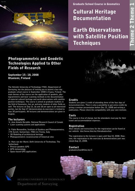
Cultural Heritage Documentation Earth Observations with Satellite ...
Cultural Heritage Documentation Earth Observations with Satellite ...
Cultural Heritage Documentation Earth Observations with Satellite ...

Create successful ePaper yourself
Turn your PDF publications into a flip-book with our unique Google optimized e-Paper software.
Kuva: ESA<br />
Graduate School Course in Geomatics<br />
<strong>Cultural</strong> <strong>Heritage</strong><br />
<strong>Documentation</strong><br />
<strong>Earth</strong> <strong>Observations</strong><br />
<strong>with</strong> <strong>Satellite</strong> Position<br />
Techniques<br />
Theme 2 Theme 1<br />
Photogrammetric and Geodetic<br />
Technologies Applied to Other<br />
Fields of Research<br />
September 15 – 18, 2008<br />
Otaniemi, Finland<br />
The Helsinki University of Technology (TKK), Department of<br />
Surveying, has the pleasure of inviting you to attend a four day<br />
graduate school course in September 2008 in Espoo, Finland. The<br />
main themes of the course are the application of geodetic, photogrammetric<br />
and laser scanning methods to the documentation<br />
of material cultural heritage and earth observations <strong>with</strong> satellite<br />
position techniques. The course is aimed at graduate students in<br />
the field of Geomatics, but we welcome students of other fields as<br />
well. The lectures on Sep 15, 16 and 18 are open to all interested<br />
parties, but the Sep 17 (demonstrations & exercises) is limited to<br />
max 30 participants. All lectures and demonstrations are given in<br />
English.<br />
The lecturers<br />
Dr. Jean Angelo Beraldin, National Research Council of Canada<br />
• Laser scanning systems and applications<br />
Dr. Fabio Remondino, Institute of Geodesy and Photogrammetry,<br />
ETH Zurich, Switzerland; FBK-irst Trento, Italy<br />
• 3D Modeling of architectural heritage<br />
• Photogrammetric reconstruction of historical sites<br />
Dr. Hans van der Marel, Delft University of Technology, The<br />
Netherlands<br />
• Precise geodetic GPS<br />
• GPS meteorology<br />
• Space based GPS applications<br />
Credits<br />
Students are given 1 credit of attending three of the four days of<br />
lectures/exercises. There is also a possibility to get extra credits by<br />
giving a seminar presentation before Dec 31, 2008 and writing a<br />
publication. Please check the compatibility <strong>with</strong> your own institute.<br />
Costs<br />
The course is free of charge, but the attendants must pay for their<br />
travel and accommodation expenses.<br />
Registration<br />
More details and instructions for the registration can be found at<br />
our website http://www.foto.hut.fi/graduateschool<br />
The registration to the lectures is open until Sep 14, 2008. However,<br />
the registration to the exercises & demonstrations part was<br />
closed Aug 15, 2008.<br />
Contact<br />
graduateschool@foto.hut.fi<br />
ABHELSINKI UNIVERSITY OF TECHNOLOGY<br />
Department of Surveying
Program for the graduate school course 2008<br />
Monday Sep 15, Lecture hall M1<br />
Day 1: Laser scanning in cultural heritage documentation<br />
9:00 – 10:45 Laser scanning systems and applications<br />
Dr. Jean-Angelo Beraldin<br />
10:45 – 11:00 Coffee break<br />
11:00 – 12:30 Laser scanning systems and applications<br />
Dr. Jean-Angelo Beraldin<br />
12:30 – 13:30 Lunch<br />
13:30 – 15:00 Laser scanning systems and applications<br />
Dr. Jean-Angelo Beraldin<br />
15:00 – 15:15 Coffee break<br />
15:15 – 17:00 Laser scanning systems and applications<br />
Dr. Jean-Angelo Beraldin<br />
Tuesday Sep 16, Lecture hall M1<br />
Day 2: Photogrammetry in cultural heritage documentation<br />
9:00 – 10:45 Photogrammetry as 3D Modeling and <strong>Documentation</strong> Technique<br />
Dr. Fabio Remondino<br />
10:45 – 11:00 Coffee break<br />
11:00 – 12:30 Photogrammetric reconstruction of historical sites<br />
Dr. Fabio Remondino<br />
12:30 – 13:30 Lunch<br />
13:30 – 15:00 Photogrammetric 3D Modeling of Architectural <strong>Heritage</strong><br />
Dr. Fabio Remondino<br />
15:00 – 15:15 Coffee break<br />
15:15 – 17:00 3D Modeling by integrating techniques<br />
Dr. Fabio Remondino<br />
Wednesday Sep 17, Lecture hall M4<br />
Day 3: Demonstrations and exercises (max 30 participants)<br />
9:00 – 17:00 Laser scanning data capture and manipulation will be demonstrated using a Leica HDS<br />
6000 and Konica-Minolta 900i scanners. The basics of photogrammetric 3D modelling will<br />
be practiced together in a group work starting from the capture of the images and camera<br />
calibration to modeling of the data <strong>with</strong> PhotoModeler, Australis and iWitness softwares.<br />
Dr. Jean-Angelo Beraldin<br />
Dr. Fabio Remondino<br />
Thursday Sep 18, Lecture hall M1<br />
Day 4: <strong>Earth</strong> observations <strong>with</strong> satellite position techniques<br />
9:00 – 10:45 Present and future Global Navigation <strong>Satellite</strong> Systems<br />
Dr. Hans van der Marel<br />
10:45 – 11:00 Coffee break<br />
11:00 – 12:30 The art of millimeter GPS<br />
Dr. Hans van der Marel<br />
12:30 – 13:30 Lunch<br />
13:30 – 15:00 GPS Meteorology – a case of give and take<br />
Dr. Hans van der Marel<br />
15:00 – 15:15 Coffee break<br />
15:15 – 17:00 Space based applications of GPS and GNSS<br />
Dr. Hans van der Marel<br />
ABHELSINKI UNIVERSITY OF TECHNOLOGY<br />
Department of Surveying